SELECTING RELOCATION OF LAND USE IN HOT MUD...
7
J. SE Asian Appl. Geol., Sep–Dec 2010, Vol. 2(3), pp. 275–281 SELECTING RELOCATION OF LAND USE IN HOT MUD DISASTER AREA BY APPLYING GEO-ENVIRONMENTAL EVALUATION. CASE STUDY: SIDOARJO, EAST JAVA,INDONESIA Doni Prakasa Eka Putra ∗ 1 , Syauqi 1 , Juwarso 1 , Agus Hendratno 1 , and Handoko Teguh Wibowo 2 1 Department of Geological Engineering, Gadjah Mada University, Yogyakarta, Indonesia 2 Badan Penanggulangan Lumpur Sidoarjo (BPLS) Abstract Since May 29, 2006, a sea of hot mud has been gushing from the ground in Sidoarjo, East Java, 35 kilometers south of Indonesia’s second largest city, Surabaya. Due to this disaster, approximately thou- sand of people have been forced from their homes be- cause 600 ha of land and villages were submerged, farmland was ruined, businesses and schools closed as the mud inundated the surrounding area. Reloca- tion of the land uses and supporting infrastructures are become important to support the human surviv- ability and environmental sustainability in this dis- aster area. In order to select the suitable location for land uses and infrastructures, aspect of environmen- tal geology must be concerned. Geo-Environmental parameters such as geological hazards and geologi- cal resources are used to select the suitable relocation area. Evaluation of the suitable land uses is con- ducted by applying simple overlay rating method. Result of this evaluation shows that the relocation of the land uses can be differentiated into three cat- egories; (i) high risk land use/infrastructure, mod- erate risk land use/infrastructure and low risk land use/infrastructure. Each of these categories have difference map of relocation suitability, however all maps indicate that the suitable relocation area is in the west-part from the hot mud disaster area. ∗ Corresponding author: D.P.E. PUTRA, Department of Geological Engineering, Faculty of Engineering, Gadjah Mada University, Jl. Grafika 2 Yogyakarta, 55281, Indone- sia. E-mail: putra [email protected] Keywords: Hot mud blast, relocation of land uses, geo-environmental evaluation 1 Background Since May 29, 2006, a sea of hot mud has been gushing from the ground in Sidoarjo, East Java, 35 kilometers south of Indonesia’s sec- ond largest city, Surabaya. Due to this dis- aster, approximately thousand of people have been forced to go out from their homes because 600 ha of land and villages were submerged, farmland was ruined, businesses and schools closed as the mud inundated the surrounding area. The authorities response was to build con- tainment ’basins’ or ’ponds’ by enclosing areas of land within earth dams, or levees. How- ever, until now, the earth dams are not effec- tive, during the heavy rain on the rainy season, the earth dams and ring-dykes have overflows and broken regularly, causing flooding on more land and damaging infrastructures (Pohl, 2007). Not only in the rainy season, the levees had also collapses during the dry season. Actually, the potential geo-hazard in this disaster area not only comes from the mud overflows, but also comes from the poisonous gases and subsi- dence which are follows the mud intrusion phe- nomena. Therefore, relocation of the land uses and supporting infrastructures are important to support the human survivability and environ- 275
Transcript of SELECTING RELOCATION OF LAND USE IN HOT MUD...

J. SE Asian Appl. Geol., Sep–Dec 2010, Vol. 2(3), pp. 275–281
SELECTING RELOCATION OF LAND USE INHOT MUD DISASTER AREA BY APPLYINGGEO-ENVIRONMENTAL EVALUATION. CASESTUDY: SIDOARJO, EAST JAVA, INDONESIA
Doni Prakasa Eka Putra∗1, Syauqi1, Juwarso1, Agus Hendratno1, and Handoko TeguhWibowo2
1Department of Geological Engineering, Gadjah Mada University, Yogyakarta, Indonesia2Badan Penanggulangan Lumpur Sidoarjo (BPLS)
Abstract
Since May 29, 2006, a sea of hot mud has beengushing from the ground in Sidoarjo, East Java, 35kilometers south of Indonesia’s second largest city,Surabaya. Due to this disaster, approximately thou-sand of people have been forced from their homes be-cause 600 ha of land and villages were submerged,farmland was ruined, businesses and schools closedas the mud inundated the surrounding area. Reloca-tion of the land uses and supporting infrastructuresare become important to support the human surviv-ability and environmental sustainability in this dis-aster area. In order to select the suitable location forland uses and infrastructures, aspect of environmen-tal geology must be concerned. Geo-Environmentalparameters such as geological hazards and geologi-cal resources are used to select the suitable relocationarea. Evaluation of the suitable land uses is con-ducted by applying simple overlay rating method.Result of this evaluation shows that the relocationof the land uses can be differentiated into three cat-egories; (i) high risk land use/infrastructure, mod-erate risk land use/infrastructure and low risk landuse/infrastructure. Each of these categories havedifference map of relocation suitability, however allmaps indicate that the suitable relocation area is inthe west-part from the hot mud disaster area.
∗Corresponding author: D.P.E. PUTRA, Department ofGeological Engineering, Faculty of Engineering, GadjahMada University, Jl. Grafika 2 Yogyakarta, 55281, Indone-sia. E-mail: putra [email protected]
Keywords: Hot mud blast, relocation of land uses,geo-environmental evaluation
1 Background
Since May 29, 2006, a sea of hot mud hasbeen gushing from the ground in Sidoarjo, EastJava, 35 kilometers south of Indonesia’s sec-ond largest city, Surabaya. Due to this dis-aster, approximately thousand of people havebeen forced to go out from their homes because600 ha of land and villages were submerged,farmland was ruined, businesses and schoolsclosed as the mud inundated the surroundingarea. The authorities response was to build con-tainment ’basins’ or ’ponds’ by enclosing areasof land within earth dams, or levees. How-ever, until now, the earth dams are not effec-tive, during the heavy rain on the rainy season,the earth dams and ring-dykes have overflowsand broken regularly, causing flooding on moreland and damaging infrastructures (Pohl, 2007).Not only in the rainy season, the levees hadalso collapses during the dry season. Actually,the potential geo-hazard in this disaster areanot only comes from the mud overflows, butalso comes from the poisonous gases and subsi-dence which are follows the mud intrusion phe-nomena. Therefore, relocation of the land usesand supporting infrastructures are important tosupport the human survivability and environ-
275
PUTRA et al.
mental sustainability in this disaster area. Inthis paper, the evaluation is focused on the re-location of the high risk infrastructures such asrailway and primary transportation roads.
2 Location of the study area
Study area is located in hot mud blast area ofSidoarjo Regency which included Porong Dis-trict, Jabon District, and Tanggulangin District,East Java Province, Indonesia (see Figure 1).
3 Geo-environmental parameters
In order to achieve the objective of this research,some environmental geology parameters mustbe considered in the analysis and evaluationof infrastructures relocation such as (1) geology(incl. engineering characteristics and faults), (2)hydrogeology (depth to groundwater and wa-ter aggresivity), and (3) geologically hazardous-ness (such as distance from the mud overflows,distance from the poisonous gases and distancefrom the subsidence).
3.1 Geology
Morphologically, the study area can be dividedinto two zones of morphology: alluvium plainand hot mud plain area. The alluvium plainarea consists of quarternary alluvium depositsof interbedded clay, silt and sand. The thicknessof alluvium deposits is approximately more orless than 200 m. The engineering characteristicsof the alluvium deposits are more or less simi-lar (Juwarso, 2008, Sudjarwo, 2007). Therefore,this factor is assumed to be similar on the wholestudy area.
While as the morphological name, the hotmud plain consists of mud sediments. The hotmud sediments consists not only a mix of finegrained sediments and water but also containsome foraminifera fossil (Handoko, 2007). Eventhough the alluvium deposits have a Quar-ternary age, geological structures definitely af-fect this sequences (Darsoatmojo et al. 2007)with major faults and surface cracks. At least,there are two faults which found in the studyarea: Watukosek fault and Siring fault. In theevaluation of the infrastructure relocation, the
distance from the faults become one of the im-portant considerations. The closer the infras-tructure to the faults, the higher the probabilityof risk if an earthquake occurrs. The geologicalmap of the study area is shown on Figure 2.
3.2 Hydrogeology
In the alluvium deposits, groundwater is foundeverywhere in the study area. The depth togroundwater ranges from less than 1 m toabout more than 4 m (see Figure 3). For in-frastructures such as railway and roads, deepergroundwater is more presumable. Althoughthe groundwater is commonly shallow, thesalinity of shallow groundwater in this arearanges from freshwater to saline water group(see Figure 4). Saline water is an aggressivetype of water that can chemically attacks con-crete foundation (Prinz & Staub, 2006). Relatedto the salinity of shallow groundwater, freshwater condition is more appropriate for con-crete foundation than saline water.
3.3 Hot mud blast hazards
The potential geohazard in this disaster area arenot only comes from the hot mud overflows,but also comes from the poisonous gases (CH4,NH3, H2S, and SO2) and subsidence whichare the secondary impact of hot mud gushing.Therefore, a detailed observation and mappingon the extent of primary and also secondaryhazards have been conducted as shown on Fig-ure 5, 6 and 7. Regarding the infrastructure relo-cation, it will be safer and better if the distancefrom those hazards is far enough.
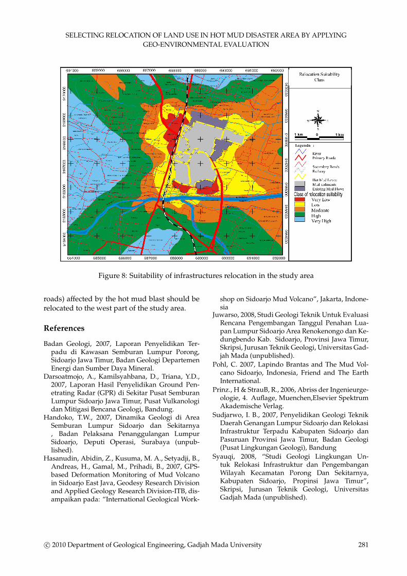
4 Geo-environmental evaluation
The criteria of selection was based on the abovementioned parameters and shown in Table 1.Each parameters have rating score for the eval-uation purposes. The suitable location is calcu-lated by summing all of the parameters rating,whereas the best suitable relocation is definedbased on the highest total score. Results of theevaluation can be seen in Figure 8. Based onthis evaluation method, it is reasonable if thehigh risk infrastructures (railway and primary
276 c© 2010 Department of Geological Engineering, Gadjah Mada University

SELECTING RELOCATION OF LAND USE IN HOT MUD DISASTER AREA BY APPLYING
GEO-ENVIRONMENTAL EVALUATION
Figure 1: Location of the study area
Figure 2: Geological map of the study are
c© 2010 Department of Geological Engineering, Gadjah Mada University 277

PUTRA et al.
Figure 3: The depth of shallow groundwater in the study area (Syauqi, 2008)
Figure 4: The EC value of shallow groundwater in the study area (Syauqi, 2008)
278 c© 2010 Department of Geological Engineering, Gadjah Mada University

SELECTING RELOCATION OF LAND USE IN HOT MUD DISASTER AREA BY APPLYING
GEO-ENVIRONMENTAL EVALUATION
Figure 5: Hazard map of hot mud overflows in the study area (Badan Geologi, 2007)
Figure 6: Location of poisonous gases occurence in the study area (Juwarso, 2008)
c© 2010 Department of Geological Engineering, Gadjah Mada University 279

PUTRA et al.
Figure 7: Subsidence hazard map in the study area (Hasanudin et al., 2007)
Table 1: Selection criteria for relocation of railway ans primary roads (high risk infrastructures) inthe study area
280 c© 2010 Department of Geological Engineering, Gadjah Mada University
SELECTING RELOCATION OF LAND USE IN HOT MUD DISASTER AREA BY APPLYING
GEO-ENVIRONMENTAL EVALUATION
Figure 8: Suitability of infrastructures relocation in the study area
roads) affected by the hot mud blast should berelocated to the west part of the study area.
References
Badan Geologi, 2007, Laporan Penyelidikan Ter-padu di Kawasan Semburan Lumpur Porong,Sidoarjo Jawa Timur, Badan Geologi DepartemenEnergi dan Sumber Daya Mineral.
Darsoatmojo, A., Kamilsyahbana, D., Triana, Y.D.,2007, Laporan Hasil Penyelidikan Ground Pen-etrating Radar (GPR) di Sekitar Pusat SemburanLumpur Sidoarjo Jawa Timur, Pusat Vulkanologidan Mitigasi Bencana Geologi, Bandung.
Handoko, T.W., 2007, Dinamika Geologi di AreaSemburan Lumpur Sidoarjo dan Sekitarnya, Badan Pelaksana Penanggulangan LumpurSidoarjo, Deputi Operasi, Surabaya (unpub-lished).
Hasanudin, Abidin, Z., Kusuma, M. A., Setyadji, B.,Andreas, H., Gamal, M., Prihadi, B., 2007, GPS-based Deformation Monitoring of Mud Volcanoin Sidoarjo East Java, Geodesy Research Divisionand Applied Geology Research Division-ITB, dis-ampaikan pada: “International Geological Work-
shop on Sidoarjo Mud Volcano”, Jakarta, Indone-sia
Juwarso, 2008, Studi Geologi Teknik Untuk EvaluasiRencana Pengembangan Tanggul Penahan Lua-pan Lumpur Sidoarjo Area Renokenongo dan Ke-dungbendo Kab. Sidoarjo, Provinsi Jawa Timur,Skripsi, Jurusan Teknik Geologi, Universitas Gad-jah Mada (unpublished).
Pohl, C. 2007, Lapindo Brantas and The Mud Vol-cano Sidoarjo, Indonesia, Friend and The EarthInternational.
Prinz., H & StrauB, R., 2006, Abriss der Ingenieurge-ologie, 4. Auflage, Muenchen,Elsevier SpektrumAkademische Verlag.
Sudjarwo, I. B., 2007, Penyelidikan Geologi TeknikDaerah Genangan Lumpur Sidoarjo dan RelokasiInfrastruktur Terpadu Kabupaten Sidoarjo danPasuruan Provinsi Jawa Timur, Badan Geologi(Pusat Lingkungan Geologi), Bandung
Syauqi, 2008, “Studi Geologi Lingkungan Un-tuk Relokasi Infrastruktur dan PengembanganWilayah Kecamatan Porong Dan Sekitarnya,Kabupaten Sidoarjo, Propinsi Jawa Timur”,Skripsi, Jurusan Teknik Geologi, UniversitasGadjah Mada (unpublished).
c© 2010 Department of Geological Engineering, Gadjah Mada University 281