Section IV. Assessments of Species and Species Assemblages
27
664 Section IV. Assessments of Species and Species Assemblages Chapter 24. Golden Eagle By Cynthia P. Melcher, Natasha B. Carr, Kirk R. Sherrill, and Gordon Reese Contents Key Ecological Attributes ....................................................................................................................... 666 Distribution and Ecology..................................................................................................................... 666 Landscape Structure and Dynamics................................................................................................... 667 Change Agents ...................................................................................................................................... 667 Development ...................................................................................................................................... 667 Altered Fire Regime and Invasive Species ......................................................................................... 668 Introduced Disease ............................................................................................................................ 669 Rapid Ecoregional Assessment Components Evaluated for Golden Eagle ........................................... 669 Methods Overview.............................................................................................................................. 673 Key Findings for Management Questions .............................................................................................. 674 Summary................................................................................................................................................ 688 References Cited ................................................................................................................................... 688 Figures 24–1. Generalized conceptual model of golden eagle habitat ................................................................ 670 24–2. Distribution of baseline golden eagle nesting habitat .................................................................... 675 24–3. Terrestrial Development Index scores for baseline golden eagle habitat...................................... 676 24–4. Area and percent of baseline golden eagle habitat as a function of the Terrestrial Development Index……...................................................................................................................................... 677 24–5. Area of golden eagle habitat as a function of patch size for baseline conditions and two development levels ....................................................................................................................... 677 24–6. Patch sizes of golden eagle habitat for baseline conditions and relatively undeveloped areas .... 678 24–7. Structural connectivity of relatively undeveloped golden eagle habitat. ........................................ 679 24–8. Potential barriers and corridors as a function of Terrestrial Development Index score for lands surrounding relatively undeveloped golden eagle habitat ............................................................. 680
Transcript of Section IV. Assessments of Species and Species Assemblages

664
Section IV. Assessments of Species and Species Assemblages
Chapter 24. Golden Eagle
By Cynthia P. Melcher, Natasha B. Carr, Kirk R. Sherrill, and Gordon Reese
Contents
Key Ecological Attributes ....................................................................................................................... 666 Distribution and Ecology ..................................................................................................................... 666Landscape Structure and Dynamics ................................................................................................... 667
Change Agents ...................................................................................................................................... 667 Development ...................................................................................................................................... 667 Altered Fire Regime and Invasive Species ......................................................................................... 668Introduced Disease ............................................................................................................................ 669
Rapid Ecoregional Assessment Components Evaluated for Golden Eagle ........................................... 669 Methods Overview .............................................................................................................................. 673
Key Findings for Management Questions .............................................................................................. 674Summary................................................................................................................................................ 688 References Cited ................................................................................................................................... 688
Figures 24–1. Generalized conceptual model of golden eagle habitat ................................................................ 670 24–2. Distribution of baseline golden eagle nesting habitat .................................................................... 675 24–3. Terrestrial Development Index scores for baseline golden eagle habitat. ..................................... 676 24–4. Area and percent of baseline golden eagle habitat as a function of the Terrestrial Development
Index……...................................................................................................................................... 677 24–5. Area of golden eagle habitat as a function of patch size for baseline conditions and two
development levels ....................................................................................................................... 677 24–6. Patch sizes of golden eagle habitat for baseline conditions and relatively undeveloped areas .... 678 24–7. Structural connectivity of relatively undeveloped golden eagle habitat. ........................................ 679 24–8. Potential barriers and corridors as a function of Terrestrial Development Index score for lands
surrounding relatively undeveloped golden eagle habitat ............................................................. 680

665
24–9. Potential for wind-energy development and existing wind-energy facilities within baseline golden eagle habitat. .................................................................................................................... 682
24–10. Annual area recently burned by wildfires and prescribed fires in baseline golden eagle habitat…683 24–11. Occurrence of recent wildfires and prescribed fires in baseline golden eagle habitat ................... 684 24–12. Relative ranks of risk from existing development, by land ownership or jurisdiction, for golden
eagle habitat…. ............................................................................................................................ 685 24–13. Ranks of landscape-level ecological values and risks for golden eagle habitat. ........................... 686 24–14. Conservation potential of golden eagle habitat ............................................................................. 687 Tables 24–1. Key ecological attributes and associated indicators of baseline golden eagle nesting habitat ...... 671 24–2. Anthropogenic Change Agents and associated indicators influencing golden eagle habitat. ....... 671 24–3. Landscape-level ecological values and risks for golden eagle habitat .......................................... 672 24–4. Management Questions addressed for golden eagles.................................................................. 672 24–5. Area and percent of golden eagle habitat by ownership or jurisdiction ......................................... 685

666
Key Ecological Attributes
Distribution and Ecology
The range of the golden eagle is broadly distributed across the northern hemisphere. In North America, it breeds primarily in Alaska, western Canada and the United States, and northern Mexico (Kochert and others, 2002). In the nonbreeding season, the species departs from most of Alaska and northern Canada and moves from higher to lower elevations (Kochert and others, 2002). During the mid-to-late 20th century, golden eagle populations declined in some regions of North America, largely due to development-related habitat loss and concomitant declines in prey abundance, as well as accidents, shootings, poisonings, and disturbance (Kochert and Steenhof, 2002). Population trends remain mixed (Farmer and others, 2008) with increases in eastern regions and decreases in parts of the West. The species is protected by the 1962 Bald and Golden Eagle Protection Act and the Migratory Bird Treaty Act. It also has special status in Montana (as well as four states outside of the Wyoming Basin region).
The Wyoming Basin is a stronghold for both breeding and wintering golden eagle populations in North America. Surveys conducted from 2006−2012 yielded a population estimate in 2012 of 6,431 golden eagles (Nielson and others, 2014) in the Northern Rockies Bird Conservation Region (including most of the Wyoming Basin REA), which represents 20 percent of the approximately 32,000 eagles that breed across the western United States (Millsap and others, 2013). During winter aerial surveys across New Mexico, Colorado, Wyoming, Utah, Montana, and Idaho from 1973–1979, Wyoming and northwestern Colorado had the highest densities (up to 18 per 100 square kilometers (km2) [18/38.61 square miles (mi2)]) of golden eagles (Kochert and others, 2002).
Migrating and nonbreeding golden eagles use a wide variety of open to semiopen habitat types to elevations of 2,500 meters (m) (8,202 feet [ft]), including grasslands, savanna, shrublands, woodland and forest edges, deserts, tundra, and both interior and coastal waterways (Kochert and others, 2002). Migrating birds frequently travel along mountain chains and other topographic features to take advantage of strong thermals (Kochert and others, 2002). Breeding habitats are similar to nonbreeding habitats but include nesting sites that provide unobstructed views of the surrounding landscape (Kochert and others, 2002). In the Great Basin, golden eagle home ranges generally include cliffs or rock outcroppings juxtaposed with sagebrush-rabbitbrush shrubland cover and areas with more shrub cover than grasslands (Marzluff and others, 1997); similar features likely characterize home ranges in the Wyoming Basin.
Golden eagles nest from late March through August, depending on location (Kochert and others, 2002). Typically, their nest sites are on cliffs or in trees but also may be located on elevated ground and human-made structures. As diurnal predators, golden eagles scout for prey while soaring or skimming along topographic contours, or while perched. They usually prey on small- to medium-sized mammals (especially leporids and sciurids), birds, and reptiles (Kochert and others, 2002). On rare occasions, they may take larger prey such as young ungulates. In winter, some golden eagles forage in waterfowl-congregation areas. They also scavenge for carrion, including roadkills and carcasses, which may contain lead shot that can result in seasonally elevated blood levels of lead (Kochert and others, 2002).

667
Landscape Structure and Dynamics
Although golden eagles will congregate at roost sites and carcasses, individuals range widely across large landscapes at fairly broad scales. Mean home-range size in southwestern Idaho was 2,280 hectares (ha) (5,634 acres ) during breeding season and 30,484 ha (75,328 acres) in the nonbreeding season, although home range sizes varied widely among individuals (Marzluff and others, 1997). In regions like the Wyoming Basin where most breeding golden eagles are year-round residents, territorial boundaries vary little between years. Overlap between individuals or pairs is minimal in breeding season but up to 10 percent at other times. Within their home ranges, the birds focus their foraging activities in core areas that range from 30–1,535 ha (74–3,793 acres) in the breeding season and 485–6,380 ha (1,198–15,765 acres) in the nonbreeding season. At this scale, individuals are more consistent with respect to habitat selection than they are throughout their home ranges (Marzluff and others, 1997). Important features of core areas include high-quality prey habitat, especially sagebrush-rabbitbrush occupied by jackrabbits. Marzluff and others (1997) recommend conserving shrub patches of at least 6,400 ha (15,815 acres) for golden eagles to accommodate core and winter range and to support immature birds and adults that do not have territories (floaters).
Golden eagle distribution and reproductive success are closely tied to prey abundance (Steenhof and others, 1997), and the dynamics of several of their key prey species are influenced by drought, fire, and inherent population cycles. Black-tailed jackrabbits exhibit 10-year population cycles, which influence nesting success of golden eagles (Steenhof and others, 1997). Both fire and drought can initially diminish the cover and forage used by primary golden eagle prey species including jackrabbits and ground squirrels. When prey are scarce, golden eagles may shift their distribution and (or) experience increased nesting failure.
Change Agents
Development
Energy and Infrastructure
A 2010 review indicated that major concerns for golden eagle conservation include habitat loss, collisions, electrocutions, and renewable energy (Holroyd and others, 2010). Golden eagles generally avoid urbanized and disturbed areas (Kochert and others, 2002). Habitat loss and fragmentation from development negatively affects golden eagles and can diminish prey populations that also depend on these habitats. Wind-farm development is accelerating across the golden eagle’s range, often in otherwise high-quality eagle habitat and migration routes (Johnston and others, 2013), ridgelines in particular. Golden eagle mortality due to collisions with wind turbine blades has been well documented and is a major concern (Hunt and others, 1999; Frosch, 2013). At the Altamont Pass Wind Resource Area in California, the estimated annual golden eagle mortality due to collisions is one bird per 8.7 megawatts of power generation (Smallwood and Thelander, 2008), with fatalities being more likely at turbines situated on or in ridge saddles, plateaus, steep slopes, ravines, canyons, slopes with southern or northwestern aspects, and near rock piles (Smallwood and Thelander, 2005).
Both energy development and urban/exurban development lead to proliferations of electrical distribution and transmission lines. For birds with large wingspans (such as eagles), electrocution when perching on these structures is common (Harness and Wilson, 2001; U.S.

668
Fish and Wildlife Service, 2009; Lehman and others, 2010). Golden eagles also collide with guy wires and powerlines. Road development not only fragments and eliminates prey habitat, roads contribute directly to golden eagle mortality (collisions with vehicles) (Kochert and others, 2002); in just one winter, 100 golden eagles were killed along southwestern Wyoming highways near Rock Springs (Phillips, 1986).
Golden eagles are sensitive to human disturbance, and disturbance during nesting can diminish nesting success. Eagles may avoid nesting close to developed areas. Indeed, occupied nesting territories encompass fewer residences within 1.6 km (0.99 mi) and lower human populations within 4.8 km (2.98 mi) than abandoned territories (Richardson and Miller, 1997). Recommended buffer distances between nests and human activities range from 200–2,000 m (656.2–6,561.7 ft), depending on context and activity type (Colorado Division of Wildlife, 2008).
Agricultural Activities
The 2010 review of major concerns for golden eagle conservation mentioned above also indicated that range and grazing management and lead poisoning, are major concerns for golden eagles (Holroyd and others, 2010). Nesting golden eagles generally avoid nonnative vegetation, including agricultural lands (Kochert and others, 2002). In addition to cropland conversion of habitat, rangeland and livestock management practices that can degrade eagle prey habitat include burning, chaining, and herbicide applications to eliminate brush for enhancing cattle forage (Knick and Dyer, 1997). Golden eagles may use agricultural lands more often in winter than during breeding, but these habitats generally do not support suitable prey species for overwintering eagles (Craig and others, 1986). Secondary poisoning can result when eagles consume prey poisoned by pesticides used to protect crops or kill rodents and coyotes in agricultural and ranching areas, or when prey contain lead after being shot to protect livestock (Kochert and others, 2002). Golden eagles are also shot and trapped to protect livestock, accounting for an unknown rate of golden eagle mortality (Farmer and others, 2008). Fencing is a common feature of rangelands and golden eagles sometimes become entangled or collide with fencing (Kochert and others, 2002).
Altered Fire Regime and Invasive Species
Golden eagles occur in a number of fire-dependent habitat types, such as grasslands, shrublands, and open coniferous woodlands (Tesky, 1994); in general, they avoid densely forested areas (Kochert and others, 2002). As described in Chapter 11—Sagebrush Steppe of this report, however, cheatgrass invasion promotes more frequent, larger, and hotter fires than occurred historically in some western shrublands (Balch and others, 2013). When large areas of sagebrush-rabbitbrush habitat burned, golden eagle prey became scarce (Slater and Frye-Christensen, 2012). Between 1981 and 1985, large fires burned large areas of shrubland in the Morley Nelson Snake River Birds of Prey National Conservation Area alone, leading to declines in eagle nesting success and territory abandonment (Kochert and others, 1999). The time period over which prey populations remain reduced postfire is unclear.

669
Introduced Disease
Disease is not currently considered a concern for golden eagles (Holroyd and others, 2010), but they are susceptible to trichomoniasis, which they contract by consuming infected doves and pigeons (Ciganovich, 2013), and wildlife disease experts believe that this disease may be very underreported (Ciganovich, 2013). An emerging disease also of potential concern for golden eagles is West Nile virus, but its effects on populations are unknown. In most of the western United States, golden eagles inhabit semiarid landscapes where mosquito populations are sparse. Although bald eagle mortality from West Nile virus has been documented in Utah, probably by consuming infected waterfowl (Utah Division of Wildlife Resources, 2013), it is not known whether golden eagles are susceptible to similar modes of West Nile virus transmission. The probability may be lower than it is for bald eagles, however, because waterfowl are not a major part of the golden eagle’s diet in the Wyoming Basin.
Rapid Ecoregional Assessment Components Evaluated for Golden Eagle
A generalized, conceptual model was used to highlight some of the key ecological attributes and Change Agents affecting golden eagles (fig. 24–1). Key ecological attributes addressed by the REA include (1) the distribution of golden eagle habitat, (2) landscape structure (patch sizes and structural connectivity), and (3) landscape dynamics (fire occurrence; table 24–1). The Change Agents evaluated were development and wind energy (table 24–2). Ecological values and risks used to assess the conservation potential of golden eagles habitat by township are summarized in table 24–3. Core and Integrated Management Questions and the associated summary maps and graphs are provided in table 24–4.

670
Figure 24–1. Generalized conceptual model of golden eagle habitat for the Wyoming Basin Rapid
Ecoregional Assessment (REA). Biophysical attributes and ecological processes regulating the occurrence, structure, and dynamics of golden eagle habitat are shown in orange rectangles; additional ecological attributes are shown in blue rectangles; and key anthropogenic Change Agents are shown in yellow ovals. The dashed lines indicate components not addressed by the REA. Livestock and invasive plants are Change Agents that were not addressed due to the lack of regionwide data.

671
Table 24–1. Key ecological attributes and associated indicators of baseline golden eagle nesting habitat1 for the Wyoming Basin Rapid Ecoregional Assessment.
[km, kilometer; mi, mile]
Attributes Variables Indicators Amount and distribution of habitat
Total area Habitat distribution derived from vegetation and abiotic variables2
Landscape structure
Patch size Patch-size frequency distribution
Structural connectivity3
Interpatch distances that provide an index of structural connectivity for baseline patches at local (0.09 km; 0.06 mi), landscape (0.18 km; 0.11 mi), and regional (0.18 km; 0.11 mi) levels
Landscape dynamics Fire occurrence4
Locations of fires and annual area burned since 1980
1 Baseline conditions are used as a benchmark to evaluate changes in the amount and landscape structure of habitat due to Change Agents. Baseline conditions are defined as the potential current distribution of golden eagle habitat derived from existing abiotic and biotic variables without explicit inclusion of Change Agents (see Chapter 2—Assessment Framework and the Appendix). 2 Habitat modeled using MaxEnt; nest site locations from Colorado Natural Heritage Program, Idaho Fish and Wildlife Information System, Montana Natural Heritage Program, Rocky Mountain Bird Observatory, Utah Natural Heritage Program, and the Wyoming Natural Diversity Database; habitat variables derived from SAGEMAP (Hanser and others, 2011) and Homer and others (2012). 3 Structural connectivity refers to the proximity of patches at local, landscape, and regional levels but does not reflect species-specific measures of connectivity. See Chapter 2—Assessment Framework. 4 See Wildland Fire section in the Appendix.
Table 24–2. Anthropogenic Change Agents and associated indicators influencing golden eagle habitat for the Wyoming Basin Rapid Ecoregional Assessment.
[km2, square kilometer; mi2, square mile; km, kilometer, mi, mile]
Change Agents Variables Indicators
Development Terrestrial Development Index1
Percent of golden eagle habitat in seven development classes using a 16-km2 (6.18-mi2) moving window Patch-size frequency distribution for golden eagle habitat that is relatively undeveloped or has low development scores compared to baseline conditions1
Interpatch distances that provide an index of structural connectivity for relatively undeveloped patches at local (0.54 km; 0.34 mi), landscape (2.97 km; 1.852 mi), and regional (4.86 km; 3.02 mi) levels
Wind energy2 Location of existing wind-energy sites and wind-energy potential within golden eagle habitat
1 See Chapter 2—Assessment Framework. 2 See Chapter 4—Development.

672
Table 24–3. Landscape-level ecological values and risks for golden eagle habitat. Ranks were combined into an index of conservation potential for the Wyoming Basin Rapid Ecoregional Assessment.
Relative rank Variables1 Lowest Medium Highest Description2
Values Area
<33 33–79 >79 Percent of township modeled as golden eagle habitat
Risks Terrestrial Development Index (TDI)
<1 1–3 >3 Mean TDI score by township
1 Township was used as the analysis unit for conservation potential on the basis of input from the Bureau of Land Management. A minimum area threshold of total area per township was established for golden eagle habitat to minimize the effects of extremely small areas and put greater emphasis on large areas (see table A–19 in the Appendix). 2 See tables 24–1 and 24–2 for description of variables.
Table 24–4. Management Questions addressed for golden eagles for the Wyoming Basin Rapid Ecoregional Assessment.
Core Management Questions Results
Where is baseline golden eagle nesting habitat, and what is the total area? Figure 24–2
Where does development pose the greatest threat to baseline golden eagle habitat, and where are the relatively undeveloped areas?
Figures 24–3 and 24–4
How has development fragmented baseline golden eagle habitat, and where are the large, relatively undeveloped patches?
Figures 24–5 and 24–6
How has development affected structural connectivity of golden eagle habitat relative to baseline conditions?
Figure 24–7
Where are potential barriers and corridors that may affect animal movements among relatively undeveloped habitat patches?
Figure 24–8
Where are existing wind-energy facilities, and where are areas with high wind-energy potential in golden eagle habitat?
Figure 24–9
Where have recent fires occurred in baseline golden eagle habitat, and what is the total area burned per year?
Figures 24–10 and 24–11
Integrated Management Questions Results
How does risk from development vary by land ownership or jurisdiction for golden eagle habitat?
Table 24–5 and Figure 24–12
Where are the townships with the greatest landscape-level ecological values? Figure 24–13
Where are the townships with the greatest landscape-level risks? Figure 24–13
Where are the townships with the greatest conservation potential? Figure 24–14

673
Methods Overview
We developed a nesting habitat model for golden eagles using MaxEnt software (Phillips and others, 2006). Values of vegetation and abiotic variables surrounding 218 recent (1990-2011) golden eagle nest site locations were derived from data sources in table 24–1. Variables with the greatest weight included topographic ruggedness, herbaceous cover, mean annual temperature, and elevation. To produce a map of potential golden eagle nesting habitat, we used MaxEnt parameter values that included 95 percent of the locations (omission rate of 5 percent). The distribution map was used to quantify key ecological attributes (table 24–1) and Change Agents (table 24–2) for baseline golden eagle nesting habitat (hereafter golden eagle habitat).
We assessed development levels in golden eagle habitat using the TDI map, and then used the resulting output to calculate patch size and structural connectivity metrics. We mapped the structural connectivity of relatively undeveloped habitat (TDI score <1 percent) at three interpatch distances derived from connectivity analysis: local (0.54 km; 0.34 mi), landscape (2.97 km; 1.85 mi), and regional (4.86 km; 3.02 mi) levels. We used development levels to identify areas that may function as barriers or corridors by overlaying relatively undeveloped habitat patches on the TDI map. The perimeters of fires in golden eagle habitat since 1980 were compiled from several data sources to assess fire frequency and extent (table 24–1). To evaluate risks to golden eagles posed by wind energy, we identified areas with existing and high potential for wind-energy development that were coincident with baseline golden eagle habitat (see Chapter 4—Development). Potential for changes in habitat resulting from climate change and associated shifts in ecological communities was not evaluated for this species because it uses a variety of shrubland and grassland habitats.
Landscape-level ecological values (area of habitat) and risk (TDI score) were compiled into an overall index of conservation potential for each township (table 24–3). Conservation potential was summarized by township based on overall landscape-level values and risks (table 24–3). ). Landscape-level values and risks, and conservation potential rankings are intended to provide a synthetic overview of the geospatial datasets developed to address Core Management Questions in the REA. Because rankings are very sensitive to the input data used and the criteria used to develop the ranking thresholds, they are not intended as stand-alone maps. Rather, they are best used as an initial screening tool to compare regional rankings in conjunction with the geospatial data for Core Management Questions and information on local conditions that cannot be determined from regional REA maps. See Chapter 2—Assessment Framework and the Appendix for additional details on the methods.

674
Key Findings for Management Questions
Where is baseline golden eagle nesting habitat, and what is the total area (fig. 24–2)? • Baseline golden eagle habitat total is 85,718 km2 (33,095.91 mi2) or 48 percent of the
Wyoming Basin project area. • Golden eagle habitat is well distributed throughout lower elevations in the Wyoming Basin
with the exception of the Bighorn Basin. Where does development pose the greatest threat to baseline golden eagle habitat, and where are the relatively undeveloped areas (figs. 24–3 and 24–4)? • Development is widely distributed across golden eagle habitat within the Wyoming Basin
(fig. 24–3). • Approximately 27 percent of golden eagle habitat in the Basin is relatively undeveloped (TDI
score <1 percent) and 17 percent had TDI scores of >5 percent (fig. 24–4). How has development fragmented baseline golden eagle habitat, and where are the large, relatively undeveloped patches (figs. 24–5 and 24–6)? • Development has effectively fragmented golden eagle habitat into smaller patches relative to
baseline conditions. All relatively undeveloped habitat (TDI score <1 percent) occurs in patches <5,000 km2 (1,930 mi2). In contrast, over 84 percent of baseline habitat occurred in patches >5,000 km2 (fig. 24–5).
• The largest relatively undeveloped habitat patches are located south of Rock Springs, Wyoming (fig. 24–6).
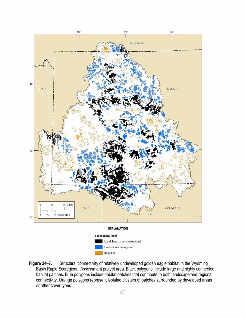
How has development affected the structural connectivity of golden eagle habitat relative to baseline conditions (fig. 24–7)? • Baseline golden eagle habitat is highly connected, with regional-scale connectivity occurring
at a 0.18-km (.011 mi) interpatch distance (fig. 24–7). • Development has greatly diminished the structural connectivity of golden eagle habitat.
Relatively undeveloped habitat is highly fragmented. Regional-scale connectivity (4.86 km [3.02 mi]) for relatively undeveloped habitat is considerably greater than baseline conditions.
• Structural connectivity for wide-ranging species like golden eagles may be less important than for less mobile species, but collectively smaller patch sizes and decreased connectivity may decrease habitat quality. In addition, eagles may avoid areas with high levels of development and human or vehicle disturbance, or suffer from high mortality levels due to collisions along roads with high traffic volumes (Phillips, 1986).
• Areas with high local and landscape connectivity may facilitate dispersal and seasonal movements, whereas habitat with only regional connectivity may have value as stopover habitat across developed or otherwise unsuitable habitat.
• Golden eagle habitat in the western and southeastern portions of the Basin has limited landscape and regional connectivity, which could increase vulnerability to habitat loss and fragmentation in these areas.

675
Figure 24–2. Distribution of baseline golden eagle nesting habitat in the Wyoming Basin Rapid
Ecoregional Assessment project area.

676
Figure 24–3. Terrestrial Development Index scores for baseline golden eagle habitat in the Wyoming
Basin Rapid Ecoregional Assessment project area.

677
Figure 24–4. Area and percent of baseline golden eagle habitat as a function of the Terrestrial
Development Index in the Wyoming Basin Rapid Ecoregional Assessment project area.
Figure 24–5. Area of golden eagle habitat as a function of patch size for baseline conditions and two
development levels: (1) Terrestrial Development Index (TDI) score <3 percent and (2) TDI score <1 percent (relatively undeveloped areas) in the Wyoming Basin Rapid Ecoregional Assessment project area.

678
Figure 24–6. Patch sizes of golden eagle habitat for the Wyoming Basin Rapid Ecoregional
Assessment project area for (A) baseline conditions and (B) relatively undeveloped areas (Terrestrial Development Index score <1 percent).
679
Figure 24–7. Structural connectivity of relatively undeveloped golden eagle habitat in the Wyoming
Basin Rapid Ecoregional Assessment project area. Black polygons include large and highly connected habitat patches. Blue polygons include habitat patches that contribute to both landscape and regional connectivity. Orange polygons represent isolated clusters of patches surrounded by developed areas or other cover types.

680
Where are potential barriers and corridors that may affect golden eagle movements among relatively undeveloped habitat patches (fig. 24–8)?
Figure 24–8. Potential barriers and corridors as a function of Terrestrial Development Index (TDI) score
for lands surrounding relatively undeveloped golden eagle habitat. Higher TDI scores (for example, >5 percent) represent potential barriers to movement among relatively undeveloped habitat patches. Lower TDI scores (for example, <2 percent) represent potential corridors for movements among patches.

681
Where are existing wind energy facilities, and where are areas with high wind-energy potential in golden eagle habitat (fig. 24–9)? • Although most existing wind-energy facilities fall within or near golden eagle habitat, they
are restricted to a few areas. • Regions with high potential for wind-energy development are found in 16 percent of golden
eagle habitat. • Migrating golden eagles also may be especially susceptible to wind-energy facilities due to
the occurrence along ridges, which often function as migration routes.

682
Figure 24–9. Potential for wind-energy development and existing wind-energy facilities within baseline
golden eagle habitat in the Wyoming Basin Rapid Ecoregional assessment project area.

683
Where have recent fires occurred in baseline golden eagle habitat, and what is the total area burned per year (figs. 24–10 and 24–11)? • Typically, only a small fraction of golden eagle habitat has burned each year since 1980.
Cumulatively, approximately 4 percent of golden eagle habitat has burned since 1980 (figs. 24–10 and 24–11).
• In most years, fires are small and burn only a small portion of golden eagle habitat; most of the area burned was due to large fires from 1996 and 2000 (fig. 24–10).
How does risk from development vary by land ownership or jurisdiction for golden eagle habitat (table 24–5, fig. 24–12)? • Slightly more than 50 percent of baseline golden eagle habitat occurs on BLM lands, and
another 33 percent is in private ownership (table 24–5). • Development levels are the lowest on Federal and Tribal lands compared to State/County or
privately owned lands (fig. 24–12).
Figure 24–10. Annual area burned by wildfires and prescribed fires in baseline golden eagle habitat
since 1980 in the Wyoming Basin Rapid Ecoregional Assessment project area.

684
Figure 24–11. Occurrence of wildfires and prescribed fires in baseline golden eagle habitat since 1980 in
the Wyoming Basin Rapid Ecoregional Assessment project area.

685
Table 24–5. Area and percent of golden eagle habitat by ownership or jurisdiction in the Wyoming Basin Rapid Ecoregional Assessment project area.
[km2, square kilometers] Ownership or jurisdiction Area (km2) Percent of area
Bureau of Land Management 42,993 50.2 Private 28,196 32.9 State/County 6,031 7.0 Tribal 3,994 4.6 Forest Service2 2,185 2.5 Other Federal1 1,762 2.1 Private conservation 395 0.6
1 National Park Service, Department of Defense, Department of Energy, Bureau of Reclamation, and U.S. Fish and Wildlife Service. 2 U.S. Department of Agriculture Forest Service.
Figure 24–12. Relative ranks of risk from existing development, by land ownership or jurisdiction, for
golden eagle habitat in the Wyoming Basin Rapid Ecoregional Assessment project area. Rankings are lowest (Terrestrial Development Index [TDI] score <1 percent), medium (TDI score 1−3 percent), and highest (TDI score >3 percent). [Forest Service, U.S. Department of Agriculture Forest Service]

686
Where are the townships with the greatest landscape-level ecological values, and where are the townships with the greatest landscape-level risks (fig. 24–11)?
Figure 24–13. Ranks of landscape-level ecological values and risks for golden eagle habitat,
summarized by township, in the Wyoming Basin Rapid Ecoregional Assessment project area. (A) Landscape-level values based on habitat area and (B) landscape-level risks based on Terrestrial Development Index (see table 24–3 for overview of methods).

687
Where are the townships with the greatest conservation potential (fig. 24–12)?
Figure 24–14. Conservation potential of golden eagle habitat, summarized by township, in the Wyoming
Basin Rapid Ecoregional Assessment project area. Highest conservation potential identifies areas that have the highest landscape-level values and the lowest risks. Lowest conservation potential identifies areas with the lowest landscape-level values and the highest risks. Ranks of conservation potential are not intended as stand-alone summaries and are best interpreted in conjunction with the geospatial datasets used to address Core Management Questions.

688
Summary
Golden eagle habitat is widely distributed throughout much of central and southern Wyoming and adjacent areas of Idaho, Utah, and Colorado. Agricultural conversion, roads, and energy development have cumulatively led to habitat loss, increased fragmentation, and decreased structural connectivity of golden eagle habitat. Golden eagles, however, may respond differently to different types of development, depending on time of year. They are especially sensitive to disturbance at their nest sites; therefore, development that causes high levels of human activity may lead to reduced nesting productivity. In addition, collisions with vehicles along major thoroughfares can result in high mortality rates (Philips, 1986). Golden eagles are especially vulnerable to mortality from wind turbines and a large proportion of their habitat within the Basin occurs in regions with high wind-development potential. Half of the golden eagle habitat in the Basin is managed by the Bureau of Land Management.
References Cited
Balch, J.K., Bradley, B.A., D’Antonio, C.M., and Gómez-Dans, José, 2013, Introduced annual grass increases regional fire activity across the arid western USA (1980–2009): Global Change Biology, v. 19, no. 1, p. 173–183.
Ciganovich, E.A., ed., 2013, Trichomoniasis, in Field manual of wildlife diseases—General field procedures and diseases of birds, information and technology report 1999–001: U.S. Geological Survey, National Wildlife Health Center, p. 201–206, at http://www.nwhc.usgs.gov/publications/field_manual/.
Colorado Division of Wildlife, 2008, Recommended buffer zones and seasonal restrictions for Colorado raptors: Fort Collins, Colo., Colorado Division of Wildlife, 7 p.
Craig, E.H., Craig, T.H., and Powers, L.R., 1986, Habitat use by wintering golden eagles and rough-legged hawks in southeastern Idaho: Journal of Raptor Research, v. 20, no. 2, p. 69–71.
Farmer, C.J., Goodrich, L.J., Ruelas Inzunza, E.R., and Smith, J.P., 2008, Conservation status of North America’s birds of prey, in Bildstein, K.L., Smith, J.P., Ruelas Inzunza, E.R., and Veit, R.R. eds., State of North America’s birds of prey, Series in Ornithology no. 3, Cambridge, Mass., Nuttall Ornithological Club and American Ornithologists’ Union, p. 303–419.
Frosch, Dan, 2013, A struggle to balance wind energy with wildlife: New York, N.Y., New York Times, at http://www.nytimes.com/2013/12/17/science/earth/a-struggle-to-balance-wind-energy-with-wildlife.html?_r=0, accessed January 9, 2014.
Harness, R.E., and Wilson, K.R., 2001, Electric-utility structures associated with raptor electrocutions in rural areas: Wildlife Society Bulletin, v. 29, no. 2, p. 612–623.
Holroyd, Geoff, Knight, Robbie, Lewis, Steve, Murphy, Robert, Pagel, Jeep, Steenhof, Karen, and Whittington, Diana, 2010, A collaborative critique of the golden eagle’s uncertain future in North America, in Minutes and notes of the North American golden eagle science meeting, September 21, 2010: Fort Collins, Colo., U.S. Geological Survey Fort Collins Science Center, and U.S. Fish and Wildlife Service, p. 1–28.
Hunt, W.G., Jackman, R.E., Hunt, T.L., Driscoll, D.E., and Culp, L., 1999, A population study of golden eagles in the Altamont Pass Wind Resource Area: Population trend analysis 1994–

689
1997: Santa Cruz, Calif., University of California, Predatory Bird Research Group, report to National Renewable Energy Laboratory, at http://www.nrel.gov/wind/pdfs/26092.pdf.
Johnston, N.N., Bradley, J.E., Pomeroy, A.C., and Otter, K.A., 2013, Flight paths of migrating golden eagles and the risk associated with wind energy development in the Rocky Mountains: Avian Conservation and Ecology, v. 8, no. 2.
Knick, S.T., and Dyer, D.L., 1997, Distribution of black-tailed jackrabbit habitat determined by GIS in southwestern Idaho: Journal of Wildlife Management, v. 61, no. 1, p. 54–68.
Kochert, M.N., and Steenhof, Karen, 2002, Golden eagles in the U.S. and Canada—Status, trends, and conservation challenges: Journal of Raptor Research, v. 36, p. 32–40.
Kochert, M.N., Steenhof, Karen, Mcintyre, C.L., and Craig, E.H., 2002, Golden eagle (Aquila chrysaetos), in Poole, A. ed., Birds of North America online, no . 684: Ithaca, New York: Cornell Lab of Ornithology.
Kochert, M.N., Steenhof, Karen, Carpenter, L.B., and Marzluff, J.M., 1999, Occupancy effects of fire on golden eagle territory and reproductive success: Journal of Wildlife Management, v. 63, no. 3, p. 773–780.
Lehman, R.N., Savidge, J.A., Kennedy, P.L., and Harness, R.E., 2010, Raptor electrocution rates for a utility in the intermountain western United States: Journal of Wildlife Management, v. 74, no. 3, p. 459–470.
Marzluff, J.M., Knick, S.T., Vekasy, M.S., Schueck, L.S., and Zarriello, T.J., 1997, Spatial use and habitat selection of golden eagles in southwestern Idaho: Auk, v. 114, no. 4, p. 673–687.
Millsap, B.A., Zimmerman, G.S., Sauer, J.R., Nielson, R.M., Otto, Mark, Bjerre, Emily, and Murphy, Robert, 2013, Golden eagle population trends in the western United States—1968−2010: Journal of Wildlife Management, v. 77, no. 7, p. 1436–1448.
Nielson, R.M., McManus, Linda, Rintz, Troy, McDonald, L.L., Murphy, R.K., Howe, W.H., and Good, R.E., 2014, Monitoring abundance of golden eagles in the western United States: Journal of Wildlife Management, v. 78, no. 4, p. 721–730.
Phillips, R.L., 1986, Current issues concerning the management of golden eagles in western U.S.A., in Chandellor, R.D., and Meyburg, B.U., Birds of Prey Bulletin no. 3: Berlin, Germany, Working Group on Birds of Prey and Owls, p. 149–156.
Phillips, S.J., Anderson, R.P., and Schapire, R.E., 2006, Maximum entropy modeling of species geographic distributions: Ecological Modelling, v. 190, p. 231−259.
Richardson, C.T., and Miller, C.K., 1997, Recommendations for protecting raptors from human disturbance: A review: Wildlife Society Bulletin, v. 25, no. 3, p. 634–638.
Slater, S.J., Frye-Christensen, K.W., Knight, R.N., MacDuff, Robyn , and Keller, Kent, 2012, Great Basin avian species-at-risk and invasive species management through multi-agency monitoring and coordination final report, Department of Defense, Legacy Resources Management Program (Project #10–102): Salt Lake City, Ut., HawkWatch International.
Smallwood, K.S., and Thelander, C.G., 2005, Bird mortality at the Altamont Pass Wind Resource Area, March 1998−September 2001: Ojai, Calif., BioResource Consultants, 404 p.

690
Smallwood, K.S., and Thelander, C.G., 2008, Bird mortality in the Altamont Pass Wind Resource Area, California: Journal of Wildlife Management, v. 72, no. 1, p. 215–223.
Steenhof, Karen, Kochert, M.N., and McDonald, T.L., 1997, Interactive effects of prey and weather on golden eagle reproduction: Journal of Animal Ecology, v. 66, p. 350–362.
Tesky, J.L., 1994, Aquila chrysaetos, in Fire Effects Information System online: U.S. Department of Agriculture Forest Service, Rocky Mountain Research Station, Fire Sciences Laboratory, at http://www.fs.fed.us/database/feis/animals/bird/aqch/all.html, accessed January 9, 2014.
U.S. Fish and Wildlife Service, 2009, News release—Utility giant to pay millions for eagle protection: Office of External Affairs, Mountain-Prairie Region, U.S. Fish and Wildlife Service at http://www.fws.gov/mountain-prairie/pressrel/09-47.html, accessed January 9, 2014.
Utah Division of Wildlife Resources, 2013, DWR learns what killed bald eagles: Utah Department of Natural Resources, Division of Wildlife Resources, Wildlife News, Tuesday, December 31, 2013, at http://wildlife.utah.gov/wildlife-news/1330-utah-dwr-learns-what-killed-bald-eagles.html, accessed approximately January, 2014.