Section C Land for SANG use within the Green Belt · 342 Section C – Land for SANG use within the...
76
342 Section C – Land for SANG use within the Green Belt These sites are which it is proposed remain in the Green Belt. They do however provide the opportunity to improve infrastructure to serve existing communities as well as support planned new development. The nature of this opportunity is in each case explained in the Proposal section. These Proposal Sites have references beginning GB.
-
Upload
truonghanh -
Category
Documents
-
view
217 -
download
0
Transcript of Section C Land for SANG use within the Green Belt · 342 Section C – Land for SANG use within the...

342
Section C – Land for SANG use within the Green Belt These sites are which it is proposed remain in the Green Belt. They do however provide the opportunity to improve infrastructure to serve existing communities as well as support planned new development. The nature of this opportunity is in each case explained in the Proposal section. These Proposal Sites have references beginning GB.

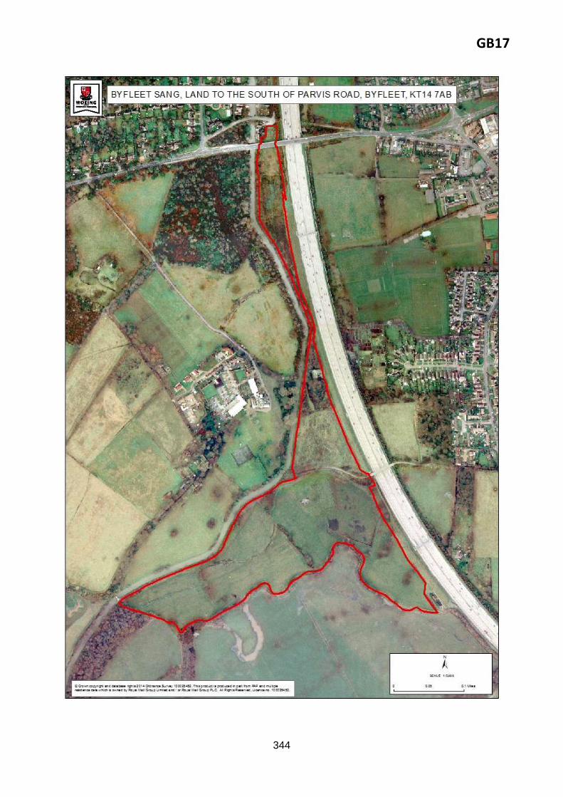
GB17
343
Byfleet
Proposal reference: GB17
Site address: Byfleet SANG, land to the south of Parvis Road, Byfleet, KT14 7AB
GB17
344

GB17
345
Policy GB17: Byfleet SANG, land to the south of Parvis Road, Byfleet, KT14 7AB This 15.43ha. Green Belt site is allocated as Suitable Alternative Natural Greenspace (SANG), to be used as informal public recreation space to mitigate the impacts of residential including Affordable Housing development in Woking Borough upon the European-protected bird habitat of the Thames Basin Heaths Special Protection Area (SPA). To achieve this, the development must address the following key requirements.
To be a designated a SANG the site will need to fulfil a certain criteria which are set by Natural
England guidelines. These include a minimum size threshold, ensuring an adequate level of parking
provision and accessibility, clear signposting, a circular walk that starts and finishes at the car park;
and unsurfaced paths that are well maintained and accessible.
A SANG Proposal and SANG Management Plan should be prepared, in consultation with Natural
England;
The following constraints will have to be addressed in any SANG Proposal and Management Plan:
o The site is within Flood Zone 2 and is therefore there is a risk of flooding. Consideration
of sustainable drainage and flood attenuation within the landscape are potential
options. Early engagement with the Environment Agency required.
o Within Biodiversity Opportunity Area; consider opportunities to enhance biodiversity
and habitat creation in the area. Surrey Wildlife Trust should be consulted.
Due to the proximity to significant traffic on the M25, any development would need to consider

GB17
346
Reasoned justification: Woking Borough Council has acquired this land for future SANG use, in line with Core Strategy Policy CS8 and saved South East Plan Policy NRM6 Thames Basin Heaths Special Protection Area.
At present, SANG provision is generally focused in the north, south and west of the Borough. The
provision of SANG in this location offers the opportunity to improve coverage to the east of the Borough and generally improve connections and accessibility between the various open spaces in this part of the Borough.
The site would provide SPA mitigation for a capacity of 78 dwellings (provisional calculation, subject to the advice of Natural England).
The land would remain within the Green Belt.
Delivery arrangements:
Woking Borough Council has purchased this land for use as a future SANG. Arrangements are in hand to bring this proposal forward;
Funding for establishment of the site for SANG purposes will be secured through s106/CIL contributions. Ongoing maintenance through CIL contributions.
Key evidence base:
Thames Basin Heaths Avoidance Strategy 2010-2015
Green Infrastructure Strategy 2014
Sustainability appraisal
Habitat Regulations Assessment
Strategic Transport Assessment
Design SPD.
the impacts on noise and air quality and ensure mitigation measures are implemented to protect
residential amenity. A Noise Impact Assessment and Air Quality Assessment would be required;
Provision of improved accessibility to open space via pedestrian/cycle links – particularly from
urban area via Parvis Road and from any new development later in safeguarded Proposal Sites
GB4 and GB5;
Improvement of public footpaths within site (to fulfil Natural England requirements for SANG
development);
Detailed design of SANG to take opportunities to improve connectivity of habitats within site and
to wider GI network;
Incorporation of waste facilities to service the open space;
Take actions to contribute to enhancement of Biodiversity Opportunity Area – consultation with
Surrey Wildlife Trust recommended.

GB18
347
Knaphill
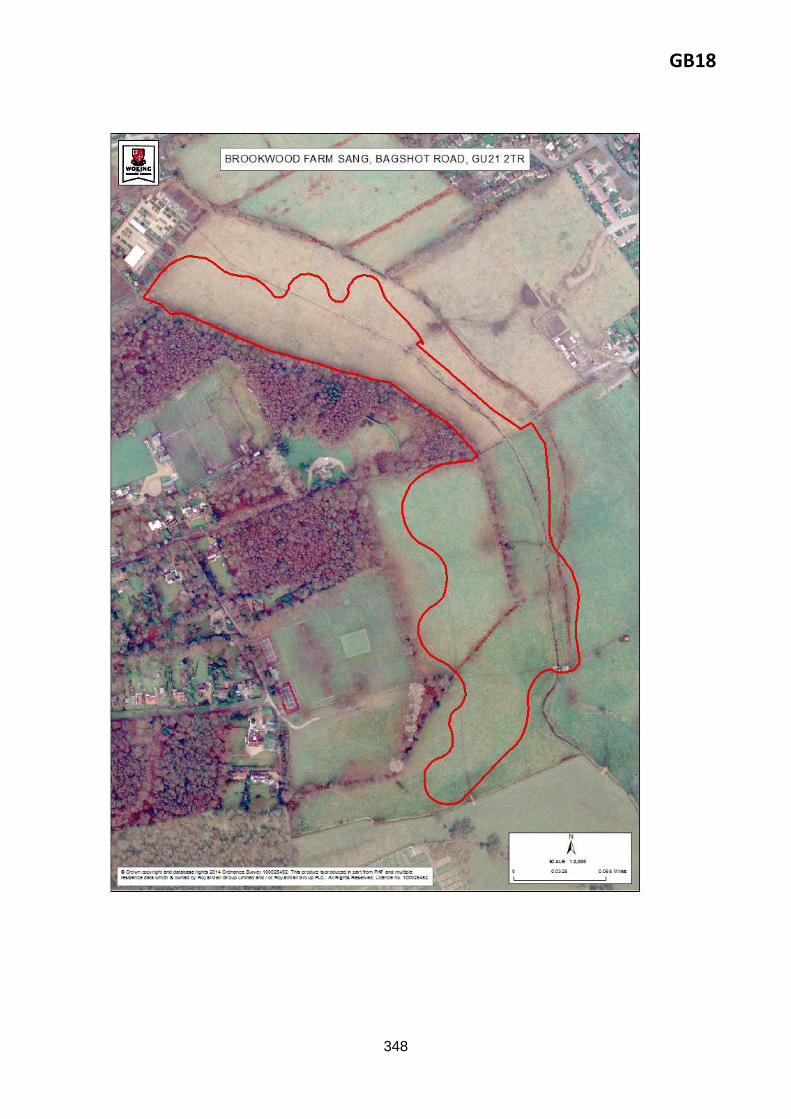
Proposal reference: GB18
Site address: Brookwood Farm SANG, Bagshot Road, Brookwood, GU21 2TR
GB18
348
GB18
349
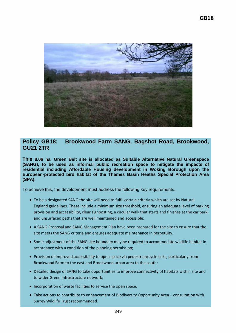
Policy GB18: Brookwood Farm SANG, Bagshot Road, Brookwood, GU21 2TR This 8.06 ha. Green Belt site is allocated as Suitable Alternative Natural Greenspace (SANG), to be used as informal public recreation space to mitigate the impacts of residential including Affordable Housing development in Woking Borough upon the European-protected bird habitat of the Thames Basin Heaths Special Protection Area (SPA). To achieve this, the development must address the following key requirements.
To be a designated SANG the site will need to fulfil certain criteria which are set by Natural
England guidelines. These include a minimum size threshold, ensuring an adequate level of parking
provision and accessibility, clear signposting, a circular walk that starts and finishes at the car park;
and unsurfaced paths that are well maintained and accessible;
A SANG Proposal and SANG Management Plan have been prepared for the site to ensure that the
site meets the SANG criteria and ensures adequate maintenance in perpetuity.
Some adjustment of the SANG site boundary may be required to accommodate wildlife habitat in
accordance with a condition of the planning permission;
Provision of improved accessibility to open space via pedestrian/cycle links, particularly from
Brookwood Farm to the east and Brookwood urban area to the south;
Detailed design of SANG to take opportunities to improve connectivity of habitats within site and
to wider Green Infrastructure network;
Incorporation of waste facilities to service the open space;
Take actions to contribute to enhancement of Biodiversity Opportunity Area – consultation with
Surrey Wildlife Trust recommended.

GB18
350
Reasoned justification: This land was approved as SANG as part of the Brookwood Farm development, in line with Core Strategy Policy CS8 and saved South East Plan Policy NRM6 Thames Basin Heaths Special Protection Area.
Details were set out in the planning application for development of the land at Brookwood Farm (permitted April 2013, PLAN/2012/0224, SHLAAKN062), currently under construction. This is a bespoke SANG associated with the residential scheme of 297 dwellings. Brookwood Farm is a Proposal Site identified in the Local Plan 1999. The SANG is to be located to the west of the site, creating a soft edge to the new scheme. The site is currently semi improved grassland with limited access. The site itself is well connected to other open spaces, including the existing Brookwood Country Park SANG and would make a positive contribution to the wider green infrastructure (GI) network.
The site would provide SPA mitigation for a capacity of 418 dwellings (provisional calculation, subject to the advice of Natural England).
This SANG will provide mitigation for the Brookwood Farm development (under construction).
The land would remain within the Green Belt.
Delivery arrangements:
A legal agreement has been signed which secures the delivery of the SANG in accordance with the SANG Proposal and Management Plan (these are appended to the legal agreement for PLAN/2012/0224). These have been informed by comments by Natural England, Surrey Wildlife Trust and the Environment Agency. Ongoing consultation with Natural England on outstanding matters.
Delivery secured through S106 in conjunction with planning permission PLAN/2012/0224. This new SANG is anticipated to come into use 2015+, subject to essential works being carried out.
Key evidence base:
Thames Basin Heaths Avoidance Strategy 2010-2015
Legal agreement for PLAN/2012/0224, appended SANG Proposal and SANG Management Plan
Green Infrastructure Strategy 2014
Sustainability appraisal
Habitat Regulations Assessment
Strategic Transport Assessment
Woking Borough Community Infrastructure Levy Regulation 123 list (2014)
Design SPD.

GB19
351
Mayford Sutton Green
Proposal reference: GB19
Site address: Mayford SANG, land to the south of Moor Lane, Mayford, Woking, GU22 9RB

GB19
352

GB19
353
Policy GB19: Mayford SANG, land to the south of Moor Lane, Mayford, Woking, GU22 9RB
This two part Green Belt site, totalling 17.4 ha, is allocated as Suitable Alternative Natural Greenspace (SANG), to be used as informal public recreation space to mitigate the impacts of residential including Affordable Housing development in Woking Borough upon the European-protected bird habitat of the Thames Basin Heaths Special Protection Area (SPA).
To achieve this, the development must address the following key requirements.
To be a designated SANG the site will need to fulfil certain criteria which are set by Natural
England guidelines. These include a minimum size threshold, ensuring an adequate level of parking
provision and accessibility, clear signposting, a circular walk that starts and finishes at the car park;
and unsurfaced paths that are well maintained and accessible;
Surrey Wildlife Trust has prepared a management plan for Westfield Common. A SANG Proposal
and SANG Management Plan should be prepared for the whole site, in consultation with Natural
England;
Specific considerations for this SANG include:
the provision of parking
the potential implications of the existing designations
exploring pedestrian and cycle accessibility between the site and the new Moor Lane

GB19
354
Reasoned justification: This land is envisaged for future SANG use, in line with Core Strategy Policy CS8 and saved South East Plan Policy NRM6 Thames Basin Heaths Special Protection Area.
The provision of SANG in this location offers the opportunity to improve linkages and accessibility between open spaces in this part of the Borough (particularly between the site and Gresham Mill).
The site is fairly narrow and linear. The northern part of the site is not considered suitable as a SANG as it has a distinct urban feel, although it provides a sufficient transitional zone between urban character to the north and the more rural character to the south, which the Council does feel could provide a SANG.
The site is owned by the Council and is an SNCI. The Council has recently adopted a Management Plan for Westfield Common, which identifies various works to be undertaken on the site in the next five years to enhance biodiversity and other general environmental improvements (benches, way markers).
development to the north of the site, and from Gresham Mill to the east of the site;
The following constraints will have to be addressed:
Part of the site is a SNCI - appropriate measures in place to conserve nature conservation interest
found in this area. Surrey Wildlife Trust should be consulted to ensure conservation interests are
safeguarded. Enhancement measures that would contribute to the biodiversity of the area are
encouraged. A Management Plan has been prepared for Westfield Common that identifies
management priorities for the next five years. Surrey Wildlife Trust will manage the
implementation of the plan on behalf of the Borough Council. The work program will be reviewed
annually as works progress and information evolves.
Part of the site is designated at a local level as the Westfield Common Site of Nature Conservation
Importance. Certain works will require the consent of DEFRA. Car parks and circular walks will in
particular require careful consideration. The designation of this site for SANG will need to ensure
that increased recreation by people and dogs do not adversely affect the nature conservation
interest.
The above constraints may result in these areas being excluded from inclusion within the SANG if
the designations affect the capacity to absorb new visitors;
Historical contaminative uses may have led to soil and groundwater contamination that will need
to be considered during any change of use of this site, dependant on detailed proposals and
consultation with Environmental Health and the Environment Agency. Investigation would be
required;
Explore potential to link this with land to the east (at Hersham Mill);
Detailed design of SANG to take opportunities to improve connectivity of habitats within site and
to wider GI network;
Incorporation of waste facilities to service the open space;
Appropriate measures to be put in place to preserve and enhance the biodiversity of the SNCI –
consult with Surrey Wildlife Trust and Natural England.

GB19
355
The site would provide SPA mitigation for a capacity of 901 dwellings (provisional calculation, subject to the advice of Natural England).
The land would remain within the Green Belt.
Delivery arrangements:
Funding for establishment of the site for SANG purposes will be secured through s106/CIL contributions. Ongoing maintenance through CIL contributions.
Key evidence base:
Thames Basin Heaths Avoidance Strategy 2010-2015
Green Infrastructure Strategy 2014
Sustainability appraisal
Habitat Regulations Assessment
Strategic Transport Assessment
Westfield Common Management Plan 2014
Letter from Natural England, August 2012
Design SPD.

GB20
356
Old Woking
Proposal reference: GB20
Site address: First SANG at Gresham Mill, High Street, Old Woking, GU22 9LH

GB20
357

GB20
358
Policy GB20: First SANG at Gresham Mill, High Street, Old Woking, GU22 9LH This 9.9 ha. Green Belt site is allocated as Suitable Alternative Natural Greenspace (SANG), to be used as informal public recreation space to mitigate the impacts of residential including Affordable Housing development in Woking Borough upon the European-protected bird habitat of the Thames Basin Heaths Special Protection Area (SPA).
To achieve this, the development must address the following key requirements.
The Council has committed to deliver the site as a SANG when it is transferred to its ownership. To
be a designated SANG this site will need to fulfil certain criteria which are set by Natural England
guidelines. These include a minimum size threshold, ensuring an adequate level of parking
provision and accessibility, clear signposting, a circular walk that starts and finishes at the car park;
and unsurfaced paths that are well maintained and accessible;
A SANG Proposal and SANG Management Plan has been/ should be prepared, in consultation with
Natural England;
There is potential for an element of flood attenuation on the site that may alleviate some of the
flooding issues in the area;
The following constraints would have to be addressed/ resolved;
Within Flood Zone 3 - therefore there is a high risk of flooding. Consideration of sustainable
drainage and flood attenuation within the landscape. Close consultation with the Environment
Agency required. A boardwalk/raised paths may be necessary to ensure that a circular walk is
accessible throughout the year;

GB20
359
Reasoned justification: This land is envisaged for future SANG use, in line with Core Strategy Policy CS8 and saved South East Plan Policy NRM6 Thames Basin Heaths Special Protection Area.
The TBHSPA Avoidance Strategy anticipates this site coming forward for SANG use. Paragraph 4.10 explains: ‘Martins Press, High Street, Old Woking – 13 hectares of SANG land will be provided. The SANG land is part of a planning application (reference 06/0538) for the redevelopment of a print works to form up to 88 residential units. A legal agreement has been signed whereby the site will be handed over to the Council and subsequently managed by the Council, becoming a SANG.
Details were set out in the planning application for development of the land at Gresham Mill / Martin’s Press PLAN/2006/0538, PLAN/2010/0234.
The site would provide SPA mitigation for a capacity of 674 dwellings. The Gresham Mill development commits 88, leaving capacity for 586 dwellings.
The land would remain within the Green Belt.
Delivery arrangements:
Landownership is due to pass to the Council from the developer;
Woking Borough Council also owns land to the west, there is potential to combine the areas and create a larger SANG in this area (see Proposal Site GB21)
Delivery expected by 2015/2016
Funding for establishment of the site for SANG purposes will be secured through s106/CIL contributions. Ongoing maintenance through CIL contributions.
Consider introducing sustainable drainage and flood attenuation within any landscape proposals;
Within Biodiversity Opportunity Area; consider opportunities to enhance biodiversity and habitat
creation in the area. Surrey Wildlife Trust should be consulted;
Historical contaminative uses may have led to soil and groundwater contamination that will need
to be considered during any change of use of this site, dependant on detailed proposals and
consultation with Environmental Health and the Environment Agency. Investigation would be
required.
Provision of improved accessibility to open space via pedestrian/cycle links – particularly from Old
Woking to north of site;
Design of SANG to pay regard to environmentally sensitive area of River Wey SNCI;
Detailed design of SANG to take opportunities to improve connectivity of habitats within site and
to wider GI network – particularly River Wey SNCI.
Design of development to pay regard to heritage assets and their setting, including locally listed
Gresham Press;
Incorporation of waste facilities to service the open space;
Take actions to contribute to enhancement of Biodiversity Opportunity Area – consultation with
Surrey Wildlife Trust recommended.
GB20
360
Key evidence base:
Thames Basin Heaths Avoidance Strategy 2010-2015
Green Infrastructure Strategy 2014
Sustainability appraisal
Habitat Regulations Assessment
Strategic Transport Assessment
Letter from Natural England, August 2012
Design SPD.

GB21
361
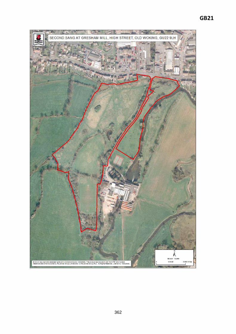
Proposal reference: GB21
Site address: Second SANG at Gresham Mill, High Street, Old Woking, GU22 9LH
GB21
362

GB21
363
Policy GB21: Second SANG at Gresham Mill, High Street, Old Woking, GU22 9LH This 9.52 ha. Green Belt site is allocated as Suitable Alternative Natural Greenspace (SANG), to be used as informal public recreation space to mitigate the impacts of residential including Affordable Housing development in Woking Borough upon the European-protected bird habitat of the Thames Basin Heaths Special Protection Area (SPA). To achieve this, the development must address the following key requirements.
To be a designated SANG this site will need to fulfil certain criteria which are set by Natural
England guidelines. These include a minimum size threshold, ensuring an adequate level of parking
provision and accessibility, clear signposting, a circular walk that starts and finishes at the car park;
and unsurfaced paths that are well maintained and accessible;
A SANG Proposal and SANG Management Plan should be prepared, in consultation with Natural
England;
The production of these will enable an appropriate tariff to be set;
Specific considerations for this SANG include design considerations such as sufficient screening in
relation to the adjoining development; the provision of parking; and the potential implications of
the existing designations. There is potential for an element of flood attenuation on the site that
may alleviate some of the flooding issues in the area;
The following constraints would have to be addressed/ resolved:
Part of the site is a SNCI - appropriate measures in place to conserve nature conservation interest

GB21
364
Reasoned justification: This land is envisaged for future SANG use, in line with Core Strategy Policy CS8 and saved South East Plan Policy NRM6 Thames Basin Heaths Special Protection Area.
The TBHSPA Avoidance Strategy anticipates the adjacent site to come forward for SANG use (see above). A legal agreement (PLAN/2006/0538) secures the transfer of this land to the Council. The Council also owns land to the west, which it anticipates will be combined with the forthcoming SANG to create one large SANG.
found in this area. Surrey Wildlife Trust should be consulted to ensure conservation interests are
safeguarded. The designation of this site for SANG will need to ensure that increased recreation
by people and dogs do not adversely affect the nature conservation interest;
Enhancement measures that would contribute to the biodiversity of the area are encouraged;
Part of the site is designated at a local level as Common land - certain works within Common Land
will require consent from DEFRA. Car parks and circular walks in particular will require careful
consideration;
The above constraints may require adjustment of the SANG boundary; additional research will be
required in this respect;
The site is within Flood Zone 3- therefore there is a risk of flooding. Consideration of sustainable
drainage and flood attenuation within the landscape are potential options. The provision of
footbridges to enable circular walks over water corridors also a consideration. Early engagement
with the Environment Agency required. A boardwalk/raised paths may be necessary to ensure that
a circular walk is accessible throughout the year;
Take actions to contribute to enhancement of Biodiversity Opportunity Area – consultation with
Surrey Wildlife Trust recommended;
Historical contaminative uses may have led to soil and groundwater contamination that will need
to be considered during any change of use of this site, dependant on detailed proposals and
consultation with Environmental Health and the Environment Agency. Investigation would be
required.
Consider introducing sustainable drainage and flood attenuation within any landscape proposals;
Provision of improved accessibility to open space via pedestrian/cycle links – particularly from Old
Woking to north of site, and Gresham Mill development;
Design of SANG to pay regard to environmentally sensitive areas of River Wey SNCI and Mill Moor
SNCI;
Design of SANG to retain and enhance protected tree belt to north west of site, subject to TPO;
Detailed design of SANG to take opportunities to improve connectivity of habitats within site and
to wider GI network
Design of development to pay regard to heritage assets and their setting, including locally listed
Gresham Press;
Incorporation of waste facilities to service the open space.
GB21
365
This would ensure a comprehensive scheme, which offers wider opportunities to militate against the impacts of residential development on the SPA. For example it would allow for improved ability to create a circular walk.
The site would provide SPA mitigation for a capacity of 493 dwellings (provisional calculation, subject to the advice of Natural England).
The land would remain within the Green Belt.
Delivery arrangements:
Part of the land is Surrey County common land and rest (the former Martins Press sports pitches) is now owned by Woking Borough Council;
Delivery of this second SANG site at Gresham Mill will be within the next five years;
Funding for establishment of the site for SANG purposes will be secured through s106/CIL contributions. Ongoing maintenance through CIL contributions.
Key evidence base:
Thames Basin Heaths Avoidance Strategy 2010-2015
Green Infrastructure Strategy 2014
Sustainability appraisal
Habitat Regulations Assessment
Strategic Transport Assessment
Letter from Natural England, August 2012
Design SPD.

GB22
366
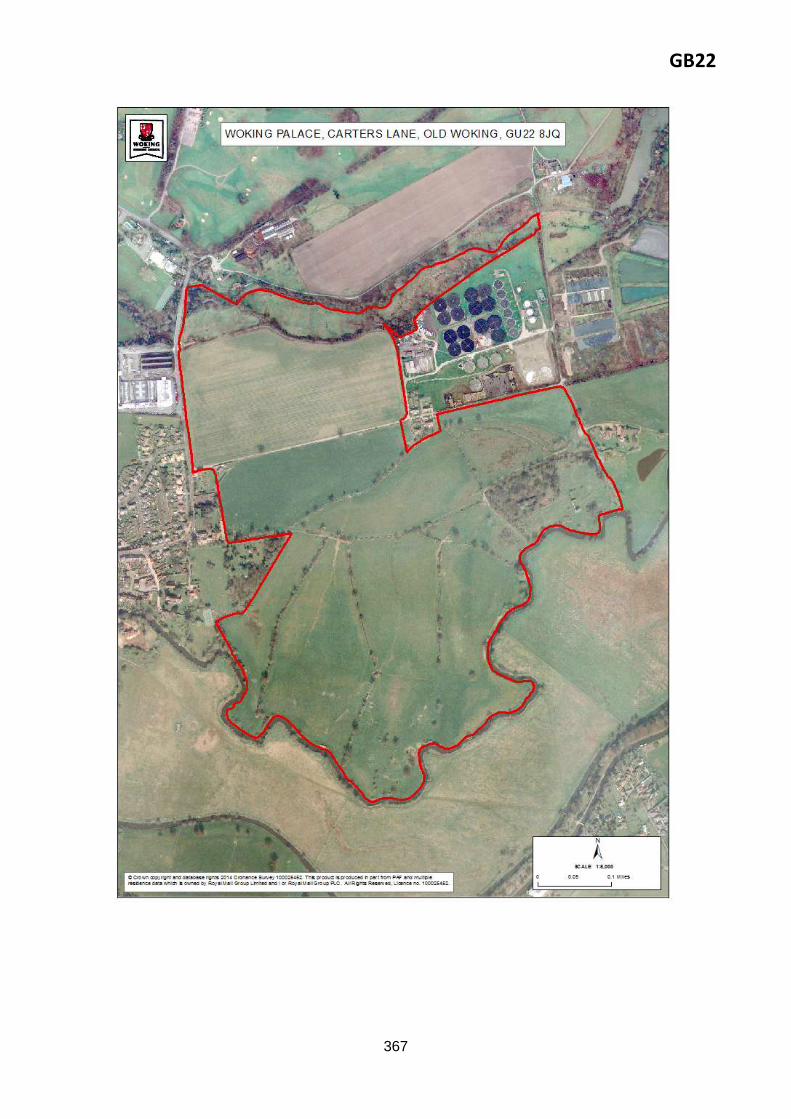
Proposal reference: GB22
Site address: Woking Palace, Carters Lane, Old Woking, GU22 8JQ
GB22
367
GB22
368
Policy GB22: Woking Palace, Carters Lane, Old Woking, GU22 8JQ
This 64.4ha site is allocated for use as Heritage Parkland/Country Park surrounding Woking Palace.
To achieve this, the development must address the following key requirements.
The Council would support the creation of a Country Park on land adjacent to Woking Palace
Scheduled Ancient Monument, as illustrated on the Proposals Map.
Proposals must pay particular attention to the sites’ Green Belt status, the setting and nature
conservation interests of the Wey and Hoe Stream, and the setting of the ancient monument.
Development should be sensitively designed to have minimal impact on the historic asset;
Restore or enhance historic features - for example the walls and ponds;
Improve accessibility to and within the site by all transport modes, including improvements on the
junction of the B382;
Include parking facilities which would have low visual impact on the surrounding landscape and
historic features;
Incorporate low key leisure, recreation and heritage uses that will have minimal impact on the
surrounding landscape;
Retain existing landscape features (including trees and hedges) to conserve and enhance
biodiversity on the site;
Create links to the wider Green Infrastructure network (including public rights of way);
Be sensitively designed to have minimal impact on the adjoining watercourses;
Submit an archaeological assessment in line with Core Strategy policy CS20; and
Be in keeping with other policies in the Development Plan for the area.
In addition to any assessments required by other Development Plan policies, planning applications
for this site should be accompanied by a heritage statement and archaeological assessment
indicating how the criteria in this policy have been addressed.
Historical contaminative uses may have led to soil and groundwater contamination that will need
to be considered during any change of use of this site, dependant on detailed proposals and
consultation with Environmental Health and the Environment Agency. Investigation would be
required;
Biodiversity improvements – the design solution should build in wildlife features/corridors;
Safe accesses for all modes (pedestrian, vehicular) will need to be identified.
Consider introducing sustainable drainage and flood attenuation within any landscape proposals
for the scheme – Flood Risk Assessment may be required;
Development of the site to incorporate low-key recreation and leisure uses that will have a
minimal impact on surrounding landscape;
GB22
369
Reasoned justification: In its mission to increase the recreational, educational and open space resources of the Borough, the Council would like to bring about the rejuvenation of Woking Palace – a Scheduled Ancient Monument.
Woking Palace comprises the remains of the built structures and also earth works from the moat, a copse and a group of fishponds. Particular importance is placed on the site because of its excellent survival, high diversity, enormous archaeological potential, historical association with royalty and amenity value. The Council supports the creation of a country park at Woking Palace and the adjoining area to help revitalise and restore this valuable historic asset, enhance biodiversity and to help meet the future open space and recreation needs of the Borough up to 2027, as identified in Core Strategy Policy CS17. The Council owns the ancient monument but not the surrounding land and would like to see it restored and brought into use through the creation of a Country Park and associated uses in this location. The area was identified in the previous Local Plan 1999 for a similar purpose.
The site was the former location of a moated manor house which was transformed into a Royal Palace in the medieval and post medieval period. Notable residents of the palace included Lady
Development to improve accessibility to and within the site by sustainable transport modes –
public footpaths, cycle routes, bus services to be created/improved;
Detailed design and site layout to take into account proximity of sewage works;
Retain, enhance and create habitats and features which have biodiversity value, including Hoe
Stream Fields SNCI, Oldhall Copse SNCI, and Roundbridge Farm SNCI;
Detailed design of open space to improve connectivity of habitats within site and to wider GI
network (e.g. by including GI corridors);
Provision of GI assets which demonstrate multi-functionality;
Surrey Wildlife Trust to be consulted with regards to Biodiversity Opportunity Area status;
Development to be sensitively designed to have minimal impact on important natural and historic
landscape (including consideration of lighting);
Development to seek to restore or enhance historic features;
Incorporate low-key leisure, recreation and heritage uses that will have minimal impact on the
surrounding landscape;
Development to seek to retain important landscape features (including trees and hedges) and
create new features;
Archaeological assessment to be conducted, and any appropriate mitigation measures to be
incorporated;
Design of development and site layout to pay regard to heritage assets and their setting.
Design of development should facilitate the reduction of waste by providing waste/recycling
facilities;
Design of development to pay regard to adjoining watercourses and retain undeveloped buffer
zones alongside them;
Retention and enhancement of public rights of way.
GB22
370
Margaret Beaufort, Henry VII and Henry VIII. At present, the only few built remains left are a few brick walls, a small stone building and a network of buried foundations. Access to the site is restricted most of the year except on a few open days where the public is invited to visit, and as such only a small number of people have had the opportunity to visit the valuable heritage asset. The isolation of the monument has led to security issues and some of the remaining buildings have been the target of arson attacks over recent years. The Council considers there to be opportunity to bring the monument and adjoining grounds into active use, which would encourage visitor numbers and add vitality to the asset, therefore reducing the vulnerability of the site to vandalism. The site could accommodate a range of low key leisure, recreation and heritage uses. The area is covered by a number of designations. It is within the Green Belt, is a Scheduled Ancient Monument with high archaeological potential, contains areas of nature conservation and is at risk of flooding. Therefore proposals will require careful consideration having regard to these, balancing the historic significance, ecological importance and economic growth. The Council will work closely with key stakeholders, including English Heritage, Natural England, interest groups such as Friends of Woking Palace and adjoining landowners and neighbours to develop an appropriate proposal for the site. Development into a Country Park will ensure positive benefits including provision of open space and recreation for the community, opportunities to improve Green Infrastructure components and the network for enhanced nature conservation and biodiversity, and the preservation and maintenance of important historical features. Improving accessibility to and within the site will be important. This includes access to the site and access within it. Junction improvements would be required on the B382 from Carters Lane, and footpath/cycle links within the site should improve accessibility to those surrounding the site. The Council will seek to secure the necessary land for the Country Park through negotiation. However, the use of compulsory purchase powers will be considered if necessary. Whilst presented under Section C, use of the site as Suitable Alternative Natural Greenspace (SANG) is not proposed at this time.
The land would remain within the Green Belt.
Delivery arrangements:
Funding for the creation of the Heritage / Country Park will be through CIL contributions.
Key evidence base:
Green Infrastructure Strategy
Friends of Woking Palace information at: www.woking-palace.org
Sustainability appraisal
Habitat Regulations Assessment
Strategic Transport Assessment
Local Plan 1999
Design SPD.
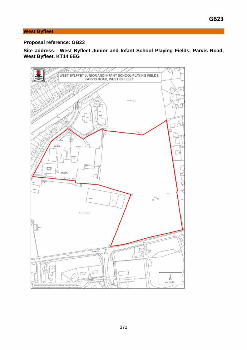
GB23
371
West Byfleet
Proposal reference: GB23
Site address: West Byfleet Junior and Infant School Playing Fields, Parvis Road, West Byfleet, KT14 6EG
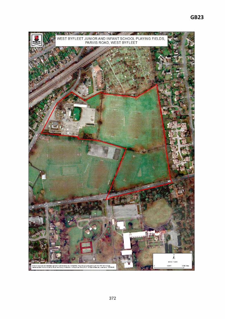
GB23
372

GB23
373
Reasoned justification: The Green Belt boundary review (GBBR) recommends exclusion of this land from the Green Belt paragraph 7.3.3 advises that it is ‘an area of public open space, a school and associated playing fields which are essentially part of the urban area of West Byfleet being contained by urban development on three sides and the Major developed site in the Green Belt at ‘Broadoaks’. It makes no contribution to Green Belt purposes’.
Taking into account other changes to the Green Belt boundary recommended by this Site Allocations DPD, would result in the formation of a Green Belt ‘island’, which would not be logical. Its exclusion from the Green Belt is therefore sought. This land would not be developed. It is existing open space associated with an educational use. Accordingly it is allocated for continued use as open space. Delivery arrangements:
None
Key evidence base:
Green Belt boundary review (Parcel 3 - Area A).
Policy GB23: West Byfleet Junior and Infant School Playing Fields, Parvis Road, West Byfleet, KT14 6EG
This 6.78ha site is excluded from the Green Belt and is allocated for open space.
To achieve this, the development must address the following key requirements.
Use of site development and site layout to pay regard to heritage assets and their setting.
Retention and enhancement of public rights of way.
374
Implementation and Monitoring of the Site Allocations This section sets out how the Site Allocations will be implemented and monitored. It shows how specific sites will be delivered, by whom and when. In some cases delivery will be assisted by additional guidance provided through Supplementary Planning Documents. There are many factors that will influence the implementation and delivery of the proposals set out in this document including land assembly, changes of ownership, funding and the economic conditions. To be effective a DPD must be deliverable.
Monitoring Preparation of a development plan document (DPD) is not a standalone activity. It is the beginning of a process of implementation that involves regularly checking how effective the plan is in delivering what it aims to achieve. For example, to consider the extent to which policies and sites are being implemented, to identify policies or sites that might need to be amended or replaced, to identify any unintended consequences, if assumptions or circumstances underlying a site’s allocation or a policy have changed and if any targets set are being met. Monitoring reveals any such delivery issues and allows adjustments to be made if required to ensure successful delivery of the plan. Monitoring the performance and effects of the Site Allocations DPD will be integral to its delivery. Monitoring will be reported annually, typically retrospectively considering the preceding full monitoring year (1 April to 31 March) or part of year (where a document is adopted part way through a year). The outcomes are presented in the Local Plan Monitoring Report, published on the Council’s website in December of each year. The annual Monitoring Report (AMR) in turn informs the timing and nature of future reviews of Local Development Documents like the Site Allocations DPD and the Core Strategy. The Council has a project management plan set out in the Local Development Scheme (LDS) for the preparation of its Local Development Documents. How the Site Allocations DPD has been prepared in accordance with timescales set out in the plan is the first stage of its monitoring. At this stage, the Site Allocations DPD has been prepared according to timescales in the plan. Monitoring of the delivery of sites is also essential for the Council to identify and maintain a continued supply of residential land, as required by national planning policy2. Through parallel monitoring of the Core Strategy, the Council also monitors the delivery of infrastructure such as transport improvements. Individual development sites allocated by the Site Allocations DPD contribute to delivery of the amount and types of development planned by the Core Strategy. Their delivery will contribute directly towards delivery of the overall planned growth to 2027 and will therefore be monitored simultaneously with the Core Strategy. The Core Strategy establishes an extensive monitoring framework to assess the delivery of strategic policies, and the Site Allocations DPD will be monitored against the monitoring indicators in the Core Strategy including those concerning residential completions, additional employment and town centre floorspace provision. In addition, progress on individual sites will be monitored against the capacity and phasing information set out under the Site Allocation ‘Proposal’ and ‘Delivery’ headings of the Site Allocations DPD.
2 National Planning Policy Framework (NPPF), https://www.gov.uk/government/publications/national-planning-
policy-framework--2
375
Implementation Delivery mechanisms Chapter 6 of the Core Strategy identifies the key mechanisms to deliver the Core Strategy, including through the Council’s own functions. These mechanisms will in turn deliver the Site Allocations / Site Allocations DPD. For example:
planning application process
developer contributions (see also ‘Infrastructure funding’ above)
Compulsory Purchase Powers
rationalisation of Public Sector Assets
publication of supplementary planning documents on key topics such as Climate Change, Affordable Housing Delivery and Design
subject to demonstrable market demand and the requirements of the Core Strategy, direct provision of developments through joint venture schemes - such as the Victoria Square Development - will be used to progress redevelopment quickly
other Council activities to proactively address key priorities such as Affordable Housing and economic growth and
those seeking to improve the quality of the living and working environment as a whole, such as public realm improvements in the Town Centre and the provision of new and improved green infrastructure networks (which help to create confidence
and encourage private investment).
There are a number of measures that could be taken to ‘unlock’ any development sites that have stalled. These might include land assembly or infrastructure provision. Delivery timing/ Phasing The development identified by the Site Allocations DPD will not be delivered in one go. Development sites will be delivered individually in response to the market, within the context of the Core Strategy and more detailed framework established by the DPD land allocations. The Council recognises that the nature and cost of development schemes will influence when specific schemes come forward in the short, medium or long term. Some schemes will need to be phased. The anticipated timing of delivery on each of the development sites is summarised in earlier Tables 2, 3 and 4. Each detailed Development Management Policy and Proposal Site in the draft Site Allocations DPD includes a section on ‘Delivery’. This explains how, when and by whom the policy will be implemented. Delivery partners The Council will work with developers and landowners (including its own housing delivery company Thameswey), infrastructure providers, Registered Providers and others to ensure effective and timely delivery of the Site Allocations. The public sector’s role will include: investment in infrastructure to help to create the necessary environment for policies and proposals to be delivered; direct investment in delivering some policies and proposals such as Affordable Housing and rationalisation of public sector assets to maximise their effective and efficient use; and disposal of assets for alternative uses or co-location for efficient use of land. Woking Borough Council and Surrey County Council will also ensure development meets all necessary standards and objectives.

376
The private and voluntary sectors will provide direct investment in land and buildings, whilst developers will also contribute directly towards infrastructure delivery through CIL. The Council will continue to work proactively in partnership to deliver projects of cross-boundary significance, such as the strategic monitoring and mitigation of Thames Basin Heaths Special Protection Areas and transport projects where Surrey County Council is the highway authority. Sustained engagement with relevant partners under the Duty to Cooperate has helped to shape the Site Allocations DPD and will continue to inform the identification of opportunities to deliver the development required in the Borough and in the wider housing and economic markets. Engagement with local communities Some Proposal Sites will require extensive consultation depending on their nature, location and sensitivity. The Council will ensure that public consultation is integral to both preparation of this Site Allocations DPD and, when adopted, to the delivery process. The Council will work closely with its partners to achieve this. More information is provided in the Statement of Community Involvement (SCI). Infrastructure funding The delivery of development needs to be supported by adequate infrastructure. The Council will ensure that development is supported by necessary infrastructure and/or financial contributions to infrastructure provision before planning permission is granted for sites allocated by the Site Allocations DPD and also those smaller development site opportunities also identified through the evidence base. The Infrastructure Delivery Plan (IDP) sets out what the infrastructure required to meet the levels of growth proposed in the Core Strategy, which the Site Allocations DPD seeks to deliver. This includes details of where and when the infrastructure will be provided, who it will be provided by and how it will be funded. As part of work to prepare the CIL, the Council used and updated the IDP to highlight the key areas of infrastructure required to support development over the next 10 years. The Community Infrastructure Levy (CIL) will contribute towards provision of this infrastructure. CIL will come into effect in Woking Borough on 1 April 2015. The adopted CIL Charging Schedule is supported by an indicative ‘Regulation 123’ list which clearly sets out infrastructure that will be funded through CIL. The CIL Infrastructure Funding Gap Topic Paper establishes the total cost of the infrastructure required to support the proposed development, and identifies other sources of funding, to determine the funding gap to which CIL will contribute. The Woking Joint Committee (including sub-committees) was established June 2014. The Committee is responsible for a number of areas previously considered under the former Surrey County Council Local Committee, as well as a number of new areas previously within the remit of Woking Borough Council. Local Borough and County councillors meet to discuss and decide jointly issues of relevance to the people who live, work or study in Woking. One of the Committee’s responsibilities is determining how certain funding will be spent, including CIL contributions. The ‘key requirements’ heading of each Policy explains, where known at this stage, the site-specific infrastructure required to deliver development of the site and/or the assessments that will be required to identify these.

377
Risk and contingencies The Council is working towards the comprehensive delivery of the policies and proposals of the Core Strategy. Delivery of the policies and development site proposals set out in this Site Allocations DPD represents a significant step towards this goal. It has no reason to believe that these will not be implemented in full. As the Core Strategy acknowledges, the Council does however accept that there could be circumstances where development fails to come forward for a number of reasons, some of which can be beyond its control. Where the Council is able to use its influence and power to enable the delivery of the Site Allocations DPD it will do so. The Core Strategy has an in-built mechanism to monitor performance through an Annual Monitoring Report. Generally, the outcome of this monitoring process will inform whether or not the Core Strategy and/or other complementary plans and strategies including the Site Allocations DPD should be reviewed. Any policies or land allocations are failing to be applied, or are rendered obsolete, will be picked up through monitoring and appropriate actions identified to address the issue, as explained above. At this stage, two potential areas of risk are identified, together with the contingency measures required to deal with them if they do occur:
(a) Failure of sites coming forward for residential and/or employment development due to difficulties of land assembly and/or residential and employment delivery falling behind the projected trajectory Windfall sites have not been counted when planning overall development supply through the Core Strategy. This therefore provides an allowance of flexibility for non-implementation of any particular site, as does the safeguarding of additional land at Pyrford (Proposal Site GB13, Land east of Upshot Lane and south of Aviary Road). The viability of all sites has been considered for al brownfield sites. The viability level has not been set at the margins of viability, this therefore builds in a viability cushion. In addition land values are continuing to rise, further assisting viability. At the end of three years after the adoption of the Core Strategy (after October 2015), the Council intends to undertake a comprehensive monitoring of the performance of residential and employment floorspace delivery. This monitoring will look at the cumulative delivery of residential and employment floorspace. If delivery is significantly behind the projected cumulative target over this period as set out in the housing trajectory and the Five Year Housing and Employment Land Supply Position Statements are not providing any evidence that this will be addressed in subsequent years, the Council will take steps to address these, as set out in paragraph 6.20 of the Core Strategy. If particular allocated sites are not coming forward for development, the Council will review their key site requirements, if required.
Through the Site Allocations DPD, the Council is safeguarding land at the locations explained in
Section B for long-term residential and associated development (between 2027 and 2040). Section
B also explains the mechanism for release of safeguarded land from the Green Belt.
(b) Infrastructure provision to support development The Council will continue to work in partnership with infrastructure providers and the Woking Joint
Committee to coordinate an effective and efficient delivery of infrastructure.
378
A significant proportion of the funding to deliver infrastructure will be secured in the form of
development contributions on the back of residential and employment development, as described
above.
Flexibility More detailed analysis is required to define the specific responsibilities of each landowner/ stakeholder and also the likely section 106 and CIL contributions that will apply. The Site Allocations DPD site allocations provide a framework, drafted to ensure clear planning policy direction yet sufficiently flexible to encourage the private sector to lead the delivery of each major development site, supported, facilitated and in some cases in legal partnership with the Council and other public sector stakeholders. Flexibility will also be improved by monitoring over time. Development viability The Council is confident that the sites allocated should be able to come forward to achieve positive viability, having regard to:
The viability of the Core Strategy, demonstrated by evidence to the satisfaction of the Examination Inspector;
The demonstrated viability of the Council’s Affordable Housing requirements;
The viability of the Community Infrastructure Levy (CIL) Charging Schedule, which will be reviews to reflect Green Belt sites following adoption of this DPD.
Nevertheless, the Core Strategy DPD provides scope for a case to be made if an applicant feels that the specific requirements for developing a particular site will make the development unviable. Very robust finance evidence will be required to justify any negotiation away from the requirements of the Core Strategy and the Site Allocations DPD. There is also flexibility built into specific strategic policies of the Core Strategy, such as Policy CS12 Affordable Housing, where a genuine viability concern exists. . The Council will expect development negotiations on specific sites to be supported by an open book financial appraisal process. The CIL rate, a mandatory requirement, will not be set at the margins of viability. It will build in sufficient viability cushion to ensure positive viability.

379
APPENDICES
Appendix 1 - Evidence base
Strategic context:
Core Strategy, Adopted Document
Proposals Map (including the Inset Map)
Local Development Scheme
Statement of Community Involvement (SCI)
Saved policies of the Woking Borough Local Plan
Woking Local Plan (1999)
National Planning Policy Framework (NPPF)
National Planning Practice Guidance (NPPG)
Core Strategy Examination Inspector’s Report
Community Infrastructure Levy (CIL) Examiner’s Report
Woking’s landscape and townscape:
Character Study
Green Belt:
Green Belt boundary review (GBBR)
Green Belt boundary review non-technical summary
Ministerial Statements Assessment Report
Homes:
West Surrey Strategic Housing Market Assessment (SHMA)
Housing Land Supply Position Statement Housing Land Supply Position Statement Annual
Strategic Housing Land Availability Assessment (SHLAA) Sustainable economic development:
Employment Land Review - Employment Position Paper
Employment Land Review – Market Appraisal
Economic Strategy
Town, District and Local Centres Study
Surrey Hotel Futures Surrey Hotel Futures
Employment Topic Paper
Biodiversity and nature conservation:
Biodiversity and Planning In Surrey

380
Strategic Access Management and Monitoring (SAMM) Tariff Guidance
Thames Basin Heaths Special Protection Areas Avoidance Strategy 2010-2015
Sites of Nature Conservation Importance (SNCI)
Open space, green infrastructure, sport and recreation:
Green Infrastructure Strategy
Greenspaces Development Plan
Open Space, Sports and Recreation Facilities Audit
Playing Pitch Strategy
Public Art Strategy
Play Strategy
Flooding and water management:
Strategic Flood Risk Assessment
Transport and accessibility:
Surrey Transport Assessment
The Surrey Transport Plan (Local Transport Plan Third Edition) LTP3
Congestion strategy
Rail strategy
Local Transport Strategy for Woking Borough
Transport and Accessibility Topic Paper / Technical Paper
Cumulative Assessment of Future Development Impacts on the Highway
Strategic transport assessment - Cumulative Assessment of Future Development Impacts on the Highway
Travel Smart
Parking Standards SPG
Infrastructure delivery:
Infrastructure Delivery Plan (IDP) (second draft)
Community Infrastructure Levy (CIL) – Adopted Charging Schedule
Community Infrastructure Levy (CIL) – Regulation 123 list
Community Infrastructure Levy - Topic Paper on Infrastructure Funding Gap
Surrey Infrastructure Capacity Study
Climate change:
Climate Change and Decentralised, Renewable and Low Carbon Evidence Base Climate Change Study
Sustainable construction
Renewable and low carbon energy generation
Climate Change Strategy

381
Climate Change supplementary planning document (SPD)
Air Quality Management Area (AQMA) re. Knaphill
Climate Change Study
Social and community infrastructure:
Social and Community Facilities Audit
Social and Community Infrastructure Requirements Study Social and Community Infrastructure Requirements.
382
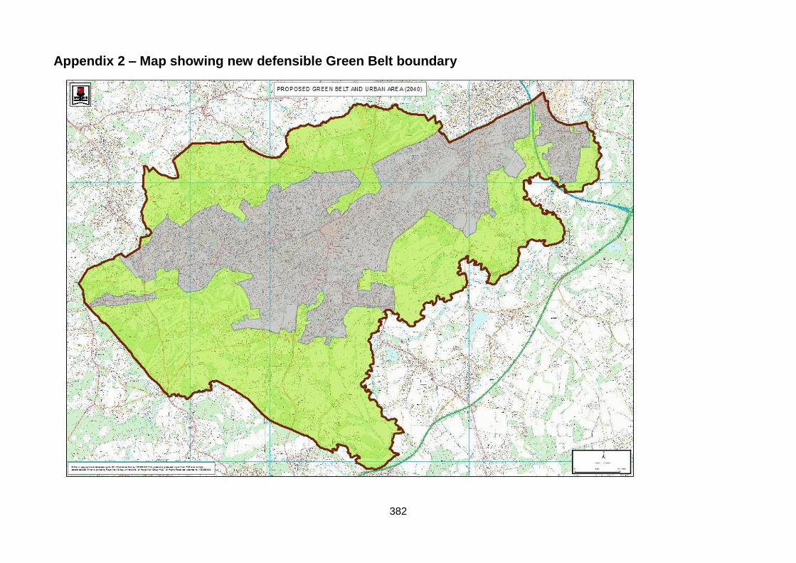
Appendix 2 – Map showing new defensible Green Belt boundary
383
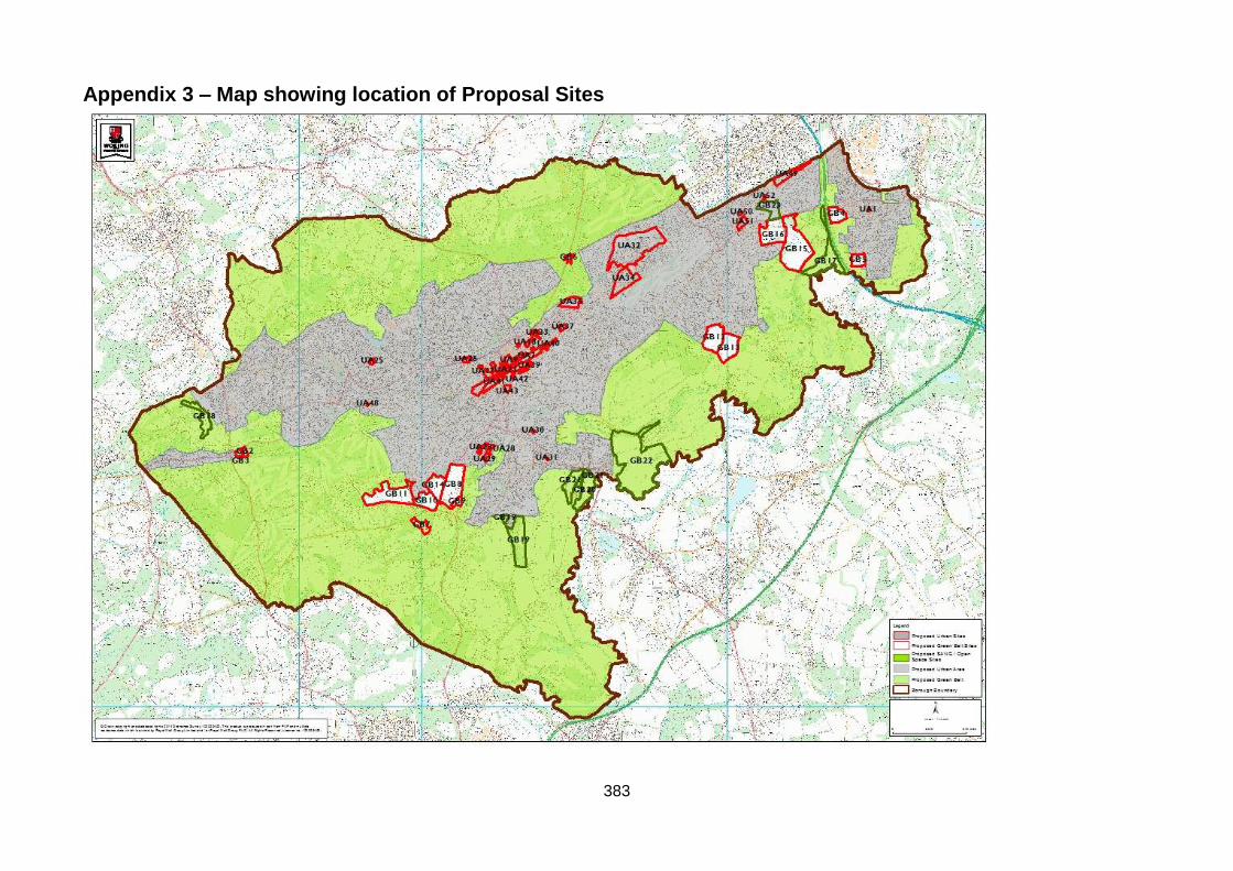
Appendix 3 – Map showing location of Proposal Sites

384
Appendix 4 – Table 5: Anticipated capacity of sites
Site Allocation ref. (n/a shows alternative sites)
Site address and reference Development uses appraised Development yields appraised
Urban Area – preferred options, recommended for allocation
UA1 SHLAABY046: Library, 71 High Road, Byfleet, KT14 7QN
Residential including Affordable Housing, replacement library, community use
12 dwellings, however the number of dwellings that can be accommodated on site is dependent on whether library is relocated elsewhere or replaced on site. Library /community floorspace reprovided.
UA2 SHLAAGE006: Trizancia House, Thomson House and 72 (Woodstead House), Chertsey Road, Woking, GU21 5BJ
Residential including Affordable Housing, offices
50 dwellings (SHLAA, 2014) 4000 sq.m net office floorspace (5000 sq.m gross).
UA3 SHLAAGE076: Chester House, 76-78 Chertsey Road, Woking, GU21 5BJ
Residential including Affordable Housing, offices
14 dwellings (SHLAA, 2014) At least 1000 sq.m net additional office floorspace (3000 sq.m gross)
UA4 SHLAAGE028: King’s Court, Church Street East, Woking, GU21 6HA
Residential including Affordable Housing, offices
14 dwellings (SHLAA, 2014) 3157 sq.m net additional office floorspace (4780 sq.m gross).
UA5 SHLAAGE026: The Cornerstone, The Broadway and Elizabeth House, Duke Street, GU21 5AS
Residential including Affordable Housing, offices
46 dwellings (SHLAA, 2014) 1000 additional sq.m office floorspace (6000 sq.m gross).

385
UA6 SHLAAGE011: Land at Albion House, High Street, Woking, GU21 6BD
Mixed use development to include approximately 100 dwellings including Affordable Housing, office and retail
100 dwellings (SHLAA, 2014) Office - existing floorspace should be re-provided Retail floorspace tbc
UA7 SHLAAGE031: 1-12 High Street and 26-34 Commercial Way, Woking, GU21 6EN
Residential including Affordable Housing, offices, retail
149 dwellings (SHLAA, 2014) 1600 sq.m office floorspace (2000 sq.m gross) Retail floorspace tbc
UA8 SHLAAGE029: 2-24 Commercial Way and 13-28 High Street, Woking, GU21 6BW
Residential including Affordable Housing, offices, retail
It is anticipated that the site would yield 200 dwellings (SHLAA, 2014). 400 sq.m office floorspace (2000 sq.m gross Retail floorspace tbc
UA9 SHLAAGE030: Victoria Square Development, Church Street West, Woking, GU21 6HD
Retail, hotel, medical/offices, residential, infrastructure (new Energy Centre, highway improvements, public open space)
392 dwellings (SHLAA, 2014) Additional retail floorspace (11,000 sq.m gross) Medical/office floorspace 190 hotel bed spaces Open space tbc ha.
UA10 SHLAAGE062: The Coign Church, 1-5 Church Street West and 5-19 Oaks Road, Woking, GU21 6DJ
Residential including Affordable Housing, community uses
It is anticipated that the site would yield 78 net additional dwellings (85 gross) (SHLAA, 2014) 2,948 sq.m community building (D1)
386
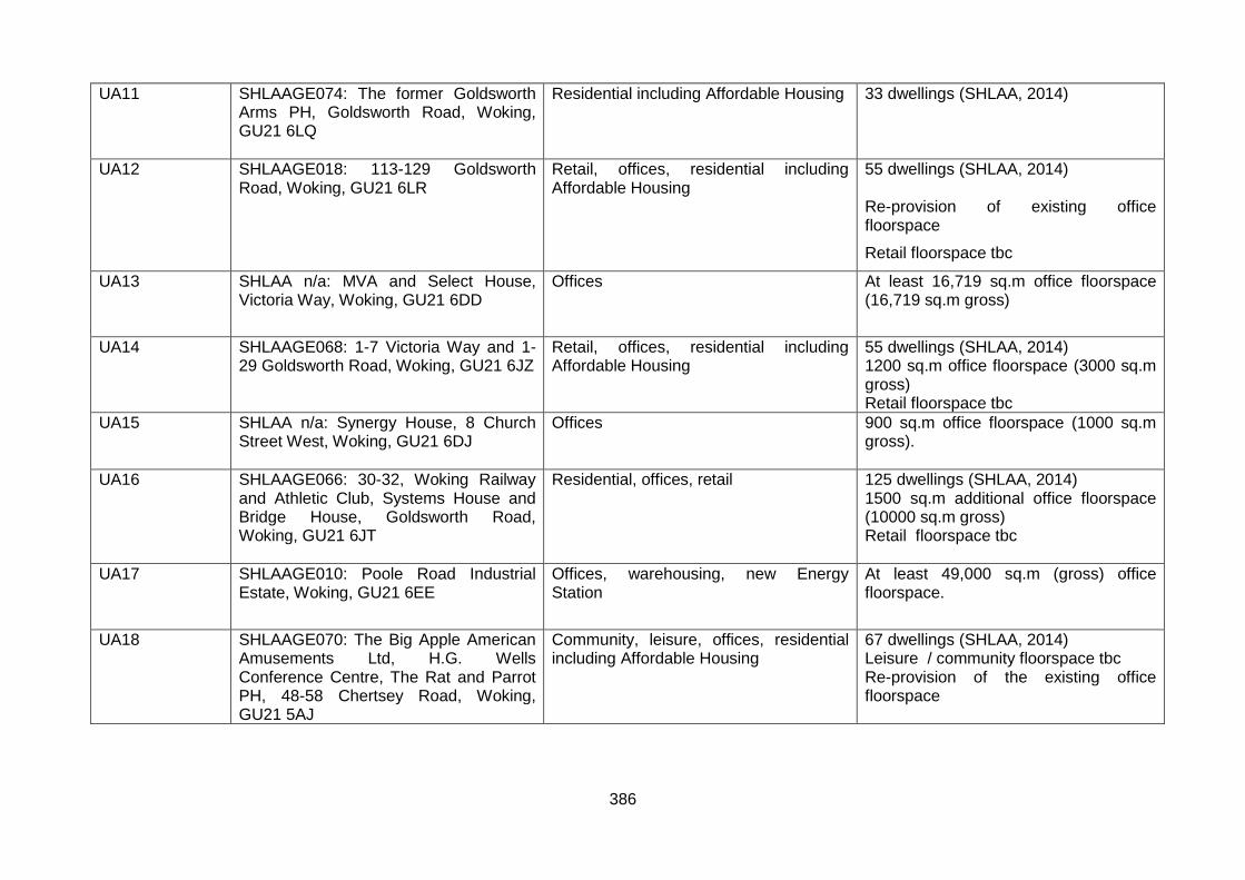
UA11 SHLAAGE074: The former Goldsworth Arms PH, Goldsworth Road, Woking, GU21 6LQ
Residential including Affordable Housing 33 dwellings (SHLAA, 2014)
UA12 SHLAAGE018: 113-129 Goldsworth Road, Woking, GU21 6LR
Retail, offices, residential including Affordable Housing
55 dwellings (SHLAA, 2014) Re-provision of existing office floorspace
Retail floorspace tbc
UA13 SHLAA n/a: MVA and Select House, Victoria Way, Woking, GU21 6DD
Offices At least 16,719 sq.m office floorspace (16,719 sq.m gross)
UA14 SHLAAGE068: 1-7 Victoria Way and 1-29 Goldsworth Road, Woking, GU21 6JZ
Retail, offices, residential including Affordable Housing
55 dwellings (SHLAA, 2014) 1200 sq.m office floorspace (3000 sq.m gross) Retail floorspace tbc
UA15 SHLAA n/a: Synergy House, 8 Church Street West, Woking, GU21 6DJ
Offices 900 sq.m office floorspace (1000 sq.m gross).
UA16 SHLAAGE066: 30-32, Woking Railway and Athletic Club, Systems House and Bridge House, Goldsworth Road, Woking, GU21 6JT
Residential, offices, retail 125 dwellings (SHLAA, 2014) 1500 sq.m additional office floorspace (10000 sq.m gross) Retail floorspace tbc
UA17 SHLAAGE010: Poole Road Industrial Estate, Woking, GU21 6EE
Offices, warehousing, new Energy Station
At least 49,000 sq.m (gross) office floorspace.
UA18 SHLAAGE070: The Big Apple American Amusements Ltd, H.G. Wells Conference Centre, The Rat and Parrot PH, 48-58 Chertsey Road, Woking, GU21 5AJ
Community, leisure, offices, residential including Affordable Housing
67 dwellings (SHLAA, 2014) Leisure / community floorspace tbc Re-provision of the existing office floorspace
387
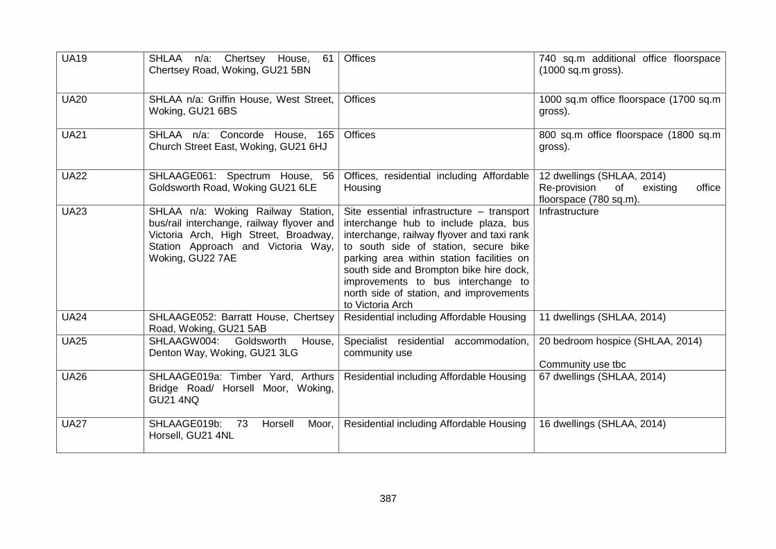
UA19 SHLAA n/a: Chertsey House, 61 Chertsey Road, Woking, GU21 5BN
Offices 740 sq.m additional office floorspace (1000 sq.m gross).
UA20 SHLAA n/a: Griffin House, West Street, Woking, GU21 6BS
Offices 1000 sq.m office floorspace (1700 sq.m gross).
UA21 SHLAA n/a: Concorde House, 165 Church Street East, Woking, GU21 6HJ
Offices 800 sq.m office floorspace (1800 sq.m gross).
UA22 SHLAAGE061: Spectrum House, 56 Goldsworth Road, Woking GU21 6LE
Offices, residential including Affordable Housing
12 dwellings (SHLAA, 2014) Re-provision of existing office floorspace (780 sq.m).
UA23 SHLAA n/a: Woking Railway Station, bus/rail interchange, railway flyover and Victoria Arch, High Street, Broadway, Station Approach and Victoria Way, Woking, GU22 7AE
Site essential infrastructure – transport interchange hub to include plaza, bus interchange, railway flyover and taxi rank to south side of station, secure bike parking area within station facilities on south side and Brompton bike hire dock, improvements to bus interchange to north side of station, and improvements to Victoria Arch
Infrastructure
UA24 SHLAAGE052: Barratt House, Chertsey Road, Woking, GU21 5AB
Residential including Affordable Housing
11 dwellings (SHLAA, 2014)
UA25 SHLAAGW004: Goldsworth House, Denton Way, Woking, GU21 3LG
Specialist residential accommodation, community use
20 bedroom hospice (SHLAA, 2014) Community use tbc
UA26 SHLAAGE019a: Timber Yard, Arthurs Bridge Road/ Horsell Moor, Woking, GU21 4NQ
Residential including Affordable Housing 67 dwellings (SHLAA, 2014)
UA27 SHLAAGE019b: 73 Horsell Moor, Horsell, GU21 4NL
Residential including Affordable Housing 16 dwellings (SHLAA, 2014)

388
UA28 SHLAAKW009a and SHLAAKW009b: Backland gardens of houses facing Ash Road, Hawthorn Road, Willow Way and Laburnum Road (Barnsbury sites 1 & 2), Barnsbury Farm Estate, Woking, GU22 0BN
Residential including Affordable Housing 55 dwellings (SHLAA, 2014)
UA29 SHLAAKW010: Backland gardens of houses facing Laburnum Road, Ash Road and Ash Close (Barnsbury Site 3), Barnsbury, Woking, GU22 0BU
Residential including Affordable Housing 12 dwellings (SHLAA, 2014)
UA30 SHLAAKW022: Elmbridge House, Elmbridge Lane, Kingfield, Woking, GU22 9AW
Residential 10 dwellings (SHLAA, 2014)
UA31 SHLAAKW036: Sherpa House, Kingfield Road, Kingfield, Woking, GU22 9EH
Residential, retail 10 dwellings (SHLAA, 2014) Retail floorspace tbc
UA32 SHLAAMS092: land within Sheerwater Priority Place , Woking, GU21 5RE
Residential including Affordable Housing, community uses, retail, open space and leisure facilities
250 dwellings (SHLAA, 2014) retail floorspace tbc community floorspace tbc open space and leisure uses tbc
UA33 SHLAAMS037: 101-121 Chertsey Road, Woking, GU21 5BG
Residential including Affordable Housing, offices
104 dwellings (SHLAA, 2014) Re-provision of the existing office floorspace.
UA34 SHLAA n/a: Forsyth Road Industrial Estate, Forsyth Road, Woking, GU21 5SU
Industrial, warehousing, offices if all the existing office use on the estate were to change to alternative B2/B8, 12000 sq.m of additional B2/B8 could be achieved on the site. Therefore, a conservative estimate of 6000 sq.m B2/B8 net is anticipated following the redevelopment of some of the office floorspace on the estate.

389
UA35 SHLAA n/a: Monument Way West Industrial Estate, Monument Way West, Woking, GU21 5LY
Industrial/warehousing, road infrastructure (fourth arm to the Sheerwater link road)
At least 3600 sq.m net/gross industrial/warehousing floorspace together with new road infrastructure.
UA36 SHLAAMS041: 29-31 Walton Road, Woking, GU21 5BX
Residential 10 dwellings (14 gross) (SHLAA, 2014)
UA37 SHLAAMS007: 1 to 5 Elliot Court, North Road, to the rear of 1 to 13 North Road, and 95-105 Maybury Road, Woking, GU21 5JL
Residential including Affordable Housing, offices (or an alternative employment use meeting Policy CS5)
77 dwellings (SHLAA, 2014) Re-provision of existing office floorspace
UA38 SHLAAMS039: Walton Road Youth Centre, Walton Road, Woking GU21 5DL
Residential including Affordable Housing, community facility (youth centre)
21 dwellings (SHLAA, 2014) Community facility – reprovision of existing floorspace
UA39 SHLAAMHE014: Royal Mail Sorting/Delivery Office, White Rose Lane, Woking, GU22 7AJ
Residential including Affordable Housing 88 dwellings (SHLAA, 2014)
UA40 SHLAAMHE011: Car park (east), Oriental Road, Woking, GU22 8BD
Residential including Affordable Housing, open space
250 dwellings (SHLAA, 2014)
UA41 SHLAAMHW014: Coal Yard/Aggregates Yard adjacent to the railway line, Guildford Road, Bradfield Close, Woking, GU22 7QE
Residential including Affordable Housing 422 dwellings (SHLAA, 2014)
UA42 SHLAAMHW029: 11-15 Guildford Road, Southern House, Jubilee House, Lynton House, Station Approach, Woking, GU22 7PX
Residential including Affordable Housing, offices, retail
90 dwellings (SHLAA, 2014) Retail floorspace tbc 1000 sq.m net additional (4000 sq.m gross) office floorspace
UA43 SHLAA n/a: Quadrant Court, Guildford Road, Woking, GU22 7QQ
Offices 1000 sq.m net additional office floorspace
UA44 SHLAAMHW030: Former St Dunstans, White Rose Lane, Woking, GU22 7AG
Retail, residential including Affordable Housing
91 dwellings (SHLAA, 2014) 161 sq.m net additional retail floorspace

390
UA45 SHLAAMHW031: Owen House and The Crescent, Heathside Crescent, Woking, GU22 7AG
Offices, residential including Affordable Housing
20 dwellings (SHLAA, 2014) Re-provision of the existing office floorspace
UA46 SHLAAMHW051: Somerset House, 1-18 Oriental Road, Heathside Crescent, Woking, GU22 7BAG
Offices, residential including Affordable Housing
10 net additional dwellings (based on 290 dph indicative density) Office floorspace tbc
UA47 SHLAAMHW043: Coroner’s Court (former Woking Magistrates Court), Station Approach, Woking, GU22 7YL
Offices, residential including Affordable Housing
48 dwellings (SHLAA, 2014) 2000 sq.m net additional office floorspace Re-provision of the Court (unless a suitable alternative location is identified).
UA48 SHLAASJHH011: Corner Garage, 16-18 St Johns Road, St Johns, GU21 7SA
Residential including Affordable Housing 11dwellings (SHLAA, 2014)
UA49 SHLAAWB003: Camphill Tip, Camphill Road, West Byfleet, KT14 6EW
Industrial 10,000 sq.m net/gross industrial floorspace (B2)
UA50 SHLAAWB014: Car park to east of Enterprise House, adjacent Social Club, Station Approach, West Byfleet, KT14 6NW
Retail, residential including Affordable Housing
12 dwellings (SHLAA, 2014) 181 sq.m net additional/gross retail floorspace
UA51 SHLAAWB023: Land at Station Approach, West Byfleet, KT14 6NG
Retail, community (library), offices, retail (Waitrose), residential including Affordable Housing
It is anticipated that the site would yield 91 dwellings (SHLAA, 2014). Community floorspace tbc (including retained or replacement Library) Retail floorspace tbc Office floorspace tbc

391
UA52 SHLAAWB050: Camphill Club and Scout Hut, Camphill Road, West Byfleet, KT14 6EF
Residential including Affordable Housing, community use
28 dwellings (SHLAA, 2014) Community floorspace tbc- reprovision of existing.
Urban Area – alternatives, not recommended for allocation
n/a SHLAAMS070 Former Woking Liberal Club, Walton Road, Woking, GU21 5DL
Residential including Affordable Housing 11 dwellings (SHLAA, 2014)
n/a SHLAAMS011: Former Gas Works, Boundary Road, Woking, GU21 5BX
Industrial use 3,604 sq.m warehouse (Employment Topic Paper)
n/a SHLAABR019: BT Telephone Exchange, Bagshot Road, Brookwood, GU21 2RP
Residential development including Affordable Housing
12 dwellings (SHLAA 2014)
n/a SHLAABY016: 94-100 Royston Road, Byfleet, KT14 7QE
Residential development including Affordable Housing
87 dwellings (SHLAA, 2014)
n/a SHLAABY017: Works at 11 Royston Road, Byfleet, KT14 7NX
Residential including Affordable Housing 46 dwellings (SHLAA, 2014)
n/a SHLAABY018: Wey Retail Park, Royston Road, Byfleet, KT14 7NY
Residential including Affordable Housing 65 dwellings (SHLAA, 2014)
n/a SHLAABY038: Land to rear of Byfleet Village Hall, High Road, Byfleet, KT14 7QL
Residential including Affordable Housing Yield in dwellings is tbc (SHLAA, 2014) however based on a density multiplier of 60 dph the site could accommodate 17 residential units.
n/a SHLAABY064: The Manor School, Magdalen Crescent, Byfleet, KT14 7SR
Residential including Affordable Housing 19 dwellings (SHLAA, 2014), based on a density multiplier of 35 dph.
n/a SHLAABY065: 96-120 Church Road, Byfleet, KT14 7NF
Residential 10 dwellings (SHLAA, 2014)
n/a SHLAABY031b: Churchill House and Beaver House, York Close, Byfleet, KT14 7HN
Residential including Affordable Housing 14 dwellings (SHLAA, 2014)
n/a SHLAAGE023: Part of car park at Goldsworth Park Centre, Denton Way, Woking, GU21 3LG
Residential 10 dwellings (SHLAA, 2014)
392
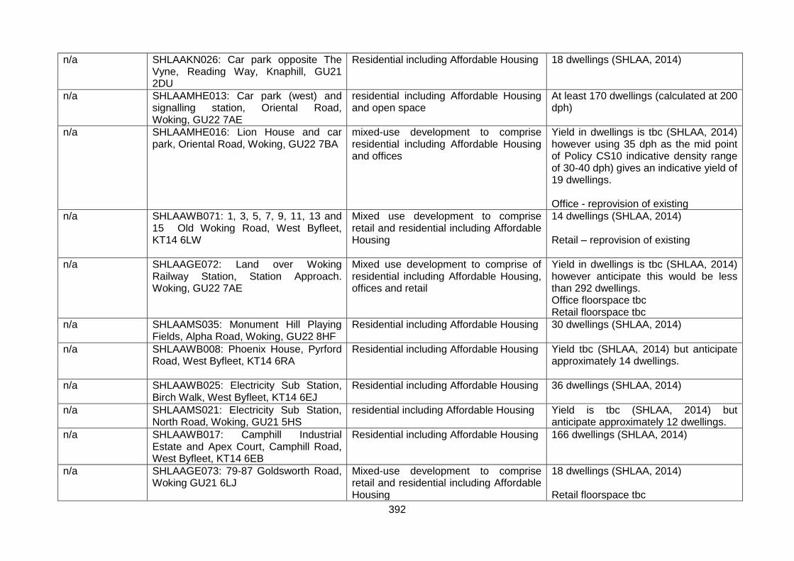
n/a SHLAAKN026: Car park opposite The Vyne, Reading Way, Knaphill, GU21 2DU
Residential including Affordable Housing 18 dwellings (SHLAA, 2014)
n/a SHLAAMHE013: Car park (west) and signalling station, Oriental Road, Woking, GU22 7AE
residential including Affordable Housing and open space
At least 170 dwellings (calculated at 200 dph)
n/a SHLAAMHE016: Lion House and car park, Oriental Road, Woking, GU22 7BA
mixed-use development to comprise residential including Affordable Housing and offices
Yield in dwellings is tbc (SHLAA, 2014) however using 35 dph as the mid point of Policy CS10 indicative density range of 30-40 dph) gives an indicative yield of 19 dwellings. Office - reprovision of existing
n/a SHLAAWB071: 1, 3, 5, 7, 9, 11, 13 and 15 Old Woking Road, West Byfleet, KT14 6LW
Mixed use development to comprise retail and residential including Affordable Housing
14 dwellings (SHLAA, 2014) Retail – reprovision of existing
n/a SHLAAGE072: Land over Woking Railway Station, Station Approach. Woking, GU22 7AE
Mixed use development to comprise of residential including Affordable Housing, offices and retail
Yield in dwellings is tbc (SHLAA, 2014) however anticipate this would be less than 292 dwellings. Office floorspace tbc Retail floorspace tbc
n/a SHLAAMS035: Monument Hill Playing Fields, Alpha Road, Woking, GU22 8HF
Residential including Affordable Housing 30 dwellings (SHLAA, 2014)
n/a SHLAAWB008: Phoenix House, Pyrford Road, West Byfleet, KT14 6RA
Residential including Affordable Housing Yield tbc (SHLAA, 2014) but anticipate approximately 14 dwellings.
n/a SHLAAWB025: Electricity Sub Station, Birch Walk, West Byfleet, KT14 6EJ
Residential including Affordable Housing 36 dwellings (SHLAA, 2014)
n/a SHLAAMS021: Electricity Sub Station, North Road, Woking, GU21 5HS
residential including Affordable Housing Yield is tbc (SHLAA, 2014) but anticipate approximately 12 dwellings.
n/a SHLAAWB017: Camphill Industrial Estate and Apex Court, Camphill Road, West Byfleet, KT14 6EB
Residential including Affordable Housing 166 dwellings (SHLAA, 2014)
n/a SHLAAGE073: 79-87 Goldsworth Road, Woking GU21 6LJ
Mixed-use development to comprise retail and residential including Affordable Housing
18 dwellings (SHLAA, 2014) Retail floorspace tbc
393
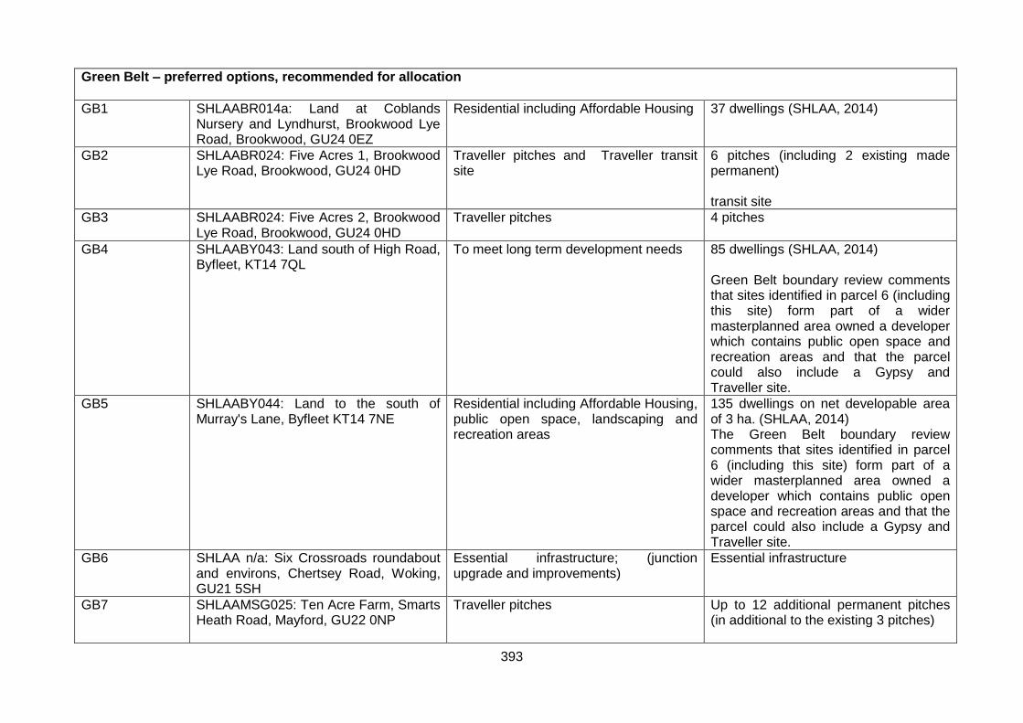
Green Belt – preferred options, recommended for allocation
GB1 SHLAABR014a: Land at Coblands Nursery and Lyndhurst, Brookwood Lye Road, Brookwood, GU24 0EZ
Residential including Affordable Housing 37 dwellings (SHLAA, 2014)
GB2 SHLAABR024: Five Acres 1, Brookwood Lye Road, Brookwood, GU24 0HD
Traveller pitches and Traveller transit site
6 pitches (including 2 existing made permanent) transit site
GB3 SHLAABR024: Five Acres 2, Brookwood Lye Road, Brookwood, GU24 0HD
Traveller pitches 4 pitches
GB4 SHLAABY043: Land south of High Road, Byfleet, KT14 7QL
To meet long term development needs 85 dwellings (SHLAA, 2014) Green Belt boundary review comments that sites identified in parcel 6 (including this site) form part of a wider masterplanned area owned a developer which contains public open space and recreation areas and that the parcel could also include a Gypsy and Traveller site.
GB5 SHLAABY044: Land to the south of Murray's Lane, Byfleet KT14 7NE
Residential including Affordable Housing, public open space, landscaping and recreation areas
135 dwellings on net developable area of 3 ha. (SHLAA, 2014) The Green Belt boundary review comments that sites identified in parcel 6 (including this site) form part of a wider masterplanned area owned a developer which contains public open space and recreation areas and that the parcel could also include a Gypsy and Traveller site.
GB6 SHLAA n/a: Six Crossroads roundabout and environs, Chertsey Road, Woking, GU21 5SH
Essential infrastructure; (junction upgrade and improvements)
Essential infrastructure
GB7 SHLAAMSG025: Ten Acre Farm, Smarts Heath Road, Mayford, GU22 0NP
Traveller pitches Up to 12 additional permanent pitches (in additional to the existing 3 pitches)

394
GB8 SHLAAMSG009: Nursery land adjacent to Egley Road, Mayford, GU22 0PL
Residential including Affordable Housing, recreational/open space and education
188 dwellings (SHLAA, 2014) Education – secondary school, up to 8 form entry Recreational/open space , including athletic track facility
GB9 SHLAAMSG030: Woking Garden Centre, Egley Road, Mayford, Woking, GU22 0NH
residential including Affordable Housing, retail and community use
50 dwellings (SHLAA, 2014) Retail/community facilities – floorspace tbc
GB10 SHLAAMSG016: Land to the north east of Saunders Lane, between Saunders Lane and Hook Hill Lane, Mayford, GU22 0NN
residential including Affordable Housing and open space
171 dwellings (SHLAA, 2014) 1.86 ha open space.
GB11 SHLAAMSG017: Land to the north west of Saunders Lane, Mayford, GU22 0NN
residential including Affordable Housing and open space
210 dwellings (SHLAA, 2014) 3.2 ha open space
GB12 SHLAAPY004: Land rear of 79-95 Lovelace Drive, Teggs Lane, Pyrford, Surrey, GU22 8QZ
Residential including Affordable Housing and open space
223 (SHLAA, 2014) 4 ha. open space.
GB13 SHLAAPY005: Land east of Upshot Lane and south of Aviary Road, Pyrford, GU22 8QZ
Residential including Affordable Housing and open space
200 dwellings (SHLAA, 2014) 7.9 ha. open space
GB14 SHLAASJHH035: Land adjacent to Hook Hill Lane, Hook Heath, Woking, GU22 0PS
Green infrastructure/open space Green infrastructure/open space
GB15 SHLAAWB019b: Land surrounding West Hall, Parvis Road, West Byfleet, KT14 6EY
Residential including Affordable Housing, open space and landscaping
592 dwellings (SHLAA, 2014) Tbc ha. open space

395
GB16 SHLAAWB004: Broadoaks, Parvis Road, West Byfleet, KT14 6LP
Quality offices and research premises, residential including Affordable Housing and housing to meet the accommodation needs of the elderly
Residential yield is tbc (SHLAA, 2014) Offices and research – employment development comprising around 16,722 sq.m offices). Potential to reuse existing floorspace and deliver remaining extant permitted floorspace, no additional capacity assumed beyond this by Employment Topic Paper)
GB17 SHLAA n/a: Byfleet SANG, land to the south of Parvis Road, Byfleet, KT14 7AB
Suitable Accessible Natural Greenspace (SANG)
1.5 hectare SANG
GB18 SHLAA n/a: Brookwood Farm SANG, Bagshot Road, Brookwood, GU21 2TR
Suitable Accessible Natural Greenspace (SANG)
8.06 hectare SANG
GB19 SHLAA n/a: Mayford SANG, land to the south of Moor Lane, Mayford, Woking, GU22 9RB
Suitable Accessible Natural Greenspace (SANG)
17.4 hectare SANG
GB20 SHLAA n/a: First SANG at Gresham Mill, High Street, Old Woking, GU22 9LH
Suitable Accessible Natural Greenspace (SANG)
9.9 hectare SANG
GB21 SHLAA n/a: Second SANG at Gresham Mill, High Street, Old Woking, GU22 9LH
Suitable Accessible Natural Greenspace (SANG)
9.52 hectare SANG
GB22 SHLAA n/a: Woking Palace, Carters Lane, Old Woking, GU22 8JQ
Heritage Parkland/Country Park 65.7 ha. open space / country park
GB23 SHLAA n/a West Byfleet Junior and Infant School Playing Fields, Parvis Road, West Byfleet, KT14 6EG
Open space 6.42 ha. open space
Green Belt – alternatives, not recommended for allocation
n/a SHLAABR021: The Meadows, Bagshot Road, Brookwood, GU21 2RP
Residential including Affordable Housing Yield is tbc (SHLAA, 2014), however around 15 residential dwellings are calculated at an indicative density of 30dph.
n/a SHLAABR0030: Blackhorse Road and Heath House Road, Brookwood, GU22 0QT
Residential including Affordable Housing Yield is tbc (SHLAA, 2014) however around 12 residential dwellings are calculated at an indicative density of 30dph, based on the total site area.
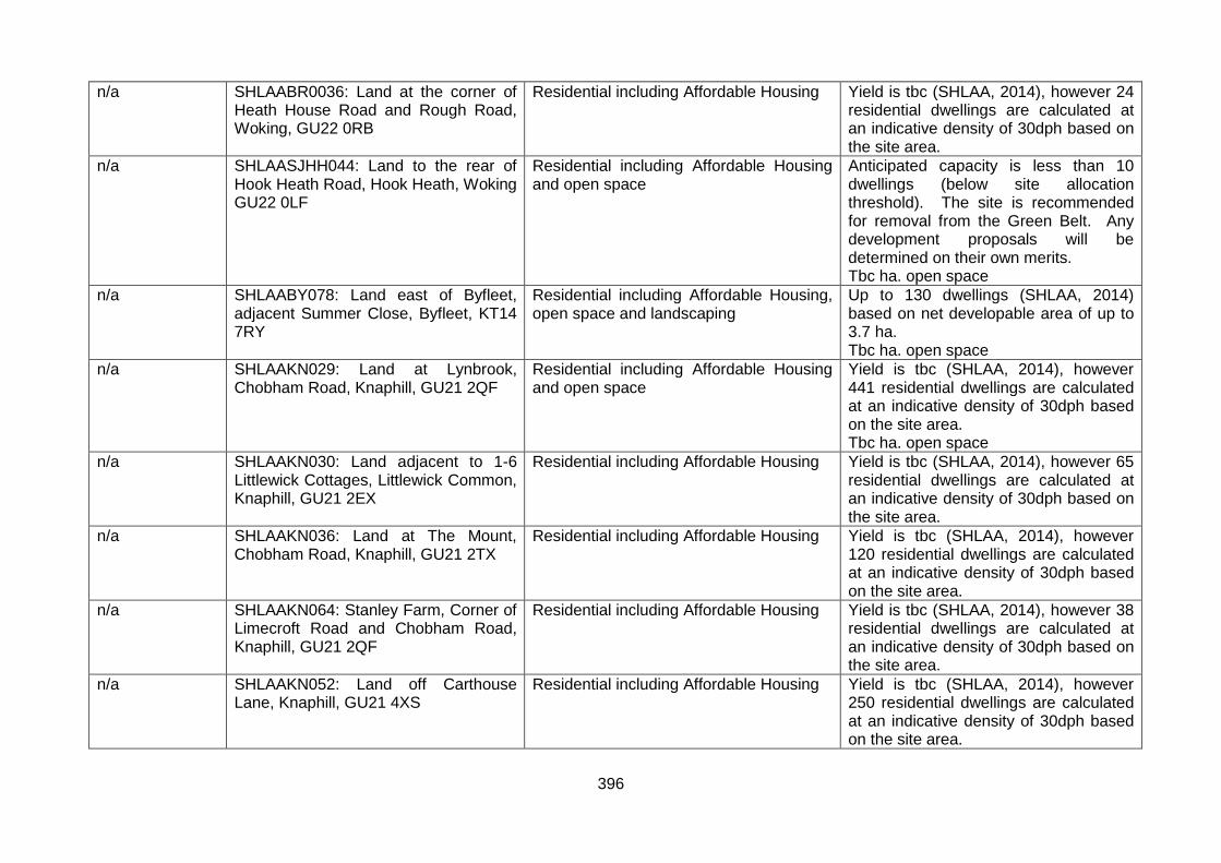
396
n/a SHLAABR0036: Land at the corner of Heath House Road and Rough Road, Woking, GU22 0RB
Residential including Affordable Housing Yield is tbc (SHLAA, 2014), however 24 residential dwellings are calculated at an indicative density of 30dph based on the site area.
n/a SHLAASJHH044: Land to the rear of Hook Heath Road, Hook Heath, Woking GU22 0LF
Residential including Affordable Housing and open space
Anticipated capacity is less than 10 dwellings (below site allocation threshold). The site is recommended for removal from the Green Belt. Any development proposals will be determined on their own merits. Tbc ha. open space
n/a SHLAABY078: Land east of Byfleet, adjacent Summer Close, Byfleet, KT14 7RY
Residential including Affordable Housing, open space and landscaping
Up to 130 dwellings (SHLAA, 2014) based on net developable area of up to 3.7 ha. Tbc ha. open space
n/a SHLAAKN029: Land at Lynbrook, Chobham Road, Knaphill, GU21 2QF
Residential including Affordable Housing and open space
Yield is tbc (SHLAA, 2014), however 441 residential dwellings are calculated at an indicative density of 30dph based on the site area. Tbc ha. open space
n/a SHLAAKN030: Land adjacent to 1-6 Littlewick Cottages, Littlewick Common, Knaphill, GU21 2EX
Residential including Affordable Housing Yield is tbc (SHLAA, 2014), however 65 residential dwellings are calculated at an indicative density of 30dph based on the site area.
n/a SHLAAKN036: Land at The Mount, Chobham Road, Knaphill, GU21 2TX
Residential including Affordable Housing Yield is tbc (SHLAA, 2014), however 120 residential dwellings are calculated at an indicative density of 30dph based on the site area.
n/a SHLAAKN064: Stanley Farm, Corner of Limecroft Road and Chobham Road, Knaphill, GU21 2QF
Residential including Affordable Housing Yield is tbc (SHLAA, 2014), however 38 residential dwellings are calculated at an indicative density of 30dph based on the site area.
n/a SHLAAKN052: Land off Carthouse Lane, Knaphill, GU21 4XS
Residential including Affordable Housing Yield is tbc (SHLAA, 2014), however 250 residential dwellings are calculated at an indicative density of 30dph based on the site area.

397
n/a SHLAABY069: Byfleet Mill, Mill Lane, Byfleet, KT14 7RR
Residential including Affordable Housing Yield is tbc (SHLAA, 2014), however 111 residential dwellings are calculated at an indicative density of 30dph based on the net site area of 3.7 ha.
n/a SHLAABY073: Land to the south of Murrays Lane, Byfleet, KT14 7NE
Residential accommodation for the Traveller community
4 pitches
n/a SITE/0090/BYFL, , Byfleet, KT14 7NE Community facility (scout hut), open space and agricultural/grazing
4.2 ha open space or grazing / agricultural Scout hut – as permitted
n/a SHLAAHEW006: Woodham Court, Martyrs Lane, Woking, GU21 5NJ
Mixed-use development to comprise of residential including Affordable Housing and research and development (materials and science related)
Yield is tbc (SHLAA, 2014), however 105 residential dwellings are calculated at an indicative density of 30dph based on the total site area. Specialised light industrial units – floorspace tbc
n/a SHLAAHEW016: Land adjacent to 462 Woodham Lane, Woking, KT15 3QA
Residential including Affordable Housing Yield is tbc (SHLAA, 2014), however 59 residential dwellings are calculated at an indicative density of 30dph based on the site area.
n/a SHLAAHEW027: Land to the east of Martyrs Lane, Woking, GU21 5NJ
Residential including Affordable Housing Yield is tbc (SHLAA, 2014), however up to 270 residential dwellings are calculated at an indicative density of 30dph based on total site area (although developable area could be less).
n/a SHLAA n/a: Hoe Valley SANG, Westfield Avenue, Woking, GU22 9PG
Suitable Accessible Natural Greenspace (SANG)
Tbc hectare SANG
n/a SHLAAMSG010: Compound, New Lane, Sutton Green, GU4 7QF
Residential accommodation for the Traveller community
Estimate 3 pitches
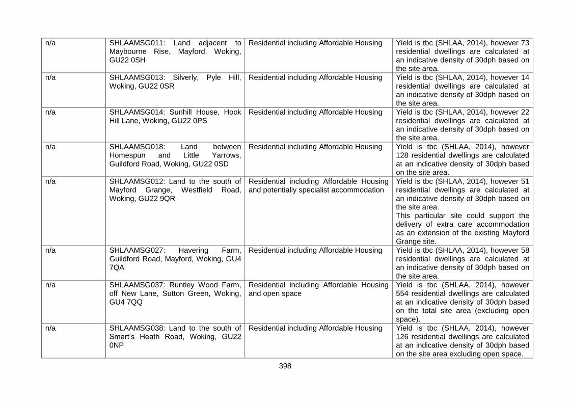
398
n/a SHLAAMSG011: Land adjacent to Maybourne Rise, Mayford, Woking, GU22 0SH
Residential including Affordable Housing Yield is tbc (SHLAA, 2014), however 73 residential dwellings are calculated at an indicative density of 30dph based on the site area.
n/a SHLAAMSG013: Silverly, Pyle Hill, Woking, GU22 0SR
Residential including Affordable Housing Yield is tbc (SHLAA, 2014), however 14 residential dwellings are calculated at an indicative density of 30dph based on the site area.
n/a SHLAAMSG014: Sunhill House, Hook Hill Lane, Woking, GU22 0PS
Residential including Affordable Housing Yield is tbc (SHLAA, 2014), however 22 residential dwellings are calculated at an indicative density of 30dph based on the site area.
n/a SHLAAMSG018: Land between Homespun and Little Yarrows, Guildford Road, Woking, GU22 0SD
Residential including Affordable Housing Yield is tbc (SHLAA, 2014), however 128 residential dwellings are calculated at an indicative density of 30dph based on the site area.
n/a SHLAAMSG012: Land to the south of Mayford Grange, Westfield Road, Woking, GU22 9QR
Residential including Affordable Housing and potentially specialist accommodation
Yield is tbc (SHLAA, 2014), however 51 residential dwellings are calculated at an indicative density of 30dph based on the site area. This particular site could support the delivery of extra care accommodation as an extension of the existing Mayford Grange site.
n/a SHLAAMSG027: Havering Farm, Guildford Road, Mayford, Woking, GU4 7QA
Residential including Affordable Housing Yield is tbc (SHLAA, 2014), however 58 residential dwellings are calculated at an indicative density of 30dph based on the site area.
n/a SHLAAMSG037: Runtley Wood Farm, off New Lane, Sutton Green, Woking, GU4 7QQ
Residential including Affordable Housing and open space
Yield is tbc (SHLAA, 2014), however 554 residential dwellings are calculated at an indicative density of 30dph based on the total site area (excluding open space).
n/a SHLAAMSG038: Land to the south of Smart’s Heath Road, Woking, GU22 0NP
Residential including Affordable Housing Yield is tbc (SHLAA, 2014), however 126 residential dwellings are calculated at an indicative density of 30dph based on the site area excluding open space.
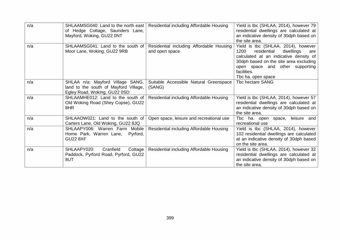
399
n/a SHLAAMSG040: Land to the north east of Hedge Cottage, Saunders Lane, Mayford, Woking, GU22 0NT
Residential including Affordable Housing Yield is tbc (SHLAA, 2014), however 79 residential dwellings are calculated at an indicative density of 30dph based on the site area.
n/a SHLAAMSG041: Land to the south of Moor Lane, Woking, GU22 9RB
Residential including Affordable Housing and open space
Yield is tbc (SHLAA, 2014), however 1200 residential dwellings are calculated at an indicative density of 30dph based on the site area excluding open space and other supporting facilities. Tbc ha. open space
n/a SHLAA n/a: Mayford Village SANG, land to the south of Mayford Village, Egley Road, Woking, GU22 0SD
Suitable Accessible Natural Greenspace (SANG)
Tbc hectare SANG
n/a SHLAAMHE012: Land to the south of Old Woking Road (Shey Copse), GU22 8HR
Residential including Affordable Housing Yield is tbc (SHLAA, 2014), however 57 residential dwellings are calculated at an indicative density of 30dph based on the site area.
n/a SHLAAOW021: Land to the south of Carters Lane, Old Woking, GU22 8JQ
Open space, leisure and recreational use Tbc ha. open space, leisure and recreational use
n/a SHLAAPY006: Warren Farm Mobile Home Park, Warren Lane, Pyrford, GU22 8XF
Residential including Affordable Housing Yield is tbc (SHLAA, 2014), however 102 residential dwellings are calculated at an indicative density of 30dph based on the site area.
n/a SHLAAPY020: Cranfield Cottage Paddock, Pyrford Road, Pyrford, GU22 8UT
Residential including Affordable Housing Yield is tbc (SHLAA, 2014), however 32 residential dwellings are calculated at an indicative density of 30dph based on the site area.

400
Appendix 5 – Table 6: Site Allocations DPD delivery of the Core Strategy
Table 6 below identifies the principal Core Strategy policies and strategic objectives that each site allocation will assist in delivering:
Core Strategy policies CS1 A spatial strategy for Woking Borough CS2 Woking Town Centre CS3 West Byfleet District Centre CS4 Local Neighbourhood Centres Shopping Parades CS5 Priority Places CS6 Green Belt CS7 Biodiversity and nature conservation CS8 Thames Basin Heaths Special Protection Areas CS9 Flooding and water management CS10 Housing provision and distribution CS11 Housing mix CS12 Affordable housing CS13 Older people and vulnerable groups CS14 Gypsies Travellers and Travelling Showpeople CS15 Sustainable economic development CS16 Infrastructure delivery CS17 Open space green infrastructure sport recreation CS18 Transport and accessibility CS19 Social and community infrastructure CS20 Heritage and conservation CS21 Design CS22 Sustainable construction CS23 Renewable and low carbon energy generation CS24 Woking’s landscape and townscape Core Strategy objectives Objective 1 Diverse range of development in Woking Town Centre Objective 2 Enable attractive and sustainable development of district and local centres Objective 3 Enable provision of well designed homes Objective 4 Protect integrity of the Green Belt Objective 5 Enable a buoyant local economy Objective 6 Lead the way in high quality sustainable development Objective 7 Maintain and improve air and water quality Objective 8 Encourage high quality design buildings neighbourhoods Objective 9 Ensure provision of community infrastructure Objective 10 Work in partnership with Surrey County Council other stakeholders Objective 11 Provide integrated effective transport interchange Objective 12 Preserve enhance cultural historic biodiversity geodiversity Objective 13 Significantly reduce absolute and relative deprivation

401
Proposal reference
Site address Delivers Core Strategy policies (in addition to CS1, CS9, CS13, CS18, CS20, CS21, CS22, CS23, CS24 and CS25 which all are expected to deliver)
Delivers Core Strategy objectives (in addition to objectives 6, 7, 8, 10 and 12 to which all developments are expected to contribute)
UA1 Library, 71 High Road, Byfleet, KT14 7QN
CS10 Housing provision and distribution, CS11 Housing mix, CS12 Affordable housing, CS19 Social and community infrastructure, CS4 Local Neighbourhood Centres Shopping Parades
Objective 2 Enable attractive and sustainable development of district and local centres, Objective 9 Ensure provision of community infrastructure, Objective 9 Ensure provision of community infrastructure, Objective 3 Enable provision of well designed homes
UA2 Trizancia House, Thomsen House & Woodstead House 72, Chertsey Road
CS10 Housing provision and distribution, CS11 Housing mix, CS12 Affordable housing, CS15 Sustainable economic development, CS2 Woking Town Centre
Objective 1 Diverse range of development in Woking Town Centre, Objective 5 Enable a buoyant local economy, Objective 3 Enable provision of well designed homes
UA3 Chester House, 76-78 Chertsey Road, Woking, GU21 5BJ
CS15 Sustainable economic development Objective 5 Enable a buoyant local economy
UA4 Kings Court, Church Street East, Woking, GU21 6HA
CS10 Housing provision and distribution, CS11 Housing mix, CS12 Affordable housing, CS15 Sustainable economic development, CS2 Woking Town Centre
Objective 1 Diverse range of development in Woking Town Centre, Objective 5 Enable a buoyant local economy, Objective 3 Enable provision of well designed homes
UA5 The Cornerstone, The Broadway and Elizabeth House, Duke Street, Woking, GU21 5AS
CS10 Housing provision and distribution, CS11 Housing mix, CS12 Affordable housing, CS15 Sustainable economic development, CS2 Woking Town Centre
Objective 1 Diverse range of development in Woking Town Centre, Objective 5 Enable a buoyant local economy, Objective 3 Enable provision of well designed homes
UA6 Land at Albion House, High Street, Woking, GU21 6BD
CS10 Housing provision and distribution, CS11 Housing mix, CS12 Affordable housing, CS15 Sustainable economic development
Objective 5 Enable a buoyant local economy, Objective 3 Enable provision of well designed homes

402
Proposal reference
Site address Delivers Core Strategy policies (in addition to CS1, CS9, CS13, CS18, CS20, CS21, CS22, CS23, CS24 and CS25 which all are expected to deliver)
Delivers Core Strategy objectives (in addition to objectives 6, 7, 8, 10 and 12 to which all developments are expected to contribute)
UA7 1-12 High Street and 26-34 Commercial Way, Woking, GU21 6EN
CS10 Housing provision and distribution, CS11 Housing mix, CS12 Affordable housing, CS15 Sustainable economic development
Objective 5 Enable a buoyant local economy, Objective 3 Enable provision of well designed homes
UA8 2-24 Commercial Way and 13-28 High Street, Woking, GU21 6BW
CS10 Housing provision and distribution, CS11 Housing mix, CS12 Affordable housing, CS15 Sustainable economic development
Objective 5 Enable a buoyant local economy, Objective 3 Enable provision of well designed homes
UA9 Victoria Square Development, Church Street West, Woking, GU21 6HD
CS10 Housing provision and distribution, CS11 Housing mix, CS12 Affordable housing, CS15 Sustainable economic development, CS17 Open space green infrastructure sport recreation, CS2 Woking Town Centre
Objective 1 Diverse range of development in Woking Town Centre, Objective 5 Enable a buoyant local economy, Objective 3 Enable provision of well designed homes
UA10 The Coign Church, 1-5 Church Street West and 5-19 Oaks Road, Woking, GU21 6DJ
CS10 Housing provision and distribution, CS11 Housing mix, CS12 Affordable housing, CS19 Social and community infrastructure, CS2 Woking Town Centre
Objective 1 Diverse range of development in Woking Town Centre, Objective 9 Ensure provision of community infrastructure, Objective 3 Enable provision of well designed homes
UA11 The former Goldsworth Arms PH, Goldsworth Road, Woking, GU21 6LQ
CS10 Housing provision and distribution, CS11 Housing mix, CS12 Affordable housing, CS2 Woking Town Centre
Objective 1 Diverse range of development in Woking Town Centre, Objective 3 Enable provision of well designed homes
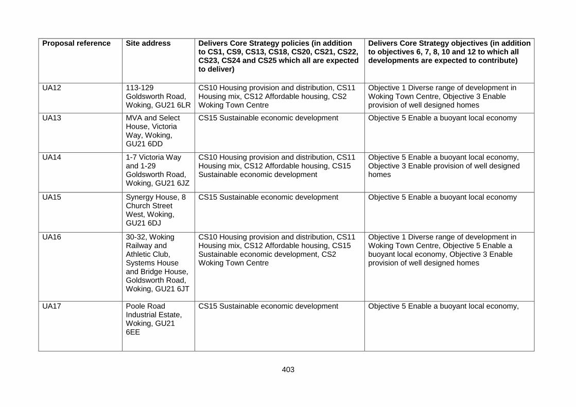
403
Proposal reference
Site address Delivers Core Strategy policies (in addition to CS1, CS9, CS13, CS18, CS20, CS21, CS22, CS23, CS24 and CS25 which all are expected to deliver)
Delivers Core Strategy objectives (in addition to objectives 6, 7, 8, 10 and 12 to which all developments are expected to contribute)
UA12 113-129 Goldsworth Road, Woking, GU21 6LR
CS10 Housing provision and distribution, CS11 Housing mix, CS12 Affordable housing, CS2 Woking Town Centre
Objective 1 Diverse range of development in Woking Town Centre, Objective 3 Enable provision of well designed homes
UA13 MVA and Select House, Victoria Way, Woking, GU21 6DD
CS15 Sustainable economic development Objective 5 Enable a buoyant local economy
UA14 1-7 Victoria Way and 1-29 Goldsworth Road, Woking, GU21 6JZ
CS10 Housing provision and distribution, CS11 Housing mix, CS12 Affordable housing, CS15 Sustainable economic development
Objective 5 Enable a buoyant local economy, Objective 3 Enable provision of well designed homes
UA15 Synergy House, 8 Church Street West, Woking, GU21 6DJ
CS15 Sustainable economic development Objective 5 Enable a buoyant local economy
UA16 30-32, Woking Railway and Athletic Club, Systems House and Bridge House, Goldsworth Road, Woking, GU21 6JT
CS10 Housing provision and distribution, CS11 Housing mix, CS12 Affordable housing, CS15 Sustainable economic development, CS2 Woking Town Centre
Objective 1 Diverse range of development in Woking Town Centre, Objective 5 Enable a buoyant local economy, Objective 3 Enable provision of well designed homes
UA17 Poole Road Industrial Estate, Woking, GU21 6EE
CS15 Sustainable economic development Objective 5 Enable a buoyant local economy,
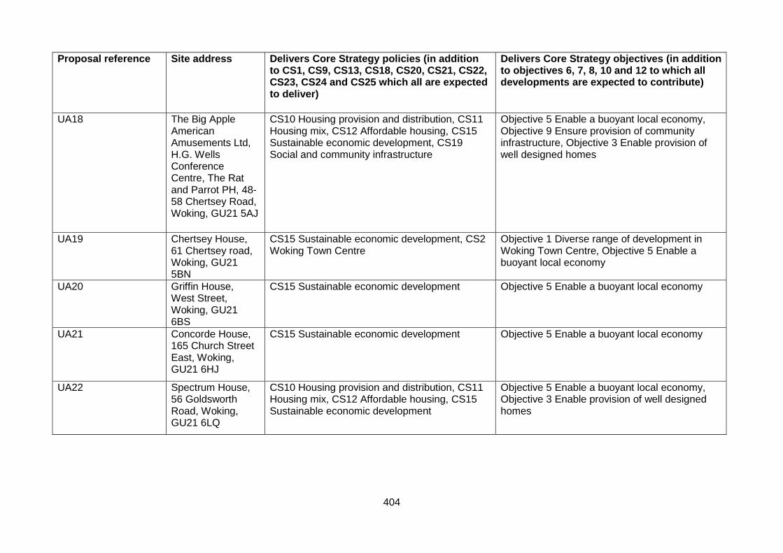
404
Proposal reference
Site address Delivers Core Strategy policies (in addition to CS1, CS9, CS13, CS18, CS20, CS21, CS22, CS23, CS24 and CS25 which all are expected to deliver)
Delivers Core Strategy objectives (in addition to objectives 6, 7, 8, 10 and 12 to which all developments are expected to contribute)
UA18 The Big Apple American Amusements Ltd, H.G. Wells Conference Centre, The Rat and Parrot PH, 48-58 Chertsey Road, Woking, GU21 5AJ
CS10 Housing provision and distribution, CS11 Housing mix, CS12 Affordable housing, CS15 Sustainable economic development, CS19 Social and community infrastructure
Objective 5 Enable a buoyant local economy, Objective 9 Ensure provision of community infrastructure, Objective 3 Enable provision of well designed homes
UA19 Chertsey House, 61 Chertsey road, Woking, GU21 5BN
CS15 Sustainable economic development, CS2 Woking Town Centre
Objective 1 Diverse range of development in Woking Town Centre, Objective 5 Enable a buoyant local economy
UA20 Griffin House, West Street, Woking, GU21 6BS
CS15 Sustainable economic development Objective 5 Enable a buoyant local economy
UA21 Concorde House, 165 Church Street East, Woking, GU21 6HJ
CS15 Sustainable economic development Objective 5 Enable a buoyant local economy
UA22 Spectrum House, 56 Goldsworth Road, Woking, GU21 6LQ
CS10 Housing provision and distribution, CS11 Housing mix, CS12 Affordable housing, CS15 Sustainable economic development
Objective 5 Enable a buoyant local economy, Objective 3 Enable provision of well designed homes

405
Proposal reference
Site address Delivers Core Strategy policies (in addition to CS1, CS9, CS13, CS18, CS20, CS21, CS22, CS23, CS24 and CS25 which all are expected to deliver)
Delivers Core Strategy objectives (in addition to objectives 6, 7, 8, 10 and 12 to which all developments are expected to contribute)
UA23 Woking Railway Station, car park and bus/rail interchange, High Street, Broadway and Station Approach, Woking, GU22 7AE
CS16 Infrastructure delivery, CS18 Transport and accessibility
Objective 11 Provide integrated effective transport interchange
UA24 Barratt House, Barratt House, 7 - 9 Chertsey Road, Woking, GU21 5AB
CS10 Housing provision and distribution, CS11 Housing mix, CS12 Affordable housing, CS2 Woking Town Centre
Objective 1 Diverse range of development in Woking Town Centre, Objective 3 Enable provision of well designed homes
UA25 Goldsworth House, Denton Way, Woking, GU21 3LG
CS10 Housing provision and distribution, CS11 Housing mix, CS12 Affordable housing
Objective 3 Enable provision of well designed homes
UA26 Timber Yard, Arthurs Bridge Road/ Horsell Moor, Woking, GU21 4NQ
CS10 Housing provision and distribution, CS11 Housing mix, CS12 Affordable housing
Objective 3 Enable provision of well designed homes
UA27 73 Horsell Moor, Horsell, GU21 4NL
CS10 Housing provision and distribution, CS11 Housing mix, CS12 Affordable housing
Objective 3 Enable provision of well designed homes
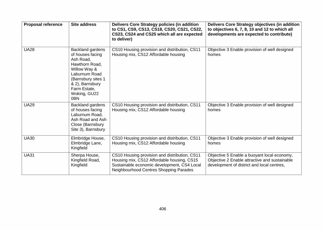
406
Proposal reference
Site address Delivers Core Strategy policies (in addition to CS1, CS9, CS13, CS18, CS20, CS21, CS22, CS23, CS24 and CS25 which all are expected to deliver)
Delivers Core Strategy objectives (in addition to objectives 6, 7, 8, 10 and 12 to which all developments are expected to contribute)
UA28 Backland gardens of houses facing Ash Road, Hawthorn Road, Willow Way & Laburnum Road (Barnsbury sites 1 & 2), Barnsbury Farm Estate, Woking, GU22 0BN
CS10 Housing provision and distribution, CS11 Housing mix, CS12 Affordable housing
Objective 3 Enable provision of well designed homes
UA29 Backland gardens of houses facing Laburnum Road, Ash Road and Ash Close (Barnsbury Site 3), Barnsbury
CS10 Housing provision and distribution, CS11 Housing mix, CS12 Affordable housing
Objective 3 Enable provision of well designed homes
UA30 Elmbridge House, Elmbridge Lane, Kingfield
CS10 Housing provision and distribution, CS11 Housing mix, CS12 Affordable housing
Objective 3 Enable provision of well designed homes
UA31 Sherpa House, Kingfield Road, Kingfield
CS10 Housing provision and distribution, CS11 Housing mix, CS12 Affordable housing, CS15 Sustainable economic development, CS4 Local Neighbourhood Centres Shopping Parades
Objective 5 Enable a buoyant local economy, Objective 2 Enable attractive and sustainable development of district and local centres,
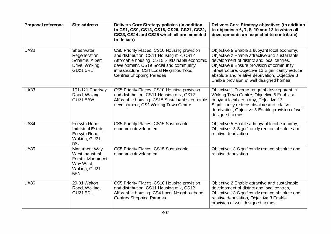
407
Proposal reference
Site address Delivers Core Strategy policies (in addition to CS1, CS9, CS13, CS18, CS20, CS21, CS22, CS23, CS24 and CS25 which all are expected to deliver)
Delivers Core Strategy objectives (in addition to objectives 6, 7, 8, 10 and 12 to which all developments are expected to contribute)
UA32 Sheerwater Regeneration Scheme, Albert Drive, Woking, GU21 5RE
CS5 Priority Places, CS10 Housing provision and distribution, CS11 Housing mix, CS12 Affordable housing, CS15 Sustainable economic development, CS19 Social and community infrastructure, CS4 Local Neighbourhood Centres Shopping Parades
Objective 5 Enable a buoyant local economy, Objective 2 Enable attractive and sustainable development of district and local centres, Objective 9 Ensure provision of community infrastructure, Objective 13 Significantly reduce absolute and relative deprivation, Objective 3 Enable provision of well designed homes
UA33 101-121 Chertsey Road, Woking, GU21 5BW
CS5 Priority Places, CS10 Housing provision and distribution, CS11 Housing mix, CS12 Affordable housing, CS15 Sustainable economic development, CS2 Woking Town Centre
Objective 1 Diverse range of development in Woking Town Centre, Objective 5 Enable a buoyant local economy, Objective 13 Significantly reduce absolute and relative deprivation, Objective 3 Enable provision of well designed homes
UA34 Forsyth Road Industrial Estate, Forsyth Road, Woking, GU21 5SU
CS5 Priority Places, CS15 Sustainable economic development
Objective 5 Enable a buoyant local economy, Objective 13 Significantly reduce absolute and relative deprivation
UA35 Monument Way West Industrial Estate, Monument Way West, Woking, GU21 5EN
CS5 Priority Places, CS15 Sustainable economic development
Objective 13 Significantly reduce absolute and relative deprivation
UA36 29-31 Walton Road, Woking, GU21 5DL
CS5 Priority Places, CS10 Housing provision and distribution, CS11 Housing mix, CS12 Affordable housing, CS4 Local Neighbourhood Centres Shopping Parades
Objective 2 Enable attractive and sustainable development of district and local centres, Objective 13 Significantly reduce absolute and relative deprivation, Objective 3 Enable provision of well designed homes
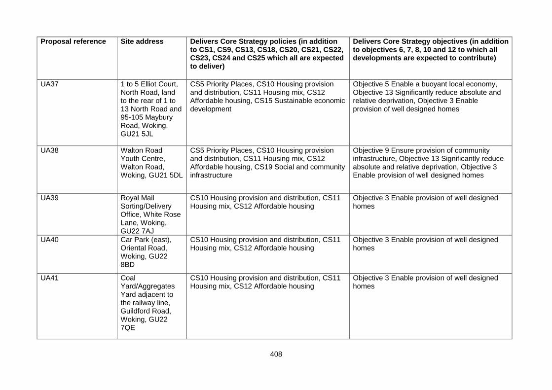
408
Proposal reference
Site address Delivers Core Strategy policies (in addition to CS1, CS9, CS13, CS18, CS20, CS21, CS22, CS23, CS24 and CS25 which all are expected to deliver)
Delivers Core Strategy objectives (in addition to objectives 6, 7, 8, 10 and 12 to which all developments are expected to contribute)
UA37 1 to 5 Elliot Court, North Road, land to the rear of 1 to 13 North Road and 95-105 Maybury Road, Woking, GU21 5JL
CS5 Priority Places, CS10 Housing provision and distribution, CS11 Housing mix, CS12 Affordable housing, CS15 Sustainable economic development
Objective 5 Enable a buoyant local economy, Objective 13 Significantly reduce absolute and relative deprivation, Objective 3 Enable provision of well designed homes
UA38 Walton Road Youth Centre, Walton Road, Woking, GU21 5DL
CS5 Priority Places, CS10 Housing provision and distribution, CS11 Housing mix, CS12 Affordable housing, CS19 Social and community infrastructure
Objective 9 Ensure provision of community infrastructure, Objective 13 Significantly reduce absolute and relative deprivation, Objective 3 Enable provision of well designed homes
UA39 Royal Mail Sorting/Delivery Office, White Rose Lane, Woking, GU22 7AJ
CS10 Housing provision and distribution, CS11 Housing mix, CS12 Affordable housing
Objective 3 Enable provision of well designed homes
UA40 Car Park (east), Oriental Road, Woking, GU22 8BD
CS10 Housing provision and distribution, CS11 Housing mix, CS12 Affordable housing
Objective 3 Enable provision of well designed homes
UA41 Coal Yard/Aggregates Yard adjacent to the railway line, Guildford Road, Woking, GU22 7QE
CS10 Housing provision and distribution, CS11 Housing mix, CS12 Affordable housing
Objective 3 Enable provision of well designed homes

409
Proposal reference
Site address Delivers Core Strategy policies (in addition to CS1, CS9, CS13, CS18, CS20, CS21, CS22, CS23, CS24 and CS25 which all are expected to deliver)
Delivers Core Strategy objectives (in addition to objectives 6, 7, 8, 10 and 12 to which all developments are expected to contribute)
UA42 11-15 Guildford Road /Southern House/Jubilee House/ Lynton House, Station Approach, Woking, GU22 7PX
CS10 Housing provision and distribution, CS11 Housing mix, CS12 Affordable housing, CS15 Sustainable economic development,CS2 Woking Town Centre
Objective 1 Diverse range of development in Woking Town Centre, Objective 5 Enable a buoyant local economy, Objective 3 Enable provision of well designed homes
UA43 Quadrant Court, Guildford Road, Woking, GU22 7QQ
CS15 Sustainable economic development Objective 5 Enable a buoyant local economy
UA44 Former St Dunstans, White Rose Lane, Woking, GU22 7AG
CS10 Housing provision and distribution, CS11 Housing mix, CS12 Affordable housing, CS2 Woking Town Centre
Objective 1 Diverse range of development in Woking Town Centre, Objective 5 Enable a buoyant local economy, Objective 3 Enable provision of well designed homes
UA45 Owen House and The Crescent, Heathside Crescent, Woking, GU22 7AG
CS10 Housing provision and distribution, CS11 Housing mix, CS12 Affordable housing, CS15 Sustainable economic development, CS2 Woking Town Centre
Objective 1 Diverse range of development in Woking Town Centre, Objective 5 Enable a buoyant local economy, Objective 3 Enable provision of well designed homes
UA46 Somerset House, 1-18 Oriental Road, Woking, GU22 7BG
CS10 Housing provision and distribution, CS11 Housing mix, CS12 Affordable housing, CS15 Sustainable economic development, CS2 Woking Town Centre
Objective 1 Diverse range of development in Woking Town Centre, Objective 5 Enable a buoyant local economy, Objective 3 Enable provision of well designed homes
UA47 Coroner’s Court (former Woking Magistrates Court), Station Approach, Woking, GU22 7YL
CS10 Housing provision and distribution, CS11 Housing mix, CS12 Affordable housing, CS15 Sustainable economic development, CS2 Woking Town Centre
Objective 1 Diverse range of development in Woking Town Centre, Objective 5 Enable a buoyant local economy, Objective 3 Enable provision of well designed homes
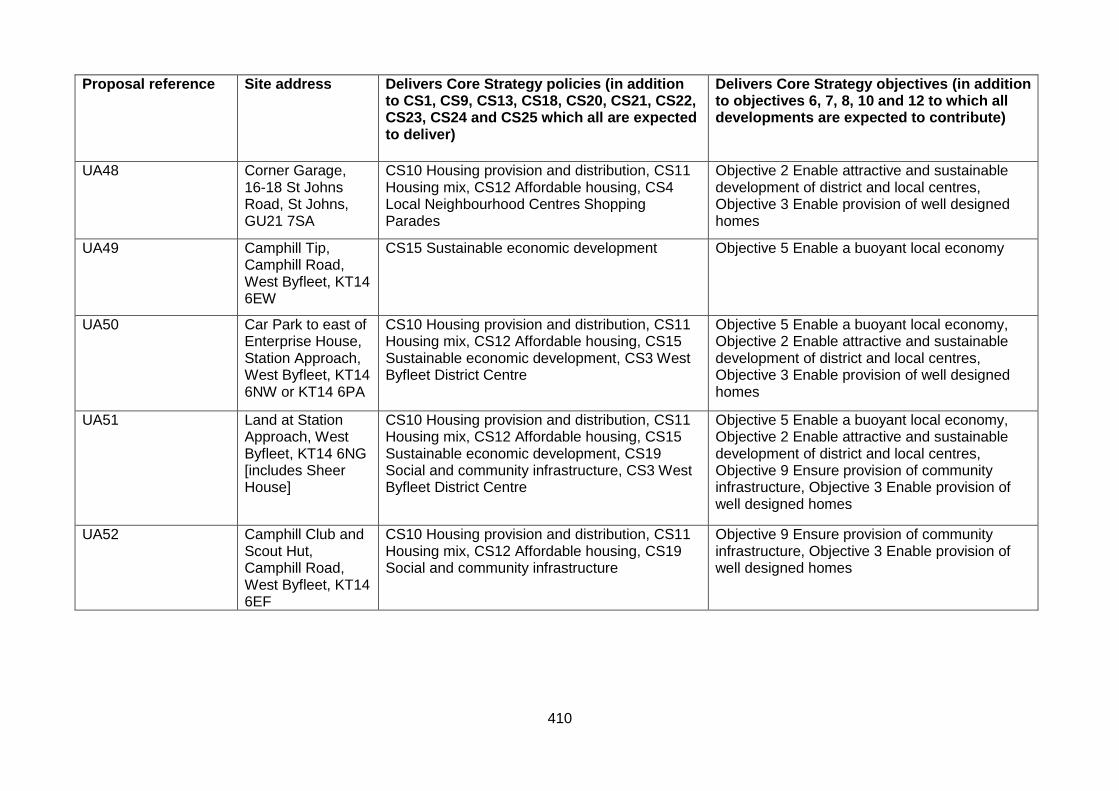
410
Proposal reference
Site address Delivers Core Strategy policies (in addition to CS1, CS9, CS13, CS18, CS20, CS21, CS22, CS23, CS24 and CS25 which all are expected to deliver)
Delivers Core Strategy objectives (in addition to objectives 6, 7, 8, 10 and 12 to which all developments are expected to contribute)
UA48 Corner Garage, 16-18 St Johns Road, St Johns, GU21 7SA
CS10 Housing provision and distribution, CS11 Housing mix, CS12 Affordable housing, CS4 Local Neighbourhood Centres Shopping Parades
Objective 2 Enable attractive and sustainable development of district and local centres, Objective 3 Enable provision of well designed homes
UA49 Camphill Tip, Camphill Road, West Byfleet, KT14 6EW
CS15 Sustainable economic development Objective 5 Enable a buoyant local economy
UA50 Car Park to east of Enterprise House, Station Approach, West Byfleet, KT14 6NW or KT14 6PA
CS10 Housing provision and distribution, CS11 Housing mix, CS12 Affordable housing, CS15 Sustainable economic development, CS3 West Byfleet District Centre
Objective 5 Enable a buoyant local economy, Objective 2 Enable attractive and sustainable development of district and local centres, Objective 3 Enable provision of well designed homes
UA51 Land at Station Approach, West Byfleet, KT14 6NG [includes Sheer House]
CS10 Housing provision and distribution, CS11 Housing mix, CS12 Affordable housing, CS15 Sustainable economic development, CS19 Social and community infrastructure, CS3 West Byfleet District Centre
Objective 5 Enable a buoyant local economy, Objective 2 Enable attractive and sustainable development of district and local centres, Objective 9 Ensure provision of community infrastructure, Objective 3 Enable provision of well designed homes
UA52 Camphill Club and Scout Hut, Camphill Road, West Byfleet, KT14 6EF
CS10 Housing provision and distribution, CS11 Housing mix, CS12 Affordable housing, CS19 Social and community infrastructure
Objective 9 Ensure provision of community infrastructure, Objective 3 Enable provision of well designed homes
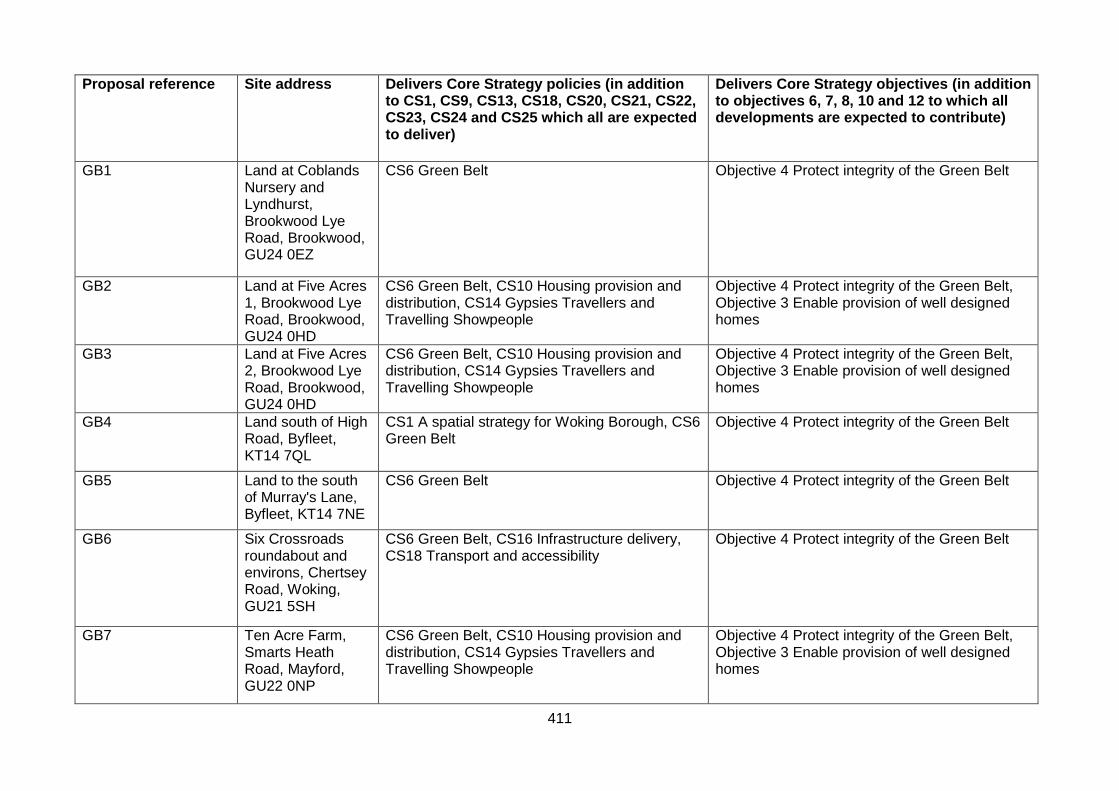
411
Proposal reference
Site address Delivers Core Strategy policies (in addition to CS1, CS9, CS13, CS18, CS20, CS21, CS22, CS23, CS24 and CS25 which all are expected to deliver)
Delivers Core Strategy objectives (in addition to objectives 6, 7, 8, 10 and 12 to which all developments are expected to contribute)
GB1 Land at Coblands Nursery and Lyndhurst, Brookwood Lye Road, Brookwood, GU24 0EZ
CS6 Green Belt Objective 4 Protect integrity of the Green Belt
GB2 Land at Five Acres 1, Brookwood Lye Road, Brookwood, GU24 0HD
CS6 Green Belt, CS10 Housing provision and distribution, CS14 Gypsies Travellers and Travelling Showpeople
Objective 4 Protect integrity of the Green Belt, Objective 3 Enable provision of well designed homes
GB3 Land at Five Acres 2, Brookwood Lye Road, Brookwood, GU24 0HD
CS6 Green Belt, CS10 Housing provision and distribution, CS14 Gypsies Travellers and Travelling Showpeople
Objective 4 Protect integrity of the Green Belt, Objective 3 Enable provision of well designed homes
GB4 Land south of High Road, Byfleet, KT14 7QL
CS1 A spatial strategy for Woking Borough, CS6 Green Belt
Objective 4 Protect integrity of the Green Belt
GB5 Land to the south of Murray's Lane, Byfleet, KT14 7NE
CS6 Green Belt Objective 4 Protect integrity of the Green Belt
GB6 Six Crossroads roundabout and environs, Chertsey Road, Woking, GU21 5SH
CS6 Green Belt, CS16 Infrastructure delivery, CS18 Transport and accessibility
Objective 4 Protect integrity of the Green Belt
GB7 Ten Acre Farm, Smarts Heath Road, Mayford, GU22 0NP
CS6 Green Belt, CS10 Housing provision and distribution, CS14 Gypsies Travellers and Travelling Showpeople
Objective 4 Protect integrity of the Green Belt, Objective 3 Enable provision of well designed homes

412
Proposal reference
Site address Delivers Core Strategy policies (in addition to CS1, CS9, CS13, CS18, CS20, CS21, CS22, CS23, CS24 and CS25 which all are expected to deliver)
Delivers Core Strategy objectives (in addition to objectives 6, 7, 8, 10 and 12 to which all developments are expected to contribute)
GB8 Nursery Land adjacent to Egley Road, Mayford, GU22 0PL
CS6 Green Belt, CS10 Housing provision and distribution, CS11 Housing mix, CS12 Affordable housing, CS16 Infrastructure Delivery
Objective 4 Protect integrity of the Green Belt, Objective 3 Enable provision of well designed homes
GB9 Woking Garden Centre, Egley Road, Mayford, Woking, GU22 0NH
CS6 Green Belt Objective 4 Protect integrity of the Green Belt
GB10 Land to the north east of Saunders Lane, between Saunders Lane and Hook Hill Lane, Mayford, GU22 0NN
CS6 Green Belt Objective 4 Protect integrity of the Green Belt
GB11 Land to the north west of Saunders Lane, Mayford, GU22 0NN
CS6 Green Belt Objective 4 Protect integrity of the Green Belt
GB12 Land rear of 79-95 Lovelace Drive, Teggs Lane, Pyrford, Surrey, GU22 8QZ
CS6 Green Belt Objective 4 Protect integrity of the Green Belt
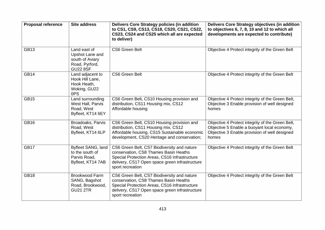
413
Proposal reference
Site address Delivers Core Strategy policies (in addition to CS1, CS9, CS13, CS18, CS20, CS21, CS22, CS23, CS24 and CS25 which all are expected to deliver)
Delivers Core Strategy objectives (in addition to objectives 6, 7, 8, 10 and 12 to which all developments are expected to contribute)
GB13 Land east of Upshot Lane and south of Aviary Road, Pyrford, GU22 8SF
CS6 Green Belt Objective 4 Protect integrity of the Green Belt
GB14 Land adjacent to Hook Hill Lane, Hook Heath, Woking, GU22 0PS
CS6 Green Belt Objective 4 Protect integrity of the Green Belt
GB15 Land surrounding West Hall, Parvis Road, West Byfleet, KT14 6EY
CS6 Green Belt, CS10 Housing provision and distribution, CS11 Housing mix, CS12 Affordable housing
Objective 4 Protect integrity of the Green Belt, Objective 3 Enable provision of well designed homes
GB16 Broadoaks, Parvis Road, West Byfleet, KT14 6LP
CS6 Green Belt, CS10 Housing provision and distribution, CS11 Housing mix, CS12 Affordable housing, CS15 Sustainable economic development, CS20 Heritage and conservation;
Objective 4 Protect integrity of the Green Belt, Objective 5 Enable a buoyant local economy, Objective 3 Enable provision of well designed homes
GB17 Byfleet SANG, land to the south of Parvis Road, Byfleet, KT14 7AB
CS6 Green Belt, CS7 Biodiversity and nature conservation, CS8 Thames Basin Heaths Special Protection Areas, CS16 Infrastructure delivery, CS17 Open space green infrastructure sport recreation
Objective 4 Protect integrity of the Green Belt
GB18 Brookwood Farm SANG, Bagshot Road, Brookwood, GU21 2TR
CS6 Green Belt, CS7 Biodiversity and nature conservation, CS8 Thames Basin Heaths Special Protection Areas, CS16 Infrastructure delivery, CS17 Open space green infrastructure sport recreation
Objective 4 Protect integrity of the Green Belt

414
Proposal reference
Site address Delivers Core Strategy policies (in addition to CS1, CS9, CS13, CS18, CS20, CS21, CS22, CS23, CS24 and CS25 which all are expected to deliver)
Delivers Core Strategy objectives (in addition to objectives 6, 7, 8, 10 and 12 to which all developments are expected to contribute)
GB19 Mayford SANG, land to the south of Moor Lane, Mayford, Woking, GU22 9RB
CS6 Green Belt, CS7 Biodiversity and nature conservation, CS8 Thames Basin Heaths Special Protection Areas, CS16 Infrastructure delivery, CS17 Open space green infrastructure sport recreation
Objective 4 Protect integrity of the Green Belt
GB20 First SANG at Gresham Mill, High Street, Old Woking, GU22 9LH
CS6 Green Belt, CS7 Biodiversity and nature conservation, CS8 Thames Basin Heaths Special Protection Areas, CS16 Infrastructure delivery, CS17 Open space green infrastructure sport recreation
Objective 4 Protect integrity of the Green Belt
GB21 Second SANG at Gresham Mill, High Street, Old Woking, GU22 9LH
CS6 Green Belt, CS7 Biodiversity and nature conservation, CS8 Thames Basin Heaths Special Protection Areas, CS16 Infrastructure delivery, CS17 Open space green infrastructure sport recreation
Objective 4 Protect integrity of the Green Belt
GB22 Woking Palace, Carters Lane, Old Woking, GU22 8JQ
CS6 Green Belt, CS7 Biodiversity and nature conservation, CS16 Infrastructure delivery, CS17 Open space green infrastructure sport recreation
Objective 4 Protect integrity of the Green Belt
GB23 West Byfleet Junior and Infant School Playing Fields, Parvis Road, West Byfleet, KT14 6EG
CS6 Green Belt, CS16 Infrastructure delivery, CS17 Open space green infrastructure sport recreation
Objective 4 Protect integrity of the Green Belt

UA52
415
Appendix 6 - Glossary of terms and abbreviations
Affordable Housing – homes with an element of public subsidy provided by either the private or public sector to make costs affordable for households on a low or moderate income. Includes social rented, intermediate, and affordable rent housing. A fuller definition is provided in the Core Strategy.
Annual Monitoring Report (AMR) – the Council produces an AMR each year to assess the performance and effects of the Local Development Documents. Brownfield land – see Previously Developed Land. Communities and Local Government (CLG) – the Government department preparing national planning policy and guidance. Core Strategy – sets out the long-term vision for the Borough. The Core Strategy for Woking Borough was adopted in October 2012. It provides the main strategic policies and proposals to deliver that vision. Development Management Policies – a Development Plan Document (DPD) that provides detailed local planning policies to support delivery of the Core Strategy. Development Plan Document (DPD) – Local Development Documents (LDD) documents containing the core planning policies and proposals. These are subject to independent examination. Woking Borough Council is intending to prepare the following DPDs: Core Strategy, Development Management DPD, Site Allocations DPD and Proposals Map. Development proposals – development schemes in preparation, the subject of a planning application or planning decision. Dwellings per hectare (dph) – measure of residential development density. Core Strategy Policy CS10 – Housing provision and distribution sets out indicative density ranges for different parts of the Borough.
Greenfield land – land or a defined site (usually garden land or farmland), that has not previously been developed. The full definition used by the Council is provided in the National Planning Policy Framework. Additional guidance on local interpretation is provided in the Affordable Housing Delivery SPD. Habitat Regulations Assessment (HRA) – also known as Appropriate Assessment. HRAs are used to determine whether a plan or project would have significant adverse affects upon the integrity of internationally designated sites of nature conservation importance, or Natura 2000 sites. The need for HRA is set out within the EC Habitats Directive 92/43/EEC and transposed into British Law by Regulation 102 of the Conservation of Habitats and Species Regulations 2010. Local Development Document (LDD) – documents providing the framework for planning in the Borough and guiding planning decisions. Comprises development plan documents, supplementary planning documents and Statement of Community Involvement i.e. both statutory and non-statutory documents. Local Planning Authority – a council’s planning service. For this area the Local Planning Authorities for most types of development is Woking Borough Council. Surrey County Councils is responsible for planning matters such as waste and minerals planning.

UA52
416
Local Transport Plan (LTP) – transport plan prepared by the Local Highway Authority, for this area this is Surrey County Council. National Planning Policy Framework (NPPF) – sets out the Government’s vision for sustainable development through a set of economic, environmental and social planning policies. National Planning Practice Guidance (NPPG) – sets out the Government’s advice on economic, environmental and social planning matters.
Previously Developed Land – land which is or was occupied by a permanent structure, including the curtilage of the developed land (although it should not be assumed that the whole of the curtilage should be developed) and any associated fixed surface infrastructure. The full definitions used by the Council are provided in the National Planning Policy Framework and in the Core Strategy. Additional local guidance on interpretation is provided in the Affordable Housing Delivery SPD.
Site allocation – identification of a site for future development, for a specified use or mix of uses, through a Development Plan Document. Site Allocations DPD – the document through which site allocations are made. Special Protection Area (SPA) – Areas which support significant numbers of ground nesting birds and their habitats. SPAs are classified under the Birds Directive. Specialist accommodation - dwellings for people with special needs, including elderly persons, persons with mental or physical needs or temporary accommodation. There are certain types of residential accommodation, which cater for sectors of the community with specific needs. These are often related to the more vulnerable members of society, or those who would benefit from a higher level of on-site support. This need can be divided into two broad groupings – the growing elderly population, and those who may need specialist social support. Strategic Environment Assessment (SEA) - an environmental assessment of plans and programmes, including Development Plan Documents. A system of incorporating environmental considerations into policies, plans and programmes. It is sometimes referred to as Strategic Environmental Impact Assessment. The specific term Strategic Environmental Assessment relates to European Union policy.
Strategic Housing Land Availability Assessment (SHLAA) - research that identifies specific deliverable and developable sites, to demonstrate how the level of housing supply set out in the adopted Core Strategy is to be achieved. Strategic Housing Market Assessment (SHMA) - an assessment of the estimated demand for market housing and need for affordable housing in a defined geographical area, in terms of distribution, house types and sizes and the specific requirements of particular groups and which considers future demographics. Suitable Alternative Natural Greenspace (SANG) - informal public recreation space to mitigate the impacts of residential development in Woking Borough upon the European-protected bird habitat of the Thames Basin Heaths Special Protection Area (SPA). Supplementary Planning Document (SPD) – non-statutory documents that expand upon policies and proposals in development plan documents (DPDs), guiding the delivery of
UA52
417
development and the principles set out in the Core Strategy. Unlike Development Plan Documents, SPDs do not form part of the statutory development plan. Sustainability Appraisal - a social, economic and environmental assessment primarily used for DPDs, incorporating the requirements of the Strategic Environmental Assessment (SEA) Directive. Sustainability appraisal assesses the economic, environmental and social effects of a plan from the outset of the preparation process to allow decisions to be made that accord with sustainable development.
Sustainable development - the core principle underpinning the planning system, as set out in the National Planning Policy Framework (NPPF). This means meeting the needs of the present without compromising the ability of future generations to meet theirs.
Transit site – a temporary stopping place for Travellers.
Traveller - the term ‘traveller’ is used to refer to Gypsies, Travellers, and Travelling Showpeople Viability - the economic viability of a scheme, assessed through a financial appraisal process of costs and values.