Review of Metropolitan Green Belt and Metropolitan … · Review of Metropolitan Green Belt and...
58
Review of Metropolitan Green Belt and Metropolitan Open Land July 2016
Transcript of Review of Metropolitan Green Belt and Metropolitan … · Review of Metropolitan Green Belt and...
Review of Metropolitan Green Belt and
Metropolitan Open Land
July 2016

Review of Metropolitan Green Belt and Metropolitan Open Land
The review of Metropolitan Green Belt and Metropolitan Open Land consists of five parts as follows:
Section 1 outlines the purposes of Metropolitan Green Belt and Metropolitan Open Land;
Section 2 consists of a review of all land designated as Metropolitan Green Belt and Metropolitan Open Land against the criteria for designation set out in the National Planning Policy Framework and London Plan respectively;
Section 3 consists of a review of land designated as Local Open Land in the Replacement Unitary Development Plan that abuts Metropolitan Green Belt;
Section 4 consists of a full review of all land designated as either Metropolitan Green Belt or Metropolitan Open Land in the Replacement Unitary Development Plan to explore potential development options and strategies; and
Section 5 details five proposal sites on land that does meet the criteria for designation as either Metropolitan Green Belt or Metropolitan Open Land but are being proposed for development either because they are previously developed sites or because exceptional circumstances exist for developing land in these locations.
This review identified three areas of land that did not meet the nationally set requirements for designation as Metropolitan Green Belt and one area of land that did not meet the requirements set out in the London Plan for designation as Metropolitan Open Land. The full details of the review, including the exceptional circumstances for amending Metropolitan Green Belt, for each of these four areas of land can be found in this document.
This review also identified 16 areas of Local Open Land abutting Metropolitan Green Belt that should be re-designated as Metropolitan Green Belt. The full details of the review, including the exceptional circumstances for amending Metropolitan Green Belt, for each of these 16 areas of land can be found in this document. Furthermore the review identified three areas of Local Open Land abutting two of the areas of Metropolitan Green Belt that did not meet the nationally set requirements for designation as Metropolitan Green Belt. These three areas of Local Open Space are proposed to be re-designated as Metropolitan Open Land instead. Full details can be found in this document.
The review of the borough’s Metropolitan Green Belt and Metropolitan Open Land was carried out as enabled by the National Planning Policy Framework as part of the partial review of the Croydon Local Plan: Strategic Policies. This was part of work to explore a potential development options and strategies that included release of land in these designations to help meet the need for homes in the borough. The development option that included the de-designation of Metropolitan Green Belt and Metropolitan Open Land was not taken forward either as a preferred or as an alternative option because it conflicted with the national policy and the London Plan. However, it was assessed as an alternative option in the Sustainability Appraisal of the Croydon Local Plan: Strategic Policies – Partial Review.

1. The purposes of Metropolitan Green Belt and Metropolitan Open Land
Metropolitan Green Belt and Metropolitan Open Land, whilst having the same level of protection against inappropriate development, have very different purposes. These are set out in the table below:
Purpose of Metropolitan Green Belt1 Purpose of Metropolitan Open Land2
To check the unrestricted sprawl of large built up areas;
To prevent neighbouring towns merging into one another;
To assist in safeguarding the countryside from encroachment;
To preserve the setting and special character of historic towns; and
To assist in urban regeneration by encouraging the recycling of derelict and other urban land.
Contributes to the physical structure of London;
Includes open air facilities which serve the whole or significant parts of London;
Contains features or landscapes of national or metropolitan importance; or
It forms part of a green chain or a link in a network of green infrastructure and meets one of the other criteria above.
Metropolitan Green Belt is a designation that prevents urban sprawl and focuses development on previously developed sites within urban areas. It does this by providing a notional barrier encircling London where within the barrier development is heavily restricted. Metropolitan Open Land is a designation that protects important open spaces within the urban area of London.
In addition to this the Local Green Space designation provides the same level of protection to smaller areas of land that are demonstrably special to a local community and hold particular local significance, for example because of their beauty, historic significance, recreational value (including as a playing field), tranquillity or richness of their wildlife3. The Local Plan sets out that in Croydon this means that in Croydon the criteria for designation as Local Green Space are the following:
Are in close proximity to the community that they serve;
Are local in character and not part of an extensive tract of land; and
Are at least three of the following or are publically accessible and at least one of the following:
Historic Park or Garden; a) Community garden; b) Children’s play area; c)
1 From paragraph 80 of the National Planning Policy Framework
2 From Policy 7.18 of the London Plan
3 From paragraph 77 of the National Planning Policy Framework

Tranquil area; d) Natural and semi-natural open space; e)
Cemetery, church yard or burial ground; f) Site of Nature Conservation Importance; or g) Playing field or recreation ground.h)

Map reproduced by permission of Ordnance Survey On behalf of HMSO. © Crown copyright and Database right 2015. Ordnance Survey Licence Number 100019257
2. Review of all land designated as Metropolitan Green Belt and Metropolitan Open Land against the criteria for designation set out in the National Planning Policy Framework and London Plan respectively
It is critical that all Metropolitan Green Belt and Metropolitan Open Land is correctly designated across the borough. The correct designation will ensure the Council is well placed to be able to resist inappropriate development proposals in the borough’s Metropolitan Green Belt and Metropolitan Open Land. The importance of getting Metropolitan Green Belt and Metropolitan Open Land designation correct is considered to be part of the exceptional circumstances for reviewing the borough’s Metropolitan Green Belt and Metropolitan Open Land as set out in national policy.
In order to assess each area of Metropolitan Green Belt and Metropolitan Open Land in Croydon, the areas of land covered by these designations were broken up into individual component parts. Every individual field and parcel of land with its own defensible boundaries (such as a railway line, road or boundary fence) was considered separately.
Review of land currently designated as Metropolitan Green Belt
Appendix 1 sets out the findings for each element of Croydon’s Metropolitan Green Belt when considered against the criteria for designation set out in the National Planning Policy Framework.
Three areas of land were found to only meet one test, namely assisting with the urban regeneration of Croydon by encouraging the recycling of brownfield land for designation as Metropolitan Green Belt. These areas were Purley Downs, Croham Hurst golf course and Sanderstead Plantation. However every area of protected open space in Croydon meets this test and the National Planning Policy Framework explicitly states (in paragraph 79) that the fundamental aim of Metropolitan Green Belt policy is to prevent urban sprawl by keeping land permanently open; the essential characteristics of Metropolitan Green Belt is its openness and its permanence. Therefore, the encouraging the recycling of brownfield land on its own it is not considered suitable to justify a Metropolitan Green Belt designation unless if forms part of a wider area that checks the unrestricted sprawl of London as a whole.
Croham Hurst itself also fails to prevent urban sprawl because, although it meets two tests for designation as Metropolitan Green Belt (preserving the setting and special character of Croydon’s heritage; and assisting with the urban regeneration of Croydon by encouraging the recycling of brownfield land), it too does not check the unrestricted sprawl of London as a whole and is not part of a wider open tract of land.
These represent the exceptional circumstance required by the National Planning Policy Framework to alter the Metropolitan Green Belt designation in these locations, namely that they are inappropriately designated as Metropolitan Green Belt. However, these three areas all

Map reproduced by permission of Ordnance Survey On behalf of HMSO. © Crown copyright and Database right 2015. Ordnance Survey Licence Number 100019257
meet at least one of the tests for designation as Metropolitan Open Land or Local Green Space and therefore, even though they do not meet the tests for designation as Metropolitan Green Belt (although they are currently designated as such), they should be re-designated as Metropolitan Open Land or Local Green Space to ensure that they continue to benefit from the same high level of protection as Metropolitan Green Belt. The specific findings are detailed below:
Croham Hurst
Croham Hurst is inappropriately designated as Metropolitan Green Belt because the only tests it meets are that by designating it as Metropolitan Green Belt it assists in the urban regeneration of Croydon by encouraging the recycling of brownfield land and part of the land preserves the setting and special character of Croydon’s heritage. However every area of protected open space in Croydon meets the first test and on its own it is not considered suitable to justify a Metropolitan Green Belt designation unless if forms part of a wider area that checks the unrestricted sprawl of London as a whole or prevents Croydon from merging with nearby towns and villages. Likewise many areas of Metropolitan Open Land and Local Green Space in Croydon meet the second test and again it is not considered suitable to justify a Metropolitan Green Belt designation unless if forms part of a wider area that checks the unrestricted sprawl of London as a whole or prevents Croydon from merging with nearby towns and villages.
However it does contribute to the physical structure of London and it contains a feature or landscape of national or metropolitan importance (because of the Site of Special Scientific Interest, a Schedule Monument, a Site of Nature Conservation Importance (Metropolitan grade) and being a Regionally Important Geological or Geomorphological Site). Therefore, it should be designated as Metropolitan Open Land to ensure it continues to benefit from the same strong level of protection that it currently enjoys.
Purley Downs
Purley Downs is inappropriately designated as Metropolitan Green Belt because the only test it meets is that by designating it as Green Belt it assists in the urban regeneration of Croydon by encouraging the recycling of brownfield land. However every area of protected open space in Croydon meets that test and on its own it is not considered suitable to justify a Metropolitan Green Belt designation unless if forms part of a wider area that checks the unrestricted sprawl of London as a whole or prevents Croydon from merging with nearby towns and villages.
However it does contribute to the physical structure of London. Therefore, it should be designated as Metropolitan Open Land to ensure it continues to benefit from the same strong level of protection that it currently enjoys.
Sanderstead Plantation
Sanderstead Plantation is inappropriately designated as Metropolitan Green Belt because the only test it meets is that by designating it as Green Belt it assists in the urban regeneration of Croydon by encouraging the recycling of brownfield land. However every area of protected

Map reproduced by permission of Ordnance Survey On behalf of HMSO. © Crown copyright and Database right 2015. Ordnance Survey Licence Number 100019257
open space in Croydon meets that test and on its own it is not considered suitable to justify a Metropolitan Green Belt designation unless if forms part of a wider area that checks the unrestricted sprawl of London as a whole or prevents Croydon from merging with nearby towns and villages.
It does not meet any of the tests for designation as Metropolitan Open Land being too small to contribute to the physical structure of London.
However it is local in character, publically accessible and a tranquil area, a Site of Nature Conservation Importance of Borough Grade II and a natural or semi-natural open space. It therefore meets the criteria for designation as Local Green Space and should be designated as such to ensure that it continues to benefit from the same strong level of protection that it currently enjoys.
Review of land currently designated as Metropolitan Open Land
Appendix 2 sets out the findings for each element of Croydon’s Metropolitan Open Land when considered against the criteria for designation set out in the London Plan.
Nine parcels of land, all in the area to the south of Shirley Oaks Hospital were found not to meet any of the tests set out in Policy 7.18 of the London Plan for designation as Metropolitan Open Land. All other areas of Metropolitan Open Land in Croydon met at least one of the tests.
The specific findings for the land to the south of Shirley Oaks Hospital are detailed below:
Land south of Shirley Oaks Hospital
Land south of Shirley Oaks Hospital as shown on the map on the following page was found not to meet the criteria for designation as Metropolitan Open Land.
The land does not include open air facilities which serve the whole or significant parts of London and it does not contain features or landscapes of national or metropolitan importance. In addition, because it is separated from the wider open area made up of Ashburton Playing Fields, South Norwood Country Park and Beckenham Cemetery by Shirley Oaks Hospital and its car park it does not contribute to the physical structure of London. Currently the car park of the hospital is designated Metropolitan Open Land.
On the ground there is a physical barrier between Ashburton Playing Fields and the land south of Shirley Oaks Hospital, it not being possible to walk directly from one area to the other because of a fence separating the hospital car park from Ashburton Playing Fields.
The separation of the land south of Shirley Oaks Hospital is shown quite clearly in the aerial photo following the map.

Map reproduced by permission of Ordnance Survey On behalf of HMSO. © Crown copyright and Database right 2015. Ordnance Survey Licence Number 100019257
Metropolitan Green Belt Metropolitan Open Land Land that does not meet the criteria for designation as Metropolitan Open Land

Map reproduced by permission of Ordnance Survey On behalf of HMSO. © Crown copyright and Database right 2015. Ordnance Survey Licence Number 100019257 Aerial photo © Getmapping plc 2013

However many parcels of land in the area meet the locally set criteria for designation as Local Green Space. These are described below and outlined on the map on the next page.
The playing field adjacent to Stroud Green Pumping Station is publically accessible and includes a playing field or recreation ground, as well as natural and semi-natural open space. Therefore it meets the criteria set out in the Local Plan for designation as Local Green Space set out earlier in this note. This designation would provide them with the same level of protection as the existing Metropolitan Open Land designation.
The existing allotments on Primrose Lane and the existing allotments on Glenthorne Avenue have statutory protection because they are allotments and cannot be used for any other purpose. They are also contiguous with the proposed Local Green Space above so it is proposed that they be included within the Local Green Space designation;
An area of land opposite Shirley Oaks Hospital is used as a community garden and is contiguous with the above Local Green Space so is also proposed to be included as part of the Local Green Space;
The area of land between Firsby Avenue and the Shirley Oaks estate is also publically accessible and includes a playing field or recreation ground, as well as natural and semi-natural open space. Therefore it too meets the criteria set out in the Local Plan for designation as Local Green Space set out earlier in this note. This designation would provide them with the same level of protection as the existing Metropolitan Open Land designation;
Land to the rear of Honeysuckle Gardens is publically accessible, is a tranquil space and is not part of a wider area of open land. Therefore it meets the criteria set out in the Local Plan for designation as Local Green Space; and
The balancing pond between Primrose Lane and Woodmere Gardens is adjacent to the proposed Local Green Space to the rear of Honeysuckle Gardens so it is proposed to be included within the Local Green Space designation. It is also considered to be essential infrastructure and therefore, not suitable for development.


3. Review of land designated as Local Open Land in the Replacement Unitary Development Plan that abuts Metropolitan Green Belt
The existing Local Open Land designation in the Croydon Replacement Unitary Development Plan is proposed to be replaced by Local Green Space (to align and conform with the National Planning Policy Framework). One of the key criteria for designation as Local Green Space is that the land must be local in character and not part of an extensive tract of land. Of all the land designated as Local Open Land in the Replacement Unitary Development, twenty parcels are immediately adjacent to land currently designated as Metropolitan Green Belt. Therefore, the land cannot be designated as Local Green Space. In order to maintain the protection of these open spaces and due to the fact they meet the Metropolitan Green Belt criteria it is proposed that 16 of these parcels of land be re-designated as Metropolitan Green Belt and three parcels be re-designated as Metropolitan Open Land. This represents the exceptional circumstances for amending Metropolitan Green Belt boundary in these locations.
The remaining parcel of land is part of a residential curtilage and is therefore not proposed as either Metropolitan Green Belt or Metropolitan Open Land.
The table below sets out the proposed changes to designations and the criteria for either Metropolitan Green Belt or Metropolitan Open Land that they meet:
Site name Metropolitan Green Belt criteria met Metropolitan Open Land criteria met
Addington Vale Checks the unrestricted sprawl of London
Assist in the regeneration by encouraging the recycling of derelict and urban land
-
Bradmore Green, Old Coulsdon Checks the unrestricted sprawl of London
Preserve the setting and special character of the heritage of Croydon
Assist in the regeneration by encouraging the recycling of derelict and urban land
-

Site name Metropolitan Green Belt criteria met Metropolitan Open Land criteria met
Coulsdon Iron Railway Embankment Checks the unrestricted sprawl of London
Preserve the setting and special character of the heritage of Croydon
Assist in the regeneration by encouraging the recycling of derelict and urban land
-
Courtwood Playground Checks the unrestricted sprawl of London
Assist in the regeneration by encouraging the recycling of derelict and urban land
-
Extension of Bradmore Green Checks the unrestricted sprawl of London
Assist in the regeneration by encouraging the recycling of derelict and urban land
-
Land at Driftwood Drive - -
Land at Rogers Close, Old Cousldon Checks the unrestricted sprawl of London
Prevent Croydon from merging with towns in neighbouring local authorities
Safeguard Croydon’s countryside from encroachment
Assist in the regeneration by encouraging the recycling of derelict and urban land
-

Site name Metropolitan Green Belt criteria met Metropolitan Open Land criteria met
Land between The Bridle Way and Selsdon Checks the unrestricted sprawl of London
Prevent Croydon from merging with towns in neighbouring local authorities
Safeguard Croydon’s countryside from encroachment
Assist in the regeneration by encouraging the recycling of derelict and urban land
-
Land between Vale Border and Selsdon Checks the unrestricted sprawl of London
Prevent Croydon from merging with towns in neighbouring local authorities
Safeguard Croydon’s countryside from encroachment
Assist in the regeneration by encouraging the recycling of derelict and urban land
-
Land in Tollers Lane Checks the unrestricted sprawl of London
Assist in the regeneration by encouraging the recycling of derelict and urban land
-
Land off Lower Barn Road -
Contributes to the physical structure of London
Site name Metropolitan Green Belt criteria met Metropolitan Open Land criteria met
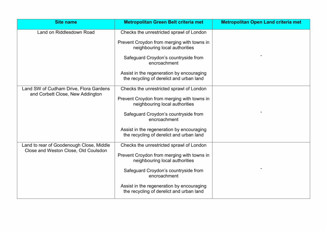
Land on Riddlesdown Road Checks the unrestricted sprawl of London
Prevent Croydon from merging with towns in neighbouring local authorities
Safeguard Croydon’s countryside from encroachment
Assist in the regeneration by encouraging the recycling of derelict and urban land
-
Land SW of Cudham Drive, Flora Gardens and Corbett Close, New Addington
Checks the unrestricted sprawl of London
Prevent Croydon from merging with towns in neighbouring local authorities
Safeguard Croydon’s countryside from encroachment
Assist in the regeneration by encouraging the recycling of derelict and urban land
-
Land to rear of Goodenough Close, Middle Close and Weston Close, Old Coulsdon
Checks the unrestricted sprawl of London
Prevent Croydon from merging with towns in neighbouring local authorities
Safeguard Croydon’s countryside from encroachment
Assist in the regeneration by encouraging the recycling of derelict and urban land
-

Site name Metropolitan Green Belt criteria met Metropolitan Open Land criteria met
Land to south of Croham Hurst -
Contributes to the physical structure of London
Milne Park Checks the unrestricted sprawl of London
Assist in the regeneration by encouraging the recycling of derelict and urban land
-
St Edmund’s Church Green -
Contributes to the physical structure of London
St John the Evangelist’s churchyard, Old Coulsdon
Checks the unrestricted sprawl of London
Preserve the setting and special character of the heritage of Croydon
Assist in the regeneration by encouraging the recycling of derelict and urban land
-
Sanderstead Recreation Ground Checks the unrestricted sprawl of London
Assist in the regeneration by encouraging the recycling of derelict and urban land
-
The Bridle Road, Shirley Checks the unrestricted sprawl of London
Prevent Croydon from merging with towns in neighbouring local authorities
Safeguard Croydon’s countryside from encroachment
Assist in the regeneration by encouraging the recycling of derelict and urban land
-

4. Full review of all land designated as either Metropolitan Green Belt or Metropolitan Open Land in the Replacement Unitary Development Plan to explore potential development options and strategies
As they have different purposes Metropolitan Green Belt and Metropolitan Open Land have been assessed in different ways.
Metropolitan Green Belt
As all but four parcels of Metropolitan Green Belt in Croydon meet the tests for designation as Metropolitan Green Belt the review of Metropolitan Green Belt followed an elimination process so that at the end only those sites that would have the least impact were they to be developed, were considered for de-designation. The criteria below were used to determine those sites in Metropolitan Green Belt that were not suitable for possible de-designation. Any site that met at least one of the following criteria has been considered unsuitable for de-designation:
An Historic Park and Garden (either of national or local importance);
A Site of Special Scientific Interest;
A Site of Nature Conservation Importance;
A Regionally Important Geological and Geomorphological site;
An allotment;
A community garden;
A cemetery, church yard or burial ground;
There are known factors that prevent the site being developed (such as legal covenants, viability issues);
The site is too small to allocate because it wouldn’t provide ten or more new homes; or
A parcel of land completely detached from built.
Sites that didn’t meet any of the criteria above were still considered to be probably unsuited to de-designation if they met any of the criteria in the table below:
Site is a sports facility or playing field which would be difficult to replace;
Site not suitable for major residential development due to poor access along local roads as they are narrow, unlit and have no pavements and due to a lack of local amenities to serve a larger residential community;
Site is very prominent and there would be significant impacts on openness if it were developed;
The existing land use is protected;

Site would be difficult (in terms of character) to integrate with the built up area of the borough;
Site is unlikely to come forward for development due to difficulty in replacing the existing function provided by the site or building; or
Already in residential use.
The remaining sites were considered as an alternative development option in the Sustainability Appraisal accompanying the Croydon Local Plan: Strategic Policies (Partial Review). However, they were not included in the preferred options for the Local Plans as, because they meet the tests for designation as Metropolitan Green Belt in both the National Planning Policy Framework and the London Plan, to include them would bring the Local Plan into conflict with the London Plan and National Planning Policy Framework.
Full details of this assessment and how it was applied to each parcel of Metropolitan Green Belt can be found in Appendix 3.
Metropolitan Open Land
The borough’s Metropolitan Open Land was assessed against the four purposes of Metropolitan Open Land set out in Policy 7.18 of the London Plan.
Purpose of Metropolitan Open Land
Contributes to the physical structure of London;
Includes open air facilities which serve the whole or significant parts of London;
Contains features or landscapes of national or metropolitan importance; or
It forms part of a green chain or a link in a network of green infrastructure and meets one of the other criteria above.
As previously stated all but nine parcels of land (all in the area south of Shirley Oaks Hospital) met at least one of these criteria. The remaining nine parcel of land were considered against the locally set criteria for designation as Local Green Space (derived from the more general criteria in paragraph 77 of the National Planning Policy Framework). The Local Green Space designation offers the exact same level of protection as the Metropolitan Open Land designation. The criteria for designation as Local Green Space are set out in section 2 of this review. All but four parcels of land meet the criteria for designation as Local Green Space either in their own right, or because they are adjacent to an area of land that meets the criteria for designation.
Full details of this assessment and how it was applied to each parcel of Metropolitan Open Land can be found in Appendix 2 and a summary of how it affects land south of Shirley Oaks Hospital can be found in section 2 of this review.
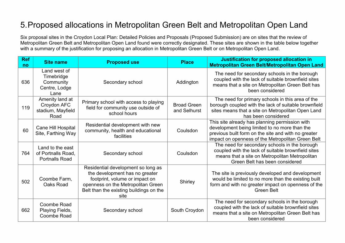
5. Proposed allocations in Metropolitan Green Belt and Metropolitan Open Land
Six proposal sites in the Croydon Local Plan: Detailed Policies and Proposals (Proposed Submission) are on sites that the review of Metropolitan Green Belt and Metropolitan Open Land found were correctly designated. These sites are shown in the table below together with a summary of the justification for proposing an allocation in Metropolitan Green Belt or on Metropolitan Open Land.
Ref no
Site name Proposed use Place Justification for proposed allocation in
Metropolitan Green Belt/Metropolitan Open Land
636
Land west of Timebridge Community
Centre, Lodge Lane
Secondary school Addington
The need for secondary schools in the borough coupled with the lack of suitable brownfield sites means that a site on Metropolitan Green Belt has
been considered
119
Amenity land at Croydon AFC
stadium, Mayfield Road
Primary school with access to playing field for community use outside of
school hours
Broad Green and Selhurst
The need for primary schools in this area of the borough coupled with the lack of suitable brownfield sites means that a site on Metropolitan Open Land
has been considered
60 Cane Hill Hospital Site, Farthing Way
Residential development with new community, health and educational
facilities Coulsdon
This site already has planning permission with development being limited to no more than the previous built form on the site and with no greater impact on openness of the Metropolitan Green Belt
764 Land to the east
of Portnalls Road, Portnalls Road
Secondary school Coulsdon
The need for secondary schools in the borough coupled with the lack of suitable brownfield sites means that a site on Metropolitan Metropolitan
Green Belt has been considered
502 Coombe Farm,
Oaks Road
Residential development so long as the development has no greater footprint, volume or impact on
openness on the Metropolitan Green Belt than the existing buildings on the
site
Shirley
The site is previously developed and development would be limited to no more than the existing built
form and with no greater impact on openness of the Green Belt
662 Coombe Road Playing Fields, Coombe Road
Secondary school South Croydon
The need for secondary schools in the borough coupled with the lack of suitable brownfield sites means that a site on Metropolitan Green Belt has
been considered

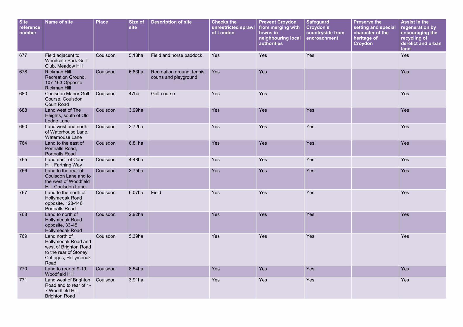
Appendix 1: Assessment of Metropolitan Green Belt land in Croydon against the national criteria for designation
Site reference number
Name of site Place Size of site
Description of site Checks the unrestricted sprawl of London
Prevent Croydon from merging with towns in neighbouring local authorities
Safeguard Croydon’s countryside from encroachment
Preserve the setting and special character of the heritage of Croydon
Assist in the regeneration by encouraging the recycling of derelict and urban land
15 Land west of Addington Village Roundabout, Kent Gate Way
Addington 13.07ha Field and horse paddock Yes Yes Yes Yes
535 New Addington Pitch and Putt, King Henry's Drive
Addington 5.7ha Site of former Pitch and Putt course
Yes Yes Yes
632 Land south of Threehalfpenny Woods, Kent Gate Way
Addington 4.42ha Field Yes Yes Yes Yes
633 Addington Cricket Club, Addington Village Road
Addington 1.15ha Cricket club Yes Yes
635 Land east of Addington Village Roundabout, Kent Gate Way
Addington 25.13ha Field Yes Yes Yes Yes
636 Land west of Timebridge Community Centre, Lodge Lane
Addington 7.44ha Amenity land Yes Yes Yes
637 Applegarth Academy Playing Fields, Bygrove
Addington 1.29ha Yes Yes Yes
638 Land east of Timebridge Community Centre, Field Way
Addington 3.96ha Amenity space Yes Yes Yes
639 Birch Wood, Field Way
Addington 12.48ha Woods Yes Yes Yes Yes
753 Land to the west of Featherbed Lane, Featherbed Lane
Addington 9.99ha Yes Yes Yes Yes
754 Hutchingson's Bank, Featherbed Lane
Addington 21.01ha Yes Yes Yes Yes
755 Pear Tree Farm & Pear Tree Farm Cottage, Featherbed Lane
Addington 3.85ha Former farm, used as a scaffolding and storage site.
Yes Yes
756 Addington High School playing fields, Fairchildes Avenue
Addington 13.19ha School playing fields Yes Yes

Site reference number
Name of site Place Size of site
Description of site Checks the unrestricted sprawl of London
Prevent Croydon from merging with towns in neighbouring local authorities
Safeguard Croydon’s countryside from encroachment
Preserve the setting and special character of the heritage of Croydon
Assist in the regeneration by encouraging the recycling of derelict and urban land
757 Allotments and surrounding land, Dunley Drive
Addington 5.61ha Allotments Yes Yes Yes
758 Rowdown Wood, Mickleham Way
Addington 13.70ha Woods Yes Yes Yes Yes
760 Land at, North Downs Crescent
Addington 11.74ha Amenity land and children's playground
Yes Yes Yes
761 Golf Centre, Featherbed Lane
Addington 25.04ha Yes Yes Yes
762 Addington Court Golf Club, Lodge Lane
Addington 36.70ha Golf Course Yes Yes Yes
831 Milne Park recreation ground between Milne Park East and West, Milne Park East
Addington 7.26ha Yes Yes Yes
832 Land between Queen Elizabeth's Drive and Godric Crescent, Queen Elizabeth Drive
Addington 10.47ha Yes Yes Yes
904 Amenity Land rear of, Cudham Drive
Addington 4.40ha Wooded area bordering New Addington
Yes Yes Yes Yes
915 Field adjacent to Addington High School playing fields, Skid Hill Lane
Addington 2.92ha Overgrown natural and semi-natural open space
Yes Yes Yes Yes
668 Allotments adjacent to Lloyd Park, Lloyd Park Avenue
Addiscombe 2.0ha Allotments Yes Yes Yes
669 The Sandilands Club, Grimwade Avenue
Addiscombe 2.48ha Sports ground and pavillion
Yes Yes
727 The Alma PH, 129 Lower Addiscombe Road
Addiscombe 0.05ha Former Public House Yes Yes
908 Shirley Park Bowling Club, 21-25 R/o Mapledale Avenue
Addiscombe 0.95ha Bowling club Yes Yes Yes
60 Cane Hill Hospital Site, Farthing Way
Coulsdon 32.37ha Former Hospital Site Yes Yes Yes
675 Woodcote Secondary School Playing Fields, Dunsfold Drive
Coulsdon 4.96ha School playing fields and athletic track
Yes Yes Yes
676 Woodcote Recreation Ground, Meadow Hill
Coulsdon 3.98ha Woodcote Recreation Ground
Yes Yes Yes
Site reference number
Name of site Place Size of site
Description of site Checks the unrestricted sprawl of London
Prevent Croydon from merging with towns in neighbouring local authorities
Safeguard Croydon’s countryside from encroachment
Preserve the setting and special character of the heritage of Croydon
Assist in the regeneration by encouraging the recycling of derelict and urban land
677 Field adjacent to Woodcote Park Golf Club, Meadow Hill
Coulsdon 5.18ha Field and horse paddock Yes Yes Yes Yes
678 Rickman Hill Recreation Ground, 107-163 Opposite Rickman Hill
Coulsdon 6.83ha Recreation ground, tennis courts and playground
Yes Yes Yes
680 Coulsdon Manor Golf Course, Coulsdon Court Road
Coulsdon 47ha Golf course Yes Yes Yes
688 Land west of The Heights, south of Old Lodge Lane
Coulsdon 3.99ha Yes Yes Yes Yes
690 Land west and north of Waterhouse Lane, Waterhouse Lane
Coulsdon 2.72ha Yes Yes Yes Yes
764 Land to the east of Portnalls Road, Portnalls Road
Coulsdon 6.81ha Yes Yes Yes Yes
765 Land east of Cane Hill, Farthing Way
Coulsdon 4.48ha Yes Yes Yes Yes
766 Land to the rear of Coulsdon Lane and to the west of Woodfield Hill, Coulsdon Lane
Coulsdon 3.75ha Yes Yes Yes Yes
767 Land to the north of Hollymeoak Road opposite, 128-146 Portnalls Road
Coulsdon 6.07ha Field Yes Yes Yes Yes
768 Land to north of Hollymeoak Road opposite, 33-45 Hollymeoak Road
Coulsdon 2.92ha Yes Yes Yes Yes
769 Land north of Hollymeoak Road and west of Brighton Road to the rear of Stoney Cottages, Hollymeoak Road
Coulsdon 5.39ha Yes Yes Yes Yes
770 Land to rear of 9-19, Woodfield Hill
Coulsdon 8.54ha Yes Yes Yes Yes
771 Land west of Brighton Road and to rear of 1-7 Woodfield Hill, Brighton Road
Coulsdon 3.91ha Yes Yes Yes Yes

Site reference number
Name of site Place Size of site
Description of site Checks the unrestricted sprawl of London
Prevent Croydon from merging with towns in neighbouring local authorities
Safeguard Croydon’s countryside from encroachment
Preserve the setting and special character of the heritage of Croydon
Assist in the regeneration by encouraging the recycling of derelict and urban land
772 Land south of Wilhelmina Avenue and west of Woodplace Lane, Woodplace Lane
Coulsdon 7.95ha Sloping field Yes Yes Yes Yes
822 Land south of Lion Green Car Park, Brighton Road
Coulsdon 1.44ha Yes Yes Yes Yes
905 Field adjacent to Woodcote Recreation Ground, Meadow Hill
Coulsdon 1.15ha Field Yes Yes Yes Yes
914 Land opposite, 17-31 Hollymeoak Road
Coulsdon 3.69ha Field Yes Yes Yes Yes
14 Land adjacent to, 37 Hawkhirst Road
Kenley and Old Coulsdon
0.46ha Land at the end of Hawkhirst Road
Yes Yes Yes Yes
24 Paddock at rear of Gayfere House, Tollers Lane
Kenley and Old Coulsdon
0.573ha Paddock at rear of Gayfere House
Yes Yes Yes
29 170 Hayes Lane Kenley and Old Coulsdon
0.46ha A 1930's house fronnting Hayes Lane behind a high hedge and boundary mound is situated in the northern half of the site. The southern half appears to be woodland
Yes Yes
69 185-215 Caterham Drive
Kenley and Old Coulsdon
1.62ha Scrubland and rear gardens. The site is completely hidden but appears to be the bottom of a valley that runs parallel and between Hayes Lane and Caterham Drive. Someone has erected a shed on the site (without the knowledge of the owner of the site).
Yes Yes
365 Kenley House and, 65-69 Kenley Lane
Kenley and Old Coulsdon
21.04ha Detached house and grounds
Yes Yes
498 Meadow View, 259-261 Hayes Lane
Kenley and Old Coulsdon
1.07ha Garden Land Yes Yes
518 Land adjacent to, 103 Goodenough Way
Kenley and Old Coulsdon
1.88ha Amenity land Yes Yes Yes
679 Grange Park, Coulsdon Road
Kenley and Old Coulsdon
4.22ha Playing field and park Yes Yes Yes

Site reference number
Name of site Place Size of site
Description of site Checks the unrestricted sprawl of London
Prevent Croydon from merging with towns in neighbouring local authorities
Safeguard Croydon’s countryside from encroachment
Preserve the setting and special character of the heritage of Croydon
Assist in the regeneration by encouraging the recycling of derelict and urban land
681 Woods adjacent to Coulsdon Manor Golf Course, 96-210 Rear Of Old Lodge Lane
Kenley and Old Coulsdon
25.26ha Woods Yes Yes Yes Yes
682 In Wood, rear of, 43-77 The Glade
Kenley and Old Coulsdon
12.53ha Yes Yes Yes Yes
684 Wattenden Primary School Playing Fields, 281 Old Lodge Lane
Kenley and Old Coulsdon
1.1ha Playing fields Yes Yes
685 Woods south and east of Wattenden Primary School, Old Lodge Lane
Kenley and Old Coulsdon
12.42ha Yes Yes Yes Yes
686 Dollyper's Hill, Old Lodge Lane
Kenley and Old Coulsdon
24ha Yes Yes Yes Yes
687 Roberts Farm, Old Lodge Lane
Kenley and Old Coulsdon
7.41ha Yes Yes Yes Yes
689 Kenley Airfield, Hayes Lane
Kenley and Old Coulsdon
69.84ha Yes Yes Yes Yes
691 Land off Hayes Lane to north and west of road opposite Kenley Airfield, Hayes Lane
Kenley and Old Coulsdon
3.93ha Yes Yes Yes Yes
692 Land off Hayes Lane between, 170-188 Hayes Lane
Kenley and Old Coulsdon
6.0ha Yes Yes Yes Yes
693 Land west of Betts Mead Cottages, Old Lodge Lane
Kenley and Old Coulsdon
10.1ha Yes Yes Yes Yes
694 Land adjacent to April Cottage, Golf Road
Kenley and Old Coulsdon
0.83ha House and surrounding land
Yes Yes
695 Field at, Golf Road Kenley and Old Coulsdon
0.40ha Field Yes Yes Yes Yes
697 Field adjacent to Highlea, Golf Road
Kenley and Old Coulsdon
0.79ha Field Yes Yes Yes Yes
698 Land at Fernlea House Farm, Golf Road
Kenley and Old Coulsdon
0.6ha Field Yes Yes Yes Yes
700 Land adjacent to Kenley Common, Kenley Lane
Kenley and Old Coulsdon
5.5ha Yes Yes Yes Yes
701 Woods south of Uplands Road and west of Welcomes Road and to rear of, 121 Welcomes Road
Kenley and Old Coulsdon
3.04ha Yes Yes Yes Yes

Site reference number
Name of site Place Size of site
Description of site Checks the unrestricted sprawl of London
Prevent Croydon from merging with towns in neighbouring local authorities
Safeguard Croydon’s countryside from encroachment
Preserve the setting and special character of the heritage of Croydon
Assist in the regeneration by encouraging the recycling of derelict and urban land
702 Land north of Uplands Road and west of Kenley Lane, Kenley Lane
Kenley and Old Coulsdon
1.6ha Yes Yes Yes Yes
703 Coombes Wood (west), Riddlesdown Road
Kenley and Old Coulsdon
2.48ha Wood Yes Yes Yes Yes
704 Coombes Wood (east), Riddlesdown Road
Kenley and Old Coulsdon
1.12ha Woods Yes Yes Yes Yes
705 Riddlesdown Woods, Godstone Road
Kenley and Old Coulsdon
12.76ha Yes Yes Yes Yes
706 Land between Riddlesdown Wood and Coombe Wood, Riddlesdown Road
Kenley and Old Coulsdon
7.51ha Yes Yes Yes Yes
707 Woods northeast of train line and south of Riddlesdown Road, Riddlesdown Road
Kenley and Old Coulsdon
5.95ha Yes Yes Yes Yes
728 Land north of rail line & south east of Riddlesdown College, Honister Heights
Kenley and Old Coulsdon
8.25ha Yes Yes Yes Yes
729 Land South of Honister Heights, Honister Heights
Kenley and Old Coulsdon
7.33ha Yes Yes Yes Yes
730 Land adjacent to pit, Riddlesdown Road
Kenley and Old Coulsdon
15.04ha Yes Yes Yes Yes
731 Riddlesdown Pit, rear of, 251 Godstone Road
Kenley and Old Coulsdon
5.17ha Yes Yes Yes Yes
773 Hooley Farm, Woodplace Lane
Kenley and Old Coulsdon
10.63ha Yes Yes Yes Yes
774 Boxers Wood, Woodplace Lane
Kenley and Old Coulsdon
3.36ha Yes Yes Yes Yes
775 Land south of Drive Road, Drive Road
Kenley and Old Coulsdon
8.7ha Yes Yes Yes Yes
776 Farthing Downs west, Ditches Lane
Kenley and Old Coulsdon
27.71ha Yes Yes Yes Yes
777 Farthing Downs tree belt, Ditches Lane
Kenley and Old Coulsdon
31.52ha Yes Yes Yes Yes
779 Land on Drive Lane, Drive Lane
Kenley and Old Coulsdon
2.34ha Horse field Yes Yes Yes Yes

Site reference number
Name of site Place Size of site
Description of site Checks the unrestricted sprawl of London
Prevent Croydon from merging with towns in neighbouring local authorities
Safeguard Croydon’s countryside from encroachment
Preserve the setting and special character of the heritage of Croydon
Assist in the regeneration by encouraging the recycling of derelict and urban land
780 Sports ground adjacent to Toldene Court, Drive Road
Kenley and Old Coulsdon
2.80ha Football pitches Yes Yes Yes
781 Happy Valley Playing Field, Old Fox Close
Kenley and Old Coulsdon
11.07ha Sports pitches Yes Yes Yes
782 Oasis Academy School Playing Fields, Homefield Road
Kenley and Old Coulsdon
4.47ha Playing fields Yes Yes
783 Land west of Rydon's Lane and north of Stites Hill Road, Rydon's Lane
Kenley and Old Coulsdon
8.55ha Yes Yes Yes Yes
784 Coulsdon Common at the junction of Homefield Road and Stites Hill Road, Stites Hill Road
Kenley and Old Coulsdon
2.74ha Yes Yes Yes Yes
785 Land south of Coulsdon Common between Coulsdon Road, Stites Hill Road and Homefield Road, Stites Hill Road
Kenley and Old Coulsdon
0.87ha Yes Yes Yes Yes
786 Land south of Coulsdon Road north of Fox Lane, Coulsdon Road
Kenley and Old Coulsdon
2.93ha Yes Yes Yes Yes
787 Land to the west and south of Old Fox Close, Old Fox Close
Kenley and Old Coulsdon
8.98ha Yes Yes Yes Yes
788 Coulsdon Common east of Coulsdon Road and west of Stites Hill Road, Stites Hill Road
Kenley and Old Coulsdon
15.51ha Yes Yes Yes Yes
789 Rydon's Wood, Caterham Drive
Kenley and Old Coulsdon
4.85ha Yes Yes Yes Yes
790 Land south of Hayes Lane and Caterham Drive, Hayes Lane
Kenley and Old Coulsdon
14.08ha Yes Yes Yes Yes
800 Devisden Wood, Ditches Lane
Kenley and Old Coulsdon
29.44ha Woods Yes Yes Yes Yes
801 Land at the end of Drive Road to west of 800 Ditches Lane, Ditches Lane
Kenley and Old Coulsdon
3.19ha Yes Yes Yes Yes

Site reference number
Name of site Place Size of site
Description of site Checks the unrestricted sprawl of London
Prevent Croydon from merging with towns in neighbouring local authorities
Safeguard Croydon’s countryside from encroachment
Preserve the setting and special character of the heritage of Croydon
Assist in the regeneration by encouraging the recycling of derelict and urban land
802 Farthings Down east, Ditches Lane
Kenley and Old Coulsdon
14.21ha Yes Yes Yes Yes
803 Woods opposite, 1-10 Goodenough Way
Kenley and Old Coulsdon
7.07ha Woods Yes Yes Yes Yes
804 Sparklie Wood, Kenley and Old Coulsdon
7.07ha Yes Yes Yes Yes
805 Land on Drive Road, south of Chaldon Way,
Kenley and Old Coulsdon
2.71ha Yes Yes Yes Yes
806 The Devil's Den, Ditches Lane
Kenley and Old Coulsdon
3.16ha Yes Yes Yes Yes
807 Purley John Fisher Rugby Club, Coulsdon Road
Kenley and Old Coulsdon
3.23ha Rugby club Yes Yes Yes
808 Parson's Pightle, Coulsdon Road
Kenley and Old Coulsdon
2.84ha Yes Yes Yes Yes
809 Land south of Parson's Pigthle, Coulsdon Road
Kenley and Old Coulsdon
4.91ha Yes Yes Yes Yes
810 Woods to rear of Goodenough Way, Goodenough Way
Kenley and Old Coulsdon
9.44ha Woods Yes Yes Yes Yes
812 Field at Happy Valley, Coulsdon Road
Kenley and Old Coulsdon
5.51ha Field Yes Yes Yes Yes
813 Woods south of Purley John Fisher Rugby Club,
Kenley and Old Coulsdon
11.38ha Woods Yes Yes Yes Yes
814 Wood at south east end of Happy Valley,
Kenley and Old Coulsdon
7.43ha Yes Yes Yes Yes
815 Land in Happy Valley, Ditches Lane
Kenley and Old Coulsdon
5.51ha Yes Yes Yes Yes
816 South east end of Happy Valley,
Kenley and Old Coulsdon
5.06ha Yes Yes Yes Yes
817 Land north of Figgs Wood,
Kenley and Old Coulsdon
4.07ha Yes Yes Yes Yes
818 Land east of Figgs Wood,
Kenley and Old Coulsdon
2.90ha Yes Yes Yes Yes
819 Figgs Wood, Kenley and Old Coulsdon
6.72ha Yes Yes Yes Yes
820 Land south of Figgs Wood,
Kenley and Old Coulsdon
2.65ha Yes Yes Yes Yes
821 North of Piles Wood, Ditches Lane
Kenley and Old Coulsdon
12.74ha Yes Yes Yes Yes
823 Bradmore Green, Coulsdon Road
Kenley and Old Coulsdon
1.51ha Yes Yes Yes Yes

Site reference number
Name of site Place Size of site
Description of site Checks the unrestricted sprawl of London
Prevent Croydon from merging with towns in neighbouring local authorities
Safeguard Croydon’s countryside from encroachment
Preserve the setting and special character of the heritage of Croydon
Assist in the regeneration by encouraging the recycling of derelict and urban land
824 Land adjacent to St John's Church Grounds & Cemetary, Church Path
Kenley and Old Coulsdon
0.3ha Yes Yes Yes Yes
825 In Wood, rear of, 1-37 Bishops Close
Kenley and Old Coulsdon
2.42ha Yes Yes Yes Yes
826 Land adjoining Gayfere House (Lacy Green), Tollers Lane
Kenley and Old Coulsdon
0.39ha Incidental open space Yes Yes Yes
827 Land south of Goodenough Way, Goodenough Way
Kenley and Old Coulsdon
0.9ha Yes Yes Yes Yes
889 Sunnycroft Farm, Golf Road
Kenley and Old Coulsdon
2.59ha Yes Yes
890 Woods to east of Welcomes Road, Welcomes Road
Kenley and Old Coulsdon
2.68ha Yes Yes Yes Yes
891 Land to west of Kenley Lane and south of Hermitage Road, Kenley Lane
Kenley and Old Coulsdon
2.99ha Yes Yes Yes Yes
892 Kenley Common, Golf Road
Kenley and Old Coulsdon
16.33ha Kenley Common Yes Yes Yes Yes
893 Land adjacent to Kenley Airfield, Hilltop Road
Kenley and Old Coulsdon
8.13ha Yes Yes Yes Yes
894 Land north of Kenley House, Kenley Lane
Kenley and Old Coulsdon
2.04ha Yes Yes Yes Yes
895 Land between Kenley Lane and Longwood Road, Kenley Lane
Kenley and Old Coulsdon
3.74ha Yes Yes Yes Yes
896 Woods rear of Summerswood Close, south of Longwood Road, Summerswood Close
Kenley and Old Coulsdon
1.34ha Yes Yes Yes Yes
897 Land west of Hawkirst Road and north of Longwood Road, 23-37 Hawkhirst Road
Kenley and Old Coulsdon
4.44ha Yes Yes Yes Yes
898 Woods west of Hawkhirst Road beyond, 37 Hawkhirst Road
Kenley and Old Coulsdon
4.91ha Yes Yes Yes Yes

Site reference number
Name of site Place Size of site
Description of site Checks the unrestricted sprawl of London
Prevent Croydon from merging with towns in neighbouring local authorities
Safeguard Croydon’s countryside from encroachment
Preserve the setting and special character of the heritage of Croydon
Assist in the regeneration by encouraging the recycling of derelict and urban land
899 Woods east of Hawkhirst Road beyond, 37 Hawkhirst Road
Kenley and Old Coulsdon
7.94ha Yes Yes Yes Yes
916 Furnlea House Farm, Kenley and Old Coulsdon
1.56ha House and land Yes Yes
917 Land to rear of, 1-28 Roffey Close
Kenley and Old Coulsdon
6.10ha Yes Yes Yes Yes
918 Woods to the rear of, 37-75 Caterham Drive
Kenley and Old Coulsdon
6.47ha Yes Yes Yes Yes
440 Land at, Mitchley Hill Sanderstead 10.31ha Field Yes Yes Yes Yes
531 Land opposite, 71-109 Mitchley Avenue
Sanderstead 9.69ha Field Yes Yes Yes Yes
532 Field adjacent to Dunmail Drive, Mitchley Hill
Sanderstead 0.78ha Field of natural and semi-natural open space
Yes Yes Yes Yes
601 Purley Downs Golf Course, Purley Downs Road
Sanderstead 53.52ha Golf course Yes
649 Croham Hurst Golf Course, Croham Road
Sanderstead 46.14ha Golf Course Yes
708 Riddlesdown High School playing fields, Honister Heights
Sanderstead 10.52ha Playing fields Yes Yes
709 Mitchley Wood, Mitchley Avenue
Sanderstead 4.77ha Woods Yes Yes Yes Yes
710 Mitchley Wood, Mitchley Avenue
Sanderstead 5.32ha Woods Yes Yes Yes Yes
711 Ragged Grove, 2-64 Holmwood Avenue
Sanderstead 3.49ha Woods Yes Yes Yes Yes
712 Land adjacent to, 69 Mitchley Hill
Sanderstead 1.98ha Grassland Yes Yes Yes Yes
713 Field at rear of, 116-122 Mitchley Avenue
Sanderstead 1.1ha Field Yes Yes Yes Yes
714 Horse stables, Dunmail Drive
Sanderstead 0.59ha Horse stables Yes Yes
715 Field to west of, Dunmail Drive
Sanderstead 2.12ha Field Yes Yes Yes Yes
716 Land south of Mitchley Wood, adjacent to school playing fields, Dunmail Drive
Sanderstead 1.74ha Yes Yes Yes Yes

Site reference number
Name of site Place Size of site
Description of site Checks the unrestricted sprawl of London
Prevent Croydon from merging with towns in neighbouring local authorities
Safeguard Croydon’s countryside from encroachment
Preserve the setting and special character of the heritage of Croydon
Assist in the regeneration by encouraging the recycling of derelict and urban land
717 Land west of Ragged Grove adjacent to Riddlesdown College playing fields, Holmwood Avenue
Sanderstead 5.53ha Yes Yes Yes Yes
718 Land south of Riddlesdown College Playing fields, Dunmail Drive
Sanderstead 8.34ha Field Yes Yes Yes Yes
719 Ansley Berry Shaw & Barnfield Shaw, Wentworth Way
Sanderstead 7.12ha Woods Yes Yes Yes Yes
720 Land west of Ansley Berry Shaw, Wentworth Way
Sanderstead 8.47ha Field Yes Yes Yes Yes
721 Land south west of Ansley Berry Shaw, Wentworth Way
Sanderstead 8.17ha Field Yes Yes Yes Yes
722 Land southeast of Ansley Berry Shaw, Wentworth Way
Sanderstead 8.54ha Field Yes Yes Yes Yes
723 Land east of Ansley Berry Shaw to rear of, 36-66 Wentworth Way
Sanderstead 4.52ha Field Yes Yes Yes Yes
724 Land to rear of and surounding Barnfield Shaw and to rear of, 114-186 Limpsfield Road
Sanderstead 14.37ha Field Yes Yes Yes Yes
725 Atwood Primary School playing fields, Limpsfield Road
Sanderstead 0.75ha Playing fields Yes Yes
732 Sanderstead Plantation, adjacent and to rear of, 55 Addington Road
Sanderstead 8.66ha Woods Yes
733 Kings Wood, 65 and Kingswood Lodge Kingswood Way
Sanderstead 67.04ha Woods Yes Yes Yes Yes
735 Land at end of Blacksmiths Hill to rear of, 33 Blacksmiths Hill
Sanderstead 5.37ha Field Yes Yes Yes Yes

Site reference number
Name of site Place Size of site
Description of site Checks the unrestricted sprawl of London
Prevent Croydon from merging with towns in neighbouring local authorities
Safeguard Croydon’s countryside from encroachment
Preserve the setting and special character of the heritage of Croydon
Assist in the regeneration by encouraging the recycling of derelict and urban land
737 Land to rear of Onslow Gardens, 14-58 Rear Of Onslow Gardens
Sanderstead 3.60ha Field Yes Yes Yes Yes
744 Kingswood Shaw, Rear of, 57-81 Kingswood Way
Sanderstead 14.43ha Yes Yes Yes Yes
745 Field at southern end of Beech Way, Beech Way
Sanderstead 3.07ha Field Yes Yes Yes Yes
747 Mossyhill Shaw, Beech Way
Sanderstead 5.37ha Yes Yes Yes Yes
748 Land north of Mosseyhill Shaw, Beech Way
Sanderstead 5.31ha Field Yes Yes Yes Yes
749 Field adjacent to Pinewood Cottage, Kingswood Way
Sanderstead 7.28ha Yes Yes Yes Yes
750 Land to the rear of Kingswood Lodge, Kingswood Lane
Sanderstead 8.4ha Yes Yes Yes Yes
751 Land to south of Kingswood Cotage, Kingswood Lane
Sanderstead 3.75ha Yes Yes Yes Yes
829 Sanderstead Recreation Ground, Limpsfield Road
Sanderstead 7.60ha Recreation ground and sports pitches
Yes Yes Yes
919 Kingswood Lodge, Kingswood Way
Sanderstead 1.25ha Yes Yes
56 Pioneer Place, Featherbed Lane
Selsdon 1.40ha Place of Worship Yes Yes
479 Falconwood Meadow, Featherbed Lane
Selsdon 1.73ha Field Yes Yes Yes
650 Bramley Bank Nature Reserve, Riesco Drive
Selsdon 10.59ha Yes Yes Yes Yes
651 Land south of Heathfield, Riesco Drive
Selsdon 4.91ha Field Yes Yes Yes Yes
652 Heathfield House & Grounds, Ballards Way
Selsdon 7.66ha Yes Yes Yes Yes
653 Land east of Heathfield, Gravel Hill
Selsdon 6.56ha Field Yes Yes Yes Yes

Site reference number
Name of site Place Size of site
Description of site Checks the unrestricted sprawl of London
Prevent Croydon from merging with towns in neighbouring local authorities
Safeguard Croydon’s countryside from encroachment
Preserve the setting and special character of the heritage of Croydon
Assist in the regeneration by encouraging the recycling of derelict and urban land
654 Field adjacent to Bramley Bank Nature Reserve, Broadcoombe
Selsdon 1.69ha Field Yes Yes Yes Yes
655 Field on, Gravel Hill Selsdon 4.36ha Field Yes Yes Yes Yes
656 Playing fields north of the Quest Academy, Broadcoombe
Selsdon 3.23ha Rugby pitches Yes Yes Yes
657 Land north of The Quest Academy, Gravel Hill
Selsdon 6.46ha Field Yes Yes Yes Yes
658 Land south of Gravel Hill Tram Stop, Gravel Hill
Selsdon 4.89ha Field Yes Yes Yes Yes
734 Old Mid-Whitgiftian Rugby Club, Blacksmiths Hill
Selsdon 5.32ha Sports pitches and pavillion
Yes Yes
738 Selsdon Park Hotel golf course, Rear of Addington Road
Selsdon 72.55ha Golf Course Yes Yes Yes Yes
739 Croydon High School for Girls Playing Fields, Rear Of Addington Road
Selsdon 4.39ha Playing fields Yes Yes
740 Land at rear of, 2-16 Mapleleaf Close
Selsdon 0.75ha Yes Yes Yes Yes
741 Land at rear of, 20-24 Kingswood Way
Selsdon 1.12ha Yes Yes Yes Yes
742 Land at rear of, 26-28 Kingswood Way
Selsdon 1.13ha Yes Yes Yes Yes
743 Land at rear of, 30-32 Kingswood Way
Selsdon 1.11ha Yes Yes Yes Yes
746 Land at rear of, 24-36 Beech Way
Selsdon 2.92ha Yes Yes Yes Yes
752 Selsdon Wood, Old Farleigh Road
Selsdon 35.15ha Yes Yes Yes Yes
763 Addington Court Golf Club, Featherbed Lane
Selsdon 49.95ha Golf Course Yes Yes Yes
793 Littleheath Woods, Rear of Littleheath Road
Selsdon 26.46ha Woods Yes Yes Yes Yes
799 Bears Wood, Rear of Court Wood Lane
Selsdon 4.23ha Yes Yes Yes Yes

Site reference number
Name of site Place Size of site
Description of site Checks the unrestricted sprawl of London
Prevent Croydon from merging with towns in neighbouring local authorities
Safeguard Croydon’s countryside from encroachment
Preserve the setting and special character of the heritage of Croydon
Assist in the regeneration by encouraging the recycling of derelict and urban land
830 Land to the north and adjoining Selsdon Wood, Cascades
Selsdon 3.08ha Yes Yes Yes Yes
913 Playground to south of Croham Hurst Golf Course,
Selsdon 1.54ha Yes Yes Yes
920 Royal Russell School, Coombe Lane
Selsdon 12.08ha School and grounds Yes Yes Yes
502 Coombe Farm, Oaks Road
Shirley 3.99ha Former school and hostel buildings
Yes Yes
620 Foxes Wood, Shirley Church Road
Shirley 3.76ha Yes Yes Yes Yes
621 Addington Palace Golf Club, Gravel Hill
Shirley 18.9ha Golf course Yes Yes Yes Yes
622 Addington Park, Kent Gate Way
Shirley 10.72ha Yes Yes Yes Yes Yes
623 Petersfield, Saxons, Slamat, Hillview & Hillside, Bishops Walk
Shirley 2.34ha Yes Yes Yes
624 Ranelagh, The Chinese, Honeywood, Chesnet, Wildacre, Langtons, Tulsivas, Tree Tops, Bishops Walk
Shirley 4.29ha Yes Yes Yes
625 Addington Palace, Gravel Hill
Shirley 1.69ha Yes Yes Yes
626 Addington Palace Golf Course, Gravel Hill
Shirley 12.11ha Yes Yes Yes Yes
627 Addington Golf Course, 197-205 Shirley Church Road
Shirley 84.06ha Golf Course Yes Yes Yes Yes
628 Scout Hut, Camp & Pine Woods, Rear of Pinewood Close
Shirley 4.10ha Yes Yes Yes
629 Kennel Wood, Land north of Shirley Church Road
Shirley 11.43ha Yes Yes Yes Yes
630 Shirley Heath, North and rear of Bridle Way
Shirley 8.11ha Yes Yes Yes Yes
631 Treehalfpenny Wood, Bridle Way
Shirley 18.28ha Woods Yes Yes Yes Yes
659 Addington Hills, Coombe Lane
Shirley 50.21ha Yes Yes Yes Yes

Site reference number
Name of site Place Size of site
Description of site Checks the unrestricted sprawl of London
Prevent Croydon from merging with towns in neighbouring local authorities
Safeguard Croydon’s countryside from encroachment
Preserve the setting and special character of the heritage of Croydon
Assist in the regeneration by encouraging the recycling of derelict and urban land
663 Shirley Park Golf Club, Addiscombe Road
Shirley 22.29ha Golf course Yes Yes Yes
664 Trinity School Playing Fields, Shirley Road
Shirley 6.52ha School playing fields Yes Yes
665 John Ruskin Playing Field, Oaks Lane
Shirley 5.24ha Playing fields Yes Yes Yes
666 Coombe Park, Oaks Lane
Shirley 11.06ha Yes Yes Yes
672 Oaks Farm, Oaks Lane
Shirley 1.32ha Former farm buildings Yes Yes
674 Woods, Oaks Road Shirley 3.29ha Yes Yes Yes Yes
910 Land and houses adjacent to Coombe Park,
Shirley ha Yes Yes Yes
927 Shirley Park Golf Club, Addiscombe Road
Shirley 24.48ha Golf Course Yes Yes Yes
648 Breakneck Hill, Croham Hurst, Upper Selsdon Road
South Croydon
36.60ha Yes Yes
660 Coombe Wood, Coombe Lane
South Croydon
37.10ha Yes Yes Yes Yes
661 Coombe Lodge Nurseries, Conduit Lane
South Croydon
4.27ha Former nursery with Yes Yes
662 Coombe Road Playing Fields, Coombe Road
South Croydon
10.80ha Playing fields Yes Yes Yes
667 Lloyd Park, Coombe Road
South Croydon
12.73ha Yes Yes Yes Yes
670 Lloyd Park, Grimwade Avenue
South Croydon
27.57ha Yes Yes Yes Yes
671 The Cedars School, Coombe Road
South Croydon
3.39ha Yes Yes Yes

Appendix 2: Assessment of Metropolitan Open Land in Croydon against the London Plan criteria for designation
Site reference number
Name of site Place Size of site Description of site Metropolitan Open Land – London Plan Policy 7.18 tests
549 Oasis Academy Shirley Park playing fields, Shirley Road
Addiscombe 4.99ha School playing fields Contributes to the physical structure of London;It forms part of a green chain or a link in a network of green infrastructure
550 Ashburton Playing Fields, Rear of Coleridge Road Addiscombe 14.02ha Playing fields Contributes to the physical structure of London;It forms part of a green chain or a link in a network of green infrastructure
551 Ashburton Playing Fields, Chaucer Green Addiscombe 4.49ha Playing fields Contributes to the physical structure of London;It forms part of a green chain or a link in a network of green infrastructure
552 Land adjacent to Ashburton Playing Fields at the rear of, 2-88 Coleridge Road
Addiscombe 1.65ha Amenity space Contributes to the physical structure of London;It forms part of a green chain or a link in a network of green infrastructure
602 Long Lane Wood, Long Lane Addiscombe 6.15ha Woods Contributes to the physical structure of London;It forms part of a green chain or a link in a network of green infrastructure
603 World of Golf, 175 Long Lane Addiscombe 3.70ha Golf range Contributes to the physical structure of London;It forms part of a green chain or a link in a network of green infrastructure
119 Amenity land at Croydon AFC stadium, Mayfield Road
Broad Green & Selhurst
2.78ha Amenity land Contributes to the physical structure of London;It forms part of a green chain or a link in a network of green infrastructure
458 Land opposite, 151-199 Wingate Crescent Broad Green & Selhurst
0.47ha Scrubland Contributes to the physical structure of London;It forms part of a green chain or a link in a network of green infrastructure
615 Archbishop Lanfranc School playing fields, 620-682 Rear of Mitcham Road
Broad Green & Selhurst
2.99ha School playing fields Contributes to the physical structure of London;It forms part of a green chain or a link in a network of green infrastructure
616 Croydon Cemetery, Thornton Road Broad Green & Selhurst
20.72ha Cemetry and crematorium Contributes to the physical structure of London;It forms part of a green chain or a link in a network of green infrastructure
617 Gonville Academy school playing fields, 131 Gonville Road
Broad Green & Selhurst
0.77ha School playing fields Contributes to the physical structure of London;It forms part of a green chain or a link in a network of green infrastructure
618 Allotments at rear of, 1-61 Mayfield Road Broad Green & Selhurst
4.13ha Allotments Contributes to the physical structure of London;It forms part of a green chain or a link in a network of green infrastructure
619 Mayfield Road playground & amenity land at rear of, 1 Mayfield Road
Broad Green & Selhurst
1.53ha Mayfield Road Playground and amenity land
Contributes to the physical structure of London;It forms part of a green chain or a link in a network of green infrastructure
612 Playing fields at Norbury Hill, 93-111 Norbury Hill Norbury 3.35ha Sports pitches Contributes to the physical structure of London
613 Norwood Grove, North of Covington Way Norbury 9.22ha Norwood Grove Contains features or landscapes of national or metropolitan importance;Contributes to the physical structure of London;It forms part of a green chain or a link in a network of green infrastructure

Site reference number
Name of site Place Size of site Description of site Metropolitan Open Land – London Plan Policy 7.18 tests
614 Norwood Grove, South of Ryecroft Road Norbury 2.95ha Norwood Grove and Bowls Club
Contains features or landscapes of national or metropolitan importance;Contributes to the physical structure of London;It forms part of a green chain or a link in a network of green infrastructure
906 Land on, Gibson's Hill Norbury 0.88ha Amenity Land Contributes to the physical structure of London;It forms part of a green chain or a link in a network of green infrastructure
554 Cumnor House School sports ground, Pampisford Road
Purley 4.11ha Playing fields Contributes to the physical structure of London;It forms part of a green chain or a link in a network of green infrastructure
555 Pampisford Road Allotments, Pampisford Road Purley 2.89ha Allotments Contributes to the physical structure of London;It forms part of a green chain or a link in a network of green infrastructure
556 Russell Hill Reservoir, Pampisford Road Purley 1.69ha Contributes to the physical structure of London;It forms part of a green chain or a link in a network of green infrastructure
128 Land at, Poppy Lane Shirley 1.43ha Cleared site Separated from wider area of open space comprising Ashburton Playing Fields, South Norwood Country Park and Beckenham Cemetery by Shirley Oaks Hospital
504 Stroud Green Pumping Station, 140 Primrose Lane Shirley 0.72ha Thames Water pumping station (which is a Locally Listed Building) and surrounding land
Separated from wider area of open space comprising Ashburton Playing Fields, South Norwood Country Park and Beckenham Cemetery by Shirley Oaks Hospital
539 Edenham High School sports ground, 80 Orchard Way
Shirley 2.53ha School sports ground Contributes to the physical structure of London
540 Shirley Oaks playing field, 30-40 Poppy Lane Shirley 4.53ha Playing field and incidental amenity space
Separated from wider area of open space comprising Ashburton Playing Fields, South Norwood Country Park and Beckenham Cemetery by Shirley Oaks Hospital
541 Land east of Shirley Oaks Road and to the rear of Beech House and Ash House, Shirley Oaks Road
Shirley 2.27ha Grassland with a few scattered detached houses
Separated from wider area of open space comprising Ashburton Playing Fields, South Norwood Country Park and Beckenham Cemetery by Shirley Oaks Hospital
542 Land to west of Shirley Oaks Road, Shirley Oaks Road
Shirley 2.49ha Grassland with a few scattered detached houses
Separated from wider area of open space comprising Ashburton Playing Fields, South Norwood Country Park and Beckenham Cemetery by Shirley Oaks Hospital
543 Field adjacent to Stroud Green Pumping Station, Primrose Lane
Shirley 2.21ha Natural and semi-natural open space
Separated from wider area of open space comprising Ashburton Playing Fields, South Norwood Country Park and Beckenham Cemetery by Shirley Oaks Hospital
544 Primrose Lane Allotments, Primrose Lane Shirley 7.3ha Separated from wider area of open space comprising Ashburton Playing Fields, South Norwood Country Park and Beckenham Cemetery by Shirley Oaks Hospital
545 Allotments to rear of Glenthorne Avenue, Glenthorne Avenue
Shirley 3.17ha Allotments Separated from wider area of open space comprising Ashburton Playing Fields, South Norwood Country Park and Beckenham Cemetery by Shirley Oaks Hospital
546 Land opposite Shirley Oaks Hospital, Poppy Lane Shirley 0.55ha Garden Separated from wider area of open space comprising Ashburton Playing Fields, South Norwood Country Park and Beckenham Cemetery by Shirley Oaks Hospital
547 Balancing pond, 1-11A Woodmere Gardens Shirley 1.34ha Balancing pond Separated from wider area of open space comprising Ashburton Playing Fields, South Norwood Country Park and Beckenham Cemetery by Shirley Oaks Hospital

Site reference number
Name of site Place Size of site Description of site Metropolitan Open Land – London Plan Policy 7.18 tests
548 Land to rear of, 5-13 Honeysuckle Gardens Shirley 1.67ha Incidental open space Separated from wider area of open space comprising Ashburton Playing Fields, South Norwood Country Park and Beckenham Cemetery by Shirley Oaks Hospital
9 South Norwood Lake, Avenue Road South Norwood & Woodside
7.80ha Park and gardens with boating lake
Contributes to the physical structure of London;It forms part of a green chain or a link in a network of green infrastructure
18 Love Lane Green, 1- 60 Love Lane South Norwood & Woodside
1.05ha Land rear of Love Lane adjoining tram line
Contributes to the physical structure of London;It forms part of a green chain or a link in a network of green infrastructure
604 Playing Fields at Croydon Arena, Rear of Macclesfield Road
South Norwood & Woodside
2.61ha Playing fields Contributes to the physical structure of London;It forms part of a green chain or a link in a network of green infrastructure
605 Croydon Arena, Rear of Albert Road South Norwood & Woodside
3.40ha Sports arena Contributes to the physical structure of London;It forms part of a green chain or a link in a network of green infrastructure
606 South Norwood Country Park, Albert Road South Norwood & Woodside
6.07ha South Norwood Country Park Contributes to the physical structure of London;It forms part of a green chain or a link in a network of green infrastructure
607 South Norwood Country Park (Pitch and Putt), Albert Road
South Norwood & Woodside
4.34ha South Norwood Country Park and Pitch and Putt
Contributes to the physical structure of London;It forms part of a green chain or a link in a network of green infrastructure
608 South Norwood Country Park, Albert Road South Norwood & Woodside
32.5ha South Norwood Country Park Contributes to the physical structure of London;It forms part of a green chain or a link in a network of green infrastructure
609 Playing fields at South Norwood Country Park, Albert Road
South Norwood & Woodside
6.80ha Playing fields Contributes to the physical structure of London;It forms part of a green chain or a link in a network of green infrastructure
610 Playing fields at South Norwood Lake, Cantley Gardens
South Norwood & Woodside
6.45ha Sports pitches Contributes to the physical structure of London;It forms part of a green chain or a link in a network of green infrastructure
611 Amenity land north of South Norwood Lake, Rear of Cantley Gardens
South Norwood & Woodside
6.48ha Heavily wooded former allotments, amenity land and play space
Contributes to the physical structure of London;It forms part of a green chain or a link in a network of green infrastructure
536 Croydon Airport, Purley Way Waddon 4.5ha Open space (including remains of Croydon Airport's runway)
Contains features or landscapes of national or metropolitan importance;Contributes to the physical structure of London;It forms part of a green chain or a link in a network of green infrastructure
553 Purley Way Playing Fields, Purley Way Waddon 39.40ha Playing fields Contributes to the physical structure of London;It forms part of a green chain or a link in a network of green infrastructure
557 Harris Academy playing fields, Kendra Hall Road Waddon 3.63ha Playing fields Contributes to the physical structure of London;It forms part of a green chain or a link in a network of green infrastructure
558 Roundshaw open space, Purley Way Waddon 10.59ha Contributes to the physical structure of London;It forms part of a green chain or a link in a network of green infrastructure
559 Land south of Roundshaw Open Space, Purley Way Waddon 1.47ha Contributes to the physical structure of London;It forms part of a green chain or a link in a network of green infrastructure

Site reference number
Name of site Place Size of site Description of site Metropolitan Open Land – London Plan Policy 7.18 tests
600 Thomas Moore Catholic School playing fields, Purley Way
Waddon 2.38ha School playing fields Contributes to the physical structure of London;It forms part of a green chain or a link in a network of green infrastructure

Appendix 3: Full review of all land designated as Metropolitan Green Belt in the Replacement Unitary Development Plan to explore potential development options and strategies
Site reference number
Name of site Place Size of site
Description of site Consideration of site Include as a potential development site for Sustainability Appraisal alternative option?
15 Land west of Addington Village Roundabout, Kent Gate Way
Addington 13.07ha Field and horse paddock
Site is a Site of Nature Conservation Importance a designation which protects site from development
No
535 New Addington Pitch and Putt, King Henry's Drive
Addington 5.7ha Site of former Pitch and Putt course
Site forms part of a green corridor or lung linking the urban area to green spaces and is integral to local character pitch and putt no longer there but some remains- looks like a formally laid out park Serves no function other than being well mainted and mowed. Could develop on this site which would allow 832 and 831 to be protected as Local Green Space as no longer part of an extensive tract of land
No
632 Land south of Threehalfpenny Woods, Kent Gate Way
Addington 4.42ha Field Site forms part of a green corridor or lung linking the urban area to green spaces and is integral to local character fairly overgrown- well screened from road- the east of the site is more overgrown- grassland separated by fence
No
633 Addington Cricket Club, Addington Village Road
Addington 1.15ha Cricket club Site is a sports facility which would be difficult to replace No
635 Land east of Addington Village Roundabout, Kent Gate Way
Addington 25.13ha Field Prominent site- impact on openness would depend on the development of the sites around it- not well screened
Yes
636 Land west of Timebridge Community Centre, Lodge Lane
Addington 7.44ha Amenity land Surrounded by a low bank on sides all the way around-limited impact on openness as fieldway all around site.
Proposed as a secondary school in Detailed Policies and Proposals. Would have been suitable as a potential development site for Sustainability Appraisal alternative option.
637 Applegarth Academy Playing Fields, Bygrove
Addington 1.29ha Site is a school playing field which would be difficult to replace;The site is an operational community facility and there is a presumption against non-community uses
No
638 Land east of Timebridge Community Centre, Field Way
Addington 3.96ha Amenity space not well screened- limited impact on openness as fieldway behind site Yes
639 Birch Wood, Field Way Addington 12.48ha Woods Site is a Site of Nature Conservation Importance a designation which protects site from development SNCI (of Metropolitan Importance or Borough Grade I or II)
No
753 Land to the west of Featherbed Lane, Featherbed Lane
Addington 9.99ha Site is a Site of Nature Conservation Importance a designation which protects site from development SNCI (of Metropolitan Importance or Borough Grade I or II)
No
754 Hutchingson's Bank, Featherbed Lane
Addington 21.01ha Site is a Site of Nature Conservation Importance a designation which protects site from development SNCI (of Metropolitan Importance or Borough Grade I or II)
No
755 Pear Tree Farm & Pear Tree Farm Cottage, Featherbed Lane
Addington 3.85ha Former farm, used as a scaffolding and storage site.
SNCI (of Metropolitan Importance or Borough Grade I or II) No

Site reference number
Name of site Place Size of site
Description of site Consideration of site Include as a potential development site for Sustainability Appraisal alternative option?
756 Addington High School playing fields, Fairchildes Avenue
Addington 13.19ha School playing fields Site is a school playing field which would be difficult to replace;The site is an operational community facility and there is a presumption against non-community uses Playing field or recreation ground School playing fields- large amount of land. At the bottom of a valley. Heavily wooded on all boundaries- site could not be viewed from adjacent field- limited impact on openness from this view. Also could not view site when looking down from Fairchilds Avenue
No
757 Allotments and surrounding land, Dunley Drive
Addington 5.61ha Allotments Site is an allotment, a use which has statutory protection from development Allotment Allotment is protected- remaining land is too small to allocate
No
758 Rowdown Wood, Mickleham Way
Addington 13.70ha Woods Site is a Site of Nature Conservation Importance a designation which protects site from development SNCI (of Metropolitan Importance or Borough Grade I or II)
No
760 Land at, North Downs Crescent
Addington 11.74ha Amenity land and children's playground
Site is very prominent and there would be significant impacts on openness if it were developed Children’s play area Very prominent site- Would have a very big impact on openness due to being able to see a number of different parts of the borough- would be terrible on its own need to consider with the golf course. Impact on view of Addington Palace
No
761 Golf Centre, Featherbed Lane
Addington 25.04ha Site is a Site of Nature Conservation Importance a designation which protects site from development SNCI (of Metropolitan Importance or Borough Grade I or II)
No
762 Addington Court Golf Club, Lodge Lane
Addington 36.70ha Golf Course Site is very prominent and there would be significant impacts on openness if it were developed Prominent site- would need to be considered with the other sites to assess the impact
No
831 Milne Park recreation ground between Milne Park East and West, Milne Park East
Addington 7.26ha If Metropolitan Open Land and Green Belt is released for development this site would meet the criteria for being designated as Local Green Space Children’s play area big open space- playground at one end with a boarded up pavillion. This is not local green space as continous with the other area- may not impact on openness however this is a local space- do not think it should be developed.
No
832 Land between Queen Elizabeth's Drive and Godric Crescent, Queen Elizabeth Drive
Addington 10.47ha If Metropolitan Open Land and Green Belt is released for development this site would meet the criteria for being designated as Local Green Space big open space- playground at one end with a boarded up pavillion. This is not local green space as continous with the other area- may not impact on openness however this is a local space- do not think it should be developed.
No
904 Amenity Land rear of, Cudham Drive
Addington 4.40ha Wooded area bordering New Addington
No access to the site from local road network;Site is a Site of Nature Conservation Importance a designation which protects site from development
No
915 Field adjacent to Addington High School playing fields, Skid Hill Lane
Addington 2.92ha Overgrown natural and semi-natural open space
Site is completely detached from a built up area and the land in between has a designation or use which precludes its redevelopment need to investigate whether this should be an SNCI. Field with young trees as well as mature. If this was to come forward on its own would become detached if without the school playing fields
No

Site reference number
Name of site Place Size of site
Description of site Consideration of site Include as a potential development site for Sustainability Appraisal alternative option?
668 Allotments adjacent to Lloyd Park, Lloyd Park Avenue
Addiscombe 2.0ha Allotments Site is an allotment, a use which has statutory protection from development Allotment
No
669 The Sandilands Club, Grimwade Avenue
Addiscombe 2.48ha Sports ground and pavillion
Site is a sports facility which would be difficult to replace Playing field or recreation ground Decidious trees on boundary. Well screened by trees and houses- not that open Would not know site was green belt
No
908 Shirley Park Bowling Club, 21-25 R/o Mapledale Avenue
Addiscombe 0.95ha Bowling club Site is a sports facility which would be difficult to replace Playing field or recreation ground Well screened from Mapledale Avenue. Need to think about impact on Lloyd Park.
No
60 Cane Hill Hospital Site, Farthing Way
Coulsdon 32.37ha Former Hospital Site Proposed site for housing – part already under construction Already a proposal site in Detailed Policies and Proposals
675 Woodcote Secondary School Playing Fields, Dunsfold Drive
Coulsdon 4.96ha School playing fields and athletic track
Site is a school playing field which would be difficult to replace;The site is an operational community facility and there is a presumption against non-community uses Playing field or recreation ground
No
676 Woodcote Recreation Ground, Meadow Hill
Coulsdon 3.98ha Woodcote Recreation Ground
Playing field or recreation ground Well screened from all sides with hedges and trees. Cannot be seen Meadow Hill or Grove Wood Hill Separated and well screened from surrounding sites and school.
Yes
677 Field adjacent to Woodcote Park Golf Club, Meadow Hill
Coulsdon 5.18ha Field and horse paddock
When viewing site from Grove Wood Hill site does not feel that open as well screened and separated from recreation ground and from golf course by mature trees. More open when viewed from Meadowhill and looking back towards housing on Grove Wood Hill. The north of the site feels much more separated from the built up area and clearly separates between existing housing to south and the golf course/borough boundary.
Yes
678 Rickman Hill Recreation Ground, 107-163 Opposite Rickman Hill
Coulsdon 6.83ha Recreation ground, tennis courts and playground
Site is a playing field which would be difficult to replace;Site is a sports facility which would be difficult to replace Children’s play area;Playing field or recreation ground Site overlooked by houses to the north of site and from Rickman Hill Road. Rickman Hill Road separates these houses from site which means site is open from the east. Not well screened.
No
680 Coulsdon Manor Golf Course, Coulsdon Court Road
Coulsdon 47ha Golf course Site is an Historic Park or Garden, a designation which protects site from development Historic Park and Garden
No
688 Land west of The Heights, south of Old Lodge Lane
Coulsdon 3.99ha Site is a Site of Nature Conservation Importance a designation which protects site from development SNCI (of Metropolitan Importance or Borough Grade I or II)
No
690 Land west and north of Waterhouse Lane, Waterhouse Lane
Coulsdon 2.72ha Site is a Site of Nature Conservation Importance a designation which protects site from development Historic Park and Garden;SNCI (of Metropolitan Importance or Borough Grade I or II)
No

Site reference number
Name of site Place Size of site
Description of site Consideration of site Include as a potential development site for Sustainability Appraisal alternative option?
764 Land to the east of Portnalls Road, Portnalls Road
Coulsdon 6.81ha site is well screened with trees and the bank from portnalls road limited impact on openness
Proposed as a secondary school in Detailed Policies and Proposals. Would have been suitable as a potential development site for Sustainability Appraisal alternative option.
765 Land east of Cane Hill, Farthing Way
Coulsdon 4.48ha Site is a Site of Nature Conservation Importance a designation which protects site from development SNCI (of Metropolitan Importance or Borough Grade I or II)
No
766 Land to the rear of Coulsdon Lane and to the west of Woodfield Hill, Coulsdon Lane
Coulsdon 3.75ha Site is a Site of Nature Conservation Importance a designation which protects site from development SNCI (of Metropolitan Importance or Borough Grade I or II)
No
767 Land to the north of Hollymeoak Road opposite, 128-146 Portnalls Road
Coulsdon 6.07ha Field site very enclosed- well screened by trees on all sides- should separate sites where separated by wide track-could provide access to sites- this area used by horses- again well screened
Yes
768 Land to north of Hollymeoak Road opposite, 33-45 Hollymeoak Road
Coulsdon 2.92ha limited impact on openness- well screened from all sides and can't see other sites from here- SNCI in some of the site
Yes
769 Land north of Hollymeoak Road and west of Brighton Road to the rear of Stoney Cottages, Hollymeoak Road
Coulsdon 5.39ha Cannot view site from Hollymeoak Road Viewed from Brighton Road- open from this view More impact on openess from development on this site than from surroundng sites due to slope- prominent site from Brighton Road
Yes
770 Land to rear of 9-19, Woodfield Hill
Coulsdon 8.54ha Site is a Site of Nature Conservation Importance a designation which protects site from development SNCI (of Metropolitan Importance or Borough Grade I or II)
No
771 Land west of Brighton Road and to rear of 1-7 Woodfield Hill, Brighton Road
Coulsdon 3.91ha Site is a Site of Nature Conservation Importance a designation which protects site from development
No
772 Land south of Wilhelmina Avenue and west of Woodplace Lane, Woodplace Lane
Coulsdon 7.95ha Sloping field No access to the site from local road network very open when viewed from other side of hill- coming down from woodfield hill. Not possible to view site from Woodplace Lane- completely inaccessible
No
822 Land south of Lion Green Car Park, Brighton Road
Coulsdon 1.44ha Site is a Site of Nature Conservation Importance a designation which protects site from development
No
905 Field adjacent to Woodcote Recreation Ground, Meadow Hill
Coulsdon 1.15ha Field When viewing the site from by the school and looking towards the golf course the site seems a lot more enclosed.
Yes
914 Land opposite, 17-31 Hollymeoak Road
Coulsdon 3.69ha Field Site well screened by treees on all boundaries. Also difficult to view site from road has well screened by trees and bank Limited impact on openness
Yes

Site reference number
Name of site Place Size of site
Description of site Consideration of site Include as a potential development site for Sustainability Appraisal alternative option?
14 Land adjacent to, 37 Hawkhirst Road
Kenley and Old Coulsdon
0.46ha Land at the end of Hawkhirst Road
Site is a Site of Nature Conservation Importance a designation which protects site from development SNCI (of Metropolitan Importance or Borough Grade I or II)
No
24 Paddock at rear of Gayfere House, Tollers Lane
Kenley and Old Coulsdon
0.573ha Paddock at rear of Gayfere House
Site is in Metropolitan Green Belt a designation which protects site from development
Yes
29 170 Hayes Lane Kenley and Old Coulsdon
0.46ha A 1930's house fronnting Hayes Lane behind a high hedge and boundary mound is situated in the northern half of the site. The southern half appears to be woodland
Site is too small to create 10 or more units;Already in residential use;Site not suitable for major residential development due to poor access along local roads as they are narrow, unlit and have no pavements and due to a lack of local amenities to serve a larger residential community
No
69 185-215 Caterham Drive Kenley and Old Coulsdon
1.62ha Scrubland and rear gardens. The site is completely hidden but appears to be the bottom of a valley that runs parallel and between Hayes Lane and Caterham Drive. Someone has erected a shed on the site (without the knowledge of the owner of the site).
No access to the site from local road network No
365 Kenley House and, 65-69 Kenley Lane
Kenley and Old Coulsdon
21.04ha Detached house and grounds
Site is completely detached from a built up area and the land in between has a designation or use which precludes its redevelopment;Site not suitable for major residential development due to poor access along local roads as they are narrow, unlit and have no pavements and due to a lack of local amenities to serve a larger residential community
No
498 Meadow View, 259-261 Hayes Lane
Kenley and Old Coulsdon
1.07ha Garden Land Site not suitable for major residential development due to poor access along local roads as they are narrow, unlit and have no pavements and due to a lack of local amenities to serve a larger residential community
No
518 Land adjacent to, 103 Goodenough Way
Kenley and Old Coulsdon
1.88ha Amenity land Site is a within a proposed extension to Metropolitan Green Belt, a designation which protects site from development Development of land closest to Goodenough Way would have less limited on openness- development of site close to playground would impact on openness and view of Farthing Downs
Yes
679 Grange Park, Coulsdon Road
Kenley and Old Coulsdon
4.22ha Playing field and park Site is within a Conservation Area and development on this site is likely to harm the character and apperance of the area;Site is a playing field which would be difficult to replace Playing field or recreation ground Open from the south. Well screened from the main road, west and east.
No

Site reference number
Name of site Place Size of site
Description of site Consideration of site Include as a potential development site for Sustainability Appraisal alternative option?
681 Woods adjacent to Coulsdon Manor Golf Course, 96-210 Rear Of Old Lodge Lane
Kenley and Old Coulsdon
25.26ha Woods Site is a Site of Nature Conservation Importance a designation which protects site from development;Site is an Historic Park or Garden, a designation which protects site from development Historic Park and Garden;SNCI (of Metropolitan Importance or Borough Grade I or II)
No
682 In Wood, rear of, 43-77 The Glade
Kenley and Old Coulsdon
12.53ha Site is a Site of Nature Conservation Importance a designation which protects site from development SNCI (of Metropolitan Importance or Borough Grade I or II)
No
684 Wattenden Primary School Playing Fields, 281 Old Lodge Lane
Kenley and Old Coulsdon
1.1ha Playing fields Site is a school playing field which would be difficult to replace Playing field or recreation ground
No
685 Woods south and east of Wattenden Primary School, Old Lodge Lane
Kenley and Old Coulsdon
12.42ha Site is a Site of Nature Conservation Importance a designation which protects site from development SNCI (of Metropolitan Importance or Borough Grade I or II)
No
686 Dollyper's Hill, Old Lodge Lane
Kenley and Old Coulsdon
24ha Site is a Site of Nature Conservation Importance a designation which protects site from development SNCI (of Metropolitan Importance or Borough Grade I or II)
No
687 Roberts Farm, Old Lodge Lane
Kenley and Old Coulsdon
7.41ha Site is a Site of Nature Conservation Importance a designation which protects site from development Parcel of land completely detached from built up area and separated by one of the designations above;SNCI (of Metropolitan Importance or Borough Grade I or II)
No
689 Kenley Airfield, Hayes Lane
Kenley and Old Coulsdon
69.84ha Site is a Site of Nature Conservation Importance a designation which protects site from development;Site is an Historic Park or Garden, a designation which protects site from development Historic Park and Garden;SNCI (of Metropolitan Importance or Borough Grade I or II)
No
691 Land off Hayes Lane to north and west of road opposite Kenley Airfield, Hayes Lane
Kenley and Old Coulsdon
3.93ha Site is a Site of Nature Conservation Importance a designation which protects site from development Historic Park and Garden;SNCI (of Metropolitan Importance or Borough Grade I or II)
No
692 Land off Hayes Lane between, 170-188 Hayes Lane
Kenley and Old Coulsdon
6.0ha Site is a Site of Nature Conservation Importance a designation which protects site from development SNCI (of Metropolitan Importance or Borough Grade I or II)
No
693 Land west of Betts Mead Cottages, Old Lodge Lane
Kenley and Old Coulsdon
10.1ha Site is a Site of Nature Conservation Importance a designation which protects site from development SNCI (of Metropolitan Importance or Borough Grade I or II)
No
694 Land adjacent to April Cottage, Golf Road
Kenley and Old Coulsdon
0.83ha House and surrounding land
Site not suitable for major residential development due to poor access along local roads as they are narrow, unlit and have no pavements and due to a lack of local amenities to serve a larger residential community would need to be part of other sites. No road network. Less impact on Cousldon Common that Sunnycroft Farm
No
695 Field at, Golf Road Kenley and Old Coulsdon
0.40ha Field Site not suitable for major residential development due to poor access along local roads as they are narrow, unlit and have no pavements and due to a lack of local amenities to serve a larger residential community Field. Quite detached from other areas and no acess from local road network. Would need to come forward as part of the other sites
No

Site reference number
Name of site Place Size of site
Description of site Consideration of site Include as a potential development site for Sustainability Appraisal alternative option?
697 Field adjacent to Highlea, Golf Road
Kenley and Old Coulsdon
0.79ha Field Site not suitable for major residential development due to poor access along local roads as they are narrow, unlit and have no pavements and due to a lack of local amenities to serve a larger residential community Currently used by horses. Development on this site would have limited impact on openness as well screened and would not impact on Kenley Common
No
698 Land at Fernlea House Farm, Golf Road
Kenley and Old Coulsdon
0.6ha Field Site not suitable for major residential development due to poor access along local roads as they are narrow, unlit and have no pavements and due to a lack of local amenities to serve a larger residential community Currently used by horses. Development on this site would have limited impact on openness as well screened and would not impact on Kenley Common
No
700 Land adjacent to Kenley Common, Kenley Lane
Kenley and Old Coulsdon
5.5ha Site is a Site of Nature Conservation Importance a designation which protects site from development SNCI (of Metropolitan Importance or Borough Grade I or II)
No
701 Woods south of Uplands Road and west of Welcomes Road and to rear of, 121 Welcomes Road
Kenley and Old Coulsdon
3.04ha Site is a Site of Nature Conservation Importance a designation which protects site from development SNCI (of Metropolitan Importance or Borough Grade I or II)
No
702 Land north of Uplands Road and west of Kenley Lane, Kenley Lane
Kenley and Old Coulsdon
1.6ha Site is a Site of Nature Conservation Importance a designation which protects site from development SNCI (of Metropolitan Importance or Borough Grade I or II)
No
703 Coombes Wood (west), Riddlesdown Road
Kenley and Old Coulsdon
2.48ha Wood Site is a Site of Nature Conservation Importance a designation which protects site from development SNCI (of Metropolitan Importance or Borough Grade I or II)
No
704 Coombes Wood (east), Riddlesdown Road
Kenley and Old Coulsdon
1.12ha Woods Site is a Site of Nature Conservation Importance a designation which protects site from development SNCI (of Metropolitan Importance or Borough Grade I or II)
No
705 Riddlesdown Woods, Godstone Road
Kenley and Old Coulsdon
12.76ha Site is a Site of Nature Conservation Importance a designation which protects site from development;Site is a Site of Special Scientific Interest a designation which provides statutory protection to the site from development SNCI (of Metropolitan Importance or Borough Grade I or II);SSSI
No
706 Land between Riddlesdown Wood and Coombe Wood, Riddlesdown Road
Kenley and Old Coulsdon
7.51ha Site is a Site of Nature Conservation Importance a designation which protects site from development;Site is a Site of Special Scientific Interest a designation which provides statutory protection to the site from development SNCI (of Metropolitan Importance or Borough Grade I or II);SSSI
No
707 Woods northeast of train line and south of Riddlesdown Road, Riddlesdown Road
Kenley and Old Coulsdon
5.95ha Site is a Site of Nature Conservation Importance a designation which protects site from development;Site is a Site of Special Scientific Interest a designation which provides statutory protection to the site from development SNCI (of Metropolitan Importance or Borough Grade I or II);SSSI
No
728 Land north of rail line & south east of Riddlesdown College, Honister Heights
Kenley and Old Coulsdon
8.25ha Site is a Site of Nature Conservation Importance a designation which protects site from development;Site is a Site of Special Scientific Interest a designation which provides statutory protection to the site from development SNCI (of Metropolitan Importance or Borough Grade I or II)
No
729 Land South of Honister Heights, Honister Heights
Kenley and Old Coulsdon
7.33ha Site is a Site of Nature Conservation Importance a designation which protects site from development SNCI (of Metropolitan Importance or Borough Grade I or II)
No

Site reference number
Name of site Place Size of site
Description of site Consideration of site Include as a potential development site for Sustainability Appraisal alternative option?
730 Land adjacent to pit, Riddlesdown Road
Kenley and Old Coulsdon
15.04ha Site is a Site of Nature Conservation Importance a designation which protects site from development SNCI (of Metropolitan Importance or Borough Grade I or II)
No
731 Riddlesdown Pit, rear of, 251 Godstone Road
Kenley and Old Coulsdon
5.17ha Site is a Site of Nature Conservation Importance a designation which protects site from development;Site is a Site of Special Scientific Interest a designation which provides statutory protection to the site from development;Site is a Regionally Important Geological and Geomorphological Site, a designation which protects site from development Regionally Important Geological and Geomorphological site;SNCI (of Metropolitan Importance or Borough Grade I or II)
No
773 Hooley Farm, Woodplace Lane
Kenley and Old Coulsdon
10.63ha Site is a Site of Nature Conservation Importance a designation which protects site from development
No
774 Boxers Wood, Woodplace Lane
Kenley and Old Coulsdon
3.36ha Site is a Site of Nature Conservation Importance a designation which protects site from development
No
775 Land south of Drive Road, Drive Road
Kenley and Old Coulsdon
8.7ha Site is a Site of Nature Conservation Importance a designation which protects site from development
No
776 Farthing Downs west, Ditches Lane
Kenley and Old Coulsdon
27.71ha Site is a Site of Nature Conservation Importance a designation which protects site from development;Site is a Site of Special Scientific Interest a designation which provides statutory protection to the site from development
No
777 Farthing Downs tree belt, Ditches Lane
Kenley and Old Coulsdon
31.52ha Site is a Site of Nature Conservation Importance a designation which protects site from development
No
779 Land on Drive Lane, Drive Lane
Kenley and Old Coulsdon
2.34ha Horse field No access to the site from local road network;Site is completely detached from a built up area and the land in between has a designation or use which precludes its redevelopment Parcel of land completely detached from built up area and separated by one of the designations above Very open- has a separating character. Also separate from built up area
No
780 Sports ground adjacent to Toldene Court, Drive Road
Kenley and Old Coulsdon
2.80ha Football pitches Site is a sports facility which would be difficult to replace Playing field or recreation ground Site doesn't not have a separating function- development on this site would not have a big impact on openness
No
781 Happy Valley Playing Field, Old Fox Close
Kenley and Old Coulsdon
11.07ha Sports pitches Site is completely detached from a built up area and the land in between has a designation or use which precludes its redevelopment;Site is a playing field which would be difficult to replace
No
782 Oasis Academy School Playing Fields, Homefield Road
Kenley and Old Coulsdon
4.47ha Playing fields Site is a school playing field which would be difficult to replace Playing field or recreation ground
No
783 Land west of Rydon's Lane and north of Stites Hill Road, Rydon's Lane
Kenley and Old Coulsdon
8.55ha Site is a Site of Nature Conservation Importance a designation which protects site from development SNCI (of Metropolitan Importance or Borough Grade I or II)
No
784 Coulsdon Common at the junction of Homefield Road and Stites Hill Road, Stites Hill Road
Kenley and Old Coulsdon
2.74ha Site is a Site of Nature Conservation Importance a designation which protects site from development SNCI (of Metropolitan Importance or Borough Grade I or II)
No

Site reference number
Name of site Place Size of site
Description of site Consideration of site Include as a potential development site for Sustainability Appraisal alternative option?
785 Land south of Coulsdon Common between Coulsdon Road, Stites Hill Road and Homefield Road, Stites Hill Road
Kenley and Old Coulsdon
0.87ha Site is a Site of Nature Conservation Importance a designation which protects site from development SNCI (of Metropolitan Importance or Borough Grade I or II)
No
786 Land south of Coulsdon Road north of Fox Lane, Coulsdon Road
Kenley and Old Coulsdon
2.93ha Site is a Site of Nature Conservation Importance a designation which protects site from development SNCI (of Metropolitan Importance or Borough Grade I or II)
No
787 Land to the west and south of Old Fox Close, Old Fox Close
Kenley and Old Coulsdon
8.98ha Site is a Site of Nature Conservation Importance a designation which protects site from development SNCI (of Metropolitan Importance or Borough Grade I or II)
No
788 Coulsdon Common east of Coulsdon Road and west of Stites Hill Road, Stites Hill Road
Kenley and Old Coulsdon
15.51ha Site is a Site of Nature Conservation Importance a designation which protects site from development SNCI (of Metropolitan Importance or Borough Grade I or II)
No
789 Rydon's Wood, Caterham Drive
Kenley and Old Coulsdon
4.85ha Site is a Site of Nature Conservation Importance a designation which protects site from development SNCI (of Metropolitan Importance or Borough Grade I or II)
No
790 Land south of Hayes Lane and Caterham Drive, Hayes Lane
Kenley and Old Coulsdon
14.08ha Site is a Site of Nature Conservation Importance a designation which protects site from development SNCI (of Metropolitan Importance or Borough Grade I or II)
No
800 Devisden Wood, Ditches Lane
Kenley and Old Coulsdon
29.44ha Woods Site is a Site of Nature Conservation Importance a designation which protects site from development;Site is a Site of Special Scientific Interest a designation which provides statutory protection to the site from development Parcel of land completely detached from built up area and separated by one of the designations above;SNCI (of Metropolitan Importance or Borough Grade I or II);SSSI
No
801 Land at the end of Drive Road to west of 800 Ditches Lane, Ditches Lane
Kenley and Old Coulsdon
3.19ha Site is a Site of Nature Conservation Importance a designation which protects site from development;Site is a Site of Special Scientific Interest a designation which provides statutory protection to the site from development;Site is completely detached from a built up area and the land in between has a designation or use which precludes its redevelopment Parcel of land completely detached from built up area and separated by one of the designations above;SNCI (of Metropolitan Importance or Borough Grade I or II);SSSI
No
802 Farthings Down east, Ditches Lane
Kenley and Old Coulsdon
14.21ha Site is a Site of Nature Conservation Importance a designation which protects site from development;Site is a Site of Special Scientific Interest a designation which provides statutory protection to the site from development SNCI (of Metropolitan Importance or Borough Grade I or II);SSSI
No
803 Woods opposite, 1-10 Goodenough Way
Kenley and Old Coulsdon
7.07ha Woods Site is a Site of Nature Conservation Importance a designation which protects site from development;Site is a Site of Special Scientific Interest a designation which provides statutory protection to the site from development SNCI (of Metropolitan Importance or Borough Grade I or II);SSSI
No
804 Sparklie Wood, Kenley and Old Coulsdon
7.07ha Site is a Site of Nature Conservation Importance a designation which protects site from development;Site is a Site of Special Scientific Interest a designation which provides statutory protection to the site from development SNCI (of Metropolitan Importance or Borough Grade I or II);SSSI
No

Site reference number
Name of site Place Size of site
Description of site Consideration of site Include as a potential development site for Sustainability Appraisal alternative option?
805 Land on Drive Road, south of Chaldon Way,
Kenley and Old Coulsdon
2.71ha Site is a Site of Nature Conservation Importance a designation which protects site from development;Site is a Site of Special Scientific Interest a designation which provides statutory protection to the site from development SNCI (of Metropolitan Importance or Borough Grade I or II);SSSI
No
806 The Devil's Den, Ditches Lane
Kenley and Old Coulsdon
3.16ha Site is a Site of Nature Conservation Importance a designation which protects site from development;Site is a Site of Special Scientific Interest a designation which provides statutory protection to the site from development
No
807 Purley John Fisher Rugby Club, Coulsdon Road
Kenley and Old Coulsdon
3.23ha Rugby club Site is a sports facility which would be difficult to replace Playing field or recreation ground we accessed the site using the track behind the woods accessed from goodenough way. Must be access via the entrance to the rugby club. Well maintained and probably well used. Well screened from the SNCI
No
808 Parson's Pightle, Coulsdon Road
Kenley and Old Coulsdon
2.84ha Site is completely detached from a built up area and the land in between has a designation or use which precludes its redevelopment access to this site would need to be as part of a redevelopment of the rugby club- individually no impact on openness as well screened from SNCI- may be different if all those sites in same area are developed. On its own would be considered as a site completely detached.
No
809 Land south of Parson's Pigthle, Coulsdon Road
Kenley and Old Coulsdon
4.91ha Site is completely detached from a built up area and the land in between has a designation or use which precludes its redevelopment access to this site would need to be as part of a redevelopment of the rugby club- individually no impact on openness as well screened from SNCI- may be different if all those sites in same area are developed. On its own would be considered as a site completely detached.
No
810 Woods to rear of Goodenough Way, Goodenough Way
Kenley and Old Coulsdon
9.44ha Woods No access to the site from local road network;Site is heavily wooded and the trees would be difficult to replace in any redevelopment Woods
No
812 Field at Happy Valley, Coulsdon Road
Kenley and Old Coulsdon
5.51ha Field Site is completely detached from a built up area and the land in between has a designation or use which precludes its redevelopment
No
813 Woods south of Purley John Fisher Rugby Club,
Kenley and Old Coulsdon
11.38ha Woods Site is a Site of Nature Conservation Importance a designation which protects site from development;Site is a Site of Special Scientific Interest a designation which provides statutory protection to the site from development;Site is completely detached from a built up area and the land in between has a designation or use which precludes its redevelopment Parcel of land completely detached from built up area and separated by one of the designations above;SNCI (of Metropolitan Importance or Borough Grade I or II);SSSI
No
814 Wood at south east end of Happy Valley,
Kenley and Old Coulsdon
7.43ha Site is a Site of Special Scientific Interest a designation which provides statutory protection to the site from development;Site is a Site of Nature Conservation Importance a designation which protects site from development Parcel of land completely detached from built up area and separated by one of the designations above;SNCI (of Metropolitan Importance or Borough Grade I or II);SSSI
No
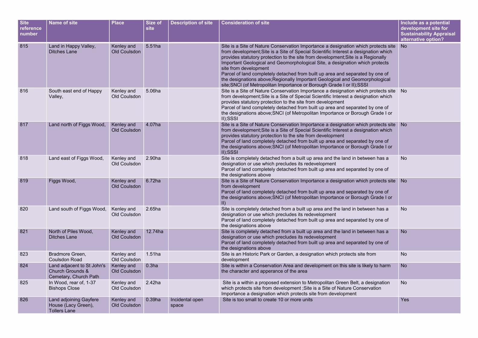
Site reference number
Name of site Place Size of site
Description of site Consideration of site Include as a potential development site for Sustainability Appraisal alternative option?
815 Land in Happy Valley, Ditches Lane
Kenley and Old Coulsdon
5.51ha Site is a Site of Nature Conservation Importance a designation which protects site from development;Site is a Site of Special Scientific Interest a designation which provides statutory protection to the site from development;Site is a Regionally Important Geological and Geomorphological Site, a designation which protects site from development Parcel of land completely detached from built up area and separated by one of the designations above;Regionally Important Geological and Geomorphological site;SNCI (of Metropolitan Importance or Borough Grade I or II);SSSI
No
816 South east end of Happy Valley,
Kenley and Old Coulsdon
5.06ha Site is a Site of Nature Conservation Importance a designation which protects site from development;Site is a Site of Special Scientific Interest a designation which provides statutory protection to the site from development Parcel of land completely detached from built up area and separated by one of the designations above;SNCI (of Metropolitan Importance or Borough Grade I or II);SSSI
No
817 Land north of Figgs Wood, Kenley and Old Coulsdon
4.07ha Site is a Site of Nature Conservation Importance a designation which protects site from development;Site is a Site of Special Scientific Interest a designation which provides statutory protection to the site from development Parcel of land completely detached from built up area and separated by one of the designations above;SNCI (of Metropolitan Importance or Borough Grade I or II);SSSI
No
818 Land east of Figgs Wood, Kenley and Old Coulsdon
2.90ha Site is completely detached from a built up area and the land in between has a designation or use which precludes its redevelopment Parcel of land completely detached from built up area and separated by one of the designations above
No
819 Figgs Wood, Kenley and Old Coulsdon
6.72ha Site is a Site of Nature Conservation Importance a designation which protects site from development Parcel of land completely detached from built up area and separated by one of the designations above;SNCI (of Metropolitan Importance or Borough Grade I or II)
No
820 Land south of Figgs Wood, Kenley and Old Coulsdon
2.65ha Site is completely detached from a built up area and the land in between has a designation or use which precludes its redevelopment Parcel of land completely detached from built up area and separated by one of the designations above
No
821 North of Piles Wood, Ditches Lane
Kenley and Old Coulsdon
12.74ha Site is completely detached from a built up area and the land in between has a designation or use which precludes its redevelopment Parcel of land completely detached from built up area and separated by one of the designations above
No
823 Bradmore Green, Coulsdon Road
Kenley and Old Coulsdon
1.51ha Site is an Historic Park or Garden, a designation which protects site from development
No
824 Land adjacent to St John's Church Grounds & Cemetary, Church Path
Kenley and Old Coulsdon
0.3ha Site is within a Conservation Area and development on this site is likely to harm the character and apperance of the area
No
825 In Wood, rear of, 1-37 Bishops Close
Kenley and Old Coulsdon
2.42ha Site is a within a proposed extension to Metropolitan Green Belt, a designation which protects site from development ;Site is a Site of Nature Conservation Importance a designation which protects site from development
No
826 Land adjoining Gayfere House (Lacy Green), Tollers Lane
Kenley and Old Coulsdon
0.39ha Incidental open space
Site is too small to create 10 or more units Yes
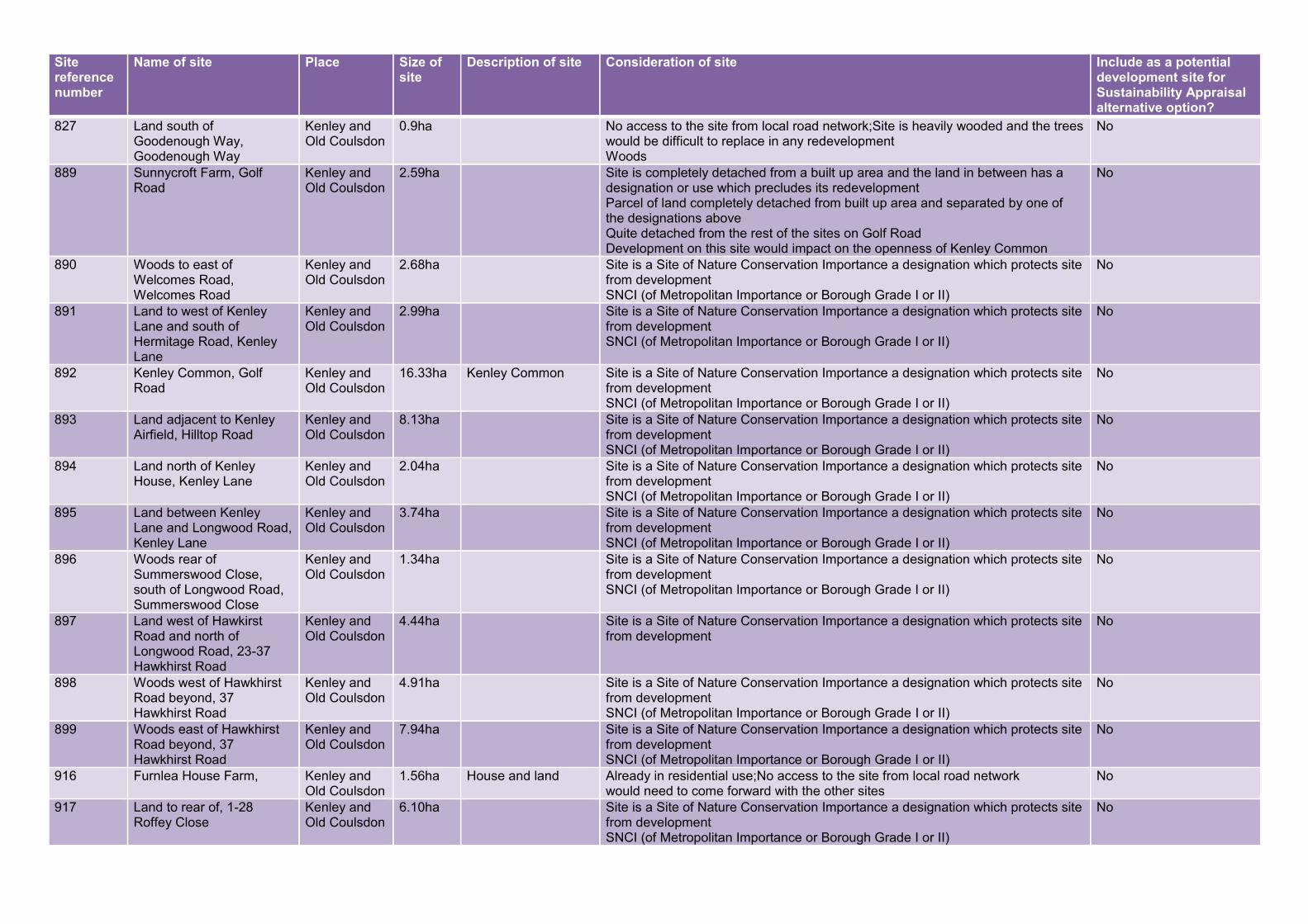
Site reference number
Name of site Place Size of site
Description of site Consideration of site Include as a potential development site for Sustainability Appraisal alternative option?
827 Land south of Goodenough Way, Goodenough Way
Kenley and Old Coulsdon
0.9ha No access to the site from local road network;Site is heavily wooded and the trees would be difficult to replace in any redevelopment Woods
No
889 Sunnycroft Farm, Golf Road
Kenley and Old Coulsdon
2.59ha Site is completely detached from a built up area and the land in between has a designation or use which precludes its redevelopment Parcel of land completely detached from built up area and separated by one of the designations above Quite detached from the rest of the sites on Golf Road Development on this site would impact on the openness of Kenley Common
No
890 Woods to east of Welcomes Road, Welcomes Road
Kenley and Old Coulsdon
2.68ha Site is a Site of Nature Conservation Importance a designation which protects site from development SNCI (of Metropolitan Importance or Borough Grade I or II)
No
891 Land to west of Kenley Lane and south of Hermitage Road, Kenley Lane
Kenley and Old Coulsdon
2.99ha Site is a Site of Nature Conservation Importance a designation which protects site from development SNCI (of Metropolitan Importance or Borough Grade I or II)
No
892 Kenley Common, Golf Road
Kenley and Old Coulsdon
16.33ha Kenley Common Site is a Site of Nature Conservation Importance a designation which protects site from development SNCI (of Metropolitan Importance or Borough Grade I or II)
No
893 Land adjacent to Kenley Airfield, Hilltop Road
Kenley and Old Coulsdon
8.13ha Site is a Site of Nature Conservation Importance a designation which protects site from development SNCI (of Metropolitan Importance or Borough Grade I or II)
No
894 Land north of Kenley House, Kenley Lane
Kenley and Old Coulsdon
2.04ha Site is a Site of Nature Conservation Importance a designation which protects site from development SNCI (of Metropolitan Importance or Borough Grade I or II)
No
895 Land between Kenley Lane and Longwood Road, Kenley Lane
Kenley and Old Coulsdon
3.74ha Site is a Site of Nature Conservation Importance a designation which protects site from development SNCI (of Metropolitan Importance or Borough Grade I or II)
No
896 Woods rear of Summerswood Close, south of Longwood Road, Summerswood Close
Kenley and Old Coulsdon
1.34ha Site is a Site of Nature Conservation Importance a designation which protects site from development SNCI (of Metropolitan Importance or Borough Grade I or II)
No
897 Land west of Hawkirst Road and north of Longwood Road, 23-37 Hawkhirst Road
Kenley and Old Coulsdon
4.44ha Site is a Site of Nature Conservation Importance a designation which protects site from development
No
898 Woods west of Hawkhirst Road beyond, 37 Hawkhirst Road
Kenley and Old Coulsdon
4.91ha Site is a Site of Nature Conservation Importance a designation which protects site from development SNCI (of Metropolitan Importance or Borough Grade I or II)
No
899 Woods east of Hawkhirst Road beyond, 37 Hawkhirst Road
Kenley and Old Coulsdon
7.94ha Site is a Site of Nature Conservation Importance a designation which protects site from development SNCI (of Metropolitan Importance or Borough Grade I or II)
No
916 Furnlea House Farm, Kenley and Old Coulsdon
1.56ha House and land Already in residential use;No access to the site from local road network would need to come forward with the other sites
No
917 Land to rear of, 1-28 Roffey Close
Kenley and Old Coulsdon
6.10ha Site is a Site of Nature Conservation Importance a designation which protects site from development SNCI (of Metropolitan Importance or Borough Grade I or II)
No

Site reference number
Name of site Place Size of site
Description of site Consideration of site Include as a potential development site for Sustainability Appraisal alternative option?
918 Woods to the rear of, 37-75 Caterham Drive
Kenley and Old Coulsdon
6.47ha Site is a Site of Nature Conservation Importance a designation which protects site from development Parcel of land completely detached from built up area and separated by one of the designations above;SNCI (of Metropolitan Importance or Borough Grade I or II)
No
440 Land at, Mitchley Hill Sanderstead 10.31ha Field Very open from all sides- no screening. Feeling that development on this site would very much change the character of this area as would result in development on either side of the valley- currently very open.
Yes
531 Land opposite, 71-109 Mitchley Avenue
Sanderstead 9.69ha Field from the south of the site (access from Honister Heights) site is well screened from all sides with dense trees and bushes- however if decidious trees, the site will no longer be well screened. Further down the site it is overlooked from housing on Derwent Avenue. Due to the topography of the site it seemed more open from the south of the site because of being at the top of the valley. From the north of the site looking up towards the south it was a lot less open.
Yes
532 Field adjacent to Dunmail Drive, Mitchley Hill
Sanderstead 0.78ha Field of natural and semi-natural open space
looks like a meadow sloping upwards dense trees at south and west of site. Sits at the bottom of the valley but less impact on openness that adjacent as more set back towards mitchley wood.
Yes
601 Purley Downs Golf Course, Purley Downs Road
Sanderstead 53.52ha Golf course Site is a Site of Nature Conservation Importance a designation which protects site from development SNCI (of Metropolitan Importance or Borough Grade I or II)
No
649 Croham Hurst Golf Course, Croham Road
Sanderstead 46.14ha Golf Course The site is an operational community facility and there is a presumption against non-community uses Playing field or recreation ground Only function of this site is a golf course- not publically accessible and is built up on all sides- not a 'green lung'. Difficult to determine how prominent the site is due to trees. Site only meets MOL criteria but is not Local Green Space
No
708 Riddlesdown High School playing fields, Honister Heights
Sanderstead 10.52ha Playing fields Site is a school playing field which would be difficult to replace Playing field or recreation ground
No
709 Mitchley Wood, Mitchley Avenue
Sanderstead 4.77ha Woods Site is a Site of Nature Conservation Importance a designation which protects site from development;Site is heavily wooded and the trees would be difficult to replace in any redevelopment SNCI (of Metropolitan Importance or Borough Grade I or II)
No
710 Mitchley Wood, Mitchley Avenue
Sanderstead 5.32ha Woods Site is a Site of Nature Conservation Importance a designation which protects site from development;Site is heavily wooded and the trees would be difficult to replace in any redevelopment SNCI (of Metropolitan Importance or Borough Grade I or II)
No
711 Ragged Grove, 2-64 Holmwood Avenue
Sanderstead 3.49ha Woods Site is a Site of Nature Conservation Importance a designation which protects site from development;Site is heavily wooded and the trees would be difficult to replace in any redevelopment SNCI (of Metropolitan Importance or Borough Grade I or II)
No
712 Land adjacent to, 69 Mitchley Hill
Sanderstead 1.98ha Grassland development on this site would have less impact on openness than site opposite due to being at the bottom of the valley and does not slope that much. Need to view from the top of site 440.
Yes
713 Field at rear of, 116-122 Mitchley Avenue
Sanderstead 1.1ha Field well screened from Mitchley Wood by dense trees. Limited impact on openness and would infill behind existing houses and is separated from other GB sites.
Yes

Site reference number
Name of site Place Size of site
Description of site Consideration of site Include as a potential development site for Sustainability Appraisal alternative option?
714 Horse stables, Dunmail Drive
Sanderstead 0.59ha Horse stables No access to the site from local road network;Site is completely detached from a built up area and the land in between has a designation or use which precludes its redevelopment Parcel of land completely detached from built up area and separated by one of the designations above
No
715 Field to west of, Dunmail Drive
Sanderstead 2.12ha Field No access to the site from local road network;Site is completely detached from a built up area and the land in between has a designation or use which precludes its redevelopment Parcel of land completely detached from built up area and separated by one of the designations above Well screened. Completely detached from rest of built up area. Would have problems with access.
No
716 Land south of Mitchley Wood, adjacent to school playing fields, Dunmail Drive
Sanderstead 1.74ha No access to the site from local road network;Site is completely detached from a built up area and the land in between has a designation or use which precludes its redevelopment Parcel of land completely detached from built up area and separated by one of the designations above Site is well screened by Mitchley Wood- development would only been seen from school and school playing fields. Would have problem with access. Site is completely separated from built up area.
No
717 Land west of Ragged Grove adjacent to Riddlesdown College playing fields, Holmwood Avenue
Sanderstead 5.53ha No access to the site from local road network;Site is completely detached from a built up area and the land in between has a designation or use which precludes its redevelopment Parcel of land completely detached from built up area and separated by one of the designations above Site is well screened by Mitchley Wood/Ragged Grove- development would only been seen from school and school playing fields. Would have problem with access. Site is completely separated from built up area.
No
718 Land south of Riddlesdown College Playing fields, Dunmail Drive
Sanderstead 8.34ha Field No access to the site from local road network;Site is completely detached from a built up area and the land in between has a designation or use which precludes its redevelopment Parcel of land completely detached from built up area and separated by one of the designations above Site is well screened on all sides- completely detached from area and has SNCI to north and south of site. No access apart from footpath/bridleway
No
719 Ansley Berry Shaw & Barnfield Shaw, Wentworth Way
Sanderstead 7.12ha Woods Site is a Site of Nature Conservation Importance a designation which protects site from development;Site is heavily wooded and the trees would be difficult to replace in any redevelopment
No
720 Land west of Ansley Berry Shaw, Wentworth Way
Sanderstead 8.47ha Field No access to the site from local road network;Site is completely detached from a built up area and the land in between has a designation or use which precludes its redevelopment Parcel of land completely detached from built up area and separated by one of the designations above Site is well screened on all sides- completely detached from area and has SNCI to north and south of site. No access apart from footpath/bridleway
No

Site reference number
Name of site Place Size of site
Description of site Consideration of site Include as a potential development site for Sustainability Appraisal alternative option?
721 Land south west of Ansley Berry Shaw, Wentworth Way
Sanderstead 8.17ha Field No access to the site from local road network;Site is completely detached from a built up area and the land in between has a designation or use which precludes its redevelopment Parcel of land completely detached from built up area and separated by one of the designations above Site is well screened on all sides- completely detached from area and has SNCI to north and south of site. No access apart from footpath/bridleway
No
722 Land southeast of Ansley Berry Shaw, Wentworth Way
Sanderstead 8.54ha Field No access to the site from local road network;Site is completely detached from a built up area and the land in between has a designation or use which precludes its redevelopment in terms of openness it is well screened by trees but overlooked by houses- development on this site would impact on the openness of the wider area as a group of green fields. No access by local road network. Also site is fully publically accessible.
No
723 Land east of Ansley Berry Shaw to rear of, 36-66 Wentworth Way
Sanderstead 4.52ha Field No access to the site from local road network;Site is very prominent and there would be significant impacts on openness if it were developed in terms of openness it is well screened by trees but overlooked by houses- development on this site would impact on the openness of the wider area as a group of green fields. No access by local road network. Also site is fully publically accessible.
No
724 Land to rear of and surounding Barnfield Shaw and to rear of, 114-186 Limpsfield Road
Sanderstead 14.37ha Field Site is a Site of Nature Conservation Importance a designation which protects site from development;No access to the site from local road network SNCI (of Metropolitan Importance or Borough Grade I or II)
No
725 Atwood Primary School playing fields, Limpsfield Road
Sanderstead 0.75ha Playing fields Site is a school playing field which would be difficult to replace Playing field or recreation ground
No
732 Sanderstead Plantation, adjacent and to rear of, 55 Addington Road
Sanderstead 8.66ha Woods Site is a Site of Nature Conservation Importance a designation which protects site from development;Site is heavily wooded and the trees would be difficult to replace in any redevelopment SNCI (of Metropolitan Importance or Borough Grade I or II)
No
733 Kings Wood, 65 and Kingswood Lodge Kingswood Way
Sanderstead 67.04ha Woods Site is a Site of Nature Conservation Importance a designation which protects site from development;Site is an Historic Park or Garden, a designation which protects site from development Historic Park and Garden;SNCI (of Metropolitan Importance or Borough Grade I or II)
No
735 Land at end of Blacksmiths Hill to rear of, 33 Blacksmiths Hill
Sanderstead 5.37ha Field Site would be difficult (in terms of character) to integrate with the built up area of the borough Well screened by boundary by trees- development on here will not have impact on surrounding area/openness. Depends on view from golf course and whether trees are screening in the winter
No
737 Land to rear of Onslow Gardens, 14-58 Rear Of Onslow Gardens
Sanderstead 3.60ha Field Site would be difficult (in terms of character) to integrate with the built up area of the borough Very overgrown field with trees. Hard to judge from this location the impact on openness from the golf course. From here would not impact as well screened
No
744 Kingswood Shaw, Rear of, 57-81 Kingswood Way
Sanderstead 14.43ha Site is a Site of Nature Conservation Importance a designation which protects site from development SNCI (of Metropolitan Importance or Borough Grade I or II)
No

Site reference number
Name of site Place Size of site
Description of site Consideration of site Include as a potential development site for Sustainability Appraisal alternative option?
745 Field at southern end of Beech Way, Beech Way
Sanderstead 3.07ha Field No access to the site from local road network No
747 Mossyhill Shaw, Beech Way
Sanderstead 5.37ha Site is a Site of Nature Conservation Importance a designation which protects site from development SNCI (of Metropolitan Importance or Borough Grade I or II)
No
748 Land north of Mosseyhill Shaw, Beech Way
Sanderstead 5.31ha Field No access to the site from local road network;Site is completely detached from a built up area and the land in between has a designation or use which precludes its redevelopment
No
749 Field adjacent to Pinewood Cottage, Kingswood Way
Sanderstead 7.28ha No access to the site from local road network;Site is completely detached from a built up area and the land in between has a designation or use which precludes its redevelopment
No
750 Land to the rear of Kingswood Lodge, Kingswood Lane
Sanderstead 8.4ha No access to the site from local road network;Site is completely detached from a built up area and the land in between has a designation or use which precludes its redevelopment
No
751 Land to south of Kingswood Cotage, Kingswood Lane
Sanderstead 3.75ha No access to the site from local road network;Site is completely detached from a built up area and the land in between has a designation or use which precludes its redevelopment
No
829 Sanderstead Recreation Ground, Limpsfield Road
Sanderstead 7.60ha Recreation ground and sports pitches
If Metropolitan Open Land and Green Belt is released for development this site would meet the criteria for being designated as Local Green Space
No
919 Kingswood Lodge, Kingswood Way
Sanderstead 1.25ha No access to the site from local road network;Site is completely detached from a built up area and the land in between has a designation or use which precludes its redevelopment Parcel of land completely detached from built up area and separated by one of the designations above
No
56 Pioneer Place, Featherbed Lane
Selsdon 1.40ha Place of Worship The site is an operational community facility and there is a presumption against non-community uses
No
479 Falconwood Meadow, Featherbed Lane
Selsdon 1.73ha Field Site is a Site of Nature Conservation Importance a designation which protects site from development
No
650 Bramley Bank Nature Reserve, Riesco Drive
Selsdon 10.59ha Site is a Site of Nature Conservation Importance a designation which protects site from development SNCI (of Metropolitan Importance or Borough Grade I or II)
No
651 Land south of Heathfield, Riesco Drive
Selsdon 4.91ha Field Surrounded by hedges and Bramley Bank Nature Reserve. Would need to be part of all sides. Would stand out on its own.
Yes
652 Heathfield House & Grounds, Ballards Way
Selsdon 7.66ha Site is an Historic Park or Garden, a designation which protects site from development Historic Park and Garden
No
653 Land east of Heathfield, Gravel Hill
Selsdon 6.56ha Field Open field surrounded by hedges- prominent views of New Addington and from Selsdon
Yes
654 Field adjacent to Bramley Bank Nature Reserve, Broadcoombe
Selsdon 1.69ha Field open from all sites. Needs to be considered with other sites in the area. Not a prominent site but could not be developed on its own
Yes
655 Field on, Gravel Hill Selsdon 4.36ha Field Need to consider with wider sites Yes
656 Playing fields north of the Quest Academy, Broadcoombe
Selsdon 3.23ha Rugby pitches Site is a playing field which would be difficult to replace Playing field or recreation ground No public access- open from all sides apart from south of site where gated
No
657 Land north of The Quest Academy, Gravel Hill
Selsdon 6.46ha Field Needs to be part of other sites Yes

Site reference number
Name of site Place Size of site
Description of site Consideration of site Include as a potential development site for Sustainability Appraisal alternative option?
658 Land south of Gravel Hill Tram Stop, Gravel Hill
Selsdon 4.89ha Field Would need to be developed as part of all other sites Yes
734 Old Mid-Whitgiftian Rugby Club, Blacksmiths Hill
Selsdon 5.32ha Sports pitches and pavillion
Site is a sports facility which would be difficult to replace Well laid out playing field and pavillion- well maintained- cricket, rugby and football. Well screened by trees but would need to consider openness and impacts of golf courses in winter
No
738 Selsdon Park Hotel golf course, Rear of Addington Road
Selsdon 72.55ha Golf Course Site is an Historic Park or Garden, a designation which protects site from development Historic Park and Garden
No
739 Croydon High School for Girls Playing Fields, Rear Of Addington Road
Selsdon 4.39ha Playing fields Site is a school playing field which would be difficult to replace No
740 Land at rear of, 2-16 Mapleleaf Close
Selsdon 0.75ha No access to the site from local road network No
741 Land at rear of, 20-24 Kingswood Way
Selsdon 1.12ha No access to the site from local road network No
742 Land at rear of, 26-28 Kingswood Way
Selsdon 1.13ha No access to the site from local road network No
743 Land at rear of, 30-32 Kingswood Way
Selsdon 1.11ha No access to the site from local road network No
746 Land at rear of, 24-36 Beech Way
Selsdon 2.92ha Site is a Site of Nature Conservation Importance a designation which protects site from development SSSI
No
752 Selsdon Wood, Old Farleigh Road
Selsdon 35.15ha Site is a Site of Nature Conservation Importance a designation which protects site from development SNCI (of Metropolitan Importance or Borough Grade I or II)
No
763 Addington Court Golf Club, Featherbed Lane
Selsdon 49.95ha Golf Course Hedgerow along Fetherbed Lane. Bank of trees along southern edge. Very open views as you go up the slope- views across to the other side of the valley. Can begin to see tops of homes in New Addington over trees. From west of site in Forestdale the golf course cannot be seen from this locaiton.
Yes
793 Littleheath Woods, Rear of Littleheath Road
Selsdon 26.46ha Woods Site is a Site of Nature Conservation Importance a designation which protects site from development SNCI (of Metropolitan Importance or Borough Grade I or II)
No
799 Bears Wood, Rear of Court Wood Lane
Selsdon 4.23ha Site is a Site of Nature Conservation Importance a designation which protects site from development SNCI (of Metropolitan Importance or Borough Grade I or II)
No
830 Land to the north and adjoining Selsdon Wood, Cascades
Selsdon 3.08ha Site is a Site of Nature Conservation Importance a designation which protects site from development
No
913 Playground to south of Croham Hurst Golf Course,
Selsdon 1.54ha Site is Metropolitan Open Land and would also the criteria for designation as Local Green Space as consulted upon in the Croydon Local Plan: Detailed Policies (Preferred and Alternative Options);Site is Metropolitan Open Land and would also meet the criteria for designation as Local Green Space as consulted upon in the Croydon Local Plan: Detailed Policies (Preferred and Alternative Options) Playing field or recreation ground This site should be MOL rather than GB- built up on all sides. Would meet the criteria for Local Green Space.
No

Site reference number
Name of site Place Size of site
Description of site Consideration of site Include as a potential development site for Sustainability Appraisal alternative option?
920 Royal Russell School, Coombe Lane
Selsdon 12.08ha School and grounds Site is an Historic Park or Garden, a designation which protects site from development;The site is an operational community facility and there is a presumption against non-community uses Historic Park and Garden
No
502 Coombe Farm, Oaks Road Shirley 3.99ha Former school and hostel buildings
Previously developed site – could be redeveloped Already a proposal site in Detailed Policies and Proposals
620 Foxes Wood, Shirley Church Road
Shirley 3.76ha Site is heavily wooded and the trees would be difficult to replace in any redevelopment
No
621 Addington Palace Golf Club, Gravel Hill
Shirley 18.9ha Golf course Site is a Site of Nature Conservation Importance a designation which protects site from development;Site is an Historic Park or Garden, a designation which protects site from development Historic Park and Garden;SNCI (of Metropolitan Importance or Borough Grade I or II)
No
622 Addington Park, Kent Gate Way
Shirley 10.72ha Site is an Historic Park or Garden, a designation which protects site from development Historic Park and Garden
No
623 Petersfield, Saxons, Slamat, Hillview & Hillside, Bishops Walk
Shirley 2.34ha Site is in multiple ownership and is unlikely to come forward for development as one site;Site is an Historic Park or Garden, a designation which protects site from development Historic Park and Garden
No
624 Ranelagh, The Chinese, Honeywood, Chesnet, Wildacre, Langtons, Tulsivas, Tree Tops, Bishops Walk
Shirley 4.29ha Site is in multiple ownership and is unlikely to come forward for development as one site;Site is an Historic Park or Garden, a designation which protects site from development Historic Park and Garden
No
625 Addington Palace, Gravel Hill
Shirley 1.69ha Site is a Site of Nature Conservation Importance a designation which protects site from development;Site is an Historic Park or Garden, a designation which protects site from development Historic Park and Garden
No
626 Addington Palace Golf Course, Gravel Hill
Shirley 12.11ha Site is a Site of Nature Conservation Importance a designation which protects site from development;Site is an Historic Park or Garden, a designation which protects site from development Historic Park and Garden;SNCI (of Metropolitan Importance or Borough Grade I or II)
No
627 Addington Golf Course, 197-205 Shirley Church Road
Shirley 84.06ha Golf Course Site is a Site of Nature Conservation Importance a designation which protects site from development;Site is an Historic Park or Garden, a designation which protects site from development Historic Park and Garden;SNCI (of Metropolitan Importance or Borough Grade I or II)
No
628 Scout Hut, Camp & Pine Woods, Rear of Pinewood Close
Shirley 4.10ha Site is an Historic Park or Garden, a designation which protects site from development Historic Park and Garden;SNCI (of Metropolitan Importance or Borough Grade I or II)
No
629 Kennel Wood, Land north of Shirley Church Road
Shirley 11.43ha Site is a Site of Nature Conservation Importance a designation which protects site from development SNCI (of Metropolitan Importance or Borough Grade I or II)
No

Site reference number
Name of site Place Size of site
Description of site Consideration of site Include as a potential development site for Sustainability Appraisal alternative option?
630 Shirley Heath, North and rear of Bridle Way
Shirley 8.11ha Site is a Site of Nature Conservation Importance a designation which protects site from development SNCI (of Metropolitan Importance or Borough Grade I or II)
No
631 Treehalfpenny Wood, Bridle Way
Shirley 18.28ha Woods Site is a Site of Nature Conservation Importance a designation which protects site from development SNCI (of Metropolitan Importance or Borough Grade I or II)
No
659 Addington Hills, Coombe Lane
Shirley 50.21ha Site is a Site of Nature Conservation Importance a designation which protects site from development SNCI (of Metropolitan Importance or Borough Grade I or II)
No
663 Shirley Park Golf Club, Addiscombe Road
Shirley 22.29ha Golf course Site is a Site of Nature Conservation Importance a designation which protects site from development;The site is an operational community facility and there is a presumption against non-community uses SNCI (of Metropolitan Importance or Borough Grade I or II) wide expanse of green belt- very prominent site if lost- houses wouldn't blend with contours. However, there is part of this site which is within a bowl which mean that development would be well screened and would not be so prominent.
No
664 Trinity School Playing Fields, Shirley Road
Shirley 6.52ha School playing fields Site is a school playing field which would be difficult to replace Playing field or recreation ground
No
665 John Ruskin Playing Field, Oaks Lane
Shirley 5.24ha Playing fields Site would be difficult (in terms of character) to integrate with the built up area of the borough;Site is a playing field which would be difficult to replace surrounded by mature trees- would need to be part of development of surrounding sites otherwise would be out of place and impact on openness but cannot be seen from elsewhere
No
666 Coombe Park, Oaks Lane Shirley 11.06ha Site is completely detached from a built up area and the land in between has a designation or use which precludes its redevelopment;No access to the site from local road network Parcel of land completely detached from built up area and separated by one of the designations above This site could not be integrated with other sites or developed areas.
No
672 Oaks Farm, Oaks Lane Shirley 1.32ha Former farm buildings
No access to the site from local road network;Site would be difficult (in terms of character) to integrate with the built up area of the borough;Site not suitable for major residential development due to poor access along local roads as they are narrow, unlit and have no pavements and due to a lack of local amenities to serve a larger residential community
No
674 Woods, Oaks Road Shirley 3.29ha Site is heavily wooded and the trees would be difficult to replace in any redevelopment
No
910 Land and houses adjacent to Coombe Park,
Shirley ha Site is in multiple ownership and is unlikely to come forward for development as one site;Site is completely detached from a built up area and the land in between has a designation or use which precludes its redevelopment;Site not suitable for major residential development due to poor access along local roads as they are narrow, unlit and have no pavements and due to a lack of local amenities to serve a larger residential community Parcel of land completely detached from built up area and separated by one of the designations above Quite prominent from site 666. Houses and gardens- reject for this reason.
No

Site reference number
Name of site Place Size of site
Description of site Consideration of site Include as a potential development site for Sustainability Appraisal alternative option?
927 Shirley Park Golf Club, Addiscombe Road
Shirley 24.48ha Golf Course Site would be difficult (in terms of character) to integrate with the built up area of the borough SNCI (of Metropolitan Importance or Borough Grade I or II) this site is less prominent- could not be seen from anywhere. This part of the golf course feels different from the other side and more likely to imagine development on this site.
No
648 Breakneck Hill, Croham Hurst, Upper Selsdon Road
South Croydon
36.60ha Site is a Site of Nature Conservation Importance a designation which protects site from development;Site is an Historic Park or Garden, a designation which protects site from development;Site is a Site of Special Scientific Interest a designation which provides statutory protection to the site from development;Site is a Regionally Important Geological and Geomorphological Site, a designation which protects site from development Historic Park and Garden;Regionally Important Geological and Geomorphological site;SNCI (of Metropolitan Importance or Borough Grade I or II)
No
660 Coombe Wood, Coombe Lane
South Croydon
37.10ha Site is a Site of Nature Conservation Importance a designation which protects site from development;Site is an Historic Park or Garden, a designation which protects site from development Historic Park and Garden;SNCI (of Metropolitan Importance or Borough Grade I or II)
No
661 Coombe Lodge Nurseries, Conduit Lane
South Croydon
4.27ha Former nursery with Difficult to view into the site from the track around the outside. Very well screened. Slightly more open when viewed from the playing fields next door
Site was being considered as a site for Gypsy and Traveller pitches as it is a previously developed site. However site was found to be unsuitable for any residential development due to noise from nearby industrial machinery.
662 Coombe Road Playing Fields, Coombe Road
South Croydon
10.80ha Playing fields Playing field or recreation ground Playing pitches laid out and in use- quite a prominent site. However could be used as school and also have playing fields. The site on the top level is well screened- could be developed and only impact would be on the few houses overlooking the site.
Proposed as a secondary school in Detailed Policies and Proposals. Would have been suitable as a potential development site for Sustainability Appraisal alternative option.
667 Lloyd Park, Coombe Road South Croydon
12.73ha Site is an Historic Park or Garden, a designation which protects site from development Historic Park and Garden
No
670 Lloyd Park, Grimwade Avenue
South Croydon
27.57ha Site is a Site of Nature Conservation Importance a designation which protects site from development;Site is an Historic Park or Garden, a designation which protects site from development Historic Park and Garden;SNCI (of Metropolitan Importance or Borough Grade I or II)
No
671 The Cedars School, Coombe Road
South Croydon
3.39ha Site is an Historic Park or Garden, a designation which protects site from development Historic Park and Garden
No