Section 4 Western Region - VEWH - Water for the ... Watering Plan 2014–15 91 Western Region...
121
Victorian Environmental Water Holder 90 Section 4 Western Region 1 3 2 1 Glenelg system 2 Wimmera system 3 Wimmera-Mallee wetland system Victorian Environmental Water Holder 90
Transcript of Section 4 Western Region - VEWH - Water for the ... Watering Plan 2014–15 91 Western Region...

Victorian Environmental Water Holder90
Section 4Western Region
1
3
2
1 Glenelg system2 Wimmera system3 Wimmera-Mallee wetland system
Victorian Environmental Water Holder90
Seasonal Watering Plan 2014–15 91
Western Region overview
4.0
The Wimmera-Mallee headworks system interconnect three major river basins, the Wimmera, Avoca and Glenelg. The complex network of channels in the Grampians Wimmera Mallee Water (GWMWater) system enables water to be shifted between storages, including from the Glenelg to the Wimmera.
Environmental water is predominantly provided under the Wimmera and Glenelg Rivers Environmental Entitlement 2010, with additional water provided to the Commonwealth Environmental Water Holder in the Wimmera and Glenelg Rivers Bulk Entitlement 2010. Water available under the environmental entitlement is shared between the Wimmera and Glenelg systems, and the Wimmera-Mallee wetlands. Waterways that receive environmental water include sections of the Glenelg, Wimmera and MacKenzie rivers, Mount William, Burnt and Bungalally creeks, in addition to priority wetlands formerly supplied by the Wimmera-Mallee channel system.
Environmental water available for use in western Victoria is held in the Wimmera-Mallee system headworks, which consists of several storages and release points across the two catchments. The headworks system contains many storages and diversions that capture water across the catchments. Moora Moora and Rocklands Reservoirs are in the Glenelg catchment. Lake Wartook, Lake Lonsdale, Lake Bellfield and off-stream storages including Taylor’s Lake Toolondo Reservoir and Lake Fyans are in the Wimmera system.
The Wimmera system forms part of the larger Murray-Darling Basin, and will be subject in the future to sustainable diversion limits outlined in the Murray-Darling Basin Plan.
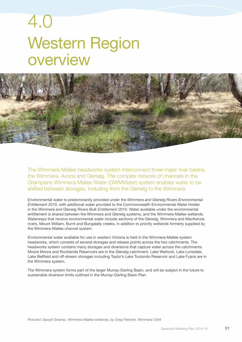
Pictured: Sawpit Swamp, Wimmera-Mallee wetlands, by Greg Fletcher, Wimmera CMA

Victorian Environmental Water Holder92
Water Holdings in the Western Region
Table 4.0.1 Water Holdings available for use in the Western Region
Entitlement Description
Wimmera and Glenelg systems
Wimmera and Glenelg Rivers Environmental Entitlement 2010
40,560 ML of regulated entitlement to supply the Wimmera and Glenelg regulated river systems
1,000 ML of regulated entitlement to supply former channel-fed wetlands
Passing flows in the Wimmera and Glenelg Rivers and Mount William Creek, with some ability to vary rates
Passing flows in Fyans Creek and the Wannon River
Commonwealth Water Holdings
Wimmera system 28,000 ML of regulated entitlement (formerly irrigation product)
4.0 Western Region overview

Seasonal Watering Plan 2014–15 93
4.1
Glenelg system
Waterway manager – Glenelg Hopkins Catchment Management AuthorityStorage manager – GWMWater
Starting and ending in national parks, the Glenelg River is valued for its environmental, economic and social values. The lower section of the Glenelg River has been recognised as a ‘heritage reach’ due to the high-value aquatic life it supports, including the endangered Glenelg freshwater mussel and Glenelg spiny crayfish. It is also home to platypus and important native fish populations, including river blackfish, estuary perch and pygmy perch. The Glenelg River supports riparian vegetation, including the endangered Wimmera bottlebrush. The Glenelg River has been the subject of a significant ongoing restoration program, the ‘Glenelg River Restoration Project’, which received the International River Foundation Australian River Prize in 2013.
System overviewThe Glenelg River starts in the Grampian Ranges and runs for over 500 kilometres, making it one of the longest rivers in Victoria. A short stretch of the estuary winds through South Australia before returning to Victoria to enter the sea at Nelson. The Glenelg system has two main storages that can capture water from the Glenelg River: Moora Moora and Rocklands reservoirs. Moora Moora Reservoir is a relatively small storage in the headwaters of the Glenelg River. Rocklands Reservoir is the largest storage in the Wimmera-Mallee headworks system and captures all inflows from seven creeks and rivers including the Glenelg River downstream of Moora Moora Reservoir. Inter-basin transfers are made from the Glenelg system to supply consumptive, recreational and environmental water uses in the Wimmera system. Despite these impacts, the Glenelg River continues its recovery from the decade of drought through targeted environmental watering actions.
Due to their high environmental value, the priority river reaches in the Glenelg system are reaches 1a (Rocklands Reservoir to 5-Mile Outlet), 1b (5-Mile Outlet to Chetwynd River) and 2 (Chetwynd River to Wannon River), (see Figure 4.1.1). Environmental water in the Glenelg system is released from Rocklands Reservoir, for reach 1a via the reservoir wall outlet, and reach 1b via 5 Mile and 12 Mile outlets, with through flow delivering water to reach 2.
Pictured: Sandford fish ladder at Glenelg River, by Stephen Ryan, Glenelg Hopkins CMA

Victorian Environmental Water Holder94
There is no measurement point in reach 1a, however the measurement point for reach 1b is at Harrow, and for reach 2 at Dergholm. The Glenelg River estuary will also receive some benefit from environmental water releases. The Glenelg River, above Rocklands River (reach 0), is also known to have some environmental values, with further work currently being undertaken to document these values and the flow requirements of this reach.
Passing flows are provided from Rocklands Reservoir into the Glenelg River, and are also provided in the Wannon River via the Wannon Diversion. In the Glenelg River, environmental releases will be combined with passing flows, unregulated flows and the delivery of consumptive water en route to maximise environmental outcomes.
Glenelg Hopkins Catchment Management Authority also advises on management of the Glenelg River compensation flow under GWMWater’s bulk entitlement. The compensation flow provides up to 3,300 ML of flow, depending upon inflows to the Wimmera-Mallee system headworks, for domestic and stock use along with other social and environmental benefits. This water will be managed in line with an annual operating plan developed by the Glenelg Hopkins Catchment Management Authority in consultation with GWMWater and the VEWH, maximising environmental benefits where possible.
Current situationThe Glenelg Basin experienced highly variable rainfall throughout 2013-14. In addition to triggering a flood watch for the Glenelg River, unregulated flow from tributaries contributed to the achievement of several flow recommendations. In contrast to the wet to average winter and spring, January and February 2014 were among the driest on record.
Monitoring results in recent years show that native fish continue to recolonise the Glenelg River with more diverse fish communities found at most monitoring sites. The abundance of key fish species continues to increase in the freshwater reaches, particularly river blackfish, estuary perch, black bream and tupong. Water quality remains within target ranges at all monitoring sites and recruitment of a range of riparian and in-stream plant species has occurred at sites protected from grazing, including widespread flowering of the endangered Wimmera River bottlebrush.
Priority watering actions and environmental objectivesPriority watering actions for the Glenelg River, along with their associated environmental objectives are provided in Table 4.1.1 and illustrated in Figure 4.1.2.
The environmental objectives for the Glenelg system focus on: maintaining sustainable populations of endemic fish species; providing connectivity between reaches to enable fish movement; maintaining appropriate aquatic habitat and food resources for fish; and ensuring water quality is maintained throughout the year.
In addition to the environmental objectives, some of these watering actions will also benefit recreational activities such as fishing.
4.1 Glenelg system

Seasonal Watering Plan 2014–15 95
Glenelg system 4.1
Figure 4.1.1 The Glenelg system
12 Mile Outlet5 Mile Outlet
2
3
1a
1b
2
3
0
1a
01b
Rocklands Reservoir
Moora MooraReservoir
Creek
Miakite
Wannon
Rive
r
Grange
Crawford
Chetwynd
Stee
p
Glenelg
Glenelg
Stokes
Wannon Henty
Kono
ngw
ooto
n
Rive
r
River
River
Burn Creek
Bryans
Cree
k
Wan
do
Cox Creek
Dwyer
Cree
k
River
River
RivuletBank
River
River
Cree
k
Creek
RocklandsToolondo Channel
•
•
•
••
•
•
•
•
•Harrow
Dergholm
Dunkeld
Balmoral
Hamilton
Dartmoor
CavendishCasterton
Coleraine
Penshurst
•Nelson
Glenthompson
Reach Moora Moora Reservoir to Rocklands Reservoir Reach Rocklands Reservoir to 5-Mile OutletReach 5-Mile Outlet to Chetwynd RiverReach Chetwynd River to Wannon RiverReach Wannon River to tidal extent Measurement point Water infrastructure Town•
•

Victorian Environmental Water Holder96
Table 4.1.1 Priority watering actions and environmental objectives for the Glenelg system
Priority watering action Environmental objective
Summer/autumn baseflows targeting reach 1a (10 ML per day or natural during December to May)1
Maintain edge habitats, pools and shallow water habitat availability for fish, macroinvertebrates and platypus
Maintain a near-permanent inundated stream channel to prevent excessive in-stream terrestrial species growth and promote in-stream vegetation
Summer/autumn baseflows targeting reach 1b (15 ML per day or natural during December to May)1
Summer/autumn baseflows targeting reach 2 (25 ML per day or natural during December to May)1
Summer/autumn freshes targeting reach 1a (two freshes of 60 ML per day for two to three days each during December to May)
Provide variable flow during low flow season to support macroinvertebrates (over wood debris to increase biofilm abundance as a food source), diverse habitats and water quality
Facilitate scouring of sand for fish habitat
Maintain condition of emergent vegetation by wetting lower banks
Wet high flow channels
Improve condition of emergent vegetation by wetting lower banks
Introduce wetting during summer to increase biofilm abundance on woody debris as a food source for macroinvertebrates
Flush pools to prevent water quality decline during low flows
Summer/autumn freshes targeting reaches 1b (two freshes of 100 ML per day for two to three days each during December to May)
Summer/autumn freshes targeting reach 2 (two freshes of 150 ML per day for two to three days each during December to May)
Winter/spring freshes targeting reach 1b (one to five freshes of 250 ML per day for one to five days during June to November)
Facilitate scouring of sand for fish habitat
Provide stimulus and opportunity for upstream and downstream fish migration
Maintain pools and inundate benches to improve in-channel diversity
Increase the baseflow water depth to provide stimulus for fish movement (not required in drought years, frequently required in wet years)
Wet low benches and increased edge habitat to improve diversity of habitat
Wet benches to improve condition of emergent vegetation and maintain habitat diversity
Increase flow depth for upstream and downstream fish migration reaches to expand populations of native fish
Winter/spring freshes targeting reach 2 (one to five freshes of 300 ML per day for one to five days during June to November)
Winter/spring baseflows targeting reach 1a (60 ML per day or natural during June to November)1, 2
Maintain seasonality of flow
Improve habitat diversity by increasing wetted area from summer period
Maintain shallow water habitat availability for fish, macroinvertebrates and facilitate annual dispersal of juvenile platypus
Winter/spring baseflows targeting reach 1b (100 ML or natural per day during June to November)1, 2
Winter/spring baseflows targeting reach 2 (160 ML per day or natural during June to November)1, 2
Autumn fresh targeting reach 0 (up to 100 ML for 15 to 30 days during April to May)
Pilot release to test infrastructure and inform future management of this reach
1 While cease-to-flow events naturally occur in the Glenelg River, there is no recommendation to manage for a cease-to-flow event. Therefore cease-to-flow events should occur as infrequently as possible, for as short a duration as possible for up to 145 days in summer and up to 110 days in winter. A pilot cease-to-flow event during low risk conditions in autumn is proposed to increase knowledge of how to restart flow should unplanned cease-to-flow events occur in the future.
2 Passing flows provided under the environmental entitlement generally provide winter/spring baseflows, however, if passing flows are reduced, managed environmental water releases may be required to supplement them or to ensure appropriate rates of rise and fall and providing appropriate conditions during fresh events.
4.1 Glenelg system

Seasonal Watering Plan 2014–15 97
Figure 4.1.2 Priority watering actions in the Glenelg system1
100
200
300
400
500
Dec Jan 2015 Feb Mar AprNovOctSeptAug May JunJuly 2014
Month
Flo
w (M
L) p
er d
ay
Summer/autumn baseflows
Summer/autumn freshes
Winter/spring freshesWinter/spring freshes
Winter/spring baseflow
Winter/spring
baseflow
Autumn Fresh Reach 0
1 This figure is for illustrative purposes only. Scheduling and delivery of particular watering actions within the stated timeframes will vary.
Summer/autumn freshes in reach 1a and winter high flows in all reaches are also important to the health of the Glenelg River, providing longitudinal connectivity and wetting channel margins and low bars in the river. Due to operational constraints and potential flooding risks, achievement of these flow components relies solely on natural events.
Reach 0 of the Glenelg River, between Moora Moora Reservoir and Rocklands Reservoir, contains important environmental values, however, operational delivery of environmental water to this reach is not well understood. A pilot release is proposed to occur in 2014-15 to investigate the feasibility of delivery, and improve knowledge regarding operational and metering issues associated with providing water to this reach.
Whilst cease-to-flow periods do not contribute to stated ecological objectives, they may occur in the future during dry conditions or as a result of low water availability. A brief cease-to-flow event is proposed to occur during March to April 2014-15 to improve knowledge of the logistics of recommencing flow following a cease-to-flow event and to better understand the hydrological and environmental responses in all reaches.
Scenario planningTable 4.1.2 outlines the priority watering actions and expected water usage under a range of planning scenarios.
General triggers for undertaking watering actions have been included in the Planning section (refer to section 1.2.4).
Channel capacity constraints, downstream of Rocklands Reservoir at Frasers Swamp, impact on flow delivery through reach 1a of the Glenelg River. As a result, flow rates released from the reservoir outlet have been limited to 60 ML per day; this rate still enables the delivery of summer/autumn freshes. The release of higher flow rates to deliver priority watering actions to reaches 1b and 2 will occur via 5 Mile and 12 Mile outlets.
Glenelg system 4.1

Victorian Environmental Water Holder98
Table 4.1.2 Priority watering actions in the Glenelg system under a range of planning scenarios
Planning scenario
DROUGHT DRY AVERAGE WET
Expected availability of Water Holdings1
24,285 ML carryover10,655 ML allocation34,940 ML total
24,285 ML carryover32,970 ML allocation57,255 ML total
24,285 ML carryover40,560 ML allocation64,485 ML
24,285 ML carryover40,560 ML allocation28,000 ML Commonwealth Holdings2
92,845 ML total
Priority watering actions
Summer/autumn baseflowsSummer/autumn fresh flowsWinter/spring fresh flowsWinter/spring baseflows
Summer/autumn baseflowsSummer/autumn fresh flowsWinter/spring fresh flowsWinter/spring baseflows
Summer/autumn baseflowsSummer/autumn fresh flowsWinter/spring fresh flowsWinter/spring baseflows
Summer/autumn baseflowsSummer/autumn fresh flowsWinter/spring fresh flowsWinter/spring baseflows
Glenelg system3
Assumed volume of passing flows for the Glenelg River
2,000 ML 12,705 ML 20,216 ML 23,800 ML
Possible volume required from the Water Holdings, in addition to the passing flows3
23,758 ML 19,649 ML 13,923 ML 12,289 ML
Wimmera system4
Assumed volume of passing flows for the Wimmera system
0 ML 0 ML 0 ML 0 ML
Possible volume required from the Water Holdings, in addition to the passing flows4
33,400 ML 36,100 ML 38,800 ML 54,300 ML
Total
Possible volume required from the Water Holdings5
57,158 ML 55,749 ML 52,723 ML 66,589 ML
Possible shortfall/surplus in the volume available in the Water Holdings6
-22,218 ML 1,506 ML 11,762 ML 26,256 ML
1 Victorian Holdings are shared across the Glenelg and Wimmera systems. Volumes specified indicate the likely availability across the two systems.
2 The Commonwealth Environmental Water Holding is only available for use in the Wimmera system.3 The volumes estimated to be supplied from the Water Holdings assume that there will be a contribution from passing
flows in the Glenelg River. If the passing flows do not eventuate, the volume required from the Water Holdings is likely to be higher.
4 The volumes estimated to be supplied from the Water Holdings in the Wimmera River assume that there will be no contribution from passing flows. In reality, passing flows are likely to be significant contributions to baseflows, reducing the reliance of the system on the Water Holdings.
5 Figures take into account the possible volume required in both the Glenelg and Wimmera systems. 6 If there is likely to be a shortfall in supply, a prioritisation process will be undertaken in consultation with the Wimmera
and Glenelg Hopkins catchment management authorities to determine the priority watering actions that will be undertaken in each system in the 2014-15 year. Surplus water can be carried over for critical or early season use in 2015-16.
4.1 Glenelg system

Seasonal Watering Plan 2014–15 99
Risk managementIn preparing its seasonal watering proposal, the Glenelg Hopkins Catchment Management Authority considered and assessed risks, and identified mitigating strategies, relating to the implementation of priority watering actions (refer to Table 4.1.3). Risks and mitigating actions are continually reassessed by environmental watering program partners throughout the water year.
Table 4.1.3 Risk management in the Glenelg system
Risk type Mitigating strategy
Current recommendations on environmental flow inaccurate
A planned cease-to-flow event will only occur when monitoring of water quality indicates that the river is not stressed; monitoring will continue during the cease-to-flow event and after flow has resumed to allow assessment of changes to water qualityA key objective of the pilot release in reach 0 is to help inform the development of flow recommendations for this reach (releases will mimic an autumn rainfall and runoff event under controlled conditions); establishing a monitoring regime is important for this objective
Resource manager cannot deliver required volume or flow rate
Releases have not been made from the Moora Moora system to the Glenelg River for many years; the Glenelg Hopkins Catchment Management Authority will work closely with GWMWater to adapt to actual outlet capacity and channel outfall capacity
Cease-to-flow events cause water quality issues Any planned cease-to-flow event will include water quality monitoring before, during and following the eventEvents will be in cooler weatherReleases will resume as soon as possible if problems are identified
Improved conditions for non-endemic species (carp) There is currently no known means available to disadvantage carp without impacting on desired speciesThe Judas Carp Project is investigating options to manipulate carp behaviour with environmental flows to allow harvesting of populations
Unable to provide evidence in meeting ecological objective
A gauge is needed in reach 1a to demonstrate compliance with flow recommendations and therefore links with ecological outcomes
Key stakeholders unsupportive of environmental water release
Glenelg Hopkins Catchment Management Authority will continue to work with the Glenelg community through its evolving communication and engagement activities to improve understanding of the program and to promote outcomes
ConsultationThe Glenelg Hopkins Catchment Management Authority has engaged with key stakeholders and other relevant individuals in preparing the seasonal watering proposal for the Glenelg system. These stakeholders are listed in Table 4.1.4.
Table 4.1.4 Key stakeholders involved in the development of the seasonal watering proposal for the Glenelg System
Stakeholder consultation
Glenelg Hopkins Catchment Management Authority River Advisory Group GWMWaterWimmera Catchment Management AuthorityVictorian Environmental Water Holder
Glenelg system 4.1

Victorian Environmental Water Holder100
Wimmera system
4.2
Waterway manager – Wimmera Catchment Management Authority
Storage manager – GWMWater
The Wimmera River boasts a wide range of environmental and social values. It is a popular spot for recreational activities such as boating, fishing and camping, and contains many important sites of Indigenous cultural heritage. The lower reach of the Wimmera River downstream of Polkemmet (near Horsham) is listed as a ‘heritage river.’ There are a number of high-value rivers and creeks that flow into the Wimmera River, including the MacKenzie River, and Mount William, Burnt and Bungalally creeks. The Wimmera system is home to many significant plant and animal species and one of Victoria’s few self-sustaining populations of freshwater catfish.
System overviewThe Wimmera River lies in western Victoria, beginning in the Pyrenees, and flowing into Lake Hindmarsh (the largest freshwater lake in Victoria) and Lake Albacutya, which is listed as a wetland of international importance under the Ramsar Convention.
Water in the Wimmera system is stored in three on-stream reservoirs: Lake Wartook on the MacKenzie River; Lake Lonsdale on Mount William Creek; and Lake Bellfield on Fyans Creek. Off-stream storages can harvest water via channels from the Wimmera River, Mount William Creek and Burnt Creek (Taylors Lake) and Fyans Creek (Lake Fyans). The channel system enables water movement between storages, and from the Glenelg to the Wimmera system. Historically, the preferred reservoir for environmental water releases for the Wimmera River is Taylors Lake, given its proximity to target reaches. When storage levels are low in Taylors Lake, releases can be made from Lake Lonsdale, if water is available. Inter-basin transfers of water can occur from Rocklands Reservoir (in the Glenelg system), via the Rocklands-Toolondo Channel, and from Moora Moora Reservoir, via the Moora Channel, to the Wimmera.
Pictured: Wimmera River Glenorchy, by Wimmera CMA
Seasonal Watering Plan 2014–15 101
The priority river reaches for environmental water management in the Wimmera River are reach 4 (MacKenzie River to Lake Hindmarsh) and then the lower section of reach 2 (Huddlestons Weir to Mt William Creek) and reach 3 (Mount William Creek to MacKenzie River). These reaches contain self-sustaining populations of freshwater catfish, and other endemic fish species including flat-headed gudgeon and smelt. These are the only reaches where environmental water can be actively managed, as the upper reaches are mostly unregulated. Mount William Creek can be used to deliver water to the Wimmera River, and is also a priority reach for the delivery of environmental water to assist in maintaining the creek’s healthy populations of endemic fish, in both the upper and lower sections.
The priority river reaches in the MacKenzie River are reaches 2 (Dad and Dave Weir to Distribution Heads) and 3 (Distribution Heads to the Wimmera River), with reach 1 (Lake Wartook to Dad and Dave Weir) receiving flows year round for Horsham’s water supply. The MacKenzie River contains the only long-term recorded population of platypus in the Wimmera region and also supports good populations of native fish. Delivery of environmental water to reaches 2 (Dad and Dave Weir to Distribution Heads) and 3 (Distribution Heads to the Wimmera River) will also provide benefits to reach 1 of the MacKenzie River (Lake Wartook to Dad and Dave Weir), and reach 4 of the Wimmera River (MacKenzie River to Lake Hindmarsh). Protecting and restoring riparian vegetation communities objectives, also make Burnt and Bungalally creeks a priority for environmental watering. Upper Burnt Creek contains an important native fish community and a population of the threatened western swamp crayfish. These creeks provide important habitat corridors for both aquatic and terrestrial species. The environmental flow reaches are shown in Figure 4.2.1. Key measurement points for the Wimmera River are at Lochiel Railway Bridge for reach 4 and at Horsham for reach 2 and 3. MacKenzie River reach 3 is measured at MacKenzie Creek Reserve, lower Mount William Creek is measured at Lake Lonsdale Tailgauge, upper Mount William Creek at Mokepilly and upper Burnt Creek at Wonwondah East.
Passing flows are provided to the Wimmera River, Mount William and Fyans creeks. Where possible, environmental water releases will be combined with passing flows, unregulated flows and the delivery of consumptive water en route to maximise environmental outcomes.
The environmental flow reaches are shown in Figure 4.2.1.
Wimmera system 4.2
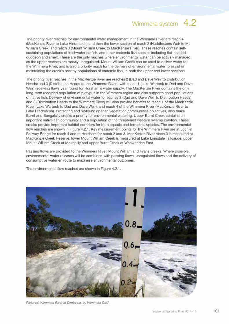
Pictured: Wimmera River at Dimboola, by Wimmera CMA

Victorian Environmental Water Holder102
Figure 4.2.1 The Wimmera system
4.2 Wimmera system
River
Creek
Distribution Heads
•
•
•
•
Horsham
Dimboola
Wail
Lochiel
Lake Hindmarsh
Lake Albacutya
Lake Lonsdale
Lake Fyans
Lake Wartook
Toolondo Reservoir
Lake Bellfield
Mount
River
River
Wimmera
Wim
mera
William
Creek
Yarriambiack
Avon
Rich
ards
on
River
Burnt Creek
MacKenzie
River
Fyans
Creek
HuddlestonsWeir
Dad and Dave Weir
Lake Buloke
TaylorsLake
Lake CoorongLake Lascelles
Bungalally Creek
3
2
1
4
1
Donald
Hopetoun
Warracknabeal
3
2
••
•
2
3
4
1
2
3
1Reach 1 Wimmera River: Glenorchy to Huddlestons WeirReach 2 Wimmera River: Huddlestons Weir to Mt William Creek Reach 3 Wimmera River: Mt William Creek to MacKenzie River Reach 4 Wimmera River: MacKenzie River to Lake HindmarshReach 1 MacKenzie River: Lake Wartook to Dad and Dave WeirReach 2 MacKenzie River: Dad and Dave Weir to Distribution HeadsReach 3 MacKenzie River: Distribution Heads to Wimmera River Burnt Creek (upper): Distribution Heads to Toolondo Channel Burnt Creek (lower): Toolondo Channel to Wimmera River Bungalally Creek: Toolondo Channel to MacKenzie River Lower Mount William Creek: Lake Lonsdale to Wimmera River Upper Mount William Creek: upstream of Lake Lonsdale Measurement point Water infrastructure Town

Seasonal Watering Plan 2014–15 103
Current situationImproved natural inflows and active environmental water management has substantially improved river health in the Wimmera system in recent years. Increased inflows to headwater streams and storages, combined with water savings generated by the completion of the Wimmera Mallee Pipeline, means that much more water has been available for the region’s waterways compared to when drought conditions prevailed. The delivery of environmental water has assisted in maintaining water quality, providing habitat and resources for macroinvertebrates, fish, platypus and vegetation communities for many waterways in the Wimmera system.
Since mid to late 2011, conditions have been very dry; however, environmental watering has helped to maintain recent improvements in river health. Releases from storages (Lake Lonsdale and Taylors Lake) to the Wimmera River have been continuous throughout 2013-14, apart from a planned cease-to-flow in early summer and an unplanned cease-to-flow for several weeks in March/April when works were undertaken on the Dimboola weir.
In winter/spring 2013-14, 1,900 ML was released in reach 3 of the MacKenzie River. Baseflows and five freshes were achieved, with fish monitoring showing good outcomes from these releases. 1,590 ML was also delivered in reach 2 of the MacKenzie River, punctuated by prescribed cease-to-flow periods. Experience over recent years, combined with regular water quality sampling and inspection of reach 2, indicates that the volumes delivered have successfully protected the fish and platypus population. The Grampians bushfire in January 2014 burnt to the banks of the MacKenzie River. Despite the fire, as well as floods and drought in recent years, four platypuses, including two juveniles, a sub-adult and an adult, all in good condition, were caught in reaches 1 and 2 in the MacKenzie River in April 2014. The discovery of the platypuses is a good indicator of the health and resilience of the MacKenzie River after a long period of environmental watering.
In winter/spring 2013-14, 150 ML was delivered to the lower Burnt Creek, delivering baseflows and freshes. Baseflows and three freshes were also achieved in the upper Burnt Creek, with 926 ML delivered. The delivery of baseflows and freshes has assisted the continued recovery of riparian vegetation initiated by the 2010-11 floods that will further support the native fish population as well as a population of the threatened western swamp crayfish.
In summer/autumn 2013-14, 951 ML was delivered to lower Mount William Creek delivering baseflows and three freshes. The delivery of environmental water has assisted in maintaining the creek’s endemic fish populations.
Priority watering actions and environmental objectivesPriority watering actions along with their associated environmental objectives are provided in Table 4.2.1 and illustrated in Figures 4.2.2-4.2.6.
Environmental objectives for the Wimmera River focus on: maintaining water quality and supporting the self-sustaining freshwater catfish in the Wimmera River; providing suitable habitat for platypus in the mid-MacKenzie River; protecting high-value fish and vegetation populations in the MacKenzie River, Burnt Creek and Mount William Creek; and maintaining vegetation condition in Bungalally Creek.
Delivery of priority watering actions may also support recreational activities such as fishing, rowing, and triathlons.
Wimmera system 4.2

Victorian Environmental Water Holder104
Table 4.2.1 Priority watering actions and associated environmental objectives for the Wimmera system
Priority watering action Environmental objective
Wimmera River (reach 4)
Summer/autumn baseflows (15 ML per day or natural1)2, 3
Maintain edge habitats in deeper pools and runs, and shallow water habitat availability for macroinvertebrates and native fish from the local areaMaintain near-permanent inundated stream channel for riparian vegetation and to prevent excessive in-stream terrestrial species growth
Winter/spring baseflows (30 ML per day) Provide flow variability to maintain diversity of habitats
Summer/autumn freshes (one to three events of 70 ML per day for two to seven days during December to May)
Provide variable flow during low flow season for macroinvertebrates (inundate woody debris to increase food sources), fish movement and to maintain water quality and diversity of habitat
Winter/spring freshes (one to five events of 70 ML per day for two to four days during June to November)
Increase the baseflow water depth to provide stimulus for fish movementProvide flow variability to maintain water quality and diversity of fish habitats
Winter/spring freshes (one to three events of 200 ML per day for one to three days during June to November)
Wet lower benches, entraining organic debris and promoting diversity of habitat
MacKenzie River (reach 2 and 3)
Year-round baseflows (of 2-27 ML per day or natural1)2, 4
Maintain edge habitats and deeper pools and runs for macroinvertebratesMaintain inundated stream channel to protect and restore riparian and floodplain vegetation communities, including the Wimmera bottlebrush and support aquatic vegetation for fish habitatMaintain sufficient area of pool habitat for intact fish communities, and shallow water habitats for small-bodied fishPrevent excessive stream-bed colonisation by terrestrial vegetation speciesFacilitate annual dispersal of juvenile platypus into the Wimmera River
Summer/autumn freshes (three to four events of 5- 50 ML per day for four to seven days each during December to May)
Provide variable flow during low flow season for macroinvertebrates (over wood debris to increase biofilm abundance as a food source), fish movement and to maintain water quality and diversity of habitat
Winter/spring freshes (five events of 35 - 55 ML per day for two to seven days during June to November)
Stimulate fish movement and maintain water quality and diversity of habitat
Burnt Creek
Year-round baseflows targeting upper Burnt Creek (1 ML per day or natural1)2, 5
Maintain edge habitats and deeper pools and runs for macroinvertebratesMaintain inundated stream channel to protect and restore riparian and floodplain vegetation communities, and prevent excessive stream bed colonisation by terrestrial vegetation speciesMaintain sufficient area of pool habitat for intact fish communities, and shallow water habitats for small-bodied fish
Summer/autumn fresh targeting upper Burnt Creek (three events of 30 ML per day for two to seven days each during December to May)
Prevent water quality decline by flushing pools during low flows
Winter/spring fresh targeting upper Burnt Creek (one to five events of 55 ML per day for three to seven days during June to November)
Provide variable flow for fish movement and diversity of habitatFlush surface sediments from hard substrates for macroinvertebrates
4.2 Wimmera system

Seasonal Watering Plan 2014–15 105
Priority watering action Environmental objective
Burnt Creek (continued)
Winter fresh targeting upper Burnt Creek (one to three events of 160 ML per day for one to three days during May and June)
Disturb the algae/bacteria/organic biofilm present on rock or wood debris to support macroinvertebrate communities
Year-round fresh targeting lower Burnt Creek (one event of 45 ML per day or natural1 for two days at anytime)6
Inundate riparian vegetation to maintain condition and facilitate recruitmentEntrain organic debris in the channel to support macroinvertebratesMaintain structural integrity of channel
High flow fresh targeting lower Burnt Creek (one event of 90 ML per day for one day during August to November)6
Inundate floodplain vegetation to maintain condition and facilitate recruitmentEntrain organic debris from the floodplain to support macroinvertebratesMaintain floodplain geomorphic features
Bungalally Creek
Year-round fresh (one event of 60 ML per day for one to two days at any time)
Inundate riparian zone to maintain condition and facilitate recruitment for riparian vegetation communitiesMaintain structural integrity of channel and prevent loss of channel diversity through lack of flow variability
Mount William Creek
Summer/autumn freshes targeting upper Mount William Creek (two events of >1 ML per day for five days during December to May)
Maintain habitat for native fish
Year-round baseflows targeting lower Mount William Creek (5 ML per day or natural1)2, 7
Maintain edge habitats and deeper pools and runs for macroinvertebratesMaintain inundated stream channel to protect and restore riparian and floodplain vegetation communities, and prevent excessive stream bed colonisation by terrestrial vegetation speciesMaintain sufficient area of pool habitat for intact fish communities, and shallow water habitats for small-bodied fishPrevent excessive stream-bed colonisation by terrestrial vegetation species
Summer/autumn freshes targeting lower Mount William Creek (three events of 20 - 30 ML per day for two to seven days during December to May)
Prevent water quality decline by flushing pools during low flowsProvide variable flow during low flow season for macroinvertebrates (over wood debris to increase biofilm abundance as a food source), fish movement and to maintain water quality and diversity of habitat
Winter/spring freshes targeting lower Mount William Creek (one to five events of 100 ML per day for three to seven days during June to November)
Wet benches, entrain organic debris and promote diversity of habitatFlush surface sediments from hard substrates to support macroinvertebrates
1 ‘Or natural’ means that flow rates may be above or below the specified target rates depending upon inflows and climatic conditions.
2 Note that cease-to-flow events are not recommended in any of these catchments and that the duration and frequency of events should be minimised. Any cease-to-flow event should be followed with a fresh lasting at least seven days in duration.
3 Cease-to-flow events should be limited to less than 21 days in total for Wimmera River reach 4. 4 Cease-to-flow events should be limited to less than 80 days in total for MacKenzie River reach 3 and to less than 21
days in total for MacKenzie River reach 2.5 Cease-to-flow events should be limited to less than 80 days in total for upper Burnt Creek.6 Consent will be sought for any flows that may impact on private land.7 Cease-to-flow events should be limited to less than 90 days in total for lower Mount William Creek.
Table 4.2.1 Priority watering actions and associated environmental objectives for the Wimmera system (continued)
Wimmera system 4.2
Victorian Environmental Water Holder106
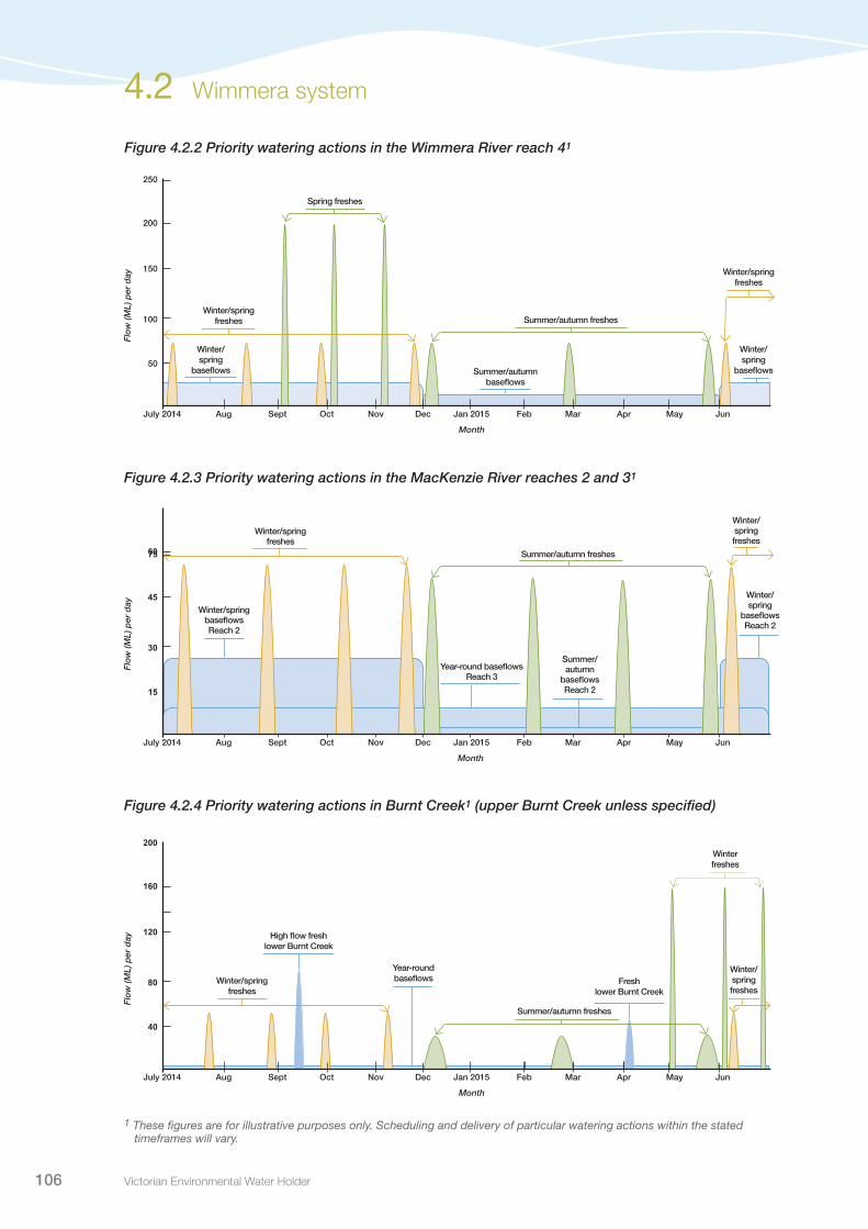
Figure 4.2.2 Priority watering actions in the Wimmera River reach 41
Figure 4.2.3 Priority watering actions in the MacKenzie River reaches 2 and 31
Figure 4.2.4 Priority watering actions in Burnt Creek1 (upper Burnt Creek unless specified)
50
100
150
200
250
Dec Jan 2015 Feb Mar AprNovOctSeptAug May JunJuly 2014
Month
Flo
w (M
L) p
er d
ay
Summer/autumn baseflows
Summer/autumn freshes
Winter/spring freshes
Winter/spring freshes
Winter/spring
baseflows
Spring freshes
Winter/spring
baseflows
75
15
30
45
60
Dec Jan 2015 Feb Mar AprNovOctSeptAug May JunJuly 2014
Month
Flo
w (M
L) p
er d
ay
Year-round baseflowsReach 3
Summer/autumn freshes
Winter/spring freshes
Winter/spring freshes
Winter/spring baseflows Reach 2
Winter/spring
baseflowsReach 2
Summer/autumn
baseflowsReach 2
40
80
120
160
200
Dec Jan 2015 Feb Mar AprNovOctSeptAug May JunJuly 2014
Month
Flo
w (M
L) p
er d
ay
Year-round baseflows
Summer/autumn freshes
Winter freshes
High flow fresh lower Burnt Creek
Fresh lower Burnt Creek
Winter/spring freshes
Winter/spring freshes
4.2 Wimmera system
1 These figures are for illustrative purposes only. Scheduling and delivery of particular watering actions within the stated timeframes will vary.

Seasonal Watering Plan 2014–15 107
Figure 4.2.5 Priority watering actions in Mount William Creek1 (lower Mount William Creek unless specified)
Figure 4.2.6 Priority watering actions in the Bungalally system1
1 These figures are for illustrative purposes only. Scheduling and delivery of particular watering actions within the stated timeframes will vary.
20
40
60
80
100
Dec Jan 2015 Feb Mar AprNovOctSeptAug May JunJuly 2014
Month
Flo
w (M
L) p
er d
ay
Year-round baseflows
Summer/autumn freshes
Winter/spring freshesWinter/spring freshes
Summer/autumn freshes Upper Mount William Creek
15
30
45
60
75
Dec Jan 2015 Feb Mar AprNovOctSeptAug May JunJuly 2014
Month
Flo
w (M
L) p
er d
ay
Year-round fresh
Wimmera system 4.2

Victorian Environmental Water Holder108
Scenario planningTable 4.2.2 outlines the priority watering actions and expected water usage under a range of planning scenarios.
General triggers for undertaking watering actions have been included in the Planning section (refer to section 1.2.4).
Water resource management in the Wimmera system is complex, with numerous storages and variable release points for supplying environmental, consumptive, and recreational water. Planning for and delivery of environmental water requires flexible and adaptive management. There are supply routes that maximise environmental outcomes throughout the system, although it may be impossible to deliver during certain periods due to storage levels or water quality issues. This may limit the viability of some priority watering actions. Wimmera Catchment Management Authority will work closely with GWMWater to maximise environmental outcomes.
Yarriambiack Creek is a distributary of the Wimmera River, flowing northwards into the Mallee region. Historically, the creek would only receive flows during high flow events in the Wimmera River. The Yarriambiack Creek off-take has since been modified, resulting in flows entering the creek on a more frequent basis. When delivering environmental water to the Wimmera River reach 4, losses are incurred into Yarriambiack Creek. Under some circumstances it may be necessary to block flows entering the creek to ensure priority watering actions in the Wimmera River can occur effectively.
Table 4.2.2 Priority watering actions under a range of planning scenarios in the Wimmera system
Planning scenario
DROUGHT DRY AVERAGE WET
Expected availability of Water Holdings1
24,285 ML carryover10,655 ML allocation34,940 ML total
24,285 ML carryover32,970 ML allocation57,255 ML total
24,285 ML carryover40,560 ML allocation64,485 ML total
24,285 ML carryover40,560 ML allocation28,000 ML Commonwealth Holdings2
92,485 ML total
Wimmera River reach 4
Priority watering actions
Year-round baseflowsSummer/autumn freshesWinter/spring freshes
Year-round baseflowsSummer/autumn freshesWinter/spring freshes
Year-round baseflowsSummer/autumn freshesWinter/spring freshes
Year-round baseflowsSummer/autumn freshesWinter/spring freshes
Possible volume required from the Water Holdings
17,600 ML 18,400 ML 18,700 ML 32,000 ML
MacKenzie River reaches 2 & 3
Priority watering actions
Year-round baseflows Summer/autumn freshesAutumn/winter/spring freshes
Year-round baseflowsSummer/autumn freshesAutumn/winter/spring freshes
Year-round baseflowsSummer/autumn freshesAutumn/winter/spring freshes
Year-round baseflowsSummer/autumn freshesAutumn/winter/spring freshes
Possible volume required from the Water Holdings
10,700 ML 11,400 ML 11,900 ML 12,000 ML
Burnt Creek (upper and lower)
Priority watering actions
Year round base flowsSummer/autumn freshesWinter /spring fresh (all upper Burnt Creek)
Year-round baseflowsSummer/autumn freshesWinter/spring freshesWinter fresh (all upper Burnt Creek)Year-round fresh (lower Burnt Creek)
Year-round baseflowsSummer/autumn freshesWinter/spring freshesWinter fresh (all upper Burnt Creek)Year-round fresh (lower Burnt Creek)
Year-round baseflowsSummer/autumn freshesWinter/spring freshesWinter fresh (all upper Burnt Creek)Year-round fresh (lower Burnt Creek)
Possible volume required from the Water Holdings
2,100 ML 2,700 ML 4,000 ML 4,200 ML
4.2 Wimmera system

Seasonal Watering Plan 2014–15 109
Planning scenario
DROUGHT DRY AVERAGE WET
Bungalally Creek
Priority watering actions None None Year-round fresh Year-round fresh
Possible volume required from the Water Holdings
0 ML 0 ML 300 ML 300 ML
Mount William Creek
Priority watering actions
Year-round baseflows Summer/autumn freshesWinter/spring freshes
Year-round baseflowsSummer/autumn freshesWinter/spring fresh
Year-round baseflowsSummer/autumn freshesWinter/spring fresh
Year-round baseflowsSummer/autumn freshesWinter/spring fresh
Possible volume required from the Water Holdings
3,000 ML 3,600 ML 3,900 ML 5,800 ML
Wimmera system total3
Assumed volume of passing flows for the Wimmera system
0 ML 0 ML 0 ML 0 ML
Possible volume required from the Water Holdings, in addition to the passing flows3
33,400 ML 36,100 ML 38,800 ML 54,300 ML
Glenelg system4
Assumed volume of passing flows for the Glenelg River
2,000 ML 12,705 ML 20,216 ML 23,800 ML
Possible volume required from the Water Holdings, in addition to the passing flows4
23,758 ML 19,649 ML 13,923 ML 12,289 ML
TOTAL
Possible volume required from the Water Holdings5
57,158 ML 55,749 ML 52,723 ML 66,589 ML
Possible shortfall/surplus in the volume available in the Water Holdings6
-22,218 ML 1,506 ML 11,762 ML 26,256 ML
1 Victorian Water Holdings are shared across the Glenelg and Wimmera systems. Volumes specified indicate the likely availability across the two systems.
2 The Commonwealth Environmental Water Holdings are only available for use in the Wimmera system.3 The volumes estimated to be supplied from the Water Holdings in the Wimmera system assume that there will be no
contribution from passing flows. In reality, passing flows are likely to be significant contributions to baseflows, reducing the reliance of the system on the Water Holdings.
4 The volumes estimated to be supplied from the Water Holdings assume that there will be a contribution from passing flows in the Glenelg River. If the passing flows do not eventuate, the volume required from the Water Holdings is likely to be higher.
5 Figures take into account the possible volume required in both the Glenelg and Wimmera systems. 6 If there is likely to be a shortfall in supply, a prioritisation process will be undertaken in consultation with the Wimmera
and Glenelg Hopkins catchment management authorities to determine the priority watering actions that will be undertaken in each system in the 2014-15 year. Surplus water can be carried over for critical or early season use in 2015-16.
Table 4.2.2 Priority watering actions under a range of planning scenarios in the Wimmera system (continued)
Wimmera system 4.2

Victorian Environmental Water Holder110
Risk managementIn preparing its seasonal watering proposal, the Wimmera Catchment Management Authority has considered and assessed risks, and identified mitigating strategies, relating to the implementation of priority watering actions (refer to Table 4.2.3). Risks and mitigating actions are continually reassessed by environmental watering program partners throughout the water year.
Table 4.2.3 Risk management in the Wimmera system
Risk type Mitigating strategy
Release volume is insufficient in meeting required flow at target point
Visual monitoring and automated gaugingIncrease environmental water releases if possibleTemporarily block Yarriambiack Creek offtake, if required
New recommendations on environmental flow inaccurate Conduct monitoring to improve environmental flow recommendations
Storage manager maintenance works affect ability to deliver water
Ongoing dialogue with GWMWater regarding storage status and the development of contingency plans to release water through other points
Storage manager cannot deliver required volume or flow rate (outlet/capacity constraints, insufficient storage volume)
Ongoing dialogue with GWMWater regarding storage status and the development of contingency plans to release water through other pointsPotential for works to be undertaken to improve delivery ratesMay require reprioritisation of flows in certain areas (eg. MacKenzie/Burnt/Bungalally) should storage levels remain low)
Limited catchment management authority resource to deliver environmental release
Multiple catchment management authority staff to implement seasonal watering plan, thereby reduce resourcing risk
Environmental release causes personal injury to river user Recommended releases are not considered a significant risk in terms of personal injury, nevertheless there will be public communication (SMS service) of environmental releases
Improved conditions for non-native species (eg. carp) Research species control methods (eg. Carp Pod Trap)
Environmental releases causes flooding of private land, public infrastructure or Crown land
Monitor upstream inflows and cease releases when high flows are occurring or substantial rainfall is forecastAffected landholders will be notified where higher flows may impact on them (eg. through inundating low level farm crossings) and consent will be sought for any flows that may impact on private landWhere public roads are expected to be inundated, Wimmera Catchment Management Authority will communicate with the roads manager to coordinate signage
Releases cause water quality issues (eg. blackwater, low dissolved oxygen, mobilisation of saline pools, etc)
Salinity and dissolved oxygen monitoringUndertake further research into saline pools
Environmental water account is overdrawn Regular consideration of water availability and correct scenario outcomes to determine priority watering actions in consultation with the storage manager, Glenelg Hopkins Catchment Management Authority and the VEWH
4.2 Wimmera system

Seasonal Watering Plan 2014–15 111
Risk type Mitigating strategy
Unable to provide evidence in meeting ecological objective
Emphasis on monitoring (eg. through the Victorian Environmental Flows Monitoring and Assessment Program)
Key stakeholders (community) not supportive of environmental water release
Ensure processes are rigorous and scientifically basedContinue to educate community/other authorities on the importance of releasesContinue to deliver messages about the effectiveness of environmental water reserveMaintain strategic relationships with relevant community groups
ConsultationThe Wimmera Catchment Management Authority has engaged with key stakeholders and other relevant individuals in preparing of the seasonal watering proposal for the Wimmera system. These stakeholders are listed in Table 4.2.4.
Table 4.2.4 Key stakeholders involved in the development of the seasonal watering proposal for the Wimmera system
Stakeholder consultation
GWMWaterGlenelg Hopkins Catchment Management AuthorityCommonwealth Environmental Water OfficeVictorian Environmental Water Holder
Table 4.2.3 Risk management in the Wimmera system (continued)
Wimmera system 4.2

Victorian Environmental Water Holder112
Wimmera-Mallee wetland system
4.3
Waterway managers – Wimmera Catchment Management Authority, Mallee Catchment Management Authority and North Central Catchment Management Authority
Storage manager – GWMWater
The Wimmera-Mallee wetland system is made up of 52 small dams and wetlands including freshwater meadows, open freshwater lakes and freshwater marshes located on public and private land in western Victoria. The wetlands vary in size and consist of a diverse range of vegetation communities, which are home to a variety of native waterbird populations, including brolgas, egrets, blue-billed ducks, freckled ducks, Australian painted snipe and glossy ibis. They also provide a valuable source of water for other native animals such as the vulnerable growling grass frog. These wetlands are highly valued by the community, providing places for recreational activities including canoeing and bird watching.
System overviewThe Wimmera-Mallee wetlands are located in north-western Victoria (see Figure 4.3.1). There is great variation in the character of the wetlands, which provide habitat, feeding and breeding opportunities for a range of waterbirds and animals. Important vegetation communities, such as spiny lignum, ridged water milfoil and cane grass are also present in the wetlands.
Water delivery infrastructure modernisation throughout the Wimmera-Mallee region has seen a shift from open channel systems to a highly-efficient piped water supply system. This change has resulted in significant water savings, which have been redirected to deliver economic, social and environmental benefits in the region. Numerous wetlands in the Wimmera-Mallee region formerly received outflows from the open channel system in addition to localised inflows during very wet periods, supporting various environmental values across the system. The need for water to support these values was recognised through the creation of a 1,000 ML entitlement to counteract the loss of open water in the landscape. Priority wetlands were selected by their environmental importance, hydrology, land management, location, feasibility of connection and delivery capacity.
Environmental water available under the wetland component of the entitlement is supplied by the Wimmera-Mallee Pipeline.
Pictured: Moreton Plains Reserve, Wimmera-Mallee wetlands, by Wimmera CMA

Seasonal Watering Plan 2014–15 113
WIMMERA SYSTEM
AVOCASYSTEM
WIMMERA MALLEE
WETLANDSRiver
Creek
Horsham
Dimboola
Lake Hindmarsh
Lake Albacutya
LakeLonsdale Toolondo
Reservoir
River
River
Wimmera
Wim
mera
William
Toolondo
Channel
Creek
Yarriambiack
Avon
Rich
ards
on
River
Burnt Creek
Mackenzie
River
Fyans
Creek
Lake Lascelles
Lake Buloke
TaylorsLake
Lalbert
Avoca
River
Creek
Tyrell
Creek
Lake Wartook
Lake Bellfield
Considines*
Beulah Weir Pool John Ampt
Cronomby Tanks
Chiprick (both)
Poyner*
Schultz/Koschitzke
Tarkedia Dam
Crow Swamp
Krong Swamp
Pinedale
Challambra Swamp
Harcoans
Jesse Swamp
Fieldings Dam
Mutton
Wal Wal Swamp
Creswick Swamp
Corack Lake
Jeffcott Wildlife ReserveFalla Dam
Cherrip Swamp
Davis DamCarapugna Moreton Plains Reserve
Sawpit Swamp
Opies Dam
!
!
Donald
Birchip
Hopetoun Wetlandslabelled in inset
Sea Lake
Glenorchy
Wedderburn
Wycheproof
Warracknabeal
Cokym Busland Reserve*
* Mallee System 5 Wetlands filled from the Murray
Priority wetlands for environmental waterTown•
Lake Hindmarsh
Lake Albacutya
Yarriambiack
Lake Lascelles
Murray
Lalbert
Tyrell
8
2
17
10
5
26
Birchip
Hopetoun
Sea Lake
WIMMERA
SYSTEM
AVOCA
SYSTEM
Wetlands inset
Barbers Swamp
Mahoods Corner
Coundons Wetland Rickard Glenys Dam
Paul Barclay
Round Swamp Bushland ReserveLake Danaher
Bushland ReserveBull Swamp
Goulds ReserveD Smith
Shannons Wayside
Roselyn Wetland/Reids Dam Greens Wetland (2)Part of Gap Reserve
Homelea Pam Juergens Dam
Tchum Lakes Lake Reserve and Tchum Lakes Swimming Pool
Kath Smith Dam
Clinton Shire Dam
Towma (Lake Marlbed) Broom Tank
J Ferrier WetlandR Ferriers Dam
Basins
WIMMERA SYSTEM
WIMMERAMALLEE
WETLANDS
AVOCASYSTEM
Figure 4.3.1. The Wimmera-Mallee wetland system
Wimmera-Mallee wetland system 4.3

Victorian Environmental Water Holder114
Current situationRecent watering of the wetlands has been influenced by factors including whether the wetland was supplied from the south (Grampians channel system) or north (Waranga channel system), and any localised, heavy rainfall events. Most of the wetlands dried completely during the late 1990s and 2000s, though some received inflows during the 2010-11 floods. Catchment conditions over the last two years have been dry, with a large number of wetlands completely drying.
Over the last three years, environmental water has been progressively delivered to more of the Wimmera-Mallee wetlands. Five wetlands in the Mallee region and one wetland in the Wimmera region received environmental water in 2012-13. Environmental water was delivered to seven wetlands in the North Central region, 24 wetlands in the Mallee region and one wetland in the Wimmera region in 2013-14.
These water deliveries have improved the condition of wetland vegetation communities, increased waterbird activity, and provided an important water source for native animals in the Wimmera-Mallee landscape.
Priority watering action and environmental objectivesPriority watering actions along with their associated environmental objectives are provided in Table 4.3.1.
The overarching environmental objectives are to: provide habitat for waterbirds, reptiles and frogs; and maintain the condition of fringing vegetation. Improving the condition of aquatic and terrestrial wetland vegetation ensures that animal species have habitat and water resources available in a predominantly dry landscape.
In addition to the environmental objectives, some of these watering actions may also provide complementary recreational opportunities such as yabbying, bird watching and camping, as well as providing visual amenity in the landscape.
4.3 Wimmera-Mallee wetland system
Pictured: Tchum Lakes North – Swimming Pool, Wimmera-Mallee wetlands, by Kym Wilson, GWM Water

Seasonal Watering Plan 2014–15 115
Table 4.3.1 Priority watering sites for the Wimmera-Mallee wetland system
Priority watering sites Environmental objective
Barbers Swamp Jesse Swamp
The overarching environmental objectives for the wetlands are to provide habitat for waterbirds, reptiles and frogs; and maintain the condition of fringing wetland vegetation. Improving the condition of aquatic and terrestrial wetland vegetation ensures that animal species have habitat and water resources available in a predominantly dry landscape
Beulah Weir Pool John Ampt
Broom Tank Kath Smith Dam
Bull Swamp Krong Swamp
Carapugna Lake Danaher Bushland Reserve
Challambra Swamp Mahoods Corner
Cherrip Swamp Moreton Plains Reserve
Chiprick (both) Mutton Swamp
Clinton Shire Dam Opies Dam
Cokym Bushland Reserve1 Pam Juergens Dam
Considines1 Part of Gap Reserve
Corack Lake Paul Barclay
Coundons wetland Pinedale
Creswick Swamp Poyner¹
Cronomby Tanks R Ferriers Dam
Crow Swamp Rickard Glenys Dam
D Smith Wetland Roselyn Wetland/Reids Dam
Davis Dam Round Swamp Bushland Reserve
Falla Dam Sawpit Swamp
Fieldings Dam Schultz/Koschitzke
Goulds Reserve Shannons Wayside
Greens Wetland (2) Tarkedia
Harcoans Tchum Lakes North - Lake Reserve
Homelea Tchum Lakes North - Swimming Pool
J Ferrier Wetland Towma (Lake Marlbed)
Jeffcott Wildlife Reserve Wal Wal Swamp
1 These wetlands have been connected to the Northern Mallee supply system, rather than the Wimmera-Mallee pipeline supply system. Therefore, it is uncertain whether these wetlands can be supplied under the Wimmera and Glenelg Rivers Environmental Entitlement 2010, as water needs to be supplied from the Murray system. Mallee Catchment Management Authority and the VEWH will work with GWMWater to resolve this supply issue.
Wimmera-Mallee wetland system 4.3

Victorian Environmental Water Holder116
Scenario planningTable 4.3.2 outlines the priority watering actions and expected water usage under a range of planning scenarios.
General triggers for undertaking watering actions have been included in the Planning section (refer to section 1.2.4).
Most Wimmera-Mallee wetlands are considered off-stream wetlands, meaning they do not receive water from a recognised watercourse. Unlike connected floodplain wetlands, catchment conditions may not strongly influence environmental water requirements unless there is a flooding event that reduces the need for water in the wetlands.
Environmental water delivery to the wetlands relies on completed infrastructure and capacity in the Wimmera-Mallee pipeline system. All wetlands in this plan were prioritised by the GWMWater Wetland Evaluation Team and have been connected to the pipeline as a result of this assessment. Catchment management authorities will work closely with GWMWater and land managers (including Parks Victoria and landowners) to implement water management throughout the season in these connected wetlands.
Table 4.3.2 Priority watering actions under a range of planning scenarios in the Wimmera-Mallee wetlands
Planning scenario
DROUGHT DRY AVERAGE WET
Expected availability of Water Holdings
739 ML carryover0 ML allocation739 ML total
785 ML carryover250 ML allocation1,035 ML total
785 ML carryover1,000 ML allocation1,785 ML total
739 ML carryover1,000 ML allocation1,785 ML total
Wetlands for watering
Barbers SwampBeulah Weir PoolBroom TankBull swampCarapugnaChallambra SwampCherrip SwampChiprick (both)Clinton Shire DamCokym bushland Reserve1
Considines1
Corack LakeCoundons WetlandCreswick SwampCronomby TanksCrow SwampD Smith WetlandDavis DamFieldings DamGreens wetland (2)HarcoansJ Ferrier WetlandJeffcott Wildlife ReserveJesse SwampJohn AmptKrong SwampLake Danaher Bushland Reserve
Barbers SwampBeulah Weir PoolBroom TankBull swampCarapugnaChallambra SwampCherrip SwampChiprick (both)Clinton Shire DamCokym bushland Reserve1
Considines1
Corack LakeCoundons WetlandCreswick SwampCronomby TanksCrow SwampD Smith WetlandDavis DamFieldings DamGoulds ReserveGreens wetland (2)HarcoansJ Ferrier WetlandJeffcott Wildlife ReserveJesse SwampJohn AmptKrong Swamp
Barbers SwampBeulah Weir PoolBroom TankBull SwampCarapugnaChallambra SwampChiprick (both)Clinton Shire DamCokym Bushland Reserve1
Considines1
Coundons WetlandCreswick SwampCronomby TanksCrow SwampD Smith WetlandFalla DamFieldings DamGoulds ReserveGreens wetland (2)HarcoansJ Ferrier WetlandJeffcott Wildlife ReserveJesse SwampJohn AmptKrong SwampLake Danaher Bushland ReserveMahoods Corner
4.3 Wimmera-Mallee wetland system

Seasonal Watering Plan 2014–15 117
Planning scenario
DROUGHT DRY AVERAGE WET
Wetlands for watering
Mahoods CornerMoreton Plains ReserveMutton SwampOpies DamPart of Gap ReservePaul BarclayPinedalePoyner1
R Ferriers DamRickard Glenys DamRoselyn Wetland/Reids DamSawpit SwampSchultz/KoschitzkeShannons WaysideTarkediaWal Wal Swamp
Mahoods CornerMoreton Plains ReserveMutton SwampOpies DamPart of Gap ReservePaul BarclayPinedalePoyner1
R Ferriers DamRickard Glenys DamRoselyn Wetland/Reids DamSawpit SwampSchultz/KoschitzkeShannons WaysideTarkediaWal Wal Swamp
Lake Danaher Bushland ReserveMahoods CornerMoreton Plains ReserveMutton SwampOpies DamPart of Gap ReservePaul BarclayPinedalePoyner1
R Ferriers DamRickard Glenys DamRoselyn Wetland/Reids DamRound SwampBushland ReserveSawpit SwampSchultz/Koschitzke Shannons WaysideTarkediaTchum Lakes North - Swimming PoolTowma (Lake Marlbed)Wal Wal Swamp
Moreton Plains ReserveMutton SwampOpies DamPam Juergens DamPart of Gap ReservePaul BarclayPinedalePoyner1
R Ferriers DamRickard Glenys DamRoselyn Wetland/Reids DamRound Swamp Bushland ReserveSawpit SwampSchultz/KoschitzkeShannons Wayside TarkediaTchum Lakes North - Lake ReserveTchum Lakes North - Swimming PoolTowma (Lake Marlbed)Wal Wal Swamp
Possible volume required from the Water Holdings
573 ML 604 ML 767 ML 924 ML
Possible volume available in the Water Holdings to carryover to 2015-16
167 ML 432 ML 1,019 ML 862 ML
1 These wetlands have been connected to the Northern Mallee supply system, rather than the Wimmera-Mallee pipeline supply system. Therefore, it is uncertain whether these wetlands can be supplied under the Wimmera and Glenelg Rivers Environmental Entitlement 2010, as water needs to be supplied from the Murray system. Mallee Catchment Management Authority and the VEWH will work with GWMWater to resolve this supply issue.
Table 4.3.2 Priority watering actions under a range of planning scenarios in the Wimmera-Mallee wetlands (continued)
Wimmera-Mallee wetland system 4.3

Victorian Environmental Water Holder118
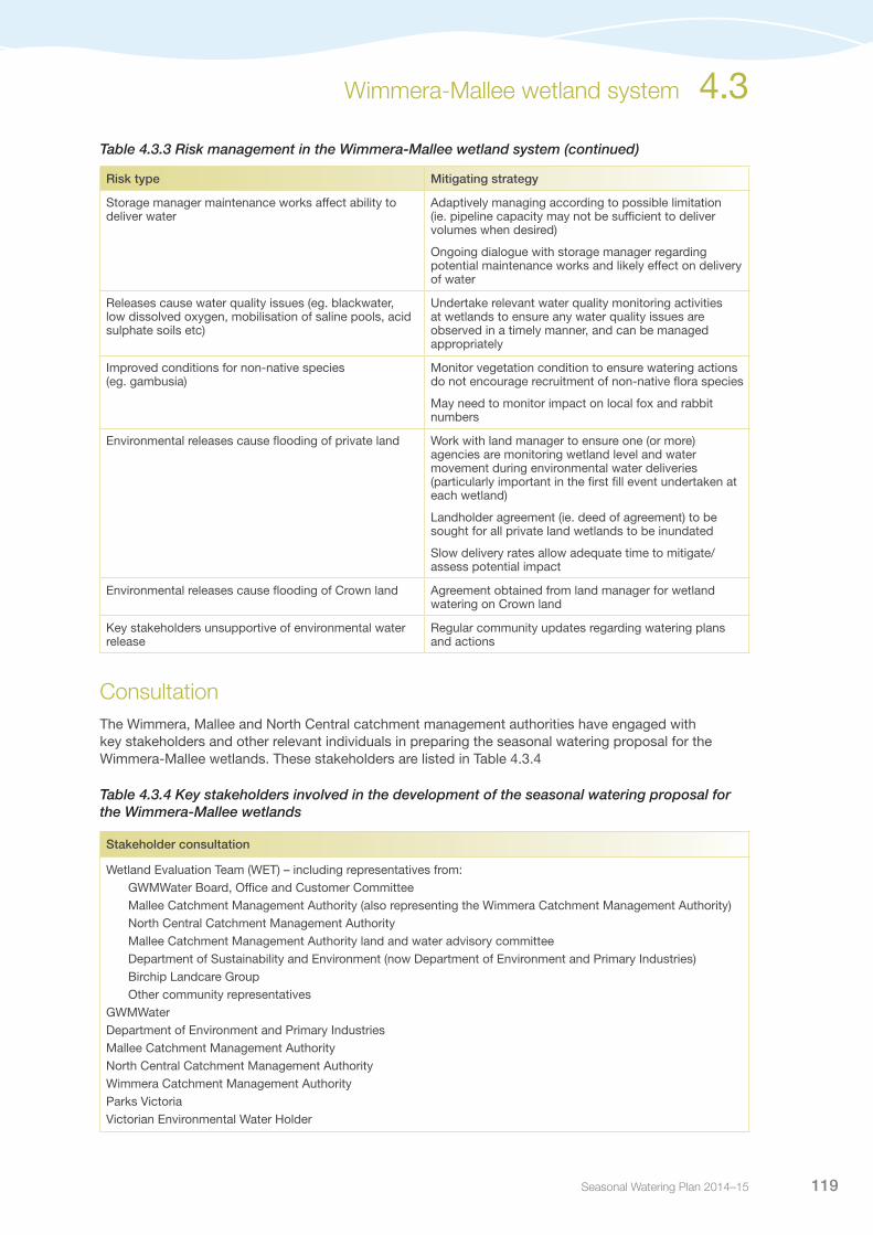
Risk managementIn preparing its seasonal watering proposal, the Wimmera, Mallee and North Central catchment management authorities have considered and assessed risks, and identified mitigating strategies, relating to the implementation of priority watering actions (refer to Table 4.3.3). Risks and mitigating actions are continually reassessed by environmental watering program partners throughout the water year.
Table 4.3.3 Risk management in the Wimmera-Mallee wetland system
Risk type Mitigating strategy
Current recommendations on environmental flows are inaccurate
Base decisions on best available science
Research flow requirements and ecological values of sites
Review watering actions with relevant stakeholders to ensure recommendations are adaptively managed over time
Unable to provide evidence in meeting ecological objective
Define ecological objectives, through development of environmental water management plans
Ensure monitoring activities are undertaken (eg. Index of Wetland Condition)
Establish monitoring framework
Environmental water management plan currently being developed to identify the flow requirements and ecological values of each site
Storage manager cannot deliver required volume or flow rate (ie. outlet/capacity constraints, insufficient storage volume)
Engage GWMWater throughout the watering season to assist with timing of releases when there is sufficient capacity to meet requirements
Ensure sufficient time to achieve the watering aim in the event that demand is high during time of delivery
Environmental water account is overdrawn Water orders are lodged with GWMWater who manage the delivery in accordance with the delivery plan
Ensure outlets lock to prevent public from operating valves
Only order water that has been issued under the seasonal watering statements
Submission of delivery plans early in season to ensure watering activities are able to occur at the appropriate time
Regular communication with the VEWH regarding water availability (ie. carryover and allocations)
Prioritisation of sites, if water resources are insufficient to meet all proposed actions
Release volume is insufficient to meet target flow Ongoing dialogue with storage manager regarding demand in the system, to assist in timing releases when there is available capacity to meet desired flow rates
Initial calculations show delivery rates will be insufficient to provide required volumes at some wetlands to meet watering objectives, therefore, delivery over multiple years may be required to achieve desired watering outcomes
Limited catchment management authority resources to deliver environmental release
Ensure environmental water management within catchment management authorities is adequately resourced for delivery tasks
Support community to undertake monitoring on behalf of the catchment management authorities
4.3 Wimmera-Mallee wetland system
Seasonal Watering Plan 2014–15 119
Risk type Mitigating strategy
Storage manager maintenance works affect ability to deliver water
Adaptively managing according to possible limitation (ie. pipeline capacity may not be sufficient to deliver volumes when desired)
Ongoing dialogue with storage manager regarding potential maintenance works and likely effect on delivery of water
Releases cause water quality issues (eg. blackwater, low dissolved oxygen, mobilisation of saline pools, acid sulphate soils etc)
Undertake relevant water quality monitoring activities at wetlands to ensure any water quality issues are observed in a timely manner, and can be managed appropriately
Improved conditions for non-native species (eg. gambusia)
Monitor vegetation condition to ensure watering actions do not encourage recruitment of non-native flora species
May need to monitor impact on local fox and rabbit numbers
Environmental releases cause flooding of private land Work with land manager to ensure one (or more) agencies are monitoring wetland level and water movement during environmental water deliveries (particularly important in the first fill event undertaken at each wetland)
Landholder agreement (ie. deed of agreement) to be sought for all private land wetlands to be inundated
Slow delivery rates allow adequate time to mitigate/assess potential impact
Environmental releases cause flooding of Crown land Agreement obtained from land manager for wetland watering on Crown land
Key stakeholders unsupportive of environmental water release
Regular community updates regarding watering plans and actions
ConsultationThe Wimmera, Mallee and North Central catchment management authorities have engaged with key stakeholders and other relevant individuals in preparing the seasonal watering proposal for the Wimmera-Mallee wetlands. These stakeholders are listed in Table 4.3.4
Table 4.3.4 Key stakeholders involved in the development of the seasonal watering proposal for the Wimmera-Mallee wetlands
Stakeholder consultation
Wetland Evaluation Team (WET) – including representatives from: GWMWater Board, Office and Customer Committee Mallee Catchment Management Authority (also representing the Wimmera Catchment Management Authority) North Central Catchment Management Authority Mallee Catchment Management Authority land and water advisory committee Department of Sustainability and Environment (now Department of Environment and Primary Industries) Birchip Landcare Group Other community representativesGWMWaterDepartment of Environment and Primary Industries Mallee Catchment Management AuthorityNorth Central Catchment Management AuthorityWimmera Catchment Management AuthorityParks VictoriaVictorian Environmental Water Holder
Table 4.3.3 Risk management in the Wimmera-Mallee wetland system (continued)
Wimmera-Mallee wetland system 4.3
Victorian Environmental Water Holder120
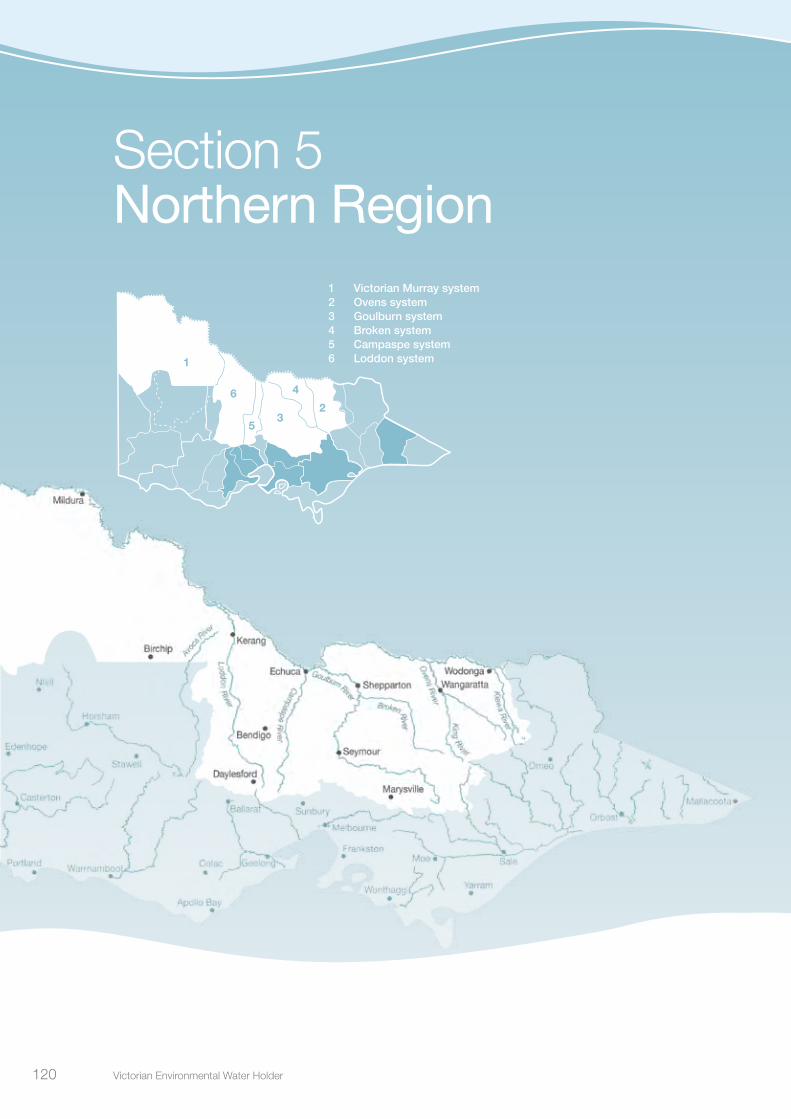
Section 5Northern Region
3
4
5
6
1
1 Victorian Murray system2 Ovens system3 Goulburn system4 Broken system5 Campaspe system6 Loddon system
2
Victorian Environmental Water Holder120

Seasonal Watering Plan 2014–15 121
Northern Region overview
5.0
Water Holdings available for use in the northern Victorian systems are held in Murray, Goulburn, Loddon and Campaspe storages. The water systems are highly connected. Infrastructure allows delivery from one system to another, as well as water trade between systems subject to trading rules. This allows environmental water to move between systems for delivery to priority environmental sites across northern Victoria. Priority sites include the Goulburn, Broken, Loddon and Campaspe rivers as well as wetlands and floodplains on the Victorian Murray system, including Barmah Forest, Gunbower Forest, Hattah Lakes and Lindsay, Wallpolla and Mulcra islands.
In addition to Victorian Water Holdings, the VEWH also coordinates delivery of Living Murray and Commonwealth environmental water entitlements in Victoria. The VEWH liaises with the Murray-Darling Basin Authority and the Commonwealth Environmental Water Office to maximise the environmental benefits of this water delivery in Victorian systems. The VEWH also authorises waterway managers to order Living Murray and Commonwealth water for downstream sites, provided there are no adverse impacts on Victorian waterways.
Northern Victoria is a part of the Murray-Darling Basin. The Murray-Darling Basin Plan was developed by the Murray-Darling Basin Authority under the Commonwealth Water Act 2007, and became law in November 2012. The Basin Plan sets legal limits on the amount of water that can be taken from the Murray-Darling Basin’s surface and groundwater resources. Chapter 8 of the Basin Plan also sets out a high-level Environmental Watering Plan, which defines environmental objectives to protect, restore and build the resilience of water-dependent ecosystems and their associated functions. The VEWH’s environmental planning and delivery is consistent with the requirements of the Basin Plan. Further to that, the priority watering actions outlined in sections 4.2 and 5.1-5.6 fulfil Victoria’s obligations under Section 8.26 of the Basin Plan to identify annual environmental watering priorities for Victoria’s water resource areas.
Pictured: Reedy Swamp, by Jo Wood, Goulburn Broken CMA
Victorian Environmental Water Holder122
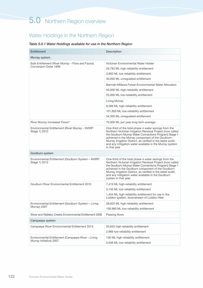
Water Holdings in the Northern Region
Table 5.0.1 Water Holdings available for use in the Northern Region
Entitlement Description
Murray system
Bulk Entitlement (River Murray – Flora and Fauna) Conversion Order 1999
Victorian Environmental Water Holder
29,783 ML high-reliability entitlement
3,993 ML low-reliability entitlement
40,000 ML unregulated entitlement
Barmah-Millewa Forest Environmental Water Allocation
50,000 ML high-reliability entitlement
25,000 ML low-reliability entitlement
Living Murray
9,589 ML high-reliability entitlement
101,850 ML low-reliability entitlement
34,300 ML unregulated entitlement
River Murray Increased Flows1 70,000 ML per year long-term average
Environmental Entitlement (River Murray – NVIRP Stage 1) 2012
One-third of the total phase 4 water savings from the Northern Victorian Irrigation Renewal Project (now called the Goulburn-Murray Water Connections Program) Stage 1 achieved in the Murray component of the Goulburn-Murray Irrigation District, as verified in the latest audit; and any mitigation water available in the Murray system in that year
Goulburn system
Environmental Entitlement (Goulburn System – NVIRP Stage 1) 2012
One-third of the total phase 4 water savings from the Northern Victorian Irrigation Renewal Project (now called the Goulburn-Murray Water Connections Program) Stage 1 achieved in the Goulburn component of the Goulburn Murray Irrigation District, as verified in the latest audit; and any mitigation water available in the Goulburn system in that year
Goulburn River Environmental Entitlement 2010 7,419 ML high-reliability entitlement
3,140 ML low-reliability entitlement
1,434 ML high-reliability entitlement for use in the Loddon system, downstream of Loddon Weir
Environmental Entitlement (Goulburn System – Living Murray) 2007
39,625 ML high-reliability entitlement
156,980 ML low-reliability entitlement
Silver and Wallaby Creeks Environmental Entitlement 2006 Passing flows
Campaspe system
Campaspe River Environmental Entitlement 2013 20,652 high-reliability entitlement
2,966 low-reliability entitlement
Environmental Entitlement (Campaspe River – Living Murray Initiative) 2007
126 ML high-reliability entitlement
5,048 ML low-reliability entitlement
5.0 Northern Region overview

Seasonal Watering Plan 2014–15 123
Entitlement Description
Loddon system
Bulk Entitlement (Loddon River – Environmental Reserve) 2005
3,480 ML high-reliability entitlement
7,490 ML high-reliability entitlement for use below Loddon Weir
2,024 ML low-reliability entitlement
Passing flows, including ability to withhold passing flows for release at a later time
Access to surplus flows (flows which cannot be captured in storage and pass downstream)
Environmental Entitlement (Birch Creek – Bullarook System) 2009
100 ML entitlement (fully available when allocations for Bullarook high-reliability water shares are at 20%)
Passing flows
Above cap water
Commonwealth Environmental Water Holdings2
Ovens system 70 ML high-reliability entitlement
Murray system 261,308 ML high-reliability entitlement
15,121 ML low-reliability entitlement
Broken system 117 ML high-reliability entitlement
4 ML low-reliability entitlement
Goulburn system 212,860 ML high-reliability entitlement
15,795 ML low-reliability entitlement
Campaspe system 6,517 ML high-reliability entitlement
395 ML low-reliability entitlement
Loddon system 2,775 ML high-reliability entitlement
527 ML low-reliability entitlement
Other Living Murray entitlements3
Victoria 17,826 ML high-reliability water share
New South Wales 5,624 ML high security entitlement
212,677 ML general security entitlement
350,000 ML supplementary entitlement
12,965 ML unregulated entitlement
South Australia 45,026 ML water licence entitlement high-reliability
1 Ability to call on water from Snowy Hydro Scheme to provide increased flows from Hume Reservoir. Access arrangements to be finalised.
2 Commonwealth Environmental Water Holdings as at 31 March 2014.3 Living Murray entitlements held by the Murray-Darling Basin Authority or other jurisdictions, as at 30 May 2014.
Table 5.0.1 Water Holdings available for use in the Northern Region (continued)
Northern Region overview 5.0

Victorian Environmental Water Holder124
Victorian Murray system
5.1
Waterway managers – Goulburn Broken Catchment Management Authority; North Central Catchment Management Authority; Mallee Catchment Management Authority
Storage manager – Goulburn-Murray Water; River Murray Water
The Victorian Murray system contains a myriad of significant floodplains and wetland systems covering the Goulburn Broken, North Central and Mallee catchment management authority regions (see Figure 5.1.1). The system contains floodplains and wetlands that are of international importance, including the iconic Hattah Lakes, Barmah Forest and Kerang wetlands, as well as a number of nationally and regionally significant sites. The system provides a wide range of habitat types that support rare and threatened waterbird species including the painted snipe, brolga, royal spoonbill and white-bellied sea eagle. They are also home to the endangered Murray hardyhead fish. The Victorian Murray system supports a variety of recreational activities such as camping, fishing, water sports, bird watching and recreational hunting and Indigenous cultural heritage values such as scar trees, middens, burial sites, artefacts and ovens.
Pictured: Harbours Lake, Barmah Forest, by Keith Ward, Goulburn Broken CMA

Seasonal Watering Plan 2014–15 125
Nya
h Fl
oodp
lain
Edm
onds
Wet
land
Cow
anna
Bill
abon
g
Cat
fish
Bill
abon
g
Vini
fera
Flo
odpl
ain
J1 C
reek
Pou
nd B
end
Bric
kwor
ks
Car
ina
Ben
d
Bot
tle B
end
Brid
ge C
reek
Bux
tons
Ben
d
Cha
ffey
Ben
d
Lake
Koo
rlong
Bul
lock
Sw
amp
Kar
adoc
Sw
ampP
sych
e B
end
Lago
on
Ivan
s W
etla
nd Car
dros
s La
kes
John
ston
s B
end
Yung
era
Wet
land
Mar
gooy
a La
goon
Dim
asis
Wet
land
Ned
s C
orne
r Wes
t
Woo
rlong
Wet
land
Ned
s C
orne
r Eas
t
Lind
say
Isla
ndW
allp
olla
Isla
nd
Hat
tah
Lake
s
Bur
ra C
reek
Sou
th
Bur
ra C
reek
Nor
th
Ned
s C
orne
r Cen
tral
Spe
nces
Ben
d W
etla
nds
Nar
rung
/Mur
rum
bidg
ee
Wet
land
San
dilo
ng C
reek
an
d B
illab
ong
Mul
cra
Isla
nd
Sw
an H
ill
Rive
r
Mur
ray
McD
onal
ds S
wam
pR
ound
Lak
eSw
an H
ill
Ker
ang
She
ppar
ton
Ech
uca
Bend
igo
Lake
Eliz
abet
h
Hird
Sw
amp
Gun
bow
er F
ores
tB
arm
ah F
ores
t
Lake
Mur
phy
Bend
igo
River
Campaspe
RiverLoddon
River
Goul
burn
CreekBendigo
Creek
Brok
en
Living
Mur
ray i
con s
ites
Lowe
r Mur
ray w
etlan
dsCe
ntral
Murra
y wetl
ands
Town
Rive
r Mur
ray
•
••
•
•
•
Loca
tion
in No
rther
n Reg
ion
Icon s
ites a
nd Lo
wer M
urra
y wetl
ands
Icon s
ites a
nd C
entra
l Mur
ray w
etlan
dsVictorian Murray system 5.1
Fig
ure
5.1.
1 T
he V
icto
rian
Mur
ray
syst
em

Victorian Environmental Water Holder126
5.1.1 Barmah ForestSystem overviewThe Barmah-Millewa Forest is the most upstream Living Murray icon site and is the largest river red gum forest in Australia and most intact freshwater floodplain system along the River Murray. It covers 66,000 hectares and straddles the Murray and Edwards rivers between the townships of Tocumwal, Deniliquin and Echuca. The Victorian component is the Barmah National Park and River Murray Regional Park, covering 28,500 hectares of forest and wetlands. The forest is a significant breeding site for waterbirds including egrets, spoonbills and night herons, as well as significant frog and turtle populations.
When river flows are above 15,000 ML per day downstream of Yarrawonga Weir, both sides of the forest are managed as a whole. When flows are below this, each side of the forest can be managed separately through regulators. Environmental water releases can be combined with unregulated flows and the delivery of consumptive water en route to maximise environmental outcomes at Barmah Forest. As Barmah Forest is located in the upper reaches of the River Murray, environmental water delivered to the forest can often be used again at sites further downstream as part of multi-site watering events; this occurs through use of return flows.
Current situationSince July 2010, the Barmah-Millewa Forest has seen consecutive years of flooding on the back of a decade of drought. The recent floods have rejuvenated some sections of the forest ecosystem, stimulating a mostly positive response from native plant and animal species. Uncharacteristically, the summer and autumn months of 2011 and 2012 saw natural flooding continue in the forest, resulting in the low-lying wetlands being inundated continuously for 18-21 months and exceeding nearly all previous flow records and known tolerance limits of some vegetation species.
Of particular concern is the moira grass, which forms part of an important, and threatened, vegetation community. There has been a 96 per cent decline in the extent of moira grassplains in Barmah Forest in the last 80 years. This is thought to be due to the impact of drought, the absence of an appropriate wetting and drying regime, and exotic animal grazing pressure.
A brief drying regime in late-autumn and early-winter 2013 was broken by a return to natural flooding in mid-winter continuing until mid-spring. Environmental water was then used to extend inundation levels through to late-spring, and resulted in significant growth and extensive flowering of moira grass, achieving the best moira grass response in seven years. The watering also provided broader benefits to floodplain vegetation, and improved habitat, feeding, and breeding resources for other species including waterbirds, fish, frogs and turtles through improved connectivity and transfer of carbon and nutrients between the floodplain and river.
Following completion of the large-scale watering, environmental water was delivered to Boals Deadwood wetland to maintain a significant ibis breeding event through to successful fledging.
Priority watering actions and environmental objectivesPriority watering actions along with their associated environmental objectives are provided in Table 5.1.1.
Priority watering actions at Barmah Forest aim to: provide opportunities for the migration and spawning of native fish; and improve the growth and reproduction of wetland and floodplain vegetation.
In addition to the environmental objectives, these watering actions will also provide opportunities for water-based activities including boating, bird watching, bushwalking and fishing.
5.1 Victorian Murray system

Seasonal Watering Plan 2014–15 127
Table 5.1.1 Priority watering actions and environmental objectives for Barmah Forest
Priority watering action Environmental objectives
Spring/summer pulsed flows in the River Murray channel (three events of up to 500 ML per day for eight days each during October to December)
Provide for flow variability within the main river channel to encourage the spawning of native fish species, primarily perch
Spring baseflow in Gulf, Smiths, Big Woodcutter and Boals creeklines (targeting approximately 500 ML per day for two to three months during September to November)
Allow lateral connectivity for native fish species to provide access to a range of floodplain habitats and resources to allow them to complete their life cycles, with a focus on meeting the requirements of southern pygmy perch
Winter/spring inundation of wetlands (variable flow rates to extend the duration and inundation extent of natural flooding during August to September)
Enhance the health of aquatic vegetation within the wetlands, watercourses and fringing forest areas of the lower terraces of the Barmah Forest floodplain
Spring/summer inundation of moira grassplains (variable flow rates to extend the duration and inundation extent of natural flooding during October to December)1
Provide flooding of sufficient duration to encourage the germination of moira grass from seed, building on the outcomes of the seed-bank created by the 2013-14 watering
Spring/summer inundation to support bird breeding in Boals Deadwoods wetland (targeting flow of approximately 200 ML per day to maintain appropriate inundation extent for approximately three months during October to January)
Maintain water levels to allow colonial waterbirds to successfully fledge their young, should breeding occur in response to natural flooding
Spring/summer inundation of Barmah Forest floodplain (variable flow rates to extend the duration and inundation extent of natural flooding during September to December)1
Enhance the health of river red gum communities on the lower terraces of the Barmah Forest floodplain by extending the tail of naturally occurring floods
1 The moira grass and floodplain forest watering objectives identified for Barmah Forest incorporate requirements of both Barmah and Millewa Forests.
Scenario planningTable 5.1.2 outlines the priority watering actions and expected water usage under a range of planning scenarios.
Environmental water requirements vary significantly in Barmah Forest in response to natural conditions. Under drier conditions, objectives focus on improving river and creek conditions to sustain fish movement and recruitment. As conditions become wetter, the focus shifts to the provision of larger-scale outcomes, such as extending the duration of natural flooding to promote the germination of moira grass seedlings, or providing benefits to broader floodplain vegetation communities including river red gum forests. Similarly, if natural flooding stimulates a significant colonial bird breeding event in Barmah Forest, environmental water will be delivered to support the colony through to fledging.
Table 5.1.2 Priority watering actions for Barmah Forest under a range of planning scenarios
Planning scenario
DROUGHT DRY AVERAGE WET
Priority watering actions
Spring/summer pulsed flows in the River Murray channel
Spring baseflow in Gulf, Smiths, Big Woodcutter and Boals creeklines
Winter/spring inundation of wetlandsSpring/summer inundation of moira grassplainsSpring/summer inundation to support bird breeding
Spring/summer inundation of Barmah Forest floodplain
Possible volume required from the Water Holdings1
12,000 ML (with12,000 ML return flow)
45,000 ML (with 30,000 ML return flow)
560,000 ML (with 369,000 ML return flow)2
300,000 ML (with 210,000 ML return flow)2
1 Possible volumes required from the Water Holdings in Barmah Forest are estimates, with volumes required being highly dependent on natural conditions.
2 Volumes identified are inclusive of the volume required to achieve moira grass and floodplain objectives in both Barmah and Millewa forests.
Victorian Murray system 5.1

Victorian Environmental Water Holder128
Risk managementIn preparing its seasonal watering proposal, the Goulburn Broken Catchment Management Authority considered and assessed risks, and identified mitigating strategies, relating to the implementation of priority watering actions (refer to Table 5.1.3). Risks and mitigating actions are continually reassessed by environmental watering program partners throughout the water year.
Table 5.1.3 Risk management in Barmah Forest
Risk type Mitigating strategies
Release volume is insufficient to meet target flow. [The risk of having insufficient water to achieve the target is considered a possibility depending upon the target and the timing of trigger occurring.]
Ensure adequate water commitments have been made to achieve the targeted inundation, in the event that no further natural inflows occur.
Storage manager cannot deliver required volume or flow rate (outlet/capacity constraints, insufficient storage volume) [Environmental water is planned to be used to primarily fill in the gaps between natural flood events. The key risk is being unable to meet the spring water requirements for moira grass, providing more favourable conditions for giant rush invasion.]
Available volumes of water as well as weather forecasts will be evaluated prior to implementing a spring watering.
Improved conditions for non-native species (eg. carp) Flooding of wetlands in spring/summer coincides with most breeding strategies for native plants and animals and hence is of advantage. However, carp have the ability to breed over a broad range of seasons and water temperatures and will benefit from this strategy also. Environmental watering has the broad strategy of providing native fish with a competitive advantage over carp. Shallow flooding of the moira grass plains will be avoided.
Environmental water account is overdrawn The Barmah-Millewa Operations Advisory Group will be active for the duration of any environmental watering event, enabling agencies to continuously monitor environmental water availability versus the forecast requirements and relate this to the watering strategy objectives. Therefore, overdraw of environmental water accounts are expected to be minimised.
Environmental release causes flooding on private land Proposed watering actions take heed of a recent Murray-Darling Basin Authority restrictions on release rates downstream of Yarrawonga to avoid the inundation of private land (15,000 ML per day maximum target flow rate). Although a buffer exists within this imposed limit, a large rainfall event could occur during the period of managed water release to have the potential to exceed the overall flow limit downstream of Yarrawonga. Mitigation measures will be via close communication with River Murray Operations within the Barmah-Millewa Operations Advisory Group and directly as required to ensure river management and rainfall forecasts are considered for potential rapid reduction or cessation to the managed releases.
5.1 Victorian Murray system

Seasonal Watering Plan 2014–15 129
ConsultationThe Goulburn Broken Catchment Management Authority has consulted stakeholders in the preparation of the seasonal watering proposals for Barmah Forest. These stakeholders are shown in Table 5.1.4.
Table 5.1.4 Key stakeholders involved in the preparation of the seasonal watering proposal for Barmah Forest
Stakeholder consultation
Yorta Yorta Nation Aboriginal Corporation Murray-Darling Basin Authority (River Murray Operations and Living Murray program)New South Wales National Parks and Wildlife Service Parks Victoria Department of Environment and Primary IndustriesGoulburn Broken Catchment Management Authority Board and staffVictorian Environmental Water Holder
Victorian Murray system 5.1
Pictured: Gunbower Forest, by North Central CMA

Victorian Environmental Water Holder130
5.1.2 Gunbower Creek and ForestSystem overviewGunbower Forest is a large flood-dependent forest situated on the River Murray floodplain in northern Victoria between Torrumbarry and Koondrook. Covering 19,450 hectares, it is bounded by the River Murray to the north and Gunbower Creek to the south. It is an internationally significant site under the Ramsar Convention, and forms part of the Living Murray Gunbower-Koondrook-Perricoota icon site. River regulation and water extraction from the River Murray and Gunbower Creek has reduced the frequency, duration and magnitude of flood events in Gunbower Forest over the long term. This has affected the extent and condition of habitat and the health of dependent animal communities.
Gunbower Forest is a priority for environmental watering due to the significant environmental values it contains – diverse and rare wetland habitats, vulnerable and endangered flora and fauna, including internationally recognised migratory waterbirds, and large areas of remnant vegetation communities.
Gunbower Creek is an integral part of the Gunbower system, providing important habitat for native fish such as Murray cod, trout cod and freshwater catfish. The creek is also a natural irrigation carrier that supplies water to the Torrumbarry Irrigation District. While the highly-regulated nature of Gunbower Creek has led to some negative impacts on environmental values, it now provides a means for environmental water to be actively delivered.
The Living Murray structural works program in the middle and lower forest was completed in 2013. The works allow up to 5,000 hectares of the wetlands and floodplain to be watered with considerably less water than would be required under natural conditions. The works aim to enable flexible watering of the forest, through Gunbower Creek, to maintain wetland and floodplain condition.
Current situationIn the last four years, Gunbower Forest has received three years of consecutive flooding. This includes a large flood event, smaller and shorter overbank floods, and low-level natural inflows. Throughout 2013-14, Gunbower Forest was managed to allow a deliberate drying phase to eliminate residual blackwater from wetlands and reduce the adult carp population. Drying the wetlands prior to the planned operation of the structural works was considered critical to maximise the opportunity for wetland vegetation germination and re-establishment when water is delivered to the forest.
During spring 2013, a small volume of water entered low-lying forest wetlands as a result of natural inflows. The natural inflows were not substantial enough to fill the wetlands and the hot summer resulted in wetland water levels receding significantly. A small volume of water was delivered to the forest in early 2014 to assist in the commissioning of infrastructure at the newly completed Hipwell Road Offtake Regulator, prior to the first trial forest watering, planned to commence in late May 2014.
Environmental water was delivered to Gunbower Creek throughout 2013-14 with a combination of winter baseflows and spring high flows to the lower reaches of the system to assist in cueing spawning and ensuring survival of large-bodied native fish larvae, such as Murray cod. This was the first time environmental water has been delivered to the creek in this way and it yielded significant results, including three successful spawning events of Murray cod, detected in spring 2013.
5.1 Victorian Murray system
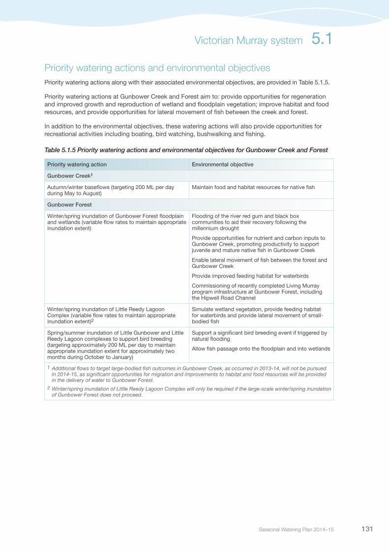
Seasonal Watering Plan 2014–15 131
Priority watering actions and environmental objectivesPriority watering actions along with their associated environmental objectives, are provided in Table 5.1.5.
Priority watering actions at Gunbower Creek and Forest aim to: provide opportunities for regeneration and improved growth and reproduction of wetland and floodplain vegetation; improve habitat and food resources, and provide opportunities for lateral movement of fish between the creek and forest.
In addition to the environmental objectives, these watering actions will also provide opportunities for recreational activities including boating, bird watching, bushwalking and fishing.
Table 5.1.5 Priority watering actions and environmental objectives for Gunbower Creek and Forest
Priority watering action Environmental objective
Gunbower Creek1
Autumn/winter baseflows (targeting 200 ML per day during May to August)
Maintain food and habitat resources for native fish
Gunbower Forest
Winter/spring inundation of Gunbower Forest floodplain and wetlands (variable flow rates to maintain appropriate inundation extent)
Flooding of the river red gum and black box communities to aid their recovery following the millennium drought
Provide opportunities for nutrient and carbon inputs to Gunbower Creek, promoting productivity to support juvenile and mature native fish in Gunbower Creek
Enable lateral movement of fish between the forest and Gunbower Creek
Provide improved feeding habitat for waterbirds
Commissioning of recently completed Living Murray program infrastructure at Gunbower Forest, including the Hipwell Road Channel
Winter/spring inundation of Little Reedy Lagoon Complex (variable flow rates to maintain appropriate inundation extent)2
Simulate wetland vegetation, provide feeding habitat for waterbirds and provide lateral movement of small-bodied fish
Spring/summer inundation of Little Gunbower and Little Reedy Lagoon complexes to support bird breeding (targeting approximately 200 ML per day to maintain appropriate inundation extent for approximately two months during October to January)
Support a significant bird breeding event if triggered by natural flooding
Allow fish passage onto the floodplain and into wetlands
1 Additional flows to target large-bodied fish outcomes in Gunbower Creek, as occurred in 2013-14, will not be pursued in 2014-15, as significant opportunities for migration and improvements to habitat and food resources will be provided in the delivery of water to Gunbower Forest.
2 Winter/spring inundation of Little Reedy Lagoon Complex will only be required if the large-scale winter/spring inundation of Gunbower Forest does not proceed.
Victorian Murray system 5.1

Victorian Environmental Water Holder132
Scenario planningTable 5.1.6 outlines the priority watering actions and expected water usage under a range of planning scenarios.
The floodplain watering proposed represents the first environmental water delivery of this scale in Gunbower Forest, and targets various environmental objectives. The watering action will also facilitate the first full operation of the Hipwell Road Channel, and commission the full package of infrastructure works at Gunbower Forest. The scale of the floodplain watering will be determined by the preceding climatic conditions, capacity, and environmental water availability.
If natural flooding does occur, active environmental water delivery will be adaptively managed to maximise ecological outcomes. Alternatively, if the floodplain watering action is not undertaken in 2014-15, environmental water delivery will target inundation of key permanent and semi-permanent wetlands in the Little Reedy Lagoon Complex.
If significant bird breeding is triggered during the year, environmental water may be delivered to assist in maintaining an appropriate inundation depth to support the waterbirds to fledging.
Table 5.1.6 Priority watering actions for Gunbower Creek and Forest under a range of planning scenarios
Planning scenario
DROUGHT DRY AVERAGE WET
Gunbower Creek and Forest
Priority watering actions
Winter/spring inundation of Little Reedy Lagoon Complex1
Autumn/winter baseflows (Gunbower Creek)
Winter/spring inundation of Gunbower Forest
Autumn/winter baseflows (Gunbower Creek)
Winter/spring inundation of Gunbower Forest
Autumn/winter baseflows (Gunbower Creek)
Winter/spring inundation of Gunbower Forest
Spring/summer inundation of Little Gunbower and Little Reedy Lagoon Complexes to support bird breeding
Autumn/winter baseflows (Gunbower Creek)
Possible volume required from the Water Holdings
15-25,000 ML
(requires delivery of ~23,000 ML of consumptive water en route)
38,000-65,000 ML
(requires delivery of 127,000-190,000 ML of consumptive water en route)
65,000 ML
(requires delivery of 190,000 ML of consumptive water en route)
67,000 ML
(requires the delivery of 220,000 ML of consumptive water en route)
1 Winter/spring inundation of Little Reedy Lagoon Complex will only be required if the large-scale winter/spring inundation of Gunbower Forest does not proceed.
5.1 Victorian Murray system

Seasonal Watering Plan 2014–15 133
Risk managementIn preparing its seasonal watering proposal, the North Central Catchment Management Authority considered and assessed risks, and identified mitigating strategies, relating to the implementation of priority watering actions (refer to Table 5.1.7). Risks and mitigating actions are continually reassessed by environmental watering program partners throughout the water year.
Table 5.1.7 Risk management in Gunbower Creek and Forest
Risk type Mitigating strategies (Gunbower Creek and Forest)
Release volume is insufficient in meeting required inundation
Discussions with Goulburn-Murray Water will take place prior to operation to ensure delivery channels have sufficient free capacity to undertake delivery prior to starting watering event
Storage manager maintenance works affect ability to deliver/exclude water
Regular liaison with Goulburn-Murray Water will occur to identify the timing of proposed maintenance works and ensure work will not impact on environmental water deliveries or adjust environmental delivery to accommodate works where necessary
Storage manager cannot deliver required volume or flow rate due to outlet/capacity constraints or high irrigation demand
Goulburn-Murray Water will provide regular updates on irrigation demand outlooks and ensure channels and regulators are in good working order so that water can be delivered at required rates
Limited catchment management authority resources to manage delivery of environmental release
Funding will be secured prior to watering event to ensure that environmental water management within the catchment management authority is adequately resourced to undertake required delivery tasks
Limited storage manager resources to operate manual regulating structures (Barham Cut and Shillinglaws)
Early and ongoing engagement with Goulburn-Murray Water to provide as much lead time as possible for manual operations
All Gunbower Operations Advisory Group members will be reminded of roles and responsibilities under Interim Gunbower Forest Operating Plan
Cost of delivery exceeds available funding All stakeholders will be made aware of potential volumes of water required early in planning
Watering will not commence without agreement on delivery charges and security of funding
Environmental water account is overdrawn 10 per cent contingency volume included in water requirement estimates
Current recommendations on environmental flow inaccurate
Proposed deliveries (including timing and rates) will be adaptively managed throughout the delivery event
Relevant stakeholders have reviewed watering actions
Delivery is designed to enable adaptive management when current recommendations are not appropriate
Advice will be provided by the Technical Working Group in the planning and implementation of the event
Ongoing ecological monitoring (if funded in 2014-15) of releases will be undertaken to assist in refining flow recommendations over time
Annual operation monitoring will be used to inform annual priority flow components
Releases cause water quality issues in the River Murray (eg. blackwater, low dissolved oxygen)
Three continuous water quality monitoring stations at strategic locations in Gunbower Creek and the River Murray (if funded in 2014-15) are installed to ensure any water quality issues are observed in a timely manner, and can be managed appropriately
Environmental flows result in improved conditions for exotic fish species (eg. gambusia, carp)
There are few opportunities available to mitigate the risk of carp spawning from environmental water in these systems
The most important opportunity is to reduce summer flooding where possible
Victorian Murray system 5.1

Victorian Environmental Water Holder134
Risk type Mitigating strategies (Gunbower Creek and Forest)
Native fish stranding on the floodplain Intensive monitoring of native fish movement (if funded in 2014-15) between wetlands, Gunbower Creek and the River Murray will be undertaken at critical times during the operation; results will be available to inform operational decisions, especially during the fish exit strategy to optimise fish movement off the floodplain
Bird breeding commences but cannot be supported Bird breeding is not a primary goal of watering in 2014-15Waterbird monitoring (if funded in 2014-15), in wetlands and particularly at known breeding sites, will be undertaken to identify early signs of bird breeding activity so that water deliveries can be managed appropriately
Environmental floodwater is the conduit for the spread of aquatic and terrestrial weeds
At present, there are few opportunities available to mitigate the weed transmission through environmental water in these systemsThe most important opportunity is to reduce flooding during the seeding phase
The watering regime of environmental releases is not ideal for wetland and floodplain vegetation communities
Vegetation monitoring (if funded in 2014-15) will assist in understanding the response of the vegetation communities to the flooding events
Wetlands are flooded in late summer, promoting river red gum germination and sapling growth
Environmental flows will be completed before the end of the calendar year to allow natural draw down over late summer, where possible (ie. not possible if supporting bird breeding)
Erosion from water deliveries at outfalls and inlets Erosion monitoring at key inflow and outfalls at varying flow ratesDepending on severity, undertake earth stabilisation works or reduce inflows
Environmental releases cause flooding of private land upstream of Hipwell Road Weir (ie. during holding phase Gunbower Creek capacity exceeded)
A slow ‘ramp up’ of flows will be implemented between 1,200-1,600 ML per day downstream of Gunbower WeirRegular monitoring will occur during this period to identify potential floodingCommunication strategy includes specific communication with landholders along Gunbower Creek to ensure they are aware of the proposed operation and have access to contact numbers for further informationIntensive monitoring of creek water levels at critical locations will be undertaken by Goulburn-Murray Water. Monitoring results will feed directly into day-to-day decisions during the ramp up and holding phasesIf flooding does occur, flow over Gunbower Weir can be reduced within a few hours
Environmental releases cause flooding of private land through forest boundary levees failing
8 out of 10 landholders are covered by flood easementIntensive monitoring of remaining two landholders levees will be undertaken and emergency repair works undertaken if required (only for the two properties not covered by flood easements)
Environmental release causes flooding to public infrastructure
Regular updates will be provided to the Department of Environment and Primary Industries and Parks Victoria land managers about environmental water releases so they can allow for potential closures and repair works in planning
Rain rejection event causes flooding Goulburn-Murray Water will manage rain rejection as part of their day-to-day operations
Key stakeholders not supportive of environmental water release(eg. restricted forest access, firewood harvesting plots, designated forest bee sites)
Community Reference Group consulted in the development and implementation of the seasonal watering proposalPublic notices and media releases prior to environmental wateringImplement communication strategy and signage planProvide regular updates to the Department of Environment and Primary Industries and Parks Victoria land managers about environmental water releases so as they can provide notice to forest users
Table 5.1.7 Risk management in Gunbower Creek and Forest (continued)
5.1 Victorian Murray system

Seasonal Watering Plan 2014–15 135
ConsultationThe North Central Catchment Management Authority has consulted stakeholders in the preparation of the seasonal watering proposal for Gunbower Creek and Gunbower Forest. These stakeholders are shown in Table 5.1.8.
Table 5.1.8 Key stakeholders involved in the preparation of the seasonal watering proposal for Gunbower Creek and Forest
Stakeholder consultation
Gunbower Environmental Water Advisory Group (with representation from Goulburn-Murray Water, Parks Victoria, Department of Environment and Primary Industries [regional], State Forests New South Wales, North Central Catchment Management Authority and VEWH) Gunbower Technical Working Group (with representation from Department of Environment and Primary Industries [Threatened Flora and Fauna], Goulburn Broken Catchment Management Authority and specialist consultants and ecologists in fish, vegetation and birds)Gunbower Forest Community Reference GroupNorth Central Catchment Management Authority Natural Resource Management Committee North Central Catchment Management Authority BoardCommonwealth Environmental Water OfficeVictorian Environmental Water Holder
Victorian Murray system 5.1
Pictured: Chettle Track at Gunbower Forest, by North Central CMA

Victorian Environmental Water Holder136
5.1.3 Central Murray wetlandsSystem overviewThe Central Murray wetland complex consists of eight actively-managed, public land wetlands on the River Murray floodplain, including the Ramsar-listed Lake Cullen, Hird Swamp and Johnsons Swamp. Round Lake, McDonalds Swamp, Lake Elizabeth, Lake Murphy and Richardsons Lagoon are all of regional significance. The wetlands are considered highly significant, supporting a number of vulnerable or endangered species including the Murray hardyhead, the Australian painted snipe and the growling grass frog. The wetlands also provide habitat for at least 19 species listed under a range of legislation and international agreements.
The Central Murray wetlands are almost wholly contained within the Torrumbarry Irrigation Region. As this area has experienced dramatic changes since European settlement with the construction of levees, roads and channels, most of the wetlands are now cut-off from natural flooding and are reliant on the provision of environmental water.
Current situationDuring 2010-11, widespread flooding and the provision of environmental water resulted in all eight wetlands in the Central Murray system being inundated, some for the first time in many years. Most of the wetlands held water throughout 2011-12 and some into 2012-13. Therefore, management in 2012-13 aimed to allow them to naturally draw down, according to their recommended watering regimes. Environmental water delivery was only prioritised for Round Lake (for Murray hardyhead), McDonalds Swamp (which dried in 2012) and Richardsons Lagoon (to inundate the floodplain). In 2013-14, priority watering focused on continued to promote the benefits experienced from flooding, while ensuring sites that recently dried were not subjected to premature rewetting. Environmental water was delivered to Round Lake (again for Murray hardyhead), Hird Swamp (west) (to fill from empty), Lake Elizabeth (to manage for potential Murray hardyhead translocation) and McDonalds Swamp (to fill from empty).
After receiving water in spring/summer 2013, monitoring at Hird Swamp (west) recorded over 3,300 waterbirds in January 2014, with 25 different species including nine species considered significant. A survey of waterfowl numbers in October 2013 and January 2014 showed that the swamp is supporting large numbers of waterfowl as well.
Round Lake received a series of top-ups to maintain conditions suitable for the endangered fish species, Murray hardyhead. Surveys undertaken in November 2013 resulted in a catch of 31 large, healthy individuals. Although lower than previous years, records show that Murray hardyhead populations often exhibit natural ‘boom and bust’ cycles. This may have been driven by the simultaneous drying of a number of wetlands in the region which resulted in an increase in the number of grazing waterfowls utilising Round Lake. As well as supporting Murray hardyhead, Round Lake is also considered highly productive for waterbirds. Surveys recorded over 1,760 waterbirds at Round Lake in November 2013 and 18 different species in January 2014. This included significant species such as Australasian shoveler, eastern great egret and the freckled duck.
Similarly, 1,100 waterbirds were recorded at McDonald’s Swamp in November 2013, with 22 different species recorded in December 2013, including the brolga, hardhead and whiskered tern. Continued growth of red gum saplings also occurred. Consistently high temperatures and low rainfall over January and February 2014 caused the wetland to completely dry in early March 2014.
Lake Elizabeth is being managed to promote conditions suitable for Murray hardyhead. Environmental water delivery in December also contributed to a surge of waterfowl at the Lake in January 2014.
5.1 Victorian Murray system

Seasonal Watering Plan 2014–15 137
Priority watering actions and environmental objectivesPriority watering actions, along with their associated environmental objectives, are provided in Table 5.1.9.
Priority watering for the 2014-15 season will focus on continuing to promote the benefits experienced from flooding whilst attempting to ensure that recently-dried sites are not subjected to premature rewetting.
In addition to the environmental objectives, these watering actions will also provide opportunities for water-based activities including bird watching, bushwalking and fishing
Table 5.1.9 Priority watering actions and environmental objectives for the Central Murray wetlands
Priority watering action Environmental objectives
Round Lake: Provide top up flows as required Maintain the lake as a permanent saline lake with habitat suitable for Murray hardyheadProvide suitable waterbird habitat
McDonalds Swamp: Provide top up flows as required and promote natural drying phase over summer
Support a diversity of plant and animal populations typical of a shallow freshwater marsh, including key waterbird habitatPromoting conditions appropriate for red gum growth
Hird Swamp (west): Provide top flows during spring and over summer and promote natural drying phase over summer
Support a diversity of habitat types for waterbird resting, nesting and feeding
Lake Elizabeth: Provide top up flows as required Promote conditions suitable for Murray hardyhead Support submerged salt-tolerant aquatic plant assemblage
Lake Murphy: Fill in spring and provide top up flows as required
Support a diversity of habitat types characteristic of a deep freshwater marsh, whilst providing important waterbird habitat
Scenario planningTable 5.1.10 outlines the priority watering actions and expected water usage under a range of planning scenarios.
Interannual planning for these wetlands has been undertaken by the catchment management authority to allow for landscape-scale management of the wetlands across time. The long-term environmental objectives and flow recommendations for the wetlands have been sourced from the environmental water management plans and environmental watering plans for the wetlands. For each wetland, recommended watering regimes regarding the timing, frequency, duration and extent/depth have been detailed. A number of wetlands require watering one in every five years, or one in every three years. It is likely that in future years, multiple wetlands will require environmental water during the same year. Interannual planning helps to manage this risk of increased pressure on environmental water resources, particularly if there is a return to drought conditions. Similarly, it helps to manage risk to waterbird populations if multiple wetlands require drying at the same time, which would reduce suitable refuge for breeding, feeding and nesting across northern Victoria.
At a number of sites, the decision to deliver environmental water will be based on the hydrologic condition, waterbird breeding activity and the potential impact environmental water delivery may have on wetland vegetation.
The highest priority for environmental water management in the Central Murray wetland complex has been identified as Round Lake, which supports the endangered Murray hardyhead. Round Lake is currently considered the only stable Murray hardyhead population in the Kerang region. It is therefore essential that the wetland continues to support the species to ensure that sufficient stock is available to establish translocation sites in the future.
Victorian Murray system 5.1

Victorian Environmental Water Holder138
Table 5.1.10 Priority watering actions for the Central Murray wetlands under a range of planning scenarios
Planning scenario
DROUGHT DRY AVERAGE WET
Priority watering sites
Round LakeHird SwampLake ElizabethLake MurphyMcDonalds Swamp
Round LakeHird SwampLake ElizabethLake MurphyMcDonalds Swamp
Round LakeHird SwampLake ElizabethLake MurphyMcDonalds Swamp
Round LakeHird SwampLake ElizabethLake MurphyMcDonalds Swamp
Possible volume required from the Water Holdings
Up to 10,000 ML Up to 10,000 ML Up to 10,000 ML Up to 10,000 ML
Risk managementIn preparing its seasonal watering proposal, North Central Catchment Management Authority considered and assessed the risks, and identified mitigating strategies, relating to the implementation of priority watering actions. Table 5.1.11 summarises these risks and the mitigating strategies. When environmental water is delivered during the season, risks are carefully reassessed, managed and mitigated by environmental watering program partners prior to and during the event.
Table 5.1.11 Risk management in the Central Murray wetlands
Risk type Mitigating strategies
Release volume fails to meet target flows Ensure delivery channels have sufficient spare capacity to undertake delivery prior to starting watering event (liaise with Goulburn-Murray Water)Ongoing dialogue with storage manager regarding consumptive demand in the system, to assist in timing releases when there is available capacity to meet desired flow ratesEnsure infrastructure and delivery channels are functional and in working order to deliver at the required rate
Current environmental flow recommendations are inaccurate
Ensure proposed deliveries (including timing and rates) are undertaken in accordance with relevant environmental water management plans and Goulburn-Murray Water Connections Project environmental watering plansUndertake review of watering actions with relevant stakeholders to ensure watering recommendations are adapted over time as appropriateUndertake ongoing ecological monitoring to assist in refining recommendations over timeUse annual operational monitoring to inform annual priority flow components
Storage manager maintenance works affect ability to deliver water
Ongoing dialogue with storage manager regarding potential maintenance works and the likely effect of such works on delivery of water
Storage manager cannot deliver required volume or flow rate (outlet/capacity constraints, insufficient storage volume)
Early and ongoing engagement with Goulburn-Murray Water regarding consumptive demand in the system, to assist in timing releases when there is available capacity to meet desired flow ratesEnsure channels and pumps are in good working order (regular maintenance) so that water can be delivered at required rates
Limited catchment management authority resources to deliver environmental release
Ensure environmental water management within the North Central Catchment Management Authority is adequately resourced to undertake required delivery tasks
Environmental releases cause personal injury to river users
Engage the community (i.e. letter drops and door knocks) and undertake local media and public notice releases prior to eventLiaise with land manager regarding public communication activities
5.1 Victorian Murray system

Seasonal Watering Plan 2014–15 139
Risk type Mitigating strategies
Releases cause water quality issues (eg. blackwater, low dissolved oxygen, mobilisation of saline pools, acid sulphate soils, etc.)
Undertake relevant water quality monitoring activities at wetlands to ensure any water quality issues are observed in a timely manner, and can be managed appropriately (eg. with the addition of water at Round Lake and Lake Elizabeth)
Improved conditions for non-native species (eg. carp) Ensure water level and salinity are closely monitored and managed at Round Lake so that salinity does not drop low enough for gambusia to thrive and predate on Murray hardyheadIf Lake Elizabeth is deemed appropriate for Murray hardyhead, initial invasive species management will be required prior to translocation of the speciesOngoing monitoring to be undertaken to ensure predators are managed
Environmental releases cause flooding of public infrastructure, private or Crown land
Work closely with the land manager to ensure one (or more) agencies are monitoring the wetland level and water movement during the environmental water deliveriesWork closely with Goulburn-Murray Water and cease regulated deliveries if high catchment runoff conditions are expectedUse SWET models and bathymetry to predict potential inundation at different volumes
Unable to provide evidence in meeting ecological objective
Ensure monitoring activities are undertaken as specified in relevant delivery plans to demonstrate ecological outcomes in association with the provision of environmental waterRegularly update environmental water management plans with knowledge of ecological outcomesSupport the Department of Environment and Primary Industries in undertaking the regular monitoring of the Murray hardyhead population at Round Lake (and possibly Lake Elizabeth)
ConsultationThe North Central Catchment Management Authority has consulted stakeholders in the preparation of the seasonal watering proposal for the Central Murray wetlands. These stakeholders are shown in Table 5.1.12.
Table 5.1.12 Key stakeholders involved in the preparation of the seasonal watering proposal for the Central Murray wetlands
Stakeholder consultation
Central Murray Wetlands Environmental Water Advisory Group (made up of community members, North Central Catchment Management Authority project staff, Board and Natural Resource Management Committee representation, Department of Environment and Primary Industries, VEWH and Commonwealth Environmental Office) Department of Environment and Primary IndustriesParks VictoriaGoulburn-Murray WaterCommonwealth Environmental Water OfficeGannawarra Shire CouncilSwan Hill Rural City CouncilBirdlife AustraliaField and Game Australia Community membersNorth Central Catchment Management Authority Natural Resource Management Committee (NRMC)North Central Catchment Management Authority BoardVictorian Environmental Water Holder
Table 5.1.11 Risk management in the Central Murray wetlands (continued)
Victorian Murray system 5.1

Victorian Environmental Water Holder140
5.1.4 Hattah LakesSystem overviewThe Hattah Lakes are adjacent to the River Murray between Mildura, Robinvale and Ouyen. They consist of over 20 semi-permanent freshwater lakes that cover an area of 48,000 hectares, and form part of the Hattah-Kulkyne National Park. The Hattah Lakes are important due to their extent, condition, diversity and habitat values as well as their social and cultural significance.
The lakes provide important habitat for colonial waterbird species, including spoonbills, egrets, night herons, bitterns and migratory bird species. Under natural conditions, the lakes were fed from high River Murray flows and influenced by all major Murray tributaries upstream of the Murrumbidgee.
Large-scale engineering works were completed in 2013 that allow water to be pumped into the Hattah Lakes to meet the environmental watering requirements. The new infrastructure includes permanent pumps that can deliver up to 1,000 ML per day to the floodplain, and water retention structures that will be able to hold water on the floodplain and manage drawdown.
Current situationBetween 1998 and December 2010, flow in the River Murray was not sufficient for water to naturally enter the Hattah Lakes system. Without environmental water delivery, the lakes would have dried for an extended period of time causing considerable stress to vegetation communities. The lakes have received environmental water since 2005. These environmental water events supplied water to the lakes via Chalka Creek, but did not supply water to the higher elevation floodplain vegetation communities, including river red gum and black box.
The first large-scale watering of Hattah Lakes occurred in 2013, with over 64,000 ML of environmental water delivered to the system. Water reached all lakes in the Hattah system, with the exception of Lake Kramen. The event saw water enter Lake Bitterang for the first time in 20 years. The delivery used the newly-constructed pump infrastructure.
These environmental watering events have been successful in maintaining, and in some cases, improving the health of wetland plants and river red gums, along with improving conditions for native fish and waterbirds. However, higher elevation vegetation communities, particularly black box woodlands, are continuing to show signs of stress.
Priority watering actions and environmental objectivesPriority watering actions along with their associated environmental objectives, are provided in Table 5.1.13.
Priority watering actions at the Hattah Lakes aim to provide opportunities for regeneration and improved growth and reproduction of wetland and floodplain vegetation, particularly black box communities.
In addition to the environmental objectives, these watering actions will also provide opportunities for recreational activities including boating, bird watching, bushwalking and fishing.
5.1 Victorian Murray system
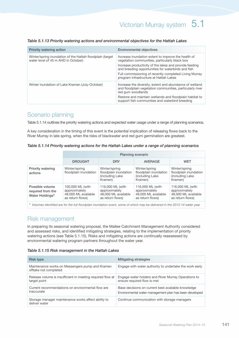
Seasonal Watering Plan 2014–15 141
Table 5.1.13 Priority watering actions and environmental objectives for the Hattah Lakes
Priority watering action Environmental objectives
Winter/spring inundation of the Hattah floodplain (target water level of 45 m AHD in October)
Increase inundation extent to improve the health of vegetation communities, particularly black boxIncrease productivity of the lakes and provide feeding and breeding opportunities for waterbirds and fishFull commissioning of recently completed Living Murray program infrastructure at Hattah Lakes
Winter inundation of Lake Kramen (July-October) Increase the diversity, extent and abundance of wetland and floodplain vegetation communities, particularly river red gum woodlandsRestore and maintain wetlands and floodplain habitat to support fish communities and waterbird breeding
Scenario planningTable 5.1.14 outlines the priority watering actions and expected water usage under a range of planning scenarios.
A key consideration in the timing of this event is the potential implication of releasing flows back to the River Murray in late spring, when the risks of blackwater and red gum germination are greatest.
Table 5.1.14 Priority watering actions for the Hattah Lakes under a range of planning scenarios
Planning scenario
DROUGHT DRY AVERAGE WET
Priority watering actions
Winter/spring floodplain inundation
Winter/spring floodplain inundation (including Lake Kramen)
Winter/spring floodplain inundation (including Lake Kramen)
Winter/spring floodplain inundation (including Lake Kramen)
Possible volume required from the Water Holdings1
100,000 ML (with approximately 48,000 ML available as return flows)
116,000 ML (with approximately 48,000 ML available as return flows)
116,000 ML (with approximately 48,000 ML available as return flows)
116,000 ML (with approximately 48,000 ML available as return flows)
1 Volumes identified are for the full floodplain inundation event, some of which may be delivered in the 2013-14 water year.
Risk managementIn preparing its seasonal watering proposal, the Mallee Catchment Management Authority considered and assessed risks, and identified mitigating strategies, relating to the implementation of priority watering actions (see Table 5.1.15). Risks and mitigating actions are continually reassessed by environmental watering program partners throughout the water year.
Table 5.1.15 Risk management in the Hattah Lakes
Risk type Mitigating strategies
Maintenance works on Messengers pump and Kramen offtake not completed
Engage with water authority to undertake the work early
Release volume is insufficient in meeting required flow at target point
Engage water holders and River Murray Operations to ensure required flow is met
Current recommendations on environmental flow are inaccurate
Base decisions on current best available knowledgeEnvironmental water management plan has been developed
Storage manager maintenance works affect ability to deliver water
Continue communication with storage managers
Victorian Murray system 5.1
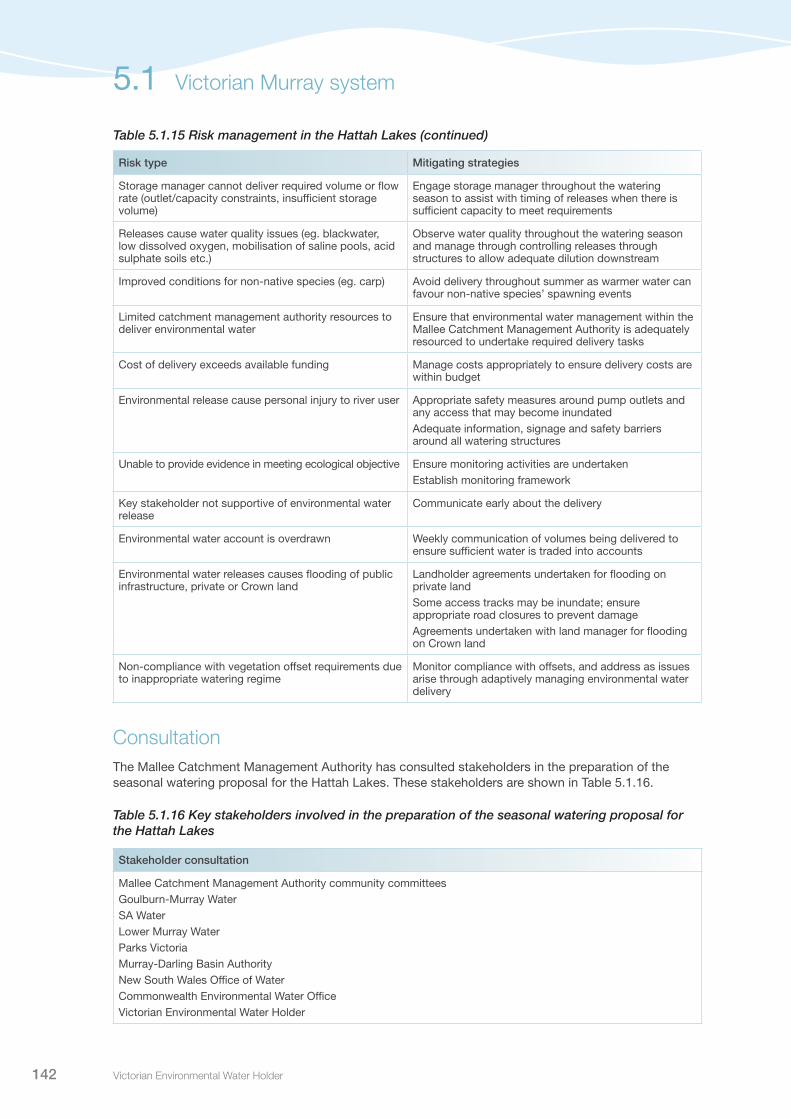
Victorian Environmental Water Holder142
Risk type Mitigating strategies
Storage manager cannot deliver required volume or flow rate (outlet/capacity constraints, insufficient storage volume)
Engage storage manager throughout the watering season to assist with timing of releases when there is sufficient capacity to meet requirements
Releases cause water quality issues (eg. blackwater, low dissolved oxygen, mobilisation of saline pools, acid sulphate soils etc.)
Observe water quality throughout the watering season and manage through controlling releases through structures to allow adequate dilution downstream
Improved conditions for non-native species (eg. carp) Avoid delivery throughout summer as warmer water can favour non-native species’ spawning events
Limited catchment management authority resources to deliver environmental water
Ensure that environmental water management within the Mallee Catchment Management Authority is adequately resourced to undertake required delivery tasks
Cost of delivery exceeds available funding Manage costs appropriately to ensure delivery costs are within budget
Environmental release cause personal injury to river user Appropriate safety measures around pump outlets and any access that may become inundatedAdequate information, signage and safety barriers around all watering structures
Unable to provide evidence in meeting ecological objective Ensure monitoring activities are undertakenEstablish monitoring framework
Key stakeholder not supportive of environmental water release
Communicate early about the delivery
Environmental water account is overdrawn Weekly communication of volumes being delivered to ensure sufficient water is traded into accounts
Environmental water releases causes flooding of public infrastructure, private or Crown land
Landholder agreements undertaken for flooding on private landSome access tracks may be inundate; ensure appropriate road closures to prevent damageAgreements undertaken with land manager for flooding on Crown land
Non-compliance with vegetation offset requirements due to inappropriate watering regime
Monitor compliance with offsets, and address as issues arise through adaptively managing environmental water delivery
ConsultationThe Mallee Catchment Management Authority has consulted stakeholders in the preparation of the seasonal watering proposal for the Hattah Lakes. These stakeholders are shown in Table 5.1.16.
Table 5.1.16 Key stakeholders involved in the preparation of the seasonal watering proposal for the Hattah Lakes
Stakeholder consultation
Mallee Catchment Management Authority community committeesGoulburn-Murray WaterSA WaterLower Murray WaterParks VictoriaMurray-Darling Basin AuthorityNew South Wales Office of WaterCommonwealth Environmental Water OfficeVictorian Environmental Water Holder
Table 5.1.15 Risk management in the Hattah Lakes (continued)
5.1 Victorian Murray system

Seasonal Watering Plan 2014–15 143
5.1.5 Lower Murray wetlandsSystem overviewThe lower Murray wetlands are distributed on the River Murray floodplain, between Vinifera and the South Australian border. The priority sites include creeks, wetlands and floodplains that are ecologically important and reflect the natural character and attributes of the River Murray floodplain. A selection of these wetlands and waterways can be actively managed with environmental water.
The wetlands support a range of aquatic and floodplain vegetation types, including lignum shrublands, and river red gum and black box woodlands, which require inundation to sustain their health and support growth and recruitment. The wetlands and waterways also provide important habitat for a broad range of fish species and waterbird populations.
Environmental water can be delivered to the wetlands in the lower Murray region through a combination of direct pumping from the River Murray and through use of irrigation infrastructure at some wetlands. All the wetlands can be managed for environmental water independently.
Current situationWetlands in the Mallee region have a long history of environmental water management. Environmental water was delivered to the lower Murray wetlands throughout the Millenium drought to prevent catastrophic ecosystem collapse and promote ecosystem resilience for post-drought recovery.
High River Murray flows in 2010 and 2011 inundated vast areas of wetlands and floodplains, which helped to improve ecosystem health. Some highly-elevated wetlands, including Liparoo East, Heywoods Lake and Robertson Wetland, were not naturally inundated during the high flow events, but were the focus of environmental water management during this time.
Monitoring at sites that have received environmental water in recent years has shown promising results. Robertson Wetland received environmental water in 2012-13 and 2013-14; five species of bat inhabited the wetland, waterbird activity increased and black box seedlings emerged. Sandilong Creek has received water since 2010-11, which has resulted in a significant reduction in the dominance of cumbungi and improvements in riparian vegetation health. Complementary works to remove fish barriers also occurred, allowing the freshwater catfish population greater access to reaches of the creek. The carp population has also decreased since environmental water delivery commenced.
Despite improvements in ecosystem health as a result of inundation during recent years, below average rainfall conditions in the Mallee in 2012 and 2013 has resulted in many wetlands and waterways requiring the delivery of environmental water to maintain their condition.
In 2013-14, wetlands that received environmental water in the lower Murray region included: Sandilong Creek and Billabong, Heywoods Lake, Robertson Wetland, Cardross Lakes, Brickworks Billabong, Woorlong Wetlands, Psyche Bend Lagoon, J1 Creek, Karadoc Swamp, Burra Creek South, Bridge Creek, Liparoo East, and Bullock Swamp.
Victorian Murray system 5.1

Victorian Environmental Water Holder144
Priority watering actions and environmental objectivesPriority watering actions, along with their associated environmental objectives, are provided in Table 5.1.17.
Priority watering actions will focus on maintaining and improving vegetation condition, habitat quality and availability throughout the wetlands, floodplains and waterways in the lower Murray region, and in some cases, rehabilitating salinity-affected wetlands.
In addition to the environmental objectives, these watering actions will also provide some complementary recreational benefits such as improved opportunities for camping, fishing, picnicking, and walking.
Table 5.1.17 Priority watering actions and environmental objectives for the lower Murray wetlands
Priority watering action Ecological objective
Brickworks Billabong: Provide top-up flows as required to maintain water quality targets
Maintain and improve the health of aquatic vegetation and suitable water quality to support Murray hardyhead
Cardross Lakes: Provide top-up flows as required to maintain water quality targets
Lake Koorlong: Provide top-up flows as required to maintain water quality targets
J1 Creek: Provide filling flows in winter/spring
Improve the health of black box and red gum communities
Bridge Creek: Provide filling flows in spring
Ivan’s Wetland: Provide filling flows in late autumn/winter/spring/early summer
Edmonds Wetlands: Provide filling flows in late autumn/winter/spring/early summer
Catfish Billabong: Provide filling flows in winter/spring
Pound Bend: Provide filling flows in late autumn/winter/spring/early summer
Johnstons Bend: Provide filling flows in late autumn/winter/spring/early summer
Chaffey Bend: Provide filling flows in late autumn/winter/spring/early summer
Ned’s Corner (west): Provide filling flows in late autumn/winter/spring/early summer
Ned’s Corner (central): Provide filling flows in late autumn/winter/spring/early summer
Ned’s Corner (east): Provide filling flows in late autumn/winter/spring/early summer
Maintain and improve the health of river red gum communities
Spence’s Bend Wetlands: Provide filling flows in winter/spring
Buxton Bend: Provide filling flows in late autumn/winter/spring/early summer
Dimasi’s Wetland: Provide filling flows in late autumn/winter/spring/early summer
Yungera Wetland: Provide filling flows in winter/spring
Nyah Floodplain: Provide filling flows in winter/spring
Vinifera Floodplain: Provide filling flows in winter/spring
Cowanna Billabong: Provide filling flows in winter/spring Improve aquatic vegetation diversityMaintain and improve the health of river red gum communities
Burra Creek North: Provide filling flows in winter/spring Improve health of black box communities
Burra Creek South: Provide filling flows in winter/spring
5.1 Victorian Murray system

Seasonal Watering Plan 2014–15 145
Priority watering action Ecological objective
Psyche Bend Lagoon: Provide filling flows in winter/spring and discharge return flows to the River Murray in line with agreed operation triggers if required
Provide freshwater inflows to reduce salinity levels and improve the condition and diversity of wetland vegetation, improving ecological function
Woorlong Wetland: Provide filling flows in winter/spring and discharge return flows to the River Murray in line with agreed operation triggers if required
Karadoc Swamp: Provide filling flows in winter/spring and discharge return flows to the River Murray in line with agreed operation triggers if required
Bullock Swamp: Provide filling flows in winter/spring and discharge return flows to the Murray River in line with agreed operation triggers, if required
Bottle Bend: Provide filling flows in winter/spring and discharge return flows to the River Murray in line with agreed operation triggers if required
Sandilong Creek and Billabong: Provide filling flows in autumn/winter/spring
Support freshwater catfish populationMaintain health of black box communities
Carina Bend: Provide filling flows in winter/spring Improve the health of river red gum communitiesMaintain and improve the health of lignum and black box communities
Margooya Lagoon: Provide filling flows in spring Improve the health of river red gum communitiesImprove the native fish assemblage of the lagoon
Narrung/Murrumbidgee Wetland: Provide filling flows in winter/spring
Reinstate and maintain the character of the semi-permanent wetlandsMaintain and improve river red gum communitiesMaintain and improve regent parrot habitat
Scenario planningTable 5.1.18 outlines the priority watering actions and expected water usage under a range of planning scenarios.
The provision of environmental water to Cardross Lakes, Lake Koorlong and Brickworks Billabong is critical to support the endangered Murray hardyhead fish. If these sites did dry out, there would be a risk of localised extinction of Murray hardyhead and potential impacts on the species as a whole, due to the scarcity of refuge sites.
Environmental water will be delivered to Psyche Lagoon in 2014 as part of the long-term plan to rehabilitate this highly-saline wetland and restore ecological function. The consequent return of water to the River Murray will be closely monitored and managed by the Mallee Catchment Management Authority to mitigate any downstream impacts.
Table 5.1.17 Priority watering actions and environmental objectives for the lower Murray wetlands (continued)
Victorian Murray system 5.1

Victorian Environmental Water Holder146
Table 5.1.18 Priority watering actions for the lower Murray wetlands under a range of planning scenarios
Planning scenario
DROUGHT DRY AVERAGE WET
Priority watering sites1
Brickworks BillabongLake KoorlongCardross Lakes
Brickworks BillabongSandilong Creek and BillabongPsyche Bend lagoonWoorlong WetlandBottle BendKaradoc SwampBullock SwampCardross LakesLake KoorlongNyah Floodplain
Edmonds WetlandsNed’s Corner (west)Ned’s Corner (central)Ned’s Corner (east)Ivan’s WetlandDimasi’s WetlandCatfish BillabongBrickworks BillabongCowanna BillabongJohnstons BendChaffey BendSandilong Creek and BillabongPsyche Bend LagoonWoorlong WetlandBottle BendKaradoc SwampBullock SwampSpence’s Bend WetlandsCardross LakesLake KoorlongBuxtonPound BendCarina BendMargooya LagoonJ1 CreekYungera WetlandNarrung/Murrumbidgee WetlandBridge CreekBurra Creek NorthBurra Creek SouthNyah FloodplainVinifera Floodplain
Edmonds WetlandsNed’s Corner (west)Ned’s Corner (central)Ned’s Corner (east)Ivan’s WetlandDimasi’s WetlandCatfish BillabongBrickworks BillabongCowanna BillabongJohnstons BendChaffey BendSandilong Creek and BillabongPsyche Bend LagoonWoorlong WetlandBottle BendKaradoc SwampBullock SwampSpence’s Bend WetlandsCardross LakesLake KoorlongBuxtonPound BendCarina BendMargooya LagoonJ1 CreekYungera WetlandNarrung/Murrumbidgee WetlandBridge CreekBurra Creek NorthBurra Creek SouthNyah FloodplainVinifera Floodplain
Possible volume required from the Water Holdings
1,500 ML 6,750 ML 36,690 ML 36,690 ML
1 Priority watering sites and volumes required are based on the maximum number of sites and volumes of water required. Under each scenario there are a number of priorities for watering, based on factors such as timing of natural inflows and bird breeding events etc.
5.1 Victorian Murray system
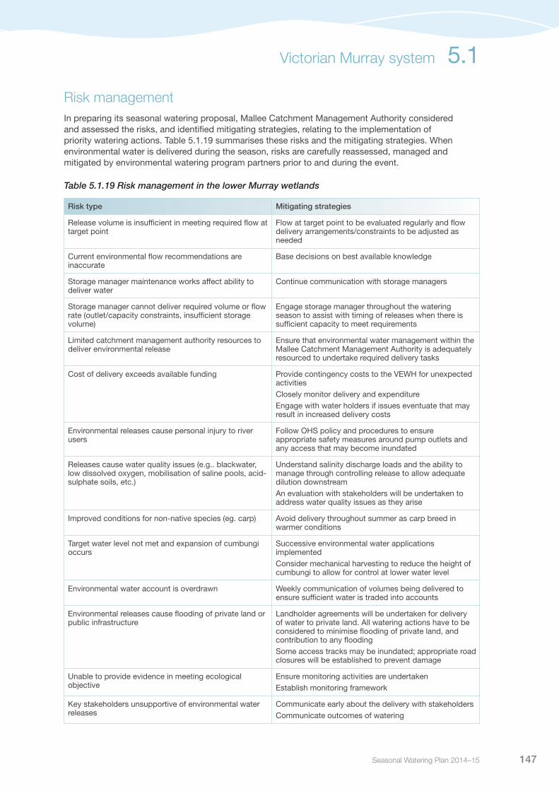
Seasonal Watering Plan 2014–15 147
Risk managementIn preparing its seasonal watering proposal, Mallee Catchment Management Authority considered and assessed the risks, and identified mitigating strategies, relating to the implementation of priority watering actions. Table 5.1.19 summarises these risks and the mitigating strategies. When environmental water is delivered during the season, risks are carefully reassessed, managed and mitigated by environmental watering program partners prior to and during the event.
Table 5.1.19 Risk management in the lower Murray wetlands
Risk type Mitigating strategies
Release volume is insufficient in meeting required flow at target point
Flow at target point to be evaluated regularly and flow delivery arrangements/constraints to be adjusted as needed
Current environmental flow recommendations are inaccurate
Base decisions on best available knowledge
Storage manager maintenance works affect ability to deliver water
Continue communication with storage managers
Storage manager cannot deliver required volume or flow rate (outlet/capacity constraints, insufficient storage volume)
Engage storage manager throughout the watering season to assist with timing of releases when there is sufficient capacity to meet requirements
Limited catchment management authority resources to deliver environmental release
Ensure that environmental water management within the Mallee Catchment Management Authority is adequately resourced to undertake required delivery tasks
Cost of delivery exceeds available funding Provide contingency costs to the VEWH for unexpected activitiesClosely monitor delivery and expenditureEngage with water holders if issues eventuate that may result in increased delivery costs
Environmental releases cause personal injury to river users
Follow OHS policy and procedures to ensure appropriate safety measures around pump outlets and any access that may become inundated
Releases cause water quality issues (e.g.. blackwater, low dissolved oxygen, mobilisation of saline pools, acid-sulphate soils, etc.)
Understand salinity discharge loads and the ability to manage through controlling release to allow adequate dilution downstreamAn evaluation with stakeholders will be undertaken to address water quality issues as they arise
Improved conditions for non-native species (eg. carp) Avoid delivery throughout summer as carp breed in warmer conditions
Target water level not met and expansion of cumbungi occurs
Successive environmental water applications implementedConsider mechanical harvesting to reduce the height of cumbungi to allow for control at lower water level
Environmental water account is overdrawn Weekly communication of volumes being delivered to ensure sufficient water is traded into accounts
Environmental releases cause flooding of private land or public infrastructure
Landholder agreements will be undertaken for delivery of water to private land. All watering actions have to be considered to minimise flooding of private land, and contribution to any floodingSome access tracks may be inundated; appropriate road closures will be established to prevent damage
Unable to provide evidence in meeting ecological objective
Ensure monitoring activities are undertaken Establish monitoring framework
Key stakeholders unsupportive of environmental water releases
Communicate early about the delivery with stakeholdersCommunicate outcomes of watering
Victorian Murray system 5.1

Victorian Environmental Water Holder148
ConsultationThe Mallee Catchment Management Authority has consulted stakeholders in the preparation of the seasonal watering proposal for the lower Murray wetlands These stakeholders are shown in Table 5.1.20.
Table 5.1.20 Key stakeholders involved in the preparation of the seasonal watering proposal for the lower Murray wetlands
Stakeholder consultation
Parks VictoriaField and Game VictoriaBirdlife AustraliaGoulburn-Murray WaterLower Murray WaterMurray-Darling Basin AuthorityNew South Wales Office of WaterParks VictoriaPrivate landholdersMallee Catchment Management Authority BoardCommonwealth Environmental Water OfficeDepartment of Environment and Primary IndustriesVictorian Environmental Water Holder
5.1 Victorian Murray system
Pictured: Hattah Lakes, by Victorian Environmental Water Holder

Seasonal Watering Plan 2014–15 149
5.1.6 Lindsay, Wallpolla and Mulcra islandsSystem overviewLindsay, Wallpolla and Mulcra islands cover over 26,100 hectares of River Murray floodplain, forming part of the Chowilla Floodplain and Lindsay-Wallpolla Island Living Murray icon site. The system includes semi-permanent and ephemeral waterways and wetlands, which support a range of vegetation types, including river red gum and black box woodlands and lignum shrublands. The creeks and streams are important in maintaining flowing water habitat for fish species such as the iconic Murray cod.
The islands are fed by high River Murray flows that are influenced by the upper Murray tributaries and flows in the Darling River. The islands are located in a reach of the River Murray that is highly regulated through a series of locks and weirs (Lock 6 to 9 all affect the natural hydrology). A combination of large floods, structural works, weir manipulation and temporary pumping allow the islands to be receive environmental water.
Structural works have been completed at Mulcra, Wallpolla and Lindsay islands that can be used to control flow through the anabranches and manage water to specific wetlands.
Current situationLindsay, Wallpolla and Mulcra islands have received environmental water since 2005. These environmental watering events have been successful in maintaining, and in some cases, improving the health of wetland plants and river red gums, along with improving conditions for native fish and waterbirds.
The commissioning of the Mulcra Island structures in 2013 provided water to the Mulcra Island floodplain, including some inundation of the fringing lignum shrublands.
Wallpolla Island did not receive environmental water in 2013-14, due to an attempt to dry the Wallpolla Horseshoe wetland to manage carp. Similarly, no environmental watering occurred at Lindsay Island, due to ongoing construction of environmental water management structures in the upper Lindsay River.
Priority watering actions and environmental objectivesPriority watering actions, along with their associated environmental objectives, are provided in Table 5.1.21.
Environmental watering at Lindsay, Wallpolla and Mulcra islands in 2014-15 aims to provide: opportunities for regeneration and improved growth and reproduction of aquatic and floodplain vegetation; feeding opportunities for waterbirds; and cues for fish breeding and recruitment.
In addition to the environmental objectives, these watering actions will also provide opportunities for recreational activities including boating, bird watching, bushwalking and fishing.
Victorian Murray system 5.1

Victorian Environmental Water Holder150
Table 5.1.21 Priority watering actions and environmental objectives for Lindsay, Wallpolla and Mulcra islands
Priority watering action Environmental objectives
Lindsay Island
Winter/spring freshening flows to Lindsay River and Mullaroo Creek (target raising of Lock 7 up to 500 mm above normal operating height during winter)
Provide flowing water habitat requirements to stimulate fish spawningCommissioning of recently completed Living Murray program infrastructure at Lindsay Island
Winter/spring inundation of Webster’s Lagoon (targeting inflows during August to November)
Promote wetland and aquatic plant diversity and maintain wetland condition
Spring inundation of Lake Wallawalla (targeting inflows during September to December)
Promote wetland and aquatic plant diversity, support germination of fringing river red gum, and maintain wetland condition
Wallpolla Island
Spring inundation of Wallpolla Horseshoe and Finnigans Creek (target raising of Lock 9 up to 500 mm above normal operating levels and provision of inflows during September to October)
Promote wetland and aquatic plant diversity and maintain wetland condition
Mulcra Island
Winter inundation of Mulcra Island (target surcharging of River Murray Lock 8 up to 800 mm above full supply during July to August)
Restore productivity linkages between river and floodplain habitatsImprove condition and increase extent to sustain species assemblages and processes typical of lignum communitiesFurther commissioning of recently completed Living Murray program infrastructure at Mulcra Island
Scenario planningTable 5.1.22 outlines the priority watering actions and expected water usage under a range of planning scenarios.
Specific flow rates and lock heights in the River Murray are required to facilitate environmental water deliveries to many parts of Mulcra, Wallpolla and Lindsay islands. As such, the ability to manage environmental water into these wetlands will be dependent upon sufficient flows being delivered down the Murray system. Under a wet scenario, high flows in the Murray system are likely to naturally inundate the wetlands, or significantly contribute to achieving the desired watering regimes.
As well as targeting environmental benefits, watering actions are importantly aimed at commissioning the new environmental water management structures. The commissioning of the Lindsay Island structures will coincide with a spring fresh to help stimulate spawning events in the Mullaroo Creek and Lindsay River.
5.1 Victorian Murray system

Seasonal Watering Plan 2014–15 151
Table 5.1.22 Priority watering actions for Lindsay, Wallpolla and Mulcra islands under a range of planning scenarios
Planning scenario
DROUGHT DRY AVERAGE WET
Priority watering actions
Winter/spring inundation of Websters Lagoon Spring inundation of Wallpolla Horseshoe and Finnigans CreekWinter inundation of Mulcra Island
Winter/spring freshening flows to Lindsay River and Mullaroo CreekWinter/spring inundation of Websters Lagoon Spring inundation of Lake WallawallaSpring inundation of Wallpolla Horseshoe and Finnigans Creek Winter inundation of Mulcra Island
Winter/spring freshening flows to Lindsay River and Mullaroo CreekWinter/spring inundation of Websters Lagoon Spring inundation of Lake WallawallaSpring inundation of Wallpolla Horseshoe and Finnigans Creek Winter inundation of Mulcra Island
Winter/spring freshening flows to Lindsay River and Mullaroo CreekWinter/spring inundation of Websters Lagoon Spring inundation of Lake WallawallaSpring inundation of Wallpolla Horseshoe and Finnigans CreekWinter inundation of Mulcra Island
Possible volume required from the Water Holdings
2,750 ML (requires delivery of 5,500 ML of consumptive water en route)
15,660 ML (requires delivery of 45,000 ML of consumptive water en route)
16,910 ML (requires delivery of 45,000 ML of consumptive water en route)
17,160 ML (requires delivery of 45,000 ML of consumptive water en route)
Risk managementIn preparing its seasonal watering proposal, Mallee Catchment Management Authority considered and assessed the risks, and identified mitigating strategies, relating to the implementation of priority watering actions. Table 5.1.23 summarises these risks and the mitigating strategies. When environmental water is delivered during the season, risks are carefully reassessed, managed and mitigated by environmental watering program partners prior to and during the event.
Table 5.1.23 Risk management for Lindsay, Wallpolla and Mulcra islands
Risk type Mitigating strategies
Mullaroo structure is not complete by August 2014, impacting on the ability to generate flow in the upper Lindsay
Continue to engage with SA Water and the Murray-Darling Basin Authority on construction.
Release volume is insufficient in meeting required flow at target point
Environmental water requirements can be met at all sites, monitoring of large infrastructure first operation and coordinating with river operations to manage delivery constraints
Current recommendations on environmental flow are inaccurate
Base decisions on current best available knowledge
Storage manager maintenance works affect ability to deliver water
Continue communication with storage managers
Storage manager cannot deliver required volume or flow rate (outlet/capacity constraints, insufficient storage volume)
Engage storage manager throughout the watering season to assist with timing of releases when there is sufficient capacity to meet requirements
Releases cause water quality issues (eg. blackwater, low dissolved oxygen, mobilisation of saline pools, acid sulphate soils etc.)
Observe water quality throughout the watering season and manage through controlling releases through structures to allow adequate dilution downstream
Improved conditions for non-native species (eg. carp) Avoid delivery throughout summer as warmer water can favour non-native species spawning events
Inappropriate watering regime used, resulting in loss of ecosystem function
Base actions on best available knowledge and weigh up the cost/benefit of watering actions
Victorian Murray system 5.1

Victorian Environmental Water Holder152
Risk type Mitigating strategies
Structures in the river do not allow the movement of Murray cod to spawning grounds or back to home reach
Continue work with understanding movement requirementsProvide adequate flow through regulators to facilitate movement
Limited catchment management authority resources to deliver environmental water
Ensure that environmental water management within the Mallee Catchment Management Authority is adequately resourced to undertake required delivery tasks
Cost of delivery exceeds available funding Manage costs appropriately to ensure delivery costs are within budget
Environmental release cause personal injury to river user Appropriate safety measures around pump outlets and any access that may become inundated
Unable to provide evidence in meeting ecological objective
Ensure monitoring activities are undertakenEstablish monitoring framework
Key stakeholder not supportive of environmental water release
Communicate early about the delivery
Environmental water account is overdrawn Weekly communication of volumes being delivered to ensure sufficient water is traded into accounts
Environmental water releases causes flooding of public infrastructure, private or Crown land
Landholder agreements undertaken for flooding on private landSome access tracks may be inundated; appropriate road closures to prevent damageAgreements undertaken with land manager for flooding on Crown land
ConsultationThe Mallee Catchment Management Authority has consulted stakeholders in the preparation of the seasonal watering proposal for the Lindsay, Wallpolla and Mulcra Islands. These stakeholders are shown in Table 5.1.24.
Table 5.1.24 Key stakeholders involved in the preparation of the seasonal watering proposal for the Lindsay, Wallpolla and Mulcra islands
Stakeholder consultation
Mallee Catchment Management Authority community committeesGoulburn-Murray WaterSA WaterLower Murray WaterParks VictoriaMurray-Darling Basin AuthorityNew South Wales governmentDepartment of Environment and Primary IndustriesCommonwealth Environmental Water OfficeVictorian Environmental Water Holder
Table 5.1.23 Risk management for Lindsay, Wallpolla and Mulcra islands (continued)
5.1 Victorian Murray system

Seasonal Watering Plan 2014–15 153
5.2
Ovens system
Waterway manager – North East Catchment Management Authority
Storage manager – Goulburn-Murray Water
The Ovens is a semi-regulated river system in the Murray-Darling Basin. The semi-regulated nature of the system means the Ovens has maintained a relatively natural flow regime. The Ovens system is particularly important for self-sustaining populations of native fish, including high-priority threatened migratory fish. The wetlands and rivers in the system support populations of Murray cod, golden perch, fly-specked hardyhead and trout cod. There are also populations of threatened bird species and frogs.
System overviewThe Ovens River system rises in the Great Dividing Range near Mount Hotham and flows approximately 150 kilometres to join the River Murray in the backwaters of Lake Mulwala and is semi-regulated. Only two small water storages have been constructed in the system – Lake Buffalo (~23,400 ML) on the Buffalo River and Lake William Hovell (~13,500 ML) on the King River. The reaches of the Ovens River system that are regulated are the Buffalo River below Lake Buffalo, the King River below Lake William Hovell, and the Ovens River from the confluence with the Buffalo River to Lake Mulwala (see Figure 5.2.1). The reaches of the Ovens River upstream of the confluence with the Buffalo River, and the reaches of the Buffalo and King rivers upstream of their storages are unregulated.
Due to only being regulated for part of the year, the Ovens River system maintains a relatively natural flow regime and has good connectivity. The river can be unregulated for long periods of the year with the storages passing all inflows. During the irrigation season, when water is required to supplement flows in the Ovens and King rivers for irrigation demands, domestic and stock requirements and minimum passing flows, Lake Buffalo and Lake William Hovell regulate releases to the system. The semi-regulated nature of the system means flow remains highly variable across the year. Therefore, environmental water delivery needs to be flexible to respond to unfolding conditions.
Pictured: Lower Ovens River, by North East CMA

Victorian Environmental Water Holder154
In recent years, there have been opportunities to add the held environmental water to a bulk release drawdown. The bulk release drawdown is made from Lake Buffalo to allow for annual maintenance at the end of the irrigation season and before the traditional winter-spring inflow period. When a bulk release drawdown is required, generally in April to May, the North East Catchment Management Authority and Goulburn-Murray Water work together to plan and deliver this water in a pattern that optimises environmental outcomes and contributes to meeting Victorian demand in the Murray system. These releases largely target outcomes in reach 4 (Ovens River from the Buffalo River to Everton/Tarrawingee) and reach 5 (Ovens River from Everton/Tarrawingee to the Murray River at Lake Mulwala). The availability and volume of the bulk release drawdown is highly dependent on seasonal conditions.
The priority reach for environmental watering for 2014-15 is reach 5, the Ovens River from Everton/Tarrawingee to the River Murray (see Figure 5.2.1). This reach is particularly important in supporting high-priority threatened native fish species. It is also the reach most exposed to stress from very low summer flows. By delivering to reach 5, the benefits of a fresh event are also realised in reaches 1 to 4.
When the bulk release drawdown is not available, watering actions target reaches 1, 2 and 3 as the small volume of held water available limits the ability to meet the requirements of reaches 4 and 5.
Current situationOver the past decade, the Ovens River system has been impacted by both drought and flood. Despite these impacts, environmental flow recommendations were largely met, except for low flows and high flows in reach 5. A small amount of environmental water (70 ML) held by the Commonwealth Environmental Water Holder has been managed and delivered in the Ovens system since 2009-10. There is 20 ML held in Lake Buffalo and 50 ML in Lake William Hovell. This water can only be delivered when the storages are not spilling. Environmental water was not actively delivered in 2010-11 due to major flooding in the system, and in 2012-13, the 50 ML entitlement in Lake William Hovell was unable to be delivered as the storage spilled earlier than expected.
Although only a relatively small volume of environmental water is held in the Ovens system, this water provides a number of important ecological outcomes, particularly in drier scenarios. These include maintaining variability and connectivity of flows, providing food resources, habitat and connectivity for macroinvertebrates and fish.
When available, a bulk release drawdown provides significantly greater scope for management of flows for environmental purposes. In 2013-14, the North East Catchment Management Authority was able to meet environmental flow recommendations for reaches 1, 4 and 5 by combining delivery of the bulk drawdown with delivery of environmental water. In addition to the environmental water and bulk releases, Goulburn-Murray Water is required to pass minimum environmental flows in the King, Buffalo and Ovens rivers under the bulk entitlement.
Priority watering actions and environmental objectivesPriority watering actions, along with their associated environmental objectives, are provided in Table 5.2.1 and illustrated in Figure 5.2.2.
The priority environmental objectives are to: maintain flow cues for native fish; maintain macroinvertebrate habitat; maintain natural connectivity along the river; manage sedimentation; and scour biofilms from the bed of the river.
In addition to the environmental objectives, these watering actions will also have the complementary benefit of supporting social values associated with passive recreation, fishing and boating.
5.2 Ovens system
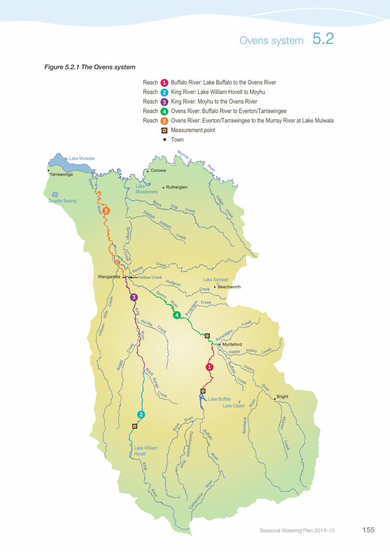
Seasonal Watering Plan 2014–15 155
Ovens system 5.2
Figure 5.2.1 The Ovens system
Buffalo
Cath
ernin
eRiv
er
River
DandongadaleRiver
Corowa
Bright
Myrtleford
Beechworth
Wangaratta
Rutherglen
Yarrawonga
River
Ovens
River
Ovens
Morses
Creek
Ovens
Creek
Creek
Hurdle
Cree
k
Bogg
y
Range
Creek
Buffalo
Creek
Happy Valley
BarwidgeeCreek
Creek
Black
Mile
Cree
k
Fifte
en
River
King
River
King
River
Rose
Buck
land
Rive
r
River
Reedy
Hodgson
Creek
Burg
oigee
Creek
DiddahDiddah
Creek
Dog
IndigoCreek
Black
River
Murray
Creek
SpringsCreek
Lake Mulwala
Lake Buffalo
Dowdle Swamp
Lake Moodemere
Lake William Hovell
Lake Catani
Lake SambellYellow Creek
•
• •
•
•
•
•
•
1
2
3
4
5
1
2
3
4
5
Reach Buffalo River: Lake Buffalo to the Ovens River Reach King River: Lake William Hovell to Moyhu Reach King River: Moyhu to the Ovens River Reach Ovens River: Buffalo River to Everton/TarrawingeeReach Ovens River: Everton/Tarrawingee to the Murray River at Lake Mulwala Measurement point Town
Buffalo
Cath
ernin
eRiv
er
River
DandongadaleRiver
Corowa
Bright
Myrtleford
Beechworth
Wangaratta
Rutherglen
Yarrawonga
River
Ovens
River
Ovens
Morses
Creek
Ovens
Creek
Creek
Hurdle
Cree
k
Bogg
y
Range
Creek
Buffalo
Creek
Happy Valley
BarwidgeeCreek
Creek
Black
Mile
Cree
k
Fifte
en
River
King
River
King
River
Rose
Buck
land
Rive
r
RiverReedy
Hodgson
Creek
Burg
oigee
Creek
DiddahDiddah
Creek
Dog
IndigoCreek
Black
River
Murray
Creek
SpringsCreek
Lake Mulwala
Lake Buffalo
Dowdle Swamp
Lake Moodemere
Lake William Hovell
Lake Catani
Lake SambellYellow Creek
•
• •
•
•
•
•
•
1
2
3
4
5
1
2
3
4
5
Reach Buffalo River: Lake Buffalo to the Ovens River Reach King River: Lake William Hovell to Moyhu Reach King River: Moyhu to the Ovens River Reach Ovens River: Buffalo River to Everton/TarrawingeeReach Ovens River: Everton/Tarrawingee to the Murray River at Lake Mulwala Measurement point Town

Victorian Environmental Water Holder156
Table 5.2.1 Priority watering actions and environmental objectives for the Ovens system
Priority watering action Environmental objective
One summer/autumn low flow fresh targeting all reaches (more than 130 ML per day for at least three days in reach 5 during April to May)
Maintain flow cues to stimulate movement of native fishMaintain short-term fluctuations in discharge to move sediment and maintain macroinvertebrate habitatMaintain connectivity between pools and rifflesScour biofilm from bed
Supporting summer/autumn low flows targeting reaches 1, 2 and 3 (flows of 10-70 ML per day during December to May)
Maintain flow cues to stimulate movement of native fishMaintain natural connectivity between pools and rifflesScour bio-film from the bedMaintain short-term fluctuations in discharge to move sediment and maintain macroinvertebrate habitat
Figure 5.2.2 Priority watering actions for the Ovens system1
50
100
150
200
Dec Jan 2015 Feb Mar AprNovOctSeptAug May JunJuly 2014
Month
Flo
w (M
L) p
er d
ay
Summer/autumn baseflows
Summer/autumn fresh
5.2 Ovens system
1 These figures are for illustrative purposes only. Scheduling and delivery of particular watering actions within the stated timeframes will vary
Scenario planningTable 5.2.2 outlines the priority watering actions and expected water usage under a range of planning scenarios.
Depending on unfolding conditions during the 2014-15 season, water may be delivered either through one fresh event or to support summer/autumn base flows.
Under a drought and dry scenario, it is considered that releases of the small volume of held environmental water, over consecutive days, would provide critical low flow support during times when the system is under greatest stress.
Under an average scenario, the majority of recommended flows will be provided by the natural flow regime. In this case, it is likely that there will be a managed bulk release drawdown from Lake Buffalo at the end of the irrigation season in April or May. Availability of this release allows the North East Catchment Management Authority and Goulburn-Murray Water to coordinate delivery of an autumn low flow fresh. In this case, held environmental water will be used to complement the low flow fresh. Estimating available volumes, or the date, of the bulk release drawdown is not possible until late in the irrigation season. Conditions under this scenario may dictate that the 50 ML of environmental water held in Lake William Hovell needs to be released earlier as a separate event.
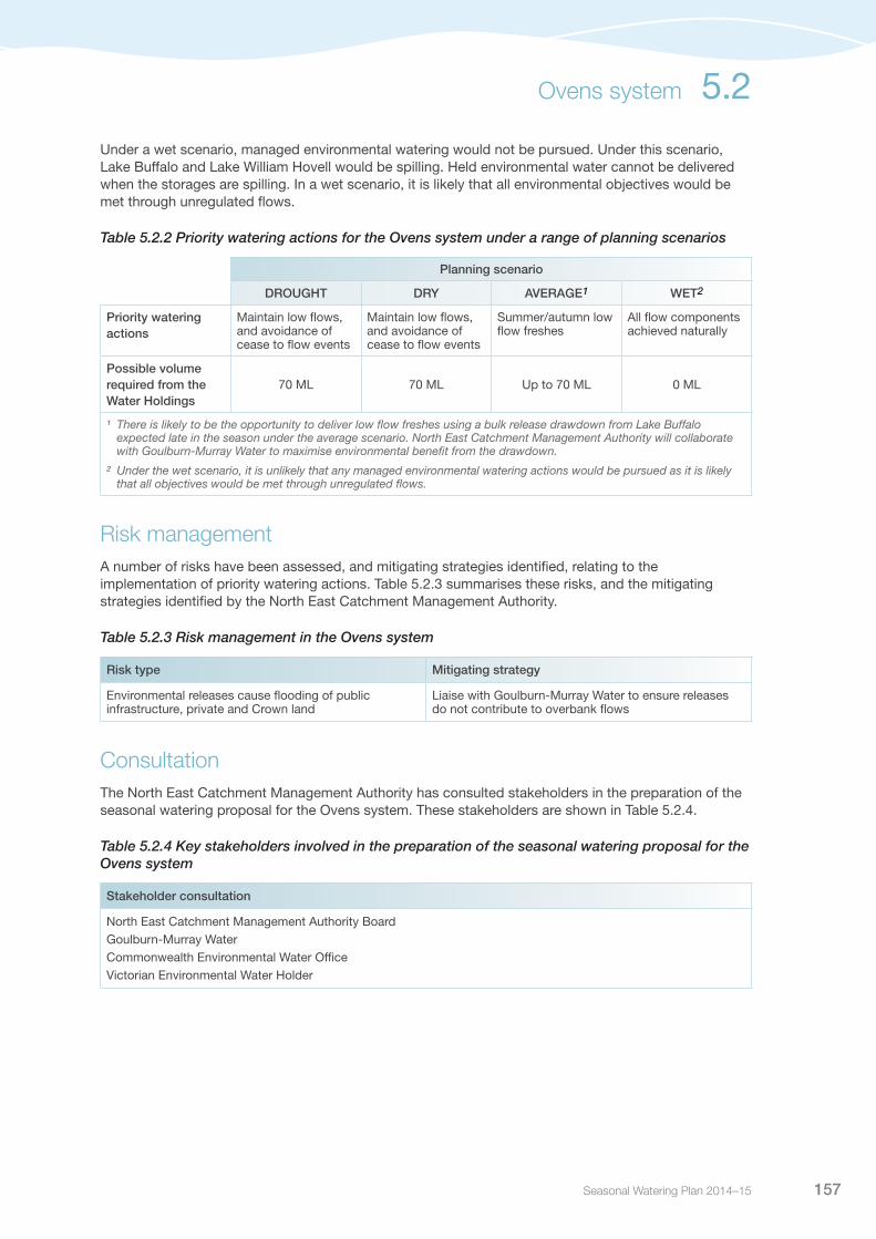
Seasonal Watering Plan 2014–15 157
Under a wet scenario, managed environmental watering would not be pursued. Under this scenario, Lake Buffalo and Lake William Hovell would be spilling. Held environmental water cannot be delivered when the storages are spilling. In a wet scenario, it is likely that all environmental objectives would be met through unregulated flows.
Table 5.2.2 Priority watering actions for the Ovens system under a range of planning scenarios
Planning scenario
DROUGHT DRY AVERAGE1 WET2
Priority watering actions
Maintain low flows, and avoidance of cease to flow events
Maintain low flows, and avoidance of cease to flow events
Summer/autumn low flow freshes
All flow components achieved naturally
Possible volume required from the Water Holdings
70 ML 70 ML Up to 70 ML 0 ML
¹ There is likely to be the opportunity to deliver low flow freshes using a bulk release drawdown from Lake Buffalo expected late in the season under the average scenario. North East Catchment Management Authority will collaborate with Goulburn-Murray Water to maximise environmental benefit from the drawdown.
² Under the wet scenario, it is unlikely that any managed environmental watering actions would be pursued as it is likely that all objectives would be met through unregulated flows.
Risk managementA number of risks have been assessed, and mitigating strategies identified, relating to the implementation of priority watering actions. Table 5.2.3 summarises these risks, and the mitigating strategies identified by the North East Catchment Management Authority.
Table 5.2.3 Risk management in the Ovens system
Risk type Mitigating strategy
Environmental releases cause flooding of public infrastructure, private and Crown land
Liaise with Goulburn-Murray Water to ensure releases do not contribute to overbank flows
ConsultationThe North East Catchment Management Authority has consulted stakeholders in the preparation of the seasonal watering proposal for the Ovens system. These stakeholders are shown in Table 5.2.4.
Table 5.2.4 Key stakeholders involved in the preparation of the seasonal watering proposal for the Ovens system
Stakeholder consultation
North East Catchment Management Authority BoardGoulburn-Murray WaterCommonwealth Environmental Water OfficeVictorian Environmental Water Holder
Ovens system 5.2

Victorian Environmental Water Holder158
Goulburn system
5.3
Waterway manager – Goulburn Broken Catchment Management AuthorityStorage manager – Goulburn-Murray Water
The Goulburn is Victoria’s largest river basin, covering over 1.6 million hectares or 7.1 percent of the State. The Goulburn River flows for 570 kilometres from the Great Dividing Range upstream of Woods Point to the River Murray east of Echuca. It is an iconic heritage river because of significant environmental, recreational and cultural values. It supports large areas of intact river red gum forest, and provides habitat for threatened and endangered bird and fish species. It also contains important cultural heritage sites, provides water for Victoria’s largest irrigation district and supports recreational activities such as fishing and canoeing. Within the Goulburn-Broken catchment, approximately 2,000 natural wetlands have been recorded, including a number of wetlands formally recognised for their conservation significance.
System overviewLake Eildon and Goulburn Weir have significantly modified the Goulburn River’s flow pattern. Due to the impact of water harvesting, lower flows now occur in the Goulburn River in winter and spring, while higher flows occur in summer and autumn due to releases to meet irrigation and consumptive demands – a reversal of what would happen naturally. The Goulburn River flow regime is also affected by land use change, and the construction of small dams and drainage schemes. Levees and other structures prevent water inundating the floodplain. Tributaries downstream of major infrastructure, such as Seven Creeks and the Broken River downstream of Goulburn Weir, help to contribute natural flows to the Goulburn River.
Environmental watering in the Goulburn River aims to help restore some of the natural flow patterns that have been removed through river regulation. The priority river reaches for environmental watering are reaches 4 and 5 (from Goulburn Weir to the River Murray), with reaches 1, 2 and 3 (between Lake Eildon and Goulburn Weir) benefiting from flows passing to the lower reaches. Reach 4 and 5 of the Goulburn River provide important habitat for native fish communities such as golden perch, Macquarie perch, carp gudgeon, trout cod, Murray cod and freshwater catfish. The environmental flow reaches are shown in Figure 5.3.1.
Pictured: Goulburn River at McCoys Bridge, by Goulburn Broken CMA

Seasonal Watering Plan 2014–15 159
Environmental water available in the Goulburn system includes Victorian, Commonwealth and Living Murray holdings. Commonwealth and Living Murray holdings are also often delivered through the Goulburn to downstream sites, while aiming to provide in-stream benefits to the Goulburn River en route. Environmental water in the Goulburn system can be released from Lake Eildon for reaches 1 to 3 and from Goulburn Weir for reaches 4 and 5. The measurement points for target flows are at Murchison for reach 4 and McCoys Bridge for reach 5.
Water can also be traded for use in the Goulburn system from other systems including the River Murray, subject to trading rules. Passing flows are provided under Goulburn-Murray Water’s bulk entitlement and consumptive water is delivered down the Goulburn River en route to the Murray River. Consumptive water can provide significant environmental benefits if delivered at the right time.
There are a large number of natural wetlands across the Goulburn catchment, including a number of wetlands formally recognised for their conservation significance. Of the Goulburn wetlands, Reedy Swamp, Doctors Swamp, One Tree Swamp, Two Tree Swamp, Wallenjoe Swamp and Mansfield Swamp can receive regulated environmental water. These wetlands contain vegetation communities ranging from river red gum dominated swamps to cane-grass. Providing environmental water to these wetlands relies on irrigation infrastructure within the Shepparton and Central Goulburn Irrigation Districts.
Reedy Swamp is an important waterbird breeding site and drought refuge. It is a stopover site for migratory birds such as the sharp-tailed sandpiper and marsh sandpiper. Reedy Swamp is listed in the Directory of Important Wetlands in Australia (as part of the Lower Goulburn listing) and is also part of the Lower Goulburn National Park. Doctors Swamp is a bioregionally significant swamp and is considered one of the most intact red gum swamps in Victoria.
One Tree Swamp, Two Tree Swamp, Wallenjoe Swamp and Mansfield Swamp form a large hydrologically-connected wetland system known as the Corop Wetland System. The Corop wetlands are listed in the Directory of Important Wetlands in Australia (as part of the Wallenjoe Wetlands listing) and are valued for their size, rarity, species diversity and waterbird habitat. Of note, One Tree and Two Tree Swamps provide important breeding habitat for brolga and One Tree Swamp is the largest cane-grass wetland in the Goulburn Broken catchment. Although the Corop Wetland System can receive environmental water, delivery of water to this system will not be considered until infrastructure works are completed to improve environmental water delivery efficiency and control.
Goulburn system 5.3

Victorian Environmental Water Holder160
Fig
ure
5.3.
1 T
he G
oul
bur
n sy
stem
5.3 Goulburn system
Cree
k
McCo
ys B
ridge
Goub
urn W
eir
Yea
Eur
oa
Tatu
ra
Loch
Gar
ry
Kya
bram
Sey
mou
r
Kilm
ore
Jam
ieso
n
Man
sfie
ld
Ale
xand
ra
Mar
ysvi
lle
Viol
et T
own
•Go
ulbu
rn
River
Seven
Castle
Big
River
Hughes
Sunday
How
qua
Major
Creig
hton
s
Yea
Deep
Dry
Cornella
Acheron
Mollison
Murrindindi
Pran
jip
Bylands
Spring
Goborup
Wormangal
East
Mer
ton
Burnt Dairy
RiverRubicon
River
River
River
Creek
Creek
Creek
Cree
k
Creek
Cree
k
Cree
k
Creek
Creek
Cree
kCreek
Cree
kCr
eek
Creek
Creeks
Cree
k
CreekCreek
Rive
r
Dela
tite
Rive
rLa
ke
Eildo
n
•
•
•
•
•
•
•
•
•
•
Goulburn
Goul
burn
Faith
fulls
King
Home
Dabyminga
Mia
Mia
Ford
Kurkuruc
Honeysuckle
Taggerty Br
anke
et
Suga
rloaf
Whi
tehe
ads
Yallagalorrah
Rive
r
Rive
r
River
CreekParrot
Cree
k
Creek
Cree
k
Creek
Creek
Creek
Creek
Cree
k
Cree
k
River
Mur
ray
She
ppar
ton
Brok
en R
iver
Goulbu
rn
Main
Channel
Cree
k
War
anga
Ba
sinSt
uart
Mur
ray
Cana
l
Catt
anac
h Ca
nal
War
anga
W
este
rn
Chan
nel
•
•
2
3
4
5
1
• Mur
chis
on
Water
Melbourne
King
DiversionAqueduct
Wal
laby
Silve
r
Creek
Cree
k Parrot
Creek
Silve
r and
Wall
aby C
reek
s
•2 3 4 51Re
ach
Lake
Eild
on to
Mole
swor
thRe
ach
Moles
worth
to S
eymo
urRe
ach
Seym
our t
o Nag
ambie
Reac
h Na
gamb
ie to
Loch
Gar
ryRe
ach
Loch
Gar
ry to
the R
iver M
urra
y
Prior
ity W
etlan
ds fo
r Env
ironm
ental
Wate
r
Meas
urem
ent p
oint
W
ater in
frastr
uctur
e
Town
Mans
field
Swam
p
Docto
rs Sw
amp
Reed
y Swa
mp
Two T
ree S
wamp
Wall
enjoe
Swa
mp
One T
ree S
wamp
"
Moo
ra C
reek
Nine M
ile Cr
eek

Seasonal Watering Plan 2014–15 161
5.3.1 Goulburn RiverCurrent situationEnvironmental water delivery in the Goulburn River has targeted recovery of the system following drought, particularly native fish populations and bank vegetation. Flows in the Goulburn River were severely affected by the Millennium drought, with the worst conditions between 2005 and 2010 when flows in the lower Goulburn did not get much above required minimum flows. These conditions were followed by an extremely wet year in 2010-2011, which resulted in several natural floods – the first on the Goulburn floodplain since 1996. One of these floods, in December 2010, produced a major blackwater event causing fish deaths. The floods also left some river banks bare of vegetation, which led to bank slumping and notching in subsequent years.
Conditions since 2011-12 have been dry to average, with environmental water releases enabling most priority watering actions to be provided. Recovery of some vegetation on the riverbanks has occurred in recent years, particularly below the level where environmental freshes have been delivered, but remains spatially patchy to date. In 2013-14, notching was significantly reduced from levels seen in 2012-13.
Aquatic plants and macroinvertebrates have so far struggled to recover from the floods in 2010, however floodplain vegetation generally remains in good condition. Golden perch breeding was successful following a spring fresh event in 2013-14; the first major breeding event since the 2010 floods. Golden perch are a key objective in environmental flow delivery as they (and silver perch) are thought to need flow variation as a cue to spawning.
Priority watering actions and environmental objectivesThe range of potential priority watering actions along with their associated environmental objectives, are provided in Table 5.3.1 and illustrated in Figure 5.3.2.
The focus in 2014-15 is similar to that of the past three years, which is to encourage the long-term improvement in the distribution, abundance and diversity of native fish, macroinvertebrates and vegetation. This will be achieved by implementing minimum flows and freshes, particularly in spring. Additional emphasis on bank stability and re-establishment of lower bank vegetation will continue from 2013-14.
In addition to the environmental objectives, these watering actions will support social values associated with passive recreation, fishing and boating.
Goulburn system 5.3

Victorian Environmental Water Holder162
Table 5.3.1 Priority watering actions and environmental objectives for the Goulburn system
Priority watering action Environmental objectives
Seasonal baseflows (500 ML per day in reach 4 and/or 540 ML per day in reach 5, year round)
Maximise habitat and movement opportunities for large and small-bodied native fish and juvenilesProvide conditions that support macroinvertebrates including: maintaining suitable water quality, encouraging aquatic vegetation for habitat, submergence of snags for habitat and food and encouraging planktonic production for food
Increased baseflows (830 ML per day in reach 4 and 940 ML per day in reach 5, year round, subject to water availability/conditions)
As above, plus:Submergence of additional snags for macroinvertebrate food and habitatMaintain pool depths and natural sediment distributionIncrease area of slackwater habitat in spring/summer to support spring-spawned larvae and juvenile fish
Spring fresh (up to 15,000 ML per day with flows at or above 5,600 ML per day for 14 days in reach 4 and/or reach 5 during October and November)
Support establishment of amphibious bank vegetationMaintain aquatic macrophyte, macroinvertebrate and fish habitat by mobilising fine sediments, submerging snags and replenishing slackwater habitatInitiate spawning and pre-spawning migrations and recruitment of native fish (golden perch)
Summer/autumn fresh (up to 5,600 ML per day for two days in reaches 4 and 5 during February and April)
Maintain aquatic macrophyte, macroinvertebrate and fish habitat by mobilising fine sediments, submerging snags and replenishing slackwater habitatSupport establishment of amphibious bank vegetation
Spring/summer fresh (up to 15,000 ML per day for two days in reaches 4 and 5 during November and December)
Initiate spawning and pre-spawning migrations and recruitment of native fish (golden perch)Support establishment of amphibious bank vegetationMaintain aquatic macrophyte, macroinvertebrate and fish habitat by mobilising fine sediments, submerging snags and replenishing slackwater habitat
Winter fresh (up to 15,000 ML per day with flows above 6,600 ML per day for 14 days in reaches 4 and 5 during June and August)
Maintain aquatic macrophyte, macroinvertebrate and fish habitat by mobilising fine sediments, submerging snags and replenishing slackwater habitat
Figure 5.3.2 Priority watering actions for the Goulburn system1
Year-round baseflows,
Reach 41,300
2,600
3,900
6,500
6,800
15,000
Dec Jan 2015 Feb Mar AprNovOctSeptAug May JunJuly 2014
Month
Flo
w (M
L) p
er d
ay
Spring/summer
fresh, Reaches
4 & 5
Winter freshes, Reaches
4 & 5Winter freshes, Reaches 4 & 5
Summer/autumn fresh
Year-round baseflows,
Reach 5
Spring fresh,
Reaches 4 & 5
5.3 Goulburn system
1 These figures are for illustrative purposes only. Scheduling and delivery of particular watering actions within the stated timeframes will vary.

Seasonal Watering Plan 2014–15 163
In addition to the priority watering actions outlined previously, environmental water may be used to slow the recession of unregulated flows or operational releases to reduce damage to banks and vegetation from rapid drops in water levels. This also helps prevent macroinvertebrates and fish from being stranded in small pools on river banks following higher flows.
Bankfull flows are important for maintaining channel shape and preventing in-filling of pools, while overbank flows are important for wetlands and bringing food resources into the river. However, they are not priority watering actions at this stage due to recent high and overbank flows. In addition, the feasibility of delivering overbank flows requires further investigation, including how best to deliver or supplement flows while avoiding damage to public and private assets. Therefore, overbank flows will only be achieved if they occur naturally.
Scenario planningTable 5.3.2 outlines the priority watering actions and expected water usage under a range of planning scenarios.
If water is limited in the Goulburn system, the 2014 spring period is most important, followed by the 2014-2015 summer period (summer is potentially more biologically productive then autumn/winter), and then the 2015 autumn/winter period.
While scenario plans provide a guide as to the key decisions that may need to be made under a range of scenarios, in-season decision making will remain adaptive in order to ensure water delivery and prioritisation can be adjusted as required as the season unfolds.
Table 5.3.2 Priority watering actions for the Goulburn system under a range of planning scenarios
Planning scenario
DROUGHT VERY DRY DRY AVERAGE WET
Expected availability of Water Holdings1
50,000 ML VEWH Holdings
30,000 ML Living Murray Holdings
160,000 ML Commonwealth Holdings
240,000 ML total
50,000 ML VEWH Holdings
39,000 ML Living Murray Holdings
213,000 ML Commonwealth Holdings
302,000 ML total
50,000 ML VEWH Holdings
39,000 ML Living Murray Holdings
213,000 ML Commonwealth Holdings
302,000 ML total
50,000 ML VEWH Holdings
39,000 ML Living Murray Holdings
213,000 ML Commonwealth Holdings
302,000 ML total
50,000 ML VEWH Holdings
79,000 ML Living Murray Holdings
217,000 ML Commonwealth Holdings
346,000 ML total
Priority watering actions (first tier)2
Winter/spring baseflows
Spring/summer fresh
Summer baseflows
Autumn/winter baseflows
Increased winter/spring baseflows
Summer/autumn fresh
Winter/spring baseflows
Spring/summer fresh
Summer baseflows
Increased autumn/winter baseflows
Increased winter/spring baseflows
Summer/autumn fresh
Spring/summer fresh (2015)
Increased winter/spring baseflows
Increased summer baseflows (2015)
Increased winter/spring baseflows
Spring/summer fresh
Increased summer baseflows
Increased autumn winter baseflows
Increased winter/spring baseflows
Summer/autumn fresh
Spring/summer fresh (2015)
Increased winter/spring baseflows
Increased summer baseflows (2015)
Increased winter/spring baseflows
Spring/summer fresh
Increased summer baseflows
Increased autumn winter baseflows
Summer/autumn fresh
Spring/summer fresh (2015)
Increased winter/spring baseflows
Increased summer baseflows (2015)
Increased winter/spring baseflows
Spring/summer fresh
Increased summer baseflows
Increased autumn winter baseflows
Summer/autumn fresh
Spring/summer fresh (2015)
Increased winter/spring baseflows (2015)
Increased summer baseflows (2015)
Goulburn system 5.3

Victorian Environmental Water Holder164
Planning scenario
DROUGHT VERY DRY DRY AVERAGE WET
Priority watering actions (second tier)3
Spring/summer fresh Increased winter/spring baseflowsIncreased summer baseflows
Winter freshIncreased autumn/winter baseflows
Winter freshIncreased autumn/winter baseflows
Winter freshIncreased winter/autumn baseflowsWinter fresh
Winter freshWinter freshIncreased summer baseflows and freshes
Possible volume required from the Water Holdings
240,000 ML 302,000 ML 302,000 ML 302,000 ML 346,000 ML
1 During water quality emergencies, up to 30,000 ML may be made available from Goulburn-Murray Water’s bulk entitlement to manage water quality issues. Additionally, the delivery of consumptive water en route, such as inter-valley transfers, may contribute to the achievement of some of the identified priority watering actions.
2 In addition to the watering actions identified above, environmental water may be used to manage the recession of high flows to minimise any ecological impact of rapid rates of water level fall, such as bank slumping.
3 Second-tier priority watering actions will only be delivered if sufficient water is available to meet first-tier priority watering actions or if they are delivered naturally.
Risk managementIn preparing its seasonal watering proposal, the Goulburn Broken Catchment Management Authority considered and assessed risks, and identified mitigating strategies, relating to the implementation of priority watering actions (see Table 5.3.3). Risks and mitigating actions are continually reassessed by delivery partners throughout the water year.
Table 5.3.3 Risk management in the Goulburn system
Risk type Mitigating strategy
Current recommendations on environmental flow in inaccurate
Monitor outcomes from flow management and reassess recommendations as necessary
Improved conditions for non-native species (eg. carp) None available
Unable to provide evidence in meeting environmental objective
Seek involvement in, and contributions and results from monitoring and research programs
Environmental release interferes with irrigation pumps and pumping
Provide public information on environmental water release intentions, and alter environmental water release management if possible
Environmental releases cause flooding of public infrastructure, private or Crown land
Consider potential catchment runoff from forecast rainfall in deciding when to commence releases and whether to prematurely cease releases
Key stakeholders unsupportive of environmental water release
Keep key stakeholders aware of environmental water release plans and timing
Limited catchment management authority resources to deliver environmental release
Seek resources to manage flows
Storage manager maintenance works affect ability to deliver water
Continued liaison with storage manager to plan releases around maintenance activity
Storage manager cannot deliver required volume or inflow rate (outlet/capacity constraints, insufficient storage volume)
Continued liaison with storage manager to plan releases around system operation to maximise environmental releases
Table 5.3.2 Priority watering actions for the Goulburn system under a range of planning scenarios (continued)
5.3 Goulburn system

Seasonal Watering Plan 2014–15 165
ConsultationThe Goulburn Broken Catchment Management Authority has consulted stakeholders in the preparation of the seasonal watering proposals for the Goulburn River. These stakeholders are shown in Table 5.3.4.
Table 5.3.4 Key stakeholders involved in the preparation of the seasonal watering proposal for the Goulburn River
Stakeholder consultation
Goulburn Environmental Water Advisory Group (made up of community members)Yorta Yorta Nation Aboriginal Corporation Goulburn-Murray WaterParks VictoriaGoulburn Broken Catchment Management Authority Board Commonwealth Environmental Water Office Victorian Environmental Water Holder
Goulburn system 5.3
Pictured: Goulburn River, by Goulburn Broken CMA
Victorian Environmental Water Holder166
5.3.2 Goulburn wetlandsCurrent situationDelivery of environmental water to the Goulburn wetlands has not been required in recent years, due to natural flooding between 2010 and 2012. Reedy Swamp filled naturally after an unseasonal rainfall event in February 2013, then partially dried, and is now wet again following further rainfall in autumn 2014. Doctors Swamp has also partially filled from natural rainfall events.
One Tree Swamp, Two Tree Swamp, Mansfield Swamp and Wallenjoe Swamp have been dry since February 2013. This drying phase is needed as a majority of these wetlands had experienced prolonged flooding between 2010 and 2012 and had exceeded their optimal wetting regimes. Delivery of environmental water to these wetlands will not be considered until infrastructure works are completed to improve environmental water delivery efficiency and control.
Priority watering actions and environmental objectivesPriority watering actions, along with their associated environmental objectives, are provided in Table 5.3.5.
Environmental water delivery in 2014-15 will assist with maintaining vegetation communities at Doctors Swamp and also providing opportunities for waterbird breeding at Reedy Swamp.
In addition to the environmental objectives, these watering actions will also provide complementary recreational benefits for activities such as camping, fishing, picnicking, and walking.
Table 5.3.5 Priority watering actions and environmental objectives for the Goulburn wetlands
Priority watering action Environmental objectives
Doctors Swamp Provide top up flows in spring and autumn if required, promote natural drying phase over summer
Maintain diversity of native wetland plant species to be consistent with the list of species and condition detailed under red gum swamp ecological vegetation class benchmarkProvide opportunities for waterbird breeding
Reedy Swamp: Provide top up flows in spring and autumn if required, promote natural drying phase over summer
Improve the diversity of native wetland plant species to be consistent with the list of species and condition detailed in the ecological vegetation class benchmarks surrounding the SwampMaintain habitat for waterbird breeding especially royal spoonbills and ibis
Scenario planningTable 5.3.6 outlines the priority watering actions and expected water usage under a range of planning scenarios.
In drier periods, restricted water resources and natural inflows may limit what can be realistically achieved in the Goulburn wetlands through environmental water management. In wetter periods, the ecological and hydrological objectives of a wetland may be largely met by natural inflows and only small volumes of environmental water may be required.
The decision to deliver environmental water to Reedy and Doctors swamps will be based on their hydrological condition, waterbird breeding activity, and the potential impact environmental water delivery may have on wetland vegetation.
5.3 Goulburn system

Seasonal Watering Plan 2014–15 167
Table 5.3.6 Priority watering actions for the Goulburn wetlands under a range of planning scenarios
Planning scenario
DROUGHT DRY AVERAGE WET
Priority watering sites1
Doctors SwampReedy Swamp
Doctors SwampReedy Swamp
Doctors SwampReedy Swamp
Doctors SwampReedy Swamp
Possible volume required from the Water Holdings
4,000 ML 4,000 ML 2,000 ML 2,000 ML
1 Priority watering sites and volumes required are based on the maximum number of sites and volumes of water required. Under each scenario there are a number of priorities for watering, based on factors such as timing of natural inflows and bird breeding events etc.
Risk managementIn preparing its seasonal watering proposal, the Goulburn Broken Catchment Management Authority considered and assessed risks, and identified mitigating strategies, relating to the implementation of priority watering actions (see Table 5.3.7). Risks and mitigating actions are continually reassessed by environmental watering program partners throughout the water year.
Table 5.3.7 Risk management in the Goulburn wetlands
Risk type Mitigating strategies
Storage manager cannot deliver required volume or flow rate (outlet/capacity constraints, insufficient storage volume)
Ongoing dialogue with Goulburn-Murray Water regarding consumptive demand in the system, to assist in timing releases when there is available capacity to meet desired flow rates
Improved conditions for non-native species (eg. carp) Minimising summer inundation and placing carp screens on inlet channels can reduce the risk
Environmental water account is overdrawn Ongoing dialogue with Goulburn-Murray Water regarding the volume of water delivered, so that if required, additional water resources can be sought in advance and negotiated with the VEWH, avoiding overdrawing the water account, while achieving the environmental objectives
ConsultationThe Goulburn Broken Catchment Management Authority has consulted stakeholders in the preparation of the seasonal watering proposal for the Goulburn wetlands. These stakeholders are shown in Table 5.3.8.
Table 5.3.8 Key stakeholders involved in the preparation of the seasonal watering proposal for the Goulburn wetlands
Stakeholder consultation
Goulburn Environmental Water Advisory Group (made up of community members)Goulburn Broken Catchment Wetland Management GroupYorta Yorta Nation Aboriginal Corporation Goulburn-Murray WaterParks VictoriaGoulburn Broken Catchment Management Authority Board Commonwealth Environmental Water OfficeVictorian Environmental Water Holder
Goulburn system 5.3
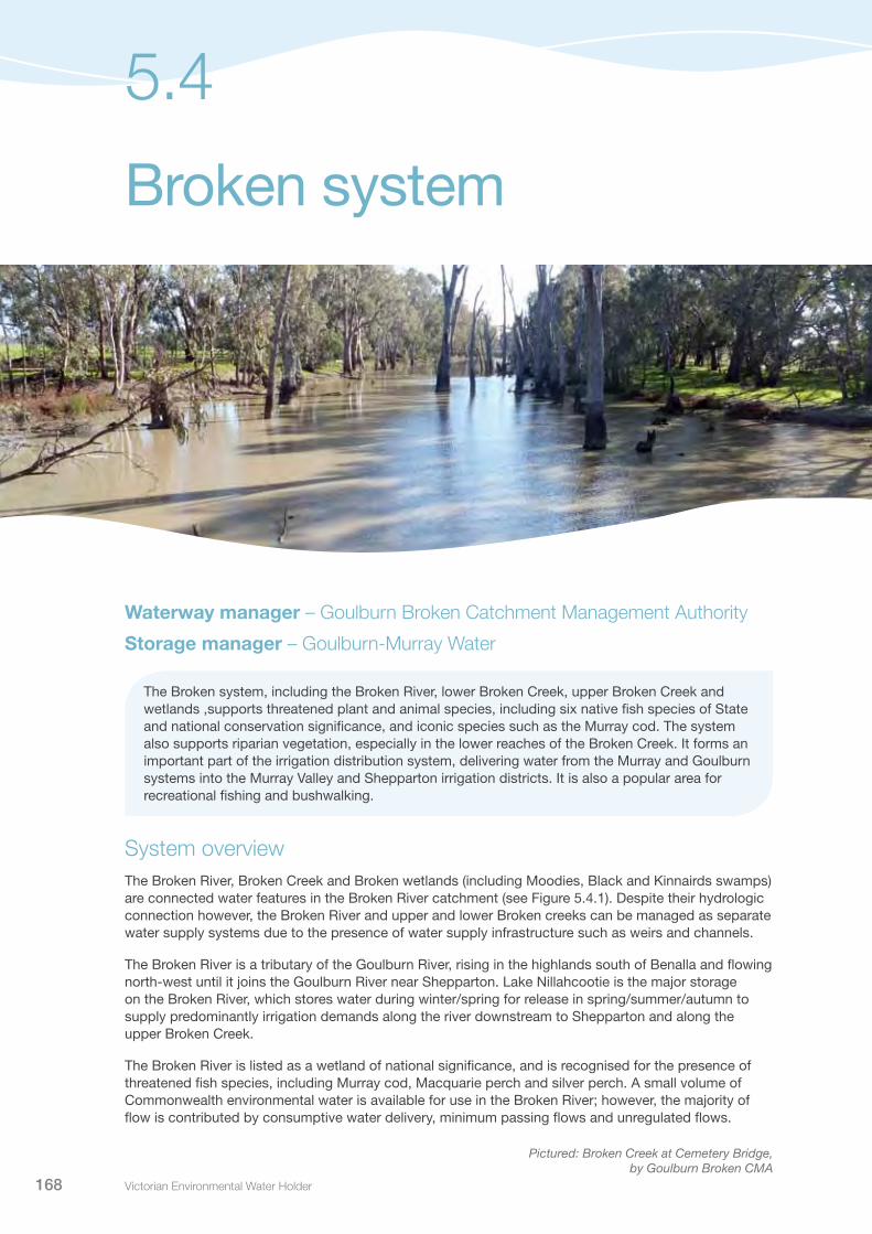
Victorian Environmental Water Holder168
Broken system
5.4
Waterway manager – Goulburn Broken Catchment Management Authority
Storage manager – Goulburn-Murray Water
The Broken system, including the Broken River, lower Broken Creek, upper Broken Creek and wetlands ,supports threatened plant and animal species, including six native fish species of State and national conservation significance, and iconic species such as the Murray cod. The system also supports riparian vegetation, especially in the lower reaches of the Broken Creek. It forms an important part of the irrigation distribution system, delivering water from the Murray and Goulburn systems into the Murray Valley and Shepparton irrigation districts. It is also a popular area for recreational fishing and bushwalking.
System overviewThe Broken River, Broken Creek and Broken wetlands (including Moodies, Black and Kinnairds swamps) are connected water features in the Broken River catchment (see Figure 5.4.1). Despite their hydrologic connection however, the Broken River and upper and lower Broken creeks can be managed as separate water supply systems due to the presence of water supply infrastructure such as weirs and channels.
The Broken River is a tributary of the Goulburn River, rising in the highlands south of Benalla and flowing north-west until it joins the Goulburn River near Shepparton. Lake Nillahcootie is the major storage on the Broken River, which stores water during winter/spring for release in spring/summer/autumn to supply predominantly irrigation demands along the river downstream to Shepparton and along the upper Broken Creek.
The Broken River is listed as a wetland of national significance, and is recognised for the presence of threatened fish species, including Murray cod, Macquarie perch and silver perch. A small volume of Commonwealth environmental water is available for use in the Broken River; however, the majority of flow is contributed by consumptive water delivery, minimum passing flows and unregulated flows.
Pictured: Broken Creek at Cemetery Bridge, by Goulburn Broken CMA
Seasonal Watering Plan 2014–15 169
The Broken Creek diverges from the Broken River downstream of Benalla and flows to the River Murray near Barmah Forest. The area is dominated by unique box riparian vegetation, supports remnant plains grassy woodland, and provides habitat for a variety of threatened fauna. Much of this area lies within the Broken Boosey State Park. Irrigation modernisation projects have reduced consumptive water demand in the upper Broken Creek system, resulting in reduced water deliveries and therefore relatively low flows all year from Caseys Weir to Waggarandal Weir. Flows often cease completely between Waggarandal Weir and Katamatite, with short duration freshes and high flow events occurring only in response to catchment rainfall. Environmental water can be diverted from the Broken River at Caseys Weir to flow down the upper Broken Creek. The Commonwealth Environmental Water Holder holds approximately 121 ML of environmental water in the Broken system.
The lower Broken and Nine Mile creeks have been regulated for over 50 years, significantly altering their flow regimes. The lower Broken Creek is operated separately to the upper Broken Creek and Broken River, because regulated water is delivered to the lower Broken Creek from the Goulburn and Murray systems via the irrigation channel network (rather than from the Broken River). Under natural conditions, the creeks would have flowed in response to significant rainfall (mainly in winter/spring) and would have ceased to flow for extended periods during summer and autumn. Today, significant flows are maintained throughout summer and autumn to supply water for irrigation, domestic and stock use. From east of Nathalia downstream, the Broken Creek has eight managed shallow weirs providing a near-constant water level that facilitates the extraction of irrigation and consumptive water. While the weir pools provide important native fish habitat, their water quality is often poor in summer and autumn.
Environmental water provided in the lower Broken Creek can be sourced from Victorian and Commonwealth Water Holdings in the Goulburn and Murray systems. Environmental water in the lower Broken Creek is released from the Goulburn system through the East Goulburn Main Channel, and from the Murray system through the Yarrawonga Main Channel. The priority river reach for environmental watering is reach 3 (from Nathalia Weir Pool to the River Murray), with flows also benefiting reaches 1 and 2. The measurement point for target flows in the lower Broken Creek is at Rices Weir.
Three wetlands in the Broken system (Moodies, Kinnairds and Black swamps) can be managed with environmental water. These wetlands contain vegetation communities ranging from river red gum dominated swamps to cane-grass wetlands. Providing environmental water to the wetlands relies on irrigation infrastructure within the Shepparton, Central Goulburn and Murray Valley irrigation districts.
ConsultationThe Goulburn Broken Catchment Management Authority has consulted stakeholders in the preparation of the seasonal watering proposal for the Broken system. These stakeholders are shown in Table 5.4.1.
Table 5.4.1 Key stakeholders involved in the preparation of the seasonal watering proposal for the Broken system
Stakeholder consultation
Broken Environmental Water Advisory Group (made up of community members)Goulburn Broken Catchment Wetland Management GroupGoulburn-Murray WaterRiver Murray Water (Murray-Darling Basin Authority)Goulburn Broken Catchment Management Authority BoardCommonwealth Environmental Water OfficeVictorian Environmental Water Holder
Broken system 5.4

Victorian Environmental Water Holder170
Figure 5.4.1 The Broken system
5.4 Broken system
•
••
•
•
•
Casey'sWeir
Rices Weir
NathaliaNathalia Weir
Katamatite
Cobram
Benalla
Numurkah
WaggarandallWeir
Lake Nillahcootie
Broken
Broken
River Murray
Broken
Pine
Sam
Lima
Five
Nine
Sawpit
Broken
Broken
UpperCreek
Sandy Creek
Creek
Creek
Winton
Creek
Creek
Holland
Ryans
Boosey
Yarra
wonga Main
East
Creek
Creek
Mile
Lodge
River
Creek
Mile
Creek
Creek
East
Cr
eek
River
Creek
Cree
k
Wat
chbo
x Cr
eek
Channel
Cha
nnel
Goulbu
rnM
ain
•
2
2
3
3
1
2
2
3
3
1
1
1
Reach Broken Creek: Boosey Creek to Nine Mile CreekReach Nine Mile Creek and Broken Creek to Nathalia WeirReach Broken Creek: Nathalia Weir to River Murray
Reach Broken River from Lake Nillahcootie to Hollands Creek Reach Broken River from Hollands Creek to Caseys Weir Reach Broken River from Caseys Weir to the Goulburn River
Reach Broken Creek from Caseys Weir to Waggarandall Weir Reach Broken Creek from Waggarandall Weir to Reillys Weir Reach Broken Creek from Reillys Weir to the Katamatite (confluence with Boosey Creek) Priority wetlands for environmental water Measurement point Water infrastructure Town
1
1
2
2
3
3
Broken River
Upper Broken Creek
Lower Broken Creek
BARMAH NATIONAL PARK
Winton Wetlands(Lake Mokoan)
Shepparton
Kinnairds Swamp
Black Swamp MoodiesSwamp
Seasonal Watering Plan 2014–15 171
5.4.1 Broken River and upper Broken CreekCurrent situationDue to limitations on environmental water availability, delivery and timing constraints, environmental water delivery in the Broken River targets long-term environmental outcomes, rather than drought recovery. Baseflows in autumn and early winter were generally naturally achieved in the last two years, although 2013 flows lacked some natural variability and in June were down to 5 ML per day. There have been no freshes through the summer/autumn and early winter. The Broken River in the reach downstream of Lake Nillahcootie requires variable minimum flows and more particularly, freshes in autumn/early winter. The upper Broken Creek has not received winter/spring or summer/autumn freshes for several years, and would benefit by their provision.
A small volume of environmental water held by the Commonwealth Environmental Water Holder is available for use in the upper Broken system. This water was released in 2012-13, targeting habitat maintenance in the creek, however was prioritised for use in Moodies Swamp in 2013-14 (see section 5.4.3). The introduction of inter-valley trade in the upper Broken trading zones, subject to conditions, may provide some limited opportunity for improved environmental water availability and flow benefits in 2014-15.
Priority watering actions and environmental objectivesThe range of potential priority watering actions along with their associated environmental objectives, are provided in Table 5.4.2 and illustrated in Figures 5.4.2 and 5.4.3.
The priority environmental objectives are to: maintain creek vegetation and water quality; provide native fish passage; provide suitable water quality conditions for native fish and macroinvertebrates.
Table 5.4.2 Priority watering actions and environmental objectives for the Broken River and upper Broken Creek
Priority watering action Environmental objective
Winter fresh targeting the upper Broken Creek (up to 200 ML per day for two days during July to November)
Maintain creek vegetation with variable wet/dry zoneMaintain creek water quality and fish pool habitatMaintain and restore creek macroinvertebrate habitat
Spring/summer/autumn fresh targeting the upper Broken Creek (up to 200 ML per day for two days during November to April)
Maintain creek vegetation with variable wet/dry zoneMaintain creek water quality and fish pool habitatMaintain and restore creek macroinvertebrate habitat
Autumn/winter baseflow or fresh targeting the upper Broken River (500 ML per day for two days during March to June)
Maintain Broken River riffles and slackwater habitats for fish and macroinvertebrates
Broken system 5.4

Victorian Environmental Water Holder172
Figure 5.4.2 Priority watering actions for the upper Broken Creek1
Figure 5.4.3 Priority watering actions for the Broken River1
100
200
300
400
500
Dec Jan 2015 Feb Mar AprNovOctSeptAug May JunJuly 2014
Month
Flo
w (M
L) p
er d
ay
Autumn/winter fresh
5.4 Broken system
1 These figures are for illustrative purposes only. Scheduling and delivery of particular watering actions within the stated timeframes will vary.
100
200
300
400
500
Dec Jan 2015 Feb Mar AprNovOctSeptAug May JunJuly 2014
Month
Flo
w (M
L) p
er d
ay
Winter/spring freshSpring/summer/autumn fresh
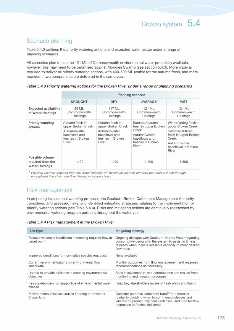
Seasonal Watering Plan 2014–15 173
Scenario planningTable 5.4.3 outlines the priority watering actions and expected water usage under a range of planning scenarios.
All scenarios plan to use the 121 ML of Commonwealth environmental water potentially available; however, this may need to be prioritised against Moodies Swamp (see section 5.4.3). More water is required to deliver all priority watering actions, with 400-500 ML usable for the autumn fresh, and more required if two components are delivered in the same year.
Table 5.4.3 Priority watering actions for the Broken River under a range of planning scenarios
Planning scenario
DROUGHT DRY AVERAGE WET
Expected availability of Water Holdings
29 ML Commonwealth
Holdings
117 ML Commonwealth
Holdings
121 ML Commonwealth
Holdings
121 ML Commonwealth
Holdings
Priority watering actions
Autumn fresh in upper Broken CreekAutumn/winter baseflows and freshes in Broken River
Autumn fresh in upper Broken CreekAutumn/winter baseflows and freshes in Broken River
Summer/autumn fresh in upper Broken CreekAutumn/winter baseflows and freshes in Broken River
Winter/spring fresh in upper Broken CreekSummer/autumn fresh in upper Broken CreekAutumn winter baseflows in Broken River
Possible volume required from the Water Holdings1
1,400 1,400 1,400 1,800
1 Possible volumes required from the Water Holdings are maximum volumes and may be reduced if met through unregulated flows from the River Murray or passing flows.
Risk managementIn preparing its seasonal watering proposal, the Goulburn Broken Catchment Management Authority considered and assessed risks, and identified mitigating strategies, relating to the implementation of priority watering actions (see Table 5.4.4). Risks and mitigating actions are continually reassessed by environmental watering program partners throughout the water year.
Table 5.4.4 Risk management in the Broken River
Risk type Mitigating strategy
Release volume is insufficient in meeting required flow at target point
Ongoing dialogue with Goulburn-Murray Water regarding consumptive demand in the system to assist in timing releases when there is available capacity to meet desired flow rates
Improved conditions for non-native species (eg. carp) None available
Current recommendations on environmental flow inaccurate
Monitor outcomes from flow management and reassess recommendations as necessary
Unable to provide evidence in meeting environmental objective
Seek involvement in, and contributions and results from monitoring and research programs
Key stakeholders not supportive of environmental water release
Keep key stakeholders aware of fresh plans and timing
Environmental releases causes flooding of private or Crown land
Consider potential catchment runoff from forecast rainfall in deciding when to commence releases and whether to prematurely cease releases, and monitor flow responses to freshes delivered
Broken system 5.4
Victorian Environmental Water Holder174
5.4.2 Lower Broken CreekCurrent situationOver recent years, environmental water has been delivered in the lower Broken Creek to help maintain water quality (particularly appropriate levels of dissolved oxygen) and provide habitat for native fish. In 2013-14, environmental flows were provided through a combination of River Murray unregulated flows, Commonwealth environmental water and inter-valley transfers.
Due to fluctuating irrigation water use from the lower Broken Creek, environmental flow targets of 250 ML per day (to increase large-bodied native fish habitat during migration and breeding seasons and to maintain dissolved oxygen levels in the warmer months) were not always met; however, there were no recorded impacts on native fish populations as a result. Large-bodied native fish continue to be found throughout the lower Broken Creek (including Murray cod, golden perch and silver perch), with some fish moving along the creek through the fish ladders. Monitoring continues to show the success of using high baseflows (up to 250 ML per day) to limit the occurrence of periods of low dissolved oxygen. Monitoring also shows there is a good coverage of bank vegetation, with amphibious (able to live in both water and on land) and flood-tolerant vegetation restricted to a narrow band above the pool water level height.
Priority watering actions and environmental objectivesPriority watering actions, along with their associated environmental objectives, are provided in Table 5.4.5 and illustrated in Figure 5.4.4.
The priority environmental objectives are to: provide native fish passage; provide suitable water quality conditions for native fish; and improve fish habitat during migration and breeding seasons.
In addition to the environmental objectives, these watering actions will also provide benefits to consumptive users through improvements in water quality.
Table 5.4.5 Priority watering actions and environmental objectives for the lower Broken Creek
Priority watering action Environmental objective
Year-round low flows (40 ML per day during August to May)
Provide native fish passage
Winter/spring medium flows (120 ML per day during August to November)
Minimise azolla growth
Spring/summer/autumn medium flows (150-250 ML per day during October to May)
Maintain water quality, including dissolved oxygen levels above five milligrams per litre
Winter/spring freshes (freshes of 120-250 ML per day for up to 14 days as required during August to November)
Remove large azolla blooms
Spring/summer high flows (250 ML per day during September to December)
Increase native fish habitat during migration and breeding seasons
5.4 Broken system

Seasonal Watering Plan 2014–15 175
Figure 5.4.4 Priority watering actions for the lower Broken Creek1
1 These figures are for illustrative purposes only. Scheduling and delivery of particular watering actions within the stated timeframes will vary.
As the lower Broken Creek is part of the irrigation distribution system, channel capacity constraints can restrict the amount of water provided for environmental purposes, particularly during spring and autumn. The Goulburn Broken Catchment Management Authority will work with Goulburn-Murray Water to optimise the delivery of water to the lower Broken Creek by using available capacity from both the Murray and Goulburn systems.
Scenario planningTable 5.4.6 outlines the priority watering actions and expected water usage under a range of planning scenarios.
Due to regulation of the lower Broken and Nine Mile creeks, their environmental water needs are relatively fixed from year to year independent of annual climatic conditions. Catchment runoff may contribute to winter low flows and winter/spring freshes. However, for the most part, flows must be delivered from the Murray and Goulburn rivers to achieve priority watering actions. Some of these priority watering actions can be met through the delivery of consumptive water en route from the Goulburn system (inter-valley transfers), or through unregulated flows from the Murray system.
During the season, the environmental watering needs of the lower Broken Creek vary, and are determined by ongoing water quality and azolla monitoring. Flows will be managed in response to drops in water quality (if dissolved oxygen levels fall towards five milligrams per litre) and if azolla growth increases. Flows will be managed to maximise native fish movement and provide habitat opportunities throughout the year.
Goulburn-Murray Water’s bulk entitlement makes available up to 30,000 ML of water to assist in mitigating water quality emergencies (such as blackwater events) in the Goulburn River and lower Broken Creek systems.
Winter/spring medium flows
Winter/spring fresh
Spring/summer/autumn medium flows
Spring/summer high flows
Winter/spring/summer/autumn low flows
60
120
180
240
300
Dec Jan 2015 Feb Mar AprNovOctSeptAug May JunJuly 2014
Month
Flo
w (M
L) p
er d
ayBroken system 5.4
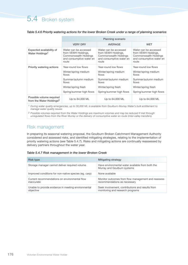
Victorian Environmental Water Holder176
Table 5.4.6 Priority watering actions for the lower Broken Creek under a range of planning scenarios
Planning scenario
VERY DRY AVERAGE WET
Expected availability of Water Holdings1
Water can be accessed from VEWH Holdings, Commonwealth Holdings and consumptive water en route
Water can be accessed from VEWH Holdings, Commonwealth Holdings and consumptive water en route
Water can be accessed from VEWH Holdings, Commonwealth Holdings and consumptive water en route
Priority watering actions Year-round low flows
Winter/spring medium flows
Summer/autumn medium flows
Winter/spring fresh
Spring/summer high flows
Year-round low flows
Winter/spring medium flows
Summer/autumn medium flows
Winter/spring fresh
Spring/summer high flows
Year-round low flows
Winter/spring medium flows
Summer/autumn medium flows
Winter/spring fresh
Spring/summer high flows
Possible volume required from the Water Holdings2 Up to 64,000 ML Up to 64,000 ML Up to 64,000 ML
1 During water quality emergencies, up to 30,000 ML is available from Goulburn-Murray Water’s bulk entitlement to manage water quality issues.
2 Possible volumes required from the Water Holdings are maximum volumes and may be reduced if met through unregulated flows from the River Murray or the delivery of consumptive water en route (inter-valley transfers).
Risk managementIn preparing its seasonal watering proposal, the Goulburn Broken Catchment Management Authority considered and assessed risks, and identified mitigating strategies, relating to the implementation of priority watering actions (see Table 5.4.7). Risks and mitigating actions are continually reassessed by delivery partners throughout the water year.
Table 5.4.7 Risk management in the lower Broken Creek
Risk type Mitigating strategy
Storage manager cannot deliver required volume Have environmental water available from both the Murray and Goulburn systems
Improved conditions for non-native species (eg. carp) None available
Current recommendations on environmental flow inaccurate
Monitor outcomes from flow management and reassess recommendations as necessary
Unable to provide evidence in meeting environmental objective
Seek involvement, contributions and results from monitoring and research programs
5.4 Broken system

Seasonal Watering Plan 2014–15 177
5.4.3 Broken wetlandsCurrent situationEnvironmental water was delivered to Kinnairds Swamp and Black Swamp in April 2014 – two months after the wetlands were burnt out during the Wunghnu complex fires in February 2014.
Black Swamp was burnt severely with a majority of the dead red gums in the bed of the wetland burnt down or completely burnt out. These dead trees provided excellent habitat for birds and small mammals. Young river red gums in the bed of the wetland were also burnt during the fire. Terrestrial vegetation surrounding the wetland was severely burnt, which will have a detrimental effect on dependent animals.
Similar to Black Swamp, surrounding terrestrial vegetation was severely burnt by the fire at Kinnairds Swamp. The wetland bed of Kinnairds Swamp was also severely burnt, but the majority of the native wetland plants were dormant as the wetland was experiencing a dry phase during the fire. These plants are expected to regenerate readily upon delivery of environmental water. Large beds of giant rush and cumbungi were also burnt during the fire, causing the loss of habitat for wetland species such as the Australasian bittern, rails and crakes.
In 2013-14, environmental water was delivered to Moodies Swamp following a drying phase. The aims of the delivery of environmental water were to promote threatened plant species (eg. ridged water-milfoil), provide breeding habitat for waterbirds and improve general wetland productivity.
Priority watering actions and environmental objectivesPriority watering actions along with their associated environmental objectives are provided in Table 5.4.8.
Environmental water delivery in 2014-15 will assist with vegetation recovery at Black Swamp and Kinnairds Swamp as well as maintaining vegetation communities and providing opportunities for waterbird breeding at Moodies Swamp.
In addition to the environmental objectives, these watering actions will provide complementary recreational benefits for activities such as camping, fishing, picnicking, and walking.
Table 5.4.8 Priority watering actions and environmental objectives for the Broken wetlands
Priority watering action Environmental objectives
Black Swamp: Provide top up flows in spring, summer and/or autumn if required and unless significant waterbird breeding events occur, promote natural drying phase over spring/summer if wetland remains wet for optimal wetting period
Improve the diversity of native wetland plant species to be consistent with the list of species and condition detailed under red gum swamp ecological vegetation class benchmarkProvide opportunities for waterbird breeding
Kinnairds Swamp: Provide top up flows in spring, summer and/or autumn if required and unless significant waterbird breeding events occur, promote natural drying phase over spring/summer if wetland remains wet for optimal wetting period
Improve the diversity of native wetland flora species to be consistent with the list of species and condition detailed under red gum swamp ecological vegetation class benchmarkImprove the diversity of native wetland flora species to be consistent with the list of species and condition detailed under the plains grassy wetland ecological vegetation class benchmark Maintain populations of vulnerable ridged water-milfoil and endangered slender water-milfoilProvide opportunities for waterbird breeding especially royal spoonbills and the Australasian shoveler
Moodies Swamp: Provide top up flows in spring, summer and/or autumn if required, promote natural drying phase over spring/summer if wetland remains wet for optimal wetting period
Maintain the diversity of species to be consistent with the list of species and condition detailed under the cane-grass swamp ecological vegetation class benchmarkProvide opportunities for waterbird breeding especially brolgaMaintain populations of the vulnerable ridged water-milfoil
Broken system 5.4

Victorian Environmental Water Holder178
Scenario planningTable 5.4.9 outlines the priority watering actions and expected water usage under a range of planning scenarios.
During the season, the decision to deliver environmental water to Black Swamp, Moody Swamp and Kinnairds Swamp will be based on their hydrological condition, waterbird breeding activity and the potential impact environmental water delivery may have on wetland vegetation.
Table 5.4.9 Priority watering actions for the Broken wetlands under a range of planning scenarios
Planning scenario
DROUGHT DRY AVERAGE WET
Priority watering sites1
Black SwampMoodies SwampKinnairds Swamp
Black SwampMoodies SwampKinnairds Swamp
Black SwampMoodies SwampKinnairds Swamp
Black SwampMoodies SwampKinnairds Swamp
Possible volume required from the Water Holdings
1,500 ML 1,500 ML 750 ML 750 ML
1 Priority watering sites and volumes required are based on the maximum number of sites and volumes of water required. Under each scenario there are a number of priorities for watering, based on factors such as timing of natural inflows and bird breeding events etc.
Risk managementIn preparing its seasonal watering proposal, the Goulburn Broken Catchment Management Authority considered and assessed risks, and identified mitigating strategies, relating to the implementation of priority watering actions (see Table 5.4.10). Risks and mitigating actions are continually reassessed by delivery partners throughout the water year.
Table 5.4.10 Risk management in the Broken wetlands
Risk type Mitigating strategies
Storage manager cannot deliver required volume or flow rate (outlet/capacity constraints, insufficient storage volume)
Ongoing dialogue with Goulburn-Murray Water regarding consumptive demand in the system, to assist in timing releases when there is available capacity to meet desired flow rates
Improved conditions for non-native species (e.g. carp) There is no strategy to mitigate this risk; however, minimising summer inundation and placing carp screens on inlet channels can reduce the risk
Environmental water account is overdrawn Ongoing dialogue with Goulburn-Murray Water regarding the volume of water delivered, so that if required, additional water resources can be sought in advance and negotiated with the VEWH, avoiding overdrawing the water account, while achieving the environmental objectives
5.4 Broken system

Seasonal Watering Plan 2014–15 179
5.5
Campaspe system
Waterway manager – North Central Catchment Management AuthorityStorage managers – Goulburn-Murray Water; Coliban Water
The Campaspe River, downstream of Lake Eppalock, supports iconic river red gum communities and a wide range of healthy native fish populations. The high density of in-stream wood provides ideal habitat for aquatic animals, including the nationally significant Murray cod and many species of State significance such as silver perch and Murray-Darling rainbowfish. The Coliban River, upstream of Lake Eppalock, provides habitat for a range of native aquatic species, including platypus and water rats. The nearby towns of Malmsbury, Taradale and Metcalfe have a strong sense of stewardship of the river, due to its environmental, aesthetic and recreational values, including camping, fishing and bird watching.
System overview The Campaspe system extends from the Great Dividing Range in the south, to the River Murray at Echuca in the north (Figure 5.5.1). Major waterways in the catchment include the Campaspe River and the Coliban River. Lake Eppalock was constructed in 1965. It has traditionally secured water for the Campaspe Irrigation District and safeguarded the Coliban supply system for Bendigo. Regulation has significantly altered river flows and has reversed the seasonal river flows in some reaches (that is, there are now low flows in winter and high flows in summer). In 2010, the decommissioning of the Campaspe Irrigation District significantly reduced irrigation demand in the system.
In the Campaspe River, the priority river reaches for environmental watering are between Lake Eppalock and the Campaspe Weir (reach 2) and the Campaspe Siphon to the Murray River confluence (reach 4). Environmental flow reaches are shown in Figure 5.5.1. Flows are measured at the Lake Eppalock Outlet (reach 2) and the Campaspe Siphon (reach 4). These reaches have significant populations of Murray cod, provide in-stream habitat for fish species including Murray cod, silver perch, golden perch, Murray-Darling rainbowfish and flat-headed gudgeon, as well as a highly-connected, intact river red gum canopy along the river banks. These reaches are also the most influenced by water releases. Water Holdings in the Campaspe River can be delivered from two locations: Lake Eppalock and the Campaspe Siphon.
Pictured: Campaspe River, by North Central CMA

Victorian Environmental Water Holder180
In addition to the Water Holdings, passing flows are provided under Goulburn-Murray Water’s bulk entitlement. There are also opportunities to achieve environmental benefit from consumptive water from the Goulburn through the lower Campaspe (reach 4) en route to meeting irrigation needs in the River Murray. This requires prior agreement with Goulburn-Murray Water and the Murray-Darling Basin Authority.
The Coliban River upstream of Lake Eppalock is a Campaspe system priority reach for environmental water management. The stretch of river from Malmsbury Reservoir to Lake Eppalock provides habitat for small native fish, platypus and water rats.
ConsultationThe North Central Catchment Management Authority has consulted stakeholders in the preparation of the seasonal watering proposal for the Campaspe system. These stakeholders are shown in Table 5.5.1
Table 5.5.1 Key stakeholders involved in the preparation of the seasonal watering proposal for the Campaspe System
Stakeholder consultation
Campaspe Environmental Water Advisory Group (made up of community members, Department of Environment and Primary Industries, Goulburn-Murray Water, CMA staff, VEWH, Commonwealth Environmental Water Office)Goulburn-Murray WaterColiban WaterNorth Central Catchment Management Authority Natural Resource Management Committee (NRMC)North Central Catchment Management Authority BoardCommonwealth Environmental Water OfficeVictorian Environmental Water Holder
5.5 Campaspe system

Seasonal Watering Plan 2014–15 181
Figure 5.5.1 The Campaspe system
Campaspe system 5.5
Cree
k
Creek
Rive
r
Creek
•
CampaspeSiphon
CampaspeWeir
Echuca
Barnadown
Lake Eppalock
MalmsburyReservoir
Kyneton
Rochester
Heathcote
Campaspe
Axe
Wild
Forest
Mcivor
Pipe
rs
Coliban
Kang
aroo
River
Campaspe
River
Murray
River
Creek
Cree
k
Cree
k
Mount
WarangaWestern
Coliban
Myrtle
Five Mile
Jews
Sheepwash RiverCam
paspe River
Creek
Harp Creek
River
Creek
Colib
an
Little
Rive
r
River
Pleasant Creek
DuckCreek
•
•
•
•
•
2
3
4
1
2
3
4
1
Reach 1 Coliban River: Malmsbury Reservoir to Lake EppalockReach 2 Campaspe River: Lake Eppalock to Campaspe WeirReach 3 Campaspe River: Campaspe Weir to Campaspe SiphonReach 4 Campaspe River: Campaspe Siphon to River Murray Measurement point Water infrastructure Town
Cree
k
Creek
Rive
r
Creek
•
CampaspeSiphon
CampaspeWeir
Echuca
Barnadown
Lake Eppalock
MalmsburyReservoir
Kyneton
Rochester
Heathcote
Campaspe
Axe
Wild
Forest
Mcivor
Pipe
rs
Coliban
Kang
aroo
River
Campaspe
River
Murray
River
Creek
Cree
k
Cree
k
Mount
WarangaWestern
Coliban
Myrtle
Five Mile
Jews
Sheepwash RiverCam
paspe River
Creek
Harp Creek
River
Creek
Colib
an
Little
Rive
r
River
Pleasant Creek
DuckCreek
•
•
•
•
•
2
3
4
1
2
3
4
1
Reach 1 Coliban River: Malmsbury Reservoir to Lake EppalockReach 2 Campaspe River: Lake Eppalock to Campaspe WeirReach 3 Campaspe River: Campaspe Weir to Campaspe SiphonReach 4 Campaspe River: Campaspe Siphon to River Murray Measurement point Water infrastructure Town

Victorian Environmental Water Holder182
5.5.1 Campaspe RiverCurrent situationThe Campaspe River was severely flow stressed during the Millennium drought, with flows significantly reduced. The natural floods in 2010-11 delivered high flows including overbank flows to the system, commencing its recovery from the drought.
While the floods caused immense damage to areas such as the township of Rochester, they also re-set the river system, scouring the river channel and removing the extensive beds of cumbungi and common reed that had proliferated during the drought. Much of the bank vegetation was stripped, leaving bare banks that are still recovering.
Management following the floods has focused primarily on the recovery of the river. The establishment of the new Campaspe Environmental Entitlement has resulted in an additional 23,000 ML per year (long-term average) now being available for environmental use in the Campaspe River.
2013-14 saw lower inflows throughout the system with no spills or pre-releases from Lake Eppalock. Environmental flow management during the 2013-14 year aimed to continue building on recovery of the system.
Priority watering actions and environmental objectivesPriority watering actions along with their associated environmental objectives, are provided in Table 5.5.2 and illustrated in Figure 5.5.2.
The priority environmental objectives are to: maintain pool habitat and water quality for fish populations; improve the potential for fish movement; maintain macroinvertebrate populations; reduce encroachment of terrestrial vegetation in-stream; maintain aquatic vegetation; and enhance river red gum recruitment.
In addition to the environmental objectives, these watering actions will also provide opportunities for motorised boating, kayaking, recreational fishing, swimming, sightseeing, bush walking and bird watching, which all provide economic benefits for local towns.
5.5 Campaspe system
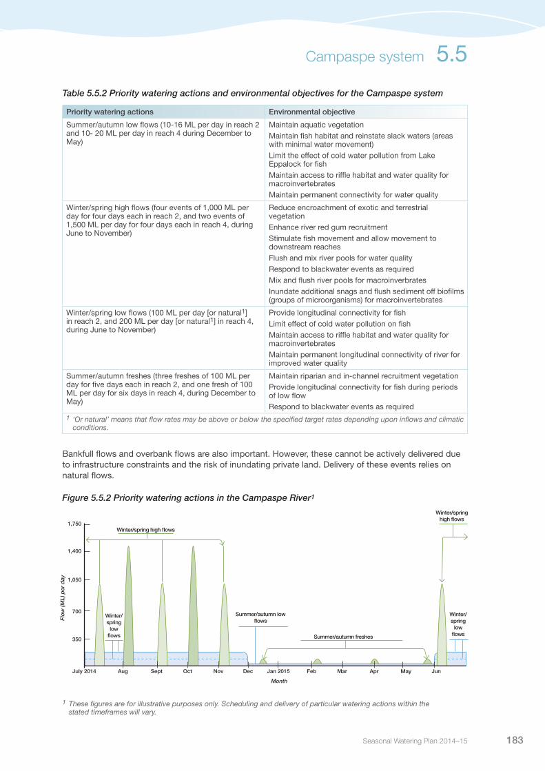
Seasonal Watering Plan 2014–15 183
Table 5.5.2 Priority watering actions and environmental objectives for the Campaspe system
Priority watering actions Environmental objective
Summer/autumn low flows (10-16 ML per day in reach 2 and 10- 20 ML per day in reach 4 during December to May)
Maintain aquatic vegetationMaintain fish habitat and reinstate slack waters (areas with minimal water movement)Limit the effect of cold water pollution from Lake Eppalock for fishMaintain access to riffle habitat and water quality for macroinvertebratesMaintain permanent connectivity for water quality
Winter/spring high flows (four events of 1,000 ML per day for four days each in reach 2, and two events of 1,500 ML per day for four days each in reach 4, during June to November)
Reduce encroachment of exotic and terrestrial vegetationEnhance river red gum recruitmentStimulate fish movement and allow movement to downstream reachesFlush and mix river pools for water qualityRespond to blackwater events as requiredMix and flush river pools for macroinverbratesInundate additional snags and flush sediment off biofilms (groups of microorganisms) for macroinvertebrates
Winter/spring low flows (100 ML per day [or natural1] in reach 2, and 200 ML per day [or natural1] in reach 4, during June to November)
Provide longitudinal connectivity for fishLimit effect of cold water pollution on fishMaintain access to riffle habitat and water quality for macroinvertebratesMaintain permanent longitudinal connectivity of river for improved water quality
Summer/autumn freshes (three freshes of 100 ML per day for five days each in reach 2, and one fresh of 100 ML per day for six days in reach 4, during December to May)
Maintain riparian and in-channel recruitment vegetationProvide longitudinal connectivity for fish during periods of low flowRespond to blackwater events as required
1 ‘Or natural’ means that flow rates may be above or below the specified target rates depending upon inflows and climatic conditions.
Bankfull flows and overbank flows are also important. However, these cannot be actively delivered due to infrastructure constraints and the risk of inundating private land. Delivery of these events relies on natural flows.
Figure 5.5.2 Priority watering actions in the Campaspe River1
Summer/autumn freshes
Winter/spring high flows
350
700
1,050
1,400
1,750
Dec Jan 2015 Feb Mar AprNovOctSeptAug May JunJuly 2014
Month
Flo
w (M
L) p
er d
ay
Summer/autumn low flows
Winter/spring
low flows
Winter/spring
low flows
Winter/spring high flows
Campaspe system 5.5
1 These figures are for illustrative purposes only. Scheduling and delivery of particular watering actions within the stated timeframes will vary.
Victorian Environmental Water Holder184
Scenario planningTable 5.5.3 outlines the priority watering actions and expected water usage under a range of planning scenarios.
Water availability in the Campaspe system in 2014-15 is expected to be reasonably high even under a drought scenario, due to carryover. The two scenarios shown in Table 5.5.3 cover the range of environmental watering activities under any eventual seasonal conditions.
Based upon key learnings from the drought, the North Central Catchment Management Authority has developed principles for prioritising flow deliveries. Ecologically, the summer period is the highest risk period due to water quality issues and the potential for a fish death event. The priority is to manage this through provision of summer baseflows and a pre-emptive winter high flow event to flush organic material from the river during the relatively lower risk winter period. Initially the focus is to provide flow to the upper reach due to the existence of large deep pools as native fish habitat. The focus moves to the lower reaches of the river as more water becomes available. A high priority is to carry over water to underpin the 2015-16 summer low flows.
The storage volume of Lake Eppalock will need to be monitored closely over the winter/autumn period to assess the likelihood and timing of any storage spills. If the storage begins to spill early in the season, management will focus on ensuring winter baseflows are maintained between spills, which may provide the required winter high flow events.
Table 5.5.3 Priority watering actions in the Campaspe system under a range of planning scenarios
Planning scenario
DROUGHT AVERAGE/WET
Campaspe River
Expected availability of Water Holdings1
20,652 ML VEWH Holdings
126 ML Living Murray Holdings
6,517 ML Commonwealth Holdings
27,295 ML total
23,618 ML VEWH Holdings
5,211 ML Living Murray Holdings
6,912 ML Commonwealth Holdings
35,741 ML total
Priority watering actions Summer/autumn low flow in reach 4
Summer/autumn low flow (carryover into 2015-16)
Winter/spring high flow in reach 4 (one event)
Winter/spring low flow in reach 2
Summer/autumn freshes in reach 4 (three events)
Winter/spring low flow in reach 4
Summer/autumn freshes in reach 4 (three events)
Winter/spring high flow in reach 2 (four events)
Winter/spring high flow in reach 4 (two events)
Possible volume required from the Water Holdings
29,500 ML 34,151 ML
Possible carryover into 2015-16 ~2,800 ML 0 ML
1 Under all scenarios, the Campaspe system will receive 100% allocations to high-reliability entitlements on July 1 2014. Water availability estimates do not include water available in the Goulburn and Murray systems, which could be traded into the system if required, subject to trading rules.
Risk managementIn preparing its seasonal watering proposal, the North Central Catchment Management Authority has considered and assessed risks, and identified mitigating strategies, relating to the implementation of priority watering actions (see Table 5.5.4). Risks and mitigating actions are continually reassessed by delivery partners throughout the water year.
5.5 Campaspe system
Seasonal Watering Plan 2014–15 185
Table 5.5.4 Risk management in the Campaspe River
Risk type Mitigating strategy
Release volume is insufficient in meeting required flow at target point
Ongoing dialogue with Goulburn-Murray Water regarding consumptive demand in the system to assist in timing releases when there is available capacity to meet desired flow rates
Current recommendations on environmental flow inaccurate
Undertake ongoing ecological monitoring of releases to assist in refining flow recommendations over time
Use annual operational monitoring to inform annual priority watering actions
Storage manager maintenance works affect ability to deliver water
Ongoing dialogue with Goulburn-Murray Water regarding maintenance schedule, to assist in timing releases when there is available capacity to meet desired flow rates
Limited catchment management authority resources to manage environmental releases
Ensure that environmental water management within the North Central Catchment Management Authority is adequately resourced to undertake required delivery tasks
Releases cause water quality issues (eg. blackwater, low dissolved oxygen levels, mobilisation of saline pools, acid sulphate soils, etc).
Summer freshes not to be delivered unless high winter flows have been provided to flush organic material from the river
Summers freshes not to be delivered unless there is sufficient water available to follow up the freshes and overcome the reduced dissolved oxygen levels through dilution and re-aeration from flow
Improved conditions for non-native species (eg. Gambusia)
There is no strategy to mitigate this risk other than the implementation of the full environmental flow regime to provide a competitive advantage to native species
Environmental water account is overdrawn Ongoing dialogue with Goulburn-Murray Water , the VEWH and the North Central Catchment Management Authority regarding water volume delivered to date
Environmental release cause personal injury to river user Maximum regulated release volume of 1,850 ML per day, which is within normal system operations
Engage the community and undertake local media, notifications on relevant websites prior to releases
Environmental releases cause flooding of private land or public infrastructure
Restrict water orders to a regulated release volume of 1,850 ML per day from Lake Eppalock, which is within normal system operations
Ensure on-ground monitoring of water levels is undertaken for every high flow event
Work closely with storage manager and cease regulated release if high catchment runoff flows are predicted
Engage the community and undertake local media prior to releases
Work with local Goulburn-Murray Water office to reduce potential flooding of diverters’ infrastructure
Unable to provide evidence in meeting ecological objective
Undertake monitoring of releases to assist in refining flow recommendations over time; use this monitoring data to strengthen the link between flow components and environmental objectives
Seek funding through the Department of Environment and Primary Industries to undertake baseline monitoring and determine best use of additional environmental entitlements for the system
Key stakeholders unsupportive of environmental water release
Engage the community in the development of seasonal watering proposals
Undertake local media prior to releases
Campaspe system 5.5
Victorian Environmental Water Holder186
5.5.2 Coliban RiverCurrent situationThe Coliban River system was impacted by the drought experienced in Victoria between 2000 and 2010. During this time all passing flow was ceased below Malmsbury Reservoir and a small environmental reserve was established which enabled emergency releases in response to declining water quality.
The VEWH does not have any Water Holdings in the Coliban system, however, the ability to flexibly manage passing flows in the system provides an opportunity to help mitigate summer low flow risks.
In the 2010-11 season, high rainfall was experienced across the catchment, resulting in an increase in flows within the river and into Coliban storages, facilitating an increase in passing flows.
The focus of environmental flow management during the 2013-14 year shifted to safeguarding for emergency events through banking withheld passing flows in late spring/early summer period, then providing water for reduced base flow events to maintain river connectivity in the upper reaches over summer.
Priority watering actions and environmental objectivesPriority watering actions along with their associated environmental objectives are provided in Table 5.5.5 and illustrated in Figure 5.5.3.
The priority environmental objectives are to: maintain aquatic vegetation; maintain fish habitat for survival and spawning; maintain permanent connectivity for water quality and fish; maintain aquatic habitat for macroinvertebrates including riffle habitats; maintain riparian and in-channel recruitment vegetation and cue fish movement.
In addition to the environmental objectives, these watering actions will also provide complementary opportunities for recreational fishing, swimming, bird watching and sightseeing.
Table 5.5.5 Priority watering actions and environmental objectives for the Coliban River
Priority watering actions Environmental objective
Summer/autumn pulsed flows (5-15 ML per day for up to two weeks during December to May)
Maintain water quality including dissolved oxygen levels, and habitat for aquatic animals
Summer/autumn low flows (2.5-5 ML per day during December to May)
Maintain aquatic vegetation
Maintain fish habitat for survival and spawning
Maintain permanent longitudinal connectivity of river for improved water quality
Maintain aquatic habitat for macroinvertebrates
Summer/autumn freshes (one fresh of 100 ML per day and one fresh of 200 ML per day for three days each during December to May)
Maintain riparian and in-channel recruiting vegetation
Provide longitudinal connectivity for fish during periods of low flow
Stimulate upstream and downstream fish movement and or spawning
Maintain water quality for macroinvertebrates
5.5 Campaspe system

Seasonal Watering Plan 2014–15 187
Figure 5.5.3 Priority watering actions in the Coliban River1
1 These figures are for illustrative purposes only. Scheduling and delivery of particular watering actions within the stated timeframes will vary.
Scenario planningTable 5.5.6 outlines the priority watering actions and expected water usage under a range of planning scenarios.
Table 5.5.6 Priority watering actions in the Campaspe system under a range of planning scenarios
Planning scenario
DROUGHT AVERAGE/WET
Expected availability of Water Holdings
Withheld passing flows for use at other times in the season
Withheld passing flows for use at other times in the season
Priority watering actions Summer/autumn pulsed flows Summer/autumn low flowsWithhold passing flows for 2014-15
Withhold passing flows for 2014-15Summer/autumn freshes
Possible volume required from the Water Holdings
1,500 ML 1,120 ML
Summer/autumn pulsed low flows
Summer/autumn fresh
20
40
60
80
100
Dec Jan 2015 Feb Mar AprNovOctSeptAug May JunJuly 2014
Month
Flo
w (M
L) p
er d
ay
Summer/autumn base flows
Campaspe system 5.5

Victorian Environmental Water Holder188
Risk managementIn preparing its seasonal watering proposal, the North Central Catchment Management Authority considered and assessed risks, and identified mitigating strategies, relating to the implementation of priority watering actions (see Table 5.5.7). Risks and mitigating actions are continually reassessed by environmental watering program partners throughout the water year.
Table 5.5.7 Risk management in the Coliban River
Risk type Mitigating strategy
Release volume is insufficient in meeting required flow at target point
Attempt to withhold passing flows in the spring/early summer period to maximise resource position to provide flows during the summer high risk and ecological stress period
Current recommendations on environmental flow inaccurate
Undertake monitoring of releases to assist in refining flow recommendations over time
Use annual operational monitoring to inform annual priority watering actions
Undertake review of watering actions with relevant stakeholders to ensure watering recommendations are adaptively managed over time
Storage manager maintenance works affect ability to deliver water
Ongoing dialogue with Coliban Water regarding maintenance schedule, to assist in timing releases when there is available capacity to meet desired flow rates
Limited catchment management authority resources to manage environmental releases
Ensure that environmental water management within the North Central Catchment Management Authority is adequately resourced to undertake required delivery tasks
Releases cause water quality issues (eg. blackwater, low dissolved oxygen levels, mobilisation of saline pools, acid sulphate soils, etc.)
Limited mitigation strategies exist due to the limited volume of water available
Improved conditions for non-native species (eg. Gambusia)
There is no strategy to mitigate this risk other than the implementation of the full environmental flow regime to provide a competitive advantage to native species
Environmental water account is overdrawn Ongoing dialogue with Coliban Water, the VEWH and the North Central Catchment Management Authority regarding water resources volume available and delivered to date
Environmental release cause personal injury to river user Volume to be delivered is relatively small and unlikely to cause issues for river users
Ensure staff are accompanied and follow field work OHS procedures
Spot trackers taken in field when working alone
Environmental releases cause flooding of private land or public infrastructure
Malmsbury Reservoir infrastructure limits environmental flow releases to maximum of approximately 150 ML per day, which is well within the channel capacity of about 6,000 ML per day
Unable to provide evidence in meeting ecological objective
Undertake monitoring of releases to assist in refining flow recommendations over time; use this monitoring data to strengthen the link between flow components and environmental objectives
Key stakeholders unsupportive of environmental water release
Engage the community in the development of seasonal watering proposals Undertake local media prior to releases
Media release to be made prior to the ceasing of any summer flows
5.5 Campaspe system

Seasonal Watering Plan 2014–15 189
5.6
Loddon system
Waterway manager – North Central Catchment Management Authority
Storage manager – Goulburn-Murray Water
The Loddon system is home to a number of native fish species, and supports an active tourism industry due to its intact forests and high-value vegetation. Birchs Creek in the upper catchment of the Loddon system contains a population of river blackfish. Pyramid Creek is a tributary of the Loddon River, which enters the system near Kerang. As well as the lower Loddon River, Pyramid Creek provides important habitat for fish including the bony herring, golden perch and Murray cod. The Boort wetlands, located on the floodplain of the Loddon River, are important for waterbird habitat and contain high-value fringing river red gums and wetland vegetation.
System overviewThe Loddon system rises on the northern slopes of the Great Dividing Range and flows north to the River Murray (see Figure 5.6.1). It contains key waterways such as the Loddon River, Tullaroop Creek, Birchs Creek and Pyramid Creek. Major storages in the system include Cairn Curran and Tullaroop Reservoir in the upper catchment and Laanecoorie Reservoir in the mid-catchment. Newlyn Reservoir and Hepburn Lagoon are storages on Birchs Creek, while Kow Swamp on the Pyramid Creek regulates flows from the River Murray via the National Channel. Environmental water can be delivered to the Loddon River below Cairn Curran Reservoir, Birchs Creek, Tullaroop Creek and Pyramid Creek.
The Boort District wetlands are located on the floodplain to the west of the Loddon River downstream of Loddon Weir. These wetlands include Lakes Boort, Leaghur, Meran, Little Meran and Yando Swamp. The wetlands have been modified over the years as part of the irrigation system, and their natural watering regimes have been altered as a result. Environmental watering tries to reinstate more natural regimes in order to enhance habitat and conditions for a range of flora and fauna including threatened and endangered species.
Pictured: Loddon River at Yando Road, by Phil Slessar, North Central CMA

Victorian Environmental Water Holder190
In the Loddon River, the priority river reach for environmental watering is between Loddon Weir and Kerang Weir (reach 4), as in-stream and riparian habitat has been most affected by river regulation in this reach. The remainder of the river upstream of Loddon Weir benefits from flows being passed to the lower reaches, providing habitat for macroinvertebrates and native fish such as the Murray cod, golden perch and silver perch. The Loddon River downstream of Kerang (reach 5) benefits from flows delivered to reach 4 of the river, as well as flows through Pyramid Creek. Pyramid Creek enters the Loddon River just upstream of Kerang Weir. The river reach between Kerang Weir and the Murray River benefits from flows from the Pyramid Creek as well as the Loddon River and is an important habitat for fish species such as Murray cod, golden and silver perch.
Tullaroop Creek (reach 2) and Birchs Creek are home to populations of regionally significant river blackfish. The provision of environmental water in these systems assists with achieving habitat requirements for these fish populations.
Water Holdings in the Loddon system are released from: Cairn Curran, Tullaroop and Lannecoorie reservoirs on the Loddon River; Newlyn Reservoir and Hepburn Lagoon on Birchs Creek; and from the River Murray via the National Channel and Kow Swamp. In addition, water in the Goulburn system can be delivered through the Waranga Western Channel to the Loddon Weir for delivery downstream. Water can also be traded from other systems into the Loddon, subject to trading rules.
In addition to the Water Holdings, passing flows are provided and consumptive water is delivered down the Loddon to meet downstream irrigation needs. Environmental water releases will be combined with passing flows, consumptive water and unregulated flows to maximise environmental outcomes.
ConsultationThe North Central Catchment Management Authority has consulted stakeholders in the preparation of the seasonal watering proposals for the Loddon system. These stakeholders are shown in Table 5.6.1.
Table 5.6.1 Key stakeholders involved in the preparation of the seasonal watering proposals for the Loddon system
Stakeholder consultation
Loddon Environmental Water Advisory Group (made up of community members, Department of Environment and Primary Industries, Goulburn-Murray Water, North Central Catchment Management Authority staff, VEWH and Commonwealth Environmental Water Office staff, Parks Victoria, Field and Game Victoria)Bullarook Environmental Water Advisory Group (made up of community members, Goulburn-Murray Water and Victorian Environmenalt Water Holder)Goulburn-Murray WaterNorth Central Catchment Management Authority Natural Resource Management Committee and BoardCommonwealth Environmental Water OfficeVictorian Environmenalt Water Holder
5.6 Loddon system

Seasonal Watering Plan 2014–15 191
Figure 5.6.1 The Loddon system
Loddon system 5.6
Cre
ek
Riv
er
CreekC
reekCreek
Creek
Creek
Serpentine
CreekC
reek
Creek
Cre
ek
•
•••
•
•
•
•
••Kerang
Cohuna
MaldonCairnCurranReservoir
Bendigo
Dunolly
Inglewood
Wedderburn
Daylesford
Maryborough Castlemaine
Bullarook system
LaanecoorieReservoir
Loddon Weir
Kerang Weir
Serpentine Weir
Lake Leaghur
Lodd
on
Myers
Bet B
et
Spring
Barr Loddon
River
Birch
Middle
Bullock
Loddon
Creek
Cree
k
Creek
River
Bendigo
Waranga
Western Channel
Gunbower
Joyces
Tulla
roop
Pyramid
Bullabul
Burnt
Bradford
Creswick
Mcc
allu
m
Muc
klef
ord
Jim C
row
Bark
ers
Cree
k
Cam
pbel
ls
Murray
Creek
Creek
Creek
Creek
Bendigo
Creek
RiverC
reek
Creek
Creek
Cree
k
Hepburn Lagoon
Newlyn Reservoir
Dean Reservoir
Creek
Birch
LangdonsCreek
Tullaroop Reservoir
Lake Lyndger
Lake Meran
Lake Yando
Little Lake Meran
Gunbower Forest
Kow Swamp
National Channel
Johnson Swamp
HirdSwamp
Lake Boort
Twelve Mile Creek
5
Reach Loddon River - Cairn Curran Reservoir to Laanecoorie Reservoir
Reach Tullaroop Creek - Tullaroop reservoir to Laanecoorie Reservoir
Reach Loddon River - Laanecoorie Reservoir to Serpentine Weir
Reach Loddon River - Serpentine Weir to Loddon Weir
Reach Loddon River - Loddon Weir to Kerang Weir
Reach Loddon River - Kerang Weir to River Murray
Reach Pyramid Creek - Box Creek to Kerang Weir
Priority Wetlands for Environmental Water
Measurement point
Water infrastructure
Town•
2
3a
3b
4
1
5
2
3a
3b
4
1
Box Creek
Cre
ek
Riv
er
CreekC
reekCreek
Creek
Creek
Serpentine
CreekC
reek
Creek
Cre
ek
•
•••
•
•
•
•
••Kerang
Cohuna
MaldonCairnCurranReservoir
Bendigo
Dunolly
Inglewood
Wedderburn
Daylesford
Maryborough Castlemaine
Bullarook system
LaanecoorieReservoir
Loddon Weir
Kerang Weir
Serpentine Weir
Lake Leaghur
Lodd
on
Myers
Bet B
et
Spring
Barr Loddon
River
Birch
Middle
Bullock
Loddon
Creek
Cree
k
Creek
River
Bendigo
Waranga
Western Channel
Gunbower
Joyces
Tulla
roop
Pyramid
Bullabul
Burnt
Bradford
Creswick
Mcc
allu
m
Muc
klef
ord
Jim C
row
Bark
ers
Cree
k
Cam
pbel
ls
Murray
Creek
Creek
Creek
Creek
Bendigo
Creek
River
Cre
ek
Creek
Creek
Cree
k
Hepburn Lagoon
Newlyn Reservoir
Dean Reservoir
Creek
Birch
LangdonsCreek
Tullaroop Reservoir
Lake Lyndger
Lake Meran
Lake Yando
Little Lake Meran
Gunbower Forest
Kow Swamp
National Channel
Johnson Swamp
HirdSwamp
Lake Boort
Twelve Mile Creek
5
Reach Loddon River - Cairn Curran Reservoir to Laanecoorie Reservoir
Reach Tullaroop Creek - Tullaroop reservoir to Laanecoorie Reservoir
Reach Loddon River - Laanecoorie Reservoir to Serpentine Weir
Reach Loddon River - Serpentine Weir to Loddon Weir
Reach Loddon River - Loddon Weir to Kerang Weir
Reach Loddon River - Kerang Weir to River Murray
Reach Pyramid Creek - Box Creek to Kerang Weir
Priority Wetlands for Environmental Water
Measurement point
Water infrastructure
Town•
2
3a
3b
4
1
5
2
3a
3b
4
1
Box Creek
Victorian Environmental Water Holder192
5.6.1 Loddon River, Tullaroop Creek and Pyramid CreekCurrent situationThe combined benefits of flood and environmental water have been significant for the Loddon River system over the past two to three years, with the condition of the river improving significantly since the drought. Frog and bird numbers have increased, and riparian and aquatic vegetation (including river red gums, phragmites, water ribbons and black box) have all shown signs of increased growth and coverage. While fish numbers are still low, the conditions in the lower Loddon are conducive to recolonisation, and this will be monitored over coming years.
Flows in summer 2013-14 were partially met, mainly because of irrigation water delivery, which generally exceeds the recommended flows, although in Tullaroop Creek (reach 2) these are more consistent with recommended flows.
Environmental water delivery provided priority watering actions in reach 4, while those in reach 5 were generally only partially provided or not provided at all. Watering actions that were partially met in this instance generally relate to flows exceeding recommended levels, mainly as a result of irrigation flows coming from Pyramid Creek.
Flow in Pyramid Creek is largely determined by Goulburn-Murray Water irrigation operations. Large pulses out of Box Creek were made during the 2010-11 floods, and in November 2012 a spring fresh was provided using consumptive water en route to users, with environmental water covering losses. The releases aimed to maintain and improve the health of resident and migrating native fish populations, including bony herring, Murray cod and golden perch, by increasing access to habitat and food resources. The flow was designed to coincide with the spring pulse from the Loddon River and to provide stimulus for movement of acoustically-tagged fish in Loddon reach 5 and Pyramid Creek.
No environmental water was delivered to Pyramid Creek in 2013-14, but flows at Kerang Weir indicate that there were some opportunities for fish movement during late winter/early spring.
Priority watering actions and environmental objectivesPriority watering actions along with their associated environmental objectives, are provided in Table 5.6.2 and illustrated in 5.6.2 and 5.6.3.
The priority environmental objectives are to enhance the condition of riparian vegetation and provide appropriate conditions for fish and macroinvertebrate colonisation.
In addition to the environmental objectives, these watering actions will also provide social benefits through improved opportunities for fishing and passive recreation activities.
5.6 Loddon system

Seasonal Watering Plan 2014–15 193
Table 5.6.2 Priority watering actions and environmental objectives for the Loddon system
Priority watering action Environmental objective
Loddon River (reach 4)
Autumn/winter/spring low flow (up to 150 ML per day during May to October)
Rehabilitate in-stream aquatic vegetation and reinstate ecological processes in main channel
Control encroachment of terrestrial vegetation in main channel
Maintain or rehabilitate flood-dependant riparian and floodplain ‘ecological vegetation classes’
Reinstate ecological connection between the floodplain and the river, and ecological processes on the floodplain
Spring fresh (up to 750 ML per day for six to 10 days during September to December)1
Provide fish movement and breeding cues
Maintain channel form and geomorphological processes along the main channel of the Loddon and its system of distributaries, such as Kinypanial Creek, Bannacher Creek and Venables Creek
Summer/autumn freshes (at least two freshes of 100 ML per day for 10-14 days during December and April)
Improve water quality
Reduce the incidence and severity of blackwater events
Limit impacts associated with acid sulphate soils
Maintain channel form and geomorphological processes along the main channel of the Loddon and its system of distributaries, such as Kinypanial Creek, Bannagher Creek and Venables Creek
Maintain habitat quality for macroinvertebrates
Spring/summer/autumn low flows (up to 40 ML per day during November to April)
Maintain habitat quality for macroinvertebrates
Improve water quality
Reduce the incidence and severity of blackwater events
Limit impacts associated with acid sulphate soils
Rehabilitate in-stream aquatic vegetation and reinstate ecological processes in main channel
Control encroachment of terrestrial vegetation in main channel
Maintain or rehabilitate flood-dependant riparian and floodplain ‘ecological vegetation classes’
Reinstate river-floodplain ecological interactions and ecological processes on floodplain
Tullaroop Creek (reach 2)
Freshening flows up to 400 ML per day for three or four days in spring
Improve water quality
Improve river geomorphology and sediment transport processes
Pyramid Creek
Spring fresh (up to 800 ML per day for 7 days during September or November)
Improve flow and habitat to facilitate native fish recruitment and growth
Improve native fish migration by providing connectivity with adjoining waterways
Provide suitable in-stream habitat and food resources for native fish and other species
1 Note that due to potential inundation of private land, environmental flows above 450 ML per day in reach 4 will not be provided without agreement of potentially affected landholders.
Loddon system 5.6
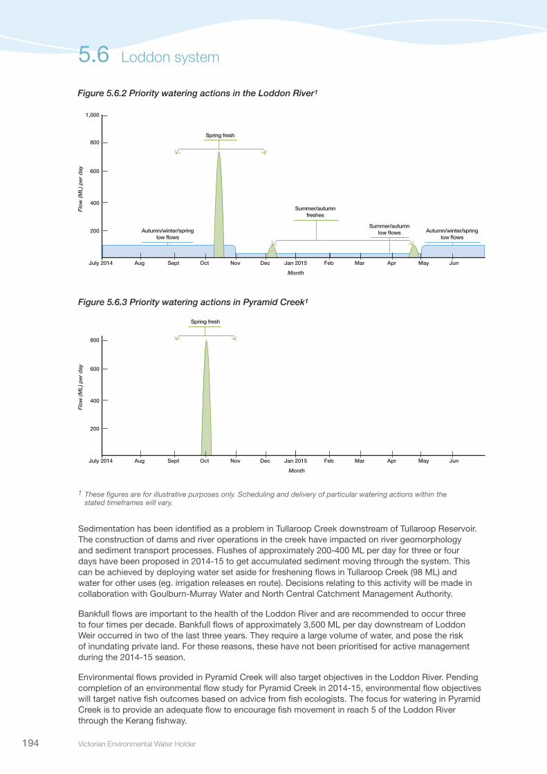
Victorian Environmental Water Holder194
Figure 5.6.2 Priority watering actions in the Loddon River1
Figure 5.6.3 Priority watering actions in Pyramid Creek1
1 These figures are for illustrative purposes only. Scheduling and delivery of particular watering actions within the stated timeframes will vary.
Sedimentation has been identified as a problem in Tullaroop Creek downstream of Tullaroop Reservoir. The construction of dams and river operations in the creek have impacted on river geomorphology and sediment transport processes. Flushes of approximately 200-400 ML per day for three or four days have been proposed in 2014-15 to get accumulated sediment moving through the system. This can be achieved by deploying water set aside for freshening flows in Tullaroop Creek (98 ML) and water for other uses (eg. irrigation releases en route). Decisions relating to this activity will be made in collaboration with Goulburn-Murray Water and North Central Catchment Management Authority.
Bankfull flows are important to the health of the Loddon River and are recommended to occur three to four times per decade. Bankfull flows of approximately 3,500 ML per day downstream of Loddon Weir occurred in two of the last three years. They require a large volume of water, and pose the risk of inundating private land. For these reasons, these have not been prioritised for active management during the 2014-15 season.
Environmental flows provided in Pyramid Creek will also target objectives in the Loddon River. Pending completion of an environmental flow study for Pyramid Creek in 2014-15, environmental flow objectives will target native fish outcomes based on advice from fish ecologists. The focus for watering in Pyramid Creek is to provide an adequate flow to encourage fish movement in reach 5 of the Loddon River through the Kerang fishway.
200
400
600
800
Dec Jan 2015 Feb Mar AprNovOctSeptAug May JunJuly 2014
Month
Flo
w (M
L) p
er d
ay
Spring fresh
200
400
600
800
1,000
Dec Jan 2015 Feb Mar AprNovOctSeptAug May JunJuly 2014
Month
Flo
w (M
L) p
er d
ay
Autumn/winter/spring low flows
Spring fresh
Summer/autumn freshes
Summer/autumn low flows Autumn/winter/spring
low flows
5.6 Loddon system

Seasonal Watering Plan 2014–15 195
Scenario planningTable 5.6.3 outlines the priority watering actions and expected water usage under a range of planning scenarios.
There are critical decisions to be made throughout the season regarding the delivery of priority watering actions in the Loddon River. For example, if there are dry catchment conditions, a spring fresh may be delivered in the first half of October. However, if it is wet and there are unregulated flows through the catchment, the delivery of this fresh may be delayed to see if objectives are achieved naturally.
Table 5.6.3 Priority watering actions in the Loddon system under a range of planning scenarios
Planning scenario
DROUGHT AVERAGE WET
Loddon River
Expected availability of Water Holdings1
9,064-10,586 ML VEWH Holdings
1,443-2,775 ML Commonwealth Holdings
10,507-13,361 ML total
8,922-10,885 ML VEWH Holdings
1,748-2,775 ML Commonwealth Holdings
10,670-13,660 ML total
8,922-11,229 ML VEWH Holdings
2,414-2,775 ML Commonwealth Holdings
11,336-14,004 ML total
Priority watering actions Autumn/winter low flowSpring freshOne summer fresh
Autumn/winter low flowSpring freshTwo summer freshesSummer low flows
Autumn/winter low flowSpring freshTwo summer freshesSummer low flows
Possible volume required from the Water Holdings2 10,815-13,217 ML 7,810-10,287 ML 4,506-7,112 ML
Possible carryover into 2014-15
0 ML (VEWH Holdings) 0-3,075 ML (VEWH Holdings)
1,810-6,723 ML (VEWH Holdings)
Pyramid Creek
Priority watering actions N/A Spring fresh Spring fresh
Possible volume required from the Water Holdings
0 ML 5,000 ML 5,000 ML
1 Does not include water available in the Goulburn and Murray systems, which could be traded into the system if required, subject to trading rules.
2 Assumes passing flows are provided, but no unregulated flows occur, therefore volumes are upper limits.
Risk managementIn preparing its seasonal watering proposal, the North Central Management Authority has considered and assessed risks, and identified mitigating strategies, relating to the implementation of priority watering actions (see Table 5.6.4). Risks and mitigating actions are continually reassessed by delivery partners throughout the water year.
Loddon system 5.6

Victorian Environmental Water Holder196
Table 5.6.4 Risk management in the Loddon system
Risk type Mitigating strategies (Loddon River)
Mitigating strategies (Pyramid Creek)
Release volume is insufficient to meet required flow at target point
Monitor outcomesRegular liaison with Goulburn-Murray Water
Current flow recommendations inaccurate or out of date
Monitor outcomes as neccessaryUndertake review of watering actions with relevant stakeholders to ensure watering recommendations are adaptively managed over time
Monitor outcomesDevelop flow recommendations
Storage manager maintenance works affect ability to deliver water
Liaise with Goulburn-Murray WaterTiming of flows to take account of maintenance
N/A
Storage manager cannot deliver required volume or flow rate (capacity constraints)
Liaise with Goulburn-Murray WaterAdjust timing of flows and manage flow rate
Limited catchment management authority resources to plan and manage environmental release
Ensure that environmental water management within the North Central Catchment Management Authority is adequately resourced to undertake required delivery tasks
Releases cause water quality issues (eg. blackwater, low dissolved oxygen, algal bloom)
Monitor water quality and/or cease flow if required
Releases cause water quality issues (eg. algal bloom) to be transported to other systems (eg. Murray River)
If bloom is present before flow commences, do not deliver water until bloom subsidesAssess if issue requires environmental flow order to be modified
Improved conditions for non-native species (eg. carp)
Currently unable to manage this risk
Cost of delivery exceeds available funding
Watering will not commence without agreement on delivery charges and security of funding
Environmental water account is overdrawn
Monitor use of waterLiaise with Goulburn-Murray Water and VEWH
Environmental release causes personal injury to river user, staff or contractor
Follow OHS proceduresEnsure contractors are OHS compliantInform landholders of flow
Follow OHS proceduresEnsure contractors are OHS compliant
Unable to provide evidence in meeting ecological objective
Continue Victorian Environmental Flows Monitoring and Assessment Program reportingMonitoring as necessaryEnvironmental Water Advisory Group and community member observations
Fish survey recommended (funding required)
Key stakeholders not supportive of environmental water release
Engage with landholders and Environmental Water Advisory GroupInformation sessions
Environmental release causes flooding to public infrastructure or private land
Monitor flows and restrict water orders to 450 ML per dayNotify landholders and stakeholders of flow delivery in advance of it commencingMinor mitigation works (eg. earthworks) if requiredEngage landholders and keep them informedMonitor rainfall forecasts for likelihood of rainfall >20mm or that will cause run-off in the relevant catchmentsReduce flow rate if required
Engage with, and inform landholders
5.6 Loddon system

Seasonal Watering Plan 2014–15 197
5.6.2 Boort wetlandsCurrent situationThe Boort wetlands are important habitat for a range of bird, reptile and amphibian species, including endangered, vulnerable and threatened species. Native vegetation values include a number of threatened ecological vegetation classes, and important plant species such as cane grass and river red gums.
The Boort wetlands are now drying out after having water in them since the 2010-11 floods. In particular, Lake Leaghur has continued to hold water until very recently, and is due for a drying phase. Lake Yando received a small volume of water to inundate gilgai channels in the lake floor, while top up flows were provided to Lake Meran in April/May 2014 after the volume in the lake dropped below the environmental trigger level in summer 2013-14. Lake Boort is currently dry. Little Lake Meran retains some water but is unlikely to receive environmental water in the foreseeable future due to delivery constraints.
Priority watering actions and environmental objectivesPriority watering actions, along with their associated environmental objectives, are provided in Table 5.6.5.
The priority environmental objectives are to: enhance vulnerable vegetation communities, including red gum, chenopod woodland and tall marshes. Bird breeding, feeding and roosting are also important objectives in these wetlands, along with the preservation of a range of vulnerable plant, reptile and frog species.
In addition to the environmental objectives, these watering actions will provide social benefits through improved opportunities for fishing and passive recreation activities.
Table 5.6.5 Priority watering actions and environmental objectives for the Boort wetlands
Priority watering action Environmental objective
Lake Boort: Provide top up flows in autumn 2015 Restore the distribution of river red gums and associated plant community across the bed of Lake Boort, including rehabilitation of southern cane grass populationsRestore and rehabilitate vegetation species diversity typical of aquatic and semi-aquatic environmentsReduce likelihood of recolonisation of lake bed by mustard weed by promoting native vegetation growth
Lake Yando: Provide top up flows in spring 2014 or autumn 2015
Maintain the health and restore the distribution of river red gumsMaintain open water and associated mudflat habitat Maintain the health and restore the distribution of the fringing riverine chenopod woodland Maintain health and restore the distribution of tangled lignum vegetation Restore diverse aquatic and amphibious plant species communities Restore habitat for the rare winged water-starwortRestore feeding and breeding opportunities for water birds, frogs and invertebratesMaintain a viable seed and egg bank
Lake Meran: Provide top up flows in autumn 2015 Maintain emergent aquatic plant communities currently persisting at the channel outfall Maintain health of the fringing intermittent swampy woodlandRestore open water/submerged aquatic plant habitat in the deeper sections of the wetlandRestore tall marsh habitat across a greater area of the lakeRestore abundance of tangled lignum vegetation within the fringing intermittent swampy woodlandRestore habitat and breeding opportunities for water birds (eg. pied cormorants), fish, frogs and invertebratesRestore connectivity between river, floodplain and wetlands
Loddon system 5.6

Victorian Environmental Water Holder198
Scenario planning Table 5.6.6 outlines the priority watering actions and expected water usage under a range of planning scenarios.
In all but the drought scenario, adequate water is expected to be available from allocations and carryover to undertake the respective priority watering actions. In the drought scenario, Lake Yando would only be partially filled, as occurred in 2013. In the wetter scenarios, the ecological benefits of filling Lake Yando would be considered. Prioritisation between sites may be required under a drought scenario if insufficient water was available to achieve all priority watering actions. This would be based on factors such as timing and total water availability, risk assessment, drying/filling regimes identified for wetlands, and anticipated ecological outcomes or threats.
Table 5.6.6 Priority watering actions in the Boort wetlands under a range of planning scenarios
Planning scenario
DROUGHT DRY AVERAGE WET
Priority watering actions
Lake Boort (up to 1,500 ML)
Lake Yando (200-450 ML)
Lake Meran (up to 1,500 ML)
Lake Boort (up to 1,500 ML)
Lake Yando (200-450 ML)
Lake Meran (up to 1,500 ML)
Lake Boort (up to 1,500 ML)
Lake Yando (200-450 ML)
Lake Meran (up to 1,500 ML)
Lake Boort (up to 1,500 ML)
Lake Yando (200-450 ML)
Lake Meran (up to 1,500 ML)
Possible volume required from the Water Holdings
Up to 3,450 ML Up to 3,450 ML Up to 3,450 ML Up to 3,450 ML
5.6 Loddon system
Pictured: Loddon River at Borung-Hurstwood Road, by Phil Slessar, North Central CMA

Seasonal Watering Plan 2014–15 199
Risk managementIn preparing its seasonal watering proposal, the North Central Management Authority has considered and assessed risks, and identified mitigating strategies, relating to the implementation of priority watering actions (see Table 5.6.7). Risks and mitigating actions are continually reassessed by environmental watering program partners throughout the water year.
Table 5.6.7 Risk management in the Boort wetlands
Risk type Mitigating strategy
Inflow volume too much or too little to achieve objectives
Monitor outcomes as appropriateLiaise with Goulburn-Murray Water
Storage manager maintenance works affect ability to deliver water
Ensure the deliveries to wetlands occur within the irrigation seasonLiaise with Goulburn-Murray Water regarding channel shut downs
Limited catchment management authority resources to plan and manage environmental release
Ensure that environmental water management within the North Central Catchment Management Authority is adequately resourced to undertake required delivery tasks
Releases cause water quality issues (eg. salinity, blackwater, algal bloom)
Monitor water quality as appropriateUndertake salinity investigations if required
Improved conditions for non-native species (eg. carp) Currently unable to manage this risk
Cost of delivery exceeds available funding Watering will not commence without agreement on delivery charges and security of funding
Environmental water account is overdrawn Monitor usage of waterLiaise with Goulburn-Murray Water and the VEWH
Environmental water release causes personal injury to wetland user, staff or contractor
Follow OHS proceduresEnsure contractors are OHS compliant
Unable to provide evidence in meeting ecological objective
Undertake vegetation and bird surveys as appropriate
Flow delivery interferes with irrigation delivery Liaise with Goulburn-Murray Water on capacity issues Interrupt environmental flow delivery if appropriate
Key stakeholders not supportive of environmental water release
Engage with landholders and Environmental Water Advisory GroupProvide information sessions
Environmental water releases cause flooding of private land or public infrastructure
Engage with landholdersReduce flow rate if required
Loddon system 5.6
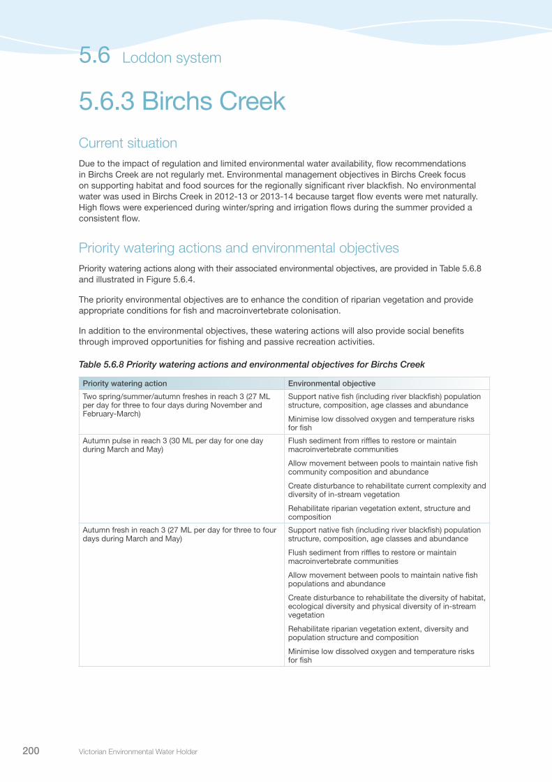
Victorian Environmental Water Holder200
5.6.3 Birchs Creek Current situationDue to the impact of regulation and limited environmental water availability, flow recommendations in Birchs Creek are not regularly met. Environmental management objectives in Birchs Creek focus on supporting habitat and food sources for the regionally significant river blackfish. No environmental water was used in Birchs Creek in 2012-13 or 2013-14 because target flow events were met naturally. High flows were experienced during winter/spring and irrigation flows during the summer provided a consistent flow.
Priority watering actions and environmental objectivesPriority watering actions along with their associated environmental objectives, are provided in Table 5.6.8 and illustrated in Figure 5.6.4.
The priority environmental objectives are to enhance the condition of riparian vegetation and provide appropriate conditions for fish and macroinvertebrate colonisation.
In addition to the environmental objectives, these watering actions will also provide social benefits through improved opportunities for fishing and passive recreation activities.
Table 5.6.8 Priority watering actions and environmental objectives for Birchs Creek
Priority watering action Environmental objective
Two spring/summer/autumn freshes in reach 3 (27 ML per day for three to four days during November and February-March)
Support native fish (including river blackfish) population structure, composition, age classes and abundance
Minimise low dissolved oxygen and temperature risks for fish
Autumn pulse in reach 3 (30 ML per day for one day during March and May)
Flush sediment from riffles to restore or maintain macroinvertebrate communities
Allow movement between pools to maintain native fish community composition and abundance
Create disturbance to rehabilitate current complexity and diversity of in-stream vegetation
Rehabilitate riparian vegetation extent, structure and composition
Autumn fresh in reach 3 (27 ML per day for three to four days during March and May)
Support native fish (including river blackfish) population structure, composition, age classes and abundance
Flush sediment from riffles to restore or maintain macroinvertebrate communities
Allow movement between pools to maintain native fish populations and abundance
Create disturbance to rehabilitate the diversity of habitat, ecological diversity and physical diversity of in-stream vegetation
Rehabilitate riparian vegetation extent, diversity and population structure and composition
Minimise low dissolved oxygen and temperature risks for fish
5.6 Loddon system
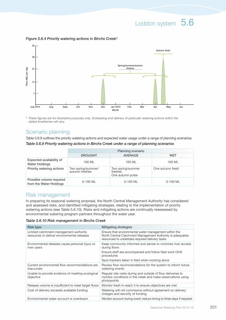
Seasonal Watering Plan 2014–15 201
1 These figures are for illustrative purposes only. Scheduling and delivery of particular watering actions within the stated timeframes will vary.
Scenario planningTable 5.6.9 outlines the priority watering actions and expected water usage under a range of planning scenarios.
Table 5.6.9 Priority watering actions in Birchs Creek under a range of planning scenarios
Planning scenarioDROUGHT AVERAGE WET
Expected availability of Water Holdings
100 ML 100 ML 100 ML
Priority watering actions Two spring/summer/autumn freshes
Two spring/summer freshesOne autumn pulse
One autumn fresh
Possible volume required from the Water Holdings
0-100 ML 0-100 ML 0-100 ML
Risk managementIn preparing its seasonal watering proposal, the North Central Management Authority has considered and assessed risks, and identified mitigating strategies, relating to the implementation of priority watering actions (see Table 5.6.10). Risks and mitigating actions are continually reassessed by environmental watering program partners throughout the water year.
Table 5.6.10 Risk management in Birchs Creek
Risk type Mitigating strategies
Limited catchment management authority resources to deliver environmental releases
Ensure that environmental water management within the North Central Catchment Management Authority is adequately resourced to undertake required delivery tasks
Environmental releases cause personal injury to river users
Keep community informed and advise to minimise river access during flowsEnsure staff are accompanied and follow field work OHS proceduresSpot trackers taken in field when working alone
Current environmental flow recommendations are inaccurate
Review flow recommendations for the system to inform future watering events
Unable to provide evidence of meeting ecological objective
Regular site visits during and outside of flow deliveries to monitor conditions in the creek and make observations using photopoints
Release volume is insufficient to meet target flows Monitor fresh in reach 3 to ensure objectives are met
Cost of delivery exceeds available funding Watering will not commence without agreement on delivery charges and security of funding
Environmental water account is overdrawn Monitor account during event; reduce timing to three days if required
Figure 5.6.4 Priority watering actions in Birchs Creek1
7
14
21
28
35
Dec Jan 2015 Feb MarNovOctSeptAug MayApr JunJuly 2014Month
Flo
w (M
L) p
er d
ay
Spring/summer/autumn freshes
Autumn fresh
Loddon system 5.6

Victorian Environmental Water Holder202
Section 6Further information
Victorian Environmental Water Holder202
Pictured: Lerderderg Gorge, Werribee system, by Bill Moulden, Melbourne Water

Seasonal Watering Plan 2014–15 203
For further information on the Seasonal Watering Plan 2014-15, please contact the VEWH office:
8 Nicholson St, East Melbourne, Victoria, 3002 PO Box 500, East Melbourne, Victoria, 3002 T: (03) 9637 8951E: [email protected]
For specific information about each system, and details about specific seasonal watering proposals, please contact the relevant catchment management authority (CMA) or Melbourne Water.
Corangamite CMA 64 Dennis Street, Colac, Victoria 3250PO Box 159, Colac, Victoria 3250T: (03) 5232 9100E: [email protected]: www.ccma.vic.gov.au
East Gippsland CMA 574 Main Street, Bairnsdale, Victoria 3875PO Box 1012, Bairnsdale, Victoria 3875T: (03) 5152 0600E: [email protected] W: www.egcma.com.au
Glenelg Hopkins CMA 79 French Street, Hamilton, Victoria 3300PO Box 502, Hamilton, Victoria 3300T: (03) 5571 2526E: [email protected] W: www.ghcma.vic.gov.au
Goulburn Broken CMA 168 Welsford Street, Shepparton, Victoria 3630PO Box 1752, Shepparton, Victoria 3630T: (03) 5820 1100E: [email protected]: www.gbcma.vic.gov.au
Mallee CMA DPI Complex, Corner Koorlong Avenue and Eleventh Street, Irymple, Victoria 3498PO Box 5017, Mildura, Victoria 3502T: (03) 5051 4377E: [email protected]: www.malleecma.vic.gov.au
Melbourne Water 990 La Trobe Street, Docklands, Victoria 3008PO Box 4342, Melbourne, Victoria 3001T: 131 722E: [email protected] W: www.melbournewater.com.au
North Central CMA 628-634 Midland Highway, Huntly, Victoria 3551PO Box 18, Huntly, Victoria 3551T: (03) 5448 7124E: [email protected]: www.nccma.vic.gov.au
North East CMA1B Footmark Court, Wodonga, Victoria 3690 PO Box 616, Wodonga VIC 3689T: (02) 6043 7600E: [email protected] W: www.necma.vic.gov.au
West Gippsland CMA 16 Hotham Street, Traralgon, Victoria 3844PO Box 1374, Traralgon, Victoria 3844T: 1300 094 262E: [email protected] W: www.wgcma.vic.gov.au
Wimmera CMA24 Darlot Street, Horsham, Victoria 3400PO Box 479, Horsham, Victoria 3402T: (03) 5382 1544E: [email protected] W: www.wcma.vic.gov.au
For specific information about the other environmental water holders, please contact:
Murray-Darling Basin AuthorityLevel 4, 51 Allara Street, Canberra, ACT 2601GPO Box 1801, Canberra, ACT 2601T: (02) 6279 0100E: [email protected] W: www.mdba.gov.au
Commonwealth Environmental Water OfficeJohn Gorton Building, King Edward Terrace, Canberra, ACT 2601GPO Box 787, Canberra, ACT 2601T: (02) 6275 9246E: [email protected] W: www.environment.gov.au/aggregation/commonwealth-environmental-water-office
6.1Contact details

Victorian Environmental Water Holder204
Acid sulphate soils – Naturally occurring soils containing high quantities of iron sulphates. When these soils remain underwater, they are stable, however if they are exposed to air, sulphuric acid is generated and can result in severe environmental impacts.
Allocation bank account – Water share owners and some other entitlement holders hold allocation bank accounts (ABAs), which are credited as water allocations are made throughout the season.
Australian Height Datum (AHD) – Height above sea level.
Azolla – A native aquatic fern which grows in waterways in dense patches; its presence usually indicates high levels of nutrients.
Bankfull flows – Flows of sufficient size to reach the top of the river bank with little flow spilling onto the floodplain.
Baseflows – A relatively stable, sustained and low flow in a river.
Biofilms – Slimy films of bacteria, other microbes and organic materials that cover underwater surfaces including rocks and snags.
Blackwater – Blackwater is a natural occurrence and is caused by the breakdown of plant matter causing water discolouration. The water turns black and can have very low dissolved oxygen levels which can cause stress to fish and other animals that breathe underwater.
Brackish water – Water that is moderately salty, but not as salty as sea water. It may result from the mixing of seawater with fresh water, as in estuaries.
Carryover – Allows entitlement holders to retain ownership of unused water into the following season (according to specified rules).
Catchment management authority – Statutory authorities established to manage river health, regional and catchment planning, and waterways, floodplains, salinity and water quality management.
Cease-to-flow – The period in which there is no discernible flow in a river and may lead to partial or total drying of the river channel.
Cold water pollution – Is caused by cold water being released into rivers, primarily from large dams, during warmer months.
Commonwealth Environmental Water Office – (part of the Department of Environment) Holds and manages the water entitlements recovered by the Australian Government through a combination of investments in water-saving infrastructure, water purchases and other water recovery programs.
Confluence – The point where a tributary joins a larger river, called the main stem, or where two streams meet to become the source of a river of a new name.
Ecological vegetation class – Components of a vegetation classification system, involving groupings of vegetation communities based on floristic, structural and ecological features.
Environmental flow regime – The timing, frequency, duration and magnitude of flows for the environment.
6.2Glossary

Seasonal Watering Plan 2014–15 205
Environmental flow study – A scientific study of the flow requirements of a particular basin’s river and wetlands systems used to inform decisions on the management and allocation of water resources.
Environmental water entitlement – An entitlement to water to achieve environmental objectives in waterways (could be an environmental entitlement, environmental bulk entitlement, water share, section 51 licence or supply agreement).
Estuary – A partially enclosed body of water along the coast where freshwater from rivers and streams meets and mixes with salt water from the ocean.
Fledging – The care of a young bird until it is able to fly.
Fledgling water birds – Young waterbirds that have just fledged, or have recently acquired the ability to fly, but are still dependent to some extent on parental care.
Flow component – Components of a river system’s flow regime that can be described by magnitude, timing, frequency and duration (for example, cease to flow and overbank flows).
Freshes – Small or short duration peak flow events which exceed the base flow and last for one or several days.
Geomorphology – The scientific study of landforms and the processes that shape them.
Gigalitre (GL) – One billion (1,000,000,000) litres.
Heritage rivers – Heritage rivers are listed under the Heritage Rivers Act 1992, and are particular parts of rivers and river catchment areas in Victoria which have significant nature conservation, recreation, scenic or cultural heritage attributes.
High-reliability entitlement – Legally recognised, secure entitlement to a defined share of water (full allocations are expected in most years).
Inter-valley transfers (IVT) – The transfer of water between river systems to meet demands as a result of water trade between river systems.
Low-reliability entitlement – Legally recognised, secure entitlement to a defined share of water (full allocations are expected only in some years).
OLARIS – A website that displays real-time data for various reservoirs and lakes including Yarra and Tarago systems. It is used to assess the water quality at the reservoir outlet prior to releasing environmental water into the river. Visit rtm.cwr.uwa.edu.au/olaris/olaris/index.php
Macroinvertebrates – Those animals that have no backbone and can be seen with the naked eye; includes worms, snails, mites, bugs, beetles, dragonflies and freshwater crayfish.
Macrophytes – Aquatic plants that are either emergent (growing out of the water; for example, phragmites), submergent (growing under water; for example, ribbonweed), or floating (for example, floating pond weed).
Managed releases – Release of water from the Water Holdings which is stored in major reservoirs; used for priority watering actions to achieve environmental outcomes.
Megalitre (ML) – One million (1,000,000) litres.
Midden – A site of cultural significance, where Indigenous people left the remains of their meals and other domestic waste.
Glossary 6.2

Victorian Environmental Water Holder206
Monthly Water Report – a report produced by the Department of Environment and Primary Industries, which provides a summary of the status of Victoria’s water resources and water supplies at the end of the reporting month.
Northern Victoria Irrigation Renewal Program (NVIRP) – An irrigation modernisation project, involving upgrading irrigation infrastructure in the Goulburn-Murray Irrigation District, which will provide water to irrigators, Melbourne and the environment. Now called the GMW Connections Project.
Passing flow – Water released out of storages to operate river and distribution systems (to deliver water to end users), provide for riparian rights and maintain environmental values and other community benefits.
Permanent trade – Transfer of ownership of a water share or licence.
Priority watering actions – Flow components that have been identified as priorities for a particular system in a particular year.
Ramsar-listed wetland – A wetland listed as internationally significant under the Convention on Wetlands signed in Ramsar, Iran in 1971.
Reach – A stretch or section of a river, generally defined in an environmental flows study.
Resource manager – Appointed by the Minister for Water to manage and allocate water resources in a particular river basin.
Restoring the Balance water recovery program – A Commonwealth Government program to return water to the environment through the purchase of water entitlements from irrigators.
Riffle – Relatively shallow section of stream where water flows at a higher velocity with increased turbulence, causing many ripples to be formed in the water surface.
Riparian vegetation – Vegetation located in the area of land that adjoins, regularly influences or is influenced by a river.
Seasonally adaptive approach – A planning approach which incorporates the likely availability of environmental water based on recent climate history and outlook, and determines the priority environmental objectives as a result.
Seasonal allocation – The volume of water allocated to a water share in a given season, expressed as a percentage of entitlement volume.
Slackwater habitat – Habitat in a body of water that has little or no flow, typically formed in areas where the current is restricted by obstructions.
Storage manager – Appointed by the Minister for Water to operate major water storages in a particular river basin to deliver to entitlement holders.
Temporary trade – Transfer of a seasonal allocation.
Terrestrial vegetation – Land-based plants.
The Living Murray – An intergovernmental program, which holds an average of 500,000 ML of environmental water per year, for use at six icon sites along the River Murray.
Tributary – Smaller river or creek that flows into a larger river.
6.2 Glossary

Seasonal Watering Plan 2014–15 207
Unregulated entitlement – An entitlement to water declared during periods of unregulated flow in a river system, that is, flows that are unable to be captured in storages.
Unregulated flows – Natural stream flows that cannot be captured in major reservoirs or storages.
Victorian Environmental Flows Monitoring and Assessment Program (VEFMAP) – Assesses the effectiveness of environmental flows in delivering ecological outcomes.
Victorian Environmental Water Holder – An independent statutory body responsible for holding and managing Victorian environmental water entitlements and allocations (Victorian Water Holdings).
Victorian Water Register – A public register of water-related entitlements in Victoria.
Waterways – Includes rivers, wetlands, creeks, floodplains and estuaries.
Water entitlement – The right to a volume of water that can (usually) be stored in reservoirs and taken and used under specific conditions.
Water Holdings – Environmental water entitlements held by the Victorian Environmental Water Holder.
Waterway manager – Agency responsible for the environmental management of catchments and waterways (includes catchment management authorities and Melbourne Water).
Glossary 6.2
Pictured: Yarra River at Warburton, by John Winther, Melbourne Water

Victorian Environmental Water Holder208
CAMBA China-Australia Migratory Bird Agreement
CEWO Commonwealth Environmental Water Office
CEWH Commonwealth Environmental Water Holder
CMA Catchment Management Authority
EWR Environmental Water Reserve
GWMWater Grampians Wimmera Mallee Water
JAMBA Japan-Australia Migratory Bird Agreement
MDBA Murray-Darling Basin Authority
NVIRP Northern Victoria Irrigation Renewal Project
ROKAMBA Republic of Korea-Australia Migratory Bird Agreement
VEFMAP Victorian Environmental Flows Monitoring and Assessment Program
VEWH Victorian Environmental Water Holder
6.3List of acronyms

Back cover image: MacKenzie River, by Josh Griffiths Pictured above: Thomson River in flow release, by Jake Marler

Victorian EnvironmentalWater Holder
T: (03) 9637 8951
PO Box 500, East Melbourne VIC 3002
8 Nicholson Street, East Melbourne
vewh.vic.gov.au
ww
w.it
alic
herr
ydes
ign.
com
.au


![Western Region News - Costume · 2 Western Region News WESTERN REGION d Z t v Z P ] } v } ( Z } µ u ^ } ] Ç } ( u ] ] u µ } (](https://static.fdocuments.us/doc/165x107/5f54d08525c3e16a50094f83/western-region-news-2-western-region-news-western-region-d-z-t-v-z-p-v-.jpg)