SEAWARD DIPPING REFLECTORS AND CRUSTAL STRUCTURE...
20
SEAWARD DIPPING REFLECTORS AND CRUSTAL STRUCTURE
Transcript of SEAWARD DIPPING REFLECTORS AND CRUSTAL STRUCTURE...

SEAWARD DIPPING REFLECTORS AND CRUSTAL STRUCTURE

Chapter-6
SEAWARD DIPPING REFLECTORS AND CRUSTAL STRUCTURE
6.1 Introduction
The western continental margin of India is considered as a typical passive rifted
margin (Biswas, 1982, 1987; Chandrasekharam, 1985; Mahadevan, 1994)
evolved during three distinct rifting episodes as discussed in chapter-2. The
southern part of the WCMI is generally considered as a non volcanic passive
margin produced during the break-up between southern India and eastern
Madagascar. Whereas, the northern part of the WCMI is a volcanic passive
margin, developed during breakup of India-Laxmi Ridge-Seychelles continental
block contemporaneous with predominant Deccan volcanic episode of excess
volcanism. Despite the fact that the India-Madagascar break-up produced an
extensive volcanic province along eastern Madagascar and basaltic flows and
intrusives on the SWCMI as well as southwest Indian shield, the nature of this
margin is not yet investigated enough to classify it as a volcanic margin.
In this chapter, the seaward dipping seismic reflectors identified from three MCS
reflection profiles RE23, RE19 and RE17 along the western flank of the Laccadive
Ridge, are analyzed under constraints of seismic refraction derived P-wave
velocities. As discussed later in this chapter, these reflectors are interpreted as
Seaward Dipping Reflectors (SDRs) — one of the diagnostic tectono-magmatic
features of the volcanic continental margin.
Further, 2D gravity modeling is carried out along five transects (RE23, RE21,
RE19, RE17 and RE15) of the southwest continental margin of India to achieve
consistent geological models, which can account for interpreted feature of the
present study and provide improved picture on crustal models reported earlier.
Improved crustal structure of the SWCMI is important in constraining the geometry
and structural parameters of the continental margins as well as continent-ocean
transition.
121 Page

Chapter-6
6.2 Seaward dipping reflectors
Volcanic passive margins differ from non volcanic passive margins mainly due to
presence of diagnostic tectono-magmatic features. These characteristic features
are the huge volume of magma emplaced during initial stage of seafloor spreading
typically as seaward dipping reflector sequences, numerous intrusive/extrusive
bodies emplaced into the sedimentary basin (Berndt et al., 2001), and a lower
crustal body with high P-wave velocity of more than 7.1 km/s (Planke et al., 1991;
Eldholm et al., 1995). The studies carried out so far on passive continental
margins worldwide suggest that Seaward Dipping Reflectors (SDRs) — one of the
most distinctive features of a volcanic passive margin - represent flood basalts
rapidly extruded during either rifting or initial stage of seafloor spreading. These
Seaward Dipping Reflectors mark the offshore limit of the continent crust, thereby
used to define Continent-Ocean Transition (COT) — a transitional boundary
between continental and oceanic crust.
SDRs are a stack of laterally continuous, divergent and offlapping reflectors
capable of yielding important evidence of evolution of continental margins. During
continental break-up extensive extrusive constructions are emplaced along
divergent volcanic margins. These constructions commonly include formations
which appear as SDR sequences in the seismic record (Figure 6.1). Therefore,
the SDRs are interpreted as voluminous basaltic flows emplaced sub aerially
and/or in a shallow sub-aqueous environment during the latest period of rifting and
earliest phase of sea floor spreading (Hinz, 1981; Austin and Uchupi, 1982; Mutter
et al., 1982; Mutter, 1985; Planke and Eldholm, 1994; Gladczenko et al., 1998).
These flows may be interbedded with sediments similar to those drilled on the
Hatton Bank (Roberts et al., 1984). According to Hinz (1981) and Mutter et al.
(1982) the regions of SDRs generally mark areas of rifted continent and their dips
arose from the subsidence due to isostatic compensation of enormous volumes of
basaltic lava flows emplaced during initial continental split-up.
The seaward dipping reflectors show diagnostic appearance in the seismic
reflection profiles. Mutter (1985) noticed following consistent features of the SDR
122IPage

Flow
•^1
Continental crust
Mantle
Continental crust
Mantle
Sea level
Spreading center
Chapter-6
Dyke injection
Figure 6.1 Schematic diagrams showing genesis of SDRs along a linear zone of dyke injection in attenuated continental crust (Hinz, 1981).
123IPage

Chapter-6
sequences based on observations made from the multi-channel seismic reflection
profiles acquired along the Norwegian continental margin.
i) The reflector sequences dip ubiquitously seaward. At the landward limit of
the sequences they often assume a horizontal to near-horizontal attitude.
ii) The reflectors usually exhibit arcuate shapes indicating upward convexity.
iii) The reflectors diverge seaward and show an overall seaward offlap.
iv) The reflectors are distributed in the form of a sea-ward dipping wedge or
fan shaped configuration. The seaward limit of the wedges is seldom well
defined and shows no distinct basal reflector.
It has been observed that the SDRs occur immediately landward of the oldest
mapped seafloor spreading type magnetic lineation, where the magnetic lineations
could jointly define with the SDR sequences on a continental margin. In some
cases they are associated directly with the oldest part of the anomaly sequence
(Mutter et al., 1982). Seaward transition of SDRs to presumed oceanic crust could
be marked by a topographic high. The SDR sequences are generally
characterized by broad feather edge to the seaward and thin progressively
landward to its interpreted apex. Feather edge of the SDRs have been used to
demarcate seaward extent of the continental crust of the Voring Plateau of
Norwegian margin, Argentina margin and east coast of US (White et al., 1987).
6.2.1 Seismic characters and identification of SDRs
In the present study, a set of westerly dipping seismic reflectors are observed
below sedimentary column at three locations (Figure 6.2) along the western flank
of the Laccadive Ridge imaged in the MCS reflection profiles RE23, RE19 and
RE17. The dipping reflectors are a stack of laterally discontinuous to continuous,
high amplitude, divergent and offlapping, westerly dipping reflectors (Figures 6.3,
6.4 and 6.5).
The MCS reflection profile RE23 depicts two sets of westerly dipping reflector
sequences (u1 and u2) separated by -5 km (Figure 6.3). These reflector
sequences, occur at a depth of -4.2 s TWT, are overlain by -0.9 s TWT thick
sediments and extend seaward for about 27 km. Another well developed dipping
124 Page

18°
14°
18°
14°
10°
64° 68° 72° 76°
Mumbai
Goa
■ ■ I
66
km ,
o 100 200 Deccan Trap
INDIA
SW— Arabian Basin
f
Mangalore
Cochin
i *2 ‘ 0 SDP-219
•
. '-' . .. I • ',' ,
/ \
g ;ca r (
4/1 1 usi I ( "
\ ) II ,.., I ,/,, t ::, \ I - ' '''■ '\ 7/ 1
ir t5SDP-220 III ,;. .... SOR Locations ">'
, — Seismic lines
6°
* DSDP-21
64° 68° 72° 76°
10°
Chapter-6
Figure 6.2 Locations of SDRs identified along western flank of the Laccadive Ridge depicted in the seismic lines. Location of refraction station LO8V (11.9067°N, 71.1750 °E) is not shown in the map as it nearly falls on the SDR location of RE17. Other details are given in the Figure 5.1.
reflectors which extends seaward for about 27 km and overlain by -1.2 s 'TWT
thick sediments is identified along the profile RE19 (Figure 6.4). The top of the
dipping reflectors lies at a depth of -3.6 s TWT. Along the profile RE17
(Figure 6.5), the westerly dipping reflectors are overlain by -0.95 s TWT thick
sediments. Individual reflectors can be traced for about 15 km down dip and the
depth to the highest distinguishable point of the reflectors is -3.8 s TWT.
125 'Page

Chapter-6
ENE WSW Arabian
Basin
Western flank of the Laccadive Ridge
7
Figure 6.3 SDRs interpreted along part of the seismic profile RE23 depicting western flank of the Laccadive Ridge. ul, u2 and reflector L1-top are explained in the text.
In order to investigate the nature of the dipping seismic reflectors, published
results of DSDP Site 219 (Whitmarsh et al., 1974) and refraction study at site
LO8V (Naini and Talwani, 1983) located on the crest and western flank of the
Laccadive Ridge respectively are used. The velocity structure at site LO8V
(Table 6.1) which is close to the dipping seismic reflectors observed at seismic
line RE17 shows the interval velocities of 1.65-2.12 km/s, 4.4 km/s, 5.6 km/s, 6.3
km/s and 7.2 km/s. The presence of chert layer of P-wave velocity 4.0 km/s of
Early and Middle Eocene age overlain by about 1 km thick sediment over the
Laccadive Ridge was inferred at DSDP Site 219. The chert layer appears as a
strong diffuse reflector often with irregular surface and sawtooth appearance
126 IPage

WSW Arabian Basin
RE19
Western flank of the Laccadive Ridge
Chapter-6
(Whitmarsh et al., 1974). Chaubey et al. (2002b) observed that reflection
character of chert layer is of high-amplitude, and discontinuously associated with
numerous diffraction hyperbolae.
Figure 6.4 SDRs interpreted along western flank of the Laccadive Ridge imaged in the seismic profile RE19.
Such reflection character at bottom of the sedimentary strata (Figures 6.3, 6.4 and
6.5) is not observed in the study area. Instead, it displays high amplitude and
continuous reflector of the seismic sequence boundary L1-top. Below the reflector
L1-top discontinuous to continuous, high amplitude, divergent, westerly dipping
and offlaping reflectors are observed in the profiles RE23, RE19 and RE17.
The velocities in the range of 5.8-6.4 km/s are generally considered as
characteristic of granitic layer in continental crust (Tucholke et al., 1981). From a
compilation of global crustal model Mooney et al. (1998) suggested 6.1-6.3 km/s
127 'Page

Chapter-6
WSW Arabian I i Western flank of the Laccadive Ridge Basin
14--- 15 km --)4
ENE
6
Figure 6.5 SDRs interpreted from part of the seismic profile RE17 depicting western flank of the Laccadive Ridge.
velocity to upper—middle crustal layer of extended continental crust. Deep seismic
sounding investigations of the western Indian shield suggested that seismic
velocity of Deccan flow basalt, lying below thick sediment column, varies between
4.7 to 5.1 km/s (Kaila et al., 1979, 1981; Reddy, 2005). From the study of dipping
reflector sequence on Hatton Bank, White et al. (1987) suggested that the seismic
velocities increase through the SDRs from typically 3.5 km/s at the top to about 6
km/s at the base. Therefore, seismic velocity of 4.4 km/s is assigned (below
sediment column of velocity 1.65-2.12 km/s) for the dipping seismic reflectors
considering the velocity structure of refraction station LO8V (Table 6.1) located
close to the dipping seismic reflectors on RE17. These seismic reflectors are
therefore interpreted as volcanic reflectors. Considering the geographic location
128 IPage

Chapter-6
and seismic characters, these dipping volcanic reflectors are interpreted as
Seaward Dipping Reflectors (SDRs).
The dipping volcanic reflectors, interpreted as SDRs, do not represent dipping
normal faults because the seismic reflectors are not associated with half-graben
structures which are formed during initial stage of continental rifting. Further, in the
locations where the SDRs are interpreted, the sub-surface is clearly devoid of
normal fault characteristics. In view of this, the dipping volcanic reflectors
identified on the western flank of the Laccadive Ridge are well developed SDRs.
Considering the genesis of SDRs, it is suggested that the dip of the SDRs arose
by subsidence of basaltic lava flows subsequent to their emplacement during
initial continental split-up.
Since the SDRs are interpreted as voluminous basaltic flows emplaced during the
latest period of rifting, the identified SDRs along the western flank of the
Laccadive Ridge are interpreted as indicative of rifted continental margin and the
volcanism prior to the onset of seafloor spreading. The seaward feather edge of
the SDR sequences indicates location of continent-ocean transition along western
margin of the Laccadive Ridge. These results are published as a scientific
research paper (Ajay et al., 2010).
Table 6.1 Seismic velocity of crustal layers at refraction station LO8V.
Layer velocity(km/s) 1.50 1.65 2.12 4.40 5.60 6.30 7.20 Layer thickness(km) 2.12 0.41 0.42 0.66 1.49 4.69 8.40
Layer thickness{(TVVT (s)} 2.83 0.50 0.40 0.30 0.53 1.49 2.33
Cumulative layer thickness{(TWT (s)} 2.83 3.33 3.73 4.03 4.56 6.05 8.38
6.3 Crustal structure of SWCMI
Crustal structure of the southwest continental margin of India is obtained by 2D
forward modeling of the free-air gravity anomalies along five traverses of the
margin. Ship-borne as well as satellite altimetry derived free-air gravity anomalies
are considered for the gravity modeling. Although crustal structure derived from
gravity modeling is non-unique, modeling under constraints of seismic reflection
129IPage
Chapter-6
and refraction data provide better constrained results and thereby improve the
interpretational reliability of the crustal structure.
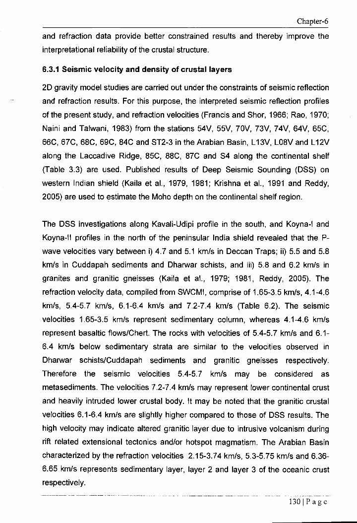
6.3.1 Seismic velocity and density of crustal layers
2D gravity model studies are carried out under the constraints of seismic reflection
and refraction results. For this purpose, the interpreted seismic reflection profiles
of the present study, and refraction velocities (Francis and Shor, 1966; Rao, 1970;
Naini and Talwani, 1983) from the stations 54V, 55V, 70V, 73V, 74V, 64V, 65C,
66C, 67C, 68C, 69C, 84C and ST2-3 in the Arabian Basin, L13V, LO8V and L12V
along the Laccadive Ridge, 85C, 88C, 87C and S4 along the continental shelf
(Table 3.3) are used. Published results of Deep Seismic Sounding (DSS) on
western Indian shield (Kaila et al., 1979, 1981; Krishna et al., 1991 and Reddy,
2005) are used to estimate the Moho depth on the continental shelf region.
The DSS investigations along Kavali-Udipi profile in the south, and Koyna-I and
Koyna-II profiles in the north of the peninsular India shield revealed that the P-
wave velocities vary between i) 4.7 and 5.1 km/s in Deccan Traps; ii) 5.5 and 5.8
km/s in Cuddapah sediments and Dharwar schists, and iii) 5.8 and 6.2 km/s in
granites and granitic gneisses (Kaila et al., 1979; 1981, Reddy, 2005). The
refraction velocity data, compiled from SWCMI, comprise of 1.65-3.5 km/s, 4.1-4.6
km/s, 5.4-5.7 km/s, 6.1-6.4 km/s and 7.2-7.4 km/s (Table 6.2). The seismic
velocities 1.65-3.5 km/s represent sedimentary column, whereas 4.1-4.6 km/s
represent basaltic flows/Chert. The rocks with velocities of 5.4-5.7 km/s and 6.1-
6.4 km/s below sedimentary strata are similar to the velocities observed in
Dharwar schists/Cuddapah sediments and granitic gneisses respectively.
Therefore the seismic velocities 5.4-5.7 km/s may be considered as
metasediments. The velocities 7.2-7.4 km/s may represent lower continental crust
and heavily intruded lower crustal body. It may be noted that the granitic crustal
velocities 6.1-6.4 km/s are slightly higher compared to those of DSS results. The
high velocity may indicate altered granitic layer due to intrusive volcanism during
rift related extensional tectonics and/or hotspot magmatism. The Arabian Basin
characterized by the refraction velocities 2.15-3.74 km/s, 5.3-5.75 km/s and 6.36-
6.65 km/s represents sedimentary layer, layer 2 and layer 3 of the oceanic crust
respectively.
130IPage

Chapter-6
The seismic refraction velocities, discussed above, have been used to infer the
density configuration for the continental as well as the oceanic crust. Densities for
various crustal layers were obtained from velocity-density conversion table of
Barton (1986) and presented in Table 6.2. The crustal velocities of the continental
shelf, Laccadive Basin and Laccadive Ridge suggest four layers of densities 2.1,
2.65, 2.8 and 2.9 g/cm 3. The density of 2.1 represents a sedimentary layer. The
density 2.65 g/cm3 may represent a thick metasedimentary layer. The densities
2.8 and 2.9 g/cm 3 represent upper and lower stretched continental crust
respectively. In the model, a high density 3.0 g/cm 3 is assumed for heavily
intruded lower crust of the Laccadive Ridge. In addition a density of 2.4 g/cm 3
Table 6.2 Crustal seismic velocities and inferred densities (after Barton, 1986)
Thickness (km)
Velocity (km/s)
Average Velocity (km/s)
Density (gm/cm 3 )
Sediment 0.48-3.55 2.15-3.74 2.65 2.1
n B
a
Oceanic Layer-2 1.28-2.43 5.3-5.75 5.5 2.7
Oceanic Layer-3 2.41-3.1 6.36-6.65 6.6 2.95
Moho - 8.1-8.3 8.2 3.3
Lacc
adi
ve
Rid
ge,
Bas
in a
nd
She
lf Sediment 0.43-2.8 1.65-3.5 2.58 2.1
Chert/Trap 0.66-2.0 4.1-4.6 4.35 2.4
Metasediment 1.49-1.93 5.4-5.7 5.55 2.65
Upper crust 1.84-4.69 6.1-6.4 6.25 2.8
Lower crust 7.99-8.4 7.2-7.4 7.3 2.9
Lower Crustal - - - 3.0 Body (LCB)
Moho - >8.0 - 3.3
131 Page

100 Ship-borne free-air gravity anomaly Satellite free-air gravity anomaly
9000 8000 7000 6000 I
5000 4000 3000 2000 1000
Shot points
100
0
Chapter-6
is used for basaltic-flow/chert, and 2.65 g/cm 3 density for SDRs in this study. In
the Arabian Basin the crustal velocities suggest three layers of densities 2.1, 2.7
and 2.95 g/cm 3 representing sediment, layer 2 and layer 3 of the oceanic crust
respectively. A uniform value of 3.3 g/cm 3 is assumed for the upper mantle.
6.3.2 Gravity modeling
Five uniformly spaced transects of the SWUM are selected along the lines RE23,
RE21, RE19, RE17 and RE15 to carry out gravity modeling under the constraints
of seismic reflection and refraction results. The four seismic lines RE23, RE21,
RE19 and RE17 were extended into deep Arabian Basin till 68 °E for the purpose
of crustal modeling from known oceanic crust of the Arabian Basin to continental
shelf. Satellite altimetry derived gridded free-air gravity anomaly database of
Sandwell and Smith (1997) are used to reconstruct the gravity profile where the
ship-borne free-air gravity anomaly data are either partly available or absent along
the seismic lines. The resolution of the satellite data was first evaluated by
comparing profiles extracted from the gridded satellite gravity data with coinciding
ship-borne gravity profile. The very good match between the gravity profiles from
two different data sources (Figure 6.6) gave confidence that the resolution of the
satellite-derived gravity data was adequate for crustal structure modeling.
Distance (km) 450 400 350 300 250 200
150
100
50
0
Figure 6.6 Match between ship-borne as well as satellite altimetry derived gridded free-air gravity anomaly data along the seismic line RE17.
1321Page

Chapter-6
For gravity modeling, main crustal layers and its thicknesses are identified based
on seismic reflection results of the present study, and refraction results (Francis
and Shor, 1966; Rao, 1970 and Naini and Talwani, 1983) reported for the study
area. 2D gravity modeling was carried out using the GM-SYS software. Modeling
was performed by applying small adjustments to the geometries of crustal layers
in order to obtain a crustal model which satisfies both the geometrical constraints
and an acceptable fit between observed and calculated free-air gravity anomalies.
In order to obtain an acceptable fit between the observed and calculated gravity
anomalies over the Laccadive Ridge, a high density (3.0 g/cm 3) Lower Crustal
Body (LCB) is introduced below the Ridge. A reasonable fit between the
computed and observed gravity anomalies is obtained with an RMS error <5
mGal. In the models, igneous intrusive bodies are expressed only in sediments
and water column as there is no appreciable lateral density contrast with other
adjoining crustal layers.
6.3.3 Results on crustal structure
Crustal structure obtained from 2D gravity modeling along five representative
transects of the southwest continental margin of India are presented in Figures
6.7, 6.8, 6.9, 6.10 and 6.11. The crustal models suggest two major crustal
domains: continental and oceanic. The stretched continental crust; comprised of
continental shelf-slope, Laccadive Basin, and Laccadive Ridge and characterized
by a number of magmatic intrusive/extrusive bodies; gradually thin towards west
and juxtaposed with the oceanic crust of the Arabian Basin. The models show
average crustal thicknesses of 22.5,19 and 6.5 km for the outer shelf, Laccadive
Ridge and Arabian Basin respectively. The COT is demarcated immediately west
of the Laccadive Ridge, seaward of the SDRs, where the free-air gravity anomaly
shows a prominent low and the Moho is characterized by significant shoaling to an
average depth of 10.5 km to the Arabian Basin. Despite having a number of
common structural characteristics, each of the transect exhibits considerable
variation in crustal thickness and several unique structural features, therefore they
are described individually in the following sections.
133 (Page

Laccadive Ridge I., Laccadive Basin --.15hell Trap
Intrusive —' PR ENE
fEl
WSW
Arabian Basin
Chapter-6
6.3.3.1 Transect RE23
Transect RE23 extends 923 km to west from continental shelf to the oceanic
domain of the Arabian Basin (Figure 6.7). The 2D gravity model along the transect
shows very good fit between the long wavelength components of the observed
and calculated anomalies. However, the short wavelength components show
minor misfits which may be largely attributed to the presence of tilted faulted
blocks, grabens, igneous intrusive bodies and SDRs along the transect. Maximum
crustal thicknesses of 22, 19.5 and 6.3 km are estimated for the continental shelf,
Laccadive Ridge and Arabian Basin respectively from the crustal model.
Moho depth is highly varying between 5 and 22 km along this transect. The
Maximum Moho depth estimated below outer continental shelf, Laccadive Ridge
and Arabian Basin are 22, 21 and 10 km respectively. The Moho is shallow (13.5
km) and more or less flat below major part of the Laccadive Basin. The Moho
below the Arabian Basin shows gradual rise from 10 km near west of Laccadive
900 800 700 600 500 400
300
200
100
0
Distance (km)
Figure 6.7 2D crustal model based on free-air gravity anomaly across the southwest continental margin of India along the seismic line RE23. PR: Prathap Ridge, SDRs: Seaward Dipping Reflectors, LCB: Lower Crustal Body, COT: Continent-Ocean Transition.
134IPage

1 Arabian Basin
20
1.71
•
0—
L9 -20 — E
▪ -40 —
▪ -60-
(.' -80
Laccadive Ridge Laccadive Basin --1Shelf
Intrusives PR ENE Etl
Chapter-6
Ridge to 9.3 km at the WSW end of transect. A lower crustal body of maximum
thickness 11.4 km is interpreted below the Laccadive Ridge indicating heavily
intruded lower continental crust of the Laccadive Ridge. The ridge is associated
with several magmatic structures such as igneous intrusives, basaltic flows/Trap
and SDRs. COT is demarcated immediately west of the Laccadive Ridge,
seaward of the identified SDRs, where the Moho shows a sharp rise to a depth of
10 km with a prominent drop in free-air gravity anomaly. The Prathap Ridge,
associated with a significant free-air gravity anomaly high, is interpreted as
uncompensated feature as it does not show flexure in the Moho.
6.3.3.2 Transect RE21
The transect RE21 extends from the continental shelf for 840 km to the oceanic
domain of the Arabian Basin (Figure 6.8). Maximum crustal thicknesses estimated
below the continental shelf, Laccadive Ridge and Arabian Basin are 19, 17.3 and
6.8 km respectively. The Moho depth varies between 9.8 and 19 km along this
transect. A maximum Moho depth of 19 km is estimated below outer shelf and
Laccadive Ridge. Below the Arabian Basin the maximum depth to Moho is 10 km.
The Moho shoals from 19 km below the outer shelf to 13.3 km beneath the
500 300 200 100 400 0
Distance (km)
Figure 6.8 2D crustal model based on free-air gravity anomaly across the southwest continental margin of India along the seismic line RE21.
800 700
1351Page

-80 — — =Calculated =Observed,
0- -
ro -20 —
E >, -
-60- ro -
RE19
COT
Arabian Basin
WSW
Laccadive Ridge Laccadive Basin--Shelf
Intrusives ENE Rs
-100
Chapter-6
Laccadive Basin. The Moho is more or less flat beneath the basin. The Moho
shows gradual decreases in depth from 10 to 9.8 km, below the Arabian basin to
the WSW end of the transect. The LCB interpreted below the Laccadive Ridge
has a maximum thickness of 9 km. COT is demarcated immediately west of the
Laccadive Ridge where the Moho is characterized by a sharp shoaling to a depth
of about 10 km associated with free-air gravity anomaly low. The Prathap Ridge is
associated with relatively subdued gravity high. The uncompensated ridge is
overlain by significantly thick sediment in the Laccadive Basin.
6.3.3.3 Transect RE19
Transect RE19 extends from the continental shelf to the Arabian Basin for about
780 km (Figure 6.9). The continental shelf, Laccadive Ridge and Arabian Basin,
shown in the model, are characterized by maximum crustal thicknesses of 23,
19.5 and 8 respectively. The Moho depth is highly varying between 10.2 to 23 km
along this transect. Maximum Moho depths of 23, 20.8 and 11 km are estimated
below the outer shelf, Laccadive Ridge and Arabian Basin respectively. The Moho
700 600 500 400
300 200 100
Distance (km)
Figure 6.9 2D crustal model across the southwest continental margin of India along the seismic line RE19.
136 'Page

Laccadive Ridge
Intrusives
I— Laccadive Basin —I Shelf
PR ENE En
Arabian Basin
SDRs
5 4.7gOgkt 7--""---' Layer 2
NLayer3 •
+++++44.
rrrrrr
wwwwwwwwwwwww mom P9Ms1,,,,wmftmwm
Ammovemee ow. wwwwwwww 000toweaeo_ew ooPmerSust. woom0000m000moom0000
wwwwww wee w0movowaowwwwwwwwwwwwwwwwwwwwwwwwwwwwwwwwww mowwwwwwmenvwewwwwwwwwwwwwwwwwwwwwwwwwwwwwwww
wwwwwww '/000000 0000000000000000000000000000 / wove wee,4Amwevomewwwwwwwwwwwwwwwwwwwwwww wee emiamowwwwwoweo meow wwwwwwwwwwwww wwwwwwwcw—wwwwwwww wwwwwwwwwww
owwwwwwwwwwwwwwww 000000000000ee00000000ee wwwwwwww
memo wwwwwww meow mew wee
ow e +1
25 ++ . :0444.
;MlAeta .iment • - - - - - - - - " ; - - - - ....
•
Chapter-6
risees below Laccadive Basin to a depth of 16 km. The Arabian Basin is
characterized by gradual decrease in Moho depth from 11 km near west of the
Laccadive Ridge to 10.2 km to the WSW end of the transect. The Laccadive
Ridge is associated with several intrusive bodies showing prominent gravity
anomaly high. The interpreted LCB has a maximum thickness of 8.7 km. The COT
is demarcated to the west of the Laccadive Ridge, seaward of the SDRs, where
the Moho depth decreases sharply to a depth of 11 km associated with a
prominent free-air gravity anomaly low.
6.3.3.4 Transect RE17
Gravity model along the 754 km long transect RE17 extends from the continental
shelf to the Arabian Basin (Figure 6.10). The model suggests maximum crustal
thicknesses of 25, 18.9 and 7 km for continental shelf, Laccadive Ridge and
Arabian Basin. The Moho depth varies from 10 to 25 km along the transect. The
maximum Moho depths estimated below the continental shelf, Laccadive Ridge
and Arabian Basin are 25, 19.3 and 10.5 km respectively. Below the Laccadive
700 600 500 400
300 200 100
Distance (km)
Figure 6.10 2D crustal model across the southwest continental margin of India along the seismic line RE17.
137IPage

1 2.6 1 0
— =Calculated
Arabian Basin Laccadive Ridge
Traa Intrusives
I Laccadive Basin I Shelf
PR ENE
zo— RE15
76 0-
E -20
•••• -40 —
-6°—
-80— --' =Observed,
COT
WSW 1 2.61
La
25 800 700 600 500 400 • 300 200 100
Distance (km)
Figure 6.11 2D crustal model across the southwest continental margin of India along the seismic line RE15.
Chapter-6
Basin the Moho rises gradually to a depth of 15.4 km. The Moho depth below the
Arabian Basin gradually decreases to the SW end of the transect from 10.5 to 10
km. The LCB interpreted below the Laccadive Ridge has a maximum thickness of
7.6 km. The COT is demarcated to the west of Laccadive Ridge, seaward of the
identified SDRs, where the Moho shows sharp shoaling to a depth of 10.5 km
associated with a low in free-air gravity anomaly. The uncompensated Prathap
Ridge is associated with prominent free-air gravity anomaly highs in the Laccadive
Basin.
6.3.3.5 Transect RE15
Transect RE15 extends for about 832 km from the continental shelf to the Arabian
Basin (Figure 6.11). The continental shelf, Laccadive Ridge and Arabian Basin
show maximum crustal thickness of 23.6, 20.2 and 6.9 km respectively. The Moho
depth, along the transect, is varying between 10.5 and 23.6 km. The maximum
depth to Moho estimated below the continental shelf, Laccadive Ridge and
Arabian Basin are 23.6, 22 and 11 km respectively. The Moho depth below the
138 'Page

Chapter-6
Laccadive Basin decreases to 18 km. Below the Arabian Basin the Moho is
characterized by gradual rise from 11 to 10.5 km to the end of the profile. The
interpreted LCB shows a maximum thickness of 9 km. COT is demarcated west of
the Laccadive Ridge where the Moho shows a sharp rise to a depth of 11 km
associated with a free-air gravity anomaly low. The Prathap Ridge as well as the
uplifted flat summit structural high, covered by the sediment, shows prominent
free-air gravity anomaly highs in the Laccadive Basin.
1391 P age