Saracen Mineral Holdings Limited Reserves …...Saracen Mineral Holdings Limited Reserves increase...
367
Saracen Mineral Holdings Limited Reserves increase 32% to 3.3Moz, underpinning 400,000ozpa for +7 years Highly successful organic growth strategy means Saracen’s future is underwritten by near-mill Reserves, additional ~6Moz in Resources paves the way for further growth in production and life ASX:SAR Registered Office: Level 11/40 The Esplanade Perth WA 6000 1 st August 2019 HIGHLIGHTS Substantial low-cost growth in Reserves Record group Reserves of 3.3Moz at 30 June 2019, up 32% from 2.5Moz at 30 June 2018 (an increase of 800,000oz despite 330,000oz depletion, gold price assumption unchanged at A$1,600/oz); Growth areas over the past 12 months include: Karari - Dervish (Carosue Dam) +200,000oz to 1.2Moz (despite 150,000oz depletion) Carosue Dam Open pits +225,000oz to 406koz Thunderbox Open pit unchanged at 460,000oz (despite 155,000oz depletion) Thunderbox Underground +190,000oz to 710,000oz Discovery cost of A$30 per Reserve oz Reserves underwrite long-life production outlook FY20 production guidance of 350 - 370,000oz at an AISC of A$1,025 - A$1,075/oz (pre-released), ounces increase and costs decrease progressively over the 12-month period Production outlook of 400,000oz per annum from FY21 - FY26; underpinned 100% by Reserves Carosue Dam mill to be expanded to 3.2Mtpa during FY20-21 (currently 2.4Mtpa), increasing production and decreasing costs from FY21; A$34m capital cost Open pit mining to resume at Carosue Dam in FY21, with a single fleet mine plan underpinned by 9.0Mt Reserves (406koz), representing +10 years of the additional mill capacity of 800,000t per annum Thunderbox Underground Feasibility Study (led by Entech) confirms a large, high productivity, low cost, long life mine underpinned by 11Mt Reserves (710koz); A$61m pre-production capital cost and A$1,251/oz life of mine AISC FY20 growth capital guidance of A$112m Pipeline of further substantial growth opportunities Record group Mineral Resources of 9.2Moz at 30 June 2019, up 7% from 8.6Moz at 30 June 2018 Significant exploration upside - FY20 exploration guidance of A$50m Materials handling optimisation - Increased productivity / lower costs from two of the largest tonnage underground gold mines in Australia (Karari-Dervish 12Mt Reserves, Thunderbox Underground 11Mt Reserves) Consolidation of recent “bolt-on” acquisitions
Transcript of Saracen Mineral Holdings Limited Reserves …...Saracen Mineral Holdings Limited Reserves increase...

Saracen Mineral Holdings Limited
Reserves increase 32% to 3.3Moz, underpinning 400,000ozpa for +7 years
Highly successful organic growth strategy means Saracen’s future is underwritten by near-mill Reserves, additional ~6Moz in Resources paves the way for further growth in production and life
ASX:SAR Registered Office: Level 11/40 The Esplanade Perth WA 6000
1st August 2019
HIGHLIGHTS Substantial low-cost growth in Reserves Record group Reserves of 3.3Moz at 30 June 2019, up 32% from 2.5Moz at 30 June 2018 (an increase of 800,000oz
despite 330,000oz depletion, gold price assumption unchanged at A$1,600/oz); Growth areas over the past 12 months include:
Karari - Dervish (Carosue Dam) +200,000oz to 1.2Moz (despite 150,000oz depletion) Carosue Dam Open pits +225,000oz to 406koz Thunderbox Open pit unchanged at 460,000oz (despite 155,000oz depletion) Thunderbox Underground +190,000oz to 710,000oz
Discovery cost of A$30 per Reserve oz
Reserves underwrite long-life production outlook FY20 production guidance of 350 - 370,000oz at an AISC of A$1,025 - A$1,075/oz (pre-released), ounces increase and
costs decrease progressively over the 12-month period
Production outlook of 400,000oz per annum from FY21 - FY26; underpinned 100% by Reserves
Carosue Dam mill to be expanded to 3.2Mtpa during FY20-21 (currently 2.4Mtpa), increasing production and decreasing costs from FY21; A$34m capital cost
Open pit mining to resume at Carosue Dam in FY21, with a single fleet mine plan underpinned by 9.0Mt Reserves
(406koz), representing +10 years of the additional mill capacity of 800,000t per annum
Thunderbox Underground Feasibility Study (led by Entech) confirms a large, high productivity, low cost, long life mine underpinned by 11Mt Reserves (710koz); A$61m pre-production capital cost and A$1,251/oz life of mine AISC
FY20 growth capital guidance of A$112m
Pipeline of further substantial growth opportunities Record group Mineral Resources of 9.2Moz at 30 June 2019, up 7% from 8.6Moz at 30 June 2018
Significant exploration upside - FY20 exploration guidance of A$50m
Materials handling optimisation - Increased productivity / lower costs from two of the largest tonnage underground gold
mines in Australia (Karari-Dervish 12Mt Reserves, Thunderbox Underground 11Mt Reserves)
Consolidation of recent “bolt-on” acquisitions

Page 2 of 367
Saracen Mineral Holdings (ASX: SAR) is pleased to announce the latest results of its highly successful organic growth strategy, with Reserves rising by 32 per cent to a record 3.3Moz.
The new Reserves fully underpin a 7 year production profile of 400,000oz a year from FY21 (after the Carosue Dam mill is expanded to 3.2Mtpa).
The update also includes a further ~6Moz in Resources, highlighting the additional growth potential at and around the Company’s mills in Western Australia.
With a further A$50 million budgeted for exploration in the current financial year, Saracen has strong potential to establish a +10-year mine life at 400,000oz a year.
Saracen Managing Director Raleigh Finlayson said the Company was now set up to generate substantial production and cash flow for many years, fully-supported by low-cost Reserves located close to its existing mills.
“To define over 1 million additional ounces in Reserves in just 12 months is an outstanding result,” Mr Finlayson said. “To do it at an average cost of A$30/oz and have all the Reserves at or near our existing mills is exceptional.
“Saracen’s future is now fully under-written by long mine life and Reserves and we have a pipeline of growth underpinned by an additional 6Moz in Resources.
“When this is viewed against our 7 year, unbroken track record of meeting or beating guidance, it is clear that Saracen is ideally positioned as a highly-reliable Australian gold producer with substantial production and a strong growth outlook.”
Saracen has budgeted A$112 million for growth capital this financial year as part of its strategy to capitalise on the increased Reserves by growing production to 400,000oz a year.
“This will see us expand the Carosue Dam mill to 3.2Mtpa and achieve a steady-state production rate of around 400,000oz a year, by which time our need for capital expenditure is expected to decline,” Mr Finlayson said.
“This should see us generate increased cash flow at a time of falling capital costs.”
Long term production outlook
Investment in exploration across the portfolio has delivered significant growth in Resources and Reserves. The new Reserves fully underpin a 7 year production profile of 400,000oz a year from FY21 (after the Carosue Dam mill is expanded to 3.2Mtpa). Figure 1 - 7 year production outlook
*FY20F is the mid-point of production guidance
The outlook is 100% in Reserves, and conservatively assumes no further exploration success, no further M&A success, no further third party ore purchases and excludes recent “bolt-on” acquisitions and the emerging Atbara discovery (also not in Resource).
Carosue Dam makes up ~60% of the total outlook ounces, and Thunderbox ~40%.
200 245 250 240 240 240 235
160155 150 160 160 160 165
0
100
200
300
400
500
FY20F* FY21F FY22F FY23F FY24F FY25F FY26F
Prod
uctio
n (ko
z)
Carosue Dam Thunderbox

Page 3 of 367
Ore Reserves
Table 1 - Saracen group Ore Reserves^
Category Gold Tonnes g/t oz
Proved 6,000,000 1.4 270,000 Probable 45,000,000 2.1 3,100,000 Total 52,000,000 2.0 3,300,000
^ Tonnes, grade and contained metal have been rounded to reflect the accuracy of the calculations. Rounding errors may occur.
The Ore Reserves Statement is reported according to the Australasian Code for Reporting of Exploration Results, Mineral Resources and Ore Reserves (the ‘JORC Code’) 2012 edition.
Key changes to the Ore Reserve statement from last year are:
• Total gold Ore Reserves have increased by 800koz (32%) to 3.3Moz, despite mining depletion • The Karari-Dervish Underground Ore Reserve has increased by 200koz to 1.2Moz, despite mining depletion of 150koz • The Thunderbox Underground Ore Reserve has increased by 190koz to 710koz following a successful FY19 drilling
program and subsequent update of the underground mining study (see detail below) • The Thunderbox Open Pit Ore Reserve has remained at 460koz, despite mining depletion of 155koz • The Kailis Open Pit Ore Reserve has been increased by 3koz to 49koz, despite mining depletion of 46koz • The Million Dollar Ore Reserve has increased by 60koz to 160koz, following a successful drill program in FY19 • The inclusion of a maiden Open Pit Ore Reserve at Otto Bore of 60koz, following a successful drill program in FY19 • The inclusion of a maiden Underground Ore Reserve at Porphyry of 110koz, following an underground mining study • The inclusion of a maiden Open Pit Ore Reserve at Karari South of 78koz, following a successful underground infill drill
program in FY19
Figure 2 - Saracen group Ore Reserve growth since 2005
0.0
0.5
1.0
1.5
2.0
2.5
3.0
3.5
2005 2006 2007 2008 2009 2010 2011 2012 2013 2014 2015 2016 2017 2018 2019
Ounc
es (M
oz)

Page 4 of 367
Figure 3 - Saracen group Ore Reserve reconciliation FY19 v FY18
Table 2 - Saracen group Ore Reserves by deposit at 30 June 2019
All data rounded to two significant figures. Rounding errors may occur.
1 Karari and Dervish Mineral Resources combined for reporting and operationally treated as one mine
2 Thunderbox Open Pit includes both C Zone and D Zone Ore Reserves
2,500
3,300
0
500
1,000
1,500
2,000
2,500
3,000
3,500
Cont
ained
oun
ces (
koz)
tonnes g/t oz. tonnes g/t oz. tonnes g/t oz.Karari / Dervish1 UG 12,000,000 3.1 1,200,000 12,000,000 3.1 1,200,000 Deep South UG 530,000 3.2 54,000 530,000 3.2 54,000 Karari South OP 1,700,000 1.4 78,000 1,700,000 1.4 78,000 Monty's Elliot OP 880,000 1.9 53,000 880,000 1.9 53,000 Million Dollar OP 3,900,000 1.3 160,000 3,900,000 1.3 160,000 Wallbrook OP 230,000 1.1 8,000 1,300,000 1.2 51,000 1,500,000 1.2 59,000 Enterprise OP 170,000 2.0 11,000 250,000 2.2 18,000 420,000 2.1 29,000 Porphyry OP 570,000 1.5 27,000 570,000 1.5 27,000 Porphyry UG 1,200,000 2.9 110,000 1,200,000 2.9 110,000 Stockpiles S 840,000 1.0 26,000 - - - 840,000 1.0 26,000 Carosue Dam Operations Sub-Total 1,200,000 1.2 45,000 22,000,000 2.5 1,800,000 24,000,000 2.3 1,800,000Thunderbox2 OP 2,900,000 1.6 150,000 6,800,000 1.4 310,000 9,700,000 1.5 460,000 Thunderbox UG 11,000,000 2.0 710,000 11,000,000 2.0 710,000 Otto Bore OP 950,000 2.0 60,000 950,000 2.0 60,000 Bannockburn OP 3,500,000 1.7 190,000 3,500,000 1.7 190,000 Kailis OP 770,000 2.0 49,000 770,000 2.0 49,000 Stockpiles S 1,900,000 1.1 68,000 - - - 1,900,000 1.1 68,000 Thunderbox Operations Sub-Total 4,800,000 1.4 220,000 23,000,000 1.8 1,300,000 28,000,000 1.7 1,500,000
6,000,000 1.4 270,000 45,000,000 2.1 3,100,000 52,000,000 2.0 3,300,000Total Ore Reserves
Thun
derb
oxCa
rosu
e Da
m
Mine Type
Proved Reserves Probable Reserves Total Ore ReservesLocation Deposit

Page 5 of 367
Mineral Resources Table 3 - Saracen group Mineral Resources
Category Gold Nickel tonnes g/t oz tonnes %Ni Ni t
Measured 19,000,000 2.0 1,200,000
Indicated 98,000,000 1.9 5,900,000 Inferred 38,000,000 1.7 2,100,000 680,000 2.1 14,000 Total 160,000,000 1.8 9,200,000 680,000 2.1 14,000
The Mineral Resources Statement is reported according to the Australasian Code for Reporting of Exploration Results, Mineral Resources and Ore Reserves (the ‘JORC Code’) 2012 edition.
Key changes to the Mineral Resources statement from last year are:
• Total gold Mineral Resources have increased by 600koz (7%) to 9.2Moz (despite mining depletion) • The Karari-Dervish Mineral Resource has increased by 100koz to 2.3Moz (despite mining depletion of 150koz) • The Thunderbox Mineral Resource has increased by 200koz to 2.4Moz (despite mining depletion of 155koz) • The Million Dollar Mineral Resource has increased by 110koz to 440koz, following the FY19 extensional drill program • The Deep South Mineral Resource has increased by 50koz to 300koz, following the FY19 extensional drill program • The Otto Bore Mineral Resource has increased by 40koz to 130koz, following the FY 19 extensional drill program • The inclusion of the recently acquired Box Well and Belize gold projects adds 210koz to the total Mineral Resource
Figure 4 - Saracen group Mineral Resources growth since 2005
0.0
1.0
2.0
3.0
4.0
5.0
6.0
7.0
8.0
9.0
10.0
2005 2006 2007 2008 2009 2010 2011 2012 2013 2014 2015 2016 2017 2018 2019
Ounc
es (M
oz)

Page 6 of 367
Table 4 - Saracen group Mineral Resources by deposit at 30 June 2019 (gold)
All data rounded to two significant figures. Rounding errors may occur.
1 Karari / Dervish Mineral Resources combined for reporting and operationally treated as one mine
2 Pinnacles Mineral Resource is a Joint Venture with Nexus Minerals (ASX:NXM). Figure reported relate only to Saracen’s portion.
3 Butcher Well, Crimson Belle and Thin Lizzie Mineral Resources are a Joint Venture with AngloGold Ashanti Australia. Figures reported relate only to Saracen’s portion.
Table 5 - Saracen group Mineral Resources by deposit at 30 June 2019 (nickel)
All data rounded to two significant figures. Rounding errors may occur.
tonnes g/t oz tonnes g/t oz tonnes g/t oz tonnes g/t ozKarari / Dervish O/P1 24,000 1.3 990 4,100,000 1.7 220,000 280,000 1.6 14,000 4,400,000 1.6 230,000Karari / Dervish U/G1 3,900,000 3.8 480,000 16,000,000 2.8 1,400,000 2,100,000 3.1 210,000 22,000,000 3.0 2,100,000Monty's/Elliots 0.0 1,400,000 2.2 98,000 660,000 1.8 38,000 2,100,000 2.1 140,000Twin Peaks 40,000 2.3 3,000 560,000 3.4 61,000 80,000 2.8 7,000 680,000 3.2 71,000North West 680,000 1.1 24,000 1,600,000 0.9 49,000 2,300,000 1.0 73,000Pinnacles2 (ASX:NXM JV) 28,000 4.8 4,300 31,000 4.5 4,500 59,000 4.6 8,800Blue Manna 1,100,000 1.5 51,000 1,100,000 1.4 51,000Porphyry O/P 4,200,000 1.3 170,000 2,100,000 1.2 84,000 6,300,000 1.2 250,000Porphyry U/G 3,000,000 3.3 310,000 1,600,000 3.3 170,000 4,600,000 3.2 480,000Million Dollar 7,000,000 1.4 310,000 3,100,000 1.3 130,000 10,000,000 1.4 440,000Wallbrook 1,300,000 1.1 44,000 6,100,000 1.0 190,000 1,500,000 0.8 36,000 8,900,000 0.9 270,000Margarets 0.0 48,000 1.4 2,000 630,000 1.1 22,000 680,000 1.1 24,000Enterprise 220,000 2.1 15,000 310,000 2.2 22,000 140,000 2.2 10,000 670,000 2.2 47,000Safari Bore 780,000 2.0 50,000 1,400,000 2.3 100,000 670,000 2.3 50,000 2,900,000 2.1 200,000Deep South O/P 43,000 4.0 5,500 260,000 1.9 16,000 410,000 1.6 21,000 710,000 1.9 43,000Deep South U/G 230,000 3.7 27,000 1,200,000 3.6 140,000 830,000 3.4 91,000 2,300,000 3.5 260,000Deep Well 68,000 2.2 5,000 15,000 2.0 1,000 83,000 2.2 6,000Box Well 1,800,000 1.6 94,000 920,000 1.2 36,000 2,700,000 1.5 130,000Belize 280,000 2.1 19,000 1,000,000 1.8 58,000 1,300,000 1.8 77,000Thin Lizzie3(ASX:AGG JV) 160,000 1.3 6,900 160,000 1.3 6,900Tin Dog 1,300,000 1.3 54,000 1,300,000 1.3 54,000Bulldog 1,500,000 0.9 44,000 1,500,000 0.9 44,000Crimson Belle 3(ASX:AGG JV) 470,000 1.8 27,000 280,000 1.4 13,000 750,000 1.7 40,000Butcher Well O/P3(ASX:AGG JV) 1,200,000 1.6 64,000 1,200,000 1.7 64,000Butcher Well U/G3(ASX:AGG JV) 1,600,000 4.6 230,000 1,600,000 4.5 230,000Ore Stockpiles 840,000 1.0 26,000 840,000 1.0 26,000Sub-grade stockpiles 930,000 0.6 17,000 930,000 0.6 17,000
Carosue Dam Mineral Resources 8,300,000 2.5 670,000 49,000,000 2.0 3,200,000 25,000,000 1.9 1,500,000 82,000,000 2.0 5,400,000Thunderbox 8,300,000 1.8 480,000 29,000,000 1.6 1,600,000 7,200,000 1.3 300,000 45,000,000 1.7 2,400,000Otto Bore 1,300,000 2.1 85,000 820,000 1.6 41,000 2,100,000 1.9 130,000Rainbow 230,000 1.5 11,000 590,000 1.2 23,000 910,000 1.0 30,000 1,700,000 1.2 64,000
Bannockburn 12,000,000 1.7 660,000 960,000 1.7 51,000 13,000,000 1.7 710,000North Well 4,300,000 1.5 210,000 2,500,000 1.6 120,000 6,800,000 1.5 330,000Kailis 1,600,000 2.2 110,000 290,000 1.6 15,000 1,900,000 2.1 130,000Ore Stockpiles 1,900,000 1.1 68,000 1,900,000 1.1 68,000Sub-grade stockpiles 340,000 0.5 5,900 340,000 0.5 5,900
Thunderbox Mineral Resources 11,000,000 1.6 560,000 49,000,000 1.7 2,700,000 13,000,000 1.3 560,000 73,000,000 1.6 3,800,000
Total Mineral Resources 19,000,000 2.0 1,200,000 98,000,000 1.9 5,900,000 38,000,000 1.7 2,100,000 160,000,000 1.8 9,200,000
Thun
derb
oxInferred Total
Caro
sue
Dam
Location Deposit Measured Indicated
tonnes Ni % Ni tonnes tonnes Ni % Ni tonnes tonnes Ni % Ni tonnes tonnes Ni % Ni tonnesMassive 20,000 7.6 1,500 20,000 7.5 1,500Matrix 52,000 4.1 2,100 52,000 4.0 2,100Disseminated 300,000 1.6 4,700 300,000 1.6 4,700Weak Disseminated 48,000 1.8 840 48,000 1.8 840All Amorac 260,000 2.0 5,100 260,000 2.0 5,100
Total Total Mineral Resources 680,000 2.1 14,000 680,000 2.1 14,000
Thun
derb
ox
Inferred TotalLocation Deposit
Measured Indicated
Page 7 of 367
Key project updates Carosue Dam - Mill expansion The Carosue Dam mill will be expanded to 3.2Mtpa during FY20-21 (currently 2.4Mtpa) for an estimated capital cost of A$34m.The additional ore required to fill the expanded mill will be sourced from the Carosue Dam open pits (+10 years at 800ktpa in Reserves).
The following upgrades are planned (focused on the milling area):
• A secondary re-grind mill will be added (nominally 3.5 - 4.0MW increase) • A gravity circuit upgrade will be added to optimise the recovery of gravity gold • A ninth tank will be added to the carbon in leach train • An elution circuit upgrade will be added to manage the increased recovered gold • Various automation and control upgrades will be added to improve the process plant operation
The above upgrades will result in the following key plant specification changes:
• Mill throughput (nameplate) increases to 3.2Mtpa (from 2.4Mtpa) • Recovery increases to 94% (from 93%) • P80 Mill feed size increases to 25mm (from 12mm) • P80 grind size reduces to 140µm (from 180µm) • Unit milling costs reduced by ~A$1.50 - A$2.50/t milled • The Bond ball mill Work Index reduces to 17.8 (from 20.5) • Mill feed is based on 70-75% underground ore / 30-25% open pit ore
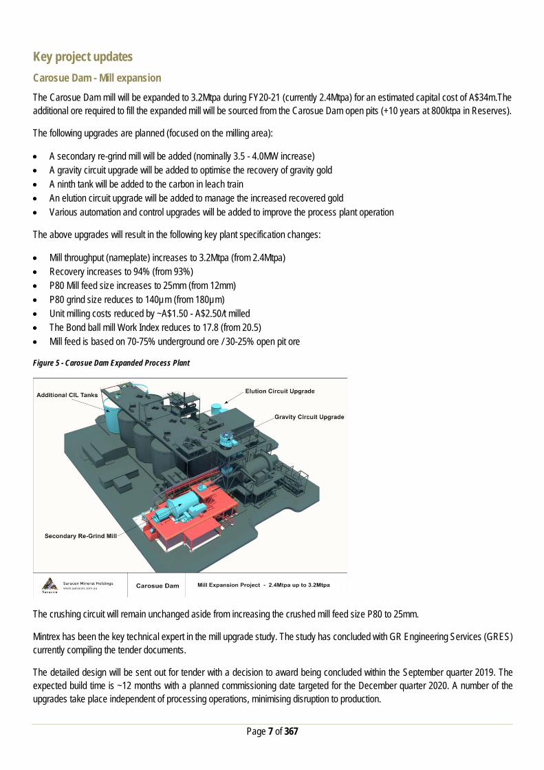
Figure 5 - Carosue Dam Expanded Process Plant
The crushing circuit will remain unchanged aside from increasing the crushed mill feed size P80 to 25mm.
Mintrex has been the key technical expert in the mill upgrade study. The study has concluded with GR Engineering Services (GRES) currently compiling the tender documents.
The detailed design will be sent out for tender with a decision to award being concluded within the September quarter 2019. The expected build time is ~12 months with a planned commissioning date targeted for the December quarter 2020. A number of the upgrades take place independent of processing operations, minimising disruption to production.
Page 8 of 367
Carosue Dam - Open pit mining
Open pit mining is planned to resume at Carosue Dam in FY21, with the development of the Million Dollar open pit utilising a single fleet mine plan. Open pit mining has not been conducted at Carosue Dam since mid-2015, when the prevailing gold price was ~A$1550/oz, ~A$500/oz below the spot price today.
The resumption of open pit mining at Carosue Dam coincides with the expansion of the Carosue Dam mill from its current nameplate of 2.4Mtpa to 3.2Mtpa during FY20-21. It is planned to fill the additional 800ktpa of mill capacity with open pit material. With 9Mt in Reserves, the open pits can supply the additional 800ktpa for more than 10 years.
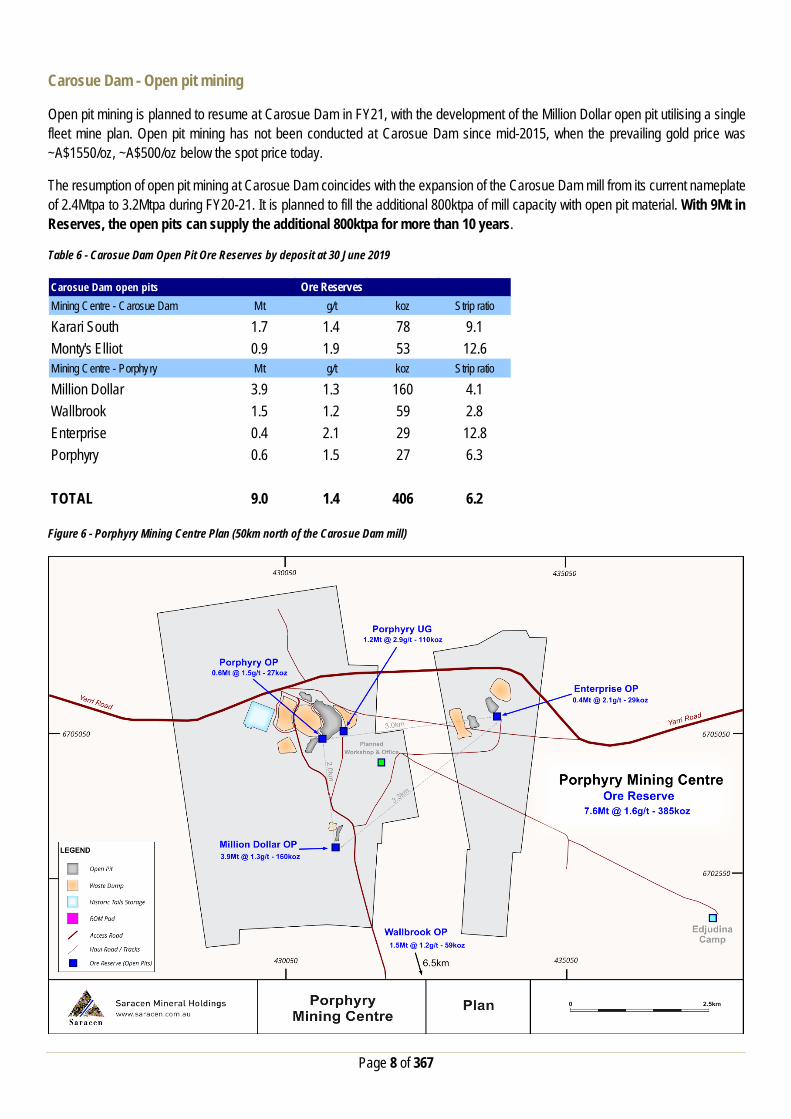
Table 6 - Carosue Dam Open Pit Ore Reserves by deposit at 30 June 2019
Figure 6 - Porphyry Mining Centre Plan (50km north of the Carosue Dam mill)
Carosue Dam open pitsMining Centre - Carosue Dam Mt g/t koz Strip ratio
Karari South 1.7 1.4 78 9.1Monty's Elliot 0.9 1.9 53 12.6Mining Centre - Porphyry Mt g/t koz Strip ratio
Million Dollar 3.9 1.3 160 4.1Wallbrook 1.5 1.2 59 2.8Enterprise 0.4 2.1 29 12.8Porphyry 0.6 1.5 27 6.3
TOTAL 9.0 1.4 406 6.2
Ore Reserves
Page 9 of 367
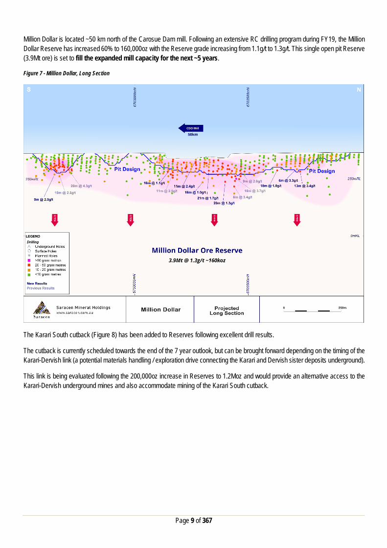
Million Dollar is located ~50 km north of the Carosue Dam mill. Following an extensive RC drilling program during FY19, the Million Dollar Reserve has increased 60% to 160,000oz with the Reserve grade increasing from 1.1g/t to 1.3g/t. This single open pit Reserve (3.9Mt ore) is set to fill the expanded mill capacity for the next ~5 years.
Figure 7 - Million Dollar, Long Section
The Karari South cutback (Figure 8) has been added to Reserves following excellent drill results.
The cutback is currently scheduled towards the end of the 7 year outlook, but can be brought forward depending on the timing of the Karari-Dervish link (a potential materials handling / exploration drive connecting the Karari and Dervish sister deposits underground).
This link is being evaluated following the 200,000oz increase in Reserves to 1.2Moz and would provide an alternative access to the Karari-Dervish underground mines and also accommodate mining of the Karari South cutback.

Page 10 of 367
Figure 8 - Carosue Dam Mining Centre Plan
The open pit mining method assumed in the Reserve estimation is the same that is currently employed at Thunderbox, which utilises industry standard drill and blast techniques, single excavator and open pit trucking fleet. The gold price assumption for all open pit Reserve estimation remains unchanged at A$1,600/oz.

Page 11 of 367
Carosue Dam - Underground mining
The Karari-Dervish Ore Reserve has increased to 1.2Moz, up 20% from 1.0Moz at June 30 2018 (despite depletion of 150koz).
During FY19 an aggressive drill program was completed which saw a total of 107,917m drilled, for a total investment of A$17m. This represents a compelling cost of conversion of A$48/oz.
The Paste Plant was commissioned in the June quarter 2019, with paste fill now consistently being delivered underground in-line with nameplate capacity and specification. This A$23m investment will ensure optimum extraction of the Reserve.
Figure 9 - Karari - Dervish Long Section, Underground Ore Reserve
Grades continue to increase at depth, with the increase in ounces per vertical metre to be fully exploited with the addition of paste fill at Karari.
Page 12 of 367
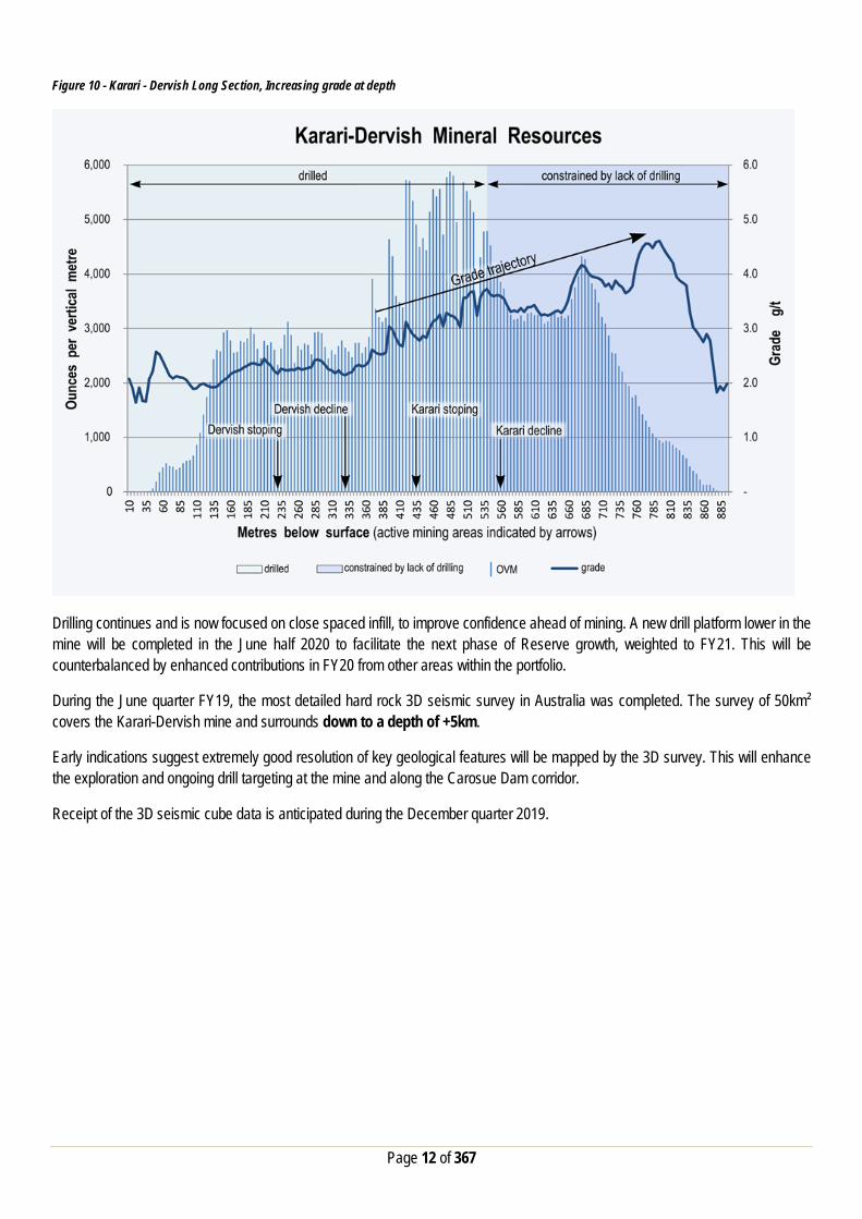
Figure 10 - Karari - Dervish Long Section, Increasing grade at depth
Drilling continues and is now focused on close spaced infill, to improve confidence ahead of mining. A new drill platform lower in the mine will be completed in the June half 2020 to facilitate the next phase of Reserve growth, weighted to FY21. This will be counterbalanced by enhanced contributions in FY20 from other areas within the portfolio.
During the June quarter FY19, the most detailed hard rock 3D seismic survey in Australia was completed. The survey of 50km² covers the Karari-Dervish mine and surrounds down to a depth of +5km.
Early indications suggest extremely good resolution of key geological features will be mapped by the 3D survey. This will enhance the exploration and ongoing drill targeting at the mine and along the Carosue Dam corridor.
Receipt of the 3D seismic cube data is anticipated during the December quarter 2019.

Page 13 of 367
Thunderbox - Underground mining Saracen is pleased to announce an updated 710,000 ounce Reserve at the Thunderbox Underground project.
The Reserve resulted from an Entech Pty Ltd (Entech) led Feasibility Study (FS) on the potential for a bulk underground operation at Thunderbox.
Table 7 - Thunderbox Underground, Key metrics*
* Production target that contains 92% Ore Reserves and 8% Inferred Mineral Resources. There is a lower level of confidence associated with Inferred Mineral Resources and there is no certainty that further exploration work will result in the conversion to Indicated Mineral Resource or that the Production Target itself will be realised. The 8% Inferred Mineral Resources are not included in Saracen’s new 7 year production outlook (Figure 1). Figure 11 - Thunderbox Long Section, Underground (and C / D Zone open pit)
Key metrics
- Development ore mined Mt 1.0- Development mine grade g/t 1.9- Stope ore mined Mt 11.1- Stope mine grade g/t 2.0
Total ore mined Mt 12.0Mine grade g/t 2.0
Contained gold koz 773Metallurgical recovery % 94Recovered gold koz 727

Page 14 of 367
Figure 12 - Thunderbox Cross Section, Underground
Mining
The FS selected an appropriate mining method, based on orebody geometry, grade and geotechnical parameters. The study built upon the 2017 PFS along with field evidence gained in the past two years including extensive Resource and geotechnical drilling, underground development in A Zone (including ore driving, batch treatment of underground ore through the Thunderbox mill) and ongoing mining of the C Zone Open Pit.
Sub Level Open Stoping (SLOS) has been selected for the wider sections of the A Zone and C Zone orebodies utilising a bottom-up primary-secondary mining sequence. The use of cemented paste fill in primary and secondary stopes has been applied to maximise recovery of the orebody and optimise capital development. Production down holes will be utilised over the 35m sublevel spacing.
SLOS was selected over the sublevel caving method contemplated in the 2017 Pre-Feasibility Study (PFS) due to lower technical risk, lower execution risk, lower capital costs and less mining dilution (lower grade risk). SLOS also provides more selectivity / optionality to future changes to gold prices and / or operating costs.
Long Hole Open Stoping (LHOS) has been selected for the upper section of the A Zone orebody. This mining method is safe, efficient and widely employed by the Western Australian mining industry (including at Carosue Dam). Recovery of the orebody is maximised, and mining dilution is minimised with this flexible method. A level spacing of 25m (floor to floor) has been applied in a top-down mining sequence retreating to the level access.
A sublevel spacing of 35m has been applied within the primary-secondary mining areas, with stoping spans limited to 25m along strike. Stope thickness (across the strike of the orebody) will be limited to 30m and mined in two passes where the orebody thickness exceeds this threshold.
Several independent stoping panels have been created within the larger A Zone to provide greater productivity and flexibility for production. Stoping will be transverse or longitudinal, and generally in a bottom-up sequence (an opportunity afforded by the investment in accelerated decline development during FY19-20).

Page 15 of 367
Rock mass conditions are generally uniform across the deposit and are well suited to the mining methods selected for each of the mining areas. Dilution will be minimised by limiting stope sizes accordingly.
The assessment of paste fill has been conducted by backfill specialist Outotec Pty Ltd. The assessment included test work, strength and stability analyses, and cost estimation, for a mix design incorporating full-stream tailings. Saracen has successfully commissioned a similar paste fill plant at Carosue Dam in FY19.
Figure 13 - Mine design layout
Page 16 of 367
Processing
The currently operating Thunderbox CIL processing facility will treat the underground ore. The assumed metallurgical recovery of 94% is consistent with the performance of the A Zone and C Zone ore currently being treated through the facility (including A Zone development ore).
Capital and operating costs
Mining operating costs are estimated from first principles and contractor costs based on equipment, labour, development and stoping requirements indicated in the mine schedule.
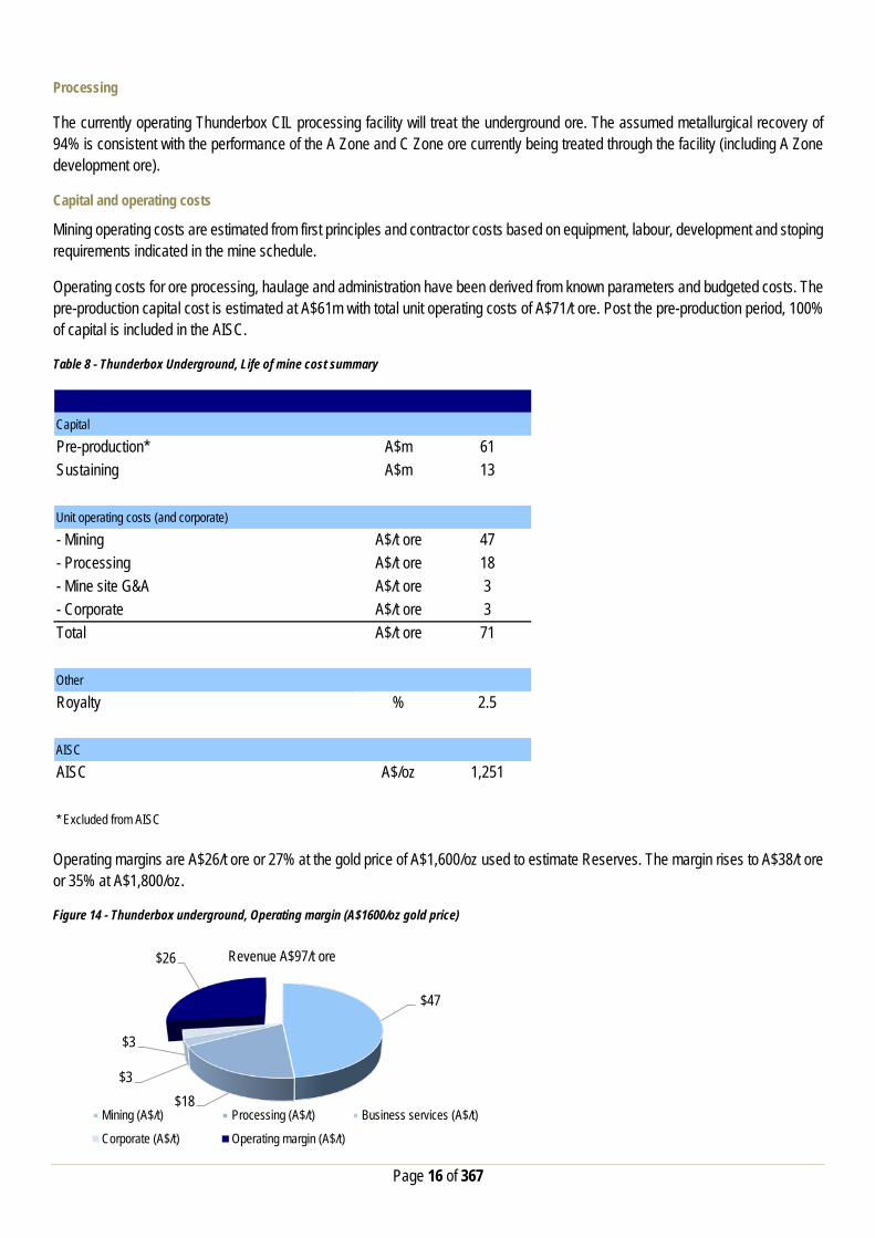
Operating costs for ore processing, haulage and administration have been derived from known parameters and budgeted costs. The pre-production capital cost is estimated at A$61m with total unit operating costs of A$71/t ore. Post the pre-production period, 100% of capital is included in the AISC.
Table 8 - Thunderbox Underground, Life of mine cost summary
Operating margins are A$26/t ore or 27% at the gold price of A$1,600/oz used to estimate Reserves. The margin rises to A$38/t ore or 35% at A$1,800/oz.
Figure 14 - Thunderbox underground, Operating margin (A$1600/oz gold price)
Capital
Pre-production* A$m 61Sustaining A$m 13
Unit operating costs (and corporate)
- Mining A$/t ore 47- Processing A$/t ore 18- Mine site G&A A$/t ore 3- Corporate A$/t ore 3Total A$/t ore 71
Other
Royalty % 2.5
AISC
AISC A$/oz 1,251
* Excluded from AISC
$47
$18 $3
$3
$26 Revenue A$97/t ore
Mining (A$/t) Processing (A$/t) Business services (A$/t)
Corporate (A$/t) Operating margin (A$/t)

Page 17 of 367
Mine schedule
Key physicals are presented below over a 7 year period.
Figure 15 - Thunderbox underground, Ore tonnes by zone, grade
Importantly Thunderbox remains a growth asset, open along strike and at depth.
Further drilling will aim to extend the mine life towards a potential +10 years. Potential conversion of the Inferred Resource immediately north of C Zone is just one example of further opportunities.
Thunderbox - C / D Zone open pit Surface drilling at D Zone returned a number of thick high grade intersections including 43m @ 3.7g/t, 73m @ 1.9g/t, 74m @ 1.6g/t and 43m @ 1.6g/t during FY19. The drilling further improved the confidence in the Resource.
As a result of the upgrade to the D Zone area Resource, the open pit Reserves remain unchanged at 9.7Mt @ 1.5g/t for 460,000oz (Figure 11). This is despite mining depletion from the C zone open pit of 155,000oz during FY19. The average remaining strip ratio of the Thunderbox C / D Zone open pit is 5.6.
It is planned that the Thunderbox underground (11Mt @ 2.0g/t for 710,000oz) mine will ramp up to ~2.0Mtpa. The remaining ~800ktpa of mill capacity will be filled by the Thunderbox C / D Zone, Kailis and Otto Bore open pits (11.4Mt @ 1.6g/t for 569,000oz), supporting a progressive production profile up to ~170,000oz pa over the next 7 years (100% already in Reserve).
The inclusion of Kailis and Otto Bore assists mill throughput and unit costs due to the very soft nature of the ore. Blending of soft ore into the mill feed will support the current milling rate of ~2.8Mtpa (12% higher than nameplate).
The open pit mining method assumed in the Reserve estimation is the same that is currently employed at Thunderbox, which utilises industry standard drill and blast techniques, excavator and open pit trucking fleet. The gold price assumption for all open pit Reserve estimation purposes remained unchanged at A$1,600/oz.
0.0
0.5
1.0
1.5
2.0
2.5
0.0
0.5
1.0
1.5
2.0
2.5
FY21F FY22F FY23F FY24F FY25F FY26F FY27F
g/t
Mt or
e
A Zone C Zone Mine Grade

Page 18 of 367
FY20 growth capital and exploration guidance Growth capital FY20 growth capital guidance of A$112 million enables Saracen to capitalise on the increased Reserves by growing production to 400,000oz per annum whilst continuing to “future proof” the business through initiatives such as accelerated decline development (well in advance of the stoping front). Table 9 - FY20 growth capital guidance
This growth capital guidance is net of revenue realised from gold sales relating to these initiatives or from pre-commercial production.
Exploration
The increased exploration spend in recent years has delivered global-leading growth, with Reserves doubling over the past three years (after mining depletion). Figure 16 - Track record of exploration investment delivering growth
This track record of success (FY19 discovery cost of A$30 per Reserve oz) has motivated FY20 exploration guidance of A$50m.
Corporate Structure:
Item A$mCarosue Dam- Mill expansion 18- Underground development 33- Open pit development 6- Capital works 16Total 73Thunderbox- Underground development 9- Open pit development 23- Capital works 7Total 39GROUP TOTAL 112
0
10
20
30
40
50
60
0.0
0.5
1.0
1.5
2.0
2.5
3.0
3.5
4.0
2008 2009 2010 2011 2012 2013 2014 2015 2016 2017 2018 2019
Explo
ratio
n sp
end (
$m) -
Line
Ore R
eser
ve (o
z) -B
ars

Page 19 of 367
Ordinary shares on issue: 831.4m Unvested employee performance rights: 17.3m
Market Capitalisation: A$3.4b (share price A$4.19)
Cash, bullion and investments (30 June): A$154.5m
Debt: Nil
Substantial Shareholders: Van Eck Global 12.1% BlackRock Group 9.2%
For further information please contact:
Investors: Media Enquiries: Troy Irvin Read Corporate Corporate Development Officer Paul Armstrong / Nicholas Read Email: [email protected] Email: [email protected] Contact (08) 6229 9100 Contact: (08) 9388 1474
Competent Person Statements The information in the report to which this statement is attached that relates to Exploration Results and Mineral Resources related to Gold is based upon information compiled by Mr Daniel Howe, a Competent Person who is a member of The Australasian Institute of Mining and Metallurgy and the Australian Institute of Geoscientists. Daniel Howe is a full-time employee of the Company. Daniel Howe has sufficient experience that is relevant to the style of mineralisation and type of deposit under consideration and to the activity being undertaken to qualify as a Competent Person as defined in the 2012 Edition of the ‘Australasian Code for Reporting of Exploration Results, Mineral Resources and Ore Reserves’. Daniel Howe consents to the inclusion in the report of matters based on his information in the form and context in which it appears.
The information in the report to which this statement is attached that relates to Exploration Results and Mineral Resources related to Nickel is based upon information compiled by Mr Lynn Widenbar, a Competent Person who is a member of The Australasian Institute of Mining and Metallurgy. Lynn Widenbar is a consultant to Saracen Mineral Holdings. Lynn Widenbar has sufficient experience that is relevant to the style of mineralisation and type of deposit under consideration and to the activity being undertaken to qualify as a Competent Person as defined in the 2012 Edition of the ‘Australasian Code for Reporting of Exploration Results, Mineral Resources and Ore Reserves’. Lynn Widenbar consents to the inclusion in the report of matters based on his information in the form and context in which it appears. The information in the report to which this statement is attached that relates to underground Ore Reserves at Deep South, and Karari - Dervish is based upon information compiled by Stephen King, a Competent Person who is a member of The Australasian Institute of Mining and Metallurgy. Stephen King is a full-time employee of the Company. Stephen King has sufficient experience that is relevant to the style of mineralisation and type of deposit under consideration and to the activity being undertaken to qualify as a Competent Person as defined in the 2012 Edition of the ‘Australasian Code for Reporting of Exploration Results, Mineral Resources and Ore Reserves’. Stephen King consents to the inclusion in the report of matters based on his information in the form and context in which it appears. The information in the report to which this statement is attached that relates to all open pit Ore Reserves relating to Gold based upon information compiled by Hemal Patel, a Competent Person who is a member of The Australasian Institute of Mining and Metallurgy. Hemal Patel is a full-time employee of the Company. Hemal Patel has sufficient experience that is relevant to the style of mineralisation and type of deposit under consideration and to the activity being undertaken to qualify as a Competent Person as defined in the 2012 Edition of the ‘Australasian Code for Reporting of Exploration Results, Mineral Resources and Ore Reserves’. Hemal Patel consents to the inclusion in the report of matters based on his information in the form and context in which it appears.
The information in the report to which this statement is attached that relates to underground Ore Reserves at Thunderbox is based upon information compiled by Dan Donald, a Competent Person who is a member of The Australasian Institute of Mining and Metallurgy. Dan Donald is a consultant to Saracen Mineral Holdings through Entech Mining Consultants. Dan Donald has sufficient experience that is relevant to the style of mineralisation and type of deposit under consideration and to the activity being undertaken to qualify as a Competent Person as defined in the 2012 Edition of the ‘Australasian Code for Reporting of Exploration Results, Mineral Resources and Ore Reserves’. Dan Donald consents to the inclusion in the report of matters based on his information in the form and context in which it appears.
Mineral Resources and Ore Reserves – Other Material Information Summary A summary of all other material information pursuant to ASX Listing Rules 5.8 and 5.9 and JORC Code 2012 is provided below for each material Saracen mining projects. Material mining projects (significant projects) are, or likely to be, material in the context of the overall business operations or financial results of Saracen Mineral Holdings Pty Ltd. The assessment and reporting criteria in accordance with JORC Code 2012 for each of the Saracen Mineral Holdings projects is presented as an appendix to this announcement.

Page 20 of 367
Karari - Dervish Underground Ore Reserve Summary Material assumptions for Ore Reserve The following material assumptions apply to the Karari – Dervish Ore Reserves
• Gold Price of $1600 per ounce (unchanged) • Current operational capital and operating cost structures • Current operational mining and metallurgical performance • An allowance for 16% dilution has been applied and a mining recovery of 96%
Ore Reserve Classification
The classification of the Karari – Dervish Ore Reserve has been carried out in accordance with the recommendations of the JORC Code 2012. It is based on the density of drilling, estimation quality and the mining methods currently in operation.
The Probable Ore Reserves have been derived from Measured and Indicated Mineral Resources respectively.
Mining Method
The Karari - Dervish underground Ore Reserve has been estimated using detailed mine development and stope designs.
The current Whirling Dervish mine design allows for 20% to 30% of the resource to remain in-situ, as either rib or sill pillars. The overall extraction ratio of this portion of the mineral resources is approximately 75%. The current Karari mine design allows for paste fill to be used throughout the mine design and therefore the overall extraction ratio of this portion of the mineral resources is approximately 96%. Some mining of remnant pillars has been included in the mine design. Standard underground infrastructure is currently operational; this includes a decline for access and truck haulage, ventilation fans, escape-way ladders, electrical reticulation, mine services (air and water), and mine dewatering infrastructure.
Processing Method
The ore reserve will be treated at the established Carosue Dam processing facility. The Carosue Dam Process Plant is a CIL cyanide leach plant incorporating a gravity circuit which is appropriate for the extraction of gold from free milling gold ores.
An average plant processing recovery of 93% has been assumed in the Ore Reserve Estimate which is consistent with current and historical plant recoveries for Karari - Dervish ore which is currently being processed. Cut-off Grade
For the purpose of Ore Reserve Estimate an operating cut-off grade of 1.4g/t was calculated based upon an assumed gold price of AUD$1,600/Oz and applicable mining production costs, processing, haulage and administration costs. This operating cut-off grade was then used as the basis of mine design. Subsequent production designs were then reviewed, and if required, lower grading stopes were removed from the design. The resulting mine grade’s, allow for the cost of capital, all operating costs, plus a return on investment.
Estimation Methodology
Please refer to Mineral Resource section.
Material Modifying Factors
There are no material modifying factors that need to be highlighted with the Ore Reserve. Karari – Dervish is an operating underground mine. All regulatory leasing, approvals, licencing, agreements, contracts and current infrastructure are in place, which considers this estimation of higher confidence than that of a feasibility study.

Page 21 of 367
Karari South Open Pit Ore Reserve Summary Material assumptions for Ore Reserve The following material assumptions apply to the Karari South Ore Reserves
• Gold Price of $1600 per ounce • Current operational capital and operating cost structures • Current operational mining performance and metallurgical test work • An allowance for 14.0% dilution has been applied and a mining recovery of 96%
Ore Reserve Classification
The classification of the Karari South Ore Reserve has been carried out in accordance with the recommendations of the JORC Code 2012. It is based on the density of drilling, estimation quality and the mining methods currently in operation.
All Proven and Probable Ore Reserves have been derived from Measured and Indicated Mineral Resources respectively.
Mining Method
The mining method to be employed at the Karari South deposit is conventional open pit mining with a hydraulic excavator, dump truck fleet, and drill and blast activity. The class of excavator employed is similar to other current open pit mining operation, providing a good operating dataset for production and productivity rate measurement and financial modelling.
The Karari South Ore Reserve pit is designed as a cutback to existing mined pit in an appropriate manner to meet operational efficiencies and optimal production rates. A Life of mine Ore Reserve pit has been designed following appropriate geotechnical recommendations made by independent external consultant following site visits, inspection of drill core, and a review of the geotechnical data gathered during earlier operations.
Processing Method
The ore reserve will be treated at the established Carosue Dam processing facility. The Carosue Dam Process Plant is a CIL cyanide leach plant incorporating a gravity circuit which is appropriate for the extraction of gold from free milling gold ores.
An average gold recovery for the Karari deposit is estimated at 93.0%. The recovery estimation is based on met test work and ongoing long term actual average recovery data collected at the Carosue Dam Plant.
Cut-off Grade
For the purpose of the Ore Reserve estimate a marginal cut-off of 0.50g/t was applied based upon an assumed gold price of AUD$1,600/oz and operating costs of processing, haulage and general administration. A top cut has already been applied to the Mineral Resource Estimate eliminating the necessity for any further adjustment to the Ore Reserve Estimate.
Estimation Methodology
Please refer to Mineral Resource section.
Material Modifying Factors
The Karari – Dervish underground mine is currently in operation and all required Environment studies have been completed. All Statutory Government Approvals namely works approvals, dewatering and discharge licence have been granted. A new Mining Approval for open pit Ore Reserves will be required before mine development. The relevant Mining Approvals for all current underground Ore Reserves are in place.
Page 22 of 367
Deep South Underground Ore Reserve Summary Material assumptions for Ore Reserve The following material assumptions apply to the Deep South Ore Reserves
• Gold Price of $1600 per ounce (unchanged) • Current operational capital and operating cost structures • Current operational mining and metallurgical performance • An allowance for 20.0% dilution has been applied and a mining recovery of 95%.
Ore Reserve Classification
The classification of the Deep South Ore Reserve has been carried out in accordance with the recommendations of the JORC Code 2012. It is based on the density of drilling, estimation quality and the mining methods currently in operation.
The Probable Ore Reserves have been derived from Measured and Indicated Mineral Resources respectively.
Mining Method
The Deep South underground Ore Reserve has been estimated using detailed mine development and stope designs.
Underground mechanised mining for development, ground support, and production stoping is used at Deep South. Mining and geotechnical studies determined two mining methods; 1) open stoping with remnant pillars, and 2) Modified Avoca with rock-fill to be appropriate for the deposit. Open Stoping with remnant pillars has been successfully applied at Deep South, while Modified Avoca (using rock-fill) will be implemented within a localised area to increase the resource extraction ratio. A bottom up approach incorporating production down-holes has been designed. Similar methods are currently utilised at other underground mines at Carosue Dam Operations, and used throughout the Western Australian Goldfields and Australia.
Standard underground infrastructure is currently in care and maintenance; this includes a decline for access and truck haulage, ventilation fans, escape-way ladders, electrical reticulation, mine services (air and water), and mine dewatering infrastructure. This infrastructure can readily be re-activated.
Processing Method
The ore reserve will be treated at the established Carosue Dam processing facility. The Carosue Dam Process Plant is a CIL cyanide leach plant incorporating a gravity circuit which is appropriate for the extraction of gold from free milling gold ores.
An average plant processing recovery of 93% has been assumed in the Ore Reserve Estimate which is consistent with current and historical plant recoveries for Deep South ore which have previously been processed. Cut-off Grade
For the purpose of Ore Reserve Estimate a planning cut-off grade of 1.8g/t was calculated based upon an assumed gold price of AUD$1,600/Oz and applicable processing, haulage and administration costs. A top cut has already been applied to the Mineral Resource Estimate eliminating the necessity for any further adjustment to the Ore Reserve estimate.
Estimation Methodology
Please refer to Mineral Resource section.
Material Modifying Factors
Deep South is currently compliant with all legal and regulatory requirements. All approvals (clearing permit, works approval and Mining Proposals) have been granted for ongoing mining and processing at Carosue Dam.

Page 23 of 367
Million Dollar Open Pit Ore Reserve Summary Material assumptions for Ore Reserve The following material assumptions apply to the Million Dollar Ore Reserves
• Gold Price of $1600 per ounce (unchanged) • Current operational capital and operating cost structures • Current operational mining and metallurgical performance • An allowance for 21.0% dilution has been applied and a mining recovery of 93%
Ore Reserve Classification
The classification of the Million Dollar Ore Reserve has been carried out in accordance with the recommendations of the JORC Code 2012. It is based on the density of drilling, estimation quality and the mining methods currently in operation.
The Probable Ore Reserves have been derived from Measured and Indicated Mineral Resources respectively.
Mining Method
The mining method to be employed at Million Dollar will be conventional open pit mining with a hydraulic excavator, dump truck fleet, and drill and blast activity. The class of excavator employed is similar to other current open pit mining operations, providing a good operating dataset for production and productivity rate measurement and financial modelling.
The Million Dollar Reserve pit is designed to include series of successive cutbacks to achieve life of mine Reserve such that it meets the operation efficiency and production rate. Appropriate mine schedule and lead time have been applied to maintain efficient mining operations between the stages.
Processing Method
The ore reserve will be treated at the established Carosue Dam processing facility. The Carosue Dam Process Plant is a CIL cyanide leach plant incorporating a gravity circuit which is appropriate for the extraction of gold from free milling gold ores.
An average gold recovery for the Million Dollar deposit is estimated at 93.0%. The recovery estimation is based on met test work and ongoing long term actual average recovery data collected at the Carosue Dam Plant.
Cut-off Grade
For the purpose of the Ore Reserve estimate the cut-off grade of 0.70g/t was applied based upon an assumed gold price of AUD$1,600/oz and operating costs of processing, haulage and general administration. A top cut has already been applied to the Mineral Resource Estimate eliminating the necessity for any further adjustment to the Ore Reserve Estimate.
Estimation Methodology
Please refer to Mineral Resource section.
Material Modifying Factors
There are no material modifying factors that need to be highlighted with the Ore Reserve. A Mining Approval has been approved for the initial mine reserve pit, however a minor amendment will be required to accommodate a further proposed deeper and wider cutback. The existing Ore Reserve are all located on granted mining leases. The road haulage network footprint is underpinned by a combination of miscellaneous licences and granted mining leases. There is no reason to expect that the applications for variations to the current approvals for future mining will not be approved.

Page 24 of 367
Montys-Elliots Open Pit Ore Reserve Summary Material assumptions for Ore Reserve The following material assumptions apply to the Montys-Elliots Ore Reserves
• Gold Price of $1600 per ounce • Current operational capital and operating cost structures • Current operational mining performance and metallurgical test work • An allowance for 15% dilution has been applied and a mining recovery of 95%
Ore Reserve Classification
The classification of the Montys-Elliots Ore Reserve has been carried out in accordance with the recommendations of the JORC Code 2012. It is based on the density of drilling, estimation quality and the mining methods currently in operation.
The Probable Ore Reserves have been derived from Measured and Indicated Mineral Resources respectively.
Mining Method
The mining method to be employed at the Montys-Elliots deposit is conventional open pit mining with a hydraulic excavator, dump truck fleet, and drill and blast activity. The class of excavator employed is similar to other current open pit mining operation, providing a good operating dataset for production and productivity rate measurement and financial modelling.
The Ore Reserve pit is designed as a cutback to the existing mined pit along with two other unmined pits that will be scheduled in an appropriate manner to meet operational efficiencies and optimal production rates. The Life of mine Ore Reserve pit has been designed following appropriate geotechnical recommendations made by independent external consultant following site visits, inspection of drill core, and a review of the geotechnical data gathered during earlier operations.
Processing Method
The ore reserve will be treated at the established Carosue Dam processing facility. The Carosue Dam Process Plant is a CIL cyanide leach plant incorporating a gravity circuit which is appropriate for the extraction of gold from free milling gold ores.
An average gold recovery for Monty’s Dam is estimated at 93.0%. The recovery estimation is based on met test work and past actual average recovery data collected at the Carosue Plant. Metallurgical test work has been carried out on samples from the Montys-Elliot’s deposit, with recoveries in the range of 92-95% hence the estimated recovery is in line with expectation.
Cut-off Grade
For the purpose of the Ore Reserve estimate a marginal cut-off of 0.50g/t was applied based upon an assumed gold price of AUD$1,600/oz and operating costs of processing, haulage and general administration. A top cut has already been applied to the Mineral Resource Estimate eliminating the necessity for any further adjustment to the Ore Reserve Estimate.
Estimation Methodology
Please refer to Mineral Resource section.
Material Modifying Factors
All required Environment studies have been completed and Statutory Government Approvals namely works approvals, dewatering and discharge licences have been granted. A Mining Approval will be required to be submitted for the new mine Ore Reserve pit in timely manner such that it will be granted before commencement of mining. There is no reason to expect that applications for a new mining approval will not be approved.

Page 25 of 367
Porphyry Underground Ore Reserve Summary Material assumptions for Ore Reserve The following material assumptions apply to the Porphyry Ore Reserves
• Gold Price of $1600 per ounce (unchanged) • Prefeasibility level of mining study • Current operational capital and operating cost structures • Current operational mining and metallurgical performance • An allowance for 20.0% dilution has been applied and a production mining recovery of 80%.
Ore Reserve Classification
The classification of the Porphyry Ore Reserve has been carried out in accordance with the recommendations of the JORC Code 2012. It is based on the density of drilling, estimation quality and the mining methods currently in operation.
The Probable Ore Reserves have been derived from Measured and Indicated Mineral Resources respectively.
Mining Method
The Porphyry underground Ore Reserve has been estimated using detailed mine development and stope designs.
Underground mechanised mining for development, ground support, and production stoping is planned to be used at Porphyry. Mining and geotechnical studies determined two mining methods; 1) Jumbo Drift and Strip, and 2) Long hole open stoping with remnant in-situ pillars to be appropriate for the deposit. Both of these mining methods have been previously successfully applied at Porphyry. Similar methods are currently utilised at other underground mines throughout the Western Australian Goldfields and Australia.
Standard underground infrastructure has been included and will be developed as part of the mine design, including a decline for access and truck haulage, ventilation fans, escape-way ladders, electrical reticulation, mine services (air and water), and mine dewatering infrastructure. No specialised infrastructure is required to accommodate these methods of mining.
Processing Method
The Ore Reserve will be treated at the established Carosue Dam processing facility. The Carosue Dam Process Plant is a CIL cyanide leach plant incorporating a gravity circuit which is appropriate for the extraction of gold from free milling gold ores.
An average plant processing recovery of 93% has been assumed in the Ore Reserve Estimate which is consistent with current and historical plant recoveries for Porphyry ore which have previously been processed. Cut-off Grade
For the purpose of Ore Reserve Estimate a planning cut-off grade of 2.0g/t was calculated based upon an assumed gold price of AUD$1,600/Oz and applicable processing, haulage and administration costs. A top cut has already been applied to the Mineral Resource Estimate eliminating the necessity for any further adjustment to the Ore Reserve estimate. The 2019 Ore Reserve is based upon a prefeasibility level underground mining study. It includes a detailed mine design, various capital and operating inputs, costs of mining, surface haulage, processing, general administration and environment management related costs.
Estimation Methodology
Please refer to Mineral Resource section.
Material Modifying Factors
Porphyry is currently compliant with all legal and regulatory requirements. A Mining Approval will be required to be submitted for the new underground Ore Reserve in timely manner such that it will be granted before commencement of mining. There is no reason to expect that applications for a new mining approval will not be approved.

Page 26 of 367
Thunderbox Underground Ore Reserve Summary Material assumptions for Ore Reserve The following material assumptions apply to the Thunderbox Underground Ore Reserves
• Gold Price of $1600 per ounce (unchanged) • Entech (mining consultants) conducted a Feasibility Study (FS) for the Thunderbox Underground (TBUG) mine • Mining capital costs are estimated from first principles and contractor costs based on equipment, labour and development
requirements. Mining capital costs also consider ventilation, electrical and dewatering requirements • Current operational mining and metallurgical performance • Average mining dilution is 6%. Stope dilution has been applied as 0.5 m of dilution to the footwall and hanging wall at zero
grade. Any wall exposed to paste also incurs 0.5 m of dilution at zero grade, and a mining recovery of 92.4%
Ore Reserve Classification
The classification of the Thunderbox underground Ore Reserve has been carried out in accordance with the recommendations of the JORC Code 2012. It is based on the density of drilling, estimation quality and the mining methods currently in operation.
All Proven and Probable Ore Reserves have been derived from Measured and Indicated Mineral Resources respectively.
Mining Method
The Thunderbox underground Ore Reserve Estimate is based on a three-dimensional mine design, geotechnical numerical modelling, mine scheduling, and cost estimation.
The Thunderbox underground Ore Reserve is based on sub-level open stoping (SLOS) with paste fill, and long hole open stoping (LHOS) mining methods. The predominant mining method is SLOS, and accounts for 84% of the Ore Reserve estimate by tonnes. The SLOS zone, ranges in width from 5 m to 50 m, and dips at 75-80 degrees.
Paste fill test work, analysis, and cost estimation, has been conducted by Outotec Pty Ltd.
Standard underground infrastructure has been included in the mine design; this includes a decline for access and truck haulage, ventilation fans, escape-way ladders, electrical reticulation, mine services (air and water), and mine dewatering infrastructure.
Processing Method
The Ore Reserve will be treated at the established Thunderbox processing facility. The facility is a conventional crushing, gravity circuit, grind, and CIL (carbon in leach) plant and is appropriate for the extraction of gold from free milling mineralisation.
An average gold recovery for Thunderbox deposit is estimated at 93.0%. The recovery estimation is based on actual average recovery data collected and ongoing test work at Thunderbox plant. The plant performance is consistently between 92 to 94% while processing different ore material from a range of ore sources.
Cut-off Grade
For the purpose of Ore Reserve Estimate a planning cut-off grade of 1.5g/t was calculated based upon an assumed gold price of AUD$1,600/Oz and applicable processing, haulage and administration costs. A development cut-off grade of 0.4 g/t is applied. A top cut has already been applied to the Mineral Resource Estimate eliminating the necessity for any further adjustment to the Ore Reserve estimate. Estimation Methodology
Please refer to Mineral Resource section.
Material Modifying Factors
There are no material modifying factors that need to be highlighted with the Ore Reserve. Thunderbox open pit and underground (development) is an operating mine. All statutory government approvals namely; clearing permit, mining permit, project management and dewatering have been granted and in place for the Ore Reserve and processing plant at Thunderbox.

Page 27 of 367
Thunderbox Open Pit Ore Reserve Summary Material assumptions for Ore Reserve The following material assumptions apply to the Thunderbox Open Pit Ore Reserves
• Gold Price of $1600 per ounce (unchanged) • Current operational capital and operating cost structures • Current operational mining and metallurgical performance • An allowance for 14.0% dilution has been applied and a mining recovery of 96%
Ore Reserve Classification
The classification of the Thunderbox Ore Reserve has been carried out in accordance with the recommendations of the JORC Code 2012. It is based on the density of drilling, estimation quality and the mining methods currently in operation.
All Proven and Probable Ore Reserves have been derived from Measured and Indicated Mineral Resources respectively.
Mining Method
Mining method currently employed at Thunderbox is conventional open pit mining with a hydraulic excavator, dump truck fleet, and drill and blast activity. The class of excavator employed is similar to Saracen’s past and current open pit mining operations and provides good comparative data for production and productivity rate measurement and financial modelling.
Thunderbox Ore Reserve pit is currently in operation and designed to include a series of successive cutbacks to achieve life of mine Reserve such that it meets the operation efficiency and production rate. Appropriate mine schedules and lead time have been applied to maintain efficient mining operations between the stages.
Processing Method
The Ore Reserve will be treated at the established Thunderbox processing facility. The facility is a conventional crushing, gravity circuit, grind, and CIL (carbon in leach) plant and is appropriate for the extraction of gold from free milling mineralisation.
An average gold recovery for Thunderbox deposit is estimated at 93.0%. The recovery estimation is based on actual average recovery data collected and ongoing test work at Thunderbox plant. The plant performance is consistently between 92 to 94% while processing different ore material from a range of ore sources.
Cut-off Grade
For the purpose of Ore Reserve Estimate a planning cut-off grade of 0.5g/t was calculated based upon an assumed gold price of AUD$1,600/Oz and applicable processing, haulage and administration costs. A top cut has already been applied to the Mineral Resource Estimate eliminating the necessity for any further adjustment to the Ore Reserve estimate.
Estimation Methodology
Please refer to Mineral Resource section.
Material Modifying Factors
Thunderbox Ore Reserve is currently in operation and all required Environment studies have been completed prior to commencement. All statutory government approvals namely; clearing permit, mining permit, project management and dewatering have been granted and in place for the Ore Reserve pit and processing plant at Thunderbox.

Page 28 of 367
Otto Bore Open Pit Ore Reserve Summary Material assumptions for Ore Reserve The following material assumptions apply to the Otto Bore Ore Reserves
• Gold Price of $1600 per ounce • Current operational capital and operating cost structures • Current operational mining and metallurgical test work • An allowance for 16.0% dilution has been applied and a mining recovery of 94%
Ore Reserve Classification
The classification of the Otto Bore Ore Reserve has been carried out in accordance with the recommendations of the JORC Code 2012. It is based on the density of drilling, estimation quality and the mining methods currently in operation.
The Probable Ore Reserves have been derived from Measured and Indicated Mineral Resources respectively.
Mining Method
The mining method to be employed at the Otto Bore deposit is conventional open pit mining with a hydraulic excavator, dump truck fleet, and drill and blast activity. The class of excavator employed is similar to other current open pit mining operation, providing a good operating dataset for production and productivity rate measurement and financial modelling.
The Otto Bore Reserve pit is designed to include a series of successive cutbacks to achieve life of mine Reserve such that it meets the operation efficiency and production rate. Appropriate mine schedule and lead times have been applied to maintain efficient mining operations between the stages. A Life of mine Ore Reserve pit has been designed following appropriate geotechnical recommendations.
Processing Method
The Ore Reserve will be treated at the established Thunderbox processing facility. The facility is a conventional crushing, gravity circuit, grind, and CIL (carbon in leach) plant and is appropriate for the extraction of gold from free milling mineralisation.
An average gold recovery for Otto Bore deposit is estimated at 94%. The recovery estimation is based on met test work and ongoing long term actual average recovery data collected at Thunderbox Plant. The plant performance is consistent between 93 to 94% while processing similar types of ore.
Cut-off Grade
For the purpose of the Ore Reserve estimate a marginal cut-off of 0.50g/t was applied based upon an assumed gold price of AUD$1,600/oz and operating costs of processing, haulage and general administration. A top cut has already been applied to the Mineral Resource Estimate eliminating the necessity for any further adjustment to the Ore Reserve Estimate.
Estimation Methodology
Please refer to Mineral Resource section.
Material Modifying Factors
The mine is currently not in operation. All required environmental studies have been completed. Other Statutory Government Approvals will be required prior to mining commencing. The Otto Bore operation will be connected to the Thunderbox processing plant via site internal access haul roads. The Otto Bore operation will utilise the existing Thunderbox processing facility, TSF, and the accommodation village that are all located on granted mining leases.

Page 29 of 367
Karari - Dervish Mineral Resource Summary
Geology and Geological Interpretation The Karari-Dervish gold deposits are located in the Carosue Basin and are defined by an anastomosing system of ductile shear zones offset by late brittle faults within a volcaniclastic terrain of metasandstones and tuffs. Early stage intrusion by monzonites (ca. 2.6Ga) introduced an initial stage of potassic alteration to the volcaniclastic units followed by sodic, muscovite, hematite, and chlorite phases in a progressive sequence. Gold mineralisation is strongly associated with sodic alteration (quartz+albite+carbonate) of the host rock that was subsequently overprinted by hematite alteration. The Karari deposit sits in the hanging wall of the Osman/Footwall Fault, while Whirling Dervish is situated in the footwall of the fault zone approximately 1.5km apart.
Drilling Techniques
In the current resource area NQ2 (75.7mm) diamond drill holes are prevalent however HQ (96mm) has been undertaken previously. RC drilling largely defines the upper mineralisation but has also been used to pre-collar deep diamond holes from surface predominantly using a 133mm bit. Historically, both aircore (AC) and rotary air blast (RAB) holes have been drilled but are not used in the current Mineral Resource Estimate (MRE).
Sampling and Sub-sampling Techniques
The Karari-Dervish deposit has been sampled primarily by RC and diamond drill holes and underground face/wall chip sampling. While not included in the Mineral Resource Estimate AC and RAB have historically been utilised. RC chips are cone or riffle split and sampled to 1m intervals. Diamond core is NQ or HQ sized, cut into half core and sampled to 1m intervals or geological boundaries where necessary. Underground faces are chip sampled to geological boundaries with a 0.2m minimum and 1m maximum intervals. All methods are used to produce representative sample of less than 3 kg. Samples are crushed, dried and pulverised to a nominal 90% passing 75µm to produce a 40g or 50 g sub sample for analysis by FA/AAS.
Estimation Methodology
Mineralisation is domained and wireframed based on geological continuity. Lode wireframes are intersected with a validated drill database from which all RAB, air core, and erroneous drill holes have been removed. All remaining diamond, RC and face samples are flagged with a domain identifier and composited to 1m with 0.3m minimum sample. Residual samples are distributed across adjacent component intervals. Composites are analysed for population outliers by domain and topcut proximal to population disintegration. Internal populations are controlled by grade indicators based on inflexion points derived from domain log probability plots from which indicator variograms are created. Categorical indicator kriging (CIK) is then used to sub-domain lodes with mixed populations. The block model used in the CIK estimation has blocks set at 1x2x1m to ensure sub-domain complexity is maintained then optimised and re-blocked to the parent block size of 5x10x5m. This model is then used to back flag the composite file with the defined sub-domain identifiers. Variography is created for all domains and sub-domains with sufficient sample data. Output variograms are utilised in kriging neighbourhood analysis (KNA) to generate optimum parent block sizes and estimation parameters. Domains and sub-domains are estimated using ordinary kriging utilising the estimation parameters defined in the KNA as inputs. Grade is estimated into parent blocks only and all kriging quality metrics and search pass values are output. The final ore model is then merged with a rock model containing all regolith, density, and depletion attributes.
Classification Criteria
The Karari-Dervish resource is classified as Measured, Indicated or Inferred based on a combination of physical and estimation quality metrics including mining exposure, drill spacing, search pass, kriging efficiency /slope, grade and geological continuity. Criteria defining Measured includes exposure by mining (open pit or development), drill spacing at <=20x20m’s, estimated in the first search pass, established grade and geological continuity, and >50% kriging efficiency and >80% slope. Indicated material is assigned where drill spacing is between 20x20m and 40x40m, search pass either 1 or 2, established grade and geological continuity, positive kriging efficiency and >50% slope. Inferred material is drill spacing between 40x40m and 80x80m’s with established geological continuity.
Cut-off grade(s) The open pit resource is reported at a 0.5g/t cut-off due to the bulk mining method assumed whereas the underground resource is reported at a 1.3g/t cut-off representing approximate break even for the long hole stoping method assumed.
Mining and Metallurgical Methods The deposit is currently being extracted via underground mining methods. Current reconciled production is sitting at 93% recovery.

Page 30 of 367
Montys – Elliot’s Mineral Resource Summary
Geology and Geological Interpretation The deposits are hosted in a sequence of volcaniclastic sandstones and porphyritic units, with mineralisation associated with quartz stockwork veining adjacent to the porphyritic contacts. Lodes mostly dip at 65-70° with hematite alteration typically accompanying mineralisation. Domains are defined by a combination of lithology, alteration, colour, and textures in conjunction with anomalous grade.
Drilling Techniques
The resource area is predominantly defined by reverse circulation (RC) drilling using a 143mm bit interspaced with NQ (75.7mm) sized diamond drill holes. Historically, both aircore (AC) and rotary air blast (RAB) holes have been drilled but are not used in the current Mineral Resource Estimate (MRE).
Sampling and Sub-sampling Techniques
The Monty’s Elliot deposit has been sampled primarily by RC and diamond drill holes. While not included in the MRE, AC and RAB have historically been utilised. RC chips are cone or riffle split and sampled to 1m intervals. Diamond core is cut into half core and sampled to 1m intervals or geological boundaries where necessary. All diamond holes are oriented using an Ezi-mark tool. All methods are used to produce representative sample of less than 3 kg. Samples are crushed, dried and pulverised to a nominal 90% passing 75µm to produce a 40g or 50 g sub sample for analysis by FA/AAS.
Estimation Methodology
Mineralisation is domained and wireframed based on geological continuity. Lode wireframes are intersected with a validated drill database from which all RAB, air core, and erroneous drill holes have been removed. All remaining diamond and RC samples are flagged with a domain identifier and composited to 1m with 0.3m minimum sample. Residual samples are distributed across adjacent component intervals. Composites are analysed for population outliers by domain and topcut proximal to population disintegration. Many of the principal lodes exhibit bimodel grade populations. These internal populations are controlled by grade indicators based on inflexion points derived from domain log probability plots from which indicator variograms are created. Categorical indicator kriging (CIK) is then used to sub-domain lodes with mixed grade populations. The block model used in the CIK estimation has blocks set at 1x2x1m to ensure sub-domain complexity is maintained then optimised and re-blocked to the parent block size of 5x10x5m. This model is then used to back flag the composite file with the defined sub-domain identifiers. Variography is created for all domains and sub-domains with sufficient sample data. Output variograms are utilised in kriging neighbourhood analysis (KNA) to generate optimum parent block sizes and estimation parameters. Domains and sub-domains are estimated using ordinary kriging utilising the estimation parameters defined in the KNA as inputs. Grade is estimated into parent blocks only and all kriging quality metrics and search pass values are output. Hard boundaries are maintained across domains and sub-domains. The final ore model is then merged with a rock model containing all regolith, density, and depletion attributes.
Classification Criteria
The Monty’s Elliot resource is classified as Measured, Indicated or Inferred based on a combination of physical and estimation quality metrics including mining exposure, drill spacing, search pass, kriging efficiency /slope, grade and geological continuity. Mineralisation has been categorised as Measured if it has been exposed by mining. Indicated material is assigned if drill spacing is between 20x20m and 40x40m, search pass either 1 or 2, established grade and geological continuity, positive kriging efficiency and >50% slope. Inferred material is drill spacing between 40x40m and 80x80m’s with established geological continuity. All other mineralisation is assigned a Potential resource category.
Cut-off grade(s) The open pit resource is reported at a 0.5g/t cut-off representing approximate break even for the bulk open pit mining method assumed.
Mining and Metallurgical Methods The deposit will likely be extracted via open pit mining. Current metallurgical test work indicates average recoveries of 92% to 94.5% with a gravity component recorded at 77%.
Million Dollar Mineral Resource Summary
Page 31 of 367
Geology and Geological Interpretation Gold mineralisation at Million Dollar is primarily hosted within a syeno-monzonite granitoid unit as shallow dipping (30°) stacked en echelon quartz veins within a braided shear system. Secondary mineralisation exists at the margins of the granitoid units in interpreted strain shadows and as minor cross linking structures between the main lodes. Higher grades are largely associated with albite-silica-hematite alteration and pyrite mineral assemblages in concert with shear parallel quartz-pyrite veining.
Drilling Techniques
The resource area is predominantly defined by reverse circulation (RC) drilling using a 133mm bit interspaced with NQ2 (75.7mm) and HQ (96mm) sized diamond drill holes. Historically, both aircore (AC) and rotary air blast (RAB) holes have been drilled but are not used in the current Mineral Resource Estimate (MRE).
Sampling and Sub-sampling Techniques
The Million Dollar deposit has been sampled primarily by RC and diamond drill holes. While not included in the MRE, AC and RAB have historically been utilised. RC chips are cone or riffle split and sampled to 1m intervals. Diamond core is NQ2 or HQ sized, cut into half core and sampled to 1m intervals or geological boundaries where necessary. All diamond holes are oriented using an Ezi-mark tool. All methods are used to produce representative sample of less than 3 kg. Samples are crushed, dried and pulverised to a nominal 90% passing 75µm to produce a 40g or 50 g sub sample for analysis by FA/AAS.
Estimation Methodology
Mineralisation is domained and wireframed based on geological continuity. Lode wireframes are intersected with a validated drill database from which all RAB, air core, and erroneous drill holes have been removed. All remaining diamond and RC samples are flagged with a domain identifier and composited to 1m with 0.3m minimum sample. Residual samples are distributed across adjacent component intervals. Composites are analysed for population outliers by domain and topcut proximal to population disintegration. Many of the principal lodes exhibit bimodel grade populations. These internal populations are controlled by grade indicators derived from inflexion points in domain log probability plots from which indicator variograms are created. Categorical indicator kriging (CIK) is then used to sub-domain lodes with mixed populations. The block model used in the CIK estimation has blocks set at 2x2x1m to ensure sub-domain complexity is maintained then optimised and re-blocked to the parent block size of 10x10x5m. This model is then used to back flag the composite file with the defined sub-domain identifiers. Variography is created for all domains and sub-domains with sufficient sample data. Output variograms are utilised in kriging neighbourhood analysis (KNA) to generate optimum parent block sizes and estimation parameters. Grade is estimated into parent blocks only and all kriging quality metrics and search pass values are output. Hard boundaries are maintained across domains and sub-domains. The final ore model is then merged with a rock model containing all regolith, density, and depletion attributes.
Classification Criteria
The Million Dollar MRE is classified as Measured, Indicated or Inferred based on a combination of physical and estimation quality metrics including mining exposure, drill spacing, search pass, kriging efficiency /slope, grade and geological continuity. The MRE has been classified as Measured if it has been exposed by mining. Indicated material is assigned where drill spacing is between 20x20m and 40x40m, search pass either 1 or 2, established grade and geological continuity, positive kriging efficiency and >50% slope. Inferred material is drill spacing between 40x40m and 80x80m’s with established geological continuity. All other mineralisation is assigned a Potential resource category.
Cut-off grade(s) The open pit resource is reported at a 0.5g/t cut-off representing approximate break even for the bulk open pit mining method assumed.
Mining and Metallurgical Methods The deposit will likely be extracted via open pit mining. Metallurgical testing of RC composites of oxide and transitional ores identified leach recoveries between 92% - 96% with a high gravity gold component (70% - 80%).

Page 32 of 367
Deep South Mineral Resource Summary
Geology and Geological Interpretation Deep South lies on the eastern margin of the Norseman – Wiluna greenstone belt. This belt is differentiated into numerous structural-stratigraphic domains separated by major regional structures, with Deep South located within the narrow NNW trending Linden Domain. The lithology comprises metasedimentary and felsic volcaniclastic rocks with an ultramafic and high magnesium basalt layer. Mineralisation occurs in two loads concordant to geology, the Butler and Scarlett lodes, and is confined between layered metasedimentary and felsic volcaniclastic units on both the hangingwall and footwall. The two lodes are separated by a high magnesium basalt and an ultramafic unit. The Butler lode is located in the hangingwall and is strongly silica and pyrrhotite-pyrite altered, and well laminated (appearing like a BIF within the oxidise portion). The contrasting physical properties of this unit to the surrounding unit have created fluid pathways and traps, as well as the high iron content of the unit providing a chemical trap, for gold deposition. The Scarlett lode is strongly weathered in the upper oxide portion to a gossanous material comprising hematite, goethite and quartz fragments. Weathering at Deep South has been preferential along Scarlett. The interpretation has been based on extensive geological logging of drill core, RC chips, underground development face chips, detailed open pit and underground mapping and assay data. The main mineralised Scarlett Lode has been confined to the geologically logged carbonate unit. Similarly the Butler lode has been defined by a highly siliceous BIF horizon. Mineralisation and lithology are both highly continuous. The stratigraphic horizons that host the mineralisation extend over a length of 15km. Grade is affected by the presence of sulphides and quartz carbonate veining. A northerly plunge in both lodes is thought to be controlled by subtle changes in strike or continuity of mineralisation at boudin neck margins. A conjugate mineralised shoot plunging to the south appears to be evident in the Scarlett lode and has been interpreted as the intersection of deposit scale shearing and lithology contacts. Drilling Techniques The deposit was initially sampled by 114 RAB holes, 211 RC holes (assumed standard 5 ¼ ‘’bit size) and 29 surface HQ and unknown diameter diamond core holes. Saracen has completed 17 surface RC precollars with NQ diamond tail drill holes (precollars averaging 185m, diamond tails averaging 360m) , 3 geotechnical surface diamond NQ drillholes, 57 RC holes from surface and 107 grade control RC holes within the pit. Underground sampling activities have included 652 NQ diamond drillholes and 1599 faces. Exploration of the broader Deep South area has included 312AC holes. Diamond tails were oriented using an Ezi-mark tool. Sampling and Sub-sampling Techniques
Sampling methods undertaken by Saracen at Deep South have included reverse circulation drillholes (RC), aircore drilling (AC), surface and underground diamond drillholes (DD), underground face chip sampling and RC grade control drilling within the pit. Sampling for diamond, face chip and RC drilling is carried out as specified within Saracen sampling and QAQC procedures as per industry standard. RC and UG face chips and diamond core provide high quality representative samples for analysis. RC chips are cone or riffle split and sampled into 1m intervals with total sample weights under 3kg. Diamond core is NQ sized, sampled to 1m intervals or geological boundaries where necessary and cut into half core to give sample weights under 3 kg. UG faces are chip sampled to geological intervals (0.2 to 1m). Samples are selected to weigh less than 3 kg to ensure total sample inclusion at the pulverisation stage. Sample Analysis Method Saracen core and chip samples are crushed, dried and pulverised to a nominal 90% passing 75µm to produce a 40g or 50 g sub sample for analysis by FA/AAS. Some grade control RC chips were analysed in the Saracen on site laboratory using a PAL (pulverise and leach) method. Estimation Methodology Block estimation has been completed in Datamine software using ordinary kriging methodology. All mineralised interval has been flagged using the interval selection tool in Leapfrog software, which were subsequently used to generate 3D mineralisation wireframes. The estimation uses these wireframes as hard boundaries except for the high grade sub-domain defined in the carbonate unit which is estimated using a soft boundary. Estimation of parent blocks are interpolated, and assigned to sub-cells. The maximum

Page 33 of 367
distance of extrapolation is less than 50m. Univariate statistical analysis of length weighted, (1m), domain coded downhole composites have been completed for all domains and top-cuts applied where applicable. Extreme grades are not common in the data set and all domains have been analysed individually to determine specific top-cut values. Variogram modelling was completed using Snowden’s Supervisor software defining the spatial continuity within the domains. The parameters determined from this analysis were used in the interpolation process. In order to deal with multiple populations within the carbonate unit in the grade control areas (areas drilled to a spacing 25m x 20m) sub-domaining was done using the Categorical Indicator technique which uses grade thresholds to segregate the different populations within the unit. Three subdomains include the, low grade (<1 g/t Au), medium grade (1<x=<9 g/t Au) and the high grade > 9 g/t Au. Two block sizes have been used in the resource model; a grade control (GC) block size at 5m(X) by 10m(Y) by 5m(Z) and resource block size at 10m(X) by 20m(Y) by 5m(Z). The Grade Control block size has been utilised in areas of drill density less than 20m by 20m and typically proximal to the open pit and/or underground development. The Resource block size has been used for all other areas. Parent blocks have been sub-celled to X (1m) by Y (1m) by Z (1m) to ensure that wireframe boundaries are honoured and preserve the location and geometry of the mineralisation. Search ranges have been informed by variogram modelling heavily influence by drill spacing, geological observations and high grade shoot geometry. Three search passes are used in the estimation to ensure that all the blocks are estimated within the respective estimation domains. Classification Criteria
The mineral resource has been classified into Measured, Indicated and Inferred categories based on drill hole spacing, geological confidence, and grade continuity and estimation quality. The combination of these factors together guide the digitising of a “cookie cutter” string in long section view which selects and codes the appropriate blocks with the nominated resource classification category.
All care has been taken to account for relevant factors influencing the mineral resource estimate. Confidence in the predicted tonnes and grade estimated in the model is high and previous mining performance suggests that the input data and geological continuity are such that a robust resource estimate can be achieved.
Cut-off grade(s) Based on Saracen’s current economic operations at Carosue Dam, and the natural grade distinction above background, a grade of 0.5g/t has been chosen.
Mining and Metallurgical Methods The Deep South deposit is amenable to mining by both open pit and underground methods. The deposit was successfully mined by open pit during 2012/2013. Underground mining extracting the mineralised positions via long hole open stoping commenced in December 2015. Deep South is currently being treated through the Carosue Dam treatment plant. Historical recovery has been around 85% reflecting the oxide component of the ore. Fresh material hauled from the active underground has a recovery of approximately 92%. The ore is relatively soft and the majority of the gold is free milling. The ore also has a predictable grind dependency / leach recovery relationship. Completed test work highlights that the ore is not chemically refractory and contains no preg robbing properties.

Page 34 of 367
Box Well Mineral Resource Summary
Geology and Geological Interpretation Locally the geology of the Box Well area consists of intermediate schists and igneous intrusives adjacent to sediments. Box Well is a silicified shear zone within a broader, gold mineralised, altered stockwork quartz veined package of felsic volcanics and volcaniclastic sediments. The gold mineralised zones dip consistently at 40 and 65 degrees to the east or north east. The mineralised widths vary between 3 – >30 metres true width. The generally thick and consistent nature of the mineralisation intersected to date indicates that limited dilution may be occur should an open pit mining operation be developed. Drilling to date has not indicated that the gold mineralisation develops a plunge orientation, however this remains a possibility. All available geological data including RC and DDH drilling has been used in the interpretation. It is understood that there are no known factors which would affect the geological continuity and grade. Drilling Techniques Drilling activities at Box Well initially included a number of RAB, RC and AC holes. The resource was further defined with 110 RC holes and 3 DD holes (unknown diameter). It is unknown if core was oriented. Sampling and Sub-sampling Techniques
Sampling methods undertaken at Box Well by previous owners have included aircore (AC) rotary air blast (RAB) reverse circulation (RC) and diamond (DD) drilling along with auger and soil sampling. Limited historical data has been provided by previous owners. Saracen has not carried out any sampling activities at the Box Well deposit due to only recently acquiring the deposit. RC chips were riffle split and sampled to 1m intervals with samples selected to weigh between 2.5 - 3.5 kg. Aircore and RAB drilling was spear sampled. Sampling methods for DD drilling are unknown. Sample Analysis Method Sampling was generally analysed via 30g or 50g fire assay. Estimation Methodology Block estimation has been completed in Surpac software using a combination ordinary kriging and inverse distance methods. A potential correlation between mineralisation and brecciation of a fine grained silicified felsic tuff and or lava unit is considered possible. A Block model cell sizes of 5 mE x 15 mN x 5 mZ was used. Variogram modelling completed using Snowdens Supervisor software. Models were generated on normal scores variograms and back transformed for use in Surpac. Modelling was completed on 1 Lode of 7 known lodes as it was the only lode with sufficient data to create a reasonable variogram model. Ore lodes with insufficient samples were estimated using Inverse Distance (squared) estimation techniques. Classification Criteria
The Box Well Mineral Resource was classified as either Indicated or Inferred based on a number of factors such as, distance to nearest sample number of samples used for estimation and estimation pass. In addition, an elevation boundary 100 m below surface (287 mRL) was used as a vertical constraint for Indicated material, based upon on both a lack of drillhole intercepts beyond this depth and achievable mining parameters - with open cut pits typically not exceeding 100 vertical metres. Cut-off grade(s) The open pit resource is reported at a 0.5g/t cut-off representing approximate break even for the bulk open pit mining method assumed.
Mining and Metallurgical Methods Open pit mining is proposed once the extent of the resource is fully understood. Minimal mining dilution is expected due to the broad nature of the ore lodes at Box Well. Saracen will soon commence a Scoping study to assess the economics of the project and how it could be incorporated into Saracen’s life of mine plan. No detailed metallurgical recovery work has been undertaken at this time at Box Well. Further work is ongoing to confirm that there are no deleterious properties at Box Well.

Page 35 of 367
Belize Mineral Resource Summary Geology and Geological Interpretation The Belize Project tenements are interpreted to consist of a west to east sequence of shales, cherty felsic metasediments, mafic and ultramafic rocks, and diorite to granodiorite dykes that abut against a strongly foliated monzogranite. Gold mineralisation at Belize area is hosted by steep west dipping, quartz-carbonate-pyrrhotite-magnetite veins within quartz rich metasediments and adjacent to lenticular ultramafic units. The mineralisation is analogous to that currently mined in the Saracen’s – Deep South Mine. The gold mineralised zone dips consistently at 70 and 80 degrees, to the west. The mineralised widths vary between 3 – 12 metres true width. All available geological data including RC and DDH drilling has been used in the interpretation. It is understood that there are no known factors which would affect the geological continuity and grade. Drilling Techniques Drilling activities at Belize initially included a number of RAB, RC and AC holes. The resource was further defined with 107 RC holes and 2 DD holes (unknown diameter). It is unknown if core was oriented. Sampling and Sub-sampling Techniques
Sampling methods undertaken at Belize by previous owners have included aircore (AC) rotary air blast (RAB) reverse circulation (RC) and diamond (DD) drilling along with auger and soil sampling. Limited historical data has been provided by previous owners. Saracen has not carried out any sampling activities at the Belize deposit due to only recently acquiring the deposit. RC chips were riffle split and sampled to 1m intervals with samples selected to weigh between 2.5 - 3.5 kg. Aircore and RAB drilling was spear sampled. Sampling methods for DD drilling are unknown. Sample Analysis Method Sampling was generally analysed via 30g or 50g fire assay with an AAS finish. Estimation Methodology Block estimation has been completed in Surpac software using a combination ordinary kriging and inverse distance methods. A Block model cell sizes of 5 mE x 12.5 mN x 5 mZ was used. Variogram modelling completed using Snowdens Supervisor software. Models were generated on normal scores variograms and back transformed for use in Surpac. Modelling was completed on 1 Lode of 6 known lodes as it was the only lode with sufficient data to create a reasonable variogram model. Ore lodes with insufficient sample were estimated using Inverse Distance (squared) estimation techniques. The variogram model for 1 Lode had two structures and was a nested-spherical model. Each lode was assessed individually for bias from extreme grades. Classification Criteria
The Belize Mineral Resource was classified as either Indicated or Inferred based on a number of factors such as, distance to nearest sample number of samples used for estimation and estimation pass. In addition, an elevation boundary 100 m below surface (303 mRL) was used as a vertical constraint for Indicated material, based upon on both a lack of drillhole intercepts beyond this depth and achievable mining parameters - with open cut pits typically not exceeding 100 vertical metres. Cut-off grade(s) The open pit resource is reported at a 0.5g/t cut-off representing approximate break even for the bulk open pit mining method assumed.
Mining and Metallurgical Methods Open pit mining is proposed once the extent of the resource is fully understood. Minimal mining dilution is expected due to the broad nature of the ore lodes at Belize. Saracen will soon commence a Scoping study to assess the economics of the project and how it could be incorporated into Saracen’s life of mine plan. No detailed metallurgical recovery work has been undertaken at this time at Belize. Further work is ongoing to confirm that there are no deleterious properties at Belize.

Page 36 of 367
Thunderbox Mineral Resource Summary Geology and Geological Interpretation Thunderbox is a mesothermal lode gold deposit located at the southern end of the Yandal greenstone belt in an area where several major shear zones converge and join with the Perseverance Fault.
The shear zone dips at 30° to 60° WSW, with the exception in the vicinity of the mineralisation, where the shear is vertical to steeply dipping. Mineralisation is hosted by strongly deformed, silicified and carbonate altered albite-quartz porphyry in the hangingwall of the shear zone. The shear juxtaposes foliated basalts and intrusive porphyries in the hangingwall against sedimentary rocks in the footwall. The zone of shearing is over 200m wide. An ultramafic unit occurs within the shear, in the footwall of the deposit and is attenuated along the shear.
The main gold related hydrothermal alteration assemblage comprises quartz-ankerite-arsenopyrite-pyrrhotite-galena and gold. This assemblage has been overprinted by a retrograde chlorite-epidote-white mica-biotite-quartz and pyrite assemblage. Syn-mineralisation veins have a continuum of vein textures ranging from laminated to pseudo-breccias.
Throughout the Thunderbox Deposit, elevated grades occur within southerly plunging ore shoots that are more evident in the lateral extents of the orebody. Whilst the shoots persist centrally, the gold distribution is for more uniform and ubiquitous than in other areas.
The Thunderbox geological interpretation is based on extensive geological logging of drill core, RC chips, detailed open pit mapping and assay data. The gross architecture of the deposit is simple and the interpretation is robust. The interpretations have been constructed using all available geological logging descriptions including but not limited to, stratigraphy, lithology, texture, and alteration. Interpreted cross cutting faults have been observed and have been use to guide disruptions in the position of the key mineralised domains.
Drilling Techniques
The deposit was initially sampled by 470 RAB holes. Further drilling included 306 RC holes (assumed standard 5 ¼ ‘’bit size) ,216 HQ, NQ and PQ diamond drillholes, approximately 15,400 blast holes and 2,400 RC grade control holes. Some diamond drilling carried out for geotechnical studies was oriented (the method is unknown), it is unknown if other core was oriented. Saracen completed 102 RC drillholes, 8 diamond geotechnical holes, 65 RC pre-collar diamond tail drillholes (pre-collars averaging 122m, diamond tails averaging 351m), 200 underground DD holes, 410 underground faces and 2437 RC grade control holes. The RC drilling was completed with a 5.5 inch diameter bit with a face sampling hammer. The rig was equipped with an external auxiliary booster. Diamond drilling was HQ or NQ diameter. Drill core was oriented utilising an ACT II core orientation tool
Sampling and Sub-sampling Techniques
Sampling methods undertaken by Saracen at Thunderbox include diamond drilling (DD), reverse circulation (RC) drilling and underground face chip sampling. RC chips are cone split and sampled into 4m or 1m intervals with total sample weights under 3kg Diamond core is NQ or HQ sized, sampled to 1m intervals or geological boundaries where necessary and cut into half core to give sample weights under 3 kg. Underground faces are chip sampled to geological boundaries (0.2-1m). Samples are selected to weigh less than 3 kg to ensure total sample inclusion at the pulverisation stage.
Sample Analysis Method Saracen core and chip samples are crushed, dried and pulverised to a nominal 90% passing 75µm to produce a 40g sub sample for analysis by FA/AAS. RC grade control drilling was used to obtain 1m samples from which 3 kg was pulverised to create a 50g charge for fire assay.
Estimation Methodology
Block estimation using a combination of ordinary kriging (OK) and categorical indicator kriging (CIK) has been completed in Datamine. CIK is utilised in all active mine areas and/or where the drill density (=<20m by 20m) supports the estimation method. All wireframes have been constructed in Leapfrog, which were used as hard boundaries for the estimations. Grade was estimated into parent blocks, meaning all the sub-cells within a parent cell assumed the grade of the parent cell. Univariate statistical analysis of length weighted (1m) domain coded downhole composites have been completed for all domains and top-cuts applied where applicable. Extreme grades are not common in the data set and all domains have been analysed individually to determine specific top-cut values.

Page 37 of 367
Due to the lack of extreme grades the top-cut process affects only 1-2% of the data. Variogram modelling was completed with Snowden’s Supervisor software. This measures the spatial variance of the gold grade within the domains. The parameters determined from this analysis were used in the interpolation process. The parent block sizes for the resource model are 5m(X) by 20m(Y) by 5m (Z). These are deemed appropriate for the majority of the resource, where drill spacing is in the order of 40m x 40m. Parent blocks have been sub-celled to 1m(X) by 2m(Y) by 1m(Y) to ensure that the wireframe boundaries are honoured and preserve the location and shape of the mineralisation.
Classification Criteria
The mineral resource has been classified into Measured, Indicated and Inferred categories based on drill hole spacing, geological confidence, and grade continuity and estimation quality. The combination of these factors together guide the digitising of a “cookie cutter” string in long section view which selects and codes the appropriate blocks with the nominated resource classification category.
All care has been taken to account for relevant factors influencing the mineral resource estimate. Confidence in the predicted tonnes and grade estimated in the model is high and previous mining performance suggests that the input data and geological continuity are such that a robust resource estimate can be achieved.
Cut-off grade(s) Based on Saracen’s current economic operations at Carosue Dam and Thunderbox, and the natural grade distinction above background, a grade of 0.5g/t Au has been chosen.
Mining and Metallurgical Methods The Thunderbox deposit is amenable to mining by both open pit and underground methods. The deposit has successfully been mined by open pit in the past between 2002 and 2007. Saracen is currently mining the C-Zone pit using Open pit methods and the A-Zone using underground methods. Beneath the mined C Zone pit is a portion of the mineral resource that has potential to be extracted by a bulk underground method. It has been discussed that in the thicker potions of the resource that an underground caving approach may be an efficient means of economic extraction. With supplementary traditional long hole stoping in areas with narrower widths.
The Thunderbox gold deposit consists of free milling gold which occurs as inclusions within, and at the rims of arsenopyrite crystals, and as free gold clusters within quartz-carbonate veins. The Thunderbox mine ore is processed at the onsite processing facility. The Thunderbox mill employs a conventional crushing, grinding and CIL leaching process to extract the gold. The mill operated successfully between 2002 and 2007, processing in excess of 9Mt of ore. The conventional plant displayed excellent performance with gold recoveries between 93.4 to 96.6 % over the life of the mine. Importantly it should be noted that no reduction in recoveries were observed when the ore changed from oxide-transitional into fresh rock. Saracen has been operating the Thunderbox plant since 2015 and recoveries have averaged 93%.

Page 38 of 367
Otto Bore Mineral Resource Summary Geology and Geological Interpretation The Otto Bore mineralised deposit is situated within a complex sequence of sheared basalts and felsic volcaniclastics. To north ultramafics occur as part of the stratigraphy. At depth mineralisation is typically associated with quartz veining and is more strongly developed at the rheological boundary between the sheared complex and the hangingwall and footwall units. The shear zone strikes roughly north-south and dips moderately (50-60degrees) to the west. NW trending structures cross cut the main shear and interplay positively with gold mineralisation. It is hypothesised that it’s the interaction of these cross cutting structures and/or the folded network within the shear zone that defines the well delineated southerly plunging shoots. Mineralisation has been well tested along a strike length of 650m.
The geological interpretation is based on extensive geological logging of drill core, xrf data, downhole structural data, RC chips, and assay data. The addition of diamond drill hole data and twinning of historic data has resulted in cross validation of the RC chips. This has led to improvements in geological consistency and knowledge. As such the confidence in the geological interpretation of the Otto Bore deposit has improved. The shear system hosting the deposit is understood at a deposit scale and there are other known gold mines associated with it on a regional scale. At a local scale, local variations suggest a folding network within the sheared package. Whilst this adds local complexity, it is not unfamiliar and is typical of the mineralised systems in this region.
Drilling Techniques Drilling activities at Otto Bore have included 31 AC holes, 748 RAB holes, 141 RC holes (assumed standard 5 ¼’’ bit size) and 4 DD holes (HQ and unknown diameter). Limited historic diamond core hole was oriented by unknown methods. Saracen completed 96 RC holes and 6 geotechnical DD holes. The RC drilling was completed with a 5.5 inch diameter bit with a face sampling hammer. The rig was equipped with an external auxiliary booster. Diamond drilling was HQ sized and orientated using an ACT 11 core orientation tool. Historical drilling is assumed completed to industry standard at that time. Sampling and Sub-sampling Techniques
Sampling methods undertaken by Saracen at Otto Bore include reverse circulation (RC) and diamond (DD) drillholes. Sampling methods undertaken at Otto Bore by previous owners have included aircore (AC), rotary air blast (RAB), RC and diamond drillholes (DD). RC chips are cone split and sampled into 1m intervals with total sample weights under 3kg. Diamond core is HQ sized, sampled to 1m intervals or geological boundaries where necessary and cut into half core to give sample weights under 3 kg.
Sample Analysis Method Saracen core and chip samples are crushed, dried and pulverised to a nominal 90% passing 75µm to produce a 40g sub sample for analysis by FA/AAS. More recent RAB and RC drilling has involved a total preparation sample protocol involving 4m composite or 1m samples from which a 50g charge is produced for aqua regia or fire assay digest and flame AAS finish.
Estimation Methodology Ordinary Kriging (OK) and Categorical Indicator Kriging (CIK) are used to estimate the Otto Bore Domains. CIK estimation is used in domains with good data support (<=20x20m spacing) and better defines the high and low grade populations than hard wireframe boundaries. All other domains with boarder sample spacing are estimated with OK. Datamine software was used to estimate gold into 5m x10m x5m size parent blocks and was supported by KNA. Drill grid spacing ranges from 20m to 50m, with the maximum distance of extrapolation at 30m for indicated material and 40m for inferred material. Drillhole sample data was flagged using domain codes generated from three dimensional mineralisation domains and oxidation surfaces. Sample data was composited to one metre downhole lengths. Over 90% of the sample intervals are 1m. Intervals with no assays were excluded from the compositing routine. The influence of extreme sample outliers was reduced by top-cutting where required. The top-cut levels were determined using a combination of top-cut analysis tools (grade histograms, log probability plots and CVs). Top-cuts were reviewed and applied on a domain basis. Variography was conducted in Snowden’s supervisor software.
A single block model for Otto Bore was constructed using a 5mE by 10mN by 5mRL parent block size with sub-celling to 1mE by 1mN by 1mRL for domain volume resolution. All estimation was completed at the parent cell scale. Kriging neighbourhood analysis was carried out for Otto Bore in order to optimise the block size, search distances and sample numbers used, (see sections above for drill spacing). Discretisation was set to 4 by 5 by 3 for all domains. The size of the search ellipse per domain was based on the gold variography. Three search passes were used for each domain. In general, the first pass used the ranges of the gold variogram and a minimum of 12 and maximum of 36 samples. In the second pass the search ranges were unchanged and the minimum
Page 39 of 367
samples reduced to 8 samples. The third pass ellipse was extended to 2 times the range of the gold variograms and the minimum number of 8 and a maximum of 32 samples were applied. A maximum of 4 samples per hole were used. In the majority of domains, most blocks were estimated in the first pass (particularly for the major domains); however, some more sparsely-sampled domains were predominantly estimated on the second or third pass. Un-estimated blocks, i.e. those outside the range of the third pass, were assigned the estimated domain mean and lower resource confidence classifications. Hard boundaries were applied between all estimation domains.
Classification Criteria
The mineral resource has been classified into Measured, Indicated and Inferred categories based on drill hole spacing, geological confidence, and grade continuity and estimation quality. The combination of these factors together guide the digitising of a “cookie cutter” string in long section view which selects and codes the appropriate blocks with the nominated resource classification category.
All care has been taken to account for relevant factors influencing the mineral resource estimate. Confidence in the predicted tonnes and grade estimated in the model is high and previous mining performance suggests that the input data and geological continuity are such that a robust resource estimate can be achieved.
Cut-off grade(s) For the purpose of the Ore Reserve estimate a marginal cut-off of 0.50g/t was applied based upon an assumed gold price of AUD$1,600/oz and operating costs of processing, haulage and general administration. A top cut has already been applied to the Mineral Resource Estimate eliminating the necessity for any further adjustment to the Ore Reserve Estimate.
Mining and Metallurgical Methods The resource model used in the Mineral Resource Estimation was the basis for the generation of a range of Whittle 4X pit optimisation shells. The generation of these shells was reliant upon costs and inputs derived from current operational data, contractors and independent consultant recommendations. An appropriate shell was then selected as the basis for an iterative process of pit design work, culminating in the finalisation of a detailed pit design for the Otto Bore Reserve. The mining method to be employed at the Otto Bore deposit is conventional open pit with hydraulic excavator and dump truck fleet, and drill and blast activity. The class of excavator employed is similar to other current open pit mining operation, providing a good operating dataset for production and productivity rate measurement and financial modelling. The Otto Bore Reserve pit is designed to include a series of successive cutbacks to achieve life of mine Reserve such that it meets the operation efficiency and production rate. Appropriate mine schedule and lead times have been applied to maintain efficient mining operations between the stages. The Ore Reserve will be treated at the established Thunderbox processing facility. The facility is a conventional crushing, gravity circuit, grind, and CIL (carbon in leach) plant and is appropriate for the extraction of gold from free milling mineralisation. The current processing plant and method applied utilises well tried and proven technology and since being in operation averages gold recoveries typically between 93 to 94% for all available different material types near Thunderbox operations. Metallurgical testwork has been carried out on samples from the Otto Bore deposit by a test lab, with suggested recoveries as high as 97% hence the estimated recovery is in line with expectation.
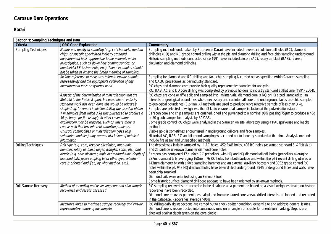
Page 40 of 367
Carosue Dam Operations Karari Section 1: Sampling Techniques and Data Criteria JORC Code Explanation Commentary Sampling Techniques Nature and quality of sampling (e.g. cut channels, random
chips, or specific specialised industry standard measurement tools appropriate to the minerals under investigation, such as down hole gamma sondes, or handheld XRF instruments, etc.). These examples should not be taken as limiting the broad meaning of sampling.
Sampling methods undertaken by Saracen at Karari have included reverse circulation drillholes (RC), diamond drillholes (DD) and RC grade control drilling within the pit, and diamond drilling and face chip sampling underground. Historic sampling methods conducted since 1991 have included aircore (AC), rotary air blast (RAB), reverse circulation and diamond drillholes.
Include reference to measures taken to ensure sample representivity and the appropriate calibration of any measurement tools or systems used
Sampling for diamond and RC drilling and face chip sampling is carried out as specified within Saracen sampling and QAQC procedures as per industry standard. RC chips and diamond core provide high quality representative samples for analysis. RC, RAB, AC and DD core drilling was completed by previous holders to industry standard at that time (1991- 2004).
Aspects of the determination of mineralisation that are Material to the Public Report. In cases where ‘industry standard’ work has been done this would be relatively simple (e.g. ‘reverse circulation drilling was used to obtain 1 m samples from which 3 kg was pulverised to produce a 30 g charge for fire assay’). In other cases more explanation may be required, such as where there is coarse gold that has inherent sampling problems. Unusual commodities or mineralisation types (e.g. submarine nodules) may warrant disclosure of detailed information
RC chips are cone or riffle split and sampled into 1m intervals, diamond core is NQ or HQ sized, sampled to 1m intervals or geological boundaries where necessary and cut into half core and underground faces are chip sampled to geological boundaries (0.2-1m). All methods are used to produce representative sample of less than 3 kg. Samples are selected to weigh less than 3 kg to ensure total sample inclusion at the pulverisation stage. Saracen core and chip samples are crushed, dried and pulverised to a nominal 90% passing 75µm to produce a 40g or 50 g sub sample for analysis by FA/AAS. Some grade control RC chips were analysed in the Saracen on site laboratory using a PAL (pulverise and leach) method. Visible gold is sometimes encountered in underground drillcore and face samples. Historical AC, RAB, RC and diamond sampling was carried out to industry standard at that time. Analysis methods include fire assay and unspecified methods.
Drilling Techniques Drill type (e.g. core, reverse circulation, open-hole hammer, rotary air blast, auger, Bangka, sonic, etc.) and details (e.g. core diameter, triple or standard tube, depth of diamond tails, face-sampling bit or other type, whether core is oriented and if so, by what method, etc.).
The deposit was initially sampled by 11 AC holes, 452 RAB holes, 496 RC holes (assumed standard 5 ¼ ‘’bit size) and 25 surface unknown diameter diamond core holes. Saracen has completed 17 surface RC precollars with HQ and NQ diamond tail drill holes (precollars averaging 287m, diamond tails averaging 168m) , 76 RC holes from both surface and within the pit ( recent drilling utilised a 143mm diameter bit with a face sampling hammer and an external auxiliary booster) and 3052 grade control RC holes within the pit. 948 NQ diamond holes have been drilled underground. 2545 underground faces and walls have been chip sampled. Diamond tails were oriented using an Ezi-mark tool. Some historic surface diamond drill core appears to have been oriented by unknown methods.
Drill Sample Recovery Method of recording and assessing core and chip sample recoveries and results assessed
RC sampling recoveries are recorded in the database as a percentage based on a visual weight estimate; no historic recoveries have been recorded. Diamond core recovery percentages calculated from measured core versus drilled intervals are logged and recorded in the database. Recoveries average >90%.
Measures taken to maximise sample recovery and ensure representative nature of the samples
RC drilling daily rig inspections are carried out to check splitter condition, general site and address general issues. Diamond core is reconstructed into continuous runs on an angle iron cradle for orientation marking. Depths are checked against depth given on the core blocks.

Page 41 of 367
Section 1: Sampling Techniques and Data Criteria JORC Code Explanation Commentary
UG faces are sampled from left to right across the face at the same height from the floor. During GC campaigns the sample bags weight versus bulk reject weight are compared to ensure adequate and even sample recovery. Historical AC, RAB, RC and diamond drilling to industry standard at that time.
Whether a relationship exists between sample recovery and grade and whether sample bias may have occurred due to preferential loss/gain of fine/coarse material.
There is no known relationship between sample recovery and grade for RC drilling. Diamond drilling has high recoveries due to the competent nature of the ground meaning loss of material is minimal. Any historical relationship is not known.
Logging Whether core and chip samples have been geologically and geotechnically logged to a level of detail to support appropriate Mineral Resource estimation, mining studies and metallurgical studies. Whether logging is qualitative or quantitative in nature. Core (or costean, channel, etc) photography.
Logging of RC chips and diamond drill core records lithology, mineralogy, texture, mineralisation, weathering, alteration and veining. Geotechnical and structural logging is carried out on all diamond holes to record recovery, RQD, defect number, type, fill material, shape and roughness and alpha and beta angles. All faces are photographed and mapped. Chips from all RC holes (exploration and GC) are stored in chip trays for future reference while remaining core is stored in core trays and archived on site. Core is photographed in both dry and wet state. Qualitative and quantitative logging of historic data varies in its completeness.
The total length and percentage of the relevant intersections logged
All RC and diamond drillholes holes are logged in full and all faces are mapped. Every second drill line is logged in grade control programs with infill logging carried out as deemed necessary. Historical logging is approximately 95% complete.
Sub-sampling techniques and sample preparation
If core, whether cut or sawn and whether quarter, half or all core taken.
All drill core is cut in half onsite using an automatic core saw. Samples are always collected from the same side.
If non-core, whether riffled, tube sampled, rotary split, etc and whether sampled wet or dry.
All exploration and grade control RC samples are cone or riffle split. Occasional wet samples are encountered. Underground faces are chip sampled using a hammer. AC, RAB and RC drilling has been sampled using riffle and unknown methods.
For all sample types, the nature, quality and appropriateness of the sample preparation technique.
The sample preparation of diamond core and RC and underground face chips adhere to industry best practice. It is conducted by a commercial laboratory and involves oven drying, coarse crushing then total grinding to a size of 90% passing 75 microns. Best practice is assumed at the time of historic sampling.
Quality control procedures adopted for all sub-sampling stages to maximise representivity of samples.
All subsampling activities are carried out by commercial laboratory and are considered to be satisfactory. Sampling by previous holders assumed to be industry standard at the time.
Measures taken to ensure that the sampling is representative of the in situ material collected, including for instance results for field duplicate/second half sampling.
RC field duplicate samples are carried out at a rate of 1:20 and are sampled directly from the on-board splitter on the rig. These are submitted for the same assay process as the original samples and the laboratory are unaware of such submissions. No duplicates have been taken of underground core or face samples. Sampling by previous holders assumed to be industry standard at the time.
Whether sample sizes are appropriate to the grain size of the material being sampled.
Sample sizes of 3kg are considered to be appropriate given the grain size (90% passing 75 microns) of the material sampled.
Quality of assay data and laboratory tests
The nature, quality and appropriateness of the assaying and laboratory procedures used and whether the technique is considered partial or total.
RC chip samples, grade control chip samples, underground face chip samples and diamond core are analysed by external laboratories using a 40g or 50g fire assay with AAS finish. These methods are considered suitable for determining gold concentrations in rock and are total digest methods. Some GC samples were analysed in the Saracen onsite laboratory using pulverise and leach method. This method is a partial digest.

Page 42 of 367
Section 1: Sampling Techniques and Data Criteria JORC Code Explanation Commentary
Historic sampling includes fire assay and unknown methods. For geophysical tools, spectrometers, handheld XRF instruments, etc, the parameters used in determining the analysis including instrument make and model, reading times, calibrations factors applied and their derivation, etc.
No geophysical tools have been utilised for reporting gold mineralisation.
Nature of quality control procedures adopted (e.g. standards, blanks, duplicates, external laboratory checks) and whether acceptable levels of accuracy (i.e. lack of bias) and precision have been established.
Certified reference material (standards and blanks) with a wide range of values are inserted into every drillhole at a rate of 1:25 for exploration RC and DD, and 1:40 for GC drilling. These are not identifiable to the laboratory. QAQC data returned are checked against pass/fail limits with the SQL database and are passed or failed on import. A report is generated and reviewed by the geologist as necessary upon failure to determine further action. QAQC data is reported monthly. Sample preparation checks for fineness are carried out to ensure a grindsize of 90% passing 75 microns. The laboratory performs a number of internal processes including standards, blanks, repeats and checks. QAQC data analysis demonstrates sufficient accuracy and precision. Industry best practice is assumed for previous holders.
Verification of sampling and assaying
The verification of significant intersections by either independent or alternative company personnel.
Significant intercepts are verified by the Geology Manager and corporate personnel.
The use of twinned holes. No specific twinned holes have been drilled at Karari but grade control drilling and underground diamond drilling has confirmed the width and grade of previous exploration drilling.
Documentation of primary data, data entry procedures, data verification, data storage (physical and electronic) protocols
Primary data is collated in a set of excel templates utilising lookup codes. This data is forwarded to the Database Administrator for entry into a secure acQuire database with inbuilt validation functions. Data from previous owners was taken from a database compilation and validated as much as practicable before entry into the Saracen acQuire database.
Discuss any adjustment to assay data. No adjustments have been made to assay data. First gold assay is utilised for resource estimation. Location of data points Accuracy and quality of surveys used to locate drillholes
(collar and down-hole surveys), trenches, mine workings and other locations used in Mineral Resource estimation.
Exploration drillholes are located using a Leica 1200 GPS with an accuracy of +/- 10mm. Drillhole collars within the pit and immediate surrounds are picked up by company surveyors using a Trimble R8 GNSS (GPS) with an expected accuracy of +/-8mm. All underground drillhole collars are picked up by company surveyors using a Leica TS15i (total station) with an expected accuracy of +/-2mm. Underground faces are located using a Leica D5 disto with and accuracy of +/- 1mm from a known survey point. Downhole surveys are carried out using the DeviFlex RAPID continuous inrod survey instrument taking readings every 5 seconds, In and Out runs and reported in 3m intervals, survey accuracy +-3:1000. A number of drillholes have also been gyroscopically surveyed. Previous holders’ survey accuracy and quality is unknown
Specification of the grid system used. A local grid system (KarariDervish) is used. The two point conversion to MGA_GDA94 zone 51 is KDEast KDNorth RL MGAEast MGANorth RL Point 1 2986.31 7233.832 0 438346.166 6663021.817 0 Point 2 3010.884 9675.445 0 438370.5380 6665462.457 0 Historic data is converted to the Karari local grid upon export from the database.
Quality and adequacy of topographic control. Topographic control originally used site based survey pickups in addition to Kevron aerial photogrammetric surveys with +/- 5m resolution. Pre mining, new and more detailed topography has since been captured and will be used in future updates and for subsequent planning purposes.

Page 43 of 367
Section 1: Sampling Techniques and Data Criteria JORC Code Explanation Commentary Data spacing and distribution
Data spacing for reporting of Exploration Results. The nominal spacing for drilling is 25m x 25m. Whether the data spacing and distribution is sufficient to establish the degree of geological and grade continuity appropriate for the Mineral Resource and Ore Reserve estimation procedure(s) and classifications applied.
Data spacing and distribution are sufficient to establish the degree of geological and grade continuity appropriate for JORC classifications applied.
Orientation of data in relation to geological structure
Whether sample compositing has been applied.
Sample compositing is not applied until the estimation stage. Some historic RAB and RC sampling was composited into 3-4m samples with areas of interest re-sampled to 1m intervals. It is unknown at what threshold this occurred.
Whether the orientation of sampling achieves unbiased sampling of possible structures and the extent to which this is known, considering the deposit type.
The majority of drillholes are positioned to achieve optimum intersection angles to the ore zone as are practicable. Underground diamond drilling is designed to intersect the orebody in the best possible orientation given the constraints of underground drill locations. UG faces are sampled left to right across the face allowing a representative sample to be taken.
If the relationship between the drilling orientation and the orientation of key mineralised structures is considered to have introduced a sampling bias, this should be assessed and reported if material.
No significant sampling bias has been recognised due to orientation of drilling in regards to mineralised structures.
Sample security The measures taken to ensure sample security. Samples are prepared on site under supervision of Saracen geological staff. Samples are selected, bagged into tied numbered calico bags then grouped into secured cages and collected by the laboratory personnel. Sample submissions are documented via laboratory tracking systems and assays are returned via email
Audits or reviews The results of any audits or reviews of sampling techniques and data.
An internal review of companywide sampling methodologies was conducted to create the current sampling and QAQC procedures. No external audits or reviews have been conducted.
Section 2: Reporting of Exploration Results Criteria JORC Code Explanation Commentary Mineral tenement and land tenure status
Type, reference name/number, location and ownership including agreements or material issues with third parties such as joint ventures, partnerships, overriding royalties, native title interests, historical sites, wilderness or national park and environmental settings.
The Karari pit is located on M28/166 and M28/167 Mining Leases M28/166 and M28/167 are held 100% by Saracen Gold Mines Pty Ltd a wholly owned subsidiary of Saracen Mineral Holdings Limited. Mining Leases M28/166 and M28/167 have a 21 year life (held until 2020) and are renewable for a further 21 years on a continuing basis. There are no registered Aboriginal Heritage sites within Mining Leases M28/166 and M28/167. M28/166 and M28/167 are the subject of the Maduwongga native title claim (WC2017/001). Mining Leases M28/166 and M28/167 are subject to two third party royalties payable on the tenements, a bank mortgage (Mortgage 499142) and two caveats (Caveat 51H/067 and 52H/067, respectively). All production is subject to a Western Australian state government NSR royalty of 2.5%. The tenements are subject to the Pinjin Pastoral Compensation Agreement. The Mining Rehabilitation Fund applies to the tenements.
The security of the tenure held at the time of reporting along with any known impediments to obtaining a licence to operate in the area.
The tenements are in good standing and the licence to operate already exists

Page 44 of 367
Section 2: Reporting of Exploration Results Criteria JORC Code Explanation Commentary Exploration done by other parties
Acknowledgment and appraisal of exploration by other parties.
The Carosue Dam project area in which the Karari deposit is located has been subjected to extensive gold exploration by numerous companies since 1991. Karari was highlighted as an area of interest following an aeromagnetic survey conducted by CRA Exploration. Auger sampling of the target defined a widespread gold anomaly with follow up RAB drilling intersecting significant gold mineralisation. RC and DD drilling further defined the mineralisation before Aberfoyle entered into a joint venture agreement with CRA. Further drilling by Aberfoyle defined mineralisation over a 600m strike length. Aberfoyle were subject to a hostile takeover by Western Metals with PacMin then purchasing the Carosue Dam project. An intensive resource definition program consisting of both RC and DD drilling was carried out before mining of Karari commenced in 2000.
Geology Deposit type, geological setting and style of mineralisation. The Karari deposit sits along the regional NNW-trending Keith-Kilkenny fault zone within the eastern edge of the Norseman-Wiluna greenstone belt. The deposit itself is lithologically and structurally controlled and sits within an altered volcaniclastic sandstone unit that has been offset along a series of major faults running NE-SW and NW-SE, as well as intruded by large lamprophyre units post mineralization. Mineralization is dominated by pyrite and hosted in broad hematite altered sandstone units with a central high grade siliceous core light-moderately dipping to the North.
Drillhole information A summary of all information material to the understanding of the exploration results including a tabulation of the following information for all Material drill holes:
• easting and northing of the drill hole collar • elevation or RL (Reduced Level – elevation • above sea level in metres) of the drill hole collar • dip and azimuth of the hole • down hole length and interception depth • hole length. • If the exclusion of this information is justified on the
basis that the information is not Material and this exclusion does not detract from the understanding of the report, the Competent Person should clearly explain why this is the case.
All material data is periodically released on the ASX: 30/04/2019, 18/02/2019, 27/11/2018, 31/07/2018, 01/05/2018,15/02/2018, 27/11/2017, 26/09/2017, 13/07/2017, 01/05/2017, 21/02/2017, 13/04/2016, 23/02/2016, 10/12/2015, 03/07/2015, 25/05/2015, 05/05/2015, 11/03/2015, 16/01/2014, 14/10/2013, 25/01/2013, 28/07/2011, 03/06/2011, 21/04/2011, 09/02/2011, 03/11/2008
Data aggregation methods In reporting Exploration Results, weighting averaging techniques, maximum and/or minimum grade truncations (e.g. cutting of high grades) and cut-off grades are usually Material and should be stated.
All underground diamond drillhole significant intercepts have been length weighted with a minimum Au grade of 2.5ppm. No high grade cut off has been applied.
Where aggregate intercepts incorporate short lengths of high grade results and longer lengths of low grade results, the procedure used for such aggregation should be stated and some typical examples of such aggregations should be shown in detail.
Intercepts are aggregated with minimum width of 0.5m and maximum width of 3m for internal dilution. Where stand out higher grade zone exist with in the broader mineralised zone, the higher grade interval is reported also.
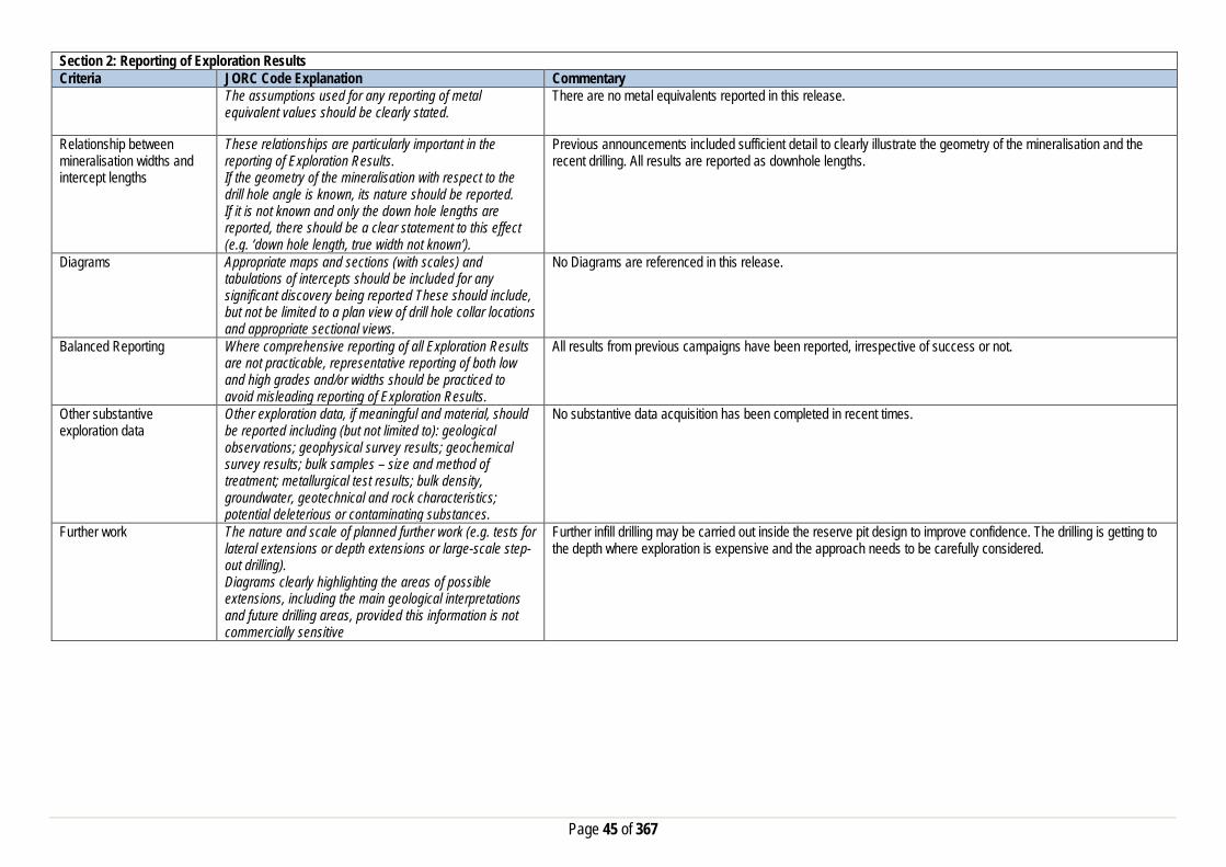
Page 45 of 367
Section 2: Reporting of Exploration Results Criteria JORC Code Explanation Commentary
The assumptions used for any reporting of metal equivalent values should be clearly stated.
There are no metal equivalents reported in this release.
Relationship between mineralisation widths and intercept lengths
These relationships are particularly important in the reporting of Exploration Results. If the geometry of the mineralisation with respect to the drill hole angle is known, its nature should be reported. If it is not known and only the down hole lengths are reported, there should be a clear statement to this effect (e.g. ‘down hole length, true width not known’).
Previous announcements included sufficient detail to clearly illustrate the geometry of the mineralisation and the recent drilling. All results are reported as downhole lengths.
Diagrams Appropriate maps and sections (with scales) and tabulations of intercepts should be included for any significant discovery being reported These should include, but not be limited to a plan view of drill hole collar locations and appropriate sectional views.
No Diagrams are referenced in this release.
Balanced Reporting Where comprehensive reporting of all Exploration Results are not practicable, representative reporting of both low and high grades and/or widths should be practiced to avoid misleading reporting of Exploration Results.
All results from previous campaigns have been reported, irrespective of success or not.
Other substantive exploration data
Other exploration data, if meaningful and material, should be reported including (but not limited to): geological observations; geophysical survey results; geochemical survey results; bulk samples – size and method of treatment; metallurgical test results; bulk density, groundwater, geotechnical and rock characteristics; potential deleterious or contaminating substances.
No substantive data acquisition has been completed in recent times.
Further work The nature and scale of planned further work (e.g. tests for lateral extensions or depth extensions or large-scale step-out drilling). Diagrams clearly highlighting the areas of possible extensions, including the main geological interpretations and future drilling areas, provided this information is not commercially sensitive
Further infill drilling may be carried out inside the reserve pit design to improve confidence. The drilling is getting to the depth where exploration is expensive and the approach needs to be carefully considered.

Page 46 of 367
Section 3: Estimation and Reporting of Mineral Resources Criteria JORC Code Explanation Commentary Database Integrity Measures taken to ensure that data has not been
corrupted by, for example, transcription or keying errors, between its initial collection and its use for Mineral Resource estimation purposes.
The database used for the estimate an extract from an Acquire SQL database. The primary database is regulated by a locked framework called the acquire data model which fixes the relationships between tables. The data model minimises the potential for data collection and data usage errors through pre-determined look up tables, storage and export functions. User defined permissions also regulate the ability to add, edit or extract data. Primary data is recorded using typical manual translation of logging and data capture from written logs and direct import of csv tables through a data import scheme where data is validated upon import or direct data entry options into the database using predefined look up values.
Data validation procedures used. Data that is captured in the field is entered into Excel templates which are checked on import into the database for errors. Assay jobs are dispatched electronically to the lab to minimise the chance of data entry errors. Assay results from the lab are received in CSV format and are checked for errors on import into the database. Data is regularly validated using the mining software. The data validation process is overseen by the Database Administrator.
Site Visits Comment on any site visits undertaken by the Competent Person and the outcome of those visits.
The Competent Person regularly visits site (monthly and more so when the geological work is more complex and demanding) to assess geological competency and ensure integrity across all geological disciplines.
If no site visits have been undertaken indicate why this is the case.
Geological Interpretation Confidence in (or conversely, the uncertainty of) the geological interpretation of the mineral deposit.
The resource categories assigned to the model directly reflect the confidence in the geological interpretation that is built using local, structural, mineral, and alteration geology obtained from mapping, logging, drill results and geophysics. Confidence in the interpretation improves with increased data density from close-spaced resource definition drilling, underground grade control drilling at 20m X 20m, face sampling of development rounds, and in pit and underground mapping.
Nature of the data used and any assumptions made. The geological interpretation of Karari has considered all available geological information including local geology, structural deformation events, and its relationship to neighbouring mineralised deposits. Rock types, mineral, alteration and veining assemblages from diamond drill core, RC Chips and development face/backs mapping were all used to help define the mineralised domains and regolith boundaries. Interpreted shears and faults obtained from in pit and underground mapping further constrained the domaining. The current resource has been interpreted from 949 diamond holes, 7 RCDD holes, 3,613 RC holes, and 2,506 simulated drill holes representing face sampling.
The affect, if any, of alternative interpretations on Mineral Resource estimation.
The geological wireframes defining the mineralised zones are considered to be robust as they provide a realistic representation of the mineralised structures. Alternative interpretations that were trialled earlier do not affect the current Mineral Resource Estimation.
The use of geology in guiding and controlling the Mineral Resource estimation.
Geological domains interpreted from all available geological data are used as estimation domains. They are further sub-domained where internal multi-modal grade populations and sufficient sample data is available in order to improve grade homogeneity and reduce variance.
The factors affecting continuity both of grade and geology. Cross cutting structures (NE - SW trending) grouped with flatter westerly dipping structures and intrusive rock types largely affect mineralisation continuity both along strike and down dip. Grade continuity is related to intense haematite, silica and sericite alteration and quartz breccia zones adjacent to shears and intrusive contacts.
Dimensins The extent and variability of the Mineral Resource expressed as length (along strike or otherwise), plan width, and depth below surface to the upper and lower limits of the Mineral Resource.
Mineralisation at Karari has continuity over 1500m along strike, 1300m down dip and 250m across strike. High grade mineralisation is controlled by 60° East dipping shear zones. Mineralisation is hosted within extensive quartz vein breccia zones adjacent to the shears. The high grade mineralisation is associated with intense haematite, silica and sericite alteration that occurs predominantly where flatter cross-linking structures intersect with the steeper dipping shears.

Page 47 of 367
Section 3: Estimation and Reporting of Mineral Resources Criteria JORC Code Explanation Commentary Estimation and modelling techniques
The nature and appropriateness of the estimation technique(s) applied and key assumptions, including treatment of extreme grade values, domaining, interpolation parameters and maximum distance of extrapolation from data points.
Mineralisation is domained based on geological continuity. All domain wireframes are created using Leapfrog software and all subsequent estimation is completed using Datamine software. Lode wireframes are intersected with a validated drill database from which all RAB, air core, and erroneous drill holes have been removed. All remaining diamond, RC and face samples are flagged with a domain identifier and composited to 1m with 0.3m minimum sample. Residual samples are distributed across adjacent component intervals. Composites are analysed for population outliers by domain and topcut proximal to population disintegration. Many of the principal lodes exhibit bi/multi-model grade populations. These internal populations are controlled by grade indicators based on inflexion points derived from domain log probability plots from which indicator variograms are created. Categorical indicator kriging (CIK) is then used to sub-domain lodes with mixed populations. The block model used in the CIK estimation has blocks set at 1x2x1m to ensure sub-domain complexity is maintained then optimised and re-blocked to the parent block size of 5x10x5m. This model is then used to back flag the composite file with the defined sub-domain identifiers. Variography is created for all domains and sub-domains with sufficient sample data. Output variograms are utilised in kriging neighbourhood analysis (KNA) to generate optimum parent block sizes and estimation parameters. Domains and sub-domains are estimated using ordinary kriging utilising the estimation parameters defined in the KNA as inputs. Grade is estimated into parent blocks only and all kriging quality metrics and search pass values are output.
The availability of check estimates, previous estimates and/or mine production records and whether the Mineral Resource estimate takes appropriate account of such data.
The Mineral Resource Estimation is checked against the previous block model estimations and reconciled production numbers on a monthly and yearly basis.
The assumptions made regarding recovery of by-products. No assumptions have been made regarding the recovery of by-products for this Mineral Resource Estimation. Estimation of deleterious elements or other non-grade variables of economic significance (e.g. sulphur for acid mine drainage characterisation).
No estimation of deleterious elements or non-grade variables is required
In the case of block model interpolation, the block size in relation to the average sample spacing and the search employed.
The model has been created using a parent cell size of 5m (East- West) x 10m (North-South) x 5m (vertical) optimised using quantitative kriging neighbourhood analysis. Sub-cells have been used at a resolution of 1m x 1m x1m to ensure high resolution at ore boundaries. The search distances are dictated by the range of each individual variogram but typically equate to 1-1.5 times the current 40x40m resource definition spacing. A 3 pass nested search strategy is employed with the first pass always set to the full range of the variogram. The second pass is set at 1.5-2 times the variogram range with the final pass set at a factor large enough to ensure all blocks comprising the domain are estimated.
Any assumptions behind modelling of selective mining units.
No assumptions have been made regarding the modelling of selective mining units for this Mineral Resource Estimation.
Any assumptions about correlation between variables. No assumptions have been made regarding the correlation between variables for this Mineral Resource Estimation. Description of how the geological interpretation was used to control the resource estimates.
Mineralisation is partitioned into estimation domains relative to stratigraphic position, structural orientation, recorded lithology and specific alteration assemblage. The geological interpretation is initially created from drill data and later calibrated with mapping from open pit and underground exposures. Domains are estimated individually with search geometry and variography controlled by lode orientation and grade continuity respectively. Variogram major search directions are aligned with geologically interpreted high grade shoot trends. Categorical indicator kriging has been utilised to define sub-domains in lodes with mixed grade populations to limit the spread of high grade mineralisation. Dynamic anisotropy has been employed on lodes exhibiting excessive undulation. Boundary analysis has been conducted on key lodes indicating hard boundaries should be maintained across domain and sub-domain contacts.
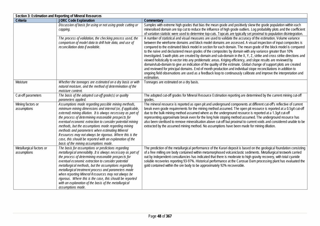
Page 48 of 367
Section 3: Estimation and Reporting of Mineral Resources Criteria JORC Code Explanation Commentary
Discussion of basis for using or not using grade cutting or capping.
Samples with extreme high grades that bias the mean grade and positively skew the grade population within each mineralised domain are top cut to reduce the influence of high grade outliers. Log probability plots and the coefficient of variation statistic were used to determine top-cuts. Topcuts are typically set proximal to population disintegration.
The process of validation, the checking process used, the comparison of model data to drill hole data, and use of reconciliation data if available.
A number of statistical and visual measures are used to validate the accuracy of the estimation. Volume variance between the wireframe domains and block model domains are assessed. A visual inspection of input composites is compared to the estimated block model in section for each domain. The mean grade of the block model is compared to the naïve and declustered mean grades of the composites by domain with any variance greater than 10% investigated. Swath plots are created by domain and sub-domain in the X, Y, Z, strike and cross strike directions and viewed holistically to vector into any problematic areas. Kriging efficiency, and slope results are reviewed by domain/sub-domain to give an indication of the quality of the estimate. Global change of support plots are created and reviewed for principal domains. End of month production and individual stope reconciliations in addition to ongoing field observations are used as a feedback loop to continuously calibrate and improve the interpretation and estimation.
Moisture Whether the tonnages are estimated on a dry basis or with natural moisture, and the method of determination of the moisture content.
Tonnages are estimated on a dry basis.
Cut-off parameters The basis of the adopted cut-off grade(s) or quality parameters applied.
The adopted cut-off grades for Mineral Resource Estimation reporting are determined by the current mining cut-off grades.
Mining factors or assumptions
Assumptions made regarding possible mining methods, minimum mining dimensions and internal (or, if applicable, external) mining dilution. It is always necessary as part of the process of determining reasonable prospects for eventual economic extraction to consider potential mining methods, but the assumptions made regarding mining methods and parameters when estimating Mineral Resources may not always be rigorous. Where this is the case, this should be reported with an explanation of the basis of the mining assumptions made.
The mineral resource is reported as open pit and underground components at different cut-off’s reflective of current break even grade requirements for the mining method assumed. The open pit resource is reported at a 0.5g/t cut-off due to the bulk mining method assumed where as the underground resource is reported at a 1.3g/t cut-off representing approximate break even for the long hole stoping method assumed. The underground resource has also been sterilised to remove mineralisation above cut-off but proximal to current voids and considered unable to be extracted by the assumed mining method. No assumptions have been made for mining dilution.
Metallurgical factors or assumptions
The basis for assumptions or predictions regarding metallurgical amenability. It is always necessary as part of the process of determining reasonable prospects for eventual economic extraction to consider potential metallurgical methods, but the assumptions regarding metallurgical treatment process and parameters made when reporting Mineral Resources may not always be rigorous. Where this is the case, this should be reported with an explanation of the basis of the metallurgical assumptions made.
The prediction of the metallurgical performance of the Karari deposit is based on the geological foundation consisting of a free milling ore body contained within metamorphosed volcaniclastic sediments. Metallurgical testwork carried out by independent consultancies has indicated that there is moderate to high gravity recovery, with total cyanide soluble recoveries reporting 93-97%. Historical performance at the Carosue Dam processing plant has evaluated the gold contained within the ore body to be approximately 92% recoverable.

Page 49 of 367
Section 3: Estimation and Reporting of Mineral Resources Criteria JORC Code Explanation Commentary Environmental factors or assumptions
Assumptions made regarding possible waste and process residue disposal options. It is always necessary as part of the process of determining reasonable prospects for eventual economic extraction to consider the potential environmental impacts of the mining and processing operation. While at this stage the determination of potential environmental impacts, particularly for a greenfields project, may not always be well advanced, the status of early consideration of these potential environmental impacts should be reported. Where these aspects have not been considered this should be reported with an explanation of the environmental assumptions made.
Waste rock characterisation has been conducted on the deposit with no environmental issues identified except dispersive oxidised material which is mitigated by the waste dump construction plan. Tailings from the deposit are stored in an appropriate licensed tailings facility with a closure plan in place.
Bulk Density Whether assumed or determined. If assumed, the basis for the assumptions. If determined, the method used, whether wet or dry, the frequency of the measurements, the nature, size and representativeness of the samples.
The bulk densities for Karari were determined via testing of representative intervals from diamond drillholes, regular sampling via grab samples from the pit and underground development. The sample size is generally between 0.5 and 1.5kg and the method of calculation is the water displacement technique. Measurements have been recorded in the acquire database and extraction schemes pair this data with the major lithology code for statistical analysis.
The bulk density for bulk material must have been measured by methods that adequately account for void spaces (vugs, porosity, etc.), moisture and differences between rock and alteration zones within the deposit.
Ore zones predominantly exist in transitional to fresh non porous material, so additional measures to reduce moisture intake during the water displacement method is unnecessary at this stage. Coating more friable oxides and sediments (to reduce moisture loss or moisture gain during the process) is considered on a deposit by deposit basis.
Discuss assumptions for bulk density estimates used in the evaluation process of the different materials.
An average mean of densities collected for each lithological type has been uniformly assigned to the modelled geological units. This includes the primary fresh lithologies as well as the weathered oxide and transitional zones.
Classification The basis for the classification of the Mineral Resources into varying confidence categories.
The Karari resource is classified as Measured, Indicated Mine Defined, Indicated or Inferred assigned via boundary string by domain based on a combination of physical and estimation quality metrics including mining exposure, drill spacing, search pass, kriging efficiency / slope / variance, grade and geological continuity. Mineralisation has been categorised as Measured if it has been exposed by mining (open pit or development), have drill spacing at <=20x20m’s, estimated in the first search pass, have established grade and geological continuity, and >50% kriging efficiency and >80% slope. Material in this category is available for stoping. Indicated Mine defined is assigned where drill spacing <=20x20m, search pass 1, established grade and geological continuity, positive kriging efficiency and >50% slope. This material is available for lateral development. Indicated material is assigned if drill spacing is between 20x20m and 35x35m, search pass either 1 or 2, established grade and geological continuity, positive kriging efficiency and >50% slope. Inferred material is drill spacing between 35x35m and 80x80m’s with established geological continuity. All other mineralisation is assigned a Potential resource category.
Whether appropriate account has been taken of all the relevant factors (i.e. relative confidence in tonnage/grade estimations, reliability of input data, confidence in continuity of geology and metal values, quality, quantity and distribution of the data).
All relevant factors have been taken into account and are validated through thorough QAQC of the drill hole database and geological knowledge and interpretation of the Karari deposit. Thorough model validations and reviews ensure the integrity of the final estimation and the grade and tonnage numbers.
Whether the result appropriately reflects the Competent Person's view of the deposit.
The geological model and the mineral resource estimate reflect the competent person’s view of the deposit.

Page 50 of 367
Section 3: Estimation and Reporting of Mineral Resources Criteria JORC Code Explanation Commentary Audits or reviews The results of any audits or reviews of Mineral Resource
estimates. Saracen has adopted a process for geological modelling, estimation and reporting of mineral resources that meets high industry standards. At the completion of resource estimation Saracen undertake an extensive review of the model that covers;
• Model inventory and comparisons to previous and budget models if in existence • Geological interpretation, wireframing, domain selection, statistics by domain, assay and metal evaluation,
parent cell sizes, data compositing, variography, search strategy, estimation and KNA • Model validation – swathe plots, visual checks, volume comparisons, composite to model metal
comparisons. In the final stages the model and resource categorisation are all discussed and scrutinized by the geological and mine planning teams. The resource estimation process is also annually reviewed by external consultants to ensure estimation methodology is robust and aligned to current industry best practice. Recommendations are always reviewed and implemented as appropriate.
Discussion of relative accuracy/confidence
Where appropriate a statement of the relative accuracy and confidence level in the Mineral Resource estimate using an approach or procedure deemed appropriate by the Competent Person. For example, the application of statistical or geostatistical procedures to quantify the relative accuracy of the resource within stated confidence limits, or, if such an approach is not deemed appropriate, a qualitative discussion of the factors that could affect the relative accuracy and confidence of the estimate.
The Mineral Resource has been reported in accordance with the guidelines of the 2012 edition of the Australasian Code for Reporting of Exploration Results, Mineral Resources and Ore Reserves. Saracen Gold Mine uses a standard approach to resource estimation and the procedure requires the systematic completion of the Saracen Resource Estimation Document that is thoroughly investigated and assessed in the Model review process, as stated above.
The statement should specify whether it relates to global or local estimates, and, if local, state the relevant tonnages, which should be relevant to technical and economic evaluation. Documentation should include assumptions made and the procedures used.
The statement relates to global estimates.
These statements of relative accuracy and confidence of the estimate should be compared with production data, where available.
Previous Mineral Resource estimates have had a positive reconciliation against mill figures.
Section 4: Estimation and Reporting of Ore Reserves Criteria JORC Code Explanation Commentary Mineral Resource estimate for conversion to Ore Reserves
Description of the Mineral resource Estimate used as a basis for the conversion to an Ore Reserve.
The Mineral Resource estimate for the Karari gold deposit used as a basis for conversion to the Ore Reserve estimate was compiled by Saracen. The data included drilling and assay data, geological mapping and historical mining records to validate the model against and solid interpretation wireframes of the geology. This information was used to construct a model estimated by ordinary kriging (ok) with categorical indicator kriging (CIK) sub domains. The model was depleted with the final pit and underground surveys completed in June 2019.
Clear statement as to whether the Mineral Resources are reported additional to. Or inclusive of, the Ore Reserves.
The Mineral Resource reported is inclusive of the Ore Reserve.

Page 51 of 367
Section 4: Estimation and Reporting of Ore Reserves Criteria JORC Code Explanation Commentary Site Visits Comment on any site visits undertaken by the Competent
Person and the outcome of those visits. Open Pit Reserve Competent Person along with geotechnical consultant has conducted several site visits to the Karari open pit since the inclusion in Carosue Dam operations life of mine plan. The purpose of these visits is to collect information for optimisation work, validating input parameters, visual pit inspection, discussion and feedback for life of mine planning. The information also includes the discussion around current mining performance, wall conditions and overall stability, and groundwater condition. Underground Reserve The competent person is conducting frequent ongoing site visits to the Carosue Dam Operations (CDO) mine site, where the Karari deposit is located. Saracen and consultant geotechnical engineers regularly visit Karari to inspect the mine and gather data used in the preparation of geotechnical reports to define parameters for underground mining. Hydrogeology consultants have visited Carosue Dam to gather data and inspect the inflow of groundwater into the open pit, used in the preparation of reports used to determine water management strategies.
If no site visits have been undertaken indicate why this is the case.
N/A
Study status The type and level of study undertaken to enable Mineral Resources to be converted to Ore Reserves
Open Pit Reserve The Karari deposit has been mined as an open pit previously by Saracen and is currently operating as an underground operation. A revised feasibility study was undertaken with the view to recommence open pit operations to mine southern part of the orebody which is not part of current underground reserve. The study includes all aspects of technical, economic and social environment risk assessment and has positively passed through the first hurdle. The 2019 Ore Reserve has included all operational inputs including actual production parameters, operating costs of mining, processing, general administration and environment management related costs. Underground Reserve The Karari deposit has been mined by Sons of Gwalia and Saracen as an open pit. Saracen commenced the underground operation in November 2014. Ore from Karari continues to be treated at the Carosue Dam processing facility. Karari is an active underground operation with a detailed mine design and an economic analysis, to define the ore reserve. From October 2017 until March 2018, external consultants (Outotec & Entech) were used to investigate the application of Paste backfill at Karari. Construction of CDO’s wet paste plant was completed in April 2019, with successful commissioning and first paste pours occurring at Karari in May 2019.
The Code requires that a study to at least Pre-Feasibility Study level has been undertaken to convert Mineral Resources to Ore Reserves. Such studies will have been carried out and will have determined a mine plan that is technically achievable and economically viable, and that material Modifying Factors have been considered.
Open Pit Reserve Modifying factors have been applied to the study to ensure the rigor of the financial analysis. Operational costs and production parameters have been used from actual and ongoing mining and processing performance. Saracen has conducted feasibility level study with all appropriate supporting mining studies required for ore reserve estimation. Underground Reserve Karari is an active underground mine. Modifying factors have been applied to the mine design, as well as a financial analysis completed, both of these have been the subject to peer review. As mentioned above paste fill feasibility studies have been carried out and it determined a mine plan that is both technically achievable and economically viable. Recent paste plant commissioning and QAQC testing on recent paste pours, confirms high quality paste at various binder ranges have been achieved at Karari.
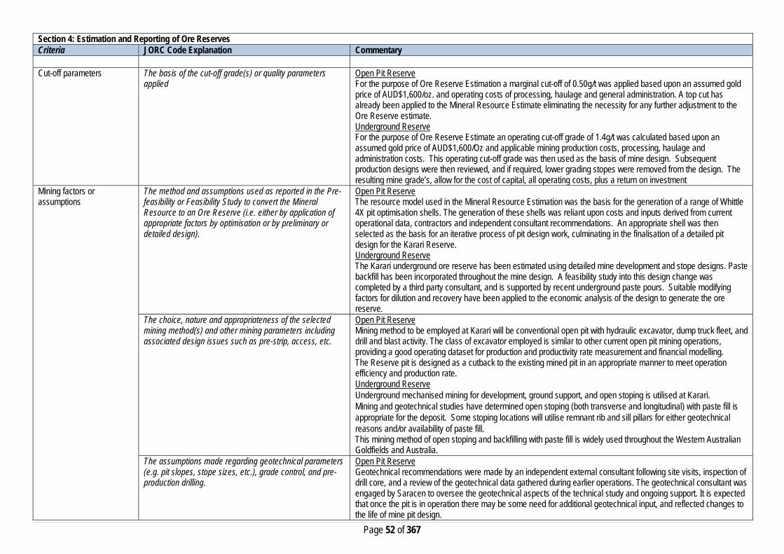
Page 52 of 367
Section 4: Estimation and Reporting of Ore Reserves Criteria JORC Code Explanation Commentary
Cut-off parameters The basis of the cut-off grade(s) or quality parameters
applied Open Pit Reserve For the purpose of Ore Reserve Estimation a marginal cut-off of 0.50g/t was applied based upon an assumed gold price of AUD$1,600/oz. and operating costs of processing, haulage and general administration. A top cut has already been applied to the Mineral Resource Estimate eliminating the necessity for any further adjustment to the Ore Reserve estimate. Underground Reserve For the purpose of Ore Reserve Estimate an operating cut-off grade of 1.4g/t was calculated based upon an assumed gold price of AUD$1,600/Oz and applicable mining production costs, processing, haulage and administration costs. This operating cut-off grade was then used as the basis of mine design. Subsequent production designs were then reviewed, and if required, lower grading stopes were removed from the design. The resulting mine grade’s, allow for the cost of capital, all operating costs, plus a return on investment
Mining factors or assumptions
The method and assumptions used as reported in the Pre-feasibility or Feasibility Study to convert the Mineral Resource to an Ore Reserve (i.e. either by application of appropriate factors by optimisation or by preliminary or detailed design).
Open Pit Reserve The resource model used in the Mineral Resource Estimation was the basis for the generation of a range of Whittle 4X pit optimisation shells. The generation of these shells was reliant upon costs and inputs derived from current operational data, contractors and independent consultant recommendations. An appropriate shell was then selected as the basis for an iterative process of pit design work, culminating in the finalisation of a detailed pit design for the Karari Reserve. Underground Reserve The Karari underground ore reserve has been estimated using detailed mine development and stope designs. Paste backfill has been incorporated throughout the mine design. A feasibility study into this design change was completed by a third party consultant, and is supported by recent underground paste pours. Suitable modifying factors for dilution and recovery have been applied to the economic analysis of the design to generate the ore reserve.
The choice, nature and appropriateness of the selected mining method(s) and other mining parameters including associated design issues such as pre-strip, access, etc.
Open Pit Reserve Mining method to be employed at Karari will be conventional open pit with hydraulic excavator, dump truck fleet, and drill and blast activity. The class of excavator employed is similar to other current open pit mining operations, providing a good operating dataset for production and productivity rate measurement and financial modelling. The Reserve pit is designed as a cutback to the existing mined pit in an appropriate manner to meet operation efficiency and production rate. Underground Reserve Underground mechanised mining for development, ground support, and open stoping is utilised at Karari. Mining and geotechnical studies have determined open stoping (both transverse and longitudinal) with paste fill is appropriate for the deposit. Some stoping locations will utilise remnant rib and sill pillars for either geotechnical reasons and/or availability of paste fill. This mining method of open stoping and backfilling with paste fill is widely used throughout the Western Australian Goldfields and Australia.
The assumptions made regarding geotechnical parameters (e.g. pit slopes, stope sizes, etc.), grade control, and pre-production drilling.
Open Pit Reserve Geotechnical recommendations were made by an independent external consultant following site visits, inspection of drill core, and a review of the geotechnical data gathered during earlier operations. The geotechnical consultant was engaged by Saracen to oversee the geotechnical aspects of the technical study and ongoing support. It is expected that once the pit is in operation there may be some need for additional geotechnical input, and reflected changes to the life of mine pit design.

Page 53 of 367
Section 4: Estimation and Reporting of Ore Reserves Criteria JORC Code Explanation Commentary
The Grade control method to be employed at Karari will utilise an RC drilling and sampling method. The method and practice has been utilised successfully at all current and past mining operations at Saracen. Underground Reserve Assumptions are based upon actual mining conditions. A review of the previous analysis and assessment of the designed stopes were performed by Saracen’s geotechnical team. Several external consultants have also reviewed the deposit and results / analysis found assumptions were acceptable. The current mine design allows for extensive use of paste fill with only a minor amount of upper mine production stopes utilising remnant rib and sill pillars, therefore the overall extraction ratio of the mineral resources is approximately 92%. Some mining of remnant pillars has been included in the mine design. A grade control program with associated development for drilling platforms, grade control drilling designs, and sampling costs have been include in the mine design, mine schedule and economic analysis.
The major assumptions made and Mineral Resource model used for pit and stope optimisation (if appropriate).
The Ore Reserve Estimate is based on detailed life of mine pit design work by using geology approved resource model, and making appropriate dilution and recovery factor allowance for mining fleet and method utilised. Open Pit Reserve The resource model used for the ore reserve calculations was ka1903_res_mine.dm Underground Reserve The resource model used for the ore reserve calculations was ka1906_res_mine.dm
The mining dilution factors used. Open Pit Reserve Mining dilution factor is applied in the Ore Reserve estimation and reflects the current mining performance of similar types of ore bodies and mining practices. A mining dilution factor of 14% is estimated for the Karari orebody, reflecting the wide mineralisation and steep dipping nature. Underground Reserve An allowance for mining dilution has been incorporated into the mine designs. An additional dilution allowance of 16.0% at 0.5g/t has been applied for stoping.
The mining recovery factors used. Open Pit Reserve Ore loss factor is applied in the Ore Reserve estimation and reflects the current mining performance of similar type of ore bodies and mining practices. An ore loss factor of 4% is estimated for the Karari orebody, reflecting the wide mineralisation and steep dipping nature. Underground Reserve A mining recovery factor of 96% has been assumed for all stopes.
Any minimum mining widths used Open Pit Reserve A minimum mining width of 25m has been adopted for the primary excavation fleet. Where ‘pinch-points’ occur or “Good Bye” cuts are considered at the base of the pit, it is assumed that a smaller or more versatile excavator will be employed. The practice is very consistent across both Saracen operations and reflects the suitability and efficiency of the mining performance. Underground Reserve A minimum stope width of 3m was applied in the design process.
The manner in which inferred Mineral resources are utilised in mining studies and the sensitivity of the outcome to their inclusion.
Open Pit Reserve Inferred material is excluded from the ore reserves and treated as waste material which incurs a mining cost but is not processed and does not generate any revenue. Therefore final pit reserve inventory has excluded any inferred mineral resources.
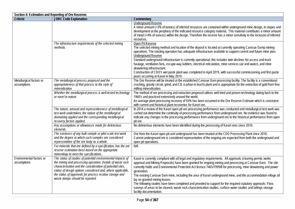
Page 54 of 367
Section 4: Estimation and Reporting of Ore Reserves Criteria JORC Code Explanation Commentary
Underground Reserve A minor amount (<3% of tonnes) of inferred resources are contained within underground mine design, in stopes and development at the periphery of the indicated resource category material. This material contributes a minor amount of metal (<4% of ounces) within the design. Therefore the reserve has a minor sensitivity to the inclusion of inferred resources.
The infrastructure requirements of the selected mining methods.
Open Pit Reserve The selected mining method and location of the deposit is located at currently operating Carosue Damp mining operations. The existing operation has adequate infrastructure available to support current and future mine plan. Underground Reserve Standard underground infrastructure is currently operational; this includes twin declines for access and truck haulage, ventilation fans, escape-way ladders, electrical reticulation, mine services (air and water), and mine dewatering infrastructure. Construction of CDO’s wet paste plant was completed in April 2019, with successful commissioning and first paste pours occurring at Karari in May 2019.
Metallurgical factors or assumptions
The metallurgical process proposed and the appropriateness of that process to the style of mineralisation
The Ore Reserve will be treated at the established Carosue Dam processing facility. The facility is a conventional crushing, gravity circuit, grind, and CIL (carbon in leach) plant and is appropriate for the extraction of gold from free milling mineralisation.
Whether the metallurgical process is well-tested technology or novel in nature.
The method of ore processing and extraction proposed utilises well tried and proven technology dating back to the 1960’s and practiced extensively around the world. An average plant processing recovery of 93% has been assumed in the Ore Reserve Estimate which is consistent with current and historical plant recoveries for Karari ore.
The nature, amount and representiveness of metallurgical test work undertaken, the nature of the metallurgical domaining applied and the corresponding metallurgical recovery factors applied.
In 2014 a review of the Karari open pit ore processing performance was conducted and metallurgical test work was carried out determine the continuity of processing performance from underground ore. No evidence was found to indicate any changes in the processing performance from underground ore to the historical performance from open pit ore.
Any assumptions or allowances made for deleterious elements.
No deleterious elements have been identified during the processing of Karari ores since 2010.
The existence of any bulk sample or pilot scale test work and the degree to which such samples are considered representative of the ore body as a whole.
Ore from the Karari open pit and underground has been treated at the CDO Processing Plant since 2010. Current underground ore is considered representative of the ongoing ore expected from both the underground and open pit operations.
For minerals that are defined by a specification, has the ore reserve estimation been based on the appropriate mineralogy to meet the specifications.
N/A
Environmental factors or assumptions
The status of studies of potential environmental impacts of the mining and processing operation. Details of waste rock characterisation and the consideration of potential sites, status of design options considered and, where applicable, the status of approvals for process residue storage and waste dumps should be reported.
Karari is currently compliant with all legal and regulatory requirements. All approvals (clearing permit, works approval and Mining Proposals) have been granted for ongoing mining and processing at Carosue Dam. The site currently holds and Environmental Protection Act licence 7465/1999/8 for processing, mine dewatering and power generation. The existing Carosue Dam mine, including the area of Karari underground mine, and the accommodation village all lay on granted mining leases. The following studies have been completed and provided to support for the required statutory approvals: Flora surveys of areas to be cleared, waste rock characterisation studies, surface water studies and tailings storage facility documentation.

Page 55 of 367
Section 4: Estimation and Reporting of Ore Reserves Criteria JORC Code Explanation Commentary Infrastructure The existence of appropriate infrastructure: availability of
land for plant development, power, water, transportation (particularly for bulk commodities), labour, accommodation; or the ease with which the infrastructure can be provided, or accessed.
Carosue Dam Operations are well established, with mining activities being conducted by Saracen since 2009. The CDO operation comprises at 2.4mtpa CIL ore processing facility, aerodrome with sealed runway, associated tailings storage facilities, several power stations, water supply, workshops, and administration offices. Karari underground mine is located within 500m of the CDO plant. A modern accommodation camp is sited within a few kilometres of the administration offices and processing facility. A 70km gravel access road links Carosue Dam Operations to the gravel section of Yarri Road. Both the Saracen and Shire of Kalgoorlie gravel roads are well maintained. The mine site is ~120km from the sealed section or Yarri Road leading to Kalgoorlie.
Costs The derivation of, or assumptions made, regarding projected capital costs in the study.
Open Pit Reserve Capital costs relating to the start-up and pre striping of the operation is included in the financial modelling. Underground Reserve Capital costs relate to establishment of capital infra-structure and continuing expansion of capital works for Karari underground. The cost estimates are based on historical costs for similar work undertaken at Carosue Dam for the establishment and operation of the Karari, Whirling Dervish and Deep South underground mines. Actual mine operating and capital costs have been used in the reserve calculations.
The methodology used to estimate operating costs. Open Pit Reserve Operating costs for open pit mining have been derived from a combination of actual costs from SGM’s Carosue Dam/Thunderbox Operations and costs supplied by various contract mining companies and independent consultants. Operating costs for ore processing, haulage and administration have been derived from known parameters at Carosue Dam operations. Underground Reserve Operating costs for underground mining have been derived from a combination of actual costs from Karari and tendered contract costs supplied by independent mining contractors. Operating costs for ore processing have been derived from known parameters at Carosue Dam, with additional costs such as labour sourced from current operational data.
Allowances made for the content of deleterious elements Current operational experience at Karari did not reveal any deleterious elements within the ore or waste that required any additional cost allowances.
The derivation of assumptions made of metal or commodity price(s), for the principal minerals and co-products
An assumed gold price of AUD$1,600/oz. has been adopted for financial modelling. No allowance is made for silver by-products.
The source of exchange rates used in study All revenue and cost calculations have been made in AUD, so no exchange rate usage or assumptions have been necessary.
Derivation of transportation charges Costs associated with bullion transportation have been derived from existing contractual arrangements at Carouse Dam.
The basis for forecasting or source of treatment and refining charges, penalties for failure to meet specification, etc.
Costs associated with refining have been derived from existing contractual arrangements at Carouse Dam.
The allowances made for royalties payable, both Government and private.
Royalty costs are the WA state government royalty of 2.5%, and a third party royalty of 1.5% is payable.
Revenue Factors The derivation of, or assumptions made, regarding revenue factors including head grade, metal or commodity price(s)
For the purposes of the Ore Reserve Estimation it has been assumed that there is no gold hedging. All gold production will be sold at spot price to the Perth Mint.

Page 56 of 367
Section 4: Estimation and Reporting of Ore Reserves Criteria JORC Code Explanation Commentary
exchange rates, transportation and treatment charges, penalties, net smelter returns, etc. The derivation of assumptions made of metal or commodity price(s), for the principal metals, minerals and co-products
Assumed gold price of AUD$1,600/oz. has been adopted for financial modelling. No allowance is made for silver by-products.
Market Assessment The demand, supply and stock situation for the particular commodity, consumption trends and factors likely to affect supply and demand into the future.
There is a transparent quoted market for the sale of gold.
A customer and competitor analysis along with the identification of likely market windows for the product.
There is a transparent quoted market for the sale of gold.
Price and volume forecasts and the basis for these forecasts.
There is a transparent quoted market for the sale of gold.
For industrial minerals the customer specification, testing and acceptance requirements prior to a supply contract.
N/A
Economic The inputs to the economic analysis to produce the net present value (NPV) in the study, the source and confidence of these economic inputs including estimated inflation, discount rate, etc.
Open Pit Reserve The Ore Reserve Estimation is based on detailed life of mine pit design and reflects positive economic outcomes. All relevant capital and operating costs as well as revenue and royalty factors have been included with appropriate discount factor for cash flow analysis. Underground Reserve All costs assumptions are made based on a combination of historical performance at Carosue Dam and Karari mine. The economic analysis is viewed as representative of the current market conditions.
NPV ranges and sensitivity to variations in the significant assumptions and inputs.
Open Pit Reserve A full financial model was developed with sensitivities applied to all key inputs and assumptions. Underground Reserve Sensitivities were not assessed.
Social The status of agreements with key stakeholders and matters leading to social licence to operate
Carosue Dam is currently operating and has good relationships with neighbouring stakeholders, including engagement with the local pastoralists and the traditional owners. The mine is located on leasehold pastoral land with compensation agreements in place with the local pastoralist. Granted mining leases cover all of the proposed mining and processing assets and there are no Native title claims pending.
Other To the extent relevant, the impact of the following on the project and/or on the estimation and classification of the Ore Reserves:
Any identified material naturally occurring risks Water inrush is identified as a naturally occurring risk with in the operation and was addressed by the construction of appropriate water diversion bunds to provide safe and risk free work environment. The sufficient long term bund wall is constructed across the mine footprint and currently still in place.
The status of material legal agreements and marketing arrangements
Contracts are in place for all critical goods and services to operate Carosue Dam Operations.
The status of governmental agreements and approvals critical to the viability of the project, such as mineral tenement status, and government and statutory approvals. There must be reasonable grounds to expect that all necessary government approvals will be received within
Open Pit Reserve A new Mining Approval will be required to be reapplied for, in a timely manner such that it will be granted before the actual commencement of mining. All other Statutory Government Approvals namely clearing permit, works approvals, dewatering and discharge licence have been granted. Underground Reserve

Page 57 of 367
Section 4: Estimation and Reporting of Ore Reserves Criteria JORC Code Explanation Commentary
the timeframes anticipated in the Pre-Feasibility or Feasibility study. Highlight and discuss the materiality of any unresolved matter that is dependent on a third party on which extraction of the reserve is contingent.
Carosue Dam Operations is in production with all required government statutory permits and approvals in place for the operating mines and processing plant. The required statutory approvals for Karari have been granted.
Classification The basis for the classification of the Ore Reserve into varying confidence categories
Open Pit Reserve The Ore Reserve Estimate classification for Karari has made been in accordance with the JORC code 2012. The Ore Reserve Estimate is classified as being Proved and Probable has been derived from Mineral Resource classified as Indicated and Measured only. Underground Reserve The Ore Reserve Estimate classification for Karari underground has been in accordance with the JORC code 2012. The estimated Ore Reserve is classified as being Probable with the majority of the reserve being derived from that portion of the Mineral Resource classified as indicated. A minor amount (<3% of tonnes) of inferred resources are contained within underground mine design, in stopes and development at the periphery of the indicated resource category material. This material contributes a minor amount of metal (<4% of ounces) within the design. Therefore the reserve has a minor sensitivity to the inclusion of inferred resources
Whether the result appropriately reflects the Competent Person’s view of the deposit.
Open Pit Reserve Cost assumptions and modifying factors applied to the pit optimisation and subsequent designs were derived from current operational data relating to Saracen’s Carosue Dam and Thunderbox operations, and supplied from contract mining companies and independent consultants. Results of these optimisations and the resultant analysis reflect the Competent Person’s view regarding the Karari deposit. Underground Reserve Cost assumptions and inputs factors applied to the underground project were derived from a combination of historical site data, current operational data relating to Carouse Dam Operations, actual mining costs, and recommendations from industry consultants. Results of the detailed design and analysis reflect the views of Competent Person regarding the Karari deposit.
The proportion of Probable Ore Reserves that have been derived from Measured Mineral Resources (if any)
Open Pit Reserve 100% of Probable ore from Ore Reserve estimate has been derived from Indicated Mineral Resource category. Underground Reserve Only 33% (by ore tonnes) of the reserve were classified as Measured Mineral Resources within the underground mine design that formed the physical extent of the estimated Ore Reserve.
Audits or reviews The results of any audits or reviews of Ore Reserve estimates
The Ore Reserve Estimation process is in line with the Saracen Ore Reserve Policy and undergone internal review. There have been no external reviews of this Ore reserve estimate.

Page 58 of 367
Section 4: Estimation and Reporting of Ore Reserves Criteria JORC Code Explanation Commentary Discussion of relative accuracy/confidence
Where appropriate a statement of the relative accuracy and confidence level in the Ore Reserve estimate using an approach or procedure deemed appropriate by the Competent Person. For example, the application of statistical or geo-statistical procedures to quantify the relative accuracy of the reserve within stated confidence limits, or, if such an approach is not deemed appropriate, a qualitative discussion of the factors which could affect the relative accuracy and confidence of the estimate. The statement should specify whether it relates to global or local estimates, and if local, state the relevant tonnages which should be relevant to technical and economic evaluation. Documentation should include assumptions made and the procedures used. Accuracy and confidence discussions should extend to specific discussions of any applied modifying factors that may have a material impact on Ore Reserve viability, or for which there are remaining areas of uncertainty at the current study stage. It is recognised that this may not be possible or appropriate in all circumstances. These statements or relative accuracy and confidence of the estimate should be compared with production data, where available.
The Ore Reserve estimate has been prepared within the guidelines of the 2012 JORC Code. The relative confidence of the estimate complies with the criteria of Probable Ore Reserves. Based upon;
- Resource estimate - significant operating history, - application of current industry practices, - appropriate operating and capital costs,
The range of the modifying factors is reasonable and confidence in the resulting reserve estimate is reasonable. Estimates are global but will be reasonably accurate on a local scale. The complete mine design with all of the modifying factors assumed and adopted, and financial analysis used in the estimated Ore Reserve have been the subject to peer review internally, and the Competent Person is confident that it is an accurate estimation of the current Karari reserve. Reconciliation results from past and current mining at Karari have been considered and factored into the reserve assumptions where appropriate.
Whirling Dervish Section 1: Sampling Techniques and Data Criteria JORC Code Explanation Commentary Sampling Techniques Nature and quality of sampling (e.g. cut channels, random
chips, or specific specialised industry standard measurement tools appropriate to the minerals under investigation, such as down hole gamma sondes, or handheld XRF instruments, etc.). These examples should not be taken as limiting the broad meaning of sampling.
Sampling methods undertaken by Saracen at Whirling Dervish have included reverse circulation (RC), surface and underground diamond drillholes (DD), underground face chip sampling and RC grade control drilling within the pit. Historic methods conducted since 1993 have included aircore (AC), rotary air blast (RAB), reverse circulation and diamond drillholes.
Include reference to measures taken to ensure sample representivity and the appropriate calibration of any measurement tools or systems used
Sampling for diamond and RC drilling and face chip sampling is carried out as specified within Saracen sampling and QAQC procedures as per industry standard. RC chips and diamond core provide high quality representative samples for analysis. RC, RAB, AC and DD core drilling was completed by previous holders to industry standard at that time (1993- 2002).
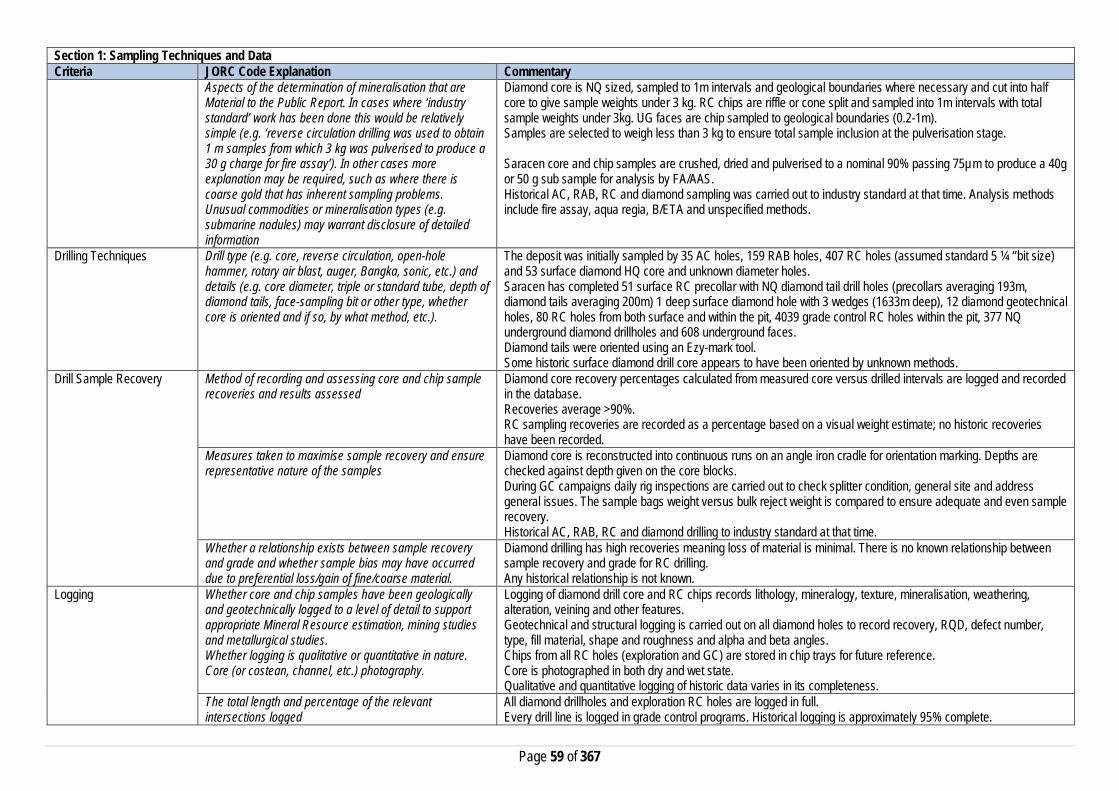
Page 59 of 367
Section 1: Sampling Techniques and Data Criteria JORC Code Explanation Commentary
Aspects of the determination of mineralisation that are Material to the Public Report. In cases where ‘industry standard’ work has been done this would be relatively simple (e.g. ‘reverse circulation drilling was used to obtain 1 m samples from which 3 kg was pulverised to produce a 30 g charge for fire assay’). In other cases more explanation may be required, such as where there is coarse gold that has inherent sampling problems. Unusual commodities or mineralisation types (e.g. submarine nodules) may warrant disclosure of detailed information
Diamond core is NQ sized, sampled to 1m intervals and geological boundaries where necessary and cut into half core to give sample weights under 3 kg. RC chips are riffle or cone split and sampled into 1m intervals with total sample weights under 3kg. UG faces are chip sampled to geological boundaries (0.2-1m). Samples are selected to weigh less than 3 kg to ensure total sample inclusion at the pulverisation stage. Saracen core and chip samples are crushed, dried and pulverised to a nominal 90% passing 75µm to produce a 40g or 50 g sub sample for analysis by FA/AAS. Historical AC, RAB, RC and diamond sampling was carried out to industry standard at that time. Analysis methods include fire assay, aqua regia, B/ETA and unspecified methods.
Drilling Techniques Drill type (e.g. core, reverse circulation, open-hole hammer, rotary air blast, auger, Bangka, sonic, etc.) and details (e.g. core diameter, triple or standard tube, depth of diamond tails, face-sampling bit or other type, whether core is oriented and if so, by what method, etc.).
The deposit was initially sampled by 35 AC holes, 159 RAB holes, 407 RC holes (assumed standard 5 ¼ ‘’bit size) and 53 surface diamond HQ core and unknown diameter holes. Saracen has completed 51 surface RC precollar with NQ diamond tail drill holes (precollars averaging 193m, diamond tails averaging 200m) 1 deep surface diamond hole with 3 wedges (1633m deep), 12 diamond geotechnical holes, 80 RC holes from both surface and within the pit, 4039 grade control RC holes within the pit, 377 NQ underground diamond drillholes and 608 underground faces. Diamond tails were oriented using an Ezy-mark tool. Some historic surface diamond drill core appears to have been oriented by unknown methods.
Drill Sample Recovery Method of recording and assessing core and chip sample recoveries and results assessed
Diamond core recovery percentages calculated from measured core versus drilled intervals are logged and recorded in the database. Recoveries average >90%. RC sampling recoveries are recorded as a percentage based on a visual weight estimate; no historic recoveries have been recorded.
Measures taken to maximise sample recovery and ensure representative nature of the samples
Diamond core is reconstructed into continuous runs on an angle iron cradle for orientation marking. Depths are checked against depth given on the core blocks. During GC campaigns daily rig inspections are carried out to check splitter condition, general site and address general issues. The sample bags weight versus bulk reject weight is compared to ensure adequate and even sample recovery. Historical AC, RAB, RC and diamond drilling to industry standard at that time.
Whether a relationship exists between sample recovery and grade and whether sample bias may have occurred due to preferential loss/gain of fine/coarse material.
Diamond drilling has high recoveries meaning loss of material is minimal. There is no known relationship between sample recovery and grade for RC drilling. Any historical relationship is not known.
Logging Whether core and chip samples have been geologically and geotechnically logged to a level of detail to support appropriate Mineral Resource estimation, mining studies and metallurgical studies. Whether logging is qualitative or quantitative in nature. Core (or costean, channel, etc.) photography.
Logging of diamond drill core and RC chips records lithology, mineralogy, texture, mineralisation, weathering, alteration, veining and other features. Geotechnical and structural logging is carried out on all diamond holes to record recovery, RQD, defect number, type, fill material, shape and roughness and alpha and beta angles. Chips from all RC holes (exploration and GC) are stored in chip trays for future reference. Core is photographed in both dry and wet state. Qualitative and quantitative logging of historic data varies in its completeness.
The total length and percentage of the relevant intersections logged
All diamond drillholes and exploration RC holes are logged in full. Every drill line is logged in grade control programs. Historical logging is approximately 95% complete.

Page 60 of 367
Section 1: Sampling Techniques and Data Criteria JORC Code Explanation Commentary Sub-sampling techniques and sample preparation
If core, whether cut or sawn and whether quarter, half or all core taken.
All drill core is cut in half onsite using an automatic core saw. Samples are always collected from the same side. Historic diamond drilling has been half core sampled.
If non-core, whether riffled, tube sampled, rotary split, etc. and whether sampled wet or dry.
All exploration and GC RC samples are cone or riffle split. Occasional wet samples are encountered; increased air capacity is routinely used to aid in keeping the sample dry when water is encountered. Historic AC, RAB and RC drilling was sampled using spear, grab, riffle and unknown methods.
For all sample types, the nature, quality and appropriateness of the sample preparation technique.
The sample preparation of diamond core and RC chips adhere to industry best practice. It is conducted by a commercial laboratory and involves oven drying, coarse crushing then total grinding to a size of 90% passing 75 microns. Best practice is assumed at the time of historic sampling.
Quality control procedures adopted for all sub-sampling stages to maximise representivity of samples.
All subsampling activities are carried out by commercial laboratory and are considered to be satisfactory. Sampling by previous holders assumed to be industry standard at the time.
Measures taken to ensure that the sampling is representative of the in situ material collected, including for instance results for field duplicate/second half sampling.
Duplicate sampling is carried out at a rate of 1:10 for exploration drilling and 1:20 for GC drilling and is sampled directly from the on-board splitter on the rig. These are submitted for the same assay process as the original samples and the laboratory are unaware of such submissions. Sampling by previous holders assumed to be industry standard at the time.
Whether sample sizes are appropriate to the grain size of the material being sampled.
Sample sizes are considered to be appropriate.
Quality of assay data and laboratory tests
The nature, quality and appropriateness of the assaying and laboratory procedures used and whether the technique is considered partial or total.
RC chip samples, grade control chip samples and diamond core are analysed by external laboratories using a 40g or 50g fire assay with AAS finish. These methods are considered suitable for determining gold concentrations in rock and are total digest methods. Historic sampling includes fire assay, aqua regia, B/ETA and unknown methods.
For geophysical tools, spectrometers, handheld XRF instruments, etc., the parameters used in determining the analysis including instrument make and model, reading times, calibrations factors applied and their derivation, etc.
No geophysical tools have been utilised for reporting gold mineralisation at Whirling Dervish.
Nature of quality control procedures adopted (e.g. standards, blanks, duplicates, external laboratory checks) and whether acceptable levels of accuracy (i.e. lack of bias) and precision have been established.
Certified reference material (standards and blanks) with a wide range of values are inserted into every drillhole at a rate of 1:25 for exploration RC and DD, and 1:40 for GC drilling. These are not identifiable to the laboratory. QAQC data returned are checked against pass/fail limits with the SQL database and are passed or failed on import. A report is generated and reviewed by the geologist as necessary upon failure to determine further action. QAQC data is reported monthly. Sample preparation checks for fineness are carried out to ensure a grindsize of 90% passing 75 microns. The laboratory performs a number of internal processes including standards, blanks, repeats and checks. QAQC data analysis demonstrates sufficient accuracy and precision. Industry best practice is assumed for previous holders.
Verification of sampling and assaying
The verification of significant intersections by either independent or alternative company personnel.
Significant intercepts are verified by the Geology Manager and corporate personnel.
The use of twinned holes. No specific twinned holes have been drilled at Whirling Dervish but grade control drilling has confirmed the width and grade of previous exploration drilling.
Documentation of primary data, data entry procedures, data verification, data storage (physical and electronic) protocols
Primary data is collated in a set of excel templates utilising lookup codes. This data is forwarded to the Database Administrator for entry into a secure acQuire database with inbuilt validation functions. Data from previous owners was taken from a database compilation and validated as much as practicable before entry into the Saracen acQuire database.

Page 61 of 367
Section 1: Sampling Techniques and Data Criteria JORC Code Explanation Commentary
Discuss any adjustment to assay data. No adjustments have been made to assay data. First gold assay is utilised for resource estimation. Location of data points Accuracy and quality of surveys used to locate drillholes
(collar and down-hole surveys), trenches, mine workings and other locations used in Mineral Resource estimation.
Exploration drillholes are located using a Leica 1200 GPS with an accuracy of +/- 10mm. Drillhole collars within the pit and immediate surrounds are picked up by company surveyors using a Trimble R8 GNSS (GPS) with an expected accuracy of +/-8mm. All underground drillhole collars are picked up by company surveyors using a Leica TS15i (total station) with an expected accuracy of +/-2mm. Downhole surveys are carried out using the DeviFlex RAPID continuous inrod survey instrument taking readings every 5 seconds, In and Out runs and reported in 3m intervals, survey accuracy +-3:1000. A number of drillholes have also been gyroscopically surveyed. Previous holders’ survey accuracy and quality is unknown
Specification of the grid system used. A local grid system (KarariDervish) is used. The two point conversion to MGA_GDA94 zone 51 is KDEast KDNorth RL MGAEast MGANorth RL Point 1 2986.31 7233.832 0 438346.166 6663021.817 0 Point 2 3010.884 9675.445 0 438370.5380 6665462.457 0 Historic data is converted to the KarariDervish local grid upon export from the database.
Quality and adequacy of topographic control. Topographic control originally used site based survey pickups in addition to Kevron aerial photogrammetric surveys with +/- 5m resolution. Pre mining, new and more detailed topography has since been captured and will be used in future updates and for subsequent planning purposes.
Data spacing and distribution
Data spacing for reporting of Exploration Results. The nominal spacing for exploration drilling is 25m x 25m Whether the data spacing and distribution is sufficient to establish the degree of geological and grade continuity appropriate for the Mineral Resource and Ore Reserve estimation procedure(s) and classifications applied.
Data spacing and distribution are sufficient to establish the degree of geological and grade continuity appropriate for JORC classifications applied.
Orientation of data in relation to geological structure
Whether sample compositing has been applied.
Sample compositing is not applied until the estimation stage. Some historic RAB and RC sampling was composited into 3-4m samples with areas of interest re-sampled to 1m intervals. It is unknown at what threshold this occurred.
Whether the orientation of sampling achieves unbiased sampling of possible structures and the extent to which this is known, considering the deposit type.
The majority of drillholes are positioned to achieve optimum intersection angles to the ore zone as are practicable.
If the relationship between the drilling orientation and the orientation of key mineralised structures is considered to have introduced a sampling bias, this should be assessed and reported if material.
No significant sampling bias is thought to occur due to orientation of drilling in regards to mineralised structures.
Sample security The measures taken to ensure sample security. Samples are prepared on site under supervision of Saracen geological staff. Samples are selected, bagged into tied numbered calico bags then grouped into secured cages and collected by the laboratory personnel. Sample submissions are documented via laboratory tracking systems and assays are returned via email.
Audits or reviews The results of any audits or reviews of sampling techniques and data.
An internal review of companywide sampling methodologies was conducted to create the current sampling and QAQC procedures.

Page 62 of 367
Section 2: Reporting of Exploration Results Criteria JORC Code Explanation Commentary Mineral tenement and land tenure status
Type, reference name/number, location and ownership including agreements or material issues with third parties such as joint ventures, partnerships, overriding royalties, native title interests, historical sites, wilderness or national park and environmental settings.
The Whirling Dervish pit is located on M28/166 and M31/220, while near mine exploration has been carried out on M28/245. The tenements are held 100% by Saracen Gold Mines Pty Ltd, a wholly owned subsidiary of Saracen Mineral Holdings Limited. Mining Leases M28/166 and M31/220 have a 21 year life (held until 2020) and are renewable for a further 21 years on a continuing basis. Mining Lease M28/245 has a 21 year life (held until 2029) and is renewable for a further 21 years on a continuing basis. Mining Lease M28/166 is subject to two third party royalties and one caveat (Caveat 51H/067). Mining Lease M31/220 is subject to two third party royalties and one caveat (Caveat 64H/067) and Mining Lease M28/245 is subject to one third party royalty. There are no caveats associated with Mining Lease M28/245. Mining Leases M28/166, M28/245 and M31/220 are subject to a bank mortgage (Mortgage 499142). All production is subject to a Western Australian state government NSR royalty of 2.5%. Mining Leases M28/166, M31/220 and M28/245 are subject to the Pinjin Pastoral Compensation Agreement. Mining Lease M31/220 is subject to the Pinjin and Gindalbie Pastoral Compensation Agreements. M28/166, M31/220 and M28/245 are the subject of the Maduwongga native title claim (WC2017/001). The Mining Rehabilitation Fund applies to the tenements.
The security of the tenure held at the time of reporting along with any known impediments to obtaining a licence to operate in the area.
The tenements are in good standing and the licence to operate already exists.
Exploration done by other parties
Acknowledgment and appraisal of exploration by other parties.
The Carosue Dam project area in which the Whirling Dervish deposit is located has been subjected to extensive gold exploration by numerous companies since 1991. Airborne geophysics conducted by Aberfoyle Resources in 1997 highlighted numerous targets in the project area with subsequent RAB drilling intersecting the Whirling Dervish mineralisation and an extensive RC campaign confirming it. Oriole Resources obtained the project in 1998 and, through wholly owned subsidiary company PacMin, completed closely spaced RC drilling to develop the resource through to reserve status. Sons of Gwalia carried out minor drilling before their collapse and takeover of the project by St Barbara.
Geology Deposit type, geological setting and style of mineralisation.
Whirling Dervish is situated along the Kilkenny-Yilgangi fault zone on the boundary of the Steeple Hill and Mulgabbie domains. The lithology comprises primarily intermediate felsic volcaniclastic sandstones, intermediate tuffs and intermediate porphyry units intruded by granites of varying composition, with stratigraphy dipping generally to the east at approx. 60 degrees. Mineralization has a combined lithological and structurally control dipping parallel to the stratigraphy. Mineralization is continuous along strike in the footwall but is very discontinuous and patchy in the hanging wall structures and overall controlled by the general NW trending ductile faulting and is characterized by weak Hematite banding on the margins to intense hematite-silica alteration hosted in breccia zones adjacent to the faulting with high grade cores typically sericite-silica breccia. Pyrite is the dominant sulphide. The mineralization is terminated to the west by the by a NW trending shear zone dipping 60 degrees to the east.

Page 63 of 367
Section 2: Reporting of Exploration Results Criteria JORC Code Explanation Commentary Drillhole information A summary of all information material to the understanding
of the exploration results including a tabulation of the following information for all Material drill holes: • easting and northing of the drill hole collar • elevation or RL (Reduced Level – elevation • above sea level in metres) of the drill hole collar • dip and azimuth of the hole • down hole length and interception depth • hole length. • If the exclusion of this information is justified on the
basis that the information is not Material and this exclusion does not detract from the understanding of the report, the Competent Person should clearly explain why this is the case.
All material data is periodically released on the ASX: 30/04/2019, 18/02/2019, 27/11/2018, 31/07/2018, 01/05/2018, 15/02/2018, 27/11/2017, 15/10/2015, 14/10/2013, 23/07/2013, 03/12/2012, 10/10/2012, 31/07/2012, 27/04/2012, 06/03/2012, 27/01/2012, 06/01/2012, 26/10/2011, 01/08/2011, 28/07/2011, 03/06/2011, 21/04/2011, 09/02/2011
Data aggregation methods In reporting Exploration Results, weighting averaging techniques, maximum and/or minimum grade truncations (e.g. cutting of high grades) and cut-off grades are usually Material and should be stated.
All significant intercepts have been length weighted with a minimum Au grade of 1ppm. No high grade cut off has been applied.
Where aggregate intercepts incorporate short lengths of high grade results and longer lengths of low grade results, the procedure used for such aggregation should be stated and some typical examples of such aggregations should be shown in detail.
Intercepts are aggregated with minimum width of 1m and maximum width of 3m for internal dilution. Where stand out higher grade zone exist with in the broader mineralised zone, the higher grade interval is reported also.
The assumptions used for any reporting of metal equivalent values should be clearly stated.
There are no metal equivalents reported in this release.
Relationship between mineralisation widths and intercept lengths
These relationships are particularly important in the reporting of Exploration Results. If the geometry of the mineralisation with respect to the drill hole angle is known, its nature should be reported. If it is not known and only the down hole lengths are reported, there should be a clear statement to this effect (e.g. ‘down hole length, true width not known’).
Previous announcements included sufficient detail to clearly illustrate the geometry of the mineralisation and the recent drilling. All results are reported as downhole lengths.
Diagrams Appropriate maps and sections (with scales) and tabulations of intercepts should be included for any significant discovery being reported These should include, but not be limited to a plan view of drill hole collar locations and appropriate sectional views.
No Diagrams are referenced in this release.
Balanced Reporting Where comprehensive reporting of all Exploration Results are not practicable, representative reporting of both low and high grades and/or widths should be practiced to avoid misleading reporting of Exploration Results.
All results from previous campaigns have been reported, irrespective of success or not.

Page 64 of 367
Section 2: Reporting of Exploration Results Criteria JORC Code Explanation Commentary Other substantive exploration data
Other exploration data, if meaningful and material, should be reported including (but not limited to): geological observations; geophysical survey results; geochemical survey results; bulk samples – size and method of treatment; metallurgical test results; bulk density, groundwater, geotechnical and rock characteristics; potential deleterious or contaminating substances.
No substantive data acquisition has been completed in recent times.
Further work The nature and scale of planned further work (e.g. tests for lateral extensions or depth extensions or large-scale step-out drilling). Diagrams clearly highlighting the areas of possible extensions, including the main geological interpretations and future drilling areas, provided this information is not commercially sensitive
Whirling Dervish is currently in production and extensional exploration at this time is under review.
Section 3: Estimation and Reporting of Mineral Resources Criteria JORC Code Explanation Commentary Database Integrity Measures taken to ensure that data has not been
corrupted by, for example, transcription or keying errors, between its initial collection and its use for Mineral Resource estimation purposes.
The database used for the estimate an extract from an Acquire SQL database. The primary database is regulated by a locked framework called the acquire data model which fixes the relationships between tables. The data model minimises the potential for data collection and data usage errors through pre-determined look up tables, storage and export functions. User defined permissions also regulate the ability to add, edit or extract data. Primary data is recorded using typical manual translation of logging and data capture from written logs and direct import of csv tables through a data import scheme where data is validated upon import or direct data entry options into the database using predefined look up values.
Data validation procedures used. Data that is captured in the field is entered into Excel templates which are checked on import into the database for errors. Assay jobs are dispatched electronically to the lab to minimise the chance of data entry errors. Assay results from the lab are received in CSV format and are checked for errors on import into the database. Data is regularly validated using the mining software. The data validation process is overseen by the Database Administrator.
Site Visits Comment on any site visits undertaken by the Competent Person and the outcome of those visits.
The Competent Person regularly visits site (monthly and more when the geological work is more complex and demanding) to assess geological competency and ensure integrity across all geological disciplines.
If no site visits have been undertaken indicate why this is the case.
Geological Interpretation Confidence in (or conversely, the uncertainty of) the geological interpretation of the mineral deposit.
The resource categories assigned to the model directly reflect the confidence in the geological interpretation. The interpretation is built using local, structural, mineral, and alteration geology obtained from mapping, logging, drill results and geophysics. Confidence in the interpretation improved with increased data density from underground grade control drilling at 35m x 35m and in pit mapping.

Page 65 of 367
Section 3: Estimation and Reporting of Mineral Resources Criteria JORC Code Explanation Commentary
Nature of the data used and any assumptions made. The geological interpretation of Whirling Dervish has considered all available geological information including local geology, structural deformation events, and its relationship to neighbouring mineralised deposits. Rock types, mineral, alteration and veining assemblages from diamond drill core, RC Chips, and underground development exposures were all used to help define the mineralised domains and regolith boundaries. Interpreted shears and faults obtained from pit and underground drive mapping further constrained the domaining. The current resource has been interpreted from 507 diamond holes, 13 RCDD holes, 4,381 RC holes, and 544 simulated drill holes representing underground face sampling.
The affect, if any, of alternative interpretations on Mineral Resource estimation.
The geological wireframes defining the mineralised zones are considered to be robust. Alternative interpretations were historically in place that reflected the bulk extraction method of open pit mining however they do not affect the current Mineral Resource Estimation which is focused on underground extraction.
The use of geology in guiding and controlling the Mineral Resource estimation.
Geological domains interpreted from all available geological data are used as estimation domains. They are further sub-domained where internal multi-modal grade populations and sufficient sample data is available in order to improve grade homogeneity and reduce variance.
The factors affecting continuity both of grade and geology. Cross cutting structures (NE - SW trending) grouped with flatter westerly dipping structures and intrusive rock types largely affect mineralisation continuity both along strike and down dip. Grade continuity is related to interaction between mylonitic shears and monzonitic intrusives and is controlled by intense haematite, biotite, carbonate, silica and albite alteration
Dimensions The extent and variability of the Mineral Resource expressed as length (along strike or otherwise), plan width, and depth below surface to the upper and lower limits of the Mineral Resource.
Mineralisation at Whirling Dervish has continuity over 960m along strike, 940m down dip and 200m across strike. High grade mineralisation is controlled by 60° North East dipping shear zones. Mineralisation is hosted within extensive mylonitic zones adjacent to the shears. The high grade mineralisation is associated with intense haematite, biotite, carbonate, silica and albite alteration.
Estimation and modelling techniques
The nature and appropriateness of the estimation technique(s) applied and key assumptions, including treatment of extreme grade values, domaining, interpolation parameters and maximum distance of extrapolation from data points.
Mineralisation is domained based on geological continuity. All domain wireframes are created using Leapfrog software and all subsequent estimation is completed using Datamine software. Lode wireframes are intersected with a validated drill database from which all RAB, air core, and erroneous drill holes have been removed. All remaining diamond, RC and face samples are flagged with a domain identifier and composited to 1m with 0.3m minimum sample. Residual samples are distributed across adjacent component intervals. Composites are analysed for population outliers by domain and topcut proximal to population disintegration. Many of the principal lodes exhibit bi/multi-model grade populations. These internal populations are controlled by grade indicators derived from inflexion points in domain log probability plots from which indicator variograms are created. Categorical indicator kriging (CIK) is then used to sub-domain lodes with mixed populations. The block model used in the CIK estimation has blocks set at 1x2x1m to ensure sub-domain complexity is maintained then optimised and re-blocked to the parent block size of 5x10x5m. This model is then used to back flag the composite file with the defined sub-domain identifiers. Variography is created for all domains and sub-domains with sufficient sample data. Output variograms are utilised in kriging neighbourhood analysis (KNA) to generate optimum parent block sizes and estimation parameters. Domains and sub-domains are estimated using ordinary kriging utilising the estimation parameters defined in the KNA as inputs. Grade is estimated into parent blocks only and all kriging quality metrics and search pass values are output. Hard boundaries are maintained across low and medium grade sub-domains however a one way soft boundary allowing the high grade sub-domain to use both high and medium grade samples in the estimate is enforced.
The availability of check estimates, previous estimates and/or mine production records and whether the Mineral Resource estimate takes appropriate account of such data.
The Mineral Resource Estimation is checked against the previous block model estimations and reconciled production data. Additionally, check estimates including conventional ordinary kriging on all domains, hard-boundaries on all sub-domains used in categorical indicator kriging, and multiple indicator kriging estimation runs were conducted to test the validity and sensitivity of the current mineral resource estimate.

Page 66 of 367
Section 3: Estimation and Reporting of Mineral Resources Criteria JORC Code Explanation Commentary
The assumptions made regarding recovery of by-products. No assumptions have been made regarding the recovery of by-products for this Mineral Resource Estimation. Estimation of deleterious elements or other non-grade variables of economic significance (e.g. sulphur for acid mine drainage characterisation).
No estimation of deleterious elements or non-grade variables is required.
In the case of block model interpolation, the block size in relation to the average sample spacing and the search employed.
The model has been created using a parent cell size of 5m (East- West) x 10m (North-South) x 5m (vertical) and optimised using kriging neighbourhood analysis. Sub-cells have been used at a resolution of 1m x 1m x1m to ensure high volume resolution at ore boundaries. The search distances are dictated by the range of each individual variogram but typically equate to 1-1.5 times the current 40x40m resource definition spacing. A three pass nested search strategy is employed with the first pass always set to the full range of the variogram. The second pass is set at 2 times the variogram range with the final pass set at a factor large enough to ensure all blocks comprising the domain are estimated.
Any assumptions behind modelling of selective mining units.
No assumptions have been made regarding the modelling of selective mining units for this Mineral Resource Estimation.
Any assumptions about correlation between variables. No assumptions have been made regarding the correlation between variables for this Mineral Resource Estimation. Description of how the geological interpretation was used to control the resource estimates.
Mineralisation is partitioned into estimation domains relative to stratigraphic position, structural orientation, recorded lithology and specific alteration assemblage. The geological interpretation is initially created from drill data and later calibrated with mapping of open pit and underground exposures. Domains are estimated individually with search geometry and variography controlled by lode orientation and grade continuity respectively. Variogram major search directions are aligned with geologically interpreted high grade shoot trends. Categorical indicator kriging has been utilised to define sub-domains in lodes with mixed grade populations to limit the spread of high grade mineralisation. Dynamic anisotropy has been employed on lodes exhibiting excessive undulation. Boundary analysis has been conducted on key lodes indicating hard boundaries should be maintained across domain and sub-domain contacts. Despite this, hard boundaries have only been implemented on low and medium grade sub-domains with soft boundaries used on the high grade sub-domains. This methodology has been implemented due to hard boundary estimates outputting grades that were considered unachievable.
Discussion of basis for using or not using grade cutting or capping.
Samples with extreme high grades that bias the mean grade and positively skew the grade population within each mineralised domain are top cut to reduce the influence of high grade outliers. Log probability plots and the coefficient of variation statistic were used to determine top-cuts.
The process of validation, the checking process used, the comparison of model data to drill hole data, and use of reconciliation data if available.
A number of statistical and visual measures are used to validate the accuracy of the estimation. Volume variance between the wireframe domains and block model domains are assessed. Domain composites are visually compared to the estimated block model in cross and long section to ensure a robust correlation. The mean grade of the block model is compared to the naïve and declustered mean grades of the composites by domain with any variance greater than 10% investigated. Swath plots are created by domain and sub-domain in the X, Y, Z, strike and cross strike directions and viewed holistically to vector into any problematic areas. Kriging efficiency, and slope results are reviewed by domain/sub-domain to give an indication of the quality of the estimate. End of month production and individual stope reconciliations in addition to ongoing field observations are used as a feedback loop to continuously calibrate and improve the interpretation and estimation.
Moisture Whether the tonnages are estimated on a dry basis or with natural moisture, and the method of determination of the moisture content.
Tonnages are estimated on a dry basis.
Cut-off parameters The basis of the adopted cut-off grade(s) or quality parameters applied.
The adopted cut-off grades for Mineral Resource Estimation reporting are 0.4g/t for Open Pit Resources, and 1.2g/t for Underground Resources. These are based around current break even mining cut-off grades.
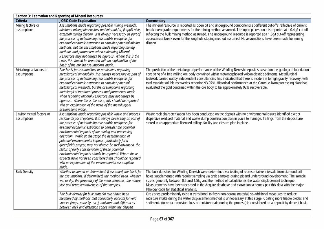
Page 67 of 367
Section 3: Estimation and Reporting of Mineral Resources Criteria JORC Code Explanation Commentary Mining factors or assumptions
Assumptions made regarding possible mining methods, minimum mining dimensions and internal (or, if applicable, external) mining dilution. It is always necessary as part of the process of determining reasonable prospects for eventual economic extraction to consider potential mining methods, but the assumptions made regarding mining methods and parameters when estimating Mineral Resources may not always be rigorous. Where this is the case, this should be reported with an explanation of the basis of the mining assumptions made.
The mineral resource is reported as open pit and underground components at different cut-off’s reflective of current break even grade requirements for the mining method assumed. The open pit resource is reported at a 0.4g/t cut-off reflecting the bulk mining method assumed. The underground resource is reported at a 1.3g/t cut-off representing approximate break even for the long hole stoping method assumed. No assumptions have been made for mining dilution.
Metallurgical factors or assumptions
The basis for assumptions or predictions regarding metallurgical amenability. It is always necessary as part of the process of determining reasonable prospects for eventual economic extraction to consider potential metallurgical methods, but the assumptions regarding metallurgical treatment process and parameters made when reporting Mineral Resources may not always be rigorous. Where this is the case, this should be reported with an explanation of the basis of the metallurgical assumptions made.
The prediction of the metallurgical performance of the Whirling Dervish deposit is based on the geological foundation consisting of a free milling ore body contained within metamorphosed volcaniclastic sediments. Metallurgical testwork carried out by independent consultancies has indicated that there is moderate to high gravity recovery, with total cyanide soluble recoveries reporting 93-97%. Historical performance at the Carosue Dam processing plant has evaluated the gold contained within the ore body to be approximately 92% recoverable.
Environmental factors or assumptions
Assumptions made regarding possible waste and process residue disposal options. It is always necessary as part of the process of determining reasonable prospects for eventual economic extraction to consider the potential environmental impacts of the mining and processing operation. While at this stage the determination of potential environmental impacts, particularly for a greenfields project, may not always be well advanced, the status of early consideration of these potential environmental impacts should be reported. Where these aspects have not been considered this should be reported with an explanation of the environmental assumptions made.
Waste rock characterisation has been conducted on the deposit with no environmental issues identified except dispersive oxidised material and waste dump construction plan in place to manage. Tailings from the deposit are stored in an appropriate licensed tailings facility and closure plan in place.
Bulk Density Whether assumed or determined. If assumed, the basis for the assumptions. If determined, the method used, whether wet or dry, the frequency of the measurements, the nature, size and representativeness of the samples.
The bulk densities for Whirling Dervish were determined via testing of representative intervals from diamond drill holes supplemented with regular sampling via grab samples during pit and underground development. The sample size is generally between 0.5 and 1.5kg and the method of calculation is the water displacement technique. Measurements have been recorded in the Acquire database and extraction schemes pair this data with the major lithology code for statistical analysis.
The bulk density for bulk material must have been measured by methods that adequately account for void spaces (vugs, porosity, etc.), moisture and differences between rock and alteration zones within the deposit.
Ore zones predominantly exist in transitional to fresh non-porous material, so additional measures to reduce moisture intake during the water displacement method is unnecessary at this stage. Coating more friable oxides and sediments (to reduce moisture loss or moisture gain during the process) is considered on a deposit by deposit basis.

Page 68 of 367
Section 3: Estimation and Reporting of Mineral Resources Criteria JORC Code Explanation Commentary
Discuss assumptions for bulk density estimates used in the evaluation process of the different materials.
An average mean of densities collected for each lithological type and position in the weathering profile has been uniformly applied to the modelled geological units. This includes the primary fresh lithologies as well as the weathered oxide and transitional zones.
Classification The basis for the classification of the Mineral Resources into varying confidence categories.
The Whirling Dervish resource is classified as Measured, Indicated Mine Defined, Indicated or Inferred assigned via boundary string by domain based on a combination of physical and estimation quality metrics including mining exposure, drill spacing, search pass, kriging efficiency / slope / variance, grade and geological continuity. Mineralisation has been categorised as Measured if it has been exposed by mining (open pit or development), have drill spacing at <=20x20m’s, estimated in the first search pass, have established grade and geological continuity, and >50% kriging efficiency and >80% slope. Material in this category is available for stoping. Indicated Mine defined is assigned where drill spacing <=20x20m, search pass 1, established grade and geological continuity, positive kriging efficiency and >50% slope. This material is available for lateral development. Indicated material is assigned if drill spacing is between 20x20m and 35x35m, search pass either 1 or 2, established grade and geological continuity, positive kriging efficiency and >50% slope. Inferred material is drill spacing between 35x35m and 80x80m’s with established geological continuity. All other mineralisation is assigned a Potential resource category.
Whether appropriate account has been taken of all the relevant factors (i.e. relative confidence in tonnage/grade estimations, reliability of input data, confidence in continuity of geology and metal values, quality, quantity and distribution of the data).
All relevant factors have been taken into account and are validated through rigorous QAQC of the drill hole database, geological knowledge and interpretation of the Whirling Dervish deposit. Thorough model validations and reviews ensure the integrity of the final estimation and the grade and tonnage numbers.
Whether the result appropriately reflects the Competent Person's view of the deposit.
The reviewing process allows the Competent Person's to assess and sign off on the model.
Audits or reviews The results of any audits or reviews of Mineral Resource estimates.
Saracen has adopted a process for geological modelling, estimation and reporting of mineral resources that meets high industry standards. At the completion of resource estimation Saracen undertake an extensive review of the model that covers;
• Model inventory and comparisons to previous and budget models if in existence • Geological interpretation, wireframing, domain selection, statistics by domain, assay and metal evaluation,
parent cell sizes, data compositing, variography, search strategy, estimation and KNA • Model validation – swathe plots, visual checks, volume comparisons, and composite to model metal
comparisons. In the final stages the model and resource categorisation are all discussed and scrutinized by the geological and mine planning teams. The resource estimation process is also annually reviewed by external consultants to ensure estimation methodology is robust and aligned to current industry best practice. Recommendations are always reviewed and implemented as appropriate.
Discussion of relative accuracy/confidence
Where appropriate a statement of the relative accuracy and confidence level in the Mineral Resource estimate using an approach or procedure deemed appropriate by the Competent Person. For example, the application of statistical or geostatistical procedures to quantify the relative accuracy of the resource within stated confidence limits, or, if such an approach is not deemed appropriate, a qualitative discussion of the factors that could affect the relative accuracy and confidence of the estimate.
The Mineral Resource has been reported in accordance with the guidelines of the 2012 edition of the Australasian Code for Reporting of Exploration Results, Mineral Resources and Ore Reserves. Saracen Gold Mine uses a standard approach to resource estimation and the procedure requires the systematic completion of the Saracen Resource Estimation Document that is thoroughly investigated and assessed in the Model review process, as stated above.

Page 69 of 367
Section 3: Estimation and Reporting of Mineral Resources Criteria JORC Code Explanation Commentary
The statement should specify whether it relates to global or local estimates, and, if local, state the relevant tonnages, which should be relevant to technical and economic evaluation. Documentation should include assumptions made and the procedures used.
The statement relates to a global estimate.
These statements of relative accuracy and confidence of the estimate should be compared with production data, where available.
The current resource model is reconciled with production data on a monthly basis. This information is fed back into the resource modelling process and used to refine the model.
Section 4: Estimation and Reporting of Ore Reserves Criteria JORC Code Explanation Commentary Mineral Resource estimate for conversion to Ore Reserves
Description of the Mineral resource Estimate used as a basis for the conversion to an Ore Reserve.
The Mineral Resource estimate for the Whirling Dervish gold deposit used as a basis for conversion to the Ore Reserve estimate was compiled by Saracen. The data included drilling and assay data, geological mapping and historical mining records to validate the model against and solid interpretation wireframes of the geology. This information was used to construct a model estimated by ordinary kriging (ok) with categorical indicator kriging (CIK) sub domains. The model was depleted with the final pit and underground survey’s completed in June 2019.
Clear statement as to whether the Mineral Resources are reported additional to. Or inclusive of, the Ore Reserves.
The Mineral Resource reported is inclusive of the Ore Reserve.
Site Visits Comment on any site visits undertaken by the Competent Person and the outcome of those visits.
The competent person is conducting frequent ongoing site visits to the Carosue Dam Operations (CDO) mine site, where the Whirling Dervish deposit is located. Saracen and consultant geotechnical engineers regularly visit Whirling Dervish to inspect the mine and gather data used in the preparation of geotechnical reports to define parameters for underground mining. Hydrogeology consultants have visited Carosue Dam to gather data and inspect the inflow of groundwater into the open pit, used in the preparation of reports used to determine water management strategies.
If no site visits have been undertaken indicate why this is the case.
N/A
Study status The type and level of study undertaken to enable Mineral Resources to be converted to Ore Reserves
The Whirling Dervish deposit was mined by Saracen as an open pit operation in three stages, commencing in 2010. The Stage 3 open pit was completed in July 2015. An underground portal and drill drive was development during 2017, and utilised for an extensive underground diamond drilling campaign. Saracen commenced the underground operation in May 2018. Ore from Whirling Dervish continues to be treated at the Carosue Dam processing facility. Whirling Dervish is an active underground operation with a detailed mine design and an economic analysis, to define the ore reserve.
The Code requires that a study to at least Pre-Feasibility Study level has been undertaken to convert Mineral Resources to Ore Reserves. Such studies will have been carried out and will have determined a mine plan that is technically achievable and economically viable, and that material Modifying Factors have been considered.
Modifying factors have been applied to the project to ensure the rigor of the financial analysis. All of the parameters assumed and adopted, as well as the financial analysis completed, are based upon current active mine inputs and have been the subject to peer review.

Page 70 of 367
Section 4: Estimation and Reporting of Ore Reserves Criteria JORC Code Explanation Commentary Cut-off parameters The basis of the cut-off grade(s) or quality parameters
applied For the purpose of Ore Reserve Estimate an operating cut-off grade of 1.4g/t was calculated based upon an assumed gold price of AUD$1,600/Oz and applicable mining production costs, processing, haulage and administration costs. This operating cut-off grade was then used as the basis of mine design. Subsequent production designs were then reviewed, and if required, lower grading stopes were removed from the design. The resulting mine grade’s, allow for the cost of capital, all operating costs, plus a return on investment.
Mining factors or assumptions
The method and assumptions used as reported in the Pre-feasibility or Feasibility Study to convert the Mineral Resource to an Ore Reserve (i.e. either by application of appropriate factors by optimisation or by preliminary or detailed design).
The Whirling Dervish underground ore reserve has been estimated using detailed mine development and stope designs. Suitable modifying factors for dilution and recovery have been applied to the economic analysis of the design to generate the ore reserve.
The choice, nature and appropriateness of the selected mining method(s) and other mining parameters including associated design issues such as pre-strip, access, etc.
Underground mechanised mining for development, ground support, and production stoping is utilised at Whirling Dervish. Mining and geotechnical studies have determined open stoping with remnant in-situ pillars to be appropriate for the deposit. This mining method of open stoping with remnant in-situ pillars is currently utilised at other underground mines at Carosue Dam Operations, and used throughout the Western Australian Goldfields and Australia.
The assumptions made regarding geotechnical parameters (e.g. pit slopes, stope sizes, etc.), grade control, and pre-production drilling.
Assumptions are based upon actual mining conditions. A review of the previous analysis and assessment of the designed stopes were performed by Saracen’s geotechnical team. Several external consultants have also reviewed the deposit and results / analysis found assumptions were acceptable. The current mine design allows for 20% to 30% of the available mineral resource to remain in-situ, as either rib or sill pillars. The overall extraction ratio of this portion of the mineral resources is approximately 75%. A grade control program with associated development for drilling platforms, grade control drilling designs, and sampling costs have been include in the mine design, mine schedule and economic analysis..
The major assumptions made and Mineral Resource model used for pit and stope optimisation (if appropriate).
The resource model used for the ore reserve calculations was wd1906_res_mine.dm
The mining dilution factors used. An allowance for mining dilution has been incorporated into the mine designs. An additional dilution allowance of 16% at 0.6g/t has been applied for stoping.
The mining recovery factors used. A mining recovery factor of 96% has been assumed for all stopes. Any minimum mining widths used A minimum stope width of 3m was applied in the design process. The manner in which inferred Mineral resources are utilised in mining studies and the sensitivity of the outcome to their inclusion.
A minor amount (<3% of tonnes) of inferred resources are contained within underground mine design, in stopes and development at the periphery of the indicated resource category material. This material contributes a minor amount of metal (<4% of ounces) within the design. Therefore the reserve has a minor sensitivity to the inclusion of inferred resources.
The infrastructure requirements of the selected mining methods.
Standard underground infrastructure is currently operational, including a decline for access and truck haulage, ventilation fans, escape-way ladders, electrical reticulation, mine services (air and water), and mine dewatering infrastructure.
Metallurgical factors or assumptions
The metallurgical process proposed and the appropriateness of that process to the style of mineralisation
The ore reserve will be treated at the established Carosue Dam processing facility. The Carosue Dam Process Plant is a CIL cyanide leach plant incorporating a gravity circuit which is appropriate for the extraction of gold from free milling gold ores. An average plant processing recovery of 93% has been assumed in the Ore Reserve Estimate which is consistent with historical plant recoveries for Whirling Dervish ore.

Page 71 of 367
Section 4: Estimation and Reporting of Ore Reserves Criteria JORC Code Explanation Commentary
Whether the metallurgical process is well-tested technology or novel in nature.
The method of ore processing and extraction proposed utilises well tried and proven technology dating back to the 1960’s and practiced extensively around the world.
The nature, amount and representiveness of metallurgical test work undertaken, the nature of the metallurgical domaining applied and the corresponding metallurgical recovery factors applied.
In 2014 a review of the Whirling Dervish open pit ore processing performance was conducted and metallurgical test work was carried out determine the continuity of processing performance from underground ore. No evidence was found to indicate any changes in the processing performance from underground ore to the historical performance from open pit ore.
Any assumptions or allowances made for deleterious elements.
No deleterious elements have been identified during the processing of Whirling Dervish ores since 2010.
The existence of any bulk sample or pilot scale test work and the degree to which such samples are considered representative of the ore body as a whole.
Ore from the Whirling Dervish open pit has been treated at the Carosue Dam processing facility since 2010. Stockpiled ore has been continually treated during 2016 and 2017. The open pit fresh rock ore processed is considered representative of the ore expected from underground.
For minerals that are defined by a specification, has the ore reserve estimation been based on the appropriate mineralogy to meet the specifications.
N/A
Environmental factors or assumptions
The status of studies of potential environmental impacts of the mining and processing operation. Details of waste rock characterisation and the consideration of potential sites, status of design options considered and, where applicable, the status of approvals for process residue storage and waste dumps should be reported.
Open pit mining operations ceased during July 2015, however all approvals (clearing permit, works approval and Mining Proposals) have been granted for ongoing mining and processing at Carosue Dam. The site currently holds and Environmental Protection Act Licence 7465/1999/8 for processing, mine dewatering and power generation. The existing Carosue Dam mine, including the area of Whirling Dervish underground mine, and the accommodation village all lay on granted mining leases. The following studies have been completed and provided to support for the required statutory approvals: Flora surveys of areas to be cleared, waste rock characterisation studies, surface water studies and tailings storage facility documentation.
Infrastructure The existence of appropriate infrastructure: availability of land for plant development, power, water, transportation (particularly for bulk commodities), labour, accommodation; or the ease with which the infrastructure can be provided, or accessed.
Carosue Dam Operations are well established, with mining activities being conducted by Saracen since 2009. The CDO operation comprises at 2.4mtpa CIL ore processing facility, aerodrome with sealed runway, associated tailings storage facilities, several power stations, water supply, workshops, and administration offices. Whirling Dervish underground mine is located within 700m of the CDO plant. A modern accommodation camp is sited within a few kilometres of the administration offices and processing facility. A 70km gravel access road links Carosue Dam Operations to the gravel section of Yarri Road. Both the Saracen and Shire of Kalgoorlie gravel roads are well maintained. The mine site is ~120km from the sealed section or Yarri Road leading to Kalgoorlie.
Costs The derivation of, or assumptions made, regarding projected capital costs in the study.
Actual mine operating and capital costs have been used. Capital costs relate to establishment of capital infra-structure and continuing expansion of capital works for Whirling Dervish underground. The cost estimates are based on historical costs for similar work undertaken at Carosue Dam for the establishment and operation of the Deep South and Karari underground mines.
The methodology used to estimate operating costs. Operating costs for underground mining have been derived from a combination of actual costs from Carosue Dam Operations and tendered contract costs supplied by independent mining contractors. Operating costs for ore processing have been derived from known parameters at Carosue Dam, with additional costs such as labour sourced from current operational data.
Allowances made for the content of deleterious elements Previous operational experience on the Whirling Dervish deposit at Carouse Dam did not reveal any deleterious elements within the ore or waste that required any additional cost allowances.

Page 72 of 367
Section 4: Estimation and Reporting of Ore Reserves Criteria JORC Code Explanation Commentary
The derivation of assumptions made of metal or commodity price(s), for the principal minerals and co-products
An assumed gold price of AUD$1,600/oz has been adopted for financial modelling.
The source of exchange rates used in study All revenue and cost calculations have been made in AUD, so no exchange rate usage or assumptions have been necessary.
Derivation of transportation charges Costs associated with bullion transportation have been derived from existing contractual arrangements at Carouse Dam Operations.
The basis for forecasting or source of treatment and refining charges, penalties for failure to meet specification, etc.
Costs associated with refining have been derived from existing contractual arrangements at Carouse Dam Operations.
The allowances made for royalties payable, both Government and private.
Royalty costs are a 2.5% royalty payable to the Western Australian state government, and a 1.5% royalty payable to IRC.
Revenue Factors The derivation of, or assumptions made, regarding revenue factors including head grade, metal or commodity price(s) exchange rates, transportation and treatment charges, penalties, net smelter returns, etc.
N/A
The derivation of assumptions made of metal or commodity price(s), for the principal metals, minerals and co-products
An assumed gold price of AUD$1,600/oz has been adopted for financial modelling.
Market Assessment The demand, supply and stock situation for the particular commodity, consumption trends and factors likely to affect supply and demand into the future.
There is a transparent quoted market for the sale of gold.
A customer and competitor analysis along with the identification of likely market windows for the product.
There is a transparent quoted market for the sale of gold.
Price and volume forecasts and the basis for these forecasts.
There is a transparent quoted market for the sale of gold.
For industrial minerals the customer specification, testing and acceptance requirements prior to a supply contract.
N/A
Economic The inputs to the economic analysis to produce the net present value (NPV) in the study, the source and confidence of these economic inputs including estimated inflation, discount rate, etc.
Cost assumptions have been made using a combination of historical performance at Carosue Dam and contract mining costs from an experienced mining contractor. The economic analysis is viewed as representative of the current market conditions.
NPV ranges and sensitivity to variations in the significant assumptions and inputs.
Sensitivities were not assessed.
Social The status of agreements with key stakeholders and matters leading to social licence to operate
Carosue Dam is currently operating and has good relationships with neighbouring stakeholders, including engagement with the local pastoralists and the traditional owners. The mine is located on leasehold pastoral land with compensation agreements in place with the local pastoralist. Granted mining leases cover all of the proposed mining and processing assets and there are no Native title claims pending.
Other To the extent relevant, the impact of the following on the project and/or on the estimation and classification of the Ore Reserves:

Page 73 of 367
Section 4: Estimation and Reporting of Ore Reserves Criteria JORC Code Explanation Commentary
Any identified material naturally occurring risks Water inrush is the only naturally occurring risk identified. Inrush from regional surface water flows has been addressed by the construction of appropriate water diversion bunds as part of previous open pit mining operations. A containment pond and dewatering infrastructure has provided for in the mine design and capital costs to mitigate water inrush from rainfall captured within the existing open pit.
The status of material legal agreements and marketing arrangements
Contracts are in place for all critical goods and services to operate Carosue Dam Operations. A mining contract will be tendered for Whirling Dervish underground prior to the commencement of mining.
The status of governmental agreements and approvals critical to the viability of the project, such as mineral tenement status, and government and statutory approvals. There must be reasonable grounds to expect that all necessary government approvals will be received within the timeframes anticipated in the Pre-Feasibility or Feasibility study. Highlight and discuss the materiality of any unresolved matter that is dependent on a third party on which extraction of the reserve is contingent.
Carosue Dam Operations is in production with all required government statutory permits and approvals in place for the three operating mines and processing plant. The required statutory approvals for Whirling Dervish will be applied for prior to the commencement of underground mining.
Classification The basis for the classification of the Ore Reserve into varying confidence categories
The Ore Reserve Estimate classification for Whirling Dervish underground has been in accordance with the JORC code 2012. The estimated Ore Reserve is classified as being Probable with the majority of the reserve being derived from that portion of the Mineral Resource classified as indicated. A minor amount (<3% of tonnes) of inferred resources are contained within underground mine design, in stopes and development at the periphery of the indicated resource category material. This material contributes a minor amount of metal (<4% of ounces) within the design. Therefore the reserve has a minor sensitivity to the inclusion of inferred resources.
Whether the result appropriately reflects the Competent Person’s view of the deposit.
Cost assumptions and inputs factors applied to the underground project were derived from a combination of historical site data, current operational data relating to Carouse Dam Operations, mining costs supplied by independent mining contractors, and recommendations from industry consultants. Results of the detailed design and analysis reflect the views of Competent Person regarding the Whirling Dervish deposit.
The proportion of Probable Ore Reserves that have been derived from Measured Mineral Resources (if any)
There were no Measured Mineral Resources within the underground mine design that formed the physical extent of the estimated Ore Reserve.
Audits or reviews The results of any audits or reviews of Ore Reserve estimates
There have been no external reviews of this Ore reserve estimate.

Page 74 of 367
Section 4: Estimation and Reporting of Ore Reserves Criteria JORC Code Explanation Commentary Discussion of relative accuracy/confidence
Where appropriate a statement of the relative accuracy and confidence level in the Ore Reserve estimate using an approach or procedure deemed appropriate by the Competent Person. For example, the application of statistical or geo-statistical procedures to quantify the relative accuracy of the reserve within stated confidence limits, or, if such an approach is not deemed appropriate, a qualitative discussion of the factors which could affect the relative accuracy and confidence of the estimate The statement should specify whether it relates to global or local estimates, and if local, state the relevant tonnages which should be relevant to technical and economic evaluation. Documentation should include assumptions made and the procedures used. Accuracy and confidence discussions should extend to specific discussions of any applied modifying factors that may have a material impact on Ore Reserve viability, or for which there are remaining areas of uncertainty at the current study stage. It is recognised that this may not be possible or appropriate in all circumstances. These statements or relative accuracy and confidence of the estimate should be compared with production data, where available.
The Ore Reserve estimate has been prepared within the guidelines of the 2012 JORC Code. The relative confidence of the estimate complies with the criteria of Probable Ore Reserves. Based upon;
- resource model,
- significant operating history,
- application of current industry practices,
- appropriate operating and capital costs,
The range of the modifying factors is reasonable and confidence in the resulting reserve estimate is reasonable. Estimates are global but will be reasonably accurate on a local scale. The complete mine design with all of the modifying factors assumed and adopted, and financial analysis used in the estimated Ore Reserve have been the subject to peer review internally, and the Competent Person is confident that it is an accurate estimation of the current Whirling Dervish reserve. Reconciliation results from past mining at Whirling Dervish and suitable factors from currently active underground operations at CDO have been considered and factored into the reserve assumptions where appropriate.
Monty’s Dam- Elliot’s Section 1: Sampling Techniques and Data Criteria JORC Code Explanation Commentary Sampling Techniques Nature and quality of sampling (e.g. cut channels, random
chips, or specific specialised industry standard measurement tools appropriate to the minerals under investigation, such as down hole gamma sondes, or handheld XRF instruments, etc.). These examples should not be taken as limiting the broad meaning of sampling.
Sampling methods undertaken by Saracen at Monty’s Dam-Elliot’s Lode have included reverse circulation drillholes (RC) and diamond drilling (DD). Historic sampling methods conducted since 1983 have included auger, aircore (AC), rotary air blast (RAB), RC and DD drillholes.
Include reference to measures taken to ensure sample representivity and the appropriate calibration of any measurement tools or systems used
Sampling for diamond and RC drilling is carried out as specified within Saracen sampling and QAQC procedures as per industry standard. RC chips and diamond core provide high quality representative samples for analysis. RC, RAB, AC and DD core drilling was completed by previous holders to industry standard at that time (1991-2003).
Aspects of the determination of mineralisation that are Material to the Public Report. In cases where ‘industry
RC chips are cone or riffle split and sampled into 1m intervals with total sample weights under 3kg.

Page 75 of 367
Section 1: Sampling Techniques and Data Criteria JORC Code Explanation Commentary
standard’ work has been done this would be relatively simple (e.g. ‘reverse circulation drilling was used to obtain 1 m samples from which 3 kg was pulverised to produce a 30 g charge for fire assay’). In other cases more explanation may be required, such as where there is coarse gold that has inherent sampling problems. Unusual commodities or mineralisation types (e.g. submarine nodules) may warrant disclosure of detailed information
Diamond core is NQ or HQ sized, sampled to 1m intervals or geological boundaries where necessary and cut into half core to give sample weights under 3 kg. Samples are selected to weigh less than 3 kg to ensure total sample inclusion at the pulverisation stage. Saracen core and chip samples are crushed, dried and pulverised to a nominal 90% passing 75µm to produce a 40g or 50 g sub sample for analysis by FA/AAS. Some grade control RC chips were analysed in the Saracen on site laboratory using a PAL (pulverise and leach) method. Historical AC, RAB, RC and diamond sampling was carried out to industry standard at that time. Analysis methods include fire assay and unspecified methods.
Drilling Techniques Drill type (e.g. core, reverse circulation, open-hole hammer, rotary air blast, auger, Bangka, sonic, etc.) and details (e.g. core diameter, triple or standard tube, depth of diamond tails, face-sampling bit or other type, whether core is oriented and if so, by what method, etc.).
The Monty’s Dam-Elliot’s Lode deposit was initially sampled by 93 AC holes, 249 RAB holes, 329 RC holes (assumed standard 5 ¼ ‘’bit size) and 15 surface diamond core holes of unknown diameter. Of the 329 RC holes, Saracen drilled 110 RC holes using a 143mm diameter bit with a face sampling hammer. The rig was equipped with an external auxiliary/ booster. Saracen has completed 10 surface RC precollar with NQ diamond tail drillhole (precollar averaging 259m, diamond tails averaging 154m) and 4 diamond drillholes (NQ sized) Diamond tails were oriented using an Ezi-mark tool. Some historic surface diamond drill core appears to have been oriented by unknown methods.
Drill Sample Recovery Method of recording and assessing core and chip sample recoveries and results assessed
RC sampling recoveries are recorded in the database as a percentage based on a visual weight estimate; no historic recoveries have been recorded. Diamond core recovery percentages calculated from measured core versus drilled intervals are logged and recorded in the database. Recoveries average >90%.
Measures taken to maximise sample recovery and ensure representative nature of the samples
During RC drilling daily rig inspections are carried out to check splitter condition, general site and address general issues. Diamond core is reconstructed into continuous runs on an angle iron cradle for orientation marking. Depths are checked against depth given on the core blocks. During GC campaigns the sample bags weight versus bulk reject weight are compared to ensure adequate and even sample recovery. Historical AC, RAB, RC and diamond drilling to industry standard at that time.
Whether a relationship exists between sample recovery and grade and whether sample bias may have occurred due to preferential loss/gain of fine/coarse material.
There is no known relationship between sample recovery and grade for RC drilling. Diamond drilling has high recoveries meaning loss of material is minimal. Any historical relationship is not known.
Logging Whether core and chip samples have been geologically and geotechnically logged to a level of detail to support appropriate Mineral Resource estimation, mining studies and metallurgical studies. Whether logging is qualitative or quantitative in nature. Core (or costean, channel, etc) photography.
Logging of RC chips and diamond drill core records lithology, mineralogy, texture, mineralisation, weathering, alteration and veining. Geotechnical and structural logging is carried out on all diamond holes to record recovery, RQD, defect number, type, fill material, shape and roughness, and alpha and beta angles. Chips from all RC holes are stored in chip trays for future reference while remaining core is stored in core trays and archived on site. Core is photographed in both dry and wet state. Qualitative and quantitative logging of historic data varies in its completeness.
The total length and percentage of the relevant intersections logged
All RC and diamond drillholes holes are logged in full. Historical logging is approximately 100% complete.
Sub-sampling techniques and sample preparation
If core, whether cut or sawn and whether quarter, half or all core taken.
All drill core is cut in half onsite using an automatic core saw. Samples are always collected from the same side.

Page 76 of 367
Section 1: Sampling Techniques and Data Criteria JORC Code Explanation Commentary
If non-core, whether riffled, tube sampled, rotary split, etc and whether sampled wet or dry.
All RC samples are cone or riffle split. Occasional wet samples are encountered. AC, RAB and RC drilling has been sampled using riffle and unknown methods.
For all sample types, the nature, quality and appropriateness of the sample preparation technique.
The sample preparation of diamond core and RC chips adhere to industry best practice. It is conducted by a commercial laboratory and involves oven drying, coarse crushing then total grinding to a size of 90% passing 75 microns. Best practice is assumed at the time of historic sampling.
Quality control procedures adopted for all sub-sampling stages to maximise representivity of samples.
All subsampling activities are carried out by commercial laboratory and are considered to be satisfactory. Sampling by previous holders assumed to be industry standard at the time.
Measures taken to ensure that the sampling is representative of the in situ material collected, including for instance results for field duplicate/second half sampling.
RC field duplicate samples are carried out at a rate of 1:20 and are sampled directly from the on-board splitter on the rig. These are submitted for the same assay process as the original samples and the laboratory are unaware of such submissions. Sampling by previous holders assumed to be industry standard at the time.
Whether sample sizes are appropriate to the grain size of the material being sampled.
Sample sizes of 3kg are considered to be appropriate given the grain size (90% passing 75 microns) of the material sampled.
Quality of assay data and laboratory tests
The nature, quality and appropriateness of the assaying and laboratory procedures used and whether the technique is considered partial or total.
RC chip samples and diamond core are analysed by external laboratories using a 40g or 50g fire assay with AAS finish. These methods are considered suitable for determining gold concentrations in rock and are total digest methods. Historic sampling includes fire assay and unknown methods.
For geophysical tools, spectrometers, handheld XRF instruments, etc, the parameters used in determining the analysis including instrument make and model, reading times, calibrations factors applied and their derivation, etc.
No geophysical tools have been utilised for reporting gold mineralisation.
Nature of quality control procedures adopted (e.g. standards, blanks, duplicates, external laboratory checks) and whether acceptable levels of accuracy (i.e. lack of bias) and precision have been established.
Certified reference material (standards and blanks) with a wide range of values are inserted into every drillhole at a rate of 1:25 for exploration RC and DD. These are not identifiable to the laboratory. QAQC data returned are checked against pass/fail limits with the SQL database and are passed or failed on import. A report is generated and reviewed by the geologist as necessary upon failure to determine further action. QAQC data is reported monthly. Sample preparation checks for fineness are carried out to ensure a grindsize of 90% passing 75 microns. The laboratory performs a number of internal processes including standards, blanks, repeats and checks. QAQC data analysis demonstrates sufficient accuracy and precision. Industry best practice is assumed for previous holders.
Verification of sampling and assaying
The verification of significant intersections by either independent or alternative company personnel.
Significant intercepts are verified by the Geology Manager and corporate personnel.
The use of twinned holes. No specific twinned holes have been drilled at Monty’s Dam-Elliot’s Lode by Saracen. It is unknown if previous holders twinned any hole.
Documentation of primary data, data entry procedures, data verification, data storage (physical and electronic) protocols
Primary data is collated in a set of acquire data entry objects utilising lookup codes. This data is forwarded to the Database Administrator for entry into a secure acQuire database with inbuilt validation functions. Data from previous owners was taken from a database compilation and validated as much as practicable before entry into the Saracen acQuire database.
Discuss any adjustment to assay data. No adjustments have been made to assay data. First gold assay is utilised for resource estimation.

Page 77 of 367
Section 1: Sampling Techniques and Data Criteria JORC Code Explanation Commentary Location of data points Accuracy and quality of surveys used to locate drillholes
(collar and down-hole surveys), trenches, mine workings and other locations used in Mineral Resource estimation.
Drillholes are located using a Leica 1200 GPS with an accuracy of +/-10mm. Downhole surveys are carried out using an Eastman single shot camera at regular intervals (usually 30m). A number of drillholes have also been gyroscopically surveyed. Previous holders’ survey accuracy and quality is unknown
Specification of the grid system used. A local grid system, Old Plough Dam West (OPDW) is used. The two point conversion to MGA_GDA94 zone 51 is: OPDWEast OPDWNorth RL MGAEast MGANorth RL Point 1 8035.58 20901.34 0 431948.52 6674917.54 0 Point 2 8147.50 17313.10 0 434806.92 6672750.25 0 Historic data is converted to the Old Plough Dam West local grid upon export from the database.
Quality and adequacy of topographic control. Topographic control originally used site based survey pickups in addition to Kevron aerial photogrammetric surveys with +/- 5m resolution. Pre mining, new and more detailed topography has since been captured and will be used in future updates and for subsequent planning purposes.
Data spacing and distribution
Data spacing for reporting of Exploration Results. Monty’s Dam has a nominal drill spacing ranging from 10m x 10m to 20m x 20m, while Elliot’s Lode has nominal 20m x 20m drill spacing.
Whether the data spacing and distribution is sufficient to establish the degree of geological and grade continuity appropriate for the Mineral Resource and Ore Reserve estimation procedure(s) and classifications applied.
Data spacing and distribution are sufficient to establish the degree of geological and grade continuity appropriate for JORC classifications applied.
Orientation of data in relation to geological structure
Whether sample compositing has been applied.
Sample compositing is not applied until the estimation stage. Some historic RAB and RC sampling was composited into 3-4m samples with areas of interest re-sampled to 1m intervals. It is unknown at what threshold this occurred.
Whether the orientation of sampling achieves unbiased sampling of possible structures and the extent to which this is known, considering the deposit type.
The majority of drillholes are positioned to achieve optimum intersection angles to the ore zone as are practicable.
If the relationship between the drilling orientation and the orientation of key mineralised structures is considered to have introduced a sampling bias, this should be assessed and reported if material.
No significant sampling bias has been recognised due to orientation of drilling in regards to mineralised structures.
Sample security The measures taken to ensure sample security. Samples are prepared on site under supervision of Saracen geological staff. Samples are selected, bagged into tied numbered calico bags then grouped into secured cages and collected by the laboratory personnel. Sample submissions are documented via laboratory tracking systems and assays are returned via email
Audits or reviews The results of any audits or reviews of sampling techniques and data.
An internal review of company-wide sampling methodologies was conducted to create the current sampling and QAQC procedures. No external audits or reviews have been conducted.
Section 2: Reporting of Exploration Results Criteria JORC Code Explanation Commentary Mineral tenement and land tenure status
Type, reference name/number, location and ownership including agreements or material issues with third parties such as joint ventures, partnerships, overriding royalties,
The Monty’s Dam-Elliot’s Lode gold deposit is located in M31/209. The tenement is held 100% by Saracen Gold Mines Pty Ltd, a wholly owned subsidiary of Saracen Mineral Holdings Limited.

Page 78 of 367
Section 2: Reporting of Exploration Results Criteria JORC Code Explanation Commentary
native title interests, historical sites, wilderness or national park and environmental settings.
Mining Lease M31/209 has a 21 year life (held until 2023) and is renewable for a further 21 years on a continuing basis. Mining Lease M31/209 is subject to two third party royalties, two caveats (Caveats 61H/067 and 340983) and a bank mortgage (Mortgage 415495). All production is subject to a Western Australian state government NSR royalty of 2.5%. Mining Lease M31/209 is subject to the Gindalbie Pastoral Compensation Agreement.
The security of the tenure held at the time of reporting along with any known impediments to obtaining a licence to operate in the area.
The tenements are in good standing and the licence to operate already exists.
Exploration done by other parties
Acknowledgment and appraisal of exploration by other parties.
The Old Plough Dam project area in which the Monty’s Dam-Elliot’s Lode deposit is located has been subjected to extensive gold exploration by numerous companies since the 1980s. Monty’s Dam was highlighted as an area of interest following a geochemical and ground magnetic survey conducted by Freeport-McMoran Australia in 1983. Auger sampling undertaken by Pancontinental Mining in 1991 further defined a target which was followed up by RAB drilling. Gold mineralisation at Monty’s Dam was confirmed in March 1993 and additional RAB and step-out RC drilling discovered the adjacent Elliot’s Lode to the north in 1994-1995. By this time, control over the prospects was transferred to Goldfields Exploration which conducted resource definition drilling, geophysical surveys and metallurgical tests until 2000. Tenement ownership then transferred to Oriole Resources which conducted infill drilling to follow up on previous works. In 2001, Sons of Gwalia (SOG) took over from Oriole Resources and undertook step-out AC drilling to test the NW extension of the deposit. SOG started mining at Monty’s Dam in 2002 while drilling AC, RC and DD at the Elliot’s Lode prospect. The tenement was then acquired by St Barbara and mined the Monty’s Dam deposit until 2005. In 2006, Saracen took over the tenement and started step-out and infill RC drilling in 2010 at the Elliot’s Lode prospect.
Geology Deposit type, geological setting and style of mineralisation.
The Monty’s Dam and Elliot’s Lode deposits are classified as a late-tectonic, epigenetic (mesothermal) gold deposit reported to be associated with late (D4) N-NNE-trending faults. Stockwork mineralization overprinting wallwork foliation was produced by low-salinity H2O-CO2 fluids. Mineralization at Monty’s Dam-Elliot’s Lode is related to moderately intense quartz veining centered along the contact between fine-grained porphyry and underlying sediment with a strong and pervasive hematite alteration halo that also extends around felsic porphyry unit. Disseminated pyrite and moderate to weak sericitization also characterize the mineralized zone at Monty’s Dam. As such, the mineralized zone is pinkish and the grade is correlatable to the degree of coloration (Fig. 12). These lensoidal to anastomosing mineralized zones vary in widths from 5 to 40 m. Because of this shape, the orientation can only be inferred to trend northwest, dipping 50 to 60 degrees to the east with a shallow plunge of 10 degrees to the south, which is similar to the regional geologic fabric (Longworth, 1994). Gold commonly occurs as blebs, intergrown within pyrite or as disseminated particles throughout the host rocks.
Drillhole information A summary of all information material to the understanding of the exploration results including a tabulation of the following information for all Material drill holes:
• easting and northing of the drill hole collar • elevation or RL (Reduced Level – elevation • above sea level in metres) of the drill hole collar • dip and azimuth of the hole • down hole length and interception depth • hole length.
All material data is periodically released on the ASX, notably on 9 December 2011 and 27 April 2012. Future drill hole data will be periodically released or when a results materially change the economic value of the project. Exclusion of the drilling information will not detract from the reader’s view of the report.
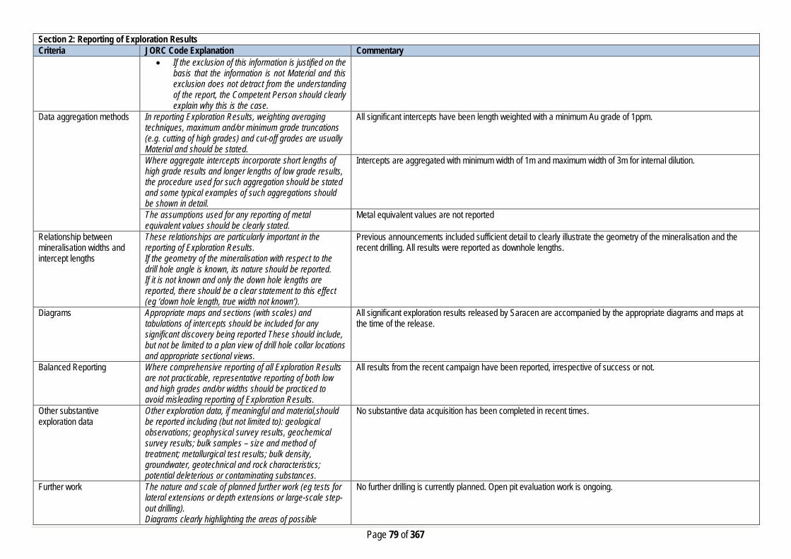
Page 79 of 367
Section 2: Reporting of Exploration Results Criteria JORC Code Explanation Commentary
• If the exclusion of this information is justified on the basis that the information is not Material and this exclusion does not detract from the understanding of the report, the Competent Person should clearly explain why this is the case.
Data aggregation methods In reporting Exploration Results, weighting averaging techniques, maximum and/or minimum grade truncations (e.g. cutting of high grades) and cut-off grades are usually Material and should be stated.
All significant intercepts have been length weighted with a minimum Au grade of 1ppm.
Where aggregate intercepts incorporate short lengths of high grade results and longer lengths of low grade results, the procedure used for such aggregation should be stated and some typical examples of such aggregations should be shown in detail.
Intercepts are aggregated with minimum width of 1m and maximum width of 3m for internal dilution.
The assumptions used for any reporting of metal equivalent values should be clearly stated.
Metal equivalent values are not reported
Relationship between mineralisation widths and intercept lengths
These relationships are particularly important in the reporting of Exploration Results. If the geometry of the mineralisation with respect to the drill hole angle is known, its nature should be reported. If it is not known and only the down hole lengths are reported, there should be a clear statement to this effect (eg ‘down hole length, true width not known’).
Previous announcements included sufficient detail to clearly illustrate the geometry of the mineralisation and the recent drilling. All results were reported as downhole lengths.
Diagrams Appropriate maps and sections (with scales) and tabulations of intercepts should be included for any significant discovery being reported These should include, but not be limited to a plan view of drill hole collar locations and appropriate sectional views.
All significant exploration results released by Saracen are accompanied by the appropriate diagrams and maps at the time of the release.
Balanced Reporting Where comprehensive reporting of all Exploration Results are not practicable, representative reporting of both low and high grades and/or widths should be practiced to avoid misleading reporting of Exploration Results.
All results from the recent campaign have been reported, irrespective of success or not.
Other substantive exploration data
Other exploration data, if meaningful and material,should be reported including (but not limited to): geological observations; geophysical survey results, geochemical survey results; bulk samples – size and method of treatment; metallurgical test results; bulk density, groundwater, geotechnical and rock characteristics; potential deleterious or contaminating substances.
No substantive data acquisition has been completed in recent times.
Further work The nature and scale of planned further work (eg tests for lateral extensions or depth extensions or large-scale step-out drilling). Diagrams clearly highlighting the areas of possible
No further drilling is currently planned. Open pit evaluation work is ongoing.

Page 80 of 367
Section 2: Reporting of Exploration Results Criteria JORC Code Explanation Commentary
extensions, including the main geological interpretations and future drilling areas, provided this information is not commercially sensitive
Section 3: Estimation and Reporting of Mineral Resources Criteria JORC Code Explanation Commentary Database Integrity Measures taken to ensure that data has not been corrupted
by, for example, transcription or keying errors, between its initial collection and its use for Mineral Resource estimation purposes.
The database used for the estimate an extract from an Acquire SQL database. The primary database is regulated by a locked framework called the acquire data model which fixes the relationships between tables. The data model minimises the potential for data collection and data usage errors through pre-determined look up tables, storage and export functions. User defined permissions also regulate the ability to add, edit or extract data. Primary data is recorded using typical manual translation of logging and data capture from written logs and direct import of csv tables through a data import scheme where data is validated upon import or direct data entry options into the database using predefined look up values.
Data validation procedures used. Data that is captured in the field is entered into Excel templates which are checked on import into the database for errors. Assay jobs are dispatched electronically to the lab to minimise the chance of data entry errors. Assay results from the lab are received in CSV format and are checked for errors on import into the database. Data is regularly validated using the mining software. The data validation process is overseen by the Database Administrator.
Site Visits Comment on any site visits undertaken by the Competent Person and the outcome of those visits.
The Competent Person regularly visits site (monthly and more so when the geological work is more complex and demanding) to assess geological competency and ensure integrity across all geological disciplines.
If no site visits have been undertaken indicate why this is the case.
Geological Interpretation Confidence in (or conversely, the uncertainty of) the geological interpretation of the mineral deposit.
A combination of well documented historic geology and structural information, exploration mapping, geophysical surveys, sufficient drill hole information and geological data collected during production at Monty’s Dam has resulted in a confident geological interpretation. Subsequent infill drilling of both Monty’s, Elliot’s and North West has increased confidence in the current interpretation.
Nature of the data used and any assumptions made. The geological interpretation of Monty’s Elliot has considered all available geological information including local geology, structural deformation events, and its relationship to neighbouring mineralised deposits. Rock types, mineral, alteration and veining assemblages from diamond drill core, RC Chips and pit high wall mapping were all used to help define the mineralised domains and regolith boundaries. Interpreted shears and faults obtained from pit exposures and geophysical data further constrained the domaining. The current resource has been interpreted from 20 diamond holes, 10 RCDD holes and 519 RC holes.
The affect, if any, of alternative interpretations on Mineral Resource estimation.
Over the life of the project additional drilling campaigns have confirmed and further clarified the ubiquitous pinch and swell geometry of the mineralised lodes in a structurally controlled environment. Whilst structural theories have altered slightly over time, the general trend, dip and plunge of the lodes has remained constant.
The use of geology in guiding and controlling the Mineral Resource estimation.
The geology has heavily influenced the extent of the domains controlling the mineral resource estimation. Mineralisation at Monty’s Dam is structurally controlled by the intersection of the local Eliot Lode Shear, (ELS) with the Monty North Shear, (MNS). The northern extent of the ELS intersects a secondary hangingwall shear and hosts the “Elliot Lode”. The deposits are hosted in a sequence of volcaniclastic sandstones and porphyritic units, with mineralisation associated with quartz stockwork veining adjacent to the porphyritic contacts. Hematite alteration accompanies mineralisation. Such lithology, alteration, colour, and textures in conjunction with anomalous grade help define the domains.

Page 81 of 367
Section 3: Estimation and Reporting of Mineral Resources Criteria JORC Code Explanation Commentary
At Monty’s North also known as North West (north of Monty’s Dam) the mineralisation is of lower grade due to the absence of potassic and hematite alteration within an andesitic porphyritic host. Domaining is predominantly based on economic Au values as the alteration assemblages mimic those of the surrounding waste rock. All mineralised domains were wireframed with hard boundaries.
The factors affecting continuity both of grade and geology. ENE (local orientation) shear zones cross cutting the Elliot Lode Shear are most likely responsible for the northern termination or dextral offset of the Monty Dam deposit and similarly for the Elliot lodes. Biotitic assemblages increase in close proximity to these cross cutting shears and economic Au grade dissipates. It is also possible that these shears affect the continuity of the weakly mineralised Monty North lodes. The intersection of the MNS with the ELS closes out the Monty Dam deposit to the south.
Dimensions The extent and variability of the Mineral Resource expressed as length (along strike or otherwise), plan width, and depth below surface to the upper and lower limits of the Mineral Resource.
Monty’s Elliot has been interpreted in MGA grid with lodes extending along strike >950m’s along strike, 400m’s down dip and up to 50m’s width when stacked together. The total mineralised package including Monty’s, Elliot’s, and North West is situated between 433950-434700mE, 6672500-6673400mN, and -80-360mRL
Estimation and modelling techniques
The nature and appropriateness of the estimation technique(s) applied and key assumptions, including treatment of extreme grade values, domaining, interpolation parameters and maximum distance of extrapolation from data points.
Mineralisation is domained based on geological continuity. All domain wireframes are created using Leapfrog software and all subsequent estimation is completed using Datamine software. Lode wireframes are intersected with a validated drill database from which all RAB, air core, and erroneous drill holes have been removed. All remaining diamond and RC samples are flagged with a domain identifier and composited to 1m with 0.3m minimum sample. Residual samples are distributed across adjacent component intervals. Composites are analysed for population outliers by domain and topcut proximal to population disintegration. Many of the principal lodes exhibit bimodal grade populations. These internal populations are controlled by grade indicators based on inflexion points derived from domain log probability plots from which indicator variograms are created. Categorical indicator kriging (CIK) is then used to sub-domain lodes with mixed grade populations. The block model used in the CIK estimation has blocks set at 1x2x1m to ensure sub-domain complexity is maintained then optimised and re-blocked to the parent block size of 5x10x5m. This model is then used to back flag the composite file with the defined sub-domain identifiers. Variography is created for all domains and sub-domains with sufficient sample data. Output variograms are utilised in kriging neighbourhood analysis (KNA) to generate optimum parent block sizes and estimation parameters. Domains and sub-domains are estimated using ordinary kriging utilising the estimation parameters defined in the KNA as inputs. Grade is estimated into parent blocks only and all kriging quality metrics and search pass values are output.
The availability of check estimates, previous estimates and/or mine production records and whether the Mineral Resource estimate takes appropriate account of such data.
Conventional ordinary kriging was conducted on the full domains as a check estimate however it was deemed unsuitable as a method to accurately quantify mineralisation due to the obvious bimodal grade populations and subsequent smearing of grade into internal waste zones. The current Mineral Resource Estimation is checked against the previous estimations. No historical production data from the Monty’s open pit is available to calibrate the estimate.
The assumptions made regarding recovery of by-products. No assumptions have been made with respect to the recovery of by-products. Estimation of deleterious elements or other non-grade variables of economic significance (e.g. sulfur for acid mine drainage characterisation).
No estimation of deleterious elements or non-grade variables is required
In the case of block model interpolation, the block size in relation to the average sample spacing and the search employed.
The model has been created using a parent cell size of 5m (East- West) x 10m (North-South) x 5m (vertical) optimised using quantitative kriging neighbourhood analysis. Sub-cells have been used at a resolution of 1m x 1m x1m to ensure high resolution at ore boundaries. The search distances are dictated by the range of each individual variogram. A 3 pass nested search strategy is employed with the first pass always set to the full range of the

Page 82 of 367
Section 3: Estimation and Reporting of Mineral Resources Criteria JORC Code Explanation Commentary
variogram. The second pass is set at 2 times the variogram range with the final pass set at a factor large enough to ensure all blocks comprising the domain are estimated.
Any assumptions behind modelling of selective mining units.
No selective mining units have been assumed.
Any assumptions about correlation between variables. No assumptions have been made regarding correlation between variables. Description of how the geological interpretation was used to control the resource estimates.
Mineralisation is partitioned into estimation domains relative to stratigraphic position, structural orientation, recorded lithology and specific alteration assemblage. The geological interpretation is initially created from drill data and later calibrated with mapping from open pit exposures and geophysical data. Domains are estimated individually with search geometry and variography controlled by lode orientation and grade continuity respectively. Variogram major search directions are aligned with geologically interpreted high grade shoot trends. Categorical indicator kriging has been utilised to define sub-domains in lodes with mixed grade populations to limit the spread of high grade mineralisation. Boundary analysis has been conducted on key lodes indicating hard boundaries should be maintained across domain and sub-domain contacts.
Discussion of basis for using or not using grade cutting or capping.
Samples with extreme high grades that bias the mean grade and positively skew the grade population within each mineralised domain are top cut to reduce the influence of high grade outliers. Log probability plots and the coefficient of variation statistic were used to determine top-cuts. Topcuts are typically set proximal to population disintegration.
The process of validation, the checking process used, the comparison of model data to drill hole data, and use of reconciliation data if available.
A number of statistical and visual measures are used to validate the accuracy of the estimation. Volume variance between the wireframe domains and block model domains are assessed. A visual inspection of input composites is compared to the estimated block model in section for each domain. The mean grade of the block model is compared to the naïve and declustered mean grades of the composites by domain with any variance greater than 10% investigated. Swath plots are created by domain and sub-domain in the X, Y, Z, strike and cross strike directions and viewed holistically to vector into any problematic areas. Kriging efficiency, and slope results are reviewed by domain/sub-domain to give an indication of the quality of the estimate. Global change of support plots are created and reviewed for principal domains.
Moisture Whether the tonnages are estimated on a dry basis or with natural moisture, and the method of determination of the moisture content.
All tonnages are estimated on a dry basis.
Cut-off parameters The basis of the adopted cut-off grade(s) or quality parameters applied.
Based on Saracen’s current economic status the natural grade distinction above background for the Monty’s Elliot deposit is at a grade of 0.5g/t.
Mining factors or assumptions
Assumptions made regarding possible mining methods, minimum mining dimensions and internal (or, if applicable, external) mining dilution. It is always necessary as part of the process of determining reasonable prospects for eventual economic extraction to consider potential mining methods, but the assumptions made regarding mining methods and parameters when estimating Mineral Resources may not always be rigorous. Where this is the case, this should be reported with an explanation of the basis of the mining assumptions made.
Historic open pit mining has been conducted at Monty’s Dam. There are reasonable grounds to assume that in the future the remaining resource at Monty’s Dam and the total resource at Elliot’s will be mined by conventional open pit methods given the close proximity to surface and the mean average grade of the mineralisation.
Metallurgical factors or assumptions
The basis for assumptions or predictions regarding metallurgical amenability. It is always necessary as part of the process of determining reasonable prospects for
Historic metallurgical data from the Monty’s Dam operation cannot be sourced. Current test work from the 2019 resource definition drill program showed average recoveries of 92% to 94.5% with the gravity component recorded at 77%.
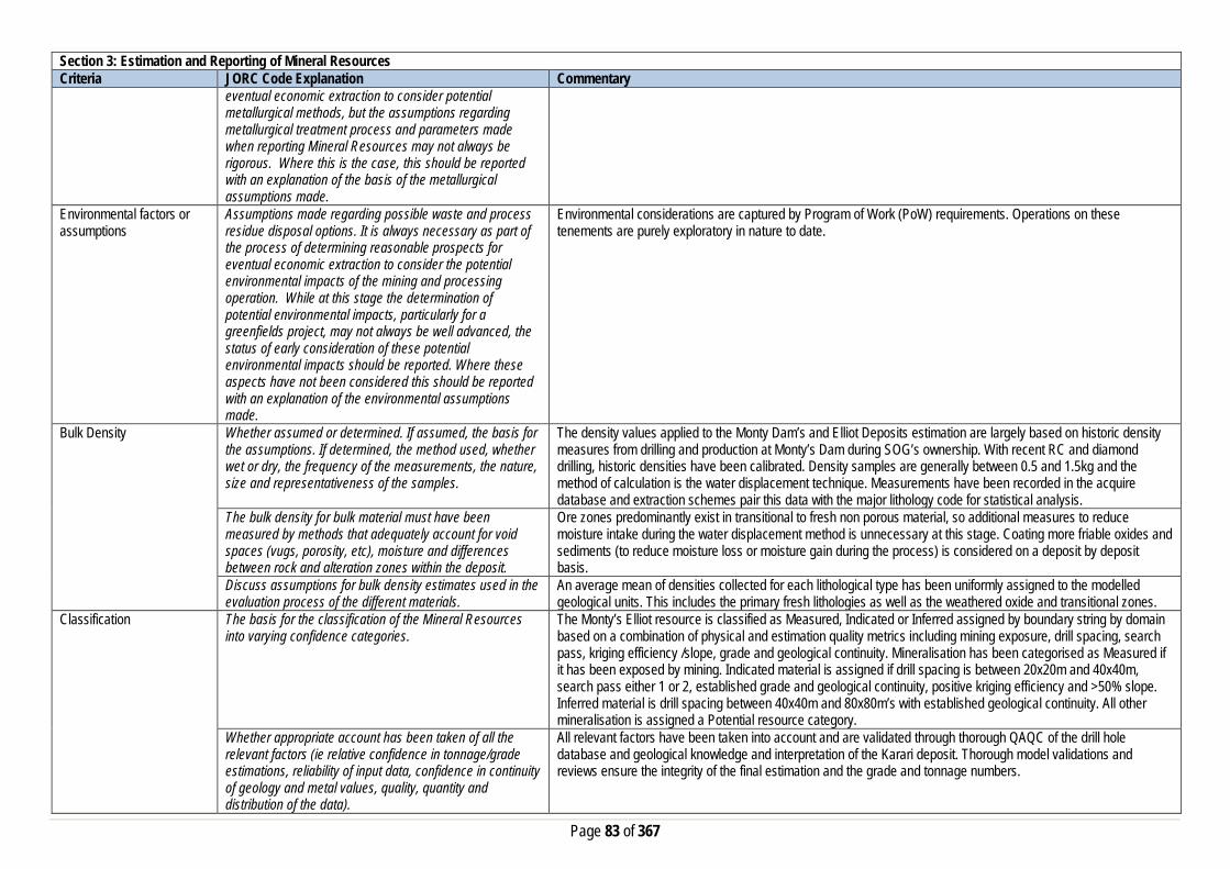
Page 83 of 367
Section 3: Estimation and Reporting of Mineral Resources Criteria JORC Code Explanation Commentary
eventual economic extraction to consider potential metallurgical methods, but the assumptions regarding metallurgical treatment process and parameters made when reporting Mineral Resources may not always be rigorous. Where this is the case, this should be reported with an explanation of the basis of the metallurgical assumptions made.
Environmental factors or assumptions
Assumptions made regarding possible waste and process residue disposal options. It is always necessary as part of the process of determining reasonable prospects for eventual economic extraction to consider the potential environmental impacts of the mining and processing operation. While at this stage the determination of potential environmental impacts, particularly for a greenfields project, may not always be well advanced, the status of early consideration of these potential environmental impacts should be reported. Where these aspects have not been considered this should be reported with an explanation of the environmental assumptions made.
Environmental considerations are captured by Program of Work (PoW) requirements. Operations on these tenements are purely exploratory in nature to date.
Bulk Density Whether assumed or determined. If assumed, the basis for the assumptions. If determined, the method used, whether wet or dry, the frequency of the measurements, the nature, size and representativeness of the samples.
The density values applied to the Monty Dam’s and Elliot Deposits estimation are largely based on historic density measures from drilling and production at Monty’s Dam during SOG’s ownership. With recent RC and diamond drilling, historic densities have been calibrated. Density samples are generally between 0.5 and 1.5kg and the method of calculation is the water displacement technique. Measurements have been recorded in the acquire database and extraction schemes pair this data with the major lithology code for statistical analysis.
The bulk density for bulk material must have been measured by methods that adequately account for void spaces (vugs, porosity, etc), moisture and differences between rock and alteration zones within the deposit.
Ore zones predominantly exist in transitional to fresh non porous material, so additional measures to reduce moisture intake during the water displacement method is unnecessary at this stage. Coating more friable oxides and sediments (to reduce moisture loss or moisture gain during the process) is considered on a deposit by deposit basis.
Discuss assumptions for bulk density estimates used in the evaluation process of the different materials.
An average mean of densities collected for each lithological type has been uniformly assigned to the modelled geological units. This includes the primary fresh lithologies as well as the weathered oxide and transitional zones.
Classification The basis for the classification of the Mineral Resources into varying confidence categories.
The Monty’s Elliot resource is classified as Measured, Indicated or Inferred assigned by boundary string by domain based on a combination of physical and estimation quality metrics including mining exposure, drill spacing, search pass, kriging efficiency /slope, grade and geological continuity. Mineralisation has been categorised as Measured if it has been exposed by mining. Indicated material is assigned if drill spacing is between 20x20m and 40x40m, search pass either 1 or 2, established grade and geological continuity, positive kriging efficiency and >50% slope. Inferred material is drill spacing between 40x40m and 80x80m’s with established geological continuity. All other mineralisation is assigned a Potential resource category.
Whether appropriate account has been taken of all the relevant factors (ie relative confidence in tonnage/grade estimations, reliability of input data, confidence in continuity of geology and metal values, quality, quantity and distribution of the data).
All relevant factors have been taken into account and are validated through thorough QAQC of the drill hole database and geological knowledge and interpretation of the Karari deposit. Thorough model validations and reviews ensure the integrity of the final estimation and the grade and tonnage numbers.

Page 84 of 367
Section 3: Estimation and Reporting of Mineral Resources Criteria JORC Code Explanation Commentary
Whether the result appropriately reflects the Competent Person's view of the deposit.
The geological model and the mineral resource estimate reflect the competent person’s view of the deposit.
Audits or reviews The results of any audits or reviews of Mineral Resource estimates.
Saracen has adopted a process for geological modelling, estimation and reporting of mineral resources that meets high industry standards. At the completion of resource estimation Saracen Metals undertake an extensive review of the model that covers;
• Model inventory and comparisons to previous and budget models if in existence • Geological interpretation, wireframing, domain selection, statistics by domain, assay and metal evaluation,
parent cell sizes, data compositing, variography, search strategy, estimation and KNA • Model validation – swathe plots, visual checks, volume comparisons, composite to model metal
comparisons. In the final stages the model and resource categorisation are all discussed and scrutinized by the geological and mine planning teams.
Discussion of relative accuracy/confidence
Where appropriate a statement of the relative accuracy and confidence level in the Mineral Resource estimate using an approach or procedure deemed appropriate by the Competent Person. For example, the application of statistical or geostatistical procedures to quantify the relative accuracy of the resource within stated confidence limits, or, if such an approach is not deemed appropriate, a qualitative discussion of the factors that could affect the relative accuracy and confidence of the estimate.
The Mineral Resource has been reported in accordance with the guidelines of the 2012 edition of the Australasian Code for Reporting of Exploration Results, Mineral Resources and Ore Reserves. Saracen Gold Mine uses a standard approach to resource estimation and the procedure requires the systematic completion of the Saracen Resource Estimation Document that is thoroughly investigated and assessed in the Model review process, as stated above.
The statement should specify whether it relates to global or local estimates, and, if local, state the relevant tonnages, which should be relevant to technical and economic evaluation. Documentation should include assumptions made and the procedures used.
The statements relate to a global estimate of tonnes and grade.
These statements of relative accuracy and confidence of the estimate should be compared with production data, where available.
The confidence in the model is reflected by the designation of Resource categories. Given the thorough geological analysis of this area and adequate drilling definition, it is a robust estimation of the resource at Monty’s Dam and Elliot’s Lode. Monty’s North, an Inferred resource, is of lower grade and has attracted far less drilling at this stage.
Section 4: Estimation and Reporting of Ore Reserves Criteria JORC Code Explanation Commentary Mineral Resource estimate for conversion to Ore Reserves
Description of the Mineral resource Estimate used as a basis for the conversion to an Ore Reserve.
The Mineral Resource Model for the Monty’s Dam and Elliot’s Lode gold deposit is a robust global estimate that was used as a basis for conversion to the Ore Reserve estimate. The resource estimate was compiled by Saracen using exploration, resource definition, and grade control drilling and assay data, geological mapping and historical mining records to validate the model against, and solid interpretation wireframes of the geology. This information was used to construct a model estimated by various kriging methods. The block model was depleted with the end of June 2019 monthly survey pickup for Reserve Estimation.
Clear statement as to whether the Mineral Resources are reported additional to. Or inclusive of, the Ore Reserves.
The Mineral Resource reported is inclusive of the Ore Reserve.

Page 85 of 367
Section 4: Estimation and Reporting of Ore Reserves Criteria JORC Code Explanation Commentary Site Visits Comment on any site visits undertaken by the Competent
Person and the outcome of those visits. A Competent Person along with a geotechnical consultant has conducted several site visits to the Monty’s Dam and Elliot’s Lode open pit since the inclusion in the Carosue Dam operations life of mine plan. The purpose of these visits is to collect information for optimisation work, validating input parameters, visual pit inspection, discussion and feedback for life of mine planning. The information also includes the discussion around current mining performance, wall conditions and overall stability, and groundwater condition.
If no site visits have been undertaken indicate why this is the case.
N/A
Study status The type and level of study undertaken to enable Mineral Resources to be converted to Ore Reserves
The Monty’s Dam and Elliot’s Lode deposit was mined previously as an open pit mine during the early 2000’s with ore processed at the current Carosue Dam plant. Saracen has commenced a full scale feasibility study with a view to bring the Monty’s open pit into operation and it has positively passed through all economic and social risk management criteria. The 2019 Ore Reserve has included all aspects of operational inputs including actual production parameters, operating costs of mining, processing, general administration and environment management related costs.
The Code requires that a study to at least Pre-Feasibility Study level has been undertaken to convert Mineral Resources to Ore Reserves. Such studies will have been carried out and will have determined a mine plan that is technically achievable and economically viable, and that material Modifying Factors have been considered.
Modifying factors have been applied to the study to ensure the rigor of the financial analysis. Operational costs and production parameters have been used from actual and ongoing mining and processing performance. Saracen has conducted a feasibility level study with all appropriate supporting mining studies required for ore reserve estimation.
Cut-off parameters The basis of the cut-off grade(s) or quality parameters applied
For the purpose of Ore Reserve Estimation a marginal cut-off of 0.50g/t was applied based upon an assumed gold price of AUD$1,600/oz and operating costs of processing, haulage and general administration. A top cut has already been applied to the Mineral Resource Estimate eliminating the necessity for any further adjustment to the Ore Reserve estimate.
Mining factors or assumptions
The method and assumptions used as reported in the Pre-feasibility or Feasibility Study to convert the Mineral Resource to an Ore Reserve (i.e. either by application of appropriate factors by optimisation or by preliminary or detailed design).
The resource model used in the Mineral Resource Estimation was the basis for the generation of a range of Whittle 4X pit optimisation shells. The generation of these shells was reliant upon costs and inputs derived from current operational data, contractors and independent consultant recommendations. An appropriate shell was then selected as the basis for an iterative process of pit design work, culminating in the finalisation of a detailed pit design for the Monty’s Dam and Elliot’s Lode Reserve.
The choice, nature and appropriateness of the selected mining method(s) and other mining parameters including associated design issues such as pre-strip, access, etc.
The mining method to be employed at Monty’s Dam and Elliot’s Lode will be conventional open pit with hydraulic excavator and dump truck fleet, and drill and blast activity. The class of excavator employed is similar to other current open pit mining operation, providing a good operating dataset for production and productivity rate measurements and financial modelling. The Reserve pit is designed as a cutback to the existing mined pit along with two other insitu Reserve pits in an appropriate manner to meet operation efficiency and production rate.
The assumptions made regarding geotechnical parameters (e.g. pit slopes, stope sizes, etc.), grade control, and pre-production drilling.
Geotechnical recommendations were made by independent external consultant following site visits, inspection of drill core, and a review of the geotechnical data gathered during earlier operations. The geotechnical consultant was engaged by Saracen to oversee all geotechnical aspects of the technical study and ongoing support. It is expected that once the pits are in operation there may be some need for additional geotechnical input and reflected changes to the life of mine pit design. The Grade control method to be employed at Monty’s Dam and Elliot’s Lode will utilise an RC drilling and sampling method. The method and practice has been utilised successfully at all current and past mining operations at Saracen.

Page 86 of 367
Section 4: Estimation and Reporting of Ore Reserves Criteria JORC Code Explanation Commentary
The major assumptions made and Mineral Resource model used for pit and stope optimisation (if appropriate).
The Ore Reserve Estimate is based on detailed life of mine pit design work by using a geology approved resource model, and making appropriate dilution and recovery factor allowances for mining fleet and methods utilised.
The mining dilution factors used. A mining dilution factor is applied in the Ore Reserve estimation and reflects the current mining performance of similar types of ore bodies and mining practices. The mining dilution factor of 15% is estimated for Monty’s Dam, reflecting the wide to narrow steep dipping mineralisation.
The mining recovery factors used. An ore loss factor is applied in the Ore Reserve estimation and reflects the current mining performance of similar types of ore bodies and mining practices. The ore loss factor of 5% is estimated for the Monty’s Dam orebody, reflecting the wide to narrow steep dipping mineralisation.
Any minimum mining widths used A minimum mining width of 25m has been adopted for the primary excavation fleet. Where ‘pinch-points’ occur or “Good Bye” cuts are considered at the base of the pit, it is assumed that a smaller or more versatile excavator will be employed. The practice is very consistent across both Saracen operations and reflects the suitability and efficiency of the mining performance.
The manner in which inferred Mineral resources are utilised in mining studies and the sensitivity of the outcome to their inclusion.
Inferred material is excluded from the ore reserves and treated as waste material, which incurs a mining cost but is not processed and does not generate any revenue. Therefore final pit reserve inventory has excluded any inferred mineral resources.
The infrastructure requirements of the selected mining methods.
The selected mining method and location of the deposit is close to the ongoing Carosue Dam mining region. The existing operation has adequate infrastructure available to support the current and future mine plan.
Metallurgical factors or assumptions
The metallurgical process proposed and the appropriateness of that process to the style of mineralisation
The Ore Reserve will be treated at the established Carosue Dam processing facility. The facility is a conventional crushing, gravity circuit, grind, and CIL (carbon in leach) plant and is appropriate for the extraction of gold from free milling mineralisation.
Whether the metallurgical process is well-tested technology or novel in nature.
The current processing plant and method applied utilises well tried and proven technology and since being in operation averages gold recoveries typically between 92 to 94% for all available different material types.
The nature, amount and representiveness of metallurgical test work undertaken, the nature of the metallurgical domaining applied and the corresponding metallurgical recovery factors applied.
An average gold recovery for Monty’s Dam is estimated at 93.0%. The recovery estimation is based on met test work and past actual average recovery data collected at the Carosue Plant. The plant performance is consistent between 92 to 94% while processing similar types of ore material blended with a range of other ore sources without any issue. Metallurgical testwork has been carried out on samples from the Monty’s Dam and Elliot’s Lode deposit by a test lab, with recoveries in the range of 92-95% hence the estimated recovery is in line with expectation.
Any assumptions or allowances made for deleterious elements.
There are no known deleterious elements present in Monty’s Dam and Elliot’s Lode ore that can impact on ore recoveries at Carosue Plant.
The existence of any bulk sample or pilot scale test work and the degree to which such samples are considered representative of the ore body as a whole.
A Number of samples of each expected rock type has been sampled through the Carosue Dam processing plant for trial test work. These bulk samples/pilot test work are considered as sufficient to represent the Monty’s Dam and Elliot’s Lode ore body as a whole.
For minerals that are defined by a specification, has the ore reserve estimation been based on the appropriate mineralogy to meet the specifications.
N/A
Environmental factors or assumptions
The status of studies of potential environmental impacts of the mining and processing operation. Details of waste rock characterisation and the consideration of potential sites, status of design options considered and, where applicable, the status of approvals for process residue storage and waste dumps should be reported.
The pit is currently on ‘care and maintenance’. All required Environment studies have been completed and Statutory Government Approvals namely works approvals, dewatering and discharge licences have been granted. Mining Approval will be required to be submitted for the new mine reserve pit in timely manner such that it will be granted before the actual commencement of mining.

Page 87 of 367
Section 4: Estimation and Reporting of Ore Reserves Criteria JORC Code Explanation Commentary
The existing Carosue Dam processing facility at which the Enterprise ore will be processed and the accommodation village are all located on granted mining leases. The road haulage network footprint is underpinned by a combination of miscellaneous licences and granted mining leases. A waste rock characterisation study has been carried out and it is expected to be representative of waste rock. An appropriate landform design criteria has been considered based on rock characteristics to mitigate current and any future pit expansion plan.
Infrastructure The existence of appropriate infrastructure: availability of land for plant development, power, water, transportation (particularly for bulk commodities), labour, accommodation; or the ease with which the infrastructure can be provided, or accessed.
The Monty’s Dam and Elliot’s Lode deposit will require minimum infrastructure due to its close proximity to Carosue Dam, and hence provide the ability to recommence operation in a short timeframe. In the past Saracen has established and operated similar satellite operations across both Carosue Dam and Thunderbox operations successfully. The processing facility and major infrastructure are in place and fully operational at Carosue Dam. Power is generated from a powerhouse containing gas/diesel generators and processing water is sourced by dewatering old pits. Potable water is sourced from borefields and then processed through a reverse osmosis plant. A modern well maintained accommodation camp is in place and fully operational at Carosue Dam. Access to the site for FIFO workers is via direct commercial flights to site and via direct haul road to Carosue Dam from Kalgoorlie.
Costs The derivation of, or assumptions made, regarding projected capital costs in the study.
Capital costs relating to the start-up and pre striping of the operation are included in the financial modelling. Other capital costs around camp and accommodation are minor given close proximity to existing Carosue Dam Operations.
The methodology used to estimate operating costs. Operating costs for open pit mining have been derived from a combination of actual costs from SGM’s Carosue Dam/Thunderbox Operations and costs supplied by various contract mining companies and independent consultants. Operating costs for ore processing, haulage and administration have been derived from known parameters at Carosue Dam operations.
Allowances made for the content of deleterious elements Previous operational experience at Monty’s Dam did not reveal any deleterious elements within the ore or waste that required any additional cost allowances.
The derivation of assumptions made of metal or commodity price(s), for the principal minerals and co-products
An assumed gold price of AUD$1,600/oz has been adopted for financial modelling. No allowance is made for silver by-products.
The source of exchange rates used in study All revenue and cost calculations have been made in AUD, so no exchange rate usage or assumptions have been necessary.
Derivation of transportation charges Costs associated with bullion transportation have been derived from existing contractual arrangements at Carouse Dam.
The basis for forecasting or source of treatment and refining charges, penalties for failure to meet specification, etc.
Costs associated with refining have been derived from existing contractual arrangements at Carouse Dam.
The allowances made for royalties payable, both Government and private.
Royalty costs are the WA state government royalty of 2.5%, and a third party royalty of 1.5% is payable.
Revenue Factors The derivation of, or assumptions made, regarding revenue factors including head grade, metal or commodity price(s) exchange rates, transportation and treatment charges, penalties, net smelter returns, etc.
For the purposes of the Ore Reserve Estimation it has been assumed that there is no gold hedging. All gold production will be sold at spot price to the Perth Mint.

Page 88 of 367
Section 4: Estimation and Reporting of Ore Reserves Criteria JORC Code Explanation Commentary
The derivation of assumptions made of metal or commodity price(s), for the principal metals, minerals and co-products
Assumed gold price of AUD$1,600/oz has been adopted for financial modelling. No allowance is made for silver by-products.
Market Assessment The demand, supply and stock situation for the particular commodity, consumption trends and factors likely to affect supply and demand into the future.
There is a transparent quoted market for the sale of gold.
A customer and competitor analysis along with the identification of likely market windows for the product.
There is a transparent quoted market for the sale of gold.
Price and volume forecasts and the basis for these forecasts.
There is a transparent quoted market for the sale of gold.
For industrial minerals the customer specification, testing and acceptance requirements prior to a supply contract.
N/A
Economic The inputs to the economic analysis to produce the net present value (NPV) in the study, the source and confidence of these economic inputs including estimated inflation, discount rate, etc.
The Ore Reserve Estimation is based on detailed life of mine pit design and reflects positive economic outcomes. All relevant capital and operating costs as well as revenue and royalty factors have been included with appropriate discount factors for cash flow analysis.
NPV ranges and sensitivity to variations in the significant assumptions and inputs.
A full financial model was developed with sensitivities applied to all key inputs and assumptions.
Social The status of agreements with key stakeholders and matters leading to social licence to operate
Monty’s Dam is located within close proximity to the Carosue Dam operations which has been operation since 2009. Saracen has experienced good relations with neighbouring stakeholders, including engagement with the local pastoralists and the traditional owners and those relationships have been maintained over time. The mine is located on leasehold pastoral land with compensation agreements in place with the local pastoralist. Granted mining leases cover all of the proposed mining and processing assets. The Maduwongga people have lodged a Native Title Application (WC2017/001 – WAD186/2017) over the area in October 2017, this application is yet to be determined.
Other To the extent relevant, the impact of the following on the project and/or on the estimation and classification of the Ore Reserves:
Any identified material naturally occurring risks Water inrush is identified as a naturally occurring risk with in the operation and was addressed by the construction of appropriate water diversion bunds to provide safe and risk free work environment. The sufficient bund wall already constructed across majority of the mine footprint with minor extension to be followed up when Monty’s Dam mining recommences.
The status of material legal agreements and marketing arrangements
A royalty of 2.5% of gold production is payable to WA State Government and additional royalty of 1.5% is payable to third party.
The status of governmental agreements and approvals critical to the viability of the project, such as mineral tenement status, and government and statutory approvals. There must be reasonable grounds to expect that all necessary government approvals will be received within the timeframes anticipated in the Pre-Feasibility or Feasibility study. Highlight and discuss the materiality of
A new Mining Approval will be required to be submitted for the updated mine reserve pit in a timely manner such that it will be granted before the actual commencement of mining. Statutory Government Approvals namely dewatering and discharge licence have been granted.
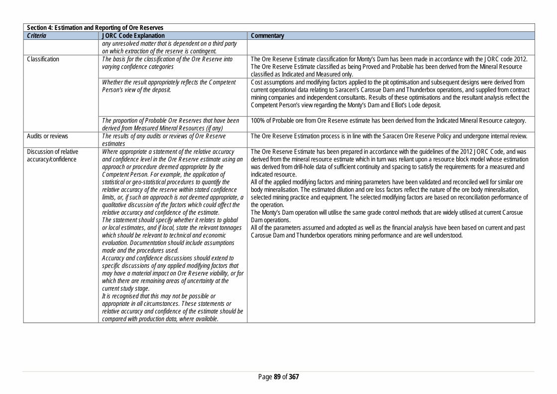
Page 89 of 367
Section 4: Estimation and Reporting of Ore Reserves Criteria JORC Code Explanation Commentary
any unresolved matter that is dependent on a third party on which extraction of the reserve is contingent.
Classification The basis for the classification of the Ore Reserve into varying confidence categories
The Ore Reserve Estimate classification for Monty’s Dam has been made in accordance with the JORC code 2012. The Ore Reserve Estimate classified as being Proved and Probable has been derived from the Mineral Resource classified as Indicated and Measured only.
Whether the result appropriately reflects the Competent Person’s view of the deposit.
Cost assumptions and modifying factors applied to the pit optimisation and subsequent designs were derived from current operational data relating to Saracen’s Carosue Dam and Thunderbox operations, and supplied from contract mining companies and independent consultants. Results of these optimisations and the resultant analysis reflect the Competent Person’s view regarding the Monty’s Dam and Elliot’s Lode deposit.
The proportion of Probable Ore Reserves that have been derived from Measured Mineral Resources (if any)
100% of Probable ore from Ore Reserve estimate has been derived from the Indicated Mineral Resource category.
Audits or reviews The results of any audits or reviews of Ore Reserve estimates
The Ore Reserve Estimation process is in line with the Saracen Ore Reserve Policy and undergone internal review.
Discussion of relative accuracy/confidence
Where appropriate a statement of the relative accuracy and confidence level in the Ore Reserve estimate using an approach or procedure deemed appropriate by the Competent Person. For example, the application of statistical or geo-statistical procedures to quantify the relative accuracy of the reserve within stated confidence limits, or, if such an approach is not deemed appropriate, a qualitative discussion of the factors which could affect the relative accuracy and confidence of the estimate. The statement should specify whether it relates to global or local estimates, and if local, state the relevant tonnages which should be relevant to technical and economic evaluation. Documentation should include assumptions made and the procedures used. Accuracy and confidence discussions should extend to specific discussions of any applied modifying factors that may have a material impact on Ore Reserve viability, or for which there are remaining areas of uncertainty at the current study stage. It is recognised that this may not be possible or appropriate in all circumstances. These statements or relative accuracy and confidence of the estimate should be compared with production data, where available.
The Ore Reserve Estimate has been prepared in accordance with the guidelines of the 2012 JORC Code, and was derived from the mineral resource estimate which in turn was reliant upon a resource block model whose estimation was derived from drill-hole data of sufficient continuity and spacing to satisfy the requirements for a measured and indicated resource. All of the applied modifying factors and mining parameters have been validated and reconciled well for similar ore body mineralisation. The estimated dilution and ore loss factors reflect the nature of the ore body mineralisation, selected mining practice and equipment. The selected modifying factors are based on reconciliation performance of the operation. The Monty’s Dam operation will utilise the same grade control methods that are widely utilised at current Carosue Dam operations. All of the parameters assumed and adopted as well as the financial analysis have been based on current and past Carosue Dam and Thunderbox operations mining performance and are well understood.

Page 90 of 367
Twin Peaks
Section 1 Sampling Techniques and Data Criteria JORC Code Explanation Commentary Sampling Techniques Nature and quality of sampling (e.g. cut channels, random
chips, or specific specialised industry standard measurement tools appropriate to the minerals under investigation, such as down hole gamma sondes, or handheld XRF instruments, etc.). These examples should not be taken as limiting the broad meaning of sampling.
Sampling methods undertaken by Saracen at Twin Peaks have included reverse circulation (RC) and diamond drillholes (DD). Historic methods conducted since 1991 have included aircore (AC), rotary air blast (RAB), reverse circulation and diamond drillholes.
Include reference to measures taken to ensure sample representivity and the appropriate calibration of any measurement tools or systems used
Sampling for diamond and RC drilling is carried out as specified within Saracen sampling and QAQC procedures as per industry standard. RC chips and diamond core provide high quality representative samples for analysis. RC, RAB, AC and DD core drilling was completed by previous holders to industry standard at that time (1991- 2004).
Aspects of the determination of mineralisation that are Material to the Public Report. In cases where ‘industry standard’ work has been done this would be relatively simple (e.g. ‘reverse circulation drilling was used to obtain 1 m samples from which 3 kg was pulverised to produce a 30 g charge for fire assay’). In other cases more explanation may be required, such as where there is coarse gold that has inherent sampling problems. Unusual commodities or mineralisation types (e.g. submarine nodules) may warrant disclosure of detailed information
Diamond core is NQ sized, sampled to 1m intervals and geological boundaries where necessary and cut into half core to give sample weights under 3 kg. Samples are selected to weigh less than 3 kg to ensure total sample inclusion at the pulverisation stage. RC chips are cone split and sampled into 1m intervals with total sample weights under 3kg Saracen core and chip samples are crushed, dried and pulverised to a nominal 90% passing 75µm to produce a 50 g sub sample for analysis by FA/AAS. Historical AC, RAB, RC and diamond sampling was carried out to industry standard at that time. Analysis methods include fire assay, aqua regia and unspecified methods.
Drilling Techniques Drill type (e.g. core, reverse circulation, open-hole hammer, rotary air blast, auger, Bangka, sonic, etc.) and details (e.g. core diameter, triple or standard tube, depth of diamond tails, face-sampling bit or other type, whether core is oriented and if so, by what method,etc.).
The deposit was initially sampled by 41 AC holes, 185 RAB holes, 110 RC holes (assumed standard 5 ¼” bit size) and 21 surface diamond HQ core and unknown diameter holes. Saracen has completed 7 surface RC precollar with NQ diamond tail drill holes (precollars averaging 241m, diamond tails averaging 209m) , and 11 RC holes. Diamond tails were oriented using an Ezy-mark tool. It is unknown if historic surface diamond drill core was oriented.
Drill Sample Recovery Method of recording and assessing core and chip sample recoveries and results assessed
Diamond core recovery percentages calculated from measured core versus drilled intervals are logged and recorded in the database. Recoveries average >98%. RC sampling recoveries are recorded as a percentage based on a visual weight estimate; no historic recoveries have been recorded.
Measures taken to maximise sample recovery and ensure representative nature of the samples
Diamond core is reconstructed into continuous runs on an angle iron cradle for orientation marking. Depths are checked against depth given on the core blocks. During RC campaigns daily rig inspections are carried out to check splitter condition, general site and address general issues. Historical AC, RAB, RC and diamond drilling to industry standard at that time.
Whether a relationship exists between sample recovery and grade and whether sample bias may have occurred due to preferential loss/gain of fine/coarse material.
Diamond drilling has high recoveries meaning loss of material is minimal. There is no known relationship between sample recovery and grade for RC drilling. Any historical relationship is not known.

Page 91 of 367
Section 1 Sampling Techniques and Data Criteria JORC Code Explanation Commentary Logging Whether core and chip samples have been geologically
and geotechnically logged to a level of detail to support appropriate Mineral Resource estimation, mining studies and metallurgical studies. Whether logging is qualitative or quantitative in nature. Core (or costean, channel, etc) photography.
Logging of diamond drill core and RC chips records lithology, mineralogy, texture, mineralisation, weathering, alteration, veining and other features. Geotechnical and structural logging is carried out on all diamond holes to record recovery, RQD, defect number, type, fill material, shape and roughness and alpha and beta angles. Chips from all RC holes are stored in chip trays for future reference. Core is photographed in both dry and wet state. Qualitative and quantitative logging of historic data varies in its completeness.
The total length and percentage of the relevant intersections logged
All diamond drillholes and exploration RC holes are logged in full. Historical logging is approximately 95% complete.
Sub-sampling techniques and sample preparation
If core, whether cut or sawn and whether quarter, half or all core taken.
All drill core is cut in half onsite using an automatic core saw. Samples are always collected from the same side. Historic diamond drilling was half core sampled or sampled via unknown methods.
If non-core, whether riffled, tube sampled, rotary split, etc and whether sampled wet or dry.
All RC samples are cone split. Occasional wet samples are encountered; increased air capacity is routinely used to aid in keeping the sample dry when water is encountered. Historic AC, RAB and RC drilling was sampled using spear, riffle and unknown methods.
For all sample types, the nature, quality and appropriateness of the sample preparation technique.
The sample preparation of diamond core and RC chips adhere to industry best practice. It is conducted by a commercial laboratory and involves oven drying, coarse crushing then total grinding to a size of 90% passing 75 microns. Best practice is assumed at the time of historic sampling.
Quality control procedures adopted for all sub-sampling stages to maximise representivity of samples.
All subsampling activities are carried out by commercial laboratory and are considered to be satisfactory. Sampling by previous holders assumed to be industry standard at the time.
Measures taken to ensure that the sampling is representative of the in situ material collected, including for instance results for field duplicate/second half sampling.
Duplicate sampling is carried out at a rate of 1:10 for exploration drilling and is sampled directly from the on-board splitter on the rig. These are submitted for the same assay process as the original samples and the laboratory are unaware of such submissions. Sampling by previous holders assumed to be industry standard at the time.
Whether sample sizes are appropriate to the grain size of the material being sampled.
Sample sizes are considered to be appropriate.
Quality of assay data and laboratory tests
The nature, quality and appropriateness of the assaying and laboratory procedures used and whether the technique is considered partial or total.
RC chip samples, grade control chip samples and diamond core are analysed by external laboratories using a 50g fire assay with AAS finish. This method is considered suitable for determining gold concentration in rock and is a total digest method. Historic sampling includes fire assay, aqua regia and unknown methods.
For geophysical tools, spectrometers, handheld XRF instruments, etc, the parameters used in determining the analysis including instrument make and model, reading times, calibrations factors applied and their derivation, etc.
No geophysical tools have been utilised for reporting gold mineralisation at Twin Peaks.
Nature of quality control procedures adopted (e.g.standards, blanks, duplicates, external laboratory checks) and whether acceptable levels of accuracy (i.e.lack of bias) and precision have been established.
Certified reference material (standards and blanks) with a wide range of values are inserted into every drillhole at a rate of 1:25 for exploration RC and DD drilling. These are not identifiable to the laboratory. QAQC data returned are checked against pass/fail limits with the SQL database and are passed or failed on import. A report is generated and reviewed by the geologist as necessary upon failure to determine further action. QAQC data is reported monthly. Sample preparation checks for fineness are carried out to ensure a grind size of 90% passing 75 microns. The laboratory performs a number of internal processes including standards, blanks, repeats and checks. QAQC data analysis demonstrates sufficient accuracy and precision.

Page 92 of 367
Section 1 Sampling Techniques and Data Criteria JORC Code Explanation Commentary
Industry best practice is assumed for previous holders. Verification of sampling and assaying
The verification of significant intersections by either independent or alternative company personnel.
Significant intercepts are verified by the Geology Manager and corporate personnel.
The use of twinned holes. No specific twinned holes have been drilled at Twin Peaks. Documentation of primary data, data entry procedures, data verification, data storage (physical and electronic) protocols
Primary data is collated in a set of excel templates utilising lookup codes. This data is forwarded to the Database Administrator for entry into a secure acQuire database with inbuilt validation functions. Data from previous owners was taken from a database compilation and validated as much as practicable before entry into the Saracen acQuire database.
Discuss any adjustment to assay data. No adjustments have been made to assay data. First gold assay is utilised for resource estimation. Location of data points Accuracy and quality of surveys used to locate drillholes
(collar and down-hole surveys), trenches, mine workings and other locations used in Mineral Resource estimation.
Exploration drillholes are located using a Leica 1200 GPS with an accuracy of +/- 10mm. Downhole surveys are carried out using an Eastman single shot camera at regular intervals (usually 30m). A number of drillholes have also been gyroscopically surveyed. Previous holders’ survey accuracy and quality is unknown.
Specification of the grid system used. A local grid system (Old Plough Dam West) is used. The two point conversion to MGA_GDA94 zone 51 is OPDWEast OPDWNorth RL MGAEast MGANorth RL Point 1 8035.58 20901.34 0 431948.52 6674917.54 0 Point 2 8147.50 17313.10 0 434806.92 6672750.25 0 Historic data is converted to Old Plough Dam West local grid upon export from the database.
Quality and adequacy of topographic control. Topographic control originally used site based survey pickups in addition to Kevron aerial photogrammetric surveys with +/- 5m resolution. Pre mining, new and more detailed topography has since been captured and will be used in future updates and for subsequent planning purposes.
Data spacing and distribution
Data spacing for reporting of Exploration Results. The nominal spacing for exploration drilling is 20 m x 20 m Whether the data spacing and distribution is sufficient to establish the degree of geological and grade continuity appropriate for the Mineral Resource and Ore Reserve estimation procedure(s) and classifications applied.
Data spacing and distribution are sufficient to establish the degree of geological and grade continuity appropriate for JORC classifications applied.
Orientation of data in relation to geological structure
Whether sample compositing has been applied. Sample compositing is not applied until the estimation stage. Some historic RAB and RC sampling was composited into 3-4m samples with areas of interest re-sampled to 1m intervals. It is unknown at what threshold this occurred.
Whether the orientation of sampling achieves unbiased sampling of possible structures and the extent to which this is known, considering the deposit type.
The majority of drillholes are positioned to achieve optimum intersection angles to the ore zone as are practicable.
If the relationship between the drilling orientation and the orientation of key mineralised structures is considered to have introduced a sampling bias, this should be assessed and reported if material.
No significant sampling bias is thought to occur due to orientation of drilling in regards to mineralised structures.
Sample security The measures taken to ensure sample security. Samples are prepared on site under supervision of Saracen geological staff. Samples are selected, bagged into tied numbered calico bags then grouped into secured cages and collected by the laboratory personnel. Sample submissions are documented via laboratory tracking systems and assays are returned via email

Page 93 of 367
Section 1 Sampling Techniques and Data Criteria JORC Code Explanation Commentary Audits or reviews The results of any audits or reviews of sampling
techniques and data. An internal review of companywide sampling methodologies was conducted to create the current sampling and QAQC procedures.
Section 2 Reporting of Exploration Results Criteria JORC Code Explanation Commentary Mineral tenement and land tenure status
Type, reference name/number, location and ownership including agreements or material issues with third parties such as joint ventures, partnerships, overriding royalties, native title interests, historical sites, wilderness or national park and environmental settings.
The Twin Peaks pit is located on M31/208. The tenement is held 100% by Saracen Gold Mines Pty Ltd, a wholly owned subsidiary of Saracen Mineral Holdings Limited. Mining Lease M31/208 has a 21 year life (held until 2023) and is renewable for a further 21 years on a continuing basis. Mining Lease M31/208 is subject to two royalty agreements, two associated caveats (60H/067 and 340982) and a bank mortgage (415495). All production is subject to a Western Australian state government NSR royalty of 2.5%. Mining Lease M31/208 is subject to the Gindalbie Pastoral Compensation Agreement. There are no registered Aboriginal Heritage sites within Mining Lease M31/208.
The security of the tenure held at the time of reporting along with any known impediments to obtaining a licence to operate in the area.
The tenement is in good standing and there are no known impediments to obtaining a licence to operate.
Exploration done by other parties
Acknowledgment and appraisal of exploration by other parties.
Exploration at Twin Peaks began in 1991 with a soil auger program carried out by PanContinental Mining outlining a number of anomalies that were followed up with RAB drilling, intersecting encouraging mineralisation. Geophysical surveys followed by RAB, RC and diamond drilling were then carried out by PanCon to further define the mineralised zone and strike extensions of the Twin Peaks deposit and calculate a resource. Goldfields acquired the project and completed further RC and DD resource definition drilling as well as RAB and aircore traverses targeting mineralisation extensions, and geophysical surveys. PacMin carried out infill resource drilling before Sons of Gwalia took ownership of the project and mined the Twin Peaks open pit between 2003 and 2004. Regional aircore and RC drilling was carried out before the collapse of Sons of Gwalia and takeover of the project by St Barbara.
Geology Deposit type, geological setting and style of mineralisation.
The Twin Peaks deposit lies within a greenstone-granite belt within the Edjudina-Kanowna region of the Archaean Yilgarn Block. The Twin Peaks mineralisation is located in metasedimentary rocks below the regional-scale Kilkenny-Yilgangi Fault within an intensely fractured, easterly plunging alteration zone. The mineralisation is associated with potassic alteration surrounded by carbonate zones within a quartz-feldspar dominated turbiditic sequence that appears to be isoclinally folded, with silt to sand particle size. The stratigraphy strikes northwest and dips on average 60 - 70 degrees to the northeast with ‘way up’ indicators suggesting the entire section in overturned.
Drillhole information A summary of all information material to the understanding of the exploration results including a tabulation of the following information for all Material drill holes:
• easting and northing of the drill hole collar • elevation or RL (Reduced Level – elevation • above sea level in metres) of the drill hole collar • dip and azimuth of the hole
All material data is periodically released on the ASX: Material relating to Twin Peaks was released on 27/01/2012. Future drill hole data will be periodically released or when a results materially change the economic value of the project.

Page 94 of 367
Section 2 Reporting of Exploration Results Criteria JORC Code Explanation Commentary
• down hole length and interception depth • hole length. • If the exclusion of this information is justified on the
basis that the information is not Material and this exclusion does not detract from the understanding of the report, the Competent Person should clearly explain why this is the case.
Data aggregation methods In reporting Exploration Results, weighting averaging techniques, maximum and/or minimum grade truncations (e.g. cutting of high grades) and cut-off grades are usually Material and should be stated.
All significant intercepts have been length weighted with a minimum Au grade of 1ppm. No high grade cut off has been applied.
Where aggregate intercepts incorporate short lengths of high grade results and longer lengths of low grade results, the procedure used for such aggregation should be stated and some typical examples of such aggregations should be shown in detail.
Intercepts are aggregated with minimum width of 1m and maximum width of 3m for internal dilution. Where stand out higher grade zone exist with in the broader mineralised zone, the higher grade interval is reported also.
The assumptions used for any reporting of metal equivalent values should be clearly stated.
Metal equivalent values are not reported
Relationship between mineralisation widths and intercept lengths
These relationships are particularly important in the reporting of Exploration Results. If the geometry of the mineralisation with respect to the drill hole angle is known, its nature should be reported. If it is not known and only the down hole lengths are reported, there should be a clear statement to this effect (eg ‘down hole length, true width not known’).
Previous announcements included sufficient detail to clearly illustrate the geometry of the mineralisation and the recent drilling.
Diagrams Appropriate maps and sections (with scales) and tabulations of intercepts should be included for any significant discovery being reported These should include, but not be limited to a plan view of drill hole collar locations and appropriate sectional views.
All significant exploration results released by Saracen are accompanied by the appropriate diagrams and maps at the time of the release.
Balanced Reporting Where comprehensive reporting of all Exploration Results is not practicable, representative reporting of both low and high grades and/or widths should be practiced to avoid misleading reporting of Exploration Results.
All results from the recent campaign have been reported, irrespective of success or not
Other substantive exploration data
Other exploration data, if meaningful and material,should be reported including (but not limited to): geological observations; geophysical survey results; geochemical survey results; bulk samples – size and method of treatment; metallurgical test results; bulk density, groundwater, geotechnical and rock characteristics; potential deleterious or contaminating substances.
No substantive data acquisition has been completed in recent times.
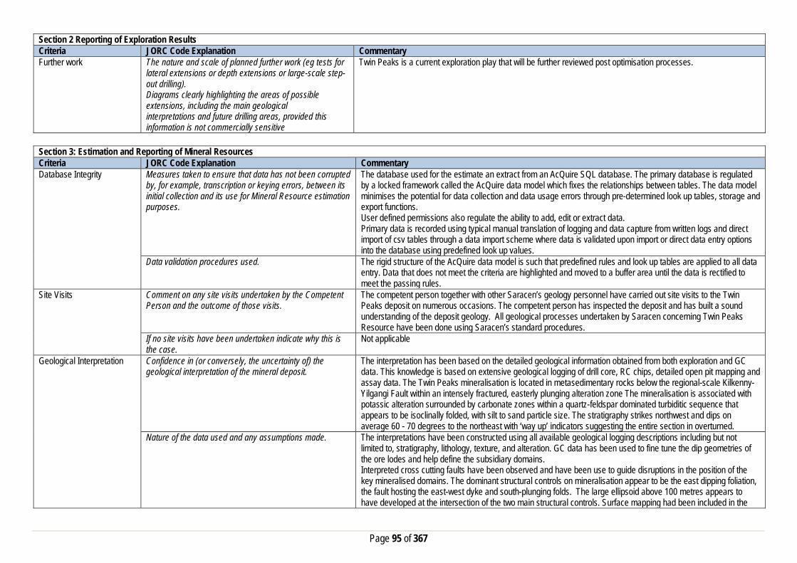
Page 95 of 367
Section 2 Reporting of Exploration Results Criteria JORC Code Explanation Commentary Further work The nature and scale of planned further work (eg tests for
lateral extensions or depth extensions or large-scale step-out drilling). Diagrams clearly highlighting the areas of possible extensions, including the main geological interpretations and future drilling areas, provided this information is not commercially sensitive
Twin Peaks is a current exploration play that will be further reviewed post optimisation processes.
Section 3: Estimation and Reporting of Mineral Resources Criteria JORC Code Explanation Commentary Database Integrity Measures taken to ensure that data has not been corrupted
by, for example, transcription or keying errors, between its initial collection and its use for Mineral Resource estimation purposes.
The database used for the estimate an extract from an AcQuire SQL database. The primary database is regulated by a locked framework called the AcQuire data model which fixes the relationships between tables. The data model minimises the potential for data collection and data usage errors through pre-determined look up tables, storage and export functions. User defined permissions also regulate the ability to add, edit or extract data. Primary data is recorded using typical manual translation of logging and data capture from written logs and direct import of csv tables through a data import scheme where data is validated upon import or direct data entry options into the database using predefined look up values.
Data validation procedures used. The rigid structure of the AcQuire data model is such that predefined rules and look up tables are applied to all data entry. Data that does not meet the criteria are highlighted and moved to a buffer area until the data is rectified to meet the passing rules.
Site Visits Comment on any site visits undertaken by the Competent Person and the outcome of those visits.
The competent person together with other Saracen’s geology personnel have carried out site visits to the Twin Peaks deposit on numerous occasions. The competent person has inspected the deposit and has built a sound understanding of the deposit geology. All geological processes undertaken by Saracen concerning Twin Peaks Resource have been done using Saracen’s standard procedures.
If no site visits have been undertaken indicate why this is the case.
Not applicable
Geological Interpretation Confidence in (or conversely, the uncertainty of) the geological interpretation of the mineral deposit.
The interpretation has been based on the detailed geological information obtained from both exploration and GC data. This knowledge is based on extensive geological logging of drill core, RC chips, detailed open pit mapping and assay data. The Twin Peaks mineralisation is located in metasedimentary rocks below the regional-scale Kilkenny-Yilgangi Fault within an intensely fractured, easterly plunging alteration zone The mineralisation is associated with potassic alteration surrounded by carbonate zones within a quartz-feldspar dominated turbiditic sequence that appears to be isoclinally folded, with silt to sand particle size. The stratigraphy strikes northwest and dips on average 60 - 70 degrees to the northeast with ‘way up’ indicators suggesting the entire section in overturned.
Nature of the data used and any assumptions made. The interpretations have been constructed using all available geological logging descriptions including but not limited to, stratigraphy, lithology, texture, and alteration. GC data has been used to fine tune the dip geometries of the ore lodes and help define the subsidiary domains. Interpreted cross cutting faults have been observed and have been use to guide disruptions in the position of the key mineralised domains. The dominant structural controls on mineralisation appear to be the east dipping foliation, the fault hosting the east-west dyke and south-plunging folds. The large ellipsoid above 100 metres appears to have developed at the intersection of the two main structural controls. Surface mapping had been included in the

Page 96 of 367
Section 3: Estimation and Reporting of Mineral Resources Criteria JORC Code Explanation Commentary
interpretation. Cross sectional interpretations of the mineralisation have been created and from the basic framework through which the 3D wireframe solid is built.
The affect, if any, of alternative interpretations on Mineral Resource estimation.
In the 2015 reinterpretation the GC data was also considered which highlighted a more moderate dip to the major domains and the occurrence of subsidiary lodes that were previously undefined by exploration data alone. Saracen has conducted extensional down dip drilling which supports the current interpretation which is considered to be robust.
The use of geology in guiding and controlling the Mineral Resource estimation.
Geological controls and relationships were used to define mineralised domains. The most important distinction is between the Breccia Zone and the Footwall Zone. This separation was handled by the position of the transitional to fresh boundary. The breccia zone is within the transitional area and the footwall zone is in the fresh area.
The factors affecting continuity both of grade and geology. At the deposit scale the gold distribution is predominantly characterised by a quartz-arsenopyrite breccia within a sericite-carbonate alteration envelope. This has been overprinted by a later quartz-pyrite-biotite vein event, which has remobilised or introduced a new phase of Au mineralisation. The dominant structural controls on mineralisation appear to be the east dipping foliation, the fault hosting the east-west dyke and south-plunging folds. The large ellipsoid above 100 metres appears to have developed at the intersection of the two main structural controls.
Dimensions The extent and variability of the Mineral Resource expressed as length (along strike or otherwise), plan width, and depth below surface to the upper and lower limits of the Mineral Resource.
Within 100 metres of the surface, the orebody has an ellipsoid shape measuring approximately 90 x 45 metres. Below this depth, mineralisation is pipe-shaped, measuring approximately 50 x 20 metres (in the horizontal plane) and plunging to grid south east at around 50°. The deposit is open below 300m.
Estimation and modelling techniques
The nature and appropriateness of the estimation technique(s) applied and key assumptions, including treatment of extreme grade values, domaining, interpolation parameters and maximum distance of extrapolation from data points.
Based on drill spacing 20m x 20m to 8m x 6m (GC), the gold grade was estimated by ordinary kriging in Micromine into the parent cells, 10m East X 20m North X 5m RL that were subcelled to 1m x 2m x 1m. Hard boundaries were utilised between the major domains at Twin Peaks. There were two model runs, one that used exploration data only; the other used both exploration and GC data. These models used different composites and topcuts, however the estimation technique and model parameters remained consistent. The exploration data was composited to 1m with a minimum of 0.3m which represented the majority (97%) length of the data. With the addition of the GC data to the dataset, the composited length was changed to 1.5m and a minimum of 0.3m. This represented the data with 79% at an average length of 1.5m. Intervals with no assays were excluded from the compositing routine. The influence of extreme sample distribution outliers was reduced by top-cutting where required. The top-cut levels were determined using a combination of top-cut analysis tools (grade histograms, mean variance plots and CVs). Top-cuts were reviewed and applied on a domain basis for each dataset. Due to the flexures in the mineralised envelopes, the estimation process was in unfolded space. The blocks are relocated back to their original space after the estimation. Variography was conducted in unfolded space using Snowden’s supervisor software. KNA was utilised to determine the optimal block size, sample numbers and search parameters. Finally, based on estimate validation, the GC & exploration informed model was spliced above the 220mRL and the exploration only informed estimate was utilised below the 220mRL.
The availability of check estimates, previous estimates and/or mine production records and whether the Mineral Resource estimate takes appropriate account of such data.
Comparisons with previous estimates, (2009, & 2011) indicate that the current model contains 25% more tonnes, 22% less grade for the same ounces.
The assumptions made regarding recovery of by-products. No assumptions have been made with respect to the recovery of by-products.

Page 97 of 367
Section 3: Estimation and Reporting of Mineral Resources Criteria JORC Code Explanation Commentary
Estimation of deleterious elements or other non-grade variables of economic significance (e.g. sulfur for acid mine drainage characterisation).
There has been no estimate at this point of deleterious elements.
In the case of block model interpolation, the block size in relation to the average sample spacing and the search employed.
Based on drill spacing 20m x 20m to 8m x 6m (GC), the gold grade was estimated by ordinary kriging in Micromine into the parent cells, 10m East X 20m North X 5m RL that were subcelled to 1m x 2m x 1m. Hard boundaries were utilised between the major domains at Twin Peaks Estimation was into the Parent Cells. A three pass search was used, whereby the search ellipse dimensions for the first search corresponded to the mineralisation continuity ranges interpreted from the variogram analysis, (15 – 25m in major direction). The second search expanded the ellipse to outer ranges of the variogram (25 – 50m major direction) and the minimum number of samples required to inform the estimation were decreased. The dimensions of the third search were doubled and the minimum samples dropped to ensure complete estimation of domains in zones of limited data. The minimum and maximum samples used were 6 and 32 samples respectively, where the minimum dropped to 4 for more sparsely populated domains, particularly for the 3rd search.
Any assumptions behind modelling of selective mining units.
No selective mining units have been assumed.
Any assumptions about correlation between variables. No assumptions have been made regarding correlation between variables. Description of how the geological interpretation was used to control the resource estimates.
The geological interpretation strongly correlates with the mineralised domains within metasediments, inside an intensely fractured, pipe like, easterly plunging alteration zone. This alteration pipe has a central high gold grade core associated with potassic alteration and surrounded by carbonate zones. All wireframe boundaries including those where lithology and mineralisation correspond, hard boundaries are enforced.
Discussion of basis for using or not using grade cutting or capping.
Statistical analysis showed the populations in each domain at Twin Peaks to generally have a reasonable coefficient of variation (<1.6) but it was noted that some of the estimation domains included outlier values that required top-cut values to be applied.
The process of validation, the checking process used, the comparison of model data to drill hole data, and use of reconciliation data if available.
Validation of the block model involved a volumetric comparison of the resource wireframes to the block model volumes with 100% reconciliation. Validating the estimate, compared block model grades to the input data that resulted in comparisons within the 10% allowed tolerance. Swathe plots were also used showing northing, easting and elevation comparisons. These showed good conformance. Visual validation of grade trends and metal distributions was carried out. Discrepancies with historic mined data and reported poor reconciliations at the time make direct comparisons to the current model inaccurate. The final ounces reported for the mined material of the 2015 model sits between the two reported mined values from 2004.
Moisture Whether the tonnages are estimated on a dry basis or with natural moisture, and the method of determination of the moisture content.
All tonnages are estimated on a dry basis.
Cut-off parameters The basis of the adopted cut-off grade(s) or quality parameters applied.
Based on Saracen’s current economic operations at Carosue Dam, and the natural grade distinction above background, a grade of 0.5g/t has been chosen.
Mining factors or assumptions
Assumptions made regarding possible mining methods, minimum mining dimensions and internal (or, if applicable, external) mining dilution. It is always necessary as part of the process of determining reasonable prospects for eventual economic extraction to consider potential mining methods, but the assumptions made regarding mining methods and parameters when estimating Mineral
Mining of the Twin Peaks at this stage deposit will be dominantly by underground mining methods involving mechanised mining techniques. The geometry of the deposit will make it amenable to mining methods currently employed in many underground operations in similar deposits around the world. No assumptions on mining methodology have been made as yet.

Page 98 of 367
Section 3: Estimation and Reporting of Mineral Resources Criteria JORC Code Explanation Commentary
Resources may not always be rigorous. Where this is the case, this should be reported with an explanation of the basis of the mining assumptions made.
Metallurgical factors or assumptions
The basis for assumptions or predictions regarding metallurgical amenability. It is always necessary as part of the process of determining reasonable prospects for eventual economic extraction to consider potential metallurgical methods, but the assumptions regarding metallurgical treatment process and parameters made when reporting Mineral Resources may not always be rigorous. Where this is the case, this should be reported with an explanation of the basis of the metallurgical assumptions made.
The following conclusions can be made from the test work conducted at Twin Peaks: • Mineralogical analysis of the ore showed a large proportion of free gold with particles at 10m to 100m in
size. No composite gold was detected. Sulphides present were mainly as pyrite and arsenopyrite. • High proportion of gold recovered to Knelson concentrate (up to 83%). • An overall gold recovery of 93% was obtained for this material. The gold recoveries ranged between 90%
to 93%, with the lower recovery attributed to gravity stage / intensive cyanidation inefficiencies. • Grindability tests showed low ore hardness with a BWi result of 6.9 kWh/t, and low abrasiveness with an
abrasion index value of 0.116. • The slurry viscosity measurements at the various shear rates showed no major pumping or mixing issues
should be experienced with this material. • The samples exhibited low cyanide consumptions and very low oxygen demands.
A large variation in gold recoveries were obtained depending on test work methods used. Tests which utilised a gravity stage were deemed as most appropriate for assessing anticipated plant performance. The testwork showed that high gold recoveries of 93% for the Twin Peaks material, is achievable. No major processing difficulties are anticipated for this deposits (assuming the material tested is representative of the ore deposit).
Environmental factors or assumptions
Assumptions made regarding possible waste and process residue disposal options. It is always necessary as part of the process of determining reasonable prospects for eventual economic extraction to consider the potential environmental impacts of the mining and processing operation. While at this stage the determination of potential environmental impacts, particularly for a greenfields project, may not always be well advanced, the status of early consideration of these potential environmental impacts should be reported. Where these aspects have not been considered this should be reported with an explanation of the environmental assumptions made.
No processing or beneficiation of ore expected on these tenements, as ore is hauled to Carosue Dam Minesite for processing. Rehabilitation of Twin Peaks WRL is progressing with 45% of the total area rated as stable with self-sustaining vegetation. The landform is functionally intact and there is no loss of material to the surrounding landscape. While ecosystem diversity completion targets are mostly achieved, landscape stability targets are yet to be achieved. Approximately 70% of the rehabilitated ROM landform, east of Twin Peaks’ WRL is poorly vegetated, of which 50% is highly saline. Remedial treatment may be required to achieve ‘sign-off’. Repair works are currently under review by SGM management and will be factored into future budgets.
Bulk Density Whether assumed or determined. If assumed, the basis for the assumptions. If determined, the method used, whether wet or dry, the frequency of the measurements, the nature, size and representativeness of the samples.
Previous owners have taken routine density measurements when drilling diamond core. The method of calculation is the water displacement technique. Density in the current model has been assigned based on oxidation state, using the most recent density determinations carried out by Saracen on the diamond drill samples. A detailed set of density data were available for Twin Peaks; these had been rigorously validated. The data was flagged by domain and analysed statistically.
The bulk density for bulk material must have been measured by methods that adequately account for void spaces (vugs, porosity, etc), moisture and differences between rock and alteration zones within the deposit.
The frequency and distribution is unknown at this point in time. It has assumed from the good reconciliation performance from mine to mill that the determined density assignments from the mine are accurate.

Page 99 of 367
Section 3: Estimation and Reporting of Mineral Resources Criteria JORC Code Explanation Commentary
Discuss assumptions for bulk density estimates used in the evaluation process of the different materials.
Average mean of densities collected for each lithological and weathering profile has been uniformly applied to the modelled geological units. This includes the primary fresh lithologies as well as the weathered oxide and transitional zones.
Classification The basis for the classification of the Mineral Resources into varying confidence categories.
The mineral resource has been classified into Measured, Indicated and Inferred categories based on drill hole spacing, geological confidence, and grade continuity and estimation quality. The combination of these factors together guide the construction of wireframes which select and codes the appropriate blocks with the nominated resource classification category.
Whether appropriate account has been taken of all the relevant factors (ie relative confidence in tonnage/grade estimations, reliability of input data, confidence in continuity of geology and metal values, quality, quantity and distribution of the data).
The input data is comprehensive in its coverage of the mineralisation and does not favour or misrepresent in-situ mineralisation. Geological control at Twin Peaks consists of a primary mineralisation is associated with easterly plunging alteration zone. The definition of mineralised zones is based on a high level of geological understanding producing a robust model of mineralised domains. The validation of the block model shows good correlation of the input data to the estimated grades.
Whether the result appropriately reflects the Competent Person's view of the deposit.
The geological model and the mineral resource estimate reflect the competent person’s view of the deposit.
Audits or reviews The results of any audits or reviews of Mineral Resource estimates.
Saracen has adopted a process for geological modelling, estimation and reporting of mineral resources that meets high industry standards. No external audits have been conducted on this deposit as Saracen is still conducting an internal scoping study.
Discussion of relative accuracy/confidence
Where appropriate a statement of the relative accuracy and confidence level in the Mineral Resource estimate using an approach or procedure deemed appropriate by the Competent Person. For example, the application of statistical or geostatistical procedures to quantify the relative accuracy of the resource within stated confidence limits, or, if such an approach is not deemed appropriate, a qualitative discussion of the factors that could affect the relative accuracy and confidence of the estimate.
The relative accuracy of the Mineral Resource estimate is reflected in the reporting of the Mineral Resource as per the guidelines of the 2012 JORC Code. The resource estimates have undergone a robust validation process, and as such, the competent person is satisfied that the resources estimated in the block model are a true representation of the global insitu resources.
The statement should specify whether it relates to global or local estimates, and, if local, state the relevant tonnages, which should be relevant to technical and economic evaluation. Documentation should include assumptions made and the procedures used.
The statements relate to a global estimate of tonnes and grade.
These statements of relative accuracy and confidence of the estimate should be compared with production data, where available.
The Twin Peaks resource model was done using Saracen’s resource estimation procedures. The model has been validated thoroughly and the competent person is satisfied that the estimated gold grades give a true reflection of the global insitu resources. The model had been compared with previous production data and it can be concluded that the model is conservative based on all the available data.

Page 100 of 367
Pinnacles Section 1: Sampling Techniques and Data Criteria JORC Code Explanation Commentary Sampling Techniques Nature and quality of sampling (e.g. cut channels, random
chips, or specific specialised industry standard measurement tools appropriate to the minerals under investigation, such as down hole gamma sondes, or handheld XRF instruments, etc.). These examples should not be taken as limiting the broad meaning of sampling.
Saracen has undertaken reverse circulation (RC) drilling at Pinnacles. Historic sampling methods conducted since 1984 have included rotary air blast (RAB) and RC drillholes.
Include reference to measures taken to ensure sample representivity and the appropriate calibration of any measurement tools or systems used
Sampling for diamond and RC drilling is carried out as specified within Saracen sampling and QAQC procedures as per industry standard. RC chips provide high quality representative samples for analysis. RC and RAB drilling was completed by previous holders to industry standard at that time (1984- 2003).
Aspects of the determination of mineralisation that are Material to the Public Report. In cases where ‘industry standard’ work has been done this would be relatively simple (e.g. ‘reverse circulation drilling was used to obtain 1 m samples from which 3 kg was pulverised to produce a 30 g charge for fire assay’). In other cases more explanation may be required, such as where there is coarse gold that has inherent sampling problems. Unusual commodities or mineralisation types (e.g. submarine nodules) may warrant disclosure of detailed information
RC chips are cone split and sampled into 1m intervals with total sample weights under 3kg Samples are selected to weigh less than 3 kg to ensure total sample inclusion at the pulverisation stage. Saracen chip samples are crushed, dried and pulverised to a nominal 90% passing 75µm to produce a 50g sub sample for analysis by FA/AAS. Historical RAB and RC sampling was carried out to industry standard at that time. Analysis methods include fire assay and atomic absorption spectroscopy.
Drilling Techniques Drill type (e.g. core, reverse circulation, open-hole hammer, rotary air blast, auger, Bangka, sonic, etc.) and details (e.g. core diameter, triple or standard tube, depth of diamond tails, face-sampling bit or other type, whether core is oriented and if so, by what method, etc.).
The deposit was initially sampled by 36 RAB holes and 63 RC holes (assumed standard 5 ¼ ‘’bit size). Saracen has completed 42 surface RC drill holes.
Drill Sample Recovery Method of recording and assessing core and chip sample recoveries and results assessed
RC sampling recoveries are recorded in the database as a percentage based on a visual weight estimate; no historic recoveries have been recorded.
Measures taken to maximise sample recovery and ensure representative nature of the samples
During RC drilling daily rig inspections are carried out to check splitter condition, general site and address general issues. Historical RAB and RC drilling to industry standard at that time.
Whether a relationship exists between sample recovery and grade and whether sample bias may have occurred due to preferential loss/gain of fine/coarse material.
There is no known relationship between sample recovery and grade for RC drilling. Any historical relationship is not known.
Logging Whether core and chip samples have been geologically and geotechnically logged to a level of detail to support appropriate Mineral Resource estimation, mining studies and metallurgical studies. Whether logging is qualitative or quantitative in nature. Core (or costean, channel, etc) photography.
Logging of RC chips records lithology, mineralogy, texture, mineralisation, weathering, alteration and veining. Chips from all RC holes are stored in chip trays for future reference. Qualitative and quantitative logging of historic data varies in its completeness.
The total length and percentage of the relevant All RC drillholes holes are logged in full.

Page 101 of 367
Section 1: Sampling Techniques and Data Criteria JORC Code Explanation Commentary
intersections logged Historical logging is approximately 95% complete. Sub-sampling techniques and sample preparation
If core, whether cut or sawn and whether quarter, half or all core taken.
No diamond drilling has been completed at Pinnacles.
If non-core, whether riffled, tube sampled, rotary split, etc and whether sampled wet or dry.
All exploration RC samples are cone split. Occasional wet samples are encountered; increased air capacity is routinely used to aid in keeping the sample dry when water is encountered. Historic RAB and RC drilling was sampled using riffle and unknown methods.
For all sample types, the nature, quality and appropriateness of the sample preparation technique.
The sample preparation of RC chips adheres to industry best practice. It is conducted by a commercial laboratory and involves oven drying, coarse crushing then total grinding to a size of 90% passing 75 microns. Best practice is assumed at the time of historic sampling.
Quality control procedures adopted for all sub-sampling stages to maximise representivity of samples.
All subsampling activities are carried out by commercial laboratory and are considered to be satisfactory. Sampling by previous holders assumed to be industry standard at the time.
Measures taken to ensure that the sampling is representative of the in situ material collected, including for instance results for field duplicate/second half sampling.
RC field duplicate samples are carried out at a rate of 1:20 and are sampled directly from the on-board splitter on the rig. These are submitted for the same assay process as the original samples and the laboratory are unaware of such submissions. Sampling by previous holders assumed to be industry standard at the time.
Whether sample sizes are appropriate to the grain size of the material being sampled.
Sample sizes of 3kg are considered to be appropriate given the grain size (90% passing 75 microns) of the material sampled.
Quality of assay data and laboratory tests
The nature, quality and appropriateness of the assaying and laboratory procedures used and whether the technique is considered partial or total.
RC chip samples are analysed by external laboratories using a 50g fire assay with AAS finish. This method is considered suitable for determining gold concentrations in rock and is a total digest method. Historic sampling includes fire assay and atomic absorption spectroscopy.
For geophysical tools, spectrometers, handheld XRF instruments, etc, the parameters used in determining the analysis including instrument make and model, reading times, calibrations factors applied and their derivation, etc.
No geophysical tools have been utilised for reporting gold mineralisation.
Nature of quality control procedures adopted (e.g. standards, blanks, duplicates, external laboratory checks) and whether acceptable levels of accuracy (i.e. lack of bias) and precision have been established.
Certified reference material (standards and blanks) with a wide range of values are inserted into every drillhole at a rate of 1:25 for exploration RC. These are not identifiable to the laboratory. QAQC data returned are checked against pass/fail limits with the SQL database and are passed or failed on import. A report is generated and reviewed by the geologist as necessary upon failure to determine further action. QAQC data is reported monthly. Sample preparation checks for fineness are carried out to ensure a grindsize of 90% passing 75 microns. The laboratory performs a number of internal processes including standards, blanks, repeats and checks. QAQC data analysis demonstrates sufficient accuracy and precision. Industry best practice is assumed for previous holders.
Verification of sampling and assaying
The verification of significant intersections by either independent or alternative company personnel.
Significant intercepts are verified by the Geology Manager and corporate personnel.
The use of twinned holes. No specific twinned holes have been drilled at Pinnacles. Documentation of primary data, data entry procedures, data verification, data storage (physical and electronic) protocols
Primary data is collated in a set of excel templates utilising lookup codes. This data is forwarded to the Database Administrator for entry into a secure acQuire database with inbuilt validation functions. Data from previous owners was taken from a database compilation and validated as much as practicable before entry into the Saracen acQuire database.
Discuss any adjustment to assay data. No adjustments have been made to assay data. First gold assay is utilised for resource estimation.

Page 102 of 367
Section 1: Sampling Techniques and Data Criteria JORC Code Explanation Commentary Location of data points Accuracy and quality of surveys used to locate drillholes
(collar and down-hole surveys), trenches, mine workings and other locations used in Mineral Resource estimation.
Exploration drillholes are located using a Leica 1200 GPS with an accuracy of +/- 10mm. Downhole surveys are carried out using an Eastman single shot camera at regular intervals (usually 30m). A number of drillholes have also been gyroscopically surveyed. Previous holders’ survey accuracy and quality is unknown
Specification of the grid system used. A local grid system (Pinnacles East) is used. The two point conversion to MGA_GDA94 zone 51 is PEEast PENorth RL MGAEast MGANorth RL Point 1 993 976 0 439656.00 6649294.68 0 Point 2 974 1060 0 439660.00 6649381.68 0 Historic data is converted to the Pinnacles East local grid upon export from the database.
Quality and adequacy of topographic control. Topographic control originally used site based survey pickups in addition to Kevron aerial photogrammetric surveys with +/- 5m resolution. Pre mining, new and more detailed topography has since been captured and will be used in future updates and for subsequent planning purposes.
Data spacing and distribution
Data spacing for reporting of Exploration Results. The nominal spacing for drilling is predominantly 15m x15m. Whether the data spacing and distribution is sufficient to establish the degree of geological and grade continuity appropriate for the Mineral Resource and Ore Reserve estimation procedure(s) and classifications applied.
Data spacing and distribution are sufficient to establish the degree of geological and grade continuity appropriate for JORC classifications applied.
Orientation of data in relation to geological structure
Whether sample compositing has been applied.
Sample compositing is not applied until the estimation stage. Some historic RC sampling was composited into 3m samples.
Whether the orientation of sampling achieves unbiased sampling of possible structures and the extent to which this is known, considering the deposit type.
The majority of drillholes are positioned to achieve optimum intersection angles to the ore zone as are practicable.
If the relationship between the drilling orientation and the orientation of key mineralised structures is considered to have introduced a sampling bias, this should be assessed and reported if material.
No significant sampling bias has been recognised due to orientation of drilling in regards to mineralised structures.
Sample security The measures taken to ensure sample security. Samples are prepared on site under supervision of Saracen geological staff. Samples are selected, bagged into tied numbered calico bags then grouped into secured cages and collected by the laboratory personnel. Sample submissions are documented via laboratory tracking systems and assays are returned via email
Audits or reviews The results of any audits or reviews of sampling techniques and data.
An internal review of companywide sampling methodologies was conducted to create the current sampling and QAQC procedures. No external audits or reviews have been conducted.
Section 2: Reporting of Exploration Results Criteria JORC Code Explanation Commentary Mineral tenement and land tenure status
Type, reference name/number, location and ownership including agreements or material issues with third parties such as joint ventures, partnerships, overriding royalties,
The Pinnacles resource is located on M28/243. The tenement is held 100% by Saracen Gold Mines Pty Ltd, a wholly owned subsidiary of Saracen Mineral Holdings Limited. Mining Lease M28/243 has a 21 year life (held until 2031) and is renewable for a further 21 years on a continuing basis.

Page 103 of 367
Section 2: Reporting of Exploration Results Criteria JORC Code Explanation Commentary
native title interests, historical sites, wilderness or national park and environmental settings.
Mining Lease M28/243 is subject to one royalty agreement and a caveat (454H/067). All production is subject to a Western Australian state government NSR royalty of 2.5%. There is one registered Aboriginal Heritage site within Mining Lease M28/243 (ID19141).
The security of the tenure held at the time of reporting along with any known impediments to obtaining a licence to operate in the area.
The tenement is in good standing and there are no known impediments to obtaining a license to operate.
Exploration done by other parties
Acknowledgment and appraisal of exploration by other parties.
Numerous companies have undertaken extensive gold exploration in the Pinnacles region beginning in the 1980’s. Central Kalgoorlie Gold Mines carried out mapping, geological and aerial surveys and RC drilling, yielding no significant results. Esmeralda Resources acquired the project and carried out channel and costean sampling, rock chip and RC drilling, intersecting mineralisation and defining a resource. Various geochemical and geophysical surveys were then conducted by Cesium International, MIM and Troy Resources, outlining a number of anomalies. Aberfoyle acquired the leases and carried out RAB drilling to test previously defined anomalies. Minor mineralisation was encountered. Sons of Gwalia carried out a successful RC drilling program designed to intersect mineralisation at depth and further define the resource, as well as a regional shallow RAB program, which returned no significant gold. The project was acquired by St Barbara’s following the collapse of Sons of Gwalia.
Geology Deposit type, geological setting and style of mineralisation.
The Pinnacles project area is situated within the Eastern Goldfields Province of the Archaean Yilgarn Craton, on the eastern margin of the Norseman- Wiluna greenstone belt. Geology of the project area is dominated by volcanically derived sandstones, black shales, mafic and ultramafic volcanics and granites. Gold mineralisation at Pinnacles is structurally controlled and defines three major domains, (Dom01, Dom02 and Dom02A) hosted within the black shale units. Intense mineralisation is associated with quartz veining and significant hematite and sulphide alteration and clay, which gives the highly mineralised zones a distinct orange brown colour. The high grade zones plunge gently (20 degrees) to the south. At depth (around the 245 to 255mRL) there is evidence of an easterly dipping (80 degrees) syn/post shear zone that obliterates the mineralisation in the major domain, Dom01.
Drillhole information A summary of all information material to the understanding of the exploration results including a tabulation of the following information for all Material drill holes:
• easting and northing of the drill hole collar • elevation or RL (Reduced Level – elevation • above sea level in metres) of the drill hole collar • dip and azimuth of the hole • down hole length and interception depth • hole length. • If the exclusion of this information is justified on the
basis that the information is not Material and this exclusion does not detract from the understanding of the report, the Competent Person should clearly explain why this is the case.
All material data was periodically released on the ASX dated; 25/01/2013, 27/04/2012, 05/03/2012, 27/01/2012, 06/01/2012, 30/07/2008, 16/06/2008. Future drill hole data will be periodically released or when a results materially change the economic value of the project. Exclusion of the drilling information will not detract from the reader’s view of the report.

Page 104 of 367
Section 2: Reporting of Exploration Results Criteria JORC Code Explanation Commentary Data aggregation methods In reporting Exploration Results, weighting averaging
techniques, maximum and/or minimum grade truncations (e.g. cutting of high grades) and cut-off grades are usually Material and should be stated.
All significant intercepts have been length weighted with a minimum Au grade of 1ppm. No high grade cut off has been applied.
Where aggregate intercepts incorporate short lengths of high grade results and longer lengths of low grade results, the procedure used for such aggregation should be stated and some typical examples of such aggregations should be shown in detail.
Intercepts are aggregated with minimum width of 1m and maximum width of 3m for internal dilution. Where stand out higher grade zone exist with in the broader mineralised zone, the higher grade interval is reported also.
The assumptions used for any reporting of metal equivalent values should be clearly stated.
Metal equivalent values are not reported
Relationship between mineralisation widths and intercept lengths
These relationships are particularly important in the reporting of Exploration Results. If the geometry of the mineralisation with respect to the drill hole angle is known, its nature should be reported. If it is not known and only the down hole lengths are reported, there should be a clear statement to this effect (eg ‘down hole length, true width not known’).
Previous announcements included sufficient detail to clearly illustrate the geometry of the mineralisation and the recent drilling. All results are reported as downhole lengths.
Diagrams Appropriate maps and sections (with scales) and tabulations of intercepts should be included for any significant discovery being reported These should include, but not be limited to a plan view of drill hole collar locations and appropriate sectional views.
All significant exploration results released by Saracen are accompanied by the appropriate diagrams and maps at the time of the release.
Balanced Reporting Where comprehensive reporting of all Exploration Results are not practicable, representative reporting of both low and high grades and/or widths should be practiced to avoid misleading reporting of Exploration Results.
All results from previous campaigns have been reported, irrespective of success or not.
Other substantive exploration data
Other exploration data, if meaningful and material, should be reported including (but not limited to): geological observations; geophysical survey results; geochemical survey results; bulk samples – size and method of treatment; metallurgical test results; bulk density, groundwater, geotechnical and rock characteristics; potential deleterious or contaminating substances.
No substantive data acquisition has been completed in recent times.
Further work The nature and scale of planned further work (eg tests for lateral extensions or depth extensions or large-scale step-out drilling). Diagrams clearly highlighting the areas of possible extensions, including the main geological interpretations and future drilling areas, provided this information is not commercially sensitive
The Pinnacle Deposit is a current exploration play that will be further reviewed post optimisation processes.

Page 105 of 367
Section 3: Estimation and Reporting of Mineral Resources Criteria JORC Code Explanation Commentary Database Integrity Measures taken to ensure that data has not been
corrupted by, for example, transcription or keying errors, between its initial collection and its use for Mineral Resource estimation purposes.
Saracen utilises AcQuire software on an SQL server database to securely store and manage all drillhole and sample information. Data integrity protocols are built into the system to ensure data validity and minimise errors.
Data validation procedures used. Data that is captured in the field is entered into Excel templates which are checked on import into the database for errors. Assay jobs are dispatched electronically to the lab to minimise the chance of data entry errors. Assay results from the lab are received in CSV format and are checked for errors on import into the database. Data is regularly validated using the mining software. The data validation process is overseen by the Database Administrator.
Site Visits Comment on any site visits undertaken by the Competent Person and the outcome of those visits.
The Competent Person visited the geological area to assess geological competency and ensure integrity across all exploration geological disciplines.
If no site visits have been undertaken indicate why this is the case.
Geological Interpretation Confidence in (or conversely, the uncertainty of) the geological interpretation of the mineral deposit.
The resource categories assigned to the model directly reflect the confidence in the geological interpretation that is built using local, structural, mineral, and alteration geology obtained from logging, drill results and geophysics.
Nature of the data used and any assumptions made. The interpretations have been constructed using all available geological logging descriptions including but not limited to, stratigraphy, lithology, texture, and alteration. It was highlighted that alteration style and colour can be adequately used to define hangingwall and footwall positions of the mineralised zone as well as a fault zone that cuts the primary ore zone and obliterates gold. Relogging of various historic RC holes and downhole magnetic surveys assisted in ore definition and propelled a geological theory of micro folding and fold nose geometry to the north of the deposit. Cross sectional interpretations of the mineralisation have been created and from the basic framework through which the 3D wireframe solid is built.
The affect, if any, of alternative interpretations on Mineral Resource estimation.
Due to the reasonably simplistic nature of the mineralisation no alternative interpretations have been considered. Over the life of the project additional drilling campaigns have confirmed the strong north-south strike of the main mineralised zone.
The use of geology in guiding and controlling the Mineral Resource estimation.
The geology has heavily influenced the domains controlling the mineral resource estimation. The structurally controlled mineralisation within a sedimentary host is clearly defined by alteration style and colour that is dominated by a quartz-hematite-sulphide-clay assemblage. These mineralised domains were wireframed with hard boundaries.
The factors affecting continuity both of grade and geology. At depth (around the 245 to 255mRL) there is evidence of a north-south trending steeply east dipping syn/post faulted/shear zone that is not gold bearing. This creates a 10m barren zone within the main mineralised domain. Where drilling intersects this fault zone, sheared and altered sediments can be identified and are visually different to that of the Au bearing zones. Four southerly plunging high grade shoots were identified within the Main mineralised domain. These shoots, with increased alteration and sulphide enrichment, were wireframed as hard boundaries.
Dimensions The extent and variability of the Mineral Resource expressed as length (along strike or otherwise), plan width, and depth below surface to the upper and lower limits of the Mineral Resource.
Pinnacles mineralisation extends from 850mN to 1180mN, 950mE – 1020mE to 180m below surface. The Pinnacles shear generally strikes North-South and dips 80 to 85° towards the West with a gentle southerly plunge. The plunge steepens to the north (up to 60°) in closer proximity to the interpreted fold nose. In the vicinity of the strongest gold mineralisation the high grade zones plunge consistently at 20° to south mimicking that of its host.
Estimation and modelling techniques
The nature and appropriateness of the estimation technique(s) applied and key assumptions, including treatment of extreme grade values, domaining,
Block estimation has been completed using Datamine software. All compositing, wireframes, surfaces, rock and domain models were constructed in Micromine. All estimation uses these wireframes as hard boundaries. Estimation of parent blocks are interpolated, and assigned to sub-cells. The maximum distance of extrapolation is less than 40m.
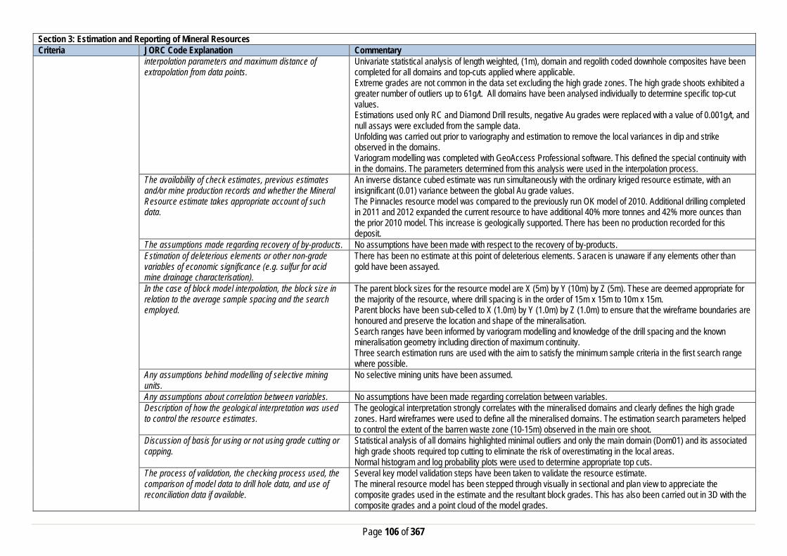
Page 106 of 367
Section 3: Estimation and Reporting of Mineral Resources Criteria JORC Code Explanation Commentary
interpolation parameters and maximum distance of extrapolation from data points.
Univariate statistical analysis of length weighted, (1m), domain and regolith coded downhole composites have been completed for all domains and top-cuts applied where applicable. Extreme grades are not common in the data set excluding the high grade zones. The high grade shoots exhibited a greater number of outliers up to 61g/t. All domains have been analysed individually to determine specific top-cut values. Estimations used only RC and Diamond Drill results, negative Au grades were replaced with a value of 0.001g/t, and null assays were excluded from the sample data. Unfolding was carried out prior to variography and estimation to remove the local variances in dip and strike observed in the domains. Variogram modelling was completed with GeoAccess Professional software. This defined the special continuity with in the domains. The parameters determined from this analysis were used in the interpolation process.
The availability of check estimates, previous estimates and/or mine production records and whether the Mineral Resource estimate takes appropriate account of such data.
An inverse distance cubed estimate was run simultaneously with the ordinary kriged resource estimate, with an insignificant (0.01) variance between the global Au grade values. The Pinnacles resource model was compared to the previously run OK model of 2010. Additional drilling completed in 2011 and 2012 expanded the current resource to have additional 40% more tonnes and 42% more ounces than the prior 2010 model. This increase is geologically supported. There has been no production recorded for this deposit.
The assumptions made regarding recovery of by-products. No assumptions have been made with respect to the recovery of by-products. Estimation of deleterious elements or other non-grade variables of economic significance (e.g. sulfur for acid mine drainage characterisation).
There has been no estimate at this point of deleterious elements. Saracen is unaware if any elements other than gold have been assayed.
In the case of block model interpolation, the block size in relation to the average sample spacing and the search employed.
The parent block sizes for the resource model are X (5m) by Y (10m) by Z (5m). These are deemed appropriate for the majority of the resource, where drill spacing is in the order of 15m x 15m to 10m x 15m. Parent blocks have been sub-celled to X (1.0m) by Y (1.0m) by Z (1.0m) to ensure that the wireframe boundaries are honoured and preserve the location and shape of the mineralisation. Search ranges have been informed by variogram modelling and knowledge of the drill spacing and the known mineralisation geometry including direction of maximum continuity. Three search estimation runs are used with the aim to satisfy the minimum sample criteria in the first search range where possible.
Any assumptions behind modelling of selective mining units.
No selective mining units have been assumed.
Any assumptions about correlation between variables. No assumptions have been made regarding correlation between variables. Description of how the geological interpretation was used to control the resource estimates.
The geological interpretation strongly correlates with the mineralised domains and clearly defines the high grade zones. Hard wireframes were used to define all the mineralised domains. The estimation search parameters helped to control the extent of the barren waste zone (10-15m) observed in the main ore shoot.
Discussion of basis for using or not using grade cutting or capping.
Statistical analysis of all domains highlighted minimal outliers and only the main domain (Dom01) and its associated high grade shoots required top cutting to eliminate the risk of overestimating in the local areas. Normal histogram and log probability plots were used to determine appropriate top cuts.
The process of validation, the checking process used, the comparison of model data to drill hole data, and use of reconciliation data if available.
Several key model validation steps have been taken to validate the resource estimate. The mineral resource model has been stepped through visually in sectional and plan view to appreciate the composite grades used in the estimate and the resultant block grades. This has also been carried out in 3D with the composite grades and a point cloud of the model grades.

Page 107 of 367
Section 3: Estimation and Reporting of Mineral Resources Criteria JORC Code Explanation Commentary
Easting, Northing and Elevation swathe plots have been constructed to evaluate the composited assay means versus the mean block estimates. The mineral resource model has been constructed to include kriging efficiency and the slope of regression values. These values are used to measure the quality of the estimate. Natural deterioration of the quality is observed in areas where data density is lower. No production has taken place for this deposit.
Moisture Whether the tonnages are estimated on a dry basis or with natural moisture, and the method of determination of the moisture content.
All tonnages are estimated on a dry basis.
Cut-off parameters The basis of the adopted cut-off grade(s) or quality parameters applied.
Based on Saracen’s current economic operations at Carosue Dam, and the natural grade distinction above background, a grade of 0.4g/t has been chosen.
Mining factors or assumptions
Assumptions made regarding possible mining methods, minimum mining dimensions and internal (or, if applicable, external) mining dilution. It is always necessary as part of the process of determining reasonable prospects for eventual economic extraction to consider potential mining methods, but the assumptions made regarding mining methods and parameters when estimating Mineral Resources may not always be rigorous. Where this is the case, this should be reported with an explanation of the basis of the mining assumptions made.
There are reasonable grounds to assume that in the future the Pinnacles resource will be mined by conventional open pit methods given the close proximity to surface and the mean average grade of the mineralisation.
Metallurgical factors or assumptions
The basis for assumptions or predictions regarding metallurgical amenability. It is always necessary as part of the process of determining reasonable prospects for eventual economic extraction to consider potential metallurgical methods, but the assumptions regarding metallurgical treatment process and parameters made when reporting Mineral Resources may not always be rigorous. Where this is the case, this should be reported with an explanation of the basis of the metallurgical assumptions made.
At this stage of the project there is no metallurgical data available.
Environmental factors or assumptions
Assumptions made regarding possible waste and process residue disposal options. It is always necessary as part of the process of determining reasonable prospects for eventual economic extraction to consider the potential environmental impacts of the mining and processing operation. While at this stage the determination of potential environmental impacts, particularly for a greenfields project, may not always be well advanced, the status of early consideration of these potential environmental impacts should be reported. Where these aspects have not been considered this should be reported
Environmental considerations are captured by Program of Work (PoW) requirements. Operations on these tenements are purely exploratory in nature to date.

Page 108 of 367
Section 3: Estimation and Reporting of Mineral Resources Criteria JORC Code Explanation Commentary
with an explanation of the environmental assumptions made.
Bulk Density Whether assumed or determined. If assumed, the basis for the assumptions. If determined, the method used, whether wet or dry, the frequency of the measurements, the nature, size and representativeness of the samples.
The density values applied to the Pinnacles estimation are largely based on historic density measures for similar lithological units in the same geological zones. The absence of diamond holes into the Pinnacles Deposit does not allow for accurate bulk density testing.
The bulk density for bulk material must have been measured by methods that adequately account for void spaces (vugs, porosity, etc), moisture and differences between rock and alteration zones within the deposit.
It is unknown how the historic bulk densities were measured. Any future bulk density measurements will follow the Saracens Metals standardised procedures. Saracens Metals have standardised procedures for bulk density testing. Most ore zones predominantly exist in transitional to fresh non porous material, however additional measures are taken to reduce moisture intake during the water displacement process if the coating is made of more friable oxides and sediments. This latter method aims to reduce moisture loss or moisture gain during the process and is considered on a deposit by deposit basis.
Discuss assumptions for bulk density estimates used in the evaluation process of the different materials.
Density values are allocated uniformly to each lithological and regolith type. This includes the primary fresh lithologies as well as the weathered oxide and transitional zones.
Classification The basis for the classification of the Mineral Resources into varying confidence categories.
The mineral resource has been classified into Indicated and Inferred categories based on drill hole spacing, geological confidence, and grade continuity and estimation quality. The combination of these factors together guided the hard boundary wireframe used to define the Indicated zone. Ore zones outside this wireframe were coded with the inferred category.
Whether appropriate account has been taken of all the relevant factors (ie relative confidence in tonnage/grade estimations, reliability of input data, confidence in continuity of geology and metal values, quality, quantity and distribution of the data).
All care has been taken to account for relevant factors influencing the mineral resource estimate. The diligent Saracen Metals Resource review process ensures that data reliability and geological and metal confidence and continuity are reflected in the resource classification.
Whether the result appropriately reflects the Competent Person's view of the deposit.
The geological model and the mineral resource estimate reflect the competent person’s view of the deposit.
Audits or reviews The results of any audits or reviews of Mineral Resource estimates.
Saracen has adopted a process for geological modelling, estimation and reporting of mineral resources that meets high industry standards. At the completion of resource estimation Saracen Metals undertake an extensive review of the model that covers;
• Model inventory and comparisons to previous and budget models if in existence • Geological interpretation, wireframing, domain selection, statistics by domain, assay and metal evaluation,
parent cell sizes, data compositing, variography, search strategy, estimation and KNA • Model validation – swathe plots, visual checks, volume comparisons, composite to model metal
comparisons. In the final stages the model and resource categorisation are all discussed and scrutinized by the geological and mine planning teams. Due to the simple geological setting of the Pinnacles Deposit no external audits have been conducted.
Discussion of relative accuracy/confidence
Where appropriate a statement of the relative accuracy and confidence level in the Mineral Resource estimate using an approach or procedure deemed appropriate by the Competent Person. For example, the application of statistical or geostatistical procedures to quantify the relative accuracy of the resource within stated confidence
The mineral resource has been reported in accordance with the guidelines established in the 2012 edition of the JORC code. Saracen Gold Mine uses a standard approach to resource estimation and the procedure requires the systematic completion of the Saracen Resource Estimation Document that is thoroughly investigated and assessed in the Model review process, as stated above. It was identified that further work on KNA for block size, minimum and maximum number of samples, search ellipses would help to further improve the optimisation of the block model.

Page 109 of 367
Section 3: Estimation and Reporting of Mineral Resources Criteria JORC Code Explanation Commentary
limits, or, if such an approach is not deemed appropriate, a qualitative discussion of the factors that could affect the relative accuracy and confidence of the estimate. The statement should specify whether it relates to global or local estimates, and, if local, state the relevant tonnages, which should be relevant to technical and economic evaluation. Documentation should include assumptions made and the procedures used.
The statements relate to a global estimate of tonnes and grade.
These statements of relative accuracy and confidence of the estimate should be compared with production data, where available.
No previous mining has occurred at this deposit.
Blue Manna Section 1: Sampling Techniques and Data Criteria JORC Code Explanation Commentary Sampling Techniques Nature and quality of sampling (e.g. cut channels, random
chips, or specific specialised industry standard measurement tools appropriate to the minerals under investigation, such as down hole gamma sondes, or handheld XRF instruments, etc.). These examples should not be taken as limiting the broad meaning of sampling.
Sampling methods undertaken at Blue Manna have included surface aircore (AC), reverse circulation (RC) and diamond drilling (DD). Auger sampling has also been carried out.
Include reference to measures taken to ensure sample representivity and the appropriate calibration of any measurement tools or systems used
Sampling was guided by Saracen Sampling and QAQC procedures as per industry standard. Historical RC and AC drilling was completed by previous holders to industry standard at that time (1994).
Aspects of the determination of mineralisation that are Material to the Public Report. In cases where ‘industry standard’ work has been done this would be relatively simple (e.g. ‘reverse circulation drilling was used to obtain 1 m samples from which 3 kg was pulverised to produce a 30 g charge for fire assay’). In other cases more explanation may be required, such as where there is coarse gold that has inherent sampling problems. Unusual commodities or mineralisation types (e.g. submarine nodules) may warrant disclosure of detailed information
Saracen RC and aircore samples are crushed, dried and pulverised to a nominal 90% passing 75µm to produce a 40 g sub sample for analysis by FA/AAS. Historical AC and RC sampling was carried out to industry standard at that time. Analysis methods include fire assay, aqua regia and unspecified methods.
Drilling Techniques Drill type (e.g. core, reverse circulation, open-hole hammer, rotary air blast, auger, Bangka, sonic, etc.) and details (e.g. core diameter, triple or standard tube, depth of diamond tails, face-sampling bit or other type, whether core is oriented and if so, by what method, etc.).
The deposit was initially sampled by 77 AC holes and 24 RC holes (assumed standard 5 ¼” bit size). Saracen has completed 97 surface RC holes, 1688 auger samples and 2 surface HQ diameter DD holes.

Page 110 of 367
Section 1: Sampling Techniques and Data Criteria JORC Code Explanation Commentary Drill Sample Recovery Method of recording and assessing core and chip sample
recoveries and results assessed Sampling recoveries of Saracen RC holes were recorded as a percentage based on a visual weight estimate. No historical record exists in the Saracen database of previous RC and AC sampling recoveries. Diamond core recovery percentages calculated from measured core versus drilled intervals are logged and recorded in the database. Recoveries average >90%
Measures taken to maximise sample recovery and ensure representative nature of the samples
At the RC rig, sampling systems are routinely cleaned to minimise contamination and drilling methods are focused on sample quality. Previous AC and RC drilling were carried out according to industry standard at that time.
Whether a relationship exists between sample recovery and grade and whether sample bias may have occurred due to preferential loss/gain of fine/coarse material.
No sample recovery issues have impacted on potential sample bias. Any relationship with historical drilling is not known.
Logging Whether core and chip samples have been geologically and geotechnically logged to a level of detail to support appropriate Mineral Resource estimation, mining studies and metallurgical studies. Whether logging is qualitative or quantitative in nature. Core (or costean, channel, etc) photography.
Logging of RC chips and diamond core records lithology, mineralogy, texture, mineralisation, weathering, alteration, veining and other features. Geotechnical logging was carried out on all drill core, and all core was photographed. Structural logging was carried out in selected RC holes using Televiewer acoustic logging technology which recorded the interpreted structure, its depth, dip and dip direction. Qualitative logging varies in the level of detail.
The total length and percentage of the relevant intersections logged
Logging is 100% complete with all AC, RC and DD information available.
Sub-sampling techniques and sample preparation
If core, whether cut or sawn and whether quarter, half or all core taken.
Diamond core is likely to be half cored following further structural analysis.
If non-core, whether riffled, tube sampled, rotary split, etc and whether sampled wet or dry.
Saracen RC samples were cone split, while historic AC and RC samples were sampled using unknown methods. Occasional wet samples were encountered.
For all sample types, the nature, quality and appropriateness of the sample preparation technique.
The sample preparation of AC and RC chips adhere to industry best practice. It is conducted by a commercial laboratory and involves oven drying, coarse crushing then total grinding using an LM5 to a grind size of 90% passing 75 microns. Best practice is assumed at the time of historic sampling.
Quality control procedures adopted for all sub-sampling stages to maximise representivity of samples.
All subsampling activities are carried out by commercial laboratory and are considered to be satisfactory. Sampling by previous holders assumed to be industry standard at the time.
Measures taken to ensure that the sampling is representative of the in situ material collected, including for instance results for field duplicate/second half sampling.
RC field duplicate samples are carried out at a rate of 1:20 and are sampled directly from the on-board splitter on the rig. These are submitted for the same assay process as the original samples and the laboratory are unaware of such submissions. Sampling by previous holders assumed to be industry standard at the time.
Whether sample sizes are appropriate to the grain size of the material being sampled.
Sample sizes of 3kg are considered to be appropriate given the grain size (90% passing 75 microns) of the material sampled.
Quality of assay data and laboratory tests
The nature, quality and appropriateness of the assaying and laboratory procedures used and whether the technique is considered partial or total.
RC chip samples are analysed by external laboratories using a 40g or 50g fire assay with AAS finish. This method is considered suitable for determining gold concentrations in rock and is a total digest method. Historic sampling includes fire assay and unknown methods.
For geophysical tools, spectrometers, handheld XRF instruments, etc, the parameters used in determining the analysis including instrument make and model, reading times, calibrations factors applied and their derivation, etc.
No geophysical tools, spectrometer, handheld XRF have been utilised for reporting gold mineralisation.

Page 111 of 367
Section 1: Sampling Techniques and Data Criteria JORC Code Explanation Commentary
Nature of quality control procedures adopted (e.g. standards, blanks, duplicates, external laboratory checks) and whether acceptable levels of accuracy (i.e. lack of bias) and precision have been established.
Certified reference material (standards and blanks) with a wide range of values are inserted into every drillhole at a rate of 1:25 for exploration RC drilling. These are not identifiable to the laboratory. QAQC data returned are checked against pass/fail limits with the SQL database and are passed or failed on import. A report is generated and reviewed by the geologist as necessary upon failure to determine further action. QAQC data is reported monthly. Sample preparation checks for fineness are carried out to ensure a grindsize of 90% passing 75 microns. The laboratory performs a number of internal processes including standards, blanks, repeats and checks. QAQC data analysis demonstrates sufficient accuracy and precision. Industry best practice is assumed for previous holders.
Verification of sampling and assaying
The verification of significant intersections by either independent or alternative company personnel.
Significant intercepts are verified by the Geology Manager and corporate personnel.
The use of twinned holes. No twinned holes have been drilled at Blue Manna. Documentation of primary data, data entry procedures, data verification, data storage (physical and electronic) protocols
Primary data is collated in a set of Excel templates utilising lookup codes. This data is forwarded to the Database Administrator for entry into a secure acQuire database with inbuilt validation functions. Data from previous owners was taken from a database compilation and validated as much as practicable before entry into the Saracen acQuire database.
Discuss any adjustment to assay data. No adjustments have been made to assay data. First gold assay is utilised for resource estimation. Location of data points Accuracy and quality of surveys used to locate drillholes
(collar and down-hole surveys), trenches, mine workings and other locations used in Mineral Resource estimation.
Exploration drillholes are located using a Leica 1200 GPS with an accuracy of +/- 10mm. Historic RC collars within the immediate surrounds of Saracen-drilled holes were picked up using the same instrument. Downhole surveys are carried out using an Eastman single shot camera at regular intervals (usually 30m). A number of drillholes have also been gyroscopically surveyed. Previous holders’ survey accuracy and quality is unknown
Specification of the grid system used. A local grid system (Old Plough Dam East) is used. The two point conversion to MGA_GDA94 zone 51 is: OPDEEast OPDENorth RL MGAEast MGANorth RL Point 1 51933.86 51985.59 0 436148.56 6675821.82 0 Point 2 51312.14 51120.80 0 436061.05 6674760.34 0 Historic data is converted to the Old Plough Dam East local grid upon export from the database.
Quality and adequacy of topographic control. DGPS survey has been used to establish a topographic surface. Data spacing and distribution
Data spacing for reporting of Exploration Results. The nominal spacing for drilling is 25m x 25m. Whether the data spacing and distribution is sufficient to establish the degree of geological and grade continuity appropriate for the Mineral Resource and Ore Reserve estimation procedure(s) and classifications applied.
Data spacing and distribution are sufficient to establish the degree of geological and grade continuity appropriate for JORC classifications applied.
Orientation of data in relation to geological structure
Whether sample compositing has been applied.
Sample compositing is not applied until the estimation stage. Historic AC sampling was composited into 4m samples with areas of interest re-sampled to 1m intervals. It is unknown at what threshold this occurred.
Whether the orientation of sampling achieves unbiased sampling of possible structures and the extent to which this is known, considering the deposit type.
The majority of drillholes are positioned to achieve optimum intersection angles to the ore zone as are practicable.
If the relationship between the drilling orientation and the orientation of key mineralised structures is considered to
No significant sampling bias is thought to occur due to orientation of drilling in regards to mineralised structures

Page 112 of 367
Section 1: Sampling Techniques and Data Criteria JORC Code Explanation Commentary
have introduced a sampling bias, this should be assessed and reported if material.
Sample security The measures taken to ensure sample security. Samples are prepared on site under supervision of Saracen geological staff. Samples are selected, bagged into tied numbered calico bags then grouped into secured cages and collected by the laboratory personnel. Sample submissions are documented via laboratory tracking systems and assays are returned via email.
Audits or reviews The results of any audits or reviews of sampling techniques and data.
An internal review of companywide sampling methodologies was conducted to create the current sampling and QAQC procedures. No external audits or reviews have been conducted.
Section 2: Reporting of Exploration Results Criteria JORC Code Explanation Commentary Mineral tenement and land tenure status
Type, reference name/number, location and ownership including agreements or material issues with third parties such as joint ventures, partnerships, overriding royalties, native title interests, historical sites, wilderness or national park and environmental settings.
Blue Manna is wholly located within Mining Lease M31/156. The tenement is held 100% by Saracen Gold Mines Pty Ltd, a wholly owned subsidiary of Saracen Mineral Holdings Limited. Mining Lease M31/156 has a 21 year life (held until 2029) and is renewable for a further 21 years on a continuing basis. Mining Lease M31/156 is subject to two third party royalties and two caveats (Caveats 340981 and 432950). All production is subject to a Western Australian state government NSR royalty of 2.5%. Mining Lease M31/156 is subject to the Gindalbie Pastoral Compensation Agreement.
The security of the tenure held at the time of reporting along with any known impediments to obtaining a licence to operate in the area.
The tenement is in good standing.
Exploration done by other parties
Acknowledgment and appraisal of exploration by other parties.
The Blue Manna area was covered by Pancontinental Mining’s regional exploration programme in the early 1990s. The prospect itself was traversed by auger and a few AC and RC drillholes (drilled in 1994). RAB holes, drilled between 1993 and 1997, are located further to the NW of the Blue Manna deposit. Saracen tightened up the auger sampling in 2008 and followed it up by 4 RC drillholes in 2012. Significant intercepts were encountered in all the drillholes such that follow up drilling was carried out in May 2013.
Geology Deposit type, geological setting and style of mineralisation.
The Blue Manna deposit sits along the regional NNW-trending Keith-Kilkenny fault zone within the eastern edge of the Norseman-Wiluna greenstone belt. Mineralization appears to be associated with lithological and/or structural contacts in between the shale and sandstone-siltstone interbed, with the best grades occurring within a dilated sandstone unit. Mineralization is accompanied by silicification, quartz veining, and minor sulphidation. Sericite alteration has been logged in some mineralized intervals.
Drillhole information A summary of all information material to the understanding of the exploration results including a tabulation of the following information for all Material drill holes:
• easting and northing of the drill hole collar • elevation or RL (Reduced Level – elevation • above sea level in metres) of the drill hole collar • dip and azimuth of the hole • down hole length and interception depth • hole length.
Material information about Saracen’s Blue Manna drilling campaign were reported on ASX releases dated 22 July 2015, 10 June 2015, 17 April 2013, 6 August 2013 and in the 2013 Annual Report. Future drill hole data will be periodically released or when a results materially change the economic value of the project. Exclusion of the drilling information will not detract from the reader’s view of the report.

Page 113 of 367
Section 2: Reporting of Exploration Results Criteria JORC Code Explanation Commentary
• If the exclusion of this information is justified on the basis that the information is not Material and this exclusion does not detract from the understanding of the report, the Competent Person should clearly explain why this is the case.
Data aggregation methods In reporting Exploration Results, weighting averaging techniques, maximum and/or minimum grade truncations (e.g. cutting of high grades) and cut-off grades are usually Material and should be stated.
All significant intercepts have been length-weighted with a minimum Au grade of 1ppm.
Where aggregate intercepts incorporate short lengths of high grade results and longer lengths of low grade results, the procedure used for such aggregation should be stated and some typical examples of such aggregations should be shown in detail.
No interval below 1m was sampled.
The assumptions used for any reporting of metal equivalent values should be clearly stated.
There are no metal equivalents reported in this release.
Relationship between mineralisation widths and intercept lengths
These relationships are particularly important in the reporting of Exploration Results. If the geometry of the mineralisation with respect to the drill hole angle is known, its nature should be reported. If it is not known and only the down hole lengths are reported, there should be a clear statement to this effect (eg ‘down hole length, true width not known’).
Drillholes on average are at 50 degrees to the mineralised contacts, thus the ratio of down length to true width is 1m: 0.75m.
Diagrams Appropriate maps and sections (with scales) and tabulations of intercepts should be included for any significant discovery being reported. These should include, but not be limited to a plan view of drill hole collar locations and appropriate sectional views.
All significant exploration results released by Saracen are accompanied by the appropriate diagrams and maps at the time of the release.
Balanced Reporting Where comprehensive reporting of all Exploration Results are not practicable, representative reporting of both low and high grades and/or widths should be practiced to avoid misleading reporting of Exploration Results.
All results from the recent campaign have been reported, irrespective of success or not.
Other substantive exploration data
Other exploration data, if meaningful and material, should be reported including (but not limited to): geological observations; geophysical survey results, geochemical survey results; bulk samples – size and method of treatment; metallurgical test results; bulk density, groundwater, geotechnical and rock characteristics; potential deleterious or contaminating substances.
Auger drilling, SAM and Gravity geophysical surveys were completed over the Blue Manna region allowing the drill program to be refined and prioritised by the results.

Page 114 of 367
Section 2: Reporting of Exploration Results Criteria JORC Code Explanation Commentary Further work The nature and scale of planned further work (eg tests for
lateral extensions or depth extensions or large-scale step-out drilling). Diagrams clearly highlighting the areas of possible extensions, including the main geological interpretations and future drilling areas, provided this information is not commercially sensitive
Blue Manna is a current exploration play that will be further reviewed post optimisation processes.
Section 3: Estimation and Reporting of Mineral Resources Criteria JORC Code Explanation Commentary Database Integrity Measures taken to ensure that data has not been corrupted
by, for example, transcription or keying errors, between its initial collection and its use for Mineral Resource estimation purposes.
Saracen utilises AcQuire software on an SQL server database to securely store and manage all drillhole and sample information. Data integrity protocols are built into the system to ensure data validity and minimise errors.
Data validation procedures used. Data that is captured in the field is entered into Excel templates which are checked on import into the database for errors. Assay jobs are dispatched electronically to the lab to minimise the chance of data entry errors. Assay results from the lab are received in CSV format and are checked for errors on import into the database. Data is regularly validated using the mining software. The data validation process is overseen by the Database Administrator.
Site Visits Comment on any site visits undertaken by the Competent Person and the outcome of those visits.
Site visits were undertaken at the Blue Manna prospect during review and exploration stages by the competent person.
If no site visits have been undertaken indicate why this is the case.
Geological Interpretation Confidence in (or conversely, the uncertainty of) the geological interpretation of the mineral deposit.
Blue Manna is interpreted as a series of stacked parallel lodes that follow the lithological or structural contacts between the shale and sandstone-siltstone interbed. Best grades are observed within a dilated sandstone unit. There is reasonable confidence in the global interpretation, however given the current drill spacing and the variability in AU (high nugget) the estimation is classified as Inferred.
Nature of the data used and any assumptions made. The interpretations have been constructed using all available geological logging descriptions including but not limited to, stratigraphy, lithology, weathering, sulphide content and alteration. It is identified that mineralization is accompanied by silicification, sericite alteration, quartz veining, and minor sulphidation.
The affect, if any, of alternative interpretations on Mineral Resource estimation.
Given the drill results and the known geological regime, the current interpretation is the best fit. There are currently no alternative interpretations.
The use of geology in guiding and controlling the Mineral Resource estimation.
The lithological geology has influenced the extent and dip of the domains controlling the mineral resource estimation.
The factors affecting continuity both of grade and geology. The continuity of the ore zones that make up Blue Manna are limited only by the extents of drilling. Within the drilled areas gold and geology continuity is largely controlled by the interlayers of metasediments, particularly the rheological contrast that occurs with the shale marker unit. Sericite alteration and quartz veining locally affect the grade continuity. Possible cross cutting structures (NE trending) appear to disjoint or offset the mineralisation along strike.
Dimensions The extent and variability of the Mineral Resource expressed as length (along strike or otherwise), plan width, and depth below surface to the upper and lower limits of the Mineral Resource.
The mineral resource covers an area 500m in the strike direction X 150m in width. It extends to 150m below the surface. Blue Manna sits within the local coordinates 51000mE – 51150mE, 49100mN – 49600mN and 340mRL – 192.5mRL.

Page 115 of 367
Section 3: Estimation and Reporting of Mineral Resources Criteria JORC Code Explanation Commentary Estimation and modelling techniques
The nature and appropriateness of the estimation technique(s) applied and key assumptions, including treatment of extreme grade values, domaining, interpolation parameters and maximum distance of extrapolation from data points.
A combination of categorical and ordinary kriged estimation was deemed appropriate for the Blue Manna deposit. Categorical estimation was used for the main lodes that were well defined by geology. An indicator at 0.4g/t cut off threshold (and resulting indicator variogram) was used to define the high grade and low grade subdomains within these main lodes. These subdomains and other subsidiary structures were then ordinary kriged to produce a robust Au estimation. KNA, swathe plots, comparative studies of mean composite and model grades and a visual inspection of the model support the level of confidence in the estimation. All estimation uses these wireframes as hard boundaries. Estimation of parent blocks are interpolated, and assigned to sub-cells. The maximum distance of extrapolation is less than 40m. Analyses of sample data lengths show all are 1m. A composite interval of 1m was chosen to maintain the differentiation of internal high grade and waste zones within the mineralised domains. Composites were broken where there was a change of mineralisation domain, subdomain code or regolith code. Clusters of higher grade outliers that could bias the mean were identified by domain by the use of log probability and mean variance plots. High grade outliers were used to determine specific top-cut values for each domain. Estimations used 100% RC Drill results, negative Au grades were replaced with a value of 0.001g/t, and null assays were excluded from the sample data. Variogram modelling was completed with Supervisor software. This defined the sample continuity and nugget value for each domain. The parameters determined from this analysis were used in the interpolation process.
The availability of check estimates, previous estimates and/or mine production records and whether the Mineral Resource estimate takes appropriate account of such data.
With the increased and extended drilling the current Blue Manna resource extends beyond the previous resource estimation. A comparison was completed for the same dimensions of the previous estimation as a check. A slight variation in the ounces can be easily accounted for as the current resource is more informed with newer assay results. Mining has not commenced at Blue Manna.
The assumptions made regarding recovery of by-products. No assumptions have been made with respect to the recovery of by-products. Estimation of deleterious elements or other non-grade variables of economic significance (e.g. sulfur for acid mine drainage characterisation).
Estimation of deleterious elements or other non-grade variables of economic significance (e.g. sulfur for acid mine drainage characterisation): There has been no estimate at this point of deleterious elements
In the case of block model interpolation, the block size in relation to the average sample spacing and the search employed.
The parent block sizes for the resource model are X (10m) by Y (25m) by Z (5m). These were deemed globally appropriate for the resource, where drill spacing is in the order from 25m x 25m. Parent blocks have been sub-celled to X (1.0m) by Y (2.5m) by Z (1.0m) to ensure that the wireframe boundaries were honoured and preserved the location and shape of the mineralisation. Search ranges have been informed by variogram modelling and knowledge of the drill spacing and the known mineralisation geometry including direction of maximum continuity. Three search estimation runs are used with the aim to satisfy the minimum sample criteria in the first search range where possible.
Any assumptions behind modelling of selective mining units.
No selective mining units have been assumed.
Any assumptions about correlation between variables. No assumptions have been made regarding correlation between variables. Description of how the geological interpretation was used to control the resource estimates.
The geology was used to define the hard wireframed domains, which were subsequently used in the estimation.
Discussion of basis for using or not using grade cutting or capping.
Linear interpolation methods such as Ordinary Kriging are sensitive to the presence of high-grade outliers that positively skew the data and bias the mean. Domain histogram and Log probability plots were used to determine appropriate top cuts.
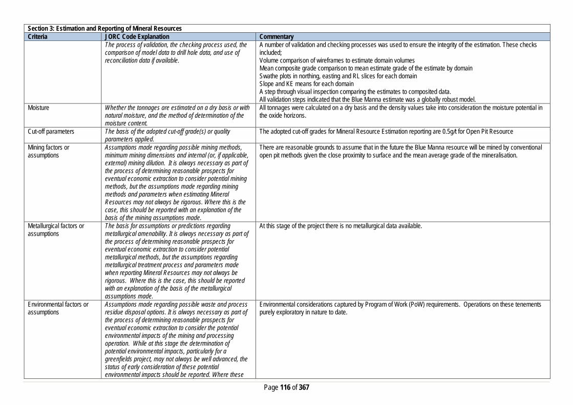
Page 116 of 367
Section 3: Estimation and Reporting of Mineral Resources Criteria JORC Code Explanation Commentary
The process of validation, the checking process used, the comparison of model data to drill hole data, and use of reconciliation data if available.
A number of validation and checking processes was used to ensure the integrity of the estimation. These checks included; Volume comparison of wireframes to estimate domain volumes Mean composite grade comparison to mean estimate grade of the estimate by domain Swathe plots in northing, easting and RL slices for each domain Slope and KE means for each domain A step through visual inspection comparing the estimates to composited data. All validation steps indicated that the Blue Manna estimate was a globally robust model.
Moisture Whether the tonnages are estimated on a dry basis or with natural moisture, and the method of determination of the moisture content.
All tonnages were calculated on a dry basis and the density values take into consideration the moisture potential in the oxide horizons.
Cut-off parameters The basis of the adopted cut-off grade(s) or quality parameters applied.
The adopted cut-off grades for Mineral Resource Estimation reporting are 0.5g/t for Open Pit Resource
Mining factors or assumptions
Assumptions made regarding possible mining methods, minimum mining dimensions and internal (or, if applicable, external) mining dilution. It is always necessary as part of the process of determining reasonable prospects for eventual economic extraction to consider potential mining methods, but the assumptions made regarding mining methods and parameters when estimating Mineral Resources may not always be rigorous. Where this is the case, this should be reported with an explanation of the basis of the mining assumptions made.
There are reasonable grounds to assume that in the future the Blue Manna resource will be mined by conventional open pit methods given the close proximity to surface and the mean average grade of the mineralisation.
Metallurgical factors or assumptions
The basis for assumptions or predictions regarding metallurgical amenability. It is always necessary as part of the process of determining reasonable prospects for eventual economic extraction to consider potential metallurgical methods, but the assumptions regarding metallurgical treatment process and parameters made when reporting Mineral Resources may not always be rigorous. Where this is the case, this should be reported with an explanation of the basis of the metallurgical assumptions made.
At this stage of the project there is no metallurgical data available.
Environmental factors or assumptions
Assumptions made regarding possible waste and process residue disposal options. It is always necessary as part of the process of determining reasonable prospects for eventual economic extraction to consider the potential environmental impacts of the mining and processing operation. While at this stage the determination of potential environmental impacts, particularly for a greenfields project, may not always be well advanced, the status of early consideration of these potential environmental impacts should be reported. Where these
Environmental considerations captured by Program of Work (PoW) requirements. Operations on these tenements purely exploratory in nature to date.
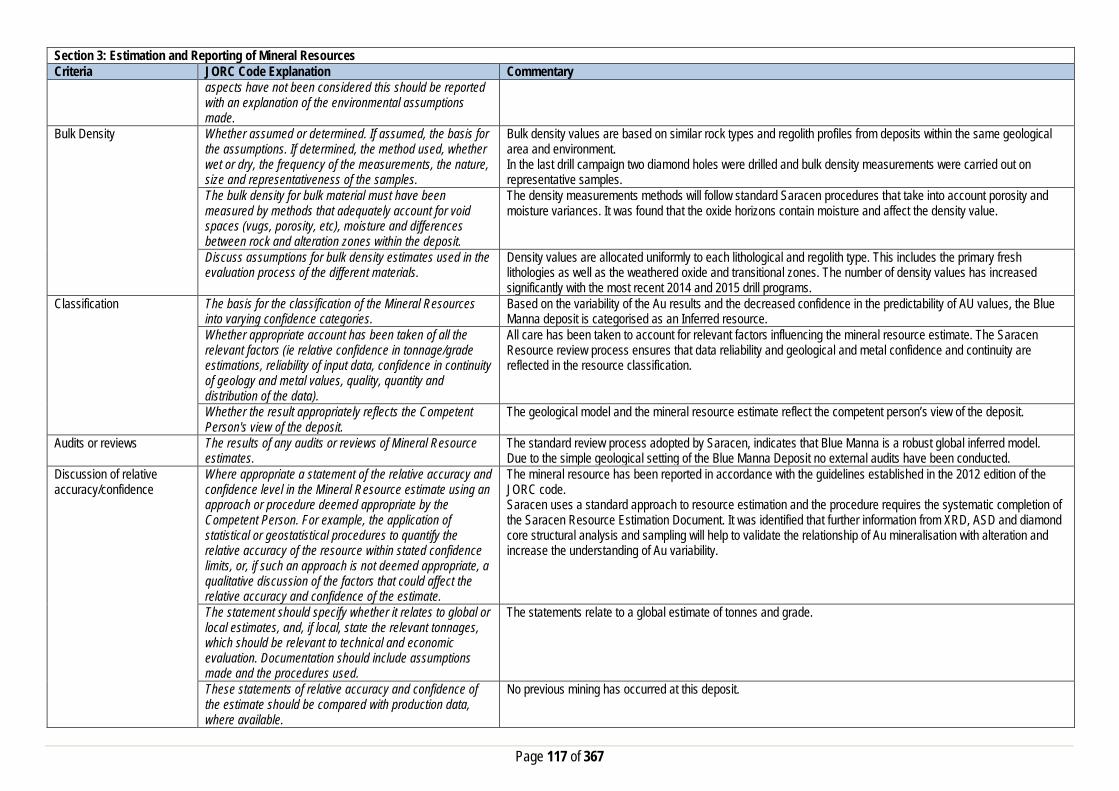
Page 117 of 367
Section 3: Estimation and Reporting of Mineral Resources Criteria JORC Code Explanation Commentary
aspects have not been considered this should be reported with an explanation of the environmental assumptions made.
Bulk Density Whether assumed or determined. If assumed, the basis for the assumptions. If determined, the method used, whether wet or dry, the frequency of the measurements, the nature, size and representativeness of the samples.
Bulk density values are based on similar rock types and regolith profiles from deposits within the same geological area and environment. In the last drill campaign two diamond holes were drilled and bulk density measurements were carried out on representative samples.
The bulk density for bulk material must have been measured by methods that adequately account for void spaces (vugs, porosity, etc), moisture and differences between rock and alteration zones within the deposit.
The density measurements methods will follow standard Saracen procedures that take into account porosity and moisture variances. It was found that the oxide horizons contain moisture and affect the density value.
Discuss assumptions for bulk density estimates used in the evaluation process of the different materials.
Density values are allocated uniformly to each lithological and regolith type. This includes the primary fresh lithologies as well as the weathered oxide and transitional zones. The number of density values has increased significantly with the most recent 2014 and 2015 drill programs.
Classification The basis for the classification of the Mineral Resources into varying confidence categories.
Based on the variability of the Au results and the decreased confidence in the predictability of AU values, the Blue Manna deposit is categorised as an Inferred resource.
Whether appropriate account has been taken of all the relevant factors (ie relative confidence in tonnage/grade estimations, reliability of input data, confidence in continuity of geology and metal values, quality, quantity and distribution of the data).
All care has been taken to account for relevant factors influencing the mineral resource estimate. The Saracen Resource review process ensures that data reliability and geological and metal confidence and continuity are reflected in the resource classification.
Whether the result appropriately reflects the Competent Person's view of the deposit.
The geological model and the mineral resource estimate reflect the competent person’s view of the deposit.
Audits or reviews The results of any audits or reviews of Mineral Resource estimates.
The standard review process adopted by Saracen, indicates that Blue Manna is a robust global inferred model. Due to the simple geological setting of the Blue Manna Deposit no external audits have been conducted.
Discussion of relative accuracy/confidence
Where appropriate a statement of the relative accuracy and confidence level in the Mineral Resource estimate using an approach or procedure deemed appropriate by the Competent Person. For example, the application of statistical or geostatistical procedures to quantify the relative accuracy of the resource within stated confidence limits, or, if such an approach is not deemed appropriate, a qualitative discussion of the factors that could affect the relative accuracy and confidence of the estimate.
The mineral resource has been reported in accordance with the guidelines established in the 2012 edition of the JORC code. Saracen uses a standard approach to resource estimation and the procedure requires the systematic completion of the Saracen Resource Estimation Document. It was identified that further information from XRD, ASD and diamond core structural analysis and sampling will help to validate the relationship of Au mineralisation with alteration and increase the understanding of Au variability.
The statement should specify whether it relates to global or local estimates, and, if local, state the relevant tonnages, which should be relevant to technical and economic evaluation. Documentation should include assumptions made and the procedures used.
The statements relate to a global estimate of tonnes and grade.
These statements of relative accuracy and confidence of the estimate should be compared with production data, where available.
No previous mining has occurred at this deposit.

Page 118 of 367
Porphyry Section 1: Sampling Techniques and Data Criteria JORC Code Explanation Commentary Sampling Techniques Nature and quality of sampling (e.g. cut channels, random
chips, or specific specialised industry standard measurement tools appropriate to the minerals under investigation, such as down hole gamma sondes, or handheld XRF instruments, etc.). These examples should not be taken as limiting the broad meaning of sampling.
Sampling methods undertaken in the Porphyry project area by Saracen have included reverse circulation (RC), diamond drillholes (DD) and RC grade control drilling within the pits. Historic methods conducted since 1945 have included rotary air blast (RAB), reverse circulation and diamond drillholes.
Include reference to measures taken to ensure sample representivity and the appropriate calibration of any measurement tools or systems used
Sampling for diamond and RC drilling is carried out as specified within Saracen sampling and QAQC procedures as per industry standard. RC chips and diamond core provide high quality representative samples for analysis. RC, RAB and DD core drilling was completed by previous holders to industry standard at that time (1945- 2003).
Aspects of the determination of mineralisation that are Material to the Public Report. In cases where ‘industry standard’ work has been done this would be relatively simple (e.g. ‘reverse circulation drilling was used to obtain 1 m samples from which 3 kg was pulverised to produce a 30 g charge for fire assay’). In other cases more explanation may be required, such as where there is coarse gold that has inherent sampling problems. Unusual commodities or mineralisation types (e.g. submarine nodules) may warrant disclosure of detailed information
Diamond core is HQ or NQ sized, sampled to 1m intervals and geological boundaries where necessary and cut into half core to give sample weights under 3 kg. Samples are selected to weigh less than 3 kg to ensure total sample inclusion at the pulverisation stage. RC chips are riffle or cone split and sampled into 1m intervals with total sample weights under 3kg Saracen core and chip samples are crushed, dried and pulverised to a nominal 90% passing 75µm to produce a 40g or 50 g sub sample for analysis by FA/AAS. Historical RAB, RC and diamond sampling was carried out to industry standard at that time. Analysis methods include fire assay, aqua regia and unspecified methods.
Drilling Techniques Drill type (e.g. core, reverse circulation, open-hole hammer, rotary air blast, auger, Bangka, sonic, etc.) and details (e.g. core diameter, triple or standard tube, depth of diamond tails, face-sampling bit or other type, whether core is oriented and if so, by what method, etc.).
The deposit was initially sampled by 574 RAB holes, 1781 RC holes (assumed standard 5 ¼ ‘’bit size) and 276 surface diamond core drillholes of unknown diameter. Saracen has completed 38 surface RC precollar with NQ diamond tail drill holes (precollars averaging 215m, diamond tails averaging 55m) , 1 HQ and 4 NQ diamond geotechnical holes , 2 NQ diamond holes for metallurgical test work, 544 RC holes from surface and 3168 grade control RC holes from within the pits. Diamond tails were oriented using an Ezy-mark tool. Limited historic surface diamond drill core was oriented via unknown methods.
Drill Sample Recovery Method of recording and assessing core and chip sample recoveries and results assessed
Diamond core recovery percentages calculated from measured core versus drilled intervals are logged and recorded in the database. Recoveries average >98%. RC sampling recoveries are recorded as a percentage based on a visual weight estimate; no historic recoveries have been recorded.
Measures taken to maximise sample recovery and ensure representative nature of the samples
Diamond core is reconstructed into continuous runs on an angle iron cradle for orientation marking. Depths are checked against depth given on the core blocks. During GC campaigns daily rig inspections are carried out to check splitter condition, general site and address general issues. The sample bags weight versus bulk reject weight is compared to ensure adequate and even sample recovery. Historical RAB, RC and diamond drilling to industry standard at that time.

Page 119 of 367
Section 1: Sampling Techniques and Data Criteria JORC Code Explanation Commentary
Whether a relationship exists between sample recovery and grade and whether sample bias may have occurred due to preferential loss/gain of fine/coarse material.
Diamond drilling has high recoveries meaning loss of material is minimal. There is no known relationship between sample recovery and grade for RC drilling. Any historical relationship is not known.
Logging Whether core and chip samples have been geologically and geotechnically logged to a level of detail to support appropriate Mineral Resource estimation, mining studies and metallurgical studies. Whether logging is qualitative or quantitative in nature. Core (or costean, channel, etc) photography.
Logging of diamond drill core and RC chips records lithology, mineralogy, texture, mineralisation, weathering, alteration, veining and other features. Geotechnical and structural logging is carried out on all diamond holes to record recovery, RQD, defect number, type, fill material, shape and roughness and alpha and beta angles. Chips from all RC holes (exploration and GC) are stored in chip trays for future reference. Core is photographed in both dry and wet state. Qualitative and quantitative logging of historic data varies in its completeness.
The total length and percentage of the relevant intersections logged
All diamond drillholes and exploration RC holes are logged in full. Every second drill line is logged in grade control programs with infill logging carried out as necessary. Historical logging is complete.
Sub-sampling techniques and sample preparation
If core, whether cut or sawn and whether quarter, half or all core taken.
All drill core is cut onsite using an automatic core saw. Geotechnical drillholes were quarter core sampled, metallurgical drillholes were full core sampled and all exploration drillholes were half core sampled. Samples are always collected from the same side. Historic diamond drilling has been sampled via unknown methods.
If non-core, whether riffled, tube sampled, rotary split, etc and whether sampled wet or dry.
All exploration and GC RC samples are cone or riffle split. Occasional wet samples are encountered; increased air capacity is routinely used to aid in keeping the sample dry when water is encountered. Historic RAB and RC drilling was sampled using spear, riffle and unknown methods.
For all sample types, the nature, quality and appropriateness of the sample preparation technique.
The sample preparation of diamond core and RC chips adhere to industry best practice. It is conducted by a commercial laboratory and involves oven drying, coarse crushing then total grinding to a size of 90% passing 75 microns. Best practice is assumed at the time of historic sampling.
Quality control procedures adopted for all sub-sampling stages to maximise representivity of samples.
All subsampling activities are carried out by commercial laboratory and are considered to be satisfactory. Sampling by previous holders assumed to be industry standard at the time.
Measures taken to ensure that the sampling is representative of the in situ material collected, including for instance results for field duplicate/second half sampling.
Duplicate sampling is carried out at a rate of 1:10 for exploration drilling and 1:20 for GC drilling and is sampled directly from the on-board splitter on the rig. These are submitted for the same assay process as the original samples and the laboratory are unaware of such submissions. Sampling by previous holders assumed to be industry standard at the time.
Whether sample sizes are appropriate to the grain size of the material being sampled.
Sample sizes are considered to be appropriate.
Quality of assay data and laboratory tests
The nature, quality and appropriateness of the assaying and laboratory procedures used and whether the technique is considered partial or total.
RC chip samples, grade control chip samples and diamond core are analysed by external laboratories using a 40g or 50g fire assay with AAS finish. These methods are considered suitable for determining gold concentrations in rock and are total digest methods. Historic sampling includes fire assay, aqua regia and unknown methods.
For geophysical tools, spectrometers, handheld XRF instruments, etc, the parameters used in determining the analysis including instrument make and model, reading times, calibrations factors applied and their derivation, etc.
No geophysical tools have been utilised for reporting gold mineralisation at Porphyry.
Nature of quality control procedures adopted (e.g. standards, blanks, duplicates, external laboratory checks)
Certified reference material (standards and blanks) with a wide range of values are inserted into every drillhole at a rate of 1:25 for exploration RC and DD, and 1:40 for GC drilling. These are not identifiable to the laboratory.

Page 120 of 367
Section 1: Sampling Techniques and Data Criteria JORC Code Explanation Commentary
and whether acceptable levels of accuracy (i.e. lack of bias) and precision have been established.
QAQC data returned are checked against pass/fail limits with the SQL database and are passed or failed on import. A report is generated and reviewed by the geologist as necessary upon failure to determine further action. QAQC data is reported monthly. Sample preparation checks for fineness are carried out to ensure a grindsize of 90% passing 75 microns. The laboratory performs a number of internal processes including standards, blanks, repeats and checks. QAQC data analysis demonstrates sufficient accuracy and precision. Industry best practice is assumed for previous holders.
Verification of sampling and assaying
The verification of significant intersections by either independent or alternative company personnel.
Significant intercepts are verified by the Geology Manager and corporate personnel.
The use of twinned holes. No specific twinned holes have been drilled at Porphyry but grade control drilling has confirmed the width and grade of previous exploration drilling.
Documentation of primary data, data entry procedures, data verification, data storage (physical and electronic) protocols
Primary data is collated in a set of excel templates utilising lookup codes. This data is forwarded to the Database Administrator for entry into a secure acQuire database with inbuilt validation functions. Data from previous owners was taken from a database compilation and validated as much as practicable before entry into the Saracen acQuire database.
Discuss any adjustment to assay data. No adjustments have been made to assay data. First gold assay is utilised for resource estimation. Location of data points Accuracy and quality of surveys used to locate drillholes
(collar and down-hole surveys), trenches, mine workings and other locations used in Mineral Resource estimation.
Exploration drillholes are located using a Leica 1200 GPS with an accuracy of +/- 10mm. Drillhole collars within the pit and immediate surrounds are picked up by company surveyors using a Trimble R8 GNSS (GPS) with an expected accuracy of +/-8mm. Downhole surveys are carried out using an Eastman single shot camera at regular intervals (usually 30m). A number of drillholes have also been gyroscopically surveyed. Previous holders’ survey accuracy and quality is unknown
Specification of the grid system used. A local grid system (Porphyry) is used. The two point conversion to MGA_GDA94 zone 51 is POREast PORNorth RL MGAEast MGANorth RL Point 1 3000 9000 0 430968.22 6706569.44 0 Point 2 3000 5000 0 430865.29 6702572.36 0 Historic data is converted to the Porphyry local grid upon export from the database.
Quality and adequacy of topographic control. Topographic control originally used site based survey pickups in addition to Kevron aerial photogrammetric surveys with +/- 5m resolution. Pre mining, new and more detailed topography has since been captured and will be used in future updates and for subsequent planning purposes.
Data spacing and distribution
Data spacing for reporting of Exploration Results. The nominal spacing for exploration drilling ranges from 20m x20m to 50mx50m Whether the data spacing and distribution is sufficient to establish the degree of geological and grade continuity appropriate for the Mineral Resource and Ore Reserve estimation procedure(s) and classifications applied.
Data spacing and distribution are sufficient to establish the degree of geological and grade continuity appropriate for JORC classifications applied.
Orientation of data in relation to geological structure
Whether sample compositing has been applied.
Sample compositing is not applied until the estimation stage. Some historic reconnaissance RAB and RC sampling was composited into 2, 3 or 4m samples.
Whether the orientation of sampling achieves unbiased sampling of possible structures and the extent to which this is known, considering the deposit type.
The majority of drillholes are positioned to achieve optimum intersection angles to the ore zone as are practicable.

Page 121 of 367
Section 1: Sampling Techniques and Data Criteria JORC Code Explanation Commentary
If the relationship between the drilling orientation and the orientation of key mineralised structures is considered to have introduced a sampling bias, this should be assessed and reported if material.
No significant sampling bias is thought to occur due to orientation of drilling in regards to mineralised structures.
Sample security The measures taken to ensure sample security. Samples are prepared on site under supervision of Saracen geological staff. Samples are selected, bagged into tied numbered calico bags then grouped into secured cages and collected by the laboratory personnel. Sample submissions are documented via laboratory tracking systems and assays are returned via email.
Audits or reviews The results of any audits or reviews of sampling techniques and data.
An internal review of companywide sampling methodologies was conducted to create the current sampling and QAQC procedures.
Section 2: Reporting of Exploration Results Criteria JORC Code Explanation Commentary Mineral tenement and land tenure status
Type, reference name/number, location and ownership including agreements or material issues with third parties such as joint ventures, partnerships, overriding royalties, native title interests, historical sites, wilderness or national park and environmental settings.
The Porphyry pit is located on M31/3, with related deposits Pioneer Paddock and Maingays situated on M31/3 and M31/5. Near mine exploration extends onto M31/4 and M31/6. The tenements are held 100% by Saracen Gold Mines Pty Ltd, a wholly owned subsidiary of Saracen Mineral Holdings Limited. Mining Leases M31/3, M31/4, M31/5 and M31/6 have a 21 year life and are held until 2025. All are renewable for a further 21 years on a continuing basis. Mining Leases M31/3, M31/4, M31/5 and M31/6 are each subject to one royalty agreement and one caveat (54H/067, 55H/067, 56H/067 and 57H/067, respectively). M31/3, M31/4 and M31/5 are each subject to a bank mortgage (415495). All production is subject to a Western Australian state government NSR royalty of 2.5%. Mining Leases M31/3, M31/4, M31/5 and M31/6 are subject to the Edjudina Pastoral Compensation Agreement. There are no registered Aboriginal Heritage sites within M31/3, M31/5 and M31/6. A single Aboriginal artefact scatter (ID2323) lies within the northern portion of M31/4 but is not impacted by current mining and exploration activities.
The security of the tenure held at the time of reporting along with any known impediments to obtaining a licence to operate in the area.
The tenements are in good standing and the licence to operate already exists.
Exploration done by other parties
Acknowledgment and appraisal of exploration by other parties.
The Porphyry deposit was discovered in the 1930s with mining operations carried out from 1936 to 1943 and minor works occurring up until 1972. Near mine exploration programs were carried out during this time. Pennzoil acquired the project in the late 1970s and embarked on an extensive RAB and DD program. The creation of Edjudina Gold Mines led to the reopening of the mine in 1984, with operations at Porphyry and Million Dollar continuing until 1988. Extensive RC and DD drilling was carried out also during this period, outlining the Maingays mineralisation. In 1989 Westralian acquired the lease and completed further resource and exploration drilling, finding mineralisation at Pioneer Paddock. Mining did not recommence due to production rate concerns. Mount Edon acquired the project and carried out limited RAB and RC drilling before being taken over by PacMin who suspended work at the project. Sons of Gwalia carried out minor drilling before their collapse and takeover of the project by St Barbara.
Geology Deposit type, geological setting and style of mineralisation.
The Porphyry deposit lies in a belt of greenstone-granite within the Edjudina-Kanowna region of the Archaean Yilgarn Block. The region of alternating mafic-ultramafic and felsic clastic sequences are currently considered overlapping contemporaneous volcanic episodes. The deposit is contained within a quartz monzonite, which intrudes the greenschist facies greenstone within the Murrin-Margaret sector. Mineralisation, especially high gold values is associated with intense shearing and confined to thin, intensely sheared bands approximately 10cm thick. The edge of the mineralisation feathers out into multiple, thin low grade bands. Generally, a halo of weak sheared and

Page 122 of 367
Section 2: Reporting of Exploration Results Criteria JORC Code Explanation Commentary
carbonatisation envelope the strongly sheared and mineralised zone of quartz-pyrite veining and hematite alteration. The most obvious guides to gold mineralisation are shearing, quartz-pyrite veining and strong hematite alteration. mineralisation is structurally controlled. The deposit is segregated into a series of lenses, with the largest measuring 400m by 150m. The ore lenses maybe separated by faults, but are generally stacked en echelon. Within each lens, the distribution of gold mineralisation is a complex series of en echelon sub-lens of 20m to 40m in width, segregated by waste bands. The lenses contain ore pods that strike perpendicular to the orebody and may dip approximately 40° south. (Smith, 2004). Ore lenses also step to the right in longitudinal section suggesting sinistral movement on the north-south portion of the mineralised structure
Drillhole information A summary of all information material to the understanding of the exploration results including a tabulation of the following information for all Material drill holes:
• easting and northing of the drill hole collar • elevation or RL (Reduced Level – elevation • above sea level in metres) of the drill hole collar • dip and azimuth of the hole • down hole length and interception depth • hole length. • If the exclusion of this information is justified on the
basis that the information is not Material and this exclusion does not detract from the understanding of the report, the Competent Person should clearly explain why this is the case.
All material data is periodically released on the ASX: 27/04/2012, 28/07/2011, 03/06/2011, 30/01/2009 Future drill hole data will be periodically released or when a results materially change the economic value of the project.
Data aggregation methods In reporting Exploration Results, weighting averaging techniques, maximum and/or minimum grade truncations (e.g. cutting of high grades) and cut-off grades are usually Material and should be stated.
All significant intercepts have been length weighted with a minimum Au grade of 1ppm. No high grade cut off has been applied.
Where aggregate intercepts incorporate short lengths of high grade results and longer lengths of low grade results, the procedure used for such aggregation should be stated and some typical examples of such aggregations should be shown in detail.
Intercepts are aggregated with minimum width of 1m and maximum width of 3m for internal dilution. Where stand out higher grade zone exist with in the broader mineralised zone, the higher grade interval is reported also.
The assumptions used for any reporting of metal equivalent values should be clearly stated.
There are no metal equivalents reported in this release.
Relationship between mineralisation widths and intercept lengths
These relationships are particularly important in the reporting of Exploration Results. If the geometry of the mineralisation with respect to the drill hole angle is known, its nature should be reported. If it is not known and only the down hole lengths are reported, there should be a clear statement to this effect (eg ‘down hole length, true width not known’).
Previous announcements included sufficient detail to clearly illustrate the geometry of the mineralisation and the latest drilling. All results were reported as downhole lengths.

Page 123 of 367
Section 2: Reporting of Exploration Results Criteria JORC Code Explanation Commentary Diagrams Appropriate maps and sections (with scales) and
tabulations of intercepts should be included for any significant discovery being reported These should include, but not be limited to a plan view of drill hole collar locations and appropriate sectional views.
All significant exploration results released by Saracen are accompanied by the appropriate diagrams and maps at the time of the release.
Balanced Reporting Where comprehensive reporting of all Exploration Results are not practicable, representative reporting of both low and high grades and/or widths should be practiced to avoid misleading reporting of Exploration Results.
All results from the recent campaign have been reported, irrespective of success or not.
Other substantive exploration data
Other exploration data, if meaningful and material,should be reported including (but not limited to): geological observations; geophysical survey results geochemical survey results; bulk samples – size and method of treatment; metallurgical test results; bulk density, groundwater, geotechnical and rock characteristics; potential deleterious or contaminating substances.
No substantive data acquisition has been completed in recent times.
Further work The nature and scale of planned further work (eg tests for lateral extensions or depth extensions or large-scale step-out drilling). Diagrams clearly highlighting the areas of possible extensions, including the main geological interpretations and future drilling areas, provided this information is not commercially sensitive
Porphyry is a current exploration play that is currently being reviewed for greater exploration potential.
Section 3: Estimation and Reporting of Mineral Resources Criteria JORC Code Explanation Commentary Database Integrity Measures taken to ensure that data has not been
corrupted by, for example, transcription or keying errors, between its initial collection and its use for Mineral Resource estimation purposes.
The database used for the estimate an extract from an acquire SQL database. The primary database is regulated by a locked framework called the acquire data model which fixes the relationships between tables. The data model minimises the potential for data collection and data usage errors through pre-determined look up tables, storage and export functions. User defined permissions also regulate the ability to add, edit or extract data. Primary data is recorded using typical manual translation of logging and data capture from written logs and direct import of csv tables through a data import scheme where data is validated upon import or direct data entry options into the database using predefined look up values.
Data validation procedures used. The rigid structure of the acquire data model is such that predefined rules and look up tables are applied to all data entry. Data that does not meet the criteria are highlighted and moved to a buffer area until the data is rectified to meet the passing rules.
Site Visits Comment on any site visits undertaken by the Competent Person and the outcome of those visits.
The Competent Person regularly visited the site during exploration and mining phases to assess geological competency and ensure integrity across all geological disciplines. The competent person has built a sound understanding of the deposit geology thus far.

Page 124 of 367
Section 3: Estimation and Reporting of Mineral Resources Criteria JORC Code Explanation Commentary
If no site visits have been undertaken indicate why this is the case.
Not applicable
Geological Interpretation Confidence in (or conversely, the uncertainty of) the geological interpretation of the mineral deposit.
The confidence in the geological interpretation of the Porphyry deposit is considered robust. The interpretation has been based on the detailed geological work completed by Saracen and previous owners of the project. This knowledge is based on extensive geological logging of drill core, RC chips, detailed open pit mapping and assay data. The Porphyry deposit lies in a belt of greenstone-granite within the Edjudina-Kanowna region of the Archaean Yilgarn Block. The region of alternating mafic-ultramafic and felsic clastic sequences are currently considered overlapping contemporaneous volcanic episodes. The deposit is contained within a quartz monzonite, which intrudes the greenschist facies greenstone within the Murrin-Margaret sector. Mineralisation, especially high gold values is associated with intense shearing and confined to thin, intensely sheared bands approximately 10cm thick. The edge of the mineralisation feathers out into multiple, thin low grade bands. Generally, a halo of weak sheared and carbonatisation envelope the strongly sheared and mineralised zone of quartz-pyrite veining and hematite alteration. The most obvious guides to gold mineralisation are shearing, quartz-pyrite veining and strong hematite alteration.
Nature of the data used and any assumptions made. The interpretations have been constructed using all available geological logging descriptions including but not limited to, stratigraphy, lithology, texture, structure and alteration. Interpreted cross cutting regional faults have been observed and have been use to guide disruptions in the position of the key mineralised domains.
The affect, if any, of alternative interpretations on Mineral Resource estimation.
The Porphyry deposit is generally sub vertical in geometry, with clear well defined zones that show the tenor of the mineralisation. Saracen considers the current interpretation to be robust based on all the examined geological data.
The use of geology in guiding and controlling the Mineral Resource estimation.
Geological controls and relationships were used to define mineralised domains. Structural controls on mineralisation are shallow dipping brittle shear zones, related to the NNW trending regional faults. Mineralisation is confined within 2 sub-parallel shear zones, the northern Porphyry shear zone and the southern Million Dollar shear zone. The 2 shear zones strike North and dip 20°- 25° east, lying close to the contact along much of its length. The Porphyry shear forms a broad, east plunging antiform. Mineralisation thickens in the middle of the structure and plunges to the SE. The majority of ounces have been mined from this shear.
The factors affecting continuity both of grade and geology.
Gold mineralisation at Porphyry is primarily hosted within a quartz monzonite and mineralisation is structurally controlled. The deposit is segregated into a series of lenses, with the largest measuring 400m by 150m. The ore lenses maybe separated by faults, but are generally stacked en echelon. Within each lens, the distribution of gold mineralisation is a complex series of en echelon sub-lens of 20m to 40m in width, segregated by waste bands. The lenses contain ore pods that strike perpendicular to the orebody and may dip approximately 40° south. (Smith, 2004). Ore lenses also step to the right in longitudinal section suggesting sinistral movement on the north-south portion of the mineralised structure.
Dimensions The extent and variability of the Mineral Resource expressed as length (along strike or otherwise), plan width, and depth below surface to the upper and lower limits of the Mineral Resource.
The gold mineralisation at Porphyry strikes about 1.4 km in length spanning over an area with 150m in width. The mineralisation extends to below 300m below surface.
Estimation and modelling techniques
The nature and appropriateness of the estimation technique(s) applied and key assumptions, including treatment of extreme grade values, domaining, interpolation parameters and maximum distance of extrapolation from data points.
Grade estimation using Ordinary Kriging (OK) was completed for Porphyry. CAE Studio 3 was used to estimate gold grades into 5m x10m x 5m size parent blocks. Drill grid spacing ranges from 20 m X 20 m to 50 m x 50 m. Drill hole sample data was flagged using domain codes generated from three dimensional mineralisation domains and oxidation surfaces. Sample data was composited to 1 metre downhole length. Intervals with no assays were excluded from the compositing routine.

Page 125 of 367
Section 3: Estimation and Reporting of Mineral Resources Criteria JORC Code Explanation Commentary
The influence of extreme sample distribution outliers was reduced by top-cutting where required. The top-cut levels were determined using a combination of top-cut analysis tools (grade histograms, log probability plots and CVs). Top-cuts were reviewed and applied on a domain basis. Due to the flexures in the mineralised envelopes, the estimation process was in unfolded space. The blocks are relocated back to their original space after the estimation. Variography was conducted in unfolded space using Geo Access software.
The availability of check estimates, previous estimates and/or mine production records and whether the Mineral Resource estimate takes appropriate account of such data.
No comparison have been done with previous estimates
The assumptions made regarding recovery of by-products.
No assumptions have been made with respect to the recovery of by-products.
Estimation of deleterious elements or other non-grade variables of economic significance (e.g. sulphur for acid mine drainage characterisation).
There has been no estimate at this point of deleterious elements or other non-grade variables of economic significance.
In the case of block model interpolation, the block size in relation to the average sample spacing and the search employed.
A single block model for Porphyry was constructed using a 5 mE by 10 mN by 5 mRL parent block size with sub-celling to 1 mE by 1 mN by 1 mRL for domain volume resolution. All estimation was completed at the parent cell size scale. Search ellipses and passes and minimum and maximum search number parameters are detailed below. The search strategy was set up such that the first search pass would fill blocks informed by the typical drill spacing. The second search used search ellipse multiplied by a factor of 2.5, while the third search increased the dimensions by a factor of 5 to ensure filling of all blocks. With the very limited across structure variogram range, a limit of 4 composites per drill hole was set. The first search pass used a maximum of 24 and a minimum of 16 samples. The second search pass used a maximum of 24 with a minimum of 8 samples while the third search pass used a maximum of 24 with a minimum of 1 sample.
Any assumptions behind modelling of selective mining units.
No selective mining units have been assumed.
Any assumptions about correlation between variables. No assumptions have been made regarding correlation between variables. Description of how the geological interpretation was used to control the resource estimates.
Geological controls and relationships were used to define mineralised domains. The mineralisation at Porphyry is structurally controlled. The deposit is segregated into a series of lenses, with the largest measuring 400m by 150m. The ore lenses maybe separated by faults, but are generally stacked en echelon. Within each lens, the distribution of gold mineralisation is a complex series of en echelon sub-lens of 20m to 40m in width, segregated by waste bands. The lenses contain ore pods that strike perpendicular to the orebody and may dip approximately 40° south. (Smith, 2004). Ore lenses also step to the right in longitudinal section suggesting sinistral movement on the north-south portion of the mineralised structure
Discussion of basis for using or not using grade cutting or capping.
A top cut was used in each sub-zone both within the main domains and according to regolith, based on a review of the histogram, log probability plot, and a summary graph of the effects of top-cutting for each domain combination. A top cut was selected to minimise the effects of isolated high grade outliers, without cutting a large proportion of the data or contained metal within the domain.
The process of validation, the checking process used, the comparison of model data to drill hole data, and use of reconciliation data if available.
Validation of the block model carried out a volumetric comparison of the resource wireframes to the block model volumes. Validating the estimate compared block model grades to the input data using tables of values, and swath plots showing northing, easting and elevation comparisons. Visual validation of grade trends and metal distributions was carried out. Reconciliation studies for Porphyry show that the model compares well with historical production

Page 126 of 367
Section 3: Estimation and Reporting of Mineral Resources Criteria JORC Code Explanation Commentary Moisture Whether the tonnages are estimated on a dry basis or
with natural moisture, and the method of determination of the moisture content.
All tonnages are estimated on a dry basis.
Cut-off parameters The basis of the adopted cut-off grade(s) or quality parameters applied.
Based on Saracen’s current economic operations at Carosue Dam, and the natural grade distinction above background, a grade of 0.4g/t has been chosen.
Mining factors or assumptions
Assumptions made regarding possible mining methods, minimum mining dimensions and internal (or, if applicable, external) mining dilution. It is always necessary as part of the process of determining reasonable prospects for eventual economic extraction to consider potential mining methods, but the assumptions made regarding mining methods and parameters when estimating Mineral Resources may not always be rigorous. Where this is the case, this should be reported with an explanation of the basis of the mining assumptions made.
Mining of the Porphyry at this stage deposit will be by Open pit mining methods involving mechanised mining techniques. Open pit mining will most likely by a cut-back on the existing Porphyry Pit. Some of the factor used in consideration of the mining method include, proximity of the mineralisation to surface, geotechnical and hydrogeological factors, prevailing gold price, planned mining dilution and mining recoveries and the average plant processing recoveries.
Metallurgical factors or assumptions
The basis for assumptions or predictions regarding metallurgical amenability. It is always necessary as part of the process of determining reasonable prospects for eventual economic extraction to consider potential metallurgical methods, but the assumptions regarding metallurgical treatment process and parameters made when reporting Mineral Resources may not always be rigorous. Where this is the case, this should be reported with an explanation of the basis of the metallurgical assumptions made.
Metallurgical testing (and processing operations at CDO) identified Porphyry ores as being free milling at coarse grind sizes with leach recoveries in excess of 90% with a high gravity gold component (>50%).
Environmental factors or assumptions
Assumptions made regarding possible waste and process residue disposal options. It is always necessary as part of the process of determining reasonable prospects for eventual economic extraction to consider the potential environmental impacts of the mining and processing operation. While at this stage the determination of potential environmental impacts, particularly for a greenfields project, may not always be well advanced, the status of early consideration of these potential environmental impacts should be reported. Where these aspects have not been considered this should be reported with an explanation of the environmental assumptions made.
No processing or benefication of ore expected on these tenements, as ore is hauled to Carosue Dam Minesite for Processing. Waste characterisation showed that Regoliths and waste bedrock associated with the Porphyry deposit pose no geochemical concerns due to the low sulphide content of the deposit and waste bedrock that is variously calcitic. The tailings solids in the historic TSF tailings solids are essentially barren and geochemically benign and do not pose any geochemical concerns for management. All long term infrastructures at Porphyry have been rehabilitated. Closure Plan is in place covering the Porphyry Mining area and infrastructure. Discharge from Porphyry Pit has occurred in the past to nearby Lake Rebecca under existing approvals and is closely monitored, no negative effects have been observed to date.
Bulk Density Whether assumed or determined. If assumed, the basis for the assumptions. If determined, the method used, whether wet or dry, the frequency of the measurements, the nature, size and representativeness of the samples.
Previous owners have taken routine density measurements when drilling diamond core. The method of calculation is the water displacement technique. Density in the current model has been assigned based on oxidation state, using averaged historical measurements.
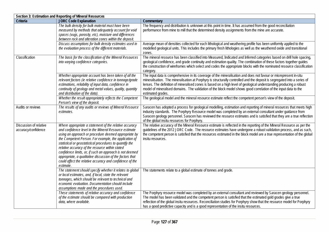
Page 127 of 367
Section 3: Estimation and Reporting of Mineral Resources Criteria JORC Code Explanation Commentary
The bulk density for bulk material must have been measured by methods that adequately account for void spaces (vugs, porosity, etc), moisture and differences between rock and alteration zones within the deposit.
The frequency and distribution is unknown at this point in time. It has assumed from the good reconciliation performance from mine to mill that the determined density assignments from the mine are accurate.
Discuss assumptions for bulk density estimates used in the evaluation process of the different materials.
Average mean of densities collected for each lithological and weathering profile has been uniformly applied to the modelled geological units. This includes the primary fresh lithologies as well as the weathered oxide and transitional zones.
Classification The basis for the classification of the Mineral Resources into varying confidence categories.
The mineral resource has been classified into Measured, Indicated and Inferred categories based on drill hole spacing, geological confidence, and grade continuity and estimation quality. The combination of these factors together guides the construction of wireframes which select and codes the appropriate blocks with the nominated resource classification category.
Whether appropriate account has been taken of all the relevant factors (ie relative confidence in tonnage/grade estimations, reliability of input data, confidence in continuity of geology and metal values, quality, quantity and distribution of the data).
The input data is comprehensive in its coverage of the mineralisation and does not favour or misrepresent in-situ mineralisation. The mineralisation at Porphyry is structurally controlled and the deposit is segregated into a series of lenses. The definition of mineralised zones is based on a high level of geological understanding producing a robust model of mineralised domains. The validation of the block model shows good correlation of the input data to the estimated grades.
Whether the result appropriately reflects the Competent Person's view of the deposit.
The geological model and the mineral resource estimate reflect the competent person’s view of the deposit.
Audits or reviews The results of any audits or reviews of Mineral Resource estimates.
Saracen has adopted a process for geological modelling, estimation and reporting of mineral resources that meets high industry standards. The Porphyry Resource model was completed by an external consultant under guidance from Saracen geology personnel. Saracen has reviewed the resource estimates and is satisfied that they are a true reflection of the global insitu resources for Porphyry.
Discussion of relative accuracy/confidence
Where appropriate a statement of the relative accuracy and confidence level in the Mineral Resource estimate using an approach or procedure deemed appropriate by the Competent Person. For example, the application of statistical or geostatistical procedures to quantify the relative accuracy of the resource within stated confidence limits, or, if such an approach is not deemed appropriate, a qualitative discussion of the factors that could affect the relative accuracy and confidence of the estimate.
The relative accuracy of the Mineral Resource estimate is reflected in the reporting of the Mineral Resource as per the guidelines of the 2012 JORC Code. The resource estimates have undergone a robust validation process, and as such, the competent person is satisfied that the resources estimated in the block model are a true representation of the global insitu resources.
The statement should specify whether it relates to global or local estimates, and, if local, state the relevant tonnages, which should be relevant to technical and economic evaluation. Documentation should include assumptions made and the procedures used.
The statements relate to a global estimate of tonnes and grade.
These statements of relative accuracy and confidence of the estimate should be compared with production data, where available.
The Porphyry resource model was completed by an external consultant and reviewed by Saracen geology personnel. The model has been validated and the competent person is satisfied that the estimated gold grades give a true reflection of the global insitu resources. Reconciliation studies for Porphyry show that the resource model for Porphyry has a good predictive capacity and is a good representation of the insitu resources.

Page 128 of 367
Section 4: Estimation and Reporting of Ore Reserves Criteria JORC Code Explanation Commentary Mineral Resource estimate for conversion to Ore Reserves
Description of the Mineral resource Estimate used as a basis for the conversion to an Ore Reserve.
The Mineral Resource Model for the Porphyry gold deposit is a robust global estimate that was used as a basis for conversion to the Ore Reserve estimate. The resource estimate was compiled by Saracen using exploration, resource definition, and grade control drilling and assay data, geological mapping and historical mining records to validate the model against and solid interpretation wireframes of the geology. This information was used to construct a model estimated by various kriging methods. The block model was depleted with the end of June 2019 monthly survey pickup for Reserve Estimation.
Clear statement as to whether the Mineral Resources are reported additional to. Or inclusive of, the Ore Reserves.
The Mineral Resource reported is inclusive of the Ore Reserve.
Site Visits Comment on any site visits undertaken by the Competent Person and the outcome of those visits.
A Competent Person along with a geotechnical consultant has conducted several site visits to the Porphyry open pit since the inclusion in the Carosue Dam operations life of mine plan. The purpose of these visits is to collect information for optimisation work, validating input parameters, visual pit inspection, discussion and feedback for life of mine planning. The information also includes the discussion around current mining performance, wall conditions and overall stability, and groundwater condition.
If no site visits have been undertaken indicate why this is the case.
N/A
Study status The type and level of study undertaken to enable Mineral Resources to be converted to Ore Reserves
Open Pit The Porphyry deposit was mined as an open pit mine for a period of 24 months between 2010-2012 under Saracen ownership. Since then a revised feasibility level study was undertaken with the view to recommence open pit operations and it has been included in the Carosue Dam life of mine plan. The 2019 Ore Reserve has included all aspects of operational inputs including actual production parameters, operating costs of mining, processing, general administration and environment management related costs. Underground The 2019 Ore Reserve is based upon a prefeasibility level underground mining study. It includes a detailed mine design, various capital and operating inputs, costs of mining, surface haulage, processing, general administration and environment management related costs.
The Code requires that a study to at least Pre-Feasibility Study level has been undertaken to convert Mineral Resources to Ore Reserves. Such studies will have been carried out and will have determined a mine plan that is technically achievable and economically viable, and that material Modifying Factors have been considered.
Modifying factors have been applied to the study to ensure the rigor of the financial analysis. Operational costs and production parameters have been used from actual and ongoing mining and processing performance. Saracen has conducted an open pit feasibility level study with all appropriate supporting mining studies required for ore reserve estimation. The 2019 underground Ore Reserve is based upon a prefeasibility level underground mining study.
Cut-off parameters The basis of the cut-off grade(s) or quality parameters applied
Open Pit For the purpose of Ore Reserve Estimation a marginal cut-off of 0.70g/t was applied based upon an assumed gold price of AUD$1,600/oz and operating costs of processing, haulage and general administration. A top cut has already been applied to the Mineral Resource Estimate eliminating the necessity for any further adjustment to the Ore Reserve estimate. Underground For the purpose of Ore Reserve Estimate a planning cut-off grade of 2.0g/t was calculated based upon an assumed gold price of AUD$1,600/Oz and applicable processing, haulage and administration costs. A top cut has already been applied to the Mineral Resource Estimate eliminating the necessity for any further adjustment to the Ore Reserve estimate.
Mining factors or assumptions
The method and assumptions used as reported in the Pre-feasibility or Feasibility Study to convert the Mineral
Open Pit

Page 129 of 367
Section 4: Estimation and Reporting of Ore Reserves Criteria JORC Code Explanation Commentary
Resource to an Ore Reserve (i.e. either by application of appropriate factors by optimisation or by preliminary or detailed design).
The resource model used in the Mineral Resource Estimation was the basis for the generation of a range of Whittle 4X pit optimisation shells. The generation of these shells was reliant upon costs and inputs derived from current operational data, contractors and independent consultant recommendations. An appropriate shell was then selected as the basis for an iterative process of pit design work, culminating in the finalisation of a detailed pit design for the Porphyry Reserve. Underground The Porphyry underground ore reserve has been estimated using detailed mine development and stope designs. Modifying factors for Ore loss due to in-situ pillars, unplanned dilution and mining recovery have been applied to the economic analysis of the design to generate the ore reserve.
The choice, nature and appropriateness of the selected mining method(s) and other mining parameters including associated design issues such as pre-strip, access, etc.
Open Pit The mining method to be employed at Porphyry will be conventional open pit with hydraulic excavator and dump truck fleet, and drill and blast activity. The class of excavator employed is similar to other current open pit mining operation, providing a good operating dataset for production and productivity rate measurement and financial modelling. The Reserve pit is designed as a cutback to the existing mined pit in an appropriate manner to meet operation efficiency and production rate. Underground Underground mechanised mining for development, ground support, and production stoping is planned to be used at Porphyry. Mining and geotechnical studies determined two mining methods; 1) Jumbo Drift and Strip, and 2) Long hole open stoping with remnant in-situ pillars to be appropriate for the deposit. Both of these mining methods have been previously successfully applied at Porphyry. Similar methods are currently utilised at other underground mines throughout the Western Australian Goldfields and Australia.
The assumptions made regarding geotechnical parameters (e.g. pit slopes, stope sizes, etc.), grade control, and pre-production drilling.
Open Pit Geotechnical recommendations were made by an independent external consultant following site visits, inspection of drill core, and a review of the geotechnical data gathered during earlier operations. The geotechnical consultant was engaged by Saracen to oversee the geotechnical aspects of the technical study and ongoing support. It is expected that once the pits are in operation there may be some need for additional geotechnical input reflected changes into the life of mine pit design. The Grade control method to be employed at Porphyry will utilise an RC drilling and sampling method. The method and practice has been utilised successfully at all current and past mining operations at Saracen. Underground Several external consultants have reviewed the deposit and previous production results. Recommendations regarding mine design and production mining methods have been incorporated within the mine design. An allowance for 25% Ore loss due to in-situ pillars has been incorporated into the mine design. A grade control program with associated development for drilling platforms, grade control drilling designs, and sampling costs have been include in the mine design, mine schedule and economic analysis.
The major assumptions made and Mineral Resource model used for pit and stope optimisation (if appropriate).
Open Pit The Ore Reserve Estimate is based on detailed life of mine pit design work by using geology approved resource model, and making appropriate dilution and recovery factor allowances for mining fleet and method utilised. Underground The resource model used for the ore reserve calculations was PO160727ore.dm

Page 130 of 367
Section 4: Estimation and Reporting of Ore Reserves Criteria JORC Code Explanation Commentary
The mining dilution factors used. Open Pit A mining dilution factor is applied in the Ore Reserve estimation and reflects the current mining performance of similar types of ore bodies and mining practices. A mining dilution factor of 20% is estimated for the Porphyry, reflecting the wide mineralisation and shallow dipping nature that requires selective mining practices. Underground An allowance for mining dilution was incorporated into the mine design. An additional unplanned dilution factor of 20% (at 0.5g/t) has been assumed for all stopes, including both production methods. An additional unplanned dilution factor of 10% has been assumed for all lateral development activities.
The mining recovery factors used. Open Pit An ore loss factor is applied in the Ore Reserve estimation and reflects the current mining performance of similar type of ore bodies and mining practices. An ore loss factor of 5% is estimated for the Porphyry mineralisation style. Underground A mining recovery factor of 80% has been assumed for all stopes, while a mining recovery factor of 95% has been assumed for all development activities.
Any minimum mining widths used Open Pit A minimum mining width of 25m has been adopted for the primary excavation fleet. Where ‘pinch-points’ occur or “Good Bye” cuts are considered at the base of the pit, it is assumed that a smaller or more versatile excavator will be employed. The practice is very consistent across both Saracen operations and reflects the suitability and efficiency of the mining performance. Underground A minimum stope width of 3.0m was adopted in the design process
The manner in which inferred Mineral resources are utilised in mining studies and the sensitivity of the outcome to their inclusion.
Open Pit Inferred material is excluded from the ore reserves and treated as waste material, which incurs a mining cost but is not processed and does not generate any revenue. Therefore final pit reserve inventory has excluded any inferred mineral resources. Underground No inferred resource metal has been reported. All inferred and unclassified material has been excluded from the stope optimisation process and subsequent block model interrogation. The dilution material is mineralised, and therefore 0.5g/t has been applied to the dilution material.
The infrastructure requirements of the selected mining methods.
Open Pit The selected mining method and location of the deposit is close to the ongoing Carosue Damp mining region. The existing operation has adequate infrastructure available to support the current and future mine plan. Underground Standard underground infrastructure has been included and will be developed as part of the mine design, including a decline for access and truck haulage, ventilation fans, escape-way ladders, electrical reticulation, mine services (air and water), and mine dewatering infrastructure. No specialised infrastructure is required to accommodate these methods of mining.
Metallurgical factors or assumptions
The metallurgical process proposed and the appropriateness of that process to the style of mineralisation
The ore reserve will be treated at the established Carosue Dam processing facility. The Carosue Dam Process Plant is a CIL cyanide leach plant incorporating a gravity circuit which is appropriate for the extraction of gold from free milling gold ores. An average plant processing recovery of 93% has been assumed in the Ore Reserve Estimate which is consistent with current and historical plant recoveries for Porphyry ore..

Page 131 of 367
Section 4: Estimation and Reporting of Ore Reserves Criteria JORC Code Explanation Commentary
Whether the metallurgical process is well-tested technology or novel in nature.
The method of ore processing and extraction proposed utilises well tried and proven technology dating back to the 1960’s and practiced extensively around the world.
The nature, amount and representiveness of metallurgical test work undertaken, the nature of the metallurgical domaining applied and the corresponding metallurgical recovery factors applied.
The average gold recovery for Porphyry deposit is estimated at 93.0%. The recovery estimation is based on met test work and past actual average recovery data collected at the Carosue Plant. The plant performance is consistent between 92 to 94% while processing similar type of ore material blend with range of other ore sources without any issue. Approximately three years of processing the Porphyry ore through this plant have resulted in a solid understanding of the metallurgical parameters of the ore.
Any assumptions or allowances made for deleterious elements.
There are no known deleterious elements present in Porphyry ore that can impact on ore recoveries at Carosue Plant.
The existence of any bulk sample or pilot scale test work and the degree to which such samples are considered representative of the ore body as a whole.
Ore from the Porphyry open pit and underground has been treated at the CDO Processing Plant since 2010. When in operation the Porphyry ore were processed through to Carosue Dam that representing a sizeable bulk sample/pilot test.
For minerals that are defined by a specification, has the ore reserve estimation been based on the appropriate mineralogy to meet the specifications.
N/A
Environmental factors or assumptions
The status of studies of potential environmental impacts of the mining and processing operation. Details of waste rock characterisation and the consideration of potential sites, status of design options considered and, where applicable, the status of approvals for process residue storage and waste dumps should be reported.
Porphyry open pit is currently on ‘care and maintenance’. All required Environment studies have been completed and Statutory Government Approvals namely works approvals, dewatering and discharge licence have been granted. Mining Approvals will require to be reapplied for the new mine reserve in timely manner such that it will be granted before the actual commencement. The existing Carosue Dam processing facility at which the Porphyry ore will be processed and the accommodation village all lay on granted mining leases. The road haulage network footprint is underpinned by a combination of miscellaneous licences and granted mining leases. Waste rock characteristic study has been carried out and it is expected to be representative of waste rock. It is proposed that all underground waste rock will remain within the existing open pit.
Infrastructure The existence of appropriate infrastructure: availability of land for plant development, power, water, transportation (particularly for bulk commodities), labour, accommodation; or the ease with which the infrastructure can be provided, or accessed.
Carosue Dam Operations are well established, with mining activities being conducted by Saracen since 2009. The operation extends from the south (CDO plant, administration, Whirling Dervish & Karari mines) to the North (Deep South mine) and is connected via a private haulage road. The CDO operation comprises at 2.4mtpa CIL ore processing facility, aerodrome with sealed runway, associated tailings storage facilities, several power stations, water supply, workshops, and administration offices. A modern accommodation camp is sited within a few kilometres of the administration offices and processing facility. A 70km gravel access road links Carosue Dam Operations to the gravel section of Yarri Road. Both the Saracen and Shire of Kalgoorlie gravel roads are well maintained. The Porphyry mine site is ~50km from the CDO Processing Plant and ~120km northeast of Kalgoorlie, adjacent to Yarri Road.
Costs The derivation of, or assumptions made, regarding projected capital costs in the study.
Open Pit Capital costs relating to the start-up and pre striping of the operation is included in the financial modelling. Other capital costs around camp and accommodation is minor given close proximity to existing Carosue Dam Operations. Underground Capital costs relate to establishment of capital infra-structure and continuing expansion of capital works for Porphyry underground. The cost estimates are based on historical costs for similar work undertaken at Carosue Dam for the establishment and operation of the Deep South, Karari and Whirling Dervish underground mines

Page 132 of 367
Section 4: Estimation and Reporting of Ore Reserves Criteria JORC Code Explanation Commentary
The methodology used to estimate operating costs. Open Pit Operating costs for open pit mining have been derived from a combination of actual costs from SGM’s Carosue Dam/Thunderbox Operations and costs supplied by various contract mining companies and independent consultants. Operating costs for ore processing, haulage and administration have been derived from known parameters at Carosue Dam operations. Underground Operating costs for underground mining have been derived from a combination of actual costs from Carosue Dam Operations and submitted indicative pricing supplied by independent mining contractors. Operating costs for ore processing have been derived from known parameters at Carosue Dam, with additional costs such as labour sourced from current operational data.
Allowances made for the content of deleterious elements Previous operational experience on the Porphyry deposit at Carouse Dam did not reveal any deleterious elements within the ore or waste that required any additional cost allowances.
The derivation of assumptions made of metal or commodity price(s), for the principal minerals and co-products
An assumed gold price of AUD$1,600/oz. has been adopted for financial modelling.
The source of exchange rates used in study All revenue and cost calculations have been made in AUD, so no exchange rate usage or assumptions have been necessary.
Derivation of transportation charges Costs associated with bullion transportation have been derived from existing contractual arrangements at Carouse Dam.
The basis for forecasting or source of treatment and refining charges, penalties for failure to meet specification, etc.
Costs associated with refining have been derived from existing contractual arrangements at Carouse Dam.
The allowances made for royalties payable, both Government and private.
Royalty costs are a 2.5% royalty payable to the Western Australian state government, and a 1.5% royalty payable to IRC.
Revenue Factors The derivation of, or assumptions made, regarding revenue factors including head grade, metal or commodity price(s) exchange rates, transportation and treatment charges, penalties, net smelter returns, etc.
N/A
The derivation of assumptions made of metal or commodity price(s), for the principal metals, minerals and co-products
An assumed gold price of AUD$1,600/oz. has been adopted for financial modelling
Market Assessment The demand, supply and stock situation for the particular commodity, consumption trends and factors likely to affect supply and demand into the future.
There is a transparent quoted market for the sale of gold.
A customer and competitor analysis along with the identification of likely market windows for the product.
There is a transparent quoted market for the sale of gold.
Price and volume forecasts and the basis for these forecasts.
There is a transparent quoted market for the sale of gold.
For industrial minerals the customer specification, testing and acceptance requirements prior to a supply contract.
N/A
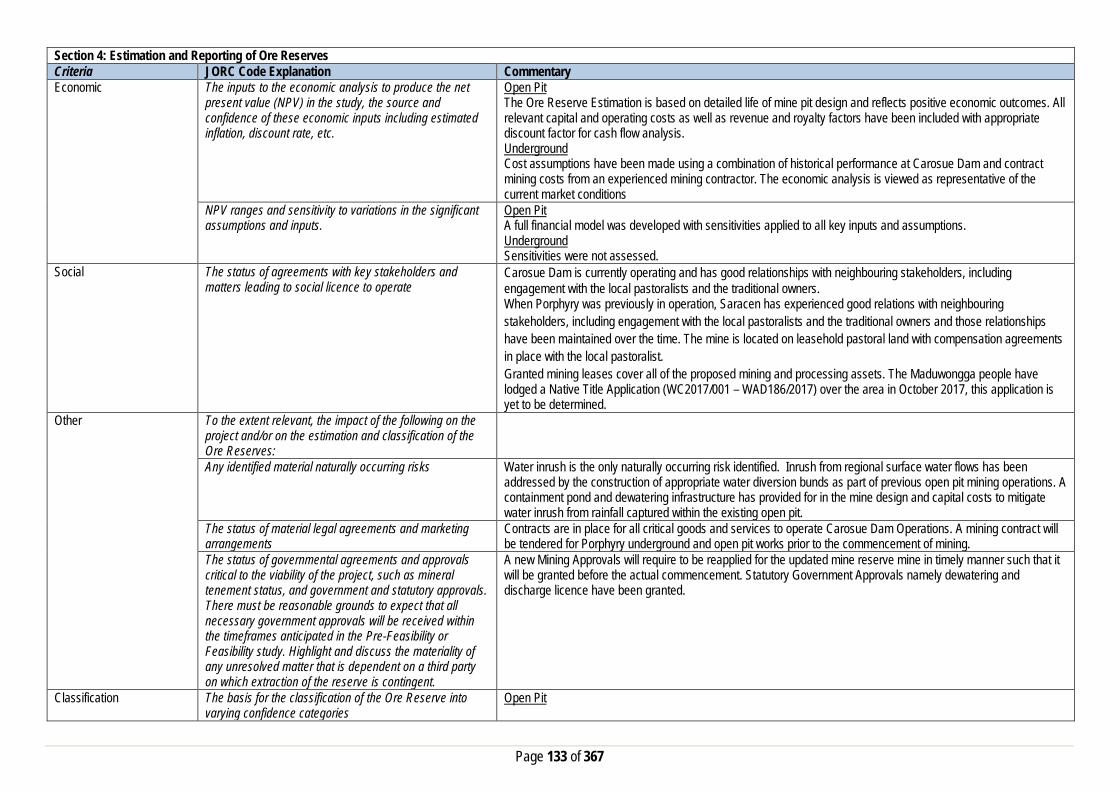
Page 133 of 367
Section 4: Estimation and Reporting of Ore Reserves Criteria JORC Code Explanation Commentary Economic The inputs to the economic analysis to produce the net
present value (NPV) in the study, the source and confidence of these economic inputs including estimated inflation, discount rate, etc.
Open Pit The Ore Reserve Estimation is based on detailed life of mine pit design and reflects positive economic outcomes. All relevant capital and operating costs as well as revenue and royalty factors have been included with appropriate discount factor for cash flow analysis. Underground Cost assumptions have been made using a combination of historical performance at Carosue Dam and contract mining costs from an experienced mining contractor. The economic analysis is viewed as representative of the current market conditions
NPV ranges and sensitivity to variations in the significant assumptions and inputs.
Open Pit A full financial model was developed with sensitivities applied to all key inputs and assumptions. Underground Sensitivities were not assessed.
Social The status of agreements with key stakeholders and matters leading to social licence to operate
Carosue Dam is currently operating and has good relationships with neighbouring stakeholders, including engagement with the local pastoralists and the traditional owners. When Porphyry was previously in operation, Saracen has experienced good relations with neighbouring stakeholders, including engagement with the local pastoralists and the traditional owners and those relationships have been maintained over the time. The mine is located on leasehold pastoral land with compensation agreements in place with the local pastoralist. Granted mining leases cover all of the proposed mining and processing assets. The Maduwongga people have lodged a Native Title Application (WC2017/001 – WAD186/2017) over the area in October 2017, this application is yet to be determined.
Other To the extent relevant, the impact of the following on the project and/or on the estimation and classification of the Ore Reserves:
Any identified material naturally occurring risks Water inrush is the only naturally occurring risk identified. Inrush from regional surface water flows has been addressed by the construction of appropriate water diversion bunds as part of previous open pit mining operations. A containment pond and dewatering infrastructure has provided for in the mine design and capital costs to mitigate water inrush from rainfall captured within the existing open pit.
The status of material legal agreements and marketing arrangements
Contracts are in place for all critical goods and services to operate Carosue Dam Operations. A mining contract will be tendered for Porphyry underground and open pit works prior to the commencement of mining.
The status of governmental agreements and approvals critical to the viability of the project, such as mineral tenement status, and government and statutory approvals. There must be reasonable grounds to expect that all necessary government approvals will be received within the timeframes anticipated in the Pre-Feasibility or Feasibility study. Highlight and discuss the materiality of any unresolved matter that is dependent on a third party on which extraction of the reserve is contingent.
A new Mining Approvals will require to be reapplied for the updated mine reserve mine in timely manner such that it will be granted before the actual commencement. Statutory Government Approvals namely dewatering and discharge licence have been granted.
Classification The basis for the classification of the Ore Reserve into varying confidence categories
Open Pit

Page 134 of 367
Section 4: Estimation and Reporting of Ore Reserves Criteria JORC Code Explanation Commentary
The Ore Reserve Estimate classification for Enterprise has been made in accordance with the JORC code 2012. The Ore Reserve Estimate is classified as being Proved and Probable has been derived from Mineral Resource classified as Indicated and Measured only. Underground The Ore Reserve Estimate classification for Porphyry underground has been in accordance with the JORC code 2012. The estimated Ore Reserve is classified as Probable (100%) with the majority of the reserve being derived from that portion of the Mineral Resource classified as Indicated.
Whether the result appropriately reflects the Competent Person’s view of the deposit.
Cost assumptions and inputs factors applied to the underground project were derived from a combination of historical site data, current operational data relating to Carouse Dam Operations, mining costs supplied by independent mining contractors, and recommendations from industry consultants. Results of the detailed design and analysis reflect the views of Competent Person regarding the Porphyry deposit.
The proportion of Probable Ore Reserves that have been derived from Measured Mineral Resources (if any)
100% of Probable ore from the Ore Reserve estimate has been derived from Indicated Mineral Resource category.
Audits or reviews The results of any audits or reviews of Ore Reserve estimates
The Ore Reserve Estimation process is in line with the Saracen Ore Reserve Policy and has undergone internal review. There have been no external reviews of this Ore reserve estimate.
Discussion of relative accuracy/confidence
Where appropriate a statement of the relative accuracy and confidence level in the Ore Reserve estimate using an approach or procedure deemed appropriate by the Competent Person. For example, the application of statistical or geo-statistical procedures to quantify the relative accuracy of the reserve within stated confidence limits, or, if such an approach is not deemed appropriate, a qualitative discussion of the factors which could affect the relative accuracy and confidence of the estimate. The statement should specify whether it relates to global or local estimates, and if local, state the relevant tonnages which should be relevant to technical and economic evaluation. Documentation should include assumptions made and the procedures used. Accuracy and confidence discussions should extend to specific discussions of any applied modifying factors that may have a material impact on Ore Reserve viability, or for which there are remaining areas of uncertainty at the current study stage. It is recognised that this may not be possible or appropriate in all circumstances. These statements or relative accuracy and confidence of the estimate should be compared with production data, where available.
The Ore Reserve estimate has been prepared within the guidelines of the 2012 JORC Code. The relative confidence of the estimate complies with the criteria of Probable Ore Reserves. Based upon;
- Resource estimate - significant operating history, - application of current industry practices, - appropriate operating and capital costs,
The range of the modifying factors is reasonable and confidence in the resulting reserve estimate is reasonable. Estimates are global but will be reasonably accurate on a local scale. The complete mine design with all of the modifying factors assumed and adopted, and financial analysis used in the estimated Ore Reserve have been the subject to peer review internally, and the Competent Person is confident that it is an accurate estimation of the current Porphyry reserve. Reconciliation results from past mining at Porphyry, independent consultant recommendations, and suitable factors from currently active underground operations at CDO have been considered and factored into the reserve assumptions where appropriate.

Page 135 of 367
Million Dollar
Section 1: Sampling Techniques and Data Criteria JORC Code Explanation Commentary Sampling Techniques Nature and quality of sampling (e.g. cut channels, random
chips, or specific specialised industry standard measurement tools appropriate to the minerals under investigation, such as down hole gamma sondes, or handheld XRF instruments, etc.). These examples should not be taken as limiting the broad meaning of sampling.
Saracen has undertaken reverse circulation drilling (RC) and diamond drilling (DD) at Million Dollar. Historic sampling methods conducted since 1979 have included rotary air blast (RAB), reverse circulation and diamond drillholes (DD).
Include reference to measures taken to ensure sample representivity and the appropriate calibration of any measurement tools or systems used
Sampling for RC and DD drilling is carried out as specified within Saracen sampling and QAQC procedures as per industry standard. RC chips and DD core provide high quality representative samples for analysis. RC, RAB and DD core drilling was completed by previous holders to industry standard at that time (1979- 2004).
Aspects of the determination of mineralisation that are Material to the Public Report. In cases where ‘industry standard’ work has been done this would be relatively simple (e.g. ‘reverse circulation drilling was used to obtain 1 m samples from which 3 kg was pulverised to produce a 30 g charge for fire assay’). In other cases more explanation may be required, such as where there is coarse gold that has inherent sampling problems. Unusual commodities or mineralisation types (e.g. submarine nodules) may warrant disclosure of detailed information
RC chips are cone split and sampled into 1m intervals with total sample weights less than 3 kg. Diamond core is HQ sized, sampled to 1m intervals or geological boundaries where necessary and cut into half core. Samples are selected to weigh less than 3 kg to ensure total sample inclusion at the pulverisation stage. Saracen chip and core samples are crushed, dried and pulverised to a nominal 90% passing 75µm to produce a 50g sub sample for analysis by FA/AAS. Historical RAB, RC and diamond sampling was carried out to industry standard at that time. Analysis methods include fire assay, screen fire assay, aqua regia and unspecified methods.
Drilling Techniques Drill type (e.g. core, reverse circulation, open-hole hammer, rotary air blast, auger, Bangka, sonic, etc.) and details (e.g. core diameter, triple or standard tube, depth of diamond tails, face-sampling bit or other type, whether core is oriented and if so, by what method, etc.).
The deposit was initially sampled by 442 RAB holes, 595 RC holes (assumed standard 5 ¼ ‘’bit size) and 49 surface unknown diameter diamond core holes. Saracen have completed 246 RC drillholes, with recent drilling utilising a 143mm diameter bit with a face sampling hammer and an external auxiliary booster, and 4 HQ diamond drillholes. Diamond holes were oriented using an ACT 111 tool It is unknown if historic diamond drill core was oriented.
Drill Sample Recovery Method of recording and assessing core and chip sample recoveries and results assessed
RC sampling recoveries are recorded in the database as a percentage based on a visual weight estimate; no historic recoveries have been recorded. Diamond core recovery percentages calculated from measured core versus drilled intervals are logged and recorded in the database No historic diamond core recovery data has been recorded.
Measures taken to maximise sample recovery and ensure representative nature of the samples
During RC drilling daily rig inspections are carried out to check splitter condition, general site and address general issues. Diamond core is reconstructed into continuous runs on an angle iron cradle for orientation marking. Depths are checked against depth given on the core blocks. Historical RAB, RC and diamond drilling to industry standard at that time.
Whether a relationship exists between sample recovery and grade and whether sample bias may have occurred due to preferential loss/gain of fine/coarse material.
There is no known relationship between sample recovery and grade for RC drilling. Diamond drilling has high recoveries due to the competent nature of the ground meaning loss of material is minimal. Any historical relationship is not known.
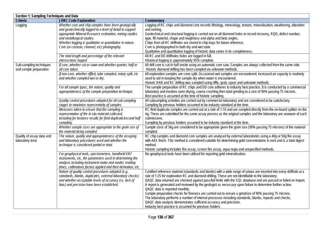
Page 136 of 367
Section 1: Sampling Techniques and Data Criteria JORC Code Explanation Commentary Logging Whether core and chip samples have been geologically
and geotechnically logged to a level of detail to support appropriate Mineral Resource estimation, mining studies and metallurgical studies. Whether logging is qualitative or quantitative in nature. Core (or costean, channel, etc) photography.
Logging of RC chips and diamond core records lithology, mineralogy, texture, mineralisation, weathering, alteration and veining. Geotechnical and structural logging is carried out on all diamond holes to record recovery, RQD, defect number, type, fill material, shape and roughness and alpha and beta angles. Chips from all RC drillholes are stored in chip trays for future reference. Core is photographed in both dry and wet state Qualitative and quantitative logging of historic data varies in its completeness.
The total length and percentage of the relevant intersections logged
All RC and DD drillholes holes are logged in full. Historical logging is approximately 95% complete.
Sub-sampling techniques and sample preparation
If core, whether cut or sawn and whether quarter, half or all core taken.
All drill core is cut in half onsite using an automatic core saw. Samples are always collected from the same side. Historic diamond drilling has been sampled via unknown methods.
If non-core, whether riffled, tube sampled, rotary split, etc and whether sampled wet or dry.
All exploration samples are cone split. Occasional wet samples are encountered; increased air capacity is routinely used to aid in keeping the sample dry when water is encountered. Historic RAB and RC drilling was sampled using riffle, grab, spear and unknown methods.
For all sample types, the nature, quality and appropriateness of the sample preparation technique.
The sample preparation of RC chips and DD core adheres to industry best practice. It is conducted by a commercial laboratory and involves oven drying, coarse crushing then total grinding to a size of 90% passing 75 microns. Best practice is assumed at the time of historic sampling.
Quality control procedures adopted for all sub-sampling stages to maximise representivity of samples.
All subsampling activities are carried out by commercial laboratory and are considered to be satisfactory. Sampling by previous holders assumed to be industry standard at the time.
Measures taken to ensure that the sampling is representative of the in situ material collected, including for instance results for field duplicate/second half sampling.
RC field duplicate samples are carried out at a rate of 1:10 and are sampled directly from the on-board splitter on the rig. These are submitted for the same assay process as the original samples and the laboratory are unaware of such submissions. Sampling by previous holders assumed to be industry standard at the time.
Whether sample sizes are appropriate to the grain size of the material being sampled.
Sample sizes of 3kg are considered to be appropriate given the grain size (90% passing 75 microns) of the material sampled.
Quality of assay data and laboratory tests
The nature, quality and appropriateness of the assaying and laboratory procedures used and whether the technique is considered partial or total.
RC chip samples and diamond core samples are analysed by external laboratories using a 40g or 50g fire assay with AAS finish. This method is considered suitable for determining gold concentrations in rock and is a total digest method. Historic sampling includes fire assay, screen fire assay, aqua regia and unspecified methods.
For geophysical tools, spectrometers, handheld XRF instruments, etc, the parameters used in determining the analysis including instrument make and model, reading times, calibrations factors applied and their derivation, etc.
No geophysical tools have been utilised for reporting gold mineralisation.
Nature of quality control procedures adopted (e.g. standards, blanks, duplicates, external laboratory checks) and whether acceptable levels of accuracy (i.e. lack of bias) and precision have been established.
Certified reference material (standards and blanks) with a wide range of values are inserted into every drillhole at a rate of 1:25 for exploration RC and diamond drilling. These are not identifiable to the laboratory. QAQC data returned are checked against pass/fail limits with the SQL database and are passed or failed on import. A report is generated and reviewed by the geologist as necessary upon failure to determine further action. QAQC data is reported monthly. Sample preparation checks for fineness are carried out to ensure a grindsize of 90% passing 75 microns. The laboratory performs a number of internal processes including standards, blanks, repeats and checks. QAQC data analysis demonstrates sufficient accuracy and precision. Industry best practice is assumed for previous holders.

Page 137 of 367
Section 1: Sampling Techniques and Data Criteria JORC Code Explanation Commentary Verification of sampling and assaying
The verification of significant intersections by either independent or alternative company personnel.
Significant intercepts are verified by the Geology Manager and corporate personnel.
The use of twinned holes. No twinned holes have been drilled at Million Dollar. Documentation of primary data, data entry procedures, data verification, data storage (physical and electronic) protocols
Primary data is collated in a set of excel templates utilising lookup codes. This data is forwarded to the Database Administrator for entry into a secure acQuire database with inbuilt validation functions. Data from previous owners was taken from a database compilation and validated as much as practicable before entry into the Saracen acQuire database.
Discuss any adjustment to assay data. No adjustments have been made to assay data. First gold assay is utilised for resource estimation. Location of data points Accuracy and quality of surveys used to locate drillholes
(collar and down-hole surveys), trenches, mine workings and other locations used in Mineral Resource estimation.
Exploration drillholes are located using a Leica 1200 GPS with an accuracy of +/- 10mm. Downhole surveys are carried out using an Eastman single shot camera at regular intervals (usually 30m). Previous holders’ survey accuracy and quality is unknown
Specification of the grid system used. A local grid system (Million Dollar) is used. The one point conversion to MGA_GDA94 zone 51 is MDEast MDNorth RL MGAEast MGANorth RL Point 1 5000 20000 0 430962.99 6703259.80 0 Historic data is converted to the Million Dollar local grid upon export from the database.
Quality and adequacy of topographic control. Topographic control originally used site based survey pickups in addition to Kevron aerial photogrammetric surveys with +/- 5m resolution. Pre mining, new and more detailed topography has since been captured and will be used in future updates and for subsequent planning purposes.
Data spacing and distribution
Data spacing for reporting of Exploration Results. The nominal spacing for drilling is 20m x 20m to 50mx50m. Whether the data spacing and distribution is sufficient to establish the degree of geological and grade continuity appropriate for the Mineral Resource and Ore Reserve estimation procedure(s) and classifications applied.
Data spacing and distribution are sufficient to establish the degree of geological and grade continuity appropriate for JORC classifications applied.
Orientation of data in relation to geological structure
Whether sample compositing has been applied. Sample compositing is not applied until the estimation stage. Some historic RAB sampling was composited into 4m samples.
Whether the orientation of sampling achieves unbiased sampling of possible structures and the extent to which this is known, considering the deposit type.
The majority of drillholes are positioned to achieve optimum intersection angles to the ore zone as are practicable.
If the relationship between the drilling orientation and the orientation of key mineralised structures is considered to have introduced a sampling bias, this should be assessed and reported if material.
No significant sampling bias has been recognised due to orientation of drilling in regards to mineralised structures.
Sample security The measures taken to ensure sample security. Samples are prepared on site under supervision of Saracen geological staff. Samples are selected, bagged into tied numbered calico bags then grouped into secured cages and collected by the laboratory personnel. Sample submissions are documented via laboratory tracking systems and assays are returned via email
Audits or reviews The results of any audits or reviews of sampling techniques and data.
An internal review of companywide sampling methodologies was conducted to create the current sampling and QAQC procedures. No external audits or reviews have been conducted.
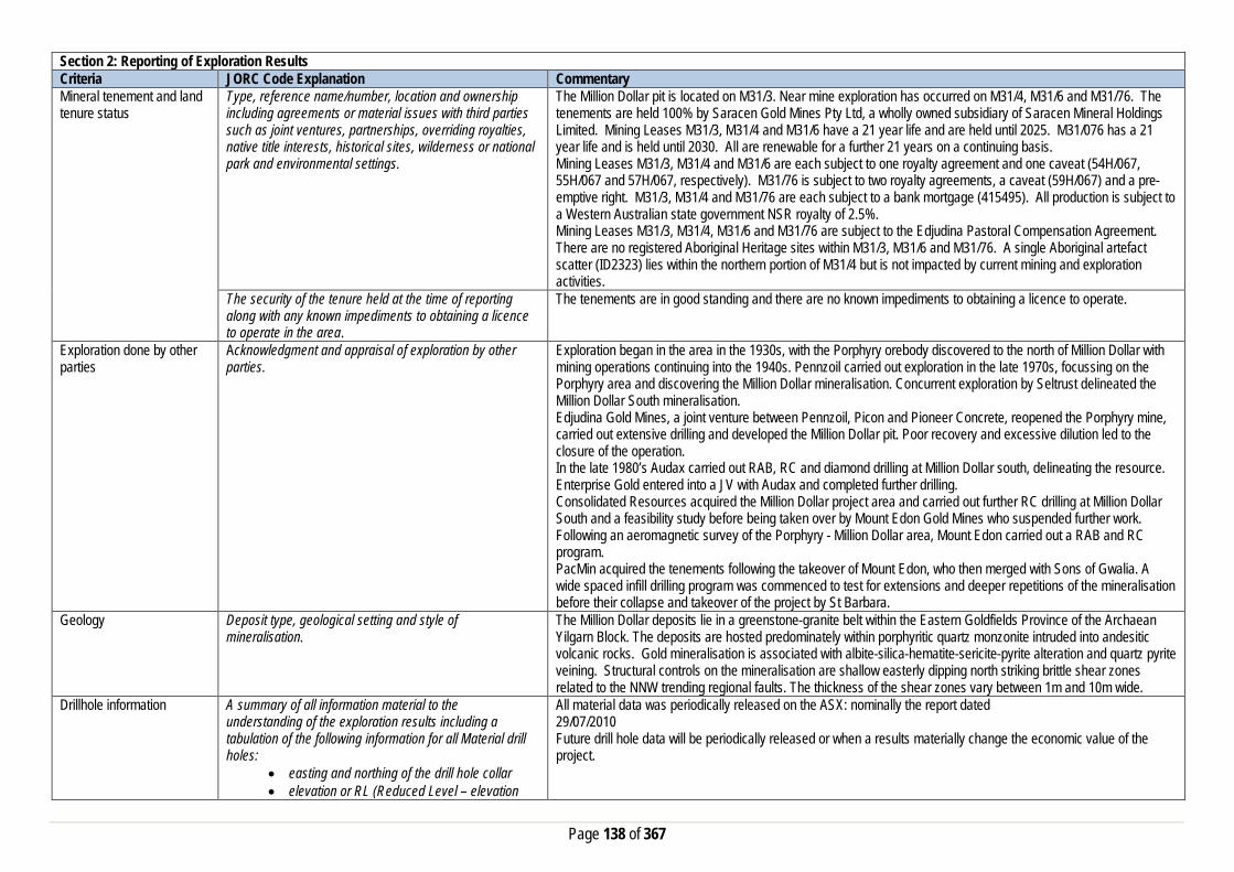
Page 138 of 367
Section 2: Reporting of Exploration Results Criteria JORC Code Explanation Commentary Mineral tenement and land tenure status
Type, reference name/number, location and ownership including agreements or material issues with third parties such as joint ventures, partnerships, overriding royalties, native title interests, historical sites, wilderness or national park and environmental settings.
The Million Dollar pit is located on M31/3. Near mine exploration has occurred on M31/4, M31/6 and M31/76. The tenements are held 100% by Saracen Gold Mines Pty Ltd, a wholly owned subsidiary of Saracen Mineral Holdings Limited. Mining Leases M31/3, M31/4 and M31/6 have a 21 year life and are held until 2025. M31/076 has a 21 year life and is held until 2030. All are renewable for a further 21 years on a continuing basis. Mining Leases M31/3, M31/4 and M31/6 are each subject to one royalty agreement and one caveat (54H/067, 55H/067 and 57H/067, respectively). M31/76 is subject to two royalty agreements, a caveat (59H/067) and a pre-emptive right. M31/3, M31/4 and M31/76 are each subject to a bank mortgage (415495). All production is subject to a Western Australian state government NSR royalty of 2.5%. Mining Leases M31/3, M31/4, M31/6 and M31/76 are subject to the Edjudina Pastoral Compensation Agreement. There are no registered Aboriginal Heritage sites within M31/3, M31/6 and M31/76. A single Aboriginal artefact scatter (ID2323) lies within the northern portion of M31/4 but is not impacted by current mining and exploration activities.
The security of the tenure held at the time of reporting along with any known impediments to obtaining a licence to operate in the area.
The tenements are in good standing and there are no known impediments to obtaining a licence to operate.
Exploration done by other parties
Acknowledgment and appraisal of exploration by other parties.
Exploration began in the area in the 1930s, with the Porphyry orebody discovered to the north of Million Dollar with mining operations continuing into the 1940s. Pennzoil carried out exploration in the late 1970s, focussing on the Porphyry area and discovering the Million Dollar mineralisation. Concurrent exploration by Seltrust delineated the Million Dollar South mineralisation. Edjudina Gold Mines, a joint venture between Pennzoil, Picon and Pioneer Concrete, reopened the Porphyry mine, carried out extensive drilling and developed the Million Dollar pit. Poor recovery and excessive dilution led to the closure of the operation. In the late 1980’s Audax carried out RAB, RC and diamond drilling at Million Dollar south, delineating the resource. Enterprise Gold entered into a JV with Audax and completed further drilling. Consolidated Resources acquired the Million Dollar project area and carried out further RC drilling at Million Dollar South and a feasibility study before being taken over by Mount Edon Gold Mines who suspended further work. Following an aeromagnetic survey of the Porphyry - Million Dollar area, Mount Edon carried out a RAB and RC program. PacMin acquired the tenements following the takeover of Mount Edon, who then merged with Sons of Gwalia. A wide spaced infill drilling program was commenced to test for extensions and deeper repetitions of the mineralisation before their collapse and takeover of the project by St Barbara.
Geology Deposit type, geological setting and style of mineralisation.
The Million Dollar deposits lie in a greenstone-granite belt within the Eastern Goldfields Province of the Archaean Yilgarn Block. The deposits are hosted predominately within porphyritic quartz monzonite intruded into andesitic volcanic rocks. Gold mineralisation is associated with albite-silica-hematite-sericite-pyrite alteration and quartz pyrite veining. Structural controls on the mineralisation are shallow easterly dipping north striking brittle shear zones related to the NNW trending regional faults. The thickness of the shear zones vary between 1m and 10m wide.
Drillhole information A summary of all information material to the understanding of the exploration results including a tabulation of the following information for all Material drill holes:
• easting and northing of the drill hole collar • elevation or RL (Reduced Level – elevation
All material data was periodically released on the ASX: nominally the report dated 29/07/2010 Future drill hole data will be periodically released or when a results materially change the economic value of the project.

Page 139 of 367
Section 2: Reporting of Exploration Results Criteria JORC Code Explanation Commentary
• above sea level in metres) of the drill hole collar • dip and azimuth of the hole • down hole length and interception depth • hole length. • If the exclusion of this information is justified on the basis that the information is not Material and this exclusion does not detract from the understanding of the report, the Competent Person should clearly explain why this is the case.
Data aggregation methods In reporting Exploration Results, weighting averaging techniques, maximum and/or minimum grade truncations (e.g. cutting of high grades) and cut-off grades are usually Material and should be stated.
All significant intercepts have been length weighted with a minimum Au grade of 1ppm. No high grade cut off has been applied.
Where aggregate intercepts incorporate short lengths of high grade results and longer lengths of low grade results, the procedure used for such aggregation should be stated and some typical examples of such aggregations should be shown in detail.
Intercepts are aggregated with minimum width of 1m and maximum width of 3m for internal dilution. Where stand out higher grade zone exist with in the broader mineralised zone, the higher grade interval is reported also.
The assumptions used for any reporting of metal equivalent values should be clearly stated.
There are no metal equivalents reported in this release.
Relationship between mineralisation widths and intercept lengths
These relationships are particularly important in the reporting of Exploration Results. If the geometry of the mineralisation with respect to the drill hole angle is known, its nature should be reported. If it is not known and only the down hole lengths are reported, there should be a clear statement to this effect (eg ‘down hole length, true width not known’).
Previous announcements included sufficient detail to clearly illustrate the geometry of the mineralisation and the latest drilling. All results were reported as downhole lengths.
Diagrams Appropriate maps and sections (with scales) and tabulations of intercepts should be included for any significant discovery being reported These should include, but not be limited to a plan view of drill hole collar locations and appropriate sectional views.
All significant exploration results released by Saracen are accompanied by the appropriate diagrams and maps at the time of the release.
Balanced Reporting Where comprehensive reporting of all Exploration Results are not practicable, representative reporting of both low and high grades and/or widths should be practiced to avoid misleading reporting of Exploration Results.
All results from the recent campaign have been reported, irrespective of success or not.
Other substantive exploration data
Other exploration data, if meaningful and material, should be reported including (but not limited to): geological observations; geophysical survey results; geochemical survey results; bulk samples – size and
No substantive data acquisition has been completed in recent times.

Page 140 of 367
Section 2: Reporting of Exploration Results Criteria JORC Code Explanation Commentary
method of treatment; metallurgical test results; bulk density, groundwater, geotechnical and rock characteristics; potential deleterious or contaminating substances.
Further work The nature and scale of planned further work (eg tests for lateral extensions or depth extensions or large-scale step-out drilling). Diagrams clearly highlighting the areas of possible extensions, including the main geological interpretations and future drilling areas, provided this information is not commercially sensitive
Million Dollar is a current exploration play that is currently being reviewed for greater exploration potential.
Section 3: Estimation and Reporting of Mineral Resources Criteria JORC Code Explanation Commentary Database Integrity Measures taken to ensure that data has not been
corrupted by, for example, transcription or keying errors, between its initial collection and its use for Mineral Resource estimation purposes.
The database used for the estimate an extract from an Acquire SQL database. The primary database is regulated by a locked framework called the acquire data model which fixes the relationships between tables. The data model minimises the potential for data collection and data usage errors through pre-determined look up tables, storage and export functions. User defined permissions also regulate the ability to add, edit or extract data. Primary data is recorded using typical manual translation of logging and data capture from written logs and direct import of csv tables through a data import scheme where data is validated upon import or direct data entry options into the database using predefined look up values.
Data validation procedures used. Data that is captured in the field is entered into Excel templates which are checked on import into the database for errors. Assay jobs are dispatched electronically to the lab to minimise the chance of data entry errors. Assay results from the lab are received in CSV format and are checked for errors on import into the database. Data is regularly validated using the mining software. The data validation process is overseen by the Database Administrator.
Site Visits Comment on any site visits undertaken by the Competent Person and the outcome of those visits.
The Competent Person regularly visited the site during exploration phases to assess geological competency and ensure integrity across all geological disciplines. The competent person has built a sound understanding of the deposit geology thus far.
If no site visits have been undertaken indicate why this is the case.
Geological Interpretation Confidence in (or conversely, the uncertainty of) the geological interpretation of the mineral deposit.
The resource categories assigned to the model directly reflect the confidence in the geological interpretation that is built using local, structural, mineral, and alteration geology obtained from mapping, logging, drill results and geophysics.
Nature of the data used and any assumptions made. The geological interpretation of Million Dollar has considered all available geological information including local geology, structural deformation events, and its relationship to neighbouring mineralised deposits. Rock types, mineral, alteration and veining assemblages from diamond drill core, RC Chips and development face/backs mapping were all used to help define the mineralised domains and regolith boundaries. Interpreted shears and faults obtained from in pit mapping further constrained the domaining. The current resource has been interpreted from 44 diamond holes, and 742 RC holes.

Page 141 of 367
Section 3: Estimation and Reporting of Mineral Resources Criteria JORC Code Explanation Commentary
The affect, if any, of alternative interpretations on Mineral Resource estimation.
The geological wireframes defining the discrete mineralised zones are considered to be robust. Alternative interpretations bulking mineralisation together have been considered but deemed unsuitable to appropriately constraining metal distribution
The use of geology in guiding and controlling the Mineral Resource estimation.
Geological domains interpreted from all available geological data are used as estimation domains. They are further sub-domained where internal multi-modal grade populations and sufficient sample data is available in order to improve grade homogeneity and reduce variance.
The factors affecting continuity both of grade and geology. Gold mineralisation at Million Dollar is primarily hosted within a syeno-monzonite granitoid unit as stacked en echelon quartz veins within a braided shear system. Secondary mineralisation does exist at the margins of the granitoid units in interpreted strain shadows and as minor cross linking structures between the main lodes. Higher grades are largely associated with albite-silica-hematite alteration and pyrite mineral assemblages in concert with shear parallel quartz-pyrite veining.
Dimensions The extent and variability of the Mineral Resource expressed as length (along strike or otherwise), plan width, and depth below surface to the upper and lower limits of the Mineral Resource.
Million Dollar mineralisation extends from 6702245mN to 6704030mN, 430870mE to 431380mE and 250 metres below surface.
Estimation and modelling techniques
The nature and appropriateness of the estimation technique(s) applied and key assumptions, including treatment of extreme grade values, domaining, interpolation parameters and maximum distance of extrapolation from data points.
Mineralisation is domained based on geological continuity. All domain wireframes are created using Leapfrog software and all subsequent estimation is completed using Datamine software. Lode wireframes are intersected with a validated drill database from which all RAB, air core, and erroneous drill holes have been removed. All remaining diamond and RC samples are flagged with a domain identifier and composited to 1m with 0.3m minimum sample. Residual samples are distributed across adjacent component intervals. Composites are analysed for population outliers by domain and topcut proximal to population disintegration. Many of the principal lodes exhibit bimodal grade populations. These internal populations are controlled by grade indicators derived from inflexion points in domain log probability plots from which indicator variograms are created. Categorical indicator kriging (CIK) is then used to sub-domain lodes with mixed populations. The block model used in the CIK estimation has blocks set at 2x2x1m to ensure sub-domain complexity is maintained then optimised and re-blocked to the parent block size of 10x10x5m. This model is then used to back flag the composite file with the defined sub-domain identifiers. Variography is created for all domains and sub-domains with sufficient sample data. Output variograms are utilised in kriging neighbourhood analysis (KNA) to generate optimum parent block sizes and estimation parameters. Domains and sub-domains are estimated using ordinary kriging utilising the estimation parameters defined in the KNA as inputs. estimated into parent blocks only and all kriging quality metrics and search pass values are output. Hard boundaries are maintained across sub-domains.Grade is
The availability of check estimates, previous estimates and/or mine production records and whether the Mineral Resource estimate takes appropriate account of such data.
The ordinary kriged resource estimate has been cross checked against several previous estimates. Historic mine production records are not available to evaluate the estimated model.
The assumptions made regarding recovery of by-products. No assumptions have been made with respect to the recovery of by-products. Estimation of deleterious elements or other non-grade variables of economic significance (e.g. sulfur for acid mine drainage characterisation).
There has been no estimate at this point of deleterious elements.
In the case of block model interpolation, the block size in relation to the average sample spacing and the search employed.
The model has been created using a parent cell size of 10m (East- West) x 10m (North-South) x 5m (vertical) and optimised using kriging neighbourhood analysis. Sub-cells have been used at a resolution of 1m x 1m x1m to ensure high volume resolution at ore boundaries. The search distances are dictated by the range of each individual

Page 142 of 367
Section 3: Estimation and Reporting of Mineral Resources Criteria JORC Code Explanation Commentary
variogram but typically equate to 1-1.5 times the current 40x40m resource definition spacing. A three pass nested search strategy is employed with the first pass always set to the full range of the variogram. The second pass is set at 2 times the variogram range with the final pass set at a factor large enough to ensure all blocks comprising the domain are estimated.
Any assumptions behind modelling of selective mining units.
No selective mining units have been assumed.
Any assumptions about correlation between variables. No assumptions have been made regarding correlation between variables. Description of how the geological interpretation was used to control the resource estimates.
Mineralisation is partitioned into estimation domains relative to structural orientation and specific alteration assemblage. The geological interpretation is initially created from drill data but calibrated with mapping of open pit exposures. Domains are estimated individually with search geometry and variography controlled by lode orientation and grade continuity respectively. Variogram major search directions are aligned with geologically interpreted high grade shoot trends. Categorical indicator kriging has been utilised to define sub-domains in lodes with mixed grade populations to limit the spread of high grade mineralisation. Dynamic anisotropy has been employed on lodes exhibiting excessive undulation. Boundary analysis has been conducted on key lodes indicating hard boundaries should be maintained across domain and sub-domain contacts.
Discussion of basis for using or not using grade cutting or capping.
Samples with extreme high grades that bias the mean grade and positively skew the grade population within each mineralised domain are top cut to reduce the influence of high grade outliers. Log probability plots and the coefficient of variation statistic were used to determine top-cuts.
The process of validation, the checking process used, the comparison of model data to drill hole data, and use of reconciliation data if available.
A number of statistical and visual measures are used to validate the accuracy of the estimation. Volume variance between the wireframe domains and block model domains are assessed. Domain composites are visually compared to the estimated block model in cross and long section to ensure a robust correlation. The mean grade of the block model is compared to the naïve and declustered mean grades of the composites by domain with any variance greater than 10% investigated. Swath plots are created by domain and sub-domain in the X, Y, Z, strike and cross strike directions and viewed holistically to vector into any problematic areas. Kriging efficiency, and slope results are reviewed by domain/sub-domain to give an indication of the quality of the estimate.
Moisture Whether the tonnages are estimated on a dry basis or with natural moisture, and the method of determination of the moisture content.
All tonnages are estimated on a dry basis.
Cut-off parameters The basis of the adopted cut-off grade(s) or quality parameters applied.
Based on Saracen’s current economic operations at Carosue Dam, and the natural grade distinction above background, a cut-off grade of 0.5g/t has been implemented.
Mining factors or assumptions
Assumptions made regarding possible mining methods, minimum mining dimensions and internal (or, if applicable, external) mining dilution. It is always necessary as part of the process of determining reasonable prospects for eventual economic extraction to consider potential mining methods, but the assumptions made regarding mining methods and parameters when estimating Mineral Resources may not always be rigorous. Where this is the case, this should be reported with an explanation of the basis of the mining assumptions made.
The deposit has previously been mined as an open pit, and it is assumed that in the future this deposit will again be mined by conventional open pit load and haul operations.
Metallurgical factors or assumptions
The basis for assumptions or predictions regarding metallurgical amenability. It is always necessary as part of
Metallurgical testing of RC composites of oxide and transitional ores identified leach recoveries from 92% to 96% with a high gravity gold component (70% - 80%).

Page 143 of 367
Section 3: Estimation and Reporting of Mineral Resources Criteria JORC Code Explanation Commentary
the process of determining reasonable prospects for eventual economic extraction to consider potential metallurgical methods, but the assumptions regarding metallurgical treatment process and parameters made when reporting Mineral Resources may not always be rigorous. Where this is the case, this should be reported with an explanation of the basis of the metallurgical assumptions made.
Environmental factors or assumptions
Assumptions made regarding possible waste and process residue disposal options. It is always necessary as part of the process of determining reasonable prospects for eventual economic extraction to consider the potential environmental impacts of the mining and processing operation. While at this stage the determination of potential environmental impacts, particularly for a greenfields project, may not always be well advanced, the status of early consideration of these potential environmental impacts should be reported. Where these aspects have not been considered this should be reported with an explanation of the environmental assumptions made.
Waste rock characterisation has been conducted on the deposit with no environmental issues identified except dispersive oxidised material and waste dump construction plan in place to manage. Tailings from the deposit are stored in an appropriate licensed tailings facility and closure plan in place.
Bulk Density Whether assumed or determined. If assumed, the basis for the assumptions. If determined, the method used, whether wet or dry, the frequency of the measurements, the nature, size and representativeness of the samples.
The bulk densities for Million Dollar were determined via testing of representative intervals from diamond drill holes. The sample size is generally between 0.5 and 1.5kg and the method of calculation is the water displacement technique. Measurements have been recorded in the Acquire database and extraction schemes pair this data with the major lithology code for statistical analysis.
The bulk density for bulk material must have been measured by methods that adequately account for void spaces (vugs, porosity, etc), moisture and differences between rock and alteration zones within the deposit.
Ore zones predominantly exist in transitional to fresh non porous material, so additional measures to reduce moisture intake during the water displacement method is unnecessary at this stage. Coating more friable oxides and sediments (to reduce moisture loss or moisture gain during the process) is considered on a deposit by deposit basis.
Discuss assumptions for bulk density estimates used in the evaluation process of the different materials.
An average mean of densities collected for each lithological type has been uniformly applied to the modelled geological units. This includes the primary fresh lithologies as well as the weathered oxide and transitional zones.
Classification The basis for the classification of the Mineral Resources into varying confidence categories.
The Million Dollar resource is classified as Measured, Indicated or Inferred assigned via boundary string by domain based on a combination of physical and estimation quality metrics including mining exposure, drill spacing, search pass, kriging efficiency / slope / variance, grade and geological continuity. Mineralisation has been categorised as Measured if it has been exposed by mining (open pit or development), have drill spacing at <=20x20m’s, estimated in the first search pass, have established grade and geological continuity, and >50% kriging efficiency and >80% slope. Indicated material is assigned if drill spacing is between 20x20m and 40x40m, search pass either 1 or 2, established grade and geological continuity, predominantly positive kriging efficiency and >50% slope. Inferred material is drill spacing between 40x40m and 80x80m’s with established geological continuity. All other mineralisation is assigned a Potential resource category.
Whether appropriate account has been taken of all the relevant factors (ie relative confidence in tonnage/grade estimations, reliability of input data, confidence in
All care has been taken to account for relevant factors influencing the mineral resource estimate. Confidence in the predicted tonnes and grade estimated in the model is high.

Page 144 of 367
Section 3: Estimation and Reporting of Mineral Resources Criteria JORC Code Explanation Commentary
continuity of geology and metal values, quality, quantity and distribution of the data). Whether the result appropriately reflects the Competent Person's view of the deposit.
The geological model and the mineral resource estimate reflect the competent person’s view of the deposit.
Audits or reviews The results of any audits or reviews of Mineral Resource estimates.
Saracen has adopted a process for geological modelling, estimation and reporting of mineral resources that meets high industry standards. At the completion of resource estimation Saracen undertake an extensive review of the model that covers: • Model inventory and comparisons to previous and budget models if in existence • Geological interpretation, wireframing, domain selection, statistics by domain, assay and metal evaluation, parent cell sizes, data compositing, variography, search strategy, estimation and KNA • Model validation – swathe plots, visual checks, volume comparisons, and composite to model metal comparisons. In the final stages the model and resource categorisation are all discussed and scrutinized by the geological and mine planning teams.
Discussion of relative accuracy/confidence
Where appropriate a statement of the relative accuracy and confidence level in the Mineral Resource estimate using an approach or procedure deemed appropriate by the Competent Person. For example, the application of statistical or geostatistical procedures to quantify the relative accuracy of the resource within stated confidence limits, or, if such an approach is not deemed appropriate, a qualitative discussion of the factors that could affect the relative accuracy and confidence of the estimate.
The Mineral Resource has been reported in accordance with the guidelines of the 2012 edition of the Australasian Code for Reporting of Exploration Results, Mineral Resources and Ore Reserves. Saracen Gold Mines uses a standard approach to resource estimation and the procedure requires the systematic completion of the Saracen Resource Estimation Document that is thoroughly investigated and assessed in the Model review process, as stated above.
The statement should specify whether it relates to global or local estimates, and, if local, state the relevant tonnages, which should be relevant to technical and economic evaluation. Documentation should include assumptions made and the procedures used.
The statements relate to a global estimate of tonnes and grade.
These statements of relative accuracy and confidence of the estimate should be compared with production data, where available.
Historical production data is not available so no comparison of the model has been made.
Section 4: Estimation and Reporting of Ore Reserves Criteria JORC Code Explanation Commentary Mineral Resource estimate for conversion to Ore Reserves
Description of the Mineral resource Estimate used as a basis for the conversion to an Ore Reserve.
The Mineral Resource Model for the Million Dollar gold deposit is a robust global estimate that was used as a basis for conversion to the Ore Reserve estimate. The Resource estimate was compiled by Saracen using exploration, resource definition, and grade control drilling and assay data, geological mapping and historical mining records to validate the model against, and solid interpretation wireframes of the geology. This information was used to construct a model estimated by various kriging methods. The block model was depleted with the end of June 2019 monthly survey pickup for Reserve Estimation.
Clear statement as to whether the Mineral Resources are reported additional to. Or inclusive of, the Ore Reserves.
The Mineral Resource reported is inclusive of the Ore Reserve.

Page 145 of 367
Section 4: Estimation and Reporting of Ore Reserves Criteria JORC Code Explanation Commentary Site Visits Comment on any site visits undertaken by the Competent
Person and the outcome of those visits. A Competent Person along with a geotechnical consultant has conducted several site visits to the Million Dollar open pit since the inclusion in the Carosue Dam operations’ life of mine plan. The purpose of these visits is to collect information for optimisation work, validating input parameters, visual pit inspection, discussion and feedback for life of mine planning. The information also includes the discussion around current mining performance, wall conditions and overall stability, and groundwater condition.
If no site visits have been undertaken indicate why this is the case.
N/A
Study status The type and level of study undertaken to enable Mineral Resources to be converted to Ore Reserves
The Million Dollar deposit was mined as an open pit for a short period during the late 1980’s. The existing historic pit excavation work is very limited to shallow depth. Saracen has completed all required feasibility studies and Million Dollar has positively passed through all economic and social risk management criteria for recommencement. The 2019 Ore Reserve has included all aspects of operational inputs including actual production parameters, operating costs of mining, processing, general administration and environment management related costs.
The Code requires that a study to at least Pre-Feasibility Study level has been undertaken to convert Mineral Resources to Ore Reserves. Such studies will have been carried out and will have determined a mine plan that is technically achievable and economically viable, and that material Modifying Factors have been considered.
Modifying factors have been applied to the optimisation study and resultant Reserve pit design work to ensure the rigor of the financial analysis. Operational costs and production parameters have been used from actual and ongoing mining and processing performance. Saracen has completed all appropriate supporting mining studies required for the Ore Reserve estimate.
Cut-off parameters The basis of the cut-off grade(s) or quality parameters applied For the purpose of the Ore Reserve estimate the cut-off grade of 0.70g/t was applied based upon an assumed gold price of AUD$1,600/oz and operating costs of processing, haulage and general administration. A top cut has already been applied to the Mineral Resource Estimate eliminating the necessity for any further adjustment to the Ore Reserve Estimate.
Mining factors or assumptions
The method and assumptions used as reported in the Pre-feasibility or Feasibility Study to convert the Mineral Resource to an Ore Reserve (i.e. either by application of appropriate factors by optimisation or by preliminary or detailed design).
The resource model used in the Mineral Resource Estimation was the basis for the generation of a range of Whittle 4X pit optimisation shells. The generation of these shells was reliant upon costs and input parameters derived from current operational data, contractors and independent consultant recommendations. An appropriate shell was then selected as the basis for an iterative process of pit design work, culminating in the finalisation of a detailed pit design for the Million Dollar Reserve.
The choice, nature and appropriateness of the selected mining method(s) and other mining parameters including associated design issues such as pre-strip, access, etc.
The mining method to be employed at Million Dollar will be conventional open pit with hydraulic excavator and dump truck fleet, and drill and blast activity. The class of excavator employed is similar to other current open pit mining operations, providing a good operating dataset for production and productivity rate measurement and financial modelling. The Million Dollar Reserve pit is designed to include series of successive cutbacks to achieve life of mine Reserve such that it meets the operation efficiency and production rate. Appropriate mine schedule and lead time have been applied to maintain efficient mining operations between the stages.
The assumptions made regarding geotechnical parameters (e.g. pit slopes, stope sizes, etc.), grade control, and pre-production drilling.
Life of Mine geotechnical recommendations were made by an independent external consultant following site visits, inspection of drill core, and a review of the geotechnical data gathered during earlier operations. The geotechnical consultant was engaged by Saracen to assist in the geotechnical aspect of technical studies. It is expected that once the pit is in operation there may be some need for additional geotechnical input and reflected changes in the life of mine pit design. The Grade control method to be employed at Million Dollar will utilise an RC drilling and sampling method. The method and practice has been utilised successfully at all current and past mining operations at Saracen.

Page 146 of 367
Section 4: Estimation and Reporting of Ore Reserves Criteria JORC Code Explanation Commentary
The major assumptions made and Mineral Resource model used for pit and stope optimisation (if appropriate).
The Ore Reserve Estimate is based on detailed life of mine pit design work by using a geology approved resource model, and making appropriate dilution and recovery factor allowances for mining fleet and methods utilised.
The mining dilution factors used. A mining dilution factor is applied in the Ore Reserve estimation and reflects the current mining performance of similar types of ore bodies and mining practices. The mining dilution factor of 21% is estimated for the Million Dollar orebody, reflecting the wide mineralisation with shallow dipping nature that requires a selective mining practice.
The mining recovery factors used. A mining dilution factor is applied in the Ore Reserve estimation and reflects the current mining performance of similar types of ore bodies displaying wide mineralisation and shallow dipping natures that require selective mining practices.
Any minimum mining widths used A minimum mining width of 25m has been adopted for the primary excavation fleet. Where ‘pinch-points’ occur or “Good Bye” cuts are considered at the base of the pit, it is assumed that a smaller or more versatile excavator will be employed. The practice is very consistent across both Saracen operations and reflects the suitability and efficiency of the mining performance.
The manner in which inferred Mineral resources are utilised in mining studies and the sensitivity of the outcome to their inclusion.
Inferred material is excluded from the ore reserves and treated as waste material, which incurs a mining cost but is not processed and does not generate any revenue. Therefore final pit reserve inventory has excluded any inferred mineral resources.
The infrastructure requirements of the selected mining methods.
The selected mining method and location of the pit is close to the ongoing Carosue Dam mining region. The existing operation has adequate infrastructure available to support the current and future mine plan.
Metallurgical factors or assumptions
The metallurgical process proposed and the appropriateness of that process to the style of mineralisation
The Ore Reserve will be treated at the established Carosue Dam processing facility. The facility is a conventional crushing, gravity circuit, grind, and CIL (carbon in leach) plant and is appropriate for the extraction of gold from free milling mineralisation.
Whether the metallurgical process is well-tested technology or novel in nature.
The current processing plant and method applied utilises well tried and proven technology, and since being in operation has recorded average gold recoveries typically between 92 to 94% for all available material types near Carosue Dam operations.
The nature, amount and representiveness of metallurgical test work undertaken, the nature of the metallurgical domaining applied and the corresponding metallurgical recovery factors applied.
An average gold recovery for the Million Dollar deposit is estimated at 92.0%. The recovery estimation is based on met test work and ongoing long term actual average recovery data collected at the Carosue Plant. The plant performance is consistent between 92 to 94% while processing similar types of ore material blended with a range of other ore sources without any issue. Metallurgical testwork has been carried out on samples from the Million Dollar deposit by a test lab, with recoveries in the range of 90-96% hence the estimated recovery is in line with expectation.
Any assumptions or allowances made for deleterious elements.
There are no known deleterious elements present in Million Dollar ore that can impact on ore recoveries at the Carosue Plant.
The existence of any bulk sample or pilot scale test work and the degree to which such samples are considered representative of the ore body as a whole.
A number of samples of each expected rock type has been sampled through the Carosue Dam processing plant for trial test work. These bulk samples/pilot test work are considered as sufficient to represent the Million Dollar ore body as a whole.
For minerals that are defined by a specification, has the ore reserve estimation been based on the appropriate mineralogy to meet the specifications.
N/A
Environmental factors or assumptions
The status of studies of potential environmental impacts of the mining and processing operation. Details of waste rock characterisation and the consideration of potential sites, status of design options considered and, where applicable, the status
The mine is currently on ‘care and maintenance’. All required Environment studies have been completed and Statutory Government Approvals namely clearing permits, works approvals, dewatering and discharge licence have been granted. A Mining Approval has been approved for the initial mine reserve pit, however a minor amendment will be required to accommodate a further proposed deeper and wider cutback.

Page 147 of 367
Section 4: Estimation and Reporting of Ore Reserves Criteria JORC Code Explanation Commentary
of approvals for process residue storage and waste dumps should be reported.
The existing Carosue Dam process are all located on granted mining leases. The road haulage network footprint is underpinned by a combination of miscellaneous licences and granted mining leases. A waste rock characterisation study has been carried out and it is expected to be representative of waste rock. An appropriate landform design criterion has been applied based on rock characteristics to mitigate the current and any future pit expansion plan.
Infrastructure The existence of appropriate infrastructure: availability of land for plant development, power, water, transportation (particularly for bulk commodities), labour, accommodation; or the ease with which the infrastructure can be provided, or accessed.
The Million Dollar operation will require minimum infrastructure hence provide the ability to recommence operation in a short timeframe. In the past Saracen has established and operated similar satellite operations across both Carosue Dam and Thunderbox operations successfully. The processing facility and major infrastructure are in place and fully operational at Carosue Dam. Power is generated from a powerhouse containing gas/diesel generators and processing water is sourced by dewatering old pits. Potable water is sourced from borefields and then processed through a reverse osmosis plant. A modern well maintained accommodation camp is in place and fully operational at Carosue Dam. Access to the site for FIFO workers is via direct commercial flights to site and via direct haul road to Carosue Dam from Kalgoorlie.
Costs The derivation of, or assumptions made, regarding projected capital costs in the study.
Capital costs relating to the start-up and pre striping of the operation are included in the financial modelling. Other capital costs around camp and accommodation are minor given close proximity to existing Carosue Dam Operations.
The methodology used to estimate operating costs. Operating costs for open pit mining have been derived from a combination of actual costs from SGM’s Carosue Dam/Thunderbox Operations and costs supplied by various contract mining companies, and consultants. Operating costs for ore processing, haulage and administration have been derived from known parameters at Carosue Dam operations.
Allowances made for the content of deleterious elements There is no evidence of any deleterious elements within the ore or waste that required any additional cost allowances.
The derivation of assumptions made of metal or commodity price(s), for the principal minerals and co-products
Assumed gold price of AUD$1,600/oz has been adopted for the financial modelling. No allowance is made for silver by-products.
The source of exchange rates used in study All revenue and cost calculations have been made in AUD, so no exchange rate usage or assumptions have been necessary.
Derivation of transportation charges Costs associated with bullion transportation have been derived from existing contractual arrangements at Carouse Dam.
The basis for forecasting or source of treatment and refining charges, penalties for failure to meet specification, etc.
Costs associated with refining have been derived from existing contractual arrangements at Carouse Dam.
The allowances made for royalties payable, both Government and private.
Royalty costs are the WA state government royalty of 2.5%, and a third party royalty of 1.5% is payable.
Revenue Factors The derivation of, or assumptions made, regarding revenue factors including head grade, metal or commodity price(s) exchange rates, transportation and treatment charges, penalties, net smelter returns, etc.
For the purposes of Ore Reserve estimation it has been assumed that there is no gold hedging. All gold production will be sold at spot price to the Perth Mint.
The derivation of assumptions made of metal or commodity price(s), for the principal metals, minerals and co-products
Assumed gold price of AUD$1,600/oz has been adopted for the financial modelling. No allowance is made for silver by-products.
Market Assessment The demand, supply and stock situation for the particular commodity, consumption trends and factors likely to affect supply and demand into the future.
There is a transparent quoted market for the sale of gold.
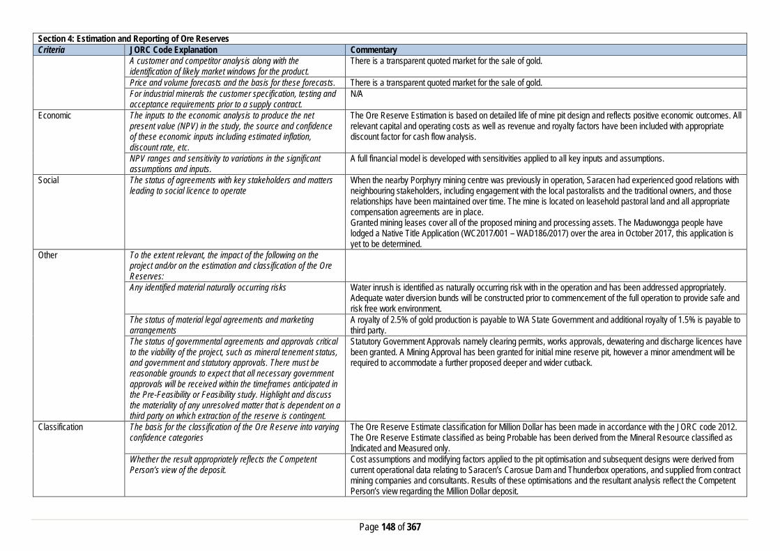
Page 148 of 367
Section 4: Estimation and Reporting of Ore Reserves Criteria JORC Code Explanation Commentary
A customer and competitor analysis along with the identification of likely market windows for the product.
There is a transparent quoted market for the sale of gold.
Price and volume forecasts and the basis for these forecasts. There is a transparent quoted market for the sale of gold. For industrial minerals the customer specification, testing and acceptance requirements prior to a supply contract.
N/A
Economic The inputs to the economic analysis to produce the net present value (NPV) in the study, the source and confidence of these economic inputs including estimated inflation, discount rate, etc.
The Ore Reserve Estimation is based on detailed life of mine pit design and reflects positive economic outcomes. All relevant capital and operating costs as well as revenue and royalty factors have been included with appropriate discount factor for cash flow analysis.
NPV ranges and sensitivity to variations in the significant assumptions and inputs.
A full financial model is developed with sensitivities applied to all key inputs and assumptions.
Social The status of agreements with key stakeholders and matters leading to social licence to operate
When the nearby Porphyry mining centre was previously in operation, Saracen had experienced good relations with neighbouring stakeholders, including engagement with the local pastoralists and the traditional owners, and those relationships have been maintained over time. The mine is located on leasehold pastoral land and all appropriate compensation agreements are in place. Granted mining leases cover all of the proposed mining and processing assets. The Maduwongga people have lodged a Native Title Application (WC2017/001 – WAD186/2017) over the area in October 2017, this application is yet to be determined.
Other To the extent relevant, the impact of the following on the project and/or on the estimation and classification of the Ore Reserves:
Any identified material naturally occurring risks Water inrush is identified as naturally occurring risk with in the operation and has been addressed appropriately. Adequate water diversion bunds will be constructed prior to commencement of the full operation to provide safe and risk free work environment.
The status of material legal agreements and marketing arrangements
A royalty of 2.5% of gold production is payable to WA State Government and additional royalty of 1.5% is payable to third party.
The status of governmental agreements and approvals critical to the viability of the project, such as mineral tenement status, and government and statutory approvals. There must be reasonable grounds to expect that all necessary government approvals will be received within the timeframes anticipated in the Pre-Feasibility or Feasibility study. Highlight and discuss the materiality of any unresolved matter that is dependent on a third party on which extraction of the reserve is contingent.
Statutory Government Approvals namely clearing permits, works approvals, dewatering and discharge licences have been granted. A Mining Approval has been granted for initial mine reserve pit, however a minor amendment will be required to accommodate a further proposed deeper and wider cutback.
Classification The basis for the classification of the Ore Reserve into varying confidence categories
The Ore Reserve Estimate classification for Million Dollar has been made in accordance with the JORC code 2012. The Ore Reserve Estimate classified as being Probable has been derived from the Mineral Resource classified as Indicated and Measured only.
Whether the result appropriately reflects the Competent Person’s view of the deposit.
Cost assumptions and modifying factors applied to the pit optimisation and subsequent designs were derived from current operational data relating to Saracen’s Carosue Dam and Thunderbox operations, and supplied from contract mining companies and consultants. Results of these optimisations and the resultant analysis reflect the Competent Person’s view regarding the Million Dollar deposit.
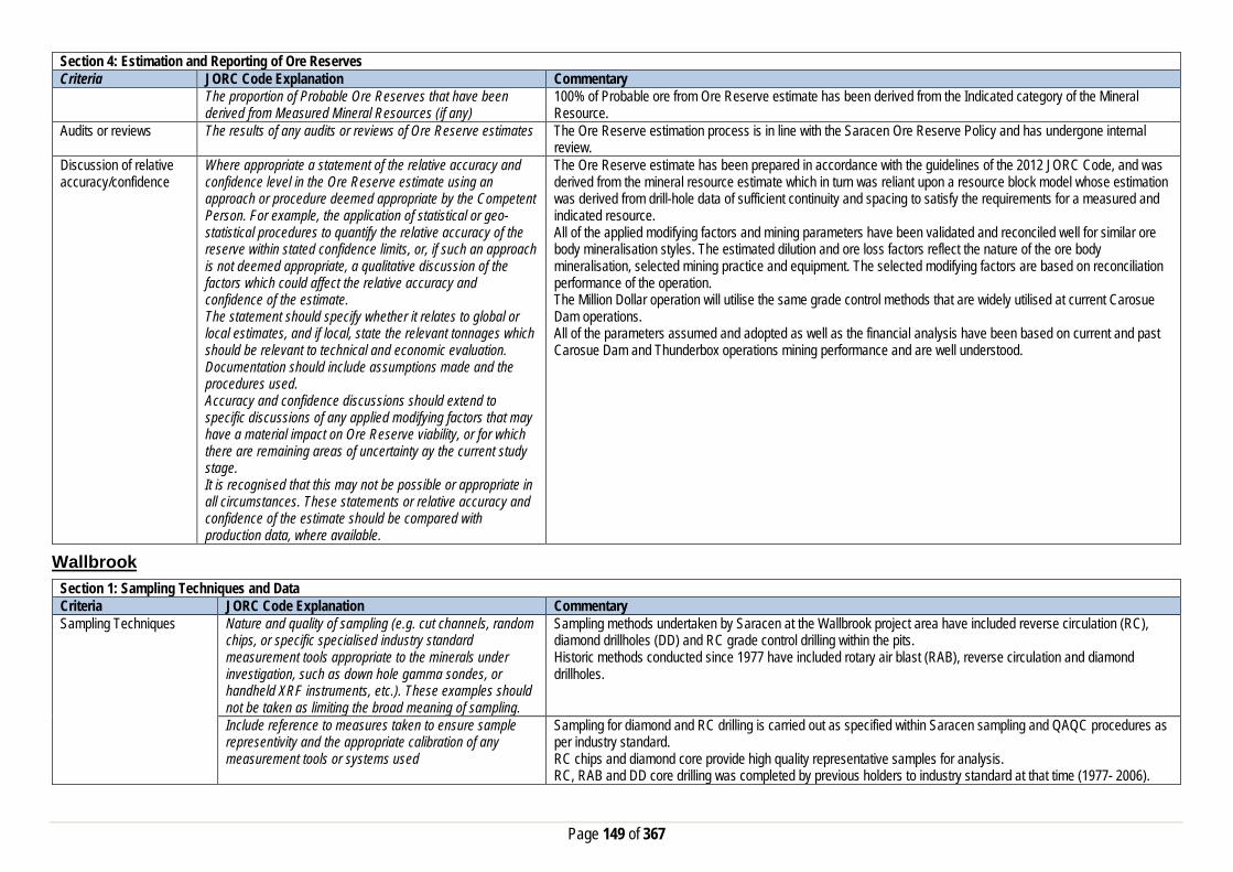
Page 149 of 367
Section 4: Estimation and Reporting of Ore Reserves Criteria JORC Code Explanation Commentary
The proportion of Probable Ore Reserves that have been derived from Measured Mineral Resources (if any)
100% of Probable ore from Ore Reserve estimate has been derived from the Indicated category of the Mineral Resource.
Audits or reviews The results of any audits or reviews of Ore Reserve estimates The Ore Reserve estimation process is in line with the Saracen Ore Reserve Policy and has undergone internal review.
Discussion of relative accuracy/confidence
Where appropriate a statement of the relative accuracy and confidence level in the Ore Reserve estimate using an approach or procedure deemed appropriate by the Competent Person. For example, the application of statistical or geo-statistical procedures to quantify the relative accuracy of the reserve within stated confidence limits, or, if such an approach is not deemed appropriate, a qualitative discussion of the factors which could affect the relative accuracy and confidence of the estimate. The statement should specify whether it relates to global or local estimates, and if local, state the relevant tonnages which should be relevant to technical and economic evaluation. Documentation should include assumptions made and the procedures used. Accuracy and confidence discussions should extend to specific discussions of any applied modifying factors that may have a material impact on Ore Reserve viability, or for which there are remaining areas of uncertainty ay the current study stage. It is recognised that this may not be possible or appropriate in all circumstances. These statements or relative accuracy and confidence of the estimate should be compared with production data, where available.
The Ore Reserve estimate has been prepared in accordance with the guidelines of the 2012 JORC Code, and was derived from the mineral resource estimate which in turn was reliant upon a resource block model whose estimation was derived from drill-hole data of sufficient continuity and spacing to satisfy the requirements for a measured and indicated resource. All of the applied modifying factors and mining parameters have been validated and reconciled well for similar ore body mineralisation styles. The estimated dilution and ore loss factors reflect the nature of the ore body mineralisation, selected mining practice and equipment. The selected modifying factors are based on reconciliation performance of the operation. The Million Dollar operation will utilise the same grade control methods that are widely utilised at current Carosue Dam operations. All of the parameters assumed and adopted as well as the financial analysis have been based on current and past Carosue Dam and Thunderbox operations mining performance and are well understood.
Wallbrook Section 1: Sampling Techniques and Data Criteria JORC Code Explanation Commentary Sampling Techniques Nature and quality of sampling (e.g. cut channels, random
chips, or specific specialised industry standard measurement tools appropriate to the minerals under investigation, such as down hole gamma sondes, or handheld XRF instruments, etc.). These examples should not be taken as limiting the broad meaning of sampling.
Sampling methods undertaken by Saracen at the Wallbrook project area have included reverse circulation (RC), diamond drillholes (DD) and RC grade control drilling within the pits. Historic methods conducted since 1977 have included rotary air blast (RAB), reverse circulation and diamond drillholes.
Include reference to measures taken to ensure sample representivity and the appropriate calibration of any measurement tools or systems used
Sampling for diamond and RC drilling is carried out as specified within Saracen sampling and QAQC procedures as per industry standard. RC chips and diamond core provide high quality representative samples for analysis. RC, RAB and DD core drilling was completed by previous holders to industry standard at that time (1977- 2006).

Page 150 of 367
Section 1: Sampling Techniques and Data Criteria JORC Code Explanation Commentary
Aspects of the determination of mineralisation that are Material to the Public Report. In cases where ‘industry standard’ work has been done this would be relatively simple (e.g. ‘reverse circulation drilling was used to obtain 1 m samples from which 3 kg was pulverised to produce a 30 g charge for fire assay’). In other cases more explanation may be required, such as where there is coarse gold that has inherent sampling problems. Unusual commodities or mineralisation types (e.g. submarine nodules) may warrant disclosure of detailed information
Diamond core is NQ sized, sampled to 1m intervals and geological boundaries where necessary and cut into half core to give sample weights under 3 kg. Samples are selected to weigh less than 3 kg to ensure total sample inclusion at the pulverisation stage. RC chips are riffle or cone split and sampled into 1m intervals with total sample weights under 3kg Saracen core and chip samples are crushed, dried and pulverised to a nominal 90% passing 75µm to produce a 50 g sub sample for analysis by FA/AAS. Historical RAB, RC and diamond sampling was carried out to industry standard at that time. Analysis methods include fire assay, aqua regia and unspecified methods.
Drilling Techniques Drill type (e.g. core, reverse circulation, open-hole hammer, rotary air blast, auger, Bangka, sonic, etc.) and details (e.g. core diameter, triple or standard tube, depth of diamond tails, face-sampling bit or other type, whether core is oriented and if so, by what method, etc.).
The deposit was initially sampled by 516 RAB holes, 360 RC holes (assumed standard 5 ¼ ‘’bit size) and 10 surface diamond HQ, PQ and unknown diameter holes. Saracen has completed 2 NQ diameter diamond geotechnical holes, 1 HQ diameter diamond drillhole for metallurgical test work, 210 RC holes from surface and 1868 grade control RC holes within the pits. Diamond drillholes were oriented using an Ezy-mark tool. It is unknown if historic diamond drill core was oriented.
Drill Sample Recovery Method of recording and assessing core and chip sample recoveries and results assessed
Diamond core recovery percentages calculated from measured core versus drilled intervals are logged and recorded in the database. No historic recoveries have been recorded. Recoveries average >95%. RC sampling recoveries are recorded as a percentage based on a visual weight estimate; limited historic recoveries have been recorded.
Measures taken to maximise sample recovery and ensure representative nature of the samples
Diamond core is reconstructed into continuous runs on an angle iron cradle for orientation marking. Depths are checked against depth given on the core blocks. During exploration RC drilling minimum tolerance shrouds were used to improve sample recovery. These were adjusted based on the difficulty of the clay. During GC campaigns daily rig inspections are carried out to check splitter condition, general site and address general issues. The sample bags weight versus bulk reject weight is compared to ensure adequate and even sample recovery. Historical RAB, RC and diamond drilling to industry standard at that time.
Whether a relationship exists between sample recovery and grade and whether sample bias may have occurred due to preferential loss/gain of fine/coarse material.
Diamond drilling has high recoveries meaning loss of material is minimal. There is no known relationship between sample recovery and grade for RC drilling. Any historical relationship is not known.
Logging Whether core and chip samples have been geologically and geotechnically logged to a level of detail to support appropriate Mineral Resource estimation, mining studies and metallurgical studies. Whether logging is qualitative or quantitative in nature. Core (or costean, channel, etc) photography.
Logging of diamond drill core and RC chips records lithology, mineralogy, texture, mineralisation, weathering, alteration, veining and other features. Geotechnical and structural logging is carried out on all diamond holes to record recovery, RQD, defect number, type, fill material, shape and roughness and alpha and beta angles. Chips from all RC holes (exploration and GC) are stored in chip trays for future reference. Core is photographed in both dry and wet state. Qualitative and quantitative logging of historic data varies in its completeness.
The total length and percentage of the relevant intersections logged
All diamond drillholes and exploration RC holes are logged in full. Every second drill line is logged in grade control programs with infill logging carried out as necessary. Historical logging is approximately 95% complete.

Page 151 of 367
Section 1: Sampling Techniques and Data Criteria JORC Code Explanation Commentary Sub-sampling techniques and sample preparation
If core, whether cut or sawn and whether quarter, half or all core taken.
All drill core is cut in half onsite using an automatic core saw. Samples are always collected from the same side. Historic drillcore had been half core, quarter core and full core sampled.
If non-core, whether riffled, tube sampled, rotary split, etc and whether sampled wet or dry.
All exploration and GC RC samples are cone or riffle split. Occasional wet samples are encountered; increased air capacity is routinely used to aid in keeping the sample dry when water is encountered. Historic RAB and RC drilling was sampled using riffle and unknown methods.
For all sample types, the nature, quality and appropriateness of the sample preparation technique.
The sample preparation of diamond core and RC chips adhere to industry best practice. It is conducted by a commercial laboratory or onsite laboratory and involves oven drying, coarse crushing then total grinding to a size of 90% passing 75 microns. Best practice is assumed at the time of historic sampling.
Quality control procedures adopted for all sub-sampling stages to maximise representivity of samples.
All subsampling activities are carried out by commercial laboratory or onsite laboratory and are considered to be satisfactory. Sampling by previous holders assumed to be industry standard at the time.
Measures taken to ensure that the sampling is representative of the in situ material collected, including for instance results for field duplicate/second half sampling.
Duplicate sampling is carried out at a rate of 1:10 for exploration drilling and 1:20 for GC drilling and is sampled directly from the on-board splitter on the rig. These are submitted for the same assay process as the original samples and the laboratory are unaware of such submissions. Sampling by previous holders assumed to be industry standard at the time.
Whether sample sizes are appropriate to the grain size of the material being sampled.
Sample sizes are considered to be appropriate.
Quality of assay data and laboratory tests
The nature, quality and appropriateness of the assaying and laboratory procedures used and whether the technique is considered partial or total.
RC chip samples, diamond core and some grade control chip samples are analysed by external laboratories using a 50g fire assay with AAS finish. This method is considered suitable for determining gold concentrations in rock and is a total digest method. Some GC samples were analysed in the Saracen onsite laboratory using a pulverise and leach method. This method is a partial digest. Historic sampling includes fire assay, aqua regia and unknown methods.
For geophysical tools, spectrometers, handheld XRF instruments, etc, the parameters used in determining the analysis including instrument make and model, reading times, calibrations factors applied and their derivation, etc.
No geophysical tools have been utilised for reporting gold mineralisation within the Wallbrook project.
Nature of quality control procedures adopted (e.g. standards, blanks, duplicates, external laboratory checks) and whether acceptable levels of accuracy (i.e. lack of bias) and precision have been established.
Certified reference material (standards and blanks) with a wide range of values are inserted into every drillhole at a rate of 1:25 for exploration RC and DD, and 1:40 for GC drilling. These are not identifiable to the laboratory. QAQC data returned are checked against pass/fail limits with the SQL database and are passed or failed on import. A report is generated and reviewed by the geologist as necessary upon failure to determine further action. QAQC data is reported monthly. Sample preparation checks for fineness are carried out to ensure a grindsize of 90% passing 75 microns. The laboratory performs a number of internal processes including standards, blanks, repeats and checks. QAQC data analysis demonstrates sufficient accuracy and precision. Industry best practice is assumed for previous holders.
Verification of sampling and assaying
The verification of significant intersections by either independent or alternative company personnel.
Significant intercepts are verified by the Geology Manager and corporate personnel.
The use of twinned holes. No specific twinned holes have been drilled in the Wallbrook project area but grade control drilling has confirmed the width and grade of previous exploration drilling.

Page 152 of 367
Section 1: Sampling Techniques and Data Criteria JORC Code Explanation Commentary
Documentation of primary data, data entry procedures, data verification, data storage (physical and electronic) protocols
Primary data is collated in a set of excel templates utilising lookup codes. This data is forwarded to the Database Administrator for entry into a secure acQuire database with inbuilt validation functions. Data from previous owners was taken from a database compilation and validated as much as practicable before entry into the Saracen acQuire database.
Discuss any adjustment to assay data. No adjustments have been made to assay data. First gold assay is utilised for resource estimation. Location of data points Accuracy and quality of surveys used to locate drillholes
(collar and down-hole surveys), trenches, mine workings and other locations used in Mineral Resource estimation.
Exploration drillholes are located using a Leica 1200 GPS with an accuracy of +/- 10mm. Drillhole collars within the pit and immediate surrounds are picked up by company surveyors using a Trimble R8 GNSS (GPS) with an expected accuracy of +/-8mm. Downhole surveys are carried out using an Eastman single shot camera at regular intervals (usually 30m). A number of drillholes have also been gyroscopically surveyed. Previous holders’ survey accuracy and quality is unknown.
Specification of the grid system used. The grid system used at the Wallbrook project area is MGA94 zone 51. Quality and adequacy of topographic control. Topographic control originally used site based survey pickups in addition to Kevron aerial photogrammetric surveys
with +/- 5m resolution. Pre mining, new and more detailed topography has since been captured and will be used in future updates and for subsequent planning purposes.
Data spacing and distribution
Data spacing for reporting of Exploration Results. The nominal spacing for exploration drilling is 25m X 25m to 25m/20m X 12.5m in the Redbrook and Eleven Bells and 30m X 20m to 20m X 20m at Red Flag and Crusader respectively.
Whether the data spacing and distribution is sufficient to establish the degree of geological and grade continuity appropriate for the Mineral Resource and Ore Reserve estimation procedure(s) and classifications applied.
Data spacing and distribution are sufficient to establish the degree of geological and grade continuity appropriate for JORC classifications applied.
Orientation of data in relation to geological structure
Whether sample compositing has been applied. Sample compositing is not applied until the estimation stage. Some historic RAB and RC sampling was composited into 3-4m samples with areas of interest re-sampled to 1m intervals. It is unknown at what threshold this occurred.
Whether the orientation of sampling achieves unbiased sampling of possible structures and the extent to which this is known, considering the deposit type.
The majority of drillholes are positioned to achieve optimum intersection angles to the ore zone as are practicable.
If the relationship between the drilling orientation and the orientation of key mineralised structures is considered to have introduced a sampling bias, this should be assessed and reported if material.
No significant sampling bias is thought to occur due to orientation of drilling in regards to mineralised structures.
Sample security The measures taken to ensure sample security. Samples are prepared on site under supervision of Saracen geological staff. Samples are selected, bagged into tied numbered calico bags then grouped into secured cages and collected by the laboratory personnel. Sample submissions are documented via laboratory tracking systems and assays are returned via email
Audits or reviews The results of any audits or reviews of sampling techniques and data.
An internal review of companywide sampling methodologies was conducted to create the current sampling and QAQC procedures.

Page 153 of 367
Section 2: Reporting of Exploration Results Criteria JORC Code Explanation Commentary Mineral tenement and land tenure status
Type, reference name/number, location and ownership including agreements or material issues with third parties such as joint ventures, partnerships, overriding royalties, native title interests, historical sites, wilderness or national park and environmental settings.
The Wallbrook area comprises a number of resources located on M31/172 and M31/231. Near mine exploration has been carried out on M31/188 and M31/251. The tenements are held 100% by Saracen Gold Mines Pty Ltd, a wholly owned subsidiary of Saracen Mineral Holdings Limited. The tenements have a 21 year mine life (held until 2029) and are renewable for a further 21 years on a continuing basis. Mining leases M31/172,M31/188 and M31/231 are subject to a bank mortgage. There are no registered Aboriginal Heritage sites within Mining Leases M31/172, M31/188, M31/231 and M31/251. All the tenements are subject to the Edjudina Pastoral Compensation agreement. All production is subject to a Western Australian state government NSR royalty of 2.5%
The security of the tenure held at the time of reporting along with any known impediments to obtaining a licence to operate in the area.
The tenements are in good standing and the licence to operate already exists.
Exploration done by other parties
Acknowledgment and appraisal of exploration by other parties.
Gold mining began in the Wallbrook area at Redbrook as early as 1903 and continued sporadically until 1942. Regional exploration carried out the 1960’s and 1970’s by Falconbridge and Asarco focused on base metal discovery with no significant anomalism detected. The exploration focus shifted back to gold in the late 1970’s. Sampling and RAB drilling carried out by Pennzoil in 1981 delineated the Wallbrook and Redbrook mineralisation, with RC drilling carried out by Ivernia in 1987 further defining the resource. The project changed hands a number of times with Poseidon, Talon Resources, Croesus and Jackson Gold all carrying out various drilling and sampling campaigns and identifying further resources including Eleven Bells, Red Flag and Crusader before Saracen acquired the project.
Geology Deposit type, geological setting and style of mineralisation.
Centred in the Wallbrook region is Wallbrook Hill area is described as a medium-grained leucocratic granitoid that crops out on two low hills which jointly cover an area of approximately 1200m (northsouth) by 200m (east west). The two hills appear to represent two narrowly separated granitoid bodies surrounded by greenstone. The greenstones are dominantly amygdaloidal basalt and chlorite-plagioclase-rich mafic schist, with minor intermediate to felsic schist. The margins of the granitoids are ‘porphyritic and interleaved with greenstone. Competency contrast between the Wallbrook granitoids and adjacent rock types, is considered important in localising mineralised vein systems at the Wallbrook deposit. At Wallbrook a mineralised quartz vein stockwork has developed within and adjacent to a small syenogranitic intrusion within metabasalt. Locally however, the wall rocks at Wallbrook comprise relatively incompetent felsic schists. Quartz veins formed a conjugate set while the local principal stress axis was oriented northeast – southwest. Further north the structurally controlled Red Flag and Crusader deposits form at sheared contacts between mafic and felsic units that exhibit increased quartz veining.
Drillhole information A summary of all information material to the understanding of the exploration results including a tabulation of the following information for all Material drill holes:
• easting and northing of the drill hole collar • elevation or RL (Reduced Level – elevation • above sea level in metres) of the drill hole collar • dip and azimuth of the hole • down hole length and interception depth • hole length.
All material data is periodically released on the ASX: 31/07/2012, 28/04/2010, 13/04/2010, 30/04/2008, 12/03/2008, 31/01/2008, 03/12/2007, 30/10/2007, 28/09/2007 Future drill hole data will be periodically released or when a results materially change the economic value of the project.

Page 154 of 367
Section 2: Reporting of Exploration Results Criteria JORC Code Explanation Commentary
• If the exclusion of this information is justified on the basis that the information is not Material and this exclusion does not detract from the understanding of the report, the Competent Person should clearly explain why this is the case.
Data aggregation methods In reporting Exploration Results, weighting averaging techniques, maximum and/or minimum grade truncations (e.g. cutting of high grades) and cut-off grades are usually Material and should be stated.
All significant intercepts have been length weighted with a minimum Au grade of 1ppm. No high grade cut off has been applied.
Where aggregate intercepts incorporate short lengths of high grade results and longer lengths of low grade results, the procedure used for such aggregation should be stated and some typical examples of such aggregations should be shown in detail.
Intercepts are aggregated with minimum width of 1m and maximum width of 3m for internal dilution. Where stand out higher grade zone exist with in the broader mineralised zone, the higher grade interval is reported also.
The assumptions used for any reporting of metal equivalent values should be clearly stated.
There are no metal equivalents reported in this release.
Relationship between mineralisation widths and intercept lengths
These relationships are particularly important in the reporting of Exploration Results. If the geometry of the mineralisation with respect to the drill hole angle is known, its nature should be reported. If it is not known and only the down hole lengths are reported, there should be a clear statement to this effect (eg ‘down hole length, true width not known’).
Previous announcements (mentioned above) included sufficient detail to clearly illustrate the geometry of the mineralisation and the recent drilling.
Diagrams Appropriate maps and sections (with scales) and tabulations of intercepts should be included for any significant discovery being reported These should include, but not be limited to a plan view of drill hole collar locations and appropriate sectional views.
All significant exploration results released by Saracen are accompanied by the appropriate diagrams and maps at the time of the release.
Balanced Reporting Where comprehensive reporting of all Exploration Results are not practicable, representative reporting of both low and high grades and/or widths should be practiced to avoid misleading reporting of Exploration Results.
All results from the recent campaign have been reported, irrespective of success or not.
Other substantive exploration data
Other exploration data, if meaningful and material,should be reported including (but not limited to): geological observations; geophysical survey results; geochemical survey results; bulk samples – size and method of treatment; metallurgical test results; bulk density, groundwater, geotechnical and rock characteristics; potential deleterious or contaminating substances.
A number of studies were carried out in 2010 including a hydrological assessment and dewatering investigation that determined no impact on surrounding area, a waste characterisation and acid mine drainage management study that reported no issues and a geotechnical study that concluded geological structures will greatly influence wall stability.
Further work The nature and scale of planned further work (eg tests for lateral extensions or depth extensions or large-scale step-out drilling).
Wallbrook is a prospective area and is well defined. Open Pit optimisation is ongoing. Further work in the future will be focused more on extensional exploration.

Page 155 of 367
Section 2: Reporting of Exploration Results Criteria JORC Code Explanation Commentary
Diagrams clearly highlighting the areas of possible extensions, including the main geological interpretations and future drilling areas, provided this information is not commercially sensitive
Section 3: Estimation and Reporting of Mineral Resources Criteria JORC Code Explanation Commentary Database Integrity Measures taken to ensure that data has not been
corrupted by, for example, transcription or keying errors, between its initial collection and its use for Mineral Resource estimation purposes.
Saracen utilises AcQuire software on an SQL server database to securely store and manage all drillhole and sample information. Data integrity protocols are built into the system to ensure data validity and minimise errors are built into the data entry and import processes.
Data validation procedures used. Data that is captured in the field is entered into Excel templates which are checked on import into the database for errors. Assay jobs are dispatched electronically to the lab to minimise the chance of data entry errors. Assay results from the lab are received in CSV format and are checked for errors on import into the database. Data is regularly validated using the mining software. The data validation process is overseen by the Database Administrator.
Site Visits Comment on any site visits undertaken by the Competent Person and the outcome of those visits.
The Competent Person visited the geological area at the time of review and exploration to assess geological competency and ensure integrity across all exploration geological disciplines.
If no site visits have been undertaken indicate why this is the case.
Geological Interpretation Confidence in (or conversely, the uncertainty of) the geological interpretation of the mineral deposit.
Included in the Wallbrook Project area are four spatially separate deposits that are possibly part of the same regional geology regime but are geologically different on a local scale. Redbrook and Eleven Bells, historically mined at a small scale, are well defined by exploration drilling and grade control drilling in the upper levels. Mineralisation at Redbrook is well understood and the resource categories applied to its estimation reflect the geological confidence. Eleven Bells mineralisation is far more complex and historic drilling at various orientations reflects the intricacies in geology. A bulk mining methodology was proposed for this deposit and with that confidence in metal recovery is high. The resource categories consider both geological understanding from drill results and the bulk mining metal recovery. Red Flag and Crusader are exhibit simpler geology and interpretations have not altered significantly over historic and more recent drilling campaigns. There is a high confidence in the interpretations and the appropriate resource categories are reflected in the model.
Nature of the data used and any assumptions made. The geological interpretation of Wallbrook has considered all available geological information including local geology, structural deformation events, and its relationship to neighbouring mineralised deposits. Rock types, mineral, alteration and veining assemblages from diamond drill core and RC Chips were all used to help define the mineralised domains, regolith boundaries and granite intrusion contacts. Historic in pit mapping further constrained the domaining.
The affect, if any, of alternative interpretations on Mineral Resource estimation.
The geological wireframes defining the mineralised zones are considered to be robust. Whilst the Eleven Bells wireframes are well defined by geology, the ambiguity surrounding the gold bearing structures resulted in various model runs that included a bulk mining approach, and estimations looking at different composited lengths. Globally they all behaved in a similar manner.
The use of geology in guiding and controlling the Mineral Resource estimation.
The wireframed domains are used as hard boundaries during the Mineral Resource Estimation. They are constructed using all available geological information (as stated above) and terminate along known structures and or granite contacts in the case of Eleven Bells and Redbrook. Mineralisation styles, geological homogenity, and grade

Page 156 of 367
Section 3: Estimation and Reporting of Mineral Resources Criteria JORC Code Explanation Commentary
distributions for each domain (used to highlight any potential for bimodal populations) are all assessed to ensure effective estimation of the domains.
The factors affecting continuity both of grade and geology. Grade and geology continuity for each of the deposits at Wallbrook are influenced by various controls. Economic mineralisation at Redbrook is largely controlled by the proximity of the granitoid contact that acts as a conduit for au bearing fluids. A stockwork of quartz veining is strongly associated with healthy Au mineralisation. The along strike extents are possibly terminated by structures however further drilling would be required to verify this. The main Redbrook domains are open at depth and down plunge. Elevenbells mineralisation abutts the northern contact of the granite and subsequently terminates along it. Moving away from the granite the NW extent of the mineralisation naturally attenuates. Quartz veining in the metabasalt host is the only consistent marker for Au mineralisation; however geological relationships are ambiguous due to the orientation of the drilling. At Red Flag Au mineralisation at Red Flag is largely associated with sheared contacts between mafic and felsic units and increased quartz veining. Both the northerly and southerly extents of these domains are terminated by local to regional scaled NW trending structures that can be easily picked in the Magnetics. Au mineralisation at Crusader mimics other deposits and is largely associated with sheared mafic (intermediate) and felsic unit contacts. Quartz veining and associated chlorite, hematite, sericite alteration is not always an indicator of economic Au mineralisation. Cross cutting the Crusader deposit to the north are a series of porphyries that are associated with weaker Au mineralisation. The southerly extent of Crusader domains are terminated by the same NW structure that intervenes with Red Flag. To the north the gold mineralisation appears to peter out, however it remains relatively untested.
Dimensions The extent and variability of the Mineral Resource expressed as length (along strike or otherwise), plan width, and depth below surface to the upper and lower limits of the Mineral Resource.
Redbrook and Eleven Bells deposits stretch from 6694800mN to 6695800mN and 433800mE to 434400mE to 300m below surface. The ore lodes have strike lengths from 25m to 260m and plunge extents and widths up to 330m. Red Flag and Crusader deposits stretch from 6695905mN to 6697595mN and 433000mE to 434600mE to 300m below surface. Red Flag domains are dominated by shorter strike lengths from 25m to 230m, whereas the domains at Crusader stretch from 60m to 1130m.
Estimation and modelling techniques
The nature and appropriateness of the estimation technique(s) applied and key assumptions, including treatment of extreme grade values, domaining, interpolation parameters and maximum distance of extrapolation from data points.
Ordinary Krige The mineralised ore domains were wireframed based on geological homogeneity, grade populations, mineralisation styles and orientation of grade continuity. The domain wireframes were used as hard boundaries during the estimation process. Grade control holes assisted in the geological definition of the primary ore domains, though were omitted in the estimation of the resource. An unfolding process was carried out prior to variography and interpolation to remove the variable dip and strike typically associated with the mineralised domains. RAB, Aircore and grab samples were excluded from the estimation process for Redbrook and Eleven Bells due to the unreliability of results. However as almost half the dataset for Red Flag and Crusader consisted of RAB drilling these were included in their estimation. Negative gold grades were replaced with a grade of 0.001 g/t and null gold grades were excluded from the estimation process. Drillhole assays were composited to 1m intervals with a minimum length of 0.3m that best conformed to the sample length of the majority of the RC data. High grades within each domain were identified and top cuts were applied where necessary. Variograms were produced to determine the directional influence of each sample during the estimation process. The Mineral Resource Estimate was interpolated using Ordinary Kriging in Micromine 2012.
The availability of check estimates, previous estimates and/or mine production records and whether the Mineral Resource estimate takes appropriate account of such data.
An inverse distance cubed estimate was run simultaneously with the ordinary kriged resource estimate, with an insignificant variance between the global Au grade values. The Wallbrook resource model was compared to the previously run Widenbar OK model of 2009 and changes including increased tonnages were the result of more available mineralised drill intersections, in pit mapping and geophysics data.

Page 157 of 367
Section 3: Estimation and Reporting of Mineral Resources Criteria JORC Code Explanation Commentary
The current resource model was reconciled with production data on a monthly basis. This information for Redbrook and Eleven Bells was fed back into the resource modelling process and used to refine the model.
The assumptions made regarding recovery of by-products. No assumptions have been made regarding the recovery of by-products for this Mineral Resource Estimation. Estimation of deleterious elements or other non-grade variables of economic significance (e.g. sulfur for acid mine drainage characterisation).
No estimation of deleterious elements or non-grade variables is required
In the case of block model interpolation, the block size in relation to the average sample spacing and the search employed.
Average drill hole data spacing and mining selectivity were among the primary considerations for block size. In the case of Red Brook and Eleven Bells, larger bulk mining practices and broader ore zones resulted in the more appropriate parent cell size of 20m X 20m X 10 m. Sub celling resolutions to 2m x 2m x 2m was applied. The parent cell size of 10m x 10m x 5m with a subcelling to 1m in each direction was used in the Red Flag and Crusader estimation. The search strategy was set up such that the first search pass would fill blocks informed by the closest spaced drilling, whilst the second search would inform blocks in area of more typical drill spacing. The second search used search ellipse multiplied by a factor of 2, while the third search increased the dimensions by a factor of 5 to ensure filling of all blocks. Initial search distances are done on a domain by domain basis.
Any assumptions behind modelling of selective mining units.
No selective mining units have been assumed.
Any assumptions about correlation between variables. No assumptions have been made regarding correlation between variables. Description of how the geological interpretation was used to control the resource estimates.
Mineralised domains were wireframed within the context of the known local and structural geology. The interpretation was influenced by historical information, geological mapping within the pit (Redbrook only) and geology logging of drillholes. Correlations between rock type, texture, and alteration, veining and gold mineralisation were investigated for each deposit.
Discussion of basis for using or not using grade cutting or capping.
Samples with extreme high grades that bias the mean grade and positively skew the grade population within each mineralised domains are top cut to reduce the influence high grade outliers. The geostatistics to determine top cuts includes log probability plots and the coefficient of variation.
The process of validation, the checking process used, the comparison of model data to drill hole data, and use of reconciliation data if available.
A number of statistical and visual measures are used to validate the accuracy of the estimation. The mean grade of the block model is compared to the mean grade of composites by domain. These are then further investigated by appropriate northing, easting and bench intervals in the form of swathe plots. The volume variance between the wireframed domains and block model domains are assessed. Kriging effeciency, and slope results give an indication of the quality of the estimate. A visual inspection of the drillhole assay results are compared to the estimated block model in section.
Moisture Whether the tonnages are estimated on a dry basis or with natural moisture, and the method of determination of the moisture content.
All tonnages are estimated on a dry basis.
Cut-off parameters The basis of the adopted cut-off grade(s) or quality parameters applied.
The adopted cut-off grades for Mineral Resource Estimation reporting are determined by the current mining cut-off grades. For Wallbrook these were set at 0.4 Au g/t.
Mining factors or assumptions
Assumptions made regarding possible mining methods, minimum mining dimensions and internal (or, if applicable, external) mining dilution. It is always necessary as part of the process of determining reasonable prospects for eventual economic extraction to consider potential mining methods, but the assumptions made regarding mining
Open cut mining has been successful at the Redbrook and Eleven Bells deposit. It is therefore assumed that there are reasonable grounds to mine the remaining resource at these deposits by conventional open pit methods given the close proximity to surface and the mean average grade of the mineralisation. Similarly mining methods would also be amenable for Red Flag and Crusader deposits.
Page 158 of 367
Section 3: Estimation and Reporting of Mineral Resources Criteria JORC Code Explanation Commentary
methods and parameters when estimating Mineral Resources may not always be rigorous. Where this is the case, this should be reported with an explanation of the basis of the mining assumptions made.
Metallurgical factors or assumptions
The basis for assumptions or predictions regarding metallurgical amenability. It is always necessary as part of the process of determining reasonable prospects for eventual economic extraction to consider potential metallurgical methods, but the assumptions regarding metallurgical treatment process and parameters made when reporting Mineral Resources may not always be rigorous. Where this is the case, this should be reported with an explanation of the basis of the metallurgical assumptions made.
Metallurgical testing (and processing operations at CDO) identified Wallbrook ores as being free milling sizes with leach recoveries in excess of 90% with a moderate gravity gold component (30% - 40%).
Environmental factors or assumptions
Assumptions made regarding possible waste and process residue disposal options. It is always necessary as part of the process of determining reasonable prospects for eventual economic extraction to consider the potential environmental impacts of the mining and processing operation. While at this stage the determination of potential environmental impacts, particularly for a greenfields project, may not always be well advanced, the status of early consideration of these potential environmental impacts should be reported. Where these aspects have not been considered this should be reported with an explanation of the environmental assumptions made.
Wallbrook Waste characterisation indicated that seepage from waste rock stockpiles at Wallbrook are slightly alkaline, non-saline to slightly brackish and contain very low concentrations of metals and metalloids. Waste materials have been classed as NAF, small percentage of low risk acid forming materials will be encapsulated in Waste Rock Dump through dump strategy. No processing or benefication of ore expected on these tenements, as ore is hauled to Carosue Dam Minesite for Processing.
Bulk Density Whether assumed or determined. If assumed, the basis for the assumptions. If determined, the method used, whether wet or dry, the frequency of the measurements, the nature, size and representativeness of the samples.
Density in the current model has been assigned based on oxidation state, using both recent density determinations carried out by Saracen on its drill samples and historical data. The sample size is generally between 0.5 and 1.5kg and the method of calculation is the water displacement technique. Measurements have been recorded in the acquire database.
The bulk density for bulk material must have been measured by methods that adequately account for void spaces (vugs, porosity, etc), moisture and differences between rock and alteration zones within the deposit.
Ore zones predominantly exist in transitional to fresh non porous material, so additional measures to reduce moisture intake during the water displacement method is unnecessary at this stage. Coating more friable oxides and sediments (to reduce moisture loss or moisture gain during the process) is considered on a deposit by deposit basis.
Discuss assumptions for bulk density estimates used in the evaluation process of the different materials.
An average mean of densities collected for each lithological type has been uniformly applied to the modelled geological units. This includes the primary fresh lithologies as well as the weathered oxide and transitional zones.
Classification The basis for the classification of the Mineral Resources into varying confidence categories.
Drill hole location plots have been used to ensure that local drill spacing conforms to the minimum expected for the resource classification. Measured material has been defined where there is detailed grade control and resource definition drilling where confidence in lode volume and continuity is very high. Indicated material is generally confined to areas where resource definition drilling is typically defined by 25m x 25m spaced drilling or closer, and there is still high confidence in lode location and continuity. Inferred material lies beyond the Indicated boundaries and meets the criteria expressed in the JORC Code for Inferred Resource.
Page 159 of 367
Section 3: Estimation and Reporting of Mineral Resources Criteria JORC Code Explanation Commentary
Based on the above criteria a series of strings were constructed and linked together to form solid wireframes that defined the measured (RESCAT = 1) and indicated (RESCAT = 2) categories. The block model outside the Indicated wireframe was given the default Inferred value of RESCAT = 3. Additionally estimation properties, such as search passes, number of samples, and kriging efficiencies, were considered in the definition of the resource boundaries and were visually compared to the RESCATS previously defined by the drill spacing and geological continuity.
Whether appropriate account has been taken of all the relevant factors (ie relative confidence in tonnage/grade estimations, reliability of input data, confidence in continuity of geology and metal values, quality, quantity and distribution of the data).
All relevant factors have been taken into account and are validated through thorough QAQC of the drill hole database and geological knowledge and interpretation of the Wallbrook deposit. Thorough model validations and reviews ensure the integrity of the final estimation and the grade and tonnage numbers.
Whether the result appropriately reflects the Competent Person's view of the deposit.
The geological model and the mineral resource estimate reflect the competent person’s view of the deposit.
Audits or reviews The results of any audits or reviews of Mineral Resource estimates.
At the completion of resource estimation Saracen Gold Mines undertake an extensive review of the model that covers model inventory and comparisons to previous and budget models. Geological interpretation,wireframing, domain selection, statisitics by domain, assay evaluation, parent cell sizes, data compositing, variography, search strategy, estimation and KNA and finally model validation and resource categorisation are all discussed and scrutinized by the geological and mine planning teams.
Discussion of relative accuracy/confidence
Where appropriate a statement of the relative accuracy and confidence level in the Mineral Resource estimate using an approach or procedure deemed appropriate by the Competent Person. For example, the application of statistical or geostatistical procedures to quantify the relative accuracy of the resource within stated confidence limits, or, if such an approach is not deemed appropriate, a qualitative discussion of the factors that could affect the relative accuracy and confidence of the estimate.
The Mineral Resource has been reported in accordance with the guidelines of the 2004 edition of the Australasian Code for Reporting of Exploration Results, Mineral Resources and Ore Reserves. Saracen Gold Mine uses a standard approach to resource estimation and the procedure requires the systematic completion of the Saracen Resource Estimation Document that is thoroughly investigated and assessed in the Model review process, as stated above. It was identified that with improved software, validation and additional KNA measures would help improve the optimisation of the block model.
The statement should specify whether it relates to global or local estimates, and, if local, state the relevant tonnages, which should be relevant to technical and economic evaluation. Documentation should include assumptions made and the procedures used.
The statements relate to a global estimate of tonnes and grade.
These statements of relative accuracy and confidence of the estimate should be compared with production data, where available.
Compared to production data, Redbrook resource estimation reconciled well, reporting 98% accuracy in ounces. This equates to a 97% tonnes and 102% grade reconciliation. This is indicative of the broad and consistent ore zone mined at Redbrook. Geology and mineralisation is less well understood at Eleven Bells and variability (10% - 35% less ounces) in historic production figures with resource estimates is indicative of this complex setting. The current bulk resource estimation takes this complexity into account, reducing the potential for ore misallocation. This setup produces far more favourable and minable set of parameters.
Page 160 of 367
Section 4: Estimation and Reporting of Ore Reserves Criteria JORC Code Explanation Commentary Mineral Resource estimate for conversion to Ore Reserves
Description of the Mineral resource Estimate used as a basis for the conversion to an Ore Reserve.
The Mineral Resource estimate for the Wallbrook gold deposit is a robust global estimate that considers the intricacies of the geology for each deposit within the geological region. Accordingly Eleven Bells adopted a bulk modelling and estimation approach and the Redbrook estimation honoured the greater geological understanding and definition. These “reduced risk” estimations were used as a basis for conversion to the Ore Reserve estimation. This resource estimate was compiled by Saracen using exploration, resource definition, and grade control drilling and assay data, geological mapping and historical mining records to validate the model against, and solid interpretation wireframes of the geology. This information was used to construct a model estimated by various kriging methods. The block model was depleted with the end of June 2019 monthly survey pickup for Reserve Estimation.
Clear statement as to whether the Mineral Resources are reported additional to. Or inclusive of, the Ore Reserves.
The Mineral Resource reported is inclusive of the Ore Reserve.
Site Visits Comment on any site visits undertaken by the Competent Person and the outcome of those visits.
A Competent Person and an independent external geotech consultant have conducted several site visits to the Wallbrook mining region since the inclusion in the Saracen life of mine plan. The purpose of these visits is to collect information for optimisation work, validating input parameters, visual pit inspection, discussion and feedback for life of mine planning. The information also includes the discussion around current mining performance, wall conditions and overall stability, and groundwater condition.
If no site visits have been undertaken indicate why this is the case.
N/A
Study status The type and level of study undertaken to enable Mineral Resources to be converted to Ore Reserves
The Wallbrook deposit was mined as an open pit in the past from 2011-2012 under Saracen ownership. Since then a revised feasibility level study was undertaken with the view to recommence open pit operations and has been included in the Carosue Dam life of mine plan. The 2019 Ore Reserve has included all aspects of operational inputs including actual production parameters, operating costs of mining, processing, general administration and environment management related costs.
The Code requires that a study to at least Pre-Feasibility Study level has been undertaken to convert Mineral Resources to Ore Reserves. Such studies will have been carried out and will have determined a mine plan that is technically achievable and economically viable, and that material Modifying Factors have been considered.
Modifying factors have been applied to the optimisation study and resultant Reserve pit design work to ensure the rigor of the financial analysis. Operational costs and production parameters have been used from actual and ongoing mining and processing performance. Saracen has conducted a feasibility level study with all appropriate supporting mining studies required for ore reserve estimation.
Cut-off parameters The basis of the cut-off grade(s) or quality parameters applied
For the purpose of the Ore Reserve Estimate a marginal cut-off of 0.70g/t was applied based upon an assumed gold price of AUD$1,600/oz and operating costs of processing, haulage and general administration. A top cut has already been applied to the Mineral Resource Estimate eliminating the necessity for any further adjustment to the Ore Reserve Estimate.
Mining factors or assumptions
The method and assumptions used as reported in the Pre-feasibility or Feasibility Study to convert the Mineral Resource to an Ore Reserve (i.e. either by application of appropriate factors by optimisation or by preliminary or detailed design).
The resource model used in the Mineral Resource Estimation was the basis for the generation of a range of Whittle 4X pit optimisation shells. The generation of these shells was reliant upon costs and inputs derived from current operational data, contractors and independent consultant recommendations. An appropriate shell was then selected as the basis for an iterative process of pit design work, culminating in the finalisation of a detailed pit design for the Wallbrook Reserve.
The choice, nature and appropriateness of the selected mining method(s) and other mining parameters including associated design issues such as pre-strip, access, etc.
The mining method to be employed at Wallbrook will be conventional open pit with hydraulic excavator and dump truck fleet, and drill and blast activity. The class of excavator employed is similar to other current open pit mining

Page 161 of 367
Section 4: Estimation and Reporting of Ore Reserves Criteria JORC Code Explanation Commentary
operations, providing a good operating dataset for production and productivity rate measurement and financial modelling. The Reserve pit for both deposits namely “Eleven Bells” and “Redbrook” is designed as successive of cutback to achieve life of mine Reserve such that it meets operation efficiency and production rates. An appropriate mine schedule has been considered to allow campaign mining operations to switch between the two deposits.
The assumptions made regarding geotechnical parameters (e.g. pit slopes, stope sizes, etc.), grade control, and pre-production drilling.
Geotechnical recommendations were made by an independent external consultant following site visits, inspection of drill core, and a review of the geotechnical data gathered during earlier operations. The geotechnical consultant was engaged by Saracen to oversee the geotechnical aspects of the technical study and ongoing support. It is expected that once the pits are in operation there may be some need for additional geotechnical input and reflected changes in the life of mine pit design. The Grade control method to be employed at Wallbrook will utilise an RC drilling and sampling method. This method and practice has been utilised successfully at all current and past mining operations at Saracen.
The major assumptions made and Mineral Resource model used for pit and stope optimisation (if appropriate).
The Ore Reserve Estimate is based on detailed life of mine pit design work by using a geology approved resource model, and making appropriate dilution and recovery factor allowances for mining fleet and methods utilised.
The mining dilution factors used. A mining dilution factor is applied in the Ore Reserve estimation and reflects the current mining performance of a similar type of ore body and mining practice. A mining dilution factor of 14% is estimated for the Wallbrook orebody style, reflecting the wide low grade bulk mineralisation that requires a bulk mining approach.
The mining recovery factors used. An ore loss factor is applied in the Ore Reserve estimation and reflects the current mining performance of a similar type of ore body and mining practice. An ore loss factor of 5% is estimated for the Wallbrook orebody, reflecting the wide low grade mineralisation that requires a bulk mining approach.
Any minimum mining widths used A minimum mining width of 25m has been adopted for the primary excavation fleet. Where ‘pinch-points’ occur or “Good Bye” cuts are considered at the base of the pit, it is assumed that a smaller or more versatile excavator will be employed. The practice is very consistent across both Saracen operations and reflects the suitability and efficiency of the mining performance.
The manner in which inferred Mineral resources are utilised in mining studies and the sensitivity of the outcome to their inclusion.
Inferred material is excluded from the ore reserves and treated as waste material, which incurs a mining cost but is not processed and does not generate any revenue. Therefore final pit reserve inventory has excluded any inferred mineral resources.
The infrastructure requirements of the selected mining methods.
The selected mining method and location of the deposit is close to the ongoing Carosue Dam mining region. The existing operation has adequate infrastructure available to support the current and future mine plan.
Metallurgical factors or assumptions
The metallurgical process proposed and the appropriateness of that process to the style of mineralisation
The Ore Reserve will be treated at the established Carosue Dam processing facility. The facility is a conventional crushing, gravity circuit, grind, and CIL (carbon in leach) plant and is appropriate for the extraction of gold from free milling mineralisation.
Whether the metallurgical process is well-tested technology or novel in nature.
The current processing plant and method applied utilises well tried and proven technology and since being in operation averages gold recoveries typically between 92 to 94% for all available different material types.
The nature, amount and representiveness of metallurgical test work undertaken, the nature of the metallurgical domaining applied and the corresponding metallurgical recovery factors applied.
The average gold recovery for the Wallbrook deposit is estimated at 93.0%. The recovery estimation is based on met test work and past actual average recovery data collected at the Carosue Plant. The plant performance is consistent between 92 to 94% while processing similar types of ore material blended with a range of other ore sources without any issue. Approximately two years of processing the Wallbrook ore through this plant has resulted in a solid understanding of the metallurgical parameters of the ore.
Any assumptions or allowances made for deleterious elements.
There are no known deleterious elements present in the Wallbrook ore that can impact on ore recoveries at the Carosue Plant.

Page 162 of 367
Section 4: Estimation and Reporting of Ore Reserves Criteria JORC Code Explanation Commentary
The existence of any bulk sample or pilot scale test work and the degree to which such samples are considered representative of the ore body as a whole.
When in operation the Wallbrook ore was processed through the Carosue Dam plant, that in itself representing a sizeable bulk sample/pilot test.
For minerals that are defined by a specification, has the ore reserve estimation been based on the appropriate mineralogy to meet the specifications.
N/A
Environmental factors or assumptions
The status of studies of potential environmental impacts of the mining and processing operation. Details of waste rock characterisation and the consideration of potential sites, status of design options considered and, where applicable, the status of approvals for process residue storage and waste dumps should be reported.
The mine is currently on ‘care and maintenance’. All required Environment studies have been completed and Statutory Government Approvals, namely clearing permits, works approvals, dewatering and discharge licences have been granted. A Mining Approval has been granted for the current reserve pit The existing Carosue Dam processing facility at which the Wallbrook ore will be processed and the accommodation village are located on granted mining leases. The road haulage network footprint is underpinned by a combination of miscellaneous licences and granted mining leases. A waste rock characterisation study has been carried out and it is expected to be representative of waste rock. An appropriate landform design criterion has been applied based on rock characteristics to mitigate current and any future waste landform expansion.
Infrastructure The existence of appropriate infrastructure: availability of land for plant development, power, water, transportation (particularly for bulk commodities), labour, accommodation; or the ease with which the infrastructure can be provided, or accessed.
The Wallbrook operation will require minimum infrastructure and hence provide the ability to recommence operation in a short timeframe. In the past Saracen has established and operated similar satellite operations across both Carosue Dam and Thunderbox operations successfully. The processing facility and major infrastructure are in place and fully operational at Carosue Dam. Power is generated from a powerhouse containing gas/diesel generators and processing water is sourced by dewatering old pits. Potable water is sourced from borefields and then processed through a reverse osmosis plant. A modern well maintained accommodation camp is in place and fully operational at Carosue Dam. Access to the site for FIFO workers is via direct commercial flights to site and via direct haul road to Carosue Dam from Kalgoorlie
Costs The derivation of, or assumptions made, regarding projected capital costs in the study.
Capital costs relating to the start-up and pre striping of the operation are included in the financial modelling. Other capital costs around camp and accommodation are minimal given the close proximity to existing Carosue Dam Operations.
The methodology used to estimate operating costs. Operating costs for open pit mining have been derived from a combination of actual costs from SGM’s Carosue Dam/Thunderbox Operations and costs supplied by various contract mining companies, and independent consultants. Operating costs for ore processing, haulage and administration have been derived from known parameters at Carosue Dam.
Allowances made for the content of deleterious elements Previous operational experience at Wallbrook did not reveal any deleterious elements within the ore or waste that required any additional cost allowances.
The derivation of assumptions made of metal or commodity price(s), for the principal minerals and co-products
An assumed gold price of AUD$1,600/oz has been adopted for the financial modelling. No allowance is made for silver by-products.
The source of exchange rates used in study All revenue and cost calculations have been made in AUD, so no exchange rate usage or assumptions have been necessary.
Derivation of transportation charges Costs associated with bullion transportation have been derived from existing contractual arrangements at Carouse Dam.

Page 163 of 367
Section 4: Estimation and Reporting of Ore Reserves Criteria JORC Code Explanation Commentary
The basis for forecasting or source of treatment and refining charges, penalties for failure to meet specification, etc.
Costs associated with refining have been derived from existing contractual arrangements at Carouse Dam.
The allowances made for royalties payable, both Government and private.
Royalty costs are the WA state government royalty of 2.5% and a third party royalty of 1.5% is payable.
Revenue Factors The derivation of, or assumptions made, regarding revenue factors including head grade, metal or commodity price(s) exchange rates, transportation and treatment charges, penalties, net smelter returns, etc.
For the purposes of the Ore Reserve Estimation it has been assumed that there is no gold hedging. All gold production will be sold at spot price to the Perth Mint.
The derivation of assumptions made of metal or commodity price(s), for the principal metals, minerals and co-products
Assumed gold price of AUD$1,600/oz has been adopted for financial modelling. No allowance is made for silver by-products.
Market Assessment The demand, supply and stock situation for the particular commodity, consumption trends and factors likely to affect supply and demand into the future.
There is a transparent quoted market for the sale of gold.
A customer and competitor analysis along with the identification of likely market windows for the product.
There is a transparent quoted market for the sale of gold.
Price and volume forecasts and the basis for these forecasts.
There is a transparent quoted market for the sale of gold.
For industrial minerals the customer specification, testing and acceptance requirements prior to a supply contract.
N/A
Economic The inputs to the economic analysis to produce the net present value (NPV) in the study, the source and confidence of these economic inputs including estimated inflation, discount rate, etc.
The Ore Reserve Estimation is based on detailed life of mine pit design and reflects positive economic outcomes. All relevant capital and operating costs as well as revenue and royalty factors have been included with appropriate discount factors for cash flow analysis.
NPV ranges and sensitivity to variations in the significant assumptions and inputs.
A full financial model is developed with sensitivities applied to all key inputs and assumptions.
Social The status of agreements with key stakeholders and matters leading to social licence to operate
When Wallbrook was previously in operation, Saracen experienced good relations with neighbouring stakeholders, including engagement with the local pastoralists and the traditional owners and those relationships have been maintained over time. The mine is located on leasehold pastoral land with compensation agreements in place with the local pastoralist. Granted mining leases cover all of the proposed mining and processing assets. The Maduwongga people have lodged a Native Title Application (WC2017/001 – WAD186/2017) over the area in October 2017, this application is yet to be determined.
Other To the extent relevant, the impact of the following on the project and/or on the estimation and classification of the Ore Reserves:
Any identified material naturally occurring risks Water inrush is identified as a naturally occurring risk with in the operation and was addressed by the construction of appropriate water diversion bunds to provide safe and risk free work environment. The sufficient long term bund wall constructed when Wallbrook was in operation is currently still in place.
The status of material legal agreements and marketing arrangements
A royalty of 2.5% of gold production is payable to WA State Government and additional royalty of 1.5% is payable to a third party.
Page 164 of 367
Section 4: Estimation and Reporting of Ore Reserves Criteria JORC Code Explanation Commentary
The status of governmental agreements and approvals critical to the viability of the project, such as mineral tenement status, and government and statutory approvals. There must be reasonable grounds to expect that all necessary government approvals will be received within the timeframes anticipated in the Pre-Feasibility or Feasibility study. Highlight and discuss the materiality of any unresolved matter that is dependent on a third party on which extraction of the reserve is contingent.
Statutory Government Approvals namely clearing permits, works approvals, dewatering and discharge licence have been granted. A Mining Approvals have been granted for the current mine reserve.
Classification The basis for the classification of the Ore Reserve into varying confidence categories
The Ore Reserve estimate classification for Wallbrook has been made in accordance with the JORC code 2012. The Ore Reserve estimate classified as being Proved and Probable has been derived from the Mineral Resource classified as Indicated and Measured only.
Whether the result appropriately reflects the Competent Person’s view of the deposit.
Cost assumptions and modifying factors applied to the pit optimisation and subsequent designs were derived from current operational data relating to Saracen’s Carosue Dam and Thunderbox operations, and supplied from contract mining companies and independent consultants. Results of these optimisations and the resultant analysis reflect the Competent Person’s view regarding the Wallbrook deposit.
The proportion of Probable Ore Reserves that have been derived from Measured Mineral Resources (if any)
100% of Probable ore from Ore Reserve estimate has been derived from Measured and Indicated ore of the Mineral Resource. 100% of Proved ore from Ore Reserve estimate has been derived from Measured ore of the Mineral Resource.
Audits or reviews The results of any audits or reviews of Ore Reserve estimates
The Ore Reserve Estimation process is in line with the Saracen Ore Reserve Policy and undergone internal review.
Discussion of relative accuracy/confidence
Where appropriate a statement of the relative accuracy and confidence level in the Ore Reserve estimate using an approach or procedure deemed appropriate by the Competent Person. For example, the application of statistical or geo-statistical procedures to quantify the relative accuracy of the reserve within stated confidence limits, or, if such an approach is not deemed appropriate, a qualitative discussion of the factors which could affect the relative accuracy and confidence of the estimate. The statement should specify whether it relates to global or local estimates, and if local, state the relevant tonnages which should be relevant to technical and economic evaluation. Documentation should include assumptions made and the procedures used. Accuracy and confidence discussions should extend to specific discussions of any applied modifying factors that may have a material impact on Ore Reserve viability, or for which there are remaining areas of uncertainty at the current study stage It is recognised that this may not be possible or appropriate in all circumstances. These statements or
The Ore Reserve Estimate has been prepared in accordance with the guideline of the 2012 JORC Code, and was derived from the mineral resource estimate which in turn was reliant upon a resource block model whose estimation was derived from drill-hole data of sufficient continuity and spacing to satisfy the requirements for a measured and indicated resource. All of the applied modifying factors and mining parameters have been validated and reconciled well for similar ore body mineralisation. The estimated dilution and ore loss factors reflect the nature of the ore body mineralisation, selected mining practice and equipment. The selected modifying factors are based on reconciliation performance of the operation. The Wallbrook operation will utilise the same grade control methods that are widely utilised at current Carosue Dam operations. All of the parameters assumed and adopted as well as the financial analysis have been based on current and past Carosue Dam and Thunderbox operations mining performance and are well understood.

Page 165 of 367
Section 4: Estimation and Reporting of Ore Reserves Criteria JORC Code Explanation Commentary
relative accuracy and confidence of the estimate should be compared with production data, where available.
Margaret’s Section 1: Sampling Techniques and Data Criteria JORC Code Explanation Commentary Sampling Techniques Nature and quality of sampling (e.g. cut channels, random
chips, or specific specialised industry standard measurement tools appropriate to the minerals under investigation, such as down hole gamma sondes, or handheld XRF instruments, etc.). These examples should not be taken as limiting the broad meaning of sampling.
Sampling methods undertaken by Saracen at Margaret’s have included reverse circulation (RC and RC grade control drilling within the pit. Historic methods conducted since 1984 have included diamond drilling (DD), rotary air blast (RAB) and reverse circulation drilling.
Include reference to measures taken to ensure sample representivity and the appropriate calibration of any measurement tools or systems used
Sampling for RC exploration and grade control drilling is carried out as specified within Saracen sampling and QAQC procedures as per industry standard. RC chips provide high quality representative samples for analysis. DD, RC and RAB drilling was completed by previous holders to industry standard at that time (1984- 2002).
Aspects of the determination of mineralisation that are Material to the Public Report. In cases where ‘industry standard’ work has been done this would be relatively simple (e.g. ‘reverse circulation drilling was used to obtain 1 m samples from which 3 kg was pulverised to produce a 30 g charge for fire assay’). In other cases more explanation may be required, such as where there is coarse gold that has inherent sampling problems. Unusual commodities or mineralisation types (e.g. submarine nodules) may warrant disclosure of detailed information
RC chips are cone split and sampled into 1m intervals with total sample weights under 3kg to ensure total sample inclusion at the pulverisation stage. Saracen chip samples are crushed, dried and pulverised to a nominal 90% passing 75µm to produce a 50 g sub sample for analysis by FA/AAS. Some grade control RC chips were analysed in the Saracen on site laboratory using a PAL (pulverise and leach) method. Historical DD, RAB and RC sampling was carried out to industry standard at that time. Analysis methods include fire assay, atomic absorption spectroscopy, aqua regia and unknown methods.
Drilling Techniques Drill type (e.g. core, reverse circulation, open-hole hammer, rotary air blast, auger, Bangka, sonic, etc.) and details (e.g. core diameter, triple or standard tube, depth of diamond tails, face-sampling bit or other type, whether core is oriented and if so, by what method, etc.).
The deposit was initially sampled by 76 RAB holes and 190 RC holes (assumed standard 5 ¼ ‘’bit size) and 19 NQ diameter diamond drill holes. Saracen has completed 30 RC holes from surface and 770 grade control RC holes within the pit. It is unknown if historic diamond drill core was oriented.
Drill Sample Recovery Method of recording and assessing core and chip sample recoveries and results assessed
Exploration RC sampling recoveries are recorded as a percentage based on a visual weight estimate; no historic recoveries have been recorded.
Measures taken to maximise sample recovery and ensure representative nature of the samples
During RC drilling daily rig inspections are carried out to check splitter condition, general site and address general issues. During GC campaigns the sample bags weight versus bulk reject weight is compared to ensure adequate and even sample recovery. Historical RAB, RC and diamond drilling to industry standard at that time.

Page 166 of 367
Section 1: Sampling Techniques and Data Criteria JORC Code Explanation Commentary
Whether a relationship exists between sample recovery and grade and whether sample bias may have occurred due to preferential loss/gain of fine/coarse material.
There is no known relationship between sample recovery and grade for RC drilling. Any historical relationship is not known.
Logging Whether core and chip samples have been geologically and geotechnically logged to a level of detail to support appropriate Mineral Resource estimation, mining studies and metallurgical studies. Whether logging is qualitative or quantitative in nature. Core (or costean, channel, etc) photography.
Logging of RC chips records lithology, mineralogy, texture, mineralisation, weathering, alteration, veining and other features. Chips from all RC holes (exploration and GC) are stored in chip trays for future reference. Qualitative and quantitative logging of historic data varies in its completeness.
The total length and percentage of the relevant intersections logged
All exploration RC holes are logged in full. Every second drill line is logged in grade control programs with infill logging carried out as necessary. Historical logging is complete.
Sub-sampling techniques and sample preparation
If core, whether cut or sawn and whether quarter, half or all core taken.
Historic drillcore has been half core sampled.
If non-core, whether riffled, tube sampled, rotary split, etc and whether sampled wet or dry.
All exploration and GC RC samples are cone split. Occasional wet samples are encountered; increased air capacity is routinely used to aid in keeping the sample dry when water is encountered. Historic RAB and RC drilling was sampled using grab, riffle and unknown methods.
For all sample types, the nature, quality and appropriateness of the sample preparation technique.
The sample preparation of RC chips adheres to industry best practice. It is conducted by a commercial or onsite laboratory and involves oven drying, coarse crushing then total grinding to a size of 90% passing 75 microns. Best practice is assumed at the time of historic sampling.
Quality control procedures adopted for all sub-sampling stages to maximise representivity of samples.
All subsampling activities are carried out by commercial or onsite laboratory and are considered to be satisfactory. Sampling by previous holders assumed to be industry standard at the time.
Measures taken to ensure that the sampling is representative of the in situ material collected, including for instance results for field duplicate/second half sampling.
Duplicate sampling is carried out at a rate of 1:10 for exploration drilling and 1:20 for GC drilling and is sampled directly from the on-board splitter on the rig. These are submitted for the same assay process as the original samples and the laboratory are unaware of such submissions. Sampling by previous holders assumed to be industry standard at the time.
Whether sample sizes are appropriate to the grain size of the material being sampled.
Sample sizes of 3kg were considered to be appropriate given the grain size (90% passing 75 microns) of the material sampled.
Quality of assay data and laboratory tests
The nature, quality and appropriateness of the assaying and laboratory procedures used and whether the technique is considered partial or total.
RC chip samples and grade control chip are analysed by external laboratories using a 50g fire assay with AAS finish. This method is considered suitable for determining gold concentrations in rock and is a total digest method. Some GC samples were analysed in the Saracen onsite laboratory using a pulverise and leach method. This method is a partial digest. Historic sampling methods include fire assay and aqua regia.
For geophysical tools, spectrometers, handheld XRF instruments, etc, the parameters used in determining the analysis including instrument make and model, reading times, calibrations factors applied and their derivation, etc.
No geophysical tools have been utilised for reporting gold mineralisation.
Nature of quality control procedures adopted (e.g. standards, blanks, duplicates, external laboratory checks) and whether acceptable levels of accuracy (i.e. lack of bias) and precision have been established.
Certified reference material (standards and blanks) with a wide range of values are inserted into every drillhole at a rate of 1:25 for exploration RC and 1:40 for GC drilling. These are not identifiable to the laboratory. QAQC data returned are checked against pass/fail limits with the SQL database and are passed or failed on import. A report is generated and reviewed by the geologist as necessary upon failure to determine further action. QAQC data is reported monthly.
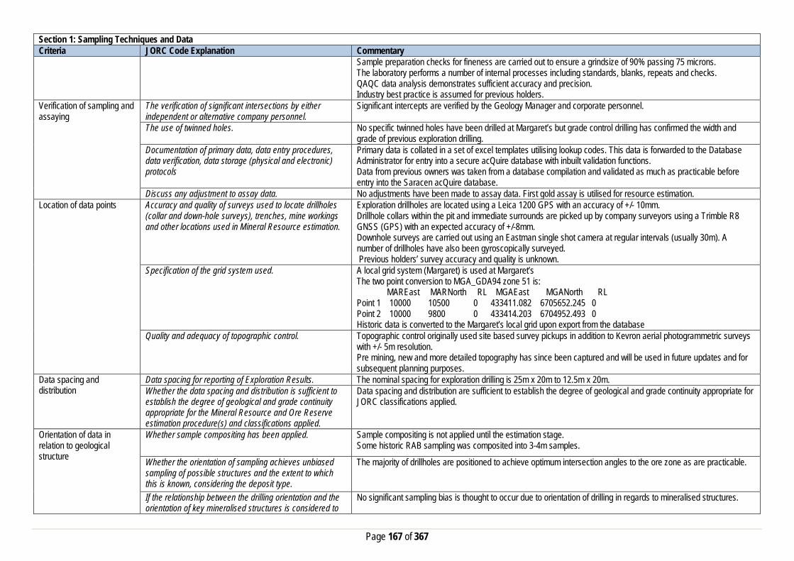
Page 167 of 367
Section 1: Sampling Techniques and Data Criteria JORC Code Explanation Commentary
Sample preparation checks for fineness are carried out to ensure a grindsize of 90% passing 75 microns. The laboratory performs a number of internal processes including standards, blanks, repeats and checks. QAQC data analysis demonstrates sufficient accuracy and precision. Industry best practice is assumed for previous holders.
Verification of sampling and assaying
The verification of significant intersections by either independent or alternative company personnel.
Significant intercepts are verified by the Geology Manager and corporate personnel.
The use of twinned holes. No specific twinned holes have been drilled at Margaret’s but grade control drilling has confirmed the width and grade of previous exploration drilling.
Documentation of primary data, data entry procedures, data verification, data storage (physical and electronic) protocols
Primary data is collated in a set of excel templates utilising lookup codes. This data is forwarded to the Database Administrator for entry into a secure acQuire database with inbuilt validation functions. Data from previous owners was taken from a database compilation and validated as much as practicable before entry into the Saracen acQuire database.
Discuss any adjustment to assay data. No adjustments have been made to assay data. First gold assay is utilised for resource estimation. Location of data points Accuracy and quality of surveys used to locate drillholes
(collar and down-hole surveys), trenches, mine workings and other locations used in Mineral Resource estimation.
Exploration drillholes are located using a Leica 1200 GPS with an accuracy of +/- 10mm. Drillhole collars within the pit and immediate surrounds are picked up by company surveyors using a Trimble R8 GNSS (GPS) with an expected accuracy of +/-8mm. Downhole surveys are carried out using an Eastman single shot camera at regular intervals (usually 30m). A number of drillholes have also been gyroscopically surveyed. Previous holders’ survey accuracy and quality is unknown.
Specification of the grid system used. A local grid system (Margaret) is used at Margaret’s The two point conversion to MGA_GDA94 zone 51 is: MAREast MARNorth RL MGAEast MGANorth RL Point 1 10000 10500 0 433411.082 6705652.245 0 Point 2 10000 9800 0 433414.203 6704952.493 0 Historic data is converted to the Margaret’s local grid upon export from the database
Quality and adequacy of topographic control. Topographic control originally used site based survey pickups in addition to Kevron aerial photogrammetric surveys with +/- 5m resolution. Pre mining, new and more detailed topography has since been captured and will be used in future updates and for subsequent planning purposes.
Data spacing and distribution
Data spacing for reporting of Exploration Results. The nominal spacing for exploration drilling is 25m x 20m to 12.5m x 20m. Whether the data spacing and distribution is sufficient to establish the degree of geological and grade continuity appropriate for the Mineral Resource and Ore Reserve estimation procedure(s) and classifications applied.
Data spacing and distribution are sufficient to establish the degree of geological and grade continuity appropriate for JORC classifications applied.
Orientation of data in relation to geological structure
Whether sample compositing has been applied. Sample compositing is not applied until the estimation stage. Some historic RAB sampling was composited into 3-4m samples.
Whether the orientation of sampling achieves unbiased sampling of possible structures and the extent to which this is known, considering the deposit type.
The majority of drillholes are positioned to achieve optimum intersection angles to the ore zone as are practicable.
If the relationship between the drilling orientation and the orientation of key mineralised structures is considered to
No significant sampling bias is thought to occur due to orientation of drilling in regards to mineralised structures.

Page 168 of 367
Section 1: Sampling Techniques and Data Criteria JORC Code Explanation Commentary
have introduced a sampling bias, this should be assessed and reported if material.
Sample security The measures taken to ensure sample security. Samples are prepared on site under supervision of Saracen geological staff. Samples are selected, bagged into tied numbered calico bags then grouped into secured cages and collected by the laboratory personnel. Sample submissions are documented via laboratory tracking systems and assays are returned via email
Audits or reviews The results of any audits or reviews of sampling techniques and data.
An internal review of companywide sampling methodologies was conducted to create the current sampling and QAQC procedures.
Section 2: Reporting of Exploration Results Criteria JORC Code Explanation Commentary Mineral tenement and land tenure status
Type, reference name/number, location and ownership including agreements or material issues with third parties such as joint ventures, partnerships, overriding royalties, native title interests, historical sites, wilderness or national park and environmental settings.
The Margaret’s pit and near mine exploration is located on M31/30. The tenement is held 100% by Saracen Gold Mines Pty Ltd, a wholly owned subsidiary of Saracen Mineral Holdings Limited. Mining Lease M31/30 has a 21 year life (held until 2028) and is renewable for a further 21 years on a continuing basis. Mining Lease M31/30 is subject to one caveat (58H/067) and a bank mortgage (415495). All production is subject to a Western Australian state government NSR royalty of 2.5%. Mining Lease M31/30 is subject to the Edjudina Pastoral Compensation Agreement. There are no registered Aboriginal Heritage sites within the mining tenement.
The security of the tenure held at the time of reporting along with any known impediments to obtaining a licence to operate in the area.
The tenement is in good standing and the licence to operate already exists.
Exploration done by other parties
Acknowledgment and appraisal of exploration by other parties.
Minor gold mining activities took place in the vicinity of Margaret’s in the 1930’s. In the early 1980s Amoco Resources carried out percussion drilling and an IP survey at the Margaret prospect before Cyprus acquired the ground and completed diamond tails on a number of the holes. Various drilling programs were completed by in the area companies including Southern Ventures, Enterprise Gold and Consolidated Resources and an open-pittable resource was delineated at Margaret’s. Consolidated were taken over by Mount Edon who completed further RAB and RC programs and were then taken over by Pacmin. Sons Of Gwalia acquired the project and completed resource definition RC drilling before their collapse and takeover of the project by St Barbara. Saracen acquired the project and carried out further resource definition RC drilling before mining part of the deposit as a two stage open pit in 2012
Geology Deposit type, geological setting and style of mineralisation.
Margaret’s is a structurally controlled deposit hosted within deformed andesites. Gold mineralisation is considered to be associated with haematitic alteration and intensity and quartz veining. The best mineralisation is postulated to occur at the intersection of strongly deformed andesites occurring within N-S trending shear/fault zones which dip steeply to the east and a series of quartz stockwork vein arrays trending NNW (325 to 340 deg) which dip steeply to the west. This mineralised system forms pipe-like bodies, which plunge gently to the south. Mineralisation also occurs within the steeply dipping quartz stockwork vein arrays that trend NNW.
Drillhole information A summary of all information material to the understanding of the exploration results including a tabulation of the following information for all Material drill holes:
• easting and northing of the drill hole collar • elevation or RL (Reduced Level – elevation
All material data in relation to this deposit was periodically released on the ASX. Future drill hole data will be periodically released or when a results materially change the economic value of the project. Exclusion of the drilling information will not detract from the reader’s view of the report.

Page 169 of 367
Section 2: Reporting of Exploration Results Criteria JORC Code Explanation Commentary
• above sea level in metres) of the drill hole collar • dip and azimuth of the hole • down hole length and interception depth • hole length. • If the exclusion of this information is justified on the
basis that the information is not Material and this exclusion does not detract from the understanding of the report, the Competent Person should clearly explain why this is the case.
Data aggregation methods In reporting Exploration Results, weighting averaging techniques, maximum and/or minimum grade truncations (e.g. cutting of high grades) and cut-off grades are usually Material and should be stated.
All significant intercepts have been length weighted with a minimum Au grade of 1ppm. No high grade cut off has been applied.
Where aggregate intercepts incorporate short lengths of high grade results and longer lengths of low grade results, the procedure used for such aggregation should be stated and some typical examples of such aggregations should be shown in detail.
Intercepts are aggregated with minimum width of 1m and maximum width of 3m for internal dilution. Where stand out higher grade zone exist with in the broader mineralised zone, the higher grade interval is reported also.
The assumptions used for any reporting of metal equivalent values should be clearly stated.
Metal equivalent values are not reported
Relationship between mineralisation widths and intercept lengths
These relationships are particularly important in the reporting of Exploration Results. If the geometry of the mineralisation with respect to the drill hole angle is known, its nature should be reported. If it is not known and only the down hole lengths are reported, there should be a clear statement to this effect (eg ‘down hole length, true width not known’).
Previous announcement included sufficient detail to clearly illustrate the geometry of the mineralisation and the drilling. All results are reported as downhole lengths
Diagrams Appropriate maps and sections (with scales) and tabulations of intercepts should be included for any significant discovery being reported These should include, but not be limited to a plan view of drill hole collar locations and appropriate sectional views.
All significant exploration results released by Saracen are accompanied by the appropriate diagrams and maps at the time of the release.
Balanced Reporting Where comprehensive reporting of all Exploration Results are not practicable, representative reporting of both low and high grades and/or widths should be practiced to avoid misleading reporting of Exploration Results.
All results from the recent campaign have been reported, irrespective of success or not.
Other substantive exploration data
Other exploration data, if meaningful and material,should be reported including (but not limited to): geological observations; geophysical survey results geochemical survey results; bulk samples – size and method of treatment; metallurgical test results; bulk density,
No substantive data acquisition has been completed in recent times.

Page 170 of 367
Section 2: Reporting of Exploration Results Criteria JORC Code Explanation Commentary
groundwater, geotechnical and rock characteristics; potential deleterious or contaminating substances.
Further work The nature and scale of planned further work (eg tests for lateral extensions or depth extensions or large-scale step-out drilling). Diagrams clearly highlighting the areas of possible extensions, including the main geological interpretations and future drilling areas, provided this information is not commercially sensitive
At this time the Margaret Deposit is under review.
Section 3: Estimation and Reporting of Mineral Resources Criteria JORC Code Explanation Commentary Database Integrity Measures taken to ensure that data has not been
corrupted by, for example, transcription or keying errors, between its initial collection and its use for Mineral Resource estimation purposes.
Saracen utilises AcQuire software on an SQL server database to securely store and manage all drillhole and sample information. Data integrity protocols are built into the system to ensure data validity and minimise errors.
Data validation procedures used. Data that is captured in the field is entered into Excel templates which are checked on import into the database for errors. Assay jobs are dispatched electronically to the lab to minimise the chance of data entry errors. Assay results from the lab are received in CSV format and are checked for errors on import into the database. Data is regularly validated using the mining software. The data validation process is overseen by the Database Administrator.
Site Visits Comment on any site visits undertaken by the Competent Person and the outcome of those visits.
At the time of mining activities in 2011/2012 the Competent Persons visited the geological area frequently to assess geological competency and ensure integrity across all geological disciplines.
If no site visits have been undertaken indicate why this is the case.
Geological Interpretation Confidence in (or conversely, the uncertainty of) the geological interpretation of the mineral deposit.
A combination of exploration mapping, geophysical surveys, both exploration and grade control drill hole information and geological data, including mapping, collected during production at Margaret’s has resulted in a confident geological interpretation.
Nature of the data used and any assumptions made. The interpretations have been constructed using all available geological logging descriptions including but not limited to, stratigraphy, lithology, texture, and alteration. It is identified that hematite and strong quartz veining is related to Au mineralisation and it is a structurally controlled environment. All the available exploration and grade control data with results returned by the end of May 2012 were used in the delineation of the Margaret domains. The latter stages of grade control drilling were therefore not incorporated into the model. Due to the difference in scales of the drill spacing only the exploration data (minus the RAB holes) were used in the estimation of the Margaret 2012 Resource. The most current and ore defining exploration drilling was all drilled and orientated according to the known geological environment. These were consistently at -60 degrees toward the west which for the majority of the primary structures is perpendicular (or close to) to actual width and strike of the ore (N-S dipping east). However the west dipping vein sets that intersect the main shear were poorly defined by this drilling, and thus it was difficult to determine the actual geometry of these from drilling. Where major structures were known to be orientated more NW (Marg_30 and 31) the drilling was optimally reorientated. Only a low grade subsidiary hangingwall structure to the
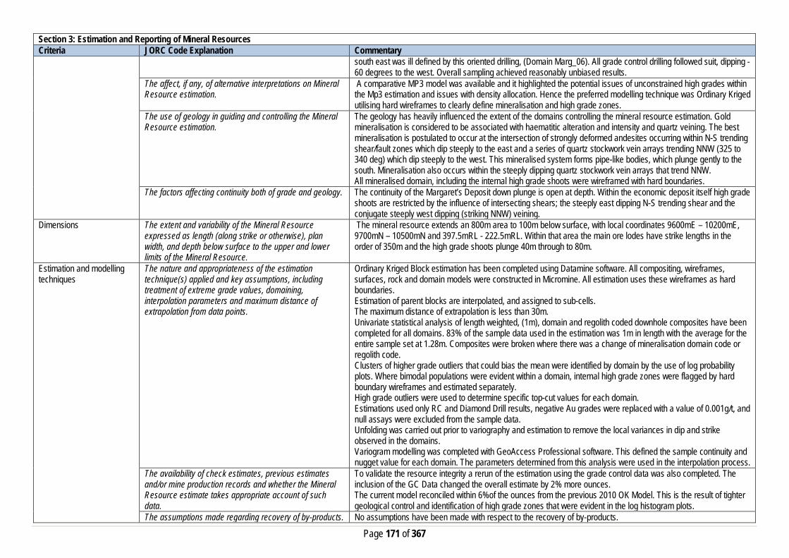
Page 171 of 367
Section 3: Estimation and Reporting of Mineral Resources Criteria JORC Code Explanation Commentary
south east was ill defined by this oriented drilling, (Domain Marg_06). All grade control drilling followed suit, dipping -60 degrees to the west. Overall sampling achieved reasonably unbiased results.
The affect, if any, of alternative interpretations on Mineral Resource estimation.
A comparative MP3 model was available and it highlighted the potential issues of unconstrained high grades within the Mp3 estimation and issues with density allocation. Hence the preferred modelling technique was Ordinary Kriged utilising hard wireframes to clearly define mineralisation and high grade zones.
The use of geology in guiding and controlling the Mineral Resource estimation.
The geology has heavily influenced the extent of the domains controlling the mineral resource estimation. Gold mineralisation is considered to be associated with haematitic alteration and intensity and quartz veining. The best mineralisation is postulated to occur at the intersection of strongly deformed andesites occurring within N-S trending shear/fault zones which dip steeply to the east and a series of quartz stockwork vein arrays trending NNW (325 to 340 deg) which dip steeply to the west. This mineralised system forms pipe-like bodies, which plunge gently to the south. Mineralisation also occurs within the steeply dipping quartz stockwork vein arrays that trend NNW. All mineralised domain, including the internal high grade shoots were wireframed with hard boundaries.
The factors affecting continuity both of grade and geology. The continuity of the Margaret’s Deposit down plunge is open at depth. Within the economic deposit itself high grade shoots are restricted by the influence of intersecting shears; the steeply east dipping N-S trending shear and the conjugate steeply west dipping (striking NNW) veining.
Dimensions The extent and variability of the Mineral Resource expressed as length (along strike or otherwise), plan width, and depth below surface to the upper and lower limits of the Mineral Resource.
The mineral resource extends an 800m area to 100m below surface, with local coordinates 9600mE – 10200mE, 9700mN – 10500mN and 397.5mRL - 222.5mRL. Within that area the main ore lodes have strike lengths in the order of 350m and the high grade shoots plunge 40m through to 80m.
Estimation and modelling techniques
The nature and appropriateness of the estimation technique(s) applied and key assumptions, including treatment of extreme grade values, domaining, interpolation parameters and maximum distance of extrapolation from data points.
Ordinary Kriged Block estimation has been completed using Datamine software. All compositing, wireframes, surfaces, rock and domain models were constructed in Micromine. All estimation uses these wireframes as hard boundaries. Estimation of parent blocks are interpolated, and assigned to sub-cells. The maximum distance of extrapolation is less than 30m. Univariate statistical analysis of length weighted, (1m), domain and regolith coded downhole composites have been completed for all domains. 83% of the sample data used in the estimation was 1m in length with the average for the entire sample set at 1.28m. Composites were broken where there was a change of mineralisation domain code or regolith code. Clusters of higher grade outliers that could bias the mean were identified by domain by the use of log probability plots. Where bimodal populations were evident within a domain, internal high grade zones were flagged by hard boundary wireframes and estimated separately. High grade outliers were used to determine specific top-cut values for each domain. Estimations used only RC and Diamond Drill results, negative Au grades were replaced with a value of 0.001g/t, and null assays were excluded from the sample data. Unfolding was carried out prior to variography and estimation to remove the local variances in dip and strike observed in the domains. Variogram modelling was completed with GeoAccess Professional software. This defined the sample continuity and nugget value for each domain. The parameters determined from this analysis were used in the interpolation process.
The availability of check estimates, previous estimates and/or mine production records and whether the Mineral Resource estimate takes appropriate account of such data.
To validate the resource integrity a rerun of the estimation using the grade control data was also completed. The inclusion of the GC Data changed the overall estimate by 2% more ounces. The current model reconciled within 6%of the ounces from the previous 2010 OK Model. This is the result of tighter geological control and identification of high grade zones that were evident in the log histogram plots.
The assumptions made regarding recovery of by-products. No assumptions have been made with respect to the recovery of by-products.

Page 172 of 367
Section 3: Estimation and Reporting of Mineral Resources Criteria JORC Code Explanation Commentary
Estimation of deleterious elements or other non-grade variables of economic significance (e.g. sulfur for acid mine drainage characterisation).
There has been no estimate at this point of deleterious elements. Saracen is unaware if any elements other than gold have been assayed.
In the case of block model interpolation, the block size in relation to the average sample spacing and the search employed.
The parent block sizes for the resource model are X (5m) by Y (10m) by Z (5m). These were deemed appropriate for the majority of the resource, where drill spacing is in the order of 25m x 20m to 12.5m x 20m. Parent blocks have been sub-celled to X (1.0m) by Y (1.0m) by Z (1.0m) to ensure that the wireframe boundaries were honoured and preserved the location and shape of the mineralisation. Search ranges have been informed by variogram modelling and knowledge of the drill spacing and the known mineralisation geometry including direction of maximum continuity. Three search estimation runs are used with the aim to satisfy the minimum sample criteria in the first search range where possible.
Any assumptions behind modelling of selective mining units.
No selective mining units have been assumed.
Any assumptions about correlation between variables. No assumptions have been made regarding correlation between variables. Description of how the geological interpretation was used to control the resource estimates.
The geological interpretation is defined by the mineralised domains and clearly delineates the structurally controlled high grade shoots. Definition of these shoots with hard wireframes helped to confine the spread of high grades in the estimation. Previous estimates had not considered this. Hard wireframes were used to define all the mineralised domains.
Discussion of basis for using or not using grade cutting or capping.
Linear interpolation methods such as Ordinary Kriging are sensitive to the presence of high-grade outliers that positively skew the data and bias the mean. Domain histogram and Log probability plots were used to determine appropriate top cuts.
The process of validation, the checking process used, the comparison of model data to drill hole data, and use of reconciliation data if available.
Several key model validation steps have been taken to validate the resource estimate. The mineral resource model has been stepped through visually in sectional and plan view to appreciate the composite grades used in the estimate and the resultant block grades. Easting, Northing and Elevation swathe plots have been constructed to evaluate the composited assay means versus the mean block estimates. The mineral resource model has been constructed to include kriging efficiency and the slope of regression values. These values are used to measure the quality of the estimate. Natural deterioration of the quality is observed in areas where data density is lower. This model was reconciled against the previous OK model, Mp3 model used in production and another run of the model was completed including the gc data to test its validity. The results of these were discussed in the “The availability of check estimates, previous estimates and/or mine production records and whether the Mineral Resource estimate takes appropriate account of such data” section above.
Moisture Whether the tonnages are estimated on a dry basis or with natural moisture, and the method of determination of the moisture content.
All tonnages are estimated on a dry basis.
Cut-off parameters The basis of the adopted cut-off grade(s) or quality parameters applied.
Based on Saracen’s current economic status the natural grade distinction above background for the Margarets deposit was at a grade of 0.4g/t.
Mining factors or assumptions
Assumptions made regarding possible mining methods, minimum mining dimensions and internal (or, if applicable, external) mining dilution. It is always necessary as part of the process of determining reasonable prospects for eventual economic extraction to consider potential mining
The Margaret’s deposit was mined by open pit in 2011/2012. Underground methods have not been considered for this deposit at this stage.

Page 173 of 367
Section 3: Estimation and Reporting of Mineral Resources Criteria JORC Code Explanation Commentary
methods, but the assumptions made regarding mining methods and parameters when estimating Mineral Resources may not always be rigorous. Where this is the case, this should be reported with an explanation of the basis of the mining assumptions made.
There are reasonable grounds to assume that in the future the remaining resource at this deposit will be mined by conventional open pit methods given the close proximity to surface and the mean average grade of the mineralisation.
Metallurgical factors or assumptions
The basis for assumptions or predictions regarding metallurgical amenability. It is always necessary as part of the process of determining reasonable prospects for eventual economic extraction to consider potential metallurgical methods, but the assumptions regarding metallurgical treatment process and parameters made when reporting Mineral Resources may not always be rigorous. Where this is the case, this should be reported with an explanation of the basis of the metallurgical assumptions made.
Given Margaret’s close proximity and similar geology to Enterprise, the same metallurgical characteristics were assumed. Metallurgical testing (and processing operations at CDO) identified the ores as being free milling at coarse grind sizes with leach recoveries in excess of 90% with a high gravity gold component.
Environmental factors or assumptions
Assumptions made regarding possible waste and process residue disposal options. It is always necessary as part of the process of determining reasonable prospects for eventual economic extraction to consider the potential environmental impacts of the mining and processing operation. While at this stage the determination of potential environmental impacts, particularly for a greenfields project, may not always be well advanced, the status of early consideration of these potential environmental impacts should be reported. Where these aspects have not been considered this should be reported with an explanation of the environmental assumptions made.
No processing or beneficiation of ore expected on these tenements, as ore is hauled to Carosue Dam Minesite for Processing. Closure Plan is in place covering the Margaret Mining area and infrastructure. Margaret waste rock can be considered geochemically benign. All rock types are classified as NAF and the quality of seepage from waste rock stockpiles of these materials are alkaline, non saline and have very low concentrations of metals and metalloids
Bulk Density Whether assumed or determined. If assumed, the basis for the assumptions. If determined, the method used, whether wet or dry, the frequency of the measurements, the nature, size and representativeness of the samples.
The density values applied to the Margaret’s Deposit estimation are largely based on historic density measures from drilling and production at Margarets in Stage 1 and Stage 2. The bulk density data was imported into the AcQuire database with the Density method unknown for the historic data.
The bulk density for bulk material must have been measured by methods that adequately account for void spaces (vugs, porosity, etc), moisture and differences between rock and alteration zones within the deposit.
Saracens Metals have standardised procedures for bulk density testing. Most ore zones predominantly exist in transitional to fresh non porous material, however additional measures are taken to reduce moisture intake during the water displacement process if the coating is made of more friable oxides and sediments. This latter method aims to reduce moisture loss or moisture gain during the process and is considered on a deposit by deposit basis.
Discuss assumptions for bulk density estimates used in the evaluation process of the different materials.
Where bulk density measures are taken an average mean of densities collected for each lithological type is uniformly applied to the modelled geological units. This includes the primary fresh lithologies as well as the weathered oxide and transitional zones.
Classification The basis for the classification of the Mineral Resources into varying confidence categories.
The mineral resource has been classified into Measured, Indicated and Inferred categories based on drill hole spacing, geological confidence, and grade continuity and estimation quality. The combination of these factors together guided the hard boundary wireframe used to define the Measured, Indicated and Inferred zones. The

Page 174 of 367
Section 3: Estimation and Reporting of Mineral Resources Criteria JORC Code Explanation Commentary
measured material relates directly to the mined material up until the end of month of April 2012. Outside the Inferred boundary the estimated blocks were flagged with rescat value of 4.
Whether appropriate account has been taken of all the relevant factors (ie relative confidence in tonnage/grade estimations, reliability of input data, confidence in continuity of geology and metal values, quality, quantity and distribution of the data).
All care has been taken to account for relevant factors influencing the mineral resource estimate. The diligent Saracen Metals Resource review process ensures that data reliability and geological and metal confidence and continuity are reflected in the resource classification.
Whether the result appropriately reflects the Competent Person's view of the deposit.
The geological model and the mineral resource estimate reflect the competent person’s view of the deposit.
Audits or reviews The results of any audits or reviews of Mineral Resource estimates.
Saracen has adopted a process for geological modelling, estimation and reporting of mineral resources that meets high industry standards. At the completion of resource estimation Saracen Metals undertake an extensive review of the model that covers;
• Model inventory and comparisons to previous and budget models if in existence • Geological interpretation, wireframing, domain selection, statistics by domain, assay and metal evaluation,
parent cell sizes, data compositing, variography, search strategy, estimation and KNA • Model validation – swathe plots, visual checks, volume comparisons, composite to model metal
comparisons. In the final stages the model and resource categorisation are all discussed and scrutinized by the geological and mine planning teams.
Discussion of relative accuracy/confidence
Where appropriate a statement of the relative accuracy and confidence level in the Mineral Resource estimate using an approach or procedure deemed appropriate by the Competent Person. For example, the application of statistical or geostatistical procedures to quantify the relative accuracy of the resource within stated confidence limits, or, if such an approach is not deemed appropriate, a qualitative discussion of the factors that could affect the relative accuracy and confidence of the estimate.
The mineral resource has been reported in accordance with the guidelines established in the 2012 edition of the JORC code. Saracen Gold Mine uses a standard approach to resource estimation and the procedure requires the systematic completion of the Saracen Resource Estimation Document that is thoroughly investigated and assessed in the Model review process, as stated above. It was identified that; Further work on KNA for block size, minimum and maximum number of samples, search ellipses and declustering of the composite data would help to further improve and validate the current optimisation of the block model.
The statement should specify whether it relates to global or local estimates, and, if local, state the relevant tonnages, which should be relevant to technical and economic evaluation. Documentation should include assumptions made and the procedures used.
The statements relate to a global estimate of tonnes and grade.
These statements of relative accuracy and confidence of the estimate should be compared with production data, where available.
The confidence in the model is reflected by the designation of Resource categories. Given the thorough geological analysis of this area and adequate drilling definition, it is a good estimation of the resource at Margaret’s Deposit. Reconciled numbers between the resource and the production figures indicated the variance was within 10%.
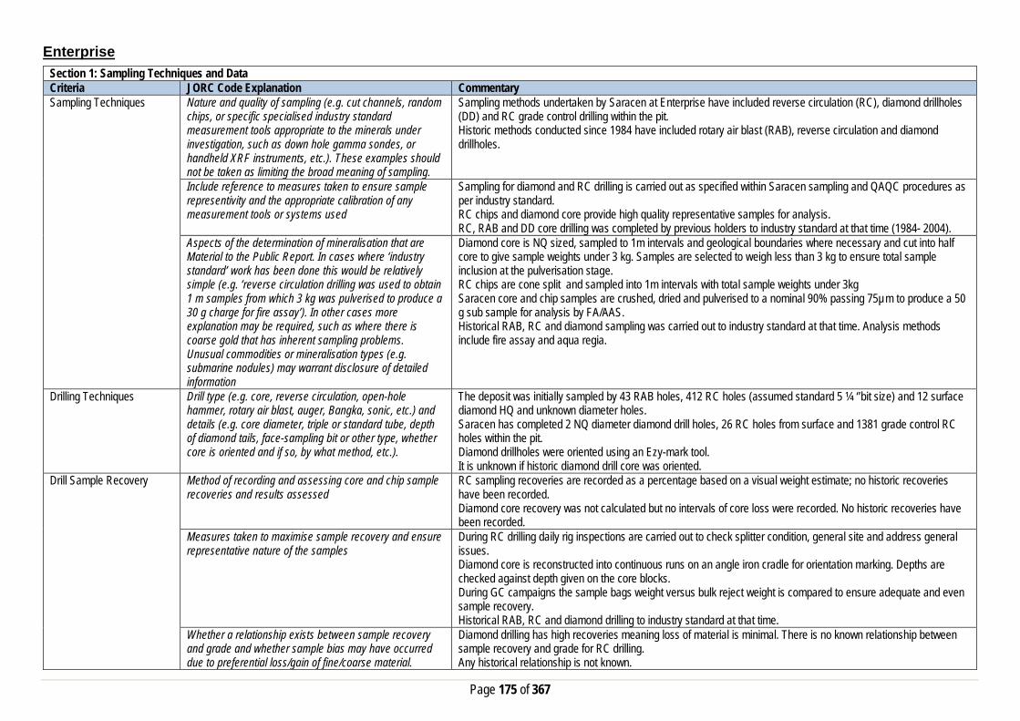
Page 175 of 367
Enterprise Section 1: Sampling Techniques and Data Criteria JORC Code Explanation Commentary Sampling Techniques Nature and quality of sampling (e.g. cut channels, random
chips, or specific specialised industry standard measurement tools appropriate to the minerals under investigation, such as down hole gamma sondes, or handheld XRF instruments, etc.). These examples should not be taken as limiting the broad meaning of sampling.
Sampling methods undertaken by Saracen at Enterprise have included reverse circulation (RC), diamond drillholes (DD) and RC grade control drilling within the pit. Historic methods conducted since 1984 have included rotary air blast (RAB), reverse circulation and diamond drillholes.
Include reference to measures taken to ensure sample representivity and the appropriate calibration of any measurement tools or systems used
Sampling for diamond and RC drilling is carried out as specified within Saracen sampling and QAQC procedures as per industry standard. RC chips and diamond core provide high quality representative samples for analysis. RC, RAB and DD core drilling was completed by previous holders to industry standard at that time (1984- 2004).
Aspects of the determination of mineralisation that are Material to the Public Report. In cases where ‘industry standard’ work has been done this would be relatively simple (e.g. ‘reverse circulation drilling was used to obtain 1 m samples from which 3 kg was pulverised to produce a 30 g charge for fire assay’). In other cases more explanation may be required, such as where there is coarse gold that has inherent sampling problems. Unusual commodities or mineralisation types (e.g. submarine nodules) may warrant disclosure of detailed information
Diamond core is NQ sized, sampled to 1m intervals and geological boundaries where necessary and cut into half core to give sample weights under 3 kg. Samples are selected to weigh less than 3 kg to ensure total sample inclusion at the pulverisation stage. RC chips are cone split and sampled into 1m intervals with total sample weights under 3kg Saracen core and chip samples are crushed, dried and pulverised to a nominal 90% passing 75µm to produce a 50 g sub sample for analysis by FA/AAS. Historical RAB, RC and diamond sampling was carried out to industry standard at that time. Analysis methods include fire assay and aqua regia.
Drilling Techniques Drill type (e.g. core, reverse circulation, open-hole hammer, rotary air blast, auger, Bangka, sonic, etc.) and details (e.g. core diameter, triple or standard tube, depth of diamond tails, face-sampling bit or other type, whether core is oriented and if so, by what method, etc.).
The deposit was initially sampled by 43 RAB holes, 412 RC holes (assumed standard 5 ¼ ‘’bit size) and 12 surface diamond HQ and unknown diameter holes. Saracen has completed 2 NQ diameter diamond drill holes, 26 RC holes from surface and 1381 grade control RC holes within the pit. Diamond drillholes were oriented using an Ezy-mark tool. It is unknown if historic diamond drill core was oriented.
Drill Sample Recovery Method of recording and assessing core and chip sample recoveries and results assessed
RC sampling recoveries are recorded as a percentage based on a visual weight estimate; no historic recoveries have been recorded. Diamond core recovery was not calculated but no intervals of core loss were recorded. No historic recoveries have been recorded.
Measures taken to maximise sample recovery and ensure representative nature of the samples
During RC drilling daily rig inspections are carried out to check splitter condition, general site and address general issues. Diamond core is reconstructed into continuous runs on an angle iron cradle for orientation marking. Depths are checked against depth given on the core blocks. During GC campaigns the sample bags weight versus bulk reject weight is compared to ensure adequate and even sample recovery. Historical RAB, RC and diamond drilling to industry standard at that time.
Whether a relationship exists between sample recovery and grade and whether sample bias may have occurred due to preferential loss/gain of fine/coarse material.
Diamond drilling has high recoveries meaning loss of material is minimal. There is no known relationship between sample recovery and grade for RC drilling. Any historical relationship is not known.

Page 176 of 367
Section 1: Sampling Techniques and Data Criteria JORC Code Explanation Commentary Logging Whether core and chip samples have been geologically
and geotechnically logged to a level of detail to support appropriate Mineral Resource estimation, mining studies and metallurgical studies. Whether logging is qualitative or quantitative in nature. Core (or costean, channel, etc) photography.
Logging of diamond drill core and RC chips records lithology, mineralogy, texture, mineralisation, weathering, alteration, veining and other features. Structural logging was carried out on all diamond holes to record defect number, type, fill material, shape and roughness and alpha and beta angles. Chips from all RC holes (exploration and GC) are stored in chip trays for future reference. Core is photographed in both dry and wet state. Qualitative and quantitative logging of historic data varies in its completeness.
The total length and percentage of the relevant intersections logged
All diamond drillholes and exploration RC holes are logged in full. Every second drill line is logged in grade control programs with infill logging carried out as necessary. Historical logging is complete.
Sub-sampling techniques and sample preparation
If core, whether cut or sawn and whether quarter, half or all core taken.
All drill core is cut in half onsite using an automatic core saw. Samples are always collected from the same side. Historic drillcore has been half or quarter core sampled.
If non-core, whether riffled, tube sampled, rotary split, etc and whether sampled wet or dry.
All exploration and GC RC samples are cone split. Occasional wet samples are encountered; increased air capacity is routinely used to aid in keeping the sample dry when water is encountered. Historic RAB and RC drilling was sampled using grab, riffle and unknown methods.
For all sample types, the nature, quality and appropriateness of the sample preparation technique.
The sample preparation of diamond core and RC chips adhere to industry best practice. It is conducted by a commercial laboratory and involves oven drying, coarse crushing then total grinding to a size of 90% passing 75 microns. Best practice is assumed at the time of historic sampling.
Quality control procedures adopted for all sub-sampling stages to maximise representivity of samples.
All subsampling activities are carried out by commercial laboratory and are considered to be satisfactory. Sampling by previous holders assumed to be industry standard at the time.
Measures taken to ensure that the sampling is representative of the in situ material collected, including for instance results for field duplicate/second half sampling.
Duplicate sampling is carried out at a rate of 1:10 for exploration drilling and 1:20 for GC drilling and is sampled directly from the on-board splitter on the rig. These are submitted for the same assay process as the original samples and the laboratory are unaware of such submissions. Sampling by previous holders assumed to be industry standard at the time.
Whether sample sizes are appropriate to the grain size of the material being sampled.
Sample sizes are considered to be appropriate.
Quality of assay data and laboratory tests
The nature, quality and appropriateness of the assaying and laboratory procedures used and whether the technique is considered partial or total.
RC chip samples, grade control chip samples and diamond core are analysed by external laboratories using a 50g fire assay with AAS finish. This method is considered suitable for determining gold concentrations in rock and is a total digest method. Historic sampling methods include fire assay and aqua regia.
For geophysical tools, spectrometers, handheld XRF instruments, etc, the parameters used in determining the analysis including instrument make and model, reading times, calibrations factors applied and their derivation, etc.
No geophysical tools have been utilised for reporting gold mineralisation.
Nature of quality control procedures adopted (e.g. standards, blanks, duplicates, external laboratory checks) and whether acceptable levels of accuracy (i.e. lack of bias) and precision have been established.
Certified reference material (standards and blanks) with a wide range of values are inserted into every drillhole at a rate of 1:25 for exploration RC and DD, and 1:40 for GC drilling. These are not identifiable to the laboratory. QAQC data returned are checked against pass/fail limits with the SQL database and are passed or failed on import. A report is generated and reviewed by the geologist as necessary upon failure to determine further action. QAQC data is reported monthly. Sample preparation checks for fineness are carried out to ensure a grindsize of 90% passing 75 microns. The laboratory performs a number of internal processes including standards, blanks, repeats and checks.

Page 177 of 367
Section 1: Sampling Techniques and Data Criteria JORC Code Explanation Commentary
QAQC data analysis demonstrates sufficient accuracy and precision. Industry best practice is assumed for previous holders.
Verification of sampling and assaying
The verification of significant intersections by either independent or alternative company personnel.
Significant intercepts are verified by the Geology Manager and corporate personnel.
The use of twinned holes. No specific twinned holes have been drilled at Enterprise but grade control drilling has confirmed the width and grade of previous exploration drilling.
Documentation of primary data, data entry procedures, data verification, data storage (physical and electronic) protocols
Primary data is collated in a set of excel templates utilising lookup codes. This data is forwarded to the Database Administrator for entry into a secure acQuire database with inbuilt validation functions. Data from previous owners was taken from a database compilation and validated as much as practicable before entry into the Saracen acQuire database.
Discuss any adjustment to assay data. No adjustments have been made to assay data. First gold assay is utilised for resource estimation. Location of data points Accuracy and quality of surveys used to locate drillholes
(collar and down-hole surveys), trenches, mine workings and other locations used in Mineral Resource estimation.
Exploration drillholes are located using a Leica 1200 GPS with an accuracy of +/- 10mm. Drillhole collars within the pit and immediate surrounds are picked up by company surveyors using a Trimble R8 GNSS (GPS) with an expected accuracy of +/-8mm. Downhole surveys are carried out using an Eastman single shot camera at regular intervals (usually 30m). A number of drillholes have also been gyroscopically surveyed. Previous holders’ survey accuracy and quality is unknown.
Specification of the grid system used. A local grid system (Enterprise) is used at Enterprise The two point conversion to MGA_GDA94 zone 51 is: ENTEast ENTNorth RL MGAEast MGANorth RL Point 1 1000 6500 0 433626.73 6706103.13 0 Point 2 1000 5400 0 433820.92 6705020.86 0 Historic data is converted to the Enterprise local grid upon export from the database
Quality and adequacy of topographic control. Topographic control originally used site based survey pickups in addition to Kevron aerial photogrammetric surveys with +/- 5m resolution. Pre mining, new and more detailed topography has since been captured and will be used in future updates and for subsequent planning purposes.
Data spacing and distribution
Data spacing for reporting of Exploration Results. The nominal spacing for exploration drilling is 25m x 20m to 12.5m x 20m. Whether the data spacing and distribution is sufficient to establish the degree of geological and grade continuity appropriate for the Mineral Resource and Ore Reserve estimation procedure(s) and classifications applied.
Data spacing and distribution are sufficient to establish the degree of geological and grade continuity appropriate for JORC classifications applied.
Orientation of data in relation to geological structure
Whether sample compositing has been applied.
Sample compositing is not applied until the estimation stage. Some historic RAB sampling was composited into 3-4m samples.
Whether the orientation of sampling achieves unbiased sampling of possible structures and the extent to which this is known, considering the deposit type.
The majority of drillholes are positioned to achieve optimum intersection angles to the ore zone as are practicable.
If the relationship between the drilling orientation and the orientation of key mineralised structures is considered to have introduced a sampling bias, this should be assessed and reported if material.
No significant sampling bias is thought to occur due to orientation of drilling in regards to mineralised structures.

Page 178 of 367
Section 1: Sampling Techniques and Data Criteria JORC Code Explanation Commentary Sample security The measures taken to ensure sample security. Samples are prepared on site under supervision of Saracen geological staff. Samples are selected, bagged into tied
numbered calico bags then grouped into secured cages and collected by the laboratory personnel. Sample submissions are documented via laboratory tracking systems and assays are returned via email
Audits or reviews The results of any audits or reviews of sampling techniques and data.
An internal review of companywide sampling methodologies was conducted to create the current sampling and QAQC procedures.
Section 2: Reporting of Exploration Results Criteria JORC Code Explanation Commentary Mineral tenement and land tenure status
Type, reference name/number, location and ownership including agreements or material issues with third parties such as joint ventures, partnerships, overriding royalties, native title interests, historical sites, wilderness or national park and environmental settings.
The Enterprise pit and near mine exploration are located on M31/380, M31/381 and M31/30. The tenements are held 100% by Saracen Gold Mines Pty Ltd, a wholly owned subsidiary of Saracen Mineral Holdings Limited. Mining Leases M31/380, M31/381 and M31/30 have a 21 year life (held until 2028) and are renewable for a further 21 years on a continuing basis. Mining Lease M31/380, M31/381 and M31/30 are each subject to two royalty agreements and one caveat (303500, 303501 and 58H/067, respectively). All are subject to a bank mortgage (415495). All production is subject to a Western Australian state government NSR royalty of 2.5%. Mining Leases M31/380, M31/381 and M31/30 are subject to the Edjudina Pastoral Compensation Agreement. There are no registered Aboriginal Heritage sites within the mining tenements.
The security of the tenure held at the time of reporting along with any known impediments to obtaining a licence to operate in the area.
The tenements are in good standing and the licence to operate already exists.
Exploration done by other parties
Acknowledgment and appraisal of exploration by other parties.
Minor gold mining activities took place in the vicinity of Enterprise in the 1930’s. Edjudina Gold Mines undertook an exploration program in the area in 1985 following the reopening of the nearby Porphyry mine and development of Million Dollar, including geochemistry, magnetic surveys and RC drilling to calculate a small resource. Enterprise Gold carried out RC drilling in the area before entering into a joint venture with Consolidated Resources. A RAB, RC and DD campaign carried out in 1994 and 1995 delineated the resource. Consolidated were taken over by Mount Edon who completed further RAB and RC programs, and were then taken over by Pacmin. Sons Of Gwalia acquired the project and completed resource definition RC drilling before their collapse and takeover of the project by St Barbara.
Geology Deposit type, geological setting and style of mineralisation.
The best mineralisation is postulated to occur at the intersection of strongly deformed andesites occurring within N-S trending shear/fault zones which dip steeply to the east and a series of quartz stockwork vein arrays trending NNW (330 to 340 deg) which dip steeply to the west. This mineralised system forms pipe-like bodies, which plunge gently to the south. Based on this geological understanding the initial stages of interpretation assumed positions of repetitious structures that structurally displaced the lodes.
Drillhole information A summary of all information material to the understanding of the exploration results including a tabulation of the following information for all Material drill holes:
• easting and northing of the drill hole collar • elevation or RL (Reduced Level – elevation • above sea level in metres) of the drill hole collar • dip and azimuth of the hole
A total of 185 exploration holes have been used in the mineral resource and are deemed to be material. The results of this data have been reported in prior ASX releases. Future drill hole data will be periodically released or when a results materially change the economic value of the project. Exclusion of the drilling information will not detract from the reader’s view of the report.

Page 179 of 367
Section 2: Reporting of Exploration Results Criteria JORC Code Explanation Commentary
• down hole length and interception depth • hole length. • If the exclusion of this information is justified on the
basis that the information is not Material and this exclusion does not detract from the understanding of the report, the Competent Person should clearly explain why this is the case.
Data aggregation methods In reporting Exploration Results, weighting averaging techniques, maximum and/or minimum grade truncations (e.g. cutting of high grades) and cut-off grades are usually Material and should be stated.
All significant intercepts have been length weighted with a minimum Au grade of 1ppm. No high grade cut off has been applied.
Where aggregate intercepts incorporate short lengths of high grade results and longer lengths of low grade results, the procedure used for such aggregation should be stated and some typical examples of such aggregations should be shown in detail.
Intercepts are aggregated with minimum width of 1m and maximum width of 3m for internal dilution. Where stand out higher grade zone exist with in the broader mineralised zone, the higher grade interval is reported also.
The assumptions used for any reporting of metal equivalent values should be clearly stated.
Metal equivalent values are not reported
Relationship between mineralisation widths and intercept lengths
These relationships are particularly important in the reporting of Exploration Results. If the geometry of the mineralisation with respect to the drill hole angle is known, its nature should be reported. If it is not known and only the down hole lengths are reported, there should be a clear statement to this effect (eg ‘down hole length, true width not known’).
Previous announcements include sufficient detail to clearly illustrate the geometry of the mineralisation and the drilling. All results are reported as downhole lengths.
Diagrams Appropriate maps and sections (with scales) and tabulations of intercepts should be included for any significant discovery being reported These should include, but not be limited to a plan view of drill hole collar locations and appropriate sectional views.
All significant exploration results released by Saracen are accompanied by the appropriate diagrams and maps at the time of the release.
Balanced Reporting Where comprehensive reporting of all Exploration Results are not practicable, representative reporting of both low and high grades and/or widths should be practiced to avoid misleading reporting of Exploration Results.
All results from the recent campaign have been reported, irrespective of success or not.
Other substantive exploration data
Other exploration data, if meaningful and material,should be reported including (but not limited to): geological observations; geophysical survey results, geochemical survey results; bulk samples – size and method of treatment; metallurgical test results; bulk density, groundwater, geotechnical and rock characteristics; potential deleterious or contaminating substances.
No substantive data acquisition has been completed in recent times

Page 180 of 367
Section 2: Reporting of Exploration Results Criteria JORC Code Explanation Commentary Further work The nature and scale of planned further work (eg tests for
lateral extensions or depth extensions or large-scale step-out drilling). Diagrams clearly highlighting the areas of possible extensions, including the main geological interpretations and future drilling areas, provided this information is not commercially sensitive
Further exploration work at Enterprise is currently under review. Economic constraints determine the priority given to this area.
Section 3: Estimation and Reporting of Mineral Resources Criteria JORC Code Explanation Commentary Database Integrity Measures taken to ensure that data has not been
corrupted by, for example, transcription or keying errors, between its initial collection and its use for Mineral Resource estimation purposes.
Saracen utilises AcQuire software on an SQL server database to securely store and manage all drillhole and sample information. Data integrity protocols are built into the system to ensure data validity and minimise errors.
Data validation procedures used. Data that is captured in the field is entered into Excel templates which are checked on import into the database for errors. Assay jobs are dispatched electronically to the lab to minimise the chance of data entry errors. Assay results from the lab are received in CSV format and are checked for errors on import into the database. Data is regularly validated using the mining software. The data validation process is overseen by the Database Administrator.
Site Visits Comment on any site visits undertaken by the Competent Person and the outcome of those visits.
At the time of mining activities in 2011/2012 the Competent Persons visited the geological area frequently to assess geological competency and ensure integrity across all geological disciplines.
If no site visits have been undertaken indicate why this is the case.
Geological Interpretation Confidence in (or conversely, the uncertainty of) the geological interpretation of the mineral deposit.
A combination of both exploration and grade control drill hole information and geological data, including mapping, collected during production at Enterprise has resulted in a confident geological interpretation, in particular the structures that control the extent of lodes within broader domains.
Nature of the data used and any assumptions made. The interpretations have been constructed using all available geological logging descriptions including but not limited to, stratigraphy, lithology, texture, and alteration. It is identified that haematitic alteration and intensity along with strong quartz veining relates well to gold grade. The best mineralisation is postulated to occur at the intersection of strongly deformed andesites occurring within N-S trending shear/fault zones which dip steeply to the east and a series of quartz stockwork vein arrays trending NNW (330 to 340 deg) which dip steeply to the west. This mineralised system forms pipe-like bodies, which plunge gently to the south. Based on this geological understanding the initial stages of interpretation assumed positions of repetitious structures that structurally displaced the lodes. In some parts this interpretation was supported by drill hole information (alteration) and the disjointed position of the lodes perpendicular to the strike. In pit mapping later confirmed the actual number and position of these structures.
The affect, if any, of alternative interpretations on Mineral Resource estimation.
An earlier interpretation of the Enterprise deposit had similar but more simplified plunging domains that were not as structurally controlled as the current interpretation. In pit mapping during production identified the repetition of structures that characterised this interpretation.
The use of geology in guiding and controlling the Mineral Resource estimation.
The geology has heavily influenced the extent of the domains controlling the mineral resource estimation. Gold mineralisation is considered to be associated with haematitic alteration and intensity and quartz veining. The Enterprise mineralisation lies within a synformal, south plunging (25 degree) zone of haematite-carbonate-quartz-
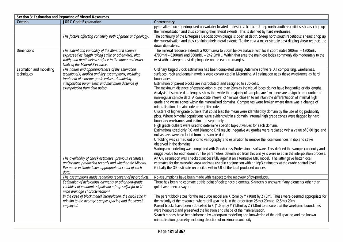
Page 181 of 367
Section 3: Estimation and Reporting of Mineral Resources Criteria JORC Code Explanation Commentary
pyrite alteration superimposed on variably foliated andesitic volcanics. Steep north south repetitious shears chop up the mineralisation and thus confining their lateral extents. This is defined by hard wireframes.
The factors affecting continuity both of grade and geology. The continuity of the Enterprise Deposit down plunge is open at depth. Steep north south repetitious shears chop up the mineralisation and thus confining their lateral extents. To the east a major steeply east dipping shear restricts the down dip extents.
Dimensions The extent and variability of the Mineral Resource expressed as length (along strike or otherwise), plan width, and depth below surface to the upper and lower limits of the Mineral Resource.
The mineral resource extends a 900m area to 200m below surface, with local coordinates 800mE – 1200mE, 4700mN – 6200mN and 380mRL – 242.5mRL. Within that area the main ore lodes commonly dip moderately to the west with a steeper east dipping lode on the eastern margins.
Estimation and modelling techniques
The nature and appropriateness of the estimation technique(s) applied and key assumptions, including treatment of extreme grade values, domaining, interpolation parameters and maximum distance of extrapolation from data points.
Ordinary Kriged Block estimation has been completed using Datamine software. All compositing, wireframes, surfaces, rock and domain models were constructed in Micromine. All estimation uses these wireframes as hard boundaries. Estimation of parent blocks are interpolated, and assigned to sub-cells. The maximum distance of extrapolation is less than 20m as individual lodes do not have long strike or dip lengths. Analysis of sample data lengths show that while the majority of samples are 1m, there are a significant number of non-regular sample data. A composite interval of 1m was chosen to maintain the differentiation of internal high grade and waste zones within the mineralised domains. Composites were broken where there was a change of mineralisation domain code or regolith code. Clusters of higher grade outliers that could bias the mean were identified by domain by the use of log probability plots. Where bimodal populations were evident within a domain, internal high grade zones were flagged by hard boundary wireframes and estimated separately. High grade outliers were used to determine specific top-cut values for each domain. Estimations used only RC and Diamond Drill results, negative Au grades were replaced with a value of 0.001g/t, and null assays were excluded from the sample data. Unfolding was carried out prior to variography and estimation to remove the local variances in dip and strike observed in the domains. Variogram modelling was completed with GeoAccess Professional software. This defined the sample continuity and nugget value for each domain. The parameters determined from this analysis were used in the interpolation process.
The availability of check estimates, previous estimates and/or mine production records and whether the Mineral Resource estimate takes appropriate account of such data.
An OK estimation was checked successfully against an alternative MIK model. The latter gave better local estimates for the mineable area and was used in conjunction with an Mp3 estimates at the grade control level. Globally the OK estimate reconciled within 6% of the total produced ounces.
The assumptions made regarding recovery of by-products. No assumptions have been made with respect to the recovery of by-products. Estimation of deleterious elements or other non-grade variables of economic significance (e.g. sulfur for acid mine drainage characterisation).
There has been no estimate at this point of deleterious elements. Saracen is unaware if any elements other than gold have been assayed.
In the case of block model interpolation, the block size in relation to the average sample spacing and the search employed.
The parent block sizes for the resource model are X (5m) by Y (10m) by Z (5m). These were deemed appropriate for the majority of the resource, where drill spacing is in the order from 25m x 20m to 12.5m x 20m. Parent blocks have been sub-celled to X (1.0m) by Y (1.0m) by Z (1.0m) to ensure that the wireframe boundaries were honoured and preserved the location and shape of the mineralisation. Search ranges have been informed by variogram modelling and knowledge of the drill spacing and the known mineralisation geometry including direction of maximum continuity.

Page 182 of 367
Section 3: Estimation and Reporting of Mineral Resources Criteria JORC Code Explanation Commentary
Three search estimation runs are used with the aim to satisfy the minimum sample criteria in the first search range where possible.
Any assumptions behind modelling of selective mining units.
No selective mining units have been assumed.
Any assumptions about correlation between variables. No assumptions have been made regarding correlation between variables. Description of how the geological interpretation was used to control the resource estimates.
The geological interpretation is defined by the structurally controlled mineralised domains that are consistently south plunging. Definition of these lodes with hard wireframes honoured both the location of the mineralisation and the extent of the estimation.
Discussion of basis for using or not using grade cutting or capping.
Linear interpolation methods such as Ordinary Kriging are sensitive to the presence of high-grade outliers that positively skew the data and bias the mean. Domain histogram and Log probability plots were used to determine appropriate top cuts.
The process of validation, the checking process used, the comparison of model data to drill hole data, and use of reconciliation data if available.
Several key model validation steps have been taken to validate the resource estimate. The mineral resource model has been stepped through visually in sectional and plan view to appreciate the composite grades used in the estimate and the resultant block grades. Northing and Elevation swathe plots were constructed to evaluate the composited assay means versus the mean block estimates. The mineral resource model has been constructed to include kriging efficiency and the slope of regression values. These values are used to measure the quality of the estimate. Natural deterioration of the quality is observed in areas where data density is lower.
Moisture Whether the tonnages are estimated on a dry basis or with natural moisture, and the method of determination of the moisture content.
All tonnages are estimated on a dry basis.
Cut-off parameters The basis of the adopted cut-off grade(s) or quality parameters applied.
Based on Saracen’s current economic status the natural grade distinction above background for the Enterprise deposit was at a grade of 0.4g/t.
Mining factors or assumptions
Assumptions made regarding possible mining methods, minimum mining dimensions and internal (or, if applicable, external) mining dilution. It is always necessary as part of the process of determining reasonable prospects for eventual economic extraction to consider potential mining methods, but the assumptions made regarding mining methods and parameters when estimating Mineral Resources may not always be rigorous. Where this is the case, this should be reported with an explanation of the basis of the mining assumptions made.
The Enterprise deposit was mined by open pit in 2011/2012 by Saracen Gold Mines. There are reasonable grounds to assume that in the future the remaining resource at this deposit will be mined by conventional open pit methods given the close proximity to surface and the mean average grade of the mineralisation. Underground methods have not been considered for this deposit at this stage.
Metallurgical factors or assumptions
The basis for assumptions or predictions regarding metallurgical amenability. It is always necessary as part of the process of determining reasonable prospects for eventual economic extraction to consider potential metallurgical methods, but the assumptions regarding metallurgical treatment process and parameters made when reporting Mineral Resources may not always be rigorous. Where this is the case, this should be reported
Metallurgical testing (and processing operations at CDO) identified Enterprise ores as being free milling at coarse grind sizes with leach recoveries in excess of 90% with a high gravity gold component.
Page 183 of 367
Section 3: Estimation and Reporting of Mineral Resources Criteria JORC Code Explanation Commentary
with an explanation of the basis of the metallurgical assumptions made.
Environmental factors or assumptions
Assumptions made regarding possible waste and process residue disposal options. It is always necessary as part of the process of determining reasonable prospects for eventual economic extraction to consider the potential environmental impacts of the mining and processing operation. While at this stage the determination of potential environmental impacts, particularly for a greenfields project, may not always be well advanced, the status of early consideration of these potential environmental impacts should be reported. Where these aspects have not been considered this should be reported with an explanation of the environmental assumptions made.
No processing or benefication of ore expected on these tenements, as ore is hauled to Carosue Dam Minesite for Processing. Closure Plan is in place covering the Enterprise Mining area and infrastructure. Enterprise waste rock can be considered geochemically benign. All rock types are classified as NAF and the quality of seepage from waste rock stockpiles of these materials are alkaline, non-saline and have very low concentrations of metals and metalloids
Bulk Density Whether assumed or determined. If assumed, the basis for the assumptions. If determined, the method used, whether wet or dry, the frequency of the measurements, the nature, size and representativeness of the samples.
Density in the current model has been assigned based on oxidation state, using both recent density determinations carried out by Saracen on its drill samples and historical data. A detailed set of density data (522 values) were available for Enterprise; these had been compiled by Speijers for the 1995 resource estimation and rigorously validated.
The bulk density for bulk material must have been measured by methods that adequately account for void spaces (vugs, porosity, etc), moisture and differences between rock and alteration zones within the deposit.
Most ore zones predominantly exist in transitional to fresh non porous material, however additional measures are taken to reduce moisture intake during the water displacement process if the coating is made of more friable oxides and sediments. This latter method aims to reduce moisture loss or moisture gain during the process and is considered on a deposit by deposit basis.
Discuss assumptions for bulk density estimates used in the evaluation process of the different materials.
Where bulk density measures are taken an average mean of densities collected for each lithological type is uniformly applied to the modelled geological units. This includes the primary fresh lithologies as well as the weathered oxide and transitional zones.
Classification The basis for the classification of the Mineral Resources into varying confidence categories.
The mineral resource has been classified into Measured, Indicated and Inferred categories based on drill density, geological confidence, and grade continuity. The combination of these factors together guided the hard boundary wireframe or dtm’s used to define the Measured, Indicated and Inferred zones. Outside the Inferred boundary the estimated blocks were flagged as unclassified.
Whether appropriate account has been taken of all the relevant factors (ie relative confidence in tonnage/grade estimations, reliability of input data, confidence in continuity of geology and metal values, quality, quantity and distribution of the data).
All care has been taken to account for relevant factors influencing the mineral resource estimate. The review process ensures that data reliability and geological and metal confidence and continuity are reflected in the resource classification.
Whether the result appropriately reflects the Competent Person's view of the deposit.
The geological model and the mineral resource estimate reflect the competent person’s view of the deposit.
Audits or reviews The results of any audits or reviews of Mineral Resource estimates.
Saracen has adopted a process for geological modelling, estimation and reporting of mineral resources that meets high industry standards. The geological interpretation of the Enterprise model was reviewed thoroughly, along with the estimate that was validated and compared to previous estimations. Results indicated a more robust model that honoured geology, structures and mean composited grades.

Page 184 of 367
Section 3: Estimation and Reporting of Mineral Resources Criteria JORC Code Explanation Commentary
The OK estimation was reviewed externally and from that an MIK model was generated for the optimised resource that was mined during 2011/2012. The OK model was deemed a robust global estimate for the remaining resource.
Discussion of relative accuracy/confidence
Where appropriate a statement of the relative accuracy and confidence level in the Mineral Resource estimate using an approach or procedure deemed appropriate by the Competent Person. For example, the application of statistical or geostatistical procedures to quantify the relative accuracy of the resource within stated confidence limits, or, if such an approach is not deemed appropriate, a qualitative discussion of the factors that could affect the relative accuracy and confidence of the estimate.
The mineral resource has been reported in accordance with the guidelines established in the 2004 edition of the JORC code. Through the review process it was identified that; Further KNA could improve the local estimate; however it is not entirely necessary at this stage.
The statement should specify whether it relates to global or local estimates, and, if local, state the relevant tonnages, which should be relevant to technical and economic evaluation. Documentation should include assumptions made and the procedures used.
The statements relate to a global estimate of tonnes and grade.
These statements of relative accuracy and confidence of the estimate should be compared with production data, where available.
The confidence in the model is reflected by the designation of Resource categories. Given the thorough geological analysis of this area and adequate drilling definition, it is a good estimation of the resource at Enterprise Deposit. Compared to reconciled production, the Enterprise deposit delivered within 6% of the total ounces defined in the resource estimate.
Section 4: Estimation and Reporting of Ore Reserves Criteria JORC Code Explanation Commentary Mineral Resource estimate for conversion to Ore Reserves
Description of the Mineral resource Estimate used as a basis for the conversion to an Ore Reserve.
The Mineral Resource Model for the Enterprise gold deposit is a robust global estimate that was used as a basis for conversion to the Ore Reserve estimate. The resource estimate was compiled by Saracen using exploration, resource definition, and grade control drilling and assay data, geological mapping and historical mining records to validate the model against, and solid interpretation wireframes of the geology. This information was used to construct a model estimated by various kriging methods. The block model was depleted with end of June 2019 monthly survey pickup for Reserve Estimation.
Clear statement as to whether the Mineral Resources are reported additional to. Or inclusive of, the Ore Reserves.
The Mineral Resource reported is inclusive of the Ore Reserve.
Site Visits Comment on any site visits undertaken by the Competent Person and the outcome of those visits.
A Competent Person along with a geotechnical consultant has conducted several site visits to the Enterprise open pit since the inclusion in Carosue Dam operation’s life of mine plan. The purpose of these visits is to collect information for optimisation work, validating input parameters, visual pit inspection, discussion and feedback for life of mine planning. The information also includes the discussion around current mining performance, wall conditions and overall stability, and groundwater condition.
If no site visits have been undertaken indicate why this is the case.
N/A
Study status The type and level of study undertaken to enable Mineral Resources to be converted to Ore Reserves
The Enterprise deposit was mined as an open pit mine for a period of 15 months between 2011-2012 under Saracen’s ownership. Since then a revised feasibility level study was undertaken with the view to recommence open pit operations and has been included in the Carosue Dam life of mine plan. The 2019 Ore Reserve has included all

Page 185 of 367
Section 4: Estimation and Reporting of Ore Reserves Criteria JORC Code Explanation Commentary
aspects of operational inputs including actual production parameters, operating costs of mining, processing, general administration and environment management related costs.
The Code requires that a study to at least Pre-Feasibility Study level has been undertaken to convert Mineral Resources to Ore Reserves. Such studies will have been carried out and will have determined a mine plan that is technically achievable and economically viable, and that material Modifying Factors have been considered.
Modifying factors have been applied to the study to ensure the rigor of the financial analysis. Operational costs and production parameters have been used from actual and ongoing mining and processing performance. Saracen has conducted a feasibility level study with all appropriate supporting mining studies required for ore reserve estimation.
Cut-off parameters The basis of the cut-off grade(s) or quality parameters applied
For the purpose of Ore Reserve Estimation a marginal cut-off of 0.70g/t was applied based upon an assumed gold price of AUD$1,600/oz and operating cost of processing, haulage and general administration. A top cut has already been applied to the Mineral Resource Estimate eliminating the necessity for any further adjustment to the Ore Reserve estimate.
Mining factors or assumptions
The method and assumptions used as reported in the Pre-feasibility or Feasibility Study to convert the Mineral Resource to an Ore Reserve (i.e. either by application of appropriate factors by optimisation or by preliminary or detailed design).
The resource model used in the Mineral Resource Estimation was the basis for the generation of a range of Whittle 4X pit optimisation shells. The generation of these shells was reliant upon costs and inputs derived from current operational data, contractors and independent consultant recommendations. An appropriate shell was then selected as the basis for an iterative process of pit design work, culminating in the finalisation of a detailed pit design for the Enterprise Reserve.
The choice, nature and appropriateness of the selected mining method(s) and other mining parameters including associated design issues such as pre-strip, access, etc.
The mining method to be employed at Enterprise will be conventional open pit with hydraulic excavator and dump truck fleet, and drill and blast activity. The class of excavator employed is similar to other current open pit mining operations, providing a good operating dataset for production and productivity rate measurement and financial modelling. The Reserve pit is designed as a cutback to the existing mined pit along with another in situ reserve pit in an appropriate manner to meet operation efficiency and production rate.
The assumptions made regarding geotechnical parameters (e.g. pit slopes, stope sizes, etc.), grade control, and pre-production drilling.
Geotechnical recommendations were made by an independent external consultant following site visits, inspection of drill core, and a review of the geotechnical data gathered during earlier operations. The geotechnical consultant was engaged by Saracen to oversee the geotechnical aspects of the technical study and ongoing support. It is expected that once the pits are in operation there may be some need for additional geotechnical input and reflected changes into the life of mine pit design. The Grade control method to be employed at Enterprise will utilise an RC drilling and sampling method. The method and practice has been utilised successfully at all current and past mining operations at Saracen.
The major assumptions made and Mineral Resource model used for pit and stope optimisation (if appropriate).
The Ore Reserve Estimate is based on detailed life of mine pit design work by using a geology approved resource model, and making appropriate dilution and recovery factor allowances for the mining fleet and method utilised.
The mining dilution factors used. A mining dilution factor is applied in the Ore Reserve estimation and reflects the current mining performance of similar types of ore bodies and mining practices. A mining dilution factor of 15% is estimated for the Enterprise mineralisation style and nature.
The mining recovery factors used. An ore loss factor is applied in the Ore Reserve estimation and reflects the current mining performance of similar types of ore body and mining practices. An ore loss factor of 5% is estimated for the Enterprise mineralisation style and ore body nature.
Any minimum mining widths used A minimum mining width of 25m has been adopted for the primary excavation fleet. Where ‘pinch-points’ occur or “Good Bye” cuts are considered at the base of the pit, it is assumed that a smaller or more versatile excavator will

Page 186 of 367
Section 4: Estimation and Reporting of Ore Reserves Criteria JORC Code Explanation Commentary
be employed. The practice is very consistent across both Saracen operations and reflects the suitability and efficiency of the mining performance.
The manner in which inferred Mineral resources are utilised in mining studies and the sensitivity of the outcome to their inclusion.
Inferred material is excluded from the ore reserves and treated as waste material, which incurs a mining cost but is not processed and does not generate any revenue. Therefore the final pit reserve inventory has excluded any inferred mineral resources.
The infrastructure requirements of the selected mining methods.
The selected mining method and location of the deposit is close to the ongoing Carosue Damp mining region. The existing operation has adequate infrastructure available to support the current and future mine plan.
Metallurgical factors or assumptions
The metallurgical process proposed and the appropriateness of that process to the style of mineralisation
The Ore Reserve will be treated at the established Carosue Dam processing facility. The facility is a conventional crushing, gravity circuit, grind, and CIL (carbon in leach) plant and is appropriate for the extraction of gold from free milling mineralisation.
Whether the metallurgical process is well-tested technology or novel in nature.
The current processing plant and method applied utilises well tried and proven technology, with average gold recovery typically between 92 to 94% for all available different material types near Carosue Dam operations.
The nature, amount and representiveness of metallurgical test work undertaken, the nature of the metallurgical domaining applied and the corresponding metallurgical recovery factors applied.
An average gold recovery for the Enterprise deposit is estimated at 93.0%. The recovery estimation is based on met test work and past actual average recovery data collected at the Carosue Plant. The plant performance is consistent between 92 to 94% while processing similar types of ore material blended with a range of other ore sources without any issue. Approximately two years of processing the Enterprise ore through this plant have resulted in a solid understanding of the metallurgical parameters of the ore.
Any assumptions or allowances made for deleterious elements.
There are no known deleterious elements present in Enterprise ore that can impact on ore recoveries at the Carosue Plant.
The existence of any bulk sample or pilot scale test work and the degree to which such samples are considered representative of the ore body as a whole.
When in operation the Enterprise ore was processed through Carosue Dam, that in itself representing a sizeable bulk sample/pilot test.
For minerals that are defined by a specification, has the ore reserve estimation been based on the appropriate mineralogy to meet the specifications.
N/A
Environmental factors or assumptions
The status of studies of potential environmental impacts of the mining and processing operation. Details of waste rock characterisation and the consideration of potential sites, status of design options considered and, where applicable, the status of approvals for process residue storage and waste dumps should be reported.
The pit is currently on ‘care and maintenance’. All required Environment studies have been completed and Statutory Government Approvals, namely works approvals, dewatering and discharge licence have been granted. A Mining Approval will be required to be reapplied for for the new mine reserve pit in a timely manner such that it will be granted before the actual commencement of mining. The existing Carosue Dam processing facility at which the Enterprise ore will be processed and the accommodation village all lay on granted mining leases. The road haulage network footprint is underpinned by a combination of miscellaneous licences and granted mining leases. A waste rock characterisation study has been carried out and it is expected to be representative of waste rock. An appropriate landform design criteria has been considered based on rock characteristics to mitigate current and any future pit expansion plans.
Infrastructure The existence of appropriate infrastructure: availability of land for plant development, power, water, transportation (particularly for bulk commodities), labour, accommodation; or the ease with which the infrastructure can be provided, or accessed.
The Enterprise deposit will require minimum infrastructure and hence provide the ability to recommence operation in short timeframe. In the past Saracen has established and operated similar satellite operations across both Carosue Dam and Thunderbox operations successfully. The processing facility and major infrastructure are in place and fully operational at Carosue Dam. Power is generated from a powerhouse containing gas/diesel generators and processing water is sourced by dewatering old
Page 187 of 367
Section 4: Estimation and Reporting of Ore Reserves Criteria JORC Code Explanation Commentary
pits. Potable water is sourced from borefields and then processed through a reverse osmosis plant. A modern well maintained accommodation camp is in place and fully operational at Carosue Dam. Access to the site for FIFO workers is via direct commercial flights to site and via direct haul road to Carosue Dam from Kalgoorlie.
Costs The derivation of, or assumptions made, regarding projected capital costs in the study.
Capital costs relating to the start-up and pre striping of the operation are included in the financial modelling. Other capital costs around camp and accommodation are minor given the close proximity to existing Carosue Dam Operations.
The methodology used to estimate operating costs. Operating costs for open pit mining have been derived from a combination of actual costs from SGM’s Carosue Dam/Thunderbox Operations and costs supplied by various contract mining companies and independent consultants. Operating costs for ore processing, haulage and administration have been derived from known parameters at Carosue Dam operations.
Allowances made for the content of deleterious elements Previous operational experience at Enterprise did not reveal any deleterious elements within the ore or waste that required any additional cost allowances.
The derivation of assumptions made of metal or commodity price(s), for the principal minerals and co-products
An assumed gold price of AUD$1,600/oz has been adopted for financial modelling. No allowance is made for silver by-products.
The source of exchange rates used in study All revenue and cost calculations have been made in AUD, so no exchange rate usage or assumptions have been necessary.
Derivation of transportation charges Costs associated with bullion transportation have been derived from existing contractual arrangements at Carouse Dam.
The basis for forecasting or source of treatment and refining charges, penalties for failure to meet specification, etc.
Costs associated with refining have been derived from existing contractual arrangements at Carouse Dam.
The allowances made for royalties payable, both Government and private.
Royalty costs are the WA state government royalty of 2.5%, and a third party royalty of 1.5% is payable.
Revenue Factors The derivation of, or assumptions made, regarding revenue factors including head grade, metal or commodity price(s) exchange rates, transportation and treatment charges, penalties, net smelter returns, etc.
For the purposes of the Ore Reserve Estimation it has been assumed that there is no gold hedging. All gold production will be sold at spot price to the Perth Mint.
The derivation of assumptions made of metal or commodity price(s), for the principal metals, minerals and co-products
Assumed gold price of AUD$1,600/oz has been adopted for financial modelling. No allowance is made for silver by-products.
Market Assessment The demand, supply and stock situation for the particular commodity, consumption trends and factors likely to affect supply and demand into the future.
There is a transparent quoted market for the sale of gold.
A customer and competitor analysis along with the identification of likely market windows for the product.
There is a transparent quoted market for the sale of gold.
Price and volume forecasts and the basis for these forecasts.
There is a transparent quoted market for the sale of gold.
For industrial minerals the customer specification, testing and acceptance requirements prior to a supply contract.
N/A

Page 188 of 367
Section 4: Estimation and Reporting of Ore Reserves Criteria JORC Code Explanation Commentary Economic The inputs to the economic analysis to produce the net
present value (NPV) in the study, the source and confidence of these economic inputs including estimated inflation, discount rate, etc.
The Ore Reserve Estimation is based on detailed life of mine pit design and reflects positive economic outcomes. All relevant capital and operating costs as well as revenue and royalty factors have been included with appropriate discount factor for cash flow analysis.
NPV ranges and sensitivity to variations in the significant assumptions and inputs.
A full financial model was developed with sensitivities applied to all key inputs and assumptions.
Social The status of agreements with key stakeholders and matters leading to social licence to operate
When Enterprise was previously in operation, Saracen has experienced good relations with neighbouring stakeholders, including engagement with the local pastoralists and the traditional owners and those relationships have been maintained over time. The mine is located on leasehold pastoral land with compensation agreements in place with the local pastoralist. Granted mining leases cover all of the proposed mining and processing assets. The Maduwongga people have lodged a Native Title Application (WC2017/001 – WAD186/2017) over the area in October 2017, this application is yet to be determined.
Other To the extent relevant, the impact of the following on the project and/or on the estimation and classification of the Ore Reserves:
Any identified material naturally occurring risks Water inrush is identified as naturally occurring risk with in the operation and was addressed by the construction of appropriate water diversion bunds to provide safe and risk free work environment. The sufficient long term bund wall constructed when Enterprise pit was in operation and currently still in place.
The status of material legal agreements and marketing arrangements
A royalty of 2.5% of gold production is payable to WA State Government and additional royalty of 1.5% is payable to third party.
The status of governmental agreements and approvals critical to the viability of the project, such as mineral tenement status, and government and statutory approvals. There must be reasonable grounds to expect that all necessary government approvals will be received within the timeframes anticipated in the Pre-Feasibility or Feasibility study. Highlight and discuss the materiality of any unresolved matter that is dependent on a third party on which extraction of the reserve is contingent.
A new Mining Approval will be required to be reapplied for, for the updated mine reserve pit in a timely manner such that it will be granted before the actual commencement of mining. All other relevant Statutory Government Approvals namely dewatering and discharge licence have been granted.
Classification The basis for the classification of the Ore Reserve into varying confidence categories
The Ore Reserve Estimate classification for Enterprise has been made in accordance with the JORC code 2012. The Ore Reserve Estimate is classified as being Proved and Probable and has been derived from the Mineral Resource classified as Indicated and Measured only.
Whether the result appropriately reflects the Competent Person’s view of the deposit.
Cost assumptions and modifying factors applied to the pit optimisation and subsequent designs were derived from current operational data relating to Saracen’s Carosue Dam and Thunderbox operations, and supplied from contract mining companies and independent consultants. Results of these optimisations and the resultant analysis reflect the Competent Person’s view regarding the Enterprise deposit.
The proportion of Probable Ore Reserves that have been derived from Measured Mineral Resources (if any)
100% of Probable ore from Ore Reserve estimate has been derived from Indicated Mineral Resource category. 100% of Proved ore from Ore Reserve estimate has been derived from Measured ore of the Mineral Resource category.
Page 189 of 367
Section 4: Estimation and Reporting of Ore Reserves Criteria JORC Code Explanation Commentary Audits or reviews The results of any audits or reviews of Ore Reserve
estimates The Ore Reserve Estimation process is in line with the Saracen Ore Reserve Policy and undergone internal review.
Discussion of relative accuracy/confidence
Where appropriate a statement of the relative accuracy and confidence level in the Ore Reserve estimate using an approach or procedure deemed appropriate by the Competent Person. For example, the application of statistical or geo-statistical procedures to quantify the relative accuracy of the reserve within stated confidence limits, or, if such an approach is not deemed appropriate, a qualitative discussion of the factors which could affect the relative accuracy and confidence of the estimate. The statement should specify whether it relates to global or local estimates, and if local, state the relevant tonnages which should be relevant to technical and economic evaluation. Documentation should include assumptions made and the procedures used. Accuracy and confidence discussions should extend to specific discussions of any applied modifying factors that may have a material impact on Ore Reserve viability, or for which there are remaining areas of uncertainty at the current study stage. It is recognised that this may not be possible or appropriate in all circumstances. These statements or relative accuracy and confidence of the estimate should be compared with production data, where available.
The Ore Reserve Estimate has been prepared in accordance with the guidelines of the 2012 JORC Code, and was derived from the mineral resource estimate which in turn was reliant upon a resource block model whose estimation was derived from drill-hole data of sufficient continuity and spacing to satisfy the requirements for a measured and indicated resource. All of the applied modifying factors and mining parameters have been validated and reconciled well for similar ore body mineralisation. The estimated dilution and ore loss factors reflect the nature of the ore body mineralisation, selected mining practice and equipment. The selected modifying factors are based on reconciliation performance of the operation. The Enterprise operation will utilise the same grade control methods that are widely utilised at current Carosue Dam operations. All of the parameters assumed and adopted as well as the financial analysis have been based on current and past Carosue Dam and Thunderbox operations mining performance and are well understood.
Safari Bore Section 1: Sampling Techniques and Data Criteria JORC Code Explanation Commentary Sampling Techniques Nature and quality of sampling (e.g. cut channels, random
chips, or specific specialised industry standard measurement tools appropriate to the minerals under investigation, such as down hole gamma sondes, or handheld XRF instruments, etc.). These examples should not be taken as limiting the broad meaning of sampling.
Saracen has undertaken reverse circulation drilling (RC) at Safari Bore. Historic methods conducted since 1968 have included aircore (AC), rotary air blast (RAB), reverse circulation and diamond drillholes.
Include reference to measures taken to ensure sample representivity and the appropriate calibration of any measurement tools or systems used
Sampling for RC drilling is carried out as specified within Saracen sampling and QAQC procedures as per industry standard. RC chips provide high quality representative samples for analysis. RC, RAB, AC and DD core drilling was completed by previous holders to industry standard at that time (1968- 2004).

Page 190 of 367
Section 1: Sampling Techniques and Data Criteria JORC Code Explanation Commentary
Aspects of the determination of mineralisation that are Material to the Public Report. In cases where ‘industry standard’ work has been done this would be relatively simple (e.g. ‘reverse circulation drilling was used to obtain 1 m samples from which 3 kg was pulverised to produce a 30 g charge for fire assay’). In other cases more explanation may be required, such as where there is coarse gold that has inherent sampling problems. Unusual commodities or mineralisation types (e.g. submarine nodules) may warrant disclosure of detailed information
RC chips are cone split and sampled into 1m intervals with total sample weights less than 3 kg. Samples are selected to weigh less than 3 kg to ensure total sample inclusion at the pulverisation stage. Saracen chip samples are crushed, dried and pulverised to a nominal 90% passing 75µm to produce a 50g sub sample for analysis by FA/AAS. Historical AC, RAB, RC and diamond sampling was carried out to industry standard at that time. Analysis methods include fire assay, aqua regia, atomic absorption spectroscopy and unspecified methods.
Drilling Techniques Drill type (e.g. core, reverse circulation, open-hole hammer, rotary air blast, auger, Bangka, sonic, etc.) and details (e.g. core diameter, triple or standard tube, depth of diamond tails, face-sampling bit or other type, whether core is oriented and if so, by what method, etc.).
The deposit was initially sampled by 161 AC holes, 452 RAB holes, 690 RC holes (assumed standard 5 ¼ ‘’bit size) and 66 surface diamond HQ core and unknown diameter holes. Saracen has completed 25 RC drillholes. It is unknown if historic diamond drill core was oriented.
Drill Sample Recovery Method of recording and assessing core and chip sample recoveries and results assessed
RC sampling recoveries are recorded as a percentage based on a visual weight estimate; limited historic recoveries have been recorded.
Measures taken to maximise sample recovery and ensure representative nature of the samples
During RC campaigns daily rig inspections are carried out to check splitter condition, general site and address general issues. Historic AC, RAB, RC and diamond drilling to industry standard at that time.
Whether a relationship exists between sample recovery and grade and whether sample bias may have occurred due to preferential loss/gain of fine/coarse material.
There is no known relationship between sample recovery and grade for RC drilling. Any historical relationship is not known.
Logging Whether core and chip samples have been geologically and geotechnically logged to a level of detail to support appropriate Mineral Resource estimation, mining studies and metallurgical studies. Whether logging is qualitative or quantitative in nature. Core (or costean, channel, etc) photography.
Logging of RC chips records lithology, mineralogy, texture, mineralisation, weathering, alteration, veining and other features. Chips from all RC holes are stored in chip trays for future reference. Qualitative and quantitative logging of historic data varies in its completeness.
The total length and percentage of the relevant intersections logged
All exploration RC samples are cone split. Occasional wet samples are encountered; increased air capacity is routinely used to aid in keeping the sample dry when water is encountered. Historic AC, RAB and RC drilling was sampled using cone, riffle and unknown methods.
Sub-sampling techniques and sample preparation
If core, whether cut or sawn and whether quarter, half or all core taken.
Saracen has not carried out diamond drilling. Historic diamond drilling has been half core sampled or sampled via unknown methods.
If non-core, whether riffled, tube sampled, rotary split, etc and whether sampled wet or dry.
All exploration RC samples are cone split. Occasional wet samples are encountered; increased air capacity is routinely used to aid in keeping the sample dry when water is encountered. Historic AC, RAB and RC drilling was sampled using cone, riffle and unknown methods.
For all sample types, the nature, quality and appropriateness of the sample preparation technique.
The sampling techniques for exploration RAB, RC and DD drilling are unknown, best practice is assumed. The sample preparation of RC grade control drilling and blast hole sampling involved oven drying, coarse crushing and total grinding in an LM5.

Page 191 of 367
Section 1: Sampling Techniques and Data Criteria JORC Code Explanation Commentary
Quality control procedures adopted for all sub-sampling stages to maximise representivity of samples.
All subsampling activities are carried out by commercial laboratory and are considered to be satisfactory. Sampling by previous holders assumed to be industry standard at the time.
Measures taken to ensure that the sampling is representative of the in situ material collected, including for instance results for field duplicate/second half sampling.
Duplicate sampling is carried out at a rate of 1:10 for exploration drilling, with the duplicate being sampled directly from the on-board splitter on the rig. These are submitted for the same assay process as the original samples and the laboratory are unaware of such submissions. Sampling by previous holders assumed to be industry standard at the time.
Whether sample sizes are appropriate to the grain size of the material being sampled.
Sample sizes are considered to be appropriate given the grainsize (90% passing 75 microns) of the material being sampled.
Quality of assay data and laboratory tests
The nature, quality and appropriateness of the assaying and laboratory procedures used and whether the technique is considered partial or total.
RC chip samples are analysed by external laboratories using a 50g fire assay with AAS finish. This method is considered suitable for determining gold concentrations in rock and is a total digest method. Historic sampling includes fire assay, aqua regia, atomic absorption spectroscopy and unknown methods.
For geophysical tools, spectrometers, handheld XRF instruments, etc, the parameters used in determining the analysis including instrument make and model, reading times, calibrations factors applied and their derivation, etc.
No geophysical tools have been utilised for reporting gold mineralisation at Whirling Dervish.
Nature of quality control procedures adopted (e.g. standards, blanks, duplicates, external laboratory checks) and whether acceptable levels of accuracy (i.e. lack of bias) and precision have been established.
Certified reference material (standards and blanks) with a wide range of values are inserted into every drillhole at a rate of 1:25 for exploration RC drilling. These are not identifiable to the laboratory. QAQC data returned are checked against pass/fail limits with the SQL database and are passed or failed on import. A report is generated and reviewed by the geologist as necessary upon failure to determine further action. QAQC data is reported monthly. Sample preparation checks for fineness are carried out to ensure a grindsize of 90% passing 75 microns. The laboratory performs a number of internal processes including standards, blanks, repeats and checks. QAQC data analysis demonstrates sufficient accuracy and precision. Industry best practice is assumed for previous holders.
Verification of sampling and assaying
The verification of significant intersections by either independent or alternative company personnel.
Significant intercepts are verified by the Geology Manager and corporate personnel.
The use of twinned holes. No specific twinned holes have been drilled at Safari Bore. Documentation of primary data, data entry procedures, data verification, data storage (physical and electronic) protocols
Primary data is collated in a set of excel templates utilising lookup codes. This data is forwarded to the Database Administrator for entry into a secure acQuire database with inbuilt validation functions. Data from previous owners was taken from a database compilation and validated as much as practicable before entry into the Saracen acQuire database.
Discuss any adjustment to assay data. No adjustments have been made to assay data. First gold assay is utilised for resource estimation. Location of data points Accuracy and quality of surveys used to locate drillholes
(collar and down-hole surveys), trenches, mine workings and other locations used in Mineral Resource estimation.
Exploration drillholes are located using a Leica 1200 GPS with an accuracy of +/- 10mm. Downhole surveys are carried out using an Eastman single shot camera at regular intervals (usually 30m). Previous holders’ survey accuracy and quality is unknown
Specification of the grid system used. A local grid system (Safari Bore) is used. The two point conversion to MGA_GDA94 zone 51 is SBEast SBNorth RL MGAEast MGANorth RL Point 1 51000 34000 0 451137.753 6734157.921 0 Point 2 51000 30000 0 451137.890 6730157.896 0 Historic data is converted to the Safari Bore local grid upon export from the database.

Page 192 of 367
Section 1: Sampling Techniques and Data Criteria JORC Code Explanation Commentary
Quality and adequacy of topographic control. Topographic control originally used site based survey pickups in addition to Kevron aerial photogrammetric surveys with +/- 5m resolution. Pre mining, new and more detailed topography has since been captured and will be used in future updates and for subsequent planning purposes.
Data spacing and distribution
Data spacing for reporting of Exploration Results. The nominal spacing for exploration drilling ranges from 20 m x 20 m Whether the data spacing and distribution is sufficient to establish the degree of geological and grade continuity appropriate for the Mineral Resource and Ore Reserve estimation procedure(s) and classifications applied.
Data spacing and distribution are sufficient to establish the degree of geological and grade continuity appropriate for JORC classifications applied.
Orientation of data in relation to geological structure
Whether sample compositing has been applied.
Sample compositing is not applied until the estimation stage. Some historic RAB and RC sampling was composited into 3-4m samples with areas of interest re-sampled to 1m intervals. It is unknown at what threshold this occurred.
Whether the orientation of sampling achieves unbiased sampling of possible structures and the extent to which this is known, considering the deposit type.
The majority of drillholes are positioned to achieve optimum intersection angles to the ore zone as are practicable.
If the relationship between the drilling orientation and the orientation of key mineralised structures is considered to have introduced a sampling bias, this should be assessed and reported if material.
No significant sampling bias is thought to occur due to orientation of drilling in regards to mineralised structures.
Sample security The measures taken to ensure sample security. Samples are prepared on site under supervision of Saracen geological staff. Samples are selected, bagged into tied numbered calico bags then grouped into secured cages and collected by the laboratory personnel. Sample submissions are documented via laboratory tracking systems and assays are returned via email
Audits or reviews The results of any audits or reviews of sampling techniques and data.
An internal review of companywide sampling methodologies was conducted to create the current sampling and QAQC procedures.
Section 2: Reporting of Exploration Results Criteria JORC Code Explanation Commentary Mineral tenement and land tenure status
Type, reference name/number, location and ownership including agreements or material issues with third parties such as joint ventures, partnerships, overriding royalties, native title interests, historical sites, wilderness or national park and environmental settings.
The Safari Bore resource is located on M39/307. Near mine exploration extends onto M39/639. The tenements are held 100% by Saracen Gold Mines Pty Ltd, a wholly owned subsidiary of Saracen Mineral Holdings Limited. Mining Leases M39/307 have a 21 year life (held until 2015 and 2024, respectively). The tenements are renewable for a further 21 years on a continuing basis. Mining Leases M39/307 and M39/639 are each subject to one royalty agreement and one associated caveat (144H/067 and 150H/067, respectively). M39/307 is subject to a bank mortgage (415495). All production is subject to a Western Australian state government NSR royalty of 2.5%. Mining Leases M39/307 and M39/639 are subject to the Edjudina Pastoral Compensation Agreement. M39/307 is subject to the Yundamindera Pastoral Compensation Agreement. There are no registered Aboriginal Heritage sites within M39/307 and M39/639.
The security of the tenure held at the time of reporting along with any known impediments to obtaining a licence to operate in the area.
The tenements are in good standing and there are no known impediments to obtaining a licence to operate.
Page 193 of 367
Section 2: Reporting of Exploration Results Criteria JORC Code Explanation Commentary Exploration done by other parties
Acknowledgment and appraisal of exploration by other parties.
Unsuccessful nickel exploration was carried out in the Mount Celia project area in which Safari Bore is located in the 1960’s and 1970’s. Pancontinental Mining pegged the ground in 1988 and began gold exploration beginning with a soil geochemistry survey (deemed ineffective due to depth of cover) followed by regional RAB then targeted RC drilling of anomalous areas. Further RC and diamond drilling was carried out to define the Safari Bore resource. PanCon entered into a joint venture with Goldfields in 1995. Extensive regional RAB and RC drilling were carried out along with RC and diamond resource infill drilling. Sons of Gwalia purchased the project from Goldfields in 2001 and completed further regional RAB and RC drilling along with resource definition RC and diamond drilling before mining commenced in 2003. St Barbara acquired the project following the collapse of Sons of Gwalia. No further exploration activities took place and mining operations were suspended in 2005.
Geology Deposit type, geological setting and style of mineralisation.
The Safari Bore deposit is located within the eastern part of the Norseman-Wiluna greenstone belt in the Eastern Goldfields province of the Archaean Yilgarn Craton. The deposit sits within the Pinjin fault, a major NNW trending regional lineament and comprises a sub vertically WSW dipping NNW striking package of intensely deformed and altered intermediate to mafic intrusive and extrusive rocks and sediments intruded by felsic porphyry. Mineralisation within this sequence occurs in multiple structural and lithological settings, in four discreet lodes (red, green, purple and Serengeti), all associated with quartz-carbonate-albite hydraulic breccia veins. Serengeti and red lodes lie within the margins of gently southerly plunging felsic porphyry. Green and purple lodes are sub vertical sheets oriented sub-parallel to foliation.
Drillhole information A summary of all information material to the understanding of the exploration results including a tabulation of the following information for all Material drill holes: • easting and northing of the drill hole collar • elevation or RL (Reduced Level – elevation • above sea level in metres) of the drill hole collar • dip and azimuth of the hole • down hole length and interception depth • hole length. • If the exclusion of this information is justified on the
basis that the information is not Material and this exclusion does not detract from the understanding of the report, the Competent Person should clearly explain why this is the case.
All significant exploration results released by Saracen are documented in ASX statements.
Data aggregation methods In reporting Exploration Results, weighting averaging techniques, maximum and/or minimum grade truncations (e.g. cutting of high grades) and cut-off grades are usually Material and should be stated.
All significant intercepts have been length weighted with a minimum Au grade of 1ppm. No high grade cut off has been applied.
Where aggregate intercepts incorporate short lengths of high grade results and longer lengths of low grade results, the procedure used for such aggregation should be stated
Intercepts are aggregated with minimum width of 1m and maximum width of 3m for internal dilution. Where stand out higher grade zone exist with in the broader mineralised zone, the higher grade interval is reported also.

Page 194 of 367
Section 2: Reporting of Exploration Results Criteria JORC Code Explanation Commentary
and some typical examples of such aggregations should be shown in detail.
The assumptions used for any reporting of metal equivalent values should be clearly stated.
Metal equivalent values are not reported
Relationship between mineralisation widths and intercept lengths
These relationships are particularly important in the reporting of Exploration Results. If the geometry of the mineralisation with respect to the drill hole angle is known, its nature should be reported. If it is not known and only the down hole lengths are reported, there should be a clear statement to this effect (eg ‘down hole length, true width not known’).
There are no exploration results to report with this document.
Diagrams Appropriate maps and sections (with scales) and tabulations of intercepts should be included for any significant discovery being reported These should include, but not be limited to a plan view of drill hole collar locations and appropriate sectional views.
All significant exploration results released by Saracen are accompanied by the appropriate diagrams and maps at the time of the release.
Balanced Reporting Where comprehensive reporting of all Exploration Results are not practicable, representative reporting of both low and high grades and/or widths should be practiced to avoid misleading reporting of Exploration Results.
All results from the recent campaign have been reported, irrespective of success or not
Other substantive exploration data
Other exploration data, if meaningful and material, should be reported including (but not limited to): geological observations; geophysical survey results; geochemical survey results; bulk samples – size and method of treatment; metallurgical test results; bulk density, groundwater, geotechnical and rock characteristics; potential deleterious or contaminating substances.
No substantive data acquisition has been completed in recent times.
Further work The nature and scale of planned further work (eg tests for lateral extensions or depth extensions or large-scale step-out drilling). Diagrams clearly highlighting the areas of possible extensions, including the main geological interpretations and future drilling areas, provided this information is not commercially sensitive
Safari Bore is currently under review and exploration targeting will focus on areas with economic gain.
Section 3: Estimation and Reporting of Mineral Resources Criteria JORC Code Explanation Commentary Database Integrity Measures taken to ensure that data has not been
corrupted by, for example, transcription or keying errors, The database used for the estimate an extract from an acquire SQL database. The primary database is regulated by a locked framework called the acquire data model which fixes the relationships between tables. The data model
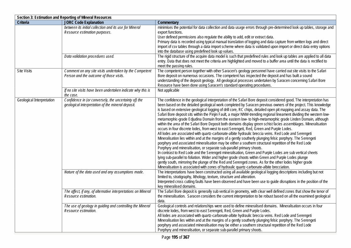
Page 195 of 367
Section 3: Estimation and Reporting of Mineral Resources Criteria JORC Code Explanation Commentary
between its initial collection and its use for Mineral Resource estimation purposes.
minimises the potential for data collection and data usage errors through pre-determined look up tables, storage and export functions. User defined permissions also regulate the ability to add, edit or extract data. Primary data is recorded using typical manual translation of logging and data capture from written logs and direct import of csv tables through a data import scheme where data is validated upon import or direct data entry options into the database using predefined look up values.
Data validation procedures used. The rigid structure of the acquire data model is such that predefined rules and look up tables are applied to all data entry. Data that does not meet the criteria are highlighted and moved to a buffer area until the data is rectified to meet the passing rules.
Site Visits Comment on any site visits undertaken by the Competent Person and the outcome of those visits.
The competent person together with other Saracen’s geology personnel have carried out site visits to the Safari Bore deposit on numerous occasions. The competent has inspected the deposit and has built a sound understanding of the deposit geology. All geological processes undertaken by Saracen concerning Safari Bore Resource have been done using Saracen’s standard operating procedures.
If no site visits have been undertaken indicate why this is the case.
Not applicable
Geological Interpretation Confidence in (or conversely, the uncertainty of) the geological interpretation of the mineral deposit.
The confidence in the geological interpretation of the Safari Bore deposit considered good. The interpretation has been based on the detailed geological work completed by Saracen previous owners of the project. This knowledge is based on extensive geological logging of drill core, RC chips, detailed open pit mapping and assay data. The Safari Bore deposit sits within the Pinjin Fault, a major NNW-trending regional lineament dividing the western low-metamorphic-grade Edjudina Domain from the eastern low- to high-metamorphic grade Linden Domain, although within the area of the Safari Bore Deposit both domains display green schist facies assemblages. Mineralisation occurs in four discrete lodes, from west to east Serengeti, Red, Green and Purple Lodes. All lodes are associated with quartz-carbonate-albite hydraulic breccia veins. Red Lode and Serengeti Mineralisation lies within and at the margins of a gently southerly plunging felsic porphyry. The Serengeti porphyry and associated mineralisation may be either a southern structural repetition of the Red Lode Porphyry and mineralisation, or separate sub-parallel primary shoots. In contrast to Red Lode and the Serengeti mineralisation, Green and Purple Lodes are sub vertical sheets lying sub-parallel to foliation. Wider and higher grade shoots within Green and Purple Lodes plunge gently south, mirroring the plunge of the Red and Serengeti zones. As for the other lodes higher grade Mineralisation is associated with zones of hydraulic quartz-carbonate-albite brecciation.
Nature of the data used and any assumptions made. The interpretations have been constructed using all available geological logging descriptions including but not limited to, stratigraphy, lithology, texture, structure and alteration. Interpreted cross cutting faults have been observed and have been use to guide disruptions in the position of the key mineralised domains.
The affect, if any, of alternative interpretations on Mineral Resource estimation.
The Safari Bore deposit is generally sub vertical in geometry, with clear well defined zones that show the tenor of the mineralisation. Saracen considers the current interpretation to be robust based on all the examined geological data.
The use of geology in guiding and controlling the Mineral Resource estimation.
Geological controls and relationships were used to define mineralised domains. Mineralisation occurs in four discrete lodes, from west to east Serengeti, Red, Green and Purple Lodes. All lodes are associated with quartz-carbonate-albite hydraulic breccia veins. Red Lode and Serengeti Mineralisation lies within and at the margins of a gently southerly plunging felsic porphyry. The Serengeti porphyry and associated mineralisation may be either a southern structural repetition of the Red Lode Porphyry and mineralisation, or separate sub-parallel primary shoots.

Page 196 of 367
Section 3: Estimation and Reporting of Mineral Resources Criteria JORC Code Explanation Commentary
In contrast to Red Lode and the Serengeti mineralisation, Green and Purple Lodes are sub vertical sheets lying sub-parallel to foliation. Wider and higher grade shoots within Green and Purple Lodes plunge gently south, mirroring the plunge of the Red and Serengeti zones. As for the other lodes higher grade mineralisation is associated with zones of hydraulic quartz-carbonate-albite brecciation.
The factors affecting continuity both of grade and geology. Gold mineralisation at Safari Bore is transgressive to lithology and occurs within multiple structural and alteration settings. Although the setting of mineralisation is variable, the distribution of gold Mineralisation may be explained by a single mechanism. In plan view the broad distribution of gold at Safari Bore is consistent with mineralisation within a sinistral oblique strike-slip regime. If the central felsic porphyry and the dioritic sheets are considered to lie sub-parallel to the local D (foliation) orientation then gold mineralisation lies within the R, T and P orientations of a sinistral strike slip regime. The variability in the style of gold mineralisation throughout Safari Bore may be attributed to variations in the orientation of the host lithology, and variable physical and chemical properties.
Dimensions The extent and variability of the Mineral Resource expressed as length (along strike or otherwise), plan width, and depth below surface to the upper and lower limits of the Mineral Resource.
The gold mineralisation at Safari Bore strikes about 1.3 km in length spanning over an area with 300m in width. The mineralisation extends to below 280m below surface.
Estimation and modelling techniques
The nature and appropriateness of the estimation technique(s) applied and key assumptions, including treatment of extreme grade values, domaining, interpolation parameters and maximum distance of extrapolation from data points.
Grade estimation using Ordinary Kriging (OK) was completed for Safari Bore. Micromine software was used to estimate gold grades into 5m x10m x5m size parent blocks. Drill grid spacing ranges from 20 m by 20 m to 40 m x 40 m. Drill hole sample data was flagged using domain codes generated from three dimensional mineralisation domains and oxidation surfaces. Sample data was composited to one metre downhole length. Over 97% of the sample intervals are 1m. Intervals with no assays were excluded from the compositing routine. The influence of extreme sample distribution outliers was reduced by top-cutting where required. The top-cut levels were determined using a combination of top-cut analysis tools (grade histograms, log probability plots and CVs). Top-cuts were reviewed and applied on a domain basis. Due to the flexures in the mineralised envelopes, the estimation process was in unfolded space. The blocks are relocated back to their original space after the estimation. Variography was conducted in unfolded space using Geo Access software.
The availability of check estimates, previous estimates and/or mine production records and whether the Mineral Resource estimate takes appropriate account of such data.
No comparison have been done with previous estimates
The assumptions made regarding recovery of by-products. No assumptions have been made with respect to the recovery of by-products. Estimation of deleterious elements or other non-grade variables of economic significance (e.g. sulphur for acid mine drainage characterisation).
There has been no estimate at this point of deleterious elements. Saracen is unaware if any elements other than gold have been assayed. Arsenic may have been assayed; however this data has not been made available.
In the case of block model interpolation, the block size in relation to the average sample spacing and the search employed.
A single block model for Safari Bore was constructed using a 5 mE by 10 mN by 5 mRL parent block size with sub-celling to 1 mE by 1 mN by 1 mRL for domain volume resolution. All estimation was completed at the parent cell size scale. Search ellipses and passes and minimum and maximum search number parameters are detailed below. The search strategy was set up such that the first search pass would fill blocks informed by the typical drill spacing. The second search used search ellipse multiplied by a factor of 2, while the third search increased the dimensions by a factor of 5 to ensure filling of all blocks. With the very limited across structure variogram range, a limit of 4 composites per drill hole was set. The first search pass used a maximum of 16 and a

Page 197 of 367
Section 3: Estimation and Reporting of Mineral Resources Criteria JORC Code Explanation Commentary
minimum of 16 samples. The second search pass used a maximum of 16 with a minimum of 8 samples while the third search pass used a maximum of 16 with a minimum of 1 sample.
Any assumptions behind modelling of selective mining units.
No selective mining units have been assumed.
Any assumptions about correlation between variables. No assumptions have been made regarding correlation between variables. Description of how the geological interpretation was used to control the resource estimates.
Geological controls and relationships were used to define mineralised domains. Mineralisation occurs in four discrete lodes, from west to east Serengeti, Red, Green and Purple Lodes. All lodes are associated with quartz-carbonate-albite hydraulic breccia veins. Red Lode and Serengeti Mineralisation lies within and at the margins of a gently southerly plunging felsic porphyry. The Serengeti porphyry and associated mineralisation may be either a southern structural repetition of the Red Lode porphyry and mineralisation, or separate sub-parallel primary shoots. In contrast to Red Lode and the Serengeti mineralisation, Green and Purple Lodes are sub vertical sheets lying sub-parallel to foliation. Wider and higher grade shoots within Green and Purple Lodes plunge gently south, mirroring the plunge of the Red and Serengeti zones. As for the other lodes higher grade Mineralisation is associated with zones of hydraulic quartz-carbonate-albite brecciation.
Discussion of basis for using or not using grade cutting or capping.
A top cut was used in each sub-zone both within the main domains and according to regolith, based on a review of the histogram, log probability plot, and a summary graph of the effects of top-cutting for each domain combination. A top cut was selected to minimise the effects of isolated high grade outliers, without cutting a large proportion of the data or contained metal within the domain.
The process of validation, the checking process used, the comparison of model data to drill hole data, and use of reconciliation data if available.
Validation of the block model carried out a volumetric comparison of the resource wireframes to the block model volumes. Validating the estimate compared block model grades to the input data using tables of values, and swath plots showing northing, easting and elevation comparisons. Visual validation of grade trends and metal distributions was carried out. Reconciliation studies for Safari Bore show that the model is conservative in its upper levels and this can be corroborated from the grade control data where there appears to be a different orientation to the resource interpretation.
Moisture Whether the tonnages are estimated on a dry basis or with natural moisture, and the method of determination of the moisture content.
All tonnages are estimated on a dry basis.
Cut-off parameters The basis of the adopted cut-off grade(s) or quality parameters applied.
Based on Saracen’s current economic operations at Carosue Dam, and the natural grade distinction above background, a grade of 0.7g/t has been chosen.
Mining factors or assumptions
Assumptions made regarding possible mining methods, minimum mining dimensions and internal (or, if applicable, external) mining dilution. It is always necessary as part of the process of determining reasonable prospects for eventual economic extraction to consider potential mining methods, but the assumptions made regarding mining methods and parameters when estimating Mineral Resources may not always be rigorous. Where this is the case, this should be reported with an explanation of the basis of the mining assumptions made.
Mining of the Safari Bore at this stage deposit will be by Open pit mining methods involving mechanised mining techniques. Open pit mining will most likely by a cut-back on the existing Safari Bore Pit. Some of the factor used in consideration of the mining method include, proximity of the mineralisation to surface, geotechnical and hydrogeological factors, prevailing gold price, planned mining dilution and mining recoveries and the average plant processing recoveries.
Metallurgical factors or assumptions
The basis for assumptions or predictions regarding metallurgical amenability. It is always necessary as part of the process of determining reasonable prospects for
Metallurgical test work was conducted on composite samples from Safari Bore. The test-work was aimed at further defining the metallurgical characteristics of the Safari deposit including gravity gold content, gold recovery, viscosity, oxygen demand, comminution characteristics, and mineralogy. The conclusions from the test work are as follows:

Page 198 of 367
Section 3: Estimation and Reporting of Mineral Resources Criteria JORC Code Explanation Commentary
eventual economic extraction to consider potential metallurgical methods, but the assumptions regarding metallurgical treatment process and parameters made when reporting Mineral Resources may not always be rigorous. Where this is the case, this should be reported with an explanation of the basis of the metallurgical assumptions made.
• Red Lode oxide and fresh material generally produced consistent results throughout the test work programs, with moderate to high gravity recoveries and overall 24 hour recoveries ranging from 87% to 97%. The lower Red Lode recoveries were due to low head grades, and therefore analysis of the data at appropriate ore deposit grades produces a recovery of approximately 95% for both oxide and fresh material.
• Purple Lode (transitional) material contained a high gravity recoverable component with a 24 hour recovery of 97% (head grade of 3.0 g/t). Limited tests have been conducted on this lode, and therefore further confirmatory test work will be completed.
• Conflicting results were obtained for the Green Lode composites tested. Two of the three test work programs for the Green Lode material generally yielded moderate gravity recoverable components, and lower overall 24 hour recoveries compared to the Red Lode material at approximately 92%. Some results also suggested that this material may be sensitive to grind size with additional gold locked in the coarser size fractions.
• Gold recovery was shown to be independent of grind size for the Red Lode material tested. Further analysis of this relationship is warranted, especially for the Green Lode material which tended to exhibit sensitivity to grind size.
• Oxygen demand test work conducted on the Red Lode material showed minimal oxygen uptake after one hour of sparging, indicating plant oxygen demand should not be significant.
• Pulp viscosity test work conducted on both oxide and fresh Red Lode samples indicated that no pumping or screening issues should be observed with this material.
• Abrasion indices for the Red Lode Oxide material were 0.17 increasing to 0.35 for the Red Lode Fresh material. Bond ball mill work indices for the Red Lode Oxide and Fresh composites were 14.3 kWh/t and 17.8 kWh/t respectively.
• Further confirmatory test work is planned to be conducted on Safari Bore to further validate the metallurgical recoveries obtained, and to generate additional information for areas with limited results.
Environmental factors or assumptions
Assumptions made regarding possible waste and process residue disposal options. It is always necessary as part of the process of determining reasonable prospects for eventual economic extraction to consider the potential environmental impacts of the mining and processing operation. While at this stage the determination of potential environmental impacts, particularly for a greenfields project, may not always be well advanced, the status of early consideration of these potential environmental impacts should be reported. Where these aspects have not been considered this should be reported with an explanation of the environmental assumptions made.
There have been previous mining activities at Safari Bore and a number of environmental factors have been considered. These factors include:
• Ground water management- Dewatering of an estimated 360 kl/day will be required. • This water will be pumped from one or two bores around the pit and from sumps within the pit to a turkey
nest dam. • The dam will be used to hold water for dust suppression and as a supply for the proposed Reverse
Osmosis plant. • This usage, together with losses from evaporation, is expected to account for the total volumes pumped.
No off-site discharge of mine water is expected to be required. • Waste Rock Disposal and Characterisation- A waste rock control strategy was put in place to minimise
the impact ARD (Acid Rain Drainage). • Flora and Fauna- Minimise disturbance of flora and Fauna and rehabilitation programs to be implemented
to ensure regeneration of the flora fauna. • Aboriginal Heritage Protection- Identified archaeological sites should be avoided at all costs.
Saracen will consider the above factors and others to meet the requirements of the current legislation. Bulk Density Whether assumed or determined. If assumed, the basis
for the assumptions. If determined, the method used, Previous owners have taken routine density measurements when drilling diamond core. The method of calculation is the water displacement technique. Density in the current model has been assigned based on oxidation state, using a

Page 199 of 367
Section 3: Estimation and Reporting of Mineral Resources Criteria JORC Code Explanation Commentary
whether wet or dry, the frequency of the measurements, the nature, size and representativeness of the samples.
total of 892 historical measurements. An analysis of both logged density and density as assigned by regolith surfaces was carried out
The bulk density for bulk material must have been measured by methods that adequately account for void spaces (vugs, porosity, etc), moisture and differences between rock and alteration zones within the deposit.
The frequency and distribution is unknown at this point in time. It has assumed from the good reconciliation performance from mine to mill that the determined density assignments from the mine are accurate.
Discuss assumptions for bulk density estimates used in the evaluation process of the different materials.
Average mean of densities collected for each lithological and weathering profile has been uniformly applied to the modelled geological units. This includes the primary fresh lithologies as well as the weathered oxide and transitional zones.
Classification The basis for the classification of the Mineral Resources into varying confidence categories.
The mineral resource has been classified into Measured, Indicated and Inferred categories based on drill hole spacing, geological confidence, and grade continuity and estimation quality. The combination of these factors together guides the construction of wireframes which select and codes the appropriate blocks with the nominated resource classification category.
Whether appropriate account has been taken of all the relevant factors (ie relative confidence in tonnage/grade estimations, reliability of input data, confidence in continuity of geology and metal values, quality, quantity and distribution of the data).
The input data is comprehensive in its coverage of the mineralisation and does not favour or misrepresent in-situ mineralisation. Mineralisation occurs in four discrete lodes, from west to east Serengeti, Red, Green and Purple Lodes. The definition of mineralised zones is based on a high level of geological understanding producing a robust model of mineralised domains. The validation of the block model shows good correlation of the input data to the estimated grades.
Whether the result appropriately reflects the Competent Person's view of the deposit.
The geological model and the mineral resource estimate reflect the competent person’s view of the deposit.
Audits or reviews The results of any audits or reviews of Mineral Resource estimates.
Saracen has adopted a process for geological modelling, estimation and reporting of mineral resources that meets high industry standards. The Safari Bore Resource model was completed by an external consultant under guidance from Saracen geology personnel. Saracen has reviewed the resource estimates and is satisfied that they are a true reflection of the global insitu resources for Safari Bore.
Discussion of relative accuracy/confidence
Where appropriate a statement of the relative accuracy and confidence level in the Mineral Resource estimate using an approach or procedure deemed appropriate by the Competent Person. For example, the application of statistical or geostatistical procedures to quantify the relative accuracy of the resource within stated confidence limits, or, if such an approach is not deemed appropriate, a qualitative discussion of the factors that could affect the relative accuracy and confidence of the estimate.
The relative accuracy of the Mineral Resource estimate is reflected in the reporting of the Mineral Resource as per the guidelines of the 2012 JORC Code. The resource estimates have undergone a robust validation process, and as such, the competent person is satisfied that the resources estimated in the block model are a true representation of the global insitu resources.
The statement should specify whether it relates to global or local estimates, and, if local, state the relevant tonnages, which should be relevant to technical and economic evaluation. Documentation should include assumptions made and the procedures used.
The statements relate to a global estimate of tonnes and grade.
These statements of relative accuracy and confidence of the estimate should be compared with production data, where available.
The Safari Bore resource model was completed by an external consultant and reviewed by Saracen geology personnel. The model has been validated thoroughly and the competent person is satisfied that the estimated gold grades give a true reflection of the global insitu resources. Reconciliation studies for Safari Bore show that the

Page 200 of 367
Section 3: Estimation and Reporting of Mineral Resources Criteria JORC Code Explanation Commentary
model is conservative in its upper levels and this can be corroborated from the grade control data where there appears to be a different orientation to the resource interpretation.
Deep South
Section 1: Sampling Techniques and Data Criteria JORC Code Explanation Commentary Sampling Techniques Nature and quality of sampling (e.g. cut channels, random
chips, or specific specialised industry standard measurement tools appropriate to the minerals under investigation, such as down hole gamma sondes, or handheld XRF instruments, etc.). These examples should not be taken as limiting the broad meaning of sampling.
Sampling methods undertaken by Saracen at Deep South have included reverse circulation drillholes (RC), aircore drilling (AC), surface and underground diamond drillholes (DD), underground face chip sampling and RC grade control drilling within the pit. Historic sampling methods conducted since 1983 have included rotary air blast (RAB), reverse circulation and diamond drillholes.
Include reference to measures taken to ensure sample representivity and the appropriate calibration of any measurement tools or systems used
Sampling for diamond, face chip and RC drilling is carried out as specified within Saracen sampling and QAQC procedures as per industry standard. RC and UG face chips and diamond core provide high quality representative samples for analysis. RC, RAB and DD core drilling was completed by previous holders to industry standard at that time (1983- 2004).
Aspects of the determination of mineralisation that are Material to the Public Report. In cases where ‘industry standard’ work has been done this would be relatively simple (e.g. ‘reverse circulation drilling was used to obtain 1 m samples from which 3 kg was pulverised to produce a 30 g charge for fire assay’). In other cases more explanation may be required, such as where there is coarse gold that has inherent sampling problems. Unusual commodities or mineralisation types (e.g. submarine nodules) may warrant disclosure of detailed information
RC chips are cone or riffle split and sampled into 1m intervals with total sample weights under 3kg Diamond core is NQ sized, sampled to 1m intervals or geological boundaries where necessary and cut into half core to give sample weights under 3 kg. UG faces are chip sampled to geological intervals (0.2 to 1m). Samples are selected to weigh less than 3 kg to ensure total sample inclusion at the pulverisation stage. Saracen core and chip samples are crushed, dried and pulverised to a nominal 90% passing 75µm to produce a 40g or 50 g sub sample for analysis by FA/AAS. Some grade control RC chips were analysed in the Saracen on site laboratory using a PAL (pulverise and leach) method. Historical RAB, RC and diamond sampling was carried out to industry standard at that time. Analysis methods include fire assay, aqua regia, atomic absorption spectroscopy and unspecified methods.
Drilling Techniques Drill type (e.g. core, reverse circulation, open-hole hammer, rotary air blast, auger, Bangka, sonic, etc.) and details (e.g. core diameter, triple or standard tube, depth of diamond tails, face-sampling bit or other type, whether core is oriented and if so, by what method, etc.).
The deposit was initially sampled by 114 RAB holes, 211 RC holes (assumed standard 5 ¼ ‘’bit size) and 29 surface HQ and unknown diameter diamond core holes. Saracen has completed 17 surface RC precollars with NQ diamond tail drill holes (precollars averaging 185m, diamond tails averaging 360m) , 3 geotechnical surface diamond NQ drillholes, 57 RC holes from surface and 107 grade control RC holes within the pit. Underground sampling activities have included 652 NQ diamond drillholes and 1599 faces. Exploration of the broader Deep South area has included 312AC holes. Diamond tails were oriented using an Ezi-mark tool. A limited amount of historic surface diamond drill core appears to have been oriented by unknown methods.
Drill Sample Recovery Method of recording and assessing core and chip sample recoveries and results assessed
RC sampling recoveries are recorded in the database as a percentage based on a visual weight estimate; limited historic recoveries have been recorded. Diamond core recovery percentages calculated from measured core versus drilled intervals are logged and recorded in the database. Recoveries average >98%. Limited historic diamond recoveries have been recorded.
Page 201 of 367
Section 1: Sampling Techniques and Data Criteria JORC Code Explanation Commentary
Measures taken to maximise sample recovery and ensure representative nature of the samples
During AC and RC drilling daily rig inspections are carried out to check splitter condition, general site and address general issues. Diamond core is reconstructed into continuous runs on an angle iron cradle for orientation marking. Depths are checked against depth given on the core blocks. UG faces are sampled left to right across the face allowing a representative sample to be taken due to the vertical nature of the orebody. During GC campaigns the sample bags weight versus bulk reject weight are compared to ensure adequate and even sample recovery. Historical RAB, RC and diamond drilling to industry standard at that time.
Whether a relationship exists between sample recovery and grade and whether sample bias may have occurred due to preferential loss/gain of fine/coarse material.
There is no known relationship between sample recovery and grade for RC or AC drilling. Diamond drilling has high recoveries meaning loss of material is minimal. Any historical relationship is not known.
Logging Whether core and chip samples have been geologically and geotechnically logged to a level of detail to support appropriate Mineral Resource estimation, mining studies and metallurgical studies. Whether logging is qualitative or quantitative in nature. Core (or costean, channel, etc) photography.
Logging of RC and AC chips and diamond drill core records lithology, mineralogy, texture, mineralisation, weathering, alteration and veining. Geotechnical and structural logging is carried out on all diamond holes to record recovery, RQD, defect number, type, fill material, shape and roughness and alpha and beta angles. Chips from all RC holes (exploration and GC) are stored in chip trays for future reference while remaining core is stored in core trays and archived on site. All faces are photographed and mapped. Core is photographed in both dry and wet state. Qualitative and quantitative logging of historic data varies in its completeness.
The total length and percentage of the relevant intersections logged
All AC, RC and diamond drillholes and grade control holes are logged in full. Historical logging is complete.
Sub-sampling techniques and sample preparation
If core, whether cut or sawn and whether quarter, half or all core taken.
All drill core is cut in half onsite using an automatic core saw. Some grade control diamond holes have been full core sampled. Samples are always collected from the same side. Some historic drillcore was half core sampled, or sampled via unknown methods.
If non-core, whether riffled, tube sampled, rotary split, etc and whether sampled wet or dry.
All exploration and grade control RC samples are cone or riffle split. AC drillholes are spear sampled. Occasional wet samples are encountered; increased air capacity is routinely used to aid in keeping the sample dry when water is encountered. UG faces are chip sampled using a hammer. Historic RAB and RC drilling was sampled using riffle and unknown methods.
For all sample types, the nature, quality and appropriateness of the sample preparation technique.
The sample preparation of diamond core, UG face chips and RC chips adhere to industry best practice. It is conducted by a commercial laboratory or onsite laboratory and involves oven drying, coarse crushing then total grinding to a size of 90% passing 75 microns. Best practice is assumed at the time of historic sampling.
Quality control procedures adopted for all sub-sampling stages to maximise representivity of samples.
All subsampling activities are carried out by commercial laboratory or onsite laboratory and are considered to be satisfactory. Sampling by previous holders assumed to be industry standard at the time.
Measures taken to ensure that the sampling is representative of the in situ material collected, including for instance results for field duplicate/second half sampling.
RC field duplicate samples are carried out at a rate of 1:20 and are sampled directly from the on-board splitter on the rig. These are submitted for the same assay process as the original samples and the laboratory are unaware of such submissions. Sampling by previous holders assumed to be industry standard at the time.

Page 202 of 367
Section 1: Sampling Techniques and Data Criteria JORC Code Explanation Commentary
Whether sample sizes are appropriate to the grain size of the material being sampled.
Sample sizes of 3kg are considered to be appropriate given the grain size (90% passing 75 microns) of the material sampled.
Quality of assay data and laboratory tests
The nature, quality and appropriateness of the assaying and laboratory procedures used and whether the technique is considered partial or total.
RC and UG chip samples and diamond core are analysed by external laboratories using a 50g fire assay with AAS finish. AC samples are analysed using a 25g aqua regia digest. These methods are considered suitable for determining gold concentrations in rock and are total digest methods. GC samples were analysed in the Saracen onsite laboratory using a pulverise and leach method. This method is a partial digest. Historic sampling includes fire assay, aqua regia, atomic absorption spectroscopy and unspecified methods.
For geophysical tools, spectrometers, handheld XRF instruments, etc, the parameters used in determining the analysis including instrument make and model, reading times, calibrations factors applied and their derivation, etc.
No geophysical tools have been utilised for reporting gold mineralisation.
Nature of quality control procedures adopted (e.g. standards, blanks, duplicates, external laboratory checks) and whether acceptable levels of accuracy (i.e. lack of bias) and precision have been established.
Certified reference material (standards and blanks) with a wide range of values are inserted into every drillhole at a rate of 1:25 for exploration AC, RC and DD, and 1:40 for GC drilling. These are not identifiable to the laboratory. QAQC data returned are checked against pass/fail limits with the SQL database and are passed or failed on import. A report is generated and reviewed by the geologist as necessary upon failure to determine further action. QAQC data is reported monthly. Sample preparation checks for fineness are carried out to ensure a grindsize of 90% passing 75 microns. The laboratory performs a number of internal processes including standards, blanks, repeats and checks. QAQC data analysis demonstrates sufficient accuracy and precision. Industry best practice is assumed for previous holders.
Verification of sampling and assaying
The verification of significant intersections by either independent or alternative company personnel.
Significant intercepts are verified by the Geology Manager and corporate personnel.
The use of twinned holes. No specific twinned holes have been drilled at Deep South but grade control drilling has confirmed the width and grade of previous exploration drilling.
Documentation of primary data, data entry procedures, data verification, data storage (physical and electronic) protocols
Primary data is collated in a set of excel templates utilising lookup codes. This data is forwarded to the Database Administrator for entry into a secure acQuire database with inbuilt validation functions. Data from previous owners was taken from a database compilation and validated as much as practicable before entry into the Saracen acQuire database.
Discuss any adjustment to assay data. No adjustments have been made to assay data. First gold assay is utilised for resource estimation. Location of data points Accuracy and quality of surveys used to locate drillholes
(collar and down-hole surveys), trenches, mine workings and other locations used in Mineral Resource estimation.
Exploration drillholes are located using a Leica 1200 GPS with an accuracy of +/- 10mm. Drillhole collars within the pit and immediate surrounds are picked up by company surveyors using a Trimble R8 GNSS (GPS) with an expected accuracy of +/-8mm. All underground drillhole collars are picked up by company surveyors using a Leica TS15i (total station) with an expected accuracy of +/-2mm. Underground faces are located using a Leica D5 disto with and accuracy of +/- 1mm from a known survey point. Downhole surveys are carried out using the DeviFlex RAPID continuous inrod survey instrument taking readings every 5 seconds, In and Out runs and reported in 3m intervals, survey accuracy +-3:1000. A number of drillholes have also been gyroscopically surveyed. Previous holders’ survey accuracy and quality is unknown
Specification of the grid system used. A local grid system (Safari Bore) is used at Deep South. The two point conversion to MGA_GDA94 zone 51 is: SBEast SBNorth RL MGAEast MGANorth RL

Page 203 of 367
Section 1: Sampling Techniques and Data Criteria JORC Code Explanation Commentary
Point 1 51000 34000 0 451137.753 6734157.921 0 Point 2 51000 30000 0 451137.896 6730157.896 0 Historic data is converted to the Safari Bore local grid upon export from the database.
Quality and adequacy of topographic control. Topographic control originally used site based survey pickups in addition to Kevron aerial photogrammetric surveys with +/- 5m resolution. Pre mining, new and more detailed topography has since been captured and will be used in future updates and for subsequent planning purposes.
Data spacing and distribution
Data spacing for reporting of Exploration Results. The nominal spacing for drilling is 20m x 40m and 40m x 40m Whether the data spacing and distribution is sufficient to establish the degree of geological and grade continuity appropriate for the Mineral Resource and Ore Reserve estimation procedure(s) and classifications applied.
Data spacing and distribution are sufficient to establish the degree of geological and grade continuity appropriate for JORC classifications applied.
Orientation of data in relation to geological structure
Whether sample compositing has been applied. AC drilling is sampled in 4m composites, no other sample compositing has been utilised Some historic RAB and RC sampling was composited into 3-4m samples with areas of interest re-sampled to 1m intervals. It is unknown at what threshold this occurred.
Whether the orientation of sampling achieves unbiased sampling of possible structures and the extent to which this is known, considering the deposit type.
The majority of drillholes are positioned to achieve optimum intersection angles to the ore zone as are practicable.
If the relationship between the drilling orientation and the orientation of key mineralised structures is considered to have introduced a sampling bias, this should be assessed and reported if material.
No significant sampling bias has been recognised due to orientation of drilling in regards to mineralised structures.
Sample security The measures taken to ensure sample security. Samples are prepared on site under supervision of Saracen geological staff. Samples are selected, bagged into tied numbered calico bags then grouped into secured cages and collected by the laboratory personnel. Sample submissions are documented via laboratory tracking systems and assays are returned via email
Audits or reviews The results of any audits or reviews of sampling techniques and data.
An internal review of companywide sampling methodologies was conducted to create the current sampling and QAQC procedures. No external audits or reviews have been conducted.
Section 2: Reporting of Exploration Results Criteria JORC Code Explanation Commentary Mineral tenement and land tenure status
Type, reference name/number, location and ownership including agreements or material issues with third parties such as joint ventures, partnerships, overriding royalties, native title interests, historical sites, wilderness or national park and environmental settings.
The Deep South pit is located on M39/740. The tenement is held 100% by Saracen Gold Mines Pty Ltd, a wholly owned subsidiary of Saracen Mineral Holdings Limited. Mining Lease M39/740 has a 21 year life (held until 2024) and is renewable for a further 21 years on a continuing basis. Mining Lease M39/740 is subject to one royalty agreement, one caveat (151H/067) and a bank mortgage (499142). All production is subject to a Western Australian state government NSR royalty of 2.5%. Mining Lease M39/740 is subject to the Edjudina Pastoral Compensation Agreement. There are no registered Aboriginal Heritage sites within Mining Lease M39/740. The Mining Rehabilitation Fund applies to Mining Lease 39/740.
The security of the tenure held at the time of reporting along with any known impediments to obtaining a licence to operate in the area.
The tenement is in good standing and the licence to operate already exists

Page 204 of 367
Section 2: Reporting of Exploration Results Criteria JORC Code Explanation Commentary Exploration done by other parties
Acknowledgment and appraisal of exploration by other parties.
Exploration in the vicinity of Deep South commenced in the 1980’s with drilling around the historic Deep Well workings 500m north of Deep South, as well as regional RC drilling carried out by Western Mining Corporation. Initial auger sampling carried out over Deep South by Pancontinental Mining in 1994 failed to detect mineralisation due to the transported material overlying the deposit. Wide spaced east angled RAB drilling carried out by Goldfields in 1999 intersected mineralisation, but results were not repeated in further drilling and the project area was sold to Sons of Gwalia. Sons of Gwalia completed extensive RC and diamond drilling to define the Deep South resource, with mining operations undertaken in 2004 before their collapse and takeover by St Barbara.
Geology Deposit type, geological setting and style of mineralisation.
Deep South lies on the eastern margin of the Norseman – Wiluna greenstone belt. This belt is differentiated into numerous structural-stratigraphic domains separated by major regional structures, with Deep South located within the narrow NNW trending Linden Domain. The lithology comprises metasedimentary and felsic volcaniclastic rocks with an ultramafic and high magnesium basalt layer. Mineralisation occurs in two loads concordant to geology, the Butler and Scarlett lodes, and is confined between layered metasedimentary and felsic volcaniclastic units on both the hangingwall and footwall. The two lodes are separated by a high magnesium basalt and an ultramafic unit. The Butler lode is located in the hangingwall and is strongly silica and pyrrhotite-pyrite altered, and well laminated (appearing like a BIF within the oxidise portion). The contrasting physical properties of this unit to the surrounding unit have created fluid pathways and traps, as well as the high iron content of the unit providing a chemical trap, for gold deposition The Scarlett lode is strongly weathered in the upper oxide portion to a gossanous material comprising hematite, goethite and quartz fragments. Weathering at Deep South has been preferential along Scarlett lode due to its high carbonate content. Where fresh, the lode is a fine grained banded carbonate unit with variable pyrrhotite, pyrite and magnetite. It is weakly foliated in line with the regional foliation.
Drillhole information A summary of all information material to the understanding of the exploration results including a tabulation of the following information for all Material drill holes: • easting and northing of the drill hole collar • elevation or RL (Reduced Level – elevation • above sea level in metres) of the drill hole collar • dip and azimuth of the hole • down hole length and interception depth • hole length. • If the exclusion of this information is justified on the
basis that the information is not Material and this exclusion does not detract from the understanding of the report, the Competent Person should clearly explain why this is the case.
All material data is periodically released on the ASX: 18/02/2019, 27/11/2018, 15/02/2018, 27/11/2017, 26/09/2017, 01/05/2017, 21/02/2017, 17/12/2016, 07/09/2016, 11/05/2016, 23/02/2016, 23/07/2013, 10/10/2012, 31/07/2012, 03/06/2011, 29/07/2010 Future drill hole data will be periodically released or when a results materially change the economic value of the project. Exclusion of the drilling information will not detract from the reader’s view of the report.
Data aggregation methods In reporting Exploration Results, weighting averaging techniques, maximum and/or minimum grade truncations (e.g. cutting of high grades) and cut-off grades are usually Material and should be stated.
All significant intercepts have been length weighted with a minimum Au grade of 1ppm, or 20ppb for AC drilling No high grade cut off has been applied.

Page 205 of 367
Section 2: Reporting of Exploration Results Criteria JORC Code Explanation Commentary
Where aggregate intercepts incorporate short lengths of high grade results and longer lengths of low grade results, the procedure used for such aggregation should be stated and some typical examples of such aggregations should be shown in detail.
Intercepts are aggregated with minimum width of 1m and maximum width of 3m for internal dilution. Where stand out higher grade zone exist with in the broader mineralised zone, the higher grade interval is reported also.
The assumptions used for any reporting of metal equivalent values should be clearly stated.
There are no metal equivalents reported in this release.
Relationship between mineralisation widths and intercept lengths
These relationships are particularly important in the reporting of Exploration Results. If the geometry of the mineralisation with respect to the drill hole angle is known, its nature should be reported. If it is not known and only the down hole lengths are reported, there should be a clear statement to this effect (eg ‘down hole length, true width not known’).
Previous announcement included sufficient detail to clearly illustrate the geometry of the mineralisation and the recent drilling. All results are reported as downhole lengths. This remains consistent with other announcements.
Diagrams Appropriate maps and sections (with scales) and tabulations of intercepts should be included for any significant discovery being reported These should include, but not be limited to a plan view of drill hole collar locations and appropriate sectional views.
All significant exploration results released by Saracen are accompanied by the appropriate diagrams and maps at the time of the release.
Balanced Reporting Where comprehensive reporting of all Exploration Results are not practicable, representative reporting of both low and high grades and/or widths should be practiced to avoid misleading reporting of Exploration Results.
All results from the recent campaign have been reported, irrespective of success or not.
Other substantive exploration data
Other exploration data, if meaningful and material, should be reported including (but not limited to): geological observations; geophysical survey results; geochemical survey results; bulk samples – size and method of treatment; metallurgical test results; bulk density, groundwater, geotechnical and rock characteristics; potential deleterious or contaminating substances.
A small geochemical program was undertaken in 2013 to determine the key features associated with mineralisation. The program gave some insight into the local characteristics of the Scarlett and Butler lodes. More work is needed to fully appreciate the geochemical signature associated with the mineralisation. A detailed gravity survey was recently completed at Deep South on a 400m x 100m grid to assist in the interpretation of the basement geology. The data is currently being processed and interpreted. Saracen has recently completed a biogeochemical sampling program at Deep South involving the sampling of new leaf growth on established Acacia trees on a 100m x 800m spacing. Samples were collected from trees of a consistent species and height. The biogeochemical program was an orientation survey only and results will not be used in any calculation of mineralisation. The leaves were washed, dried and pulverised followed by an aqua regia digest for multielement determination.
Further work The nature and scale of planned further work (eg tests for lateral extensions or depth extensions or large-scale step-out drilling). Diagrams clearly highlighting the areas of possible extensions, including the main geological interpretations and future drilling areas, provided this information is not commercially sensitive
The initial results from the biogeochemical sampling were encouraging and further expansion of the survey area is currently being planned. The exploration effort continues at Deep South. The focus remains in the near mine scale areas to extend and build the resource base.

Page 206 of 367
Section 3: Estimation and Reporting of Mineral Resources Criteria JORC Code Explanation Commentary Database Integrity Measures taken to ensure that data has not been
corrupted by, for example, transcription or keying errors, between its initial collection and its use for Mineral Resource estimation purposes.
Saracen utilises AcQuire software on an SQL server database to securely store and manage all drillhole and sample information. Data integrity protocols are built into the system to ensure data validity and minimise errors during data entry and import processes.
Data validation procedures used. Data that is captured in the field is entered into Excel templates which are checked on import into the database for errors. Assay jobs are dispatched electronically to the lab to minimise the chance of data entry errors. Assay results from the lab are received in CSV format and are checked for errors on import into the database. Data is regularly validated using the mining software. The data validation process is overseen by the Database Administrator.
Site Visits Comment on any site visits undertaken by the Competent Person and the outcome of those visits.
The Competent Person has visited the site during drilling and mining operations. Robust systems and procedures have been established to track and monitor progress.
If no site visits have been undertaken indicate why this is the case.
Geological Interpretation Confidence in (or conversely, the uncertainty of) the geological interpretation of the mineral deposit.
The interpretation has been based on historical data captured by previous owners and refined by new information generated by Saracen following project acquisition. This knowledge is built on extensive geological logging of drill core, RC chips, underground development face chips, detailed open pit and underground mapping and assay data. The gross architecture of the deposit is relatively simple and the interpretation robust.
Nature of the data used and any assumptions made. The interpretations have been constructed using all available geological logging descriptions including but not limited to, stratigraphy, lithology, texture, and alteration. Open pit mapping has been included in the interpretation however only affects the location of the domain boundaries inside the previously mined open pit. Cross sectional interpretations of the mineralisation have been created and form the basic framework through which the 3D wireframe solids are built.
The affect, if any, of alternative interpretations on Mineral Resource estimation.
Due to the simplistic nature of the mineralisation no alternative interpretations have been considered. Over the life of the project several different sources have interpreted the mineralisation and all agree on the same basic geological constraints. The mineralisation is typically discrete and bound to specific lithological units.
The use of geology in guiding and controlling the Mineral Resource estimation.
The geology has heavily influenced the domains controlling the mineral resource estimation. The main mineralised Scarlett Lode has been confined to the geologically logged carbonate unit. Similarly the Butler lode has been defined by a highly siliceous BIF horizon. In order to deal with multiple populations within the carbonate unit in the grade control areas (areas drilled to a spacing 25m x 20m) sub-domaining was done using the Categorical Indicator technique which uses grade thresholds to segregate the different populations within the unit. Three subdomains include the , low grade (<1 g/t Au), medium grade (1<x=<9 g/t Au) and the high grade > 9 g/t Au
The factors affecting continuity both of grade and geology. Mineralisation and lithology are both highly continuous. The stratigraphic horizons that host the mineralisation extend over a length of 15km. Grade is affected by the presence of sulphides and quartz carbonate veining. A northerly plunge in both lodes is thought to be controlled by subtle changes in strike or continuity of mineralisation at boudin neck margins. A conjugate mineralised shoot plunging to the south appears to be evident in the Scarlett lode and has been interpreted as the intersection of deposit scale shearing and lithology contacts.
Dimensions The extent and variability of the Mineral Resource expressed as length (along strike or otherwise), plan width, and depth below surface to the upper and lower limits of the Mineral Resource.
Both mineralised lodes at Deep South have continuity over 500m along strike and 400m down dip. The Scarlett lode averages 5m in width and the Butler lode averages 2m in width. Both lodes strike North north-west and dip steeply at 75 degrees to the west. The higher grade plunge direction is to the north, pitching 70 degrees in the Scarlett but more steeply at 80 degrees in the Butler. The south plunging shoot in the Scarlett pitches at approximately 65 degrees.

Page 207 of 367
Section 3: Estimation and Reporting of Mineral Resources Criteria JORC Code Explanation Commentary Estimation and modelling techniques
The nature and appropriateness of the estimation technique(s) applied and key assumptions, including treatment of extreme grade values, domaining, interpolation parameters and maximum distance of extrapolation from data points.
Block estimation has been completed in Datamine software using ordinary kriging methodology. All mineralised interval has been flagged using the interval selection tool in Leapfrog software, which were subsequently used to generate 3D mineralisation wireframes. The estimation uses these wireframes as hard boundaries except for the high grade sub-domain defined in the carbonate unit which is estimated using a soft boundary. Estimation of parent blocks are interpolated, and assigned to sub-cells. The maximum distance of extrapolation is less than 50m. Univariate statistical analysis of length weighted, (1m), domain coded downhole composites have been completed for all domains and top-cuts applied where applicable. Extreme grades are not common in the data set and all domains have been analysed individually to determine specific top-cut values. Variogram modelling was completed using Snowden’s Supervisor software defining the spatial continuity within the domains. The parameters determined from this analysis were used in the interpolation process.
The availability of check estimates, previous estimates and/or mine production records and whether the Mineral Resource estimate takes appropriate account of such data.
Underground production has provided mill reconciled data to assess the predictive capacity of the current model with good comparative metrics recorded over the long term Saracen has been mining at Deep South.
The assumptions made regarding recovery of by-products. No assumptions have been made with respect to the recovery of by-products. Estimation of deleterious elements or other non-grade variables of economic significance (e.g. sulfur for acid mine drainage characterisation).
There has been no estimate at this point of deleterious elements. Saracen is unaware if any elements other than gold have been historically assayed on a routine basis. There are no future plans to assay for non-grade variables.
In the case of block model interpolation, the block size in relation to the average sample spacing and the search employed.
Two block sizes have been used in the resource model; a grade control (GC) block size at 5m(X) by 10m(Y) by 5m(Z) and resource block size at 10m(X) by 20m(Y) by 5m(Z). The Grade Control block size has been utilised in areas of drill density less than 20m by 20m and typically proximal to the open pit and/or underground development. The Resource block size has been used for all other areas. In both cases kriging neighbourhood analysis (KNA) has been conducted to ensure the appropriate block size has been used relative to available data spacing. Parent blocks have been sub-celled to X (1m) by Y (1m) by Z (1m) to ensure that wireframe boundaries are honoured and preserve the location and geometry of the mineralisation. Search ranges have been informed by variogram modelling heavily influence by drill spacing, geological observations and high grade shoot geometry. Three search passes are used in the estimation to ensure that all the blocks are estimated within the respective estimation domains.
Any assumptions behind modelling of selective mining units.
No selective mining units have been assumed.
Any assumptions about correlation between variables. No assumptions have been made regarding correlation between variables. Description of how the geological interpretation was used to control the resource estimates.
The geological interpretation strongly correlates with the mineralised domains. In all wireframes, including those where lithology and mineralisation correspond, hard boundaries are enforced.
Discussion of basis for using or not using grade cutting or capping.
Statistical analysis of all domains highlight that there are very few grades in the domain populations that require top-cutting. Top-cuts have been employed to eliminate the risk of overestimating in the local areas where a few high grade samples exist. A sensitivity analysis was carried out on the data, by relaxing the top-cut values. This demonstrated that the grade would appreciate by 1.0g/t on average with higher topcuts.
The process of validation, the checking process used, the comparison of model data to drill hole data, and use of reconciliation data if available.
Several key model validation steps have been taken to support the resource estimate. The mineral resource model has been stepped through visually in sectional and plan view to correlate the composite grades used in the estimate and the resultant block grades. This has also been carried out in 3D with the composite grades and a point cloud of the model grades.

Page 208 of 367
Section 3: Estimation and Reporting of Mineral Resources Criteria JORC Code Explanation Commentary
Easting, Northing and Elevation swathe plots have been constructed to evaluate the composited assay means verses the mean block estimates. The mineral resource model has been constructed to include kriging efficiency and slope of regression values. These values are used to measure the quality of the estimate. Natural deterioration of the quality is observed at the perimeter of the modelled areas or where data density is lower. The estimate was checked against reconciled production with all comparative metrics within desired thresholds limits.
Moisture Whether the tonnages are estimated on a dry basis or with natural moisture, and the method of determination of the moisture content.
All tonnages are estimated on a dry basis.
Cut-off parameters The basis of the adopted cut-off grade(s) or quality parameters applied.
Based on Saracen’s current economic operations at Carosue Dam, and the natural grade distinction above background, a grade of 0.5g/t has been chosen.
Mining factors or assumptions
Assumptions made regarding possible mining methods, minimum mining dimensions and internal (or, if applicable, external) mining dilution. It is always necessary as part of the process of determining reasonable prospects for eventual economic extraction to consider potential mining methods, but the assumptions made regarding mining methods and parameters when estimating Mineral Resources may not always be rigorous. Where this is the case, this should be reported with an explanation of the basis of the mining assumptions made.
The Deep South deposit is amenable to mining by both open pit and underground methods. The deposit was successfully mined by open pit during 2012/2013. Underground mining extracting the mineralised positions via long hole open stoping commenced in December 2015.
Metallurgical factors or assumptions
The basis for assumptions or predictions regarding metallurgical amenability. It is always necessary as part of the process of determining reasonable prospects for eventual economic extraction to consider potential metallurgical methods, but the assumptions regarding metallurgical treatment process and parameters made when reporting Mineral Resources may not always be rigorous. Where this is the case, this should be reported with an explanation of the basis of the metallurgical assumptions made.
Deep South is currently being treated through the Carosue Dam treatment plant. Historical recovery has been around 85% reflecting the oxide component of the ore. Fresh material hauled from the active underground has a recovery of approximately 92%. The ore is relatively soft and the majority of the gold is free milling. The ore also has a predictable grind dependency / leach recovery relationship. Completed test work highlights that the ore is not chemically refractory and contains no preg robbing properties.
Environmental factors or assumptions
Assumptions made regarding possible waste and process residue disposal options. It is always necessary as part of the process of determining reasonable prospects for eventual economic extraction to consider the potential environmental impacts of the mining and processing operation. While at this stage the determination of potential environmental impacts, particularly for a greenfields project, may not always be well advanced, the status of early consideration of these potential environmental impacts should be reported. Where these aspects have not been considered this should be reported
Waste rock characterisation has been conducted on the deposit with no environmental issues identified. Tailings from the deposit are stored in an appropriate licensed tailings facility and a closure plan is in place.

Page 209 of 367
Section 3: Estimation and Reporting of Mineral Resources Criteria JORC Code Explanation Commentary
with an explanation of the environmental assumptions made.
Bulk Density Whether assumed or determined. If assumed, the basis for the assumptions. If determined, the method used, whether wet or dry, the frequency of the measurements, the nature, size and representativeness of the samples.
Bulk densities for Deep South were determined via testing of representative intervals from diamond drill holes and regular grab samples from the pit and underground development. The sample size is generally between 0.5 and 1.5kg and the method of calculation is the water displacement technique. Measurements have been recorded in the acquire database and extraction schemes pair this data with the major lithology code for statistical analysis.
The bulk density for bulk material must have been measured by methods that adequately account for void spaces (vugs, porosity, etc), moisture and differences between rock and alteration zones within the deposit.
Bulk density values from point samples have been calibrated against haulage figures and mill weightometer data and are appropriate for the material being mined.
Discuss assumptions for bulk density estimates used in the evaluation process of the different materials.
An average mean of densities collected for each lithological type has been uniformly applied to the modelled geological units. This includes the primary fresh lithologies as well as the weathered oxide and transitional zones.
Classification The basis for the classification of the Mineral Resources into varying confidence categories.
The mineral resource has been classified into Measured, Indicated and Inferred categories based on drill hole spacing, geological confidence, grade continuity and estimation quality. The combination of these factors together guide the digitising of a “cookie cutter” string in long section view which selects and codes the appropriate blocks with the nominated resource classification category.
Whether appropriate account has been taken of all the relevant factors (ie relative confidence in tonnage/grade estimations, reliability of input data, confidence in continuity of geology and metal values, quality, quantity and distribution of the data).
All care has been taken to account for relevant factors influencing the mineral resource estimate. Confidence in the predicted tonnes and grade estimated in the model is high and previous mining performance suggests that the input data and geological continuity are such that a robust resource estimate can be achieved.
Whether the result appropriately reflects the Competent Person's view of the deposit.
The geological model and the mineral resource estimate reflect the competent person’s view of the deposit.
Audits or reviews The results of any audits or reviews of Mineral Resource estimates.
At the completion of a resource estimation Saracen Gold Mines undertake an extensive review of the model that covers model inventory and comparisons to previous models, geological interpretation, wireframing, domain selection, statistics by domain, assay evaluation, parent cell sizes, data compositing, variography, search strategy, estimation and kriging neighbourhood analysis (KNA) and finally model validation and resource categorisation are all discussed and scrutinized by the geological and mine planning teams. Recommendations from previous resource reviews have been discussed and implemented where appropriate.
Discussion of relative accuracy/confidence
Where appropriate a statement of the relative accuracy and confidence level in the Mineral Resource estimate using an approach or procedure deemed appropriate by the Competent Person. For example, the application of statistical or geostatistical procedures to quantify the relative accuracy of the resource within stated confidence limits, or, if such an approach is not deemed appropriate, a qualitative discussion of the factors that could affect the relative accuracy and confidence of the estimate.
The Mineral Resource has been reported in accordance with the guidelines of the JORC 2012 edition of the Australasian Code for Reporting of Exploration Results, Mineral Resources and Ore Reserves. Saracen Gold Mine uses a standard approach to resource estimation and the procedure requires the systematic completion of the Saracen Resource Estimation Document that is thoroughly investigated and assessed in the Model review process, as stated above.
The statement should specify whether it relates to global or local estimates, and, if local, state the relevant tonnages, which should be relevant to technical and economic evaluation. Documentation should include assumptions made and the procedures used.
The statements relate to a global estimate of tonnes and grade.

Page 210 of 367
Section 3: Estimation and Reporting of Mineral Resources Criteria JORC Code Explanation Commentary
These statements of relative accuracy and confidence of the estimate should be compared with production data, where available.
The resource estimation is checked against reconciled production data on a monthly basis. Comparative metrics continue to be within acceptable threshold limits. The Mine Call Factor at Deep South on tonnes has been 99% and 100% on grade since underground mining commenced in 2015.
Section 4: Estimation and Reporting of Ore Reserves Criteria JORC Code Explanation Commentary Mineral Resource estimate for conversion to Ore Reserves
Description of the Mineral resource Estimate used as a basis for the conversion to an Ore Reserve.
The Mineral Resource estimate for the Deep South gold deposit used as a basis for conversion to the Ore Reserve estimate was compiled by Saracen. The data included drilling and assay data, geological mapping and historical mining records to validate the model against and solid interpretation wireframes of the geology. This information was used to construct a model estimated by ordinary kriging (ok) with categorical indicator kriging (CIK) sub domains. The model was depleted with the final pit and underground survey’s completed in June 2019.
Clear statement as to whether the Mineral Resources are reported additional to. Or inclusive of, the Ore Reserves.
The Mineral Resource reported is inclusive of the Ore Reserve.
Site Visits Comment on any site visits undertaken by the Competent Person and the outcome of those visits.
The competent person is conducting frequent ongoing site visits to the Carosue Dam Operations (CDO) mine site. Deep South is located 90kms north of the CDO Processing Plant and regularly visits the mine. Saracen and consultant geotechnical engineers regularly visit Deep South to inspect the mine and gather data used in the preparation of geotechnical reports to define parameters for underground mining. Hydrogeology consultants have visited Carosue Dam to gather data and inspect the inflow of groundwater into the open pit, used in the preparation of reports used to determine water management strategies.
If no site visits have been undertaken indicate why this is the case.
N/A
Study status The type and level of study undertaken to enable Mineral Resources to be converted to Ore Reserves
Saracen commenced underground operations at Deep South in October 2015. Deep South is an active underground operation with a detailed mine design and an economic analysis, to define the ore reserve. The Deep South deposit was originally mined by Sons of Gwalia commencing in 2004. Saracen completed a pit cutback during 20012/2013. The Stage 2 open pit was completed in April 2013. Ore from Deep South open pit was treated at the CDO Processing Plant.
The Code requires that a study to at least Pre-Feasibility Study level has been undertaken to convert Mineral Resources to Ore Reserves. Such studies will have been carried out and will have determined a mine plan that is technically achievable and economically viable, and that material Modifying Factors have been considered.
Modifying factors have been applied to the project to ensure the rigor of the financial analysis. All of the parameters assumed and adopted, as well as the financial analysis completed, are based upon current active mine inputs and have been the subject to peer review.
Cut-off parameters The basis of the cut-off grade(s) or quality parameters applied
For the purpose of Ore Reserve Estimate a planning cut-off grade of 1.8g/t was calculated based upon an assumed gold price of AUD$1,600/Oz and applicable processing, haulage and administration costs. A top cut has already been applied to the Mineral Resource Estimate eliminating the necessity for any further adjustment to the Ore Reserve estimate.
Mining factors or assumptions
The method and assumptions used as reported in the Pre-feasibility or Feasibility Study to convert the Mineral Resource to an Ore Reserve (i.e. either by application of
The Deep South underground ore reserve has been estimated using detailed mine development and stope designs. Modifying factors for dilution and recovery have been applied to the economic analysis of the design to generate the ore reserve.

Page 211 of 367
Section 4: Estimation and Reporting of Ore Reserves Criteria JORC Code Explanation Commentary
appropriate factors by optimisation or by preliminary or detailed design). The choice, nature and appropriateness of the selected mining method(s) and other mining parameters including associated design issues such as pre-strip, access, etc.
Underground mechanised mining for development, ground support, and production stoping is used at Deep South. Mining and geotechnical studies determined two mining methods; 1) open stoping with remnant pillars, and 2) Modified Avoca with rock-fill to be appropriate for the deposit. Open Stoping with remnant pillars has been successfully applied at Deep South, while Modified Avoca (using rock-fill) will be implemented within a localised area to increase the resource extraction ratio. A bottom up approach incorporating production down-holes has been designed. Similar methods are currently utilised at other underground mines at Carosue Dam Operations, and used throughout the Western Australian Goldfields and Australia.
The assumptions made regarding geotechnical parameters (e.g. pit slopes, stope sizes, etc.), grade control, and pre-production drilling.
Assumptions are based upon actual mining conditions. A review of the previous analysis and assessment of the designed stopes were performed by Saracen’s Geotechnical team. Several external consultants have also reviewed the deposit and previous production results. Recommendations regarding mine design and production mining methods have been incorporated within the mine design. A grade control program with associated development for drilling platforms, grade control drilling designs, and sampling costs have been include in the mine design, mine schedule and economic analysis.
The major assumptions made and Mineral Resource model used for pit and stope optimisation (if appropriate).
The resource model used for the ore reserve calculations was 1906_ds_mine.dm.
The mining dilution factors used. An allowance for mining dilution was incorporated into the mine design. An additional unplanned dilution factor of 20% has been assumed for all stopes, including both production methods.
The mining recovery factors used. A mining recovery factor of 95% has been assumed for all stopes. Any minimum mining widths used A minimum stope width of 2.5m was adopted in the design process. The manner in which inferred Mineral resources are utilised in mining studies and the sensitivity of the outcome to their inclusion.
No inferred resource metal has been reported. All inferred and unclassified material has been excluded from the stope optimisation process and subsequent block model interrogation. As such, all dilution material beyond the orebody boundary carries zero grade. The dilution material is mineralised, but grade was zeroed to avoid reporting inferred material in the Ore Reserves inventory.
The infrastructure requirements of the selected mining methods.
Standard underground infrastructure has been developed and will be provided, including a decline for access and truck haulage, ventilation fans, escape-way ladders, electrical reticulation, mine services (air and water), and mine dewatering infrastructure. No specialised infrastructure is required to accommodate these methods of mining.
Metallurgical factors or assumptions
The metallurgical process proposed and the appropriateness of that process to the style of mineralisation
The ore reserve will be treated at the established Carosue Dam processing facility. The Carosue Dam Process Plant is a CIL cyanide leach plant incorporating a gravity circuit which is appropriate for the extraction of gold from free milling gold ores. An average plant processing recovery of 93% has been assumed in the Ore Reserve Estimate which is consistent with current and historical plant recoveries for Deep South ore.
Whether the metallurgical process is well-tested technology or novel in nature.
The method of ore processing and extraction proposed utilises well tried and proven technology dating back to the 1960’s and practiced extensively around the world.
The nature, amount and representiveness of metallurgical test work undertaken, the nature of the metallurgical domaining applied and the corresponding metallurgical recovery factors applied.
In September 2014 a review of the Deep South open pit ore processing performance was conducted and metallurgical test work was carried out determine the continuity of processing performance from underground ore. No evidence was found to indicate any changes in the processing performance from underground ore to the historical performance from open pit ore.

Page 212 of 367
Section 4: Estimation and Reporting of Ore Reserves Criteria JORC Code Explanation Commentary
Any assumptions or allowances made for deleterious elements.
No deleterious elements have been identified during the processing of Deep South ores.
The existence of any bulk sample or pilot scale test work and the degree to which such samples are considered representative of the ore body as a whole.
Ore from the Deep South open pit and underground has been treated at the CDO Processing Plant since 2004. Current underground ore is considered representative of the ongoing ore expected from underground.
For minerals that are defined by a specification, has the ore reserve estimation been based on the appropriate mineralogy to meet the specifications.
N/A
Environmental factors or assumptions
The status of studies of potential environmental impacts of the mining and processing operation. Details of waste rock characterisation and the consideration of potential sites, status of design options considered and, where applicable, the status of approvals for process residue storage and waste dumps should be reported.
Deep South is currently compliant with all legal and regulatory requirements. All approvals (clearing permit, works approval and Mining Proposals) have been granted for ongoing mining and processing at Carosue Dam. The site currently holds and Environmental Protection Act licence L8666/2012/2 for mine dewatering. The existing Carosue Dam mine, including the area of Deep South underground mine, and the accommodation village all lay on granted mining leases. The following studies have been completed and provided to support for the required statutory approvals: Flora surveys of areas to be cleared, waste rock characterisation studies, surface water studies and tailings storage facility documentation.
Infrastructure The existence of appropriate infrastructure: availability of land for plant development, power, water, transportation (particularly for bulk commodities), labour, accommodation; or the ease with which the infrastructure can be provided, or accessed.
Carosue Dam Operations are well established, with mining activities being conducted by Saracen since 2009. The operation extends from the south (CDO plant, administration, Whirling Dervish & Karari mines) to the North (Deep South mine) and is connected via a private haulage road. The CDO operation comprises at 2.4mtpa CIL ore processing facility, aerodrome with sealed runway, associated tailings storage facilities, several power stations, water supply, workshops, and administration offices. The Deep South accommodation camp is a modern facility situated ~5kms to the west of the Deep South mine site. A 70km gravel access road links Carosue Dam Operations to the gravel section of Yarri Road. Both the Saracen and Shire of Kalgoorlie gravel roads are well maintained. The Deep South mine site is ~70km of the CDO Processing Plant and ~200km northeast of Kalgoorlie, ~1km off Yarri Road.
Costs The derivation of, or assumptions made, regarding projected capital costs in the study.
Capital costs relate to establishment of capital infra-structure and continuing expansion of capital works for Deep South underground. The cost estimates are based on historical costs for similar work undertaken at Carosue Dam for the establishment and operation of the Deep South, Karari and Whirling Dervish underground mines.
The methodology used to estimate operating costs. Operating costs for underground mining have been derived from a combination of actual costs from Carosue Dam Operations and tendered contract costs supplied by independent mining contractors. Operating costs for ore processing have been derived from known parameters at Carosue Dam, with additional costs such as labour sourced from current operational data.
Allowances made for the content of deleterious elements Previous operational experience on the Deep South deposit at Carouse Dam did not reveal any deleterious elements within the ore or waste that required any additional cost allowances.
The derivation of assumptions made of metal or commodity price(s), for the principal minerals and co-products
An assumed gold price of AUD$1,600/oz. has been adopted for financial modelling.
The source of exchange rates used in study All revenue and cost calculations have been made in AUD, so no exchange rate usage or assumptions have been necessary.
Derivation of transportation charges Costs associated with bullion transportation have been derived from existing contractual arrangements at Carouse Dam Operations.

Page 213 of 367
Section 4: Estimation and Reporting of Ore Reserves Criteria JORC Code Explanation Commentary
The basis for forecasting or source of treatment and refining charges, penalties for failure to meet specification, etc.
Costs associated with refining have been derived from existing contractual arrangements at Carouse Dam Operations.
The allowances made for royalties payable, both Government and private.
Royalty costs are a 2.5% royalty payable to the Western Australian state government, and a 1.5% royalty payable to IRC.
Revenue Factors The derivation of, or assumptions made, regarding revenue factors including head grade, metal or commodity price(s) exchange rates, transportation and treatment charges, penalties, net smelter returns, etc.
N/A
The derivation of assumptions made of metal or commodity price(s), for the principal metals, minerals and co-products
An assumed gold price of AUD$1,600/oz. has been adopted for financial modelling.
Market Assessment The demand, supply and stock situation for the particular commodity, consumption trends and factors likely to affect supply and demand into the future.
There is a transparent quoted market for the sale of gold.
A customer and competitor analysis along with the identification of likely market windows for the product.
There is a transparent quoted market for the sale of gold.
Price and volume forecasts and the basis for these forecasts.
There is a transparent quoted market for the sale of gold.
For industrial minerals the customer specification, testing and acceptance requirements prior to a supply contract.
N/A
Economic The inputs to the economic analysis to produce the net present value (NPV) in the study, the source and confidence of these economic inputs including estimated inflation, discount rate, etc.
Cost assumptions have been made using a combination of historical performance at Carosue Dam and contract mining costs from an experienced mining contractor. The economic analysis is viewed as representative of the current market conditions.
NPV ranges and sensitivity to variations in the significant assumptions and inputs.
Sensitivities were not assessed.
Social The status of agreements with key stakeholders and matters leading to social licence to operate
Carosue Dam is currently operating and has good relationships with neighbouring stakeholders, including engagement with the local pastoralists and the traditional owners. The mine is located on leasehold pastoral land with compensation agreements in place with the local pastoralist. Granted mining leases cover all of the proposed mining and processing assets and there are no Native title claims pending.
Other To the extent relevant, the impact of the following on the project and/or on the estimation and classification of the Ore Reserves:
Any identified material naturally occurring risks Water inrush is the only naturally occurring risk identified. Inrush from regional surface water flows has been addressed by the construction of appropriate water diversion bunds as part of previous open pit mining operations. A containment pond and dewatering infrastructure has provided for in the mine design and capital costs to mitigate water inrush from rainfall captured within the existing open pit.
The status of material legal agreements and marketing arrangements
Contracts are in place for all critical goods and services to operate Carosue Dam Operations. A mining contract will be tendered for Deep South underground prior to the commencement of mining.

Page 214 of 367
Section 4: Estimation and Reporting of Ore Reserves Criteria JORC Code Explanation Commentary
The status of governmental agreements and approvals critical to the viability of the project, such as mineral tenement status, and government and statutory approvals. There must be reasonable grounds to expect that all necessary government approvals will be received within the timeframes anticipated in the Pre-Feasibility or Feasibility study. Highlight and discuss the materiality of any unresolved matter that is dependent on a third party on which extraction of the reserve is contingent.
Carosue Dam Operations is in production with all required government statutory permits and approvals in place for the operating mines and processing plant. The required statutory approvals for Deep South have been submitted and approved (August 2015) by the DMP.
Classification The basis for the classification of the Ore Reserve into varying confidence categories
The Ore Reserve Estimate classification for Deep South underground has been in accordance with the JORC code 2012. The estimated Ore Reserve is classified as Probable (100%) with the majority of the reserve being derived from that portion of the Mineral Resource classified as indicated.
Whether the result appropriately reflects the Competent Person’s view of the deposit.
Cost assumptions and inputs factors applied to the underground project were derived from a combination of historical site data, current operational data relating to Carouse Dam Operations, mining costs supplied by independent mining contractors, and recommendations from industry consultants. Results of the detailed design and analysis reflect the views of Competent Person regarding the Deep South deposit.
The proportion of Probable Ore Reserves that have been derived from Measured Mineral Resources (if any)
There were 1% (by ounce) Measured Mineral Resources within the underground mine design that formed the physical extent of the estimated Ore Reserve.
Audits or reviews The results of any audits or reviews of Ore Reserve estimates
There have been no external reviews of this Ore reserve estimate.
Discussion of relative accuracy/confidence
Where appropriate a statement of the relative accuracy and confidence level in the Ore Reserve estimate using an approach or procedure deemed appropriate by the Competent Person. For example, the application of statistical or geo-statistical procedures to quantify the relative accuracy of the reserve within stated confidence limits, or, if such an approach is not deemed appropriate, a qualitative discussion of the factors which could affect the relative accuracy and confidence of the estimate. The statement should specify whether it relates to global or local estimates, and if local, state the relevant tonnages which should be relevant to technical and economic evaluation. Documentation should include assumptions made and the procedures used. Accuracy and confidence discussions should extend to specific discussions of any applied modifying factors that may have a material impact on Ore Reserve viability, or for which there are remaining areas of uncertainty at the current study stage. It is recognised that this may not be possible or appropriate in all circumstances. These statements or relative accuracy
The Ore Reserve estimate has been prepared within the guidelines of the 2012 JORC Code. The relative confidence of the estimate complies with the criteria of Probable Ore Reserves. Based upon;
• Resource estimate • significant operating history, • application of current industry practices, • appropriate operating and capital costs,
The range of the modifying factors is reasonable and confidence in the resulting reserve estimate is reasonable. Estimates are global but will be reasonably accurate on a local scale. The complete mine design with all of the modifying factors assumed and adopted, and financial analysis used in the estimated Ore Reserve have been the subject to peer review internally, and the Competent Person is confident that it is an accurate estimation of the current Deep South reserve. Reconciliation results from past mining at Deep South and suitable factors from currently active underground operations at CDO have been considered and factored into the reserve assumptions where appropriate.
Page 215 of 367
Section 4: Estimation and Reporting of Ore Reserves Criteria JORC Code Explanation Commentary
and confidence of the estimate should be compared with production data, where available.
Deep Well Section 1: Sampling Techniques and Data Criteria JORC Code Explanation Commentary Sampling Techniques Nature and quality of sampling (e.g. cut channels, random
chips, or specific specialised industry standard measurement tools appropriate to the minerals under investigation, such as down hole gamma sondes, or handheld XRF instruments, etc.). These examples should not be taken as limiting the broad meaning of sampling.
Sampling methods undertaken by Saracen at Deep Well have included reverse circulation drillholes (RC) and RC grade control drilling from surface. Historic sampling methods conducted since 1984 have included rotary air blast (RAB) and RC drillholes.
Include reference to measures taken to ensure sample representivity and the appropriate calibration of any measurement tools or systems used
Sampling for diamond and RC drilling is carried out as specified within Saracen sampling and QAQC procedures as per industry standard. RC chips provide high quality representative samples for analysis. RC, RAB and DD core drilling was completed by previous holders to industry standard at that time (1980- 2004).
Aspects of the determination of mineralisation that are Material to the Public Report. In cases where ‘industry standard’ work has been done this would be relatively simple (e.g. ‘reverse circulation drilling was used to obtain 1 m samples from which 3 kg was pulverised to produce a 30 g charge for fire assay’). In other cases more explanation may be required, such as where there is coarse gold that has inherent sampling problems. Unusual commodities or mineralisation types (e.g. submarine nodules) may warrant disclosure of detailed information
RC chips are cone split and sampled into 1m intervals with total sample weights under 3kg Samples are selected to weigh less than 3 kg to ensure total sample inclusion at the pulverisation stage. Saracen exploration chip samples are crushed, dried and pulverised to a nominal 90% passing 75µm to produce a 50 g sub sample for analysis by FA/AAS. Grade control RC chips were analysed in the Saracen on site laboratory using a PAL (pulverise and leach) method. Historical RAB and RC sampling was carried out to industry standard at that time. Analysis methods include fire assay, atomic absorption spectroscopy and unspecified methods.
Drilling Techniques Drill type (e.g. core, reverse circulation, open-hole hammer, rotary air blast, auger, Bangka, sonic, etc.) and details (e.g. core diameter, triple or standard tube, depth of diamond tails, face-sampling bit or other type, whether core is oriented and if so, by what method, etc.).
The deposit was initially sampled by 15 RAB holes and 103 RC holes (assumed standard 5 ¼ ‘’bit size). Saracen has completed 53 surface RC drill holes and 52 grade control RC holes from surface utilising a standard 5 ¼ ‘’bit with a face sampling hammer.
Drill Sample Recovery Method of recording and assessing core and chip sample recoveries and results assessed
RC sampling recoveries are recorded in the database as a percentage based on a visual weight estimate; no historic recoveries have been recorded.
Measures taken to maximise sample recovery and ensure representative nature of the samples
During RC drilling daily rig inspections are carried out to check splitter condition, general site and address general issues. During GC campaigns the sample bags weight versus bulk reject weight are compared to ensure adequate and even sample recovery. Historical RAB and RC drilling to industry standard at that time.

Page 216 of 367
Section 1: Sampling Techniques and Data Criteria JORC Code Explanation Commentary
Whether a relationship exists between sample recovery and grade and whether sample bias may have occurred due to preferential loss/gain of fine/coarse material.
There is no known relationship between sample recovery and grade for RC drilling. Any historical relationship is not known.
Logging Whether core and chip samples have been geologically and geotechnically logged to a level of detail to support appropriate Mineral Resource estimation, mining studies and metallurgical studies. Whether logging is qualitative or quantitative in nature. Core (or costean, channel, etc) photography.
Logging of RC chips records lithology, mineralogy, texture, mineralisation, weathering, alteration and veining. Chips from all RC holes (exploration and GC) are stored on site in chip trays for future reference. Qualitative and quantitative logging of historic data varies in its completeness.
The total length and percentage of the relevant intersections logged
All RC and grade control holes are logged in full. Historical logging is complete.
Sub-sampling techniques and sample preparation
If core, whether cut or sawn and whether quarter, half or all core taken.
No diamond drilling has been completed at Deep Well
If non-core, whether riffled, tube sampled, rotary split, etc and whether sampled wet or dry.
All exploration and grade control RC samples are cone split. Occasional wet samples are encountered; increased air capacity is routinely used to aid in keeping the sample dry when water is encountered. Historic RAB and RC drilling was sampled using riffle and unknown methods.
For all sample types, the nature, quality and appropriateness of the sample preparation technique.
The sample preparation of RC chips adheres to industry best practice. It is conducted by a commercial laboratory or onsite laboratory and involves oven drying, coarse crushing then total grinding to a size of 90% passing 75 microns. Best practice is assumed at the time of historic sampling.
Quality control procedures adopted for all sub-sampling stages to maximise representivity of samples.
All subsampling activities are carried out by commercial laboratory or onsite laboratory and are considered to be satisfactory. Sampling by previous holders assumed to be industry standard at the time.
Measures taken to ensure that the sampling is representative of the in situ material collected, including for instance results for field duplicate/second half sampling.
RC field duplicate samples are carried out at a rate of 1:20 and are sampled directly from the on-board splitter on the rig. These are submitted for the same assay process as the original samples and the laboratory are unaware of such submissions. Sampling by previous holders assumed to be industry standard at the time.
Whether sample sizes are appropriate to the grain size of the material being sampled.
Sample sizes of 3kg are considered to be appropriate given the grain size (90% passing 75 microns) of the material sampled.
Quality of assay data and laboratory tests
The nature, quality and appropriateness of the assaying and laboratory procedures used and whether the technique is considered partial or total.
RC chip samples are analysed by external laboratories using a 50g fire assay with AAS finish. This method is considered suitable for determining gold concentrations in rock and is a total digest method. GC samples were analysed in the Saracen onsite laboratory using a pulverise and leach method. This method is a partial digest. Historic sampling includes fire assay, atomic absorption spectroscopy and unspecified methods.
For geophysical tools, spectrometers, handheld XRF instruments, etc, the parameters used in determining the analysis including instrument make and model, reading times, calibrations factors applied and their derivation, etc.
No geophysical tools have been utilised for reporting gold mineralisation.
Nature of quality control procedures adopted (e.g. standards, blanks, duplicates, external laboratory checks) and whether acceptable levels of accuracy (i.e. lack of bias) and precision have been established.
Certified reference material (standards and blanks) with a wide range of values are inserted into every drillhole at a rate of 1:25 for exploration RC and 1:40 for GC drilling. These are not identifiable to the laboratory. QAQC data returned are checked against pass/fail limits with the SQL database and are passed or failed on import. A report is generated and reviewed by the geologist as necessary upon failure to determine further action. QAQC data is reported monthly.
Page 217 of 367
Section 1: Sampling Techniques and Data Criteria JORC Code Explanation Commentary
Sample preparation checks for fineness are carried out to ensure a grindsize of 90% passing 75 microns. The laboratory performs a number of internal processes including standards, blanks, repeats and checks. QAQC data analysis demonstrates sufficient accuracy and precision. Industry best practice is assumed for previous holders.
Verification of sampling and assaying
The verification of significant intersections by either independent or alternative company personnel.
Significant intercepts are verified by the Geology Manager and corporate personnel.
The use of twinned holes. No specific twinned holes have been drilled at Deep Well but grade control drilling has confirmed the width and grade of previous exploration drilling.
Documentation of primary data, data entry procedures, data verification, data storage (physical and electronic) protocols
Primary data is collated in a set of excel templates utilising lookup codes. This data is forwarded to the Database Administrator for entry into a secure acQuire database with inbuilt validation functions. Data from previous owners was taken from a database compilation and validated as much as practicable before entry into the Saracen acQuire database.
Discuss any adjustment to assay data. No adjustments have been made to assay data. First gold assay is utilised for resource estimation. Location of data points Accuracy and quality of surveys used to locate drillholes
(collar and down-hole surveys), trenches, mine workings and other locations used in Mineral Resource estimation.
Exploration drillholes are located using a Leica 1200 GPS with an accuracy of +/- 10mm. Drillhole collars within the pit footprint and immediate surrounds are picked up by company surveyors using a Trimble R8 GNSS (GPS) with an expected accuracy of +/-8mm. Downhole surveys were carried out on RC drillholes using an electronic multishot at 5m intervals. Grade control drilling was not downhole surveyed due to short hole lengths. Previous holders’ survey accuracy and quality is unknown
Specification of the grid system used. A local grid system (Deep Well) is used at Deep Well. The two point conversion to MGA_GDA94 zone 51 is: DWEast DWNorth RL MGAEast MGANorth RL Point 1 1507.00 5865.00 0 455804.62 6733624.61 0 Point 2 617.00 4439.00 0 455516.65 6731971.50 0 Historic data is converted to the Deep Well local grid upon export from the database.
Quality and adequacy of topographic control. Topographic control originally used site based survey pickups in addition to Kevron aerial photogrammetric surveys with +/- 5m resolution. Pre mining, new and more detailed topography has since been captured and will be used in future updates and for subsequent planning purposes.
Data spacing and distribution
Data spacing for reporting of Exploration Results. The nominal spacing for drilling is 20m x 20m. Whether the data spacing and distribution is sufficient to establish the degree of geological and grade continuity appropriate for the Mineral Resource and Ore Reserve estimation procedure(s) and classifications applied.
Data spacing and distribution are sufficient to establish the degree of geological and grade continuity appropriate for JORC classifications applied.
Orientation of data in relation to geological structure
Whether sample compositing has been applied.
Sample compositing is not applied until the estimation stage.
Whether the orientation of sampling achieves unbiased sampling of possible structures and the extent to which this is known, considering the deposit type.
The majority of drillholes are positioned to achieve optimum intersection angles to the ore zone as are practicable.
If the relationship between the drilling orientation and the orientation of key mineralised structures is considered to
No significant sampling bias has been recognised due to orientation of drilling in regards to mineralised structures.

Page 218 of 367
Section 1: Sampling Techniques and Data Criteria JORC Code Explanation Commentary
have introduced a sampling bias, this should be assessed and reported if material.
Sample security The measures taken to ensure sample security. Samples are prepared on site under supervision of Saracen geological staff. Samples are selected, bagged into tied numbered calico bags then grouped into secured cages and collected by the laboratory personnel. Sample submissions are documented via laboratory tracking systems and assays are returned via email
Audits or reviews The results of any audits or reviews of sampling techniques and data.
An internal review of companywide sampling methodologies was conducted to create the current sampling and QAQC procedures. No external audits or reviews have been conducted.
Section 2: Reporting of Exploration Results Criteria JORC Code Explanation Commentary Mineral tenement and land tenure status
Type, reference name/number, location and ownership including agreements or material issues with third parties such as joint ventures, partnerships, overriding royalties, native title interests, historical sites, wilderness or national park and environmental settings.
The Deep Well resource is located on M39/129. The tenement is held 100% by Saracen Gold Mines Pty Ltd, a wholly owned subsidiary of Saracen Mineral Holdings Limited. Mining Lease M39/129 has a 21 year life (held until 2030) and is renewable for a further 21 years on a continuing basis. Mining Lease M39/129 is subject to one royalty agreement. All production is subject to a Western Australian state government NSR royalty of 2.5%. Mining Lease M39/129 is subject to the Edjudina Pastoral Compensation Agreement. There are no registered Aboriginal Heritage sites within Mining Lease M39/129.
The security of the tenure held at the time of reporting along with any known impediments to obtaining a licence to operate in the area.
The tenement is in good standing and there are no known impediments to obtaining a licence to operate.
Exploration done by other parties
Acknowledgment and appraisal of exploration by other parties.
Gold exploration began in the vicinity of Deep Well in the 1980’s by Pennzoil. Rock chip sampling, mapping and ground magnetics were carried out before a series of RAB holes intersected variable gold mineralisation within an auriferous banded iron formation (BIF). Pennzoil believed the deposit did not have any potential for bulk tonnage and carried out no further work. Picon acquired the ground in 1985 and carried out detailed ground magnetics, geochemical surveying and exploration and infill RC drilling to define an ore reserve. They too deemed the deposit to be sub-economic. Redback Mining drilled a series of RC holes in 1997 and 1998 aimed at extending the mineralisation and targeting an anomaly to the west of the main BIF, returning anomalous and sub-economic gold values. Redback Mining sold the project to Yilgarn Mining in 2003, who then conducted aeromagnetics and RC drilling targeting the footwall, central and hangingwall BIF units, and the western anomaly. Results from the western anomaly were encouraging while the footwall and hangingwall BIF units returned no anomalous results.
Geology Deposit type, geological setting and style of mineralisation.
The Deep Well Project lies on the eastern margin of the Norseman-Wiluna greenstone belt within the narrow NNW- trending, low to high metamorphic grade Linden Domain. The domain is characterised by basalt, meta-sedimentary and felsic volcaniclastic rocks, ultramafics and minor banded iron formations (BIF). Bedrock geology within the project area is poorly exposed but comprises three distinct BIF horizons within a sequence of felsic volcaniclastic rocks intruded by gabbro and dacitic porphyry. Mineralisation appears to be mostly confined to the oxidised sulphidic central BIF. The immediate hangingwall to the central BIF is metamorphosed high-Mg basalt, while the footwall varies between basalt, ultramafic, biotite schist, dolerite and dacitic porphyry. The eastern BIF is predominantly a silicified pyritic black shale/chert unit with extensive massive quartz veining. The western BIF a magnetite rich unit within felsic schists.
Drillhole information A summary of all information material to the understanding of the exploration results including a
A total of 146 holes have been used in the mineral resource and are deemed to be material. This material was reported in prior ASX releases.

Page 219 of 367
Section 2: Reporting of Exploration Results Criteria JORC Code Explanation Commentary
tabulation of the following information for all Material drill holes: • easting and northing of the drill hole collar • elevation or RL (Reduced Level – elevation • above sea level in metres) of the drill hole collar • dip and azimuth of the hole • down hole length and interception depth • hole length. • If the exclusion of this information is justified on the
basis that the information is not Material and this exclusion does not detract from the understanding of the report, the Competent Person should clearly explain why this is the case.
Future drill hole data will be periodically released or when a results materially change the economic value of the project. Exclusion of the drilling information will not detract from the reader’s view of the report.
Data aggregation methods In reporting Exploration Results, weighting averaging techniques, maximum and/or minimum grade truncations (e.g. cutting of high grades) and cut-off grades are usually Material and should be stated.
All significant intercepts have been length weighted with a minimum Au grade of 1ppm. No high grade cut off has been applied.
Where aggregate intercepts incorporate short lengths of high grade results and longer lengths of low grade results, the procedure used for such aggregation should be stated and some typical examples of such aggregations should be shown in detail.
Intercepts are aggregated with minimum width of 1m and maximum width of 3m for internal dilution. Where stand out higher grade zone exist with in the broader mineralised zone, the higher grade interval is reported also.
The assumptions used for any reporting of metal equivalent values should be clearly stated.
Metal equivalent values are not reported
Relationship between mineralisation widths and intercept lengths
These relationships are particularly important in the reporting of Exploration Results. If the geometry of the mineralisation with respect to the drill hole angle is known, its nature should be reported. If it is not known and only the down hole lengths are reported, there should be a clear statement to this effect (eg ‘down hole length, true width not known’).
Previous announcements included sufficient detail to clearly illustrate the geometry of the mineralisation and the drilling. All results were reported as downhole lengths.
Diagrams Appropriate maps and sections (with scales) and tabulations of intercepts should be included for any significant discovery being reported These should include, but not be limited to a plan view of drill hole collar locations and appropriate sectional views.
All significant exploration results released by Saracen are accompanied by the appropriate diagrams and maps at the time of the release.
Balanced Reporting Where comprehensive reporting of all Exploration Results are not practicable, representative reporting of both low and high grades and/or widths should be practiced to avoid misleading reporting of Exploration Results.
All results from the recent campaign have been reported, irrespective of success or not.
Other substantive exploration data
Other exploration data, if meaningful and material, should be reported including (but not limited to): geological
No substantive data acquisition has been completed in recent times

Page 220 of 367
Section 2: Reporting of Exploration Results Criteria JORC Code Explanation Commentary
observations; geophysical survey results; geochemical survey results; bulk samples – size and method of treatment; metallurgical test results; bulk density, groundwater, geotechnical and rock characteristics; potential deleterious or contaminating substances.
Further work The nature and scale of planned further work (eg tests for lateral extensions or depth extensions or large-scale step-out drilling). Diagrams clearly highlighting the areas of possible extensions, including the main geological interpretations and future drilling areas, provided this information is not commercially sensitive
No further drilling is currently planned. Open pit evaluation work is ongoing.
Section 3: Estimation and Reporting of Mineral Resources Criteria JORC Code Explanation Commentary Database Integrity Measures taken to ensure that data has not been
corrupted by, for example, transcription or keying errors, between its initial collection and its use for Mineral Resource estimation purposes.
Saracen utilises AcQuire software on an SQL server database to securely store and manage all drillhole and sample information. Data integrity protocols are built into the system to ensure data validity and minimise errors are built into the data entry and import processes.
Data validation procedures used. Data that is captured in the field is entered into Excel templates which are checked on import into the database for errors. Assay jobs are dispatched electronically to the lab to minimise the chance of data entry errors. Assay results from the lab are received in CSV format and are checked for errors on import into the database. Data is regularly validated using the mining software. The data validation process is overseen by the Database Administrator.
Site Visits Comment on any site visits undertaken by the Competent Person and the outcome of those visits.
The Competent Person has visited the site during drilling operations. All operations were to a high standard and processes have been established to track and monitor progress.
If no site visits have been undertaken indicate why this is the case.
Geological Interpretation Confidence in (or conversely, the uncertainty of) the geological interpretation of the mineral deposit.
The interpretation has been based on the detailed geological work completed by a series of previous owners of the project. This knowledge is based on geological logging of RC chips from both historical drilling carried out by previous owners and more recent drilling completed by Saracen.
Nature of the data used and any assumptions made. The interpretations have been constructed using all available geological logging descriptions including but not limited to, stratigraphy, lithology, texture, and alteration. Cross sectional interpretations of the mineralisation have been created and from the basic framework through which the 3D wireframe solid is built.
The affect, if any, of alternative interpretations on Mineral Resource estimation.
Due to the simplistic nature of the mineralisation no alternative interpretations have been considered. Over the life of the project several different sources have interpreted the mineralisation and all agree on the same basic interpretation. The mineralisation is very discrete and bound to a specific geological unit.
The use of geology in guiding and controlling the Mineral Resource estimation.
The geology has heavily influenced the domains controlling the mineral resource estimation. The main mineralised lode is the northern continuation of the Butler Lode from Deep South. The main controlling unit is a strongly silicified BIF horizon.
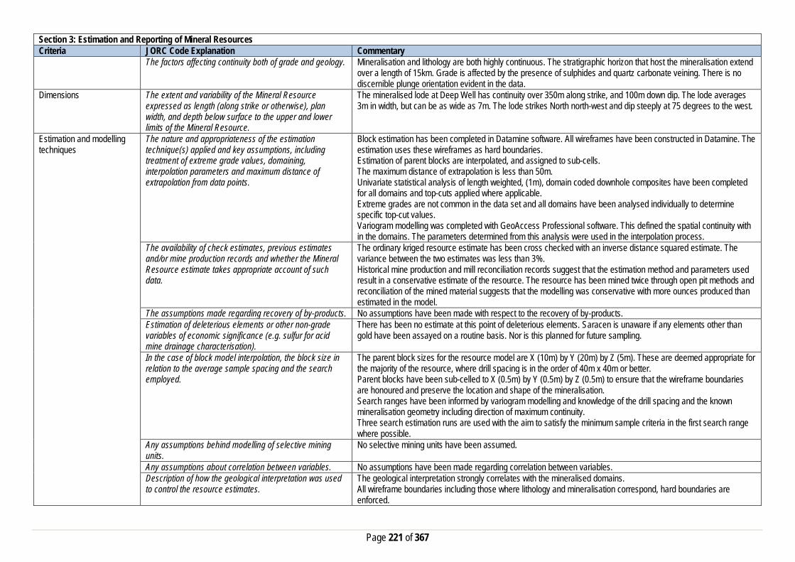
Page 221 of 367
Section 3: Estimation and Reporting of Mineral Resources Criteria JORC Code Explanation Commentary
The factors affecting continuity both of grade and geology. Mineralisation and lithology are both highly continuous. The stratigraphic horizon that host the mineralisation extend over a length of 15km. Grade is affected by the presence of sulphides and quartz carbonate veining. There is no discernible plunge orientation evident in the data.
Dimensions The extent and variability of the Mineral Resource expressed as length (along strike or otherwise), plan width, and depth below surface to the upper and lower limits of the Mineral Resource.
The mineralised lode at Deep Well has continuity over 350m along strike, and 100m down dip. The lode averages 3m in width, but can be as wide as 7m. The lode strikes North north-west and dip steeply at 75 degrees to the west.
Estimation and modelling techniques
The nature and appropriateness of the estimation technique(s) applied and key assumptions, including treatment of extreme grade values, domaining, interpolation parameters and maximum distance of extrapolation from data points.
Block estimation has been completed in Datamine software. All wireframes have been constructed in Datamine. The estimation uses these wireframes as hard boundaries. Estimation of parent blocks are interpolated, and assigned to sub-cells. The maximum distance of extrapolation is less than 50m. Univariate statistical analysis of length weighted, (1m), domain coded downhole composites have been completed for all domains and top-cuts applied where applicable. Extreme grades are not common in the data set and all domains have been analysed individually to determine specific top-cut values. Variogram modelling was completed with GeoAccess Professional software. This defined the spatial continuity with in the domains. The parameters determined from this analysis were used in the interpolation process.
The availability of check estimates, previous estimates and/or mine production records and whether the Mineral Resource estimate takes appropriate account of such data.
The ordinary kriged resource estimate has been cross checked with an inverse distance squared estimate. The variance between the two estimates was less than 3%. Historical mine production and mill reconciliation records suggest that the estimation method and parameters used result in a conservative estimate of the resource. The resource has been mined twice through open pit methods and reconciliation of the mined material suggests that the modelling was conservative with more ounces produced than estimated in the model.
The assumptions made regarding recovery of by-products. No assumptions have been made with respect to the recovery of by-products. Estimation of deleterious elements or other non-grade variables of economic significance (e.g. sulfur for acid mine drainage characterisation).
There has been no estimate at this point of deleterious elements. Saracen is unaware if any elements other than gold have been assayed on a routine basis. Nor is this planned for future sampling.
In the case of block model interpolation, the block size in relation to the average sample spacing and the search employed.
The parent block sizes for the resource model are X (10m) by Y (20m) by Z (5m). These are deemed appropriate for the majority of the resource, where drill spacing is in the order of 40m x 40m or better. Parent blocks have been sub-celled to X (0.5m) by Y (0.5m) by Z (0.5m) to ensure that the wireframe boundaries are honoured and preserve the location and shape of the mineralisation. Search ranges have been informed by variogram modelling and knowledge of the drill spacing and the known mineralisation geometry including direction of maximum continuity. Three search estimation runs are used with the aim to satisfy the minimum sample criteria in the first search range where possible.
Any assumptions behind modelling of selective mining units.
No selective mining units have been assumed.
Any assumptions about correlation between variables. No assumptions have been made regarding correlation between variables. Description of how the geological interpretation was used to control the resource estimates.
The geological interpretation strongly correlates with the mineralised domains. All wireframe boundaries including those where lithology and mineralisation correspond, hard boundaries are enforced.

Page 222 of 367
Section 3: Estimation and Reporting of Mineral Resources Criteria JORC Code Explanation Commentary
Discussion of basis for using or not using grade cutting or capping.
Statistical analysis of all domains highlight that there are very few grades in the domain populations that require top-cutting. Top-cut have been employed to eliminate the risk of overestimating in the local areas where a few high grade sample exist. A sensitivity analysis was carried out on the data, by relaxing the top-cut values. This did not have a material effect on the resultant grades in the model.
The process of validation, the checking process used, the comparison of model data to drill hole data, and use of reconciliation data if available.
Several key model validation steps have been taken to validate the resource estimate. The mineral resource model has been stepped through visually in sectional and plan view to appreciate the composite grades used in the estimate and the resultant block grades. This has also been carried out in 3D with the composite grades and a point cloud of the model grades. Easting, Northing and Elevation swathe plots have been constructed to evaluate the composited assay means verses the mean block estimates. The mineral resource model has been constructed to include kriging efficiency and the slope of regression values. These values are used to measure the quality of the estimate. Natural deterioration of the quality is observed at the perimeter of the modelled areas where data density is lower. The estimate was checked against previously reconciled production records with tonnes being even with production but grade being lower than actual production.
Moisture Whether the tonnages are estimated on a dry basis or with natural moisture, and the method of determination of the moisture content.
All tonnages are estimated on a dry basis.
Cut-off parameters The basis of the adopted cut-off grade(s) or quality parameters applied.
Based on Saracen’s current economic operations at Carosue Dam, and the natural grade distinction above background, a grade of 0.5g/t has been chosen.
Mining factors or assumptions
Assumptions made regarding possible mining methods, minimum mining dimensions and internal (or, if applicable, external) mining dilution. It is always necessary as part of the process of determining reasonable prospects for eventual economic extraction to consider potential mining methods, but the assumptions made regarding mining methods and parameters when estimating Mineral Resources may not always be rigorous. Where this is the case, this should be reported with an explanation of the basis of the mining assumptions made.
The Deep Well deposit is amenable to mining by open pit methods. Currently the definition of the resource does not highlight any potential future for underground mining operations.
Metallurgical factors or assumptions
The basis for assumptions or predictions regarding metallurgical amenability. It is always necessary as part of the process of determining reasonable prospects for eventual economic extraction to consider potential metallurgical methods, but the assumptions regarding metallurgical treatment process and parameters made when reporting Mineral Resources may not always be rigorous. Where this is the case, this should be reported with an explanation of the basis of the metallurgical assumptions made.
Deep Well has not previously been treated through the Carosue Dam treatment plant. Given the geological similarities between Deep South and Deep Well it has been assumed that metallurgical properties are also similar. Recent test work of Deep South ore demonstrates that recoveries between 82% and 88% are achievable. The ore is relatively soft and the majority of the gold is free milling. The ore also has a predictable grind dependency / leach recovery relationship. The test work also highlights that the ore is not chemically refractory and contains no preg robbing properties.
Environmental factors or assumptions
Assumptions made regarding possible waste and process residue disposal options. It is always necessary as part of the process of determining reasonable prospects for
No specific waste rock characterisation has been conducted at Deep Well. This test work will be completed if the resource is converted into a reserve. Waste rock characterisation carried out at Deep South (similar geology to

Page 223 of 367
Section 3: Estimation and Reporting of Mineral Resources Criteria JORC Code Explanation Commentary
eventual economic extraction to consider the potential environmental impacts of the mining and processing operation. While at this stage the determination of potential environmental impacts, particularly for a greenfields project, may not always be well advanced, the status of early consideration of these potential environmental impacts should be reported. Where these aspects have not been considered this should be reported with an explanation of the environmental assumptions made.
Deep Well) identified no environmental issues. Tailings from the deposit would be stored in an appropriate licensed tailings facility and closure plan in place if mined and processed in the future.
Bulk Density Whether assumed or determined. If assumed, the basis for the assumptions. If determined, the method used, whether wet or dry, the frequency of the measurements, the nature, size and representativeness of the samples.
The bulk densities for Deep Well were determined via testing of transitional rock samples from the limited outcrop, with most densities being assumed from the nearby Deep South deposit. The sample size is generally between 0.5 and 1.5kg and the method of calculation is the water displacement technique. Measurements have been recorded in the acquire database and extraction schemes pair this data with the major lithology code for statistical analysis.
The bulk density for bulk material must have been measured by methods that adequately account for void spaces (vugs, porosity, etc), moisture and differences between rock and alteration zones within the deposit.
Data spacing is well distributed and in some locations, infill “grade control” patterns have been drilled to confirm continuity and grade. In these areas confidence is very good.
Discuss assumptions for bulk density estimates used in the evaluation process of the different materials.
An average mean of densities collected for each lithological type has been uniformly applied to the modelled geological units. This includes the primary fresh lithologies as well as the weathered oxide and transitional zones. These samples are from the nearby Deep South deposit as there is no diamond core available for Deep Well at this point. It has been determined that the two mineralised systems are similar enough to draw this assumption.
Classification The basis for the classification of the Mineral Resources into varying confidence categories.
The mineral resource has been classified into Measured, Indicated and Inferred categories based on drill hole spacing, geological confidence, and grade continuity and estimation quality. The combination of these factors together guide the digitising of a “cookie cutter” string in long section view which selects and codes the appropriate blocks with the nominated resource classification category.
Whether appropriate account has been taken of all the relevant factors (ie relative confidence in tonnage/grade estimations, reliability of input data, confidence in continuity of geology and metal values, quality, quantity and distribution of the data).
All care has been taken to account for relevant factors influencing the mineral resource estimate. Confidence in the predicted tonnes and grade estimated in the model is high given the density of data controlling the mineralised domains and the relative simplicity of the geology.
Whether the result appropriately reflects the Competent Person's view of the deposit.
The geological model and the mineral resource estimate reflect the competent person’s view of the deposit.
Audits or reviews The results of any audits or reviews of Mineral Resource estimates.
At the completion of a resource estimation Saracen Gold Mines undertake an extensive review of the model that covers model inventory and comparisons to previous models, geological interpretation, wireframing, domain selection, statistics by domain, assay evaluation, parent cell sizes, data compositing, variography, search strategy, estimation and QKNA and finally model validation and resource categorisation are all discussed and scrutinized by the geological and mine planning teams.
Discussion of relative accuracy/confidence
Where appropriate a statement of the relative accuracy and confidence level in the Mineral Resource estimate using an approach or procedure deemed appropriate by the Competent Person. For example, the application of statistical or geostatistical procedures to quantify the
The Mineral Resource has been reported in accordance with the guidelines of the JORC 2012 edition of the Australasian Code for Reporting of Exploration Results, Mineral Resources and Ore Reserves. Saracen Gold Mine uses a standard approach to resource estimation and the procedure requires the systematic completion of the Saracen Resource Estimation Document that is thoroughly investigated and assessed in the Model review process,

Page 224 of 367
Section 3: Estimation and Reporting of Mineral Resources Criteria JORC Code Explanation Commentary
relative accuracy of the resource within stated confidence limits, or, if such an approach is not deemed appropriate, a qualitative discussion of the factors that could affect the relative accuracy and confidence of the estimate.
as stated above. It was identified that further work on QKNA for block size and search ellipses would help to further improve the optimisation of the block model.
The statement should specify whether it relates to global or local estimates, and, if local, state the relevant tonnages, which should be relevant to technical and economic evaluation. Documentation should include assumptions made and the procedures used.
The statements relate to a global estimate of tonnes and grade.
These statements of relative accuracy and confidence of the estimate should be compared with production data, where available.
There is one small shaft at Deep Well, which from probe drilling has very limited extents. No production data is available at this time.
Box Well
Section 1: Sampling Techniques and Data Criteria JORC Code Explanation Commentary Sampling Techniques Nature and quality of sampling (e.g. cut channels, random
chips, or specific specialised industry standard measurement tools appropriate to the minerals under investigation, such as down hole gamma sondes, or handheld XRF instruments, etc.). These examples should not be taken as limiting the broad meaning of sampling.
Sampling methods undertaken at Box Well by previous owners have included aircore (AC) rotary air blast (RAB) reverse circulation (RC) and diamond (DD) drilling along with auger and soil sampling. Limited historical data has been provided by previous owners. Saracen has not carried out any sampling activities at the Box Well deposit due to only recently acquiring the deposit.
Include reference to measures taken to ensure sample representivity and the appropriate calibration of any measurement tools or systems used
RC, RAB, and DD core drilling is assumed to have been completed by previous holders to industry standard at that time.
Aspects of the determination of mineralisation that are Material to the Public Report. In cases where ‘industry standard’ work has been done this would be relatively simple (e.g. ‘reverse circulation drilling was used to obtain 1 m samples from which 3 kg was pulverised to produce a 30 g charge for fire assay’). In other cases more explanation may be required, such as where there is coarse gold that has inherent sampling problems. Unusual commodities or mineralisation types (e.g. submarine nodules) may warrant disclosure of detailed information
RC chips were riffle split and sampled to 1m intervals with samples selected to weigh between 2.5 - 3.5 kg. Aircore and RAB drilling was spear sampled. Sampling methods for DD drilling are unknown. Sampling was generally analysed via 30g or 50g fire assay No information has been found or supplied for older drilling assumed all RAB, RC and DD and sampling was carried out to industry standard at that time. Most assay methods are unknown
Drilling Techniques Drill type (e.g. core, reverse circulation, open-hole hammer, rotary air blast, auger, Bangka, sonic, etc.) and details (e.g. core diameter, triple or standard tube, depth
Drilling activities at Box Well initially included included a number of RAB, RC and AC holes. The resource was further defined with 110 RC holes and 3 DD holes (unknown diameter). It is unknown if core was oriented.

Page 225 of 367
Section 1: Sampling Techniques and Data Criteria JORC Code Explanation Commentary
of diamond tails, face-sampling bit or other type, whether core is oriented and if so, by what method, etc.).
Drill Sample Recovery Method of recording and assessing core and chip sample recoveries and results assessed
Recoveries for some more recent RC drilling have been recorded based on a visual weight estimate. No other recoveries have been provided, it is unknown if they were recorded.
Measures taken to maximise sample recovery and ensure representative nature of the samples
RC drilling utilised a compressor to ensure sample recovery and representivity, methods for other drilling are unknown.
Whether a relationship exists between sample recovery and grade and whether sample bias may have occurred due to preferential loss/gain of fine/coarse material.
Any historical relationship is not known.
Logging Whether core and chip samples have been geologically and geotechnically logged to a level of detail to support appropriate Mineral Resource estimation, mining studies and metallurgical studies. Whether logging is qualitative or quantitative in nature. Core (or costean, channel, etc) photography.
Logging of diamond drill core, AC, RAB, and RC chips record lithology, mineralogy, texture, mineralisation, weathering, alteration and veining. It is unknown if all diamond core was photographed. All chips have been retained in chip trays
The total length and percentage of the relevant intersections logged
All drillholes appear to have been logged in full, with AC, RC and RAB drilling logged by the metre
Sub-sampling techniques and sample preparation
If core, whether cut or sawn and whether quarter, half or all core taken.
The sampling method for drill core is unknown
If non-core, whether riffled, tube sampled, rotary split, etc and whether sampled wet or dry.
RAB drilling was spear sampled, RC samples were riffle split, most samples were dry Some sampling methods remain unknown.
For all sample types, the nature, quality and appropriateness of the sample preparation technique.
The sample preparation techniques for much of the historic AC, RAB, RC and DD drilling are unknown, best practice is assumed.
Quality control procedures adopted for all sub-sampling stages to maximise representivity of samples.
Best practice is assumed at the time of historic RAB, DD and RC sampling.
Measures taken to ensure that the sampling is representative of the in situ material collected, including for instance results for field duplicate/second half sampling.
It is unknown if duplicate sampling was performed on all exploration drilling. Some field duplicates were carried out on some more recent RC drilling
Whether sample sizes are appropriate to the grain size of the material being sampled.
It is assumed sample sizes were appropriate for the grain size of material being sampled.
Quality of assay data and laboratory tests
The nature, quality and appropriateness of the assaying and laboratory procedures used and whether the technique is considered partial or total.
A 30 or 50 gram fire assay with AAS finish was used to determine the gold concentration much of the recent drilling. This method is considered suitable for determining gold concentrations in rock and is a total digest method.
For geophysical tools, spectrometers, handheld XRF instruments, etc, the parameters used in determining the analysis including instrument make and model, reading times, calibrations factors applied and their derivation, etc.
It is unknown if any instruments of this nature have been used at Box Well. Saracen has not had full access to all the data during the acquisition process.
Nature of quality control procedures adopted (e.g. standards, blanks, duplicates, external laboratory checks) and whether acceptable levels of accuracy (i.e. lack of bias) and precision have been established.
QAQC samples were submitted with all drill sampling activities at a rate of 6/100 for standards and 1/100 for blank material. All QAQC sample are noted to have performed well within expected limits
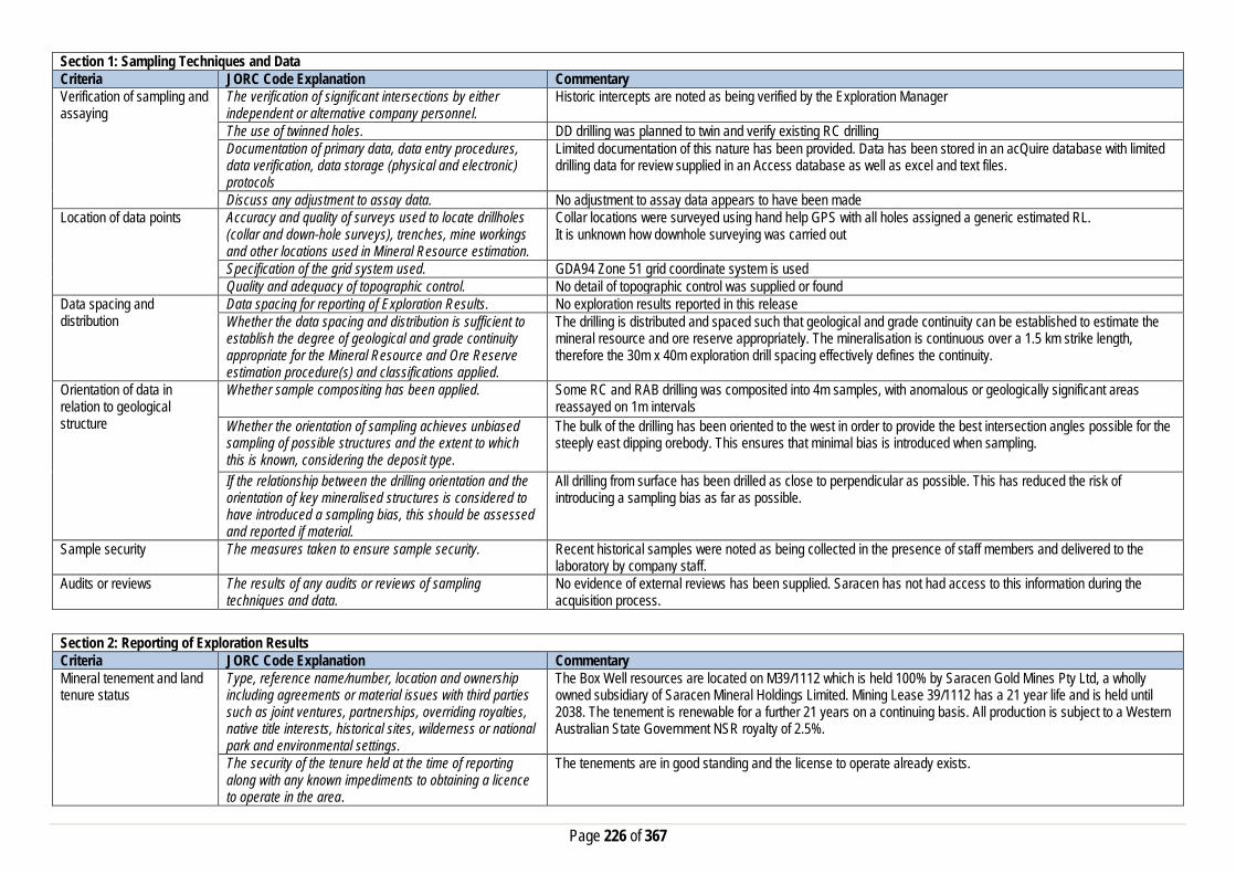
Page 226 of 367
Section 1: Sampling Techniques and Data Criteria JORC Code Explanation Commentary Verification of sampling and assaying
The verification of significant intersections by either independent or alternative company personnel.
Historic intercepts are noted as being verified by the Exploration Manager
The use of twinned holes. DD drilling was planned to twin and verify existing RC drilling Documentation of primary data, data entry procedures, data verification, data storage (physical and electronic) protocols
Limited documentation of this nature has been provided. Data has been stored in an acQuire database with limited drilling data for review supplied in an Access database as well as excel and text files.
Discuss any adjustment to assay data. No adjustment to assay data appears to have been made Location of data points Accuracy and quality of surveys used to locate drillholes
(collar and down-hole surveys), trenches, mine workings and other locations used in Mineral Resource estimation.
Collar locations were surveyed using hand help GPS with all holes assigned a generic estimated RL. It is unknown how downhole surveying was carried out
Specification of the grid system used. GDA94 Zone 51 grid coordinate system is used Quality and adequacy of topographic control. No detail of topographic control was supplied or found
Data spacing and distribution
Data spacing for reporting of Exploration Results. No exploration results reported in this release Whether the data spacing and distribution is sufficient to establish the degree of geological and grade continuity appropriate for the Mineral Resource and Ore Reserve estimation procedure(s) and classifications applied.
The drilling is distributed and spaced such that geological and grade continuity can be established to estimate the mineral resource and ore reserve appropriately. The mineralisation is continuous over a 1.5 km strike length, therefore the 30m x 40m exploration drill spacing effectively defines the continuity.
Orientation of data in relation to geological structure
Whether sample compositing has been applied.
Some RC and RAB drilling was composited into 4m samples, with anomalous or geologically significant areas reassayed on 1m intervals
Whether the orientation of sampling achieves unbiased sampling of possible structures and the extent to which this is known, considering the deposit type.
The bulk of the drilling has been oriented to the west in order to provide the best intersection angles possible for the steeply east dipping orebody. This ensures that minimal bias is introduced when sampling.
If the relationship between the drilling orientation and the orientation of key mineralised structures is considered to have introduced a sampling bias, this should be assessed and reported if material.
All drilling from surface has been drilled as close to perpendicular as possible. This has reduced the risk of introducing a sampling bias as far as possible.
Sample security The measures taken to ensure sample security. Recent historical samples were noted as being collected in the presence of staff members and delivered to the laboratory by company staff.
Audits or reviews The results of any audits or reviews of sampling techniques and data.
No evidence of external reviews has been supplied. Saracen has not had access to this information during the acquisition process.
Section 2: Reporting of Exploration Results Criteria JORC Code Explanation Commentary Mineral tenement and land tenure status
Type, reference name/number, location and ownership including agreements or material issues with third parties such as joint ventures, partnerships, overriding royalties, native title interests, historical sites, wilderness or national park and environmental settings.
The Box Well resources are located on M39/1112 which is held 100% by Saracen Gold Mines Pty Ltd, a wholly owned subsidiary of Saracen Mineral Holdings Limited. Mining Lease 39/1112 has a 21 year life and is held until 2038. The tenement is renewable for a further 21 years on a continuing basis. All production is subject to a Western Australian State Government NSR royalty of 2.5%.
The security of the tenure held at the time of reporting along with any known impediments to obtaining a licence to operate in the area.
The tenements are in good standing and the license to operate already exists.

Page 227 of 367
Section 2: Reporting of Exploration Results Criteria JORC Code Explanation Commentary Exploration done by other parties
Acknowledgment and appraisal of exploration by other parties.
The Bow Well area was soil sampled by Anglogold Australia, WMC and Delta gold between 1986 -2000. No further work was carried out until Hawthorn acquired the tenements and carried out soil and auger sampling, and RAB, RC and DD drilling
Geology Deposit type, geological setting and style of mineralisation.
Locally the geology of the Box Well area consists of intermediate schists and igneous intrusives adjacent to sediments. Basaltic andesite, felsic volcanics and volcaniclastics trend in a north west- south east direction. The northern tenements are dominated by interbedded undifferentiated sediments and andesite. Differentiated doleritic sills intrude into conglomeritic and polymictic sands stones towards the east of the tenements. Interbedded ultramafic, peridotite-bearing intrusives and dolerite form a distinctive north-west trend in along the west of the tenements. These lithologies can be overlain by Cenozoic ferruginous clay, colluvium and silts. Several significant drainage systems in the licence are associated with alluvium, clay, silt and sand
Drillhole information A summary of all information material to the understanding of the exploration results including a tabulation of the following information for all Material drill holes: • easting and northing of the drill hole collar • elevation or RL (Reduced Level – elevation
above sea level in metres) of the drill hole collar • dip and azimuth of the hole • down hole length and interception depth • hole length. • f the exclusion of this information is justified on
the basis that the information is not Material and this exclusion does not detract from the understanding of the report, the Competent Person should clearly explain why this is the case.
A total of 92 holes have been used in the mineral resource and are deemed to be material. It is not practical to summarise all of the holes here in this release. Future drill hole data will be periodically released or when a results materially change the economic value of the project. Exclusion of the drilling information will not detract from the reader’s view of the report.
Data aggregation methods In reporting Exploration Results, weighting averaging techniques, maximum and/or minimum grade truncations (e.g. cutting of high grades) and cut-off grades are usually Material and should be stated.
No exploration results are reported in this release.
Where aggregate intercepts incorporate short lengths of high grade results and longer lengths of low grade results, the procedure used for such aggregation should be stated and some typical examples of such aggregations should be shown in detail.
No exploration results are reported in this release.
The assumptions used for any reporting of metal equivalent values should be clearly stated.
No exploration results are reported in this release.
Relationship between mineralisation widths and intercept lengths
These relationships are particularly important in the reporting of Exploration Results. If the geometry of the mineralisation with respect to the drill hole angle is known, its nature should be reported.
Saracen has not previously reported exploration results nor are any included in this release. Drilling has been orientated to intersect the various orebodies at most optimum angle where possible. This has not always been achieved. On average drilling intersects the mineralisation perpendicular.

Page 228 of 367
Section 2: Reporting of Exploration Results Criteria JORC Code Explanation Commentary
If it is not known and only the down hole lengths are reported, there should be a clear statement to this effect (eg ‘down hole length, true width not known’).
Diagrams Appropriate maps and sections (with scales) and tabulations of intercepts should be included for any significant discovery being reported These should include, but not be limited to a plan view of drill hole collar locations and appropriate sectional views.
No diagrams are referenced in this release.
Balanced Reporting Where comprehensive reporting of all Exploration Results are not practicable, representative reporting of both low and high grades and/or widths should be practiced to avoid misleading reporting of Exploration Results.
Saracen has not previously reported exploration results nor are any included in this release.
Other substantive exploration data
Other exploration data, if meaningful and material, should be reported including (but not limited to): geological observations; geophysical survey results; geochemical survey results; bulk samples – size and method of treatment; metallurgical test results; bulk density, groundwater, geotechnical and rock characteristics; potential deleterious or contaminating substances.
Detailed SAM (sub-audio magnetics) and aeromagnetic surveys were carried out over Box Well and surrounding tenements by previous owners in order to define targets for drilling
Further work The nature and scale of planned further work (eg tests for lateral extensions or depth extensions or large-scale step-out drilling). Diagrams clearly highlighting the areas of possible extensions, including the main geological interpretations and future drilling areas, provided this information is not commercially sensitive
Saracen is currently working on establishing an exploration program which will identify areas of opportunity to extend or enhance the Box Well mineral resource.
Section 3: Estimation and Reporting of Mineral Resources Criteria JORC Explanation Commentary Database Integrity Measures taken to ensure that data has not been
corrupted by, for example, transcription or keying errors, between its initial collection and its use for Mineral Resource estimation purposes.
The database provide to Saracen was stored in a number of excel spreadsheets and text files. The primary database is regulated by a locked framework called the acquire data model which fixes the relationships between tables. The data model minimises the potential for data collection and data usage errors through pre-determined look up tables, storage and export functions. User defined permissions also regulate the ability to add, edit or extract data. It is unknown at this stage how the process used to record the primary data. Typical methods are manual translation of logging and data capture from written logs, direct import of csv tables through a data import scheme where data is validated upon import or direct data entry options into the database using predefined look up values.
Data validation procedures used. The rigid structure of the acquire data model is such that predefined rules and look up tables are applied to all data entry. Data that does not meet the criteria are highlighted and moved to a buffer area until the data is rectified to meet the passing rules. It is unknown at this stage how the database was managed and who was responsible for its maintenance. It is also unknown if there was any built in functionality around pass/fail checks on assay importing.

Page 229 of 367
Section 3: Estimation and Reporting of Mineral Resources Criteria JORC Explanation Commentary Site Visits Comment on any site visits undertaken by the Competent
Person and the outcome of those visits. The competent person regularly visited site and directed work in his role as Exploration Manager.
If no site visits have been undertaken indicate why this is the case.
Geological Interpretation Confidence in (or conversely, the uncertainty of) the geological interpretation of the mineral deposit. Nature of the data used and any assumptions made. The affect, if any, of alternative interpretations on Mineral Resource estimation. The use of geology in guiding and controlling the Mineral Resource estimation. The factors affecting continuity both of grade and geology.
At the Box Well Prospect a strongly gold mineralised, silicified shear zone has been discovered within a broader, gold mineralised, altered stockwork quartz veined package of felsic volcanics and volcaniclastic sediments. Despite an extensive history of modern exploration in the prospect area this newly identified mineralised unit had not previously been identified or drilled, prior to Hawthorn’s (Previous owner) exploration discovery. The gold mineralised zones dip consistently at 40 and 65 degrees to the east or north east. The mineralised widths vary between 3 – >30 metres true width. The generally thick and consistent nature of the mineralisation intersected to date indicates that limited dilution may be occur should an open pit mining operation be developed. Drilling to date has not indicated that the gold mineralisation develops a plunge orientation, however this remains a possibility. All available geological data including RC and DDH drilling has been used in the interpretation. It is understood that there are no known factors which would affect the geological continuity and grade.
Dimensions The extent and variability of the Mineral Resource expressed as length (along strike or otherwise), plan width, and depth below surface to the upper and lower limits of the Mineral Resource.
The zone of mineralization extends for approximately 1500 m along strike, 3 to 30 m across strike and from near surface (1-2 m BSL) up to 180 m vertically. Limited drilling has occurred between 100 metres and 180 metres vertical depth. The 100 m BSL (287 m RL) was used as a vertical constraint for Indicated material based on both a lack of drillholes beneath this depth and an estimate of the realistic notional mining depth of an open cut pit
Estimation and modelling techniques
The nature and appropriateness of the estimation technique(s) applied and key assumptions, including treatment of extreme grade values, domaining, interpolation parameters and maximum distance of extrapolation from data points. The availability of check estimates, previous estimates and/or mine production records and whether the Mineral Resource estimate takes appropriate account of such data. The assumptions made regarding recovery of by-products. Estimation of deleterious elements or other non-grade variables of economic significance (e.g. sulfur for acid mine drainage characterisation). In the case of block model interpolation, the block size in relation to the average sample spacing and the search employed. Any assumptions behind modelling of selective mining units. Any assumptions about correlation between variables. Description of how the geological interpretation was used to control the resource estimates.
There are no by-products currently known. At this time there has been no estimation for deleterious elements as the data collection is ongoing. There is no correlation between gold grades and any other element known at this time. There is no relationship between grade and structure or depth. A potential correlation between mineralisation and brecciation of a fine grained silicified felsic tuff and or lava unit is considered
possible. Surpac software was used for the estimation. JORC Code 2012 Block model cell sizes of 5 mE x 15 mN x 5 mZ were used Variogram modelling completed using Snowdens Supervisor software Models were generated on normal scores variograms and back transformed for use in Surpac Modelling was completed on 1 Lode of 7 known lodes as it was the only lode with sufficient data to create a reasonable variogram model. Ore lodes with insufficient sample were estimated using Inverse Distance (squared) estimation techniques. The variogram model for 1 Lode had two structures and was a nested-spherical model. Each lode was assessed individually for bias from extreme grades Composite statistics from the global dataset produced a Coefficient of Variation of 1.19, a value representative of a homogenous dataset with a single population of grades. Based on this
assessment it was deemed unnecessary to top cut the data. Saracen recently undertook a check estimate of the Box Well resource before it acquired the project, and the results were very close to those reported by the pervious owners.

Page 230 of 367
Section 3: Estimation and Reporting of Mineral Resources Criteria JORC Explanation Commentary
The process of validation, the checking process used, the comparison of model data to drill hole data, and use of reconciliation data if available.
Moisture Whether the tonnages are estimated on a dry basis or with natural moisture, and the method of determination of the moisture content.
Tonnage has been calculation on a dry bulk density. No allowance for moisture has been made.
Cut-off parameters The basis of the adopted cut-off grade(s) or quality parameters applied.
A range of cut-off grade models have been produced – with 0.5, 1.0 & 1.5 g/t Au reported.
Mining factors or assumptions
Assumptions made regarding possible mining methods, minimum mining dimensions and internal (or, if applicable, external) mining dilution. It is always necessary as part of the process of determining reasonable prospects for eventual economic extraction to consider potential mining methods, but the assumptions made regarding mining methods and parameters when estimating Mineral Resources may not always be rigorous. Where this is the case, this should be reported with an explanation of the basis of the mining assumptions made.
Open pit mining is proposed once the extent of the resource is fully understood. Minimal mining dilution is expected due to the broad nature of the ore lodes at Box Well. Saracen will soon commence a Scoping study to assess the economics of the project and how it could be incorporated into Saracen’s life of mine plan.
Metallurgical factors or assumptions
The basis for assumptions or predictions regarding metallurgical amenability. It is always necessary as part of the process of determining reasonable prospects for eventual economic extraction to consider potential metallurgical methods, but the assumptions regarding metallurgical treatment process and parameters made when reporting Mineral Resources may not always be rigorous. Where this is the case, this should be reported with an explanation of the basis of the metallurgical assumptions made.
No detailed metallurgical recovery work has been undertaken at this time at Box Well. Further work is ongoing to confirm that there are no deleterious properties at Box Well
Environmental factors or assumptions
Assumptions made regarding possible waste and process residue disposal options. It is always necessary as part of the process of determining reasonable prospects for eventual economic extraction to consider the potential environmental impacts of the mining and processing operation. While at this stage the determination of potential environmental impacts, particularly for a greenfields project, may not always be well advanced, the status of early consideration of these potential environmental impacts should be reported. Where these aspects have not been considered this should be reported with an explanation of the environmental assumptions made.
Work is required to confirm that there will be no impact from acid rock drainage (ARD) from waste material at the Box Well prospect. Any tailings placement to be stored on site will require detailed environmental assessment.

Page 231 of 367
Section 3: Estimation and Reporting of Mineral Resources Criteria JORC Explanation Commentary Bulk Density Whether assumed or determined. If assumed, the basis
for the assumptions. If determined, the method used, whether wet or dry, the frequency of the measurements, the nature, size and representativeness of the samples. The bulk density for bulk material must have been measured by methods that adequately account for void spaces (vugs, porosity, etc), moisture and differences between rock and alteration zones within the deposit. The basis for the classification of the Mineral Resources into varying confidence categories.
A total of 290 core samples were assessed for Specific Gravity by wax immersion at Bureau Veritas Kalgoorlie 17 Holes at Box Well were surveyed by a Geovista Dual gamma probe operated by ABIMS Pty Ltd Density data from the diamond core was used as a benchmark for calibration of the downhole survey density data
Classification The basis for the classification of the Mineral Resources into varying confidence categories. Whether appropriate account has been taken of all the relevant factors (ie relative confidence in tonnage/grade estimations, reliability of input data, confidence in continuity of geology and metal values, quality, quantity and distribution of the data). Whether the result appropriately reflects the Competent Person's view of the deposit.
The Box Well Resources was classified as either Indicated or Inferred based on a number of factors, such as • Distance to nearest sample • Number of samples used for estimation and • Estimation pass
In addition, an elevation boundary 100 m below surface (287 mRL) • was used as a vertical constraint for Indicated material, based upon • on both a lack of drillhole intercepts beyond this depth and • achievable mining parameters - with open cut pits typically not exceeding 100 vertical metres
Audits or reviews The results of any audits or reviews of Mineral Resource estimates.
No audits have been done at this time.
Discussion of relative accuracy/confidence
Where appropriate a statement of the relative accuracy and confidence level in the Mineral Resource estimate using an approach or procedure deemed appropriate by the Competent Person. For example, the application of statistical or geostatistical procedures to quantify the relative accuracy of the resource within stated confidence limits, or, if such an approach is not deemed appropriate, a qualitative discussion of the factors that could affect the relative accuracy and confidence of the estimate. The statement should specify whether it relates to global or local estimates, and, if local, state the relevant tonnages, which should be relevant to technical and economic evaluation. Documentation should include assumptions made and the procedures used. These statements of relative accuracy and confidence of the estimate should be compared with production data, where available.
At this time the Indicated Mineral resources are being considered for further technical evaluation. The statements relate to global estimate of tonnes and grade. Following metallurgical / hydrological / geotechnical assessments to be carried out in the upcoming quarters a Scoping study may be produced that assesses the economic viability of each resources Further drilling both along strike and at depth has been recommended by the previous owners

Page 232 of 367
Belize
Section 1: Sampling Techniques and Data Criteria JORC Code Explanation Commentary Sampling Techniques Nature and quality of sampling (e.g. cut channels, random
chips, or specific specialised industry standard measurement tools appropriate to the minerals under investigation, such as down hole gamma sondes, or handheld XRF instruments, etc.). These examples should not be taken as limiting the broad meaning of sampling.
Sampling methods undertaken at Belize by previous owners have included aircore (AC) rotary air blast (RAB) reverse circulation (RC) and diamond (DD) drilling along with auger and soil sampling. Limited historical data has been provided by previous owners. Saracen has not carried out any sampling activities at the Belize deposit due to only recently acquiring the deposit.
Include reference to measures taken to ensure sample representivity and the appropriate calibration of any measurement tools or systems used
RC, RAB, and DD core drilling is assumed to have been completed by previous holders to industry standard at that time.
Aspects of the determination of mineralisation that are Material to the Public Report. In cases where ‘industry standard’ work has been done this would be relatively simple (e.g. ‘reverse circulation drilling was used to obtain 1 m samples from which 3 kg was pulverised to produce a 30 g charge for fire assay’). In other cases more explanation may be required, such as where there is coarse gold that has inherent sampling problems. Unusual commodities or mineralisation types (e.g. submarine nodules) may warrant disclosure of detailed information
RC chips were riffle split and sampled to 1m intervals with samples selected to weigh between 2.5 - 3.5 kg. Aircore and RAB drilling was spear sampled. Sampling methods for DD drilling are unknown. Sampling was generally analysed via 30g or 50g fire assay No information has been found or supplied for older drilling assumed all RAB, RC and DD and sampling was carried out to industry standard at that time. Most assay methods are unknown
Drilling Techniques Drill type (e.g. core, reverse circulation, open-hole hammer, rotary air blast, auger, Bangka, sonic, etc.) and details (e.g. core diameter, triple or standard tube, depth of diamond tails, face-sampling bit or other type, whether core is oriented and if so, by what method, etc.).
Drilling activities at Belize initially included a number of RAB, RC and AC holes. The resource was further defined with 107 RC holes and 2 DD holes (unknown diameter). It is unknown if core was oriented.
Drill Sample Recovery Method of recording and assessing core and chip sample recoveries and results assessed
Recoveries for some more recent RC drilling have been recorded based on a visual weight estimate. No other recoveries have been provided, it is unknown if they were recorded.
Measures taken to maximise sample recovery and ensure representative nature of the samples
RC drilling utilised a compressor to ensure sample recovery and representivity, methods for other drilling are unknown.
Whether a relationship exists between sample recovery and grade and whether sample bias may have occurred due to preferential loss/gain of fine/coarse material.
Any historical relationship is not known.
Logging Whether core and chip samples have been geologically and geotechnically logged to a level of detail to support appropriate Mineral Resource estimation, mining studies and metallurgical studies. Whether logging is qualitative or quantitative in nature. Core (or costean, channel, etc) photography.
Logging of diamond drill core, AC, RAB, and RC chips record lithology, mineralogy, texture, mineralisation, weathering, alteration and veining. It is unknown if all diamond core was photographed. All chips have been retained in chip trays
The total length and percentage of the relevant intersections logged
All drillholes appear to have been logged in full, with AC, RC and RAB drilling logged by the metre

Page 233 of 367
Section 1: Sampling Techniques and Data Criteria JORC Code Explanation Commentary Sub-sampling techniques and sample preparation
If core, whether cut or sawn and whether quarter, half or all core taken.
The sampling method for drill core is unknown
If non-core, whether riffled, tube sampled, rotary split, etc and whether sampled wet or dry.
RAB drilling was spear sampled, RC samples were riffle split, most samples were dry Some sampling methods remain unknown.
For all sample types, the nature, quality and appropriateness of the sample preparation technique.
The sample preparation techniques for much of the historic AC, RAB, RC and DD drilling are unknown, best practice is assumed.
Quality control procedures adopted for all sub-sampling stages to maximise representivity of samples.
Best practice is assumed at the time of historic RAB, DD and RC sampling.
Measures taken to ensure that the sampling is representative of the in situ material collected, including for instance results for field duplicate/second half sampling.
It is unknown if duplicate sampling was performed on all exploration drilling. Some field duplicates were carried out on some more recent RC drilling
Whether sample sizes are appropriate to the grain size of the material being sampled.
It is assumed sample sizes were appropriate for the grain size of material being sampled.
Quality of assay data and laboratory tests
The nature, quality and appropriateness of the assaying and laboratory procedures used and whether the technique is considered partial or total.
A 30 or 50 gram fire assay with AAS finish was used to determine the gold concentration much of the recent drilling. This method is considered suitable for determining gold concentrations in rock and is a total digest method.
For geophysical tools, spectrometers, handheld XRF instruments, etc, the parameters used in determining the analysis including instrument make and model, reading times, calibrations factors applied and their derivation, etc.
It is unknown if any instruments of this nature have been used at Belize. Saracen has not had full access to all the data during the acquisition process.
Nature of quality control procedures adopted (e.g. standards, blanks, duplicates, external laboratory checks) and whether acceptable levels of accuracy (i.e. lack of bias) and precision have been established.
QAQC samples were submitted with all drill sampling activities at a rate of 6/100 for standards and 1/100 for blank material. All QAQC sample are noted to have performed well within expected limits
Verification of sampling and assaying
The verification of significant intersections by either independent or alternative company personnel.
Historic intercepts are noted as being verified by the Exploration Manager
The use of twinned holes. DD drilling was planned to twin and verify existing RC drilling Documentation of primary data, data entry procedures, data verification, data storage (physical and electronic) protocols
Limited documentation of this nature has been provided. Data has been stored in an acQuire database with limited drilling data for review supplied in an Access database as well as excel and text files.
Discuss any adjustment to assay data. No adjustment to assay data appears to have been made Location of data points Accuracy and quality of surveys used to locate drillholes
(collar and down-hole surveys), trenches, mine workings and other locations used in Mineral Resource estimation.
Collar locations were surveyed using hand help GPS with all holes assigned a generic estimated RL. It is unknown how downhole surveying was carried out
Specification of the grid system used. GDA94 Zone 51 grid coordinate system is used Quality and adequacy of topographic control. No detail of topographic control was supplied or found
Data spacing and distribution
Data spacing for reporting of Exploration Results. No exploration results reported in this release Whether the data spacing and distribution is sufficient to establish the degree of geological and grade continuity appropriate for the Mineral Resource and Ore Reserve estimation procedure(s) and classifications applied.
The drilling is distributed and spaced such that geological and grade continuity can be established to estimate the mineral resource and ore reserve appropriately. The mineralisation is continuous over a 1.3 km strike length, therefore the 30m x 40m exploration drill spacing effectively defines the continuity.

Page 234 of 367
Section 1: Sampling Techniques and Data Criteria JORC Code Explanation Commentary Orientation of data in relation to geological structure
Whether sample compositing has been applied.
Some RC and RAB drilling was composited into 4m samples, with anomalous or geologically significant areas reassayed on 1m intervals
Whether the orientation of sampling achieves unbiased sampling of possible structures and the extent to which this is known, considering the deposit type.
The majority of drilling at South is at -60 ° drilled towards 085 -090°. Orientations are at or within 10 degrees to the interpreted right angle of the strike of mineralisation. Dip of mineralisation is believed to be at 75-80° to the W. Drill hole traces deviate remarkably in several holes with 10-15° deviations towards the south common. Downhole surveys are taken at a minimum of 30 metre intervals. It is understood that there is no bias introduced by the drilling direction however.
If the relationship between the drilling orientation and the orientation of key mineralised structures is considered to have introduced a sampling bias, this should be assessed and reported if material.
All drilling from surface has been drilled as close to perpendicular as possible. This has reduced the risk of introducing a sampling bias as far as possible.
Sample security The measures taken to ensure sample security. Recent historical samples were noted as being collected in the presence of staff members and delivered to the laboratory by company staff.
Audits or reviews The results of any audits or reviews of sampling techniques and data.
No evidence of external reviews has been supplied. Saracen has not had access to this information during the acquisition process.
Section 2: Reporting of Exploration Results Criteria JORC Code Explanation Commentary Mineral tenement and land tenure status
Type, reference name/number, location and ownership including agreements or material issues with third parties such as joint ventures, partnerships, overriding royalties, native title interests, historical sites, wilderness or national park and environmental settings.
The Belize resources are located on M39/1109 and M39/1110 which is held 100% by Saracen Gold Mines Pty Ltd, a wholly owned subsidiary of Saracen Mineral Holdings Limited. The Mining Leases have a 21 year life and is held until 2038. Each tenement is renewable for a further 21 years on a continuing basis. All production is subject to a Western Australian State Government NSR royalty of 2.5%.
The security of the tenure held at the time of reporting along with any known impediments to obtaining a licence to operate in the area.
The tenements are in good standing and the license to operate already exists.
Exploration done by other parties
Acknowledgment and appraisal of exploration by other parties.
The Belize tenements have a limited exploration history with Gut nick Resources carrying out tenement wide RA drilling on 200 -800 metre fences and 40 – 80 metre drill spacing between 1999 - 2003. No further work was carried out on the tenements until Hawthorn obtained the tenements. Targets at were RC drilled by Hawthorn in 2010-2012. Follow-up RC programs were drilled in 2014, with extra holes drilled in 2016 in order to obtain the current resource estimation.
Geology Deposit type, geological setting and style of mineralisation.
The Belize Project tenements are interpreted to consist of a west to east sequence of shales, cherty felsic metasediments, mafic and ultramafic rocks, and diorite to granodiorite dykes that abut against a strongly foliated monzogranite. The contact between the highly foliated silicified quartzo-feldspathic sediments and the fine grained basalt is strongly deformed and interpreted to be associated with the Safari Fault system. Rare pegmatoid dyke are observed in the Paradise Well area of the Project Area. The ultramafic rocks consist of fine grained peridotites to talc carbonate schists whilst the mafic rocks are fine grained tholeiitic to high-Mg spinifex textured basalt. Little outcrop is observed in the tenements, with a few sparse outcrops of sheared psammite and ultramafics occasionally
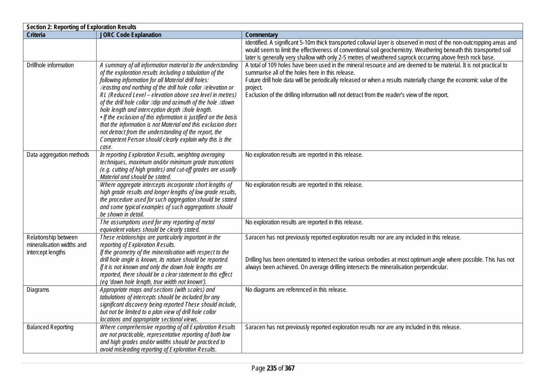
Page 235 of 367
Section 2: Reporting of Exploration Results Criteria JORC Code Explanation Commentary
identified. A significant 5-10m thick transported colluvial layer is observed in most of the non-outcropping areas and would seem to limit the effectiveness of conventional soil geochemistry. Weathering beneath this transported soil later is generally very shallow with only 2-5 metres of weathered saprock occurring above fresh rock base.
Drillhole information A summary of all information material to the understanding of the exploration results including a tabulation of the following information for all Material drill holes: easting and northing of the drill hole collar elevation or RL (Reduced Level – elevation above sea level in metres) of the drill hole collar dip and azimuth of the hole down hole length and interception depth hole length. • If the exclusion of this information is justified on the basis that the information is not Material and this exclusion does not detract from the understanding of the report, the Competent Person should clearly explain why this is the case.
A total of 109 holes have been used in the mineral resource and are deemed to be material. It is not practical to summarise all of the holes here in this release. Future drill hole data will be periodically released or when a results materially change the economic value of the project. Exclusion of the drilling information will not detract from the reader’s view of the report.
Data aggregation methods In reporting Exploration Results, weighting averaging techniques, maximum and/or minimum grade truncations (e.g. cutting of high grades) and cut-off grades are usually Material and should be stated.
No exploration results are reported in this release.
Where aggregate intercepts incorporate short lengths of high grade results and longer lengths of low grade results, the procedure used for such aggregation should be stated and some typical examples of such aggregations should be shown in detail.
No exploration results are reported in this release.
The assumptions used for any reporting of metal equivalent values should be clearly stated.
No exploration results are reported in this release.
Relationship between mineralisation widths and intercept lengths
These relationships are particularly important in the reporting of Exploration Results. If the geometry of the mineralisation with respect to the drill hole angle is known, its nature should be reported. If it is not known and only the down hole lengths are reported, there should be a clear statement to this effect (eg ‘down hole length, true width not known’).
Saracen has not previously reported exploration results nor are any included in this release. Drilling has been orientated to intersect the various orebodies at most optimum angle where possible. This has not always been achieved. On average drilling intersects the mineralisation perpendicular.
Diagrams Appropriate maps and sections (with scales) and tabulations of intercepts should be included for any significant discovery being reported These should include, but not be limited to a plan view of drill hole collar locations and appropriate sectional views.
No diagrams are referenced in this release.
Balanced Reporting Where comprehensive reporting of all Exploration Results are not practicable, representative reporting of both low and high grades and/or widths should be practiced to avoid misleading reporting of Exploration Results.
Saracen has not previously reported exploration results nor are any included in this release.

Page 236 of 367
Section 2: Reporting of Exploration Results Criteria JORC Code Explanation Commentary Other substantive exploration data
Other exploration data, if meaningful and material,should be reported including (but not limited to): geological observations; geophysical survey results; geochemical survey results; bulk samples – size and method of treatment; metallurgical test results; bulk density, groundwater, geotechnical and rock characteristics; potential deleterious or contaminating substances.
Detailed SAM (sub-audio magnetics) and aeromagnetic surveys were carried out over Belize and surrounding tenements by previous owners in order to define targets for drilling
Further work The nature and scale of planned further work (eg tests for lateral extensions or depth extensions or large-scale step-out drilling). Diagrams clearly highlighting the areas of possible extensions, including the main geological interpretations and future drilling areas, provided this information is not commercially sensitive
Saracen is currently working on establishing an exploration program which will identify areas of opportunity to extend or enhance the Belize mineral resource.
Section 3: Estimation and Reporting of Mineral Resources Criteria JORC Explanation Commentary Database Integrity Measures taken to ensure that data has not been
corrupted by, for example, transcription or keying errors, between its initial collection and its use for Mineral Resource estimation purposes.
The database provide to Saracen was stored in a number of excel spreadsheets and text files. The primary database is regulated by a locked framework called the acquire data model which fixes the relationships between tables. The data model minimises the potential for data collection and data usage errors through pre-determined look up tables, storage and export functions. User defined permissions also regulate the ability to add, edit or extract data. It is unknown at this stage how the process used to record the primary data. Typical methods are manual translation of logging and data capture from written logs, direct import of csv tables through a data import scheme where data is validated upon import or direct data entry options into the database using predefined look up values.
Data validation procedures used. The rigid structure of the acquire data model is such that predefined rules and look up tables are applied to all data entry. Data that does not meet the criteria are highlighted and moved to a buffer area until the data is rectified to meet the passing rules. It is unknown at this stage how the database was managed and who was responsible for its maintenance. It is also unknown if there was any built in functionality around pass/fail checks on assay importing.
Site Visits Comment on any site visits undertaken by the Competent Person and the outcome of those visits.
The competent person regularly visited site and directed work in his role as Exploration Manager.
If no site visits have been undertaken indicate why this is the case.

Page 237 of 367
Section 3: Estimation and Reporting of Mineral Resources Criteria JORC Explanation Commentary Geological Interpretation Confidence in (or conversely, the uncertainty of) the
geological interpretation of the mineral deposit. Nature of the data used and any assumptions made. The affect, if any, of alternative interpretations on Mineral Resource estimation. The use of geology in guiding and controlling the Mineral Resource estimation. The factors affecting continuity both of grade and geology.
Gold mineralisation at Belize area is hosted by steep west dipping, quartz-carbonate-pyrrhotite-magnetite veins within quartz rich metasediments and adjacent to lenticular ultramafic units. The mineralisation is analogous to that currently mined in the Saracen’s – Deep South Mine. The gold mineralised zone dips consistently at 70 and 80 degrees. to the west. The mineralised widths vary between 3 – 12 metres true width. All available geological data including RC and DDH drilling has been used in the interpretation. It is understood that there are no known factors which would affect the geological continuity and grade.
Dimensions The extent and variability of the Mineral Resource expressed as length (along strike or otherwise), plan width, and depth below surface to the upper and lower limits of the Mineral Resource.
The zone of mineralization extends 2000 m along strike, 3 to 12 m across strike and from near surface (3-8 m BSL) up to 290 m vertically. Limited drilling has occurred between 140 metres and 290 metres vertical depth The 100 m BSL (303 m RL) was used as a vertical constraint for Indicated material based on both a lack of drillholes beneath this depth and an estimate of the realistic notional mining depth of an open cut pit
Estimation and modelling techniques
The nature and appropriateness of the estimation technique(s) applied and key assumptions, including treatment of extreme grade values, domaining, interpolation parameters and maximum distance of extrapolation from data points. The availability of check estimates, previous estimates and/or mine production records and whether the Mineral Resource estimate takes appropriate account of such data. The assumptions made regarding recovery of by-products. Estimation of deleterious elements or other non-grade variables of economic significance (e.g. sulfur for acid mine drainage characterisation). In the case of block model interpolation, the block size in relation to the average sample spacing and the search employed. Any assumptions behind modelling of selective mining units. Any assumptions about correlation between variables. Description of how the geological interpretation was used to control the resource estimates. The process of validation, the checking process used, the comparison of model data to drill hole data, and use of reconciliation data if available.
There are no by-products currently known. At this time there has been no estimation for deleterious elements as the data collection is ongoing. There is no correlation between gold grades and any other element known at this time. There is no relationship between grade and structure or depth. However high grade shoots of mineralisation are known within the mineralised envelope. These shoots appear to plunge steeply to the north. Some potential may exist for shoots that are essentially blind to surface Surpac software was used for the estimation. JORC Code 2012 6 mineralised lodes were modelled Block model cell sizes of 5 mE x 12.5 mN x 5 mZ were used Variogram modelling completed using Snowdens Supervisor software Models were generated on normal scores variograms and back transformed for use in Surpac Modelling was completed on 1 Lode of the 6 known lodes as it was the only lode with sufficient data to create a reasonable variogram model. Ore lodes with insufficient sample were estimated using Inverse Distance (squared) estimation techniques. The variogram model for 1 Lode had two structures and was a nested-spherical model.
Moisture Whether the tonnages are estimated on a dry basis or with natural moisture, and the method of determination of the moisture content.
Tonnage has been calculation on a dry bulk density. No allowance for moisture has been made.

Page 238 of 367
Section 3: Estimation and Reporting of Mineral Resources Criteria JORC Explanation Commentary Cut-off parameters The basis of the adopted cut-off grade(s) or quality
parameters applied. A range of cut-off grade models have been produced – with 0.5, 1.0 & 1.5 g/t Au reported.
Mining factors or assumptions
Assumptions made regarding possible mining methods, minimum mining dimensions and internal (or, if applicable, external) mining dilution. It is always necessary as part of the process of determining reasonable prospects for eventual economic extraction to consider potential mining methods, but the assumptions made regarding mining methods and parameters when estimating Mineral Resources may not always be rigorous. Where this is the case, this should be reported with an explanation of the basis of the mining assumptions made.
Open pit mining is proposed once the extent of the resource is fully understood. Some mining dilution is expected, but not as yet quantified, due to the thin to moderate width of the ore lodes. Saracen will soon commence a Scoping study to assess the economics of the project and how it could be incorporated into Saracen’s life of mine plan.
Metallurgical factors or assumptions
The basis for assumptions or predictions regarding metallurgical amenability. It is always necessary as part of the process of determining reasonable prospects for eventual economic extraction to consider potential metallurgical methods, but the assumptions regarding metallurgical treatment process and parameters made when reporting Mineral Resources may not always be rigorous. Where this is the case, this should be reported with an explanation of the basis of the metallurgical assumptions made.
No detailed metallurgical recovery work has been undertaken at this time at Belize. Further work is ongoing to confirm that there are no deleterious properties at Belize
Environmental factors or assumptions
Assumptions made regarding possible waste and process residue disposal options. It is always necessary as part of the process of determining reasonable prospects for eventual economic extraction to consider the potential environmental impacts of the mining and processing operation. While at this stage the determination of potential environmental impacts, particularly for a greenfields project, may not always be well advanced, the status of early consideration of these potential environmental impacts should be reported. Where these aspects have not been considered this should be reported with an explanation of the environmental assumptions made.
Work is required to confirm that there will be no impact from acid rock drainage (ARD) from waste material at the Belize project. Any tailings placement to be stored on site will require detailed environmental assessment.
Bulk Density Whether assumed or determined. If assumed, the basis for the assumptions. If determined, the method used, whether wet or dry, the frequency of the measurements, the nature, size and representativeness of the samples. The bulk density for bulk material must have been measured by methods that adequately account for void spaces (vugs, porosity, etc), moisture and
A total of 70 core samples were assessed for Specific Gravity by wax immersion at Bureau Veritas Kalgoorlie 16 Holes at Belize were surveyed by a Geovista Dual gamma probe operated by ABIMS Pty Ltd Density data from the diamond core was used as a benchmark for calibration of the downhole survey density data

Page 239 of 367
Section 3: Estimation and Reporting of Mineral Resources Criteria JORC Explanation Commentary
differences between rock and alteration zones within the deposit. The basis for the classification of the Mineral Resources into varying confidence categories.
Classification The basis for the classification of the Mineral Resources into varying confidence categories. Whether appropriate account has been taken of all the relevant factors (ie relative confidence in tonnage/grade estimations, reliability of input data, confidence in continuity of geology and metal values, quality, quantity and distribution of the data). Whether the result appropriately reflects the Competent Person's view of the deposit.
The Belize Resources was classified as either Indicated or Inferred based on a number of factors, such as • Distance to nearest sample • Number of samples used for estimation and • Estimation pass In addition, an elevation boundary 100 m below surface (303 mRL) • was used as a vertical constraint for Indicated material, based upon • on both a lack of drillhole intercepts beyond this depth and • achievable mining parameters - with open cut pits typically not exceeding 100 vertical metres
Audits or reviews The results of any audits or reviews of Mineral Resource estimates.
No audits have been done at this time.
Discussion of relative accuracy/confidence
Where appropriate a statement of the relative accuracy and confidence level in the Mineral Resource estimate using an approach or procedure deemed appropriate by the Competent Person. For example, the application of statistical or geostatistical procedures to quantify the relative accuracy of the resource within stated confidence limits, or, if such an approach is not deemed appropriate, a qualitative discussion of the factors that could affect the relative accuracy and confidence of the estimate. The statement should specify whether it relates to global or local estimates, and, if local, state the relevant tonnages, which should be relevant to technical and economic evaluation. Documentation should include assumptions made and the procedures used. These statements of relative accuracy and confidence of the estimate should be compared with production data, where available.
At this time the Indicated Mineral resources are being considered for further technical evaluation. The statements relate to global estimate of tonnes and grade. Following metallurgical / hydrological / geotechnical assessments to be carried out in the upcoming quarters a Scoping study may be produced that assesses the economic viability of each resources Further drilling both along strike and at depth has been recommended by the previous owners.
Thin Lizzy Section 1: Sampling Techniques and Data Criteria JORC Code Explanation Commentary Sampling Techniques Nature and quality of sampling (e.g. cut channels, random
chips, or specific specialised industry standard Saracen has not completed any sampling activities at Thin Lizzy.

Page 240 of 367
Section 1: Sampling Techniques and Data Criteria JORC Code Explanation Commentary
measurement tools appropriate to the minerals under investigation, such as down hole gamma sondes, or handheld XRF instruments, etc.). These examples should not be taken as limiting the broad meaning of sampling.
Historic sampling methods conducted by previous owners since 1984 have included aircore (AC), rotary air blast (RAB), and reverse circulation (RC) drillholes.
Include reference to measures taken to ensure sample representivity and the appropriate calibration of any measurement tools or systems used
RC, RAB and AC drilling was completed by previous holders to industry standard at that time (1984- 2002).
Aspects of the determination of mineralisation that are Material to the Public Report. In cases where ‘industry standard’ work has been done this would be relatively simple (e.g. ‘reverse circulation drilling was used to obtain 1 m samples from which 3 kg was pulverised to produce a 30 g charge for fire assay’). In other cases more explanation may be required, such as where there is coarse gold that has inherent sampling problems. Unusual commodities or mineralisation types (e.g. submarine nodules) may warrant disclosure of detailed information
Historical AC, RAB, and RC sampling was carried out to industry standard at that time. Sampling methods for RC drilling included cone and riffle splitting. Methods for RAB and AC remain unknown. Analysis methods include fire assay, aqua regia and unspecified methods.
Drilling Techniques Drill type (e.g. core, reverse circulation, open-hole hammer, rotary air blast, auger, Bangka, sonic, etc.) and details (e.g. core diameter, triple or standard tube, depth of diamond tails, face-sampling bit or other type, whether core is oriented and if so, by what method, etc.).
The deposit has been sampled by 8 AC holes, 61 RAB holes and 149 RC holes (assumed standard 5 ¼ ‘’bit size).
Drill Sample Recovery Method of recording and assessing core and chip sample recoveries and results assessed
No historic sampling recoveries have been recorded.
Measures taken to maximise sample recovery and ensure representative nature of the samples
It is unknown what, if any, measures were taken to ensure sample recovery and representivity.
Whether a relationship exists between sample recovery and grade and whether sample bias may have occurred due to preferential loss/gain of fine/coarse material.
Any historical relationship is not known.
Logging Whether core and chip samples have been geologically and geotechnically logged to a level of detail to support appropriate Mineral Resource estimation, mining studies and metallurgical studies. Whether logging is qualitative or quantitative in nature. Core (or costean, channel, etc) photography.
Historical logging of RC, RAB and AC has recorded lithology, mineralogy, texture, mineralisation, weathering, alteration and veining. Qualitative and quantitative logging of historic data varies in its completeness.
The total length and percentage of the relevant intersections logged
All drillholes appear to have been logged in full.
Sub-sampling techniques and sample preparation
If core, whether cut or sawn and whether quarter, half or all core taken.
No diamond drilling has been completed at Thin Lizzy.
If non-core, whether riffled, tube sampled, rotary split, etc and whether sampled wet or dry.
Historic RC samples were cone or riffle split. The sampling methods for AC and RAB are unknown. It is unknown if wet samples were encountered.

Page 241 of 367
Section 1: Sampling Techniques and Data Criteria JORC Code Explanation Commentary
For all sample types, the nature, quality and appropriateness of the sample preparation technique.
The sampling techniques for historic drilling are unknown, best practice is assumed.
Quality control procedures adopted for all sub-sampling stages to maximise representivity of samples.
Sampling by previous holders assumed to be industry standard at the time.
Measures taken to ensure that the sampling is representative of the in situ material collected, including for instance results for field duplicate/second half sampling.
It is unknown if historic duplicate sampling was performed.
Whether sample sizes are appropriate to the grain size of the material being sampled.
It is assumed historic sample sizes were appropriate to the grainsize of material being sampled.
Quality of assay data and laboratory tests
The nature, quality and appropriateness of the assaying and laboratory procedures used and whether the technique is considered partial or total.
RC, RAB and AC samples were analysed using fire assay and aqua regia methods. These methods are considered suitable for determining gold concentrations in rock and are total digest methods. Some samples were analysed using unknown methods
For geophysical tools, spectrometers, handheld XRF instruments, etc, the parameters used in determining the analysis including instrument make and model, reading times, calibrations factors applied and their derivation, etc.
No geophysical tools have been utilised for reporting gold mineralisation.
Nature of quality control procedures adopted (e.g. standards, blanks, duplicates, external laboratory checks) and whether acceptable levels of accuracy (i.e. lack of bias) and precision have been established.
Historic RAB, AC and RC drilling is assumed to have been carried out to industry standard regarding QAQC procedures.
Verification of sampling and assaying
The verification of significant intersections by either independent or alternative company personnel.
It is unknown if historic intercepts were verified by alternative company personnel.
The use of twinned holes. No specific twinned holes have been drilled at Thin Lizzy Documentation of primary data, data entry procedures, data verification, data storage (physical and electronic) protocols
Data from previous owners was taken from a database compilation and validated as much as practicable before entry into the Saracen acQuire database.
Discuss any adjustment to assay data. No adjustments have been made to assay data. First gold assay is utilised for resource estimation. Location of data points Accuracy and quality of surveys used to locate drillholes
(collar and down-hole surveys), trenches, mine workings and other locations used in Mineral Resource estimation.
Previous holders’ survey accuracy and quality is unknown.
Specification of the grid system used. MGA Zone 51 grid system is used in the Thin Lizzy area. Quality and adequacy of topographic control. Kevron Geomatic Services flew and processed aerial photography and provided orthoimages at 1:5000 scale over
the Thunderbox deposit and environs. Data spacing and distribution
Data spacing for reporting of Exploration Results. No exploration results reported in this release Whether the data spacing and distribution is sufficient to establish the degree of geological and grade continuity appropriate for the Mineral Resource and Ore Reserve estimation procedure(s) and classifications applied.
Data spacing and distribution are sufficient to establish the degree of geological and grade continuity appropriate for JORC classifications applied.
Whether sample compositing has been applied.
Some historic RAB, AC and RC sampling was composited into 3-4m samples with areas of interest re-sampled to 1m intervals. It is unknown at what threshold this occurred.

Page 242 of 367
Section 1: Sampling Techniques and Data Criteria JORC Code Explanation Commentary Orientation of data in relation to geological structure
Whether the orientation of sampling achieves unbiased sampling of possible structures and the extent to which this is known, considering the deposit type.
The majority of drillholes are positioned to achieve optimum intersection angles to the ore zone as are practicable.
If the relationship between the drilling orientation and the orientation of key mineralised structures is considered to have introduced a sampling bias, this should be assessed and reported if material.
No significant sampling bias has been recognised due to orientation of drilling in regards to mineralised structures.
Sample security The measures taken to ensure sample security. It is unknown what measures were taken to ensure sample security, best practice is assumed. Audits or reviews The results of any audits or reviews of sampling
techniques and data. It is unknown if any audits or reviews were completed.
Section 2: Reporting of Exploration Results Criteria JORC Code Explanation Commentary Mineral tenement and land tenure status
Type, reference name/number, location and ownership including agreements or material issues with third parties such as joint ventures, partnerships, overriding royalties, native title interests, historical sites, wilderness or national park and environmental settings.
The Thin Lizzie resource is located on M39/120. The tenement is held 100% by Saracen Gold Mines Pty Ltd, a wholly owned subsidiary of Saracen Mineral Holdings Limited. Mining Lease M39/120 has a 21 year life (held until 2030) and is renewable for a further 21 years on a continuing basis. Mining Lease M39/120 is subject to three royalty agreements and two associated caveats (138H/067 and 323785). All production is subject to a Western Australian state government NSR royalty of 2.5%. Mining Lease M39/120 is subject to the Yundamindera Pastoral Compensation Agreement. There are no registered Aboriginal Heritage sites within the tenement.
The security of the tenure held at the time of reporting along with any known impediments to obtaining a licence to operate in the area.
The tenement is in good standing and there are no known impediments to obtaining a licence to operate.
Exploration done by other parties
Acknowledgment and appraisal of exploration by other parties.
Exploration began in the Camelback area near the Thin Lizzy deposit in the 1980’s, with WMC carrying out surface geochemical and drilling activities. Further drilling and sampling was completed by Newmont, Newcrest and Consex before the Thin Lizzy resource was delineated by Sons of Gwalia in 1995. They carried out further near deposit drilling and surface sampling until their collapse and takeover by St Barbara in 2004.
Geology Deposit type, geological setting and style of mineralisation.
Gold mineralisation occurs within the Thin Lizzie deposit as a wide variety of vein and veinlet types within BIF chert zone. The main mineralisation is characterised by NS strike and 70° – 80° easterly dip.
Drillhole information A summary of all information material to the understanding of the exploration results including a tabulation of the following information for all Material drill holes:
• easting and northing of the drill hole collar • elevation or RL (Reduced Level – elevation • above sea level in metres) of the drill hole collar • dip and azimuth of the hole • down hole length and interception depth • hole length. • If the exclusion of this information is justified on the
basis that the information is not Material and this
It is not practical to summarise all of the holes deemed material in this release. Exclusion of the drilling information will not detract from the reader’s view of the report.
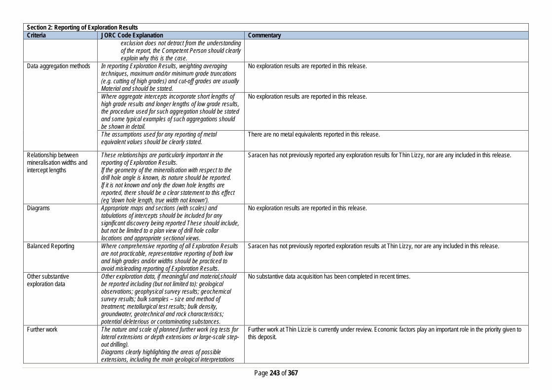
Page 243 of 367
Section 2: Reporting of Exploration Results Criteria JORC Code Explanation Commentary
exclusion does not detract from the understanding of the report, the Competent Person should clearly explain why this is the case.
Data aggregation methods In reporting Exploration Results, weighting averaging techniques, maximum and/or minimum grade truncations (e.g. cutting of high grades) and cut-off grades are usually Material and should be stated.
No exploration results are reported in this release.
Where aggregate intercepts incorporate short lengths of high grade results and longer lengths of low grade results, the procedure used for such aggregation should be stated and some typical examples of such aggregations should be shown in detail.
No exploration results are reported in this release.
The assumptions used for any reporting of metal equivalent values should be clearly stated.
There are no metal equivalents reported in this release.
Relationship between mineralisation widths and intercept lengths
These relationships are particularly important in the reporting of Exploration Results. If the geometry of the mineralisation with respect to the drill hole angle is known, its nature should be reported. If it is not known and only the down hole lengths are reported, there should be a clear statement to this effect (eg ‘down hole length, true width not known’).
Saracen has not previously reported any exploration results for Thin Lizzy, nor are any included in this release.
Diagrams Appropriate maps and sections (with scales) and tabulations of intercepts should be included for any significant discovery being reported These should include, but not be limited to a plan view of drill hole collar locations and appropriate sectional views.
No exploration results are reported in this release.
Balanced Reporting Where comprehensive reporting of all Exploration Results are not practicable, representative reporting of both low and high grades and/or widths should be practiced to avoid misleading reporting of Exploration Results.
Saracen has not previously reported exploration results at Thin Lizzy, nor are any included in this release.
Other substantive exploration data
Other exploration data, if meaningful and material,should be reported including (but not limited to): geological observations; geophysical survey results; geochemical survey results; bulk samples – size and method of treatment; metallurgical test results; bulk density, groundwater, geotechnical and rock characteristics; potential deleterious or contaminating substances.
No substantive data acquisition has been completed in recent times.
Further work The nature and scale of planned further work (eg tests for lateral extensions or depth extensions or large-scale step-out drilling). Diagrams clearly highlighting the areas of possible extensions, including the main geological interpretations
Further work at Thin Lizzie is currently under review. Economic factors play an important role in the priority given to this deposit.

Page 244 of 367
Section 2: Reporting of Exploration Results Criteria JORC Code Explanation Commentary
and future drilling areas, provided this information is not commercially sensitive
Section 3: Estimation and Reporting of Mineral Resources Criteria JORC Code Explanation Commentary Database Integrity Measures taken to ensure that data has not been
corrupted by, for example, transcription or keying errors, between its initial collection and its use for Mineral Resource estimation purposes.
Saracen utilises AcQuire software on an SQL server database to securely store and manage all drillhole and sample information. Data integrity protocols are built into the system to ensure data validity and minimise errors.
Data validation procedures used. Data that is captured in the field is entered into Excel templates which are checked on import into the database for errors. Assay jobs are dispatched electronically to the lab to minimise the chance of data entry errors. Assay results from the lab are received in CSV format and are checked for errors on import into the database. Data is regularly validated using the mining software. The data validation process is overseen by the Database Administrator.
Site Visits Comment on any site visits undertaken by the Competent Person and the outcome of those visits.
At the time of exploration and review (2010) of the deposit the Competent Persons visited the geological area frequently to assess geological competency and ensure integrity across all geological disciplines.
If no site visits have been undertaken indicate why this is the case.
Geological Interpretation Confidence in (or conversely, the uncertainty of) the geological interpretation of the mineral deposit.
A combination of exploration mapping, geophysical surveys, both exploration and grade control drill hole information and geological data, including mapping, has resulted in a reasonable geological interpretation.
Nature of the data used and any assumptions made. The interpretations have been constructed using all available geological logging descriptions including but not limited to, stratigraphy, lithology, texture, and alteration. Most information was obtained from drill hole results and some historic mapping from Sons of Gwalia production.
The affect, if any, of alternative interpretations on Mineral Resource estimation.
Due to the simplicity of the model, there are no alternative models at this stage.
The use of geology in guiding and controlling the Mineral Resource estimation.
The geology has heavily influenced the extent of the domains controlling the mineral resource estimation. Gold mineralisation occurs within the Thin Lizzie deposit as a wide variety of vein and veinlet types within BIF chert zone. The main mineralisation is characterised by NS strike and 70° – 80° easterly dip. All mineralised domains were wireframed with hard boundaries. The wireframes for the current model were generated in Micromine based on a cut-off of 0.25 g/t of gold in individual sections of drill holes.
The factors affecting continuity both of grade and geology. The continuity of this inferred, thin and low grade deposit is considered open in all directions however it is relatively unexplored due to its lower economic viability.
Dimensions The extent and variability of the Mineral Resource expressed as length (along strike or otherwise), plan width, and depth below surface to the upper and lower limits of the Mineral Resource.
At Thin Lizzie deposit, a total of 14 sections at 50m spacing were interpreted from 6,400N to 7,050N. The interpretation and wireframes were generated based on a 50m × 20m exploration drilling patterns.
Estimation and modelling techniques
The nature and appropriateness of the estimation technique(s) applied and key assumptions, including treatment of extreme grade values, domaining,
A conventional 3D Ordinary Kriging modelling technique has been used, with an unfolding methodology applied to provide a dynamic element to the allocation of search ellipses. The modelling technique is suitable to the domains being estimated allowing reasonable expectation of mining selectivity across the mineralised domain. OK Block

Page 245 of 367
Section 3: Estimation and Reporting of Mineral Resources Criteria JORC Code Explanation Commentary
interpolation parameters and maximum distance of extrapolation from data points.
estimation has been completed using Datamine software. All compositing, wireframes, surfaces, rock and domain models were constructed in Micromine. All estimation uses these wireframes as hard boundaries. Estimation of parent blocks are interpolated, and assigned to sub-cells. The maximum distance of extrapolation is less than 50m. Univariate statistical analysis of length weighted, (1m), domain and regolith coded downhole composites have been completed for all domains. More than 80% of the sample data used in the estimation was 1m in length with the average for the entire sample set at 1.40m. Composites were broken where there was a change of mineralisation domain code or regolith code. Clusters of higher grade outliers that could bias the mean were identified by domain by the use of log probability plots. High grade outliers were used to determine specific top-cut values for each domain. Estimations used only used RC and Diamond Drill results, negative Au grades were replaced with a value of 0.001g/t, and null assays were excluded from the sample data. Unfolding was carried out prior to variography and estimation to remove the local variances in dip and strike observed in the domains. Variogram modelling was completed with GeoAccess Professional software. This defined the sample continuity and nugget value for each domain. Nugget effect in the major domains is typically 25% to 35%, which is moderate for a gold deposit and illustrates the robustness of the unfolded coordinate system as used for variogram calculation. The parameters determined from this analysis were used in the interpolation process.
The availability of check estimates, previous estimates and/or mine production records and whether the Mineral Resource estimate takes appropriate account of such data.
Comparatively this estimate remains unchanged in the tonnage value as the mineralised domains were left unadjusted from the previous interpretation done by SGW in 2000. However the current estimate places the global grade 0.40g/t lower the previous 2000 estimate. Unfortunately the numbers from the 2000 estimate seem erroneous with a mismatch between the grade and the ounces calculation.
The assumptions made regarding recovery of by-products. No assumptions have been made with respect to the recovery of by-products. Estimation of deleterious elements or other non-grade variables of economic significance (e.g. sulfur for acid mine drainage characterisation).
There has been no estimate at this point of deleterious elements. Saracen is unaware if any elements other than gold have been assayed.
In the case of block model interpolation, the block size in relation to the average sample spacing and the search employed.
The parent block sizes for the resource model are X (5m) by Y (5m) by Z (1m). Drillhole data spacing, mining selectivity and mineralised lode geometry are among the primary considerations for the determination of the estimation block size. Drilling data at Thin Lizzie is primarily on a 50 x 25 metre drilling pattern, grading to a 60 x 30 to 80 x 50 metre patterns at depth. Parent blocks have been sub-celled to X (1.0m) by Y (1.0m) by Z (1.0m) to ensure that the wireframe boundaries were honoured and preserved the location and shape of the mineralisation. Search ranges have been informed by variogram modelling and knowledge of the drill spacing and the known mineralisation geometry including direction of maximum continuity. Three search estimation runs are used with the aim to satisfy the minimum sample criteria in the first search range where possible. Major ranges varied from 60m to 100m, with a limited range across the mineralisation of typically 15 to 30m. Down plunge ranges can be limited to 5m to 10m in some cases. The majority of the mineralised domains have data spacing that is well within the variogram ranges.
Any assumptions behind modelling of selective mining units.
No selective mining units have been assumed.
Any assumptions about correlation between variables. No assumptions have been made regarding correlation between variables. Description of how the geological interpretation was used to control the resource estimates.
The geological interpretation strongly correlates with the mineralised domains. Hard wireframes were used to define all the mineralised domains.

Page 246 of 367
Section 3: Estimation and Reporting of Mineral Resources Criteria JORC Code Explanation Commentary
Discussion of basis for using or not using grade cutting or capping.
Linear interpolation methods such as Ordinary Kriging are sensitive to the presence of high-grade outliers that positively skew the data and bias the mean. Domain histogram and Log probability plots were used to determine appropriate top cuts for each domain. Not all domains required top cutting.
The process of validation, the checking process used, the comparison of model data to drill hole data, and use of reconciliation data if available.
Several key model validation steps have been taken to validate the resource estimate. The mineral resource model has been stepped through visually in sectional and plan view to appreciate the composite grades used in the estimate and the resultant block grades. The mean average composite grade and block model grade by deposit and domain were compared. QQ and scatter plots for the averaged sample data vs. block model results were also plotted. Easting, Northing and Elevation swathe plots have been constructed to evaluate the declustered composited assay means versus the mean block estimates.
Moisture Whether the tonnages are estimated on a dry basis or with natural moisture, and the method of determination of the moisture content.
All tonnages are estimated on a dry basis.
Cut-off parameters The basis of the adopted cut-off grade(s) or quality parameters applied.
Based on Saracen’s current economic status the natural grade distinction above background for the Thin Lizzie deposit was at a grade of 0.8g/t.
Mining factors or assumptions
Assumptions made regarding possible mining methods, minimum mining dimensions and internal (or, if applicable, external) mining dilution. It is always necessary as part of the process of determining reasonable prospects for eventual economic extraction to consider potential mining methods, but the assumptions made regarding mining methods and parameters when estimating Mineral Resources may not always be rigorous. Where this is the case, this should be reported with an explanation of the basis of the mining assumptions made.
If the Thin Lizzie deposit is deemed economical it would be amenable to mining by open pit methods. There has not been any serious mining at Thin Lizzie. There are reasonable grounds to assume that in the future this deposit will be mined by conventional open pit methods given the close proximity to surface of the mineralisation.
Metallurgical factors or assumptions
The basis for assumptions or predictions regarding metallurgical amenability. It is always necessary as part of the process of determining reasonable prospects for eventual economic extraction to consider potential metallurgical methods, but the assumptions regarding metallurgical treatment process and parameters made when reporting Mineral Resources may not always be rigorous. Where this is the case, this should be reported with an explanation of the basis of the metallurgical assumptions made.
There is limited information with regards to metallurgical factors for the Thin Lizzie deposit. It is assumed that this deposit would have very similar results to that of Crimson Belle given they are hosted and exist in the same geological regime. Metallurgical testing of a transition/fresh composite shows gravity recovery of 73% and total recovery of 79%.
Environmental factors or assumptions
Assumptions made regarding possible waste and process residue disposal options. It is always necessary as part of the process of determining reasonable prospects for eventual economic extraction to consider the potential environmental impacts of the mining and processing operation. While at this stage the determination of potential environmental impacts, particularly for a
Environmental considerations are captured by Program of Work (PoW) requirements. Operations on these tenements are purely exploratory in nature to date.
Page 247 of 367
Section 3: Estimation and Reporting of Mineral Resources Criteria JORC Code Explanation Commentary
greenfields project, may not always be well advanced, the status of early consideration of these potential environmental impacts should be reported. Where these aspects have not been considered this should be reported with an explanation of the environmental assumptions made.
Bulk Density Whether assumed or determined. If assumed, the basis for the assumptions. If determined, the method used, whether wet or dry, the frequency of the measurements, the nature, size and representativeness of the samples.
The density values applied to the Thin Lizzie Deposit estimation are largely based on historic density measures from similar rock types known to the geological area.
The bulk density for bulk material must have been measured by methods that adequately account for void spaces (vugs, porosity, etc), moisture and differences between rock and alteration zones within the deposit.
It is unknown how the historic bulk densities were measured. Any future bulk density measurements follow the Saracens Metals standardised procedures. Most ore zones predominantly exist in transitional to fresh non porous material, however additional measures are taken to reduce moisture intake during the water displacement process if the coating is made of more friable oxides and sediments. This latter method aims to reduce moisture loss or moisture gain during the process and is considered on a deposit by deposit basis.
Discuss assumptions for bulk density estimates used in the evaluation process of the different materials.
Density values are allocated uniformly to each lithological and regolith type. This includes the primary fresh lithologies as well as the weathered oxide and transitional zones.
Classification The basis for the classification of the Mineral Resources into varying confidence categories.
Information from the estimation process, including search pass, number of composites used in the search ellipse and Kriging variance are all used in conjunction with drill spacing to finalise classification domains. Thin Lizzie blocks are all classified as Inferred category according to the 2004 JORC Code.
Whether appropriate account has been taken of all the relevant factors (ie relative confidence in tonnage/grade estimations, reliability of input data, confidence in continuity of geology and metal values, quality, quantity and distribution of the data).
All care has been taken to account for relevant factors influencing the mineral resource estimate. The diligent Saracen Metals Resource review process ensures that data reliability and geological and metal confidence and continuity are reflected in the resource classification.
Whether the result appropriately reflects the Competent Person's view of the deposit.
The geological model and the mineral resource estimate reflect the competent person’s view of the deposit.
Audits or reviews The results of any audits or reviews of Mineral Resource estimates.
This model was reviewed at the time of completion to the JORC 2004 standards. At the time the quality of the estimate was deemed appropriate and robust as a global estimate. Saracen Metals undertake an extensive review of the model that covers;
• Model inventory and comparisons to previous and budget models if in existence • Geological interpretation, wireframing, domain selection, statistics by domain, assay and metal evaluation,
parent cell sizes, data compositing, variography, search strategy, estimation and KNA • Model validation – swathe plots, visual checks, volume comparisons, composite to model metal
comparisons. Due to its simple geological geometry, external audits were deemed unnecessary at the time.
Discussion of relative accuracy/confidence
Where appropriate a statement of the relative accuracy and confidence level in the Mineral Resource estimate using an approach or procedure deemed appropriate by the Competent Person. For example, the application of statistical or geostatistical procedures to quantify the
The mineral resource has been reported in accordance with the guidelines established in the 2004 edition of the JORC code. A standardised approach has been implemented for this estimation and the result is a robust model with appropriately defined resource categories. The validation process is also thorough suggesting the estimate has a

Page 248 of 367
Section 3: Estimation and Reporting of Mineral Resources Criteria JORC Code Explanation Commentary
relative accuracy of the resource within stated confidence limits, or, if such an approach is not deemed appropriate, a qualitative discussion of the factors that could affect the relative accuracy and confidence of the estimate.
reasonable level of confidence. The resource estimate is a good global estimate however locally there is room for improvement particularly in the selection of optimal block size. The review of the estimate identified that; Further testing on the bulk density values would be invaluable, and The use of KNA for optimal block size, minimum and maximum number of samples, search ellipse dimension, and discretisation would help to further improve the optimisation of the block model on a local scale.
The statement should specify whether it relates to global or local estimates, and, if local, state the relevant tonnages, which should be relevant to technical and economic evaluation. Documentation should include assumptions made and the procedures used.
The statements relate to a global estimate of tonnes and grade.
These statements of relative accuracy and confidence of the estimate should be compared with production data, where available.
An historic pit exits over Thin Lizzie, however there is no link to historic production.
Tin Dog Section 1: Sampling Techniques and Data Criteria JORC Code Explanation Commentary Sampling Techniques Nature and quality of sampling (e.g. cut channels, random
chips, or specific specialised industry standard measurement tools appropriate to the minerals under investigation, such as down hole gamma sondes, or handheld XRF instruments, etc.). These examples should not be taken as limiting the broad meaning of sampling.
Saracen has undertaken reverse circulation (RC) drilling at Tin Dog. Historic methods conducted since 1986 have included aircore (AC), rotary air blast (RAB) and reverse circulation drilling.
Include reference to measures taken to ensure sample representivity and the appropriate calibration of any measurement tools or systems used
Sampling of RC drilling was carried out as specified within Saracen sampling and QAQC procedures as per industry standard. RC chips provide high quality representative samples for analysis. RC, RAB and, AC drilling was completed by previous holders to industry standard at that time (1986- 2002).
Aspects of the determination of mineralisation that are Material to the Public Report. In cases where ‘industry standard’ work has been done this would be relatively simple (e.g. ‘reverse circulation drilling was used to obtain 1 m samples from which 3 kg was pulverised to produce a 30 g charge for fire assay’). In other cases more explanation may be required, such as where there is coarse gold that has inherent sampling problems. Unusual commodities or mineralisation types (e.g. submarine nodules) may warrant disclosure of detailed information
RC chips were cone split and sampled into 1m intervals with total sample weights under 3kg Samples were selected to weigh less than 3 kg to ensure total sample inclusion at the pulverisation stage. A select number of samples were composited into 4m lengths and sampled in the Saracen onsite laboratory using a PAL (pulverise and leach) method as a first pass indicator. Any samples exceeding 0.2ppm Au were then resampled into 1m intervals and assayed via commercial laboratory where they were crushed, dried and pulverised to a nominal 90% passing 75µm to produce a 50 g sub sample for analysis by FA/AAS. Historical AC, RAB, and RC sampling was carried out to industry standard at that time. Analysis methods include fire assay, aqua regia and unspecified methods.
Drilling Techniques Drill type (e.g. core, reverse circulation, open-hole hammer, rotary air blast, auger, Bangka, sonic, etc.) and
The deposit was initially sampled by 4 AC holes, 551 RAB holes and 43 RC holes (assumed standard 5 ¼‘’ bit size). Saracen has completed 16 RC drillholes utilising a 5 ¼‘’ diameter bit with face sampling hammer.
Page 249 of 367
Section 1: Sampling Techniques and Data Criteria JORC Code Explanation Commentary
details (e.g. core diameter, triple or standard tube, depth of diamond tails, face-sampling bit or other type, whether core is oriented and if so, by what method, etc.).
Drill Sample Recovery Method of recording and assessing core and chip sample recoveries and results assessed
RC sampling recoveries are recorded as a percentage based on a visual weight estimate; no historic recoveries have been recorded.
Measures taken to maximise sample recovery and ensure representative nature of the samples
During RC campaigns daily rig inspections are carried out to check splitter condition, general site and address general issues. Historical AC, RAB and RC to industry standard at that time.
Whether a relationship exists between sample recovery and grade and whether sample bias may have occurred due to preferential loss/gain of fine/coarse material.
There is no known relationship between sample recovery and grade for RC drilling. Any historical relationship is not known.
Logging Whether core and chip samples have been geologically and geotechnically logged to a level of detail to support appropriate Mineral Resource estimation, mining studies and metallurgical studies. Whether logging is qualitative or quantitative in nature. Core (or costean, channel, etc) photography.
Logging of RC chips records lithology, mineralogy, texture, mineralisation, weathering, alteration, veining and other features. Chips from all RC holes are stored in chip trays for future reference. Qualitative and quantitative logging of historic data varies in its completeness.
The total length and percentage of the relevant intersections logged
All Saracen RC drill holes are logged in full. Historical logging is approximately 95% complete.
Sub-sampling techniques and sample preparation
If core, whether cut or sawn and whether quarter, half or all core taken.
No diamond drilling has been completed at Tin Dog
If non-core, whether riffled, tube sampled, rotary split, etc and whether sampled wet or dry.
All RC samples were cone split. Occasional wet samples were encountered; increased air capacity was routinely used to aid in keeping the sample dry when water was encountered. Historic AC, RAB and RC drilling was sampled using spear, riffle and unknown methods.
For all sample types, the nature, quality and appropriateness of the sample preparation technique.
The sample preparation of RC chips adheres to industry best practice. It was conducted by a commercial or onsite laboratory and involved oven drying, coarse crushing then total grinding to a size of 90% passing 75 microns. Best practice is assumed at the time of historic sampling.
Quality control procedures adopted for all sub-sampling stages to maximise representivity of samples.
All subsampling activities were carried out by commercial or onsite laboratory and are considered to be satisfactory. Sampling by previous holders assumed to be industry standard at the time.
Measures taken to ensure that the sampling is representative of the in situ material collected, including for instance results for field duplicate/second half sampling.
Duplicate sampling was carried out at a rate of 1:10 for exploration drilling and was sampled directly from the on-board splitter on the rig. These were submitted for the same assay process as the original samples and the laboratory were unaware of such submissions. Sampling by previous holders assumed to be industry standard at the time.
Whether sample sizes are appropriate to the grain size of the material being sampled.
Sample sizes are considered to be appropriate given the grainsize (90% passing 75um) of the material sampled.
Quality of assay data and laboratory tests
The nature, quality and appropriateness of the assaying and laboratory procedures used and whether the technique is considered partial or total.
RC chip samples were analysed by an external laboratory using a 50g fire assay with AAS finish. This method is considered suitable for determining gold concentration in rock and is a total digest method. Some RC samples were analysed in the Saracen onsite laboratory using a pulverise and leach method. This method is a partial digest. Historic sampling includes fire assay, aqua regia and unknown methods.
For geophysical tools, spectrometers, handheld XRF instruments, etc, the parameters used in determining the
No geophysical tools have been utilised for reporting gold mineralisation at Tin Dog.
Page 250 of 367
Section 1: Sampling Techniques and Data Criteria JORC Code Explanation Commentary
analysis including instrument make and model, reading times, calibrations factors applied and their derivation, etc. Nature of quality control procedures adopted (e.g. standards, blanks, duplicates, external laboratory checks) and whether acceptable levels of accuracy (i.e. lack of bias) and precision have been established.
Certified reference material (standards and blanks) with a wide range of values were inserted into every drillhole at a rate of 1:25 for exploration RC drilling. These were not identifiable to the laboratory. QAQC data returned were checked against pass/fail limits with the SQL database and were passed or failed on import. A report was generated and reviewed by the geologist as necessary upon failure to determine further action. QAQC data was reported monthly. Sample preparation checks for fineness were carried out to ensure a grindsize of 90% passing 75 microns. The laboratory performed a number of internal processes including standards, blanks, repeats and checks. QAQC data analysis demonstrates sufficient accuracy and precision. Industry best practice is assumed for previous holders.
Verification of sampling and assaying
The verification of significant intersections by either independent or alternative company personnel.
Significant intercepts are verified by the Geology Manager and corporate personnel.
The use of twinned holes. No specific twinned holes have been drilled at Tin Dog. Documentation of primary data, data entry procedures, data verification, data storage (physical and electronic) protocols
Primary data was collated in a set of excel templates utilising lookup codes. This data was forwarded to the Database Administrator for entry into a secure acQuire database with inbuilt validation functions. Data from previous owners was taken from a database compilation and validated as much as practicable before entry into the Saracen acQuire database.
Discuss any adjustment to assay data. No adjustments have been made to assay data. First gold assay is utilised for resource estimation. Location of data points Accuracy and quality of surveys used to locate drillholes
(collar and down-hole surveys), trenches, mine workings and other locations used in Mineral Resource estimation.
Exploration drillholes were located using a Leica 1200 GPS with an accuracy of +/- 10mm. Downhole surveys were carried out using an Eastman multi shot camera at regular intervals (usually 30m). Previous holders’ survey accuracy and quality is unknown.
Specification of the grid system used. A local grid system (Tin Dog Local Grid) is used. The one point conversion to MGA_GDA94 zone 51 is TDLGEast TDLGNorth RL MGAEast MGANorth RL Point 1 10000 50000 0 438291.149 6748659.094 0 Historic data is converted to Tin Dog local grid upon export from the database.
Quality and adequacy of topographic control. Topographic control originally used site based survey pickups in addition to Kevron aerial photogrammetric surveys with +/- 5m resolution.
Data spacing and distribution
Data spacing for reporting of Exploration Results. The nominal spacing for exploration drilling is 50mN x 25mE to 100mN x 25mE Whether the data spacing and distribution is sufficient to establish the degree of geological and grade continuity appropriate for the Mineral Resource and Ore Reserve estimation procedure(s) and classifications applied.
Data spacing and distribution are sufficient to establish the degree of geological and grade continuity appropriate for JORC classifications applied.
Orientation of data in relation to geological structure
Whether sample compositing has been applied.
A select number of samples were composited into 4m lengths and sampled in the Saracen onsite laboratory as a first pass indicator. Any samples exceeding 0.2ppm Au were then resampled into 1m intervals and assayed via commercial laboratory. Some historic RAB and RC sampling was composited into 3-4m samples with areas of interest re-sampled to 1m intervals. It is unknown at what threshold this occurred.
Whether the orientation of sampling achieves unbiased sampling of possible structures and the extent to which this is known, considering the deposit type.
The majority of drillholes are positioned to achieve optimum intersection angles to the ore zone as are practicable.

Page 251 of 367
Section 1: Sampling Techniques and Data Criteria JORC Code Explanation Commentary
If the relationship between the drilling orientation and the orientation of key mineralised structures is considered to have introduced a sampling bias, this should be assessed and reported if material.
No significant sampling bias is thought to occur due to orientation of drilling in regards to mineralised structures.
Sample security The measures taken to ensure sample security. Samples are prepared on site under supervision of Saracen geological staff. Samples are selected, bagged into tied numbered calico bags then grouped into secured cages and collected by the laboratory personnel. Sample submissions are documented via laboratory tracking systems and assays are returned via email
Audits or reviews The results of any audits or reviews of sampling techniques and data.
An internal review of companywide sampling methodologies was conducted to create the current sampling and QAQC procedures.
Section 2: Reporting of Exploration Results Criteria JORC Code Explanation Commentary Mineral tenement and land tenure status
Type, reference name/number, location and ownership including agreements or material issues with third parties such as joint ventures, partnerships, overriding royalties, native title interests, historical sites, wilderness or national park and environmental settings.
The Tin Dog project is located on M39/588 with near mine exploration extending onto M39/589. The tenement is held 100% by Saracen Gold Mines Pty Ltd, a wholly owned subsidiary of Saracen Mineral Holdings Limited.
The security of the tenure held at the time of reporting along with any known impediments to obtaining a licence to operate in the area.
The tenements are in good standing and the licence to operate already exists
Exploration done by other parties
Acknowledgment and appraisal of exploration by other parties.
Pennzoil carried out limited exploration in the Tin Dog project area in the early 1980’s consisting of mapping, rock chip sampling and RAB drilling. Results were not encouraging and the project was relinquished. Billiton acquired the ground and carried out soil sampling and RAB drilling and identified broad zones of low grade mineralisation before entering into a JV with Newmont. RAB, RC and diamond drilling along with geophysics and surface sampling were completed. Goldfields Exploration entered into the Keith-Kilkenny JV and carried out RAB and RC drilling to confirm the continuity of mineralisation associated with the shearing and synenites in the area. They found the results to be disappointing and sold the project area to Sons of Gwalia. Further drilling and geophysics were carried out before St Barbara acquired the ground upon the collapse of Sons of Gwalia.
Geology Deposit type, geological setting and style of mineralisation.
Mineralisation occurs in close proximity to the felsic/intermediate volcanic and syenite contact that are intercalated with carbonaceous shales, along with minor BIF and chert. A wide variety of quartz dominated vein and veinlet types are associated with gold mineralisation
Drillhole information A summary of all information material to the understanding of the exploration results including a tabulation of the following information for all Material drill holes: • easting and northing of the drill hole collar • elevation or RL (Reduced Level – elevation • above sea level in metres) of the drill hole collar • dip and azimuth of the hole • down hole length and interception depth
It is not practical to summarise all of the holes deemed material in this release. Exclusion of the drilling information will not detract from the reader’s view of the report. Future drill hole data will be periodically released or when a results materially change the economic value of the project.

Page 252 of 367
Section 2: Reporting of Exploration Results Criteria JORC Code Explanation Commentary
• hole length. • If the exclusion of this information is justified on the
basis that the information is not Material and this exclusion does not detract from the understanding of the report, the Competent Person should clearly explain why this is the case.
Data aggregation methods In reporting Exploration Results, weighting averaging techniques, maximum and/or minimum grade truncations (e.g. cutting of high grades) and cut-off grades are usually Material and should be stated.
All significant intercepts have been length weighted with a minimum Au grade of 1ppm. No high grade cut off has been applied.
Where aggregate intercepts incorporate short lengths of high grade results and longer lengths of low grade results, the procedure used for such aggregation should be stated and some typical examples of such aggregations should be shown in detail.
Intercepts are aggregated with minimum width of 1m and maximum width of 3m for internal dilution. Where stand out higher grade zone exist with in the broader mineralised zone, the higher grade interval is reported also.
The assumptions used for any reporting of metal equivalent values should be clearly stated.
There are no metal equivalents reported in this release.
Relationship between mineralisation widths and intercept lengths
These relationships are particularly important in the reporting of Exploration Results. If the geometry of the mineralisation with respect to the drill hole angle is known, its nature should be reported. If it is not known and only the down hole lengths are reported, there should be a clear statement to this effect (eg ‘down hole length, true width not known’).
Previous announcements included sufficient detail to clearly illustrate the geometry of the mineralisation and the recent drilling. All results were reported as downhole lengths.
Diagrams Appropriate maps and sections (with scales) and tabulations of intercepts should be included for any significant discovery being reported These should include, but not be limited to a plan view of drill hole collar locations and appropriate sectional views.
All significant exploration results released by Saracen are accompanied by the appropriate diagrams and maps at the time of the release.
Balanced Reporting Where comprehensive reporting of all Exploration Results are not practicable, representative reporting of both low and high grades and/or widths should be practiced to avoid misleading reporting of Exploration Results.
All results from the drilling campaigns have been reported, irrespective of success or not
Other substantive exploration data
Other exploration data, if meaningful and material,should be reported including (but not limited to): geological observations; geophysical survey results; geochemical survey results; bulk samples – size and method of treatment; metallurgical test results; bulk density, groundwater, geotechnical and rock characteristics; potential deleterious or contaminating substances.
No substantive data acquisition has been completed in recent times.
Page 253 of 367
Section 2: Reporting of Exploration Results Criteria JORC Code Explanation Commentary Further work The nature and scale of planned further work (eg tests for
lateral extensions or depth extensions or large-scale step-out drilling). Diagrams clearly highlighting the areas of possible extensions, including the main geological interpretations and future drilling areas, provided this information is not commercially sensitive
In the current economic climate, exploration activities at Tin Dog have been given a lower priority.
Section 3: Estimation and Reporting of Mineral Resources Criteria JORC Code Explanation Commentary Database Integrity Measures taken to ensure that data has not been
corrupted by, for example, transcription or keying errors, between its initial collection and its use for Mineral Resource estimation purposes.
Saracen utilises AcQuire software on an SQL server database to securely store and manage all drillhole and sample information. Data integrity protocols are built into the system to ensure data validity and minimise errors.
Data validation procedures used. 95% Data for this deposit was inherited from SOG’s database during the acquisition in 2006. This data was imported into the Saracen AcQuire Database and in the process was validated by internal processes and systems. The process was overseen by the Database Administrator. Data collected by Saracen personnel that is captured in the field is entered into Excel templates which are checked on import into the database for errors. Assay jobs are dispatched electronically to the lab to minimise the chance of data entry errors. Assay results from the lab are received in CSV format and are checked for errors on import into the database. Data is regularly validated using the mining software. The data validation process is overseen by the Database Administrator.
Site Visits Comment on any site visits undertaken by the Competent Person and the outcome of those visits.
There have been no recent visits to the Tin Dog deposit by the competent person. Exploration personnel and geological managers have covered the ground since its acquisition from SOG’s in 2006, and the resource was updated in 2010 to reflect their findings.
If no site visits have been undertaken indicate why this is the case.
Geological Interpretation Confidence in (or conversely, the uncertainty of) the geological interpretation of the mineral deposit.
The resource category of Inferred was assigned to the whole model as it directly reflects the confidence in the geological interpretation that is built using mineral, and alteration geology obtained from mapping, logging, (50mN x 25mE to 100mN x 25mE drill spacing), drill results and geophysics.
Nature of the data used and any assumptions made. The geological interpretation and delineation of the mineralisation was predominantly constructed by grade and where possible alteration type, alteration intensity and veining. A cut-off grade of 0.25g/t was used to delineate the ore zones. Magnetic geophysical surveys and mapping also assisted in the interpretation of Tin Dog Cross sectional interpretations of the mineralisation have been created and from this basic framework a 3D wireframe solid is built.
The affect, if any, of alternative interpretations on Mineral Resource estimation.
Over the life of the project several different sources have interpreted the mineralisation and all agree on the same basic interpretation.
The use of geology in guiding and controlling the Mineral Resource estimation.
Mineralisation occurs in close proximity to the felsic/intermediate volcanic and syenite contact that are intercalated with carbonaceous shales, along with minor BIF and chert. A wide variety of quartz dominated vein and veinlet types are associated with gold mineralisation. Such geological details influence the domaining that controls the mineral resource estimation.

Page 254 of 367
Section 3: Estimation and Reporting of Mineral Resources Criteria JORC Code Explanation Commentary
The factors affecting continuity both of grade and geology. On the lease M3900588, a lack of drilling affects confidence in geological and grade continuity. Dimensions The extent and variability of the Mineral Resource
expressed as length (along strike or otherwise), plan width, and depth below surface to the upper and lower limits of the Mineral Resource.
Tin Dog mineralisation extends from 49800mN to 51000mN, 49400mE to 50800mE and to 300 meters below surface; however Saracen has only reported the metal located on the lease M3900588. This is the northern extent of the deposit. The lodes in lease M3900588 vary in orientation from a North – South to NW-SE strike, dipping steeply to moderately to the west or gently to the east following structural and lithological controls.
Estimation and modelling techniques
The nature and appropriateness of the estimation technique(s) applied and key assumptions, including treatment of extreme grade values, domaining, interpolation parameters and maximum distance of extrapolation from data points.
The estimation of Tin Dog was completed using all data available including that information from the JV lease. Block estimation has been completed in Datamine software. All wireframes have been constructed in Micromine and were used as hard boundaries for the estimation. Estimation of parent blocks are interpolated with block discretisation points set to 5 x 5 x 5. The maximum distance of extrapolation is less than 150m. Univariate statistical analysis of length weighted, (1m), domain coded downhole composites have been completed for all domains and top-cuts applied where applicable. Minor clusters of high grades were apparent in the data set and the lodes were analysed individually to determine specific top-cut values. Only RC data was used, negative Au grades replaced with a value of 0.001g/t, null assays were excluded from the sample data. Unfolding was carried out prior to variography and interpolation to remove the variable dip and strike typically associated with the mineralised domains. Variogram modelling was completed with GeoAccess Professional software. This defined the sample continuity with in the domains. The parameters determined from this analysis were used in the interpolation process.
The availability of check estimates, previous estimates and/or mine production records and whether the Mineral Resource estimate takes appropriate account of such data.
As an inferred resource there has been no production reported for the Tin Dog deposit on the lease M3900588.
The assumptions made regarding recovery of by-products. No assumptions have been made with respect to the recovery of by-products. Estimation of deleterious elements or other non-grade variables of economic significance (e.g. sulfur for acid mine drainage characterisation).
There has been no estimate at this point of deleterious elements. Saracen is unaware if any elements other than gold have been assayed.
In the case of block model interpolation, the block size in relation to the average sample spacing and the search employed.
The parent block sizes for the resource model are X (5m) by Y (10m) by Z (5m). Globally these are reasonable for this Inferred only resource, where drill spacing is in the order of 50mN x 25mE to 100mN x 25mE. Mining selectivity and mineralised lode geometry also influenced the estimation block size. Parent blocks have been sub-celled to X (1m) by Y (1m) by Z (1m) to ensure that the wireframe boundaries are honoured and preserve the location and shape of the mineralisation. Search ranges have been informed by variogram modelling and knowledge of the drill spacing and the known mineralisation geometry including direction of maximum continuity. Three search estimation runs were used with the aim to satisfy the minimum sample criteria in the first search range where possible.
Any assumptions behind modelling of selective mining units.
No selective mining units have been assumed.
Any assumptions about correlation between variables. No assumptions have been made regarding correlation between variables. Description of how the geological interpretation was used to control the resource estimates.
The geological interpretation correlates with the mineralised domains.

Page 255 of 367
Section 3: Estimation and Reporting of Mineral Resources Criteria JORC Code Explanation Commentary
All wireframe boundaries including those where lithology and mineralisation correspond, hard boundaries are enforced. There were no internal geological features identified that could help shape the estimation.
Discussion of basis for using or not using grade cutting or capping.
Individual analysis of the domains indicates small clusters of high grade outliers for 5 out of Tin Dog’s 16 domains. Top-cuts have been employed to eliminate the risk of overestimating in the local areas and bring those outliers in line with the majority of the population.
The process of validation, the checking process used, the comparison of model data to drill hole data, and use of reconciliation data if available.
Several key model validation steps have been taken to validate the resource estimate. The mineral resource model has been stepped through visually in sectional and plan view to appreciate the composite grades used in the estimate and the resultant block grades. Easting, Northing and Elevation swathe plots have been constructed to evaluate the composited assay means and declustered mean versus the mean block estimates. These showed good agreement. QQ and scatter plots for the averaged sample data vs. block model results were completed and showed a slight yet expected deviation from the 45° line. Moving from sample size data to a much bigger volume resulted in a slight overstatement of the low grades and an understatement of high grades.
Moisture Whether the tonnages are estimated on a dry basis or with natural moisture, and the method of determination of the moisture content.
All tonnages are estimated on a dry basis.
Cut-off parameters The basis of the adopted cut-off grade(s) or quality parameters applied.
Based on Saracen’s current economic profile, and the natural grade distinction above background, a grade of 0.8/t has been chosen
Mining factors or assumptions
Assumptions made regarding possible mining methods, minimum mining dimensions and internal (or, if applicable, external) mining dilution. It is always necessary as part of the process of determining reasonable prospects for eventual economic extraction to consider potential mining methods, but the assumptions made regarding mining methods and parameters when estimating Mineral Resources may not always be rigorous. Where this is the case, this should be reported with an explanation of the basis of the mining assumptions made.
At this stage there have been no mining assumptions or factors for the Tin Dog deposit on lease M3900588. There are reasonable grounds to assume that in the future this deposit will be mined by conventional open pit methods given the close proximity to surface of the mineralisation.
Metallurgical factors or assumptions
The basis for assumptions or predictions regarding metallurgical amenability. It is always necessary as part of the process of determining reasonable prospects for eventual economic extraction to consider potential metallurgical methods, but the assumptions regarding metallurgical treatment process and parameters made when reporting Mineral Resources may not always be rigorous. Where this is the case, this should be reported with an explanation of the basis of the metallurgical assumptions made.
At this stage of the project there has been no metallurgical testing.
Environmental factors or assumptions
Assumptions made regarding possible waste and process residue disposal options. It is always necessary as part of the process of determining reasonable prospects for eventual economic extraction to consider the potential environmental impacts of the mining and processing
Environmental considerations are captured by Program of Work (PoW) requirements. Operations on these tenements are purely exploratory in nature to date.

Page 256 of 367
Section 3: Estimation and Reporting of Mineral Resources Criteria JORC Code Explanation Commentary
operation. While at this stage the determination of potential environmental impacts, particularly for a greenfields project, may not always be well advanced, the status of early consideration of these potential environmental impacts should be reported. Where these aspects have not been considered this should be reported with an explanation of the environmental assumptions made.
Bulk Density Whether assumed or determined. If assumed, the basis for the assumptions. If determined, the method used, whether wet or dry, the frequency of the measurements, the nature, size and representativeness of the samples.
The density values applied to the Tin Dog estimation were based on historic density measures for similar lithological units in the same geological zones. At this stage there is no new Bulk Density data collected and measured by Saracen.
The bulk density for bulk material must have been measured by methods that adequately account for void spaces (vugs, porosity, etc), moisture and differences between rock and alteration zones within the deposit.
It is unknown how the historic bulk densities were measured. Any future bulk density measurements will follow the Saracens Metals standardised procedures.
Discuss assumptions for bulk density estimates used in the evaluation process of the different materials.
Density values are allocated uniformly to each lithological and regolith type. This includes the primary fresh lithologies as well as the weathered oxide and transitional zones.
Classification The basis for the classification of the Mineral Resources into varying confidence categories.
The mineral resource has been classified as an Inferred category only, based on the variable drill spacing and the lower confidence in geological continuity.
Whether appropriate account has been taken of all the relevant factors (ie relative confidence in tonnage/grade estimations, reliability of input data, confidence in continuity of geology and metal values, quality, quantity and distribution of the data).
All care has been taken to account of all available relevant information that could influence the mineral resource estimate.
Whether the result appropriately reflects the Competent Person's view of the deposit.
The geological model and the mineral resource estimate reflect the competent person’s view of the deposit.
Audits or reviews The results of any audits or reviews of Mineral Resource estimates.
There has been no new information or updates of the 2010 Tin Dog mineral resource which was reported according to the 2004 JORC standards. Due to the simplicity of the deposit, no external audits have been conducted at this stage.
Discussion of relative accuracy/confidence
Where appropriate a statement of the relative accuracy and confidence level in the Mineral Resource estimate using an approach or procedure deemed appropriate by the Competent Person. For example, the application of statistical or geostatistical procedures to quantify the relative accuracy of the resource within stated confidence limits, or, if such an approach is not deemed appropriate, a qualitative discussion of the factors that could affect the relative accuracy and confidence of the estimate.
Saracen Gold Mine uses a standard approach to resource estimation and the procedure requires the systematic completion of the Saracen Resource Estimation Document that is thoroughly investigated and assessed. It was identified that; Further work on KNA for block size, minimum and maximum number of samples, search ellipses would help to further improve the optimisation of the block model. It is recommended to use optimised pit shells or designs as a guide to create drilling programmes that maximise the conversion from inferred to indicated category. And it is recommended to initiate a bulk density programme with sufficient samples from the oxide and transitional layer to test the assumed values used in the estimate.
The statement should specify whether it relates to global or local estimates, and, if local, state the relevant tonnages, which should be relevant to technical and
The statements relate to a global estimate of tonnes and grade.

Page 257 of 367
Section 3: Estimation and Reporting of Mineral Resources Criteria JORC Code Explanation Commentary
economic evaluation. Documentation should include assumptions made and the procedures used. These statements of relative accuracy and confidence of the estimate should be compared with production data, where available.
Mining production has not ensued at the Tin Dog Deposit on lease M3900588.
Bulldog Section 1: Sampling Techniques and Data Criteria JORC Code Explanation Commentary Sampling Techniques Nature and quality of sampling (e.g. cut channels, random
chips, or specific specialised industry standard measurement tools appropriate to the minerals under investigation, such as down hole gamma sondes, or handheld XRF instruments, etc.). These examples should not be taken as limiting the broad meaning of sampling.
Saracen has not undertaken any sampling activities at Bulldog. Historic sampling methods conducted since 1985 have included aircore (AC), rotary air blast (RAB), reverse circulation (RC) and diamond drillholes (DD).
Include reference to measures taken to ensure sample representivity and the appropriate calibration of any measurement tools or systems used
RC, RAB, AC and DD core drilling is assumed to have been completed by previous holders to industry standard at that time (1985- 2002).
Aspects of the determination of mineralisation that are Material to the Public Report. In cases where ‘industry standard’ work has been done this would be relatively simple (e.g. ‘reverse circulation drilling was used to obtain 1 m samples from which 3 kg was pulverised to produce a 30 g charge for fire assay’). In other cases more explanation may be required, such as where there is coarse gold that has inherent sampling problems. Unusual commodities or mineralisation types (e.g. submarine nodules) may warrant disclosure of detailed information
Historical AC, RAB, RC and DD sampling was carried out to industry standard at that time. Sampling methods for RC drilling included riffle splitting and unknown methods. Methods for RAB and AC remain unknown. Diamond core was half core sampled. Analysis methods include fire assay, aqua regia and unspecified methods.
Drilling Techniques Drill type (e.g. core, reverse circulation, open-hole hammer, rotary air blast, auger, Bangka, sonic, etc.) and details (e.g. core diameter, triple or standard tube, depth of diamond tails, face-sampling bit or other type, whether core is oriented and if so, by what method, etc.).
The deposit has been sampled by 134 AC holes, 120 RAB holes, 52 RC holes (assumed standard 5 ¼ ‘’bit size) and 1 unknown diameter diamond core hole. It is unknown if the diamond drillhole was oriented.
Drill Sample Recovery Method of recording and assessing core and chip sample recoveries and results assessed
No historic recoveries have been recorded.
Measures taken to maximise sample recovery and ensure representative nature of the samples
It is unknown what, if any, measures were taken to ensure sample recovery and representivity.
Whether a relationship exists between sample recovery and grade and whether sample bias may have occurred due to preferential loss/gain of fine/coarse material.
Any historical relationship is not known.
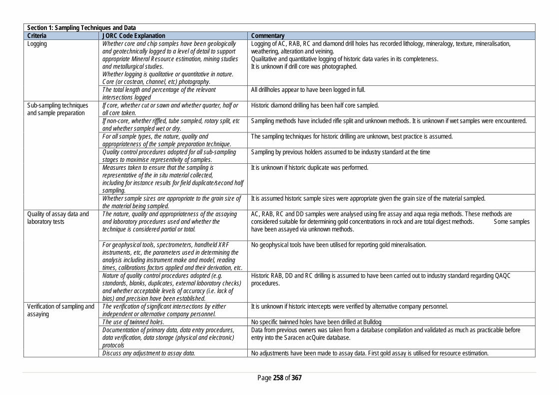
Page 258 of 367
Section 1: Sampling Techniques and Data Criteria JORC Code Explanation Commentary Logging Whether core and chip samples have been geologically
and geotechnically logged to a level of detail to support appropriate Mineral Resource estimation, mining studies and metallurgical studies. Whether logging is qualitative or quantitative in nature. Core (or costean, channel, etc) photography.
Logging of AC, RAB, RC and diamond drill holes has recorded lithology, mineralogy, texture, mineralisation, weathering, alteration and veining. Qualitative and quantitative logging of historic data varies in its completeness. It is unknown if drill core was photographed.
The total length and percentage of the relevant intersections logged
All drillholes appear to have been logged in full.
Sub-sampling techniques and sample preparation
If core, whether cut or sawn and whether quarter, half or all core taken.
Historic diamond drilling has been half core sampled.
If non-core, whether riffled, tube sampled, rotary split, etc and whether sampled wet or dry.
Sampling methods have included rifle split and unknown methods. It is unknown if wet samples were encountered.
For all sample types, the nature, quality and appropriateness of the sample preparation technique.
The sampling techniques for historic drilling are unknown, best practice is assumed.
Quality control procedures adopted for all sub-sampling stages to maximise representivity of samples.
Sampling by previous holders assumed to be industry standard at the time
Measures taken to ensure that the sampling is representative of the in situ material collected, including for instance results for field duplicate/second half sampling.
It is unknown if historic duplicate was performed.
Whether sample sizes are appropriate to the grain size of the material being sampled.
It is assumed historic sample sizes were appropriate given the grain size of the material sampled.
Quality of assay data and laboratory tests
The nature, quality and appropriateness of the assaying and laboratory procedures used and whether the technique is considered partial or total.
AC, RAB, RC and DD samples were analysed using fire assay and aqua regia methods. These methods are considered suitable for determining gold concentrations in rock and are total digest methods. Some samples have been assayed via unknown methods.
For geophysical tools, spectrometers, handheld XRF instruments, etc, the parameters used in determining the analysis including instrument make and model, reading times, calibrations factors applied and their derivation, etc.
No geophysical tools have been utilised for reporting gold mineralisation.
Nature of quality control procedures adopted (e.g. standards, blanks, duplicates, external laboratory checks) and whether acceptable levels of accuracy (i.e. lack of bias) and precision have been established.
Historic RAB, DD and RC drilling is assumed to have been carried out to industry standard regarding QAQC procedures.
Verification of sampling and assaying
The verification of significant intersections by either independent or alternative company personnel.
It is unknown if historic intercepts were verified by alternative company personnel.
The use of twinned holes. No specific twinned holes have been drilled at Bulldog Documentation of primary data, data entry procedures, data verification, data storage (physical and electronic) protocols
Data from previous owners was taken from a database compilation and validated as much as practicable before entry into the Saracen acQuire database.
Discuss any adjustment to assay data. No adjustments have been made to assay data. First gold assay is utilised for resource estimation.
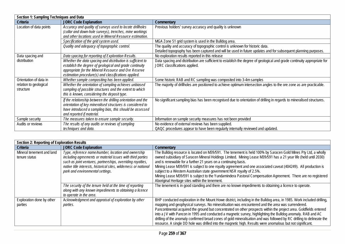
Page 259 of 367
Section 1: Sampling Techniques and Data Criteria JORC Code Explanation Commentary Location of data points Accuracy and quality of surveys used to locate drillholes
(collar and down-hole surveys), trenches, mine workings and other locations used in Mineral Resource estimation.
Previous holders’ survey accuracy and quality is unknown
Specification of the grid system used. MGA Zone 51 grid system is used in the Bulldog area. Quality and adequacy of topographic control. The quality and accuracy of topographic control is unknown for historic data.
Detailed topography has been captured and will be used in future updates and for subsequent planning purposes. Data spacing and distribution
Data spacing for reporting of Exploration Results. No exploration results reported in this release Whether the data spacing and distribution is sufficient to establish the degree of geological and grade continuity appropriate for the Mineral Resource and Ore Reserve estimation procedure(s) and classifications applied.
Data spacing and distribution are sufficient to establish the degree of geological and grade continuity appropriate for JORC classifications applied.
Orientation of data in relation to geological structure
Whether sample compositing has been applied. Some historic RAB and RC sampling was composited into 3-4m samples Whether the orientation of sampling achieves unbiased sampling of possible structures and the extent to which this is known, considering the deposit type.
The majority of drillholes are positioned to achieve optimum intersection angles to the ore zone as are practicable.
If the relationship between the drilling orientation and the orientation of key mineralised structures is considered to have introduced a sampling bias, this should be assessed and reported if material.
No significant sampling bias has been recognised due to orientation of drilling in regards to mineralised structures.
Sample security The measures taken to ensure sample security. Information on sample security measures has not been provided Audits or reviews The results of any audits or reviews of sampling
techniques and data. No evidence of external reviews has been supplied. QAQC procedures appear to have been regularly internally reviewed and updated.
Section 2: Reporting of Exploration Results Criteria JORC Code Explanation Commentary Mineral tenement and land tenure status
Type, reference name/number, location and ownership including agreements or material issues with third parties such as joint ventures, partnerships, overriding royalties, native title interests, historical sites, wilderness or national park and environmental settings.
The Bulldog resource is located on M39/591. The tenement is held 100% by Saracen Gold Mines Pty Ltd, a wholly owned subsidiary of Saracen Mineral Holdings Limited. Mining Lease M39/591 has a 21 year life (held until 2030) and is renewable for a further 21 years on a continuing basis. Mining Lease M39/591 is subject to one royalty agreement and one associated caveat (404249). All production is subject to a Western Australian state government NSR royalty of 2.5%. Mining Lease M39/591 is subject to the Yundamindera Pastoral Compensation Agreement. There are no registered Aboriginal Heritage sites within the tenement.
The security of the tenure held at the time of reporting along with any known impediments to obtaining a licence to operate in the area.
The tenement is in good standing and there are no known impediments to obtaining a licence to operate.
Exploration done by other parties
Acknowledgment and appraisal of exploration by other parties.
BHP conducted exploration in the Mount Howe district, including in the Bulldog area, in 1985. Work included drilling, mapping and geophysical surveys. No mineralisation was encountered and the area was surrendered. Pancontinental acquired the ground but concentrated on other prospects within the project area. Goldfields entered into a JV with Pancon in 1995 and conducted a magnetic survey, highlighting the Bulldog anomaly. RAB and AC drilling of the anomaly confirmed broad zones of gold mineralisation and was followed by RC drilling to delineate the resource. A single DD hole was drilled into the magnetic high. Results were anomalous but not significant.
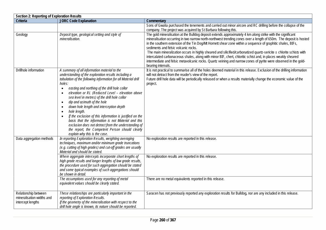
Page 260 of 367
Section 2: Reporting of Exploration Results Criteria JORC Code Explanation Commentary
Sons of Gwalia purchased the tenements and carried out minor aircore and RC drilling before the collapse of the company. The project was acquired by St Barbara following this.
Geology Deposit type, geological setting and style of mineralisation.
The gold mineralisation at the Bulldog deposit extends approximately 4 km along strike with the significant mineralisation occurring in two narrow north-northwest trending zones over a length of 650m. The deposit is hosted in the southern extension of the Tin Dog/Mt Hornett shear zone within a sequence of graphitic shales, BIFs, sediments and felsic volcanic rocks. The main mineralization occurs in highly sheared and silicified/carbonatized quartz-sericite ± chlorite schists with intercalated carbonaceous shales, along with minor BIF, chert, chloritic schist and, in places weakly sheared intermediate and felsic metavolcanic rocks. Quartz veining and narrow zones of pyrite were observed in the gold-bearing intervals.
Drillhole information A summary of all information material to the understanding of the exploration results including a tabulation of the following information for all Material drill holes: • easting and northing of the drill hole collar • elevation or RL (Reduced Level – elevation above
sea level in metres) of the drill hole collar • dip and azimuth of the hole • down hole length and interception depth • hole length. • If the exclusion of this information is justified on the
basis that the information is not Material and this exclusion does not detract from the understanding of the report, the Competent Person should clearly explain why this is the case.
It is not practical to summarise all of the holes deemed material in this release. Exclusion of the drilling information will not detract from the reader’s view of the report. Future drill hole data will be periodically released or when a results materially change the economic value of the project.
Data aggregation methods In reporting Exploration Results, weighting averaging techniques, maximum and/or minimum grade truncations (e.g. cutting of high grades) and cut-off grades are usually Material and should be stated.
No exploration results are reported in this release.
Where aggregate intercepts incorporate short lengths of high grade results and longer lengths of low grade results, the procedure used for such aggregation should be stated and some typical examples of such aggregations should be shown in detail.
No exploration results are reported in this release.
The assumptions used for any reporting of metal equivalent values should be clearly stated.
There are no metal equivalents reported in this release.
Relationship between mineralisation widths and intercept lengths
These relationships are particularly important in the reporting of Exploration Results. If the geometry of the mineralisation with respect to the drill hole angle is known, its nature should be reported.
Saracen has not previously reported any exploration results for Bulldog, nor are any included in this release.

Page 261 of 367
Section 2: Reporting of Exploration Results Criteria JORC Code Explanation Commentary
If it is not known and only the down hole lengths are reported, there should be a clear statement to this effect (eg ‘down hole length, true width not known’).
Diagrams Appropriate maps and sections (with scales) and tabulations of intercepts should be included for any significant discovery being reported These should include, but not be limited to a plan view of drill hole collar locations and appropriate sectional views.
No exploration results are reported in this release.
Balanced Reporting Where comprehensive reporting of all Exploration Results are not practicable, representative reporting of both low and high grades and/or widths should be practiced to avoid misleading reporting of Exploration Results.
Saracen has not previously reported exploration results at Bulldog, nor are any included in this release.
Other substantive exploration data
Other exploration data, if meaningful and material,should be reported including (but not limited to): geological observations; geophysical survey results; geochemical survey results; bulk samples – size and method of treatment; metallurgical test results; bulk density, groundwater, geotechnical and rock characteristics; potential deleterious or contaminating substances.
No substantive data acquisition has been completed in recent times.
Further work The nature and scale of planned further work (eg tests for lateral extensions or depth extensions or large-scale step-out drilling). Diagrams clearly highlighting the areas of possible extensions, including the main geological interpretations and future drilling areas, provided this information is not commercially sensitive
In the current economic climate, exploration activities at Bull Dog have been given a lower priority.
Section 3: Estimation and Reporting of Mineral Resources Criteria JORC Code Explanation Commentary Database Integrity Measures taken to ensure that data has not been
corrupted by, for example, transcription or keying errors, between its initial collection and its use for Mineral Resource estimation purposes.
Saracen utilises AcQuire software on an SQL server database to securely store and manage all drillhole and sample information. Data integrity protocols are built into the system to ensure data validity and minimise errors.
Data validation procedures used. Data for this deposit was inherited from SOG’s database during the acquisition in 2006. This data was imported into the Saracen AcQuire Database and in the process was validated by internal processes and systems. The process was overseen by the Database Administrator.
Site Visits Comment on any site visits undertaken by the Competent Person and the outcome of those visits.
There have been no recent visits to the Bulldog deposit by the competent person. Exploration personnel and geological managers have covered the ground since its acquisition from SOG’s in 2006, and the resource was updated in 2010 to reflect their findings.
If no site visits have been undertaken indicate why this is the case.

Page 262 of 367
Section 3: Estimation and Reporting of Mineral Resources Criteria JORC Code Explanation Commentary Geological Interpretation Confidence in (or conversely, the uncertainty of) the
geological interpretation of the mineral deposit. The resource category of Inferred was assigned to the whole model as it directly reflects the confidence in the geological interpretation that is built using mineral, and alteration geology obtained from mapping, logging, (100mN x 40mE drill spacing), drill results and geophysics.
Nature of the data used and any assumptions made. The geological interpretation and delineation of the mineralisation was predominantly constructed by grade and where possible alteration type, alteration intensity and veining. A cut-off grade of 0.25g/t was used to delineate the ore zones. Interpretations were based on the drilling results provided by SOG’s. Saracen Metals have not drilled any additional holes to this deposit. Magnetic geophysical surveys and mapping also assisted in the interpretation of Bulldog. Cross sectional interpretations of the mineralisation have been created and from this basic framework a 3D wireframe solid is built.
The affect, if any, of alternative interpretations on Mineral Resource estimation.
Due to the simplistic nature of the mineralisation no alternative interpretations have been considered. Over the life of the project several different sources have interpreted the mineralisation and all agree on the same basic interpretation.
The use of geology in guiding and controlling the Mineral Resource estimation.
The main mineralization occurs in highly sheared and silicified/carbonatized quartz-sericite ± chlorite schists with intercalated carbonaceous shales, along with minor BIF, chert, chloritic schist and, in places weakly sheared intermediate and felsic metavolcanic rocks. Quartz veining and narrow zones of pyrite were observed in the gold-bearing intervals and these influenced the domaining that controls the mineral resource estimation. The western (flatter) mineralised lode is hosted by a massive- to weakly foliated porphyritic metabasalt unit showing local evidence of brittle deformation and variable silicification and carbonatisation.
The factors affecting continuity both of grade and geology. Late stage faults that cross cut the lithological and structural grain occur throughout the project area that potentially result in the local change in strike of the mineralised lodes, every 900 – 1000m. The northern and southern termination is dictated more by the lack drilling in those directions. Drill spacing and depth makes it difficult to conclude accurate factors influencing continuity. Hence the appropriate assignment of Inferred to this resource.
Dimensions The extent and variability of the Mineral Resource expressed as length (along strike or otherwise), plan width, and depth below surface to the upper and lower limits of the Mineral Resource.
Bulldog mineralisation extends from 41000mN to 44000mN, 50500mE to 51000mE and to 150 meters below surface. There are two defining Bulldog Shears, the main shear strikes NNW-SSE and dips 50° towards the NE whilst lode 2 strikes N-S and is subhorizontal with a slight dip to the east.
Estimation and modelling techniques
The nature and appropriateness of the estimation technique(s) applied and key assumptions, including treatment of extreme grade values, domaining, interpolation parameters and maximum distance of extrapolation from data points.
Block estimation has been completed in Datamine software. All wireframes have been constructed in Micromine and were used as hard boundaries for the estimation. Estimation of parent blocks are interpolated with block discretisation points set to 5 x 5 x 5. The maximum distance of extrapolation is less than 100m. Univariate statistical analysis of length weighted, (1m), domain coded downhole composites have been completed for all domains and top-cuts applied where applicable. Minor clusters of high grades were apparent in the data set and the two lodes were analysed individually to determine specific top-cut values of 3.0g/t. RAB and Aircore Drill data was excluded from the dataset, negative Au grades replaced with a value of 0.001g/t and null assays were excluded from the sample data. Unfolding was carried out prior to variography and interpolation to remove the variable dip and strike typically associated with the mineralised domains. Variogram modelling was completed with GeoAccess Professional software. This defined the sample continuity with in the domains. The parameters determined from this analysis were used in the interpolation process.

Page 263 of 367
Section 3: Estimation and Reporting of Mineral Resources Criteria JORC Code Explanation Commentary
The availability of check estimates, previous estimates and/or mine production records and whether the Mineral Resource estimate takes appropriate account of such data.
As an inferred resource there has been no production reported for the Bulldog deposit. There were no previous historic models of this deposit to make a comparison.
The assumptions made regarding recovery of by-products. No assumptions have been made with respect to the recovery of by-products. Estimation of deleterious elements or other non-grade variables of economic significance (e.g. sulfur for acid mine drainage characterisation).
There has been no estimate at this point of deleterious elements. Saracen is unaware if any elements other than gold have been assayed.
In the case of block model interpolation, the block size in relation to the average sample spacing and the search employed.
The parent block sizes for the resource model are X (5m) by Y (10m) by Z (5m). Globally these are reasonable for this Inferred only resource, where drill spacing is in the order of 100m x 40m. Mining selectivity and mineralised lode geometry also influenced the estimation block size. Parent blocks have been sub-celled to X (1m) by Y (1m) by Z (1m) to ensure that the wireframe boundaries are honoured and preserve the location and shape of the mineralisation. Search ranges have been informed by variogram modelling and knowledge of the drill spacing and the known mineralisation geometry including direction of maximum continuity. Three search estimation runs were used with the aim to satisfy the minimum sample criteria in the first search range where possible.
Any assumptions behind modelling of selective mining units.
No selective mining units have been assumed.
Any assumptions about correlation between variables. No assumptions have been made regarding correlation between variables. Description of how the geological interpretation was used to control the resource estimates.
The geological interpretation correlates with the mineralised domains. All wireframe boundaries including those where lithology and mineralisation correspond, hard boundaries are enforced. There were no internal geological features identified that could help shape the estimation.
Discussion of basis for using or not using grade cutting or capping.
Individual analysis of the two domains indicates small clusters of high grade outliers that bias the mean grade and positively skew the grade population. Top-cuts (3.0g/t) have been employed to eliminate the risk of overestimating in the local areas and bring those outliers in line with the majority of the population.
The process of validation, the checking process used, the comparison of model data to drill hole data, and use of reconciliation data if available.
Several key model validation steps have been taken to validate the resource estimate. The mineral resource model has been stepped through visually in sectional and plan view to appreciate the composite grades used in the estimate and the resultant block grades. Easting, Northing and Elevation swathe plots have been constructed to evaluate the composited assay means and declustered mean versus the mean block estimates. These showed good agreement. QQ and scatter plots for the averaged sample data vs. block model results were completed and showed a slight yet expected deviation from the 45° line. Moving from sample size data to a much bigger volume resulted in a slight overstatement of the low grades and an understatement of high grades.
Moisture Whether the tonnages are estimated on a dry basis or with natural moisture, and the method of determination of the moisture content.
All tonnages are estimated on a dry basis.
Cut-off parameters The basis of the adopted cut-off grade(s) or quality parameters applied.
Based on Saracen’s current economic operations at Carosue Dam, and the natural grade distinction above background, a grade of 0.8g/t has been selected.
Mining factors or assumptions
Assumptions made regarding possible mining methods, minimum mining dimensions and internal (or, if applicable, external) mining dilution. It is always necessary as part of
At this stage there have been no mining assumptions or factors for the Bulldog deposit.

Page 264 of 367
Section 3: Estimation and Reporting of Mineral Resources Criteria JORC Code Explanation Commentary
the process of determining reasonable prospects for eventual economic extraction to consider potential mining methods, but the assumptions made regarding mining methods and parameters when estimating Mineral Resources may not always be rigorous. Where this is the case, this should be reported with an explanation of the basis of the mining assumptions made.
Metallurgical factors or assumptions
The basis for assumptions or predictions regarding metallurgical amenability. It is always necessary as part of the process of determining reasonable prospects for eventual economic extraction to consider potential metallurgical methods, but the assumptions regarding metallurgical treatment process and parameters made when reporting Mineral Resources may not always be rigorous. Where this is the case, this should be reported with an explanation of the basis of the metallurgical assumptions made.
There are no metallurgical factors at this stage of the project.
Environmental factors or assumptions
Assumptions made regarding possible waste and process residue disposal options. It is always necessary as part of the process of determining reasonable prospects for eventual economic extraction to consider the potential environmental impacts of the mining and processing operation. While at this stage the determination of potential environmental impacts, particularly for a greenfields project, may not always be well advanced, the status of early consideration of these potential environmental impacts should be reported. Where these aspects have not been considered this should be reported with an explanation of the environmental assumptions made.
Environmental considerations are captured by Program of Work (PoW) requirements. To date operations on these tenements is purely exploratory in nature.
Bulk Density Whether assumed or determined. If assumed, the basis for the assumptions. If determined, the method used, whether wet or dry, the frequency of the measurements, the nature, size and representativeness of the samples.
The density values applied to the Bulldog estimation were based on historic density measures for similar lithological units in the same geological zones. At this stage there is no new Bulk Density data collected and measured by Saracen.
The bulk density for bulk material must have been measured by methods that adequately account for void spaces (vugs, porosity, etc), moisture and differences between rock and alteration zones within the deposit.
It is unknown how the historic bulk densities were measured. Any future bulk density measurements will follow the Saracens Metals standardised procedures.
Discuss assumptions for bulk density estimates used in the evaluation process of the different materials.
Density values are allocated uniformly to each lithological and regolith type. This includes the primary fresh lithologies as well as the weathered oxide and transitional zones.
Classification The basis for the classification of the Mineral Resources into varying confidence categories.
The mineral resource has been classified as an Inferred category only based on the 100m x 40m drill hole spacing and the resulting lower confidence in geological continuity.

Page 265 of 367
Section 3: Estimation and Reporting of Mineral Resources Criteria JORC Code Explanation Commentary
Whether appropriate account has been taken of all the relevant factors (ie relative confidence in tonnage/grade estimations, reliability of input data, confidence in continuity of geology and metal values, quality, quantity and distribution of the data).
All care has been taken to account of all available relevant information that could influence the mineral resource estimate.
Whether the result appropriately reflects the Competent Person's view of the deposit.
The geological model and the mineral resource estimate reflect the competent person’s view of the deposit.
Audits or reviews The results of any audits or reviews of Mineral Resource estimates.
There has been no new information or updates of the 2010 Bulldog mineral resource which was reported according to the 2004 JORC standards. Due to the simple geological setting and inferred classification of the Bulldog Deposit no external audits have been conducted at this stage.
Discussion of relative accuracy/confidence
Where appropriate a statement of the relative accuracy and confidence level in the Mineral Resource estimate using an approach or procedure deemed appropriate by the Competent Person. For example, the application of statistical or geostatistical procedures to quantify the relative accuracy of the resource within stated confidence limits, or, if such an approach is not deemed appropriate, a qualitative discussion of the factors that could affect the relative accuracy and confidence of the estimate.
Saracen Gold Mine uses a standard approach to resource estimation and the procedure requires the systematic completion of the Saracen Resource Estimation Document that is thoroughly investigated and assessed. It was identified that; Further work on KNA for block size, minimum and maximum number of samples, search ellipses would help to further improve the optimisation of the block model. It is recommended to use optimised pit shells or designs as a guide to create drilling programmes that maximise the conversion from inferred to indicated category. And it is recommended to initiate a bulk density programme with sufficient samples from the oxide and transitional layer to test the assumed values used in the estimate.
The statement should specify whether it relates to global or local estimates, and, if local, state the relevant tonnages, which should be relevant to technical and economic evaluation. Documentation should include assumptions made and the procedures used.
The statements relate to a global estimate of tonnes and grade.
These statements of relative accuracy and confidence of the estimate should be compared with production data, where available.
Mining production has not ensued at the Bulldog Deposit.
Crimson Belle
Section 1: Sampling Techniques and Data Criteria JORC Code Explanation Commentary Sampling Techniques Nature and quality of sampling (e.g. cut channels, random
chips, or specific specialised industry standard measurement tools appropriate to the minerals under investigation, such as down hole gamma sondes, or handheld XRF instruments, etc.). These examples should not be taken as limiting the broad meaning of sampling.
Saracen has undertaken reverse circulation drilling (RC) at Crimson Belle. Historic methods conducted since 1984 have included aircore (AC), rotary air blast (RAB), reverse circulation and diamond drillholes.
Include reference to measures taken to ensure sample representivity and the appropriate calibration of any measurement tools or systems used
Sampling for RC drilling was carried out as specified within Saracen sampling and QAQC procedures as per industry standard. RC chips provide high quality representative samples for analysis.

Page 266 of 367
Section 1: Sampling Techniques and Data Criteria JORC Code Explanation Commentary
RC, RAB, AC and DD core drilling was completed by previous holders to industry standard at that time (1984- 2000).
Aspects of the determination of mineralisation that are Material to the Public Report. In cases where ‘industry standard’ work has been done this would be relatively simple (e.g. ‘reverse circulation drilling was used to obtain 1 m samples from which 3 kg was pulverised to produce a 30 g charge for fire assay’). In other cases more explanation may be required, such as where there is coarse gold that has inherent sampling problems. Unusual commodities or mineralisation types (e.g. submarine nodules) may warrant disclosure of detailed information
RC chips were cone split and sampled into 1m intervals with total sample weights less than 3 kg. Samples were selected to weigh less than 3 kg to ensure total sample inclusion at the pulverisation stage. Saracen chip samples were crushed, dried and pulverised to a nominal 90% passing 75 microns to produce a 50g sub sample for analysis by FA/AAS. Historical AC, RAB, RC and diamond sampling was carried out to industry standard at that time. Analysis methods include fire assay, aqua regia and unspecified methods.
Drilling Techniques Drill type (e.g. core, reverse circulation, open-hole hammer, rotary air blast, auger, Bangka, sonic, etc.) and details (e.g. core diameter, triple or standard tube, depth of diamond tails, face-sampling bit or other type, whether core is oriented and if so, by what method, etc.).
The deposit was initially sampled by 9 AC holes, 19 RAB holes, 232 RC holes (assumed standard 5 ¼ ‘’bit size) and 3 surface diamond unknown diameter holes. Saracen has completed 28 RC drillholes utilising a 5 ¼ ‘’ face sampling hammer. It is unknown if historic diamond drill core was oriented.
Drill Sample Recovery Method of recording and assessing core and chip sample recoveries and results assessed
RC sampling recoveries were recorded as a percentage based on a visual weight estimate; no historic recoveries have been recorded.
Measures taken to maximise sample recovery and ensure representative nature of the samples
During RC campaigns daily rig inspections are carried out to check splitter condition, general site and address general issues. Historic AC, RAB, RC and diamond drilling to industry standard at that time.
Whether a relationship exists between sample recovery and grade and whether sample bias may have occurred due to preferential loss/gain of fine/coarse material.
There is no known relationship between sample recovery and grade for RC drilling. Any historical relationship is not known.
Logging Whether core and chip samples have been geologically and geotechnically logged to a level of detail to support appropriate Mineral Resource estimation, mining studies and metallurgical studies. Whether logging is qualitative or quantitative in nature. Core (or costean, channel, etc) photography.
Logging of RC chips recorded lithology, mineralogy, texture, mineralisation, weathering, alteration, veining and other features. Chips from all RC holes were stored in chip trays for future reference. Qualitative and quantitative logging of historic data varies in its completeness.
The total length and percentage of the relevant intersections logged
All exploration RC holes were logged in full. Historical logging is complete.
Sub-sampling techniques and sample preparation
If core, whether cut or sawn and whether quarter, half or all core taken.
Saracen has not carried out diamond drilling at Crimson Belle. Historic diamond drilling has been sampled via unknown methods.
If non-core, whether riffled, tube sampled, rotary split, etc and whether sampled wet or dry.
All exploration RC samples were cone split. Occasional wet samples were encountered; increased air capacity was routinely used to aid in keeping the sample dry when water was encountered. Historic AC, RAB and RC drilling was sampled using spear, riffle and unknown methods.
For all sample types, the nature, quality and appropriateness of the sample preparation technique.
The sample preparation of RC chips adhered to industry best practice. It was conducted by a commercial laboratory and involved oven drying, coarse crushing then total grinding to a size of 90% passing 75 microns. Best practice is assumed at the time of historic sampling.

Page 267 of 367
Section 1: Sampling Techniques and Data Criteria JORC Code Explanation Commentary
Quality control procedures adopted for all sub-sampling stages to maximise representivity of samples.
All subsampling activities were carried out by commercial laboratory and are considered to be satisfactory. Sampling by previous holders assumed to be industry standard at the time.
Measures taken to ensure that the sampling is representative of the in situ material collected, including for instance results for field duplicate/second half sampling.
Duplicate sampling was carried out at a rate of 1:10 for exploration drilling, with the duplicate being sampled directly from the on-board splitter on the rig. These were submitted for the same assay process as the original samples and the laboratory were unaware of such submissions. Sampling by previous holders assumed to be industry standard at the time.
Whether sample sizes are appropriate to the grain size of the material being sampled.
Sample sizes are considered to be appropriate given the grainsize (90% passing 75 microns) of the material sampled.
Quality of assay data and laboratory tests
The nature, quality and appropriateness of the assaying and laboratory procedures used and whether the technique is considered partial or total.
RC chip samples were analysed by external laboratories using a 50g fire assay with AAS finish. This method is considered suitable for determining gold concentrations in rock and is a total digest method. Historic sampling includes fire assay, aqua regia and unknown methods.
For geophysical tools, spectrometers, handheld XRF instruments, etc, the parameters used in determining the analysis including instrument make and model, reading times, calibrations factors applied and their derivation, etc.
No geophysical tools have been utilised for reporting gold mineralisation at Crimson Belle.
Nature of quality control procedures adopted (e.g. standards, blanks, duplicates, external laboratory checks) and whether acceptable levels of accuracy (i.e. lack of bias) and precision have been established.
Certified reference material (standards and blanks) with a wide range of values were inserted into every drillhole at a rate of 1:25 for exploration RC drilling. These were not identifiable to the laboratory. QAQC data returned were checked against pass/fail limits within the SQL database and were passed or failed on import. A report was generated and reviewed by the geologist as necessary upon failure to determine further action. QAQC data was reported monthly. Sample preparation checks for fineness are carried out to ensure a grindsize of 90% passing 75 microns. The laboratory performed a number of internal processes including standards, blanks, repeats and checks. QAQC data analysis demonstrates sufficient accuracy and precision. Industry best practice is assumed for previous holders.
Verification of sampling and assaying
The verification of significant intersections by either independent or alternative company personnel.
Significant intercepts are verified by the Geology Manager and corporate personnel.
The use of twinned holes. No specific twinned holes have been drilled at Crimson Belle. Documentation of primary data, data entry procedures, data verification, data storage (physical and electronic) protocols
Primary data was collated in a set of excel templates utilising lookup codes. This data was forwarded to the Database Administrator for entry into a secure acQuire database with inbuilt validation functions. Data from previous owners was taken from a database compilation and validated as much as practicable before entry into the Saracen acQuire database.
Discuss any adjustment to assay data. No adjustments have been made to assay data. First gold assay is utilised for resource estimation. Location of data points Accuracy and quality of surveys used to locate drillholes
(collar and down-hole surveys), trenches, mine workings and other locations used in Mineral Resource estimation.
Exploration drillholes were located using a Leica 1200 GPS with an accuracy of +/- 10mm. Downhole surveys were carried out using an electronic multishot tool at 5m intervals. Previous holders’ survey accuracy and quality is unknown
Specification of the grid system used. A local grid system (CamelBack) is used. The two point conversion to MGA_GDA94 zone 51 is CBEast CBNorth RL MGAEast MGANorth RL Point 1 8000 5775 0 433743.35 6764980.48 0 Point 2 8000 6249.75 0 433633.80 6765442.59 0 Historic data is converted to the CamelBack local grid upon export from the database.

Page 268 of 367
Section 1: Sampling Techniques and Data Criteria JORC Code Explanation Commentary
Quality and adequacy of topographic control. Topographic control originally used site based survey pickups in addition to Kevron aerial photogrammetric surveys with +/- 5m resolution.
Data spacing and distribution
Data spacing for reporting of Exploration Results. The nominal spacing for exploration drilling is 40m x 20m drilling pattern, grading to a 50m x 30m to 50m x 50m patterns at depth.
Whether the data spacing and distribution is sufficient to establish the degree of geological and grade continuity appropriate for the Mineral Resource and Ore Reserve estimation procedure(s) and classifications applied.
Data spacing and distribution are sufficient to establish the degree of geological and grade continuity appropriate for JORC classifications applied.
Orientation of data in relation to geological structure
Whether sample compositing has been applied.
Sample compositing is not applied until the estimation stage. Some historic RAB and RC sampling was composited into 3-4m samples.
Whether the orientation of sampling achieves unbiased sampling of possible structures and the extent to which this is known, considering the deposit type.
The majority of drillholes are positioned to achieve optimum intersection angles to the ore zone as are practicable.
If the relationship between the drilling orientation and the orientation of key mineralised structures is considered to have introduced a sampling bias, this should be assessed and reported if material.
No significant sampling bias is thought to occur due to orientation of drilling in regards to mineralised structures.
Sample security The measures taken to ensure sample security. Samples were prepared on site under supervision of Saracen geological staff. Samples were selected, bagged into tied numbered calico bags then grouped into secured cages and collected by the laboratory personnel. Sample submissions are documented via laboratory tracking systems and assays are returned via email
Audits or reviews The results of any audits or reviews of sampling techniques and data.
An internal review of companywide sampling methodologies was conducted to create the current sampling and QAQC procedures.
Section 2: Reporting of Exploration Results Criteria JORC Code Explanation Commentary Mineral tenement and land tenure status
Type, reference name/number, location and ownership including agreements or material issues with third parties such as joint ventures, partnerships, overriding royalties, native title interests, historical sites, wilderness or national park and environmental settings.
The Crimson Belle resource is located on M39/120. Near mine exploration has been carried out on M39/118 and E39/1410. The tenements are held 100% by Saracen Gold Mines Pty Ltd, a wholly owned subsidiary of Saracen Mineral Holdings Limited. Mining Leases M39/118 and M39/120 have a 21 year life (held until 2030) and are renewable for a further 21 years on a continuing basis. Exploration Licence 39/1410 expires in 2019 with further yearly extensions of term permissible on a continuing basis. Mining Lease M39/118 is subject to three royalty agreements and three associated caveats (1154H/967, 136H/067 and 323783). Mining Lease M39/120 is subject to three royalty agreements and two associated caveats (138H/067 and 323785). Exploration Licence E39/1410 is subject to one royalty and one associated caveat (410509). All production is subject to a Western Australian state government NSR royalty of 2.5%. Mining Leases M39/118 and M39/120, and Exploration Licence E39/1410 are subject to the Yundamindera Pastoral Compensation Agreement. Mining Lease 39/120 contains four Aboriginal Heritage sites (Place ID 21755, 21756, 21903, 21904). Mining Lease 39/118 contains three Aboriginal Heritage sites (Place ID 21753, 21902, 21903)
The security of the tenure held at the time of reporting along with any known impediments to obtaining a licence to operate in the area.
The tenements are in good standing and there are no known impediments to obtaining a licence to operate.

Page 269 of 367
Section 2: Reporting of Exploration Results Criteria JORC Code Explanation Commentary Exploration done by other parties
Acknowledgment and appraisal of exploration by other parties.
The Camelback prospect, in near vicinity to Crimson Belle, was discovered by WMC in the 1970’s through a rock chip campaign. Drilling was initially carried out in 1984 and intersected variable gold grades. Further drilling and geochemical activities were continued through the 1980’s and 1990’s by WMC, Windarra Nickel, Consex, Newmont, Dominion, Plutonic and Mount Burgess. Drilling carried out by Sons of Gwalia in 1995 following their JV with Mount Burgess delineated the Crimson Belle resource.
Geology Deposit type, geological setting and style of mineralisation.
Gold mineralisation at Crimson Belle is hosted within a 15-30m wide shear zone dipping 50-80 degrees to the east, within a sedimentary sequence containing abundant chert. Mineralisation occurs in five lodes associated with quartz-sulphide veining hosted within the silicified gossanous chert and extends for approximately 700m along a north-south strike.
Drillhole information A summary of all information material to the understanding of the exploration results including a tabulation of the following information for all Material drill holes: • easting and northing of the drill hole collar • elevation or RL (Reduced Level – elevation • above sea level in metres) of the drill hole collar • dip and azimuth of the hole • down hole length and interception depth • hole length. • If the exclusion of this information is justified on the
basis that the information is not Material and this exclusion does not detract from the understanding of the report, the Competent Person should clearly explain why this is the case.
All material data is periodically released on the ASX: 25/01/2013. Future drill hole data will be periodically released or when a results materially change the economic value of the project. Exclusion of the drilling information will not detract from the reader’s view of the report.
Data aggregation methods In reporting Exploration Results, weighting averaging techniques, maximum and/or minimum grade truncations (e.g. cutting of high grades) and cut-off grades are usually Material and should be stated.
All significant intercepts have been length weighted with a minimum Au grade of 1ppm. No high grade cut off has been applied.
Where aggregate intercepts incorporate short lengths of high grade results and longer lengths of low grade results, the procedure used for such aggregation should be stated and some typical examples of such aggregations should be shown in detail.
Intercepts are aggregated with minimum width of 1m and maximum width of 3m for internal dilution. Where stand out higher grade zone exist with in the broader mineralised zone, the higher grade interval is reported also.
The assumptions used for any reporting of metal equivalent values should be clearly stated.
There are no metal equivalents reported in this release.
Relationship between mineralisation widths and intercept lengths
These relationships are particularly important in the reporting of Exploration Results. If the geometry of the mineralisation with respect to the drill hole angle is known, its nature should be reported. If it is not known and only the down hole lengths are reported, there should be a clear statement to this effect (eg ‘down hole length, true width not known’).
This announcement includes sufficient detail to clearly illustrate the geometry of the mineralisation and the recent drilling. All results are reported as downhole lengths. This remains consistent with previous announcements.

Page 270 of 367
Section 2: Reporting of Exploration Results Criteria JORC Code Explanation Commentary Diagrams Appropriate maps and sections (with scales) and
tabulations of intercepts should be included for any significant discovery being reported These should include, but not be limited to a plan view of drill hole collar locations and appropriate sectional views.
All significant exploration results released by Saracen are accompanied by the appropriate diagrams and maps at the time of the release.
Balanced Reporting Where comprehensive reporting of all Exploration Results are not practicable, representative reporting of both low and high grades and/or widths should be practiced to avoid misleading reporting of Exploration Results.
All results from the last campaign have been reported, irrespective of success or not.
Other substantive exploration data
Other exploration data, if meaningful and material,should be reported including (but not limited to): geological observations; geophysical survey results; geochemical survey results; bulk samples – size and method of treatment; metallurgical test results; bulk density, groundwater, geotechnical and rock characteristics; potential deleterious or contaminating substances.
No substantive data acquisition has been completed in recent times.
Further work The nature and scale of planned further work (eg tests for lateral extensions or depth extensions or large-scale step-out drilling). Diagrams clearly highlighting the areas of possible extensions, including the main geological interpretations and future drilling areas, provided this information is not commercially sensitive
Crimson Belle is a prospective resource with exploration potential. Further Exploration activity for this deposit is currently under review.
Section 3: Estimation and Reporting of Mineral Resources Criteria JORC Code Explanation Commentary Database Integrity Measures taken to ensure that data has not been
corrupted by, for example, transcription or keying errors, between its initial collection and its use for Mineral Resource estimation purposes.
Saracen utilises AcQuire software on an SQL server database to securely store and manage all drillhole and sample information. Data integrity protocols are built into the system to ensure data validity and minimise errors.
Data validation procedures used. Data that is captured in the field is entered into Excel templates which are checked on import into the database for errors. Assay jobs are dispatched electronically to the lab to minimise the chance of data entry errors. Assay results from the lab are received in CSV format and are checked for errors on import into the database. Data is regularly validated using the mining software. The data validation process is overseen by the Database Administrator.
Site Visits Comment on any site visits undertaken by the Competent Person and the outcome of those visits.
At the time of exploration and review (2010) of the deposit, the Competent Persons visited the geological area frequently to assess geological competency and ensure integrity across all geological disciplines.
If no site visits have been undertaken indicate why this is the case.
Geological Interpretation Confidence in (or conversely, the uncertainty of) the geological interpretation of the mineral deposit.
A combination of exploration mapping, geophysical surveys, both exploration and grade control drill hole information and geological data, including mapping, has resulted in a reasonable geological interpretation.

Page 271 of 367
Section 3: Estimation and Reporting of Mineral Resources Criteria JORC Code Explanation Commentary
Nature of the data used and any assumptions made. The interpretations have been constructed using all available geological logging descriptions including but not limited to, stratigraphy, lithology, texture, and alteration. Most information was obtained from drill hole results and some historic mapping. There is strong correlation between mineralisation and the BIF unit. This was used as the main driver for the interpretation.
The affect, if any, of alternative interpretations on Mineral Resource estimation.
Due to the simplicity of the model, there are no alternative models at this stage.
The use of geology in guiding and controlling the Mineral Resource estimation.
The geology has heavily influenced the extent of the domains controlling the mineral resource estimation. Gold mineralisation occurs within the Crimson Belle deposit as a wide variety of vein and veinlet types within a NNW-striking and west-dipping sequence of sandstone, siltstone, shale and cherty banded iron formation (BIF), (although basalt and ultramafic schist have been intersected in some drillholes). The main mineralisation is confined to the BIF unit and is characterised by NNW strike and 50° – 80° easterly dip. All mineralised domains were wireframed with hard boundaries. The wireframes for the current model were generated in Leapfrog utilising interval selection based on a cut-off of 0.25 g/t of gold the drillholes. The continuity of grade is largely related to the occurrence of BIF, and AU mineralisation is found within it and close to other rock type contacts. Internal waste was domained out where possible. The geological interpretation indicates mineralisation is continuous and still open at depth and along strike.
The factors affecting continuity both of grade and geology. Dimensions The extent and variability of the Mineral Resource
expressed as length (along strike or otherwise), plan width, and depth below surface to the upper and lower limits of the Mineral Resource.
A total of 21 sections at 40m spacing were interpreted from 10,150N to 10,920N, 4500mE to 5100mE, covering the extent of the mineralisation in Crimson Belle deposit area. The interpretation and wireframes were generated based on a 40m × 15m and 40m × 20m exploration drilling patterns.
Estimation and modelling techniques
The nature and appropriateness of the estimation technique(s) applied and key assumptions, including treatment of extreme grade values, domaining, interpolation parameters and maximum distance of extrapolation from data points.
A conventional 3D Ordinary Kriging (OK) modelling technique has been used. The modelling technique is suitable to the domains being estimated allowing reasonable expectation of mining selectivity across the mineralised domain. All compositing, wireframes, surfaces, rock/domain models and OK estimation were completed in Micromine. All estimation uses these wireframes as hard boundaries. Estimation of parent blocks are interpolated, and assigned to sub-cells. The maximum distance of extrapolation is less than 50m. Univariate statistical analysis of length weighted, (1m), domain and regolith coded downhole composites have been completed for all domains. Over 95% of the sample data used in the estimation was 1m in length with the average for the entire sample set at 1.00m. Composites were broken where there was a change of mineralisation domain code or regolith code. For each domain, log probability plots identified clusters of higher grade outliers that could bias the mean. High grade outliers were used to determine specific top-cut values for each domain. Estimations used only RC and Diamond Drill results; negative Au grades were replaced with a value of 0.001g/t, and null assays were excluded from the sample data. Variogram modelling was completed with Snowden Supervisor software. This defined the sample continuity and nugget value for each domain. Nugget effect in the major domains is typically 33% to 43%. Major ranges varied from 50 to 60m’s, with a limited range across the mineralisation of typically 7 to 10m. Down plunge ranges can be limited to 22 to 30m’s in some cases. The majority of the mineralised domains have data spacing that is well within the variogram ranges. The parameters determined from this analysis were used in the interpolation process.

Page 272 of 367
Section 3: Estimation and Reporting of Mineral Resources Criteria JORC Code Explanation Commentary
The availability of check estimates, previous estimates and/or mine production records and whether the Mineral Resource estimate takes appropriate account of such data.
A comparative OK estimate was completed in Datamine. No significant variance between estimations was observed. The concerted effort to domain out internal waste zones relative to the current geological interpretation resulted in a 6% reduction in ore tonnes reciprocal 6% increase in the grade. Overall metal remained the same.
The assumptions made regarding recovery of by-products. No assumptions have been made with respect to the recovery of by-products. Estimation of deleterious elements or other non-grade variables of economic significance (e.g. sulfur for acid mine drainage characterisation).
There has been no estimate at this point of deleterious elements. Saracen is unaware if any elements other than gold have been assayed.
In the case of block model interpolation, the block size in relation to the average sample spacing and the search employed.
The parent block sizes for the resource model are X (10m) by Y (20m) by Z (10m). Drillhole data spacing, mining selectivity and mineralised lode geometry are among the primary considerations for the determination of an appropriate estimation block size confirmed by kriging neighbourhood analysis (KNA) completed in Snowden Supervisor. Drilling data at Crimson Belle is primarily on a 40 x 20 metre drilling pattern, grading to a 50 x 30 to 50 x 50 metre patterns at depth. Parent blocks have been sub-celled to X (1.0m) by Y (2.0m) by Z (1.0m) to ensure that wireframe boundaries were honoured and mineralisation geometry and contacts preserved. Search ranges have been informed by variogram modelling and knowledge of the drill spacing and the known mineralisation geometry including direction of maximum continuity Three search estimation runs are used with the aim to satisfy the minimum sample criteria in the first search range where possible. First pass searches in all domains were set to 80% of the range expanding out to the full range on the second pass. A third search at three times the range was completed to estimate all residual material however this was taken into account during resource classification. Full ranges for all domains in the major direction were between 50 to 60m’s, semi major 22 to 30m’s, and 7 to 10m’s in the minor direction.
Any assumptions behind modelling of selective mining units.
No selective mining units have been assumed.
Any assumptions about correlation between variables. No assumptions have been made regarding correlation between variables. Description of how the geological interpretation was used to control the resource estimates.
The geological interpretation strongly correlates with the mineralised domains. Hard wireframes were used to define all the mineralised domains.
Discussion of basis for using or not using grade cutting or capping.
Linear interpolation methods such as Ordinary Kriging are sensitive to the presence of high-grade outliers that positively skew the data and bias the mean. Domain histogram and Log probability plots were used to determine appropriate top cuts for each domain. Not all domains required top cutting.
The process of validation, the checking process used, the comparison of model data to drill hole data, and use of reconciliation data if available.
Several key model validation steps have been taken to validate the resource estimate. The mineral resource model has been stepped through visually in sectional and plan view to appreciate the composite grades used in the estimate and the resultant block grades. The mean average composite grade and block model grade by deposit and domain were compared. QQ and scatter plots for the averaged sample data vs. block model results were also plotted. Easting, Northing and Elevation swathe plots have been constructed to evaluate the declustered composited assay means versus the mean block estimates. Global change of support graphs were completed for domains containing sufficient samples.
Moisture Whether the tonnages are estimated on a dry basis or with natural moisture, and the method of determination of the moisture content.
All tonnages are estimated on a dry basis.

Page 273 of 367
Section 3: Estimation and Reporting of Mineral Resources Criteria JORC Code Explanation Commentary Cut-off parameters The basis of the adopted cut-off grade(s) or quality
parameters applied. Based on Saracen’s current economic status the natural grade distinction above background for the Crimson Belle deposit was at a grade of 0.8g/t.
Mining factors or assumptions
Assumptions made regarding possible mining methods, minimum mining dimensions and internal (or, if applicable, external) mining dilution. It is always necessary as part of the process of determining reasonable prospects for eventual economic extraction to consider potential mining methods, but the assumptions made regarding mining methods and parameters when estimating Mineral Resources may not always be rigorous. Where this is the case, this should be reported with an explanation of the basis of the mining assumptions made.
The Crimson Belle deposit is amenable to mining by open pit methods. There has not been any serious mining at Crimson Belle. There are reasonable grounds to assume that in the future this deposit will be mined by conventional open pit methods given the close proximity of the mineralisation to surface.
Metallurgical factors or assumptions
The basis for assumptions or predictions regarding metallurgical amenability. It is always necessary as part of the process of determining reasonable prospects for eventual economic extraction to consider potential metallurgical methods, but the assumptions regarding metallurgical treatment process and parameters made when reporting Mineral Resources may not always be rigorous. Where this is the case, this should be reported with an explanation of the basis of the metallurgical assumptions made.
Limited metallurgical information is available for Crimson Belle. Metallurgical testing of a transition/fresh composite shows gravity recovery of 73% and total recovery of 79%.
Environmental factors or assumptions
Assumptions made regarding possible waste and process residue disposal options. It is always necessary as part of the process of determining reasonable prospects for eventual economic extraction to consider the potential environmental impacts of the mining and processing operation. While at this stage the determination of potential environmental impacts, particularly for a greenfields project, may not always be well advanced, the status of early consideration of these potential environmental impacts should be reported. Where these aspects have not been considered this should be reported with an explanation of the environmental assumptions made.
Environmental considerations are captured by Program of Work (PoW) requirements. Operations on these tenements are purely exploratory in nature to date.
Bulk Density Whether assumed or determined. If assumed, the basis for the assumptions. If determined, the method used, whether wet or dry, the frequency of the measurements, the nature, size and representativeness of the samples.
The density values applied to the Crimson Belle Deposit estimation are largely based on historic density measures from similar rock types known to the geological area.
The bulk density for bulk material must have been measured by methods that adequately account for void spaces (vugs, porosity, etc), moisture and differences between rock and alteration zones within the deposit.
It is unknown how the historic bulk densities were measured. Any future bulk density measurements will follow the Saracens Metals standardised procedures.

Page 274 of 367
Section 3: Estimation and Reporting of Mineral Resources Criteria JORC Code Explanation Commentary
Discuss assumptions for bulk density estimates used in the evaluation process of the different materials.
Density values are allocated uniformly to each lithological and regolith type. This includes the primary fresh lithologies as well as the weathered oxide and transitional zones
Classification The basis for the classification of the Mineral Resources into varying confidence categories.
Information from the estimation process, including search pass, number of composites used in the search ellipse, Kriging variance and Kriging efficiency are all used in conjunction with drill spacing to finalise classification domains. Crimson Belle was classified into Indicated, Inferred and unclassified categories according to the 2012 JORC Code.
Whether appropriate account has been taken of all the relevant factors (ie relative confidence in tonnage/grade estimations, reliability of input data, confidence in continuity of geology and metal values, quality, quantity and distribution of the data).
All care has been taken to account for relevant factors influencing the mineral resource estimate. The diligent Saracen Metals Resource review process ensures that data reliability and geological and metal confidence and continuity are reflected in the resource classification.
Whether the result appropriately reflects the Competent Person's view of the deposit.
The geological model and the mineral resource estimate reflect the competent person’s view of the deposit.
Audits or reviews The results of any audits or reviews of Mineral Resource estimates.
This model was reviewed at the time of completion to the JORC 2012 standards. At the time the quality of the estimate was deemed appropriate and robust as a global estimate. Saracen Metals undertake an extensive review of the model that covers; • Model inventory and comparisons to previous and budget models if in existence • Geological interpretation, wireframing, domain selection, statistics by domain, assay and metal evaluation, parent cell sizes, data compositing, variography, search strategy, estimation and KNA • Model validation – swathe plots, visual checks, volume comparisons, composite to model metal comparisons and global change of support comparisons. Due to its simple geological geometry, external audits were deemed unnecessary at the time.
Discussion of relative accuracy/confidence
Where appropriate a statement of the relative accuracy and confidence level in the Mineral Resource estimate using an approach or procedure deemed appropriate by the Competent Person. For example, the application of statistical or geostatistical procedures to quantify the relative accuracy of the resource within stated confidence limits, or, if such an approach is not deemed appropriate, a qualitative discussion of the factors that could affect the relative accuracy and confidence of the estimate.
The mineral resource has been reported in accordance with the guidelines established in the 2012 edition of the JORC code. A standardised approach has been implemented for this estimation and the result is a robust model with appropriately defined resource categories. The validation process is also thorough suggesting the estimate has a reasonable level of confidence. The resource estimate is good global estimate however locally there is room for improvement particularly in the selection of optimal block size. The review of the estimate identified that further testing on the bulk density values and additional field mapping to confirm shoot trends is required in conjunction with an infill drill program to increase confidence in local estimates and model quality.
The statement should specify whether it relates to global or local estimates, and, if local, state the relevant tonnages, which should be relevant to technical and economic evaluation. Documentation should include assumptions made and the procedures used.
The statements relate to a global estimate of tonnes and grade.
These statements of relative accuracy and confidence of the estimate should be compared with production data, where available.
An historic pit (quarry) exits over Crimson Belle, however there is no link to historic production.

Page 275 of 367
Butcher Well Section 1: Sampling Techniques and Data Criteria JORC Code Explanation Commentary Sampling Techniques Nature and quality of sampling (e.g. cut channels, random
chips, or specific specialised industry standard measurement tools appropriate to the minerals under investigation, such as down hole gamma sondes, or handheld XRF instruments, etc.). These examples should not be taken as limiting the broad meaning of sampling.
Sampling methods undertaken by Saracen in the Butcher Well project area have included reverse circulation (RC) and RC grade control drilling within two pits. Historic methods conducted since 1988 have included aircore (AC), rotary air blast (RAB), reverse circulation and diamond drillholes.
Include reference to measures taken to ensure sample representivity and the appropriate calibration of any measurement tools or systems used
Sampling for RC exploration and grade control drilling was carried out as specified within Saracen sampling and QAQC procedures as per industry standard. RC chips provide high quality representative samples for analysis. RC, RAB, AC and DD core drilling was completed by previous holders to industry standard at that time (1988- 2004).
Aspects of the determination of mineralisation that are Material to the Public Report. In cases where ‘industry standard’ work has been done this would be relatively simple (e.g. ‘reverse circulation drilling was used to obtain 1 m samples from which 3 kg was pulverised to produce a 30 g charge for fire assay’). In other cases more explanation may be required, such as where there is coarse gold that has inherent sampling problems. Unusual commodities or mineralisation types (e.g. submarine nodules) may warrant disclosure of detailed information
RC chips were riffle or cone split and sampled into 1m intervals with total sample weights less than 3kg. Samples were selected to weigh less than 3 kg to ensure total sample inclusion at the pulverisation stage. Saracen chip samples were crushed, dried and pulverised to a nominal 90% passing 75µm to produce a 40g or 50 g sub sample for analysis by FA/AAS. Historical AC, RAB, RC and diamond sampling was carried out to industry standard at that time. Analysis methods include fire assay, aqua regia, atomic absorption spectroscopy and unspecified methods.
Drilling Techniques Drill type (e.g. core, reverse circulation, open-hole hammer, rotary air blast, auger, Bangka, sonic, etc.) and details (e.g. core diameter, triple or standard tube, depth of diamond tails, face-sampling bit or other type, whether core is oriented and if so, by what method, etc.).
The project area was initially sampled by 130 AC holes, 800 RAB holes, 1404 RC holes (assumed standard 5 ¼ ‘’bit size) and 49 surface diamond core HQ, NQ, PQ and unknown diameter holes. Saracen has completed 172 surface RC holes and 159 grade control RC holes within the Sizzler and Old Camp pits. It is unknown if historic diamond drill core was oriented.
Drill Sample Recovery Method of recording and assessing core and chip sample recoveries and results assessed
RC sampling recoveries were recorded as a percentage based on a visual weight estimate; no historic recoveries have been recorded.
Measures taken to maximise sample recovery and ensure representative nature of the samples
During RC exploration and grade control campaigns daily rig inspections were carried out to check splitter condition, general site and address general issues. The sample bag’s weight versus bulk reject weight was compared to ensure adequate and even sample recovery. Historical AC, RAB, RC and diamond drilling to industry standard at that time.
Whether a relationship exists between sample recovery and grade and whether sample bias may have occurred due to preferential loss/gain of fine/coarse material.
There is no known relationship between sample recovery and grade for RC drilling. Any historical relationship is not known.
Logging Whether core and chip samples have been geologically and geotechnically logged to a level of detail to support appropriate Mineral Resource estimation, mining studies and metallurgical studies. Whether logging is qualitative or quantitative in nature.
Logging of RC chips records lithology, mineralogy, texture, mineralisation, weathering, alteration, veining and other features. Chips from all RC holes (exploration and GC) are stored in chip trays for future reference. Qualitative and quantitative logging of historic data varies in its completeness.

Page 276 of 367
Section 1: Sampling Techniques and Data Criteria JORC Code Explanation Commentary
Core (or costean, channel, etc) photography. The total length and percentage of the relevant intersections logged
All exploration RC holes were logged in full. Every second drill line was logged in grade control programs with infill logging carried out as necessary. Historical logging is approximately 95% complete.
Sub-sampling techniques and sample preparation
If core, whether cut or sawn and whether quarter, half or all core taken.
Saracen has not completed any diamond drilling at Butcher Well. Historic diamond drilling was quarter core sampled or sampled via unknown methods.
If non-core, whether riffled, tube sampled, rotary split, etc and whether sampled wet or dry.
All exploration and grade control RC samples were cone or riffle split. Occasional wet samples were encountered; increased air capacity was routinely used to aid in keeping the sample dry when water was encountered. Historic AC, RAB and RC drilling was sampled using spear, grab, riffle and unknown methods.
For all sample types, the nature, quality and appropriateness of the sample preparation technique.
The sample preparation of RC chips adhered to industry best practice. It was conducted by a commercial laboratory and involved oven drying, coarse crushing then total grinding to a size of 90% passing 75 microns. Best practice is assumed at the time of historic sampling
Quality control procedures adopted for all sub-sampling stages to maximise representivity of samples.
All subsampling activities were carried out by commercial laboratory and are considered to be satisfactory. Sampling by previous holders assumed to be industry standard at the time.
Measures taken to ensure that the sampling is representative of the in situ material collected, including for instance results for field duplicate/second half sampling.
Duplicate sampling was carried out at a rate of 1:10 for exploration drilling and 1:20 for GC drilling and was sampled directly from the on-board splitter on the rig. These were submitted for the same assay process as the original samples and the laboratory were unaware of such submissions. Sampling by previous holders assumed to be industry standard at the time.
Whether sample sizes are appropriate to the grain size of the material being sampled.
Sample sizes are considered to be appropriate give n the grainsize (90% passing 75 microns) of the material sampled.
Quality of assay data and laboratory tests
The nature, quality and appropriateness of the assaying and laboratory procedures used and whether the technique is considered partial or total.
RC chip samples and grade control chip samples were analysed by external laboratories using a 40g or 50g fire assay with AAS finish. These methods are considered suitable for determining gold concentrations in rock and are total digest methods. Historic sampling includes fire assay, aqua regia, atomic absorption spectroscopy and unspecified methods
For geophysical tools, spectrometers, handheld XRF instruments, etc, the parameters used in determining the analysis including instrument make and model, reading times, calibrations factors applied and their derivation, etc.
No geophysical tools have been utilised for reporting gold mineralisation at Butcher Well.
Nature of quality control procedures adopted (e.g. standards, blanks, duplicates, external laboratory checks) and whether acceptable levels of accuracy (i.e. lack of bias) and precision have been established.
Certified reference material (standards and blanks) with a wide range of values were inserted into every drillhole at a rate of 1:25 for exploration RC and 1:40 for GC drilling. These were not identifiable to the laboratory. QAQC data returned were checked against pass/fail limits with the SQL database and were passed or failed on import. A report was generated and reviewed by the geologist as necessary upon failure to determine further action. QAQC data was reported monthly. Sample preparation checks for fineness were carried out to ensure a grind size of 90% passing 75 microns. The laboratory performed a number of internal processes including standards, blanks, repeats and checks. QAQC data analysis demonstrates sufficient accuracy and precision. Industry best practice is assumed for previous holders.
Verification of sampling and assaying
The verification of significant intersections by either independent or alternative company personnel.
Significant intercepts were verified by the Geology Manager and corporate personnel.
The use of twinned holes. Saracen has not drilled any specific twinned holes at Butcher Well but grade control drilling has confirmed the width and grade of previous exploration drilling. Mount Burgess carried out a twinning program to confirm previous (Billiton) results, and test ore zone repeatability.

Page 277 of 367
Section 1: Sampling Techniques and Data Criteria JORC Code Explanation Commentary
Documentation of primary data, data entry procedures, data verification, data storage (physical and electronic) protocols
Primary data was collated in a set of excel templates utilising lookup codes. This data was forwarded to the Database Administrator for entry into a secure acQuire database with inbuilt validation functions. Data from previous owners was taken from a database compilation and validated as much as practicable before entry into the Saracen acQuire database
Discuss any adjustment to assay data. No adjustments have been made to assay data. First gold assay is utilised for resource estimation. Location of data points Accuracy and quality of surveys used to locate drillholes
(collar and down-hole surveys), trenches, mine workings and other locations used in Mineral Resource estimation.
Exploration drillholes were located using a Leica 1200 GPS with an accuracy of +/- 10mm. Drillhole collars within the pits and immediate surrounds were picked up by company surveyors using a Trimble R8 GNSS (GPS) with an expected accuracy of +/-8mm. Downhole surveys were carried out using an Eastman single shot or multishot camera at regular intervals (usually 30m). A number of drillholes were also gyroscopically surveyed. Previous holders’ survey accuracy and quality is unknown
Specification of the grid system used. A local grid system (Butcher Well) is used. The two point conversion to MGA_GDA94 zone 51 is BWEast BWNorth RL MGAEast MGANorth RL Point 1 18877.20 10507.60 0 434331.81 6764334.45 0 Point 2 18698.30 10552.30 0 434147.44 6764339.35 0 Historic data is converted to the Butcher Well local grid upon export from the database.
Quality and adequacy of topographic control. Topographic control originally used site based survey pickups in addition to Kevron aerial photogrammetric surveys with +/- 5m resolution.
Data spacing and distribution
Data spacing for reporting of Exploration Results. The nominal spacing for exploration drilling are sufficient to establish the degree of geological and grade continuity Whether the data spacing and distribution is sufficient to establish the degree of geological and grade continuity appropriate for the Mineral Resource and Ore Reserve estimation procedure(s) and classifications applied.
Data spacing and distribution are sufficient to establish the degree of geological and grade continuity appropriate for JORC classifications applied.
Orientation of data in relation to geological structure
Whether sample compositing has been applied.
Sample compositing is not applied until the estimation stage. Some historic aircore, RAB and RC sampling was composited into 3-4m samples with areas of interest re-sampled to 1m intervals. It is unknown at what threshold this occurred.
Whether the orientation of sampling achieves unbiased sampling of possible structures and the extent to which this is known, considering the deposit type.
The majority of drillholes were positioned to achieve optimum intersection angles to the ore zone as was practicable.
If the relationship between the drilling orientation and the orientation of key mineralised structures is considered to have introduced a sampling bias, this should be assessed and reported if material.
No significant sampling bias was thought to occur due to orientation of drilling in regards to mineralised structures.
Sample security The measures taken to ensure sample security. Samples were prepared on site under supervision of Saracen geological staff. Samples were selected, bagged into tied numbered calico bags then grouped into secured cages and collected by the laboratory personnel. Sample submissions were documented via laboratory tracking systems and assays were returned via email
Audits or reviews The results of any audits or reviews of sampling techniques and data.
An internal review of companywide sampling methodologies was conducted to create the current sampling and QAQC procedures

Page 278 of 367
Section 2: Reporting of Exploration Results Criteria JORC Code Explanation Commentary Mineral tenement and land tenure status
Type, reference name/number, location and ownership including agreements or material issues with third parties such as joint ventures, partnerships, overriding royalties, native title interests, historical sites, wilderness or national park and environmental settings.
The Butcher Well resources are located on M39/165, M39/166 and M39/230. These tenements are held 100% by Saracen Gold Mines Pty Ltd, a wholly owned subsidiary of Saracen Mineral Holdings Limited. Saracen entered a farm-in agreement with AngloGold Ashanti during 2016 that covers these tenements. Mining Leases M39/165 and M39/166 have a 21 year life and are held until 2030. Mining Lease M39/230 has a 21 year life and is held until 2032. All are renewable for a further 21 years on a continuing basis. Mining Leases M39/165, M39/166 and M39/230 are each subject to two royalty agreements and one associated caveat (139H/067, 140H/067 and 141H/067, respectively). All are subject to a mortgage. All production is subject to a Western Australian state government NSR royalty of 2.5%. Mining Leases M39/165, M39/166 and M39/230 are subject to the Yundamindera Pastoral Compensation Agreement. There are no registered Aboriginal Heritage sites within any of the tenements.
The security of the tenure held at the time of reporting along with any known impediments to obtaining a licence to operate in the area.
The tenements are in good standing and the license to operate already exists.
Exploration done by other parties
Acknowledgment and appraisal of exploration by other parties.
Gold exploration over the Butcher Well project area began in 1988 with Billiton embarking on an extensive exploration program including geophysics, costeaning, and RAB, RC and diamond drilling, delineating the Enigmatic, Hronsky and Butcher Well prospects. Mount Burgess purchased the project in 1990 carrying out further diamond and RC drilling, including a twinning program to confirm Billiton results and repeatability of ore zones, and geochemical sampling. Infill drilling resulted in resources being calculated at the Enigmatic, Butcher Well and Hronsky deposits. Mining at the three resources commenced in 1993. Drilling in the vicinity of these deposits led to the delineation of the Old Camp, Marchelayo and Sizzler prospects. Mount Burgess entered into a joint venture with Sons of Gwalia in 1994. Exploration continued in the project area including geochemical sampling, geophysics, RAB, diamond and RC drilling. Sons of Gwalia purchased Mount Burgess’ share to wholly control the project in 1999. Reconnaissance RAB and aircore drilling to the north of Butcher well resulted in the discovery of the Jericho prospect, which was confirmed with RC drilling. Exploration activities in the project area continued until Son of Gwalia’s collapse and takeover by St Barbara
Geology Deposit type, geological setting and style of mineralisation.
Gold mineralisation at the Butcher Well group of deposits occurs as a wide variety of vein and veinlet types (that are identified in mapping and logging) within the Mount Hornet shear zone. The Butcher Well South deposits (Enigmatic, Hronsky, Sizzler and Old Camp) are controlled by deformed, altered “blocky” basalt on the margins of sheared syenite stocks and dykes and at the contact with mafic schist. The alteration assemblage is carbonate-silica-sericite-pyrite arsenopyrite. A short distance along strike at Butcher Well North, gold mineralisation occurs with a similar alteration assemblage but is hosted by silicified, commonly brecciated intermediate volcaniclastics.
Drillhole information A summary of all information material to the understanding of the exploration results including a tabulation of the following information for all Material drill holes:
• easting and northing of the drill hole collar • elevation or RL (Reduced Level – elevation • above sea level in metres) of the drill hole collar • dip and azimuth of the hole • down hole length and interception depth • hole length.
All material data is periodically released on the ASX: 27/01/2012, 06/01/2012, 28/07/2011. Future drill hole data will be periodically released or when a results materially change the economic value of the project. Exclusion of the drilling information will not detract from the reader’s view of the report.

Page 279 of 367
Section 2: Reporting of Exploration Results Criteria JORC Code Explanation Commentary
• If the exclusion of this information is justified on the basis that the information is not Material and this exclusion does not detract from the understanding of the report, the Competent Person should clearly explain why this is the case.
Data aggregation methods In reporting Exploration Results, weighting averaging techniques, maximum and/or minimum grade truncations (e.g. cutting of high grades) and cut-off grades are usually Material and should be stated.
All significant intercepts have been length weighted with a minimum Au grade of 1ppm. No high grade cut off has been applied.
Where aggregate intercepts incorporate short lengths of high grade results and longer lengths of low grade results, the procedure used for such aggregation should be stated and some typical examples of such aggregations should be shown in detail.
Intercepts are aggregated with minimum width of 1m and maximum width of 3m for internal dilution. Where stand out higher grade zone exist with in the broader mineralised zone, the higher grade interval is reported also.
The assumptions used for any reporting of metal equivalent values should be clearly stated.
There are no metal equivalents reported in this release.
Relationship between mineralisation widths and intercept lengths
These relationships are particularly important in the reporting of Exploration Results. If the geometry of the mineralisation with respect to the drill hole angle is known, its nature should be reported. If it is not known and only the down hole lengths are reported, there should be a clear statement to this effect (eg ‘down hole length, true width not known’).
This announcement includes sufficient detail to clearly illustrate the geometry of the mineralisation and the recent drilling. All results are reported as downhole lengths. This remains consistent with previous announcements
Diagrams Appropriate maps and sections (with scales) and tabulations of intercepts should be included for any significant discovery being reported These should include, but not be limited to a plan view of drill hole collar locations and appropriate sectional views.
This release illustrates in long section and in cross section views the nature of the drilling and its relationship to the mineralisation.
Balanced Reporting Where comprehensive reporting of all Exploration Results are not practicable, representative reporting of both low and high grades and/or widths should be practiced to avoid misleading reporting of Exploration Results.
All results from the recent campaign have been reported, irrespective of success or not
Other substantive exploration data
Other exploration data, if meaningful and material,should be reported including (but not limited to): geological observations; geophysical survey results; geochemical survey results; bulk samples – size and method of treatment; metallurgical test results; bulk density, groundwater, geotechnical and rock characteristics; potential deleterious or contaminating substances.
No substantive data acquisition has been completed in recent times.
Further work The nature and scale of planned further work (eg tests for lateral extensions or depth extensions or large-scale step-out drilling).
In the current economic climate, exploration activities at Butcher Well are under review to highlight areas of greatest potential.

Page 280 of 367
Section 2: Reporting of Exploration Results Criteria JORC Code Explanation Commentary
Diagrams clearly highlighting the areas of possible extensions, including the main geological interpretations and future drilling areas, provided this information is not commercially sensitive
Section 3: Estimation and Reporting of Mineral Resources Criteria JORC Code Explanation Commentary Database Integrity Measures taken to ensure that data has not been
corrupted by, for example, transcription or keying errors, between its initial collection and its use for Mineral Resource estimation purposes.
Saracen utilises AcQuire software on an SQL server database to securely store and manage all drillhole and sample information. Data integrity protocols are built into the system to ensure data validity and minimise errors.
Data validation procedures used. Data that is captured in the field is entered into Excel templates which are checked on import into the database for errors. Assay jobs are dispatched electronically to the lab to minimise the chance of data entry errors. Assay results from the lab are received in CSV format and are checked for errors on import into the database. Data is regularly validated using the mining software. The data validation process is overseen by the Database Administrator.
Site Visits Comment on any site visits undertaken by the Competent Person and the outcome of those visits.
At the time of renewed exploration and mining activities in 2011 & 2012 the Competent Persons visited the geological area to assess geological competency and ensure integrity across all exploration geological disciplines.
If no site visits have been undertaken indicate why this is the case.
Geological Interpretation Confidence in (or conversely, the uncertainty of) the geological interpretation of the mineral deposit.
A combination of well documented historic geology and structural information, exploration mapping, geophysical surveys, sufficient drill hole information and geological data collected during historic production at Butcher Well North, Enigmatic and Old Camp has resulted in a confident geological interpretation.
Nature of the data used and any assumptions made. Geological interpretation was centred around historic and where possible in pit mapping that corresponds to grade mineralisation. This helped to define the domains for each deposit. Lithology and where possible alteration type, alteration intensity and veining from drill logs were also utilised. The wireframes for the current model were generated in Micromine based on a cut-off of 0.40 g/t of gold in individual sections of drill holes. The cut-off level reduced internal dilution within domains and also allowed for clearer ore definition from one section to the next creating ore zones of greater continuity. For the purpose of the estimation the data was rotated into the Butcherwell local grid to ensure the holes (now east-west) intersected mineralisation at right angles to remove sampling bias.
The affect, if any, of alternative interpretations on Mineral Resource estimation.
Over time the model for the Butcherwell deposit has improved with the gathering of more geological information. The latest iteration is a culmination of all available geological data and this is considered a robust interpretation. Thus alternative interpretations have not been considered at this stage.
The use of geology in guiding and controlling the Mineral Resource estimation.
The geology has heavily influenced the geometry of the domains controlling the mineral resource estimation. In particular known geological mapping was incorporated into the ore definition process, at Butcher Well, Butcher Well North and Enigmatic (inc North) and helped to define the major cross cutting structures, that displace or truncate the ore. Gold mineralisation at the Butcher Well group of deposits occurs as a wide variety of vein and veinlet types (that are identified in mapping and logging) within the Mount Hornet shear zone. The Butcher Well South deposits (Enigmatic, Hronsky, Sizzler and Old Camp) are controlled by deformed, altered “blocky” basalt on the margins of sheared syenite stocks and dykes and at the contact with mafic schist. The alteration assemblage is carbonate-silica-sericite-pyrite arsenopyrite. A short distance along strike at Butcher Well North, gold mineralisation occurs with a similar alteration assemblage but is hosted by silicified, commonly brecciated intermediate volcaniclastics.

Page 281 of 367
Section 3: Estimation and Reporting of Mineral Resources Criteria JORC Code Explanation Commentary
All geological information, from historic and current resources was considered and incorporated into the modelling. All mineralised domains were wireframed with hard boundaries.
The factors affecting continuity both of grade and geology. Continuity of mineralisation and geology varies by deposit. Butcherwell North – NW trending shears terminate the strike extent of the main lodes of this deposit, however Au is remobilised along these NW shears to form less significant domains. Au is also anomalous adjacent to a cross cutting porphyry. Drilling indicates a hiatus of Au mineralisation at 300mRL. Machelayo and Jericho – the strike extents of these deposits could be terminated by similar NW trending shears however the hypothesis are inconclusive due to a lack of drilling. Old camp, Engimatic. Hronsky and Sizzler –these deposits are intricately linked by offsetting shear zones and syenite intrusions, both of which cause anomalous Au near these geological features, but also terminate their strike extents. In all deposits, down dip extents are largely open and untested.
Dimensions The extent and variability of the Mineral Resource expressed as length (along strike or otherwise), plan width, and depth below surface to the upper and lower limits of the Mineral Resource.
The Butcher Well gold project hosts a group of gold deposits, including Old Camp, Enigmatic, Hronsky, Enigmatic North, Sizzler, Butcher Well North, Marchelayo and Jericho, all of which are situated within a 4.5Km strike in north-south direction. A total of 185 sections at 25m spacing were interpreted from 8,400mN to 13,350mN.
Estimation and modelling techniques
The nature and appropriateness of the estimation technique(s) applied and key assumptions, including treatment of extreme grade values, domaining, interpolation parameters and maximum distance of extrapolation from data points.
Block estimation has been completed using Datamine software. All compositing, wireframes, surfaces, rock and domain models were constructed in Micromine. All estimation uses these wireframes as hard boundaries. Estimation of parent blocks are interpolated, and assigned to sub-cells. The maximum distance of extrapolation varies between deposits based on geological confidence and drill density. Where extrapolation was greater than 50m the resource category of Potential (4) came into play and highlighted areas for exploration. Univariate statistical analysis of length weighted, (1m, minimum of 0.3m), domain and regolith coded downhole composites have been completed for all domains. 95% of the sample data used in the estimation is 1m in length. A composite interval of 1m also allowed the differentiation of both the lodes and the high grade zones within the individual lodes. Clusters of higher grade outliers that could bias the mean were identified by domain by the use of log probability plots and/or normal histogram plots. These were used to determine specific top-cut values for each domain. Butcherwell North & Machelayo - Estimations used only used RC and Diamond Drill results, with at least 91% of the data being RC. Jericho - Estimations used Diamond, RC and AC drill results, where AC made up 30% of the dataset. As a result this deposit was categorised as Inferred to Potential. Old Camp, Enigmatic, Hronsky & Sizzler – Estimations used combinations of RC, Diamond, and RAB drill results, where RAB made up less than 18% of the dataset for each deposit. Negative assays which were determined to be below detection were replaced with a positive value of 0.001 g/t; Missing assays which were due to incomplete samples, or missing core/chips were left as null samples. These will have no impact on interpolation, and the assumption is that the grade of these missing values is similar to that of neighbouring samples, and that local block interpolation will generate representative estimates based on neighbouring data contained in the search ellipse; Zero grade values were replaced with nulls if determined to be true missing data, or a below detection positive value (0.001) otherwise. Unfolding was carried out prior to variography and estimation to remove the local variances in dip and strike observed in the domains.

Page 282 of 367
Section 3: Estimation and Reporting of Mineral Resources Criteria JORC Code Explanation Commentary
Variogram modelling was completed with GeoAccess Professional software. This defined the sample continuity and nugget value for each domain. The parameters determined from this analysis were used in the interpolation process.
The availability of check estimates, previous estimates and/or mine production records and whether the Mineral Resource estimate takes appropriate account of such data.
Previous estimates from 2009 were deemed too liberal and unconstrained based upon a simplified geological interpretation and loose resource category boundaries. The current model that utilises all geological information is far more constrained and results are indicative of these changes. 33% of the Indicated tonnes were reallocated to the Inferred category with the recognition that more drilling would be required to improve confidence. On the upside this model highlights great exploration potential.
The assumptions made regarding recovery of by-products. No assumptions have been made with respect to the recovery of by-products. Estimation of deleterious elements or other non-grade variables of economic significance (e.g. sulfur for acid mine drainage characterisation).
There has been no estimate at this point of deleterious elements. Saracen is unaware if any elements other than gold have been assayed.
In the case of block model interpolation, the block size in relation to the average sample spacing and the search employed.
The parent block sizes for the resource model are 10mE × 12.5mN × 5mRL. These are deemed appropriate for the majority of the resource, where drill spacing is in the order of 25m × 12.5m and 25m × 25m and to a 30m x 30m up to 50m x 50m patterns at depth. Parent blocks have been sub-celled to X (1.0m) by Y (1.25m) by Z (1.0m) to ensure that the wireframe boundaries are honoured and preserve the location and shape of the mineralisation. Search ranges have been informed by variogram modelling and knowledge of the drill spacing and the known mineralisation geometry including direction of maximum continuity. Three search estimation runs are used with the aim to satisfy the minimum sample criteria in the first search range where possible. Minimum number of samples, numbers of drill holes, and search distances were determined by drill pattern spacing, and the geometry of the mineralised lodes. In the southern deposits major mineralisation occurs in relatively thick tabular lodes, often 10 - 20 meters in width, so a minimum of 12 samples per drill hole, in 4 drill holes was selected for the first search pass. The subsequent passes are set to lower minimums while increasing the search distances to find sufficient samples where drilling density decreases. A similar approach to the northern deposits was taken, however due the thin undulating nature of the ore zones the maximum number of samples was increased to 32 and the minimum for the first search pass was dropped to 10. This improved the number of samples obtained in the first pass without a significant increase in negative weights.
Any assumptions behind modelling of selective mining units.
Subcelling to X (1.0m) by Y (1.25m) by Z (1.0m) allows for the 5m and 10m selective mining units explored as options by Saracens.
Any assumptions about correlation between variables. No assumptions have been made regarding correlation between variables. Description of how the geological interpretation was used to control the resource estimates.
The geological interpretation strongly correlates with the mineralised domains. Hard wireframes were used to define all the mineralised domains.
Discussion of basis for using or not using grade cutting or capping.
Linear interpolation methods such as Ordinary Kriging are sensitive to the presence of high-grade outliers that positively skew the data and bias the mean. Domain histogram and Log probability plots were used to determine appropriate top cuts, (if necessary) for every single domain for each deposit.
The process of validation, the checking process used, the comparison of model data to drill hole data, and use of reconciliation data if available.
Several key model validation steps have been taken to validate the resource estimate. The mineral resource model has been stepped through visually in sectional and plan view to appreciate the composite grades used in the estimate and the resultant block grades. The mean average composite grade and block model grade by deposit and domain were compared. Easting, Northing and Elevation swathe plots have been constructed to evaluate the composited assay means versus the mean block estimates.

Page 283 of 367
Section 3: Estimation and Reporting of Mineral Resources Criteria JORC Code Explanation Commentary
The mineral resource model has been constructed to include kriging efficiency and the slope of regression values. These values are used to measure the quality of the estimate. Natural deterioration of the quality is observed in areas where data density is lower.
Moisture Whether the tonnages are estimated on a dry basis or with natural moisture, and the method of determination of the moisture content.
All tonnages are estimated on a dry basis.
Cut-off parameters The basis of the adopted cut-off grade(s) or quality parameters applied.
Based on Saracen’s current economic status the natural grade distinction above background for the suite of Butcherwell deposits is set at a grade of 0.8g/t.
Mining factors or assumptions
Assumptions made regarding possible mining methods, minimum mining dimensions and internal (or, if applicable, external) mining dilution. It is always necessary as part of the process of determining reasonable prospects for eventual economic extraction to consider potential mining methods, but the assumptions made regarding mining methods and parameters when estimating Mineral Resources may not always be rigorous. Where this is the case, this should be reported with an explanation of the basis of the mining assumptions made.
Extensive Open Pit mining has occurred at the Butcherwell deposits. There are reasonable grounds to assume that in the future the remaining resources from the Butcherwell suite of deposits will be mined by conventional open pit methods given the close proximity to surface and the mean grade of the mineralisation.
Metallurgical factors or assumptions
The basis for assumptions or predictions regarding metallurgical amenability. It is always necessary as part of the process of determining reasonable prospects for eventual economic extraction to consider potential metallurgical methods, but the assumptions regarding metallurgical treatment process and parameters made when reporting Mineral Resources may not always be rigorous. Where this is the case, this should be reported with an explanation of the basis of the metallurgical assumptions made.
Metallurgical investigations identified that high metallurgical recoveries are possible in the oxide & transition zones (>90%) with recovery reducing at depth. Metallurgical testing of primary ores shows the presence of refractory gold. Previous mining/processing of deeper ores by Mount Burgess Mining ceased due to low plant recoveries.
Environmental factors or assumptions
Assumptions made regarding possible waste and process residue disposal options. It is always necessary as part of the process of determining reasonable prospects for eventual economic extraction to consider the potential environmental impacts of the mining and processing operation. While at this stage the determination of potential environmental impacts, particularly for a greenfields project, may not always be well advanced, the status of early consideration of these potential environmental impacts should be reported. Where these aspects have not been considered this should be reported with an explanation of the environmental assumptions made.
No processing or beneficiation of ore expected on these tenements, as ore is hauled to Carosue Dam Minesite for Processing. Waste is characterised by highly dispersive and saline oxide materials, which have been addressed by Waste Dump design. Rehabilitation trials are currently underway to assess the redesign of batter slopes to lower gradients to prevent future erosion. Waste Rock Dump (WRD) monitoring is carried out annually on all WRD's.
Bulk Density Whether assumed or determined. If assumed, the basis for the assumptions. If determined, the method used,
No new Bulk Density data was collected and measured by Saracen at the time of the resource review in 2011. Densities used in the current model are based on data collected by Sons of Gwalia Exploration and Resource

Page 284 of 367
Section 3: Estimation and Reporting of Mineral Resources Criteria JORC Code Explanation Commentary
whether wet or dry, the frequency of the measurements, the nature, size and representativeness of the samples.
Development departments. Data consists of 35 samples collected by regolith zone. The bulk density data was imported into the AcQuire database.
The bulk density for bulk material must have been measured by methods that adequately account for void spaces (vugs, porosity, etc), moisture and differences between rock and alteration zones within the deposit.
It is unclear of the exact method used by Sons of Gwalia Exploration to determine bulk density values. Any future density measurements will adhere to Saracens Metals standardised procedures for bulk density testing.
Discuss assumptions for bulk density estimates used in the evaluation process of the different materials.
Where bulk density measures are taken an average mean of densities collected for each lithological type is uniformly applied to the modelled geological units. This includes the primary fresh lithologies as well as the weathered oxide and transitional zones.
Classification The basis for the classification of the Mineral Resources into varying confidence categories.
The mineral resource has been classified into Indicated, Inferred and Potential categories based on drill hole spacing, drill hole type and quality (in the case of Jericho), geological confidence, and grade continuity and estimation quality. The combination of these factors together guided the hard boundary wireframe used to define the Indicated and Inferred zones. Ore zones outside this wireframe were coded with the possible category of 4. Measured material was not defined for this estimation as QAQC data was lacking from the database.
Whether appropriate account has been taken of all the relevant factors (ie relative confidence in tonnage/grade estimations, reliability of input data, confidence in continuity of geology and metal values, quality, quantity and distribution of the data).
All care has been taken to account for relevant factors influencing the mineral resource estimate. The diligent Saracen Metals Resource review process ensures that data reliability and geological and metal confidence and continuity are reflected in the resource classification.
Whether the result appropriately reflects the Competent Person's view of the deposit.
The geological model and the mineral resource estimate reflect the competent person’s view of the deposit.
Audits or reviews The results of any audits or reviews of Mineral Resource estimates.
Saracen has adopted a process for geological modelling, estimation and reporting of mineral resources that meets high industry standards. At the completion of resource estimation Saracen Metals undertake an extensive review of the model that covers; • Model inventory and comparisons to previous and budget models if in existence • Geological interpretation, wireframing, domain selection, statistics by domain, assay and metal evaluation, parent cell sizes, data compositing, variography, search strategy, estimation and KNA • Model validation – swathe plots, visual checks, volume comparisons, composite to model metal comparisons. In the final stages the model and resource categorisation are all discussed and scrutinized by the geological and mine planning teams.
Discussion of relative accuracy/confidence
Where appropriate a statement of the relative accuracy and confidence level in the Mineral Resource estimate using an approach or procedure deemed appropriate by the Competent Person. For example, the application of statistical or geostatistical procedures to quantify the relative accuracy of the resource within stated confidence limits, or, if such an approach is not deemed appropriate, a qualitative discussion of the factors that could affect the relative accuracy and confidence of the estimate.
The mineral resource has been reported in accordance with the guidelines established in the 2004 edition of the JORC code. Saracen Gold Mine uses a standard approach to resource estimation and the procedure requires the systematic completion of the Saracen Resource Estimation Document that is thoroughly investigated and assessed in the Model review process, as stated above. It was identified that; Comparative bulk density measurements are necessary to confirm SOG’s density values. Further work on KNA for block size, minimum and maximum number of samples, search ellipses and declustering of the composite data would help to further improve the optimisation of the block model.
The statement should specify whether it relates to global or local estimates, and, if local, state the relevant tonnages, which should be relevant to technical and
The statements relate to a global estimate of tonnes and grade.

Page 285 of 367
Section 3: Estimation and Reporting of Mineral Resources Criteria JORC Code Explanation Commentary
economic evaluation. Documentation should include assumptions made and the procedures used. These statements of relative accuracy and confidence of the estimate should be compared with production data, where available.
The confidence in the model is reflected by the designation of Resource categories. Given the thorough geological analysis of this area and adequate drilling definition, it is a good estimation of all the resources at Butcherwell. Jericho, an Inferred resource, has far less drilling and a third of that is AC data. Actual Production from the Sizzler and Old Camp deposits reconciled well with the resource estimate. Sizzler reported a 12% increase in tonnes for a 12% loss in grade for no change in the total ounces. Old Camp reported a 7% increase in total ounces as a result of improved tonnages.
Thunderbox Operations Thunderbox
Section 1: Sampling Techniques and Data Criteria JORC Code Explanation Commentary Sampling Techniques
Nature and quality of sampling (e.g. cut channels, random chips, or specific specialised industry standard measurement tools appropriate to the minerals under investigation, such as down hole gamma sondes, or handheld XRF instruments, etc.). These examples should not be taken as limiting the broad meaning of sampling.
Sampling methods undertaken by Saracen at Thunderbox include diamond drilling (DD), reverse circulation (RC) drilling and underground face chip sampling. Sampling methods undertaken by previous owners have included rotary air blast (RAB), DD and RC drilling and blast hole sampling within the pit. Limited historical data has been provided by previous owners.
Include reference to measures taken to ensure sample representivity and the appropriate calibration of any measurement tools or systems used
Sampling for diamond and RC drilling is carried out as specified within Saracen sampling and QAQC procedures as per industry standard. RC chips and diamond core provide high quality representative samples for analysis Historic RC, RAB, and DD core drilling is assumed to have been completed by previous holders to industry standard at that time (1999- 2007).
Aspects of the determination of mineralisation that are Material to the Public Report. In cases where ‘industry standard’ work has been done this would be relatively simple (e.g. ‘reverse circulation drilling was used to obtain 1 m samples from which 3 kg was pulverised to produce a 30 g charge for fire assay’). In other cases more explanation may be required, such as where there is coarse gold that has inherent sampling problems. Unusual commodities or mineralisation types (e.g. submarine nodules) may warrant disclosure of detailed information
RC chips are cone split and sampled into 4m or 1m intervals with total sample weights under 3kg Diamond core is NQ or HQ sized, sampled to 1m intervals or geological boundaries where necessary and cut into half core to give sample weights under 3 kg. Underground faces are chip sampled to geological boundaries (0.2-1m). Samples are selected to weigh less than 3 kg to ensure total sample inclusion at the pulverisation stage. Saracen core and chip samples are crushed, dried and pulverised to a nominal 90% passing 75µm to produce a 40g sub sample for analysis by FA/AAS. All historic RAB, RC and DD and sampling is assumed to have been carried out to industry standard at that time. RC grade control drilling was used to obtain 1m samples or 2m composite samples from which 3 kg was pulverised to create a 50g charge for fire assay, while blast hole samples were composited into 2.5m before a 3kg sample was obtained for pulverising to a final 50g charge for fire assay.
Drilling Techniques Drill type (e.g. core, reverse circulation, open-hole hammer, rotary air blast, auger, Bangka, sonic, etc.) and details (e.g. core diameter, triple or standard tube, depth
The deposit was initially sampled by 470 RAB holes. Further drilling included 306 RC holes (assumed standard 5 ¼ ‘’bit size) , 216 HQ, NQ and PQ diamond drillholes , approximately 15,400 blast holes and 2,400 RC grade control holes.
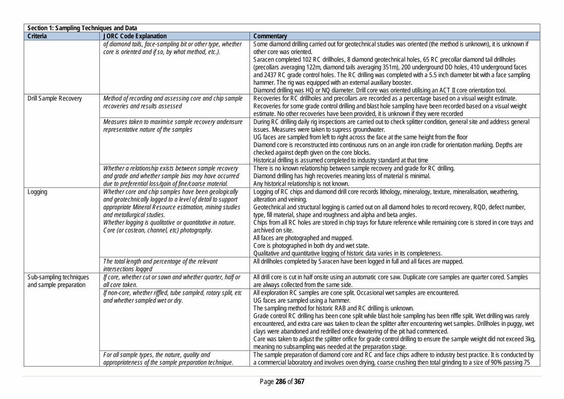
Page 286 of 367
Section 1: Sampling Techniques and Data Criteria JORC Code Explanation Commentary
of diamond tails, face-sampling bit or other type, whether core is oriented and if so, by what method, etc.).
Some diamond drilling carried out for geotechnical studies was oriented (the method is unknown), it is unknown if other core was oriented. Saracen completed 102 RC drillholes, 8 diamond geotechnical holes, 65 RC precollar diamond tail drillholes (precollars averaging 122m, diamond tails averaging 351m), 200 underground DD holes, 410 underground faces and 2437 RC grade control holes. The RC drilling was completed with a 5.5 inch diameter bit with a face sampling hammer. The rig was equipped with an external auxiliary booster. Diamond drilling was HQ or NQ diameter. Drill core was oriented utilising an ACT II core orientation tool.
Drill Sample Recovery Method of recording and assessing core and chip sample recoveries and results assessed
Recoveries for RC drillholes and precollars are recorded as a percentage based on a visual weight estimate. Recoveries for some grade control drilling and blast hole sampling have been recorded based on a visual weight estimate. No other recoveries have been provided, it is unknown if they were recorded
Measures taken to maximise sample recovery andensure representative nature of the samples
During RC drilling daily rig inspections are carried out to check splitter condition, general site and address general issues. Measures were taken to supress groundwater. UG faces are sampled from left to right across the face at the same height from the floor Diamond core is reconstructed into continuous runs on an angle iron cradle for orientation marking. Depths are checked against depth given on the core blocks. Historical drilling is assumed completed to industry standard at that time
Whether a relationship exists between sample recovery and grade and whether sample bias may have occurred due to preferential loss/gain of fine/coarse material.
There is no known relationship between sample recovery and grade for RC drilling. Diamond drilling has high recoveries meaning loss of material is minimal. Any historical relationship is not known.
Logging Whether core and chip samples have been geologically and geotechnically logged to a level of detail to support appropriate Mineral Resource estimation, mining studies and metallurgical studies. Whether logging is qualitative or quantitative in nature. Core (or costean, channel, etc) photography.
Logging of RC chips and diamond drill core records lithology, mineralogy, texture, mineralisation, weathering, alteration and veining. Geotechnical and structural logging is carried out on all diamond holes to record recovery, RQD, defect number, type, fill material, shape and roughness and alpha and beta angles. Chips from all RC holes are stored in chip trays for future reference while remaining core is stored in core trays and archived on site. All faces are photographed and mapped. Core is photographed in both dry and wet state. Qualitative and quantitative logging of historic data varies in its completeness.
The total length and percentage of the relevant intersections logged
All drillholes completed by Saracen have been logged in full and all faces are mapped.
Sub-sampling techniques and sample preparation
If core, whether cut or sawn and whether quarter, half or all core taken.
All drill core is cut in half onsite using an automatic core saw. Duplicate core samples are quarter cored. Samples are always collected from the same side.
If non-core, whether riffled, tube sampled, rotary split, etc and whether sampled wet or dry.
All exploration RC samples are cone split. Occasional wet samples are encountered. UG faces are sampled using a hammer. The sampling method for historic RAB and RC drilling is unknown. Grade control RC drilling has been cone split while blast hole sampling has been riffle split. Wet drilling was rarely encountered, and extra care was taken to clean the splitter after encountering wet samples. Drillholes in puggy, wet clays were abandoned and redrilled once dewatering of the pit had commenced. Care was taken to adjust the splitter orifice for grade control drilling to ensure the sample weight did not exceed 3kg, meaning no subsampling was needed at the preparation stage.
For all sample types, the nature, quality and appropriateness of the sample preparation technique.
The sample preparation of diamond core and RC and face chips adhere to industry best practice. It is conducted by a commercial laboratory and involves oven drying, coarse crushing then total grinding to a size of 90% passing 75

Page 287 of 367
Section 1: Sampling Techniques and Data Criteria JORC Code Explanation Commentary
microns. The sampling techniques for historic exploration RAB, RC and DD drilling are unknown, best practice is assumed. The sample preparation of RC grade control drilling and blast hole sampling involved oven drying, coarse crushing and total grinding in an LM5.
Quality control procedures adopted for all sub-sampling stages to maximise representivity of samples.
All subsampling activities are carried out by commercial laboratory and are considered to be satisfactory. Best practice is assumed at the time of historic RAB, DD and RC sampling. Procedures adopted to ensure sample representivity for RC grade control and blast hole sampling included weight analysis to determine split ratio (at least 2 holes per program) and sizing analysis of every 25th sample, with an expected return of 90% passing 75um.
Measures taken to ensure that the sampling is representative of the in situ material collected, including for instance results for field duplicate/second half sampling.
RC field duplicate samples are carried out at a rate of 1:20 and are sampled directly from the on-board splitter on the rig. These are submitted for the same assay process as the original samples and the laboratory are unaware of such submissions. It is unknown if duplicate sampling was performed on historic exploration RAB, RC and DD drilling. Field duplicates were carried out on RC grade control drilling at a rate of one per hole, collected from the second sample port on the cone splitter. Duplicates were carried out at a rate of 1 in 20 for blast hole sampling.
Whether sample sizes are appropriate to the grain size of the material being sampled.
Analysis of data determined sample sizes were considered to be appropriate.
Quality of assay data and laboratory tests
The nature, quality and appropriateness of the assaying and laboratory procedures used and whether the technique is considered partial or total.
RC and UG face chip samples and diamond core are analysed by an external laboratory using a 40g fire assay with AAS finish. This method is considered suitable for determining gold concentrations in rock and is a total digest method. A 50 gram fire assay with AAS finish was used to determine the gold concentration for all grade control samples. This method is considered suitable for determining gold concentrations in rock and is a total digest method. Methods for exploration RC, RAB and DD drilling included fire assay with AAS finish, BAAS and unknown methods.
For geophysical tools, spectrometers, handheld XRF instruments, etc, the parameters used in determining the analysis including instrument make and model, reading times, calibrations factors applied and their derivation, etc.
The clay mineralogy of the deposit was investigated using PIMA (Portable Infra-red Microscopic Analyser) analysis to assist with geological interpretation. This data was not used in the estimation process.
Nature of quality control procedures adopted (e.g. standards, blanks, duplicates, external laboratory checks) and whether acceptable levels of accuracy (i.e. lack of bias) and precision have been established.
Certified reference material (standards and blanks) with a wide range of values are inserted into every drillhole at a rate of 1:25 for exploration RC and DD. These are not identifiable to the laboratory. QAQC data returned are checked against pass/fail limits with the SQL database and are passed or failed on import. A report is generated and reviewed by the geologist as necessary upon failure to determine further action. QAQC data is reported monthly. Sample preparation checks for fineness are carried out to ensure a grindsize of 90% passing 75 microns. The laboratory performs a number of internal processes including standards, blanks, repeats and checks. QAQC data analysis demonstrates sufficient accuracy and precision. Industry best practice is assumed for previous holders.
Verification of sampling and assaying
The verification of significant intersections by either independent or alternative company personnel.
Significant intercepts are verified by the Geology Manager and corporate personnel
The use of twinned holes. A number of exploration RC holes were drilled to twin original RAB holes and verify results. Documentation of primary data, data entry procedures, data verification, data storage (physical and electronic) protocols
Primary data is collated in a set of excel templates utilising lookup codes. This data is forwarded to the Database Administrator for entry into a secure acQuire database with inbuilt validation functions. Data from previous owners was taken from a database compilation and validated as much as practicable before entry into the Saracen acQuire database
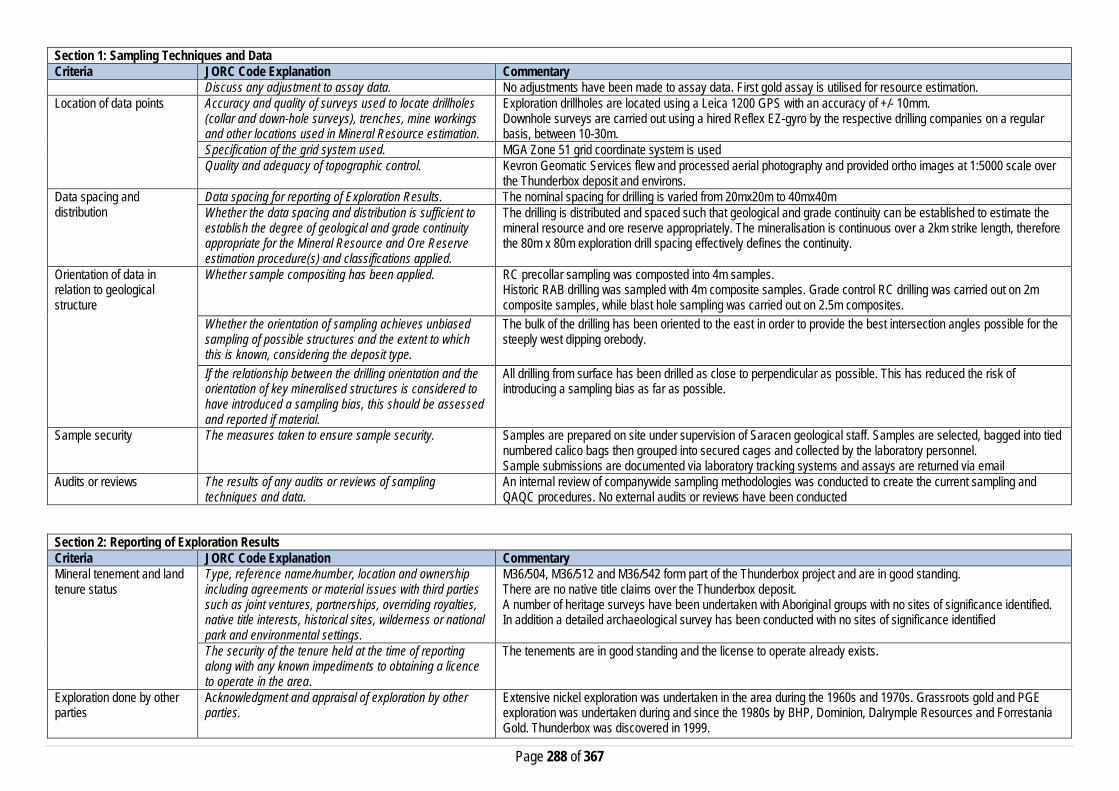
Page 288 of 367
Section 1: Sampling Techniques and Data Criteria JORC Code Explanation Commentary
Discuss any adjustment to assay data. No adjustments have been made to assay data. First gold assay is utilised for resource estimation. Location of data points Accuracy and quality of surveys used to locate drillholes
(collar and down-hole surveys), trenches, mine workings and other locations used in Mineral Resource estimation.
Exploration drillholes are located using a Leica 1200 GPS with an accuracy of +/- 10mm. Downhole surveys are carried out using a hired Reflex EZ-gyro by the respective drilling companies on a regular basis, between 10-30m.
Specification of the grid system used. MGA Zone 51 grid coordinate system is used Quality and adequacy of topographic control. Kevron Geomatic Services flew and processed aerial photography and provided ortho images at 1:5000 scale over
the Thunderbox deposit and environs. Data spacing and distribution
Data spacing for reporting of Exploration Results. The nominal spacing for drilling is varied from 20mx20m to 40mx40m Whether the data spacing and distribution is sufficient to establish the degree of geological and grade continuity appropriate for the Mineral Resource and Ore Reserve estimation procedure(s) and classifications applied.
The drilling is distributed and spaced such that geological and grade continuity can be established to estimate the mineral resource and ore reserve appropriately. The mineralisation is continuous over a 2km strike length, therefore the 80m x 80m exploration drill spacing effectively defines the continuity.
Orientation of data in relation to geological structure
Whether sample compositing has been applied.
RC precollar sampling was composted into 4m samples. Historic RAB drilling was sampled with 4m composite samples. Grade control RC drilling was carried out on 2m composite samples, while blast hole sampling was carried out on 2.5m composites.
Whether the orientation of sampling achieves unbiased sampling of possible structures and the extent to which this is known, considering the deposit type.
The bulk of the drilling has been oriented to the east in order to provide the best intersection angles possible for the steeply west dipping orebody.
If the relationship between the drilling orientation and the orientation of key mineralised structures is considered to have introduced a sampling bias, this should be assessed and reported if material.
All drilling from surface has been drilled as close to perpendicular as possible. This has reduced the risk of introducing a sampling bias as far as possible.
Sample security The measures taken to ensure sample security. Samples are prepared on site under supervision of Saracen geological staff. Samples are selected, bagged into tied numbered calico bags then grouped into secured cages and collected by the laboratory personnel. Sample submissions are documented via laboratory tracking systems and assays are returned via email
Audits or reviews The results of any audits or reviews of sampling techniques and data.
An internal review of companywide sampling methodologies was conducted to create the current sampling and QAQC procedures. No external audits or reviews have been conducted
Section 2: Reporting of Exploration Results Criteria JORC Code Explanation Commentary Mineral tenement and land tenure status
Type, reference name/number, location and ownership including agreements or material issues with third parties such as joint ventures, partnerships, overriding royalties, native title interests, historical sites, wilderness or national park and environmental settings.
M36/504, M36/512 and M36/542 form part of the Thunderbox project and are in good standing. There are no native title claims over the Thunderbox deposit. A number of heritage surveys have been undertaken with Aboriginal groups with no sites of significance identified. In addition a detailed archaeological survey has been conducted with no sites of significance identified
The security of the tenure held at the time of reporting along with any known impediments to obtaining a licence to operate in the area.
The tenements are in good standing and the license to operate already exists.
Exploration done by other parties
Acknowledgment and appraisal of exploration by other parties.
Extensive nickel exploration was undertaken in the area during the 1960s and 1970s. Grassroots gold and PGE exploration was undertaken during and since the 1980s by BHP, Dominion, Dalrymple Resources and Forrestania Gold. Thunderbox was discovered in 1999.

Page 289 of 367
Section 2: Reporting of Exploration Results Criteria JORC Code Explanation Commentary Geology Deposit type, geological setting and style of
mineralisation. Thunderbox is a mesothermal lode gold deposit located at the southern end of the Yandal greenstone belt in an area where several major shear zones converge and join with the Perseverance Fault. The shear zone dips at 30° to 60° WSW, with the exception in the vicinity of the mineralisation, where the shear is vertical to steeply dipping. Mineralisation is hosted by strongly deformed, silicified and carbonate altered albite-quartz porphyry in the hangingwall of the shear zone. The shear juxtaposes foliated basalts and intrusive porphyries in the hangingwall against sedimentary rocks in the footwall. The zone of shearing is over 200m wide. An ultramafic unit occurs within the shear, in the footwall of the deposit and is attenuated along the shear. The main gold related hydrothermal alteration assemblage comprises quartz-ankerite-arsenopyrite-pyrrhotite-galena and gold. This assemblage has been overprinted by a retrograde chlorite-epidote-white mica-biotite-quartz and pyrite assemblage. Syn-mineralisation veins have a continuum of vein textures ranging from laminated to pseudo-breccias. Throughout the Thunderbox Deposit, elevated grades occur within southerly plunging ore shoots that are more evident in the lateral extents of the orebody. Whilst the shoots persist centrally, the gold distribution is for more uniform and ubiquitous than in other areas.
Drillhole information A summary of all information material to the understanding of the exploration results including a tabulation of the following information for all Material drill holes:
• easting and northing of the drill hole collar • elevation or RL (Reduced Level – elevation • above sea level in metres) of the drill hole collar • dip and azimuth of the hole • down hole length and interception depth • hole length. • If the exclusion of this information is justified on the
basis that the information is not Material and this exclusion does not detract from the understanding of the report, the Competent Person should clearly explain why this is the case.
A total of 3401 holes have been used in the mineral resource and are deemed to be material. It is not practical to summarise all of the holes here in this release. Exclusion of the drilling information will not detract from the reader’s view of the report. All material data is periodically released on the ASX: 30/04/2019, 18/02/2019, 27/11/2018, 31/07/2018, 01/05/2018, 13/07/2017, 21/02/2017, 07/12/2016, 25/11/2015, 29/04/2015, 23/03/2015
Data aggregation methods In reporting Exploration Results, weighting averaging techniques, maximum and/or minimum grade truncations (e.g. cutting of high grades) and cut-off grades are usually Material and should be stated.
All significant intercepts have been length weighted with a minimum Au grade of 0.5ppm. No high grade cut off has been applied.
Where aggregate intercepts incorporate short lengths of high grade results and longer lengths of low grade results, the procedure used for such aggregation should be stated and some typical examples of such aggregations should be shown in detail.
Intercepts are aggregated with minimum width of 1m and maximum width of 3m for internal dilution.
The assumptions used for any reporting of metal equivalent values should be clearly stated.
There are no metal equivalents reported in this release.

Page 290 of 367
Section 2: Reporting of Exploration Results Criteria JORC Code Explanation Commentary Relationship between mineralisation widths and intercept lengths
These relationships are particularly important in the reporting of Exploration Results. If the geometry of the mineralisation with respect to the drill hole angle is known, its nature should be reported. If it is not known and only the down hole lengths are reported, there should be a clear statement to this effect (eg ‘down hole length, true width not known’).
This announcement includes sufficient detail to clearly illustrate the geometry of the mineralisation and the recent drilling. All results are reported as downhole lengths. The geometry of the mineralisation is well known and true thickness can be calculated. Drilling intersects the mineralisation perpendicular and at an average intersection angle of 45 degrees.
Diagrams Appropriate maps and sections (with scales) and tabulations of intercepts should be included for any significant discovery being reported These should include, but not be limited to a plan view of drill hole collar locations and appropriate sectional views.
Included in this release is an appropriately orientated longsection of the mineralisation, illustrating the centroids of the intercept point projected to a plane. Included also in this release are cross section views of the mineralisation which provides the visual perspective of the typical drilling angle.
Balanced Reporting Where comprehensive reporting of all Exploration Results are not practicable, representative reporting of both low and high grades and/or widths should be practiced to avoid misleading reporting of Exploration Results.
All results from the recent campaign have been reported, irrespective of success or not.
Other substantive exploration data
Other exploration data, if meaningful and material,should be reported including (but not limited to): geological observations; geophysical survey results; geochemical survey results; bulk samples – size and method of treatment; metallurgical test results; bulk density, groundwater, geotechnical and rock characteristics; potential deleterious or contaminating substances.
Historic activities have included drilling to obtain samples for metallurgical test work, bulk density analyses and geotechnical analyses. A number of geophysical surveys including dipole-dipole IP, Gradient array IP and TEM were carried out over known mineralisation to determine effectiveness in delineating mineralisation/alteration. None were deemed effective. An environmental survey investigated the erosional characteristics of the soil, surface hydrology and groundwater and identified no issues. A partial leach soil sampling program carried out over the deposit was deemed effective in identifying anomalous gold values associated with the deposit. A detailed structural review of the mineralisation has been conducted by Model Earth
Further work The nature and scale of planned further work (eg tests for lateral extensions or depth extensions or large-scale step-out drilling). Diagrams clearly highlighting the areas of possible extensions, including the main geological interpretations and future drilling areas, provided this information is not commercially sensitive
Saracen is currently working on establishing exploration opportunities which will extend the known mineralisation at depth. This will primarily focus on understanding the key geological relationships and critical continuity directions to target depth extensions.
Section 3: Estimation and Reporting of Mineral Resources Criteria JORC Code Explanation Commentary Database Integrity Measures taken to ensure that data has not been
corrupted by, for example, transcription or keying errors, between its initial collection and its use for Mineral Resource estimation purposes.
The historic database provided to Saracen was an extract from an acquire SQL database. For the majority of the historic database, the process used to record the primary data was unknown. All data collected and drilled by Saracen Metals is regulated by a locked framework called the acquire data model which fixes the relationships between tables. The data model minimises the potential for data collection and data usage errors through pre-determined look up tables, storage and export functions.
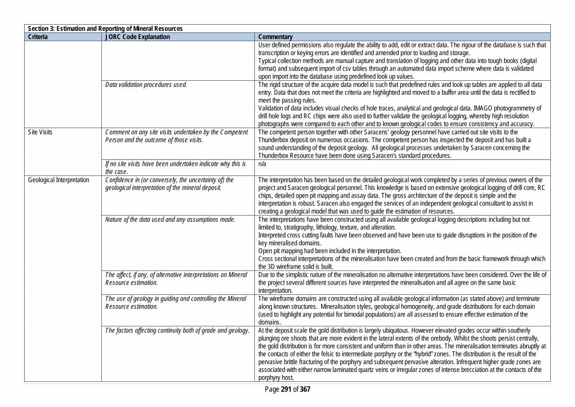
Page 291 of 367
Section 3: Estimation and Reporting of Mineral Resources Criteria JORC Code Explanation Commentary
User defined permissions also regulate the ability to add, edit or extract data. The rigour of the database is such that transcription or keying errors are identified and amended prior to loading and storage. Typical collection methods are manual capture and translation of logging and other data into tough books (digital format) and subsequent import of csv tables through an automated data import scheme where data is validated upon import into the database using predefined look up values.
Data validation procedures used. The rigid structure of the acquire data model is such that predefined rules and look up tables are applied to all data entry. Data that does not meet the criteria are highlighted and moved to a buffer area until the data is rectified to meet the passing rules. Validation of data includes visual checks of hole traces, analytical and geological data. IMAGO photogrammetry of drill hole logs and RC chips were also used to further validate the geological logging, whereby high resolution photographs were compared to each other and to known geological codes to ensure consistency and accuracy.
Site Visits Comment on any site visits undertaken by the Competent Person and the outcome of those visits.
The competent person together with other Saracens’ geology personnel have carried out site visits to the Thunderbox deposit on numerous occasions. The competent person has inspected the deposit and has built a sound understanding of the deposit geology. All geological processes undertaken by Saracen concerning the Thunderbox Resource have been done using Saracen’s standard procedures.
If no site visits have been undertaken indicate why this is the case.
n/a
Geological Interpretation Confidence in (or conversely, the uncertainty of) the geological interpretation of the mineral deposit.
The interpretation has been based on the detailed geological work completed by a series of previous owners of the project and Saracen geological personnel. This knowledge is based on extensive geological logging of drill core, RC chips, detailed open pit mapping and assay data. The gross architecture of the deposit is simple and the interpretation is robust. Saracen also engaged the services of an independent geological consultant to assist in creating a geological model that was used to guide the estimation of resources.
Nature of the data used and any assumptions made. The interpretations have been constructed using all available geological logging descriptions including but not limited to, stratigraphy, lithology, texture, and alteration. Interpreted cross cutting faults have been observed and have been use to guide disruptions in the position of the key mineralised domains. Open pit mapping had been included in the interpretation. Cross sectional interpretations of the mineralisation have been created and from the basic framework through which the 3D wireframe solid is built.
The affect, if any, of alternative interpretations on Mineral Resource estimation.
Due to the simplistic nature of the mineralisation no alternative interpretations have been considered. Over the life of the project several different sources have interpreted the mineralisation and all agree on the same basic interpretation.
The use of geology in guiding and controlling the Mineral Resource estimation.
The wireframe domains are constructed using all available geological information (as stated above) and terminate along known structures. Mineralisation styles, geological homogeneity, and grade distributions for each domain (used to highlight any potential for bimodal populations) are all assessed to ensure effective estimation of the domains.
The factors affecting continuity both of grade and geology. At the deposit scale the gold distribution is largely ubiquitous. However elevated grades occur within southerly plunging ore shoots that are more evident in the lateral extents of the orebody. Whilst the shoots persist centrally, the gold distribution is for more consistent and uniform than in other areas. The mineralisation terminates abruptly at the contacts of either the felsic to intermediate porphyry or the “hybrid” zones. The distribution is the result of the pervasive brittle fracturing of the porphyry and subsequent pervasive alteration. Infrequent higher grade zones are associated with either narrow laminated quartz veins or irregular zones of intense brecciation at the contacts of the porphyry host.

Page 292 of 367
Section 3: Estimation and Reporting of Mineral Resources Criteria JORC Code Explanation Commentary
Gold mineralisation appears to be related to the type and abundance of sulphides and carbonate alteration. Grades are generally higher in arsenopyrite and ankerite rich zones and lower in pyrite and dolomite rich zones. Pyrite is generally coarse, euhedral and late. The presence of pre-, syn-, and post deformational sulphides suggests multi-phase episodes of deformation and mineralisation.
Dimensions The extent and variability of the Mineral Resource expressed as length (along strike or otherwise), plan width, and depth below surface to the upper and lower limits of the Mineral Resource.
Thunderbox mineralisation extends from 6879000mN to 6881000mN, 304000mE to 304400mE and 500 meters below surface (MGA-Zone51). The Thunderbox shear generally strike NNW and dips 60° towards the WSW. In the vicinity of the strongest gold mineralisation the shear is vertical to steeply west dipping. The shear and mineralisation is offset across a series of dextral, NE trending faults.
Estimation and modelling techniques
The nature and appropriateness of the estimation technique(s) applied and key assumptions, including treatment of extreme grade values, domaining, interpolation parameters and maximum distance of extrapolation from data points.
Block estimation using a combination of ordinary kriging (OK) and categorical indicator kriging (CIK) has been completed in Datamine. CIK is utilised in all active mine areas and/or where the drill density (=<20m by 20m) supports the estimation method. All wireframes have been constructed in Leapfrog, which were used as hard boundaries for the estimations. Grade was estimated into parent blocks, meaning all the sub-cells within a parent cell assumed the grade of the parent cell. Univariate statistical analysis of length weighted (1m) domain coded downhole composites have been completed for all domains and top-cuts applied where applicable. Extreme grades are not common in the data set and all domains have been analysed individually to determine specific top-cut values. Due to the lack of extreme grades the top-cut process affects only 1-2% of the data. Variogram modelling was completed with Snowden’s Supervisor software. This measures the spatial variance of the gold grade within the domains. The parameters determined from this analysis were used in the interpolation process.
The availability of check estimates, previous estimates and/or mine production records and whether the Mineral Resource estimate takes appropriate account of such data.
Historical mine production and mill reconciliation records suggest that the estimation method and parameters used result in a highly accurate estimate of the resource. Over the 6 year life, the resource reconciled at 98.5%. Additionally over the 3 years Saracen has mined and processed ore at Thunderbox, the resource has reconciled at approximately 100%. There is no evidence in the geology to suggest this trend would not continue.
The assumptions made regarding recovery of by-products. No assumptions have been made with respect to the recovery of by-products. Estimation of deleterious elements or other non-grade variables of economic significance (e.g. sulfur for acid mine drainage characterisation).
There has been no estimate at this point of deleterious elements. Arsenic has been found in some samples
In the case of block model interpolation, the block size in relation to the average sample spacing and the search employed.
The parent block sizes for the resource model are 5m(X) by 20m(Y) by 5m (Z). These are deemed appropriate for the majority of the resource, where drill spacing is in the order of 40m x 40m. Parent blocks have been sub-celled to 1m(X) by 2m(Y) by 1m(Y) to ensure that the wireframe boundaries are honoured and preserve the location and shape of the mineralisation. Search ranges have been derived from the variogram modelling and knowledge of the drill spacing and the known mineralisation geometry including direction of maximum continuity. Three search estimation runs are used with the aim to satisfy the minimum sample criteria in the first search range where possible. A kriging neighbourhood analysis study conducted ensured that the block sized and the search volume used in the resource estimate are optimal after considering all the relevant factors (i.e. drill spacing, geometry and dimensions of mineralisation). In active mining areas drill spacing is on average 10m by 10m (but up to 20m by 20m in the underground) and a block size of 5m(X) by 5m(Y) by 2.5m (Z) is utilised during the estimation process. Different estimation parameters are used in the grade control areas (active mining areas) during grade estimation.

Page 293 of 367
Section 3: Estimation and Reporting of Mineral Resources Criteria JORC Code Explanation Commentary
Any assumptions behind modelling of selective mining units.
A block size of 5 x 5 x 2.5 m is used in the estimation of grade in the active mining areas and is deemed appropriate as a Selective Mining Unit (SMU) which matches the current mining equipment. Current successful ongoing mining activities at Thunderbox support this as an appropriate SMU.
Any assumptions about correlation between variables. No assumptions have been made regarding correlation between variables. Gold is the only mineral of economic significance at Thunderbox at this stage.
Description of how the geological interpretation was used to control the resource estimates.
The geological interpretation strongly correlates with the mineralised domains. Specifically where the mineralised domain corresponds with the felsic to intermediate porphyry intrusion. Where well known the geological unit is described in the block model. All wireframe boundaries including those where lithology and mineralisation correspond, hard boundaries are enforced.
Discussion of basis for using or not using grade cutting or capping.
Statistical analysis of all domains highlight that there are very few grades in the domain populations that require top-cutting. Top-cuts have been employed to eliminate the risk of overestimating in the local areas where a few high grade samples exist.
The process of validation, the checking process used, the comparison of model data to drill hole data, and use of reconciliation data if available.
Several key model validation steps have been taken to validate the resource estimate. The mineral resource model has been stepped through visually in sectional and plan view to compare the composite grades used in the estimate and the resultant block grades. This has also been carried out in 3D with the composite grades and a point cloud of the model grades. Northing and Elevation swathe plots have been constructed to evaluate the composited assay means against the mean block estimates. The mineral resource model has been constructed to include kriging efficiency and the slope of regression values. These values are used to measure the quality of the estimate. Natural deterioration of the quality is observed at the perimeter of the modelled areas where data density is lower. The estimates also reconcile very closely with the production data.
Moisture Whether the tonnages are estimated on a dry basis or with natural moisture, and the method of determination of the moisture content.
All tonnages are estimated on a dry basis.
Cut-off parameters The basis of the adopted cut-off grade(s) or quality parameters applied.
Based on Saracen’s current economic operations at Carosue Dam and Thunderbox, and the natural grade distinction above background, a grade of 0.5g/t has been chosen.
Mining factors or assumptions
Assumptions made regarding possible mining methods, minimum mining dimensions and internal (or, if applicable, external) mining dilution. It is always necessary as part of the process of determining reasonable prospects for eventual economic extraction to consider potential mining methods, but the assumptions made regarding mining methods and parameters when estimating Mineral Resources may not always be rigorous. Where this is the case, this should be reported with an explanation of the basis of the mining assumptions made.
The Thunderbox deposit is amenable to mining by both open pit and underground methods. The deposit has successfully been mined by open pit in the past between 2002 and 2007. Saracen is currently mining the C-Zone pit using Open pit methods and the A-Zone using underground methods. Beneath the mined C Zone pit is a portion of the mineral resource that has potential to be extracted by a bulk underground method. It has been discussed that in the thicker potions of the resource that an underground caving approach may be an efficient means of economic extraction. With supplementary traditional long hole stoping in areas with narrower widths.
Metallurgical factors or assumptions
The basis for assumptions or predictions regarding metallurgical amenability. It is always necessary as part of the process of determining reasonable prospects for eventual economic extraction to consider potential metallurgical methods, but the assumptions regarding
The Thunderbox gold deposit consists of free milling gold which occurs as inclusions within, and at the rims of arsenopyrite crystals, and as free gold clusters within quartz-carbonate veins. The Thunderbox mine ore is processed at the onsite processing facility. The Thunderbox mill employs a conventional crushing, grinding and CIL leaching process to extract the gold. The mill operated successfully between 2002 and 2007, processing in excess of 9Mt of ore. The conventional plant displayed excellent

Page 294 of 367
Section 3: Estimation and Reporting of Mineral Resources Criteria JORC Code Explanation Commentary
metallurgical treatment process and parameters made when reporting Mineral Resources may not always be rigorous. Where this is the case, this should be reported with an explanation of the basis of the metallurgical assumptions made.
performance with gold recoveries between 93.4 to 96.6 % over the life of the mine. Importantly it should be noted that no reduction in recoveries were observed when the ore changed from oxide-transitional into fresh rock. Saracen has been operating the Thunderbox plant since 2015 and recoveries have averaged 93%.
Environmental factors or assumptions
Assumptions made regarding possible waste and process residue disposal options. It is always necessary as part of the process of determining reasonable prospects for eventual economic extraction to consider the potential environmental impacts of the mining and processing operation. While at this stage the determination of potential environmental impacts, particularly for a greenfields project, may not always be well advanced, the status of early consideration of these potential environmental impacts should be reported. Where these aspects have not been considered this should be reported with an explanation of the environmental assumptions made.
As arsenic is present in the mineralogy of the deposit, the processing plant has been designed to ensure effective management of potentially harmful arsenic contamination. A 20m diameter high rate thickener is used to thicken the tails to maximise water and cyanide recovery. Process water is added to the thickener feed to create one wash stage prior to detoxification. Arsenic precipitation is effected in a stirred closed tank with air sparging. Ferric sulphate solution is metered into the reactor on the basis of dissolved arsenic concentration. The fumes from the precipitation tank are passed through a packed bed caustic scrubber before venting to the atmosphere. The precipitation tank overflow is then passed to the tails hopper.
Bulk Density Whether assumed or determined. If assumed, the basis for the assumptions. If determined, the method used, whether wet or dry, the frequency of the measurements, the nature, size and representativeness of the samples.
Previous owners took routine density measurements when drilling diamond core, along with a comprehensive grab sampling regime during the mining of the pit. The method of calculation is the water displacement technique. Measurements have been recorded in the acquire database and extraction schemes pair this data with the major lithology code for statistical analysis. From the recent drilling done by Saracen early 2015, 237 fresh mafic samples, 196 fresh porphyry samples, 348 fresh sedimentary rock samples and 47 tectonite shear samples were measured for bulk density. In addition density sample are routinely taken in the active mining areas and are used to adjust the weathering profile surfaces. 10cm length NQ core samples were taken in one meter intervals in the ore zones and every 30m in waste zones.
The bulk density for bulk material must have been measured by methods that adequately account for void spaces (vugs, porosity, etc), moisture and differences between rock and alteration zones within the deposit.
The procedure the previous owners utilised, included the coating of dried samples in paraffin wax where the samples had some degree of weathering, were porous or clay rich. These coated samples were then tested using the water displacement technique as previously mentioned. Saracen applies the same procedure in its routine bulk density determinations.
Discuss assumptions for bulk density estimates used in the evaluation process of the different materials.
An average mean of densities collected for each lithology type has been uniformly applied to the modelled geological units. This includes the primary fresh lithologies as well as the weathered oxide and transitional zones.
Classification The basis for the classification of the Mineral Resources into varying confidence categories.
The mineral resource has been classified into Measured, Indicated and Inferred categories based on drill hole spacing, geological confidence, and grade continuity and estimation quality. The combination of these factors together guide the digitising of a “cookie cutter” string in long section view which selects and codes the appropriate blocks with the nominated resource classification category.
Whether appropriate account has been taken of all the relevant factors (ie relative confidence in tonnage/grade estimations, reliability of input data, confidence in continuity of geology and metal values, quality, quantity and distribution of the data).
All care has been taken to account for relevant factors influencing the mineral resource estimate. Confidence in the predicted tonnes and grade estimated in the model is high and previous mining performance suggests that the input data and geological continuity are such that a robust resource estimate can be achieved.

Page 295 of 367
Section 3: Estimation and Reporting of Mineral Resources Criteria JORC Code Explanation Commentary
Whether the result appropriately reflects the Competent Person's view of the deposit.
The geological model and the mineral resource estimate reflect the competent person’s view of the deposit.
Audits or reviews The results of any audits or reviews of Mineral Resource estimates.
At the completion of every resource estimate Saracen Gold Mines undertake an extensive review of the model that covers model inventory and comparisons to previous and budget models. Geological interpretation, wire-framing, domain selection, statistics by domain, assay evaluation, parent cell sizes, data compositing, variography, search strategy, estimation and Kriging Neighbourhood Analysis and finally model validation and resource categorisation are all discussed and scrutinized by the geological and mine planning teams.
Discussion of relative accuracy/confidence
Where appropriate a statement of the relative accuracy and confidence level in the Mineral Resource estimate using an approach or procedure deemed appropriate by the Competent Person. For example, the application of statistical or geostatistical procedures to quantify the relative accuracy of the resource within stated confidence limits, or, if such an approach is not deemed appropriate, a qualitative discussion of the factors that could affect the relative accuracy and confidence of the estimate.
The mineral resource has been reported in accordance with the guidelines established in the 2012 edition of the JORC code. Saracen Gold Mine uses a standard approach to resource estimation and the procedure requires the systematic completion of the Saracen Resource Estimation Document that is thoroughly investigated and assessed in the Model review process, as stated above.
The statement should specify whether it relates to global or local estimates, and, if local, state the relevant tonnages, which should be relevant to technical and economic evaluation. Documentation should include assumptions made and the procedures used.
The statements relate to a global estimate of tonnes and grade.
These statements of relative accuracy and confidence of the estimate should be compared with production data, where available.
Historical mining operation reports suggest that the estimated tonnes were within 0.4% and grade within -2.3%. Since Saracen started mining and processing ore at Thunderbox the Mine Call Factor (MCF) on tonnes has been 100% and grade 103.8%
Section 4: Estimation and Reporting of Ore Reserves Criteria JORC Code Explanation Commentary Mineral Resource estimate for conversion to Ore Reserves
Description of the Mineral resource Estimate used as a basis for the conversion to an Ore Reserve.
The Mineral Resource estimate for the Thunderbox gold deposit is a robust global estimate that was used as a basis for conversion to the Ore Reserve estimate. The resource estimate was compiled by Saracen using exploration, resource definition, and grade control drilling and assay data, geological mapping and historical mining records to validate the model against and solid interpretation wireframes of the geology. This information was used to construct a model estimated by various kriging methods. The model was depleted to end of June 2019 monthly survey pickup for Ore Reserve Estimation.
Clear statement as to whether the Mineral Resources are reported additional to. Or inclusive of, the Ore Reserves.
The Mineral Resource reported is inclusive of the Ore Reserve.
Site Visits Comment on any site visits undertaken by the Competent Person and the outcome of those visits.
Open Pit Reserve A Competent Person has conducting frequent ongoing site visits to the Thunderbox operations since mining commenced under Saracen ownership. The purpose of these visits is to collect information for optimisation work, validating input parameters, visual pit inspection, discussion and feedback for life of mine planning. The information also includes the discussion around current mining performance, wall conditions and overall stability, and groundwater condition. Underground Reserve
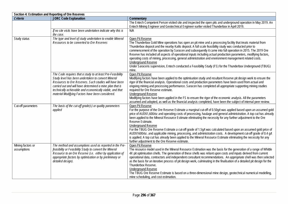
Page 296 of 367
Section 4: Estimation and Reporting of Ore Reserves Criteria JORC Code Explanation Commentary
The Entech Competent Person visited site and inspected the open pits and underground operation in May 2019. An Entech Mining Engineer and Geotechnical Engineer earlier visited Thunderbox in April 2019.
If no site visits have been undertaken indicate why this is the case.
N/A
Study status The type and level of study undertaken to enable Mineral Resources to be converted to Ore Reserves
Open Pit Reserve The Thunderbox Gold Mine operations has open an pit mine and a processing facility that treats material from Thunderbox deposit and the nearby Kailis deposit. A full scale feasibility study was conducted prior to commencement of the operation by Saracen and subsequently it came into full operation in 2015. The 2019 Ore Reserve has included all aspects of operational inputs including actual production parameters, modifying factors, operating costs of mining, processing, general administration and environment management related costs. Underground Reserve Under Saracens supervision, Entech conducted a Feasibility Study (FS) for the Thunderbox Underground (TBUG) mine.
The Code requires that a study to at least Pre-Feasibility Study level has been undertaken to convert Mineral Resources to Ore Reserves. Such studies will have been carried out and will have determined a mine plan that is technically achievable and economically viable, and that material Modifying Factors have been considered.
Open Pit Reserve Modifying factors have been applied to the optimisation study and resultant Reserve pit design work to ensure the rigor of the financial analysis. Operational costs and production parameters have been used from actual and ongoing mining and processing performance. Saracen has completed all appropriate supporting mining studies required for Ore Reserve estimate. Underground Reserve Modifying factors have been applied in the FS to ensure the rigor of the economic analysis. All the parameters assumed and adopted, as well as the financial analysis completed, have been the subject of internal peer review.
Cut-off parameters The basis of the cut-off grade(s) or quality parameters applied
Open Pit Reserve For the purpose of the Ore Reserve Estimate a marginal cut-off of 0.50g/t was applied based upon an assumed gold price of AUD$1,600/oz and operating costs of processing, haulage and general administration. A top cut has already been applied to the Mineral Resource Estimate eliminating the necessity for any further adjustment to the Ore Reserve Estimate. Underground Reserve For the TBUG Ore Reserve Estimate a cut-off grade of 1.5g/t was calculated based upon an assumed gold price of AUD$1600/oz. and applicable mining, processing, and administration costs. A development cut-off grade of 0.4 g/t is applied. A top cut has already been applied to the Mineral Resource Estimate eliminating the necessity for any further adjustment to the Ore Reserve estimate.
Mining factors or assumptions
The method and assumptions used as reported in the Pre-feasibility or Feasibility Study to convert the Mineral Resource to an Ore Reserve (i.e. either by application of appropriate factors by optimisation or by preliminary or detailed design).
Open Pit Reserve The resource model used in the Mineral Resource Estimation was the basis for the generation of a range of Whittle 4X pit optimisation shells. The generation of these shells was reliant upon costs and inputs derived from current operational data, contractors and independent consultant recommendations. An appropriate shell was then selected as the basis for an iterative process of pit design work, culminating in the finalisation of a detailed pit design for the Thunderbox Reserve. Underground Reserve The TBUG Ore Reserve Estimate is based on a three-dimensional mine design, geotechnical numerical modelling, mine scheduling, and cost estimation.

Page 297 of 367
Section 4: Estimation and Reporting of Ore Reserves Criteria JORC Code Explanation Commentary
The choice, nature and appropriateness of the selected mining method(s) and other mining parameters including associated design issues such as pre-strip, access, etc.
Open Pit Reserve Mining method currently employed at Thunderbox Gold Mine is conventional open pit with hydraulic excavator and dump truck fleet, and drill and blast activity. The class of excavator employed is similar to other current open pit mining operations, providing a good operating dataset for production and productivity rate measurement and financial modelling. Thunderbox Reserve pit is currently in operation and designed to include a series of successive cutbacks to achieve life of mine Reserve such that it meets the operation efficiency and production rates. Appropriate mine schedule, operating cost and lead time have been applied to maintain efficient mining operations between the stages. Underground Reserve The TBUG Ore Reserve is based on sub-level open stoping (SLOS) with paste fill, and long hole open stoping (LHOS) mining methods. SLOS is the predominate mining method, and accounts for 84% of the Ore Reserve estimate by tonnes. The SLOS zone, ranges in width from 5 m to 50 m, and dips at 75-80 degrees. Paste fill test work, analysis, and cost estimation, has been conducted by Outotec Pty Ltd.
The assumptions made regarding geotechnical parameters (e.g. pit slopes, stope sizes, etc.), grade control, and pre-production drilling.
Open Pit Reserve Life of mine Reserve pit has been designed following appropriate geotechnical recommendation. The geotechnical guidelines were prepared by site geotechnical team using current wall stability performance and analysing long term wall stability aspects. Analysis includes inspection of drill core, review of the geotechnical data, slope monitoring results and probability testing. The geotechnical team oversees all geotechnical aspect of technical study and provide ongoing site support. The Reserve pit design is reflecting the updated guideline following current mining performance. The Grade control method currently employed at Thunderbox is utilising an RC drilling and sampling method. The method and practice has been utilised successfully at all current and past mining operations at Saracen. Underground Reserve Sub-level open stoping (SLOS) with paste fill has been selected as the preferred mining method. Geotechnical investigations for the project are based on detailed geotechnical logging of oriented core from >21,000m of core, and a comprehensive laboratory testing program. Geotechnical assessments based on rock mass characterisation, empirical methods and numerical modelling analysis have been undertaken to assess mining methods and sequencing, stope spans and dilution expectations, pillar stability in both uphole stoping and crown pillars and development ground support and reinforcement requirements, and stand-off distances for underground infrastructure.
The major assumptions made and Mineral Resource model used for pit and stope optimisation (if appropriate).
Open Pit Reserve The Ore Reserve Estimate is based on detailed life of mine pit design work by using a geology approved resource model, and making appropriate dilution and recovery factor allowance for mining fleet and method utilised. Underground Reserve N/A
The mining dilution factors used. Open Pit Reserve Mining dilution factor is applied in the Ore Reserve estimation and reflect actual reconciliation of current mining performance and solid understanding of mining practice. The mining dilution factor varies from 10% to 15% depending on what stage of the pit mining occurs. The estimated factors reflect Thunderbox bulk mineralisation characteristics and it reconciling well with current bulk mining practice. Underground Reserve Average mining dilution is 6%. Stope dilution has been applied as 0.5 m of dilution to the footwall and hangingwall at zero grade. Any wall exposed to paste also incurs 0.5 m of dilution at zero grade.

Page 298 of 367
Section 4: Estimation and Reporting of Ore Reserves Criteria JORC Code Explanation Commentary
The mining recovery factors used. Open Pit Reserve Ore loss factor is applied in the Ore Reserve estimation and reflect actual reconciliation of current mining performance and solid understanding of mining practice. The ore loss factor varies from 2% to 4% depending on what stage of the pit mining occurs. Underground Reserve Average mining recovery is 92.4%.
Any minimum mining widths used Open Pit Reserve A minimum mining width of 25m has been adopted for the primary excavation fleet. Where ‘pinch-points’ occur or “Good Bye” cuts are considered at the base of the pit, it is assumed that a smaller or more versatile excavator will be employed. The practice is very consistent across all open pit operations and reflects the suitability and efficiency of the mining performance. Underground Reserve Minimum mining widths of 3 m, where sub levels are 25 m intervals, and 5 m where sub levels are 35 m, are applied.
The manner in which inferred Mineral resources are utilised in mining studies and the sensitivity of the outcome to their inclusion.
Open Pit Reserve Inferred material is excluded from the ore reserves and treated as waste material which incurs a mining cost but is not processed and does not generate any revenue. Therefore final pit reserve inventory has excluded any inferred mineral resources. Underground Reserve The feasibility study mine design includes Inferred Resources representing 8% of the Production Target. The study is not sensitive to the inclusion of this material.
The infrastructure requirements of the selected mining methods.
Open Pit Reserve Thunderbox Gold Mine is currently in operation and operates the open pit and underground mine along with 2.8mt process plant. Therefore adequate infrastructure is available to support current and future mine plan. Underground Reserve The selected mining method requires the development of an access decline, ventilation raises, and associated electrical and dewatering infrastructure.
Metallurgical factors or assumptions
The metallurgical process proposed and the appropriateness of that process to the style of mineralisation
The Ore Reserve will be treated at the established Thunderbox processing facility. The facility is a conventional crushing, gravity circuit, grind, and CIL (carbon in leach) plant and is appropriate for the extraction of gold from free milling mineralisation.
Whether the metallurgical process is well-tested technology or novel in nature.
The current processing plant and method applied utilises well tried and proven technology and since being in operation has averaged gold recovery typically between 93 to 94% for all available different material near Thunderbox operations.
The nature, amount and representiveness of metallurgical test work undertaken, the nature of the metallurgical domaining applied and the corresponding metallurgical recovery factors applied.
An average gold recovery for Thunderbox deposit is estimated at 93.0%. The recovery estimation is based on actual average recovery data collected from ongoing test work at Thunderbox plant. The plant performance is consistent between 93 to 94% while processing all different ore material from a range of ore sources without any issue. Oxide, transitional and primary fresh ore have been processed through this plant since recommencement and reconciled well to current estimation. Underground Reserve An average plant processing recovery of 94% has been assumed in the TBUG Ore Reserve Estimate.
Any assumptions or allowances made for deleterious elements.
Arsenopyrite is present in the ore and high levels of arsenic are solubilised in the plant solutions. The arsenic levels are monitored on a continuous basis and infrastructure exists for the addition of ferric sulphate where the levels

Page 299 of 367
Section 4: Estimation and Reporting of Ore Reserves Criteria JORC Code Explanation Commentary
impact the environment/exceed the environmental limits. The ferric sulphate is added to precipitate the free arsenic as ferric arsenate thereby locking the arsenic in the plant tailings for storage.
The existence of any bulk sample or pilot scale test work and the degree to which such samples are considered representative of the ore body as a whole.
All Thunderbox ore mined by Saracen and previous operator has been processed through the current processing plant hence it represents Thunderbox mineralisation characteristics as a whole. Processing plant regularly carries out bulk sample/pilot test for continuous improvement and check balance.
For minerals that are defined by a specification, has the ore reserve estimation been based on the appropriate mineralogy to meet the specifications.
N/A
Environmental factors or assumptions
The status of studies of potential environmental impacts of the mining and processing operation. Details of waste rock characterisation and the consideration of potential sites, status of design options considered and, where applicable, the status of approvals for process residue storage and waste dumps should be reported.
Thunderbox Gold Mine is in operation and all required Environment studies have been completed prior to commencement. All statutory government approvals namely clearing permit, mining approvals, project management and dewatering have been granted. Further Mining Approvals are required for proposed future cutbacks to existing Thunderbox open pit. The existing Thunderbox mine, the processing facility, waste rock landform, TSF, and the accommodation village are all lay on granted mining leases. The gas spur pipeline, the bore field and the airstrip are all on granted miscellaneous licences. Waste rock characteristic study has been carried out and is representative of Thunderbox waste rock. An appropriate landform design criteria has been considered based on rock characteristic to mitigate current and any future waste landform expansion.
Infrastructure The existence of appropriate infrastructure: availability of land for plant development, power, water, transportation (particularly for bulk commodities), labour, accommodation; or the ease with which the infrastructure can be provided, or accessed.
The site is well established with all adequate infrastructure is in place and operational. These include well equipped offices, workshop, storage facilities and a CIL ore processing plant that has name plate capacity of 2.5mtpa situated adjacent to the Thunderbox pit. A modern accommodation camp is located within a few kilometres of the pit, and a well maintained gravel airstrip services the camp. The mine site is connected to Goldfields highway and the Gas Transmission Line, and runs on dual fuel (diesel/gas) power generator.
Costs The derivation of, or assumptions made, regarding projected capital costs in the study.
Open Pit Reserve All major capital works relate to mine site infrastructure have been completed. A new cutback related pre-strip mining capital cost has been applied in the financial model. Underground Reserve Mining capital costs are estimated from first principles and contractor costs based on equipment, labour and development requirements indicated in the mine schedule. Mining capital costs also consider ventilation, electrical and dewatering requirements.
The methodology used to estimate operating costs. Open Pit Reserve Operating costs for open pit mining have been derived from a combination of actual mining costs for Thunderbox Operations and costs supplied by various contract mining companies, and independent consultants. Underground Reserve Mining operating costs are estimated from first principles and contractor costs based on equipment, labour and development and stoping requirements indicated in the mine schedule. Operating costs for ore processing, haulage and administration have been derived from known parameters and budgeted cost.
Allowances made for the content of deleterious elements Appropriate allowance has been made in the processing cost to compensate the additional treatment required for the high presence of Arsenopyrite in the ore and arsenic in the plant solutions.

Page 300 of 367
Section 4: Estimation and Reporting of Ore Reserves Criteria JORC Code Explanation Commentary
The derivation of assumptions made of metal or commodity price(s), for the principal minerals and co-products
An assumed gold price of AUD$1,600/oz has been adopted for the financial modelling. No allowance is made for silver by-products.
The source of exchange rates used in study All revenue and cost calculations have been made in AUD, so no exchange rate usage or assumptions have been necessary.
Derivation of transportation charges Costs associated with bullion transportation have been derived from existing contractual arrangements at Thunderbox.
The basis for forecasting or source of treatment and refining charges, penalties for failure to meet specification, etc.
Costs associated with refining have been derived from existing contractual arrangements at Thunderbox.
The allowances made for royalties payable, both Government and private.
The WA state government royalty of 2.5% has been applied. No third party royalty exists.
Revenue Factors The derivation of, or assumptions made, regarding revenue factors including head grade, metal or commodity price(s) exchange rates, transportation and treatment charges, penalties, net smelter returns, etc.
For the purposes of the Ore Reserve Estimation it has been assumed that there is no gold hedging. All gold production will be sold at spot price to the Perth Mint.
The derivation of assumptions made of metal or commodity price(s), for the principal metals, minerals and co-products
Assumed gold price of AUD$1,600/oz has been adopted for financial modelling. No allowance is made for silver by-products.
Market Assessment The demand, supply and stock situation for the particular commodity, consumption trends and factors likely to affect supply and demand into the future.
There is a transparent quoted market for the sale of gold.
A customer and competitor analysis along with the identification of likely market windows for the product.
There is a transparent quoted market for the sale of gold.
Price and volume forecasts and the basis for these forecasts.
There is a transparent quoted market for the sale of gold.
For industrial minerals the customer specification, testing and acceptance requirements prior to a supply contract.
N/A
Economic The inputs to the economic analysis to produce the net present value (NPV) in the study, the source and confidence of these economic inputs including estimated inflation, discount rate, etc.
Open Pit Reserve The Ore Reserve Estimation is based on detailed life of mine pit design and reflects positive economic outcomes. All relevant capital and operating costs as well as revenue and royalty factors have been included with appropriate discount factor for cash flow analysis. Underground Reserve The Ore Reserve Estimate is based on detailed underground design using $1,600/oz. gold price. A discount rate of annual 5% was assumed in all NPV calculations.
NPV ranges and sensitivity to variations in the significant assumptions and inputs.
Underground Reserve A full financial model was developed with sensitivities applied to all key inputs and assumptions (+/- 15%), which is appropriate to the level of study undertaken (FS).
Social The status of agreements with key stakeholders and matters leading to social licence to operate
Thunderbox mine is located on lease-hold pastoral land with regular community engagement and communication of the mining lease and operation. Compensation agreements are in place with the local pastoralist and Saracen is having a good relationship with neighbouring stakeholders, including local pastoralists and the traditional owners.

Page 301 of 367
Section 4: Estimation and Reporting of Ore Reserves Criteria JORC Code Explanation Commentary
Granted mining leases cover all of the proposed mining and processing assets. The Wutha People have lodged the Darlot Claim (WC2018/005, WAD142/2018).
Other To the extent relevant, the impact of the following on the project and/or on the estimation and classification of the Ore Reserves:
Any identified material naturally occurring risks Water inrush is identified as a naturally occurring risk with in the operation and was addressed by the construction of appropriate water diversion bunds to provide safe and risk free work environment.
The status of material legal agreements and marketing arrangements
Gold produced from Thunderbox Mine will be sold on the spot market. A royalty of 2.5% is payable to the W.A. State government. No third party royalty is applicable.
The status of governmental agreements and approvals critical to the viability of the project, such as mineral tenement status, and government and statutory approvals. There must be reasonable grounds to expect that all necessary government approvals will be received within the timeframes anticipated in the Pre-Feasibility or Feasibility study. Highlight and discuss the materiality of any unresolved matter that is dependent on a third party on which extraction of the reserve is contingent.
Thunderbox Gold Mine is in operation and all required Statutory Approvals including Environment approvals have been completed and granted. Further Mining Approvals are required for proposed future cutbacks to the existing Thunderbox open pit.
Classification The basis for the classification of the Ore Reserve into varying confidence categories
The Ore Reserve estimate classification for Thunderbox has been in accordance with the JORC code 2012. The Ore Reserve estimate is classified as being Proved and Probable has been derived from the Mineral Resource classified as Indicated and Measured only.
Whether the result appropriately reflects the Competent Person’s view of the deposit.
Cost assumptions and modifying factors applied to the pit optimisation, Underground Feasibility Study and subsequent designs were derived from current operational data relating to Thunderbox operations, and supplied by contract mining companies and independent consultants. Results of these optimisations, reserve designs and the resultant analysis reflect the Competent Person’s view regarding the Thunderbox deposit.
The proportion of Probable Ore Reserves that have been derived from Measured Mineral Resources (if any)
Open Pit Reserve 100% of Probable ore from Ore Reserve Estimate has been derived from Indicated ore of the Mineral Resource. 100% of Proved ore from Ore Reserve Estimate has been derived from Measured ore of the Mineral Resource. Underground Reserve 100% of Probable ore from Ore Reserve Estimate has been derived from Indicated ore of the Mineral Resource. 100% of Proved ore from Ore Reserve Estimate has been derived from Measured ore of the Mineral Resource.
Audits or reviews The results of any audits or reviews of Ore Reserve estimates
The Ore Reserve Estimation process is in line with the Saracen Ore Reserve Policy and undergone internal review.
Discussion of relative accuracy/confidence
Where appropriate a statement of the relative accuracy and confidence level in the Ore Reserve estimate using an approach or procedure deemed appropriate by the Competent Person. For example, the application of statistical or geo-statistical procedures to quantify the relative accuracy of the reserve within stated confidence limits, or, if such an approach is not deemed appropriate, a qualitative discussion of the factors which could affect the relative accuracy and confidence of the estimate.
The ore reserve estimate has been prepared in accordance with the guideline of the 2012 JORC Code, and was derived from the mineral resource estimate which in turn was reliant upon a resource block model whose estimation was derived from drill-hole data of sufficient continuity and spacing to satisfy the requirements for a measured and indicated resource. Open Pit Reserve All of the applied modifying factors and mining parameters have been validated and reconciled well with Thunderbox mineralisation and mining fleet being utilised at Thunderbox open pit operation. The estimated dilution and ore loss factors are justified by continuity of wide mineralisation of the ore body, selected mining practice and equipment. The selected modifying factors are reflecting good reconciliation performance of the operation. The current grade control method and estimation process is well understood for Thunderbox operations.

Page 302 of 367
Section 4: Estimation and Reporting of Ore Reserves Criteria JORC Code Explanation Commentary
The statement should specify whether it relates to global or local estimates, and if local, state the relevant tonnages which should be relevant to technical and economic evaluation. Documentation should include assumptions made and the procedures used. Accuracy and confidence discussions should extend to specific discussions of any applied modifying factors that may have a material impact on Ore Reserve viability, or for which there are remaining areas of uncertainty at the current study stage. It is recognised that this may not be possible or appropriate in all circumstances. These statements or relative accuracy and confidence of the estimate should be compared with production data, where available.
All of the parameters assumed and adopted as well as the financial analysis have been based on current and past Thunderbox operations mining performance. Underground Reserve Stope dilution and recovery are based upon assumptions including: the stress regime (based on the numerous mines in the region), stress modelling, hanging wall and footwall failure, and paste fill dilution. Long term paste fill test work is ongoing at the time of reporting. Hydrogeological assessments have not been conducted for the project, though costs have been allowed in the cost estimate for reasonable levels of ground water inflow and underground operations to date have encountered minimal groundwater inflows. A first-year capital cost contingency of 14% has been allowed for. The project is sensitive to factors that affect revenue (gold price, dilution and recovery)
Otto Bore Section 1: Sampling Techniques and Data Criteria JORC Code Explanation Commentary Sampling Techniques Nature and quality of sampling (e.g. cut channels, random
chips, or specific specialised industry standard measurement tools appropriate to the minerals under investigation, such as down hole gamma sondes, or handheld XRF instruments, etc.). These examples should not be taken as limiting the broad meaning of sampling.
Sampling methods undertaken by Saracen at Otto Bore include reverse circulation (RC) and diamond (DD) drillholes Sampling methods undertaken at Otto Bore by previous owners have included aircore (AC), rotary air blast (RAB), RC and diamond drillholes (DD).
Include reference to measures taken to ensure sample representivity and the appropriate calibration of any measurement tools or systems used
Sampling for diamond and RC drilling is carried out as specified within Saracen sampling and QAQC procedures as per industry standard. AC, RC, RAB, and DD core drilling is assumed to have been completed by previous holders to industry standard at that time (1988- 2012).
Aspects of the determination of mineralisation that are Material to the Public Report. In cases where ‘industry standard’ work has been done this would be relatively simple (e.g. ‘reverse circulation drilling was used to obtain 1 m samples from which 3 kg was pulverised to produce a 30 g charge for fire assay’). In other cases more explanation may be required, such as where there is coarse gold that has inherent sampling problems. Unusual commodities or mineralisation types (e.g. submarine nodules) may warrant disclosure of detailed information
RC chips are cone split and sampled into 1m intervals with total sample weights under 3kg. Diamond core is HQ sized, sampled to 1m intervals or geological boundaries where necessary and cut into half core to give sample weights under 3 kg. Samples are selected to weigh less than 3 kg to ensure total sample inclusion at the pulverisation stage. Saracen core and chip samples are crushed, dried and pulverised to a nominal 90% passing 75µm to produce a 40g sub sample for analysis by FA/AAS. Limited information has been found for historic drilling so it is assumed all AC, RAB, RC and DD and sampling was carried out to industry standard at that time. More recent RAB and RC drilling has involved a total preparation sample protocol involving 4m composite or 1m samples from which a 50g charge is produced for aqua regia or fire assay digest and flame AAS finish.
Drilling Techniques Drill type (e.g. core, reverse circulation, open-hole hammer, rotary air blast, auger, Bangka, sonic, etc.) and details (e.g. core diameter, triple or standard tube, depth
Drilling activities at Otto Bore have included 31 AC holes, 748 RAB holes, 141 RC holes (assumed standard 5 ¼’’ bit size) and 4 DD holes (HQ and unknown diameter). Limited historic diamond core hole was oriented by unknown methods.

Page 303 of 367
Section 1: Sampling Techniques and Data Criteria JORC Code Explanation Commentary
of diamond tails, face-sampling bit or other type, whether core is oriented and if so, by what method, etc.).
Saracen completed 96 RC holes and 6 geotechnical DD holes. The RC drilling was completed with a 5.5 inch diameter bit with a face sampling hammer. The rig was equipped with an external auxiliary booster. Diamond drilling was HQ sized and orientated using an ACT 11 core orientation tool. Historical drilling is assumed completed to industry standard at that time
Drill Sample Recovery Method of recording and assessing core and chip sample recoveries and results assessed
Recoveries for RC drillholes and precollars are recorded as a percentage based on a visual weight estimate.
Measures taken to maximise sample recovery and ensure representative nature of the samples
During RC drilling daily rig inspections are carried out to check splitter condition, general site and address general issues. Measures were taken to supress groundwater.
Whether a relationship exists between sample recovery and grade and whether sample bias may have occurred due to preferential loss/gain of fine/coarse material.
There is no known relationship between sample recovery and grade for RC drilling. Diamond drilling has high recoveries meaning loss of material is minimal. Any historical relationship is not known.
Logging Whether core and chip samples have been geologically and geotechnically logged to a level of detail to support appropriate Mineral Resource estimation, mining studies and metallurgical studies. Whether logging is qualitative or quantitative in nature. Core (or costean, channel, etc) photography.
Logging of RC chips and DD core records lithology, mineralogy, texture, mineralisation, weathering, alteration and veining. Geotechnical and structural logging is carried out on all diamond holes to record recovery, RQD, defect number, type, fill material, shape and roughness and alpha and beta angles. Chips from all RC holes are stored in chip trays for future reference while remaining core is stored in core trays and archived on site. Some historic diamond drilling has had limited geotechnical logging carried out. Core has been photographed in both dry and wet state. It is unknown if historic diamond core was photographed. It is unknown if any historic diamond core was photographed.
The total length and percentage of the relevant intersections logged
All drillholes completed by Saracen have been logged in full.
Sub-sampling techniques and sample preparation
If core, whether cut or sawn and whether quarter, half or all core taken.
All drill core is cut in half onsite using an automatic core saw. Samples are always collected from the same side. The sampling method for most historic drill core is unknown, a small amount is recorded as half core sampled.
If non-core, whether riffled, tube sampled, rotary split, etc and whether sampled wet or dry.
All exploration RC samples are cone split. Occasional wet samples are encountered. The sampling methods for much of the historic AC, RC and RAB drilling are unknown. More recent RC and RAB drilling has been riffle split or spear sampled. It is unknown if wet samples were encountered.
For all sample types, the nature, quality and appropriateness of the sample preparation technique.
The sample preparation of RC chips and DD core adhere to industry best practice. It is conducted by a commercial laboratory and involves oven drying, coarse crushing then total grinding to a size of 90% passing 75 microns. The sampling techniques for much of the historic AC, RAB, RC and DD drilling are unknown, best practice is assumed.
Quality control procedures adopted for all sub-sampling stages to maximise representivity of samples.
All subsampling activities are carried out by commercial laboratory and are considered to be satisfactory Best practice is assumed at the time of historic AC, RAB, DD and RC sampling.
Measures taken to ensure that the sampling is representative of the in situ material collected, including for instance results for field duplicate/second half sampling.
RC field duplicate samples are carried out at a rate of 1:20 and are sampled directly from the on-board splitter on the rig. These are submitted for the same assay process as the original samples and the laboratory are unaware of such submissions. It is unknown if duplicate sampling was performed on the majority of historic AC, RAB, RC and DD drilling. There is evidence of field duplicate sampling being conducted in more recent campaigns.
Whether sample sizes are appropriate to the grain size of the material being sampled.
Analysis of data determined sample sizes were considered to be appropriate.

Page 304 of 367
Section 1: Sampling Techniques and Data Criteria JORC Code Explanation Commentary Quality of assay data and laboratory tests
The nature, quality and appropriateness of the assaying and laboratory procedures used and whether the technique is considered partial or total.
RC chip and DD core samples are analysed by an external laboratory using a 40g fire assay with AAS finish. This method is considered suitable for determining gold concentrations in rock and is a total digest method. Numerous assay techniques have been used in the history of the deposit, most commonly fire assay, fire assay with flame finish and aqua regia. These methods are considered suitable for determining gold concentrations in rock and are total digest methods. Other assay methods utilised for gold determination include BETA, atomic absorption spectrometry and unknown methods.
For geophysical tools, spectrometers, handheld XRF instruments, etc, the parameters used in determining the analysis including instrument make and model, reading times, calibrations factors applied and their derivation, etc.
It is unknown if any instruments of this nature have been used at Otto Bore.
Nature of quality control procedures adopted (e.g. standards, blanks, duplicates, external laboratory checks) and whether acceptable levels of accuracy (i.e. lack of bias) and precision have been established.
Certified reference material (standards and blanks) with a wide range of values are inserted into every drillhole at a rate of 1:25 for exploration RC and DD. These are not identifiable to the laboratory. QAQC data returned are checked against pass/fail limits with the SQL database and are passed or failed on import. A report is generated and reviewed by the geologist as necessary upon failure to determine further action. QAQC data is reported monthly. Sample preparation checks for fineness are carried out to ensure a grindsize of 90% passing 75 microns. The laboratory performs a number of internal processes including standards, blanks, repeats and checks. QAQC data analysis demonstrates sufficient accuracy and precision. Industry best practice is assumed for previous holders.
Verification of sampling and assaying
The verification of significant intersections by either independent or alternative company personnel.
Significant intercepts are verified by the Geology Manager and corporate personnel
The use of twinned holes. Specific drilling programs consisting of twinned holes are not apparent. Documentation of primary data, data entry procedures, data verification, data storage (physical and electronic) protocols
Primary data is collated in a set of excel templates utilising lookup codes. This data is forwarded to the Database Administrator for entry into a secure acQuire database with inbuilt validation functions. Data from previous owners was taken from a database compilation and validated as much as practicable before entry into the Saracen acQuire database
Discuss any adjustment to assay data. No adjustment to assay data appears to have been made Location of data points Accuracy and quality of surveys used to locate drillholes
(collar and down-hole surveys), trenches, mine workings and other locations used in Mineral Resource estimation.
Exploration drillholes are located using a Leica 1200 GPS with an accuracy of +/- 10mm. Downhole surveys are carried out using a hired Reflex EZ-gyro by the respective drilling companies on a regular basis, between 10-30m. The survey quality and control is unknown for the majority of historic drilling. More recent drilling has collar locations surveyed by unspecified GPS and DGPS equipment. Downhole survey methods recorded include Eastman single and multishot, gyro, inferred and unknown methods.
Specification of the grid system used. MGA Zone 51 grid coordinate system is used. Some historic data drilled on local grid systems has been converted to this grid system
Quality and adequacy of topographic control. Digital ortho-imagery of the area from Kevron Aerial Surveys was used in the early 2000s to establish topographic control.
Data spacing and distribution
Data spacing for reporting of Exploration Results. No exploration results reported in this release. The nominal drillhole spacing is 20 m (northing) by 20 m (easting) in the core of the deposit, and increases to the margins of the deposit.
Whether the data spacing and distribution is sufficient to establish the degree of geological and grade continuity
The mineralised domains at Otto Bore have demonstrated sufficient continuity in both geological and grade continuity to support the definition of Mineral Resources, and the classifications applied under the 2012 JORC Code.
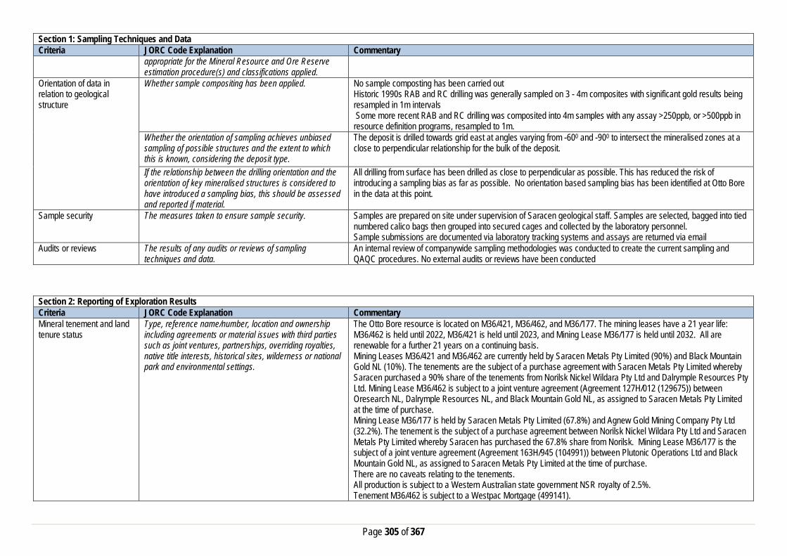
Page 305 of 367
Section 1: Sampling Techniques and Data Criteria JORC Code Explanation Commentary
appropriate for the Mineral Resource and Ore Reserve estimation procedure(s) and classifications applied.
Orientation of data in relation to geological structure
Whether sample compositing has been applied.
No sample composting has been carried out Historic 1990s RAB and RC drilling was generally sampled on 3 - 4m composites with significant gold results being resampled in 1m intervals Some more recent RAB and RC drilling was composited into 4m samples with any assay >250ppb, or >500ppb in resource definition programs, resampled to 1m.
Whether the orientation of sampling achieves unbiased sampling of possible structures and the extent to which this is known, considering the deposit type.
The deposit is drilled towards grid east at angles varying from -600 and -900 to intersect the mineralised zones at a close to perpendicular relationship for the bulk of the deposit.
If the relationship between the drilling orientation and the orientation of key mineralised structures is considered to have introduced a sampling bias, this should be assessed and reported if material.
All drilling from surface has been drilled as close to perpendicular as possible. This has reduced the risk of introducing a sampling bias as far as possible. No orientation based sampling bias has been identified at Otto Bore in the data at this point.
Sample security The measures taken to ensure sample security. Samples are prepared on site under supervision of Saracen geological staff. Samples are selected, bagged into tied numbered calico bags then grouped into secured cages and collected by the laboratory personnel. Sample submissions are documented via laboratory tracking systems and assays are returned via email
Audits or reviews The results of any audits or reviews of sampling techniques and data.
An internal review of companywide sampling methodologies was conducted to create the current sampling and QAQC procedures. No external audits or reviews have been conducted
Section 2: Reporting of Exploration Results Criteria JORC Code Explanation Commentary Mineral tenement and land tenure status
Type, reference name/number, location and ownership including agreements or material issues with third parties such as joint ventures, partnerships, overriding royalties, native title interests, historical sites, wilderness or national park and environmental settings.
The Otto Bore resource is located on M36/421, M36/462, and M36/177. The mining leases have a 21 year life: M36/462 is held until 2022, M36/421 is held until 2023, and Mining Lease M36/177 is held until 2032. All are renewable for a further 21 years on a continuing basis. Mining Leases M36/421 and M36/462 are currently held by Saracen Metals Pty Limited (90%) and Black Mountain Gold NL (10%). The tenements are the subject of a purchase agreement with Saracen Metals Pty Limited whereby Saracen purchased a 90% share of the tenements from Norilsk Nickel Wildara Pty Ltd and Dalrymple Resources Pty Ltd. Mining Lease M36/462 is subject to a joint venture agreement (Agreement 127H/012 (129675)) between Oresearch NL, Dalrymple Resources NL, and Black Mountain Gold NL, as assigned to Saracen Metals Pty Limited at the time of purchase. Mining Lease M36/177 is held by Saracen Metals Pty Limited (67.8%) and Agnew Gold Mining Company Pty Ltd (32.2%). The tenement is the subject of a purchase agreement between Norilsk Nickel Wildara Pty Ltd and Saracen Metals Pty Limited whereby Saracen has purchased the 67.8% share from Norilsk. Mining Lease M36/177 is the subject of a joint venture agreement (Agreement 163H/945 (104991)) between Plutonic Operations Ltd and Black Mountain Gold NL, as assigned to Saracen Metals Pty Limited at the time of purchase. There are no caveats relating to the tenements. All production is subject to a Western Australian state government NSR royalty of 2.5%. Tenement M36/462 is subject to a Westpac Mortgage (499141).

Page 306 of 367
Section 2: Reporting of Exploration Results Criteria JORC Code Explanation Commentary
All tenements are subject to a pastoral compensation agreement between Saracen Metals Pty Ltd and Weebo Station. There are no native title claims over the tenements. There is a newly identified Aboriginal Heritage on M36/462 that is yet to be confirmed and registered by an Anthropologist.
The security of the tenure held at the time of reporting along with any known impediments to obtaining a licence to operate in the area.
No known impediment to obtaining a licence to operate exists and the remainder of the tenements are in good standing.
Exploration done by other parties
Acknowledgment and appraisal of exploration by other parties.
Gold exploration was conducted near Otto Bore in the 1950s following the discovery of the nearby Goanna Patch mineralisation. Nippon picked up the ground to the north of Otto Bore in the late 1980s and intersected anomalous zones at the Otto Bore prospect, but mineralisation was not deemed extensive enough. Otto Bore was discovered by Kismet in 1990 after they followed up regional RAB traverses at Goanna Patch and encountered mineralisation. It was deemed not large enough for consideration. Leader Resources picked up the area and completed RAB drilling before also deeming the area not worthy of follow up. They did however mine the nearby Double A open cut between March 1990 and May 1991 and concentrated much of the exploration in this area. Forrestania and LionOre entered into a JV on the area in the early 2000s. RAB drilling following up anomalous values from historic drilling intersected mineralisation and was followed up with RC and DD drilling and the Otto Bore resource was defined. Norilsk acquired the deposit but conducted no further exploration in the Otto Bore region.
Geology Deposit type, geological setting and style of mineralisation.
The Otto Bore mineralised deposit is situated within a complex sequence of sheared basalts and felsic volcaniclastics. To north ultramafics occur as part of the stratigraphy. At depth mineralisation is typically associated with quartz veining and is more strongly developed at the rheological boundary between the sheared complex and the hangingwall and footwall units. The shear zone strikes roughly north-south and dips moderately (50-60degrees) to the west. NW trending structures cross cut the main shear and interplay positively with gold mineralisation. It is hypothesised that it’s the interaction of these cross cutting structures and/or the folded network within the shear zone that defines the well delineated southerly plunging shoots. Mineralisation has been well tested along a strike length of 650m.
Drillhole information A summary of all information material to the understanding of the exploration results including a tabulation of the following information for all Material drill holes:
• easting and northing of the drill hole collar • elevation or RL (Reduced Level – elevation • above sea level in metres) of the drill hole collar • dip and azimuth of the hole • down hole length and interception depth • hole length. • If the exclusion of this information is justified on the
basis that the information is not Material and this exclusion does not detract from the understanding
A total 253 holes have been used in the mineral resource and are deemed to be material. It is not practical to summarise all of the holes here in this release. All material data is periodically released on the ASX: 18/02/2019, 01/05/2018 Exclusion of the drilling information will not detract from the reader’s view of the report.

Page 307 of 367
Section 2: Reporting of Exploration Results Criteria JORC Code Explanation Commentary
of the report, the Competent Person should clearly explain why this is the case.
Data aggregation methods In reporting Exploration Results, weighting averaging techniques, maximum and/or minimum grade truncations (e.g. cutting of high grades) and cut-off grades are usually Material and should be stated.
All significant intercepts have been length weighted with a minimum Au grade of 0.5ppm. No high grade cut off has been applied.
Where aggregate intercepts incorporate short lengths of high grade results and longer lengths of low grade results, the procedure used for such aggregation should be stated and some typical examples of such aggregations should be shown in detail.
Intercepts are aggregated with minimum width of 1m and maximum width of 3m for internal dilution.
The assumptions used for any reporting of metal equivalent values should be clearly stated.
There are no metal equivalents reported in this release.
Relationship between mineralisation widths and intercept lengths
These relationships are particularly important in the reporting of Exploration Results. If the geometry of the mineralisation with respect to the drill hole angle is known, its nature should be reported. If it is not known and only the down hole lengths are reported, there should be a clear statement to this effect (e.g. ‘down hole length, true width not known’).
Previous announcements included sufficient detail to clearly illustrate the geometry of the mineralisation and the recent drilling. All results are reported as downhole lengths.
Diagrams Appropriate maps and sections (with scales) and tabulations of intercepts should be included for any significant discovery being reported These should include, but not be limited to a plan view of drill hole collar locations and appropriate sectional views.
No diagrams are referenced in this release.
Balanced Reporting Where comprehensive reporting of all Exploration Results are not practicable, representative reporting of both low and high grades and/or widths should be practiced to avoid misleading reporting of Exploration Results.
All results from the recent campaign have been reported, irrespective of success or not.
Other substantive exploration data
Other exploration data, if meaningful and material,should be reported including (but not limited to): geological observations; geophysical survey results geochemical survey results; bulk samples – size and method of treatment; metallurgical test results; bulk density, groundwater, geotechnical and rock characteristics; potential deleterious or contaminating substances.
Geophysical surveys including aeromagnetics and gravity have been carried out by previous owners to highlight and interpret prospective structures in the project area.
Further work The nature and scale of planned further work (e.g. tests for lateral extensions or depth extensions or large-scale step-out drilling). Diagrams clearly highlighting the areas of possible extensions, including the main geological interpretations
Saracen is currently exploring proximal to the Otto Bore deposit and is working on an exploration program which will test the lateral and down dip extents of the Otto Bore mineral resource.

Page 308 of 367
Section 2: Reporting of Exploration Results Criteria JORC Code Explanation Commentary
and future drilling areas, provided this information is not commercially sensitive
Section 3: Estimation and Reporting of Mineral Resources Criteria JORC Code Explanation Commentary Database Integrity Measures taken to ensure that data has not been
corrupted by, for example, transcription or keying errors, between its initial collection and its use for Mineral Resource estimation purposes.
The historic database provided to Saracen was an extract from an acquire SQL database. For the majority of the historic database, the process used to record the primary data was unknown. All data collected and drilled by Saracen Metals is regulated by a locked framework called the acquire data model which fixes the relationships between tables. The data model minimises the potential for data collection and data usage errors through pre-determined look up tables, storage and export functions. User defined permissions also regulate the ability to add, edit or extract data. The rigour of the database is such that transcription or keying errors are identified and amended prior to loading and storage. Typical collection methods are manual capture and translation of logging and other data into tough books (digital format) and subsequent import of csv tables through an automated data import scheme where data is validated upon import into the database using predefined look up values.
Data validation procedures used. The rigid structure of the acQuire 4 SQL data model is such that predefined rules and look up tables are applied to all data entry. Data that does not meet the criteria are highlighted and moved to a buffer area until the data is rectified to meet the passing rules. Validation of data includes visual checks of hole traces, analytical and geological data. IMAGO photogrammetry of all drill hole logs and RC chips are also used to further validate the geological logging, whereby high resolution photographs of holes can be compared to each other and known geological codes to ensure consistency and accuracy. It is unknown at this stage how the predecessors’ database was managed and who was responsible for its maintenance. It is also unknown if there was any built in functionality around pass/fail checks on assay importing.
Site Visits Comment on any site visits undertaken by the Competent Person and the outcome of those visits.
The competent person has undertaken several site visits to Otto Bore since Saracen acquired the project in 2014. Historical drill core as well as recent drill core was inspected during the visits. Reconnaissance geological mapping was also done to better understand the local geology.
If no site visits have been undertaken indicate why this is the case.
N/A
Geological Interpretation Confidence in (or conversely, the uncertainty of) the geological interpretation of the mineral deposit.
The interpretation has been based on the detailed geological work completed by previous owners combined with the data from the recent drilling programs by Saracen. This knowledge is based on extensive geological logging of drill core, xrf data, downhole structural data, RC chips, and assay data. The addition of diamond drill hole data and twinning of historic data has resulted in cross validation of the RC chips. This has led to improvements in geological consistency and knowledge. As such the confidence in the geological interpretation of the Otto Bore deposit has improved. The shear system hosting the deposit is understood at a deposit scale and there are other known gold mines associated with it on a regional scale. At a local scale, local variations suggest a folding network within the sheared package. Whilst this adds local complexity, it is not unfamiliar and is typical of the mineralised systems in this region.
Nature of the data used and any assumptions made. The interpretations have been constructed using all available geological logging descriptions including but not limited to, stratigraphy, lithology, texture, veining, structure, mineral assemblages and alteration. Cross sectional interpretations of the mineralisation have been created and from the basic framework through which the 3D wireframe solids are built in leapfrog.

Page 309 of 367
Section 3: Estimation and Reporting of Mineral Resources Criteria JORC Code Explanation Commentary
The affect, if any, of alternative interpretations on Mineral Resource estimation.
The Otto Bore deposit is generally sub-vertical in geometry with clear southerly plunging ore shoots. Infill drilling done over the years supported the current interpretation. Over the life of the project several different sources have interpreted the mineralisation and all agree on the same basic interpretation.
The use of geology in guiding and controlling the Mineral Resource estimation.
Geological controls and relationships were used to define mineralised domains with clear southerly plunging ore shoots. The Otto Bore deposit is hosted within a sequence of sheared basalts and felsic to volcaniclastics, bounded by a basaltic footwall and a dolerite hangingwall.
The factors affecting continuity both of grade and geology. At the deposit scale the mineralisation at Otto Bore is hosted in sheared basalts, with southerly plunging ore shoots. Mineralisation is typically associated with quartz veining and is more strongly developed at the rheological boundary between the sheared complex and the dolerite hangingwall or basalt footwall. Mineralisation becomes weaker away from the plunging shoots and more erratic and discontinuous away from the shear zone itself.
Dimensions The extent and variability of the Mineral Resource expressed as length (along strike or otherwise), plan width, and depth below surface to the upper and lower limits of the Mineral Resource.
Otto Bore mineralisation extends from 6888600mN to 6889200mN, 304750mE to 305000mE and 170 meters below surface. The shear system controlling mineralisation at Otto Bore generally strikes North-South
Estimation and modelling techniques
The nature and appropriateness of the estimation technique(s) applied and key assumptions, including treatment of extreme grade values, domaining, interpolation parameters and maximum distance of extrapolation from data points.
Ordinary Kriging (OK) and Categorical Indicator Kriging (CIK) are used to estimate the Otto Bore Domains. CIK estimation is used in domains with good data support (<=20x20m spacing) and better defines the high and low grade populations than hard wireframe boundaries. All other domains with boarder sample spacing are estimated with OK. Datamine software was used to estimate gold into 5m x10m x5m size parent blocks and was supported by KNA. Drill grid spacing ranges from 20m to 50m, with the maximum distance of extrapolation at 30m for indicated material and 40m for inferred material. Drillhole sample data was flagged using domain codes generated from three dimensional mineralisation domains and oxidation surfaces. Sample data was composited to one metre downhole lengths. Over 90% of the sample intervals are 1m. Intervals with no assays were excluded from the compositing routine. The influence of extreme sample outliers was reduced by top-cutting where required. The top-cut levels were determined using a combination of top-cut analysis tools (grade histograms, log probability plots and CVs). Top-cuts were reviewed and applied on a domain basis. Variography was conducted in Snowden’s supervisor software.
The availability of check estimates, previous estimates and/or mine production records and whether the Mineral Resource estimate takes appropriate account of such data.
The OK/CIK resource estimate has been compared with previous resource estimate done by Saracen. The current resource estimate was updated with all the recent drilling done by Saracen in early 2018 and 2019 resulting in a 47% increase in the resource. Check estimates were done with different estimation parameters to find the best estimate that represents the informing input data. There are no previous mining activities at Otto Bore
The assumptions made regarding recovery of by-products. No assumptions have been made with respect to the recovery of by-products. Estimation of deleterious elements or other non-grade variables of economic significance (e.g. sulphur for acid mine drainage characterisation).
There has been no estimate at this point of deleterious elements. Other elements that have been assayed other than gold include Arsenic, Cobalt, Nickel, Chromium and Magnesium albeit in low levels not to warrant their estimation. Arsenic occurs in low levels and is not considered harmful.
In the case of block model interpolation, the block size in relation to the average sample spacing and the search employed.
A single block model for Otto Bore was constructed using a 5mE by 10mN by 5mRL parent block size with sub-celling to 1mE by 1mN by 1mRL for domain volume resolution. All estimation was completed at the parent cell scale. Kriging neighbourhood analysis was carried out for Otto Bore in order to optimise the block size, search distances and sample numbers used, (see sections above for drill spacing). Discretisation was set to 4 by 5 by 3 for all domains. The size of the search ellipse per domain was based on the gold variography. Three search passes were used for each domain. In general, the first pass used the ranges of the gold variogram and a minimum of 12 and maximum

Page 310 of 367
Section 3: Estimation and Reporting of Mineral Resources Criteria JORC Code Explanation Commentary
of 36 samples. In the second pass the search ranges were unchanged and the minimum samples reduced to 8 samples. The third pass ellipse was extended to 2 times the range of the gold variograms and the minimum number of 8 and a maximum of 32 samples were applied. A maximum of 4 samples per hole were used. In the majority of domains, most blocks were estimated in the first pass (particularly for the major domains); however, some more sparsely-sampled domains were predominantly estimated on the second or third pass. Un-estimated blocks, i.e. those outside the range of the third pass, were assigned the estimated domain mean and lower resource confidence classifications. Hard boundaries were applied between all estimation domains.
Any assumptions behind modelling of selective mining units.
No selective mining units have been assumed.
Any assumptions about correlation between variables. No assumptions have been made regarding correlation between variables. Description of how the geological interpretation was used to control the resource estimates.
The geological interpretation correlates with the mineralised and estimated domains. Specifically the mineralised domains correspond with sheared basalts, quartz veining and rheological contacts with felsic volcaniclastics. The latter is more evident in the fresh material than it is in the oxide regolith profile. The southerly plunging ore shoots are well defined in the variography with the direction of maximum continuity and search ellipses aligned to that direction. The geological units are flagged in the block model. All wireframe boundaries including those where lithology and mineralisation correspond, hard boundaries are enforced.
Discussion of basis for using or not using grade cutting or capping.
Statistical analysis showed the populations in some of the domains at Otto Bore to generally have outliers which would if left unchecked would compromise the quality of the estimation by the smearing of grade. Where applicable top-cuts where applied to remove the influence of the outliers.
The process of validation, the checking process used, the comparison of model data to drill hole data, and use of reconciliation data if available.
Validation of the block model carried out a volumetric comparison of the resource wireframes to the block model volumes. Validating the estimate compared block model grades to the input data using tables of values, and swath plots showing northing, easting and elevation comparisons. Visual validation of grade trends and metal distributions was carried out. There have not been any previous mining activities at Otto Bore; therefore no reconciliation data is available.
Moisture Whether the tonnages are estimated on a dry basis or with natural moisture, and the method of determination of the moisture content.
All tonnages are estimated on a dry basis.
Cut-off parameters The basis of the adopted cut-off grade(s) or quality parameters applied.
Based on the natural grade distinction above background, a grade of 0.3g/t was used in the oxide profile and 0.5g/t was chosen for the fresh material to define the mineralised envelopes. Based on Saracen’s current economic operations at Thunderbox the economic cut-off grade for Otto Bore is set at 0.5g/t.
Mining factors or assumptions
Assumptions made regarding possible mining methods, minimum mining dimensions and internal (or, if applicable, external) mining dilution. It is always necessary as part of the process of determining reasonable prospects for eventual economic extraction to consider potential mining methods, but the assumptions made regarding mining methods and parameters when estimating Mineral Resources may not always be rigorous. Where this is the case, this should be reported with an explanation of the basis of the mining assumptions made.
The Otto Bore deposit is amenable to mining by open pit methods. There has not been any previous mining at Otto Bore. There are reasonable grounds to assume that in the future this deposit will be mined by conventional open pit methods given the close proximity to surface of the mineralisation.
Page 311 of 367
Section 3: Estimation and Reporting of Mineral Resources Criteria JORC Code Explanation Commentary Metallurgical factors or assumptions
The basis for assumptions or predictions regarding metallurgical amenability. It is always necessary as part of the process of determining reasonable prospects for eventual economic extraction to consider potential metallurgical methods, but the assumptions regarding metallurgical treatment process and parameters made when reporting Mineral Resources may not always be rigorous. Where this is the case, this should be reported with an explanation of the basis of the metallurgical assumptions made.
It is expected that any future mining of the Otto Bore deposit will be processed at the Thunderbox processing facility which is currently processing ore from the Thunderbox Open Pit. The Thunderbox mill employs a conventional crushing, grinding and CIL leaching process to extract the gold. The mill operated successfully between 2002 and 2007, processing in excess of 9Mt of ore. The conventional plant displayed excellent performance with gold recoveries between 93.4 to 96.6 % over the life of the mine. Test work by Armtek completed historically suggests Otto Bore mineralisation should achieve similar recoveries to the mineralisation previously processed at Thunderbox.
Environmental factors or assumptions
Assumptions made regarding possible waste and process residue disposal options. It is always necessary as part of the process of determining reasonable prospects for eventual economic extraction to consider the potential environmental impacts of the mining and processing operation. While at this stage the determination of potential environmental impacts, particularly for a greenfields project, may not always be well advanced, the status of early consideration of these potential environmental impacts should be reported. Where these aspects have not been considered this should be reported with an explanation of the environmental assumptions made.
Arsenic is present in the mineralogy of the deposit albeit in low levels. The processing plant has been designed to ensure effective management of potentially harmful arsenic contamination. A 20m diameter high rate thickener is used to thicken the tails to maximise water and cyanide recovery. Process water is added to the thickener feed to create one wash stage prior to detoxification. Arsenic precipitation is effected in a stirred closed tank with air sparging. Ferric sulphate solution is metered into the reactor on the basis of dissolved arsenic concentration. The fumes from the precipitation tank are passed through a packed bed caustic scrubber before venting to the atmosphere. The precipitation tank overflow is then passed to the tails hopper.
Bulk Density Whether assumed or determined. If assumed, the basis for the assumptions. If determined, the method used, whether wet or dry, the frequency of the measurements, the nature, size and representativeness of the samples.
Previous owners have taken routine density measurements when drilling diamond core. The method of calculation is the water displacement technique. Saracen has validated these historical values by taking its own density samples from the recent drilling done in 2018 and 2019. Measurements have been recorded in the acquire database and extraction schemes pair this data with the major lithology code for statistical analysis. At this point Saracen does not have the available data to comment on the frequency and distribution of the historical density measurements. The size and nature of the samples is also unknown to Saracen at this time.
The bulk density for bulk material must have been measured by methods that adequately account for void spaces (vugs, porosity, etc), moisture and differences between rock and alteration zones within the deposit.
As stated above the frequency and distribution is unknown at this point in time. Saracen however assumes from the very good performance from mine to mill from the other surrounding deposits of similar geology the density assignments at Otto Bore are deemed accurate.
Discuss assumptions for bulk density estimates used in the evaluation process of the different materials.
An average mean of densities collected for each lithological type has been uniformly applied to the modelled geological units. This includes the primary fresh lithologies as well as the weathered oxide and transitional zones.
Classification The basis for the classification of the Mineral Resources into varying confidence categories.
The mineral resource has been classified into Indicated and Inferred categories based on drill hole spacing, geological confidence, and grade continuity and estimation quality. The combination of these factors together guide the digitising of a “cookie cutter” string in long section view which selects and codes the appropriate blocks with the nominated resource classification category.
Whether appropriate account has been taken of all the relevant factors (ie relative confidence in tonnage/grade estimations, reliability of input data, confidence in
The input data is comprehensive in its coverage of the mineralisation and does not favour or misrepresent in-situ mineralisation. Geological control at Otto Bore is predominantly confined to sheared basalts. The definition of mineralised zones is based on a good level of geological understanding producing a robust model of mineralised

Page 312 of 367
Section 3: Estimation and Reporting of Mineral Resources Criteria JORC Code Explanation Commentary
continuity of geology and metal values, quality, quantity and distribution of the data).
domains. Successive drilling campaigns by the previous owners and recently Saracen, have confirmed the current interpretation used in this resource model. The validation of the block model shows good correlation of the input data to the estimated grades.
Whether the result appropriately reflects the Competent Person's view of the deposit.
The geological model and the mineral resource estimate reflect the competent person’s view of the deposit.
Audits or reviews The results of any audits or reviews of Mineral Resource estimates.
Saracen has adopted a process for geological modelling, estimation and reporting of mineral resources that meets high industry standards. An external review CSA Global was done on the Otto Bore resource estimate, and no fatal flaws identified.
Discussion of relative accuracy/confidence
Where appropriate a statement of the relative accuracy and confidence level in the Mineral Resource estimate using an approach or procedure deemed appropriate by the Competent Person. For example, the application of statistical or geostatistical procedures to quantify the relative accuracy of the resource within stated confidence limits, or, if such an approach is not deemed appropriate, a qualitative discussion of the factors that could affect the relative accuracy and confidence of the estimate.
The relative accuracy of the Mineral Resource estimate is reflected in the reporting of the Mineral Resource as per the guidelines of the 2012 JORC Code. The resource estimates have undergone a robust validation process, and as such, the competent person is satisfied that the resources estimated in the block model are a true representation of the in-situ resources.
The statement should specify whether it relates to global or local estimates, and, if local, state the relevant tonnages, which should be relevant to technical and economic evaluation. Documentation should include assumptions made and the procedures used.
The statements relate to a global estimate of tonnes and grade.
These statements of relative accuracy and confidence of the estimate should be compared with production data, where available.
There have been no mining activities at Otto Bore.
Section 4: Estimation and Reporting of Ore Reserves Criteria JORC Code Explanation Commentary Mineral Resource estimate for conversion to Ore Reserves
Description of the Mineral resource Estimate used as a basis for the conversion to an Ore Reserve.
The Mineral Resource estimate for the Otto Bore gold deposit is a robust global estimate that was used as a basis for conversion to the Ore Reserve estimate. The resource estimate was compiled by Saracen using exploration, resource definition, and grade control drilling and assay data, geological mapping and historical mining records to validate the model against, and solid interpretation wireframes of the geology. This information was used to construct a model estimated by various kriging methods. The block model was depleted with end of June 2019 monthly survey pickup for Reserve Estimation.
Clear statement as to whether the Mineral Resources are reported additional to. Or inclusive of, the Ore Reserves.
The Mineral Resource reported is inclusive of the Ore Reserve.
Site Visits Comment on any site visits undertaken by the Competent Person and the outcome of those visits.
A Competent Person has conducted several site visits to the Otto Bore open pit operation since the inclusion in the Thunderbox operations life of mine plan. The purpose of these visits is to collect information for optimisation work, validating input parameters, visual pit inspection, discussion and feedback for life of mine planning. The information also includes the discussion around current mining performance, wall conditions and overall stability, and groundwater condition.
Page 313 of 367
Section 4: Estimation and Reporting of Ore Reserves Criteria JORC Code Explanation Commentary
If no site visits have been undertaken indicate why this is the case.
N/A
Study status The type and level of study undertaken to enable Mineral Resources to be converted to Ore Reserves
The Otto Bore deposit is located in close proximity to the Thunderbox operations which includes a processing facility. Saracen has commenced a full scale feasibility study with a view to bring the Otto Bore open pit into operation and it has positively passed through all economic and social risk management criteria. The 2019 Ore Reserve has included all aspects of operational inputs including actual production parameters, operating costs of mining, processing, general administration and environment management related costs.
The Code requires that a study to at least Pre-Feasibility Study level has been undertaken to convert Mineral Resources to Ore Reserves. Such studies will have been carried out and will have determined a mine plan that is technically achievable and economically viable, and that material Modifying Factors have been considered.
Modifying factors have been applied to the optimisation study and resultant Reserve pit design work to ensure the rigor of the financial analysis. Operational costs and production parameters have been used from actual and ongoing mining and processing performance. Saracen has completed all appropriate supporting mining studies required for Ore Reserve estimate.
Cut-off parameters The basis of the cut-off grade(s) or quality parameters applied
For the purpose of the Ore Reserve estimate a marginal cut-off of 0.50g/t was applied based upon an assumed gold price of AUD$1,600/oz and operating costs of processing, haulage and general administration. A top cut has already been applied to the Mineral Resource Estimate eliminating the necessity for any further adjustment to the Ore Reserve Estimate.
Mining factors or assumptions
The method and assumptions used as reported in the Pre-feasibility or Feasibility Study to convert the Mineral Resource to an Ore Reserve (i.e. either by application of appropriate factors by optimisation or by preliminary or detailed design).
The resource model used in the Mineral Resource Estimation was the basis for the generation of a range of Whittle 4X pit optimisation shells. The generation of these shells was reliant upon costs and inputs derived from current operational data, contractors and independent consultant recommendations. An appropriate shell was then selected as the basis for an iterative process of pit design work, culminating in the finalisation of a detailed pit design for the Otto Bore Reserve.
The choice, nature and appropriateness of the selected mining method(s) and other mining parameters including associated design issues such as pre-strip, access, etc.
The mining method to be employed at the Otto Bore deposit is conventional open pit with hydraulic excavator and dump truck fleet, and drill and blast activity. The class of excavator employed is similar to other current open pit mining operation, providing a good operating dataset for production and productivity rate measurement and financial modelling. The Otto Bore Reserve pit is designed to include a series of successive cutbacks to achieve life of mine Reserve such that it meets the operation efficiency and production rate. Appropriate mine schedule and lead times have been applied to maintain efficient mining operations between the stages.
The assumptions made regarding geotechnical parameters (e.g. pit slopes, stope sizes, etc.), grade control, and pre-production drilling.
A Life of mine Reserve pit has been designed following appropriate geotechnical recommendations. The geotechnical guidelines were prepared by the site geotechnical team by reviewing geotechnical drill holes results and conducting further assessment on wall stability performance and long term stability aspects. The geotechnical team oversees all geotechnical aspects of the technical study and provide ongoing site support. The Reserve pit design reflects the updated guidelines following current mining performance. The Grade control method to be employed at Otto Bore will utilise an RC drilling and sampling method. The method and practice has been utilised successfully at all current and past mining operations at Saracen.
The major assumptions made and Mineral Resource model used for pit and stope optimisation (if appropriate).
The Ore Reserve Estimate is based on detailed life of mine pit design work by using a geology approved resource model, and making appropriate dilution and recovery factor allowances for mining fleet and methods utilised.
The mining dilution factors used. A mining dilution factor is applied in the Ore Reserve estimation and reflects the current mining performance of similar types of ore bodies and mining practices. The mining dilution factor of 16% is estimated for the Otto Bore mineralisation style.

Page 314 of 367
Section 4: Estimation and Reporting of Ore Reserves Criteria JORC Code Explanation Commentary
The mining recovery factors used. An ore loss factor is applied in the Ore Reserve estimation and reflects the current mining performance of similar types of ore bodies and mining practices. The ore loss factor of 6% is estimated for the Otto Bore mineralisation style.
Any minimum mining widths used A minimum mining width of 25m has been adopted for the primary excavation fleet. Where ‘pinch-points’ occur or “Good Bye” cuts are considered at the base of the pit, it is assumed that a smaller or more versatile excavator will be employed. The practice is very consistent across all open pit operations and reflects the suitability and efficiency of the mining performance.
The manner in which inferred Mineral resources are utilised in mining studies and the sensitivity of the outcome to their inclusion.
Inferred material is excluded from the ore reserves and treated as waste material which incurs a mining cost but is not processed and does not generate any revenue. Therefore final pit reserve inventory has excluded any inferred mineral resources.
The infrastructure requirements of the selected mining methods.
The selected mining method and location of the deposit is close to the current operating Thunderbox operations. The existing operation has adequate infrastructure available to support the current and future mine plan.
Metallurgical factors or assumptions
The metallurgical process proposed and the appropriateness of that process to the style of mineralisation
The Ore Reserve will be treated at the established Thunderbox processing facility. The facility is a conventional crushing, gravity circuit, grind, and CIL (carbon in leach) plant and is appropriate for the extraction of gold from free milling mineralisation.
Whether the metallurgical process is well-tested technology or novel in nature.
The current processing plant and method applied utilises well tried and proven technology and since being in operation averages gold recoveries typically between 93 to 94% for all available different material types near Thunderbox operations.
The nature, amount and representiveness of metallurgical test work undertaken, the nature of the metallurgical domaining applied and the corresponding metallurgical recovery factors applied.
An average gold recovery for Otto Bore deposit is estimated at 94%. The recovery estimation is based on met test work and ongoing long term actual average recovery data collected at Thunderbox Plant. The plant performance is consistent between 93 to 94% while processing similar types of ore material without any issue. Metallurgical testwork has been carried out on samples from the Otto Bore deposit by a test lab, with suggested recoveries as high as 97% hence the estimated recovery is in line with expectation.
Any assumptions or allowances made for deleterious elements.
There are no known deleterious elements present in Otto Bore ore.
The existence of any bulk sample or pilot scale test work and the degree to which such samples are considered representative of the ore body as a whole.
A number of samples of each expected rock type has been sampled through the Thunderbox processing plant for trial test work. These bulk samples/pilot test work are considered as sufficient to represent the Otto Bore ore body as a whole.
For minerals that are defined by a specification, has the ore reserve estimation been based on the appropriate mineralogy to meet the specifications.
N/A
Environmental factors or assumptions
The status of studies of potential environmental impacts of the mining and processing operation. Details of waste rock characterisation and the consideration of potential sites, status of design options considered and, where applicable, the status of approvals for process residue storage and waste dumps should be reported.
The mine is currently not in operation. All required Environment studies have been completed. Other Statutory Government Approvals will be required to be applied for before mining commencement. The existing Otto Bore mine is connected to the Thunderbox processing plant via site internal access haul roads. The Otto Bore operation will utilise the existing Thunderbox processing facility, TSF, and the accommodation village that are all located on granted mining leases. The gas spur pipeline, the bore field and the airstrip at Thunderbox are all on granted miscellaneous licences. A waste rock characterisation study has been carried out is expected to be representative of Otto Bore waste rock. An appropriate landform design criteria has been considered based on rock characteristics to mitigate current and any future waste landform expansion.

Page 315 of 367
Section 4: Estimation and Reporting of Ore Reserves Criteria JORC Code Explanation Commentary Infrastructure The existence of appropriate infrastructure: availability of
land for plant development, power, water, transportation (particularly for bulk commodities), labour, accommodation; or the ease with which the infrastructure can be provided, or accessed.
The Otto Bore operation will require minimum infrastructure given its proximity to the Thunderbox operation and hence provide ability to commence operation in a short timeframe. In the past Saracen has established and operated similar satellite operations across both Carosue Dam and Thunderbox operations successfully. The ore will be transported at the nearby Thunderbox processing plant via internal haul road. The processing facility and major infrastructure are in place and fully operational at Thunderbox. A modern accommodation camp is located within a few kilometres of the pit, and a well maintained gravel airstrip services the camp. The mine site is connected to Goldfields highway and the Gas Transmission Line, and runs on dual fuel (diesel/gas) power generator.
Costs The derivation of, or assumptions made, regarding projected capital costs in the study.
Capital costs relating to the start-up and pre striping of the operation are included in the financial modelling. A haul road will need to be upgraded at the commencement of production to facilitate the ore haulage.
The methodology used to estimate operating costs. Operating costs for open pit mining have been derived from a combination of actual mining costs for Thunderbox Operations and costs supplied by various contract mining companies, and independent consultants. Operating costs for ore processing, haulage and administration have been derived from known parameters at Thunderbox Operations.
Allowances made for the content of deleterious elements Historical data and met test work carried out at Otto Bore did not reveal any deleterious elements within the ore or waste that required any additional cost allowances.
The derivation of assumptions made of metal or commodity price(s), for the principal minerals and co-products
An assumed gold price of AUD$1,600/oz has been adopted for the financial modelling. No allowance is made for silver by-products.
The source of exchange rates used in study All revenue and cost calculations have been made in AUD, so no exchange rate usage or assumptions have been necessary.
Derivation of transportation charges Costs associated with bullion transportation have been derived from existing contractual arrangements at Thunderbox.
The basis for forecasting or source of treatment and refining charges, penalties for failure to meet specification, etc.
Costs associated with refining have been derived from existing contractual arrangements at Thunderbox.
The allowances made for royalties payable, both Government and private.
Royalty costs are the WA state government royalty of 2.5% and a Third Party Royalty of 2.5% for production between 42,000 to 100, 00 oz. No Third-party royalty is applicable below and above the given ounce production range.
Revenue Factors The derivation of, or assumptions made, regarding revenue factors including head grade, metal or commodity price(s) exchange rates, transportation and treatment charges, penalties, net smelter returns, etc.
For the purposes of the Ore Reserve Estimation it has been assumed that there is no gold hedging. All gold production will be sold at spot price to the Perth Mint.
The derivation of assumptions made of metal or commodity price(s), for the principal metals, minerals and co-products
Assumed gold price of AUD$1,600/oz has been adopted for financial modelling. No allowance is made for silver by-products.
Market Assessment The demand, supply and stock situation for the particular commodity, consumption trends and factors likely to affect supply and demand into the future.
There is a transparent quoted market for the sale of gold.
A customer and competitor analysis along with the identification of likely market windows for the product.
There is a transparent quoted market for the sale of gold.
Price and volume forecasts and the basis for these forecasts.
There is a transparent quoted market for the sale of gold.

Page 316 of 367
Section 4: Estimation and Reporting of Ore Reserves Criteria JORC Code Explanation Commentary
For industrial minerals the customer specification, testing and acceptance requirements prior to a supply contract.
N/A
Economic The inputs to the economic analysis to produce the net present value (NPV) in the study, the source and confidence of these economic inputs including estimated inflation, discount rate, etc.
The Ore Reserve Estimation is based on detailed life of mine pit design and reflects positive economic outcomes. All relevant capital and operating costs as well as revenue and royalty factors have been included with appropriate discount factors for cash flow analysis.
NPV ranges and sensitivity to variations in the significant assumptions and inputs.
A full financial model is developed with sensitivities applied to all key inputs and assumptions.
Social The status of agreements with key stakeholders and matters leading to social licence to operate
Otto Bore is located close proximity to the Thunderbox operations which has been in operation under Saracen ownership since 2015. Saracen has well maintained relationship with neighbouring stakeholders including engagement with the local pastoralists and the traditional owners. The mine is located on leasehold pastoral land with compensation agreements in place with the local pastoralist. Granted mining leases cover all of the proposed mining and processing assets. The Wutha People have lodged the Darlot Claim (WC2018/005, WAD142/2018).
Other To the extent relevant, the impact of the following on the project and/or on the estimation and classification of the Ore Reserves:
Any identified material naturally occurring risks Water inrush is identified as a naturally occurring risk within the operation and was addressed by the construction of appropriate water diversion bunds to provide safe and risk free work environment.
The status of material legal agreements and marketing arrangements
A Royalty of 2.5% of gold production is payable to WA State Government and a Third Party Royalty of 2.5% for the ounce production between 42,000 to 100,00 oz.
The status of governmental agreements and approvals critical to the viability of the project, such as mineral tenement status, and government and statutory approvals. There must be reasonable grounds to expect that all necessary government approvals will be received within the timeframes anticipated in the Pre-Feasibility or Feasibility study. Highlight and discuss the materiality of any unresolved matter that is dependent on a third party on which extraction of the reserve is contingent.
Relevant Statutory Government approvals will need to be sought for proposed mine reserve namely mining proposal, project management plan, works approvals and clearing permits.
Classification The basis for the classification of the Ore Reserve into varying confidence categories
The Ore Reserve Estimate classification for Otto Bore has made been in accordance with the JORC code 2012. The Ore Reserve Estimate classified as being Probable has been derived from the Mineral Resource classified as Indicated only.
Whether the result appropriately reflects the Competent Person’s view of the deposit.
Cost assumptions and modifying factors are applied to the pit optimisation and subsequent designs were derived from current operational data relating to Thunderbox operations, and supplied by contract mining companies and independent consultants. Results of these optimisations, reserve pit design and the resultant inventory reflect the Competent Person’s view regarding the Otto Bore deposit.
The proportion of Probable Ore Reserves that have been derived from Measured Mineral Resources (if any)
100% of Probable ore from the Ore Reserve Estimate has been derived from Indicated ore of the Mineral Resource.
Audits or reviews The results of any audits or reviews of Ore Reserve estimates
The Ore Reserve Estimation process is in line with the Saracen Ore Reserve Policy and has undergone internal review.

Page 317 of 367
Section 4: Estimation and Reporting of Ore Reserves Criteria JORC Code Explanation Commentary Discussion of relative accuracy/confidence
Where appropriate a statement of the relative accuracy and confidence level in the Ore Reserve estimate using an approach or procedure deemed appropriate by the Competent Person. For example, the application of statistical or geo-statistical procedures to quantify the relative accuracy of the reserve within stated confidence limits, or, if such an approach is not deemed appropriate, a qualitative discussion of the factors which could affect the relative accuracy and confidence of the estimate. The statement should specify whether it relates to global or local estimates, and if local, state the relevant tonnages which should be relevant to technical and economic evaluation. Documentation should include assumptions made and the procedures used. Accuracy and confidence discussions should extend to specific discussions of any applied modifying factors that may have a material impact on Ore Reserve viability, or for which there are remaining areas of uncertainty at the current study stage. It is recognised that this may not be possible or appropriate in all circumstances. These statements or relative accuracy and confidence of the estimate should be compared with production data, where available.
The ore reserve estimate has been prepared in accordance with the guideline of the 2012 JORC Code, and was derived from the mineral resource estimate which in turn was reliant upon a resource block model whose estimation was derived from drill-hole data of sufficient continuity and spacing to satisfy the requirements for a measured and indicated resource. All of the applied modifying factors and mining parameters have been validated and reconciled well for similar ore body mineralisation. The estimated dilution and ore loss factors reflect the correct nature of the ore body mineralisation, selected mining practice and equipment. The selected modifying factors are based on reconciliation performance of the operation. The Otto Bore operation will utilise the same grade control methods that widely utilised at current Thunderbox operations. All of the parameters assumed and adopted as well as the financial analysis have been based on past and current Thunderbox operations mining performance and are well understood.
Rainbow
Section 1: Sampling Techniques and Data Criteria JORC Code Explanation Commentary Sampling Techniques Nature and quality of sampling (e.g. cut channels, random
chips, or specific specialised industry standard measurement tools appropriate to the minerals under investigation, such as down hole gamma sondes, or handheld XRF instruments, etc.). These examples should not be taken as limiting the broad meaning of sampling.
Sampling methods undertaken at Rainbow by previous owners have included rotary air blast (RAB), reverse circulation (RC) and diamond drillholes (DD). Saracen has not carried out any sampling activities at Rainbow due to only recently acquiring the deposit.
Include reference to measures taken to ensure sample representivity and the appropriate calibration of any measurement tools or systems used
RC, RAB, and DD core drilling is assumed to have been completed by previous holders to industry standard at that time (1980- 2010).
Aspects of the determination of mineralisation that are Material to the Public Report. In cases where ‘industry standard’ work has been done this would be relatively simple (e.g. ‘reverse circulation drilling was used to obtain
Limited information has been found for historic drilling so it is assumed all RAB, RC and DD and sampling was carried out to industry standard at that time. More recent RAB and RC drilling has involved a total preparation sample protocol involving 4m composite samples or 1m samples from which a 50g charge is produced for aqua regia or fire assay digest and flame AAS finish.

Page 318 of 367
Section 1: Sampling Techniques and Data Criteria JORC Code Explanation Commentary
1 m samples from which 3 kg was pulverised to produce a 30 g charge for fire assay’). In other cases more explanation may be required, such as where there is coarse gold that has inherent sampling problems. Unusual commodities or mineralisation types (e.g. submarine nodules) may warrant disclosure of detailed information
Drilling Techniques Drill type (e.g. core, reverse circulation, open-hole hammer, rotary air blast, auger, Bangka, sonic, etc.) and details (e.g. core diameter, triple or standard tube, depth of diamond tails, face-sampling bit or other type, whether core is oriented and if so, by what method, etc.).
Drilling activities at Rainbow have included 308 RAB holes, 173 RC holes (assumed standard 5 ¼’’ bit size) and 5 DD holes (HQ diameter). Limited historic diamond core hole was oriented by unknown methods.
Drill Sample Recovery Method of recording and assessing core and chip sample recoveries and results assessed
Recoveries for some more recent RC drilling have been recorded based on a visual weight estimate. It is unknown historic recoveries were recorded.
Measures taken to maximise sample recovery and ensure representative nature of the samples
It is unknown what, if any, measures were taken to ensure sample recovery and representivity.
Whether a relationship exists between sample recovery and grade and whether sample bias may have occurred due to preferential loss/gain of fine/coarse material.
Any historical relationship is not known.
Logging Whether core and chip samples have been geologically and geotechnically logged to a level of detail to support appropriate Mineral Resource estimation, mining studies and metallurgical studies. Whether logging is qualitative or quantitative in nature. Core (or costean, channel, etc) photography.
Logging of diamond drill core, RAB and RC chips record lithology, mineralogy, texture, mineralisation, weathering, alteration and veining. Some diamond drilling has had limited geotechnical logging carried out. It is unknown if any diamond core was photographed.
The total length and percentage of the relevant intersections logged
Some early drilling has not had lithology recorded in the database; the majority of more recent drillholes appear to have been logged in full.
Sub-sampling techniques and sample preparation
If core, whether cut or sawn and whether quarter, half or all core taken.
The method for diamond core is quarter or half core sampling.
If non-core, whether riffled, tube sampled, rotary split, etc and whether sampled wet or dry.
The sampling methods for much of the historic RC and RAB drilling are unknown. More recent RC and RAB drilling has been riffle split or spear sampled. It is unknown if wet samples were encountered.
For all sample types, the nature, quality and appropriateness of the sample preparation technique.
The sampling techniques for much of the historic, RAB, RC and DD drilling are unknown, best practice is assumed.
Quality control procedures adopted for all sub-sampling stages to maximise representivity of samples.
Best practice is assumed at the time of historic RAB, DD and RC sampling.
Measures taken to ensure that the sampling is representative of the in situ material collected, including for instance results for field duplicate/second half sampling.
It is unknown if duplicate sampling was performed on the majority of historic RAB, RC and DD drilling. There is evidence of field duplicate sampling being conducted in more recent RC campaigns.

Page 319 of 367
Section 1: Sampling Techniques and Data Criteria JORC Code Explanation Commentary
Whether sample sizes are appropriate to the grain size of the material being sampled.
It is assumed sample sizes were appropriate for the grain size of material being sampled. More recent drilling included sizing analysis (90% passing 75 micron) to confirm this.
Quality of assay data and laboratory tests
The nature, quality and appropriateness of the assaying and laboratory procedures used and whether the technique is considered partial or total.
Numerous assay techniques have been used in the history of the deposit, most recently fire assay, fire assay with flame finish and aqua regia. These methods are considered suitable for determining gold concentrations in rock and are total digest methods. Other assay methods utilised for gold determination include BETA and unknown methods.
For geophysical tools, spectrometers, handheld XRF instruments, etc, the parameters used in determining the analysis including instrument make and model, reading times, calibrations factors applied and their derivation, etc.
It is unknown if any instruments of this nature have been used at Rainbow.
Nature of quality control procedures adopted (e.g. standards, blanks, duplicates, external laboratory checks) and whether acceptable levels of accuracy (i.e. lack of bias) and precision have been established.
QAQC information from historic Rainbow sampling data is limited therefore all drilling is assumed to have been carried out to industry standard. More recent drilling carried out at the deposit adhered to strict QAQC protocols involving weighing of samples, collection of field duplicates and insertion of blanks and standards. Laboratory repeats were also carried out. Analysis of the data confirmed acceptable levels of precision and accuracy.
Verification of sampling and assaying
The verification of significant intersections by either independent or alternative company personnel.
It is unknown if historic intercepts were verified by alternative company personnel.
The use of twinned holes. Specific drilling programs consisting of twinned holes are not apparent. Documentation of primary data, data entry procedures, data verification, data storage (physical and electronic) protocols
Limited documentation of this nature has been provided. Data has been stored in an acQuire database.
Discuss any adjustment to assay data. No adjustment to assay data appears to have been made Location of data points Accuracy and quality of surveys used to locate drillholes
(collar and down-hole surveys), trenches, mine workings and other locations used in Mineral Resource estimation.
The survey quality and control is unknown for the majority of historic drilling. More recent drilling has collar locations surveyed by unspecified GPS and DGPS equipment. Downhole survey methods recorded include Eastman single shot, Reflex, gyro, inferred and unknown methods.
Specification of the grid system used. MGA Zone 51 grid coordinate system is used. Some historic data drilled on local grid systems has been converted to this grid system
Quality and adequacy of topographic control. LionOre purchased digital orthoimagery of the area from Kevron Aerial Surveys in the early 2000s and used this to establish topographic control.
Data spacing and distribution
Data spacing for reporting of Exploration Results. No exploration results reported in this release. The nominal drillhole spacing is 25 m (northing) by 25 m (easting) in the core of the deposit, and increases to the margins of the deposit.
Whether the data spacing and distribution is sufficient to establish the degree of geological and grade continuity appropriate for the Mineral Resource and Ore Reserve estimation procedure(s) and classifications applied.
The mineralised domains at Rainbow have demonstrated sufficient continuity in both geological and grade continuity to support the definition of Mineral Resources and the classifications applied under the 2012 JORC Code.
Orientation of data in relation to geological structure
Whether sample compositing has been applied.
Historic 1990s RAB and RC drilling was generally sampled on 3 - 4m composites. More recent RAB and RC drilling was composited into 4m samples with any assay >250ppb resampled to 1m.
Whether the orientation of sampling achieves unbiased sampling of possible structures and the extent to which this is known, considering the deposit type.
The deposit is drilled towards grid east at angles varying from -600 and -900 to intersect the mineralised zones at a close to perpendicular relationship for the bulk of the deposit.
Page 320 of 367
Section 1: Sampling Techniques and Data Criteria JORC Code Explanation Commentary
If the relationship between the drilling orientation and the orientation of key mineralised structures is considered to have introduced a sampling bias, this should be assessed and reported if material.
All drilling from surface has been drilled as close to perpendicular as possible. This has reduced the risk of introducing a sampling bias as far as possible. No orientation based sampling bias has been identified at Rainbow in the data at this point.
Sample security The measures taken to ensure sample security. Information on sample security measures has not been provided Audits or reviews The results of any audits or reviews of sampling
techniques and data. No evidence of external reviews has been supplied. Saracen has not had access to this information during the acquisition process.
Section 2: Reporting of Exploration Results Criteria JORC Code Explanation Commentary Mineral tenement and land tenure status
Type, reference name/number, location and ownership including agreements or material issues with third parties such as joint ventures, partnerships, overriding royalties, native title interests, historical sites, wilderness or national park and environmental settings.
The Rainbow resource is located on M36/541, with near mine exploration extending onto M36/476 and M36/462. Mining Leases M36/541 and M36/476 are held by Norilsk Nickel Wildara Pty Ltd (60%) and Dalrymple Resources Pty Ltd (40%). The tenements are subject to a purchase agreement with Saracen Metals Pty Limited whereby Saracen has purchased 100% of the tenements from Norilsk and Dalrymple. Mining Lease M36/541 and M36/476 are subject to a joint venture agreement (Agreement 65H/012 (88218)) between Oresearch NL and Dalrymple Resources NL, as assigned to Saracen Metals Pty Limited. Mining Lease M36/462 is currently held by Norilsk Nickel Wildara Pty Ltd (54%), Dalrymple Resources Pty Ltd (36%) and Black Mountain Gold NL (10%). The tenement is the subject of a purchase agreement with Saracen Metals Pty Limited whereby Saracen has purchased a 90% share of the tenement from Norilsk and Dalrymple. Mining Lease M36/462 is subject to a joint venture agreement (Agreement 127H/012 (129675)) between Oresearch NL, Dalrymple Resources NL and Black Mountain Gold NL, as assigned to Saracen Metals Pty Limited. The mining leases have a 21 year life: Mining Leases M36/541 and M36/476 are held until 2021 and Mining Leases M36/462 is held until 2022. All are renewable for a further 21 years on a continuing basis. All production is subject to a Western Australian state government NSR royalty of 2.5%. The tenements are all subject to a 1.5% royalty on all minerals which are capable of being sold or otherwise disposed of, multiplied by the Net Smelter Return and capped at $17 million. The royalty is payable to Norilsk Nickel Wildara Pty Ltd. A single Aboriginal Heritage site exists within M36/541 – Site ID 2551 Leonora-Leinster 22 artefacts and scatter. The site is not impacted by near mine exploration on the tenement. There are no other registered Aboriginal Heritage sites within the tenements. There are no caveats or bank mortgages relating to the tenements. There are no pastoral compensation agreements over the tenements.
The security of the tenure held at the time of reporting along with any known impediments to obtaining a licence to operate in the area.
No known impediment exists to obtaining a licence to operate and the tenements are all in good standing.
Exploration done by other parties
Acknowledgment and appraisal of exploration by other parties.
Initial exploration efforts carried out in the Rainbow area in the late 1970s- early 1980s by companies including WMC, Seltrust and BP minerals concentrated on nickel sulphide mineralisation. Gold and PGE exploration in the district began in the 1980s, carried out by companies including BHP, Dominion, Dalrymple and Miralga. The Rainbow mineralisation was discovered in 1997 by Forrestania (the managing party in the Wildara JV with Dalrymple) after anomalous rock chips were followed up with soil sampling. This defined two broad zones of anomalism. RAB drilling confirmed mineralisation over a 1.2km strike length and RC drilling was carried out to test

Page 321 of 367
Section 2: Reporting of Exploration Results Criteria JORC Code Explanation Commentary
the down dip extent. RAB and RC drilling continued along the Rainbow mineralisation hosting structure, extending the mineralised strike considerably. Further RC and drilling activities occurred in order to define the resource. In 2007 Norilsk acquired the project after taking over Lionore (who had previously merged with Dalrymple). Little work was carried out after this.
Geology Deposit type, geological setting and style of mineralisation.
Regionally the Rainbow deposit occurs on the southern end of the Yandal greenstone belt in an area where several major intra-greenstone shear zones converge and join with the Perseverance Fault. This shear system (the “Yandal-Melita shear”) hosts the Bronzewing and Mt McClure deposits to the north of Thunderbox and continues south beyond the pinch out of the Yandal greenstone belt to the Leonora district, where it is associated with the Tarmoola, Jasper Flat, Tower Hill, Harbour Lights and Gwalia deposits. This shear system appears to be a major geological discontinuity, defining the boundary between two potentially distinct geological domains. The western domain is continuous with the Wiluna – Mt Keith – Leinster – Mt Clifford sequence and is characterised by deformed and metamorphosed ultramafic and mafic dominated greenstone stratigraphy intruded by granitoid plutons. The eastern domain is dominated by sediments, felsic volcanics and felsic intrusive complexes in addition to mafics and contains copper-zinc volcanogenic massive sulphide mineralisation (at Teutonic Bore).
Locally the deposit is contained with a sheared unit with sediments in the footwall and mafics in the hanging wall. The shear dips to the west at approximately 450 and strikes 340 degrees.
Gold mineralisation at Rainbow occurs in shallow west dipping quartz +/-sulphide lodes within sheared basalts/sediments. Mineralisation occurs as one main lode, however other smaller lodes are apparent as is some supergene enrichment.
Drillhole information A summary of all information material to the understanding of the exploration results including a tabulation of the following information for all Material drill holes:
• easting and northing of the drill hole collar • elevation or RL (Reduced Level – elevation • above sea level in metres) of the drill hole collar • dip and azimuth of the hole • down hole length and interception depth • hole length. • If the exclusion of this information is justified on the
basis that the information is not Material and this exclusion does not detract from the understanding of the report, the Competent Person should clearly explain why this is the case.
A total 601 (predominantly Diamond and RC) holes have been used in the mineral resource and are deemed to be material. It is not practical to summarise all of the holes here in this release. Future drill hole data will be periodically released or when a results materially change the economic value of the project. Exclusion of the drilling information will not detract from the reader’s view of the report.
Data aggregation methods In reporting Exploration Results, weighting averaging techniques, maximum and/or minimum grade truncations (e.g. cutting of high grades) and cut-off grades are usually Material and should be stated.
No exploration results are reported in this release.

Page 322 of 367
Section 2: Reporting of Exploration Results Criteria JORC Code Explanation Commentary
Where aggregate intercepts incorporate short lengths of high grade results and longer lengths of low grade results, the procedure used for such aggregation should be stated and some typical examples of such aggregations should be shown in detail.
No exploration results are reported in this release.
The assumptions used for any reporting of metal equivalent values should be clearly stated.
No exploration results are reported in this release.
Relationship between mineralisation widths and intercept lengths
These relationships are particularly important in the reporting of Exploration Results. If the geometry of the mineralisation with respect to the drill hole angle is known, its nature should be reported. If it is not known and only the down hole lengths are reported, there should be a clear statement to this effect (e.g. ‘down hole length, true width not known’).
Saracen has not previously reported exploration results nor are any included in this release.
Diagrams Appropriate maps and sections (with scales) and tabulations of intercepts should be included for any significant discovery being reported These should include, but not be limited to a plan view of drill hole collar locations and appropriate sectional views.
No diagrams are referenced in this release.
Balanced Reporting Where comprehensive reporting of all Exploration Results are not practicable, representative reporting of both low and high grades and/or widths should be practiced to avoid misleading reporting of Exploration Results.
Saracen has not previously reported exploration results nor are any included in this release.
Other substantive exploration data
Other exploration data, if meaningful and material, should be reported including (but not limited to): geological observations; geophysical survey results; geochemical survey results; bulk samples – size and method of treatment; metallurgical test results; bulk density, groundwater, geotechnical and rock characteristics; potential deleterious or contaminating substances.
No substantive data acquisition has been completed in recent times.
Further work The nature and scale of planned further work (e.g. tests for lateral extensions or depth extensions or large-scale step-out drilling). Diagrams clearly highlighting the areas of possible extensions, including the main geological interpretations and future drilling areas, provided this information is not commercially sensitive
Saracen is currently working on establishing an exploration program which will identify areas of opportunity to extend or enhance the Rainbow mineral resource.
Section 3: Estimation and Reporting of Mineral Resources Criteria JORC Code Explanation Commentary Database Integrity Measures taken to ensure that data has not been
corrupted by, for example, transcription or keying errors, The database provide to Saracen was an extract from an acquire SQL database. The primary database is regulated by a locked framework called the acquire data model which fixes the relationships between tables. The data model
Page 323 of 367
Section 3: Estimation and Reporting of Mineral Resources Criteria JORC Code Explanation Commentary
between its initial collection and its use for Mineral Resource estimation purposes.
minimises the potential for data collection and data usage errors through pre-determined look up tables, storage and export functions. User defined permissions also regulate the ability to add, edit or extract data. It is unknown at this stage how the process used to record the primary data. Typical methods are manual translation of logging and data capture from written logs, direct import of csv tables through a data import scheme where data is validated upon import or direct data entry options into the database using predefined look up values.
Data validation procedures used. The rigid structure of the acquire data model is such that predefined rules and look up tables are applied to all data entry. Data that does not meet the criteria are highlighted and moved to a buffer area until the data is rectified to meet the passing rules. It is unknown at this stage how the database was managed and who was responsible for its maintenance. It is also unknown if there was any built in functionality around pass/fail checks on assay importing.
Site Visits Comment on any site visits undertaken by the Competent Person and the outcome of those visits.
No site visits have taken place at this point in time by the competent person. However, a team of 12 people including Saracen technical representatives as well as industry consultants did conduct site visits. Historical drill core was inspected during the visits.
If no site visits have been undertaken indicate why this is the case.
Given that there was no activity (drilling, mining etc.), it was deemed that a site visit during the process would not provide significant value and not materially affect the outcome of any resource estimate.
Geological Interpretation Confidence in (or conversely, the uncertainty of) the geological interpretation of the mineral deposit.
The interpretation has been based on the detailed geological work completed by previous owners of the deposit. This knowledge is based on extensive geological logging of drill core, RC chips, and assay data. The confidence in the geological interpretation of the Rainbow deposit is considered good. The shear system hosting the deposit is well understood and there are other known gold mines associated with it on a regional scale.
Nature of the data used and any assumptions made. The interpretations have been constructed using all available geological logging descriptions including but not limited to, stratigraphy, lithology, texture, and alteration. Cross sectional interpretations of the mineralisation have been created and from the basic framework through which the 3D wireframe solids are built.
The affect, if any, of alternative interpretations on Mineral Resource estimation.
The Rainbow deposit is generally sub-vertical in geometry, with clear boundaries which define the mineralised domains. Infill drilling done over the years supported the current interpretation which is considered to be robust. Over the life of the project several different sources have interpreted the mineralisation and all agree on the same basic interpretation.
The use of geology in guiding and controlling the Mineral Resource estimation.
Geological controls and relationships were used to define mineralised domains. The Rainbow deposit is within a sequence of sheared basalts
The factors affecting continuity both of grade and geology. At the deposit scale the mineralisation at Rainbow is hosted in sheared basalts. Mineralisation is mainly confined to the shear system which trends north south and becomes erratic and discontinuous away from it.
Dimensions The extent and variability of the Mineral Resource expressed as length (along strike or otherwise), plan width, and depth below surface to the upper and lower limits of the Mineral Resource.
Rainbow mineralisation extends from 6888600mN to 6889200mN, 304750mE to 305000mE and 170 meters below surface. The shear system controlling mineralisation at Rainbow generally strikes North-South
Estimation and modelling techniques
The nature and appropriateness of the estimation technique(s) applied and key assumptions, including treatment of extreme grade values, domaining, interpolation parameters and maximum distance of extrapolation from data points.
Grade estimation using Ordinary Kriging (OK) was completed at Rainbow. Micromine software was used to estimate gold into10m x20m x5m size parent blocks. Drill grid spacing ranges from 25 m to 50 m. Drillhole sample data was flagged using domain codes generated from three dimensional mineralisation domains and oxidation surfaces. Sample data was composited to one metre downhole length. Over 90% of the sample intervals are 1m. Intervals with no assays were excluded from the compositing routine.

Page 324 of 367
Section 3: Estimation and Reporting of Mineral Resources Criteria JORC Code Explanation Commentary
The influence of extreme sample distribution outliers was reduced by top-cutting where required. The top-cut levels were determined using a combination of top-cut analysis tools (grade histograms, log probability plots and CVs). Top-cuts were reviewed and applied on a domain basis. Variography was conducted in Snowden’s supervisor software.
The availability of check estimates, previous estimates and/or mine production records and whether the Mineral Resource estimate takes appropriate account of such data.
The ordinary kriged resource estimate has been compared with previous resource estimate done by the previous owner. The previous resource predicted more tonnes and lower grade for the total inventory resource. This resource estimate done by Saracen predicts less tonnes at higher grades. This discrepancy can be explained by the ‘loose’ broad mineralisation envelopes used in conjunction with the Multiple Indicator kriging methodology in the previous estimate compared with Saracen’s mineralisation envelopes which were constructed using a nominal 0.5 g/t Au cut-off grade. There are no previous mining activities at Rainbow
The assumptions made regarding recovery of by-products. No assumptions have been made with respect to the recovery of by-products. Estimation of deleterious elements or other non-grade variables of economic significance (e.g. sulphur for acid mine drainage characterisation).
There has been no estimate at this point of deleterious elements. Other elements that have been assayed other than gold include Arsenic, Cobalt, Nickel, Chromium and Magnesium albeit in low levels to warrant their estimation. Arsenic occurs in low levels to be considered harmful.
In the case of block model interpolation, the block size in relation to the average sample spacing and the search employed.
A single block model for Rainbow was constructed using a 10 mE by 20 mN by 5 mRL parent block size with sub-celling to 1 mE by 2 mN by 1 mRL for domain volume resolution. All estimation was completed at the parent cell scale. Kriging neighbourhood analysis was carried out for Rainbow in order to optimise the block size, search distances and sample numbers used. Discretisation was set to 4 by 5 by 3 for all domains. The size of the search ellipse per domain was based on the gold variography. Three search passes were used for each domain. In general, the first pass used the ranges of the gold variogram and a minimum of 12 and maximum of 36 samples. In the second pass the search ranges were unchanged and the minimum samples reduced to 8 samples. The third pass ellipse was extended to 2 times the range of the gold variograms and the minimum number of 8 and a maximum of 32 samples were applied. A maximum of 4 samples per hole were used. In the majority of domains, most blocks were estimated in the first pass (particularly for the major domains); however, some more sparsely-sampled domains were predominantly estimated on the second or third pass. Un-estimated blocks, i.e. those outside the range of the third pass, were assigned the estimated domain mean and lower resource confidence classifications. Hard boundaries were applied between all estimation domains.
Any assumptions behind modelling of selective mining units.
No selective mining units have been assumed.
Any assumptions about correlation between variables. No assumptions have been made regarding correlation between variables. Description of how the geological interpretation was used to control the resource estimates.
The geological interpretation strongly correlates with the mineralised domains. Specifically where the mineralised domain corresponds with sheared basalts. Where well known the geological unit is described in the block model all wireframe boundaries including those where lithology and mineralisation correspond, hard boundaries are enforced.
Discussion of basis for using or not using grade cutting or capping.
Statistical analysis showed the populations in some of the domains at Rainbow to generally have outliers which would if left unchecked would compromise the quality of the estimation by the smearing of grade. Where applicable top-cuts where applied to remove the influence of the outliers.
The process of validation, the checking process used, the comparison of model data to drill hole data, and use of reconciliation data if available.
Validation of the block model carried out a volumetric comparison of the resource wireframes to the block model volumes. Validating the estimate compared block model grades to the input data using tables of values, and swath plots showing northing, easting and elevation comparisons. Visual validation of grade trends and metal distributions

Page 325 of 367
Section 3: Estimation and Reporting of Mineral Resources Criteria JORC Code Explanation Commentary
was carried out. There have not been any previous mining activities at Rainbow; therefore no reconciliation data is available.
Moisture Whether the tonnages are estimated on a dry basis or with natural moisture, and the method of determination of the moisture content.
All tonnages are estimated on a dry basis.
Cut-off parameters The basis of the adopted cut-off grade(s) or quality parameters applied.
Based on Saracen’s current economic operations at Carosue Dam, and the natural grade distinction above background, a grade of 0.5g/t has been chosen. This cut-off grade was used to define the mineralised envelopes.
Mining factors or assumptions
Assumptions made regarding possible mining methods, minimum mining dimensions and internal (or, if applicable, external) mining dilution. It is always necessary as part of the process of determining reasonable prospects for eventual economic extraction to consider potential mining methods, but the assumptions made regarding mining methods and parameters when estimating Mineral Resources may not always be rigorous. Where this is the case, this should be reported with an explanation of the basis of the mining assumptions made.
The Rainbow deposit is amenable to mining by open pit methods. There has not been any previous mining at Rainbow. There are reasonable grounds to assume that in the future this deposit will be mined by conventional open pit methods given the close proximity to surface of the mineralisation.
Metallurgical factors or assumptions
The basis for assumptions or predictions regarding metallurgical amenability. It is always necessary as part of the process of determining reasonable prospects for eventual economic extraction to consider potential metallurgical methods, but the assumptions regarding metallurgical treatment process and parameters made when reporting Mineral Resources may not always be rigorous. Where this is the case, this should be reported with an explanation of the basis of the metallurgical assumptions made.
It is expected that any future mining of the Rainbow deposit will be processed at the Thunderbox processing facility which is currently on care and maintenance. The Thunderbox mill employs a conventional crushing, grinding and CIL leaching process to extract the gold. The mill operated successfully between 2002 and 2007, processing in excess of 9Mt of ore. The conventional plant displayed excellent performance with gold recoveries between 93.4 to 96.6 % over the life of the mine. Test work by Ammtec completed historically suggests Rainbow mineralisation should achieve similar recoveries to the mineralisation previously processed at Thunderbox.
Environmental factors or assumptions
Assumptions made regarding possible waste and process residue disposal options. It is always necessary as part of the process of determining reasonable prospects for eventual economic extraction to consider the potential environmental impacts of the mining and processing operation. While at this stage the determination of potential environmental impacts, particularly for a greenfields project, may not always be well advanced, the status of early consideration of these potential environmental impacts should be reported. Where these aspects have not been considered this should be reported with an explanation of the environmental assumptions made.
Arsenic is present in the mineralogy of the deposit albeit in low levels to be considered harmful. The processing plant has been designed to ensure effective management of potentially harmful arsenic contamination. A 20m diameter high rate thickener is used to thicken the tails to maximise water and cyanide recovery. Process water is added to the thickener feed to create one wash stage prior to detoxification. Arsenic precipitation is effected in a stirred closed tank with air sparging. Ferric sulphate solution is metered into the reactor on the basis of dissolved arsenic concentration. The fumes from the precipitation tank are passed through a packed bed caustic scrubber before venting to the atmosphere. The precipitation tank overflow is then passed to the tails hopper.
Bulk Density Whether assumed or determined. If assumed, the basis for the assumptions. If determined, the method used,
Previous owners have taken routine density measurements when drilling diamond core. The method of calculation is the water displacement technique. Measurements have been recorded in the acquire database and extraction schemes pair this data with the major lithology code for statistical analysis.
Page 326 of 367
Section 3: Estimation and Reporting of Mineral Resources Criteria JORC Code Explanation Commentary
whether wet or dry, the frequency of the measurements, the nature, size and representativeness of the samples.
At this point Saracen does not have the available data to comment on the frequency and distribution of the density measurements. The size and nature of the samples is also unknown to Saracen at this time.
The bulk density for bulk material must have been measured by methods that adequately account for void spaces (vugs, porosity, etc), moisture and differences between rock and alteration zones within the deposit.
As stated above the frequency and distribution is unknown at this point in time. Saracen however assumes from the very good performance from mine to mill from the other surrounding deposits of similar geology the density assignments at Rainbow are deemed accurate.
Discuss assumptions for bulk density estimates used in the evaluation process of the different materials.
An average mean of densities collected for each lithological type has been uniformly applied to the modelled geological units. This includes the primary fresh lithologies as well as the weathered oxide and transitional zones.
Classification The basis for the classification of the Mineral Resources into varying confidence categories.
The mineral resource has been classified into Indicated and Inferred categories based on drill hole spacing, geological confidence, and grade continuity and estimation quality. The combination of these factors together guide the digitising of a “cookie cutter” string in long section view which selects and codes the appropriate blocks with the nominated resource classification category.
Whether appropriate account has been taken of all the relevant factors (ie relative confidence in tonnage/grade estimations, reliability of input data, confidence in continuity of geology and metal values, quality, quantity and distribution of the data).
The input data is comprehensive in its coverage of the mineralisation and does not favour or misrepresent in-situ mineralisation. Geological control at Rainbow is predominantly confined to sheared basalts. The definition of mineralised zones is based on a high level of geological understanding producing a robust model of mineralised domains. Successive drilling campaigns by the previous owners have confirmed the current interpretation used in this resource model. The validation of the block model shows good correlation of the input data to the estimated grades.
Whether the result appropriately reflects the Competent Person's view of the deposit.
The geological model and the mineral resource estimate reflect the competent person’s view of the deposit.
Audits or reviews The results of any audits or reviews of Mineral Resource estimates.
Saracen has adopted a process for geological modelling, estimation and reporting of mineral resources that meets high industry standards. No external audits have been conducted, as this deposit was recently acquired, Saracen however intends have an external audit done prior to commencement of any mining activity.
Discussion of relative accuracy/confidence
Where appropriate a statement of the relative accuracy and confidence level in the Mineral Resource estimate using an approach or procedure deemed appropriate by the Competent Person. For example, the application of statistical or geostatistical procedures to quantify the relative accuracy of the resource within stated confidence limits, or, if such an approach is not deemed appropriate, a qualitative discussion of the factors that could affect the relative accuracy and confidence of the estimate.
The relative accuracy of the Mineral Resource estimate is reflected in the reporting of the Mineral Resource as per the guidelines of the 2012 JORC Code. The resource estimates have undergone a robust validation process, and as such, the competent person is satisfied that the resources estimated in the block model are a true representation of the in-situ resources.
The statement should specify whether it relates to global or local estimates, and, if local, state the relevant tonnages, which should be relevant to technical and economic evaluation. Documentation should include assumptions made and the procedures used.
The statements relate to a global estimate of tonnes and grade.
These statements of relative accuracy and confidence of the estimate should be compared with production data, where available.
There have been no mining activities at Rainbow.

Page 327 of 367
Bannockburn Section 1: Sampling Techniques and Data Criteria JORC Code Explanation Commentary Sampling Techniques Nature and quality of sampling (e.g. cut channels, random
chips, or specific specialised industry standard measurement tools appropriate to the minerals under investigation, such as down hole gamma sondes, or handheld XRF instruments, etc.). These examples should not be taken as limiting the broad meaning of sampling.
Sampling methods undertaken by Saracen at Bannockburn include diamond drilling (DD), reverse circulation (RC) drilling and aircore (AC) drilling. Sampling methods undertaken at Bannockburn by previous owners have included rotary air blast (RAB), reverse circulation (RC) and diamond drillholes (DD). Limited historical data has been provided by previous owners.
Include reference to measures taken to ensure sample representivity and the appropriate calibration of any measurement tools or systems used
Sampling for DD, RC and AC drilling is carried out as specified within Saracen sampling and QAQC procedures as per industry standard. RC, RAB, and DD core drilling is assumed to have been completed by previous holders to industry standard at that time (1990- 2008).
Aspects of the determination of mineralisation that are Material to the Public Report. In cases where ‘industry standard’ work has been done this would be relatively simple (e.g. ‘reverse circulation drilling was used to obtain 1 m samples from which 3 kg was pulverised to produce a 30 g charge for fire assay’). In other cases more explanation may be required, such as where there is coarse gold that has inherent sampling problems. Unusual commodities or mineralisation types (e.g. submarine nodules) may warrant disclosure of detailed information
RC chips are cone split, while AC samples are spear sampled, with both sampled into 4m or 1m intervals with total sample weights under 3kg. Diamond core is NQ or HQ sized, sampled to 1m intervals or geological boundaries where necessary and cut into half core to give sample weights under 3 kg. Samples are selected to weigh less than 3 kg to ensure total sample inclusion at the pulverisation stage. Saracen core and chip samples are crushed, dried and pulverised to a nominal 90% passing 75µm to produce a 40g sub sample for analysis by FA/AAS. Initial RC drilling in the early 1990s included single stage mix and grind sample preparation to create a 300g pulp from which a 50g charge was used for assay determination. More recent RC drilling involved total preparation of a 4m composite sample to provide a 40g charge for fire assay. No other information has been found or supplied so it is assumed all RAB, RC and DD and sampling was carried out to industry standard at that time.
Drilling Techniques Drill type (e.g. core, reverse circulation, open-hole hammer, rotary air blast, auger, Bangka, sonic, etc.) and details (e.g. core diameter, triple or standard tube, depth of diamond tails, face-sampling bit or other type, whether core is oriented and if so, by what method, etc.).
Historic drilling activities at Bannockburn have included 684 RAB holes, 1694 RC holes (some with diamond tails) and 78 DD holes (HQ, NQ, and unknown diameter). Saracen has completed 148 RC drillholes, 6 DD drillholes and 952 AC holes. The RC drilling was completed with a 5.5 inch diameter bit with a face sampling hammer. The rig was equipped with an external auxiliary booster. Diamond drilling was HQ or NQ sized and core was orientated using an ACT III core orientation tool. Some historic HQ core was oriented by unknown methods.
Drill Sample Recovery Method of recording and assessing core and chip sample recoveries and results assessed
Recoveries for RC and AC drillholes are recorded as a percentage based on a visual weight estimate. Diamond core recovery percentages calculated from measured core versus drilled intervals are logged and recorded in the database No other recoveries have been provided, it is unknown if they were recorded.
Measures taken to maximise sample recovery and ensure representative nature of the samples
During RC and AC drilling daily rig inspections are carried out to check splitter condition, general site and address general issues. Measures were taken to supress groundwater. Diamond core is reconstructed into continuous runs on an angle iron cradle for orientation marking. Depths are checked against depth given on the core blocks. It is unknown what, if any, measures were taken to ensure sample recovery and representivity.
Whether a relationship exists between sample recovery and grade and whether sample bias may have occurred due to preferential loss/gain of fine/coarse material.
There is no known relationship between sample recovery and grade for RC or AC drilling. Diamond drilling has high recoveries meaning loss of material is minimal. Any historical relationship is not known.
Logging Whether core and chip samples have been geologically and geotechnically logged to a level of detail to support
Logging of RC and AC chips and DD core record lithology, mineralogy, texture, mineralisation, weathering, alteration and veining. Chips from all RC holes are stored in chip trays for future reference.

Page 328 of 367
Section 1: Sampling Techniques and Data Criteria JORC Code Explanation Commentary
appropriate Mineral Resource estimation, mining studies and metallurgical studies. Whether logging is qualitative or quantitative in nature. Core (or costean, channel, etc.) photography.
Geotechnical and structural logging is carried out on all diamond holes to record recovery, RQD, defect number, type, fill material, shape and roughness and alpha and beta angles. Some historic diamond drilling has been photographed and geotechnically logged. Core is photographed in both dry and wet state. It is unknown if all diamond core was photographed. Qualitative and quantitative logging of historic data varies in its completeness
The total length and percentage of the relevant intersections logged
All drillholes completed by Saracen have been logged in full.
Sub-sampling techniques and sample preparation
If core, whether cut or sawn and whether quarter, half or all core taken.
All drill core is cut in half onsite using an automatic core saw. Samples are always collected from the same side. The sampling method for most historic drill core is unknown. Some historic core was half core sampled.
If non-core, whether riffled, tube sampled, rotary split, etc. and whether sampled wet or dry.
All RC samples were cone split. Occasional wet samples were encountered. AC drillholes were spear sampled RC drilling carried out in the 1990s includes spear sampled composites and riffle split 1m samples. RAB drilling was spear sampled. More recent RC drilling has been riffle split or spear sampled. Some sampling methods remain unknown.
For all sample types, the nature, quality and appropriateness of the sample preparation technique.
The sample preparation of RC and AC chips and DD core adheres to industry best practice. It is conducted by a commercial laboratory and involves oven drying, coarse crushing then total grinding to a size of 90% passing 75 microns. The sample preparation of 1990s RC drilling involved a single stage mix and grind method, more recent RC drilling involved a total preparation method. The sampling techniques for much of the remaining historic RAB, RC and DD drilling are unknown, best practice is assumed.
Quality control procedures adopted for all sub-sampling stages to maximise representivity of samples.
All subsampling activities are carried out by commercial laboratory and are considered to be satisfactory Best practice is assumed at the time of historic RAB, DD and RC sampling.
Measures taken to ensure that the sampling is representative of the in situ material collected, including for instance results for field duplicate/second half sampling.
Field duplicate samples are carried out at a rate of 1:20 and are sampled directly from the on-board splitter on the rig. These are submitted for the same assay process as the original samples and the laboratory are unaware of such submissions It is unknown if duplicate sampling was performed on historic RAB, RC and DD drilling. Limited field duplicates were carried out on some more recent RC grade control drilling at a rate of one per hole.
Whether sample sizes are appropriate to the grain size of the material being sampled.
Analysis of data determined sample sizes were considered to be appropriate.
Quality of assay data and laboratory tests
The nature, quality and appropriateness of the assaying and laboratory procedures used and whether the technique is considered partial or total.
RC chip samples and DD core samples are analysed by an external laboratory using a 40g fire assay with AAS finish. AC samples are analysed using a 25g aqua regia digest. Both method are considered suitable for determining gold concentrations in rock and are total digest methods. Limited historic samples were assayed using a leachwell digest and AAS finish in the onsite laboratory. More recent RC drilling has been assayed using a 50g aqua regia or 40g fire assay with AAS finish. Other assay methods for exploration RC, RAB and DD drilling included fire assay with AAS finish, aqua regia with AAS finish and unknown methods.
For geophysical tools, spectrometers, handheld XRF instruments, etc., the parameters used in determining the analysis including instrument make and model, reading times, calibrations factors applied and their derivation, etc.
It is unknown if any instruments of this nature have been used at Bannockburn.

Page 329 of 367
Section 1: Sampling Techniques and Data Criteria JORC Code Explanation Commentary
Nature of quality control procedures adopted (e.g. standards, blanks, duplicates, external laboratory checks) and whether acceptable levels of accuracy (i.e. lack of bias) and precision have been established.
Certified reference material (standards and blanks) with a wide range of values are inserted into every drillhole at a rate of 1:25 for RC, DD and AC. These are not identifiable to the laboratory. QAQC data returned are checked against pass/fail limits with the SQL database and are passed or failed on import. A report is generated and reviewed by the geologist as necessary upon failure to determine further action. QAQC data is reported monthly. Sample preparation checks for fineness are carried out to ensure a grindsize of 90% passing 75 microns. The laboratory performs a number of internal processes including standards, blanks, repeats and checks. QAQC data analysis demonstrates sufficient accuracy and precision. Industry best practice is assumed for previous holders.
Verification of sampling and assaying
The verification of significant intersections by either independent or alternative company personnel.
Significant intercepts are verified by the Geology Manager and corporate personnel
The use of twinned holes. Specific drilling programs consisting of twinned holes are not apparent. However, grade control from both open pit and underground operations have confirmed the width and grade of previous exploration drilling.
Documentation of primary data, data entry procedures, data verification, data storage (physical and electronic) protocols
Primary data is collated in a set of excel templates utilising lookup codes. This data is forwarded to the Database Administrator for entry into a secure acQuire database with inbuilt validation functions. Data from previous owners was taken from a database compilation and validated as much as practicable before entry into the Saracen acQuire database
Discuss any adjustment to assay data. No adjustment to assay data appears to have been made Location of data points Accuracy and quality of surveys used to locate drillholes
(collar and down-hole surveys), trenches, mine workings and other locations used in Mineral Resource estimation.
Saracen drillholes are located using a Leica 1200 GPS with an accuracy of +/- 10mm. Downhole surveys are carried out using a hired Reflex EZ-gyro by the respective drilling companies on a regular basis, between 10-30m. Collar locations for early 1990s RC, RAB and DD drilling were surveyed using an EDM theodolite. The precision of this equipment in unknown. Downhole surveys were carried out using a CHAMP downhole electronic multishot system. More recent drilling has collar locations surveyed by unknown GPS and DGPS equipment, while downhole surveys have been carried out at regular intervals by unknown methods.
Specification of the grid system used. MGA Zone 51 grid coordinate system is used. Some historic data drilled on local grid systems has been converted to this grid system
Quality and adequacy of topographic control. No detail of topographic control was supplied or found. Data spacing and distribution
Data spacing for reporting of Exploration Results. AC drilling was carried out on a broad 400x200m to 600x800m grid, with some closer spacing (50x50m) designed to test geophysical and geochemical targets
Whether the data spacing and distribution is sufficient to establish the degree of geological and grade continuity appropriate for the Mineral Resource and Ore Reserve estimation procedure(s) and classifications applied.
The drilling is distributed and spaced such that geological and grade continuity can be established to estimate the mineral resource and ore reserve appropriately. The mineralisation is continuous over a 2km strike length, therefore the 25m x 25m exploration drill spacing effectively defines the continuity. The tight drill spacing at the exploration and mineral resource definition stage highlight the complex nature of some areas of the resource.
Orientation of data in relation to geological structure
Whether sample compositing has been applied.
RC and A sampling was composited into 4m samples with mineralised areas resampled to 1m intervals Historic 1990s RC drilling was sampled on 6m composites due to the depth of overburden, with significant gold results being resampled in 1m intervals. Historic RAB drilling was generally 4m composite sampled with anomalous zones resampled to 1m intervals. Some more recent RC drilling was composited into 3m or 4m samples with areas of interest resampled to 1m.
Whether the orientation of sampling achieves unbiased sampling of possible structures and the extent to which this is known, considering the deposit type.
Due to the variability in the dip direction of the various lodes at Bannockburn, drilling has been orientated in multiple directions to ensure all mineralisation has been tested effectively. This ensures that minimal bias is introduced when sampling.

Page 330 of 367
Section 1: Sampling Techniques and Data Criteria JORC Code Explanation Commentary
If the relationship between the drilling orientation and the orientation of key mineralised structures is considered to have introduced a sampling bias, this should be assessed and reported if material.
All drilling from surface has been drilled as close to perpendicular as possible. This has reduced the risk of introducing a sampling bias as far as possible. Multiple drill orientations have been used to test the variably orientated mineralisation.
Sample security The measures taken to ensure sample security. Samples are prepared on site under supervision of Saracen geological staff. Samples are selected, bagged into tied numbered calico bags then grouped into secured cages and collected by the laboratory personnel. Sample submissions are documented via laboratory tracking systems and assays are returned via email
Audits or reviews The results of any audits or reviews of sampling techniques and data.
An internal review of companywide sampling methodologies was conducted to create the current sampling and QAQC procedures. No external audits or reviews have been conducted
Section 2: Reporting of Exploration Results Criteria JORC Code Explanation Commentary Mineral tenement and land tenure status
Type, reference name/number, location and ownership including agreements or material issues with third parties such as joint ventures, partnerships, overriding royalties, native title interests, historical sites, wilderness or national park and environmental settings.
The Bannockburn pit and associated infrastructure is located across M37/339, M37/340, M37/360, and M37/361. The tenements are 100% held by Saracen Metals Pty Ltd. The mining leases have a 21 year life and are all held until 2034. All are renewable for a further 21 years on a continuing basis. The tenements are the subject of a purchase and sale agreement between Norilsk Nickel Wildara Pty Ltd and Saracen Metals Pty Limited dated the 6 May 2014, whereby Saracen purchased 100% shares in the tenements. The tenements are all subject to a royalty of $25 p/oz over 33,000 and up to 73,000 oz of gold produced from the Resources, and $1 p/oz on each ounce of gold after 73,000 oz of gold produced from the Resource payable to Challenger Gold Operations Pty Ltd. Mining Lease 37/340 is subject to a Westpac mortgage (499139). All production is subject to a Western Australia state government NSR royalty of 2.5%. There are two registered heritage sites located over the tenements: Bannockburn 1 site (Place ID 1119) located over M37/361 and Koara Camp site (Place ID 1522) located over M37/339 and M37/340 There are no caveats relating to the tenements. There are no native title claims or pastoral compensation agreements over the tenements.
The security of the tenure held at the time of reporting along with any known impediments to obtaining a licence to operate in the area.
The tenements are in good standing and the license to operate already exists.
Exploration done by other parties
Acknowledgment and appraisal of exploration by other parties.
Gold was discovered at Bannockburn in the late 1800s with small scaled working of the deposit until the 1950s. Modern exploration began in the late 1970s with initial exploration targeting nickel sulphides before gold exploration began in 1979. Exploration activities by numerous companies including Freeport of Australia, Kulim Limited and Arboyne took place until Dominion purchased the project and commenced mining in 1991. Dominion pushed brownfields exploration which included aeromagnetic surveys, soil sampling, and RAB and RC drilling and led to the discovery of neighbouring deposits North Well, Blue Tank and Slaughter Yard. The Bannockburn mine was placed on care and maintenance in 1995 and by 1996 was back up and running under the management of Consolidated Gold Mines. Subsequent liquidation of the parent company to CGM, saw Arrow Resources continue on with mining until the reserves were exhausted in 1998. They re-evaluated the nickel sulphide potential. Breakaway Resources acquired the project which was then purchased by LionOre Australia in 2005. LionOre Australia NL retained the ground prospective for gold and divested ground considered prospective for nickel to Jubilee Mines. LionOre was then taken over by Norilsk Nickel Australia Pty Ltd in August 2007. Norilsk carried out diamond and RC drilling programmes, geochemical and geophysical surveys and reviews. Review of the base metal potential was carried out in 2010 and Bannockburn AU resource review and geological review was completed in 2011.

Page 331 of 367
Section 2: Reporting of Exploration Results Criteria JORC Code Explanation Commentary Geology Deposit type, geological setting and style of
mineralisation. The Bannockburn deposit is located along the western margin within the central portion of the Norseman-Wiluna greenstone belt. Locally the project area is dominated by an extensive sequence of tholeiitic, high-Mg and komatiitic basalts with intercalated sedimentary and intermediate volcaniclastic horizons. Dolerite and gabbro sills intrude the sequence. The deposit is complex with multiple controlling factors. The gross geometry of the deposit is controlled by the Bannockburn fault, a steeply dipping NNW trending fault that is continuous over at least 2.3km on the western margin of the orebody. The fault separates an ultramafic unit in the west from the Bannockburn host sequence in the east. It dips steeply east, rolling to vertical and steep west dipping in the northern part of the orebody. The Bannockburn fault is effectively the western boundary to the orebody with very little mineralisation penetrating the western side of the fault. The Central fault which hosts the Central orebody has a shallow northerly plunge and is the orebody on which the majority of the underground workings is focused. There are a series of steeply east dipping lodes in the hangingwall of the central lode; these are interpreted as either tensional veins of reverse faults with shearing present along the veins. Black graphic shale units present within the stratigraphy have acted as a localised control on the mineralisation. The black shale units have taken up some of the deformation with stratigraphy parallel shearing and mafic sequences between the shales have extended to form steep east dipping extension veins.
Drillhole information A summary of all information material to the understanding of the exploration results including a tabulation of the following information for all Material drill holes: • easting and northing of the drill hole collar • elevation or RL (Reduced Level – elevation • above sea level in metres) of the drill hole collar • dip and azimuth of the hole • down hole length and interception depth • hole length. • If the exclusion of this information is justified on the
basis that the information is not Material and this exclusion does not detract from the understanding of the report, the Competent Person should clearly explain why this is the case.
A total of 2064 holes have been used in the mineral resource and are deemed to be material. It is not practical to summarise all of the holes here in this release. Exclusion of the drilling information will not detract from the reader’s view of the report. All material data is periodically released to the ASX: 30/04/2019, 18/02/2019, 27/11/2018
Data aggregation methods In reporting Exploration Results, weighting averaging techniques, maximum and/or minimum grade truncations (e.g. cutting of high grades) and cut-off grades are usually Material and should be stated.
All significant intercepts have been length weighted with a minimum Au grade of 1ppm for RC and DD drilling or 20ppb for AC drilling. No high grade cut off has been applied.
Where aggregate intercepts incorporate short lengths of high grade results and longer lengths of low grade results, the procedure used for such aggregation should be stated and some typical examples of such aggregations should be shown in detail.
Intercepts are aggregated with minimum width of 1m and maximum width of 3m for internal dilution. Where stand out higher grade zone exist with in the broader mineralised zone, the higher grade interval is reported also

Page 332 of 367
Section 2: Reporting of Exploration Results Criteria JORC Code Explanation Commentary
The assumptions used for any reporting of metal equivalent values should be clearly stated.
There are no metal equivalents reported in this release.
Relationship between mineralisation widths and intercept lengths
These relationships are particularly important in the reporting of Exploration Results. If the geometry of the mineralisation with respect to the drill hole angle is known, its nature should be reported. If it is not known and only the down hole lengths are reported, there should be a clear statement to this effect (e.g. ‘down hole length, true width not known’).
The geometry of the mineralisation is highly variable and the complex nature of the orebodies makes the definitive calculation of true thickness difficult. As such, all results are reported as downhole lengths Drilling has been orientated to intersect the various orebodies at most optimum angle where possible. This has not always been achieved. Where holes have drilled parallel to or within a lode, additional holes have been drilled at a more suitable orientation to account for the poor angle.
Diagrams Appropriate maps and sections (with scales) and tabulations of intercepts should be included for any significant discovery being reported These should include, but not be limited to a plan view of drill hole collar locations and appropriate sectional views.
All significant exploration results released by Saracen are accompanied by the appropriate diagrams and maps at the time of the release.
Balanced Reporting Where comprehensive reporting of all Exploration Results are not practicable, representative reporting of both low and high grades and/or widths should be practiced to avoid misleading reporting of Exploration Results.
All results from the recent campaign have been reported, irrespective of success or not.
Other substantive exploration data
Other exploration data, if meaningful and material, should be reported including (but not limited to): geological observations; geophysical survey results; geochemical survey results; bulk samples – size and method of treatment; metallurgical test results; bulk density, groundwater, geotechnical and rock characteristics; potential deleterious or contaminating substances.
Various geophysical surveys have been carried out over the Bannockburn deposit in an effort to delineate structure and mineralisation including magnetics, gravity, CSMAT (Controlled Source Audio Magneto Telluric), radiometrics and SAM (sub-audio magnetics). CSMAT was deemed ineffective due to penetration issues while other methods returned varying results.
Further work The nature and scale of planned further work (e.g. tests for lateral extensions or depth extensions or large-scale step-out drilling). Diagrams clearly highlighting the areas of possible extensions, including the main geological interpretations and future drilling areas, provided this information is not commercially sensitive
Saracen is currently reviewing its recent exploration programs and identifying further opportunity to extend or enhance the Bannockburn deposit both proximal and distal to the known mineral resource.
Section 3: Estimation and Reporting of Mineral Resources Criteria JORC Explanation Commentary Database Integrity Measures taken to ensure that data has not been
corrupted by, for example, transcription or keying errors, between its initial collection and its use for Mineral Resource estimation purposes.
The historic database provided to Saracen was an extract from an acquire SQL database. For the majority of the historic database, the process used to record the primary data was unknown. All data collected and drilled by Saracen Metals is regulated by a locked framework called the acquire data model which fixes the relationships between tables. The data model minimises the potential for data collection and data usage errors through pre-determined look up tables, storage and export functions.

Page 333 of 367
Section 3: Estimation and Reporting of Mineral Resources Criteria JORC Explanation Commentary
User defined permissions also regulate the ability to add, edit or extract data. The rigour of the database is such that transcription or keying errors are identified and amended prior to loading and storage. Typical collection methods are manual capture and translation of logging and other data into tough books (digital format) and subsequent import of csv tables through an automated data import scheme where data is validated upon import into the database using predefined look up values.
Data validation procedures used. The rigid structure of the acquire data model is such that predefined rules and look up tables are applied to all data entry. Data that does not meet the criteria are highlighted and moved to a buffer area until the data is rectified to meet the passing rules. All Saracen data was validated and collars and surveys cross referenced with the planned data. The geological data is further cross referenced with IMAGO core photos which ensure consistent and accurate logging. It is unknown at this stage how the historic data was managed and who was responsible for its maintenance. It is also unknown if there was any built in functionality around pass/fail checks on assay importing. The historic data was initially cross validated with the database provided by Norilsk Nickel Australia LTD PTY during the due diligence process, and also the database supplied to Golder by Norilsk Nickel Australia LTD PTY. Such cross validations highlighted variances that were reconciled against, surface, pit and underground surveys. This reconciled database was further validated by Saracen drill programs. These programs successfully targeted voids, mineralised pillars, and tested for geological consistency.
Site Visits Comment on any site visits undertaken by the Competent Person and the outcome of those visits.
The Competent person together with Saracen’s technical team has conducted numerous site visits with core inspections, pit visits and remapping exercises. All observations and data collection were used to improve and validate the geological knowledge and subsequent estimation.
If no site visits have been undertaken indicate why this is the case.
n/a
Geological Interpretation Confidence in (or conversely, the uncertainty of) the geological interpretation of the mineral deposit.
The interpretation has been based on the detailed geological work completed by a series of previous owners of the project. This knowledge is based on extensive geological logging of drill core, RC chips, detailed open pit mapping, underground mapping and assay data. The gross architecture of the deposit is well known however the local scale structural controls are complex. Confidence can be taken from the fact that the deposit has since been drilled, validated and reviewed by Saracen, but also as it has been mined previously by open pit and underground methods.
Nature of the data used and any assumptions made. The interpretations have been constructed using all available geological logging descriptions including but not limited to, stratigraphy, lithology, texture, and alteration. Open pit and underground observations, mapping and face maps have all been included in the interpretation; whilst this data only assists the delineation of the domain boundaries and structures locally, it does highlight both mineralogical and structural trends, and timing relationships between lodes that can be applied throughout the deposit. These relationships and observations are honoured in the creation of the geological and ore lode models (3D hard boundaries) within Leapfrog.
The affect, if any, of alternative interpretations on Mineral Resource estimation.
No other interpretations have been tested at this point. The tightness of the drilling restricts the possible options of the interpretations particularly about the main Bannockburn fault and Central thrust. These are highly continuous and predictable structures. The shorter scale extensional lodes in the hanging wall or footwall of the central thrust are more variable. Whilst they can still be interpreted between sections more definitive structural work will help to improve the local scaled variability and timing.
The use of geology in guiding and controlling the Mineral Resource estimation.
The geology has been used to assist controlling the mineral resource estimation. The main mineralised shear zones have been domained such that the geological characteristics have been honoured and validated against historic and current sections and logging. This includes discriminating between the main shear zones and the extensional vein arrays splaying off the shear zones and mineralisation associated with black shale zones.

Page 334 of 367
Section 3: Estimation and Reporting of Mineral Resources Criteria JORC Explanation Commentary
The factors affecting continuity both of grade and geology. At the deposit scale laminated quartz veins have higher grades than bucky and coarsely brecciated quartz veins. Highly silicified mafic schist is the main locus for mineralisation. The stronger the silicic and biotite alteration the higher the grade. It is estimated that 75% of the gold is located in the alteration halos and 25% in the veins themselves. Additionally it has been noted that mineralisation is strong where increased percentages of arsenopyrite are present. A small amount of remobilised mineralisation can be found on the margins of porphyry and lamprophyric intrusives. The interplay of apparent cross cutting NE trending structures locally displaces (few metres at most) the mineralisation. The Bannockburn Shear itself limits the mineralisation to the west. To the south the geology is complex and structurally complicated with minimal mineralisation. The plunge of the of the central thrust limits the mineralisation in the south and to the north it appears to terminate or weaken along a NE trend. Increasing distance away from the Central thrust and the Bannockburn shear tends to weaken the mineralisation, however at this stage the deposit remains open to the North and North East.
Dimensions The extent and variability of the Mineral Resource expressed as length (along strike or otherwise), plan width, and depth below surface to the upper and lower limits of the Mineral Resource.
Bannockburn mineralisation extends from 6849500mN to 6852000mN, 292750mE to 294500mE and 150 meters below surface. The Bannockburn gold deposit has a strike of 340° (NNW) and has a shallow plunge 5-10° to the NNW. The Bannockburn Shear dips steeply to the east, whilst the Central thrust varies from 30°dip to the west and east but is predominantly flat.
Estimation and modelling techniques
The nature and appropriateness of the estimation technique(s) applied and key assumptions, including treatment of extreme grade values, domaining, interpolation parameters and maximum distance of extrapolation from data points.
Block estimation has been completed in Datamine software. All wireframes have been constructed in leapfrog. All estimation uses these wireframes as hard boundaries. Ordinary Kriging has been chosen as the estimation method. Dynamic Anisotropy was used to improve the estimation of domains that had variable dip and plunge orientations. A total of 100 domains were defined in the deposit. Estimation of parent blocks are interpolated, and assigned to sub-cells. The maximum distance of extrapolation is less than 40m. Univariate statistical analysis of length weighted, (1m), domain coded down hole composites have been completed for all domains and top-cuts applied where applicable. Extreme grades have been appraised in each domain and have been analysed to determine specific top-cut values. Log-probability plots were used supplementary to the histogram analysis. KNA was performed on the major domains to determine appropriate block size, sample support, search dimensions and block discretisation values.
The availability of check estimates, previous estimates and/or mine production records and whether the Mineral Resource estimate takes appropriate account of such data.
The OK model has been compared to the due diligence inverse distance cubed resource estimate with similar global results, (<2% variance in tonnes, grade and ounces). This comparison suggests a robust estimation. Since the due diligence the underground void and open pit mined surfaces have been scrutinised. Updated void models have been sourced and surfaces updated to include last stages of production that correlate with grade control production holes. Globally the OK estimate and total production reconcile within 5% of the ounces.
The assumptions made regarding recovery of by-products. No assumptions have been made with respect to the recovery of by-products. Estimation of deleterious elements or other non-grade variables of economic significance (e.g. sulphur for acid mine drainage characterisation).
There has been no estimate at this point of deleterious elements. Recently, within the 2018/2019 drill programs asbestos form was identified (tremolite and actinolite) within the footwall ultramafic unit of the Bannockburn Shear. Mine safety and mine designs will need to consider this deleterious element.
In the case of block model interpolation, the block size in relation to the average sample spacing and the search employed.
The parent block sizes for the rock model are X (10m) by Y (20m) by Z (10m) and for resource domain model are X (5m) by Y (10m) by Z (5m). These are deemed appropriate for the majority of the resource, where KNA and drill spacing is in the order of 20m x 15m to 25m x 20m and less than in the underground GC area.
Page 335 of 367
Section 3: Estimation and Reporting of Mineral Resources Criteria JORC Explanation Commentary
Parent blocks have been sub-celled to X (1.0m) by Y (1.0m) by Z (0.5m) to ensure that the wireframe boundaries are honoured and preserve the location and shape of the mineralisation. Search ranges have been informed by the KNA, knowledge of the drill spacing and the known mineralisation geometry including direction of maximum continuity. Three search estimation runs are used with the aim to satisfy the minimum sample criteria in the first search range where possible. The minimum and maximum samples for search 1 range from 6-10 to 20-30 respectively, dependant on sample density and KNA for +80 domains. The minimum samples were sequentially reduced for Search 2 and Search 3, on average to 6 and 4, whilst the maximums were similar to Search 1.
Any assumptions behind modelling of selective mining units.
No selective mining units have been assumed.
Any assumptions about correlation between variables. No assumptions have been made regarding correlation between variables. Description of how the geological interpretation was used to control the resource estimates.
The geological interpretation correlates with the mineralised domains. Specifically the steeply dipping mineralised domains correspond with the key mineralised fault zone, the Bannockburn Fault. Similarly the main Central Lode mimics the thrust plane of the Central Fault. All wireframe boundaries including those where lithology and mineralisation correspond, hard boundaries are enforced. Data selection and estimation are domain controlled.
Discussion of basis for using or not using grade cutting or capping.
Statistical analysis of all domains highlight that there are very few grades (1% of the total samples) in the domain populations that require top-cutting. Top-cut have been employed to eliminate the risk of overestimating in the local areas where high grade samples exist.
The process of validation, the checking process used, the comparison of model data to drill hole data, and use of reconciliation data if available.
Several key model validation steps have been taken to validate the resource estimate. These steps include; The volume variance between the estimate and the wireframed domains with the expectation that the variance is<1% The metal variance between composited values and non-composited values. The composited declustered grades are compared to the estimate mean grade for each individual domain. Within +-10% is an acceptable result. The comparison of the model mean grade, the composite grades and their informing sample numbers are further investigated by appropriate northing, easting and bench interval slices displayed as swathe plots. Visually the mineral resource model is stepped through in sectional and plan view to appreciate the composite grades used in the estimate and the resultant block grades. Kriging efficiency and slope results also gave an indication of the quality of the estimate, which deteriorated as the search increased.
Moisture Whether the tonnages are estimated on a dry basis or with natural moisture, and the method of determination of the moisture content.
All tonnages are estimated on a dry basis.
Cut-off parameters The basis of the adopted cut-off grade(s) or quality parameters applied.
Based on Saracen’s current economic operations at Thunderbox Operations, and the natural grade distinction above background, a grade of 0.5g/t has been chosen.
Mining factors or assumptions
Assumptions made regarding possible mining methods, minimum mining dimensions and internal (or, if applicable, external) mining dilution. It is always necessary as part of the process of determining reasonable prospects for eventual economic extraction to consider potential mining methods, but the assumptions made regarding mining methods and parameters when estimating Mineral
The Bannockburn deposit is amenable to mining by both open pit and underground methods. The deposit has been mined by open pit and underground methods historically. There are reasonable grounds to assume that in the future this deposit will again be mined by conventional open pit load and haul operations. It is unlikely that the mineralisation would be accessed by underground methods. Any open pit operations that may interact with historical underground workings would need to assume a higher ore loss factor around the margins of voids. This is particularly important to consider if underground voids have not been filled as is the majority of the case at Bannockburn.

Page 336 of 367
Section 3: Estimation and Reporting of Mineral Resources Criteria JORC Explanation Commentary
Resources may not always be rigorous. Where this is the case, this should be reported with an explanation of the basis of the mining assumptions made.
Metallurgical factors or assumptions
The basis for assumptions or predictions regarding metallurgical amenability. It is always necessary as part of the process of determining reasonable prospects for eventual economic extraction to consider potential metallurgical methods, but the assumptions regarding metallurgical treatment process and parameters made when reporting Mineral Resources may not always be rigorous. Where this is the case, this should be reported with an explanation of the basis of the metallurgical assumptions made.
It is expected that any future mining of the Bannockburn deposit will be processed at the Thunderbox processing facility which is currently on care and maintenance. The Thunderbox mill employs a conventional crushing, grinding and CIL leaching process to extract the gold. The mill operated successfully between 2002 and 2007, processing in excess of 9Mt of ore. The conventional plant displayed excellent performance with gold recoveries between 93.4 to 96.6 % over the life of the mine. Test work by Ammtec completed historically suggests Bannockburn mineralisation should achieve similar recoveries to the mineralisation previously processed at Thunderbox.
Environmental factors or assumptions
Assumptions made regarding possible waste and process residue disposal options. It is always necessary as part of the process of determining reasonable prospects for eventual economic extraction to consider the potential environmental impacts of the mining and processing operation. While at this stage the determination of potential environmental impacts, particularly for a greenfields project, may not always be well advanced, the status of early consideration of these potential environmental impacts should be reported. Where these aspects have not been considered this should be reported with an explanation of the environmental assumptions made.
As arsenic is present in the mineralogy of the deposit, the processing plant has been designed to ensure effective management of potentially harmful arsenic contamination. A 20m diameter high rate thickener is used to thicken the tails to maximise water and cyanide recovery. Process water is added to the thickener feed to create one wash stage prior to detoxification. Arsenic precipitation is effected in a stirred closed tank with air sparging. Ferric sulphate solution is metered into the reactor on the basis of dissolved arsenic concentration. The fumes from the precipitation tank are passed through a packed bed caustic scrubber before venting to the atmosphere. The precipitation tank overflow is then passed to the tails hopper.
Bulk Density Whether assumed or determined. If assumed, the basis for the assumptions. If determined, the method used, whether wet or dry, the frequency of the measurements, the nature, size and representativeness of the samples.
Previous owners have taken routine density measurements when drilling diamond core. The method of calculation is the water displacement technique. Measurements have been recorded in the acquire database and extraction schemes pair this data with the major lithology code for statistical analysis. At this point Saracen does not have the available data to comment on the frequency and distribution of the density measurements. The size and nature of the samples is also unknown to Saracen at this time.
The bulk density for bulk material must have been measured by methods that adequately account for void spaces (vugs, porosity, etc.), moisture and differences between rock and alteration zones within the deposit.
As stated above the frequency and distribution is unknown at this point in time. It has assumed from the very good reconciliation performance from mine to mill that the determined density assignments from the mine are accurate. Recent drill campaigns were predominantly RC. The density data gathered from the few diamond holes are still being processed. They are expected to return similar values to those currently applied to the estimate.
Discuss assumptions for bulk density estimates used in the evaluation process of the different materials.
An average mean of densities collected for each lithological type has been uniformly applied to the modelled geological units. This includes the primary fresh lithologies as well as the weathered oxide and transitional zones.
Classification The basis for the classification of the Mineral Resources into varying confidence categories.
The mineral resource has been classified into Measured, Indicated and Inferred categories based on drill hole spacing, geological confidence, and grade continuity and estimation quality. The combinations of these factors together guide the formation of 3D wireframes that code the appropriate blocks with the nominated resource classification category.

Page 337 of 367
Section 3: Estimation and Reporting of Mineral Resources Criteria JORC Explanation Commentary
Whether appropriate account has been taken of all the relevant factors (i.e. relative confidence in tonnage/grade estimations, reliability of input data, confidence in continuity of geology and metal values, quality, quantity and distribution of the data).
All care has been taken to account for relevant factors influencing the mineral resource estimate. Confidence in the predicted tonnes and grade estimated in the model is high and previous mining performance suggests that the input data and geological continuity are such that a reasonable resource estimate can achieved.
Whether the result appropriately reflects the Competent Person's view of the deposit.
The geological model and the mineral resource estimate reflect the competent person’s view of the deposit.
Audits or reviews The results of any audits or reviews of Mineral Resource estimates.
Saracen has adopted a process for geological modelling, estimation and reporting of mineral resources that meets high industry standards. CSA global completed an external audit on Bannockburn in June 2019. It found no fatal flaws or any issues that could affect the resultant estimation.
Discussion of relative accuracy/confidence
Where appropriate a statement of the relative accuracy and confidence level in the Mineral Resource estimate using an approach or procedure deemed appropriate by the Competent Person. For example, the application of statistical or geostatistical procedures to quantify the relative accuracy of the resource within stated confidence limits, or, if such an approach is not deemed appropriate, a qualitative discussion of the factors that could affect the relative accuracy and confidence of the estimate.
The mineral resource has been reported in accordance with the guidelines established in the 2012 edition of the JORC code. Analysis, cross checks and validation of the acquired database occurred prior to the construction of this detailed mineral resource update. The previous sections of this table identify the areas that require further update and validation. It is unlikely that these minor checks would have any material effect on the results of mineral resource. It was highlighted in the initial review process that the surfaces supplied by the previous owners were incomplete. As the in pit water depletes, the final pit surface is resurveyed and the model surfaces updated in the estimate. The clear line between potential backfill and what was previously mined is still unclear, and as such where logic prevails (historic GC drilling), the estimation within these “unsurveyed zones” has been preferentially depleted, assuming mining has occurred. The underground void shape is currently in the best shape that can be expected. It is likely that there will be local variations in this. Within the block model and estimate, a 5m skin is flagged about the voids to ensure this material is duly factored and treated conservatively.
The statement should specify whether it relates to global or local estimates, and, if local, state the relevant tonnages, which should be relevant to technical and economic evaluation. Documentation should include assumptions made and the procedures used.
The statements relate to a global estimate of tonnes and grade.
These statements of relative accuracy and confidence of the estimate should be compared with production data, where available.
Previous mining operation reports suggest that the estimated metal is within 5%.
Section 4: Estimation and Reporting of Ore Reserves Criteria JORC Explanation Commentary Mineral Resource estimate for conversion to Ore Reserves
Description of the Mineral resource Estimate used as a basis for the conversion to an Ore Reserve.
The Mineral Resource estimate for the Bannockburn gold deposit is a robust global estimate that was used as a basis for conversion to the Ore Reserve estimate. The resource estimate was compiled by Saracen using a combination of data supplied by previous operators, and data compiled by Saracen. The data included resource and grade control drilling and assay data, geological mapping and historical mining records to validate the model against, and solid interpretation wireframes of the geology. This information was used to construct a model estimated by ordinary kriging. A zone around underground workings, and areas highlighted as backfill and/ or containing water, were flagged in the estimate to allow for conservative evaluations during the optimisation. The
Page 338 of 367
Section 4: Estimation and Reporting of Ore Reserves Criteria JORC Explanation Commentary
block model was depleted with the end of June 2018 monthly survey pickup including old underground workings for Reserve Estimation.
Clear statement as to whether the Mineral Resources are reported additional to. Or inclusive of, the Ore Reserves.
The Mineral Resource reported is inclusive of the Ore Reserve.
Site Visits Comment on any site visits undertaken by the Competent Person and the outcome of those visits.
A Competent Person has conducted several site visits to the Bannockburn open pit operation since the inclusion in Thunderbox operation’s life of mine plan. The purpose of these visits are to collect information, discussion and feedback for optimisation work, input parameters, visual pit inspection and life of mine planning. The information also includes the discussion around current mining performance, wall conditions, overall stability, and inflow of groundwater.
If no site visits have been undertaken indicate why this is the case.
N/A
Study status The type and level of study undertaken to enable Mineral Resources to be converted to Ore Reserves
The Bannockburn deposit has been mined utilising both open pit and underground methods in the past with ore processed through the nearby processing facility. Since acquiring the project Saracen have conducted feasibility level studies with a view to bring the Bannockburn open pit into operation. The 2018 Ore Reserve has included all aspects of operational inputs including actual production parameters, operating costs of mining, processing, general administration and environment management related costs.
The Code requires that a study to at least Pre-Feasibility Study level has been undertaken to convert Mineral Resources to Ore Reserves. Such studies will have been carried out and will have determined a mine plan that is technically achievable and economically viable, and that material Modifying Factors have been considered.
Modifying factors have been applied to the optimisation study and resultant Reserve pit design work to ensure the rigor of the financial analysis. Operational costs and production parameters have been used from actual and ongoing mining and processing performance. Saracen has completed all appropriate supporting mining studies required for an Ore Reserve estimate.
Cut-off parameters The basis of the cut-off grade(s) or quality parameters applied
For the purpose of the Ore Reserve estimate a marginal cut-off of 0.7g/t was applied based upon an assumed gold price of AUD$1,600/oz and operating costs of processing, haulage and general administration. A top cut has already been applied to the Mineral Resource Estimate eliminating the necessity for any further adjustment to the Ore Reserve Estimate.
Mining factors or assumptions
The method and assumptions used as reported in the Pre-feasibility or Feasibility Study to convert the Mineral Resource to an Ore Reserve (i.e. either by application of appropriate factors by optimisation or by preliminary or detailed design).
The resource model used in the Mineral Resource Estimation was the basis for the generation of a range of Whittle 4X pit optimisation shells. The generation of these shells was reliant upon costs and inputs derived from current operational data, contractors and independent consultant recommendations. An appropriate shell was then selected as the basis for an iterative process of pit design work, culminating in the finalisation of a detailed pit design for the Bannockburn Reserve.
The choice, nature and appropriateness of the selected mining method(s) and other mining parameters including associated design issues such as pre-strip, access, etc.
The mining method to be employed at Bannockburn is conventional open pit with hydraulic excavator and dump truck fleet, and drill and blast activity. The class of excavator employed is similar to Saracen’s past and current open pit mining operation at Thunderbox/Carosue Dam and provides good comparative data for production and productivity rate measurement and financial modelling. Bannockburn Reserve pit is designed to include series of successive cutbacks to achieve life of mine Reserve such that it meets the operation efficiency and production rate. Appropriate mine schedule and lead time have been applied to maintain efficient mining operations between the stages.
The assumptions made regarding geotechnical parameters (e.g. pit slopes, stope sizes, etc.), grade control, and pre-production drilling.
Life of Mine geotechnical recommendations were made by an independent external consultant following site visits, inspection of drill core, and a review of the geotechnical data gathered during earlier operations. The geotechnical consultant was engaged by Saracen to oversee the geotechnical aspects of the technical study and ongoing

Page 339 of 367
Section 4: Estimation and Reporting of Ore Reserves Criteria JORC Explanation Commentary
support. It is expected that once the pit is in operation there may be some need for additional geotechnical input, and reflected changes into the life of mine pit design. The Grade control method to be employed at Bannockburn will utilise an RC drilling and sampling method. This method and practice has been utilised successfully at all current and past mining operations at Saracen.
The major assumptions made and Mineral Resource model used for pit and stope optimisation (if appropriate).
The Ore Reserve Estimate is based on detailed life of mine pit design work by using a geology approved resource model, and making appropriate dilution and recovery factor allowances for mining fleet and method utilised.
The mining dilution factors used. A mining dilution factor is applied in the Ore Reserve estimation and reflects the current and past mining performance on similar types of ore bodies with similar mining methods and equipment. The mining dilution factor of 30% is estimated for the Bannockburn mineralisation style and nature. The dilution factor applied takes into account the old underground working. Material that is located within close proximity to the underground void will have higher potential for dilution and ore loss compared to other ore loads away from the underground void. Upper oxide and transitional type mineralisation has less dilution and higher recovery due to less blast movement and no void issues.
The mining recovery factors used. An ore loss factor is applied in the Ore Reserve estimation and reflects the current and past mining performance on similar types of ore bodies with similar mining methods and equipment. An ore loss factor of 10% is estimated for the Bannockburn mineralisation style and nature. The ore loss factor applied takes into account the old underground working. Material that is located within close proximity to the underground void will have a higher potential for ore loss compared to other ore loads away from underground void. Upper oxide and transitional type mineralisation has a higher recovery due to less blast movement and no void issue.
Any minimum mining widths used A minimum mining width of 25m has been adopted for the primary excavation fleet. Where ‘pinch-points’ occur or “Good Bye” cuts are considered at the base of the pit, it is assumed that a smaller or more versatile excavator will be employed. The practice is very consistent across both Saracen operations and reflects the suitability and efficiency of the mining performance.
The manner in which inferred Mineral resources are utilised in mining studies and the sensitivity of the outcome to their inclusion.
Inferred material is excluded from the ore reserves and treated as waste material which incurs a mining cost but is not processed and does not generate any revenue. Therefore final pit reserve inventory has excluded any inferred mineral resources.
The infrastructure requirements of the selected mining methods.
The selected mining method and location of the deposit is close to ongoing Thunderbox operations. The existing operation has adequate infrastructure available to support current and future mine plans.
Metallurgical factors or assumptions
The metallurgical process proposed and the appropriateness of that process to the style of mineralisation
The Ore Reserve will be treated at the established Thunderbox processing facility. The facility is a conventional crushing, gravity circuit, grind, and CIL (carbon in leach) plant and is appropriate for the extraction of gold from free milling mineralisation.
Whether the metallurgical process is well-tested technology or novel in nature.
The current processing plant and method applied utilises well tried and proven technology and since being in operation for last 15 years has averaged gold recoveries typically between 92 to 94%.
The nature, amount and representiveness of metallurgical test work undertaken, the nature of the metallurgical domaining applied and the corresponding metallurgical recovery factors applied.
An average gold recovery for the Bannockburn deposit is estimated at 93%. The recovery estimation is based on feasibility test work and ongoing long term actual average recovery data collected at the Thunderbox Plant. The plant performance is consistent between 92 to 94% while processing similar types of ore material blends with ranges of other ore sources without any issue. Metallurgical testwork has been carried out on samples from the Bannockburn deposit by a test lab, with recoveries in the range of 92-98% hence the estimated recovery is in line with expectation.
Any assumptions or allowances made for deleterious elements.
There are no known deleterious elements present in Bannockburn ore.
Page 340 of 367
Section 4: Estimation and Reporting of Ore Reserves Criteria JORC Explanation Commentary
The existence of any bulk sample or pilot scale test work and the degree to which such samples are considered representative of the ore body as a whole.
Previously Bannockburn ore sourced from both open pit and underground mining was processed through a CIP plant on site at Bannockburn, which has since been dismantled and removed. This period of operation represents series of bulk sample/pilot test work that represent the Bannockburn ore body. A review of data from Bannockburn Operations has identified that plant recoveries during this period ranged from 90 – 98% with an average of 94%.
For minerals that are defined by a specification, has the ore reserve estimation been based on the appropriate mineralogy to meet the specifications.
N/A
Environmental factors or assumptions
The status of studies of potential environmental impacts of the mining and processing operation. Details of waste rock characterisation and the consideration of potential sites, status of design options considered and, where applicable, the status of approvals for process residue storage and waste dumps should be reported.
The mine is currently on ‘care and maintenance’. A clearing permit and groundwater dewatering licences are in place. All other required Statutory approvals will be submitted to relevant authorities in an appropriate manner such that they are granted prior to when the operation is ready to commence. The existing Bannockburn mine is connected to the Thunderbox processing plant via a site internal access haul road. The Bannockburn operation will utilise the existing Thunderbox processing facility, TSF, and the accommodation village that are all located on granted mining leases. The gas spur pipeline, the bore field and the airstrip at Thunderbox are all on granted miscellaneous licences. A waste rock characterisation study that has been carried out is expected to be representative of Bannockburn waste rock. An appropriate landform design criterion has been applied based on rock characteristics to mitigate current and any future waste landform expansion.
Infrastructure The existence of appropriate infrastructure: availability of land for plant development, power, water, transportation (particularly for bulk commodities), labour, accommodation; or the ease with which the infrastructure can be provided, or accessed.
The Bannockburn operation will require minimum infrastructure hence provide the ability to commence operation in a short timeframe. In the past Saracen has established and operated similar satellite operations across both the Carosue Dam and Thunderbox operations successfully. The ore will be transported to the nearby Thunderbox processing plant via internal gravel haul road. The processing facility and major infrastructure are in place and fully operational at Thunderbox. A modern accommodation camp is located within a few kilometres of the pit, and a well maintained gravel airstrip services the camp. The mine site is connected to the Goldfields highway and the Gas Transmission Line, and runs on a dual fuel (diesel/gas) power generator.
Costs The derivation of, or assumptions made, regarding projected capital costs in the study.
Capital costs relating to the commencement of this operation are low. A haul road will need to be upgraded at the commencement of production to facilitate the haulage of ore to the Thunderbox processing facility. Monthly allowances have been made in life of mine and financial analysis for sustaining capital.
The methodology used to estimate operating costs. Operating costs for open pit mining have been derived from a combination of actual mining costs for Thunderbox Operations and costs supplied by various contract mining companies, and independent consultants. Operating costs for ore processing, haulage and administration have been derived from known parameters at Thunderbox Operations.
Allowances made for the content of deleterious elements Historical reports and feasibility test work carried out at Bannockburn did not reveal any deleterious elements within the ore or waste that required any additional cost allowances.
The derivation of assumptions made of metal or commodity price(s), for the principal minerals and co-products
An assumed gold price of AUD$1,600/oz has been adopted for the financial modelling. No allowance is made for silver by-products.
The source of exchange rates used in study All revenue and cost calculations have been made in AUD, so no exchange rate usage or assumptions have been necessary.
Derivation of transportation charges Costs associated with bullion transportation have been derived from existing contractual arrangements at Thunderbox.

Page 341 of 367
Section 4: Estimation and Reporting of Ore Reserves Criteria JORC Explanation Commentary
The basis for forecasting or source of treatment and refining charges, penalties for failure to meet specification, etc.
Costs associated with refining have been derived from existing contractual arrangements at Thunderbox.
The allowances made for royalties payable, both Government and private.
Royalty costs are the WA state government royalty of 2.5% and a Third Party Royalty of AU$1/ounce produced will be applicable.
Revenue Factors The derivation of, or assumptions made, regarding revenue factors including head grade, metal or commodity price(s) exchange rates, transportation and treatment charges, penalties, net smelter returns, etc.
For the purposes of the Ore Reserve Estimation it has been assumed that there is no gold hedging. All gold production will be sold at spot price to the Perth Mint.
The derivation of assumptions made of metal or commodity price(s), for the principal metals, minerals and co-products
Assumed gold price of AUD$1,600/oz has been adopted for financial modelling. No allowance is made for silver by-products.
Market Assessment The demand, supply and stock situation for the particular commodity, consumption trends and factors likely to affect supply and demand into the future.
There is a transparent quoted market for the sale of gold.
A customer and competitor analysis along with the identification of likely market windows for the product.
There is a transparent quoted market for the sale of gold.
Price and volume forecasts and the basis for these forecasts.
There is a transparent quoted market for the sale of gold.
For industrial minerals the customer specification, testing and acceptance requirements prior to a supply contract.
N/A
Economic The inputs to the economic analysis to produce the net present value (NPV) in the study, the source and confidence of these economic inputs including estimated inflation, discount rate, etc.
The Ore Reserve Estimation is based on a detailed life of mine pit design and reflects positive economic outcomes. All relevant capital and operating costs as well as revenue and royalty factors have been included with appropriate discount factor for cash flow analysis.
NPV ranges and sensitivity to variations in the significant assumptions and inputs.
A full financial model is developed with sensitivities applied to all key inputs and assumptions.
Social The status of agreements with key stakeholders and matters leading to social licence to operate
When previously in operation, Bannockburn mine operators had a well maintained relationship with neighbouring stakeholders including engagement with the local pastoralists and the traditional owners. The mine is located on leasehold pastoral land with compensation agreements in place with the local pastoralist. Granted mining leases cover all of the proposed mining and processing assets. The Wutha People have lodged the Darlot Claim (WC2018/005, WAD142/2018).
Other To the extent relevant, the impact of the following on the project and/or on the estimation and classification of the Ore Reserves:
Any identified material naturally occurring risks Water inrush is identified as a naturally occurring risk with in the operation and has been addressed appropriately. Adequate water diversion bunds will be constructed prior to commencement of the full operation as a part of the Saracen mining practice.
The status of material legal agreements and marketing arrangements
A Royalty of 2.5% of gold production is payable to WA State Government and a third party royalty of AU$1/ounce produced will be applicable.
The status of governmental agreements and approvals critical to the viability of the project, such as mineral
Statutory Government approvals will need to be sought for proposed mining plan namely mining proposal, project management plan, waste rock landform, diversion of surface run-off and associated work.

Page 342 of 367
Section 4: Estimation and Reporting of Ore Reserves Criteria JORC Explanation Commentary
tenement status, and government and statutory approvals. There must be reasonable grounds to expect that all necessary government approvals will be received within the timeframes anticipated in the Pre-Feasibility or Feasibility study. Highlight and discuss the materiality of any unresolved matter that is dependent on a third party on which extraction of the reserve is contingent.
Classification The basis for the classification of the Ore Reserve into varying confidence categories
The Ore Reserve Estimate classification for Bannockburn has been made in accordance with the JORC code 2012. The Ore Reserve Estimate classified as being Probable has been derived from the Mineral Resource classified as Indicated only.
Whether the result appropriately reflects the Competent Person’s view of the deposit.
Cost assumptions and modifying factors applied to the pit optimisation and subsequent designs were derived from current operational data relating to the Thunderbox operations, and supplied by contract mining companies and independent consultants. Results of these optimisations, reserve pit design and the resultant analysis reflect the Competent Person’s view regarding the Bannockburn deposit.
The proportion of Probable Ore Reserves that have been derived from Measured Mineral Resources (if any)
100% of Probable ore from Ore Reserve Estimate has been derived from Indicated ore of the Mineral Resource.
Audits or reviews The results of any audits or reviews of Ore Reserve estimates
The Ore Reserve Estimation process is in line with the Saracen Ore Reserve Policy and has undergone internal review.
Discussion of relative accuracy/confidence
Where appropriate a statement of the relative accuracy and confidence level in the Ore Reserve estimate using an approach or procedure deemed appropriate by the Competent Person. For example, the application of statistical or geo-statistical procedures to quantify the relative accuracy of the reserve within stated confidence limits, or, if such an approach is not deemed appropriate, a qualitative discussion of the factors which could affect the relative accuracy and confidence of the estimate. The statement should specify whether it relates to global or local estimates, and if local, state the relevant tonnages which should be relevant to technical and economic evaluation. Documentation should include assumptions made and the procedures used. Accuracy and confidence discussions should extend to specific discussions of any applied modifying factors that may have a material impact on Ore Reserve viability, or for which there are remaining areas of uncertainty at the current study stage. It is recognised that this may not be possible or appropriate in all circumstances. These statements or relative accuracy and confidence of the estimate should be compared with production data, where available.
The ore reserve estimate has been prepared in accordance with the guidelines of the 2012 JORC Code, and was derived from the mineral resource estimate which in turn was reliant upon a resource block model whose estimation was derived from drill-hole data of sufficient continuity and spacing to satisfy the requirements for a measured and indicated resource. All of the applied modifying factors and mining parameters have been validated and reconciled with a similar type of mineralisation and mining fleet being utilized at Thunderbox operations. The adoption of dilution and ore loss factors are justified by the continuity of the Bannockburn mineralised zone, selected mining practice and equipment and has reflected in the past and current reconciliation performance. It utilises the same grade control methods that are widely in operation at the current Carosue Dam and Thunderbox operations. All of the parameters assumed and adopted as well as the financial analysis have been based on past and current Thunderbox operations’ mining performance and are well understood.

Page 343 of 367
North Well Section 1: Sampling Techniques and Data Criteria JORC Code Explanation Commentary Sampling Techniques Nature and quality of sampling (e.g. cut channels, random
chips, or specific specialised industry standard measurement tools appropriate to the minerals under investigation, such as down hole gamma sondes, or handheld XRF instruments, etc.). These examples should not be taken as limiting the broad meaning of sampling.
Sampling methods undertaken at North Well by previous owners have included rotary air blast (RAB), reverse circulation (RC) and diamond drillholes (DD). Saracen has completed DD drilling at the prospect
Include reference to measures taken to ensure sample representivity and the appropriate calibration of any measurement tools or systems used
Sampling for diamond drilling is carried out as specified within Saracen sampling and QAQC procedures as per industry standard Historic RC, RAB, and DD core drilling is assumed to have been completed by previous holders to industry standard at that time (1992- 2010).
Aspects of the determination of mineralisation that are Material to the Public Report. In cases where ‘industry standard’ work has been done this would be relatively simple (e.g. ‘reverse circulation drilling was used to obtain 1 m samples from which 3 kg was pulverised to produce a 30 g charge for fire assay’). In other cases more explanation may be required, such as where there is coarse gold that has inherent sampling problems. Unusual commodities or mineralisation types (e.g. submarine nodules) may warrant disclosure of detailed information
Diamond core is NQ sized, sampled to 1m intervals or geological boundaries where necessary and cut into half core to give sample weights under 3 kg. Samples are selected to weigh less than 3 kg to ensure total sample inclusion at the pulverisation stage. Saracen core and samples are crushed, dried and pulverised to a nominal 90% passing 75µm to produce a 40g sub sample for analysis by FA/AAS Limited information has been found or supplied so it is assumed all RAB, RC and DD and sampling was carried out to industry standard at that time. More recent sampling carried out by Norilsk has involved the use of 4m composite or 1m re-split samples from which a 40g charge was produced for fire assay and aqua regia digest.
Drilling Techniques Drill type (e.g. core, reverse circulation, open-hole hammer, rotary air blast, auger, Bangka, sonic, etc.) and details (e.g. core diameter, triple or standard tube, depth of diamond tails, face-sampling bit or other type, whether core is oriented and if so, by what method, etc.).
Drilling activities at North Well have included 818 RAB holes, 785 RC holes (assumed standard 5 ¼ ‘’ bit size) and 25 DD holes (HQ, NQ, and unknown diameter, some with RC precollars). Limited historic diamond core hole was oriented by unknown methods. Saracen has completed 8 NQ diameter DD holes, oriented via an ACT III tool.
Drill Sample Recovery Method of recording and assessing core and chip sample recoveries and results assessed
Recoveries for some more recent RC drilling have been recorded based on a visual weight estimate. It is unknown historic recoveries were recorded.
Measures taken to maximise sample recovery and ensure representative nature of the samples
Diamond core is reconstructed into continuous runs on an angle iron cradle for orientation marking. Depths are checked against depth given on the core blocks. It is unknown what, if any, measures were taken to ensure sample recovery and representivity in historical drilling.
Whether a relationship exists between sample recovery and grade and whether sample bias may have occurred due to preferential loss/gain of fine/coarse material.
Any historical relationship is not known.
Logging Whether core and chip samples have been geologically and geotechnically logged to a level of detail to support appropriate Mineral Resource estimation, mining studies and metallurgical studies. Whether logging is qualitative or quantitative in nature. Core (or costean, channel, etc) photography.
Logging of diamond drill core, RAB and RC chips record lithology, mineralogy, texture, mineralisation, weathering, alteration and veining. Some historic diamond drilling has been geotechnically logged. It is unknown if any historic diamond core was photographed, all core drilled by Saracen was photographed in both dry and wet state
The total length and percentage of the relevant All diamond drillholes have been logged in full The majority of historic drillholes appear to have been logged in full.
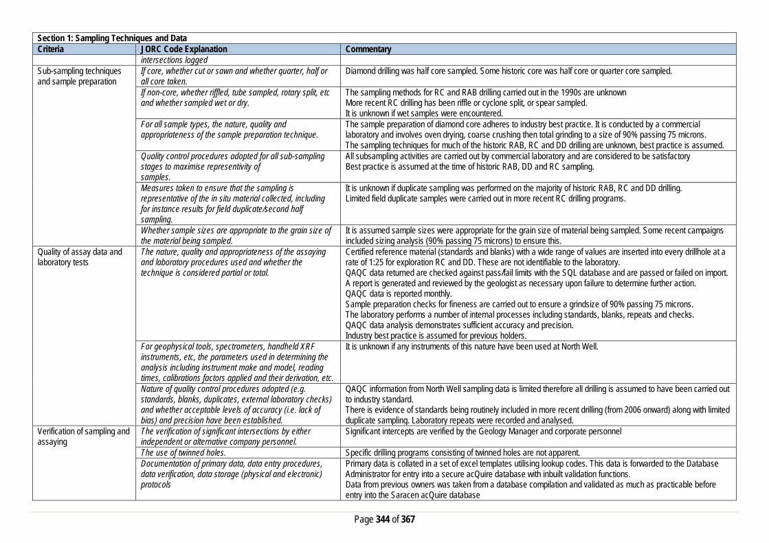
Page 344 of 367
Section 1: Sampling Techniques and Data Criteria JORC Code Explanation Commentary
intersections logged Sub-sampling techniques and sample preparation
If core, whether cut or sawn and whether quarter, half or all core taken.
Diamond drilling was half core sampled. Some historic core was half core or quarter core sampled.
If non-core, whether riffled, tube sampled, rotary split, etc and whether sampled wet or dry.
The sampling methods for RC and RAB drilling carried out in the 1990s are unknown More recent RC drilling has been riffle or cyclone split, or spear sampled. It is unknown if wet samples were encountered.
For all sample types, the nature, quality and appropriateness of the sample preparation technique.
The sample preparation of diamond core adheres to industry best practice. It is conducted by a commercial laboratory and involves oven drying, coarse crushing then total grinding to a size of 90% passing 75 microns. The sampling techniques for much of the historic RAB, RC and DD drilling are unknown, best practice is assumed.
Quality control procedures adopted for all sub-sampling stages to maximise representivity of samples.
All subsampling activities are carried out by commercial laboratory and are considered to be satisfactory Best practice is assumed at the time of historic RAB, DD and RC sampling.
Measures taken to ensure that the sampling is representative of the in situ material collected, including for instance results for field duplicate/second half sampling.
It is unknown if duplicate sampling was performed on the majority of historic RAB, RC and DD drilling. Limited field duplicate samples were carried out in more recent RC drilling programs.
Whether sample sizes are appropriate to the grain size of the material being sampled.
It is assumed sample sizes were appropriate for the grain size of material being sampled. Some recent campaigns included sizing analysis (90% passing 75 microns) to ensure this.
Quality of assay data and laboratory tests
The nature, quality and appropriateness of the assaying and laboratory procedures used and whether the technique is considered partial or total.
Certified reference material (standards and blanks) with a wide range of values are inserted into every drillhole at a rate of 1:25 for exploration RC and DD. These are not identifiable to the laboratory. QAQC data returned are checked against pass/fail limits with the SQL database and are passed or failed on import. A report is generated and reviewed by the geologist as necessary upon failure to determine further action. QAQC data is reported monthly. Sample preparation checks for fineness are carried out to ensure a grindsize of 90% passing 75 microns. The laboratory performs a number of internal processes including standards, blanks, repeats and checks. QAQC data analysis demonstrates sufficient accuracy and precision. Industry best practice is assumed for previous holders.
For geophysical tools, spectrometers, handheld XRF instruments, etc, the parameters used in determining the analysis including instrument make and model, reading times, calibrations factors applied and their derivation, etc.
It is unknown if any instruments of this nature have been used at North Well.
Nature of quality control procedures adopted (e.g. standards, blanks, duplicates, external laboratory checks) and whether acceptable levels of accuracy (i.e. lack of bias) and precision have been established.
QAQC information from North Well sampling data is limited therefore all drilling is assumed to have been carried out to industry standard. There is evidence of standards being routinely included in more recent drilling (from 2006 onward) along with limited duplicate sampling. Laboratory repeats were recorded and analysed.
Verification of sampling and assaying
The verification of significant intersections by either independent or alternative company personnel.
Significant intercepts are verified by the Geology Manager and corporate personnel
The use of twinned holes. Specific drilling programs consisting of twinned holes are not apparent. Documentation of primary data, data entry procedures, data verification, data storage (physical and electronic) protocols
Primary data is collated in a set of excel templates utilising lookup codes. This data is forwarded to the Database Administrator for entry into a secure acQuire database with inbuilt validation functions. Data from previous owners was taken from a database compilation and validated as much as practicable before entry into the Saracen acQuire database
Page 345 of 367
Section 1: Sampling Techniques and Data Criteria JORC Code Explanation Commentary
Discuss any adjustment to assay data. No adjustment to assay data has been made Location of data points Accuracy and quality of surveys used to locate drillholes
(collar and down-hole surveys), trenches, mine workings and other locations used in Mineral Resource estimation.
The survey quality and control is unknown for the majority of historic drilling. More recent drilling has collar locations surveyed by unknown GPS and DGPS equipment. Downhole survey methods recorded include Eastman single and multishot, gyro, inferred and unknown methods.
Specification of the grid system used. MGA Zone 51 grid coordinate system is used. Some historic data drilled on local grid systems has been converted to this grid system
Quality and adequacy of topographic control. No detail of topographic control was supplied or found. Data spacing and distribution
Data spacing for reporting of Exploration Results. No exploration results reported in this release. The nominal drillhole spacing is 25 m (northing) by 25 m (easting) in the core of the deposit, and increases to the margins of the deposit.
Whether the data spacing and distribution is sufficient to establish the degree of geological and grade continuity appropriate for the Mineral Resource and Ore Reserve estimation procedure(s) and classifications applied.
The mineralised domains at North Well have demonstrated sufficient continuity in both geological and grade continuity to support the definition of Mineral Resources and Reserves, and the classifications applied under the 2012 JORC Code.
Orientation of data in relation to geological structure
Whether sample compositing has been applied.
Historic 1990s RAB and RC drilling was generally sampled on 3 - 4m composites with significant gold results being resampled in 1m intervals Some more recent RC pre-collar drilling was composited into 6m samples with areas of interest resampled to 1m.
Whether the orientation of sampling achieves unbiased sampling of possible structures and the extent to which this is known, considering the deposit type.
The deposit is drilled towards grid west at angles varying from -600 and -900 to intersect the mineralised zones at a close to perpendicular relationship for the bulk of the deposit.
If the relationship between the drilling orientation and the orientation of key mineralised structures is considered to have introduced a sampling bias, this should be assessed and reported if material.
All drilling from surface has been drilled as close to perpendicular as possible. This has reduced the risk of introducing a sampling bias as far as possible. No orientation based sampling bias has been identified at North Well in the data at this point.
Sample security The measures taken to ensure sample security. Information on sample security measures has not been provided Audits or reviews The results of any audits or reviews of sampling
techniques and data. No evidence of external reviews has been supplied.
Section 2: Reporting of Exploration Results Criteria JORC Code Explanation Commentary Mineral tenement and land tenure status
Type, reference name/number, location and ownership including agreements or material issues with third parties such as joint ventures, partnerships, overriding royalties, native title interests, historical sites, wilderness or national park and environmental settings.
The North Well resource is located on M37/358, M37/359 and M37/465. Near Mine exploration extends onto M37/340. The tenements are held by Norilsk Nickel Wildara Pty Ltd but are the subject of a purchase agreement with Saracen Metals Pty Limited whereby Saracen has purchased 100% of the tenements. The mining leases have a 21 year life: Mining Lease M37/465 is held until 2015 and Mining Leases M37/340, M37/358, and M37/359 are held until 2034. All are renewable for a further 21 years on a continuing basis. All production is subject to a Western Australian state government NSR royalty of 2.5%. Mining Leases M37/358 and M37/359 are subject to a royalty of $25.00 per ounce of gold produced from the tenements over 33,000 ounces and up to 73,000 ounces and of $1.00 per ounce of gold produced over 73,000 ounces payable to Dominion Gold Operations Pty Ltd. Mining Lease M37/465 is subject to a royalty payable to Forsyth NL calculated as a percentage of the Ore Value for ore processed each quarter. The Ore Value is calculated by reference to the Ore Grace and the Average Gold Price

Page 346 of 367
Section 2: Reporting of Exploration Results Criteria JORC Code Explanation Commentary
for the quarter. For ore processed with an Ore Grade greater than 1.5 g/tonne the royalty is 4% of the Ore Value and less than 1.5g/tonne, the royalty is 2.5% of the Ore Value. The tenements are all subject to a 1.5% royalty on all minerals which are capable of being sold or otherwise disposed of, multiplied by the Net Smelter Return, capped at $17 million, payable to Norilsk Nickel Wildara Pty Ltd. There are no caveats or bank mortgages relating to the tenements. A single Aboriginal Heritage site exists within M37/340 – Site ID 1522 Koara Camp artefacts and scatter. The site is not impacted by near mine exploration on the tenement. There are no other registered Aboriginal Heritage sites within the tenements. There are no pastoral compensation agreements over the tenements.
The security of the tenure held at the time of reporting along with any known impediments to obtaining a licence to operate in the area.
No known impediment exists to obtaining a licence to operate and the tenements are all in good standing.
Exploration done by other parties
Acknowledgment and appraisal of exploration by other parties.
Gold was discovered in the area in the late 1800s with intermittent working of the nearby Bannockburn deposit until the 1950s. Modern exploration began in the late 1970s with initial exploration targeting nickel sulphides before gold exploration began in 1979. Exploration activities by numerous companies including Freeport of Australia, Kulim Limited and Arboyne took place until Dominion purchased the project. Soil sampling and RAB drilling highlighted the North Well anomaly followed by an extensive RC campaign to delineate the resource. Mining at North Well began in 1995 and continued after the project was sold to Australian Goldfields. DD and RC drilling continued in and around the deposit along with surface sampling and various geophysical surveys in an effort to extend mineralisation and define new targets. AGF were placed under administration and mining ceased in 1998 upon the exhaustion of the mine reserves. Arrow Resources Management acquired the project and sold it to Breakaway Resources who carried out minor RAB drilling in the area. Lionore acquired the ground from Breakaway and completed resource extension and near mine exploration RC drilling. Norilsk acquired the project and carried out further drilling as well as a MILTEM survey over the North Well area, highlighting several areas of interest.
Geology Deposit type, geological setting and style of mineralisation.
The North Well deposit is located on the central portion of the Archaean Norseman- Wiluna greenstone belt. Mafic to ultramafic intrusive and extrusive rocks, with intercalated sedimentary horizons dominate the greenstone stratigraphy. There are some felsic rocks to intermediate volcanic rocks and their derivatives. The greenstone sequences, confined to the west by basement (pre-tectonic) granitoid, gneiss, smaller syntectonic granitoid stocks, and batholiths, generally occupy the core of anticlinal domes. Some basement rocks partially invade the greenstone stratigraphy. Stratigraphy dips are relatively modest throughout the majority of the project, but steepen considerably towards more vertical, major tectonic structures. The mineralisation at North Well is confined to the Bannockburn Shear Zone (“BSZ”). The BSZ is a concave structure that has a strike length of approximately 30km, strikes roughly north south, and dips to the east. The BSZ is an approximately one kilometre wide zone of deformation that separates the basement granite/gneiss terrane to the west from greenstone terrane to the east. At North Well, the gold mineralisation is located approximately 400m from the main granite greenstone contact. Gold mineralisation is in east dipping basalts within a sequence of siltstones and acid volcaniclastics and occurs over a strike length of approximately 2600m and to a depth of 170m. Gold mineralisation is predominantly associated with quartz +/- sulphide filled shear structures. A strong S2/S3 lineation controls the mineralisation into a series of shallow (~25°) south plunging ore shoots that form en echelon zones along strike and down the dip of the shear zone. A series of east west late stage faults (some with dolerite intrusions) cross cut the mineralisation.

Page 347 of 367
Section 2: Reporting of Exploration Results Criteria JORC Code Explanation Commentary Drillhole information A summary of all information material to the
understanding of the exploration results including a tabulation of the following information for all Material drill holes:
• easting and northing of the drill hole collar • elevation or RL (Reduced Level – elevation • above sea level in metres) of the drill hole collar • dip and azimuth of the hole • down hole length and interception depth • hole length. • If the exclusion of this information is justified on
the basis that the information is not Material and this exclusion does not detract from the understanding of the report, the Competent Person should clearly explain why this is the case.
A total of 515 holes have been used in the mineral resource and are deemed to be material. It is not practical to summarise all of the holes here in this release. Future drill hole data will be periodically released or when a results materially change the economic value of the project. Exclusion of the drilling information will not detract from the reader’s view of the report.
Data aggregation methods In reporting Exploration Results, weighting averaging techniques, maximum and/or minimum grade truncations (e.g. cutting of high grades) and cut-off grades are usually Material and should be stated.
No exploration results are reported in this release.
Where aggregate intercepts incorporate short lengths of high grade results and longer lengths of low grade results, the procedure used for such aggregation should be stated and some typical examples of such aggregations should be shown in detail.
No exploration results are reported in this release.
The assumptions used for any reporting of metal equivalent values should be clearly stated.
No exploration results are reported in this release.
Relationship between mineralisation widths and intercept lengths
These relationships are particularly important in the reporting of Exploration Results. If the geometry of the mineralisation with respect to the drill hole angle is known, its nature should be reported. If it is not known and only the down hole lengths are reported, there should be a clear statement to this effect (e.g. ‘down hole length, true width not known’).
Saracen has not previously reported exploration results nor are any included in this release.
Diagrams Appropriate maps and sections (with scales) and tabulations of intercepts should be included for any significant discovery being reported These should include, but not be limited to a plan view of drill hole collar locations and appropriate sectional views.
No diagrams are referenced in this release.
Balanced Reporting Where comprehensive reporting of all Exploration Results are not practicable, representative reporting of both low
Saracen has not previously reported exploration results nor are any included in this release.
Page 348 of 367
Section 2: Reporting of Exploration Results Criteria JORC Code Explanation Commentary
and high grades and/or widths should be practiced to avoid misleading reporting of Exploration Results.
Other substantive exploration data
Other exploration data, if meaningful and material, should be reported including (but not limited to): geological observations; geophysical survey results;geochemical survey results; bulk samples – size and method of treatment; metallurgical test results; bulk density, groundwater, geotechnical and rock characteristics; potential deleterious or contaminating substances.
A number of geophysical surveys have been completed and interpreted including regional aeromagnetics, radiometrics, SAM (sub-audio magnetics) and MLTEM (Moving loop electromagnetics) in an effort to highlight potential target areas.
Further work The nature and scale of planned further work (e.g. tests for lateral extensions or depth extensions or large-scale step-out drilling). Diagrams clearly highlighting the areas of possible extensions, including the main geological interpretations and future drilling areas, provided this information is not commercially sensitive
Saracen is currently working on establishing an exploration program which will identify areas of opportunity to extend or enhance the North Well mineral resource.
Section 3: Estimation and Reporting of Mineral Resources Criteria JORC Code Explanation Commentary Database Integrity Measures taken to ensure that data has not been
corrupted by, for example, transcription or keying errors, between its initial collection and its use for Mineral Resource estimation purposes.
The database provided to Saracen was an extract from an acquire SQL database. The primary database is regulated by a locked framework called the acquire data model which fixes the relationships between tables. The data model minimises the potential for data collection and data usage errors through pre-determined look up tables, storage and export functions. User defined permissions also regulate the ability to add, edit or extract data. It is unknown at this stage how the process used to record the primary data. Typical methods are manual translation of logging and data capture from written logs, direct import of csv tables through a data import scheme where data is validated upon import or direct data entry options into the database using predefined look up values.
Data validation procedures used. The rigid structure of the acquire data model is such that predefined rules and look up tables are applied to all data entry. Data that does not meet the criteria are highlighted and moved to a buffer area until the data is rectified to meet the passing rules. It is unknown at this stage how the database was managed and who was responsible for its maintenance. It is also unknown if there was any built in functionality around pass/fail checks on assay importing.
Site Visits Comment on any site visits undertaken by the Competent Person and the outcome of those visits.
No site visits have taken place at this point in time by the competent person. However, a team of 12 people including Saracen technical representatives as well as industry consultants did conduct site visits. Historical drill core was inspected during the visits.
If no site visits have been undertaken indicate why this is the case.
Given that there was no activity (drilling, mining etc.), it was deemed that a site visit during the process would not provide significant value and not materially affect the outcome of any resource estimate.
Geological Interpretation Confidence in (or conversely, the uncertainty of) the geological interpretation of the mineral deposit.
The interpretation has been based on the detailed geological work completed by previous owners of the project. This knowledge is based on extensive geological logging of drill core, RC chips, detailed open pit mapping and assay data. The majority of the mineralisation is mainly confined to Bannockburn Shear Zone (BSZ) that passes through the deposit, with weaker mineralisation on the footwall and hanging wall lodes. Within the BSZ, mineralisation is hosted in east dipping basalts within a sequence of siltstones and acid volcanics and is associated

Page 349 of 367
Section 3: Estimation and Reporting of Mineral Resources Criteria JORC Code Explanation Commentary
with quartz+/- sulphide filled structures. A strong S2/S3 lineation controls the mineralisation into a series of shallow (~25 o) south plunging shoots that form en echelon zones along strike and down dip of the shear zone.
Nature of the data used and any assumptions made. The interpretations have been constructed using all available geological logging descriptions including but not limited to, stratigraphy, lithology, texture, and alteration. Interpreted cross cutting faults have been observed and have been use to guide disruptions in the position of the key mineralised domains. Surface mapping had been included in the interpretation. Cross sectional interpretations of the mineralisation have been created and from the basic framework through which the 3D wireframe solid is built.
The affect, if any, of alternative interpretations on Mineral Resource estimation.
The North Well deposit is generally sub-vertical in geometry, with clear boundaries which define the mineralised domains. Infill drilling has supported and refined the model and the current interpretation is thus considered to be robust. Over the life of the project several different sources have interpreted the mineralisation and all agree on the same basic interpretation, given the bulk of the mineralisation is confined to the Bannockburn Shear Zone.
The use of geology in guiding and controlling the Mineral Resource estimation.
Geological controls and relationships were used to define mineralised domains. Key features are sulphide content, associated with quartz structures.
The factors affecting continuity both of grade and geology. At the deposit scale the gold distribution is predominantly confined to the Bannockburn shear zone, with distinct south dipping (~25 o) higher grade shoots forming an en echelon pattern along the strike of the deposit. Mineralisation is mainly associated with quartz+/- sulphide filled structures. These factors have been addressed via the resource estimation process applied.
Dimensions The extent and variability of the Mineral Resource expressed as length (along strike or otherwise), plan width, and depth below surface to the upper and lower limits of the Mineral Resource.
North Well mineralisation extends from 6853875mN to 6856525mN, 291700mE to 292500mE and 250 meters below surface. The Bannockburn shear generally strikes north-south along the North Well deposit.
Estimation and modelling techniques
The nature and appropriateness of the estimation technique(s) applied and key assumptions, including treatment of extreme grade values, domaining, interpolation parameters and maximum distance of extrapolation from data points.
Grade estimation using Ordinary Kriging (OK) was completed for North Well. CAE Studio 3 software was used to estimate gold into10m x20m x5m size parent blocks. Drill grid spacing ranges from 25 m to 50 m. Drill hole sample data was flagged using domain codes generated from three dimensional mineralisation domains and oxidation surfaces. Sample data was composited to one metre downhole length. Over 90% of the sample intervals are 1m. Intervals with no assays were excluded from the compositing routine. The influence of extreme sample distribution outliers was reduced by top-cutting where required. The top-cut levels were determined using a combination of top-cut analysis tools (grade histograms, log probability plots and Coefficient of Variation (CV)). Top-cuts were reviewed and applied on a domain basis. Due to the flexures in the mineralised envelopes, the estimation process was guided by the Dynamic Anisotropy technique in CAE’s Studio3. This basically links the geometrical shape of the mineralisation wireframe to the search ellipse during the estimation process. Variography was conducted in Snowden’s supervisor software.
The availability of check estimates, previous estimates and/or mine production records and whether the Mineral Resource estimate takes appropriate account of such data.
The ordinary kriged resource estimate has been compared with previous resource estimate done by the previous owner. The previous resource predicted more tonnes and lower grade for the total inventory resource. This resource estimate done by Saracen predicts less tonnes at higher grades. This discrepancy can be explained by the ‘loose’ broad mineralisation envelopes used in conjunction with the Multiple Indicator kriging methodology in the previous estimate compared with Saracen’s mineralisation envelopes which were constructed using a nominal 0.5 g/t Au cut-off. Although there is previous mining activities at North Well, no historical mine production and mill reconciliation records were sighted that can be directly compared with this resource estimate.
Page 350 of 367
Section 3: Estimation and Reporting of Mineral Resources Criteria JORC Code Explanation Commentary
The assumptions made regarding recovery of by-products. No assumptions have been made with respect to the recovery of by-products. Estimation of deleterious elements or other non-grade variables of economic significance (e.g. sulphur for acid mine drainage characterisation).
There has been no estimate at this point of deleterious elements. Saracen is unaware if any elements other than gold have been assayed. Arsenic may have been assayed; however this data has not been made available.
In the case of block model interpolation, the block size in relation to the average sample spacing and the search employed.
A single block model for North Well was constructed using an 10 mE by 20 mN by 5 mRL parent block size with subcelling to 1 mE by 2 mN by 1 mRL for domain volume resolution. All estimation was completed at the parent cell scale. Kriging neighbourhood analysis was carried out for North Well in order to optimise the block size, search distances and sample numbers used. Discretisation was set to 4 by 8 by 5 for all domains. The size of the search ellipse per domain was based on the gold variography. Three search passes were used for each domain. In general, the first pass used the ranges of the gold variogram and a minimum of 12 and maximum of 32 samples. In the second pass the search ranges were unchanged and the minimum samples reduced to 8 samples. The third pass ellipse was extended to 2 times the range of the gold variograms and the minimum number of samples reduced to 4 and a maximum of 32 samples were applied. A maximum of 4 samples per hole were used. In the majority of domains, most blocks were estimated in the first pass (particularly for the main domains); however, some more sparsely-sampled domains were predominantly estimated on the second or third pass. Un-estimated blocks, i.e. those outside the range of the third pass, were assigned the estimated domain mean and lower resource confidence classifications. Hard boundaries were applied between all estimation domains except for the major domain D_200_MN (at diesel) and F_100_MN (at Frosties) where a soft boundary was applied.
Any assumptions behind modelling of selective mining units.
No selective mining units have been assumed.
Any assumptions about correlation between variables. No assumptions have been made regarding correlation between variables. Description of how the geological interpretation was used to control the resource estimates.
The geological interpretation strongly correlates with the mineralised domains. Specifically where the mineralised domain corresponds with the presence of sulphide filled quartz structures. Where well known the geological unit is described in the block model. All wireframe boundaries including those where lithology and mineralisation correspond, hard boundaries are enforced.
Discussion of basis for using or not using grade cutting or capping.
Statistical analysis showed the populations in each domain at North Well to generally have a low coefficient of variation but it was noted that a very small number of estimation domains included outlier values that required top-cut values to be applied.
The process of validation, the checking process used, the comparison of model data to drill hole data, and use of reconciliation data if available.
Validation of the block model carried out a volumetric comparison of the resource wireframes to the block model volumes. Validating the estimate compared block model grades to the input data using tables of values, and swath plots showing northing, easting and elevation comparisons. Visual validation of grade trends and metal distributions was carried out. Although there has been historical mining at North Well there has not been any historical data that has been verified to be directly linked to the North Well deposit. There have not been accurate mining records kept by a succession of previous owners of this deposit.
Moisture Whether the tonnages are estimated on a dry basis or with natural moisture, and the method of determination of the moisture content.
All tonnages are estimated on a dry basis.
Cut-off parameters The basis of the adopted cut-off grade(s) or quality parameters applied.
Based on Saracen’s current economic operations at Carosue Dam, and the natural grade distinction above background, a grade of 0.5g/t has been chosen.
Page 351 of 367
Section 3: Estimation and Reporting of Mineral Resources Criteria JORC Code Explanation Commentary Mining factors or assumptions
Assumptions made regarding possible mining methods, minimum mining dimensions and internal (or, if applicable, external) mining dilution. It is always necessary as part of the process of determining reasonable prospects for eventual economic extraction to consider potential mining methods, but the assumptions made regarding mining methods and parameters when estimating Mineral Resources may not always be rigorous. Where this is the case, this should be reported with an explanation of the basis of the mining assumptions made.
The North Well deposit is amenable to mining by open pit methods. The deposit has successfully been mined by open pit in the past prior to 2007. There are reasonable grounds to assume that in the future this deposit will again be mined by conventional open pit load and haul operations, particularly to the south of the current mined out pits at Diesel and Frosties
Metallurgical factors or assumptions
The basis for assumptions or predictions regarding metallurgical amenability. It is always necessary as part of the process of determining reasonable prospects for eventual economic extraction to consider potential metallurgical methods, but the assumptions regarding metallurgical treatment process and parameters made when reporting Mineral Resources may not always be rigorous. Where this is the case, this should be reported with an explanation of the basis of the metallurgical assumptions made.
It is expected that any future mining of the North Well deposit will be processed at the Thunderbox processing facility which is currently on care and maintenance. The Thunderbox mill employs a conventional crushing, grinding and CIL leaching process to extract the gold. The mill operated successfully between 2002 and 2007, processing in excess of 9Mt of ore. The conventional plant displayed excellent performance with gold recoveries between 93.4 to 96.6 % over the life of the mine. Test work by Ammtec completed historically suggests North Well mineralisation should achieve similar recoveries to the mineralisation previously processed at Thunderbox.
Environmental factors or assumptions
Assumptions made regarding possible waste and process residue disposal options. It is always necessary as part of the process of determining reasonable prospects for eventual economic extraction to consider the potential environmental impacts of the mining and processing operation. While at this stage the determination of potential environmental impacts, particularly for a greenfields project, may not always be well advanced, the status of early consideration of these potential environmental impacts should be reported. Where these aspects have not been considered this should be reported with an explanation of the environmental assumptions made.
As arsenic is present in the mineralogy of the deposit, the processing plant has been designed to ensure effective management of potentially harmful arsenic contamination. A 20m diameter high rate thickener is used to thicken the tails to maximise water and cyanide recovery. Process water is added to the thickener feed to create one wash stage prior to detoxification. Arsenic precipitation is effected in a stirred closed tank with air sparging. Ferric sulphate solution is metered into the reactor on the basis of dissolved arsenic concentration. The fumes from the precipitation tank are passed through a packed bed caustic scrubber before venting to the atmosphere. The precipitation tank overflow is then passed to the tails hopper.
Bulk Density Whether assumed or determined. If assumed, the basis for the assumptions. If determined, the method used, whether wet or dry, the frequency of the measurements, the nature, size and representativeness of the samples.
Previous owners have taken routine density measurements when drilling diamond core. The method of calculation is the water displacement technique. Measurements have been recorded in the acquire database and extraction schemes pair this data with the major lithology code for statistical analysis. At this point Saracen does not have the available data to comment on the frequency and distribution of the density measurements. The size and nature of the samples is also unknown to Saracen at this time.
The bulk density for bulk material must have been measured by methods that adequately account for void spaces (vugs, porosity, etc), moisture and differences between rock and alteration zones within the deposit.
As stated above the frequency and distribution is unknown at this point in time. It has assumed from the very good reconciliation performance from mine to mill that the determined density assignments from the mine are accurate.

Page 352 of 367
Section 3: Estimation and Reporting of Mineral Resources Criteria JORC Code Explanation Commentary
Discuss assumptions for bulk density estimates used in the evaluation process of the different materials.
An average mean of densities collected for each lithological type has been uniformly applied to the modelled geological units. This includes the primary fresh lithologies as well as the weathered oxide and transitional zones.
Classification The basis for the classification of the Mineral Resources into varying confidence categories.
The mineral resource has been classified into Indicated and Inferred categories based on drill hole spacing, geological confidence, and grade continuity and estimation quality. The combination of these factors together guide the digitising of a “cookie cutter” string in long section view which selects and codes the appropriate blocks with the nominated resource classification category.
Whether appropriate account has been taken of all the relevant factors (i.e. relative confidence in tonnage/grade estimations, reliability of input data, confidence in continuity of geology and metal values, quality, quantity and distribution of the data).
The input data is comprehensive in its coverage of the mineralisation and does not favour or misrepresent in-situ mineralisation. Geological control at North Well consists of a primary mineralisation is associated with sulphide filled quartz structures within the major BSZ (Bannockburn Shear Zone) regional structure. The definition of mineralised zones is based on a high level of geological understanding producing a robust model of mineralised domains. The validation of the block model shows good correlation of the input data to the estimated grades.
Whether the result appropriately reflects the Competent Person's view of the deposit.
The geological model and the mineral resource estimate reflect the competent person’s view of the deposit.
Audits or reviews The results of any audits or reviews of Mineral Resource estimates.
Saracen has adopted a process for geological modelling, estimation and reporting of mineral resources that meets high industry standards. No external audits have been conducted, as this deposit was recently acquired, Saracen however intends have an external audit done prior to commencement of any mining activity.
Discussion of relative accuracy/confidence
Where appropriate a statement of the relative accuracy and confidence level in the Mineral Resource estimate using an approach or procedure deemed appropriate by the Competent Person. For example, the application of statistical or geostatistical procedures to quantify the relative accuracy of the resource within stated confidence limits, or, if such an approach is not deemed appropriate, a qualitative discussion of the factors that could affect the relative accuracy and confidence of the estimate.
The relative accuracy of the Mineral Resource estimate is reflected in the reporting of the Mineral Resource as per the guidelines of the 2012 JORC Code. The resource estimates have undergone a robust validation process, and as such, the competent person is satisfied that the resources estimated in the block model are a true representation of the insitu resources.
The statement should specify whether it relates to global or local estimates, and, if local, state the relevant tonnages, which should be relevant to technical and economic evaluation. Documentation should include assumptions made and the procedures used.
The statements relate to a global estimate of tonnes and grade.
These statements of relative accuracy and confidence of the estimate should be compared with production data, where available.
No accurate records at of production data is available at North Well to say to a give a realistic comparison with this resource estimate
Kailis Section 1: Sampling Techniques and Data Criteria JORC Code Explanation Commentary Sampling Techniques Nature and quality of sampling (e.g. cut channels, random
chips, or specific specialised industry standard measurement tools appropriate to the minerals under
Saracen has completed reverse circulation drilling (RC) and diamond (DD) drilling at Kailis. Sampling methods undertaken at Kailis by previous owners have included rotary air blast (RAB), (RC), aircore (AC) and diamond drillholes (DD).

Page 353 of 367
Section 1: Sampling Techniques and Data Criteria JORC Code Explanation Commentary
investigation, such as down hole gamma sondes, or handheld XRF instruments, etc.). These examples should not be taken as limiting the broad meaning of sampling.
Limited historical data has been provided by previous owners.
Include reference to measures taken to ensure sample representivity and the appropriate calibration of any measurement tools or systems used
Sampling for RC and DD drilling is carried out as specified within Saracen sampling and QAQC procedures as per industry standard. RC chips and diamond core provide high quality representative samples for analysis. RC, RAB, AC and DD core drilling is assumed to have been completed by previous holders to industry standard at that time (1980- 2008).
Aspects of the determination of mineralisation that are Material to the Public Report. In cases where ‘industry standard’ work has been done this would be relatively simple (e.g. ‘reverse circulation drilling was used to obtain 1 m samples from which 3 kg was pulverised to produce a 30 g charge for fire assay’). In other cases more explanation may be required, such as where there is coarse gold that has inherent sampling problems. Unusual commodities or mineralisation types (e.g. submarine nodules) may warrant disclosure of detailed information
RC Chips are cone split and sampled into 1m intervals with total sample weights under 3kg to ensure total sample inclusion at the pulverisation stage. Diamond core is HQ sized, sampled to 1m intervals or geological boundaries where necessary and cut into half core to give sample weights under 3 kg. Samples are selected to weigh less than 3 kg to ensure total sample inclusion at the pulverisation stage. Saracen core and chip samples are crushed, dried and pulverised to a nominal 90% passing 75µm to produce a 40g sub sample for analysis by FA/AAS. All RAB, RC, AC and DD and sampling is assumed to have been carried out to industry standard at that time. The majority of recent drillholes have been riffle or cone split to provide 1m samples for analysis. Older drillholes have been sampled via spear sampling or unknown methods. Analysis methods include aqua regia, fire assay and unknown methods.
Drilling Techniques Drill type (e.g. core, reverse circulation, open-hole hammer, rotary air blast, auger, Bangka, sonic, etc.) and details (e.g. core diameter, triple or standard tube, depth of diamond tails, face-sampling bit or other type, whether core is oriented and if so, by what method, etc.).
The deposit was initially sampled by 156 RAB holes. Further drilling included 51 RAB holes, 1186 RC holes (assumed standard 5 ¼“ face sampling hammer bit) 220 AC holes and 54 HQ (mostly standard tube, a limited number were triple tube) and unknown diameter diamond drillholes. A number of these were diamond tails on existing RC drillholes. Saracen has completed 5 diamond geotechnical holes and 130 RC drill holes, completed with a 5.5 inch diameter bit with a face sampling hammer. The rig was equipped with an external auxiliary booster. 3241 grade control RC drillholes have been completed within the pit. Diamond drilling was HQ sized and orientated using an ACT 11 core orientation tool. It is unknown if diamond drill core was oriented.
Drill Sample Recovery Method of recording and assessing core and chip sample recoveries and results assessed
Recoveries for RC drilling are recorded as a percentage based on a visual weight estimate. In historical data it has been noted that recoveries were rarely less than 100% although recovery data has not been provided. Some problems were reported with wet samples from RC drilling. Core loss through the ore zone was reported occasionally however recoveries for diamond drilling programs were around 95%.
Measures taken to maximise sample recovery and ensure representative nature of the samples
During RC drilling daily rig inspections are carried out to check splitter condition, general site and address general issues. It is unknown what, if any, measures were taken to ensure sample recovery and representivity.
Whether a relationship exists between sample recovery and grade and whether sample bias may have occurred due to preferential loss/gain of fine/coarse material.
There is no known relationship between sample recovery and grade for RC drilling. Diamond drilling has high recoveries meaning loss of material is minimal. Any historical relationship is not known.
Logging Whether core and chip samples have been geologically and geotechnically logged to a level of detail to support appropriate Mineral Resource estimation, mining studies and metallurgical studies. Whether logging is qualitative or quantitative in nature.
Logging of RC chips and DD core has recorded lithology, mineralogy, texture and colour, mineralisation, weathering, alteration and veining. Geotechnical and structural logging is carried out on all diamond holes to record recovery, RQD, defect number, type, fill material, shape and roughness and alpha and beta angles. Chips from all RC holes are stored in chip trays for future reference.

Page 354 of 367
Section 1: Sampling Techniques and Data Criteria JORC Code Explanation Commentary
Core (or costean, channel, etc) photography. Some historic diamond drilling has been geotechnically logged to provide data for geotechnical studies. Core has been photographed in both dry and wet state. It is unknown if historic diamond core was photographed.
The total length and percentage of the relevant intersections logged
All drillholes completed by Saracen have been logged in full.
Sub-sampling techniques and sample preparation
If core, whether cut or sawn and whether quarter, half or all core taken.
All drill core is cut in half onsite using an automatic core saw. Samples are always collected from the same side. The sampling method for most historic drill core is unknown, a small amount is recorded as half core sampled.
If non-core, whether riffled, tube sampled, rotary split, etc and whether sampled wet or dry.
All RC samples are cone split. Occasional wet samples are encountered. The sampling method for the majority of the historic RAB, AC and RC drilling is unknown: a small number have been recorded as spear sampled. Some wet sampling has been reported in historic drilling but only a small proportion of these had poor recoveries
For all sample types, the nature, quality and appropriateness of the sample preparation technique.
The sample preparation of RC chips and DD core adheres to industry best practice. It is conducted by a commercial laboratory and involves oven drying, coarse crushing then total grinding to a size of 90% passing 75 microns. The sampling techniques for historic RAB, RC, AC and DD drilling are unknown, best practice is assumed.
Quality control procedures adopted for all sub-sampling stages to maximise representivity of samples.
All subsampling activities are carried out by commercial laboratory and are considered to be satisfactory. Best practice is assumed at the time of historic RAB, DD, AC and RC sampling. Procedures adopted to ensure sample representivity for more recent drilling included sizing analysis, with an expected return of 85% passing 75um.
Measures taken to ensure that the sampling is representative of the in situ material collected, including for instance results for field duplicate/second half sampling.
RC field duplicate samples are carried out at a rate of 1:20 and are sampled directly from the on-board splitter on the rig. These are submitted for the same assay process as the original samples and the laboratory are unaware of such submissions. It is unknown if duplicate sampling was performed on historic RAB, RC, AC and DD drilling.
Whether sample sizes are appropriate to the grain size of the material being sampled.
Analysis of data determined sample sizes were considered to be appropriate.
Quality of assay data and laboratory tests
The nature, quality and appropriateness of the assaying and laboratory procedures used and whether the technique is considered partial or total.
RC chip and diamond core samples are analysed by an external laboratory using a 40g fire assay with AAS finish. This method is considered suitable for determining gold concentrations in rock and is a total digest method. Methods for historic RC, RAB, AC and DD drilling included fire assay, aqua regia and unknown methods.
For geophysical tools, spectrometers, handheld XRF instruments, etc, the parameters used in determining the analysis including instrument make and model, reading times, calibrations factors applied and their derivation, etc.
No geophysical tools have been utilised at the Kailis project
Nature of quality control procedures adopted (e.g. standards, blanks, duplicates, external laboratory checks) and whether acceptable levels of accuracy (i.e. lack of bias) and precision have been established.
Certified reference material (standards and blanks) with a wide range of values are inserted into every drillhole at a rate of 1:25 for RC and DD drilling. These are not identifiable to the laboratory. QAQC data returned are checked against pass/fail limits with the SQL database and are passed or failed on import. A report is generated and reviewed by the geologist as necessary upon failure to determine further action. QAQC data is reported monthly. Sample preparation checks for fineness are carried out to ensure a grindsize of 90% passing 75 microns. The laboratory performs a number of internal processes including standards, blanks, repeats and checks. QAQC data analysis demonstrates sufficient accuracy and precision. Industry best practice is assumed for previous holders.

Page 355 of 367
Section 1: Sampling Techniques and Data Criteria JORC Code Explanation Commentary Verification of sampling and assaying
The verification of significant intersections by either independent or alternative company personnel.
Significant intercepts are verified by the Geology Manager and corporate personnel
The use of twinned holes. A number of historic DDH holes were drilled to twin original RC holes and verify results. Documentation of primary data, data entry procedures, data verification, data storage (physical and electronic) protocols
Primary data is collated in a set of excel templates utilising lookup codes. This data is forwarded to the Database Administrator for entry into a secure acQuire database with inbuilt validation functions. Data from previous owners was taken from a database compilation and validated as much as practicable before entry into the Saracen acQuire database
Discuss any adjustment to assay data. No adjustments have been made to assay data. First gold assay is utilised for resource estimation. Location of data points Accuracy and quality of surveys used to locate drillholes
(collar and down-hole surveys), trenches, mine workings and other locations used in Mineral Resource estimation.
Drillhole are located using a Trimble R8 GPS/GNSS with an accuracy of +/- 10mm. Downhole surveys are carried out using a hired Reflex EZ-gyro by the respective drilling companies on a regular basis, between 10-30m. Historic drilling was located using mine surveyors and standard survey equipment; more recent drilling has been surveyed using a Real Time Kinetic GPS system. The majority of downhole surveys for RC drilling were carried out using an Eastman single shot camera at regular intervals. Some drillholes were gyroscopically surveyed and some survey methods remain unknown.
Specification of the grid system used. MGA Zone 51 grid coordinate system is used Quality and adequacy of topographic control. DTM surveys were obtained for the project area from Tesla Airborne Geoscience
Data spacing and distribution
Data spacing for reporting of Exploration Results. No exploration results reported in this release Whether the data spacing and distribution is sufficient to establish the degree of geological and grade continuity appropriate for the Mineral Resource and Ore Reserve estimation procedure(s) and classifications applied.
Data spacing is nominally 20m N-S by 20m E-W and 20m N-S by 40m E-W in more sparsely drilled areas of the resource. 10m N-S x16m E-W to 5m N-S x8m E-W grade control drilling is staged over mined areas to establish continuity of the main lode.
Orientation of data in relation to geological structure
Whether sample compositing has been applied.
No samples have been composited. Some historic RAB and AC drilling was sampled with 3-4m composite samples. Anomalous zones were resampled at 1m intervals in some cases; it is unknown at what threshold this occurred.
Whether the orientation of sampling achieves unbiased sampling of possible structures and the extent to which this is known, considering the deposit type.
Sampling is perpendicular to the main mineralisation orientation and is well understood from past production.
If the relationship between the drilling orientation and the orientation of key mineralised structures is considered to have introduced a sampling bias, this should be assessed and reported if material.
There is no record of any sample bias that has been introduced because of the relationship between the orientation of the drilling and that of the mineralised structures. There is the possibility of the very high nugget and visual gold distribution introducing a local bias. This is factored into the modelling of domains and estimation with broader mineralised envelopes, top cuts and indicator estimation techniques.
Sample security The measures taken to ensure sample security. Samples are prepared on site under supervision of Saracen geological staff. Samples are selected, bagged into tied numbered calico bags then grouped into secured cages and collected by the laboratory personnel. Sample submissions are documented via laboratory tracking systems and assays are returned via email
Audits or reviews The results of any audits or reviews of sampling techniques and data.
An internal review of companywide sampling methodologies was conducted to create the current sampling and QAQC procedures. No external audits or reviews have been conducted

Page 356 of 367
Section 2: Reporting of Exploration Results Criteria JORC Code Explanation Commentary Mineral tenement and land tenure status
Type, reference name/number, location and ownership including agreements or material issues with third parties such as joint ventures, partnerships, overriding royalties, native title interests, historical sites, wilderness or national park and environmental settings.
The Kailis pit and near mine exploration are located on M37/46, M37/219, M37/564, and M37/902 which are granted until 2027, 2031, 2020, and 2030 respectively. All mining leases have a 21 year life and are renewable for a further 21 years on a continuing basis. The mining leases are 100% held and managed by Saracen Metals Pty Limited, a wholly owned subsidiary of Saracen Minerals Holdings Limited. The tenements are subject to a 1.5% International Royalty Corporation (IRC) royalty. The tenements are subject to an IRC caveat (68H/067, 87H/067, 122H/067, and 403551) and a St Barbara Limited caveat (498250, 498249, 498248, and 498251). The tenements are subject to a Westpac mortgage (499141). All production is subject to a Western Australian state government NSR royalty of 2.5%. The tenements are subject to the Mining Rehabilitation Fund. There are currently no native title claims applied for or determined across the tenements. However, an historic agreement for Heritage Protection with the Wutha People still applies. Lodged Aboriginal Heritage site 17587 (Kailis Project Quartz Site) is located on M37/46.
The security of the tenure held at the time of reporting along with any known impediments to obtaining a licence to operate in the area.
The tenements are in good standing and the license to operate already exists.
Exploration done by other parties
Acknowledgment and appraisal of exploration by other parties.
Mineralisation was discovered in the Kailis project area in the early 1980s after RAB drilling returned anomalous gold and arsenic values. Carr Boyd minerals intersected mineralisation with an initial RC program targeting these anomalies in 1982. Esso, City Resources and Sons of Gwalia all held the project at various times and carried out RAB, RC, AC and DDH programs delineating the resource. The deposit was mined in 2000-2001 by Sons of Gwalia. Mining was carried out by St Barabara at the nearby Trump deposit between 2008-2009.
Geology Deposit type, geological setting and style of mineralisation.
Gold mineralisation at Kailis is hosted in quartz-sericite schist within a broad east-west trending, shallow to moderately dipping (40-50 degrees SSE) shear zone with a strike length in excess of 1800m. Mineralised intervals are often narrow (1-3m) but thicken to 8-20m in places. The shear zone encapsulates a high nugget mineralisation style with common occurrences of visual gold. Structural studies identified narrow sub vertical NE-SW trending quartz vein sets/structures that cross cut the main shear zone as possible controls on high grade mineralisation. The best gold grades tend to occur in the oxide and transitional zones with lower grades in the fresh rock. Mineralisation is open at depth but closed along strike.
Drillhole information A summary of all information material to the understanding of the exploration results including a tabulation of the following information for all Material drill holes:
• easting and northing of the drill hole collar • elevation or RL (Reduced Level – elevation • above sea level in metres) of the drill hole collar • dip and azimuth of the hole • down hole length and interception depth • hole length. • • If the exclusion of this information is justified on
the basis that the information is not Material and this exclusion does not detract from the
A total of 3491 holes have been used in the mineral resource and are deemed to be material. It is not practical to summarise all of the holes here in this release. All material data is periodically released on the ASX: 27/11/2018, 31/07/2018, 27/11/2017, 01/05/2017 Future drill hole data will be periodically released or when a results materially change the economic value of the project. Exclusion of the drilling information will not detract from the reader’s view of the report.

Page 357 of 367
Section 2: Reporting of Exploration Results Criteria JORC Code Explanation Commentary
understanding of the report, the Competent Person should clearly explain why this is the case.
Data aggregation methods In reporting Exploration Results, weighting averaging techniques, maximum and/or minimum grade truncations (e.g. cutting of high grades) and cut-off grades are usually Material and should be stated.
All significant intercepts have been length weighted with a minimum Au grade of 0.5ppm. No high grade cut off has been applied.
Where aggregate intercepts incorporate short lengths of high grade results and longer lengths of low grade results, the procedure used for such aggregation should be stated and some typical examples of such aggregations should be shown in detail.
Intercepts are aggregated with minimum width of 1m and maximum width of 3m for internal dilution.
The assumptions used for any reporting of metal equivalent values should be clearly stated.
There are no metal equivalents reported in this release.
Relationship between mineralisation widths and intercept lengths
These relationships are particularly important in the reporting of Exploration Results. If the geometry of the mineralisation with respect to the drill hole angle is known, its nature should be reported. If it is not known and only the down hole lengths are reported, there should be a clear statement to this effect (eg ‘down hole length, true width not known’).
Saracen has not previously reported exploration results nor are any included in this release. The geometry of the mineralisation is well known and true thickness can be calculated. Mineralisation at Kailis has been mainly intersected by vertical drill holes which have an average intersection angle to mineralisation of approximately 68 degrees.
Diagrams Appropriate maps and sections (with scales) and tabulations of intercepts should be included for any significant discovery being reported These should include, but not be limited to a plan view of drill hole collar locations and appropriate sectional views.
Included also in this release are cross section views of the mineralisation which provides the visual perspective of the typical drilling angle.
Balanced Reporting Where comprehensive reporting of all Exploration Results are not practicable, representative reporting of both low and high grades and/or widths should be practiced to avoid misleading reporting of Exploration Results.
Saracen has not previously reported exploration results nor are any included in this release.
Other substantive exploration data
Other exploration data, if meaningful and material, should be reported including (but not limited to): geological observations; geophysical survey results; geochemical survey results; bulk samples – size and method of treatment; metallurgical test results; bulk density, groundwater, geotechnical and rock characteristics; potential deleterious or contaminating substances.
Historic activities have included drilling to obtain samples for metallurgical, geotechnical and hydrological test work. A number of geophysical surveys including airborne magnetics, radiometrics, and gravity have been carried out over the project area by various companies to identify strike extensions and /or strike parallel mineralisation. Drilling of identified targets proved successful identifying several anomalous zones. A detailed structural review of the nearby Trump deposit was carried out in 2012, highlighting the importance of the cross cutting structures as possible controls on the high grade mineralisation.
Further work The nature and scale of planned further work (eg tests for lateral extensions or depth extensions or large-scale step-out drilling).
Saracen is not actively exploring proximal to the Kailis deposit, however exploration potential is being considered in the form of repeat structures.

Page 358 of 367
Section 2: Reporting of Exploration Results Criteria JORC Code Explanation Commentary
Diagrams clearly highlighting the areas of possible extensions, including the main geological interpretations and future drilling areas, provided this information is not commercially sensitive
Section 3: Estimation and Reporting of Mineral Resources Criteria JORC Code Explanation Commentary Database Integrity Measures taken to ensure that data has not been
corrupted by, for example, transcription or keying errors, between its initial collection and its use for Mineral Resource estimation purposes.
The historic database provided to Saracen was an extract from an acquire SQL database. For the majority of the historic database, the process used to record the primary data was unknown. All data collected and drilled by Saracen Metals is regulated by a locked framework called the acquire data model which fixes the relationships between tables. The data model minimises the potential for data collection and data usage errors through pre-determined look up tables, storage and export functions. User defined permissions also regulate the ability to add, edit or extract data. The rigour of the database is such that transcription or keying errors are identified and amended prior to loading and storage. Typical collection methods are manual capture and translation of logging and other data into tough books (digital format) and subsequent import of csv tables through an automated data import scheme where data is validated upon import into the database using predefined look up values.
Data validation procedures used. The rigid structure of the acQuire 4 SQL data model is such that predefined rules and look up tables are applied to all data entry. Data that does not meet the criteria are highlighted and moved to a buffer area until the data is rectified to meet the passing rules. Validation of data includes visual checks of hole traces, analytical and geological data. IMAGO photogrammetry of all drill hole logs and RC chips are also used to further validate the geological logging, whereby high resolution photographs of holes can be compared to each other and known geological codes to ensure consistency and accuracy. It is unknown at this stage how the predecessors’ database was managed and who was responsible for its maintenance. It is also unknown if there was any built in functionality around pass/fail checks on assay importing.
Site Visits Comment on any site visits undertaken by the Competent Person and the outcome of those visits.
The competent person together with Saracen technical representatives conducted numerous site visits and have an appreciation of the Kailis deposit geology and the historic and current mining activities. Drilling, mining, safety and geological processes were inspected during the visits.
Geological Interpretation Confidence in (or conversely, the uncertainty of) the geological interpretation of the mineral deposit.
The interpretation has been based on the detailed geological work completed both by the previous owners of the project, but more so by the current Saracen Metals technical team. Saracen has reviewed and validated the historical interpretation of the Kailis deposit by comparing it to its current geological findings. Saracen Metals knowledge has increased from extensive geological logging of Grade Control and Resource Definition RC chips, detailed open pit mapping and assay data. Mineralisation domains are defined by a combination of quartz veining, regolith (dominantly oxide profile), colour and gold grade. Given the extreme nuggetty distribution of the gold (70%) with common occurrences of visual gold, a bulk method of domaining (within the shear package) was adopted for the primary lodes to ensure maximum recovery of the gold and limit ore loss during the planning and mining phase. Such decisions to define bulk domains improved both geological and mining confidence. Cross cutting structures (NE-SW and a weaker conjugate set) were mapped and understood to both displace the ore (few metres) and control the SE shallow plunging high grade envelopes.
Nature of the data used and any assumptions made. The interpretations have been constructed using all available geological logging descriptions including but not limited to, regolith profiles, veining, lithology, texture and colour, and alteration.
Page 359 of 367
Section 3: Estimation and Reporting of Mineral Resources Criteria JORC Code Explanation Commentary
Open pit mapping and observations on vein continuity and the relationship between veining and visual gold, which was established during the mining process, has assisted in the interpretation. This has aided better informed assumptions on domain continuity where RC drill intercepts has missed the very high nuggetty gold. Cross sectional interpretations of the mineralisation have been created and from the basic framework through which the 3D leapfrog shapes have been created.
The affect, if any, of alternative interpretations on Mineral Resource estimation.
A comparative study was completed between bulk domaining of the primary ore lodes and defining those lodes as more unique individual lodes. Given the nature of the gold distribution within a less visual oxide profile and at a moderate dip, the refined interpretation introduced a lot of risk and significantly lowered the confidence in recovering the gold.
The use of geology in guiding and controlling the Mineral Resource estimation.
Structural understanding, the plunging nature of higher grade zones, and the nugget distribution all helped to refine and control the method of domaining, and refine the variography and estimation.
The factors affecting continuity both of grade and geology. The cross cutting structures have an effect on both the continuity and the thickening of grade. Movement along these structures defines a SE plunging envelopes or pillows of increased grade. In these zones visual gold was particularly focused at the hangingwall contact. Further to the east (stage 2) the primary lodes less continuous and are generally of lower tenor than the primary domains to the west. It is likely that the NW structures are more repetitive in the east, however in the early stages of mining of Stage 2 it is difficult to pinpoint these structures in the oxide profile.
Dimensions The extent and variability of the Mineral Resource expressed as length (along strike or otherwise), plan width, and depth below surface to the upper and lower limits of the Mineral Resource.
The Kailis resource is contained within a + 40m wide shear zone which extends over a strike length of approximately 1,300m from 174,400mE to 175,720mE (MGA), and dips 30° to the south. Mineralisation is open at depth and to the west. It sits primarily within the oxide profile with economic mineralisation occurring at 30m below surface to 120m depth.
Estimation and modelling techniques
The nature and appropriateness of the estimation technique(s) applied and key assumptions, including treatment of extreme grade values, domaining, interpolation parameters and maximum distance of extrapolation from data points.
Block estimation using ordinary kriging and Multiple Indicator Kriging is completed in Datamine. MIK estimation technique is applied to the primary domains as this non-linear technique is better suited for grade distributions that have greater variance and high CV’s after top cutting is imposed. All other domains are being estimated with Ordinary kriging. All wireframes are constructed in Leapfrog, which are used as hard boundaries for the estimations. Estimation of parent blocks are interpolated, and assigned to sub-cells. Univariate statistical analysis of length weighted (1m) domain coded downhole composites have been completed for all domains and top-cuts applied where applicable. Extreme grades are common in the primary domains and are part of the true population. In these cases top cuts are scrutinised and sensitivity studies are completed and compared back to mill reconciled data. All domains have been analysed individually to determine specific top-cut values. The top-cut process affects only 2-3% of the data, depending on the gold distribution. Care was taken not to severely reduce the metal by cutting a large proportion of the data. Variogram modelling was completed with Snowden’s Supervisor software. Variography directions were checked against possible high grade shoot plunges, with good correlation between those directions and geological observations. The parameters determined from this analysis were used in the interpolation process. The maximum distance of extrapolation from known data points is <30m.
The availability of check estimates, previous estimates and/or mine production records and whether the Mineral Resource estimate takes appropriate account of such data.
Given its nuggetty gold distribution numerous check estimates, using differently spaced grade control data and various estimation techniques have been completed for the Kailis deposit. Categorical, Conditional simulation, MIK and OK have all been compared, resulting in a combination of MIK and OK estimation methods. Validation of these methods (comparison of composite and model means, swathe plots and visual checks) indicate a good reconciliation. The estimation was continuously compared back to mining and mill reconciled data for Stage 1. Due to a consistent positive MCF (mill/metal call factor), which for the end of stage 1 was 126%, a number of model

Page 360 of 367
Section 3: Estimation and Reporting of Mineral Resources Criteria JORC Code Explanation Commentary
iterations were run (at the time of mining) with variable to no top cuts applied. It was concluded that the 10x5m diced spaced GC pattern could not accurately define the amount of nuggetty (visual gold) gold within the deposit. A level of conservatism is applied to Stage 2 as high grade intercepts are less common and the geology is less coherent.
The assumptions made regarding recovery of by-products. No assumptions have been made with respect to the recovery of by-products. Estimation of deleterious elements or other non-grade variables of economic significance (e.g. sulfur for acid mine drainage characterisation).
There has been no estimate at this point of deleterious elements. Arsenic has been found in some samples however not to a level of interference.
In the case of block model interpolation, the block size in relation to the average sample spacing and the search employed.
The parent block sizes for the resource model are 10m(X) by 10m(Y) by 2.5m(Z). These are deemed appropriate for the majority of the resource, where drill spacing is in the order of 5m x10m. Parent blocks have been sub-celled to 1m(X) by 1m(Y) by 0.25m (Z) to ensure that the wireframe boundaries are honoured and preserve the location and shape of the mineralisation. Search ranges have been informed by variogram modelling and knowledge of the drill spacing and the known mineralisation geometry including direction of maximum continuity. Three search estimation runs are used with the aim to satisfy the minimum sample criteria in the first search range where possible.
Any assumptions behind modelling of selective mining units.
A block size of 10 x 10 x 2.5 m is used in the estimation of grade in the active mining areas and is deemed appropriate as a Selective Mining Unit (SMU) which matches the current mining equipment. Ore lodes are mined using selective mining techniques on 5m benches at 2.5 metre flitches. In most cases the oxide profile does not require blasting allowing digging to occur insitu.
Any assumptions about correlation between variables. No assumptions have been made regarding correlation between variables. Description of how the geological interpretation was used to control the resource estimates.
The geological interpretation of the sheared package and structural disruption of cross cutting shears strongly correlates with the mineralised domains. Care is taken with the bulk domain shapes to ensure the nuggetty gold is captured. These are refined and expanded at the mining stage when in pit observations help to guide domain continuity.
Discussion of basis for using or not using grade cutting or capping.
Statistical analysis of all domains highlight that very high grades are part of the true population that require sensitivity studies and careful top-cutting. Top-cuts have been employed to eliminate the risk of overestimating in the local areas. See the availability of check estimates section.
The process of validation, the checking process used, the comparison of model data to drill hole data, and use of reconciliation data if available.
Several key model validation steps have been taken to validate the resource estimate. The mineral resource model has been stepped through visually in sectional and plan view to appreciate the composite grades used in the estimate and the resultant block grades. This has also been carried out in 3D with the composite grades and a point cloud of the model grades. Northing, Easting and Elevation swathe plots have been constructed to evaluate the composited assay means against the mean block estimates. The mineral resource model has been constructed to include kriging efficiency and the slope of regression values. These values are used to measure the quality of the estimate. Natural deterioration of the quality is observed at the perimeter of the modelled areas where data density is lower. The estimate is regularly checked against the current mill reconciled production records. Stage 1 resulted in a large upside or positive MCF of 126% indicating the underestimation of the model. Even with the removal of top cuts, the final metal within the system could not be appropriately estimated. It was concluded, given the 70% nugget factor, that the 10x5m diced spaced GC pattern could not accurately define the amount of nuggetty (visual gold) gold within the deposit. It was unreasonable from a cost perspective and mining schedule to reduce the drill spacing.

Page 361 of 367
Section 3: Estimation and Reporting of Mineral Resources Criteria JORC Code Explanation Commentary Moisture Whether the tonnages are estimated on a dry basis or with
natural moisture, and the method of determination of the moisture content.
All tonnages are estimated on a dry basis.
Cut-off parameters The basis of the adopted cut-off grade(s) or quality parameters applied.
Based on Saracen’s current economic operations at Thunderbox, the consistent positive MCF for Kailis and the natural grade distinction above background, a grade of 0.6g /t has been chosen. However in a high nugget deposit defined by RC grade control and in an oxide environment, all factors of geology and knowledge are applied to the domain definition and material <0.6g/t is included in the bulk shapes to ensure all metal is captured.
Mining factors or assumptions
Assumptions made regarding possible mining methods, minimum mining dimensions and internal (or, if applicable, external) mining dilution. It is always necessary as part of the process of determining reasonable prospects for eventual economic extraction to consider potential mining methods, but the assumptions made regarding mining methods and parameters when estimating Mineral Resources may not always be rigorous. Where this is the case, this should be reported with an explanation of the basis of the mining assumptions made.
The Kailis deposit, being shallow and primarily oxide source, is currently being mined as an open pit load and haul operation. The deposit has successfully been mined by open pit in the past and in Stage 1.
Metallurgical factors or assumptions
The basis for assumptions or predictions regarding metallurgical amenability. It is always necessary as part of the process of determining reasonable prospects for eventual economic extraction to consider potential metallurgical methods, but the assumptions regarding metallurgical treatment process and parameters made when reporting Mineral Resources may not always be rigorous. Where this is the case, this should be reported with an explanation of the basis of the metallurgical assumptions made.
Based on historical mining at Kailis, gold recovery factors for oxide and transition ore are around 94% and that the gravity gold recovery is as high as 65%.
Environmental factors or assumptions
Assumptions made regarding possible waste and process residue disposal options. It is always necessary as part of the process of determining reasonable prospects for eventual economic extraction to consider the potential environmental impacts of the mining and processing operation. While at this stage the determination of potential environmental impacts, particularly for a greenfields project, may not always be well advanced, the status of early consideration of these potential environmental impacts should be reported. Where these aspects have not been considered this should be reported with an explanation of the environmental assumptions made.
No significant problems were registered on previous Notice Of Intent applications (NOIs) dating from 2000-2003 for the Kailis deposit.
Bulk Density Whether assumed or determined. If assumed, the basis for the assumptions. If determined, the method used,
Previous owners have taken routine density measurements when drilling diamond core, along with a comprehensive grab sampling regime during the mining of the pit. The method of calculation is the water displacement technique.

Page 362 of 367
Section 3: Estimation and Reporting of Mineral Resources Criteria JORC Code Explanation Commentary
whether wet or dry, the frequency of the measurements, the nature, size and representativeness of the samples.
Measurements have been recorded in the acquire database and extraction schemes pair this data with the major lithology code for statistical analysis. Validation of the historic density data revealed minor discrepancies between these results and the application of these to the previous estimation. Saracen initially took a conservative view and as mining progressed updated the density profile of the deposit by following its density sample collection procedure. Samples were allowed to dry and wrapped/coated to ensure no moisture absorption during the water displacement method. All samples were paired to the oxide profile. A number of diamond holes drilled into the Stage 2 area of Kailis allowed further validation of the density data, which proved to reconcile well with the values being used in the oxide, transitional and fresh regolith profiles of the estimate.
The bulk density for bulk material must have been measured by methods that adequately account for void spaces (vugs, porosity, etc), moisture and differences between rock and alteration zones within the deposit.
The procedure the previous owners utilised, included the coating of dried samples in paraffin wax where the samples had some degree of weathering, were porous or clay rich. These coated samples were then tested using the water displacement technique as previously mentioned. Saracen implements a similar process.
Discuss assumptions for bulk density estimates used in the evaluation process of the different materials.
An average mean of densities collected for each weathering profile material, fresh, transitional and oxide
Classification The basis for the classification of the Mineral Resources into varying confidence categories.
The mineral resource has been classified into Measured, Indicated and Inferred categories based on, mining, drill hole spacing, geological confidence, and grade continuity and estimation quality. The combinations of these factors were used to assign resource categories on a domain by domain basis. Care is taken not to over extend the resource categories in a high nugget oxide deposit. As such measured material correlates to that which is mined and the indicated material is largely defined by drilling 5m x10m up to 20m x 20m. Inferred is applied to any estimate define by drilling >20m apart and confidence in geological continuity is low.
Whether appropriate account has been taken of all the relevant factors (ie relative confidence in tonnage/grade estimations, reliability of input data, confidence in continuity of geology and metal values, quality, quantity and distribution of the data).
All care has been taken to account for relevant factors influencing the mineral resource estimate. Confidence in the predicted tonnes and grade estimated in the model is high and current mining performance suggests that the input data and geological continuity are such that a robust resource estimate can be achieved.
Whether the result appropriately reflects the Competent Person's view of the deposit.
The geological model and the mineral resource estimate reflect the competent person’s view of the deposit.
Audits or reviews The results of any audits or reviews of Mineral Resource estimates.
No external reviews or audits were undertaken for this resource estimate, however the resource is actively scrutinised against the current mining and mill reconciled data. At the completion of the resource estimation Saracen Gold Mines undertake an extensive review of the model that covers model inventory and comparisons to previous models. Geological interpretation, wireframing, domain selection, statistics by domain, assay evaluation, parent cell sizes, data compositing, variography, search strategy, estimation and Kriging Neighbourhood Analysis and finally model validation and resource categorisation are all discussed and scrutinized by the geological and mine planning teams.
Discussion of relative accuracy/confidence
Where appropriate a statement of the relative accuracy and confidence level in the Mineral Resource estimate using an approach or procedure deemed appropriate by the Competent Person. For example, the application of statistical or geostatistical procedures to quantify the relative accuracy of the resource within stated confidence limits, or, if such an approach is not deemed appropriate,
The mineral resource has been reported in accordance with the guidelines established in the 2012 edition of the JORC code. Saracen Gold Mine uses a standard approach to resource estimation and the procedure requires the systematic completion of the Saracen Resource Estimation Document that is thoroughly investigated and assessed in the Model review process, as stated above. Given the nature and gold distribution of this deposit a large portion of the grade control drilling is completed up front to ensure the global estimate is robust and will closely resemble the local estimate.

Page 363 of 367
Section 3: Estimation and Reporting of Mineral Resources Criteria JORC Code Explanation Commentary
a qualitative discussion of the factors that could affect the relative accuracy and confidence of the estimate. The statement should specify whether it relates to global or local estimates, and, if local, state the relevant tonnages, which should be relevant to technical and economic evaluation. Documentation should include assumptions made and the procedures used.
The statements relate to a global estimate of tonnes and grade.
Section 4: Estimation and Reporting of Ore Reserves Criteria JORC Code Explanation Commentary Mineral Resource estimate for conversion to Ore Reserves
Description of the Mineral resource Estimate used as a basis for the conversion to an Ore Reserve.
The Mineral Resource estimate for the Kailis gold deposit is a robust global estimate that was used as a basis for conversion to the Ore Reserve estimate. The resource estimate was compiled by Saracen using a combination of the drill hole database and information compiled by Saracen. The data included resource and grade control drilling and assay data, geological mapping and historical mining records to validate the model against, and solid interpretation wireframes of the geology. This information was used to construct a model estimated by various kriging methods. The block model was depleted to the end of June 2019 monthly survey pickup for Ore Reserve Estimation.
Clear statement as to whether the Mineral Resources are reported additional to. Or inclusive of, the Ore Reserves.
The Mineral Resource reported is inclusive of the Ore Reserve.
Site Visits Comment on any site visits undertaken by the Competent Person and the outcome of those visits.
A Competent Person is conducting frequent ongoing site visits to the Thunderbox operations since mining has commenced under Saracen ownership. The purpose of these visits is to collect information for optimisation work, validating input parameters, visual pit inspection, discussion and feedback for life of mine planning. The information also includes the discussion around current mining performance, wall conditions and overall stability, and groundwater condition.
If no site visits have been undertaken indicate why this is the case.
N/A
Study status The type and level of study undertaken to enable Mineral Resources to be converted to Ore Reserves
The Kailis open pit has been in operation since April 2017 under Saracen ownership after positive outcomes in the feasibility study. The 2019 Ore Reserve has included all aspects of operational inputs including actual production parameters, operating costs of mining, processing, general administration and environment management related costs. Kailis ore is currently being treated at the Thunderbox processing plant.
The Code requires that a study to at least Pre-Feasibility Study level has been undertaken to convert Mineral Resources to Ore Reserves. Such studies will have been carried out and will have determined a mine plan that is technically achievable and economically viable, and that material Modifying Factors have been considered.
Modifying factors have been applied to the optimisation study and resultant Reserve pit design work to ensure the rigor of the financial analysis. Operational costs and production parameters have been used from actual and ongoing mining and processing performance. Saracen has completed all appropriate supporting mining studies required for Ore Reserve estimate.
Cut-off parameters The basis of the cut-off grade(s) or quality parameters applied
For the purpose of the Ore Reserve Estimate a marginal cut-off of 0.70g/t was applied based upon an assumed gold price of AUD$1,600/oz and operating costs of processing, haulage and general administration. A top cut has already been applied to the Mineral Resource Estimate eliminating the necessity for any further adjustment to the Ore Reserve Estimate.

Page 364 of 367
Section 4: Estimation and Reporting of Ore Reserves Criteria JORC Code Explanation Commentary Mining factors or assumptions
The method and assumptions used as reported in the Pre-feasibility or Feasibility Study to convert the Mineral Resource to an Ore Reserve (i.e. either by application of appropriate factors by optimisation or by preliminary or detailed design).
The resource model used in the Mineral Resource Estimation was the basis for the generation of a range of Whittle 4X pit optimisation shells. The generation of these shells was reliant upon costs and inputs derived from current operational data, contractors and independent consultant recommendations. An appropriate shell was then selected as the basis for an iterative process of pit design work, culminating in the finalisation of a detailed pit design for the Kailis Reserve.
The choice, nature and appropriateness of the selected mining method(s) and other mining parameters including associated design issues such as pre-strip, access, etc.
The mining method currently employed for the Kailis open pit is conventional open pit with hydraulic excavator and dump truck fleet, and drill and blast activity. The class of excavator employed is similar to other open pit mining operations at Thunderbox/Carosue Dam. Therefore it provides a good operating dataset for production and productivity rate measurement and financial modelling. Kailis Reserve pit is currently in operation and appropriately managed such that it meets the operational efficiency and production rates. Realistic mine schedules, operating costs and lead times have been applied to maintain efficient mining operations.
The assumptions made regarding geotechnical parameters (e.g. pit slopes, stope sizes, etc.), grade control, and pre-production drilling.
A life of mine Reserve pit has been designed following appropriate geotechnical recommendation. The geotechnical guidelines were prepared by the site geotechnical team using current wall stability performance and analysing long term wall stability aspects. Analysis includes inspection of drill core, review of the geotechnical data, slope monitoring results and probability testing. The geotechnical team oversees all geotechnical aspects of technical study and provide ongoing site support. The Reserve pit design reflects the updated guidelines following current mining performance. The Grade control method currently employed at Kailis is an RC drilling and sampling method. The method and practice has been utilised successfully at all current and past mining operations at Saracen.
The major assumptions made and Mineral Resource model used for pit and stope optimisation (if appropriate).
The Ore Reserve Estimate is based on detailed life of mine pit design work by using a geology approved resource model, and making appropriate dilution and recovery factor allowances for mining fleet and methods utilised.
The mining dilution factors used. A mining dilution factor is applied in the Ore Reserve estimation and reflects actual reconciliation of the current mining performance and a solid understanding of mining practice. A mining dilution factor of 20% is estimated for the Kailis ore body. The estimated factor reflects the flat nature of the mineralisation and over the time it reconciled well with the selective mining practice.
The mining recovery factors used. An ore loss factor is applied in the Ore Reserve estimation and reflects the actual reconciliation of current mining performance and a solid understanding of mining practice. An ore loss factor of 15% is estimated for the Kailis ore body. The resultant ore loss factor is considered to be conservative as an appropriate allowance for block size been made in reporting for narrow vein mineralised zones.
Any minimum mining widths used A minimum mining width of 25m has been adopted for the primary excavation fleet. Where ‘pinch-points’ occur or “Good Bye” cuts are considered at the base of the pit, it is assumed that a smaller or more versatile excavator will be employed. The practice is very consistent across all open pit operations and reflects the suitability and efficiency of the mining performance.
The manner in which inferred Mineral resources are utilised in mining studies and the sensitivity of the outcome to their inclusion.
Inferred material is excluded from the ore reserves and treated as waste material, which incurs a mining cost but is not processed and does not generate any revenue. Therefore the final pit reserve inventory has excluded any inferred mineral resources.
The infrastructure requirements of the selected mining methods.
The selected mining method and location of the deposit is within close proximity to ongoing Thunderbox operations. The existing operation has adequate infrastructure available to support the current and future mine plan.
Metallurgical factors or assumptions
The metallurgical process proposed and the appropriateness of that process to the style of mineralisation
The Ore Reserve will be treated at the established Thunderbox processing facility. The facility is a conventional crushing, gravity circuit, grind, and CIL (carbon in leach) plant and is appropriate for the extraction of gold from free milling mineralisation.

Page 365 of 367
Section 4: Estimation and Reporting of Ore Reserves Criteria JORC Code Explanation Commentary
Whether the metallurgical process is well-tested technology or novel in nature.
The current processing plant and method applied utilises well tried and proven technology, and since being in operation averages gold recoveries typically between 93 to 94% for all different available material types near Thunderbox operations.
The nature, amount and representiveness of metallurgical test work undertaken, the nature of the metallurgical domaining applied and the corresponding metallurgical recovery factors applied.
An average gold recovery for the Kailis deposit is estimated at 94.0%. The recovery estimation is based on actual recovery data collected and ongoing test work conducted for Kailis at the Thunderbox plant. The plant performance is consistent between 94 to 97% while processing Kailis material along with a constant blend from Thunderbox ore. Current estimated metallurgical parameters and test results have occurred under Saracen ownership through the Thunderbox processing plant. Oxide, transitional and primary fresh ore have been processed through this plant since recommencement and reconciled well to current estimation.
Any assumptions or allowances made for deleterious elements.
There are no known deleterious elements present in Kailis ore.
The existence of any bulk sample or pilot scale test work and the degree to which such samples are considered representative of the ore body as a whole.
All Kailis ore mined by Saracen has been processed through the Thunderbox processing plant hence it represents the Kailis mineralisation characteristics as a whole. The processing plant regularly carries out bulk sample/pilot tests for continuous improvement and checks.
For minerals that are defined by a specification, has the ore reserve estimation been based on the appropriate mineralogy to meet the specifications.
N/A
Environmental factors or assumptions
The status of studies of potential environmental impacts of the mining and processing operation. Details of waste rock characterisation and the consideration of potential sites, status of design options considered and, where applicable, the status of approvals for process residue storage and waste dumps should be reported.
The Kailis open pit mine is in operation and all required Environment studies have been completed for the current Reserve pit. All statutory government approvals namely clearing permits, mining proposals, project management and dewatering have been granted and are in place for the Reserve pit. The existing Thunderbox processing facility where Kailis ore is treated, including Tailing Storage Facility (TSF), and the accommodation village are all located on granted mining leases. A waste rock characterisation study has been carried out and is expected to be representative of Kailis waste rock. An appropriate landform design criterion has been applied based on rock characteristics to mitigate current and any future waste landform expansion.
Infrastructure The existence of appropriate infrastructure: availability of land for plant development, power, water, transportation (particularly for bulk commodities), labour, accommodation; or the ease with which the infrastructure can be provided, or accessed.
The Kailis open pit is currently in operation and therefore all required infrastructure is in place. The Kailis operation is 5km north of the Leonora township and 80km south of Saracen’s Thunderbox operation where the ore is currently being treated and has a well maintained processing facility and all other major infrastructure in place. A modern accommodation camp facility is located at Leonora township and is well connected via both road and airport facility.
Costs The derivation of, or assumptions made, regarding projected capital costs in the study.
All major capital works relating to mine site infrastructure have been completed.
The methodology used to estimate operating costs. Operating costs for open pit mining have been derived from a combination of actual mining costs for Kailis Operation and costs supplied by various contract mining companies, and independent consultants. Operating costs for ore processing, haulage and administration have been derived from known parameters at Thunderbox Operations.
Allowances made for the content of deleterious elements Kailis did not reveal any deleterious elements within the ore or waste that required any additional cost allowances. The derivation of assumptions made of metal or commodity price(s), for the principal minerals and co-products
An assumed gold price of AUD$1,600/oz has been adopted for the financial modelling. No allowance is made for silver by-products.
The source of exchange rates used in study All revenue and cost calculations have been made in AUD, so no exchange rate usage or assumptions have been necessary.
Page 366 of 367
Section 4: Estimation and Reporting of Ore Reserves Criteria JORC Code Explanation Commentary
Derivation of transportation charges Costs associated with bullion transportation have been derived from existing contractual arrangements at Thunderbox
The basis for forecasting or source of treatment and refining charges, penalties for failure to meet specification, etc.
Costs associated with refining have been derived from existing contractual arrangements at Thunderbox.
The allowances made for royalties payable, both Government and private.
Royalty costs are the WA state government royalty of 2.5% and Third party royalty of 1.5%.
Revenue Factors The derivation of, or assumptions made, regarding revenue factors including head grade, metal or commodity price(s) exchange rates, transportation and treatment charges, penalties, net smelter returns, etc.
For the purposes of reserve estimation it has been assumed that there is no gold hedging. All gold production will be sold at spot price to the Perth Mint.
The derivation of assumptions made of metal or commodity price(s), for the principal metals, minerals and co-products
Assumed gold price of AUD$1,600/oz has been adopted for financial modelling. No allowance is made for silver by-products.
Market Assessment The demand, supply and stock situation for the particular commodity, consumption trends and factors likely to affect supply and demand into the future.
There is a transparent quoted market for the sale of gold.
A customer and competitor analysis along with the identification of likely market windows for the product.
There is a transparent quoted market for the sale of gold.
Price and volume forecasts and the basis for these forecasts.
There is a transparent quoted market for the sale of gold.
For industrial minerals the customer specification, testing and acceptance requirements prior to a supply contract.
N/A
Economic The inputs to the economic analysis to produce the net present value (NPV) in the study, the source and confidence of these economic inputs including estimated inflation, discount rate, etc.
The Ore Reserve Estimation is based on a detailed life of mine pit design and reflects positive economic outcomes. All relevant capital and operating costs as well as revenue and royalty factors have been included with appropriate discount factors for cash flow analysis.
NPV ranges and sensitivity to variations in the significant assumptions and inputs.
A full financial model is developed with sensitivities applied to all key inputs and assumptions.
Social The status of agreements with key stakeholders and matters leading to social licence to operate
Kailis open pit is located on lease-hold pastoral land with regular community engagement and communication of the mining plan and operation. Compensation agreements are in place with the local pastoralist and Saracen has a good relationship with neighbouring stakeholders, including local pastoralists and the traditional owners. Granted mining leases cover all of the Kailis mining area and processing facility at Thunderbox. The Wutha People have lodged the Darlot Claim (WC2018/005, WAD142/2018).
Other To the extent relevant, the impact of the following on the project and/or on the estimation and classification of the Ore Reserves:
Any identified material naturally occurring risks Water inrush is identified as a naturally occurring risk with in the operation and was addressed by the construction of appropriate water diversion bunds to provide safe and risk free work environment.
The status of material legal agreements and marketing arrangements
Gold produced from Thunderbox Mine will be sold on the spot market. A royalty of 2.5% of gold production to WA State Government and additional royalty of 1.5% is payable to third party.
The status of governmental agreements and approvals critical to the viability of the project, such as mineral
All statutory approvals for the Reserve pit namely clearing permits, mining proposals and dewatering have been granted and are in place for the Kailis operation.

Page 367 of 367
Section 4: Estimation and Reporting of Ore Reserves Criteria JORC Code Explanation Commentary
tenement status, and government and statutory approvals. There must be reasonable grounds to expect that all necessary government approvals will be received within the timeframes anticipated in the Pre-Feasibility or Feasibility study. Highlight and discuss the materiality of any unresolved matter that is dependent on a third party on which extraction of the reserve is contingent.
Classification The basis for the classification of the Ore Reserve into varying confidence categories
The Ore Reserve estimate classification for Kailis has been made in accordance with the JORC code 2012. The Ore Reserve Estimate classified as being Probable has been derived from the Mineral Resource classified as Indicated only.
Whether the result appropriately reflects the Competent Person’s view of the deposit.
Cost assumptions and inputs applied to the pit optimisation and subsequent design were derived from current operational data relevant to Kailis/Thunderbox operations, and supplied by contract mining companies and independent consultants. Results of these optimisations, reserve pit design and the inventory reflect the Competent Person’s view regarding the Kailis Reserve.
The proportion of Probable Ore Reserves that have been derived from Measured Mineral Resources (if any)
100% of Probable ore from Ore Reserve estimate has been derived from Indicated ore of the Mineral Resource.
Audits or reviews The results of any audits or reviews of Ore Reserve estimates
The Ore Reserve Estimation process is in line with the Saracen Ore Reserve Policy and has undergone internal review.
Discussion of relative accuracy/confidence
Where appropriate a statement of the relative accuracy and confidence level in the Ore Reserve estimate using an approach or procedure deemed appropriate by the Competent Person. For example, the application of statistical or geo-statistical procedures to quantify the relative accuracy of the reserve within stated confidence limits, or, if such an approach is not deemed appropriate, a qualitative discussion of the factors which could affect the relative accuracy and confidence of the estimate. The statement should specify whether it relates to global or local estimates, and if local, state the relevant tonnages which should be relevant to technical and economic evaluation. Documentation should include assumptions made and the procedures used. Accuracy and confidence discussions should extend to specific discussions of any applied modifying factors that may have a material impact on Ore Reserve viability, or for which there are remaining areas of uncertainty at the current study stage. It is recognised that this may not be possible or appropriate in all circumstances. These statements or relative accuracy and confidence of the estimate should be compared with production data, where available.
The ore reserve estimate has been prepared in accordance with the guideline of the 2012 JORC Code, and was derived from the mineral resource estimate which in turn was reliant upon a resource block model whose estimation was derived from drill-hole data of sufficient continuity and spacing to satisfy the requirements for a measured and indicated resource. All of the applied modifying factors and mining parameters have been validated and reconciled well with Kailis mineralisation and the mining fleet being utilised at Kailis open pit operations. The estimations of dilution and ore loss factors are justified by the continuity of the mineralised zone, selected mining practice and equipment. The selected modifying factors are reflective of the good reconciliation performance of the operation. The current grade control method and estimation process is well understood for the Kailis deposit. All of the parameters assumed and adopted as well as the financial analysis have been based on current and past Kailis mining performance and are well understood.