Santa Cruz River Watershed - United States Fish and ... 10...U.S. Fish and Wildlife Service Arizona...
86
U.S. Fish and Wildlife Service Arizona Game and Fish Department Chapter 10 Santa Cruz River Watershed Biological Assessment of the Arizona Game and Fish Department’s January 2011 Statewide and Urban Fisheries Stocking Program 10-1 Chapter 10 Santa Cruz River Watershed Chapter 10 Santa Cruz River Watershed ................................................................................... 10-4 Upper Santa Cruz River Sub-Watershed................................................................................ 10-9 Parker Canyon Lake..................................................................................................... 10-10 Peña Blanca Lake......................................................................................................... 10-25 Patagonia Lake ............................................................................................................. 10-33 Upper Santa Cruz River Complex Analysis .................................................................... 10-41 Middle Santa Cruz River Sub-Watershed ............................................................................ 10-46 Fagan Tank................................................................................................................... 10-48 Sahuarita Lake ............................................................................................................. 10-53 Kennedy Park Lake ...................................................................................................... 10-56 Silverbell Lake ............................................................................................................. 10-58 Pantano Wash-Rillito River Complex ............................................................................. 10-61 Rose Canyon Lake ....................................................................................................... 10-62 Lakeside Lake .............................................................................................................. 10-71 Reid Park Lake............................................................................................................. 10-74 Middle Santa Cruz River Complex Analysis ....................................................................... 10-76 Brawley Wash-Los Robles Wash Complex..................................................................... 10-78 Arivaca Lake ................................................................................................................ 10-79 List of Figures Figure 1. Santa Cruz River sub-watersheds. .............................................................................. 10-5 Figure 2. Satellite photo showing terminus of Santa Cruz into agricultural fields. ................... 10-6 Figure 3. Santa Cruz Watershed tributaries. .............................................................................. 10-7 Figure 4. USGS Gauge discharge data from Santa Cruz River in Tucson, AZ. ........................ 10-9 Figure 5. Parker Canyon Lake overview map. ........................................................................ 10-10 Figure 6. Approximate location of Watershed above Parker Canyon Lake. ........................... 10-12 Figure 7. Watershed below Parker Canyon Lake, showing neighboring and downstream watersheds. ................................................................................................................... 10-13 Figure 8. Aerial photo of the confluence of Parker Canyon and the Santa Cruz River in Mexico. ........................................................................................................................ 10-13 Figure 9. Natural barriers in Parker Canyon ¼ mile above Parker Canyon Lake. .................. 10-14 Figure 10. USGS Gauge data from Santa Cruz near Lochiel, AZ, just north of international border, before Parker Canyon enters watershed. .................................... 10-15
Transcript of Santa Cruz River Watershed - United States Fish and ... 10...U.S. Fish and Wildlife Service Arizona...

U.S. Fish and Wildlife Service Arizona Game and Fish Department Chapter 10 Santa Cruz River Watershed
Biological Assessment of the Arizona Game and Fish Department’s January 2011 Statewide and Urban Fisheries Stocking Program
10-1
Chapter 10 Santa Cruz River Watershed Chapter 10 Santa Cruz River Watershed ................................................................................... 10-4
Upper Santa Cruz River Sub-Watershed ................................................................................ 10-9 Parker Canyon Lake ..................................................................................................... 10-10
Peña Blanca Lake ......................................................................................................... 10-25
Patagonia Lake ............................................................................................................. 10-33
Upper Santa Cruz River Complex Analysis .................................................................... 10-41
Middle Santa Cruz River Sub-Watershed ............................................................................ 10-46 Fagan Tank................................................................................................................... 10-48
Sahuarita Lake ............................................................................................................. 10-53
Kennedy Park Lake ...................................................................................................... 10-56
Silverbell Lake ............................................................................................................. 10-58
Pantano Wash-Rillito River Complex ............................................................................. 10-61
Rose Canyon Lake ....................................................................................................... 10-62
Lakeside Lake .............................................................................................................. 10-71
Reid Park Lake ............................................................................................................. 10-74
Middle Santa Cruz River Complex Analysis ....................................................................... 10-76 Brawley Wash-Los Robles Wash Complex ..................................................................... 10-78
Arivaca Lake ................................................................................................................ 10-79
List of Figures Figure 1. Santa Cruz River sub-watersheds. .............................................................................. 10-5 Figure 2. Satellite photo showing terminus of Santa Cruz into agricultural fields. ................... 10-6 Figure 3. Santa Cruz Watershed tributaries. .............................................................................. 10-7 Figure 4. USGS Gauge discharge data from Santa Cruz River in Tucson, AZ. ........................ 10-9 Figure 5. Parker Canyon Lake overview map. ........................................................................ 10-10 Figure 6. Approximate location of Watershed above Parker Canyon Lake. ........................... 10-12 Figure 7. Watershed below Parker Canyon Lake, showing neighboring and downstream
watersheds. ................................................................................................................... 10-13 Figure 8. Aerial photo of the confluence of Parker Canyon and the Santa Cruz River in
Mexico. ........................................................................................................................ 10-13 Figure 9. Natural barriers in Parker Canyon ¼ mile above Parker Canyon Lake. .................. 10-14 Figure 10. USGS Gauge data from Santa Cruz near Lochiel, AZ, just north of
international border, before Parker Canyon enters watershed. .................................... 10-15
U.S. Fish and Wildlife Service Arizona Game and Fish Department Chapter 10 Santa Cruz River Watershed
Biological Assessment of the Arizona Game and Fish Department’s January 2011 Statewide and Urban Fisheries Stocking Program
10-2
Figure 11. Named stock tanks in the headwaters of the Santa Cruz drainage that are known to support fish populations. More stock tanks exist, but are not named or mapped. ........................................................................................................................ 10-17
Figure 12. Map of Upper and Lower Sub-Complex of the Santa Cruz River Watershed buffered stocking complex:.......................................................................................... 10-22
Figure 13. Peña Blanca Lake drainage. ................................................................................... 10-26 Figure 14. Aerial photo of sand and gravel operation that intercepts flow in Agua Fria
Canyon downstream of Peña Blanca Lake. ................................................................. 10-28 Figure 15. Road Crossing above Peña Blanca Lake looking downstream. ............................. 10-29 Figure 16. Sonoita Creek and Patagonia Lake overview map. ................................................ 10-35 Figure 17. Spillway and low flow releaase channels below Patagonia Lake. ......................... 10-36 Figure 18. Natural barrier in Fresno Canyon that prevents upstream movement of fish
from Sonoita Creek below Patagonia Lake. ................................................................ 10-37 Figure 19. Distribution of fish species in lower Sonoita Creek in 2005. Distance units are
miles. ............................................................................................................................ 10-38 Figure 20. Perennial stock tanks and lakes in the Santa Cruz watershed (n=807). ................. 10-44 Figure 21. Tucson UFP and Prospective Fishing in the Neighborhood Lake. ........................ 10-48 Figure 22. Map of Fagan Tank Sub-Complex of Santa Cruz River Watershed buffered
stocking complex: ........................................................................................................ 10-52 Figure 23. Photo of Sahuarita Lake. ........................................................................................ 10-54 Figure 24. Photo of Kennedy Park Lake. ................................................................................. 10-56 Figure 25. Photo of Silverbell Lake. ........................................................................................ 10-59 Figure 26. USGS Gauge data from Rillito River near Dodge Blvd, Tucson, AZ (1999-
2009). ........................................................................................................................... 10-62 Figure 27. Mean (1 SE) monthly discharge at USGS gauge 09484500 Tanque Verde
Creek at Tucson, AZ from 1999 - 2009. ...................................................................... 10-64 Figure 28. Lower drainage of Rose Canyon Lake showing connection to Bear Canyon
and then to Sabino Canyon. ......................................................................................... 10-64 Figure 29. Sabino Canyon dam located in lower Sabino Canyon which prevents upstream
movement of fish escaping from Rose Canyon Lake. ................................................. 10-66 Figure 30. Overview map of Bear and Sabino Canyon confluences. Light blue along
Sabino Canyon depicts critical habitat designation. .................................................... 10-67 Figure 31. Photo of Lakeside Lake. ......................................................................................... 10-72 Figure 32. USGS Gauge of monthly mean flows for Brawley Wash 1999-2009.................... 10-79 Figure 33. Arivaca Lake drainage. Red lines denote ephemeral stretches and blue lines
denote perennial stretch. .............................................................................................. 10-80 Figure 34. USGS Gauge data for the perennial section of Arivaca Creek 2004-2009. ........... 10-83 Figure 35. Aerial photo of poor channel definition below Arivaca Lake where flows
become sheet flows. ..................................................................................................... 10-83
List of Tables Table 1. Historic Department fish stockings at Parker Canyon Lake. ..................................... 10-11 Table 2. Fish collected during Parker Canyon electrofishing surveys 2008. ........................... 10-16 Table 3. Aquatic fauna captured 2009 from the upper Santa Cruz Basin above the Mexico
border (Ehret 2009). ..................................................................................................... 10-17

U.S. Fish and Wildlife Service Arizona Game and Fish Department Chapter 10 Santa Cruz River Watershed
Biological Assessment of the Arizona Game and Fish Department’s January 2011 Statewide and Urban Fisheries Stocking Program
10-3
Table 4. Historic Department fish stockings at Peña Blanca Lake. ......................................... 10-26 Table 5. Species composition and distribution below Peña Blanca Lake 1996 and 1997. ...... 10-29 Table 6. Fish Species collected in Peña Blanca Lake electrofishing surveys 2008. ................ 10-30 Table 7. Historic Department fish stocking at Patagonia Lake. .............................................. 10-34 Table 8. Species sampled at Patagonia Lake in electrofishing surveys 2008. ......................... 10-37 Table 9. Catch per unit effort in Santa Cruz River and Nogales Wash. .................................. 10-45 Table 10. Historic Department fish stocking of Fagan Tank. .................................................. 10-49 Table 11. Historic UFP fish stocking of Sahuarita Lake. ........................................................ 10-54 Table 12. Historic UFP fish stocking of Kennedy Park Lake. ................................................. 10-57 Table 13. Historic UFP fish stocking of Silverbell Lake. ........................................................ 10-60 Table 14. Historic Department fish stocking at Rose Canyon Lake. ....................................... 10-63 Table 15. Historic UFP fish stocking of Lakeside Lake. ......................................................... 10-73 Table 16. Historic Department fish stocking at Arivaca Lake. ................................................ 10-81 Table 17. Electrofishing Survey of Arivaca Lake 2008. ......................................................... 10-84

U.S. Fish and Wildlife Service Arizona Game and Fish Department Chapter 10 Santa Cruz River Watershed
Biological Assessment of the Arizona Game and Fish Department’s January 2011 Statewide and Urban Fisheries Stocking Program
10-4
Chapter 10 SANTA CRUZ RIVER WATERSHED Physical Geographic Description
Drainage area The Santa Cruz River Watershed is located in south-central Arizona and Northern Sonora, Mexico. Within the U.S. the watershed encompasses > 8,000 square miles. The river flows in a north direction. There are very few perennial reaches remaining in the drainage: portions of the mainstem Santa Cruz River in the San Rafael Valley, an 11 mi reach downstream of the Nogales Sewage Treatment Plant (effluent dominant segment), and portions of Cienega, Sabino, and Sonoita Creeks. All other reaches in the watershed are either intermittent (flowing seasonally) or ephemeral (flowing in response to precipitation events) and are characterized by broad, flat bottoms with deep sand substrate.
The Santa Cruz River watershed stocking sites for the proposed action are discussed based on location of stocking sites and drainage patterns to the Santa Cruz River. There are six proposed stocking sites and five urban waters in the Santa Cruz basin (Figure 1) The watershed is divided into the Upper Santa Cruz River sub-watershed, Middle Santa Cruz River sub-watershed (including Pantano Wash-Rillito Creek complex) and the Brawley Wash-Los Robles complex.
The channel continues north, paralleling I-19 for 17.5 miles to Amado, where Sopori Wash joins. The Santa Cruz continues north 44 miles to Tucson where the Rillito River (which is formed at the junction of Tanque Verde and Pantano washes) joins. From this point it continues north and west paralleling Interstate 10 where Brawley Wash enters, upstream of where it historically connected to the Gila River. However, the Santa Cruz now rarely flows past the Santa Cruz Flats, just south of Eloy before reaching the Gila River. Santa Cruz Flats is now a large active agricultural area (Figure 2). Cienega Creek, Sabino Creek, Sonoita Creek, Tanque Verde Wash, Canyon del Oro Wash, and Pantano Wash are the primary tributaries of the Santa Cruz. Of these, only Cienega, Sabino, and Sonoita, contain perennial reaches, none of which reach the Santa Cruz under normal flow conditions (Figure 3). The USGS gauge from the Santa Cruz River near Tucson shows the lack of flow, except during the monsoon, over the past 10 years (Figure 4).
Range of Elevations The watershed ranges from over 9,400 feet in the Santa Rita Mountains to 1,100 feet near the terminus at Santa Cruz Flats.

U.S. Fish and Wildlife Service Arizona Game and Fish Department Chapter 10 Santa Cruz River Watershed
Biological Assessment of the Arizona Game and Fish Department’s January 2011 Statewide and Urban Fisheries Stocking Program
10-5
Figure 1. Santa Cruz River sub-watersheds.

U.S. Fish and Wildlife Service Arizona Game and Fish Department Chapter 10 Santa Cruz River Watershed
Biological Assessment of the Arizona Game and Fish Department’s January 2011 Statewide and Urban Fisheries Stocking Program
10-6
Figure 2. Satellite photo showing terminus of Santa Cruz into agricultural fields.
Agricultural fields

U.S. Fish and Wildlife Service Arizona Game and Fish Department Chapter 10 Santa Cruz River Watershed
Biological Assessment of the Arizona Game and Fish Department’s January 2011 Statewide and Urban Fisheries Stocking Program
10-7
Figure 3. Santa Cruz Watershed tributaries.

U.S. Fish and Wildlife Service Arizona Game and Fish Department Chapter 10 Santa Cruz River Watershed
Biological Assessment of the Arizona Game and Fish Department’s January 2011 Statewide and Urban Fisheries Stocking Program
10-8

U.S. Fish and Wildlife Service Arizona Game and Fish Department Chapter 10 Santa Cruz River Watershed
Biological Assessment of the Arizona Game and Fish Department’s January 2011 Statewide and Urban Fisheries Stocking Program
10-9
UPPER SANTA CRUZ RIVER SUB-WATERSHED The upper Santa Cruz River includes Parker Canyon, Patagonia and Pena Blanca Lakes.
Physical Geographic Description The upper watershed contains the mainstem Santa Cruz River from its headwaters in the United States, south through Mexico, then north back into the United States up through the Tucson area. The drainage area is 2,227 square miles. The upper watershed begins in the San Rafael Valley and flows south into Mexico, where Parker Canyon (Parker Canyon Lake drainage) empties into the Santa Cruz, then it enters active agricultural fields for 10 miles, then it flows south and west around Sierra de San Antonio, where it turns north and re-enters the U.S east of Nogales, Arizona. Twelve miles downstream, at Rio Rico, Arizona, Sonoita Creek in the Patagonia Lake drainage enters the Santa Cruz River. Just north of this confluence, Agua Fria Canyon in the Peña Blanca Lake drainage joins the Santa Cruz.
Figure 4. USGS Gauge discharge data from Santa Cruz River in Tucson, AZ.
Drainage Area and Elevations Sonoita Creek and Sopori Wash are the two major tributaries in this portion of the drainage. Both drainages contain ephemeral/intermittent reaches of flow during periods of rainfall. Only Sonoita Creek contains perennial reaches scattered throughout is length. Perennial portions of Sonoita Creek do not connect with the Santa Cruz River and typically ceases to be perennial approximately 3 miles upstream of the confluence with the Santa Cruz River. Additionally there are several perennial tributaries located in the upper reaches of Sonoita Creek. These include Redrock Canyon, Harshaw Canyon, Temporal Canyon, Fresno Canyon, Coal Mine Springs Canyon, Flux Canyon and Alum Canyon. None of these locations contain perennial waters at their confluences with Sonoita Creek and many if not all of them are separated by at least several
0
10
20
30
40
50
60
70
80
90
Jan Feb Mar Apr May Jun Jul Aug Sep Oct Nov Dec
Month
Mea
n M
onth
ly D
isch
arge
(cfs
)19
99- 2
009
U.S. Fish and Wildlife Service Arizona Game and Fish Department Chapter 10 Santa Cruz River Watershed
Biological Assessment of the Arizona Game and Fish Department’s January 2011 Statewide and Urban Fisheries Stocking Program
10-10
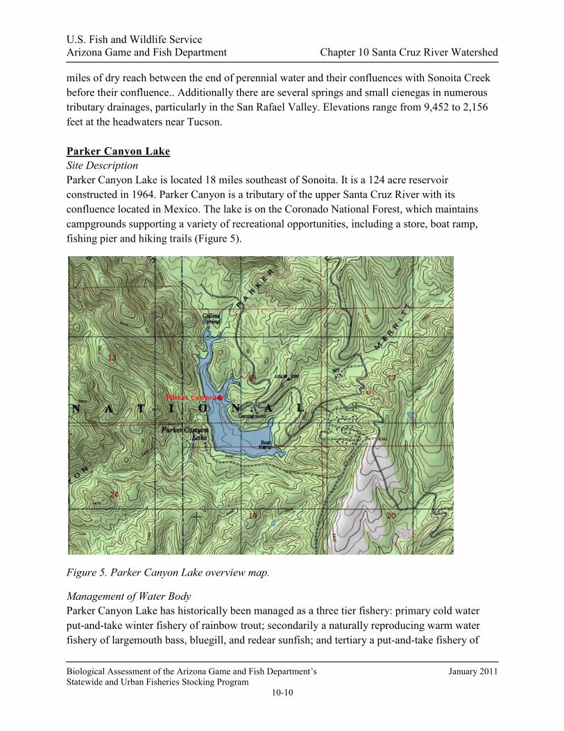
miles of dry reach between the end of perennial water and their confluences with Sonoita Creek before their confluence.. Additionally there are several springs and small cienegas in numerous tributary drainages, particularly in the San Rafael Valley. Elevations range from 9,452 to 2,156 feet at the headwaters near Tucson. Parker Canyon Lake Site Description Parker Canyon Lake is located 18 miles southeast of Sonoita. It is a 124 acre reservoir constructed in 1964. Parker Canyon is a tributary of the upper Santa Cruz River with its confluence located in Mexico. The lake is on the Coronado National Forest, which maintains campgrounds supporting a variety of recreational opportunities, including a store, boat ramp, fishing pier and hiking trails (Figure 5).
Figure 5. Parker Canyon Lake overview map.
Management of Water Body Parker Canyon Lake has historically been managed as a three tier fishery: primary cold water put-and-take winter fishery of rainbow trout; secondarily a naturally reproducing warm water fishery of largemouth bass, bluegill, and redear sunfish; and tertiary a put-and-take fishery of
U.S. Fish and Wildlife Service Arizona Game and Fish Department Chapter 10 Santa Cruz River Watershed
Biological Assessment of the Arizona Game and Fish Department’s January 2011 Statewide and Urban Fisheries Stocking Program
10-11
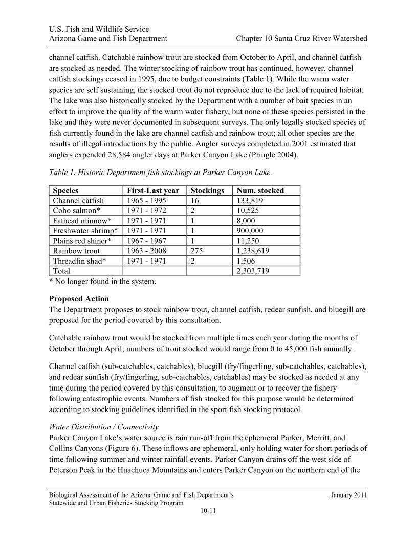
channel catfish. Catchable rainbow trout are stocked from October to April, and channel catfish are stocked as needed. The winter stocking of rainbow trout has continued, however, channel catfish stockings ceased in 1995, due to budget constraints (Table 1). While the warm water species are self sustaining, the stocked trout do not reproduce due to the lack of required habitat. The lake was also historically stocked by the Department with a number of bait species in an effort to improve the quality of the warm water fishery, but none of these species persisted in the lake and they were never documented in subsequent surveys. The only legally stocked species of fish currently found in the lake are channel catfish and rainbow trout; all other species are the results of illegal introductions by the public. Angler surveys completed in 2001 estimated that anglers expended 28,584 angler days at Parker Canyon Lake (Pringle 2004).
Table 1. Historic Department fish stockings at Parker Canyon Lake.
Species First-Last year Stockings Num. stocked Channel catfish 1965 - 1995 16 133,819 Coho salmon* 1971 - 1972 2 10,525 Fathead minnow* 1971 - 1971 1 8,000 Freshwater shrimp* 1971 - 1971 1 900,000 Plains red shiner* 1967 - 1967 1 11,250 Rainbow trout 1963 - 2008 275 1,238,619 Threadfin shad* 1971 - 1971 2 1,506 Total 2,303,719
* No longer found in the system.
Proposed Action The Department proposes to stock rainbow trout, channel catfish, redear sunfish, and bluegill are proposed for the period covered by this consultation.
Catchable rainbow trout would be stocked from multiple times each year during the months of October through April; numbers of trout stocked would range from 0 to 45,000 fish annually.
Channel catfish (sub-catchables, catchables), bluegill (fry/fingerling, sub-catchables, catchables), and redear sunfish (fry/fingerling, sub-catchables, catchables) may be stocked as needed at any time during the period covered by this consultation, to augment or to recover the fishery following catastrophic events. Numbers of fish stocked for this purpose would be determined according to stocking guidelines identified in the sport fish stocking protocol.
Water Distribution / Connectivity Parker Canyon Lake’s water source is rain run-off from the ephemeral Parker, Merritt, and Collins Canyons (Figure 6). These inflows are ephemeral, only holding water for short periods of time following summer and winter rainfall events. Parker Canyon drains off the west side of Peterson Peak in the Huachuca Mountains and enters Parker Canyon on the northern end of the

U.S. Fish and Wildlife Service Arizona Game and Fish Department Chapter 10 Santa Cruz River Watershed
Biological Assessment of the Arizona Game and Fish Department’s January 2011 Statewide and Urban Fisheries Stocking Program
10-12
lake. Collins Canyon, the second major tributary, is about 0.5 miles in length and drains rain runoff from a small portion of the watershed northwest of the lake. Merritt Canyon, the third major ephemeral tributary, enters from the east, and is about 4 miles in length.
Figure 6. Approximate location of Watershed above Parker Canyon Lake.
Parker Canyon Dam has an incorporated spillway for water overflow in periods of sustained heavy rainfall. Arizona Game and Fish Department engineers estimate that the lake will fill only 3 out of 10 years. There are no data for spill history. The drainage heads southwest for 10 miles to the Mexican border. Directly below the spillway, Parker Canyon is perennial for 1 mile. This perennial water is in pools supported by a spring that began producing surface flow during the construction of the dam in the 1960’s. The next 4.5 miles below the end of the perennial reach is ephemeral until it reaches another 0.25 mile stretch of perennial water (Figure 7). Past this point the reach is ephemeral for 6 miles, to the confluence with the Santa Cruz River in Mexico. At the confluence in Mexico the flows are intercepted by active agricultural fields (Figure 8).

U.S. Fish and Wildlife Service Arizona Game and Fish Department Chapter 10 Santa Cruz River Watershed
Biological Assessment of the Arizona Game and Fish Department’s January 2011 Statewide and Urban Fisheries Stocking Program
10-13
Figure 7. Watershed below Parker Canyon Lake, showing neighboring and downstream watersheds.
Figure 8. Aerial photo of the confluence of Parker Canyon and the Santa Cruz River in Mexico.
Fish Movement Parker Canyon contains a series of fish barriers, 0.25 miles upstream of the confluence with the lake (Figure 9), in addition to the absence of perennial water; therefore fish cannot move up or
Santa Cruz River channel
Lower end of Parker Canyon
US-Mexico Border

U.S. Fish and Wildlife Service Arizona Game and Fish Department Chapter 10 Santa Cruz River Watershed
Biological Assessment of the Arizona Game and Fish Department’s January 2011 Statewide and Urban Fisheries Stocking Program
10-14
persist. The other inflows, while not containing fish barriers, are ephemeral and have broad sandy bottoms that do not hold water long enough to sustain fish.
Figure 9. Natural barriers in Parker Canyon ¼ mile above Parker Canyon Lake.
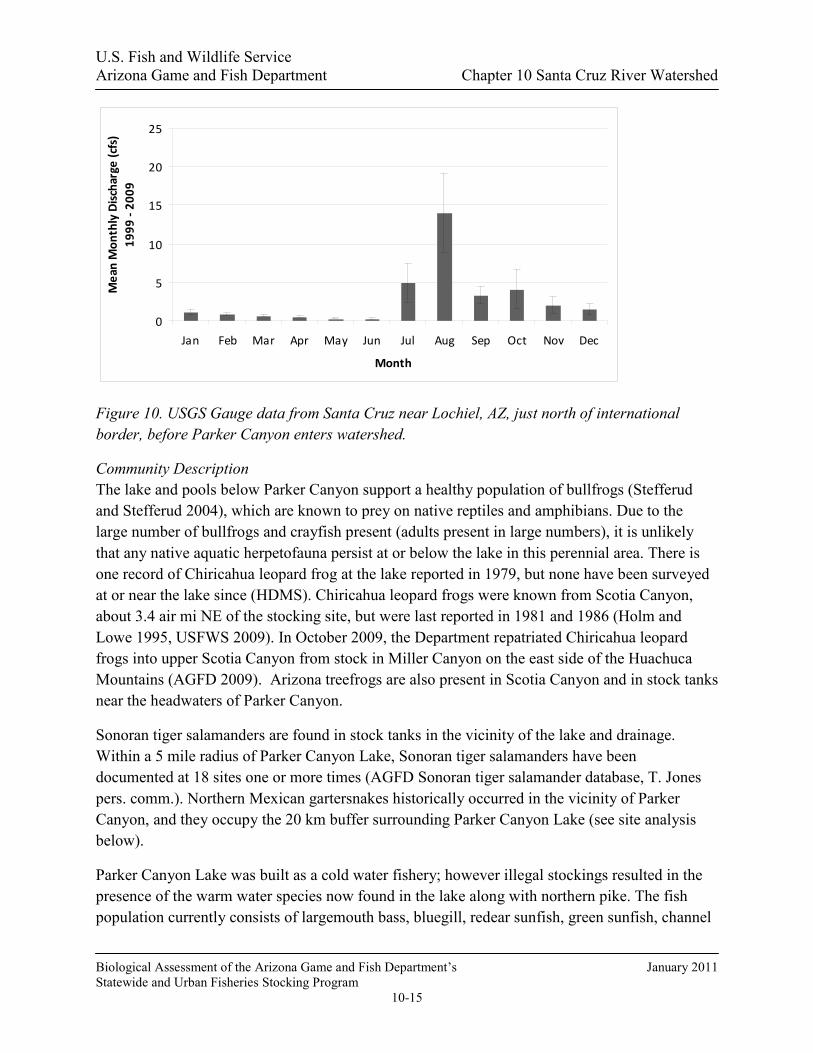
There is potential for fish to spill from Parker Canyon Lake. The perennial reach below the dam maintains water, mostly in two large pools. Beyond these pools, all but 0.25 miles of the 12 mile drainage is ephemeral, to its confluence with the Santa Cruz River in Mexico, and contains no suitable habitat for stocked fish. Shortly before the confluence with the Santa Cruz, the drainage gets very broad and there are several small channels that could allow fish to reach the Santa Cruz River directly during periods of low sustained flows. However, during heavy flows typically associated with monsoonal events, because the channel is poorly defined it is more likely fish and water could become spread on the numerous active agricultural fields located directly in the confluence of Parker Canyon and the Santa Cruz River (Figure 8). Above the confluence of Parker Canyon and the Santa Cruz, flows are minimal except during the monsoon season, as shown by the USGS gauge (Figure 10).
U.S. Fish and Wildlife Service Arizona Game and Fish Department Chapter 10 Santa Cruz River Watershed
Biological Assessment of the Arizona Game and Fish Department’s January 2011 Statewide and Urban Fisheries Stocking Program
10-15
Figure 10. USGS Gauge data from Santa Cruz near Lochiel, AZ, just north of international border, before Parker Canyon enters watershed.
Community Description The lake and pools below Parker Canyon support a healthy population of bullfrogs (Stefferud and Stefferud 2004), which are known to prey on native reptiles and amphibians. Due to the large number of bullfrogs and crayfish present (adults present in large numbers), it is unlikely that any native aquatic herpetofauna persist at or below the lake in this perennial area. There is one record of Chiricahua leopard frog at the lake reported in 1979, but none have been surveyed at or near the lake since (HDMS). Chiricahua leopard frogs were known from Scotia Canyon, about 3.4 air mi NE of the stocking site, but were last reported in 1981 and 1986 (Holm and Lowe 1995, USFWS 2009). In October 2009, the Department repatriated Chiricahua leopard frogs into upper Scotia Canyon from stock in Miller Canyon on the east side of the Huachuca Mountains (AGFD 2009). Arizona treefrogs are also present in Scotia Canyon and in stock tanks near the headwaters of Parker Canyon.
Sonoran tiger salamanders are found in stock tanks in the vicinity of the lake and drainage. Within a 5 mile radius of Parker Canyon Lake, Sonoran tiger salamanders have been documented at 18 sites one or more times (AGFD Sonoran tiger salamander database, T. Jones pers. comm.). Northern Mexican gartersnakes historically occurred in the vicinity of Parker Canyon, and they occupy the 20 km buffer surrounding Parker Canyon Lake (see site analysis below).
Parker Canyon Lake was built as a cold water fishery; however illegal stockings resulted in the presence of the warm water species now found in the lake along with northern pike. The fish population currently consists of largemouth bass, bluegill, redear sunfish, green sunfish, channel
0
5
10
15
20
25
Jan Feb Mar Apr May Jun Jul Aug Sep Oct Nov Dec
Month
Mea
n M
onth
ly D
isch
arge
(cfs
)19
99 -
2009

U.S. Fish and Wildlife Service Arizona Game and Fish Department Chapter 10 Santa Cruz River Watershed
Biological Assessment of the Arizona Game and Fish Department’s January 2011 Statewide and Urban Fisheries Stocking Program
10-16
catfish, black bullhead, mosquitofish, and northern pike. Coho salmon, red shiner, threadfin shad, and fathead minnows have all been stocked at the lake, but none of these species have been documented in biannual surveys. Catchable sized rainbow trout are stocked in the winter months from October through April. Rainbow trout do carry over in the cool deep waters of the hypolimnion, but they cannot spawn due to lack of appropriate habitat. Northern pike were illegally introduced in the late 1990’s. Reproduction of this species has only been documented in 1999, even though electrofishing and gill net surveys are done each year.
Surveys of Parker Canyon downstream of the dam were completed in 1997 and 2004. In 1997, the fish population consisted of green sunfish, largemouth bass, and bluegill, within the 1 mile perennial section of Parker Canyon directly below the lake (D. Mitchell, pers. comm.). A 2004 survey of the drainage below the lake to Mexico showed the fish community consisted of green sunfish, largemouth bass, mosquitofish, and longfin dace in the two perennial reaches (Stefferud and Stefferud 2004).
Catfish species have never been documented within the perennial section of Parker Canyon (Stefferud and Stefferud 2004; D. Mitchell pers. comm.). In 20 plus years of annual sampling by the Department Gila chub and topminnow have never been found at Parker Canyon Lake or in Parker Canyon. The closest population of both species is 18 drainage miles from the stocking location, in a couple of springs in the San Rafael Valley, upstream of the confluence with the Santa Cruz and agricultural fields. No stocked species have ever been documented in these springs (Simons 1987; Bagley et al 1991; Weedman and Young 1997; Voeltz and Bettaso 2003; Table 3).
The Department monitors about 200 stock tanks for Sonoran tiger salamanders in the Santa Cruz drainage of the San Rafael Valley and surrounding foothills on a variable and rotating basis. Most of these tanks are actively managed for Sonoran tiger salamanders by the Department and cooperators. Although managed for Sonoran tiger salamanders, a few of these tanks still harbor sport fish species and could be contributing fish to the Santa Cruz River (Figure 11). Of those tanks, Ridge Tank has been known to support bass and bluegill sunfish species continuously since at least 1997; 3 tanks have supported both bluegill and green sunfish and bullhead catfish at least until 2002 or 2003, but each of those has been fishless since then and has supported Sonoran tiger salamanders in the last five years; 6 tanks had fish in the 1990’s but have not supported fishes in the last 5 years and at least 2 have had Sonoran tiger salamanders in the last 10 years; 2 others supported unidentified centrarchids and catfish (probably bullheads) in 1999 and 2001, respectively, but have not been sampled since (AGFD Sonoran tiger salamander database, T. Jones pers. comm.).
Table 2. Fish collected during Parker Canyon electrofishing surveys 2008.

U.S. Fish and Wildlife Service Arizona Game and Fish Department Chapter 10 Santa Cruz River Watershed
Biological Assessment of the Arizona Game and Fish Department’s January 2011 Statewide and Urban Fisheries Stocking Program
10-17
Species Num. Sampled Largemouth Bass 177 Bluegill 69 Redear Sunfish 14 Green Sunfish 29
Figure 11. Named stock tanks in the headwaters of the Santa Cruz drainage that are known to support fish populations. More stock tanks exist, but are not named or mapped.
Table 3. Aquatic fauna captured 2009 from the upper Santa Cruz Basin above the Mexico border (Ehret 2009).
Location Methods Green Sunfish
Mosquitofish Gila Chub
bullfrog Sonoran mud turtle
Santa Cruz at Corral
5 hoop nets 4 minnow traps
33 64 0 6 3
Santa Cruz at Corral
2 seine hauls 3 155 0 8 0
Santa Cruz 2 seine hauls 77 10 0 6 0

U.S. Fish and Wildlife Service Arizona Game and Fish Department Chapter 10 Santa Cruz River Watershed
Biological Assessment of the Arizona Game and Fish Department’s January 2011 Statewide and Urban Fisheries Stocking Program
10-18
Location Methods Green Sunfish
Mosquitofish Gila Chub
bullfrog Sonoran mud turtle
at Duquesne Bridge Santa Cruz at Border
3 minnow traps
4 4 0 0 0
Santa Cruz at Border
1 seine haul 1 63 0 24 0
Heron Spring
2 minnow traps
0 0 0 0 0
Sheehy Spring
4 minnow traps 3 hoop nets
0 0 385 11 0
Total 118 296 385 55 3
Consultation Species and Critical Habitat Potential impacts to the Arizona treefrog distinct population segment, Chiricahua leopard frog, Gila chub, Gila topminnow, northern Mexican gartersnake and Sonoran tiger salamander are addressed below.
Potential impacts from the proposed action to candidate and listed species are described below. Please refer to Chapter 4 for a detailed description of the nature of the impacts (which may include predation, competition for space and food, and hybridization etc.).Subsequent responses (resulting from the frequency, magnitude and duration of the impacts) between proposed stocked and candidate and listed species, and any site or complex factors that provide context for determining the meaningfulness of the impacts, are discussed below. Impacts from the proposed action resulting from angler related recreation and/or potential introduction of disease, pathogen or invasive species are evaluated at a broad scale for the entire action area and are described in Chapter 4. If potential impacts specific to a stocking site or complex have been identified they are discussed below.
The lake and pools below Parker Canyon support a healthy population of bullfrogs (Stefferud and Stefferud, 2004), which are known to prey on native reptiles and amphibians. Due to the large number of bullfrogs and crayfish present (adults present in large numbers), it is unlikely that any native aquatic herpetofauna persist at or below the lake in this perennial area.
Chiricahua leopard frogs are analyzed at a site, complex and broad scale level due to the movement potential into the stocked area and fish movement potential up or downstream into areas where frogs may occur.
Northern Mexican gartersnakes are analyzed on a complex and downstream scale due to the movement potential into the stocked area and fish movement potential up or downstream into areas where the snakes may occur.

U.S. Fish and Wildlife Service Arizona Game and Fish Department Chapter 10 Santa Cruz River Watershed
Biological Assessment of the Arizona Game and Fish Department’s January 2011 Statewide and Urban Fisheries Stocking Program
10-19
Arizona Treefrog Site-Specific Analysis: The distribution of Arizona treefrogs in and around the Huachuca Mountains is incompletely understood (USFWS 2008h). Arizona treefrogs occur within 1.2 miles of Parker Canyon Lake, and most of the known extant localities are within about 5 miles, all of which are east, northeast or north of the lake in the headwaters of Turkey Creek and in the Scotia Canyon drainage (USFWS 2008h). Nearest known breeding sites include Hannah Tank (1.05 mi [1.7 km] E of Parker Canyon Lake) and Whiner Tank (1.8 mi [2.9 km] N of Parker Canyon Lake); other nearby sites include those in Scotia Canyon northeast of the lake (> 1.9 mi [> 3 km]) (USFWS 2008h). There have been no systematic surveys specifically for Arizona treefrogs at or around Parker Canyon Lake. Stock tanks within a 5 mile radius of Parker Canyon Lake (n = 29), many of which could provide breeding habitat for Arizona treefrogs, were sampled over 200 times from 1999 – 2008, and most were surveyed multiple times (range 1 – 22) (AGFD Sonoran tiger salamander database, T. Jones pers. comm.). However, many of those surveys were conducted in months during which Arizona treefrogs would not have been active, so it is unclear how effective the surveys might have been. In 2008 – 2009, there were numerous surveys in upper Scotia Canyon during efforts to eliminate bullfrogs from its perennial waters (T. Jones pers. comm.), and reproductively active Arizona treefrogs were documented in 2008 (Jones and Timmons in review). Stefferud and Stefferud and Stefferud (2004), conducted fish surveys of pools in Parker Canyon below the lake, and although those surveys were conducted in May before treefrogs would be reproductively active, bullfrogs were abundant at all sites making the habitat unsuitable for treefrogs.
There are no movement data to evaluate the extent to which Arizona treefrogs disperse away from breeding ponds, so the extent to which they are likely to move to sites with stocked fish is unknown. Studies of other, ecologically similar and similarly-sized species of hylid frogs provide a conservative basis for comparison. Maximum movement distances have been reported for pine barrens treefrogs (102 m), gray treefrogs (about 300 m) and western chorus frogs (about 200 m) (Freda and Gonzalez 1986, Johnson et al. 2007, Kramer 1973), all of which breed in ephemeral waters and spend most of the non-breeding season feeding in adjacent forests. Importantly, all of those species occur in more mesic habitats in the eastern U.S., which would presumably facilitate more lengthy terrestrial movements. Thus, we conservatively suggest that Arizona treefrogs might move up to 300 m from breeding sites. Although the known sites listed above are farther than 300 m from Parker Canyon Lake, we do not know if there are populations of Arizona treefrogs closer to the lake. Thus, it is possible that Arizona treefrogs could enter Parker Canyon Lake and be preyed upon by stocked fish or their progeny. Broad Scale Analysis: Parker Canyon Lake discharges into Parker Canyon. There are no records of Arizona treefrogs downstream from Parker Canyon Lake (HDMS, USFWS 2008), and therefore no downstream exposure to dispersing fish is anticipated.

U.S. Fish and Wildlife Service Arizona Game and Fish Department Chapter 10 Santa Cruz River Watershed
Biological Assessment of the Arizona Game and Fish Department’s January 2011 Statewide and Urban Fisheries Stocking Program
10-20
Chiricahua Leopard Frog Local Analysis: The Parker Canyon Lake buffered stocking site is within the historical range of the Chiricahua leopard frog, and the buffered stocking site is currently occupied by Chiricahua leopard frogs (Figure 12; AGFD Riparian Herpetofauna Database, V. Boyarski pers. comm.). Parker Canyon Lake is located within the Upper San Pedro-Santa Cruz Recovery Unit. Within the buffered stocking complex there are historical records for Chiricahua leopard frogs from Parker Canyon Lake (no date) (reported in Platz and Mecham 1979). Chiricahua leopard frogs occurred in upper Scotia Canyon, about 3.4 air mi NE of the stocking site, and were last reported in 1981 and 1986 (Holm and Lowe 1995, USFWS 2009). AGFD, with partners in USFWS and USFS repatriated Chiricahua leopard frogs into the upper reaches of Scotia Canyon in October 2009 (AGFD 2009).
There have been no systematic surveys for Chiricahua leopard frogs at Parker Canyon Lake. Surveys of Parker Canyon below the lake have only documented bullfrogs (Stefferud and Stefferud 2004), and bullfrogs occupy the lake. Stock tanks within the buffered stocking site (n = 29) have been sampled over 200 times from 1999 – 2008, and most were surveyed multiple times (range 1 – 22) (AGFD Sonoran tiger salamander database, T. Jones pers. comm.). No Chiricahua leopard frogs were reported during those surveys. In 2008 – 2009 there were numerous surveys in upper Scotia Canyon during efforts to eliminate bullfrogs from its perennial waters (T. Jones pers. comm.), but no Chiricahua leopard frogs were seen.
Scotia Canyon is a tributary to Bodie Canyon which lies approximately parallel to Parker Canyon to the southeast. Bodie Canyon is an ephemeral drainage that flows into the Santa Cruz River south of the Parker Canyon – Santa Cruz confluence. The upper part of Scotia Canyon includes an approximately 1.5 mi permanent reach, below which the canyon is intermittent (Stefferud and Stefferud 2004). It is logical to assume that once leopard frogs are established, they will occupy much or all of the perennial reach of Scotia Canyon.
There are two logical routes by which Chiricahua leopard frogs might access Parker Canyon Lake from the lower end of the perennial Scotia Canyon reach. Dispersing frogs could either travel about 0.7 miles overland into Merritt Canyon and then about 2.3 mi down that ephemeral canyon to the lake, or travel about 3.8 mi through seasonally dry Scotia Canyon to a point closest to and about 1.0 mi overland from Parker Canyon Lake. The topography surrounding Scotia Canyon is relatively rugged, and would likely impede movement of leopard frogs. Therefore, the likelihood of exposure of dispersing Chiricahua leopard frogs to stocked fish in Parker Canyon Lake is moderate.
Broad Scale Analysis: Below Parker Canyon Lake there are Chiricahua leopard frog records from seven sites in the upper Santa Cruz River drainage in the San Rafael Valley. Five sites include no records more recent than 1985, and all of them have supported bullfrogs at some time in the last 20 years (AGFD Riparian Herpetofauna Database, AGFD Sonoran Tiger Salamander

U.S. Fish and Wildlife Service Arizona Game and Fish Department Chapter 10 Santa Cruz River Watershed
Biological Assessment of the Arizona Game and Fish Department’s January 2011 Statewide and Urban Fisheries Stocking Program
10-21
Database, T. Jones pers. comm.). In 1995, Chiricahua leopard frogs were recorded at three stock tanks west of the Santa Cruz River, in the southern part of the Valley. Each of those tanks empties into ephemeral washes, and are over four “wash” miles from the river. The latter two tanks drain into washes that enter the Santa Cruz River 0.86 and 1.39 miles south of the international boundary, respectively. There have been no reports of Chiricahua leopard frogs in the Santa Cruz River mainstem or its perennial tributaries in 25 years. AGFD has systematically surveyed for Sonoran tiger salamanders for most of the last 10 years, which since 2004 has included a randomized sampling design that covers nearly 200 sites in the San Rafael Valley and surrounding foothills (including the three tanks referenced above) (AGFD Sonoran Tiger Salamander Database, T. Jones pers. comm.). No Chiricahua leopard frogs have been found since 1995. AGFD, with partners in USFWS and USFS repatriated Chiricahua leopard frogs into a frog-fenced stock tank on private land in the San Rafael Valley in October 2009 (AGFD 2009). In all cases in which Chiricahua leopard frogs have been reported from stock tanks, those tanks drain into ephemeral washes through which fish would not be able to travel. Therefore, stocked fish that might escape from Parker Canyon Lake would not encounter frogs at those tanks, nor are they likely to encounter Chiricahua leopard frogs in the San Rafael Valley. Because there are no known free-living Chiricahua leopard frogs in the San Rafael Valley, it is not likely that dispersing leopard frogs would encounter stocked fish that might escape into the upper Santa Cruz River.

U.S. Fish and Wildlife Service Arizona Game and Fish Department Chapter 10 Santa Cruz River Watershed
Biological Assessment of the Arizona Game and Fish Department’s January 2011 Statewide and Urban Fisheries Stocking Program
10-22
Figure 12. Map of Upper and Lower Sub-Complex of the Santa Cruz River Watershed buffered stocking complex:
The purple line illustrates the 5 mile buffer surrounding a stocking site, stocking reach, or a group of stocking sites. Blue lines symbolize streams and rivers (both perennial and intermittent). A black line represents a Chiricahua leopard frog Recovery Unit boundary. The background color represents the 8 digit Hydrologic Unit Code. Other data are described in the legend. (Note: HDMS data appear as buffered points and may appear larger than site records for other surveys).
Gila Chub The closest population of Gila chub is located at Sheehy Spring in the San Rafael Valley, approximately 18 drainage miles from the lake.
Potential Impacts The proposed activity is not anticipated to impact the Gila chub, as the nearest population occurs over 18 drainage miles from the lake within in a somewhat isolated spring. Impacts are extremely unlikely to occur because the stocked species would have to escape into Parker Canyon, persist through the 12 miles of ephemeral reaches, and end up in the mainstem of the

U.S. Fish and Wildlife Service Arizona Game and Fish Department Chapter 10 Santa Cruz River Watershed
Biological Assessment of the Arizona Game and Fish Department’s January 2011 Statewide and Urban Fisheries Stocking Program
10-23
Santa Cruz River in Mexico. Once in Mexico, during periods of heavy flow water would likely inundate active agricultural fields located at the confluence causing fish to be washed into these fields as well. During periods of slower flow, it is likely fish and water could stay contained in the small ephemeral channel and end up in the Santa Cruz River. From this point, fish would then have to swim upstream in the main channel of the river and eventually find their way into the small side channel that would allow access to the small side drainage in which Sheehy spring is located.
The potential for Gila chub to be washed out of Sheehy Spring in the Santa Cruz River where they could come in contact with escaped stocked species is extremely unlikely. The small drainage that Sheehy Spring is located in has a diversion located upstream of the spring that collects rain runoff and likely prevents large amounts of water form flushing through the small channel down where the spring is located. However if severe flood conditions lasted long enough for chub to wash from Sheehy Spring and stocked fish from Parker Canyon, and both fish survive, the two could coexist in the Santa Cruz, where impacts due to predation and/or competition for resources may occur. This would be very unlikely based on the low potential for connectivity and ephemeral barriers within the system, as well as the sediment load and debris associated with such a flood precluding fish survival. Furthermore, it would be extremely difficult to determine the source of sport fish in such an event due to the presence of stock tanks that harbor non native fish species (Figure 11) as well as the presence of many of the same non native fish species within the Santa Cruz River in Mexico. There are no known angling opportunities in the Santa Cruz or the lower end of the Parker Canyon drainage due to the ephemeral nature of the drainages and the lack of habitat for sport fish to persist. Some angling does occur in the Parker Canyon drainage directly below the lake however. No impacts due to angling in these areas outside of the lake are anticipated.
Gila Topminnow The closest known population of Gila topminnow was located in Sharp Spring and Heron Spring in the San Rafael Valley; approximately 18 miles downstream of the lake (see previous Gila chub discussion). Topminnows have also been documented downstream in the Santa Cruz River in Mexico. Suitable habitat is present for the Gila topminnow in the Santa Cruz River in the U.S. but has not been detected in the river since 1993 (Weedman and Young 1997; Voeltz and Bettaso 2003). The last known occurrences in the San Rafael Valley were in 1999 in Sharp Spring and 2003 in Heron Spring (Voeltz and Bettaso 2003).
Potential Impacts Impacts could potentially occur over time only if the stocked species were able to escape into the mainstem of the Santa Cruz and persist, moving down into Mexico (see Gila Chub above). It is unlikely that connectivity would persist long enough for exposure would occur. For potential impacts in the Santa Cruz River, refer to the Upper Santa Cruz River complex analysis.

U.S. Fish and Wildlife Service Arizona Game and Fish Department Chapter 10 Santa Cruz River Watershed
Biological Assessment of the Arizona Game and Fish Department’s January 2011 Statewide and Urban Fisheries Stocking Program
10-24
Northern Mexican Gartersnake Stocking Site Analysis: Northern Mexican gartersnakes occupy the 20 km buffer surrounding Parker Canyon Lake. There are recent (1986), verified observations of northern Mexican gartersnakes from Parker Canyon Lake (HDMS, Rosen and Schwalbe 1988). There also is an unsubstantiated observation of an individual from the lake in 2006 (V. Boyarski, pers.comm.). The presence of crayfish and bullfrogs at the lake make the habitat less suitable for northern Mexican garternakes, but the snakes may persist there in low numbers. There also are recent (2008, 2009) records of the species from nearby upper Scotia Canyon (about 3.4 air mi NE of the stocking site), Turkey Creek (approx. 8.7 air mi away; 1985, 2008, 2009), and Canelo Hills (approx. 7.5 air mi away; 1992) (HDMS, V. Boyarski pers. comm.). There also are recent northern Mexican gartersnake observations from the San Rafael Valley (1986, 2007), the Santa Cruz River (1986, 2000, 2005), northern (1994) and eastern (1987) Huachuca Mountains (HDMS), which represent surrounding drainages but are within the buffer and therefore within possible dispersal distance. It is likely that northern Mexican gartersnakes will be exposed to sportfish stocked into Parker Canyon Lake because the snakes might occupy the lake, and because northern Mexican gartersnakes might disperse to the lake from surrounding populations.
Downstream Analysis: Northern Mexican gartersnakes could be exposed to stocked sport fish that escape from Parker Canyon Lake and disperse downstream along Parker Canyon to the Santa Cruz River because northern Mexican gartersnakes occupy the Santa Cruz River above the international border in the San Rafael Valley (HDMS, V. Boyarski). Because there are recent (1986, 2000, 2005) records of northern Mexican gartersnakes from the Santa Cruz River upstream of the International Border, it is likely that northern Mexican gartersnakes also occupy the river in Mexico and snakes could be exposed to dispersing stocked sport fish (HDMS). However, no known recent surveys have been conducted in Mexico.
Sonoran Tiger Salamander Site-specific Analysis: Sonoran tiger salamanders occur in and around stock tanks near Parker Canyon Lake within the upper Santa Cruz River watershed. Breeding populations of Sonoran tiger salamanders are found in stock tanks throughout the San Rafael Valley and in much of the Canelo Hills. Sonoran tiger salamander sites have been surveyed since the 1980s, although earlier sampling was directed at selected sites (Collins et al. 1988, Jones et al. 1988, AGFD Sonoran Tiger Salamander Database). AGFD has systematically surveyed for Sonoran tiger salamanders for most of the last 10 years (AGFD Sonoran Tiger Salamander Database). Stock tanks within an approximately 5 mile radius of Parker Canyon Lake (n = 30) have been sampled over 200 times from 1999 – 2008, and most were surveyed multiple times (range 1 – 22). Sonoran tiger salamanders have been documented at 18 of those sites one or more times (AGFD Sonoran tiger salamander database, T. Jones pers. comm.). Salamanders have never been documented at Parker Canyon Lake (HDMS), and in the San Rafael Valley they have never been documented in perennial waters other than stock tanks.

U.S. Fish and Wildlife Service Arizona Game and Fish Department Chapter 10 Santa Cruz River Watershed
Biological Assessment of the Arizona Game and Fish Department’s January 2011 Statewide and Urban Fisheries Stocking Program
10-25
There are few data to evaluate the extent to which metamorphosed Sonoran tiger salamanders move away from breeding ponds. But, marked Sonora tiger salamanders have been found 0.9 and 1.2 miles from tanks where they had been found the previous spring, and others have been found 1.9 – 2.5 miles from the nearest potential source population (Maret et al. 2006). The sites nearest to Parker Canyon Lake that have been known to support Sonoran tiger salamanders and their straight-line distances from the lake include: Hannah Tank (1.1 mi), Heidi Tank (1.75 mi), High Berm Tank (1.7 mi), Dinner Tank (2.1 mi) and Bill Woods Tank (2.6 mi), all of which are presumably close enough for salamanders to disperse to Parker Canyon Lake. Consequently, it is possible that Sonoran tiger salamanders could enter Parker Canyon Lake, but we do not know how likely that would be. Broad Scale Analysis: Below Parker Canyon Lake there are extant Sonoran tiger salamander populations throughout the upper Santa Cruz River drainage in the San Rafael Valley (USFWS 2007, AGFD Sonoran Tiger Salamander Database). Except for one site in Scotia Canyon, in all cases in which Sonoran tiger salamanders have been reported from stock tanks, those tanks drain into ephemeral washes through which fish would not be able to travel even at exceptionally high water levels. Therefore, stocked fish that might escape from Parker Canyon Lake would not encounter salamanders at the tanks. Nonetheless, because tiger salamanders have been known to travel at least 2.5 miles from the nearest potential source population (Maret et al. 2006), it is possible that metamorphosed individuals might enter the Santa Cruz River, and there they might encounter non native fishes that are either resident in the Santa Cruz River, or have escaped from one of several stock tanks currently occupied by non natives or from Parker Canyon Lake. Peña Blanca Lake Site Description Peña Blanca Lake, a 50 acre lake created in 1957, is located approximately 12 miles northwest of Nogales in Peña Blanca Wash (Figure 13). The lake is on the Coronado National Forest, which maintains campgrounds and supports recreational opportunities. There is a boat ramp and fishing pier along with hiking trails. United States Forest Service drained the lake in 2008 to remove mercury contaminated sediment from the lake bottom. The project was completed in September 2009 and the lake refilled following significant winter rainfall in January 2010. The Service completed a consultation that allowed the Department to stock rainbow trout in the lake in the winter and spring 2010. The Forest Service is completing a consultation for the reestablishment of the warm water species that were present in the lake prior to their dredging project.

U.S. Fish and Wildlife Service Arizona Game and Fish Department Chapter 10 Santa Cruz River Watershed
Biological Assessment of the Arizona Game and Fish Department’s January 2011 Statewide and Urban Fisheries Stocking Program
10-26
Figure 13. Peña Blanca Lake drainage.
Management of Water Body Peña Blanca was historically managed as a two tiered fishery. The primary fishery was a naturally reproducing warm water fishery, and a secondary winter put-and-take trout fishery that was sustained with multiple stockings annually of catchable sized rainbow trout. While the warm water species are self sustaining, the stocked trout do not carry over due to warm water temperatures and do not reproduce due to lack of required habitat. Stocking history at the lake consists of sporadic warm water species stockings with regular winter trout stockings (Table 4). Fathead minnow and threadfin shad were stocked to increase the forage base, but these species did not persist. Angler surveys completed in 2001 estimated angler use days at 21,298 (Pringle 2004).
Table 4. Historic Department fish stockings at Peña Blanca Lake.
Species First Year Last Year Stockings Num. Stocked
Black crappie 1958 1958 2 64
Channel catfish 1958 1993 42 340,106
Crayfish 1991 1993 4 1,800

U.S. Fish and Wildlife Service Arizona Game and Fish Department Chapter 10 Santa Cruz River Watershed
Biological Assessment of the Arizona Game and Fish Department’s January 2011 Statewide and Urban Fisheries Stocking Program
10-27
Fathead minnow* 1991 1994 4 117,268
Largemouth bass 1958 1964 6 20,326
Rainbow trout 1959 2010 550 1,407,194
Threadfin shad* 1957 1958 4 16,000
Bullfrog Tadpole 1968 1971 4 7,800
Total 1,906,558
*Never documented as persisting in the lake.
Proposed Action The Department proposes to stock rainbow trout for the period covered by this consultation.
Catchable rainbow trout would be stocked from November to March multiple times each year; the numbers of trout stocked would range from 0 to 45,000 fish annually.
Water Distribution / Connectivity Peña Blanca Lake is a run-off fed reservoir with Peña Blanca Wash at its main tributary. The wash starts in Mexico and flows north for 4.5 miles before reaching Peña Blanca Lake. The canyon is ephemeral and only has water in it following rainfall events. Alamo Canyon, an ephemeral tributary to Peña Blanca Canyon, also starts in Mexico and is a major tributary; it often flows continuously throughout the summer monsoon season. These canyons join approximately 0.75 miles above Peña Blanca Lake.
Peña Blanca Dam has an incorporated spillway and does spill in high seasonal rains. The first mile downstream is a canyon that contains scattered pools of water that can persist throughout much of the year, except during the driest summer months. The next two miles downstream, the wash is ephemeral with a wide sandy bottom. Three miles downstream of the lake, the wash joins with Agua Fria Canyon, also an ephemeral drainage with a wide sandy bottom. The drainage continues another 4 miles before being intercepted by a large sand and gravel operation located within Agua Fria Canyon, where flow would spread over a thin sheet (Figure 14). The drainage leaving the sand and gravel operation continues 1.5 miles to the confluence with the Santa Cruz River. The Santa Cruz River is perennial at the confluence with Agua Fria Canyon due to sewage effluent releases from the City of Nogales.

U.S. Fish and Wildlife Service Arizona Game and Fish Department Chapter 10 Santa Cruz River Watershed
Biological Assessment of the Arizona Game and Fish Department’s January 2011 Statewide and Urban Fisheries Stocking Program
10-28
Figure 14. Aerial photo of sand and gravel operation that intercepts flow in Agua Fria Canyon downstream of Peña Blanca Lake.
Fish Movement During periods of flooding, it is unlikely fish could move upstream due the presence of a small fish barrier created by Arizona Hwy 289, also known as Ruby Road that crosses Peña Blanca Canyon just above the lake and creates a fish barrier with a three to four foot drop (Figure 15).

U.S. Fish and Wildlife Service Arizona Game and Fish Department Chapter 10 Santa Cruz River Watershed
Biological Assessment of the Arizona Game and Fish Department’s January 2011 Statewide and Urban Fisheries Stocking Program
10-29
Figure 15. Road Crossing above Peña Blanca Lake looking downstream.
Fish can spill from the reservoir during flood events. The first mile downstream contains pool habitat that is suitable for trout, except in summer months. These pools below the lake were surveyed in 1996 and 1997, and although fish had escaped from the lake, they did not reproduce or persist for more than a couple of months because the pools either dried up during the summer months or dissolved oxygen dropped to lethal levels for trout. Table 5 shows species occurrence documented below the lake during this survey (D. Mitchell, pers. comm.). Although rainbow trout have not been documented below the lake in these pools it is likely they do wash out of the lake however conditions are not adequate to support their survival as summer temperatures cause water temperatures to reach lethal limits for trout survival (D. Mitchell, pers. comm.). Beyond the few pools immediately below the lake there is no perennial water in Peña Blanca Canyon, Agua Fria Canyon, or any of their tributaries. The ephemeral nature of the extensive sandy washes provides no habitat for fish. The gravel and sand operation in the drainage forces flows to a thin sheet that would not support fish movement, and any water would quickly be absorbed by the sand bottom. The lake was pumped dry during fall 2008 and winter 2009, and water flowed continuously over the spillway for 34 days. Even then, flows were only a trickle when they finally reached the bridge at I-19, and they were not enough to transport stocked species (J. Kline, pers. comm.). Furthermore, there are no records of stocked species occurring in the Santa Cruz River in the vicinity of the confluence of Agua Fria Canyon (HDMS).
Table 5. Species composition and distribution below Peña Blanca Lake 1996 and 1997.
Date Station 1 Station 2 Station 3 Station 4 Station 5 12/1996 No fish Dry Dry Dry Dry 01/1997 No fish Dry Dry Dry Dry 02/1997 Green sunfish, bluegill,
yellow bullhead, mosquitofish
No Fish Dry Dry Dry
03/1997 mosquitofish mosquitofish mosquitofish Dry Dry 04/1997 No Fish No fish No Fish Dry Dry 05/1997 Largemouth bass,
yellow bullhead, mosquitofish, bluegill
No fish Dry Dry Dry
09/1997 mosquitofish Dry Dry Dry Dry
Community Description Peña Blanca was filled by heavy winter rains in January 2010. Rainbow trout were stocked into the lake. Prior to draining and dredging, Peña Blanca’s fish population consisted of largemouth bass, bluegill, redear sunfish, green sunfish, black crappie, channel catfish, and black bullhead, but only four of these species were documented in 2008 surveys (Table 6). All of these species

U.S. Fish and Wildlife Service Arizona Game and Fish Department Chapter 10 Santa Cruz River Watershed
Biological Assessment of the Arizona Game and Fish Department’s January 2011 Statewide and Urban Fisheries Stocking Program
10-30
except bullhead catfish and green sunfish are proposed for restocking as part of the consultation being completed by the Forest Service. Prior to the populations being removed all of these species were reproducing in the lake. During the winter months of November through early March, the Department stocks catchable rainbow trout. These fish do not persist or reproduce in Peña Blanca, due to warm water temperatures and lack of habitat. Historically, the lake was stocked with a number of bait species in an effort to improve the quality of the warm water fishery; however, none of these species persisted in the lake and were never documented in subsequent surveys. Since 1993, the lake has only been stocked annually with rainbow trout in support of the trout fishery (Table 4).
Table 6. Fish Species collected in Peña Blanca Lake electrofishing surveys 2008.
Species Num. Sampled Largemouth Bass 182 Bluegill 103 Redear Sunfish 38 Black Crappie 14
Peña Blanca harbored a population of bullfrogs; however, during the dredging project steps were taken to attempt to remove them from the area to protect native ranid frog populations. At present it appears that the project has been successful and careful monitoring of aquatic habitats in the area should prevent them from recolonizing. Lowland leopard frogs are found in Peña Blanca Canyon about 1 mile above the lake at Peña Blanca Spring, and populations of Chiricahua leopard frogs have been known to occupy stock tanks near the headwaters of Alamo Canyon. In summer 2009 prior to the lake refilling, both species of leopard frog dispersed into the lake basin and occupied a pool that was fed by an apparently temporary spring that erupted in the lake bottom during the removal of sediment from the lake bottom. At present, it is not known if they continue to persist in the lake now that it has refilled completely.
Peña Blanca Lake lies within the potential historical range for Northern Mexican Gartersnakes, though they likely do not occupy the 20 km buffer surrounding the lake (see site analysis below), and there are no historical records near the lake.
Consultation Species or Critical Habitat Potential impacts to Chiricahua leopard frogs, Gila topminnow, Mexican spotted owl and northern Mexican gartersnake are discussed below.
Potential impacts from the proposed action to candidate and listed species are described below. Please refer to Chapter 4 for a detailed description of the nature of the impacts (which may include predation, competition for space and food, and hybridization etc.).Subsequent responses (resulting from the frequency, magnitude and duration of the impacts) between proposed stocked

U.S. Fish and Wildlife Service Arizona Game and Fish Department Chapter 10 Santa Cruz River Watershed
Biological Assessment of the Arizona Game and Fish Department’s January 2011 Statewide and Urban Fisheries Stocking Program
10-31
and candidate and listed species, and any site or complex factors that provide context for determining the meaningfulness of the impacts, are discussed below. Impacts from the proposed action resulting from angler related recreation and/or potential introduction of disease, pathogen or invasive species are evaluated at a broad scale for the entire action area and are described in Chapter 4. If potential impacts specific to a stocking site or complex have been identified they are discussed below.
Chiricahua and northern leopard frogs are analyzed at a local and broad scale level due to the movement potential into the stocked area and fish movement potential up or downstream into areas where frogs may occur.
Northern Mexican gartersnakes are analyzed on a complex and downstream scale due to the movement potential into the stocked area and fish movement potential up or downstream into areas where the snakes may occur.
Chiricahua Leopard Frog Local Analysis: Peña Blanca Lake is within the historical range of the Chiricahua leopard frog, and there is a high likelihood that Chiricahua leopard frogs will come into contact with fish stocked in the lake. There are historical and recent records (2010) for Chiricahua leopard frogs from the vicinity of Peña Blanca Lake and within the buffered stocking complex (Figure 12, AGFD Riparian Herpetofauna Database, HDMS, M. Sredl pers. comm., T. Jones pers. comm.). Peña Blanca Lake was completely drained and dried in 2008 – 2009, and sediments were removed. The lake refilled with heavy winter rains in January 2010.
A total of 73 sites have each been surveyed once within the buffered stocking site. Prior to 2006, 14 of 73 sites had each been surveyed one or more times (n = 57 surveys), and in 2008 – 2009 each of those 73 sites was surveyed from 1 – 13+ times, (n = 106+ surveys) (AGFD Riparian Herpetofauna Database, T. Jones pers. comm.). Chiricahua leopard frogs were documented at 9 sites, including five sites from 1993 through 2004, and four other sites in 2008-09. Each of those 9 currently or formerly occupied sites is upstream from Peña Blanca Lake. In 2008 – 2009, bullfrogs were systematically removed from within the buffered stocking site, thus making new and historical habitat available for colonization by Chiricahua leopard frogs. Subsequently in 2009, a Chiricahua leopard frog was found on Forest Rd. 39 where it crosses Peña Blanca Canyon, about 0.9 air mi upstream from the lake (C. Akins, A. Owens pers. comm.), and seven individuals were observed in a spring pool in the dried lake basin (T. Jones pers. comm.). The lake has not been surveyed for Chiricahua leopard frogs since it refilled.
Broad Scale Analysis: There are no historical records for Chiricahua leopard frogs below Peña Blanca Lake in or around Agua Fria Canyon. Agua Fria Canyon is ephemeral throughout its entire length from the mouth of Peña Blanca Canyon to the confluence with the Santa Cruz River. However, there were pools in Peña Blanca Canyon immediately below the lake, many of

U.S. Fish and Wildlife Service Arizona Game and Fish Department Chapter 10 Santa Cruz River Watershed
Biological Assessment of the Arizona Game and Fish Department’s January 2011 Statewide and Urban Fisheries Stocking Program
10-32
which supported non native fishes (presumably centrarchids) through June 2009 (T. Jones, C. Akins pers. comm.). Failure to identify these fish resulted in an inability to determine if they were stocked species or other wild centrarchids (i.e. green sunfish). The pools are unsuitable for Chiricahua leopard frogs to persist because of these nonnatives. Chiricahua leopard frogs immediately above the lake have the potential to occupy pools below the lake and additional sites around the lake that were previously occupied by bullfrogs. Thus, if fish were to disperse from Peña Blanca Lake, the likelihood that they would encounter Chiricahua leopard frogs would be high immediately below Peña Blanca Lake dam with a decreasing likelihood the further downstream from the dam you go because the habitats are not perennial and spilled fish would always eventually die from desiccation. Similarly, if fish escaped and occupied those pools below the lake, there would be a high likelihood that dispersing Chiricahua leopard frogs would encounter those fish.
Gila Topminnow The closest suitable habitat and documented occurrences for Gila topminnow occur in the Santa Cruz River approximately 7 miles downstream from the lake (refer to the Upper Santa Cruz River complex analysis). Upstream in the Santa Cruz from the confluence with the Agua Fria Canyon in Nogales Wash, topminnows were documented in 2002 (HDMS). Downstream near the confluence of the Santa Cruz and Negro Canyon, topminnows were documented in 2002 (HDMS).
Potential Impacts
The proposed activity is not anticipated to have impacts to topminnow due to the distance and conditions in the drainage (refer to fish movement discussion). In the unlikely event trout were able to access the Santa Cruz River mainstem and move into occupied topminnow habitat, potential impacts may include predation and competition for space. Trout would not be anticipated to have long-term persistence due to the elevated water temperatures in the late spring and early fall causing mortality. Refer to the Upper Santa Cruz River complex analysis for further information.
Mexican Spotted Owl Critical Habitat This stocking location is within Mexican spotted owl (MSO) critical habitat (CH).
Potential Impacts The CH designation included most other protected and restricted habitats for the MSO. Indirect effects to CH may include actions that can affect forest structure and maintenance of adequate prey species identified as PCEs. These actions may include trampling of vegetation, soil compaction, removal of small woody debris or other physical degradation potentially altering the productivity and succession/regeneration of the vegetation. In the designation of critical habitat (USFWS 2004) most recreational activities, including angling, were not identified as requiring

U.S. Fish and Wildlife Service Arizona Game and Fish Department Chapter 10 Santa Cruz River Watershed
Biological Assessment of the Arizona Game and Fish Department’s January 2011 Statewide and Urban Fisheries Stocking Program
10-33
restrictions to protect the PCE’s of critical habitat from destruction or adverse modification. In making that statement, recreational activities, including angling were assumed to not contribute to significant habitat-affecting activities such as cutting large trees or snags, removal of large woody debris from the forest floor, altering the tree species diversity, or other large-scale changes to habitat structure. The act of a relatively small number of people walking through habitat is not likely to cause the kind of effects that would result in adverse effects to the PCEs/KHCs of MSO CH and/or restricted and protected habitats.
Northern Mexican Gartersnake Site-Specific Analysis: Although Peña Blanca Lake lies within the potential historical range of northern Mexican gartersnakes, there are no known records of the species from the lake (HDMS, AGFD Riparian Herpetofauna Database). Within the 20 km buffer surrounding Peña Blanca Lake, there are historical records of northern Mexican gartersnakes along the Santa Cruz River at Portrero Canyon (1956), near Tumacacori National Monument (1970), and just outside the 20 km buffer at Tubac (1942) (HDMS). There is also a historical (1941) record along Forest Service Road 39, west of Ruby (AGFD Riparian Herpetofauna Database). There are no recent records of northern Mexican gartersnakes within the 20 km buffer surrounding Peña Blanca Lake, and it is unlikely that they occupy the buffered stocking complex, though no systematic surveys for gartersnakes have been conducted in this area. Therefore, it is unlikely that northern Mexican gartersnakes will be exposed to sport fish stocked into Peña Blanca Lake.
Downstream Analysis: As mentioned in the Fish Movement section, downstream dispersal of stocked sport fish would occur when heavy rains caused the lake to overflow, and fish survival would be limited to pools immediately below the dam. The Agua Fria Canyon below Peña Blanca Lake is ephemeral and there are no records of stocked species occurring in the Santa Cruz River in the vicinity of the confluence of Agua Fria Canyon (HDMS). Additionally, northern Mexican gartersnakes are likely extirpated from the Santa Cruz River downstream of the buffered stocking complex (HDMS). Therefore, it is unlikely that northern Mexican gartersnakes would be exposed to dispersing stocked sport fish that escape from Peña Blanca Lake.
Patagonia Lake Site Description Patagonia Lake is a 265 surface acre reservoir with a storage right and water right for 11,420 acre-feet for recreation and wildlife uses. The lake is located 10 miles east of Nogales in Santa Cruz County. Patagonia Lake and the associated recreation facilities were constructed in the late 1960’s by the Lake Patagonia Recreation Association, Inc. The lake and its facilities became an Arizona State Parks property in the mid 1970’s. Since that time, the lake has been managed cooperatively between Arizona State Parks and the Department.

U.S. Fish and Wildlife Service Arizona Game and Fish Department Chapter 10 Santa Cruz River Watershed
Biological Assessment of the Arizona Game and Fish Department’s January 2011 Statewide and Urban Fisheries Stocking Program
10-34
Patagonia Lake is located within Patagonia Lake State Park and is a recreational destination in that includes trails, campgrounds, boat ramps, store, marina, and a swim beach.
Management of Water Body The primary fishery at Patagonia Lake is a naturally reproducing warm water fishery, and as secondary fishery an intensive winter put-and-take rainbow trout fishery with stockings occurring multiple times annually. While the warm water species are self-sustaining, the stocked trout do not persist due to warm water temperatures, nor reproduce due the lack of required spawning habitat. Stocking history at the lake consists of sporadic warm water species stockings with regular winter trout stockings (Table 7).
Table 7. Historic Department fish stocking at Patagonia Lake.
Species First Year Last Year Stockings Num. Stocked
Brook trout* 1977 1977 1 8,500
Channel catfish 1977 1984 3 47,000
Largemouth bass 1977 1977 3 8,464
Rainbow trout 1976 2007 227 645,494
Redear sunfish 1977 1978 4 20,388
Threadfin shad 1979 1979 2 3,400
Total 733,246
*No longer found in this location.
Angler surveys conducted at the lake in 2002, show that the lake provides approximately 21,298 angler days per year (Pringle 2004).
Proposed Action The Department proposes to stock rainbow trout, are proposed for the period covered by this consultation.
Catchable rainbow trout would be stocked from November to March multiple times each year; the numbers of trout stocked would range from 0 to 30,000 fish annually.
Water Distribution / Connectivity The lake’s water source is precipitation runoff from Sonoita Creek and Ash Canyon, and treated effluent flowing down Sonoita Creek from the town of Patagonia. Sonoita Creek is perennial

U.S. Fish and Wildlife Service Arizona Game and Fish Department Chapter 10 Santa Cruz River Watershed
Biological Assessment of the Arizona Game and Fish Department’s January 2011 Statewide and Urban Fisheries Stocking Program
10-35
from the Town of Patagonia, approximately seven miles upstream, where the town releases treated effluent into Sonoita Creek, to near the inlet at the lake. This water from the town’s water treatment plant keeps this portion of the creek perennial for all but the driest parts of the driest years. There are several tributaries to Sonoita Creek: Redrock Canyon, Temporal Gulch, Big Casa Blanca Canyon, Harshaw Canyon, and Cottonwood Spring, which contain perennial water and native fish populations. However, these perennial waters are all separated from Sonoita Creek by several-mile stretches of dry creek bed in their lower ends, except during periods following significant rainfall events when they could be temporarily connected. Ash Creek is ephemeral and only flows into Patagonia Lake after significant rainfall.
Water can leave Patagonia Lake at two locations: the water right maintained through the dam, which is perennial, or the spillway in flood events (Figure 16). Sonoita Creek is perennial below the lake because water is released to satisfy a downstream water right held by the City of Nogales (Figure 16). The perennial portion of Sonoita Creek is approximately 5 miles long from the dam, and then flows go underground 3 miles upstream of the confluence with the Santa Cruz River near the town of Rio Rico. Fresno Canyon is the only tributary downstream of the lake that holds perennial water. Fresno Canyon is protected by a natural barrier (Figure 18) just above its confluence with Sonoita Creek. The lowest 0.25 - 0.5 miles of Fresno Canyon are also dry except during periods of run-off as a result of rainfall events.
Figure 16. Sonoita Creek and Patagonia Lake overview map.
Fish Movement There are no barriers to prevent fish from moving upstream into Sonoita Creek; however, the reach immediately upstream of Patagonia Lake dries nearly every summer, and the perennial reach farther upstream contains no suitable habitat for rainbow trout (see Community

U.S. Fish and Wildlife Service Arizona Game and Fish Department Chapter 10 Santa Cruz River Watershed
Biological Assessment of the Arizona Game and Fish Department’s January 2011 Statewide and Urban Fisheries Stocking Program
10-36
Description below). Ash Creek is ephemeral and lacks habitat for stocked species or other fishes to persist
Patagonia Lake has a spillway, separate from the dam, which will allow for fish to spill from the lake during flood events into a short tributary that re-joins Sonoita Creek just downstream of the dam (Figure 17). The reach below the spillway is ephemeral. Below the dam, Sonoita Creek is perennial as discussed above. The water quality in this reach is poor due to the depth at which water is released from the dam through a bottom release structure, and generally only supports crayfish the first 0.87 mile. Beyond this 0.87 reach the creek will, and has, supported fish. Fresno Canyon, the only perennial tributary below the lake, is protected by a natural barrier as was shown in Figure 18. Streams and tributaries downstream of Patagonia Lake were shown in Figure 16.
Figure 17. Spillway and low flow releaase channels below Patagonia Lake.
Community Description The current fish population within the lake consists of largemouth bass, bluegill, redear sunfish, green sunfish, channel catfish, flathead catfish, black crappie, and threadfin shad (Table 8). During the winter months of November through early March, catchable size rainbow trout have been stocked at this lake, but they do not persist when summer water temperatures exceed upper thermal limits for survival. Black bullhead, red shiner, mosquitofish and crayfish have been documented both above and below the lake within Sonoita Creek but have never been documented during bi-annual sportfish surveys in Patagonia Lake. Numerous surveys show that while sport fish can move upstream, native fish dominate the population (Foster and Mitchell 2005; Killeen 2005; Rodgeveller unpublished manuscript). One rainbow trout was documented above the lake in the early 1990’s but the information is not available in any report or database

U.S. Fish and Wildlife Service Arizona Game and Fish Department Chapter 10 Santa Cruz River Watershed
Biological Assessment of the Arizona Game and Fish Department’s January 2011 Statewide and Urban Fisheries Stocking Program
10-37
(D. Mitchell pers. comm.) Native species that occupy Sonoita Creek above the lake include topminnows, speckled dace, Longfin dace, sonoran suckers and desert suckers (HDMS Database). In 2005, only native species (speckled dace, longfin dace, and desert sucker) were found in two surveys above the lake (Foster and Mitchell 2005).
Figure 18. Natural barrier in Fresno Canyon that prevents upstream movement of fish from Sonoita Creek below Patagonia Lake.
Table 8. Species sampled at Patagonia Lake in electrofishing surveys 2008.
Species Number Sampled Largemouth Bass 223 Bluegill 96 Redear Sunfish 177 Green Sunfish 2

U.S. Fish and Wildlife Service Arizona Game and Fish Department Chapter 10 Santa Cruz River Watershed
Biological Assessment of the Arizona Game and Fish Department’s January 2011 Statewide and Urban Fisheries Stocking Program
10-38
Channel Catfish 6 Flathead Catfish 18
Historically, mosquitofish, topminnow, longfin dace, black bullhead, green sunfish, red shiner, fathead minnows, flathead catfish, channel catfish, bluegill sunfish, desert suckers, Sonoran suckers and speckled dace have been documented below the lake (AGFD data). In 2005, the Department surveyed lower Sonoita Creek. Crayfish and mosquito fish dominated the fisheries biomass, with low concentrations of largemouth bass, black bullhead, and green sunfish (Foster and Mitchell 2004; Figure 19).
Figure 19. Distribution of fish species in lower Sonoita Creek in 2005. Distance units are miles.
Bullfrogs are common in Patagonia Lake and along Sonoita Creek (Turner 2006), and they, along with crayfish, likely contribute to the absence of some native reptiles and amphibians, including northern Mexican gartersnakes and lowland leopard frogs. Northern Mexican gartersnakes might still occupy the 20 km buffer surrounding Patagonia Lake (see analysis below).
U.S. Fish and Wildlife Service Arizona Game and Fish Department Chapter 10 Santa Cruz River Watershed
Biological Assessment of the Arizona Game and Fish Department’s January 2011 Statewide and Urban Fisheries Stocking Program
10-39
Consultation Species or Critical Habitat Potential impacts to Chiricahua leopard frogs, Gila topminnow, northern Mexican gartersnakes and Western yellow-billed cuckoo are addressed below. Potential impacts from the proposed action to candidate and listed species are described below. Please refer to Chapter 4 for a detailed description of the nature of the impacts (which may include predation, competition for space and food, and hybridization etc.).Subsequent responses (resulting from the frequency, magnitude and duration of the impacts) between proposed stocked and candidate and listed species, and any site or complex factors that provide context for determining the meaningfulness of the impacts, are discussed below. Impacts from the proposed action resulting from angler related recreation and/or potential introduction of disease, pathogen or invasive species are evaluated at a broad scale for the entire action area and are described in Chapter 4. If potential impacts specific to a stocking site or complex have been identified they are discussed below.
Chiricahua and Northern leopard frogs are analyzed at a site, complex and broad scale level due to the movement potential into the stocked area and fish movement potential up or downstream into areas where frogs may occur.
Northern Mexican gartersnakes are analyzed on a complex and downstream scale due to the movement potential into the stocked area and fish movement potential up or downstream into areas where the snakes may occur.
Chiricahua Leopard Frog Local Analysis: Although the Patagonia Lake stocking site is not in the historical range of the Chiricahua leopard frog, a portion of the 5 mile buffer falls within the frog’s former range. There are no records for Chiricahua leopard frogs from Patagonia Lake, however, there is one historical record of Chiricahua leopard frogs from one site within the buffered stocking site: Sonoita Creek (= Circle Z Ranch) (1928), however, subsequent surveys in 2006 (n = 9) (Turner 2006) have not reported Chiricahua leopard frogs in the area (Figure 12, AGFD Riparian Herpetofauna Database, M. Sredl pers. comm.). The likelihood that Chiricahua leopard frogs would be exposed to stocked fish at Patagonia Lake is low because the stocking site is not within the historical range of the frog and data suggest that frogs no longer occupy sites within the buffered complex that falls into former Chiricahua leopard frog range. In addition, crayfish, non-native fish and bullfrogs make the habitat less suitable for Chiricahua leopard frogs (AGFD Riparian Herpetofauna Database, M. Sredl pers. comm.).
Broad Scale Analysis: The likelihood that Chiricahua leopard frogs could be exposed to dispersing fish from the Patagonia Lake buffered stocking complex is low. There are historical records for Chiricahua leopard frogs outside the buffered stocking complex; however, subsequent data suggest that it is unlikely that Chiricahua leopard frogs still occupy sites outside

U.S. Fish and Wildlife Service Arizona Game and Fish Department Chapter 10 Santa Cruz River Watershed
Biological Assessment of the Arizona Game and Fish Department’s January 2011 Statewide and Urban Fisheries Stocking Program
10-40
the buffer to which stocked fish could disperse (AGFD Riparian Herpetofauna Database, M. Sredl pers. comm. and HDMS).
Gila Topminnow Suitable habitat and documented occurrences for topminnow occur in Sonoita Creek and tributaries to Sonoita Creek both up and downstream of Patagonia Lake. Upstream includes: Sonoita Creek proper, Cottonwood Spring, Monkey Spring (protected by a natural barrier), Redrock Canyon. Downstream includes: Sonoita Creek proper, Fresno Canyon (protected by a barrier) and Coal Mine Canyon (protected by a barrier). Refer to the Upper Santa Cruz River complex analysis for information downstream to the confluence with the Santa Cruz River mainstem.
Potential Impacts Winter stocking of rainbow trout may result in the potential for them to escape from the lake to move either upstream or downstream in Sonoita Creek during the cooler season when water temperatures allow for their persistence and flows for movement. Trout would not persist or establish in the stream due to the elevated water temperatures in the late spring and through early fall. Upstream movement could occur during low winter flows with downstream movement occurring due to spill. Department survey data have not found trout downstream of the reservoir but one trout has been found upstream within Sonoita Creek (D. Mitchell pers. comm.).
Northern Mexican Gartersnake Local Analysis: It is unknown whether northern Mexican gartersnakes occupy the 20 km buffer surrounding Patagonia Lake, though it lies within the historical range of the species. No northern Mexican gartersnakes were detected during recent surveys of Patagonia Lake State Park or the Sonoita Creek State Natural Area, and none have been detected within the 20 km buffer since 1974 (Turner 2006, HDMS). Additionally, the USFWS (2008a) determined in the 12-month finding that northern Mexican gartersnakes are likely extirpated along the Santa Cruz River downstream of the Nogales area in Arizona and at Portrero Canyon/Springs. Within the 20 km buffer for Patagonia Lake, there are historical records of northern Mexican gartersnakes upstream of the lake along Sonoita Creek at the confluence with Adobe Canyon (1928, 1965), Patagonia (1954), and Circle K Ranch (1974) (HDMS). Downstream of Patagonia Lake and along the Santa Cruz River, there are also historical northern Mexican gartersnake records at Portrero Canyon (1956), near Tumacacori National Monument (1970), and just outside the 20 km buffer at Tubac (1942) (HDMS). The likelihood that northern Mexican gartersnakes will be exposed to stocked rainbow trout in Patagonia Lake or those that emigrate from the lake during flooding of the main channel of Sonoita Creek is low because trout will not persist during warm water temperatures (probably between mid-April through mid-September when the snakes would be active). Additionally, it is unknown whether northern Mexican gartersnakes currently occupy the buffered stocking complex. The existing community of warm water sport fish, bullfrogs and

U.S. Fish and Wildlife Service Arizona Game and Fish Department Chapter 10 Santa Cruz River Watershed
Biological Assessment of the Arizona Game and Fish Department’s January 2011 Statewide and Urban Fisheries Stocking Program
10-41
crayfish in the lake and surrounding general area, coupled with the lack of native ranid frogs considerably diminish the amount of suitable habitat for northern Mexican gartersnakes.
Downstream Analysis: It is unlikely that northern Mexican gartersnakes would be exposed to dispersing rainbow trout that escape from Patagonia Lake and move downstream through Sonoita Creek to the Santa Cruz River the species may be extirpated from the area or only persist in low numbers (USFWS 2008a). Additionally, stocked rainbow trout would not persist in warm water temperatures.
Western Yellow-Billed Cuckoo Suitable breeding and/or foraging habitat exists at or adjacent to the lake for the cuckoo. In 1998 and 2003, documented occurrences for migrating birds were located on the outskirts of the lake. Sonoita Creek above the lake also contains occurrences of cuckoos.
Potential impacts are identified below and described in greater detail in the methodology and criteria contained in Chapter 3. Potential Impacts There may be some limited amount of habitat degradation and some amount of disturbance to nesting cuckoos from anglers using or creating new trails to access the stocking site. Potential impacts to migrant cuckoos can occur statewide and are most frequently found in the riparian zones along aquatic habitats (rivers, creeks, etc.), it is difficult to identify areas where they could not occur during migration. Additionally, the habitat requirements for migrant cuckoos are not as specific as nesting birds and specific stopover locations used are unpredictable in timing, duration, location, and abundance.
UPPER SANTA CRUZ RIVER COMPLEX ANALYSIS Water Distribution / Connectivity Parker Canyon drains off the west side of Peterson Peak in the Huachuca Mountains and enters Parker Canyon on the northern end of the lake. Collins Canyon, the second major tributary, is about 0.5 miles in length and drains rain runoff from a small portion of the watershed northwest of the lake. Merritt Canyon, the third major ephemeral tributary, enters from the east, and is about 4 miles in length. Peña Blanca Lake is a run-off fed reservoir with Peña Blanca Wash at its main tributary. The wash starts in Mexico and flows north for 4.5 miles before reaching Peña Blanca Lake. The canyon is ephemeral and only has water in it following rainfall events. Alamo Canyon, an ephemeral tributary to Peña Blanca Canyon, also starts in Mexico and is a major tributary; it often flows continuously throughout the summer monsoon season. These canyons join approximately 0.75 miles above Peña Blanca Lake.

U.S. Fish and Wildlife Service Arizona Game and Fish Department Chapter 10 Santa Cruz River Watershed
Biological Assessment of the Arizona Game and Fish Department’s January 2011 Statewide and Urban Fisheries Stocking Program
10-42
Water can leave Patagonia Lake at two locations: the water right maintained through the dam, which is perennial, or the spillway in flood events (Figure 16). Sonoita Creek is perennial below the lake because water is released to satisfy a downstream water right held by the City of Nogales (Figure 16). The perennial portion of Sonoita Creek is approximately 5 miles long from the dam, and then flows go underground 3 miles upstream of the confluence with the Santa Cruz River near the town of Rio Rico. Fresno Canyon is the only tributary downstream of the lake that holds perennial water. Fresno Canyon is protected by a natural barrier (Figure 18) just above its confluence with Sonoita Creek. Fish Movement Parker Canyon contains a series of fish barriers, 0.25 miles upstream of the confluence with the lake (Figure 9), in addition to the absence of perennial water; therefore fish cannot move up or persist. The other inflows, while not containing fish barriers, are ephemeral and have broad sandy bottoms that do not hold water long enough to sustain fish. There is potential for fish to spill from Parker Canyon Lake. The perennial reach below the dam maintains water, mostly in two large pools. Beyond these pools, all but 0.25 miles of the 12 mile drainage is ephemeral, to its confluence with the Santa Cruz River in Mexico, and contains no suitable habitat for stocked fish.
During periods of flooding at Pena Blanca, it is unlikely fish could move upstream due the presence of a small fish barrier created by Arizona Hwy 289, also known as Ruby Road that crosses Peña Blanca Canyon just above the lake and creates a fish barrier with a three to four foot drop (Figure 15). Fish can spill from the reservoir during flood events. The first mile downstream contains pool habitat that is suitable for fish, except in summer months. These pools below the lake were surveyed in 1996 and 1997, and although fish had escaped from the lake, they did not reproduce or persist for more than a couple of months, since the pools either dried up during the summer months or dissolved oxygen dropped to lethal levels for fish (refer to Table 5). Beyond the few pools immediately below the lake there is no perennial water in Peña Blanca Canyon, Agua Fria Canyon, or any of their tributaries. The ephemeral nature of the extensive sandy washes provides no habitat for fish.
There are no barriers to prevent fish from moving upstream into Sonoita Creek from Patagonia Lake; however, the reach immediately upstream of Patagonia Lake dries nearly every summer, and the perennial reach farther upstream contains no suitable habitat for stocked species. Patagonia Lake has a spillway, separate from the dam, which will allow for fish to spill from the lake during flood events into a short tributary that re-joins Sonoita Creek just downstream of the dam (Figure 17). The reach below the spillway is ephemeral.
Community Description Sensitive fish and amphibian species are seasonally isolated by ephemeral stream reaches both up and downstream of the perennial waters. This is also true of tributary canyons, where frogs

U.S. Fish and Wildlife Service Arizona Game and Fish Department Chapter 10 Santa Cruz River Watershed
Biological Assessment of the Arizona Game and Fish Department’s January 2011 Statewide and Urban Fisheries Stocking Program
10-43
are located, that are seasonally isolated by long stretches of ephemeral channel. Fish sampling (Native Fish Database) has documented mosquitofish, green sunfish, largemouth bass, and fathead minnow in the Santa Cruz River upstream of the confluence with Parker Canyon. The actual origin of these fish and all other non native fish in the watershed should be considered unknown because there are several stock tanks in the area (Figure 11) that maintain non native fish populations along with the, presence of non native fish species in the Santa Cruz River in Mexico. Fish sampling data collected during 1992-1996 (Weedman and Young 1997) and between 1998-2003 (Voeltz and Bettaso 2003) Gila topminnow monitoring show that rainbow trout, redear sunfish, bluegill sunfish and channel catfish were not found in the area on the Santa Cruz River upstream of the confluence with Parker Canyon Creek. These results were supported by subsequent monitoring since Voeltz and Bettaso 2003 (R. Timmons pers. comm.). Thus, the ephemeral reaches appear to have served as an effective barrier to upstream movement of fishes to occupied topminnow populations.

U.S. Fish and Wildlife Service Arizona Game and Fish Department Chapter 10 Santa Cruz River Watershed
Biological Assessment of the Arizona Game and Fish Department’s January 2011 Statewide and Urban Fisheries Stocking Program
10-44
Figure 20. Perennial stock tanks and lakes in the Santa Cruz watershed (n=807).
Consultation Species or Critical Habitat Potential impacts to Gila topminnow in the mainstem Santa Cruz River are discussed below. Impacts to topminnow directly up or downstream from proposed sites were discussed at the site.
Northern Mexican gartersnakes are analyzed on a complex and downstream scale due to the movement potential into the stocked area and fish movement potential up or downstream into areas where the snakes may occur. The gartersnakes were discussed within the proposed sites.

U.S. Fish and Wildlife Service Arizona Game and Fish Department Chapter 10 Santa Cruz River Watershed
Biological Assessment of the Arizona Game and Fish Department’s January 2011 Statewide and Urban Fisheries Stocking Program
10-45
Potential impacts from the proposed action to candidate and listed species are described below. Please refer to Chapter 4 for a detailed description of the nature of the impacts (which may include predation, competition for space and food, and hybridization etc.).Subsequent responses (resulting from the frequency, magnitude and duration of the impacts) between proposed stocked and candidate and listed species, and any site or complex factors that provide context for determining the meaningfulness of the impacts, are discussed below. Impacts from the proposed action resulting from angler related recreation and/or potential introduction of disease, pathogen or invasive species are evaluated at a broad scale for the entire action area and are described in Chapter 4. If potential impacts specific to a stocking site or complex have been identified they are discussed below.
Gila Topminnow Populations of Gila topminnows are known in Sharp spring and Heron spring (HDMS 2001) in the San Rafael Valley downstream of Parker Canyon Lake. Suitable habitat and documented occurrences for the Gila topminnow also occurs in Sonoita Creek and tributaries to Sonoita Creek both upstream and downstream of Patagonia Lake. These upstream tributaries include: Sonoita Creek proper, Cottonwood Spring (protected by barrier), Monkey Spring (protected by barrier), Redrock Canyon (protected by natural barrier) Sonoita Creek, Cottonwood, Monkey and Redrock are considered occupied habitats. Downstream tributaries to Sonoita Creek include: Fresno Canyon and Coal Mine Canyon (protected by barriers) and are considered occupied. Downstream in the Santa Cruz from the confluence with Agua Fria Canyon, Gila topminnows were last observed in Nogales Wash a small tributary to the Santa Cruz River in 2002 (HDMS) and Negro Canyon in 2002 (HDMS).Surveys conducted in this portion of the river in 2008 and 2009 did not detect topminnows (Table 9). Table 9. Catch per unit effort in Santa Cruz River and Nogales Wash.
Location Date Longfin
Dace (N)
Mosquitofish (N)
Effort (seconds or m2)
Longfin Dace CPUE (fish/min. or
fish/ m2)
Mosquitofish CPUE
(Fish/min.) Method
Chavez Siding
11/08 1 0 431 s 0.14 0 e-shock
11/09 26 47 908 s 1.72 3.11 Dipnet,e-shock
Tubac Bridge
11/08 1 0 436s 0.14 0 e-shock
11/09 36 103 485 s 4.46 12.75 e-shock & block
Santa 11/08 0 0 468s 0 0 e-shock
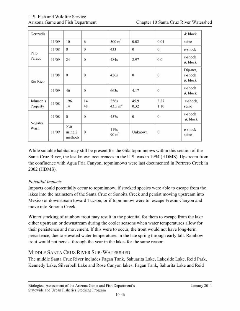
U.S. Fish and Wildlife Service Arizona Game and Fish Department Chapter 10 Santa Cruz River Watershed
Biological Assessment of the Arizona Game and Fish Department’s January 2011 Statewide and Urban Fisheries Stocking Program
10-46
Gertrudis & block
11/09 10 6 500 m2 0.02 0.01 seine
Palo Parado
11/08 0 0 433 0 0 e-shock
11/09 24 0 484s 2.97 0.0 e-shock & block
Rio Rico 11/08 0 0 426s 0 0
Dip-net, e-shock & block
11/09 46 0 663s 4.17 0 e-shock & block
Johnson’s Property
11/08 196 14
14 48
256s 43.5 m2
45.9 0.32
3.27 1.10
e-shock, seine
Nogales Wash
11/08 0 0 457s 0 0 e-shock & block
11/09 230 using 2 methods
0 119s 90 m2
Unknown 0 e-shock seine
While suitable habitat may still be present for the Gila topminnows within this section of the Santa Cruz River, the last known occurrences in the U.S. was in 1994 (HDMS). Upstream from the confluence with Agua Fria Canyon, topminnows were last documented in Portrero Creek in 2002 (HDMS). Potential Impacts Impacts could potentially occur to topminnow, if stocked species were able to escape from the lakes into the mainstem of the Santa Cruz or Sonoita Creek and persist moving upstream into Mexico or downstream toward Tucson, or if topminnow were to escape Fresno Canyon and move into Sonoita Creek.
Winter stocking of rainbow trout may result in the potential for them to escape from the lake either upstream or downstream during the cooler seasons when water temperatures allow for their persistence and movement. If this were to occur, the trout would not have long-term persistence, due to elevated water temperatures in the late spring through early fall. Rainbow trout would not persist through the year in the lakes for the same reason.
MIDDLE SANTA CRUZ RIVER SUB-WATERSHED The middle Santa Cruz River includes Fagan Tank, Sahuarita Lake, Lakeside Lake, Reid Park, Kennedy Lake, Silverbell Lake and Rose Canyon lakes. Fagan Tank, Sahurita Lake and Reid

U.S. Fish and Wildlife Service Arizona Game and Fish Department Chapter 10 Santa Cruz River Watershed
Biological Assessment of the Arizona Game and Fish Department’s January 2011 Statewide and Urban Fisheries Stocking Program
10-47
Park are closed systems with no hydrological connections to the Santa Cruz River. Sahuarita, Lakeside, Kennedy, Reid Park and Siverbell are Urban Fishing Program waters.
This sub-watershed includes several Tucson Area Urban Fishing Lakes that have outflows, or are closed systems, that join the same ephemeral stream channels as other stocked lakes in the Santa Cruz system. Origin of stocked species, if they were to occur in the system, could not be attributed to any specific stocking locality. These urban lakes are included in the for the Santa Cruz River Watershed analysis. There are currently three Urban Fishing Program (UFP) waters in Tucson and one south of the city in the Town of Sahuarita, near the Santa Cruz River. These artificial lakes are all in municipal public parks and urban recreational areas (Figure 21). Three types of fish stockings occur at UFP lakes:
• Put-and-take stockings of catchable sized fish for the purpose of recreation and harvest; • Supplemental stockings that either add fish to a fishery, or help augment low natural
reproduction, or increase short-term fishing success for a fishing clinic or other similar event, or;
• Restocking of fish communities following catastrophic events or lake draining and maintenance.

U.S. Fish and Wildlife Service Arizona Game and Fish Department Chapter 10 Santa Cruz River Watershed
Biological Assessment of the Arizona Game and Fish Department’s January 2011 Statewide and Urban Fisheries Stocking Program
10-48
Figure 21. Tucson UFP and Prospective Fishing in the Neighborhood Lake.
Physical Geographic Description
The middle Santa Cruz River contains the mainstem Santa Cruz River.
Drainage area and elevations
Fagan Tank Site Description Fagan Tank is located near Mount Fagan on lands owned by the Forest Service. It is also labeled as "The Lake" on the USGS Topo map. The 5 acre tank is located on the eastern side of the upper Santa Cruz watershed. There are no improvements such as campgrounds, restrooms or boat ramps at this location, and there are no known data on the recreational use patterns at this

U.S. Fish and Wildlife Service Arizona Game and Fish Department Chapter 10 Santa Cruz River Watershed
Biological Assessment of the Arizona Game and Fish Department’s January 2011 Statewide and Urban Fisheries Stocking Program
10-49
lake. Road access to this location is by unimproved dirt road off Highway 83, approximately 7.5 miles south of the I-10 interstate and Highway 83 intersection.
Management of Water body Fagan tank is managed as a naturally reproducing warm water fishery to provide year round low-yield angling opportunities to anglers. Historically, the location has been infrequently stocked with channel catfish, largemouth bass, redear sunfish, and flathead catfish to maintain and augment the existing fish population (Table 10). In years past, fish used for stocking this location have been captured at Patagonia Lake during annual fish population surveys and then transported to Fagan Tank for release.
Table 10. Historic Department fish stocking of Fagan Tank.
Species First Year Last Year Num. Stocked Channel catfish 1974 1984 5,900 Flathead catfish 1991 1991 1 Largemouth bass 1986 1991 670
Redear sunfish 1989 1991 5,024
Total 11,595
The Department has not completed fish population surveys or creel surveys at the tank, and currently the existing condition is unknown. Based on reports from district officers and the public, the tank has gone dry due to drought conditions several times in the past 5 to 10 years.
Proposed Action The Department proposes to stock bluegill sunfish, and redear sunfish for the period covered by this consultation.
Bluegill sunfish (sub-catchables, catchables), and redear sunfish (sub-catchables, catchables) may be stocked on an as needed basis at any time during the year to augment or to recover the fishery, following catastrophic events. Numbers of fish stocked for this purpose would be determined according to stocking guidelines as identified in the sport fish stocking protocol.

U.S. Fish and Wildlife Service Arizona Game and Fish Department Chapter 10 Santa Cruz River Watershed
Biological Assessment of the Arizona Game and Fish Department’s January 2011 Statewide and Urban Fisheries Stocking Program
10-50
Water Distribution / Connectivity Upstream, there are several large unnamed drainages that feed water into Fagan Tank, with rain runoff during the summer and winter rainy season; these are Fagan Tank’s only source of water. All of these drainages are ephemeral and only contain water after a heavy rain.
Fagan tank could potentially spill during heavy rainfall events in the late summer and winter. Water leaving the tank flows in a northerly direction in an unnamed wash until it meets a second unnamed wash approximately 5 miles downstream. From there, water flows in a westerly direction for another 6 miles before the wash terminates into a bajada just west of Houghton road, southwest of Tucson. The ephemeral drainage has an extremely low gradient (0.01%), going from an elevation of about 4200 feet at Fagan Tank to an elevation of about 2500 feet where the nondescript unnamed drainage empties into the Santa Cruz River. This drainage then passes several check dams and erosion control structures as it traverses to the lower Sonoran desert. Because flows from this creek would be expected to terminate prior to reaching any tributaries hydrologically connected to the sub-watershed and due to the extensive distance and low gradient of these washes, Fagan Tank is considered a closed system. Fagan Tank is not in the Cienega Creek watershed. Fagan Tank has been reported to have gone dry several times during the past 5 to 10 years by the public and wildlife managers. No flooding or spilling has been reporting however it is likely to occur during periods of significant rainfall and runoff.
Fish Movement Fish cannot persist upstream of Fagan; none of the drainages that provide water to the tank contain perennial water, nor is there any persistent aquatic habitat within them. Any fish that swam upstream in a flood would quickly die as the water evaporated and absorbed into the sand substrate.
Due to the ephemeral nature and wide sandy bottoms of the drainages, no habitat exists for aquatic species; any fish that wash out of Fagan Tank would be stranded with no water in a few days. Fagan Tank is a closed system that is isolated from the Cienega Creek watershed.
Community Description Currently, the aquatic species assemblage is unknown; it is possible the tank is currently fishless due to the repeated drying of the tank due to existing drought conditions. Historically, the fish population consisted of largemouth bass, channel catfish, and redear sunfish within the tank.
Consultation Species or Critical Habitat There are no consultation species in the drainage for Fagan Tank. Stocked fish cannot escape into Cienega Creek drainage because Fagan Tank’s drainage does not hydrologically connect with Cienega Creek. Potential impacts to Chiricahua leopard frog and northern Mexican gartersnake are discussed below due to the movement potential of frogs into the drainage area for the tank.

U.S. Fish and Wildlife Service Arizona Game and Fish Department Chapter 10 Santa Cruz River Watershed
Biological Assessment of the Arizona Game and Fish Department’s January 2011 Statewide and Urban Fisheries Stocking Program
10-51
Potential impacts from the proposed action to candidate and listed species are described below. Please refer to Chapter 4 for a detailed description of the nature of the impacts (which may include predation, competition for space and food, and hybridization etc.).Subsequent responses (resulting from the frequency, magnitude and duration of the impacts) between proposed stocked and candidate and listed species, and any site or complex factors that provide context for determining the meaningfulness of the impacts, are discussed below. Impacts from the proposed action resulting from angler related recreation and/or potential introduction of disease, pathogen or invasive species are evaluated at a broad scale for the entire action area and are described in Chapter 4. If potential impacts specific to a stocking site or complex have been identified they are discussed below.
Chiricahua leopard frogs are analyzed at a site, complex and broad scale level due to the movement potential into the stocked area and fish movement potential up or downstream into areas where frogs may occur.
Chiricahua Leopard Frog Local Analysis: Although, Fagan Tank is within the historical range of the Chiricahua leopard frog, the likelihood that frogs could be exposed to fish stocked in Fagan Tank is low. There are no historical records for Chiricahua leopard frogs from Fagan Tank, however, there is 1 current record for Chiricahua leopard frogs from 1 site within the buffered stocking complex; East Dam (= S of Barrel Canyon) (2008) and there have not been any further surveys (Figure 22, AGFD Riparian Herpetofauna Database, M. Sredl pers. comm.). Although the area has not been adequately surveyed and Chiricahua leopard frogs occupy the buffered complex, Fagan Tank is a closed system and it is unlikely for frogs to disperse to Fagan Tank because the occupied site exceeds the five mile distance a Chiricahua leopard frog would likely disperse (AGFD Riparian Herpetofauna Database, M. Sredl pers. comm.).

U.S. Fish and Wildlife Service Arizona Game and Fish Department Chapter 10 Santa Cruz River Watershed
Biological Assessment of the Arizona Game and Fish Department’s January 2011 Statewide and Urban Fisheries Stocking Program
10-52
Figure 22. Map of Fagan Tank Sub-Complex of Santa Cruz River Watershed buffered stocking complex:
The purple line illustrates the 5 mile buffer surrounding a stocking site, stocking reach, or a group of stocking sites. Blue lines symbolize streams and rivers (both perennial and intermittent). A black line represents a Chiricahua leopard frog Recovery Unit boundary. The background color represents the 8 digit Hydrologic Unit Code. Other data are described in the legend. (Note: HDMS data appear as buffered points and may appear larger than site records for other surveys).
Broad Scale Analysis: The likelihood that Chiricahua leopard frogs could be exposed to dispersing fish from the Fagan Tank buffered stocking complex is low. There are records for Chiricahua leopard frogs outside the buffered stocking complex, however, Fagan Tank is a closed system and it is unlikely for Chiricahua leopard frogs to disperse to Fagan Tank from occupied sites outside the buffered stocking complex because the occupied frog sites exceed the five mile distance a Chiricahua leopard frog would likely disperse (AGFD Riparian Herpetofauna Database, M. Sredl pers. comm.). Northern Mexican Gartersnake Site-Specific Analysis: There are no historical northern Mexican gartersnake records from Fagan Tank, however, it lies within the historical range of the species and northern Mexican gartersnakes occupy the 20 km buffer surrounding Fagan Tank. There are recent northern

U.S. Fish and Wildlife Service Arizona Game and Fish Department Chapter 10 Santa Cruz River Watershed
Biological Assessment of the Arizona Game and Fish Department’s January 2011 Statewide and Urban Fisheries Stocking Program
10-53
Mexican gartersnake records from the headwaters of Cienega Creek (1994) and along Cienega Creek within the Las Cienegas National Conservation Area (1985-2009) and near Davidson Canyon (1999, 2001) (Rosen et al. 2001; HDMS; AGFD Riparian Herpetofauna Database). Fagan Tank is considered a closed system and isolated from the Cienega Creek watershed where northern Mexican gartersnakes persist, thus it is unlikely that northern Mexican gartersnakes will disperse to Fagan Tank from the Cienega Creek area. Therefore, although northern Mexican gartersnakes occupy the buffered stocking complex, it is unlikely that snakes could be exposed to fish stocked in Fagan Tank.
Downstream Analysis: It is unlikely that northern Mexican gartersnakes could be exposed to dispersing fish from the Fagan Tank buffered stocking complex because Fagan Tank is considered a closed system and isolated from the Cienega Creek watershed where northern Mexican gartersnakes persist. Additionally, stocked sportfish that escape from Fagan Tank will not survive.
Sahuarita Lake Site Description Sahuarita Lake is located at Sahuarita Park on La Villita Road and Rancho Sahuarita Boulevard in the Town of Sahuarita, at 2710 foot elevation (Figure 23). This 10-acre lake was constructed in 2002 as part of their urban park system. The lake was built for park aesthetics, recreational fishing, property value, and for use in watering park landscape. This artificial lake has a sealed bottom and a concrete perimeter edge. Lake depths average 7 feet with a maximum of 12 feet. Sahuarita Park has a variety of improvements including restrooms, seating areas, ramadas, lighting, handicap accessibility, and a boat ramp.

U.S. Fish and Wildlife Service Arizona Game and Fish Department Chapter 10 Santa Cruz River Watershed
Biological Assessment of the Arizona Game and Fish Department’s January 2011 Statewide and Urban Fisheries Stocking Program
10-54
Figure 23. Photo of Sahuarita Lake.
Management of Water Body Since 2002, Sahuarita Park Lake has been managed as an intensively stocked put-and-take fishery (Table 11) to provide year-round high use urban fishing opportunities for anglers of all ages and abilities. Special regulations are in place for this UFP water that governs the harvest of trout, catfish, bass, and sunfish. No live baitfish use is allowed.
Creel survey results from 2005 found 23,100 angler use days per year, an angler satisfaction rate of 84% and a 36% youth participation rate (Swanson and Hill 2006).
Put-and-take stockings occur from September through early July each year, with trout stocked in November through March, and catfish stocked in the fall and spring. Sunfish and largemouth bass are stocked in the fall and/or spring. Due to high temperatures, rainbow trout do not persist through the summer. Besides providing put-and-take fishing, some of the stocked warm water species remain to spawn and augment the modest sport fish populations of the lake.
Table 11. Historic UFP fish stocking of Sahuarita Lake.
Species Years Num. of Stockings Num. Stocked
Rainbow trout 2002-2008 54 24,678

U.S. Fish and Wildlife Service Arizona Game and Fish Department Chapter 10 Santa Cruz River Watershed
Biological Assessment of the Arizona Game and Fish Department’s January 2011 Statewide and Urban Fisheries Stocking Program
10-55
Channel catfish 2002-2008 72 37,320
Bluegill/Hybrid sunfish 2002-2008 12 10,320
Largemouth bass 2002-2008 3 3,180
TOTAL 141 75,498
Proposed Action The Department proposes to stock rainbow trout, channel catfish, bluegill, redear sunfish, and largemouth bass for the period covered by this consultation.
Catchable rainbow trout, channel catfish, bluegill sunfish, and redear sunfish would be stocked multiple times each year; the numbers of each of these species stocked would range from 0 to 20,000 fish annually.
Largemouth bass (sub-catchables, catchables) would be stocked annually in numbers ranging from 0 to 1,500.
Largemouth bass (fry/fingerlings, sub-catchables, catchables), bluegill sunfish (fry/fingerlings, sub-catchables, catchables), and redear sunfish (fry/fingerlings, sub-catchables, catchables) may be stocked on an as needed basis at any time during the period covered by this consultation to restore a depleted fishery, or recover the fishery following catastrophic events that cause major fish kills, or for construction events that require draining the lake. Numbers of fish stocked for this purpose would be determined according to stocking guidelines indentified in the Urban Fishing Start-up and Augmentation Stocking Guidelines.
Water Distribution / Connectivity Sahuarita Lake is considered a closed system water body because there is no drainage inflow or outflow, with no spillway present. The lake is supplied with ground-water fed through a pipeline. Pumps pull lake water from the lake to irrigate surrounding park turf grass. While not connected, the lake is located 0.3 miles from the ephemeral Santa Cruz River.
Fish Movement There is no opportunity for fish to leave this lake. There is no lake outflow. Water pumped from the lake has screened intakes and supplies the turf sprinkler systems.
Community Description Swanson and Hill (2006) report rainbow trout, channel catfish, bluegill/hybrid sunfish, and largemouth bass. All species present are part of the current stocking program.

U.S. Fish and Wildlife Service Arizona Game and Fish Department Chapter 10 Santa Cruz River Watershed
Biological Assessment of the Arizona Game and Fish Department’s January 2011 Statewide and Urban Fisheries Stocking Program
10-56
Consultation Species or Critical Habitat Sahuarita is considered a closed system with no hydrologic connection to the Santa Cruz River.
Kennedy Park Lake Site Description Kennedy Park Lake is located at Mission Road and Ajo Way in southwest Tucson, at 2450 foot elevation (Figure 24). This 10-acre lake is in the UFP. Constructed by the City of Tucson in the 1960’s as part of their urban park system, the lake was built for park aesthetics, recreational fishing, and for minor flood retention. This artificial lake with earthen dam has a sealed bottom and a gradually sloping dirt edge around the shoreline perimeter. Lake depths average 7 feet with a maximum of 13 feet. Tucson’s popular Kennedy Park has a variety of improvements including restrooms, ramadas, picnic tables, lighting, handicap accessibility, and a boat ramp.
Figure 24. Photo of Kennedy Park Lake.
Management of Water Body Since 1984, Kennedy Park Lake has been managed as an intensively stocked put-and-take fishery (Table 12) to provide a year round high-use urban fishing opportunity for anglers of all

U.S. Fish and Wildlife Service Arizona Game and Fish Department Chapter 10 Santa Cruz River Watershed
Biological Assessment of the Arizona Game and Fish Department’s January 2011 Statewide and Urban Fisheries Stocking Program
10-57
ages and abilities. Special regulations are in place for this UFP water that governs the harvest of trout, catfish, bass, sunfish, and white amur. No live baitfish use is allowed.
Creel survey results from 2005 found 48,000 angler use days per year, an angler satisfaction rate of 86% and a 28% youth participation rate (Swanson and Hill 2006).
Put-and-take stockings occur from September through early July each year, with trout stocked in November through March, and catfish stocked in the fall and spring. Sunfish and largemouth bass are stocked in the fall and/or spring. Due to high temperatures, rainbow trout do not persist through the summer. Besides providing put-and-take fishing, some of the stocked warm water species remain to spawn and augment the modest sport fish populations of the lake.
Table 12. Historic UFP fish stocking of Kennedy Park Lake.
Species Years Num. of Stockings Num. Stocked
Rainbow trout 1984-2008 216 104,568
Channel catfish 1984-2008 288 159,600
Bluegill/Hybrid sunfish 1984-2008 48 33,480
Largemouth bass 1984-2008 12 11,400
TOTAL 564 309,048
Proposed Action The Department proposes to stock rainbow trout, channel catfish, bluegill, redear sunfish, and largemouth bass for the period covered by this consultation.
Catchable rainbow trout, channel catfish, bluegill sunfish, and redear sunfish would be stocked multiple times each year; the numbers of each of these species stocked would range from 0 to 20,000 fish annually.
Largemouth bass (sub-catchables, catchables) would be stocked annually in numbers ranging from 0 to 1,500.
Largemouth bass (fry/fingerlings, sub-catchables, catchables), bluegill sunfish (fry/fingerlings, sub-catchables, catchables), and redear sunfish (fry/fingerlings, sub-catchables, catchables), may be stocked on an as needed basis at any time during the period covered by this consultation to restore a depleted fishery, or recover the fishery following catastrophic events that cause major fish kills, or for construction events that require draining the lake. Numbers of fish stocked for

U.S. Fish and Wildlife Service Arizona Game and Fish Department Chapter 10 Santa Cruz River Watershed
Biological Assessment of the Arizona Game and Fish Department’s January 2011 Statewide and Urban Fisheries Stocking Program
10-58
this purpose would be determined according to stocking guidelines indentified in the Urban Fishing Start-up and Augmentation Stocking Guidelines.
Water Distribution / Connectivity Kennedy Park Lake is considered a predominately closed system water body because it has a small desert watershed inflow and a spillway. The lake is supplied with ground-water pumped through a pipeline. There are no pumps to withdraw water from the lake.
The lake is subject to extreme overflow events (winter storms or summer monsoons) every few years on average. Water leaving the lake will flow in a northerly direction in an unnamed ephemeral wash until it connects to Pantano Wash, also an ephemeral wash 0.5 mile north of Kennedy Park Lake. From there, water flows in a northerly direction for another three miles until it connects to the Santa Cruz River. The small drainage above Kennedy Park Lake and the ephemeral washes connecting to the Santa Cruz River do not contain any perennial waters nor is there persistent aquatic habitat within them.
Fish Movement Precipitation events that fill the lake to overflowing are infrequent, occurring on average at 3-7 year intervals. During an overflow event, the possibility exists for stocked fish or offspring of stocked fish to move over the spillway into the ephemeral washes below. Any fish caught in these episodic flooding events would be subjected to a variety of environmental and physical stressors including: turbulence, high sediment loads, drop structures, physical damage, clogged gills, and disorientation. As flood flows in these ephemeral drainages recede in hours or days, any remaining fish would be subject to rapid temperature changes, loss of oxygen, stranding, and desiccation/mortality. The only persistent aquatic habitat available downstream is located approximately 10 miles away on the Santa Cruz River below the Roger Road wastewater treatment discharge site. To reach this location, fish would need to move downstream in the watercourse described in the Water Distribution/Connectivity section above. No sampling has been done to determine if fish have spilled in the drainage below Kennedy.
Community Description Swanson and Hill (2006) report seasonal rainbow trout, channel catfish, largemouth bass, bluegill/hybrid sunfish, common carp, white amur, and black crappie.
Consultation Species or Critical Habitat Refer to the Middle Santa Cruz River Complex Analysis for potential impacts to Gila chub, Gila topminnow and northern Mexican gartersnakes downstream in the Santa Cruz River.
Silverbell Lake Site Description Silverbell Lake is located at Christopher Columbus Park on 4600 North Silverbell Road in northwest Tucson, at 2255 foot elevation (Figure 25). This 13-acre lake was constructed by the

U.S. Fish and Wildlife Service Arizona Game and Fish Department Chapter 10 Santa Cruz River Watershed
Biological Assessment of the Arizona Game and Fish Department’s January 2011 Statewide and Urban Fisheries Stocking Program
10-59
City of Tucson in the 1960’s as part of their urban park system. The lake was built for park aesthetics and recreational fishing. This artificial lake has a natural, dirt edge around the shoreline perimeter and has a dirt bottom. Lake depths average 5 feet with a maximum of 7 feet. Tucson’s popular Christopher Columbus Park has a variety of improvements including restrooms, ramadas, picnic tables, lighting, handicap accessibility, a dog park, and boat ramps.
Figure 25. Photo of Silverbell Lake.
Management of Water Body Since 1984, Silverbell Lake has been managed as an intensively stocked put-and-take fishery (Table 13) to provide year round high-use urban fishing opportunities for anglers of all ages and abilities. Special regulations are in place for this UFP water that manages the harvest of trout, catfish, bass, sunfish, and white amur. No live baitfish use is allowed.
Creel survey results from 2005 found 54,900 angler use days per year, an angler satisfaction rate of 80% and a 19% youth participation rate (Swanson and Hill 2006).
Put-and-take stockings occur from September through early July each year, with trout stocked in November through March, and catfish stocked in the fall and spring. Sunfish and largemouth bass are stocked in the fall and/or spring. Due to high temperatures, rainbow trout do not persist through the summer. Besides providing put-and-take fishing, some of the stocked warm water species remain to spawn and augment the modest sport fish populations of the lake.

U.S. Fish and Wildlife Service Arizona Game and Fish Department Chapter 10 Santa Cruz River Watershed
Biological Assessment of the Arizona Game and Fish Department’s January 2011 Statewide and Urban Fisheries Stocking Program
10-60
Table 13. Historic UFP fish stocking of Silverbell Lake.
Species Years Num. of Stockings Num. Stocked
Rainbow trout 1984-2008 216 134,016
Channel catfish 1984-2008 288 171,264
Bluegill/Hybrid sunfish 1984-2008 48 43,440
Largemouth bass 1984-2008 12 11,352
TOTAL 564 360,072
Proposed Action The Department proposes to stock rainbow trout, channel catfish, bluegill sunfish, redear sunfish, black crappie and largemouth bass are proposed for the period covered by this consultation.
Catchable rainbow trout, channel catfish, bluegill sunfish, and redear sunfish would be stocked multiple times each year; the numbers of each of these species stocked would range from 0 to 25,000 fish annually.
Largemouth bass (sub-catchables, catchables) would be stocked annually in numbers ranging from 0 to 2,000.
Largemouth bass (fry/fingerlings, sub-catchables, catchables), bluegill sunfish (fry/fingerlings, sub-catchables, catchables), redear sunfish (fry/fingerlings, sub-catchables, catchables), and black crappie (sub-catchables, catchables) may be stocked on an as needed basis at any time during the period covered by this consultation to restore a depleted fishery, or recover the fishery following catastrophic events that cause major fish kills, or for construction events that require draining the lake. Numbers of fish stocked for this purpose would be determined according to stocking guidelines indentified in the Urban Fishing Start-up and Augmentation Stocking Guidelines.
Water Distribution / Connectivity Silverbell Lake is considered a predominately closed system water body as it has a small desert watershed inflow and an overflow feature. The lake is supplied with ground-water pumped through a pipeline from a shallow, reclaimed water recharge zone. There are no pumps to withdraw water from the lake.
The park watershed size is too small to cause a lake spillover; however, lake operators have, at times, not turned off the well water pumps and subsequently some lake water has spilled from

U.S. Fish and Wildlife Service Arizona Game and Fish Department Chapter 10 Santa Cruz River Watershed
Biological Assessment of the Arizona Game and Fish Department’s January 2011 Statewide and Urban Fisheries Stocking Program
10-61
the outflow. Water discharged from the lake flows in a northerly direction through a small unnamed drainage, then goes to a small retention or catchment area that allows water to percolate into the ground. Within 200 feet of this site is the Santa Cruz River, a perennial reach that is solely supported by reclaimed water discharge from the City of Tucson Roger Road water treatment facility.
Fish Movement During an extreme overflow event or a lake operations error, the possibility exists for stocked fish or offspring of stocked fish to move over the spillway into the ephemeral wash below. As flood flows in the ephemeral drainage recede, any remaining fish would be subject to rapid temperature changes, loss of oxygen, stranding, and desiccation/mortality. A persistent aquatic habitat is available downstream at the confluence with the Santa Cruz River. If stocked fish were to escape and make it to the Santa Cruz River, the poor water quality associated with the treated effluent, the irregular flows, and the high water temperatures during the summer would prohibit long term survival of escaped fish. No sampling has been done to determine if fish have spilled in the drainage below Silverbell.
Community Description Swanson and Hill (2006) report seasonal rainbow trout, channel catfish, largemouth bass, bluegill/hybrid sunfish, common carp, white amur, and black crappie. Consultation Species or Critical Habitat Refer to the Middle Santa Cruz River Complex Analysis for potential impacts to Gila chub, Gila topminnow and northern Mexican gartersnakes downstream in the Santa Cruz River.
PANTANO WASH-RILLITO RIVER COMPLEX Physical Geographic Description
Drainage area
The Pantano Wash–Rillito River sub-watershed begins in the north western most portion of Santa Cruz County and eastern Pima County. The upper end of the watershed contains the headwaters of Cienega Creek in Santa Cruz County, as well as the headwaters of Tanque Verde Wash, the Rillito River, and Pantano Wash to the confluence of the Rillito River with the Santa Cruz River in north Tucson. The drainage area encompasses about 920 square miles.
Tributaries
Major tributaries for this portion of the drainage include Cienega Creek, Tanque Verde Creek, Rillito River, Pantano Wash, and Canada Del Oro Wash. Of the major tributaries, only Cienega Creek maintains perennial water and is protected by a barrier at Del Lago. Portions of these tributaries and other smaller tributaries are ephemeral or intermittent.

U.S. Fish and Wildlife Service Arizona Game and Fish Department Chapter 10 Santa Cruz River Watershed
Biological Assessment of the Arizona Game and Fish Department’s January 2011 Statewide and Urban Fisheries Stocking Program
10-62
The Rillito River is actually an ephemeral wash, only supporting water for short periods after heavy rainfall (Figure 26).
Figure 26. USGS Gauge data from Rillito River near Dodge Blvd, Tucson, AZ (1999-2009).
Rose Canyon Lake Site Description Constructed in 1959, Rose Canyon Lake is a 7 acre impoundment located on the Coronado National Forest, located 40 miles northeast of Tucson. Rose Canyon Lake is located within an improved Forest Service campground. In addition, there is a handicapped trail around a portion of the lake that leads to a handicapped accessible fishing pier. The campground and area around the lake is only open from April-October; outside those months anglers must hike into Rose Canyon Lake.
Management of Water Body Rose Canyon Lake is managed as intensive use cold water put-and-take rainbow trout fishery and a put- grow-and-take brown trout fishery, to provide year-round angling opportunities with multiple stockings of both species annually (Table 14). The lake harbored a population of illegally stocked green sunfish until a dredging project in 2000 drained the entire lake, resulting in their removal. The ability of the Department to stock this location is highly dependent on water quality during the summer months and it is not uncommon to suspend trout stockings due to high temperatures during the months of June through August. Because the lake has always been a put-and-take trout fishery, and other priorities have not made surveying a stocked population possible, the Department has never conducted a fish survey at this lake. Angler survey data collected in 2001 showed anglers spent 6,097 angler use days at Rose Canyon Lake (Pringle 2004).
0
20
40
60
80
100
120
Jan Feb Mar Apr May Jun Jul Aug Sep Oct Nov Dec
Month
Mea
n M
onth
ly D
isch
arge
(cfs
)19
99 -
2009
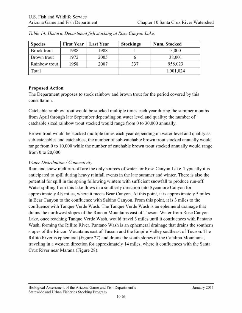
U.S. Fish and Wildlife Service Arizona Game and Fish Department Chapter 10 Santa Cruz River Watershed
Biological Assessment of the Arizona Game and Fish Department’s January 2011 Statewide and Urban Fisheries Stocking Program
10-63
Table 14. Historic Department fish stocking at Rose Canyon Lake.
Species First Year Last Year Stockings Num. Stocked Brook trout 1988 1988 1 5,000 Brown trout 1972 2005 6 38,001 Rainbow trout 1958 2007 337 958,023 Total 1,001,024
Proposed Action The Department proposes to stock rainbow and brown trout for the period covered by this consultation.
Catchable rainbow trout would be stocked multiple times each year during the summer months from April through late September depending on water level and quality; the number of catchable sized rainbow trout stocked would range from 0 to 30,000 annually.
Brown trout would be stocked multiple times each year depending on water level and quality as sub-catchables and catchables; the number of sub-catchable brown trout stocked annually would range from 0 to 10,000 while the number of catchable brown trout stocked annually would range from 0 to 20,000.
Water Distribution / Connectivity Rain and snow melt run-off are the only sources of water for Rose Canyon Lake. Typically it is anticipated to spill during heavy rainfall events in the late summer and winter. There is also the potential for spill in the spring following winters with sufficient snowfall to produce run-off. Water spilling from this lake flows in a southerly direction into Sycamore Canyon for approximately 4½ miles, where it meets Bear Canyon. At this point, it is approximately 5 miles in Bear Canyon to the confluence with Sabino Canyon. From this point, it is 3 miles to the confluence with Tanque Verde Wash. The Tanque Verde Wash is an ephemeral drainage that drains the northwest slopes of the Rincon Mountains east of Tucson. Water from Rose Canyon Lake, once reaching Tanque Verde Wash, would travel 3 miles until it confluences with Pantano Wash, forming the Rillito River. Pantano Wash is an ephemeral drainage that drains the southern slopes of the Rincon Mountains east of Tucson and the Empire Valley southeast of Tucson. The Rillito River is ephemeral (Figure 27) and drains the south slopes of the Catalina Mountains, traveling in a western direction for approximately 14 miles, where it confluences with the Santa Cruz River near Marana (Figure 28).

U.S. Fish and Wildlife Service Arizona Game and Fish Department Chapter 10 Santa Cruz River Watershed
Biological Assessment of the Arizona Game and Fish Department’s January 2011 Statewide and Urban Fisheries Stocking Program
10-64
Figure 27. Mean (1 SE) monthly discharge at USGS gauge 09484500 Tanque Verde Creek at Tucson, AZ from 1999 - 2009.
Figure 28. Lower drainage of Rose Canyon Lake showing connection to Bear Canyon and then to Sabino Canyon.
0
10
20
30
40
50
60
70
80
Jan Feb Mar Apr May Jun Jul Aug Sep Oct Nov Dec
Month
Mea
n M
onth
ly D
isch
arge
(cfs
)19
91 -
2009

U.S. Fish and Wildlife Service Arizona Game and Fish Department Chapter 10 Santa Cruz River Watershed
Biological Assessment of the Arizona Game and Fish Department’s January 2011 Statewide and Urban Fisheries Stocking Program
10-65
Fish Movement Stocked trout can escape from Rose Canyon Lake when it overflows. They would leave the lake via a spillway over the dam and drop approximately 50 feet into Rose Canyon. There is a small concrete splash pad located at the bottom of the spillway. Trout that do make it over the spillway and survive landing on the splash pad could then be washed further downstream and would follow the same path as the water connectivity above. Further downstream, Rose Canyon joins Sycamore Canyon, where there is the remnants of an old reservoir known as Sycamore Reservoir. This reservoir is now silted in and any escaped fish will pass through this location over an 18 foot drop from the crest of the dam and onto exposed bedrock at the base of the old dam. Because the reservoir is silted in to the top of the dam there is no aquatic habitat in this location except during flood events. Beyond the old dam at Sycamore Reservoir, Bear Canyon narrows to a bedrock canyon and there is sporadic perennial water located in pools created by depressions in the bedrock. These tinajas are created and destroyed due to the large amount of sediment that continues to move through the drainage as a result of the 2003 Aspen fire. Because these tinajas do come and go so frequently, there is no way to predict where fish will be and will not be from year to year; however, because they do exist there is opportunity for short term survival of escaped fish in Bear Canyon following significant flow events.
Any survival of trout in these locations would be of short duration because water temperatures exceed upper limits for trout survival, and dissolved oxygen is low in these pools (Ehret 2008). Just past these tinajas there is a series of seven waterfalls that total about 400 feet; each has a bedrock base that trout would have to survive passage over in order to travel downstream to the confluence with Sabino Canyon. If a trout survived the falls, it could possibly move upstream in Sabino Canyon; however, 1½ miles upstream of the confluence of Bear Canyon and Sabino Canyon there is an old dam structure at Sabino Lake that is approximately 12 feet high and serves as a barrier to upstream movement of fish (Figure 29). Any trout that might persist in Sabino Canyon below this structure would only do so for a short duration because summer water temperatures exceed upper thermal limits for trout survival. If an extreme flood event occurred, fish could be washed to the normally dry Rillito River, which is very broad and flat with a deep sand bottom. From the Rillito, they could be washed downstream into the Santa Cruz River; however, the water would be loaded with sediment and debris, and trout would likely not survive in the muddy flood waters. In the highly unlikely event of stocked fish escaping and making it all the way to the Santa Cruz River, fish could reach perennial water located at the confluence of Rillito Creek and the Santa Cruz River. Perennial flow is provided by several municipal wastewater treatment plant outflow pipes at Sweetwater and Roger Roads. This portion of the river is perennial due to discharges of treated effluent from several treatment plants located along the river. This treated effluent’s water quality is very poor for aquatic species survival due to high levels of ammonia and low levels of dissolved oxygen (Pima County 2002; Walker et al undated).

U.S. Fish and Wildlife Service Arizona Game and Fish Department Chapter 10 Santa Cruz River Watershed
Biological Assessment of the Arizona Game and Fish Department’s January 2011 Statewide and Urban Fisheries Stocking Program
10-66
Figure 29. Sabino Canyon dam located in lower Sabino Canyon which prevents upstream movement of fish escaping from Rose Canyon Lake.
Community Description The aquatic species assemblage within Rose Canyon Lake currently consists of crayfish, bullfrogs, mosquitofish, rainbow trout, and brown trout. Prior to the dredging project crayfish, bullfrogs and mosquito fish were present. Although the lake was dry for a period of nearly one full year, both bullfrogs and crayfish were observed almost immediately once the lake begin to fill, and mosquitofish were observed several months later once the lake had completely re-filled. It is likely that the mosquitofish were stocked by someone, but it is unlikely that the crayfish and bullfrogs were stocked, given the quickness in which they reappeared once the lake begun to refill. It is unknown how these species were able to find their way back to Rose Canyon Lake. Both rainbow trout and brown trout persist in the lake year round and have been stocked regularly since the completion of the 2002 dredging project. The lack of appropriate spawning habitat required by trout species prevents natural reproduction in the lake. All trout currently resident in the lake are the result of stocking.
Because the Department re-established Gila chub in 2004 following the Aspen fire, they have expanded from the initial stocking locations and are now found throughout the 7 miles of perennial habitat in Sabino Canyon above Sabino Lake. These 7 miles of habitat located from the confluence between Sabino Canyon and the west fork of Sabino Canyon downstream to the Forest Service boundary is designated as critical habitat for the chub (Figure 30). Until about the mid 1980’s, within Sabino Canyon, both rainbow and brown trout were stocked in the higher elevations of Sabino Canyon. No surveys have been completed in these higher elevations and it is currently not known if brown trout still persist. Anglers report catching rainbow trout regularly

U.S. Fish and Wildlife Service Arizona Game and Fish Department Chapter 10 Santa Cruz River Watershed
Biological Assessment of the Arizona Game and Fish Department’s January 2011 Statewide and Urban Fisheries Stocking Program
10-67
in the higher elevations of Sabino Canyon and Lemmon Creek, which is a small tributary to Sabino Canyon that was also stocked historically. Although trout species persist in the higher elevations of Sabino Canyon and its tributaries, they have never been documented in the lower elevation habitats that are occupied by the chub (Kline 2006; Ehret 2008, 2009). This is likely due to water temperatures in the summer that exceed lethal limits for trout survival and low dissolved oxygen in the pools.
In addition to the efforts in Sabino Canyon, the Department established a population of Gila chub in Bear Canyon, as well as during the 2004 efforts to expand the fishes range in the Santa Catalina Mountains and reduce threats from catastrophic losses in Sabino Canyon. Due to poor rainfall patterns and an overall lack of suitable habitat at the time, chub were only stocked in pools located directly below Sycamore Dam in Bear Canyon. Because of this initial stocking, chub have expanded downstream and can now be found throughout Bear Canyon as suitable habitat is available Kline 2006; Ehret 2008, 2009). During these survey efforts no other fish species have been documented within Bear Canyon (Foster 2005; Kline 2006; Ehret 2008, 2009).
Figure 30. Overview map of Bear and Sabino Canyon confluences. Light blue along Sabino Canyon depicts critical habitat designation.
Consultation Species or Critical Habitat Potential impacts to Gila chub and Mexican spotted owl addressed below. Refer to the Middle Santa Cruz River Complex Analysis for potential impacts to Gila chub, Gila topminnow and northern Mexican gartersnakes downstream in the Santa Cruz River.

U.S. Fish and Wildlife Service Arizona Game and Fish Department Chapter 10 Santa Cruz River Watershed
Biological Assessment of the Arizona Game and Fish Department’s January 2011 Statewide and Urban Fisheries Stocking Program
10-68
Potential impacts from the proposed action to candidate and listed species are described below. Please refer to Chapter 4 for a detailed description of the nature of the impacts (which may include predation, competition for space and food, and hybridization etc.).Subsequent responses (resulting from the frequency, magnitude and duration of the impacts) between proposed stocked and candidate and listed species, and any site or complex factors that provide context for determining the meaningfulness of the impacts, are discussed below. Impacts from the proposed action resulting from angler related recreation and/or potential introduction of disease, pathogen or invasive species are evaluated at a broad scale for the entire action area and are described in Chapter 4. If potential impacts specific to a stocking site or complex have been identified they are discussed below.
Northern Mexican gartersnakes are analyzed on a complex and downstream scale due to the movement potential into the stocked area and fish movement potential up or downstream into areas where the snakes may occur.
Gila Chub Suitable habitat and documented occurrences for Gila chub occur within both Sabino Canyon and Bear Canyon. Additionally, critical habitat is designated within Sabino Canyon. Outside of these two locations there is no other suitable habitat for Gila chub to occur within the drainage.
Potential Impacts The persistent native fish populations in this location are found in Sabino Canyon and Bear Canyon. Due to the presence of Sabino Dam located upstream of the confluence of Sabino Canyon and Bear Canyon, it is unlikely that stocked trout that were to escape from Rose Canyon lake could travel upstream into Sabino Canyon and have impacts on Gila chub populations. Any trout that were to escape and end up in Sabino Canyon, along with any Gila chub that may be washed out of Sabino Canyon below Sabino dam, could persist for a short period of time while water persists in the ephemeral channel below Sabino Dam. Although no stream flow gauge data exist for the stream channel below Sabino Dam, stream channel gauge data collected approximately ¼ quarter mile above Sabino Dam documents the small amount of surface flow reaching Sabino dam (Figure 27).

U.S. Fish and Wildlife Service Arizona Game and Fish Department Chapter 10 Santa Cruz River Watershed
Biological Assessment of the Arizona Game and Fish Department’s January 2011 Statewide and Urban Fisheries Stocking Program
10-69
Figure 25. USGS Gauge data from Sabino Creek located approximately ¼ mile above Sabino dam.
Stocked trout and Gila chub may co-exist together downstream of Sabino dam in pools filled during runoff events. The period of co-existence would likely be brief, from a couple of hours to several weeks, depending on season and rainfall or run-off patterns. During these brief periods of time impacts to Gila chub could be in the form of competition for food and space or, depending on the size of chub, possibly predation on chub by trout. Although interactions could occur because of the ephemeral nature of the aquatic habitat and these temporary locations where both species are together, the impacts cannot be measured and will likely be insignificant because both species will perish once aquatic habitat is lost due to it drying.
Impacts within Bear Canyon can be expected to be similar to those expected within Sabino Canyon when stocked trout escape from Rose Canyon Lake and become deposited in pools inhabited by Gila chub. Impacts for such instances could be in the form of competition for space and food, and once again depending on the size of chub in the pools, with trout predation is possible as well.
In both instances where trout escape and move downstream into perennial habitats occupied by Gila chub it is likely that impacts would once again be in the form of competition for food and for space as well as predation if chub of the appropriate size are available. Such interactions in the perennial locations are likely to occur until trout die from elevated water temperatures in the summer months.

U.S. Fish and Wildlife Service Arizona Game and Fish Department Chapter 10 Santa Cruz River Watershed
Biological Assessment of the Arizona Game and Fish Department’s January 2011 Statewide and Urban Fisheries Stocking Program
10-70
Because there is no perennial habitat beyond the confluence of Sabino Canyon with Tanque Verde Wash, any trout that were washed downstream into these lower tributaries would only persist for a short duration following the rainfall event, and would die once conditions dried. In the unlikely event that water did persist in these lower tributaries for any length of time, summer water temperatures at this elevation would exceed upper survival limits for trout, and preclude their persistence for extended periods of time.
Mexican Spotted Owl and Critical Habitat This stocking location is within Mexican spotted owl (MSO) critical habitat (CH) and the northern part of lake is in a buffer. There is little vegetation along most of the shoreline of the stocking location and can be accessed by foot.
Potential Impacts The stocking site, extended area for fish movements from the stocking site, and/or the area of potential angler access are within the 0.25 mile buffer around MSO PACs in the general vicinity of the site. No physical effects to MSO habitat in the PAC are anticipated because anglers are not expected to be present in the PAC. There may be some disturbance to MSOs from human presence and associated noise if those owls are using the edge of the PAC or the buffer area for foraging or other normal activities. The disturbance effects do not occur in the PAC where nesting, roosting, and most foraging occur.
Indirect effects may include actions that can affect forest structure and maintenance of adequate prey species identified as PCEs or KHCs. These actions may include trampling of vegetation, soil compaction, removal of woody debris or other physical degradation potentially altering the productivity and succession/regeneration of the vegetation. In the designation of critical habitat (USFWS 2004) most recreational activities, including angling, were not identified as requiring restrictions to protect the PCE’s of critical habitat from destruction or adverse modification. In making that statement, recreational activities, including angling were assumed to not contribute to significant habitat-affecting activities such as cutting large trees or snags, removal of large woody debris from the forest floor, altering the tree species diversity, or other large-scale changes to habitat structure. The act of a relatively small number of people walking through habitat is not likely to cause the kind of effects that would result in adverse effects to the PCEs/KHCs of MSO CH and/or restricted and protected habitats.
The CH designation included most other protected and restricted habitats for the MSO. Indirect effects to CH may include actions that can affect forest structure and maintenance of adequate prey species identified as PCEs. These actions may include trampling of vegetation, soil compaction, removal of small woody debris or other physical degradation potentially altering the productivity and succession/regeneration of the vegetation. In the designation of critical habitat (USFWS 2004) most recreational activities, including angling, were not identified as requiring restrictions to protect the PCE’s of critical habitat from destruction or adverse modification. In
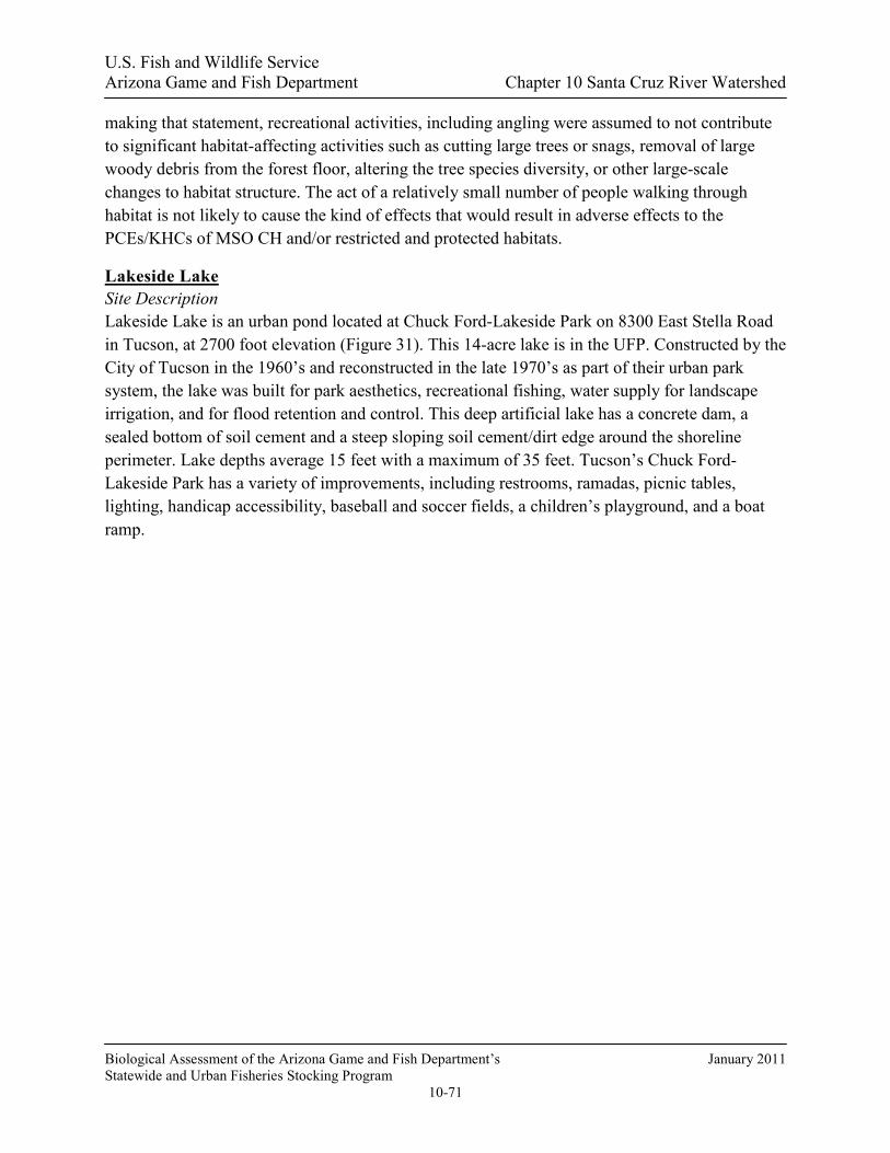
U.S. Fish and Wildlife Service Arizona Game and Fish Department Chapter 10 Santa Cruz River Watershed
Biological Assessment of the Arizona Game and Fish Department’s January 2011 Statewide and Urban Fisheries Stocking Program
10-71
making that statement, recreational activities, including angling were assumed to not contribute to significant habitat-affecting activities such as cutting large trees or snags, removal of large woody debris from the forest floor, altering the tree species diversity, or other large-scale changes to habitat structure. The act of a relatively small number of people walking through habitat is not likely to cause the kind of effects that would result in adverse effects to the PCEs/KHCs of MSO CH and/or restricted and protected habitats.
Lakeside Lake Site Description Lakeside Lake is an urban pond located at Chuck Ford-Lakeside Park on 8300 East Stella Road in Tucson, at 2700 foot elevation (Figure 31). This 14-acre lake is in the UFP. Constructed by the City of Tucson in the 1960’s and reconstructed in the late 1970’s as part of their urban park system, the lake was built for park aesthetics, recreational fishing, water supply for landscape irrigation, and for flood retention and control. This deep artificial lake has a concrete dam, a sealed bottom of soil cement and a steep sloping soil cement/dirt edge around the shoreline perimeter. Lake depths average 15 feet with a maximum of 35 feet. Tucson’s Chuck Ford-Lakeside Park has a variety of improvements, including restrooms, ramadas, picnic tables, lighting, handicap accessibility, baseball and soccer fields, a children’s playground, and a boat ramp.

U.S. Fish and Wildlife Service Arizona Game and Fish Department Chapter 10 Santa Cruz River Watershed
Biological Assessment of the Arizona Game and Fish Department’s January 2011 Statewide and Urban Fisheries Stocking Program
10-72
Figure 31. Photo of Lakeside Lake.
Management of Water Body Since 1986, Lakeside Lake at Chuck Ford-Lakeside Park has been managed as an intensively stocked put-and-take fishery (Table 15) to provide year round high-use urban fishing opportunities for anglers of all ages and abilities. Special regulations are in place for this UFP water that manages the harvest of trout, catfish, bass, and sunfish. Live baitfish use is not allowed.
Creel survey results from 2005 found 41,500 angler use days per year, an angler satisfaction rate of 89% and a 23% youth participation rate (Swanson and Hill 2006).
Put-and-take stockings occur from September through early July each year, with trout stocked in November through March, and catfish stocked in the fall and spring. Sunfish and largemouth bass are stocked in the fall and/or spring. Due to high temperatures, rainbow trout do not persist through the summer. Besides providing put-and-take fishing, some of the stocked warm water species remain to spawn and augment the modest sport fish populations of the lake.

U.S. Fish and Wildlife Service Arizona Game and Fish Department Chapter 10 Santa Cruz River Watershed
Biological Assessment of the Arizona Game and Fish Department’s January 2011 Statewide and Urban Fisheries Stocking Program
10-73
Table 15. Historic UFP fish stocking of Lakeside Lake.
Species Years Num. of Stockings Num. Stocked
Rainbow trout 1986-2008 198 122,848
Channel catfish 1986-2008 264 158,400
Bluegill/Hybrid sunfish 1986-2008 44 38,720
Largemouth bass 1986-2008 11 10,560
TOTAL 517 330,528
Proposed Action The Department proposes to stock rainbow trout, channel catfish, bluegill, redear sunfish, and largemouth bass for the period covered by this consultation.
Catchable rainbow trout, channel catfish, bluegill, and redear sunfish would be stocked multiple times each year; the numbers of each of these species stocked would range from 0 to 25,000 fish annually.
Largemouth bass (sub-catchables, catchables) would be stocked annually in numbers ranging from 0 to 2,000.
Largemouth bass (fry/fingerlings, sub-catchables, catchables), bluegill sunfish (fry/fingerlings, sub-catchables, catchables), and redear sunfish (fry/fingerlings, sub-catchables, catchables) may be stocked on an as needed basis at any time during the period covered by this consultation to restore a depleted fishery, or recover the fishery following catastrophic events that cause major fish kills, or for construction events that require draining the lake. Numbers of fish stocked for this purpose would be determined according to stocking guidelines indentified in the Urban Fishing Start-up and Augmentation Stocking Guidelines.
Water Distribution / Connectivity Lakeside Lake is considered an open system water body because it has a substantial urban watershed inflow and a spillway. The lake was primarily supplied with reclaimed water and urban runoff until 2008. Through negotiations with the Arizona Department of Environmental Quality for a National Pollution Discharge Elimination System (NPDES) permit, the use of reclaimed water for water supply was stopped and converted to a ground-water supply. There are pumps that withdraw water from the lake for landscape and turf irrigation. In 2001, the City of Tucson installed a sophisticated two stage aeration system to improve water quality, particularly dissolved oxygen and pH.
U.S. Fish and Wildlife Service Arizona Game and Fish Department Chapter 10 Santa Cruz River Watershed
Biological Assessment of the Arizona Game and Fish Department’s January 2011 Statewide and Urban Fisheries Stocking Program
10-74
The lake is subject to overflow runoff events (winter storms and summer monsoons) one or two times a year on average. The Atterbury Wash watershed above Lakeside captures runoff from a substantial area (about 11,000 acres) that brings runoff into the lake during winter and summer rains. Water leaving the lake will flow in a northerly direction in Atterbury Wash 0.6 miles to Pantano Wash, then northwesterly 6.7 miles into Rillito Wash, then 12.3 miles westerly to the confluence with the Santa Cruz River. Pantano Wash joins Rillito Creek downstream of Sabino Canyon, which is the drainage containing Rose Canyon Lake. The ephemeral Atterbury watershed above Lakeside Lake includes some golf course ponds, but no other perennial waters or persistent aquatic habitat.
Fish Movement During an overflow event, the possibility exists for stocked fish or offspring of stocked fish to move over the spillway into the sequence of ephemeral washes below. Any fish caught in these episodic flooding events would be subjected to a variety of environmental and physical stressors including: turbulence, high sediment loads, drop structures, physical damage, clogged gills, and disorientation. As flood flows in these ephemeral drainages recede, any remaining fish would be subject to rapid temperature changes, loss of oxygen, stranding, and desiccation/mortality. The only persistent aquatic habitat available downstream is located approximately 20 miles away on the Santa Cruz River below the Roger Road wastewater treatment discharge site. To reach this location, fish would need to move downstream in the watercourse described in the Water Distribution/Connectivity section, then move upstream on the Santa Cruz. No sampling has been done to determine if fish have spilled in the drainage below Lakeside.
Community Description Department records (Swanson and Hill 2006) report seasonal rainbow trout, channel catfish, largemouth bass, bluegill/hybrid sunfish, goldfish, and black crappie. Consultation Species or Critical Habitat Refer to the Middle Santa Cruz River Complex Analysis for potential impacts to Gila chub, Gila topminnow and northern Mexican gartersnakes downstream in the Santa Cruz River.
Reid Park Lake Site Description Reid Park Lake is located at Reid Park on East 22nd Street and Randolph Way in central Tucson. There are two adjoining lakes, 0.5-acre and 1.0-acre, that are not stocked by the Department. Constructed by the City of Tucson in the 1950’s, these small lakes were built for park aesthetics, recreational fishing, and for use in watering park landscape. These artificial lakes have sealed bottoms and concrete perimeter edges. Lake depths average 5 feet with a maximum of 8 feet. Tucson’s popular Reid Park, located next to the Tucson Zoo, has a variety of improvements including restrooms, ramadas, picnic tables, lighting, handicap accessibility, sports fields, and a children’s playground.

U.S. Fish and Wildlife Service Arizona Game and Fish Department Chapter 10 Santa Cruz River Watershed
Biological Assessment of the Arizona Game and Fish Department’s January 2011 Statewide and Urban Fisheries Stocking Program
10-75
Management of Water Body Reid Park Lake has been managed by the City of Tucson as a light-use recreational fishery, primarily for children, with a modest warm water fishery. Special regulations are in place for this park water that reduces the harvest of trout and catfish.
There have been no surveys of angling use of these facilities. For many years the City of Tucson used to allow only children to fish the lakes with an inexpensive permit. The Tucson Parks and Recreation Department conducts kids fishing clinics and derbies at this location several times annually.
Proposed Action The Department proposes to stock rainbow trout, channel catfish, bluegill sunfish, redear sunfish, and largemouth bass for the period covered by this consultation.
Catchable rainbow trout, channel catfish, bluegill sunfish, and redear sunfish would be stocked annually; the numbers of each of these species stocked would range from 0 to 2,000 fish annually.
Largemouth bass (sub-catchables, catchables) would be stocked annually in numbers ranging from 0 to 500.
Largemouth bass (fry/fingerlings, sub-catchables, catchables), bluegill sunfish (fry/fingerlings, sub-catchables, catchables), and redear sunfish (fry/fingerlings, sub-catchables, catchables) may be stocked on an as needed basis at any time during the period covered by this consultation to restore a depleted fishery, or recover the fishery following catastrophic events that cause major fish kills, or for construction events that require draining the lake. Numbers of fish stocked for this purpose would be determined according to stocking guidelines indentified in the Urban Fishing Start-up and Augmentation Stocking Guidelines.
Water Distribution / Connectivity Reid Park Lake is considered a closed system water body because it has no drainage inflow and no outflow or spillway. The lakes are supplied with ground-water fed through a pipeline. Pumps pull lake water from the lake to irrigate surrounding park turf grass.
Fish Movement There is no opportunity for fish to leave this lake. There is no lake outflow. Water pumped from the lake has screened intakes and supplies the turf sprinkler systems.
Community Description Largemouth bass, bluegill, and channel catfish have been documented from these lakes. Other fish species are unknown.

U.S. Fish and Wildlife Service Arizona Game and Fish Department Chapter 10 Santa Cruz River Watershed
Biological Assessment of the Arizona Game and Fish Department’s January 2011 Statewide and Urban Fisheries Stocking Program
10-76
Consultation Species or Critical Habitat Reid Park Lake is considered a closed system with no hydrological connection to the sub-watershed and no consultation species or impacts have been identified.
MIDDLE SANTA CRUZ RIVER COMPLEX ANALYSIS Water Distribution / Connectivity All but two of the Tucson Area Urban Lakes has water connectivity with the Santa Cruz River; Reid Park and Sahuarita lakes are closed systems. The three remaining waters are periodically subjected to extreme overflow events in the form of winter storms or summer monsoons, or operational maintenance errors that result in a water discharge into the Santa Cruz River or its tributaries. Fagan Tank is also a closed system.
Fish Movement During an overflow event, the possibility exists for stocked fish or offspring of stocked fish to move over the spillway into the ephemeral washes below Kennedy, Silverbell and Lakeside Lakes. Any fish caught in these episodic flooding events would be subjected to a variety of environmental and physical stressors including: turbulence, high sediment loads, drop structures, physical damage, clogged gills, and disorientation. As flood flows in these ephemeral drainages recede in hours or days, any remaining fish would be subject to rapid temperature changes, loss of oxygen, stranding, and desiccation/mortality. If stocked fish were to escape and make it to the Santa Cruz River, the poor water quality associated with the treated effluent, the irregular flows, and the high water temperatures during the summer would prohibit long term survival of escaped fish.
Stocked trout can escape from Rose Canyon Lake when it overflows via a spillway over the dam and drop approximately 50 feet into Rose Canyon. Rose Canyon joins Sycamore Canyon, where there is the remnants of an old reservoir known as Sycamore Reservoir. Beyond the old dam at Sycamore Reservoir, Bear Canyon narrows to a bedrock canyon and there is sporadic perennial water located in pools created by depressions in the bedrock. These tinajas are created and destroyed due to the large amount of sediment that continues to move through the drainage as a result of the 2003 Aspen fire. Because these tinajas do come and go so frequently, there is no way to predict where fish would be and would not be from year to year; however, because they do exist there is opportunity for short-term survival of escaped fish in Bear Canyon following significant flow events.
Community Description Refer to the Santa Cruz River aquatic community description section as it is interrelated to the three Tucson UFP lakes; Kennedy, Lakeside, and Silverbell.

U.S. Fish and Wildlife Service Arizona Game and Fish Department Chapter 10 Santa Cruz River Watershed
Biological Assessment of the Arizona Game and Fish Department’s January 2011 Statewide and Urban Fisheries Stocking Program
10-77
Consultation Species or Critical Habitat Potential impacts to Gila chub, Gila topminnow and northern Mexican gartersnakes downstream in the Santa Cruz River are discussed below.
Potential impacts from the proposed action to candidate and listed species are described below. Please refer to Chapter 4 for a detailed description of the nature of the impacts (which may include predation, competition for space and food, and hybridization etc.).Subsequent responses (resulting from the frequency, magnitude and duration of the impacts) between proposed stocked and candidate and listed species, and any site or complex factors that provide context for determining the meaningfulness of the impacts, are discussed below. Impacts from the proposed action resulting from angler related recreation and/or potential introduction of disease, pathogen or invasive species are evaluated at a broad scale for the entire action area and are described in Chapter 4. If potential impacts specific to a stocking site or complex have been identified they are discussed below.
Chiricahua leopard frogs are analyzed at a site, complex and broad scale level due to the movement potential into the stocked area and fish movement potential up or downstream into areas where frogs may occur.
Northern Mexican gartersnakes are analyzed on a complex and downstream scale due to the movement potential into the stocked area and fish movement potential up or downstream into areas where the snakes may occur.
Gila Chub The nearest documented occurrences of Gila chub are within Sabino Canyon. None have been found in the main stem Santa Cruz River.
Potential Impacts
No potential impacts beyond those identified in the Rose Canyon Lake consultation section would be anticipated from stocked species on Gila chub, due to the distance of nearest occurrence and lack of potential for exposure due to the system being predominately closed with no to limited connectivity.
Gila Topminnow The nearest documented occurrences of Gila topminnow are at Cienega Creek. None have been found in the main stem Santa Cruz River that is the watershed that these waters are connected to.
Potential Impacts
No potential impacts would be anticipated from stocked species on Gila topminnow, due to the distance of nearest occurrence and lack of potential for exposure due to the system being predominately closed with no to limited connectivity.

U.S. Fish and Wildlife Service Arizona Game and Fish Department Chapter 10 Santa Cruz River Watershed
Biological Assessment of the Arizona Game and Fish Department’s January 2011 Statewide and Urban Fisheries Stocking Program
10-78
Northern Mexican Gartersnake Stocking - Site Analysis: Northern Mexican gartersnakes are considered extirpated from the Santa Cruz River downstream of Nogales at the International Border, at Portrero Canyon/Springs, and in Tucson at Tanque Verde Creek, Rillito Creek, and Agua Caliente Spring, thus they would not be exposed to sport fish stocked into sites within the Lower and Middle Santa Cruz River complexes (USFWS 2008a; HDMS)
Downstream Analysis: Northern Mexican gartersnakes would not be exposed to dispersing stocked sport fish that escape from sites within the Lower and Middle Santa Cruz River complexes because they are considered extirpated from the Santa Cruz River downstream of Nogales at the International Border, at Portrero Canyon/Springs, and in Tuscson at Tanque Verde Creek, Rillito Creek, and Agua Caliente Spring (USFWS 2008a; HDMS).
BRAWLEY WASH-LOS ROBLES WASH COMPLEX Physical Geographic Description
Drainage Area The Brawley Wash – Los Robles Wash Sub-Watershed drains 1390 square miles and contains one proposed stocking site (Arivaca Lake). Los Robles Wash is a tributary of the Santa Cruz River that turns into Brawley Wash as it drains north. Brawley Wash joins the Santa Cruz River north and west of Tucson. Brawley Wash only flows enough to transport fish after heavy monsoon rains in the summer months (Figure 32).
Range of Elevations Elevations range from 6880 feet at Kitt Peak near the headwaters, to 600 feet at the confluence with the Santa Cruz.
Tributaries Ephemeral washes dominate the sub-watershed. Two ephemeral tributaries draining into Arivaca Lake are Bartolo Canyon and Chimney Canyon. Downstream from the lake is Cedar Creek, which becomes Arivaca Creek near the town of Arivaca.

U.S. Fish and Wildlife Service Arizona Game and Fish Department Chapter 10 Santa Cruz River Watershed
Biological Assessment of the Arizona Game and Fish Department’s January 2011 Statewide and Urban Fisheries Stocking Program
10-79
Figure 32. USGS Gauge of monthly mean flows for Brawley Wash 1999-2009.
Arivaca Lake Site Description Arivaca Lake, a run-off fed reservoir created by a dam constructed by the Department with Federal Aid Sport Fish Restoration monies in 1957, is in Cedar Canyon at the confluence with Chimney Canyon. As such the property must be maintained as a sport fishery or the monies must be repaid to Federal Aid in today’s dollars. The lake and surrounding property is owned by the Department and adjacent lands are owned by the Forest Service and USFWS National Wildlife Refuge properties. The lake is located 7 miles from Arivaca, AZ (Figure 33).
0
5
10
15
20
25
30
35
Jan Feb Mar Apr May Jun Jul Aug Sep Oct Nov Dec
Month
Mea
n M
onth
ly D
isch
arge
(cfs
)19
99 -
2009
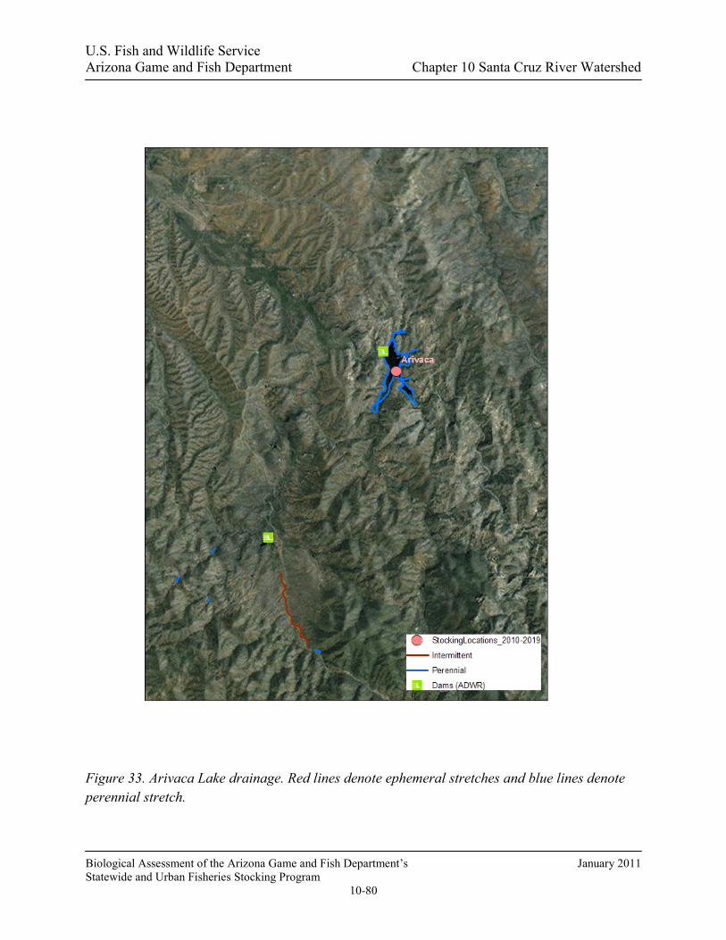
U.S. Fish and Wildlife Service Arizona Game and Fish Department Chapter 10 Santa Cruz River Watershed
Biological Assessment of the Arizona Game and Fish Department’s January 2011 Statewide and Urban Fisheries Stocking Program
10-80
Figure 33. Arivaca Lake drainage. Red lines denote ephemeral stretches and blue lines denote perennial stretch.

U.S. Fish and Wildlife Service Arizona Game and Fish Department Chapter 10 Santa Cruz River Watershed
Biological Assessment of the Arizona Game and Fish Department’s January 2011 Statewide and Urban Fisheries Stocking Program
10-81
Management of Water Body The fishery at Arivaca Lake is a naturally reproducing warm water fishery consisting of largemouth bass, channel catfish, bluegill, and redear sunfish. The lake has historically been managed as a trophy largemouth bass fishery, and that management strategy continues today. After a fish kill in 1999, sunfish populations rebounded quickly; however, the lake was restocked with largemouth bass and channel catfish (Table 16). In 2001, angler surveys showed that anglers expended 22,963 angler use days (Pringle 2004).
Table 16. Historic Department fish stocking at Arivaca Lake.
Species First Year Last Year Num. of Stockings Num. Stocked Channel catfish 1970 1999 19 137,233 Largemouth bass 1970 1999 5 16,142 Redear sunfish 1977 1978 2 18,620 Sunfish hybrid 1970 1970 2 9,000 Bullfrog Tadpole 1971 1971 1 5,000 Threadfin shad 1974 1974 1 1,000
Total 184,995
Proposed Action The Department proposes to stock channel catfish, bluegill, and redear sunfish for the period covered by this consultation.
Channel catfish (sub-catchables, catchables), bluegill sunfish (fry/fingerling, sub-catchables, catchables), and redear sunfish (fry/fingerling, sub-catchables, catchables) may be stocked as needed at any time during the period covered by this consultation, to augment or to recover the fishery following catastrophic events. Numbers of fish stocked for this purpose would be determined according to stocking guidelines identified in the sport fish stocking protocol.
Water Distribution / Connectivity The Department maintains a water right of approximately 1300 acre-feet of water, with the only source of that water being rain runoff. Chimney Canyon and Cedar Canyon on the southern end of the lake provide the majority of the water for this lake, with several other minor canyons around the lake contributing some water as well. Typically this lake will spill during heavy rainfall events in the late summer and winter; however, this has only occurred twice in the past ten years due to drought conditions at the lake.
Water can spill via an incorporated spillway at the dam. It travels downstream in the ephemeral Cedar Canyon approximately 0.75 miles, before the channel becomes poorly defined. Then flows spread out into sheet flow, before continuing downstream in the poorly defined channel

U.S. Fish and Wildlife Service Arizona Game and Fish Department Chapter 10 Santa Cruz River Watershed
Biological Assessment of the Arizona Game and Fish Department’s January 2011 Statewide and Urban Fisheries Stocking Program
10-82
approximately 3.5 miles where it enters active agricultural fields. Then it flows into Arivaca Cienega, which is also the confluence with Arivaca Wash (Figure 35). Flows reaching Arivaca Wash would then flow in a westerly direction in and connect with a small perennial stretch of Arivaca Creek just west of the town of Arivaca. Leaving this point, water then would travel 6 miles before turning north and becoming part of the ephemeral Altar Wash. Water would then flow in the Altar Wash north for approximately 20 miles, where numerous washes in the Altar Valley converge to form the Brawley Wash about 14 miles south of Three Points. The Brawley Wash then travels nearly 40 miles before its confluence with the Santa Cruz River near Red Rock.
Fish Movement Upstream of the lake, both Cedar Canyon and Chimney Canyon and the smaller tributaries to these two canyons are ephemeral and contain no known barriers to upstream movement. Cedar Canyon begins 4 miles south of the lake on Bartolo Mountain; Cedar Canyon branches with Bartolo Canyon approximately 3 miles upstream of the lake. There is no fish habitat in any of these canyons. Chimney Canyon gets it start just north of the Town of Ruby and flows approximately 4 miles before emptying into Arivaca Lake on the southern end. There are numerous unnamed smaller tributaries associated with Chimney Canyon, however, none of them along with Chimney Canyon contain fish habitat in the absence of rainfall events. If fish were able to move up into these canyons, they would only survive a matter of days due to the lack of habitat and loss of water to evaporation.
Fish can spill from Arivaca after heavy summer rains. Fish would leave the lake and enter Cedar Canyon, which becomes poorly defined after 0.75 miles, and flows spread out into sheet over a wide, sandy bottom. After an additional 4 miles the drainage enters an active alfalfa field before entering Arivaca Cienega. There is no suitable habitat for stocked species in this reach, and it is very unlikely fish would get past the fields and cienega as the flow spreads out into a shallow sheet of water that fish cannot move through. Beyond the cienega the wash runs past the town of Arivaca and into a short, shallow, perennial reach of Arivaca Creek with very low to no flow (Figure 34). No stocked species have ever been documented in this reach (LCRB Aquatic GAP), most likely due to the difficulty of a stocked species reaching it, and the lack of pool habitat in the reach. Beyond this stretch the entire drainage consists of large washes with wide sandy bottoms (Figure 35) none of which contain water or fish habitat except during heavy rainfall periods. In the unlikely event fish could move down as far as these washes they would not persist because the water would quickly dry up.
There are numerous stock tanks in the vicinity of Arivaca Lake, both upstream and downstream, that may contain sport fish. These tanks are on private property and have not been surveyed by the Department, but 11 of them have had aquatic stocking permits for many sport fish species, such as largemouth bass, channel catfish, bluegill, redear sunfish and various minnows, issued to them historically (D. Mitchell, pers. comm.).

U.S. Fish and Wildlife Service Arizona Game and Fish Department Chapter 10 Santa Cruz River Watershed
Biological Assessment of the Arizona Game and Fish Department’s January 2011 Statewide and Urban Fisheries Stocking Program
10-83
Figure 34. USGS Gauge data for the perennial section of Arivaca Creek 2004-2009.
Figure 35. Aerial photo of poor channel definition below Arivaca Lake where flows become sheet flows.
0
0.5
1
1.5
2
2.5
3
3.5
Jan Feb Mar Apr May Jun Jul Aug Sep Oct Nov Dec
Month
Mea
n M
onth
ly D
isch
arge
(cfs
)20
04 -
2009
Sheet flow

U.S. Fish and Wildlife Service Arizona Game and Fish Department Chapter 10 Santa Cruz River Watershed
Biological Assessment of the Arizona Game and Fish Department’s January 2011 Statewide and Urban Fisheries Stocking Program
10-84
Community Description Currently, the lake’s fish population consists of naturally reproducing largemouth bass, redear sunfish, bluegill, and mosquitofish populations with multiple age classes of each. In 1999, the lake experienced a fish kill and the majority of fish in the lake were lost. In response to the fish kill, the Department completed internal environmental compliance documents along with Section 7 documents to begin the process of reestablishing the fish population, and was approved for the stocking of largemouth bass, bluegill, redear sunfish, and channel catfish. However, only largemouth bass and channel catfish were needed to be stocked. Based on fish population surveys conducted since the fish kill in 1999, all populations of fish with the exception of channel catfish have rebounded and are at or near pre-kill conditions (Table 17). Historical stocking information shows threadfin shad were stocked in the lake in 1974; however, this species can no longer be found in the lake. All other species historically stocked by the Department still persist in the lake and reproduce annually. Arivaca Lake, Cedar Canyon, and Arivaca Cienega all harbor bullfrogs. Northern Mexican gartersnakes are historically known from Arivaca Lake and may still occur in the area (see analysis below).
Table 17. Electrofishing Survey of Arivaca Lake 2008.
Species Num. Sampled
Largemouth Bass 225
Bluegill 49
Redear Sunfish 71
Green Sunfish 2
Consultation Species or Critical Habitat Potential impacts to Chiricahua leopard frog and northern Mexican gartersnake are discussed below.
Chiricahua Leopard Frog Local Analysis: Although Arivaca Lake is within the historical range of the Chiricahua leopard frog, the likelihood that frogs could be exposed to fish stocked in Arivaca Lake is low. There are no historical records for Chiricahua leopard frogs from Arivaca Lake, however, there are 5 historical records for Chiricahua leopard frogs from 4 sites within the buffered stocking complex; Arivaca Creek (1992), Frog Tank (1993), Bolsa Tank (1989), Oro Blanco Wash (1992-Pre) and California Gulch (1989). Subsequent surveys in 1994-1995 in Oro Blanco Wash and California Gulch and extensive site visits from 2007-2009 to Frog and Bolsa Tanks have been negative for Chiricahua leopard frogs (Figure 12, AGFD Riparian Herpetofauna Database, M. Sredl pers. comm., C. Akins pers. comm., T. Jones pers. comm., HDMS). Data suggest that it is

U.S. Fish and Wildlife Service Arizona Game and Fish Department Chapter 10 Santa Cruz River Watershed
Biological Assessment of the Arizona Game and Fish Department’s January 2011 Statewide and Urban Fisheries Stocking Program
10-85
likely that Chiricahua leopard frogs no longer occupy the buffered stocking complex that includes Arivaca Lake and the presence of non-native fish and bullfrogs make the habitat less suitable for Chiricahua leopard frogs (AGFD Riparian Herpetofauna Database, M. Sredl pers. comm.). In addition, as mentioned in the Fish Movement section, it is unlikely that fish stocked in Arivaca Lake would disperse up or downstream of the stocking site and persist for more than a few days.
Broad Scale Analysis: The likelihood that Chiricahua leopard frogs could be exposed to dispersing fish from the Arivaca Lake buffered stocking complex is low. As mentioned in the Fish Movement section, it is very unlikely for fish stocked in Arivaca Lake to disperse up or downstream of the stocking site and persist for more than a few days. There are records for Chiricahua leopard frogs outside the buffered stocking complex (AGFD Riparian Herpetofauna Database, M. Sredl pers. comm., HDMS, C.R. Schwalbe unpublished), however, occupied frog sites outside the buffered stocking complex exceed the five mile distance a Chiricahua leopard frog would likely disperse (AGFD Riparian Herpetofauna Database, M. Sredl pers. comm.).
Northern Mexican Gartersnake Site-Specific Analysis: Although Arivaca Lake and the surrounding area lies within the historical range of northern Mexican gartersnakes, their current status is unknown (USFWS 2008a; HDMS). Through extensive trapping effort along the Arivaca Cienega in 1994 and 2000, Rosen and Schwalbe (2002) detected a single northern Mexican gartersnake from the cienega in 2000, which indicates the species may be persisting in the area at low densities (Rosen et al. 2001). No recent systematic surveys for gartersnakes have been conducted at the cienega or elsewhere within the 20 km buffer. Therefore, northern Mexican gartersnakes may occupy the 20 km buffer surrounding Arivaca Lake, at least in low numbers. There are also historical records (1934, 1970) from Arivaca Creek and (1941) along Forest Service Road 39, West of Ruby (Rosen and Schwalbe 1988, HDMS, AGFD Riparian Herpetofauna Database). Rosen and Schwalbe (1988) described a skin shed found in 1986 along the stream below the Ruby Road crossing as probably that of a northern Mexican gartersnake. The presence of non-native fish and bullfrogs in Arivaca Lake make the habitat less suitable for northern Mexican gartersnakes. In addition, as mentioned in the Fish Movement section, it is very unlikely for fish stocked in Arivaca Lake to disperse up or downstream of the stocking site and persist for more than a few days. Therefore, the likelihood that northern Mexican gartersnakes will be exposed to stocked channel catfish, bluegill and redear sunfish in Arivaca Lake is low.
Downstream Analysis: There are no northern Mexican gartersnake records downstream of the Arivaca Lake buffered stocking complex (HDMS). There is a recent (2001) northern Mexican gartersnake record from Presumido Canyon in the Baboquivari Mountains >22 air mi west of Arivaca Lake, though snakes from that area are unlikely to disperse to the stocking site (HDMS, AGFD Riparian Herpetofauna Database). Therefore, northern Mexican gartersnakes are unlikely to be exposed to dispersing fish from the Arivaca Lake buffered stocking complex because

U.S. Fish and Wildlife Service Arizona Game and Fish Department Chapter 10 Santa Cruz River Watershed
Biological Assessment of the Arizona Game and Fish Department’s January 2011 Statewide and Urban Fisheries Stocking Program
10-86
gartersnakes are unlikely to occur downstream. Additionally, as mentioned in the Fish Movement section, it is very unlikely for fish stocked in Arivaca Lake to disperse up or downstream of the stocking site and persist for more than a few days.