SaFE mountaIn CampaIgn In El Valle de Benasque · The ascent from Benasque to Cerler follows the...
2
El Valle de Benasque SAFE MOUNTAIN CAMPAIGN IN...
Transcript of SaFE mountaIn CampaIgn In El Valle de Benasque · The ascent from Benasque to Cerler follows the...

El Valle de BenasqueSaFE mountaIn CampaIgn In...
Refugio Lizara, Aragüés del Puerto (Hu)� Tel. 974 348 433
Refugio Respomuso, Sallent de Gállego (Hu)� Tel. 974 337 556
Refugio de los Ibonesde Bachimaña (Hu)� Tel. 697 126 967
Refugio Casa de Piedra, Balneario de Panticosa (Hu)� Tel. 974 487 571
Refugio Góriz, Parque Nacional de Ordesa y Monte Perdido (Hu)� Tel. 974 341 201
Refugio Pineta, Bielsa (Hu)� Tel. 974 501 203
Refugio Estós, Benasque (Hu)� Tel. 974 344 515
Refugio Ángel Orús, Eriste (Hu)� Tel. 974 344 044
Refugio La Renclusa, Benasque (Hu)� Tel. 974 344 646
Escuela de Montaña Benasque, Benasque (Hu)� Tel. 974 552 019
Refugio Cap de Llauset, Montanuy (Hu)� Tel. 974 120 400
Refugio Riglos, Riglos (Hu)� Tel. 974 383 051
Escuela-Refugio de Alquézar, Alquézar (Hu)� Tel. 974 318 966
Albergue de Morata, Morata de Jalón (Z)� Tel. 976 818 155Refugio Rabadá y Navarro, Camarena de la Sierra (Te)� Tel. 978 768 083
Otros refugiosRefugio Linza, Ansó (Hu)� Tel. 974 348 289Refugio Gabardito,Valle de Hecho (Hu)� Tel. 974 375 387Refugio de Bujaruelo, Torla (Hu)� Tel. 974 486 412Refugio de Viadós, Gistaín (Hu)� Tel. 974 341 613 / 974 506 082
Useful websites
www.montanasegura.comwww.fam.eswww.aemet.eswww.alberguesyrefugiosdearagon.com
7
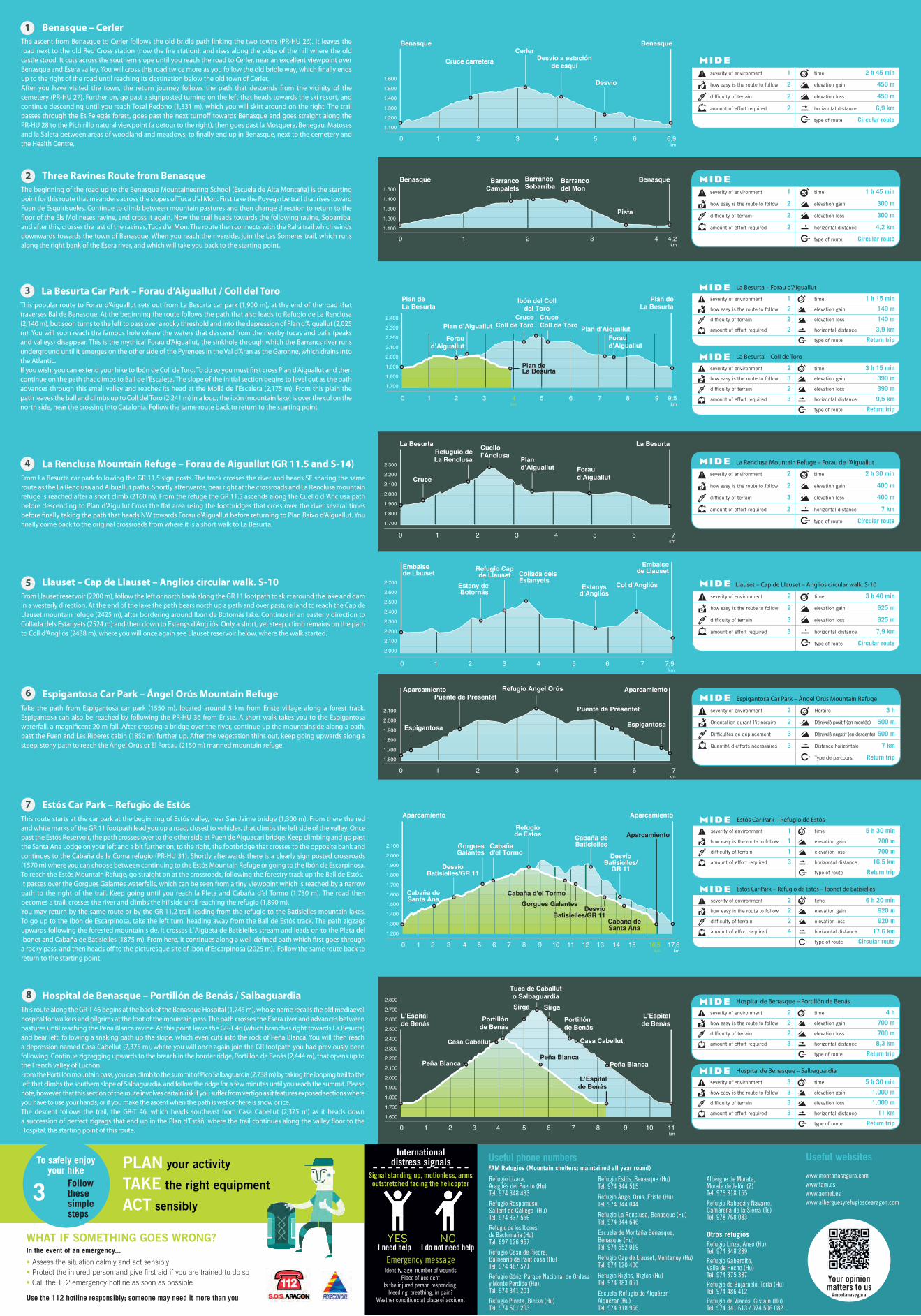
Hospital de Benasque – Portillón de Benás / SalbaguardiaThis route along the GR-T 46 begins at the back of the Benasque Hospital (1,745 m), whose name recalls the old mediaeval hospital for walkers and pilgrims at the foot of the mountain pass. The path crosses the Ésera river and advances between pastures until reaching the Peña Blanca ravine. At this point leave the GR-T 46 (which branches right towards La Besurta) and bear left, following a snaking path up the slope, which even cuts into the rock of Peña Blanca. You will then reach a depression named Casa Cabellut (2,375 m), where you will once again join the GR footpath you had previously been following. Continue zigzagging upwards to the breach in the border ridge, Portillón de Benás (2,444 m), that opens up to the French valley of Luchon.From the Portillón mountain pass, you can climb to the summit of Pico Salbaguardia (2,738 m) by taking the looping trail to the left that climbs the southern slope of Salbaguardia, and follow the ridge for a few minutes until you reach the summit. Please note, however, that this section of the route involves certain risk if you suffer from vertigo as it features exposed sections where you have to use your hands, or if you make the ascent when the path is wet or there is snow or ice.The descent follows the trail, the GR-T 46, which heads southeast from Casa Cabellut (2,375 m) as it heads down a succession of perfect zigzags that end up in the Plan d’Estáñ, where the trail continues along the valley floor to the Hospital, the starting point of this route.
Your opinionmatters to us
#montanasegura
severity of environment 2
how easy is the route to follow 2
difficulty of terrain 3
amount of effort required 2
time 2 h 30 min
elevation gain 400 m
elevation loss 400 m
horizontal distance 7 km
type of route Circular route
La Renclusa Mountain Refuge – Forau de l’AiguallutLa Renclusa Mountain Refuge – Forau de Aiguallut (GR 11.5 and S-14)From La Besurta car park following the GR 11.5 sign posts. The track crosses the river and heads SE sharing the same route as the La Renclusa and Aibuallut paths. Shortly afterwards, bear right at the crossroads and La Renclusa mountain refuge is reached after a short climb (2160 m). From the refuge the GR 11.5 ascends along the Cuello dl’Anclusa path before descending to Plan d’Aigullut.Cross the flat area using the footbridges that cross over the river several times before finally taking the path that heads NW towards Forau d’Aiguallut before returning to Plan Baixo d’Aiguallut. You finally come back to the original crossroads from where it is a short walk to La Besurta.
4
Llauset – Cap de Llauset – Anglios circular walk. S-10From Llauset reservoir (2200 m), follow the left or north bank along the GR 11 footpath to skirt around the lake and dam in a westerly direction. At the end of the lake the path bears north up a path and over pasture land to reach the Cap de Llauset mountain refuge (2425 m), after bordering around Ibón de Botomás lake. Continue in an easterly direction to Collada dels Estanyets (2524 m) and then down to Estanys d’Angliós. Only a short, yet steep, climb remains on the path to Coll d’Angliós (2438 m), where you will once again see Llauset reservoir below, where the walk started.
severity of environment 2
how easy is the route to follow 2
difficulty of terrain 3
amount of effort required 3
time 3 h 40 min
elevation gain 625 m
elevation loss 625 m
horizontal distance 7,9 km
type of route Circular route
Llauset – Cap de Llauset – Anglios circular walk. S-10
6
Estós Car Park – Refugio de EstósThis route starts at the car park at the beginning of Estós valley, near San Jaime bridge (1,300 m). From there the red and white marks of the GR 11 footpath lead you up a road, closed to vehicles, that climbs the left side of the valley. Once past the Estós Reservoir, the path crosses over to the other side at Puen de Aiguacari bridge. Keep climbing and go past the Santa Ana Lodge on your left and a bit further on, to the right, the footbridge that crosses to the opposite bank and continues to the Cabaña de la Coma refugio (PR-HU 31). Shortly afterwards there is a clearly sign posted crossroads (1570 m) where you can choose between continuing to the Estós Mountain Refuge or going to the Ibón de Escarpinosa.To reach the Estós Mountain Refuge, go straight on at the crossroads, following the forestry track up the Ball de Estós.It passes over the Gorgues Galantes waterfalls, which can be seen from a tiny viewpoint which is reached by a narrow path to the right of the trail. Keep going until you reach la Pleta and Cabaña d’el Tormo (1,730 m). The road then becomes a trail, crosses the river and climbs the hillside until reaching the refugio (1,890 m).You may return by the same route or by the GR 11.2 trail leading from the refugio to the Batisielles mountain lakes. To go up to the Ibón de Escarpinosa, take the left turn, heading away from the Ball de Estós track. The path zigzags upwards following the forested mountain side. It crosses L´Aigüeta de Batisielles stream and leads on to the Pleta del Ibonet and Cabaña de Batisielles (1875 m). From here, it continues along a well-defined path which first goes through a rocky pass, and then heads off to the picturesque site of Ibón d’Escarpinosa (2025 m). Follow the same route back to return to the starting point.
5
Espigantosa Car Park – Ángel Orús Mountain RefugeTake the path from Espigantosa car park (1550 m), located around 5 km from Eriste village along a forest track. Espigantosa can also be reached by following the PR-HU 36 from Eriste. A short walk takes you to the Espigantosa waterfall, a magnificent 20 m fall. After crossing a bridge over the river, continue up the mountainside along a path, past the Fuen and Les Riberes cabin (1850 m) further up. After the vegetation thins out, keep going upwards along a steep, stony path to reach the Ángel Orús or El Forcau (2150 m) manned mountain refuge.
severity of environment 2
Orientation durant l’itinéraire 2
Difficultés de déplacement 3
Quantité d’efforts nécessaires 3
Horaire 3 h
Dénivelé positif (en montée) 500 m
Dénivelé négatif (en descente) 500 m
Distance horizontale 7 km
Type de parcours Return trip
Espigantosa Car Park – Ángel Orús Mountain Refuge
Useful phone numbersFAM Refugios (Mountain shelters; maintained all year round)
1
3
Benasque – CerlerThe ascent from Benasque to Cerler follows the old bridle path linking the two towns (PR-HU 26). It leaves the road next to the old Red Cross station (now the fire station), and rises along the edge of the hill where the old castle stood. It cuts across the southern slope until you reach the road to Cerler, near an excellent viewpoint over Benasque and Ésera valley. You will cross this road twice more as you follow the old bridle way, which finally ends up to the right of the road until reaching its destination below the old town of Cerler.After you have visited the town, the return journey follows the path that descends from the vicinity of the cemetery (PR-HU 27). Further on, go past a signposted turning on the left that heads towards the ski resort, and continue descending until you reach Tosal Redono (1,331 m), which you will skirt around on the right. The trail passes through the Es Felegás forest, goes past the next turnoff towards Benasque and goes straight along the PR-HU 28 to the Pichirillo natural viewpoint (a detour to the right), then goes past la Mosquera, Benegau, Matoses and la Saleta between areas of woodland and meadows, to finally end up in Benasque, next to the cemetery and the Health Centre.
Three Ravines Route from BenasqueThe beginning of the road up to the Benasque Mountaineering School (Escuela de Alta Montaña) is the starting point for this route that meanders across the slopes of Tuca d’el Mon. First take the Puyegarbe trail that rises toward Fuen de Esquirisueles. Continue to climb between mountain pastures and then change direction to return to the floor of the Els Molineses ravine, and cross it again. Now the trail heads towards the following ravine, Sobarriba, and after this, crosses the last of the ravines, Tuca d’el Mon. The route then connects with the Rallá trail which winds downwards towards the town of Benasque. When you reach the riverside, join the Les Someres trail, which runs along the right bank of the Ésera river, and which will take you back to the starting point.
La Besurta Car Park – Forau d’Aiguallut / Coll del ToroThis popular route to Forau d’Aiguallut sets out from La Besurta car park (1,900 m), at the end of the road that traverses Bal de Benasque. At the beginning the route follows the path that also leads to Refugio de La Renclusa (2,140 m), but soon turns to the left to pass over a rocky threshold and into the depression of Plan d’Aiguallut (2,025 m). You will soon reach the famous hole where the waters that descend from the nearby tucas and balls (peaks and valleys) disappear. This is the mythical Forau d’Aiguallut, the sinkhole through which the Barrancs river runs underground until it emerges on the other side of the Pyrenees in the Val d’Aran as the Garonne, which drains into the Atlantic.If you wish, you can extend your hike to Ibón de Coll de Toro. To do so you must first cross Plan d’Aiguallut and then continue on the path that climbs to Ball de l’Escaleta. The slope of the initial section begins to level out as the path advances through this small valley and reaches its head at the Mollá de l’Escaleta (2,175 m). From this plain the path leaves the ball and climbs up to Coll del Toro (2,241 m) in a loop; the ibón (mountain lake) is over the col on the north side, near the crossing into Catalonia. Follow the same route back to return to the starting point.
2
severity of environment 1
how easy is the route to follow 2
difficulty of terrain 2
amount of effort required 2
time 2 h 45 min
elevation gain 450 m
elevation loss 450 m
horizontal distance 6,9 km
type of route Circular route
severity of environment 1
how easy is the route to follow 2
difficulty of terrain 2
amount of effort required 2
time 1 h 45 min
elevation gain 300 m
elevation loss 300 m
horizontal distance 4,2 km
type of route Circular route
severity of environment 1
how easy is the route to follow 2
difficulty of terrain 2
amount of effort required 2
time 1 h 15 min
elevation gain 140 m
elevation loss 140 m
horizontal distance 3,9 km
type of route Return trip
La Besurta – Forau d’Aiguallut
severity of environment 2
how easy is the route to follow 3
difficulty of terrain 2
amount of effort required 3
time 3 h 15 min
elevation gain 390 m
elevation loss 390 m
horizontal distance 9,5 km
type of route Return trip
La Besurta – Coll de Toro
severity of environment 2
how easy is the route to follow 2
difficulty of terrain 2
amount of effort required 3
time 4 h
elevation gain 700 m
elevation loss 700 m
horizontal distance 8,3 km
type of route Return trip
Hospital de Benasque – Portillón de Benás
severity of environment 3
how easy is the route to follow 3
difficulty of terrain 3
amount of effort required 3
time 5 h 30 min
elevation gain 1.000 m
elevation loss 1.000 m
horizontal distance 11 km
type of route Return trip
Hospital de Benasque – Salbaguardia
severity of environment 1
how easy is the route to follow 1
difficulty of terrain 1
amount of effort required 3
time 5 h 30 min
elevation gain 700 m
elevation loss 700 m
horizontal distance 16,5 km
type of route Return trip
Estós Car Park – Refugio de Estós
severity of environment 2
how easy is the route to follow 2
difficulty of terrain 2
amount of effort required 4
time 6 h 20 min
elevation gain 920 m
elevation loss 920 m
horizontal distance 17,6 km
type of route Circular route
Estós Car Park – Refugio de Estós – Ibonet de Batisielles
WHat IF SomEtHIng goES Wrong?In the event of an emergency...
• Assess the situation calmly and act sensibly• Protect the injured person and give first aid if you are trained to do so• Call the 112 emergency hotline as soon as possible
To safely enjoy your hike
Follow these simple steps
pLan your activity
taKE the right equipment
aCt sensibly
Use the 112 hotline responsibly; someone may need it more than you
Internationaldistress signals
Signal standing up, motionless, arms outstretched facing the helicopter
I need help I do not need help
Emergency messageIdentity, age, number of wounds
Place of accidentIs the injured person responding,
bleeding, breathing, in pain?Weather conditions at place of accident