S1 Mobile for Android App Class: Creating Editable … Editable Feature Services and Basemaps for...
49
August 2016 Presented by Michael Tripp Creating Editable Feature Services and Basemaps for Mobile DRAFT
Transcript of S1 Mobile for Android App Class: Creating Editable … Editable Feature Services and Basemaps for...

August 2016
Presented by Michael Tripp
Creating Editable Feature Services
and Basemaps for Mobile
DRAFT

DRAFT
Service 1st TeamOregon and Washington US Department of the Interior
Bureau of Land ManagementRegion 6 US Department of Agriculture
Forest Service

DRAFT
Today’s Topics
Publishing a Hosted Feature Service
Creating a Tile Package (TPK)
Time for Questions
Group Discussion

DRAFT
What is a Feature Service A platform that allows spatial data to be served over
the web providing feature symbology, database schema, and the ability to query/edit/sync field collected features.

DRAFT
Publishing a Hosted Feature Service Scope of a Hosted Feature Service Project level data
o This type of data frequently does not have an enterprise database
To collect and interact with data using the S1 Application Data must be published as a feature service
Publisher account in ArcGIS Online (AGOL) Custom role required to publish and manage a feature
service
Once a Publisher has the correct AGOL account permissions Use ArcMap to publish data as a hosted feature service Citrix Environment or stand-alone computer
DRAFT
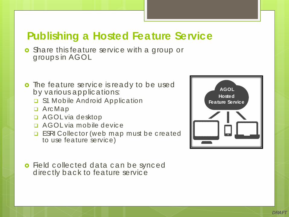
Publishing a Hosted Feature Service Share this feature service with a group or
groups in AGOL
The feature service is ready to be used by various applications: S1 Mobile Android Application ArcMap AGOL via desktop AGOL via mobile device ESRI Collector (web map must be created
to use feature service)
Field collected data can be synced directly back to feature service
AGOLHosted
Feature Service

DRAFT
Hosted Feature Service Workflow
BLM or USFS Publisher
BLM or USFS Citrix User
BLM or USFS Web User
BLM or USFS Field Workers
PublishMap
Create Local GDB
Copy for Editing
Hosted FeatureService
OfflineGDB Syncs
WebMap
DRAFT
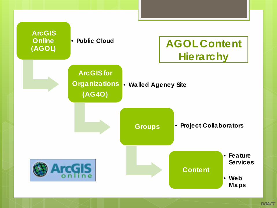
ArcGIS Online (AGOL)
• Public Cloud
ArcGIS forOrganizations
(AG4O)• Walled Agency Site
Groups • Project Collaborators
Content
• Feature Services
• Web Maps
AGOL Content Hierarchy

DRAFT
Steps to Publish a Hosted Feature Service Pre-work Create file geodatabase (GDB) and feature classes
ArcMap set-up Configure data frame and feature class properties
Sign into AG4O account
Publish Service Configure the Service Editor
Analyze/Prepare Window
Publish the service

DRAFT
Pre-work before Publishing Create GDB and feature classes Set coded value domains
Set default values for fields
Set required values for fields
Create attachments if photos are to be part of the feature service
Use GlobalID as primary key when working with related tables
DRAFT
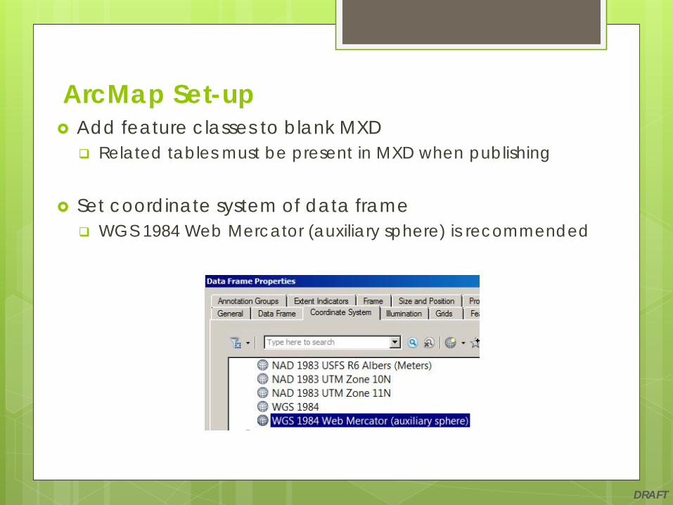
ArcMap Set-up Add feature classes to blank MXD Related tables must be present in MXD when publishing
Set coordinate system of data frame WGS 1984 Web Mercator (auxiliary sphere) is recommended
DRAFT
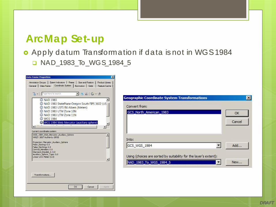
ArcMap Set-up Apply datum Transformation if data is not in WGS 1984 NAD_1983_To_WGS_1984_5

DRAFT
ArcMap Set-up Important for USFS and BLM publishers using R6 Albers Projection Set data frame to correct coordinate system if publishing a
feature service using R6 Alberso Location of projection: Projected Coordinate System > State Systemso Name : NAD 1983 USFS R6 Albers (Meters)o Sets WKID (Well-Known ID): 102218o Sets Authority: ESRI
CorrectIncorrect

DRAFT
Set extent of MXD This extent will be the area in which data can be collected using
the feature service
Zoom data frame to full extent of where features will be collected Ex: Forest Service Boundary, BLM District Resource Area
Choose Other and Specify Extent Set to Current Visible Extent
ArcMap Set-up

DRAFT
ArcMap Set-up Remove all layers from map not part of editable
feature service such as reference data or imagery
Make sure a feature template has been created prior to publishing
Keep symbology simple for points, lines and polygons Set point size: 16-20
Set line width: 2-5
Set polygon outline width: 2-5
Set Maximum and Minimum Scale Ranges
Turn off non-essential fields
Turn on/off labels as needed
Save MXD

DRAFT
Start ArcMap and open the map you want to publish
Enter your Username and Password for your ArcGIS Online account BLM users login to AGOL DOI SAML User
account (Enterprise Account)o Enter your ArcGIS organization's URL:
blm-egis.maps.arcgis.como Choose Using Your DOI Accounto If prompted, pick the appropriate
certificateo Enter Smart Card PIN
USFS users login to standard AGOL account
Publish a Hosted Feature Service

DRAFT
Access File Menu in ArcMap Share as a Service File > Share As > Service
Choose Publish a service
Publish a Hosted Feature Service
DRAFT
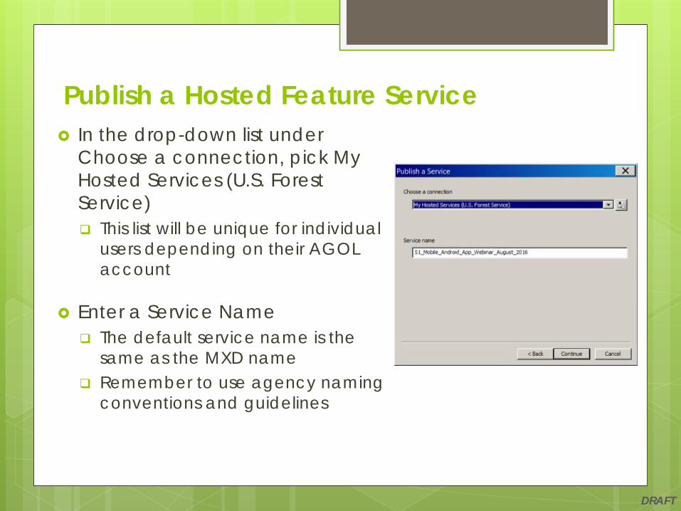
In the drop-down list under Choose a connection, pick My Hosted Services (U.S. Forest Service) This list will be unique for individual
users depending on their AGOL account
Enter a Service Name The default service name is the
same as the MXD name Remember to use agency naming
conventions and guidelines
Publish a Hosted Feature Service

DRAFT
Recommended not to change default settings for Parameters These settings will be grayed out until you activate
Feature Access under Capabilities tab
Publish a Hosted Feature Service

DRAFT
Activate Capabilities Tab Turn ON Feature Access by checking box Turn OFF Tiled Mapping by unchecking box
Publish a Hosted Feature Service

DRAFT
Activate Feature Access Tab Turn ON all operations by checking boxes under Operations
allowed: o Createo Deleteo Query o Synco Update
Publish a Hosted Feature Service

DRAFT
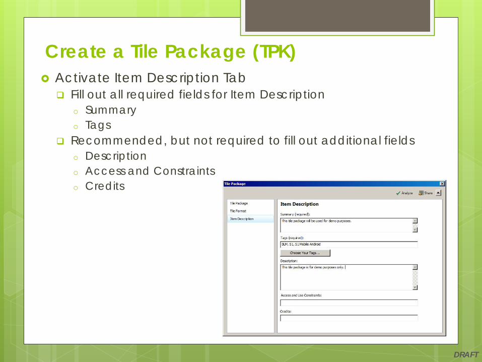
Activate Item Description Tab Fill out all required fields for Item Description
o Summaryo Tags
Recommended, but not required to fill out additional fields o Descriptiono Access and Constraintso Credits
Publish a Hosted Feature Service

DRAFT
Activate Sharing Tab Set who to Share your service with: Assign Members of these groups:
Publish a Hosted Feature Service

DRAFT
Analyze feature service to access Prepare window
All Errors must be fixed in the Prepare window before the service can be published
Optional, but recommended to fix Warnings and Messages
Publish a Hosted Feature Service

DRAFT
Analyze again to recheck for any additional errors, warnings, and messages
Publish when ready to publish the service
A message appears when the service has been published successfully
Publish a Hosted Feature Service

DRAFT
Publishing Internal Feature Services
Scope of an Internal Feature Service Enterprise level data
o Data is stored on an internal server (ex. ArcGIS Server) in an SDE environment
Data from the feature service is synced directly back to SDE enterprise database
The details and workflow of this methodology are currently being established for both BLM and USFS

DRAFT
Simplified Internal Feature Services Workflow
Image credit: http://server.arcgis.com/en/server/10.3/publish-services/linux/GUID-DD228B30-3D3B-4A92-B8BB-9DD3C7902CA9-web.png
DRAFT
Custom Roles in AGOL
Custom Roles by Agency to Publish Feature Services
USFS Publisher o Ability to publish services and create groups
BLM Publisher and Group Assignero Ability to publish services and create groups

DRAFT
How to request a Publisher Account BLM Request:
AGOL Accounto https://blmspace.blm.doi.net/oc/intra/drs/Sit
ePages/SOP1%20001%20Requesting%20Access%20to%20AGOL.pdf
AGOL DOI SAML User Accounto https://blmspace.blm.doi.net/oc/intra/drs/Sit
ePages/How%20to%20get%20an%20AGOL%20DOI%20SAML%20User%20Account.pdf
USFS Request: AGOL Account
o http://fswebgstc.gsc.wo.fs.fed.us/services/applications_tools/AGOL/request_access.php
DRAFT
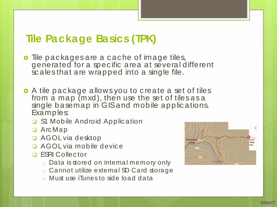
Tile Package Basics (TPK) Tile packages are a cache of image tiles,
generated for a specific area at several different scales that are wrapped into a single file.
A tile package allows you to create a set of tiles from a map (mxd), then use the set of tiles as a single basemap in GIS and mobile applications. Examples: S1 Mobile Android Application ArcMap AGOL via desktop AGOL via mobile device ESRI Collector
o Data is stored on internal memory only o Cannot utilize external SD Card storageo Must use iTunes to side load data
DRAFT
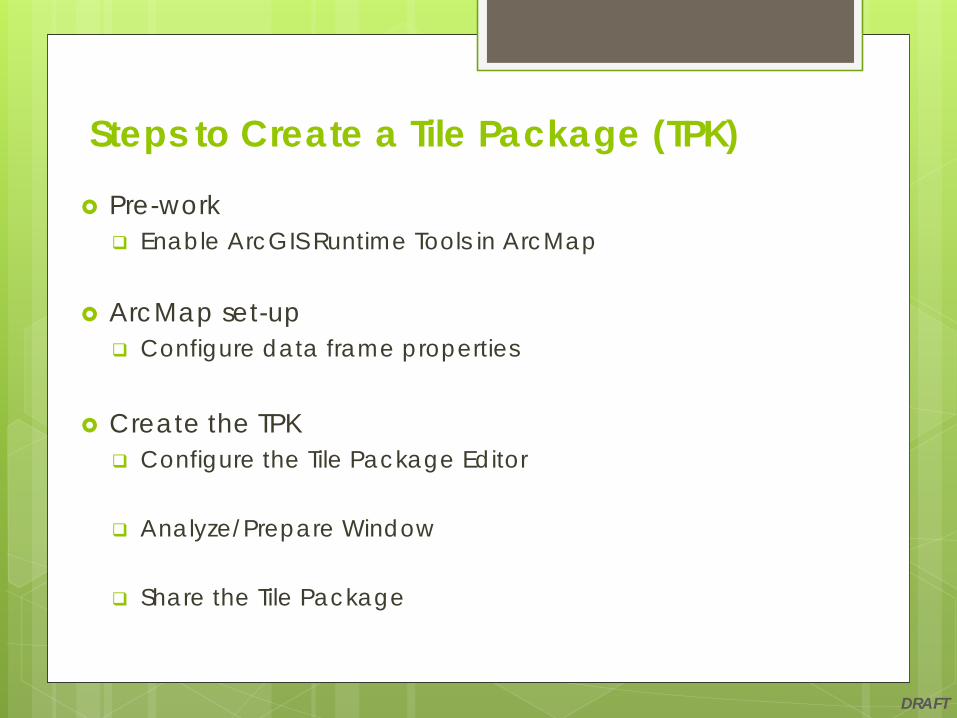
Steps to Create a Tile Package (TPK)
Pre-work Enable ArcGIS Runtime Tools in ArcMap
ArcMap set-up Configure data frame properties
Create the TPK Configure the Tile Package Editor
Analyze/Prepare Window
Share the Tile Package
DRAFT
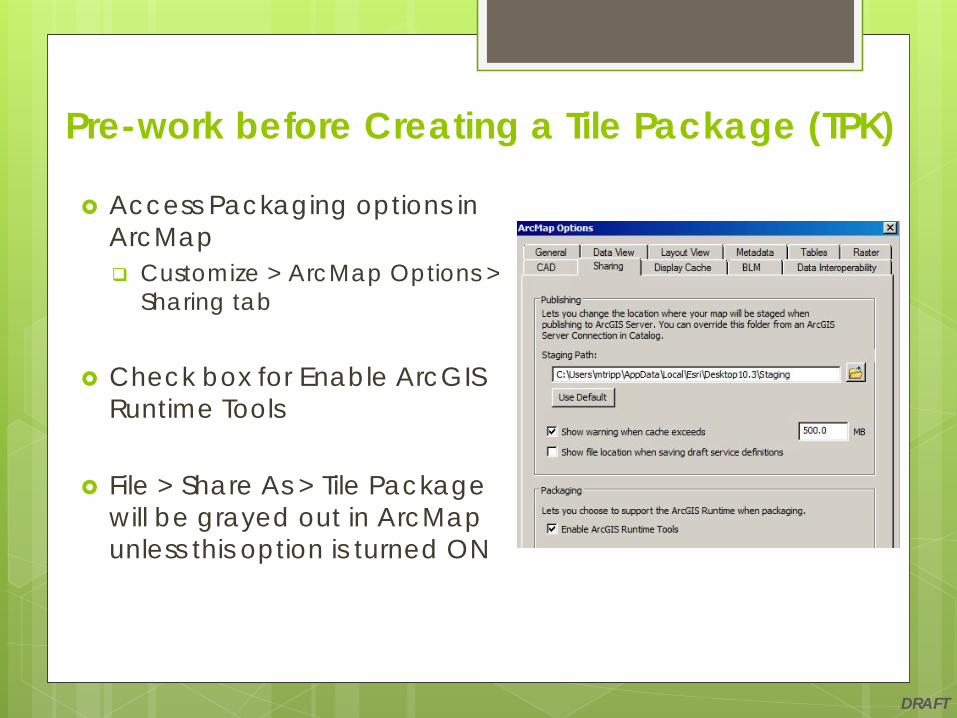
Pre-work before Creating a Tile Package (TPK)
Access Packaging options in ArcMap Customize > ArcMap Options >
Sharing tab
Check box for Enable ArcGIS Runtime Tools
File > Share As > Tile Package will be grayed out in ArcMap unless this option is turned ON
DRAFT
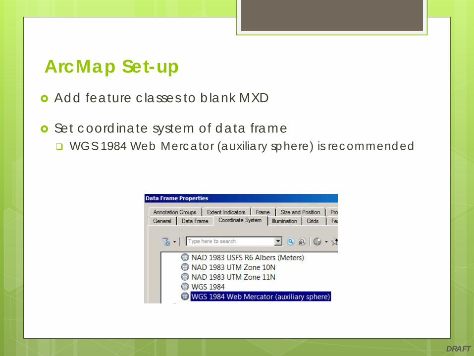
ArcMap Set-up Add feature classes to blank MXD
Set coordinate system of data frame WGS 1984 Web Mercator (auxiliary sphere) is recommended

DRAFT
ArcMap Set-up Apply datum Transformation if data is not in WGS 1984 NAD_1983_To_WGS_1984_5

DRAFT
Zoom map to the maximum extent desired in the tile package.
A large map extent will increase processing time as well as output file size
Data Frame Properties > Data Frame Choose Other and Specify Extent Set to Current Visible Extent
ArcMap Set-up

DRAFT
Define the outer edge of the map extent This setting clips map extent to the current visible extent Helps to reduce processing time and file size
Clip Options Choose Clip to shape
Specify Extent Set to Current Visible Extent
ArcMap Set-up

DRAFT
Set data frame background to no color
Data Frame Properties > Frame tab In the Background section
o Set Color patch: No Color
ArcMap Set-up
DRAFT
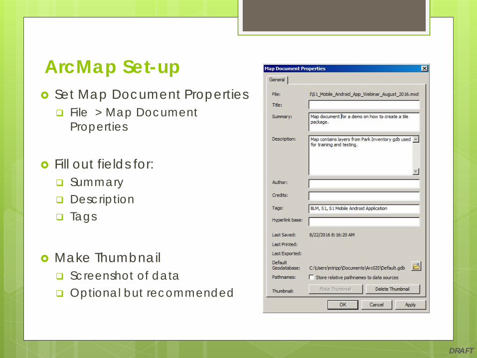
Set Map Document Properties File > Map Document
Properties
Fill out fields for: Summary Description Tags
Make Thumbnail Screenshot of data Optional but recommended
ArcMap Set-up

DRAFT
Share as a Tile Package Access File Menu in ArcMap File > Share As > Tile Package
o This option will be grayed out unless ArcGIS Runtime Tools are enabled in ArcMap Options (Sharing tab)
Create a Tile Package (TPK)

DRAFT
Activate Tile Package Tab Specify location of where to save tile package
o Network location o Local folder on desktop
Create a Tile Package (TPK)

DRAFT
Activate Tile Format Tab Set Tiling Scheme: ArcGIS Online/Bing Maps/ Google Maps Set Tiling Format: PNG8 Set Level of Detail by moving the slider bar
o Approximate size of the tile package updates as bar is movedo A higher level of detail will increase processing time as well as
output file size Recommended to keep the tile package under 100MB in size
Create a Tile Package (TPK)
DRAFT
Activate Item Description Tab Fill out all required fields for Item Description
o Summaryo Tags
Recommended, but not required to fill out additional fields o Descriptiono Access and Constraintso Credits
Create a Tile Package (TPK)
DRAFT
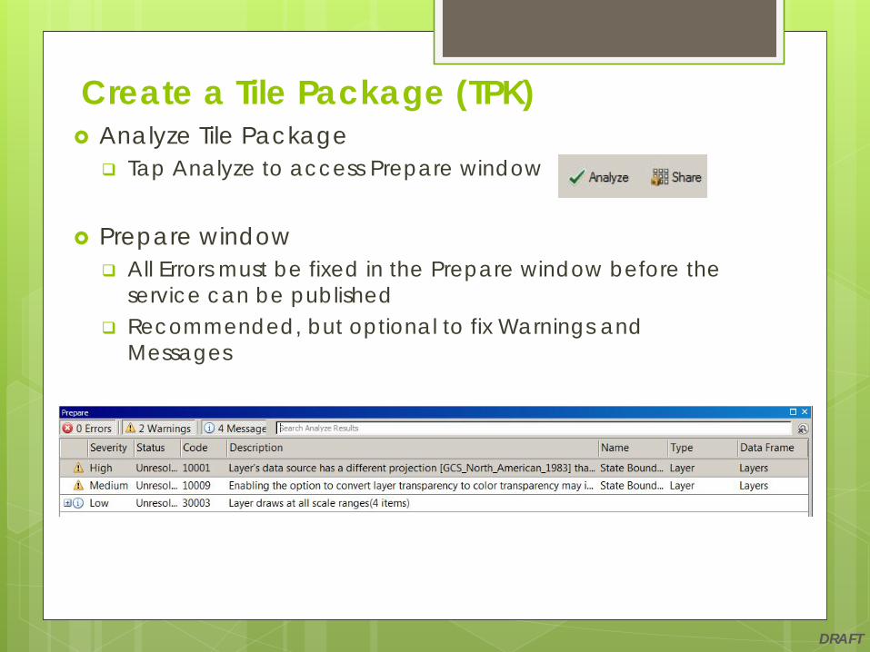
Analyze Tile Package Tap Analyze to access Prepare window
Prepare window All Errors must be fixed in the Prepare window before the
service can be published Recommended, but optional to fix Warnings and
Messages
Create a Tile Package (TPK)

DRAFT
Re-Analyze Tile Package Analyze again to recheck for any additional errors,
warnings, and messages
Share Tile Package Tap on Share A Save Map Document window may appear
o If prompted, save MXD and tap Yes
Create a Tile Package (TPK)

DRAFT
Packaging window Displays progress of the tile
package process Displays the number of tiles
being generated
Succeeded window Indicates tile package has
been successfully created Shows file path to tile package
Tap OK
Create a Tile Package (TPK)

DRAFT
Side Loading a Tile Package (TPK) Once a TPK has been created it can be side
loaded to a mobile device
With the S1 Application TPKs can either be used as: User Reference Maps:
o Side load to Local_Ref_Maps folder Base Maps:
o Side load to Offline_Base_Maps folder

DRAFT
Adding a Tile Package (TPK) to AGOL Important setting when adding a TPK to AGOL Uncheck box to Publish this file as a tile layer
o If checked, a feature service of the TPK is created rather than a stand-alone TPK
The TPK can be shared with a group or groups once added to AGOL
Link to pre-canned USFS TPKs http://fsweb-drm.r6.fs.fed.us/webmaps/tpks/

DRAFT
Aaron DickMobile GIS [email protected]
Michael TrippMobile GIS [email protected]
Forrest KayeMobile GIS [email protected]
S1 Team Resources
Thank You!
DRAFT
….Questions?
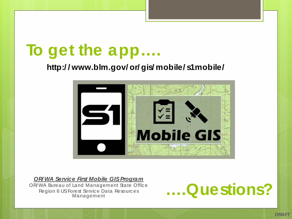
http://www.blm.gov/or/gis/mobile/s1mobile/To get the app….
OR/WA Service First Mobile GIS ProgramOR/WA Bureau of Land Management State Office
Region 6 US Forest Service Data Resources Management