RUSH LINE BUS RAPID TRANSIT STATION AREA PLANNING …
13
RUSH LINE BUS RAPID TRANSIT STATION AREA PLANNING OVERVIEW: WHITE BEAR LAKE MAY 2020
Transcript of RUSH LINE BUS RAPID TRANSIT STATION AREA PLANNING …

RUSH LINE BUS RAPID TRANSIT STATION AREA PLANNING
OVERVIEW: WHITE BEAR LAKE MAY 2020

i
TABLE OF CONTENTS 1.1. What is Station Area Planning? ................................................................................................. 1
1.2. Preliminary Station Area Planning ............................................................................................. 2
1.3. Available Implementation Resources......................................................................................... 8
1.4. Advanced Station Area Planning ............................................................................................. 10
LIST OF FIGURES Figure 1: Rush Line BRT Project Advisory Committees ....................................................................... 2
Figure 2: White Bear Lake Area Rush Line BRT Stations .................................................................... 4
Figure 3: White Bear Lake Demographic Characteristics ..................................................................... 5
Figure 4: White Bear Lake Employment Characteristics ...................................................................... 6
Figure 5: Six-Step Framework for Health Impact Assessments ........................................................... 7

1
The Rush Line Bus Rapid Transit (BRT) Project is a 15-mile proposed transit route with stops between Union Depot in Lowertown Saint Paul and downtown White Bear Lake. The project is currently in the environmental analysis phase, during which the project’s design is advanced while seeking to increase its potential benefits and minimize potential social and environmental impacts. During this phase, project staff have completed preliminary station area planning work to: inform platform location decisions and pedestrian and bicycle improvements; evaluate demographic, economic conditions in each station area; and identify ways to maximize the public health benefit of the project. The purpose of this memo is to summarize the station area planning work that has been completed to date and to lay the groundwork for advanced station area planning efforts for the Rush Line BRT Project. This memo:
• Defines station area planning and establishes the reasons it is important. • Summarizes preliminary station area planning efforts and highlights aspects of this planning
work that are applicable for future station area planning activities. • Summarizes findings from a market analysis of White Bear Lake station areas and lessons
learned from case studies of planning for transit-oriented development associated with other BRT projects.
• Outlines recommendations for pedestrian and bicycle improvements in addition to those planned as part of the Rush Line BRT Project and other capital improvements.
• Identifies station area planning resources available through Ramsey County, the Metropolitan Council and Metro Transit.
• Describes key tasks and anticipated outcomes of advanced station area planning.
This memo briefly summarizes the following documents, which are included in the appendices as noted:
• Station area planning meeting summaries (Appendix A). • Market Assessment (Appendix B). • Walkshed and Bikeshed Analysis (Appendix C). • Health Impact Assessment (Appendix D).
1.1. WHAT IS STATION AREA PLANNING? Station area planning is a process in which agency staff work together with community members to establish a plan for the area surrounding proposed transit stations. The goal of station area planning is to create a short-term and a long-term vision that reflects the community’s goals, promotes transit-oriented development, ensures that transit is effectively integrated with the surrounding community and helps the community enjoy and use a new transit investment. The result is a vision for the area coupled with a set of recommended actions and policy changes for cities, agencies and local communities to consider as they move forward to realize that vision. Implementation of station area plans will lead to equitable transit-oriented development that is consistent with local goals. Transit-oriented development is development that aims to increase the density of residential, commercial and leisure uses within one-half mile of a transit station. Equitable transit-oriented development should be driven by community priorities and values with the clear expectation that its outcomes will be responsive to underserved populations and vulnerable groups. In addition to these community benefits, station area planning is important for securing capital funding from the Federal Transit Administration. Several of the ratings used to determine a project’s eligibility
2
for New Starts funding are determined by whether land use policies in the project area are supportive of transit-oriented development or in the process of being updated.
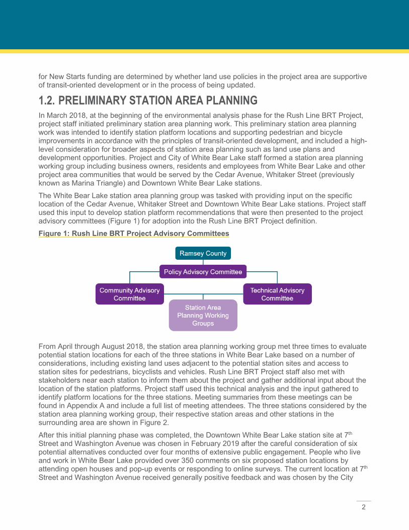
1.2. PRELIMINARY STATION AREA PLANNING In March 2018, at the beginning of the environmental analysis phase for the Rush Line BRT Project, project staff initiated preliminary station area planning work. This preliminary station area planning work was intended to identify station platform locations and supporting pedestrian and bicycle improvements in accordance with the principles of transit-oriented development, and included a high-level consideration for broader aspects of station area planning such as land use plans and development opportunities. Project and City of White Bear Lake staff formed a station area planning working group including business owners, residents and employees from White Bear Lake and other project area communities that would be served by the Cedar Avenue, Whitaker Street (previously known as Marina Triangle) and Downtown White Bear Lake stations. The White Bear Lake station area planning group was tasked with providing input on the specific location of the Cedar Avenue, Whitaker Street and Downtown White Bear Lake stations. Project staff used this input to develop station platform recommendations that were then presented to the project advisory committees (Figure 1) for adoption into the Rush Line BRT Project definition. Figure 1: Rush Line BRT Project Advisory Committees
From April through August 2018, the station area planning working group met three times to evaluate potential station locations for each of the three stations in White Bear Lake based on a number of considerations, including existing land uses adjacent to the potential station sites and access to station sites for pedestrians, bicyclists and vehicles. Rush Line BRT Project staff also met with stakeholders near each station to inform them about the project and gather additional input about the location of the station platforms. Project staff used this technical analysis and the input gathered to identify platform locations for the three stations. Meeting summaries from these meetings can be found in Appendix A and include a full list of meeting attendees. The three stations considered by the station area planning working group, their respective station areas and other stations in the surrounding area are shown in Figure 2. After this initial planning phase was completed, the Downtown White Bear Lake station site at 7th Street and Washington Avenue was chosen in February 2019 after the careful consideration of six potential alternatives conducted over four months of extensive public engagement. People who live and work in White Bear Lake provided over 350 comments on six proposed station locations by attending open houses and pop-up events or responding to online surveys. The current location at 7th Street and Washington Avenue received generally positive feedback and was chosen by the City

3
Council as the ultimate recommendation due to its minimal impacts on traffic and parking, adequate space for efficient and safe bus operations and proximity to key destinations. In addition to the three stations considered by the station area planning working group, the County Road E will serve part of White Bear Lake. White Bear Lake city staff and business owners attended station area planning meetings for the County Road E station to provide input on its location as well. Members of the County Road E station area planning working group expressed support for a station serving Buerkle Road. Based on this input, project staff recommended the addition of a station at this location, which was adopted into the project definition by the Policy Advisory Committee in September 2018 after the completion of this preliminary station area planning work.

4
Figure 2: White Bear Lake Area Rush Line BRT Stations

5
1.2.1. Market Assessment As part of the preliminary station area planning process, project staff conducted a market assessment for each station area, which is included in Appendix B. The Market Assessment is intended to provide a research base that will be used to inform future station area planning efforts rather than recommend any land use changes or development types. The goals of the Market Assessment are to establish an understanding of the economic conditions surrounding proposed Rush Line BRT stations, identify the types of development that would be supported given the existing conditions in each station area and describe tools and strategies that may be used to promote equitable transit-oriented development in station areas. The Market Assessment examines the following:
• Existing conditions. A high-level overview of project area communities and descriptions of the demographic and economic characteristics in each station areas. Summaries of the demographic and employment characteristics of White Bear Lake are shown in Figures 3 and 4.
• Peer system case studies. Analysis and summary of best practices and strategies from three existing BRT systems comparable to Rush Line BRT: CT Fastrak in the Hartford, Connecticut area; South Bay Rapid in San Diego, California; and Pulse BRT in Richmond, Virginia. The Market Assessment discusses zoning code updates, transit-oriented development, station area plans and other relevant elements of each of these BRT projects.
• Affordable housing considerations. Key considerations and best practices for affordable housing provision and preservation surrounding transit stations.
The Market Assessment identifies and describes a variety of tools and strategies to support transit-oriented development and affordable housing in proximity to peer BRT projects:
• Zoning code updates. Updating zoning codes is one of the first steps a community can take to prepare for growth and development around a transit station.
• Parking requirements. Parking requirements increase construction and maintenance costs and often result in an oversupply of parking at the expense of developing land for other, more productive uses. Reducing or eliminating the parking requirements for new development can leave more land available for development, improve walkability and encourage transit use.
Figure 3: White Bear Lake Demographic Characteristics

6
• Incentive policies. City policies can be used to incentivize development, including inclusionary zoning, reduction in permitting and development fees, density bonuses, expedited permitting and tax-increment financing.
• Public funding for affordable housing. To encourage development of affordable housing near transit stations, agencies may need to employ public funding sources. Potential approaches include land banking and housing trusts as well as leveraging federal, state and local funding sources.
• Public-private partnerships. Partnerships between local governments and the private sector, including the business sector and community-based nonprofit housing providers, can bring additional resources and skills to the development process in support of building affordable housing.
• Protecting existing affordable housing. New or enhanced transit service has the potential to displace nearby residents by increasing their housing costs. An early step to protect existing affordable housing is to develop an inventory of these units. Next, agencies may use a variety of strategies to preserve housing, including the acquisition of naturally-occurring affordable housing in order to preserve it, acquisition of subsidized properties and identification of long-term owners of naturally-occurring affordable housing.
1.2.2. Walkshed and Bikeshed Analysis As part of the preliminary station area planning process, project staff evaluated the existing walkshed (one-half mile walk) and bikeshed (3-mile distance) conditions around each proposed station. This analysis included identification of pedestrian and bicycle improvements proposed as part of the Rush Line BRT Project as well as other county- and city-led projects. The purpose of this evaluation was to determine where improvements to pedestrian and bicycle infrastructure are most needed to improve accessibility to proposed Rush Line BRT stations, in addition to those that are already planned. The report identifies additional improvements that could be undertaken by the local communities separate from the Rush Line BRT Project, evaluates the ease of implementing these improvements and
Figure 4: White Bear Lake Employment Characteristics
7
prioritizes the improvements. Priority pedestrian improvements for White Bear Lake are shown in pages 31 through 36 of the Walksheds Gap Recommendations and Improvements Summary (Appendix C) and include:
• Linden Street from Cedar Avenue to Birch Street. • Whitaker Street from Highway 61 to Lake Avenue. • 7th Street (north side) from Highway 61 to Cook Avenue.
Recommended pedestrian and bicycle improvements are described in full in Appendix C.
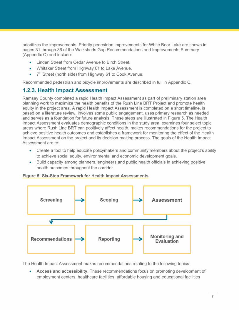
1.2.3. Health Impact Assessment Ramsey County completed a rapid Health Impact Assessment as part of preliminary station area planning work to maximize the health benefits of the Rush Line BRT Project and promote health equity in the project area. A rapid Health Impact Assessment is completed on a short timeline, is based on a literature review, involves some public engagement, uses primary research as needed and serves as a foundation for future analysis. These steps are illustrated in Figure 5. The Health Impact Assessment evaluates demographic conditions in the study area, examines four select topic areas where Rush Line BRT can positively affect health, makes recommendations for the project to achieve positive health outcomes and establishes a framework for monitoring the effect of the Health Impact Assessment on the project and its decision-making process. The goals of the Health Impact Assessment are to:
• Create a tool to help educate policymakers and community members about the project’s ability to achieve social equity, environmental and economic development goals.
• Build capacity among planners, engineers and public health officials in achieving positive health outcomes throughout the corridor.
Figure 5: Six-Step Framework for Health Impact Assessments
The Health Impact Assessment makes recommendations relating to the following topics:
• Access and accessibility. These recommendations focus on promoting development of employment centers, healthcare facilities, affordable housing and educational facilities
8
proximate to transit. These recommendations also address infrastructure improvements for pedestrians and bicyclists.
• Connectivity. These recommendations focus on updating zoning to allow for transit-oriented development near stations, connecting the street grid to better serve pedestrians and bicyclists, implementing wayfinding signage near stations and repurposing underused parking facilities.
• Employment and jobs. These recommendations focus on recruiting, retaining and growing businesses located near stations, as well as promoting transit use among employees who work in station areas.
• Affordable housing. These recommendations focus on preserving naturally occurring affordable housing and implementing programs and policies to promote development of multi-family and affordable housing in station areas.
The full document, including research on these topic areas and recommendations for each, is included in Appendix D.
1.3. AVAILABLE IMPLEMENTATION RESOURCES There are financial resources available at the federal, regional and county level to assist municipalities in planning for and implementing transit-oriented development.
1.3.1. Federal Transit Administration Grants to Support Joint Development Joint Development commonly refers to the coordinated development of public transportation facilities with non-transit commercial, residential or public facilities. Joint development may be associated with, or take place on property associated with, any mode of public transportation. Strategic, coordinated Joint Development can enhance the value of both the transit and non-transit, public and private, activities taking place on real property, resulting in an efficient use of real estate, reduced distances between transportation and destinations, and focused economic development for communities. Project sponsors can pursue Joint Development through new grants or with property previously acquired with Federal Transit Administration (FTA) assistance. The project sponsor maintains satisfactory continuing control over such property used in a Joint Development project by ensuring that the property continues to serve its originally authorized purpose. Proceeds from an FTA-assisted Joint Development project, such as long-term ground lease payments, are considered program income, which the project sponsor may apply to eligible FTA capital or operating expenses. In this metropolitan region, Metropolitan Council is the project sponsor and public entities have become Joint Development partners. Section 5309, New Starts funds, can be the source of the grant funding. The Metro Transit Transit-Oriented Development Office and FTA Circular C7050.1A are the two key resources to learn more about how to use FTA funds or FTA-funded real property for Joint Development.
1.3.2. Metropolitan Council LIVABLE COMMUNITIES The Metropolitan Council offers funding for transit-oriented development through Livable Communities Demostration Account and Transit-Oriented Development grants disbursed by its Livable Communities grant program. Livable Communities Demonstration Account grants fund innovative

9
development and redevelopment projects that efficiently link housing, jobs, services and transit. Successful projects:
• Connect housing, jobs, civic sites, retail centers and local/regional transportation systems. • Demonstrate a variety of housing densities, types and costs; creative placemaking;
environmentally sensitive development; and compact land use. • Catalyze additional development that efficiently uses land and infrastructure, and supports
vibrant, diverse communities.
Transit-Oriented Development grants promote moderate- to higher-density development, typically with a mix of uses such as housing, jobs and retail, located within one-half mile of a major transit stop. There are three types of Transit-Oriented Development grants:
• Pre-Development. Pre-Development grants are intended for applicants that have identified a redevelopment site that exemplifies Livable Communities Demonstration Account goals and are defining their transit-oriented development project through activities such as design workshops, financial analyses and market studies.
• Development. Development grants are intended for applicants that are ready to begin a development or redevelopment project that exemplifies Livable Communities Demonstration Account goals and have the land and/or infrastructure necessary to support it.
• Zoning Implementation. Zoning Implementation grants are intended for applicants that need to craft transit-oriented development zoning ordinances, such as form-based codes, to implement existing small area or station area plans.
The Rush Line BRT Project is currently eligible for Pre-Development and Zoning Implementation grants. In the future, the Rush Line BRT Project may also become eligible for Development grants. Information about the Livable Communities goals for each grant program is available online at https://metrocouncil.org/Communities/Services/ Livable-Communities-Grants/Transit-Oriented-Development.aspx.1 These grants could be used for future residential, commercial and/or mixed-use projects proximate to the Rush Line BRT route.
REGIONAL SOLICITATION Every two years, the Regional Solicitation distributes federal transportation funds to locally initiated projects that meet regional transportation needs. Regional Solicitation requires only a 20 percent local match for qualifying projects. The Metropolitan Council works with the Transportation Advisory Board to review and allocate these funds using a data-driven process. The three federally funded programs for the solicitations are the Surface Transportation Block Grant Program, the Congestion Mitigation Air Quality Program and Highway Safety Improvement Program. Regional Solicitation funds may be used to fund pedestrian and bicycle improvements beyond those currently planned by the project and project area communities.
1.3.3. Ramsey County Ramsey County operates a Corridor Revitalization Pilot Program, which may be leveraged to finance work related to transit-oriented development. Existing and planned transitways are eligible for grants
1 Accessed February 2020.

10
through this program, and a grant through this program may be used to fund the following planning activities:
• Land use, small area, areawide and corridor planning initiatives. • Redevelopment feasibility or market analyses. • Infrastructure planning and conceptual designs, including pedestrian and bike connections and
public realm improvements.
Government entities and nonprofit organizations may apply for up to $50,000 in funding. Ramsey County’s Environmental Response Fund may also be used to help facilitate transit-oriented development. This fund is maintained by the Ramsey County Community and Economic Development Department and the Housing and Redevelopment Authority to support brownfield cleanup. Transit-oriented development sites are often previously occupied by another use, requiring cleanup to transform contaminated brownfield sites into viable new uses; thus, transit-oriented development projects may be eligible for this funding. The current contact for these programs is Rick Howden, Ramsey County Economic Development Specialist, 651-351-2454, [email protected].
1.4. ADVANCED STATION AREA PLANNING As the project design is further developed leading up to the anticipated start of construction in 2024, station area planning efforts should be advanced to build on the preliminary station area planning work described above. In November 2019, Ramsey County applied for a Transit-Oriented Planning Pilot Program grant through the Federal Transit Administration. If awarded, this grant would fund the next phase of station area planning for the Rush Line BRT Project, which would likely occur between 2020 and 2022. If not awarded, Ramsey County will consult with project area communities to determine how best to advance station area planning. Advanced station area planning will build off the information developed through the preliminary station area planning work and may include the following:
• Public and stakeholder engagement building on previous and ongoing public engagement efforts.
• A real estate market and housing gap analysis that identifies land uses, land availability, development and redevelopment opportunities, and housing availability and needs, among several other aspects of the real estate market. Staff will work with stakeholders including property brokers, city staff, affordable housing organizations and others to identify barriers to developing affordable and market-rate housing and set targets for preservation and development of affordable housing. Staff will also work to identify opportunities for commercial, residential and institutional development and redevelopment.
• Station area concepts and development plans that include an existing conditions analysis that evaluates land use plans and related policies, physical features such as character of the streetscape and building design, gaps in pedestrian and bicycle infrastructure, and improvements needed to enhance access for people with disabilities, pedestrians, transit riders and bicyclists. Staff will facilitate a visioning process to create a corridor-wide vision for station area concepts and land use change and stability. These plans will also identify desired scale and types of development and other aspects of the built environment and will
11
recommend land use and development policies that will facilitate transit-oriented development near stations.
• An implementation plan that identifies tools for planning and financing transit-oriented development; technical assistance needs for zoning, land use policies and affordable housing strategies; pedestrian and bike improvements; utilities and stormwater infrastructure needs; transit-oriented development financing and value-capture strategies; potential (re)development sites; and adoption of station area plans into local governing documents.