RURAL INFRASTRUCTURE FUND PROSECTpdf.usaid.gov/pdf_docs/PDABN690.pdf · RURAL INFRASTRUCTURE FUND...
53
RURAL INFRASTRUCTURE FUND PROSECT LOUIS BERGER INTERNATIONAL, HNC , 800 Halsted Sweet, fist Oranp, NJJB, 07019, U.S.A. 313 joint venture wib TECHNOSPHERE CONSULTANTS GROUP, HNC, 150 kpazpi St., kgqi Village, Makati, Metro Manila, Philippines -, --
Transcript of RURAL INFRASTRUCTURE FUND PROSECTpdf.usaid.gov/pdf_docs/PDABN690.pdf · RURAL INFRASTRUCTURE FUND...
RURAL INFRASTRUCTURE FUND PROSECT
LOUIS BERGER INTERNATIONAL, HNC , 800 Halsted Sweet, f i s t Oranp, NJJB, 07019, U.S.A.
313 joint venture w i b
TECHNOSPHERE CONSULTANTS GROUP, HNC, 150 kpazpi St., k g q i Village, Makati, Metro Manila, Philippines
-, --
REPUBLIC OF THE PHILIPPINES DEPARTMENT OF PUBLIC WORKS AND HIGHWAYS
RURAL INFRASTRUCTURE FUND PROJECT
(UNITED STATES AGENCY FOR INTERNATIONAL DEVELOPMENT PROJECT NO. 492-0420) 0.
4 aD
August 1991

PROPONENT
TYPE AND PURPOSE OF PROJECT
LOCATION OF TElE PROJECT
DESCRIPTION OF ENVIRONMENTAL SETTING
PROJECT SCALE AND CYCLE
SOURCES OF ENVlRONMENATAL IMPACT
ENVIRONMENTAL MANAGEMENT MEASURES
STATUS OF THE PROJECT
SIGNATURES OF PROJECT PROPONENT AND PROJECT DESCRIPTION PREPARER
APPENDIX A CONTACT LIST
APPENDIX B LIST OF FIGURES
PAGE
1
1
2
2
7
13
14
16
APPENDIX C PROJECT AREA PHOTOGRAPHS
APPENDIX D MINES ADMINISTRATNE ORDER NO. MRD 27
PROJECT DESCRIPTION Initial Environmental Examination
MAGAT BRIDGE
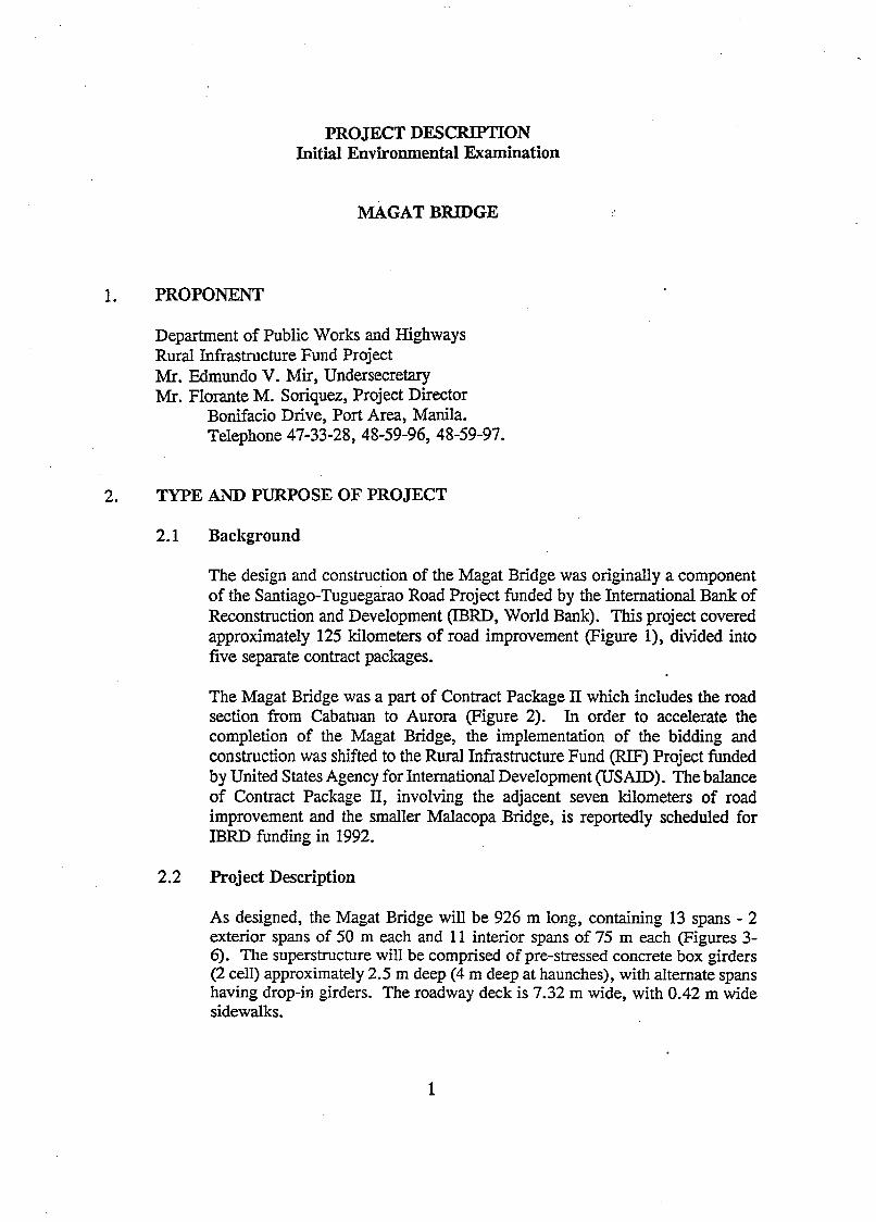
1. PROPONENT
Department of Public Works and Highways Rural Infrastructure Fund Project Mr. Edmundo V. Miry Undersecretary Mr. Florante M. Soriquez, Project Director
Bonifacio Drive, Port Area, Manila. Telephone 47-33-28, 48-59-96, 48-59-97.
2. TYPE AND PURPOSE OF PROJECT
2.1 Background
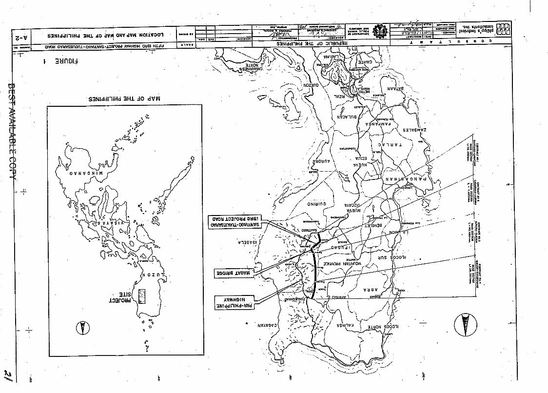
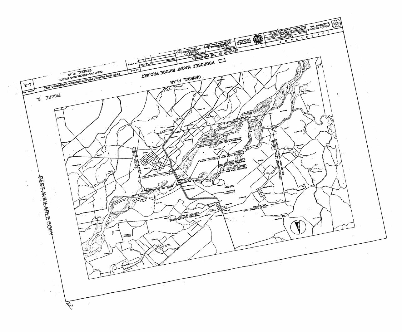
The design and construction of the Magat Bridge was originally a component of the Santiago-~uguegarao Road Project funded by the International Bank of Reconstruction and Development (IBRD, World Bank). This project covered approximately 125 kilometers of road improvement (Figure I), divided into five separate contract packages.
The Magat Bridge was a part of Contract Package 11 which includes the road section from Cabatuan to Aurora (Figure 2). In order to accelerate the completion of the Magat Bridge, the implementation of the bidding and construction was shifted to the Rural Infrastructure Fund (RE) Project funded by United States Agency for International Development (USAID). The balance of Contract Package 11, involving the adjacent seven kilometers of road improvement and the smaller Malacopa Bridge, is reportedly scheduled for IBRD funding in 1992.
2.2 Project Description
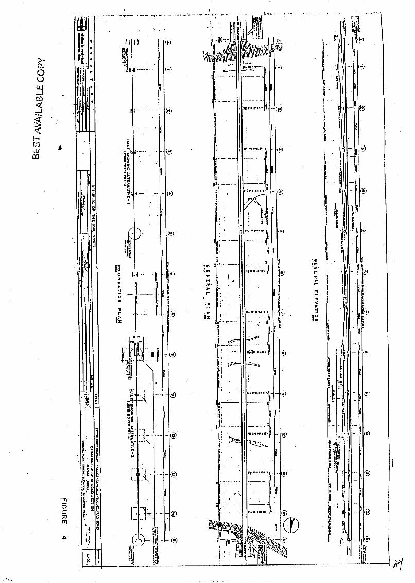
As designed, the Magat Bridge will be 926 m long, containing 13 spans - 2 exterior spans of 50 m each and 11 interior spans of 75 m each (Figures 3- 6). The superstructure will be comprised of pre-stressed concrete box girders (2 cell) approximately 2.5 m deep (4 m deep at haunches), with alternate spans having drop-in girders. The roadway deck is 7.32 m wide, with 0.42 m wide sidewalks.

The substructure will incorporate reinforced concrete piers and abutments supported by either driven steel H-piles or cast-in-place bored piles.
The proposed bridge project will include rubble-concrete revetments on each river bank (one 550 m length and one 242 m length) and also the two sections of approach road on each side of the bridge, one 250 m long and one 200 m long.
Purpose of the Project
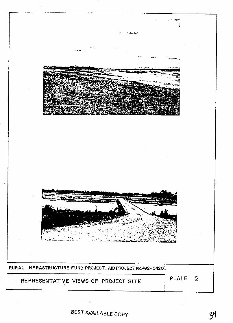
The existing IBRD Project Road, from Santiago to Tuguegarao, serves as the primary route to the agnculturaI communities of the western Czigayan Valley (Figure 7). Utilization of this important transportation route is limited by the existing Magat River crossing between the municipalities of Cabatuan and Aurora, which consists of a low, "Irish-bridge" or over-flow type structure covering part of the river's width (Plates 1-3). At present, vehicles must often ford the unbridged 450-500 m wide river section. During periods of high water the river is reportedly impassible and north-south traffic is diverted through the municipality of Roxas and the Pan-Philippine Highway; an added distance from Aurora to Cabatuan of nearly eighty kilometers (Figure 7). The current Road Influence Area (RIA) affects a population of over 600,000.
3. LOCATION OF THE PROJECT
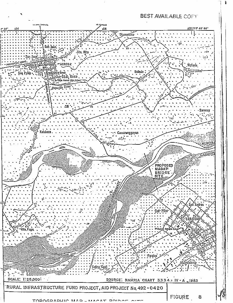
The proposed site of the Magat Bridge straddles, approximately mid-river, the political boundaries of Barangay Del Pilar of the Municipality of Cabatuan, and Barangay Saranay of the Municipality of Aurora (Figure 8). Both municipalities are located in the Province of Isabela, Region 11, in Northern Luzon (Figure I). Th~coordinates of the project site are approximately 121" 39' 00" east and 16" 58' 00" north. A reproduction of the latest available cadastral survey (1:20,000 scale, dated 1927), is provided for the project site in Figure 9.
4. DESCRIPTION OF ENVIRONMENTAL SETTING
4.1 Nearby Surface Water Bodies
The proposed Magat Bridge is a multi-span structure which will cross the Magat River between two municipalities of Isabela province; Cabatuan on the south and Aurora on the north.
Magat River flows across the Cagayan Valley in a northeasterly direction until it meets the Cagayan River 65 krn downstream. The hydroelectric and imgation potentid of the Magat River has been tapped with the construction of a series of multi-purpose dams, including the Maris Dam and the Magat Dam, 18 and 23 km upstream of the proposed bridge site, respectively (Figure 10).

In the vicinity of the proposed project are two major tributaries of the Magat River, namely the Tao-Tao River and the Malacopa Creek. The surrounding Cagayan Valley is laced with additional tributaries of the Cagayan River (Figure 10) as well as the distribution network of irrigation canals of the National Irrigation Administration (NTA).
Magat River was classified by the Environmental Management Bureau (EMB) in 1983 as a Class "C" river and continuous monitoring by the DENR regional office supports this classification. Class "C" waters are described as suitable for fishery, recreational and industrial uses. (DENR Administrative Order No. 34, Series of 1990).
The water of the Magat River is silty and brown in appearance and color as it carries eroded soil from upland slopes and stream banks.
In addition to wide-spread irrigation use of the Magat River provided by upstream multi-purpose dams, local use of the river is primarily for a limited, subsistence fishery of freshwater fish (tilapia) and shrimps. Observed catch methods include hand lines, traps and nets. Due to the silty nature of the Magat River water, local communities utilize abundant groundwater and pumps to provide domestic and drinking water needs.
4.2 Important Ecological Systems
In the vicinity of the proposed project site, the Cagayan Valley can be described as an expansive flood plain, with the dominant land cover primarily agricultural (Figure 11). Remnant, uncultivated riverine environments exist along scattered sections of surveyed water courses. Wetland areas which are too deep for rice cultivation may be seasonally present during the rainy season. Based on a literature review, the project vicinity does not include any undegraded or primary forest (initially identified on land cover maps); wetland areas (identified by the Asian Wetland Bureau); prime fisheries area; and areas under or proposed for protection as national parks or reserves.
In addition to the multi-purpose dams near Oscaris, Ramon, the water course and natural habitats of the Magat River have been altered by dry season farming practices and extensive river training structures, including a 15 km length of levees near San Mateo.
4.3 Land Uses
Agriculture is the predominant existing land use within the project vicinity (Figure 11; Plate 1). Based on the socio-economic profile available for the municipality of Cabatuan (1990), agricultural use occupies 6,266 ha or 78% of the total municipal land area, with the balance of the land use areas described as open grasslands, roads and irrigation canals. Rice and corn are the traditional .crops planted.
Similar land use is assumed for the adjoining municipality of Aurora, for which a current socio-economic profile was not obtained due to the flooded condition of the existing Magat River crossing at the time of the environmental field survey (August, 1991). ,
The Magat River bed, including an area near the proposed project site, has been utilized in the past as a traditional borrow source of aggregates and gravel. Use of river source borrow sites is anticipated to continue, as identified on the source materials map (Figure 7).
4.4 Existing Environmental or Population Problems
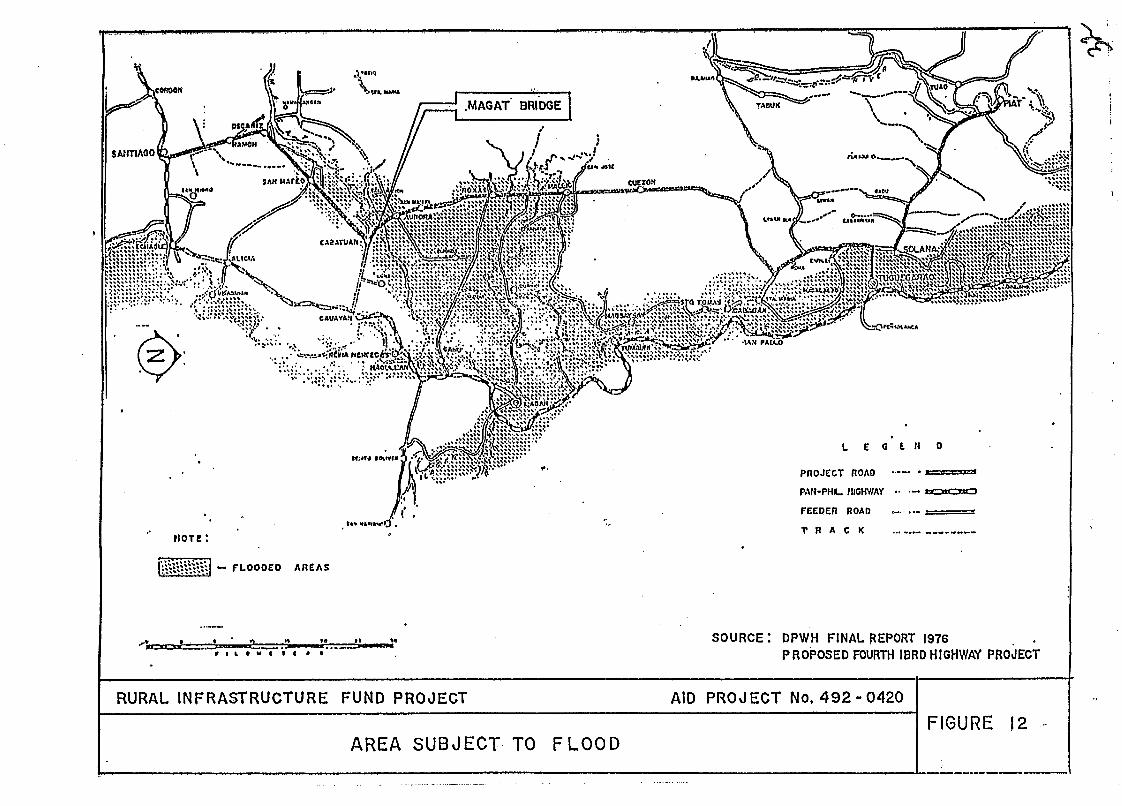
Flooding is the most prominent environmental problem besetting the two municipalities and adjacent areas as they form part of the Isabela flood plain. (Figure 12). This flood plain is shaped by the confluence of the Magat and Cagayan rivers. A number of factors contribute to flooding in the area including low elevation, poor drainage, high rainfall intensity, deforestation in the highland zones and overflowing of the Magat and Cagayan Rivers during periods of high water flow.
Prior to 1982, the year the Magat River Multi-Purpose Dam was completed, Cabatuan and Aurora were subject to seasonal floodwaters during the river's high stage discharge. For example, in 1971, flood depths of six meters were measured within the Magat Basin. With the construction and operation of the dam, it was observed and confirmed by local officials and residents that no major flooding has occurred in the area.
rought was also a recent environmental problem which occurred from the first months of 1991 to the usually wet months of May, June and July. The severity of the drought caused the alteration of the normal cropping seasons for rice and other crops. From three cropping cycles per year, it is likely that there will e only one cropping cycle for rice in 1991. The drought also depleted the ater stored at the Magat Dam reservoir which will only-be replenished with
anticipated onset of rains in August. I
Environmental problems related to the local prevalence of agriculture include the potential of surface and groundwater contamination by commonly used pesticides and fertilizers. Dust pollution, generated from milling and trucking operations, may be common following harvest. In Cabatuan alone, there are twelve rice and corn mills with a reported daily milling capacity of 1,500 metric tons. During a previous feasibility study (DPWH, 1988), nearly 60%, or 1000 MT of surveyed daily freight travelling the Santiago-Tuguegarao Project Road consisted of rice and corn products.
As identified in previous studies involving the Magat Bridge and through site visits and interviews, a primary population problem remains the poor condition and serviceability of the existing transportation infrastructure. serving the western Cagayan Valley.

4.5 S ocio-Er.onomic Indicators
Aurora - Saranay
Cabatuan
Del Pilar
Based on the 1990 National Statistical Coordination Board survey of population, the municipaIity of Aurora has a total population of 24,903 distributed among a total of 4,794 households or families. The proposed bridge would be located partially within the barangay of Saranay which has a popuIation of 346 comprising about 1.4 percent of the mucicipal population (Table 1). There is a total of 67 households in this barangay.
The municipality of Cabatuan has a slightly higher population than Aurora with a total population of 26,380 divided among 5,118 households. The project would be located partially within the barangay of Del Pilar which has a population of 1,246. This accounts for 4.7 percent of the total municipal population. A reported 257 households reside within this barangay.
From 1975 to 1987, the municipalities of Aurora and Cabatuan registered almost identical annual population growth rates of 2.48 percent and 2.47 percent respectively. These rates are lower than the annual provincial growth rate of 3.08 percent, which may indicate out migration from these rural areas.
Source: 1990 Census of Population and Housing National Statistics Office

4.5.2 Income
The 1988 National Statistics Office survey on family income indicated an annual average family income of P 36,145 ,for the province of Isabela. The province has a total of 37 municipalities. Income figures per household were not available for local barangay and municipality level comparisons.
As previously described, agriculture is the main source of income in the two municipalities of Aurora and Cabanatuan. In addition, they have a combined total of 83 agro-industrial establishments which include rice/corn mills, warehouses, grain driers and food factories. The two municipalities rank among the top ten municipalities of Isabela with regards to the number of agro-industrial establishments.
4.6 Environmentally Critical Projects and Areas
Presidential Proclamation No. 2146 (1983) describes specific projects and areas which are considered to be environmentally critical from the perspective of potential impact. Based on a review of this proclamation in relation to the described siting and scale of the Magat Bridge, the proposed project appears to fall within four categories of concern:
+ major roads and bridges which could affect the hydrology of traversed areas;
li major roads and bridges which could substantially increase or impede J traffic flow;
li areas frequently visited and/or hard-hit by natural calamities; and
+ areas classified as prime agricultural lands.
The management and mitigation of these four recognized categories of concern is included in Section 7, Environmental Management Measures.
.-I

PROJECT SCALE AND CYCLE
5.1 Project Area
Based on the project description (Section 2.2, includkg Figures 3-6) and review of the submitted construction method statement P.M. Consunji, Inc.), the estimated project area is 7.2 ha as summarized in Table 2. Of this estimated project area, approximltely 55% or 4.0 ha, is described as temporary use, construction areas (service roads, work camp, borrow sit?) while 3.4 ha encompasses the permanent project displacement area, in;luding the bridge surface area, river revetments and ay2roi:ch roads. T;le general location of these areas are indicated on Figures 2 and 3. Several local river sources for required aggregate materials are identified in Figure 7. Actual location of the project borrow site(s) will be detemineci by material specifications and existing government regulations and policies, including the Mines Administrative Order No. MRD 27, Series of 1980, of the Department of Environm2nt and Natural Resources, which governs the issuarlce of extraction permits (Agpendix 1).
5.2 Projected lifespan and cost of construction
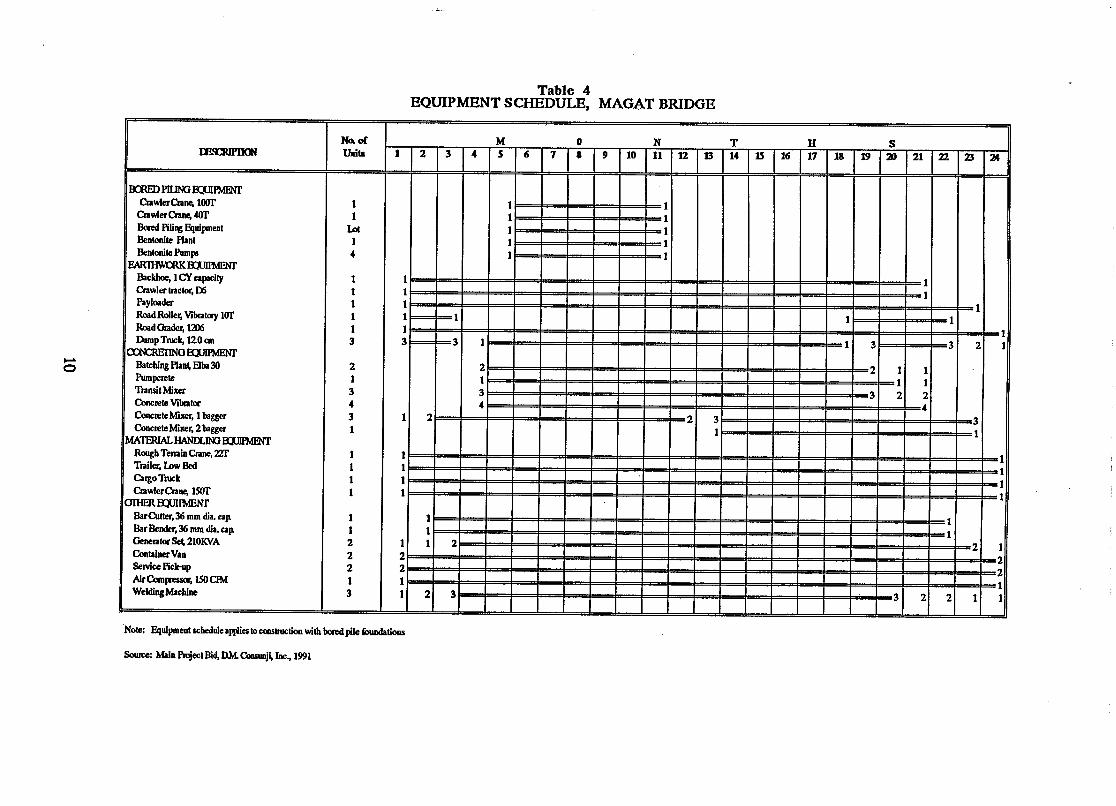
Construction of the Magat Bridge is anticipated to span a 24 month period, with an estimated project cost of 9 237 million. A construction schedule and a corresponding equipment schedule is provided in Tables 3 and 4.
5.3 Construction Method
5.3.1 River Diversion
To enable construction equipment to work in the dry, the river will be temporarily diverted during a pre-determined stage of construction . River diversion would be accomplished by excavating a channel where water may pass and at thr same time filling the portion of the river where construction work has tote done. Chmnel excavation and filling work would be done with the use of bulldozers.
5.3.2 Tem~orarv Access Roads
Temporary access roads for construction equipment will be constructed to allow maneuverability of the various construction eqfpment. The access road would run parallel to the length of Cle proposed bridge so that all pier locations can be rexhed.

Table 2 1
ESTIMATED PROJECT AREA, MAGAT BRIDGE
I Construction, Temporary Use
Work Camp, Batching Plant, I Pre-casting Yard
Access and Service Roads 1 .O
Borrow Site, Quarry 2.0
Operation, Permanent Use
Bridge Structure, Surface Area
Land Area, 12 Bored Pile Piers 0.02
River Revetments 1.5
Approach Roads 1.0
Estimated Total Project Area, Temporary and Permanent Use

Table 3 C30NSIRUCIION tScmDuLE, MAGATBRIDGE

.. 5.3.3 Bored Piling
Excavation would be undertaken with the use of a rotary drilling machine mounted on a 100 ton capacity crawler crane. The excavated trench or hole would be filled with bentonite clay suspension to keep the sides of the excavation stable. Prior to concreting, the bentonite suspension would be recycled or desanded until such time that its density and other physical properties are acceptable. Rebar cages will be prefabricated on site and transported to the pile location by crane. Placing of concrete will be done with the use of tremie pipes or through the tremie method.
5.3.4 Driving of Steel H-Piles
If used, steel H-Piles would be driven with the use of either Delmag D- 36 or Kobe K-45 diesel hammers. To ensure safety and accuracy of driving, fixed leads shallbe installed on 60 to 100 ton capacity crawler cranes to support the pile hammer.
5.3.5 Structural Excavation
Excavation for pile caps, abutments and other structures will be done with the use of backhoes. ~xkvated materials would be loaded on dump trucks and hauled off site if found unsuitable for embankments or backfill.
, 5.4 Construction MateriaLs
A summary of the estimated quantities of construction material is included as Table 5. In addition to the listed line items of locally-sourced. borrow and crushed aggregate material, approximately 6,820 cu.m. of sand and 8,840 cu.m. of gravel are required as components of the listed quantities of concrete.

Table 5 ESTIMATED CONSTRUCTION QUANTITIES, MAGAT BRIDGE
USING CAST4WLACE BORED PILINGS
lTEM NO.
EARTHWORKS
Clearing and Grubbing Individual Removal of Trees or Stumps Unsuitable Roadway Excavatim Embankment from Roadway Excavation Embankment from Borrow Selected Borrow Topping
SUBBASE AND BASE COURSE
Crushed Aggregate Subbase Course Crushed Aggregate Base Course
SURFACE COURSES
Portland Cement Concrete Pavement (230 mm) Lean Concrete (Bridge Approaches)
BRIDGE CONSTRUCIXON
S u B S T R U r n
CASTWLACE BORED PILING
Concrete Piles Cast in Drilled Holes Bored Holes Permanent Steel Casing Lefk'fllace (10 m long average per hole) Reinforcing Steel, Grade 40 Reinforcing Steel, Grade 60 Structural Concrete Class "P" (Tremie Pour) Structural Concrete Class "P" (Above Normal Water Level) Structural Concrete Class "D", 400 psi Reno Mattress
Railings Furnish, Fabricate & Erect Bridge Bearing Reinforcing Steel, Grade 40 PrwVessing Reinforcing Steel Structural Concrete, Class "A" Structural Concrete, Class "A", Precast Structural Concrete, Class "P" Structural Concrete, Class "D" Expansion Joint Device (Waboflex) Prestressed Structural Concrete Wirder, Type VI (Modified Interior) Prestressed Structural Concrete Wirder, Type VI, (Modified Exterior)
DRAINAGE & SLOPE PROTEGfION STRUCTURES
Structural Concrete Class "B" Rubble Concrete Class "Bw Grouted R i p p Class "A" Loose Boulder Fill
17p4.00 Sq. M. 20.00 Ea.
2,882.00 CU.U 3,314.00 CU. M.
66,920.00 CU. M. 951.00 CU. M.
1,672.00 CU. M. 461.00 CU.M.
CU. M. CU. M.
L.M. Ea Kg. Kg-
cum. cu.a cu.m. cu.a
L . a Ea. Kg- Kg.
cu.a cu.m. cum. cu.a L a Ea. Ea.
c u m cu.a cu.m. cu.m.

5.5 Construction Manpower
Construction manpower will include direct (field) and indirect (office) labor requirements. During the timeframe of the project, the direct labor requirement will range from an estimated 45 to a maximum 281 persons while indirect labor will range from 60 to 304 persons. Locally recruited manpower is anticipated to satisfy the direct labor requirements of the project.
6. SOURCES OF ENVIRONMENTAL IMPACT
Four major categories of environmental concern are described in Section 4.6 for defined critical projects and area. Sources of environmental impact related to these specific concerns are anticipated to be present during construction and operational phases of the project cycle.
6.1 Construction of the Project
Identified sources of environmental impact during construction of the proiect include:
1- e site disruption of temporary use construction areas, including service
roads, work camp, borrow sites and river diversion courses;
construction-generated traffic, fugitive dust and noise;
o river-borne silt derived from pile borings, river diversion activities, river bed, borrow sites and service roads;
e effluents, emissions and wastes associated with the projected manpower, equipment and material requirements, and site abandonment;
flood water obstructions due to construction and diversion structures.
6.2 Operation of the Bridge
Potential sources of environmental impact associated with$ the operation of the Magat Bridge may include:
o Increase in traffic flow utilizing the Santiago-Tuguegarao Project Road
e Site displacement of permanent use approach roads, bridge structures and revetments
flood water obstruction of completed bridge structure

7. ENVIRONMENTAL MANAGEMENT MEASURES
As an initial step in the process of impact management and mitigation, this project description outlines, in Sections 4.6, 6.1 and 6.2, identified areas of concern and sources of environment impact. Existing and proposed environmental manqement measures will be incorporated into the construction contract agreement for this prckt .
7.1 Major Roads and Bridges Which Could Affect the Hydrology of Traversed Area
As designed, the Magat Bridge will accommodate anticipa & 100-year flood levels based on existing and projected river flow data. For example, the wide (75 m width) and high spans of the proposed structure will offer the minimum backwater pressure compared to alternative (two shorter bridges) and existing structures (over-flow type "Irish Bridge" and ford, Plate 2). Since 1982, flow of the Magat River has been controlled by the Magat and Maris Dams.
The deep footings of the proposed cast-in-place bored piles are designed to handle both aggradation and degradation of the river bed at the bridge site. River bank revetments are included to maintain the integrity of the bridge abutments and approach road embankments.
The alignment of the proposed Magat Bridge will closely parallel the existing "Irish Bridge" and ford crossing. As an amendment to the const~ction contract, the removal of the close spanned "Irish Bridgen structure and recentlv graded ford would be required upon completion of project construction to eliminate potential waterflow obstructions. During a recent environme~tal field survey (August, 1991), the pilings of the existing "Irish-Bridge" were noted to restrict water flow by impediment of water borne debris, notably water hyacinth plants. )
7.2 Major Roads and Bridges Which Could Substantially Increase or Impede Traffic Flow
A 1991 Traffic Survey (DPWH) recorded a daily average of 1190 vehicles (not including motorcycles and tricycles) along the project road section from San Manuel to Cabanatuan, which includes the Magat River crossing. A previous feasibility study @PWH, 1988) estimated diverted traffic on completion of the Santiago-Tuguegarao Road Project of approximately 500 vehicIes per day. As designed, the Bridge and associated road project can accommodate substantially higher levels of traffic flow, while relieving the current congestion of the distressed Pan-Philippine Highway.

7.3 Areas Frequently Visited andfor Hard Hit By Natural Calamities
In addition to site hydrology, the proposed bridge design incorporates seismic loadings per the latest eciition of the National Building Code, Volume I1 (Bridges) which are very similar to American Association of State Highway and Transportation Officials (AASJTO) Standards and were submitted and approved by the Bureau of Designs (BOD).
7.4 Areas ClassLi'ied as Prime Agricultural Lands
The Cagayan Valley is noted as a prime agricultural area The proposed project area includes both a riverbed, which is seasonally utilized for marginal farming and approach road areas above the existing river banks which include year round farm land primarily planted to com.
In addition to an estimated 1.7 ha of permanently displaced seasonal riverbed and year round riverbank farm land, approximately 2.0 ha of these areas will be required temporarily for construction activities (Table 2). The compensation for rental or purchase of these land areas will be a component of the project costs, per DPWH Standard Procedures. Consultations should be held with affected landholders and local officials to determine adequate compensation rates, which could include primary consideration for local manpower employment during the projects' construction cycle.
7.5 Site Disruption of Temporary Use Construction Areas, . -
Rehabilitation of affected temporary use areas will be incorporated as an amendment to the construction contract. Rehabilitation will include regrading of affected areas to original topographic configurations and deep plowing of discontinued service roads and work camp areas within farm land areas.
7.6 Construction-Generated Traffic, Fugitive Dust and Noise
Substantial loads of heavy equipment and off-site materials are required for project construction (Tables 4 and 5). Preliminary surveys will be conducted to ascertain the load and traffic bearing capacity of connector road linkages to the project site to avoid project-related excesses. Construction access roads and work camp surface areas should be gravel to reduce incidental dust generation. With respect to noise, there are not permanent residences currently in the immediate vicinity of the project area.
7.7 River Borne Silt Derived From Pile Borings, River Diversion Activities, River Bed Borrow Sites and Service Roads
Environment field surveys indicate that the Magat River is presently silt-laden from upstream sources. Construction activities will be scheduled to coordinate with low water flows associated with dry seasons to minimize additional silt inputs.

7.8 Effluent, Emissions and Wastes Associated with the projected Manpower, Equipment and Material Requirements, and Site Abandonment
Construction-related impacts to land and aquatic resources could occur as a result of improper disposal of solid and liquid wastes and accidental spills of environmentally harmful materials such as construction contract, it will be mandatory for the contractor to implement a waste management program for the duration of construction activity that ensures safe and appropriate handling.
7.9 Flood Water Obstructions Due to Construction and Diversion Structures
As described in Section 7.7, constructional activities will be scheduled during low water, dry season periods.
7.10 Increase in Traffic Flow Utilizing the Santiago-Tuguegarao Project Road
Refer to Section 7.2 ' t
7.11 Site Displacement of Permanent Use Approach Roads, Bridge Structures and Revetments
Refer to Section 7.4
7.12 Flood Water Obstruction of Completed Bridge Structure .
Refer to Section 7.1
8. STATUSOFTHZPROJECT
Feasibility and Detailed Design Studies for the Magat Bridge have been completed and reviewed. The proposed project has been released for bid to identify the prime contractor. Ground breaking rites for the project were recently held at the site, officiated by President Corazon C. Aquino. The final release of USAID project funding is pending the Environmental Management Bureau (EMB) review of this Project Description and issuance of the Environmental Compliance Certificate (ECC). IBRD funding of the balance of Contract Package II is reportedly scheduled for 1992.

9. SIGNATURES OF PROJECT PROPONENT AND PROJECT DESCRIPTION PREPARER
Prepared by: LOUIS BERGER INTERNATIONAL, INC.
Michael d~ oss Environmental Specialist Rural Infrastructure Fund Project
Reviewed and endorsed by: ~EPARTMENT OF PUBLIC WORKS AND HIGHWAYS
Rural Infrast c re Fund Project v

CONTACT LIST
Cabatuan, Isabela
Municipal Government Dr. Benedicto A. Acousta, Mayor Mr. Fred L. Subillaga, Municipal Planning and Development Coordinator
Cauavan, Isabela
Department of Public Works and Highways, District 2 Engr. Ernesto D. Bulatao, Assistant District Engineer Engr. Moises Mansano, Materials Engineer
National Irrigation Administration Engr. Jose Rosero, Magat Multi-Purpose Dam Project
Ilagan, Isabela
Provincial Government Mr. Nicolas P. Baggao, Provincial Administrator Mr. Nestor 0. Santiago, Senior Project Analysis (PPDO) Mr. Elias Seraspi, Provincial Environment and Natural Resources Officer
(PEN-Jw Major Castro, 5th Infantry Division, Philippine Army
Tupegarao, Cagayan
Department of Environment and Natural Resources (DENR) Region 2 Engr. Leonardo Paat, Regional Executive Director, Region 2 Mrs. Resty Antolin, Senior Ecosystem Management Specialist Mr. Julius V. Calina, Division Chief, Bureau of Land Management Engr. Jaime Briones, Coordinator, Land Evaluation, Forest Management Bureau Mr. Edwin Ganu, Division Chief, Mines and Geosciences Bureau
Housing and Land Use Regulatory Board (HLURB) Mr. Gerry Cacliong, Head Technical Division Region 2
Mr. Roger Salvatierra Head, Compliance Monitoring Section Region 2

Manila
Environmental Management Bureau, DENR Mr. Sixto E. Tolentino, Jr., Head, Environmental Impact Assessr-mt Group
Philipp's Technical consultants Inc. Mr. Epifanio C. Lustre, President and General Mmager
REFERENCES:
Technical Re~ort on Magat Bri d ~ e . Michael A. Stevens, Louis Btrger International, Inc.. 1990.
Desim Report. Fifth IBRD Highway Project. Santia~o-Tuguegarao Road. Philipp's TechnicaI Consultants. 1990
Fourth UNDP Road Feasibility Study. Draft Report on the Feasibility of U- srading the Santiago-Tuguegarao Road. North Luzon. DPWH - Grenardet S.A. 1988.
Socio-Economic Profile of the Municipality of Cabatuan. Municipal Planning and Development Office. 1990.
LocaI Government Report. Province of Isabela. Provincial Planning and Development Office, 1990.
Socio-Economic Profile of the Municiuality of Aurcra. Municipal Planning and Development Office. 1979.
Medium-Term Ca~ayan Vallev Region Development Plan. 1987-1992. Regiond Development Council, NEDA Region 2. 1986.
Updated Regional Development Council NEDA Region 2. Dec. 1986.
National Statistical Board. Population Census. 1990.
Final Report. Santiaco-Tu~ue~arao and Solma-Piat Roads Northern Luzon. Vol. 2 - Figures and Tables. DPWH-VLD-Techniks, Inc., 1976,
Philipvine Statistical Yearbook. National Statistical Coordination Board. 1990
Family Income and Expenditures Survey. National Statistics Office, Volume 11, Final Report. 1988
LIST OF F'IGURES
Figure 1
Figure 2
Figure 3
Figure 4
Figure 5
Figure 6
Figure 7
Figure 8
Figure 9
Figure 10
Figure 11
Figure 12
Location Map of the hili lip pines
Cabatuan - A~rora Road Section General Plan
Cabataan - Aurora Road Section Magat Eridge, Location Plan and Gen. Notes
Cabatuan - Aurora Road Section Magat Bridge, General Plan, General Elevation and Foundation Plan
Cabatuan - Aurora Road Section Plan and Profile, Km. 363+500 to Km. 3644-250
Cabatuan - Auroza Road Section Plan and Profile, Km. 364 +25O to Km. 365+000
Material Source Map, Magat Bridge
Topographic Map - Magat Bridge Site
Cadastral Survey Plan - Magat Bridge Site
Project Service Area Magat River-Purpose Project
Land Cover Map
Area Subject to Flood

-
A. REFERENCE CODES I. STANDARD SPECIFICATIONS FOR HIGHWAY BRIDGES.
THIRTEENTH EDITION.1983. ADOPTED BY THE
AMERICAN ASS~CIATION OF STATE HIGHWAY AND
TRANSPORT OFFICIALS ( A A S H T 0 )
2. STANDARD SPECIFICATIONS FOR PUBLIC WORKS
ANDHIGHWAY.1988 . BY D P W H.
3. MANUAL OF STEEL CONSTRUCTION ElOHTH EDITION
BY THE AMERICAN INSTITUTE OF S T E E L
CONSTRUCTION ( A I S C 1
I. DESIGN FLOW : a,$ 14.474 ma / See.
2. DESIGN VELOCITY: V ' 4-01 m / See.
C DESIGN LOADS
I. DEAD LOAD
a. CONCRETE - 23.6 K N /ma
b. WEARING COLASE- 1.06 kPa
2 LIVE LO80
TRUCK LOADING -AASHTO U S - I 6 OR
EQUIVALENT
3. SEISMIC LOAD
IN ACCORDANCE WlTH J.B HOLLINGS REPORlS
OR 10%(DL+ W L L ) WHICHEVER IS GREATER.
D. DESIGN STRESSES L CONCRETE
UNLESS OTHERWISE NOTED.MINIMUM CYLIKDER
COMPRESSIVE STRENGTH AT 2 8 - DAY AGE
( f c ' ) AS FOLLOWS: - a FOR A L L REINFORCED CONCRETE EXCEPT
PlLE CAP AND FOOTINGS fe'-27.6 U P 0
b. FOR REINFORCED CONCRETE P l L E C A P
AND FOOTINGS - fc' - 20 .7 M P o
c. FOR PRESTRESSED CONCRETE AND E m
PILES f c ' - 34.5 MPa
2. REINFORCING STEEL . UNLESS NOTED OTHERWISE. REINFORCING
STEEL SHALL CONFORM T O ASTM A 6 1 5
GRADE 4 0 WlTH A MINIMUM YIELD STRENOTH,
t y 2 7 6 MPa.
3. PRESTRESSINO STEEL
PRESTRESSINO STEEL SHdlL CONFOR hi TO
ASTM A416 AASHTO M 2 0 3 WlTH A MIN-
IMUM ULTIMATE STRENGTH OF I 8 80 MPP
MTE:
4. STRUCTURAL STEEL
STRUCTURAL STEEL SHALL CONFORM TO ASTM A 3 6
OR AASHTO M 183 WlTH A MINIMUM YIELD STRENGTH,
f y 240 MPa.
I. PlLES SHALL CONFORM TO A1 SC DESIGNATION HP
14 X 117 WlTH AWEIGHT OF 1.71 KN /M.
2. PlLES SHALL BE DRIVEN TO A DEPTH THAT WILL
PRODUCE THE REQUIRED M I N l MUM BEARING
CAPACITY OF WO TONS BUT MUST MAINTAIN A MINIMU4
PlLE LENGTH OF 27.00m FROM TIP TO TOP PLATE. 3. PlLES SHALL BE PROVIDED WlTH METAL SHOE
FOR HARD DRIVING.
4. TEST PILES WlTH SAME PROPERTIES AND CA-
PACITY AS THE REGULAR PlLES SHALL BE DRIVEN
AT THE INDICATED LOCATIONS AND SHALL FORM
PART OF THE. P lLE FOUNDATION.
i? DIMENSIONS : ALL DIMENSIONS ARE IN MILLIMETERS UNLESS
NOTED OTHERWISE. ALL ELEVATIONS ARE IN
METERS AND STATIONINGS ARE IN KILOMETERS
AND METERS UNLESS OTHERWISE SHOWN.
ALL BAR SPACINGS REFER TO DISTANCE BET-
WEEN CENTERS OF BARS. THE MINIMUM CMKIlETr
COVER MEASURED FROM THE SURFACE OF CON-
CRETE TO THE FACE OF OUTERMOST,&%R W L
BE 5Omm iJNLESS OTHERWISE NOTED.CLEAWKE
BETWEEN REINFORCING BARS IN GIRDERS SHALL
NOT BE LESS THAN 5 0 mm.
G. BORING DATA: SEE DRAWING NO. L - 2 0
H. ALL STATlONlNGS AND ELEVATIONS SHALL BE VERIFIED BEFORE CONSTRUCTION.
I. BASIS FOR COMPUTING ALLOWABLE PlLE BEARING CAPACITY: 124 ah& Wr t 0.16 Wp Pa"' ( % k 5 4 )(TFq-)
WHERE:
Pall ALLOWABLE PlLE BEARING CAPACITYITON)
*h . WMMER EFFICIENCY . Eh - HAMMER ENERGY RATING (KN- m)
Wr - WEIGHT OF RAM (kN)
Wp = WEIGHT OF PlLE AND OTHER DRIVEN WEIGHTS ( k N )
S AVERAGE PENETRATION PER BLOW FOR THE LAST ISOmm OF D R I V I N G O -
FIGURE

.--- R E F E R E N C E P O I N T S
P.LHO. IRZF. NCII AZIMUTH I DISTANCE I OESCRIPTION
S*. CNIVATURC O H T
ZRT CIJWMUIIE . + 1 ~ . . 7 S % . g SOJ 1 ~ 0 1 5 E ~ l Z Q . ~ ~ m w L l l ~ ~ l l O O 1 l . O . O O %
------ -------------- - - - - - - - - - - - - - - - - - -------- ----- YI+I IP.m.
N . E . W A L . - I 0 N M E N T , FIGURE 5 -- I
C O W S U L f A N T . REPUBUC OF Tlf F W l P P M S I FIFTH l0RO HIGHWAY PROJECT- SANTIAGO TUOUEG!lRAO M A D 1- m I R L D I 1 M r s ~ O > - (*."Om..:
I philip~'b.tsChnicat z:z.I,nr PL ANAND PROFILE CABATUAN -AURORA ROAD SECTION
consultants ine. 0-5 Urn. 363+100 l o Km.364+250

SECTION .A,;&' SCALE
EXICTlHE V I A V f A ROAD 7 / /
, e , r F i H l s l l C D OR-
DETAILS OF .WEEPHOLE . . f 1.O.OoI -----
1 1 I *-.-

AGGREGATE SURFACE CD'JRSE BASE COURSE
-- SOURCE N0.14
SELECTED BORROW
BORROW SELECTED BORROW AGGREGATE SURFACE COURSE
___----
SELECTED BOFlROW AGGREGATE SURmCE COURSE
I BASE COURSE
DENSE GRADED SURFACE COURSE
LEGEND-: PROJECT ROAD SAW YARlAI10 .......... PAN-PHIL: HIGHWAY.. .... c m c ~ r n AGGREGATES - FEEDER ROAD - 'P ......... em = u)& ........ T R A C . K L---
RURAL INFRASTRUCTURE FUND PROJECT ., AID PROJECT NO. 492 - 0 4 2 0 SOURCE : F I N A L REPORT, P H A S E I FEASIBIL ITY STUDIES FOR
SANTIAGO- TUGUEGARAO AND SOLANA - P I A T ROAD MATERIAL SOURCE MAP, MAGAT BRIDGE FIGURE 7
V6LUME 2 , JAKUARY, 1976 DEPARTMENT OF P U B L I C -WORKS AND HIGHWAY. I

SCALE: 'I: 25,000 i .' SQURSE: NAMRIA.CHART 3334.2 I V - A ,,I983 '
*RURAL INFRASTRUCTURE FUND PR0JECT;AID PROJECT No.492 -0420 I
TOPOGRAPHIC MAP - MAGAT BRIDGE SlTE

. .
EST
.


5 ' : 0 ' 5 I0 KMS. I . - m/ O I P T E R O C A ~ P FOREST., CLOSED CANOPY p i &*-: $; RIVERSEOS
. . . O l P l E R O C A R F FOREST. OPEN O N O W BUILT UP AREA
[:.iif/ ......... c L : v i r ~ o A n o t m t o r r o m * e Gars. a
,.&. ,. . CROP L A N O S t . 1 1 ~ ~ 0 WITH COCO~ILW PLANTA+IO~IS.
SOURCE: PCGS 2506,2808 - NATIONAL MAPPING 6 RESOURCE I I RUI:AL I N F R A S T R U C T U R E F U N D PROJECT, AID PROJECT' ~~492-04201 . - FIGURE I I'
LAND COVER MAP
L E G E N D
FEEDER ROAD -. ..- -
SOURCE : DPWH FINAL REPORT 1976 PROPOSED FOURTH IBRD HIGHWAY PRO~ECT
RURAL INFRASTRUCTURE FUND PROJECT AID PROJECT NO, 492 - 0420 1 1 FIGURE 12 .
AREA SUBJECT TO F LOOD I

RURAL INFRASTRUCTURE FUND PROJECT. AID PROJECT ~ ~ 4 9 2 - 04201
REPRESENTATIVE VIEWS O F PROJECT SITE PLATE 1
LURAL INFRASTRUCTURE FUND PROJECT, AID PROJECT Na492- 0420
REPRESENTATIVE VIEWS O F PROJECT SlTE
EST AVAIIA

i
- . # --
rre
RURAL INFRASTRUCTURE FUND PROJECT, AID PROJECT Na492- 0420
REPRESENTATIVE VIEWS O F PROJECT SlTE PLATE 3

S e r i e s of 1980
1 Furssant. t o Scst ion 2 ( f ) of Prer;idcr:tinl Dacree No, 463, o thc rv i s e kncwn ES the "Einer:l Eosources Devclopzent Decrea .' of 1974t1, as nnendeq by Preside.ntiol..Cecree Ros, 1385 an& 1577, the ,f olluwin& -rules .and r e g t l a t i o u s a r e hercby promu2,~ted for " '
the : guidance of 211 .conc;?rinkd: .--'
kC7ICTX I SECTION I. ---- D3FiBlTION OF. TERLC;. - Unless otherwizs speci-
f ied , tZ is t e r m arxi phrrlsos used. i n tbese -rules and r e ~ u l a t i o n s . s h a l l hi~re the f 012 o v i n ~ ~enninp,.; . .
1-6 Ii6irectcr - f j i r ec to r . of b i n s and ~ c 6 k c i e n c e s . .. . . 1,3,. ' ''P'dncs an3 C-co-Scicnccs Reeionnl Officer" - the Head . . .. . of a Pines and Geo-Sciences Rcll;ioqal :Office, 1 "Kinern1 D i s t r i c t .OfficcrVt-.-,the Read oi'l5incral zi; 2ict .
Office. t
- 2 -
."Public Len;?" - the p o r t i o n of ~ 6 3 1 i c d o m i n t o which t i t l e i s s t i l l i ras to5 i n the Government.
' ' T r i v a t e Lnndt' - ttione 'cje?.on33..r t o n ~ i v a t e persons with cor;z;late t i t le: : ss veil a s those l ands claimed' b:: Sr~r;r-,f f cte holder, c la imart , o r occut;ant x i%h ' ; L ? C T ~ C C ~ . t i t l e .
lt?eralt" - c o n m r c i ~ l , fcrcshcrc. . . qrattr i tous, i n d u s t r i a l , an2 s ~ e c i a i ~ e r ~ i t s iocuoll 1:rcler th i s ,Order , .
ttForeshosen - tb area offshbre h y o n d 100 ce t e r s ' from . ttc waterzer'?; st thn ceen iow t i d e extending . . s e atr-wd ,
"Fuka" - the por t ion .of a s h e l l t h a t dS3 s o ~ e t i m e s found' ~ i x e r l w i t 5 snl;d an& ~ r z ~ ~ c l ,
"9iver Bed" - bed pf cyac4s, streams, brooks, etc;- ttje round cover24 bv water Curins i ts highest
. . f locd v i t hou t causing imtidation. ! .
SK, 2, PZ2I;'iT X! T ? ? T ::?XI 313X?6?63 CY IS,3T3?I.1LC. - 7 col-poration, carvrwrjhip o r . ~0\=3ixmt enti tv / ins i ; ru~cntn l f t ;y s h a l l .
be a l l o l ~ c d t o t d c e 7119 disposc of m t ? r i n l s covered by the's? reeulaA...; t ioas fron; pub l i c wrkcrs o? i n p u b l i c . 07 7.rivatc Isrds unless author- ized unde*. a p e r n i t i s sued i n qccordance ~ 5 t h t h i s Order. ! . . . . -
.
i s - (a] ' ~ 'Q~I . . zZ!C~~ ,~ P:!?I.lT - Shal l cover a n of ?.lot than : (1) ?lectare iu public w@ers o r i n puSl lc 2nd p r h n t e 1 m d s and is' ~raxtcd f o r a ~ c r i o d of not ' Kore than one (1) yzsr , renewable for: ~.
szzc period; .; . . .

I (e) ' S P E C I ~ ~ PE3hlT - . s h a l l be i s sued t o an app l icen t f o r an ' ,
i n d u s t r i a l pe r r i i t pendGg approvnl o f tho p e r n i t b,v . the h i n i s t e r , o r Fo those applyin;; t o dispose o f r i n t e r i d s covered by 'these; re- gu l a t i ons abandoned by t%c ~ i n i n q opcrat~r/p;ovcrnment/~rivate con- t r a c t o r i n t he course of its operatEan/construction, o r t o those f o r l t h e i r personal use not t o exceelc. f i f t ~ (50) cubic ne t e r s , f o r
. a pe r iod n o t exceeding sixty (60) cubic meters, f o r a per iod not exceeding si&y (60) dz?*s.
.; SEC. 4, FILIKG G D R3X8fiiATSOiT FZES - A l l applicatioris 'and 0 t h e r r e l a t e d ' docuncntS shall be f i l e d and / o ~ r e g i s t e r e d with t he r*ines and Geo-Sciences Regional 0 f f i c e o r Kiueral D i s t r i c t Off i c e having j u r i s d k t i o n over he area. The follow in^ charges shall be ' paid u2on f i l i n g -and/or r e g i s t r a t i o n o f t h e s s m ;
7 .
(1) "ommercial, Foreshore, S p ~ o i a l and . Gratu i tous Perrcit Appl icat ioa . . . . . . , . ~20.00 I
(2) Xndus t r i s l Permit Application . . , . . . . . 50.00 : (3) Deed of Assiqnment/l'rensf c r , Spec i a l .
Power o f Attorncy and o the r reg i s - tzable d o c u ~ e n t s , . . , . , . . , , , , . . . 20.00
a.
SEC. 5. MI0 KAY 8E GX:NED P33MTfi - a permit s h a l l bs i s sued t o any app l i can t who has c o w l i e d with t h e requirements
. prescr ibed by these r u l e s and r egu l a t i ons and o t h e r p e r t i c e n t lawa . . and: who'"possesses t h e fo l l owing qua l i f i c a t i ons :
1 (a) 1; cBse of a ind.ividua1, he must be of leg31 a6e and a citizen of t h e P h i l i ~ p i n e s ;
(c) l n ' i s e ef a kovernmnt asency/off icl, it r u s t be duly re- '
'
cognized and e x i s t i n ? s2d i n need o f ~ ,+x : r ia l s f o r i n f r a s t r u c t u r e p r o j c c t s as c e r t i f i e d t o by t h s q e n c y concerned, . .
. 'I .. . . . . : : .
I . BE. 6. I U T H O X I ~ ~ "I. Tie a p p l i c n n t / ~ c r ~ i t tw E Z L ~ be represented . by"@nother provia ed said a u t h o r i t y is contnined . i n a pub l i c ins.tru-
xcent ba'lg r e g i s t e r e d vith the rrining ~ C C O ~ C Z L T P conc?rned. i i
SEC. 3 . DEPUYl3S OF %T DI!?%ZOTi - p i e IYncs snrI GCO-sciences ke&onnl Off ice r , l i in?=nl - I j -x imicer , snd C i t r / Y r w i n c i a l . . I'rens'uur s h a l l be tha ciepz~ ties or the D i r ec to r w i f ? i n t h e i r :respect- - . . ivo; t e r r i t o r i a l jurisc5ictian and as such de7utics & a l l hzve jthe . . . powem a.nd d u t i e s fioscribad I n the succeeding section.
. : ' SXC. 0. - FO!,J3'TG ::ID DUTIES OF DXPUTIir. - The Rines and 'Gee- -- Sciences Regional Officer 2nd k i r e r a l ~ i x i c t Of f ice r , concerned shsli i s s u e Coimerciel, boreshore, ~ r a t c i t o u s and Spec i a l Permits $cr ~ e r s o n a l use, o r f o r &sndocod ~ a t ? ? ' i d s , ccpies of vihfcti s h a l l -3e Z.-wrfished the Direcl;or and the City>%kovincial 9keacursr whithlh five. (5) davs f r o n rant thereof. ! .
%ha P i i . t ~ a sncl G n o d ~ i o n ~ e n Begional C f f i c e concernsd s h d l have o r i g i n a l J u r i s d i c t i o n t o t r y and decide cases a r i s i n z from these r u l e s and re.-.ul?tions 2nd s h a l l have! t h e o o l i c o power to enforce and/or execut.! i ts d e c i s i o n s / o ~ f e r s ; Frovided, t h a t i n ceses o f c o n f l i c t involving n quarry applicoticrn and/or a mining qlaim w ~ t h a sa3d nnd ~ r a v c l app l ic~ t ion /pnrn i i t, o r i g i n s 1 juris- cisction s h a l l be ves ted with t he Director . . . i
: A l l apTl ica t ions undar those r u l e s ngd r a a u l q t i o n i IF.^ be . r e j e c t e d o r denied bv t h e Paines anr! Cr-0-3 c ienzes S ~ ~ i o n n l Of f i ce r . o r 'Mineral D i s t r i c t Of f i cc r concerned, i f i r 3 t h e i r opinions, : t h e s q e do n o t warrant f w o r r i b l ~ considcrnt ion; I'rovided, t h a t i n . .
cs se of i n d u s t r i a l p e r n i t a an l i ce t i on , nu tho r i i x t o r e j e c t o r deny t be s a m skill be vcsted w i t 3 th Director .
; In add i t i on t o t h o City/?rcvincinl Tr~nsuror's duty of collect- '
i n s saad and crave1 ex t r ac t i on fees due *&thin t 3 c i r resuec t ive du r i sd i c t i on , .he sb911, c o x u r r e n t l y wi th t'n? r ep re sen t a t i ve of t h s ' . wries nqd Gco-Sciences Styion31 cnrl h i n c r a l D i s t r i c t G f f i c e ~ s , con-
-. duc t i n spec t i on of book of accuynts, chock nroduction sqsin& allow- . able. volume, coqiuc t inventory of qc t i v e o ~ e r a t i o n o and r e n o r t t o the fieyion.?l o r O i s t r i c t Of f ice r concerrsd f r a r t i n o t o t i ~ e o ~ as nay be r e r p i ~ e d , the ~ c t i v i t i e s performed i n connection wifh these .
r u l e s ?.nil regula t ions .
' . SEC. 9, f.JPES.S, The decision/or.ler of the p.ir%s enJ Gel+ s c i e n c e s Reqionol 0 f f i c e r ccncerned - shell becomc f i n g l nn6 execut- .. o r y i f no appeal i s rads tai thin f i v e (5) doys upon r c c c i p t by the ,
l o s i n q party of a cops of such decision/orSer; Provided, bowever, t h a t mere f i l i n g o f 23 spgeal d h l l not s t q r the execution of t h e decision/order sou.;fit t o Se sppealed, U ~ I ~ C S S the Di rec tor o rders . ' otberwide, Ihe d c c i c i o n / o r d ~ r o f t h e D i r r c t c r is 2ppcaloble to .
the YAnister whose dec i s ion s ) l~? l be fioal, Xo f o r ~ a l conplaint or: a p ~ z d shall be e i l tnr ts incd un less a dockctinl: f e e .of twsnttj- f iye ' pesos (P25.00) is paid, . . . . :
2 ' 4.. . . .... * .
! : .a) The f a x s i t rag bc? suspendsd o r rcroked a t any tim 'by
t h ~ iriiata??, %rectr?r , Lines zqd Gco-Gcismxs. Rwion31 Off iccr , or I - - i x r a l D i s t r i c t Of f i ce r , as the cr,se ray 5-3, whcn i n h i s opi- . gion, n u b l i c i n t e r e s t so r e q u i m s o r ngon f q i l u r e o f the permi t tee t o corp lg w i t ? the o t \? r t e r n s rirlr! c ~ n r l i t i o n s st?.tod. i n t 5 b permit.
. b) The s t a t n r e n t s r=de i n t%a mplfcct t io? or t b s e made l s t e r i n sun3ort t l~ereof shzl l be coasidcred zr ccndi t i ons 2nd e s s e n t i a l - - p$rfs o f the .Pcrcft and s3y r i s r c n r c s a n t ~ t i o n c o n t & j e d t ye r e in
. sh311 bo n czuse far t':a nu?;pznsio3 o r rcvr?r,n';ian of t\c '2ermit; . . . . ? '
, ' 5 ) The c?rriit ~'1a1.1 b? i n o n c r k l v c F~ I?" a r a m cover.rldi by I=i*+. I ' e~porsry P e r r i ts, Ciuarry Liceqsec :. ?errr.its o r 1.-iningi Ltjases un less . t'?a ?rim O U ~ ' - I O T ~ W of tt? :!Lic~~.mrc/T,wrf t tm: or
. 'lq?het: .is obtr ined;

. . ;h) Th- P k i t t e e o r h i s axent o r r e p r e s e n t a t i v e s h a l l pist a -
CODY of t h e Permit a t t he ~ l s c e of r e m v a l o r t3?cin,c, of ~ a t e r i s l s aga nske a v a i l s b l e ' e t a l l t imes f o r i n s p e c t i 0 3 o r exQr ina t i on b~ any represen ta t ive of the i ' i n i s t e r , t h e Di rec to r t?e h n e s and Geo- Sciences Rogipnal Officer, M n e r a l D i s t r i c t b f f i c e r and t h e !keasmer ' . . concerned;
: i) . Ths . p e r z i t t e e ' sha l l ' koep book of accounts .wherein th&e '
s h a l l be en te red evesvday t h e a u a n t i t ~ and kicd of a a t e r i a l s :removed f ro= t>e area covered bv ths r e m i t , t h e f e e s ?a id t h e r e f o r e .ss wel l as f h quan t i t v ' and k ind of m s t e r i d s tiisposed of o r so ld , t h e i r s e l l i n q p r i c e s , t32 3 3 m s a3rl frddresses of t h e wPrsons o r psrties:to whom the sane were SG? cl OT .d5snosed o f , m d , o the r t r a n s s c t i o n s i n 'conpecti.on w i t 3 t h s busiztess. Such book of .sccounts s h s l l a t .all t i n e s b e oDen t o i n sbec t i on 3-2 t h e r e p r e s e n t a t i v e s of t h s Y in i s t e r , t h , ? Director , t3e E n e s a3d Geo-Gcisnces Sag ions l Of f ice r , Finera1 D i s t r i c t . @ f f i c e r . .... o r t3w Traasurer conc4rned;.
. j) The P e r r i t t e 5 33311 v i t h i n (10) d a ~ s s f t e ' r ths end of each : conth, srr3r;if t o t \ e 5resnurer concerted, t'be Direc to r a x l t h e i s s u i n g . - O f f i c e r copies-..o"f, s v o m z ,epir ts s t a t i n g t b a q u s n t i t p sml kind of oste-. r i a l s r e ' n h e ~ o r . t a k l z n - . ' ~ $ ~ t ~ v ? s r ~ i t t e e , t h e a m u n t of f e e paid, t h e . . ' . qusnti- azld kind of r n ' t s r i a l s .sold o r d i s ~ o s w i of duzzing the peruodl covered by t h e r e ~ o r t , . t h e i r s e l l i n f : n r i c s , t 3e zaces snd addresses . o f t h e persons t a w k o ~ t!~? sqriie > e r e so ld , ~2.i t3e q u m t i t y a ~ d kind of .zsteri. , ls l e f t in stock;
SEC' 15 SU37FYYSIOX \rE WXOCLTIOB O F F%?I':II., P z r ~ i t s issued under t h i s Order cay be suspended or r e v o k ~ d by the Piinister, Director, '5nes and Gdo-Sciences R9gional Officer o r % n e r d % s t r i c t Off icer conc&ed f o ~ v io la t ion of i t s t e r n s axl confiitions, the provisions of these r u l e s and r sgula t ions , when public i x t e r e s t o r peace.snd order coslditions so
: demand, o r f o r egological reasons; Trovirled, t ha t i n c a s e of Indus t r i a l Permit, cnly the Plinister o r the Director s h a l l exercise such functions
S ~ ~ . 16. RECORDS AI~ I ZFEPXTION. - %'he pe rn i t t ee s h s l l keep a book of accounts i n which shTf1 be enterad everyday, the quant i ty and kind of e;ater.ials removed, the fees pa id therefor , t k i r s e l l i n g pr ices , the nan;es.and addressee of the persons o r e n t i t y t o whom the same have been so ld o r 'disposed of and 0the.r t-rsnsactions r e l a t i v e t o t%e bs&>ess, Sa id book s h a l l a t a l l times be ava i lab le f o r inspection by t ? ~ e duly authorized representati-bes of the F in i s t e r , tbe Director, the I'lines and Geo-Sciences 'Regional Off i ces the I'Iineral D i s t r i c t Off icer o r the City/ ~ r o u i n c i a l *easurer concerned.
S ~ C . 17.NXEilL'I B3l?OBTS. - The p e r ~ i t t e e s h s l l iuboi t t o the hinss and Geo-Scieaces Rei:ionsl Officer/Yineral D i s t r i c t Off icer concerned
: with i3 ten, (10) days a f t e r the end. of 2ech c s l e n h r lronth a sworn r epor t i n the prescribed form s t s t inq , arcong o thers , thz q ~ a n t i t y and k i ~ d of ns te r iaxs extracted, the fees $aid the re fo r azd the r s e s and addresses of t\% buy$r,
SEC, 18. . A.SSIGhT.3ZT -- -.--, 5 - 5 - 22 hG3F";S.- An aqnl i sz t ion o r a ~ a r & t can be sssigned 'or t r ans fe r s1 3v the s p p l i c a ~ t / p e r c i t t s e t o sny qual i f ied f zldividu3ljentit;p i n za i n s i r u e w t duly no t a r i z o 2 and z e ~ i s tered with the iriines ; aria Geo-Scie ness Reyional Cff ice/i:;inorsl D i s t r i c t Office concerned :
upon y2yc;ent of the required r e s i s t r a t i c ln fee. Such assigaoent or trans- : f e r shall,..Se qproveii by tl;e P i m s x13 Geo-Sci+r,r,es l2er;;ion.d Officer/ 'Finer3.1 ::?istrict O f f i c c ccr?ce~ned, o r the PIirLster, zs th? case maybe,
. '.

leased. o n l y unon a s ~ i c e n t of the requ i red counts t o t h e t r e a s u r e r o f , an8 &dl accrue t o , ttle c i t r / ~ r o v i n c e &ere th? i s t e k i a l s were apprehended. ,
I
! ~36. 23. 'F~II.LZ?S 10 15SUT D T T 4 3 T C P%?XFTS C)R' 189UING F9.4UDULPUXII .. =%I'~. - F%i-0 ism8 f;enui le d e l i v e r y r e c e i p t s o r
&ss~ ing : - f r sudu~en tmr~r ' ? r e c e i p t s s h s l l be suf f i c ienG ground f o r t h e : susp;snsioa/revocstion of 312 p e r d t , .
AXTlCZZ I7 C O P ~ R S I AX P ~ P Z I ' .
. SZC, 24. C.OFJ!r,l!tIt .-.--- r"TP.P.Fl'1, - A c o m c w c i ~ l r roroi t sills11 be issued t o . . dispose of sand snd crsvel a ~ d o t h ~ r l oose o r ~ n c o n s o l i d e t e d msterisls whit? s r e t&eh i? l t h 2 i r n ~ t u r s l o r m i g i n s 1 s t a t e wit3out undergoing pro- cessing. The- perrcittfta s h l l be ' en t i t l ed t o e x t r m t 2nd r s m v q t he matei2 -7 . r i s l s covered by .ths p e r ~ i t t=, t h e ~:cclus ion of C* t h m s e x c ~ p t : t o holders . of s r a t u i t o u s ? , o r d t ,
. . SZC, ;27, 's~"P,TF ?QTl, - - To m s w s r fr?r sn-4 s u w z n t e e p s q q n t f o r whsf;-
ever r ,c tus l dsnsse t h a t n;ar 3 s i n cu r r sd bp. ressan of: th? sand :and g a v e l : operat ion, . t h s n s r e i t t e n s h a l l ~ o s t s suyetv hnnrl i r ? the srrour~t of 'Pen Thousand P t s o s .(?lo, OCICI, QD) w i t b s u r s t p a ccm t -;>ls t o t h e 3 i r e c t o r o r h i s d e ~ u t i e s . ' . .
&?$lCI.3 v F ~ ? ~ ~ ~ ~ ~
SZC. 28, 3CRsX?r?;3 PT.hlP, - A ffnres5ore D-rrmi't i s i s sued covering tw of fs-hore rxea ona huzlrlrerl (100) e n t c r s f z o ~ t ? r ? v2 t a r r s k a t the ~ e a p low t i d e ex t en3 i . n~ se.tr.rsrd o r l?kew?r? t o kx t rgc t 2nd dispose mate- ri31s cons is ti^^. o f rocn.la? c r f l s t t e n n d fr ~ ~ ~ : ~ 3 t s cf' =o.c?rs, - l i m s t o ~ s , -. o u s t s , i n c h d i n q m t o r i ? l s 'coononlv hxva ss b-.rssh-aut't Gr 8'tpwitss8' . t h s t h w e bee? rietsc?w-1 f r n ~ .t-Fleir souzce. cez~'it?d 5?-d t ranspor ted by ' . waves 393 nccumls t sE i n t h e b?ds o f sess an4 13k?s.
s -4. I i c : 7 PS7I.ZP. - C31-J 05s (1) * -- - -----
p a r k i t e&rscin,g n o t ~ . O X thsa one (7)hestt.x ~?all 5s crah ted t b an a p a l i c s ~ t i n m e r 7 m n i c i p s l i t u . . .
GEC, 31, - ST?=. 2:ID. - f o qugran?e~? f ?i :-aful r , r ,~ .~ i i2nce i with the 3: = terxiis 933 c c r t d ~ t m z p s7;.qts9 i n t he p e r n i t , 9 ssurct-. band i n t h e s ~ o u n t of Tc,n *T5ousanri Pesos (?-10:@00,00) s5.111 be posted b-,p tts2 aupl ican t with . .
. . . s r ~ c t y sccsptg3lq t o t he Z i r a c t o r or h i s De-~u ti-es.

. . .s%c. ..%. F R ~ v ~ ! ~ ~ ,'J?4?339 TO G@V*:RV:T?T Q W i C 3 hi-3 IIISTRUI~FT& . . . -- . . .- .. . ~ l ~ l : % y ~ h e co3-fitior?s, l i z i t 2 t i a n . s and/or requirercents
.orescribed i n , T-rder HBV 5 e S U S D ~ D ~ S B o r d i s ~ ~ n s e d with by t h ~ Piinistc: =he D i ~ e c t o r , o r : his deputy i 3 cases of qsstuitou.; onr l r i t s granted t o go-. v e r n ~ e n t o f f i c e s f s n t i t i a s , o r i a s t r u c e n t s l i t i e s is need of c = t e r i e l s f o r . .
'
. . *.a) th'st t h e .oerf.ad of t h e q r a n t shsl l be cotsrrrinous with t h e %err;! of t h e n r c j e c t b u t not t o e x c e ~ d one ( I ) year ; :
? b) t h a t the appl ican t s h a l l s u b z i t 3 p r o j e c t 6 r o ~ o s a l ? h e r e t h e .
. n a t e r i s l s ' $ir 5 e taken s h A l be ~ S r i l rnJ the sstbrcated vhlume needed;
: . - c) t33t t h e qovers ren t o f f i c e concerried s h a l l , whonever p r a c t i - :
c sb l s , use 9n.l u t i l i z e i ts own veb fc l c s snd equipn;ent i n ex- t z a c t i n s , h m l i n g and t r an spo r t i n5 t he n s t e r i s l s ; 3rovided,
'
however, t h a t t%e n e r r i t t e e r . 3 ~ e n t e r . in to a con t r ac t wi th a p r i v s t e ~ e r s o n / e z l t i t y $or t h e aumosc? of heu l ing $nd trans- .
:por t ing . .... , such rztsrisls;. . - d) t h a t t h e ~ a t s r i a l s m t h o r i r e d to be recaved t h n l l b e s t r i c t -
17 f o r i n f r s s t r c c t u r e n r o j ? c t s a33 i n 30 case s h a l l t h e same '
be. df spcsed of commercinlly, otbsrwise, wrsons respons ib le t h e r e f o r s l l d l Se l i a b l f c ~ r c a e c u t i o n uniier a g r o p r i a t e . . 1 a m ; -
. .
EST . .
-b) Cltars3ces i?cr t5.e ybv%mrnnt syencies concerned t h a t may b e ,
af fec ted by .th? oners t ion , er w i t t ' a l n;.rrihsion ;":;.: t%e ow- ner of t h e 9r33 nwdied f a r ;
c) Prosect study ~ r e m r e d , s i ~ n c d snd ssfled, bv s r e ~ i s t e r e d .engineer s t a t i n ? arro?z o t h c r s , t 3 e n s tu r e 33d k i d of t he B a t e r i a l s ap?.li;S. f o r , p rnduc t ion r s te , e ~ u i n ~ e ~ ? m d mschi- n e r i e s t o be U S C ~ , s s t i ~ s t e d v ~ l u c s of t h e d c , o s i t , f inancing sch=~;e , r l s rks t iag , tocbn5csl n ~ r s o n n e l ,r?gctrationsl and r e h a b i l i t . - t s t i o n ~ 1 3 2 s a3d the ecomriic fessibilitv o f t h e proposed ope,- r a t i o n ;
d) l n i t i q l %vi ronnen ta l Exer ; imt ins Pnoort (In) o r ~nviroamen: t a l I r q e c t S t . ? t e ~ e n t (FJS);
e) Bureku of Lsnr.1~ c e r t i f i c s t i o n as t o whsthw .the ares ,is public or private nronerty; b
. . :f) Cer t i f i c s t i oz i by I)arsnqey C a ~ t s i n 3 t t s r ; t i n ~ : t o the f m t ' o f
survey conducted; q) Proof of f i n a n c i a l snd t s c h n i c a l c a p 3 5 i l i t y o f t h e app+snt
.to develop and emloit t h e z s t c r i ? l s abpl ied f o r srd ta reha- b i l i t B t e escsvsted a ress ; and
h) Mri t t en au t3o r i t y o f t h e aqent cr r ? ~ r ? s c ? n t e t i v c s t a t e d i n ' a Du31ic instrurs?. l t r3~;i.s t ~ r e d vitkL t 5 e X n e s and eeo-Sciences R e ~ i o n s l C f f i c e concsrhed.
-3- @LE?PT* T'3, - TO ms;.1%2" ftn crl3 ~u=n%nf ee ~ s p u e n t f o r 3-kJ- 38- 2.- .----.- d m t e v e r dscszes t h s t r;.-*? r ? s u l t i3 t'ls ~ % t r s s t i o ~ t / o o e ~ a t i o ~ , ' t h 5 a p p l S ~ cc3t s h a l l o o s t 9 s m ? t - . r ho=d i n ths q m u n t of T9mr.tsr Ihousan,: jl?eoos (??0,000.00) with sure t - a s c m t a 3 l n t o t h e D i r s c t m snrl t o t h s ; l i i n i s t e r , .
. . . . . . . . .. . ,.: I . . . . :c;~C, .'3(?;-.' : SFXIZ. --- F%i;iT. - Fesrlirq s a ~ r c v s l of the asrmi* -by - . ;.,
ths. k i n l s t a r ; the, -csint w v , upon rsqnsst i n v r i t i n s , be granted: a s w c i a l . n $ r ~ i t . t o cnrduct cr?rr=rci.,l one r s t i ons f o r 7 c s r i o d of 30.t EcTa thzn six* . ( C 5 ) d?7s, =.snevabls, o?Jrr or io , s ~ h j c c t t o t be : t o rn s
, . 924 c o l d i t i a p s ?roniSerl t ' le re la ,
+- -!I parsons T ~ o n r n s l b l e fcr cc,r.rrt-?..:p- g - p pf forecoins . acts s b X L 54 ~ T O S O C U ~ Y ~ f r ? ~ - t3qf t ?gd n?s:3.iz~fi 2 3 ? c c c . I . ~ ~ ~ ~ = With- . ..s . tk s?.~ces<ing s o c t i o 2 ,
. . . - . . % 4 ?~?-u*T-~. - C o 3 - r i c t k g of !.;:v cf t?-,s q::ts refarred 'to in,
the 9~5c%?i3,g fiectiorl s'\?ll be 6 u ) J j y f t~ 1"!.5 r??qli.v arr\vitIed f a r bg the ~ z o v l s i o a ~ of Prcsi!nr,t:d 3ocree ;TO, 4531, ,s stenti&.
. .

SE, 45,. FAJJ my 90 T C \ ' P P 3XK8 07 ASCOIJI7TG .!-:?I SLl f iT I.'c??z@,~ - -------- -- RzX@XTS, 3.G. - Psilure o.f the permttee, as ~ ~ w i r e d i n thxs Eder, to- E e g book ?.f-accounts cont? idnq the r e c m d s of trsnssc t ions re lated to
the r a t e r i a l s re~oved snd 8 i s ~ a s e d o f , or re~eaterl f a i l u r ~ t o subrzit the 1ioqtb1.~ reports withoct j u s t i f i s b l e rsson. . ; s h z l l be s u f f i c i e n t grcund for the suspension or revmat ion of t h e ??nit, tbe c o n f i s c s t i o n . of the .bong. 3a3 fcrf eiturct c?f dl nslrrr;mts cads 57 tSs p c r d t t a e ; .
' - i . . *
SS. ~ 2 , - 23fi:. ?.in98 A d ~ i a i s t ~ . t i v e i'rder shall: take ef fec t iknedia--'-" . : .
. .
Agency for International Development Washington, D.C. 20523
FACSIMILE TRANSMISSION COVER SHEET
Office Name: c% Fax Number: 887 -5188
Office Name: APR.E/DR/TR
Fax Number: 2021663-2149
Off ice Number: Y2-9- T C C ~ Off ice Number: 202/663-2288
8 I/ Number of Pages (Including cover sheet)

MAP OF THE PHILIPPIP: