Roby Conservation Area - Metropolitan Borough of Knowsley · Historic Map 1840 28 Appendix 2...
34
1 Adopted Character Appraisal 2015 Roby Conservation Area
Transcript of Roby Conservation Area - Metropolitan Borough of Knowsley · Historic Map 1840 28 Appendix 2...

1
Adopted Character Appraisal 2015
Roby Conservation Area

2
This document has been written and prepared by Knowsley Metropolitan Borough Council
Department of Regeneration Economy and Skills Planning Department PO Box 26 Huyton Knowsley Merseyside L36 9FB Telephone: 0151 443 2381

3
Contents
1 Introduction 5
1.1 Roby Conservation Area 5
1.2 The planning policy context 6
2 Location and landscape setting 7 2.1 Location and activities 7
2.2 Topography and geology 7
2.3 Relationship of the Roby Conservation Area to its surroundings 8
3 Historic development and archaeology 9 3.1 Historic development 9
3.2 Archaeology 9
4 Spatial analysis 12 4.1Layout and street pattern 12
4.2 Open spaces, trees and landscape 12
4.3 Focal points, focal buildings and views 14
4.4 Boundaries 14
4.5 Public realm 15
5 The buildings of the conservation area 17 5.1 Building types 17
5.2 Listed buildings 17
5.3 Locally listed buildings 17
5.4 Positive buildings 19
5.5 Building styles, materials and colours 19
6 Character areas 21 6.1 Key positive Features 21
6.2 Key negative features 21
4
7 Issues 22 7.1 Conservation area boundary review 22
7.2 Traffic and pedestrian 22
7.3 Vacant or derelict sites 22
7.4 Buildings at risk 23
7.5 Public realm 23
7.6 Advertising, shop fronts, signage 23
7.7 Article 4 Directions 24
7.8 Heritage assets 24
Further Reading 26
Glossary 27
Appendix 1 Historic Map 1840 28
Appendix 2 Historic Map 1907 29
Appendix 3 Historic Map 1927 30
Appendix 4 Townscape Appraisal Map 31
Appendix 4 Boundary Review Map 32

5
1.1 Roby Conservation Area
Roby Conservation Area is located on the
edge of the greenbelt to the south of
Knowsley in between Liverpool and Huyton. In
1978 it was designated as a Conservation Area
with 14 other areas throughout the Borough.
Although Roby can be dated to the pre
conquest period it was principally developed
in the Victorian era as a suburb of Liverpool
after the construction of the railway. Today
Roby retains a high number of attractive,
locally distinctive buildings with a good
connection to the historic context of the area.
The Conservation Area of Roby is centred on a
‘village green’ at the junction of Roby Road
and Station Road. The ‘village green’ is
surrounded by buildings of high architectural
value. Seven buildings have been placed on
the Statutory List due to their special interest.
These include No. 66 Roby Road, No. 70 Roby
Road, No. 1-5 Station Road as well as the
Roby Cross. Roby Cross is believed to date
back to the medieval era. The Victorian villas
on Station Road although not listed make a
positive contribution to the special interest of
the Conservation Area. These buildings have
a notable presence on the streetscape and
have retained their large rear gardens.
Derby Lodge Hotel, formerly known as
Edenhurst with its stable buildings and coach
house is set back and slightly elevated from
Roby Road. Edenhurst was constructed
approximately 10 years after the construction
of Roby Railway Station. The building is
constructed out of local red sandstone and is
the only building of its kind in the
Conservation Area; it is on a prominent site
and adds to the street scene.
There are a number of late 20th century
residential additions to the Conservation Area
these include Boxwood Close and Wynwood
Park Estate. These houses were built within
the former grounds of ‘Edenhurst’. The
properties have been constructed of materials
which replicate the historically used local
materials and although they are attractive and
well maintained they do not contribute to the
historic character of the area.
Roby Conservation Area extends along Roby
Road and terminates at Eaton Close. The
properties along this section of the
Conservation Area range from different
periods and the proportions of the property
vary considerably, this contributes to the
areas uniqueness.
1. Introduction
6
1.2 Planning Policy Context
Conservation Areas are covered under the
requirements of Section 69 of the Planning
(Listed Buildings and Conservation Areas) Act
1990. The overall definition of a Conservation
Area is stated within the same act as “an area
of special architectural or historic interest, the
character or appearance of which it is
desirable to preserve or enhance”.
Section 71 of the Planning (Listed Buildings
and Conservation Areas) Act 1990 makes it
the duty of any Local Planning Authority to
formulate and publish proposal plans in order
to continue the preservation and
enhancement of their area which are
conservation areas. Additionally Section 72
specifies that in making a decision on an
application for development within a
Conservation Area, special attention must be
paid to the desirability of preserving or
enhancing the character and or the
appearance of that area.
National Governmental Policy regarding
Conservation Areas is set out within the
National Planning Policy Framework (NPPF)
and Planning Policy Statement 5 (PPS5)
Historic Environment Planning Practice Guide,
which remains a material consideration in
planning decisions.
In answer to the statutory requirement stated
within the key Acts, this document identifies
and assesses the special architectural and
historic interest of Roby Conservation Area,
Knowsley. This document is in line with the
English Heritage’s ‘Guidance on Conservation
Area Appraisals’ produced by the Planning
Advisory Service.

7
2.1 Location and Activities
Traditionally part of Lancashire, Roby is now
located in the County of Merseyside, in the
Borough of Knowsley, and has been since its
creation in 1972. As of 1st April 2014, the
Borough became part of The Liverpool City
Region Combined Authority, which is
responsible for economic development,
transport, employment and skills, and
strategic housing in the Region.
The district is located approximately 6 miles
from the centre of Liverpool and it lies next to
the M62 that links Liverpool and Manchester.
Roby is served by Roby train station which
runs from Liverpool along to Salford and
Manchester. The western side of the
Conservation Area lies next to Bowring Park
and the associated Bowring Park golf club.
Historically, Roby Conservation Area had a
number of local services though many of
these no longer exist. The former village shop
at No. 66 Roby Road is now a residential
property that is grade II listed; it has retained
many of the original features of the period
including the ornate iron work. Station Road
was previously the site of an infant school for
Roby and the local area and is believed to be
located on the site where No. 7a Station Road
now stands. In more recent years the school
expanded and moved to Tarbock Road,
Huyton. The boundary of the Conservation
Area includes Roby Railway Station ticket
office. The station and surrounding
residential properties were built in the
Victorian period and are remnants of that era.
Roby Conservation Area is mainly residential
with approximately 93 properties. The only
hotel in the Conservation Area is the former
manor house on Roby Road, formerly known
as ‘Edenhurst’. The local public house is
known as the Stanley Arms and it is located
adjacent to No. 48 Roby Road. On the eastern
edge of the Conservation Area is Roby Road
Dentist Surgery, one of the few businesses
remaining in the village.
2. Location and landscape
setting

8
2.2 Topography and geology
The Conservation Area sits on a slight south-
facing hill looking towards Bowring Park Golf
Course and on to the M62. The slight incline
peaks at the ‘village green’ and then declines
towards Station Road and at its greatest
gradient within Wynwood Park. It is believed
that the area must have represented the most
appropriate place for a settlement. The
reason for this was not for strategic or
defensive reasons but simply because much
of the surrounding area was marsh and bog
land and therefore drainage on the hill site
was relatively better. The higher level was
also a natural choice of habitation in the
mediaeval period.
The area can now be accessed by Carr Lane,
to the south side of the M62 and is labelled as
‘Carrs’ on the historic ordinance survey maps.
‘Carr’ is Old Norse for bog or swampy land.
The geology of the township is Triassic
Sandstone which outcrops in a few small
areas though most of the area is overlain by
boulder clay.
2.3 Relationship of Roby
Conservation Area and its
surroundings
Roby is often referred to as Huyton-with-
Roby, as over time the settlements of Roby
and Huyton have merged together with the
expansion of Liverpool after the Second
World War. Roby since the 17th century has
had good links with Liverpool. The creation of
the Turnpike Road in 1726 improved this
connection and was further strengthened
with the addition of the railway in 1830.
These linkages have in effect made Roby and
Huyton a suburb of Liverpool.
Historically from the 16th century, Bowring
Park has been a prominent feature of the
Roby area. However, only the park, golf
course, former stable block and potting sheds
now remain. The association between Roby
and the park is important as Roby manor was
the largest single owner of land in the area. In
1907 the park and gardens were donated to
the people of Liverpool (and Knowsley), the
park was a large open space for the citizens of
the area to use.
The park became the first municipal golf
course in the country; this strengthened the
relationship of the park with the local area.
The park has been significantly reduced in size
particularly when the M62 was constructed
through the park in the late 1970s and again
when Roby Road was expanded and re-
routed.
The park is a local heritage asset and should
improvements to the historic fabric be
undertaken the relationship with the
conservation area would be enhanced.

9
3.1 Historic development
Roby is believed to have originated in
approximately 900-925 AD, when it was a
small hill, Norse Settlement, and Huyton was
occupied by the Anglo Saxons. Roby is first
recorded in 1086 in the Doomsday Book as
‘Rabil’. It has also previously been known as
‘Rabi’, 1292, although from 1332 it was
known as ‘Roby’. The name itself means
boundary farm or settlement.
In 1304, Robert de Lathom was granted the
right to hold a market and fair in the
township. The market was held weekly, on
Fridays with an annual fair held on St.
Wilfred’s Day. The importance of the fair
seemed to be in decline as early as the 1320’s
unlike most of market towns of the era that
prospered into wealthy towns. It is believed
that this was due to opening of the Prescot
market. Roby Cross, was possibly first erected
as the market or boundary cross and was
located on Roby Road, with ‘stocks’ adjacent.
The medieval village of Roby was developed
around the crossroads, of what is now Station
Road, Roby Road and old Carr Lane. The
centre of these three road junction now has a
‘village green’ near to where the Roby Cross is
located. The cross has had numerous names
including the Market Cross, Stocks Cross and
the Boundary Stone.
The Roby Cross, was originally situated on
Roby Road between Lawton Road and Carr
Lane. It was relocated to its present site on
Station Road junction in the 1970’s. The Cross
is a Grade II Listed heritage asset and was
restored in 2006, and a bronze plaque has
been erected explaining its history and
provenance.
The township of Roby remained rural and
agricultural until the introduction of the
Turnpike roads in 1726. The route
commenced in Liverpool, travelling through
Roby and along to Prescot. This brought an
increasing volume of through traffic to the
township. No. 77 Roby Road also known as
‘Toll Bar Cottage’ was one of two that were
responsible for collecting toll charges in this
period. It is a prominent feature and is a
Grade II heritage asset. Over recent years
Roby Road has been altered a number of
times to adapt to the increasing levels of
traffic.
3. Historic Development and
Archaeology
10
Historically, Carr Lane was the site of a
sandstone quarry. As the red, iron rich
sandstone was readily available it was used in
the construction of local buildings and
boundary walls. Many of these structures are
evident within the Roby Conservation Area
and throughout the surrounding areas. The
development in the transport infrastructure
included the construction of the Liverpool to
Manchester railway.
Initially the route planned to cut through the
Croxteth and the Knowsley Estate was heavily
opposed by the owners of the properties,
namely the Earl of Sefton and the Earl of
Derby.
George Stephenson was responsible for the
construction of the railway but was replaced
by Charles Vignoles, who commissioned an
alternative route via Huyton and Roby to
avoid the Knowsley estate. However, George
Stephenson was later re-employed as the
principal engineer. Overall the route took
approximately three years to build. The
railway is of significant historical importance
as it was the world’s first passenger railway
line with the Rainhill Trails of 1829 taking
place in neighbouring St Helens. In
September 1830 the current Prime Minister,
the Duke of Wellington officially opened Roby
Station. During this period Roby was
transformed from a rural village into a
desirable suburb. Roby is probably among the
first villages in the region to undergo such a
transformation. The ticket office at the
station is the original building which remains
in its original use. The station house/ticket
office building has significant architectural
style with its decorative, coloured brickwork,
ornate window surrounds and dentil timber
work.
With the construction of the railway new
residential dwellings began to spring up. In
particular Edenhurst estate which was built by
Edward Stanley who became the 14th Earl of
Derby. Edenhurst has seen a number of
changes of use. The building has served as a
care home and more recently as Derby Lodge,
a part of the Premier Inn hotel chain.
Roby Hall was located to the eastern edge of
Roby Conservation Area and in the 16th
century was known as ‘Bury Hall’ named after
the family who lived there. In 1761 the hall
was rebuilt in impressive red brick to the
south-west of the original hall. The hall and
estate comprised of over 100 acres of
parkland, including the manor house and
some small cottages. In 1906 these were all
offered to the Liverpool City Corporation for
the use of the local residents as a public park.
The park was situated in the Metropolitan
Borough of Knowsley under the Trusteeship
of Liverpool City Council from the owner
Alderman William Benjamin Bowring.
In 1913 Bowring Park became the first
municipal golf course in England, and in 1921
the old English gardens were opened to the
public. Bowring Park and the hall were
commandeered for war time service in both
of the World Wars. During the Second World
War much of the area was given over for
growing produce. When the hall was
returned to civilian use it was in a poor state
of repair and was subsequently demolished in
the 1950’s. This followed a national trend of
demolition in the 1950’s and early 60’s as
Roby Hall and other manor houses became
un-economical to manage due to their large
scale and declining condition. Today only the
former stables, coach house and potting
sheds survive. In June 1997 the park was
taken-over by Knowsley Metropolitan
Borough with a view to submitting an
application to the Heritage Board to assist the
restoration of the 'walled' and 'sunken'
gardens and the development of the golf
course.
Roby Hall, Bowring Park in the 1950’s Roby Hall, Bowring Park in the 1950’s Roby Hall, Bowring Park in the 1950’s Roby Hall, Bowring Park in the 1950’s
11
In the 1930’s the surrounding area of Roby
began to experience significant expansion in
terms of housing estates which were being
built between the fringes of Huyton and Roby.
This is the point at which the two settlements
of Roby and Huyton began to merge. Areas of
land around Roby were being purchased for
development by Liverpool City Corporation to
reduce the housing waiting list within the city.
A significant number of estates including
Fincham, Page Moss and Sunnyside estates
were built within a relatively few years and on
an extensive scale. The number of inhabited
houses in Roby rose from 1236 in 1931 to
8619 in 1938. During this time the heart of
the settlement began to shift north away
from Station Road towards Huyton and
Liverpool.
In the 1960's the high volume of traffic
passing through the village required the
widening of Roby Road. Edenhurst cottages
were demolished and Roby Cross was moved
to its current position by the ‘village green’.
The building of the M62 motorway in 1975
cut through a large section of Bowring Park.
12
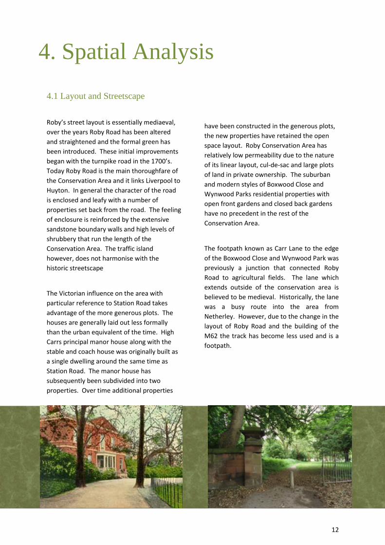
4.1 Layout and Streetscape
Roby’s street layout is essentially mediaeval,
over the years Roby Road has been altered
and straightened and the formal green has
been introduced. These initial improvements
began with the turnpike road in the 1700’s.
Today Roby Road is the main thoroughfare of
the Conservation Area and it links Liverpool to
Huyton. In general the character of the road
is enclosed and leafy with a number of
properties set back from the road. The feeling
of enclosure is reinforced by the extensive
sandstone boundary walls and high levels of
shrubbery that run the length of the
Conservation Area. The traffic island
however, does not harmonise with the
historic streetscape
The Victorian influence on the area with
particular reference to Station Road takes
advantage of the more generous plots. The
houses are generally laid out less formally
than the urban equivalent of the time. High
Carrs principal manor house along with the
stable and coach house was originally built as
a single dwelling around the same time as
Station Road. The manor house has
subsequently been subdivided into two
properties. Over time additional properties
have been constructed in the generous plots,
the new properties have retained the open
space layout. Roby Conservation Area has
relatively low permeability due to the nature
of its linear layout, cul-de-sac and large plots
of land in private ownership. The suburban
and modern styles of Boxwood Close and
Wynwood Parks residential properties with
open front gardens and closed back gardens
have no precedent in the rest of the
Conservation Area.
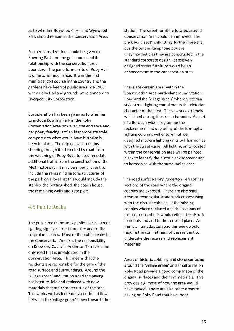
The footpath known as Carr Lane to the edge
of the Boxwood Close and Wynwood Park was
previously a junction that connected Roby
Road to agricultural fields. The lane which
extends outside of the conservation area is
believed to be medieval. Historically, the lane
was a busy route into the area from
Netherley. However, due to the change in the
layout of Roby Road and the building of the
M62 the track has become less used and is a
footpath.
4. Spatial Analysis

13
4.2 Open Spaces, Trees and
Landscape
The most prominent area for open space is
not within the Conservation Area, but touches
the western edge of the Conservation
Boundary. This area is known as ‘Bowring
Park’ and Bowring Park Golf Course. Bowring
Park was previously the site ‘Roby Hall’ which
was demolished in the 1950’s. A number of
outbuildings remain and are local heritage
assets. The main section of the park is largely
open space that provides a variety of dense
deciduous woodland and open grassed areas.
The walled flower garden to the south
overlooks the first municipal golf course in the
country and with enhancement could be an
attractive focal point for the area.
Historically, the park was an extremely
popular destination, as it was the last stop on
the Liverpool tram network. The entrance
could be improved as it currently separates
the Park area from Roby’s historic core. The
motorway and Roby Road cut through two
sections of the site and this has not helped
the sense of place of the park. The previous
entrance is believed to be further north by
the junction of the new housing estate known
as Roby Park, where there is still evidence of
the former boundary wall and gate piers. The
fencing around the park is not in keeping with
the original fencing which would have been a
small metal picket style fence. Measures
should be considered to subdue the noise of
the traffic on Roby Road from the park. The
remaining buildings may benefit for being
locally listed.
The ‘village green’ at the junction of Station
Road and Roby Road is the only other area of
public open space and this forms the centre of
the Conservation Area. The green supports a
prominent mature tree and well manicured
flower beds that help preserve and enhance
the attractiveness of the area. The green is an
important feature which contributes to the
sense of place and complements the
traditional appearance of the cottages on
Station Road.
Within the Conservation Area, many of the
residential properties have private front and
back gardens. The properties that do not
have a private front gardens include the row
of terraced housing on ‘Anderton Terrace’
previously known as ‘Stanley Terrace’, No. 61
Roby Road, No. 48 Roby Road and the
adjoining property, ‘Toll Bar Cottage’ and
‘High Carrs Lodge’. A number of these
properties were formerly coach houses and
stables that served the main manor houses of
‘High Carrs’ and ‘Derby Lodge’. In contrast,
the properties along Station Road have large
front gardens in which the properties are well
spaced. Many of the front gardens have been
converted to driveways for residential
parking.
Derby Lodge was previously set within its own
grounds. Sections of the grounds were sold
off and the residential developments of
Boxwood Close and Wynwood Park were built
on the site. Derby Lodge retains its formal,
manicured grounds at the front of the
property with similar formal gardens to the
rear. Parking provision and modern
extensions to the side of the property have
had an impact on the property, although this
is recognised as a necessary provision due to
the nature of the business.
The properties along Roby Road are from
various different eras. These properties all
have private gardens which separate the
houses from the road and many are screened
from the traffic by mature tree growth and
shrubbery. Opposite these properties is a

14
leafy tree-lined verge that runs along Roby
Road for a short distance.
All trees over 7cm in diameter are protected
within a conservation area. Trees have an
important role in the historic environment
and are often clearly visible on historic
Ordnance Survey Maps.
4.3 Focal points, Focal buildings and
Views
Focal point
One of the most prominent focal points
within the Conservation Area is the ‘village
green’. The quality of the street materials and
the planting that surrounds the area and the
stone work that edges the green significantly
enhances the streetscape. Unfortunately, the
telephone box and the bus shelter are
unsympathetic to the area.
Focal Buildings
A significant locally important building is Roby
railway station which is located to the north
of Station Road. Although this is a small
station, it has played a pivotal role in the
development of the residential houses in the
vicinity. Many of the original architectural
features have been retained on the building
including dentil under the eaves, decorative
wrought iron brackets supporting a wooden
canopy, picketing and segmental brick arches
with key stones and coloured brickwork. The
line links Manchester to Liverpool.
Historically, the railway is a significant
element of the Conservation Area and is
testament to the remarkable engineering
advances of the late Georgian era. Originally,
the station had four platforms but the two
platforms to the north, were closed in the
1970’s. As a part of the European Union
funded electrification of the Liverpool-
Manchester Line, Platform 3 will be brought
back into use for December 2014. However,
due to careful design and consultation with
Network Rail via the planning process this
should not have a major impact on the
character of the station or the surrounding
area.
Views
A view that is of particular interest is facing
towards No. 66 Station Road from the west of
Roby Road. The building is located on the
curve of Roby Road/Station Road Junction
with its prominent decorative, wrought iron
veranda, chequered brick and corbelled
chimneys. The building is distinctive and can
be seen from various viewing points. It is a
prominent landmark within the Conservation
Area.
4.4 Boundaries
The Conservation Area boundary presently
includes Boxwood Close and Wynwood Park.
These recent housing developments do not
relate to the village’s historic character or
local distinctiveness. The houses were built
on land that was once a part of the
‘Edenhurst’ Estate and the Edenhurst
Cottages which were demolished for the
expansion of Roby Road. The unsightly
substation at the entrance of the estate on
Roby Road, even though a necessity could be
hidden from view or screened more
effectively in order to reduce the impact on
the ‘village green’ and surrounding historic
houses. The tree cover and shrubbery in this
area does not strongly contribute to the
streetscape which strengthens the question
15
as to whether Boxwood Close and Wynwood
Park should remain in the Conservation Area.
Further consideration should be given to
Bowring Park and the golf course and its
relationship with the conservation area
boundary. The park, former site of Roby Hall
is of historic importance. It was the first
municipal golf course in the country and the
gardens have been of public use since 1906
when Roby Hall and grounds were donated to
Liverpool City Corporation.
Consideration has been given as to whether
to include Bowring Park in the Roby
Conservation Area however, the entrance and
periphery fencing is of an inappropriate style
compared to what would have historically
been in place. The original wall remains
standing though it is bisected by road from
the widening of Roby Road to accommodate
additional traffic from the construction of the
M62 motorway. It may be more prudent to
include the remaining historic structures of
the park on a local list this would include the
stables, the potting shed, the coach house,
the remaining walls and gate piers.
4.5 Public Realm
The public realm includes public spaces, street
lighting, signage, street furniture and traffic
control measures. Most of the public realm in
the Conservation Area’s is the responsibility
on Knowsley Council. Anderton Terrace is the
only road that is un-adopted in the
Conservation Area. This means that the
residents are responsible for the care of the
road surface and surroundings. Around the
‘village green’ and Station Road the paving
has been re- laid and replaced with new
materials that are characteristic of the area.
This works well as it creates a continued flow
between the ‘village green’ down towards the
station. The street furniture located around
Conservation Area could be improved. The
brick built ‘seat’ is ill-fitting, furthermore the
bus shelter and telephone box are
unsympathetic as they are constructed in the
standard corporate design. Sensitively
designed street furniture would be an
enhancement to the conservation area.
There are certain areas within the
Conservation Area particular around Station
Road and the ‘village green’ where Victorian
style street lighting compliments the Victorian
character of the area. These work extremely
well in enhancing the areas character. As part
of a Borough wide programme the
replacement and upgrading of the Boroughs
lighting columns will ensure that well
designed modern lighting units will harmonise
with the streetscape. All lighting units located
within the conservation area will be painted
black to identify the historic environment and
to harmonise with the surrounding area.
The road surface along Anderton Terrace has
sections of the road where the original
cobbles are exposed. There are also small
areas of rectangular stone work crisscrossing
with the circular cobbles. If the missing
cobbles where replaced and the sections of
tarmac reduced this would reflect the historic
materials and add to the sense of place. As
this is an un-adopted road this work would
require the commitment of the resident to
undertake the repairs and replacement
materials.
Areas of historic cobbling and stone surfacing
around the ‘village green’ and small areas on
Roby Road provide a good comparison of the
original surfaces and the new materials. This
provides a glimpse of how the area would
have looked. There are also other areas of
paving on Roby Road that have poor

16
pavement treatments which could be
improved.
A positive addition to the public realm is the
bronze interpretation panel at Roby Cross
which informs the reader of the provenance
and history of the Cross.
The stone wall that runs the length of the
Conservation Area from the western side of
Roby Road to the east is a historic boundary.
The red sand stone wall’s throughout the
Conservation Area are typical of the area and
enhance the conservation area.
Traffic bollards and unattractive utility fencing
surrounding the substation detract from the
conservation area and it may be prudent to
consider measures to improve this area or
remove it from the conservation area
boundary.

17
5.1 Building types
The buildings within Roby Conservation Area
are of different eras though the majority are
from the mid-18th and 19th Century and range
from small cottages to country houses. The
Conservation Area contains a number of 20th
century infill properties including Boxwood
Close and Wynwood Park estates. The
Stanley Arm’s public house although not listed
is of interest and has an interesting mix of
styles from different eras which includes Neo-
Georgian and Art Deco features. The
properties which back on to car park of the
Stanley Arms show successive incremental
alteration as does the rear of the Stanley
Arms.
The majority of buildings are two storeys with
the occasional three storey building, Station
Road and High Carrs are predominately three
storey. These properties were built around
the same time as the railway and are
prestigious brick residential Victorian
properties. The majority of 18th century
properties on Roby Road are remnants of the
Georgian era. They retain their attractive
detailing, such as ‘pargetting’ and sash
windows.
5.2 Listed buildings
There are seven listed properties within the
Conservation Area and one public monument
all are Grade II Listed. These heritage assets
are nationally important and are of significant
local interest.
No. 66 Roby Road
This property was previously known as ‘the
corner stores’ and built in circa 1840 but later
extended. The shop would have originally
served the village and the commuters of the
railway station. The building is of a two storey
height that includes three bays. The front of
the property is dominated by an ornate cast
iron veranda on the ground floor with paint
white brickwork behind. The expansive
windows on the ground floor are divided into
three with arched detailing. The first floor has
chequered brickwork and the roof has a
slated covering roof and corbelled chimney
stacks.
5. The Buildings of the
Conservation Area

18
No. 70 Roby Road
No.70 Roby Road was formerly a Toll Bar
Cottage and is a Grade II Listed building. It is
believed to date back to 1723, when the
Turnpike road travelled through Roby. The
building comprises of two bays. The first is a
rectangular bay window and porch to the
front of the property the porch is now
enclosed. The second bay is to the east side
of the main entrance and is surrounded by
hedgerows. The overriding material of the
building is painted white brick; it has a regular
coursed slate roof, and tall chimney stack.
No. 1-5, Station Road
This collection of cottages forms a terrace
that dates back to circa 1870. The terrace
would have also been built as commuter
cottages. The fine detailed panelling indicates
that these were not standard workers
cottages.
The buildings are built from red sand stone
block, the end buildings have quoins, with
tiled roof and decorative terracotta ridge tiles,
finials and corbelled red brick chimney stacks.
The ground floor window openings are red
brick segmental arch with stone sill and
casement windows. The first floor windows
are jettied with bay windows whilst bay three
and six have timber-framed gabled canted bay
windows over open porches. Decorative
plaster panels have painted floral pargetting.
Porches have posts with decorative brackets
and top panels. Gables have recessed stone
panels and central shield in the architrave.
Roby Cross
Roby Cross is believed to be the remains of a
medieval cross. It is of red sandstone and has
a square base and the shaft of the cross. The
cross was removed from its original site at the
corner of Carr Lane in 1979 and may have
connection with Roby Market, charter
granted in 1304.
There are a number of listed buildings within
close proximity of the Conservation Area
including:-
Archway Road Railway Bridge
The railway bridge on Archway Road is a
Grade II listed bridge. It was built between
1828 and 1830 for the Liverpool to
Manchester Railway which was engineered by
George Stephenson. The bridge is
constructed of red sand stone with a
segmental arch with voussoir stones,
ornamental brackets and a parapet cornice.
Pilch Lane East Railway Bridge
Pilch Lane railway bridge has less architectural
detail but is has significance as a part of the
railways industrial past. It was built by
George Stevenson is Grade II listed it is
located along Pilch Lane East. The stone work
is less impressive and has a single span arch.
Church of St Bartholomew, Church Road
Although it is not located in the Conservation
Area St Bartholomew’s has played a
prominent role in Roby village’s past. The
centre of the village was previously located
around the junction of Station Road and Roby
Road but with the building of the church
communities moved north and across the
railway tracks. This in turn lead to the
Liverpool City Corporation building Page Moss
housing estate after the inter war period to
relieve the expansion of the city centre. The
church was built in 1853 by Ewan Christian. St
Bartholomew's Church was built thanks to
19
donations from Lord Derby and Rev. Ellis
Ashton, Vicar of St Michael's, Huyton. In 1875
the tower was added it has unique setback
buttresses the building is an impressive
structure and a Grade II listed building.
5.3 Locally Listed Buildings
At present Knowsley Council does not have a local list. However the Council is in the process of collating a list of locally important buildings which are ‘significant ‘to the local area and the Borough. Although these buildings will not have any additional planning controls their historic importance will be considered when taken into planning applications for alteration or demolition. Potential inclusions for the local list include:-
Edenhurst Manor House (now Derby Lodge)
Bowring Park Stables
Bowring Park Coach House
Bowring Park Potting Shed
Sandstone Walls to the North of Roby Road original park walls
Three sandstone gate piers
The Stanley Pub
5.4 Positive Buildings
In addition to the nationally listed buildings,
there are a number of unlisted buildings that
make a positive contribution to the area’s
character and appearance.
Stanley Arms public house is not listed and is
located towards the eastern edge of the
Conservation Area. The building’s positive
architectural style is unique for the area and
was built around the 1930’s. The
architectural style has aspects of Art Deco and
Neo-Georgian styles. The sash windows and
detailed brickwork is influenced by Georgian
architecture though the tiled entrance at
ground floor combined with curved side
entrances gives the impression of Art Deco.
At roof level the building has low stone
parapet wall which rises to an apex. Located
under the apex and above the Georgian
windows is the Stanley Crest of the eagle and
child and three bucks heads. The signage to
the front of the Stanley has a statue of an
Eagle and Child which has been gold leafed.
The emblem is synonymous with Lord Derby
and the Stanley family and can be seen on
various buildings and signs throughout the
Knowsley area.
Although it is not listed, Derby Lodge is a
significant historic building which is
prominent on the streetscape. Formerly
known as Edenhurst the red sandstone block
building and the lodge at the entrance to the
site are impressive historic buildings. Located
on an elevated site above Roby Road and set
within manicured gardens Derby Lodge has an
undulating roof line with low parapet wall, the
front elevation has stone drip mouldings,
stone detailing and the entrance has an
impressive fan light over the door.
5.5 Building Styles, materials and
colours
Roby was historically in close proximity to a
number of sandstone quarries, the nearest
being located on the edge of the conservation
area at Carr Lane. This has played a
significant part in the construction materials
and architectural style of the area.
Throughout the Conservation Area, the
different eras have been influenced by a
diverse range of building materials available
to the area.
Along the eastern side of Roby Road some of
the houses appear to be from the late

20
Georgian era. A number of these properties
have been rendered and painted white. It is
difficult to ascertain whether these properties
were originally brick and have at a later date
been rendered or whether they were simply
stucco rendered originally. Many of these
properties retain their original sash windows.
Over the years a number of these properties
have had minor alterations but the defining
features have stayed the same. The
sandstone wall with white rendered or red
sandstone gate piers is typical of the area.
The three properties at the entrance of the
Anderton Terrace were originally red brick
built however, a number of these properties
have been rendered possibly to cover up
damage to the brick work or in an attempt to
modernise. The bricks are handmade and this
is reflected in the texture and varying tones of
the brick in the remaining properties.
In between Anderton Terrace and Station
Road the properties range from detached
Georgian properties along to small cottages.
A number of properties from the Victorian era
retain the original slate roofing and sash
windows. On this section of Roby Road a few
of the houses have timber ‘dentil’ in some
cases the beams have been painted white.
Roby station is relatively hidden as it located
to the north of Station Road. The detailed
brick work and decorative iron supporting
brackets are good example of the Victorian
infrastructure.
The red, yellow and brown brickwork that
forms the segmental arches over the windows
and doors is specific to the architectural style
at the station.
Historically, on the corner of Carr Lane was a
row of cottages known as Edenhurst Cottages.
The cottages were of architectural merit and
were adjacent to the original location of Roby
Cross. Unfortunately, the properties were
demolished in the 1970’s to make way for the
expansion of the Roby Road.
The properties on Station Road are
predominantly from the Victorian Era. These
mid - 19th century suburban villas were built
out of alternative materials as stucco began to
fall out of favour. The introduction of the
improved machinery and production in
Victorian era ensured bricks were easily
transported via rail. The buildings on Station
Road are constructed of red brick with
decorative drip mouldings impressive decor at
door entrances. A number of these buildings
would have had decorative wrought and cast
iron gates and railings. The houses are
generally in excellent condition and well
maintained most alterations and extension
have been in keeping with the principle
building.
Roofing materials in the Conservation Area
are generally constructed of Welsh slate
however from the 1870s clay tiles appeared
with terracotta ridge tiles.
Fenestration is predominantly of two styles of
traditional window types. The older buildings,
which date from the 17th and 18th centuries,
tend to have tall, narrow casement windows
with frames made of either timber or lead,
often with lead lattice this can be seen on No.
62 and No. 64. Roby Road
Due to the close proximity of local quarries,
iron rich red sandstone is a dominant material
used throughout the Conservation Area.
Many properties feature a boundary wall in
red sandstone, with stone, brick or rendered
gate piers. ‘Edenhurst’ now Derby Lodge is
built out of this locally sourced material and it
is one of the most prominent buildings in
Roby Conservation Area.

21
Key positive features:
Roby Conservation Area can be evidenced to
its former medieval settlement. However, the
overriding character is that of an area which
has become firmly established with the
introduction of the railways. The notable
elements of the Conservation Area include its
Victorian villas, the railway station and
ticketing office and the extensive use of the
locally sourced red sandstone on its buildings
and walls. The more significant buildings
include:-
- No. 66 Roby Road a Grade II Listed Building
- No.1-5 Station Road, Grade II Listed
Buildings
- No. 70 Station Road, also known as the Toll House is a Grade II Listed Building
- Roby Cross adjacent to the small
‘village green’
- Quality paving and detailed cobbled stone work
- The attractive location around the
central green
- The ticket office building at Roby Railway Station should be considered for local listing.
- Potential to local list the remaining structures in Bowring Park
- Potential archaeological interest from Roby Old Hall in Bowring Park
- Different eras evident
Key negative features:
- Modern housing development of Boxwood and Wynwood Park has no particular heritage or architectural interest
- Busy traffic route along Roby Road
- Unsympathetic bus stop and telephone box around the ‘village green’
- Poor road surfacing along Anderton Terrace
- Dentist Surgery the late 20th Century front extension obscures the sandstone fronted building. The extension is out of character with the neighbouring properties.
- A number of unsympathetic boundary treatments
6. Character Areas
22
The following issues are considered to be
principal matters which the emerging Roby
Conservation Area Management Plan needs
to address:
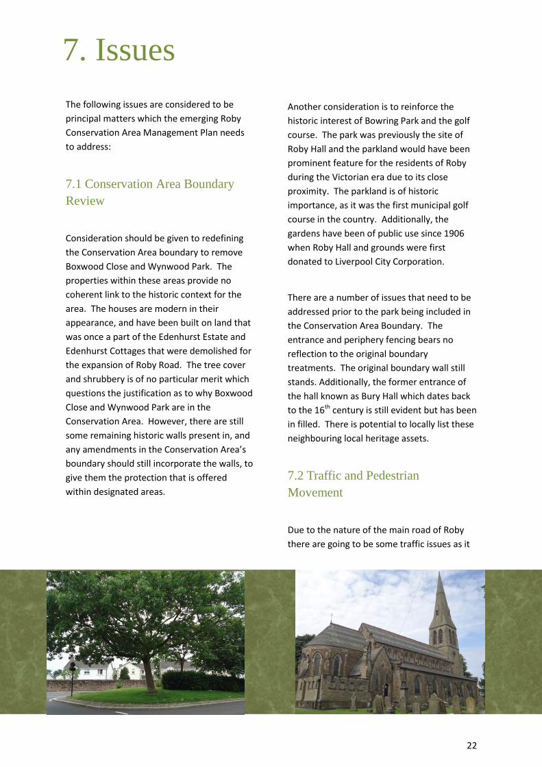
7.1 Conservation Area Boundary
Review
Consideration should be given to redefining
the Conservation Area boundary to remove
Boxwood Close and Wynwood Park. The
properties within these areas provide no
coherent link to the historic context for the
area. The houses are modern in their
appearance, and have been built on land that
was once a part of the Edenhurst Estate and
Edenhurst Cottages that were demolished for
the expansion of Roby Road. The tree cover
and shrubbery is of no particular merit which
questions the justification as to why Boxwood
Close and Wynwood Park are in the
Conservation Area. However, there are still
some remaining historic walls present in, and
any amendments in the Conservation Area’s
boundary should still incorporate the walls, to
give them the protection that is offered
within designated areas.
Another consideration is to reinforce the
historic interest of Bowring Park and the golf
course. The park was previously the site of
Roby Hall and the parkland would have been
prominent feature for the residents of Roby
during the Victorian era due to its close
proximity. The parkland is of historic
importance, as it was the first municipal golf
course in the country. Additionally, the
gardens have been of public use since 1906
when Roby Hall and grounds were first
donated to Liverpool City Corporation.
There are a number of issues that need to be
addressed prior to the park being included in
the Conservation Area Boundary. The
entrance and periphery fencing bears no
reflection to the original boundary
treatments. The original boundary wall still
stands. Additionally, the former entrance of
the hall known as Bury Hall which dates back
to the 16th century is still evident but has been
in filled. There is potential to locally list these
neighbouring local heritage assets.
7.2 Traffic and Pedestrian
Movement
Due to the nature of the main road of Roby
there are going to be some traffic issues as it
7. Issues
23
is the through route to Huyton and the M62,
Liverpool and Manchester. However, the
unsympathetic traffic crossings and lighting
opposite the ‘village green’ diminishes the
areas character and does little to conserve the
historic townscape. This is a necessity as
there are very few traffic crossing on the
road, however there are opportunities to
attain a more sensitive style in relation to the
surroundings.
7.3 Vacant or derelict sites
There are no significant derelict sites or
obsolete buildings within the Roby
Conservation Area. However there are
buildings which are not fully occupied. The
site of Edenhurst (Derby Lodge) has some
sections of the building which are not fully
used, namely the former stable building.
7.4 Buildings at Risk
At the time of writing there are no significant
buildings at risk in the Roby Conservation
Area. The station building has undergone
some adaptation to ensure that Roby station
and ticket office is able to comply with the
requirements of the 21st Century. However,
the works have been undertaken with the
character of the original building being
retained and replicated where necessary.
Although there are no particular buildings at
risk there are a number of high profile
buildings within the Conservation Area that
have had some inappropriate alterations, for
example the fitting of uPVC windows. These
incremental changes can have a cumulative
and negative effect on the conservation and
can put a Conservation Area at risk.
7.5 Public realm
A significant amount of improvements have
already been undertaken on Roby’s public
realm, most notably on Station Road and
‘village green’ area. The new paving and
sympathetic materials enhances the historic
environment. Ideally further improvements
would be extended throughout the
Conservation Area as some areas of paving
are mismatched.
The public realm also includes four large
sandstone blocks this is located in front of
number 66 Roby Road. These sandstone
blocks once supported a large sandstone
trough which would have a watering trough
for horses. Unfortunately, the trough has
been removed and lost.
7.6 Advertising, shop fronts and
signage
Derby Lodge’s has a prominent position on
Roby Road, the trees and formal gardens to
the front of the property reinforce the
grandeur of the building. The Premier Inn
hotel chain now occupies the building and the
advertising for the hotel and restaurant is
quite bold.
There is often a balance that has to be
considered in regard to the conversion of a
historic building to a new use. Advertising can
be controlled through the planning legislation
though legislation can be considered to be
quite lenient in the amount and size of
advertising permissible. However, the
balance in this case is that it is better that this
building was brought back into use with the
advertising rather than the premises being

24
vacant and obsolete.
Roby Conservation Area does not have any
shops where traditional shop front would be
required. Signage mainly relates to the
highways signage. Advertisements and
signage in relation to business mainly for
Derby Lodge, The Stanley Pub and the dentist
all of which are subject to the planning
process. The aim is to reduce any
unnecessary signage and create a clutter free
Conservation Area.
7.7 Article 4 Directions
The use of ‘Article 4 Directions’ enables local
planning authorities to control minor
alterations to unlisted residential properties
which could otherwise be carried out by a
property owner without planning permission
under their ‘permitted development’ rights.
Alterations such as the installation of
replacement doors and windows, reroofing in
modern materials, the removal of chimneys,
creation of dormer window, the addition of
porches or and the creation of car parking in
the front garden can all be controlled by
‘Article 4 Directions’. The aim of any such
Direction is mainly to encourage property
owners to use traditional materials within the
Conservation Area ideally to prevent the
gradual erosion of its special interest.
Anderton Terrace and the eastern side of
Roby Road have undergone significant levels
of erosion within the Conservation Area.
Incremental building alterations have
impacted on the Conservation Area even
relatively minor changes to properties can
have a detrimental impact on the streetscape.
A typical alteration has been the Georgian
windows being replaced with inappropriate
window styles and materials. To be effective
it is essential that such controls continue to
receive public support and understanding and
that management and decision making is
consistent.
Whilst it is recognised that the introduction of
an Article 4 Direction would be an effective
way of safeguarding the remaining historical
character of the Conservation Area, the
introduction of one would require a
substantial amount of support and
recommendation from the local residents. It
would then have to go through a public
consultation process before it was
implemented.
7.8 Heritage Assets
The statutory list of the Borough of Knowsley
was reviewed in 1992 by the Department of
Culture Media and Sport. There are plans
within the Historic Environment Strategy,
2013 to review the statutory list in terms of
buildings with local and architectural interest.
It is possible that several of the buildings
within the Conservation Area would benefit
from being considered for inclusion onto the
Statutory List or local list. Details would be
sent to English Heritage (Statutory Advisors)
and the properties would be assessed against
national criteria for inclusion on the list of
national heritage assets. A number of the
positive buildings which have been identified
in this Character Appraisal that would benefit
from being ‘Locally Listed’ and included on a
local list. Community participation,
agreement, and consultation would be a
major factor in this process. Buildings for
consideration include:

25
- No. 6 Station Road
- No. 8 – 18 Station Road
- Roby Railway Station, Station Road
7.9 Maintenance of key areas
Specific details for this section will be set out
in the Area Management Plan for the Roby
Conservation Area. Potential enhancements
include:
- Negotiation with service providers for
sympathetic street furniture including
bus shelters, street lighting and
traffic crossings
- Improvements to road surfacing along
Anderton Terrace, although there
may be issues due to the road being
‘un-adopted’
- The provision of heritage
interpretation panels regarding the
significance of the area and its history
- The extension of the good quality
paving from the ‘village green’ to
other areas of the Conservation Area
- Consider alteration to the
Conservation Area boundary to
include Bowring Park, Roby Train
Station and the deletion of Boxwood
Close and Wynwood Park
In terms of street lighting within Roby
Conservation Area and the remaining
Knowsley Borough a PFI (Private Finance
Initiative) will be upgrading all the street
lighting throughout the Borough. As some of
the existing lighting columns are not
compliant with the new specification and a
significant number of lighting columns are
being replaced. The new lighting columns
that are being erected will be painted black in
the conservation areas.

26
Knowsley MBC. 2010. Roby Origins and
History. [online] Available at:
http://history.knowsley.gov.uk/information/p
rint_text.msql?name=Roby&ref=rborigins
[Accessed: 3 Sep 2013].
National Statistics. 2001. Lead Key Figures.
[online] Available at:
http://neighbourhood.statistics.gov.uk/disse
mination/LeadKeyFigures.do?a=3&b=5941470
&c=roby&d=14&e=16&g=358046&i=1001x10
03x1004&m=0&r=1&s=1212101378078&enc=
1 [Accessed: 3 Sep 2013].
Vision of Britain. 2001. History of Roby, in
Knowsley and Lancashire | Map and
description. [online] Available at:
http://www.visionofbritain.org.uk/place/plac
e_page.jsp?p_id=21061 [Accessed: 3 Sep
2013].
Old Mersey Times. 2002. Huyton-with-Roby.
[online] Available at: http://www.old-
merseytimes.co.uk/HuytonwithRoby.html
[Accessed: 3 Sep 2013].
Knowsley Historic Built Environment Strategy
2013.
Further Reading
27
Article 4 Direction A legal direction imposed by the local Council which requires that development which would otherwise be ‘Permitted Development’ which will require planning permission.
Conservation Area Areas of special historic or architectural character. New development within these areas must preserve or enhance the special characteristics of
the area. Corbelling Corbelling a projection from a wall or reveal designed to support a weight. A corbel table is a series of corbels usually set just below the eaves. Gap Site A gap is usually a site or piece of land where demolition of a building has occurred and has not been re-developed. This leaves a vacant site on the streetscape, breaking the flow of the urban fabric. Historic Environment All aspects of the environment resulting from the interaction between people and places through time, including all surviving physical remains of past human activity, whether visible, buried or submerged and landscaped and planted or managed flora.
Listed Building Listed buildings and structures that are on the national statutory list due to their special architectural or historic significance. Listed Buildings have a level of protection from demolition or inappropriate alterations. Listed Building Consent is required for works affecting these buildings.
Local Listing A local listed building is a building or structure which is not nationally important but is important to Knowsley’s heritage due to its architectural, historic or archaeological significance
National Planning Policy Framework The National Planning Policy Framework sets out the Government’s planning policies for England and how they will be applied. It provides a framework within which local people and their local authority can produce their own distinctive local and neighbourhood plans which reflect the needs and priorities of their communities.
Pargetting Pargetting or external plaster work refers to the decoration in relief of the plastering usually on outside of half-timber properties, or sometimes covering the whole wall. It can also used as a decoration on much later dated properties and is produced by the application of carved timber moulds pressed against the plaster before it dries. In some instances it is undertaken by a skilled plasterer and the design applied freehand.
Permitted Development Rights Under government legislation, certain forms of minor development (such as small extensions to houses, small fences and walls, small extensions to factories) do not require planning permission. However, the rules governing these ‘Permitted Development’ rights are complex and therefore you are always advised to contact the Council for advice. In some areas (eg. some Conservation Areas, converted barns and in some housing estates) Permitted Development rights have been removed by the Council meaning that planning permission is required even for the smallest extension to a house, or building of a boundary walls, etc. Quoins Angular courses of stone at the corner of a building, usually laid as alternate quoin (headers and stretchers).
Trees
Tree coverage provides a vital aspect of the
character and appearance of a Conservation Area,
therefore they too are protected through
legislation. Any work affecting trees within the
Conservation Area requires six weeks’ notice to be
given to the Council.
Turnpike Turnpike is another term for a toll road. Turnpike trusts were, a body set up by Act of Parliament, with powers to collect road tolls for maintaining the principal highways during the 18
th and 19
th
Centuries.
Glossary

28
Appendix 1 Historic Map 1840

29
Appendix 2 Historic Map 1907

30
Appendix 3 Historic Map 1927
31
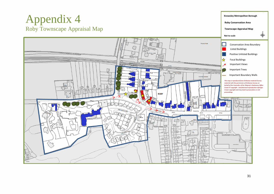
Appendix 4 Roby Townscape Appraisal Map
Knowsley Metropolitan Borough
Council
Roby Conservation Area
Townscape Appraisal Map
Not to scale
Conservation Area Boundary
Listed Buildings
Positive Unlisted Buildings
Focal Buildings
Important Views
Important Views
Important Trees
Important Boundary Walls
This map is reproduced from Ordnance material Survey
material with the permission of Ordnance Survey on
behalf of the Controller of Her Majesty’s Stationary Office
Crown © copyright. Unauthorised reproduction infringes
Crown copyright and may lead to prosecution or civil
proceedings
This map is reproduced from Ordnance material Survey
material with the permission of Ordnance Survey on
behalf of the Controller of Her Majesty’s Stationary Office
Crown © copyright. Unauthorised reproduction infringes
Crown copyright and may lead to prosecution or civil
proceedings

32
Appendix 5 Roby Boundary Review Map

33
34
Knowsley Metropolitan Borough Council Directorate of Place Planning Services
PO Box 26 Huyton, Knowsley
Merseyside L36 9FB
Telephone: 0151 443 2381