RIU-Formatted Final Reportnepa.gov.jm/eias/StAnn/MammeeBay/RIU/RIU-MammeeBay-EIA_Final… · final...
113
FINAL REPORT ENVIRONMENTAL IMPACT ASSESSMENT FOR THE PROPOSED RIU – OCHO RIOS MAMMEE BAY, ST. ANN Prepared by ENVIRONMENTAL SCIENCE AND TECHNOLOGY LIMITED 14 Carvalho Drive Kingston 10 For: Port Marly Limited Norman Manley Boulevard Negril May 2004
-
Upload
hoanghuong -
Category
Documents
-
view
219 -
download
2
Transcript of RIU-Formatted Final Reportnepa.gov.jm/eias/StAnn/MammeeBay/RIU/RIU-MammeeBay-EIA_Final… · final...
FINAL REPORT
ENVIRONMENTAL IMPACT ASSESSMENT FOR THE PROPOSED RIU – OCHO RIOS
MAMMEE BAY, ST. ANN
Prepared by ENVIRONMENTAL SCIENCE AND TECHNOLOGY LIMITED
14 Carvalho Drive Kingston 10
For:
Port Marly Limited Norman Manley Boulevard
Negril
May 2004
ES*PRJ 1004/04
Environmental Science & Technology Ltd. Mammee Bay EIA i
TABLE OF CONTENTS TABLE OF CONTENTS............................................................................................................................ I
LIST OF TABLES.................................................................................................................................... IV
LIST OF FIGURES.................................................................................................................................. IV
LIST OF APPENDICES............................................................................................................................V
EXECUTIVE SUMMARY.....................................................................................................................VII
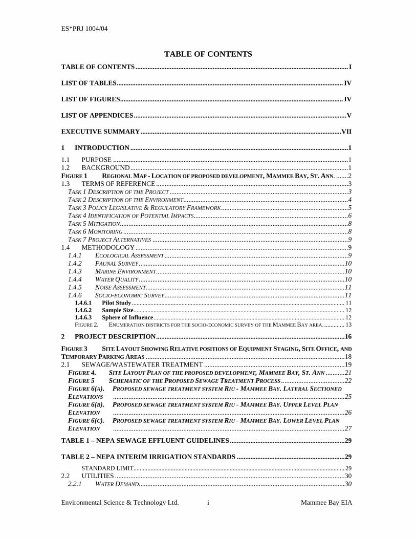
1 INTRODUCTION ...............................................................................................................................1 1.1 PURPOSE .........................................................................................................................................1 1.2 BACKGROUND...............................................................................................................................1 FIGURE 1 REGIONAL MAP - LOCATION OF PROPOSED DEVELOPMENT, MAMMEE BAY, ST. ANN. .......2 1.3 TERMS OF REFERENCE ................................................................................................................3
TASK 1 DESCRIPTION OF THE PROJECT ........................................................................................................3 TASK 2 DESCRIPTION OF THE ENVIRONMENT................................................................................................4 TASK 3 POLICY LEGISLATIVE & REGULATORY FRAMEWORK..........................................................................5 TASK 4 IDENTIFICATION OF POTENTIAL IMPACTS..........................................................................................6 TASK 5 MITIGATION.....................................................................................................................................8 TASK 6 MONITORING ...................................................................................................................................8 TASK 7 PROJECT ALTERNATIVES ..................................................................................................................9
1.4 METHODOLOGY............................................................................................................................9 1.4.1 ECOLOGICAL ASSESSMENT ...........................................................................................................9 1.4.2 FAUNAL SURVEY ........................................................................................................................10 1.4.3 MARINE ENVIRONMENT..............................................................................................................10 1.4.4 WATER QUALITY ........................................................................................................................10 1.4.5 NOISE ASSESSMENT....................................................................................................................11 1.4.6 SOCIO-ECONOMIC SURVEY.........................................................................................................11
1.4.6.1 Pilot Study ......................................................................................................................................... 11 1.4.6.2 Sample Size........................................................................................................................................ 12 1.4.6.3 Sphere of Influence ........................................................................................................................... 12 FIGURE 2. ENUMERATION DISTRICTS FOR THE SOCIO-ECONOMIC SURVEY OF THE MAMMEE BAY AREA. ............. 13
2 PROJECT DESCRIPTION..............................................................................................................16 FIGURE 3 SITE LAYOUT SHOWING RELATIVE POSITIONS OF EQUIPMENT STAGING, SITE OFFICE, AND TEMPORARY PARKING AREAS ....................................................................................................................18 2.1 SEWAGE/WASTEWATER TREATMENT ..................................................................................19
FIGURE 4. SITE LAYOUT PLAN OF THE PROPOSED DEVELOPMENT, MAMMEE BAY, ST. ANN ...........21 FIGURE 5 SCHEMATIC OF THE PROPOSED SEWAGE TREATMENT PROCESS .....................................22 FIGURE 6(A). PROPOSED SEWAGE TREATMENT SYSTEM RIU - MAMMEE BAY. LATERAL SECTIONED ELEVATIONS .......................................................................................................................................25 FIGURE 6(B). PROPOSED SEWAGE TREATMENT SYSTEM RIU - MAMMEE BAY. UPPER LEVEL PLAN ELEVATION .......................................................................................................................................26 FIGURE 6(C). PROPOSED SEWAGE TREATMENT SYSTEM RIU - MAMMEE BAY. LOWER LEVEL PLAN ELEVATION .......................................................................................................................................27
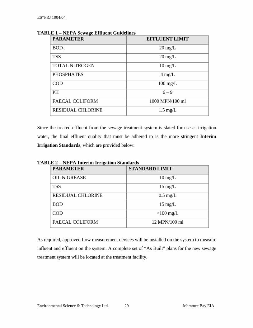
TABLE 1 – NEPA SEWAGE EFFLUENT GUIDELINES...................................................................29
TABLE 2 – NEPA INTERIM IRRIGATION STANDARDS ...............................................................29 STANDARD LIMIT........................................................................................................................................ 29
2.2 UTILITIES ......................................................................................................................................30 2.2.1 WATER DEMAND........................................................................................................................30
ES*PRJ 1004/04
Environmental Science & Technology Ltd. Mammee Bay EIA ii
2.2.2 ELECTRICITY DEMAND...............................................................................................................30 2.3 MODIFICATIONS TO BEACH OR FORESHORE......................................................................31 3 DESCRIPTION OF THE ENVIRONMENT..................................................................................33 3.1 PHYSICAL ENVIRONMENT .......................................................................................................33
3.1.1 CLIMATE ...................................................................................................................................33 3.1.2 TOPOGRAPHY AND GEOLOGY .....................................................................................................34
3.1.2.1 General Topography and Geology .................................................................................................. 34 3.1.2.2 Beach Topography and Geology ..................................................................................................... 34 FIGURE 7 SOIL TEXTURE MAP OF PARTS OF ST. ANN, INCLUSIVE OF THE PROPOSED SITE ......................... 36
3.1.3 WATER QUALITY ANALYSIS.........................................................................................................37 3.1.3.1 Analytical Results ............................................................................................................................. 37 Table 5 Results of water quality analysis conducted on samples collected at Mammee Bay, St. Ann............ 37
3.1.4 NOISE ASSESSMENT....................................................................................................................39 3.1.5 STORM WATER MANAGEMENT ....................................................................................................40 3.1.6 SOLID WASTE MANAGEMENT......................................................................................................40
3.1.6.1 Pre-construction ............................................................................................................................... 40 3.1.6.2 Construction Phase........................................................................................................................... 40 3.1.6.3 Occupational Phase .......................................................................................................................... 41
3.2 BIOLOGICAL ENVIRONMENT ..................................................................................................41 3.2.1 VEGETATION..............................................................................................................................41
TABLE 3 – OBSERVED VEGATATION SPECIES.............................................................................43 3.2.2 FAUNAL SURVEY ........................................................................................................................44
3.3 MARINE ENVIRONMENT ...........................................................................................................44 3.3.1 REEF ASSESSMENT.....................................................................................................................44 FIGURE 8 MARINE VIDEO-GRAPHED SURVEY SITES FOR THE RIU OCHO RIOS HOTEL DEVELOPMENT. .......................................................................................................................................45
Site 1: The Shore East of the Mammee Bay Beach Club to the front section of the Inner Reef.................. 46 PHOTO INVENTORY.................................................................................................................................. 47
Site 2: West of the Small Inner Reef and back to Shore ................................................................................. 48 PHOTO INVENTORY.................................................................................................................................. 49
Site 3 – Region extending from the Shore, West of the Mammee Bay Beach Club, towards the Eastern Limits of the Inner Reef, going along to the back of the Inner Reef. ............................................................. 49
PHOTO INVENTORY.................................................................................................................................. 50 Site 4 – Region between the back of the Inner Reef and the front of the Main Reef .................................... 50
PHOTO INVENTORY.................................................................................................................................. 51 Site 5 – Traveling Southeast from the edge of the Main Reef towards the Shore line.................................. 53
PHOTO INVENTORY.................................................................................................................................. 54 3.4 SOCIO-ECONOMIC SURVEY AND CULTURAL CONSIDERATIONS ....................................55
3.4.1 DEMOGRAPHIC PROFILE............................................................................................................55 3.4.2 URBAN SETTING.........................................................................................................................55
Table 5 Impact Population of the Mammee Bay Area by ED, Age/Sex Structure .......................................... 55 3.4.3 RESIDENTIAL DEVELOPMENT .....................................................................................................55 3.4.4 SOCIAL ENVIRONMENT...............................................................................................................56 3.4.5 ENVIRONMENTAL IMPACTS .........................................................................................................57 3.4.6 HEALTH IMPACTS ......................................................................................................................57 3.4.7 CULTURAL AND HISTORICAL IMPACTS ........................................................................................58
3.4.7.1 Archaeological Retrieval Plan ......................................................................................................... 58 3.4.8 COMMUNITY MEETINGS .............................................................................................................59
4 POLICY, LEGISLATION AND REGULATIONS........................................................................62 4.1 AGENDA 21 ......................................................................................................................................62 4.2 DEVELOPMENT GUIDELINES...................................................................................................64
4.2.1 St. Ann Parish – Town and Country Planning Provisional Development Order, 1998 ..........64 4.3 RELEVANT LEGISLATION.........................................................................................................64
4.3.1 THE NATURAL RESOURCES CONSERVATION AUTHORITY (NRCA) ACT, 1991 ...............................64
ES*PRJ 1004/04
Environmental Science & Technology Ltd. Mammee Bay EIA iii
4.3.2 THE BEACH CONTROL ACT (1956) .............................................................................................65 4.3.3 THE PUBLIC HEALTH ACT (1974) ..............................................................................................67 4.3.4 JAMAICA NATIONAL HERITAGE TRUST ACT (1985)......................................................................67 4.3.5 TOWN & COUNTRY PLANNING ACT (1987) .................................................................................67 4.3.6 THE NATURAL RESOURCES (MARINE PARKS) REGULATIONS, 1992..............................................68
5 IDENTIFICATION OF POTENTIAL ENVIRONMENTAL IMPACTS AND MITIGATION70 5.1 IMPACT IDENTIFICATION & MITIGATION ............................................................................70
5.1.1 Socio-Economic Impacts .........................................................................................................70 5.1.2 Environmental Impacts............................................................................................................71
5.1.2.1 Pre-Construction/Construction Phases........................................................................................... 71 5.1.2.2 Operational Phase ............................................................................................................................ 79
6 ENVIRONMENTAL ACTION/MONITORING PLAN ...............................................................84 6.1 PRE-CONSTRUCTION PHASE MONITORING .........................................................................85 CONSTRUCTION PHASE MONITORING..............................................................................................86 6.2 OPERATION PHASE MONITORING ..........................................................................................87 7 ANALYSIS OF ALTERNATIVES..................................................................................................89 7.1 THE NO ACTION ALTERNATIVE..............................................................................................89 7.2 THE PROPOSED DEVELOPMENT .............................................................................................90 7.3 THE PROPOSED DEVELOPMENT WITH MODIFICATIONS..................................................91 7.4 THE PROPOSED DEVELOPMENT IN ANOTHER LOCATION...............................................93 APPENDIX A...............................................................................................................................................2
APPENDIX A-1 REQUEST TO N.W.C. FROM JAMPRO ON BEHALF OF PORT MARLY LTD. FOR THE ASSURANCE OF WATER AVAILABILITY FOR THE RIU OCHO RIOS DEVELOPMENT .......................................2 APPENDIX A-2 N.W.C COMMITMENT TO SUPPLYING THE WATER FOR THE RIU OCHO RIOS DEVEOPMENT .......................................................................................................................................3
ES*PRJ 1004/04
Environmental Science & Technology Ltd. Mammee Bay EIA iv
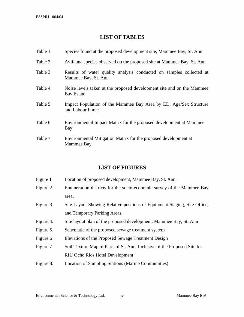
LIST OF TABLES
Table 1 Species found at the proposed development site, Mammee Bay, St. Ann
Table 2 Avifauna species observed on the proposed site at Mammee Bay, St. Ann
Table 3 Results of water quality analysis conducted on samples collected at Mammee Bay, St. Ann
Table 4 Noise levels taken at the proposed development site and on the Mammee Bay Estate
Table 5 Impact Population of the Mammee Bay Area by ED, Age/Sex Structure and Labour Force
Table 6 Environmental Impact Matrix for the proposed development at Mammee
Bay Table 7 Environmental Mitigation Matrix for the proposed development at
Mammee Bay
LIST OF FIGURES Figure 1 Location of proposed development, Mammee Bay, St. Ann.
Figure 2 Enumeration districts for the socio-economic survey of the Mammee Bay
area.
Figure 3 Site Layout Showing Relative positions of Equipment Staging, Site Office,
and Temporary Parking Areas.
Figure 4. Site layout plan of the proposed development, Mammee Bay, St. Ann
Figure 5. Schematic of the proposed sewage treatment system
Figure 6 Elevations of the Proposed Sewage Treatment Design
Figure 7 Soil Texture Map of Parts of St. Ann, Inclusive of the Proposed Site for
RIU Ocho Rios Hotel Development
Figure 8. Location of Sampling Stations (Marine Communities)
ES*PRJ 1004/04
Environmental Science & Technology Ltd. Mammee Bay EIA v
LIST OF APPENDICES
Appendix A
Appendix A-1 Request to N.W.C. from JAMPRO on behalf of Port Marly Ltd. For the assurance of Water Availability for the RIU Ocho Rios Development.
Appendix A-2 N.W.C Commitment to Supplying Water for The RIU Ocho Rios Development

THE EXECUTIVE SUMMARY
ES*PRJ 1004/04
Environmental Science & Technology Ltd. Mammee Bay EIA vii
ENVIRONMENTAL IMPACT ASSESSMENT FOR THE PROPOSED RIU – OCHO RIOS RESORT DEVELOPMENT
MAMMEE BAY, ST. ANN
EXECUTIVE SUMMARY 1. Port Marly Limited proposes to construct a 846 room hotel on 13.87 hectares (34.26
acres) of land located at Mammee Bay, St. Ann. An Environmental Impact
Assessment (EIA) of the project was conducted by Environmental Science and
Technology Limited (ESTECH), to provide a complete description of the existing
site, detail the elements of the development, identify major environmental issues, and
report on public perception.
2. The EIA seeks to identify those activities of the project, which could have an
adverse effect on the environment, and to determine means of avoiding the adverse
consequences identified.
3. The study area extended from the Mammee Bay Beach Club to the west, to the
Sandals Dunn’s River property to the east, and from the Caribbean Sea on the north
to the Mammee Beach Road to the south. The proposed development will consist
of 846 rooms, with such facilities as disco, shops, bar, pool, sports and recreation
areas, support facilities, and a sewage treatment plant.
4. A sewage treatment system designed to treat to the tertiary level using oxidation,
filtration and chlorination is proposed for the development. This sewage treatment
system is designed to produce an effluent that will be suitable for irrigation
purposes in keeping with NEPA’s irrigation standards. The system will be
designed to a volumetric capacity of 1,400 m3 (369,841 gals), which is 15% more
capacity than will be generated by the facility at maximum occupancy.
Wastewater will be collected at various pump stations throughout the facility,
pumped to a principal septic tank then to the main collection tank for settling. The
liquid portion is then transferred to three large oxidation tanks where air is
injected. When the bacterial process is completed, the liquid is passed through
decanters (secondary settling tanks) where the solids and liquids are further
ES*PRJ 1004/04
Environmental Science & Technology Ltd. Mammee Bay EIA viii
separated; the liquid is filtered and chlorinated prior to going to the irrigation
vault, while the solids are re-entrained into the front of the process.
5. The project is expected to consume approximately 1,832,139 litres/day (484,000
gallons/day) of water during maximum occupancy of the development. As a
condition of purchase, The NWC has given the developers the assurance that
water will be made available for the development. Appendix A includes the
correspondence between NWC and JAMPRO on this issue.
6. The hotel is also estimated to use approximately 847,200 kW/month during
operation, which will be supplied from the Jamaica Public Service Company (JPS
Co.) service lines.
7. Four alternatives to the development have been identified. These are:
• The No Action alternative
This alternative would see the cessation of project plans and the site retained in
its present state, and is not a favoured action by the developers or community.
The “No Action” Alternative is likely to have the greatest implications on the
socio- economic environment. This action would result in the loss of a major
direct and indirect employment generating activity and foreign exchange
revenue. The potential use of the site by squatters and for dumping of solid
waste would aid in the degradation of the site and the community. If this
alternative were adopted, the developers would need to find an alternative site
for the development.
• The Proposed Development
This alternative would see the construction of the hotel as proposed by the
developers. It would provide positive benefits such as employment for
approximately 1200 persons during construction and approximately 800 who live
in the wider community during operation. Additionally, the multiplier effect of
ES*PRJ 1004/04
Environmental Science & Technology Ltd. Mammee Bay EIA ix
this type of development would result in noticeable economic benefits for the
community. The proposed project will also make a positive contribution to social
infrastructure, overall residential development, upkeep and renewal of the
residential community. At this time there is strong support for this development
from the residents of the area (based on results of socio-economic survey and
community meetings).
This is the preferred alternative and is supported by the community.
• The Proposed Development with Modifications
Residents do have some concerns about sewage treatment, building heights and
density with this project and want to see the project developed within the rules
and regulations with minimal impact on the environment and the aesthetics of the
community.
There is a recognized need for improved communication between the developers
and residents of the community. Through community meetings, many issues have
been resolved that could have been resolved sooner and easier if communication
was better.
• The Proposed Development in Another Location
Other locations were considered in conjunction with the proposed Mammee Bay location
for implementation of this project. However, the Mammee Bay property offered the
following advantages over other locations considered:

ES*PRJ 1004/04
Environmental Science & Technology Ltd. Mammee Bay EIA x
• Land was zoned for the type of development desired
• Size of available land (34 acres) was desirable
• Land was previously permitted for use as a resort hotel development
• Beach and waterfront location was ideal with beautiful white sand beach and high
quality marine environment
• Size of property allowed for inclusion of a tertiary level sewage treatment system
with capability to treat to a level satisfactory for use as irrigation water
• Issues relevant to solid waste management were easily satisfied due to the
development of the area and availability of resources
No other location was able to offer the comprehensive package of available land,
size, natural resources and access. As a result, no location that was more suitable
or amenable than the Mammee Bay site identified in the Ocho Rios area.
8. All development applications have been submitted for approval to the Town
Country Planning Authority, through their local Parish Council and then forwarded
to the relevant authorities including the National Environmental Planning Agency
(NEPA) and the Environmental Control Division (ECD). NEPA, the governing
environmental agency, may require an environmental impact assessment (EIA) to
be considered along with the development plan for the Authority's approval. The
ECD of the Ministry of Health imposes guidelines for air, water and soil standards
to be maintained after construction.
9. Legislation relevant to the establishment of a hotel development in St. Ann are:
ES*PRJ 1004/04
Environmental Science & Technology Ltd. Mammee Bay EIA xi
• The Natural Resources Conservation Authority (NRCA) Act, 1991
• The Beach Control Act (1956)
• The Public Health Act (1974))
• Jamaica National Heritage Trust Act (1985)
• Town & Country Planning Act (1987)
10. The parish of St. Ann receives an average of 1,016 mm (40") of rainfall per year
and has two distinct rainy periods, between the months of May and June and from
October to November. Temperatures range from 21 0C to 32 0C during the hottest
months and 18 °C to 28 °C during the colder months. Hurricanes are a serious
seasonal threat from July to November. The site is not in a major earthquake
zone, as only three earthquakes events of intensity greater than six have been
reported in the area between 1897 and 1978.
11. The shoreline soil is a part of the Falmouth Formation, and consists of a coarse,
poorly sorted, calcareous sand with numerous smooth pebbles. However, the
dominant lithology is the Hopegate Formation, which tends to be soft and rubbly
at depth, so structures built on slopes greater than 1:4 may be at risk. The soft,
rubbly nature of the soil also increases the risk of erosion during earth moving
activities.
12. The vegetation communities on the site are a remnant of the original vegetation,
and only contain a portion of the species usually found in typically coastal
communities. The beach pioneer species included Laguncularia racemosa (White
mangrove), Coccoloba uvifera (Sea grape) and B. maritima (Salt wort). The
majority of the vegetation of the site consisted of mature tree species, typically
coastal, which are adapted to hot, salty conditions. The dominant plant was
Seaside Mahoe (Thespesia populnea). Thirty (30) plant species were recorded,
none of which are endemic, rare, threatened or endangered.
ES*PRJ 1004/04
Environmental Science & Technology Ltd. Mammee Bay EIA xii
13. Five (5) bird species were observed on the site, one of which, the Red-billed
Streamer tail, is endemic. In addition, at least 20 burrows belong to the species
Cardisoma guanhumi (Great land crabs) were observed on the site.
14. An assessment of the marine communities in the area was done at 5 locations. At
all locations, the reef communities showed signs of vitality and appear to be
improving from past stresses and degradation. A wide variety of fish species were
present at the locations.
15. The findings of the water quality sampling, indicated that water in the coastal
waters at the time of sampling were in excellent condition. These results are
promising, as the condition of the reefs appears to reflect the water condition
recorded in the area. The type of sewage treatment system proposed for this
development will not impact negatively on coastal waters, since there is no direct
discharge to the environment. The results obtained from the noise assessment
indicated that at present, noise levels in the community are well within the
prescribed limits of 70 dB.
16. The project is proposed for an area with a total impact population of 1128 (509M,
619F). The total population of Mammee Bay (1991) was 491 (207M; 284F), with
the bulk of the population in the economically active age group (15-64). The area
is in a designated resort area, where tourism, agriculture and mining as important
elements of the economic base of the region. The parish capital, St. Ann’s Bay
(population 10,961) is west of the project area, and the town of Ocho Rios, the
second largest tourism centre (population 8,189), is east of the project area.
17. Residents in the community are in favour of the development being constructed.
They cite issues ranging from need for employment to economic development of
the area as reasons for the support. There is concern however, with water supply
to the development and how it will impact on service to those already in the
community. Many have voiced opinions on this matter and would like to see the
ES*PRJ 1004/04
Environmental Science & Technology Ltd. Mammee Bay EIA xiii
NWC upgrade the system significantly so that this and other developments can
be welcomed in the area.
18. No major impacts on the environment were identified in the proposed
development. The defined project area was previously cleared and only sustained
introduced flora, there was however, sightings of the endemic Red Billed
Streamer tail bird in the area. The removal of vegetation and ecological habitats is
unavoidable and is the main trade-off to be made against the economic benefits to
be derived from project implementation. However, careful planning can ensure
protection of some mature standing trees, and by extension, some of the endemic
terrestrial fauna. Issues related to dust management will be addressed in the
monitoring plan for construction and should not be a major issue.
19. An environmental impact matrix is a simple tool for identifying the possible
impacts, whether positive or negative, of human activities on the environment. The
activities carried out during the various phases of the hotel development are
considered in the matrix with respect to the environmental factors that are deemed
relevant to the specific site, or which may be affected indirectly as a result of project
activities. The impact mitigation matrix highlights those activities needed to
remove or ameliorate the identified significant adverse impacts and to enhance the
positive aspects of the development.
20. The construction of buildings, ancillary facilities, parking areas and tennis courts,
etc., will permanently cover the soil surface, rendering these areas impermeable to
infiltration of water in the soil, and increasing surface runoff. This runoff will be
properly managed and channeled into soak-away pits (French drains) to lessen the
impact of storm water on the marine environment.
21. The monitoring plan devised for the development should be implemented at the pre-
construction, construction and operational phases of the project. Monitoring should
involve the assessment of activities to ensure adherence to the recommendations
ES*PRJ 1004/04
Environmental Science & Technology Ltd. Mammee Bay EIA xiv
made to reduce negative impacts. This should include monitoring for noise, dust,
erosion and storm water management.
22. This development is supported by the community, the developers have shown that
they can develop quality resort hotels in Jamaica within the rules and regulations
and are willing to work with the regulatory agencies and community to insure that
the development is pleasing and acceptable to all involved. Additionally, this
development will have no major negative environmental impact and will result in
several major positive socio-economic impacts on the surrounding communities and
country as a whole. It is our recommendation that this project be approved for
development and a permit granted.
SECTION 1: INTRODUCTION
ES*PRJ 1004/04
Environmental Science & Technology Ltd. Mammee Bay EIA 1
1 INTRODUCTION
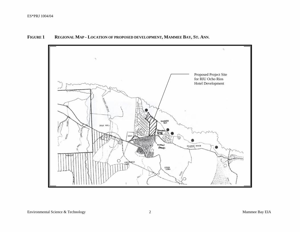
1.1 PURPOSE Port Marly Limited proposes to construct a 846 room hotel on 13.86 hectares (34.5 acres)
of land located at Mammee Bay, St. Ann, in compliance with the St. Ann Parish
Development Order, The Town and Country Planning Act and the NRCA Act of 1991
and other relevant policies, legislation, regulations and standards (Figure 1 – Regional
Map). This document embodies a report of the results of the Environmental Impact
Assessment (EIA) conducted by Environmental Science and Technology Limited
(ESTECH) on the proposed development.
1.2 BACKGROUND Tourism is one of the major foreign exchange earning sectors in the Jamaican economy. A
close relationship exists between tourism-related activities and environmental quality. The
natural, socio-economic and cultural environments are important resources for tourism but
these features are sensitive to disturbance by human activities. Therefore, negative impacts
resulting from inadequately planned and uncontrolled tourism developments can adversely
affect the environments on which their success depends. The magnitude of these impacts is
largely dependent on the scale, type and operational nature of developments proposed
relative to the fragility of the environment.
Tourism development also increases the demand on local infrastructure including
transportation, water supply, wastewater collection, sewage treatment, solid waste disposal
and health care facilities, among others. Without adequate planning, the service demands
may exceed capacity with adverse effects for both tourists and residents.
The 13.86-hectare (34.5 acres) property upon which the development is proposed is situated
within the upper-income residential/resort community known as Mammee Bay Estate. The
proposed development is located physically between the Sandals Dunn’s River Hotel to the
east and the Mammee Bay Beach House to the west and Mammee Bay Estates to the
southwest.
ES*PRJ 1004/04
Environmental Science & Technology Mammee Bay EIA 2
FIGURE 1 REGIONAL MAP - LOCATION OF PROPOSED DEVELOPMENT, MAMMEE BAY, ST. ANN.
Proposed Project Site for RIU Ocho Rios Hotel Development
ES*PRJ 1004/04
Environmental Science & Technology Ltd. Mammee Bay EIA 3
The resort hotel is anticipated to cover a total floor area of approximately 68,756.43 square
meters, which will include the appropriate physical structures (rooms, restaurants),
amenities, recreational areas (disco, water sport activities), utilities (electricity generation,
service areas) and a sewage treatment plant.
The site proposed for this development was permitted for a similar hotel development in
1998, however, that facility was never constructed and the lands were sold to the present
developer.
1.3 TERMS OF REFERENCE An EIA is required to assess the environmental resources present in the area, to identify
those activities associated with the proposed project which could have an adverse effect on
the environment, and to determine means of avoiding or mitigating the deleterious
consequences identified.
The Terms of Reference approved by NEPA for this EIA is as follows:
TASK 1 DESCRIPTION OF THE PROJECT To be provided is a comprehensive description of the project and its construction
methodology noting areas to be reserved for construction, areas to be preserved in their
existing state as well as activities and features which will introduce risks or generate
impact (negative and positive) on the environment. A comprehensive description of the
proposed method of the wastewater treatment and disposal (including the location of
infrastructure in relation to the hotel facilities) will also be included along with any
structure that will be constructed that may encroach or modify the fore shore of the sea
which borders the property where the proposed development is to occur. An estimation of
the project life span time lines for the individual tasks in the proposed works is also to be
provided. This will involve the use of maps, site plans, aerial photographs and other
graphic aids and images, as appropriate, and include information on location, general
layout and size, as well as pre-construction, construction, and post construction plans.
ES*PRJ 1004/04
Environmental Science & Technology Ltd. Mammee Bay EIA 4
TASK 2 DESCRIPTION OF THE ENVIRONMENT This task involves the generation of baseline data that is used to describe the study area
as follows:
i) physical environment
ii) biological environment
iii) Socio-economic and cultural constraints.
It is expected that methodologies employed to obtain baseline and other data be clearly
detailed.
Baseline data will include:
(A) Physical
i) A detailed description of the existing geology and hydrology. Special
emphasis will be placed on storm water run-off, drainage patterns, effect on
groundwater and availability of potable water. Any slope stability issues that
could arise will be thoroughly explored.
ii) Water quality of any existing wells, rivers, ponds, streams or coastal waters
in the vicinity of the development. Quality Indicators will include but not
necessarily be limited to nitrates, phosphates, faecal coliform, and suspended
solids.
iii) A detailed description of the oceanography of the adjoining marine
environment.
iv) A description of the beach with respect to stability, composition, and
morphology.
v) Climatic conditions and air quality in the area of influence including wind
speed and direction, precipitation, relative humidity and ambient
temperatures.
ES*PRJ 1004/04
Environmental Science & Technology Ltd. Mammee Bay EIA 5
vi) Noise levels of the undeveloped site and the ambient noise in the area of
influence.
vii) Obvious sources of pollution existing and extent of contamination.
viii) Availability of solid waste management facilities.
Biological A presentation of a detailed description of the flora and fauna (terrestrial and aquatic) of
the area, with special emphasis on rare, endemic, protected or endangered species will be
provided. Migratory species will also be considered. There may be the need to
incorporate micro-organisms to obtain an accurate baseline assessment. Generally,
species dependence, niche specificity, community structure and diversity ought to be
considered.
(B) Socio-economic & cultural Present and projected population; present and proposed land use; planned development
activities, issues relating to squatting and relocation, community structure, employment,
distribution of income, goods and services; recreation; public health and safety; cultural
peculiarities, aspirations and attitudes will be explored. The historical importance of the
area will also be examined along with any cultural or historical resources that may be on
the site. While this analysis is being conducted, an assessment of public perception of the
proposed development will be conducted. The assessment may vary with community
structure and may take multiple forms such as public meetings or questionnaires.
A Natural Hazard Vulnerability assessment may also be conducted
TASK 3 POLICY LEGISLATIVE & REGULATORY FRAMEWORK An outline of the pertinent regulations and standards governing environmental quality,
safety and health, protection of sensitive areas, protection of endangered species, siting
and land use control at the national and local levels will be provided. The examination of
the legislation shall include at minimum, legislation such as the NRCA Act, the Housing
ES*PRJ 1004/04
Environmental Science & Technology Ltd. Mammee Bay EIA 6
Act, the Town and Country Planning Act, Beach Control Authority Act, JNHT Act, The
Wildlife Protection Act, Building Codes and Standards, Development Orders and Plans
and the appropriate international convention/protocol/treaty where applicable.
TASK 4 IDENTIFICATION OF POTENTIAL IMPACTS Identification of the major environmental and public health issues of concern will be
provided and an indication of their relative importance to the design of the subdivision.
Identification of the potential impacts will be provided as they relate to, (but are not
restricted by) the following:
• Change in drainage pattern
• Flooding potential
• Landscape impacts of excavation and construction
• Loss of natural features, habitats and species by construction and operation
• Pollution of potable, coastal, surface and ground water
• Air pollution
• Capacity and design parameters of proposed sewage treatment facility.
• Socio-economic and cultural impacts
• Risk assessment
• Noise
• Solid waste
• The carrying capacity of the proposed site.
• Removal of vegetation
ES*PRJ 1004/04
Environmental Science & Technology Ltd. Mammee Bay EIA 7
• Impact on endemic species
• Impact on the Ocho Rios Marine Park Protected Area.
• Impact on potable water supply
• Impact on aesthetics
• Impact of storm surge on the development
• Impact of storm water run-off on the beach
• Impact of sewage effluent arising from the operation of the development
• Impact of construction (such as batching plants, petrol/oil/lubricant storage,
sewage)
• Impact to traditional use (bathing and fishing) at the site
• Impact of (high) water table on the construction and operation
A distinction between significant positive and negative impacts, direct and indirect, long
term and immediate impacts will be done. Identify avoidable as well as irreversible
impacts. Characterize the extent and quality of the available data, explaining significant
information deficiencies and any uncertainties associated with the predictions of impacts.
A major environmental issue is determined after examining the impact (positive and
negative) on the environment and having the negative impact significantly outweigh the
positive. It is also determined by the number and magnitude of mitigation strategies
which need to be employed to reduce the risk(s) introduced to the environment. Project
activities and impacts should be represented in matrix form with separate matrices for pre
and post mitigation scenarios.
ES*PRJ 1004/04
Environmental Science & Technology Ltd. Mammee Bay EIA 8
TASK 5 MITIGATION Guidelines will be prepared for avoiding, as far as possible, any adverse impacts due to
proposed usage of the site and utilizing of existing environmental attributes for optimum
development. Quantify and assign financial and economic values to mitigating methods.
TASK 6 MONITORING A plan will be designed to monitor implementation of mitigatory or compensatory
measures and project impacts during construction and occupation/operation of the
units/facility. An Environmental Management Plan for the long term operations of the
site should be prepared.
An outline monitoring programme will be included in the EIA, and a detailed version
submitted to NEPA for approval after the granting of the permit and prior to the
commencement of the development. At the minimum the monitoring programme and
report will include:
• Introduction outlining the need for a monitoring programme and the relevant
specific provisions of the permit license(s) granted.
• The activity being monitored and the parameters chosen to effectively carry out
the exercise.
• The methodology to be employed and the frequency of monitoring.
• The sites being monitored. These may in instances, be pre-determined by the
local authority and will incorporate a control site where no impact from the
development is expected.
• Frequency of report to NEPA.
The Monitoring report will also include a minimum:
• Raw data collected. Tables and graphs are to be used where appropriate.
ES*PRJ 1004/04
Environmental Science & Technology Ltd. Mammee Bay EIA 9
• Discussion of results with respect to the development in progress, highlighting
any parameter(s) that exceeds the expected standards(s).
• Recommendations
• Appendices of data and photographs if necessary.
TASK 7 PROJECT ALTERNATIVES An examination of the alternatives to the project will be done, inclusive of its layout and
design, the site location, the proposed construction methodology and sewage treatment
options and also the no-action alternative. This examination of project alternatives will
incorporate the use history of the overall area in which the site is located and previous
uses of the site itself. As necessary, reference to NEPA guidelines for EIA preparation
will be done.
All findings will be presented to the EIA report and will reflect the headings in the body
of the TOR’s, as well as references. Eight hard copies and an electronic copy of the
report will be submitted. The report will include an appendix with items such as maps,
site plans, the study team, photographs, and other relevant information.
1.4 METHODOLOGY A study of the existing natural communities found at the proposed site of the
development at Mammee Bay was conducted. The study compiled data through
assessment, characterizing, mapping and field observation.
1.4.1 ECOLOGICAL ASSESSMENT Major ecological community types were determined by field assessments, while
community classifications were based on the dominant plant types and substrates that
composed them. Field investigations also included community structure, primary and
secondary human disturbances, fauna and flora identification, water quality analysis and a
detailed survey of the reef communities in the project area.
ES*PRJ 1004/04
Environmental Science & Technology Ltd. Mammee Bay EIA 10
1.4.2 FAUNAL SURVEY The fauna were surveyed by direct observation and searching for indicators, such as
burrows, tracks, scat, tests, skeletons, etc. Species and indicators encountered on the site
proposed for development, as well as any observed in the general Mammee Bay area were
reported.
Specific sampling of the avifauna was conducted between the hours of 8:00 am and 10:00
am, the period when the species are most active. An accurate description of the physical
and vocal characteristics of species that could not be immediately identified was taken; and
verification effected by the use of field guides (Bond, 1990; Downer et al, 1990).
1.4.3 MARINE ENVIRONMENT The inshore marine flora and fauna were assessed by snorkeling at 4 sites 100m-400m
offshore, within the bay, and at 1 site at the outer reef crest. The species composition and
health of the reef communities and associated flora and fauna were assessed. A video and
photos of the marine environment were taken to provide a clear depiction of what was
observed during the assessment.
1.4.4 WATER QUALITY A water quality assessment was conducted on coastal waters collected just off the shores of
the proposed development. Samples were collected for chemical analysis at mid-depth, and
sent to the analytical laboratory section of the Scientific Research Council for analysis.
Samples were analysed for the following parameters:
• Biochemical Oxygen Demand (BOD)
• pH
• Nitrate
• Conductivity
• Total Phosphate
• Faecal Coliform
• Total Coliform
ES*PRJ 1004/04
Environmental Science & Technology Ltd. Mammee Bay EIA 11
1.4.5 NOISE ASSESSMENT An audiometric survey was conducted on the perimeter of the proposed development site
to determine background noise levels along the property boundaries. Readings were
taken along the property boundary with Sandals Dunn’s River, along the property
boundary with Mammee Bay Estates and along the boundary with the Mammee Bay
main road.
1.4.6 SOCIO-ECONOMIC SURVEY A socio-economic impact assessment was obtained from data collected from primary and
secondary sources. Secondary material (literature review, census, other official statistics,
survey data) was used to determine the basic demographic profile of the study area, land
use pattern and urban setting.
Primary data was collected from the communities surrounding the proposed development
to obtain a detailed examination of the potential impacts as perceived by members of the
communities. This was done through:
• Field observations within the surrounding communities.
• A social survey, based on a written questionnaire. The survey employed both
interviewing and sampling to produce quantitative data sets amenable to socio-
economic analysis.
• Information collected during two (2) meetings held within the community to address
issues relevant to the proposed development.
1.4.6.1 Pilot Study Once the survey instrument was designed, reviewed and approved, a pilot test was
carried out to test and measure the instruments’ reliability. The questionnaire was then
revised on the basis of the findings of the pilot study, and the sample defined and selected
from Enumeration Districts (EDs.) used in the 1991 Population Census, Parish of St. Ann
(STATIN, 1994). In addition, fieldwork, planning, supervision, training and debriefing,
coding of completed questionnaires, consistency checks and editing of the resulting data
set were executed.
ES*PRJ 1004/04
Environmental Science & Technology Ltd. Mammee Bay EIA 12
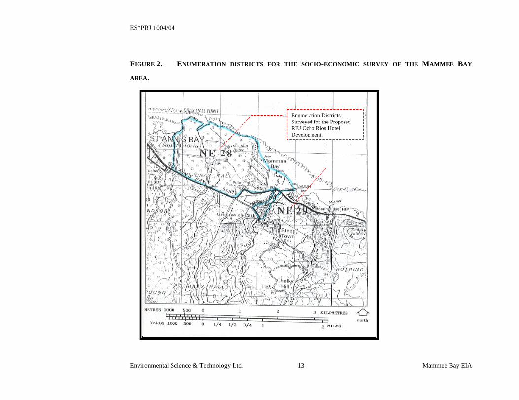
1.4.6.2 Sample Size The survey used a sample size that would be representative, valid and reliable. The
social survey was administered to 26 of the household heads in the study area (10F;
16M). Interviewing was conducted during the month of October 1997 in St. Ann North
East EDs 28, 29 (Figure 2).
1.4.6.3 Sphere of Influence The sociological limit of the sphere of influence of the project was determined by the
Enumeration Districts (EDs), which impinge upon the proposed site. Households located
within there comprise the basic units of analysis. The impact population of the proposed
development is located in St. Ann, NE, EDs 28 and 29. (Figure 2).
ES*PRJ 1004/04
Environmental Science & Technology Ltd. Mammee Bay EIA 13
FIGURE 2. ENUMERATION DISTRICTS FOR THE SOCIO-ECONOMIC SURVEY OF THE MAMMEE BAY
AREA.
Enumeration Districts Surveyed for the Proposed RIU Ocho Rios Hotel Development.
ES*PRJ 1004/04
Environmental Science & Technology Ltd. Mammee Bay EIA 14
The socio-economic survey also included:
• A demographic profile for the parish of St. Ann
• An analysis of the Ocho Rios to Mammee Bay coastal strip, focusing on
proposed developments and resort characteristics (urban setting)
• Road and transportation requirements of the region and site
• Land use
SECTION 2: PROJECT DESCRIPTION
ES*PRJ 1004/04
Environmental Science & Technology Ltd. Mammee Bay EIA 16
2 PROJECT DESCRIPTION
Port Marly Limited is proposing to develop its third resort in Jamaica at a site located in
Mammee Bay, St. Ann. The proposed site is situated on 13.87 hectares (34.26 acres) of
land located on the north coast of Jamaica between the towns of Ocho Rios and St. Ann’s
Bay, and directly between the existing Sandals Dunn’s River Resort and the residential
community of Mammee Bay Estates.
The construction phase of the proposed hotel development is scheduled to last
approximately 18 months and will be similar in design to the first two hotels constructed
by Riu in Negril and will consist of 846 rooms with a floor area of approximately 56,686
m2 divided into three “buildings.” For the purpose of this report, the buildings have been
labeled “Building A”, “Building B”, and “Building C.” Buildings A, B, and C will
comprise rooms inclusive of double and triple occupancy and suites, with “Building B” also
housing the main lobby area, entertainment areas, restaurants and administrative area.
Building A comprises 361 rooms and is five (5) stories high. Building B comprises two
sections, a one story building which houses the offices, main lobby area and a small
restaurant and a second section with the main dining area, main kitchen and delivery on the
first floor and 137 rooms to a total of seven (7) stories. Building C houses 348 rooms and is
six (6) stories high. The buildings for the proposed development are situated towards the
northern section of the property and will be constructed primarily of block and steel walls
with concrete roofs. The buildings will have ornamental finishes such as roof finials,
ornamental aluminum railings on balconies and decorative finishes to the façade of the
building.
During construction, the property will be fenced along the boundary lines to provide for
security and minimize the potential for fugitive emissions of dust to impact on the
neighbouring establishments. Temporary buildings will be utilized onsite during
construction for storage and field offices. These buildings will be removable containers and
are temporary structures on the site. The proposed equipment staging area and location of
temporary storage and office buildings are presented on Figure 3. Mobile temporary
chemical toilets will be provided throughout the construction phase through contract with
ES*PRJ 1004/04
Environmental Science & Technology Ltd. Mammee Bay EIA 17
an approved company. These units will be fully contained and will be removed from the
site where they will be disposed of appropriately. At the request of any regulatory agency,
the contracted company will be subject to an audit of its operations to insure that waste
materials are properly handled and disposed. There will be no one residing on the site
during the construction phase; all staff will be housed in surrounding areas off the site.
Provisions will be made for temporary parking (mostly for office staff) close to the
temporary site offices.
This development will include facilities typical of a resort hotel, including but not limited to
shops, spa, bars, swimming pools, restaurants, entertainment, sports and recreation areas,
support facilities, and a sewage treatment plant. There is, however, currently no plan by the
developers to construct any structure, which will encroach or modify the foreshore and or
the floor of the sea. The Site Layout Plan is presented as Figure 4.

ES*PRJ 1004/04
Environmental Science & Technology Mammee Bay EIA 18
FIGURE 3 SITE LAYOUT SHOWING RELATIVE POSITIONS OF EQUIPMENT STAGING, SITE OFFICE, AND TEMPORARY PARKING
AREAS
Proposed Equipment Staging Area
Proposed Site Office and Storage and Temporary Parking
ES*PRJ 1004/04
Environmental Science & Technology Ltd. Mammee Bay EIA 19
The proposed development has a plot area ratio of 19,980.86 m2 on a site that consists of
138,678.05 m2 (approx. 34.5 acres). Approximately one quarter of the available lands will
be preserved in its existing state (more or less) with brush removal and landscaping being
done to maintain the aesthetic of the development and the area. This area to be preserved
comprises the southeastern end of the property from the parking areas to the shared
boundaries with both Sandals Dunn’s River and Mammee Bay Estates. Mature trees will be
left in place, including the royal palms that line the entranceway into the facility. This same
area (southeastern end) will be utilized during the construction phase to locate the field
office, general equipment parking and staging of supplies. Adequate parking for the hotel is
situated towards the southern side of the site. All structures to be built on the site will
adhere to and fall within the regulations and standards of the St. Ann Parish Development
Order and the Natural Resources Conservation Act of 1991, which is enforced by the
statutory body, the National Environmental Planning Authority (NEPA).
2.1 SEWAGE/WASTEWATER TREATMENT Two types of wastewater will be generated at the hotel development:
1. Black Water (faecal content and general human egested/excreted waste)
2. Grey Water (bath, laundry and wash basin water)
*The grey water to black water ratio is approximately 3:1
Based on a design of 850 rooms and an estimated wastewater generation rate of 1.4
m3/room/day (369.84 gals/room/day) it is anticipated that 1,190 m3 (314,362 gals) of
wastewater will be generated on a daily basis at maximum occupancy of the property.
This represents the basis of design for the sewage treatment system, which will treat it to
the tertiary level (suitable for use as irrigation water) and is designed to process a daily
volumetric capacity of 1,400 m3 (369,841 gals), which provides a 15% (210 m3 or 55,476
gal) contingency over the anticipated volume at maximum capacity.
The physical structures that will comprise the sewage treatment system will be
constructed in the upper southeast corner of the property along the property boundary
ES*PRJ 1004/04
Environmental Science & Technology Ltd. Mammee Bay EIA 20
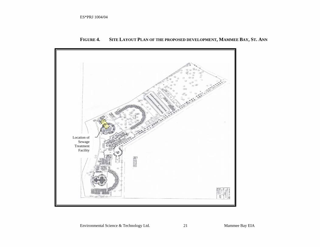
with Sandals Dunn’s River Resort (See Figure 4 – Site Layout). The structures will be
partially underground with approximately one metre of the tanks and decanters above
ground. This will facilitate ease of access and allow for the opportunity to utilize
landscaping techniques to reduce any impacts on the aesthetics of the site. A schematic of
the proposed sewage treatment process is provided below as Figure 5.
ES*PRJ 1004/04
Environmental Science & Technology Ltd. Mammee Bay EIA 21
FIGURE 4. SITE LAYOUT PLAN OF THE PROPOSED DEVELOPMENT, MAMMEE BAY, ST. ANN
Location of Sewage
Treatment Facility
ES*PRJ 1004/04
Environmental Science & Technology Ltd. Mammee Bay EIA 22
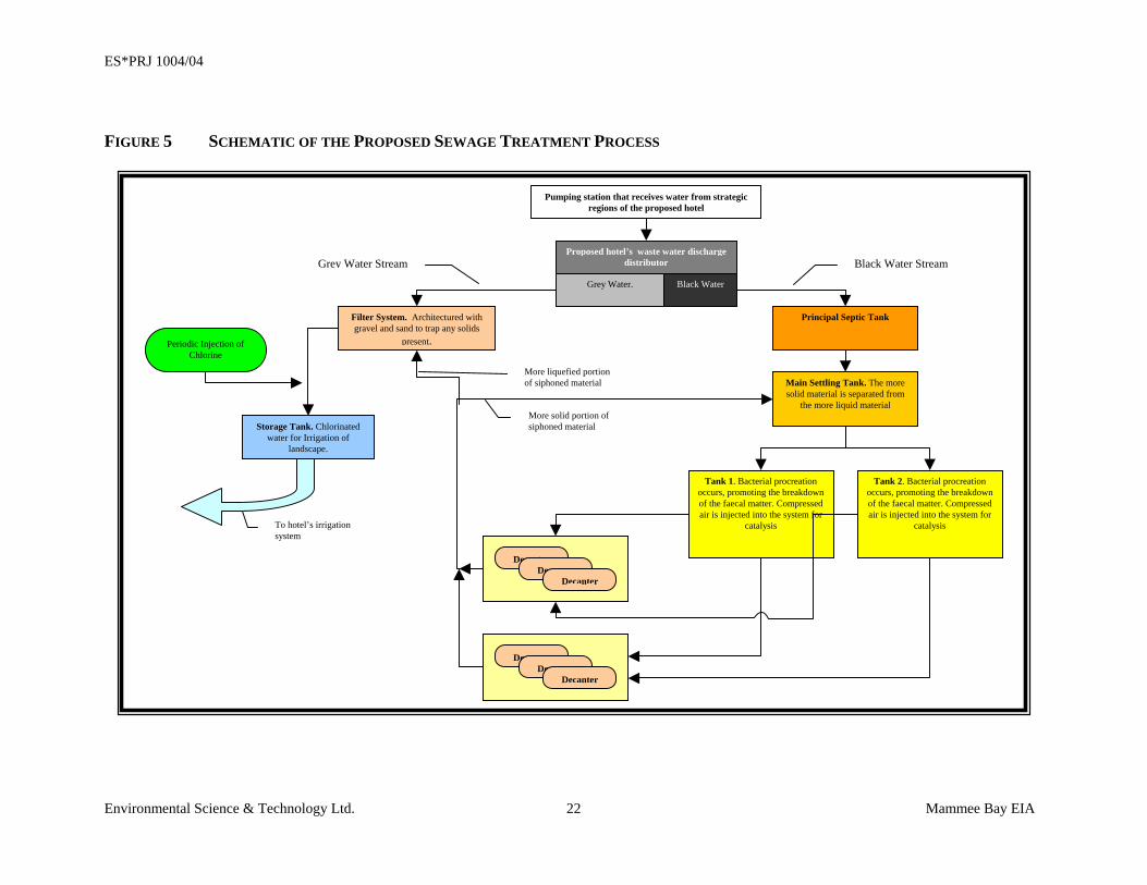
FIGURE 5 SCHEMATIC OF THE PROPOSED SEWAGE TREATMENT PROCESS
Decanter
Proposed hotel’s waste water discharge distributor
Filter System. Architectured with gravel and sand to trap any solids
present.
Principal Septic Tank
Black Water Stream
Main Settling Tank. The more solid material is separated from
the more liquid material
Tank 2. Bacterial procreation occurs, promoting the breakdown of the faecal matter. Compressed air is injected into the system for
catalysis
Tank 1. Bacterial procreation occurs, promoting the breakdown of the faecal matter. Compressed air is injected into the system for
catalysis
Storage Tank. Chlorinated water for Irrigation of
landscape.
More solid portion of siphoned material
Grey Water Stream
To hotel’s irrigation system
Periodic Injection of Chlorine
Grey Water. Black Water
DecanterDecanter
Decanter
DecanterDecanter
Pumping station that receives water from strategic regions of the proposed hotel
More liquefied portion of siphoned material
ES*PRJ 1004/04
Environmental Science & Technology Ltd. Mammee Bay EIA 23
The treatment process will be as follows:
• Effluent will be collected from various sections of the hotel via a series of
pumping stations located at strategic points within the site and passed on to a
principal septic tank.
• From the principal septic tank, the wastewater will be passed to a main collection
tank that facilitates settling and is the beginning of the separation process.
• The mostly liquid portion of the waste material is then transferred from the main
settling tank to three (3) large oxidation tanks each with a capacity of 34m3 (8,976
gals). It is within these three tanks, that bacterial procreation will occur to
promote the breakdown of the faecal matter. This reaction will be further
enhanced with the aid of compressed air being injected into the system.
• With the completion of the bacterial breakdown process, the liquid is passed to
four (4) sets of two (2) decanters or secondary settling tanks. In these eight (8)
tanks, the liquid portion of the wastewater is progressively siphoned off and
channeled away, with the more solid portions being re-circulated to the main
settlement tank where the process begins again.
• The decanted liquid is now channeled to a 34m3 (8,977 gallons) pre-filtered
storage tank, from which the treated wastewater is pumped through a gravel and
sand filtration system for polishing prior to entering the irrigation vault.
• On the way to the irrigation vault, chlorine is periodically injected into the system
as a final treatment step.
• At this point, the water is suitable to be utilized for irrigation of the landscape on
the property.
The proposed sewage treatment system has the following advantages, which led to its
selection over other methods:
ES*PRJ 1004/04
Environmental Science & Technology Ltd. Mammee Bay EIA 24
• Simplicity
• Ease of operation
• Ease of maintenance
• Low cost of operation and maintenance
• Availability of land space
• Quality of treated water
• Odour free
ES*PRJ 1004/04
Environmental Science & Technology Ltd. Mammee Bay EIA 25
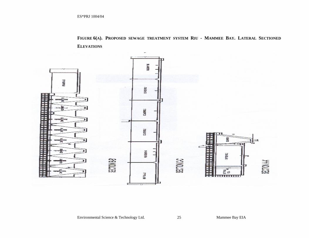
FIGURE 6(A). PROPOSED SEWAGE TREATMENT SYSTEM RIU - MAMMEE BAY. LATERAL SECTIONED
ELEVATIONS
ES*PRJ 1004/04
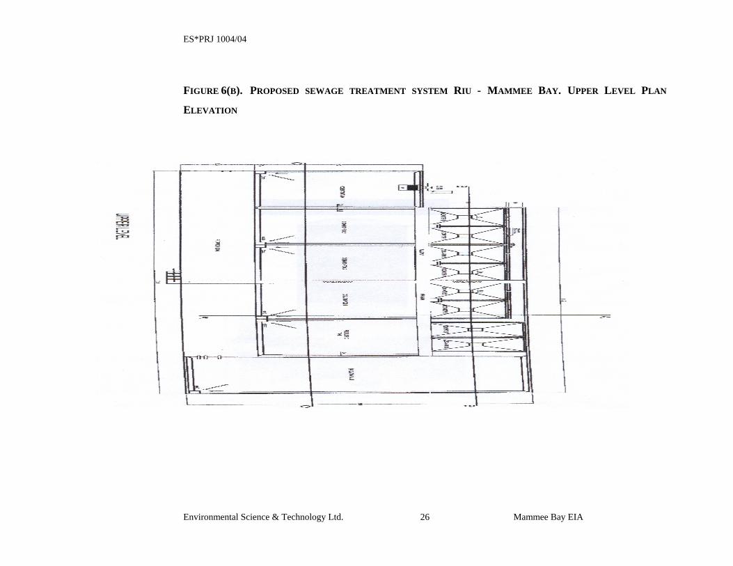
Environmental Science & Technology Ltd. Mammee Bay EIA 26
FIGURE 6(B). PROPOSED SEWAGE TREATMENT SYSTEM RIU - MAMMEE BAY. UPPER LEVEL PLAN
ELEVATION
ES*PRJ 1004/04
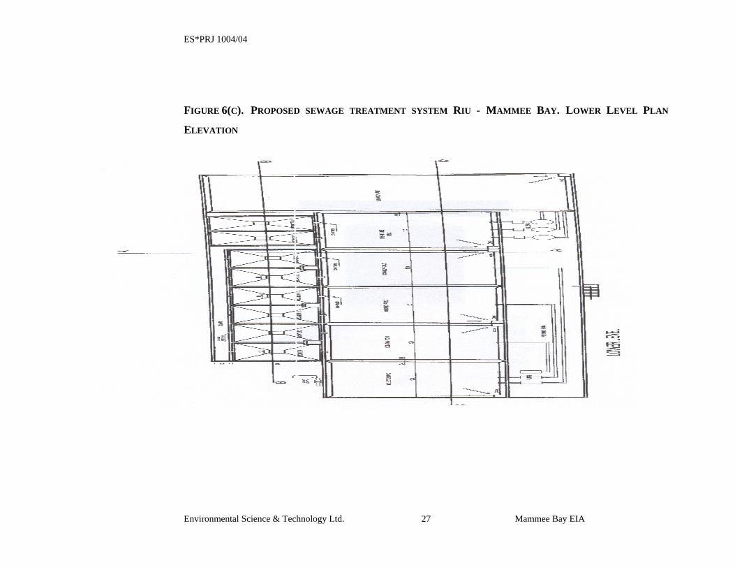
Environmental Science & Technology Ltd. Mammee Bay EIA 27
FIGURE 6(C). PROPOSED SEWAGE TREATMENT SYSTEM RIU - MAMMEE BAY. LOWER LEVEL PLAN
ELEVATION
ES*PRJ 1004/04
Environmental Science & Technology Ltd. Mammee Bay EIA 28
The sewage treatment system will be provided with back up facilities and spare parts to
accommodate any contingencies that may arise. This includes the ability to remove
treated effluent from the system via approved septic hauler service for appropriate
disposal should the holding tank approach its capacity. It is in the best interest of the
developers to construct and operate a quality sewage treatment system that will not
impact negatively on the environment, tourism product, or their image. Additionally, the
sewage treatment system will include a standby generator to provide emergency power.
The use of the liquid effluent from the sewage treatment system for irrigation will assist
in reducing the water demand of the development, provide a highly beneficial use for the
treated water and afford the facility the opportunity to support a vibrant flora regardless
of weather conditions at the property. Keep in mind that the greater portion of the
property will be landscaped and kept in a natural state through preservation of many of
the existing trees.
The system has been located along the property boundary with the Sandals Dunn’s River
Resort in proximity to that facility’s existing sewage treatment system. That location is
situated to minimize the potential for impact (aesthetic) to Sandals, the neighbouring
residential community and the proposed development. Appropriate laybacks will be
observed during construction.
The proposed sewage treatment system is designed to meet and in some instances exceed
the regulatory standards. NEPA Sewage Effluent Guidelines are the primary regulatory
guidelines utilized for this design, with consideration given to World Health Organization
(WHO) standards. NEPA Sewage Effluent Guidelines for new plants constructed after 1997
are presented below:
ES*PRJ 1004/04
Environmental Science & Technology Ltd. Mammee Bay EIA 29
TABLE 1 – NEPA Sewage Effluent Guidelines PARAMETER EFFLUENT LIMIT
BOD5 20 mg/L
TSS 20 mg/L
TOTAL NITROGEN 10 mg/L
PHOSPHATES 4 mg/L
COD 100 mg/L
PH 6 – 9
FAECAL COLIFORM 1000 MPN/100 ml
RESIDUAL CHLORINE 1.5 mg/L
Since the treated effluent from the sewage treatment system is slated for use as irrigation
water, the final effluent quality that must be adhered to is the more stringent Interim
Irrigation Standards, which are provided below:
TABLE 2 – NEPA Interim Irrigation Standards PARAMETER STANDARD LIMIT
OIL & GREASE 10 mg/L
TSS 15 mg/L
RESIDUAL CHLORINE 0.5 mg/L
BOD 15 mg/L
COD <100 mg/L
FAECAL COLIFORM 12 MPN/100 ml
As required, approved flow measurement devices will be installed on the system to measure
influent and effluent on the system. A complete set of “As Built” plans for the new sewage
treatment system will be located at the treatment facility.
ES*PRJ 1004/04
Environmental Science & Technology Ltd. Mammee Bay EIA 30
2.2 UTILITIES
2.2.1 WATER DEMAND The calculations for water demand were done for a defined number of rooms based on
maximum guest occupancy and their general habits. Consideration is given to the fact
that guests at all-inclusive resorts tend to demand more water and generate more sewage
due to the extended time spent at the resort during the course of an average day.
The project is expected to consume approximately 1,832,139 litres/day (484,000
gals/day) of water at maximum capacity during the operational phases of the
development. As a condition of purchase, the National water Commission (NWC)
committed to meet the water supply needs of the development if it is implemented. A
copy of the letter from JAMPRO to the NWC requesting confirmation that the NWC can
in fact meet the demand of the facility if it is constructed, and the NWC's response
indicating their ability to provide the necessary water resources have been included as
APPENDIX A. It is anticipated that the source of the water will be additional to that
which presently supplies the communities of Mammee Bay Estates, Greenwich Park and
Steer Town and will come from the Bogue water supply system. Water for the facility
will be taken off a new 12 inch main which is being run from Drax Hall to Dunn’s River
to replace the existing 8 inch main. This new 12-inch water main will then tie into the
existing 24-inch line that supplies Ocho Rios. Residents of the community have shown
some concern about NWC’s ability to supply the water necessary for the development
without affecting their existing supply, primarily through low-pressure service or
frequent loss of service. In addition, the residents are concerned about NWC’s stepped
approach to upgrading water supply in the area and would rather see the proposed 12 inch
main upgraded to 18 inch or even 24 inch at this time rather than later. The NWC has
given the developers the assurance that water will be made available for the project.
2.2.2 ELECTRICITY DEMAND The hotel is estimated to use approximately 847,200 kW/month during the operational
phase at maximum occupancy. Electrical power will be supplied from the Jamaica Public
Service Company (JPS Co.) service lines. A JPS Co substation is located within one mile
ES*PRJ 1004/04
Environmental Science & Technology Ltd. Mammee Bay EIA 31
of the proposed development and it is not anticipated that there will be any issues related
to availability or supply of electrical power to the development. The facility will also be
equipped with standby generators that will ensure continued facility operation (inclusive
of the sewage treatment system) in the event of a power outage on the JPS Co supply.
2.3 MODIFICATIONS TO BEACH OR FORESHORE The proposed development includes beach frontage which will be utilized for recreational
bathing and resort activities. At this time, there are no plans to modify or place any
structures on the beach or foreshore that would require a license under the Beach Control
Act. If any such modification or structure is planned in the future, all applicable licenses
will be obtained prior to implementation.
SECTION 3: DESCRIPTION OF THE ENVIRONMENT
ES*PRJ 1004/04
Environmental Science & Technology Ltd. Mammee Bay EIA 33
3 DESCRIPTION OF THE ENVIRONMENT The study area extends from the Mammee Bay Estate property boundary to the west, to the
Sandals Dunn’s River property boundary to the east, and from the Caribbean Sea on the
north to the Mammee Bay main road to the south (Figure 2).
3.1 PHYSICAL ENVIRONMENT
3.1.1 CLIMATE The parish of St. Ann receives an average of 1,016 mm (40") of rainfall per year and has
two distinct rainy periods, between the months of May and June and from October to
November. The driest period occurs from January to March, with less than 127 mm (5")
per month. Temperatures are relatively constant throughout the year, but range from 21 0C
to 32 0C during the hottest months and 18 °C to 28 °C during the colder months.
Relative humidity in this area averages approximately 73% throughout most of the year but
trends upward during the warmer summer months typically not exceeding 90% for
extended periods.
Specific wind data was not available for the project area. The closest available data that
could be considered reliable was from the Sangster International Airport in Montego Bay
which is approximately 64 miles to the west of the project area. It is assumed that wind
patterns and influences at the project site are similar to those in Montego Bay. This means
that northeast trade winds occur year round with east-northeasterly winds predominant
during the daytime ranging from calm up to speeds in excess of 40 km/hour, average speed
is estimated to be 25 km/hour. At night, the wind is primarily southerly moving across the
land and out towards the sea. Wind speed during the night ranges from calm to over 20
km/hour, with the average estimated to be 15 km/hour.
Hurricanes are a serious seasonal threat from July to November; since 1886, 21 hurricanes
have made landfall in Jamaica, while over 100 have passed within 240 km (150 miles) of
the island. Tsunamis are also a major risk.
ES*PRJ 1004/04
Environmental Science & Technology Ltd. Mammee Bay EIA 34
Considerations have been given to issues related to storm water and potential for erosion
during the construction and operational phases of the development. As such, a storm water
management system, involving the use of drains and absorption pits (French drains) has
been designed.
3.1.2 TOPOGRAPHY AND GEOLOGY
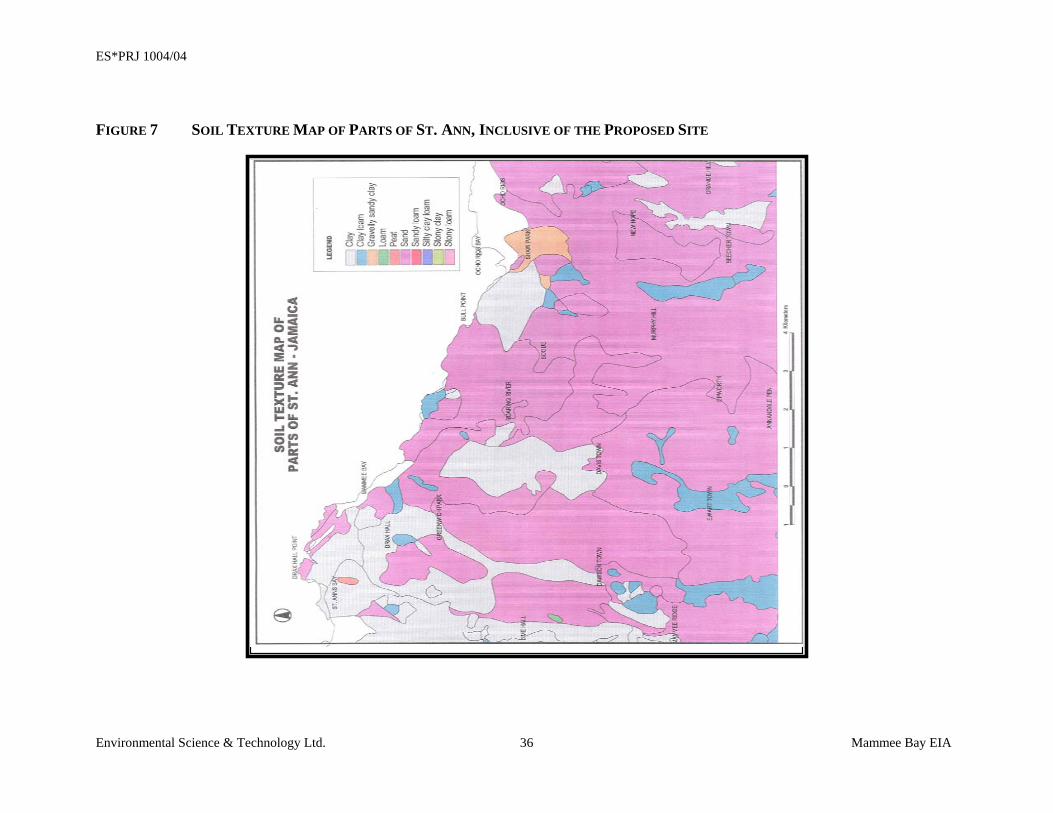
3.1.2.1 General Topography and Geology Elevations at the site increase gently from sea level along the shoreline to a maximum of
20.35 metres above sea level along the boundary with the St. Ann’s Bay to Ocho Rios
main road. The soil at the shoreline is a part of the Falmouth Formation, and consists of
coarse, poorly sorted, calcareous sand with numerous smooth pebbles. However, the
dominant lithology of the site is the Hopegate Formation. This soil type tends to be soft
and rubbly at depth, so care will be taken in the designs to guarantee structural stability
particularly on the slopes. There is a potential for erosion of soil materials during periods
of moderate to heavy rainfall at the site. This potential is acknowledged and will be
mitigated during such events. During the assessment of the site, no obvious sources or
existing pollution or contamination was observed across the project area.
3.1.2.2 Beach Topography and Geology Along the beach, the substrate depth ranged from 0 cm to 10 cm, and consists of coarse,
angular, highly sorted carbonate sand grains with large pieces of coral and marine tests.
This suggests recent (less than 50 years) storm surge deposits. Sediments on the sandy
shore are composed of large, poorly sorted, angular sand grains, 50% of which were larger
then 125 mm.
The site is not in a major earthquake zone. Only three earthquakes events of intensity
greater than six (VI; Modified Mercalli Scale) have been reported in the area between
1897 and 1978.
ES*PRJ 1004/04
Environmental Science & Technology Ltd. Mammee Bay EIA 35
It is not perceived that the present topography and geology of the site requires any special
considerations prior to a development such as the one proposed being implemented. As
mentioned, the developers will incorporate erosion controls during the construction and
operational phases.
ES*PRJ 1004/04
Environmental Science & Technology Ltd. Mammee Bay EIA 36
FIGURE 7 SOIL TEXTURE MAP OF PARTS OF ST. ANN, INCLUSIVE OF THE PROPOSED SITE
ES*PRJ 1004/04
Environmental Science & Technology Ltd. Mammee Bay EIA 37
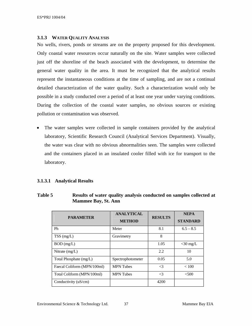
3.1.3 WATER QUALITY ANALYSIS No wells, rivers, ponds or streams are on the property proposed for this development.
Only coastal water resources occur naturally on the site. Water samples were collected
just off the shoreline of the beach associated with the development, to determine the
general water quality in the area. It must be recognized that the analytical results
represent the instantaneous conditions at the time of sampling, and are not a continual
detailed characterization of the water quality. Such a characterization would only be
possible in a study conducted over a period of at least one year under varying conditions.
During the collection of the coastal water samples, no obvious sources or existing
pollution or contamination was observed.
• The water samples were collected in sample containers provided by the analytical
laboratory, Scientific Research Council (Analytical Services Department). Visually,
the water was clear with no obvious abnormalities seen. The samples were collected
and the containers placed in an insulated cooler filled with ice for transport to the
laboratory.
3.1.3.1 Analytical Results
Table 5 Results of water quality analysis conducted on samples collected at Mammee Bay, St. Ann
PARAMETER ANALYTICAL
METHOD RESULTS
NEPA
STANDARD
Ph Meter 8.1 6.5 – 8.5
TSS (mg/L) Gravimetry 8
BOD (mg/L) 1.05 <30 mg/L
Nitrate (mg/L) 2.2 10
Total Phosphate (mg/L) Spectrophotometer 0.05 5.0
Faecal Coliform (MPN/100ml) MPN Tubes <3 < 100
Total Coliform (MPN/100ml) MPN Tubes <3 <500
Conductivity (uS/cm) 4200
ES*PRJ 1004/04
Environmental Science & Technology Ltd. Mammee Bay EIA 38
The results of the water quality analysis indicate that water quality in the area at the time of
the sampling event was in excellent condition. No parameters were observed above the
NEPA standards. It is understood that water quality in the marine environment is highly
variable, but this analysis provides an understanding of the general water quality in the area,
which is very good. The results from our marine assessment corroborate that the marine
environment in the area is in a very healthy state, which can only benefit from good water
quality.
The proposed development is not designed to have any negative impacts on the marine
environment. No treated sewage will be discharged into the sea; the contingency for
emergency removal of sewage is to utilize licensed septic service contractors. In addition,
no structures are proposed for construction that will impact on the sea floor or the marine
environment.
ES*PRJ 1004/04
Environmental Science & Technology Ltd. Mammee Bay EIA 39
3.1.4 NOISE ASSESSMENT
A noise level assessment was conducted at the site to determine background noise levels
along the boundaries of the property. Noise levels were measured using a calibrated
Quest Technologies Model 2800 Impulse Integrating sound level meter. The meter is
capable of accurately measuring decibel levels from as low as 20 dB to as high as 140 dB
at varying rates of response. Results of a noise level assessment undertaken at the site to
establish background noise levels indicated the following:
• Background noise levels along the property boundary with Sandals Dunn’s River
ranged between 40db to 68db
• Noise levels measured along the property boundary with Mammee Bay Estates
ranged between 36db to 63db
• Noise levels measured along the property boundary with the Mammee Bay main
road ranged from 45db to 84db
The NEPA standard for acceptable noise levels in residential communities is 70 dB,
while the results of the noise assessment indicated levels within the range 36db to 84 db.
This indicates that, at present, the noise level in the community (for the most part) is well
within the acceptable limits.
The higher noise levels obtained along the boundary with the main road is more than
likely due to the movement of vehicular activity along the roadway. The use of horns on
vehicles will cause elevated readings. These types of noise are usually not perceived as
disturbances by persons in proximity, as they are a part of normal activities. However,
noise created by loud voices or the use of heavy equipment, such as is likely during the
construction phase of the development, although it may be within acceptable limits, may
be considered disturbing to residents, as it is of an intrusive nature. The developers plan
to implement a monitoring program during the construction phase of the project that will
include monitoring of noise and dust levels to insure that the comfort of residents in the
community is appreciated.
ES*PRJ 1004/04
Environmental Science & Technology Ltd. Mammee Bay EIA 40
3.1.5 STORM WATER MANAGEMENT Storm water management is of concern, primarily to the residents of the community. The
designs of the proposed development have taken storm water management into
consideration. The designs incorporate drainage patterns and channeling incorporated
with French drains (gravel soak-away) to reduce the potential for flooding and to keep
rainwater from flowing across the property and into the sea. The storm water
management system is designed for a 10-year return rainfall event. This method of storm
water management has the potential to impact groundwater in the area, however, this
impact will be similar to that which occurs under natural circumstances where rainfall
percolates into the subsurface and makes it way to groundwater.
The proposed development is responsible for storm water generated on their property and
it will be the National Works Agency’s (NWA) responsibility to control and contain
storm water that will be generated on the roadways, which are proposed for upgrading as
part of the Highway 2000 project.
3.1.6 SOLID WASTE MANAGEMENT Solid waste generated during the pre-construction, construction and occupational phases
of the project will be properly managed to maintain the aesthetic and cleanliness of the
site.
3.1.6.1 Pre-construction Pre-construction activities will generate waste primarily associated with the removal of
vegetation from the site. This waste will be stockpiled on site and removed through a
contract waste removal company for proper disposal.
3.1.6.2 Construction Phase A wide variety of waste materials will be generated during the construction phase of the
project. This will include packaging materials, containers, general construction refuse and
rubble among other items. During construction, roll-off type waste containers will be
situated throughout the project area for collection of solid waste generated. These roll-off
ES*PRJ 1004/04
Environmental Science & Technology Ltd. Mammee Bay EIA 41
containers will be exchanged as they become full and will be removed from the site by a
contracted waste disposal company for disposal at landfill. Care will be taken to insure
that waste materials are managed and maintained in such a way that they do not get
scattered by wind and impact on the property or the surrounding communities.
3.1.6.3 Occupational Phase During the occupational phase of the project, a variety of solid waste streams will be
generated. Where practicable, the facility will undertake recycling and reuse of materials
to minimize the volume of waste that must be disposed. Additionally, the facility will be
equipped with solid waste dumpsters provided by the contracted solid waste removal
company. These will be located at several locations around the facility to make waste
management and disposal convenient. Issues relevant to the control of pests, vermin and
any other potential waste related problem will be addressed as needed.
3.2 BIOLOGICAL ENVIRONMENT
3.2.1 VEGETATION The project site is a coastal plot in an existing residential/resort area known as Mammee
Bay. The site comprises 13.87 hectares and is one of few remaining undeveloped plots in
the estate. It appears that the site had been previously cleared (probably for
development) but was allowed to re-vegetate under natural conditions. The vegetation
communities observed, are a remnant of the original vegetation, and only contain a
portion of the species usually found in a typical coastal community.
Approximately 2m from the water’s edge, beach pioneer plants such as Laguncularia
racemosa (White mangrove), Coccoloba uvifera (Sea grape) and B. maritima (Salt wort)
were present. This vegetation type continued approximately 2 m inland, where it integrated
with the other coastal plants.
The majority of the vegetation of the site consisted of mature tree species, ranging in
height from 2m - 3m (6ft - 9ft). The shrub layer was not well represented, and large areas
under the canopy of the trees were bare. In the open, unshaded areas, a well-developed
ES*PRJ 1004/04
Environmental Science & Technology Ltd. Mammee Bay EIA 42
herb layer of Sesuvium portucalastrum (Seaside purslane) and Ipomea sp. were apparent.
The species present on the site are typical coastal species, which are adapted to hot, salty
conditions. The dominant plant was Seaside Mahoe (Thespesia populnea), a tree common
in coastal locations.
Thirty (30) plant species were recorded, none of which are endemic, rare, threatened or
endangered. Additionally, none of the plants have significant cultural or economic value.
However, a number of these species are attractive and a recommendation has been made
to the developers (which they have included in the design) to save as many of the trees
and if possible, incorporate them into the landscape design.
ES*PRJ 1004/04
Environmental Science & Technology Ltd. Mammee Bay EIA 43
Table 3 – Observed Vegetation Species
FAMILY SCIENTIFIC NAME COMMON NAME
B. maritime Salt wort ***** ***** Mahogany ***** Spathodea Flame of the Forest Aizoaceae Sesuvium portulacastrum Seaside purslane Amaranthaceae Achyranthes indica Devil's Horsewhip Bombacaceae Ceiba pentandra Silk Cotton tree Boraginaceae Cordia collococca Clammy Cherry Boraginaceae Cordia sp - Burseraceae Bursera simaruba Red Birch Caesalpiniaceae Delonix regia Poinciana Casuarinaceae Casuarina equisetifolia Willow Combretaceae Conocarpus erectus Button mangrove Combretaceae Laguncularia racemosa White Mangrove Combretaceae Terminalia catappa Almond Euphorbiaceae Jatropha curcas Physic nut Euphorbiaceae Ricinus communis Castor oil nut Gramineae Panicum maximum Guinea grass Guttiferae Calophvllum calaba Santa Maria Malvaceae Thespesia populnea Seaside Mahoe Mimosaceae Pithecellobium arboreum Wild tamarind Mimosaceae Pithecellobium unguis-cati Privet Mimosaceae Prosopis juliflora Cashaw Mimosaceae Samanea saman Guango Moraceaee Cecropia peltata Trumpet tree Moraceaee Chlorophlora tinctoria Fustic tree Myrtaceace Pimenta dioica Pimento Palmae Cocos nucifera Coconut Palmae Roystonea princeps Royal Palm Polygonaceae Coccoloba uvifera Sea Grape Sapindaceace Blighia sapida Ackee
***** Common names do not match list in literature consulted
Although the vegetation of the site is not ecologically significant it does have the
potential to support fauna.
ES*PRJ 1004/04
Environmental Science & Technology Ltd. Mammee Bay EIA 44
3.2.2 FAUNAL SURVEY Five (5) bird species were observed on the site, one of which, the Red-billed Streamer
Tail, is endemic. The species were observed feeding, indicating that the site is used by
the species for their ecological activities. Table 4 below, provides a listing of avifauna
observed on the proposed development site.
Table 4 Avifauna species observed on the proposed site at Mammee Bay, St. Ann
FAMILY SCIENTIFIC NAMES COMMON NAMES Trochilidae Trochilus polytmus polytmus** Red Bellied Streamer tail Icterinae Quiscalus niger Greater Antillean Grackle Coerebinae Coereba flaveola Bananaquit Mimidae Mimus polyglottos Northern Mockingbird Tyrannidae Tyrannus caudifasciatus Loggerhead kingbird
** Endemic
In addition, at least 20 burrows belonging to the species Cardisoma guanhumi (Great land
crabs) were observed on the site.
3.3 MARINE ENVIRONMENT
3.3.1 REEF ASSESSMENT A marine assessment was conducted of the marine environment in the area at five (5)
locations in the vicinity of the proposed development (Figure 7). The marine assessment
utilized dives of the area, video and still photography to document the condition of the
structures and marine life in the study area. The sites assessed are:
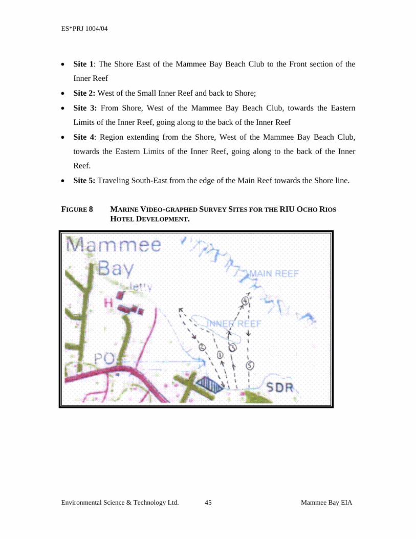
ES*PRJ 1004/04
Environmental Science & Technology Ltd. Mammee Bay EIA 45
• Site 1: The Shore East of the Mammee Bay Beach Club to the Front section of the
Inner Reef
• Site 2: West of the Small Inner Reef and back to Shore;
• Site 3: From Shore, West of the Mammee Bay Beach Club, towards the Eastern
Limits of the Inner Reef, going along to the back of the Inner Reef
• Site 4: Region extending from the Shore, West of the Mammee Bay Beach Club,
towards the Eastern Limits of the Inner Reef, going along to the back of the Inner
Reef.
• Site 5: Traveling South-East from the edge of the Main Reef towards the Shore line.
FIGURE 8 MARINE VIDEO-GRAPHED SURVEY SITES FOR THE RIU OCHO RIOS HOTEL DEVELOPMENT.
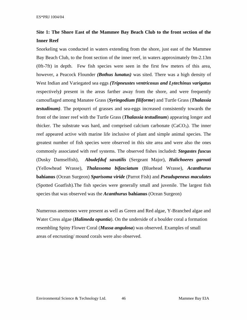
ES*PRJ 1004/04
Environmental Science & Technology Ltd. Mammee Bay EIA 46
Site 1: The Shore East of the Mammee Bay Beach Club to the front section of the
Inner Reef
Snorkeling was conducted in waters extending from the shore, just east of the Mammee
Bay Beach Club, to the front section of the inner reef, in waters approximately 0m-2.13m
(0ft-7ft) in depth. Few fish species were seen in the first few meters of this area,
however, a Peacock Flounder (Bothus lunatus) was sited. There was a high density of
West Indian and Variegated sea eggs (Tripneustes ventricosus and Lytechinus varigatus
respectively) present in the areas farther away from the shore, and were frequently
camouflaged among Manatee Grass (Syringodium filiforme) and Turtle Grass (Thalassia
testudinum). The potpourri of grasses and sea-eggs increased consistently towards the
front of the inner reef with the Turtle Grass (Thalassia testudinum) appearing longer and
thicker. The substrate was hard, and comprised calcium carbonate (CaCO3). The inner
reef appeared active with marine life inclusive of plant and simple animal species. The
greatest number of fish species were observed in this site area and were also the ones
commonly associated with reef systems. The observed fishes included: Stegastes fuscus
(Dusky Damselfish), Abudefduf saxatilis (Sergeant Major), Halichoeres garnoti
(Yellowhead Wrasse), Thalassoma bifasciatum (Bluehead Wrasse), Acanthurus
bahianus (Ocean Surgeon) Sparisoma viride (Parrot Fish) and Pseudupeneus maculates
(Spotted Goatfish).The fish species were generally small and juvenile. The largest fish
species that was observed was the Acanthurus bahianus (Ocean Surgeon)
Numerous anemones were present as well as Green and Red algae, Y-Branched algae and
Water Cress algae (Halimeda opuntia). On the underside of a boulder coral a formation
resembling Spiny Flower Coral (Mussa angulosa) was observed. Examples of small
areas of encrusting/ mound corals were also observed.
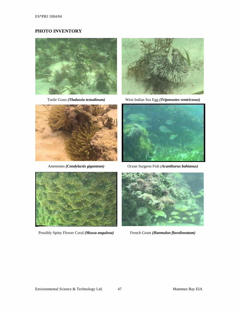
ES*PRJ 1004/04
Environmental Science & Technology Ltd. Mammee Bay EIA 47
PHOTO INVENTORY
Turtle Grass (Thalassia testudinum) West Indian Sea Egg (Tripneustes ventricosus)
Anemones (Condylactis gigantean) Ocean Surgeon Fish (Acanthurus bahianus)
Possibly Spiny Flower Coral (Mussa angulosa) French Grunt (Haemulon flavolineatum)
ES*PRJ 1004/04
Environmental Science & Technology Ltd. Mammee Bay EIA 48
Site 2: West of the Small Inner Reef and back to Shore Water depth at this site (west of the front of the small Inner Reef towards reference point
on the shore from Site 1) ranged from 2.13m-3.0m (7ft-10ft).
In moving further west along the front of the inner reef, the reef was more scattered and
less protected, causing a slight ‘rip’ current out to the sea. The reduced visibility of this
region of Site 2, was caused by the increased water movement that dispersed the fine
sand at the sea-bottom through out the western portions of the Site 2 region. There were
also patches of sand, Turtle Grass, and of sea-eggs that formed a natural undulating
scheme, giving the impression of a dune-like landscape, thereby characterizing the
western section of the Site 2 region. A group of six reef squids (Sepioteuthis sepioidea)
was also observed in this area.
Towards the reference point on the shore of the Site 1 region, moving away from the reef
in a southeasterly direction, the ocean floor became less undulating and progressively
consistent in its height perpendicular to the sea floor surface, with frequent occurrences
of sea-grass and sea-eggs.
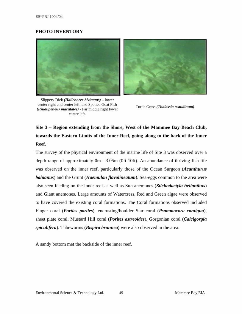
ES*PRJ 1004/04
Environmental Science & Technology Ltd. Mammee Bay EIA 49
PHOTO INVENTORY
Slippery Dick (Halichoere bivittatus) – lower
center right and center left; and Spotted Goat Fish (Psudupeneus maculates) - Far middle right lower
center left.
Turtle Grass (Thalassia testudinum)
Site 3 – Region extending from the Shore, West of the Mammee Bay Beach Club,
towards the Eastern Limits of the Inner Reef, going along to the back of the Inner
Reef.
The survey of the physical environment of the marine life of Site 3 was observed over a
depth range of approximately 0m - 3.05m (0ft-10ft). An abundance of thriving fish life
was observed on the inner reef, particularly those of the Ocean Surgeon (Acanthurus
bahianus) and the Grunt (Haemulon flavolineatum). Sea-eggs common to the area were
also seen feeding on the inner reef as well as Sun anemones (Stichodactyla helianthus)
and Giant anemones. Large amounts of Watercress, Red and Green algae were observed
to have covered the existing coral formations. The Coral formations observed included
Finger coral (Porties porties), encrusting/boulder Star coral (Psammocora contigua),
sheet plate coral, Mustard Hill coral (Porites astreoides), Gorgonian coral (Calcigorgia
spiculifera). Tubeworms (Bispira brunnea) were also observed in the area.
A sandy bottom met the backside of the inner reef.
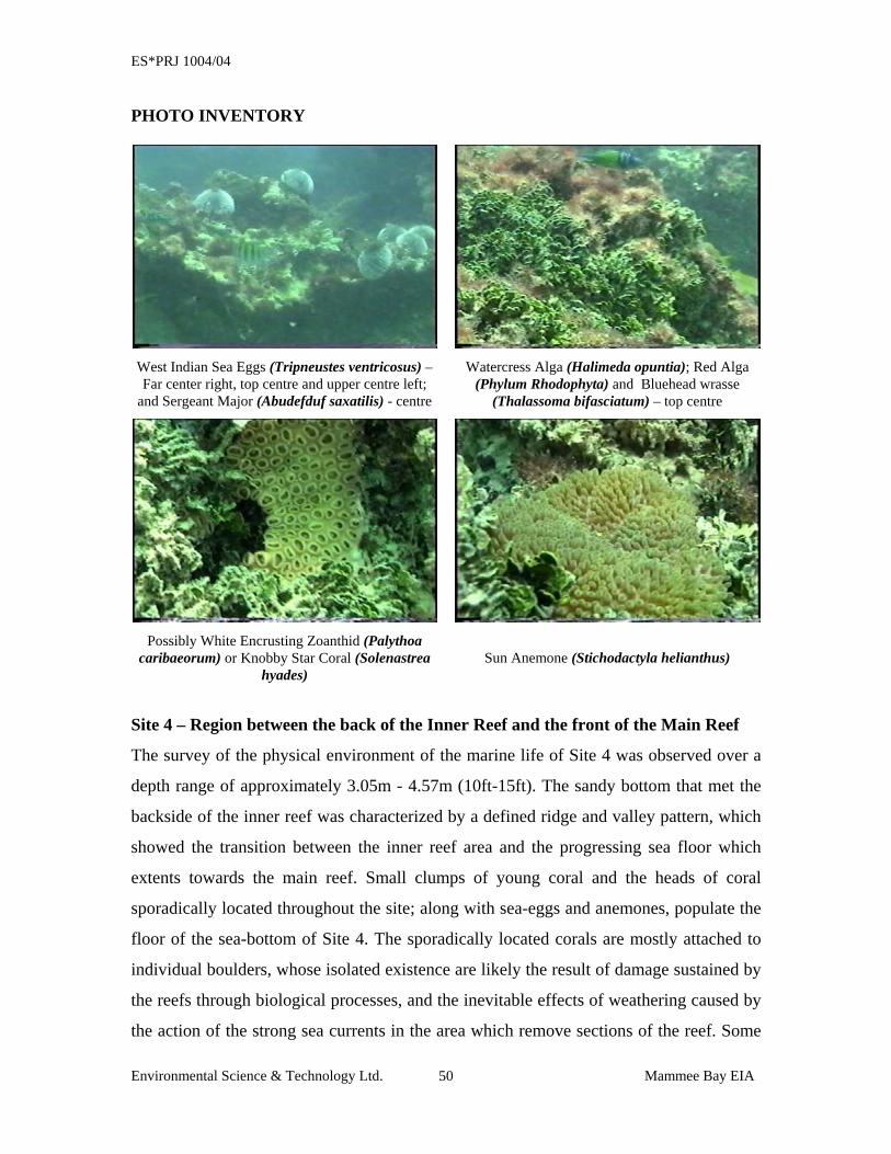
ES*PRJ 1004/04
Environmental Science & Technology Ltd. Mammee Bay EIA 50
PHOTO INVENTORY
West Indian Sea Eggs (Tripneustes ventricosus) – Far center right, top centre and upper centre left;
and Sergeant Major (Abudefduf saxatilis) - centre
Watercress Alga (Halimeda opuntia); Red Alga (Phylum Rhodophyta) and Bluehead wrasse
(Thalassoma bifasciatum) – top centre
Possibly White Encrusting Zoanthid (Palythoa
caribaeorum) or Knobby Star Coral (Solenastrea hyades)
Sun Anemone (Stichodactyla helianthus)
Site 4 – Region between the back of the Inner Reef and the front of the Main Reef
The survey of the physical environment of the marine life of Site 4 was observed over a
depth range of approximately 3.05m - 4.57m (10ft-15ft). The sandy bottom that met the
backside of the inner reef was characterized by a defined ridge and valley pattern, which
showed the transition between the inner reef area and the progressing sea floor which
extents towards the main reef. Small clumps of young coral and the heads of coral
sporadically located throughout the site; along with sea-eggs and anemones, populate the
floor of the sea-bottom of Site 4. The sporadically located corals are mostly attached to
individual boulders, whose isolated existence are likely the result of damage sustained by
the reefs through biological processes, and the inevitable effects of weathering caused by
the action of the strong sea currents in the area which remove sections of the reef. Some
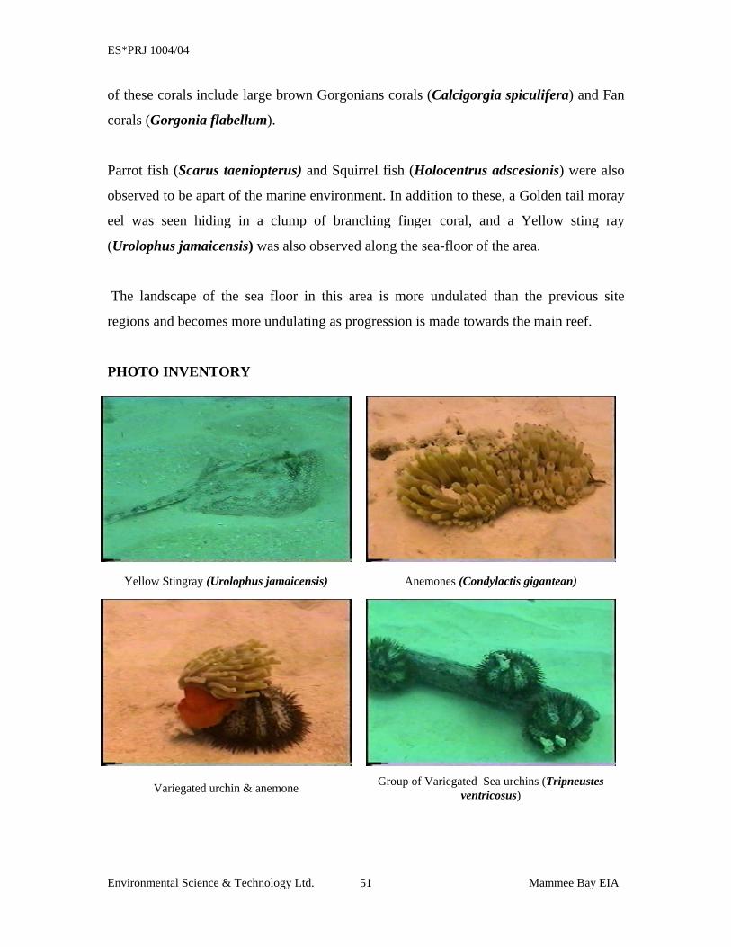
ES*PRJ 1004/04
Environmental Science & Technology Ltd. Mammee Bay EIA 51
of these corals include large brown Gorgonians corals (Calcigorgia spiculifera) and Fan
corals (Gorgonia flabellum).
Parrot fish (Scarus taeniopterus) and Squirrel fish (Holocentrus adscesionis) were also
observed to be apart of the marine environment. In addition to these, a Golden tail moray
eel was seen hiding in a clump of branching finger coral, and a Yellow sting ray
(Urolophus jamaicensis) was also observed along the sea-floor of the area.
The landscape of the sea floor in this area is more undulated than the previous site
regions and becomes more undulating as progression is made towards the main reef.
PHOTO INVENTORY
Yellow Stingray (Urolophus jamaicensis) Anemones (Condylactis gigantean)
Variegated urchin & anemone Group of Variegated Sea urchins (Tripneustes ventricosus)
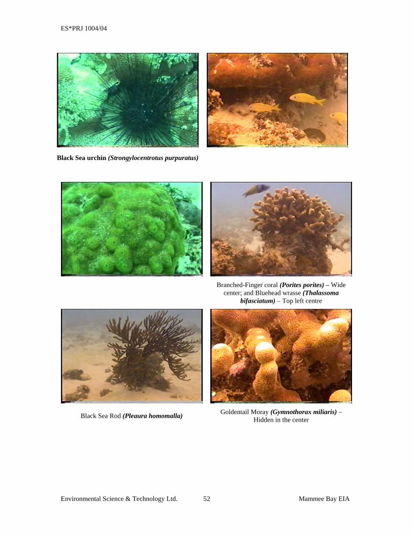
ES*PRJ 1004/04
Environmental Science & Technology Ltd. Mammee Bay EIA 52
Black Sea urchin (Strongylocentrotus purpuratus)
Branched-Finger coral (Porites porites) – Wide
center; and Bluehead wrasse (Thalassoma bifasciatum) – Top left centre
Black Sea Rod (Pleaura homomalla) Goldentail Moray (Gymnothorax miliaris) – Hidden in the center
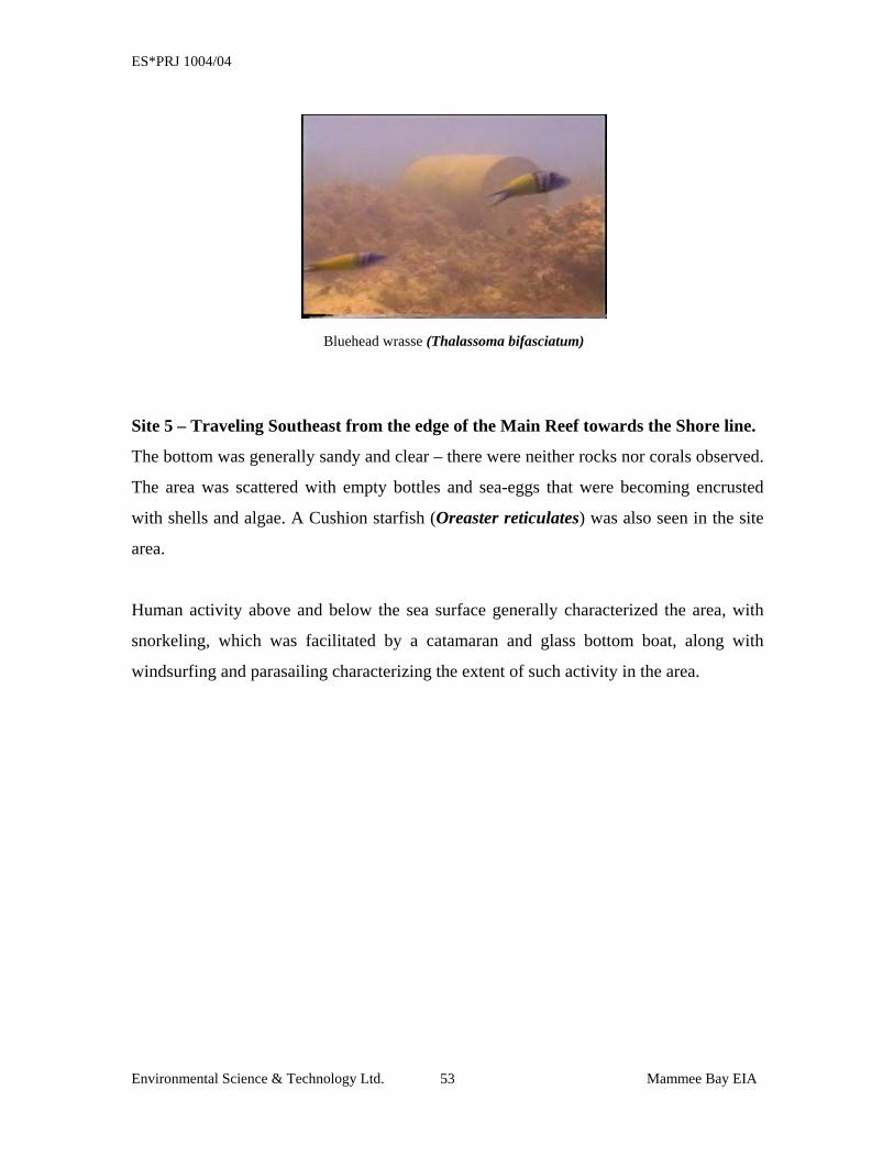
ES*PRJ 1004/04
Environmental Science & Technology Ltd. Mammee Bay EIA 53
Bluehead wrasse (Thalassoma bifasciatum)
Site 5 – Traveling Southeast from the edge of the Main Reef towards the Shore line.
The bottom was generally sandy and clear – there were neither rocks nor corals observed.
The area was scattered with empty bottles and sea-eggs that were becoming encrusted
with shells and algae. A Cushion starfish (Oreaster reticulates) was also seen in the site
area.
Human activity above and below the sea surface generally characterized the area, with
snorkeling, which was facilitated by a catamaran and glass bottom boat, along with
windsurfing and parasailing characterizing the extent of such activity in the area.
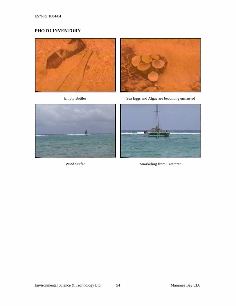
ES*PRJ 1004/04
Environmental Science & Technology Ltd. Mammee Bay EIA 54
PHOTO INVENTORY
Empty Bottles Sea Eggs and Algae are becoming encrusted
Wind Surfer Snorkeling from Catamran
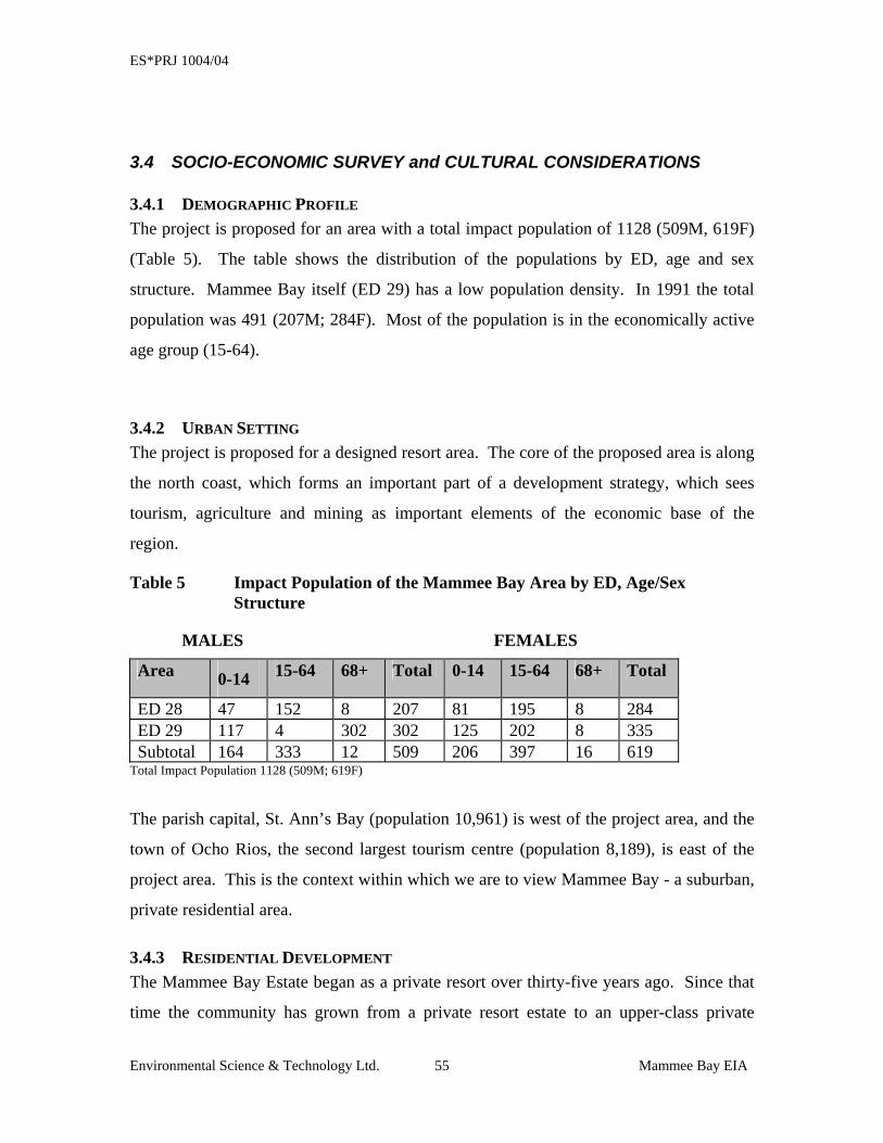
ES*PRJ 1004/04
Environmental Science & Technology Ltd. Mammee Bay EIA 55
3.4 SOCIO-ECONOMIC SURVEY and CULTURAL CONSIDERATIONS
3.4.1 DEMOGRAPHIC PROFILE The project is proposed for an area with a total impact population of 1128 (509M, 619F)
(Table 5). The table shows the distribution of the populations by ED, age and sex
structure. Mammee Bay itself (ED 29) has a low population density. In 1991 the total
population was 491 (207M; 284F). Most of the population is in the economically active
age group (15-64).
3.4.2 URBAN SETTING The project is proposed for a designed resort area. The core of the proposed area is along
the north coast, which forms an important part of a development strategy, which sees
tourism, agriculture and mining as important elements of the economic base of the
region.
Table 5 Impact Population of the Mammee Bay Area by ED, Age/Sex Structure
MALES FEMALES
Area 0-14 15-64 68+ Total 0-14 15-64 68+ Total
ED 28 47 152 8 207 81 195 8 284 ED 29 117 4 302 302 125 202 8 335 Subtotal 164 333 12 509 206 397 16 619
Total Impact Population 1128 (509M; 619F)
The parish capital, St. Ann’s Bay (population 10,961) is west of the project area, and the
town of Ocho Rios, the second largest tourism centre (population 8,189), is east of the
project area. This is the context within which we are to view Mammee Bay - a suburban,
private residential area.
3.4.3 RESIDENTIAL DEVELOPMENT The Mammee Bay Estate began as a private resort over thirty-five years ago. Since that
time the community has grown from a private resort estate to an upper-class private
ES*PRJ 1004/04
Environmental Science & Technology Ltd. Mammee Bay EIA 56
residential community. In July 1989, permission was granted by the St. Ann Parish
Council for the erection of sixty-five (65) apartments. The notion behind the
development of Mammee Bay, that of the ‘villa concept’ laid the foundation for its
subsequent development as a private residential area. It was designed for families to live
and vacation in peace and tranquility. A close-knit community has emerged in which
there is a strong sense of solidarity and concern for the welfare of the community
members. This provides a sense of security, friendship, and close personal ties. At
present, there are approximately:
• 70 permanent residences on the estate
• 20 homes (eight of which are partial rentals)
• 57 vacant lots
• 8 commercial lots
3.4.4 SOCIAL ENVIRONMENT The survey used a sample size that would be representative of the population of the
communities. The social survey was administered to Fifty (50) households within the
project area (including Mammee Bay, Mammee Bay Estates, Greenwich Park and Steer
Town) which constituted approximately 4.5% of the area population, while incorporating
over 10% of the households in the area.
Ninety-two percent (92%) of those surveyed indicated an awareness of the proposed
development, with six percent not aware and two percent not commenting. Ninety-four
percent (94%) of the households surveyed, indicated that they were in favour of the
development, with seventy-two per cent (72%) indicating that they were ‘in favour’ and
twenty-two percent (22%) indicating that they were ‘strongly in favor’ of the proposed
resort development. Further, ninety-six percent (96%) of the respondents indicated that
they were looking forward to the proposed development with only four percent (4%) of
the respondents stating that they were not looking forward to the development. Of the
96% who were looking forward to the development being built, only twenty percent
(20%) knew when the development was scheduled to begin construction, the remaining
ES*PRJ 1004/04
Environmental Science & Technology Ltd. Mammee Bay EIA 57
80% were unaware but the overriding sentiment was optimism that the new development
would benefit the community favourably by providing much needed employment,
increase economic activity, and attract spin-off businesses to the area. Many of the
respondents were hopeful that these types of developments would have a positive impact
on the overall Jamaican economy.
While the majority of the respondents are looking forward to and in favor of the proposed
RIU Ocho Rios Hotel development, a reasonable percentage (72%) are not convinced
that the project will affect their livelihood, however they indicate that sufficient
opportunities for employment and tangible jobs are guaranteed whether directly or
indirectly by the development.
3.4.5 ENVIRONMENTAL IMPACTS When asked if they believed the planned development would affect the availability of
their resources, forty-four percent (44%) said Yes. 95% of those who indicated that they
believed their resources would be affected, indicated that the impacts on their water
supply was of most concern, particularly water pressure to the homes and reliable service.
14% indicated that electricity was of concern, while sewage, traffic and aesthetics were
each mentioned by 4% of the respondents.
3.4.6 HEALTH IMPACTS Concerns with health impacts related to the development was mentioned by very few of
the respondents to the survey. The major issue that arose in this regard is the proper
treatment and management of sewage generated at the facility. During a community
meeting to discuss the proposed development, residents were very concerned about this
aspect of the development and one attendee asked if a “guarantee” could be given that the
sewage would be treated to the tertiary level and not be disposed in the sea.
ES*PRJ 1004/04
Environmental Science & Technology Ltd. Mammee Bay EIA 58
3.4.7 CULTURAL AND HISTORICAL IMPACTS A review was done on the known cultural and historical resources of the general area,
inclusive of the surrounding landscapes and communities. It is believed that the
indigenous Arawak or Taino people at one time inhabited areas along the north coast of
the island, possibly including the proposed project area. There is no physical evidence at
the site indicating the former existence of a “midden” or Taino community, however, if
during excavation activities any artifacts are unearthed, the Archaeological Retrieval Plan
outlined later in this document will be followed.
Additional potential cultural impacts include the disruption of the traditional use of the
beach for bathing or fishing by residents of the community. The Prescriptive rights of
individuals to use the beach for bathing and fishing are protected and a process is in place
to facilitate this right if individuals seek to pursue it.
3.4.7.1 Archaeological Retrieval Plan Historically, it is known that the indigenous people of the island, Arawaks or Tainos
inhabited the northern coast of the island. While no physical evidence exists at this time,
there is a possibility that the site proposed for this development may have once included a
“midden” or Taino community. In the event that artifacts or items of cultural or historical
significance are unearthed (or there is uncertainty), the following Archaeological
Retrieval Plan will be followed:
ES*PRJ 1004/04
Environmental Science & Technology Ltd. Mammee Bay EIA 59
Action 1: Stop excavation and all other works in the general area
Action 2: Notify the Jamaica National Heritage Trust at 922-1287-8 or 967-8059.
Inform them of the situation and request that they visit the site and verify
the finding.
Action 3: If the find represents an artifact or items of cultural or historic
significance, the JNHT will take control of that portion of the site and
make the necessary arrangements to secure, remove and process the find.
Action 4: Construction work at that location will only continue on the order of the
JNHT.
3.4.8 COMMUNITY MEETINGS
In an attempt to address concerns of residents and other stakeholders from the area, the
developers and their representatives have attended two (2) meetings within the
community. The first meeting was held on May 2, 2004 at a private residence in
Mammee Bay Estates and was hosted by the Mammee Bay Estate Citizens Association.
Concerned residents in the area called this meeting to discuss major issues associated
with the proposed development. Approximately 15 individuals attended the meeting from
Mammee Bay Estates and surrounding communities including Steer Town and
Greenwich Acres. Issues discussed were relevant to the development and included:
• Sewage Treatment
• Water Supply
• Status of Approvals from NEPA and Parish Council
• Building Height and Density
• Drainage
• Dust Suppression and Fencing
The residents voiced their opinions and where possible, information was provided by
representatives of the developers, JAMPRO and NWC. Several outstanding issues
ES*PRJ 1004/04
Environmental Science & Technology Ltd. Mammee Bay EIA 60
remained at the end of the meeting and it was agreed that a follow-up meeting may be
necessary to complete the dialogue.
A second meeting was convened by the Mammee Bay Estate Citizens Association on
May 2, 2004 to get an update from the previous meeting and receive more detail on some
areas of concern. This meeting was held at the Mammee Bay Beach Club and was
attended by approximately 43 individuals from Mammee Bay Estates and the
surrounding communities including Greenwich Acres and Steer Town along with
representatives of the developers and government agencies. At this meeting, there
appeared to be more support for the project, however, the major issues (some of which
were unresolved from the March 15, 2004 meeting) were still in the forefront of the
discussions. These included:
• Water Supply
• Sewage Treatment to Tertiary Level
• Regulatory Standards being used
• Building Height and Density
• Visual and Aesthetic Concerns
• Storm water Management
• Dust Suppression
At the end of the meeting, some issues had been sufficiently addressed, however, others
such as water supply and building height and density were still unresolved. It was agreed
that the developers would furnish copies of the final design drawings to the Citizens
Association as soon as they became available.
ES*PRJ 1004/04
Environmental Science & Technology Ltd. Mammee Bay EIA 61
SECTION 4: POLICY, LEGISLATION, AND
REGULATIONS

ES*PRJ 1004/04
Environmental Science & Technology Ltd. Mammee Bay EIA 62
4 POLICY, LEGISLATION AND REGULATIONS
The policies, legislation, regulations and environmental standards of the Government of
Jamaica (GOJ), which pertain to this development have been researched and analyzed, to
ensure that the project complies with all policy, legal and regulatory requirements. The
areas examined included environmental quality, health and safety, protection of sensitive
areas, protection of endangered species, site selection and land use control at the regional,
national and local levels, which relate to or should be considered within the framework of
the project.
4.1 Agenda 21 In June 1992, Jamaica participated in the United Nations Conference for Environment
and Development (UNCED). One of the main outputs of the conference was a plan of
global action, titled Agenda 21, which is a “comprehensive blueprint for the global
actions to affect the transition to sustainable development” (Maurice Strong). To which,
Jamaica is a signatory. Twenty seven (27) environmental principles were outlined in the
Agenda 21 document. Those relevant to this project, which Jamaica is obligated to follow
are outlined below:
ES*PRJ 1004/04
Environmental Science & Technology Ltd. Mammee Bay EIA 63
Principle 1 – Human beings are at the center of concerns for sustainable development.
They are entitled to a healthy and productive life in harmony with nature.
Principle 3 – The right to development must be fulfilled to equitably meet developmental
and environmental needs of present and future generations.
Principle 10 – Environmental issues are best handled with the participation of all
concerned citizens, at the relevant level, each individual shall have appropriate access to
information concerning the environment that is held by public authorities, including
information on hazardous materials and activities in their communities, and the
opportunity to participate in the decision making process.
Principle 11 – States shall enact effective environmental legislation, environmental
standards, management objectives and priorities should reflect the environmental and
developmental context to which they apply.
Principle 15 – In order to protect the environment, the precautionary approach shall be
widely applied by States according to their capabilities. Where there are threats of serious
or irreversible damage, lack of scientific certainty shall not be used as a reason for
postponing cost-effective measures to prevent environmental degradation.
ES*PRJ 1004/04
Environmental Science & Technology Ltd. Mammee Bay EIA 64
4.2 DEVELOPMENT GUIDELINES All development applications are submitted for approval to the Town Country Planning
Authority, through the local Parish Council and then forwarded to the relevant authorities
including NEPA and the Environmental Control Division (ECD) of the Ministry of Health.
NEPA, the governing environmental agency, may require an environmental impact
assessment (EIA) to be considered along with the development plan for the Authority's
approval. The ECD imposes guidelines for air, water and soil standards to be maintained
after construction.
4.2.1 St. Ann Parish – Town and Country Planning Provisional Development Order, 1998
The St. Ann Developmental Order includes:
Section 5: Permitted development
Section 6: Approval of planning permission
Section 7: Prohibition of development
Section 8: Outline planning permission
4.3 RELEVANT LEGISLATION Legislation relevant to the establishment of a hotel development in St. Ann is outlined
below.
4.3.1 THE NATURAL RESOURCES CONSERVATION AUTHORITY (NRCA) ACT, 1991 The NRCA Act (1991) is the overriding legislation governing environmental
management in Jamaica. It requires that all new projects, (or expansion of existing
projects), which fall within prescribed categories be subject to an environmental impact
assessment (EIA).
The regulations require that eight (8) copies of the EIA Report be submitted to the
Authority for review. There is a preliminary review period of ten (10) days to determine
whether additional information is needed. After the initial review the process can take up
to ninety (90) days for approval. If on review and evaluation of the EIA the required
ES*PRJ 1004/04
Environmental Science & Technology Ltd. Mammee Bay EIA 65
criteria are met, a permit is granted. In the event that the EIA is not approved, there is
provision for an appeal to be made to the Minister.
Specifically, the relevant section(s) under the Act which address the proposed project are:
Section 10: Empowers the Authority to request EIAs for the construction of any
enterprise of a prescribed category.
Section 12: Addresses the potential for contamination of ground water by trade
effluent and sewage.
Section 15: Addresses the implementation of stop orders and fines associated with the
pollution of water resources.
Section 16: Authorizes the government to intervene in order to prevent the
contamination of ground water.
Section 17: Addresses the authority of the government to request in writing, any
information pertaining to the:
1. performance of the facility
2. quantity and condition of the effluent discharged
3. the area affected by the discharge of effluent.
In keeping with the requirements of this Act, the following submittal have been in
support of this project:
• Permit Application (pursuant to Section 9)
• Project Information Form (PIF) pursuant to Section 10 (1)(a)
• Completed EIA document (8 copies to NEPA and one electronic copy)
4.3.2 THE BEACH CONTROL ACT (1956) The Beach Control Act provides for the regulation of activities within twenty-five (25)
metres of the shoreline. It includes control of the construction of sheds and huts on
beaches, and prohibits the use of public beaches for fishing activities. The Act is
administered by NEPA, and also makes provisions for the creation of Marine Protected
Areas. The sections of the Act relevant to the project are:
ES*PRJ 1004/04
Environmental Science & Technology Ltd. Mammee Bay EIA 66
Section 7: (1) Notwithstanding anything to the contrary in this Act, the Minister
may, upon the recommendation of the Authority, make an order
declaring:
(a) any part of the foreshore and the floor of the sea defined in the Order
together with the water lying on such part of the floor of the sea to be a
protected area for the purpose of this Act; and
(b) such activities as may be specified in the Order to be prohibited
activities in the area defined in the Order, being any or all of the following
activities:
(i) fishing by any means specified in the Order;
(ii) the use of boats other than boats propelled by wind or oars
where such boats are used for purposes other than for the doing
of anything which may be lawfully done under the Harbours
Act, the Marine Board Act, the Wrecks and Salvage Law, the
Pilotage Act or the Exclusive Economic Zone Act;
(iii) the disposal of rubbish or any other waste material;
(iv) water-skiing;
(v) the dredging or disturbance in any way of the floor of the sea.
Section 9: (1) Subject to the provision of Section 8 (this does not apply to docks
wharves pier etc. constructed prior to June 1, 1956), no person shall erect,
construct or maintain any dock, wharf, pier or jetty on the foreshore or
the floor of the sea, or any structure, apparatus or equipment pertaining to
any dock, wharf, pier or jetty and encroaching on the foreshore or the
floor of the sea, except under the Authority of a license granted by the
Minister on behalf of the Crown.
ES*PRJ 1004/04
Environmental Science & Technology Ltd. Mammee Bay EIA 67
4.3.3 THE PUBLIC HEALTH ACT (1974) This Act falls under the ambit of the Ministry of Health (MOH) and governs all matters
concerning the handling of food material. In addition, provisions are also made under
this Act for the activities of the Environmental Control Division (ECD), a division of the
MOH. The ECD has no direct legislative jurisdiction, but works through the Public Heath
Act to monitor and control pollution from point sources. Action against any breaches of
this Act would be administered by the Central Health Committee. The functions of the
department include:
• The monitoring of waste water quality, including regular water quality analysis, using water standards published by NEPA;
• Monitoring of occupational health as it relates to industrial hygiene of
potentially hazardous working environments; • Monitoring of air pollutants through its laboratory facilities.
4.3.4 JAMAICA NATIONAL HERITAGE TRUST ACT (1985) The Jamaica National Heritage Trust, formerly the Jamaica National trust, administers
the Act. This Act provides for the protection of important areas, including the numerous
monuments, forts, statues, and buildings of historic and architectural importance in
Jamaica.
This Act will prove applicable if any structures of archaeological and/or architectural
importance are located on the site, affected by the site activities or unearthed during site
activities. Since this project is in an area that may contain items of archaeological
importance, an Archaeological Retrieval Plan is included as part of this document.
4.3.5 TOWN & COUNTRY PLANNING ACT (1987) This Act governs the development and land use (excluding agriculture) in specified areas,
through Development Orders, local planning authorities, development planning processes
and Tree Preservation Orders. Under this Act the Town Planning Department is the
ES*PRJ 1004/04
Environmental Science & Technology Ltd. Mammee Bay EIA 68
agency responsible for the review of any plans involving development. The Act allows
for specific conditions to be stipulated and imposed on any approved plans. The planning
decision is based upon several factors, including;
• Location of the development;
• Land use and zoning;
• Effect of the proposal on amenities, traffic, etc.
4.3.6 THE NATURAL RESOURCES (MARINE PARKS) REGULATIONS, 1992 This Act regulates activities relevant to the use of areas designated as Marine Parks
across the Island. In this case, the closest Marine Park is the Ocho Rios Marine Park.
Sections of this Act relevant to this proposed development include:
Offences – 4: Removal or destruction of natural features and marine life
5: Dredging, filling, excavation and building activities
6: Refuse and polluting substances
7: Markers
10: Litter, waste material
15: Refusal to comply with orders – penalty $50,000
17: Parking etc., of conveyances or vessels
Enforcement - 19: Arrest without warrant
20,21: Removal and disposal of abandoned conveyances and vessels
ES*PRJ 1004/04
SECTION 5: POTENTIAL ENVIRONMENTAL
IMPACTS AND MITIGATION
ES*PRJ 1004/04
Environmental Science & Technology Ltd. Mammee Bay EIA 70
5 IDENTIFICATION OF POTENTIAL ENVIRONMENTAL
IMPACTS AND MITIGATION
5.1 IMPACT IDENTIFICATION & MITIGATION A development such as the one proposed for Mammee Bay has the potential to create a variety of impacts
as it is implemented. These potential impacts can be both positive or negative depending on the receptors
involved and other parameters such as magnitude and duration. It is anticipated that this project will have
significant positive impacts on areas such as the economy, employment, foreign exchange earnings among
others. Since this report is geared primarily towards identification of environmental impacts those will be
presented in greater detail later in this report, other impacts will be presented in less detail as indicated
below:
5.1.1 Socio-Economic Impacts
Employment – Direct employment of approximately 1200 tradesmen and labourers
during pre-construction and construction phases. Direct employment of approximately
800 employees is anticipated during the operational phase. The development will also
spawn indirect employment throughout the surrounding communities and within the
tourism industry as a whole. This represents a significant positive, both direct and
indirect, long-term impact.
Foreign Exchange Earnings/Benefit to Economy – The proposed development
represents an estimated total investment of about US$60,000,000 and a long-term source
of foreign exchange in keeping with success of the resort. The Island should see
increased revenues from Income and General Consumption Taxes resulting from the
development. This is a significant positive, both direct and indirect, long-term impact on
the economy of the communities and the country.
Community Benefits – Other than providing direct and indirect employment and
revenue sources, the development will result in an improvement of infrastructure and
resources in the area (water and electricity) along with improved property values. These
are significant positive, direct, long-term impacts to the community.
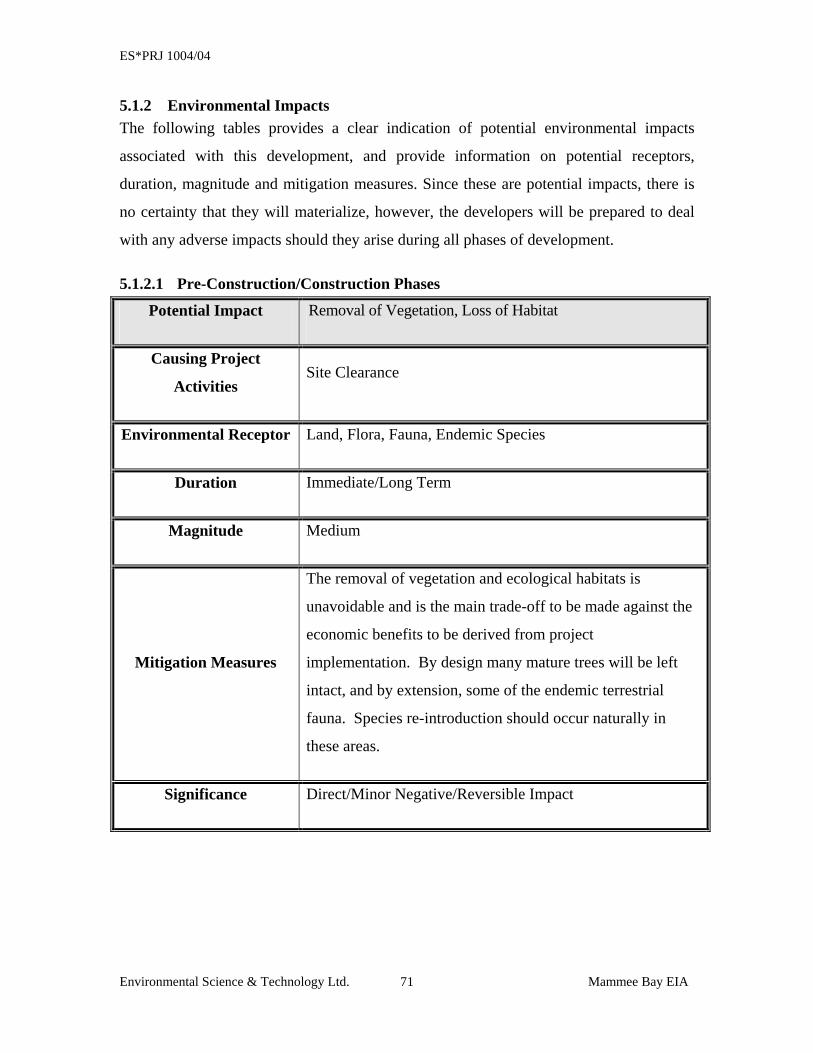
ES*PRJ 1004/04
Environmental Science & Technology Ltd. Mammee Bay EIA 71
5.1.2 Environmental Impacts The following tables provides a clear indication of potential environmental impacts
associated with this development, and provide information on potential receptors,
duration, magnitude and mitigation measures. Since these are potential impacts, there is
no certainty that they will materialize, however, the developers will be prepared to deal
with any adverse impacts should they arise during all phases of development.
5.1.2.1 Pre-Construction/Construction Phases
Potential Impact Removal of Vegetation, Loss of Habitat
Causing Project
Activities Site Clearance
Environmental Receptor Land, Flora, Fauna, Endemic Species
Duration Immediate/Long Term
Magnitude Medium
Mitigation Measures
The removal of vegetation and ecological habitats is
unavoidable and is the main trade-off to be made against the
economic benefits to be derived from project
implementation. By design many mature trees will be left
intact, and by extension, some of the endemic terrestrial
fauna. Species re-introduction should occur naturally in
these areas.
Significance Direct/Minor Negative/Reversible Impact
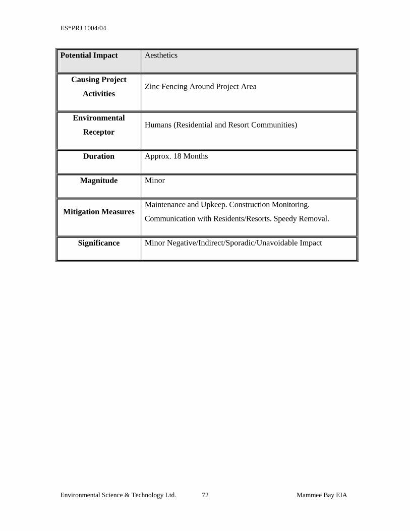
ES*PRJ 1004/04
Environmental Science & Technology Ltd. Mammee Bay EIA 72
Potential Impact Aesthetics
Causing Project
Activities Zinc Fencing Around Project Area
Environmental
Receptor Humans (Residential and Resort Communities)
Duration Approx. 18 Months
Magnitude Minor
Mitigation Measures Maintenance and Upkeep. Construction Monitoring.
Communication with Residents/Resorts. Speedy Removal.
Significance Minor Negative/Indirect/Sporadic/Unavoidable Impact
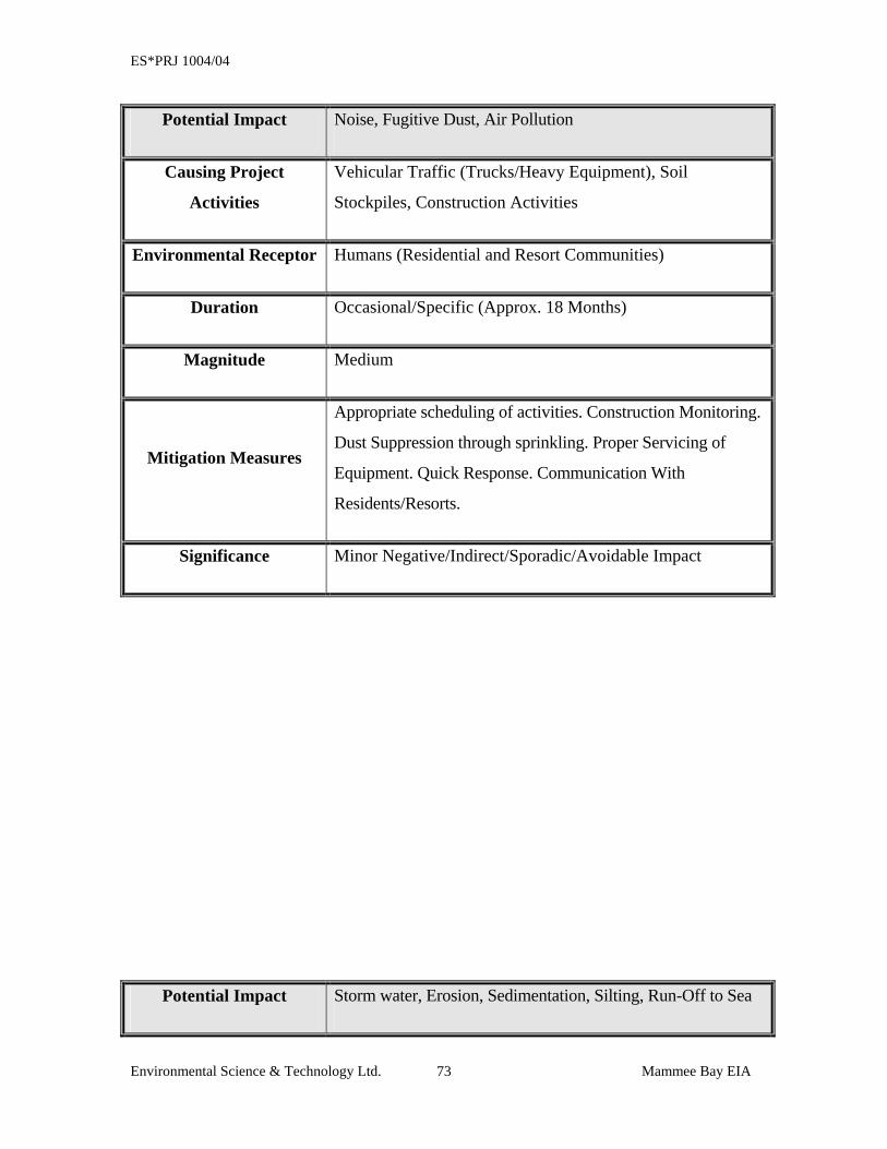
ES*PRJ 1004/04
Environmental Science & Technology Ltd. Mammee Bay EIA 73
Potential Impact Noise, Fugitive Dust, Air Pollution
Causing Project
Activities
Vehicular Traffic (Trucks/Heavy Equipment), Soil
Stockpiles, Construction Activities
Environmental Receptor Humans (Residential and Resort Communities)
Duration Occasional/Specific (Approx. 18 Months)
Magnitude Medium
Mitigation Measures
Appropriate scheduling of activities. Construction Monitoring.
Dust Suppression through sprinkling. Proper Servicing of
Equipment. Quick Response. Communication With
Residents/Resorts.
Significance Minor Negative/Indirect/Sporadic/Avoidable Impact
Potential Impact Storm water, Erosion, Sedimentation, Silting, Run-Off to Sea
ES*PRJ 1004/04
Environmental Science & Technology Ltd. Mammee Bay EIA 74
Causing Project
Activities Site Clearance, Vegetation Removal, Excavation
Environmental Receptor Marine/Coastal/Marine Park
Duration Occasional/Long Term (through occupational phase)
Magnitude Medium
Mitigation Measures
Careful Phasing of Activities With Consideration of Rainy
Seasons. Construction Monitoring. Implementation of Control
Devices (Drainage, Silt Fencing, Soak-away, etc.)
Significance Minor Negative/Indirect/Sporadic/Avoidable Impact
Potential Impact Flooding Potential, Drainage Patterns, Storm Surge, High
Water Table.
ES*PRJ 1004/04
Environmental Science & Technology Ltd. Mammee Bay EIA 75
Causing Project
Activities Incidental Rainfall, Hurricane, Excavation, Soak Away
Environmental Receptor Groundwater, Coastal Waters, Project Area
Duration Occasional/Long Term
Magnitude Medium
Mitigation Measures
Site designed to withstand 10-year return rainfall event.
Construction Monitoring. Maintain design elevations.
Maintain site drainage mechanisms. Not a typical problem in
the area.
Significance Minor Negative/Indirect/Occasional/Avoidable Impact
Potential Impact Sewage and Wastewater (Effluent/Odour)
Causing Project Sewage Treatment System, Temporary Sewage Handling during
ES*PRJ 1004/04
Environmental Science & Technology Ltd. Mammee Bay EIA 76
Activities Construction
Environmental
Receptor Coastal Waters, Groundwater, Human
Duration Long-Term
Magnitude Minor
Mitigation Measures
Operate and Maintain facility in keeping with designs. Quick
Response to issues. Implement contingency plans as needed
(Septic Hauler, etc.). System has no direct discharge to the
environment. Treated effluent goes to irrigation. Utilize licensed
temporary sewage system provider for Portable Toilets and
associated disposal.
Significance Minor Negative, indirect, avoidable impact
Potential Impact Socio-Economic/Cultural/Loss of Traditional Use and Access to
beach
Causing Project Entire Development
ES*PRJ 1004/04
Environmental Science & Technology Ltd. Mammee Bay EIA 77
Activities
Environmental
Receptor Human
Duration Long-Term
Magnitude Large
Mitigation Measures
Positive socio-economic impacts. Provide public access if
possible or prudent to beaches. Identify optional public
resources in proximity for bathing, fishing, etc. Recognize
Prescriptive Rights of population to utilize beach. Secure any
identified cultural heritage resources through JNHT.
Significance Minor Negative/direct impact
Potential Impact Solid Waste Handling and Disposal
Causing Project
Activities Vegetation Removal/Construction Activities/Packaging
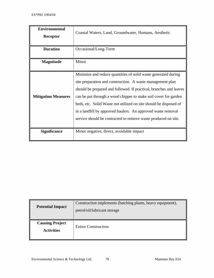
ES*PRJ 1004/04
Environmental Science & Technology Ltd. Mammee Bay EIA 78
Environmental
Receptor Coastal Waters, Land, Groundwater, Humans, Aesthetic
Duration Occasional/Long-Term
Magnitude Minor
Mitigation Measures
Minimize and reduce quantities of solid waste generated during
site preparation and construction. A waste management plan
should be prepared and followed. If practical, branches and leaves
can be put through a wood chipper to make soil cover for garden
beds, etc. Solid Waste not utilized on site should be disposed of
in a landfill by approved haulers. An approved waste removal
service should be contracted to remove waste produced on site.
Significance Minor negative, direct, avoidable impact
Potential Impact Construction implements (batching plants, heavy equipment),
petrol/oil/lubricant storage
Causing Project
Activities Entire Construction
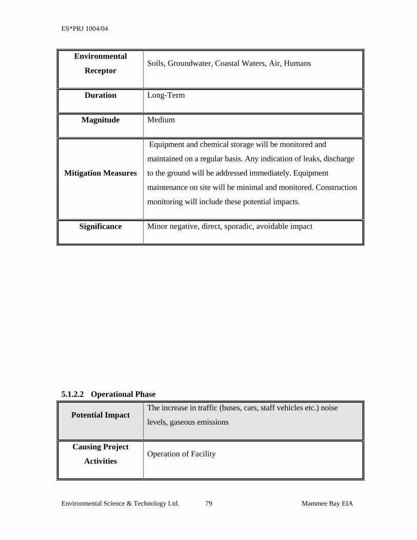
ES*PRJ 1004/04
Environmental Science & Technology Ltd. Mammee Bay EIA 79
Environmental
Receptor Soils, Groundwater, Coastal Waters, Air, Humans
Duration Long-Term
Magnitude Medium
Mitigation Measures
Equipment and chemical storage will be monitored and
maintained on a regular basis. Any indication of leaks, discharge
to the ground will be addressed immediately. Equipment
maintenance on site will be minimal and monitored. Construction
monitoring will include these potential impacts.
Significance Minor negative, direct, sporadic, avoidable impact
5.1.2.2 Operational Phase
Potential Impact The increase in traffic (buses, cars, staff vehicles etc.) noise
levels, gaseous emissions
Causing Project
Activities Operation of Facility
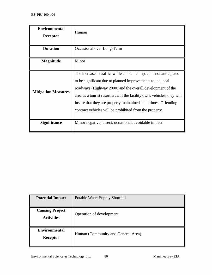
ES*PRJ 1004/04
Environmental Science & Technology Ltd. Mammee Bay EIA 80
Environmental
Receptor Human
Duration Occasional over Long-Term
Magnitude Minor
Mitigation Measures
The increase in traffic, while a notable impact, is not anticipated
to be significant due to planned improvements to the local
roadways (Highway 2000) and the overall development of the
area as a tourist resort area. If the facility owns vehicles, they will
insure that they are properly maintained at all times. Offending
contract vehicles will be prohibited from the property.
Significance Minor negative, direct, occasional, avoidable impact
Potential Impact Potable Water Supply Shortfall
Causing Project
Activities Operation of development
Environmental
Receptor Human (Community and General Area)
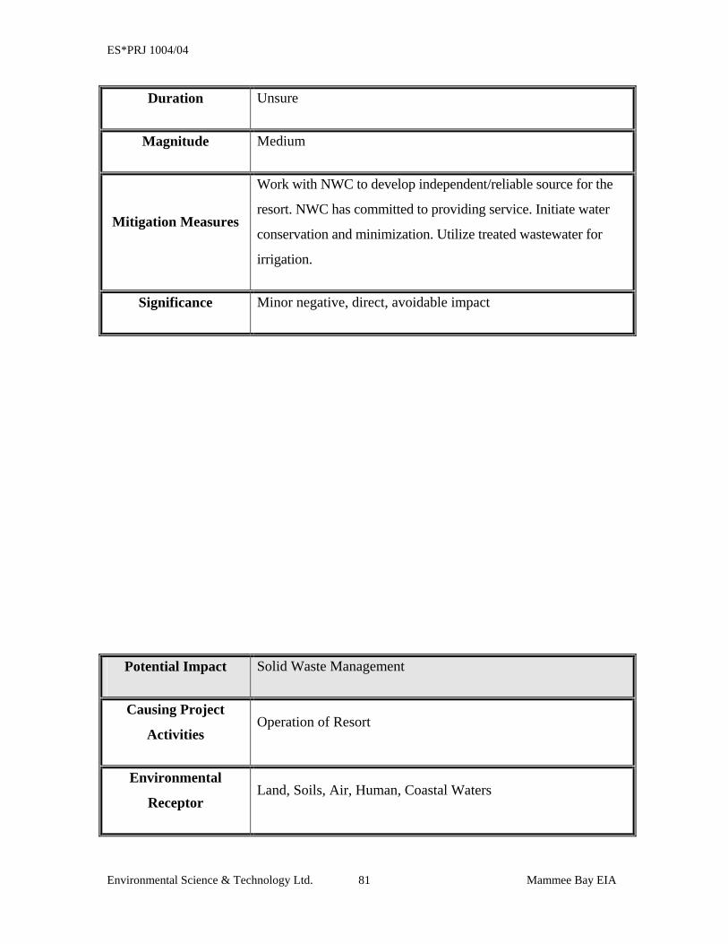
ES*PRJ 1004/04
Environmental Science & Technology Ltd. Mammee Bay EIA 81
Duration Unsure
Magnitude Medium
Mitigation Measures
Work with NWC to develop independent/reliable source for the
resort. NWC has committed to providing service. Initiate water
conservation and minimization. Utilize treated wastewater for
irrigation.
Significance Minor negative, direct, avoidable impact
Potential Impact Solid Waste Management
Causing Project
Activities Operation of Resort
Environmental
Receptor Land, Soils, Air, Human, Coastal Waters
ES*PRJ 1004/04
Environmental Science & Technology Ltd. Mammee Bay EIA 82
Duration Occasional
Magnitude Minor
Mitigation Measures
It is in the best interest of the facility to maintain high quality
waste management and disposal practices. Garbage
skips/dumpsters will be strategically placed throughout the site
and emptied as needed by a contract solid waste company for
disposal at landfill.
Significance Minor indirect, occasional, avoidable impact
SECTION 7: ENVITONMENTAL
ACTION/MONITORING PLAN
ES*PRJ 1004/04
Environmental Science & Technology Ltd. Mammee Bay EIA 84
6 ENVIRONMENTAL ACTION/MONITORING PLAN The Monitoring Plan to be devised for the development should be implemented during the
pre-construction and construction phases of the project. Monitoring involves the
observation, review and assessment of onsite activities to ensure adherence to regulatory
standards and the recommendations made to reduce negative impacts. The Plan must be
comprehensive and address relevant issues, with a reporting component that will be made
available to the regulatory agencies based on a mutually agreed frequency. It is
recommended that a minimum monthly monitoring report be submitted to NEPA.
The monitoring report will include at a minimum:
• Raw data collected
• Tables/graphs (where appropriate)
• Discussion of results with respect to the development in progress, highlighting
parameters which exceed standards
• Recommendations
• Appendices with photos/data, etc.
At a minimum, the following activities will be monitored in the various phases:
ES*PRJ 1004/04
Environmental Science & Technology Ltd. Mammee Bay EIA 85
6.1 PRE-CONSTRUCTION PHASE MONITORING
• During site clearing activities, those trees that will be saved and incorporated into
the facility must be identified and protected. The plants to be retained should be
pegged and flagged and if necessary fenced. It is suggested that the developers
assess a monetary value (e.g. $2,500) be placed on each plant, for which the
contractor will be made liable. Should the contractor damage or remove a protected
tree, the penalty should be assessed. An inventory and map (if applicable) of all
trees to be retained must be developed. (Weekly Monitoring)
• Where identified, endemic and rare species should be preserved in place or
collected for transplanting (As Observed)
• Stockpiles of soil and vegetative debris generated during site clearing activities
should be monitored and maintained to eliminate generation of fugitive dust.
(Daily Monitoring)
• Noise levels along the perimeters of the project area should be monitored and
recorded to insure that activities at the site are not exceeding standards. (Daily
Monitoring)
ES*PRJ 1004/04
Environmental Science & Technology Ltd. Mammee Bay EIA 86
CONSTRUCTION PHASE MONITORING
• Sewage - Ensure that temporary portable chemical toilets are available for
construction personnel and that the contents are disposed by an approved waste
hauler in an appropriate waste disposal facility. (Weekly Monitoring)
• Sand/Marl/Aggregate Supply - Routinely monitor sourcing of quarry materials to
ensure supplier is obtaining supplies from licensed operations. (Monthly
Monitoring)
• Solid Waste Management - Ensure that solid waste management plan is prepared,
and that workers are aware that no solid waste material should be scattered around
the site. Monitor availability and location of skips/dumpsters. (Weekly Monitoring)
• Monitor the disposal of refuse to insure that skips/dumpsters are not overfilled.
(Weekly Monitoring)
• Routine collection of solid waste for disposal must be implemented, and disposal
monitored to ensure use of approved disposal facilities. (Weekly Monitoring)
• Exposed soil areas must be monitored to determine potential for erosion, silting and
sedimentation particularly during storm events. (Weekly Monitoring)
• If erosion, silting or sedimentation is a potential or occurs, immediate steps must be
taken to negate the impact on the coastal waters and other receptors where
applicable. (As Needed)
• Equipment staging and parking areas must be monitored for releases and potential
impacts. (Weekly Monitoring)
• If any cultural heritage resources are unearthed during construction activities,
activities should be stopped and the Archaeological Retrieval Plan included in this
report implemented. (As Needed)
• Noise levels along the perimeters of the project area should be monitored and
recorded to insure that activities at the site are not exceeding standards. (Daily
Monitoring)
ES*PRJ 1004/04
Environmental Science & Technology Ltd. Mammee Bay EIA 87
6.2 OPERATION PHASE MONITORING • Sewage - Monitor effluent quality periodically to determine compliance with
regulatory standards and appropriateness for use as irrigation water. (Monthly
Monitoring or as determined by regulatory standards)
• Solid Waste - Monitor solid waste skips/dumpsters and removal contractor to ensure
proper waste handling and disposal. (Weekly Monitoring)
• Drainage - Regular inspections of drainage systems should be performed to ensure
that the drains remain clear of blockages to safeguard against flooding or erosion of
beach. (Monthly Monitoring)
ES*PRJ 1004/04
SECTION 7: ANALYSIS OF ALTERNATIVES
ES*PRJ 1004/04
Environmental Science & Technology Ltd. Mammee Bay EIA 89
7 ANALYSIS OF ALTERNATIVES In considering the development options, three alternatives can be exercised. These are:
1. The No Action Alternative
2. The Proposed Development
3. The Proposed Development with modifications
4. Proposed Development in another location
Consideration must be given to the fact that this area is zoned for this type of
development. The area is basically a resort residential area with an existing resort and a
residential community on either side of the proposed development.
7.1 THE NO ACTION ALTERNATIVE The selection of the “No Action” alternative would mean the discontinuation of project
designs and result in the site being retained in its existing form. There are physical,
biological and socio-economic implications of this alternative. Physically, the site is
unlikely to undergo any major changes from its condition at present, with the exception
of the potential for erosion, which may be a possibility due to planned road construction
scheduled for the area in the near term and the fact that no storm water diversion devices
are located at the site. Biologically, the vegetation present on the site is unlikely to be
severely affected, other than the potential for uncontrolled growth of weeds, bushes and
trees introduced by avifauna, wind or other means. Unless the vacant lot is maintained,
this could result in an eyesore and a possible venue for illicit and otherwise objectionable
activities. The “No Action” Alternative is likely to have the greatest implications on the
socio-economic environment of the area and surrounding communities. Due to the
proposed quality of the development it is anticipated that it would provide a major
opportunity for employment, foreign exchange revenue, benefits associated with the
construction industry and potentially significant business opportunities for existing and
new tourism support businesses. In addition, a development of this caliber will add to the
islands ability to market itself to visitors from markets previously under represented
through previous marketing activities. If left undeveloped, there is a strong potential for
ES*PRJ 1004/04
Environmental Science & Technology Ltd. Mammee Bay EIA 90
the site to revert to use by squatters and for the illegal dumping of refuse which only
serves to bring down property values and promote a negative image of the area.
If this alternative were adopted, the developers would need to find an alternative site for
the development or decide to develop the product outside of Jamaica.
7.2 THE PROPOSED DEVELOPMENT This alternative would see the construction of the development as proposed by the
developers, and as outlined in this EIA document. This option has good support (based
on results of socio-economic survey) by the persons who would be most affected by its
implementation, i.e., residents within Mammee Bay Estate, Greenwich Park and Steer
Town. Therefore, community support is anticipated for the development.
The designers have made maximum use of the available property to insure that the
development once completed will provide a quality experience for the guests, while
maintaining original flora in as many areas as possible. The areas comprising Buildings
“A” and “B” will be completely cleared to allow for construction activities, however,
from Building “C” through to the southern property boundary, less mature trees will be
removed as many are incorporated into the design.
Generally, it is believed that this alternative will provide positive benefits to the
communities and Jamaica’s tourism product. This includes benefits such as employment
opportunities, foreign exchange earnings, increased property values and benefits to
ancillary supporters/dependents of the tourism industry. In fact, the total investment is
estimated at about US$60,000,000. If approved, construction at the facility is scheduled
to last approximately 18 months, and is likely to provide employment for an average of
forty (40) individuals during pre-construction, eight hundred (800) tradesmen and
labourers during construction, which at its peak will increase to approximately twelve
hundred (1200) workers and approximately eight hundred (800) employees during the
operational phase. Site work will be completed on a single shift basis to minimize
disturbance to residents and guests in the area. Additionally, the multiplier effects to the
ES*PRJ 1004/04
Environmental Science & Technology Ltd. Mammee Bay EIA 91
construction and support industries during this period are likely to affect a much larger
number of persons.
The proposed project will also make a positive contribution to social infrastructure,
overall residential development, upkeep and renewal of the residential community. The
proposed development is being designed and built to meet or exceed local and
international standards and regulations. A key benefit also is the installation of a tertiary
level sewage treatment facility that will produce an effluent suitable for use as irrigation
water on the facility while meeting, and in some instances exceeding, standards for
coastal water quality.
7.3 THE PROPOSED DEVELOPMENT WITH MODIFICATIONS If there are issues concerning the project that may be enhanced, changed or modified to
increase the acceptability of the project, then these issues should be considered. At this
time based on communication with residents of surrounding communities, it appears that
there are several issues that once resolve satisfactorily whether through modification or
compromise would further increase support for the development. These include but are
not limited to:
ES*PRJ 1004/04
Environmental Science & Technology Ltd. Mammee Bay EIA 92
• Issues related to the proposed height of the structures (The design has already
been modified to meet the existing requirements of the St. Ann Parish Council)
• Guarantees that the sewage treatment system will treat wastewater to be used for
irrigation to the tertiary level (the system has been designed to achieve irrigation
standards which are more stringent than discharge standards)
• Utilization of different sewage treatment options (due to the availability of space
at the proposed site, very few sewage treatment technologies could be
implemented that would treat to the same level, with the low operational and
maintenance costs and reliability anticipated for this system)
• Independent water supply source and impact on the existing supplies in the area
(as a condition of purchase, the present owners were guaranteed water supply by
the NWC. This service should not interfere with existing service to the residential
or other water consumers in the vicinity of the project)
• Established lines of communication with the possibility of a liaison officer
between the developers and the community
• Soil stockpile and dust issues
• Aesthetics, particularly the timely removal of zinc fencing surrounding the site
and construction of an aesthetically pleasing fence.
All these issues are easily resolvable through either modification or compromise and we
do not foresee these issues resulting in disapproval of the development by interested
community and regulatory agencies. The developers have publicly resolved to work with
the communities and residents to design, construct and operate a quality facility that will
be the pride of all involved or partake in its operation.
This alternative retains the same positive benefits as with maintaining the proposed
development option.
ES*PRJ 1004/04
Environmental Science & Technology Ltd. Mammee Bay EIA 93
7.4 THE PROPOSED DEVELOPMENT IN ANOTHER LOCATION Other locations were considered in conjunction with the proposed Mammee Bay location
for implementation of this project. However, the Mammee Bay property offered the
following advantages over other locations considered:
Land was zoned for the type of development desired
• Size of available land (34 acres) was desirable
• Land was previously permitted for use as a resort hotel development
• Beach and waterfront location was ideal with beautiful white sand beach and high
quality marine environment
• Size of property allowed for inclusion of a tertiary level sewage treatment system
with capability to treat to a level satisfactory for use as irrigation water
• Issues relevant to solid waste management were easily satisfied due to the
development of the area and availability of resources
No other location was able to offer the comprehensive package of available land, size,
natural resources and access. As a result, no location that was more suitable or amenable
than the Mammee Bay site identified in the Ocho Rios area.
The recommended alternative is the “Proposed Alternative” because it recognizes the
viability and need for the proposed development, is designed to address environmental
issues and concerns, meets or exceeds all local regulatory requirements and supports
communication and close relations during all stages of the development between the
developers and the surrounding communities.

ES*PRJ 1004/04
APPENDICES
ES*PRJ 1004/04
APPENDIX A
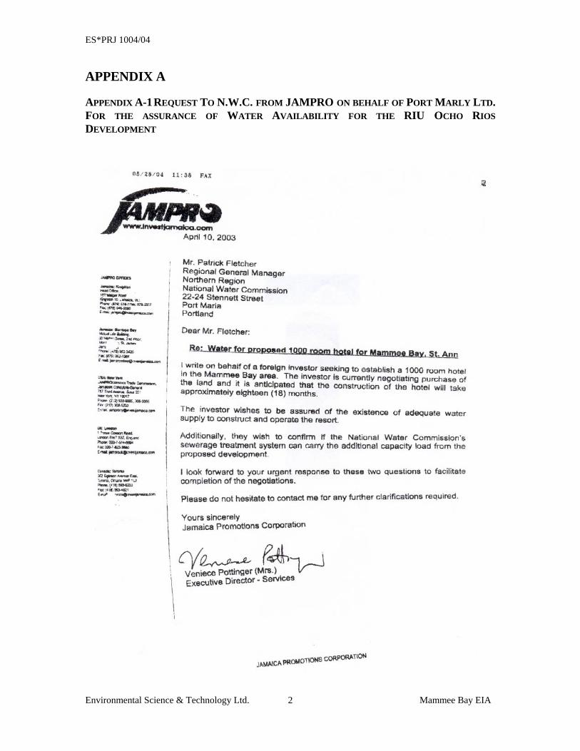
ES*PRJ 1004/04
Environmental Science & Technology Ltd. Mammee Bay EIA 2
APPENDIX A
APPENDIX A-1 REQUEST TO N.W.C. FROM JAMPRO ON BEHALF OF PORT MARLY LTD. FOR THE ASSURANCE OF WATER AVAILABILITY FOR THE RIU OCHO RIOS DEVELOPMENT
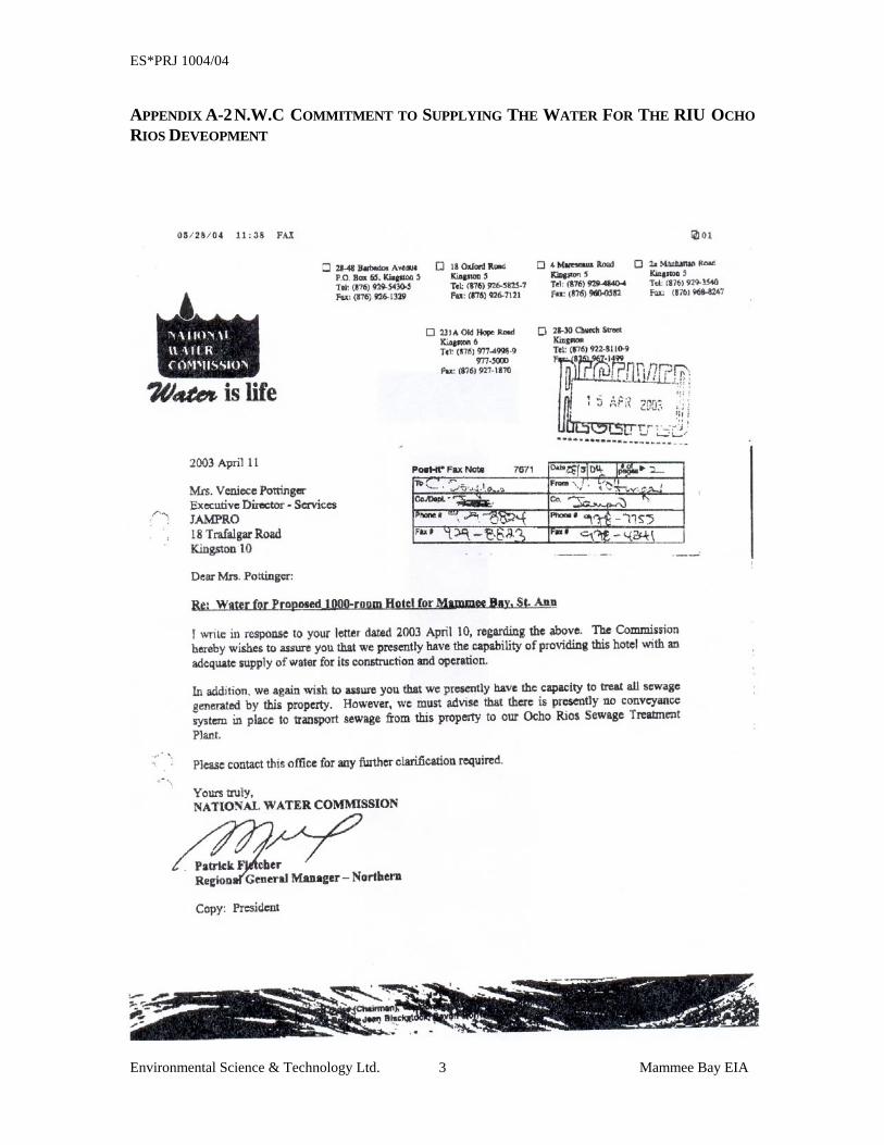
ES*PRJ 1004/04
Environmental Science & Technology Ltd. Mammee Bay EIA 3
APPENDIX A-2 N.W.C COMMITMENT TO SUPPLYING THE WATER FOR THE RIU OCHO RIOS DEVEOPMENT