
Requirements for the Submission of Resource...
45
Requirements for the Submission of Resource Information Reports and Data in Electronic Format JANUARY 2006
Transcript of Requirements for the Submission of Resource...

Requirements for the Submission of Resource Information Reports and Data in
Electronic Format
JANUARY 2006
Revision Status Rev No. Page No. Description Author Approved By Issue date
0 - Draft All Original issue Brad Fuller July 2002
V2 - Draft All Circulated to members of the Data Submission Working Group in October 2002.
Brad Fuller October 2002
V3 - Draft All Reviewed based on comments from Meeting 1 of the Data Submission Working Group on November 18th, 2002.
Brad Fuller December 2002
V3_1-Draft Reviewed based on feedback from WRC users of the documentation and templates.
Brad Fuller March 2003
V3_2-Draft Name change Brad Fuller June 2003
V3_3 First published version Brad Fuller August 2003
V3_3a Updated for change to DoE
Brad Fuller July 2004
V3_4 Updated instructions for templates.
Brad Fuller November 2004
V3_5 Updated for new organisation
Brad Fuller January 2006

Contents
Introduction ..............................................................................................................................................................................1 Contacts ................................................................................................................................................................................1 Delivery ................................................................................................................................................................................1
Media........................................................................................................................................................................................2 File naming conventions...........................................................................................................................................................3 Media labelling .........................................................................................................................................................................4 Glossary....................................................................................................................................................................................5 Types of data ............................................................................................................................................................................6
Tabular data ..........................................................................................................................................................................6 Geophysical log data.............................................................................................................................................................6 Maps .....................................................................................................................................................................................6 Reports..................................................................................................................................................................................7 Photographs ..........................................................................................................................................................................7 Scanned images ....................................................................................................................................................................7 Metadata ...............................................................................................................................................................................7
Templates ...............................................................................................................................................................................10 Site Details..........................................................................................................................................................................10 Logs – Lithology ................................................................................................................................................................12 Logs – Summary.................................................................................................................................................................12 Bore Construction (Construction Elements) .......................................................................................................................13 Pumping Tests and Development .......................................................................................................................................14 Parties .................................................................................................................................................................................14 Status ..................................................................................................................................................................................14 Purpose ...............................................................................................................................................................................15 Reference Points (Datum Planes) .......................................................................................................................................15 Coordinates.........................................................................................................................................................................15 Aquifers (Groundwater Source)..........................................................................................................................................16 Media References ...............................................................................................................................................................16 Field, Monitoring and Production Data (Samples and Readings).......................................................................................16 Chemical Analyses (Laboratory Samples)..........................................................................................................................18
Template fields .......................................................................................................................................................................19 Using the templates.............................................................................................................................................................35
Data conventions ....................................................................................................................................................................36 Measurements from a Reference Point (Datum Plane).......................................................................................................36 Measurements.....................................................................................................................................................................36 Coordinates – GDA94 ........................................................................................................................................................36 Australian Height Datum - AHD........................................................................................................................................36 Date and Time Formats ......................................................................................................................................................36 Names .................................................................................................................................................................................37
Codes ......................................................................................................................................................................................38 References ..............................................................................................................................................................................39

Appendix 1 - Electronic data templates ..................................................................................................................................40

Tables Table 1 - File naming conventions ...........................................................................................................................................3 Table 2 - Glossary....................................................................................................................................................................5 Table 3 - Types of Data ............................................................................................................................................................6 Table 4 - Metadata file header format.......................................................................................................................................8 Table 5 - Site Details worksheet .............................................................................................................................................19 Table 6 - Logs-Lithology worksheet .....................................................................................................................................22 Table 7 - Logs-Summary worksheet.......................................................................................................................................23 Table 8 - Bore Construction worksheet ..................................................................................................................................24 Table 9 - Pumping Tests and Development worksheet...........................................................................................................26 Table 10 - Parties worksheet...................................................................................................................................................28 Table 11 - Status worksheet....................................................................................................................................................29 Table 12 - Purpose worksheet.................................................................................................................................................29 Table 13 - Reference Points worksheet ..................................................................................................................................29 Table 14 - Coordinates worksheet ..........................................................................................................................................30 Table 15 - Aquifers worksheet................................................................................................................................................31 Table 16 - Media References worksheet.................................................................................................................................31 Table 17 - Samples - Field, Monitoring & Production worksheet ..........................................................................................32 Table 18 - Samples - Chemical Analyses worksheet ..............................................................................................................34

Requirements for the Submission of Resource Information Reports and Data in Electronic Format
Introduction Clause 38 for artesian wells of the RIWI Regulations 2000 and Section 26E for non-artesian wells of the RIWI Act requires that information on wells be provided to the Department of Water (the Department). Currently this data is either provided on the Particulars of Completed Borehole – Form L or in Hydrogeological Reports.
The Department will now accept data and reports in electronic format. This is in response to Department and industry requirements to make data and reports more readily available.
Note that whilst this document is primarily targeted at data required by the RIWI Regulations and Act it can be applied to any resource information data that is supplied to the Department, regardless of the purpose or project.
This document contains specifications of data requirements and formats required for submission of resource information in electronic format. A set of templates is available to be used for submission of data and data must be formatted according to the requirements to allow import to the Department’s Water Information Database.
Details to be supplied are based on requirements defined in the documents Minimum Construction Requirements for Water Bores in Australia (ARMCANZ), The Australian National Groundwater Data Transfer Standard (NLP) and ANZLIC Metadata Guidelines (ANZLIC) with modifications to ensure compatibility of data with the Department’s corporate databases.
Contacts Enquiries regarding the submission of electronic data should be directed to:
Brad Fuller – Phone 61 8 6364 7470
John Patten – Phone 61 8 6364 7455
Facsimile – 61 8 9426 4817
Email – [email protected]
Delivery Data may either be mailed if on suitable media (floppy disk, cd-ROM, DVD-R etc.) or emailed to the addresses detailed below:
Post Data Management Coordinator
Department of Water
Water Information Branch
PO Box K822
Perth WA 6842
Email Email - [email protected]
V3_5 – January 2006 1

Requirements for the Submission of Resource Information Reports and Data in Electronic Format
Media The following media are acceptable:
1.44MB 31/2” Floppy Disk
CD-ROM
DVD-R
Email – [email protected]
The media must be readable in a Windows (NT, 2000, XP) environment.
The supplier should keep a backup of the data for at least a year in case of corruption of data supplied to the Department.
V3_5 – January 2006 2

Requirements for the Submission of Resource Information Reports and Data in Electronic Format
File naming conventions
Report Files • Report Number eg. HR159
• Project – eg. Toolibin
• Year of Report – eg. 2000
• File extension – eg. .pdf
For example: HR159 Toolibin 2000.pdf
Tabular Data Excel Files
• Report Number – eg. HR159
• Project – eg. Toolibin
• Year of Report – eg. 2000
• Template Name – eg. WIN_Site_Details-V3_5.xlt
• File extension – eg. .xls
• One file with separate tabs for each Data Type (ie. Site Details, Bore Construction etc.)
For example: HR159 Toolibin 2000 WIN Site Details.xls
Table 1 - File naming conventions Description of File File or Report Name File name Comment
Reports
Esperance Water Supply Investigation 2002
HR159 Toolibin 2000.pdf
BORE COMPLETION REPORTS, CORAMUP-BANDY CREEK, ESPERANCE
HR159 HR159 Toolibin 2000.tif
Scanned Image of Hydrogeological Report
Data
Esperance Water Supply Investigation 2002 – Site Details
Excel files HR159 Toolibin 2000 WIN Site Details.xls
Monitoring data
Esperance Water Supply Investigation 2002 – Monitoring Data
Excel files Esperance Monitoring Data 2002.xls
Esperance Water Supply Investigation 2002 – Laboratory Water Quality Reports
Excel Files 02-09888.xls Generally forwarded as batches by laboratories
Forms
Licence number 1 - Particulars of Completed Borehole – Form L
Particulars of Completed Borehole – Form L
PCB Form L 1.tif Scanned Image of Particulars of Completed Borehole – Form L
V3_5 – January 2006 3

Requirements for the Submission of Resource Information Reports and Data in Electronic Format
Media labelling Disks, CD-ROMS and Emails submitted to the Department should be labelled or titled with:
• Company or organisation name
• Project or report name
• Year
V3_5 – January 2006 4

Requirements for the Submission of Resource Information Reports and Data in Electronic Format
Glossary Table 2 - Glossary Abbreviation Used for Description
ASCII American Standard Code for Information Interchange
International standard
DoW Department of Water Organisation
PDF Portable Data File File type – Raster format
RIWI Rights in Water and Irrigation Act State Legislation
SHP ArcInfo Shape Files File type
TIF, TIFF Tagged Image File File type – Raster format
TXT ASCII Text file File type
XLS Microsoft Excel Workbook File type
SRF Surfer files File type
DXF CAD files File type – Vector format
DGN Microstation files File type
JPG, JPEG Image files File type – Raster format
V3_5 – January 2006 5

Requirements for the Submission of Resource Information Reports and Data in Electronic Format
Types of data The Department will accept data in the formats detailed below:
Table 3 - Types of Data Type Format Parameter Suffix
Tabular data Excel files .xls
Geophysical Log Data
- Log Plots
- Raw Data
LAS
.las
Maps Surfer
AutoCAD Microstation ArcInfo ArcView
.dxf, .srf
.dxf
.dgn
.shp
Reports PDF
Word documents
.doc
Photographs PDF, TIFF, JPEG .pdf, tif, jpg
Scanned Images PDF, TIFF, JPEG .pdf, tif, jpg
Tabular data
Background Data is currently received by the Department in hardcopy form either in reports or on Particulars of Completed Borehole forms. Data in these formats does not lend itself to efficient storage or capture to the Department’s Water Information Database (WIN).
Purpose The purpose of providing standards for electronic data is to ensure that data is submitted in a format compatible with the Department’s corporate databases.
Format Data are to be supplied as Microsoft Excel Workbooks with an extension of .xls.
For Microsoft Excel Workbooks all data may be contained in the tabs as provided in the WIN_Site_Details-V3_5.xlt workbook.
Geophysical log data Plots can be supplied as PDF files. The raw data can be supplied in their native format, for example LAS files with an extension of .las.
Maps Maps can either be supplied as ArcInfo shape files, in PDF format or within the report PDF file.
Maps can be provided in either AGD84 (Australian Geodetic Datum 1984 /AMG) or GDA94 (Geodetic Datum of Australia 1994/MGA) and in either Projection (AMG/MGA) or Geographic (Latitude and Longitude) coordinates. The preferred datum is GDA94. Maps in local grids are not acceptable
V3_5 – January 2006 6

Requirements for the Submission of Resource Information Reports and Data in Electronic Format
Reports Reports previously supplied in hardcopy format should preferably be supplied in PDF format. If reports are not supplied in PDF format then they should be supplied in their original electronic format (for example Word). These will be converted to PDF for storage on the Department’s record management database (TRIM).
Photographs Photographs not contained in the report PDF file can be supplied as PDF, TIFF or JPEG files.
Scanned images Scanned images or hardcopy reports can be supplied as PDF, TIFF or JPEG files.
Metadata The ANZLIC metadata guidelines are used to describe the electronic data.
Metadata is data about data, as structured summary of information that describes the data. Metadata includes, but is not restricted to, characteristics such as the content, quality, currency, access and availability of the data. For spatial information or information with a geographic component, metadata deals with the ‘what, when, who, where and how’ of the data. (ANZLIC Metadata Guidelines)
Metadata provides a description of a dataset, is a key element of appropriate data management by the custodian, and also allows potential data users to assess the suitability of the dataset to their needs. The ANZLIC metadata guidelines (ANZLIC, 1996) are to be used to describe features of the groundwater data transaction such as the data custodian, how often the data is updated, its currency, available digital formats, conditions of use and contact details. (The Australian National Groundwater Data Transfer Standard)
The worksheet is constructed according to the layout defined in the Metadata file header format table. The metadata specifications have been slightly modified from the ANZLIC Metadata Guidelines as some data requires additional metadata to provide sufficient and meaningful information for interpretation (the additional metadata is highlighted).
When to use Metadata should always be entered for the dataset(s) provided.
How to use Metadata should be entered in the Metadata worksheet of the WIN_Site_Details-V3_5 template. If all data is in one file then only one row of detail is required, however if the data is provided in more than one file then a row of detail is required for each file. There is no need to repeat details for each file if they are the same as in the first row of metadata.
Note: Organisation and contact details in the Metadata sheet need not be repeated in the Parties sheet.
V3_5 – January 2006 7

Requirements for the Submission of Resource Information Reports and Data in Electronic Format
Table 4 - Metadata file header format Category Element Definition of Element Manda
tory Max Occ
Field Example
Data File Details Data File Name of the data file in which the data has been provided
Y 1 Text(256) hyd minesite 2003.xls
Number of sites Number of sites in the file Y 1 Number(3) 5
Template Name of the template used to produce the data file
Y 1 Text(256) WIN_Site_Details-V3_5.xlt
Dataset Identifier The unique identifier given to the dataset
Y 1 Text(15) gw pave minesite 2003
Title The ordinary name of the dataset.
Y 1 Text(160) GROUNDWATER EXPLORATION – PAVE MINESITE – 2003
Custodian The individual or organisation responsible for the dataset.
Y 1 Text(120) Pave Mining
Description Search word(s) Words likely to be used by a non-expert to find the dataset.
Y N Text(60) Groundwater, Hydrogeology, Bore Completion Report
Geographic Extent Name The ordinary name of one or more predefined, known geographic objects that reasonably show the extent of geographic coverage of the dataset.
For example the 1:250 000 map sheet Name and Number
O N Text(190) SH50-5 DONGARA
Geographic Bounding Box
A rectangle defining the minimum and maximum coordinates of the entire data.
- MGA Zone (if Easting/Northing)
- North Bounding Latitude/Northing
- South Bounding Latitude/Northing
- East Bounding Longitude/Easting
- West Bounding Longitude/Easting
Y 1 Number -32.00, -33.00, 118.50,117.00 (Latitude/Longitude)
or
50, 6459000, 6458000,642000,641000 (Easting/Northing)
Data Currency Report date Date of the Report in which the data is included.
Y 1 Date (yyyy-mm-dd)
01/02/2003
Contact Information
Contact Organisation Name of the organisation from which the dataset may be obtained.
Y 12 Text(120) Pave Mining Pty Ltd
Contact Position The position in the Contact Organisation that will answer questions about the dataset.
Y 12 Text(40) Hydrogeologist
Mail Address Postal address or delivery point of the Contact Position.
Y 22 Text(40) PO Box 135
Locality Locality associated with the Mail Address
Y 12 Text(60) PERTH
State Aust: State associated with the Mail Address.
NZ: Optional extension for Locality.
Y 12 Text(40) WA
Country Country associated with the Mail Address.
Y 12 Text(40) AUSTRALIA
Postcode Aust:Postcode associated with the Mail Address.
NZ: Optional postcode for mail
Y 12 Text(10) 6000
V3_5 – January 2006 8

Requirements for the Submission of Resource Information Reports and Data in Electronic Format
Category Element Definition of Element Mandatory
Max Occ
Field Example
sorting.
Telephone Telephone number of the Contact Position.
O 12 Text(25) (01) 9753 2468
Facsimile Facsimile number of the Contact Position.
O 12 Text(25) (01) 9753 2467
Electronic Mail Address Electronic Mail Address of the Contact Position
O 12 Text(80) [email protected]
Additional Metadata
Additional Metadata Any additional metadata that supports documentation of the dataset including a reference to another directory or report.
O 12 Tex(256) Pave Minesite 2003 Production and Monitoring Summary
Licence Number The Licence Number that applies to sites in the report.
R Text(256) 999333
1 Dependent upon the repeatability of the parent element.
2 Number of occurrences associated with each contact – a dataset may have many contacts
Refer to ANZLIC Metadata Guidelines for descriptions of the ANZLIC Core Metadata Elements.
Mandatory
An element may be Mandatory (Y), Optional (O), Recommended (R) or Conditional (C). Mandatory requires an element to be completed whilst optional means the element may be left blank. Conditional means completion of the element may become mandatory if another element is completed. For instance, GEN Category must be completed if either GEN Custodial Jurisdiction or the GEN name is completed. In other instances it may be left blank.
Maximum occurrence (Max Occ)
The number of times that an element may be repeated. The repeatability of an element is defined in relationship to its parent. For instance, a metadata record may have many Contact Organisations associated with it even though each Contact metadata record may have only one Contact Organisation.
V3_5 – January 2006 9

Requirements for the Submission of Resource Information Reports and Data in Electronic Format
Templates See Template Fields for details of fields in each template.
Templates are in the attached WIN_Site_Details-V3_5.zip file.
To ensure standardisation of data, codes are used in many fields. The codes are detailed in the Codes worksheet of the Excel template.
An example of completed data based on the templates is in the WIN_Site_Details-V3_5.zip file.
Site Details
When to use Use this worksheet for adding details for new sites.
How to use The mandatory details on the worksheet are the minimum details required to register a site.
If all available detail for a site can be entered in this sheet then there is no need to repeat the same detail on any of the other sheets. For example the Coordinates, Site Status, Site Purpose, Reference Points, Main Aquifer, Field Samples and Readings and Media References do not need to be repeated on the corresponding sheets if the details are entered in the Site Details sheet.
Where there are multiple (more than one Reference Point) or historical (details such as Purpose may change over time) details then use the appropriate alternative worksheet (eg. Reference Points or Purpose).
Where additional details are being provided for a previously registered site use there is no need to add details to the Site Details worksheet, just use the appropriate alternative worksheet. For example if Bore Construction was not provided originally it can be provided on the Bore Construction worksheet.
Where bore construction or log details are available these details should be provided using the Lithology and Bore Construction templates.
One line of details is required for each site.
Templates:
- Site Details
The Site Details are categorised into these entities that correspond to additional worksheets for adding additional or historical data for a site:
References Identifies the Type and Feature for the site, the Project or Borefield and Site Name or Number for the site.
Where a site is referred to by multiple names then the additional name(s) can be added to the Other Name field.
Coordinates Identifies the location of a site. The location can be provided in either AGD84 (Australian Geodetic Datum 1984 /AMG) or GDA94 (Geodetic Datum of Australia 1994/MGA) and in either Projection (AMG/MGA) or Geographic (Latitude and Longitude) coordinates. The preferred datum is GDA94. Maps in local grids are not acceptable
The location for bores refers to the bore top of casing. For drains or trenches the location is the discharge point. For areas or polygonal features such as contamination areas the location is the centroid of the polygon.
V3_5 – January 2006 10

Requirements for the Submission of Resource Information Reports and Data in Electronic Format
Where updated or more accurate coordinates are available for an existing site these can be provided on the Coordinates worksheet.
Site Status The Status of the site on completion.
When the Status of the site changes over time use the Status worksheet.
Site Purpose The Purpose of the site on completion.
When the Purpose of the site changes over time use the Purpose worksheet.
Reference Points (or Datum Plane) A horizontal plane used as a reference to determine the position and elevation of components of Construction, Logs and Aquifers and as a reference point for depth to water and depth to samples. For example by knowing the elevation of the top of casing in AHD and the depth to water, the elevation of the water level in AHD can be determined.
If the site has only one reference point then add the detail to the Site Details worksheet. Otherwise add all reference point details to the Reference Points worksheet.
When the Reference Point changes over time or there are multiple reference points for a site (for example water levels are taken from top of casing but the drilled depth is from ground level or the top of casing level changes because the casing is lowered) then these details should be included in the Reference Points worksheet.
Main Aquifer (Groundwater Source) The range of the main aquifer intersected by the bore.
Where multiple aquifers are intersected these can be provided in the Aquifers worksheet.
Field Samples Readings that were taken in-situ during drilling or on completion of the bore.
When more than one sample is taken at a site during drilling, at different depths during drilling or on completion of the bore use the Field, Monitoring and Production Data worksheet.
For samples sent to laboratories for analysis the data should be provided in the spreadsheet format supplied by the laboratory. Details for the sample such as time and date collected, collection method etc. should be provided.
Header
Header information required for samples.
Readings
Includes variables generally measured during drilling or on completion of the bore.
Media References References to media containing information about the site.
Where there are multiple media references for a site these should be entered in the Media References worksheet.
V3_5 – January 2006 11

Requirements for the Submission of Resource Information Reports and Data in Electronic Format
Logs – Lithology
When to use Use this worksheet for providing lithology log details - (lithological descriptions):
- A Lithology Log is a record of the rocks/sediments and their characteristics passed through by a borehole or well.
How to use Enter one row of header detail (Lithology – Header) for each log.
Enter one row of detail (Lithology – Details) for each depth range.
Multiple logs can be included on a single worksheet with a header detail (Lithology – Header) to identify each log.
No blank rows between logs.
NOTE: Logs should not include water sample details or drilling information in the Lithology Description. Water samples should be included in Field Samples or Field, Monitoring & Production and drilling information in Bore Construction.
Templates:
- Logs - Lithology
Logs – Summary
When to use Use this worksheet for providing summary log details (stratigraphic interpretation):
- A Summary Log is summary of the lithological log according to the geological time, original succession and age relations of rock strata and their form, distribution and deposition. Summary includes: age/formation name and 3 major rock names.
How to use Descriptions associated with Codes are use to describe the Stratigraphy and Lithology. If a formation is not included in the Stratigraphy list then add the detail to the Comment field.
Enter one row of header detail (Lithology – Header) for each log.
Enter one row of detail (Lithology – Details) for each depth range.
Multiple logs can be included on a single worksheet with a header detail (Lithology – Header) to identify each log.
No blank rows between logs.
Templates:
- Logs - Summary
V3_5 – January 2006 12

Requirements for the Submission of Resource Information Reports and Data in Electronic Format
Bore Construction (Construction Elements)
When to use Use this worksheet for providing bore construction (construction elements) information.
- Bore Construction / Construction Elements are the combination of construction elements makes up what has been built at a site.
How to use One row of detail is used for each depth range. Each row represents a Construction Element – A standard set of Construction Elements is available in the list box for the Category and Element field. Construction Elements are placed in these categories, with specific elements associated with each category:
Void hole excavated to intercept groundwater.
Lining material inserted to line inside of the void.
Inlet part of the construction that allows intake of groundwater. eg. Screen, Slotted, Open Hole.
Annula Fill fill within the annulus between linings or between the lining and the surrounding geological material.
Void Fill material reinserted inside the void (or lining if existing).
Fixture fitting associated with construction eg. Standpipe.
If a Category or Element needs to be used that is not in the Category and Element list then add the detail to the Bore Construction Comment field.
Enter one row of header detail (Bore – Construction Header) for each site.
Enter one row of detail (Bore Completion – Details) for each depth range.
Construction for more than one site can be included on a single worksheet with a header detail to identify each site.
No blank rows between sites.
Templates:
- Bore Construction
V3_5 – January 2006 13

Requirements for the Submission of Resource Information Reports and Data in Electronic Format
Pumping Tests and Development
When to use Use this worksheet for providing details of Pumping Tests and Development.
How to use Enter one row of detail for each stage of the pumping test or development.
Templates:
- Pumping Tests and Development
Parties
When to use Use this worksheet for providing details of individuals or organisations associated with a project or site. For example the bore owner, licensee and drilling company.
Any organisations or persons that are included in data for the site should be detailed here.
How to use Enter one row of detail for each person or organisation.
Organisation and contact details in the Metadata sheet need not be repeated in the Parties sheet.
Templates:
– Parties
Status
When to use Use this worksheet for providing site status information for a sites where the site status changes over time.
For example a site may have been Operating for a period then Abandoned. A standard set of Status details are available in the list box for the Status field.
How to use Enter one row of detail for each change of Status for a site.
Do not repeat Site Status details from the Site Details sheet - Only enter details if they are additional to those provided on the Site Details sheet.
Templates:
– Status
V3_5 – January 2006 14

Requirements for the Submission of Resource Information Reports and Data in Electronic Format
Purpose
When to use Use this worksheet for providing purpose information for a sites where the site purpose changes over time.
For example a site may have been an Investigation bore for a period then become a Monitoring bore. A standard set of Purpose details are available in the list box for the Purpose field.
How to use Enter one row of detail for each change of Purpose for a site.
Do not repeat Site Purpose details from the Site Details sheet - Only enter details if they are additional to those provided on the Site Details sheet.
Templates:
– Purpose
Reference Points (Datum Planes)
When to use Use this worksheet for providing reference points (datum planes) where water levels are measured from more than one reference point or the level of the reference point changes over time.
For example if water levels are taken from top of casing but the drilled depth is from ground level then multiple reference points are required.
How to use Enter one row of detail for each Reference Point for a site.
Do not repeat Reference Point details from the Site Details sheet - Only enter details if they are additional to those provided on the Site Details sheet.
Templates:
– Reference Points
Coordinates
When to use Use this worksheet for providing updated coordinates where more accurate or corrected coordinates are available for a site.
For example the original coordinates for a site may have been obtained from a map and updated later with measurements using a GPS.
How to use Enter one row of detail for each change in Coordinates for a site.
Do not repeat Coordinate details from the Site Details sheet - Only enter details if they are additional to those provided on the Site Details sheet.
Templates:
– Coordinates
V3_5 – January 2006 15

Requirements for the Submission of Resource Information Reports and Data in Electronic Format
Aquifers (Groundwater Source)
When to use Use this worksheet for providing aquifer details where a bore intersects multiple aquifers.
For example in a fractured rock aquifer there may be many individual water cuts during drilling.
How to use Enter one row of detail for each aquifer intersected by the bore.
Do not repeat Aquifer details from the Site Details sheet - Only enter details if they are additional to those provided on the Site Details sheet.
Templates:
– Aquifers
Media References
When to use Use this worksheet for providing media references where there are multiple media references for a site.
For example data for a site may come from a hardcopy (or PDF) report and the site may also have data in a geophysical log (as a .las file).
How to use Enter one row of detail for each Media Reference for a site.
Do not repeat Media Reference details from the Site Details sheet - Only enter details if they are additional to those provided on the Site Details sheet.
Templates:
- Media References
Field, Monitoring and Production Data (Samples and Readings)
When to use Use this worksheet for providing monitoring data collected in the field. This may include samples taken at a site during drilling, at different depths during drilling, on completion of the bore or regular and irregular samples taken for ongoing monitoring.
How to use For field monitoring data details of the variables including description, units, limits of reporting (LOR), analysis method and analysis date should be provided.
Where Units or Limit of Reporting are different to those in the header they should be changed in the header. Alternatively if units vary for each reading then the Unit can be included as part of the value – eg. 101 mS/m
For samples sent to laboratories for analysis the data should be provided in the spreadsheet format supplied by the laboratory. Details for the sample such as time and date collected, collection method etc. should be provided along with the name of the file provided by the lab (in the Lab File field) or the hard copy report.
Header
Header information required for samples. V3_5 – January 2006 16

Requirements for the Submission of Resource Information Reports and Data in Electronic Format
Monitoring
Includes variables generally measured as a part of ongoing monitoring.
Field Samples
Includes variables generally measured in the field as a part of ongoing monitoring.
Additional Variables
Used to add variables not included on the standard template. Note that the Variable, Method, Units and Limit of Reporting must be included for each additional variable.
Enter one row of detail for each Sample.
Do not repeat Field Sample details from the Site Details sheet - Only enter details if they are additional to those provided on the Site Details sheet.
Templates:
- Field, Monitoring & Production
V3_5 – January 2006 17

Requirements for the Submission of Resource Information Reports and Data in Electronic Format
Chemical Analyses (Laboratory Samples)
When to use Use this worksheet for providing chemical analyses results from samples analysed by laboratories. The preferred option is to provide spreadsheets as supplied by laboratories but in the absence of these data can be entered onto this worksheet.
How to use It is important that these details are provided from the laboratory report:
Variable – the standard short name (in the header) and description of the variable
Method – the analysis method (in the header) code and description
Units – the units in which the result is recorded (in the header)
Limit of Reporting – the limit of reporting for the variable and method
Header
Header information required for samples.
Analysis Details
Used to add variables to the standard template. Note that the Variable, Method, Units and Limit of Reporting must be included for each variable.
Enter one row of detail for each Sample.
Templates:
- Chemical Analyses
V3_5 – January 2006 18

Requirements for the Submission of Resource Information Reports and Data in Electronic Format
Template fields Table 5 - Site Details worksheet Field Description Code Mandatory Format Examples
Site Details General Site Details.
- One row per site only.
Use other worksheets for additional details if required.
Site Type
Site Type and Feature The type and feature for the site. Y Y Type – Text(12) Feature – Text(256)
Ground – Borehole or Well
References
Project The project or borefield that the site is associated with.
Y Text(50) PAVE MINESITE
Site Name or Number The name or number of the site Y Text(150) OBS 01/03
Other Name Any other name used to identify a site (eg the Colloquial Name for the site).
Text(150)
Licence Number The Licence Number that applies to the site.
R Text(256) 999333
Coordinates Location details for the site.
For updated or corrected site location details use the Coordinates-Updates worksheet.
Zone (null if Lat/Long) Zone (null if Lat/Long) NOTE – Only Easting/Northing OR Longitude/Latitude are required, not both.
Y Number(2) 50
Easting Easting Y Number(8,2) 353245
Northing Northing Y Number(9,2)
6234564
Latitude Latitude Y Decimal degrees – Number(11,9)
Longitude Longitude Y Decimal degrees – Number(12,9)
Location Datum Location Datum Y Y Text(256) Australian Geodetic Datum 1984
Location Method
What method was used to determine the coordinates ?
Y Y Text(256) GPS – Single
Location Precision (m) How accurate are the coordinates ? +/- x metres
Y Y Text(256) 10
Site Address Description information about the address of a location.
Lot or Location number.
Text(256) 300m north-east of Pave Road;
Lot 55 East Pave Road
Parties Owner of the Site
Site Owner The name of the owner of the site.Additional detail (address etc.) for the party can be includes on the Parties worksheet.
Y Text(250) Pave Mining
Site Status Status of the site.
For sites where the status has changed over time use the Status worksheet.
V3_5 – January 2006 19

Requirements for the Submission of Resource Information Reports and Data in Electronic Format
Field Description Code Mandatory Format Examples
Status Status of the site Y Y Text(256) Operating
Site Purpose Purpose of the site.
For sites where the purpose has changed over time use the Purpose worksheet.
Purpose Purpose of the site Y Text(256) Monitoring
Reference Points (Datum Plane)
Reference points from which depth or distance to water level or samples are taken. Also point from which measurements for Construction or Logs are taken.
For sites that have multiple reference points use the Reference Points – Multi or Hist worksheet.
Reference Point Reference point from which measurements are taken.
Y Text(256) Ground level
Date Established The date on which the site was established.
Y dd/mm/yyyy 29/01/2003
Elevation Datum Datum to which the Reference Point and Elevation refer.
Y Text(256) Australian Height Datum
Elevation (m) Elevation of the Reference Point, in relation to the Elevation Datum.
Number(8,3) 12.012
Measurement Method Method used to measure the Elevation.
Y Text(256) Surveyed
Reference Point Comment Reference Point comment. Text(256)
Main Aquifer The main aquifer for the site.
For multiple aquifers use the Aquifers worksheet.
Aquifer Type The Aquifer Type
If Unknown enter details in the Aquifer Description field.
Y Text(10) Unknown
Aquifer Name The Aquifer Name
If Unknown enter details in the Aquifer Description field.
Y Text(50) Unknown
Aquifer Description Textual descriptions of the water bearing bed, water bearing formation or group of the formation.
If the Aquifer Type or Aquifer Name is Unknown then details must be entered in the Aquifer Description field.
Text(100) Fractures
Aquifer Reference Point Reference point from which measurements are taken.
Y Text(256) Ground level
Depth From (m) Depth from which the aquifer starts.
Number(8,3) 10.000
Depth To (m) Depth at which the aquifer ends. Y Number(8,3) 12.000
Measurement Method Method used to measure the Depth From and Depth To.
Y Text(256) Bore construction
Aquifer Comment Any additional comments regarding the Aquifer.
Text(256) Main aquifer
Field Samples Details of water level and water quality (field or in-situ readings).
For additional samples for a site use the Field, Monitoring & Production or Chemical Analyses worksheets.
Sample Number Number on the sample bottle for identification.
Text(50) 2003_001
V3_5 – January 2006 20

Requirements for the Submission of Resource Information Reports and Data in Electronic Format
Field Description Code Mandatory Format Examples
V3_5 – January 2006 21
Sample Time and Date Time and date of the sample. hh:mm dd/mm/yyyy 12:15 02/02/2003
Sample type (matrix) Defines the medium within which the analyte of interest is found.
Y Text(256) Water sample
Collection method Defines the method used to collect the sample.
Y Text(256) Insitu reading or observation
Water Level/Sample Reference Point
The point from which the water level / sample depth was measured.
Y Text(256) Ground level
Sampler Who collected the sample ? Text(256)
Instrument Used The instrument used to take measurements.
Text(256) WTW
Sample Comment General comment about the sample.
Text(256)
Lab File Name of file containing analysis results supplied by the laboratory or a reference to the hard copy report.
Text(256)
Depth to sample
(m)
Depth or depth range the sample was taken from. Eg ‘0.5m’ or ’10.2 – 12.6m’ (as a positive number).
Number(5,3)
Readings Readings associated with field samples
Water Level (Static Water Level) (m)
Depth or distance to water.
- from the Water Level Reference Point.
(- for water levels above the Water Level Reference Point)
Number(8,3) 11.000;
-1.000
Water Cut (m) Depth at which water is cut during drilling.
- from the Water Level Reference Point.
Number(8,3) 12.453
TDS (mg/L) The Total Dissolved Solids (TDS) / Salinity of the water in mg/L.
Generally this is calculated from the Conductivity using a factor.
Units can also be:
parts per thousand (ppt).
Number(8,3) 1000
Water Temperature (in situ) (deg C)
Temperature of the water. Number(8,3) 32
Conductivity uncompensated (in situ) (uS/cm)
Uncompensated Conductivity of the water in microsiemens per centimetre (uS/cm).
Use this if the instrument being used does not compensate the conductivity reading.
Note: Water Temperature (in situ) must be provided if Conductivity uncompensated is provided.
Units can also be:
millisiemens per metre (mS/m)
Number(8,3) 200.5
Conductivity compensated to 25 deg C (in situ) (uS/cm)
Compensated Conductivity of the water in microsiemens per centimetre (uS/cm).
Use this if the instrument being used compensates the conductivity reading.
Units can also be:
millisiemens per metre (mS/m)
Number(8,3) 200.6
pH (in situ) pH of the water. Number(8,3) 6.4

Requirements for the Submission of Resource Information Reports and Data in Electronic Format
Field Description Code Mandatory Format Examples
Geophysical Log
Geophysical Log ? Does a Geophysical Log exist ? If a geophysical log is provided then it should be indicated here and entered as a Media Reference.
Y Y Yes/No Yes
Media References References to media containing information about the site.
Media Type The type of media. Y Text(256) Hard copy report
Report or File Name The report name or file name. Text(256) Pave Minesite 2003 Production and Monitoring Summary
File Extension The file extension. Text(64) pdf
Media Comment Any additional comments regarding the media reference.
Text(1000) Report contains monitoring data associated with the borefield.
Table 6 - Logs-Lithology worksheet Field Description Code Mandatory Format Examples
Logs - Lithology A record of the rocks/sediments and their characteristics passed through by a borehole or well.
Lithology - Header General information about the lithology log.
One row for each log.
Site Name or Number The name or number of the site Y Text(150) OBS 01/03
Log Date Date on which the log was recorded
Y dd/mm/yyyy 02/05/2002
Logged By (Name) Who did the log.
Additional detail (address etc.) for the party can be included on the Parties worksheet.
Y Text(250)
Last Name , First Name
Geologist, Pave
Log Reliability Qualification of person that interpreted the log
Y Y Text(256) Driller – Geologist log
Reference Point Reference Point from which depth of logs (From and To) are measured.
Y Y Text(256) Ground level
Comment Lithology Log comment Text(256) Cuttings logged at 1m intervals.
Lithology - Details Details of the lithology.
One row for each depth range.
From (m) The depth in metres at the start of the interval.
Y Number(8,3) 0
To (m) The depth in metres at the end of the interval.
Y Number(8,3) 3
Lithology Description Description of the main lithology features.
Y Text(250) SANDY CLAY. Brown, fine to medium sub-angular sand, poorly sorted
V3_5 – January 2006 22

Requirements for the Submission of Resource Information Reports and Data in Electronic Format
Table 7 - Logs-Summary worksheet Field Description Code Mandatory Format Examples
Logs - Summary A summary of the lithological log according to the geological time, original succession and age relations of rock strata and their form, distribution and deposition. Summary includes: age/formation name and 3 major rock names.
Summary- Header General information about the summary log.
One row for each log.
Site Name or Number The name or number of the site Y Text(150) OBS 01/03
Log Date Date on which the log was recorded
Y dd/mm/yyyy 02/05/2002
Interpreted Date Date on which the log was interpreted
dd/mm/yyyy 04/05/2002
Logged By (Name) Who did the log.
Additional detail (address etc.) for the party can be includes on the Parties worksheet.
Y Text(250)
Last Name , First Name
Geologist, Pave
Interpreted By (Name) Who interpreted the log.
Additional detail (address etc.) for the party can be includes on the Parties worksheet.
Text(250)
Last Name , First Name
Geologist, Pave
Log Reliability Qualification of person that interpreted the log
Y Text(256) Driller – Geologist log
Reference Point Reference Point from which depth of logs (From and To) are measured.
Y Y Text(256) Ground level
Comment Summary Log comment Text(256)
Summary - Details Details of the lithology.
One row for each depth range.
From (m) The depth in metres at the start of the interval.
Y Number(8,3) 0
To (m) The depth in metres at the end of the interval.
Y Number(8,3) 3
Stratigraphy Description representing the age and formation of the strata type.
Y Y Text(50) Q – Quaternary
Lithology 1 Type of lithology. Y Text(256) sdy – sandy
Lithology 2 Type of lithology. Y Text(256) cl – clay
Lithology 3 Type of lithology. Y Text(256)
V3_5 – January 2006 23

Requirements for the Submission of Resource Information Reports and Data in Electronic Format
Table 8 - Bore Construction worksheet Field Description Code Mandatory Format Examples
Bore Construction For providing bore construction (construction elements) information.
The combination of construction elements makes up what has been built at a site.
Bore Construction – Header One row of header details required for each set of Bore Construction – Details (Construction Elements)
Site Name or Number The name or number of the site Y Text(150) OBS 01/03
Date Drilled Date that drilling started dd/mm/yyyy 02/05/2003
Date Completed Date that construction was completed
Y dd/mm/yyyy 14/05/2003
Drilling Contractor Name of the drilling contractor (company).
Additional detail (address etc.) for the party can be includes on the Parties worksheet.
Y Text(250)
Organisation - Full Name, Abbreviation
Person - Last Name, First Name
Pave Mining
Development Method How the bore was developed. Text(256) Airlifting
Construction Reference Point Reference Point from which measurements for bore construction and completion are taken.
Must be from Depth Reference Points entered for the site (on Site Details or Reference Points worksheets).
Y Y Ground level
Total Drilled Depth (m) Total drilled depth of the bore Y Number(8,3) 23.000
Depth Measurement Method How was the Total Drilled Depth measured ?
Y Y Text(256) Bore construction
Drilling Method How the hole was drilled. Y Y Text(256) Rotary mud drill
Drilling Method Comment Additional detail about how the bore was drilled.
Text(256) AIR AND MUD ROTARY
Pumping Test ? Was the bore/aquifer tested ? Y Yes / No Yes
Pumping Test Method How was the bore/aquifer tested ? Text(256) Constant flow rate - 24 hrs.
Construction Comment Comment about the drilling or construction.
Text(256) Difficult to drill; Security pipe set 0.5 m below ground level
Bore Construction - Details Details of the bore construction. One row per depth interval where the Category and Element change.
Distance to Top (m) Distance to Top (m) of Element
- for values above the Construction Reference Point
Number(8,3) -0.500
Distance to Bottom (m) Distance to Bottom (m) of Element
- for values above the Construction Reference Point
Number(8,3) 20.000
Category and Element Construction Category and Element.
Y Y Text(256) Lining – Casing
Material Material from which construction elements are made (eg Steel, PVC).
Y Y Text(256) PVC Class 9
Internal Dimensions (mm) The minimum dimension of the construction element in millimetres.
If the casing size is recorded as nominal size then add it as the
Number(8,3) 52.6
V3_5 – January 2006 24

Requirements for the Submission of Resource Information Reports and Data in Electronic Format
Field Description Code Mandatory Format Examples
Internal Dimension.
Maximum Dimensions (mm) The maximum dimension of the construction element in millimetres.
Number(8,3) 55.2
Thickness (mm) The thickness of the construction element in millimetres.
Number(8,3) 2.6
Packer Pressure (kilopascals) The desired pressure for the packer in kilopascals.
Number(8,3) 300
Screen Aperture (mm) Width of the screen openings. Number(8,3) 0.5
Fill Volume (m3) The volume (in cubic metres) of the fill at the base of a bore.
Number(8,3) 14.5
Grain Size A description of the size of the material used as an annulus fill (mainly around the screen) or void fill in the bore.
Text(20) 8/16 grade;
3-2 – 6.4 mm
Construction Detail Comment Any additional comments regarding the construction element.
Text(256) 50 mm PVC protective cap.
V3_5 – January 2006 25

Requirements for the Submission of Resource Information Reports and Data in Electronic Format
Table 9 - Pumping Tests and Development worksheet Field Description Code Mandatory Format Examples
Pumping Tests and Development
Sample Header
Site Name or Number The name or number of the site. Y Text(150) OBS 01/03
Sample Time and Date Time and date of the sample.
For Pumping Tests and Development this is the Time and date on which the Test or development was completed.
Y hh:mm dd/mm/yyyy 12:00 01/02/2003
Sample type (matrix) Defines the medium within which the analyte of interest is found.
Y Y Text(256) Water sample
Pumping Test or Development Method
Defines the method used for the Pumping Test or Development.
Y Y Text(256) Pump Test - Airlift Pump
Water Level/Sample Reference Point
The point from which the water level / sample depth was measured.
Y Text(256) Top of casing
Sampler Who collected the sample ? Text(256)
Comment General comment about the sample.
Text(256) Sample collected after development
Pump Intake Depth (m) Depth to the pump intake. Number(5,3) 20.000
Pumping Test
Start Time and Date Start time and date of the pumping test
hh:mm dd/mm/yyyy 11:00 31/01/2003
Water Level (Static Water Level) (m)
Distance to the water surface level.
-ve if above the reference point.
Number(5,3) 11.000;
-1.000
Pumping rate (L/s) Pumping rate for the pumping test
- Indicate units if not L/s, for example m3/day.
Number(8,3) 13
Flow rate (Artesian) (L/s) Flow rate from an overflowing artesian well.
- Indicate units if not L/s, for example m3/day.
Number(8,3) 12
Time pumped (h) Time pumped (Elapsed Time) at the current Pumping rate or Time used to measure Flow rate (Artesian)
h 12
Drawdown level (pumping test) (m)
Difference between the water level measured before pumping and the observed water level during pumping.
Number(5,3) 11.5
Drawdown - Residual (m) Difference between the water level measured during the recovery test and the water level measured before pumping.
Number(5,3) 2
Recovery Time (h) Time measured during the recovery period, since pumping stopped and until recovery level is reached (water level is stable or water level has reached the approximate level before pumping started).
h 18
Yield (m3/day) Measured yield during pumping test.
If Yield is obtained using a method other than a pump test add details of the method in the Comment field.
Number(5,3) 8
Yield - Recommended (m3/d) Recommended yield Number(5,3) 5
V3_5 – January 2006 26

Requirements for the Submission of Resource Information Reports and Data in Electronic Format
Field Description Code Mandatory Format Examples
Yield - Estimated (m3/d) Estimated yield or Estimated yield during the pumping test.
If Estimated Yield is obtained using a method other than a pump test add details of the method in the Comment field.
Number(5,3) 7
Airlift rate - Pumping Test (L/s) Airlift rate used during the pumping test.
- Indicate units if not L/s, for example m3/day.
Number(5,3) 80
Development
Airlift rate - Development (L/s) Airlift rate used during development
- Indicate units if not L/s, for example m3/day.
Number(8,3) 80
Yield (m3/day) Yield measured during development.
If Yield is obtained using a method other than a pump test add details of the method in the Comment field.
Number(5,3) 8
Yield - Estimated (m3/d) Estimated yield during development.
If Estimated Yield is obtained using a method other than a pump test add details of the method in the Comment field.
Number(5,3) 7
Time pumped (h) Time pumped for development h 18
V3_5 – January 2006 27
Requirements for the Submission of Resource Information Reports and Data in Electronic Format
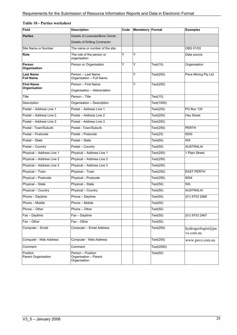
Table 10 - Parties worksheet Field Description Code Mandatory Format Examples
Parties Details of Licensee/Bore Owner
Details of Drilling Contractor
Site Name or Number The name or number of the site. OBS 01/03
Role The role of the person or organisation
Y Y Data source
Person Organisation
Person or Organisation Y Y Text(10) Organisation
Last Name Full Name
Person – Last Name Organisation – Full Name
Y Text(250) Pave Mining Pty Ltd
First Name Organisation
Person – First Name
Organisation – Abbreviation
Y Text(250)
Title Person – Title Text(10)
Description Organisation – Description Text(1000)
Postal – Address Line 1 Postal – Address Line 1 Text(250) PO Box 135
Postal – Address Line 2 Postal – Address Line 2 Text(250) Hay Street
Postal – Address Line 3 Postal – Address Line 3 Text(250)
Postal - Town/Suburb Postal - Town/Suburb Text(250) PERTH
Postal – Postcode Postal – Postcode Text(25) 6000
Postal – State Postal – State Text(50) WA
Postal – Country Postal – Country Text(50) AUSTRALIA
Physical – Address Line 1 Physical – Address Line 1 Text(250) 1 Plain Street
Physical – Address Line 2 Physical – Address Line 2 Text(250)
Physical – Address Line 3 Physical – Address Line 3 Text(250)
Physical – Town Physical – Town Text(250) EAST PERTH
Physical – Postcode Physical – Postcode Text(250) 6004
Physical – State Physical – State Text(50) WA
Physical – Country Physical – Country Text(50) AUSTRALIA
Phone – Daytime Phone – Daytime Text(50) (01) 9753 2468
Phone – Mobile Phone – Mobile Text(50)
Phone – Other Phone – Other Text(50)
Fax – Daytime Fax – Daytime Text(50) (01) 9753 2467
Fax – Other Fax – Other Text(50)
Computer – Email Computer – Email Address Text(250) [email protected]
Computer - Web Address Computer - Web Address Text(250) www.pave.com.au
Comment Comment Text(2000)
Position Parent Organisation
Person – Position Organisation – Parent Organisation
Text(50)
V3_5 – January 2006 28

Requirements for the Submission of Resource Information Reports and Data in Electronic Format
Table 11 - Status worksheet Field Description Code Mandatory Format Examples
Status Use where the Status for a site has changed over time.
Site Name or Number The name or number of the site. Y Text(150) OBS 01/03
Status The Status of the site. Y Y Text(256) Not operating
Start Date Start date for the status. Y dd/mm/yyyy 01/03/2003
End Date End date for the status dd/mm/yyyy
Status Comment Status comment Text(256) Site closed
Table 12 - Purpose worksheet Field Description Code Mandatory Format Examples
Purpose Use where the Purpose of a site has changed over time.
Site Name or Number The name or number of the site. Y Text(150) OBS 01/03
Purpose The Purpose of the site. Y Y Text(256) Observation
Start Date Start date for the purpose. Y dd/mm/yyyy 29/01/2003
End Date End date for the purpose. dd/mm/yyyy
Purpose Comment Purpose comment. Text(256) Observation bore prior to drilling of Production bore Prod 01/03
Table 13 - Reference Points worksheet Field Description Code Mandatory Format Examples
Reference Points Use when the site has multiple measurement reference points.
Site Name or Number The name or number of the site. Y Text(150) OBS 01/03
Reference Point Reference point from which measurements are taken.
Y Y Text(256) Top of casing
Date Established The date on which the measurement is effective from.
Y dd/mm/yyyy 29/01/2003
Elevation Datum Datum to which the Reference Point and Elevation refer.
Y Y Text(256) Australian Height Datum
Elevation (m) Elevation of the Reference Point, in relation to the Elevation Datum.
Y Number(8,3) 12.500
Measurement Method Method used to measure the Elevation.
Y Y Text(256) Surveyed
Reference Point Comment Reference Point comment. Text(256) Top of casing used for water level measurements.
V3_5 – January 2006 29

Requirements for the Submission of Resource Information Reports and Data in Electronic Format
Table 14 - Coordinates worksheet Field Description Code Mandatory Format Examples
Coordinates For providing updated coordinates where more accurate or corrected coordinates are available for a site
Site Name or Number The name or number of the site. Y Text(150) OBS 01/03
Zone (null if Lat/Long) Zone (null if Lat/Long) NOTE – Only Easting/Northing OR Longitude/Latitude are required, not both.
Y Number(2) 50
Easting Easting Y Number(8,2) 353245.5
Northing Northing Y Number(9,2)
6234564.5
Latitude Latitude Y Decimal degrees – Number(11,9)
Longitude Longitude Y Decimal degrees – Number(12,9)
Location Datum Location Datum Code. Y Y Text(256) Geodetic Datum of Australia 1994
Date Effective From Date that the change in coordinates is effective from.
Y 01/03/2003
Location Method
What method did you use to determine the coordinates.
Y Y Text(256) GPS – Differential
Location Precision (m) How accurate are the coordinates ? +/- x metres
Y Y Text(256) 0.2
Location Map The map on which the site is plotted.
Text(256) 1929I NE
Site Address Description information about the address of a location.
Lot or Location number.
Text(256) 300m north-east of Pave Road;
Lot 55 East Pave Road
Coordinates Comment Coordinates comment Text(256) Coordinates updated using more accurate GPS.
V3_5 – January 2006 30

Requirements for the Submission of Resource Information Reports and Data in Electronic Format
Table 15 - Aquifers worksheet Field Description Code Mandatory Format Examples
Aquifers For providing aquifer details where a bore intersects multiple aquifers
Site Name or Number The name or number of the site. Y Text(150) OBS 01/03
Aquifer Type The type of aquifer Y Y Text Unknown
Aquifer Name The name of the aquifer Unknown
Aquifer Description A textual description of the water body when the aquifer is not known.
Text(100) YARRAGADEE FORMATION
Reference Point Reference point from which measurements are taken.
Y Y Text(256) Ground level
Depth From (m) Depth from which the aquifer starts.
Number(8,3)
Depth To (m) Depth at which the aquifer ends. Number(8,3)
Measurement Method Method used to measure the Depth From and Depth To.
Y Y Text(256) (none)
Aquifer Comment Any additional comments regarding the Aquifer.
Text(256)
Table 16 - Media References worksheet Field Description Code Mandatory Format Examples
Media References For providing media references where there are multiple media references for a site.
Site Name or Number The name or number of the site. Y Text(150) OBS 01/03
Media Type The type of media. Y Y Text(256) Image file
Report or File Name The report name or file name. Text(256) Pave bore logs
File Extension The file extension. Text(64) wcl
Media Comment Any additional comments regarding the media reference.
Text(1000) Wellcad file of bore logs
V3_5 – January 2006 31

Requirements for the Submission of Resource Information Reports and Data in Electronic Format
Table 17 - Samples - Field, Monitoring & Production worksheet Field Description Code Mandatory Format Example
Field, Monitoring & Production (Field Samples)
For providing monitoring data collected in the field.
Sample Header
Site Name or Number The name or number of the site. Y Text(150) OBS 01/03
Sample Number Number on the sample bottle for identification.
Text(50) 2003_001
Sample Time and Date Time and date of the sample. Y hh:mm dd/mm/yyyy 12:00 01/02/2003
Sample type (matrix) Defines the medium within which the analyte of interest is found.
Y Y Text(256) Water sample
Collection method Defines the method used to collect the sample.
Y Y Text(256) Insitu reading or observation
Water Level/Sample Reference Point
The point from which the water level / sample depth was measured.
Y Text(256) Top of casing
Sampler Who collected the sample ? Text(256)
Instrument Used The instrument used to take measurements.
Text(256) WTW
Sample Comment General comment about the sample.
Text(256) Sample collected after development
Lab File Name of file containing analysis results supplied by the laboratory or a reference to the hard copy report.
Text(256)
Depth to sample (m) Depth or depth range the sample was taken from. Eg ‘0.5m’ or ’10.2 – 12.6m’ (as a positive number).
Number(5,3) 18.000
Monitoring Monitoring readings associated with field samples
Water Level (Static Water Level) (m)
Distance to the water surface level.
-ve if above the reference point.
Number(5,3) 11.600;
-1.000
Water consumed (m3) Water consumed in m3 since the last reading.
May be an accumulated (counter) value.
Number(10,0)
Field Samples Field sample data
TDS (mg/L) The Total Dissolved Solids (TDS) / Salinity of the water in mg/L.
Generally this is calculated from the Conductivity using a factor.
If the value is calculated change the Method of Direct reading to Calculated.
Units can also be:
parts per thousand (ppt).
Number(8,0)
Water Temperature (in situ) (deg C)
Temperature of the water in degrees Celsius.
Number(2,1) 31
Conductivity uncompensated (in situ) (uS/m)
Uncompensated Conductivity of the water in microsiemens per centimetre (uS/cm).
Use this if the instrument being used does not compensate the conductivity reading.
Note: Water Temperature (in situ) must be provided if Conductivity uncompensated is provided.
Units can also be:
Number(9,0) 220
V3_5 – January 2006 32

Requirements for the Submission of Resource Information Reports and Data in Electronic Format
Field Description Code Mandatory Format Example
millisiemens per metre (mS/m)
Conductivity compensated to 25 deg C (in situ) (uS/m)
Compensated Conductivity of the water in microsiemens per centimetre (uS/cm).
Use this if the instrument being used compensates the conductivity reading.
Units can also be:
millisiemens per metre (mS/m)
Number(9,0)
pH (in situ) pH of the water. Number(2,1) 7.2
Additional variables Must supply these details for each variable column:
Variable
Method
Units
Limit of Reporting
V3_5 – January 2006 33

Requirements for the Submission of Resource Information Reports and Data in Electronic Format
Table 18 - Samples - Chemical Analyses worksheet Field Description Code Mandatory Format Example
Chemical Analyses (Laboratory Samples)
For providing data where samples are analysed at a laboratory
Sample Header
Site Name or Number The name or number of the site. Y Text(150) OBS 01/03
Sample Number Number on the sample bottle for identification.
Text(50) 2003_001
Sample Time and Date Time and date of the sample. Y hh:mm dd/mm/yyyy 12:00 01/02/2003
Sample type (matrix) Defines the medium within which the analyte of interest is found.
Y Y Text(256) Water sample
Collection method Defines the method used to collect the sample.
Y Y Text(256) Peristaltic pump
Water Level/Sample Reference Point
The point from which the water level / sample depth was measured.
Y Text(256) Top of casing
Sampler Who collected the sample ? Text(256)
Instrument Used The instrument used to take measurements.
Text(256)
Sample Comment General comment about the sample. Text(256)
Laboratory Name of laboratory that analysed sample
Text(256) AEL
Lab File Name of file containing analysis results supplied by the laboratory or a reference to the hard copy report.
Text(256) 99 2003.xls
Depth to sample
(m)
Depth or depth range the sample was taken from. Eg ‘0.5m’ or ‘10.2 –12.6m’ (as a positive number).
Number(5,3) 18.000
Analysis Details
– Variable – Method – Units – Analysis Date – Limit of Reporting
These details must be supplied for each variable column.
Additional columns can be added for each variable.
V3_5 – January 2006 34

Requirements for the Submission of Resource Information Reports and Data in Electronic Format
Using the templates
Instructions The WIN_Site_Details-V3_5.xlt file is an Excel template (with an extension of .xlt). When the template is opened a new Excel file is created (with an extension of .xls) – this file should be saved with a file name that is meaningful to the project.
All sheets are protected so that only fields that accept data can be edited.
Each template had been formatted to accept 100 rows of data. If additional rows need to be added then just copy and paste the last row.
Formatting Fields that require specific formatting are pre-formatted. For example date fields are formatted as dd/mm/yyyy.
It is OK to resize columns and rows so that text can be viewed.
Buttons
Flip
Formats worksheet to allow entry either: - Vertically (headers down the left) or; - Horizontally (headers across the top)
NOTE: Do not use Flip if you have entered more than 100 rows of details or some data will be lost.
Highlighting Header – do not edit. Cells for headers are highlighted in green.
Bold: Mandatory fields – Details must be entered. Cells for mandatory fields are highlighted in yellow.
Italics – Recommended fields. Cells for recommended fields are highlighted in blue.
Normal font – Optional fields.
Code Fields Code fields have a list box that includes all available entries for the field. No other entries are allowed. If none of the entries listed match the detail to be entered then select (none) or Unknown and add a comment in the comment field.
When to use Indicates when to use the worksheet. For more information refer to the associated documentation.
How to use Indicates how to use the worksheet. For more information refer to the associated documentation.
V3_5 – January 2006 35

Requirements for the Submission of Resource Information Reports and Data in Electronic Format
Data conventions
Measurements from a Reference Point (Datum Plane) Depths, distances or levels measured above a reference point are recorded as negative values.
Depths, distances or levels measured below a reference point are recorded as positive values.
Examples The water level of a flowing artesian bore measured as 5m above ground level is reported as –5.
The depth to the top of the screen at 35m from ground level is reported as 35.
Measurements Measurements of distance, depth, volume etc. should be recorded to the measured precision. For example if a depth is measured to the nearest 0.01 metres then it should be recorded to the nearest 0.01 metres.
Examples If a depth is measured to 11.21 metres then enter it as 10.21 metres and not 10.210.
NOTE: Fields in the template are formatted to the best possible precision for the data so when data is entered it may appear as 10.210 when 10.21 was entered.
Coordinates – GDA94 Geocentric Datum of Australia 1994 (GDA94) is the standard datum used by the Commission for recording the location coordinates for a site (and for production of maps). Where possible coordinates for a site should be supplied in either in geographical coordinates of latitude and longitude (GDA94) or grid coordinates as zone, easting and northing (MGA94). If coordinates are only available in AGD84 / AMG then these can be converted. Coordinates in local grids are not acceptable.
Australian Height Datum - AHD Australian Height Datum (AHD) is the standard datum used by the Commission for recording the elevation of reference points (datum planes). AHD is based on mean sea level having an elevation of 0m AHD.
Examples The ground level at a bore is 101m AHD and the water level is 5m below ground level then the water level in AHD can be derived as 96m AHD.
Date and Time Formats The standard date and time formats to be used for entering details into the standard templates are:
Date format: dd/mm/yyyy
Time format: hhmm (24 hour clock)
The detail that is used if components of the date and time are not known are:
day not known: 01 01/03/2002
month not known: 01 01/01/2002
year not known: 1000 01/01/1000
minute not known: 00 1300
hour not known: 0000 0000
The WIN database stores a date reliability for each date and time field but these are not included in the standard templates.
V3_5 – January 2006 36

Requirements for the Submission of Resource Information Reports and Data in Electronic Format
Names Names of people should be formatted as:
Last Name, First Name
For example: Fuller, Brad
V3_5 – January 2006 37

Requirements for the Submission of Resource Information Reports and Data in Electronic Format
Codes Codes are in the attached on the Codes worksheet of the WIN_Site_Details-V3_5.xls contained in the WIN_Site_Details-V3_5.zip file.
Fields with codes have a list box to allow selection of appropriate codes for the field.
V3_5 – January 2006 38

Requirements for the Submission of Resource Information Reports and Data in Electronic Format
References BRS 1999, The Australian National Groundwater Data Transfer Standard, Release 1.0 July 1999, National Groundwater Committee Working Group on National Groundwater Data Standards, http://www.brs.gov.au/land&water/groundwater/
ANZLIC 2002, ANZLIC Metadata Guidelines: Version 2, Australia New Zealand Land Information Council, http://www.anzlic.org.au/asdi/metgidv2.pdf
AWRC 1976, Standards for Interchange of Water Resources Data on Computer Media, Hydrological Series No. 10, Australian Water Resources Council
DoW 2002, Particulars of Completed Borehole - Form L, Department of Water
McCrea, A. 1998, GUIDELINES FOR HYDROGEOLOGICAL REPORTS and GROUNDWATER MONITORING EPORTS ASSOCIATED WITH A GROUNDWATER WELL LICENCE, Version 10ab- May 1998, Water and Rivers Commission, Resource Allocation Branch
ARMCANZ, 1997, Minimum Construction Requirements for Water Bores in Australia, Agriculture and Resource Management Council of Australia and New Zealand (ARMCANZ), http://www.affa.gov.au/docs/operating_environment/armcanz/home.html
DEPARTMENT OF MINERALS AND ENERGY WESTERN AUSTRALIA, 1995, Guidelines for mineral exploration reports on mining tenements,
http://www.mpr.wa.gov.au/prodserv/pub/mining_info/magix/guidlins.html
DEPARTMENT OF MINERAL AND PETROLEUM RESOURCES, 2002, Guidelines for the protection of surface and groundwater resources during exploration drilling,
http://www.mpr.wa.gov.au/prodserv/pub/pdfs/Guidelines_exp_drill.pdf
DEPARTMENT OF MINERALS AND ENERGY WESTERN AUSTRALIA, 2000, Requirements for the submission of mineral exploration data in digital format,
http://www.doir.wa.gov.au/documents/mineralsandpetroleum/gsdsubdigfm.pdf
Rights in Water and Irrigation Act 1914 (WA) as amended.
Rights in Water and Irrigation Amendment Act 2000 (WA)
Rights in Water and Irrigation Regulations 2000 (WA)
V3_5 – January 2006 39

Requirements for the Submission of Resource Information Reports and Data in Electronic Format
V3_5 – January 2006 40
Appendix 1 - Electronic data templates
The Excel template file and examples are available from the Departments website at http://waterinformation.water.wa.gov.au - See Requirements for the Submission of Resource Information Reports and Data in Electronic Format – Part B. This links to the file WIN_Site_Details-3_5.zip that contains the Excel template and example file. Right click on the link and select Save Target As to save the file.


![[Insert document title here] - water.wa.gov.au › __data › assets › pdf_file › 0009 › 9837 … · Conservation measures may reduce the amount of water being used by licensees](https://static.fdocuments.us/doc/165x107/5f19ec8b02e20c7f7b65a70f/insert-document-title-here-waterwagovau-a-data-a-assets-a-pdffile.jpg)


