Report Habitats Regulations Assessment: Saham Toney ...
56
Habitats Regulations Assessment: Saham Toney Neighbourhood Plan Saham Toney Parish Council February 2020
Transcript of Report Habitats Regulations Assessment: Saham Toney ...

Habitats Regulations Assessment: Saham Toney Neighbourhood Plan Saham Toney Parish Council February 2020

Habitats Regulations Assessment: Saham Toney Neighbourhood Plan
Saham Toney Parish Council
Prepared for: Saham Toney Parish Council
AECOM
Quality information Prepared by Checked by Verified by Approved by
Hannah Corrigan Graduate Ecologist
James Riley Technical Director
Max Wade Technical Director
James Riley Technical Director
Revision History Revision Revision date Details Authorized Name Position
0 03/02/20 Draft for comment JR James Riley Technical Director
1 19/02/2020 Updates following review from Neighbourhood Plan Group
JR James Riley Technical Director
Distribution List # Hard Copies PDF Required Association / Company Name

Habitats Regulations Assessment: Saham Toney Neighbourhood Plan
Saham Toney Parish Council
Prepared for: Saham Toney Parish Council
AECOM
Prepared for: Saham Toney Parish Council
Prepared by: AECOM Limited Midpoint, Alencon Link Basingstoke Hampshire RG21 7PP United Kingdom T: +44(0)1256 310200 aecom.com
© 2020 AECOM Limited. All Rights Reserved.
This document has been prepared by AECOM Limited (“AECOM”) for sole use of our client (the “Client”) in accordance with generally accepted consultancy principles, the budget for fees and the terms of reference agreed between AECOM and the Client. Any information provided by third parties and referred to herein has not been checked or verified by AECOM, unless otherwise expressly stated in the document. No third party may rely upon this document without the prior and express written agreement of AECOM.
Habitats Regulations Assessment: Saham Toney Neighbourhood Plan
Saham Toney Parish Council
Prepared for: Saham Toney Parish Council
AECOM
Table of Contents
1. Introduction ...................................................................................................... 5 Scope of project ...................................................................................................................................................... 5 Legislation ............................................................................................................................................................... 5 2. Methodology .................................................................................................... 7 Introduction ............................................................................................................................................................. 7 HRA Task 1 – Likely Significant Effects (LSE) ......................................................................................................... 7 HRA Task 2 – Appropriate Assessment (AA) ........................................................................................................... 7 HRA Task 3 – Avoidance and Mitigation.................................................................................................................. 8 Confirming Other Plans and Projects That May Act ‘In Combination’ ...................................................................... 9 3. Internationally Designated Sites .................................................................... 10 4. Test of Likely significant effects ..................................................................... 12 Background to Saham Toney Parish ..................................................................................................................... 12 Physical scope of the HRA .................................................................................................................................... 12 5. Appropriate assessment ................................................................................ 25 6. Conclusion ..................................................................................................... 40 Appendix A : European Sites Citations ..................................................................... 41
Figures
Figure 1: Four Stage Approach to Habitats Regulations Assessment. .................................................................... 7 Figure 2: European Sites of Relevance to Saham Toney Parish ........................................................................... 11 Figure 3: Breckland SAC and SPA 400m urbanization buffer ................................................................................ 16 Figure 4: Stone curlew buffers .............................................................................................................................. 18 Figure 5: Likelihood of a heathland patch being occupied in relation to the area of heathland. ........................... 27
Tables Table 1. Description of potential impact pathways from increased development to European Sites. .................... 13 Table 2. Screening assessment (Likely Significant Effects) of the Saham Toney NP. ........................................... 19
Habitats Regulations Assessment: Saham Toney Neighbourhood Plan
Saham Toney Parish Council
Prepared for: Saham Toney Parish Council
AECOM 5
1. Introduction Scope of project 1.1 AECOM was appointed by Saham Toney Parish Council to undertake a Habitats Regulation Assessment
(HRA) for the Saham Toney Neighbourhood Plan (STNP), Regulation 14 Pre-Submission 2019-2036. This is to inform the planning group and local councils of the potential effects of NP development on European Sites and how they are being addressed in the Regulation 14 Pre-Submission Plan.
1.2 The adopted Breckland Local Plan (LP) 2011-2036 was subject to HRA in 2018 and was updated in 2019. The primary conclusion of those HRAs was a need to address urbanisation and recreational pressure to European Sites that are located within the Breckland District or within the influence catchment of European Sites as a result of development growth set out in the LP. The HRA recommended policy mechanisms for this that are reflected in the adopted Local Plan, and where applicable, discussed herein.
1.3 The Breckland LP does not allocate specific development sites in Saham Toney, and at the time the HRA of the Breckland LP was prepared the quantum of development in Saham Toney was not final. However, the overall scale of growth expected within the district was assessed. The objective of this particular HRA is to identify if any particular STNP site allocation and/or other policies have the potential to cause an adverse effect on the integrity of Natura 2000 or European designated sites (Special Areas of Conservation, SACs, Special Protection Areas, SPAs, and Ramsar sites designated under the Ramsar convention), either in isolation or in combination with other plans and projects, and to determine whether site-specific or policy mitigation measures are required.
Legislation 1.4 The need for HRA is set out within the Conservation of Habitats & Species Regulations 2017 (as amended)
and concerns the protection of European sites. European sites (also called Natura 2000 sites) can be defined as actual or proposed/candidate Special Areas of Conservation (SAC) or Special Protection Areas (SPA). It is also Government policy for sites designated under the Convention on Wetlands of International Importance (Ramsar sites) to be treated as having equivalent status to Natura 2000 sites.
1.5 The HRA process applies the precautionary principle to protected areas. Plans and projects can only be permitted having ascertained that there will be no adverse effect on the integrity of the site(s) in question. Plans and projects may still be permitted if there are no alternatives to them and there are Imperative Reasons of Overriding Public Interest (IROPI) as to why they should go ahead. In such cases, compensation would be necessary to ensure the overall integrity of the site network.
Box 1: The legislative basis for HRA
1.6 It is therefore important to note that this report has two purposes:
• To assist the Qualifying Body (Saham Toney Parish Council) in preparing their plan by recommending (where necessary) any adjustments required to protect European sites, thus making it more likely their plan will be deemed compliant with the Conservation of Habitats and Species Regulations 2017 (as amended); and
• On behalf of the Qualifying Body, to assist the Local Planning Authority to discharge their duty under Regulation 105 (in their role as ‘plan-making authority’ within the meaning of that regulation) and Regulation 106 (in their role as ‘competent authority’).
Conservation of Habitats and Species Regulations 2017 (as amended) With specific reference to Neighbourhood Plans, Regulation 106(1) states that:
“A qualifying body which submits a proposal for a neighbourhood development plan must provide such information as the competent authority [the Local Planning Authority] may reasonably require for the purpose of the assessment under regulation 105… [which sets out the formal process for determination of ‘likely significant effects’ and the appropriate assessment’].”
Habitats Regulations Assessment: Saham Toney Neighbourhood Plan
Saham Toney Parish Council
Prepared for: Saham Toney Parish Council
AECOM 6
1.7 As ‘competent authority’, the legal responsibility for ensuring that a decision of ‘likely significant effects’ is made, for ensuring an ‘appropriate assessment’ (where required) is undertaken, and for ensuring Natural England are consulted, falls on the local planning authority. However, they are entitled to request from the Qualifying Body the necessary information on which to base their judgment and that is a key purpose of this report.
1.8 Over the years, ‘Habitats Regulations Assessment’ (HRA) has come into wide currency to describe the overall process set out in the Habitats Regulations, from screening through to identification of IROPI. This has arisen in order to distinguish the overall process from the individual stage of "Appropriate Assessment". Throughout this Report the term HRA is used for the overall process and restricts the use of Appropriate Assessment to the specific stage of that name.
Habitats Regulations Assessment: Saham Toney Neighbourhood Plan
Saham Toney Parish Council
Prepared for: Saham Toney Parish Council
AECOM 7
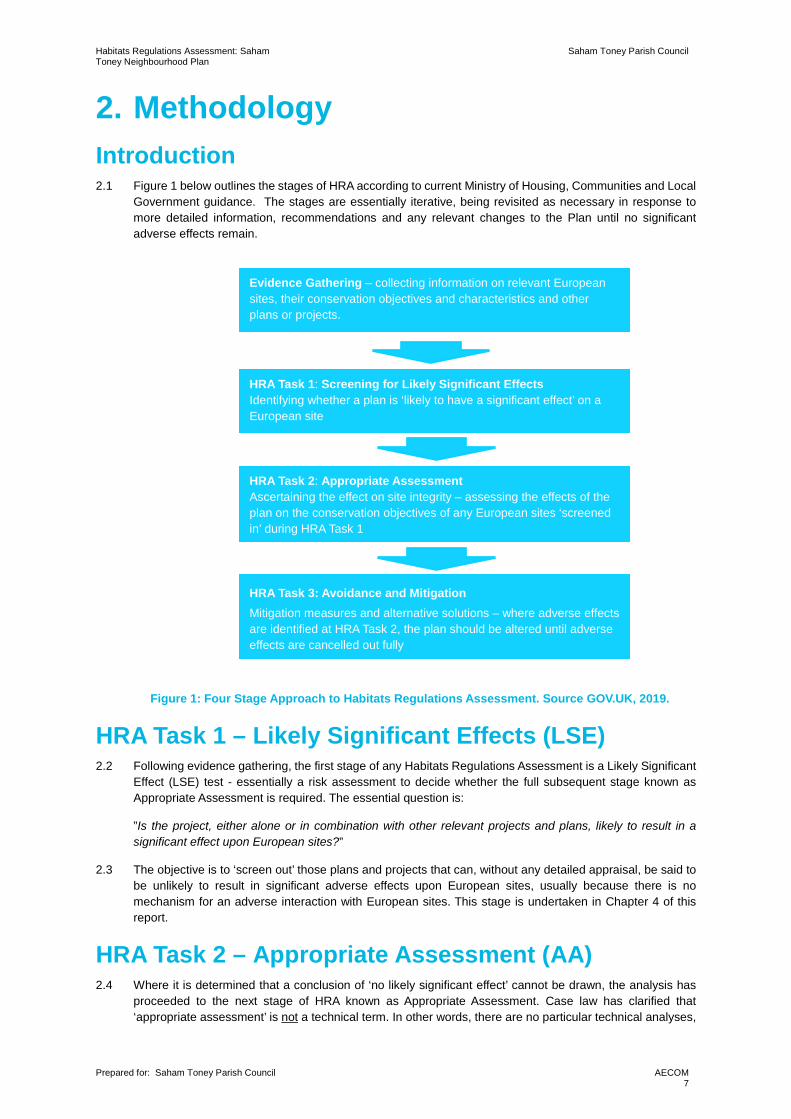
2. Methodology Introduction 2.1 Figure 1 below outlines the stages of HRA according to current Ministry of Housing, Communities and Local
Government guidance. The stages are essentially iterative, being revisited as necessary in response to more detailed information, recommendations and any relevant changes to the Plan until no significant adverse effects remain.
Figure 1: Four Stage Approach to Habitats Regulations Assessment. Source GOV.UK, 2019.
HRA Task 1 – Likely Significant Effects (LSE) 2.2 Following evidence gathering, the first stage of any Habitats Regulations Assessment is a Likely Significant
Effect (LSE) test - essentially a risk assessment to decide whether the full subsequent stage known as Appropriate Assessment is required. The essential question is:
”Is the project, either alone or in combination with other relevant projects and plans, likely to result in a significant effect upon European sites?”
2.3 The objective is to ‘screen out’ those plans and projects that can, without any detailed appraisal, be said to be unlikely to result in significant adverse effects upon European sites, usually because there is no mechanism for an adverse interaction with European sites. This stage is undertaken in Chapter 4 of this report.
HRA Task 2 – Appropriate Assessment (AA) 2.4 Where it is determined that a conclusion of ‘no likely significant effect’ cannot be drawn, the analysis has
proceeded to the next stage of HRA known as Appropriate Assessment. Case law has clarified that ‘appropriate assessment’ is not a technical term. In other words, there are no particular technical analyses,
HRA Task 1: Screening for Likely Significant Effects Identifying whether a plan is ‘likely to have a significant effect’ on a European site
HRA Task 2: Appropriate Assessment Ascertaining the effect on site integrity – assessing the effects of the plan on the conservation objectives of any European sites ‘screened in’ during HRA Task 1
HRA Task 3: Avoidance and Mitigation Mitigation measures and alternative solutions – where adverse effects are identified at HRA Task 2, the plan should be altered until adverse effects are cancelled out fully
Evidence Gathering – collecting information on relevant European sites, their conservation objectives and characteristics and other plans or projects.

Habitats Regulations Assessment: Saham Toney Neighbourhood Plan
Saham Toney Parish Council
Prepared for: Saham Toney Parish Council
AECOM 8
or level of technical analysis, that are classified by law as belonging to appropriate assessment rather than determination of likely significant effects.
2.5 During July 2019 the Ministry of Housing, Communities and Local Government published guidance for Appropriate assessment1. Paragraph: 001 Reference ID: 65-001-20190722m explains: ‘Where the potential for likely significant effects cannot be excluded, a competent authority must make an appropriate assessment of the implications of the plan or project for that site, in view of the site’s conservation objectives. The competent authority may agree to the plan or project only after having ruled out adverse effects on the integrity of the habitats site. Where an adverse effect on the site’s integrity cannot be ruled out, and where there are no alternative solutions, the plan or project can only proceed if there are imperative reasons of over-riding public interest and if the necessary compensatory measures can be secured’.
2.6 As this analysis follows on from the screening process, there is a clear implication that the analysis will be more detailed than undertaken at the Screening stage and one of the key considerations during appropriate assessment is whether there is available mitigation that would entirely address the potential effect. In practice, the appropriate assessment takes any policies or allocations that could not be dismissed following the high-level screening analysis and analyses the potential for an effect in more detail, with a view to concluding whether there would be an adverse effect on integrity (in other words, disruption of the coherent structure and function of the European site(s)).
2.7 A decision by the European Court of Justice2 concluded that measures intended to avoid or reduce the harmful effects of a proposed project on a European site may no longer be taken into account by competent authorities at the Likely Significant Effects or ‘screening’ stage of HRA. The UK is no longer part of the European Union. However, as a precaution, it is assumed for the purposes of this HRA that EU case law regarding Habitat Regulations Assessment will still be considered informative jurisprudence by the UK courts. That ruling has therefore been considered in producing this HRA.
2.8 Also, in 2018 the Holohan ruling3 was handed down by the European Court of Justice. Among other provisions paragraph 39 of the ruling states that ‘As regards other habitat types or species, which are present on the site, but for which that site has not been listed, and with respect to habitat types and species located outside that site, … typical habitats or species must be included in the appropriate assessment, if they are necessary to the conservation of the habitat types and species listed for the protected area’ [emphasis added]. This has been taken into account in the HRA process.
HRA Task 3 – Avoidance and Mitigation 2.9 Where necessary, measures are recommended for incorporation into STNP in order to avoid or mitigate
adverse effects on European sites. There is considerable precedent concerning the level of detail that a Local Development Plan document needs to contain regarding mitigation for recreational impacts on European sites. The implication of this precedent is that it is not necessary for all measures that will be deployed to be fully developed prior to adoption of the Plan, but the Plan must provide an adequate policy framework within which these measures can be delivered.
2.10 In evaluating significance, AECOM has relied on professional judgement and the LP HRA regarding development impacts on the European sites considered within this assessment.
2.11 When discussing ‘mitigation’ for a Local Development Plan document, one is concerned primarily with the policy framework to enable the delivery of such mitigation rather than the details of the mitigation measures themselves since the Local Development Plan document is a high-level policy document. A Neighbourhood Plan is a lower level constituent of a Local Development Plan and, where applicable, this report makes STNP policy-specific recommendations.
1 https://www.gov.uk/guidance/appropriate-assessment#what-are-the-implications-of-the-people-over-wind-judgment-for-habitats-regulations-assessments [Accessed: 07/01/2020]. 2 People Over Wind and Sweetman v Coillte Teoranta (C-323/17) 3 Case C-461/17

Habitats Regulations Assessment: Saham Toney Neighbourhood Plan
Saham Toney Parish Council
Prepared for: Saham Toney Parish Council
AECOM 9
Confirming Other Plans and Projects That May Act ‘In Combination’ 2.12 It is a requirement of the Regulations that the impacts of any land use plan being assessed are not
considered in isolation but in combination with other plans and projects that may also be affecting the European site(s) in question.
2.13 In considering the potential for combined regional housing development to impact on European sites the primary consideration is the impact of visitor numbers – i.e. recreational pressure and urbanisation.
2.14 When undertaking this part of the assessment it is essential to bear in mind the principal intention behind the legislation i.e. to ensure that those projects or plans (which in themselves may have minor impacts) are not simply dismissed on that basis but are evaluated for any cumulative contribution they may make to an overall significant effect. In practice, in-combination assessment is therefore of greatest relevance when the plan or policy would otherwise be screened out because its individual contribution is inconsequential.

Habitats Regulations Assessment: Saham Toney Neighbourhood Plan
Saham Toney Parish Council
Prepared for: Saham Toney Parish Council
AECOM 10
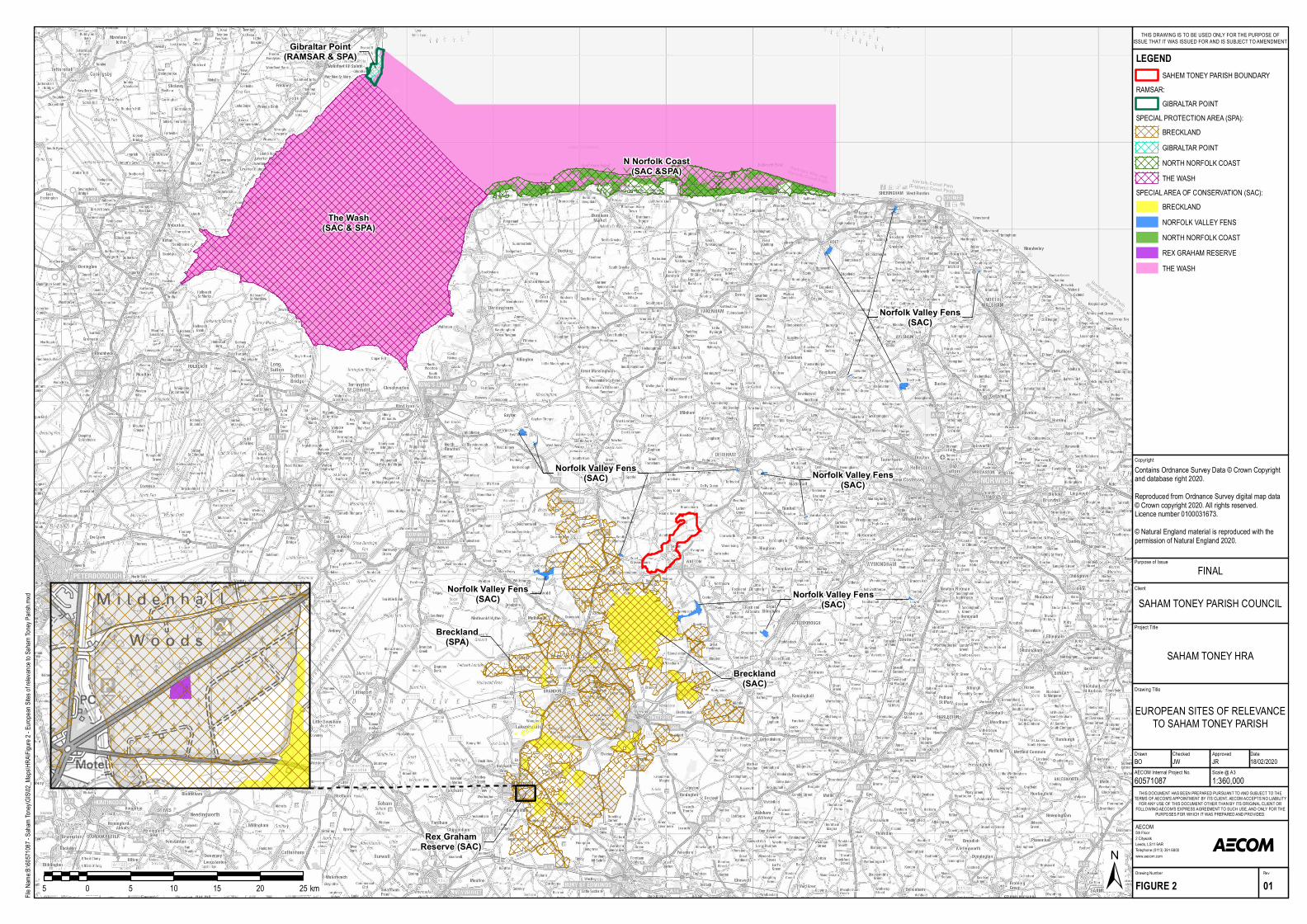
3. Internationally Designated Sites 3.1 As identified by the Breckland Local Plan HRA there are several European Sites that are of relevance to
the Saham Toney Neighbourhood Plan. These are:
• Breckland SAC/SPA (370m S of the parish boundary at its closest point),
• Norfolk Valley Fens SAC (2.3km, W of the parish boundary at its closest point),
• Rex Graham Reserve SAC (29km, S), and
• The Wash and North Norfolk Coast Complex (34-36km, N)
The Wash SAC/SPA,
Norfolk Coast SAC/SPA,
Gibraltar Point SPA/ Ramsar
3.2 Refer to Appendix A for full citation details and Figure 2 and Figure 3 for European Site locations.
Habitats Regulations Assessment: Saham Toney Neighbourhood Plan
Saham Toney Parish Council
Prepared for: Saham Toney Parish Council
AECOM 11
Figure 2: European Sites of Relevance to Saham Toney Parish
The Wash(SAC & SPA)
Breckland(SPA)
Gibraltar Point(RAMSAR & SPA)
N Norfolk Coast(SAC &SPA)
Norfolk Valley Fens(SAC)
Norfolk Valley Fens(SAC)
Norfolk Valley Fens(SAC)
Norfolk Valley Fens(SAC)
Rex GrahamReserve (SAC)
Norfolk Valley Fens(SAC)
Norfolk Valley Fens(SAC)
Norfolk Valley Fens(SAC)
Norfolk Valley Fens(SAC)
Norfolk Valley Fens(SAC)
Norfolk Valley Fens(SAC)
Norfolk Valley Fens(SAC)
Norfolk Valley Fens(SAC)
Norfolk Valley Fens(SAC)
Norfolk Valley Fens(SAC)
Norfolk Valley Fens(SAC)
Breckland(SAC)
Purpose of Issue
Project Title
Drawing Title
Drawn Checked
5th Floor2 CitywalkLeeds, LS11 9ARTelephone (0113) 391 6800www.aecom.com
AECOM
DateApproved
RevDrawing Number
FIGURE 2 01
THIS DOCUMENT HAS BEEN PREPARED PURSUANT TO AND SUBJECT TO THETERMS OF AECOM'S APPOINTMENT BY ITS CLIENT. AECOM ACCEPTS NO LIABILITY
FOR ANY USE OF THIS DOCUMENT OTHER THAN BY ITS ORIGINAL CLIENT ORFOLLOWING AECOM'S EXPRESS AGREEMENT TO SUCH USE, AND ONLY FOR THE
PURPOSES FOR WHICH IT WAS PREPARED AND PROVIDED.
AECOM Internal Project No. Scale @ A360571087 1:360,000BO JW JR 18/02/2020
Client
File Na
me:B:
\60571
087 - S
aham T
oney\G
IS\02_
Maps\
HRA\F
igure 2
- Euro
pean S
ites of
relevan
ce to S
aham T
oney P
arish.m
xd
±5 0 5 10 15 20 25 km
LEGENDSAHEM TONEY PARISH BOUNDARY
RAMSAR: GIBRALTAR POINT
SPECIAL PROTECTION AREA (SPA): BRECKLANDGIBRALTAR POINTNORTH NORFOLK COASTTHE WASH
SPECIAL AREA OF CONSERVATION (SAC): BRECKLANDNORFOLK VALLEY FENSNORTH NORFOLK COASTREX GRAHAM RESERVETHE WASH
EUROPEAN SITES OF RELEVANCETO SAHAM TONEY PARISH
SAHAM TONEY HRA
FINAL
SAHAM TONEY PARISH COUNCIL
THIS DRAWING IS TO BE USED ONLY FOR THE PURPOSE OFISSUE THAT IT WAS ISSUED FOR AND IS SUBJECT TO AMENDMENT
CopyrightContains Ordnance Survey Data © Crown Copyright and database right 2020.Reproduced from Ordnance Survey digital map data © Crown copyright 2020. All rights reserved.Licence number 0100031673.© Natural England material is reproduced with thepermission of Natural England 2020.

Habitats Regulations Assessment: Saham Toney Neighbourhood Plan
Saham Toney Parish Council
Prepared for: Saham Toney Parish Council
AECOM 12
4. Test of Likely significant effects Background to Saham Toney Parish 4.1 Saham Toney is a village and a civil parish in the county of Norfolk, roughly centrally located within Breckland
District. The parish comprises not only the village of Saham Toney, but also Saham Hills, which has its own distinct history and character, together with a number of small hamlets, including Saham Waite. The majority of land in the parish is open farmland or parkland and residential.
4.2 The residential population of Saham Toney at the 2011 Census was 1,507 people residing at 785 dwellings. Breckland Council’s adopted Local Plan designates Saham Toney as one of 17 ‘Villages with Boundaries’; in which permitted development will be restricted, consistent with the rural character of those villages and reflective of the more limited service provision and infrastructure available. Both the parish and village of Saham Toney have a distinctly rural character, which in part at least determines the social character of the area. It has a gently undulating land form, tributary streams, arable and pasture farmland and small blocks of farm woodland.
Physical scope of the HRA 4.3 Three of the European Sites that are described in Appendix A lie at relatively close proximity to the boundary
of Saham Toney Parish. These are Breckland SPA (370m, S), Breckland SAC (2km, S) and Norfolk Valley Fens SAC, the Great Cressingham component (2.3km, W).
4.4 Rex Graham Reserve SAC is located 29km from the parish; given this distance air quality or urbanisation associated with growth in Saham Toney is not a realistic impact pathway and the site is not identified to be at risk of damaging recreational pressure due to growth in Breckland in the overarching Local Plan HRA. The SAC is therefore scoped out of this HRA.
4.5 European Sites that are further afield but which are identified in the Breckland LP HRA to be susceptible to recreational pressure produced by residential growth across the district in combination are The Wash SAC/SPA/Ramsar (34km, N) and the North Norfolk Coast SAC/SPA/Ramsar (36km, N). It is acknowledged that these distances are considerable; however, given the strong recreational attraction of these sites (i.e. coastal sites) and their identification in the Local Plan HRA assessment of Saham Toney development to these SAC/SPA/Ramsar are considered in-combination with growth of surrounding local authorities.
4.6 Based upon Natural England Site Improvement Plans and previous HRA work undertaken for Breckland Council, there are several impact pathways of impact that require analysis regarding increased development within the Saham Toney Parish and said European Sites. These are:
• Water quality (surface water runoff),
• Water quality (discharge of treated sewage effluent),
• Hydrological changes, including water abstraction,
• Air quality,
• Habitat fragmentation,
• Recreational pressure, and
• Urbanisation.
4.7 Table 1 describes these environmental impact pathways. The consideration of Neighbourhood Plan policies (the Test of Likely Significant Effects) is then documented in Table 2.

Habitats Regulations Assessment: Saham Toney Neighbourhood Plan
Saham Toney Parish Council
Prepared for: Saham Toney Parish Council
AECOM 13
Table 1. Description of potential impact pathways from increased development to European Sites.
Impact pathway Discussion
Water quality (surface water runoff)
Increased residential development within Saham Toney villages could lead to the loss of previously undeveloped land and increased surface water runoff to nearby European Sites. Breckland SPA/SAC is located only 370m south, and the Norfolk Valley Fens SAC (Great Cressingham component) is located 2.3km west of the parish boundary. There is a risk that inappropriate drainage design may lead to increased surface water runoff from new development. The Wash SAC/SPA/Ramsar (34km, NW) and the North Norfolk Coast SAC/SPA/Ramsar (36km, N) are located at too great a distance to be impacted by issues of surface water runoff from increased development in the Parish.
Water quality (discharge of treated sewage effluent)
Increased housing development at Saham Toney could lead to increased sewage production. Therefore, it is necessary to consider any risk that increased sewage could degrade the water quality (i.e. through increased phosphorus discharge) of European Sites, in the absence of environmental mitigation and adequate wastewater treatment works.
In 2017 Breckland District Council commissioned a Water Cycle Study (WCS) to assess the water quality of the region4. It was reported that:
• Watton Wastewater Treatment Works (WwTW) (i.e. the WwTW for Saham Toney) has available flow headroom in its existing discharge permit but could only accept growth of approximately 19 dwellings, after which the volumetric discharge permit will be exceeded. Unless additional headroom can be made available in the catchment after 19 dwellings, any growth draining to the WwTW would cause the WwTW to exceed its existing volumetric permit conditions.
• Water quality modelling has shown that in order to maintain the current Water Framework Directive (WFD) status of the Watton Brook with predicted charge volumes (from new connections), the permit conditions on discharge quality for Biochemical Oxygen Demand BOD and ammonia would need to be tighter than they currently are. The calculations show that the permit conditions should be set at 12mg/l 95 percentile limit for BOD10 and 3mg/l mean limit for ammonia. The theoretical conditions for both BOD and ammonia are considered to be within the limits of conventional treatment. No change would be required in the phosphate permit to ensure no deterioration in status. The modelling has shown that the growth would not prevent Future Good Status being reached in the Watton Brook for phosphate as it could not be reached with current discharge levels.
• Thus, this WCS has shown that a technically feasible engineering solution can be delivered to accommodate all of the growth proposed within the Watton WwTW catchment (based on the housing numbers that the district council provided for use in the WCS).
Anglian Water (the Statutory Water Authority for Saham Toney) carried out assessments of 16 sites put forward for potential allocation in STNP, and its conclusions were published in the STNP Site Selection Report of June 2019. Of particular relevance they advised in notes to the assessments:
“Anglian Water has made an assessment of the available capacity at the receiving Water Recycling Centre (formerly known as sewage treatment works) for each of the proposed sites. As you will see there is currently limited capacity at the Water Recycling Centre for additional growth in Saham Toney sewer catchment. Anglian Water has a statutory obligation to provide sufficient capacity for sites with the benefit of planning permission. We are also currently in discussion with the Environment Agency about how
4 AECOM (2017). Water Cycle Study Update. Available online: https://www.breckland.gov.uk/media/2970/Water-Cycle-Study-Update/pdf/Breckland_WCS_2017_v3_issued.pdf?m=636255992882070000 [Accessed: 29/01/20].

Habitats Regulations Assessment: Saham Toney Neighbourhood Plan
Saham Toney Parish Council
Prepared for: Saham Toney Parish Council
AECOM 14
this can be best achieved as part of a revised permit for the site. As such this shouldn’t be viewed as an absolute constraint to additional residential development at Saham Toney.” It is considered that based on current WCS and that fact that no STW that serve Saham Toney discharge into European Sites of concern, this is not a realistic impact pathway linking growth at Saham Toney to European sites. Therefore, water quality issues relating to the discharge of treated sewage effluent are not assessed further.
Hydrological changes, including water abstraction
The Norfolk Valley Fens SAC supports spring-fed fens that are susceptible to changes in water table fluctuations. Increased development at Saham Toney could impact the water table of lowland bog. Impacts could occur from increased water abstraction for public water supply5.
Air quality Increased residential development within Saham Toney will lead to a greater number of vehicles within the parish. As such, increased air pollution could arise relative to a situation of no growth. Pollutants realised from vehicles may be carried directly by wind currents and deposited to the Breckland SAC/SPA and Norfolk Valley Fens or pollutants may become soluble and taken up during evaporation and deposited to said sites during precipitation. Guidance from the Institute of Air Quality Management and Highways England both set an impact zone of 200m from the roadside for potential significant air quality effects to vegetation from road traffic. However, The Wash SAC/SPA/Ramsar (34km, NW) and the North Norfolk Coast SAC/SPA/Ramsar (36km, N) are located at too great a distance to be impacted by air pollution from Saham Toney.
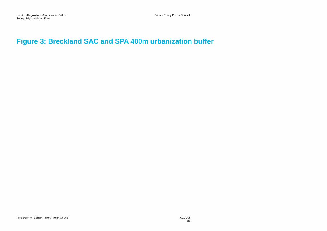
Habitat fragmentation Simply described, habitat fragmentation is the division of an expanse of habitat into smaller, individual patches that are isolated from each other by the removal of the original habitat6. Breckland SAC/SPA supports a diversity of habitats that are the primary reason for the sites’ selection. One such habitat includes inland dunes that supports rare species including grey hair-grass Corynephorus canescens and sand sedge Carex arenaria; with limited dispersal capabilities. In addition, heathland (also supported by Breckland SAC/SPA) is arguably one of the most severely fragmentated habitats in the world with heathland cover decreased by 85% over the past 150 years as a result of agriculture and development7. The loss of heathland has had population consequences to the species that are supported by this habitat (including nightjar and woodlark)8. Given that Breckland SAC/SPA is located only 370m south of Saham Toney and supporting habitat (i.e. not within designated boundaries) is found within the parish boundary there is a risk that increased development could fragment these habitats, either through direct loss or providing barriers to movement (i.e. impacting protected species). In addition, the Breckland LP HRA identified that stone curlew (designation of Breckland SPA) could be supported in Saham Toney, refer to Figure 3 and Figure 4.
Recreational pressure Increased development within Saham Toney could lead to higher numbers of visitors to European Sites, particularly those within relatively easy recreational access. For example, the nature, scale, timing and duration of some human activities can result in the disturbance of birds at a level that may substantially affect their behaviour, and consequently affect the long-term viability of the population. It is long standing knowledge that the European Sites located in Norfolk are attractive to visitors on a county, national and in some cases international level. Increased visitors can have direct and indirect for a European Site that could prevent said site achieving its conservation objectives. European Sites impacted by recreational pressure are Breckland SAC/SPA, The Wash SAC/SPA/Ramsar and the North Norfolk Coast SAC/SPA/Ramsar. On the other hand, the Norfolk Valley Fens SAC is not identified by Natural England to be impacted by recreational pressure.
5 Labadz, J., Allott, T., Evans, M., Butcher, D., Billett, M., Stainer, S., Yallop, A., Jones, P., Innerdale, M., Harmon, N. and Maher, K., 2010. Peatland Hydrology: Draft Scientific Review to IUCN Peatland Programme Commission of Inquiry on Peatlands. 6 Wilcove, D.S., McLellan, C.H. and Dobson, A.P., 1986. Habitat fragmentation in the temperate zone. Conservation biology, 6, pp.237-256. 7 English Nature (2002). Lowland heathland a cultural and endangered landscape. Northminster House: Peterborough 8 Liley, D. and Clarke, R.T., 2003. The impact of urban development and human disturbance on the numbers of nightjar Caprimulgus europaeus on heathlands in Dorset, England. Biological Conservation, 114(2), pp.219-230.

Habitats Regulations Assessment: Saham Toney Neighbourhood Plan
Saham Toney Parish Council
Prepared for: Saham Toney Parish Council
AECOM 15
Urbanisation Increased urbanisation could lead to likely significant effects to European Sites9. For example, development within 400m of the SPA could increase cat predation to ground nesting birds and chicks reducing breeding success10 of Annex II species, increase the occurrence of wildfire and have profound edge effects and habitat fragmentation. Of relevance to Saham Toney is the potential impact of increased housing in close proximity to the Brecklands SAC/SPA. Saham Toney lies within 400m of the SAC/SPA and supports habitat of suitable quality for designated species, refer to Figure 3.
9 Chace, J.F. and Walsh, J.J., 2006. Urban effects on native avifauna: a review. Landscape and urban planning, 74(1), pp.46-69. 10 Marzluff, J.M., 2001. Worldwide urbanization and its effects on birds. In Avian ecology and conservation in an urbanizing world (pp. 19-47). Springer, Boston, MA.
Habitats Regulations Assessment: Saham Toney Neighbourhood Plan
Saham Toney Parish Council
Prepared for: Saham Toney Parish Council
AECOM 16
Figure 3: Breckland SAC and SPA 400m urbanization buffer

STNP1
STNP5STNP4
STNP16
STNP2
STNP9STNP15
STNP14
STNP7
STNP6
STNP13
Breckland(SPA)
Breckland (SPA)
Breckland(SAC)
Breckland (SPA)Breckland (SPA)Breckland (SPA)Breckland (SPA)
Breckland(SPA)
Breckland(SAC)
Breckland(SPA)
Breckland(SPA)
Breckland(SPA)
Purpose of Issue
Project Title
Drawing Title
Drawn Checked
5th Floor2 CitywalkLeeds, LS11 9ARTelephone (0113) 391 6800www.aecom.com
AECOM
DateApproved
RevDrawing Number
FIGURE 3 01
THIS DOCUMENT HAS BEEN PREPARED PURSUANT TO AND SUBJECT TO THETERMS OF AECOM'S APPOINTMENT BY ITS CLIENT. AECOM ACCEPTS NO LIABILITY
FOR ANY USE OF THIS DOCUMENT OTHER THAN BY ITS ORIGINAL CLIENT ORFOLLOWING AECOM'S EXPRESS AGREEMENT TO SUCH USE, AND ONLY FOR THE
PURPOSES FOR WHICH IT WAS PREPARED AND PROVIDED.
AECOM Internal Project No. Scale @ A360571087 1:35,000BO JW JR 18/02/2020
Client
File Na
me:B:
\60571
087 - S
aham T
oney\G
IS\02_
Maps\
HRA\F
igure 3
- Brec
kland
SAC &
SPA 4
00m urb
anisat
ion bu
ffer.mx
d
±0.5 0 0.5 1 1.5 2 2.5 km
LEGENDSAHEM TONEY PARISH BOUNDARY400M URBANISATION IMPACT BUFFERHOUSING ALLOCATION
SPECIAL PROTECTION AREA (SPA):BRECKLAND
SPECIAL AREA OF CONSERVATION (SAC):BRECKLAND
BRECKLAND SAC/SPA400M URBANISATION BUFFER
SAHAM TONEY HRA
FINAL
SAHAM TONEY PARISH COUNCIL
THIS DRAWING IS TO BE USED ONLY FOR THE PURPOSE OFISSUE THAT IT WAS ISSUED FOR AND IS SUBJECT TO AMENDMENT
CopyrightReproduced from Ordnance Survey digital map data © Crown copyright 2020. All rights reserved.Licence number 0100031673.© Natural England material is reproduced with thepermission of Natural England 2020.

Habitats Regulations Assessment: Saham Toney Neighbourhood Plan
Saham Toney Parish Council
Prepared for: Saham Toney Parish Council
AECOM 17
4.8 For the Screening assessment (Table 2) green shading in the final column indicates that the proposed development site or policy has been determined not to lead to a likely significant effect on any European sites due to the absence of any mechanism for an adverse effect. Orange shading indicates that a pathway of impact exists, and further discussion is therefore required. Note that where European Site boundaries overlap, the closest distance to the SAC, SPA or Ramsar is taken.
4.9 The Breckland LP HRA undertook extensive research to identify the impact buffers of stone curlew supported by the Breckland SPA (refer to Figure 4). There are three buffer tiers that apply to the SPA, these are:
• Primary buffer (1500m buffer) – this includes functionally linked land of the SPA. RSPB data indicates that there is a significantly high chance stone curlew would use these areas for nesting and foraging.
• Secondary (3km buffer) – this includes functionally linked land of the SPA that could support nesting and foraging stone curlew.
• Additional 1km orange cells – these are additional plots outside of the secondary and primary buffers where RSPB data was insufficient to provide for full analysis. These 1km orange cells could also support functionally linked habitat to the SPA; however, further species data would be required.
4.10 These zones have been used in evaluating the potential effect of growth in Saham Toney on the stone curlew population of the SPA.

Habitats Regulations Assessment: Saham Toney Neighbourhood Plan
Saham Toney Parish Council
Prepared for: Saham Toney Parish Council
AECOM 18
Figure 4: Stone curlew buffers

Purpose of Issue
Project Title
Drawing Title
Drawn Checked
5th Floor2 CitywalkLeeds, LS11 9ARTelephone (0113) 391 6800www.aecom.com
AECOM
DateApproved
RevDrawing Number
FIGURE 4 01
THIS DOCUMENT HAS BEEN PREPARED PURSUANT TO AND SUBJECT TO THETERMS OF AECOM'S APPOINTMENT BY ITS CLIENT. AECOM ACCEPTS NO LIABILITY
FOR ANY USE OF THIS DOCUMENT OTHER THAN BY ITS ORIGINAL CLIENT ORFOLLOWING AECOM'S EXPRESS AGREEMENT TO SUCH USE, AND ONLY FOR THE
PURPOSES FOR WHICH IT WAS PREPARED AND PROVIDED.
AECOM Internal Project No. Scale @ A360571087 1:170,000BO JW JR 18/02/2020
Client
File Na
me:B:
\60571
087 - S
aham T
oney\G
IS\02_
Maps\
HRA\F
igure 4
- Ston
e curle
w buffe
rs.mxd
±3 0 3 6 9 12 15 km
LEGENDSAHEM TONEY PARISH BOUNDARYADDITIONAL HABITAT - 1KM CELLSHOUSING ALLOCATIONEUROPEAN SITES (SAC AND SPA)PRIMARY BUFFER - 1500M (STONECURLEW)SECONDARY BUFFER - 1500M(STONE CURLEW)
STONE CURLEW BUFFERS
SAHAM TONEY HRA
FINAL
SAHAM TONEY PARISH COUNCIL
THIS DRAWING IS TO BE USED ONLY FOR THE PURPOSE OFISSUE THAT IT WAS ISSUED FOR AND IS SUBJECT TO AMENDMENT
CopyrightContains Ordnance Survey Data © Crown Copyright and database right 2020.Reproduced from Ordnance Survey digital map data © Crown copyright 2020. All rights reserved.Licence number 0100031673.© Natural England material is reproduced with thepermission of Natural England 2020.

Habitats Regulations Assessment: Saham Toney Neighbourhood Plan
Saham Toney Parish Council
Prepared for: Saham Toney Parish Council
AECOM 19
Table 2. Screening assessment (Likely Significant Effects) of the Saham Toney NP.
Policy11 European Sites and Proximity to Policy Area Brief summary Screening outcome
Policy 1: services, facilities and infrastructure
N/A Policy describes requirements for developments to provide sufficient infrastructure (i.e. education, community facilities, healthcare, public transport).
No likely Significant Effect. Screened out. This is a development management policy and does not specifically allocate sites for development. Therefore, no impact pathways exist to European Sites.
Policy 2A: residential housing allocation
Measured at the closest point from the parish boundary:
• Breckland SAC/SPA: 370m, S • Norfolk Valley Fens SAC: 2.3km, W • The Wash SAC/SPA/Ramsar: 34km, N • Norfolk Coast SAC/SPA/Ramsar: 36km, N
Allocate 83 new homes up to 2036 through 11 sites allocated in Policies 2G to 2Q.
Likely Significant Effect. Screened in. This policy provides for the delivery of 83 residential dwellings. Therefore, the following impact pathways could arise alone and in combination with surrounding growth: • Breckland SPA / SAC: water quality (surface water),
air quality, habitat fragmentation, recreational pressure and urbanisation.
• Norfolk Valley Fens SAC: water quality (surface water), hydrological changes, and air quality.
• The Wash SAC/SPA/Ramsar: recreational pressure • Norfolk Coast SAC/SPA/Ramsar: recreational
pressure.
Policy Map 2A: Site allocation locations
N/A Policy provides a map marking the locations of 11 site allocation of policies 2F to 2Q. It is therefore included in this table.
No likely Significant Effect. Screened out. This in itself does not allocate sites for development, rather it provides a map for readers reference. Therefore, no impact pathways exist to European Sites.
Policy 2B: residential development within the settlement boundary
Measured at the closest point from the parish boundary:
• Breckland SAC/SPA: 370m, S (at closest point to parish boundary)
• Norfolk Valley Fens SAC: 2.3km, W • The Wash SAC/SPA/Ramsar: 34km, N
• Norfolk Coast SAC/SPA/Ramsar: 36km, N
Policy describes settlement boundary and provides requirements for development design to be in keeping with the settlement and landscape of Saham Toney.
Likely Significant Effect. Screened in. This is a development management policy and does not specifically allocate sites for development. However, it does allow for windfall housing development. Therefore, the following impact pathways could arise alone and in combination with surrounding growth: • Breckland SPA / SAC: water quality (surface water),
air quality, habitat fragmentation, recreational pressure and urbanisation.
• Norfolk Valley Fens SAC: water quality (surface water), hydrological changes, and air quality.
• The Wash SAC/SPA/Ramsar: recreational pressure • Norfolk Coast SAC/SPA/Ramsar: recreational
pressure.
Policy 2C: residential development outside the settlement boundary
Measured at the closest point from the parish boundary:
• Breckland SAC/SPA: 370m, S • Norfolk Valley Fens SAC: 2.3km, W • The Wash SAC/SPA/Ramsar: 34km, N
Policy provides for development outside the Saham Toney settlement boundary.
Likely Significant Effect. Screened in. This policy provides for the delivery of residential dwellings that are outside the settlement boundary and in some cases within greenfield areas. Therefore, the following impact pathways could arise alone and in combination with surrounding growth:
11 The full text of each STNP policy can be found at https://www.stnp2036.org/the-policies.html; STNP policy maps can be found at https://www.stnp2036.org/policy-maps.html

Habitats Regulations Assessment: Saham Toney Neighbourhood Plan
Saham Toney Parish Council
Prepared for: Saham Toney Parish Council
AECOM 20
• Norfolk Coast SAC/SPA/Ramsar: 36km, N • Breckland SPA / SAC: water quality (surface water), air quality, habitat fragmentation, recreational pressure and urbanisation.
• Norfolk Valley Fens SAC: water quality (surface water), hydrological changes, and air quality.
• The Wash SAC/SPA/Ramsar: recreational pressure • Norfolk Coast SAC/SPA/Ramsar: recreational
pressure.
Policy 2D: affordable housing
N/A Policy describes affordable housing requirements of new residential developments.
No likely Significant Effect. Screened out. This is a development management policy and does not specifically allocate sites for development. Therefore, no impact pathways exist to European Sites.
Policy 2E: housing mix N/A Policy describes the requirement of housing mix (i.e. number of bedrooms) for new residential developments.
No likely Significant Effect. Screened out. This is a development management policy and does not specifically allocate sites for development. Therefore, no impact pathways exist.
Policy 2F: common criteria for allocated sites
N/A Policy describes the requirement of housing mix, sustainable drainage, ecological assessments, car parking provisions and green infrastructure of new residential development.
No likely Significant Effect. Screened out. This is a development management policy and does not specifically allocate sites for development. Therefore, no impact pathways exist.
Policy 2G: site allocation STNP1: Grange Farm, Cheques Lane
Measured at the closest point from housing allocation:
• Breckland SAC/SPA: 2.5km, S • Norfolk Valley Fens SAC: 5km, W • The Wash SAC/SPA/Ramsar: 37km, N • Norfolk Coast SAC/SPA/Ramsar: 42km, N
Policy allocates a maximum of 10 residential dwellings on 1.06ha of predominantly brownfield land.
Likely Significant Effect. Screened in. This policy allocates 10 net residential dwellings. Therefore, the following impact pathways could arise alone and in combination with surrounding growth: • Breckland SPA / SAC: water quality (surface water),
air quality, habitat fragmentation, recreational pressure and urbanisation.
• Norfolk Valley Fens SAC: water quality (surface water), hydrological changes, and air quality.
• The Wash SAC/SPA/Ramsar: recreational pressure • Norfolk Coast SAC/SPA/Ramsar: recreational
pressure.
Policy 2H: site allocation STNP2: Disused Piggery, Of Hills Road
Measured at the closest point from housing allocation:
• Breckland SAC/SPA: 3.3km, S • Norfolk Valley Fens SAC: 5.2km, W • The Wash SAC/SPA/Ramsar: 36km, N • Norfolk Coast SAC/SPA/Ramsar: 41km, N
Policy allocates a maximum of 4 residential dwellings on 0.5ha of brownfield land.
Likely Significant Effect. Screened in. This policy allocates 4 net residential dwellings. Therefore, the following impact pathways could arise alone and in combination with surrounding growth: • Breckland SPA / SAC: water quality (surface water),
air quality, habitat fragmentation, recreational pressure and urbanisation.
• Norfolk Valley Fens SAC: water quality (surface water), hydrological changes, and air quality.
• The Wash SAC/SPA/Ramsar: recreational pressure • Norfolk Coast SAC/SPA/Ramsar: recreational
pressure.

Habitats Regulations Assessment: Saham Toney Neighbourhood Plan
Saham Toney Parish Council
Prepared for: Saham Toney Parish Council
AECOM 21
Policy 2I: site allocation STNP4: Land at the Junction of Pound Hill and Page’s Lane
Measured at the closest point from housing allocation:
• Breckland SAC/SPA: 2.6km, S • Norfolk Valley Fens SAC: 5km, W • The Wash SAC/SPA/Ramsar: 38km, N • Norfolk Coast SAC/SPA/Ramsar: 42km, N
Policy allocates a maximum of 13 dwellings on 0.81ha of greenfield land.
Likely Significant Effect. Screened in. This policy allocates 13 net residential dwellings. Therefore, the following impact pathways could arise alone and in combination with surrounding growth: • Breckland SPA / SAC: water quality (surface water),
air quality, habitat fragmentation, recreational pressure and urbanisation.
• Norfolk Valley Fens SAC: water quality (surface water), hydrological changes, and air quality.
• The Wash SAC/SPA/Ramsar: recreational pressure • Norfolk Coast SAC/SPA/Ramsar: recreational
pressure.
Policy 2J: site allocation STNP5: Land to the East of Pound Hill
Measured at the closest point from housing allocation:
• Breckland SAC/SPA: 2.6km, S • Norfolk Valley Fens SAC: 5km, W • The Wash SAC/SPA/Ramsar: 38km, N • Norfolk Coast SAC/SPA/Ramsar: 42km, N
Policy allocates a maximum of 12 dwellings on 1.01ha of greenfield land.
Likely Significant Effect. Screened in. This policy allocates 12 net residential dwellings. Therefore, the following impact pathways could arise alone and in combination with surrounding growth: • Breckland SPA / SAC: water quality (surface water),
air quality, habitat fragmentation, recreational pressure and urbanisation.
• Norfolk Valley Fens SAC: water quality (surface water), hydrological changes, and air quality.
• The Wash SAC/SPA/Ramsar: recreational pressure • Norfolk Coast SAC/SPA/Ramsar: recreational
pressure.
Policy 2K: site allocation STNP6: Land at the Junction of Pound Hill and Page’s Lane
Measured at the closest point from housing allocation:
• Breckland SAC/SPA: 2.6km, S • Norfork Valley Fens SAC: 5km, W • The Wash SAC/SPA/Ramsar: 38km, N • Norfolk Coast SAC/SPA/Ramsar: 42km, N
Policy allocates a maximum of 5 dwellings on 0.46ha of greenfield land.
Likely Significant Effect. Screened in. This policy allocates 5 net residential dwellings. Therefore, the following impact pathways could arise alone and in combination with surrounding growth: • Breckland SPA / SAC: water quality (surface water),
air quality, habitat fragmentation, recreational pressure and urbanisation.
• Norfolk Valley Fens SAC: water quality (surface water), hydrological changes, and air quality.
• The Wash SAC/SPA/Ramsar: recreational pressure • Norfolk Coast SAC/SPA/Ramsar: recreational
pressure.
Policy 2L: site allocation STNP7: Page’s Farm
Measured at the closest point from housing allocation:
• Breckland SAC/SPA: 2.6km, S • Norfolk Valley Fens SAC: 5km, W • The Wash SAC/SPA/Ramsar: 38km, N • Norfolk Coast SAC/SPA/Ramsar: 42km, N
Policy allocates a maximum of 8 dwellings on 0.54ha of brownfield land.
Likely Significant Effect. Screened in. This policy allocates 8 net residential dwellings. Therefore, the following impact pathways could arise alone and in combination with surrounding growth: • Breckland SPA / SAC: water quality (surface water),
air quality, habitat fragmentation, recreational pressure and urbanisation.
• Norfolk Valley Fens SAC: water quality (surface water), hydrological changes, and air quality.
Habitats Regulations Assessment: Saham Toney Neighbourhood Plan
Saham Toney Parish Council
Prepared for: Saham Toney Parish Council
AECOM 22
• The Wash SAC/SPA/Ramsar: recreational pressure • Norfolk Coast SAC/SPA/Ramsar: recreational
pressure.
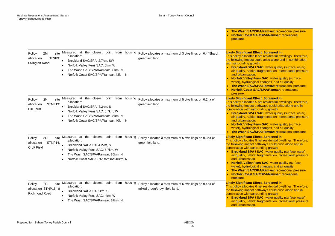
Policy 2M: site allocation STNP9: Ovington Road
Measured at the closest point from housing allocation:
• Breckland SAC/SPA: 2.7km, SW • Norfolk Valley Fens SAC: 6km, W • The Wash SAC/SPA/Ramsar: 39km, N • Norfolk Coast SAC/SPA/Ramsar: 43km, N
Policy allocates a maximum of 3 dwellings on 0.445ha of greenfield land.
Likely Significant Effect. Screened in. This policy allocates 8 net residential dwellings. Therefore, the following impact could arise alone and in combination with surrounding growth: • Breckland SPA / SAC: water quality (surface water),
air quality, habitat fragmentation, recreational pressure and urbanisation.
• Norfolk Valley Fens SAC: water quality (surface water), hydrological changes, and air quality.
• The Wash SAC/SPA/Ramsar: recreational pressure • Norfolk Coast SAC/SPA/Ramsar: recreational
pressure.
Policy 2N: site allocation STNP13: Hill Farm
Measured at the closest point from housing allocation:
• Breckland SAC/SPA: 4.2km, S • Norfolk Valley Fens SAC: 5.7km, W • The Wash SAC/SPA/Ramsar: 36km, N • Norfolk Coast SAC/SPA/Ramsar: 40km, N
Policy allocates a maximum of 5 dwellings on 0.2ha of greenfield land.
Likely Significant Effect. Screened in. This policy allocates 5 net residential dwellings. Therefore, the following impact pathways could arise alone and in combination with surrounding growth: • Breckland SPA / SAC: water quality (surface water),
air quality, habitat fragmentation, recreational pressure and urbanisation.
• Norfolk Valley Fens SAC: water quality (surface water), hydrological changes, and air quality.
• The Wash SAC/SPA/Ramsar: recreational pressure
Policy 2O: site allocation STNP14: Croft Field
Measured at the closest point from housing allocation:
• Breckland SAC/SPA: 4.2km, S • Norfolk Valley Fens SAC: 5.7km, W • The Wash SAC/SPA/Ramsar: 36km, N • Norfolk Coast SAC/SPA/Ramsar: 40km, N
Policy allocates a maximum of 5 dwellings on 0.3ha of greenfield land.
Likely Significant Effect. Screened in. This policy allocates 5 net residential dwellings. Therefore, the following impact pathways could arise alone and in combination with surrounding growth: • Breckland SPA / SAC: water quality (surface water),
air quality, habitat fragmentation, recreational pressure and urbanisation.
• Norfolk Valley Fens SAC: water quality (surface water), hydrological changes, and air quality.
• The Wash SAC/SPA/Ramsar: recreational pressure • Norfolk Coast SAC/SPA/Ramsar: recreational
pressure.
Policy 2P: site allocation STNP15: 8 Richmond Road
Measured at the closest point from housing allocation:
• Breckland SAC/SPA: 2km, S • Norfolk Valley Fens SAC: 4km, W • The Wash SAC/SPA/Ramsar: 37km, N
Policy allocates a maximum of 6 dwellings on 0.4ha of mixed green/brownfield land.
Likely Significant Effect. Screened in. This policy allocates 6 net residential dwellings. Therefore, the following impact pathways could arise alone and in combination with surrounding growth: • Breckland SPA / SAC: water quality (surface water),
air quality, habitat fragmentation, recreational pressure and urbanisation.

Habitats Regulations Assessment: Saham Toney Neighbourhood Plan
Saham Toney Parish Council
Prepared for: Saham Toney Parish Council
AECOM 23
• Norfolk Coast SAC/SPA/Ramsar: 42km, S • Norfolk Valley Fens SAC: water quality (surface water), hydrological changes, and air quality.
• The Wash SAC/SPA/Ramsar: recreational pressure • Norfolk Coast SAC/SPA/Ramsar: recreational
pressure.
Policy 2Q: site allocated STNP16: Richmond Hall
Measured at the closest point from housing allocation:
• Breckland SAC/SPA: 1.6km, S • Norfolk Valley Fens SAC: 5km, W • The Wash SAC/SPA/Ramsar: 37km, N • Norfolk Coast SAC/SPA/Ramsar: 43km, N
Policy allocates a maximum of 12 dwellings on 0.65ha of greenfield land.
Likely Significant Effect. Screened in. This policy allocates 12 net residential dwellings. Therefore, the following impact pathways could arise alone and in combination with surrounding growth: • Breckland SPA / SAC: water quality (surface water),
air quality, habitat fragmentation, recreational pressure and urbanisation.
• Norfolk Valley Fens SAC: water quality (surface water), hydrological changes, and air quality.
• The Wash SAC/SPA/Ramsar: recreational pressure • Norfolk Coast SAC/SPA/Ramsar: recreational
pressure.
Policy 3A: design N/A Policy describes development requirements to keep in line with the local character of Saham Toney through good quality design.
No likely Significant Effect. Screened out. This is a development management policy and does not specifically allocate sites for development. Therefore, no impact pathways exist to European Sites.
Policy 3B: density of residential developments
N/A Policy prevents overdevelopment within the parish. No likely Significant Effect. Screened out. This is a development management policy and does not specifically allocate sites for development. Therefore, no impact pathways exist to European Sites.
Policy 3C: site access and on-site streets
N/A Policy ensures that new developments are well linked to existing transportation links.
No likely Significant Effect. Screened out. This is a development management policy and does not specifically allocate sites for development. Therefore, no impact pathways exist to European Sites.
Policy 3D: parking N/A Policy ensures that new development provides adequate car/ bike parking facilities.
No likely Significant Effect. Screened out. This is a development management policy and does not specifically allocate sites for development. Therefore, no impact pathways exist to European Sites.
Policy 3E: dark skies preservation
N/A Policy safeguards dark skies through the control of street lighting within the parish.
No likely Significant Effect. Screened out. This is an environmentally positive policy. Therefore, no impact pathways exist to European Sites.
Policy 4: non-residential development
N/A Policy provides safeguarding to existing community facilities and where appropriate supports the development/ enhancement of new business, recreation, spot or tourism related facilities.
No likely Significant Effect. Screened out. While this policy does support development there are strict policy requirements and it does not specifically allocate sites for development. Therefore, no impact pathways exist to European Sites.

Habitats Regulations Assessment: Saham Toney Neighbourhood Plan
Saham Toney Parish Council
Prepared for: Saham Toney Parish Council
AECOM 24
Policy 5: Saham Toney rural cap
N/A Policy safeguards the green gap that is established between Saham Toney and Watton villages/towns from inappropriate development.
No likely Significant Effect. Screened out. This is a development management policy and does not specifically allocate sites for development. Therefore, no impact pathways exist to European Sites.
Policy 6: heritage assets
N/A Policy affords protection of local heritage assets No likely Significant Effect. Screened out. This is a development management policy and does not specifically allocate sites for development. Therefore, no impact pathways exist to European Sites.
Policy 7A: landscape character preservation and enhancement
N/A Policy describes design requirements of new development to be in keeping with landscape and village character.
No likely Significant Effect. Screened out. This is a development management policy and does not specifically allocate sites for development. Therefore, no impact pathways exist to European Sites.
Policy 7B: key views N/A Policy affords protection to the key view of the parish. Development is required to preserve, incorporate and enhance.
No likely Significant Effect. Screened out. This is a development management policy and does not specifically allocate sites for development. Therefore, no impact pathways exist to European Sites.
Policy 7C: local green spaces
N/A Policy affords protection to local green spaces. No likely Significant Effect. Screened out. This is a development management policy and does not specifically allocate sites for development. Therefore, no impact pathways exist to European Sites.
Policy 7D: biodiversity and habitats
N/A Policy affords protection to biodiversity and requires enhancement of biodiversity for development sites.
No likely Significant Effect. Screened out. This is an environmentally positive policy. Therefore, no impact pathways exist to European Sites.
Policy 7E: green infrastructure
N/A Policy affords protection to green infrastructure and enhance possible.
No likely Significant Effect. Screened out. This is an environmentally positive policy. Therefore, no impact pathways exist to European Sites.
Policy 7F: trees and hedges
N/A Policy affords protection to trees and hedges. No likely Significant Effect. Screened out. This is an environmentally positive policy. Therefore, no impact pathways exist to European Sites.
Policy 8: surface water management and sewage provision
N/A Policy requires development to include a site-specific Flood Risk Assessment and Surface Water Drainage Strategy.
No likely Significant Effect. Screened out. This is an environmentally positive policy. Therefore, no impact pathways exist to European Sites.

Habitats Regulations Assessment: Saham Toney Neighbourhood Plan
Saham Toney Parish Council
Prepared for: Saham Toney Parish Council
AECOM 25
5. Appropriate assessment Introduction 5.1 The law does not prescribe how an appropriate assessment should be undertaken or presented but the
appropriate assessment must consider all impact pathways that have been screened in, whether they are due to policies alone or to impact pathways that arise in combination with other projects and plans. That analysis is the purpose of this section. The law does not require the ‘alone’ and ‘in combination’ effects to be examined separately provided all effects are discussed.
5.2 By virtue of the small amount of growth the STNP specifies for Saham Toney, the main impact pathways of concern to this HRA (water quality, air quality, recreational pressure, urbanisation, habitat fragmentation and hydrological changes including water abstraction) are inherently ‘in combination’ with neighbouring plans and projects. However, for completeness, potential impacts of 83 net residential developments within Saham Toney Parish in isolation are also assessed.
5.3 For Saham Toney, the Breckland LP apportioned a total of 33 residential dwellings, outside but immediately adjacent to the settlement boundary, in the adopted 2019 plan, together with an unspecified number within the settlement boundary; this means that the STNP aims to allocate a maximum of 50 additional dwellings to those already covered by the Local Plan HRA. However, when taken in the context of 15,298 dwellings to be delivered by the Breckland LP; 50 dwellings are not high enough to materially change the in-combination conclusions of the LP HRA. It is, however, an important factor to consider in relation to European Sites within close distance to Saham Toney Parish.
5.4 The HRA screening exercise undertaken in Chapter 4, Table 2 indicated a total of 14 policies that may have likely significant effects to the European Sites due to air quality, water quality, hydrological changes/water abstraction, recreational pressure, and urbanisation issues. At the screening stage the following policies were screened in, requiring further assessment:
• Policy 2A: residential housing allocation,
• Policy 2B: residential development within the settlement boundary,
• Policy 2C: residential development outside the settlement boundary,
• Policy 2G: site allocation STNP1: Grange Farm, Cheques Lane – 10 dwellings,
• Policy 2H: site allocation STNP2: Disused Piggery, Of Hills Road – 4 dwellings,
• Policy 2I: site allocation STNP4: Land at the Junction of Pound Hill and Page’s Lane – 13 dwellings,
• Policy 2J: site allocation STNP5: Land to the East of Pound Hill – 12 dwellings,
• Policy 2K: site allocation STNP6: Land at the Junction of Pound Hill and Page’s Lane – 5 dwellings,
• Policy 2L: site allocation STNP7: Page’s Farm - 8 dwellings,
• Policy 2M: site allocation STNP9: Ovington Road – 3 dwellings,
• Policy 2M: site allocation STNP13: Hill Farm – 5 dwellings,
• Policy 2O: site allocation STNP14: Croft Field -5 dwellings,
• Policy 2P: site allocation STNP15: 8 Richmond Road – 6 dwellings, and
• Policy 2Q: site allocated STNP16: Richmond Hall -12 dwellings.
Urbanisation 5.5 Urbanisation is essentially the encroaching of settlements onto open space to such an extent that there is
a regular background level of impact (whether recreational activity, cat predation, fly tipping or garden waste and other activities) due to the close proximity of large amounts of housing. This can have a negative effect
Habitats Regulations Assessment: Saham Toney Neighbourhood Plan
Saham Toney Parish Council
Prepared for: Saham Toney Parish Council
AECOM 26
on wildlife causing retreat further into the body of a habitat; it can also impact breeding success and result in habitat fragmentation and changes in plant communities12.
5.6 The HRA for the LP applied a 400m buffer (a distance at which impacts from built development and some urbanisation effects cannot be mitigated for) to urbanisation impacts to European Sites. That limit is specified in LP Policy ENV 03 with regard particular regard to woodlark and nightjar. At the closest distance (370m) to the parish boundary the Breckland SPA is within a 400m catchment. No site allocations are made within this distance and only a small area of the Parish falls within the catchment (refer to Figure 3). Future unallocated windfall is a possibility but development in Saham Toney must comply with the overarching LP Policy: ENV03. To flag the significance of the 400m exclusion zone, it is recommended that supporting text be added to policies 2B and 2C in the plan that confirms housing development within 400m of the Breckland SPA will not be supported.
Habitat fragmentation Background 5.7 As described in Table 1, habitat fragmentation is the division of larger habitats into smaller patches and/or
due to the loss of supporting habitat (otherwise referred to as a functional linkage in relation to European Sites) as a consequence of development13 14 15.
5.8 The decline in heathland habitat and increased fragmentation has contributed to a decline in nightjar and woodlark numbers throughout the UK16 (i.e. Annex II species supported by Breckland SPA). Populations of each species are now largely confined to fragmented heathland habitat and from this, issues of: population bottlenecks17, reduced reproductive success18 and high mortality rate, due to lack of available resources, can all contribute to a decline or, in severe cases, extinction of populations within a particular habitat patch. For example, Bright et al (2007)19 observed that nightjar, occupied patches that were significantly larger in size when compared to unoccupied patches. They also observed a positive correlation between nightjar occupation with heathland patches that were within closer proximity (i.e. less fragmented), Figure 5 shows these findings.
12 Vallet, J., Beaujouan, V., Pithon, J., Rozé, F. and Daniel, H., 2010. The effects of urban or rural landscape context and distance from the edge on native woodland plant communities. Biodiversity and Conservation, 19(12), pp.3375-3392. 13 Bright, P.W., 1993. Habitat fragmentation‐problems and predictions for British mammals. Mammal Review, 23(3‐4), pp.101-111. 14 Mullu, D., (2016) A Review on the Effect of Habitat Fragmentation on Ecosystem. Journal of Natural Sciences Research, 6. 15 Natural England (2012). Improvement programme for England’s Natura 2000 sites (IPENS). Available online: https://www.gov.uk/government/publications/improvement-programme-for-englands-natura-2000-sites-ipens [Accessed: 16/01/20] 16 Langston, R.H.W., Wotton, S.R., Conway, G.J., Wright, L.J., Mallord, J.W., Currie, F.A., Drewitt, A.L., Grice, P.V., Hoccom, D.G. and Symes, N., 2007. Nightjar Caprimulgus europaeus and Woodlark Lullula arborea–recovering species in Britain?. Ibis, 149, pp.250-260. 17 Broquet, T., Angelone, S., Jaquiery, J., Joly, P., LENA, J.P., Lengagne, T., Plenet, S., Luquet, E. and Perrin, N., 2010. Genetic bottlenecks driven by population disconnection. Conservation Biology, 24(6), pp.1596-1605. 18 Bright, J.A., Langston, R. and Bierman, S., 2007. Habitat associations of nightjar Caprimulgus europaeus breeding on heathland in England. RSPB. 19 Bright, J.A., Langston, R. and Bierman, S., 2007. Habitat associations of nightjar Caprimulgus europaeus breeding on heathland in England. RSPB.

Habitats Regulations Assessment: Saham Toney Neighbourhood Plan
Saham Toney Parish Council
Prepared for: Saham Toney Parish Council
AECOM 27
Figure 5 Bright et al (2007): Likelihood of a heathland patch being occupied in relation to the area of heathland.
5.9 Natural England’s definition of functional linkage is: ‘functional linkage’ refers to the role or ‘function’ that land or sea beyond the boundary of a European site might fulfil in terms of supporting the populations for which the site was designated or classified. Such an area of land or sea is therefore ‘linked’ to the site in question because it provides a (potentially important) role in maintaining or restoring a protected population at favourable conservation status. Whilst areas beyond a site boundary might serve a function in respect of a designated habitat type, for example by being linked hydrologically to the qualifying habitat, in the context of this report ‘functional linkage’ refers only to land or sea which is linked to a qualifying species (whether an Annex II species for which a SAC has been designated, or a bird species for which a SPA has been classified)20.’
5.10 As previously described, parts of Saham Toney lie within the functional linkage zone of the Breckland SPA due to the presence of supporting habitat, and the existence of RSPB records of foraging and nesting stone curlew outside the SPA boundary, but within the parish. Natural England report that residential development within Saham Toney is of conservation concern for the species and SPA: ‘even 5-10 houses within the 1.5km Breckland SPA buffer put in place to protect stone curlew, a qualifying species of Breckland SPA and Breckland Farmland SSSI, can result in significant effects on the species population (particularly when considered in-combination)’21.
Discussion 5.11 The Breckland LP HRA provided a detailed study of potential fragmentation impacts relating to the loss of
functionally linked land outside of the SPA boundary for stone curlew. This analysis provides three buffer zones that apply to the SPA and are of relevance to Saham Toney (refer to Figure 4):
• Primary buffer – 1500m from SPA boundary,
• Secondary buffer – 1500m from primary buffer, and
• Additional habitat – 1km cells.
5.12 Parts of Saham Toney lie within the additional orange cell 1km squares that identify areas of potential supporting habitat, as shown in Figure 4; however, there are data gaps according to RSPB records. The LP HRA concluded ‘orange cells are ones where there are data gaps and additional data checks, or survey data, may be required to check for use by Stone Curlews’. Stone curlews are strongly associated with short semi-natural grassland, heaths and spring-sown arable fields that provide suitable nesting habitat22.
20 CHAPMAN, C. & TYLDESLEY, D. 2016. Functional linkage: How areas that are functionally linked to European sites have been considered when they may be affected by plans and projects - a review of authoritative decisions. Natural England Commissioned Reports, Number207. 21 Regulation 14 Consultation Response to STNP from Natural England. Reference: 292319. 22 Green, R.E., Tyler, G.A. and Bowden, C.G.R., 2000. Habitat selection, ranging behaviour and diet of the stone curlew (Burhinus oedicnemus) in southern England. Journal of Zoology, 250(2), pp.161-183.

Habitats Regulations Assessment: Saham Toney Neighbourhood Plan
Saham Toney Parish Council
Prepared for: Saham Toney Parish Council
AECOM 28
Considering that Saham Toney is a rural village surrounded by agricultural fields there is reason to believe that the parish could support suitable habitat for foraging and/or nesting stone curlew.
5.13 At the screening stage no allocation sites were identified to lie within 1500m of the SPA. However, under Policy 2Q, site STNP16 is located only 1600m from the SPA boundary and within the 1km orange cells. Policy 2G (site STNP1), Policy 2I (site STNP4), Policy 2J (site STNP5), Policy 2K (site STNP6), Policy 2L (site STNP7), Policy 2M (site STNP9) and Policy 2P (site STNP15) all allocate sites within 3km of the SPA boundary (the secondary buffer used in the Local Plan HRA) and are also within identified 1km cells. As such, there is a potential risk to stone curlew from these development allocations.
5.14 The remaining site allocation policies 2H (site STNP2), 2N (site STNP13) and Policy 2O (site STNP14) lie further than 3km from the SPA boundary and outside any identified 1km cells. Therefore, these policies are not expected to impact either stone curlew risk areas or the Breckland SPA in general with respect to habitat fragmentation.
5.15 Given that parts of Saham Toney have been identified to potentially support suitable habitat for stone curlew, and that the SPA supports over 70% of the breeding population of the species it is very important that development is sensitive to this protected species23 24. Because of their location in stone curlew ‘risk cells’, additional conditions are recommended for Policy 2G, Policy 2I, Policy 2J, Policy 2K, Policy 2L, Policy 2M, Policy 2P and Policy 2Q to clarify for the relevant developers that further species data should be obtained, and assessment undertaken, to support a planning application:
‘The Ecological Assessment for the site shall include:
1. Reference to historical stone curlew species records, if available, pertaining to the grid cell(s) in which a proposal is located. (Policy supporting text: historical records may be obtained from the RSPB and/or Norfolk Biodiversity Information Service (local Biological Recording Centre);
2. Since the Local Plan HRA identifies that existing records are likely to be incomplete the application should also be accompanied by the results of a site-specific stone curlew survey undertaken over a period from early April to mid-May, undertaken with appropriate sensitivity to species disturbance;
3. Where stone curlews are identified on a site, the proposals shall include a site-specific Habitats Regulations Assessment that includes proposed mitigation measures. Proposals lacking acceptable mitigation measures, where such are required, will not be permitted’.
Recreational pressure Introduction 5.16 There is growing concern over the cumulative impacts of recreation on key nature conservation sites in the
UK, as most sites must fulfil conservation objectives while also providing recreational opportunity. Various research reports have provided compelling links between changes in housing and access levels and impacts on European protected sites25 26. This applies to any habitat, but the additional recreational pressure from housing growth on destinations with water features is likely to be especially strong and some of the qualifying waterfowl are known to be susceptible to disturbance. Different European sites are subject to different types of recreational pressures and have different vulnerabilities. Studies across a range of species have shown that the effects from recreation can be complex. HRAs of Plans tend to focus on recreational sources of disturbance as a result of new residents27.
23 Clarke, R.T., Liley, D., Sharp, J.M. & Green, R.E. (2013) Building Development and Roads: Implications for the Distribution of Stone Curlews across the Brecks. PLoS ONE, 8, e72984. 24 Clarke, R. & Liley, D. (2013) Further Assessment of the Relationship between Buildings and Stone Curlew Distribution. Footprint Ecology/Breckland District Council. 25 Liley D, Clarke R.T., Mallord J.W., Bullock J.M. 2006a. The effect of urban development and human disturbance on the distribution and abundance of nightjars on the Thames Basin and Dorset Heaths. Natural England / Footprint Ecology. 26 Liley D., Clarke R.T., Underhill-Day J., Tyldesley D.T. 2006b. Evidence to support the appropriate Assessment of development plans and projects in south-east Dorset. Footprint Ecology / Dorset County Council. 27 The RTPI report ‘Planning for an Ageing Population‘ (2004) which states that ‘From being a marginalised group in society, the elderly are now a force to be reckoned with and increasingly seen as a market to be wooed by the leisure and tourist industries. There are more of them and generally they have more time and more money.’ It also states that ‘Participation in most physical

Habitats Regulations Assessment: Saham Toney Neighbourhood Plan
Saham Toney Parish Council
Prepared for: Saham Toney Parish Council
AECOM 29
5.17 Human activity can affect organisms directly (e.g. loss of habitat or by causing species to flee) and indirectly (e.g. by damaging their habitat or reducing their fitness in less obvious ways e.g. stress). The most obvious direct effect is the loss of habitat as a result of increased visitors to a site (i.e. trampling). But human activity can also lead to much subtler behavioural (e.g. alterations in feeding behaviour, avoidance of certain areas and use of sub optimal areas etc.) and physiological changes to species (e.g. an increase in heart rate). While these are less noticeable, they might result in major population-level changes by altering the balance between immigration/birth and emigration/death28.
5.18 At the screening stage (Table 2) there were three European Sites identified in that could be impacted by recreational pressures. These were the Breckland SAC/SPA, The Wash SAC/SPA/Ramsar and the Norfolk Coast SAC/SPA/Ramsar. For the purpose of this assessment each European Site is assessed separately for clarity.
Brecklands SAC/SPA Background 5.19 Impacts of recreational pressure for Breckland SAC would likely be through direct trampling impact whereas
for the SPA impact would be more indirect through disturbance of species. For example, the impact of bird disturbance has been particularly well studied. Much research concern stems from the fact that birds expend energy unnecessarily when disturbed and the time they spend responding to humans is time that is not spent feeding29. Disturbance therefore risks increasing energy expenditure of birds while reducing their energy intake, which can adversely affect their ‘condition’ and ultimately their survival. Additionally, displacement of birds from one feeding site to others can increase the pressure on the resources available within the remaining sites, as they then must sustain a greater number of birds30. Moreover, the more time a breeding bird spends disturbed from its nest, the more its eggs are likely to cool and the more vulnerable they, or any nestlings, are to predators. Recreational effects on ground-nesting birds are particularly severe, with many studies concluding that urban sites support lower densities of key species, such as nightjar31 32.
5.20 Evidence in the literature suggests that the magnitude of disturbance clearly differs between different types of recreational activities. For example, dog walking leads to a significantly higher reduction in bird diversity and abundance than hiking33. Scientific evidence also suggests that key disturbance parameters, such as areas of influence and flush distance, are significantly greater for dog walkers than hikers34. A UK meta-analysis suggests that important spatial (e.g. the area of a site potentially influenced) and temporal (e.g. how often or long an activity is carried out) parameters differ between recreational activities, suggesting that activity type is a factor that should be taken into account in HRAs35.
5.21 Other habitats such as ‘inland dunes with open Corynephorus and Agrostis grasslands’ can be more complex. Traditionally, these habitats would have been grazed and are able to withstand trampling and disturbance impacts, indeed healthy dune ecosystems are dynamic, with changing conditions and structure36. Recreational activity presented by humans can replace grazing disturbance; however, there is a threshold when recreation can then become a pressure to the habitats supported. This is largely through the erosion of dunes (i.e. excessive trampling and especially the use of vehicles) this can be to an extent that the formation of embryo dunes (i.e. the beginning stage of dune formation) becomes inhibited37.
activities shows a significant decline after the age of 50. The exceptions to this are walking, golf, bowls and sailing, where participation rates hold up well into the 70s’. 28 Riley, J. 2003. Review of Recreational Disturbance Research on Selected Wildlife in Scotland. Scottish Natural Heritage. 29 Riddington, R. et al. 1996. The impact of disturbance on the behaviour and energy budgets of Brent geese. Bird Study 43:269-279 30 Gill, J.A., Sutherland, W.J. & Norris, K. 1998. The consequences of human disturbance for estuarine birds. RSPB Conservation Review 12: 67-72 31 Clarke R.T., Liley D., Sharp J.M., Green R.E. 2013. Building development and roads: Implications for the distribution of stone curlews across the Brecks. PLOS ONE. doi:10.1371/journal.pone.0072984. 32 Liley D., Clarke R.T. 2003. The impact of urban development and human disturbance on the numbers of nightjar Caprimulgus europaeus on heathlands in Dorset, England. Biological Conservation 114: 219-230. 33 Banks P.B., Bryant J.Y. 2007. Four-legged friend or foe? Dog walking displaces native birds from natural areas. Biology Letters 3: 14pp. 34 Miller S.G., Knight R.L., Miller C.K. 2001. Wildlife responses to pedestrians and dogs. 29: 124-132. 35 Weitowitz D., Panter C., Hoskin R., Liley D. The spatio-temporal footprint of key recreation activities in European protected sites. Manuscript in preparation. 36 Curreli, A., Wallace, H., Freeman, C., Hollingham, M., Stratford, C., Johnson, H. and Jones, L., 2013. Eco-hydrological requirements of dune slack vegetation and the implications of climate change. Science of the total environment, 443, pp.910-919. 37 JNCC (2016). Threats to UK Coastal Habitats. Available online: http://archive.jncc.gov.uk/default.aspx?page=5377 [Accessed: 1401/20].

Habitats Regulations Assessment: Saham Toney Neighbourhood Plan
Saham Toney Parish Council
Prepared for: Saham Toney Parish Council
AECOM 30
5.22 Around the Breckland SAC/SPA the scale of existing residential area within 5km is relatively low (i.e. the dominant habitat type outside the SPA is agricultural land). However, there have been long standing concerns about the impact of new residential development on the SPA, in particular. Although, the total quantum of housing allocated in the STNP (83 dwellings) is relatively small, when this figure is taken in-combination with growth of surrounding authorities, pressures can be multiplied. For example, growth taken from other towns and parishes in Breckland District within 5km from the SPA totals at least 12,325 dwellings38. When considering this figure, the potential number of visitors to the SPA is considerably greater.
5.23 Breckland LP HRA identified recreational pressure as a key issue to the SPA due to the level of planned development within the District (15,298 dwellings). In addition, the district council have commissioned numerous visitor surveys for European Sites that are within the district boundary and within influence catchments of those outside the district. It has been recorded that 95% of visitors to the Breckland SPA were on short trips travelling from home and only 5% of people were on holiday. Furthermore, 49% of people reported that they visited the site once or more than once a week (i.e. indicating high frequency use by local residents). With regards to distance travelled from home the majority of visitors travelled up to 10km from home and 95% of visitors travelled to site by car, suggesting a catchment area of up to 10km for the Brecklands SPA.
Discussion 5.24 All housing sites allocated by STNP policies (Policy 2G, Policy 2H, Policy 2I Policy 2J, Policy 2K, Policy 2L,
Policy 2M, Policy 2N, Policy 2O, Policy 2P and Policy 2Q) are within 5km of the Breckland SAC/SPA. Therefore, it is entirely possible that residential development at Saham Toney will lead to increased visitors to the Breckland SAC/SPA both alone and more significantly when considered in-combination with growth across the catchment.
5.25 The adopted Breckland LP provides mitigating policies that afford protection to the SAC/SPA and functionally linked habitat from development and these will apply to development in Saham Toney:
• ‘Policy ENV 02 Biodiversity protection and enhancement: The highest level of protection will be given to European Sites, with development only permitted where the proposal is in accordance with the requirements of the Conservation of Habitats and Species Regulations 2017. Where measures to mitigate for potential adverse effects on European sites are required, the proposed mitigation measures must be justified as fit for purpose with appropriate evidence, to inform the Council’s Habitats Regulations Assessment.’
• ‘Policy ENV 03 The Brecks Protected Habitats & Species: …Recreational Pressure. Plan level Habitats Regulations Assessment has identified the potential for increased disturbance to Nightjar, Woodlark and Stone Curlew as a result of recreation, and the potential for other urban effects such as increased fire, litter and eutrophication to significantly affect Breckland SPA and SAC. The Council commits to a framework of measures that will enable it to co- ordinate the necessary monitoring and mitigation measures required to demonstrate that the increases in visitor pressure arising from new development in the District will be addressed before adverse effects on European sites occurs. These will include as a minimum the following measures to be implemented following adoption of the Plan:
• Creation of an advisory group
• Production of a monitoring programme
• Identification of mitigation measures; and
• Defining funding to support the above measures….’
5.26 It is recommended that supporting text is added to STNP Policies 2B: Residential Development Within the Settlement Boundary; 2C: Residential Development Outside the Settlement Boundary; 2F: Common Criteria for Allocated Sites, and 4: Non-Residential Development, making reference to, and stressing the requirements of, Local Plan Policies ENV 02 and 03.
38 This an approximate figure and is taken from housing allocated in the Breckland LP as set out on pages 36 to 36. It is obtained by summing planned growth in the following settlements: Watton (1636 dwellings), Swaffham (1553), Thetford (3,666), Ashill (105), Garboldisham (50), Harling (250), Kenninghall (66), Narborough (160), Necton (283), Sporle (72), Weeting (101) and Attleborough (4,383).

Habitats Regulations Assessment: Saham Toney Neighbourhood Plan
Saham Toney Parish Council
Prepared for: Saham Toney Parish Council
AECOM 31
5.27 Currently, Breckland Council is in the process of establishing an advisory group for the Breckland SPA that will provide mitigation and monitoring programs. Following that, it is possible that financial contributions will be sought from new housing development by the District Council to deliver mitigation measures such as:
• SANG (Suitable Alternative Natural Greenspace) - The provision of alternative recreational land to attract new residents away from the European Sites in question;
• SAMM (Strategic Access Management and Monitoring); and/ or
• A bespoke solution to provide adequate mitigation measures to avoid any potential adverse effects.
5.28 It is considered that the overall mitigation strategy that will follow from the strategic work being developed by Breckland Council would provide the mechanism to address recreational pressures caused by residential development in Saham Toney on the Breckland SPA / SAC in combination with growth across the relevant parts of Breckland District. Since this represents ongoing work by Breckland Council any requirements that arise from the work during the Neighbourhood Plan preparation timetable should be reflected in the Neighbourhood Plan for the benefit of informing developers.
The Wash and Norfolk Coast SAC/SPA/Ramsar Background 5.29 The Wash and Norfolk Coast are popular recreational destinations for residents of Norfolk and the rest of
the UK. Visitor surveys have suggested that people are willing to travel long distances to visit the coast for recreation and for the coastal landscape. Breckland Council report that for the Norfolk Coast and The Wash SAC/SPA/Ramsar most visitors were travelling over 50km to reach each site. During this study the overall proportion of visitors per hour was highest for the North Coast SAC/SPA/Ramsar (44.6 visitors per hour) and The Wash SAC/SPA/Ramsar (32.5 visitors per hour). Furthermore, the North Coast SAC/SPA/Ramsar also attracted a large number of people on holiday (46% of visitors). The median distance people were willing to travel to the North Coast SAC/SPA/Ramsar was 58.8km (13km for Norfolk residents only) and 53.2km (14.5km for Norfolk residents only).
5.30 Recreational activities at these sites include:
• Beach,
• Boating,
• Fishing,
• Kite surfing,
• Sailing,
• Kayaking/paddle boarding,
• Wind surfing, and
• Scuba diving.
5.31 Due to the diversity of activities available at these locations these sites have a strong recreational pull to people throughout the UK. However, high levels of recreation that are experienced at these sites have become a conservation concern for the habitats and species that are supported there. A brief description of example recreational activities and how these have direct/ indirect impacts to site integrity are described below.
Recreational walking/ dog walking
5.32 Recreational disturbance of waterfowl and waders is anticipated to be high considering the large number of individuals supported by the Wash and Norfolk Coast SPA/SAC/Ramsar. Disturbance and displacement as a result of human activity is highly complex. However, it is considered that the effects of disturbance on birds stems from the fact that they are expending energy unnecessarily and the time they spend responding to disturbance is time that is not spent feeding39. Disturbance therefore risks increasing energy output while reducing energy input, which can adversely affect the ‘condition’ and ultimately survival of the birds. In addition, displacement of birds from one feeding site to others can increase the pressure on the resources
39 Riddington, R. et al. 1996. The impact of disturbance on the behaviour and energy budgets of Brent geese. Bird Study 43:269-279

Habitats Regulations Assessment: Saham Toney Neighbourhood Plan
Saham Toney Parish Council
Prepared for: Saham Toney Parish Council
AECOM 32
available within the remaining sites, as they have to sustain a greater number of birds40. Moreover, the more time a breeding bird spends disturbed from its nest, the more its eggs are likely to cool and the more vulnerable they, or any nestlings, are to predators.
5.33 The potential for disturbance may be less in winter than in summer, in that there are often a smaller number of recreational users. In addition, the consequences of disturbance at a population level may be reduced because birds are not breeding. However, winter activity can still cause important disturbance, especially as birds are particularly vulnerable at this time of year due to food shortages, such that disturbance which results in abandonment of suitable feeding areas through disturbance can have severe consequences. Several empirical studies have, through correlative analysis, demonstrated that out-of-season (October-March) recreational activity can result in quantifiable disturbance41 42 43.
Recreational boating and noise pollution44
5.34 Marine mammals (particularly cetaceans) can be impacted by noise disturbance. Noise levels produced from boat engines can interact with marine mammal communication because marine mammals are sensitive to a wide bandwidth of sound. The general frequencies when considering noise disturbance issues for marine mammals are:
• Responsive to frequencies from 100 Hz to 170 kHz; and
• Sensitive to perceiving/hearing frequencies ranging from 20 kHz to 150 kHz.
5.35 Persistent recreational boating within a European Site designated for marine mammals can cause:
• Behavioural changes - Behavioural responses to underwater sound are highly variable ranging from an animal orienting itself to hear the sound through to a panic and fleeing response, and45
• Chronic stress - long term exposure to elevated noise levels can cause chronic stress to marine species (i.e. increased cortisol production). Increases in cortisol levels for marine mammals may result it accelerated ageing, slow disintegration of body condition, sickness symptoms and suppression of reproduction (physiologically and behaviourally)46.
Kayaking/Paddle boarding
5.36 Marine mammals can become simply disturbed by the presence of humans. For example, kayaking within 150m of harbour and grey seal colonies (i.e. haul-outs) can spook seals into the water. Kayakers (and other tourists) may be unaware that disturbance has arisen since seals will often swim towards kayakers47. The potential impacts that could be generated from recreational activities may reduce seal and/or otter resting and digestion time and/or during the breeding season female seals may become separated from their pups that risks pup survivorship (i.e. reduced suckling) and reproductive success48. If recreational disturbance was to increase within a European Site that supports marine mammals, this could reduce the ability of a site to support protected species thereby impacting site integrity.
Discussion 5.37 An important finding of the visitor surveys, of relevance to Saham Toney, is that residents of Norfolk were
less likely to travel as far to the SAC/SPA/Ramsar’s (i.e. their median travel distance being up to 14.5km) when compared to those visitors living outside of Norfolk. Nevertheless, the overall attractiveness of these sites is high, and residents demonstrated willingness (inside and outside of Norfolk) to make long journeys to visit these coastal sites. Given that all new housing allocation lies within the overall median distance (over
40 Gill, J.A., Sutherland, W.J. & Norris, K. 1998. The consequences of human disturbance for estuarine birds. RSPB Conservation Review 12: 67-72 41 Footprint Ecology. 2010. Recreational Disturbance to Birds on the Humber Estuary 42 Footprint Ecology, Jonathan Cox Associates & Bournemouth University. 2010. Solent Disturbance and Mitigation Project – various reports. 43 Liley, D., Panter, C., Marsh, P. & Roberts, J. 2017. Recreational activity and interactions with birds within the SSSIs on the North-West coast of England. Unpublished report for Natural England. 44 Hildebrand, J.A. 2009. Anthropogenic and natural sources of ambient noise in the ocean. Marine Ecology Progress Series. 395, 5-20. 45 Jehl, J.; Cooper, C. Potential effects of space shuttle booms on the biota and geology of the California channel islands. Center for Marine Science Rpt., San Diego, CA; 1980 46 Wright et al. (2007a). Do Marine Mammals Experience Stress Related to Anthropogenic Noise?, International Journal of Comparative Psychology, 20, 274-316. 47 Wilsom. C. S The impact of human disturbance at seal haul-outs A literature review for the Seal Conservation Society: Tara Seal Research 48 Boren LJ, Gemmell NJ and Barton KJ. 2002. Tourist disturbance on New Zealand fur seals Arctocephalus –forsteri. Australian Mammalogy 24: 85–95
Habitats Regulations Assessment: Saham Toney Neighbourhood Plan
Saham Toney Parish Council
Prepared for: Saham Toney Parish Council
AECOM 33
50km) there is a risk that STNP could act in-combination (i.e. with Breckland’s overall total of 15,298 dwellings and development in other Norfolk districts) to exacerbate recreational pressure to the protected sites. It is understood that when considering the demographics of visitor’s, mitigation is more suitable at plan level. Therefore, the conclusions of Breckland LP HRA and the North Norfolk LP HRA are provided:
• Breckland: ‘Recreation pressure on the North Norfolk Coast - Plan wording to commit to new research and collaboration with other neighbouring local authorities…mitigation measures are currently applied for the Local Development Framework, in light of the previous HRA findings and recommendations made’.
• North Norfolk: ‘A programme of assessing visitor behaviour at European sites and their potential impact, to establish a pre-development baseline from which the impact of future development can be assessed…Provision of open space within the larger site allocations is provided for, and the HRA of the Site Allocations advised that there is a need for further understanding of the potential role of these open spaces and the green infrastructure network in reducing pressure on European sites… Ensuring that any future monitoring taking place at European sites is complementary to advancing the evidence base in relation to consideration of recreation impacts and mitigation needs…A programme of mitigation measures to potentially include interpretation materials, visitor education, activity or season specific restriction measures, footpath closures or re-routing, car parking considerations and alternative greenspaces. Action for the next plan making stage - The progression of these measures into a coherent strategy will be reviewed again at the next iteration of this HRA, and Natural England’s advice sought.’
5.38 Policy ENV 02 of the Breckland LP affords protection from adverse impact (i.e. those caused from recreation) to European Sites:
• Policy ENV 02 Biodiversity protection and enhancement: ‘The highest level of protection will be given to European Sites, with development only permitted where the proposal is in accordance with the requirements of the Conservation of Habitats and Species Regulations 2017. Where measures to mitigate for potential adverse effects on European sites are required, the proposed mitigation measures must be justified as fit for purpose with appropriate evidence, to inform the Council’s Habitats Regulations Assessment.’
5.39 Based upon the conclusions of the Breckland and North Norfolk HRAs, and the current collaboration of local authorities to combat the issue of recreational pressure to The Wash SAC/SPA/Ramsar Norfolk Coast SAC/SPA/Ramsar, it is considered that together with the respective Local Plans they provide plan level in-combination mitigation that also applies to Saham Toney and no further measures are required in STNP.
Air quality Introduction 5.40 Residential development within Saham Toney could decrease air quality through increased emissions from
vehicle exhausts. There are two measures of relevance regarding air quality impacts from vehicle exhausts. The first is the concentration of oxides of nitrogen (known as NOx) in the atmosphere. In extreme cases NOx can be directly toxic to vegetation but its main importance is as a source of nitrogen, which is then deposited on adjacent habitats. The guideline atmospheric concentration advocated by Government for the protection of vegetation is 30 micrograms per cubic metre (µgm-3), known as the Critical Level, as this concentration relates to the growth effects of nitrogen derived from NOx on vegetation.
5.41 The second important metric is a measure of the rate of the resulting nitrogen deposition. The addition of nitrogen is a form of fertilization, which can have a negative effect on woodlands and other habitats over time by encouraging more competitive plant species that can force out the less competitive species that are more characteristic. Unlike NOx in atmosphere, the nitrogen deposition rate below which we are confident effects would not arise is different for each habitat. The rate (known as the Critical Load) is provided on the UK Air Pollution Information System (APIS) website (www.apis.ac.uk) and is expressed as a quantity (kilograms) of nitrogen over a given area (hectare) per year (kgNha-1yr-1).
Habitats Regulations Assessment: Saham Toney Neighbourhood Plan
Saham Toney Parish Council
Prepared for: Saham Toney Parish Council
AECOM 34
5.42 Emissions of NOx and resulting deposition can have community level impacts to habitats and European Sites. Habitats that are particularly sensitive to elevated nitrogen levels include heathlands49 and sand dunes50. Supported communities that make up sand dunes are particularly sensitive to nitrogen deposition51. Dune ecosystems are dynamic in their environmental condition and state; this has allowed the conisation of specialist species that make up the dune community. Nitrogen is a factor currently contributing to the stabilisation of dune ecosystems. Field et al (2014)52 observed for dune systems that with increasing nitrogen deposition per year species richness declined by 36% when 17kg/ha/yr was deposited. The protection of this habitat from nitrogen degradation is therefore incredibly important.
5.43 The routes that nitrogen deposition impacts habitats and vegetation as described above are through environmental changes, toxicity and the movement of nitrogen through trophic levels. Another route of effect is through nitrogen acidification. A study undertaken by Maskell et al (2010)53 observed that with increasing acid deposition from NOx there was a decrease in species richness within heathland. Acid deposition can have serious impacts to the health of soil structure and the microbial communities found here. These species carryout a natural decaying process known as nitrification (converting ammonium to nitrate) that generates acidity. However, when in combination with acid deposition from NOx pollution the soil pH may become too acidic for specialised plant communities to survive and result in a net decrease in biodiversity54. Acidification tends to be more of an issue for acid substrates, which have poor buffering capacity (i.e. heathland), than neutral or calcareous substrates.
5.44 Air quality impacts of development plans are most appropriately tackled at the Local Plan level. Impacts of air quality to European Sites within Breckland District were assessed in 2019 during the Breckland LP HRA. A summary of these findings is described below.
5.45 The LP HRA recorded that for the Breckland SAC/SPA a total of 6 main roads were within 200m of the SAC. These roads are also of relevance to STNP:
• A1065 - major route to the north coast and passes directly through the SAC,
Habitat within 200m: road verges and plantation woodland
• A134 – link road from the A11 to the A1065 and passes directly through the SAC,
Habitat within 200m: road verges, planation woodland and arable fields
• A11(T) – major route to Norwich and passes and passes through the southern section of the SAC,
Habitat within 200m: road verges, planation woodland, arable fields, amenity grassland and residential areas
• A1075 – link road to the A11 (could be used by Saham Toney residents) passes through the southern section of the SAC,
Habitat within 200m: road verges, plantation woodland and arable fields
• B1107 – passes directly through the northern section of the SAC, and
Habitat within 200m: road verges, plantation woodland and arable fields
• B1108 – alternative route to Norwich passes directly north of the SAC.
Habitat within 200m: road verges, plantation woodland and arable fields
5.46 In addition, main roads within 200m of the Norfolk Valley Fens SAC were:
• A1072 – a potential link road to the A11 that passes directly east of the SAC.
49 Aerts, R., Berendse, F., de Caluwe, H. and Schmitz, M., 1990. Competition in heathland along an experimental gradient of nutrient availability. Oikos, 57(3), pp.310-318. 50 Jones, M.L.M., Wallace, H.L., Norris, D., Brittain, S.A., Haria, S., Jones, R.E., Rhind, P.M., Reynolds, B.R. and Emmett, B.A., 2004. Changes in vegetation and soil characteristics in coastal sand dunes along a gradient of atmospheric nitrogen deposition. Plant Biology, 6(05), pp.598-605. 51 Plassmann, K., Edwards-Jones, G. and Jones, M.L.M., 2009. The effects of low levels of nitrogen deposition and grazing on dune grassland. Science of the total environment, 407(4), pp.1391-1404. 52 Field, C.D., Dise, N.B., Payne, R.J., Britton, A.J., Emmett, B.A., Helliwell, R.C., Hughes, S., Jones, L., Lees, S., Leake, J.R. and Leith, I.D., 2014. The role of nitrogen deposition in widespread plant community change across semi-natural habitats. Ecosystems, 17(5), pp.864-877. 53 Maskell, L.C., Smart, S.M., Bullock, J.M., Thompson, K.E.N. and Stevens, C.J., (2010). Nitrogen deposition causes widespread loss of species richness in British habitats. Global Change Biology, 16(2), pp.671-679. 54 Defra (2007) Acid Deposition Processes. Nobel House: London.
Habitats Regulations Assessment: Saham Toney Neighbourhood Plan
Saham Toney Parish Council
Prepared for: Saham Toney Parish Council
AECOM 35
Habitat within 200m: road verges, arable fields and broadleaved woodland.
Discussion 5.47 It is generally considered that impact arising from nitrogen deposition through emissions would need to
occur on SAC/SPA habitat that supports designated habitats and features. Given that many of the roads noted above pass through the Breckland SAC; nitrogen could be directly deposited onto designated habitats. That said, based on freely available aerial imagery, the majority of habitat located within 200m of each of the identified roads are road verges, planation woodland, arable fields, amenity grassland and/or residential areas. Therefore, the following assessment applies to the Breckland SAC/SPA:
• The areas closest to the road are typically permanent woodland (i.e. not subject to felling regimes/ intensive management) and/or unlikely to supporting nesting woodlark, nightjar or stone curlew due to disturbance;
• Where plantation is within 200m of the road, forestry management practices necessary to keep the plantation suitable for nightjar and woodlark will have the dominant effect on forest clearing structure compared to the relatively subtle effects that may arise from atmospheric deposition;
• Where arable land is within 200m of the road, this is already a nitrogen rich habitat and its suitability for stone curlew is dependent on management; and
• Road verges and residential areas are not considered suitable habitat for stone curlew, woodlark or nightjar due to lack of foraging habitat and disturbance.
5.48 Regarding the Norfolk Valley Fens SAC, the analysis of the Breckland LP HRA applies to STNP: ‘It is recommended that Breckland Council reviews current air quality monitoring and the triggers for requesting air quality assessments as part of planning applications, to determine whether this adequately protects [European Sites] from air quality impacts…. [roads within 200m of each European Sites that was described by the LP] should assist Breckland Council in determining the locations where large-scale developments leading to increases in traffic volumes on roads within 200m of European sites would need to provide traffic and air quality assessments.’
5.49 The Breckland HRA provided policy recommendations to the LP to afford protection to European Sites. The LP incorporated these with overarching policies (i.e. which also apply to Saham Toney) that have an aim to reduce the need to travel by car and improve air quality:
• Paragraph 4.13: ‘To encourage the use of low emission vehicles to support improvements in air quality, the Council will be working in partnership with Norfolk County Council to achieve the appropriate provision of electric vehicle charging points, particularly for large scale housing, retail and commercial developments.’
• ‘Policy TR 01 Sustainable Transport Network: The Council will work in partnership to promote a safe, efficient and convenient sustainable transport system… [reduce] the need to travel by private car in towns and villages and increasing the proportion of shorter journeys made on foot or cycle…development should seek to minimise the need to travel’.
• ‘Policy COM 01 – Design: Development should be designed to reduce the impact on local air quality, particularly from road traffic, especially in those areas in or likely to impact on, areas identified as ‘at risk’ of exceeding air quality objectives.’
5.50 As already identified the small change in housing numbers for Saham Toney being delivered through the Neighbourhood Plan does not materially change the overall housing and employment numbers for Breckland district and air quality is inherently an ‘in combination’ matter when growth across the district is considered cumulatively with growth in other authority areas. It is therefore concluded that air quality assessment previously completed for the Breckland LP remains appropriate for the STNP. That assessment provided recommendations for the inclusion of air policy wording that was successfully adopted by Breckland Council in the LP. Two LP policies provide an overarching requirement for development to promote sustainable modes of transport and for air quality to be considered at the design stage of development. These measures are considered sufficient to mitigate impacts of poor air quality to European Sites as a result of STNP.
Habitats Regulations Assessment: Saham Toney Neighbourhood Plan
Saham Toney Parish Council
Prepared for: Saham Toney Parish Council
AECOM 36
Water quality: surface water runoff Introduction 5.51 Considering that Breckland SPA/SAC is located only 370m south of the parish boundary there is a risk that
inappropriate conversion of land to hardstanding and poor drainage could lead to contaminated runoff causing an excessive build-up of nutrients in water bodies of European Sites.
5.52 The quality of the water that feeds European Sites is an important determinant of the nature of their habitats and the species they support55. Rivers, streams and aquatic environments supported/that are fed by these sites can be affected by pollution from road run-off such as oil/ vehicle chemicals, and in the winter increased salt from de-icing the roads and pollution incident(s).
5.53 Within areas of excavation (i.e. construction activities) there is a potential for increased risk to groundwater resources from any spills/ leaks of fuel, oil and/or sediment.
5.54 Poor water quality can have a range of environmental impacts. At high levels, toxic chemicals and metals can result in the immediate death of aquatic life. At lower levels, detrimental effects can also be experienced, including increased vulnerability to disease and changes in wildlife behaviour56.
5.55 The impacts of poor water quality entering European Sites can have far-reaching consequences similar to air quality. For example:
• At high levels, toxic chemicals and metals can result in immediate death of aquatic life, and can have detrimental effects even at lower levels, including increased vulnerability to disease and changes in wildlife behaviour. Eutrophication, the enrichment of plant nutrients in water, increases plant growth and consequently results in oxygen depletion. Algal blooms, which commonly result from eutrophication, increase turbidity and decrease light penetration. The decomposition of organic wastes that often accompanies eutrophication deoxygenates water further, augmenting the oxygen depleting effects of eutrophication. In the marine environment, nitrogen is the limiting plant nutrient and so eutrophication is associated with discharges containing available nitrogen57 58.
• Some pesticides, industrial chemicals, and components of sewage effluent are suspected to interfere with the functioning of the endocrine system, possibly having negative effects on the reproduction and development of aquatic life.
5.56 Breckland SPA/SAC supports the habitat ‘Natural eutrophic lakes with Magnopotamion or Hydrocharition’. In the UK, natural eutrophic lakes typically contain aquatic macrophyte communities dominated by pondweeds Potamogeton spp., spiked water-milfoil Myriophyllum spicatum, yellow water-lily Nuphar lutea, and occasionally by associations of stoneworts Chara spp. Except in the most northerly areas, many eutrophic lakes are fringed by reedmace – common reed Scirpo – Phragmitetum associations.
5.57 Naturally this habitat type is higher in nutrient levels (i.e. nitrogen) when compared to other lake habitats; resulting in a higher natural productivity and are typically species-rich. However, many such lakes have been damaged by over-enrichment with nutrients, resulting in hypertrophic conditions and a net reduction in species-richness59. Natural England’s site improvement plan for Breckland SAC/SPA highlights that water pollution is a current threat to the integrity of the site. Nutrient enriched water and/or contaminated water may leach into the SAC and degrade habitats.
5.58 The Norfolk Valley Fens SAC is located only 2.3km west of the Saham Toney Parish boundary. In addition, Breckland LP HRA highlighted that ‘Natural England has advised Footprint Ecology that there are potential concerns with regard to isolation, run-off and water abstraction in relation to the Norfolk Valley Fens SAC and run off in particular is a focus of Natural England’s programme of site improvements. These issues therefore need to be considered with the key evidence documents for water; the Water Cycle Study prepared by Breckland Council and the Flood Risk Assessment work undertaken by the County Council. It
55 Johnson, W.W. and Finley, M.T., 1980. Handbook of acute toxicity of chemicals to fish and aquatic invertebrates: Summaries of toxicity tests conducted at Columbia National Fisheries Research Laboratory, 1965-78 (No. 137). US Fish and Wildlife Service. 56 Poulin, R., 1992. Toxic pollution and parasitism in freshwater fish. Parasitology Today, 8(2), pp.58-61. 57 Rabalais, N.N., 2002. Nitrogen in aquatic ecosystems. AMBIO: A Journal of the Human Environment, 31(2), pp.102-113. 58 Howarth, R.W. and Marino, R., 2006. Nitrogen as the limiting nutrient for eutrophication in coastal marine ecosystems: evolving views over three decades. Limnology and Oceanography, 51(1part2), pp.364-376. 59 JNCC (2019). 3150 Natural eutrophic lakes with Magnopotamion or Hydrocharition-type vegetation. Available online: https://sac.jncc.gov.uk/habitat/H3150/ [Accessed: 15/01/20].

Habitats Regulations Assessment: Saham Toney Neighbourhood Plan
Saham Toney Parish Council
Prepared for: Saham Toney Parish Council
AECOM 37
will be important to consider hydrological connections within the catchment of each fen, as part of the Water Cycle Study.’ Given its distance from Saham Toney, abstraction relating to the public water supply is the principal relevant impact pathway for Norfolk Valley Fens SAC.
Background 5.59 Saham Toney (and much of Breckland District) is prone to surface water flooding (i.e. the failure to
adequately drain rain water). The surrounding agricultural fields at Saham Toney are interconnected and divided by a network of ditches and drains that can flood during times of high rainfall. Saham Toney is classified as generally at ‘medium’ risk of flooding; each year, the area has a chance of flooding of between 1 in 100 (1%) and 1 in 30 (3.3%). However, with regard to surface water flooding, the Environment Agency also identify that some parts of the parish are also at high risk of flooding. The risk and frequency of surface water flooding can increase when hard, impermeable surfaces are constructed on greenfield land60. In the event of inappropriate or inadequate drainage design, contaminated water (i.e. toxic chemicals dissolved into flood water) could leach into surrounding water courses and thereafter to SACs when flood levels recede.
5.60 At this stage it is important to note that, as groundwater migrates, natural filtration occurs; this has a positive correlation with increased distance travelled from the point source61. However, with distances of STNP housing allocations from the Breckland SPA/SAC ranging between 1.6km and 4.2km, although not directly adjacent to the SPA/SAC, such allocations could threaten the protected site’s integrity if pollution contaminates surface water. In addition, Breckland SAC and Norfolk SAC are hydrologically connected through the ditch network, and the movement of contaminated water through this system could occur in-combination with surrounding parishes during times of flooding.
Discussion 5.61 In 2017, Norfolk Council, as the Lead Local Flood Authority, prepared a Flood Investigation Report after
flooding occurred in several parishes during 2016. The key trends for the causes of flooding in Saham Toney (and neighbouring authorities) was a result of:
• High rainfall,
• Surface water drainage capacity exceed (highway and private properties),
• The capacity of the foul network was also exceeded due to the ingress of surface water into the foul network. This caused the foul network to surcharge in a number of locations during the event,
• The flooding in several locations was exacerbated by the loss of drainage features including ditches and ponds, and
• Features such as kerbs, walls, garden fences and alleyways had the effect of containing or channelling flood water.
5.62 Considering the above, it is evident from review of Breckland SAC Site Improvement Plan, scientific research and previous HRA/WCS (Water Cycle Study) that surface water runoff is a potential issue for European Sites within influence distance of Saham Toney. Preventing further surface water runoff and flood risk within the parish can be mitigated using high quality drainage design that prevents surface water entering environmentally sensitive areas. Based on its policies, STNP recognises this risk and provides policy requirements for the management of surface water:
• Policy 2F: Common Criteria for Allocated Sites – ‘Dwellings shall be drained by an adequate individual and/or communal sustainable drainage system’.
• Policy 8: Surface Water Management & Sewerage Provision - ‘Proposals for all sites allocated in this Plan shall include a site-specific Flood Risk Assessment and / or a Drainage Strategy. All development proposals shall satisfy the following criteria: The application includes a site-specific Flood Risk Assessment and Surface Water Drainage Strategy that gives adequate and appropriate consideration to all sources of flooding and proposed surface water drainage to ensure that there is no increased risk of surface water flooding either on the development site itself or to existing property or infrastructure, and that there will be no risk of ground water flooding occurring (either on the site itself or within a radius of 1km of the site boundary) as a result of the development…The Surface Water Drainage Strategy, including any necessary flood risk mitigation measures, should be agreed as a
60 GOV (2016). Flood risk and coastal change. Available online: https://www.gov.uk/guidance/flood-risk-and-coastal-change [Accessed: 15/01/20] 61 Cheremisinoff, N.P., 1998. Groundwater remediation and treatment technologies. Elsevier.

Habitats Regulations Assessment: Saham Toney Neighbourhood Plan
Saham Toney Parish Council
Prepared for: Saham Toney Parish Council
AECOM 38
condition of the development, before any work commences on the site, and implemented before the new development is connected to the existing drainage system…The provision of SuDs is the preferred method to manage surface water run-off from new developments…Assessment of flood risk and design of a surface water drainage system shall include allowance for climate change’.
5.63 In addition to the above policies each housing allocation in an area of medium or high surface water flood risk (Policies 2G, 2I, 2J, 2K, 2L and 2M) has specific drainage and flooding mitigation requirements:
• ‘A Flood Risk Assessment shall be submitted, describing the means of surface water drainage; including details of how surface and storm water will be managed on-site to safeguard dwellings and their residents, site access and egress, and the ground water environment, and to ensure no increase in off-site surface water flood risk’ and
• ‘Development shall avoid areas at risk of surface water flood or drainage risk’.
5.64 Further drainage and flooding mitigations are provided in the overarching Breckland LP:
• Policy ENV 09: Flood Risk & Surface Water Drainage – ‘All new development will: be located to minimise the risk of flooding, mitigating any such risk through design and implementing sustainable drainage (SuDS) principles. incorporate appropriate surface water drainage mitigation measures to minimise its own risk of flooding and should not materially increase the flood risk to other areas. Particular care will be required in relation to habitats designated as being of international importance in the area and beyond which are water sensitive, as well as habitats designated of regional or local importance.’
‘Developers will be required to show that the proposed development would: i) not increase green field run off rates and vulnerability of the site, or the wider catchment, to flooding from surface water run-off from existing or predicted water flows; ii) wherever practicable, have a positive impact on the risk of surface water flooding in the surrounding area adjacent to the development.’
‘This will be minimised through the installation of infiltration and attenuation measures to dispose of surface water in accordance with sustainable drainage system (SuDS) principles and the refinements to, and evolution of, the technical evidence base and guidance (as may be updated and superseded over the life of this Plan).’
‘Proposals for vulnerable development in medium (zone 2) and higher flood risk areas (zones 3a and 3b) must be accompanied by a site-specific flood risk assessment, clearly identifying whether the development will be safe for its lifetime, taking account of the vulnerability of its users, and whether there may be any potential increase or reduction in flood risk elsewhere.’
‘Consideration should be given to assessing opportunities to undertake river restoration and enhancement as part of a development to make space for water.’
5.65 Polices brought forward at the screening stage due to proximity of allocation and surface water issues were Policies 2A to 2C and Policies 2G to 2Q. Given the extensive mitigating policies that are already in place by Breckland LP and drafted by Saham Toney NP sufficient requirements are in place for development to provide sustainable drainage design that prevents surface water runoff to water courses. To ensure European Sites protection it is recommended that reference to water quality protection of the Breckland SAC and Norfolk SAC is included within Policy 8.
Hydrological Changes: abstraction for public water supply Background 5.66 Water abstraction reduces flow in rivers and streams, lowers groundwater levels and potentially depletes
aquifers. Impacts potentially occur where the interest features are aquatic or depend on water. In addition, Breckland Council report that ‘the District is one of the driest areas of the country and availability of water resources is an issue with the increasing pressure for development. Climate change remains a significant challenge over the longer term with the expectation of warmer wetter winters and drier hotter summers; reduced water resources’. The Norfolk Valley Fens SAC is identified by Natural England’s Site Improvement Plan to be susceptible to water abstraction and lies within catchment of the Saham Toney NP. However, the issue of water abstraction is better served at LP level in collaboration with water companies and the Environment Agency. Therefore, assessments commissioned by Breckland Council are reviewed here.

Habitats Regulations Assessment: Saham Toney Neighbourhood Plan
Saham Toney Parish Council
Prepared for: Saham Toney Parish Council
AECOM 39
5.67 Breckland LP HRA paragraph 7.5: ‘Natural England has advised Footprint Ecology that there are potential concerns with regard to isolation, run-off and water abstraction in relation to the Norfolk Valley Fens SAC, and run off in particular is a focus of Natural England’s programme of site improvements. These issues therefore need to be considered with the key evidence documents for water; the Water Cycle Study prepared by Breckland Council and the Flood Risk Assessment work undertaken by the County Council. It will be important to consider hydrological connections within the catchment of each fen, as part of the Water Cycle Study.’
5.68 Water resources within the Breckland District were assessed in the Council’s Water Cycle Study. This report identified key findings that are of relevance to Saham Toney in-combination with other parishes:
• Raw water availability within the District is currently limited,
• The Anglian Water Services Management Plan (2019) HRA (2019) concluded that the Norfolk Valley Fens SAC lies outside the Fenland reservoir zone of influence and was ‘scoped out of further assessment…with no potential adverse effects62.’
• The WRMP 'Water neutral’ assessment demonstrated that water neutrality is theoretically attainable by the end of the plan period, but would require new development to be built to the highest efficiency specifications based on technologies (such as greywater recycling) which are not yet widely adopted in the UK. Although, these technologies are not available to the council this assessment demonstrates that other water resource measures are of high quality.
5.69 It is considered, Breckland Council have demonstrated a sound understanding for the environmental impacts of excessive water abstraction and are collaborating with Anglian Water to improve water resource use throughout the district. These efforts will directly apply to water resources at Saham Toney and no additional measures are required in STNP.
62 Mott Macdondald (2019). Anglian Water – Water Resources Services Management Plan. Habitat Regulation Assessment Task II: Appropriate Assessment Final for Publication. https://www.anglianwater.co.uk/siteassets/household/about-us/wrmp-2019-hra-task-ii.pdf [Accessed: 03/02/2020].

Habitats Regulations Assessment: Saham Toney Neighbourhood Plan
Saham Toney Parish Council
Prepared for: Saham Toney Parish Council
AECOM 40
6. Conclusion 6.1 For those policies brought forward for appropriate assessment the recommended safeguarding policy and
supporting text wording, where applicable to a policy, should be added to the Saham Toney Neighbourhood Plan. Given the incorporation of those recommendations, it is concluded that no adverse effect would occur on the integrity of European Sites within the catchment of Saham Toney Parish as a result of STNP policies.

Habitats Regulations Assessment: Saham Toney Neighbourhood Plan
Saham Toney Parish Council
Prepared for: Saham Toney Parish Council
AECOM 41
Appendix A : European Sites Citations Breckland SAC/SPA Introduction 6.2 The area in which this site is located is characterised by a gently undulating plateau underlain by bedrock
of Cretaceous Chalk that is largely covered by varying depths of windblown sand. The highly variable soils generally consist of a very sandy free-draining mix of chalk, sand, silt, clay and flints, which show marked pH variation within short distances. This has a profound influence on the natural vegetation and has resulted in mosaics of heather-dominated heathland, acidic grassland and calcareous grassland that are unlike those of any other site. In many places there is a linear or patterned distribution of heath and grassland, arising from fossilised soil patterns that formed under peri-glacial conditions. The climate of the Brecks is markedly less maritime than other parts of England, with relatively hot summers, cold winters and low rainfall. The unique combination of underlying geology, low-fertility soils, soil disturbance, a dry, frost-prone climate and grazing by sheep and rabbits has strongly influenced the natural and cultural evolution of the landscape.
Reasons for SAC designation63 6.3 Qualifying habitats of European Importance that are supported by the site are:
• Inland dunes with open Corynephorus and Agrostis grasslands
─ Inland dunes with open Corynephorus and Agrostis grasslands are an extremely rare habitat in the UK and are found in one small part of Breckland in East Anglia, eastern England. This habitat comprises inland dune grassland containing grey hair-grass Corynephorus canescens. In the UK the vegetation of this habitat falls within NVC types SD11 Carex arenaria – Cornicularia aculeata dune community, and SD12 Carex arenaria – Festuca ovina – Agrostis capillaris grassland, where the vegetation includes stands of grey hair-grass in inland situations.
• Natural eutrophic lakes with Magnopotamion or Hydrocharition
─ The Breckland meres in Norfolk represent natural eutrophic lakes in the east of England. They are examples of hollows within glacial outwash deposits and are fed by water from the underlying chalk aquifer. Natural fluctuations in groundwater tables mean that these lakes occasionally dry out. The flora is dominated by stonewort – pondweed Characeae – Potamogetonaceae associations.
• European dry heaths
─ The dry acidic heath of Breckland is represented by H1 Calluna vulgaris – Festuca ovina heath in the SAC series. The sand sedge-dominated Carex arenaria sub-community (H1d) is typical of areas of blown sand – a very unusual feature of this location. The highly variable soils of Breckland, with underlying chalk being largely covered with wind-blown sands, have resulted in mosaics of heather- dominated heathland, acidic grassland and calcareous grassland that are unlike those of any other site. In many places there is a linear or patterned distribution of heath and grassland, arising from fossilised soil patterns that formed under peri-glacial conditions.
• Semi-natural dry grasslands and scrubland facies on calcareous substrates (Festuco-Brometalia) (* important orchid sites)
─ Breckland in East Anglia is the most extensive surviving area of the rare grassland type CG7 Festuca ovina – Hieracium pilosella – Thymus praecox grassland. The grassland is rich in rare species typical of dry, winter-cold, continental areas, and is more akin to the grassland types in central Europe than almost any other semi-natural dry grassland found in the UK. The terrain is relatively flat, with few physical variations, but there are mosaics of calcareous grassland and heath/acid grassland, giving rise to patterns of structural variation.
6.4 Annex I habitats present as a qualifying feature, but not a primary reason for selection of this site:
63 JNCC (2019). Breckland SAC. Available online: https://sac.jncc.gov.uk/site/UK0019865 [Accessed: 07/01/2020].

Habitats Regulations Assessment: Saham Toney Neighbourhood Plan
Saham Toney Parish Council
Prepared for: Saham Toney Parish Council
AECOM 42
• Alluvial forests with Alnus glutinosa and Fraxinus excelsior (Alno-Padion, Alnion incanae, Salicion albae)*
─ Alder woodland on floodplains. These forests, characteristic of the floodplains of lowland rivers, are now rare throughout Europe. Alder Alnus glutinosa is usually the dominant tree but willows Salix species, ash Fraxinus excelsior, downy birch Betula pubescens or elder Sambucus nigra may also be common. This habitat can range from alder stands on the braided channels of fast-flowing rivers, to stands on former peat cuttings along fenland rivers.
6.5 Annex II species present as a qualifying feature, but not a primary reason for site selection:
• Great crested newt Triturus cristatus
─ The water-bodies in the SAC are confined to key population centres within the Stanford Training Area. These are located in a variety of habitats including the meres and pingos, spring lines and low-lying meadows with natural depressions, whilst others are clearly man made. A programme to restore water bodies on the site has been is ongoing for a number of years and has greatly increased the extent of available breeding habitat.
Reason for SPA designation64 6.6 The Breckland SPA is located in parts of both Norfolk and Suffolk in the heart of East Anglia. It forms part
of The Brecks National Character Area (NCA 85), which has a very particular land use history and a richly distinctive wildlife, which sets it apart from all surrounding landscapes.
6.7 The area consists of a gently undulating plateau underlain by a bedrock of Cretaceous Chalk, which is covered largely by thin deposits of sand and flint of glacial origin. The semi-continental climate, with low rainfall and free-draining soils, has led to the development of dry heath and grassland communities. The complex of soils has led to the creation of intimate mosaics of heather dominated heathland with acid and calcareous grassland rarely found elsewhere. The remnants of the dry heath and grassland that remain within the SPA today support populations of Annex 1 heathland breeding birds, where grazing by sheep and rabbits is sufficiently intensive to create short turf and open ground. The Annex 1 breeding bird species have also adapted to live in arable and forestry habitats, which cover extensive areas of the SPA. The regular, rotational clear-felling of select areas of plantation forest creates suitable breeding habitat for SPA bird species which utilise the early years of re-planted blocks.
6.8 Qualifying individual species listed in Annex I of the Wild Birds Directive that are supported by the site are:
• Stone-curlew Burhinus oedicnemus (Breeding)
─ When classified, the SPA supported 115 breeding pairs (5 year mean 1994 – 1998) which represented 60.1% of the GB population,
• European nightjar Caprimulgus europaeus (Breeding)
─ When classified, the SPA supported 415 males breeding (Count as at 1998) which represented 12.2% of the GB population
• Woodlark Lullula arborea (Breeding)
─ When classified, the SPA supported 430 breeding pairs (Count as at 1997) which represented 28.7% of the GB population.
Current threats and pressures65 6.9 The heaths supported by the SAC include the best-preserved systems of inland sand dune vegetation The
heaths include the best preserved systems of inland sand dune vegetation, which is in part characterised by the nationally rare grey hair-grass Corynephorus canescens, and sand sedge Carex arenaria. The G7 Festuca ovina – Hieracium pilosella – Thymus praecox grassland type is rich in rare species and is more
64 JNCC (2001). Breckland SPA designation. Available from: http://archive.jncc.gov.uk/default.aspx?page=2016 [Accessed: 10/01/20] 65 Natural England (2015). Site Improvement Plan: Breckland (SIP025). Available online: http://publications.naturalengland.org.uk/publication/5075188492271616 [Accessed: 10/01/20]

Habitats Regulations Assessment: Saham Toney Neighbourhood Plan
Saham Toney Parish Council
Prepared for: Saham Toney Parish Council
AECOM 43
typical of the steppe vegetation associated with central Europe. Current threats and pressures experienced by the site are:
• Lack of ground disturbance,
• Undergrazing,
• Forestry and woodland management,
• Water pollution,
• Changes in species distributions,
• Stone curlew monitoring and intervention,
• Planning permission: general,
• Monitoring,
• Air pollution,
• Public access,
• Climate changes,
• Changes in species distributions,
• Inappropriate scrub control,
• Inappropriate management practices,
• Habitat fragmentation,
• Inappropriate weed control,
• Inappropriate pest control,
• Changes in species distributions, and
• Inappropriate cutting/ mowing.
SAC Conservation Objectives66 6.10 ‘Ensure that the integrity of the site is maintained or restored as appropriate, and ensure that the site
contributes to achieving the Favourable Conservation Status of its Qualifying Features, by maintaining or restoring;
• The extent and distribution of qualifying natural habitats and habitats of qualifying species
• The structure and function (including typical species) of qualifying natural habitats
• The structure and function of the habitats of qualifying species
• The supporting processes on which qualifying natural habitats and the habitats of qualifying species rely
• The populations of qualifying species, and,
• The distribution of qualifying species within the site.’
SPA Conservation Objectives67 6.11 Ensure that the integrity of the site is maintained or restored as appropriate, and ensure that the site
contributes to achieving the aims of the Wild Birds Directive, by maintaining or restoring;
• The extent and distribution of the habitats of the qualifying features
• The structure and function of the habitats of the qualifying features
66 Natural England (2015). European Site Conservation Objectives for Breckland SAC (UK0019865). Available online: http://publications.naturalengland.org.uk/publication/6145904885104640 [Accessed: 10/01/20] 67 Natural England (2019). European Site Conservation Objectives for Breckland SPA (UK9009201). Available online: http://publications.naturalengland.org.uk/publication/4572292419944448 [Accessed: 10/01/20]

Habitats Regulations Assessment: Saham Toney Neighbourhood Plan
Saham Toney Parish Council
Prepared for: Saham Toney Parish Council
AECOM 44
• The supporting processes on which the habitats of the qualifying features rely
• The population of each of the qualifying features, and,
• The distribution of the qualifying features within the site.’
Norfolk Valley Fens SAC Introduction 6.12 This SAC comprises a series of 14 valley-head spring-fed fens scattered across 200km2 of central and
north Norfolk; and falling within a number of National Character Areas (NCA).
6.13 Such spring-fed flush fens are very rare in the lowlands. The spring-heads are dominated by the small sedge fen type, mainly referable to black-bog-rush – blunt-flowered rush (Schoenus nigricans – Juncus subnodulosus) mire, but there are transitions to reedswamp and other fen and wet grassland types. The individual fens vary in their structure according to intensity of management and provide a wide range of variation. There is a rich flora associated with these fens, including species such as grass-of-Parnassus Parnassia palustris, common butterwort Pinguicula vulgaris, marsh helleborine Epipactis palustris and narrow-leaved marsh-orchid Dactylorhiza traunsteineri.
6.14 In places the calcareous fens grade into acidic flush communities on the valley sides. Purple moor-grass Molinia caerulea is often dominant with a variety of mosses including thick carpets of bog-moss Sphagnum spp. Marshy grassland may be present on drier ground and purple moor-grass is again usually dominant but cross-leaved heath Erica tetralix can be frequent. Alder Alnus glutinosa forms carr woodland in places by streams. Wet and dry heaths and acid, neutral and calcareous grassland surround the mires.
6.15 Within the Norfolk Valley Fens there are a number of marginal fens associated with pingos – pools that formed in hollows left when large blocks of ice melted at the end of the last Ice Age. These are very ancient wetlands and several support strong populations of Desmoulin’s whorl snail Vertigo moulinsiana as part of a rich assemblage of rare and scarce species in standing water habitat. At Flordon Common a strong population of narrow-mouthed whorl snail Vertigo angustior occurs in flushed grassland with yellow iris Iris pseudacorus.
Reason for designation68 6.16 Annex I habitats that are a primary reason for selection of this site is:
• Alkaline fens
─ Norfolk Valley Fens is one of two sites selected in East Anglia, in eastern England, where the main concentration of lowland Alkaline fens occurs. This site comprises a series of valley-head spring-fed fens. Such spring-fed flush fens are very rare in the lowlands. Most of the vegetation at this site is of the small sedge fen type, mainly referable to M13 Schoenus nigricans – Juncus subnodulosus mire, but there are transitions to reedswamp and other fen and wet grassland types. The individual fens vary in their structure according to intensity of management and provide a wide range of variation. There is a rich flora associated with these fens, including species such as grass-of-Parnassus Parnassia palustris, common butterwort Pinguicula vulgaris, marsh helleborine Epipactis palustris and narrow-leaved marsh-orchid Dactylorhiza traunsteineri.
6.17 Annex I habitats present as a qualifying feature, but not a primary reason for selection of this site are:
• Northern Atlantic wet heaths with Erica tetralix
• European dry heaths
• Semi-natural dry grasslands and scrubland facies on calcareous substrates (Festuco-Brometalia) (important orchid sites)
• Molinia meadows on calcareous, peaty or clayey-silt-laden soils (Molinion caeruleae)
• Calcareous fens with Cladium mariscus and species of the Caricion davallianae
68 JNCC (2019). Norfolk Valley Fens SAC. Available online: https://sac.jncc.gov.uk/site/UK0012892 [Accessed: 10/01/20]

Habitats Regulations Assessment: Saham Toney Neighbourhood Plan
Saham Toney Parish Council
Prepared for: Saham Toney Parish Council
AECOM 45
• Alluvial forests with Alnus glutinosa and Fraxinus excelsior (Alno-Padion, Alnion incanae, Salicion albae)
Current threats and pressures69 6.18 Norfolk Valley Fens is one of two sites selected in East Anglia, in eastern England, where the main
concentration of lowland Alkaline fens occurs. This site comprises a series of valley-head spring-fed fens. Such spring-fed flush fens are very rare in the lowlands. Most of the vegetation at this site is of the small sedge fen type, mainly referable to M13 Schoenus nigricans – Juncus subnodulosus mire, but there are transitions to reedswamp and other fen and wet grassland types. Current threats and pressures experienced by the site are:
• Inappropriate water levels,
• Inappropriate scrub control,
• Hydrological changes,
• Water pollution,
• Inappropriate cutting/mowing,
• Water abstraction,
• Undergrazing and overgrazing,
• Invasive species,
• Changes in land management,
• Changes in species distribution, and
• Air pollution.
Conservation objectives70 6.19 ‘Ensure that the integrity of the site is maintained or restored as appropriate, and ensure that the site
contributes to achieving the Favourable Conservation Status of its Qualifying Features, by maintaining or restoring;
• The extent and distribution of qualifying natural habitats and habitats of qualifying species
• The structure and function (including typical species) of qualifying natural habitats
• The structure and function of the habitats of qualifying species
• The supporting processes on which qualifying natural habitats and the habitats of qualifying species rely
• The populations of qualifying species, and,
• The distribution of qualifying species within the site.’
Rex Graham Reserve SAC Introduction 6.20 Covering approximately 2.67 hectares and situated within the Brecks National Character Area, Rex Graham
Reserve comprises a small disused chalk pit, together with surrounding grassland and woodland, which supports a large number of military orchids Orchis militaris. Only two other wild populations of this plant are known in the UK and the Rex Graham Reserve population is by far the largest, comprising more than 95% of the current total UK population.
69 Natural England (2014). Site Improvement Plan: Norfolk Valley Fens (SIP150). Available online: http://publications.naturalengland.org.uk/publication/6261291761008640 [Accessed: 10/01/20] 70 Natural England (2018). European Site Conservation Objectives for Norfolk Valley Fens SAC (UK0012892). Available from: http://publications.naturalengland.org.uk/publication/6684666086031360 [Accessed: 10/01/20]

Habitats Regulations Assessment: Saham Toney Neighbourhood Plan
Saham Toney Parish Council
Prepared for: Saham Toney Parish Council
AECOM 46
Reasons for designation 6.21 Annex I habitats that are a primary reason for selection of this site is:
• Semi-natural dry grasslands and scrubland facies on calcareous substrates (Festuco-Brometalia)
─ This habitat type comprises dry calcareous grasslands on chalk or limestone soils which contain important orchid assemblages and/or individual populations of rare orchids. Priority status is afforded to examples of this habitat type which meet these criteria.
─ Rex Graham Reserve SAC is a disused chalk pit with developing dry grassland characterised by false oat-grass Arrhenatherum elatius. The site has been selected as a SAC as it supports the largest population of military orchid Orchis militaris in the UK, comprising more than 95% of the current total population. This wild plant is afforded special protection under the 1981 Wildlife and Countryside Act (as amended) and it is an offence to deliberately pick, collect, cut, uproot or destroy any of these wild plants. It is also an offence for any purpose to possess, sell or exchange such a plant.
Current threats and pressures71 6.22 Only two other wild populations of Military orchid Orchis militaris are known in the UK and the Rex Graham
Reserve population is by far the largest, comprising more than 95% of the current total UK population. Current threats and pressures experienced by the site include:
• Changes in species distribution,
• Air pollution,
• Habitat fragmentation,
• Deer,
• Invasive species, and
• Public access/ disturbance.
Conservation objectives72 6.23 ‘Ensure that the integrity of the site is maintained or restored as appropriate, and ensure that the site
contributes to achieving the Favourable Conservation Status of its Qualifying Features, by maintaining or restoring;
• The extent and distribution of qualifying natural habitats
• The structure and function (including typical species) of qualifying natural habitats, and
• The supporting processes on which qualifying natural habitats’.
The Wash North Norfolk Coast The Wash and North Norfolk Coast introduction 6.24 Situated on the East Coast of England, The Wash and North Norfolk SAC encompasses the largest
embayment in the UK. Subtidal sandbanks and reefs are widespread throughout The Wash and North Norfolk coast. Commercially important fish species use sandbanks as nursery grounds and reefs are associated with elevated biodiversity and species abundance. The site has an outstanding example of the habitat Sabellaria spinulosa reef, which is of European significance. It is one of only five SACs in the UK where this habitat is the primary reason for the sites designation and contains a significant proportion of the S. spinulosa reef located on the eastern coast of the UK.
71 Natural England (2015). Site Improvement Plan: Rex Graham Reserve (SIP183). Available from: http://publications.naturalengland.org.uk/publication/5988120809963520 [Accessed: 10/01/20] 72 Natural England (2018). European Site Conservation Objectives for Rex Graham Reserve SAC (UK0019866) Available online: http://publications.naturalengland.org.uk/publication/5320741566283776 [Accessed: 10/01/20]

Habitats Regulations Assessment: Saham Toney Neighbourhood Plan
Saham Toney Parish Council
Prepared for: Saham Toney Parish Council
AECOM 47
Reasons for SAC designation 6.25 Annex I habitats that are a primary reason for selection of this site are:
• Sandbanks which are slightly covered by sea water all the time
─ On this site sandy sediments occupy most of the subtidal area, resulting in one of the largest expanses of sublittoral sandbanks in the UK. It provides a representative example of this habitat type on the more sheltered east coast of England. The subtidal sandbanks vary in composition and include coarse sand through to mixed sediment at the mouth of the embayment. Sublittoral communities present include large dense beds of brittlestars Ophiothrix fragilis. Species include the sand-mason worm Lanice conchilega and the tellin Angulus tenuis. Benthic communities on sandflats in the deeper, central part of the Wash are particularly diverse. The subtidal sandbanks provide important nursery grounds for young commercial fish species, including plaice Pleuronectes platessa, cod Gadus morhua and sole Solea solea.
• Mudflats and sandflats not covered by seawater at low tide
─ The Wash, on the east coast of England, is the second-largest area of intertidal flats in the UK. The sandflats in the embayment of the Wash include extensive fine sands and drying banks of coarse sand, and this diversity of substrates, coupled with variety in degree of exposure, means that there is a high diversity relative to other east coast sites. Sandy intertidal flats predominate, with some soft mudflats in the areas sheltered by barrier beaches and islands along the north Norfolk coast. The biota includes large numbers of polychaetes, bivalves and crustaceans. Salinity ranges from that of the open coast in most of the area (supporting rich invertebrate communities) to estuarine close to the rivers. Smaller, sheltered and diverse areas of intertidal sediment, with a rich variety of communities, including some eelgrass Zostera spp. beds and large shallow pools, are protected by the north Norfolk barrier islands and sand spits.
• Large shallow inlets and bays
─ The Wash is the largest embayment in the UK and represents Large shallow inlets and bays on the east coast of England. It is connected via sediment transfer systems to the north Norfolk coast. Together, the Wash and North Norfolk Coast form one of the most important marine areas in the UK and European North Sea coast, and include extensive areas of varying, but predominantly sandy, sediments subject to a range of conditions. Communities in the intertidal include those characterised by large numbers of polychaetes, bivalve and crustaceans. Sublittoral communities cover a diverse range from the shallow to the deeper parts of the embayments and include dense brittlestar beds and areas of an abundant reef-building worm (‘ross worm’) Sabellaria spinulosa. The embayment supports a variety of mobile species, including a range of fish and common seal Phoca vitulina.
• Reefs
─ The Wash is the largest embayment in the UK with extensive areas of subtidal mixed sediment. In the tide-swept approaches to the Wash, with a high loading of suspended sand, the relatively common tube-dwelling polychaete worm Sabellaria spinulosa forms areas of biogenic reef. These structures are varied in nature and include reefs which stand up to 30 cm proud of the seabed and which extend for hundreds of metres. The reefs are thought to extend into The Wash where super-abundant S. spinulosa occurs and where reef-like structures such as concretions and crusts have been recorded. The site and its surrounding waters is considered particularly important as it is the only currently known location of well-developed stable Sabellaria reef in the UK. The reefs are particularly important components of the sublittoral as they are diverse and productive habitats which support many associated species (including epibenthos and crevice fauna) that would not otherwise be found in predominantly sedimentary areas. As such, the fauna is quite distinct from other biotopes found in the site. Associated motile species include large numbers of polychaetes, mysid shrimps, the pink shrimp Pandalus montagui, and crabs. S. spinulosa is considered to be an important food source for the commercially important pink shrimp P. montagui.
• Salicornia and other annuals colonizing mud and sand
─ The largest single area of this vegetation in the UK occurs at this site on the east coast of England, which is one of the few areas in the UK where saltmarshes are generally accreting. The proportion of the total saltmarsh vegetation represented by Salicornia and other annuals colonising mud and sand is high because of the extensive enclosure of marsh in this site. The vegetation is also unusual in that it forms a pioneer community with common cord-grass Spartina anglica in which it is an equal component.
Habitats Regulations Assessment: Saham Toney Neighbourhood Plan
Saham Toney Parish Council
Prepared for: Saham Toney Parish Council
AECOM 48
The inter-relationship with other habitats is significant, forming a transition to important dune, saltmeadow and halophytic scrub communities.
• Atlantic salt meadows (Glauco-Puccinellietalia maritimae)
─ This site on the east coast of England is selected both for the extensive ungrazed saltmarshes of the North Norfolk Coast and for the contrasting, traditionally grazed saltmarshes around the Wash. The Wash saltmarshes represent the largest single area of the habitat type in the UK. The Atlantic salt meadows form part of a sequence of vegetation types that are unparalleled among coastal sites in the UK for their diversity and are amongst the most important in Europe. Saltmarsh swards dominated by sea-lavenders Limonium spp. are particularly well-represented on this site. In addition to typical lower and middle saltmarsh communities, in North Norfolk there are transitions from upper marsh to freshwater reedswamp, sand dunes, shingle beaches and mud/sandflats.
• Mediterranean and thermo-Atlantic halophilous scrubs (Sarcocornetea fruticosi)
─ The Wash and North Norfolk Coast, together with the North Norfolk Coast, comprises the only area in the UK where all the more typically Mediterranean species that characterise Mediterranean and thermo-Atlantic halophilous scrubs occur together. The vegetation is dominated by a shrubby cover up to 40 cm high of scattered bushes of shrubby sea-blite Suaeda vera and sea-purslane Atriplex portulacoides, with a patchy cover of herbaceous plants and bryophytes. This scrub vegetation often forms an important feature of the upper saltmarshes, and extensive examples occur where the drift-line slopes gradually and provides a transition to dune, shingle or reclaimed sections of the coast. At a number of locations on this coast perennial glasswort Sarcocornia perennis forms an open mosaic with other species at the lower limit of the sea-purslane community.
6.26 Annex I habitats present as a qualifying feature, but not a primary reason for selection of this site are:
• Coastal lagoons
6.27 Annex II species that are a primary reason for selection of this site is:
• Harbour seal Phoca vitulina
─ The Wash, on the east coast of England, is the largest embayment in the UK. The extensive intertidal flats here and on the North Norfolk Coast provide ideal conditions for Harbour seal Phoca vitulina breeding and hauling-out. This site is the largest colony of common seals in the UK, with some 7% of the total UK population.
6.28 Annex II species present as a qualifying feature, but not a primary reason for site selection is:
• Otter Lutra lutra
North Norfolk Coast SAC introduction 6.29 The North Norfolk Coast SAC has an area of 3,207.37 ha and is located to the east of The Wash embayment
on the East coast of England. The North Norfolk Coast SAC was designated for percolation lagoons and together with the Orfordness-Shingle Street SAC and the Benacre-Eastern Bavents SAC, forms a significant part of the percolation lagoon resource in this part of the UK. Percolation lagoons are separated from the sea by shingle banks but allow sea water to enter by percolating through the shingle or by over-topping the bank (e.g. in storms). Salinity in the lagoons is maintained by this percolation of seawater through the beach or dune barrier with the substrate located at the bottom of the lagoons being generally made up of shingle covered by mud.
Reasons for SAC designation73 6.30 Annex I habitats that are a primary reason for selection of this site are:
• Coastal lagoons
─ Note: not a marine feature as occur landward of Highest Astronomical Tide This site encompasses a number of small percolation lagoons on the east coast of England; together with Orfordness - Shingle Street and Benacre to Easton Bavents, it forms a significant part of the percolation lagoon resource concentrated in this part of the UK. The most notable of the lagoons at this site are Blakeney Spit Pools,
73 JNCC (2019). North Norfolk Coast SAC. Available from: https://sac.jncc.gov.uk/site/UK0019838. [Accessed: 10/01/19]

Habitats Regulations Assessment: Saham Toney Neighbourhood Plan
Saham Toney Parish Council
Prepared for: Saham Toney Parish Council
AECOM 49
a lagoon system of six small pools between a shingle ridge and saltmarsh. The bottom of each pool is shingle overlain by soft mud. The fauna of the lagoons includes a nationally rare species, the lagoonal mysid shrimp Paramysis nouveli.
• Perennial vegetation of stony banks
─ Perennial vegetation of stony banks occurs at Blakeney Point, a shingle spit on the east coast of England with a series of recurves partly covered by sand dunes. This extensive site has a typical sequence of shingle vegetation, which includes open communities of pioneer species on the exposed ridge and more continuous grassland communities on the more sheltered shingle recurves. It also includes some of the best examples of transitions between shingle and saltmarsh, with characteristic but rare species more typical of the Mediterranean. These include one of the best examples of the transition from sand and shingle to vegetation dominated by shrubby sea-blite Suaeda vera (1420 Mediterranean and thermo-Atlantic halophilous scrubs). Blakeney Point is part of a multiple-interest site. The shingle structure forms a highly significant component of the geomorphological structure of the North Norfolk Coast and helps to maintain a series of interrelated habitats.
• Mediterranean and thermo-Atlantic halophilous scrubs (Sarcocornetea fruticosi)
─ The North Norfolk Coast, together with The Wash and North Norfolk Coast, comprises the only area in the UK where all the more typically Mediterranean species that characterise Mediterranean and thermo-Atlantic halophilous scrubs occur together. The vegetation is dominated by a shrubby cover up to 40 cm high of scattered bushes of shrubby sea-blite Suaeda vera and sea-purslane Atriplex portulacoides, with a patchy cover of herbaceous plants and bryophytes. This scrub vegetation often forms an important feature of the upper saltmarshes, and extensive examples occur where the drift-line slopes gradually and provides a transition to dune, shingle or reclaimed sections of the coast. At a number of locations on this coast perennial glasswort Sarcocornia perennis forms an open mosaic with other species at the lower limit of the sea-purslane community.
• Embryonic shifting dunes
─ North Norfolk Coast in East Anglia is one of two sites representing Embryonic shifting dunes in the east of England (the other being Winterton – Horsey Dunes). It is a long, thin dune system, displaying both progradation and erosion. The exceptional length and variety of the dune/beach interface is reflected in the high total area of embryonic dune (over 40 ha or at least 14% of the national total). The process of continued progradation is central to the conservation of this habitat type at this site. Sand couch Elytrigia juncea is the most prominent sand-binding grass.
• "Shifting dunes along the shoreline with Ammophila arenaria (""white dunes"")"
─ Shifting dunes form a major component of the complex of often linear dune systems that make up the North Norfolk Coast, which is representative of Shifting dunes along the shoreline with Ammophila arenaria in East Anglia. The site supports over 100 ha of shifting dune vegetation, 8% of the estimated total area of this habitat type in Britain. The shifting dune vegetation is also varied, containing examples of all the main variants found in the southern part of the geographical range.
• "Fixed coastal dunes with herbaceous vegetation (""grey dunes"")" * Priority feature
─ North Norfolk Coast on the east coast of England contains a large, active series of dunes on shingle barrier islands and spits and is little affected by development. The fixed dunes with herbaceous vegetation represent one of the principal variants of this vegetation type in the UK, as many of the swards are rich in lichens and drought-avoiding winter annuals such as common whitlowgrass Erophila verna, early forget-me-not Myosotis ramosissima and common cornsalad Valerianella locusta. The main communities represented are marram Ammophila arenaria with red fescue Festuca rubra and sand sedge Carex arenaria, with lichens such as Cornicularia aculeata.
• Humid dune slacks
─ The slacks within this site are comparatively small and the Yorkshire-fog Holcus lanatus community predominates. The site represents Humid dune slacks on the dry east coast of England and present an extreme of the geographical range and ecological variation of the habitat within the UK. They are calcareous and complement the acidic dune slacks at Winterton – Horsey Dunes, also in eastern England. The dune slack communities occur in association with swamp communities.
6.31 Annex II species present as a qualifying feature, but not a primary reason for site selection are:
• Otter Lutra lutra

Habitats Regulations Assessment: Saham Toney Neighbourhood Plan
Saham Toney Parish Council
Prepared for: Saham Toney Parish Council
AECOM 50
• Petalwort Petalophyllum ralfsii
The Wash SPA introduction 6.32 The Wash SPA is composed of tidal rivers, estuaries, lagoons, mud and sand flats and in the centre, deep
channels surrounded by shallower waters. These areas predominantly consist of saltmarsh, intertidal banks of sand and mud, sandy and shingle beaches and subtidal sandy sediments. Shallow coastal waters support small fish which are preyed upon by tern species. Intertidal mud and sand flats support a variety of polychaete worms and bivalve molluscs including cockle and mussel beds which alongside algae provide rich foraging grounds for a number of bird species.
Reasons for SPA designations74 6.33 The primary reason for this site selection is the assemblage of wetland birds that are supported by the site.
These are:
• Dark-bellied brent goose (Branta bernicla bernicla), oystercatcher (Haematopus ostralegus), common scoter (Melanitta nigra), sanderling (Calidris alba), gadwall (Anas strepera), curlew (Numenius arquata), pintail (Anas acuta), shelduck (Tadorna tadorna), dunlin (Calidris alpina alpina), knot (Calidris canutus), bar-tailed godwit (Limosa lapponica) and black-tailed godwit (Limosa limosa islandica).
• Further inland saltmarsh provides important roosting habitat at the site for a number of bird species, including redshank, curlew, pintail and dunlin. Additionally, saltmarsh provides an important foraging habitat for the dark-bellied brent goose, wigeon (Anas penelope), pintail and dunlin. The latter of which also roosts alongside oystercatchers on arable fields. Bordering agricultural and pasture land provide foraging for pink footed goose and overspill foraging for curlew, oystercatcher, dunlin and black-tailed godwit during high tides.
• Some of the species roosting at the site require unrestricted views of the surrounding area and take advantage of bare ground and short vegetation to roost. These include redshank (Tringa totanus), grey plover (Pluvialis squatarola) and both black and bar-tailed godwit. Other species, such as common tern (Sterna hirundo), little tern (Sternula albifrons), sanderling and grey plover utilise the sandy, shingle and gravel beaches to roost. Wigeon roost at Wainfleet, Black Bout and Wolfreton Sands and pink footed goose can be found roosting at Freiston, Snettisham and Terrington. Roger or Toft Gat and Seal sands support roosting sanderling and pintail roost on the flats of the rivers Nene and Ouse.
North Norfolk Coast SPA introduction 6.34 This SPA is located east of The Wash on the northern coastline of Norfolk, eastern England. The SPA covers
7886.79 ha and extends 40km from Holme to Weybourne and includes a great variety of coastal habitats; intertidal mudflats and sandflats, coastal waters, saltmarshes, shingle, sand dunes, freshwater grazing marshes and reedbeds.
Reasons for SPA designation 6.35 The primary reason for this site selection is the assemblage of wetland birds that are supported by the site.
These are:
• Avocet (Recurvirostra avosetta), Breeding
• Bittern (Botaurus stellaris), Breeding
• Common tern (Sterna hirundo), Breeding
• Dark-bellied brent goose (Branta bernicla bernicla), Non-breeding
• Knot (Calidris canutus), Non-breeding
• Little tern (Sternula albifrons), Breeding
74 Natural England (2017). Natural England Conservation Advice for Marine Protected Areas The Wash SPA. Available from: https://designatedsites.naturalengland.org.uk/Marine/MarineSiteDetail.aspx?SiteCode=UK9008021&SiteName=the%20wash&countyCode=&responsiblePerson=&SeaArea=&IFCAArea=&HasCA=1&NumMarineSeasonality=21&SiteNameDisplay=The%20Wash%20SPA [Accessed: 10/01/20]

Habitats Regulations Assessment: Saham Toney Neighbourhood Plan
Saham Toney Parish Council
Prepared for: Saham Toney Parish Council
AECOM 51
• Marsh harrier (Circus aeruginosus), Breeding
• Montagu's harrier (Circus pygargus), Breeding
• Pink-footed goose (Anser brachyrhynchus), Non-breeding
• Sandwich tern (Thalasseus sandvicensis), Breeding
• Waterbird assemblage, Non-breeding
• Wigeon (Anas penelope), Non-breeding
Gibraltar Point SPA/ Ramsar introduction 6.36 Gibraltar Point was first classified as a SPA in 1993. It is underpinned by the Gibraltar Point SSSI and it is
also a Ramsar site. Gibraltar Point is located in Eastern England to the north of The Wash on the Lincolnshire coast. It is adjacent to The Wash SPA and The Wash and North Norfolk Coast SAC and includes an actively accreting sand-dune system as well as saltmarsh and intertidal flats.
Reasons for SPA/Ramsar designation 6.37 The primary reason for this site selection is the assemblage of wetland birds that are supported by the site.
These are:
• Bar-tailed godwit (Limosa lapponica), Non-breeding
• Grey plover (Pluvialis squatarola), Non-breeding
• Little tern (Sternula albifrons), Breeding
• Sanderling (Calidris alba), Non-breeding
Current threats and pressures 6.38 The Wash is the largest marine embayment in Britain, with the second largest expanse of intertidal sediment
flats in the country. These include extensive fine sands and drying banks of coarser sand which support a community characterised by large numbers of polychaetes, bivalves, and crustaceans. The North Norfolk coast provides the only typical British example of a barrier beach system. Extensive areas of salt marsh with characteristic creek patterns have developed behind sand and shingle spits and bars. Current threats and pressures experienced by the site include:
• Inappropriate water levels,
• Public access/disturbance,
• Siltation,
• Fisheries: recreational marine and estuarine,
• Invasive species,
• Inappropriate coastal management,
• Fisheries: commercial marine and estuarine,
• Predation,
• Coastal squeeze,
• Change in land management,
• Air pollution, and
• Changes in species distributions.

Habitats Regulations Assessment: Saham Toney Neighbourhood Plan
Saham Toney Parish Council
Prepared for: Saham Toney Parish Council
AECOM 52
aecom.com

Habitats Regulations Assessment: Saham Toney Neighbourhood Plan
Saham Toney Parish Council
Prepared for: Saham Toney Parish Council
AECOM 53


![Amanah Saham Nasional Berhad (ASNB) - MASTER ......ASB 3 Didik : Amanah Saham Bumiputera 3 – Didik [formerly kown as Amanah Saham Didik] ASN : Amanah Saham Nasional ASN Imbang 1](https://static.fdocuments.us/doc/165x107/611a65731f6af02a78680513/amanah-saham-nasional-berhad-asnb-master-asb-3-didik-amanah-saham.jpg)