Remote Sensing of Illegal Black Sand Mining in the...
22
Remote Sensing of Illegal Black Sand Mining in the Philippines Sara Kerosky (UCSD) Estelle Chaussard (UCB) CEGA Behavioral Sensing Challenge 2014
Transcript of Remote Sensing of Illegal Black Sand Mining in the...

Remote Sensing of Illegal Black Sand Mining in the Philippines
Sara Kerosky (UCSD) Estelle Chaussard (UCB) CEGA Behavioral Sensing Challenge 2014

2004 2006 2008 2010 2012 2014
5010
015
0
Iron Ore Monthly Price
Date
$/M
etric
Ton
What is black sand? • Black&sand,&or&magne0te,&is&a&type&of&iron&ore.&
• O8en&used&in&steel&produc0on.&
• High&demand&in&rapidly&developing&countries,&such&as&China.&
• Naturally&occurs&in&riverbeds&and&on&beaches&in&the&Philippines.&
&
&&
source:&indexmundi.com&
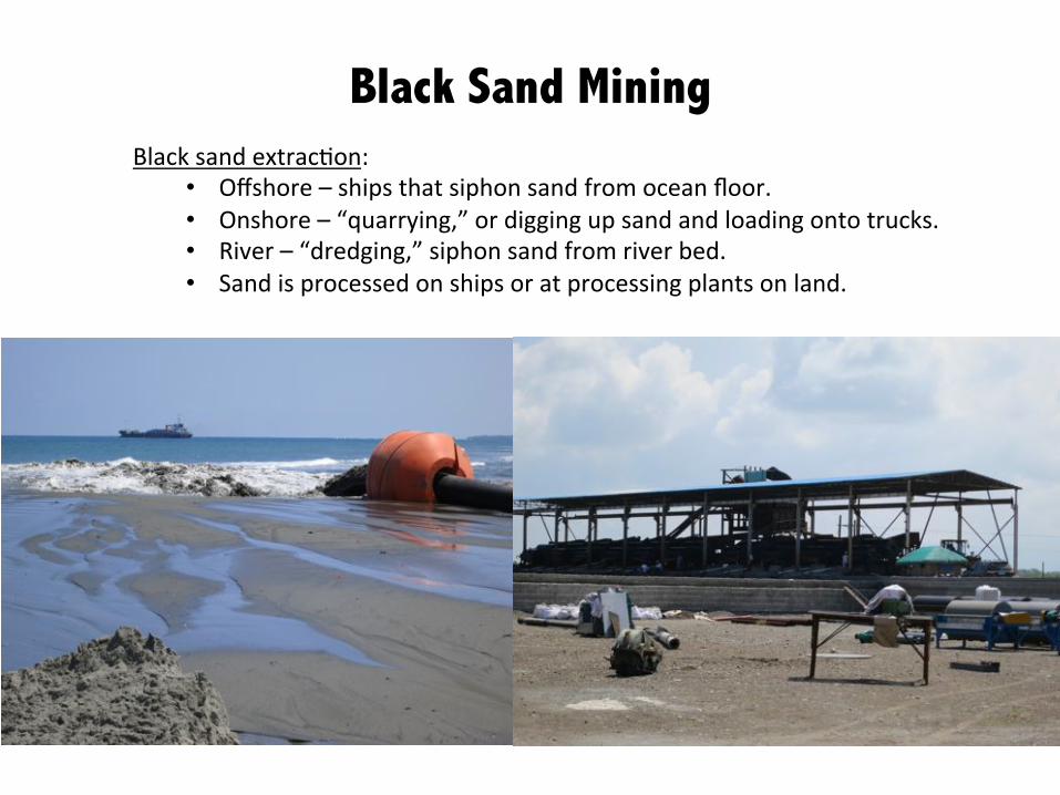
Black Sand Mining
&&
Black&sand&extrac0on:&
• Offshore&–&ships&that&siphon&sand&from&ocean&floor.&
• Onshore&–&“quarrying,”&or&digging&up&sand&and&loading&onto&trucks.&
• River&–&“dredging,”&siphon&sand&from&river&bed.&
• Sand&is&processed&on&ships&or&at&processing&plants&on&land.&
&
&&

Black Sand Mining
&&
Effect&on&local&livelihoods:&
• Erosion;&communi0es&on&the&coast.&
• Disturbs&local&marine&ecosystem;&threat&to&fisheries.&
• Allows&saltwater&to&penetrate&water&table;&freshwater&less&suitable&for&
drinking&and&agriculture.&
&&
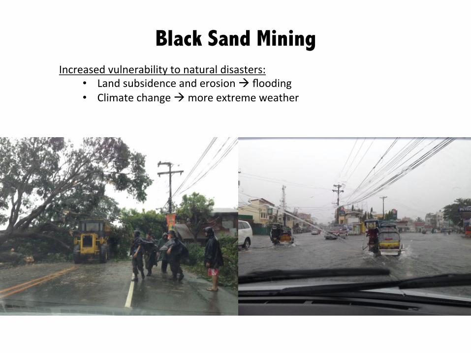
Black Sand Mining
&&
Increased&vulnerability&to&natural&disasters:&
• Land&subsidence&and&erosion&!&flooding&
• Climate&change&!&more&extreme&weather&
&&

Black Sand Mining
&&
Illegality:&
• Philippine&Mining&Act&1995:&illegal&to&mine&within&200&m&of&coastline.&
• Since&2006,&illegal&black&sand&mining&has&been&on&the&rise&in&Luzon.&
• Local&poli0cians&receive&bribes&from&foreign&mining&firms.&
• Incumbent&poli0cians&then&use&these&rents&to&bribe&ci0zens&for&votes.&
&&

Black Sand Mining
&&
Illegality:&
• Philippine&Mining&Act&1995:&illegal&to&mine&within&200&m&of&coastline.&
• Since&2006,&illegal&black&sand&mining&has&been&on&the&rise&in&Luzon.&
• Local&poli0cians&receive&bribes&from&foreign&mining&firms.&
• Incumbent&poli0cians&then&use&these&rents&to&bribe&ci0zens&for&votes.&
Informa0on&based&on&interviews&conducted&in&each&province,&September&2014&
&&
Province Number of Bgy with mining
Before 2007
2007-2010
2010-2013
2013-present
Cagayan 1 1 27 18
Ilocos Norte 1 1 0 0
Ilocos Sur 6 17 13 4
La Union
Pangasinan
Zambales 1-2*

Explore&poten0al&for&using&remote&sensing&to&measure&the&scope&of&illegal&black&sand&mining&
and&its&environmental&impacts&in&the&Philippines.&
&
&1/&Use&Landsat/Google&Earth&op0cal&images&to&iden0fy&mining&sites.&
&2/&Use&ALOS&InSAR&to&iden0fy&land&subsidence.&
&3/&Combining&subsidence&rate&and&eleva0on,&evaluate&the&0me&to&permanent&flooding.&
&4/&Verify&sites&and&mining&methodologies,&and&collect&local&elec0on&results.&
&
&
&
Project Aims
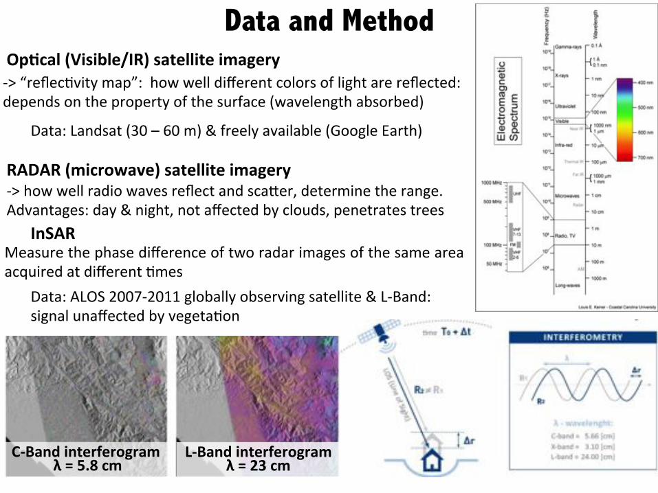
Data and Method
a>&“reflec0vity&map”:&&how&well&different&colors&of&light&are&reflected:&
depends&on&the&property&of&the&surface&(wavelength&absorbed)&
RADAR$(microwave)$satellite$imagery$a>&how&well&radio&waves&reflect&and&scaeer,&determine&the&range.&&
Advantages:&day&&&night,¬&affected&by&clouds,&penetrates&trees&
&
Op7cal$(Visible/IR)$satellite$imagery$
Data:&Landsat&(30&–&60&m)&&&freely&available&(Google&Earth)&
InSAR$$$$
Measure&the&phase&difference&of&two&radar&images&of&the&same&area&
acquired&at&different&0mes&
Data:&ALOS&2007a2011&globally&observing&satellite&&&LaBand:&
signal&unaffected&by&vegeta0on&
C?Band$interferogram$$λ$=$5.8$cm&
L?Band$interferogram$$λ$=$23$cm&
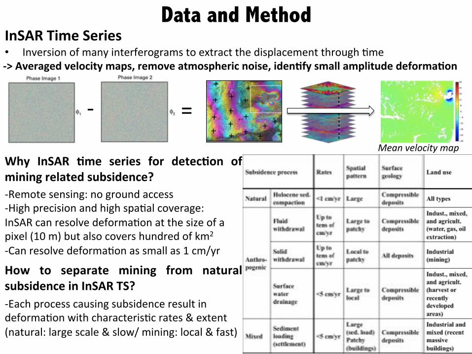
• Inversion&of&many&interferograms&to&extract&the&displacement&through&0me&&
?>$Averaged$velocity$maps,$remove$atmospheric$noise,$iden7fy$small$amplitude$deforma7on$
InSAR$Time$Series$$$$ a& =&
Mean%velocity%map%
Data and Method
aRemote&sensing:&no&ground&access&
aHigh&precision&and&high&spa0al&coverage:&
InSAR&can&resolve&deforma0on&at&the&size&of&a&
pixel&(10&m)&but&also&covers&hundred&of&km2&&
aCan&resolve&deforma0on&as&small&as&1&cm/yr&
Why$ InSAR$ 7me$ series$ for$ detec7on$ of$mining$related$subsidence?$
How$ to$ separate$ mining$ from$ natural$subsidence$in$InSAR$TS?$aEach&process&causing&subsidence&result&in&
deforma0on&with&characteris0c&rates&&&extent&
(natural:&large&scale&&&slow/&mining:&local&&&fast)&
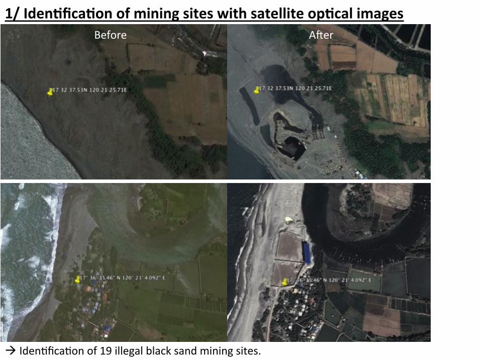
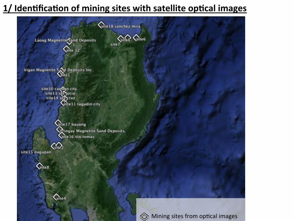
1/$Iden7fica7on$of$mining$sites$with$satellite$op7cal$images$$
!&Iden0fica0on&of&19&illegal&black&sand&mining&sites.&&
Before&& A8er&
1/$Iden7fica7on$of$mining$sites$with$satellite$op7cal$images$$
Mining&sites&from&op0cal&images&

2/$InSAR$for$land$subsidence$iden7fica7on$$
ALOS&data&
Mining&sites&from&op0cal&images&
a>&Processing&of&14&ALOS&
frames&with&each&9a25&
acquisi0ons&
!&40&to&250&interferograms&
per&track&

2/$InSAR$for$land$subsidence$iden7fica7on$$
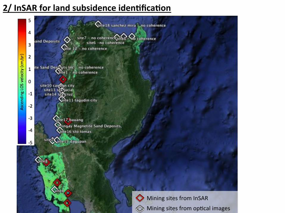
2/$InSAR$for$land$subsidence$iden7fica7on$$
Mining&sites&from&op0cal&images&
Mining&sites&from&InSAR&
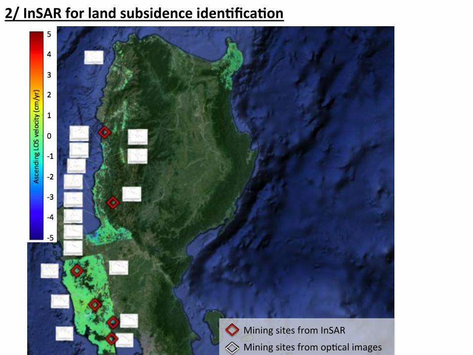
2/$InSAR$for$land$subsidence$iden7fica7on$$
Mining&sites&from&op0cal&images&
Mining&sites&from&InSAR&
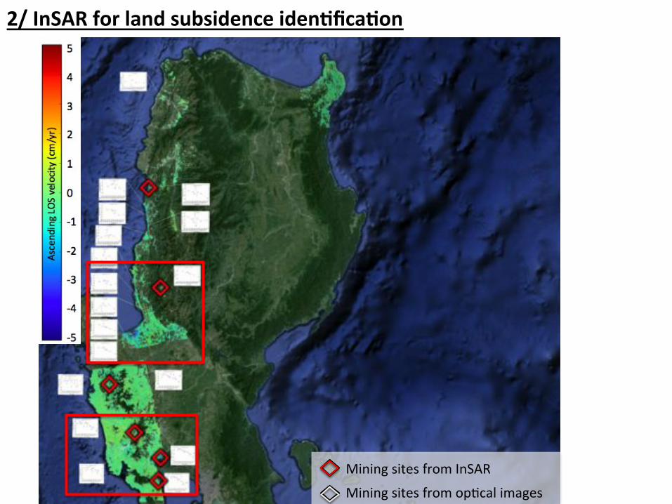
2/$InSAR$for$land$subsidence$iden7fica7on$$
Mining&sites&from&op0cal&images&
Mining&sites&from&InSAR&

Zoom&on&south&Area&
1.3& cm/yr&
2.6& cm/yr&
3.5& cm/yr&
1.2& cm/yr&
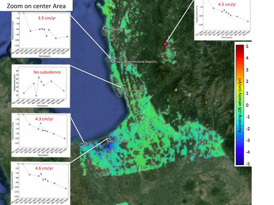
Zoom&on¢er&Area&
3.9&cm/yr&
No&subsidence&
4.5&cm/yr&
4.3&cm/yr&
4.6&cm/yr&

&
&
&
&
a Op0cal&images&enable&iden0fica0on&of&some&illegal&mining&sites.&&
a 7&mining&sites&have&no&coherence&in&InSAR&images&–&biggest&limita0on&of&InSAR&
(too&much&change&in&proper0es&–&too&recent&development?&too&much&subsidence?)&&
a 5&sites&show&no&subsidence:&subsidence&likely&depends&on&the&amount&of&mining/pumping&and&0ming.&
a 13$sites$show$subsidence&a 6¬&originally&iden0fied&with&op0cal&images&
! InSAR&can&further&help&iden0fy&areas&of&high&risk&&
a Paeern&~&100&0me&larger&than&mining&site&
(mining&0.05&km2&/&subsidence&5a10&km2)&&
a Subsidence&up&to&7&cm/yr&in&coastal&area&
! Increases&the&threat&of&flooding&&
&
&
Site Subsidence (cm/yr)
Adding sea level rise
(1.3 cm/yr -NOAA)
Elevation above sea level (m)
Time before land is
below sea level (yrs)
Candon 10 3.6 4.9 2-4 41-82
Sta Lucia 13 5.2 6.5 2-4 31-62
Aringay 4.7 6.0 4-6 67-100
Dagupan 15 5.5 6.8 2-4 29-59
Lingayen 2 5.2 6.5 2-4 31-62
Candelaria 8 2.2 3.5 2-4 57-114
Summary$

Next Steps &
• Incorpora0ng&elec0on&and&census&data.&
• Further&evalua0on&of&land&use&and&
water&extrac0on&near&high&subsidence&
sites.&
• DigitalGlobe&imagery&grant&–&two&higha
resolu0on&images&of&one&site.&
• Partnership&with&Big&Pixel&Ini0a0ve,&
Calit2&@&UCSD&+&DigitalGlobe,&to&explore&
magne0te&ID&and/or&land&use&
classifica0on&in&higharesolu0on&satellite&
data.&
• Field&experiment&in&2015&to&test&effect&
of&monitors&equipped&with&smart&
phones&and&apps&to&report&illegal&mining&
in&real&0me.&
• ALOSa2&launched&&
&&&&&&summer&2014.&&
Acknowledgements &
We&are&very&grateful&to&the&Center&for&Effec0ve&Global&Ac0on,&the&Ins0tute&of&
Interna0onal&Studies,&the&Development&Impact&Lab,&and&the&Behavioral&Sensing&
Workgroup&at&UC&Berkeley&for&suppor0ng&this&project.&
&
Alaska&Satellite&Facility&for&providing&the&data&for&InSAR.&
&
We&also&thank&Michael&Davidson&for&research&assistance&in&the&field&and&con0nued&
collabora0on&on&this&project;&Cesi&Cruz,&Erin&Troland,&and&UCSD’s&Human&Nature&
Group&for&helpful&feedback;&Father&Albert&Rabe&(ISCAPE),&Sister&Lillian&Carranza&
(Caritas),&Ninoy&Tabalada&(ISCAPE),&Father&Jaime&Jose&and&Donna&Rabaang&Peta&
(Defend&Ilocos&Against&Mining),&and&Art&Alariao&(FEAC)&for&accommoda0ng&us&and&
providing&valuable&informa0on.&
&
&