
RELEASE GUIDE - imagemnl.com · The scope of this document is the GeoMedia Desktop (GeoMedia...
108
RELEASE GUIDE GEOMEDIA DESKTOP GeoMedia Desktop 2018 Update 2
Transcript of RELEASE GUIDE - imagemnl.com · The scope of this document is the GeoMedia Desktop (GeoMedia...
RELEASE GUIDE GEOMEDIA DESKTOP
GeoMedia Desktop 2018 Update 2
2
Contents
About This Release ........................................................................................................................ 7
GeoMedia Product Tiers ................................................................................................................ 7
New Platforms (16.1) ...................................................................................................................... 7
Oracle ................................................................................................................................... 7
New Platforms (16.2) ...................................................................................................................... 8
Oracle ................................................................................................................................... 8
SQL Server ........................................................................................................................... 8
PostGIS ................................................................................................................................ 8
New Platforms (16.5) ...................................................................................................................... 8
SQL Server ........................................................................................................................... 8
Impacts (16.1) ................................................................................................................................. 8
Expressions .......................................................................................................................... 8
Handling of null values in the NOT BETWEEN operator ...................................... 8
Boolean expressions with attribute-based symbology ......................................... 9
Impacts (16.5) ................................................................................................................................. 9
Data Access .......................................................................................................................... 9
Warehouse Templates ........................................................................................ 9
GML and WFS data servers ................................................................................ 9
Coordinate Systems ............................................................................................................ 10
Application Development .................................................................................................... 10
Impacts (16.5 Update 1) ............................................................................................................... 10
Data Access ........................................................................................................................ 10
Oracle data server ............................................................................................. 10
Map Display ........................................................................................................................ 11
Bing Maps command ......................................................................................... 11
Impacts (16.5 Update 2) ............................................................................................................... 11
Data Access ........................................................................................................................ 11
3
WFS-T data server ............................................................................................ 11
Impacts (Future) ........................................................................................................................... 11
Feature Caching ................................................................................................................. 11
PublishIFC Utility ............................................................................................... 11
New Technology (16.1) ................................................................................................................ 12
Data Access ........................................................................................................................ 12
PostGIS data server .......................................................................................... 12
WMS data server ............................................................................................... 12
WMTS data server ............................................................................................. 12
Oracle LTT data server ...................................................................................... 12
Database Utilities ............................................................................................... 12
Feature Caching ................................................................................................................. 13
Logging .............................................................................................................. 13
Improved performance ...................................................................................... 13
Compatibility with Advanced Feature Model ...................................................... 13
Data Output ......................................................................................................................... 14
OutputToTableService ....................................................................................... 14
Analysis .............................................................................................................................. 14
Spatial Intersection command and SpatialIntersectionPipe ............................... 14
Spatial Modeling ................................................................................................................. 15
Run Spatial Model command ............................................................................. 15
Explorer window ................................................................................................ 15
Support for Spatial Model Results in commands ............................................... 16
Sample Spatial Models ...................................................................................... 17
Spatial Model Editor .......................................................................................... 17
Advanced Feature Model .................................................................................................... 17
AFMConvertService .......................................................................................... 17
Compatibility with feature caching ..................................................................... 17
4
New Technology (16.2) ................................................................................................................ 17
General ............................................................................................................................... 17
Application Window ........................................................................................... 17
InvokeCommand method ................................................................................... 17
Coordinate Systems ............................................................................................................ 18
Geodetic Datums ............................................................................................... 18
EPSG Codes ..................................................................................................... 18
Datum Transformations ..................................................................................... 18
Data Output ......................................................................................................................... 18
OutputToTableService ....................................................................................... 18
Map Display ........................................................................................................................ 19
Thematic Legend Entries ................................................................................... 19
Spatial Modeling ................................................................................................................. 19
Sample Spatial Models ...................................................................................... 19
New Technology (16.5) ................................................................................................................ 19
General ............................................................................................................................... 19
Licensing ........................................................................................................... 19
Branding ............................................................................................................ 21
Setup ................................................................................................................. 21
Sample Data ...................................................................................................... 22
Data Access ........................................................................................................................ 22
GeoPackage data server ................................................................................... 22
New Warehouse command ............................................................................... 23
Database Utilities ............................................................................................... 25
Batch Publishing for PostGIS ............................................................................ 25
GML data server ................................................................................................ 26
WFS data server ................................................................................................ 30
Define Warehouse Configuration File utility ....................................................... 32
5
Data Capture ....................................................................................................................... 32
Select Set Properties ......................................................................................... 32
Offline Editing .................................................................................................... 32
Spatial Modeling ................................................................................................................. 32
Spatial Model Editor .......................................................................................... 32
New Operators .................................................................................................. 32
Expressions within Operators ............................................................................ 33
Enhancements to Existing Operators ................................................................ 34
Other New Operators ........................................................................................ 35
Sample Spatial Models ...................................................................................... 35
New Technology (16.5 Update 1) ................................................................................................ 36
Coordinate Systems ............................................................................................................ 36
Geodetic Datums ............................................................................................... 36
Data Access ........................................................................................................................ 37
Oracle data server ............................................................................................. 37
GeoPackage data server ................................................................................... 37
Feature Caching ................................................................................................................. 37
Improved performance ...................................................................................... 37
Advanced Feature Model .................................................................................................... 38
New Rule Classes ............................................................................................. 38
Data Capture ....................................................................................................................... 39
Merge Features ................................................................................................. 39
Customization of data capture ........................................................................... 39
Analysis .............................................................................................................................. 40
Buffer Zone ........................................................................................................ 40
Libraries .............................................................................................................................. 41
New Library Connection command .................................................................... 41
New Library command ....................................................................................... 42
6
Library Organizer command .............................................................................. 42
Map Display ........................................................................................................................ 42
Raster Display ................................................................................................... 42
Bing Maps command ......................................................................................... 42
New Technology (16.5 Update 2) ................................................................................................ 43
General ............................................................................................................................... 43
Installation and Configuration ............................................................................ 43
Application Startup ............................................................................................ 44
About Command ................................................................................................ 44
Coordinate Systems ............................................................................................................ 45
Vertical Transformations .................................................................................... 45
Data Access ........................................................................................................................ 46
GeoPackage data server ................................................................................... 46
PostGIS data server .......................................................................................... 46
Database Utilities ............................................................................................... 46
WFS-T data server ............................................................................................ 47
Define Warehouse Configuration File utility ....................................................... 49
Layout ................................................................................................................................. 49
Layout Legend ................................................................................................... 49
Spatial Modeling ................................................................................................................. 49
New Operators .................................................................................................. 49
System Requirements (16.5) ....................................................................................................... 50
System Requirements Notes ............................................................................................... 51
Issues Resolved (16.1) ................................................................................................................. 53
Issues Resolved (16.2) ................................................................................................................. 66
Issues Resolved (16.5) ................................................................................................................. 76
Issues Resolved (16.5 Update 1) ................................................................................................. 91
Issues Resolved (16.5 Update 2) ................................................................................................. 97
About Us ..................................................................................................................................... 105
About This Release
7
ABOUT THIS RELEASE This document describes the enhancements for GeoMedia. Although the information in this document is current as of the product release, see the Hexagon Geospatial Support website for the most current version.
This release includes both enhancements and fixes. For information on enhancements, see the New Technology section. For information on fixes that were made to GeoMedia for this release, see the Issues Resolved section.
This document is only an overview and does not provide all of the details about the product's capabilities. See the online help and other documents provided with GeoMedia for more information.
The scope of this document is the GeoMedia Desktop (GeoMedia Essentials, GeoMedia Advantage, GeoMedia Professional) as well as GeoMedia Viewer and GeoMedia Objects.
GEOMEDIA PRODUCT TIERS GeoMedia® is a flexible and dynamic GIS package for creating, updating, managing and analyzing your valuable geospatial information. Generate and update vector layers. Perform dynamic spatial analysis and generate reports. Automatically create and update maps. Manage data and map production more efficiently. GeoMedia is available in three product tiers, Essentials, Advantage, and Professional.
GeoMedia Essentials enables you to query and analyse a wide variety of geospatial data sources. It also includes ERDAS IMAGINE Essentials, giving you the ability to do simple image preparation.
GeoMedia Advantage has all the functionality of GeoMedia Essentials and is excellent for data collection and editing, processing and analyzing elevation and terrain data including LiDAR. It also includes data validation and sophisticated raster analysis tools.
GeoMedia Professional includes all of the features of the previous tiers and provides enterprise-wide, multi-user data management and analysis. Manage linear networks, produce professional cartographic maps, conduct advanced feature editing, manage parcel holdings, conduct utility network analysis, monitor and control changes, integrate data from multiple sources, and assure overall data quality with GeoMedia Professional.
NEW PLATFORMS (16.1)
ORACLE The utility Database Utilities now supports Oracle 12c through use of the Oracle OLEDB provider.
New Platforms (16.2)
8
NEW PLATFORMS (16.2)
ORACLE Oracle 12.2 is now supported.
The utility Transaction Administrator now supports Oracle 12c through use of the Oracle OLEDB provider.
SQL SERVER SQL Server 2016 is now supported.
POSTGIS PostGIS 2.3 / PostgreSQL 9.6 is now supported.
NEW PLATFORMS (16.5)
SQL SERVER SQL Server 2017 is now supported.
IMPACTS (16.1)
EXPRESSIONS
HANDLING OF NULL VALUES IN THE NOT BETWEEN OPERATOR In the functional attribute system and when querying a feature cache, the NOT BETWEEN operator has been fixed to properly handle the NULL value case. Specifically, when BETWEEN evaluates to NULL, NOT BETWEEN also now evaluates to NULL rather than TRUE, so that “A NOT BETWEEN B AND C” now returns the same answer as “NOT(A BETWEEN B AND C)”. This may impact query results for the Functional Attribute, Analytical Merge, and Aggregation commands; as well as attribute-based map displays and map tooltip definitions that involve expressions.
Impacts (16.5)
9
BOOLEAN EXPRESSIONS WITH ATTRIBUTE-BASED SYMBOLOGY When an expression is evaluated in the context of the map display system (e.g. in an attribute-based definition for a style property), and that expression yields a Boolean data type with a NULL value, then that NULL value is now returned as expected. This is important because some Boolean style properties (e.g. Displayable) are defined as “if missing, then true”. If the expression were to return a value of FALSE rather than NULL, then a NULL value cannot be received by the style property.
However when such an expression is evaluated in any other context (e.g. in the computation of a functional attribute), then the NULL value is converted to FALSE in order to simulate previous behaviour and minimize impact.
Techniques that may be used for accommodating the new 16.0 behavior include:
⚫ Use the ISNULL(value, valueIfNull) function. This returns “value” if it is not NULL, and “valueIfNull” if it is NULL.
⚫ Use the “value IS NULL” operator to test whether “value” is or is not NULL. This operator returns only TRUE or FALSE.
IMPACTS (16.5)
DATA ACCESS
WAREHOUSE TEMPLATES The following Access warehouse templates used by the New Warehouse command have been removed due to their age and obsolescence:
• Access97.mdt
• Access2003.mdt
• AccessXP.mdt
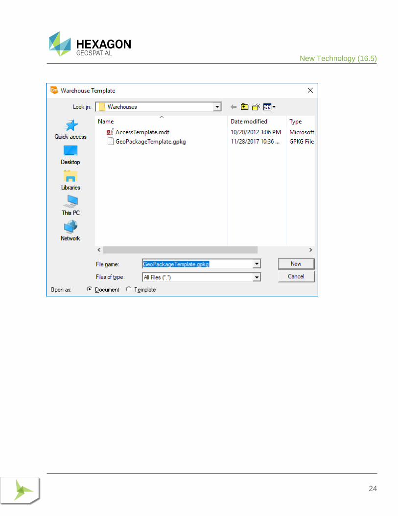
In addition, the remaining template “normal.mdt” has been renamed “AccessTemplate.mdt” in conjunction with support for the new GeoPackage data server which will introduce “GeoPackageTemplate.gpkg” as a warehouse template.
GML AND WFS DATA SERVERS The previous GML and WFS Read-Only data servers have been deprecated and replaced. Existing warehouse connections to those prior data servers continue to function within a GeoWorkspace, but it is not possible to create new connections using those data servers. Also, the Warehouse Connections command indicates that the “Type” of these data servers is now “GML (deprecated)” and “WFS Read-Only (deprecated)” respectively in order to discriminate between them and the new data servers replacing them.
Through API, these previous data servers will continue to function using their previous ProgIDs. The new data servers have new ProgIDs of GML2.GDatabase and WFS2.GDatabase respectively.
Impacts (16.5 Update 1)
10
The previous WFS Read-Write data server which supports the WFS-T specification, is unchanged.
COORDINATE SYSTEMS It is sometimes necessary to customize files related to Coordinate Systems capabilities, such as autodt.ini and NamedHDatum.ini; or to add grid files (.gsb) into the system for datum transformations. The location for these files and folders has changed for this release to:
C:\Program Files (x86)\Common Files\Intergraph\GeoMedia\Program\PrivateAssemblies
APPLICATION DEVELOPMENT Hexagon Geospatial products now use private deployment within each product, of certain common geospatial components such as Coordinate Systems and Raster. Custom applications may be impacted, depending on the type of technology being used (e.g. COM versus .net) and the type of application software being developed (e.g. custom command versus standalone application). For more information see “What’s New for Version 16.5” in the GeoMedia Object Reference help.
IMPACTS (16.5 UPDATE 1)
DATA ACCESS
ORACLE DATA SERVER As indicated in the New Technology section for 16.5 Update 1, this data server now supports the Unified Auditing capability when enabled with Oracle 12c. Most customers will not be impacted by this, but you are impacted if the following conditions are true:
1. You are using Oracle 12c or later with existing modification log triggers and wish to enable Unified Auditing.
2. You have custom triggers installed that populate the SESSIONID field of the ModificationLog using the Oracle value USERENV(‘SESSIONID’) and wish to enable Unified Auditing.
If either of the above is true, then your existing triggers need to be dropped and recreated. The normal ModificationLog triggers can be created in the regular manner using Database Utilities, available from the Start menu.
If you have secured features with existing modification log triggers they can be updated using the new PL/SQL procedure UpdateLTTModLogTriggers added to the GTM Package. Secured feature triggers can also be updated by using Transaction Administrator to unsecure the feature, recreate triggers using Database Utilities, then re-securing the feature with Transaction Administrator. However the latter method will delete any existing LTT history
Impacts (16.5 Update 2)
11
information. Refer to the GeoMedia Help topic on Triggers, under Using Oracle Connections, for additional information.
MAP DISPLAY
BING MAPS COMMAND As indicated in the New Technology section for 16.5 Update 1, this command has been upgraded for compatibility with Bing Maps V8. The V8 version of the Bing Maps API no longer informs the embedding application (GeoMedia) when the Bing Maps credentials are invalid or expired, so GeoMedia is unaware. Instead the end user is directly informed through the display of a banner across the middle of the map display which interferes with the usability of the map and offers instructions for how to get a valid key.
In order to allow the user to submit a new valid key and eliminate the banner, a new button is provided in the Bing Maps window which invokes the Bing Maps Credentials dialog.
IMPACTS (16.5 UPDATE 2)
DATA ACCESS
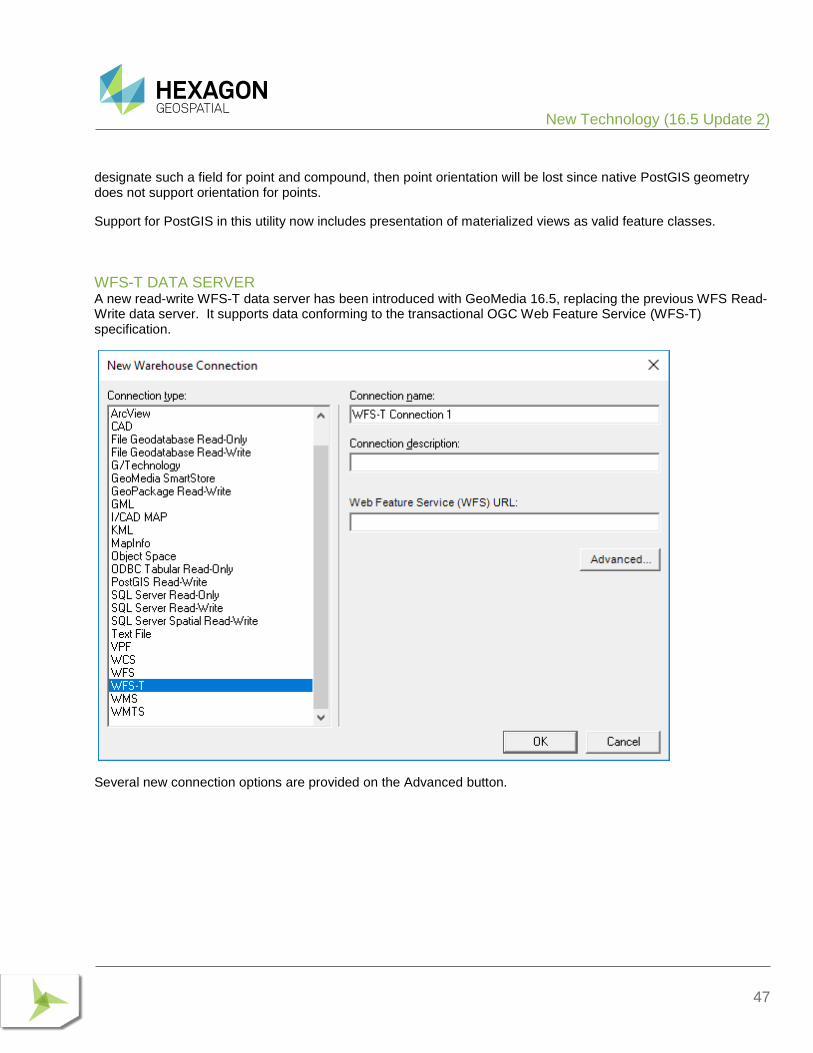
WFS-T DATA SERVER The previous WFS Read-Write data server has been deprecated and replaced. Existing warehouse connections to that prior data server continue to function within a GeoWorkspace, but it is not possible to create new connections using that data server. Also, the Warehouse Connections command indicates that the “Type” of this data server is now “WFS Read-Write (deprecated)” in order to discriminate between it and the new data server replacing it.
Through API, this previous data server will continue to function using its previous ProgID. The new data server has a new ProgID of WFS2RW.GDatabase.
The previous WFS Read-Write data server which supports the WFS-T specification, is unchanged.
IMPACTS (FUTURE)
FEATURE CACHING
PUBLISHIFC UTILITY Since introduction of the PublishIFC.exe utility and its companion DataSourceMonikerCreator.exe, IFC publishing has been supported through two avenues – data servers and feature accessors. In the future, the feature

New Technology (16.1)
12
accessor mechanism will be deprecated and only data servers supported. It is recommended even with GeoMedia 16.5 that all publishing of IFC files be done via data servers.
NEW TECHNOLOGY (16.1)
DATA ACCESS
POSTGIS DATA SERVER The PostGIS data server now better supports multi-table read-write views of various kinds, and supports queries against the picklist table.
The PostGIS data server now filters out feature classes which have table and field names containing uppercase characters. Such characters require special syntax in SQL and are not supported within GeoMedia.
WMS DATA SERVER The WMS data server now automatically recognizes and handles certain Coordinate Reference Systems as being defined with swapped axes (e.g. Y-X rather than X-Y). It is no longer necessary to add an .ini file entry to convey the need to swap axes, in most such cases. The .ini file entry is still available for cases in which the software misinterprets the CRS, or in which the WMS site results don’t match the CRS.
WMTS DATA SERVER The WMTS data server now automatically recognizes and handles certain Coordinate Reference Systems as being defined with swapped axes (e.g. Y-X rather than X-Y). In addition, an .ini file entry is now available for cases in which the software misinterprets the CRS, or in which the WMTS site results don’t match the CRS.
ORACLE LTT DATA SERVER Further changes to optimize LTT-specific queries for Oracle 12c have been made to resolve performance issues. These are beyond the changes in GeoMedia 16.1 for CR# 1-S0AO0B.
DATABASE UTILITIES We’ve improved the PostGIS capabilities within Database Utilities, as well as changed the definition of the GFeatures view to filter out feature classes which have table and field names containing uppercase characters. Such characters require special syntax in SQL and are not supported within GeoMedia.

New Technology (16.1)
13
FEATURE CACHING
LOGGING An optional log file may be created, and if present the feature caching system will provide diagnostic information about whether and how caches are being used at runtime.
IMPROVED PERFORMANCE IFC files that are created with GeoMedia Desktop 16.1 are organized for even better performance, especially for cases of very large files accessed over a network share. Previously published feature cache files remain compatible, but performance will improve if the files are newly published.
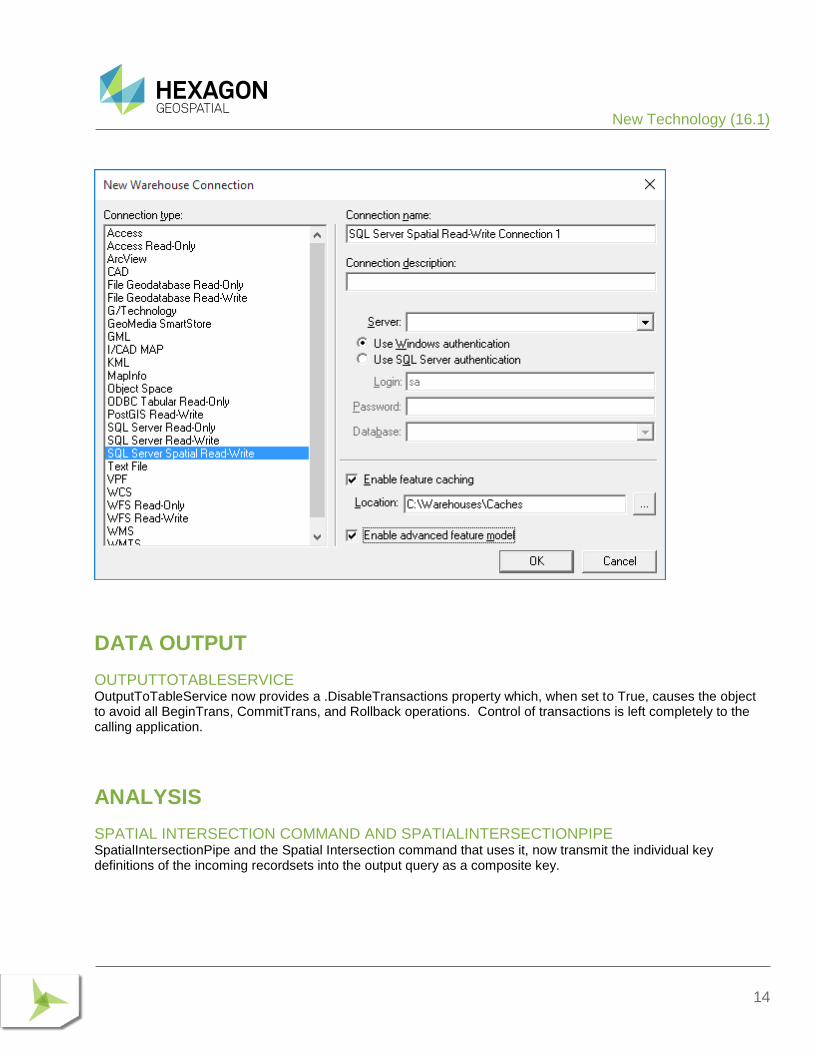
COMPATIBILITY WITH ADVANCED FEATURE MODEL On the New Warehouse Connection command as well as the Properties dialog of the Warehouse Connections command, the “Enable advanced feature model” and “Enable feature caching” checkboxes are no longer mutually exclusive. The performance improvements that come with feature caching are now available for AFM-configured warehouses as well.
New Technology (16.1)
14
DATA OUTPUT
OUTPUTTOTABLESERVICE OutputToTableService now provides a .DisableTransactions property which, when set to True, causes the object to avoid all BeginTrans, CommitTrans, and Rollback operations. Control of transactions is left completely to the calling application.
ANALYSIS
SPATIAL INTERSECTION COMMAND AND SPATIALINTERSECTIONPIPE SpatialIntersectionPipe and the Spatial Intersection command that uses it, now transmit the individual key definitions of the incoming recordsets into the output query as a composite key.
New Technology (16.1)
15
SPATIAL MODELING
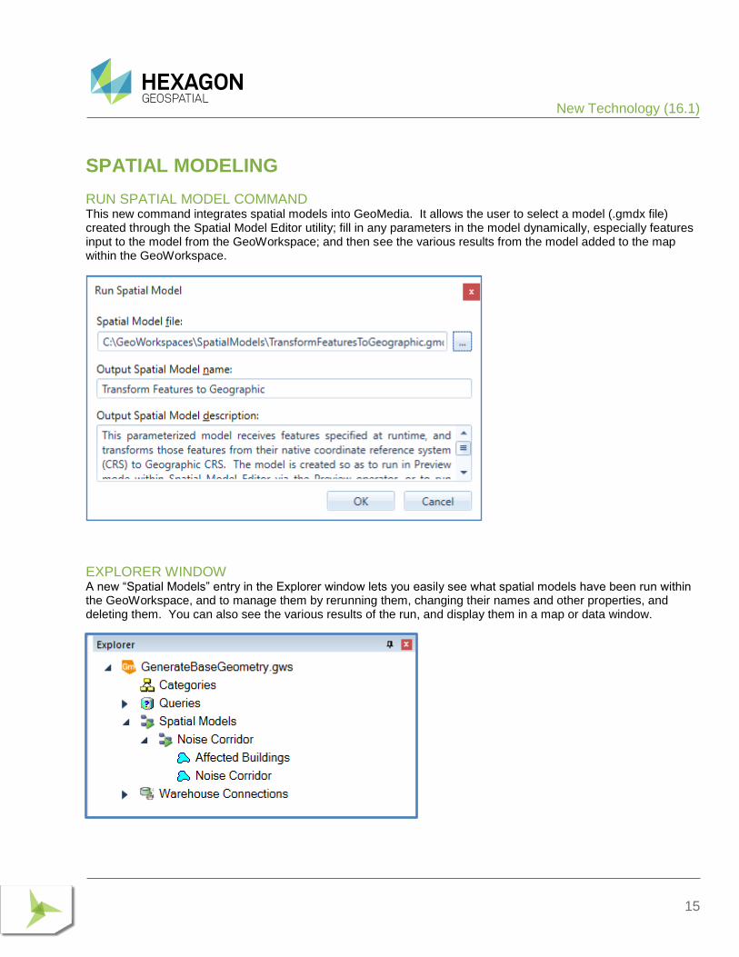
RUN SPATIAL MODEL COMMAND This new command integrates spatial models into GeoMedia. It allows the user to select a model (.gmdx file) created through the Spatial Model Editor utility; fill in any parameters in the model dynamically, especially features input to the model from the GeoWorkspace; and then see the various results from the model added to the map within the GeoWorkspace.
EXPLORER WINDOW A new “Spatial Models” entry in the Explorer window lets you easily see what spatial models have been run within the GeoWorkspace, and to manage them by rerunning them, changing their names and other properties, and deleting them. You can also see the various results of the run, and display them in a map or data window.
New Technology (16.1)
16
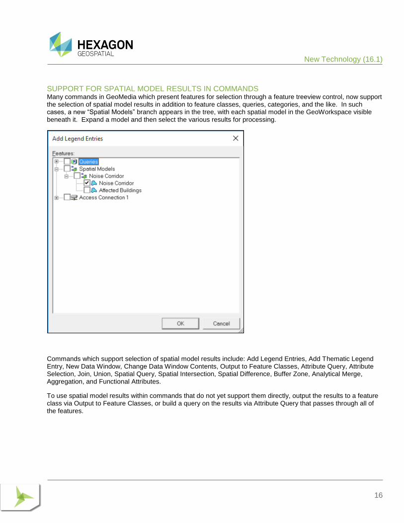
SUPPORT FOR SPATIAL MODEL RESULTS IN COMMANDS Many commands in GeoMedia which present features for selection through a feature treeview control, now support the selection of spatial model results in addition to feature classes, queries, categories, and the like. In such cases, a new “Spatial Models” branch appears in the tree, with each spatial model in the GeoWorkspace visible beneath it. Expand a model and then select the various results for processing.
Commands which support selection of spatial model results include: Add Legend Entries, Add Thematic Legend Entry, New Data Window, Change Data Window Contents, Output to Feature Classes, Attribute Query, Attribute Selection, Join, Union, Spatial Query, Spatial Intersection, Spatial Difference, Buffer Zone, Analytical Merge, Aggregation, and Functional Attributes.
To use spatial model results within commands that do not yet support them directly, output the results to a feature class via Output to Feature Classes, or build a query on the results via Attribute Query that passes through all of the features.
New Technology (16.2)
17
SAMPLE SPATIAL MODELS The default spatial models folder (C:\GeoWorkspaces\SpatialModels) now contains sample models that demonstrate use of certain operators and demonstrate how to construct a model properly for use with the Run Spatial Model command.
SPATIAL MODEL EDITOR This utility has been upgraded to the latest version released with ERDAS IMAGINE 16.1.
ADVANCED FEATURE MODEL
AFMCONVERTSERVICE AFMConvertService is a new component that provides the ability through API to convert a standard non-AFM warehouse to a warehouse configured for the Advanced Feature Model. This capability was previously available only through GUI.
COMPATIBILITY WITH FEATURE CACHING On the New Warehouse Connection command as well as the Properties dialog of the Warehouse Connections command, the “Enable advanced feature model” and “Enable feature caching” checkboxes are no longer mutually exclusive. The performance improvements that come with feature caching are now available for AFM-configured warehouses as well.
NEW TECHNOLOGY (16.2)
GENERAL
APPLICATION WINDOW The name of the active GeoWorkspace is now displayed in the caption of the application window at all times, whether the active map, data, or layout window is maximized or not. Previously the GeoWorkspace name was shown only when a child window was not maximized.
INVOKECOMMAND METHOD The method InvokeCommand on the Application object now supports invocation of the Select Tool command.
New Technology (16.2)
18
COORDINATE SYSTEMS
GEODETIC DATUMS Support for the following datums has now been added:
• Oman National Geodetic Datum 2014. This addition includes support for use of ONGD14 with UTM zones 39-41 North. It also includes autodt.ini support for 7-parameter datum transformation between ONGD14 and WGS84 (ITRF89).
• Geocentric Datum of Australia 2020. This addition includes support for use of GDA2020 with MGA (UTM) zones 46-59 South. It also includes autodt.ini support for 7-parameter datum transformation between GDA1994 and GDA2020.
• Ross Sea Region Geodetic Datum 2000.
• NAD83(NSRS 2011) and associated PA11 and MA11. This addition includes support for use of NAD83(NSRS PA11) with Hawaiian State Plane 1983 zones and NAD83(NSRS 2011) with other State Plane 1983 zones, as well as use with various UTM zones.
• Rauenberg Datum/83 and Potsdam Datum/83. Standardizes support for Gauss-Kruger (3 degree) zones and 7-parameter datum transformations to ETRS89 that were previously emulated.
EPSG CODES EPSG support has now been updated from version 8.8 to version 9.0 of the geodesy dataset. EPSG added 139 new Coordinate Reference System codes; this release adds support for 110 of them (those unsupported are CRS types not intrinsically supported in GeoMedia, such as Engineering or Vertical-only CRS).
DATUM TRANSFORMATIONS A new transformation is now introduced which streamlines the number of steps needed in a transformation path involving one of the example Named Datum entries associated with the NAD83 geodetic datum in the United States. This improves performance for large datasets.
DATA OUTPUT
OUTPUTTOTABLESERVICE For the Access data server only, as a consequence of Create Table committing any open transaction in Access, the new transaction-disabling logic will now begin a new transaction after the Create Table. For this scenario, the calling application must delete the created table itself, when performing rollback logic.
New Technology (16.5)
19
MAP DISPLAY
THEMATIC LEGEND ENTRIES On the Legend Entry Properties dialog for Unique Value and Range thematic legend entries, the column header over the on/off checkboxes in the thematic class grid can now be used to turn on and off the entire set of checkboxes together. Click on the column header to toggle the checkbox for the topmost row, and to set all other checkboxes to the same value. Click again to reverse the settings for all classes.
If a Unique Value or Range legend entry is not displayed in the map window, and the legend window is used to display one of its child legend entries representing a thematic class, the parent legend entry will now automatically have its display turned on so that the thematic class is displayed in the map.
SPATIAL MODELING
SAMPLE SPATIAL MODELS Additional sample models for raster data have been introduced.
NEW TECHNOLOGY (16.5)
GENERAL
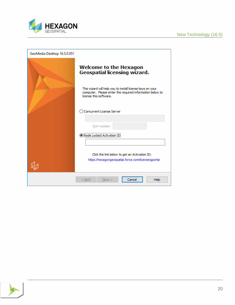
LICENSING Starting with the Power Portfolio 2018 release, licenses are no longer based on Certificate-file based technology. Instead, licenses are based on Activation IDs, allowing you to activate products without providing Host IDs or other hardware-related parameters. You can also re-host without emailing the licensing team for assistance. The Power Portfolio 2018 release also includes improved tools that make it easier to install licenses, set up license servers, and provide more professional error handling. Finally, the Power Portfolio 2018 release includes improved customer notification in the products, such as an “end of subscription” message in the Start-up screen. These more secure and automated processes, along with a new licensing portal, provide you with a better overall user experience.
New Technology (16.5)
20
New Technology (16.5)
21
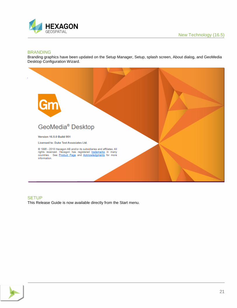
BRANDING Branding graphics have been updated on the Setup Manager, Setup, splash screen, About dialog, and GeoMedia Desktop Configuration Wizard.
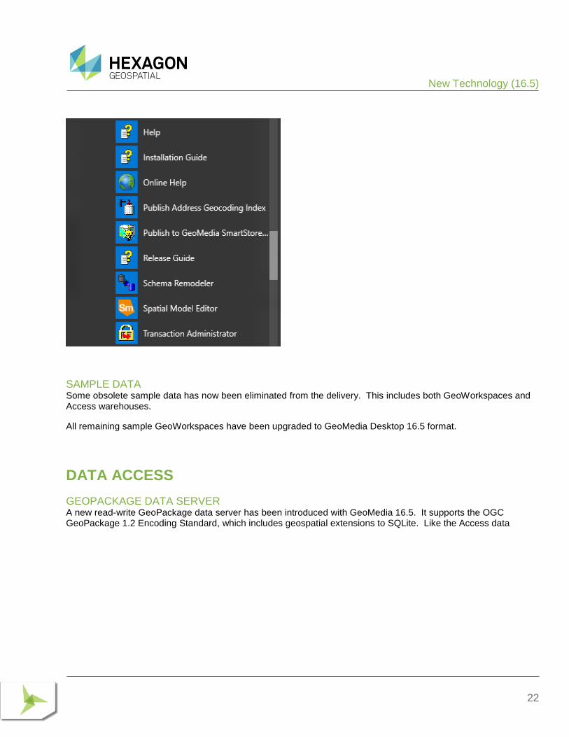
SETUP This Release Guide is now available directly from the Start menu.
New Technology (16.5)
22
SAMPLE DATA Some obsolete sample data has now been eliminated from the delivery. This includes both GeoWorkspaces and Access warehouses.
All remaining sample GeoWorkspaces have been upgraded to GeoMedia Desktop 16.5 format.
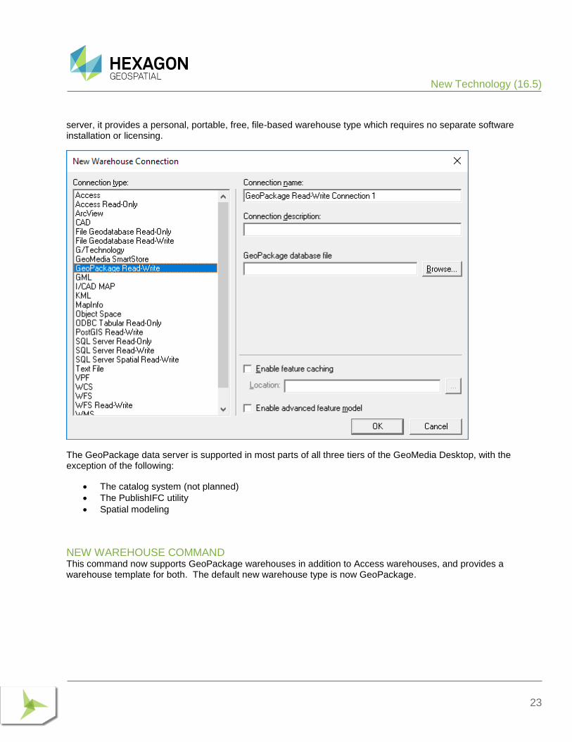
DATA ACCESS
GEOPACKAGE DATA SERVER A new read-write GeoPackage data server has been introduced with GeoMedia 16.5. It supports the OGC GeoPackage 1.2 Encoding Standard, which includes geospatial extensions to SQLite. Like the Access data
New Technology (16.5)
23
server, it provides a personal, portable, free, file-based warehouse type which requires no separate software installation or licensing.
The GeoPackage data server is supported in most parts of all three tiers of the GeoMedia Desktop, with the exception of the following:
• The catalog system (not planned)
• The PublishIFC utility
• Spatial modeling
NEW WAREHOUSE COMMAND This command now supports GeoPackage warehouses in addition to Access warehouses, and provides a warehouse template for both. The default new warehouse type is now GeoPackage.
New Technology (16.5)
24
New Technology (16.5)
25
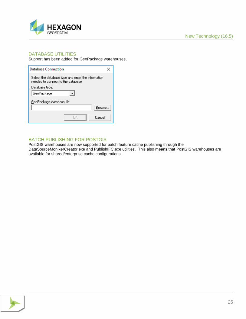
DATABASE UTILITIES Support has been added for GeoPackage warehouses.
BATCH PUBLISHING FOR POSTGIS PostGIS warehouses are now supported for batch feature cache publishing through the DataSourceMonikerCreator.exe and PublishIFC.exe utilities. This also means that PostGIS warehouses are available for shared/enterprise cache configurations.
New Technology (16.5)
26
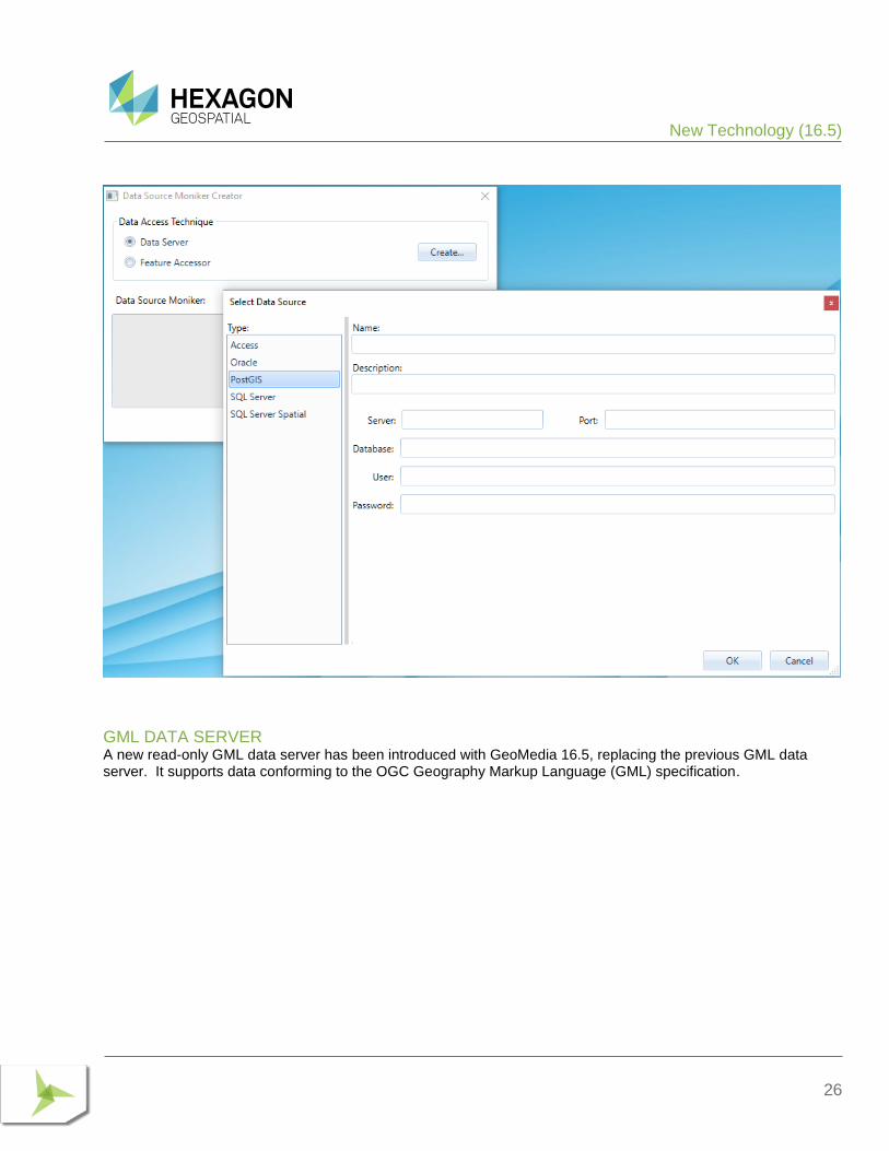
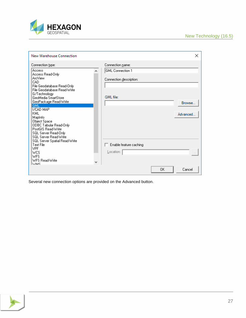
GML DATA SERVER A new read-only GML data server has been introduced with GeoMedia 16.5, replacing the previous GML data server. It supports data conforming to the OGC Geography Markup Language (GML) specification.
New Technology (16.5)
27
Several new connection options are provided on the Advanced button.
New Technology (16.5)
28
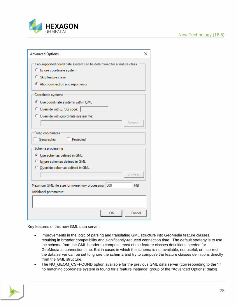
Key features of this new GML data server:
• Improvements in the logic of parsing and translating GML structure into GeoMedia feature classes,
resulting in broader compatibility and significantly-reduced connection time. The default strategy is to use
the schema from the GML header to compose most of the feature classes definitions needed for
GeoMedia at connection time. But in cases in which the schema is not available, not useful, or incorrect,
the data server can be set to ignore the schema and try to compose the feature classes definitions directly
from the GML structure.
• The NO_GEOM_CSFFOUND option available for the previous GML data server (corresponding to the “If
no matching coordinate system is found for a feature instance” group of the “Advanced Options” dialog
New Technology (16.5)
29
box) has been retired and is ignored if passed to the ConnectInfo parameter through API. The GeoMedia
feature model does not support GML files with features of the same feature class having different
coordinate systems. The new GML data server assumes that the first feature found within a feature class
sets the coordinate system for the whole class. The benefit of this assumption is a much shorter
connection time, especially with GML having multiple feature classes.
• Overriding the coordinate system is possible for incorrectly-defined GML files. The user can input a valid
EPSG code or a CSF file, and the new coordinate system definition is applied to all feature classes from
the GML file.
• The data server will respect the axis order according to the standard EPSG or CSF definition. If the GML
file does not respect the axis order (for example files with the EPSG:4326 coordinate system in which
latitude-longitude is expected but longitude-latitude is what is provided), options for swapping the
coordinates are available.
• In cases when the schema associated with a GML file is not available, not useful (i.e. does not completely
describe the GML structure), or incorrect, the user has options for identifying a different schema file or
ignoring the schema. When ignoring the schema, the connection time increases because the data server
must read most of the GML file to discover its structure.
• The data server better handles very large GML files that have produced many “out of memory” errors in the past. When dealing with large files (greater than a default threshold), a disk cache is created and the memory footprint of GeoMedia is considerably reduced. The default value for this file size limit is set at 500MB. Because performance degrades when using a disk cache instead of memory, this setting can be increased by the user if the computer has enough RAM to accommodate the data.
New Technology (16.5)
30
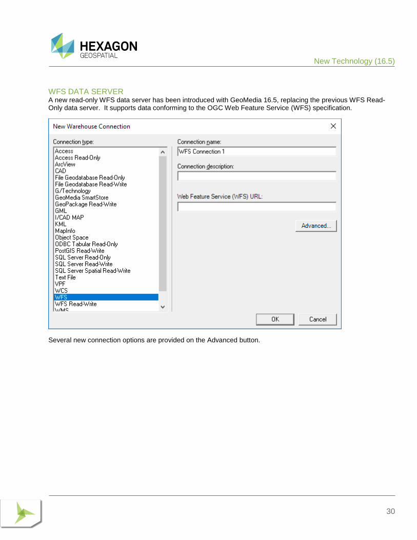
WFS DATA SERVER A new read-only WFS data server has been introduced with GeoMedia 16.5, replacing the previous WFS Read-Only data server. It supports data conforming to the OGC Web Feature Service (WFS) specification.
Several new connection options are provided on the Advanced button.
New Technology (16.5)
31
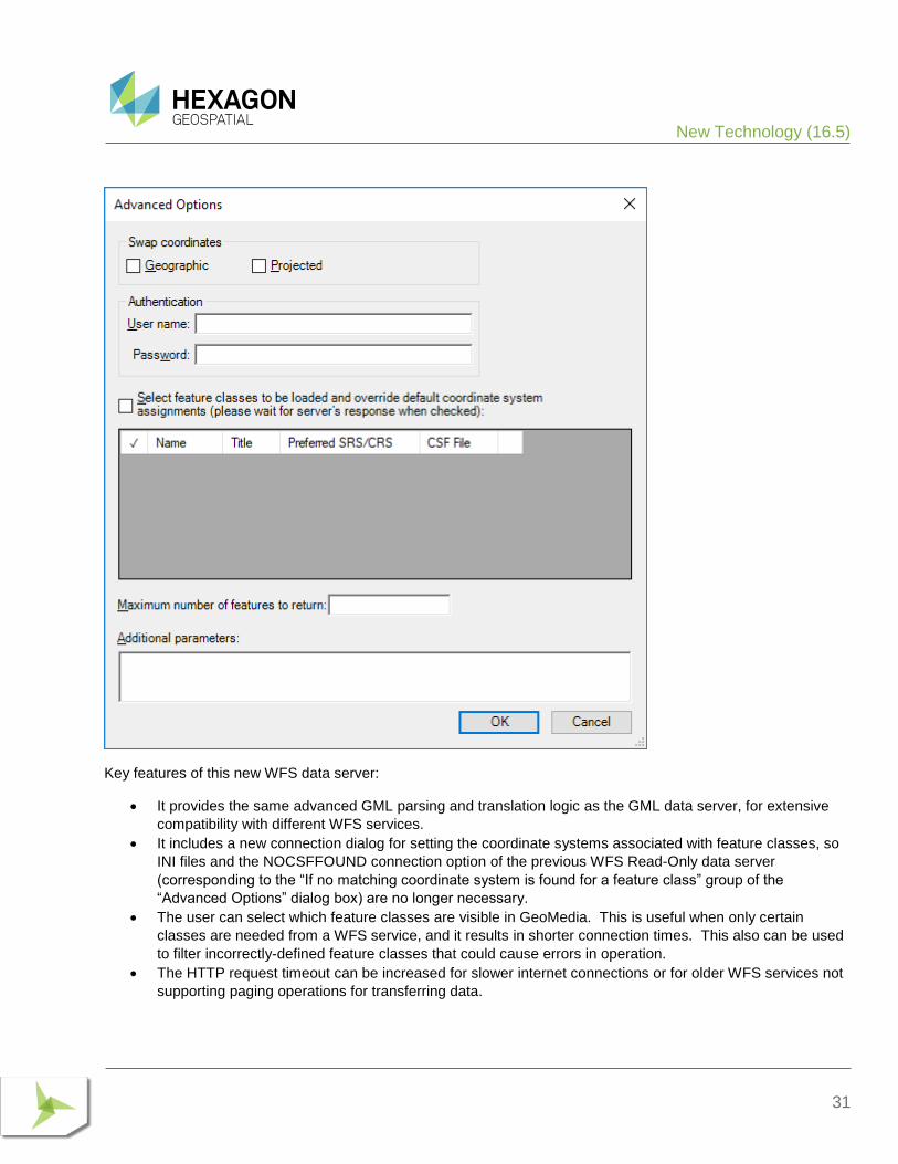
Key features of this new WFS data server:
• It provides the same advanced GML parsing and translation logic as the GML data server, for extensive
compatibility with different WFS services.
• It includes a new connection dialog for setting the coordinate systems associated with feature classes, so
INI files and the NOCSFFOUND connection option of the previous WFS Read-Only data server
(corresponding to the “If no matching coordinate system is found for a feature class” group of the
“Advanced Options” dialog box) are no longer necessary.
• The user can select which feature classes are visible in GeoMedia. This is useful when only certain
classes are needed from a WFS service, and it results in shorter connection times. This also can be used
to filter incorrectly-defined feature classes that could cause errors in operation.
• The HTTP request timeout can be increased for slower internet connections or for older WFS services not
supporting paging operations for transferring data.
New Technology (16.5)
32
DEFINE WAREHOUSE CONFIGURATION FILE UTILITY This utility no longer offers the ability to define or edit INI files for the WFS Read-Only data server. The new WFS data server offers the convenience of connection parameters provided exclusively within the connection syntax, with no external file required.
DATA CAPTURE
SELECT SET PROPERTIES This command now remembers the position, size, and column widths of the dialog across sessions.
OFFLINE EDITING The commands Output to Offline and Post from Offline now support GeoPackage warehouses as the offline connection.
SPATIAL MODELING
SPATIAL MODEL EDITOR This utility has been upgraded to the latest version released with ERDAS IMAGINE 16.5.
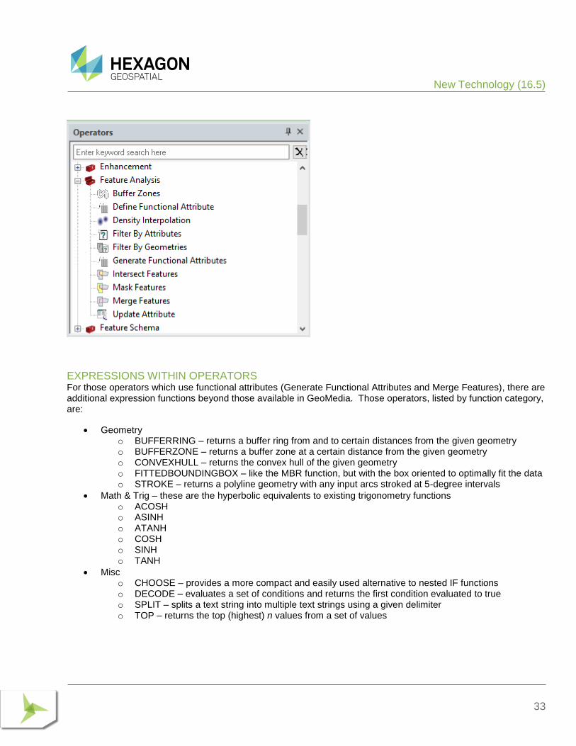
NEW OPERATORS New operators have been introduced for performing geoprocessing on feature data, which are borne out of certain GeoMedia capabilities. These are found in the new Feature Analysis and Geometry Creation operator categories, and include:
• Generate Functional Attributes and Define Functional Attribute operators, analogous to the Functional Attributes command and corresponding pipe.
• Intersect Features operator, analogous to the Spatial Intersection command and corresponding pipe.
• Mask Features operator, analogous to the Spatial Difference command and corresponding pipe.
• Merge Features operator, analogous to the Analytical Merge command and corresponding pipe. This operator replaces an earlier operator implementation by the same name, which had limited capabilities.
• Create Centroid and Create Centerpoint operators, providing efficient access to these capabilities also provided through the Generate Functional Attributes operator.
New Technology (16.5)
33
EXPRESSIONS WITHIN OPERATORS For those operators which use functional attributes (Generate Functional Attributes and Merge Features), there are additional expression functions beyond those available in GeoMedia. Those operators, listed by function category, are:
• Geometry o BUFFERRING – returns a buffer ring from and to certain distances from the given geometry o BUFFERZONE – returns a buffer zone at a certain distance from the given geometry o CONVEXHULL – returns the convex hull of the given geometry o FITTEDBOUNDINGBOX – like the MBR function, but with the box oriented to optimally fit the data o STROKE – returns a polyline geometry with any input arcs stroked at 5-degree intervals
• Math & Trig – these are the hyperbolic equivalents to existing trigonometry functions o ACOSH o ASINH o ATANH o COSH o SINH o TANH
• Misc o CHOOSE – provides a more compact and easily used alternative to nested IF functions o DECODE – evaluates a set of conditions and returns the first condition evaluated to true o SPLIT – splits a text string into multiple text strings using a given delimiter o TOP – returns the top (highest) n values from a set of values
New Technology (16.5)
34
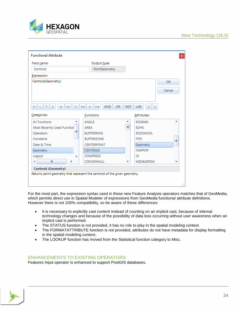
For the most part, the expression syntax used in these new Feature Analysis operators matches that of GeoMedia, which permits direct use in Spatial Modeler of expressions from GeoMedia functional attribute definitions. However there is not 100% compatibility, so be aware of these differences:
• It is necessary to explicitly cast content instead of counting on an implicit cast, because of internal technology changes and because of the possibility of data loss occurring without user awareness when an implicit cast is performed.
• The STATUS function is not provided, it has no role to play in the spatial modeling context.
• The FORMATATTRIBUTE function is not provided, attributes do not have metadata for display formatting in the spatial modeling context.
• The LOOKUP function has moved from the Statistical function category to Misc.
ENHANCEMENTS TO EXISTING OPERATORS Features Input operator is enhanced to support PostGIS databases.
New Technology (16.5)
35
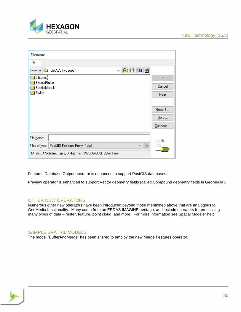
Features Database Output operator is enhanced to support PostGIS databases.
Preview operator is enhanced to support Vector geometry fields (called Compound geometry fields in GeoMedia).
OTHER NEW OPERATORS Numerous other new operators have been introduced beyond those mentioned above that are analogous to GeoMedia functionality. Many come from an ERDAS IMAGINE heritage, and include operators for processing many types of data – raster, feature, point cloud, and more. For more information see Spatial Modeler help.
SAMPLE SPATIAL MODELS The model “BufferAndMerge” has been altered to employ the new Merge Features operator.
New Technology (16.5 Update 1)
36
NEW TECHNOLOGY (16.5 UPDATE 1)
COORDINATE SYSTEMS
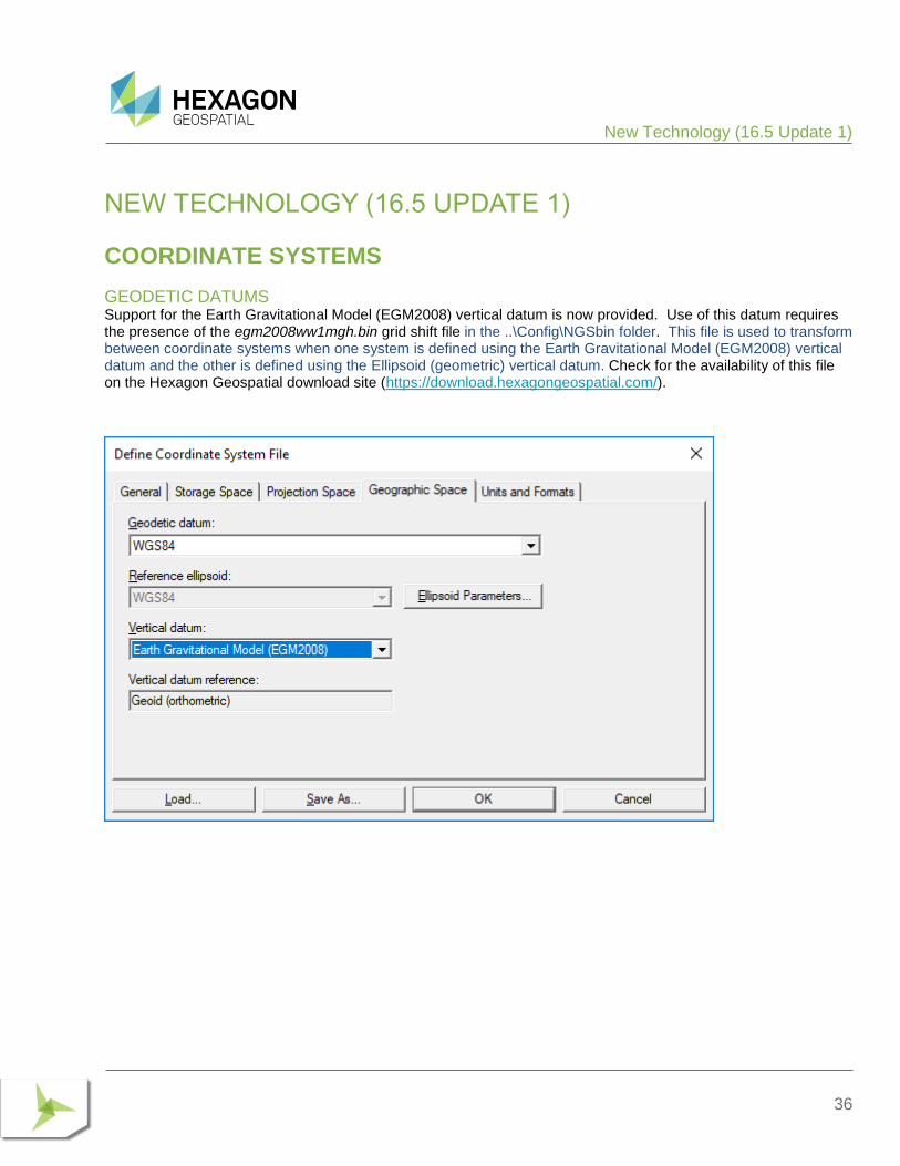
GEODETIC DATUMS Support for the Earth Gravitational Model (EGM2008) vertical datum is now provided. Use of this datum requires the presence of the egm2008ww1mgh.bin grid shift file in the ..\Config\NGSbin folder. This file is used to transform between coordinate systems when one system is defined using the Earth Gravitational Model (EGM2008) vertical datum and the other is defined using the Ellipsoid (geometric) vertical datum. Check for the availability of this file on the Hexagon Geospatial download site (https://download.hexagongeospatial.com/).
New Technology (16.5 Update 1)
37
DATA ACCESS
ORACLE DATA SERVER This data server now supports the Unified Auditing capability when enabled with Oracle 12c. When in this configuration, different logic is used to generate the “SESSIONID” values used in modification logging.
Customers with existing modification log triggers in their Oracle databases who turn on Unified Auditing in Oracle may need to take additional steps to enable this for GeoMedia. For more information see the Impacts section for 16.5 Update 1.
GEOPACKAGE DATA SERVER This data server can now be used with the following parts of the GeoMedia Desktop:
• Grid
• Labeling (for output of static labels)
• Libraries
The data server now supports optional creation of point and compound geometry fields without the GeoMedia-specific companion fields used to store GDO geometries that retain point orientation. This configuration improves the sharing of data between GeoMedia and other software (such as Mobile MapWorks) that also operate on GeoPackage databases. However in this scenario the orientation of points is lost because GeoPackage does not have a way to retain this value in its geometry. The option is enabled by the addition of an entry in the GParameters table – a parameter with the name “NATIVE”, of type String, with the value “True”. A new GeoPackage template warehouse “GeoPackageNativeGeometryFieldsTemplate.gpkg” is preconfigured with this setting and is provided for use with the New Warehouse command. Note that area and line geometry fields never have this companion field, and graphic text and coverage geometry fields always have this companion field since there is no provision for such data types in GeoPackage.
FEATURE CACHING
IMPROVED PERFORMANCE A variety of performance-related enhancements have been made for the feature caching system. These include:
• Capture of index statistics while publishing cache files, and use of those statistics to optimize queries against a cache by selecting the proper means to filter the data. IFC files must be re-published in order to gain this benefit, but the time required to publish is not increased.
• Avoidance of redundant scans through the data when responding to attribute filters.
• Smarter decisions about when to traverse the entire cache sequentially versus traversing it page by page (especially important for network-resident cache files).
• Automatic rebalancing of indexes when bulk updates cause them to become unbalanced and therefore slower to traverse.
New Technology (16.5 Update 1)
38
ADVANCED FEATURE MODEL
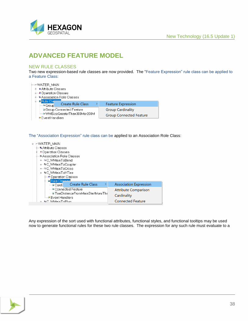
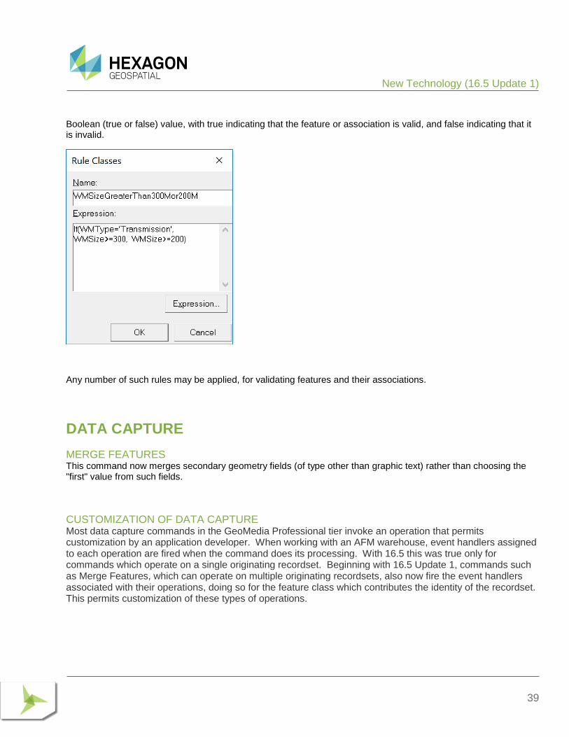
NEW RULE CLASSES Two new expression-based rule classes are now provided. The “Feature Expression” rule class can be applied to a Feature Class:
The “Association Expression” rule class can be applied to an Association Role Class:
Any expression of the sort used with functional attributes, functional styles, and functional tooltips may be used now to generate functional rules for these two rule classes. The expression for any such rule must evaluate to a
New Technology (16.5 Update 1)
39
Boolean (true or false) value, with true indicating that the feature or association is valid, and false indicating that it is invalid.
Any number of such rules may be applied, for validating features and their associations.
DATA CAPTURE
MERGE FEATURES This command now merges secondary geometry fields (of type other than graphic text) rather than choosing the "first" value from such fields.
CUSTOMIZATION OF DATA CAPTURE Most data capture commands in the GeoMedia Professional tier invoke an operation that permits customization by an application developer. When working with an AFM warehouse, event handlers assigned to each operation are fired when the command does its processing. With 16.5 this was true only for commands which operate on a single originating recordset. Beginning with 16.5 Update 1, commands such as Merge Features, which can operate on multiple originating recordsets, also now fire the event handlers associated with their operations, doing so for the feature class which contributes the identity of the recordset. This permits customization of these types of operations.
New Technology (16.5 Update 1)
40
ANALYSIS
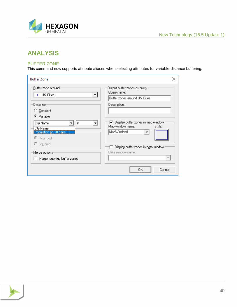
BUFFER ZONE This command now supports attribute aliases when selecting attributes for variable-distance buffering.
New Technology (16.5 Update 1)
41
LIBRARIES
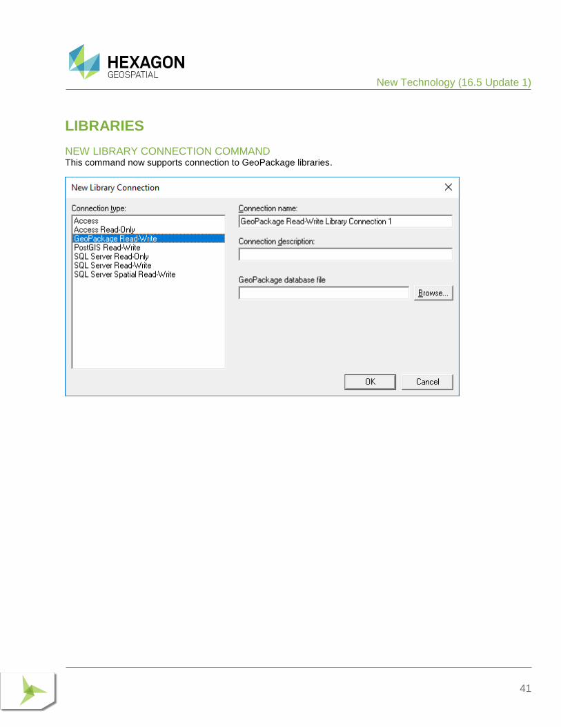
NEW LIBRARY CONNECTION COMMAND This command now supports connection to GeoPackage libraries.
New Technology (16.5 Update 1)
42
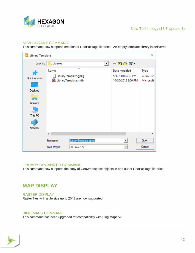
NEW LIBRARY COMMAND This command now supports creation of GeoPackage libraries. An empty template library is delivered.
LIBRARY ORGANIZER COMMAND This command now supports the copy of GeoWorkspace objects in and out of GeoPackage libraries.
MAP DISPLAY
RASTER DISPLAY Raster files with a tile size up to 2048 are now supported.
BING MAPS COMMAND This command has been upgraded for compatibility with Bing Maps V8.
New Technology (16.5 Update 2)
43
There is also a new button in the window which permits direct invocation of the Bing Maps Credentials dialog, so that a new key can be provided at any time.
For information on a behavioural change in the Bing Maps display, see the Impacts section for 16.5 Update 1.
NEW TECHNOLOGY (16.5 UPDATE 2)
GENERAL
INSTALLATION AND CONFIGURATION On the Configuration Wizard, the software no longer displays messages about installation of IMAGINE help, and no longer requires that the user wait for that help installation to complete before the product can be used. Instead,

New Technology (16.5 Update 2)
44
the necessary help for Spatial Modeler is installed silently and through a background process so that the Configuration Wizard completes smoothly and quickly and the product can be used more immediately.
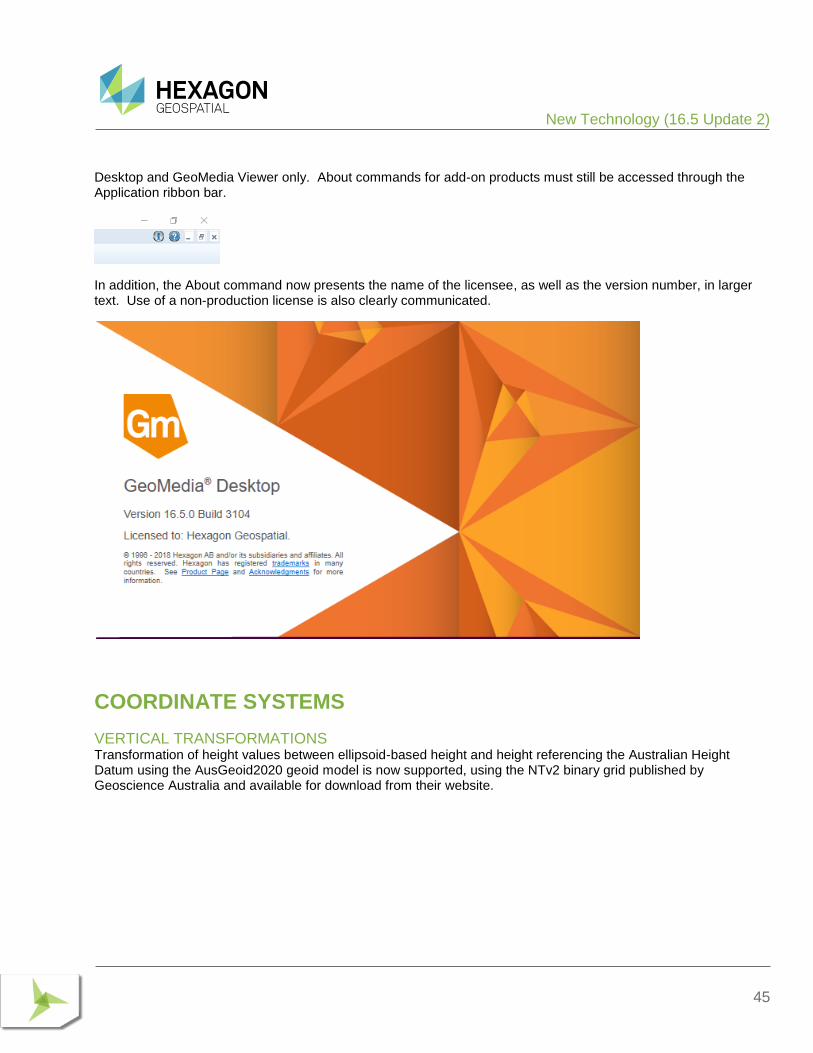
APPLICATION STARTUP The “splash screen” displayed at application startup now presents the name of the licensee in larger text.
ABOUT COMMAND This command can now be directly accessed from the ribbon. A new “i” icon can be found to the left of the existing “?” icon at the rightmost edge of the ribbon tab bar. This command display the About dialog for the GeoMedia
New Technology (16.5 Update 2)
45
Desktop and GeoMedia Viewer only. About commands for add-on products must still be accessed through the Application ribbon bar.
In addition, the About command now presents the name of the licensee, as well as the version number, in larger text. Use of a non-production license is also clearly communicated.
COORDINATE SYSTEMS
VERTICAL TRANSFORMATIONS Transformation of height values between ellipsoid-based height and height referencing the Australian Height Datum using the AusGeoid2020 geoid model is now supported, using the NTv2 binary grid published by Geoscience Australia and available for download from their website.

New Technology (16.5 Update 2)
46
DATA ACCESS
GEOPACKAGE DATA SERVER This data server now optimizes output of collections to employ more precisely-typed WKB collections. Instead of producing GeometryCollection in all cases, it now produces:
• MultiPoint in case of geometry collections for point fields and graphic text fields
• MultiCurve in case of geometry collections for line fields
• MultiSurface in case of geometry collections for area fields
• MultiPolygon in case of geometry collections for coverage fields
• GeometryCollection in case of geometry collections for compound fields
This improvement will also overcome an interoperability limitation of QGIS, which does not support the WKB GeometryCollection.
POSTGIS DATA SERVER This data server now optimizes output of collections to employ more precisely-typed WKB collections. Instead of producing GeometryCollection in all cases, it now produces:
• MultiPoint in case of geometry collections for point fields and graphic text fields
• MultiCurve in case of geometry collections for line fields
• MultiSurface in case of geometry collections for area fields
• MultiPolygon in case of geometry collections for coverage fields
• GeometryCollection in case of geometry collections for compound fields
This improvement will also overcome an interoperability limitation of QGIS, which does not support the WKB GeometryCollection.
This data server also now supports full read and write operations on PostGIS native geometry fields which have no companion GDO geometry field as established through Database Utilities. This is true for area and line geometry fields by default, and it is an option for point and compound fields. If you choose this option then point orientation will be lost since native PostGIS geometry does not support orientation for points. This choice is not available for graphic text or coverage fields as there is not native PostGIS geometry support for these.
This data server also now supports use of schemas other than “public”. Special treatment of the "public" schema is still provided since this is the default and most common configuration.
DATABASE UTILITIES When inserting or editing feature class metadata for a PostGIS warehouse, the user interface has been altered to reflect the ability of the PostGIS data server to not require a companion GDO geometry field for point and compound fields; and to not allow a companion GDO geometry field for area and line fields. If you choose not to
New Technology (16.5 Update 2)
47
designate such a field for point and compound, then point orientation will be lost since native PostGIS geometry does not support orientation for points.
Support for PostGIS in this utility now includes presentation of materialized views as valid feature classes.
WFS-T DATA SERVER A new read-write WFS-T data server has been introduced with GeoMedia 16.5, replacing the previous WFS Read-Write data server. It supports data conforming to the transactional OGC Web Feature Service (WFS-T) specification.
Several new connection options are provided on the Advanced button.
New Technology (16.5 Update 2)
48
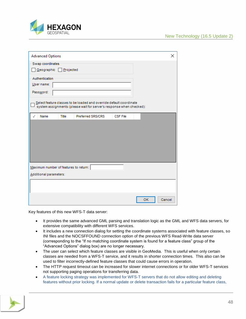
Key features of this new WFS-T data server:
• It provides the same advanced GML parsing and translation logic as the GML and WFS data servers, for
extensive compatibility with different WFS services.
• It includes a new connection dialog for setting the coordinate systems associated with feature classes, so
INI files and the NOCSFFOUND connection option of the previous WFS Read-Write data server
(corresponding to the “If no matching coordinate system is found for a feature class” group of the
“Advanced Options” dialog box) are no longer necessary.
• The user can select which feature classes are visible in GeoMedia. This is useful when only certain
classes are needed from a WFS-T service, and it results in shorter connection times. This also can be
used to filter incorrectly-defined feature classes that could cause errors in operation.
• The HTTP request timeout can be increased for slower internet connections or for older WFS-T services
not supporting paging operations for transferring data.
• A feature locking strategy was implemented for WFS-T servers that do not allow editing and deleting
features without prior locking. If a normal update or delete transaction fails for a particular feature class,
New Technology (16.5 Update 2)
49
the data server will attempt first to lock the feature using the LockFeature operation or the
GetFeatureWithLock operation. If one of the locking operations succeeds for that feature class, it is
memorized during the session in order for all following transactions to work with the same strategy.
DEFINE WAREHOUSE CONFIGURATION FILE UTILITY This utility no longer offers the ability to define or edit INI files for the WFS Read-Write data server. The new WFS-T data server offers the convenience of connection parameters provided exclusively within the connection syntax, with no external file required.
LAYOUT
LAYOUT LEGEND When working with a dynamic map in the layout window, additional kinds of changes in the map window legend are now reflected in the layout window legend:
• Hiding of a map window legend entry now causes the layout window legend entry to be removed, and other legend entries below it to be repositioned.
• Editing of the map window legend entry title now causes the title to be changed in the layout window. No adjustments are made in the positioning of the legend entry or those near it.
SPATIAL MODELING
NEW OPERATORS New operators have been introduced for performing geoprocessing on feature data, which are equivalent to certain GeoMedia capabilities. These are found in the Feature Analysis and Geometry Creation operator categories, and include:
• Summarize Related Features operator, analogous to the Aggregation command and corresponding pipe.
• Join Features operator, analogous to the Join command and corresponding pipe.
• Union Features operator, analogous to the Union command and corresponding pipe.
• Create Buffer Zone and Create Buffer Ring operators, providing efficient access to these capabilities also provided through the Generate Functional Attributes operator. Create Buffer Zone will eventually replace the prior Buffer Zones operator.
System Requirements (16.5)
50
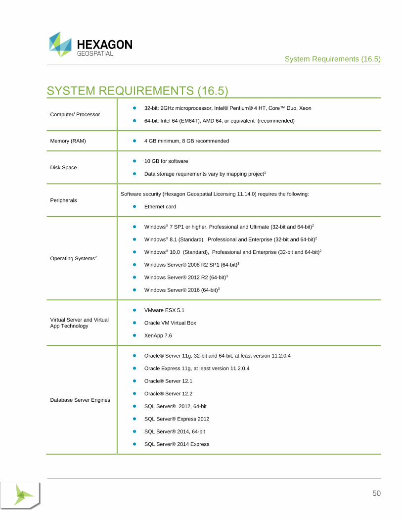
SYSTEM REQUIREMENTS (16.5)
Computer/ Processor
⚫ 32-bit: 2GHz microprocessor, Intel® Pentium® 4 HT, Core™ Duo, Xeon
⚫ 64-bit: Intel 64 (EM64T), AMD 64, or equivalent (recommended)
Memory (RAM) ⚫ 4 GB minimum, 8 GB recommended
Disk Space
⚫ 10 GB for software
⚫ Data storage requirements vary by mapping project1
Peripherals
Software security (Hexagon Geospatial Licensing 11.14.0) requires the following:
⚫ Ethernet card
Operating Systems2
⚫ Windows® 7 SP1 or higher, Professional and Ultimate (32-bit and 64-bit)2
⚫ Windows® 8.1 (Standard), Professional and Enterprise (32-bit and 64-bit)2
⚫ Windows® 10.0 (Standard), Professional and Enterprise (32-bit and 64-bit)2
⚫ Windows Server® 2008 R2 SP1 (64-bit)3
⚫ Windows Server® 2012 R2 (64-bit)3
⚫ Windows Server® 2016 (64-bit)3
Virtual Server and Virtual App Technology
⚫ VMware ESX 5.1
⚫ Oracle VM Virtual Box
⚫ XenApp 7.6
Database Server Engines
⚫ Oracle® Server 11g, 32-bit and 64-bit, at least version 11.2.0.4
⚫ Oracle Express 11g, at least version 11.2.0.4
⚫ Oracle® Server 12.1
⚫ Oracle® Server 12.2
⚫ SQL Server® 2012, 64-bit
⚫ SQL Server® Express 2012
⚫ SQL Server® 2014, 64-bit
⚫ SQL Server® 2014 Express

System Requirements (16.5)
51
⚫ SQL Server® 2016, 64-bit
⚫ SQL Server® 2016 Express
⚫ SQL Server® 2017, 64-bit
⚫ SQL Server® 2017 Express
⚫ PostgreSQL 9.3 with PostGIS 2.1
⚫ PostgreSQL 9.4 with PostGIS 2.2
⚫ PostgreSQL 9.6 with PostGIS 2.3
Database Client Engines
⚫ Oracle Client 11g, 32-bit4
⚫ Oracle Client 12.1, 32-bit4
⚫ Oracle Client 12.2, 32-bit4
⚫ SQL Server Native Client 10.0 or higher5
SYSTEM REQUIREMENTS NOTES 1 Disk I/O is usually the slowest task in geospatial data processing. Faster hard disks improve productivity. Reading data from one disk, writing temporary data to a second disk, and writing data to a third disk improves performance. Disk arrays improve productivity but some RAID options slow performance. Network disk drives are subject to network limitations.
2 Windows 7 32-bit, Windows 8 32-bit, Windows 8.1 32-bit and Windows 10 32-bit are considered viable platforms. Viable platforms are not an explicit requirement and have not been tested as a standard scenario in Hexagon Geospatial’s Development and Quality Assurance cycles. However, the technology is similar to one of the supported platforms that compatibility is practical. Although we expect our applications to be compatible with viable platforms, we cannot guarantee contractual performance or high availability requirements.
3 GeoMedia runs on 64-bit systems in 32-bit emulation mode.
4 Oracle Data Access Components (ODAC) is required if using the Feature Accessor option for Oracle in the PublishIFC utility, or if using the Database Utilities utility to manage an Oracle warehouse. ODAC is normally delivered by the Oracle Client Administrator installer, but not by the Oracle InstantClient installer. ODAC contains many components, of which PublishIFC requires the Oracle Data Provider for .NET, and Database Utilities requires the Oracle Provider for OLEDB.
5 The SQL Server Native Client 10.0 or higher is needed in order for the Database Utilities utility to automatically create the correct GeoMedia metadata for date, time, and datetime2 data types when using a SQL Server or SQL Server Spatial warehouse. You may get SQL Server Native Client 10.0 or higher from the corresponding Microsoft websites. If the SQL Server Native Client is not installed on the system, you will need to manually choose Date as the data type from the dropdown combo box for these data types in the Feature Class Properties dialog and set the format properly.

System Requirements (16.5)
52
Issues Resolved (16.1)
53
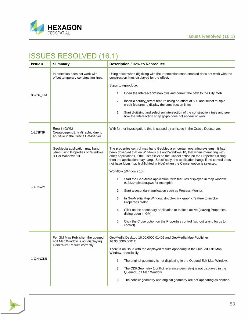
ISSUES RESOLVED (16.1) Issue # Summary Description / How to Reproduce
86726_GM
Intersection does not work with offset temporary construction lines.
Using offset when digitizing with the Intersection snap enabled does not work with the construction lines displayed for the offset.
Steps to reproduce.
1. Open the IntersectionSnap.gws and correct the path to the City.mdb.
2. Insert a county_street feature using an offset of 500 and select mutiple creek features to display the construction lines.
3. Start digitizing and select an intersection of the construction lines and see how the Intersection snap glyph does not appear or work.
1-LJ3K3P Error in GWM CreateLegendEntryGraphic due to an issue in the Oracle Dataserver.
With further investigation, this is caused by an issue in the Oracle Dataserver.
1-LI3G2M
GeoMedia application may hang when using Properties on Windows 8.1 or Windows 10.
The properties control may hang GeoMedia on certain operating systems. It has been observed that on Windows 8.1 and Windows 10, that when interacting with other applications, if the user clicks on the Cancel option on the Properties dialog then the application may hang. Specifically, the application hangs if the control does not have focus (top highlighted in blue) when the Cancel option is selected.
Workflow (Windows 10):
1. Start the GeoMedia application, with features displayed in map window (USSampledata.gws for example).
2. Start a secondary application such as Process Monitor.
3. In GeoMedia Map Window, double-click graphic feature to invoke Properties dialog.
4. Click on the secondary application to make it active (leaving Properties dialog open in GM).
5. Click the Close option on the Properties control (without giving focus to control).
1-QNNZK5
For GM Map Publisher, the queued edit Map Window is not displaying Generalize Results correctly.
GeoMedia Desktop 16.00.0000.01405 and GeoMedia Map Publisher 16.00.0000.00012
There is an issue with the displayed results appearing in the Queued Edit Map Window, specifically:
1. The original geometry is not displaying in the Queued Edit Map Window.
2. The CDRGeometry (conflict reference geometry) is not displayed in the Queued Edit Map Window.
3. The conflict geometry and original geometry are not appearing as dashes.
Issues Resolved (16.1)
54
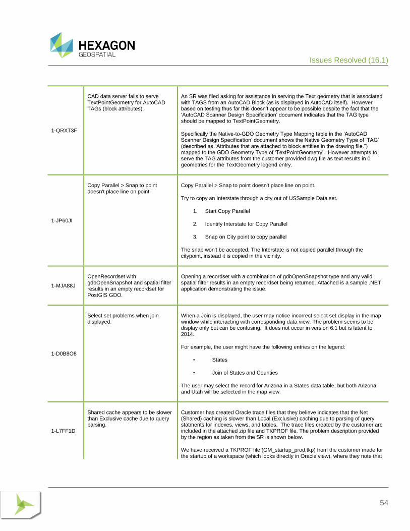
1-QRXT3F
CAD data server fails to serve TextPointGeometry for AutoCAD TAGs (block attributes).
An SR was filed asking for assistance in serving the Text geometry that is associated with TAGS from an AutoCAD Block (as is displayed in AutoCAD itself). However based on testing thus far this doesn’t appear to be possible despite the fact that the ‘AutoCAD Scanner Design Specification’ document indicates that the TAG type should be mapped to TextPointGeometry.
Specifically the Native-to-GDO Geometry Type Mapping table in the ‘AutoCAD Scanner Design Specification’ document shows the Native Geometry Type of ‘TAG’ (described as “Attributes that are attached to block entities in the drawing file.”) mapped to the GDO Geometry Type of ‘TextPointGeometry’. However attempts to serve the TAG attributes from the customer provided dwg file as text results in 0 geometries for the TextGeometry legend entry.
1-JP60JI
Copy Parallel > Snap to point doesn't place line on point.
Copy Parallel > Snap to point doesn't place line on point.
Try to copy an Interstate through a city out of USSample Data set.
1. Start Copy Parallel
2. Identify Interstate for Copy Parallel
3. Snap on City point to copy parallel
The snap won't be accepted. The Interstate is not copied parallel through the citypoint, instead it is copied in the vicinity.
1-MJA88J
OpenRecordset with gdbOpenSnapshot and spatial filter results in an empty recordset for PostGIS GDO.
Opening a recordset with a combination of gdbOpenSnapshot type and any valid spatial filter results in an empty recordset being returned. Attached is a sample .NET application demonstrating the issue.
1-D0B8O8
Select set problems when join displayed.
When a Join is displayed, the user may notice incorrect select set display in the map window while interacting with corresponding data view. The problem seems to be display only but can be confusing. It does not occur in version 6.1 but is latent to 2014.
For example, the user might have the following entries on the legend:
• States
• Join of States and Counties
The user may select the record for Arizona in a States data table, but both Arizona and Utah will be selected in the map view.
1-L7FF1D
Shared cache appears to be slower than Exclusive cache due to query parsing.
Customer has created Oracle trace files that they believe indicates that the Net (Shared) caching is slower than Local (Exclusive) caching due to parsing of query statments for indexes, views, and tables. The trace files created by the customer are included in the attached zip file and TKPROF file. The problem description provided by the region as taken from the SR is shown below.
We have received a TKPROF file (GM_startup_prod.tkp) from the customer made for the startup of a workspace (which looks directly in Oracle view), where they note that
Issues Resolved (16.1)
55
a lot of time is spent on parsing statements that query for indexes for the various views and tables.
It accounts for a significant amount of the total startup time. If you look at the summary for non-recursive statement at the bottom of the TKPROF file you can see that almost 24 seconds are spent parsing.
Would it be possible to reduce time spent parsing by using bind variables?
1-QJA89D
Reverse Direction does not work on a secondary geometry, it reverses the unselected primary geometry.
Secondary geometries are not reversed when using the Reverse Direction command from the Vector tab or when using the Reverse command from the Geometry Information context menu. Here is the workflow to reproduce the problem:
1. Extract the attached ReverseGeometry.zip file and then open the ReverseGeometry.gws that has an Access connection to the ReverseGeometry.mdb file.
a. When the .gws is opened, note that the legend contains two entries for the feature class named LineFeature and its associated secondary geometry named ‘Geometry2 of LineFeature’. The primary geometry for the feature class is displayed in red and the secondary geometry in blue. Additionally a style is applied with an arrow symbol indicating the direction of each geometry.
2. Use the cursor to click on one of the secondary geometries in the map window (i.e. the red geometry). Note that only the secondary geometry is shown in the select color (e.g. green highlight).
3. Now choose the Reverse Direction command from Vector > Edit on the ribbon bar. This will result in the reversal of the primary geometry even though it was not selected, while the secondary geometry which was selected remains unchanged. This is apparent because the arrows for the blue primary geometry style are reversed, but the arrows for the red secondary geometry are still pointing in the original direction.
4. This same behavior is observed with the Reverse command when accessed via Geometry Information. For instance select the red secondary geometry, then choose the Geometry Information command and right click on the ‘PolylineGeometry’ node, then choose Reverse from the displayed context menu. As before, the primary geometry will be reversed, but the selected secondary geometry will remain “as is”.
1-LRSMRH
Ghost circles rendered in display when create thematic of polygons containing arcs (Regression).
Creation of a thematic mapping with color fill of polygon geometries containing small arc geometry components may result in color filled circles appearing in both map and layout window displays; the circles change in distribution and size depending on zoom scale. The problem is not seen in version 2015.
See attachments for screen shot showing comparison between version 2015 and 2016. If the arcs are removed from the polygon geometries, the problem does not occur in version 2016.
Workflow using data provided in Attachments:
1. Extract contents of .zip
2. Use GeoMedia 2016 to open Version2016_Access.gws, correcting path to source warehouse.
Issues Resolved (16.1)
56
3. Observe small circles in the map display that change with changes in the display scale.
If review Geometry Information for some of the polygons, you can see that the geometry has arc components; The geometry seems to pass standard Toolbox > Validate Geometry checks (no problems are found).
If the arcs are removed the problem does not occur.
1-M17EFA
Unable to display (.ecw) WMTS layers that can be displayed successfully in other applications.
Unable to display (.ecw) layers from ERDAS Apollo WMTS service that can be displayed successfully in other applications.
The GeoMedia WMTS data server is unable to display certain layers from the ERDAS Apollo Essentials WMTS service. The same layers can be displayed successfully in other clients using the same coordinate system (either EPSG:4326 or EPSG:3857).
The layers from the service that fail to display in GeoMedia (but display in the other clients) are ‘sandiego3i_ecw’ and ‘bucuresti_ecw’.
To reproduce the problem, use the steps below.
1. Start GeoMedia and make a new WMTS connection.:
2. Use Add Legend Entries to add ‘sandiego3i_ecw’ to the legend. A legend entry will be created with geometry statistics showing one instance.
3. If you fit the view and click the map window you can see the layer footprint highlighted, but there is no image/tiles displayed within the footprint.
The coordinate system used in all of the clients was the same (EPSG:4326).
* Note that the ‘sandiego3i_jp2’ and ‘‘sandiego3i_otdf’ layers from the same service can be displayed successfully in GeoMedia . These layers appear to be the same as the ‘sandiego3i_ecw’ with presumably a different format for the source imagery (i.e. JPEG 2000 and OTDF respectively). This means that the problem appears to be specific the ECW format.
1-M8DCID
WMTS data server requests/displays data in wrong coordinate system (other clients work correctly).
The GeoMedia WMTS data server serves the ‘MAPA TOPOGRAFICZNA’ feature class from the WMTS service with the wrong coordinate system. Specifically the GetTile requests uses the EPSG:4326 TileMatrixSet instead of the default EPSG:2180 TileMatrixSet.
The EPSG:2180 TileMatrixSet appears to be the default since it is the first listed in the GetCapabilities document and GeoMedia will even show that the coordinate system assigned to the ‘MAPA TOPOGRAFICZNA’ feature class is EPSG:2180 after it is served using the WMTS data server.
There appears to be a disconnect between the metadata in that Feature Class Definition indicates that the coordinate system is EPSG:2180 and the actual feature class served which seems to be EPSG:4326. This problem results in an incomplete display of ‘MAPA TOPOGRAFICZNA’ feature class in the Map Window and the portion of the data that is visible is warped presumably due to the coordinate system transformation from EPSG:4326 to EPSG:2180.
The same problem exists even if you use a Warehouse Configuration File (.ini) for the WMTS connection with the following entry defining the default TileMatrixSet as EPSG:2180.
Issues Resolved (16.1)
57
[TileMatrixSet for Feature Classes]
Default=EPSG:2180
1-ANAB3S
Layout > Print/Plot > Background image prints black (Images with more than 3 bands).
Customer has 6" resolution imagery. These are uncompressed 4 band (32bit) untiled TIFF (tested with and without overviews) for their service area. They report that the images appear solid black when trying to output a layout to .pdf or other printing device.
Open GWS, connect to USSampleData or a blank Access connection. Insert the two Geotiffs. Print to PDF (Used PDF995 locally) and outputs are black for the images. Also tested with Adobe Acrobat 10 and the local hard copy devices.
Workaround is to give the image feature class (or any feature class displayed on legend) a 1% translucency. The image plots, looks great.
This is not specific to TIFF images, seen with JFIF and other formats as well.
This is apparently a problem common to all 4-sample-per-pixel data.
1-M2V06J
Errors occur with multiple commands when using PostGIS table names containing uppercase characters.
The PostGIS data server in GeoMedia 2016 does not correctly handle feature class/table names that contain uppercase letters, resulting in errors. This issue was reported by a customer who states that the open source PostGIS data server that could be used with GeoMedia 2015 did not have this problem.
1-95FGMS
Layout - Text Placement and Text Properties > Support for OpenType (.otf) fonts is missing.
There is a failure when displaying OpenType fonts in GeoMedia 2013. Support replicated failure on both GeoMedia 6.2 and Geomedia 2014.
In versions of GeoMedia prior to 6.1 (5.2, 6.0), this .otf font was available in the drop- down list for text placement in the Layout Window, and the text was displayed with the proper font. But starting in the 6.1 version, the fonts does not show up in the drop- down list - they are not available for placing new text in the layout window.
In versions since 5.2 (5.2, 6.0, 6.1, 2013, 2014) right click on selected layout text and then 'Properties' shows the text properties dialog. In the sample .gws, note that the customer's font is the StencilStd.otf, and that it displays with bright green color, indicating a non-supported font.. Also note that newly placed text in a new, blank .gws can also be given the StencilStd.otf font, but that the layout window does not display the text with this font properly - text appears bright green.
Thus there are two parts to this issue. One is a regression from 6.0 GeoMedia to later versions – you can no longer place or display layout text with .otf fonts. The second part is that if the regression was an intentional change in the product, one should not be able to select .otf font from the layout Text Properties dialog.
Both parts are resolved if we restore the previous functionality, placement and display of layout text with OpenType fonts.
1-SMHSUB
Originating Pipe recordset open/reopen spams registry for GDO configuration.
Opening a recordset through an originating pipe will cause it to check the registry for CacheEnabled setting for the specific connection type. However, this is accomplished by instantiating a whole new GDOServerRegEntries object that enumerates the whole HKLM\Software\Wow6432Node\GDO registry subkey and parses values therein.
Issues Resolved (16.1)
58
The function using the GDOServerRegEntries is: GMConnection::GetCacheFileName, which it does even if the given connection is created without explicitly enabling caching.
This causes a registry contention in an environment when multiple concurrent GDO requests are being served, like in a WebMap installation.
1-LUTZ6G
Using WMTS data server hangs GeoMedia forcing the GeoMedia process to be killed with Task Manager.
Use of the WMTS data server results in GeoMedia hanging (where there is no response to any mouse click), thus forcing the GeoMedia process to be killed via Task Manager. This problem seems to occur most often when using the Zoom In command or the Pan command while WMTS layers are displayed in the Map Window while already zoomed into the data set.
1. Open the provided ‘WMTS_Kademo2.gws’ which has a single WMTS connection to the service used.
There are six layers present in this WMTS and all of the layers are added to the legend and displayed in the Map Window. The Display Scale for the Map Window is set to 1:2500.
2. Select the ‘Zoom In’ command and at the prompt “Click to zoom or press and drag”, place a single data point in the center of Map Window to perform a zoom.
After the data point is placed, the Map Window display starts to update and the ‘Processing window update…’ message is displayed in the message strip. If you click the ESC key to cancel the update the wait cursor will disappear and the ‘Processing window update…’ message will be removed, but GeoMedia is now in a completely unresponsive state, so the only recourse is to kill the GeoMedia process.
* To reproduce this issue a second time you may need to remove the temp files from your user temp folder (i.e. %TEMP%).
1-LTZTTN
Some WMTS services are not displayed.
The WMTS servvices of our customer published by ERDAS APOLLO Ess+SDI are not dispalyed correctly in the GM. The capabilities document is loaded, but no other picture ("data") is loaded into the map winddow. Only blank frame is displayed in the GM. It should use EPSG:5514. The capabilities document containes czech diacritic letters and more tilematrixset.
1-LR7ZLA
Update Attributes - geometry functions fail to update.
Any functional expression that updates geometry fails with errors.
Example workflow: Attempting to use Update Attributes to compress a geometry fails in version 2016.
Using a standard COMPRESS(Input.Geometry) to update an area geometry field in 2016 fails with the following message:
---------------------------
GeoMedia Desktop
Update Attributes was unable to update all features. Please refer to log file C:\Warehouses\\States.txt for details.
---------------------------
Issues Resolved (16.1)
59
Review of the text file shows the following error for each record processed:
“could not be updated. Data type conversion error”
Workflow:
1. Open USSampleData.gws
2. Vector > Update > Update Attributes
3. Select States, click in Geometry field and select Expression.
4. Build expression for COMPRESS(Input.Geometry) then add the expression.
5. Click OK to run the update.
Observe the error messages.
1-SD94Q1
GeometryStorageService fails to transform PolygonGeometry when run inprocess from .NET.
A working sample of PolygonGeometry construction and transforming to storage blob by the means of GeometryStorageService usage was working up to the newest 15.0 release of GeoMedia. When the same application is recompiled in a 16.0 environment it fails when all the objects (PolygonGeometry, point and GeometryStorageService) are created inprocess of a .NET application. It does not fail when run from inside a native COM process like the MapSvr.exe of GeoMedia WebMap.
1-TEDR0Q
Attribute Based Style not correctly evaluated/displayed in GeoMedia 2016.
A customer has a data set that makes extensive use of Attribute Based Styles that displays correctly (i.e. as expected based on the ABS expressions) in GeoMedia 2015, but when the same .gws is opened in GeoMedia 2016 the styles rendered are incorrect. In other words the styles do not appear the same in GeoMedia 2016 as they do in GeoMedia 2015.
One of the issues involves the use of a nested IF expression to assign Color or Override Color based on the values of One (or Two) attributes.
1-THBCC0
Attribute Based Style is incorrectly displayed in GeoMedia 2016.
A customer that uses ABS extensively filed a SR stating that the display of the styles in their GeoWorkspace was significantly different when the .gws was opened in GeoMedia 2016 as compared to the same .gws in GeoMedia 2015. This CR is filed for an issue with the expressions used by the customer on the CharacterString property as a means to specify which of several available Font Styles from a Point Style Collection should be displayed for a particular feature instance.
1-LRSQEP
Functional nested IF statement returns incorrect results when evaluating null values.
User-provided functional expression that works to return valid values for all records in 2015, fails to return valid values for some records in 2016.
The user is using a nested IF statement.
1-SLIP4P Memory leak apparent in the PostGIS GDO.
There seems to be a memory leak caused by the PostGISRW.GDatabase object while opening consecutive recordsets from the same connection.
Issues Resolved (16.1)
60
1-SBLPA3
GeoMedia / Webmap memory error in GML dataserver.
There is a memory problem in GeoMedia Pro / WebMap Pro when using GML dataserver. Workflow in GMPro:
1. Open GMPro. The GeoMedia application process memory usage is ~ 50.MB.
2. Create new warehouse connection –using a GML type The GeoMedia application process memory usage is ~ 250.MB
3. Add EGB_PktGraniczny_copy feature class to the map window. The GeoMedia application process memory usage is ~ 265.MB
4. Remove legend entries from the legend.
5. Close and delete the GML connection.
GeoMedia application process memory usage remains the same ~ 250.MB.
When using Webmap on our Customers production system we do have a lot of big GMLs that need to be imported to continuous Oracle database. We suffer OutOfMemory exceptions and HResult exceptions because of this error described above.
To compare, do the same workflow with Access warehouse type using USSampleData. You will notice that the memory is being released after closing and deleting connection.
1-L4T7SQ
Features from spatially filtered GML connection fail to display when GeoWorkspace is re-opened.
When a GeoWorkspace with a connection to the customer provided GML file has a spatial filter applied, the features from GML connection will be filtered as expected and the legend statistics will be displayed appropriately. However if that GeoWorkspace is then saved with the spatial filter in place and then reopened the features from the GML connection that were filtered will be missing from the Map Window and the legend statistics will show a value of ‘0’ for the corresponding legend entries.
1-S0AO0B
GeoMedia performance problem: Oracle LTT 12c fails to use bind variables for select from all_indexes.
User testing of GeoMedia version 2015, has noted a potential performance issue while working with Oracle 12c using GeoMedia Oracle LTT data server. It has been proposed that the performance is due to GeoMedia’s failure to use bind variables when the GeoMedia Oracle LTT data server issues queries such as SELECT FROM ALL_INDEXES.
1-CAJXWS
Event AfterUpdate(vbCanceled, objGFeature) - objGFeature is not initialized after first insert.
This code in VB .NET (AfterUpdate Event):
Private Sub Fnc_AfterUpdate(ByVal vbCanceled As Boolean, ByVal objFeature As PAFM.GFeature) Handles currentFeatureClassEvent.AfterUpdateHandler
Try
MsgBox("State: " + objFeature.State.ToString())
Catch ex As Exception
MsgBox(ex.Message)
End Try
Issues Resolved (16.1)
61
End Sub
Return exception after insert first feature in GM2015:
Feature must by initialized with either Bookmark or KeyAttributeValues
Notes - GM 2015:
objFeature is not filled with right attributes of new added Feature, witch exist in this moment in DB
next insert of the same feature is OK
1-QR3T93
After upgrade to GeoMedia 2016 cannot open a number of Geomedia 2014 created GeoWorkspaces.
A customer filed a SR reporting that several of their GeoWorkspaces that were created with GeoMedia 2014 cannot be opened successfully in GeoMedia 2016 (i.e. a ‘Failed to open document’ message is displayed when an attempt is made to open the .gws in 2016.)
When attempting to open the .gws in GeoMedia 2016 a number of the map windows are loaded prior to the ‘Failed to open document’ message, but as soon as the message dialog is dismissed with the OK button the .gws is closed.
The issue appears to be caused by one specific legend entry. Specifically a unique value thematic entry named 'Route Shield County Scale' in the Map Window named 'ESZs'. If the 'Route Shield County Scale' legend entry from this map window is deleted from the .gws while it is open in GeoMedia 2014 and then the .gws is saved without that legend entry, the .gws can then be opened successfully in GeoMedia 2016.
1-T4DNWD
Desktop 2015 GeoWorkspace cannot be opened on Desktop 2016.
Customer reports, support duplicates a problem where a .gws created with vanilla GMDesktop 2015 cannot be opened in vanilla GMDesktop 2016. Workflow to reproduce:
• Copy attachment 'Tom.gwt' to GMDesktop 2015 templates folder "C:\Program Files (x86)\Hexagon\GeoMedia Professional\Templates\GeoWorkspaces". Start GMDesktop, new .gws, select 'tom.gwt' as the template. At this point I made an Access connection to USSampleData.mdb and added a few legend entries. Exit and save the .gws.
• On a GMDesktop 2016 system, open the saved .gws. Error appears.
• Attachment 'joe_15.gws' was created using this workflow and will not open on my GMDesktop 2016 system.
Creating a new .gws on 2016 using this same template doesn't cause a problem.
1-S3NVRQ 2016 G/Tech Interface features not loading Style Index. Regression from G/Tech Interface 2015.
Using GeoMedia 2016 the StyleIndex for some Features imported with the G/Techinterface are not generated. This results in the displayed Style in the Map to be incorrect. GeoMedia 2015 generates the StyleIndex.
1-SDCP7C
New GeoWorkSpaces NOT saved after selecting yes to save.
Users who use GeoWorkSpace template (.gwt) files other than Normal.gwt may encounter problems saving GeoWorkSpaces upon exiting.
Example workflow using supplied GeoWorkSpace template (.gwt) file:
Issues Resolved (16.1)
62
1. Create new GeoWorkSpace using the template option.
2. Use a template other than Normal.gwt.
3. Optionally do queries etc in the GeoWorkSpace.
4. Select File > Exit, select Yes to save.
Observation: The Save GeoWorkSpace As dialog does NOT appear. GeoMedia simply exits and none of the work performed in step 3 is saved. The GeoWorkSpace does not seem to be saved anywhere.
1-F5HZ7Q
GeoMedia Professional 2015 does not honor long-press gesture for "right-click" on touch screen.
GeoMedia Professional 2015 does not respond to typical "right-click" replacement on tablet touch screen devices (long press).
We are unable to "right click" using the touch screen functionality on our tablet. "right-click" is typically replaced by a long press and hold on touch/tablet devices using a long press. GeoMedia responds to double-tap (double-click) and single tap (single-click), but does not react to the right-click/long press action.
1-7ZHFQL
Right click doesn't work on touchscreen under Windows 8.
On customer's laptop with touchscreen and Windows 8, the right click doesn't work with GeoMedia.
1) When using a mouse, right-click in GeoMedia works fine.
2) When using touch screen, right-click in GeoMedia is not working.
Right-click using touch screen in Windows itself (not GeoMedia), is:
• press the fingertip and hold for a while - first I see a little circle around the place where I touch, then for a little while it changes into a square and then a dialog appears as expected
When customer tries the same in GeoMedia, they only get the circle around the place where they touch, but no square, nor any dialog.
Tested this in GeoMedia 13.00.0000.00242.
1-U5NDKZ
Animated styles not updating/shown with map extent change.
Animated styles not updating/shown with map extent change.
To reproduce:
-New GeoWorkspace with USSampleData access connection
-Add HighwayInterchange feature class
-Zoom in so that roughly 1/4 of the features are visible in the map
-Edit the style for HighwayInterchange so that it is animated. Changing the size between 2 frames is sufficient. Animate upon display with unlimited repetitions.
-After applying the style, note that the features in the map display are animated.
-Zoom out, pan, etc. and note that none of the features outside the initial map extent are displayed until the style is applied again.
Issues Resolved (16.1)
63
Initially discovered in 16.1..10195 using Oracle RW.
1-SD9H98
Selecting Attribute Properties dialog crashes GM on German vm w/German language package.
Selecting Attribute Properties dialog crashes or hangs GM on German vm w/German language package.
This hang/crash occurs on German WINDOWS 8 or WINDOWS 12 with the GM German language package installed. The crash happens if GM is configured as English also.
1. Open USExample.gws
2. Double click on State feature to bring up the Select Set Properties dialog.
3. Don't close the Select Set Properties Dialog
4. Click on Windows Start and GM geoworkspace hangs/crashes.
1-LR3GAX
Attribute Properties dialog as well as other dialogs fall behind other applications.
User has noted that dialogs upgrade from VB6 do not pop to the top when the GeoMedia application is selected. This can give users the illusion that the application has hung and/or forces users to collapse all applications in effort to "search" for the hidden GeoMedia dialog.
Problem occurs in both 2015 and 2016 for Attribute Properties.
Example Workflow:
1. Open USSampledata.gws
2. Double-click on graphic feature.
3. The Properties dialog will appear showing attributes for the feature.
4. Drag the dialog outside of the GeoWorkSpace document container.
5. Activate some other application(s) such as MS Word or Notepad, placing the application over the Attribute Properties dialog. Obseve the dialog is hidden (this is expected).
6. Now click inside of GeoMedia document giving focus to the GeoMedia application. Notice that GeoMedia is NOT responsive until you search, find and dismiss the hidden properties dialog.
Problem also noted for other dialogs such as Map Window Properties.
The user may be able to click on the application in the task bar or possibly use <Alt> <Tab> keys to force dialog and application back to the top.
1-LRSQUG
Release Guide missing configuration dependencies for certain utilities.
The GeoMedia Desktop Release Guide fails to include configuration dependencies for the following:
Database Utilities requires that MS SQL Native Client 10.0 or higher be installed when working with MS SQL Spatial warehouses. The MS SQL Native Client is normally delivered as part of MS SQL Management Studio or can be installed as a standalone product.
Issues Resolved (16.1)
64
Oracle Data Access Components (ODAC) is required if using the Feature Accessor option in PublishIFC Utility. ODAC is normally delivered by Oracle Client Administrative install but not for Oracle Instant Client.
1-AFI8VA
Tooltips in the map window only display while using the select command (clarify in documentation).
When turning on tooltips for legend entries, they only display when the select tool is selected. All other commands cause the pointer to change (from an arrow to whatever glyph the command uses) and disables the tooltip display. This causes issues while trying to figure out what event you’re looking at on the map while using a command such as Interactive Calibration or Move.
Steps to reproduce
• Open a GeoWorkspace and display a feature in the map window
• Turn on map window tooltips for that feature. Ensure that the select tool is selected and hover over a feature in the map window to verify that it is displayed.
• Switch to a command which changes the glyph (e.g. from the ribbon, Vector > Move). You’ll notice that the glyph is changed to a crosshair.
• Hover over a feature and notice that the tooltip does not display.
1-VUIMMI
Grant Statements need to be modified to be correct.
GRANT SELECT ON SYS.GV_$SESSION TO SYSTEM WITH GRANT OPTION;
should be modified to the following:
GRANT SELECT ON SYS.GV_$SESSION TO PUBLIC WITH GRANT OPTION;
GRANT INHERIT PRIVILEGES ON SYSTEM TO GDOSYS:
should be modified to the following 2 lines:
GRANT SELECT ON SYS.V_$SESSION TO PUBLIC WITH GRANT OPTION;
GRANT SELECT ANY SEQUENCE TO WMSYS; -- allows use of identity based primary keys in version enabled tables - new in Oracle 12c
1-LJFRUY
WMTS: Support sites with swapped coordinate systems, via the INI setting.
WMTS implementation does not currently support the case of a CRS with swapped coordinates. The INI entry is present (as with WMS) but there is no implementation present.
1-LQ38PC
ECW images that displayed properly in GM2015 have their display corrupted.
Customer supplies several ECW images that do not display properly. Images display as basically a black and grey block, and you must zoom way in to see the rough outline of a feature. This problem relates to both the CS of the geoworkspace and the size of the image. When in Geographic LL, the image displays fine. It also displays fine in the Albers custom CS from USSampleData.gws. Image displays incorrectly in customer's standard NAD83 for S. Louisiana (EPSG3452) To recreate:
• Open GeoMedia Desktop,
• Create a new .gws and create a new warehouse.
• Insert one or both of the customer's .ecw files. The files display fine, since the default CS for a new .gws/.mdb is Geographic.
• Load the customer's NAD83 Louisiana SP CS and the image display is corrupted.
Issues Resolved (16.1)
65
1-QKE51A
PostGIS GDO ModificationLog is not properly updated after insert / edit in join view.
If you have a join view defined with an INSTEAD of trigger/function in place, the GDO ModificationLog table is not properly updated for inserts, edits and deleting. It may be that there is some mistake but GeoMedia offers no example steps for an INSTEAD of trigger workflow. The trigger works outside of GeoMedia.
1-R2G9D9
Raster performance degradation with GM 2015 versus earlier versions.
User reports and support duplicates a performance degradation when displaying raster feature classes in GMDesktop 2015, compared to previous versions of the product. Images that formerly took about 20 seconds to display now take almost 8 minutes.
1-WHKTNF
Help Document > Batch Plotting > Variable Text String Substitution: Help is unclear
The Help for Batch Plotting does not explicitly state that Variable Text String Substitution is only available via the Sheet Composition workflow. Customer attempted to use the Sheet Selection workflow with a .gws containing [GM-Date] and [GM-Time] in a template used w/ a layout sheet and filed an SR when this failed to work properly.
1-UR4591
Insert Feature fails with cannot insert record if have database Default Value defined (Regression)
User has MS SQL Spatial warehouse where one or more fields have default values defined in the database using the Default Value or Binding property in the design view of the table (MS SQL Management Studio). These default values are properly populated by Insert Feature command in 2015 but Insert Feature in 2016 fails with an error: "Could not insert a record in the database." Example: User has defined default values using functions such as: (getdate()) : returns the current date for a date field. (suser_sname()) : returns the MS SQL user name inserting the record for a text field. These functions work when using Insert Feature in 2015 but fail in 2016. Records CAN however be inserted into the data grid of the Data Window in 2016 thus the problem may be related to the Properties control. Additionally records can be inserted with proper default values when using Interactive Insert Area by Face. Insert Area by Face however fails to properly populate default values.
1-VSDFXJ
GeoMedia hangs using Geometry Information on Windows 8.1 or 10 if focus changes to another app
A SR was filed reporting that when running GeoMedia Desktop 2015 on Windows 8.1 or Windows 10 the ‘Geometry Information’ dialog falls behind the GeoMedia map window if focus switches to another application while the ‘Geometry Information’ dialog is displayed. This results in a hang of GeoMedia that requires the GeoMedia.exe process to be killed via Task Manager. The customer that reported the issue with the Geometry Information command was using Geomedia 2015 with the German Language pack configured. Reproduced the problem with version 16.00.0000.01405 using the German Language Pack configured as German or as English. 1. On a Windows 8.1 or Windows 10 machine use Geomedia to open USSampleData.gws. 2. Click on a States feature class in the Map Window to select it and then right-click and choose the ‘Geometry Information’ command from the menu. 3. Now that the ‘Geometry Information’ dialog is displayed, switch to another application (the SR recommended the PDF Reader application which is what I used). If using the PDF Reader application you can collapse the application window using the minimize button (-) in the upper right corner. 4. Now that the GeoMedia application is visible again, note that the Geometry Information dialog is no longer visible (it has presumably been hidden behind the map window). 5. At this point you will be unable to perform any further actions in GeoMedia, thus the GeoMedia process will have to be killed via Task Manager.
1-CF3XHZ Documentation typo - Oracle NUMBER(1,0) maps to BOOLEAN.
In the documentation (Using Oracle Connections-> Datatype matching - Oracle to GeoMedia ) we have: ------------------------------------------------------
66
Oracle Datatype | GeoMedia Data Type NUMBER (p,s) | Long (p<10,s=0) ----------------------------------------------------- When creating table like CREATE TABLE N ( GM_BOOL NUMBER(1,0) ); GM_BOOL is mapped to GeoMedia Boolean. Should be: ------------------------------------------------------ Oracle Datatype | GeoMedia Data Type NUMBER (p,s) | Long (p<10>1, s=0) -----------------------------------------------------
1-KXGPVS Documentation > Help > Feature Caching
While it is true that large volumes of data (raster, point clouds, etc.) are used in GeoMedia, it is not relevant to Feature Caching. The document needs to be corrected.
1-LWVZPB
Changes to Help concerning use of Hypertext fields
Users can right-click in data window or properties dialog to insert a file/path into a field defined as Hypertext. While this can be useful for stored files, it does NOT allow users to actually edit or define URL values. Users can however, press and hold the <Ctrl> key when clicking into a Hypertext field to edit a URL. This information should be added to GeoMedia Help in the section titled: "Using Hypertext"
1-QKAWM1 GeoMedia 2016 Language Pack always installs on Drive C: (Hardcoded)
GeoMedia 2016 Language Pack installs on Drive C: (Hardcoded), even if GeoMedia has been installed on drive D:\ This causes the GeoMedia Menu to remain in English language after configuring GeoMedia to German.
1-SCRY2U Properties-Window of a feature disappears when using an attribute-hyperlink.
Properties-Window of a feature disappears when using an attribute-hyperlink. After clicking on the hyperlink, the window disapperars in the back.
ISSUES RESOLVED (16.2) Issue # Summary Description / How to Reproduce
1-XJZBTU
Very slow connection to Oracle 12C databases
Problems with poor connection performance for Oracle and Oracle LTT connections when working with Oracle 12c databases. Patches to address Oracle 12c performance issues were provided for GeoMedia 2015 and was presumed to be available in GeoMedia 2015 builds 10254 and higher.
1-YDZQD5
Delivery issue with AppDotNETSupport DLL
Problem is reflected in below stack trace:
Message: System.MissingMethodException: Method not found: 'Void Intergraph.GeoMedia.GeoMedia.GMApplicationEventPackage..ctor(Intergraph.GeoMedia.GeoMedia.Application)'.
at Intergraph.EGIS.GeoMediaDesktop.CommandTracking.GeoMediaEditCommandListener.Initialize(Application geoMediaApplication)
Issues Resolved (16.2)
67
at Intergraph.EGIS.GeoMediaDesktop.StartupCommand.StartupCommand.Initialize(Application application, Object viewListeners)
Code of Intergraph.EGIS.GeoMediaDesktop.CommandTracking.GeoMediaEditCommandListener.Initialize does only one thing before exception is raised: var gmApplicationEventPackage = new GMApplicationEventPackage(geoMediaApplication);
After investigation we found that on failing machine (it has recent webmap installed) dll did not change with update to 10267 GM and is the one attached with 1 in extension. On machines where it works, the one with 2 is present both in:
C:\Program Files (x86)\Common Files\Intergraph\GeoMedia\Program\
and
c:\Windows\Microsoft.NET\assembly\GAC_32\AppDotNETSupport\v4.0_6.1.1.0__9ed92a685a4e3166\
Some clever tools suggest that difference for this method is that type of parameter is coming from different places.
What is interesting in 10157 setup 30KB dll was delivered, in 10267 – 44KB one. Both share same version number.
1-Y72FGN
Use of GeometryStorageService.GeometryToStorage method crashes in version 16.1
A lot of custom application errors appeared after upgrading to latest version. We managed to isolate the problem with this simple VB classic code:
Dim g As Object
Dim objPol As Object
Dim objP As Object
Dim objGSS As Object
Dim objBLOB As Variant
\
Set g = GetObject(, "GeoMedia.Application")
Set objP = g.CreateService("GeoMedia.Point")
Set objPol = g.CreateService("GeoMedia.PolygonGeometry")
With objPol
objP.X = 500000
objP.Y = 500000
objPol.Points.Add objP
objP.X = 550000
Issues Resolved (16.2)
68
objP.Y = 500000
objPol.Points.Add objP
objP.X = 550000
objP.Y = 550000
objPol.Points.Add objP
objP.X = 500000
objP.Y = 550000
objPol.Points.Add objP
objP.X = 500000
objP.Y = 500000
objPol.Points.Add objP
End With
Set objGSS = g.CreateService("GeoMedia.GeometryStorageService")
objGSS.GeometryToStorage objPol, objBLOB
If you run it (having GeoMedia opened) it will give error at the last line (invalid geometry object). Previous versions worked fine.
If you replace g.CreateService with CreateObject it will work but we need to run inside GeoMedia's environment.
Analyst Description of Problem:
Using the basic VB6 code, I created a VB.NET project on version 16.1 and duplicated the problem. Since the customer is within the GM Application environment, they want to use the CreateService method to avoid crossing process spaces. When you use the CreateService method, the GSS object is of type Intergraph.GeoMedia.PClient.GeometryStorageService. When you use the CreateObject method, the GSS object is of type Intergraph.GeoMedia.PClient.GeometryStorageServiceClass. For me, neither way of creating the GeometryStorageService object then worked successfully on the GeometryToStorage method call.
1-XNK5OL
SRS - Symbols - Edit Point Symbol brings up error "Invalid Symbol Type"
In SRS Points Symbols display error "Invalid Symbol Type" when edited in SRS File - Tab SymbolSets.
After opening the SymbolSets tab dialog and clicking on Edit the error "Invalid Symbol Type" appears mainly for FSM-symbols.
If I click OK on the "Invalid Symbol Type" dialog 4 to 5 times the dialog comes up sometimes.
Issues Resolved (16.2)
69
1-ZU4C98
Selecting ‘Validate Areas’ closes Oracle LTT connection used as Cadastral Connection (Regression)
A customer has been using a configuration (in GeoMedia 2015) whereby they have chosen their ‘Oracle Object LTT Read-Write’ as the Cadastral Connection via the Set Cadastral Connection command. However after upgrading to GeoMedia 2016 they now find that selecting the Validate Areas command (from the Cadastral tab) results in the closure of the ‘Oracle Object LTT Read-Write’ in the GeoWorkspace, thus invalidating any legend entries based on that connection.
Additionally I have verified that in 16.1 if using a standard Oracle Object Model Read-Write connection to the database and making that connection the Cadastral Connection the Oracle Object Model Read-Write connection will remain open when Validate Areas is selected. So this appears to be a regression in 16.1 specifically for the case where an Oracle Object LTT connection is set as the Cadastral Connection.
1-10A4DFM
Cadastral Validate Areas cmd causes Oracle LTT connection to close.
Cadastral Validate Areas cmd causes Oracle LTT connection to close. This is a regression from GM 2015.
Cadastral_Oracle_LTT.gws attached to CR.
1. Open Cadastral_Oracle_LTT.gws
2. Select Cadastral>Validate Areas cmd and Validate Areas dialog comes up, but there are no features listed to validate because the Oracle LTT connection has been closed.
1-TT66ZK
GeoMedia fails to connect to WMTS that other clients can use successfully
When attempting to connect to a WMTS URL …with the GeoMedia WMTS data server the connection fails with the message:
"Unable to connect to the database. Please verify that your warehouse-connection parameters are correct and try again."
Other clients including Geospatial Portal and QGIS are able to successfully connect to the same WMTS and to successfully display the tiles from the DOP layer from the WMTS.
1-YZSXU0
Multiple symbol file (fsm) locations and missing symbol files
Customer asks: "Are there any symbols for airports that are available for GeoMedia?"
The GISsym.fsm file contains the airport symbol the customer was looking for. However, it appears that GeoMedia Desktop 2015 and 2016 (others?) are not delivering this file in the default symbol file location (C:\Program Files (x86)\Hexagon\GeoMedia Professional\Symbols). Looks like there are other files missing as well:
codis.fsm
geomorphologie.fsm
radio.fsm
(one or more of these may be customer supplied and not delivered with the product (support machine!))
Issues Resolved (16.2)
70
This issue is specifically requesting that GISsym.fsm be included with the symbol files currently delivered with GeoMedia Desktop 2016 and later, in the default symbol file location.
1-KOTXDZ
Contours are incorrectly attributed as depressions after running Generate Terrain Contours.
[Note: This defect is reported against GeoMedia Feature Cartographer, which is part of the GeoMedia Mapping Manager product. The complete fix is in two parts, requiring a change in GMFC as well as this delivery of the GeoMedia Desktop.]
Contours are incorrectly attributed as depressions after running Generate Terrain Contours. Several contours are being attributed as depressions when they should not be. 1. Open FCWorkspace.gws and correct path to the FCElevationWarehouse.mdb warehouse.
2. Run Import Elevation Source Data using the Import cmd in GM Grid and the Prepare Elevation Data Result Layer.mfm as input or you can use the square.tiff file.
3. Run the Apply Geomorphic Features using the Prepare Elevation Data Result Layer result from step 2. See the Apply Geomorphic Dialog and Contour Generation.png for dialog settings.
4. Run the Generate Contours cmd using the Geomorphic Feature grid layer created in Step 3.
5. Compare contour output to the Problem Depression Features.pdf to see where the problem contours are.
1-RHRQXX
GeoMedia spatial filter fails to correctly filter if PostGIS user has only SELECT privilege on table
User desires to apply SELECT only privilege to one or more tables but has found that the spatial filter command returns an empty record set. If however the user adds INSERT a table privilege to the group/user, then the spatial filter returns records/graphics as expected.
Customer states:
"We need to use a spatial filter for some of our datasets as they are over 25 million polygons. We don’t really want users to have insert privileges for these tables however."
1-YVSJJZ
2015 GeoWorkspace fails to open in 2016 (v 16.1) with 'Failed to open document' error
A customer has a number of GeoWorkspaces that were created with GeoMedia 2015 that cannot be opened in GeoMedia 2016 v16.1. When attempting to open the .gws file the message “Failed to open document.” is displayed. This problem appears to be related to the ‘Oracle Object Model LTT Read-Write’ connection and is a regression from 16.0.
1-YIJDVX
Problem with PatternedLinearStyle object in custom code
I have legacy custom commands written in vb6. One of them uses the object PatternedLinearStyle. The following line used to work in Geomedia 2015 but now gives an error when compiled against, and run in Geomedia 2016. Set objStyle = CreateObject("Geomedia.PatternedLinearStyle") The error recieved is Run-time error '-2147467259 (80004005)' Automation error Unspecified error
Issues Resolved (16.2)
71
1-RRNGPW
Pre ‘1900’ attribute values of type ‘Date’ are invalid in SQL Server when AFM enabled (regression)
An SR was filed reporting that when using Output To Feature Classes to output a feature class from an AFM enabled SQL Server Read-Write connection to a new SQL Server Read-Write feature class, certain records from the source feature classed fail to be output. The error written to the GMOTTS.log file for these failed records is like the following: “Error: Unable to update the record. (Error: Invalid character value for cast specification.Could not insert a record in the database.Invalid character value for cast specification. Could not insert a record in the database. ) where ID = 1 Error: Unable to update the record. (Error: Invalid character” Upon investigation it was discovered that the records that fail during the OTFC process are those where the ‘Date’ attribute has a value earlier than ‘1/1/1900’ (e.g. 1/1/1899 12:00:00 AM). To reproduce the problem, use the steps below: 1. Open the provided TestAFMGDO_2016.gws with GeoMedia 2016. This .gws contains a AFM enabled SQL Server Read-Write connection. The ‘FtrDatesPre1900’ feature class displayed on the legend contains an attribute of type Date with the name ’Datefield’. Each of the 7 feature instances has a pre-1900 date value assigned for Datefield. As you can see in the displayed Data Window for the ‘FtrDatesPre1900’ feature class the Datefield value is shown as ‘Invalid DateTime Invalid DateTime’ for each of the features. 2. Now double click on one of the red ‘FtrDatesPre1900’ features displayed in the map window to open the Select Set Properties dialog and note that the Datefield contains a valid pre-1900 date (e.g. the feature with ID=1 has a DateField of ‘1/1/1882 12:00:00 AM’ which is shown correctly in the Select Set Properties dialog’. 3. Dismiss the Select Set Properties dialog and select the Output To Feature Classes command. Choose the ‘FtrDatesPre1900’ as the Source feature to output. A default Target Feature Class with output mode New will be defined for the same SQL Server connection, so you can click OK to begin the output process. After the process completes an error message is displayed with the message “Unable to create table or output all features for one or more feature classes. Refer to log file C:\Warehouses\\GMOTTS.log for details.” The GMOTTS.log will include the errors noted previously. 4. Next use the Warehouse Connection > Properties dialog to uncheck the ‘Enable advanced feature model’ option. The click OK and Close on the dialogs. 5. Now if you review the Datefield values in the Data Window for the ‘FtrDatesPre1900’ feature class you will see the correct values instead of the ‘Invalid DateTime Invalid DateTime’ text. 6. Likewise if you run Output To Feature Classes again using the same workflow from step 3, the process will complete without error.
1-M3S31H
Properties dialog Cannot Edit Hypertext field value if defined as URL
Properties dialog:
Use of <Ctrl> key to edit a URL based hypertext value no longer works. Problem is a regression from version 6.1
Editing of hypertext URL values has always been problematic because:
a) If you click into the field, the hypertext link/object fires instead of allowing the edit.
b) If you right-click and select Edit, the Browse for FILE dialog appears but it does NOT allow the user to insert or edit a URL value.
Users should be able to use the <Ctrl> key when clicking into the field to edit the data value (without the hypertext firing to the associated application). In
Issues Resolved (16.2)
72
version 6.1, the user can use the <CTRL> key but testing in version 2015 and 2016 shows that use of the <CTRL> still fires the associated application.
The use of <Ctrl> key works in data window to edit values but fails in 2015 and 2016 Properties dialog. The <Ctrl> key method works for version 6.1 Properties dialog.
Resolution: The help topic has been altered to indicate how editing is done by clicking within the cell but away from the URL text (after, before, above, or below it) when the cursor is not changed to indicate hyperlink invocation.
1-M8ALZ1
Layout Insert Scale Bar dialog default Unit Label does not match the default Unit (Regression)
Layout > Insert Scale Bar dialog default unit does not match the default Unit Label. Problem is present in 2015 and 2016 but is a regression from version 2014.
Example:
The default Unit is shown as "km", yet at the same time, the default Unit Label shows "Miles"; it is expected that the default Unit and Unit Label should be of equivalent units of measure.
1-M1BN5A
Query Connectivity should not require a read write connection (Regression)
Query Connectivity command (previously called Validate Connectivity in version 6.1) is unavailable (command is grayed out) if all connections are read-only. A read-write connection should NOT be required to generate a connectivity query.
1-XJVP0X
Major performance degradation utilizing GM 16.0 as compared to GM 15.0
Internally, while testing, we have workspace that is loaded both on a GM 16 and a GM 15 machine. When attempting to open the Queries command, it takes GM 3 minutes, 35 seconds to open the dialog on a GM 16.00.0000.10267 machine and it takes the Queries command only 4 seconds to open the Queries dialog on the machine running GM 15.00.0000.10203, over a 50 fold drop in performance. Once the dialog is up, if any changes are made to a query, a similar performance hit is being seen when the changes are being executed, all Queries operations are terribly slow with GM 16.
1-TPHACS
Open/closing Queries dialog causes memory to increase every time.
Open/closing Queries dialog causes memory to increase every time.
Using customer's dataset if the Analysis>Queries dialog is opened, but no action taken and then closes the Queries dialog the CPU memory on the machine increases approximately 150,000 K. This happens every time the Queries dialog is opened and closed even without doing any action on the Queries dialog. Once the Queries dialog is opened the user clicks on the Close button.
1-VJT8C7
Undesired X and Y shift when transforming between NAD83.NAV88 and WGS84.EGM96
User has reported and provided example data that shows an unexpected X and Y shift when transforming between NAD83/NAVD88 and WGS845/EGM96. The problem occurs when NGSGEOID .bin files have been loaded and configured for proper Z height transformations.
1. Place GEOID files and area.ini in C:\Program Files (x86)\Common Files\Intergraph\Coordinate Systems\3.0\Config\NGSGEOID folder.
Issues Resolved (16.2)
73
2. Create New GeoWorkSpace and establish connection to Test_Sanborn_Points.mdb.
3. Add the two Point features to the map.
Observation: Notice how the points do NOT align. It is expected that these points should be at or near coincident. Problem does not occur if the binary NGSGEOID files are not used however then the Z height values are not properly transformed.
1-JJGD47 Labeling> Expression Builder: Some informational strings are English. Need to be localizable.
i18n: Labeling> Expression Builder: Some informational strings are English. Need to be localizable.
1-U66Z0O
Static Label text geometry fails to transform with coordinate system changes
Static label text added to the map legend fails to transform if the GeoWorkSpace Coordinate System is changed. If however, the same label text is added to the map using Legend > Add Legend Entries command, the text geometry transforms as expected with changes to the GeoWorkSpace Coordinate System.
Steps using example data:
1. Open GeoWorkSpace correcting path to .mdb warehouses as needed.
2. Save the .gws file.
3. Use Labeling > Display Labels to display STATE_NAMES from the Static_Labels warehouse connection.
4. Change the coordinate system (for example to Geographic)
Observation: The labels are NOT properly transformed at all and data is totally misaligned.
5. Exit without saving.
6. Open .gws file again.
7. Use Home tab, Legends > Add Legend Entries to add Static_Labels_txt feature to the map.
8. Change the coordinate system.
Observation: The labels ARE transformed as expected.
1-YSZJ6B
Silent Install of German Language Pack fails using instructions from GeoMedia_Installation_Guide.pdf
When the German Language Pack for 16.1 (v16.00.0000.10023) is installed in Silent Mode using the command line “setup.exe /s GermanGM /ni ACCEPT_EULA=1” the installation will complete without any obvious errors.
In fact after the setup.exe completes if you check the Control Panel > Programs and Features you will see an entry for ‘Hexagon GeoMedia Desktop 2016 German Language Pack’ indicating that it was installed successfully.
However after running the configure command line of “setup.exe /s GeoMedia /c GeoMedia” (with the appropriate edit to the Intergraph.GeoMedia.ConfigurationWizard.exe.config to modify the
Issues Resolved (16.2)
74
RuntimeLCID value to 7 for German) the configuration does not change to German. In other words when you start GeoMedia the user interface is still shown in English, despite installation of the German language pack and configuration to German from the command line.
00020653
GeoMedia Essentials - Error Unique Value Thematic
When the client wants to classify the shapefile by using the option 'Unique Value Thematic' and they do not use the option Classify, but want to generate own values, they receive the following error code: GMLgdCtlObject variable or With block variable not set. I tested this on GM Essentials and GM Professional. GM Professional gives no error, but you can only fill in numerical values. GM Essentials gives the error all the time.
00020624
Pictometry and Bing Maps fail to work in GeoMedia SP3 (Build 10290) Regression
Customer with pictometry data has noted that the Manage Data, External Maps commands no longer work in Geomedia Desktop 2016 SP3 (Build 10290). The buttons for Manage tab, Bing Maps and Pictometry are grayed out and cannot be accessed. There does not appear to be a work-around.
Issue is a regression from GeoMedia 16.1 (build 10267).
00020653
Cannot enter thematic Unique Value classes manually
When the client wants to classify the shapefile by using the option 'Unique Value Themic' and they do not use the option Classify, but want to generate own values, they receive the following error code: GMLgdCtlObject variable or With block variable not set.
00020728
Ghost circles or arcs displayed in map view depending on display scale (Regression)
User has area geometry feature class where the geometry contains many composite polyline geometries with arcs. Many have holes. Displaying this data, you will see what appear to be circles or arcs (ghost type elements) in the map display. The number of ghost elements will vary according the display scale where zooming out (Smaller Display Scale), you will see more and zooming in you will see fewer of the problematic elements. Problem is a regression from version 2015 (tested build 10258). Problem observed in version 16.1 and 16.2.
00020746
Geomedia .gws crashes when deleting legend entry subtitle
If a user removes a subtitle from a legend entry, and then clicks on the legend entry name in question after backspacing all characters, the GM .gws will crash.
Using GM 2016 build 10290
00020778
Dialog hangs GeoMedia after using context sensitive Help or switching to another application
When running on a Windows 10 operating system, after using F1 to get the context Help for ‘Map Window Properties’ and closing the Help Window with the Cancel (X) button, GeoMedia hangs forcing the GeoMedia process to be killed via Task Manager.
The steps to reproduce the problem are as follows:
1. Start GeoMedia and open any GeoWorkspace (e.g. USSampleData.gws) or create a new GeoWorkspace.
2. Right-click in the Map Window and choose ‘Map Window Properties’ from the context menu or choose Map Window Properties from the Home tab of the ribbon bar.
Issues Resolved (16.2)
75
3. Press F1 to enable the context Help for the ‘Map Window Properties’ command.
4. Close the GeoMedia Help dialog for Map Window Properties by clicking the (X) button in the title bar.
Observations:
After dismissing the Help dialog, note that the ‘Map Window Properties’ dialog is no longer visible.
This will result in GeoMedia hanging, so that Task Manager must be used to kill the process.
00013164
Displaying a single legend thematic legend entry doesn't display the theme in the Map Window
Displaying a single legend thematic legend entry doesn't display the theme in the Map Window
To reproduce:
Start USSampleData.gws. Select the thematic legend “Rivers” in the active legend. Right click and select Display Off.
Select “Perennial – Single Line” in the thematic legend entry “Rivers” and right click Display On.
In the legend “Perennial – Single Line” is now set to Display On, but this legend entry is not displayed in the Map Window.
00020749
Crash occurs in GeoMedia 16.1 with Select Set Properties when AFM is Enabled for SQL Server (Regression)
When AFM is enabled for a SQL Server connection a crash occurs after performing several zooms and pans, then double-clicking a feature to display Select Set Properties. This problem does not seem to occur with 16.0, so this seems to be a regression from that version.
00020569
Temporal Query problem with dates when regional Short date = dd-MMM-yy
The Queries command displays the ‘As of date’ from a Temporal Query with the day and month swapped if the ‘Short date’ setting for the PC is ‘dd-MMM-yy’ and the day value (i.e. dd) falls between 1 and 12. For instance when those two conditions are met a Temporal Query that was created with the ‘As of date’ = ‘11-Apr-17’ will be displayed via the Queries command with the ‘As of date’ = ‘04-Nov-17’.
1-JMEI28
German Language Pack "Invalid linear pattern with name: Volllinie."Error in layout window"
German Language Pack "Invalid linear pattern with name: Volllinie."Error in layout window"
A problem with the GeoMedia Desktop SP1 German Language Pack produces an error when right clicking on a map/picture in the layout window and selecting the properties. The error message reads: "Invalid linear pattern with name: Volllinie."
This mainly caused due to the fact that the style names in the tab general (right click on map in layout window > properties) stay in English.
00020713 Delete of multiple point features from Access connection invalidates the legend entry
A customer has an Access warehouse containing a point feature class that has a primary key consisting of two attributes (MOFILE which is of type Text and CHAINAGE which is of type Long Integer). When the point feature class is added to the legend and the user selects and then deletes 50 to 100 of the
76
point features the legend entry is set to a disabled state (so that the legend entry icon is shown with the diamond containing a red exclamation point and there are no features displayed in the map window). If you right click on the legend entry and select Load Data the remaining point features are re-displayed in the map window and the legend entry returns to a valid state. If you only delete a few of the points at one time (fewer than 20 for instance) the legend remains in a valid state and is updated as expected with the new legend statistics reflecting the deleted points.
This issue seems to be related to the primary key definition, since if you use Output To Feature Classes to generate a new feature class with a new primary key (e.g. ID1 of type AutoNumber) deletes of multiple features from that feature class can be performed without any type of error.
Additional observations:
Validate Geometry reports no anomalies for the COE_STN_RR feature class.
Turning off the ‘Undo’ option does not change the behavior.
00020725
Update Attributes throws Object is invalid for operation error when input record set has multiple keys
When using Update Attributes command to update features with multiple primary keys, the following error may occur when the "Enable undo and logging" option is enabled (checked):
GeoMedia Desktop
Object is invalid for operation.
OK
The error occurs multiple times upon completion of the update to the point that the user may need to use the option to get rid of the repeating message, after which the recordset is unloaded by the application. The input record set is left in an unloaded state however once re-loaded the user should find all attributes have been correctly updated. The user can forcefully reload the record set using a right-click on the legend entry for Load Data or Refresh of the Warehouse Connection.
ISSUES RESOLVED (16.5) Issue # Summary Description / How to Reproduce
1-FFI1K1
Problem importing GTech legend and then saving .gws on German machine with German GM configured
Issue/error occurs when saving workspace because imported GTech legends Style Properties with advanced tab attribute based expressions. The problem is in the style rules list separator "In (...)" function which should be a semi-colon ";" but is a comma ",".
German machine configuration. Still get error when saving with Style properties “Character string”.
Issues Resolved (16.5)
77
Windows 2012 R2 Standard German, GeoMedia 2015 SP1 German Language Pack
Regional and language setting: Format German (Germany), Location Germany, Administrative->System locale German(Germany)
Does not occur on English machine configuration.
Same machine Windows 2012 R2 Standard German, GeoMedia 2015 SP1 German Language Pack
Regional and language setting: Format English (United States), Location United States, Administrative->System locale English(United States)
In the style properties dialog if the list separator "In (...)" function expression is changed from “,” to “;”the error will not occur and the .gws can be saved without an error
00021133
GWS opening time - regression The performance of loading Dynamic Segmentation queries has dropped significantly in version 16.2 as compared to version 16.1. The time required to load is so slow that the command is essentially unusable. The problem reported using Oracle data however the issue persist when using Access data. This represents a regression from 16.1 and would prevent users who use Dynamic Segmentation from upgrading to 16.2.
00021255
Unable to connect to MS SQL Library (Regression from 16.1)
When attempt to connect to GeoMedia Library stored in MS SQL the following error occurs:
*******
GeoMedia Desktop
Unable to create library database objects. Standard metadata tables may be missing.
*******
This is regression from GeoMedia Desktop 16.1. Error in 16.2 prevents use of MS SQL Libraries and occurs despite connecting using the same user credentials as used in the successful 16.1 connection.
1-1060NSY GSB grid file calculation incorrect A G/Technology customer is using a grid file that is very large and dense. According
to CCS there is an index calculation using variables that are too small and thus overflow.
1-9BGBSD
Button labels on German 'Export to GML' dialog misspelled (i.e. Durchuchen instead of Durchsuchen)
A SR was filed noting that there is a typo in the German GUI for the Export to GML dialog. Specifically the Browse buttons for the GML schema file and the Base GML Schema are labeled as 'Durchuchen' instead of the correct spelling of 'Durchsuchen'. The Browse button for the GML data file on the same dialog has the correct label of ‘Durchsuchen’ already.
1-53ENVQ
Publish to Map command outputs areas with holes to KML incorrectly
The 'Publish to Map' command publishes an area with holes to KML as MultiGeometry (so that each hole becomes a polygon with an outerBoundary). The expected result is for the main polygon to have an outerBoundary with the each hole represented as an innerBoundary.
Issues Resolved (16.5)
78
This problem can be observed by serving a KML file that contains an area with holes into GeoMedia then publishing that feature to a new KML file and serving the new KML file into GeoMedia as well.
This difference in the geometry also affects the display of the KML file in Google Earth.
1-ML83PS
Icons too small and dialogs partially displayed on Microsoft Surface Pro 4 running Windows 10
Customer has found that the icons within GeoMedia command dialogs are too small when GeoMedia 2016 is installed on Microsoft Surface Pro 4 tablet running Windows 10.
Specific examples cited by the customer are the GPS Tracking command where the command icons on the dialog for Settings, ‘Stop tracking’, ‘Turn on skyplot’, etc are approximately a quarter of their normal size and the Tracking dialog itself appears to be only partially displayed.
A second example cited by the customer is the Add Legend Entries command. It appears that the customer is concerned about the size of the icons to the right of the checkboxes that indicate the object type. For instance there is a “?” mark symbol to the right of the Queries checkboxes and a geometry type icon (for Areas, Point, Lines, Text, etc.) to the right of feature classes to indicate their type.
1-D0ARTU
Customer has 3200X1800 display - reports toolbars, dockable controls, WMS text unusable
On a full resolution 3200X1800 display, the customer complains that:
1) The dockable control for spatial filter is unusable.
2) The WMS service -> legend entries are too small.
Not corrected by changing resolution to 1600X900.
1-LQH5RZ
The message displayed on Labeling is partially English but the string has been localized.
i18n: The message displayed on Labeling is partially English but the string has been localized.
Labeling > Preferences
When the specified folder is not vaild, then the message is displayed. (See attached image)
The corresponding strings has been translated but not used in this message box.
1-YG822N
Spatial Model Editor ‘Oracle Features Proxy’ fails (Feature accessor error)
When attempting to make an Oracle Features Proxy connection to an Oracle database an error message is displayed with the text…
“Feature accessor is not on a row.”
Since the ‘Database Connection’ row cannot be selected on the Connection Manager dialog without error, the ‘Features Tables’ grid is never populated thereby preventing selection of a desired ‘Features Table’ row and creation of the .ofp file.
This problem was reproduced on four different machines using GeoMedia Desktop version 16.00.0000.10267. However the same workflow is successful when using version 16.00.0000.01415 so this is a regression from the previous release.
Issues Resolved (16.5)
79
Additional Observations: It is possible to successfully create a SQL Server Feature Proxy (*.sfp) file using the same workflow, so the problem seems to related to the Oracle connection rather than the grid control.
1-YG3BW6
Spatial Model Editor ‘Oracle Features Proxy’ creation fails for Read-Only Oracle user
When attempting to make an Oracle Features Proxy connection to an Oracle database via a ‘Read-Only’ Oracle user an error message is displayed with a message like the following…
“Custom type mapping for 'dataSource='TSDB64' schemaName='MDSYS' typeName='MBRCOORDLIST'' is not specified or is invalid”
The values in the error message for dataSource, schemaName, and typeName will reflect the particular Oracle database to which you are attempting to connect.
1-UDPBY5
Spatial Modeler ‘Preview’ operator fails with errors if input feature uses EPSG:2056 coordinate system
When a spatial model is created where the input features to the Preview operator have the EPSG:2056 coordinate system assigned an error will occur when the Preview button is invoked for the model within the Spatial Model Editor utility delivered with GeoMedia 16.00.0000.1405. There are actually two error messages displayed in succession. The first error message states “No translation for spheroid/datum”. When the OK button is used to dismiss the first message, a second message is displayed stating “Failed to open Preview layer.: : Unsupported moniker”. When these errors occur, there are no features displayed in the resulting Preview window.
If you add a ‘Coordinate Transformation’ operator prior to the ‘Preview’ and set the TargetCRS for the CoordinateReferenceID port to “Authority: EPSG; Code: 32632” for instance, the Preview will then complete successfully without error messages and display features in the preview window. However if you double-click the ‘Coordinate Transformation’ operator to review to open the Properties dialog for that operator you will then see the same “No translation for spheroid/datum” that was previously displayed for the Preview operator. If you click OK to dismiss the first message a second message stating “Unsupported moniker” is displayed. The customer notes that the Preview works if the same spatial model is run in IMAGINE.
1-TCP6FO
Spatial Modeler crashes when choosing a Swiss Coordinate System
Reproduction:
1) Open Spatial Modeler
2) Insert Coordinate Transformation
3) Double Click on TargetCRS
4) Click on "Set"
5) Change to Standard
6) Categories: Switzerland
7) Ok to the Error message
8) Click on CH1903*/LV95 (EPSG 2056), Oblique Mercator for SOCET SET, or Swiss LV03(EPSG 21781) results in Direct Crash
9) Click on Oblique Mercator (Bessel) or ch1903 --> Crash after confirmation.
Issues Resolved (16.5)
80
1-TY55QJ
Security vulnerability with xerces-c_2_8.dll - Version 2.8.0 delivered with Spatial Modeler
The software installs Xerces 2.8.0. Please be advised that Xerces 2.8.0 and all earlier releases are 100% unsupported and should no longer be used by applications.
The current version is Xerces 3.1.4.
1-VEFBE3
Removal of ERDAS IMAGINE 2016 renders GeoMedia Desktop 2016 corrupt
Customer reports and support duplicates a problem with removal of ERDAS IMAGINE 2016 from system with GeoMedia Desktop 2016. GeoMedia is left inoperable. Running GeoMedia Desktop 2016 repair restores functionality.
Problem appears to be related to the Spatial Modeler installation? After removing IMAGINE, the Spatial Modeler installed by GeoMedia Desktop is missing several files.
1-L1FH32
Spatial Intersection is returning incorrect results for query between two area feature classes
Spatial Intersection is returning invalid results (i.e. an incorrect geometry with zingers) for a query between two area feature classes when using the ‘overlap’ or ‘touch’ operator. Validate Geometry does not indicate that there are any geometry errors that would account for the error in the results, but the geometry is unusual in that it appears that all of the vertices are rounded to whole numbers (as if they were integer).
00021356 Contour generation model fails from the Run Spatial Model command
Contour generation Spatial model fails on GeoMedia Desktop 16.2 but works perfectly on IMAGINE.
00022045
Cannot create more than one gws from a read-only template
When a gwt template file has a read-only flag set, a new gws based on this template can only be created once. Each successive attempt to open this template will result in an error. This is most likely caused by the fact, that a copy of the gwt file is created in the %TEMP% folder and is not deleted upon GM exit when the template file is read only. This worked fine in GM 2015.
00022149
Drawing Toolbar is partially displayed on High DPI monitor preventing access to multiple commands
When running GeoMedia on a High DPI display device the Drawing toolbar in the layout window is clipped both vertically and horizontally, so that it is only partially visible. The horizontal clipping results in the loss of a number of commands on the right side of the toolbar making them inaccessible. Thus far, no workaround has been identified for this issue.
00022182
Spatial Model Editor does not run with borrowed license
If a user borrows a GeoMedia Desktop license it is expected that the user can also run either a Spatial Model (spatial model engine) or Spatial Model Editor (GeoMedia Professional tier only). This is not the case however as Spatial Modeler will NOT start after a GeoMedia Professional license has been successfully borrowed. The Spatial Model Editor utility for example will continue to look for the license server when offline even when GeoMedia Professional will run offline (in a borrowed state).
1-WFVZG2
The certificate of the digital signature of version 2016 GM Desktop, Setup.exe is expired
The certificate of the digital signature of version 2016 GM Desktop, Setup.exe is expired. Here are the steps to reproduce the problem. Once you download GeoMedia Objects 2016:
• unzip
• click to get the file properties of Setup.exe
Issues Resolved (16.5)
81
• go to the Digital signature tab and click Details
• click on view the certificate
• The certificate is valid until May 14th 2016.
00022897
00022767
Picklists defined for a PostGIS Read-Write connection are not displayed in the product
When using a PostGIS Read-Write connection the Select Set Properties command fails to display the picklist values for an attribute field for which a valid picklist has been defined.
00020667 Non-loaded legend entries show record number (0)
Starting with GM 2016, the non-loaded legend entries show the record number. They used to show no number until loaded in 2015 and before.
00023104
Legend Statistics Count Properties show zero records
2016 Legend Statistics Count Properties show zero records while in prior versions zero count was not displayed if
A bug in the map window legend properties count has been introduced with GeoMedia 2016. (at least in V2)
Previous versions legend entries that were not loaded did not display any information on how many features are loaded from the database. Now these legend entries shows (0), as if they were loaded and in fact has zero features in the record set. This causes confusion.
00020764
'Unhandled Exception' error occurs when reviewing Rules properties with German regional settings
When using German regional settings, an ‘Unhandled Exception’ error occurs with Label Manager, upon click of the Rules button to review the properties of a previously created rule where the ‘Allow Use of Leader Lines’ option was enabled with the Leader Line Width set to 0,1. This problem does not occur with English regional settings.
1-4VHJJB
00014324
Select Set Properties grid not remembering column widths (minor regression from version 6.0)
Client has just completed a roll-out from 6.0 to 6.1 and has noticed that in 6.1 the columns widths of the Select Set dialog grid are not being saved after the dialog has closed, whereas they were in 6.0. The dialog dimensions however are being saved. A lot of their tables have long field names, so they are having to resize the column on a regular basis.
In the Feature Attribute Form the attributes of the Feature are displayed in two columns, one for the name and other for the value. If you try to change the width of the columns, it is impossible if you don't select previously one value (one row).
1-K7G7IU
00006913
Moving Labels created by Label Manager
After using the Edit Geometry command to move the position of a label created with the Generate Static Labels command a Zoom or Fit was required to refresh the screen in order to see the correct display of the moved label. Upon researching the issue it was determined that the labels were generated with the Output set to GeoWorkspace, so the labels being edited are from a query.
1-E3E83J
00018102
00014780
Toggle Dynamic results in error Unable to get GDatabase property
Users are reporting that when attempting to select the Labeling, Toggle Dynamic option, the following error occurs:
Unable to get the GDatabase property if the connection was never opened. Please connect and try again.
Issues Resolved (16.5)
82
00009619
00006075
00005116
00018899
00013065
00009679
00009320
00009973
00003841
00021140
00022669
Failed to dynamically label the map.
At this point the user cannot display dynamic labels. If the user can successfully remove all invalid queries (those that do not show an icon after reviewing within Analysis > Queries > Properties) AND remove all invalid connections, then it may be possible to once again display labels. The Display Labels command appears to be unable to gracefully handle certain invalid references. Need better handling of closed connections to avoid this problem.
00021166
Add Legend Entries (from Legend right-click menu) incorrectly loads legend entries that are set to ‘Display Off’
When the ‘Add Legend Entries’ command is invoked from the Legend right click-menu and a new legend entry is added, the data for any existing legend entries that were set to Display Off (that were in an unloaded state because the ‘Do not load data when opening GeoWorkspace’ option was enabled on the General tab of the Options dialog when the GeoWorkspace was opened) will be loaded.
This behavior occurs only if the right-click menu from the Legend was used to select the Add Legend Entries command. The existing legend entries that are in a Display Off state remain unloaded if the new legend entry is added using other methods including…
• The Home > Legends > Add Legend Entries command from the ribbon bar
• The ‘Add to Map Window’ right click option from the Explorer command
• The Home > Legends > Add Thematics Legend Entry
• ‘Insert Feature’ automatically adding the legend entry after digitizing a new feature instance for a feature class not currently on the legend
00021719
Installation of GeoMedia 16.0 or 16.1 on Windows Server 2012 R2 results in SideBySide errors
When GeoMedia Desktop 16.00.0000.01405 or 16.00.0000.10267 is installed on new Windows Server 2012 R2 operating system where no GeoMedia software has been previously installed there will be multiple entries written to the Event Viewer (Windows > Application) log reporting SideBySide errors.
The SideBySide errors occur during the installation (rather than when running the product) and the errors all seem to be associated with the various Intergraph.CoordSystem components (e.g. Intergraph.CoordSystems.IgdsUtil, Intergraph.CoordSystems.Cgnl, Intergraph.CoordSystems.Services. and Intergraph.CoordSystems.MiniPSupt).
The errors are reported for each of the executables delivered with GeoMedia (i.e. GeoMedia.exe and the executables for the various utilities such as CCSDefCSF.exe, SchemaRemodeler.exe, etc.).
Issues Resolved (16.5)
83
00021722
Database Utilities – Coordinate System creation fails on German system for Oracle connection with ORA-01722 error
Database Utilities – Coordinate System creation fails on German system for Oracle connection with ORA-01722 error.
On a machine with a German operating system (e.g. running Windows 7 Professional German) install GeoMedia Desktop 16.00.0000.20059. The customer reported this problem with the German Language Pack installed, but I was able to reproduce the error without the language pack.
1-9CQ4FV
Label Manager settings and resulting Dynamic labels overlap
Label Manager settings and resulting Dynamic labels overlap. Workflow to reproduce:
1. Create a new blank gws or open CR 1-9CQ4FV.gws
2. Connect to the USSampleData (Access) warehouse
3. Display only the feature class 'Cities'
4. Run Label Manager and create a label on the Cities legend entry containing the ID and the CITY_NAME (Expression : ID && CITY_NAME).
5. Add a symbol to this label with the 'Scale to text' option activated.
6. Create a rule for this label with just create leader lines selected.
7. Display the labels using Toggle dynamic.
8. The result is OK (no overlap).
9. Modify the label properties by splitting the labels on 2 separated lines (Expression : ID\nCITY_NAME).
10. The resulting Labels display overlapped labels.
This bug appears when the following conditions are active :
• A multiline label
• A symbol on the label
• Leader lines activated
00022046
Output to Feature Classes to Oracle fails to add legend entry when spatial filter is applied
Oracle users using spatial filtering with features created by Output to Features Classes command will encounter errors when attempting to add features to the map legend.
1. Apply spatial filter
2. Use GeoMedia 2016 Output to Feature Classes to copy features from Access to Oracle.
Observe following message:
Error creating a legend entry for OM_ALABAMA.STUDY_AREA
Issues Resolved (16.5)
84
Source: GeoMedia
Description:The input recordset is invalid.
Continue with operation?
Selecting More option on the error dialog displays the following message:
ORA-00904: "A"."GEOMETRY"."SPATIALEXTENT": invalid identifier
An error occurred in the underlying database
The "error occured in the underlying database" occurs once for every record.
Spatially indexing the data seems to correct the problem so the errors can be avoided when using spatial filtering.
00022161
Split by Existing Features can hang or crash GeoMedia
User has reported problem where GeoMedia Professional hangs or crashes when using the Split command with the Split by Existing Features option. Issue can prevent user from saving any changes to the GeoWorkSpace (.gws) document. Problem is a regression from behavior observed in 2014 and 2015.
In the data provided the goal is to split the large area (hydroarea) using the boundary line (hydroline) with the Split by Existing Features option.
General Workflow (see also Attachments for data and example video)
1. Select the HydroArea.
2. Select the Split by Existing Features option.
3. Select the HydroLine
4. Double-Click to perform the split.
Observation: The application hangs with continual on screen wait cursor. No CPU activity for GeoMedia.exe. Split by line works even when splitting along the entire length of the linear feature (HydroLine).
00022491 ExportToGMLService does not escape special characters
When exporting to GML, labels of text geometries containing special characters such as < or >, are exported as is, thus not escaped correctly. It results in an invalid GML file.
1-8XQGDP
Break all feature classes not honored against categories
What is happening is that when collecting features (whether it’s a point, line or area feature) a node is not being placed on the feature that is being intersected. The results are that the feature being collected contains the vertex at the point of intersection of the underlying feature, but the underlying feature does not have the vertex. The 'break all feature classes' option is active for Placement and Editing.
Issues Resolved (16.5)
85
After conducting several tests we found that this only happens if all of the following conditions exist:
• The GeoWorkspace contains more than one warehouse connection where at least one of the connections is closed
• When selecting the a feature to be inserted, the feature is selected from a previously created Category
00022469
In DefCSF, a user-defined name is always overwritten with EPSG Code
User has Coordinate System (.csf) files created with user defined names (as seen on the dialog after opening in the Name property field). If we open these coordinate systems in 16.2 the name is immediately over-written with a string representing the EPSG code in the form of: EPSGnnnn
Problem is a regression from version 16.0 build 1415 (16.0 patch 1). Problem began in 16.1, build 10267.
We expected that the user defined Name property would preserved and not be over-written as it is not null.
00022846
Database Utilities - GDOSYS Oracle GFEATURES-View is not being created
Database Utilities doesn’t work correct for GDOSYS creation and metadata table creation on Oracle on Germany Operating systems.
GDOSYS is created by using Database Utilities. But the view GFEATURES is not created and missing afterwards in the GDOSYS Metadata Schema. Same behavior with script CreateGDOSYS.sql
Running the database utilities a second time GFEATURES was created. But not running the Script a time. And it seems to depend on German operating system.
00021879
Layout Print or Plot to PDF of WMTS data fails for large sheets
Users may experience problems when printing or plotting WMTS data to PDF using GeoMedia Layout Window, File Print command. When printing a large sheet (A0, A1, A2, A3 sizes for example), the output PDF may be blank, incomplete (partial), corrupted or not created at all. It is believed that GeoMedia may be submitting unnecessary WMTS layers to print rather than only the appropriate tile layer for plot scale.
00021543 Table's owner unable to secure table in GTM in 12c R2
GeoMedia documentation fails to indicate that for Oracle 12c, a normal DBA cannot write to MDSYS.SDO_GEOM_METADATA_TABLE unless explicitly granted the right.
1-KPQCX4
WFS connection with Username/Password fails when .gws is reopened even though password is provided
When a GeoWorkspace with a WFS connection that requires a Username/Password is saved and then that GeoWorkspace is reopened it is not possible to open the existing WFS connection even though the appropriate password for the WFS is provided on the Advanced Options dialog. The error displayed to the user is the generic “Version negotiation failed. The WFS does not support the version supported by the data server (2.0.0/1.1.0/1.0.0/0.0.14/0.0.13).”
This problem occurs when the default StorePassword value of 0 is used for the WFS data server. If the StorePassword value is set to 1 then there is no need to reenter the password for the WFS when the GeoWorkspace is reopened, thus the problem does not occur. Setting the StorePassword value to 1 is not an option for customers working in a secure environment however.
Issues Resolved (16.5)
86
00021607 WFS attribute queries on values containing umlaut characters fail to return expected results
It seems that attribute queries on text fields containing values with umlaut characters fail to return the correct and expected result.
00022446 Delete of Rule Classes results in automation error and crash of GeoMedia
When using an AFM model enabled connection, if attempt to delete rule classes from the Feature model, then GeoMedia Professional application will crash. Problem does not occur in 16.00.000, build 1415 (problem is specific to 16.1 (build 10267+).
1-619NSD
GML connection error 'out of stack space' in GeoMedia Pro
A GML connection with a lot of xsd files (including gml3.1.1 and citygml) an error when making the connnection in GeoMedia Professional. There are two errors that showed up
- 'Out of stack space'
- 'Out of memory'
There is very few data in the GML, but the structure is complex. Every feature is composed of an area, all points of the area and some attributes.
It looks like that GeoMedia cannot handle the structure of the GML and corresponding xsd files. Customer claims that the gml and xsd's are valid with OGC.
1-8VBY7F
GeoMedia fails to connect/display layer from WFS URL that works with Geospatial Portal 2013
I have tried to connect this service in GeoMedia Professional 13. The service is not connected, it return an error. This service was developed by the customer with other software. I can't say that the service was 100% correct, but I have checked the service in Geospatial Portal 13 and it can be connected without any error and display data.
URL service http://www.ign.es/wfs-inspire/ngbe
The GetCapabilities URL is http://www.ign.es/wfs-inspire/ngbe?Request=GetCapabilities&Service=WFS.
I've verified that GeoSpatial Portal 2013 can connect to this URL and successfully display features in the map view for the NamedPlace layer.
00020964
A GML data connection only shows one feature (terrain), others exist but the legend only shows terrain feature
A GML data connection only shows one feature (terrain) Other's exist but the legend only shows terrain feature.
After making a GML warehouse connection to "TOP10NL_02O.gml" only one feature(relief/terrain) displays in the map window. The other features do not display even though records are available for them. These layers can be seen if the "TOP10NL_02O.gml" is displayed using QGIS viewer.
00022783
GML data server fails to connect to GML file with “Access is denied.” Message
A customer provided a sample GML file from the Dutch Kadaster in the Netherlands named ‘kadastralekaartv3_kadastralegrens.gml’ that can be opened successfully using QGIS. However when attempting to server the GML file with the GeoMedia GML data server the connection fails with the familiar ‘Unable to connect to the database’ message and the More button reveals the additional message “Access is denied.”.
Issues Resolved (16.5)
87
00008010
Customer believes WFS filter request should not return an error when GET fails, but POST succeeds
An SR was filed by a customer noting that they have a WFS that prohibits filtered GET requests (either spatial or attribute filters), but the WFS will accept POST filter requests.
Using this WFS the customer has noticed (via the use of Fiddler and the GDOWFS.log file) that when they submit a filter request via the Attribute Query command or by applying a Spatial Filter that the GET request fails because the service returns a HTML page with a “error 403 Forbidden” message. However the WFS data server then submits a POST request with the same filter information and the service will accept the POST request. However no results from the POST request are returned to the user in GeoMedia. Thus the customer states…
“GM should not stop working when receiving a html page but should continue with processing the requests it creates after receiving the error html page.”
00020254
Connection fails when URL contains a ';’ character, but other clients can connect successfully
The OGC services offered by Land Information New Zealand (LINZ), a government agency, require an API key for access. That API key is included within the URL in the format shown below… When attempting to connect to this WFS URL from GeoMedia with the WFS Read-Only data server the connection fails with the ubiquitous message 'Version negotiation failed. The WFS does not support the version supported by the data server (2.0.0/1.1.0/1.0.0/0.0.14/0.0.13).'. Using the Fiddler Web Debugger utility you can see that the URL submitted via GeoMedia for the WFS data server connection was actually… https://data.linz.govt.nz/services?request=GetCapabilities&SERVICE=WFS As you can see the URL was truncated at the position of the semi-colon “;” character, so that it is no longer a valid URL for accessing the customer WFS. The WFS data server automatically adds the request=GetCapabilities&SERVICE=WFS parameters to the URL which accounts for the complete URL shown in Fiddler. However if the URL is modified to encode the “;” character so that it appears as… https://data.linz.govt.nz/services%3Bkey=d011d2eda3b649fc8af142e308046611/wfs/layer-772?service=WFS&request=GetCapabilities … this URL can be used to connect to the WFS successfully using the GeoMedia WFS Read-Only data server. The only difference in the URL for the successful connection is that the semi-colon ( was replaced with the %3B characters. The semi-colon character is a reserved ‘delimiter’ character for a URL and it appears that its usage in the URL in this context is valid. Therefore it seems that the WFS data server as well as the other GeoMedia OGC data servers should be able accept the presence of the semi-colon character in the URL by either parsing it “as is” or encoding it if necessary.
00018063
WFS services with https configured cannot be consumed in GeoMedia 2015
We are installing 2015 products on the client’s server. We create several WFS services. We follow the instruction in the web.config to enable https protocol. The WFS services are consumed fine in Geospatial Portal instances, but they cannot be consumed by GeoMedia, showing the error below: ”Schema declaration for namespace 'http: //www.intergraph.com/geomedia/gml' is not found.”
00022705
00018303
Data server adds attributes that cause failure when using Output To Feature Classes
When the WFS data server in GeoMedia is used to connect to the customer provided WFS at… https://data.canterburymaps.govt.nz/services%3Bkey%3D2452782855cd4b9bb7ad10c65876bc99/wfs/layer-7494?service=WFS&request=GetCapabilities … if you review the attributes associated with the Clean_Air_Zones feature class (via Feature Class Definition) you will see that there are five attributes listed for the feature class that are not listed for the data.canterburymaps.govt.nz:layer-7494 layer name in the DescribeFeatureType response. This (layer-7494) layer name corresponds to the Clean_Air_Zones title and thus the Clean_Air_Zones feature class served in GeoMedia. The five attribute names and corresponding type that seem to have been added by the data server are… gml_description Memo gml_name Memo location_nilReason Memo Shape_nilReason Memo Shape_owns Boolean If you
Issues Resolved (16.5)
88
request the DescribeFeatureType document using the URL below and review the element-name list you will see that the attributes listed are not present for ‘layer-7494’. https://data.canterburymaps.govt.nz/services%3Bkey%3D2452782855cd4b9bb7ad10c65876bc99/wfs/layer-7494?service=WFS&request=DescribeFeatureType&Typename=layer-7494 If you attempt to use Output To Feature Classes to output Clean_Air_Zones to a new feature class in SQL Server Read-Write or Access connection the OTFC will fail with an entry written to GMOTTS.log for each of the 8 records in the feature class with a message like the following… Error: Unable to get the value of location_nilReason ( Error message: ) where rid = layer-7494.42 Similar errors occur for Shape_nilReason, and Shape_owns. Therefore the only way to successfully output the Clean_Air_Zones feature class is to exclude the attributes location_nilReason, Shape_nilReason, and Shape_owns use the ‘Select Source Attributes’ dialog from the Advanced tab of Output To Feature Classes.
00021292 Example for Functional REPLACE function links to incorrect webpage
Customer has pointed out that example link for the REPLACE function incorrectly links to an example for FORMATATTRIBUTE function.
00013855
ProgID for SQL Server Native Spatial RW data server is not listed
In the GeoMedia Object reference.chm guide there is not ProgID for SQL Server Native Spatial RW data server listed in the GDatabase list of Type property for the Connection object. Please update the documentation to include this as it is now coming in the installed Desktop product and is no longer an add on install.
00012194
GeoMedia fails to serve GML file that can be opened successfully with other GML clients
A customer provided an INSPIRE compliant GML file that cannot be served with the GeoMedia Desktop 2015 GML data server. When a GML connection is attempted the connection fails with the error message:
“Error loading schema. Could not find file at the schema location : http://inspire.ec.europa.eu/schemas/base/3.2/BaseTypes.xsd urn:x-inspire:specification:gmlas:HydroPhysicalWaters:3.0”
00022125
GeoMedia fails to connect to GML file that other clients can serve successfully
When attempting to connect to the customer provided ‘Geometry_CaseID100093802_med_xsd.gml’ using the GML data server the connection fails with the error message:
"Reference to undeclared namespace prefix: 'gml'.”
00020104
GML Connections Consume Unreasonable Amounts of Memory
Creating a simple GML connection consumes so much memory that the usefulness of GML data server to serve large GML files and/or serve data from multiple GML connections is severely limited. Connecting to a 500mb gml file (containing a single feature class) causes the GeoMedia.exe to increase by approximately 1 GB. The memory use occurs after selecting OK on the connection dialog (no record sets have been requested) which is highly unusual when compared to other data servers. The memory use nearly doubles again if the user then attempts to display the feature class from the GML connection!
00014233
00010083
Can't open a WFS service (geoservice.plansystem.dk)
This service
http://geoservice.plansystem.dk/wfs?service=WFS&Request=GetCapabilities
..can't be opened in GeoMedia via WFS read-only connection. Attempting to connect in GeoMedia results in the following error:
Issues Resolved (16.5)
89
Schema declaration for namespace 'http://geoservice.plansystemdk.dk/lpd' is not found.
00006141 Unable to display features (geometry) from WFS from Norwegian mapping authority
Several WFS 2.0 services set up by the Norwegian mapping Authority will not display the geometries in GeoMedia. The log file gdowfs.log does not report any problems. And we can display the attribute data in the data window.
00020707 WFS data closes the application GeoMedia Desktop Professional
After connecting to this WFS GeoMedia Desktop Pro stops working and closes on attempt to use command New Data Window to view any of the shown 5 non-graphic feature classes / tables.
00009707
Documentation typo - Oracle NUMBER(1,0) maps to BOOLEAN
In the documentation (Using Oracle Connections-> Datatype matching - Oracle to GeoMedia ) we have:
Oracle Datatype | GeoMedia Data Type
NUMBER (p,s) | Long (p<10,s=0)
When creating table like
CREATE TABLE N ( GM_BOOL NUMBER(1,0) );
GM_BOOL is mapped to GeoMedia Boolean.
Should be:
Oracle Datatype | GeoMedia Data Type
NUMBER (p,s) | Long (p<10>1, s=0)
00018767
Button labels on German 'Export to GML' dialog mispelled (i.e. Durchuchen instead of Durchsuchen)
An SR was filed noting that there is a typo in the German GUI for the Export to GML dialog. Specifically the Browse buttons for the GML schema file and the Base GML Schema are labeled as 'Durchuchen' instead of the correct spelling of 'Durchsuchen'. The Browse button for the GML data file on the same dialog has the correct label of ‘Durchsuchen’ already.
00021532
Output to Feature Classes command fails to write WFS features to Access
Have WFS point data using using link below:
https://maps.brla.gov/gis/services/Infrastructure/Business/MapServer/WFSServer?request=GetCapabilities&service=WFS
When attempt to output to feature classes the process fails. The GMOTTS.log file has errors for each WFS record attempted.
Example error seen in GMOTTS.log
Error: Unable to get the value of location_nilReason ( Error message: Extension, FeatureModel, not found) where rid = F-1__183645
Export to shapefile however works without errors.
Issues Resolved (16.5)
90
00013326
WFS url geometry can't be displayed with WFS data server, but GeoSpatial Data Portal can
WFS url geometry cannot be displayed with WFS data server but geometry can be displayed with GeoSpatial Data Portal
These Inspire WFS services set up in Norway by the Norwegian Mapping Authority.
WFS 2.0 / GML 3.2.1
No Geometry is Displayed in GeoMedia, but attributes are available.
The log-file gdowfs.log reports no problems.
URL’s GN (GeographicalNames):
http://wfs.geonorge.no/skwms1/wfs.elf-gn_test?Service=WFS&request=GetCapabilities
http://wfs.geonorge.no/skwms1/wfs.elf-gn_test?request=GetFeature&service=WFS&version=2.0.0&typeName=elf-gn:NamedPlace&count=1000
In GeoMedia I used the following connection string:
http://wfs.geonorge.no/skwms1/wfs.elf-gn_test?SERVICE=WFS&VERSION=2.0.0&count=10
Please beware that there is a very high MaxFeature, so its's adviced to use the count parameter.
1-5STKGY
Need ability to connect to WFS (and other OGC) services without schema validation
When the WFS data server is unable to validate a schema (when peforming a DescribeFeatureType request for instance) this prevents GeoMedia from connecting to the service while other clients that do not require this schema validation can connect successfully. This often puts GeoMedia at a disadvantage when comparing it to other clients that do not experience the connection problem.
[NOTE: This defect report became a placeholder for numerous customer-reported cases of inability to connect to certain WFS sites for various reasons. Schema validation has not been abandoned, but the new WFS data server is much more tolerant in dealing with invalid or poorly-implemented services / schemas. Future cases will be dealt with individually due to their different causes.]
00014853
00009845
00009846
00021573
00023019
Attribute Query dialog Filter button errors on Join published to a WFS service
There is a new problem when trying to use the Attribute Query dialog in the GM GUI on the Join published to the WFS Service.
In the Attribute Query dialog, once you have selected the Join "feature", if you then select the Filter button, it will process for a little while but will eventually display an error message stating:
Unexpected error in Show function. System error: -2147012890
00011748
Connection to WFS fails in GeoMedia, but same WFS can be opened with other clients
When attempting to connect to the WFS at… http://sentinel.ga.gov.au/geoserver/wfs?Request=GetCapabilities …with the WFS Read-Only data server the connection fails. The error message is the standard: “Unable to connect to the database. Please verify that your warehouse-connection parameters are correct and try again.” Pressing the ‘More’ button reveals the
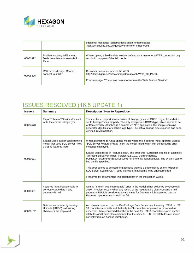
91
additional message: “Schema declaration for namespace 'http://sentinel.ga.gov.au/geoserver/historic' is not found.”
00001892 Problem copying WFS memo fields from data window to MS Excel
When copying a field in data window defined as a memo for a WFS connection only results in only part of the field copied.
00008426
R/W or Read Only - Cannot connect to a WFS
Customer cannot connect to the WFS http://daily.digpro.se/bios/wfs/app/dpmap/web/WFS_TK_PARK.
Error message: "There was no response from the Web Feature Service"
ISSUES RESOLVED (16.5 UPDATE 1) Issue # Summary Description / How to Reproduce
00024578
ExportToMstnV8Service does not write the correct linkage type
The mentioned export service writes all linkage types as ODBC, regardless what is set to LinkageTypes property. The only exception is DMRS type, which seems to be written correctly. Attached is a sample VB.NET application, the sample contains generated dgn files for each linkage type. The actual linkage type exported has been veryfied in Microstation.
00010671
Spatial Model Editor failed running model that uses SQL Server Proxy (.sfp) as features input
When attempting to run a Spatial Model where the ‘Features Input’ operator used a ‘SQL Server Features Proxy (.sfp)’ the model failed to run with the following error message displayed…
Spatial Model failed in Features Input. The error was "Could not load file or assembly 'Microsoft.SqlServer.Types, Version=12.0.0.0, Culture=neutral, PublicKeyToken=89845dcd8080cc91' or one of its dependencies. The system cannot find the file specified.".
This error seems to be occurring because there is a dependency on the 'Microsoft SQL Server System CLR Types' software, that seems to be undocumented.
[Resolved by documenting this dependency in the Installation Guide.]
00019691
Features Input operator fails to correctly serve data if any geometry is null
Getting “Stream was not readable” error in the Model Editor delivered by GeoMedia 2016. Problem occurs when any record of the input feature class contains a null geometry. NULL is considered a valid value for Geometry; it is expected that the Features Input operator should not fail.
00026152
Data server incorrectly serving Unicode (UTF-8) text, wrong characters are displayed
A customer reported that the GeoPackage Data Server is not serving UTF-8 or UTF-16 characters correctly and that only ANSI characters appeared to be served as expected. I have confirmed that this is the case for UTF-8 characters stored as Text attributes and I have also confirmed that the same UTF-8 Text attributes are served correctly from an Access warehouse.
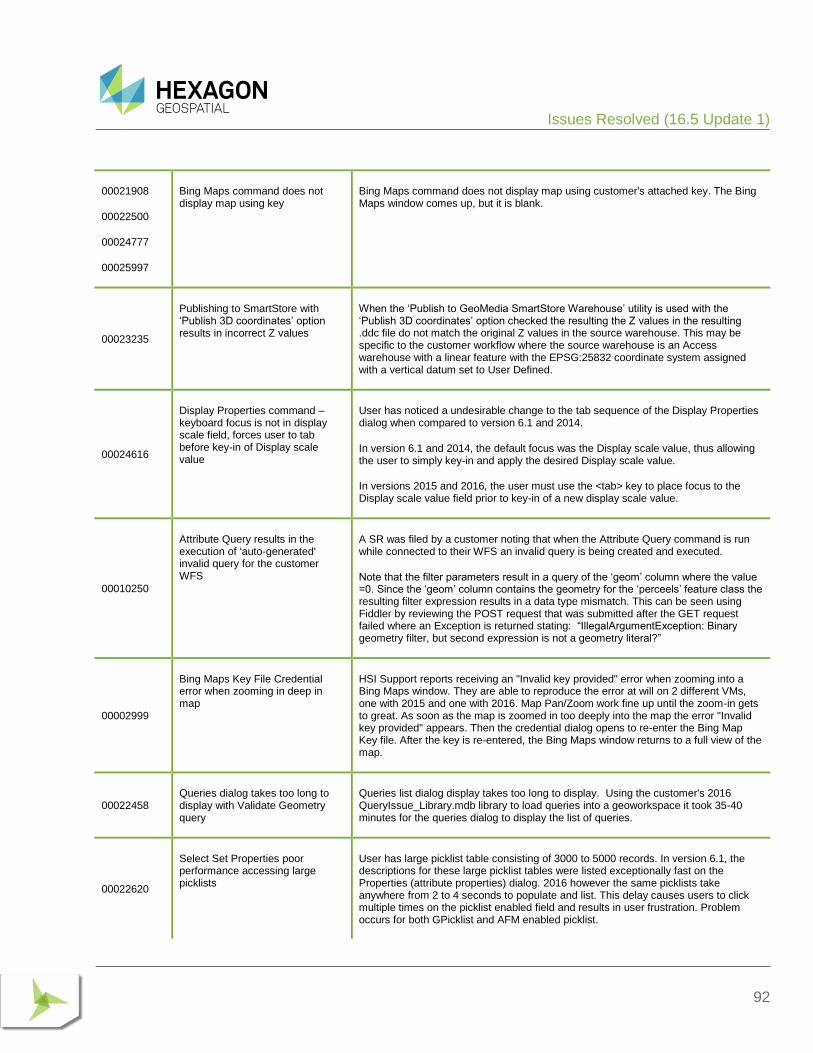
Issues Resolved (16.5 Update 1)
92
00021908
00022500
00024777
00025997
Bing Maps command does not display map using key
Bing Maps command does not display map using customer's attached key. The Bing Maps window comes up, but it is blank.
00023235
Publishing to SmartStore with ‘Publish 3D coordinates’ option results in incorrect Z values
When the ‘Publish to GeoMedia SmartStore Warehouse’ utility is used with the ‘Publish 3D coordinates’ option checked the resulting the Z values in the resulting .ddc file do not match the original Z values in the source warehouse. This may be specific to the customer workflow where the source warehouse is an Access warehouse with a linear feature with the EPSG:25832 coordinate system assigned with a vertical datum set to User Defined.
00024616
Display Properties command – keyboard focus is not in display scale field, forces user to tab before key-in of Display scale value
User has noticed a undesirable change to the tab sequence of the Display Properties dialog when compared to version 6.1 and 2014.
In version 6.1 and 2014, the default focus was the Display scale value, thus allowing the user to simply key-in and apply the desired Display scale value.
In versions 2015 and 2016, the user must use the <tab> key to place focus to the Display scale value field prior to key-in of a new display scale value.
00010250
Attribute Query results in the execution of 'auto-generated' invalid query for the customer WFS
A SR was filed by a customer noting that when the Attribute Query command is run while connected to their WFS an invalid query is being created and executed.
Note that the filter parameters result in a query of the ‘geom’ column where the value =0. Since the ‘geom’ column contains the geometry for the ‘perceels’ feature class the resulting filter expression results in a data type mismatch. This can be seen using Fiddler by reviewing the POST request that was submitted after the GET request failed where an Exception is returned stating: “IllegalArgumentException: Binary geometry filter, but second expression is not a geometry literal?”
00002999
Bing Maps Key File Credential error when zooming in deep in map
HSI Support reports receiving an "Invalid key provided" error when zooming into a Bing Maps window. They are able to reproduce the error at will on 2 different VMs, one with 2015 and one with 2016. Map Pan/Zoom work fine up until the zoom-in gets to great. As soon as the map is zoomed in too deeply into the map the error "Invalid key provided" appears. Then the credential dialog opens to re-enter the Bing Map Key file. After the key is re-entered, the Bing Maps window returns to a full view of the map.
00022458 Queries dialog takes too long to display with Validate Geometry query
Queries list dialog display takes too long to display. Using the customer's 2016 QueryIssue_Library.mdb library to load queries into a geoworkspace it took 35-40 minutes for the queries dialog to display the list of queries.
00022620
Select Set Properties poor performance accessing large picklists
User has large picklist table consisting of 3000 to 5000 records. In version 6.1, the descriptions for these large picklist tables were listed exceptionally fast on the Properties (attribute properties) dialog. 2016 however the same picklists take anywhere from 2 to 4 seconds to populate and list. This delay causes users to click multiple times on the picklist enabled field and results in user frustration. Problem occurs for both GPicklist and AFM enabled picklist.
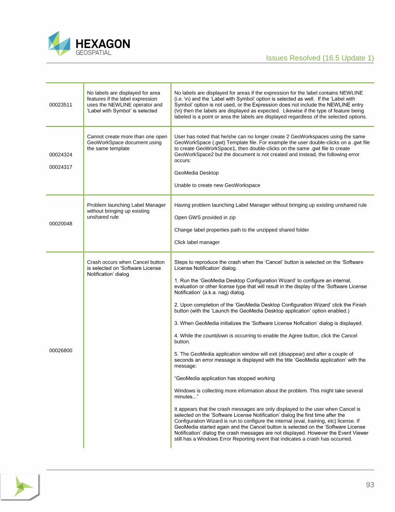
Issues Resolved (16.5 Update 1)
93
00023511
No labels are displayed for area features if the label expression uses the NEWLINE operator and ‘Label with Symbol’ is selected
No labels are displayed for areas if the expression for the label contains NEWLINE (i.e. \n) and the ‘Label with Symbol’ option is selected as well. If the ‘Label with Symbol’ option is not used, or the Expression does not include the NEWLINE entry (\n) then the labels are displayed as expected. Likewise if the type of feature being labeled is a point or area the labels are displayed regardless of the selected options.
00024324
00024317
Cannot create more than one open GeoWorkSpace document using the same template
User has noted that he/she can no longer create 2 GeoWorkspaces using the same GeoWorkSpace (.gwt) Template file. For example the user double-clicks on a .gwt file to create GeoWorkSpace1, then double-clicks on the same .gwt file to create GeoWorkSpace2 but the document is not created and instead, the following error occurs:
GeoMedia Desktop
Unable to create new GeoWorkspace
00020048
Problem launching Label Manager without bringing up existing unshared rule
Having problem launching Label Manager without bringing up existing unshared rule
Open GWS provided in zip
Change label properties path to the unzipped shared folder
Click label manager
00026800
Crash occurs when Cancel button is selected on ‘Software License Notification’ dialog
Steps to reproduce the crash when the ‘Cancel’ button is selected on the ‘Software License Notification’ dialog.
1. Run the ‘GeoMedia Desktop Configuration Wizard’ to configure an internal, evaluation or other license type that will result in the display of the ‘Software License Notification’ (a.k.a. nag) dialog.
2. Upon completion of the ‘GeoMedia Desktop Configuration Wizard’ click the Finish button (with the ‘Launch the GeoMedia Desktop application’ option enabled.)
3. When GeoMedia initializes the ‘Software License Nofication’ dialog is displayed.
4. While the countdown is occurring to enable the Agree button, click the Cancel button.
5. The GeoMedia application window will exit (disappear) and after a couple of seconds an error message is displayed with the title ‘GeoMedia application’ with the message:
“GeoMedia application has stopped working
Windows is collecting more information about the problem. This might take several minutes...”
It appears that the crash messages are only displayed to the user when Cancel is selected on the ‘Software License Notification’ dialog the first time after the Configuration Wizard is run to configure the internal (eval, training, etc) license. If GeoMedia started again and the Cancel button is selected on the ‘Software License Notification’ dialog the crash messages are not displayed. However the Event Viewer still has a Windows Error Reporting event that indicates a crash has occurred.
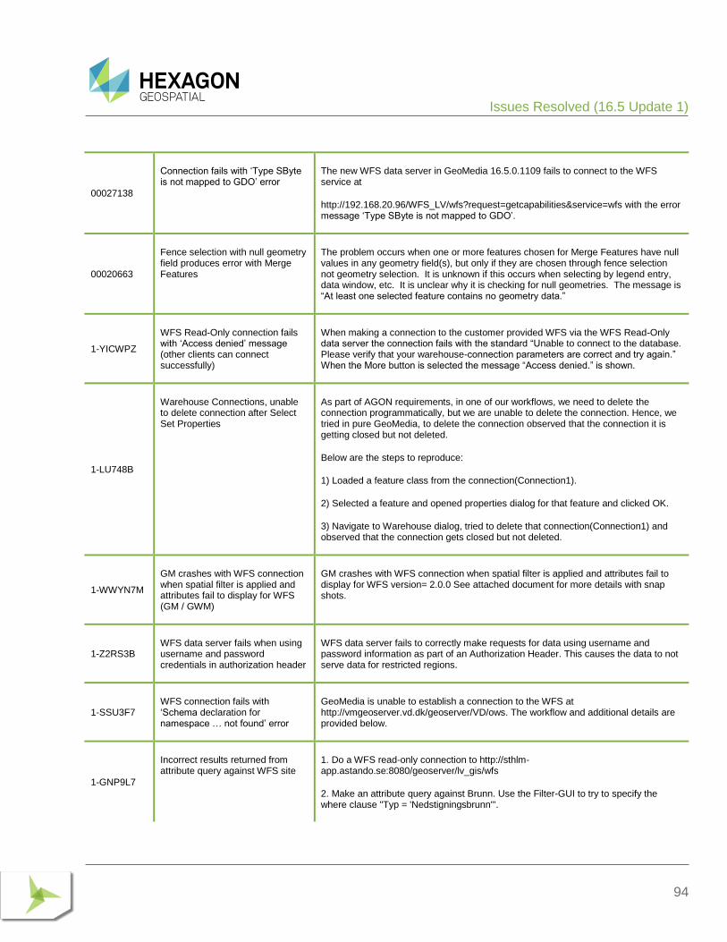
Issues Resolved (16.5 Update 1)
94
00027138
Connection fails with ‘Type SByte is not mapped to GDO’ error
The new WFS data server in GeoMedia 16.5.0.1109 fails to connect to the WFS service at
http://192.168.20.96/WFS_LV/wfs?request=getcapabilities&service=wfs with the error message ‘Type SByte is not mapped to GDO’.
00020663
Fence selection with null geometry field produces error with Merge Features
The problem occurs when one or more features chosen for Merge Features have null values in any geometry field(s), but only if they are chosen through fence selection not geometry selection. It is unknown if this occurs when selecting by legend entry, data window, etc. It is unclear why it is checking for null geometries. The message is “At least one selected feature contains no geometry data.”
1-YICWPZ
WFS Read-Only connection fails with ‘Access denied’ message (other clients can connect successfully)
When making a connection to the customer provided WFS via the WFS Read-Only data server the connection fails with the standard “Unable to connect to the database. Please verify that your warehouse-connection parameters are correct and try again.” When the More button is selected the message “Access denied.” is shown.
1-LU748B
Warehouse Connections, unable to delete connection after Select Set Properties
As part of AGON requirements, in one of our workflows, we need to delete the connection programmatically, but we are unable to delete the connection. Hence, we tried in pure GeoMedia, to delete the connection observed that the connection it is getting closed but not deleted.
Below are the steps to reproduce:
1) Loaded a feature class from the connection(Connection1).
2) Selected a feature and opened properties dialog for that feature and clicked OK.
3) Navigate to Warehouse dialog, tried to delete that connection(Connection1) and observed that the connection gets closed but not deleted.
1-WWYN7M
GM crashes with WFS connection when spatial filter is applied and attributes fail to display for WFS (GM / GWM)
GM crashes with WFS connection when spatial filter is applied and attributes fail to display for WFS version= 2.0.0 See attached document for more details with snap shots.
1-Z2RS3B WFS data server fails when using username and password credentials in authorization header
WFS data server fails to correctly make requests for data using username and password information as part of an Authorization Header. This causes the data to not serve data for restricted regions.
1-SSU3F7 WFS connection fails with ‘Schema declaration for namespace … not found’ error
GeoMedia is unable to establish a connection to the WFS at http://vmgeoserver.vd.dk/geoserver/VD/ows. The workflow and additional details are provided below.
1-GNP9L7
Incorrect results returned from attribute query against WFS site
1. Do a WFS read-only connection to http://sthlm-app.astando.se:8080/geoserver/lv_gis/wfs
2. Make an attribute query against Brunn. Use the Filter-GUI to try to specify the where clause "Typ = 'Nedstigningsbrunn'".
Issues Resolved (16.5 Update 1)
95
If you use the "show values"-button on Typ the form will not populate with the valid values in the database.
If you type in the text Nedstigningsbrunn (without apostrophies) in the Value field and press the down-button to append it to the Expression field you will get the error message "Unable to validate field value according to type. Please input new value."
However - if you type in the correct where clause in the Expression field and press OK you will get a working query and some output. Furthermore - the non-working steps above are NOT reproducable if you categorize Brunn and do an Attribute query against this category.
1-9X1IY3
GeoMedia hangs when connecting to specific WFS, must kill the GeoMedia process to regain control
When attempting to make a WFS data server connection to the provided http://www.geoservicos.ibge.gov.br:80/geoserver/wfs service GeoMedia hangs. The only way to exit the application once it hangs is to kill the GeoMedia.exe process (via Task Manager or using the X on the application). The Geospatial Portal application can connect to the same WFS successfully (and display features from the WFS successfully.)
00023093
Transformation using .gsb for Geocentric Datum of Australia failing
GeoMedia 16.2 now supplies a parameter based Bursa Wolf transformation for transformations from Geocentric Datum of Australia 1994 to Geocentric Datum of Australia 2020.
The Australian geodetic authority has now published grid (.gsb) files but attempting to configure and use the .gsb files in GeoMedia does not result in any transformation. It is as if the transformation is being skipped.
If we then change the datum of the GeoWorkSpace Coordinate System to Geodetic Datum of Austraila 2020, the coordinates are not transformed at all.
1-AXAM6E
GeoMedia adds WFS 2.0.0 feature class to legend with no geometry, the same layer displays from 1.0.0
Use GeoMedia 2014 or 2015 and connect to the wsf data source at http://sthlm-app.astando.se:8082/geoserver-2.4/lv_gis/ows and add either dispens (less data) or brunn (more data) to the legend.
• Using version 1.0.0 should work
• Using version 1.1.0 will raise the same error at connect as in the closed worksheet (but we can forget about this problem for now)
• Using version 2.0.0 will add the legend entry (plus an extra legend entry named 'gml_location of xxx', where xxx is the feature class name) but no data will be loaded
• Using no specified version will work the same as for version 2.0.0
00028348
PostGIS feature classes with user-defined spatial indexes cannot be displayed in GeoMedia if AFM is enabled
When spatial indexes are created on tables, GeoMedia can not display the tables when the 'Enable AFM' option is enabled on the connection (the data are visible when the option is off).
After creating a spatial index on an existing AFM enabled PostGIS feature the following error occurs when attempting to display the feature in GeoMedia. The problem does NOT occur if the AFM connection property is disabled (unchecked).
GeoMedia Desktop
Issues Resolved (16.5 Update 1)
96
Error creating a legend entry for power_poles
Source: GeoMedia
Description: The input recordset is invalid.
Continue with operation?
00026202
Editing line geometry results in Z values being changed to "0" or other values
After editing/moving a vertex of a line geometry the Z value height of the moved point is set to "0" or some other number.
Reproduced with English/German configuration of GM 16.5 on WIN10 German operating system and GM 16.2 English/German configuration on WIN7 English system.
00028900
Operators that reference coordinate system operations fail if using EPSG:2193 data
Attempting to use EPSG:2193 data with Spatial Model Editor fails with errors. EPSG:2193 is N,E (Y,X) referenced axes for NZGD2000 / New Zealand Transverse Mercator 2000 and is supported by GeoMedia. No problems are observed when working with the same data / coordinate system in GeoMedia GeoWorkSpace sessions; the errors only occur in Spatial Model Editor (Spatial Modeler).
00022766
Spatial Model with Measure Area operator fails using certain supported coordinate systems
A Spatial Model that uses the Measure Area operator fails when the input features are defined with the coordinate system EPSG:3008 via a .csf file. When the Spatial Model is run in GeoMedia using the ‘Run Spatial Model’ command an error dialog is displayed with the messages shown below:
GeoMedia Desktop
Input parameters may not be valid. More information below :
HexGeo::SpatialModeler::Operator::Execute failed
HexGeo::SpatialModeler::Operator::SetErrorMessage failed
Spatial Model failed in Measure Area. The error was "HexGeo::SpatialModelerGeospatial::CoordinateReferenceSystemID::CreateCoordinateReferenceSystem failed
Failed to recognize Authority Code with Authority "GeoKey Moniker" and Authority Code "1,1,0,6/1024,1/2048,32767/2050,6619/3072,32767/3074,17322/4096,5773"".
When the same Spatial Model is run using the Preview button in Spatial Model Editor the following errors are shown as displayed from the ‘Accumlated Messages dialog
Unrecognized ProjectionGeoKey 17322
Unsupported moniker
00029055
Editing or moving vertices changes Z values to Default height value
If the user edits/moves the position of a node using smartsnap on a linear or area feature (or moves a point feature) the node is assigned a new Z value equal to the Default Height value set in Options. Problem appears when smartsnap is used.
If using the Move command with smartsnap this also changes the Z value of the geometry, but not if smartsnap is not used(click out away from geometry.
97
Problem appears when smartsnap is used. Any dataset can be used. Same problem on GM 16.2.
00029046
AFM associations are not complete when using certain symbology
If the user turns OFF the ‘Automatically add legend entries’ on the Placement and Editing tab under Options, they experience issues when inserting data, using GPW. When the user inserts a WATER_MAIN, they are prompted with a start node. They select WATER_PLUG. They are then prompted to continue digitizing the WATER_MAIN which they do. The problem arises after they place the next node. Regardless of what they pick, once the feature is inserted, they are prompted again to place another node feature. What is happening is that it is not recognizing an association between the WATER_MAIN and the node.
If the user turns ON the ‘Automatically add legend entries’ on the Placement and Editing tab under Options, they DO NOT experience issues when inserting data, using GPW.
The associations for the water tee is also not correct as there is only one water main being associatted when there should be two water main associatted with the tee.
ISSUES RESOLVED (16.5 UPDATE 2) Issue # Summary Description / How to Reproduce
1-QJD6GP
Adding FieldProperty metadata for a second boolean field after a first call was made for a Boolean
Customer Description of Problem along with sample C++ Code.
If the following method is called twice on two different tables with fieldtype being gdbBoolean on both calls, the second call crashes on metadataservice->AddFieldMetadata(&dispfieldproperty);
00022649
All subtitles for thematic legend entries are lost if a class is ‘omitted’ via Legend Entry Properties
If the Legend Entry Properties dialog is used to modify the displayed classes for a thematic legend entry where subtitles have been defined, all the previously defined subtitles will be missing after clicking OK on the Legend Entry Properties dialog.
00023767
Edit Feature Class Metadata for PostGIS feature class fails to update geometrytype column for gdo.geometryproperties
A customer created a PostGIS database and populated it with features outside of GeoMedia. They then used Database Utilities to create the necessary metadata to connect to the database and display the feature classes from the database within GeoMedia. However when inserting the feature class metadata they mistakenly assigned the wrong geometry type to a feature class. To correct the problem, they used the ‘Edit Feature Class Metadata’ command to reassign the correct geometry type to the feature class, but the metadata was not updated correctly in all the required metadata tables. Specifically, the the geometrytype column in the gdo.geometryproperties table retained the previous geometrytype value instead of being updated with the new geometrytype as assigned via Edit Feature Class Metadata. Note that the geometrytype column in the gdo.gfeaturesbase table was updated correctly, but not the corresponding gdo.geometryproperties table.
Issues Resolved (16.5 Update 2)
98
00023877
Edit Feature Class Metadata shows empty rows for new attributes created via database
If a table representing a feature class in a PostGIS database is edited at the database level to add new attributes and then Database Utilities ‘Edit Feature Class Metadata’ command is used on that feature class the ‘Feature Class Properties’ dialog will show extra rows on the Attributes tab for each of the attribute columns that was added via the database. The extra rows (one for each attribute column added via the database) will have no attribute name shown (i.e. the ‘Field Name’ column is blank) and the ‘DataType’ field is shown with the value ‘Autonumber’ with the ‘Displayable’ field value set to ‘No’.
00027262
Insert Feature Class Metadata creates incorrect metadata for PostGIS table names with diacritics resulting in Insert Feature failure
When the Database Utilities > Insert Feature Class Metadata command is used to create metadata for table name containing the Swedish diacritic characters (i.e. å ä ö) the resulting metadata is incorrect. The presence of this incorrect metadata causes the Insert Feature command to return an error when attempting to insert an instance of the feature class.
00027498
Edit or Insert Metadata for viewname with diacritics creates invalid PostGIS metadata for primary keys
User has views that are named using diacritic characters (i.e. å ä ö). Per 00027262, the user corrected the ‘f_table_name’ value in the gdo.gfieldmapping table manually. Even with this fix however, the user noticed that errors such as the following were encountered when feature caching was enabled
An error was encountered loading data for read.funktionell_vägklass legend entry.
“Invalid operation
Do you want to continue loading remaining legend entries?”
Selection of More button shows the following message:
“Member not found”
Further investigation revealed that the view as seen in GeoMedia's Feature Class Definition did not have a primary key defined. Using Database Utilities to Edit the metadata and declare a primary key however did not resolve the issue as Database Utilities failed to correctly populate the gdo.gindexcolumns table where you can see that the object_name field values no longer contains the correct diacritic characters; thus GeoMedia feature caching is unable to correctly determine the primary key field.
00030984
Edit Metadata makes incomplete updates for geometry type for PostGIS features not stored in public schema
If features are stored in a schema other than public, then Database Utilities, Edit Metadata command fails to properly update changes to the geometry. Specifically, the subtype field of the gdo.gfieldmapping table is not properly updated by the Edit Metadata command. In contrast, the Insert Metadata command works fine.
00017423
Spatial Intersection returning incorrect results for query between two area feature classes
The customer said that some occurrences of the topology error are solved, but also some are not solved. The (sample issue) data provided by the customer is attached. I also verify the behaviour on my test GeoMedia prerelease 16.5 by spatial intersection - it is in the attached GWS as query. The data and GWS is for two pairs of data layers.
The issue occurs only when all polygons are used into the analyze. In the case, when only selected polygons are input to the analyze (possible also as GM query) the output is correct for the same polygons.
Issues Resolved (16.5 Update 2)
99
00023964
Enabling Index Feature Caching (IFC) for vanilla PostGIS data results in application crash
The GeoMedia application may crash without opportunity to save changes if Index Feature Caching is enabled for PostGIS. The problem occurs when there is no GeoMedia GDO metadata.
After using GeoMedia to connect to PostGIS database where:
a) The schema for user data is stored in the default public schema
b) The GDO metadata schema is not present
c) There are no GDO bytea geometry fields present
d) There are spatial geometry fields present: point, line and area (1 record each)
The data can be successfully served and displayed in GeoMedia as read-only features but if edit the connection to enable the IFC Caching option on the connection then GeoMedia immediately crashes without any opportunity to save.
00030199
WFS data server failure "WFS2.GDatabase is not registered"
Open 'Publish to GeoMedia SmartStore' utility
Click 'New Connection
Choose WFS (not WFS Read-Write)
Enter a URL to a valid WFS Service (e.g. http://demo.hexagongeospatial.com/WFS_LondonReligion/service.svc/get)
Result: Error message 'The GDO object WFS2.GDatabase is not registered correctly. Please reinstall the application to assure proper registration'
00029967
Applying spatial filter creates errors in postgresql .log files
When a spatial filter is applied to PostGIS data in GeoMedia, errors appear in the PostgreSQL .log files found in C:\Program Files\PostgreSQL\9.5\data\pg_log folder.
Example errors:
2018-07-06 09:11:22 CDT ERROR: prepared statement "teststmt" does not exist
2018-07-06 09:11:22 CDT STATEMENT: deallocate teststmt
Every time a spatial filter is called, the errors are logged, and there can be thousands of them for WebMap users since WMTS tiling process sending out thousands of spatial filtered WMS map requests.
00032009
GeoMedia is unable to display any features (geometry) for feature classes from a vanilla PostGIS database
When a PostGIS data server connection is made to the customer provided PostGIS database (that has no GDO schema, thus no GeoMedia metadata tables), the Add Legend Entries command can be used to add the feature classes from that database to the legend. However, there are no geometries displayed for the feature classes. In other words, the legend statistics show a value of 0 and there are no features visible in the map window.
00031674
‘Failed to open document’ error occurs when opening any GeoWorkspace (including new
Multiple customer reports have been received (via support tickets and the support forum) stating that installing GeoMedia Desktop 2018 Update 1 results in a ‘Failed to open document’ error when opening any .gws file. This includes a new .gws via the ‘New GeoWorkspace’ command. In all reported cases (except one) the customer also has GeoMedia Webmap 2018 installed on the machine when the error occurs and in
Issues Resolved (16.5 Update 2)
100
.gws) after installing GeoMedia Desktop 2018 Update 1
my testing I was only able to reproduce the problem by first installing GeoMedia WebMap 2018.
00030280
Loading ECW files cause GM to crash
On the ‘Insert Georeferenced Images’ dialog when you select a .ecw raster file for display a crash will occur if the folder also contains a .eww world file. This problem does not occur when using GeoMedia 16.00.0000.201114 so this is a regression from that version.
00029970
GeoMedia 2018 does not read ECW / EWW image format
GeoMedia 2018 fails to read/display ECW / EWW image format
Unable to display in GM using the 417_3_25_1.ecw file with the 417_3_25_1.EWW and EPSG_3763.csf files.
Customer is able to open 417_3_25_1.ecw in ERDAS but not in GeoMedia 2018. Customer in ERDAS then exported to 417_3_25_1_erdas.ecw,
Able to insert the 417_3_25_1.ecw using interactive mode successfully. It is also possible to open in GeoMedia 2018 using "other with external coordinate system" mode but not in "world file" mode.
00009852
DBU posts success for PostGIS metadata even when no metadata tables are created
Selecting the Create Metadata Tables button in Database Utilities may post a successful message that the metadata tables were created when in fact the metadata was not created at all.
When creating metadata for PostGIS, if the database Privilege properties for the Postgres role/user used for the connection does not have CREATE privilege then the following message is posted:
---------------------------
Database Utilities
Processing of Create Metadata Tables is completed.
GeoMedia metadata system is modified.
OK
---------------------------
In fact, the GDO schema is not created at all thus there are no metadata tables created. If the user does not have proper privileges then we'd expect a message from Database Utilities to indicate there was a problem creating the metadata.
00026588
00015958
Insert Feature Class Metadata fails to show materialized view from PostGIS
When a materialized view is present in a PostgreSQL/PostGIS database and a connection to that database is made from Database Utilities using the PostGIS connect the Insert Feature Class Metadata dialog does not show the materialized view in the list of ‘Available tables/views’.
00030572
PDF attributes do not display in Adobe Reader on German system
I checked the PDF attributes on the machine and it appears not to be exporting the chosen attributes using the PDF Attributes command and Export to PDF on German system - the attributes can't be seen in Adobe Reader on German system. This is NOT a problem only for German system. Problem exists on ALL systems. Seeing this with ussample.gws and with the .gws delivered with the PDF tutorial on the web.
Issues Resolved (16.5 Update 2)
101
00023254
Image data fails to transform or display as expected from GDA94 datum to GDA2020 datum when using Advance image processing option
User-provided GeoTiff raster files fail to transform as expected when transforming from Geocentric Datum of Australia 1994 (GDA94) to Geocentric Datum of Australia 2020 (GDA2020).
GeoTiff image data, referenced and stored using GDA94 is correctly displayed in GeoWorkSpace with Coordinate system set to GDA94 datum. If the GeoWorkSpace coordinate system is changed to GDA2020, the image data does not display / transform correctly if the Advanced Image Processing option is enabled (checked). If however the Advanced Image Processing option is disabled (forcing affine transformation) the image seems to transform as one might expect.
When File > Options, Map Display tab, Advanced Image Processing option is enabled, then a transformation of the image data from GDA94 to GDA2020 results in a correctly transformed image polygon but some of the image pixel data are unexpectedly shifted / (displayed off by by 1 pixel).
When transforming from GDA94 to GDA2020 it is expected that data should shift by small amounts (usually less than 1 m) to the west and to the north. It is believed that GeoMedia is correctly transforming the vector data and the image polygon. It seems however that the logic for Advanced Image Processing seems incorrectly "back fill" using white pixels along the top and left borders of the image. Interestingly the lower right corner seems to be correct.
1-U66Z0O
Static labels output to warehouse are not transformed correctly when converting Coordinate System
This behavior is consistent with the GeoMedia 06.01.11 / GeoLabel configuration and is most evident when changing between changing between geographic and projected or visa-versa. Workflow:
1) Create a new GeoWorkspace and connect to World.mdb warehouse.
2) Add the Country legend entry
3) Invoke GeoWorkspace Coordinate System and ensure coordinate system is set to Geographic
4) Set the Nominal Map Scale and Display Scale to 1:75,000,000
5) Invoke Label Manager and define the label properties (Text = CNTRY_NAME, Size = 8)
6) Invoke Generate Static Labels and output to warehouse. Set the options to full map extent, and the nominal map scale.
7) Invoke GeoWorkspace Coordinate System and ensure coordinate system is set to Projected - set the system to Robinson.
8) Notice the labels are not transformed correctly.
00022013
Insert fails to map PostgreSQL binary types to gdbLongBinary
The following supported PostgreSQL data types are not displayed in GeoMedia's Database Utilities:
• bit [n]
• bit varying [n]
• bytea
Issues Resolved (16.5 Update 2)
102
According to GeoMedia Help topic "[PostGIS to GeoMedia Data Type Matching|http://example.com]", these PostgreSQL data types are supported and can be mapped to GeoMedia data type of gdbLongBinary.
The bit, bit varying and bytea attributes are not listed as available attributes in Database Utilities, Attributes tab.
The bytea attribute is of specific concern to the end user reporting this issue. The user has bytea user defined information (not geometry). Database Utilities however does not allow the user to insert metadata for non-geometry mapped (via the Geometry tab in Database Utilities) bytea attribute fields. Database Utilities is incorrectly expecting that all bytea fields should be mapped to a geometry type.
Customer is specifically interested in using bytea which not only does not show in Attributes but also is forced to a geometry mapping.
00017807
Generate Static Label command does not create proper GeoMedia metadata
FieldLookup and AttributeProperties tables are NOT populated with field name entries for the static label generated feature classes. Thus the metadata in Database Utilities does not show a Geometry tab and the attributes tab does not show any attribute field listings!
Problem reproduced for both Access and Oracle.
00004513
Static Label text geometry fails to transform with coordinate system changes
Static label text added to the map legend fails to transform if the GeoWorkspace Coordinate System is changed. If however, the same label text is added to the map using Legend > Add Legend Entries command, the text geometry transforms as expected with changes to the GeoWorkSpace Coordinate System.
00024754
Attribute based style for linear pattern inset properties producing undesirable results
User has noted that 2015 and 2016 produce undesirable results for a linear pattern that uses an attribute based style (ABS) setting for starting and ending inset properties. The user considers the results seen in 2015 and 2016 to be incorrect and a regression from behavior seen in 6.1 and 2014.
Specifically, when the ABS for the EndingInset property evaluates to a negative value, the result is that the pattern point is not displayed. The user expects that the points should be displayed as "outsets" when a negative value is used (as seen in versions 6.1 and 2014).
00032134
PostGIS producer fails in Features Database Output operator with incomplete output when using PostGIS as the Output Connection
When running the provided ‘my_salidaclaseentidad1.gmdx’ model where the ‘Features Database Output’ operator is used to output features from an input shapefile with 226,232 area features to a new table in a PostGIS connection the process fails within the ‘Features Database Output’ operator after 105,366 records have been output to the PostGIS table. After the error occurs if you double-click the ‘Features Output Operator’ to open the ‘Output Connection’ dialog this results in the display of an error dialog with the message “Timeout while getting a connection from pool.”. After this error message dialog is dismissed the ‘Output Connection’ dialog will be displayed.
Note that if the ‘Feature Output Operator’ is modified to use a new table from a SQL Server Spatial connection and the same model is run, the process completes without error with all input records are successfully output to the SQL Server Spatial table. Therefore this issue seems to be related to the use of the PostGIS connection for the output table.
Issues Resolved (16.5 Update 2)
103
00033664
Spatial Intersection results incorrect for certain data
User has provided example data and workflow where the results of Spatial Intersection of two area feature classes using the Overlap operator produces incorrect results (unexpected and invalid geometries). The incorrect results of this specific data are obvious, but it is assumed that more often such invalid results may be difficult to identify. The issue is a regression from version 2014 where the results of the spatial intersection are correct; Incorrect results from spatial intersection is first observed in version 15.00.0000.10258.
00005214
00016206
Legend entry title editing: Copy & Paste using keyboard shortcuts is not working
Legend entry title editing: Copy & Paste using keyboard shortcuts is not working anymore. In GeoMedia 6.1 it was possible to use Ctrl+C and Ctrl+V to copy and paste texts from and into legend entry titles. In GeoMedia 2016 this doesn't work anymore. The only way to use the clipboard is using the context menu when editing the legend title/subtitle.
00034139
Update Attributes fails to update boolean values after selecting boolean value
When working with Boolean fields, the Update Attributes dialog allows users to select a Boolean value from a drop down list similar to a picklist that is populated with only True or False. In version 2015 (15.00.0000.10258) the user could simply pick a Boolean value to be used for the update. In versions since 16.0 (16.0.0000.01415+), an error occurs after attempting to update by simply selecting a Boolean value. Version 2016+ users can no longer simply select the Boolean value to be used.
To work-around this problem, the Expression button can be used to build a custom expression such as one of the following examples:
• True()
• False()
It seems that prior to 2016, when updating Boolean fields, the dialog was able to interpret Long Integer values of 1 and 0 as TRUE() and FALSE(). It does seem strange that one could use a Long Integer output type to update a Boolean field therefore when selecting True or False from a list, we might expect the expression to be populated as TRUE() or FALSE() which equate to Boolean types.
1-955OHB
Unable to make edits to features from ESRI 1.1.0 WFS-T service which uses GetFeatureWithLock
Attempts to edit features from WFS-T 1.1.0 service from ESRI results in errors in the client and a response from the server stating "Updates in a WFS Transaction request require a lockId. Use GetFeatureWithLock to acquire a lock before attempting to update it".
The server response was reported by the customer in the SR, but I have not actually observed this response myself. However when connected to the service with the WFS Read-Write data server any attempts to edit geometry or attributes will result in an error message which is often blank.
A GDOWFSRW.log file was created and is included in the attachments tab.
I was unable to find another WFS client that could make edits to the WFS and a Google search turned up some discussion of this issue indicating that most clients don’t support the ESRI 1.1.0 WFS-T service that uses the GetFeatureWithLock element (as per the link below)… http://forums.arcgis.com/threads/51417-Arcgis-server-WFS-T-and-interoperability
The customer reported this issue with 14.00.0001.00064, but I have reproduced it with 14.00.0002.92 patch version as well.
Issues Resolved (16.5 Update 2)
104
1-8811AN
Unable to insert features with GMPro into WFS-T connection
Unable to insert features with GMPro into WFS-T connection. When trying to insert a feature, a warning dialog box was displayed:
"Features cannot be inserted into a read-only feature class"
Problem also observed in GeoMedia Pro 06.01.11.13. The same features can be edited / inserted using open source Udig software.
1-B70WYQ
WFS-T Data Server Does Not Properly Read and Use InputFormat Parameter
The WFS-T Data server does not read and honour the inputFormat parameter prescribed for Transactions. This issue was noted by development research on issues and problems with GeoMedia reading and writing to GeoServer WFS-T service.
"We do not read and honour the inputFormat parameter prescribed for Transactions. Bug on WFS-T Dataserver
<ows:Parameter name="inputFormat"><ows:AllowedValues><ows:Value>text/xml; subtype=gml/3.2</ows:Value></ows:AllowedValues></ows:Parameter>
The request for WFS is always constructed in gml 3.1.1 since we do not honour the inputFormat parameter. This is a problem since the initial development of the WFS – RW dataserver and has never been upgraded."
00020521
Using default value for text field in PostGIS incorrectly shows value enclosed by quotes on properties dialog
If use Default Value for a text field, the value is enclosed by quotes on the Properties dialog when inserting features. These quotes will be stored as part of the text string attribute if the text field is large enough to accept the additional quote characters.
The problem was first identified for AFM defined default value fields but the issue also occurs for Non-AFM PostGIS warehouses using a simple feature model where the default value has been set via Warehouse > Feature Class Definition. The problem occurs on Inserts but does not occur when editing the properties of existing features (updates).
00031898
00020517
Disabling AFM Property for PostGIS connection may result in application failure
User reported that sometimes when disabling the AFM property for PostGIS connections that GeoMedia crashes without opportunity to save.
A specific workflow and data were not provided other than the following statement:
Most of the time, this arrive after using several editing vector commands with AFM activated (new feature, editing geometry, merge feature, split features ...). After that go to Warehouse connections and disable AFM in PostGIS properties connection. GeoMedia crash after that.
00029046
Validate Feature Classes queries are not correctly updated when a Spatial Filter is defined
AFM Validate Feature Classes queries are not correctly updated when using GeoMedia version 16.00.0000.20137 to insert features in an AFM enabled connection when there is a spatial filter applied. If there is no spatial filter present the queries are updated as expected. Specifically, after the feature class is inserted with the required associations to make it valid the feature continues to be shown as invalid (meaning the legend statistics for the Validate Feature Classes queries continue to indicate that the feature is invalid and the style in the map window for the feature continues to the show the ‘red’ color that is used by the Validate Feature Classes query command to indicate an invalid feature.)

About Us
105
ABOUT US Hexagon Geospatial helps you make sense of the dynamically changing world. We enable you to envision, experience and communicate geographic information. Our technology provides you the form to design, develop and deliver solutions that solve complex, real-world challenges. Ultimately, this is realized through our creative software products and platforms.
CUSTOMERS. Globally, a wide variety of organizations rely on our products daily including local, state and national mapping agencies, transportation departments, defense organizations, engineering and utility companies, and businesses serving agriculture and natural resource needs. Our portfolio enables these organizations to holistically understand change and make clear, reliable decisions.
TECHNOLOGY. Our priority is to deliver products, platforms and solutions that make our customers successful. Hexagon Geospatial is focused on developing technology that displays and interprets information in a personalized, meaningful way. We enable you to transform location-based content into dynamic and useable business information that creatively conveys the answers you need.
PARTNERS. As an organization, we are partner-focused, working alongside our channel to ensure we succeed together. We provide the right platforms, products, and support to our business partners so that they may successfully deliver sophisticated solutions for their customers. We recognize that we greatly extend our reach and influence by cultivating channel partner relationships both inside and outside of Hexagon.
TEAM. As an employer, we recognize that the success of our business is the result of our highly motivated and collaborative staff. At Hexagon Geospatial, we celebrate a diverse set of people and talents, and we respect people for who they are and the wealth of knowledge they bring to the table. We retain talent by fostering individual development and ensuring frequent opportunities to learn and grow.
HEXAGON. Hexagon’s solutions integrate sensors, software, domain knowledge and customer workflows into intelligent information ecosystems that deliver actionable information. They are used in a broad range of vital industries.
Hexagon (Nasdaq Stockholm: HEXA B) has more than 18,000 employees in 50 countries and net sales of approximately 3.3bn USD. Learn more at hexagon.com and follow us @HexagonAB.

About Us
106
Copyright
© 2018 Hexagon AB and/or its subsidiaries and affiliates. All Rights Reserved. Hexagon has registered trademarks in many countries throughout the world. Visit the Trademarks Page for information about the countries in which the trademarks are registered. See Product Page and Acknowledgements for more information.
Product Documentation Terms of Use
PLEASE READ THESE TERMS CAREFULLY BEFORE USING HEXAGON GEOSPATIAL’S DOCUMENTATION ("DOCUMENT"). USE OF THIS DOCUMENT INDICATES ACCEPTANCE OF THIS AGREEMENT WITHOUT MODIFICATION. IF YOU DO NOT AGREE TO THE TERMS HEREOF ("TERMS"), DO NOT USE THIS DOCUMENT.
Use Of This Document
All materials in this Document are copyrighted and any unauthorized use may violate worldwide copyright, trademark, and other laws. Subject to the terms of this Agreement, Hexagon Geospatial (a Division of Intergraph Corporation) and Intergraph’s subsidiaries ("Intergraph") hereby authorize you to reproduce this Document solely for your personal, non-commercial use. In consideration of this authorization, you agree to retain all copyright and other proprietary notices contained therein. You may not modify the Materials in any way or reproduce or publicly display, perform, or distribute or otherwise use them for any public or commercial purpose, except as specifically authorized in a separate agreement with Hexagon Geospatial.
The foregoing authorization specifically excludes content or material bearing a copyright notice or attribution of rights of a third party. Except as expressly provided above, nothing contained herein shall be construed as conferring by implication, estoppel or otherwise any license or right under any copyright, patent or trademark of Hexagon Geospatial or Intergraph or any third party.
If you breach any of these Terms, your authorization to use this Document automatically terminates. Upon termination, you will immediately destroy any downloaded or printed Materials in your possession or control.
Disclaimers
ALL MATERIALS SUPPLIED HEREUNDER ARE PROVIDED "AS IS", WITHOUT WARRANTY OF ANY KIND, EITHER EXPRESSED OR IMPLIED, INCLUDING, BUT NOT LIMITED TO, ANY IMPLIED WARRANTIES OF MERCHANTABILITY, FITNESS FOR A PARTICULAR PURPOSE, OR NON-INFRINGEMENT. Hexagon Geospatial does not warrant that the content of this Document will be error-free, that defects will be corrected, or that any Hexagon Geospatial Website or the services that make Materials available are free of viruses or other harmful components.
Hexagon Geospatial does not warrant the accuracy and completeness of this Document. Hexagon Geospatial may make changes to this Document at any time without notice.
Limitation Of Liability
IN NO EVENT SHALL HEXAGON GEOSPATIAL BE LIABLE FOR ANY DIRECT, INDIRECT, INCIDENTAL, SPECIAL OR CONSEQUENTIAL DAMAGES, OR DAMAGES FOR LOSS OF PROFITS, REVENUE, DATA OR USE, INCURRED BY YOU OR ANY THIRD PARTY, WHETHER IN AN ACTION IN CONTRACT OR TORT, ARISING FROM YOUR ACCESS TO, OR USE OF, THIS DOCUMENT.
Indemnification
You agree to defend, indemnify, and hold harmless Hexagon Geospatial, its officers, directors, employees, and agents from and against any and all claims, liabilities, damages, losses or expense, including reasonable attorneys’ fees and costs, arising out of or in any way connected with your access to or use of this Document.
Use Of Software
Use of software described in this Document is subject to the terms of the end user license agreement that accompanies the software, if any. You may not download or install any software that is accompanied by or includes an end user license agreement unless you have read and accepted the terms of such license agreement. Any such software is the copyrighted work of Hexagon Geospatial, Intergraph or its licensors. Portions of the user interface copyright 2012-2018 Telerik AD.
Links To Third Party Websites
About Us
107
This Document may provide links to third party websites for your convenience and information. Third party websites will be governed by their own terms and conditions. Hexagon Geospatial does not endorse companies or products to which it links.
Third party websites are owned and operated by independent parties over which Hexagon Geospatial has no control. Hexagon Geospatial shall not have any liability resulting from your use of the third party website. Any link you make to or from the third party website will be at your own risk and any information you share with the third party website will be subject to the terms of the third party website, including those relating to confidentiality, data privacy, and security.
Trademarks
The trademarks, logos and service marks ("Marks") displayed in this Document are the property of Hexagon Geospatial, Intergraph or other third parties. Users are not permitted to use Marks without the prior written consent of Hexagon Geospatial, Intergraph or the third party that owns the Mark. "Intergraph" is a registered trademark of Intergraph Corporation in the United States and in other countries. Other brands and product names are trademarks of their respective owners.
Find additional trademark information.
Procedure For Making Claims Of Copyright Infringement
Notifications of claimed copyright infringement should be sent to Hexagon Geospatial by mail at the following address: Intergraph Corporation, Attn: Intergraph Legal Department, P.O. Box 240000, Huntsville, Alabama 35824.
US Government Restricted Right
Materials are provided with "RESTRICTED RIGHTS." Use, duplication, or disclosure of Materials by the U.S. Government is subject to restrictions as set forth in FAR 52.227-14 and DFARS 252.227-7013 et seq. or successor provisions thereto. Use of Materials by the Government constitutes acknowledgement of Hexagon Geospatial or Intergraph’s proprietary rights therein.
International Use
You may not use or export Materials in violation of U.S. export laws and regulations. Hexagon Geospatial makes no representation that Materials are appropriate or available for use in every country, and access to them from territories where their content is illegal is prohibited.
Hexagon Geospatial provides access to Hexagon Geospatial international data and, therefore, may contain references or cross references to Hexagon Geospatial products, programs and services that are not announced in your country. These references do not imply that Hexagon Geospatial intends to announce such products, programs or services in your country.
The Materials are subject to U.S. export control and economic sanctions laws and regulations and you agree to comply strictly with all such laws and regulations. In addition, you represent and warrant that you are not a national of, or otherwise located within, a country subject to U.S. economic sanctions (including without limitation Iran, Syria, Sudan, Cuba, and North Korea) and that you are not otherwise prohibited from receiving or accessing the Materials under U.S. export control and economic sanctions laws and regulations. Hexagon Geospatial makes no representation that the Materials are appropriate or available for use in every country, and access to them from territories where their content is illegal is prohibited. All rights to use the Materials are granted on condition that such rights are forfeited if you fail to comply with the terms of this agreement.
Revisions
Hexagon Geospatial reserves the right to revise these Terms at any time. You are responsible for regularly reviewing these Terms. Your continued use of this Document after the effective date of such changes constitutes your acceptance of and agreement to such changes.
Applicable Law
This Document is created and controlled by Hexagon Geospatial in the State of Alabama. As such, the laws of the State of Alabama will govern these Terms, without giving effect to any principles of conflicts of law. You hereby irrevocably and unconditionally consent to submit to the exclusive jurisdiction of the United States District Court for the Northern District of Alabama, Northeastern Division, or the Circuit Court for Madison County, Alabama for any litigation arising out of or relating to use of this Document (and agree not to commence any litigation relating thereto except in such courts), waive any objection to the laying of venue of any such litigation in such Courts and agree not to plead or claim in any such Courts that such litigation brought therein has been brought in an inconvenient forum. Some jurisdictions do not allow the exclusions or limitations set forth in these Terms. Such exclusions or limitations shall apply in all jurisdictions to the maximum extent allowed by applicable law.

About Us
108
Questions
Contact us with any questions regarding these Terms.