RELATÓRIO FAPESP CASOS OCORRIDOS DURANTE O SOS...
21
RELATÓRIO FAPESP CASOS OCORRIDOS DURANTE O SOS-CHUVA
Transcript of RELATÓRIO FAPESP CASOS OCORRIDOS DURANTE O SOS...
RELATÓRIO FAPESP
CASOS OCORRIDOS DURANTE O SOS-CHUVA

03/12/2016
The event occurred as an upper-level trough moved over the region, causing widespread
convection. A squall line formed and strong wind gusts were reported in the cities of Piracicaba,
Jundiaí and Campinas (http://deolhonotempo.com.br/index.php/nacional/6739-temporal-com-granizo-
atinge-hortolandia-indaiatuba-iracemapolis-e-rio-das-pedras-sp, http://g1.globo.com/sp/campinas-
regiao/noticia/2016/12/chuva-de-sabado-derrubou-8-arvores-em-campinas-diz-defesa-civil.html).
18/12/2016
On the afternoon 18 December 2016, the thermodynamic conditions favored convective
systems in the Sao Paulo state. Thundestorms in São Paulo, Campinas, Guarulhos and Campos do
Jordão, among other localities, caused strong wind gusts and hail. The radar image show VIL at nearly
the time of severe weather.

19/12/2016
The conditions were favorable for convection during the afternoon of 19 December, with some
hail registered in the north of São Paulo city. Groups of storms formed in the study area and some
attained severe characteristics.
25/12/2016

An event with hail and strong wind gusts affected Campinas and São Carlos on the 25
December 2016. The radar depicted an organized area of convection advancing towards the region in
association with high vertically integrated liquid (VIL).
03/01/2017
The high thermodynamic instability favored strong storms in São Paulo, the Paraiba Valley
and other regions within the study area. The storms were mainly discrete and presented high number of
lightning flashes. Strong wind gusts caused several trees to fall in Idaiatuba
(http://www.portalcbncampinas.com.br/2017/01/temporal-no-final-da-tarde-causa-estragos-em-
indaiatuba/, http://www.tribunadeindaia.com.br/_conteudo/2017/01/cidade/31285-prefeitura-lanca-
mao-de-forca-tarefa-depois-do-temporal.html).
http://www.portalcbncampinas.com.br/2017/01/temporal-no-final-da-tarde-causa-estragos-em-indaiatuba/
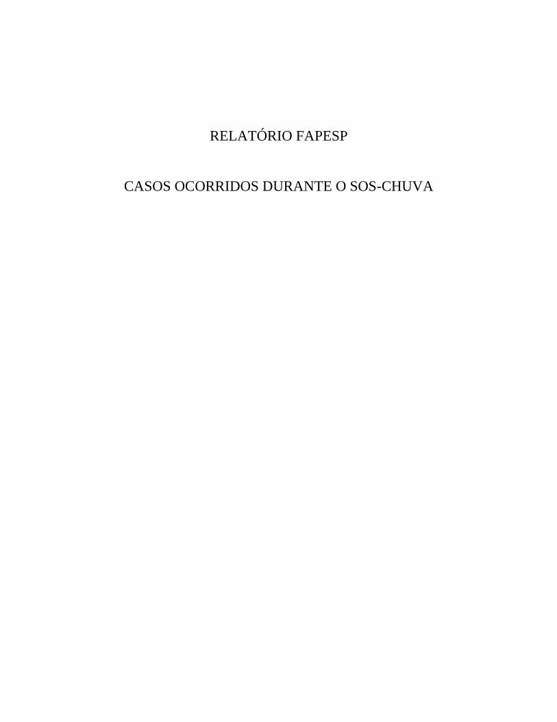
07/01/2017
Strong rains cause flooded streets, isolating neighborhoods and causing the temporary closure
of a subway station in São Paulo (http://www.cearaagora.com.br/site/chuva-provoca-transbordamento-
de-rio-e-alagamento-em-sao-paulo/, https://noticias.uol.com.br/cotidiano/ultimas-
noticias/2017/01/07/com-chuva-estacao-de-metro-alaga-e-rio-transborda-em-sao-paulo.htm). In the
Paraiba Valley cities, the heavy rain and strong wind gusts caused floods and the fall of trees.
15-16/01/2017
The atmospheric conditions were favorable for the formation of several convective cells in the
area of study on 15 and 16 of January. Strong rains cause flooded streets and two deaths in the São
Paulo metropolitan region. On the night of the 15th, 115 mm were registered in 24 hours in Mirante de
Santana weather station in São Paulo, the highest 24-hours precipitation accumulation in that station for
January in 68 years. In the same station, 64.6 mm were accumulated in only an hour
(http://g1.globo.com/sao-paulo/noticia/temporal-atinge-grande-sp-e-mulher-morre-em-guarulhos-apos-
ter-carro-arrastado-pela-enxurrada.ghtml). A severe storm caused severe wind gusts in Indaiatuba on
the 16.

28/01/2017
On this day, an organized squall line passed over São Paulo state. The strong wind gusts
caused the fall of 177 trees in the city of São Paulo
(http://www1.folha.uol.com.br/cotidiano/2017/01/1853224-temporal-deixa-sao-paulo-em-atencao-e-
com-vias-congestionadas.shtml). In Campinas, strong gust winds of up to 64,6 km/h were registered by
CEPAGRI in Barão Geraldo, causing the fall of 47 trees (http://g1.globo.com/sp/campinas-
regiao/noticia/2017/01/chuva-provoca-queda-de-47-arvores-e-pontos-de-alagamento-em-
campinas.html), while the heavy rain caused floods in many cities in the state.
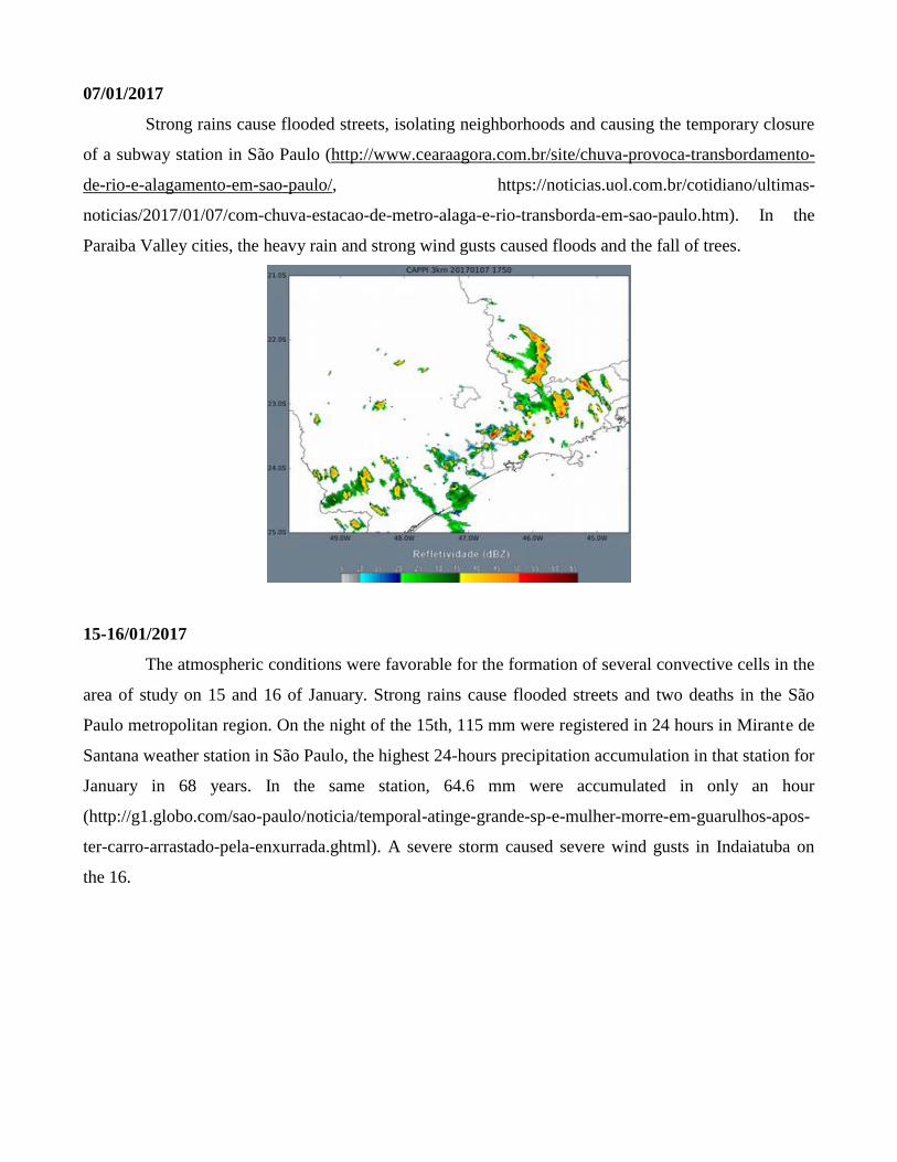
30/01/2017
An upper tropospheric cyclonic vortex over Paraguay favored convection in the south and
southeastern of Brazil. Scattered storms formed in the study region, and hail was reported in Jundiaí
and Campinas (http://g1.globo.com/sp/campinas-regiao/noticia/2017/01/temporal-tem-ventos-de-85-
kmh-e-alaga-ruas-em-campinas-sp.htmls).
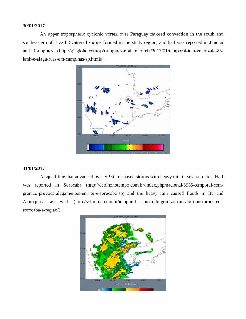
31/01/2017
A squall line that advanced over SP state caused storms with heavy rain in several cities. Hail
was reported in Sorocaba (http://deolhonotempo.com.br/index.php/nacional/6985-temporal-com-
granizo-provoca-alagamentos-em-itu-e-sorocaba-sp) and the heavy rain caused floods in Itu and
Araraquara as well (http://z1portal.com.br/temporal-e-chuva-de-granizo-causam-transtornos-em-
sorocaba-e-regiao/).

02/02/2017
Another squall line impacted São Paulo metropolitan region, Campinas, and other cities in the
state on 02 February. Although the storms were not as severe as some that occurred in January 2017,
the rains led to local flash floods (http://noticias.band.uol.com.br/cidades/noticia/100000843284/sp-
apos-chuva-itaquera-tem-cenario-de-destruicao.html). This case is interesting in particular for the
modeling point of view.
04/02/2017
A line of organized convection over São Paulo state caused heavy rains in São Paulo city
(https://www.bemparana.com.br/noticia/486542/chuva-coloca-sp-em-estado-de-atencao-e-causa-dois-
desabamentos).

06/02/2017
The storms on São Paulo state on this day were accompanied by wind gusts of up to ~80 km/h
in São Paulo metropolitan region and up to ~76 km/h in Campinas. Hail was reported in Guarulhos,
and the quantity of lightning strikes in the region was high (news:
http://www.bemparana.com.br/noticia/486797/chuva-causa-alagamentos-quedas-de-arvores-e-
prejudica-aeroporto-em-sp, http://g1.globo.com/sp/vale-do-paraiba-regiao/noticia/2017/02/mais-de-
mil-raios-atingiram-regiao-nesta-segunda-aponta-o-elat.html).
22/02/2017
An isolated storm over São Paulo city formed due to the combined effect of strong diurnal
heating and the sea breeze effect, causing heavy rains, accumulating small hail and flash floods
(http://g1.globo.com/sao-paulo/noticia/chuva-de-granizo-cria-efeito-neve-em-rua-do-centro-de-sao-
paulo.ghtml?utm_source=whatsapp&utm_medium=share-bar-smart&utm_campaign=share-bar). A
downburst was protographed in Limeira.
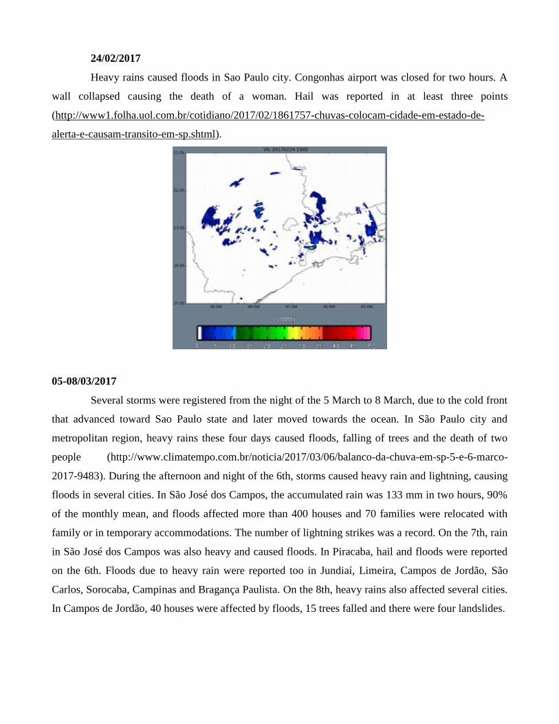
24/02/2017
Heavy rains caused floods in Sao Paulo city. Congonhas airport was closed for two hours. A
wall collapsed causing the death of a woman. Hail was reported in at least three points
(http://www1.folha.uol.com.br/cotidiano/2017/02/1861757-chuvas-colocam-cidade-em-estado-de-
alerta-e-causam-transito-em-sp.shtml).
05-08/03/2017
Several storms were registered from the night of the 5 March to 8 March, due to the cold front
that advanced toward Sao Paulo state and later moved towards the ocean. In São Paulo city and
metropolitan region, heavy rains these four days caused floods, falling of trees and the death of two
people (http://www.climatempo.com.br/noticia/2017/03/06/balanco-da-chuva-em-sp-5-e-6-marco-
2017-9483). During the afternoon and night of the 6th, storms caused heavy rain and lightning, causing
floods in several cities. In São José dos Campos, the accumulated rain was 133 mm in two hours, 90%
of the monthly mean, and floods affected more than 400 houses and 70 families were relocated with
family or in temporary accommodations. The number of lightning strikes was a record. On the 7th, rain
in São José dos Campos was also heavy and caused floods. In Piracaba, hail and floods were reported
on the 6th. Floods due to heavy rain were reported too in Jundiaí, Limeira, Campos de Jordão, São
Carlos, Sorocaba, Campinas and Bragança Paulista. On the 8th, heavy rains also affected several cities.
In Campos de Jordão, 40 houses were affected by floods, 15 trees falled and there were four landslides.
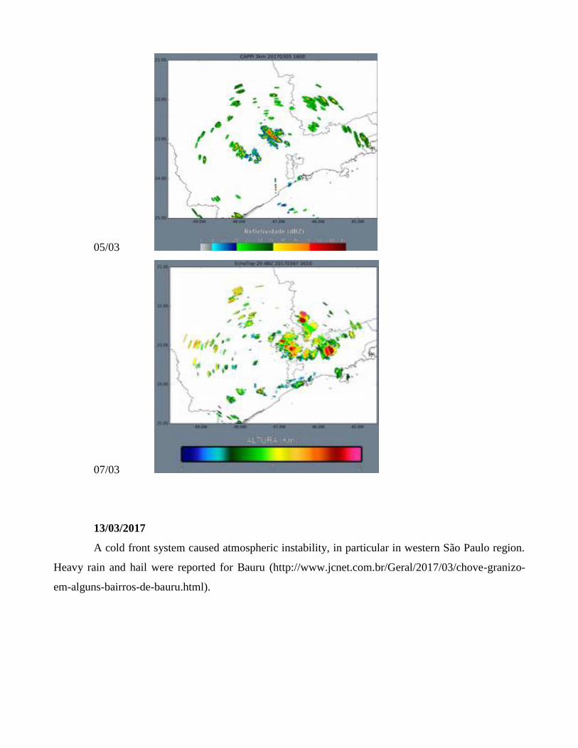
05/03
07/03
13/03/2017
A cold front system caused atmospheric instability, in particular in western São Paulo region.
Heavy rain and hail were reported for Bauru (http://www.jcnet.com.br/Geral/2017/03/chove-granizo-
em-alguns-bairros-de-bauru.html).
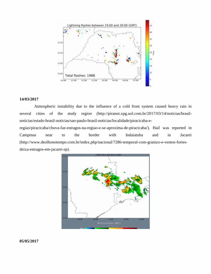
14/03/2017
Atmospheric instability due to the influence of a cold front system caused heavy rain in
several cities of the study region (http://piranot.xpg.uol.com.br/2017/03/14/noticias/brasil-
noticias/estado-brasil-noticias/sao-paulo-brasil-noticias/localidade/piracicaba-e-
regiao/piracicaba/chuva-faz-estragos-na-regiao-e-se-aproxima-de-piracicaba/). Hail was reported in
Campinas near to the border with Indaiatuba and in Jacarei
(http://www.deolhonotempo.com.br/index.php/nacional/7286-temporal-com-granizo-e-ventos-fortes-
deixa-estragos-em-jacarei-sp).
05/05/2017

A trough caused instability on the southeast of Brazil on this day. Several storms, in many
cases with hail, were reported in the São Paulo state. In Pederneiras, near Bauru, hail covered railways
and caused floods (http://g1.globo.com/sp/bauru-marilia/noticia/chuva-de-granizo-cobre-de-gelo-
rodovia-em-pederneiras.ghtml).
19/05/2017
In the São Paulo state, atmospheric instability favored the formation of severe storms capable of
large hail. In Dracena, near Presidente Prudente, large hail damaged cars and house roofs and left the
municipality in an emergency state with 40 families homeless after the event. Severe wind gusts were
also reported (http://g1.globo.com/sp/presidente-prudente-regiao/noticia/temporal-com-chuva-de-
granizo-causa-estragos-em-dracena.ghtml?utm_source=whatsapp&utm_medium=share-bar-
smart&utm_campaign=share-bar).

27/10/2017
In the afternoon of 27 October 2017, a severe thunderstorm was responsible for flash flooding
and wind damage in Mogi Mirim, Itapira and Serra Negra (https://g1.globo.com/sp/campinas-
regiao/noticia/chuva-provoca-queda-de-arvores-em-itapira-mogi-mirim-e-serra-negra.ghtml ;
https://g1.globo.com/sp/campinas-regiao/noticia/apos-temporal-cerca-de-13-mil-moradores-continuam-
sem-energia-eletrica-em-itapira-sp.ghtml). The storm presented very high reflectivity (~ 60 dBZ) over
the Mogi Mirim, Mogi Guaçu and Itapira region, with a northwest-southeast orientation at 2130 UTC.
The Dopper radial velocities confirms that this storm was in fact organized. Rotation is observed in
association with the storm, indicating the presence of a mesocyclone.
18/12/2017
In the afternoon of 18 December 2017, a severe thunderstorm caused flash flooding, hail and
high winds in Taubaté-SP (https://g1.globo.com/sp/vale-do-paraiba-regiao/noticia/chuva-em-taubate-
alaga-ruas-derruba-arvores-e-deixa-familias-desalojadas.ghtml). The thunderstorms formed over the
Mantiqueira mountains and moved over the Paraiba Valley, where Taubaté is located. The figure below
shows the high reflectivity associated with the storms over Taubaté at 1840 UTC. The storms were
predominantly stationary.

25/12/2017
In the Christmas afternoon, a squall line (Fig. 1) moved through central São Paulo State and
caused intense precipitation over Campinas-SP region (https://g1.globo.com/sp/campinas-
regiao/noticia/campinas-tem-temporal-com-ventos-de-mais-de-80-kmh-e-alagamentos.ghtml). Several
parts of Campinas were rapidly flooded due to high precipitation rates. According to Cepagri, the
measured precipitation rate was nearly 20 mm/h, which is sufficient to cause flash flooding. The
accumulated precipitation is shown in Fig. 2. The precipitation over Campinas (20-25 mm) occurred in
only 1-2 hours.
20-21/01/2018
Some cities in eastern São Paulo state were affected by flash floods in 20 and 21 January
2018. On 20, Indaiatuba registered heavy rain and some river rise over the banks
(https://g1.globo.com/sp/campinas-regiao/noticia/temporal-em-indaiatuba-desaloja-familias-derruba-
muro-e-arvores-e-deixa-carro-em-pe-apos-ser-arrastado-por-enxurrada.ghtml). Some neighborhoods of
São Paulo were also flooded due to large amounts of precipitation in a short period of time
(https://g1.globo.com/sp/sao-paulo/noticia/enxurrada-arrasta-carros-e-pedestre-no-beco-do-batman-em-
sp.ghtml and http://www1.folha.uol.com.br/cotidiano/2018/01/1952205-chuva-forte-derruba-arvores-e-
alaga-ruas-na-zona-oeste-de-sao-paulo.shtml). The storm occurred in Indaiatuba on 20 Jan is show in
Fig. 3 at peak intensity over the city.
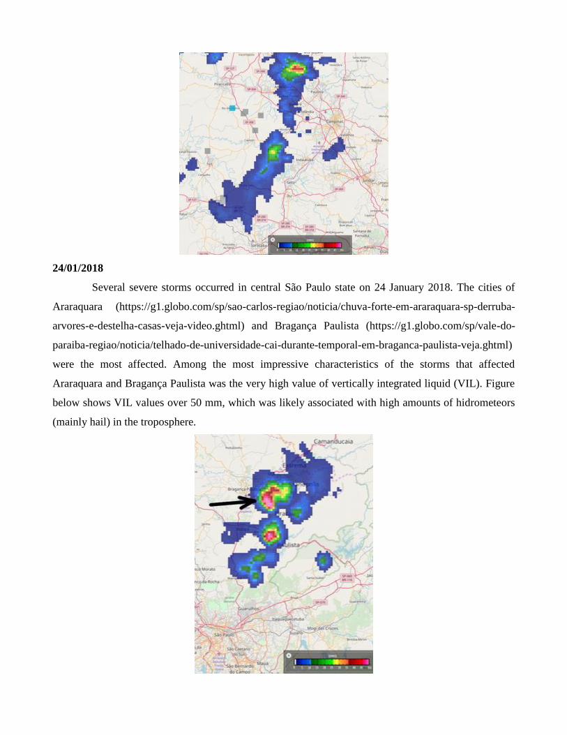
24/01/2018
Several severe storms occurred in central São Paulo state on 24 January 2018. The cities of
Araraquara (https://g1.globo.com/sp/sao-carlos-regiao/noticia/chuva-forte-em-araraquara-sp-derruba-
arvores-e-destelha-casas-veja-video.ghtml) and Bragança Paulista (https://g1.globo.com/sp/vale-do-
paraiba-regiao/noticia/telhado-de-universidade-cai-durante-temporal-em-braganca-paulista-veja.ghtml)
were the most affected. Among the most impressive characteristics of the storms that affected
Araraquara and Bragança Paulista was the very high value of vertically integrated liquid (VIL). Figure
below shows VIL values over 50 mm, which was likely associated with high amounts of hidrometeors
(mainly hail) in the troposphere.

26/02/2018
On 26 February 2018, the city of São Paulo was affected by heavy rain, which causes flash
floods and traffic jams all over the metropolitan region. Nearly 70 mm of precipitation fell in a few
hours (https://g1.globo.com/sp/sao-paulo/noticia/chuva-deixa-zona-leste-de-sp-em-estado-de-atencao-
para-alagamentos.ghtml). The radar imagery between 1800 and 2000 UTC is shown below. Some
thunderstorms formed over São Paulo near a southeast-northwest-oriented band of precipitation farther
north, and causes intense precipitation at 1800 UTC. Then, the precipitation stalled over the city
causing the high rainfall totals and hazardous weather.
1800 UTC:
05/03/2018
Some cities in the Paraiba river valley experienced strong winds in the afternoon of 05 March
2018. In São José dos Campos, the wind gusts peaked at 75 km/h, and nearly 100 trees fell, causing
trouble to the traffic (https://g1.globo.com/sp/vale-do-paraiba-regiao/noticia/temporal-com-ventos-de-
mais-de-75-kmh-derruba-cerca-de-100-arvores-e-deixa-bairros-sem-energia-em-sao-jose.ghtml). The
reflectivity core that passed over São José dos Campos is shown below. The highest reflectivity was
nearly 55 dBZ at 1.0° elevation, which characterizes high amounts of hydrometeors. The most affected
area was the south of the city, exactly where the convective core is located at 1920 UTC. VIL was
greater than 50 mm in this area.
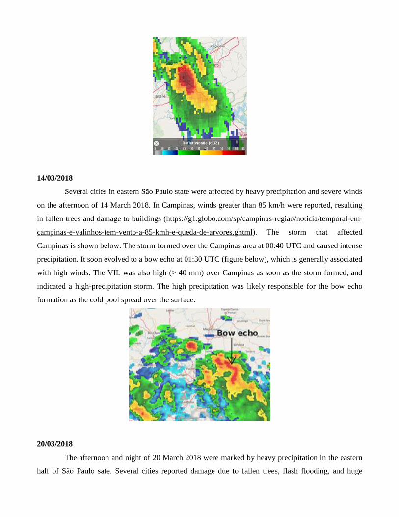
14/03/2018
Several cities in eastern São Paulo state were affected by heavy precipitation and severe winds
on the afternoon of 14 March 2018. In Campinas, winds greater than 85 km/h were reported, resulting
in fallen trees and damage to buildings (https://g1.globo.com/sp/campinas-regiao/noticia/temporal-em-
campinas-e-valinhos-tem-vento-a-85-kmh-e-queda-de-arvores.ghtml). The storm that affected
Campinas is shown below. The storm formed over the Campinas area at 00:40 UTC and caused intense
precipitation. It soon evolved to a bow echo at 01:30 UTC (figure below), which is generally associated
with high winds. The VIL was also high (> 40 mm) over Campinas as soon as the storm formed, and
indicated a high-precipitation storm. The high precipitation was likely responsible for the bow echo
formation as the cold pool spread over the surface.
20/03/2018
The afternoon and night of 20 March 2018 were marked by heavy precipitation in the eastern
half of São Paulo sate. Several cities reported damage due to fallen trees, flash flooding, and huge

amounts of lightning. São José dos Campos reported small hail (https://g1.globo.com/sp/vale-do-
paraiba-regiao/noticia/sao-jose-dos-campos-tem-chuva-de-granizo-na-primeira-tarde-do-outono.ghtml),
Guaratinguetá had flash flooding (https://g1.globo.com/sp/vale-do-paraiba-regiao/noticia/temporal-
provoca-alagamentos-em-casas-e-ruas-em-guaratingueta.ghtml) and in São Paulo 95 trees fell and 2
people died, along with the impressive amount of 14 thousand lightning strikes over the city
(https://g1.globo.com/sp/sao-paulo/noticia/cerca-de-mil-pessoas-estao-fora-de-casa-apos-chuva-em-sp-
62-arvores-e-14-mil-raios-cairam.ghtml). The radar imagery depicts de formation of several storms
during the afternoon (18-21Z), and upscale growth in early night as ascent increased over the area.
Some squall lines accompanied the precipitation area.
26/03/2018
The city of Jacareí, in the Paraíba Valley, reported flash floods on 26 March 2018. Several
streets were flooded due to the high precipitation rates (https://g1.globo.com/sp/vale-do-paraiba-
regiao/noticia/temporal-causa-alagamentos-e-agua-invade-creche-em-jacarei-sp.ghtml). The storm is
shown below. It persisted over Jacareí for about 1:30h, and this slow movement was determinant in the
flash flood. VIL values over Jacareí were greater than 40 mm for more than one hour.

28-31/03/2018
Thunderstorms stroke São Paulo city in five consecutive days in the end of March 2018.
Multiple flash floods and fallen trees were reported throughout the city (https://g1.globo.com/sp/sao-
paulo/noticia/chuvas-causam-queda-de-89-arvores-em-sao-paulo-no-feriado.ghtml), causing chaos in
the traffic. Some radar images are shown below to exemplify the storm modes observed in the region.
The convection was not very intense nor organized, but the fact that it occurred in a city with poor
drainage was the key factor.
19/05/2018
A strong cold front was responsible for the formation of a squall line over São Paulo state on
the morning of 19 May 2018. This system caused severe winds in the city of São Paulo which were
accompanied by fallen trees and power lines (https://g1.globo.com/sp/sao-paulo/noticia/bombeiros-
recebem-mais-de-30-chamados-para-quedas-de-arvores-em-sp-apos-chuva-forte-com-rajada-de-
vento.ghtml). The strongest wind gust was 93 km/h in the Guarulhos airport.
07/06/2018
In the afternoon of 07 June 2018, severe storms affected the eastern São Paulo state and
southern Minas Gerais state. The storms formed under a very intense upper-level jet, which caused
deep-layer shear of more than 25 m/s in some locations. The thermodynamic instability was not high,
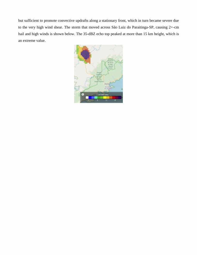
but sufficient to promote convective updrafts along a stationary front, which in turn became severe due
to the very high wind shear. The storm that moved across São Luiz do Paraitinga-SP, causing 2+-cm
hail and high winds is shown below. The 35-dBZ echo top peaked at more than 15 km height, which is
an extreme value.