REBUILD BY DESIGN MEADOWLANDS FLOOD PROTECTION …
46
FINAL REBUILD BY DESIGN MEADOWLANDS FLOOD PROTECTION PROJECT BOROUGHS OF LITTLE FERRY, MOONACHIE, CARLSTADT, AND TETERBORO AND THE TOWNSHIP OF SOUTH HACKENSACK IN BERGEN COUNTY, NEW JERSEY Public Scoping Document for the Environmental Impact Statement August 17, 2016 Prepared By
Transcript of REBUILD BY DESIGN MEADOWLANDS FLOOD PROTECTION …

FINAL
REBUILD BY DESIGN MEADOWLANDS FLOOD PROTECTION PROJECT BOROUGHS OF LITTLE FERRY, MOONACHIE, CARLSTADT, AND TETERBORO AND THE TOWNSHIP OF SOUTH HACKENSACK IN BERGEN COUNTY, NEW JERSEY
Public Scoping Document for the Environmental Impact Statement
August 17, 2016
Prepared By


Rebuild By Design Meadowlands Flood Protection Project Final Public Scoping Document │ i
TABLE OF CONTENTS
TABLE OF CONTENTS ............................................................................................................................ i
ACRONYMS AND ABBREVIATIONS .................................................................................................. iii
EXECUTIVE SUMMARY ........................................................................................................................ v
1.0 INTRODUCTION ........................................................................................................................... 1 1.1 Overview ....................................................................................................................................... 1 1.2 History of Flooding in the Project Area ........................................................................................ 1 1.3 Rebuild By Design Competition ................................................................................................... 3 1.4 Federal Proposed Project .............................................................................................................. 3 1.5 Overview of the Public Scoping Document .................................................................................. 3 1.6 Overview of the NEPA Process .................................................................................................... 4
2.0 REGULATORY FRAMEWORK ................................................................................................. 6
3.0 PROPOSED PROJECT ................................................................................................................. 6 3.1 Meadowlands History ................................................................................................................... 6 3.2 Proposed Project Background ....................................................................................................... 7 3.3 Proposed Project Evolution ........................................................................................................... 9
4.0 PURPOSE AND NEED .................................................................................................................. 9 4.1 Purpose .......................................................................................................................................... 9 4.2 Need .............................................................................................................................................. 9 4.3 Proposed Project Goals and Objectives ...................................................................................... 11
5.0 PROPOSED PROJECT ALTERNATIVES ............................................................................... 12 5.1 Alternatives Development........................................................................................................... 12 5.2 Alternatives Screening ................................................................................................................ 12 5.3 Proposed Project Alternatives ..................................................................................................... 13
6.0 POTENTIAL REGULATORY APPROVALS .......................................................................... 14 6.1 Federal Regulatory Approvals .................................................................................................... 14 6.2 State of New Jersey Regulatory Approvals ................................................................................ 14 6.3 Local and Municipal Approvals .................................................................................................. 15
7.0 ENVIRONMENTAL IMPACT STATEMENT SCOPE OF WORK ...................................... 15 7.1 Alternatives Development and Analysis ..................................................................................... 15 7.2 Public Involvement ..................................................................................................................... 16 7.3 Technical Resource Areas ........................................................................................................... 16
7.3.1 Land Use and Land Use Planning ....................................................................................... 16 7.3.2 Visual Quality/Aesthetics ................................................................................................... 17 7.3.3 Socioeconomics and Community/Population and Housing ................................................ 17 7.3.4 Environmental Justice ......................................................................................................... 18 7.3.5 Cultural and Historic Resources.......................................................................................... 18 7.3.6 Transportation and Circulation ........................................................................................... 21 7.3.7 Noise ................................................................................................................................... 22 7.3.8 Air Quality .......................................................................................................................... 24 7.3.9 Greenhouse Gas (GHG) Emissions ..................................................................................... 24 7.3.10 Global Climate Change/Sea Level Rise .............................................................................. 24

Rebuild By Design Meadowlands Flood Protection Project Final Public Scoping Document │ ii
7.3.11 Recreation ........................................................................................................................... 25 7.3.12 Utilities and Service Systems .............................................................................................. 25 7.3.13 Public Services .................................................................................................................... 25 7.3.14 Biological Resources........................................................................................................... 26 7.3.15 Geology and Soils ............................................................................................................... 29 7.3.16 Hydrology and Flooding ..................................................................................................... 30 7.3.17 Water Resources, Water Quality, and Waters of the United States .................................... 30 7.3.18 Coastal Zone Management .................................................................................................. 31 7.3.19 Sustainability/Green Infrastructure ..................................................................................... 32 7.3.20 Hazards and Hazardous Materials ....................................................................................... 33 7.3.21 Mineral and Energy Resources ........................................................................................... 34 7.3.22 Agricultural Resources and Prime Farmlands ..................................................................... 35
7.4 Cumulative Impacts .................................................................................................................... 35
8.0 REFERENCES REVIEWED ....................................................................................................... 37
FIGURES
Figure 1. Rebuild by Design Meadowlands Flood Protection Project Area ................................................. 2
Figure 2. Overview of the NEPA Process ..................................................................................................... 5
Figure 3. Meadowlands Program Area ......................................................................................................... 8
Figure 4. FEMA’s Digital Flood Insurance Rate Mapping within the Project Area .................................. 10
Figure 5. The Hackensack Meadowlands Ecosystem ................................................................................. 27

Rebuild By Design Meadowlands Flood Protection Project Final Public Scoping Document │ iii
ACRONYMS AND ABBREVIATIONS
APE Area of Potential Effect
AUL Activity and Use Limitation
CAA Clean Air Act
CAG Citizen Advisory Group
CDBG-DR Community Development Block Grant Disaster Recovery
CEQ Council on Environmental Quality
CFR Code of Federal Regulations
CO Carbon Monoxide
CO2 Carbon Dioxide
COP Citizen Outreach Plan
CREC Controlled Recognized Environmental Condition
CRP Comprehensive Restoration Plan
dB Decibel
dBA A-weighted Decibel
DEIS Draft Environmental Impact Statement
EDR Environmental Data Resources
EFH Essential Fish Habitat
EIS Environmental Impact Statement
EISA Energy Independence and Security Act of 2007
EPA US Environmental Protection Agency
EPW Evaluation of Planned Wetlands
EJ Environmental Justice
EO Executive Order
ESA Endangered Species Act
FEMA Federal Emergency Management Agency
FEIS Final Environmental Impact Statement
FR Federal Register
GHG Greenhouse Gas
GIS Geographic Information System
GPI Guidance for Public Involvement
HMD Hackensack Meadowlands District
HREC Historical Recognized Environmental Condition
HUD US Department of Housing and Urban Development
I Interstate
LiDAR Light Detection and Ranging

Rebuild By Design Meadowlands Flood Protection Project Final Public Scoping Document │ iv
LSRP Licensed Site Remediation Professionals
MERI Meadowlands Environmental Research Institute
MIKE3 Time-variable Water Quality Model
NEPA National Environmental Policy Act
NFIP National Flood Insurance Program
NHPA National Historic Preservation Act
NJAC New Jersey Administrative Code
NJDA New Jersey Department of Agriculture
NJDCA New Jersey Department of Community Affairs
NJDEP New Jersey Department of Environmental Protection
NJDOT New Jersey Department of Transportation
NJ SHPO New Jersey State Historic Preservation Office
NJPDES New Jersey Pollutant Discharge Elimination System
NJSA New Jersey Statutes Annotated
NJSEA New Jersey Sports and Exposition Authority
NJTPA New Jersey Transportation Planning Authority
NMFS National Marine Fisheries Service
NOA Notice of Availability
NOAA National Oceanic and Atmospheric Administration
NOI Notice of Intent
NRHP National Register of Historic Places
O3 Ozone
PAH Polycyclic Aromatic Hydrocarbon
RBD Rebuild by Design
REC Recognized Environmental Condition
ROD Record of Decision
SGCN Species of Greatest Conservation Need
SOI Secretary of the Interior
TCT Technical Coordination Team
T&E Threatened and Endangered
US United States
USACE US Army Corps of Engineers
USC US Code
USCG US Coast Guard
USGS US Geological Survey
USFWS US Fish and Wildlife Service
WET Wetlands Evaluation Technique

Rebuild By Design Meadowlands Flood Protection Project Final Public Scoping Document │ v
EXECUTIVE SUMMARY
The State of New Jersey Department of Environmental Protection (NJDEP), on behalf of the State of
New Jersey through its Department of Community Affairs (NJDCA), as the recipient of United States
(US) Department of Housing and Urban Development (HUD) grant funds and as the “Responsible
Entity,” as that term is defined by HUD regulations at 24 Code of Federal Regulations (CFR) Part
58.2(a)(7)(i), intends to prepare an Environmental Impact Statement (EIS) for the Rebuild by Design
(RBD) Meadowlands Flood Protection Project (the Proposed Project).
In accordance with criteria in 40 CFR Part 1501.5(c), NJDCA has designated NJDEP as the Lead Agency
to prepare the EIS for the Proposed Project in accordance with the National Environmental Policy Act
(NEPA; 42 US Code [USC] 4321 et seq.).
The EIS will analyze the environmental effects of alternatives for the construction of flood risk reduction
measures within the Boroughs of Little Ferry, Moonachie, Carlstadt, and Teterboro, and the Township of
South Hackensack, all in Bergen County, New Jersey (the Project Area).
Such measures will be designed to address the impacts of coastal and systemic inland flooding on the
quality of the physical, natural, cultural, and socioeconomic environment in the Project Area due to both
sea level rise and storm hazards, including heavy rainfall events and intense coastal storm events.
The approximate Project Area boundaries are: the Hackensack River to the east; Paterson Plank Road and
the southern boundary of Carlstadt to the south; State Route 17 to the west; and Interstate 80 and the
northern boundary of the Borough of Little Ferry to the north.
The State of New Jersey, through NJDCA, is the Grantee of HUD Community Development Block Grant
Disaster Recovery (CDBG–DR) funds that have been appropriated under the Disaster Relief
Appropriations Act of 2013 (Pub. L. 113–2, approved January 29, 2013) related to disaster relief, long-
term recovery, restoration of infrastructure and housing, and economic revitalization in the most impacted
and distressed areas resulting from a major disaster that was declared pursuant to the Robert T. Stafford
Disaster Relief and Emergency Assistance Act of 1974 (Stafford Act) in calendar year 2012 for Hurricane
Sandy.
The Proposed Project was developed and selected as a winning concept through HUD’s and the Hurricane
Sandy Rebuilding Task Force’s RBD competition. The RBD competition promoted the development of
innovative resilience projects in the Sandy-affected region. HUD has allocated $150 million in CDBG-
DR funds for the planning, design, and implementation of this Proposed Project. Receipt of CDBG-DR
funding requires compliance with NEPA.
The 30-day public scoping period for this EIS, as required in accordance with 40 CFR Part 1501.07,
formally began with publication of the Notice of Intent (NOI) to prepare the EIS in the Federal Register
on June 20, 2016. As part of the public scoping process required under NEPA, the Council on
Environmental Quality (CEQ) Regulations Implementing the Procedural Provisions of NEPA (40 CFR
Parts 1500-1508), and HUD’s NEPA Regulations (24 CFR Part 58), the Draft version of this Public
Scoping Document for the Proposed Project was made available for public review and comment. The
Draft Public Scoping Document, very similar to this Final Public Scoping Document, outlined the
Proposed Project’s Purpose and Need, initial range of alternatives, resource areas to be addressed in the
EIS, proposed analytical methodologies, and other elements associated with the Proposed Project and this
NEPA process as known at this early stage.

Rebuild By Design Meadowlands Flood Protection Project Final Public Scoping Document │ vi
The EIS will examine three Build Alternatives, as well as a No Action Alternative. Each of the three
Build Alternatives will seek to reduce the flood risk within the Project Area. These alternatives vary by
the type of infrastructure that is proposed. Alternative 1 will analyze the use of levees, berms, barriers, or
floodwalls to reduce flood risk; Alternative 2 will analyze the impacts of substantial drainage
improvements achieved through a series of local projects within the Project Area to reduce flood risk; and
Alternative 3, a hybrid of Alternatives 1 and 2, will analyze the impacts of blending new infrastructure
and drainage improvements to reduce flood risk in the Project Area.
Each alternative is being evaluated through the ongoing engineering Feasibility Study and application of
preliminary screening criteria. The Feasibility Study will help determine the feasible designs and
strategies that best address the impacts from the two types of flooding (coastal and systemic inland
flooding). The next phase of the alternatives development process will be the evaluation of those
alternatives; the community will be engaged to help develop screening criteria that will determine how
well each of the alternatives meets the Proposed Project’s Purpose and Need. These alternatives will be
further defined and modified as the EIS is developed.
Following the public scoping process, a Draft EIS (DEIS) will be prepared that analyzes the Proposed
Project. Once the DEIS is certified as complete, a notice will be sent to appropriate government agencies,
groups, and individuals known to have an involvement or interest in the DEIS, and particularly in the
environmental impact issues identified therein. A Notice of Availability (NOA) of the DEIS will be
published in the Federal Register and local media outlets at that time in accordance with HUD and CEQ
regulations.
The resources to be analyzed within the EIS, as well as the methods proposed to analyze these resources,
are set forth in Section 7.0 of this document. The methods for assessing cumulative impacts associated
with the Proposed Project are also described in Section 7.0.
This Final Public Scoping Document reflects and incorporates substantive comments received during the
public scoping period, and will be used as input during the development of the EIS. This project-specific
NEPA process will extend for approximately 19 months, from June 20, 2016 through approximately
December 31, 2017.
Rebuild By Design Meadowlands Flood Protection Project Final Public Scoping Document │ 1
1.0 INTRODUCTION
1.1 Overview
The State of New Jersey Department of Environmental Protection (NJDEP), on behalf of the State of
New Jersey through its Department of Community Affairs (NJDCA), as the recipient of United States
(US) Department of Housing and Urban Development (HUD) grant funds and as the “Responsible
Entity,” as that term is defined by HUD regulations at 24 Code of Federal Regulations (CFR) Part
58.2(a)(7)(i), intends to prepare an Environmental Impact Statement (EIS) for the Rebuild by Design
(RBD) Meadowlands Flood Protection Project (the Proposed Project).
In accordance with criteria in 40 CFR Part 1501.5(c), NJDCA has designated NJDEP as the Lead Agency
to prepare the EIS for the Proposed Project in accordance with the National Environmental Policy Act
(NEPA; 42 US Code [USC] 4321 et seq.).
The EIS will analyze the environmental effects of the Proposed Project alternatives within the Boroughs
of Little Ferry, Moonachie, Carlstadt, and Teterboro, and the Township of South Hackensack, all in
Bergen County, New Jersey (the Project Area). The Project Area has the following approximate
boundaries: the Hackensack River to the east; Paterson Plank Road to the south; State Route 17 to the
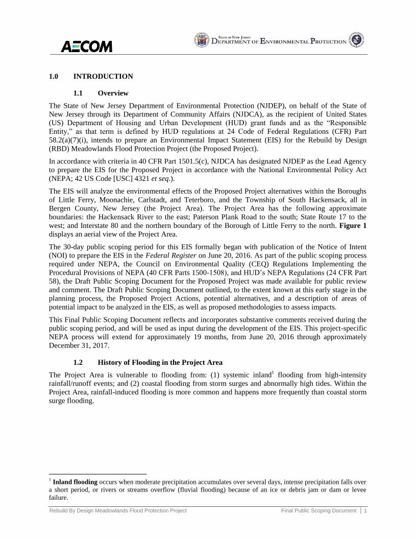
west; and Interstate 80 and the northern boundary of the Borough of Little Ferry to the north. Figure 1
displays an aerial view of the Project Area.
The 30-day public scoping period for this EIS formally began with publication of the Notice of Intent
(NOI) to prepare the EIS in the Federal Register on June 20, 2016. As part of the public scoping process
required under NEPA, the Council on Environmental Quality (CEQ) Regulations Implementing the
Procedural Provisions of NEPA (40 CFR Parts 1500-1508), and HUD’s NEPA Regulations (24 CFR Part
58), the Draft Public Scoping Document for the Proposed Project was made available for public review
and comment. The Draft Public Scoping Document outlined, to the extent known at this early stage in the
planning process, the Proposed Project Actions, potential alternatives, and a description of areas of
potential impact to be analyzed in the EIS, as well as proposed methodologies to assess impacts.
This Final Public Scoping Document reflects and incorporates substantive comments received during the
public scoping period, and will be used as input during the development of the EIS. This project-specific
NEPA process will extend for approximately 19 months, from June 20, 2016 through approximately
December 31, 2017.
1.2 History of Flooding in the Project Area
The Project Area is vulnerable to flooding from: (1) systemic inland1 flooding from high-intensity
rainfall/runoff events; and (2) coastal flooding from storm surges and abnormally high tides. Within the
Project Area, rainfall-induced flooding is more common and happens more frequently than coastal storm
surge flooding.
1 Inland flooding occurs when moderate precipitation accumulates over several days, intense precipitation falls over
a short period, or rivers or streams overflow (fluvial flooding) because of an ice or debris jam or dam or levee
failure.

Rebuild By Design Meadowlands Flood Protection Project Final Public Scoping Document │ 2
Figure 1. Rebuild by Design Meadowlands Flood Protection Project Area

Rebuild By Design Meadowlands Flood Protection Project Final Public Scoping Document │ 3
Hurricane Sandy exposed the vulnerabilities within the Project Area after low-lying areas were inundated
by coastal storm surges in October 2012. Hurricane Sandy significantly impacted the Project Area,
highlighting existing deficiencies in the Project Area's resiliency and ability to adequately protect
vulnerable populations and critical infrastructure from flooding during major storm events. These impacts
included extensive inland flooding due to major tidal surges, with significant damage to residential and
commercial properties; impacts to critical health care facilities; and the failure of critical power,
transportation, and water and sewer infrastructure.
During Hurricane Sandy, the impacts of rainfall flooding were considerably less than those from coastal
storm surge flooding. If Hurricane Sandy had been a substantial rainfall event as well as a storm surge
event, the Project Area’s past history of flooding during heavy rainfall events indicates that Hurricane
Sandy could have further increased flood levels and property damages. For more information on the
history of the Project Area, please refer to Section 3.1.
1.3 Rebuild By Design Competition
HUD launched the RBD competition in the summer of 2013 (July 29, 2013, 78 Federal Register [FR]
45551) to develop ideas to improve physical, ecological, economic, and social resilience in regions
affected by Hurricane Sandy. The competition sought to promote innovation by developing flexible
solutions that would increase regional resilience.
The Proposed Project was one of the competition's winning concepts; it was developed with the goal of
reducing frequent flooding due to storm surge, high tide, and heavy rainfall. The Proposed Project was
selected as a comprehensive urban water strategy to reduce flood hazard and flood-related public health
risks within the Project Area. HUD awarded $150 million in Community Development Block Grant
Disaster Recovery (CDBG-DR) funds to the State of New Jersey for the Proposed Project, specifically for
the Project Area.
1.4 Federal Proposed Project
Because HUD, a Federal agency, is funding the Proposed Project, and because the Proposed Project is
considered a “major Federal action significantly affecting the quality of the human environment,” the
Proposed Project must comply with the requirements of NEPA, and an EIS must be prepared. CDBG-DR
funding requires compliance with NEPA as stated in HUD's regulations outlined in 24 CFR Part 58
(Environmental Review Procedures for Entities Assuming HUD Environmental Responsibilities). The
Proposed Project is also subject to the CEQ’s Regulations Implementing the Procedural Provisions of
NEPA at 40 CFR Parts 1500-1508. HUD has further outlined the Proposed Project's environmental
review requirements in a Federal Register notice published on October 16, 2014 (79 FR 62182).
In accordance with 42 USC 5304(g) and HUD’s regulations at 24 CFR Part 58, HUD has provided for
assumption of its NEPA authority by the State of New Jersey through the NJDCA, with NJDCA
delegating NEPA Lead Agency responsibility to NJDEP for the administration of the Proposed Project,
including its environmental review and preparation of the EIS. With NJDEP serving as the Lead Agency,
the EIS will be prepared in accordance with NEPA, CEQ regulations found at 40 CFR Parts 1500 –1508,
and HUD regulations found at 24 CFR Part 58.
1.5 Overview of the Public Scoping Document
On June 20, 2016, HUD published in the Federal Register a NOI to prepare an EIS in accordance with
CEQ regulations (40 CFR Part 1508.22). This notification formally initiated the NEPA process, and
represented the beginning of the public scoping process as outlined in 40 CFR Part 1501.07.
Public scoping is a critical and necessary component of the NEPA process, and serves to focus the initial
stage of the process on the Proposed Project, the Proposed Project’s Purpose and Need, potential

Rebuild By Design Meadowlands Flood Protection Project Final Public Scoping Document │ 4
alternatives, and environmental issues, concerns, and methods of analysis. As part of the public scoping
process, the Draft Public Scoping Document was made available for public comment.
The Draft Public Scoping Document outlined and described, to the extent known at this early stage in the
planning process, the following:
Proposed Project’s Purpose and Need
Proposed Project
Potential Alternatives
Areas of potential impact to be analyzed in the EIS.
The publication of the NOI and the concurrent release of the Draft Public Scoping Document initiated a
30-day public scoping period. During this 30-day period, comments were sought from the public, relevant
agencies, and other interested parties both at a publicized scoping meeting on July 6, 2016 and via written
submittal. Substantive comments have been incorporated into this Final Public Scoping Document, which
will inform the development of the EIS.
A Citizen Outreach Plan (COP) has also been developed and made available online that describes the
efforts being made to engage and collaborate with the general public, including vulnerable and
underserved populations, to provide timely information and solicit relevant input. More information
concerning both the public scoping process and the overall public involvement and outreach efforts
associated with this EIS can be found within the COP and the Proposed Project’s Guidance for Public
Involvement (GPI).
The COP, as well as additional data concerning the Proposed Project, can be found on the
Proposed Project’s website at:
www.rbd-meadowlands.nj.gov
NJDEP has established an email address to receive input into this NEPA process:
1.6 Overview of the NEPA Process
Completion of this Final Public Scoping Document marks the beginning of the detailed Alternatives
Development and Screening phase. This phase will invite input from local, State, and Federal entities, as
well as the community and other public stakeholders, to help develop the criteria by which the
alternatives will be screened, and to evaluate the alternatives developed.
This outreach will occur primarily through periodic Technical Coordination Team (TCT) meetings and
Citizen Advisory Group (CAG) meetings. The TCT is composed of regulatory agencies having potential
purview over the Proposed Project. The CAG is comprised of local key stakeholders, including local
citizens within, and in the vicinity of, the Project Area, as well as representatives from local governance
and other organizations. The CAG has been established as the primary point of coordination between the
Proposed Project Team and the local communities.
AECOM, as the NJDEP’s NEPA consultant on the Proposed Project Team, will present and discuss technical
activities involving the Proposed Project to and with the CAG members at the request of the NJDEP. The
CAG meetings will be conducted as outlined in the Proposed Project’s COP. The Alternatives Development
and Screening phase, once complete, will lead to the identification of the three Build Alternatives. These
three Build Alternatives, as well as the No Action Alternative (pursuant to 40 CFR Part 1502.14(d)), will
be analyzed in the EIS.

Rebuild By Design Meadowlands Flood Protection Project Final Public Scoping Document │ 5
The DEIS is the first formal step in documenting the environmental analysis of the Proposed Project. The
DEIS will describe the Proposed Project’s Purpose and Need; discuss the alternatives analysis process
and the public participation process; describe the three Build Alternatives and the No Action Alternative;
identify the regulatory requirements applicable to the Proposed Project; describe the affected natural and
built environment; provide an analysis of potential impacts; and identify potential mitigation measures
that could be used to avoid, reduce, or compensate for anticipated impacts.
The DEIS, once prepared, will be published via a Notice of Availability (NOA) in the Federal Register
and local media outlets in accordance with HUD and CEQ regulations. Following the publication of the
NOA, there will be a 45-day public review and comment period, during which the DEIS will be made
available to the general public for comment (including at a formal public hearing), and circulated to
stakeholders, groups, and government agencies that have been identified as having particular interest in,
or jurisdiction over, the Proposed Project.
At the conclusion of the 45-day comment period for the DEIS, NJDEP will incorporate substantive public
comments into the document and compile the Final EIS (FEIS). The FEIS will be circulated in the same
manner as the DEIS (including the publication of a NOA in the Federal Register and local media) and
will have a review/comment period of 30 days. At that time, NJDEP will determine whether a public
hearing on the FEIS is appropriate.
If no additional substantive comments are received during the FEIS comment period, NJDEP will prepare
a Record of Decision (ROD) and Statement of Findings. The ROD will summarize the Government’s
decision, identify the Environmentally Preferable Alternative, select the Alternative that will be
implemented, and identify the potential environmental impacts of that Alternative, as well as the
mitigation measures that the Government will implement. If additional substantive comments are received
during the FEIS comment period, NJDEP will address these comments in the ROD. An overview of the
NEPA process is provided in Figure 2.
Figure 2. Overview of the NEPA Process

Rebuild By Design Meadowlands Flood Protection Project Final Public Scoping Document │ 6
2.0 REGULATORY FRAMEWORK
As described in Sections 1.3 and 1.4, HUD’s award comes in the form of CDBG-DR funds that require
compliance with HUD’s Environmental Review Procedures as outlined in 24 CFR Part 58, as well as with
NEPA and the CEQ’s Regulations Implementing the Procedural Provisions of NEPA at 40 CFR Parts
1500-1508. In accordance with these regulations, the Proposed Project also must comply with other
Federal regulations and Executive Orders (EOs), including but not limited to the following:
Clean Air Act (CAA) and Clean Air Act Amendments of 1990
HUD Air Quality Regulations (40 CFR Parts 6, 51, & 93)
Clean Water Act, Sections 401 and 404, as amended
Section 10 of the Rivers and Harbors Act of 1899
Section 14 of the Rivers and Harbors Act of 1899
Section 106 of the National Historic Preservation Act (NHPA) of 1966
Endangered Species Act (ESA) of 1973
Floodplain Management and Wetland Protection (EOs 11988, 11990 and 13690)
Coastal Zone Management Act of 1972
Flood Disaster Protection Act of 1973
National Flood Insurance Reform Act of 1994 (42 USC 5154a)
Environmental Justice (EJ) (EO 12898)
HUD Contaminated and Toxic Substances Regulations (24 CFR Part 50.3[i] and 24 CFR Part
58.5[i][2])
Noise Control Act of 1972, as amended by the Quiet Communities Act of 1978
HUD Noise Abatement and Control Standards (24 CFR Part 51 Subpart B)
Siting of HUD Assisted Projects in Runway Clear Zones at Civil Airports and Clear Zones and
Accident Potential Zones at Military Airfields (24 CFR Part 51 Subpart D).
Energy Independence and Security Act of 2007 (EISA)
Planning for Federal Sustainability in the Next Decade (EO 13693)
3.0 PROPOSED PROJECT
3.1 Meadowlands History
The Proposed Project is located within the New Jersey Meadowlands. The Meadowlands are an essential
component of the New York/New Jersey Harbor Estuary and part of the largest wetland ecosystem in
northern New Jersey (US Fish and Wildlife Service [USFWS] 1997). The Meadowlands are located in a
valley between the Palisades to the east and a parallel western ridge, both of which run in a southwest to
northeast direction (New Jersey Sports and Exposition Authority [NJSEA] 2004). Elevations of the
Meadowlands range from 0 to 10 feet above sea level (USFWS 1997). The area is prone to chronic
flooding due to the nature of the landscape, elevation above sea level, complexity of tidal influence, and
inadequate storm water management systems (NJSEA 2004).
Historically, the Meadowlands contained approximately 17,000 acres of waters and pristine wetlands
featuring wetland cover types such as tidal marsh, hardwood forest, and Atlantic white-cedar swamp
(NJSEA 2004). An estimated 8,400 acres of wetlands and waterways remain in the Meadowlands as a

Rebuild By Design Meadowlands Flood Protection Project Final Public Scoping Document │ 7
result of decades of extensive destruction and disturbance from activities including development,
dredging, draining, and landfilling (NJSEA 2004; USFWS 1997). In addition, historic construction of
dikes and tide gates, in an attempt to control and reduce flooding events, has further affected the integrity
and spatial configuration of the Meadowlands and altered its biodiversity (NJSEA 2004). Despite its
developed nature, the Meadowlands provide an oasis of diverse habitats for plants and wildlife in the
urban New York-New Jersey metropolitan region (NJSEA 2004; USFWS 1997).
Approximately 8,600 acres of the former Meadowlands, as noted above, have been developed and altered
by human activity, including extensive land use and land cover changes, and the creation of large areas of
impervious surfaces. As a result of these man-made changes throughout the Meadowlands, development
within the Project Area is vulnerable to both inland and coastal flooding.
3.2 Proposed Project Background
Hurricane Sandy significantly impacted the Project Area, highlighting existing deficiencies in the Project
Area's resiliency and ability to adequately protect vulnerable populations and critical infrastructure from
flooding during major storm events. These impacts included extensive coastal flooding due to major tidal
surges, with significant damage to residential and commercial properties; impacts to critical health care
facilities; and the failure of critical power, transportation, and water and sewer infrastructure.
The Proposed Project was developed and selected as a winning concept through HUD’s and the Hurricane
Sandy Rebuilding Task Force’s RBD competition. The RBD competition promoted the development of
innovative resilience projects in the Sandy-affected region. The Proposed Project is a component of a
regional concept proposal for the New Jersey Meadowlands (the Meadowlands Program Area) that aims
to reduce flooding risks and potentially provide ancillary benefits.
As originally proposed during the RBD competition, the concept envisioned creating a system of natural
areas, berms, and additional wetlands to reduce flooding risks. The original concept also articulated an
integrated vision for protecting, connecting, and growing the Meadowlands, as a critical asset, to both the
rest of New Jersey and the metropolitan area of New York. By integrating transportation, ecology, and
development, the awarded concept sought to transform the Meadowlands basin to address a wide
spectrum of risks, while providing potential civic amenities and creating opportunities for new
redevelopment.
The entire Meadowlands Program Area is shown in Figure 3. As described in Section 1.3, HUD awarded
$150 million in CDBG-DR funds to the State of New Jersey for the Proposed Project, specifically for the
“Phase 1 Pilot Area.” The Phase 1 Pilot Area is now referred to as the Rebuild by Design Meadowlands
Flood Protection Project Area, as shown in Figure 1.
The RBD award-winning concept took a multi-faceted approach intended to address flooding from both
major storm surges and high tides, as well as from heavy rainfall events, with several potential ancillary
benefits. The concept’s comprehensive approach to resilience consisted of three integrated components:
Protect, Connect, and Grow.
1. Protect: Provide flood protection through a combination of hard infrastructure (such as bulkheads or
floodwalls) and soft landscaping features (such as berms and/or levees) that act as barriers during
exceptionally high tide and/or storm surge events. Flood control structures would be complemented
with freshwater basins and expanded Meadowlands wetlands to increase flood storage capacity. A
proposed Meadowpark, envisioned as a natural reserve and expansion of the existing marsh, would
offer additional flood protection and connection of surrounding developments to the Meadowlands
through its views and recreational offerings.
2. Connect: Increase connectivity in and between Meadowlands towns with a “Meadowband” (multi-use
levee) that would include a new local street, recreational facilities and access, and a Bus Rapid
Transit line that would provide improved connectivity and access within the Project Area, much in

Rebuild By Design Meadowlands Flood Protection Project Final Public Scoping Document │ 8
the same way 5th Avenue and 8
th Avenue frame Central Park in New York City.
3. Grow: Through improved flood control, an ancillary benefit of re-zoning and up-zoning newly
protected areas could become a reality. Through re-zoning, the local development pattern could
transform from lower density, suburban-type development to a denser, better planned, multi-
functional, and multi-level mixed use of offices, warehousing, retail, and residential development.
Figure 3.
Meadowlands Program Area
Source: RBD Design Competition, New
Meadowlands (2015).
Note: This NEPA analysis focuses on the area
labeled as “Pilot #1,” which is the Project
Area of the EIS. All three Pilot Areas are
shown here to depict the complete scope of the
overall Meadowlands Program Area.

Rebuild By Design Meadowlands Flood Protection Project Final Public Scoping Document │ 9
3.3 Proposed Project Evolution
Based on the amount of CDBG-DR funding (i.e., $150M) provided by HUD for the “Phase 1 Pilot Area,”
now referred to as the Project Area, NJDEP has determined that the Proposed Project, in application, will
focus primarily on reducing flood risk within the Project Area (i.e., the “Protect” component of the
“Protect, Connect, Grow” concept). Potential ancillary “Connect” and “Grow” components of the
winning concept, while not funded specifically at this point, could be logical and reasonable future
outcomes following implementation of the critical “Protect” function as additional funding is identified,
secured, and made available. Any such projects would be subject to their own, independent environmental
review requirements. It is reasonable to conclude that once the Project Area enjoys increased flood
protection, additional transportation, ecological, and redevelopment improvements could occur.
4.0 PURPOSE AND NEED
4.1 Purpose
The Proposed Project includes the construction of flood risk reduction measures designed to address the
impacts of coastal and systemic inland flooding on the quality of the physical, natural, cultural, and
socioeconomic environment due to both storm hazards and sea level rise within the Project Area. The
purpose of the Proposed Project is to reduce flood risk and increase the resiliency of the communities and
ecosystems within Project Area, thereby protecting critical infrastructure, residences, businesses, and
ecological resources from the more frequent and intense flood events anticipated in the future.
4.2 Need
The Meadowlands are situated in a valley or “bowl” with ridges on its sides that run parallel in a
southwest to northeast direction. In some locations, these ridges are over 100 feet above sea level.
Comprised of mostly flat terrain, elevations within the Meadowlands do not exceed 10 feet above sea
level, with most areas less than 6 to 7 feet above sea level. Flow of water within the Project Area is
greatly affected not only by local topography, but also by patterns of urbanization and development. In
addition, historic construction of dikes and tide gates in an attempt to control and reduce flooding events
has further affected the integrity and spatial configuration of the Project Area and altered its biodiversity.
As shown in Figure 4, the majority of the Project Area, including critical community infrastructure, is
within the Federal Emergency Management Agency (FEMA)-designated 100-year2 floodplain. Figure 4
also shows existing tide gates and pump stations within the Project Area. These data were obtained from
the NJSEA, and reviewed and supplemented by the CAG and local municipalities.
The Project Area’s exposure to flood hazard risks is evident by the number of properties included in the
FEMA National Flood Insurance Program (NFIP). Mortgage lenders for properties within the Special
Flood Hazard Area (i.e., Zone AE) require property owners to obtain flood insurance from the NFIP. In
addition, property owners receiving awards following presidentially declared disasters (such as Hurricane
Sandy) are also often required to obtain NFIP insurance.
The interrelationship between coastal flooding and rainfall events contributes to the recurring flooding
conditions throughout the Project Area. Each component represents challenges and needs to be addressed
within the context of an overall flood reduction strategy for the Project Area. As such, the Proposed
Project is needed to address: (1) systemic inland flooding from high-intensity rainfall/runoff events, and
(2) coastal flooding from storm surges and abnormally high tides.
2 A 100-year flood is a flood event that has a 1% probability of occurring in any given year.

Rebuild By Design Meadowlands Flood Protection Project Final Public Scoping Document │ 10
Figure 4. FEMA’s Digital Flood Insurance Rate Mapping within the Project Area

Rebuild By Design Meadowlands Flood Protection Project Final Public Scoping Document │ 11
In addition to reducing flooding in the Project Area, the Proposed Project is needed to directly protect life,
public health, and property in the Project Area. The Proposed Project seeks to reduce flood insurance
rates and claims from future events, and potentially restore property values to the extent possible.
The Proposed Project is further needed to increase community resiliency, including protecting
accessibility to, and on-going operations of, critical health care services, emergency services, and
transportation and utility infrastructure.
The Proposed Project could also deliver co-benefits through the protection of ecological resources and
enhancement of water quality, which in turn could benefit regional biodiversity and ecosystem resiliency.
In addition, the Proposed Project could potentially integrate the flood hazard risk reduction strategy with
civic, cultural, and recreational values to incorporate active and passive recreational uses, multi-use
facilities, public spaces, and other design elements that integrate the Proposed Project into the fabric of
the community to the extent practicable with the available funding.
4.3 Proposed Project Goals and Objectives
The Proposed Project is an urban water strategy whose overall purpose is to reduce flood hazard risks and
flood-related public health risks with available funding. The ability to meet this purpose will be measured
in terms of the following project goals and objectives:
Goal: Contribute to Community Resiliency. The Proposed Project would integrate a flood hazard
risk reduction strategy with existing and proposed land uses and assets. The Proposed Project
would reduce flood risks within the Project Area, leading to improved resiliency and the
protection of accessibility and on-going operations of services (including protecting critical
infrastructure such as hospitals, fire stations, and police department buildings; and roadways and
transit resources). This would allow these key assets to support emergency preparedness and
community resiliency during and after flood events.
Goal: Reduce Risks to Public Health. In addition to providing protection to critical healthcare
infrastructure (such as local hospitals and emergency services), the flood risk reduction strategy
would reduce the adverse health impacts associated with these types of flood events.
Goal: Contribute to On-going Community Efforts to Reduce FEMA Flood Insurance Rates. The
NFIP’s Community Rating System allows municipalities to reduce their flood insurance rates
through implementation of comprehensive floodplain management. The Proposed Project would
include concepts and alternatives that are consistent with the local municipalities’ overall effort to
reduce FEMA Flood Insurance Rates.
Goal: Deliver Co-Benefits. Where possible, the Proposed Project would integrate the flood hazard
risk reduction strategy with civic, cultural, ecological, and recreational values. The Proposed
Project would strive to incorporate active and passive recreational uses, multi-use facilities, and
other design elements that integrate the Proposed Project into the fabric of the community. In this
way, the Proposed Project would be independent of but complement local strategies for future
growth, to the extent possible.
Goal: Enhance and Improve Use of Public Space. The Proposed Project would strive to include
concepts that reduce risks to private and public property from flood impacts while also
incorporating design elements that improve public and recreational spaces, thereby enhancing
quality of life for the community.
Goal: Consider Impacts from Sea Level Rise. The Proposed Project would consider the projected
impacts from sea level rise and its impacts on the frequency and degree of flooding.

Rebuild By Design Meadowlands Flood Protection Project Final Public Scoping Document │ 12
Goal: Protect Ecological Resources. The Proposed Project would strive to protect and enhance
ecological resources by protecting wetlands and other habitats that contribute to regional
biodiversity and ecosystem resiliency.
Goal: Improve Water Quality. The Proposed Project may incorporate green infrastructure
solutions into the design and construction of proposed flood risk reduction measures to manage
storm water runoff, reduce storm water pollution, and improve water quality.
5.0 PROPOSED PROJECT ALTERNATIVES
The ongoing engineering Feasibility Study will develop and analyze initial flood risk reduction
alternatives that address the Proposed Project’s Purpose and Need (i.e., as part of the Alternatives
Development and Screening process). This analysis will determine what designs and strategies best
address the impacts from the two types of flooding (coastal storm surge and systemic inland flooding).
The next step in the Alternatives Development and Screening process will be the evaluation of those
alternatives; the community and government entities will be engaged to help develop appropriate
screening criteria, which will be used to determine how well each of the alternatives meets the Purpose
and Need. This will ultimately lead to the selection of the Proposed Project’s three Build Alternatives.
The Build Alternatives will then be advanced for further environmental review within the EIS.
5.1 Alternatives Development
The Alternatives Development process will involve the identification of flooding sources, locations of
flooding, and the crafting of potential flood risk reduction alternatives. As stated previously, the Project
Area is subject to two sources of flooding – coastal storm surge events and systemic inland flooding from
moderate to severe rainfall events. As part of the engineering Feasibility Study, an integrated coastal and
inland flooding model will be developed to identify the locations of flooding and evaluate the
effectiveness of various flood risk reduction alternatives to reduce flood impacts.
The success of constructing a reliable, permanent, and comprehensive flood risk reduction system
depends on designing project alternatives that take into consideration existing infrastructure and
environmental constraints. The key to the successful implementation of this Proposed Project is to design
the flood risk reduction system in accordance with applicable regulatory standards, such as FEMA flood
elevation standards, the NJDEP Flood Hazard Area Control Act, and local floodplain ordinances, while
verifying that it aesthetically blends with and enhances the existing environment to the extent possible.
The location of existing infrastructure, such as parks, roadways, transit systems, storm water systems,
subsurface utilities, and foundation structures for various types of infrastructure, will dictate the available
footprint for implementing the various project elements. The size and availability of the footprint area
would then dictate the type of potential project elements that could be constructed, such as earthen berms,
floodwalls, deployable flood systems, street-side green infrastructure, etc. In certain areas, it may be
feasible to relocate some infrastructure facilities; however, due to cost considerations and a desire to
reduce construction impacts, the Proposed Project seeks to minimize the relocation of such facilities.
5.2 Alternatives Screening
The culmination of the Alternatives Development and Screening process will be an evaluation of the
alternatives through a screening matrix in a community workshop setting. The screening matrix will be
developed with input from stakeholder groups (including the CAG) informed by NJDEP Proposed Project
Team Subject Matter Experts, and will be used to evaluate each alternative on its potential impacts to the
many resources within the Project Area. This process will allow for the elimination of alternatives that
least satisfy the Proposed Project’s Purpose and Need.

Rebuild By Design Meadowlands Flood Protection Project Final Public Scoping Document │ 13
Criteria in the screening matrix will be utilized to reflect and address the Proposed Project’s Purpose and
Need, Project Goals and Objectives, its potential impacts to the natural environment and the community,
and the Proposed Project’s overall feasibility. Examples of criteria to be included are performance criteria
such as flood risk reduction, environmental constraints (including but not limited to cultural resources,
hazardous waste, and environmental justice), and community interests. Criteria will also include
feasibility factors, such as constructability and construction cost. Metrics that are measurable, either
qualitatively or quantitatively, will be developed for each criterion.
After the establishment of the metrics, a matrix will be developed to evaluate each alternative. The
completed matrix will allow for a comparison of each alternative. The three alternatives that are
considered to best meet the Purpose and Need will be advanced as the Proposed Project’s Build
Alternatives, and analyzed further in the EIS.
5.3 Proposed Project Alternatives
The EIS will examine three Build Alternatives, as well as a No Action Alternative. Currently, these three
Build Alternatives are broadly defined and presented for discussion purposes below; these alternatives,
including various sub-alternatives, will be further developed through the Alternatives Development and
Screening process described in Sections 5.1 and 5.2.
Each of the three Build Alternatives seeks to reduce the flood risk within the Project Area. These
alternatives vary by the type of infrastructure that is proposed. Alternative 1 will analyze the use of
levees, berms, barriers, or floodwalls to reduce flood risk; Alternative 2 will analyze the impacts of
substantial drainage improvements achieved through a series of local projects within the Project Area to
reduce flood risk; and Alternative 3, a hybrid of Alternatives 1 and 2, will analyze the impacts of blending
new infrastructure and drainage improvements to reduce flood risk in the Project Area.
Each alternative is being evaluated through the ongoing engineering Feasibility Study and application of
preliminary screening criteria, as described in Sections 5.1 and 5.2. These alternatives will be further
developed and modified as the EIS process proceeds. Each alternative must be implementable within the
limits of the CDBG-DR funding available at the latest by September 30, 2022. The three Build
Alternatives, as currently proposed, are summarized below.
Alternative 1, or the Structural Flood Reduction Alternative, will analyze various structural,
infrastructure-based solutions that would be constructed to provide protection from both inland
and tidal/storm surge flooding. This alternative, to the extent practical, would evaluate a FEMA
Certifiable level of flood protection to a portion of the Project Area. This alternative may consist
of a range of structures, including levees, berms, barriers, drainage structures, pump stations,
floodgates, and/or other hard and soft infrastructure to achieve the required level of flood
protection. Different routing alignments and different levels of flood protection are also being
considered.
Alternative 2, or the Storm Water Drainage Improvement Alternative, will analyze a series
of storm water drainage projects aimed at reducing the occurrence of higher frequency, small- to
medium-scale flooding events that impact the communities located in the Project Area. Together,
these interventions would provide a system of improved storm water management, and may
include both local drainage improvements and wetlands restoration to protect communities
located in the Project Area and address day-to-day water management challenges. These
interventions may include: drainage ditches, pipes, and pump stations at strategic locations;
increased roadway elevations; new green infrastructure (e.g., wetland drainage basins, bioswales),
water storage areas, and water control structures; cleaning and de-snagging of existing
waterways; and increasing and enhancing public open space.

Rebuild By Design Meadowlands Flood Protection Project Final Public Scoping Document │ 14
Alternative 3, or the Hybrid Alternative, will analyze a strategic, synergistic blend of new
infrastructure and local drainage improvements to reduce flood risk in the Project Area.
Components of Alternatives 1 and 2 will be combined to provide an integrated, hybrid solution
that employs a combination of appropriate levees, berms, drainage structures, pump stations,
and/or floodgates, coupled with local drainage improvement projects, to achieve the maximum
amount of flood protection within the boundaries of the Project Area.
The No Action Alternative will also be evaluated in accordance with CEQ regulations at 40 CFR Part
1502.14(d). The No Action Alternative represents the status quo or baseline conditions without
implementation of any of the improvements associated with the Proposed Project.
The alternatives analysis will consist of a comparison of the four alternatives' impacts on the physical,
natural, cultural, and socioeconomic environment pursuant to 24 CFR Part 58, as well as how well each
alternative meets the Purpose of and Need for the Proposed Project. This process, which will be described
in detail in the DEIS, will lead to the designation of a Preferred Alternative.
6.0 POTENTIAL REGULATORY APPROVALS
In addition to the NEPA requirements described in Section 1.4, the Proposed Project also will be subject
to other additional regulatory approvals. The following is a list of potential regulatory approvals that the
Proposed Project may require; these will be discussed in greater depth within the EIS. This list may
increase as the NEPA analysis proceeds.
6.1 Federal Regulatory Approvals
HUD: The Proposed Project is subject to the funding disbursement and Action Plan Amendment
requirements stated in 79 FR 62182, published October 16, 2014 [Docket No. FR–5696–N–11].
Practicable alternatives will be identified and evaluated, as required by EO 11988 and 11990, in
accordance with HUD regulations at 24 CFR Part 55.20 Subpart C, Procedures for Making
Determinations on Floodplain Management and Protection of Wetlands. The Proposed Project
also will comply with EO 13690 (the Federal Flood Risk Management Standard).
US Army Corps of Engineers (USACE): In-water activities will require Clean Water Act
Section 404 and Rivers and Harbors Act Section 10 permits.
National Oceanic and Atmospheric Administration (NOAA) National Marine Fisheries
Service (NMFS): An Essential Fish Habitat (EFH) review will be conducted. Depending on these
findings and proposed in-water impacts, additional consultation may be required.
USFWS: Depending on potential impacts to threatened and endangered (T&E) species and/or
critical habitat, consultation under Section 7 of the ESA may be required.
US Coast Guard (USCG): Construction of structures within navigable waters requires approval
from the USCG in accordance with Section 9 of the Rivers and Harbors Act.
FEMA: Review of proposed flood protection components will require FEMA review for any
potential changes to the FIRM.
US Environmental Protection Agency (EPA): General Conformity relating to the CAA
requirements for Federal actions will be required, as well as the identification of potential impacts
to Superfund sites (e.g. Berry’s Creek).
6.2 State of New Jersey Regulatory Approvals
NJDEP: The Proposed Project will require several permits from NJDEP to demonstrate
compliance with several acts/authorities, including Coastal Zone Management (Waterfront

Rebuild By Design Meadowlands Flood Protection Project Final Public Scoping Document │ 15
Development, New Jersey Statutes Annotated [NJSA] 12:5-3 et seq.), Flood Hazard Area Control
Act (New Jersey Administrative Code [NJAC] 7:13-1.1 et seq.), Freshwater Wetlands Protection
Act (NJAC 7:7.A), Storm Water Management (NJAC 7:8), Water Supply Allocation (NJAC
7:19), and Section 401 of the Clean Water Act. Coordination with the Bureau of Tidelands is also
anticipated to be necessary to determine if a Tideland Instrument will be required for any in-water
impacts. In addition, a New Jersey Pollutant Discharge Elimination System (NJPDES) Permit is
required for any discharges to surface waters.
New Jersey State Historic Preservation Office (NJ SHPO): Review of the Proposed Project
for potential impacts to historic properties will be required in accordance with Section 106 of the
NHPA of 1966. In addition, the New Jersey Register of Historic Places (NJSA 13:1B-15.128 et
seq.) will be reviewed.
New Jersey EO #96 on Environmental Justice: Pursuant to the EO signed in 2004, all activities
conducted throughout the EIS process will abide by the spirit of the EO and ensure the process is
open and responsive to any EJ concerns.
6.3 Local and Municipal Approvals
The Proposed Project will require local and municipal approvals, including zoning compliance, roadway
and sidewalk opening/closing approvals, and other construction approvals/permits from the various
municipalities involved. In addition, the following approvals will be required:
NJSEA: The Proposed Project is located within the Hackensack Meadowlands District (HMD), a
regional planning area delineated at NJSA 5:10A. Pursuant to Public Law 2015, Chapter 19, the
New Jersey Meadowlands Commission, which was established to oversee planning and zoning in
the HMD, was made a part of the NJSEA effective February 5, 2015. The NJSEA implements
Land Use Management within the HMD in accordance with the Meadowlands District Zoning
Regulations (NJAC 19:4-1.1 et seq.). Zoning and site plan approvals from the NJSEA will be
required for the Proposed Project.
Local Soil Conservation District: Soil Erosion and Sediment Control Certification will be
required for activities involving greater than 5,000 square feet of ground disturbance.
7.0 ENVIRONMENTAL IMPACT STATEMENT SCOPE OF WORK
Below is a discussion of the anticipated sections of the EIS. The EIS will consist of a description of the
Proposed Project’s Purpose and Need (see Section 4.0), the Proposed Project (see Section 3.0),
Alternatives Development and Analysis, Public Involvement Effort, Affected Environment, and Potential
Environmental Consequences (including direct, indirect, and cumulative impacts) and appropriate
mitigation measures.
7.1 Alternatives Development and Analysis
This section of the EIS will describe the evaluation of all potential alternatives considered during the
engineering Feasibility Study, and the development and application of the screening criteria used to
identify the three Build Alternatives to be carried forward for more detailed analysis in the EIS.
Alternatives considered, but not carried forward for further analysis, will be identified along with the
rationale for eliminating these alternatives. The screening process will be referenced to support this
discussion. For example, alternatives may be eliminated because they are outside the scope of the
Proposed Project or not affordable, among other reasons.
A detailed description will be provided for each of the three Build Alternatives and the No Action
Alternative (to be analyzed within the technical resource area sections of the EIS, pursuant to 24 CFR Part

Rebuild By Design Meadowlands Flood Protection Project Final Public Scoping Document │ 16
58.5). These alternatives will be further defined and modified as the EIS is developed. A Preferred
Alternative will be identified and the rationale for why that course of action is preferred will be provided.
Finally, a comparison of the potential impacts associated with the Preferred Alternative, two remaining
Build Alternatives, and No Action Alternative will be provided. In accordance with 40 CFR Part 1502.14,
this comparative alternatives analysis will clearly define the issues and provide an understandable basis
for choice among alternatives by the decision-maker and the public.
7.2 Public Involvement
Throughout the course of this NEPA process, the Proposed Project’s COP will be implemented. The COP
is available on the Proposed Project website at www.rbd-meadowlands.nj.gov. The Proposed Project
website also contains the GPI that provides general information on the public involvement aspects of this
NEPA process. The reader is referred to the website for more information on the proposed public
involvement and outreach program for this Proposed Project. This section of the EIS will summarize
relevant public involvement efforts associated with this NEPA process.
7.3 Technical Resource Areas
This section describes the technical resource areas that will be analyzed in the EIS. Each section on a
technical resource area will consist of a characterization of the affected environment and a detailed impact
assessment for the Proposed Project’s three Build Alternatives and the No Action Alternative. The impact
analysis for each technical resource area will address anticipated direct, indirect, and cumulative effects of
each alternative from Proposed Project components throughout its life cycle, from construction through
operation.
The Proposed Project would primarily and directly affect the Boroughs of Little Ferry, Moonachie,
Carlstadt, and Teterboro, and the Township of South Hackensack (the Project Area; see Figure 1).
When necessary, data gathering and analysis for a given technical resource area may extend beyond the
Project Area boundary in order to adequately address potential indirect impacts resulting from the
Proposed Project. Analysis areas will be extended outside the Project Area on an individual basis, when
appropriate, and defined within the affected environment of the relevant technical resource. More detailed
documentation will be provided in the Draft EIS.
7.3.1 Land Use and Land Use Planning
A brief development history and trends analysis of the Project Area will be presented, including a
description of recent development trends, potential future growth induced by proposed new flood
protections, and foreseeable development initiatives within the planning horizon. The planning horizon is
typically defined as 30 years from the completion of the Proposed Project. Since the Proposed Project
must be implemented by September 30, 2022, the planning horizon would extend through approximately
2052 for this analysis.
Land use and zoning in the Project Area will be mapped and described, and the impacts of the Build
Alternatives on these land uses will be characterized. The analysis will also identify open space (local,
county, State, and Federal parkland), along with an inventory of current land uses and zoning regulations
for the potentially affected communities. This section of the EIS will examine each alternative’s
consistency with the existing and proposed land uses and zoning within the Project Area as described in
county and municipal master plans. This analysis will identify current conditions and trends via review of
secondary data and field reconnaissance surveys and interviews with local planning officials and affected
parties. Planning efforts and initiatives in the Project Area under the Smart Growth Plan and the New
Jersey State Development and Redevelopment Plan, both implemented by the NJDCA, will be identified.

Rebuild By Design Meadowlands Flood Protection Project Final Public Scoping Document │ 17
Potentially affected properties will be visually identified using preliminary design drawings developed
during the engineering Feasibility Study of the Proposed Project, as the drawings would depict existing
property lines and existing buildings, as well as proposed right-of-way lines and toe-of-slope lines. Once
identified and compiled, each parcel will be digitized to obtain its total land area. For each identified
parcel, its assessed value and tax liability will be obtained from the appropriate tax assessor’s office in
Bergen County. Any property acquisition needs will be quantified and evaluated, including the following:
Full property takings: An acquisition that involves procuring the original parcel in its entirety
Partial property takings: An acquisition in which the original property is severed to form two
parcels, and only one is acquired
Construction and/or utility easements: An interest by one individual in the land of another that
entitles the first individual to a limited use of the land or a right to preclude specified uses in the
easement area by others.
7.3.2 Visual Quality/Aesthetics
The existing visual character and quality of the Project Area will be inventoried, described, and analyzed
to establish baseline visual resources. Any sensitive visual resources, such as significant views and view
corridors, will be identified, as will any potentially sensitive viewers. A total of six existing views will be
analyzed as a baseline for comparison with each of the three Build Alternatives. These views would
represent the existing visual environment by illustrating publicly accessible views from throughout the
Project Area, as well as from points potentially affected by the alternatives, and which will be used as the
basis for photo-simulations.
The potential change in the visual environment will be analyzed, projected, and described for each of the
Build Alternatives, including a discussion of proposed bulk, height, design, and scale of the new
construction. The discussion will be supported with up to 18 photo-simulations, including six views for
each Build Alternative. Potential mitigation scenarios, such as design options to reduce potential impacts
on aesthetic resources in the Proposed Project’s view shed, will be assessed and incorporated into the
final photo-simulations. Given the nature of visual resource assessment, no analysis or simulation will be
performed under the No Action Alternative, as no visual change would result.
7.3.3 Socioeconomics and Community/Population and Housing
The socioeconomic analysis will include a baseline assessment of the current community and a
characterization of specific neighborhoods. This assessment will identify and describe data on residential
populations, ages, incomes, housing types, vacancy rates, and characteristics of the local economy. The
principal issue of concern to socioeconomic resources is whether the Proposed Project would result in
significant adverse social, economic, or demographic impacts in the Project Area and adversely affect the
community character of the Project Area. An example of adverse impacts resulting from the Build
Alternatives may be the direct displacement of residents or businesses. Impacts to businesses would
include the loss or relocation of businesses and associated employees. Economic impacts for the No
Action Alternative will be assessed. These impacts may include operating losses for businesses, lost
wages, loss of tax revenue from flooded uninhabitable buildings, and the cost to restore damaged
buildings.
Property tax data obtained from County databases including the Mod IV data for property assessments
and characteristics (available from the New Jersey Department of the Treasury) will be presented. In
addition, indirect impacts on the Project Area and regional economy will be assessed. Indirect impacts
may result from changes in land use patterns, growth rate or population densities, or changes on the built
environment from environmental resource areas.

Rebuild By Design Meadowlands Flood Protection Project Final Public Scoping Document │ 18
7.3.4 Environmental Justice
The EJ analysis will generally follow the CEQ’s EJ Guidance under NEPA and the HUD Guidance on EJ,
as well as EO 12898. The major steps in the assessment process are as follows:
Identify the study area
Compile population characteristics and identify locations with populations of concern for EJ (i.e.,
low-income and minorities)
Conduct public outreach
Identify adverse effects on populations of concern
Evaluate each considered alternative’s effects.
In New Jersey, EO #96 on EJ issued in February 2004 underscores the importance of protecting human
health and the environment for all citizens of the State. EO #96 directs State agencies to ensure that
communities of color and low-income are afforded fair treatment and meaningful involvement in
decision-making for projects that affect the environment. NJDEP administers the State’s EJ program.
Public outreach activities conducted throughout the EIS process will abide by the spirit of EO #96 and
ensure programs are open and responsive to any EJ concerns.
The principal focus will be the existing minority and low-income populations in the study area. If any of
the Build Alternatives have geographically broader potential impacts (e.g., traffic, air quality, noise), the
study area for EJ analysis will be expanded. The EJ analysis will be conducted using the results from the
land use/zoning/community facility, socioeconomic/demographic, residential/business displacement,
air/noise, traffic, water/natural resource, construction, and visual/aesthetic analyses to determine the
degree of any direct, indirect, and cumulative impacts on EJ populations.
The EJ analysis will evaluate the presence of EJ populations based on the US Census Bureau’s 2010
Census of Population and Housing, as well as data from the American Community Survey 2010–2014
estimates. Demographic data will be aggregated by the census block, census block group, and census
tracts for the Project Area and compared to Bergen County and New Jersey as a whole. The regional
thresholds identified in the Regional Plan for Sustainable Development that was prepared by Together
North Jersey, a planning consortium established in part by the New Jersey Transportation Planning
Authority (NJTPA) and the Metropolitan Planning Organization for North Jersey, will be used to further
identify EJ communities. The Regional Plan for Sustainable Development provides thresholds based on a
variety of socioeconomic characteristics such as income, poverty, and race.
The EJ section will also summarize public outreach and participation efforts specific to low-income and
minority populations. An analysis of disproportionately high and adverse effects for each alternative will
be prepared, and measures for reducing or mitigating the severity of these impacts, if any, will be
presented. If necessary, final mitigation, minimization, or avoidance strategies to address any identified
EJ concerns will be developed using input from the community, as appropriate. A project with
disproportionately high and adverse effects to EJ populations may only be carried out if further
avoidance, minimization, and mitigation measures are deemed not practicable. In determining whether a
measure is “practicable,” the social, economic, and environmental effects of avoiding, minimizing or
mitigating the adverse effects will be taken into account, and the rationale for findings will be
documented in the EIS.
7.3.5 Cultural and Historic Resources
Section 106 of the NHPA of 1966 requires Federal agencies to consider the impacts of their actions on
historic properties. This includes impacts on properties identified as National Historic Landmarks,
properties or resources that are listed, or eligible for listing, in the National Register of Historic Places

Rebuild By Design Meadowlands Flood Protection Project Final Public Scoping Document │ 19
(NRHP). Because the Proposed Project is being funded by HUD, compliance with Section 106 must be
demonstrated. The cultural resources analysis will be prepared in consultation with the NJ SHPO.
Consultation
The Section 106 process includes consultation between the lead Federal agency (HUD), other involved
Federal agencies, representatives of local governments, and Federally recognized Indian Tribes (36 CFR
Part 800.2(a)(4)); the public is also included in the consulting process. Consulting parties that will
participate in this Proposed Project’s Section 106 process will include, at a minimum, the NJ SHPO, other
Federal agencies with regulatory or permitting authority over the Project Area, and Federally recognized
Indian tribes with an ancestral or traditional relationship with the Project Area. AECOM will assist in the
preparation of consultation documents and engage in a reasonable and good faith effort to identify Indian
tribes that may attach religious and cultural significance to the Project Area. Consultation documents will
be distributed to identified consulting parties early in the process to engage them in the Section 106
process.
Data Collection
As part of the data gathering task for cultural resources, several repositories will be visited to collect and
review prior cultural resource studies from the Project Area. Published secondary sources, prior
architectural surveys, cultural resource reports, and available maps (including NOAA maps) will be
reviewed to characterize the architectural, archaeological, and maritime history of the Project Area.
The following data-gathering steps are anticipated to be conducted: research of documents and
archaeological site files at the New Jersey State Museum and the NJ SHPO in Trenton; review of
historical maps and local histories available from the New Jersey State Library in Trenton; review of files
and information collected and maintained by other local libraries and repositories including Rutgers
University, Alexander Library-Special Collections, Rutgers University Community Repository, Secaucus
Public Library, Bergen Community College Library, New Jersey Institute of Technology State Data
Centers and Library Database; and review of online resources to summarize the Project Area’s land use
history.
As part of this task, data will be collected on previously identified historic properties in the Project Area.
Initial data collection has indicated that there are no known archaeological sites present within 1 mile of
the Project Area. There is one known historic district within the Project Area (the Erie Railroad Main
Line Historic District – Bergen County Line). In addition, there is one known NRHP eligible site (the US
Route 46 Bascule Bridge) and one NRHP listed resource (the Gethsemane Cemetery). These are in
addition to individual historic properties either listed on, or eligible for inclusion in, the NRHP. The
analysis will focus on both the prehistoric and historic use of the Project Area and may include the
following topics: Pre-contact, Developed Uses, Cemeteries and Churches, Docks, Wharves and Landfills,
and Transportation.
After reviewing the Build Alternatives, an Area of Potential Effects (APE) will be established for both
archaeological and historical resources. This APE will be further refined through consultation with the NJ
SHPO upon formalization of the three Build Alternatives, depending on the ultimate location of proposed
activities. The APE will include the geographic area within which the Proposed Project may directly or
indirectly cause changes in the character or use of historic properties. The APE for archaeological
resources will be limited to the footprint of project-related ground disturbance. The APE for historic
architectural resources will include properties within the Project Area and its viewshed. The specific
studies to be conducted for archaeological and historic architectural resources are summarized below.

Rebuild By Design Meadowlands Flood Protection Project Final Public Scoping Document │ 20
Archaeological Resources
As part of the evaluation of archaeological resources, a Phase IA Archaeological Assessment will be
conducted. The APE will be divided into areas of archaeological sensitivity based on previously identified
cultural resources, the cultural history of the surrounding area, and a site-specific land-use history. These
sensitivity areas will then be used to provide recommendations for future testing and/or monitoring. The
results of the Phase IA survey will be summarized in a final report that will be submitted to NJ SHPO.
The findings of this report will be forwarded to the consulting parties and summarized in the EIS.
This study will be performed in accordance with the Secretary of the Interior (SOI) Standards and
Guidelines for Archaeology and Historic Preservation (48 FR 44716) and the NJ SHPO Guidelines for
Phase I Archaeological Investigations: Identification of Archaeological Resources and Guidelines for
Preparing Cultural Resources Management Archaeological Reports Submitted to the Historic
Preservation Office (1996, 2000). Archaeological work will be conducted by, or under the supervision of,
individuals who meet the SOI Professional Qualifications Standards for archaeology (48 FR 44738-9).
As part of this effort, the following activities will be conducted:
Summarize the background research conducted as part of the data gathering.
Conduct background research on the environmental context of properties to inform the
archaeological sensitivity assessment.
Summarize contextual studies focused on both the prehistoric and historic use of the Project Area.
These may include the following topics: Pre-contact, Commercial, Residential, Institutional,
Industrial, Cemeteries and Churches, and Transportation.
Conduct a pedestrian reconnaissance to photo-document and visually inspect the APE for
evidence of prehistoric or historic archaeological resources and to document current site
conditions. The pedestrian reconnaissance will also identify areas of obvious disturbance that can
be demonstrated as having little to no archaeological potential.
Summarize areas of archaeological sensitivity and provide recommendations for future
archaeological testing and/or monitoring.
Historic Architectural Resources
The architectural resources analysis will consider whether construction of the Proposed Project would be
likely to affect any historic architectural resources, either directly through construction activities, or
indirectly through alteration of the context or visual environment of these resources. The following tasks
will be undertaken as part of the architectural resources analysis.
A study of historic architectural resources will be prepared that will assess the Proposed Project’s
potential to affect historic resources in the APE. The APE will be defined as the area subject to Proposed
Project elements associated with the Build Alternatives, which may directly or indirectly change the
character or use of historic properties, including from noise or viewshed effects.
As part of this task, an intensive-level architectural survey will be conducted for previously unidentified
properties in the APE. For purposes of this task, it is assumed that the architectural survey will be for up
to 25 properties over 50 years of age that would be subjected to an intensive-level architectural survey to
assess their potential eligibility for listing in the NRHP. Following the NJ SHPO’s Guidelines for
Architectural Survey, each property will be recorded on a Base Survey Form and a Building/Element
Attachment Form. In addition, an Eligibility Worksheet Form will be prepared for each surveyed
property. The results of the intensive-level architectural survey will be summarized in a final report that
will be submitted to the NJ SHPO. The findings of this report will be summarized in the EIS.

Rebuild By Design Meadowlands Flood Protection Project Final Public Scoping Document │ 21
Upon completion of the intensive-level architectural survey, the Criteria of Adverse Effect will be applied
to identified properties. Avoidance and minimization of impacts on the historic districts in the Project
Area will be a key consideration. Team cultural resources professionals will work with the design team to
develop designs that are consistent with the SOI’s Standards for the Treatment of Historic Properties and
that minimize the potential for adverse effects to the extent possible.
If adverse effects are identified, potential mitigation measures will be recommended in the EIS.
Implementation of mitigation measures, if included in the ROD, would occur during the final design,
construction, and/or implementation phase of the Proposed Project elements, as appropriate. Public
outreach as required under Section 106 will be undertaken, wherein reports will be distributed to the NJ
SHPO and interested and consulting parties.
7.3.6 Transportation and Circulation
The Project Area is connected to the regional road network by three major interstates and several State
routes. Some of the prominent roadways in the area include Interstates (I-) 95, 495, and 280; US 1-9 and
US 46; State Routes 3, 17, and 120; and Liberty Street from Little Ferry to Carlstadt.
The EIS for this resource area will include a schematic plan for the local road and transportation network
expected to be directly or indirectly impacted by the flood risk reduction plans developed under the
Proposed Project. The potential impact of the Build Alternatives to the regional traffic circulation patterns
along major roadways and convergence points in the Project Area will be documented. If applicable,
mitigation measures to prevent any adverse long-term impacts will be documented as part of the EIS.
Although the Build Alternatives differ in size and location, the study area will be the same for each of the
alternatives and will be sized to capture relevant transportation impacts, which may extend beyond the
Project Area. Each alternative will be evaluated with the same set of locations to serve as an appropriate
comparison.
Intersection turning movement counts (TMCs) for vehicles, pedestrians, and bicycles will be collected for
the typical AM, PM, and mid-day peak periods (3 hours each) at intersections potentially affected by the
Proposed Project. Automatic Traffic Recorders (ATRs) will collect vehicular volumes on freeways and
ramps within the Project Area. Travel time and delay data will also be collected for the major corridors
during the peak periods when the TMC data are being collected. The EIS will also document travel data
such as transit volumes by direction, transit ridership, intersection signal timing, and future planned
development information from Bergen and Hudson Counties, local municipalities, New Jersey Transit,
Meadowlink, and other transit/shuttle service providers. Input will be solicited from school bus service
providers, emergency service providers, maintenance operators, and utility companies regarding how they
use the affected street segments.
A Synchro traffic analysis model will be prepared for the Project Area to evaluate the traffic impacts that
can be expected during construction of the Build Alternatives and the No Action Alternative. The existing
and future No Action Alternative conditions will be analyzed to serve as a basis for comparison. The
Synchro model will be constructed based on the collected traffic data, as well as available roadway,
intersection, and traffic control data provided by New Jersey Department of Transportation (NJDOT),
NJSEA, Bergen County, Hudson County, and local municipalities. The model will be used to generate the
appropriate traffic performance metrics and assist the decision-making process under the Feasibility Study
and the Design Development stages.
Up to two (2) conceptual construction staging schemes for each of the three Build Alternatives will be
developed and a detailed traffic analysis will be performed to assess the traffic performance of each
conceptual staging scheme. Mitigation measures for each conceptual staging scheme will then be
identified based on the analysis results. Certain stages of construction activities would likely require
Rebuild By Design Meadowlands Flood Protection Project Final Public Scoping Document │ 22
closure of a travel lane, travel direction, or street segment. The EIS will document mitigation strategies
for potential permanent and temporary impacts from the Proposed Project.
In addition to the traffic analyses, impacts on public transportation services and facilities in the Project
Area will be identified and evaluated, including impacts to bus service and New Jersey transit passenger
rail, as applicable. Potential impacts to pedestrian and bicycle circulation, freight network, and freight
activity, and to ancillary transportation facilities in the Project Area will also be considered, including
Teterboro Airport, a general aviation relief airport owned by the Port Authority of New York and New
Jersey, and the Little Ferry Seaplane Base, a public-use seaplane base, on the Hackensack River.
A crash analysis will be conducted as part of the EIS to determine potential impacts of the proposed Build
Alternatives on roadway safety. Crash records and summaries by county for years 2011-2014 will be
requested from NJDOT and local municipalities and analyzed to determine the average crash rates, crash
patterns, and high crash locations, where applicable.
As part of the ancillary Proposed Project benefits, new pedestrian, bicycle, and vehicle facilities may be
constructed, which would generate additional volumes for each of these travel modes. Additionally,
planned land development and changes in zoning would have an effect on the future population and
potentially employment growth. To account for these infrastructure and policy changes, the NJTPA Plan
2040 will be used to forecast the peak period volumes (weekday AM, PM, and mid-day). The
introduction of a new roadway as part of the Proposed Project would also require traffic signal warrant
analysis to determine the need for intersection control at the new intersections.
7.3.7 Noise
Data requirements for noise are directly related to the presence of sensitive receptors and noise generation
sources. Within the Project Area, the primary source of environmental noise is from traffic. Existing noise
levels will be determined throughout the Project Area by conducting field measurements using procedures
specified in NJAC 7:29 and in accordance with HUD’s noise standards set forth in 24 CFR Part 51,
Subpart B.
Up to 40 representative noise-sensitive locations (such as residences, schools, health care facilities, and
worship facilities) will be measured based on preliminary traffic study findings, land use activity, and
noise sensitivity of specific locations. Up to 10 of these locations will be monitored for a continuous 24-
hour period to document diurnal variations in background sound levels for each general noise-sensitive
region, and up to 30 locations will be monitored to document short-term (15 to 20 minutes each)
background sound level variations during the day and night in each neighborhood. Readings will take
place outdoors under favorable weather conditions (no precipitation or winds higher than 12 miles per
hour) to conform to the NJAC and standard monitoring practices.
Mobile Source
The Proposed Project will generate vehicular trips, but given the background concentrations and
anticipated project-generated traffic, significant noise impacts from mobile sources are not expected. This
will be confirmed through standard screening analyses.
Stationary Source
The potential noise impacts for each Build Alternative and the No Action Alternative will be determined.
The determination of impact will include both the type (e.g., residential, non-residential, and others) and
number or extent of receptors impacted by each Build Alternative and the No Action Alternative. The
Proposed Project may involve construction of berms, pump stations, and other structures, such as flood
gates and tide gates to prevent flooding. Proposed pump stations and other relevant stationary sources are
subject to the maximum permissible sound levels published in NJAC 7:29 during weekly testing of
Rebuild By Design Meadowlands Flood Protection Project Final Public Scoping Document │ 23
emergency generators. The noise analysis will identify sensitive noise receivers adjacent to proposed
emergency generators, and noise levels will be measured continuously for a 24-hour period at up to two
representative noise-sensitive locations closest to each group of proposed generators. Stationary source
noise related to the pump stations will be qualitatively addressed, and NJAC 7:29 compliance
requirements will be included in the EIS.
Construction Source
Proposed improvements may include construction of structural measures, such as flood walls, flood gates,
and other forms of coastal flood protection, all of which involve heavy, long-term construction activities
involving both mobile and stationary sources. In addition, storm water drainage conveyances may be
installed throughout the Project Area. The New Jersey Statewide Noise Control Code (NJAC 7:29) does
not regulate noise from construction activities; however, the Statewide Noise Code includes a provision
allowing municipalities to adopt a noise control ordinance, provided that the ordinance is more stringent
than, or otherwise consistent with, NJAC 7:29.
The Project Area is in Bergen County, and therefore subject to compliance with the local noise ordinance.
According to the Bergen County noise ordinance, construction noise is exempt during weekday daytime
hours. However, construction activities on private or public rights-of-way are not permitted on weekdays
between 6 p.m. and 7 a.m. (overnight), or at any time on weekends and legal holidays, unless resultant
levels are at or below 50 A-weighted decibels (dBA) and 65 dBA during overnight and daytime hours,
respectively, at the closest noise-sensitive locations. Since non-emergency overnight and weekend
construction activities related to this Proposed Project may be necessary, the analysis will develop a
project-specific construction noise level limit based on identification of noise-sensitive sites adjacent to
construction areas.
The project-specific construction noise limit will be based on actual background (baseline) noise levels,
which will then determine an acceptable noise level limitation above baseline. Background noise
monitoring findings and recommended construction noise level limits will be submitted to the relevant
regulatory agency for approval, such as NJDEP. The background noise level study will be performed at
up to 40 locations, and reasonable project-specific construction noise level limits will be developed and
detailed in the EIS.
In addition, noise levels related to two construction phases at each monitoring location will be predicted
based on the Federal Highway Administration Roadway Construction Noise Model to determine whether
certain construction tasks can meet the criteria. In the event that specific construction activities cannot
meet established noise criteria, appropriate mitigation measures will be developed and proposed, which
may include a combination of path and source controls. However, there may be some major construction
activities that cannot meet the project-specific construction noise level limit and, therefore, would need to
be restricted during nights and weekends. Construction noise analyses and applicable mitigation measures
will be detailed in the EIS.
Aquatic Noise
The Proposed Project may result in construction activities along the shoreline. The NMFS is currently
revising the underwater noise exposure guidelines, which have not been released yet. Therefore, analyses
will be based on current Fisheries Hydroacoustic Working Group criteria to assess the potential
physiological effects on fish exposure to impulsive noise of 206 decibels (dB) peak and 183 dB
cumulative sound exposure level (for onset of physical injury) and 150 dB RMS (for behavioral
modification). Based on general construction scenarios potentially planned along the shoreline of the
Hackensack River, the most reasonable reference level for the construction method chosen to estimate
underwater acoustic levels for comparison with all aforementioned thresholds at one applicable location
will be documented. In the event underwater noise levels are predicted to exceed established acoustic

Rebuild By Design Meadowlands Flood Protection Project Final Public Scoping Document │ 24
thresholds, mitigation measures, such as bubble curtains, will be evaluated. Underwater acoustics
analyses and mitigation measures will be detailed in the EIS.
7.3.8 Air Quality
The Project Area is in portions of Bergen County which are designated by the EPA as a Marginal
nonattainment area for ozone (O3) and a maintenance area for carbon monoxide (CO). All other criteria
pollutants are in attainment in the county. Existing air quality levels documented by NJDEP O3 and CO
monitoring stations will be discussed in the EIS. EPA regulations relating to the CAA require that Federal
actions conform to the appropriate State, Tribal, or Federal implementation plan for attaining clean air
(Transportation Conformity or General Conformity). Mobile sources of air emissions would not be
affected by the Proposed Project; therefore, there may not be a need for transportation conformity.
However, since the Proposed Project will likely require Federal and State permits, it may be subject to the
General Conformity requirements. The General Conformity Analysis will require that emissions of non-
attainment pollutants and their precursors conform to the State implementation plan during construction
and operation. Based on the level of information available to quantify construction-related activities in
areas requiring Federal permits during preparation of the EIS, a General Conformity Analysis will be
performed. Both mobile and stationery sources of emissions will be analyzed, as applicable.
7.3.9 Greenhouse Gas (GHG) Emissions
The CEQ issued memoranda in 2010 and 2015 directing Federal agencies to consider the effect of GHG
emissions and climate change in their evaluation of proposals for Federal actions under NEPA. The
analysis conducted in this section will be an extension of the air quality analysis performed as part of the
EIS. In particular, this section will document the emission levels of the six main GHGs associated with
the Proposed Project: carbon dioxide (CO2), nitrous oxide, methane, hydrofluorocarbons,
perfluorocarbons, and sulfur hexafluoride. This section will estimate the indirect and direct CO2
emissions from the Proposed Project, including as a result of construction. A discussion of alternatives
and their potential impacts on GHG emissions will be presented. The EIS will include a review and
assessment of mitigation measures applicable to the Proposed Project, including calculations of the
projected reduction in GHG emissions that would result from each mitigation measure.
7.3.10 Global Climate Change/Sea Level Rise
Global climate change is an important environmental challenge facing the world today, and human
activity is one of the drivers affecting it. Research on this topic has been well-documented in reports by
the United Nations Intergovernmental Panel on Climate Change (www.ipcc.ch), US Climate Change
Science Program’s Science Synthesis and Assessment Products, and the US Global Change Research
Program.
In addition, CEQ issued updated Draft Guidance (2014) on Considering Climate Change in NEPA
Reviews, which provides Federal agencies with direction on when and how to consider the effects of
GHG emissions and climate change in their evaluation of proposed Federal actions. Per CEQ guidance,
this section will discuss the potential for the Proposed Project, through GHG emissions, to affect climate
change, as well as the potential implications of climate change for the environmental effects of the
Proposed Project.
This section of the EIS will review the results of Sections 7.3.8 and 7.3.9 and discuss whether the
Proposed Project has the potential to increase vulnerability of the area and ecosystem to specific effects of
climate change, such as increasing sea level or causing ecological changes in the future. Specifically,
analysis will utilize the NOAA Sea Level Rise Tool at the year 2075 interval using two predictive
scenarios (intermediate-low and intermediate-high) to develop and evaluate the existing inland and tidal
flood conditions. As the extreme precipitation, heat, and water levels likely to impact the ecosystem

Rebuild By Design Meadowlands Flood Protection Project Final Public Scoping Document │ 25
change, it could be critical to set up the baseline for the multi-frequency events for comparing resiliency
benefits and enhanced public open space. An adaptive approach will be followed that has a design
flexible enough to be adjusted in the future for any unforeseen event or change in future sea level rise
predictions.
7.3.11 Recreation
This section of this EIS will include data from available city and State resources for the Project Area.
Detailed data on open space and parkland uses, such as active play areas, passive uses, natural features,
and visual buffers in the Project Area will be gathered. Weekday and weekend park utilization will be
observed at selected locations. Relevant State and local agencies, including the NJDEP, New Jersey State
Park Service, and the Bergen County Department of Parks and Recreation, will be consulted.
Proposed or planned park improvements will be described, including vehicular, bicycle, and pedestrian
access, as appropriate; this information will provide the basis for a profile of future conditions in the
Project Area with the No Action Alternative. The direct and indirect effects of each of the three Build
Alternatives on inventoried parks will be assessed in terms of potential changes to use, access, noise, and
aesthetics. Reasonable and practicable mitigation measures to reduce or eliminate significant impacts to
parks and open space will be identified and discussed.
7.3.12 Utilities and Service Systems
The existence, availability, and capacity of the infrastructure in the Project Area will be documented.
Infrastructure and utilities to be inventoried will include water, sanitary sewer, storm sewer, combined
sewers, electricity, natural gas, telecommunications, and fiber optic/cable. The Project Area includes an
existing utility network consisting of underground and overhead utility facilities comprising municipal-
owned and -operated sanitary and storm sewers, NJPDES-permitted outfalls, and infrastructure associated
with the Public Service Enterprise Group, United Water, Bergen County Utilities Authority, Verizon, and
Cablevision. As the Proposed Project’s engineering progresses, additional information will be
incorporated into the infrastructure evaluation. This information will be supplemented by field
verification. Potential impacts to local infrastructure resulting from construction and operation of each of
the three Build Alternatives, as well as the No Action Alternative, will be identified and discussed,
including service disruption, displacement, or relocation. The discussion will also include any planned
improvements or expansion of infrastructure services, as well as the adequacy and capacity of the
infrastructure to support any secondary and cumulative impacts resulting from the Proposed Project.
Reasonable and practicable mitigation measures to reduce or eliminate significant project-induced
impacts to infrastructure will be identified and discussed.
7.3.13 Public Services
Community facilities and public services in the Project Area will be identified and described. Field
reconnaissance surveys and interviews will be conducted to supplement or corroborate the findings of
public documents and maps. Community facilities include schools, churches, libraries, institutional
residences, hospitals, municipal buildings, senior/civic centers, and health care facilities, as well as public
services such as police, ambulance, and fire stations.
Any future or planned community facilities will also be identified to evaluate their potential interactions
with the three Build Alternatives. The potential impacts on community facilities and public services in the
Project Area as a result of the Build Alternatives will be identified and analyzed. Effects of the No Action
Alternative will also be addressed. Reasonable and practicable mitigation measures, if applicable, to
reduce or eliminate significant project-induced impacts related to community facilities and public services
will be identified and discussed.
Rebuild By Design Meadowlands Flood Protection Project Final Public Scoping Document │ 26
7.3.14 Biological Resources
The Meadowlands are the largest remaining brackish estuary complex in the New York/New Jersey
Harbor Estuary. Located seven miles from Manhattan and completely surrounded by the urban sprawl of
the New York City metropolis, the Meadowlands are an important resource for scores of flora and fauna.
The Meadowlands are home to some 50 species of fish and shellfish, 25 species of reptiles and
amphibians, 24 species of mammals, and over 330 species of birds. In addition, approximately 1,000
plant species have been documented recently or historically in the Meadowlands. The Meadowlands are a
key habitat resource within the North Atlantic flyway, which is the major avian migratory route along the
east coast. There are 80 T&E species of flora and fauna within the Meadowlands.
As shown in Figure 5, the Project Area borders a section of the Hackensack River and other waterbodies,
such as Berry’s Creek and smaller creeks. Large tidally inundated emergent wetlands are hydrologically
connected to these waterbodies. Also within and adjacent to the marshes, pockets of vegetated uplands
dominated with old fields and early successional forests combine to form a habitat complex suitable to
support numerous species. However, as an urban estuary, the Meadowlands are influenced by
development and storm water/combined sewer discharges into the waters, which degrade water and
habitat quality. Thus, potential changes to the hydrologic regime of the Meadowlands have the potential
to further negatively impact aquatic and wetland habitats and their flora and fauna.
Ecological resources in the Project Area will be identified through review of existing data and reports,
formal written requests to regulatory agencies, and field studies. Both short-term construction impacts and
long-term operational impacts will be assessed. The Project Team will identify noise propagation and
other potential impacts during construction, loss of acreage of habitats, potential disruption to migration,
possible changes to water quality, reduction of ecological functions and values of neighboring or regional
habitats, and other stressors. The Project Team will also use appropriate models to identify and justify
proposed mitigation measures. The affected environment will be documented through the following
actions:
Desktop Studies
The USFWS Information for Planning and Conservation System will be used to identify
Federally listed T&E species, migratory birds, and their critical habitats in the Project Area. Also,
NMFS will be contacted for information on T&E species, fisheries resources, and EFH in the
Project Area.
A request will be sent to NJDEP Natural Heritage Program for a database search and review for
records of State-listed rare and T&E/special concern species, Species of Greatest Conservation
Need (SGCN), and their habitats in the Project Area.
Other data sources that will be reviewed to identify the biological resources of the Project Area
include available geographic information system (GIS) data, published literature, and web-based
resources. These include, but are not limited to, the following:
o New Jersey Online Field Guide for Reptiles and Amphibians
o New Jersey Audubon Breeding Bird Atlas and Records of New Jersey Birds;
o Avian Abundance and Distribution in the New Jersey Meadowlands District: The
Importance of Habitat, Landscape, and Disturbance, 2007 (prepared for NJSEA);
o Hackensack River Migratory Bird Report with Recommendations for Conservation
(Kane and Githens 1997);
o Meadowlands Biodiversity: What do Butterflies, Odonates, and Frogs Tell Us?
(Meadowlands Environmental Research Institute [MERI] 2011);
o Monitoring Biological Diversity in the Hackensack Meadowlands (Kiviat 2007).

Rebuild By Design Meadowlands Flood Protection Project Final Public Scoping Document │ 27
Source: http://www.fws.gov/northeast/njfieldoffice/PCP_2007/Chapter_01_I.pdf
Figure 5. The Hackensack Meadowlands Ecosystem

Rebuild By Design Meadowlands Flood Protection Project Final Public Scoping Document │ 28
Field Studies
The proposed disturbance footprint (both permanent and temporary) for each of the Build
Alternatives will be mapped through a GIS desktop exercise and supplemented/confirmed with
field visits. The habitats within each proposed footprint will be classified by cover type (e.g.,
deciduous successional forest, emergent high marsh, intertidal mudflat, etc.) and the dominant
species in each habitat identified. Also, land areas within and/or immediately adjacent to the
proposed disturbance footprints that are known to and/or are capable of supporting T&E species
will be identified and evaluated.
Habitats within adjacent land areas will be identified through available mapping, aerial
photographs, etc. Open waters will be observed at both high and low tide conditions. Benthic
habitats will be visually assessed, to the extent possible, and supplemented by sediment grabs.
Fish attractors (e.g., oyster beds, etc.) will be identified. For wetlands that could be affected by
the Proposed Project, the Project Team will collect data suitable for either the Evaluation of
Planned Wetlands (EPW) or Wetlands Evaluation Technique (WET), subject to approval by
pertinent regulatory agencies. Both EPW and WET are rapid wetland assessment techniques often
used as a tool in the wetlands impacts analytical and mitigation processes.
Within select mapped habitats that may be affected by the Build Alternatives, biological field
studies will be performed in 2016 and early 2017 to document the faunal usage by avifauna,
benthic invertebrates, herptofauna, mammals, and T&E species. Studies will include both
daytime and nocturnal observations, using a variety of census techniques. During the studies,
appropriate ambient data conditions (e.g., temperature, precipitation, water clarity, pH, etc.) or
site-specific data will be documented and collected as appropriate; for long-term regional
conditions, water quality will based upon available, long-term data sets. Due to the size of the
Project Area (i.e., approximately 5,500 acres), biological studies (e.g., avifauna, fish, etc.) will
occur within the proposed disturbance footprints. Up to seven representative locations will be
censused seasonally, with targeted studies occurring in the proposed disturbance footprints.
Because it is not feasible to census every habitat polygon within the proposed disturbance
footprint of the Build Alternatives, the analysis will employ a similar, scientifically accurate and
legally sufficient technique used in other NEPA analyses, whereby a representative location will
be selected for censusing to represent other similar habitats. The census areas will be selected so
that the greatest amount of the proposed disturbance footprints can be adequately assessed; all
habitats with the proposed disturbance footprints will be mapped and dominant vegetation
identified. Therefore, if there is a small or unique habitat within the proposed disturbance
footprint, it will be noted and targeted studies will occur as necessary and appropriate.
In order to calculate the direct temporary and permanent habitat loss potential of each Build Alternative,
the disturbance footprint will be overlain on the mapped GIS habitats. Ecologists will calculate the
potential acreage of habitat loss by type; view the potential disturbances in a regional context to identify
potential impacts resulting from habitat fragmentation, disruptions to migration, and loss of ecological
functions and values; and identify areas that may have seasonal construction constraints due to species
presence (e.g., overwintering of T&E species, etc.).
The aquatic ecology evaluation will involve a characterization of water quality conditions in the Project
Area using available existing regional and site-specific water quality information from NJDEP, USACE,
EPA, NOAA, MERI, and the Harbor Estuary Program. The general characteristics of this portion of the
Lower Hackensack River will be described in terms of currents, tidal range, water quality classification,
sediments, pollutants, and biological conditions. Potential effects to the aquatic ecology from
implementation of the three Build Alternatives and the No Action Alternative will be considered and
addressed in the EIS. Please see Section 7.3.17 for more information concerning Water Resources.

Rebuild By Design Meadowlands Flood Protection Project Final Public Scoping Document │ 29
A “desktop” model of Project Area conditions will be prepared using available information, including
geology, bathymetry, latitude, and biogenic habitat. The model will predict the suitability of an area for
potential EFH based on existing environmental conditions and data on fish distributions and habitat use.
The EFH review will be conducted in close coordination with NMFS to discuss review protocols and
prepare the “desktop” model and NMFS EFH Worksheet.
The Proposed Project, including each of the three Build Alternatives, will be reviewed for compliance
with the ESA. Associated tasks will include consultation and coordination with USACE, USFWS, and
NMFS, as required; the EIS analysis will address the Fish and Wildlife Coordination Act (16 USC §§ 661
et seq.) and the Magnuson-Stevens Fishery Conservation and Management Act (Public Law 94-265, as
amended).
A Comprehensive Restoration Plan (CRP) has been developed through the combined efforts of many
agencies and organizations, including the Harbor Estuary Program, USACE, EPA, USFWS, NOAA, the
Port Authority of New York and New Jersey, NY/NJ Baykeeper, New York State Department of
Environmental Conservation, NJDEP, other State and city agencies, and non-government organizations,
to restore and protect habitat in the Lower Hackensack River. Mitigation measures that are proposed in
the EIS will complement the goals of the CRP to the greatest extent practicable.
Mitigation measures, as applicable, will be designed to act in concert with the CRP and will be evaluated
to minimize potential adverse impacts to aquatic resources, including relocation of in-water features to
avoid spawning areas, designing in-water features to minimize habitat modifications, allowing for
adequate tidal flushing and fish movement, and potentially performing pre- and post-construction
monitoring to ensure structures are functioning as expected. Adaptive management measures will be
considered if the structures are not performing as anticipated. Invasive species and other pests (i.e.,
mosquitoes) will also be taken into consideration, and appropriate best management practices and/or
mitigation measures will be recommended to minimize potential impacts during the construction and
operation of the Proposed Project.
Potential aquatic and terrestrial ecological impacts associated with the three Build Alternatives and the No
Action Alternative will be described, and the required Federal, State, and local agency environmental
permit requirements will be identified. Solutions resulting in a cost-effective, constructible design
minimizing impacts to natural resources to the extent practicable will be pursued.
If a Build Alternative would result in excavation or placement of fill within tidal waters of the Lower
Hackensack River, the Project Team will attempt to minimize any unavoidable impacts, typically
mitigated at a 1:1 ratio under NJDEP regulation. NJDEP also regulates the impacts on vegetation along
riparian zones and wetlands, typically requiring mitigation at a ratio of greater than 1 (e.g., 2:1). Impacts
on State-owned tidelands will require authorization via a tidelands lease or grant. Solutions will be
evaluated to determine the most efficient and effective type of mitigation given existing site conditions
and constraints. Proposed mitigation measures will be scored through either the EPW process or WET
model.
7.3.15 Geology and Soils
The topography, geology, and soils in the Project Area will be described from existing data. Sediment
quality and transport impacts from proposed flood mitigation structures on the Hackensack River and
other waterbodies will be characterized and evaluated within the context of the Water Resources analysis
(see Sections 7.3.16 and 7.3.17).
Potential impacts from construction activities will be discussed. The use of containment devices, such as
silt curtains and sheet piles, will be discussed in conjunction with the discussion of potential water quality
impacts (see Section 7.3.17). Potential construction mitigation methods will be evaluated and specified in
the EIS.
Rebuild By Design Meadowlands Flood Protection Project Final Public Scoping Document │ 30
Site-specific geotechnical information will be required and obtained for areas along each Build
Alternative alignment for design and construction purposes; these data will be used to support this
analysis within the EIS. Areas requiring additional information include locations of any proposed levees,
berms, flood gates, pump stations, and other hard and soft infrastructure.
7.3.16 Hydrology and Flooding
Existing hydrologic and hydraulic conditions in the Hackensack River, tributaries, and other waterbodies
draining within or along the Project Area, as well as existing storm water systems, will be reviewed.
Information from prior hydrologic and hydraulic modeling efforts, analyses, field studies performed in the
waterways, and information from previous reports, including appropriate FEMA Flood Insurance Studies
and State/local flood surveys, will be used to document existing conditions.
Improved conditions analyses will be used to determine potential impacts to existing storm water drainage
systems as a result of river changes, changes in flood storage, and induced flooding from each of the three
Build Alternatives. Potential impacts to storm water management and induced flooding due to loss of
storage and hydraulic changes will be assessed and documented. In these cases, mitigation measures to
eliminate or limit induced flooding will be identified. This effort will be coordinated with the wetland
mitigation program to incorporate flood storage capacity and net fill replacement as part of the
creation/enhancement design.
Potential coastal flooding impacts as a result of hydrodynamic changes in storm surge propagation will be
assessed and documented. Potential impacts include re-direction of storm surge to other coastal areas and
increased storm surge elevations.
Potential impacts to existing wetlands hydrology due to bifurcation by proposed Build Alternatives will
be assessed and documented. Impacts will be evaluated using hydrologic and hydraulic models noted
above or by analyzing existing and proposed hydrologic budgets3 for the potentially impacted wetlands.
7.3.17 Water Resources, Water Quality, and Waters of the United States
Existing conditions in the Hackensack River, creeks, and other waterbodies in the Project Area will be
reviewed, including existing water and sediment quality data, as well as sediment transport data.
Information from prior mathematical modeling and field studies performed in the waterways, and
information from previous reports, will be used to document existing conditions.
Sources of data that will be referenced include, but are not limited to the following:
New Jersey Surface Water Quality Standards, NJAC 7:9B, which establish the designated uses
and anti-degradation categories of the State's surface waters, classify surface waters based on
those uses (i.e., stream classifications), and specify the water quality criteria and other policies
and provisions necessary to attain those designated uses.
New Jersey Integrated Water Quality Monitoring and Assessment Report (includes 305(b) Report
and 303(d) List); this biennial report describes the status of principal waters in terms of overall
water quality and support of designated uses, as well as strategies to maintain and improve water
quality.
Available bathymetric survey data stored by NOAA and the USACE will be obtained to describe
existing conditions within the waterbodies in the Project Area with regard to water depth and
channel width.
3 A hydrologic budget is an accounting of the inflow to, outflow from, and storage in, a specified hydrologic unit,
such as a drainage basin, aquifer, soil zone, lake, reservoir, or wetland.
Rebuild By Design Meadowlands Flood Protection Project Final Public Scoping Document │ 31
Water quality and sediment monitoring data maintained by MERI
(http://meri.njmeadowlands.gov/projects/continuous-water-monitoring-stations/), and as available
from other local, regional, State, and/or Federal agencies.
Water quality standards and criteria applicable to the Project Area will be identified, including those
related to storm water quality during the construction phase, as well as the operation and maintenance
phase, of the Proposed Project.
Construction impacts of each of the three Build Alternatives will be analyzed, including those resulting
from erosion and runoff and those resulting from re-suspension of sediments and changes in sediment
quality and transport. The impacts of temporary and localized increases in turbidity and suspended
sediment concentrations caused by in-water construction activities (e.g., pile driving), as well as land-
based construction site and staging area disturbance, will be addressed. This will include application of
the criteria set forth in the Standards for Soil Erosion and Sediment Control in New Jersey (New Jersey
Department of Agriculture [NJDA] and New Jersey Soil Conservation Districts, 7th Edition, January
2014), New Jersey Storm Water Best Management Practices Manual (NJDEP 2004, last revised 2016),
Section 404(b)(1) of the Federal Water Pollution Control Act (33 USC 1251 I), applicable water quality
standards, and storm water discharge permits.
Potential impacts on water quality during construction will be analyzed using methods such as the
Revised Universal Soils Loss Equation, Soil Conservation District permit requirements, and the time-
variable water quality model (MIKE3).
Post-construction storm water runoff water quality will be analyzed under existing and future conditions
along with data on the water quality (total suspended solids, nutrients, oil and grease, metals, total organic
carbon, and polycyclic aromatic hydrocarbons [PAHs], and MIKE3 model data). Construction impacts
will be mitigated in accordance with a storm water management plan, which includes an Erosion and
Sediment Control Plan, developed in compliance with both storm water discharge permit requirements
and NJ Storm Water Management Rules (NJAC 7:8). The major components of this plan will be
summarized in the EIS.
The potential for the alternatives to alter the hydraulics in the waterbodies will be assessed by comparing
the size of the within-water structure of each of the three Build Alternatives and the potential for each
alternative to alter sediment scour and deposition in the waterbodies.
Potential effects on water quality will be estimated, and will be considered in the context of required
compliance with Storm Water Management Rules and associated adherence with runoff quality
requirements, Soil Erosion and Sediment Control Standards, and storm water permitting. If mitigation is
required, types of systems will be recommended for collecting storm water and removing suspended
sediment and non-point source pollutants, such as oil and grease, prior to discharge. Mitigation defined in
Hydraulics and Flooding sections will also be considered for hydraulics and bathymetry.
In order to identify and evaluate potential impacts to jurisdictional “waters of the US,” including
wetlands, a formal delineation of these surface water features will be conducted by a qualified wetland
specialist within and immediately adjacent to the proposed disturbance area of each Build Alternative. The
wetland delineation will identify tidal and/or freshwater wetlands per USACE and NJDEP regulations. Tidal
wetlands will be identified by elevation. Freshwater wetlands will be those wetlands above the high tide line.
The upland wetland boundary of the freshwater wetlands will be delineated using the 1989 Federal Manual.
The delineated wetland line, wetland flags, and observation points would be surveyed by a licensed surveyor.
7.3.18 Coastal Zone Management
This section of the EIS will include an assessment of the coastal zones in the Project Area and identify
key resources. States with Federally approved coastal programs delineate a coastal zone consistent with
common standards determined by the Coastal Zone Management Act of 1972. This act is administered by

Rebuild By Design Meadowlands Flood Protection Project Final Public Scoping Document │ 32
NOAA to promote management of the nation’s coastal resources. It encourages the management of
coastal zone areas and grants funding for maintaining coastal zone areas. Potential impacts on coastal
zones resulting from the three Build Alternatives will be assessed and documented, and appropriate
mitigation measures will be identified.
Each of the three Build Alternatives will be assessed with respect to compliance with applicable policies
detailed in the New Jersey Coastal Zone Management Rules (NJAC 7:7), which constitute the enforceable
policies of the New Jersey Coastal Management Program as approved under the Federal Coastal Zone
Management Act (16 USC §§ 1451 et seq.).
The Proposed Project is located within the HMD; in this area, tidal waterways and lands lying thereunder,
up to and including the mean high water line, are within the Coastal Zone and are subject to the State’s
coastal policies. Relevant Coastal Policies related to Special Areas, General Water Areas, Location Rules,
Use Rules, and Resource Rules will be considered in the EIS’ analysis. Mitigation requirements for
unavoidable impacts to tidal wetlands and intertidal and subtidal shallows will also be addressed as part of
Coastal Zone Management compliance.
The HMD has been identified by New Jersey’s Coastal Management Program as a Geographic Area of
Particular Concern pursuant to 16 USC 1455. Accordingly, the New Jersey Meadowlands Commission
Master Plan has been adopted as part of New Jersey’s Coastal Management Program. Therefore, in
addition to compliance with State coastal policies, each of the three Build Alternatives, as well as the No
Action Alternative, will be reviewed for consistency with the NJ Meadowlands Commission Master Plan
as part of the Coastal Consistency Determination process.
7.3.19 Sustainability/Green Infrastructure
A consistency review will be performed for the Proposed Project with Federal regulatory requirements
and policies related to sustainability, including the Energy Independence and Security Act of 2007 (EISA)
and EO 13693: Planning for Federal Sustainability in the Next Decade. Under Section 438 of EISA,
Federal agencies are required to maintain or restore the pre-development hydrology for all new
development or redevelopment that exceeds 5,000 square feet. EO 13693 directs Federal agencies to
improve agency water use efficiency and management with the installation of appropriate green
infrastructure features on Federally owned property to help with stormwater and wastewater management.
As the project is funded with Federal dollars, this consistency review will be completed to assess the
long-term operational impacts of the Proposed Project. The impact assessment will focus on stormwater
management and will reference impact assessments performed for the Technical Resource Areas of: (1)
Water Resources, Water Quality, and Waters of the United States; and (2) Hydrology and Flooding. In
addition, impact assessments related to the Technical Resource Areas of: (1) Air Quality; (2) GHG
Emissions; and (3) Global Climate Change will also be referenced to ensure overall compliance with
Federal energy and sustainability requirements and policies.
For the purposes of this assessment, the Affected Environment will focus on the Project Area, and
specifically the area within the “footprint” of the Proposed Project under each of the Build Alternatives.
This task will be coordinated with the assessments of existing conditions for the following Technical
Resource Areas: (1) Land Use and Land Use Planning; (2) Utilities and Service Systems; and (3)
Hydrology and Flooding, to characterize existing development, impervious surface coverage, drainage
patterns, topography, and stormwater conveyance or storage and sewer systems. Data previously
compiled from the five communities, Bergen County, NJSEA, and sewage utilities with respect to land
use, drainage systems, and flood-prone areas will be combined with Light Detection and Ranging
(LiDAR) and aerial impervious surface coverage information to describe and calculate pre-development
land cover area within the Proposed Project footprint under each of the Build Alternatives.

Rebuild By Design Meadowlands Flood Protection Project Final Public Scoping Document │ 33
Any proposed change in land cover associated with each of the Build Alternatives will be used to
calculate the post-development land cover within the Proposed Project footprint under each alternative,
and compare it to the pre-development land cover calculated above. Based on this comparison, potential
changes in runoff volume and hydrologic conditions will be calculated. As applicable, one of the two
options provided in EISA and related technical guidance will be used to estimate the runoff generated
during pre- and post-construction periods for each alternative: Option 1 uses the 95th percentile rainfall
event to compare pre- and post-construction conditions; and Option 2 requires a site-specific hydrologic
analysis to compare pre- and post-development hydrology. Based on the option selected, either: (1) the
95th percentile rainfall volume will be calculated using hourly precipitation data from Newark Liberty
International Airport and Teterboro Airport NOAA gauge using a rainfall record of 30 years or more; or
(2) a Soil Conservation Service event-based hyetograph will be created for 1-, 2-, 10-, and 100-year 24-
hour storm events using NOAA Atlas 14 data. With this information, the generated runoff volume for the
pre- and post-project condition under each of the Build Alternatives will be calculated and compared for
an understanding of Proposed Project impacts.
Post-Construction Impacts: If any of the Build Alternatives would result in an increase in runoff
volume, opportunities for green infrastructure solutions will be assessed. This assessment is dependent on
the option selected above to determine Proposed Project impacts per EISA, as well as the identification of
opportunities for green infrastructure identified as part of overall development of alternatives, being
conducted as part of the Feasibility Study for the Proposed Project. Runoff volume retained and/or
detained using green infrastructure concepts will be estimated for green infrastructure concepts identified
under the Build Alternatives. This estimation of runoff volume retained/detained will then be compared to
the excess runoff volume generated by the Proposed Project under each Build Alternative.
7.3.20 Hazards and Hazardous Materials
The Project Area is in a densely developed urban area with land uses ranging from residential and heavy
industrial to open lands, wetlands, and large recreational areas. Based on a review of NJDEP’s GIS data
layers and local land use plans, there are multiple Known Contaminated Sites in the Project Area,
including parcels with soil and groundwater contamination. Along the Hackensack River waterfront alone
within the Project Area, there are nearly 20 sites with confirmed contamination and eight sites pending
confirmation. According to the EPA, Bergen County has seven Superfund sites on the National Priorities
List. Two sites with the highest levels of contamination in the area include: (1) the former Scientific
Chemical Processing Site in Carlstadt; and (2) Berry’s Creek Marsh located in Rutherford, just south of
the Project Area. The 110-acre Keegan Landfill, located west of exit 15W on the New Jersey Turnpike, is
one of the active sites in the area. In addition, most of the Project Area is underlain by historic fill
material, and it can be assumed that this material contains contaminants typical of historic fill, such as
elevated concentrations of PAHs and metals. Contaminated soil is anticipated to be of concern during
construction.
This section of the EIS will document the results of an Environmental Data Resources (EDR) database
search for the entire, approximately 5,500-acre Project Area. Concurrent with review of the EDR data,
Site Remediation Program layers from NJ-GeoWeb, Classification Exception Areas, and Deed Notices
for the Project Area will be evaluated. A reconnaissance of relevant portions of the Project Area and
vicinities will be conducted to obtain a better understanding of the potential soil and groundwater
contamination concerns. Additionally, historical aerial photographs for the Project Area and historical US
Geological Survey (USGS) maps, as well as Sanborn fire insurance maps for the locations of the three
Build Alternatives, will be reviewed to understand the history of potential contamination concerns in the
Project Area. The properties identified as representing an environmental concern during the review
process will be classified according to the ASTM International’s Standard Practice for Environmental
Site Assessments: Phase I Environmental Site Assessment Process Designation E 1527-13 terminology as
follows:
Rebuild By Design Meadowlands Flood Protection Project Final Public Scoping Document │ 34
Recognized Environmental Condition (REC): “The presence or likely presence of any hazardous
substance or petroleum products in, on, or at a property: (1) due to any release to the
environment; (2) under conditions indicative of a release to the environment; or (3) under
conditions that pose a material threat of a future release to the environment.”
Historical Recognized Environmental Condition (HREC): “A past release of any hazardous
substance or petroleum products that has occurred in connection with the property and has been
addressed to the satisfaction of the applicable regulatory authority or meeting unrestricted
residential use criteria established by a regulatory authority, without subjecting the property to
any required controls (e.g., property use restrictions, Activity and Use Limitations (AULs),
institutional controls, or engineering controls).”
Controlled Recognized Environmental Condition (CREC): “A REC resulting from a release of
hazardous substances or petroleum products that has been addressed to the satisfaction of the
applicable regulatory authority (e.g., as evidenced by the issuance of a No Further Action letter or
equivalent, or meeting risk-based criteria established by regulatory authority), with hazardous
substances or petroleum products allowed to remain in place subject to the implementation of
required controls (e.g., property use restrictions, AULs, institutional controls, or engineering
controls).”
In cases where the analyzed information indicates that contaminated sites may affect the Proposed Project
through the migration of contaminated groundwater, additional information and/or NJDEP and municipal
files of the contaminated sites will be reviewed to identify specific impacts associated with each Build
Alternative.
In 2009, the Site Remediation Reform Act (NJSA 58:10C-1 et seq.) established that Licensed Site
Remediation Professionals (LSRPs) could act on behalf of NJDEP to oversee the remediation of
contaminated sites. In cases where remediation of a site is overseen by an LSRP, the LSRP of Record will
be contacted for site-specific information, if warranted. If a site is overseen by NJDEP, the internal case
manager will be contacted. Based on this data gathering process, a summary of RECs, HRECs, and
CRECs that could pose constraints on each of the Build Alternatives will be compiled. The need for
additional, site-specific hazardous materials assessment, investigation, and analysis will be determined
and specified in the EIS. Each Build Alternative will be evaluated relative to the identified RECs,
HRECs, and CRECs. The Build Alternative locations will be mapped along with the areas of soil and
groundwater contamination.
Based on the evaluation of the Build Alternatives, as well as the No Action Alternative, recommendations
will be presented, potentially including additional site investigation, remediation/mitigation, alternative
locations for the Build Alternatives, and the reasoning for the recommendations.
7.3.21 Mineral and Energy Resources
This section of the EIS will include a qualitative discussion of energy demands and use during planned
construction of each of the three Build Alternatives. The analysis will identify potential impacts, if any,
on existing energy sources and supplies due to the Build Alternatives. Bergen County is not identified as
a principal mineral producing area by the USGS; therefore, potential impacts of the three Build
Alternatives on mineral resources in the Project Area are not anticipated to be a concern (USGS 2015).
However, the EIS will include a qualitative discussion of the mineral resources, including crushed stone,
soils, sand, gravel, steel, and other mineral materials, that would be utilized during construction of each of
the three Build Alternatives. Regional suppliers of stone, sand, and gravel will be identified and
secondary impacts to the originating locales of these mineral resources will also be qualitatively
considered, to the extent that the locations are determinable. The EIS will include a discussion on the

Rebuild By Design Meadowlands Flood Protection Project Final Public Scoping Document │ 35
differences in mineral resources commitments among the three Build Alternatives and the No Action
Alternative.
7.3.22 Agricultural Resources and Prime Farmlands
This section of the EIS will include an assessment of the farmlands located in the Project Area and
identify key agricultural resources. State and county agricultural profiles will be used to represent existing
conditions. Due to the current emphasis on community and urban gardening in the Project Area,
residential vegetable gardens will be discussed and considered in this analysis. Other key sources of
information will include information contained in county and municipal planning department documents,
parcel databases, and inventories obtained from the US Census of Agriculture (US Department of
Agriculture, National Agricultural Statistics Service) and from the NJDA. Any impacts to farmlands and
agricultural resources from the three Build Alternatives and the No Action Alternative will be described
along with mitigation strategies, if applicable.
7.4 Cumulative Impacts
As required by NEPA and CEQ regulations (40 CFR Part 1508.7), the EIS analysis will include an
examination of cumulative impacts associated with each of the three Build Alternatives and the No
Action Alternative. Cumulative impacts are incremental actions that, individually, may not represent a
significant environmental impact; however, when taking into consideration other past, current, proposed,
or reasonably foreseeable actions with similar impacts at the same time and in the same space, the overall
result may be significant. Often, individual actions do not result in adverse impacts; instead, adverse
impacts arise from the aggregated incremental impacts of many separate actions over the course of time.
The cumulative impacts analysis will identify other nearby past, current, proposed, and in-development
independent projects. To determine which projects will be included in this analysis, CEQ’s guidance on
cumulative impacts, which identifies the following steps, will be followed:
Step 1: Determine the significant cumulative impacts from the Proposed Project. For each
discipline of study, determine which resources (natural as well as the built environment) would be
affected.
Step 2: Establish the geographic scope. Determine the spatial extent of the impacts identified in
Step 1.
Step 3: Establish the time frame for analysis. Determine how long the impacts identified in Step 1
would last (e.g., temporary during construction or permanent impacts).
Step 4: Identify other actions affecting the resources, ecosystems, and human communities of
concern. Identify other projects within the geographic extent identified in Step 2 that have
impacts on the resources identified in Step 1, whose own impacts would occur within the same
timeframe as those resources established in Step 3.
An identification of nearby past, current, proposed, and in-development independent projects will be
conducted based on a desktop review of information from various online sources such as news articles,
local master plans, and planning documents. For example, the potential impacts of the original RBD
regional concept proposal for the Meadowlands Program Area in the Phase 2 and Phase 3 Pilot Areas (see
Section 3.2) would be addressed in this analysis, if future development of these proposals is reasonably
foreseeable. Additionally, the NJDEP Action Plan Amendment 12 (published April 22, 2015) contains a
summary of projects whose separate, individual impacts will be considered in this analysis. In general,
projects and activities within the Project Area and its vicinity would be used for the cumulative impacts
analysis, as past, present, and reasonably foreseeable future projects within this area are most likely, in
concert with the Proposed Project, to contribute to cumulative effects. The list of projects will be
Rebuild By Design Meadowlands Flood Protection Project Final Public Scoping Document │ 36
monitored and updated throughout the course of this NEPA process to include relevant projects that may
contribute cumulative effects.
The cumulative effects analysis will consider the probable environmental impacts from other projects and
evaluate them in conjunction with the anticipated direct and indirect impacts from the considered Build
Alternatives and the No Action Alternative. Focus will be on potential impacts to vulnerable
communities, notably including EJ areas and locations that have historically received significant amounts
of flooding. The Proposed Project’s impacts on flooding will be examined in conjunction with other
independent projects’ impacts on flooding patterns (identified through the steps above). Particular
attention will be paid to whether adjoining areas not protected by the Proposed Project will be adversely
impacted by the Proposed Project and other independent projects. The analysis will consider other
independent projects to help identify and address possible impacts.
Ultimately, the analysis will compare the potential cumulative effects of each Build Alternative and the
No Action Alternative on each technical resource area, informing the identification of a Preferred
Alternative. If adverse cumulative impacts are identified, this analysis will identify potential mitigation
measures that could be employed or incorporated into the design of the specific alternative to mitigate
these effects.

Rebuild By Design Meadowlands Flood Protection Project Final Public Scoping Document │ 37
8.0 REFERENCES REVIEWED
Boyle Jr., William J. The Birds of New Jersey: Status and Distribution. Princeton University Press, 2011.
Clark Caton Hintz, 2013. Reexamination Report of the Master Plan, The Borough of Little Ferry, October
2013. Available at: http://www.littleferrynj.org/filestorage/159/195/Little_Ferry_DRAFT_
Reexamination_Report.pdf. Last Accessed May 5, 2016.
Federal Emergency Management Agency, 2013. Hurricane Sandy Advisory Base Flood Elevations – New
York and New Jersey, March 7, 2013. Available at:
https://www.fema.gov/disaster/4086/updates/hurricane-sandy-advisory-base-flood-elevations-
abfes-new-jersey. Last Accessed May 5, 2016.
Federal Emergency Management Agency, n.d. National Flood Insurance Program BureauNet
Homepage. Available at: http://bsa.nfipstat.fema.gov/. Last Accessed: August 26, 2015.
Kane, R., and D. Githens. "Hackensack River Migratory Bird report with Recommendations for
Conservation." April 1997. (accessed August 8, 2016).
Kiviat, Erik. "Monitoring Biological Diversity in the Hackensack Meadowlands." August 18, 2007.
http://meriverso.njmeadowlands.gov/homepages/efiles/docs/ML-07-9.pdf (accessed August 9,
2016).
Meadowlands Environmental Research Institute. Meadowlands Biodiversity: What Do Butterflies,
Odonates, and Frogs Tell Us? September 15, 2011.
http://meri.njmeadowlands.gov/events/meadowlands-biodiversity-what-do-butterflies-odonates-
and-frogs-tell-us/ (accessed August 9, 2016).
Municipal Storm Water Management Plan Borough of Little Ferry Bergen County, New Jersey. 2005
New Jersey Audubon. New Jersey Birds. 2014.
http://www.njaudubon.org/SectionResearch/NewJerseyBirds.aspx (accessed August 9, 2016).
New Jersey Department of Environmental Protection (NJDEP) Geographic Information System
geospatial data. Available at: http://www.state.nj.us/dep/gis/. Last Accessed May 5, 2016.
New Jersey Division of Fish and Wildlife. Online Field Guide for Reptiles and Amphibians. June 6, 2014.
http://www.njfishandwildlife.com/ensp/fieldguide_herps.htm (accessed August 9, 2016).
New Jersey Meadowlands Commission. "Avian Abundance and Distribution in the New Jersey
Meadowlands District: The Importance of Habitat, Landscape, and Disturbance." November 28,
2007. http://www.hackensackriverkeeper.org/NJASAvianAbundanceStudy.pdf (accessed August
9, 2016).
New Jersey Sports and Exposition Authority (NJSEA). 2004. Master Plan. Available online at
http://www.njsea.com/njmc/land/master-plan.html. Last Accessed April 29, 2016.
NJSEA. 2015. Meadowlands Environmental Research Institute (NJSEA) Homepage. Available at:
http://meri.njmeadowlands.gov/gis/downloads/. Last Accessed May 5, 2016.
NY∙NJ∙CT Regional Plan Association and Maser Consulting, 2011. Vision Bergen: The Visioning
Component of the Bergen County Master Plan, May 2011. Available at:
http://togethernorthjersey.com/wp-content/uploads/2012/12/Bergen-County-Master-Plan-
Visioning-Component.pdf. Last Accessed May 5, 2016.
Oneill, James M., 2015. “Feds make it official: Hackensack River being considered for Superfund status,”
NorthJersey.com, March 11, 2015. Available at:
http://www.northjersey.com/news/environment/feds-to-assess-river-pollution-1.1286365. Last
Accessed May 5, 2016.
Schwartz, Art, 2015. “EPA Takes First Steps Toward Hackensack River Cleanup,” HudsonReporter.com,
Rebuild By Design Meadowlands Flood Protection Project Final Public Scoping Document │ 38
December 6, 2015. Available at: http://hudsonreporter.com/bookmark/26989047-EPA-takes-first-
steps-toward-Hackensack-River-cleanup-br-font-size-2-i-Will-begin-testing-for-possible-
superfund-status-font-i-br-. Last Accessed May 5, 2016.
US Army Corps of Engineers, 2004. Meadowlands Environmental Site Investigation Compilation
(MESIC), Hudson-Raritan Estuary, Hackensak Meadowlands. May 2004. Available at:
http://meri.njmeadowlands.gov/mesic/sites/waterbodies-and-other-wetlands/hackensack-river-2/.
Last Accessed February 18, 2016.
US Environmental Protection Agency, 2015. Lower Hackensack River Bergen and Hudson Counties,
New Jersey Preliminary Assessment, September 2015. Prepared by Ecology And Environment,
Inc., Lancaster, New York. Available at: http://www.epa.gov/sites/production/files/2015-
11/documents/r_hackensack_river_pa_09292015.pdf. Last Accessed May 5, 2016.
US Fish and Wildlife Service (USFWS). 1997. Significant Habitats and Habitat Complexes of the New
York Bight Watershed: Hackensack Meadowlands, Complex #19. Available online at
http://nctc.fws.gov/resources/knowledge-resources/pubs5/web_link/text/hm_form.htm. Last
Accessed April 29, 2016.
US Geological Survey, 2015. 2010-2011 Minerals Yearbook: New Jersey [Advance Release]. October
2015. Available at: http://minerals.usgs.gov/minerals/pubs/state/2010_11/myb2-2010_11-nj.pdf.
Last Accessed February 26, 2016.