Reassessment of the 1907 Sumatra “Tsunami Earthquake ...
38
Reassessment of the 1907 Sumatra ‘‘Tsunami Earthquake’’ Based on Macroseismic, Seismological, and Tsunami Observations, and Modeling STACEY SERVITO MARTIN, 1 LINLIN LI, 1 EMILE A. OKAL, 2 JULIE MORIN, 3 ALEXANDER E. G. TETTEROO, 4 ADAM D. SWITZER, 1,5 and KERRY E. SIEH 1,5 Abstract—On 4 January 1907, an earthquake occurred off the west coast of Sumatra, Indonesia, with an instrumental surface- wave magnitude (M S ) in the range of 7.5–8.0 at periods of * 40 s. The tsunami it generated was destructive on the islands of Nias and Simeulue, where it killed hundreds and gave rise to the legend of the S’mong. This tsunami was also observed in other parts of the Indian Ocean basin. Relative to its instrumented magnitude, the size of the tsunami was anomalous, qualifying the event as a ‘‘tsunami earthquake’’. However, unusually for a tsunami earth- quake, the shaking on Nias was severe (7 EMS). We revisit the 1907 earthquake with a multidisciplinary approach by extracting evidence describing shaking effects or the tsunami from written documents and by acquiring new seismograms. Combining these, we discriminate two large earthquakes within an hour of each other with clear differences in seismological character. The first we interpret to be a tsunami earthquake with characteristic low levels of shaking, an estimated average seismic moment (M 0 ) of 2.5 9 10 28 dyn cm (M W & 8.2) in the frequency band 6–8 mHz, and an epicentral location close to the front of the Sunda Megathrust. The seismograms we analyzed also document a regular growth of moment with period, approaching M W & 8.4 at the longest resolvable period (* 170 s). For the second earthquake that caused damage on Nias, we estimate M S & 7 based on seis- mograms and phase data. We also identify two M S & 6 aftershocks within 24 h of the mainshock. Additionally, we present a dataset of 88 locations within the Indian Ocean basin where the tsunami was observed. Using a subset of these, we forward modeled the tsunami to propose a seismic rupture model extending along the Sunda Megathrust for about 220 km (* 94.7°E to * 97°E) with a maximum modeled slip of * 21 m. Our new rupture model provides an acceptable fit to our new dataset of tsunami runup and inundation values from 88 local and far-field locations in the Indian Ocean basin. We also urge caution against an over-reliance on the S’mong legend for tsunami evacuation as its premise, that a tsu- nami will only follow an earthquake with very severe ground motions, is rendered ineffective for tsunami earthquakes. Key words: Tsunami, earthquake, Simeulue, Nias, Sumatra, Indonesia, Indian Ocean, 1907. 1. Introduction Numerous large earthquakes have occurred off the west coast of Sumatra, Indonesia, during the histori- cal and instrumental eras (e.g., Newcomb and McCann 1987), and in particular since 2000. These events include a tsunamigenic earthquake on 4 Jan- uary 1907 near the islands of Simeulue and Nias (Fig. 1), which Newcomb and McCann (1987) asso- ciated with shaking of such severity that ‘‘people on Nias could not stand’’. As many as 370 people were killed on Nias, and at least 1818 lives were lost on Simeulue (Koloniaal Verslag van 1907; Openbaar Verbaal 1908), including 1205 in Tapah (Tapak in Dutch) District, 431 in Simeuloee ¨ Rajou District, 130 in Salang District, and 52 in Leuko ¨on District on Simeulue (Bataviaasch Nieuwsblad, 12 February 1907). It was feared that 1000 people were killed at Koela-Deh in Tapah alone (Utrechts Nieuwsblad, 14 February 1907). This led to the disaster being embodied in myth and legend on the island of Simeulue (e.g., McAdoo et al. 2006; Syafwina 2014; Rahman et al. 2017). As discussed herein, the 1907 tsunami was also recorded in the far field, as far away as the island of La Re ´union (Bertho 1910), which gives the event a clearly anomalous character in the context of the comparatively low ‘‘Pasadena’’ mag- nitude (M PAS = 7.6) assigned to the earthquake by Electronic supplementary material The online version of this article (https://doi.org/10.1007/s00024-019-02134-2) contains sup- plementary material, which is available to authorized users. 1 Earth Observatory of Singapore, Nanyang Technological University, Singapore, Singapore. E-mail: [email protected]; [email protected] 2 Department of Earth and Planetary Sciences, Northwestern University, Evanston, USA. 3 Laboratoire Magmas et Volcans, Universite ´ Clermont Auvergne, Clermont-Ferrand, France. 4 Institute for History, Leiden University, Leiden, The Netherlands. 5 Asian School of the Environment, Nanyang Technological University, Singapore, Singapore. Pure Appl. Geophys. 176 (2019), 2831–2868 Ó 2019 Springer Nature Switzerland AG https://doi.org/10.1007/s00024-019-02134-2 Pure and Applied Geophysics
Transcript of Reassessment of the 1907 Sumatra “Tsunami Earthquake ...

Reassessment of the 1907 Sumatra ‘‘Tsunami Earthquake’’ Based on Macroseismic,
Seismological, and Tsunami Observations, and Modeling
STACEY SERVITO MARTIN,1 LINLIN LI,1 EMILE A. OKAL,2 JULIE MORIN,3 ALEXANDER E. G. TETTEROO,4
ADAM D. SWITZER,1,5 and KERRY E. SIEH1,5
Abstract—On 4 January 1907, an earthquake occurred off the
west coast of Sumatra, Indonesia, with an instrumental surface-
wave magnitude (MS) in the range of 7.5–8.0 at periods of * 40 s.
The tsunami it generated was destructive on the islands of Nias and
Simeulue, where it killed hundreds and gave rise to the legend of
the S’mong. This tsunami was also observed in other parts of the
Indian Ocean basin. Relative to its instrumented magnitude, the
size of the tsunami was anomalous, qualifying the event as a
‘‘tsunami earthquake’’. However, unusually for a tsunami earth-
quake, the shaking on Nias was severe (7 EMS). We revisit the
1907 earthquake with a multidisciplinary approach by extracting
evidence describing shaking effects or the tsunami from written
documents and by acquiring new seismograms. Combining these,
we discriminate two large earthquakes within an hour of each other
with clear differences in seismological character. The first we
interpret to be a tsunami earthquake with characteristic low levels
of shaking, an estimated average seismic moment (M0) of
2.5 9 1028 dyn cm (MW & 8.2) in the frequency band 6–8 mHz,
and an epicentral location close to the front of the Sunda
Megathrust. The seismograms we analyzed also document a regular
growth of moment with period, approaching MW & 8.4 at the
longest resolvable period (* 170 s). For the second earthquake
that caused damage on Nias, we estimate MS & 7 based on seis-
mograms and phase data. We also identify two MS & 6 aftershocks
within 24 h of the mainshock. Additionally, we present a dataset of
88 locations within the Indian Ocean basin where the tsunami was
observed. Using a subset of these, we forward modeled the tsunami
to propose a seismic rupture model extending along the Sunda
Megathrust for about 220 km (* 94.7�E to * 97�E) with a
maximum modeled slip of * 21 m. Our new rupture model
provides an acceptable fit to our new dataset of tsunami runup and
inundation values from 88 local and far-field locations in the Indian
Ocean basin. We also urge caution against an over-reliance on the
S’mong legend for tsunami evacuation as its premise, that a tsu-
nami will only follow an earthquake with very severe ground
motions, is rendered ineffective for tsunami earthquakes.
Key words: Tsunami, earthquake, Simeulue, Nias, Sumatra,
Indonesia, Indian Ocean, 1907.
1. Introduction
Numerous large earthquakes have occurred off the
west coast of Sumatra, Indonesia, during the histori-
cal and instrumental eras (e.g., Newcomb and
McCann 1987), and in particular since 2000. These
events include a tsunamigenic earthquake on 4 Jan-
uary 1907 near the islands of Simeulue and Nias
(Fig. 1), which Newcomb and McCann (1987) asso-
ciated with shaking of such severity that ‘‘people on
Nias could not stand’’. As many as 370 people were
killed on Nias, and at least 1818 lives were lost on
Simeulue (Koloniaal Verslag van 1907; Openbaar
Verbaal 1908), including 1205 in Tapah (Tapak in
Dutch) District, 431 in Simeuloee Rajou District, 130
in Salang District, and 52 in Leukoon District on
Simeulue (Bataviaasch Nieuwsblad, 12 February
1907). It was feared that 1000 people were killed at
Koela-Deh in Tapah alone (Utrechts Nieuwsblad, 14
February 1907). This led to the disaster being
embodied in myth and legend on the island of
Simeulue (e.g., McAdoo et al. 2006; Syafwina 2014;
Rahman et al. 2017). As discussed herein, the 1907
tsunami was also recorded in the far field, as far away
as the island of La Reunion (Bertho 1910), which
gives the event a clearly anomalous character in the
context of the comparatively low ‘‘Pasadena’’ mag-
nitude (MPAS = 7.6) assigned to the earthquake by
Electronic supplementary material The online version of this
article (https://doi.org/10.1007/s00024-019-02134-2) contains sup-
plementary material, which is available to authorized users.
1 Earth Observatory of Singapore, Nanyang Technological
University, Singapore, Singapore. E-mail: [email protected];
[email protected] Department of Earth and Planetary Sciences, Northwestern
University, Evanston, USA.3 Laboratoire Magmas et Volcans, Universite Clermont
Auvergne, Clermont-Ferrand, France.4 Institute for History, Leiden University, Leiden, The
Netherlands.5 Asian School of the Environment, Nanyang Technological
University, Singapore, Singapore.
Pure Appl. Geophys. 176 (2019), 2831–2868
� 2019 Springer Nature Switzerland AG
https://doi.org/10.1007/s00024-019-02134-2 Pure and Applied Geophysics

Gutenberg and Richter (1954). Other estimates of
conventional magnitudes for this earthquake have
been presented by Abe and Noguchi (1983; MS =
7.6), and recently the ISC (MS = 7.8; Storchak et al.
2013). Duda (1965) proposed a figure of 7.8, but the
nature of this magnitude was unspecified. More
recently, Kanamori et al. (2010) conducted an
extensive seismological study of the 1907 earthquake
based on a number of historical seismograms. While
they did not compute a seismic moment through
waveform fitting, they measured a surface-wave
magnitude MS = 7.8 ± 0.25 and estimated a moment
magnitude MW = 7.8 by scaling time-domain ampli-
tudes of body and surface waves of the 1907
earthquake to those of nearby modern earthquakes
with known moment tensors. These results were
obtained in the period range 40–50 s, but Kanamori
et al. (2010) stress that the source was obviously
longer, and thus the moment should be larger at
longer periods, suggestive of a ‘‘tsunami
earthquake’’.
The term ‘‘tsunami earthquake’’ was first used by
Kanamori (1972) to discuss the sources of the 1896
Meiji Sanriku and 1946 Unimak (Aleutian Islands)
earthquakes, both of which resulted in anomalously
large tsunamis with respect to their instrumental
magnitudes. This type of event can be distinguished
based on disproportionate relationships between sur-
face-wave magnitude (MS) and seismic moment (M0),
from the observation of longer than expected process
Figure 1Generalized tectonic map of the Sunda Megathrust in Indonesia. First-order rupture of the 1907 earthquake (Event I, this study) indicated by a
filled red polygon. Rupture areas for the 1797, 1833, 1861, 1994, 2004, 2006, 2007, and 2010 earthquakes are also shown (Bilek and Engdahl
2007; Chlieh et al. 2007; Konca et al. 2008; Hill et al. 2012). Location of the possible historical Ratu Kidul tsunami earthquake discussed in
the text is labeled and appended by a question mark. Stars represent selected recent earthquakes. Inset box shows the islands of Simeulue and
Nias with the first-order rupture of the 1907 earthquake (this study) indicated by a filled grey polygon, red star representing the epicenter of the
1907 earthquake (this study), and an orange triangle indicating the approximate location of Event II. Outlines of the 2004 (dot-dashed) and
2005 (dotted) lines are also displayed. Location of coral microatolls LBJ and LAG-3B from Meltzner et al. (2015) are also shown
2832 S. S. Martin et al. Pure Appl. Geophys.

times despite small rupture areas (Sykes 1971;
Kanamori 1972; Pelayo and Wiens 1992; Polet and
Kanamori 2000), and from lower than anticipated
macroseismic intensities (Kanamori 1972; Fukao
1979; Bourgeois et al. 1999). The longer process
times result in red-shifting of the source spectrum,
and in inconsistencies between deficient seismic
magnitudes measured at short to moderate periods
(thus relevant to macroseismic effects) and enhanced
ultralong-period seismic moments (controlling the
generation of tsunamis). The ruptures of tsunami
earthquakes have been observed to propagate toward
the trench axis (Polet and Kanamori 2000) on very
shallow dipping faults or on splays (Fukao 1979;
Pelayo and Wiens 1990, 1992) located in weakly
coupled regions of aseismic convergence (Pelayo and
Wiens 1990, 1992; Bourgeois et al. 1999), or at the
very top of the plate interface under conditions of
sediment starvation leading to a jagged rupture
(Tanioka et al. 1997). Rupture velocities for such
earthquakes are also less than expected for typical
earthquakes owing to the low rigidity of materials
proximal to the trench axis (Fukao 1979; Pelayo and
Wiens 1990, 1992; Heinrich et al. 1998; Ihmle et al.
1998). In addition, tsunami earthquakes can occur as
mainshocks, which Okal and Saloor (2017) qualified
as ‘‘primary tsunami earthquakes’’ (PTEs), or as
‘‘aftershock tsunami earthquakes’’ (ATEs), following
a larger, regular megathrust event.
With the exception of the 2010 Mentawai event
(e.g., Newman et al. 2011a; Hill et al. 2012), no other
tsunami earthquakes have been conclusively identi-
fied off the Sumatran coast during the modern or
historical period. Furthermore, in stark contrast to
other natural disasters in the Dutch East Indies such
as the 1883 eruption of Krakatau for which detailed
official reports were written (e.g., Verbeek 1885),
locating an official scientific report for the 1907
disaster was futile despite exhaustive efforts on our
part. Szirtes (1912a, p. 5) carries cursory mention of a
‘‘detailed study’’ (eingehende Untersuchung in Ger-
man) by T.H. Staverman, including possibly a study
of its epicentral location, but without a complete
citation. The scientific bibliography relating to geol-
ogy in the Dutch East Indies between 1907 and 1912
(e.g., Verbeek 1912) has no record of this document,
and its whereabouts remain a mystery, including at
Strasbourg where Siegmund Szirtes was based
(L. Rivera, personal communication 2017). In light
of missing colonial investigative reports, and despite
the conclusion in more general terms by Kanamori
et al. (2010) that the 1907 Sumatra earthquake bore
all the hallmarks of a tsunami earthquake, key aspects
of this event remain unaddressed, including (1) con-
clusive, quantitative evidence of its nature as a
‘‘tsunami earthquake’’ and (2) an estimate of the
geometry and slip parameters of the source support-
ing the reported distribution of the tsunami. In
addition, perplexing observations clearly in need of
further study include (3) the anomalously violent
ground motions (Newcomb and McCann 1987;
Kanamori et al. 2010) in comparison with other tsu-
nami earthquakes, (4) the lack of aftershocks, and (5)
the lack of land level changes comparable to those
identified for other large earthquakes in the Simeu-
lue–Nias region (e.g., Meltzner et al. 2012, 2015).
In this article, we employ a multidisciplinary
approach to tackle these points. Through scrutiny of
original macroseismic reports and systematic analysis
of a number of seismograms, we separate the main-
shock (henceforth Event I) from a previously
unsuspected large aftershock that occurred only
* 53 min later (henceforth Event II). Waveform
analysis of digitized seismograms allows quantifica-
tion of the mainshock at mantle wave periods up to
170 s and further demonstrates significant differences
in source spectra between the mainshock and the
large * 06:12 GMT aftershock. We also compile a
set of 88 qualitative and instrumental observations of
the tsunami in the Indian Ocean basin (including nil
reports) and utilize a subset of these to prepare a slip
model for the 1907 mainshock.
2. Reassessing Macroseismic Intensities
and the Discovery of Event II
The earliest macroseismic study of the 1907
Sumatra earthquake by Newcomb and McCann
(1987) is a dual-zoned intensity map (Fig. 2a) uti-
lizing the Modified Mercalli Intensity Scale (MMI) to
distinguish between what they defined as weak (MMI
I–IV) and strong shaking (MM V–VII), for what was
assumed to be a single event. We use the 1998
Vol. 176, (2019) Reassessment of the 1907 Sumatra ‘‘Tsunami Earthquake’’ 2833

European Macroseismic Scale (EMS-98; Grunthal
1998) to assess intensity with our choice of macro-
seismic intensity assessment adhering to modern
practice (e.g., Toppozada and Real 1981; Ambraseys
and Douglas 2004; Martin and Szeliga 2010). The
EMS-98 scale is equivalent to MMI (Musson et al.
2010); its merits and its suitability for use outside
Europe are discussed by Hough et al (2016),
and Martin and Hough (2016). In this and subsequent
sections, non-English text appears in parenthesis (bh:
Bahasa Indonesia, nl: Dutch; fr: French; de: German)
accompanying the modern reformed Indonesian or
English spelling, e.g., earthquake (nl: aardbeving).
The same applies for place names in use during the
colonial Dutch period, e.g. Jakarta (nl: Batavia). Our
reassessment of intensity focuses on an annual sum-
mary of felt earthquakes in the Dutch East Indies
(Anonymous 1909) by the Royal Magnetic and
Meteorological Observatory (nl: Koninklijk Mag-
netisch en Meteorologisch Observatorium, KMMO)
that was culled from official correspondence. This
was supplemented with further accounts extracted
from colonial newspapers published in Indonesia and
in the Netherlands (see Online Appendices A and B).
Accurate timekeeping is vital to accurately asso-
ciate reports with individual earthquakes. In this
respect, the KMMO summary was invaluable as it
printed the standard time in Jakarta (known as
Batavia Time or BT) for seismic disturbances
recorded instrumentally at Jakarta or Bogor
Figure 2Intensity map (a) from Newcomb and McCann (1987) in comparison with intensities determined by our study for the mainshock at 05:19
GMT (b) and the largest aftershock at * 06:12 GMT (c). Intensity for the largest known aftershocks on 4 January (d) and 5 January (e) are
also shown along with the earthquake of 21 November 1907 (g) near Banda Aceh. White boxes marked with an ‘‘F’’ indicate that an
earthquake was felt but macroseismic data were insufficient to assign an intensity
2834 S. S. Martin et al. Pure Appl. Geophys.
(nl: Buitenzorg). BT was 7 h 7 min ahead of Green-
wich Mean Time (GMT). It also published the
difference in time at places outside Jakarta with
respect to Batavia Time; For example, BT was 36 min
ahead of local time at Gunungsitoli (nl: Goenoeng
Sitoli) on Nias and 17 min behind local time at Pacitan
(nl: Patjitan) in central Java. Thus, the local time was
GMT ? 06:31 at Gunungsitoli, GMT ? 07:07 at
Jakarta, and GMT ? 07:24 at Pacitan.
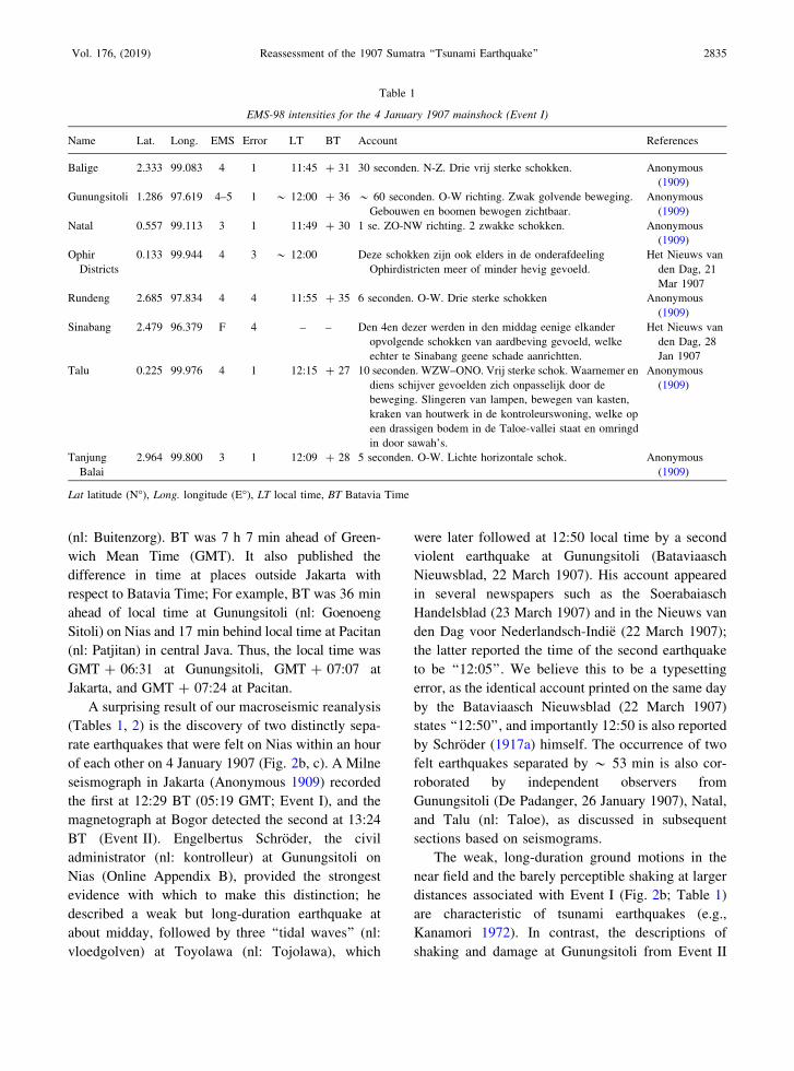
A surprising result of our macroseismic reanalysis
(Tables 1, 2) is the discovery of two distinctly sepa-
rate earthquakes that were felt on Nias within an hour
of each other on 4 January 1907 (Fig. 2b, c). A Milne
seismograph in Jakarta (Anonymous 1909) recorded
the first at 12:29 BT (05:19 GMT; Event I), and the
magnetograph at Bogor detected the second at 13:24
BT (Event II). Engelbertus Schroder, the civil
administrator (nl: kontrolleur) at Gunungsitoli on
Nias (Online Appendix B), provided the strongest
evidence with which to make this distinction; he
described a weak but long-duration earthquake at
about midday, followed by three ‘‘tidal waves’’ (nl:
vloedgolven) at Toyolawa (nl: Tojolawa), which
were later followed at 12:50 local time by a second
violent earthquake at Gunungsitoli (Bataviaasch
Nieuwsblad, 22 March 1907). His account appeared
in several newspapers such as the Soerabaiasch
Handelsblad (23 March 1907) and in the Nieuws van
den Dag voor Nederlandsch-Indie (22 March 1907);
the latter reported the time of the second earthquake
to be ‘‘12:05’’. We believe this to be a typesetting
error, as the identical account printed on the same day
by the Bataviaasch Nieuwsblad (22 March 1907)
states ‘‘12:50’’, and importantly 12:50 is also reported
by Schroder (1917a) himself. The occurrence of two
felt earthquakes separated by * 53 min is also cor-
roborated by independent observers from
Gunungsitoli (De Padanger, 26 January 1907), Natal,
and Talu (nl: Taloe), as discussed in subsequent
sections based on seismograms.
The weak, long-duration ground motions in the
near field and the barely perceptible shaking at larger
distances associated with Event I (Fig. 2b; Table 1)
are characteristic of tsunami earthquakes (e.g.,
Kanamori 1972). In contrast, the descriptions of
shaking and damage at Gunungsitoli from Event II
Table 1
EMS-98 intensities for the 4 January 1907 mainshock (Event I)
Name Lat. Long. EMS Error LT BT Account References
Balige 2.333 99.083 4 1 11:45 ? 31 30 seconden. N-Z. Drie vrij sterke schokken. Anonymous
(1909)
Gunungsitoli 1.286 97.619 4–5 1 * 12:00 ? 36 * 60 seconden. O-W richting. Zwak golvende beweging.
Gebouwen en boomen bewogen zichtbaar.
Anonymous
(1909)
Natal 0.557 99.113 3 1 11:49 ? 30 1 se. ZO-NW richting. 2 zwakke schokken. Anonymous
(1909)
Ophir
Districts
0.133 99.944 4 3 * 12:00 Deze schokken zijn ook elders in de onderafdeeling
Ophirdistricten meer of minder hevig gevoeld.
Het Nieuws van
den Dag, 21
Mar 1907
Rundeng 2.685 97.834 4 4 11:55 ? 35 6 seconden. O-W. Drie sterke schokken Anonymous
(1909)
Sinabang 2.479 96.379 F 4 – – Den 4en dezer werden in den middag eenige elkander
opvolgende schokken van aardbeving gevoeld, welke
echter te Sinabang geene schade aanrichtten.
Het Nieuws van
den Dag, 28
Jan 1907
Talu 0.225 99.976 4 1 12:15 ? 27 10 seconden. WZW–ONO. Vrij sterke schok. Waarnemer en
diens schijver gevoelden zich onpasselijk door de
beweging. Slingeren van lampen, bewegen van kasten,
kraken van houtwerk in de kontroleurswoning, welke op
een drassigen bodem in de Taloe-vallei staat en omringd
in door sawah’s.
Anonymous
(1909)
Tanjung
Balai
2.964 99.800 3 1 12:09 ? 28 5 seconden. O-W. Lichte horizontale schok. Anonymous
(1909)
Lat latitude (N�), Long. longitude (E�), LT local time, BT Batavia Time
Vol. 176, (2019) Reassessment of the 1907 Sumatra ‘‘Tsunami Earthquake’’ 2835
Table 2
EMS-98 intensities for the 4 January 1907 aftershock (Event II)
Name Lat. Long. EMS Error LT BT Account References
Airbangis 0.201 99.380 4 1 12:38 ? 29 * 60 seconden. Hevige schok. Anonymous (1909)
Bagan Si
Api Api
2.157 100.816 4 1 12:45 ? 23 * 60 seconden. O-W. Vrij hevige schommeling.
De waarnemer had een gevoel als werd hij
duizelig.
Anonymous (1909)
Barus 2.012 98.400 4–5 1 12:48 ? 33 * 120 seconden. ZW-NO. Verscheidene kort op
elkaar volgende vrij sterke schokken. De
houten gebouwen kraakten. In de betonmuur
van de verlaten benteng kwamen scheuren.
Anonymous (1909)
Gunungsitoli 1.286 97.619 7 1 12:50 ? 36 * 60 seconden. O-W richtung. Zeer zware
golvingen. Het was onmogelijk op de been te
blijven. Alles schommelde sterk heen en weer.
Allerwege groote schade aan gebouwen.
Richting horizontale scheuren in cementen
vloer douanekantoor, Noord 20 Oost, Noord en
Noord 340 Oost. Cementen vloer gevangenis
Noord 305 Oost.
Anonymous (1909)
Kuala Bee 4.371 96.062 3 1 12:30 ? 42 45 seconden. N-Z. Anonymous (1909)
Lambuhanbilik 2.520 100.165 4 1 12:45 ? 26 10 seconden. O-W. Twee vrij sterke schokken. Anonymous (1909)
Langkat
Regency
3.743 98.268 4 3 12:55 Een vrij sterke aardschock waargenomen in the
richting Noord-Zuid.
Deli Courant, 4 Jan
1907
Lubuksikaping 0.137 100.167 3 1 * 12:40 ? 26 * 40 seconden. N-Z. Vele, zeer goed
waarneembare golvingen. Een vrij zware
golvende aardbeving waargenomen, die eenige
seconden aanhield.
Anonymous (1909);
Het Nieuws van
den Dag, 21 Mar
1907
Medan 3.589 98.669 3 1 12:50 Hedenmiddag te 12.50 precies heeft hier terstede
een duidelijk waarneembare aardbeving in
noord-zuidelijke richting plaatsgehad. In het
Medan-Hotel kwamen alle lampen, ook de
zware in de groote zaal, in beweging, terwijl
alle klokken er bleven stilstaan. Ook op het
Postkantoor staakten de klokken den dienst. In
den loop van den middag bereikten ons nog
verschillende berichten, die met het
bovenstaande overeenstemmen, en waaruit
blijkt dat de aardbeving van vrij langen duur is
geweest.
De Sumatra Post, 4
Jan 1907
Natal 0.557 99.113 4 1 12:42 ? 30 1 seconde. ZO-NW richting. 3 sterke schokken. Anonymous (1909)
Padang
Brahrang
3.588 98.435 3 1 12:50 Ook uit Padang Brahrang wordt ons omtrent een
aardbeving gemeld. Ze is daar bedenmiddag
eveneens 12:50 waargenomen en de richting
was Oost-west. Het was een soort golvende
beweging, die de lampen flink aan het slingeren
bracht.
De Sumatra Post, 4
Jan 1907
Payakumbuh –0.231 100.630 4 1 13:15 ?23 10 seconden. O-W. Een lichte schok. Vrij hevige
schok werd gevoeld.
Anonymous (1909);
Het Nieuws van
den Dag, 21 Mar
1907
Pulau Pandan –0.949 100.140 3 1 12:55 ? 26 5 seconden. W-O. 5 lichte schokken. Anonymous (1909)
Priaman –0.628 100.116 4 1 13:02 ? 26 *30 seconden. O-W. Hevige horizonale
bevingen.
Anonymous (1909)
Seribu Dolok 2.252 98.748 2 1 12:40 ? 32 Enkele seconden. 2 schokken. Anonymous (1909)
Sibolga 1.739 98.783 3 1 12:35 ? 31 * 54 seconden. NW-ZO. Zacht golvende
beweging.
Anonymous (1909)
Siborongborong 2.210 98.972 4 1 *13:00 ? 30 10 seconden. Sterk. Anonymous (1909)
2836 S. S. Martin et al. Pure Appl. Geophys.

(Fig. 2c; Table 2) lead us to believe that it was
responsible for the violent shaking on Nias that was
misconstrued as the mainshock by Newcomb and
McCann (1987) and flagged as anomalous by Kana-
mori et al. (2010). Countless houses were destroyed
on Nias by Event II, and even weeks later many
people were living under temporary canopy shelters
(bh: pondok) put up near their dwellings (Bataviaasch
Nieuwsblad, 22 March 1907). Unusually, neither
earthquake was reported in an official summary of
news and affairs for January 1907 from Aceh (nl:
Atjeh) i.e. ‘‘Atjeh-verslag over Januari’’ (Java Bode,
16 April 1907). These earthquakes also do not appear
in catalogues of felt earthquakes in Thailand (Nuta-
laya et al. 1985), nor were they reported from
anywhere else in Southeast Asia.
Our research underscores the importance of
meticulously collated and analyzed noninstrumental
evidence that allows the study of historical earth-
quakes for which instrumental data are lacking or
severely limited. The serendipitous discovery of
Event II was an unexpected outcome borne out of
careful scrutiny of macroseismic data that led us to
look for seismological evidence (discussed in subse-
quent sections) to support it. The absence of this
event from earthquake catalogues (e.g., Gutenberg
and Richter 1954; Storchak et al. 2013) is very con-
spicuous but not unusual, as with other recently
discovered large early-instrumental earthquakes
(Hough et al. 2005). This results from the limited
number of seismograms at hand for early instru-
mental earthquakes, and the inadequacy (or simple
inexistence) of proper algorithms to associate repor-
ted phase times, not to mention the adjustment of
local times before implementation of standard time
zones.
3. Location of the Mainshock (Event I)
The earliest published locations for Event I come
from Turner et al. (1912) and Szirtes (1912a), who
used arrival times from over 66 stations. As sum-
marized by Kanamori et al. (2010), and not surprising
for an event at the beginning of the 20th century,
epicentral estimates are poorly constrained and sig-
nificantly scattered (Fig. 3). Gutenberg and Richter’s
(1954) solution (2�N, 94��E) is on the outer rise and
slightly west of the solution (2�N, 95�E) by Turner
et al. (1912), but both are very unlikely locations for
a tsunami earthquake. By contrast, Szirtes (1912a)
reports a location by T.H. Staverman (2�N, 96��E)
in the immediate vicinity of the trench. In their recent
compilation of relocations for early instrumental
earthquakes, Storchak et al. (2013) locate the event at
(1.87�N, 94.21�E), near the Turner et al. (1912) and
Gutenberg and Richter (1954) epicenters, and with a
remarkably small error ellipse (semi-axes: 28 km and
16 km). The most recent version (5.0) of the ISC-
GEM catalog moves the epicenter north by 61 km, to
Table 2 continued
Name Lat. Long. EMS Error LT BT Account References
Sidikalang 2.738 98.320 4 1 12:50 ? 33 10 seconden. NW-ZO. Zwakke schok. Beven der
houten gebouwen, slingeren van lampen.
Anonymous (1909)
Talu 0.225 99.976 4 1 13:05 ? 27 30 seconden. WNW-OZO. Hevige schok.
Waarnemer kreeg een onpasselijk gevoel.
Slingeren van lampen, bewegen van kasten,
kraken van houten deelen van het gebouw.
Anonymous (1909)
Tanjung Balai 2.964 99.800 4 1 12:53 ? 28 *120 seconden. O-W. Reeks opvolgende
tamelijk sterke schokken. N-Z slingers klocken
stopten. Lampen beschreven cirkels van 30
c.m. straal. Menschen kregen een gevoel van
duizeligheid. Onmiddellijk na den schok brak
een zware regenbui met donder los.
Anonymous (1909)
Lat. latitude (N�), Long. longitude (E�), LT local time, BT Batavia Time
Vol. 176, (2019) Reassessment of the 1907 Sumatra ‘‘Tsunami Earthquake’’ 2837

(2.422�N, 94.258�E). It is noteworthy that the very
small confidence ellipse (20 km by 17 km) of the
ISC-GEM solution does not overlap with the solution
from Storchak et al. (2013) (Fig. 3). This casts doubt
on the reliability of both locations, since they are
supposed to be derived from the same algorithm. On
the other hand, a systematic grid search of the same
dataset confirms a large scatter of possible solutions
but proposes a best-fitting epicenter at 2.67�N,
95.01�E (D. Di Giacomo, personal communication
2017), 125 km NE and across the plate boundary
from the Storchak et al. (2013) solution.
Figure 3Relocations of the 1907 Sumatra event. The red dot shows our solution, with associated Monte Carlo ellipse. The green inverted triangle is the
epicenter from Kanamori et al. (2010), with the confidence ellipse described in their online appendix shown in green. The dark-brown upward
triangle is Gutenberg and Richter’s (1954) epicenter, and the orange square T. Staveman’s (Szirtes 1912a). The blue diamonds (with
respective confidence ellipses) are the ISC solution by Storchak et al. (2013; solid, bright), and from the ISC-GEM (5.0) catalog (outlined,
light blue); note that the ellipses do not intersect, suggesting that they are deceptively small. The yellow diamond is the best estimate from a
grid search (D. Di Giacomo, pers. comm., 2017), and the preferred location is shown as the purple bull’s eye symbol. The light-brown triangle
is Turner et al.’s (1912) location. The black stars show the epicenters of the megathrust events of 2004 (Sumatra–Andaman, ‘‘S–A’’), 2005
(Nias, ‘‘N’’), and 2007 (Bengkulu, ‘‘B’’), and the yellow star (‘‘M’’) the 2010 Mentawai tsunami earthquake. Background seismicity
(1970–2015; h\ 100 km; M C 5) shown as light-grey dots. Isobaths are at 500-m intervals (green at 500 m; dark blue at 4000 m and deeper)
2838 S. S. Martin et al. Pure Appl. Geophys.

Kanamori et al. (2010) relocated event I based on
travel times listed in Gutenberg’s personal notepads
(Goodstein et al. 1980), with an emphasis on differ-
ential S – P times, to minimize errors due to clock
uncertainties. Their solution (2.48�N, 96.11�E;
Fig. 3) is located approximately 60 km closer to the
trench than the 2004 and 2005 epicenters, at the
seaward limit of the zone of interplate seismicity
(Pesicek et al. 2010). This configuration is reminis-
cent of the 2010 Mentawai tsunami earthquake
(Newman et al. 2011a; Hill et al. 2012). However,
the 95 % confidence ellipse defined by Kanamori
et al. (2010, p. 371) extends * 500 km, from the
outer rise, beyond the Gutenberg and Richter (1954)
and Storchak et al. (2013) locations, all the way to
inland Sumatra.
We perform an independent relocation using the
dataset listed by the ISC, and the interactive method
of Wysession et al. (1991), which includes a Monte
Carlo algorithm injecting Gaussian noise into the
data. For an event in the 1900s, we give the noise a
standard deviation rG = 12.5 s. Our solution con-
verges to (2.24�N; 94.72�E: O.T. 05:19:13 GMT), a
location on the outer rise, in the vicinity of the
Storchak et al. (2013) and Gutenberg and Richter
(1954) epicenters, but our confidence ellipse extends
across the trench and grazes the solution from
Kanamori et al. (2010); it is essentially contained
inside these authors’ ellipse. While all these reloca-
tions have very large uncertainties [we regard the
Storchak et al. (2013) confidence ellipse as decep-
tively small], the emerging general pattern (Fig. 3) is
that Event I was probably significantly displaced
updip and trenchward with respect to the main seis-
mogenic zone at the interplate contact on the Sunda
Megathrust, to the general area located between the
ISC grid-search solution and that of Staverman (in
Szirtes 1912a), in a tectonic environment reminiscent
of that of the Mentawai tsunami earthquake of 25
October 2010 (Newman et al. 2011a; Hill et al.
2012). This is our preferred location for the epicenter
of Event I (2.5�N, 95.5�E) and is indicated by a red
star on Fig. 4.
Our preferred location lies within an east-facing
reentrant on the Sunda Megathrust (Franke et al.
2008) that indicates a zone of low seismic
productivity between 1918 and 2007, and adjacent to,
but not within, the rupture and aftershock zones of the
2004 and 2005 earthquakes (Chlieh et al. 2007;
Engdahl et al. 2007; Konca et al. 2008; Pesicek et al.
2010). In this region, seismic reflection surveys
(Franke et al. 2008) and three-dimensional (3-D)
active source tomography (Tang et al. 2013) have
identified a ridge of oceanic basement (Fig. 1b) that
projects into the Wharton Basin, coinciding with a
mapped fracture zone (Singh et al. 2011; Jacob et al.
2014). Onshore on Simeulue, this coincides with the
Simeulue Saddle (Sieh et al. 2006), which has served
as a persistent barrier to rupture in the past (Meltzner
et al. 2012). Further downdip and beneath the
Simeulue Saddle (Sieh et al. 2006), this morpholog-
ical high can be associated with a region of strong
coupling beneath central Simeulue (Tsang et al.
2015), and has been inferred as a structural control
for local seismicity and the rupture dimensions of
modern earthquakes under central Simeulue (Morgan
et al. 2017). The dimensions of this morphological
feature are debated (Franke et al. 2008; Tang et al.
2013; also see Fig. 4b in Morgan et al. 2017).
Although our best-fit epicentral location lies slightly
to the west of this feature, its uncertainty ellipse
overlaps the western ramp of this morphological
high, which we believe played a crucial role in rup-
ture propagation and tsunami generation.
4. Event II and Later Aftershocks
Our study is the first to identify several aftershocks
associated with the 1907 Sumatran earthquake. For the
newly discovered large earthquake (Event II), wave-
forms were far fewer than for the mainshock, but we
identified it in new records from Manila (Maso 1907)
and Shimla (Patterson 1909), and the Osaka record
scrutinized by Kanamori et al. (2010). Station bulletins
from Manila (Maso 1907), Osaka (Anonymous 1931),
and Shanghai (de Moidrey 1912) also list it. Maso
(1907) interpreted the Manila records as requiring two
events but pointed out the lack of evidence for Event II
at Zikawei (Shanghai) and in Europe; we believe this to
be partially incorrect, as Event II appears in the Zika-
wei bulletin (de Moidrey 1912). Anonymous (1909)
Vol. 176, (2019) Reassessment of the 1907 Sumatra ‘‘Tsunami Earthquake’’ 2839

provides the time a magnetograph at Bogor detected
this shock as 13:24 BT (* 06:18 GMT), which gives
an origin time of 06:15 GMT correcting for travel time
to Bogor. We note, however, that the arrival time of the
mainshock at this instrument is unknown. The differ-
ence in arrival time between the P waves from Event II
and those of the mainshock at Osaka (Anonymous
1931), the difference in arrival time between the S
waves from both events at Manila (Maso 1907) and
Shanghai (de Moidrey 1912), and inspection of the
waveform recorded at Manila (Maso 1907) suggest
a * 53 min interval between the two. We therefore
estimate an origin time of * 06:12 GMT, which is
also supported by the first-hand account by Schroder
(1917a) of two shocks * 50 min apart.
The paucity of instrumental records prevents an
instrumental location for Event II, but an epicentral
distance (5420 km) to Osaka has been previously pub-
lished (Anonymous 1931). Unfortunately, this datum is
of little help, since Osaka is essentially equidistant
(within 10 km) from the preferred locations of Events I
and II. Finally, an epicenter in the region of Nias for
Event II is further supported by the damage at
Gunungsitoli (Table 2) and the destruction of buildings
elsewhere on Nias (Bataviaasch Nieuwsblad, 22 March
1907). It is also likely, as discussed in more detail below,
that uplifts inferred to have occurred in the Hinako
Islands (Bataviaasch Nieuwsblad, 22 March 1907) and
documented from a fossil coral microatoll on southern
Nias (Meltzner et al. 2015) were related to Event II.
This would suggest a source region in south–central
Nias or off its south–central coast.
Two strongly felt aftershocks (Anonymous 1909)
at * 09:55 GMT on 4 January (Fig. 2d; Table 3)
and * 23:52 GMT on 5 January (Fig. 2e; Table 4)
could be correlated with sparse regional and tele-
seismic recordings (Levitski 1909; Pechau 1907;
Geiger 1909; Szirtes 1912b; Turner and Milne
1908a, b); origin times for both are corrected with
respect to travel time to Jakarta from the Simeulue–
Nias region. We estimated MS = 5.8 for the 5 January
event using phase data from Gottingen (Geiger 1909)
and Jena (Pechau 1907). We also compute Milne
magnitudes (MM) of * 6.1 to * 6.2 for both events
assuming an instrumental gain of 5 (Abe and Noguchi
1983); however, we emphasize that these values are
very poorly constrained, and are associated with
uncertainties of up to ±0.5 (1r).
In addition to the above, 19 felt aftershocks were
counted on Simeulue on 4 January (Bataviaasch
Nieuwsblad, 12 February 1907). Earthquakes were felt
daily (Nieuws van den Dag voor Nederlandsch-Indie, 24
January 1907) with rarer aftershocks experienced after
15 January 1907 (De Sumatra Post, 1 February 1907).
Earthquakes were also felt at Sinabang on Simeulue at
23:45 LT on 19 January 1907 (Bataviaasch Nieuwsblad,
12 February 1907) and on 8 July 1907 (Het Nieuws van
den Dag, 20 September 1907), while on Nias,
Figure 4Spectral amplitudes of Rayleigh and Love waves at Gottingen, interpreted as corrected mantle magnitudes Mc (Okal and Talandier 1989),
computed in the geometry / = 320�, d = 15�; k = 90�, in the frequency band 6–10 mHz. The black dashed lines and yellow band show the
average value and standard deviation of the full dataset, while the purple dashed line shows its best linear regression. Note the strong increase
of moment with period
2840 S. S. Martin et al. Pure Appl. Geophys.

aftershocks were felt continuously until 17 January
(Bataviaasch Nieuwsblad, 29 January 1907). After-
shocks occuring later than 5 January 1907 were only
reported from Nias (Anonymous 1909). Well-timed felt
earthquakes are almost absent from Simeulue except for
a shock that was quite heavy (nl: vrij hevig) at Sinabang
around midday (* 12:42 BT) on 4 January 1907
(Utrechts Nieuwsblad, 14 February 1907) without
causing any damage (De Sumatra Post, 1 February
1907). We suspect this shock could be related to Event I
or a strong local aftershock, neither of which we can
definitively rule out. Another large earthquake was felt
in the Banda Aceh region on 21 November 1907
(Fig. 2g; Anonymous 1909), but this was probably
unrelated to Event I.
5. Reassessment of Long-Period Seismic Moment
and Source Slowness
Kanamori et al. (2010) inferred a seismic moment
(M0) of about 6 9 1027 dyn cm for Event I at periods
of * 50 s, through a comparison of time-domain
amplitudes of body waves at Gottingen with those
obtained at the nearby Black Forest Observatory
(BFO) during the earthquake of 2 November 2002.
This method, which assumes the same focal geometry
for both events [strike (/) = 297�, dip (d) = 16�, slip
angle (k) = 73�], is confined to the time domain and,
as such, tacitly assumes that Event I had a source
spectrum similar to that of the reference event, and
hence followed scaling laws. However, those are
expected to be violated precisely by tsunami earth-
quakes, whose source spectrum is red-shifted towards
lower frequencies with respect to a more traditional
source, such as the 2002 event for which we have
verified a totally regular energy-to-moment parameter
(H = -4.92). For this reason, it is necessary to fur-
ther explore the source spectrum of Event I in the
frequency domain to constrain its seismic moment at
periods typical of mantle waves.
In addition to the waveforms interpreted by
Kanamori et al. (2010), we revisit the record from
Gottingen (GTT), and locate three previously unused
waveforms from Pulkovo, Russia (Golitsyn 1908),
Shimla, India (Patterson 1909), and Manila,
Table 3
EMS-98 intensities for the 4 January 1907 aftershock at 9:55 GMT
Name Lat. Long. EMS Error LT BT Account References
Gunungsitoli 1.286 97.619 4 1 16:20 ? 36 NO-ZW. Meerdere sterke schokken.
Slingeren van lampen
Anonymous (1909)
Natal 0.557 99.113 2 0 16:27 ? 30 1 second. ZO-NW. Zwakke schok. Anonymous (1909)
Barus 2.012 98.400 3 0 16:27 ? 33 15-seconden. ZW-NO. Enkele
kort op elkaar volgende lichte schokken.
Anonymous (1909)
Siborongborong 2.210 98.972 3 0 * 17:00 ? 30 N-Z. Zwak. Anonymous (1909)
Rundeng 2.685 97.834 4 0 16:25 ? 35 Sterke schok. Anonymous (1909)
Lat. latitude (N�), Long. longitude (E�), LT local time, BT Batavia Time
Table 4
EMS-98 intensities for the 5 January 1907 aftershock at 23:52 GMT
Name Lat. Long. EMS Error LT BT Account References
Gunungsitoli 1.286 97.619 4 0 06:15 ? 36 2-seconden. Z-N. Korte sterke schok Anonymous (1909)
Siborongborong 2.210 98.972 3 0 06:00 ? 30 N-Z. Zwak Anonymous (1909)
Rundeng 2.685 97.834 4 0 06:00 ? 35 Een sterke schok Anonymous (1909)
Lat. latitude (N�), Long. longitude (E�), LT local time, BT Batavia Time
Vol. 176, (2019) Reassessment of the 1907 Sumatra ‘‘Tsunami Earthquake’’ 2841

Philippines (Maso 1907). The Pulkovo record only
features a partial, single component for Event I, and
none for its aftershocks (Golitsyn 1908), while the
Shimla seismogram clipped during Event I (Patterson
1909). The Manila record was written on a Vicentini
mechanical seismometer with a period T = 1.4 s,
which makes it the only short-period recording
available to us of the 1907 Sumatra earthquakes; its
crucial importance to our study is discussed in a
subsequent section.
We use the first passages of Rayleigh (R1) and
Love (G1) waves at Gottingen (GTT) for which pre-
cise metadata are available, with records hand-
digitized at a sampling rate of 1 s. Our results are
presented (Fig. 4) in the mantle range of frequencies
(6–10 mHz), expressed as a mantle magnitude cor-
rected for focal mechanism (Mc = log10 M0 - 20
with M0 in dyn cm) in the formalism of Okal and
Talandier (1989). We use a slightly adapted focal
mechanism (/ = 320�, d = 15�; k = 90�), rotated
only 8� in the formalism of Kagan (1991) from
Kanamori et al.’s (2010), in order to reduce the
scatter between Love and Rayleigh spectral ampli-
tudes. Note that this new mechanism is also closer to
the geometry of the nearby 2005 Nias megathrust
earthquake (/ = 333�, d = 8�; k = 118�). Our results
(Fig. 4) suggest an average moment
M0 & 2.5 9 1028 dyn cm (Mc & 8.2) at periods
between 100 and 160 s; at the largest resolvable
period (* 170 s), the magnitude estimate approaches
Mc & 8.4. This value of the seismic moment is about
four times larger than proposed by Kanamori et al.
(2010) from an estimate of time-domain amplitudes
of S waves around 50 s and demonstrates slowness in
the source of the 1907 mainshock, in clear agreement
with its nature as a ‘‘tsunami earthquake’’. In addi-
tion, Fig. 4 documents a growth of moment with
period, with a regression slope for MC versus fre-
quency of -0.09 logarithmic units per mHz. This
number is comparable to values obtained for docu-
mented tsunami earthquakes (e.g., Java, 2006: -0.11;
Mentawai, 2010: -0.08; Manzanillo, 22 June 1932:
-0.14; Hikurangi, 1947: -0.07 and -0.08); by
contrast, traditional subduction events feature lower
slopes (in absolute value) that do not exceed -0.05
(e.g., Maule, 2010: -0.05; Illapel, 2015: -0.05;
Manzanillo, 3 June 1932: -0.01; see Okal and Saloor
2017). This property provides a quantitative confir-
mation of the nature of Event I as a tsunami
earthquake in conjunction with its anomalously low
felt intensities.
6. Ratio of Estimated Energies between Events I
and II
In the case of Event II, we recompute conven-
tional magnitude estimates from those reports of
ground amplitude for which associations could be
made, using established formulæ and guidelines
(Karnık et al. 1962; Geller and Kanamori 1977;
Ambraseys and Douglas 2000). Our best estimate of
MS is * 7.1 based on phase data from Osaka.
We also reproduce in Fig. 5 a copy of the Manila
seismic record from Maso (1907). The seismogram in
the top frame (Fig. 5a) was written on a Vicentini
mechanical seismometer with a period T = 1.4 s. The
distance to Manila is D = 29�. Even though the ori-
entation of this horizontal seismogram (NNW–SSE
or 337�–157�) is pure transverse (the back-azimuth at
Manila being b = 247�), this record clearly shows the
P waves from two earthquakes separated by * 53
min, corresponding to the two shocks identified on
the basis of macroseismic data. We align the traces of
the two events vertically to ease comparison of their
waveforms (Fig. 5a, b). The body waves have a
dominant recorded period of * 4 s. The P waves of
the mainshock are both much weaker and of longer
duration than those of the aftershock. Note also that
the mainshock P wavetrain consists of several sube-
vents, lasting a total of about 2 min, while the
aftershock waveform features two main packets, each
lasting about 3 s. By contrast, we show in the lower
frame a record (Fig. 5b) written on a longer-period
Omori system with a natural period T = 6.4 s, ori-
ented ENE–WSW, which this time is purely
orthoradial. On that record, the amplitudes of the P
waves from the two events become very comparable,
and the main shock displays prominent Rayleigh
waves featuring a period of * 9 s at their maximum
amplitude (probably reflecting the peaked response of
the instrument), while the surface waves from the
aftershock are much weaker.
2842 S. S. Martin et al. Pure Appl. Geophys.

In an attempt to quantify these observations, we
enlarged the Vicentini records (Fig. 5a) and digitized
them at a time sampling dt = 0.1 s. Unfortunately,
the Vicentini instrument was undamped (Maso 1907),
which means that it would, at least theoretically, have
an infinite response at its natural period. In this
context, it would not be possible to formally compute
an energy-to-moment ratio and a slowness parameter
(H) as defined by Newman and Okal (1998). This is
further compounded by the fact that the photographic
magnification of the figure by Maso (1907) is
unknown. Under these circumstances, we use the
model of a very weakly damped instrument (e = 1.1)
and obtain a ratio of estimated energies between the
mainshock (Event I) and aftershock (Event II) of
EI/EII& 0.2. Furthermore, we obtain an estimate of
MS & 7.1 for the classical surface-wave magnitude
of Event II as described in the previous section,
which would correspond to a maximum moment
of * 4 9 1026 dyn cm, assuming that it follows
scaling laws. However, the strong intensities reported
may suggest that its source is blue-shifted towards
Figure 5Seismic recordings at Manila (distance 29�; back-azimuth 247�), reproduced from Maso (1907), clearly showing the two events, separated
by * 53 min. a Short-period Vicentini seismograph; b Omori seismograph. In both instances, the records are offset to align corresponding
phases vertically. Time marks are at 30-s intervals, with original times given as local p.m. times (GMT ? 8). Standard times (GMT) are
overprinted in dark blue. These records dramatically illustrate the different characteristics of the two events
Vol. 176, (2019) Reassessment of the 1907 Sumatra ‘‘Tsunami Earthquake’’ 2843

higher frequencies, in which case the moment could
be lower. Given the long-period moment estimated
above for the mainshock (2.5 9 1028 dyn cm), this
would suggest a factor of 300 between the energy-to-
moment ratios of Events I and II, amounting to a
difference of * 2.5 units in their parameters H.
While this value is not unreasonable, it comes close
to the maximum range of H values that we have
documented [see Okal and Saloor (2017) for an
extensive dataset] and could be explained using both
a very low value of H & -6.5 for the mainshock,
and a high value, H & -4, for Event II. The former
value is within the range of observed H for tsunami
earthquakes [El Salvador 2012: -6.42; Hikurangi
1947 (II, 17 May): -6.51 (Okal and Saloor 2017)],
while the latter would be typical of a ‘‘snappy’’
earthquake (Okal and Kirby 2002) occurring inside
the overriding plate, such as the main normal faulting
aftershock of the 2011 Tohoku earthquake (-4.12) or
the 1939 Chillan earthquake (-4.04) (Okal and Kirby
2002; Okal et al. 2016). The jagged nature of the P
waves of the mainshock at Manila would also be in
line with observations during the 1992 Nicaragua
event (Polet and Kanamori 2000) and the resulting
model by Tanioka et al. (1997).
7. Indian Ocean Tsunami Observations
We were able to compile 88 observations of the
tsunami generated by Event I across the Indian Ocean
(Table 5; Fig. 6; Online Appendix B). They were
obtained from individual accounts (e.g., Schroder
1917a), as well as from reports published in local
newspapers. Most of the Dutch news reports were
corroborated by later official Dutch correspondence
(Openbaar Verbaal, 23 April 1908). First- and sec-
ond-hand accounts from a few locales in the near and
far field are available (e.g., Anonymous 1909; Visser
1922), and some were repeated by Solov’ev and Go
(1974). We also extracted eyewitness or second-hand
accounts appearing in contemporary anthropological
(e.g., Baumwoll 2008; Rahman et al. 2017) and sci-
entific studies (Yogaswara and Yulianto 2006;
Whitlow 2008; Fujino et al. 2014).
The impact of the tsunami was greatest on the
southern coast of Simeulue, and on the northern and
western coasts of Nias (Fig. 6a, b). Without providing
additional location details, news and official reports
from Simeulue suggest the tsunami struck after Fri-
day afternoon prayers, the sea flooding inland as
much as 600–800 m with isolated inundations of
1200 m, or to the foot of the hills, sweeping coral
boulders and marine fauna inland (Bataviaasch
Nieuwsblad, 12 February 1907; Utrechts Nieuwsblad,
14 February 1907; Openbaar Verbaal, 23 April 1908;
Yogaswara and Yulianto 2006). Better numerical
constraint is forthcoming from Nias (Fig. 6a, c), for
example, from Afulu (nl: Afoeloe), where the sea
washed inland for over a kilometer (nl: ongeveer een
paal)1 as far as the foot of the hills, where it deposited
debris that included human remains and large
uprooted trees (Bataviaasch Nieuwsblad, 22 March
1907). Schroder (1917a) noted that a part of the bay
at Afulu was filled with sand and other material (nl:
Vermelding verdient de opvulling van een deel de
baai van Afulu met zand en ander materiaal) at the
time of his visit. Schroder (1917a) also reports that
Hulo Uma near Afulu was ‘‘robbed of all life’’ (nl:
van alle leven beroofd). Southwest of Toyolawa, only
the west coast of the island of Pulau Mausi (nl:
Ma’uso or Maoesi) was impacted by the tsunami
(Schroder 1917a). However, to the south, the tsunami
appears to have rapidly diminished in character at
Lagundi (Fig. 6b; Bataviaasch Nieuwsblad, 22 March
1907).
The island of Simeulue Cut (nl: Simeuloee Tjoet
or Simaloer Tjoet) off the southern coast of Simeulue
(Fig. 6a) ‘‘was lost’’ or ‘‘disappeared’’ (nl: is verd-
wenen) with only the hill at the center of the island
above the water (Fig. 6b), suggestive of extreme
tsunami erosion or, possibly, subsidence. West of
Nias, on Pulau Wunga (Fig. 6b), the tsunami swept
the island from the west (Schroder 1917a), destroying
three-fourths of it including numerous coconut trees,
with debris and victims swept into the lagoon at the
center of the island (Bataviaasch Nieuwsblad, 22
March 1907). The height of the tsunami at Pulau
Wunga is estimated at between 6 m and 15 m
(Schroder 1917a; De Padanger, 25 February 1907),
and in 2005, modern residents told one of the authors
1 The old Dutch measure ‘‘een paal’’ used in colonial
Indonesia is equivalent to 1507 m (Staring 1871).
2844 S. S. Martin et al. Pure Appl. Geophys.

Tab
le5
Tsu
na
mi
ob
serv
ati
on
sfo
rth
e1
90
7ts
un
am
iex
tra
cted
from
new
spa
per
rep
ort
sa
nd
oth
erp
ub
lica
tio
ns
fro
m8
8lo
cati
on
s(i
ncl
ud
ing
nil
rep
ort
s)fr
om
the
Ind
ian
Oce
an
ba
sin
#N
ame
CN
Lat
.L
on
g.
HT
(m)
IN(m
)D
escr
ipti
on
1A
den
YE
12
.80
24
5.0
18
––
‘‘T
he
tid
alw
ave
was
no
tp
erce
pti
ble
atth
isp
ort
’’(E
rsk
ine
19
09)
2A
fulu
ID1
.263
97
.24
5–
15
07
Tsu
nam
iw
ent
inla
nd
abo
ut
‘‘ee
np
aal’’
(15
07
m,
see
text
)al
mo
stto
the
bas
eo
fth
e
hil
lsw
her
ed
ebri
san
dsk
elet
on
so
fth
ose
kil
led
wer
ele
ft;
atle
ast
50
kil
led
(Ba
tavi
aa
sch
Nie
uw
sbla
d,
22
Mar
19
07)
3A
yer
ID2
.591
95
.96
8–
–V
illa
ge
com
ple
tely
‘‘lo
st’’
(Ba
tavi
aa
sch
Nie
uw
sbla
d,
12
Feb
19
07)
4A
lafa
nID
2.8
24
95
.75
6[
8–
Lo
cal
his
tory
pre
serv
edb
yw
ord
of
mo
uth
reca
lls
corp
ses
left
inth
eb
ran
ches
of
du
rian
tree
s,an
dm
ake
no
teto
po
int
ou
tth
atth
e2
00
4ts
un
ami
(th
atw
as8
-mh
igh
atth
islo
cati
on
)d
idn
ot
reac
hth
eh
eigh
to
fth
eb
ran
ches
of
du
rian
tree
s(K
om
pa
s,
20
Au
gu
st2
01
4)
5A
ng
ke
ID2
.509
96
.16
5–
–V
illa
ge
com
ple
tely
‘‘lo
st’’
(Ba
tavi
aa
sch
Nie
uw
sbla
d,
12
Feb
19
07)
6A
po
llo
Ban
dar
IN1
8.9
22
72
.83
40
.050
8–
‘‘T
he
effe
cto
fth
eti
dal
wav
eis
no
tice
able
bet
wee
n7
P.M
.o
n4
th,
and
9P
.M.
on
5th
Jan
uar
y,
the
osc
illa
tio
ns
of
the
pen
cil
occ
urr
ing
on
lyat
or
abo
ut
the
tim
eo
fsl
ack
wat
erat
low
and
hig
hti
des
.T
he
gre
ates
tm
ov
emen
to
fth
ep
enci
lo
ut
of
the
no
rmal
was
2in
ches
at2
-50
A.
M.
on
5th
’’(E
rsk
ine
19
09)
7A
we
Ket
jil
ID2
.436
96
.25
2–
–V
illa
ge
com
ple
tely
‘‘lo
st’’
(Ba
tavi
aa
sch
Nie
uw
sbla
d,
12
Feb
19
07)
8A
we
Seb
alID
2.4
33
96
.27
1–
–V
illa
ge
com
ple
tely
‘‘lo
st’’
(Ba
tavi
aa
sch
Nie
uw
sbla
d,
12
Feb
19
07)
9B
aho
eID
––
––
Vil
lag
eco
mp
lete
ly‘‘
lost
’’(B
ata
via
asc
hN
ieu
wsb
lad,
12
Feb
19
07)
10
Bai
ed
uC
ou
rrie
rM
G-
12
.26
54
9.0
59
––
No
reco
rdo
fth
ets
un
ami
avai
lab
le(s
eete
xt)
11
Bar
us
ID2
.012
98
.33
9–
–‘‘
Fo
rth
eti
dal
wav
e,w
hic
hd
estr
oy
edth
eis
lan
do
fS
imal
oer
on
4Ja
nu
ary
19
07,
report
sw
ere
rece
ived
from
Gunungsi
toli
,N
ias,
Pula
uW
unga,
Nat
al,
Bar
us,
Meu
lab
oh
,K
ual
aB
hee
,P
ula
uR
aja
and
Pu
lau
Tel
lo’’
(An
on
ym
ou
s1
90
9)
12
Boem
an/S
erie
Boen
on/B
oen
on
Sir
iID
2.5
19
96.1
50
––
Vil
lage
com
ple
tely
‘‘lo
st’’
(Ba
tavi
aa
sch
Nie
uw
sbla
d,
12
Feb
19
07)
13
Cap
eT
olo
jaw
aID
1.4
04
97
.06
2–
–V
illa
ge
alm
ost
com
ple
tely
des
troy
ed;
two
kil
led;
wat
erle
apt
wit
hg
reat
forc
e
lan
dw
ard
bu
tw
asb
rok
enb
yth
eco
ral
reef
s(B
ata
via
asc
hN
ieu
wsb
lad,
22
Mar
19
07)
14
Co
lom
bo
SL
6.9
79
79
.87
0–
–‘‘
Itw
aso
bse
rved
asa
dis
turb
ance
,o
rti
dal
wav
e,at
the
mo
uth
of
the
Kel
ani
riv
er,an
d
by
the
vil
lager
so
nth
eb
ank
sfo
rso
me
mil
esu
pst
ream
’’(C
eylo
nO
bse
rver
,1
0
Jan
uar
y1
90
7)
15
Die
go
Su
arez
(Ants
iran
ana)
MG
-1
2.2
89
49
.30
2–
–N
ore
cord
of
the
tsun
ami
avai
lab
le(s
eete
xt)
16
Do
emal
aID
1.1
71
97
.30
4–
–P
arti
ally
des
tro
yed
;th
eca
pe
toth
en
ort
h–
wes
tb
rok
eth
ets
un
ami;
thre
efa
tali
ties
(Ba
tavi
aa
sch
Nie
uw
sbla
d,
22
Mar
19
07)
Vol. 176, (2019) Reassessment of the 1907 Sumatra ‘‘Tsunami Earthquake’’ 2845

Tab
le5
con
tin
ued
#N
ame
CN
Lat
.L
on
g.
HT
(m)
IN(m
)D
escr
ipti
on
17
Gal
leS
L6
.031
80
.23
1–
–‘‘
Ag
reat
dea
lo
fex
cite
men
tw
asca
use
din
the
Fo
rtto
day
wh
enth
ose
asse
mb
led
on
the
jett
ynoti
ced
that
the
sea
had
rece
ded
inth
ehar
bor,
the
whole
coas
tro
und
the
bay
bei
ng
hig
han
dd
ryso
me
25
or
35
feet
.T
he
lig
hte
rsan
do
ther
bo
ats
moo
red
nea
rth
eje
tty
wer
ele
fton
dry
land.
The
hull
of
the
wre
cked
‘‘D
alsw
into
n’’
was
exp
ose
dto
vie
w.
Th
eco
oli
esn
ear
the
jett
yse
cure
da
go
od
dea
lo
ffi
sh,
lob
ster
s,
etc.
The
sea
rece
ded
seven
tim
esat
inte
rval
so
fh
alf-
an-h
our.
Aft
erea
chre
cess
ion
the
in-c
om
ing
flo
wo
fw
ater
was
ver
yh
eav
y.
On
the
thir
do
ccas
ion
itw
asn
earl
y
level
wit
hth
eje
tty.T
he
sea
was
per
fect
lyca
lm,an
dno
wav
esw
ere
noti
ceab
le,but
the
curr
ent
wit
hth
ein
-co
min
gsw
ell
was
ver
yst
ron
g.
Th
eB
.I.
stea
mer
‘‘L
oodia
na’
’w
asin
har
bor
dis
char
gin
gri
ce,
and
was
affe
cted
by
the
movem
ent
of
the
seas
,b
ein
gm
ov
edb
ack
war
ds
and
forw
ard
s.S
ever
alli
gh
ters
lad
enw
ith
rice
wer
eo
nth
eir
way
fro
mth
est
eam
erto
the
jett
y,
and
wer
ein
dan
ger
of
bei
ng
das
hed
agai
nst
the
rock
so
win
gto
the
hea
vy
infl
ow
’’(C
eylo
nO
bse
rver
,1
0Ja
nu
ary
19
07;
Als
ose
eO
nli
ne
Ap
pen
dix
B)
18
Guhan
aga
(Gen
i)ID
4.6
83
95.6
86
–A
ney
ewit
nes
scl
aim
edth
eK
ruen
gS
abe
river
over
flow
edunti
lD
esa
Gen
ii.
e.
mod
ern
Gu
han
aga
(Ace
hP
ost
,1
0A
pri
l2
01
3)
19
Gu
nu
ng
sito
liID
1.2
86
97
.61
90
.70
–‘‘
At
Gu
nu
ng
sito
lise
awat
er,
dar
kb
row
nin
colo
ur,
leap
tag
ainst
the
bea
chto
ah
eigh
t
of
abo
ut
70
cm(7
dM
)’’
(Ba
tavi
aa
sch
Nie
uw
sbla
d,
12
Feb
19
07)
20
Ham
ban
tota
SL
6.1
23
81
.12
2–
–‘‘
Th
efi
rst
big
wav
ew
asp
rob
ably
un
reco
rded
and
occ
urr
ed,
Mr.
Bar
nar
dth
ink
s,at
abo
ut
1:3
0p
.m.
Th
ese
con
dg
reat
wav
eo
ccu
rred
at3
p.m
.an
dth
eth
ird
at3
:05
p.m
.T
he
wav
esar
en
ot
alw
ays
qu
ite
exac
t,w
hic
hac
cou
nts
for
the
tim
eb
etw
een
the
wav
esat
wh
ich
No
.7
wav
eo
ccu
rred
,an
dal
soat
4:0
5p
.m.,
wh
eno
ne
was
po
ssib
lyu
nre
cord
ed,
or
spo
ilt
by
the
inte
rfer
ing
wav
es.
Aw
ave
afte
rru
shin
gu
p
the
bea
chre
coil
edan
dm
etth
esu
ccee
din
go
ne,
mak
ing
its
forc
ed
imin
ish
ed,an
dit
mig
ht
hap
pen
that
on
ere
tiri
ng
wav
eju
stm
etan
inco
min
gsm
all
on
ean
dsp
oil
t
it…
…b
etw
een
gre
ates
tri
sean
dfa
ll1
4fe
etm
easu
red
atJe
tty
’’(C
eylo
nO
bse
rver
,
10
Jan
uar
y1
90
7;
Als
ose
eO
nli
ne
Ap
pen
dix
B)
21
Hu
loU
ma
ID1
.252
97
.23
6–
–H
ulo
Um
an
ear
Afu
luw
as‘‘
rob
bed
of
all
life
’’(S
chro
der
19
17a)
22
Ile
Am
ster
dam
(qu
esti
on
ab
le)
FR
-3
7.8
34
77
.55
6–
–L
am
eme
mar
eesi
smiq
ue
aet
eo
bse
rvee
aux
Iles
Sai
nt-
Pau
l,A
mst
erd
am,R
od
rigu
ez,
laR
eun
ion
,M
auri
ceet
enfi
nau
xS
eych
elle
s(B
erth
o1
91
0)
23
Ile
Sai
nt-
Pau
l(q
ues
tio
na
ble
)F
R-
38
.72
47
7.5
15
––
La
mem
em
aree
sism
iqu
ea
ete
ob
serv
eeau
xIl
esS
ain
t-P
aul,
Am
ster
dam
,R
od
rigu
ez,
laR
eun
ion
,M
auri
ceet
enfi
nau
xS
eych
elle
s(B
erth
o1
91
0)
24
Ino
el/I
no
erID
2.4
83
96
.19
5–
–V
illa
ge
com
ple
tely
‘‘lo
st’’
(Ba
tavi
aa
sch
Nie
uw
sbla
d,
12
Feb
19
07)
25
Kar
ach
iP
K2
4.8
33
66
.99
20
.076
2–
‘‘T
he
dis
turb
ance
com
men
ced
at5
P.M
.o
n4
thJa
nu
ary
,ab
ou
tth
eti
me
of
slac
kw
ater
atlo
wti
de
and
last
edti
ll1
0A
.M.
on
5th
.It
was
dis
tin
ctly
no
tice
able
bet
wee
n1
1
P.M
.o
n4
than
de
P.M
.o
n5
th;
at1
–1
5A
.M
.at
slac
kw
ater
ath
igh
tid
eo
nth
e5
th,
the
pen
cil
sho
wed
anab
no
rmal
mov
emen
to
fth
ew
ave
of
3in
ches
’’(E
rsk
ine
19
09)
26
Kay
uM
enan
gID
2.3
06
97
.74
1–
–P
oss
ibly
affe
cted
by
flo
od
ing
in1
90
7ca
usi
ng
resi
den
tsto
mo
ve
toS
ing
kil
(Ace
h
Po
st,
10
Ap
ril
20
13)
27
Kid
der
po
reIN
22
.54
88
8.3
20
––
‘‘T
her
eis
no
trac
eo
fth
eti
dal
wav
eo
nth
ed
iagra
ms,
atth
eri
ver
po
rts
of
Ran
go
on
and
Kid
der
pore
’’(E
rskin
e1
90
9)
2846 S. S. Martin et al. Pure Appl. Geophys.

Tab
le5
con
tin
ued
#N
ame
CN
Lat
.L
on
g.
HT
(m)
IN(m
)D
escr
ipti
on
28
Ko
ela
Deh
IDn
/an
/a–
–V
illa
ge
com
ple
tely
‘‘lo
st’’
(Ba
tavi
aa
sch
Nie
uw
sbla
d,
12
Feb
19
07)
29
Kota
Lad
ang
IDn/a
n/a
––
Dis
appea
red
(Utr
echts
Nie
uw
sbla
d,
14
Feb
19
07
)
30
Ko
taT
ing
gi
ID2
.399
96
.47
5–
60
0–
90
0V
illa
ge
com
ple
tely
‘‘lo
st’’
(Ba
tavi
aa
sch
Nie
uw
sbla
d,
12
Feb
19
07)
31
Ku
ala
Bhee
ID4
.371
96
.06
2–
–‘‘
Fo
rth
eti
dal
wav
e,w
hic
hd
estr
oy
edth
eis
lan
do
fS
imal
oer
on
4Ja
nu
ary
19
07,
report
sw
ere
rece
ived
from
Gunungsi
toli
,N
ias,
Pula
uW
unga,
Nat
al,
Bar
us,
Meu
lab
oh
,K
ual
aB
hee
,P
ula
uR
aja
and
Pu
lau
Tel
lo’’
(An
on
ym
ou
s1
90
9)
32
La-
eion
ID2.5
47
96.1
08
––
Vil
lage
com
ple
tely
‘‘lo
st’’
(Ba
tavi
aa
sch
Nie
uw
sbla
d,
12
Feb
19
07)
33
Lah
alo
sID
n/a
n/a
––
Vil
lag
eco
mp
lete
ly‘‘
lost
’’(B
ata
via
asc
hN
ieu
wsb
lad,
12
Feb
19
07)
34
Lah
oeb
ang
(Lak
uban
g)
ID2
.586
95
.98
9–
20
00
–3
00
0V
illa
ge
com
ple
tely
‘‘lo
st’’
(Ba
tavi
aa
sch
Nie
uw
sbla
d,
12
Feb
19
07).
Do
lph
ins
(bh
:
ikan
lum
ba-
lum
ba)
and
wh
ales
(bh
:ik
anp
aus)
carr
ied
inla
nd
up
tod
ista
nce
so
f
2–
3k
mfr
om
the
coas
t(Y
og
asw
ara
and
Yu
lian
to2
00
6)
35
Laf
uID
1.4
01
97
.21
3–
*1
00
‘‘A
few
ho
use
sd
amag
ed;
tid
alw
ave
ran
abo
ut
10
0m
inla
nd
;d
amag
em
ino
r’’
(Ba
tavi
aa
sch
Nie
uw
sbla
d,
22
Mar
19
07)
36
Lag
und
iID
0.5
82
97
.73
7–
–‘‘
Wea
kts
un
ami’’
(Ba
tavi
aa
sch
Nie
uw
sbla
d,
22
Mar
19
07
)
37
Lam
ajan
(Cap
e)ID
2.5
72
95
.99
6–
–V
illa
ge
com
ple
tely
‘‘lo
st’’
(Ba
tavi
aa
sch
Nie
uw
sbla
d,
12
Feb
19
07)
38
Lao
keh
IDn
/an
/a–
–V
illa
ge
com
ple
tely
‘‘lo
st’’
(Ba
tavi
aa
sch
Nie
uw
sbla
d,
12
Feb
19
07)
39
Las
ing
alo
eID
2.4
42
96
.23
2–
–V
illa
ge
com
ple
tely
‘‘lo
st’’
(Ba
tavi
aa
sch
Nie
uw
sbla
d,
12
Feb
19
07)
40
Les
sih
anID
2.4
07
96
.32
4–
–‘‘
Dis
app
eare
d’’
(Utr
ech
tsN
ieu
wsb
lad,
14
Feb
ruar
y1
90
7)
41
Leb
ang
ID2
.433
96
.28
3–
–V
illa
ge
com
ple
tely
‘‘lo
st’’
(Ba
tavi
aa
sch
Nie
uw
sbla
d,
12
Feb
19
07)
42
Leu
koen
(Lu
kon
)ID
2.6
09
95
.86
7–
–65
kil
led
(Utr
echts
Nie
uw
sbla
d,
14
Feb
1907).
On
the
(sm
all)
isla
nds
of
Sim
eulo
ee
Tjo
et,
Lin
gg
ang
and
Leu
koen
most
the
ho
use
sw
ere
des
troy
ed.
(Ba
tavi
aa
sch
Nie
uw
sbla
d,
12
Feb
19
07)
43
Lin
gg
ang
ID2
.610
95
.86
8–
–O
nth
e(s
mal
l)is
lan
ds
of
Sim
eulo
eeT
joet
,L
ing
gan
gan
dL
euk
oen
most
the
ho
use
s
wer
ed
estr
oy
ed.
(Ba
tavi
aa
sch
Nie
uw
sbla
d,
12
Feb
19
07
)
44
Mad
ras
(Chen
nai
)IN
13.0
91
80.2
98
––
‘‘O
scil
lati
ons
due
toth
eti
dal
wav
ear
etr
acea
ble
on
the
tidal
dia
gra
mbet
wee
n
mid
nig
ht
of
4th
and
mid
nig
ht
of
5th
Jan
uar
y.
Th
eyar
ein
sig
nifi
can
t’’
(Ers
kin
e
19
09)
45
Mat
ara
SL
5.9
42
80.5
43
––
‘‘T
he
sea
rece
ded
asfa
rbac
kth
atth
esu
nken
ridge
of
rock
sa
quar
ter
of
am
ile
from
the
sho
reb
ecam
ev
isib
le.T
his
hap
pen
edtw
oo
rth
ree
tim
es’’
(Cey
lon
Ob
serv
er,1
0
Jan
uar
y1
90
7)
46
Mau
riti
us
FR
-2
0.2
85
57
.57
3–
–L
am
eme
mar
eesi
smiq
ue
aet
eo
bse
rvee
aux
Iles
Sai
nt-
Pau
l,A
mst
erd
am,R
od
rigu
ez,
laR
eun
ion
,M
auri
ceet
enfi
nau
xS
eych
elle
s(B
erth
o1
91
0)
47
Meu
lab
oh
(An
alab
u)
ID4
.143
96
.12
8–
–‘‘
Fo
rth
eti
dal
wav
e,w
hic
hd
estr
oy
edth
eis
lan
do
fS
imal
oer
on
4Ja
nu
ary
19
07,
report
sw
ere
rece
ived
from
Gunungsi
toli
,N
ias,
Pula
uW
unga,
Nat
al,
Bar
us,
Meu
lab
oh
,K
ual
aB
hee
,P
ula
uR
aja
and
Pu
lau
Tel
lo’’
(An
on
ym
ou
s1
90
9)
48
Mo
edil
ID2
.466
96
.21
7–
–V
illa
ge
com
ple
tely
‘‘lo
st’’
(Ba
tavi
aa
sch
Nie
uw
sbla
d,
12
Feb
19
07)
49
Nan
tjal
laID
2.4
50
96
.22
7–
–V
illa
ge
com
ple
tely
‘‘lo
st’’
(Ba
tavi
aa
sch
Nie
uw
sbla
d,
12
Feb
19
07)
Vol. 176, (2019) Reassessment of the 1907 Sumatra ‘‘Tsunami Earthquake’’ 2847

Tab
le5
con
tin
ued
#N
ame
CN
Lat
.L
on
g.
HT
(m)
IN(m
)D
escr
ipti
on
50
Nai
bos
ID2
.489
96
.18
78
–1
0*
10
00
Vil
lag
eco
mp
lete
ly‘‘
lost
’’(B
ata
via
asc
hN
ieu
wsb
lad,
12
Feb
19
07);
Sh
arks
(bh
:ik
an
hiu
),w
hal
es(b
h:
ikan
pau
s),
and
cora
lb
ou
lder
sw
ere
tran
spo
rted
inla
nd
;m
arin
e
faun
aw
assw
ept
inla
nd
asm
uch
asa
kil
om
eter
atN
aib
os
inso
uth
Sim
eulu
ew
her
e
loca
lnar
rati
ves
also
alle
ge
hum
anco
rpse
san
ddea
dli
ves
tock
such
asbuff
alo
wer
e
fou
nd
inth
eto
ps
of
coco
nu
ttr
ees
ath
eigh
tso
f8
–1
0m
(Yo
gas
war
aan
dY
uli
anto
20
06)
51
Nat
alID
0.5
57
99
.11
3–
–‘‘
Fo
rth
eti
dal
wav
e,w
hic
hd
estr
oy
edth
eis
lan
do
fS
imal
oer
on
4Ja
nu
ary
19
07,
report
sw
ere
rece
ived
from
Gunungsi
toli
,N
ias,
Pula
uW
unga,
Nat
al,
Bar
us,
Meu
lab
oh
,K
ual
aB
hee
,P
ula
uR
aja
and
Pu
lau
Tel
lo’’
(An
on
ym
ou
s1
90
9)
52
Oej
ong
ID2
.688
95
.77
6–
–8
7k
ille
d(U
trec
hts
Nie
uw
sbla
d,
14
Feb
19
07)
53
Oed
joen
gL
oja
ng
ID1
.530
97
.35
2–
–‘‘
All
ho
use
sex
cep
to
ne
flat
ten
edto
the
gro
un
d’’
(Bata
viaasc
hN
ieuw
sbla
d,
29
Jan
19
07).
Note
:U
nce
rtai
nif
dam
age
isfr
om
the
eart
hquak
eof
the
tsunam
i
54
Oed
joen
gO
eso
ej(U
jung
Go
sso
ng
?)ID
––
––
Vil
lag
eco
mp
lete
ly‘‘
lost
’’(B
ata
via
asc
hN
ieu
wsb
lad,
12
Feb
19
07)
55
Pad
ang
ID-
1.0
03
10
0.3
79
–R
eco
rded
by
the
auto
mat
icti
de
gau
ge
inT
eluk
Bay
ur
(nl:
Em
mah
aven
)(A
no
nym
ou
s
19
09;
also
see
tex
t)
56
Po
inte
des
Gal
ets
FR
-2
0.9
40
55
.30
5–
–‘‘
Le
4ja
nv
ier
19
07
,a
4h
20
md
el’
apre
s-m
idi,
aum
om
ent
de
lap
lein
em
er,
on
vit
l’ea
um
onte
ras
sez
rapid
emen
tdan
sle
port
,at
teig
nan
t60
mm
a70
mm
au-d
essu
s
du
niv
eau
des
mar
ees
de
syzy
gie
s,p
uis
tout
aco
up
sere
tire
rle
nte
men
tb
ien
au-
des
sous
du
niv
eau
des
plu
sb
asse
sm
ers.
Cet
teel
evat
ion
etce
tab
aiss
emen
tse
rep
eter
ent
avec
un
ryth
me
par
fait
,d
e1
0en
10
min
,ai
nsi
qu
el’
ab
ien
ind
ique
le
mar
egra
ph
e.L
am
er,
aula
rge,
etai
tca
lme
etb
elle
,sa
ns
ho
ule
.L
ad
eniv
ella
tio
n,
toute
sle
s1
0m
in,
etai
td
elm
,7
0.
Le
ph
eno
men
eco
nti
nua
jusq
u‘a
u6
jan
vie
rau
soir
,av
ecd
esre
cru
des
cen
ces
d’i
nte
nsi
te’’
(Ber
tho
19
10)
57
Po
rtB
lair
IN1
1.6
75
92
.76
10
.127
–‘‘
Th
efi
rst
dis
turb
ance
app
eare
dto
hav
eco
mm
ence
dat
1-4
5P
.M.,
on
4th
Jan
uar
y
1907;
the
osc
illa
tions
of
the
pen
cil
due
toth
eti
dal
wav
e,w
ere
slig
ht
up
to2-4
0
P.M
.,af
ter
wh
ich
they
incr
ease
din
freq
uen
cyan
din
hei
gh
tu
pto
6-3
0P
.M
.,th
e
tim
eo
fsl
ack
wat
erat
low
tid
e,w
hen
the
wav
ew
asg
reat
est,
the
hei
gh
tb
eing
5
inch
es.
Aft
erth
isth
ecu
rve
sho
wed
ad
imin
ish
ing
of
the
wav
eu
nti
lit
ceas
edat
10
-20
P.M
.o
n6
thin
stan
t.T
he
osc
illa
tio
ns
wer
em
ost
mar
ked
atea
chsl
ack
wat
er
atlo
wan
dh
igh
tid
es’’
(Ers
kin
e1
90
9)
58
Pu
lau
Mau
siID
1.3
55
97
.10
1–
–T
he
wes
tco
ast
of
the
isla
nd
of
Pu
lau
Mau
siw
asim
pac
ted
by
the
tsun
ami
(Sch
rod
er
19
17a)
59
Pu
lau
Raj
aID
4.8
69
95
.38
2–
–‘‘
Fo
rth
eti
dal
wav
e,w
hic
hd
estr
oy
edth
eis
lan
do
fS
imal
oer
on
4Ja
nu
ary
19
07,
report
sw
ere
rece
ived
from
Gunungsi
toli
,N
ias,
Pula
uW
unga,
Nat
al,
Bar
us,
Meu
lab
oh
,K
ual
aB
hee
,P
ula
uR
aja
and
Pu
lau
Tel
lo’’
(An
on
ym
ou
s1
90
9)
60
Pu
lau
Tel
loID
-0
.066
98
.26
4–
–‘‘
Fo
rth
eti
dal
wav
e,w
hic
hd
estr
oy
edth
eis
lan
do
fS
imal
oer
on
4Ja
nu
ary
19
07,
report
sw
ere
rece
ived
from
Gunungsi
toli
,N
ias,
Pula
uW
unga,
Nat
al,
Bar
us,
Meu
lab
oh
,K
ual
aB
hee
,P
ula
uR
aja
and
Pu
lau
Tel
lo’’
(An
on
ym
ou
s1
90
9)
61
Pu
lau
Wo
enga
(Pu
lau
Wu
nga)
ID1
.207
97
.09
17
–5
–A
llh
ou
ses
was
hed
into
the
lag
oo
nw
ith
atle
ast
10
0k
ille
d.
12
0co
con
ut
tree
s
des
troy
ed;
esti
mat
edto
hav
eb
een
7m
–1
5m
hig
h(S
chro
eder
,1
91
2a;
De
Pa
dan
ger
,2
5F
eb1
90
7;
Ba
tavi
aa
sch
Nie
uw
sbla
d,
22
Mar
19
07)
2848 S. S. Martin et al. Pure Appl. Geophys.

Tab
le5
con
tin
ued
#N
ame
CN
Lat
.L
on
g.
HT
(m)
IN(m
)D
escr
ipti
on
62
Ran
go
on
MY
16
.76
89
6.1
59
––
‘‘T
her
eis
no
trac
eo
fth
eti
dal
wav
eo
nth
ed
iagra
ms,
atth
eri
ver
po
rts
of
Ran
go
on
and
Kid
der
pore
’’(E
rskin
e1
90
9)
63
Ro
dri
gu
esIs
lan
dF
R-
19
.71
16
3.4
48
––
‘‘T
he
offi
cer
inch
arg
eo
fth
eE
aste
rnE
xte
nsi
on
Tel
egra
ph
offi
ce,
Bar
rack
Str
eet,
stat
edla
stn
igh
tth
atat
8:3
5p
.m.
the
Com
pan
y’s
offi
ceat
Coco
sIs
lan
dh
adb
een
info
rmed
by
the
Ro
dri
gu
esm
anag
erth
atth
ese
aw
asb
oil
ing
,an
dth
atsm
all
tid
al
wav
esw
ere
bei
ng
exp
erie
nce
d.
At
abo
ut
9o
’clo
ckin
form
atio
nca
me
toh
and
that
the
tide,
whic
hsh
ould
hav
ebee
nat
its
low
est
ebb,
was
risi
ng
rapid
ly,
and
that
a
smal
lre
efw
hic
hw
aso
rdin
aril
yv
isib
lest
andin
go
ut
of
the
wat
erw
asb
eing
cover
ed.
The
tide
was
hig
her
than
ithad
ever
bee
nbef
ore
.H
alf
anhour
late
rth
e
tid
ew
asre
po
rted
tob
est
ill
risi
ng
,an
dth
ere
sid
ents
wer
eh
auli
ng
thei
rb
oat
su
po
ut
of
dan
ger
.S
hort
lyb
efo
re1
1p
.m.
the
Ro
dri
gu
esst
atio
nre
po
rted
that
the
tid
ew
as
fall
ing
’’(T
he
Wes
tA
ust
rali
an,
5Ja
nu
ary
19
07)
64
Sal
ang
ID2
.637
95
.86
4–
–V
illa
ge
com
ple
tely
‘‘lo
st’’
(Ba
tavi
aa
sch
Nie
uw
sbla
d,
12
Feb
19
07)
65
Sal
oer
Ilir
ID2
.443
96
.23
8–
–V
illa
ge
com
ple
tely
‘‘lo
st’’
(Ba
tavi
aa
sch
Nie
uw
sbla
d,
12
Feb
19
07)
66
Sai
nt-
Ben
oıt
FR
-2
1.0
44
55
.71
7–
–‘‘
Le
ph
eno
men
eet
ait
bie
nm
arq
ue,
etco
mp
lete
men
tv
isib
led
ela
«B
atte
rie
»,
ou
bea
uco
up
de
per
son
nes
on
tl’
hab
itu
de
de
pre
nd
rele
frai
sd
ans
les
jou
rnee
sch
aud
es
ver
sle
soir
.Il
etai
t4
h.�
.T
ou
ta
cou
p,le
sla
mes
qu
id
eto
ut
tem
ps
def
erle
nt
ace
t
end
roit
,d
isp
arai
ssen
t,la
mer
sere
tire
calm
e,la
issa
nt
ase
cu
nfo
nd
d’u
ne
cen
tain
e
de
met
res
de
larg
een
vir
on.
Les
eaux
sere
tire
nt
der
rier
ela
chai
ne
de
Cap
s,q
ui
form
ele
reci
fde
St-
Ben
oit
,ca
ps
qui
n’e
mer
gea
ien
tja
mai
sq
uel
qu
ete
mp
sq
u’i
lfı
t,
mai
sq
ue
lare
trai
ted
ela
mer
lais
seen
tier
emen
ta
nu
.P
arm
ile
ssp
ecta
teu
rsd
u
ph
eno
men
e,d
esje
unes
gar
con
s,at
tire
sp
arl’
app
at,
sep
reci
pit
ent
sur
les
po
isso
ns
surp
ris,
qu
el’
eau
aab
and
on
nes
.M
ais
ap
ein
eq
uel
qu
esm
inu
tes
s’et
aien
tec
ou
lees
,
qu
ele
sg
ens
rest
essu
rle
rivag
esi
gnal
ent
ace
sje
unes
imp
ruden
ts,u
ne
ho
ule
d’u
ne
hau
teur
extr
aord
inai
reven
ant
de
tres
loin
.C
eux-c
in
’eu
ren
tq
ue
lete
mp
s
d’a
ban
don
ner
leu
rb
uti
net
de
gag
ner
laco
te.
Bie
nle
ur
enp
rit
:la
ho
ule
est
ven
ue
def
erle
ret
env
ahir
late
rre
ferm
ea
une
lim
ite
que
n’a
ttei
nt
pas
d’o
rdin
aire
le
niv
eau
de
lam
er,le
ress
acbal
ayan
tet
entr
aın
ant
tou
t:
po
isso
ns
etg
alet
s.P
lusi
eurs
vag
ues
sem
bla
ble
sse
sont
succ
ede
ad
iffe
rents
inte
rval
les.
An
euf
du
soir
lam
era
com
men
cea
repre
nd
reso
nn
ivea
uo
rdin
aire
,p
uis
tou
tes
tre
ntr
ed
ans
l’o
rdre
no
rmal
’’(J
ou
rna
ld
el’
ıle
de
La
Reu
nio
n,
8Ja
nu
ary
19
07)
67
Sai
nt-
Gil
les-
de-
Bai
nF
R-
21
.05
35
5.2
24
––
‘‘P
eut-
etre
qu
elq
ues
un
sd
en
os
erudit
snous
donner
ont-
ils
l’ex
pli
cati
on
de
ce
ph
eno
men
eq
ui
afo
rtem
ent
imp
ress
ion
ne
lap
op
ula
tio
nsa
int
gil
lois
eet
mem
ele
s
qu
elq
ues
bai
gn
eurs
env
ille
gia
ture
’’(J
ou
rna
ld
el’
ıle
de
La
Reu
nio
n,
8Ja
nu
ary
19
07)
68
Sai
nt-
Mar
ieF
R-
20
.89
35
5.5
08
––
‘‘…
.et
qu
’aS
teM
arie
des
roch
ers
qu
in
’em
erg
ent
jam
ais,
on
tet
eco
mp
lete
men
tm
isa
dec
ou
ver
t’’
(La
Pa
trie
Cre
ole
,8
Jan
uar
y1
90
7)
69
Sai
nt-
Pie
rre
FR
-2
1.3
34
55
.47
1–
–‘‘
Ilp
araı
tq
ue
dan
sle
po
rtd
eS
t-P
ierr
e,il
aet
ere
lev
eu
ne
dif
fere
nce
de
niv
eau
de
pre
sd
ed
eux
met
res,
pro
duis
ant,
aure
trai
td
el’
eau
,d
ev
erit
able
sca
scad
es
des
cen
dan
td
esh
auts
fon
ds
no
nd
rag
ues
’’(L
aP
atr
ieC
reo
le,
8Ja
nu
ary
19
07)
Vol. 176, (2019) Reassessment of the 1907 Sumatra ‘‘Tsunami Earthquake’’ 2849
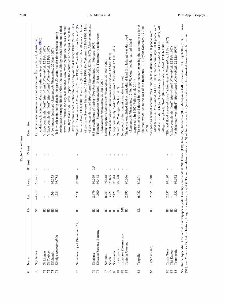
Tab
le5
con
tin
ued
#N
ame
CN
Lat
.L
on
g.
HT
(m)
IN(m
)D
escr
ipti
on
70
Sey
chel
les
SC
-4
.712
55
.49
1–
–L
am
eme
mar
eesi
smiq
ue
aet
eo
bse
rvee
aux
Iles
Sai
nt-
Pau
l,A
mst
erd
am,
Rod
rig
uez
,la
Reu
nio
n,
Mau
rice
eten
fin
aux
Sey
chel
les
(Ber
tho
19
10)
71
Si
Lin
gg
asID
––
––
Vil
lag
eco
mp
lete
ly‘‘
lost
’’(B
ata
via
asc
hN
ieu
wsb
lad,
12
Feb
19
07)
72
Si
To
eboeh
ID–
––
–V
illa
ge
com
ple
tely
‘‘lo
st’’
(Ba
tavi
aa
sch
Nie
uw
sbla
d,
12
Feb
19
07)
73
Sif
ahan
dro
ID1
.504
97
.35
3–
–A
few
ho
use
sd
estr
oy
ed(B
ata
via
asc
hN
ieu
wsb
lad,
22
Mar
19
07)
74
Sib
olg
a(q
ues
tio
na
ble
)ID
1.7
31
98
.78
2–
–‘‘
Itis
wo
rth
men
tio
nin
gth
atin
the
pas
t5
0y
ears
,(a
tth
eti
me)
wh
ena
stro
ng
eart
hq
uak
ed
estr
oy
edH
inak
o(N
ias)
,th
ese
aat
Sib
olg
aru
shed
fort
han
da
tid
al
wav
ew
asfo
rmed
,th
eci
tyw
asfl
oo
ded
.N
ow
wh
enp
eop
lese
eth
ese
aeb
ban
d
flo
w,
they
fear
ati
dal
wav
e(r
eport
fro
mth
eco
ntr
oll
ero
fS
ibo
lga)
.M
ore
than
lik
ely
that
this
repo
rtis
rela
ted
toth
eea
rth
quak
eo
f4
Jan
uar
y1
90
7’’
(Vis
ser
19
31)
75
Sim
uel
oee
Tjo
et(S
imuel
ue
Cu
t)ID
2.5
31
95
.94
0–
–‘‘
Hal
flo
st’’
(Ba
tavi
aa
sch
Nie
wsb
lad,
23
Jan
19
07)
or
‘‘par
tial
lylo
stin
the
sea’
’(D
e
Su
mat
raP
ost
,1
Feb
19
07).
Bar
ely
the
(lit
tle)
top
of
the
(lit
tle)
hil
lw
asv
isib
leo
ut
of
the
wat
er(U
trec
hts
Nie
uw
sbla
d,1
4F
eb1
90
7;
De
Pa
da
ng
er,2
5F
eb1
90
7;
Mo
st
of
the
ho
use
sd
estr
oy
ed(B
ata
via
asc
hN
iew
sbla
d,1
2F
eb1
90
7).
Als
ose
em
ain
tex
t
76
Sin
aban
gID
2.4
79
96
.37
90
.5–
0.5
mo
scil
lati
on
so
fh
arb
or
(Utr
ech
tsN
ieu
wsb
lad,
14
Feb
ruar
y1
90
7)
77
Sir
iwao
e/S
aro
eng
Bar
oen
gID
1.7
00
97
.44
8–
–‘‘
Flo
od
ed’’
(Ba
tavi
aa
sch
Nie
uw
sbla
d,
10
Jan
19
07).
Tem
po
rari
lyu
nd
erw
ater
(Ba
tavi
aa
sch
Nie
uw
sbla
d,
29
Jan
19
07)
78
Sir
om
bu
ID0
.951
97
.41
8–
–D
eath
sre
po
rted
(Ba
tavi
aa
sch
Nie
uw
sbla
d,
22
Mar
19
07
)
79
So
soh
ID3
.721
96
.82
5–
–‘‘
Wen
tu
nd
erw
ater
’’(B
ata
via
asc
hN
ieu
wsb
lad,
12
Mar
19
07)
80
So
ea-S
oea
ID2
.421
96
.31
4–
–V
illa
ge
com
ple
tely
‘‘lo
st’’
(Ba
tavi
aa
sch
Nie
uw
sbla
d,
12
Feb
19
07)
81
Tal
oe
Sia
ba
ID1
.510
97
.37
8–
–‘‘
Lo
st’’
(De
Pa
da
ng
er,
26
Jan
19
07
)
82
Tam
atav
e(T
oam
asin
a)M
G–
–N
ore
cord
of
the
tsun
ami
avai
lab
le(s
eete
xt)
83
Tan
jung
Goss
ong
ID2.3
95
96.3
36
––
The
new
lyes
tabli
shed
fiel
do
rag
ricu
ltura
lla
nd
(bh:
ladan
g)
was
des
troyed
(Ba
tavi
aa
sch
Nie
uw
sbla
d,
12
Feb
1907);
Cora
lbould
erca
rrie
din
land
sup
po
sed
lyin
19
07
(Fu
jino
etal
.2
01
4)
84
Tan
gal
leS
L6
.022
80
.80
1–
–‘‘
Th
ese
aeb
bed
and
flo
wed
inth
esa
me
man
ner
,ex
po
sin
gth
ese
ab
ott
om
asfa
ras
the
rock
whic
hli
esto
the
east
of
the
Res
thouse…
’’.
(Cey
lon
Ob
serv
er,
17
Jun
e
19
09)
85
Tap
ah(i
slan
d)
ID2
.355
96
.24
0–
–‘‘
As
go
od
asw
ith
out
coco
nut
tree
s’’
and
on
this
isla
nd
abo
ut
20
0p
eop
lew
ere
kil
led
(Utr
echts
Nie
uw
sbla
d,
14
Feb
19
07);
On
eac
cou
nt
say
s1
00
0p
eop
lew
ere
kil
led
atK
ual
aD
eh(o
nT
apah
)al
on
e(U
trec
hts
Nie
uw
sbla
d,
14
Feb
19
07
);A
ll
vil
lages
com
ple
tely
‘‘lo
st’’
(Ba
tavi
aa
sch
Nie
uw
sbla
d,
12
Feb
19
07)
86
Tap
akT
uan
ID2
.357
97
.18
0–
–‘‘
Eb
ban
dfl
oo
do
bse
rved
thri
ce’’
( Ba
tavi
aa
sch
Nie
uw
sbla
d,
12
Feb
19
07
)
87
Tit
iK
apo
erID
––
––
Vil
lag
eco
mp
lete
ly‘‘
lost
’’(B
ata
via
asc
hN
ieu
wsb
lad,
12
Feb
19
07)
88
Toer
elao
eja
ID1.5
32
97.5
32
––
‘‘A
fish
erm
anw
askil
led’’
(Ba
tavi
aa
sch
Nie
uw
sbla
d,
22
Mar
19
07)
See
On
lin
eA
pp
end
ixB
for
ver
bat
imn
ewsp
aper
rep
ort
s.C
ou
ntr
yn
ame
cod
e(C
N):
Fra
nce
(FR
),In
dia
(IN
),In
do
nes
ia(I
D),
Mad
agas
car
(MG
),P
akis
tan
(PK
),S
eych
elle
s(S
C),
Sri
Lan
ka
(SL
),an
dY
emen
(YE
);L
at.
=la
titu
de,
Lo
ng
.=
lon
git
ude,
hei
gh
t(H
T),
and
inu
nd
atio
nd
ista
nce
(IN
)o
fts
un
ami
inm
eter
s(m
)as
bes
tas
can
be
esti
mat
edfr
om
avai
lab
lem
ater
ial
2850 S. S. Martin et al. Pure Appl. Geophys.

(K.S.) that corpses were stranded in coconut trees in
1907. The only photographic evidence of this disaster
that we found is from Pulau Wunga (Schroder 1917b;
Fig. 7a, b); how representative these are of damage
elsewhere on the island is unknown, but the similarity
of the post-tsunami landscape to that of Pulau Sibigau
Figure 6Tsunami observations on Simeulue (a), Nias (b), and northern Sumatra (c), and in the Indian Ocean basin (d) including Sri Lanka (e) and La
Reunion (f), also tabulated in Table 5. White circles show locations where the tsunami was observed, and black circles indicate sites used to
forward model the tsunami. Red circles mark questionable or false reports. White triangles show tide gauges where readings were available,
and red triangles show tide gauges in operation in 1907 where either data were unavailable, the tsunami was unrecorded, or records were
incomplete
Vol. 176, (2019) Reassessment of the 1907 Sumatra ‘‘Tsunami Earthquake’’ 2851

(Hill et al. 2012) following the 2010 Mentawai tsu-
nami earthquake is striking.
On the Sumatran mainland (Fig. 6a), vague
accounts suggest Kayu Menang (Aceh Post, 10 June
2013) and Sibolga (Visser 1931) were possibly floo-
ded. At Guhanaga (formerly Geni), a flood in the
Krueng Sabe River (Aceh Post, 10 June 2013) was
attributed to the tsunami by an eyewitness, but we
consider this account cautiously as the date associ-
ated with it is unreliable. The tsunami was reportedly
recorded by a tide gauge in the harbor at Padang
(Anonymous 1909), but this record has been lost.
Monecke et al. (2008) suggest that a sand sheet (unit
A) deposited on the Sumatran coast to the north of
Meulaboh was related to the 1907 tsunami. While
accounts at our disposal from the west coast of
Sumatra are sparse, we doubt a tsunami that flooded
several kilometers inland would go unnoticed, and
despite a heavy colonial military presence in the
region at the time, there is no record of damage to
towns on the coast (Koloniaal Verslag van 1907;
1908). We believe there is a higher likelihood that
this sand sheet was instead deposited by the tsunami
that destroyed Bubon, Meulaboh (formerly Analabu)
and Singkel, following the 16 February 1861 Nias
earthquake (Padangsch nieuws- en advertentie-blad, 2
March 1861; Pinang Gazette, 16 March 1861).
On the Indian Subcontinent in erstwhile British
India and her dependencies, tide gauges operated by
the Survey of India at Port Blair (Andaman Islands),
Apollo Bandar (in Mumbai), Chennai (Madras), and
Karachi provide the only instrumental readings from
this tsunami (Erskine 1908, 1909; Fig. 6d), but
maregrams were unavailable to us. Similar instru-
ments at Kidderpore (Kolkata), Yangon (Rangoon,
Myanmar), and Aden (Yemen) did not record the
disturbance (Erskine 1908, 1909). In Sri Lanka, it
was observed at points on the southern coast in par-
ticular at Galle, where the harbor filled and emptied
seven times at half-hour intervals, but water did not
overflow the jetty (Ceylon Observer, 10 January
1907).
In the Southern Indian Ocean (Fig. 6f), the tsu-
nami was observed at Mauritius (Erskine 1909) and
on Rodrigues (The West Australian, 5 January 1907).
La Reunion (Bertho 1910; Sahal et al. 2011), sup-
ported by readings on a maregraph, reports an
‘‘oscillation’’ (presumably peak-to-peak) of 1.7 m at
Pointe des Galets, about 1/3 (if meant to represent a
peak-to-peak amplitude) of the runup observed in
2004 at nearby (and vastly developed) Le Port (Okal
et al. 2006a), starting at 16:20 local time (which
before 1911 was GMT ? 3:42), in perfect agreement
with the 7.5 h propagation time observed in 2004.
Bertho (1910) also mentions observations in the
Seychelles and on the French islands of Amsterdam
and Saint Paul; however, the remoteness of the latter
two islands, whose settlement at the time is not pro-
ven beyond doubt, lead us to question the veracity of
the corresponding reports. Curiously, this event is
missing from the French national tsunami database
(Lambert and Terrier 2011).
As for Madagascar, historical tide gauge data
available from Service hydrographique et oceano-
graphique de la Marine (SHOM) for Diego-Suarez
(now Antsiranana; SHOM Shelfmark: SHD R
Figure 7The northern (a) and western part (b) of the island of Pulau Wunga
(Schroder 1917b)
2852 S. S. Martin et al. Pure Appl. Geophys.

7JJ2384) have no entries for 3–6 January 1907
(Garnier-Loussaut, personal communication 2014).
Observations of high and low water levels are miss-
ing for January 1907 from Tamatave (now
Toamasina), and diurnal visual observations made
with a tide staff are only available for 15 February
until 2 March 1907 from Baie du Courrier (Ferret,
personal communication 2014). No reports could be
found in the several French-language newspapers
published in Madagascar at the time.
8. Tsunami Modeling Methodology
We choose a subset of 12 locations with reliable
geographic coordinates on the islands of Simeulue
and Nias (Fig. 6a, b), at which either runup, wave
heights, or inundation distances could be determined
(Table 5). These also include islands such as Lukon,
Pulau Wunga, Simeulue Cut, and Tapah that were
completely or partially overtopped (Table 5). These
sites extend approximately parallel to the northern
Sunda Trench, along strike from Simeulue to Nias,
for a distance of about 220 km. Their spatial distri-
bution and their proximity to the Sunda Trench
(60–80 km), along with the effect of directivity (e.g.,
Miyoshi 1955; Kajiura 1972) then allow a causal
relationship between field observations and the
parameters of the rupture, with each site serving as a
control point to estimate and constrain slip on a
corresponding segment of a model of the parent
seismic source.
Our tsunami simulations use the Cornell Multi-
grid Coupled Tsunami Model (COMCOT), a fully
validated finite-difference algorithm solving the
nonlinear shallow-water approximation of hydrody-
namics (Liu et al. 1998). COMCOT simulates
tsunami wave propagation in the deep ocean by
solving linear, shallow-water equations in a spherical
coordinate system (Wang 2009), while depth-aver-
aged nonlinear, shallow-water equations are used to
simulate near-shore wave propagation and onshore
inundation (Wang 2009). It has been used to inves-
tigate both historical and modern tsunamis (e.g., Li
et al. 2015; Wang and Liu 2006). We use three nested
layers or grids (Grid 01–Grid 03) to simulate the
tsunami at different scales, with the resolution of the
grids varying from * 2000 m in the source region
near the Sunda Trench to 100 m in the coastal areas
of Simeulue and Nias. Our setup of computational
grids is shown in Fig. 8. A 30 arc-second grid (ca.
925 m) from the General Bathymetric Chart of the
Oceans (GEBCO) digital bathymetry dataset (see
‘‘Data and Resources’’) is used to create the compu-
tational Grids 01 and 02. Three sublayers, each with
a resolution of 100 m, are used for Grid 03 to cover
the 12 selected sites on Simeulue and Nias. The
topography in the innermost Grid 03 is the ‘‘bare-
earth’’ digital elevation model (DEM), in which
vegetation biases are removed from Shuttle Radar
Topography Mission (SRTM) data using a multisen-
sor approach (O’Loughlin et al. 2016). We derived
nearshore bathymetry and topography by combining
depth contours digitized by us from hard-copy maps,
with digitally available topographic contours and the
30 arc-second GEBCO dataset (see ‘‘Data and
Resources’’). We also specify a constant Manning’s
roughness of 0.013 for the ocean floor and 0.025 for
the inland area in the innermost grids.
The extremely limited nature and quality of the
available seismological data preclude the use of
commonplace modern methods (e.g., Kikuchi and
Kanamori 1982, 1986, 1991) to constrain the
parameters (fault length and width, seismic slip)
necessary to compute a field of initial conditions for
the simulation of the tsunami. As documented in a
recent study (Ebel and Chambers 2016) seismicity
occurring in the vicinity of past large ruptures in
eastern North America and California shows a ten-
dency to concentrate its largest events at the edges of
past ruptures. They went on to show that this geo-
graphical trend can be used to map the rupture area of
historical events predating the development of mod-
ern (and especially digital) data necessary to conduct
detailed source tomography. In this context, and
assuming that Ebel and Chambers’ (2016) paradigm
can be extended to the case of large subduction
interfaces, we use our preferred epicentral location,
and catalogues of relocated seismicity before and
after the 2004 Sumatra–Andaman and 2005 Nias
earthquakes (Engdahl et al. 2007; Pesicek et al.
2010), to define a zone of presently low seismic
productivity in the uppermost part of the interface of
the Sunda Megathrust, extending roughly 250 km
Vol. 176, (2019) Reassessment of the 1907 Sumatra ‘‘Tsunami Earthquake’’ 2853

Figure 8Hypothetical slip models utilized by us to reproduce the 1907 tsunami. Slip is initially assumed to be 9 m (a), but we increase this value
incrementally to 24 m (b–f). Green triangles represent locations where the tsunami was reported, and red triangles represent locations used in
the tsunami model (Table 5). Inundation distances estimated from documentary evidence are indicated in f with updip segments along the
trench (from west to east) are A (light yellow), B (black), C (orange) and D (red)
2854 S. S. Martin et al. Pure Appl. Geophys.

between 94.7�E and 97�E. In this general area, we
then envision a number of scenarios for seismic
rupture along the shallow updip plate interface of the
Sunda Megathrust, which we divide into 16 elemen-
tary subfaults, themselves regrouped into four
segments labeled A to D. The 16 patches, each
measuring 30 km 9 40 km, are distributed in updip–
downdip pairs (Fig. 8), their exact geometry follow-
ing Slab 1.0 (Hayes et al. 2012).
Given the slowness we have documented in the
source of the 1907 earthquake, we use slip estimates
departing from the classical scaling laws applicable
to subduction events (Geller 1976; Blaser et al. 2010)
and consider models with variable rigidity (l). We
begin by assuming that the rupture was limited to the
shallowest portion of the interface; conventional
crustal material would feature a typical value
l = 3 9 1011 dyn/cm2, which using the moment
M0 = 2.5 9 1028 dyn cm obtained from mantle
waves, would result in a slip (Du) & 7 m on each of
the updip subfaults. We then model a tsunami
earthquake by varying the rigidity on each segment
between 0.7 and 2.0 9 1011 dyn/cm2, which increa-
ses the slip to between 9 and 24 m (Fig. 8; S1–S6) in
3-m increments. These values of l fall in the range
proposed in the context of tsunami earthquakes by a
number of investigators (Ide et al. 1993; Satake 1995;
Bilek and Lay 1999; Geist and Bilek 2001; Hill et al.
2012; Li et al. 2015). For each of these models, we
then compare the simulated tsunami amplitudes with
those estimated from documentary material (Fig. 6).
Incidentally, the largest inferred slip in 1907 on
the interface of the Sunda Megathrust coincides with
a morphological high. As discussed previously, this
feature has been associated with a region of strong
coupling beneath central Simeulue (Tsang et al.
2015), and inferred as a structural control for local
seismicity and for the rupture dimensions of modern
earthquakes under central Simeulue (Sieh et al. 2006;
Morgan et al. 2017). This pattern is very similar to
that of other tsunami earthquakes and associates both
event nucleation and the largest slip with the sub-
duction of subsurface topography along strongly
coupled interfaces (e.g., Tanioka et al. 1997; Aber-
crombie et al. 2001; Newman et al. 2011b; Bell et al.
2014). This remark is also supported by the jagged
nature of the Omori waveform at Manila discussed
above. Another morphological feature to the south in
the vicinity of the Batu Islands (Natawidjaja et al.
2006; Fig. 1b) represents another barrier to rupture
(Philibosian et al. 2014) and demarcates an important
segment boundary on the Sunda Megathrust near the
Batu Islands (Meltzner et al. 2015). The weaker
tsunami amplitudes on southern Nias suggest that the
1907 rupture did not extend to the Batu Islands seg-
ment barrier or terminated in the neighborhood of this
southern segment boundary near the likely rupture of
a deadly tsunamigenic earthquake near the island of
Simuk (Fig. 1b) to the south of Nias on 9 March 1861
(Reiche 1863). Since our rupture is only constrained
by tsunami observations, further research would also
be required to refine the western limit of the 1907
rupture in the region of the morphological high
identified by Franke et al. (2008) and Tang et al.
(2013), to determine whether the rupture stopped at,
or propagated through, this segment boundary.
9. Observed and Modeled Tsunami Impacts
The tsunami impacts documented on Simeulue
(Fig. 6a) were best replicated by more than 21 m of
slip on segment B, which is our preferred rupture
model (Fig. 9); For example, at Lakubang, the inun-
dation distance is thought to have approached 3 km
(Yogaswara and Yulianto 2006; Fig. 9b). At this
location, despite slip greater than 21 m on seg-
ment B, the inundation remains underpredicted and
we suspect that the inundation distance reported by
Yogaswara and Yulianto (2006) is strongly controlled
by local drainage that is known to allow tsunamis to
travel much farther inland following the channels of
natural and manmade drainage features (e.g., Mori
et al. 2011). In the region of Nias to the south
(Fig. 9c), we find that a slip of 15 m is required on
segment D to reproduce the wave heights reported
from Pulau Wunga (Fig. 9c). Our constraints on the
amount of slip on segments A and C (Fig. 9) are
weaker due to the lack of quantitative records from
northern Simeulue and the Banyak Islands, respec-
tively (Fig. 6a–c). However, we infer that the
noticeable tsunami impacts on the west coast of
Sumatra (Fig. 6c) such as the flooding at Susoh
(Bataviaasch Nieuwsblad, 12 February 1907),
Vol. 176, (2019) Reassessment of the 1907 Sumatra ‘‘Tsunami Earthquake’’ 2855

Tapaktuan (Anonymous 1909), and possibly Kayu
Menang (Aceh Post, 10 June 2013), are probably
indicative of slip of 6–9 m on those segments.
In conclusion, our simulation experiments indi-
cate that the values of runup and inundation estimated
from the documentary material require seismic slips
varying from 6–9 m on segments A and C to as much
as 15 m on segment D, and probably more than 21 m
on segment B. These values are greater, by factors
ranging from 1.3 to 5, than expected under scaling
laws (e.g., Geller 1976) for an earthquake of
M0 = 2.5 9 1028 dyn cm. This provides an additional
argument for the anomalous properties of the 1907
event, and quantifies its character as a ‘‘tsunami
earthquake’’, as defined in Kanamori’s (1972) land-
mark study.
Our preferred rupture model satisfactorily predicts
tsunami heights at all but one location, i.e., Afulu on
Nias (Figs. 6b, 9b). We note that the modern village
is located near a semicircular bay (Telok Afulu)
opening to the south and sheltered on the west by a
small island called Hulo Uma (1.251�N, 97.236�E);
further, a review of topographic data (see ‘‘Data and
Resources’’) indicates steep relief (C 20 m) close to
Figure 9Hypothetical rupture geometry and slip parameters for the 1907 mainshock (a) estimated in this study off Simeulue (c, d) and Nias (e). Green
triangles represent locations where the tsunami was reported (Table 5), and red triangles represent locations used in the tsunami model
2856 S. S. Martin et al. Pure Appl. Geophys.

the shore, and a drainage channel extending inland
for * 1 km from the northwestern shore of Telok
Afulu. Such features can cause highly localized
amplification of tsunami waves (e.g., Shimozono
et al. 2014), while a small island can also amplify
tsunami waves in its lee, a scenario known as the
‘‘Babi effect’’ (e.g. Briggs et al. 1995). Localized
extreme inundation could also be due to an aerial or
subaerial landslide, possibly triggered by the snappier
Event II (e.g., Tsuji et al. 1995; Pflaker 1997). We
also cannot rule out the possibility of a separate, local
tsunami caused by Event II, especially given the lack
of arrival times in the accounts of the tsunami at
Afulu.
Figure 10Maximum tsunami amplitude simulated in deep water using our preferred model of rupture for the 1907 mainshock, whose epicenter is shown
as the large star. Locations with tsunami effects either instrumentally recorded or simply reported, are shown as black bull’s eye symbols (Ka:
Karachi; Mu: Mumbai; Ch: Chennai; SL: Sri Lanka; PB: Port Blair; Ro: Rodrigues; Se: Seychelles; Ma: Mauritius; Re: La Reunion).
Instrumented locations not reporting the event are shown as open triangles (Ad: Aden; Ko: Kolkata; Ya: Yangon; An: Antsiranana/Diego
Suarez). The port of Toamasina (Tamatave), Madagascar (To), discussed in the text, is shown as an inverted triangle. Amsterdam (Am) and
Saint Paul (SP) islands, sites of questionable reports, are shown as grey-centered squares
Vol. 176, (2019) Reassessment of the 1907 Sumatra ‘‘Tsunami Earthquake’’ 2857

Figure 10 contours the maximum amplitudes
simulated in deep water (i.e., not including the
interaction of the wave with coastlines) in the far
field, throughout the Indian Ocean basin. As expec-
ted, our results are generally similar to previous
simulations for scenarios of large earthquakes on the
Sunda Megathrust, as presented, for example, by
Okal et al. (2009), the main pattern being the com-
bination of a major lobe of directivity in the direction
perpendicular to the strike of the trench (Ben-Mena-
hem and Rosenman 1972), and of the focusing effect
of the shallow bathymetry along the Southwest Indian
Ocean Ridge.
Owing to the limited nature of the available far-
field reports, it is only possible to compare them
qualitatively with our simulations. We first note that
reports of the tsunami at Karachi and Mumbai, on the
western coast of the Indian Subcontinent, are gener-
ally compatible with the development of a probable
edge wave hugging the broad continental shelf pre-
sent in the area, while the river port sites at Kolkata
and Yangon, with no tsunami reported on existing
tide gauges, appear relatively sheltered in our simu-
lations. In the Southwest Indian Ocean, the
Mascarene Islands (Seychelles, La Reunion, Rodri-
gues, and Mauritius) all feature deep-water
amplitudes on the same order (20–30 cm) as simu-
lated for the 2004 tsunami (Okal et al. 2006a). On the
other hand, the Mascarene Plateau, arcing from La
Reunion to the Seychelles, clearly screens the Mas-
carene Basin in its lee, thus protecting the northern
half of Madagascar, and explaining the lack of tsu-
nami reports from the maregraph at Diego-Suarez.
This would also explain the lack of observations at
Tamatave, which was already the main trading port of
the island and whose activity was at the time well
described in the local press. By contrast, stronger
amplitudes, potentially comparable to those at the
Mascarene Islands, would be expected on the south-
ern part of Madagascar, the site of the highest runup
values in 2004 (Okal et al. 2006b); the absence of
reports in the press may reflect poor communications
and possibly an ongoing state of insurgency. Finally,
regarding the islands of Amsterdam and Saint Paul,
deep-water amplitudes in the range of 0.2 m and an
individual simulated value reaching 0.9 m within
5 km of the coast of Saint Paul would give some
veracity to the report of an observable wave (Bertho
1910), but the presence of a settlement at the time on
the island of Saint Paul remains unproven.
The value of maximum slip in our rupture model
is obtained in the model of a simple planar rupture,
but we also recognize the possibility of a complex
rupture involving splay faults within the overlying
accretionary wedge. Seismic reflection profiles indi-
cate the presence of frontal folds and pop-up
structures south (Franke et al. 2008) and west (Singh
et al. 2008) of Simeulue. The relation between splay
faults and unexpectedly large seafloor displacements
has been numerically proven (e.g., Wendt et al. 2009)
and proposed for other tsunami earthquakes (e.g., Fan
et al. 2017). However, given the uncertainties in the
near field associated with both quantifiable numeric
observations, i.e., runup and inundation distances, as
well as the largely unknown local arrival times of the
tsunami, we restrict this study to a simple planar
model. In conclusion, despite the largely qualitative
nature of the available dataset of observations, sim-
ulations based on our preferred rupture model
correctly predict the main features of the tsunami in
the far field.
10. Discussion
Our study resolves many unaddressed aspects of
the 1907 Sumatra earthquake sequence but leaves
unanswered the question of whether any subsidence
was associated with this sequence. In this context, we
note Hodgson’s (1934) remark that ‘‘the south coast
was partially submerged by an earthquake’’, which
could be interpreted as coseismic subsidence
(Meltzner et al. 2010, 2015) or as tsunami inunda-
tion, in the semantics of the 1930s. Reports from the
southern coast of Simeulue are limited, and none of
the available Dutch accounts mention land level
changes associated with the 1907 earthquake, except
in brief descriptions from Simeulue Cut (Haagsche
Courant, 14 February 1907; Fig. 6a) and the Hinako
Islands (Bataviaasch Nieuwsblad, 22 March 1907;
Fig. 6b). We model subsidence (Figs. S7, S8) of
B 50 cm on Simeulue Cut and at the south coast of
the island of Simeulue due to a dislocation in an
elastic half-space (Okada 1985), and calculate even
2858 S. S. Martin et al. Pure Appl. Geophys.

smaller values of subsidence (B 15 cm) at the
Hinako Islands. The accounts at our disposal do not
state whether the writer visited the island of Simeulue
Cut, viewed it from a distance, interviewed direct
witnesses, or simply derived this information second-
hand. If taken at face value, the description from
Simeulue Cut might be inferred as coseismic subsi-
dence or extreme tsunami erosion. The other
perplexing detail comes from the Hinako Islands
(Fig. 6b), where the seabed was reportedly exposed
(uplifted?) for up to 2 h (Bataviaasch Nieuwsblad, 22
March 1907). Coral microatolls have been well
studied on Simeulue and have contributed to our
understanding of the rupture extents of great medie-
val earthquakes (Meltzner et al. 2015), as they are
natural long-term indicators of changes in relative sea
level, but these are often subject to preservation
issues that can undermine temporal completeness
(Meltzner et al. 2012). In this regard, and pertinent to
our study, Meltzner et al. (2012) investigated a coral
microatoll at Ujung Lambajo (LBJ; Fig. 1b) at a
distance of * 6 km northeast of Simeulue Cut but
found that the paleorecord at this site only extended
to 1955. Much further south, Meltzner et al. (2015)
record the death of a microatoll (LAG-3B; Fig. 1b)
near Lagundri on Nias and suggest this could either
be related to the 1907 earthquake or had ‘‘nothing to
do with tectonics or relative sea level (RSL) change’’.
Unlike the locations of many tsunami earthquakes
that are devoid of offshore islands, Simeulue and
Nias lie within 100 km of the trench axis and there-
fore increase the likelihood that the coseismic
signature of land level changes from tsunami earth-
quakes could be recorded in the paleorecord of
microatolls. It is also entirely plausible that the
inferred land level changes on Simeulue Cut and the
Hinako Islands are indicative of a rupture that
extended further downdip than in our first-order
model. Also, they could have been, both or inde-
pendently, associated with the aftershock, or with
postseismic after-slip; the alleged Hinako uplift
(Bataviaasch Nieuwsblad, 22 March 1907) could
have occurred concurrently with the death of a coral
microatoll (LAG-3B) previously documented by
Meltzner et al. (2015), and thus could possibly rep-
resent coseismic uplift from Event II. Bearing in
mind the uncertainties in all of the above, we do not
incorporate these in our rupture model but suggest
that further work is required in this unique physio-
graphic environment to uncover the paleorecord of
previous tsunami earthquakes near Simeulue.
Owing to its size and location, the identification of
the 1907 Sumatra earthquake as a tsunami earthquake
has a number of implications which must be dis-
cussed in a global perspective. Table 6 compiles
characteristics of 21 known such events, including
estimates of seismic moments and, when available, of
the slowness parameter H introduced by Newman
and Okal (1998). At M0 = 2.5 9 1028 dyn cm, the
1907 earthquake ranks as the third largest docu-
mented ‘‘tsunami earthquake’’, after the 2004
Sumatra–Andaman earthquake and the 1946 Aleutian
Islands earthquake. Note that the list in Table 6 may
not be exhaustive since the origin of some historical
destructive waves remains debated, such as the tsu-
nami of 26 February 1902 in El Salvador (Cruz and
Wyss 1983; Ambraseys and Adams 1996). Some
evidence would also characterize the 1700 Cascadia
megathrust event as a tsunami earthquake (Obermeier
and Dickenson 2000; Okal 2011). We also speculate
that the 16th century disaster on the south coast of
Java relating to the Javanese and Sundanese legend of
Ratu Kidul and recently interpreted as a tsunami
based on surviving indigenous Babads and written
Dutch sources (Reid 2014) could have been another
tsunami earthquake, owing to the lack of reported
shaking effects preserved in these materials. How-
ever, we emphasize that the brief nature of these
documents warrants further work to confirm our
assertions, as these could also be related to traditional
earthquakes, seismically or gravitationally triggered
turbidity currents, or meteorological phenomena.
Paramount among remaining questions of primary
importance is the relationship between PTEs and
ATEs as defined by Okal and Saloor (2017) with
traditional megathrust earthquakes, namely: (1) Does
the distribution of PTEs bear a regional signal? (2)
Does the occurrence of PTEs along a subduction zone
rule out regular (and possibly larger) megathrust
earthquakes? (3) Can a subduction zone be consid-
ered immune to tsunami earthquakes, either PTEs or
ATEs?
A systematic study by Okal and Newman (2001)
in the regions of the three 1990s PTEs (Nicaragua
Vol. 176, (2019) Reassessment of the 1907 Sumatra ‘‘Tsunami Earthquake’’ 2859

1992, Java 1994, and northern Peru 1996) found no
systematic trend for slowness in background seis-
micity but identified an older event in northern Peru
in 1960 as a PTE, 340 km from the 1996 Chimbote
source, thus suggesting a lateral coherence in the
updip properties of the interface governing the
occurrence of PTEs. Following their study, the 2006
Java earthquake provided a confirmation of this trend,
occurring 580 km from the 1994 epicenter. Similarly,
the 2012 El Salvador PTE occurred only 175 km
from the site of the 1992 Nicaragua earthquake;
should the 1902 event (Cruz and Wyss 1983;
Ambraseys and Adams 1996) be confirmed as a PTE,
then it would earmark a 350-km section of the Cen-
tral American subduction zone as prone to PTEs. In
this context, the 1907 event provides some limited
new insight. It was indeed followed, 98 years later,
by a slow megathrust earthquake, but the origin of
their slow character may not be comparable: based on
its location near the trench, the 1907 event’s slowness
was rooted in its shallow source, whereas in 2004, it
emanated from a relatively slow and jagged propa-
gation along its exceptionally long fault length (Ishii
et al. 2005; de Groot-Hedlin 2005; Tolstoy and
Bohnenstiehl 2005). More comparable are the events
of 1907 and 2010, both of which took place along the
shallowest, probably structurally similar, portions of
the plate interface, and were separated laterally by
900 km. However, the 2010 Mentawai earthquake
was clearly an ATE of the 2007 Bengkulu megathrust
event, while the 1907 earthquake was primary: there
is no concrete evidence in the known historical record
for an immediately preceding mainshock which
would have been significantly larger (Newcomb and
McCann 1987).
Whether or not the occurrence of PTEs along a
subduction zone rules out regular (and possibly lar-
ger) megathrust earthquakes is particularly critical
Table 6
List of documented tsunami earthquakes since 1896
# Date (D M Y) Region Type* Moment (1027 dyn cm) H Notes
1 15 June 1896 Meiji Sanriku, Japana PTE * 12 NA Tanioka and Satake (1996)
2 4 January 1907 Northern Sumatra PTE * 25 -6.5? This study
3 13 April 1923 Kamchatka ATE (L) 1.2 Saloor and Okal (2018)
4 23 June 1932 Manzanillo, Mexico ATE 5.2 -6.18 Okal and Borrero (2011)
5 21 July 1934 Santa Cruz Islands ATE 10 -6.10 Okal and Saloor (2017)
6 1 April 1946 Aleutian Islandsa PTE (L) 85 -7.03 Lopez and Okal (2006)
7 25 March 1947 Gisborne, New Zealand PTE 4 -5.94 Okal and Saloor (2017)
8 17 May 1947 Gisborne, New Zealand b 3 -6.51 Okal and Saloor (2017)
9 20 November 1960 Northern Peru PTE 2.7 -6.13 Okal and Newman (2001)
10 20 October 1963 Kuril Islands ATE 7.5 -6.42 Fukao (1979)
11 13 August 1965 Vanuatu ATE 2 -5.88 Okal and Saloor (2017)
12 10 June 1975 Nemuro-Oki, Japan ATE 0.8 -6.43 Fukao (1979)
13 19 December 1982 Tonga PTE 2.0 -5.76 Newman and Okal (1998)
14 2 September 1992 Masachapa, Nicaragua PTE 3.4 -6.30 Newman and Okal (1998)
15 2 June 1994 South of East Java PTE 5.3 -6.01 Newman and Okal (1998)
16 21 February 1996 Chimbote, Peru PTE 2.2 -5.94 Newman and Okal (1998)
17 26 December 2004 Sumatra–Andaman PTE 1200 -6.40 Stein and Okal (2007),
Choy and Boatwright (2007)
and Okal (2011)
18 17 July 2006 South of Central Java PTE 4.6 -6.13 Saloor and Okal (2018)
19 25 October 2010 Mentawai Islands ATE 6.8 -6.22 Saloor and Okal (2018)
20 27 August 2012 El Salvador PTE 1.3 -6.42 Saloor and Okal (2018)
21 6 February 2013 Santa Cruz Islands PTE 9.4 -5.94 Okal and Saloor (2017)
*PTE primary tsunami earthquake, ATE aftershock tsunami earthquake (Okal and Saloor 2017), L tsunami enhanced by ancillary landslideaCharter events from Kanamori (1972)bWhile #8 is smaller than its predecessor (#7), the moment ratio (3/4) is too close to qualify the second event as an aftershock of #7
2860 S. S. Martin et al. Pure Appl. Geophys.

along the south coast of Java, where two PTEs fea-
turing very similar source characteristics took place
in 1994 and 2006, and where no truly gigantic
earthquake is known in the admittedly short historical
record (Newcomb and McCann 1987). Our assertion
would also apply to the Hikurangi subduction zone,
off the North Island of New Zealand, where the his-
torical record is even shorter and where the only large
interplate thrust earthquakes since 1917 are the 1947
tsunami earthquakes (Doser and Webb 2003; Okal
and Saloor 2017), although Cochran et al. (2006)
inferred prehistoric tsunamis from an analysis of
wetland sediment cores. Our assertion would also
extend conceivably to Cascadia if indeed the 1700
event had a slow source. In this context, the prox-
imity of the 1907 and 2005 epicenters would suggest
a negative answer, namely that PTEs and regular
megathrust events may occur along neighboring
subduction segments (or even along the same one at
different depths along the interface). Note that this
conclusion might be supported by the case of the
1946 Aleutian PTE, in comparison to the nearby
1938 and 1957 megathrust earthquakes which did not
exhibit source slowness, the former even generating a
deceptively small tsunami (Stover and Coffmann
1993); however, this analogy remains tentative in the
presence of the Shumagin gap between the 1946 and
1938 ruptures, where no large events are known since
at least 1787 (Davies et al. 1981), which leaves the
question of its potential for a PTE wide open until the
next large earthquake fills it.
Tsunami earthquakes have not yet been docu-
mented in a number of subduction zones having
produced large tsunamigenic earthquakes during the
era of instrumental seismology (e.g., Southern Peru,
Northern Chile, Makran), or during preinstrumental,
historical times (e.g., Hellenic Arc, Ryukyu). A
small-scale study in Vanuatu by Okal and Saloor
(2017) documents a lateral, along-strike, variation of
the slowness parameter H, in conjunction with the
subduction of submarine structures, on a scale of only
a few hundred kilometers. The underestimation of the
magnitudes of great earthquakes prior to instrumen-
tation (Hough 2013), the largely random nature of the
fragmentation of rupture at subduction zones (Ando
1975), and the gross temporal undersampling of tec-
tonic cycles by modern seismology which resulted in
unexpectedly large events such as the 2004 Sumatra–
Andaman and 2011 Tohoku earthquakes, have led to
the demise of otherwise promising paradigms (Stein
and Okal 2007; McCaffrey 2007). Thus the only
prudent answer to this question must remain negative.
The 1907 earthquake provides no new insight, how-
ever, on whether any subduction zone can be
considered immune to tsunami earthquakes, either
PTEs or ATEs.
In the absence of definitive evidence of aseismic
slip, tremor, or slow-slip earthquakes updip (Feng
et al. 2015; Tsang et al. 2015), and based on newly
modeled estimates of convergence of 46 mm year-1
at 1�N, 96�E (Bradley et al. 2017), we believe that
the rupture patch identified in this study could host a
future MW C 7.7 tsunami earthquake, updip and
trenchward between the rupture patches of the 2004
and 2005 earthquakes with dimensions and physical
properties similar to our preferred model (Fig. 8), and
with lower than anticipated ground motions to elicit
self-evacuation. We recall that, on Simeulue, the
local legend of the S’mong associates strong earth-
quakes with tsunami hazard and elicits self-
evacuation to high ground upon feeling strong shak-
ing (McAdoo et al. 2006; Baumwoll 2008; Syafwina
2014), which turned out particularly effective in
preventing heavy loss of life on Simeulue during the
2004 Sumatra–Andaman and 2005 Nias tsunamis,
both preceded by damaging shak-
ing (Martin 2005; McAdoo et al. 2006). It has been
proposed (e.g., Syafwina 2014) that the S’mong is
based on memories from 1907 preserved in verse or
in stories passed down by older generations [we note,
however, that Yogaswara and Yulianto (2006) record
versions of the legend, both with and without severe
shaking]. If so, the exact role played, in the S’mong
legend, by the weak shaking due to Event I, and the
presumably stronger one from Event II, remains
unclear; at any rate, shaking from Event II, estimated
to lag Event I by * 53 min, may not have occurred
before the tsunami attacked Simeulue; this is further
suggested by E. Schroder’s account of the second
shock felt on Nias (located farther from Event I than
Simeulue) after flooding by the tsunami (Bataviaasch
Nieuwsblad, 22 March 1907). While the S’mong
tradition may have saved many lives in 2004 and
2005, it is clear that it is not adapted to the particular
Vol. 176, (2019) Reassessment of the 1907 Sumatra ‘‘Tsunami Earthquake’’ 2861

challenge of tsunami earthquakes, as illustrated by
the case of the 2010 Mentawai tsunami earthquake,
600 km southeast of Simeulue (Figs. 1, 3), a typical
ATE following the 2007 Bengkulu megathrust
earthquake. Some interviewed witnesses reported that
the 2010 shaking on the Mentawai Islands was both
weak and long, lasting as much as ‘‘several minutes’’
or was even not felt at some locations in the Pagai
islands (Hill et al. 2012). This is an important
observation, since source slowness is expected to
both decrease high-frequency ground motion (and
hence the level of shaking) and increase the duration
of seismic wavetrains; the comparison of these two
properties has been earmarked by Convers and
Newman (2013) and Okal (2013) as a means of
identifying tsunami earthquakes from the analysis of
first-arriving P wave shapes. Yet, the ensuing 2010
tsunami attained runup heights of 17 m and killed
more than 500 people. In this case, local villagers did
not immediately evacuate as the shaking was weaker
than during the seismologically much larger 2007
Bengkulu mainshock (Borrero et al. 2009) and during
the 2009 intraplate Padang earthquake (McCloskey
et al. 2010), both of which did not produce significant
tsunamis in the Mentawai Islands. Accordingly, we
end by reiterating the recommendation made by Hill
et al. (2012) to include the duration of felt shaking as
a warning for spontaneous evacuation, in a sense to
implement a variant of Convers and Newman’s
(2013) algorithm based on human perception. This
constitutes a formidable challenge, since our experi-
ence gathered from a large number of post-tsunami
surveys (e.g., Synolakis and Okal 2005) is that the
perception of relatively short time durations (seconds,
minutes) by lay individuals in a situation of emer-
gency and panic is even less accurate than that of
distance.
11. Conclusions
The main conclusion of our study is the confir-
mation and quantification of the slowness of the 1907
mainshock (Event I), which we achieve from a broad
range of seismological observations. By computing
its seismic moment from the spectral amplitude of
surface waves measured at mantle periods (up to
170 s), we obtain a value significantly greater (by a
factor of about 4) than previously derived around 50 s
by Kanamori et al. (2010). The identification of
Event II, occurring only 53 min after the mainshock,
clearly resolves the paradox of an event bearing many
hallmarks of a ‘‘tsunami earthquake’’ but being felt at
surprisingly high intensities. Although it must remain
qualitative in the absence of instrumental metadata,
the comparison of amplitudes and duration of body
and surface waves at Manila clearly documents the
difference in source properties between Events I and
II, hence the slowness of the mainshock. We also
propose a seismic rupture model which provides an
acceptable fit to a new dataset of tsunami runup and
inundation values from local and far-field locations in
the Indian Ocean basin. Our preferred model extends
from * 94.7�E to * 97�E along the Sunda
Megathrust with as much as 21 m of slip. We also
note that while the S’mong tradition may have pre-
vented heavy loss of life on Simeulue in 2004 and
2005, both of which were preceded by severe shak-
ing, it will be ineffective for future tsunami
earthquakes that do not generate shaking violent
enough to elicit societal concern, and in turn, to
warrant spontaneous evacuations.
12. Data and Resources
We present a list of all newspaper titles and dates
consulted including libraries and online databases
(free and subscription-based) where these are cur-
rently available (Online Appendix A) with
transcriptions of selected newspaper reports in Online
Appendix B. We consulted official mail reports (nos.
88, 91, 179, 202, 258, and 1134) which include
telegrams sent by the Governor of Atjeh and the
Resident at Tapanoeli to the Governor-General in
Batavia (Jakarta). These are stored in the Openbaar
Verbaal (23-05-1908, no. 11) for ‘‘Atjeh en Onder-
horigheden’’ belonging to the collection ‘‘Ministerie
van Kolonien: Politieke Verslagen en Berichten uit
de Buitengewesten’’ (2.10.52.01), inventory number
16 at the National Archives of the Netherlands, The
Hague. ‘‘Handelingen der Staten-Generaal’’ which
contains the ‘‘Koloniaal Verslag’’ for 1907 and 1908
can be found via the Staten-Generaal Digitaal
2862 S. S. Martin et al. Pure Appl. Geophys.

(https://www.statengeneraaldigital.nl/). Figures were
created using freely available Generic Mapping Tools
(Wessel and Smith 1991) and QGIS software (http://
download.qgis.org/). Bathymetry was digitized for
Nias and Simeulue from AMS T503 series maps
(1:250,000; sheets NA 47-5, NA 47-8, NA 47-9, NA
47-13, NA 47-14, NA 46-8) available via the Perry-
Castaneda Map Collection at the University of Texas
at Austin (http://www.lib.utexas.edu/maps/ams/
indonesia/, last accessed July 2017). We also used
the General Bathymetric Chart of the Oceans
(GEBCO) digital bathymetry dataset (http://www.
gebco.net/, last accessed in October 2014). Digital
topographic contours (1:5000) are available from
Badan Informasi Geospasial (http://tanahair.
indonesia.go.id; last accessed 27 November 2017).
The topographic data used in the tsunami simulations
are bare-ground Shuttle Radar Topography Mission
(SRTM) data downloaded from https://data.bris.ac.
uk/data/dataset/10tv0p32gizt01nh9edcjzd6wa (last
accessed, April 2018). For some key locations
including Lakubang, Lukon, and Simeulue Cut, we
replace the SRTM data with 4-m-resolution digital
terrain data purchased from the Nippon Telegraph
and Telephone (NTT) Data Corporation. Topographic
maps (1:50,000) prepared by the 653rd Topographic
Engineering Battalion of the United States Air Force
for Simeulue (Series HIND 605 Sheet 5; NLA shelf
mark: MAP G8082.S5 s50) and by the British War
Office for Nias (Series HIND 614 Sheet 9; NLA shelf
mark: MAP G8082.N5 s50) were procured from the
National Library of Australia (NLA).
Acknowledgements
This article has benefited from interactions with
Alicia Schriker, Anthony Reid, Aron Meltzner,
Christina Widiwijayanti, Euan Smith, Lauriane Char-
dot, Hiroo Kanamori, Luis Rivera, Priyamvada
Nanjundiah, Qiang Qiu, Shengji Wei, and Susan
Bilek. We are also grateful for the constructive
reviews of two anonymous reviewers and the com-
ments of Guest Editor Yuichiro Tanioka. We would
like to thank H.P. Shukla, Isabelle Garnier-Loussaut,
Susanne Sargeant, Vineet Gahalaut, and Yann Ferret
for assistance rendered in our efforts to locate
additional seismograms and station bulletins for the
earthquake, and maregrams. Hiroo Kanamori pro-
vided Japanese seismograms from Hongo and Osaka.
Dominico Di Giacomo provided a customized grid-
search relocation. Robert Engdahl provided relocated
seismicity from Engdahl et al. (2007), and Alexandre
Sahal provided French newspaper reports from La
Reunion. Cagıl Karakas, Iwan Hermawan, Koen van
Noten, and Mari Hamahashi assisted with, or verified
selected translations. Aron Meltzner provided field
notes and photos from the 2005–2007 field season.
Isabelle Autissier and Gracieuse Delepine provided
insight on the conditions at Saint Paul and Amster-
dam Islands. We also acknowledge the services
rendered by the staff at libraries in The Hague
(Koninklijk Bibliotheek and Nationaal Archief),
Berkeley (National Information Service for Earth-
quake Engineering, University of California,
Berkeley), Canberra (National Library of Australia),
Jakarta (UNESCO), London (The British Library),
Los Angeles (University of California, Los Angeles),
Paris (Bibliotheque Nationale de France), and Singa-
pore (National Library of Singapore). E.O. was
partially supported at Northwestern University by
the National Science Foundation, under subcontract
from the University of Pittsburgh’s Hazards SEES
Grant Number OCE-1331463. This paper is a contri-
bution to IGCP Project 639 Sea-Level Changes from
Minutes to Millennia. This research is partly sup-
ported by the National Research Foundation
Singapore and the Singapore Ministry of Education
under the Research Centres of Excellence initia-
tive. This work comprises Earth Observatory of
Singapore contribution number 218.
Publisher’s Note Springer Nature remains neutral
with regard to jurisdictional claims in published maps
and institutional affiliations.
REFERENCES
Abe, K., & Noguchi, S. (1983). Determination of magnitude for
large shallow earthquakes 1898–1917. Physics of the Earth and
Planetary Interiors, 32, 45–59.
Abercrombie, R. E., Antolik, M., Felzer, K., & Ekstrom, G. (2001).
The 1994 Java tsunami earthquake: Slip over a subducting
Vol. 176, (2019) Reassessment of the 1907 Sumatra ‘‘Tsunami Earthquake’’ 2863

seamount. Journal of Geophysical Research, 106(B4),
6595–6607. https://doi.org/10.1029/2000jb900403.
Ambraseys, N., & Adams, R. D. (1996). Large magnitude Central
American earthquakes, 1898–1994. Geophysical Journal Inter-
national, 127, 665–692.
Ambraseys, N., & Douglas, J. (2000). Reappraisal of surface wave
magnitudes in the Eastern Mediterranean region and the Middle
East. Geophysical Journal International, 141(2), 357–373.
https://doi.org/10.1046/j.1365-246x.2000.00084.x.
Ambraseys, N., & Douglas, J. (2004). Magnitude calibration of
north Indian earthquakes. Geophysical Journal International,
159(1), 165–206. https://doi.org/10.1111/j.1365-246x.2004.
02323.x.
Ando, M. (1975). Source mechanism and tectonic significance of
historical earthquakes along the Nankai Trough, Japan.
Tectonophysics, 27, 119–140.
Anonymous. (1909). Vulkanische verschijnselen en aardbevingen
in den Oost-Indischen Archipel waargenomen gedurende het jaar
1907. Natuurkundig tijdschrift voor Nederlandsch Indie, 68(2),
117–201.
Anonymous. (1931). The seismological bulletin in Osaka
(1882–1929) (p. 132). Osaka: Osaka Meteorological
Observatory.
Baumwoll, J. (2008). The value of indigenous knowledge for dis-
aster risk reduction: A unique assessment tool for reducing
community vulnerability to natural disasters. Webster Univer-
sity, Vienna, Master of Arts in International Relations thesis,
p 153.
Bell, R., Holden, C., Power, W., Wang, X., & Downes, G. (2014).
Hikurangi margin tsunami earthquake generated by slow seismic
rupture over a subducted seamount. Earth and Planetary Science
Letters, 397, 1–9. https://doi.org/10.1016/j.epsl.2014.04.005.
Ben-Menahem, A., & Rosenman, M. (1972). Amplitude patterns of
tsunami waves from submarine earthquakes. Journal of Geo-
physical Research, 77, 3097–3128.
Bertho, J. (1910). Tremblements de terre, Bulletin de la Societe
Astronomique de France et revue mensuelle d’Astronomie, de
meteorologie et de Physique du Globe, Seance du 5 Octobre
1910, Communications ecrites, p. 481, Paris.
Bilek, S. L., & Engdahl, E. R. (2007). Rupture characterization and
relocation of aftershocks for the 1994 and 2006 tsunami earth-
quakes in the Java subduction zone. Geophysical Research
Letters, 34, L20311. https://doi.org/10.1029/gl031357.
Bilek, S. L., & Lay, T. (1999). Rigidity variations with depth along
interplate megathrust faults in subduction zones. Nature, 400,
443–446.
Blaser, L. F., Kruger, M. Ohrnberger, & Scherbaum, F. (2010).
Scaling relations of earthquake source parameter estimates with
special focus on subduction environment. Bulletin of the Seis-
mological Society of America, 100, 2914–2926. https://doi.org/
10.1785/0120100111.
Borrero, J. C., Weiss, R., Okal, E. A., Hidayat, R., Suranto, D.
Arcas, & Titov, V. V. (2009). The tsunami of 12 September
2007, Bengkulu province, Sumatra, Indonesia: Post-tsunami
survey and numerical modelling. Geophysical Journal Interna-
tional, 178, 180–194.
Bourgeois, J., Petroff, C., Yeh, H., Titov, V., Synolakis, C. E.,
Benson, B., et al. (1999). Geologic setting, field survey and
modeling of the Chimbote, Northern Peru, tsunami of 21
February 1996. Pure and Applied Geophysics, 154(3), 513–540.
https://doi.org/10.1007/s000240050242.
Bradley, K. E., Feng, L., Hill, E. M., Natawidjaja, D. H., & Sieh, K.
(2017). Implications of the diffuse deformation of the Indian
Ocean lithosphere for slip partitioning of oblique plate conver-
gence in Sumatra. Journal of Geophysical Research Solid Earth,
122, 572–591. https://doi.org/10.1002/2016JB013549.
Briggs, M. J., Synolakis, C. E., Harkins, G. S., & Green, D. R.
(1995). Laboratory experiments of tsunami run-up on a circular
island. Pure and Applied Geophysics, 144, 569–594.
Chlieh, M., Avouac, J.-P., Hjorleifsdottir, V., Song, T.-R. A., Ji, C.,
Sieh, K., et al. (2007). Coseismic slip and afterslip of the great M
9.15 Sumatra-Andaman earthquake of 2004. Bulletin of the
Seismological Society of America, 97, S152–S173. https://doi.
org/10.1785/0120050631.
Choy, G. L., & Boatwright, J. (2007). The energy radiated by the
26 December 2004 Sumatra-Andaman earthquake estimated
from 10-minute P-wave windows. Bulletin of the Seismological
Society of America, 97, S18–S24.
Cochran, U., Berryman, K., Zachariasen, J., Mildenhall, D., Hay-
ward, B., Southall, K., et al. (2006). Paleoecological insights into
subduction zone earthquake occurrence, eastern North Island,
New Zealand. Geological Society of America Bulletin,
118(9–10), 1051–1074. https://doi.org/10.1130/B25761.1.
Convers, J. A., & Newman, A. V. (2013). Rapid earthquake rupture
duration estimates from teleseismic energy rates, with applica-
tion to real-time warning. Geophysical Research Letters, 40,
5844–5848.
Cruz, G., & Wyss, M. (1983). Large earthquakes, mean sea level,
and tsunamis along the Pacific Coast of Mexico and Central
America. Bulletin of the Seismological Society of America, 73,
553–570.
Davies, J., Sykes, L., House, L., & Jacob, K. (1981). Shumagin
Seismic Gap, Alaska Peninsula: History of great earthquakes,
tectonic setting, and evidence for high seismic potential. Journal
of Geophysical Research, 86, 3821–3855.
de Groot-Hedlin, C. D. (2005). Estimation of the rupture length and
velocity of the Great Sumatran earthquake of December 26, 2004
using hydroacoustic signals. Geophysical Research Letters, 32,
11.
de Moidrey, J. T. (1912). Bulletin des observations—Annee 1907:
Observatoire magnetique meteorologique et sismologique de Zi-
Ka-Wei (Chine), Fascicule C Sismologie, La Mission Catholique
(Les missionnaires de la Compagnie de Jesus). Shanghai, 33, 12.
Doser, D. I., & Webb, T. H. (2003). Source parameters of large
historical (1917–1961) earthquakes, North Island, New Zealand.
Geophysical Journal International, 152, 795–832. https://doi.
org/10.1046/j.1365-246x.2003.01895.x.
Duda, S. J. (1965). Secular seismic energy release in the circum-
Pacific belt. Tectonophysics, 2, 409–452.
Ebel, J. E., & Chambers, D. W. (2016). Using the locations of the
M[ 4 earthquakes to delineate the extents of the ruptures of past
major earthquakes. Geophysical Journal International, 207,
862–875.
Engdahl, E. R., Villasenor, A., DeShon, H. R., & Thurber, C. H.
(2007). Teleseismic relocation and assessment of seismicity
(1918–2005) in the region of the 2004 MW 9.0 Sumatra-An-
daman and 2005 MW 8.6 Nias Island great earthquakes. Bulletin
of the Seismological Society of America, 97, S43–S61.
Erskine, C.F. (1908). The operations of the Field Parties—Tidal
and Levelling. In: F.B. Longe (ed) General report on the oper-
ations of the Survey of India administered under the Government
of India during 1906–07, Calcutta, p 28.
2864 S. S. Martin et al. Pure Appl. Geophys.

Erskine, C. F. (1909). Tidal and levelling operations, in Extracts
from narrative reports of officers of the Survey of India for the
season 1906–07 (ed. S.G. Burrard), Calcutta, pp. 95–96.
Fan, W., Bassett, W. D., Jiang, J., Shearer, P. M., & Ji, C. (2017).
Rupture evolution of the 2006 Java tsunami earthquake and the
possible role of splay faults. Tectonophysics, 721, 143–150.
https://doi.org/10.1016/j.tecto.2017.
Feng, L., Hill, E. M., Banerjee, P., Hermawan, I., Tsang, L. L. H.,
Natawidjaja, D. H., et al. (2015). A unified GPS-based earth-
quake catalog for the Sumatran plate boundary between 2002 and
2013. Journal of Geophysical Research Solid Earth, 120,
3566–3598. https://doi.org/10.1002/2014jb011661.
Franke, D., Schnabel, M., Ladage, S., Tappin, D. R., Neben, S.,
Djajadihardja, Y. S., et al. (2008). The great Sumatra-Andaman
earthquakes—Imaging the boundary between the ruptures of the
great 2004 and 2005 earthquakes. Earth and Planetary Science
Letters, 269, 118–130. https://doi.org/10.1016/j.epsl.2008.01.
047.
Fujino, S., Sieh, K., Meltzner, A. J., Yulianto, E., & Chiang, H.-W.
(2014). Ambiguous correlation of precisely dated coral detritus
with the tsunamis of 1861 and 1907 at Simeulue Island, Aceh
Province, Indonesia. Marine Geology, 357, 384–391. https://doi.
org/10.1016/j.margeo.2014.09.047.
Fukao, Y. (1979). Tsunami earthquakes and subduction processes
near deep-sea trenches. Journal of Geophysical Research,
84(B5), 2303–2314.
Geiger, L. (1909). Seismische Registrierungen in Gottingen im
Jahre 1907 mit einem Vorwort uber die Bearbeitung der Erd-
bebendiagramme. Nachrichten von der Koniglichen Gesellschaft
der Wissenschaften zu Gottingen (pp. 1–44). Gottingen: Mathe-
matisch-physikalische Klasse.
Geist, E. L., & Bilek, S. L. (2001). Effect of depth-dependent shear
modulus on tsunami generation along subduction zones. Geo-
physical Research Letters, 28, 1315–1318. https://doi.org/10.
1029/2000gl012385.
Geller, R. J. (1976). Scaling relations for earthquake source
parameters and magnitudes. Bulletin of the Seismological Society
of America, 66, 1501–1523.
Geller, R. J., & Kanamori, H. (1977). Magnitudes of great shallow
earthquakes from 1904 to 1952. Bulletin of the Seismological
Society of America, 67(3), 587–598.
Golitsyn, B. B. (1908). Seismometriche Beobachtungen in Pulk-
owa. Academie imperiale des Sciences, Commission sismique
permanente, 3(1), 117–172.
Goodstein, J. R., Kanamori, H., & Lee, W. H. K. (1980). Seis-
mology microfiche publications from the Caltech archives.
Bulletin of the Seismological Society of America, 70, 657–658.
Grunthal, G. (Ed.). (1998). The European Macroseismic Scale
EMS-98, Conseil de l’Europe (Vol. 15, p. 101). Luxembourg:
Cahiers du Centre Europeen de Geodynamique et de
Seismologie.
Gutenberg, B., & Richter, C. F. (1954). Seismicity of the Earth and
associated phenomena (p. 310). Princeton: Princeton.
Hayes, G. P., Wald, D. J., & Johnson, R. L. (2012). Slab1.0: A
three-dimensional model of global subduction zone geometries.
Journal of Geophysical Research, 117, B01302. https://doi.org/
10.1029/2011jb008524.
Heinrich, P., Schindele, F., Guibourg, S., & Ihmle, P. F. (1998).
Modelling of the February 1996 Peruvian tsunami. Geophysical
Research Letters, 25(14), 2687–2690. https://doi.org/10.1029/
98gl01780.
Hill, E. M., Borrero, J. C., Huang, Z., Qiu, Q., Banerjee, P.,
Natawidjaja, D. H., et al. (2012). The 2010 MW 7.8 Mentawai
earthquake: Very shallow source of a rare tsunami earthquake
determined from tsunami field survey and near-field GPS data.
Journal of Geophysical Research, 117, B06402. https://doi.org/
10.1029/2012jb009159.
Hodgson, F. N. (1934). Malacca Strait Pilot, comprising Malacca
Strait and its Northern Approaches (p. 430). London: Singapore
Strait and the West Coast of Sumatra, Hydrographic Department
-Admiralty.
Hough, S. E. (2013). Missing great earthquakes. Journal of Geo-
physical Research Solid Earth, 118, 1098–1108. https://doi.org/
10.1002/jgrb.50083.
Hough, S. E., Bilham, R., Ambraseys, N., & Feldl, N. (2005).
Revisiting the 1897 Shillong and 1905 Kangra earthquakes in
northern India: Site response, Moho reflections and a triggered
earthquake. Current Science, 88(10), 1632–1638.
Hough, S. E., Martin, S. S., Gahalaut, V., Joshi, A., Landes, M.,
Bossu, R. (2016). A comparison of observed and predicted
ground motions from the 2015 MW7.8 Gorkha, Nepal, earth-
quake. Natural Hazards, 84(3):1661–1684
Ide, S., Imamura, F., Yoshida, Y., & Abe, K. (1993). Source
characteristics of the Nicaraguan tsunami earthquake of
September 2, 1992. Geophysical Research Letters, 20, 863–866.
Ihmle, P. F., Gomez, J.-M., Heinrich, P., & Guibourg, S. (1998).
The 1996 Peru tsunamigenic earthquake: Broadband source
process. Geophysical Research Letters, 25(14), 2691–2694.
Ishii, M., Shearer, P. M., Houston, H., & Vidale, J. E. (2005).
Extent, duration and speed of the 2004 Sumatra-Andaman
earthquake imaged by the Hi-Net array. Nature, 435, 933–936.
Jacob, J., Dyment, J., & Yatheesh, V. (2014). Revisiting the
structure, age, and evolution of the Wharton Basin to better
understand subduction under Indonesia. Journal of Geophysical
Research, 119, 169–190. https://doi.org/10.1002/2013jb010285.
Kagan, Y. Y. (1991). 3-D rotation of double-couple earthquake
sources. Geophysical Journal International, 106, 709–716.
Kajiura, K. (1972). The directivity of energy radiation of the tsu-
nami generated in the vicinity of a continental shelf. Journal of
Oceanography, 28(6), 260–277. https://doi.org/10.1007/
bf02109296.
Kanamori, H. (1972). Mechanism of tsunami earthquakes. Physics
of the Earth and Planetary Interiors, 6, 346–359.
Kanamori, H., Rivera, L., & Lee, W. H. K. (2010). Historical
seismograms for unravelling a mysterious earthquake: The 1907
Sumatra earthquake. Geophysical Journal International, 183,
358–374. https://doi.org/10.1111/j.1365-246x.2010.04731.x.
Karnık, V., Kondorskaya, N. V., Ju, V., Riznitchenko, E. F.,
Savarensky, S. L., Soloviev, N. V., et al. (1962). Standardization
of the earthquake magnitude scale. Studia Geophysica et Geo-
daetica, 6(1), 41–48.
Kikuchi, M., & Kanamori, H. (1982). Inversion of complex body
waves. Bulletin of the Seismological Society of America, 72(2),
491–506.
Kikuchi, M., & Kanamori, H. (1986). Inversion of complex body
waves—II. Physics of the Earth and Planetary Interiors, 43(3),
205–222.
Kikuchi, M., & Kanamori, H. (1991). Inversion of complex body
waves—III. Bulletin of the Seismological Society of America,
81(6), 2335–2350.
Konca, A. O., Avouac, J.-P., Sladen, A., Meltzner, A. J., Sieh, K.,
Fang, P., et al. (2008). Partial rupture of a locked patch of the
Vol. 176, (2019) Reassessment of the 1907 Sumatra ‘‘Tsunami Earthquake’’ 2865

Sumatra megathrust during the 2007 earthquake sequence. Na-
ture, 456, 631–635. https://doi.org/10.1038/nature07572.
Lambert, J., & Terrier, M. (2011). Historical tsunami database for
France and its overseas territories. Natural Hazards and Earth
System Science, 11, 1037–1046. https://doi.org/10.5194/nhess-
11-1037-2011.
Levitski, G.V. (1909). Zydfhm - b.yz 1907 ujlf, Bpdtcnbzgjcnjzyyjq wtynhfkmyjq ctqcvbxtcrjq rjvbccbb,
Bvgthfnjhcrfz frfltvbz yfer (January to June 1907, Report of
the Permanent Central Seismic Commission, Imperial Academy
of Sciences, 3(2), 17–21, Saint Petersburg
Li, L., Switzer, A. D., Wang, Y., Weiss, R., Qiu, Q., Chan, C.-H.,
et al. (2015). What caused the mysterious eighteenth century
tsunami that struck the southwest Taiwan coast? Geophysical
Research Letters, 42, 8498–8506. https://doi.org/10.1002/
2015gl065567.
Liu, P.L.F., Woo, S.B., & Cho, Y.S. (1998). Computer programs
for tsunami propagation and inundation. Technical report, Cor-
nell University Ithaca, New York.
Lopez, A. M., & Okal, E. A. (2006). A seismological reassessment
of the 1946 Aleutian ‘‘tsunami’’ earthquake. Geophysical Journal
International, 165, 835–849.
Martin, S. S. (2005). Intensity Distribution from the 2004 M 9.0
Sumatra-Andaman Earthquake. Seismological Research Letters,
76(3):321–330.
Martin, S. & Szeliga, W. (2010). A Catalog of Felt Intensity Data
for 570 Earthquakes in India from 1636 to 2009. Bulletin of the
Seismological Society of America, 100(2):562–569.
Martin, S. S., & Hough, S. E. (2016). Reply to, ‘‘Comment on
‘Ground Motions from the 2015 MW 7.8 Gorkha, Nepal, Earth-
quake Constrained by a Detailed Assessment of Macroseismic
Data’ by Stacey Martin, Susan E. Hough and Charleen Hung’’ by
Andrea Tertulliani, Laura Graziani, Corrado Castellano,
Alessandra Maramai, Antonio Rossi. Seismological Research
Letters, 87(4), 369–377. https://doi.org/10.1785/0220160061.
Maso, M. S. (1907). Seismological Bulletin for January 1907,
Monthly Bulletin 1907, Department of the Interior—Weather
Bureau (pp. 37–39). Manila: Manila Central Observatory.
McAdoo, B. G., Dengler, L., Prasetya, G., & Titov, V. (2006).
Smong: How an oral history saved thousands on Indonesia’s
Simeulue island during the December 2004 and March 2005
tsunamis. Earthquake Spectra, 22(S3), 661–669.
McCaffrey, R. (2007). The next great earthquake. Science, 315,
1675–1676.
McCloskey, J., Lange, D., Tilman, F., Nalbant, S. S., Bell, A. F.,
Natawidjaja, D. H., et al. (2010). The September 2009 Padang
earthquake. Nature Geoscience, 3, 70–71.
Meltzner, A. J., Sieh, K., Chiang, H.-W., Shen, C.-C., Suwargadi,
B. W., Natawidjaja, D. H., et al. (2012). Persistent termini of
2004- and 2005-like ruptures of the Sunda megathrust. Journal of
Geophysical Research, 117, B04405. https://doi.org/10.1029/
2011jb008888.
Meltzner, A. J., Sieh, K., Chiang, H.-W., Shen, C.-C., Suwargadi,
B. W., Natawidjaja, D. H., et al. (2010). Coral evidence for
earthquake recurrence and an AD 1390–1455 cluster at the south
end of the 2004 Aceh-Andaman rupture. Journal of Geophysical
Research, 115, B10. https://doi.org/10.1029/2010jb007499.
Meltzner, A. J., Sieh, K., Chiang, H.-W., Wu, C.-C., Tsang, L.
L. H., Shen, C.-C., et al. (2015). Time-varying interseismic strain
rates and similar seismic ruptures on the Nias-Simeulue patch of
the Sunda megathrust. Quaternary Science Reviews, 122,
258–281. https://doi.org/10.1016/j.quascirev.2015.06.003.
Miyoshi, H. (1955). Directivity of the recent tsunamis. Journal of
the Oceanographic Society of Japan, 11(4), 151–156.
Monecke, K., Finger, W., Klarer, D., Kongko, W., McAdoo, B.,
Moore, A. L., et al. (2008). A 1,000-year sediment record of
tsunami recurrence in northern Sumatra. Nature, 455,
1232–1234.
Morgan, P. M., Feng, L., Meltzner, A. J., Lindsey, E. O., Tsang, L.
L. H., & Hill, E. M. (2017). Sibling earthquakes generated within
a persistent rupture barrier on the Sunda megathrust under
Simeulue Island. Geophysical Research Letters, 44, 2159–2166.
https://doi.org/10.1002/2016gl071901.
Mori, N., Takahashi, T., Yasuda, T., & Yanagisawa, H. (2011).
Survey of 2011 Tohoku earthquake tsunami inundation and run-
up. Geophysical Research Letters, 38, L00G14. https://doi.org/
10.1029/2011gl049210.
Musson, R. M. W., Grunthal, G., & Stucchi, M. (2010). The
comparison of macroseismic intensity scales. Journal of Seis-
mology, 14, 413–428. https://doi.org/10.1007/s10950-009-9172-
0.
Natawidjaja, D. H., Sieh, K., Chlieh, M., Galetzka, J., Suwargadi,
B. W., Cheng, H., et al. (2006). Source parameters of the great
Sumatran megathrust earthquakes of 1797 and 1833 inferred
from coral microatolls. Journal of Geophysical Research, 111,
B06403. https://doi.org/10.1029/2005jb004025.
Newcomb, K. R., & McCann, W. R. (1987). Seismic history and
seismotectonics of the Sunda Arc. Journal of Geophysical
Research, 92(B1), 421–439. https://doi.org/10.1029/jb092ib0
1p00421.
Newman, A. V., Feng, L., Fritz, H. M., Lifton, Z. M., Kalligeris,
N., & Wei, Y. (2011a). The energetic 2010 MW 7.1 Solomon
Islands tsunami earthquake. Geophysical Journal International,
186, 775–781. https://doi.org/10.1111/j.1365-246x.2011.05057.
x.
Newman, A. V., Hayes, G., Wei, Y., & Convers, J. (2011b). The 25
October 2010 Mentawai tsunami earthquake, from real-time
discriminants, finite-fault rupture, and tsunami excitation. Geo-
physical Research Letters, 38(5), L05302. https://doi.org/10.
1029/2010gl046498.
Newman, A. V., & Okal, E. A. (1998). Teleseismic estimates of
radiated seismic energy: The E/M0 discriminant for tsunami
earthquakes. Journal of Geophysical Research, 103,
26885–26898.
Nutalaya, P., Sodsri, S., & Arnold, E. P. (1985). Series on seis-
mology, Thailand. Southeast Asia Association of Seismology and
Earthquake Engineering, 2, 409.
Obermeier, S. F., & Dickenson, S. E. (2000). Liquefaction evidence
for the strength of ground motions resulting from Late Holocene
Cascadia subduction earthquakes, with emphasis on the event of
1700 A.D. Bulletin of the Seismological Society of America, 90,
876–896.
Okada, Y. (1985). Surface deformation due to shear and tensile
faults in a half-space. Bulletin of the Seismological Society of
America, 75(4), 1135–1154.
Okal, E. A. (2011). Tsunamigenic earthquakes: Past and present
milestones. Pure and Applied Geophysics, 168, 969–996.
Okal, E. A. (2013). From 3-Hz P waves to 0S2: No evidence of a
slow component to the source of the 2011 Tohoku earthquake.
Pure and Applied Geophysics, 170, 963–973.
2866 S. S. Martin et al. Pure Appl. Geophys.

Okal, E. A., & Borrero, J. C. (2011). The ‘‘tsunami earthquake’’ of
22 June 1932 in Manzanillo, Mexico: Seismological study and
tsunami simulation. Geophysical Journal International, 187,
1443–1459.
Okal, E. A., Fritz, H. M., Raveloson, R., Joelson, G., Pancoskova,
P., & Rambolamanana, G. (2006a). Madagascar field survey after
the December 2004 Indian Ocean tsunami. Earthquake Spectra,
22, S263–S283.
Okal, E. A., Fritz, H. M., & Sladen, A. (2009). 2004 Sumatra
tsunami surveys in the Comoro Islands and Tanzania and
regional tsunami hazard from future Sumatra events. South
African Journal of Geology, 112, 343–358.
Okal, E.A., & Kirby, S.H. (2002). Energy-to-moment ratios for
damaging intraslab earthquakes: Preliminary results on a few
case studies. USGS Open File Report, 02-328, pp. 127–131.
Okal, E. A., Kirby, S. H., & Kalligeris, N. (2016). The Showa
Sanriku earthquake of 1933 March 2: A global seismological
reassessment. Geophysical Journal International, 206,
1492–1514.
Okal, E. A., & Newman, A. V. (2001). Tsunami earthquakes: The
quest for a regional signal. Physics of the Earth and Planetary
Interiors, 124, 45–70.
Okal, E. A., & Saloor, N. (2017). Historical tsunami earthquakes in
the Southwestern Pacific: An extension to D[ 80� of the energy-
to-moment parameter H. Geophysical Journal International,
210, 852–873.
Okal, E. A., Sladen, A., & Okal, E. A.-S. (2006b). Rodrigues,
Mauritius and Reunion Islands field survey after the December
2004 Indian Ocean tsunami. Earthquake Spectra, 22, S241–
S261.
Okal, E. A., & Talandier, J. (1989). Mm: A variable period mantle
magnitude. Journal of Geophysical Research, 94, 4169–4193.
O’Loughlin, F. E., Paiva, R. C. D., Durand, M., Alsdorf, D. E., &
Bates, P. D. (2016). A multi-sensor approach towards a global
vegetation corrected SRTM DEM product. RSEnv, 182(Supple-
ment C), 49–59. https://doi.org/10.1016/j.rse.2016.04.018.
Patterson, J. (1909). The Simla seismograms obtained between
June 1905 and November 1908. Memoirs of the Indian Meteo-
rological Department, 20(3), 97–143.
Pechau, W. (1907). Monatliche Erdbebenberichte der Seismischen
Station zu Jena—1907, Ant (p. 28). Jena: Kampfe,
Buchdruckerei.
Pelayo, A. M., & Wiens, D. A. (1990). The November 20, 1960
Peru tsunami earthquake: Source mechanism of a slow event.
Geophysical Research Letters, 17(6), 661–664.
Pelayo, A. M., & Wiens, D. A. (1992). Tsunami earthquakes: Slow
thrust-faulting events in the accretionary wedge. Journal of
Geophysical Research, 97(B11), 15321–15337.
Pesicek, J. D., Thurber, C. H., Zhang, H., DeShon, H. R., Engdahl,
E. R., & Widiyantoro, S. (2010). Teleseismic double-difference
relocation of earthquakes along the Sumatra-Andaman subduc-
tion zone using a 3-D model. Journal of Geophysical Research,
115, B10303. https://doi.org/10.1029/2010jb007443.
Pflaker, G. L. (1997). Catastrophic tsunami generated by submarine
slides and backarc thrusting during the 1992 earthquake on
Eastern Flores Island, Indonesia. Geological Society of America
(abstracts with program), 29(5), 57.
Philibosian, B., Sieh, K., Avouac, J.-P., Natawidjaja, D. H., Chiang,
H.-W., Wu, C.-C., et al. (2014). Rupture and variable coupling
behavior of the Mentawai segment of the Sunda megathrust
during the supercycle culmination of 1797 to 1833. Journal of
Geophysical Research, 119, 7258–7287. https://doi.org/10.1002/
2014jb011200.
Polet, J., & Kanamori, H. (2000). Shallow subduction zone earth-
quakes and their tsunamigenic potential. Geophysical Journal
International, 142, 684–702. https://doi.org/10.1046/j.1365-
246x.2000.00205.x.
Rahman, A., Sakurai, A., & Munadi, K. (2017). The analysis of the
development of the Smong story on the 1907 and 2004 Indian
Ocean tsunamis in strengthening the Simeulue island commu-
nity’s resilience. International Journal of Disaster Risk
Reduction, 29, 13–24. https://doi.org/10.1016/j.ijdrr.2017.07.
015.
Reiche, M Th. (1863). Aanteekeningen omtrent aardbevingen en
andere natuurverschijnselen, waargenomen in den Indischen
Archipel, gedurende het laaste gedeelte van 1860 en het jaar
1861, verzameld. Natuurkundig tijdschrift voor Nederlandsch
Indie, 25(1), 108–137.
Reid, A. (2014). Two hitherto unknown Indonesian tsunamis of the
seventeenth century: Probabilities and context. Journal of
Southeast Asian Studies, 47(1), 88–108. https://doi.org/10.1017/
s002246341500048x.
Sahal, A., Morin, J., Schindele, F., & Lavigne, F. (2011). A catalog
of tsunamis in La Reunion Island (France) from 1883 to 2010.
Science of Tsunami Hazards, 30(3), 178–190.
Saloor, N., & Okal, E. A. (2018). Extension of the energy-to-mo-
ment parameter H to intermediate and deep earthquakes. Physics
of the Earth and Planetary Interiors, 274, 37–48.
Satake, K. (1995). Linear and non-linear computations of the 1992
Nicaragua earthquake tsunami. Pure and Applied Geophysics,
144, 455–470.
Schroder, E.E.W.G. (1917a). Nias. Ethnographische, geographis-
che en historische aanteekeningen en studien (vol 1), E.J. Brill,
Leiden, p. 866.
Schroder, E.E.W.G. (1917b). Nias. Ethnographische, geographis-
che en historische aanteekeningen en studien: Platen en Kaarten
(vol 2), Plate 128, Images 241 and 242, E.J. Brill, Leiden.
Shimozono, T., Cui, H., Pietrzak, J. D., Hermann, F., Okayasu, A.,
& Hooper, A. J. (2014). Short wave amplification and extreme
runup by the 2011 Tohoku tsunami. Pure and Applied Geo-
physics, 171(12), 3217–3228. https://doi.org/10.1007/s00024-
014-0803-1.
Sieh, K., Briggs, R., Meltzner, A. J., Natawidjaja, D., Hananto, N.,
& Suprihanto, I. (2006). The Simeulue saddle: Evidence for a
barrier to rupture for both the 2004 and 2005 Sumatran
megathrust failures. EOS, Transactions of the American Geo-
physical Union, vol 87, p. 52, U14A-01 (Abstract).
Singh, S. C., Carton, H., Chauhan, A. S., Androvandi, S., Davaille,
A., Dyment, J., et al. (2011). Extremely thin crust in the Indian
Ocean possibly resulting from plume-ridge interaction. Geo-
physics Journal International, 184(1), 29–42. https://doi.org/10.
1111/j.1365-246x.2010.04823.x.
Singh, S. C., Carton, H., Tapponnier, P., Hananto, N. D., Chauhan,
A. P. S., Haryoto, D., et al. (2008). Seismic evidence for broken
oceanic crust in the 2004 Sumatra earthquake epicentral region.
Nature Geoscience, 1, 777–781.
Solov’iev, S.L., & Go, Ch. (1974). Ranakou wyyavb ya pagalyovgo,epe;me nbxouo oreaya (Catalogue of tsunamis on the western
shores of the Pacific Ocean), Hayra (Nauka), p. 310. (English
translation by Sidney O. Wigen, Institute of Ocean Sciences,
Department of Fisheries and Oceans, #5077, Sidney, Canada,
1984).
Vol. 176, (2019) Reassessment of the 1907 Sumatra ‘‘Tsunami Earthquake’’ 2867

Staring, W. C. H. (1871). De binnen- en buitenlandsche maten,
gewichten en munten van vroeger en tegenwoordig met hunne
onderlinge vergelijkingen en herleidingen benevens vele andere,
dagelijks te pas komende opgaven en berekeningen, 4th edition
(1980 reprint). Arnhem: Gybers & Van Loon, p 196.
Stein, S., & Okal, E. A. (2007). Ultra-long period seismic study of
the December 2004 Indian Ocean earthquake and implications
for regional tectonics and the subduction process. Bulletin of the
Seismological Society of America, 97, S279–S295.
Storchak, D. A., Giacomo, D. D., Bondar, I., Engdahl, E. R., Harris,
J., Lee, W. H. K., et al. (2013). Public release of the ISC-GEM
global instrumental earthquake catalogue (1900–2009). Seismo-
logical Research Letters, 84(5), 810–815.
Stover, C. W., & Coffmann, J. L. (1993). Seismicity of the United
States, 1568–1989 (Revised). United States Geological Survey
Professional Paper, vol 1527, p. 418.
Syafwina, S. (2014). Recognizing indigenous knowledge for dis-
aster management: Smong, early warning system from Simeulue
Island, Aceh. Procedia Environmental Sciences, 20, 572–582.
Sykes, L. (1971). Aftershock zones of great earthquakes seismicity
gaps, and earthquake prediction for Alaska and the Aleutians.
Journal of Geophysical Research, 76, 8021–8041.
Synolakis, C. E., & Okal, E. A. (2005). 1992–2002: Perspective on
a decade of post-tsunami surveys. In K. Satake (Ed.), Tsunamis:
Case studies and recent developments. Advances in Natural and
Technological Hazards (pp. 1–30). Berlin: Springer.
Szirtes, S. (1912a). Registerierungen der besser ausgepragten
seismischen Storungen des Jahres 1907, Erganzung mit mikro-
seismischen Katalog, Veroffentlichungen des Zentral-bureaus
der Internationalen Seismologischen Assoziation (Publications
du bureau central de l’association internationale de seismologie),
Strassburg, p. 111.
Szirtes, S. (1912b). Katalog der im Jahr 1907 registierten seis-
mischen Storungen, Veroffentlichungen des Zentral-bureaus der
Internationalen Seismologischen Assoziation (Publications du
bureau central de l’association internationale de seismologie),
Strassburg, p. 120.
Tang, G., Barton, P. J., McNeill, L. C., Henstock, T. J., Tilmann,
F., Dean, S. M., et al. (2013). 3-D active source tomography
around Simeulue Island offshore Sumatra: Thick crustal zone
responsible for earthquake segment boundary. Geophysical
Research Letters, 40, 48–53. https://doi.org/10.1029/
2012gl054148.
Tanioka, Y., Ruff, L., & Satake, K. (1997). What controls the
lateral variation of large earthquake occurrence along the Japan
trench? Island Arc, 6, 261–266. https://doi.org/10.1111/j.1440-
1738.1997.tb00176.x.
Tanioka, Y., & Satake, K. (1996). Fault parameters of the 1896
Sanriku tsunami earthquake estimated from tsunami modelling.
Geophysical Research Letters, 23, 1549–1552.
Tolstoy, M., & Bohnenstiehl, D. R. (2005). Hydroacoustic con-
straints on the rupture duration, length, and speed of the great
Sumatra-Andaman earthquake. Seismological Research Letters,
76, 419–425.
Toppozada, T. R., & Real, C. R. (1981). Preparation of isoseismal
maps and summaries of reported effects for pre-1900 California
earthquakes. U.S. Geological Survey Open File Report,
1981–262, 7–11.
Tsang, L. L. H., Meltzner, A. J., Philibosian, B., Hill, E. M.,
Freymueller, J. T., & Sieh, K. (2015). A 15-year slow-slip event
on the Sunda megathrust offshore Sumatra. Geophysical
Research Letters, 42, 6630–6638. https://doi.org/10.1002/
2015gl064928.
Tsuji, Y., Matsutomi, H., Imamura, F., Takeo, M., Kawata, Y.,
Matsuyama, M., et al. (1995). Damage to coastal villages due to
the 1992 Flores Island earthquake tsunami. Pure and Applied
Geophysics, 144, 481–524.
Turner, H. H., & Milne, J. (1908a). Circular No. 15 issued by the
Seismological Committee. British Association for the Advance-
ment of Science (Shide Circulars), Newport, pp. 105–152.
Turner, H. H., & Milne, J. (1908b). Circular No. 16 issued by the
Seismological Committee. British Association for the Advance-
ment of Science (Shide Circulars), Newport, pp. 153–186.
Turner, H. H., Milne, J., Boys, C. V., Darwin, G., Darwin, H.,
Glazerbrook, R. T., Gray, M. H., Gray, R. K., Judd, J. W., Knott,
C. G., Meldola, R., Oldham, R. D., Perry, J., Plummer, W. E.,
Sampson, R. A., & Schuster, A. (1912). Seismic activity, 1904 to
1910 inclusive with map of origins, Seismological Investigations.
In: 17th report of the Committee, British Association for the
Advancement of Science (BAAS), pp. 70–87.
Verbeek, R. D. M. (1885). Krakatau, Landsrukkerij, Batavia,
p. 624.
Verbeek, R. D. M. (1912). Opgave van geschriften over geologie
en mijnbouw van Nederlandsch Oost-Indie. Geologisch-Mijn-
bouwkundig Genootschap voor Nederland en Kolonien,
Geologische serie, 1, 31–284.
Visser, S. W. (1922). Inland and submarine epicentra of Sumatra
and Java earthquakes, Verhandelingen 9 (complement to Ver-
handelingen 7) (pp. 1–14). Batavia: Koninklijk Magnetisch en
Meteorologisch Observatorium te Batavia.
Visser, S. W. (1931). Aardbevingen en getijden. Natuurkundig
tijdschrift voor Nederlandsch Indie, 91(2), 153–166.
Wang, X. (2009). User manual for Cornell Multi-grid COupled
Tsunami model-COMCOT V1.7, edited, http://ceeserver.cee.
cornell.edu/pll-group/doc/COMCOT_User_Manual_v1_7.pdf.
(last accessed, 1 October 2018).
Wang, X., & Liu, P. L. F. (2006). An analysis of 2004 Sumatra
earthquake fault plane mechanisms and Indian Ocean tsunami.
Journal of Hydraulic Research, 44(2), 147–154.
Wendt, J., Oglesby, D. D., & Geist, E. L. (2009). Tsunamis and
splay fault dynamics. Geophysical Research Letters, 36, L15303.
https://doi.org/10.1029/2009gl038295.
Wessel, P., & Smith, W. H. F. (1991). Free software helps map and
display data. Eos Transactions AGU, 72, 441. https://doi.org/10.
1029/90eo00319.
Whitlow, K. F. (2008). The 2004 and 1861 tsunami deposits on
Simeulue Island, western Sumatra. Central Washington Univer-
sity, Master of Science in Geology thesis, p. 75.
Wysession, M. E., Okal, E. A., & Miller, K. L. (1991). Intraplate
seismicity of the Pacific Basin, 1913–1988. Pure and Applied
Geophysics, 135, 261–359.
Yogaswara, H., & Yulianto, E. (2006). Pengetahuan local tenTang
tsunami pada masyarakat Simeulue, Nanggroe Aceh Darus-
salam, Assessing and recognising community preparedness in
natural disasters in Indonesia, LIPI–UNESCO/ISDR, p. 69.
(Received October 6, 2018, revised February 7, 2019, accepted February 11, 2019, Published online March 26, 2019)
2868 S. S. Martin et al. Pure Appl. Geophys.