Real-time Outdoor Localization Using Radio Maps: A Deep ...
23
Real-time Outdoor Localization Using Radio Maps: A Deep Learning Approach C ¸ a˘ gkan Yapar ‡ * Ron Levie †* Gitta Kutyniok †S Giuseppe Caire ‡ ‡ Institute of Telecommunication Systems, TU Berlin, † Department of Mathematics, LMU M¨ unchen, S Department of Physics and Technology, University of Tromsø Abstract This paper deals with the problem of localization in a cellular network in a dense urban scenario. Global Navigation Satellite Systems typically perform poorly in urban environments, where the likelihood of line-of-sight conditions between the devices and the satellites is low, and thus alter- native localization methods are required for good accuracy. We present a deep learning method for localization, based merely on pathloss, which does not require any increase in computation complexity at the user de- vices with respect to the device standard operations, unlike methods that rely on time of arrival or angle of arrival information. In a wireless net- work, user devices scan the base station beacon slots and identify the few strongest base station signals for handover and user-base station associ- ation purposes. In the proposed method, the user to be localized simply reports such received signal strengths to a central processing unit, which may be located in the cloud. For each base station we have good approx- imation of the pathloss at every location in a dense grid in the map. This approximation is provided by RadioUNet, a deep learning-based simula- tor of pathloss functions in urban environment, that we have previously proposed and published. Using the estimated pathloss radio maps of all base stations and the corresponding reported signal strengths, the pro- posed deep learning algorithm can extract a very accurate localization of the user. The proposed method, called LocUNet, enjoys high robustness to inaccuracies in the estimated radio maps. We demonstrate this by numerical experiments, which obtain state-of-the-art results. 1 Introduction The location information of a User Equipment (UE) is essential for many cur- rent and envisioned applications that range from emergency 911 services [1], autonomous driving [2], intelligent transportation systems [3], proof of witness presence [4], 5G networks [5], to social networks, asset tracking and advertis- ing [6], to name some. In urban environments, Global Navigation Satellite Systems (GNSS) alone may fail to provide a reliable localization estimate due to the lack of line-of- sight conditions between the UE and the GNSS satellites [7]. In addition, the * Equal contribution. 1 arXiv:2106.12556v1 [cs.LG] 23 Jun 2021
Transcript of Real-time Outdoor Localization Using Radio Maps: A Deep ...

Real-time Outdoor Localization Using
Radio Maps: A Deep Learning Approach
Cagkan Yapar‡∗ Ron Levie†∗ Gitta Kutyniok†S Giuseppe Caire‡‡ Institute of Telecommunication Systems, TU Berlin,
† Department of Mathematics, LMU Munchen,SDepartment of Physics and Technology, University of Tromsø
Abstract
This paper deals with the problem of localization in a cellular networkin a dense urban scenario. Global Navigation Satellite Systems typicallyperform poorly in urban environments, where the likelihood of line-of-sightconditions between the devices and the satellites is low, and thus alter-native localization methods are required for good accuracy. We presenta deep learning method for localization, based merely on pathloss, whichdoes not require any increase in computation complexity at the user de-vices with respect to the device standard operations, unlike methods thatrely on time of arrival or angle of arrival information. In a wireless net-work, user devices scan the base station beacon slots and identify the fewstrongest base station signals for handover and user-base station associ-ation purposes. In the proposed method, the user to be localized simplyreports such received signal strengths to a central processing unit, whichmay be located in the cloud. For each base station we have good approx-imation of the pathloss at every location in a dense grid in the map. Thisapproximation is provided by RadioUNet, a deep learning-based simula-tor of pathloss functions in urban environment, that we have previouslyproposed and published. Using the estimated pathloss radio maps of allbase stations and the corresponding reported signal strengths, the pro-posed deep learning algorithm can extract a very accurate localization ofthe user. The proposed method, called LocUNet, enjoys high robustnessto inaccuracies in the estimated radio maps. We demonstrate this bynumerical experiments, which obtain state-of-the-art results.
1 Introduction
The location information of a User Equipment (UE) is essential for many cur-rent and envisioned applications that range from emergency 911 services [1],autonomous driving [2], intelligent transportation systems [3], proof of witnesspresence [4], 5G networks [5], to social networks, asset tracking and advertis-ing [6], to name some.
In urban environments, Global Navigation Satellite Systems (GNSS) alonemay fail to provide a reliable localization estimate due to the lack of line-of-sight conditions between the UE and the GNSS satellites [7]. In addition, the
∗Equal contribution.
1
arX
iv:2
106.
1255
6v1
[cs
.LG
] 2
3 Ju
n 20
21

continuous reception and detection of GNSS signals is one of the dominatingfactors in battery consumption for hand-held devices. It is thus necessary toresort to other complementary means to achieve the UE localization with thedesired high accuracy. In cellular networks, the position of UE can be estimatedby using different metrics that UE may report or the network can infer. Themost prominent localization methods in the literature are based on Time ofArrival (ToA) [8, 9], Time Difference of Arrival (TDoA) [10], Angle of Arrival(AoA) [11] and Received Signal Strength (RSS) [12] measurements.
1.1 Received Signal Strength (RSS)
Received signal strength quantifies the received power (averaged over a limitedtime interval and over the signal bandwidth) at a UE due to signals sent by aBase Station (BS). Since the transmit power of the BS on its beacon signal slotsis fixed and known, the received signal strength is a function of the pathloss ofthe propagation between the BS and the UE. In fact, received signal strengthmeasurements are routinely performed by UEs and reported to the system as“received signal strength indicators” (RSSI). Reporting RSS information is astandard feature in most current wireless protocols. For example, this is usedto trigger handovers and to enable UE-BS association for load balancing pur-poses. Therefore, exploiting RSS information for localization is attractive sinceit is a feature already built-in in the wireless protocols and does not requireany further specific signal processing at the UE, whereas the time-based (ToAand TDoA) and angle-based (AoA) methods require high precision clocks andantenna arrays, respectively [13,14].
Remark 1: For ease of exposition, throughout the paper we consider a cellularnetwork scenario with BSs. Essentially, any wireless signal source with knownlocation, e.g., WiFi-Hotspots, can be utilized.
1.2 Ranging-based Methods
In ranging-based techniques, the distances between the UE and the BSs are usedto estimate the position of UE by lateration. Here, the distances are estimatedby using RSS or ToA measurements, based on a statistical signal attenuation ortime delay model to estimate the distance between the UE and the BS. However,using such models is not appropriate in urban settings, since in practice the sig-nal undergoes diverse propagation phenomena such as penetrations, reflections,diffractions, and wave guiding effects, due to the presence of obstacles in theenvironment. This leads to very large errors in the distance estimation [14].We call this phenomenon range estimation mismatch. Several works [8,9,15–22]proposed methods to mitigate the effects of obstructions in the range estimationmismatch. Nevertheless, these methods do not directly use a complete modelof the propagation phenomena, and only partially alleviate the aforementionedproblem.
1.3 Fingerprint-Based Methods
Fingerprint-based methods, as opposed to ranging-based methods, do not im-pose any modeling assumption on the signal strength propagation. Instead,these methods rely on offline generated extensive databases of the measured
2

signatures of the signal at different locations. Given a reported signal finger-print, these methods infer the location of the UE by “looking up” a locationwith a similar fingerprint from the database. Many fingerprint types, such asvisual, radio wave (e.g. RSS or the baseband transfer function with complexchannel coefficients, i.e., the so-called Channel State Information (CSI)), or mo-tion fingerprints, can be utilized for localization purpose [23]. In the currentwork we restrict our focus to RSS signatures. Fingerprint-based methods arewell-known for outperforming the ranging-based techniques in complex urbanenvironments [24]. Many machine learning techniques based on RSS fingerprintshave been applied for positioning in past work [25].
1.4 Physical Simulations of Radio Maps and RadioUNet
A major drawback of fingerprinting is the difficulty in generating and updatingthe radio maps. Fingerprinting requires a labor intensive, time consuming andexpensive site surveying to generate the radio maps, which needs to be repeatedas the environment changes. Hence, numerous methods have been proposed toreduce the site surveying efforts (See e.g. [26, 27]).
A more feasible alternative for generating the radio map is using physicalsimulation methods such as ray-tracing [28–30], thereby bypassing the extensivemeasurement campaigns. Based on an approximate model of the physical sig-nal propagation phenomena, such simulations yield very accurate predictions,especially when accurate geometrical description of the urban environment isavailable. Many previous works proposed using simulated radio maps for local-ization, e.g. [31–38].
However, such simulations are computationally demanding and are thus notsuitable for real time applications. Recently, an efficient deep learning basedmethod termed RadioUNet [39] (see Subsection 2.4) was proposed by the au-thors of this paper. This algorithm enables the generation of high accuracypathloss radio maps in much shorter time, and is thus adopted as an importantbuilding block of the current work.
1.5 Machine Learning For Localization
Lately, several machine learning based localization approaches have been pro-posed, e.g. [40–42], see the recent surveys [43,44]. To the best of our knowledge,none of the previous works benefited from the availability of accurate radiomaps via physical simulations (or good approximations like RadioUNet), andrelied solely on the RSS/CSI measurements of the signals from the BSs at theUE, or vice versa. We note that the radio maps serve straightforwardly as ameans to assess a likelihood for the location of the UE, for each BS, e.g., bysimply comparing the reported RSS with the radio map estimate at the locationat question. As opposed to previous work, our presented method fully utilizesaccurate radio map estimations (See Section 3) instead of pathloss statisticalmodels.
Remark 2: It should be noticed here that there exist plenty of pathloss statisticalmodels which are routinely used in standardization (e.g., 3GPP) for differentpropagation environments. These models consider the pathloss as a randomvariable whose mean (in dB scale) follows typically a piece-wise linear decreasingfunction of distance, and the fluctuations around the mean are Gaussian in dB
3

scale, yielding the classical log-normal shadowing. These models are obtained bypooling a large number of measurements and plotting the signal strength in dBscale versus distance. Hence, their radial symmetry (i.e. the pathloss statisticsare a function of the distance between Tx and Rx only) is a built-in feature of themodeling itself. Unfortunately, this is far from realistic for any specific urbanenvironment, characterized by given building shapes and locations and streetcanyon propagation. We would like to stress here that a key difference betweenour proposed method and other RSS-based methods is that we use an accuratelylearned pathloss model (using RadioUNet), which reflects the specific non-radialcharacteristics of a given specific environment. On the other hand, our approachis also very different from other Deep Learning approaches that require that radiosignatures are collected on a dense grid of locations for any specific environment.In fact, the only required input to RadioUNet is the city map and the locationof the BS transmitters, which are of course accurately known by the system.No signatures must be collected for the specific environment in a system setupphase.
1.6 State-of-the-Art Urban Localization in Current Com-mercial Use
The industry state-of-the-art on radio localization as implemented by systemssuch as Google Maps and Apple Maps are based on a multitude of sensor data,including GNSS, “radio signatures” of all sort (e.g., WiFi SSIDs, cellular channelquality, detailed channel frequency response of the fading channels over theOFDM subcarriers, and so on), and these data are fused via some machinelearning scheme. Since these practical implementations are ad-hoc industryintellectual property and not revealed in the open literature at a level of detailssufficient to run accurate performance comparisons, it is virtually impossible toassess the performance of our proposed method against the “real-world” state-of-the-art.
In contrast, we hasten to say here that our method is based uniquely on re-ceived signal level measurements from known BSs/WiFi-Hotspots. These mea-surements are collected by default by standard user devices since each devicecontinuously measures the received signal strength from BS beacon signals, inorder to select the best cell and trigger handovers. Furthermore, these measure-ments are very robust since BS beacon signals are easy to detect and do notrequire any calibration or accurate timing and frequency synchronization, sincethey are simply wideband power measurements.
1.7 Our Contribution
Our contribution can be summarized as follows.
• We propose an accurate and computationally efficient localization method,merely based on RSS measurements, which does not necessitate additionalsignal processing or hardware (e.g., calibrated antenna arrays) at the userdevices.
• Using the recently developed RadioUNet, we can estimate radio mapsvery efficiently and accurately, by using the knowledge of the propagationenvironment, e.g., a map of the city. This was not possible until very
4

recently. Optionally, RadioUNet can also deal with uncertainties in theenvironment via reported measurements from nodes with known locations,e.g., the BSs or other devices with known locations.
• The presented method relies on radio map (pathloss function) estimationsand the reported received signal strength (RSS) values from the device ofinterest. Given the transmit powers of the devices, we can compute thepathloss experienced by the UE from each BS. Based on these informationand additional optional input features, the proposed neural network yieldsvery accurate localization results, which are demonstrated by numericalexperiments. The proposed method achieves about 5m of accuracy inmean absolute error, when trustworthy radio map estimates are available,which outperforms current state-of-the art. Moreover, our method demon-strates high robustness to inaccuracies in the radio map estimates, whilethe compared methods´ performances deteriorate greatly.
The rest of the paper is organized as follows. We present the preliminariesin Section 2. The proposed method is explained in Section 3. Numerical resultsare presented in Section 4, and conclusions are drawn in Section 5.
2 Preliminaries
In this section, we present the preliminaries that serve as the building blocks ofthe proposed method.
2.1 Radio Maps
Pathloss (or large-scale fading coefficient), quantifies the loss of wireless signalstrength between a transmitter (Tx) and receiver (Rx) due to large scale effects.The signal strength attenuation can be caused by many factors, such as free-space propagation loss, penetration, reflection and diffraction losses by obstacleslike buildings and cars in the environment. In dB scale1, pathloss amounts toPL = (PRx)dB − (PTxrocess)dB, where PTx and PRx denote the transmitted andreceived locally averaged power (RSS) at the Tx and Rx locations, respectively.Notice that “locally averaged” power is defined as the energy per unit timeaveraged over time intervals of the order of a typical transmission slot in theunderlying protocol (e.g., the duration of a Resource Block in 5G NR standard[45]) and over the whole system bandwidth. Hence, the effect of the small-scalefrequency selective fading is averaged out and only the frequency-flat pathlossmatters.
A radio map function R(x1,x2) defines the pathloss between any two pointsx1 and x2 in the plane. For fixed Tx position x1 = xtx, the radio map is a func-tion of the Rx position x2 = xrx, i.e., it can be represented as a 2-dimensionalimage where the value of the pathloss R(xtx,xrx) at each suitably discretizedposition xrx corresponds to a “pixel” of the image. Since signals received at highpower dominate the system performance while signals with received power belowa certain threshold are not useful (cf. [39, Section II-A and III-C] for a detaileddiscussion), we convert the pathloss values PL to pixel values between 0 and 1
1(·)dB := 10 log10(·).
5

Parameter ValueNumber of transmitters 80
Frequency 5.9 GHzBandwidth 10 MHzPixel length 1 meter
Noise power spectral density -174 dBm/HzTransmit power 23 dBm
Noise figure 0 dB
Table 1: RadioMapSeer Dataset parameters.
(gray level) in the following way. The pixel values are assigned by calculating
f = max{ PL−PL,thr
M1−PL,thr, 0} for each possible Rx pixel and the considered Tx pixel.
Here, M1 is the maximal pathloss in all radio maps in the dataset [39,46], and thepathloss threshold is given as PL,thr = −(PTx)dB + (SNRthr)dB + (N )dB, whereSNRthr and N denote the desired SNR requirement and the noise floor, respec-tively. Thus, f = 0 represents any pathloss value below the pathloss threshold,and f = 1 represents the maximal pathloss at the Tx pixel in the radio mapdataset. Here, the noise floor in dB is found by (N )dB = 10 log10W +N0 + NF,where W , N0 and NF denote the bandwidth (in Hz), noise power spectral den-sity (in dB/Hz) and noise figure (in dB), respectively. The signal bandwidthW is set to 10MHz in the 5.9GHz band, and we have (PTx)dB = 23dBm andN0 = −174dBm/Hz and an idealistic noise figure of NF = 0dB at receivers (cf.Table 1 for a summary of the system parameters). For these parameters, thepathloss threshold is found to be PL,thr = −127dB.
Therefore, in the current work, a radio map is represented by a functionR(xtx,xrx), where xtx and xrx are the 2-dimensional pixel coordinates, andR(xtx,xrx) is the associated gray level pathloss value f , as given above.
2.2 Radio Map Simulations
One well-known class of numerical methods for solving Maxwell’s equations infar-field propagation conditions is Ray Tracing [29]. In ray tracing, the signalis modeled as rays that are cast from the transmitter, travel in straight lines inhomogeneous medium (like free space), and undergo rules of reflection, refractionand diffraction when the medium changes (e.g., when hitting an obstacle).
There are two main approaches for finding the ray paths in a given envi-ronment. Classical ray tracing searches for the paths between the transmitterand each receiver point, which necessitates very high computational time, withexponential dependency between the number of interactions and the complexityof the geometry (e.g., the number of buildings), and a linear dependency be-tween the computation time and the number of receiver pixels [47]. The secondapproach, ray launching [48], discretizes the propagation angle at the transmit-ter and launches rays in all directions. The rays interact with the environmentas before, and terminate when a predetermined maximum number of interac-tions is reached or when the signal strength goes below a minimum value. Thereceived signal strength is then computed as the sum of all rays at all receiverpixels (i.e., discretized locations).
In the following, we present the simulation models used in this paper, com-
6

puted using the software WinProp [30].
2.2.1 Dominant Path Model (DPM) [49]
DPM is based on the assumption that the dominant propagation path fromTx to Rx must arrive via convex corners of the obstacles to Rx, and thus onlydiffraction is taken into account, omitting reflections and penetrations. Themodel assigns the pathloss of the ray with the largest received power to eachreceiver point. This is equivalent to finding the shortest free space path to eachpoint, and computing the corresponding pathloss.
The formula of the pathloss is given by some statistical model, based onthe following parameters as inputs: The length of the path, a parameter thatdepends on the distance and visibility between the Tx and Rx, and a diffractionloss function, which depends on the angle of the diffraction and the numberof previous diffractions in the path. The model can also consider waveguidingpathloss effects when calculating the pathlosses of the paths, where reflectionloss of the walls along the path as well as their distance to the path influencethe value. This simplified model of the signal propagation allows a very efficientimplementation with respect to more traditional ray tracing methods.
2.2.2 Intelligent Ray Tracing (IRT) [47]
This algorithm starts with a pre-processing step for the considered map, wherethe faces of the obstacles are discretized into regular tiles, their edges into seg-ments, and the visibility relations among the centers of these elements are found.For the visible element pairs, the distance between the centers of them and thesubtended angles are calculated. The computations of the paths, based onray launching approach, are then accelerated using the pre-computed visibilitymodel. The maximum number of interactions is set by the user.
In our simulations, we set the maximum number of interactions as two (atmost two diffractions or two reflections). We dub this method IRT2. We setthe tile length as 100m, which results in having only one tile for most of thebuilding walls and for all of the cars.
2.3 UNets
A UNet [50] is a popular convolutional network architecture, typically used inimage-to-image tasks. To recall the definition of UNets, we first establish someterminology. A feature map is a function from a 2D grid to vectors in RN , whereN is called the number of feature channels. A feature map with N = 1 is calleda gray-level image.
UNets are defined by aggregating the following four basic computationalsteps as the layers. i) In a convolution layer an input feature map is convolvedwith a filter kernel and added to some scalars called the bias. Let N be thenumber of input feature channels and M the number of output feature channels.Let f1, . . . , fN be the components of the input feature map f (each fn is a graylevel image). The components of the output feature map, gm, are defined forevery m = 1 . . . ,M by
gm =
N∑n=1
fn ∗ yn,m + bm (1)
7

where ∗ denotes convolution, and for each m = 1, . . . ,M and n = 1, . . . , N , yn,mis a gray level filter kernel, and bm is a scalar (the m-th component of the bias).ii) An activation function is any function applied element-wise on the entries ofa feature map. One example is Leaky ReLU, defined by
r(z) =
{z if z > 0αz otherwise
,
for some 0 < α < 1. iii) A pooling layer takes a feature map and down-samplesit. iv) An up-sampling layer up-samples lower resolution feature maps to higherresolution ones.
The UNet architecture is a convolution network that takes an image as aninput and returns an image as output. At every step, the UNet applies a con-volution layer, an activation layer, and a pooling or up-sampling layers, and soon. The network is divided into two paths. The first half of the layers graduallydown-samples the image as the layers deepen, and gradually increases the num-ber of feature channels. This path—also called the encoder—is interpreted as aprocedure for extracting “concepts” which become more complex/high-level andless spatially localized along the layers. The second portion of the layers—alsocalled the decoder—gradually up-samples the image as the layers deepen andreduces the number of feature channels. This path is interpreted as a procedureof combining the concepts to lower-level concepts, and eventually to an outputimage. In the decoder layers lower resolution images are up-sampled, so withoutan additional step, high resolution information cannot be created. Fine detailinformation is provided to the decoder layers by the so-called skip connections.Here, the feature maps in the encoder layers are copied and concatenated to thecorresponding feature maps of the decoder layers having the same resolution.The original UNet architecture uses max pooling, ReLU as activation function,and transposed convolutions for up-sampling.
2.4 RadioUNet
RadioUNet is a UNet-based simulation method introduced in [39,51]. The firstversion of the method, RadioUNetC , is a function that receives the map of thecity and the location of a BS and returns an estimation of the correspondingradio map.
The second version of the method, RadioUNetS , is a function that receivesthe map of the city, the location of a BS, and a list of measurements of theground truth radio map at some locations, and returns an estimation of theradio map. When using RadioUNetS , the measurements either come from otherBS, for which we know the locations, or from other UE with known locations.We justify the latter case as follows. There are many localization techniquesbased on different fingerprints. Different methods fail at different situations,and it is thus beneficial to rely on a set of methods for localization. Hence,we suppose that a subset of UEs can be localized using some other methods.These devices with known locations, report the received average signal strengthfrom each BS, and hence can be used as input measurements in RadioUNetS .Moreover, RadioUNetS is less sensitive to inaccuracies in the domain, since itis a hybrid between a physics simulation and an interpolation of the pathlossmeasurements. Both methods achieve high accuracy, with root-mean-square-
8

error of order of 1% in various scenarios, and a run-time order of millisecondson NVIDIA Quadro GP100 [39].
RadioUNet is trained in supervised learning to match simulations of radiomaps, using the RadioMapSeer dataset [46] (Also see Subsection 2.1).
Since the simulations only roughly approximate the real-life radio maps, wecall them coarse simulations. It is hence important to adapt and modify whatwas learned from the coarse simulations, so that RadioUNet performs betterin real life scenarios. For this, RadioUNet requires an additional, and muchsmaller, dataset of sparsely measured real-life radio maps. The idea is to usethis much smaller dataset to further train RadioUNet (in a supervised fashion).Instead of a dataset of real-life measurements, we consider a surrogate – a sim-ulated dataset based on a different simulation model of the ray tracing software(different from the coarse simulations). The “real-life” measurements are thengenerated by sampling a small number of random locations of these simulatedradio maps. RadioUNet is first trained to match the coarse simulations. Afterthis first training, RadioUNet is optionally further trained, by tuning a rela-tively small number of trainable parameters, to match the measured “real-life”dataset. See [39, Section I-D3] for additional details).
In all of the above settings, a second version of each simulation is given,where the effects of cars of size 2×5×1.5 (width × length × height), randomlygenerated near and along or perpendicular to roads, is also simulated.
3 Pathloss Based Fingerprint Localization withDeep Learning
In this section we present LocUNet – a deep learning localization method basedon high accuracy estimations of pathloss radio maps.
3.1 Proposed Method
Suppose that a user with location xU = (xU , yU ) reports the strength of pilotsignals, transmitted from a set of BSs Bj , j = 1, . . . , J , with known coordinatesxBj
= (xBj, yBj
). Based on the relation between transmit/receive powers andthe pathloss (PRx)dB = PL + (PTx)dB, the pathloss between the device and theBSs, pj , j = 1, . . . , J , can be calculated, where we assume the small-scale fadingeffects are eliminated by time averaging [52]. In our approach, the position ofthe UE is estimated based on the following information.
1. The reported pathloss values pj , j = 1, . . . , J ,
2. The estimations of the radio maps for each BS Rj(x, y) := R(xBj , (x, y)),j = 1, . . . , J , computed via RadioUNet,2
3. The map of the urban environment, the locations of the BSs, and op-tionally the reported pathloss values from some other devices with knownlocations.
2From now on it is convenient to represent the locations as pixel coordinates (x, y) in the2-dimensional plane.
9

The processing is typically performed by centralized processing in the cloud,based on the RSS information reported by the UE. Alternatively, localized pro-cessing at the UE may also be considered, but in this case the UE must beaware of the BSs location (beyond their identity) and of the corresponding ra-dio maps. At this point we do not distinguish between these two options, whichare equivalent in terms of system performance (although may not be equivalentin terms of protocol overhead, computation complexity at the UE, and privacyof the UE location with respect to the network control).
Our method, called LocUNet, computes an estimation of the location ofUE using a UNet with some additional steps. In order to input the aboveinformation (1)–(3) to the UNet, it is first represented as a set of 2D images.
1. The RSS values {pj} are converted in gray-level as explained before. Eachpathloss pj is represented as a 2D image Pj(x, y) of a constant value pj ,i.e., for each j this is an all-gray uniform image, but the level of gray differsfor different indices j.
2. Each radio map Rj(x, y) is represented as a 2D image, with pixel valuein gray-level. Radio maps are obtained by using RadioUNet, which takesthe map of the urban environment, the locations of BSs, and optionallymeasurements from ground truth as input features [39].
3. The map of the urban environment is represented as a binary black andwhite image, where the interior of the buildings are white (pixel value= 1), and the exterior is black (pixel value = 0).
4. The location of each BS Bj is represented as a one-hot binary image,where the pixel at location (xBj , yBj ) is white, and the rest is black.
Inputs (3) and (4) are optional for LocUNet (Note that they are still needed togenerate the input (2) via RadioUNet), and in our experiments we compare themethod with and without these inputs.
The first part of LocUNet is a UNet variant [50], with average pooling,upsampling + bilinear interpolation, and Leaky ReLU as the activation function(cf. Subsection 2.3). The output feature map of the UNet is a gray-level imageH(x, y) that represents the probability of the UE to be located at (x, y) for eachpoint (x, y) in the map. We call H(x, y) a heat-map.
The final layer of LocUNet computes the center of mass (CoM) (µx, µy) ofthe heat-map H(x, y),
µx =
∑256x=1
∑256y=1 xH(x, y)∑256
x=1
∑256y=1H(x, y)
(2a)
µy =
∑256x=1
∑256y=1 yH(x, y)∑256
x=1
∑256y=1H(x, y)
, (2b)
where 256 is the number of pixels along each axis.We measure the accuracy of the proposed method with mean absolute error
(MAE), which is the average 2D Euclidean distance between the estimated UElocation and the ground-truth location. Namely,
L(u, u) =1
|S|∑k∈S
||uk − uk||, (3)
10

LocUNetLayer In 1 2 3 4 5 6 7 8 9
Resolution 256 256 128 64 64 32 32 16 16 16Channel in 20 50 60 70 90 100 120 120 135Filter size 3 5 5 5 5 5 5 3 5 5Layer 10 11 12 13 14 15 16 17 18 19
Resolution 8 8 4 4 2 4 4 8 8 16Channel 150 225 300 400 500 400 + 400 300 + 300 225 + 225 150 + 150 135 + 135Filter size 5 5 5 5 4 5 4 5 4 5Layer 20 21 22 23 24 25 26 27 28 29
Resolution 16 16 32 32 64 64 128 256 256 256Channel 120 + 120 120 + 120 100 + 100 90 + 90 70 + 70 60 + 60 50 + 50 20 + 20 + in 20 + in 1Filter size 3 6 5 6 5 6 6 5 5 -
Table 2: Architecture of the first part of LocUNet (w/o final CoM layer). Resolutionis the number of pixels of the image in each feature channel along the x, y axis.Filter size is the number of pixels of each filter kernel along the x, y axis. The inputlayer is concatenated in the last two layers before the CoM layer. in = 10/11/15/16,cf. Table 3.
where uk := (µkx, µ
ky) and uk := (xkU , y
kU ) denote the LocUNet estimation and
the ground-truth of the kth instance of the dataset, and S is the entire trainingset. When using stochastic gradient descent for training, we take S = Bm,where Bm is the mth mini-batch of the training set.
The architecture of LocUNet is summarized in Table 2.
Remark 3: The LocUNet produces in the pre-CoM layer a heat-map H that weinterpret as the probability density function of the location of the UE. Since thetarget can be seen as a delta distribution δu about the ground-truth UE locationu, it seems reasonable to take as the loss function the cross entropy between δuand H, i.e. a classification approach. However, in practice, we find that trainingdoes not converge with this loss. Instead, we opt for the final CoM layer andMAE loss function, i.e. a regression approach, which produces good localizationestimates. We believe that the main advantage of CoM+MAE over cross-entropycomes from the fact that CoM is derived from the metric3 of the spatial domain,while cross entropy does not. In the CoM loss, the location of each pixel playsan important role – the accuracy of the probability density function is definedthrough pixel distances, a metric property. On the other hand, the cross entropyloss treats each pixel as its own class, with no underlying metric structure. In thecross entropy approach, the location (100, 100) is as “dissimilar” to (101, 101)as the location (200, 200). Ignoring the spatial metric, a fundamental aspect ofthe physical phenomenon, makes cross entropy less appropriate than CoM aidedregression for localization.
We also report that a more straight forward regression approach, where in-stead of CoM layer a fully connected layer was used, yielded a much inferiorlocalization accuracy. We note that similar observations were made in [53].
In conclusion, if the learned image H(x, y) is interpreted as the a posterioriprobability distribution of the UE location given the reported RSS information,then the estimator in (2) corresponds to the posterior mean estimator of thelocation, which minimizes the Mean-Square Error (i.e., the squared Euclideandistance between the true and estimated locations), which is consistent with therelevant distance metric in the plane.
3A metric space is a set of points in which the distance between each pair of points isdefined. The term metric in this context means distance.
11

3.2 Dataset
We introduce a dataset of city maps, BS locations, and corresponding simulatedradio maps with traditional simulations and with RadioUNet. The dataset isbased on the test set of RadioMapSeer [39], which contains 99 maps and 80 BSper map. The maps are randomly split into 69 training, 15 validation and 15test maps. For each map we randomly generate 200 UE positions and randomlypick 5 BS positions out of the 80 available ones. We repeat the latter step 50times for each map, to represent different scenarios of BS deployment. The BSlocations are chosen to be separated by at least 20m. Moreover, the BSs andUEs are restricted to lie in the middle 150× 150 and 164× 164 boxes about thecenter of the 256×256 grid of the RadioMapSeer images. For each of the abovemaps and BS location, we provide a number of versions of estimated radio mapsvia RadioUNet (see Subsection 4.1), in addition to the ground-truth simulatedradio map.
We also generated a new dataset of radio maps based on DPM, of the samecity maps, which provides ToA information of the dominant paths. This isexplained in Subsection 4.5. These two new datasets, that we call RadioLocSeerand RadioToASeer, can be found at https://RadioMapSeer.GitHub.io/LocUNet.html.
3.3 Training
We perform supervised learning on the training set. We use Adam optimizer [54]with an initial learning rate of 10−5 and decrease the learning rate by 10 after 30epochs. We set the total number of epochs for training as 50 and batch size as 15.To avoid overfitting, we save the network parameters with the lowest validationerror in the 50 training epochs. We used PyTorch for implementation4.
4 Numerical Results
In this Section, we demonstrate the performance of LocUNet by numerical sim-ulations. We assess the accuracy of LocUNet and the compared methods onthe test set, namely, by MAE (3) with S = T , where T is the test set (cf.Subsection 3.1).
First, we describe the different settings that we consider, and then illustratethe results with some examples. Next, we report the accuracy of our methodfor different input features. Finally, we compare the presented method withstate-of-the-art fingerprint based and ToA ranging based methods. For ToAranging methods, we also present a new dataset based on the dominant pathmodel. The conducted numerical experiments show that LocUNet outperformsall previously state-of-the-art methods.
All of the compared algorithms with CPU implementation were run on anIntel Core i7-8750H, and LocUNet was run on a GPU of NVIDIA Quadro RTX6000.
4The code is available at https://GitHub.com/CagkanYapar/LocUNet.
12

4.1 LocUNet Scenarios
In the following, we present different scenarios to showcase the performanceof LocUNet under different degrees of accuracy of the used radio map withrespect to the true radio map. In each scenario, radio maps are estimated byRadioUNetC/RadioUNetS with different ground truth radio map assumptions.The ground truth pathloss measurements at UE are assumed to stem from DPMor IRT2 simulations, optionally perturbed by cars with unknown locations. Wename the scenarios as follows.
4.1.1 DPM
RadioUNetC trained on coarse DPM simulations, with no surrogate ”real-life”dataset. Here, the DPM is assumed to be the ground truth radio map. Thisscenario represents the ideal case, where ground truth was available for thetraining of RadioUNet.
4.1.2 Zero-shot DPMtoIRT2
RadioUNetC trained on coarse DPM simulations, and ”real-life” dataset basedon IRT2 simulations. The network is only trained against DPM, without adapt-ing it to IRT2 sparsely measured dataset. The idea is that the DPM coarse sim-ulations, used for achieving fast radio map estimations via RadioUNet, are quitedifferent from IRT2, which are taken to represent the real-life phenomenon.
4.1.3 DPMtoIRT2
RadioUNetC trained on coarse DPM simulations and adapted to a small datasetof sampled IRT2 simulations, as explained in Section 2.4. LocUNet enjoys amore reliable radio map input in this scenario than Zero-shot DPMtoIRT2.
4.1.4 DPMcars
RadioUNetS trained on a dataset of DPM simulations including the perturba-tions of cars with unknown locations. RadioUNetS compensates for the uncer-tainty in the domain (the unknown car locations) by using the small number ofground truth measurements (200 measurements). Pathloss measurements arebased on DPM simulations with known car locations. Both the coarse simula-tions and the ”real-life” radio maps are assumed to be DPM.
4.1.5 IRT2cars DPM
RadioUNetC trained on coarse DPM simulations without cars. The groundtruth ”realf-life” pathloss measurements are assumed to be IRT2 simulationsincluding the effect of cars with unknown locations. Once LocUNet is trainedon DPM, it is not adapted to IRT2 with cars. This scenario represents thecase where radio map estimations are not accurate due to faulty ground truthknowledge in the propagation model and the environment map.
13

Inputs MAE #Inputs #ParametersRadio maps + measured pathlosses 8.86 10 22, 328, 151
Radio maps + measured pathlosses + city map 8.74 11 22, 328, 856Radio maps + measured pathlosses + Tx maps 8.90 15 22, 331, 676
Radio maps + measured pathlosses + city map + Tx maps 8.65 16 22, 332, 381
Table 3: Mean absolute error and number of trainable (and total) parameters ofLocUNet for different input types under DPMtoIRT2 scenario.
4.1.6 IRT2cars DPMtoIRT2
RadioUNetC trained on coarse DPM simulations and adapted to a small datasetof “real-life” measured IRT2 simulations without cars, while the ground truthphenomenon is assumed to be IRT2 with cars. The ground truth is the sameas the previous scenario. In comparison to the previous scenario, the producedradio maps are of higher accuracy, as they are adapted to IRT2, which approx-imates IRT2 with cars better than DPM.
4.2 Examples
In Figure 1, we show the results of LocUNet for an example test map in threescenarios: DPM, Zero-Shot DPMtoIRT2, and DPMtoIRT2. We show the cor-responding ”real-life” ground truth radio maps, from which the UE’s reportedpathloss is measured, the radio map estimations via RadioUNet, the heat-mapgenerated by LocUNet, and the estimated and ground truth UE location. Inthe first four rows we show the following radio maps for the considered 5 BSlocations (From top to bottom): DPM ground-truth, DPM estimation, IRT2ground-truth, DPMtoIRT2 estimation. In the last row, we show the outputs ofLocUNet’s last two layers, i.e., the heat-map and CoM of the heat-map, for theabove mentioned three scenarios.
The DPM scenario takes the pathloss measurements from the DPM ground-truth and the DPM estimations as radio maps. Zero-shot DPMtoIRT2 scenariotakes the pathloss measurements from the IRT2 ground-truth and the DPM es-timations as radio maps. DPMtoIRT2 scenario takes the pathloss measurementsfrom the IRT2 ground-truth and the DPMtoIRT2 estimations as radio maps. Inall the scenarios, the city maps and Tx locations were given as additional inputsto LocUNet. We overlay the BS locations with diamonds. The UE’s true andestimated locations are marked with green cross and yellow square, respectively.The pixels occupied by buildings are displayed in blue.
4.3 Accuracy Comparison Between Input Scenarios
In Table 3 we report the test accuracies for the different LocUNet input scenariosdescribed in Sec. 3.1 for DPMtoIRT2 LocUNet scenario. We observe that usingall the optional input features (City map, Tx maps) yields the best accuracy.We also report the number of trainable parameters for each scenario.
14

(a) Tx 1DPM true
(b) Tx 2DPM true
(c) Tx 3DPM true
(d) Tx 4DPM true
(e) Tx 5DPM true
(f) Tx 1DPM est.
(g) Tx 2DPM est.
(h) Tx 3DPM est.
(i) Tx 4DPM est.
(j) Tx 5DPM est.
(k) Tx 1IRT2 true
(l) Tx 2IRT2 true
(m) Tx 3IRT2 true
(n) Tx 4IRT2 true
(o) Tx 5IRT2 true
(p) Tx 1DPMtoIRT2est.
(q) Tx 2DPMtoIRT2est.
(r) Tx 3DPMtoIRT2est.
(s) Tx 4DPMtoIRT2est.
(t) Tx 5DPMtoIRT2est.
(u) DPM (v) Zero-shotDPMtoIRT2
(w) DPMtoIRT2
Figure 1: First row: DPM true maps. Second row: DPM estimated maps. Thirdrow: IRT2 true maps. Fourth row: DPMtoIRT2 estimated maps. Fifth row:LocUNet results for different scenarios. The heat-maps of LocUNet before CoM layerare shown in gray-level. Buildings are blue, Tx locations are marked with reddiamonds. Estimated and true locations are marked with yellow square and greencross, respectively.
4.4 Comparison with Pathloss Fingerprint Based Meth-ods
In Table 4, we report the MAE accuracy and run-time of LocUNet in the scenar-ios described in Subsection 4.1, and compare to the MAE accuracy and run-timeof the competing fingerprint based methods. We compare with two fingerprintbased methods, namely, k-nearest neighbors (kNN) method [55] and an adaptivekNN variant [56]. We determined the k values of the kNN algorithm by coarse
15

grid-search. We note that the run-time is not meant for comparison betweenthe methods, as the CPU and GPU are not comparable, and is only reportedhere to provide additional information.
We observe that LocUNet provides the best accuracy among the fingerprintbased methods for all the scenarios. Let us highlight the performance of theproposed method in the two extreme scenarios. 1) The DPM scenario (Subsec-tion 4.1.1), where there is a perfect match between the reality and the model,and the mismatch between the reality and the estimated radio map is solelydue to the estimation error of RadioUNet; 2) The IRT2cars DPM scenario, i.e.,the case with the least radio map accuracy due to model mismatch between theDPM and IRT2, and the presence of unknown obstructions, the cars (Subsection4.1.5). For these scenarios, LocUNet outperforms the best performing competi-tor algorithm (kNN) by about 2.3m and 14m in MAE, respectively, showingthat LocUNet is especially good at dealing with inaccuracies in the radio mapestimations.
4.5 Comparison with ToA Ranging Based Methods
We also compare our method with the state-of-the-art ToA ranging based algo-rithms. These algorithms assume that it is not possible to distinguish whethera link between the UE and BS is in line-of-sight (LOS) or non-line-of-sight(NLOS). The difference between ranging with ToA measurement of the ray(Range is calculated as ToA times the speed of light) and the true geographicaldistance between UE and BS is called the NLOS bias, which is by definitionnon-negative (Zero when the link is in LOS, positive otherwise).
To perform a comparison, we generated the RadioToASeer dataset, based onthe dominant path model (cf. Subsection 2.2.1) via the software WinProp [30],which we call RadioToASeer Dataset and explain in the following.
4.5.1 RadioToASeer Dataset
As explained in more detail in Subsection 2.2.1, the dominant path model findsthe shortest path between the Tx and each Rx pixel, while only taking diffrac-tions into account. This new dataset provides ToA information for the dominantpath model dataset in the RadioMapSeer [46]. We use the same maps and BSlocations as in the RadioLocSeer dataset. The empirical cumulative distributionfunction (CDF) of the NLOS bias of the dataset is shown in Fig. 2. We seethat 47% of the links in RadioToASeer dataset are in LOS.
We argue that using this dataset serves as a quasi-lower bound for the errorin the ToA ranging based methods, as explained next.
Remark 4: We call the straight line connecting Tx and Rx, which may intersectbuildings, the direct path. We argue that even though the dominant path is aNLOS path in general, and hence introduces a NLOS bias, this bias is lower thanthe NLOS bias in real life situations, where the signal also undergoes reflections.
In principle we “would have been happy” to use the direct path (which wouldgive the perfect range estimation). However, the signal corresponding to thedirect path is highly unlikely to be detected, as explained next. Firstly, we notethat empirical evidence shows that loss due to penetration through a building isabout 15 − 20dB [57]. In an urban scenario, the associated direct path of anNLOS link is usually subject to blockage by numerous buildings. For devices
16

with realistic noise figures and SNR requirements, the received power of such apath may go easily below the detection threshold.
Moreover, the bandwidth considered in the current paper does not allow for awell resolvability of the multi-path components. Indeed, in the considered setting,we have ∆τ = 1/W = 100ns, so, when multiplied with the speed of light c ≈3×10⁸ m/s, the difference between the paths should be at least ∆d = c∆τ = 30mfor resolvability. In our dataset, we see that about 92% of NLOS direct pathsdon’t satisfy this.
Lastly, whenever the direct path penetrates an obstacle, there is the so-calledexcess delay
t∆ = (√εr − 1)
dwc. (4)
Here, t∆ is the excess delay, εr denotes relative electric permittivity, and dwstands for the thickness of the wall. Assuming a total length of 3m of penetratedwall of concrete with permittivity 4, we get an excess delay of 10ns, which furthermakes the ToA of the direct and dominant path closer, deteriorating resolvabilityfurther: about 94% of NLOS direct paths don’t satisfy this.
Hence, it is reasonable to ignore such paths. Since all free space paths fromthe BS to the UE are longer than the shortest path computed in DPM, theRadioToASeer dataset represents a scenario with the lowest possible NLOS bias.
Figure 2: Empirical CDF of the difference between the direct and dominant path inmeters
4.5.2 Comparison Results
Since our dataset is free of measurement noise, we set the noise variance pa-rameter as σ = 0.0001 for the compared methods. For the robust ToA meth-ods [19–21], we pick the NLOS bias b at CDF 0.9 (20m), as suggested in [22],and also at CDF 0.5 (0.7m) (cf. Fig. 2).
In Table 5 we show the numerical results of the methods based on ToAranging. We also show the performance of the LocUNet scenario DPM (cf.
17
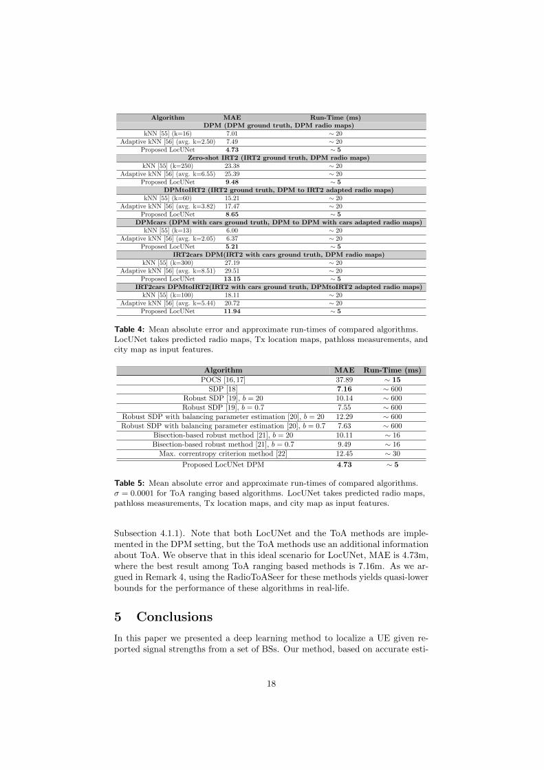
Algorithm MAE Run-Time (ms)DPM (DPM ground truth, DPM radio maps)
kNN [55] (k=16) 7.01 ∼ 20Adaptive kNN [56] (avg. k=2.50) 7.49 ∼ 20
Proposed LocUNet 4.73 ∼ 5Zero-shot IRT2 (IRT2 ground truth, DPM radio maps)
kNN [55] (k=250) 23.38 ∼ 20Adaptive kNN [56] (avg. k=6.55) 25.39 ∼ 20
Proposed LocUNet 9.48 ∼ 5DPMtoIRT2 (IRT2 ground truth, DPM to IRT2 adapted radio maps)
kNN [55] (k=60) 15.21 ∼ 20Adaptive kNN [56] (avg. k=3.82) 17.47 ∼ 20
Proposed LocUNet 8.65 ∼ 5DPMcars (DPM with cars ground truth, DPM to DPM with cars adapted radio maps)
kNN [55] (k=13) 6.00 ∼ 20Adaptive kNN [56] (avg. k=2.05) 6.37 ∼ 20
Proposed LocUNet 5.21 ∼ 5IRT2cars DPM(IRT2 with cars ground truth, DPM radio maps)
kNN [55] (k=300) 27.19 ∼ 20Adaptive kNN [56] (avg. k=8.51) 29.51 ∼ 20
Proposed LocUNet 13.15 ∼ 5IRT2cars DPMtoIRT2(IRT2 with cars ground truth, DPMtoIRT2 adapted radio maps)
kNN [55] (k=100) 18.11 ∼ 20Adaptive kNN [56] (avg. k=5.44) 20.72 ∼ 20
Proposed LocUNet 11.94 ∼ 5
Table 4: Mean absolute error and approximate run-times of compared algorithms.LocUNet takes predicted radio maps, Tx location maps, pathloss measurements, andcity map as input features.
Algorithm MAE Run-Time (ms)
POCS [16,17] 37.89 ∼ 15SDP [18] 7.16 ∼ 600
Robust SDP [19], b = 20 10.14 ∼ 600Robust SDP [19], b = 0.7 7.55 ∼ 600
Robust SDP with balancing parameter estimation [20], b = 20 12.29 ∼ 600Robust SDP with balancing parameter estimation [20], b = 0.7 7.63 ∼ 600
Bisection-based robust method [21], b = 20 10.11 ∼ 16Bisection-based robust method [21], b = 0.7 9.49 ∼ 16
Max. correntropy criterion method [22] 12.45 ∼ 30
Proposed LocUNet DPM 4.73 ∼ 5
Table 5: Mean absolute error and approximate run-times of compared algorithms.σ = 0.0001 for ToA ranging based algorithms. LocUNet takes predicted radio maps,pathloss measurements, Tx location maps, and city map as input features.
Subsection 4.1.1). Note that both LocUNet and the ToA methods are imple-mented in the DPM setting, but the ToA methods use an additional informationabout ToA. We observe that in this ideal scenario for LocUNet, MAE is 4.73m,where the best result among ToA ranging based methods is 7.16m. As we ar-gued in Remark 4, using the RadioToASeer for these methods yields quasi-lowerbounds for the performance of these algorithms in real-life.
5 Conclusions
In this paper we presented a deep learning method to localize a UE given re-ported signal strengths from a set of BSs. Our method, based on accurate esti-
18

mates of the radio maps of each BS, is tailored to work in realistic propagationenvironments in urban settings. The proposed approach does not necessitate ex-pensive hardware neither at UEs nor at BSs, and does not require an extensivemeasurement campaign, and thus can be easily integrated in the localizationmethods that are already in use. Our method outperforms the state-of-the-artlocalization algorithms in realistic urban scenarios and enjoys high robustnessto inaccuracies in the radio map estimates.
6 Acknowledgment
The work presented in this paper was partially funded by the DFG Grant DFGSPP 1798 “Compressed Sensing in Information Processing” through ProjectMassive MIMO-II, and by the German Ministry for Education and Researchas BIFOLD - Berlin Institute for the Foundations of Learning and Data (ref.01IS18037A).
References
[1] J. Warrior, E. McHenry, and K. McGee, “They know where you are [locationdetection],” IEEE Spectrum, vol. 40, no. 7, pp. 20–25, 2003.
[2] G. Bresson, Z. Alsayed, L. Yu, and S. Glaser, “Simultaneous localization andmapping: A survey of current trends in autonomous driving,” IEEE Transactionson Intelligent Vehicles, vol. 2, no. 3, pp. 194–220, 2017.
[3] S. Severi, H. Wymeersch, J. Harri, M. Ulmschneider, B. Denis, and M. Bartels,“Beyond GNSS: Highly accurate localization for cooperative-intelligent transportsystems,” in 2018 IEEE Wireless Communications and Networking Conference(WCNC), 2018, pp. 1–6.
[4] E. Pournaras, “Proof of witness presence: Blockchain consensus for augmenteddemocracy in smart cities,” Journal of Parallel and Distributed Computing, vol.145, pp. 160–175, 2020.
[5] R. Di Taranto, S. Muppirisetty, R. Raulefs, D. Slock, T. Svensson, andH. Wymeersch, “Location-aware communications for 5G networks: How loca-tion information can improve scalability, latency, and robustness of 5G,” IEEESignal Processing Magazine, vol. 31, no. 6, pp. 102–112, 2014.
[6] A. H. Sayed, A. Tarighat, and N. Khajehnouri, “Network-based wireless location:Challenges faced in developing techniques for accurate wireless location informa-tion,” IEEE Signal Processing Magazine, vol. 22, no. 4, pp. 24–40, 2005.
[7] A. Amini, R. M. Vaghefi, J. M. de la Garza, and R. M. Buehrer, “Improving GPS-based vehicle positioning for intelligent transportation systems,” in 2014 IEEEIntelligent Vehicles Symposium Proceedings, 2014, pp. 1023–1029.
[8] I. Guvenc and C. Chong, “A survey on TOA based wireless localization and NLOSmitigation techniques,” IEEE Communications Surveys Tutorials, vol. 11, no. 3,pp. 107–124, 2009.
[9] R. M. Vaghefi and R. M. Buehrer, “Cooperative sensor localization with NLOSmitigation using semidefinite programming,” in 2012 9th Workshop on Position-ing, Navigation and Communication, 2012, pp. 13–18.
[10] H. Liu, H. Darabi, P. Banerjee, and J. Liu, “Survey of wireless indoor positioningtechniques and systems,” IEEE Transactions on Systems, Man, and Cybernetics,Part C (Applications and Reviews), vol. 37, no. 6, pp. 1067–1080, 2007.
19

[11] R. M. Vaghefi, M. R. Gholami, and E. G. Strom, “Bearing-only target localiza-tion with uncertainties in observer position,” in 2010 IEEE 21st InternationalSymposium on Personal, Indoor and Mobile Radio Communications Workshops,2010, pp. 238–242.
[12] R. M. Vaghefi and R. M. Buehrer, “Received signal strength-based sensor localiza-tion in spatially correlated shadowing,” in 2013 IEEE International Conferenceon Acoustics, Speech and Signal Processing, 2013, pp. 4076–4080.
[13] H. Laitinen, J. Lahteenmaki, and T. Nordstrom, “Database correlation methodfor GSM location,” in IEEE VTS 53rd Vehicular Technology Conference, Spring2001. Proceedings (Cat. No.01CH37202), vol. 4, 2001, pp. 2504–2508 vol.4.
[14] G. Giorgetti, S. Gupta, and G. Manes, “Localization using signal strength: Torange or not to range?” in Proceedings of the First ACM International Workshopon Mobile Entity Localization and Tracking in GPS-Less Environments, ser.MELT ’08. New York, NY, USA: Association for Computing Machinery, 2008,p. 91–96. [Online]. Available: https://doi.org/10.1145/1410012.1410033
[15] S. Marano, W. M. Gifford, H. Wymeersch, and M. Z. Win, “NLOS identificationand mitigation for localization based on UWB experimental data,” IEEE Journalon Selected Areas in Communications, vol. 28, no. 7, pp. 1026–1035, 2010.
[16] M. R. Gholami, H. Wymeersch, E. G. Strom, and M. Rydstrom, “Wireless net-work positioning as a convex feasibility problem,” EURASIP Journal on WirelessCommunications and Networking, vol. 2011, no. 1, p. 161, 2011.
[17] A. O. Hero and D. Blatt, “Sensor network source localization via projection ontoconvex sets (POCS),” in Proceedings. (ICASSP ’05). IEEE International Confer-ence on Acoustics, Speech, and Signal Processing, 2005., vol. 3, 2005, pp. iii/689–iii/692 Vol. 3.
[18] R. M. Vaghefi, J. Schloemann, and R. M. Buehrer, “NLOS mitigation in TOA-based localization using semidefinite programming,” in 2013 10th Workshop onPositioning, Navigation and Communication (WPNC), Dresden, Germany, 2013,pp. 1–6.
[19] G. Wang, H. Chen, Y. Li, and N. Ansari, “NLOS error mitigation for TOA-basedlocalization via convex relaxation,” IEEE Transactions on Wireless Communica-tions, vol. 13, no. 8, pp. 4119–4131, 2014.
[20] H. Chen, G. Wang, and N. Ansari, “Improved robust TOA-based localizationvia NLOS balancing parameter estimation,” IEEE Transactions on VehicularTechnology, vol. 68, no. 6, pp. 6177–6181, 2019.
[21] S. Tomic, M. Beko, R. Dinis, and P. Montezuma, “A robust bisection-based es-timator for TOA-based target localization in NLOS environments,” IEEE Com-munications Letters, vol. 21, no. 11, pp. 2488–2491, 2017.
[22] W. Xiong, C. Schindelhauer, H. Cheung So, and Z. Wang, “Maximum correntropycriterion for robust TOA-based localization in NLOS environments,” arXiv e-prints, p. arXiv:2009.06032, Sep. 2020.
[23] Q. D. Vo and P. De, “A survey of fingerprint-based outdoor localization,” IEEECommunications Surveys Tutorials, vol. 18, no. 1, pp. 491–506, 2016.
[24] E. Laitinen, J. Talvitie, E.-S. Lohan, and M. Renfors, “Comparison of positioningaccuracy of grid and path loss-based mobile positioning methods using receivedsignal strengths,” in Proc. Signal Process. and Appl. Math. for Electron. andCommun. (SPAMEC), Cluj-Napoca, Romania, 2011.
[25] W. Y. Al-Rashdan and A. Tahat, “A comparative performance evaluation ofmachine learning algorithms for fingerprinting based localization in DM-MIMOwireless systems relying on big data techniques,” IEEE Access, vol. 8, pp. 109 522–109 534, 2020.
20
[26] H. Zou, M. Jin, H. Jiang, L. Xie, and C. J. Spanos, “WinIPS: WiFi-based non-intrusive indoor positioning system with online radio map construction and adap-tation,” IEEE Transactions on Wireless Communications, vol. 16, no. 12, pp.8118–8130, 2017.
[27] B. Huang, Z. Xu, B. Jia, and G. Mao, “An online radio map update scheme forWiFi fingerprint-based localization,” IEEE Internet of Things Journal, vol. 6,no. 4, pp. 6909–6918, 2019.
[28] K. Rizk, J. F. Wagen, and F. Gardiol, “Two-dimensional ray-tracing modelingfor propagation prediction in microcellular environments,” IEEE Trans. Vehic.Tech., vol. 46, no. 2, pp. 508–518, May 1997.
[29] Z. Yun and M. F. Iskander, “Ray tracing for radio propagation modeling: Prin-ciples and applications,” IEEE Access, vol. 3, pp. 1089–1100, 2015.
[30] R. Hoppe, G. Wolfle, and U. Jakobus, “Wave propagation and radio networkplanning software WinProp added to the electromagnetic solver package FEKO,”in Proc. Int. Appl. Computational Electromagnetics Society Symp. - Italy (ACES),Florence, Italy, March 2017, pp. 1–2.
[31] A. Del Corte-Valiente, J. M. Gomez-Pulido, O. Gutierrez-Blanco, and J. L.Castillo-Sequera, “Localization approach based on ray-tracing simulations andfingerprinting techniques for indoor–outdoor scenarios,” Energies, vol. 12, no. 15,2019. [Online]. Available: https://www.mdpi.com/1996-1073/12/15/2943
[32] M. Raspopoulos, C. Laoudias, L. Kanaris, A. Kokkinis, C. G. Panayiotou, andS. Stavrou, “3D ray tracing for device-independent fingerprint-based positioningin WLANs,” in 2012 9th Workshop on Positioning, Navigation and Communica-tion, 2012, pp. 109–113.
[33] P. S. Maher and R. A. Malaney, “A novel fingerprint location method using ray-tracing,” in GLOBECOM 2009 - 2009 IEEE Global Telecommunications Confer-ence, 2009, pp. 1–5.
[34] K. El-Kafrawy, M. Youssef, A. El-Keyi, and A. Naguib, “Propagation modelingfor accurate indoor WLAN RSS-based localization,” in 2010 IEEE 72nd VehicularTechnology Conference - Fall, 2010, pp. 1–5.
[35] F. Firdaus, N. A. Ahmad, and S. Sahibuddin, “Accurate indoor-positioning modelbased on people effect and ray-tracing propagation,” Sensors, vol. 19, no. 24, 2019.
[36] M. M. Butt, A. Rao, and D. Yoon, “RF fingerprinting and deep learning assistedUE positioning in 5G,” arXiv preprint arXiv:2001.00977, 2020.
[37] G. Wolfle, R. Hoppe, D. Zimmermann, and F. M. Landstorfer, “Enhanced local-ization technique within urban and indoor environments based on accurate andfast propagation models,” in European Wireless, Firence, Italy, February 2002,pp. 3799–3803.
[38] M. N. de Sousa, R. L. Cardoso, H. S. Melo, J. W. C. Parente, and R. S. Thoma,“Machine learning and multipath fingerprints for emitter localization in urbanscenario,” in Developments and Advances in Defense and Security, A. Rocha andR. P. Pereira, Eds. Singapore: Springer Singapore, 2020, pp. 217–230.
[39] R. Levie, C. Yapar, G. Kutyniok, and G. Caire, “RadioUNet: Fast radio mapestimation with convolutional neural networks,” IEEE Transactions on WirelessCommunications, vol. 20, no. 6, pp. 4001–4015, 2021.
[40] D. Li, Y. Lei, H. Zhang, and X. Li, “Outdoor positioning based on deep learningand wireless network fingerprint technology,” International Journal of RF andMicrowave Computer-Aided Engineering, vol. 30, no. 12, p. e22444, 2020.
21

[41] K. Elawaad, M. Ezzeldin, and M. Torki, “DeepCReg: Improving cellular-basedoutdoor localization using CNN-based regressors,” in 2020 IEEE Wireless Com-munications and Networking Conference (WCNC), 2020, pp. 1–6.
[42] P. Garau Burguera, “Logical radio maps for user localization in a realoutdoor radio environment,” Master’s thesis, Aalto University. School ofElectrical Engineering, 2020. [Online]. Available: http://urn.fi/URN:NBN:fi:aalto-2020122056430
[43] D. Burghal, A. T. Ravi, V. Rao, A. A. Alghafis, and A. F. Molisch, “A Compre-hensive Survey of Machine Learning Based Localization with Wireless Signals,”arXiv e-prints, p. arXiv:2012.11171, Dec. 2020.
[44] J. F. Li, Y.-X. Ye, A.-N. Lu, M.-Y. You, K. Huang, and B. Jiang, “Wirelesslocalization based on deep learning: State of art and challenges,” MathematicalProblems in Engineering, vol. 2020, p. 5214920, 2020.
[45] A. Zaidi, F. Athley, J. Medbo, U. Gustavsson, G. Durisi, and X. Chen, 5G Physi-cal Layer: principles, models and technology components. Academic Press, 2018.
[46] “RadioMapSeer Dataset,” https://RadioMapSeer.github.io/, 2020, [Online].
[47] R. Hoppe, G. Wolfle, and F. Landstorfer, “Fast 3-D ray tracing for the planning ofmicrocells by intelligent preprocessing of the data base,” in 3rd European Personaland Mobile Communications Conference (EPMCC), 1999.
[48] G. Durgin, N. Patwari, and T. S. Rappaport, “An advanced 3D ray launchingmethod for wireless propagation prediction,” in 1997 IEEE 47th Vehicular Tech-nology Conference. Technology in Motion, vol. 2, 1997, pp. 785–789 vol.2.
[49] R. Wahl, G. Wolfle, P. Wertz, P. Wildbolz, and F. Landstorfer, “Dominant pathprediction model for urban scenarios,” in 14th IST Mobile and Wireless Commu-nications Summit, 2005.
[50] O. Ronneberger, O. Fischer, and T. Brox, “U-Net: Convolutional networks forbiomedical image segmentation,” in Medical Image Computing and Computer-Assisted Intervention – MICCAI 2015, N. Navab, J. Hornegger, W. M. Wells,and A. F. Frangi, Eds. Cham: Springer International Publishing, 2015, pp.234–241.
[51] R. Levie, C. Yapar, G. Kutyniok, and G. Caire, “Pathloss prediction using deeplearning with applications to cellular optimization and efficient D2D link schedul-ing,” in ICASSP 2020 - 2020 IEEE International Conference on Acoustics, Speechand Signal Processing (ICASSP), 2020, pp. 8678–8682.
[52] W. G. Figel, N. H. Shepherd, and W. F. Trammell, “Vehicle location by a signalattenuation method,” IEEE Transactions on Vehicular Technology, vol. 18, no. 3,pp. 105–109, 1969.
[53] B. Brousseau, J. Rose, and M. Eizenman, “Hybrid eye-tracking on a smartphonewith CNN feature extraction and an infrared 3D model,” Sensors, vol. 20, no. 2,2020. [Online]. Available: https://www.mdpi.com/1424-8220/20/2/543
[54] D. P. Kingma and J. Ba, “Adam: A method for stochastic optimization,” in Proc.Int. Conf. Learn. Represent. (ICLR), San Diego, CA, USA, May 2015.
[55] P. Bahl and V. N. Padmanabhan, “Radar: An in-building RF-based user loca-tion and tracking system,” in Proceedings IEEE INFOCOM 2000. Conferenceon Computer Communications. Nineteenth Annual Joint Conference of the IEEEComputer and Communications Societies (Cat. No.00CH37064), vol. 2, 2000, pp.775–784 vol.2.
[56] J. Oh and J. Kim, “Adaptive k-nearest neighbour algorithm for WiFifingerprint positioning,” ICT Express, vol. 4, no. 2, pp. 91 – 94, 2018,sI on Artificial Intelligence and Machine Learning. [Online]. Available:http://www.sciencedirect.com/science/article/pii/S240595951830050X
22

[57] G. Durgin, T. S. Rappaport, and Hao Xu, “Measurements and models for radiopath loss and penetration loss in and around homes and trees at 5.85 GHz,” IEEETransactions on Communications, vol. 46, no. 11, pp. 1484–1496, 1998.
23


![Indoor localization and navigation for blind persons using ... · Drishti [1] is an in- and outdoor navigation system. Outdoor it uses DGPS localization to keep the user as close](https://static.fdocuments.us/doc/165x107/5fe1ce25ab027730e458db70/indoor-localization-and-navigation-for-blind-persons-using-drishti-1-is-an.jpg)