
RE: Application under the Canadian Environmental ... · Mine Permit Application was submitted on...
78
Page 1 December 7, 2012 Sean Carriere, Project Manager Canadian Environmental Assessment Agency #425 10115 – 100 A Street Edmonton, Alberta T5J 2W2 Dear Mr. Carriere: RE: Application under the Canadian Environmental Assessment Act (“CEAA”) for the Coal Valley Resources Inc. Robb Trend Project CVRI has obtained a Project Agreement with the Government of Canada, dated July 18, 2011, outlining the regulatory process regarding the Robb Trend Project. An Environmental Impact Assessment and Mine Permit Application was submitted on April 11, 2012 which addressed the environmental the environmental aspects of the proposed Project. In addition to the Application, CVRI has completed and attached a Screening Report to be reviewed by the Canadian Environmental Assessment Agency (CEAA). This document summarizes the application and also identifies federal involvement. In July and September 2012, Alberta Environment and Sustainable Resource Development (ESRD) along with the Energy Resource and Conservation Board (ERCB) completed their initial review of the CVRI mine permit application and each issued a set of Supplemental Information Requests (SIRs). Attached are CVRI’s completed responses to these SIRs. CVRI has completed the documents that were requested in order to continue the review of the application. All communications in respect to the application should be directed to: Mr. Les Lafleur, Project Manager Coal Valley Resources Inc. Coal Valley Mine Bag Service 5000 Edson, Alberta T7E 1W1 Telephone: (780) 865-8607 Fax: (780) 865-8630 Email: [email protected] Yours truly, COAL VALLEY RESOURCES INC. Les, LaFleur Project Manager Robb Trend Project c.c. Blaine Renkas, Sherritt Coal
Transcript of RE: Application under the Canadian Environmental ... · Mine Permit Application was submitted on...

Page 1
December 7, 2012
Sean Carriere, Project Manager Canadian Environmental Assessment Agency #425 10115 – 100 A Street Edmonton, Alberta T5J 2W2
Dear Mr. Carriere:
RE: Application under the Canadian Environmental Assessment Act (“CEAA”) for the Coal Valley Resources Inc. Robb Trend Project
CVRI has obtained a Project Agreement with the Government of Canada, dated July 18, 2011, outlining the regulatory process regarding the Robb Trend Project. An Environmental Impact Assessment and Mine Permit Application was submitted on April 11, 2012 which addressed the environmental the environmental aspects of the proposed Project.
In addition to the Application, CVRI has completed and attached a Screening Report to be reviewed by the Canadian Environmental Assessment Agency (CEAA). This document summarizes the application and also identifies federal involvement.
In July and September 2012, Alberta Environment and Sustainable Resource Development (ESRD) along with the Energy Resource and Conservation Board (ERCB) completed their initial review of the CVRI mine permit application and each issued a set of Supplemental Information Requests (SIRs). Attached are CVRI’s completed responses to these SIRs.
CVRI has completed the documents that were requested in order to continue the review of the application.
All communications in respect to the application should be directed to:
Mr. Les Lafleur, Project Manager Coal Valley Resources Inc. Coal Valley Mine Bag Service 5000 Edson, Alberta T7E 1W1 Telephone: (780) 865-8607 Fax: (780) 865-8630 Email: [email protected]
Yours truly,
COAL VALLEY RESOURCES INC.
Les, LaFleur Project Manager Robb Trend Project
c.c. Blaine Renkas, Sherritt Coal

Coal Valley Resources Inc. - Coal Valley Mine
Robb Trend ProjectEnvironmental Screening Report
Submitted toCanadian Environmental Assessment Agency,
Alberta Environment and Sustainable Resource Development andthe Energy Resources and Conservation Board
Prepared by: Millennium EMS Solutions Ltd.December 2012CEAR #: 61436

Robb Trend Project Environmental Screening Report
TABLE OF CONTENTS
Page
1. INTRODUCTION ................................................................................................................. 1
1.1 Federal EA Contact Information.................................................................................. 1
2. PROJECT DESCRIPTION.................................................................................................. 2
2.1 Project Schedule ............................................................................................................. 3
3. SUMMARY OF THE ENVIRONMENTAL ASSESSMENT........................................... 6
3.1 Environmental Assessment Methods............................................................................ 6
4. SUMMARY OF ENVIRONMENTAL EFFECTS ASSESSMENT ................................. 8
4.1 Atmospheric Environment ............................................................................................ 8
4.1.1 Air Quality ................................................................................................................ 8
4.1.2 Noise ......................................................................................................................... 9
4.2 Groundwater Resources ................................................................................................ 9
4.3 Surface Water Resources............................................................................................. 10
4.3.1 Surface Water Quality............................................................................................. 10
4.3.2 Hydrology (Water Management)............................................................................ 13
4.4 Aquatic Environment................................................................................................... 14
4.5 Terrestrial Environment.............................................................................................. 16
4.5.1 Soils and Terrain ..................................................................................................... 16
4.5.2 Vegetation, Rare Plants and Wetlands.................................................................... 17
4.5.3 Mammalian Carnivores........................................................................................... 18
4.5.4 Wildlife (Ungulates) ............................................................................................... 18
4.6 Archaeological and Heritage Resources..................................................................... 20
4.6.1 Historical Resources ............................................................................................... 20
4.6.2 Traditional Land Use .............................................................................................. 21
4.7 Current Land and Resource Use ................................................................................ 23
4.8 Health and Socio-Economic ........................................................................................ 24
4.8.1 Human Health ......................................................................................................... 24
4.8.2 Socio-Economic...................................................................................................... 25
4.9 Effects of the Environment on the Project................................................................. 26
5. CUMULATIVE ENVIRONMENTAL EFFECTS ASSESSMENT ............................... 26
6. PUBLIC ENGAGEMENT.................................................................................................. 27
6.1 Need for Public Engagement....................................................................................... 27
6.2 Objectives and Scope ................................................................................................... 27
6.3 Results of Public Engagement..................................................................................... 28
6.4 Continuing Consultation ............................................................................................. 29
7. CONCLUSION.................................................................................................................... 30

Robb Trend Project Environmental Screening Report
December 2012 Page ii
List of Tables
Page
Table 2-1 Start Up Schedule ..................................................................................................... 4
Table 2-2 Development Schedule ............................................................................................. 5
List of Figures
Figure 2-1 Development Area
List of Appendices
Appendix 1 Effects Summary Tables
Appendix 2 Mitigation Summary Tables
Appendix 3 Monitoring Summary

Robb Trend Project Environmental Screening Report
December 2012 Page 1
1. INTRODUCTION
Pursuant to the Canadian Environmental Assessment Act (the Act), the Department of Fisheries
and Oceans Canada (DFO), Natural Resources Canada (NRCan), and Transport Canada (TC) are
the Responsible Authorities (RA) for the Coal Valley Resources Inc. (CVRI) Coal Valley Mine
(CVM) Robb Trend Project (the Project) as they may issue permits or licences, approvals or take
other action to allow the Project to commence. DFO may take action in relation to subsection
35(2) of the Fisheries Act; NRCan may take action in relation to paragraph 7(1)(a) of the
Explosives Act, and TC may take action in relation to Section 5 of the Navigable Waters
Protection Act. Due to this potential involvement, DFO, NRCan, and TC are required to ensure
that an Environmental Assessment (EA) is conducted in compliance with the Act. The Project is
subject to a screening-level EA.
This screening report provides a summary based on the “CVRI CVM Robb Trend Project
Environmental Impact Assessment” (EIA) application. This application is to be considered as
part of the information available for review during the screening report assessment. Although
this application was submitted to the Energy Resources -Conservation Board (ERCB) and
Alberta Environment and Sustainable Resource Development (ESRD) it is our position that in
the spirit of the harmonized review of resource development projects, this information can also
be referenced in the screening report.
Key documents for the EA include:
Notice of Commencement of an Environmental Assessment; Coal Mine, Embarras, Erith
and Pembina Rivers, Robb, AB (April 18, 2011; updated June 19, 2012) (see the
Agency et al. 2011).
Final Terms of Reference Environmental Impact Assessment Report for Coal Valley
Resources Inc. Proposed Robb Trend Project (ESRD 2011).
Coal Valley Mine Robb Trend Project Environmental Impact Assessment and Mine
Permit Application (CVRI 2012).
Responses to Supplemental Information Requests (SIRs) from ESRD and responsible and
federal authorities.
1.1 Federal EA Contact Information
The Federal Environmental Assessment Coordinator for this Project is the Canadian
Environmental Assessment Agency (the Agency). For information related to the EA for this
Project please contact:
Robb Trend Project Environmental Screening Report
December 2012 Page 2
Name/Title: Susan Tiege, Team LeadAddress: #425 10115-100a Street, Edmonton, ABPhone: (780) 495-2450Fax: (780) 495-2876Email: [email protected]
2. PROJECT DESCRIPTION
Project Information
Project TitleCoal Valley Resources Inc. Coal Valley MineRobb Trend Project
Description of Work/Activity Open pit coal mine extension
Project LocationApproximately 100km south of Edson in theCoal Branch area of Alberta near the town ofRobb.
Proponent and Contact Information
Coal Valley Resources Inc.Les LaFleurProject ManagerCoal Valley Mine, Bag Service 5000Edson, Alberta T7E 1W1Phone: (780) 865-8607Fax: (780) 865-8630E-Mail: [email protected]
Provincial Application Date April 11, 2012
CEAA Registration Date April 18, 2011
CEAA TriggersSection 5(1)(d) of the Act as CVRI will requireto obtain permits or authorizations from RAs.
Assessment Coordinator Susan Tiege, Team Lead
CEAA Determination Date TBD
CVRI is proposing to continue operations of the CVM by developing coal resources in the Robb
Trend Area (Figure 2-1). The Project is not a new mining development but is rather an extension
to the existing mining and coal processing activities at the CVM. The existing infrastructure and
resources currently in place for the operation of the CVM will be extended to the Project. The
considerable operations and reclamation expertise of CVRI from the existing mining areas will
be important to the success of the Project.
The Project is adjacent to existing mining operations and was initially disclosed to the public in
2006. CVRI’s reserve estimate for the Project area indicates that it would release approximately
177.5 million tonnes of coal for processing yielding approximately 88.75 million clean metric

Robb Trend Project Environmental Screening Report
December 2012 Page 3
tonnes (CMT) available for sale. This additional tonnage would provide CVRI with the
necessary resources to operate at projected rates of production until 2038.
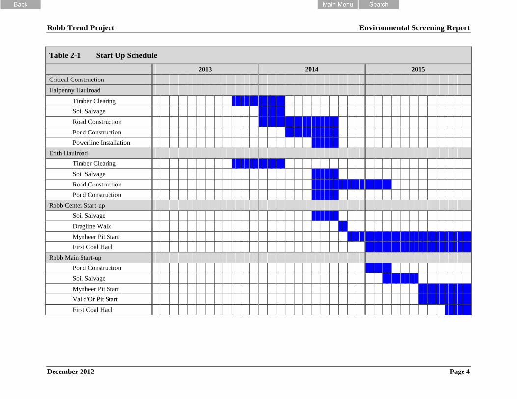
2.1 Project Schedule
The CVM requires access to the resources encompassed within the Project in a timely manner.
In order to plan for this, CVM is planning that all required regulatory, municipal and internal
approvals are received by Q3 of 2013. With this date the schedule for the critical construction
and start-up of operations of the Project is expected to be as outlined below in Table 2-1.
Table 2-2 provides an illustration of the current mine progress plan. Full production is expected
to be reached by 2018 with all mine equipment relocated into the Project area. Available coal
resources within the existing CVM operations will have reached the end of their economic limits
and will essentially be completed by this time. Full production is expected to continue until
2034 when annual production rates will slowly decline as the remaining reserve area is
completed. The life of the CVM, based on the remaining reserves within the Project area and
currently licenced mining areas, is 2038, an operating life of 25 years.
Robb Trend Project Environmental Screening Report
December 2012 Page 4
Table 2-1 Start Up Schedule
2013 2014 2015
Critical Construction
Halpenny Haulroad
Timber Clearing
Soil Salvage
Road Construction
Pond Construction
Powerline Installation
Erith Haulroad
Timber Clearing
Soil Salvage
Road Construction
Pond Construction
Robb Center Start-up
Soil Salvage
Dragline Walk
Mynheer Pit Start
First Coal Haul
Robb Main Start-up
Pond Construction
Soil Salvage
Mynheer Pit Start
Val d'Or Pit Start
First Coal Haul

Robb Trend Project Environmental Screening Report
December 2012 Page 5
Table 2-2 Development Schedule
Year ‘14 ‘15 ‘16 ‘17 ‘18 ‘19 ‘20 ‘21 ‘22 ‘23 ‘24 ‘25 ‘26 ‘27 ‘28 ‘29 ‘30 ‘31 ‘32 ‘33 ‘34 ‘35 ‘36 ‘37 ‘38
Corridor Construction
Halpenny Corridor
Erith Corridor
Bryan Corridor
Mine Development
Robb East
Robb Center
Robb Main
Robb West
Coal Haul
Halpenny Corridor
Erith Corridor
Bryan Corridor
Robb Trend Project Environmental Screening Report
December 2012 Page 6
3. SUMMARY OF THE ENVIRONMENTAL ASSESSMENT
For the purpose of the federal EA, the scope of the Project was determined to include the
following elements and activities:
the construction of mine related infrastructure such as haul roads, water management
systems (ponds, ditches, sumps), access roads, pits and dumps;
the operation of an open pit coal mine and associated infrastructure (as listed above)
under normal operation as well as accidents or malfunctions that might occur during the
operation; and
the reclamation and decommissioning of the coal mine and related infrastructure at the
end of the mine life to the extent that is currently known and as approved by the
provincial regulatory authority.
The scope of the federal environmental assessment is outlined in the Notice of Commencement
of an Environmental Assessment; Coal Mine, Embarras, Erith and Pembina Rivers, Robb AB
(April 18, 2011), and Final Terms of Reference Environmental Impact Assessment Report for
Coal Valley Resources Inc. Proposed Robb Trend Project (ESRD 2011). The scope of the EA
included mandatory factors under Section 16(1)(a) to (e) and 16(2) of the Act.
As stated in the Notice of Commencement of an Environmental Assessment; Coal Mine,
Embarras, Erith and Pembina Rivers, Robb AB (April 18, 2011), “The scope of the project
includes all physical activities associated with the expansion of the existing mine and coal
mining activities including watercourse crossings and realignments, access, storage areas and
other undertaking directly associated with the works.”
3.1 Environmental Assessment Methods
The EA methods are described in detail in the Coal Valley Mine Robb Trend Project
Environmental Impact Assessment and Mine Permit Application (CVRI 2012).
The EA focused on Valued Environmental Components (VECs) that could potentially be
affected by the Project and that were identified through field studies, literature review, past
experiences, Project plans or identified by discipline experts involved in the EA. The following
disciplines and related VEC’s were considered in the EA:
Atmospheric Environment:
Air quality; and
Noise;
Groundwater resources;

Robb Trend Project Environmental Screening Report
December 2012 Page 7
Surface water resources:
surface water quality; and
hydrology (water management);
Aquatic environment:
fisheries resources; and
habitat within the aquatic environment;
Terrestrial environment:
Soils and terrain;
Vegetation, rare plants and wetlands; and
Wildlife;
Archaeological and heritage resources:
Historical Resources; and
Traditional Land Use;
Conservation of reclamation materials and reclamation of areas disturbed by mining and
mining related activities;
Current land and resource use;
Public health and safety;
Socio-Economic; and
Public and First Nations engagement.
Potential cumulative environmental effects that could occur due to other regional projects,
accidents, malfunctions and unplanned events (i.e., extreme weather events) were also
considered in the EA.
Potential environmental effects were identified in relation to the particular VEC’s. Significance
of the potential environmental effect was listed and mitigation measures that are to be employed
were described. With the proper implementation of the mitigation measures no significant
adverse environmental impacts remain throughout the life of the Project.
Robb Trend Project Environmental Screening Report
December 2012 Page 8
4. SUMMARY OF ENVIRONMENTAL EFFECTS
ASSESSMENT
A complete and detailed description of the environmental effects assessment is available in the
Coal Valley Mine Robb Trend Project Environmental Impact Assessment and Mine Permit
Application (CVRI 2012). The following sections provide a summary of what is captured in the
application.
4.1 Atmospheric Environment
4.1.1 Air Quality
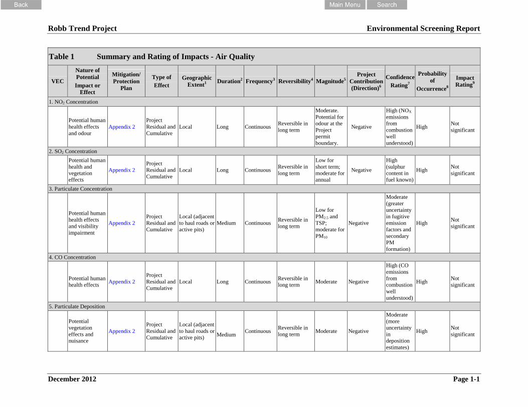
The potential effects of the Project on air quality are discussed in the following. A detailed
summary of the components of the air quality assessment is provided in Appendix 1, Table 1 of
this report.
A number of potential VECs were identified during the issue scoping process as they relate to
potential human or ecosystem health effects. The air quality VECs include:
sulphur dioxide (SO2), nitrogen dioxide (NO2), carbon monoxide (CO), particulate matter
(PM2.5; PM10; TSP), volatile organic compounds (VOCs) and polycyclic aromatic
hydrocarbons (PAHs), ozone (O3), and metal concentrations;
particulate and nitrogen deposition; and
GHG Emissions.
Modelling was done using the CALMET/CALPUFF model, and was conducted according to
ESRD (2009). Predictions were made for the maximum point of impingement (MPOI)
determined using a grid of receptors as well as at 18 specific receptors. These predictions were
compared to the Alberta Ambient Air Quality Objectives (AAAQO), Alberta Ambient Air
Quality Guideline (AAAQG, for hourly PM2.5 only), and the Canada Wide Standards (CWS) for
regulated compounds.
Mitigation strategies proposed by CVRI in order to reduce potential impacts of the Project on air
quality are discussed in Appendix 2. CVRI is proposing to continue their current program of air
quality mitigation.
Monitoring is an important component of the effects assessment and supports the continuous
improvement of the environmental management program at the CVM. Monitoring specific to air
quality effects are discussed in Appendix 3.
Robb Trend Project Environmental Screening Report
December 2012 Page 9
4.1.2 Noise
A detailed summary of the components of the noise assessment is provided in Appendix 1,
Table 2 of this report.
The purpose of the assessment was to generate a computer noise model of the Project under
Application Case conditions and compare the resultant sound levels to the Alberta Energy
Resources Conservation Board (ERCB) permissible sound level guidelines (Directive 038 on
Noise Control, 2007).
Residential receptors in the area include two trappers cabins (located approximately 8.3 km
southeast of the Plant and approximately 8 km northwest of Robb), and the community of Robb.
All other trappers’ cabins, campsites, etc. are more than 1.5 km beyond the proposed Project
mine permit boundary and have not been included in the study. This meets with the
requirements of ERCB Directive 038.
Mitigation strategies proposed by CVRI in order to reduce potential impacts of the Project on
noise are discussed in Appendix 2. CVRI is proposing to continue their current program of noise
effects mitigation.
Monitoring is an important component of the effects assessment and supports the continuous
improvement of the environmental management program at the CVM. Monitoring specific to
noise effects are discussed in Appendix 3.
4.2 Groundwater Resources
A detailed summary of the components of the hydrogeology (groundwater) assessment is
provided in Appendix 1, Table 3.
Previous environmental assessments have demonstrated that hydrogeological impacts of mining
in this area will not extend beyond the boundary of the mine permit. Therefore, the LSA is the
proposed mine permit boundary and there is no differentiation between the LSA and RSA for the
purposes of the hydrogeological assessment.
VECs were selected to assess the significance of potential impacts to groundwater within the
LSA and RSA. The VECs selected for assessment include groundwater quantity and quality and
how they relate to the water wells in the community of Robb.
The community of Robb relies on water wells to supply individual homes. Unacceptable
drawdown of water levels in water wells in Robb is likely to occur when mining operations are
active in the areas of the Lakeside and Bryan Mines. This impact will be highest for shallow
wells located close to these mines and much less for wells which are deeper and/or located

Robb Trend Project Environmental Screening Report
December 2012 Page 10
farther away from the underground mines. In all cases, deepening of existing wells represents a
viable mitigation. A plan of action should subsequently be developed in consultation with the
community that will include mitigation of impacts and include:
deepening or replacement of wells that are judged to be at high risk;
monitoring of observation wells to provide notice of diminishing water supply; and
procedures to provide an emergency water supply should residents experience an
interruption of their water supply.
As mining progresses beyond Robb the water diversion in the Lakeside and Bryan Mine’s will
cease and the groundwater levels will begin to rise beneath the community of Robb. With this
rise in water levels the potential for impact will decline; particularly as many of the wells in
Robb will have been previously deepened. There will be no significant impacts in the residual or
cumulative sense.
Mitigation strategies proposed by CVRI in order to reduce potential impacts of the Project on
groundwater are discussed in Appendix 2. CVRI is proposing to continue their current program
of groundwater mitigation.
Monitoring is an important component of the effects assessment and supports the continuous
improvement of the environmental management program at the CVM. Monitoring specific to
groundwater effects are discussed in Appendix 3.
4.3 Surface Water Resources
4.3.1 Surface Water Quality
A detailed summary of the components of the surface water quality assessment is provided in
Appendix 1, Table 4.
The LSA for the Project is defined by the small drainages that begin within or run through the
Project permit boundary including:
Bryan Creek, an unnamed creek draining into the Embarrass River near Robb, Hay
Creek, Mitchell Creek, Bacon Creek, Lendrum Creek, and an unnamed creek draining
into the Pembina River at the time this assessment was prepared were not downstream of
existing mines; and
Jackson Creek, Erith River, Halpenny Creek, Lund Creek, and Lendrum Creek are
downstream of existing mines.

Robb Trend Project Environmental Screening Report
December 2012 Page 11
The RSA for the Project is defined by the LSA plus the following watercourses:
Embarras River from its confluence with Jackson Creek downstream to its confluence
with the Erith River;
Erith River from its confluence with Lund Creek to its confluence with the Embarras
River; and
Pembina River beginning at its confluence with the unnamed creek draining into the
Pembina River at the southeastern end of the Project permit boundary to approximately
10 km downstream.
Surface water quality is the VEC considered in this assessment. Surface water quality issues
considered in the assessment were obtained from results of the public consultation program,
information obtained from the Traditional Environmental Knowledge (TEK) and Traditional
Land Use (TLU) study, scope of previous assessments at CVM, and a review of the Project mine
plans. Issues considered include:
soil erosion, sediments entering streams via surface runoff, increased sedimentation of
surface waters;
leaching of nitrates into surface waters;
discharges of water from impoundments to natural watercourses; and
effects on end-pit lakes on surface water quality.
During the construction phase of the Project, activities such as tree clearing; constructing access
roads, diversions, and settling ponds; area disturbances for waste and soil piles; clearing and site
disturbance; and constructing drainage controls, cleanouts/retention areas have the potential to
impact water quality. With implementation of the mitigation measures, potential impacts of the
construction phases are predicted to be not significant in the LSA and therefore are assessed as
not significant in the RSA. The Planned Development Case for both the LSA and RSA are
assessed as not significant as well.
Explosives containing ammonium nitrate will be used during the mine operations to break up the
overburden material. The residual effects (after mitigation) of the Project on surface water
quality due to increases in nitrogen caused by the use of explosives containing ammonium nitrate
are assessed as not significant in the LSA and therefore are assessed as not significant in the
RSA. The Planned Development Case for both the LSA and RSA are assessed as not significant
as well.
Water collection and impoundment structures will be used to attenuate the impacts of the mining
activities on the local watercourses, including increased sediment loads and deposition of those
sediments. The water from these impoundments will be released into local streams which will

Robb Trend Project Environmental Screening Report
December 2012 Page 12
eventually enter the Embarras and Pembina Rivers and smaller tributaries. There will be
changes in surface water quality with the Project; however, there are expected to be relatively
few instances of detectable increases in the concentration of water quality variables as a result of
impoundment discharges and even fewer instances detectable increases in concentration coupled
with concentrations being above surface water quality guidelines. Effects of the Project on
surface water quality, after mitigation, for operation of impoundments are not significant in the
LSA and RSA. The Planned Development Case for both the LSA and RSA are assessed as not
significant as well.
Twelve end-pit lakes/ponds will be constructed as part of the reclamation landscape for the
Project. The effects of these end-pit lakes on the surface water quality have been assessed. The
following conclusions may be made regarding the results of the impact analysis of water quality
in end-pit lakes:
all of the end-pit lakes proposed for the Project will likely have groundwater as their
major source of water;
some of the end-pit lakes will be meromictic, others will be holomictic, and others will
likely exhibit partial mixes;
the specific turnover pattern of any particular end-pit lake cannot be predicted, although
the likelihood that an end-pit lake will be holomictic will be greater with similar salinity
of (any) surface and groundwater inflows and shallower end-pit lake depth;
the concentration of a number of water quality variables, such as nutrients and major
ions, are predicted to be higher in the end-pit lakes than in natural lakes, but these higher
concentrations are not at levels that would affect the ecological viability of the end-pit
lakes;
there are predicted to be relatively few instances of measured water quality metals
exceeding provincial or federal water quality guidelines in the end pit lakes; and
patterns of dissolved oxygen concentration with depth and changes in these patterns are
predicted to be the major water quality variable influencing amount of suitable aquatic
habitat available for aquatic life in the end-pit lakes proposed for the Project.
Effects of the Project on surface water quality in the end-pit lakes (after mitigation) as a result of
their design, construction, and management are assessed as not significant.
Mitigation strategies proposed by CVRI in order to reduce potential impacts of the Project on
surface water quality are discussed in Appendix 2. CVRI is proposing to continue their current
program of surface water quality mitigation.

Robb Trend Project Environmental Screening Report
December 2012 Page 13
Monitoring is an important component of the effects assessment and supports the continuous
improvement of the environmental management program at the CVM. Monitoring specific to
surface water quality effects are discussed in Appendix 3.
4.3.2 Hydrology (Water Management)
A detailed summary of the components of the surface hydrology assessment is provided in
Appendix 1, Table 5.
The surface hydrology assessment presents proposed water management plans and addresses the
potential impact of the Project on the quantity of surface water flow and stream behaviour during
high, average and low flow conditions, and sediment concentrations in local and regional
streams.
The Project area is located almost entirely within the McLeod River watershed with the southern
extent of the Project extending into a tributary of the Pembina River. The RSA primarily focuses
on the McLeod River basin upstream of its confluence with the Embarras River and includes the
Pembina River basin at the confluence with this unnamed tributary. The locally affected
watersheds within the LSA of the proposed Project are as follows:
the Erith River basin and its main tributaries Bacon, Halpenny, Lendrum and Lund
creeks;
the Bryan, Hay and an unnamed creek which join the Embarras River near Robb; and
the unnamed creek basin draining north into the Pembina River.
For the hydrology assessment the VECs selected include water availability (i.e., flow) and water
quality. Elements of the Project that could have an effect on runoff and sediment include cleared
land; waste rock piles; haul roads; mine pits and dewatering; water impoundments during and
after mining; water diversions (during mining and restoration); and water withdrawals. Various
water management and sediment control measures will be implemented for the Project during
operations, reclamation, and closure in order to mitigate potential impacts to flow and water
quality.
The net impacts of various activities in a basin are highly temporal and site-specific. They
depend on the number, size, and location of activity within the watershed. The combined
existing CVM and proposed Project mine disturbance areas average 16.5% in the main
watersheds. The greatest percentage disturbance in any single basin is in the smaller Hay Creek
watershed at 48.6%. The long-term residual effect of surface water flow by watershed was
assessed and found to be not significant with the implementation of appropriate mitigation
measures.

Robb Trend Project Environmental Screening Report
December 2012 Page 14
CVRIs historical records show that total suspended sediment (TSS) levels from mine operations
are highly variable and within the range of those measured on the regional watersheds. Runoff
from Project operations can be controlled by routing to settling ponds before being released to
external watersheds. Precipitation in excess of the design storm event, or unusual short-term
sediment generation events, may occur. Design of controlled outflows for this type of event will
provide an effective level of sediment control. The Project is expected to have an not significant
effect on sediment loads compared to natural conditions.
Other activities in the local watersheds that could have a cumulative effect on stream flows and
sediment concentrations in the receiving streams are timber harvesting operations, road and rail
areas, petroleum and natural gas activities, the Robb area community, and recreational uses. In
the larger McLeod and Embarras basins, the effects of the Project and other activities on river
flows diminish to near negligible. With sediment and control measures implemented and
maintained at the mines, roads, pipelines and other projects in the basins, the cumulative effects
on sediment loading will be not significant compared to natural variations.
Mitigation strategies proposed by CVRI in order to reduce potential impacts of the Project on
surface hydrology are discussed in Appendix 2. CVRI is proposing to continue their current
program of surface hydrology mitigation.
Monitoring is an important component of the effects assessment and supports the continuous
improvement of the environmental management program at the CVM. Monitoring specific to
surface hydrology effects are discussed in Appendix 3.
4.4 Aquatic Environment
A detailed summary of the components of the fisheries assessment is provided in Appendix 1,
Table 6.
The aquatics LSA was selected based on the Project area boundaries, drainage basin
characteristics, and encompassed the spatial area where Project-specific effects associated with
mining activities may occur. This included the Embarras River watershed, including the Erith
River and several watercourses in the Erith sub-basin, as well as one tributary to the Pembina
River. The RSA encompassed the LSA and the following:
the Embarras River from its confluence with Jackson Creek downstream to its confluence
with the McLeod River;
the Erith River basin excluding tributaries in the lower part of the basin;
Lund Creek from the headwaters to the confluence with the Embarras River;
Lendrum Creek from the headwaters to the confluence with the Embarras River; and

Robb Trend Project Environmental Screening Report
December 2012 Page 15
the Pembina River from its confluence with the unnamed tributary (PET1) that drains the
southeast end of the Project mine permit area to approximately 10 km downstream.
Outside the RSA, aquatic habitat conditions and aquatic resources are expected to be the same,
with or without the Project.
During baseline field investigations fish presence was confirmed in 53 of the 84 sites sampled in
42 waterbodies in and adjacent to the Project. Fifteen different fish species were captured and
identified. Rainbow trout were the most common and widespread species within the LSA and
RSA and were found in 38 of the 42 waterbodies sampled. Bull trout, burbot, lake chub,
longnose sucker, and spoonhead sculpin were encountered much less frequently than rainbow
trout but were still found at a number of different locations. Other species, including arctic
grayling, brook stickleback, brook trout, longnose dace, mountain whitefish, northern pike, pearl
dace, trout-perch, and white sucker were uncommon and were only found in one or two
waterbodies.
None of the species captured are listed under the federal Species at Risk Act (2003).
Provincially, there is one species listed as At Risk (rainbow trout), one species listed as May be at
Risk (Spoonhead Sculpin), two species that are listed as Sensitive (artic grayling, bull trout), one
species listed as Undetermined (pearl dace), one species listed as Exotic/Alien (brook trout), and
the remaining species are listed as Secure.
The VECs selected for assessment include: arctic grayling; bull trout; rainbow trout (Athabasca);
and benthic invertebrates.
The issues identified as possibly affecting fish habitat potential, the abundance, health and
survival of fish populations (in general) and the abundance, health and survival of VECs within
the RSA and LSA were principally related to:
potential changes to physical habitat components;
potential changes to water quality (sediment and other chemical contaminants);
potential changes to flow regime; and
potential changes to the fisheries resource access.
Given that potential effects of the Project on rainbow trout, bull trout, and artic grayling can be
fully mitigated, the Project is not expected to have a negative effect on these VEC species.
Cumulative effects on fisheries VECs associated with direct habitat loss alteration, changes in
water quality, and changes in flows are not expected with mitigation measures implemented.

Robb Trend Project Environmental Screening Report
December 2012 Page 16
Mitigation strategies proposed by CVRI in order to reduce potential impacts of the Project on
fisheries are discussed in Appendix 2. CVRI is proposing to continue their current program of
fisheries mitigation.
Monitoring is an important component of the effects assessment and supports the continuous
improvement of the environmental management program at the CVM. Monitoring specific to
fisheries effects are discussed in Appendix 3.
4.5 Terrestrial Environment
4.5.1 Soils and Terrain
A detailed summary of the components of the fisheries assessment is provided in Appendix 1,
Table 7.
The RSA used for the soil assessment corresponds with the proposed mine permit boundary and
the LSA corresponds to the Project footprint.
Soils were investigated at 1350 inspection points within the RSA. An additional 328 soil
inspections are located in close proximity to the RSA. A baseline of available soil resources to a
depth of 1 m of the surface was prepared using soil landscape mapping combined with laboratory
analysis of samples collected from 59 soil profiles to characterize soil suitability for
re-vegetation.
The VEC’s were identified as a result of the soil and terrain inventory and input from the public;
from governments; and from other Project team members. VECs related to soil resources
include:
the soil resource (including topsoil) and the natural diversity of the soil landscapes;
land capability for preferred land uses plus future productivity; and
soil and surficial geologic materials have normal concentrations of trace elements.
The soil resource can be lost or degraded in several ways: disturbance of natural soil profile and
landscape; burial of soil; mixing of soil; erosion; loss of diversity; and loss of land capability.
Soils will be salvaged in a one lift operation which results in mixing of soil horizons. Prescribed
salvage depths will avoid soil layers that are detrimental to surface soil quality. Impacts due to
mixing of the soil are not significant.
Erosion of placed cover soil material can occur until the soil surface is stabilized with vegetation
cover. With the use of appropriate and available technology there is low risk for accelerated
erosion of cover soil. The net loss of soil resources through erosion is not significant.

Robb Trend Project Environmental Screening Report
December 2012 Page 17
Mitigation strategies proposed by CVRI in order to reduce potential impacts of the Project on
soil resources are discussed in Appendix 2. CVRI is proposing to continue their current program
of soils effects mitigation.
Monitoring is an important component of the effects assessment and supports the continuous
improvement of the environmental management program at the CVM. Monitoring specific to
soil resources effects are discussed in Appendix 3.
4.5.2 Vegetation, Rare Plants and Wetlands
A detailed summary of the components of the vegetation assessment is provided in Appendix 1,
Table 8.
The LSA used for the vegetation and wetlands assessment encompasses the proposed Project
mine permit boundary and the RSA extends from Hinton in the northwest past Edson to near
Sang Lake in the northeast, down almost to the Blackstone Lookout in the southwest, to near
Medicine Lake in the southeast.
The assessment of Project effects on vegetation and wetland resources was based on eight VECs.
terrestrial vegetation;
forest resources;
wetlands;
old growth forests;
non-native and noxious plant species;
traditionally used vegetation species;
fragmentation; and
biodiversity.
The LSA was mapped utilizing the Beckingham et al. (1996) ecological land classification
system which incorporates vegetation, soil, site, and productivity information. Wetland
sampling, rare plant survey, invasive species survey, and old growth inventory were incorporated
into the detailed vegetation. In total, 574 vegetation species were documented during field
surveys within the LSA. The Project Footprint is predicted to cover 5,728 ha. This represents
the removal of 56.8% of ecosite phases from the LSA. Over time, reclaimed and revegetated
sites are expected to resemble pre-disturbance ecosites. The residual Project effect is not
significant following the implementation of mitigation and monitoring measures.

Robb Trend Project Environmental Screening Report
December 2012 Page 18
Mitigation strategies proposed by CVRI in order to reduce potential impacts of the Project on
vegetation resources are discussed in Appendix 2. CVRI is proposing to continue their current
program of vegetation effects mitigation.
Monitoring is an important component of the effects assessment and supports the continuous
improvement of the environmental management program at the CVM. Monitoring specific to
vegetation resources effects are discussed in Appendix 3.
4.5.3 Mammalian Carnivores
A detailed summary of the components of the vegetation assessment is provided in Appendix 1,
Table 9.
Eighteen species of mammalian carnivore are known to be present or are assumed to exist in the
RSA. All were initially considered to be candidates as VECs. Seven of the 18 species are listed
as Species of Concern by provincial or federal governments. Listed species include grizzly bear,
bobcat, lynx, fisher, long-tailed weasel, wolverine and badger. Five mammalian carnivores
species were selected as VECs for the assessment of Project and cumulative impacts on
mammalian carnivores; grizzly bear, marten, fisher, lynx and wolf.
The assessment addressed five potential effects on wildlife habitat and populations including:
increased mortality;
habitat alteration;
sensory disturbance and effective habitat loss;
barriers to movement and
habitat fragmentation.
Mitigation strategies proposed by CVRI in order to reduce potential impacts of the Project on
carnivores are discussed in Appendix 2. CVRI is proposing to continue their current program of
carnivores effects mitigation.
Monitoring is an important component of the effects assessment and supports the continuous
improvement of the environmental management program at the CVM. Monitoring specific to
carnivores effects are discussed in Appendix 3.
4.5.4 Wildlife (Ungulates)
A detailed summary of the components of the ungulates assessment is provided in Appendix 1,
Table 10.
The VEC’s chosen for assessment of the Project effects include:

Robb Trend Project Environmental Screening Report
December 2012 Page 19
ungulates (elk, moose, and deer);
small mammals;
breeding birds and raptors; and
amphibians.
A number of field surveys were undertaken to assist with identifying wildlife resources in the
area. These included:
winter ungulate aerial survey;
pellet-group counts;
winter snow-tracking surveys;
small mammal trapping;
bat survey;
bird surveys; and
amphibian survey.
With mitigation the overall impact to wildlife resources will be not significant. This assessment
is based on the following vegetation response after reclamation:
grassland vegetation will take five years to establish after initial disturbance;
trees are typically planted 2-4 years after the initial seed mix. After 8 years (for pine) or
14 years (for spruce) trees will be 2 m high and begin to provide hiding cover for
ungulates, i.e., 10-18 years after initial seeding. It is assumed that shrubs will be
established at the same time as trees;
most areas planted to trees will have crown closure by 25 years after initial seeding,
average tree height will be >5 m, understorey vegetation will change to respond to altered
light regime and native species adapted to understorey conditions will begin to ingress
and dominate;
wetlands will re-establish; and
forest stands will begin to resemble ecosites with an understorey of hairy wild rye and
labrador tea / feather moss at 50 years. More open areas including less densely planted
forests and areas left as meadows will have higher cover and diversity of plant species
and native graminoids will increasingly dominate open areas.
Given that appropriate habitats are established and movement opportunities are designed into the
Project disturbance, wildlife are expected to adjust to the initial displacement and disturbance by
colonizing newly available habitat and incorporating it into their daily and seasonal activities.
Species composition on the reclaimed LSA will be similar, but changed, in response to the

Robb Trend Project Environmental Screening Report
December 2012 Page 20
addition of lakes, ponds and other habitat features into the final landscape. Species composition
of the wildlife communities will change over time in response to vegetation development and
maturation.
The residual impact ratings assume:
human recreation and access is managed to provide security for wildlife especially in the
vicinity of the Lovett Ridge;
diverse habitat types are established;
structural complexity is established in reclaimed forest types;
deciduous shrubs are incorporated into the reclaimed landscape; and
industrial development in the region is coordinated and promotes best management
practices that ensure long term viable wildlife populations.
Mitigation strategies proposed by CVRI in order to reduce potential impacts of the Project on
ungulates are discussed in Appendix 2. CVRI is proposing to continue their current program of
ungulates effects mitigation.
Monitoring is an important component of the effects assessment and supports the continuous
improvement of the environmental management program at the CVM. Monitoring specific to
ungulates effects are discussed in Appendix 3.
4.6 Archaeological and Heritage Resources
4.6.1 Historical Resources
A detailed summary of the components of the ungulates assessment is provided in Appendix 1,
Table 11.
In the Province of Alberta, historical resources are defined and regulated under the Alberta
Historical Resources Act. Historical resources include historic, archaeological, and
palaeontological resources. The Project is located in close proximity to Historic Coal Branch
towns that results in elevated potential for the presence of historic period sites.
The LSA utilized for the historical resource impact assessment (HRIA) is defined as the mine
permit area and the RSA is an area within 10 km of the LSA.
The assessment of sites was accomplished through surface survey and subsurface prospecting of
high potential zones and ground-truthing of other areas. The field program involved completion
of 1838 shovel tests. This is in addition to the 272 shovel tests previously undertaken prior to

Robb Trend Project Environmental Screening Report
December 2012 Page 21
coal exploration activities and 505 shovel tests completed in support of other developments and
shovel tests completed in support of the Denison mine project.
The HRIA program recorded 67 precontact and historic sites associated with the Project area.
Sixty of these are within the proposed Project mine permit area and 36 are found within the
Project footprint. There were no palaeontological remains identified in the development zones
and there were not any significant bedrock exposures identified.
Archaeological sites located within the Project footprint will be disturbed. CVRI will work with
Alberta Culture and Community Services (ACCS) to determine the mitigation strategy for each
site and disturbance will not occur until clearance is issued by ACCS under the Historical
Resources Act. Of the 36 sites found within the Project footprint 27 of these sites are considered
to be of low historical potential. That is, the artifact density, diversity, and distributions at those
sites indicate that excavation or other forms of recording is unlikely to contribute any meaningful
understanding of the past. Five are precontact sites and four are historic period sites that have
the potential to contribute to the knowledge of the area. It has been recommended that CVRI
undertake additional mitigation at these nine sites prior to development.
Mitigation strategies proposed by CVRI in order to reduce potential impacts of the Project on
historical resources are discussed in Appendix 2. CVRI is proposing to continue their current
program of historical resources effects mitigation.
Monitoring is an important component of the effects assessment and supports the continuous
improvement of the environmental management program at the CVM. Monitoring specific to
historical resources effects are discussed in Appendix 3.
If a historical resource is encountered during mining that has not been identified under an HRIA
CVRI will stop work in the area until ACCS has been notified and the appropriate mitigation
measures put in place.
4.6.2 Traditional Land Use
A detailed summary of the components of the ungulates assessment is provided in Appendix 1,
Table 12.
Consultation and traditional ecological knowledge and traditional land use studies for the Project
are conducted in accordance with the Government of Alberta’s First Nations Consultation
Guidelines on Land Management and Resource Development. The Project’s consultation
program also incorporated directives from the Canadian Environmental Assessment Agency
(CEAA) or other Federal government agencies on Aboriginal consultation when and where
required.

Robb Trend Project Environmental Screening Report
December 2012 Page 22
As part of CVRI’s ongoing consultation program Aboriginal community representatives have
been kept up-to-date on mine development activities and toured current mine operations and of
potential extension areas. Aboriginal communities involved in CVRI’s consultation process
include Alexis First Nation, Jim O’Chiese and the Foothills Ojibway Society, and the
Nakcowinewak Nation of Canada. The Paul First Nation, Sunchild First Nation, O’Chiese First
Nations, Mountain Cree (Smallboy) Camp, Aseniwuche Winewak Nation, and the Métis Nation
of Alberta have more recently been involved with consultation activities with CVRI.
During discussions, open houses, and fieldwork with Aboriginal groups several items of concern
have been raised about the proposed Project and developments. Other stakeholders and the
general public had expressed some of the same general concerns. The following summarizes
concerns raised:
water quality;
moose licks/salt licks/springs;
displacement of wildlife;
bears;
health of wild game;
avoidance of important locales;
impact to medicinal and food plants;
future extension;
exporting coal/transporting coal;
clear-cutting and noise pollution reclamation;
employment opportunities;
contracting opportunities; and
agreements.
Mitigation strategies proposed by CVRI in order to reduce potential impacts of the Project on
traditional resources are discussed in Appendix 2. CVRI is proposing to continue their current
program of traditional resources effects mitigation.
Monitoring is an important component of the effects assessment and supports the continuous
improvement of the environmental management program at the CVM. Monitoring specific to
traditional resources effects are discussed in Appendix 3.

Robb Trend Project Environmental Screening Report
December 2012 Page 23
4.7 Current Land and Resource Use
A detailed summary of the components of the ungulates assessment is provided in Appendix 1,
Table 13.
The LSA for the Project is the mine permit boundary. Under the Coal Development Policy for
Alberta the Project is located within Category 4 which allows for “development permitted under
normal approval procedures” subject to proper assurances respecting protection of the
environment and reclamation of disturbed lands.
The Project is located in an area that is subject to the Coal Branch Sub-Regional Integrated
Resource Plan and lies within the Robb Highlands Resource Management Area. Under the
RMA the Project falls within three zones:
Zone 2 (Critical Wildlife) – To protect specific fish and wildlife populations by
protecting aquatic and terrestrial habitat crucial to the maintenance of those populations.
Zone 5 (Multiple Use) – To provide for the management and development of the full
range of available resources, while meeting long-term objectives for watershed
management and environmental protection.
Zone 8 (Facility) – To recognize existing or approved settlement and commercial
development areas.
Under SRD Fish and Wildlife portions of the Project fall within the Wildlife and Watercourse
zone.
CRVI has identified other surface and subsurface land and resource users located within the
Project mine permit boundary and are listed as follows:
coal leases;
petroleum and natural gas leases and licences;
public lands surface dispositions;
forestry resources;
utilities;
aggregate resources;
infrastructure;
consultative notations;
trapping resources; and
non-industrial land users.
Robb Trend Project Environmental Screening Report
December 2012 Page 24
Mitigation strategies proposed by CVRI in order to reduce potential impacts of the Project on
land and resource use are discussed in Appendix 2. CVRI is proposing to continue their current
program of land and resources effects mitigation.
Monitoring is an important component of the effects assessment and supports the continuous
improvement of the environmental management program at the CVM. Monitoring specific to
land and resource use effects are discussed in Appendix 3.
4.8 Health and Socio-Economic
4.8.1 Human Health
A detailed summary of the components of the ungulates assessment is provided in Appendix 1,
Table 14.
The Human Health Risk Assessment (HHRA) describes the nature and significance of potential
short-term (acute) and long-term (chronic) health risks to people associated with exposure to the
Chemicals of Potential Concern (COPCs) emitted or released from the proposed Project. The
HHRA examines potential health risks attributable to the Project in combination with existing
developments.
The HHRA focused on the potential health risks associated with chemical concentrations in the
LSA and RSA which are consistent with the air quality study areas.
The COPCs for the Project were identified through the development of a comprehensive
inventory of chemicals emitted from the Project and to which people might be exposed. The
COPCs used in the assessment, in general, include:
criteria air contaminants (CACs);
metals;
polycyclic aromatic carbons (PAHs);
petroleum hydrocarbon (PHC) fractions; and
volatile organic compounds (VOCs).
Based on predicted Project air emissions, local residents and persons spending any time near the
Project site or in local communities could be exposed through inhalation of COPCs to the
atmosphere from the Project.
The following exposure pathways were included in the HHRA:
inhalation of air;

Robb Trend Project Environmental Screening Report
December 2012 Page 25
inhalation of dust;
ingestion of soil (inadvertent);
ingestion of water;
ingestion of local above-ground plants (including fruit and vegetables);
ingestion of local below-ground plants (root vegetables);
ingestion of local traditional plants (Labrador tea and cattail);
ingestion of local fish;
ingestion of local wild game (moose, snowshoe hare and ruffed grouse);
ingestion of water while swimming;
dermal contact with water; and
dermal contact with soil.
Mitigation strategies proposed by CVRI in order to reduce potential impacts of the Project on
human health are discussed in Appendix 2. CVRI is proposing to continue their current program
of human health effects mitigation.
Monitoring is an important component of the effects assessment and supports the continuous
improvement of the environmental management program at the CVM. Monitoring specific to
human health effects are discussed in Appendix 3.
4.8.2 Socio-Economic
A detailed summary of the components of the ungulates assessment is provided in Appendix 1,
Table 15.
For the purpose of the socio-economic analysis, the RSA includes Yellowhead County and the
hamlets within its boundaries (including the community of Robb), the Town of Edson; and the
Town of Hinton. The LSA is defined as the Project mine permit area and the community of
Robb.
The Project is not a new enterprise but an undertaking that will allow the continuation of an
existing venture. Employment is expected to remain roughly constant to current levels,
therefore, population and social conditions in the local or regional area are expected to stay fairly
static.
The Project will ensure the continuation of the following economic impacts:
the provision of employing 490 RSA residents in well-paying jobs;

Robb Trend Project Environmental Screening Report
December 2012 Page 26
spending an additional $85 million over a six-year period in site preparation and support
infrastructure;
annual mine operations spending amounts to $226 million, of which $54 million is spent
in the RSA, primarily in the form of direct wages and salaries;
the generation of $230 million to provincial GDP and $109 million in provincial
household income every year;
the generation of approximately $2.8 million annually in royalties to the Province of
Alberta and municipal tax payments of $500,000; and
the support of local RSA events and initiatives through community investment funding,
donating about $250,000 annually.
Mitigation strategies proposed by CVRI in order to reduce potential impacts of the
Project on socio-economic are discussed in Appendix 2. CVRI is proposing to
continue their current program of socio-economic effects mitigation.
Monitoring is an important component of the effects assessment and supports the
continuous improvement of the environmental management program at the CVM.
Monitoring specific to socio-economic effects are discussed in Appendix 3.
4.9 Effects of the Environment on the Project
Potential effects of the environment on the Project (throughout all phases including construction,
operation, and reclamation) were identified. Climatic factors that could pose a risk to the Project
resulting in delays and or modifications include:
severe weather such as heavy rainfall events, blizzards and thunderstorms;
flooding; and
wildfires.
Mitigation measures such as suspension, modification or addition of specific construction
activities will allow the Project to safely and successfully continue operations throughout these
severe environmental events. Adaptive management, along with prevention, detection and
suppression will also make sure that any environmental events will have an not significant
influence on overall operations.
5. CUMULATIVE ENVIRONMENTAL EFFECTS
ASSESSMENT
Cumulative environmental effects are defined as the effects of a project that are likely to result
when a residual effect acts in combination with the effects of other projects or activities that have
been or will be carried out. The cumulative effects assessment was scoped to focus on the

Robb Trend Project Environmental Screening Report
December 2012 Page 27
identified VECs and residual environmental effects of the Project when considered in association
with environmental issues of regional concern, and the effects of past, present, and future actions
or projects that have been or will be carried out in the region.
CVRI assessed the cumulative effects of the Project, in combination with existing facilities and
other reasonably foreseeable projects, for each VEC. The detailed information related to the
cumulative environmental effects assessment can be found in the CVRI CVM Robb Trend
Project Environmental Impact Assessment (EIA) application.
With the implementation of mitigation measures, the Project is not expected to result in any
significant adverse environmental effects.
6. PUBLIC ENGAGEMENT
6.1 Need for Public Engagement
During its over 35 years of operation at the CVM, CVRI has successfully developed and
implemented a consultation plan with stakeholders to ensure wide spread awareness of mine
activities and provide a forum for discussing concerns and issues. CVRI is committed to the
continuation of their public engagement program, including:
engaging in ongoing, open and co-operative dialogue with anyone with a sincere interest
in the Project;
considering concerns in the development and design stages of the Project;
meeting with public participants who reside, use or have a specific interest in the Project
area and/or adjacent locale. For those groups having interests, which are provincial in
scope, efforts will be made to seek representatives from local chapters residing within the
Coal Valley area. Where local representation is not available, CVRI will make
participation as convenient as possible through regular correspondence and/or by
arranging to meet with interested groups;
allowing opportunities for the local community and key stakeholders to assist in decision
making for the Project, such as opportunities to view, question and understand CVRI
plans and operating practices. Local community and key stakeholder input and review
will be one of the criteria used in choosing the preferred development options; and
providing ongoing public consultation for the life of the Project.
6.2 Objectives and Scope
CVRI has established the following objectives to guide the public engagement program for the
proposed Project:
Robb Trend Project Environmental Screening Report
December 2012 Page 28
establish a program within the overall application, work scheduling and budget;
identify key community and interest groups and people and encourage their participation;
provide adequate information for people to learn about the Project and weigh the
advantages and disadvantages of its development;
obtain information from the public to assist in Project decision making;
identify and understand the concerns and issues of stakeholders; and
enhance public understanding of the Project and foster support through a credible and
consistent involvement process.
A broad range of community, stakeholder and public interests have been identified, including
(but not limited to and in no particular order):
First Nations and Métis communities and organizations declared to have a traditional land
use (TLU) interest in the area;
residents and organizations in the Robb, Mercoal and Edson communities;
local business and other resource holders;
environment and health interests;
municipal governments;
provincial government;
federal government;
people with an interest in the area - historical patterns of use;
recreation users;
identified industry operators in the region; and
CVRI employees.
The public engagement program methods included distribution of Project information to area
residents, interested groups and individuals, in addition to the CVM employees. The Project was
discussed with stakeholders through direct contact, three newsletters and two open houses.
6.3 Results of Public Engagement
From the various consultation methods, a list of comments and concerns regarding the Project
was compiled. The main areas of concern identified to date include:
mine planning (sequencing and anticipated timing) and proximity to Robb (need for a
buffer);
air quality (dust) and nuisance factors (noise and blasting vibrations, impact on views);
trapping resources;

Robb Trend Project Environmental Screening Report
December 2012 Page 29
groundwater and surface water quality and quantity;
land reclamation and end land use;
recreational access and use;
aboriginal consultation;
public information, awareness and engagement;
underground coal fires;
economic and social impacts;
wildlife and fisheries; and
historic resources.
6.4 Continuing Consultation
A broad range of interests were identified during the preparation of this application. Should the
Project be approved, CVRI intends to continue the communities’ engagement in decisions that
affect them. CVRI’s goal is to carry forward the following public involvement principles as part
of mine development operations:
decisions which may affect the public will be clearly identified and explained;
public participants will be provided with opportunities to view, learn, question and
understand CVRI’s operating practices;
access will be provided to Project representatives to provide information and discuss
issues, needs and concerns;
a variety of mechanisms for involvement are possible and CVRI will endeavour to adopt
those that are receptive to the community of interest, and/or most effective and
appropriate to the needs or issues at hand. There will be an ongoing relationship with
government representatives who regulate, review and approve plans or issue permits or
licences;
meaningful public involvement opportunities will be provided that are advertised,
documented, and linked to the Project decision making processes; and
Project and application time requirements will be adhered to, to the extent possible.
Where appropriate, CVRI staff will also endeavour to serve as a participant or advisor in regional
public land and resource planning. For example, over the operating life of the CVM, CVRI has
used a wide range of opportunities to maintain a forum for exchange of information and ideas
with stakeholders and the general public. Specific opportunities for public input include:
CVRI’s annual participation in the Edson & District Chamber of Commerce Trade Fair;
and

Robb Trend Project Environmental Screening Report
December 2012 Page 30
CVRI’s status as an active member on West Fraser Mills Ltd. Forest Resources Advisory
Group.
Personal contact is encouraged and made with numerous stakeholder groups to discuss specific
mine related activities such as off-permit exploration activities and reclamation/lake access
considerations.
7. CONCLUSION
CVRI believes that, based on the information presented in the application, along with the
implementation of appropriate mitigation measures, the Project will not have a significant effect
on the environment.

Robb Trend Project Environmental Screening Report
December 2012
FIGURES

or
Cr
Tay
CrCr
Rainbow l
Creek
Meadow
Pembina
River
Cre
ek
Creek
Bailey
FairfaxLake
LakeMoose
Wampus
Erickson
Cr.
y
Chance
Cr.
Hay
Cr
Bacon
Creek
Raven
Centre
Cr.
Wickham
Cr.
n
Cr.
Mitc
hell
Cr.
Cr.
Eu
nice
re
pl
a
Tho
mps
on
e
Bryan
d
Cr
River
a
n
H
Felton
Cr
Creek
v
Cr
Dee
rlick
Mercoal
B
McL
eod
a
Creek
Cr.
Mac
kenz
ie
Cre
ek
Cr.
Lendrum
Chi
ef
Rai
nbow
Creek
Creek
m
Taylor
Creek
Hanlan
e
Cr.
Embarras
River
Erith
River
$K
R 21 R 20 R 19
T 46
T 47
T 48
T 49
R 17 W5MR 18R 22R 23
Robb"
"Mercoal
Robb HanlanGas Plant
²³
40
²³
40
²³
47
I
0 3 61.5
Kilometres
2-1
PS/JG
KP
Dec 6/12
08-041
Development Area
Coal Valley MineRobb Trend Project
PROJECT:
DATE:
CHECKED:
DRAWN: FIGURE:
PROJECT:
TITLE:
REF: CVRI 2011, Orthophoto Date, 2010
Legend
Proposed Robb Trend Mine Permit Boundary
Proposed Footprint
Existing Mine Permit Boundary
Ma
pD
ocu
me
nt:
(K:\
Activ
eP
roje
cts
20
08
\Pro
jects
08
-00
1to
08
-05
0\0
8-0
41
Ro
bb
Tre
nd
\Fin
alD
ocs\S
IR\F
ig2
-1D
eve
lop
me
ntA
rea
.mxd
)1
2/6
/20
12
--3
:40
:51
PM

Robb Trend Project Environmental Screening Report
December 2012
Appendix 1
Effects Summary Tables
Robb Trend Project Environmental Screening Report
December 2012 Page 1-1
Table 1 Summary and Rating of Impacts - Air Quality
VEC
Nature ofPotential
Impact orEffect
Mitigation/Protection
Plan
Type of
Effect
GeographicExtent1 Duration2 Frequency3 Reversibility4 Magnitude5
ProjectContribution(Direction)6
Confidence
Rating7
Probabilityof
Occurrence8
ImpactRating9
1. NO2 Concentration
Potential humanhealth effectsand odour
Appendix 2ProjectResidual andCumulative
Local Long ContinuousReversible inlong term
Moderate.Potential forodour at theProjectpermitboundary.
Negative
High (NOX
emissionsfromcombustionwellunderstood)
HighNotsignificant
2. SO2 Concentration
Potential humanhealth andvegetationeffects
Appendix 2ProjectResidual andCumulative
Local Long ContinuousReversible inlong term
Low forshort term;moderate forannual
Negative
High(sulphurcontent infuel known)
HighNotsignificant
3. Particulate Concentration
Potential humanhealth effectsand visibilityimpairment
Appendix 2ProjectResidual andCumulative
Local (adjacentto haul roads oractive pits)
Medium ContinuousReversible inlong term
Low forPM2.5 andTSP;moderate forPM10
Negative
Moderate(greateruncertaintyin fugitiveemissionfactors andsecondaryPMformation)
HighNotsignificant
4. CO Concentration
Potential humanhealth effects
Appendix 2ProjectResidual andCumulative
Local Long ContinuousReversible inlong term
Moderate Negative
High (COemissionsfromcombustionwellunderstood)
HighNotsignificant
5. Particulate Deposition
Potentialvegetationeffects andnuisance
Appendix 2ProjectResidual andCumulative
Local (adjacentto haul roads oractive pits)
MediumContinuous
Reversible inlong term
Moderate Negative
Moderate(moreuncertaintyindepositionestimates)
HighNotsignificant

Robb Trend Project Environmental Screening Report
December 2012 Page 1-2
Table 1 Summary and Rating of Impacts - Air Quality
VEC
Nature ofPotential
Impact orEffect
Mitigation/Protection
Plan
Type of
Effect
GeographicExtent1 Duration2 Frequency3 Reversibility4 Magnitude5
ProjectContribution(Direction)6
Confidence
Rating7
Probabilityof
Occurrence8
ImpactRating9
6. Ozone Concentration
Potential humanhealth effects
Based onmanagement ofprecursors
ProjectResidual andCumulative l
Regional Long ContinuousReversible inlong term
Low Negative
Moderate(based onprovincialscalemodeling)
HighNotsignificant
7. VOC and PAH Concentration
Potential humanhealth effectsand odour
Appendix 2ProjectResidual andCumulative
Local Long ContinuousReversible inlong term
Moderate Positive
Moderate(products ofincompletecombustionless certain)
MediumNotsignificant
8. Metal Concentrations
Potential humanand ecologicalhealth effects
Appendix 2ProjectResidual andCumulative
Local (adjacentto haul roads)
Long ContinuousReversible inlong term
LowNegative/Positive
Moderate(contribution of crustalsourcesmorevariable)
MediumNotsignificant
(1) Local, Regional, Provincial, National, Global(2) Short, Long, Extended, Residual(3) Continuous, Isolated, Periodic, Occasional (Accidental,Seasonal)
(4) Reversible in short term, Reversible in long term, Irreversible –rare(5) Nil, Low, Moderate, High(6) Neutral, Positive, Negative
(7) Low, Moderate, High(8) Low, Medium, High(9) Not significant, Significant

Robb Trend Project Environmental Screening Report
December 2012 Page 1-3
Table 2 Summary and Rating of Impacts - Noise
Scenario 1 which represents the highest possiblenoise levels within the community of Robb while theProject is operating at its closest distance to thenorthwest
The modeled night-time and day-time noise levelsare under the PSLs with Project noise combined withthe ASL values at all residential and theoretical1,500 m receptor locations
Not Significant
Scenario 2 which represents the highest possiblenoise levels within the community of Robb while theProject is operating at its closest distance to thesoutheast
The modeled night-time and day-time noise levelsare under the PSLs with Project noise combined withthe ASL values at all residential and theoretical1,500 m receptor locations
Not Significant
Scenario 3 which represents the highest possiblenoise levels at a distance of 1,500 m from the minepermit boundary for mining activity because the twomining operations will be directly adjacent to eachother
There are no differences between day-time andnight-time operations for this scenario, so the noiselevels will be the same day or night. The modelednight-time noise levels are under the PSLs withProject noise combined with the ASL values at allresidential and theoretical 1,500 m receptor locations
Not Significant

Robb Trend Project Environmental Screening Report
December 2012 Page 1-4
Table 3 Summary and Rating of Impacts - Hydrogeology
VEC
Nature ofPotential
Impact orEffect
Mitigation/Protection
Plan
Type of
Effect
GeographicExtent1 Duration2 Frequency3 Reversibility4 Magnitude5
ProjectContribution(Direction)6
Confidence
Rating7
Probability of
Occurrence8ImpactRating9
1. Impacts on Water Wells
Wells in RobbWater WellReplacementPolicy
Project Local Short None R-ST Low Neutral High ModerateNotsignificant
Residual Local Short None R-ST Low Neutral High ModerateNotsignificant
Cumulative Local Short None R-ST Low Neutral High ModerateNotsignificant
(1) Local, Regional, Provincial, National, Global(2) Short, Long, Extended, Residual(3) Continuous, Isolated, Periodic, Occasional
(Accidental, Seasonal)
(4) Reversible in short term, Reversible in long term, Irreversible – rare(5) Nil, Low, Moderate, High(6) Neutral, Positive, Negative
(7) Low, Moderate, High(8) Low, Medium, High(9) Not significant- (No Impact, Low Impact, Moderate
Impact), Significant (High Impact)

Robb Trend Project Environmental Screening Report
December 2012 Page 1-5
Table 4 Summary and Rating of Impacts - Surface Water Quality
VEC
Nature ofPotential
Impact orEffect
Mitigation/Protection
Plan
Type of
Effect
GeographicExtent1
Duration2 Frequency3 Reversibility4 Magnitude5Project
Contribution(Direction)6
Confidence
Rating7
Probability of
Occurrence8
ImpactRating9
1. Surface Water Quality
Changes inSurface WaterQuality fromConstructionActivities
Appendix 2
Application
Local Short IsolatedReversible,Short-term
Low Negative High HighNotsignificant
Regional Short IsolatedReversible,Short-term
Low Negative High HighNotsignificant
PlannedDevelopment
Local Short IsolatedReversible,Short-term
Low Negative High HighNotsignificant
Regional Short IsolatedReversible,Short-term
Low Negative High HighNotsignificant
Changes inSurface WaterQuality fromuse of Nitrogen-BasedExplosives
Appendix 2
Application
Local Long PeriodicReversible,Long-term
Low Negative High HighNotsignificant
Regional Long PeriodicReversible,Long-term
Low Negative High HighNotsignificant
PlannedDevelopment
Local Long PeriodicReversible,Long-term
Low Negative High HighNotsignificant
Regional Long PeriodicReversible,Long-term
Low Negative High HighNotsignificant
Changes inSurface WaterQuality fromOperation ofProjectImpoundments
Appendix 2
Application
Local Extended OccasionalReversible,Long-term
Low Negative High HighNotsignificant
Regional Extended OccasionalReversible,Long-term
Low Negative High HighNotsignificant
PlannedDevelopment
Local Extended OccasionalReversible,Long-term
Low Negative High HighNotsignificant
Regional Extended OccasionalReversible,Long-term
Low Negative High HighNotsignificant
Water Qualityof End-PitLakes
Appendix 2 Application Local Residual Continuous Irreversible Low Neutral High HighNotsignificant
(1) Local, Regional, Provincial, National, Global(2) Short, Long, Extended, Residual(3) Continuous, Isolated, Periodic, Occasional
(Accidental, Seasonal)
(4) Reversible in short term, Reversible in long term, Irreversible – rare(5) Nil, Low, Moderate, High(6) Neutral, Positive, Negative
(7) Low, Moderate, High(8) Low, Medium, High(9) Not significant, Significant
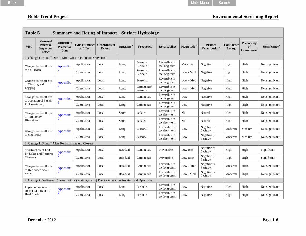
Robb Trend Project Environmental Screening Report
December 2012 Page 1-6
Table 5 Summary and Rating of Impacts - Surface Hydrology
VEC
Nature ofPotentialImpact or
Effect
Mitigation/
ProtectionPlan
Type of Impactor Effect
GeographicalExtent 1 Duration 2 Frequency3 Reversability4 Magnitude 5 Project
Contribution6Confidence
Rating7
Probabilityof
Occurrence8Significance9
1. Change in Runoff Due to Mine Construction and Operation
Changes in runoff dueto haul roads
Appendix2
Application Local LongSeasonal/Periodic
Reversible inthe long-term
Moderate Negative High High Not significant
Cumulative Local LongSeasonal/Periodic
Reversible inthe long-term
Low - Mod Negative High High Not significant
Changes in runoff dueto Clearing andLogging
Appendix2
Application Local Long SeasonalReversible inthe long-term
Low – Mod Negative High High Not significant
Cumulative Local LongContinuous/Seasonal
Reversible inthe long-term
Low – Mod Negative High High Not significant
Changes in runoff dueto operation of Pits &Pit Dewatering
Appendix2
Application Local Long ContinuousReversible inthe long-term
Low Negative High High Not significant
Cumulative Local Long ContinuousReversible inthe long-term
Low Negative High High Not significant
Changes in runoff dueto TemporaryDiversions
Appendix2
Application Local Short IsolatedReversible inthe short-term
Nil Neutral High High Not significant
Cumulative Local Short IsolatedReversible inthe short-term
Nil Neutral High High Not significant
Changes in runoff dueto Spoil Piles
Appendix2
Application Local Long SeasonalReversible inthe short-term
LowNegative &Positive
Moderate Medium Not significant
Cumulative Local Long SeasonalReversible inthe short-term
LowNegative &Positive
Moderate Medium Not significant
2. Change in Runoff After Reclamation and Closure
Construction of EndPit Lakes and RestoredChannels
Appendix2
Application Local Residual Continuous Irreversible Low-HighNegative &Positive
High High Significant
Cumulative Local Residual Continuous Irreversible Low-HighNegative &Positive
High High Significant
Changes in runoff dueto Reclaimed SpoilAreas
Appendix2
Application Local Residual ContinuousReversible inthe long-term
Low – ModNegative toPositive
Moderate High Not significant
Cumulative Local Residual ContinuousReversible inthe long-term
Low - ModNegative toPositive
Moderate High Not significant
3. Change in Sediment Concentrations (Water Quality) Due to Mine Construction and Operation
Impact on sedimentconcentrations due toHaul Roads
Appendix2
Application Local Long PeriodicReversible inthe long-term
Low Negative High High Not significant
Cumulative Local Long PeriodicReversible inthe long-term
Low Negative High High Not significant

Robb Trend Project Environmental Screening Report
December 2012 Page 1-7
Table 5 Summary and Rating of Impacts - Surface Hydrology
VEC
Nature ofPotentialImpact or
Effect
Mitigation/
ProtectionPlan
Type of Impactor Effect
GeographicalExtent 1 Duration 2 Frequency3 Reversability4 Magnitude 5 Project
Contribution6Confidence
Rating7
Probabilityof
Occurrence8Significance9
Impact on sedimentconcentrations due toClearing and Logging
Appendix2
Application Local Long PeriodicReversible inthe long-term
Low Negative High High Not significant
Cumulative Local Long PeriodicReversible inthe long-term
Low Negative High High Not significant
Impact on sedimentconcentrations due toPit & Pit Dewatering
Appendix2
Application Local LongOccasional/Isolated
Reversible inthe short-term
Low Negative High Medium Not significant
Cumulative Local LongOccasional/Isolated
Reversible inthe short-term
Low Negative High Medium Not significant
Impact on sedimentconcentrations due toTemporary Diversions
Appendix2
Application Local Short IsolatedReversible inthe short-term
Nil Neutral High High Not significant
Cumulative Local Short IsolatedReversible inthe short-term
Nil Neutral High High Not significant
Impact on sedimentconcentrations due toSpoil Piles & RockDrains
Appendix2
Application Local LongSeasonal/Periodic
Reversible inthe long-term
Low Negative Moderate Medium Not significant
Cumulative Local LongSeasonal/Periodic
Reversible inthe long-term
Low Negative Moderate Medium Not significant
4. Change in Sediment Concentrations (Water Quality) After Reclamation and Closure
Impact on sedimentconcentrations due toEnd Pit Lakes andRestored Channels
Appendix2
Application Local Residual Periodic IrreversibleLow-Moderate
Positive/Neutral High High Not significant
Cumulative Local Residual Periodic IrreversibleLow-Moderate
Positive/Neutral
High High Not significant
Impact on sedimentconcentrations due toReclaimed Spoil Areas
Appendix2
Application Local Residual PeriodicReversible inthe short-term
Low Neutral Moderate Low Not significant
Cumulative Local Residual PeriodicReversible inthe short-term
Low Neutral Moderate Low Not significant
(1) Local, Regional, Provincial, National, Global(2) Short, Long, Extended, Residual(3) Continuous, Isolated, Periodic, Occasional (Accidental, Seasonal)
(4) Reversible in short term, Reversible in long term, Irreversible – rare(5) Nil, Low, Moderate, High(6) Neutral, Positive, Negative
(7) Low, Moderate, High(8) Low, Medium, High(9) Not significant, Significant

Robb Trend Project Environmental Screening Report
December 2012 Page 1-8
Table 6 Summary and Rating of Impacts - Aquatic Resources Environmental Components
VEC
Nature ofPotential
Impact or Effect
Mitigation/ ProtectionPlan
Type of
Effect
GeographicExtent1 Duration2 Frequency3 Reversibility4 Magnitude5
ProjectContribution(Direction)6
Confidence
Rating7
Probability of
Occurrence8
ImpactRating9
1. Rainbow Trout
Habitat alteration,changes insurfacehydrology,sedimentationand other changesin water quality
Appendix 2
Project Local Long Occasional Reversible Low Negative High Low Not significant
Residual Local Long Occasional Reversible Low Negative High Low Not significant
Cumulative
No cumulative effects as project contribution to effect can be fully mitigated
2. Bull TroutHabitat alteration,changes insurfacehydrology,sedimentationand other changesin water quality
Appendix 2
Project Local Long Occasional Reversible Low Negative High Low Not significant
Residual Local Long Occasional Reversible Low Negative High Low Not significant
Cumulative
No cumulative effects as project contribution to effect can be fully mitigated
3. Arctic Grayling
Sedimentationand other changesin water qualityhabitat alteration,changes insurface hydrology
Appendix 2
Project Local Long Occasional Reversible Low Negative High Low Not significant
Residual Local Long Occasional Reversible Low Negative High Low Not significant
Cumulative
No cumulative effects as project contribution to effect can be fully mitigated
4. Benthic InvertebratesHabitat alteration,changes insurfacehydrology,sedimentationand other changesin water quality
Appendix 2
Project Local Long Occasional Reversible Low Negative High Low Not significant
Residual Local Long Occasional Reversible Low Negative High Low Not significant
Cumulative
No cumulative effects as project contribution to effect can be fully mitigated
(1) Local, Regional, Provincial, National, Global(2) Short, Long, Extended, Residual(3) Continuous, Isolated, Periodic, Occasional (Accidental, Seasonal)
(4) Reversible in short term, Reversible in long term, Irreversible – rare(5) Nil, Low, Moderate, High(6) Neutral, Positive, Negative
(7) Low, Moderate, High(8) Low, Medium, High(9) Not significant, Significant

Robb Trend Project Environmental Screening Report
December 2012 Page 1-9
Table 7 Summary and Rating of Impacts - Soil & Terrain
VEC
Nature ofPotentialImpact or
Effect
Mitigation/Protection Plan
Type ofEffect
GeographicExtent1 Duration2 Frequency3 Reversibility4 Magnitude5
ProjectContribution(Direction)6
ConfidenceRating7
Probabilityof
Occurrence8
ImpactRating9
1. Soils
Disruption ofnatural soillandscapes
Appendix 2
ProjectLocal5,729 ha
Short ContinuousReversible(long term)
High Negative High HighNotsignificant
ResidualLocal5,729 ha
Residual ContinuousReversible(long term)
Low Neutral High HighNotsignificant
CumulativeLocal5,729 ha
Residual ContinuousReversible(long term)
Low Neutral High HighNotsignificant
Loss of non-salvageable soil
Appendix 2
ProjectLocal5,729 ha
Short Isolated Irreversible Low Negative High HighNotsignificant
Residual No residual effects notedNotsignificant
Cumulative No cumulative effects notedNotsignificant
Change in soilquality by mixingduring salvage
Appendix 2
ProjectLocal5,729 ha
Short PeriodicReversible(long term)
Low Neutral High HighNotsignificant
ResidualLocal5,729 ha
Residual ContinuousReversible(long term)
Low Neutral High HighNotsignificant
Cumulative No cumulative effects notedNotsignificant
Accelerated erosionof minesoils causesloss of soil resource
Appendix 2
ProjectLocal5,729 ha
Short IsolatedReversible(long term)
Low Neutral High HighNotsignificant
ResidualLocal5,729 ha
Residual IsolatedReversible(long term)
Low Neutral High HighNotsignificant
Cumulative No cumulative effects notedNotsignificant
Loss of soillandscape diversity
Appendix 2
ProjectLocal5,729 ha
Extended ContinuousReversible(long term)
Low Neutral High HighNotsignificant
Residual No residual effects notedNotsignificant
Cumulative No cumulative effects notedNotsignificant
2. Land Capability
Loss of landcapability andfuture production
Appendix 2
ProjectLocal5,729 ha
Short Continuous Reversible Moderate Negative High HighNotsignificant
ResidualLocal5,729 ha
Extended Continuous Reversible Moderate Neutral High HighNotsignificant
CumulativeLocal5,729 ha
Extended Continuous Reversible Moderate Neutral High HighNotsignificant

Robb Trend Project Environmental Screening Report
December 2012 Page 1-10
Table 7 Summary and Rating of Impacts - Soil & Terrain
VEC
Nature ofPotentialImpact or
Effect
Mitigation/Protection Plan
Type ofEffect
GeographicExtent1 Duration2 Frequency3 Reversibility4 Magnitude5
ProjectContribution(Direction)6
ConfidenceRating7
Probabilityof
Occurrence8
ImpactRating9
Delay in returningcapability anddiversity
Appendix 2
ProjectLocal5,729
Short Continuous Reversible Moderate Negative High HighNotsignificant
ResidualLocal5,729 ha
Extended Isolated Reversible Moderate Neutral High HighNotsignificant
Cumulative No cumulative effects notedNotsignificant
Climate changecauses increasedmoisture deficits
Appendix 2 Project No project effects notedNotsignificant
3. Overburden CharacteristicsIncreased traceelementconcentrations
Appendix 2 Project No project effects notedNotsignificant
(1) Local, Regional, Provincial, National, Global(2) Short, Long, Extended, Residual(3) Continuous, Isolated, Periodic, Occasional
(Accidental, Seasonal)
(4) Reversible in short term, Reversible in long term, Irreversible – rare(5) Nil, Low, Moderate, High(6) Neutral, Positive, Negative
(7) Low, Moderate, High(8) Low, Medium, High(9) Not significant, Significant

Robb Trend Project Environmental Screening Report
December 2012 Page 1-11
Table 8 Summary and Rating of Impacts - Vegetation and Wetlands
VECNature ofPotential
Effect
Mitigation /Protection
Plan
Type ofEffect
GeographicalExtent ofEffect1
Duration ofEffect2
Frequency ofEffect3
Ability forRecovery
from Effect4
Magnitudeof Effect5
ProjectContribution6
ConfidenceRating7
Probability ofEffect
Occurrence8Significance9
1. Terrestrial Vegetation/Plant Communities (Ecosite Phases)
Reduction inPlantCommunityTypes &Area
Appendix2
Application Local Extended ContinuousReversibleLong Term
High Neutral Moderate HighNotsignificant
Cumulative Local Extended ContinuousReversibleLong Term
High Neutral Moderate HighNotsignificant
2. Rare Plants, Rare Plant Communities and Rare Plant Potential
Removal ofRareSpecies,Communities& Potential
Appendix2
Application Local Extended ContinuousReversibleLong Term
Moderate Neutral Low HighNotsignificant
Cumulative Local Extended ContinuousReversibleLong Term
Moderate Neutral Low HighNotsignificant
3. Wetlands
Reduction inTypes &Area
Appendix2
Application Local Extended ContinuousReversibleLong Term
Low Neutral Low HighNotsignificant
Cumulative Local Extended ContinuousReversibleLong Term
Low Neutral Low HighNotsignificant
4. Old Growth Forests
Removal ofOld GrowthForests
Appendix2
Application Local Extended IsolatedReversibleLong Term
Low Neutral High HighNotsignificant
Cumulative Local Extended IsolatedReversibleLong Term
Low Neutral High HighNotsignificant
5. Non-native and invasive species
Spread ofInvasive &Non-nativeSpecies
Appendix2
Application Local Extended PeriodicReversibleLong Term
Low Neutral High HighNotsignificant
Cumulative Local Extended PeriodicReversibleLong Term
Low Neutral High HighNotsignificant
6. Traditionally Used Plants
RemovedfromFootprint
Appendix2
Application Local Extended ContinuousReversibleLong Term
Moderate Neutral High HighNotsignificant
Cumulative Local Extended ContinuousReversibleLong Term
Moderate Neutral High HighNotsignificant

Robb Trend Project Environmental Screening Report
December 2012 Page 1-12
Table 8 Summary and Rating of Impacts - Vegetation and Wetlands
VECNature ofPotential
Effect
Mitigation /Protection
Plan
Type ofEffect
GeographicalExtent ofEffect1
Duration ofEffect2
Frequency ofEffect3
Ability forRecovery
from Effect4
Magnitudeof Effect5
ProjectContribution6
ConfidenceRating7
Probability ofEffect
Occurrence8Significance9
7. Biodiversity
Reduction inGenetic-SpeciesDiversity
Appendix2
Application Local Extended ContinuousReversibleLong Term
Low Negative Moderate HighNotsignificant
Cumulative Local Extended ContinuousReversibleLong Term
Low Neutral Moderate HighNotsignificant
Reduction ofCommunityDiversity
Appendix2
Application Local Extended ContinuousReversibleLong Term
Low Neutral High HighNotsignificant
Cumulative Local Extended ContinuousReversibleLong Term
Low Neutral High HighNotsignificant
Reduction ofLandscapeDiversity
Appendix2
Application Local Extended ContinuousReversibleLong Term
Low Neutral High HighNotsignificant
Cumulative Local Extended ContinuousReversibleLong Term
Low Neutral High HighNotsignificant
(1) Local, Regional, Provincial, National, Global(2) Short, Long, Extended, Residual(3) Continuous, Isolated, Periodic, Occasional (Accidental, Seasonal)
(4) Reversible in short term, Reversible in long term, Irreversible – rare(5) Nil, Low, Moderate, High(6) Neutral, Positive, Negative
(7) Low, Moderate, High(8) Low, Medium, High(9) Not significant, Significant

Robb Trend Project Environmental Screening Report
December 2012 Page 1-13
Table 9 Summary and Rating of Impacts - Mammalian Carnivore
VEC
Nature ofPotential
Impact orEffect
Mitigation/Protection
Plan
Type of
Effect
GeographicExtent1 Duration2 Frequency3 Reversibility4 Magnitude5
ProjectContribution(Direction)6
Confidence
Rating7
Probabilityof
Occurrence8
ImpactRating9
1. Marten
IncreasedMortality
Appendix 2
Application Local Extended Occasional Reversible-LT Low Negative High MediumNotsignificant
Cumulative Regional Extended Occasional Reversible-LT Low Negative High MediumNotsignificant
HabitatAlteration
Application Local Extended Continuous Reversible-LT Moderate Negative High HighNotsignificant
Cumulative Regional Extended Continuous Reversible-LT High Negative High HighNotsignificant
SensoryDisturbance
Application Regional Long Isolated Reversible-ST Low Negative Moderate HighNotsignificant
Cumulative Regional Extended Periodic Reversible-ST Low Negative Moderate HighNotsignificant
HabitatFragmentation
Application Local Extended Continuous Reversible-LT Moderate Negative High HighNotsignificant
Cumulative Regional Extended Continuous Reversible-LT High Negative High HighNotsignificant
Barriers toMovement
Application Local Extended Continuous Reversible-LT Moderate Negative High HighNotsignificant
Cumulative Regional Extended Continuous Reversible-LT Moderate Negative High HighNotsignificant
2. Fisher
IncreasedMortality
Appendix 2
Application Local Extended Occasional Reversible-LT Low Negative High MediumNotsignificant
Cumulative Regional Extended Occasional Reversible-LT Low Negative High MediumNotsignificant
HabitatAlteration
Application Local Extended Continuous Reversible-LT Moderate Negative High HighNotsignificant
Cumulative Regional Extended Continuous Reversible-LT Low Negative High HighNotsignificant
SensoryDisturbance
Application Regional Long Isolated Reversible-ST Moderate Negative Low HighNotsignificant
Cumulative Regional Extended Periodic Reversible-ST Low Negative Moderate HighNotsignificant

Robb Trend Project Environmental Screening Report
December 2012 Page 1-14
Table 9 Summary and Rating of Impacts - Mammalian Carnivore
VEC
Nature ofPotential
Impact orEffect
Mitigation/Protection
Plan
Type of
Effect
GeographicExtent1 Duration2 Frequency3 Reversibility4 Magnitude5
ProjectContribution(Direction)6
Confidence
Rating7
Probabilityof
Occurrence8
ImpactRating9
HabitatFragmentation
Application Local Extended Continuous Reversible-LT Moderate Negative Moderate HighNotsignificant
Cumulative Regional Extended Continuous Reversible-LT Moderate Negative Low HighNotsignificant
Barriers toMovement
Application Local Extended Continuous Reversible-LT Moderate Negative Moderate HighNotsignificant
Cumulative Regional Extended Continuous Reversible-LT Moderate Negative Moderate HighNotsignificant
3. Lynx
IncreasedMortality
Appendix 2
Application Local Extended Occasional Reversible-LT Low Negative High MediumNotsignificant
Cumulative Regional Extended Occasional Reversible-LT Low Negative High MediumNotsignificant
HabitatAlteration
Application Local Extended Continuous Reversible-LT Low Positive High HighNotsignificant
Cumulative Regional Extended Continuous Reversible-LT Low Positive High HighNotsignificant
SensoryDisturbance
Application Regional Long Isolated Reversible-ST Low Negative Moderate HighNotsignificant
Cumulative Regional Extended Periodic Reversible-ST Low Negative Moderate HighNotsignificant
HabitatFragmentation
Application Local Extended Continuous Reversible-LT Moderate Negative High HighNotsignificant
Cumulative Regional Extended Continuous Reversible-LT Moderate Positive High HighNotsignificant
Barriers toMovement
Application Local Extended Continuous Reversible-LT Moderate Negative High HighNotsignificant
Cumulative Regional Extended Continuous Reversible-LT Moderate Negative High HighNotsignificant
4. Wolf
IncreasedMortality
Appendix 2
Application Local Extended Occasional Reversible-LT Low Negative High MediumNotsignificant
Cumulative Regional Extended Occasional Reversible-LT Low Negative Moderate HighNotsignificant
HabitatAlteration
Application Local Extended Continuous Reversible-LT High Negative High HighNotsignificant

Robb Trend Project Environmental Screening Report
December 2012 Page 1-15
Table 9 Summary and Rating of Impacts - Mammalian Carnivore
VEC
Nature ofPotential
Impact orEffect
Mitigation/Protection
Plan
Type of
Effect
GeographicExtent1 Duration2 Frequency3 Reversibility4 Magnitude5
ProjectContribution(Direction)6
Confidence
Rating7
Probabilityof
Occurrence8
ImpactRating9
Cumulative Regional Extended Continuous Reversible-LT High Negative High HighNotsignificant
SensoryDisturbance
Application Regional Long Isolated Reversible-ST Low Negative Moderate HighNotsignificant
Cumulative Regional Extended Periodic Reversible-ST Low Negative Moderate HighNotsignificant
HabitatFragmentation
Application Local Extended Continuous Reversible-LT Low Negative High MediumNotsignificant
Cumulative Regional Extended Continuous Reversible-LT Low Positive Moderate MediumNotsignificant
Barriers toMovement
Application Local Extended Continuous Reversible-LT Low Negative High MediumNotsignificant
Cumulative Regional Extended Continuous Reversible-LT Low Negative High MediumNotsignificant
5. Grizzly Bear
IncreasedMortality
Appendix 2
Application Local Extended Occasional Reversible-LT Low Negative High LowNotsignificant
Cumulative Regional Extended Occasional Reversible-LT High Negative High Medium Significant
HabitatAlteration
Application Local Extended Continuous Reversible-LT Moderate Positive High HighNotsignificant
Cumulative Regional Extended Continuous Reversible-LT Moderate Negative High HighNotsignificant
SensoryDisturbance
Application Regional Long Isolated Reversible-ST Low Negative High MediumNotsignificant
Cumulative Regional Extended Periodic Reversible-ST Low Negative High MediumNotsignificant
HabitatFragmentation
Application Local Extended Continuous Reversible-LT Low Negative High LowNotsignificant
Cumulative Regional Extended Continuous Reversible-LT Low Negative High LowNotsignificant
Barriers toMovement
Application Local Long Isolated Reversible-LT Low Negative High MediumNotsignificant
Cumulative Regional Extended Continuous Reversible-LT Low Negative High MediumNotsignificant
(1) Local, Regional, Provincial, National, Global(2) Short, Long, Extended, Residual(3) Continuous, Isolated, Periodic, Occasional (Accidental, Seasonal)
(4) Reversible in short term, Reversible in long term, Irreversible – rare(5) Nil, Low, Moderate, High(6) Neutral, Positive, Negative
(7) Low, Moderate, High(8) Low, Medium, High(9) Not significant, Significant

Robb Trend Project Environmental Screening Report
December 2012 Page 1-16
Table 10 Summary and Rating of Impacts - Wildlife
VECNature of
Potential Impact
Mitigation/
ProtectionPlan
Type ofEffect
Criteria for Determining Significance
SignificanceProject
ContributionConfidence
RatingExtent Duration Frequency Recovery Magnitude Probability
UNGULATES (Moose, Deer, Elk)
Elk
Loss of ForagingHabitat
Appendix 2
Project Local GrasslandDevelopment(Extended)
Shrub Development(Long)Forest
Development(Long)
Continuous Reversible inShort-Term
Moderate High Significant Positive High
Loss of ForestCover
Residual Local Continuous Reversible inLong-Term
Low High Notsignificant
Neutral High
Moose
Loss ofForaging Habitat
Appendix 2
Project Local Shrub Development(Long)
Continuous ReversibleLong-Term
Low High Notsignificant
Neutral Moderate
Loss ofForest Cover
Residual Local ForestDevelopment
(Long)
Continuous Reversible inLong-Term
Low High Notsignificant
Neutral High
Deer
Loss of ForagingHabitat
Appendix 2
Project Local GrasslandDevelopment(Extended)
Shrub Development(Long)Forest
Development(Long)
Continuous Reversible inShort-Term
Moderate High Significant Positive High
Loss of ForestCover
Residual Local Continuous Reversible inLong-Term
Low High Notsignificant
Neutral High
ElkMooseDeer
Disruption ofMovement Patterns
Appendix 2
Project Local Short Continuous Reversible inShort-Term
Low High Notsignificant
Neutral High
Project Local Short Continuous Reversible inShort-Term
Moderate High Notsignificant
Neutral Moderate
ElkMooseDeer
Displacement Appendix 2 ProjectRegional
Long ContinuousReversible inLong-Term
Moderate MediumNotsignificant
Neutral Moderate
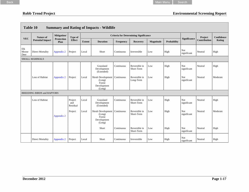
Robb Trend Project Environmental Screening Report
December 2012 Page 1-17
Table 10 Summary and Rating of Impacts - Wildlife
VECNature of
Potential Impact
Mitigation/
ProtectionPlan
Type ofEffect
Criteria for Determining Significance
SignificanceProject
ContributionConfidence
RatingExtent Duration Frequency Recovery Magnitude Probability
ElkMooseDeer
Direct Mortality Appendix 2 Project Local Short Continuous Irreversible Low HighNotsignificant
Neutral High
SMALL MAMMALS
Loss of Habitat Appendix 2 Project Local
GrasslandDevelopment
(Extended)
Continuous Reversible inShort-Term
Low High Notsignificant
Neutral High
Shrub Development(Long)Forest
Development(Long)
Continuous Reversible inLong-Term
Low High Notsignificant
Neutral Moderate
BREEDING BIRDS and RAPTORS
Loss of Habitat
Appendix 2
Projectand
Residual
Local GrasslandDevelopment(Extended)
Continuous Reversible inShort-Term
Low High Notsignificant
Neutral High
Project Local Shrub Development(Long)Forest
Development(Long)
Continuous Reversible inShort-Term
Low High Notsignificant
Neutral Moderate
Short Continuous Reversible inShort-Term
Low High Notsignificant
Neutral High
Direct Mortality Appendix 2 Project Local Short Continuous Irreversible Low HighNotsignificant
Neutral High

Robb Trend Project Environmental Screening Report
December 2012 Page 1-18
Table 10 Summary and Rating of Impacts - Wildlife
VECNature of
Potential Impact
Mitigation/
ProtectionPlan
Type ofEffect
Criteria for Determining Significance
SignificanceProject
ContributionConfidence
RatingExtent Duration Frequency Recovery Magnitude Probability
Displacement
Appendix 2
Projectand
Residual
Local GrasslandDevelopment(Extended)
Continuous Reversible inShort-Term
Low High Notsignificant
Neutral High
Project Local Shrub Development(Long)Forest
Development(Long)
Continuous Reversible inShort-Term
Low High Notsignificant
Neutral Moderate
Short Continuous Reversible inShort-Term
Low High Notsignificant
Neutral High
AMPHIBIANS
Loss of Habitat Appendix 2 Project Local Short ContinuousReversible in
Short-TermLow High
Notsignificant
Neutral High

Robb Trend Project Environmental Screening Report
December 2012 Page 1-19
Table 11 Summary and Rating of Impacts – Historical Resources
Resources with potential for impact by miningoperations.
The assessment of sites was accomplished through surface survey andsubsurface prospecting of high potential zones and ground-truthing ofother areas. Field reconnaissance focused on systematic traverse andshovel testing of high potential landforms within the high potentialzones. The field program involved completion of 1838 shovel tests.This is in addition to the 272 shovel tests previously undertaken priorto coal exploration activities and 505 shovel tests completed in supportof other developments and shovel tests completed in support of theDennison mine project. Over the years approximately 3000 shoveltests have been excavated in the Project area.
The HRIA programs recorded 67 precontact and historic sitesassociated with the Project area. Of the 67 sites, 60 are within theproposed mine permit area and 36 are found within the Projectfootprint.
There were no palaeontological remains identified in the developmentzones and there were not any significant bedrock exposures identified.
Not Significant
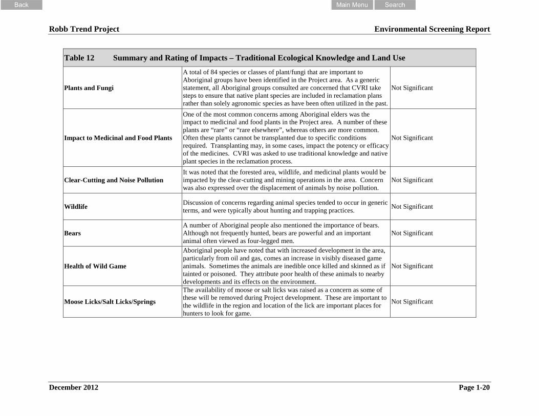
Robb Trend Project Environmental Screening Report
December 2012 Page 1-20
Table 12 Summary and Rating of Impacts – Traditional Ecological Knowledge and Land Use
Plants and Fungi
A total of 84 species or classes of plant/fungi that are important toAboriginal groups have been identified in the Project area. As a genericstatement, all Aboriginal groups consulted are concerned that CVRI takesteps to ensure that native plant species are included in reclamation plansrather than solely agronomic species as have been often utilized in the past.
Not Significant
Impact to Medicinal and Food Plants
One of the most common concerns among Aboriginal elders was theimpact to medicinal and food plants in the Project area. A number of theseplants are “rare” or “rare elsewhere”, whereas others are more common.Often these plants cannot be transplanted due to specific conditionsrequired. Transplanting may, in some cases, impact the potency or efficacyof the medicines. CVRI was asked to use traditional knowledge and nativeplant species in the reclamation process.
Not Significant
Clear-Cutting and Noise PollutionIt was noted that the forested area, wildlife, and medicinal plants would beimpacted by the clear-cutting and mining operations in the area. Concernwas also expressed over the displacement of animals by noise pollution.
Not Significant
WildlifeDiscussion of concerns regarding animal species tended to occur in genericterms, and were typically about hunting and trapping practices.
Not Significant
BearsA number of Aboriginal people also mentioned the importance of bears.Although not frequently hunted, bears are powerful and an importantanimal often viewed as four-legged men.
Not Significant
Health of Wild Game
Aboriginal people have noted that with increased development in the area,particularly from oil and gas, comes an increase in visibly diseased gameanimals. Sometimes the animals are inedible once killed and skinned as iftainted or poisoned. They attribute poor health of these animals to nearbydevelopments and its effects on the environment.
Not Significant
Moose Licks/Salt Licks/Springs
The availability of moose or salt licks was raised as a concern as some ofthese will be removed during Project development. These are important tothe wildlife in the region and location of the lick are important places forhunters to look for game.
Not Significant

Robb Trend Project Environmental Screening Report
December 2012 Page 1-21
Table 12 Summary and Rating of Impacts – Traditional Ecological Knowledge and Land Use
Displacement of Wildlife
Many Aboriginal people use or have used this area for hunting, particularlyfor moose, deer, and elk. Many mentioned that portions of the Project areaare great moose habitat and expressed concerns about impact of the Projecton game populations (particularly moose). Moose are culturally importantas the most preferred game. Furbearers commonly trapped are of generalconcern although no Aboriginal person cited ownership of a trapline to beaffected.
Not Significant
Water Quality
Water Quality is the most commonly raised issue for Aboriginal people.Their concern is how the CVRI will keep the water clean and expressedscepticism that it could be accomplished. Concerns include surface waterand groundwater. One issue raised is how groundwater flow will affectothers on the margins of the Project area. As water is often seen as one ofthe four major elements of life, it is critical to the well-being of all animaland plant life in the region.
Not Significant
Avoidance of Important Locales
Aboriginal groups have or will identify to CVRI the locations of knownburials, ceremonial sites, and camping locations within the proposedProject areas and region. Discussions are underway on avoidance ormitigation strategies on a case-by-case basis.
Not Significant
Future Extension
One individual expressed concern about the potential extension of theProject to the southeast on the opposite side of the Pembina River. Activetraplines are located to the east. One individual expressed concern that theCVM could potentially expand to the Genesee area because of the extent ofthe coal seams.
Not Significant
Exporting Coal/Transporting CoalSeveral individuals expressed concern that the coal was being exported toforeign lands. At one Open House, an individual inquired about coal trainsand exposure to coal dust along rail lines.
Not Significant

Robb Trend Project Environmental Screening Report
December 2012 Page 1-22
Table 12 Summary and Rating of Impacts – Traditional Ecological Knowledge and Land Use
Employment /Contracting Opportunitiesand Agreements
Many people expressed interest in job opportunities for Aboriginalpeoples. Concerns were voiced about past discrimination and therequirement for a high school diploma to obtain employment withsome industries. Several elders thought the need for a diploma wouldencourage youth to finish school but frequently this was viewed as abarrier to older Aboriginal individuals. The need for further training orcertificates for certain positions was raised. Desire for theincorporation of Aboriginal youth into positions such as environmentalmonitors or to assist in reclamation was expressed
A number of consulted Aboriginal groups have expressed interest insolidifying their relationship with CVRI through long-term memorandaof understanding or similar written agreements.
Several Aboriginal groups enquired about contracting opportunities forAboriginally-owned companies or affiliated corporations
Not Significant
Reclamation
The use of native species and traditional knowledge during reclamationis important. Questions were raised about the expected length of timerequired for regrowth of mushrooms, tree fungus, trees, and plants.Questions of what the landscape would look like after reclamation andif prior reclamation studies had been completed were also raised.Several people mentioned that animals are attracted to reclaimed areasand expressed concerns about the effect of this on game populationsand hunting rights.
Not Significant

Robb Trend Project Environmental Screening Report
December 2012 Page 1-23
Table 13 Summary and Rating of Impacts – Land and Resource Use
Industrial Uses
A majority of the coal leases within the Project area are held by CVRIor held by companies within a royalty arrangement to CVRI.
An agreement is currently under negotiation between CVRI and WestFraser to remove lands to be mined as part of the Project from theFMA.
Not Significant
Non-Industrial Uses
Public engagement program CVRI has undertaken discussions withmany of the non-industrial users that may be impacted by the proposeddevelopment. CVRI will continue to work with the public with respectto expressed concerns.
Not Significant

Robb Trend Project Environmental Screening Report
December 2012 Page 1-24
Table 14 Summary and Rating of Impacts – Human Health
Potential human health risks associated withProject emissions or releases were examinedusing a conventional risk assessmentparadigm.
The risk assessment paradigm is consistent with those developed byAlberta Health and Wellness (AHW 2011), Health Canada (2009a), theCanadian Council of Ministers of the Environment (CCME 2006), andthe U.S. Environmental Protection Agency (US EPA OSW 2005). Thismethodology has been endorsed by a number of provincial regulatoryauthorities in the past, including AEW, Alberta Health and Wellness(AHW) and the Alberta Energy Resources and Conservation Board(ERCB).
The risk assessment paradigm involves four steps:
problem formulation;
exposure assessment;
toxicity assessment; and
risk characterization.
Not Significant
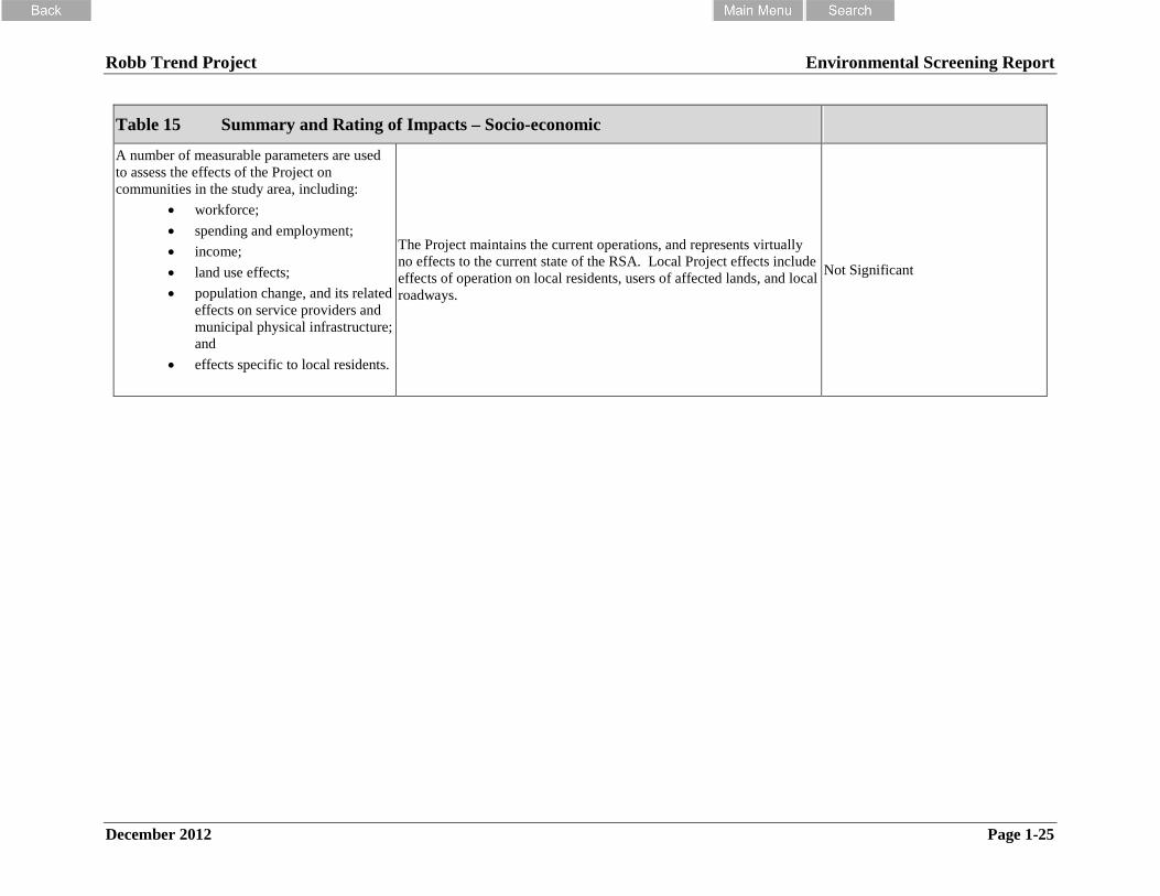
Robb Trend Project Environmental Screening Report
December 2012 Page 1-25
Table 15 Summary and Rating of Impacts – Socio-economic
A number of measurable parameters are usedto assess the effects of the Project oncommunities in the study area, including:
workforce;
spending and employment;
income;
land use effects;
population change, and its relatedeffects on service providers andmunicipal physical infrastructure;and
effects specific to local residents.
The Project maintains the current operations, and represents virtuallyno effects to the current state of the RSA. Local Project effects includeeffects of operation on local residents, users of affected lands, and localroadways.
Not Significant

Robb Trend Project Environmental Screening Report
December 2012
Appendix 2
Mitigation Summary Tables
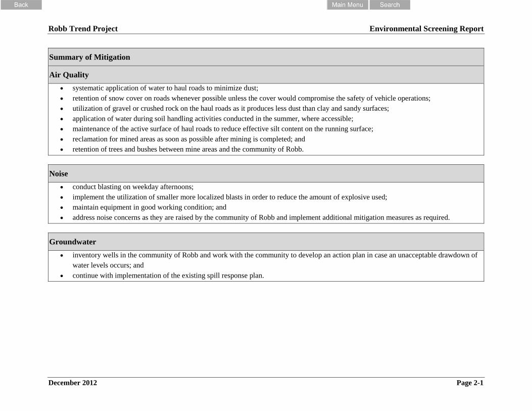
Robb Trend Project Environmental Screening Report
December 2012 Page 2-1
Summary of Mitigation
Air Quality
systematic application of water to haul roads to minimize dust;
retention of snow cover on roads whenever possible unless the cover would compromise the safety of vehicle operations;
utilization of gravel or crushed rock on the haul roads as it produces less dust than clay and sandy surfaces;
application of water during soil handling activities conducted in the summer, where accessible;
maintenance of the active surface of haul roads to reduce effective silt content on the running surface;
reclamation for mined areas as soon as possible after mining is completed; and
retention of trees and bushes between mine areas and the community of Robb.
Noise
conduct blasting on weekday afternoons;
implement the utilization of smaller more localized blasts in order to reduce the amount of explosive used;
maintain equipment in good working condition; and
address noise concerns as they are raised by the community of Robb and implement additional mitigation measures as required.
Groundwater
inventory wells in the community of Robb and work with the community to develop an action plan in case an unacceptable drawdown of
water levels occurs; and
continue with implementation of the existing spill response plan.

Robb Trend Project Environmental Screening Report
December 2012 Page 2-2
Surface Water Quality
plan to divert clean water around areas to be disturbed;
minimize the time interval between clearing/grubbing and subsequent earthworks, particularly at or in the vicinity of watercourses or in
areas susceptible to erosion;
install surface runoff collection and treatment systems in an effort to control groundwater seepage from road cuts and surface runoff from
disturbed areas. Surface runoff will be directed to settling impoundments for removal of settleable solids;
utilize slope grading and stabilization techniques to control erosion including: ditching above the cutslope to channel surface runoff away
from the cutslope, leaving buffer (vegetation) strips between the construction site and a watercourse, placing large rock rip rap to stabilize
slopes;
utilize temporary measures to control erosion before a vegetation cover is re-established, including: diversion ditches, drainage control,
check dams, sediment ponds, sumps and mulches;
plan to undertake progressive reclamation to reduce the amount of disturbed area at any given time;
whenever possible, carry out construction activities in close proximity to watercourses during periods of relatively low surface runoff and
maintain a 30 m buffer (vegetation) strip between construction sites and watercourses except at stream crossings and diversions;
design and construct all stream crossings in compliance with the Alberta Code of Practice for Watercourse Crossings and associated
guidelines;
where necessary, utilize interim erosion/sediment control measures until long-term protection can be effectively implemented;
implement the use of explosives with less slurry to reduce the amount of nitrogen compounds released;
minimize water contact with explosives by undertaking water control activities (dewatering of pit areas, use of diversion ditches and
interceptor ditches) for drier conditions for mining and blasting operations; and
design water management to direct mine-affected water to settling impoundments for treatment prior to discharge of surface waters and
discharge from impoundments in accordance with conditions in the EPEA approval.

Robb Trend Project Environmental Screening Report
December 2012 Page 2-3
Hydrology
plan and layout facilities in an effort to minimize drainage diversions and runoff;
direct runoff from active mining areas, spoil piles and roads to settling ponds or retention and clean-out areas for sediment settling
treatment;
design settling ponds according to the latest sizing;
divert runoff from natural undisturbed area around mine activities;
divert natural streams around or through active mine areas in a controlled manner to assist in maintaining flows by:
providing gradual flow diversions with initial flushing/cleaning operations where water flows through new ditches or pits;
providing armouring and/or lining of ditches or using culverts or flumes where appropriate to control erosion and limit seepage losses;
collecting clean water in in-pit sumps to isolate and keep clear of mine operations;
using temporary pumps to direct water around pits where short term bypasses (usually less than 1 year) are required;
directing all dirty water to settling facilities and then to the receiving stream once regulatory guidelines have been met; and
sizing diversion capacities according to the design life of the diversion, seasonal flows, potential flooding, and fish use and passage.
design and construct watercourse crossings to meet or exceed the regulatory requirements for approval under the provincial Water Act and
the federal Fisheries Act and Navigable Waters Protection Act;
size watercourse and diversions on fish bearing streams to permit fish passage in accordance with standard;
install haul road berms to contain road runoff and direct it to designated runoff control works;
establish vegetated buffer setbacks of at least 10 m from streams and 30 m from major streams, where possible, to minimize the risk of
sediment laden runoff entering the streams;
incorporate flow and erosion control measures, such as ditch check structures, natural depressions or low areas to create cleanouts (for
runoff and sediment retention);
allow depressions or cleanouts to de-water by a combination of evaporation and exfiltration, wherever possible;
filter sediments by seepage through natural buffers and constructed materials and possibly through local wetland areas where possible;
and
train personnel to minimize disturbances and use and maintain drainage and sediment controls.
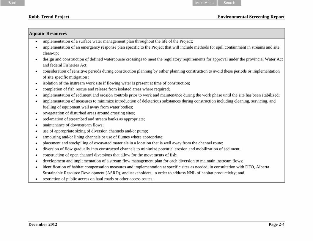
Robb Trend Project Environmental Screening Report
December 2012 Page 2-4
Aquatic Resources
implementation of a surface water management plan throughout the life of the Project;
implementation of an emergency response plan specific to the Project that will include methods for spill containment in streams and site
clean-up;
design and construction of defined watercourse crossings to meet the regulatory requirements for approval under the provincial Water Act
and federal Fisheries Act;
consideration of sensitive periods during construction planning by either planning construction to avoid these periods or implementation
of site specific mitigation ;
isolation of the instream work site if flowing water is present at time of construction;
completion of fish rescue and release from isolated areas where required;
implementation of sediment and erosion controls prior to work and maintenance during the work phase until the site has been stabilized;
implementation of measures to minimize introduction of deleterious substances during construction including cleaning, servicing, and
fuelling of equipment well away from water bodies;
revegetation of disturbed areas around crossing sites;
reclamation of streambed and stream banks as appropriate;
maintenance of downstream flows;
use of appropriate sizing of diversion channels and/or pump;
armouring and/or lining channels or use of flumes where appropriate;
placement and stockpiling of excavated materials in a location that is well away from the channel route;
diversion of flow gradually into constructed channels to minimize potential erosion and mobilization of sediment;
construction of open channel diversions that allow for the movements of fish;
development and implementation of a stream flow management plan for each diversion to maintain instream flows;
identification of habitat compensation measures and implementation at specific sites as needed, in consultation with DFO, Alberta
Sustainable Resource Development (ASRD), and stakeholders, in order to address NNL of habitat productivity; and
restriction of public access on haul roads or other access routes.
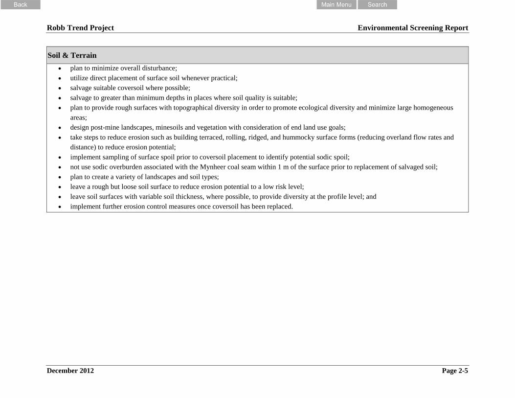
Robb Trend Project Environmental Screening Report
December 2012 Page 2-5
Soil & Terrain
plan to minimize overall disturbance;
utilize direct placement of surface soil whenever practical;
salvage suitable coversoil where possible;
salvage to greater than minimum depths in places where soil quality is suitable;
plan to provide rough surfaces with topographical diversity in order to promote ecological diversity and minimize large homogeneous
areas;
design post-mine landscapes, minesoils and vegetation with consideration of end land use goals;
take steps to reduce erosion such as building terraced, rolling, ridged, and hummocky surface forms (reducing overland flow rates and
distance) to reduce erosion potential;
implement sampling of surface spoil prior to coversoil placement to identify potential sodic spoil;
not use sodic overburden associated with the Mynheer coal seam within 1 m of the surface prior to replacement of salvaged soil;
plan to create a variety of landscapes and soil types;
leave a rough but loose soil surface to reduce erosion potential to a low risk level;
leave soil surfaces with variable soil thickness, where possible, to provide diversity at the profile level; and
implement further erosion control measures once coversoil has been replaced.

Robb Trend Project Environmental Screening Report
December 2012 Page 2-6
Vegetation and Wetlands
implement a re-vegetation program which aims at the establishment of ecosite equivalent to the pre-disturbed landscape;
implement a re-vegetation program which aims at the re-establishment of ecosites which are regionally limited in distribution;
design to preserve adjacent habitat by minimizing the area required for construction and operation of the Project;
seed stockpiled topsoil with suitable species mix to ensure long term stability of the soil piles, which reduces erosion and the potential for
weed establishment;
use coarse woody debris, when available, to amend soils to provide mycorrhizal and microbial inoculum;
implement the use of tree, shrub, forb and graminoid vegetation species native to ecosites;
implement the use of tree, shrub, forb and graminoid vegetation species to provide structure to ecosites with the goal of enhancing
biodiversity;
design the division of wetlands by roads to reduce the effect of water flow to wetlands outside of the Project;
implement the use of short-lived agronomics on sites with a higher degree of disturbance, to provide soil stability and prevent soil erosion;
work with Aboriginal groups to design and implement re-vegetation programs that target and support TEK vegetation;
for areas with high and very high rare plant potential, will focus on the re-establishment of ecosite capability which includes high and very
high rare plant potential;
transplant rare plants found within the Project where possible that have a provincial ranking of S1-S3 and global rank of less than G4;
plan to salvage all merchantable timber; and
continue the weed control program currently in place at the CVM.
Mammalian Carnivore
incorporate select native trees and shrubs such as alder and willow into re-vegetation activities;
maximize downed woody debris (stumps) through direct placement of top-soil and associated slash and stumps;
maintain and connect to core areas as many residual forest patches as possible;
maintain a 30 metre buffer zone of undisturbed natural habitat along well developed riparian corridors, where available;
plant coniferous trees at higher stem densities (>180 stems per acre);
continue to maintain hunting and firearm restrictions on the reclaimed areas of the Project including after mining has ceased and until
hiding cover on the mines is equivalent to that of natural closed forest cover types.; and
maintain haul truck and regular vehicle speeds of <70 kph.

Robb Trend Project Environmental Screening Report
December 2012 Page 2-7
Wildlife
undertake reclamation activities that specifically enhance wildlife use of the reclaimed area. Specifically provide diverse vegetation
communities and complex arrangements of vegetation and landscape features;
maintain as much undisturbed habitat as possible during mining will help to enhance the wildlife diversity of the reclaimed sites;
avoid disturbing wetland habitats as much as possible particularly during haul road placement;
where possible vegetation clearing should be planned for outside of the May to July breeding season;
if raptor nests are found during operations, mitigation measures will be developed to address the specific situation;
continue with the existing CVM wildlife management;
remove carrion from haul roads to reduce raptor mortality;
use of raptor-safe power line configurations for distribution lines to minimize chances of raptor electrocution;
focus reclamation on establishing ecosystem function and initiating soil microbial activity. Wherever possible, direct haul placement
techniques will be used;
reclamation seed mix will be composed of several species of grasses and several species of legumes to provide foraging diversity for small
mammals, ungulates, and selected bird species. Reclamation activities will initially establish a cover vegetation of grasses and legumes to
prevent erosion and initiate soil development. Trees and shrubs will additionally be planted at the appropriate time;
planting of willow, and other deciduous shrubs in selected areas to provide additional hiding cover and browsing opportunities for
ungulates;
plan upland grasslands for south-facing aspects so that winter forage opportunities are created for elk and deer;
plant a variety of deciduous, mixed wood and coniferous forest types would establish forest complexity for ungulates and other wildlife;
mimic the natural disturbance regime where possible. This includes designing complexity into the landscape by establishing forests with
structural diversity and variety in vegetation communities and topography and reclaiming wetlands to include islands, irregular shoreline
features, and a variety of aquatic and upland vegetation will promote nesting by waterfowl;
identify opportunities to develop a number of ponds with shallow edges (<1 m) and emergent vegetation suitable for amphibian breeding
and waterfowl nesting;
vegetate soil stockpiles and waste areas with a grass/legume-forb mix to maintain wildlife use in the disturbance zone and reduce erosion
potential;
reduce line of site and promote movement of wildlife across reclaimed areas by using variable contouring of dump slopes;
break continuous pit disturbances at intervals by “land bridges” or by variable slope angles as is currently done on the CVM; and
establish where possible specialized habitat features such as snags, rock outcrops, cliffs and mineral licks.

Robb Trend Project Environmental Screening Report
December 2012 Page 2-8
Historical Resources
obtain clearance from ACCS, as required, prior to development; and
undertake mitigation measures as recommended and agreed upon with ACCS
Traditional Ecological Knowledge and Land Use
continue consultations with the Aboriginal groups as information is brought forward regarding specific impacts to traditional use areas;
continue to update SREM Aboriginal Affairs Branch (SAAB) on the progress of consultation with potentially affected Aboriginal groups;
continue negotiations with Aboriginal groups, on a case by case basis, for avoidance of ceremonial areas, specific plant species, graves,
and other areas; and
undertake further discussions with Aboriginal groups on specific impacts and mitigation measures following the submission of final
reports on traditional use studies.
Land and Resource Use
continue to communicate with West Fraser and Sundance Forest Industries as to the salvage of merchantable timber;
discuss with other industrial developers opportunities to maximize resource use and minimize development conflicts;
continue with CVRI’s trapper compensation program; and
continue with CVRI’s public engagement program.
Human Health
Monitoring and mitigation has been a part of CVRI operations at the CVM and will be continued as part of this Project. Mitigation programs for
key human health related disciplines are provided within Appendix 2 of this report and include:
air monitoring;
groundwater monitoring; and
surface water monitoring.

Robb Trend Project Environmental Screening Report
December 2012 Page 2-9
Socio-economic
ongoing inter-industry cooperation with forestry and energy companies building on current working relationships;
designing the mine plan to avoid active mining on both sides of Robb concurrently and minimizing the duration of development nearest
the community;
continuing the use of dust reduction strategies, such as watering of haul roads;
using of noise reduction strategies such as lowered night-time activity, use of alternates to equipment horns and alarms;
continue present monitoring of blasting vibration and noise levels in Robb. Monitoring will also include dust and groundwater supply and
quality;
consideration of inherent advantages of vendors located in or near operating areas when contracting for goods and services;
continued participation in community involvement initiatives.

Robb Trend Project Environmental Screening Report
December 2012
Appendix 3
Monitoring Summary

Robb Trend Project Environmental Screening Report
December 2012 Page 3-1
Air Quality
In order to track the effectiveness of the mitigation measures CVRI will:
conduct monitoring as required in the EPEA approval;
establish a continuous ambient air quality monitoring station in or near the community of
Robb three years before opening Robb Main and continue until mining operations at
Robb East are completed, include monitoring of 10-m wind speed and wind gust, 10-m
wind direction, temperature, PM2.5 and TSP; and
conduct passive sampling at the community of Robb for NO2.
Noise
In order to assess the effectiveness of mitigation measures CVRI will:
conduct noise and vibration monitoring once mining begins to come close to Robb.
Groundwater
In order to monitor the effectiveness of the mitigation measures CVRI will:
monitor shallow groundwater conditions as required in the EPEA approval;
monitor water chemistry in selected springs on an on-going basis;
monitor water levels and water chemistry in selected monitoring wells on an ongoing
basis;
establish observation wells into the Mynheer and Wee seams beneath Robb; and
select existing observation wells established for the Project for on-going monitoring.
Surface Water Quality
In order to monitor the effectiveness of mitigation measures CVRI will:
monitor impoundments as required in the EPEA approval; and
monitor surface water quality in natural watercourses, both upstream and downstream of
Project activities as required in the EPEA approval.

Robb Trend Project Environmental Screening Report
December 2012 Page 3-2
Hydrology
In order to monitor the effectiveness of the mitigation measures CVRI will:
continue monitoring programs already in place at the existing CVM mine (i.e., flow and
TSS at settling ponds, regular inspections of all drainage works, and upstream and
downstream water quality sampling);
document the effect of mine operations on long term flow regimes in order to document
critical low flow conditions during pit filling periods and define the need for any bypass
pumping to maintain in-stream flows;
establish flow monitoring stations 2-3 years in advance of commencement of Project
operations in each watershed;
conduct periodic runoff and drainage control monitoring (adjust the capacity of or
relocate sump systems and drainage works as mining proceeds);
conduct ongoing monitoring, operations, and maintenance as outlined in the water
management plan with periodic reviews and adjustments; and
monitor adjacent undisturbed areas to ensure surface runoff from disturbed areas does not
occur.
Aquatics
In order to monitor the effectiveness of the mitigation measures CVRI will:
monitor flows and TSS at all settling ponds;
conduct regular inspections of all drainage works;
expand the existing CVM aquatics monitoring program to include additional benthic
macroinvertebrate sample sites;
implement a water quality monitoring program for the life of the Project designed to meet
the requirements of the Project approval;
conduct long term monitoring of flow in each main creek to document critical low flow
conditions during pit filling periods and to define the need for any bypass pumping to
maintain in-stream flows;
monitor components of the compensation plan, (i.e., fish habitat enhancement structures)
post-construction to assess the effectiveness of the compensation and to identify
modifications that will be made (if necessary);
evaluate end pit lakes to assess fish use, biological productivity, water quality, and other
physical properties (i.e. thermal regime);
implement TSS/turbidity monitoring during instream work if deemed necessary due to
site conditions or timing of works; and
Robb Trend Project Environmental Screening Report
December 2012 Page 3-3
monitor downstream flows to ensure instream flow needs are met.
Soil Resources
In order to assess the effectiveness of mitigation measures CVRI will:
implement sampling of areas recontoured with overburden salvaged from areas over the
Mynheer coal seam to determine presence of sodic spoil material; and
monitor reclaimed areas for erosion.
Vegetation
In order to assess the effectiveness of the mitigation measures CVRI will:
assess the composition, structure, ecological succession and biodiversity targets of
reclaimed sites;
monitor timber harvesting activities;
monitor revegetation efforts by performing survival, growth and health assessments;
conduct a rare plant survey on any new development areas not included in this
assessment;
monitor and maintain drainage control structures in relation to wetlands adjacent to the
Project;
monitor re-establishment in reclaimed wetlands;
conduct regeneration surveys on reclaimed lands and assess whether stocking densities
and performance expectations are being met;
conduct regular site inspections to identify invasive species; and
complete post reclamation studies, similar to those completed on existing CVM
reclaimed sites, to assess reclamation and allow for adaptive management.
Carnivores
In order to monitor the effectiveness of mitigation measures CVRI will:
monitor the effectiveness of measures designed to increase understory cover (downed
woody debris, shrubs, tree density) on reclaimed mine lands for marten, fisher and lynx;
monitor response of marten, fisher lynx to existing and planned mine land reclamation
using winter tracking techniques;
determine if habitats required for fisher maternal denning occur on or immediately
adjacent to the Project and assess their levels of use by fisher;
monitor the effectiveness of establishing and maintaining hiding cover for grizzly bears
near Project edges and adjacent to main roads;

Robb Trend Project Environmental Screening Report
December 2012 Page 3-4
measure and monitor human use levels of linear features during summer, winter and fall
(hunting) seasons. Assign this as a primary task of the ‘bear warden’ position. Use this
data to design road closure plans;
monitor the effectiveness of voluntary and enforced road closures including gating;
monitor and study specific use of the existing CVM and proposed Project by grizzly
bears. Investigate the extent to which existing mines in the region serve as attractive
forage sources for grizzlies, and study implications for subregional mortality. Consider
non-intrusive methods including DNA hair snagging; and
continue long-term, multi-species winter monitoring of mammals (carnivores and prey)
to regional habitat fragmentation using the tracking data conducted in 2007, 2009 and
2011 as a starting point.
Wildlife
CVM will monitor:
human use of reclaimed areas and if determined necessary, develop an access
management plan;
timber removal by the FMA holder so that mining and forest harvesting can be
coordinated so they do not result in simultaneous removal of mature tree cover and the
creation of overly large open disturbances; and
the response of ungulates to reclamation of the Project and other CVM projects.
Historical Resources
If a historical resource is encountered during mining that has not been identified
under an HRIA CVRI will stop work in the area until ACCS has been notified and the
appropriate mitigation measures put in place.
Traditional Ecological Knowledge and Land Use
CVRI will undertake the following monitoring measures:
complete longer-term monitoring on the impact to medicinal and other plants and for
general environmental monitoring; and
continue to consult with the Aboriginal communities regarding future development plans.
Land and Resource Use
CVRI will continue to consult with stakeholders as development of the Project area
progresses over the life of the mine area.

Robb Trend Project Environmental Screening Report
December 2012 Page 3-5
Human Health
Monitoring and mitigation has been a part of CVRI operations at the CVM and will be continued
as part of this Project. Mitigation programs for key disciplines are provided within the individual
consultant reports as appropriate and are summarized as follows:
air monitoring;
groundwater monitoring; and
surface water monitoring.
Socio-economic
CVRI will continue with the following:
ongoing inter-industry cooperation with forestry and energy companies building on
current working relationships;
designing the mine plan to avoid active mining on both sides of Robb concurrently and
minimizing the duration of development nearest the community;
continuing the use of dust reduction strategies, such as watering of haul roads;
using of noise reduction strategies such as lowered night-time activity, use of alternates to
equipment horns and alarms;
continue present monitoring of blasting vibration and noise levels in Robb. Monitoring
will also include dust and groundwater supply and quality;
consideration of inherent advantages of vendors located in or near operating areas when
contracting for goods and services;
continued participation in community involvement initiatives


![2020 Scholarship Application - cmich.edu Tucker Application 2020[1].pdf• Completed scholarship application, typed or printed. • A persuasive cover letter addressed to the selection](https://static.fdocuments.us/doc/165x107/5f024a027e708231d403867e/2020-scholarship-application-cmichedu-tucker-application-20201pdf-a-completed.jpg)
