RATP: 3D Multimodal stop place accessibility and indoor...
23
RATP: 3D Multimodal stop place accessibility and indoor way finding. Three experiments to build and use map and network with ESRI and MOBIGIS tools under standard models for disable persons. From 2D CAD or point cloud data to 3D BIM through GIS tools. David Lellouche RATP | 20.05.2016 Département de la communication • Marque
Transcript of RATP: 3D Multimodal stop place accessibility and indoor...

RATP: 3D Multimodal stop place accessibility and indoor way finding.
Three experiments to build and use map and network with ESRI and MOBIGIS tools under standard models for disable persons.
From 2D CAD or point cloud data to 3D BIM through GIS tools.
David Lellouche RATP | 20.05.2016
Département de la communication • Marque
Goals and use cases with GIS data, ESRI and MOBIGIS
2D/3D GIS map for a better view and description of complexes indoor transport sites spaces
Improve accessibility and information for passengers and disables persons as well as safety and maintenance
Give a view from territory to local area is similar than run a door to door travel engine to run an indoor path way finder to exit or make a connection
Associate an accessibility and navigation standard model with map and improve transport site interoperability with GIS and as built 3D model
z

RATP Transport operator experiments :
2D/3D map accessibility and indoor way finding Results, limitations and prospects
1 : Central Multimodal stations in Paris. Accessibility and route finding From CAD to GIS map 2D and 3D visualization => data accuracy Network, route finder, multimodal identification => Navigation map database IFOPT a standard for accessibility and fixed object.
2 : 3D point cloud survey in AUBER/OPERA to 3D BIM visualization 3D point cloud, shape recognition to BIM model.= > State of art, interoperability, costs Comparison between 2D CAD and 3D BIM Limits
3 : Sound cards. A linear sound approach of path for blind persons Map for underlying model.
z

Écran de transition Titre
Texte complémentaire
Video: From 2D Map territory
to 3D underground station
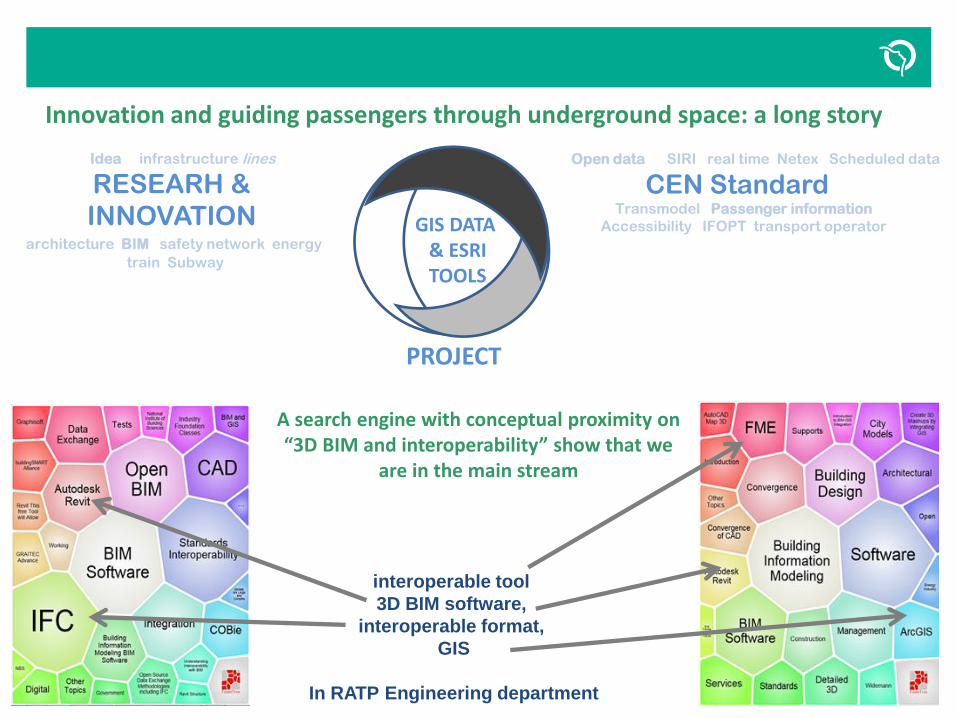
Innovation and guiding passengers through underground space: a long story
z
Idea infrastructure lines
RESEARH &
INNOVATION architecture BIM safety network energy
train Subway
Open data SIRI real time Netex Scheduled data
CEN Standard Transmodel Passenger information
Accessibility IFOPT transport operator
PROJECT
GIS DATA & ESRI TOOLS
A search engine with conceptual proximity on “3D BIM and interoperability” show that we
are in the main stream
interoperable tool
3D BIM software,
interoperable format,
GIS
In RATP Engineering department

Standard transport model and GIS. Locate on map: vehicles, clients, disruptions, objects, stop points, route
z in
no
vati
on
to
sta
nd
ard
isat
ion
Transport operations
Passengers Information
Real and estimated times SIRI SM, GM
Situation exchange SIRI SX
Open data and schedule data Multimodal door to door route engine GTFS, NETEX
Services platform for disable persons
Indoor Location wifi, Blue- -tooth Without Infra, Lora, LIFI
Fixed object & equipment Status data transfert SIRI FM. Facility monitoring
GIS indoor database map, CAD, GIS SHP, BIM 2D/3D IFC, RVT …
tested standards in POC
BIM & GIS
Network infrastructure
Accessibility, Indoor network & geometry IFOPT, TRANSMODEL
Navigation model, users profiles & grammar

First experiment: Central Multimodal stations on suburban railway mode (RER A) Model and indoor way finding
z
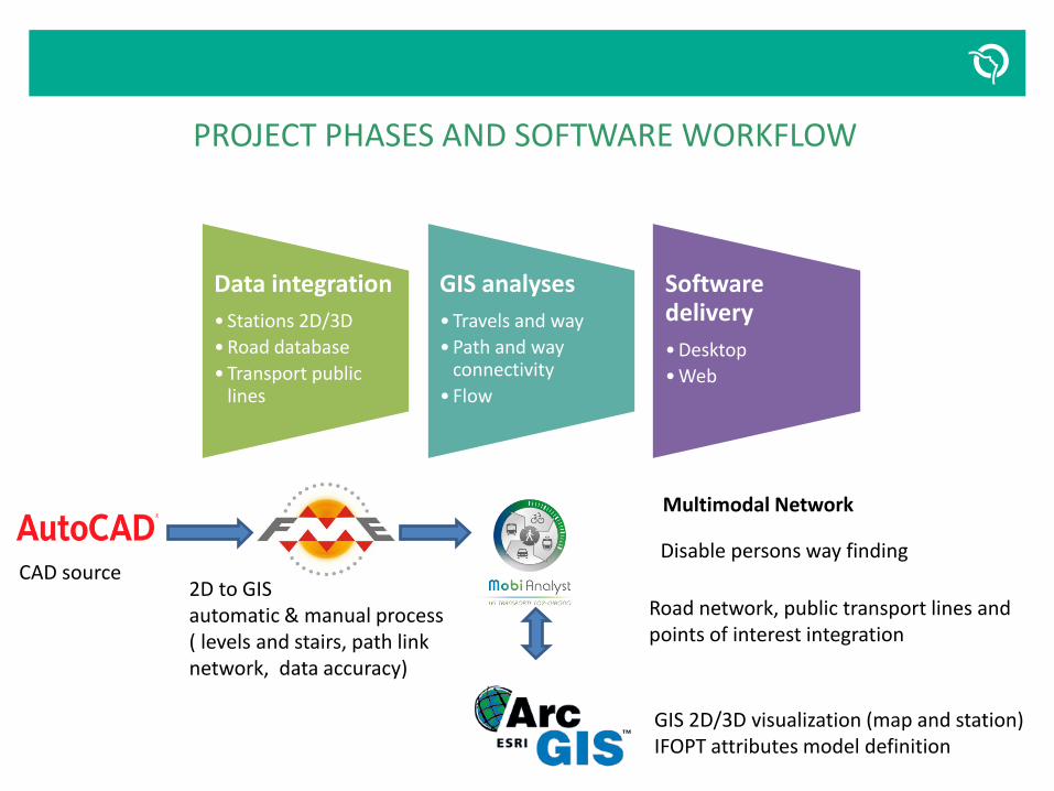
PROJECT PHASES AND SOFTWARE WORKFLOW
z
CAD source
Road network, public transport lines and points of interest integration
Multimodal Network
2D to GIS automatic & manual process ( levels and stairs, path link network, data accuracy)
GIS 2D/3D visualization (map and station) IFOPT attributes model definition
Disable persons way finding
Data integration
• Stations 2D/3D
•Road database
•Transport public lines
GIS analyses
•Travels and way
•Path and way connectivity
• Flow
Software delivery
•Desktop
•Web
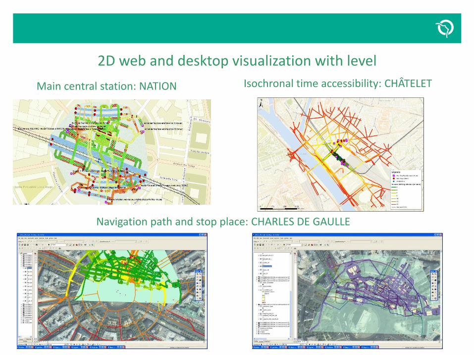
2D web and desktop visualization with level
z
Main central station: NATION Isochronal time accessibility: CHÂTELET
Navigation path and stop place: CHARLES DE GAULLE
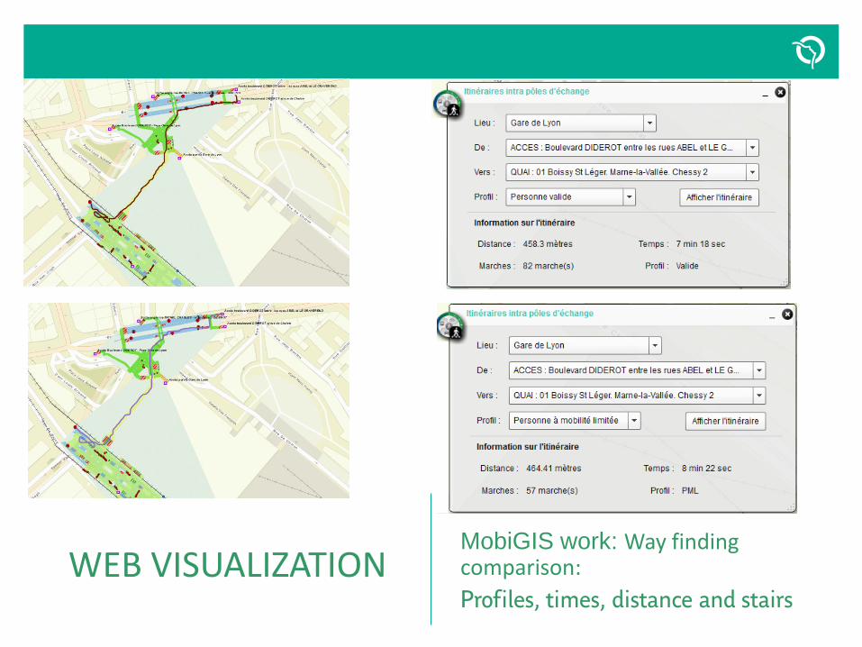
WEB VISUALIZATION
MobiGIS work: Way finding comparison:
Profiles, times, distance and stairs
z

CAD visualisation Classical emergency 3D
Levels and labels :
3D Arcscene visualization
Extruded levels and stairs.
z
AUBER station

Second experiment: 3D point cloud survey
in AUBER/OPERA to 3D BIM visualization
z

Methodology and software workflow: From laser point cloud to BIM
z
1. Laser survey 2. 3D recognition 3. models 4. Uses case
Laser point cloud +-= Big data
• Valuation of mobile laser solution in a multimodal station: AUBER
• Valuation to extend the solution to one line or all network.
• Develop news services upon uses cases
Laser, Photo 360°, Mobile, backpack, Stop and go, handheld
VIAMETRIS
3D shape recognition, fixed equipment Structure, location & point cloud comparison
REVIT and RECAP. 3D light BIM Model in point cloud wired 3D with Leica software in arc-explorer
CAD GIS
AUTOCAD 2D station Asset Management Database
2D comparison in CAD and GIS tools.
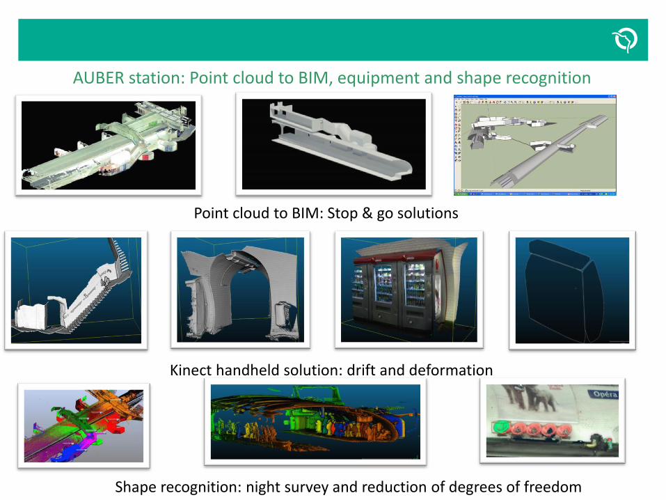
AUBER station: Point cloud to BIM, equipment and shape recognition
z
Point cloud to BIM: Stop & go solutions
Kinect handheld solution: drift and deformation
Shape recognition: night survey and reduction of degrees of freedom

Écran de transition Titre
Texte complémentaire
Video Dynamic visualization of different
3D models Point cloud,
mesh with photo texture and BIM

Accuracy: comparison between 2D CAD database and as built 3D model projection
z
3D synthesis from 2D. The data must be treated to assign the good quay level
3D level synthesis on flow, stairs or space with 2D CAD/GIS . A new obligation and advantage of BIM project.
BIM projection (blue) and CAD reference (pink) Only 4cm deviation with 2D referential database.
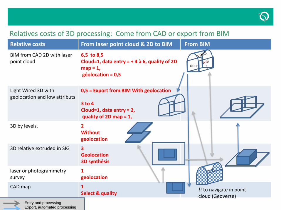
Relatives costs of 3D processing: Come from CAD or export from BIM
z
Relative costs From laser point cloud & 2D to BIM From BIM
BIM from CAD 2D with laser point cloud
6,5 to 8,5 Cloud=1, data entry = + 4 à 6, quality of 2D map = 1, géolocation = 0,5
Light Wired 3D with geolocation and low attributs
0,5 = Export from BIM With geolocation 3 to 4 Cloud=1, data entry = 2, quality of 2D map = 1,
3D by levels. 2 Without geolocation
3D relative extruded in SIG 3 Geolocation 3D synthésis
laser or photogrammetry survey
1 geolocation
CAD map 1 Select & quality
!! to navigate in point cloud (Geoverse)
door
Entry and processing Export, automated processing

z
Use case Work function photo Laser,photogrammetry
2D CAD
2D SIG
3D CAD levels
3D SIG extruded
3D Wired SIG
3D BIM
Shape calculation Asset management + ++ ++ ++ +
3D referential geodatabase, sites connection. Equipment and way
Asset & equipment management
++ ++ ++ ++ +
Passenger map database for indoor routing
Commercial + + + ++ ++ +
Virtual visit or travel scheduling Equipment management + + + + + +
Flow simulation in space Project, conception + + +
Checking templates . Near quay and trains
Engineer, asset managmt + ++
Simple site asset management Engineer, asset managmt + + + +
Intelligent site management asset management + ++ ++
Safety , emergency simulations safety + ++ + ++ +
sport & health in the subway. Accessibility
Accessibility ++ +
Ambience and environnement settings
Asset management + + +
Passenger comfort (sound, radio, lighting, visual)
Commercial, innovation + + + + + +
Journey planning commercial +
TOTAL 15 15 5 8 3 6 14 9
Uses case and 3D technology

Third experiment:
Sound cards.
A linear sound approach of path, agnostic
or without infrastructure
for blind persons
GIS for MODELS and MAP
RATP/ ACCESSIBILITY
THIM laboratory Paris 8 university
URBILOG company
z

Accessibility: the sound card project for blind and others persons. Goals
z
A simple mobile application with one touch ergonomic, hand free, in the pocket with headsets and with a vocal description of indoor travel.
increase the autonomy of passengers and universal design thinking. Profiling the accessibility with users needs and extend it to foreigners and tourists.
a pivot grammar with seven segments based on a topological modeling spaces obtained from map . A grammar which could be translate in other languages. A safety way for exchanges indoor network map?
A multimodal station with several line connections. Indoor routing to entrances/exits, connections or other modes.
Three stages. Audio guide without radio beacon. Mobile signature sensor track for characteristics steps (stairs) and location with radio tags.
A low investment cost for a wide deployment.

Bastille 2D/3D level map
Passengers spaces
Passengers Flow
Stairs, services extraction
Visibility and Voronoi 3D model
z

Navigation Model and topological pivot language supporting segmented grammar
Mixed use of model based on both visibility (obstacles, services and equipment.) and Voronoi (middle way in space) associated with à simple seven segments navigation grammar for each path link. Mandatory Reference descriptor from, safety sound, location information, target object, direction, distance.
z
Navigation grammar: Back to the quay, on the right (or at 3 hours), at 10 meters, a short (around twenty meters) corridor
Conclusions:
high cost to make as build 3D BIM. We need to find an economic
model, the best way to produce it and a use case with an early adopter
for a 3D referential.
Upgrade the existing 2D referential ?
Point cloud could be the first stage for some use.
2D map is still the cheapest and widely available for indoor way
finding.
Best model and organization to manage work and renovation on sites
and the associated model of indoor way finding.
GIS the necessary territorial coherence
z