Quantitative hydrogeological studies of the Treviso...
7
Abstract Quantitative hydrogeological studies of the Treviso alluvial plain, NE Italy Pier Andrea Vorlicek 1 , Renzo Antonelli 1 , Paolo Fabbri 1 & Randolf Rausch 2 1 Dipartimento di Geologia,Paleontologia e Geofisica dell’Università di Padova, via Giotto, 1, 35137, Padova, Italy (e-mail: [email protected]) 2 Landesamt fur Geologie, Rohstoffe und Bergbau, Baden-Wurttemberg, Urbanstrasse 53, 70182, Stuttgart, Germany T he alluvial plain of Treviso (NE Italy) is one of the most important aquifers in the Veneto Region. Numerous hydrogeological studies of this unconfined groundwater system of the Venetian Plain provided qualitative and semi-quantitative data for its structural and hydrodynamic assessment. The unconfined aquifer changes from high plain southwards to multi-layered confined or semi-confined aquifers. The transition zone corresponds to a band 2–5 km wide where characteristic plain springs emerge with maximum discharge along a line known as the fontanili line. Import- ant groundwater resources are exploited by widespread industry and agriculture, and also for public water supply including some large towns outside of study area. In recent years some test sites at which the knowledge of hydrodynamic parameters of the aquifer were improved, have been established in the study area. These, together with already available data (geometry, boundary con- ditions, recharge-discharge process, flow nets) allowed a water balance and a 2-D finite difference groundwater flow model to be constructed. A first calibration gave reasonable results. This flow model could be developed further to provide a tool for managing groundwater resources including chemical water quality when combined with chemical transport models. Keywords: Treviso (NE of Italy), porous media, groundwater protection, water budget, numerical modelling The high alluvial plain of Treviso (NE Italy) is one of the most important aquifer systems of the Veneto Region. There are considerable water resources in the gravelly and sandy strata, with a high vertical and lateral continuity down to the bedrock. These resources are of good quality, due to very active recharge mainly from massive leakage of two main rivers the Brenta and Piave, to the west and east respectively (Fig. 1). In the specific study area about 250 000 people live in 17 municipalities, including the town of Treviso. There are nine public drinking- water plants, each being a multiple well system, as well as many thousands of domestic, industrial and agricultural wells, with an estimated combined production of about 110 10 3 m 3 /day. Immediately south of the studied area approximately 52010 3 m 3 /day of drinking- water are extracted to supply Treviso, Mestre and Venice. In the last twenty years, because of intensive agriculture and the spread of industrial activity, general deterioration of groundwater quality standards as hard- ness and conductivity increase, began to be observed by ARPA (Regional Agency Environmental Protection) in some plain areas, where the most relevant recharge processes take place. More recently, some cases of pollution (nitrates, pesticides, organic chemicals) have been observed north of Treviso (Antonelli & Dal Pra ` 1991; Zangheri 1995; Antonelli et al. 2000). In this hydrogeological system of regional relevance, classical numerical methods have been applied using previously acquired hydrogeologic parameters. The aim of this research is to devise a finite difference flow model, to which a mathematical model of groundwater quality may later be related. The final target is to give decision- makers an indispensable instrument for groundwater management and control. Description of site Geological and hydrogeological scheme of conceptual model The Montello anticline defines the northern boundary to the hydrogeologic domain of the alluvial plain (Fig. 1). It marks the southern edge of the Pre-Alps and is composed of the Upper Miocene conglomerates and Late Miocene calcarenites with low permeability. The river Piave defines the study area to the east and cuts its own coarse, permeable alluvial deposits, allowing part of its discharge to reach the underlying free aquifer. As there is no natural hydrogeological boundary, the lines joining Montebelluna-Barcon and Barcon- Istrana-Treviso have been assumed as the outer limits respectively west and SW. The southern boundary corresponds to the plain spring-line (fontanili zone). The whole high and middle plain of Treviso is a well-defined alluvial unit, mostly formed of the ancient riverbeds of the Palaeo-Piave, which flowed much further west than it does nowadays. The low plain starts to the south of lower boundary of plain springs and extends to the Adriatic coast line (Figs. 2 & 3). Quarterly Journal of Engineering Geology and Hydrogeology, 37, 0–0 1470-9236/04 $15.00 2004 Geological Society of London
Transcript of Quantitative hydrogeological studies of the Treviso...

Abstract
Quantitative hydrogeological studies of the Trevisoalluvial plain, NE Italy
Pier Andrea Vorlicek1, Renzo Antonelli1, Paolo Fabbri1 & Randolf Rausch2
1Dipartimento di Geologia,Paleontologia e Geofisica dell’Università di Padova, via Giotto, 1, 35137, Padova,Italy (e-mail: [email protected])
2Landesamt fur Geologie, Rohstoffe und Bergbau, Baden-Wurttemberg, Urbanstrasse 53, 70182, Stuttgart,Germany
The alluvial plain of Treviso (NE Italy) is one ofthe most important aquifers in the VenetoRegion. Numerous hydrogeological studies ofthis unconfined groundwater system of the
Venetian Plain provided qualitative and semi-quantitativedata for its structural and hydrodynamic assessment. Theunconfined aquifer changes from high plain southwardsto multi-layered confined or semi-confined aquifers. Thetransition zone corresponds to a band 2–5 km widewhere characteristic plain springs emerge with maximumdischarge along a line known as the fontanili line. Import-ant groundwater resources are exploited by widespreadindustry and agriculture, and also for public water supplyincluding some large towns outside of study area. Inrecent years some test sites at which the knowledge ofhydrodynamic parameters of the aquifer were improved,have been established in the study area. These, togetherwith already available data (geometry, boundary con-ditions, recharge-discharge process, flow nets) allowed awater balance and a 2-D finite difference groundwaterflow model to be constructed. A first calibration gavereasonable results. This flow model could be developedfurther to provide a tool for managing groundwaterresources including chemical water quality whencombined with chemical transport models.
Keywords: Treviso (NE of Italy), porous media, groundwaterprotection, water budget, numerical modelling
The high alluvial plain of Treviso (NE Italy) is oneof the most important aquifer systems of the VenetoRegion. There are considerable water resources in thegravelly and sandy strata, with a high vertical and lateralcontinuity down to the bedrock. These resources are ofgood quality, due to very active recharge mainly frommassive leakage of two main rivers the Brenta andPiave, to the west and east respectively (Fig. 1). In thespecific study area about 250 000 people live in 17municipalities, including the town of Treviso.
There are nine public drinking- water plants, eachbeing a multiple well system, as well as many thousandsof domestic, industrial and agricultural wells, withan estimated combined production of about 110 �
103 m3/day. Immediately south of the studied areaapproximately 520�103 m3/day of drinking- water areextracted to supply Treviso, Mestre and Venice.
In the last twenty years, because of intensiveagriculture and the spread of industrial activity, generaldeterioration of groundwater quality standards as hard-ness and conductivity increase, began to be observed byARPA (Regional Agency Environmental Protection) insome plain areas, where the most relevant rechargeprocesses take place. More recently, some cases ofpollution (nitrates, pesticides, organic chemicals) havebeen observed north of Treviso (Antonelli & Dal Pra1991; Zangheri 1995; Antonelli et al. 2000).
In this hydrogeological system of regional relevance,classical numerical methods have been applied usingpreviously acquired hydrogeologic parameters. The aimof this research is to devise a finite difference flow model,to which a mathematical model of groundwater qualitymay later be related. The final target is to give decision-makers an indispensable instrument for groundwatermanagement and control.
Description of site
Geological and hydrogeological scheme ofconceptual model
The Montello anticline defines the northern boundary tothe hydrogeologic domain of the alluvial plain (Fig. 1).It marks the southern edge of the Pre-Alps and iscomposed of the Upper Miocene conglomerates andLate Miocene calcarenites with low permeability. Theriver Piave defines the study area to the east and cuts itsown coarse, permeable alluvial deposits, allowing partof its discharge to reach the underlying free aquifer. Asthere is no natural hydrogeological boundary, thelines joining Montebelluna-Barcon and Barcon-Istrana-Treviso have been assumed as the outer limitsrespectively west and SW.
The southern boundary corresponds to the plainspring-line (fontanili zone).
The whole high and middle plain of Treviso is awell-defined alluvial unit, mostly formed of the ancientriverbeds of the Palaeo-Piave, which flowed muchfurther west than it does nowadays. The low plain startsto the south of lower boundary of plain springs andextends to the Adriatic coast line (Figs. 2 & 3).
Quarterly Journal of Engineering Geology and Hydrogeology, 37, 0–0 1470-9236/04 $15.00 � 2004 Geological Society of London

During and after the Würm glacial period, thePiave channels formed large alluvial fans which wereoverlapped and laterally penetrated by fans fromadjacent rivers. As shown in Figure 3, the entire plainfrom the piedmont belt in the north to about 15 kmsouth, thus consists of an undifferentiated accumula-tion of gravel with sand, sometimes interbedded with
clay layers. In the distal part of this fan, the alluvialbody is made up of alternating layers of gravel,sand, silt and clay, the fine-grained deposits being oflagoonal or marine origin. At variable depths between50 and 150 m, the Riss-Würm conglomerate is inter-bedded within this sediment (Venzo 1977; Surian et al.1993).
Fig. 1. Geographical sketch of NE Italy; trace of geological cross-section (A-A’) of Figure 3. Study area rectangle near Treviso
Fig. 2. Measured isopotential contour lines of study area.
VORLICEK ET AL.2
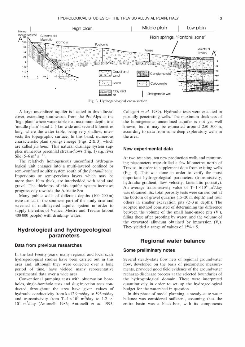
A large unconfined aquifer is located in this alluvialcover, extending southwards from the Pre-Alps as the‘high plain’ where water table is at maximum depth, to a‘middle plain’ band 2–5 km wide and several kilometreslong, where the water table, being very shallow, inter-sects the topographic surface. In this band, numerouscharacteristic plain springs emerge (Figs. 2 & 3), whichare called fontanili. This natural drainage system sup-plies numerous perennial stream-flows (Fig. 1) e.g. riverSile (5–6 m3 s�1).
The relatively homogeneous unconfined hydrogeo-logical unit changes into a multi-layered confined orsemi-confined aquifer system south of the fontanili zone.Impervious or semi-pervious layers which may bemore than 10 m thick, are interbedded with sand andgravel. The thickness of this aquifer system increasesprogressively towards the Adriatic Sea.
Many public wells of different depths (100–200 m)were drilled in the southern part of the study area andscreened in multilayered aquifer system in order tosupply the cities of Venice, Mestre and Treviso (about400 000 people) with drinking- water.
Hydrological and hydrogeologicalparameters
Data from previous researches
In the last twenty years, many regional and local scalehydrogeological studies have been carried out in thisarea and, although they were collected over a longperiod of time, have yielded many representativeexperimental data over a wide area.
Conventional pumping tests with observation bore-holes, single-borehole tests and slug injection tests con-ducted throughout the area have given values ofhydraulic conductivity from k=12.9 m/day to 596 m/dayand transmissivity from T=1�103 m2/day to 1.2 �104 m2/day (Antonelli 1986; Antonelli et al. 1995;
Callegari et al. 1989). Hydraulic tests were executed inpartially penetrating wells. The maximum thickness ofthe homogeneous unconfined aquifer is not yet wellknown, but it may be estimated around 250–300 m,according to data from some deep exploratory wells inthe area.
New experimental data
At two test sites, ten new production wells and monitor-ing piezometers were drilled a few kilometres north ofTreviso, in order to supplement data from existing wells(Fig. 4). This was done in order to verify the mostimportant hydrogeological parameters (transmissivity,hydraulic gradient, flow velocity, kinematic porosity).An average transmissivity value of T=1�104 m2/daywas obtained. Six total porosity tests were carried out atthe bottom of gravel quarries (15–20 m depth) and fourothers in smaller excavation pits (2–3 m depth). Theadopted method consisted of determining the differencebetween the volume of the small hand-made pits (Vt),filling these after proofing by water, and the volume ofthe excavated alluvium obtained by immersion (Vs).They yielded a range of values of 15%�5.
Regional water balance
Some preliminary notes
Several steady-state flow nets of regional groundwaterflow, developed on the basis of piezometric measure-ments, provided good field evidence of the groundwaterrecharge-discharge process at the selected boundaries ofthe hydrogeological domain. These were interpretedquantitatively in order to set up the hydrogeologicalbudget for the watershed in question.
In this phase of model planning, a steady-state waterbalance was considered sufficient, assuming that theentire basin was a black-box, with its components
Fig. 3. Hydrogeological cross-section.
HYDROLOGICAL STUDIES OF THE TREVISO ALLUVIAL PLAIN, ITALY 3

lumped together according to the theory of systemsanalysis (De Marsily 1986). As a consequence somerecharge and discharge components of the hydrologiccycle were treated by an approach which masks theimportance of time-dependent effects, e.g. the incomingriver Piave and irrigation canals, which lose water to thesubsurface system as they traverse the recharge area.
Recharge components
Annual precipitation was interpolated from 5 meteoro-logical stations well distributed on the plain. Datarecorded over the last 16 years were compared withthose of another series over a period of more than20 years in order to verify the variance of data.
In the study area, the average rainfall computed bythe Thiessen method is 1071 mm/a. Using the Turcformula corrected by average monthly rainfall (Turc1954), an effective infiltration recharge of about450 mm/a was estimated. The application of other com-mon methods based on empirical correlations betweenevapotranspiration and climatic factors, i.e. Blaney &Criddle (1950), Thornthwaite (1948), did not, for thepurposes of this paper, give significantly different values.
Leakage from the Piave river along the wholeeastern boundary of the watershed was estimated by 10differential flow rate measurements at each of 5 cross-sections along the river at different seasonal conditions.A recharge of 1.7–1.8 m3 s�1 km�1 was calculated,considering an average river flow rate of 50 m3s�1
(D’alpaos & Dal Pra 1978).Irrigation over an area of 250 km2 is one of the most
important components of groundwater recharge. An
average flow rate of 10 m3 s�1 (Regional IrrigationAgency) in the hydrologic year is taken by irrigationplants. Considering the field capacity of the soil,especially of gravely-sandy kind, its mean depth (0.5–1.0) and ground-cover conditions, Public ReclamationsCompanies estimated that about 55–60% of theirrigation water volume is lost to the aquifers by netinfiltration.
A constant discharge of about 15 m3 s�1 throughoutthe year flows into two main irrigation canals. Theirleakage was calculated by the same method as applied tothe Piave (Dal Pra et al. 1996) producing recharge ratesto the free aquifer from the Vittoria and Piavesellacanals of 0.3 m3 s�1 and 0.2 m3 s�1 respectively.
The inflow rate through the specified flux boundary(Montebelluna-Barcon line) into the aquifer was esti-mated at 0.8 m3 s�1 (Fig. 4), by applying the flow netmethod developed in different seasons and assuming atthe northern side of the plain an aquifer cross- section200 m deep, with average values of hydraulic gradientand hydraulic conductivity.
Discharge components
In a flat basin, it is considered an acceptable approxima-tion to estimate surface run-off as nil.
The total natural discharge of the shallow aquiferalong the fontanili spring line was measured by flow-meter at 20 m3 s�1 (Antonelli & Dal Pra 1980). In thedischarge area extending from Treviso to the Piave, themeasured flow net shows an upward-flow component(Fig. 2).
Fig. 4. Boundary conditions, simulated head distribution and observation-calibration wells.
VORLICEK ET AL.4
The total groundwater exploited by public wellslocated both inside and immediately south of thehydrogeological domain was evaluated with reasonableapproximation from recorded data (Bullo & Dal Pra1994). It is more difficult to make a reliable estimation offlow rate withdrawn from private wells because of theirvery large number and lack of records. An average flowrate of 1.3 m3 s�1 was estimated by applying a statisticalapproach to some rural, urban and industrial sampleareas.
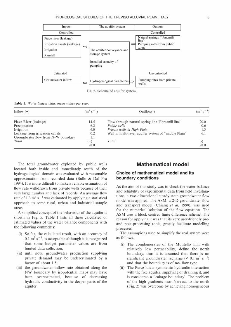
A simplified concept of the behaviour of the aquifer isshown in Fig. 5. Table 1 lists all these calculated orestimated values of the water balance components withthe following comments:
(i) So far, the calculated result, with an accuracy of0.1 m3 s�1, is acceptable although it is recognizedthat some budget parameter values are fromlimited data collection;
(ii) until now, groundwater production supplyingprivate demand may be underestimated by afactor of about 1.5;
(iii) the groundwater inflow rate obtained along theNW boundary by isopotential maps may havebeen overestimated, because of decreasinghydraulic conductivity in the deeper parts of theaquifer.
Mathematical model
Choice of mathematical model and itsboundary conditions
As the aim of this study was to check the water balanceand reliability of experimental data from field investiga-tions, a two-dimensional steady-state groundwater flowmodel was applied. The ASM, a 2-D groundwater flowand transport model (Chiang et al. 1998), was usedfor the numerical solution of the flow equation. TheASM uses a block centred finite difference scheme. Thereason for applying it was that its very user-friendly pre-and post-processing tools, greatly facilitate modellingprocesses.
The assumpions used to simplify the real system wereas follows.
(i) The conglomerates of the Montello hill, withrelatively low permeability, define the northboundary; thus it is assumed that there is nosignificant groundwater recharge (< 0.1 m3 s�1)and that the boundary is of no- flow type.
(ii) The Piave has a symmetric hydraulic interactionwith the free aquifer, supplying or draining it, andis considered a ‘leakage boundary’. The problemof the high gradients near Nervesa to the north(Fig. 2) was overcome by achieving homogeneous
Fig. 5. Scheme of aquifer system.
Table 1. Water budget data; mean values per year.
Inflow (+) (m3 s�1) Outflow(-) (m3 s�1)
Piave River (leakage) 14.5 Flow through natural spring line ‘Fontanili line’ 20.0Precipitation 6.2 Public wells 0.6Irrigation 6.0 Private wells in High Plain 1.3Leakage from irrigation canals 0.2 Well in multi-layer aquifer system of “middle Plain” 6.1Groundwater flow from N–W boundary 1.1Total (+) Total (-)
28.0 28.0
HYDROLOGICAL STUDIES OF THE TREVISO ALLUVIAL PLAIN, ITALY 5

decreasing distribution of the highly localizedleakage values along the course of the river, fromnorth to south.
(iii) There is a constant discharge from the unconfinedaquifer at the fontanili springs (lower boundary)and a prescribed head boundary is therefore con-sidered appropriate. The isopotential line, 11 mabove sea level, was thus chosen, characterizedby small variations (some decimetres) in thewater-table over the average hydrologic year.
(iv) The west boundary is divided into two parts, ofwhich one corresponds to an isopotential line at35 m a.s.l. and is considered a specified fluxboundary. The second part of the west boundary,drawn at right angles to the isopotential lines, isconsidered a no-flow boundary (Fig. 4).
A finite difference grid with 9424 square cells with aconstant cell size of 250 m over an area of about590 km2 was selected for the flow model. There are 124cells in the ‘x’ direction (west to east) and 76 in the ‘y’direction. The number of inactive cells is 4100. Thisdiscretisation gives a clear-cut idea of the groundwaterflow field in the entire area.
Calibration of the model
In this preliminary phase it appeared sufficient toachieve the identification or calibration model that is theprocess of determining the various coefficient andparameter values. This process (inverse problem) isbased on a comparison between predicted and observedresponse in the form of field values (Bear 1982).
A homogeneous distribution of the transmissivityvalue of T=2.5 x 10³ m2/day, deduced by harmonicmean, was assigned to the whole study area to guaranteethe uniqueness of the solution. Therefore only theinflows and outflows of the aquifer have been calibrated.
The inflows are: the leakage from the river Piaveand irrigation canals, the groundwater flow from thewestern boundary and the recharge by precipitation andirrigation.
The outflows are: the discharges by pumping wellsand the outflow from the southern boundary (fontanilizone) (Table 1).
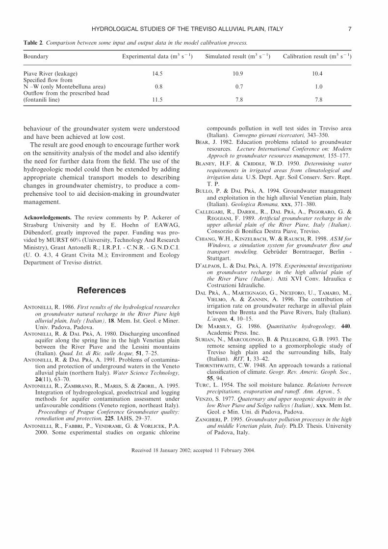
The calibration was partly undertaken by trial anderror, partly using an automatic calibration procedure(AMS modulus based on the Marquard-Lovembergmethod), considering that the calculated parametersmatched the measured ones fairly well. The diagram ofFigure 6 demonstrates that the calculated heads are in agood agreement with the ones measured at the obser-vation wells. Table 2 specifies some input and outputdata obtained by simulation and calibration modellingprocedures that are in the same range as the experimen-tal data. The error can be considered compatible withthe aims to be pursued in this research.
Conclusions
The Treviso plain is underlain by a major alluvialaquifer consisting of coarse-grained, fluvio-glacial sedi-ment of uncertain thickness, probably up to 300 m. Thenorthern limit of the study area, of approximately400 km2, was defined by the emerging bedrock (Upperand Late Miocene) and the southern limit by the springzone, known as the ‘fontanili line’ where fine-graineddeposits start to become intercalated with the coarsematerial. The eastern limit was defined by a major river,the Piave, but the western limit had no specific hydro-geological boundary and was assumed partly as specifiedflux boundary, partly as no-flow boundary.
A successful attempt was made to construct a waterbalance for the aquifer by quantifying as far as possiblethe various recharge (rainfall, river leakage, canal leak-age, irrigation seepage and ground water inflow) anddischarge (spring and extraction) components. Some ofthis data was limited in detail and spread in time andcould be subject to revision when more informationbecomes available.
A 2-D finite difference steady-state model was devel-oped incorporating this water balance and assigningappropriate hydraulic condition to the hydrogeologicalboundaries (dynamic boundaries). The model also usedexisting data from various field experiments on aquiferproperties.
The calibration of the model was reasonable andtaken to show that the basic characteristics and
Fig. 6. Comparison of calculated and observed heads.
VORLICEK ET AL.6
behaviour of the groundwater system were understoodand have been achieved at low cost.
The result are good enough to encourage further workon the sensitivity analysis of the model and also identifythe need for further data from the field. The use of thehydrogeologic model could then be extended by addingappropriate chemical transport models to describingchanges in groundwater chemistry, to produce a com-prehensive tool to aid decision-making in groundwatermanagement.
Acknowledgements. The review comments by P. Ackerer ofStrasburg University and by E. Hoehn of EAWAG,Dübendorf, greatly improved the paper. Funding was pro-vided by MURST 60% (University, Technology And ResearchMinistry), Grant Antonelli R.; I.R.P.I. - C.N.R. - G.N.D.C.I.(U. O. 4.3, 4 Grant Civita M.); Environment and EcologyDepartment of Treviso district.
References
A, R. 1986. First results of the hydrological researcheson groundwater natural recharge in the River Piave highalluvial plain, Italy (Italian), 18. Mem. Ist. Geol. e Miner.Univ. Padova, Padova.
A, R. & D P, A. 1980. Discharging unconfinedaquifer along the spring line in the high Venetian plainbetween the River Piave and the Lessini mountains(Italian). Quad. Ist. di Ric. sulle Acque, 51, 7–25.
A, R. & D P, A. 1991. Problems of contamina-tion and protection of underground waters in the Venetoalluvial plain (northern Italy). Water Science Technology,24(11), 63–70.
A, R., Z, R., M, S. & Z, A. 1995.Integration of hydrogeological, geoelectrical and loggingmethods for aquifer contamination assessment underunfavourable conditions (Veneto region, northeast Italy).Proceedings of Prague Conference Groundwater quality:
remediation and protection, 225. IAHS, 29–37.A, R., F, P., V, G. & V, P.A.
2000. Some experimental studies on organic chlorine
compounds pollution in well test sides in Treviso area(Italian). Convegno giovani ricercatori, 343–350.
B, J. 1982. Education problems related to groundwaterresources. Lecture International Conference on: ModernApproch to groundwater resources management, 155–177.
B, H.F. & C, W.D. 1950. Determining waterrequirements in irrigated areas from climatological andirrigation data. U.S. Dept. Agr. Soil Conserv. Serv. Rept.T. P.
B, P. & D P, A. 1994. Groundwater managementand exploitation in the high alluvial Venetian plain, Italy(Italian). Geologica Romana, xxx, 371–380.
C, R., D, R., D P, A., P, G. &R, F. 1989. Artificial groundwater recharge in theupper alluvial plain of the River Piave, Italy (Italian).Consorzio di Bonifica Destra Piave, Treviso.
C, W.H., K, W. & R, R. 1998. ASM forWindows, a simulation system for groundwater flow andtransport modeling. Gebrüder Borntraeger, Berlin -Stuttgart.
D’, L. & D P, A. 1978. Experimental investigationson groundwater recharge in the high alluvial plain ofthe River Piave (Italian). Atti XVI Conv. Idraulica eCostruzioni Idrauliche.
D P, A., M, G., N, U., T, M.,V, A. & Z, A. 1996. The contribution ofirrigation rate on groundwater recharge in alluvial plainbetween the Brenta and the Piave Rivers, Italy (Italian).L’acqua, 4, 10–15.
D M, G. 1986. Quantitative hydrogeology, 440.Academic Press. Inc.
S, N., M, B. & P, G.B. 1993. Theremote sensing applied to a geomorphologic study ofTreviso high plain and the surrounding hills, Italy(Italian). RIT, 1, 33–42.
T, C.W. 1948. An approach towards a rationalclassification of climate. Geogr. Rev. Americ. Geoph. Soc.,55, 94.
T, L. 1954. The soil moisture balance. Relations betweenprecipitations, evaporation and runoff. Ann. Agron., 5.
V, S. 1977. Quaternary and upper neogenic deposits in thelow River Piave and Soligo valleys (Italian), xxx. Mem Ist.Geol. e Min. Uni. di Padova, Padova.
Z, P. 1995. Groundwater pollution processes in the highand middle Venetian plain, Italy. Ph.D. Thesis. Universityof Padova, Italy.
Received 18 January 2002; accepted 11 February 2004.
Table 2. Comparison between some input and output data in the model calibration process.
Boundary Experimental data (m3 s�1) Simulated result (m3 s�1) Calibration result (m3 s�1)
Piave River (leakage) 14.5 10.9 10.4Specified flow fromN –W (only Montebelluna area) 0.8 0.7 1.0Outflow from the prescribed head(fontanili line) 11.5 7.8 7.8
HYDROLOGICAL STUDIES OF THE TREVISO ALLUVIAL PLAIN, ITALY 7