4. Bruce Hydrogeological Landscape
17
4. Bruce Hydrogeological Landscape LOCALITIES Bruce, Kaleen, Lawson, Giralang, Aranda MAP SHEET Canberra 1:100 000 CONFIDENCE LEVEL Moderate OVERVIEW The Bruce Hydrogeological Landscape (HGL) extends from the Gungaderra Grasslands Nature Reserve in the north to Arcadia in the south. The area encompasses the University of Canberra and Bruce (Figure 1). The HGL covers an area of 19 km 2 and receives 600 to 700 mm of rain per annum. Figure 1: Bruce HGL distribution map. Moderate Land Salinity Low Salt Load (in-stream) Low EC (in-stream)
Transcript of 4. Bruce Hydrogeological Landscape

4. Bruce Hydrogeological Landscape
LOCALITIES Bruce, Kaleen, Lawson, Giralang, Aranda
MAP SHEET Canberra 1:100 000
CONFIDENCE LEVEL Moderate
O V E R V I E W
The Bruce Hydrogeological Landscape (HGL) extends from the Gungaderra Grasslands Nature Reserve in the north to Arcadia in the south. The area encompasses the University of Canberra and Bruce (Figure 1). The HGL covers an area of 19 km2 and receives 600 to 700 mm of rain per annum.
Figure 1: Bruce HGL distribution map.
Moderate Land
Salinity
Low Salt Load
(in-stream)
Low EC
(in-stream)

Bruce HGL is encompassed by a boundary based on Adaminaby Group metasediments (Figure 2). The suburb of Aranda is elevated and timbered and ridge lines drain steeply to storm water systems mainly lined with concrete.
Although salinity symptoms are not highly visible, the combination of Adaminaby Group geology and urban development in this rainfall zone indicates a high risk of urban salinity. However, previous planning policies of vents under houses, elevated houses on piers and limited lawn and garden irrigation has limited urban salinity. There are homes that show some signs of urban salinity, but not to the degree usually associated with this geology and landform combination.
Older urban development has occurred in Bruce, Kaleen and Giralang, and there is rapid new expansion in the Lawson area adjacent to Baldwin Drive.
Minor salt sites are located adjacent to the stream lines and waterlogging occurs on the lower landform slope change but salt sites have rarely been observed in this area.
Figure 2: Conceptual cross-section for Bruce HGL showing the distribution of regolith and landforms, salt sites if
present, and flow paths of water infiltrating the system.
Salinity expression in this HGL is in the form of land salinity (Table 1).
Table 1: Bruce HGL salinity expression.
S A L I N I T Y E X P R E S S I O N
Land Salinity (Occurrence)
Moderate – observed salinity symptoms in cuttings and on homes. Sites in mid-slope and lower slope locations
Salt Load (Export)
Low – high runoff and dilution flow
EC (Water Quality)
Low

Salt store refers to the amount of salt stored in soil and geology materials. Salt availability refers to how easily water can move this salt. Salt stored within Bruce HGL has high mobility. There is a moderate salt store that has high availability (Table 2).
Table 2: Bruce HGL salt store and availability.
S A L T M O B I L I T Y
Low
availability
Moderate
availability
High
availability
High salt store
Moderate salt store Bruce
Low salt store
Overall salinity hazard is based on the likelihood of salinity occurring and how much impact it will have. The overall salinity hazard in the Bruce HGL is moderate. This is due to the moderate likelihood that salinity issues will occur that could have potentially significant impacts (Table 3).
Table 3: Likelihood of salinity occurrence, potential impact and overall hazard of salinity for Bruce HGL.
O V E R A L L S A L I N I T Y H A Z A R D
Limited potential impact
Significant potential impact
Severe potential impact
High likelihood of occurrence
Moderate likelihood of occurrence
Bruce
Low likelihood of occurrence
L A N D S C A P E F E A T U R E S
The following photographs illustrate landscapes and specific features observed in this HGL. Information used to define the HGL is summarised in Table 4.

Photo 1: Cutting indicating Adaminaby Group sediments on Gungahlin Drive on the edge of the HGL unit (Photo: DPI
/A Nicholson).
Photo 2: Undeveloped land next to Baldwin Drive (Photo: DPI / A Nicholson).

Photo 3: New urban development in Lawson (Photo: DPI / A Nicholson).
Photo 4: Urban salinity damage indicated in the lower landscape elements of Bruce. Note vents and wet bricks below
damp course (Photo: DPI / A Nicholson).

Photo 5: Older urban development in Giralang (Photo: DPI / A Nicholson).
Photo 6: Concrete lined channel in Bruce HGL (Photo: DPI /A Nicholson).
Table 4: Summary of information used to define Bruce HGL.
Lithology (Raymond et al. 2007; Geoscience Australia 2015)
This HGL comprises Ordovician metasediments. The key lithology is:
Adaminaby Group
Annual Rainfall 600–700 mm

Regolith and Landforms
Soil generally <1 m deep higher in the landscape and >1 m on lower slopes and in drainage lines. Deeper soil and imperfect drainage provide moderate potential for salt store.
Slope class 0–10% with small areas of slopes of 10–32%
Elevation range is 580–670 m
Soil Landscapes (Jenkins 1993; Jenkins 2000; Cook & Jenkins in prep)
The following soil landscapes are dominant in this HGL:
Winnunga
Queanbeyan
Well drained Clastic Rudosols or Leptic Tenosols (Lithosols) on crests and upper slopes. Moderately well drained Red Kurosols and Red Chromosols (Red Podzolic Soils) occur on mid slopes. Brown Chromosols (Yellow Podzolic Soils) on better drained lower slopes. Mottled Sodosols (Solodic Soils) in drainage lines and poorer drained lower slopes.
Land and Soil Capability
Class 5
Land Use urban development
Key Land Degradation Issues
water erosion
sediment loss to streams
Native Vegetation (Keith 2004; Gellie 2005; Dept of Environment 2012)
This HGL is situated within the IBRA7 South Eastern Highlands (Murrumbateman subregion)
The HGL has been extensively cleared with remaining vegetation formations comprising Dry Sclerophyll Forest and Grassy Woodland
Local vegetation is described by Gellie (2005)
H Y D R O G E O L O G Y
Typical values for the hydrogeological parameters of this HGL are summarised in Table 5.
Table 5: Summary of values for typical hydrogeological parameters of Bruce HGL.
Aquifer Type Unconfined to semi-confined in fractured rock and saprolite
Lateral flow through unconsolidated colluvial and alluvial sediments on slopes and in flow lines
Hydraulic Conductivity
Moderate
Range: 10-2–10 m/day
Aquifer Transmissivity
Low
Range: <2 m2/day
Specific Yield Moderate
Range: 5–15%
Hydraulic Gradient Gentle to moderate
Range: <10–30%
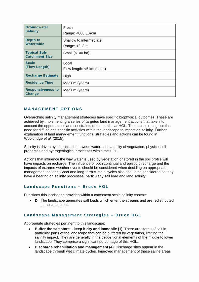
Groundwater Salinity
Fresh
Range: <800 µS/cm
Depth to Watertable
Shallow to intermediate
Range: <2–8 m
Typical Sub-Catchment Size
Small (<100 ha)
Scale (Flow Length)
Local
Flow length: <5 km (short)
Recharge Estimate High
Residence Time Medium (years)
Responsiveness to Change
Medium (years)
M A N A G E M E N T O P T I O N S
Overarching salinity management strategies have specific biophysical outcomes. These are achieved by implementing a series of targeted land management actions that take into account the opportunities and constraints of the particular HGL. The actions recognise the need for diffuse and specific activities within the landscape to impact on salinity. Further explanation of land management functions, strategies and actions can be found in Wooldridge et al. (2015).
Salinity is driven by interactions between water-use capacity of vegetation, physical soil properties and hydrogeological processes within the HGL.
Actions that influence the way water is used by vegetation or stored in the soil profile will have impacts on recharge. The influence of both continual and episodic recharge and the impacts of extreme weather events should be considered when deciding on appropriate management actions. Short and long-term climate cycles also should be considered as they have a bearing on salinity processes, particularly salt load and land salinity.
L a n d s c a p e F u n c t i o n s – B r u c e H G L
Functions this landscape provides within a catchment scale salinity context:
D. The landscape generates salt loads which enter the streams and are redistributed in the catchment.
L a n d s c a p e M a n a g e m e n t S t r a t e g i e s – B r u c e H G L
Appropriate strategies pertinent to this landscape:
Buffer the salt store – keep it dry and immobile (1): There are stores of salt in particular parts of the landscape that can be buffered by vegetation, limiting the salinity impact. They are generally in the depositional elements of the middle to lower landscape. They comprise a significant percentage of this HGL.
Discharge rehabilitation and management (4): Discharge sites appear in the landscape through wet climate cycles. Improved management of these saline areas

can reduce the impact of salinisation and prevent large negative impacts during wet cycles. Discharge management will also limit on-site land degradation.
Dry out the landscape with diffuse actions over most of the landscape (6): Encourage plant growth and increase plant water use to counteract excess soil moisture and shallow groundwater. Healthy, actively growing vegetation will also buffer groundwater accessions in wet seasonal conditions.
K e y M a n a g e m e n t F o c u s – B r u c e H G L
Urban water management is the focus for this HGL. There are homes that show some signs of urban salinity, but not to the level that is usually associated with this geology and landform combination.
Although salinity symptoms are not highly visible, the combination of Adaminaby geology and urban development in this rainfall zone indicates a high risk of urban salinity. Previous planning policy of vents under houses, elevated house on piers and limited lawn and garden irrigation has limited urban salinity in this area. Adherence to this policy is recommended.
S p e c i f i c L a n d M a n a g e m e n t O p p o r t u n i t i e s
Specific opportunities for this HGL:
high degree of control of water through storm water systems
public green spaces are common in critical parts of the landscape i.e. edges of flow lines and drainage depressions
planning policy has limited urban salinity.
S p e c i f i c L a n d M a n a g e m e n t C o n s t r a i n t s
Constraints on land management in this HGL include:
hard to change water management in older suburbs to improve ecological function.
high risk salinity landscape that is currently mitigated by planning policy.
S p e c i f i c T a r g e t e d A c t i o n s
Management areas for this HGL are illustrated in Figures 3 and 4. The specific management actions for these areas are described in Table 6. Management actions for urban areas are given in Table 8.

Figure 3: Management cross-section for Bruce HGL showing defined management areas.

Figure 4: Spatial distribution of management areas for Bruce HGL.

Table 6: Specific management actions for management areas within Bruce HGL.
Management Area (MA)
Action
MA 1
(RIDGES)
Vegetation for ecosystem function
Maintain and improve existing native woody vegetation to reduce discharge (VE3)
Specific urban management options as appropriate
MA 2
(UPPER SLOPE – EROSIONAL)
Vegetation for ecosystem function
Maintain and improve existing native woody vegetation to reduce discharge (VE3)
Vegetation for production
Revegetation of non-agricultural land with native species to manage recharge (VP8)
Specific urban management options as appropriate
MA 4/5
(MID SLOPES & UPPER SLOPE – COLLUVIAL)
NB: INCLUDES MA7 – SALTLAND
Vegetation for ecosystem function
Maintain and improve existing native woody vegetation to reduce discharge (VE3)
Salt Land Rehabilitation
Rehabilitation of salt land to minimise onsite and offsite degradation (SR4)
Specific urban management options as appropriate
MA 6
(RISES)
Vegetation for ecosystem function
Maintain and improve existing native woody vegetation to reduce discharge (VE3)
MA 9/10
(ALLUVIAL AREA & CHANNEL)
NB INCLUDES MA7 SALTLAND
Vegetation for ecosystem function
Maintain and improve existing native woody vegetation to reduce discharge (VE3)
Maintain and improve riparian native vegetation to reduce discharge to streams (VE4)
Salt Land Rehabilitation
Rehabilitation of salt land to minimise onsite and offsite degradation (SR4)
Irrigation Systems
On farm (site) irrigation management BMP (IS1)
Establish effective effluent disposal systems specific to site conditions (IS3)
H i g h H a z a r d L a n d U s e
There are some management actions that should be discouraged in this HGL as they will have negative impacts on salinity (Table 7). High hazard management actions for urban areas are given in Table 9.
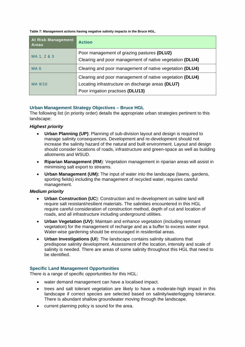
Table 7: Management actions having negative salinity impacts in the Bruce HGL.
At Risk Management Areas
Action
MA 1, 2 & 3 Poor management of grazing pastures (DLU2)
Clearing and poor management of native vegetation (DLU4)
MA 6 Clearing and poor management of native vegetation (DLU4)
MA 9/10
Clearing and poor management of native vegetation (DLU4)
Locating infrastructure on discharge areas (DLU7)
Poor irrigation practises (DLU13)
Urban Management Strategy Objectives – Bruce HGL The following list (in priority order) details the appropriate urban strategies pertinent to this landscape:
Highest priority
Urban Planning (UP): Planning of sub-division layout and design is required to manage salinity consequences. Development and re-development should not increase the salinity hazard of the natural and built environment. Layout and design should consider locations of roads, infrastructure and green-space as well as building allotments and WSUD.
Riparian Management (RM): Vegetation management in riparian areas will assist in minimising salt export to streams.
Urban Management (UM): The input of water into the landscape (lawns, gardens, sporting fields) including the management of recycled water, requires careful management.
Medium priority
Urban Construction (UC): Construction and re-development on saline land will require salt resistant/resilient materials. The salinities encountered in this HGL require careful consideration of construction method, depth of cut and location of roads, and all infrastructure including underground utilities.
Urban Vegetation (UV): Maintain and enhance vegetation (including remnant vegetation) for the management of recharge and as a buffer to excess water input. Water-wise gardening should be encouraged in residential areas.
Urban Investigations (UI): The landscape contains salinity situations that predispose salinity development. Assessment of the location, intensity and scale of salinity is needed. There are areas of some salinity throughout this HGL that need to be identified.
Specific Land Management Opportunities There is a range of specific opportunities for this HGL:
water demand management can have a localised impact.
trees and salt tolerant vegetation are likely to have a moderate-high impact in this landscape if correct species are selected based on salinity/waterlogging tolerance. There is abundant shallow groundwater moving through the landscape.
current planning policy is sound for the area.

Specific Land Management Constraints Constraints on land management in this HGL include:
there is some salt store in the mid-upper landscape, that needs to limit impact of salinity on mid-lower slopes
sodic and dispersive subsoils
avoid excessive infiltration of water into soils.
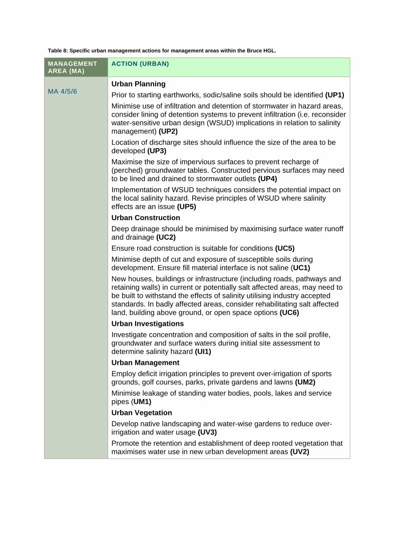
Table 8: Specific urban management actions for management areas within the Bruce HGL.
MANAGEMENT AREA (MA)
ACTION (URBAN)
MA 4/5/6
Urban Planning
Prior to starting earthworks, sodic/saline soils should be identified (UP1)
Minimise use of infiltration and detention of stormwater in hazard areas, consider lining of detention systems to prevent infiltration (i.e. reconsider water-sensitive urban design (WSUD) implications in relation to salinity management) (UP2)
Location of discharge sites should influence the size of the area to be developed (UP3)
Maximise the size of impervious surfaces to prevent recharge of (perched) groundwater tables. Constructed pervious surfaces may need to be lined and drained to stormwater outlets (UP4)
Implementation of WSUD techniques considers the potential impact on the local salinity hazard. Revise principles of WSUD where salinity effects are an issue (UP5)
Urban Construction
Deep drainage should be minimised by maximising surface water runoff and drainage (UC2)
Ensure road construction is suitable for conditions (UC5)
Minimise depth of cut and exposure of susceptible soils during development. Ensure fill material interface is not saline (UC1)
New houses, buildings or infrastructure (including roads, pathways and retaining walls) in current or potentially salt affected areas, may need to be built to withstand the effects of salinity utilising industry accepted standards. In badly affected areas, consider rehabilitating salt affected land, building above ground, or open space options (UC6)
Urban Investigations
Investigate concentration and composition of salts in the soil profile, groundwater and surface waters during initial site assessment to determine salinity hazard (UI1)
Urban Management
Employ deficit irrigation principles to prevent over-irrigation of sports grounds, golf courses, parks, private gardens and lawns (UM2)
Minimise leakage of standing water bodies, pools, lakes and service pipes (UM1)
Urban Vegetation
Develop native landscaping and water-wise gardens to reduce over-irrigation and water usage (UV3)
Promote the retention and establishment of deep rooted vegetation that maximises water use in new urban development areas (UV2)

MANAGEMENT AREA (MA)
ACTION (URBAN)
MA 9/10
Urban Management
Employ deficit irrigation principles to prevent over-irrigation of sports grounds, golf courses, parks, private gardens and lawns (UM2)
Minimise leakage of standing water bodies, pools, lakes and service pipes (UM1)
Urban Vegetation
Develop native landscaping and water-wise gardens to reduce over-irrigation and water usage (UV3)
Urban Investigations
Investigate concentration and composition of salts in the soil profile, groundwater and surface waters during initial site assessment to determine salinity hazard (UI1)
Riparian Management
Retain or re-establish effectively vegetated riparian buffer zones to manage discharge areas (preferably salt tolerant indigenous vegetation) (RM1)
Maintain/re-establish effective vegetated riparian buffer zones (RM2)
Table 9: Urban management actions having negative salinity impacts in the Bruce HGL.
AT RISK MANAGEMENT AREAS
ACTION
MA 4,5,6,9,10 Avoid:
overwatering of parks and gardens
ponding water on lower landform units
deep cut and exposure of susceptible soils during development when establishing infrastructure and dwellings
input of extra recharge from delivery and stormwater systems
R E F E R E N C E S
Department of the Environment 2012, Interim Biogeographic Regionalisation for Australia (IBRA), Version 7 (Regions), Australian Government, Department of the Environment, Canberra, ACT
Gellie, N.J.H. 2005, Native vegetation of the Southern Forests: South-east Highlands, Australian Alps, South-west Slopes and SE Corner bioregions, Cunninghamia 9(2), pp 219–253
Geoscience Australia, 2015, Australian stratigraphic units database, Canberra, ACT, [Accessed: 20 June 2015] http://dbforms.ga.gov.au/www/geodx.strat_units.int
Jenkins B.R. 1993, Soil Landscapes of the Michelago 1:100 000 Sheet map and report, Department of Conservation and Land Management, Sydney, NSW
Jenkins B.R. 2000, Soil Landscapes of the Canberra 1:100 000 Sheet map and report, Department of Land and Water Conservation, Sydney, NSW
Keith, D. A. 2004, Ocean shores to desert dunes: the native vegetation of New South Wales and the ACT, NSW Department of Environment and Conservation, Hurstville, NSW
Raymond, O.L., Lui, S., Kilgour, P., Retter, A.J., Stewart, A.J. and Stewart, G. 2007, Surface geology of Australia 1:1,000,000 scale, New South Wales – 2nd edition, Geoscience Australia, Canberra, ACT
Wooldridge, A., Nicholson, A., Muller R., Jenkins, B. R., Wilford, J. and Winkler, M. 2015, Guidelines for managing salinity in rural areas, NSW Office of Environment and Heritage, Sydney, NSW [Accessed: 20 June 2015] http://www.environment.nsw.gov.au/resources/salinity/150241-HGL-salinity-rural.pdf