Purpose and objectives of the Gippsland Region … · Web viewDELWP Lead Agency Latrobe District...
77
Joint Fuel Management Program 2018/19 – 2020/2021 Gippsland Region Incorporating South East Region
Transcript of Purpose and objectives of the Gippsland Region … · Web viewDELWP Lead Agency Latrobe District...

Joint Fuel Management Program2018/19 – 2020/2021
Gippsland RegionIncorporating South East Region

Acknowledgements© The State of Victoria Department of Environment, Land, Water and Planning 2018
This work is licensed under a Creative Commons Attribution 4.0 International licence. You are free to re-use the work under that licence, on the condition that you credit the State of Victoria as author. The licence does not apply to any images, photographs or branding, including the Victorian Coat of Arms, the Victorian
Government logo and the Department of Environment, Land, Water and Planning (DELWP) logo. To view a copy of this licence, visit http://creativecommons.org/licenses/by/4.0/
ISBN 978-1-76077-258-1 (pdf/online)
DisclaimerThis publication may be of assistance to you but the State of Victoria and its employees do not guarantee that the publication is without flaw of any kind or is wholly appropriate for your particular purposes and therefore disclaims all liability for any error, loss or other consequence which may arise from you relying on any information in this publication.
AccessibilityIf you would like to receive this publication in an alternative format, please telephone the DELWP Customer Service Centre on 136186, email [email protected] or via the National Relay Service on 133 677 www.relayservice.com.au. This document is also available on the internet at www.delwp.vic.gov.au.
We acknowledge and respect Victorian Traditional Owners as the original custodians of Victoria’s land and waters, their unique ability to care for Country and deep spiritual connection to it. We honor Elders past and present whose knowledge and wisdom has ensured the continuation of culture and traditional practices.
We are committed to genuinely partner, and meaningfully engage, with Victoria's Traditional Owners and Aboriginal communities to support the protection of Country, the maintenance of spiritual and cultural practices and their broader aspirations in the 21st century and beyond.

Foreword............................................................................................................................4
Purpose and objectives of the Gippsland Region Joint Fuel Management Program..............................................................................................................................5Purpose.......................................................................................................................................................... 5
Objective......................................................................................................................................................... 6Strategic Bushfire Management Planning................................................................................................6Bushfire Risk Reduction............................................................................................................................. 7Working with communities......................................................................................................................... 9Maintaining and enhancing Ecosystem Resilience..................................................................................9Other objectives specific to the Gippsland Region................................................................................11
Endorsement....................................................................................................................12
Approval...........................................................................................................................12
Viewing the Gippsland Region Joint Fuel Management Program..............................12
How to become involved in the Joint Fuel Management Program.............................13
Appendix (i): Schedules of Activities............................................................................14DELWP LEAD AGENCY LATROBE DISTRICT SCHEDULE......................................................................14
DELWP LEAD AGENCY MACALISTER DISTRICT SCHEDULE................................................................23
DELWP LEAD AGENCY TAMBO DISTRICT SCHEDULE...........................................................................32
DELWP LEAD AGENCY SNOWY DISTRICT SCHEDULE..........................................................................46
CFA LEAD AGENCY DISTRICT 27 SCHEDULE.........................................................................................56
CFA LEAD AGENCY DISTRICT 09 SCHEDULE.........................................................................................58
CFA LEAD AGENCY DISTRICT 10 SCHEDULE.........................................................................................60
CFA LEAD AGENCY DISTRICT 11 SCHEDULE.........................................................................................62
MELBOURNE WATER PLANNED BURNS SCHEDULE.............................................................................63
Glossary...........................................................................................................................64
Page 3
Contents

In 2015, the Victorian Government set out a new approach to reducing the risk of bushfire in Victoria called Safer Together. Safer Together outlines an approach to reducing the risk of bushfires to Victorian communities, which focuses on how effective our actions are in reducing risk. It aims for a more integrated approach across public and private land.
Working together, FFMVic* and the Country Fire Authority (CFA) has developed this first Joint Fuel Management Program which covers the Gippsland Department of Environment, Land, Water and Planning (DELWP) Region and South East CFA Region. It demonstrates our commitment to working more closely to deliver the best bushfire risk reduction outcomes for Victorians. It recognises that bushfire risk occurs across all land.
The Joint Fuel Management Program (JFMP) is compiled to achieve an integrated and risk-focused fuel management program across public and private land. It is designed to implement long-term strategic bushfire management strategies that outline how we will manage the risk of bushfires for the protection of life and property on public and private land, while maintaining and improving natural ecosystems.
Fuel management is recognised as one of the most effective ways to reduce the impacts of bushfires to communities and the environment.
This JFMP has been shaped by a variety of information, such as risk-based planning detailed within our strategic bushfire management plans, specialist input from FFMVic, CFA staff and key industries, as well as knowledge from local communities, including Traditional Owners and key stakeholders.
We have identified planned burns across all land tenures. However, for this first JFMP, only private property burns that are a direct risk reduction benefit, are high profile or where a community need is identified, are included. All other CFA planned burns which are not listed in this document, will be added to the JFMP map over time so the public can see the complete fuel management program from all agencies. In the future, burns will be planned with increasing collaboration, as we continue to work closely together.
All CFA planned burns are documented in Municipal Fire Management Plans held by the relevant local government authority. Some Municipal Fire Management Plans also include strategic fuel breaks, works required for the maintenance of fire access roads and other roadside and railway burns.
The Joint Fuel Management Program (JFMP) replaces DELWP’s Fire Operation Plan (FOP).
Based on feedback and local knowledge from communities and key stakeholders, we will review and update the JFMP each year. We may make changes to burns or other fuel management activities. Our highest priority however, in carrying out fuel management activities is always the need to reduce the impact of bushfires on life and property.
We would like to acknowledge this as a significant milestone for Safer Together and recognise the work that has been put into developing this first Joint Fuel Management Plan, both by FFMVic staff, CFA and local communities. We encourage your continued input to ensure our plans protect those assets and values which are important to all Victorians.
Kelly Rash Trevor OwenAssistant Chief Fire Officer DELWP Assistant Chief Officer CFAGippsland Region South East Region
* Forest Fire Management Victoria (FFMVic) – is the organisation that delivers services to achieve DELWP’s legislated responsibilities. It consists of specialist staff from DELWP, Parks Victoria, Melbourne Water and VicForests.
Gippsland Region Joint Fuel Management Program 2018/19 – 2020/21 Page 4
Foreword

Purpose and objectives of the Gippsland Region Joint Fuel Management ProgramPurposeThe maps and schedules contained within this Joint Fuel Management Program set out where and when fuel management activities are planned to occur for the period 2018/19 to 2020/21 within the Gippsland Region.
These activities are carried out to reduce bushfire fuels – like leaves, twigs, bark and grass – to make bushfires less intense, minimising the risk to communities and providing safety to fire-fighters while fighting these fires. Activities are also done to maintain the health of ecosystems that rely on fire to regenerate.
It is important to note that the ability to carry out burns is dependent on seasonal and local weather conditions. To allow for this, planned burns from the second and third years of the program may be brought forward to the current year to replace a burn planned for the first year.
Fuel Management activities are under taken across the landscape on public and private land. Through the fuel management planning processes the appropriate lead agency for delivery has been determined.
This document consists of Lead Agency District sub-plans and contains the following schedules:
Schedule 1 – Planned Burns. This schedule lists planned fuel reduction, ecological and other planned burns by indicative year for the three-year period.
Schedule 2 – Non-Burn Fuel Treatments. This schedule summaries the program that uses methods other than burning to achieve the fuel management objectives.
Schedule 3 – Strategic Fuelbreaks. This schedule provides an overview of FFMVic strategic fuelbreaks to be constructed during the three-year period. The locations of strategic fuelbreaks are included for information only. These activities are approved via other FFMVic and Parks Victoria processes.
It should be noted that CFA/Municipality led strategic fuel breaks are critical to bushfire management, although are not included in this Regional JFMP. These activities are approved and listed as part of Municipal planning processes.
The following Districts are part of the Gippsland Region as per Map 1 below:
Latrobe District, DELWP District 8, CFA
Macalister District, DELWP District 9, CFA
Tambo District, DELWP District 27, CFA
Snowy, District, DELWP District 10, CFA
District 11, CFA
CFA Lead Planned Burns will continue to be planned and delivered through their respective Authorising District, irrespective of which regional JFMP they appear in.
Gippsland Region Joint Fuel Management Program 2018/19 – 2020/21 Page 5
Map 1: Gippsland Region
Burns associated with logging regeneration as well as small heap burns are not included in the Joint Fuel Management Program process.
The Joint Fuel Management Program is prepared and will be implemented in accordance with the Code of Practice for Bushfire Management on Public Land 2012 (the Code), Safer Together: A new approach to reducing the risk of bushfire in Victoria and relevant CFA and FFMVic Instructions, Manuals and Guidelines.
ObjectiveThe Gippsland Region JFMP has been developed to implement strategies set out in FFMVic’s strategic bushfire management plans which address DELWP’s legal obligations, policy commitments and objectives, including:
bushfire risk reduction to protect human life and property, maintaining and enhancing ecosystem resilience, and achieving other desired outcomes as identified by communities.
Strategic Bushfire Management PlanningFFMVic in consultation with CFA and communities has developed long-term strategic bushfire management plans to identify where it is best to undertake fire management to achieve the above objectives.
The strategies apply to four Fire Management Zones (FMZ) on public land as described in the Code. While the Code of Practice objectives apply across the whole landscape, the FMZ system provides a spatial representation of which objectives are the main focus in different parts of the landscape. These include:
Asset Protection Zone (APZ): where intensive fuel management provides the highest level of localised protection to human life and property;
Bushfire Moderation Zone (BMZ): where there is fuel management to reduce the speed and intensity of bushfires, either close to towns or as they spread through the landscape;
Gippsland Region Joint Fuel Management Program 2018/19 – 2020/21 Page 6

Landscape Management Zone (LMZ): where fuel management is done to reduce fuel hazard, improve ecosystem resilience and manage the land for particular uses (such as forest regeneration and water catchment protection); and
Planned Burning Exclusion Zone (PBEZ): where there is no planned burning, mainly to protect areas that can’t tolerate fire.
The zones and other strategies in strategic bushfire management plans inform the development of the JFMP. They are used to determine where fuel management activities need to be carried out over the next three-year period to meet the longer-term strategy’s objectives, if weather and other conditions permit.
Burns are planned across all available fire management zones (APZ, BMZ and LMZ) for maintaining bushfire risk to desired levels. It is also important to carry out planned burns in remote areas, as fires can start in these areas and spread to threaten houses and communities.
Spatial classification of private land risk (similar to fire management zoning on public land) will occur as further analysis and the planning process for a Strategic Gippsland plan is undertaken in 2018/19. This next step will re-enforce our tenure-blind commitment to achieving an integrated approach to bushfire fuel management.
Strategic bushfire management plans for two bushfire risk landscapes were used in the development of the current Gippsland JFMP. The Alpine and Greater Gippsland Bushfire Risk Landscape strategic plan covers three Gippsland Districts: Tambo, Macalister and Snowy. The remaining Gippsland District, Latrobe, is covered by the East Central Bushfire Risk Landscape strategic plan. The strategic planning process is working towards the realignment of the bushfire risk landscape to Gippsland's Regional boundary to match the operational planning process.
In general, fuel treatment in the form of planned burning will be focused in APZ and BMZ, north-west and south-west of communities, as this is typically the direction from which the worst bushfires approach. Fuel hazard is managed close to towns and communities in APZ and BMZ to reduce bushfire intensity. It is also managed throughout the broader landscape in LMZ to assist with early suppression, preventing smaller bushfires from becoming large campaign bushfires.
Bushfire Risk ReductionSafer Together: A new approach to reducing the risk of bushfire in Victoria sets out the Victorian Government’s commitments to reducing the risk of bushfire in Victoria. It adopts a risk reduction target to guide fuel management, maintaining bushfire risk at or below a residual risk of 70% in the long-term.
Residual risk, is the risk, on average, that bushfires will impact on life and property across the landscape. It is expressed as the percentage of the risk that remains after bushfire history and fuel management (mainly planned burning) activities are considered.
Residual risk is currently 64.2% in the Gippsland region. The Residual risk status of individual Districts is 82.6% in Latrobe District, 50.1% in Macalister District, 54.7% in Snowy District and 49.9% in Tambo District.
By 2021 the state-wide JFMP is anticipated to reduce residual risk by 18% compared to the level it would reach without fuel management and maintain residual risk below the state-wide target of 70%. Gippsland’s JFMP contributes approximately one fifth (i.e. 3.5% of 18%) of the state-wide reduction in risk from fuel management, anticipating 264,000 ha treated over the three years of the Gippsland JFMP.
Anticipated residual risk following implementation of the 3-year JFMP is 67.4% for the region, 80.9% in Latrobe district, 52.5% in Macalister district, 61.1% in Snowy district and 57.5% in Tambo district. These residual risk calculations are based on Gippsland delivering 88,000ha each year for 3 years.
Residual risk will increase across the region by around 3.2% over 3 years. This is mainly due to fuel accumulation following large bushfires in 2009 (Latrobe district), 2014 (Snowy district), 2017 (Tambo district) and 2018 (Macalister district). If the JFMP is not implemented, residual risk will increase by an estimated 15.2% over 3 years.
See Table 1, which shows projected residual risk with and without JFMP implementation.
Gippsland Region Joint Fuel Management Program 2018/19 – 2020/21 Page 7

Table 1: Estimated residual risk to 2021
Residual Risk Categories Latrobe District
Macalister District
Snowy District
Tambo District
Gippsland Region
Current Residual Risk 82.6% 50.1% 54.7% 49.9% 64.2%
Projected Residual Risk 2021 – JFMP implemented to 88,000ha/yr
80.9% 52.5% 61.1% 57.5% 67.4%
Projected Residual Risk if JFMP not implemented 87.1% 62.8% 77.8% 72.9% 79.4%
The Gippsland Region’s contribution to meeting the state-wide JFMP risk reduction target anticipates 88,000 ha per annum of fuel management in the 2018/19-2020/21 JFMP. Table 2 below shows the breakdown of the Gippsland Region’s fuel management planning across the three years of the JFMP. To allow for flexibility in the delivery of the planned burning program, additional hectares are included in the JFMP. Figures represented in the Districts Schedule of planned burns are recorded as gross mapped areas and in some cases, are significantly larger than the nett planned treatment area.
Table 2 Area planned for treatment Gippsland Joint Fuel Management Program 2018/19- 2020/21
Fuel Treatment 2018/19 2019/20 2020/21
JFMP delivery hectares (ha) 88,000 88,000 88,000
Planned burning nett (ha) 94,500 106,235 95,431
Planned burning gross (ha) 134,835 112,179 118,573
Safer Together commits FFMVic and CFA to working together, sharing responsibility for fuel management with private landholders and local government. This new approach will enhance FFMVic and CFA to plan, prepare and deliver a fuel management program across the landscape, regardless of land tenure.
The Gippsland JFMP has 33 cross-tenure burns over the 3 years of the JFMP. Where cross-tenure and private property burns have been included on this JFMP, representatives from either/or both CFA and FFMVic have worked collaboratively with the relevant landholder(s) to plan the burn. Burns conducted partially or wholly on private land are always undertaken with the landholder’s consent.
In future, we aim to have a greater number of private land burns where risk assessment indicates it is a priority. More private landholders will be involved in fuel management strategy development, and they and the CFA will be empowered to conduct burns on private land with the support of FFMVic.
The JFMP planning process is informed by the current Strategic Bushfire Management Plans, which were created in 2015. Now, under the Safer Together program, a new strategic bushfire management planning process is being undertaken in Gippsland, inclusive of public and private land. Outcomes of this new planning process will:
• align strategic bushfire planning to the Gippsland regional footprint (as opposed to the previous planning footprint of Bushfire Risk Landscapes)
• strengthen the cross-tenure approach to bushfire management planning
• improve planning tools to better link strategic and operational planning
This new approach has a broadened scope of objectives for bushfire management planning that will apply to both public and private land. These objectives have been developed by, and agreed to, through a series of workshops with the fire management sector in Gippsland, and public consultation is currently underway to assess how well they align with the community’s priorities. The objectives are:
Gippsland Region Joint Fuel Management Program 2018/19 – 2020/21 Page 8

• Minimise human life loss and serious injury
• Minimise social, livelihood and economic disruption
• Minimise disruption to essential services and critical infrastructure
• Minimise loss of community and cultural assets
• Minimise decline in native plant and animal populations
In developing an improved strategic bushfire management plan for Gippsland, the interaction and trade-offs associated with achieving these objectives will be considered and incorporated into decision making. The new strategic plan will include revised Fire Management Zoning, spatial classification of private land, and long-term targets for performance measures (including residual risk) for fuel management across Gippsland.
Working with communitiesManaging bushfire risk is an ongoing and shared responsibility in which everyone has a role. To work well with communities to manage bushfire risk, FFMVic operates under the principles of the DELWP Community Charter and CFA operates under the CFA Service Delivery Strategy 2015-2020.
In the Gippsland Region, FFMVic and CFA form partnerships with each other to work with communities, while each agency also maintains relationships with communities independent of each other. Under Safer Together, partnerships between FFMVic, CFA, local government and other agencies will continue to be enhanced so that communities receive the best level of service.
FFMVic and CFA work all year round with communities to understand and reduce bushfire risk. As a part of delivering Safer Together, FFMVic has worked with many stakeholders and partners to develop the JFMP, including Local Government, apiarists, wine growers, Traditional Owner groups and environmental groups.
Community stakeholders have provided input throughout the year resulting in numerous changes to the JFMP. This local knowledge has been incorporated into determining where planned burns take place, how they should be delivered and what values need protection. Changes include removal of burns, addition of private property to enable cross tenure burns, burn boundary alterations and changes with burn scheduling to better reflect community priorities.
Gunaikurnai Land and Waters Aboriginal Corporation (GLaWAC) represents Traditional Owners from the Brataualung, Brayakaulung, Brabralung, Krauatungalung and Tatungalung family clans. DELWP and other agencies work with GLaWAC to implement the Whole of Country plan objectives, including “We want to be actively managing the water, fire, wildlife and biodiversity on our Country, and helping others to also do this in a culturally appropriate way.” The Victorian Government and GLaWAC have a formal and ongoing partnership known as Joint Management where both share their knowledge and share the management of certain parks and reserves on Crown Land. In Gippsland, GLaWAC jointly manage 10 parks and reserves, working in partnership with Parks Victoria and FFMVic. Across the 3 years of the JFMP, Gippsland has 16 planned burns within joint management areas. Work will continue to deliver the Joint Management Plan objective to “Re-establish Gunaikurnai fire management knowledge and practices in Joint Management parks.”
In implementing the JFMP, FFMVic and CFA will work closely with the community. In relation to potential smoke impacts form planned burning, FFMVic will also work with the community in the broader Latrobe Valley Area. A Smoke Management Plan has been developed by FFMVic, Department of Health and Human Services (DHHS), Environment Protection Authority (EPA) and the CFA. Community groups are listed in the plan and are notified and engaged if the plan is required. The plan was first used in autumn 2017. Smoke Management Officers have been deployed to Incident Management Teams during significant smoke events in Gippsland to provide engagement support. This role was included as part of Gippsland’s planned burning program since 2015.
Community Based Bushfire Management (CBBM) is about communities and agencies working collaboratively, sharing and valuing knowledge, enabling communities to make informed decisions, and developing local solutions to reduce the bushfire risk. The focus of CBBM in Gippsland over the coming year will be around the Briagolong, Mallacoota and Latrobe Valley communities. In each of these areas, agencies are developing a close working relationship with the Shire Council, residents and community groups to develop Community Emergency Management Plans or other CBBM related projects.
Gippsland Region Joint Fuel Management Program 2018/19 – 2020/21 Page 9

Maintaining and enhancing Ecosystem ResilienceAn objective of the Code is to “maintain or improve the resilience of natural ecosystems and their ability to deliver services such as biodiversity, water, carbon storage and forest products” (the Code). Strategic bushfire management plans include consideration of ecosystem resilience at a strategic level over the long term, particularly how we can measure it. However, FFMVic is working towards developing a more detailed understanding of how planned burning might impact flora and fauna, and how we can use fire to maintain and enhance ecosystem resilience into the future.
A greater risk-based focus to operational planning has allowed Districts to improve consideration of ecosystem resilience.
Potential impacts on species and communities listed under the Commonwealth Environment Protection and Biodiversity Conservation Act 1999 (EPBC Act) or the Victorian Flora and Fauna Guarantee Act 1988 (FFG Act) have been addressed at the operational review of the draft JFMP. Records of listed species from the Victorian Biodiversity Atlas were used to identify potential conflicts with proposed burns and works. Advice has been provided regarding the potential nature of any impacts, along with recommendations to eliminate, mitigate or minimise potential threats to these values during planned burning. FFMVic is currently developing a strategic assessment process to identify, assess and mitigate potential impacts of the planned burning program on Matters of National Environmental Significance.
Other objectives specific to the Gippsland RegionDuring the development of the Gippsland JFMP, several ecological principles were considered. These reflect a strategic approach to maintaining or improving ecosystem resilience and include:
Retaining long undisturbed vegetation in the landscape where risk reduction is not a priority Minimising burning areas in LMZ that are below minimum TFI Minimising burning vegetation types in LMZ that have a large extent across the landscape below
minimum TFI Avoiding burning areas with little bushfire risk reduction benefit Retaining long undisturbed habitat of fauna species with a preference for older vegetation Avoiding ignition and planned burning in Leadbeater’s Possum habitat Identifying methods to mitigate risk to biodiversity values during burn preparation and
implementation
Gippsland Region Joint Fuel Management Program 2018/19 – 2020/21 Page 10

EndorsementThe 2018/19 – 2020/21 Joint Fuel Management Plan for the Gippsland Region has been endorsed by:
DELWP Assistant Chief Fire Officer: Kelly Rash, Gippsland Region
CFA Assistant Chief Officer: Trevor Owen, South East Region
ApprovalThe 2018/19 – 2020/21 Joint Fuel Management Plan for the Gippsland Region has been approved by:
DELWP Chief Fire Officer: Chris Hardman
CFA Chief Officer: Steve Warrington
Noting for on ground ignition and delivery of cross tenure and private property burns, DELWP and CFA agency responsibilities remain unchanged.
Viewing the Gippsland Region Joint Fuel Management ProgramThe 2018/19 – 2020/21 Joint Fuel Management Plan for the Gippsland Region can be viewed during normal business hours at the following office locations:
Location Address
Bairnsdale CFA 261 – 263 Main St, Bairnsdale
Bairnsdale DELWP 574 Main St, Bairnsdale
Orbost CFA & DELWP 171 – 173 Nicholson St, Orbost
Sale CFA 64 – 66 Foster St, Sale
Traralgon DELWP 70 Hotham St, Traralgon
Morwell CFA 20 Hazelwood Rd, Morwell
Viewing the Plan online:You can view the Gippsland Joint Fuel Management Program online at:
http://www.ffm.vic.gov.au/bushfire-fuel-and-risk-management/fire-operation-plans
Upcoming burnsBurns that will be conducted within the next ten days (weather conditions permitting) can be viewed at:
http://www.ffm.vic.gov.au/bushfire-fuel-and-risk-management/planned-burns
Gippsland Region Joint Fuel Management Program 2018/19 – 2020/21 Page 11

You can also sign up to the Planned burning notification system (PBNS) and Vic Emergency App to receive automated SMS and email notifications about planned burns when they are close to being carried out.
How to become involved in the Joint Fuel Management Program FFMVic and CFA welcome comment on fire management all year round, on all parts of the planning process – both strategic and operational. Please be aware that due to the planning cycle your comments relating to fire operations may be included in next year’s Joint Fuel Management Plan.
Comments and suggestions about FFMVic and CFA fire management planning can be sent to:
Regional Fuel Management Coordinator, Gippsland, DELWP574 Main StreetBairnsdale 3875
Vegetation Management Officer, South East Region, CFA20 Hazelwood RoadMorwell 3840
Vegetation Management Officer, South East Region, CFA130 Macleod StBairnsdale 3875
Planned Burning Email contact details: Comments may also be sent by email to: gippsland.plannedburning @delwp.vic.gov.au or for Tambo and Snowy Districts: [email protected]
Gippsland Region Joint Fuel Management Program 2018/19 – 2020/21 Page 12

Appendix (i): Schedules of ActivitiesDELWP LEAD AGENCY LATROBE DISTRICT SCHEDULESCHEDULE 1: PLANNED BURNS The activities in this schedule are planned burns.
Please note that the planned burn year and season identified for each planned burn is indicative only and may be changed due to weather conditions and operational requirements.
Abbreviations in Schedule1: ‘*’ asterisk on burn name denotes a cross tenure burn; ‘#’ hash on burn name denotes a Jointly Management Area (JMA) burn; PV - Parks Victoria; COM - Committee of Management; DELWP- Department of Environment Land Water and Planning; PP – Private Property; FRB - Fuel Reduction Burn; ECO - ecological burn; FMZ – Fire Management Zone; APZ - Asset Protection Zone; BMZ – Bushfire Moderation Zone; LMZ - Landscape Management Zone; PBEZ – Planned Burn Exclusion Zone; NZ -Not Zoned.
DELWP Lead Agency Planned Burns 2018/19
Local Government
Area
BurnNumber
Burn Name GeneralLocation
Land Manager
BurnSeason
Burn Type(FRB/ECO)
Land Management Objective FMZ Planned Burn Size
(ha)
New Burn(New)
Baw Baw GP-LAT-ERI-0003
ERICA - RINTOUL CREEK
10km SE of EricaDELWP Autumn FRB To provide bushfire protection outcomes by
reducing overall fuel hazard and bushfire hazard in the landscape.
LMZ 1264.4
Baw Baw GP-LAT-NJE-0003
FUMINA - COSTINS
2.5km S of Fumina DELWP Autumn FRB To develop fuel reduced areas of sufficient width and continuity to reduce the speed and intensity of bushfires.
BMZ 186.1
Baw Baw GP-LAT-NJE-0015
*FUMINA SOUTH - TANJIL JUNCTION WEST
5km E of Fumina South DELWP Autumn FRB To develop fuel reduced areas of sufficient width and continuity to reduce the speed and intensity of bushfires.
BMZ 450.4
Baw Baw GP-LAT-NJE-0009
*Hill End – Camp Creek
2km W of Hill End DELWP Autumn FRB To develop a fuel reduced area to the West of Hill End Township.
BMZ 488.8
South Gippsland
GP-LAT-SGD-0018
MIRBOO NORTH - HOODS HILL
1.5km E of Mirboo North DELWP AUTUMN FRB To develop fuel reduced areas of sufficient width and continuity to reduce the speed and intensity of bushfires.
BMZ 26.08
DELWP Lead Agency Latrobe District Page 13

South Gippsland
GP-LAT-SGD-0017
*Mirboo North - Railway Road
2km NE of Mirboo North DELWP AUTUMN FRB To develop fuel reduced areas of sufficient width and continuity to reduce the speed and intensity of bushfires.
BMZ 9.81
Baw Baw GP-LAT-ERI-0021
Moondarra - Wild Cow
7km NE of Tanjil South Parks Victoria
AUTUMN FRB To develop fuel reduced areas of sufficient width and continuity to reduce the speed and intensity of bushfires.
BMZ 1014.1
Baw Baw GP-LAT-NJE-0017
NAYOOK - WHITES CORNER
2km W of Nayook DELWP AUTUMN FRB To provide the highest level of localised protection to human life, property and community assets identified as highly valued including Nayook and Piedmont.
BMZ 370.71
Baw Baw GP-LAT-NJE-0010
Noojee - Bushland Reserve East
0.1km S of Noojee Parks Victoria
AUTUMN FRB To provide the highest level of localised protection to human life, property and community assets identified as highly valued including Noojee township.
APZ 47.99
Baw Baw GP-LAT-ERI-0026
Rawson - Amor Jack
1km N of Rawson DELWP AUTUMN FRB To provide the highest level of localised protection to human life, property and community assets identified as highly valued including Rawson Township.
APZ 80.75
Baw Baw GP-LAT-ERI-0010
Rawson - Mclelland Rd
.5km SE of Rawson DELWP AUTUMN FRB To provide the highest level of localised protection to human life, property and community assets identified as highly valued including Rawson Township.
APZ 14.11
Baw Baw GP-LAT-ERI-0009
RAWSON - OLD DEPOT
1km S of Rawson DELWP AUTUMN FRB To develop a fuel reduced area to the South East of Rawson Township.
BMZ 218
Baw Baw GP-LAT-NJE-0014
*SPRINGSURE HILL - SHADY CREEK
8km E of Neerim South DELWP AUTUMN FRB To develop fuel reduced areas of sufficient width and continuity to reduce the speed and intensity of bushfires.
BMZ 378.95
Baw Baw GP-LAT-ERI-0022
Tanjil - Stuart Mine
8km E of Hill End DELWP AUTUMN FRB To provide bushfire protection outcomes by reducing overall fuel hazard and bushfire hazard in the landscape.
LMZ 3488.34
Baw Baw GP-LAT-ERI-0002
TANJIL EAST - ANDERSONS
6KM NW of Yallourn North
Parks Victoria
AUTUMN FRB To develop fuel reduced areas of sufficient width and continuity to reduce the speed and intensity of bushfires.
BMZ 393.78
Latrobe City GP-LAT-ERI-0004
Toongabbie - Mt Lookout
4km NW of Toongabbie DELWP AUTUMN FRB To develop fuel reduced areas of sufficient width and continuity to reduce the speed and intensity of bushfires.
BMZ 590.78
Gippsland Region Joint Fuel Management Program 2018/19 – 2020/21 Page 14

South Gippsland
GP-LAT-SGD-0006
Walkerville - Walkerville South Road
2.5km SW of Walkerville PARKS VICTORIA
AUTUMN FRB To provide bushfire protection outcomes by reducing overall fuel hazard and bushfire hazard in the landscape.
LMZ 12.7
South Gippsland
GP-LAT-SGD-0016
Waratah Bay - Heath Loop Tk
0.5km NNW of Waratah Bay
Parks Victoria
AUTUMN FRB To develop a fuel reduced area to the North West of the Waratah Bay township.
BMZ 12.24
South Gippsland
GP-LAT-SGD-0026
Wilsons Promontory - Big Hummock exclusion plot
9km SE of Yanakie Parks Victoria
WINTER FRB To modify the vegetation structure across the planned area to assist the promotion of Coastal Woodland.
LMZ 0.57
South Gippsland
GP-LAT-SGD-0028
Wilsons Promontory - Block 3 exclusion plot
11km S of Yanakie Parks Victoria
WINTER FRB To modify the vegetation structure across the planned area to assist the promotion of Coastal Woodland.
LMZ 0.11
South Gippsland
GP-LAT-SGD-0027
Wilsons Promontory - Grassland exclusion plot
10km SE of Yanakie Parks Victoria
WINTER FRB To modify the vegetation structure across the planned area to assist the promotion of Coastal Woodland.
LMZ 0.1
South Gippsland
GP-LAT-SGD-0029
Wilsons Promontory - Limestone exclusion plot
13km SE of Yanakie Parks Victoria
WINTER FRB To modify the vegetation structure across the planned area to assist the promotion of Coastal Woodland.
LMZ 0.66
South Gippsland
GP-LAT-SGD-0025
Wilsons Promontory - Little Drift exclusion plot
9km SE of Yanakie Parks Victoria
WINTER FRB To modify the vegetation structure across the planned area to assist the promotion of Coastal Woodland.
LMZ 0.36
Bass Coast GP-LAT-SGD-0036
WONTHAGGI - CAMPBELL STREET
0.5km W of Wonthaggi Parks Victoria
SPRING FRB To modify the vegetation structure across the planned area to assist the promotion of Coastal Woodland.
BMZ 2.61
Bass Coast GP-LAT-SGD-0037
Wonthaggi - Heathlands Block C
3 KM SOUTH OF WONTHAGGI
Parks Victoria
AUTUMN ECO To modify the vegetation structure across the planned area to assist the promotion of both the Eastern Spider Orchid and the Southern Brown Bandicoot habitats.
LMZ 16.2 New
South Gippsland
GP-LAT-SGD-0015
WPNP - Little Drift Track
10km SE of Yanakie Parks Victoria
SPRING ECO To modify the vegetation structure across the planned area to assist the promotion of Coastal Woodland.
LMZ 389.43
South GP-LAT- WPNP - Millers 14km SSW of Yanakie Parks AUTUMN FRB To develop fuel reduced areas of sufficient width and continuity to reduce the speed and intensity of
BMZ 96.94
Gippsland Region Joint Fuel Management Program 2018/19 – 2020/21 Page 15

Gippsland SGD-0012
Landing Victoria bushfires.
South Gippsland
GP-LAT-SGD-0014
WPNP - Squeaky South
1km NW of Tidal River Parks Victoria
SPRING FRB To develop a fuel reduced area to the North West of the Tidal River village.
BMZ 182.42
Baw Baw GP-LAT-ERI-0005
*YALLOURN NORTH - LESLIE TRACK
5km N of Yallourn North Parks Victoria
AUTUMN FRB To develop a fuel reduced area to the North of Yallourn North Township.
BMZ 256.02
Gippsland Region Joint Fuel Management Program 2018/19 – 2020/21 Page 16

DELWP Lead Agency Planned Burns 2019/20
Local Governmen
t Area
BurnNumber
Burn Name GeneralLocation
Land Manager
BurnSeason
Burn Type(FRB/ECO)
Land Management Objective FMZ Planned Burn Size
(ha)
New Burn(New)
Latrobe City GP-LAT-SGD-0021
Boolarra - Rabbi Track
2.2km S of Boolarra DELWP AUTUMN FRB To provide bushfire protection outcomes by reducing overall fuel hazard and bushfire hazard in the landscape.
LMZ 13.76
Latrobe City GP-LAT-SGD-0009
BOOLARRA SOUTH - NATHANS TRK
5.5km SW of Boolarra Parks Victoria
AUTUMN FRB To provide bushfire protection outcomes by reducing overall fuel hazard and bushfire hazard in the landscape.
LMZ 50.43
Latrobe City GP-LAT-ERI-0014
*COWWARR - TOONGABBIE
4.5KM WNW OF COWWARR
DELWP AUTUMN FRB To develop a fuel reduced area to the West of Cowwarr Township.
BMZ 1306.75
Baw Baw GP-LAT-ERI-0015
Erica - W18 1km E of Moondarra Reservoir
DELWP AUTUMN FRB To develop a fuel reduced area to the North West of Tyers township.
BMZ 1222.57
Baw Baw GP-LAT-NJE-0002
Fumina - Roast Tea
3km E of Fumina DELWP AUTUMN FRB To provide bushfire protection outcomes by reducing overall fuel hazard and bushfire hazard in the landscape.
LMZ 602.43
Baw Baw GP-LAT-NJE-0005
FUMINA SOUTH - WILD BULL
2km SW of Fumina South DELWP AUTUMN FRB To develop a fuel reduced area to the West of Fumina South.
BMZ 411.59
Latrobe City GP-LAT-ERI-0017
GLENGARRY - E7
5.5km NNW of Glengarry DELWP AUTUMN FRB To develop fuel reduced areas of sufficient width and continuity to reduce the speed and intensity of bushfires.
BMZ 310.76
Baw Baw GP-LAT-NJE-0006
Hill End - Hard Up
5.5km WSW of Hill End DELWP AUTUMN FRB To provide bushfire protection outcomes by reducing overall fuel hazard and bushfire hazard in the landscape.
LMZ 675.27
Baw Baw GP-LAT-ERI-0007
HILL END - MERVS
5km E of Hill End DELWP AUTUMN FRB To provide bushfire protection outcomes by reducing overall fuel hazard and bushfire hazard in the landscape.
LMZ 633.03
Baw Baw GP-LAT-ERI-0008
JERICHO - RJ SPUR
1km SE of Jericho DELWP AUTUMN FRB To provide bushfire protection outcomes by reducing overall fuel hazard and bushfire hazard in the landscape.
LMZ 187.93
South GP-LAT- Mirboo North - 1.5km E of Mirboo North DELWP AUTUMN FRB To develop a fuel reduced area to the North of BMZ 27.1
DELWP Lead Agency Latrobe District Page 17

Gippsland SGD-0010
Transfer Station Baromi.
Baw Baw GP-LAT-NJE-0027
Noojee - Bushland Reserve West
05 km South of Noojee DELWP AUTUMN FRB To provide a high level of strategic protection to human life, property and highly valued assets in Noojee.
APZ 18.3 New
Baw Baw GP-LAT-NJE-0024
*Noojee - Ridge Road
2.5km N of Noojee DELWP AUTUMN FRB To develop a fuel reduced area to the North of Noojee Township.
BMZ 341.52
Baw Baw GP-LAT-ERI-0029
Parkers Corner - Finns Track
2km NW of Rawson DELWP AUTUMN FRB To provide the highest level of localised protection to human life, property and community assets identified as highly valued including Rawson Township.
APZ 75.69
Baw Baw GP-LAT-NJE-0007
SWEETWATER - BEARDS
10km ESE of Neerim South
Parks Victoria
AUTUMN FRB To develop a fuel reduced area to the West of Willow Grove.
BMZ 181.44
Baw Baw GP-LAT-ERI-0020
TANJIL - LADY MANOR SUTTON
14.5km WNW of Erica DELWP AUTUMN FRB To provide bushfire protection outcomes by reducing overall fuel hazard and bushfire hazard in the landscape.
LMZ 857.13
Baw Baw GP-LAT-NJE-0012
THOMSON - POOLE JORDAN
9km SW of Woods Point DELWP AUTUMN FRB To develop fuel reduced areas of sufficient width and continuity to reduce the speed and intensity of bushfires.
BMZ 1759.16
Baw Baw GP-LAT-ERI-0006
WALHALLA - MORMON TOWN
6km N of Walhalla Parks Victoria
AUTUMN FRB To provide bushfire protection outcomes by reducing overall fuel hazard and bushfire hazard in the landscape.
LMZ 597.1
South Gippsland
GP-LAT-SGD-0011
WPNP - SouWest Corner Track
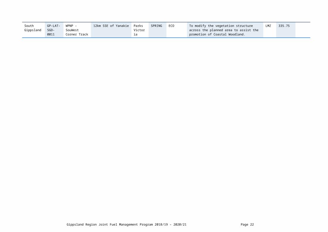
12km SSE of Yanakie Parks Victoria
SPRING ECO To modify the vegetation structure across the planned area to assist the promotion of Coastal Woodland.
LMZ 335.75
Gippsland Region Joint Fuel Management Program 2018/19 – 2020/21 Page 18

DELWP Lead Agency Planned Burns 2020/21
Local Governmen
t Area
BurnNumber
Burn Name GeneralLocation
Land Manager
BurnSeason
Burn Type(FRB/ECO)
Land Management Objective FMZ Planned Burn Size
(ha)
New Burn(New)
Bass Coast GP-LAT-SGD-0033
*Adams Estate - Stanley Rd
0.1km S of Adams Estate
COM Council AUTUMN FRB To provide the highest level of localised protection
to human life, property and community assets identified as highly valued including Adams Estate.
Non FPA Land
22.24
Baw Baw GP-LAT-ERI-0013
BAW BAW - BEARDMORES
1km E of Thomson Dam Parks Victoria
AUTUMN FRB To develop fuel reduced areas of sufficient width and continuity to reduce the speed and intensity of bushfires.
BMZ 353.81
Latrobe City GP-LAT-ERI-0018
Callignee - Robs Tk
3km N of Callignee Parks Victoria
AUTUMN FRB To develop a fuel reduced area to the North of residences along Sunday Rd and the West along Old Callignee Rd.
BMZ 107.32
Baw Baw GP-LAT-NJE-0023
Crossover - Gunn Rd
3km SE of Neerim South DELWP AUTUMN FRB To develop fuel reduced areas of sufficient width and continuity to reduce the speed and intensity of bushfires.
BMZ 184.71
Baw Baw GP-LAT-ERI-0023
Erica - Hotel Creek
1km W of Erica DELWP AUTUMN FRB To provide the highest level of localised protection to human life, property and community assets identified as highly valued including Erica Township.
APZ 264.52
Baw Baw GP-LAT-ERI-0016
ERICA - MIDDLE CREEK
3.5km WNW of Erica DELWP AUTUMN FRB To provide the highest level of localised protection to human life, property and community assets identified as highly valued including Erica township.
APZ 156.17
Baw Baw GP-LAT-ERI-0025
Jacob Creek - Mcconachys Road
3.6km SE of Erica DELWP AUTUMN FRB To provide bushfire protection outcomes by reducing overall fuel hazard and bushfire hazard in the landscape.
Non FPA Land
13.22
Baw Baw GP-LAT-NJE-0022
Jericho - Poole Road
6km SE of Matlock DELWP AUTUMN FRB To develop fuel reduced areas of sufficient width and continuity to reduce the speed and intensity of bushfires.
BMZ 1761.85
Baw Baw GP-LAT-NJE-0020
*Loch Valley - Lv1 Track
4km N of Noojee DELWP AUTUMN FRB To develop a fuel reduced area to the North of Noojee township.
BMZ 484.44
DELWP Lead Agency Latrobe District Page 19

Baw Baw GP-LAT-ERI-0031
*Moondarra - Almond Track
9KM SSW OF ERICA DELWP AUTUMN FRB To develop fuel reduced areas of sufficient width and continuity to reduce the spread of bushfire and provide protection to the Moondarra Water Catchment.
Non FPA Land
240.5 New
Baw Baw GP-LAT-ERI-0027
Moondarra - Dwyers Track
7km W of Moondarra Parks Victoria
AUTUMN FRB To develop fuel reduced areas of sufficient width and continuity to reduce the speed and intensity of bushfires.
BMZ 1143.7
Baw Baw GP-LAT-ERI-0024
Moondarra - Tea Tree Creek
5km SW of Erica Parks Victoria
AUTUMN FRB To develop fuel reduced areas of sufficient width and continuity to reduce the speed and intensity of bushfires.
BMZ 1008.92
Baw Baw GP-LAT-NJE-0021
Neerim South - Whitelaw Track
5km E of Neerim South DELWP AUTUMN FRB To develop fuel reduced areas of sufficient width and continuity to reduce the speed and intensity of bushfires.
BMZ 204.31
Baw Baw GP-LAT-NJE-0028
Noojee - Christians Break
7 km North of Noojee DELWP AUTUMN FRB To develop a fuel reduced corridor to the west of the Loch Valley Road.
187.2 New
Baw Baw GP-LAT-ERI-0030
Rawson - Caravan Park
0.5km East of Rawson DELWP AUTUMN FRB To provide a high level of strategic protection to human life, property and highly valued assets in Rawson township.
APZ 45.2 New
Baw Baw GP-LAT-ERI-0012
TANJIL - WOMBAT LINK
5km E of Fumina South DELWP AUTUMN FRB To provide bushfire protection outcomes by reducing overall fuel hazard and bushfire hazard in the landscape.
LMZ 926.79
Baw Baw GP-LAT-NJE-0018
Thomson - Upper Thomson Rd
13km W of Aberfeldy DELWP AUTUMN FRB To develop fuel reduced areas of sufficient width and continuity to reduce the speed and intensity of bushfires.
BMZ 841.66
Latrobe City GP-LAT-ERI-0028
Toongabbie - Fells Creek
3km NW of Toongabbie DELWP AUTUMN FRB To develop a fuel reduced area to the North West of Toongabbie township.
BMZ 1422.84
South Gippsland
GP-LAT-SGD-0032
Waratah Bay - West Block
0.5km W of Waratah Bay Parks Victoria
AUTUMN FRB To provide bushfire protection outcomes by reducing overall fuel hazard and bushfire hazard in the landscape.
LMZ 32.46
Gippsland Region Joint Fuel Management Program 2018/19 – 2020/21 Page 20

SCHEDULE 2: NON-BURN FUEL TREATMENTS 2018/19 - DELWP Lead Agency The table below contains a summary of proposed non-burn fuel treatments over the following year. Some of these fuel treatments are annual, with others prioritised based on the seasonal conditions and which planned burns are scheduled. Accompanying maps provide detail on where these fuel treatment activities are located. Note that the maps show approximate areas only and the actual treatment area will be dependent on the condition of the fuels at the time of assessment. Please contact your local DELWP or Parks Victoria office if further detail is required.
Works by Land ManagerParks Victoria (ha)
DELWP(ha)
Other(ha)
Hectares Planned 368 329 320
DELWP Lead Agency Latrobe District Page 21
DELWP LEAD AGENCY MACALISTER DISTRICT SCHEDULESCHEDULE 1: PLANNED BURNS The activities in this schedule are planned burns.
Please note that the planned burn year and season identified for each planned burn is indicative only and may be changed due to weather conditions and operational requirements.
Abbreviations in Schedule1: ‘*’ asterisk on burn name denotes a cross tenure burn; ‘#’ hash on burn name denotes a Jointly Management Area (JMA) burn; PV - Parks Victoria; COM - Committee of Management; DELWP- Department of Environment Land Water and Planning; PP – Private Property; FRB - Fuel Reduction Burn; ECO - ecological burn; FMZ – Fire Management Zone; APZ - Asset Protection Zone; BMZ – Bushfire Moderation Zone; LMZ - Landscape Management Zone; PBEZ – Planned Burn Exclusion Zone; NZ -Not Zoned.
DELWP Lead Agency Planned Burns 2018/19
Local Governmen
t Area
BurnNumber
Burn Name GeneralLocation
Land Manager
BurnSeason
Burn Type(FRB/ECO)
Land Management Objective FMZ Planned Burn
Size (ha)
New Burn(New)
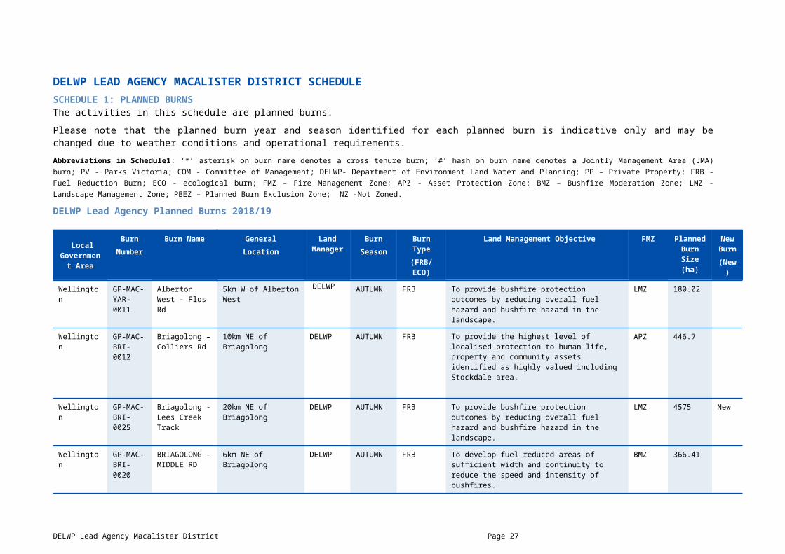
Wellington GP-MAC-YAR-0011
Alberton West - Flos Rd
5km W of Alberton West
DELWP AUTUMN FRB To provide bushfire protection outcomes by reducing overall fuel hazard and bushfire hazard in the landscape.
LMZ 180.02
Wellington GP-MAC-BRI-0012
Briagolong – Colliers Rd
10km NE of Briagolong
DELWP AUTUMN FRB To provide the highest level of localised protection to human life, property and community assets identified as highly valued including Stockdale area.
APZ 446.7
Wellington GP-MAC-BRI-0025
Briagolong - Lees Creek Track
20km NE of Briagolong
DELWP AUTUMN FRB To provide bushfire protection outcomes by reducing overall fuel hazard and bushfire hazard in the landscape.
LMZ 4575 New
Wellington GP-MAC-BRI-0020
BRIAGOLONG - MIDDLE RD
6km NE of Briagolong DELWP AUTUMN FRB To develop fuel reduced areas of sufficient width and continuity to reduce the speed and intensity of bushfires.
BMZ 366.41
Wellington GP-MAC-BRI-0013
*Briagolong - Quarry Road
6km NNE of Briagolong
DELWP AUTUMN FRB To provide the highest level of localised protection to human life, property and community assets identified as highly valued including the Stockdale and Briagolong area.
APZ 190
Wellington GP-MAC-BRI-0019
BRIAGOLONG - TOGGLE HILL TRACK NORTH
18KM N OF BRIAGOLONG
DELWP AUTUMN FRB To develop fuel reduced areas of sufficient width and continuity to reduce the speed and intensity of bushfires.
BMZ 530.4
DELWP Lead Agency Macalister District Page 22

Wellington GP-MAC-BRI-0026
Briagolong - Toggle Hill Track South
14KM N of Briagolong DELWP AUTUMN FRB To develop fuel reduced areas of sufficient width and continuity to reduce the speed and intensity of bushfires.
BMZ 210.7
Wellington GP-MAC-YAR-0009
Carrajung South - Hopkins Track
8km SE of Carrajung South
DELWP AUTUMN ECO To promote ecological resilience in Tall Mixed Forest and Inland Plains Woodland by manipulating the growth stage distribution.
LMZ 253.6
Wellington GP-MAC-DGO-0004
Cobbannah - Pretty Boy Hill
17km SW of Dargo DELWP AUTUMN FRB To provide bushfire protection outcomes by reducing overall fuel hazard and bushfire hazard in the landscape.
LMZ 424.3
Wellington GP-MAC-BRI-0015
Coongulla - Avon Track
15km NE of Coongulla DELWP AUTUMN FRB To develop fuel reduced areas of sufficient width and continuity to reduce the speed and intensity of bushfires.
BMZ 6126
Wellington GP-MAC-DGO-0006
*DARGO - THOMSON TRK
5km S of Dargo DELWP AUTUMN FRB To develop fuel reduced areas of sufficient width and continuity to reduce the speed and intensity of bushfires.
BMZ 1097
Wellington GP-MAC-DGO-0011
Dargo - Wonnangatta Valley Block 2
49km NW of Dargo Parks Victoria
AUTUMN ECO To modify the vegetation structure across the planned area to assist the promotion of Foothills Forest.
LMZ 182.5
Wellington GP-MAC-YAR-0012
Darriman - Lime Pit
2km W of Darriman Parks Victoria
AUTUMN FRB To develop fuel reduced areas of sufficient width and continuity to reduce the speed and intensity of bushfires.
LMZ 30.55
Wellington GP-MAC-YAR-0018
Giffard - Darriman Reserve Block 3
0.2km SE of Giffard Parks Victoria
SUMMER ECO To modify the vegetation structure across the planned area to assist the promotion of Tall Mixed Forest and Damp Scrub.
LMZ 10.66
Wellington GP-MAC-YAR-0015
Giffard West - Running Track
3km SW of Giffard West
DELWP AUTUMN ECO To promote ecological resilience in Inland Plains Woodland by manipulating the growth stage distribution.
LMZ 274.74
East Gippsland
GP-MAC-BRI-0010
Glenaladale - Boundary 34
2km SW of Glenaladale
DELWP AUTUMN FRB To develop fuel reduced areas of sufficient width and continuity to reduce the speed and intensity of bushfires.
BMZ 56.27
Wellington GP-MAC-LSP-0003
# Golden Beach - Track Three
3.5km N of Golden Beach
Parks Victoria
AUTUMN FRB To develop fuel reduced areas of sufficient width and continuity to reduce the speed and intensity of bushfires.
LMZ 241.8
Wellington GP-MAC-HEY-
HOLEY PLAINS - TELEPHONE
8km SE of Rosedale Parks AUTUMN FRB To develop fuel reduced areas of sufficient width and continuity to reduce the speed and intensity of
BMZ 229
Gippsland Region Joint Fuel Management Program 2018/19 – 2020/21 Page 23

0006 TK Victoria bushfires.
Wellington GP-MAC-LSP-0002
# LOCHSPORT - LAKE REEVE NORTH
5KM SW OF LOCH SPORT
Parks Victoria
AUTUMN FRB To provide the highest level of localised protection to human life, property and community assets identified as highly valued including Loch Sport Township.
APZ 154.27
Wellington GP-MAC-YAR-0008
PORT ALBERT –
RACECOURSE
1.5km N of Port Albert COM Local
AUTUMN FRB To provide the highest level of localised protection to human life, property and community assets identified as highly valued including Port Albert and Langsborough areas.
Non FPA Land
18.82
Wellington GP-MAC-BRI-0018
STOCKDALE - RIDLEYS TRK
2km W of Stockdale DELWP AUTUMN FRB To provide the highest level of localised protection to human life, property and community assets identified as highly valued including Stockdale area.
APZ 192.8
Wellington GP-MAC-BRI-0027
# Stratford - Knob Reserve Block 2
2.5km SE of Stratford COM Other
SUMMER FRB To modify the vegetation composition across the planned area to assist the promotion of Inland Plains Woodland.
LMZ 6.99 New
Wellington GP-MAC-DGO-0002
Talbotville - Bulltown Spur
8km E of Talbotville Parks Victoria
AUTUMN FRB To develop fuel reduced areas of sufficient width and continuity to reduce the speed and intensity of bushfires.
BMZ 4415
Wellington GP-MAC-DGO-0003
Talbotville - McMillans Track
5km SE of Talbotville Parks Victoria
AUTUMN FRB To develop fuel reduced areas of sufficient width and continuity to reduce the speed and intensity of bushfires.
BMZ 3600
Wellington GP-MAC-YAR-0004
*WON WRON - GRAVEL 1
7km SW of Won Wron DELWP AUTUMN FRB To provide bushfire protection outcomes by reducing overall fuel hazard and bushfire hazard in the landscape.
LMZ 20.2
Gippsland Region Joint Fuel Management Program 2018/19 – 2020/21 Page 24

DELWP Lead Agency Planned Burns 2019/20
Local Governmen
t Area
BurnNumber
Burn Name GeneralLocation
Land Manager
BurnSeason
Burn Type(FRB/ECO)
Land Management Objective FMZ Planned Burn Size
(ha)
New Burn
(New/ )
Wellington GP-MAC-BRI-0004
BRIAGOLONG - COOPERS RD
5km NE of Briagolong DELWP AUTUMN FRB To provide the highest level of localised protection to human life, property and community assets identified as highly valued including Briagolong Area and HVP Plantations.
APZ 387.3
Wellington GP-MAC-BRI-0014
BRIAGOLONG - MARATHON RD
6.5km NW of Briagolong DELWP AUTUMN FRB To develop fuel reduced areas of sufficient width and continuity to reduce the speed and intensity of bushfires.
BMZ 44.8
Wellington GP-MAC-HEY-0003
COONGULLA - MILLERS RD
3km N of Coongulla DELWP AUTUMN FRB To provide the highest level of localised protection to human life, property and community assets identified as highly valued including the township of Coongulla.
APZ 162.2
Wellington GP-MAC-HEY-0010
Coongulla - Mount Hedrick
7km NE of Coongulla DELWP AUTUMN FRB To develop fuel reduced areas of sufficient width and continuity to reduce the speed and intensity of bushfires.
BMZ 1529
Wellington GP-MAC-DGO-0008
DARGO - PUNCHEN BUDWUD DIVIDE
5KM E OF DARGO DELWP AUTUMN FRB To develop fuel reduced areas of sufficient width and continuity to reduce the speed and intensity of bushfires.
BMZ 684
Wellington GP-MAC-DGO-0012
Dargo - Wonnangatta Valley Block 1
47km NW of Dargo PARKS VICTORIA
AUTUMN ECO To modify the vegetation structure across the planned area to assist the promotion of Foothills Forest.
LMZ 73.3
Wellington GP-MAC-YAR-0020
GELLIONDALE - BANKSIA
6KM SW of Gelliondale DELWP AUTUMN FRB To provide bushfire protection outcomes by reducing overall fuel hazard and bushfire hazard in the landscape.
LMZ 226.8
Wellington GP-MAC-YAR-0019
GIFFARD WEST -CLEMENTS ROAD
6KM NE OF GIFFARD WEST
Parks Victoria
AUTUMN FRB To provide bushfire protection outcomes by reducing overall fuel hazard and bushfire hazard in the landscape.
BMZ 625.7
DELWP Lead Agency Macalister District Page 25

Wellington GP-MAC-YAR-0025
Gormandale - Whites Rd
6km E of Gormandale DELWP AUTUMN FRB To provide bushfire protection outcomes by reducing overall fuel hazard and bushfire hazard in the landscape.
LMZ 969
Wellington GP-MAC-YAR-0026
Greenmount - Elliots Rd
4km NE of Greenmount DELWP AUTUMN FRB To develop fuel reduced areas of sufficient width and continuity to reduce the speed and intensity of bushfires.
BMZ 264.5
Wellington GP-MAC-HEY-0012
Holey Plains - Wattle Track
10km NW of Stradbroke Parks Victoria
AUTUMN FRB To provide bushfire protection outcomes by reducing overall fuel hazard and bushfire hazard in the landscape.
LMZ 291
Wellington GP-MAC-LSP-0005
# LOCHSPORT - BEACON SWAMP EAST
6KM SW OF LOCH SPORT
Parks Victoria
AUTUMN FRB To develop a fuel reduced area to the South West of the Loch Sport township.
BMZ 310
Wellington GP-MAC-LSP-0006
# LOCHSPORT - WEST THALIA
10KM SW OF LOCH SPORT
Parks Victoria
AUTUMN FRB To provide bushfire protection outcomes by reducing overall fuel hazard and bushfire hazard in the landscape.
LMZ 114
Alpine GP-MAC-DGO-0013
Mayford - Grasslands
41km N of Dargo Parks Victoria
WINTER ECO To modify the vegetation structure across the planned area to assist the promotion of Grassy/Heathy Dry Forest.
LMZ 29.2
Wellington GP-MAC-HEY-0009
MOUNT DARLING - SNOWY BLUFF
40KM NE OF LICOLA Parks Victoria
AUTUMN ECO To promote ecological resilience in Grassy/Heathy Dry Forest and High Altitude Shrubland/Woodland by manipulating the growth stage distribution.
LMZ 29298
Wellington GP-MAC-BRI-0028
Munro - Rail Reserve Block 2
200m E of Munro DELWP AUTUMN ECO To modify the vegetation composition across the planned area to assist the promotion of Inland Plains Woodland and Tall Mixed Forest.
NZ 32.1
Wellington GP-MAC-BRI-0029
Munro - Rail Reserve Block 4
7km ENE of Munro DELWP AUTUMN ECO To modify the vegetation composition across the planned area to assist the promotion of Heathland (sands) and Riparian.
NZ 19.6
Wellington GP-MAC-BRI-0030
# Stratford - Knob Reserve Block 1
2km SE of Stratford COM Other
SUMMER ECO To modify the vegetation composition across the planned area to assist the promotion of Inland Plains Woodland.
LMZ 16.89 New
Wellington GP-MAC-BRI-0005
VALENCIA CREEK - DERMODYS
5km W of Valencia Creek DELWP AUTUMN FRB To provide the highest level of localised protection to human life, property and community assets identified as highly valued including Surrounding Valencia Creek Area.
APZ 633.7
Wellington GP-MAC-BRI-0006
Valencia Creek - Georges
8km NNE of Valencia Creek
DELWP AUTUMN FRB To provide the highest level of localised protection to human life, property and community assets
APZ 440.5
Gippsland Region Joint Fuel Management Program 2018/19 – 2020/21 Page 26
Creek identified as highly valued including Briagolong and Valencia Creek Areas.
Wellington GP-MAC-YAR-0003
YARRAM - DEW DROP INN
3.5km NE of Yarram DELWP AUTUMN FRB To develop a fuel reduced area to the North of Dew Drop Inn Rd area.
BMZ 5.2
Gippsland Region Joint Fuel Management Program 2018/19 – 2020/21 Page 27

DELWP Lead Agency Planned Burns 2020/21
Local Governmen
t Area
BurnNumber
Burn Name GeneralLocation
Land Manage
r
BurnSeason
Burn Type(FRB/ECO)
Land Management Objective FMZ Planned Burn Size
(ha)
New Burn(New)
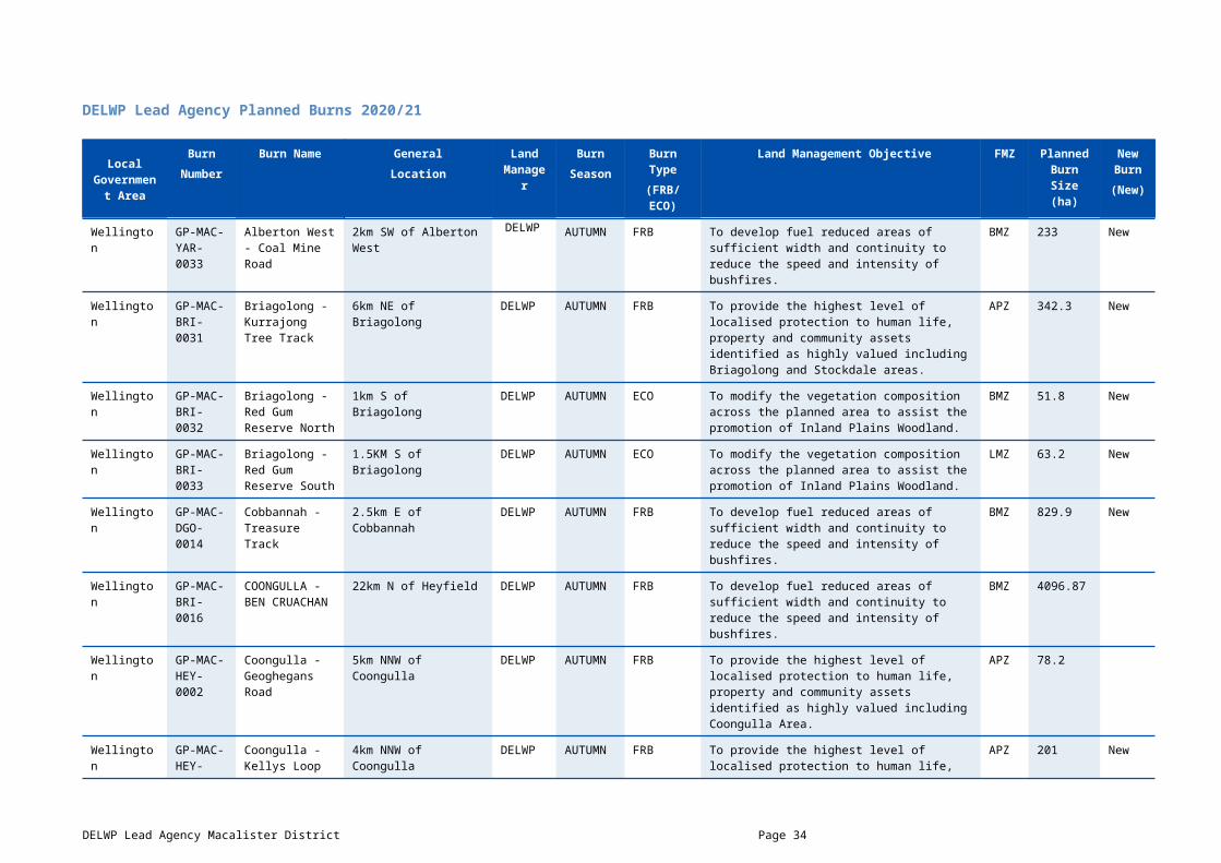
Wellington GP-MAC-YAR-0033
Alberton West - Coal Mine Road
2km SW of Alberton West
DELWP AUTUMN FRB To develop fuel reduced areas of sufficient width and continuity to reduce the speed and intensity of bushfires.
BMZ 233 New
Wellington GP-MAC-BRI-0031
Briagolong - Kurrajong Tree Track
6km NE of Briagolong DELWP AUTUMN FRB To provide the highest level of localised protection to human life, property and community assets identified as highly valued including Briagolong and Stockdale areas.
APZ 342.3 New
Wellington GP-MAC-BRI-0032
Briagolong - Red Gum Reserve North
1km S of Briagolong DELWP AUTUMN ECO To modify the vegetation composition across the planned area to assist the promotion of Inland Plains Woodland.
BMZ 51.8 New
Wellington GP-MAC-BRI-0033
Briagolong - Red Gum Reserve South
1.5KM S of Briagolong DELWP AUTUMN ECO To modify the vegetation composition across the planned area to assist the promotion of Inland Plains Woodland.
LMZ 63.2 New
Wellington GP-MAC-DGO-0014
Cobbannah - Treasure Track
2.5km E of Cobbannah DELWP AUTUMN FRB To develop fuel reduced areas of sufficient width and continuity to reduce the speed and intensity of bushfires.
BMZ 829.9 New
Wellington GP-MAC-BRI-0016
COONGULLA - BEN CRUACHAN
22km N of Heyfield DELWP AUTUMN FRB To develop fuel reduced areas of sufficient width and continuity to reduce the speed and intensity of bushfires.
BMZ 4096.87
Wellington GP-MAC-HEY-0002
Coongulla - Geoghegans Road
5km NNW of Coongulla DELWP AUTUMN FRB To provide the highest level of localised protection to human life, property and community assets identified as highly valued including Coongulla Area.
APZ 78.2
Wellington GP-MAC-HEY-0013
Coongulla - Kellys Loop Track
4km NNW of Coongulla DELWP AUTUMN FRB To provide the highest level of localised protection to human life, property and community assets identified as highly valued including Coongulla Area.
APZ 201 New
Wellington GP-MAC-DGO-0015
Dargo - Birregun Road
10km NNW of Dargo DELWP AUTUMN FRB To develop fuel reduced areas of sufficient width and continuity to reduce the speed and intensity of bushfires.
BMZ 1803 New
DELWP Lead Agency Macalister District Page 28

Wellington GP-MAC-DGO-0007
DARGO - GIBRALTAR RANGE
5km W of Dargo DELWP AUTUMN FRB To develop fuel reduced areas of sufficient width and continuity to reduce the speed and intensity of bushfires.
BMZ 473
Wellington GP-MAC-DGO-0016
DARGO - WONNANGATTA VALLEY BLOCK 3
51KM NW OF DARGO Parks Victoria
AUTUMN ECO To modify the vegetation structure across the planned area to assist the promotion of Foothills Forest.
LMZ 446.6
Wellington GP-MAC-YAR-0023
Giffard West - Tower Track
5km NNW of Giffard West
Parks Victoria
AUTUMN FRB To develop fuel reduced areas of sufficient width and continuity to reduce the speed and intensity of bushfires.
BMZ 268.25
Wellington GP-MAC-HEY-0007
Heyfield - Dawson Reserve North Block
5km W of Heyfield COM Other
AUTUMN ECO To modify the vegetation structure across the planned area to assist the promotion of Purple Diuris.
Non FPA Land
2.63
Wellington GP-MAC-HEY-0011
Heyfield - Glenmaggie Regional Park
4km NNE of Heyfield Parks Victoria
AUTUMN FRB To develop fuel reduced areas of sufficient width and continuity to reduce the speed and intensity of bushfires.
BMZ 84.9
Wellington GP-MAC-YAR-0027
HOLEY PLAINS - ROSEDALE STRADBROKE
9km E of Willung Parks Victoria
AUTUMN FRB To provide bushfire protection outcomes by reducing overall fuel hazard and bushfire hazard in the landscape.
LMZ 305.17
Wellington GP-MAC-LSP-0007
# Loch Sport - Pelican Point
1km NE of Loch Sport Parks Victoria
AUTUMN FRB To develop a fuel reduced area to the East of the Loch Sport township.
BMZ 202 New
Wellington GP-MAC-LSP-0004
# Loch Sport - Trig Track Nth
15km SW of Loch Sport Parks Victoria
AUTUMN FRB To provide bushfire protection outcomes by reducing overall fuel hazard and bushfire hazard in the landscape.
LMZ 267.56
Wellington GP-MAC-HEY-0014
Macalister River - Toms Cap
28km N of Licola Parks Victoria
AUTUMN FRB To provide bushfire protection outcomes by reducing overall fuel hazard and bushfire hazard in the landscape.
LMZ 17563 New
Wellington GP-MAC-YAR-0028
STRADBROKE WEST - WELLINGTON BLOCK
19km SW of Sale Parks Victoria
AUTUMN ECO To modify the vegetation abundance across the planned area to assist the promotion of Wellington Mint Bush.
LMZ 49.56
Wellington GP-MAC-BRI-0034
# Stratford - Knob Reserve Block 3
2km SE of Stratford COM Other
SUMMER ECO To modify the vegetation composition across the planned area to assist the promotion of Inland Plains Woodland.
LMZ 20.9 New
Gippsland Region Joint Fuel Management Program 2018/19 – 2020/21 Page 29

Wellington GP-MAC-YAR-0029
TOMS CAP - OLD ROSEDALE
9km E of Carrajung South
DELWP AUTUMN FRB To provide bushfire protection outcomes by reducing overall fuel hazard and bushfire hazard in the landscape.
LMZ 965.85
Wellington GP-MAC-BRI-0035
Valencia Creek - OKeefe Road
10km NW of Briagolong DELWP AUTUMN FRB To provide the highest level of localised protection to human life, property and community assets identified as highly valued including Surrounding Valencia Creek area.
APZ 289.7 New
Wellington GP-MAC-BRI-0022
VALENCIA CREEK - ONE TREE HILL TRACK
7km NE of Valencia Creek
DELWP AUTUMN FRB To provide the highest level of localised protection to human life, property and community assets identified as highly valued including Briagolong and surrounding area.
APZ 152.2
Wellington GP-MAC-DGO-0009
WATERFORD - MCCARTHY SPUR TK
0.2km S of Waterford DELWP AUTUMN FRB To develop fuel reduced areas of sufficient width and continuity to reduce the speed and intensity of bushfires.
BMZ 2035
Wellington GP-MAC-YAR-0034
Willung - Stradbroke FFR
5km SE of Willung Parks Victoria
AUTUMN FRB To provide bushfire protection outcomes by reducing overall fuel hazard and bushfire hazard in the landscape.
LMZ 221.54
Wellington GP-MAC-YAR-0031
Willung South - Willung Bushland
1.5km E of Willung South Parks Victoria
AUTUMN ECO To bring fire age class distribution closer to the idealised distribution identified through fire ecology study
LMZ 148.61
Wellington GP-MAC-YAR-0032
Woodside Beach - Hidden Hide
4km N of Woodside Beach
Parks Victoria
AUTUMN FRB To provide bushfire protection outcomes by reducing overall fuel hazard and bushfire hazard in the landscape.
LMZ 340.74
Gippsland Region Joint Fuel Management Program 2018/19 – 2020/21 Page 30

SCHEDULE 2: NON-BURN FUEL TREATMENTS 2018/19 - DELWP Lead Agency The table below contains a summary of proposed non-burn fuel treatments over the following year. Some of these fuel treatments are annual, with others prioritised based on the seasonal conditions and which planned burns are scheduled. Accompanying maps provide detail on where these fuel treatment activities are located. Note that the maps show approximate areas only and the actual treatment area will be dependent on the condition of the fuels at the time of assessment. Please contact your local DELWP or Parks Victoria office if further detail is required.
Works by Land ManagerParks Victoria (ha)
DELWP(ha)
Other(ha)
Hectares Planned 565.5 695.6 914.2
DELWP Lead Agency Macalister District Page 31

DELWP LEAD AGENCY TAMBO DISTRICT SCHEDULESCHEDULE 1: PLANNED BURNS The activities in this schedule are planned burns.
Please note that the planned burn year and season identified for each planned burn is indicative only and may be changed due to weather conditions and operational requirements.
Abbreviations in Schedule1: ‘*’ asterisk on burn name denotes a cross tenure burn; ‘#’ hash on burn name denotes a Jointly Management Area (JMA) burn; PV - Parks Victoria; COM - Committee of Management; DELWP- Department of Environment Land Water and Planning; PP – Private Property; FRB - Fuel Reduction Burn; ECO - ecological burn; FMZ – Fire Management Zone; APZ - Asset Protection Zone; BMZ – Bushfire Moderation Zone; LMZ - Landscape Management Zone; PBEZ – Planned Burn Exclusion Zone; NZ -Not Zoned.
DELWP Lead Agency Planned Burns 2018/19
Local Governmen
t Area
BurnNumber
Burn Name GeneralLocation
Land Manager
BurnSeason
Burn Type(FRB/ECO)
Land Management Objective FMZ Planned Burn Size
(ha)
New Burn(New)
East Gippsland
GP-TAM-SCK-0026
*BENAMBRA - BENAMBRA CORRYONG RD
14km N of Benambra Parks Victoria AUTUMN FRB To develop a fuel reduced area to the North of
Benambra Township.LMZ 775.23
East Gippsland
GP-TAM-SCK-0007
*Benambra - Mt Misery Road
15km NE of Benambra DELWP AUTUMN FRB To provide bushfire protection outcomes by reducing overall fuel hazard and bushfire hazard in the landscape.
LMZ 5990
East Gippsland
GP-TAM-SCK-0019
*Benambra - Murphys Forest Rd
10km N of Benambra DELWP AUTUMN FRB To develop a fuel reduced area to the North of Benambra Township.
BMZ 574.84
East Gippsland
GP-TAM-SCK-0024
Bindi - Escarpment Track
16km NE Swifts Creek DELWP AUTUMN FRB To provide bushfire protection outcomes by reducing overall fuel hazard and bushfire hazard in the landscape.
LMZ 4777.41
East Gippsland
GP-TAM-BAI-0062
*BOGGY CREEK - FAULKNER SPUR RD
13km N of Bairnsdale DELWP AUTUMN FRB To develop a fuel reduced area to the North West of Mount Taylor community.
BMZ 206.47
East Gippsland
GP-TAM-SCK-0032
Brumby - Tambo River
18km ESE of Benambra DELWP AUTUMN FRB To provide bushfire protection outcomes by reducing overall fuel hazard and bushfire hazard in the landscape.
LMZ 1021.7
DELWP Lead Agency Tambo District Page 32

East Gippsland
GP-TAM-BAI-0040
Bruthen - Boys Camp Road
5km NE of Bruthen DELWP AUTUMN FRB To provide the highest level of localised protection to human life, property and community assets identified as highly valued including the Ramrod Creek area, Great Alpine Road and Kurnai Park.
APZ 335
East Gippsland
GP-TAM-BAI-0027
*Bruthen - Brooks Road East
1km N of Bruthen DELWP SPRING FRB To provide the highest level of localised protection to human life, property and community assets identified as highly valued including the Bruthen community.
APZ 20.87
East Gippsland
GP-TAM-BAI-0017
Bruthen - Monkey Creek
6km WNW of Bruthen DELWP AUTUMN FRB To develop a fuel reduced area to the North of the Wiseleigh and Bruthen communities.
BMZ 1441.97
East Gippsland
GP-TAM-BAI-0024
Bruthen - OMaras Road
3km NE of Bruthen DELWP AUTUMN FRB To develop a fuel reduced area to the North East of Bruthen community.
BMZ 188.67
East Gippsland
GP-TAM-NOW-0050
Buchan - Bull Flat tk
8 km NW of Buchan DELWP WINTER ECO To re-introduce very low intensity fire into areas affected by Bushfire to reduce biomass of regrowth
LMZ 755 New
East Gippsland
GP-TAM-NOW-0038
Buchan South - Davidsons Lane
6km SW of Buchan DELWP AUTUMN FRB To provide the highest level of localised protection to human life, property and community assets identified as highly valued including Buchan South community.
APZ 677.2
East Gippsland
GP-TAM-SCK-0033
Ensay - Doctors Flat
4km North West of Ensay
DELWP WINTER FRB To provide bushfire protection by reducing overall fuel hazard and bushfire hazard in the landscape
Non FPA Land
14
East Gippsland
GP-TAM-BAI-0065
Forge Creek - Bairnsdale Flora Reserve
3KM West South West of Eagle Point
Parks Victoria
SPRING ECO To reduce overall biomass and to encourage diversity of Plains Grassy Woodland EVC species
Non FPA Land
2 New
East Gippsland
GP-TAM-BAI-0014
Flaggy Creek - Watts Creek Track
7km N of Lindenow DELWP AUTUMN FRB To develop a fuel reduced area to the North of the Wuk Wuk and Flaggy Creek communities.
BMZ 387.47
East Gippsland
GP-TAM-NOW-0002
Gelantipy - Bald Hills Bushland Reserve
8.5km N of Gelantipy Parks Victoria
SPRING FRB To provide bushfire protection outcomes by reducing overall fuel hazard and bushfire hazard in the landscape.
LMZ 34.32
East Gippsland
GP-TAM-NOW-0036
*GELANTIPY - BUTCHERS CREEK
14km NNE of Buchan DELWP AUTUMN FRB To provide bushfire protection outcomes by reducing overall fuel hazard and bushfire hazard in the landscape.
LMZ 3093.64
East Gippsland
GP-TAM-NOW-
Gelantipy - Glenmore
9km West of Gelantipy
DELWP AUTUMN FRB To develop a fuel reduced area to the West of Butcher's Ridge community.
BMZ 2138.21
Gippsland Region Joint Fuel Management Program 2018/19 – 2020/21 Page 33
0035
East Gippsland
GP-TAM-SCK-0018
GLEN VALLEY - TRAPYARD GAP TRACK
19km NW Omeo Parks Victoria
AUTUMN FRB To provide bushfire protection outcomes by reducing overall fuel hazard and bushfire hazard in the landscape.
LMZ 3834.28
East Gippsland
GP-TAM-BAI-0013
Hillside - Hillside Lane South
3km WSW of Hillside DELWP AUTUMN ECO To modify the vegetation composition across the planned area to assist the promotion of orchids and Grassland EVC.
Non FPA Land
2.99
Wellington GP-TAM-BAI-0057
Jones - Mount Steve
10km NE of Dargo DELWP AUTUMN FRB To provide bushfire protection outcomes by reducing overall fuel hazard and bushfire hazard in the landscape.
LMZ 2344.53
East Gippsland
GP-TAM-NOW-0033
LAKE TYERS - RED BLUFF
7km ENE of Lakes Entrance
Parks Victoria
AUTUMN FRB To provide bushfire protection outcomes by reducing overall fuel hazard and bushfire hazard in the landscape.
LMZ 10
East Gippsland
GP-TAM-NOW-0032
LAKES ENTRANCE - BUNGA CREEK
6km N of Lakes Entrance
DELWP AUTUMN FRB To develop a fuel reduced area to the North of Lakes Entrance township.
BMZ 195.8
East Gippsland
GP-TAM-BAI-0044
Melwood - Fred Wiggs Track
3km W of Mt Taylor DELWP AUTUMN FRB To develop a fuel reduced area to the West of Kent Park and Mount Taylor communications towers.
BMZ 337.48
East Gippsland
GP-TAM-BAI-0053
MOSSIFACE - BAINES ROAD RESERVE
1km S of Mossiface Parks Victoria
AUTUMN FRB To provide bushfire protection outcomes by reducing overall fuel hazard and bushfire hazard in the landscape.
LMZ 16.08
East Gippsland
GP-TAM-BAI-0006
Mount Taylor - Pine Block
1km S of Mt Taylor DELWP SPRING FRB To provide the highest level of localised protection to human life, property and community assets identified as highly valued including Bullumwaal Road and adjacent properties. .
APZ 34.91
East Gippsland
GP-TAM-BAI-0037
Mt Alfred - Kill Me Dead Creek
22km NW of Bairnsdale DELWP AUTUMN FRB To provide bushfire protection outcomes by reducing overall fuel hazard and bushfire hazard in the landscape.
LMZ 492.02
East Gippsland
GP-TAM-NOW-0016
Nowa Nowa - Bruthen Buchan Road
3KM North of Nowa Nowa
DELWP AUTUMN FRB To develop a fuel reduced area to the North of the Nowa Nowa community.
BMZ 1536.51
East Gippsland
GP-TAM-NOW-0031
# NOWA NOWA - NELSONS ROAD
2KM SE NOWA NOWA Parks Victoria
AUTUMN FRB To provide the highest level of localised protection to human life, property and community assets identified as highly valued including Nowa Nowa township.
APZ 259.56
Gippsland Region Joint Fuel Management Program 2018/19 – 2020/21 Page 34

East Gippsland
GP-TAM-NOW-0030
NOWA NOWA - OLD BUCHAN ROAD
2.6km NE of Nowa Nowa DELWP SPRING FRB To provide the highest level of localised protection to human life, property and community assets identified as highly valued including Nowa Nowa township.
APZ 433.07
East Gippsland
GP-TAM-NOW-0051
NOWA NOWA - RADAR HILL
10km NW of Nowa Nowa DELWP AUTUMN FRB To develop a fuel reduced area to the North West of Nowa Nowa township.
BMZ 1878.51
East Gippsland
GP-TAM-SCK-0003
OMEO - KOSCIUSKO LOOKOUT
6km SW of Omeo DELWP SPRING FRB To provide bushfire protection outcomes by reducing overall fuel hazard and bushfire hazard in the landscape.
LMZ 41.12
East Gippsland
GP-TAM-SCK-0002
Omeo - Mt Livingstone
7km Sw of Omeo DELWP AUTUMN FRB To develop a fuel reduced area to the South West of Omeo Township and surrounding the Communications Equipment on Mt Livingstone.
Non FPA Land
1483.46
East Gippsland
GP-TAM-BAI-0045
Sarsfield - Gerharts Road
2km NW of Sarsfield DELWP AUTUMN FRB To provide the highest level of localised protection to human life, property and community assets identified as highly valued including the Sarsfield community.
APZ 304.21
East Gippsland
GP-TAM-BAI-0052
#TABBERABBERA - MORRIS PEAK WEST
32km NW of Bairnsdale DELWP AUTUMN FRB To develop fuel reduced areas of sufficient width and continuity to reduce the speed and intensity of bushfires.
BMZ 3190.65
East Gippsland
GP-TAM-BAI-0050
Tambo - Playgrounds
11km NE of Bruthen Parks Victoria
AUTUMN ECO To develop a fuel reduced area to the North East of Bruthen township.
LMZ 2263.53
East Gippsland
GP-TAM-BAI-0051
TAMBO CROSSING - CONNS BOUNDARY
5km W of Tambo Crossing
DELWP AUTUMN FRB To develop a fuel reduced area to the West of Tambo Crossing community.
BMZ 838.9
East Gippsland
GP-TAM-SCK-0006
*Tambo Crossing - Dahlstrom Break
3km NW Tambo Crossing
DELWP AUTUMN FRB To develop fuel reduced areas of sufficient width and continuity to reduce the speed and intensity of bushfires.
LMZ 3839.44
East Gippsland
GP-TAM-NOW-0013
Tostaree - Hall Road South
1km N of Tostaree DELWP AUTUMN FRB To develop a fuel reduced area to the North of the Tostaree community.
BMZ 913.46
East Gippsland
GP-TAM-NOW-0003
Wairewa - North East Interface
2.5km NE of Wairewa DELWP SPRING FRB To provide the highest level of localised protection to human life, property and community assets identified as highly valued including the Wairewa community.
APZ 72.97
Gippsland Region Joint Fuel Management Program 2018/19 – 2020/21 Page 35

East Gippsland
GP-TAM-BAI-0048
*WATERHOLES - ARCHIES ROAD
13.4km NW of Bruthen DELWP AUTUMN FRB To develop a fuel reduced area to the North of Waterholes community.
BMZ 143.14
East Gippsland
GP-TAM-BAI-0019
WATERHOLES - NICHOLSON RIVER
23km NE of Bairnsdale DELWP AUTUMN FRB To develop a fuel reduced area to the North West of adjacent private property and the Waterholes community.
BMZ 189.81
Gippsland Region Joint Fuel Management Program 2018/19 – 2020/21 Page 36

DELWP Lead Agency Planned Burns 2019/20
Local Governmen
t Area
BurnNumber
Burn Name GeneralLocation
Land Manager
BurnSeason
Burn Type(FRB/ECO)
Land Management Objective FMZ Planned Burn Size
(ha)
New Burn
(New/ )
East Gippsland
GP-TAM-SCK-0016
*Benambra - Buenba Gap Tk
28km NW of Benmabra Parks Victoria AUTUMN FRB To provide bushfire protection outcomes by
reducing overall fuel hazard and bushfire hazard in the landscape.
LMZ 1981.04
East Gippsland
GP-TAM-SCK-0023
*BENAMBRA - THE BROTHERS
7 KM NE OF BENAMBRA
DELWP AUTUMN FRB To provide bushfire protection outcomes by reducing overall fuel hazard and bushfire hazard in the landscape.
LMZ 3291.88
East Gippsland
GP-TAM-BAI-0060
Bengworden - Hall Reserve
0km W of BENGWORDEN
DELWP SPRING ECO To modify the vegetation structure across the planned area to assist the promotion of Inland Plains Woodland.
Non FPA Land
33.79
East Gippsland
GP-TAM-SCK-0021
Brookville - Dead Bird Spur North
8km South West of Swifts Creek
DELWP AUTUMN FRB To develop fuel reduced areas of sufficient width and continuity to reduce the speed and intensity of bushfires to the adjacent private land
BMZ 347 New
Wellington GP-TAM-SCK-0035
Brookville - Odells Hut
Brookville DELWP WINTER FRB To develop fuel reduced areas of sufficient width and continuity to protect Odells Hut
Non FPA Land
0.2 New
East Gippsland
GP-TAM-NOW-0029
BUCHAN - GREEN HILLS
25km N of Buchan DELWP AUTUMN ECO To modify the vegetation abundance across the planned area to assist the promotion of Thesium australe.
LMZ 1329.37
East Gippsland
GP-TAM-NOW-0007
*BUCHAN SOUTH - HOLLOWAYS RD RESERVE A
14km SW of Buchan DELWP AUTUMN FRB To provide bushfire protection outcomes by reducing overall fuel hazard and bushfire hazard in the landscape.
LMZ 108.09
East Gippsland
GP-TAM-NOW-0008
BUCHAN SOUTH - HOLLOWAYS RD RESERVE B
12km SW of Buchan DELWP AUTUMN FRB To provide bushfire protection outcomes by reducing overall fuel hazard and bushfire hazard in the landscape.
LMZ 64.27
East Gippsland
GP-TAM-BAI-0021
Bullumwaal - Rifle Range Track
5km NW of Mt Taylor DELWP AUTUMN FRB To provide the highest level of localised protection to human life, property and community assets identified as highly valued
APZ 111.81
DELWP Lead Agency Tambo District Page 37
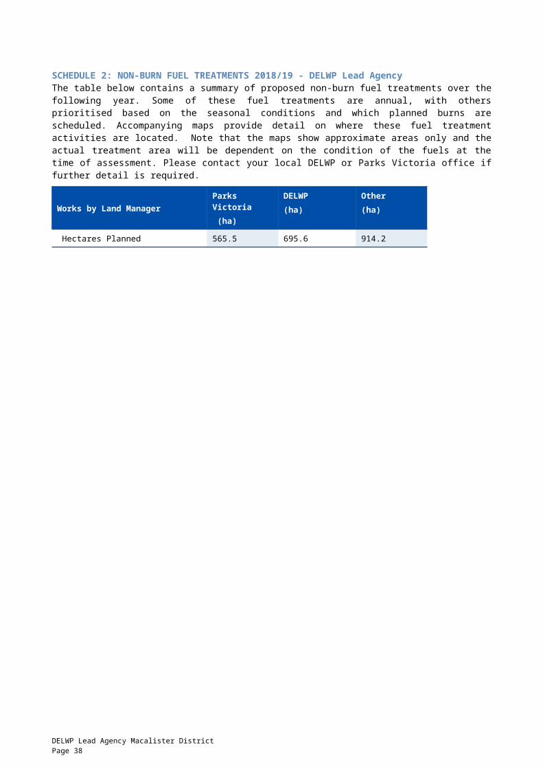
including the Flaggy Creek and Mount Taylor communities.
East Gippsland
GP-TAM-SCK-0014
*Cassilis - Springs Trk
1km W Cassilis Parks Victoria
AUTUMN FRB To provide bushfire protection outcomes by reducing overall fuel hazard and bushfire hazard in the landscape.
LMZ 753.75
East Gippsland
GP-TAM-BAI-0042
Clifton Creek - Bark Bucket Creek
2.5km W of Clifton Creek DELWP AUTUMN FRB To provide the highest level of localised protection to human life, property and community assets identified as highly valued including the Clifton Creek community.
APZ 268.57
Alpine GP-TAM-SCK-0010
*Cobungra - Great Alpine Road
7km NW Cobungra DELWP AUTUMN FRB To develop a fuel reduced area to the North West of Cobungra.
BMZ 2140.35
East Gippsland
GP-TAM-BAI-0031
DEPTFORD - NICHOLSON CREEK LINK
14.7KM NE BULLUMWAAL
DELWP AUTUMN ECO To develop a fuel reduced area to the North West of Waterholes community.
BMZ 243.54
East Gippsland
GP-TAM-BAI-0020
Deptford - Sisters Road
5km NW of Deptford DELWP AUTUMN FRB To develop a fuel reduced area to the North West of Waterholes community.
BMZ 2752.93
East Gippsland
GP-TAM-SCK-0008
*Ensay - Mt Wong Tk
7km ENE Ensay DELWP AUTUMN FRB To develop a fuel reduced area to the North West of Buchan township.
BMZ 2173.48
East Gippsland
GP-TAM-BAI-0043
FAIRY DELL - ELEVEN MILE ROAD
6.5km W of Bruthen DELWP AUTUMN FRB To provide the highest level of localised protection to human life, property and community assets identified as highly valued including adjacent forested private land and the Wiseleigh community.
APZ 335.98
East Gippsland
GP-TAM-BAI-0058
Forge Creek - Forge Creek
9km S of Bairnsdale DELWP AUTUMN ECO To modify the vegetation composition across the planned area to assist the promotion of Inland Plains Woodland.
LMZ 66.5
East Gippsland
GP-TAM-NOW-0009
GELANTIPY - BALD HILLS
13km W of Gelantipy DELWP AUTUMN FRB To provide bushfire protection outcomes by reducing overall fuel hazard and bushfire hazard in the landscape.
LMZ 7737.54
East Gippsland
GP-TAM-NOW-0014
GELANTIPY - MOUNT ELEPHANT
13km SSW of Gelantipy Parks Victoria
AUTUMN FRB To provide bushfire protection outcomes by reducing overall fuel hazard and bushfire hazard in the landscape.
LMZ 909.54
Gippsland Region Joint Fuel Management Program 2018/19 – 2020/21 Page 38

East Gippsland
GP-TAM-NOW-0010
LAKES ENTRANCE - CASEY CREEK
9KM N LAKES ENTRANCE
DELWP AUTUMN FRB To develop a fuel reduced area to the West of the Toorloo Arm community.
BMZ 751.46
East Gippsland
GP-TAM-BAI-0070
Lindenow South - Buntines Road Rail Reserve
3.5km West of Lindenow South
DELWP AUTUMN ECO To modify the vegetation structure across the planned area to assist the promotion of Central Gippsland Plains Grassland
Non FPA Land
12.7
East Gippsland
GP-TAM-BAI-0071
Lindenow South - Resides Road Rail reserve
4km West of Lindenow South
DELWP AUTUMN ECO To modify the vegetation structure across the planned area to assist the promotion of Central Gippsland Plains Grassland
Non FPA Land
17.5
East Gippsland
GP-TAM-BAI-0028
Melwood - Melwood Boundary Track
1km W of Melwood DELWP SPRING FRB To develop a fuel reduced area to the North of the Flaggy Creek and Melwood communities.
BMZ 182.8
East Gippsland
GP-TAM-BAI-0039
Moormurng Reserve - Leathams Road
10km SW of Bairnsdale Parks Victoria
AUTUMN FRB To provide bushfire protection outcomes by reducing overall fuel hazard and bushfire hazard in the landscape.
LMZ 113.95
East Gippsland
GP-TAM-BAI-0008
MOUNT ALFRED - WATTLE CREEK ROAD
9.8km W of Bullumwaal DELWP AUTUMN FRB To develop a fuel reduced area to the North West of the Wuk Wuk, Flaggy Creek and Melwood communities.
BMZ 681.09
East Gippsland
GP-TAM-NOW-0011
NOWA NOWA - 5 MILE
4km NE of Nowa Nowa DELWP AUTUMN FRB To develop a fuel reduced area to the West of the Wairewa community.
BMZ 697.73
East Gippsland
GP-TAM-NOW-0020
Nowa Nowa - Stockyard Break
3km NW of Nowa Nowa DELWP AUTUMN FRB To develop a fuel reduced area to the North West of the Nowa Nowa community.
BMZ 416.68
East Gippsland
GP-TAM-NOW-0006
# NOWA NOWA - STONEY CREEK
11km NE of Lakes Entrance
Parks Victoria
AUTUMN FRB To provide bushfire protection outcomes by reducing overall fuel hazard and bushfire hazard in the landscape.
LMZ 36.27
East Gippsland
GP-TAM-SCK-0015
Omeo - Oriental Claims
1 km W Omeo Parks Victoria
SPRING FRB To develop a fuel reduced area to the South West of Omeo Township.
BMZ 85.17
East Gippsland
GP-TAM-SCK-0009
OMEO VALLEY - GRAY CREEK
11 km NW Benambra Parks Victoria
AUTUMN FRB To provide bushfire protection outcomes by reducing overall fuel hazard and bushfire hazard in the landscape.
LMZ 1528.33
Gippsland Region Joint Fuel Management Program 2018/19 – 2020/21 Page 39
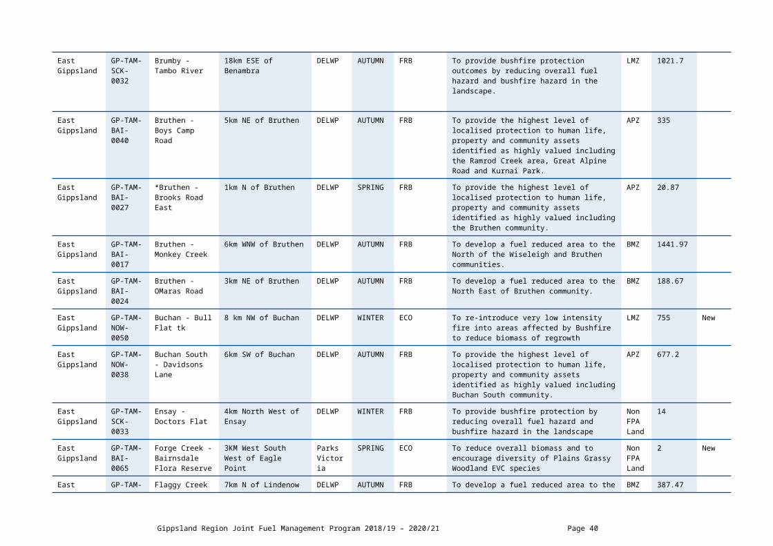
East Gippsland
GP-TAM-BAI-0023
# Tabberabbera - Dead Bull Creek
2km SE of Tabberabbera DELWP AUTUMN FRB To develop fuel reduced areas of sufficient width and continuity to reduce the speed and intensity of bushfires.
BMZ 609.81
East Gippsland
GP-TAM-BAI-0049
TIMBARRA - CUTTS CREEK SOUTH
11km W of Buchan DELWP AUTUMN FRB To develop a fuel reduced area to the West of Buchan and Buchan South communities.
BMZ 3056.14
East Gippsland
GP-TAM-BAI-0007
WATERHOLES - AMES CREEK
13.2km NW of Bruthen DELWP AUTUMN ECO To promote ecological resilience in Foothills Forest by manipulating the growth stage distribution.
BMZ 535.75
East Gippsland
GP-TAM-BAI-0035
Wiseleigh - Nicholson Creek Rd East
4km W of Bruthen DELWP SPRING FRB To provide the highest level of localised protection to human life, property and community assets identified as highly valued including the Wiseleigh community and adjacent private property.
APZ 52.05
Gippsland Region Joint Fuel Management Program 2018/19 – 2020/21 Page 40
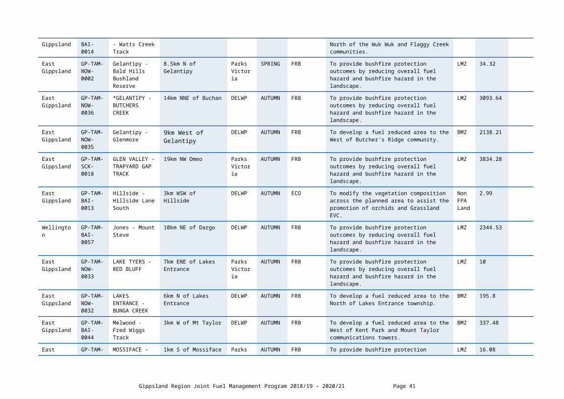
DELWP Lead Agency Planned Burns 2020/21
Local Government
Area
BurnNumber
Burn Name GeneralLocation
Land Manager
BurnSeason
Burn Type(FRB/ECO)
Land Management Objective FMZ Planned Burn Size
(ha)
New Burn(New)
East Gippsland
GP-TAM-SCK-0034
Anglers Rest - Cobungra river
2.5 km South of Anglers Rest
DELWP AUTUMN FRB To develop fuel reduced areas of sufficient width and continuity to reduce the speed and intensity of bushfires
BMZ 2228 New
East Gippsland
GP-TAM-BAI-0064
Bairnsdale - Macleod Morass
1km N of Bairnsdale Parks Victoria
AUTUMN FRB To modify the vegetation abundance across the planned area to assist the control of Typha domingensia and Phargmites australis.
LMZ 80.72
East Gippsland
GP-TAM-NOW-0018
*Balley Hooley - River Junction
8km E of Buchan Parks Victoria
AUTUMN FRB To provide bushfire protection outcomes by reducing overall fuel hazard and bushfire hazard in the landscape.
Non FPA Land
345.81
East Gippsland
GP-TAM-SCK-0011
*Benambra - Macs Creek
13km ENE of Benambra DELWP AUTUMN FRB To provide bushfire protection outcomes by reducing overall fuel hazard and bushfire hazard in the landscape.
LMZ 3852.85
East Gippsland
GP-TAM-BAI-0029
Blonde Bay - Grass Tree North
5km SE of Goon Nure Parks Victoria
AUTUMN FRB To provide bushfire protection outcomes by reducing overall fuel hazard and bushfire hazard in the landscape.
LMZ 63.6
East Gippsland
GP-TAM-NOW-0012
BRUTHEN - DEADHORSE CREEK
7km E of Bruthen DELWP AUTUMN FRB To develop fuel reduced areas of sufficient width and continuity to reduce the speed and intensity of bushfires.
BMZ 1227.18
East Gippsland
GP-TAM-NOW-0021
Buchan - Frying Pan Creek
4km W of Murrindal DELWP AUTUMN FRB To develop a fuel reduced area to the West of Murrindal community.
BMZ 1553.95
East Gippsland
GP-TAM-NOW-0049
Buchan - Moons Road
4km E of Buchan DELWP AUTUMN FRB To provide bushfire protection outcomes by reducing overall fuel hazard and bushfire hazard in the landscape.
Non FPA Land
4.63
East Gippsland
GP-TAM-NOW-0026
# Buchan Caves - Spring Creek
1km W of Buchan Parks Victoria
AUTUMN ECO To modify the vegetation structure across the planned area to assist the promotion of orchids.
BMZ 1.21
East Gippsland
GP-TAM-BAI-0047
Bullumwaal - Mt Alfred
1km W of Boggy Creek DELWP AUTUMN FRB To provide bushfire protection outcomes by reducing overall fuel hazard and bushfire hazard in the landscape.
LMZ 429.83
DELWP Lead Agency Tambo District Page 41
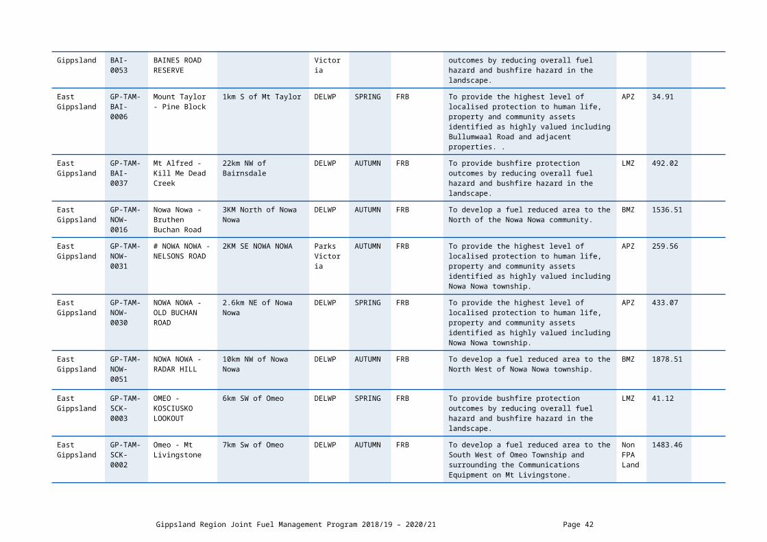
East Gippsland
GP-TAM-BAI-0041
Bullumwaal - Perseverance Track
1km W of Bullumwaal DELWP AUTUMN FRB To provide the highest level of localised protection to human life, property and community assets identified as highly valued including the Bullumwaal and Boggy Creek communities.
APZ 477.19
East Gippsland
GP-TAM-BAI-0069
Bumberrah - Kettles Lane Rail Trail
0.5km South of Bumberrah
COM Local
AUTUMN ECO To modify the vegetation structure across the planned area to assist the promotion of Forest Red Gum Grassy Woodland
Non FPA Land
11 New
East Gippsland
GP-TAM-NOW-0027
Colquhoun - Tin Shed Track
6km NW of Kalimna Parks Victoria
AUTUMN FRB To provide the highest level of localised protection to human life, property and community assets identified as highly valued including Forestech and the Kalimna West community.
APZ 348.33
East Gippsland
GP-TAM-BAI-0022
Dawson City - Nightmare Stream
7km SW of Brookville DELWP AUTUMN FRB To develop fuel reduced areas of sufficient width and continuity to reduce the speed and intensity of bushfires.
BMZ 1954.75
East Gippsland
GP-TAM-BAI-0030
DEPTFORD - FARM STORE CREEK
25km N of Bairnsdale DELWP AUTUMN ECO To develop a fuel reduced area to the North of the Waterholes community.
BMZ 904.68
Alpine GP-TAM-SCK-0030
Dogs Grave - Birregan Road West
31km West of Swifts Creek
DELWP AUTUMN FRB To develop a fuel reduced area to the west of Swifts Creek and to provide a level of protection to the Dogs Grave recreation site.
BMZ 2606 New
East Gippsland
GP-TAM-SCK-0037
Ensay - Gap Creek
8.5km East of Ensay DELWP AUTUMN FRB To develop a fuel reduced area to the north of private property
BMZ 1704 New
East Gippsland
GP-TAM-BAI-0072
Fernbank - Sinclairs Road Rail Reserve
0.5 km West of Fernbank
DELWP AUTUMN ECO To modify the structure across the planned area to assist the promotion of Purple Diuris
Non FPA Land
14.6 New
East Gippsland
GP-TAM-NOW-0047
Gelantipy - Gelantipy Road
11km N of Gelantipy DELWP AUTUMN FRB To provide bushfire protection outcomes by reducing overall fuel hazard and bushfire hazard in the landscape.
LMZ 25.82
East Gippsland
GP-TAM-BAI-0073
Glenaladale - Woolshed Creek
8.5km NNW of Glenaladale
PARKS VICTORIA
AUTUMN FRB To develop a fuel reduced area to the north of adjoining private property and the greater community of Glenaladale.
BMZ 1261 New
East Gippsland
GP-TAM-NOW-0015
LAKE TYERS - CLIFF ROAD
6km ENE of Lakes Entrance
Parks Victoria
AUTUMN FRB To provide bushfire protection outcomes by reducing overall fuel hazard and bushfire hazard in the landscape.
LMZ 18.05
Gippsland Region Joint Fuel Management Program 2018/19 – 2020/21 Page 42

East Gippsland
GP-TAM-BAI-0036
# MITCHELL RIVER NP - BALD HILL CREEK
24km NW of Bairnsdale Parks Victoria
AUTUMN FRB To develop fuel reduced areas of sufficient width and continuity to reduce the speed and intensity of bushfires.
BMZ 912.53
East Gippsland
GP-TAM-NOW-0028
Murrindal - Potholes Cave Reserve
6.5km NE of Buchan COM Parks Victoria
AUTUMN ECO To modify the vegetation abundance across the planned area to assist the promotion of Leafy Greenhood Orchid.
LMZ 12.97
East Gippsland
GP-TAM-NOW-0024
Nowa Nowa - Kenny Road
8.5km NW of Nowa Nowa
DELWP AUTUMN FRB To develop fuel reduced areas of sufficient width and continuity to reduce the speed and intensity of bushfires.
BMZ 1253.88
East Gippsland
GP-TAM-NOW-0025
Nowa Nowa - Siberia Crossing Road
6km W of Nowa Nowa DELWP AUTUMN FRB To provide bushfire protection outcomes by reducing overall fuel hazard and bushfire hazard in the landscape.
LMZ 644.72
East Gippsland
GP-TAM-NOW-0048
Nowa Nowa - Smarts Break
4km NW of Nowa Nowa DELWP AUTUMN FRB To build on protection works in the adjacent Asset Protection Zone.
BMZ 2.57
East Gippsland
GP-TAM-SCK-0036
Omeo - Mt Cook Tk
5.5km East of Omeo DELWP AUTUMN FRB To develop a fuel reduced area to the West and North West of adjacent private property
BMZ 1775 New
East Gippsland
GP-TAM-SCK-0012
*Omeo - Mt Sam
3km NW Omeo DELWP AUTUMN FRB To provide bushfire protection outcomes by reducing overall fuel hazard and bushfire hazard in the landscape.
LMZ 1636.78
East Gippsland
GP-TAM-SCK-0013
*OMEO - ZIG ZAG TRK
10km WNW Cassilis DELWP AUTUMN FRB To provide bushfire protection outcomes by reducing overall fuel hazard and bushfire hazard in the landscape.
LMZ 4078.82
East Gippsland
GP-TAM-BAI-0034
Tambo Crossing - Rouches Road East
5km SW of Tambo Crossing
DELWP AUTUMN FRB To develop a fuel reduced area to the South West of the Tambo Crossing community.
BMZ 2682.53
East Gippsland
GP-TAM-NOW-0023
# Toorloo Arm - Peterson Road
4km N of Lake Tyers Parks Victoria
AUTUMN FRB To provide the highest level of localised protection to human life, property and community assets identified as highly valued including Toorloo Arm and the Lake Tyers community.
APZ 199.43
East Gippsland
GP-TAM-NOW-0022
Wairewa - Fairweather Track
4.5km NE of Nowa Nowa
DELWP AUTUMN FRB To provide the highest level of localised protection to human life, property and community assets identified as highly valued including the Wairewa community.
APZ 377.53
Gippsland Region Joint Fuel Management Program 2018/19 – 2020/21 Page 43

East Gippsland
GP-TAM-BAI-0074
Wiseleigh - Nicholson Creek South
4.5km West of Bruthen DELWP AUTUMN FRB To provide the highest level of localised protection to human life, property and community assets identified as highly valued including the neighbouring private property
APZ 112 New
East Gippsland
GP-TAM-BAI-0032
Wuk Wuk - Harding Road East
10km NNW of Lindenow DELWP AUTUMN FRB To develop a fuel reduced area to the North West of the Wuk Wuk, Flaggy Creek and Melwood communities.
BMZ 457.05
East Gippsland
GP-TAM-BAI-0038
Wuk Wuk - Stoney Creek
6km N of Wuk Wuk DELWP AUTUMN FRB To provide the highest level of localised protection to human life, property and community assets identified as highly valued including adjacent private property.
APZ 61.67
East Gippsland
GP-TAM-NOW-0019
Wulgulmerang - Mt Seldom Seen
6km SW of Wulgulmerang
Parks Victoria
AUTUMN FRB To develop a fuel reduced area to the West of the Wulgulmerang community.
BMZ 2893.81
Gippsland Region Joint Fuel Management Program 2018/19 – 2020/21 Page 44

SCHEDULE 2: NON-BURN FUEL TREATMENTS 2018/19 - DELWP Lead Agency The table below contains a summary of proposed non-burn fuel treatments over the following year. Some of these fuel treatments are annual, with others prioritised based on the seasonal conditions and which planned burns are scheduled. Accompanying maps provide detail on where these fuel treatment activities are located. Note that the maps show approximate areas only and the actual treatment area will be dependent on the condition of the fuels at the time of assessment. Please contact your local DELWP or Parks Victoria office if further detail is required.
Works by Land ManagerParks Victoria (ha)
DELWP(ha)
Other(ha)
Hectares Planned 188 7356 0
DELWP Lead Agency Tambo District Page 45

SCHEDULE 3: NEW STRATEGIC FUELBREAKS 2018/19 - DELWP Lead Agency DELWP and Parks Victoria work together to establish and maintain a network of strategic fuelbreaks to expand the protection of communities, forests and parks from the risk of bushfire. A strategic fuelbreak is a strip of land where vegetation has been modified to reduce the amount of fuel available to burn during a bushfire. Strategic fuelbreaks are an important tool for fire management on public land. They provide a fuel-reduced area from which to conduct back burning ahead of an approaching bushfire or to assist in the implementation of a planned burn.
Machinery is used to clear vegetation generally within a 15-20-metre-wide strip. In some instances, this width could be up to 40m. Existing roads and tracks are considered part of the clearing. Where possible, overstorey trees are retained to provide shading and connection between the trees for wildlife and landscape values. The locations of strategic fuelbreaks are included for information only. These activities are approved via other DELWP and Parks Victoria processes. CFA strategic fuel breaks are included in Municipal Fire Management Plans.
Strategic fuel break maintenance is an annual program and included in Schedule 2 above.
Road or Location Name Locality Operation Type Distance (km)
Two existing breaks Raymond Island Widening 1.66
Gippsland Region Joint Fuel Management Program 2018/19 – 2020/21 Page 46
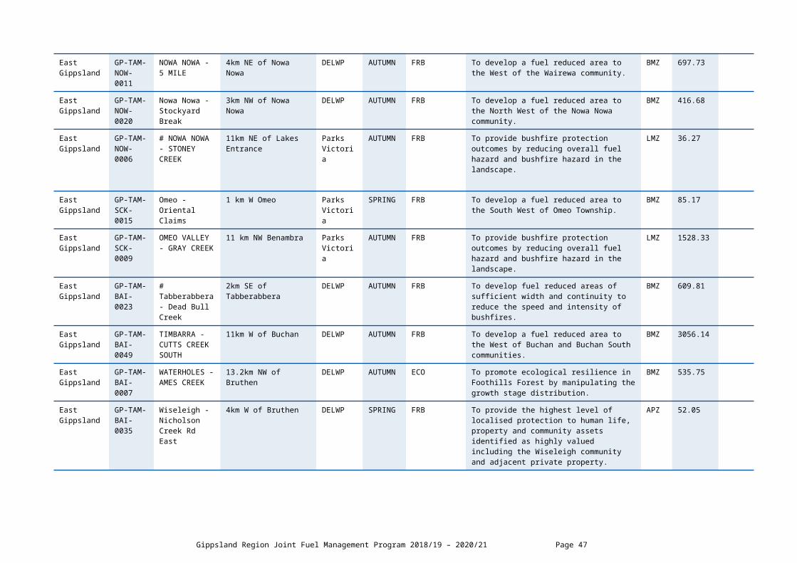
DELWP LEAD AGENCY SNOWY DISTRICT SCHEDULESCHEDULE 1: PLANNED BURNS The activities in this schedule are planned burns.
Please note that the planned burn year and season identified for each planned burn is indicative only and may be changed due to weather conditions and operational requirements.
Abbreviations in Schedule1: ‘*’ asterisk on burn name denotes a cross tenure burn; PV - Parks Victoria; COM - Committee of Management; DELWP- Department of Environment Land Water and Planning; PP – Private Property; FRB - Fuel Reduction Burn; ECO - ecological burn; FMZ – Fire Management Zone; APZ - Asset Protection Zone; BMZ – Bushfire Moderation Zone; LMZ - Landscape Management Zone; PBEZ – Planned Burn Exclusion Zone; NZ -Not Zoned.
DELWP Lead Agency Planned Burns 2018/19
Local Governmen
t Area
BurnNumber
Burn Name GeneralLocation
Land Manage
r
BurnSeason
Burn Type(FRB/ECO)
Land Management Objective FMZ Planned Burn Size
(ha)
New Burn
(New/ )
East Gippsland
2OOR0102 Bemm River - Bemm River North
Bemm River DELWP SPRING FRB To provide the highest level of localised protection to human life, property and community assets identified as highly valued including Bemm River Township
APZ 10
East Gippsland
GP-SNO-ORB-0002
Bemm River - Hekarwe Trk
4km SW of Bemm River Parks Victoria
AUTUMN FRB To provide bushfire protection outcomes by reducing overall fuel hazard and bushfire hazard in the landscape
LMZ 860.97
East Gippsland
2OOR0008 Bemm River - Swampy Ridges
3km W of Bemm River Parks Victoria
AUTUMN FRB To develop a fuel reduced area to the West of Bemm River township
BMZ 907
East Gippsland
GP-SNO-BOC-0016
BENDOC - MARIOTT CREEK
4KM S BENDOC DELWP AUTUMN FRB To develop a fuel reduced area to the South East of Bendoc Township
BMZ 1417.44
East Gippsland
2OCR0033 CANN RIVER - AXEMANS
4KM E CANN RIVER DELWP AUTUMN FRB To develop a fuel reduced area to the East of Cann River Township
BMZ 2318.6
East Gippsland
2OCR0019 Cann River - Cemetery Track South
1km E of Cann River DELWP SPRING FRB To develop a fuel reduced area to the South of Cann River township
BMZ 93.28
East Gippsland
GP-SNO-ORB-0025
Cape Conran - Laughrans
16km E of Marlo Parks Victoria
AUTUMN FRB To develop a fuel reduced area to the East of Marlo township & west of Cape Conran campground
BMZ 118.15
DELWP Lead Agency Snowy District Page 47

East Gippsland
GP-SNO-CAN-0015
Club Terrace - Blackwatch
0.1 km S of Club Terrace DELWP SPRING FRB To develop a fuel reduced area to the West of Club Terrace Township
BMZ 122.89
East Gippsland
GP-SNO-BOC-0014
Delegate River - Concordia Gully
3km SE of Delegate River
DELWP AUTUMN FRB To provide bushfire protection outcomes by reducing overall fuel hazard and bushfire hazard in the landscape
LMZ 1094
East Gippsland
GP-SNO-CAN-0016
Genoa-Bens Track
11km W of Genoa DELWP AUTUMN FRB To develop a fuel reduced area to the West of Township of Genoa
BMZ 1290
East Gippsland
GP-SNO-CAN-0009
Genoa-Border Track
9km NE of Genoa DELWP AUTUMN FRB To develop a fuel reduced area to the North East of Genoa Township
BMZ 1152.33
East Gippsland
2OCR0119 *Karbeethong - Mullet Creek
3km NW of Mallacoota DELWP AUTUMN FRB To provide the highest level of localised protection to human life, property and community assets identified as highly valued including Mallacoota Township
APZ 85.57
East Gippsland
GP-SNO-MAL-0004
Mallacoota - Double Creek
6km NW of Mallacoota Parks Victoria
AUTUMN FRB To provide the highest level of localised protection to human life, property and community assets identified as highly valued including Mallacoota Township
APZ 808.21
East Gippsland
GP-SNO-ORB-0007
Marlo - Bushland Reserve East and William Hunter Flora Reserve
1km E of Marlo Township
DELWP SPRING FRB To provide the highest level of localised protection to human life, property and community assets identified as highly valued including Marlo Township
APZ 21.63
East Gippsland
GP-SNO-ORB-0022
Marlo - William Court
2.5km E of Marlo Parks Victoria
SPRING FRB To develop a fuel reduced area to the East of Marlo Township
BMZ 58
East Gippsland
2OCR0021B OLD COAST - B 11km ENE Bemm River Parks Victoria
AUTUMN FRB To develop a fuel reduced mosaic west of the Tamboon South township only. To allow available fuels to burn freely to the west until they extinguish naturally. To provide bushfire protection by reducing overall fuel hazard and bushfire hazard in the landscape
LMZ 606.76
East Gippsland
GP-SNO-ORB-0019
Orbost - Mount Raymond
10KM E ORBOST Parks Victoria
AUTUMN FRB To develop a fuel reduced area to the east of Orbost township
BMZ 1274
East Gippsland
GP-SNO-ORB-0018
Orbost - Partellis Crossing Road
14km W of Orbost DELWP AUTUMN FRB To develop a fuel reduced area to the North West of Simpsons Creek, Bete Belong and Waygara farming communities
BMZ 2532.49
Gippsland Region Joint Fuel Management Program 2018/19 – 2020/21 Page 48

East Gippsland
GP-SNO-CAN-0012
SOUTHERN BURN - F
4km SE of Cann River DELWP AUTUMN FRB To provide bushfire protection outcomes by reducing overall fuel hazard and bushfire hazard in the landscape
LMZ 15112
East Gippsland
2OCR0016G SOUTHERN BURN - G
25KM SE CANN RIVER Parks Victoria
AUTUMN FRB To provide bushfire protection by reducing overall fuel hazard and bushfire hazard in the landscape
LMZ 19279
East Gippsland
GP-SNO-BOC-0012
Tubbut - Laurie Trk
10km N of Tubbut Parks Victoria
AUTUMN FRB To provide bushfire protection outcomes by reducing overall fuel hazard and bushfire hazard in the landscape
LMZ 4748.4
DELWP Lead Agency Snowy District Page 49

DELWP Lead Agency Planned Burns 2019/20
Local Government
Area
BurnNumber
Burn Name GeneralLocation
Land Manager
BurnSeason
Burn Type(FRB/ECO)
Land Management Objective FMZ Planned Burn Size
(ha)
New Burn
(New/ )
East Gippsland
2OOR0132 Bemm River - Sydenham Inlet Road
Bemm Rvier DELWP AUTUMN FRB To provide bushfire protection by reducing overall fuel hazard and bushfire hazard in the landscape
LMZ 3151.65
East Gippsland
2OBE0083 Bendoc - Corner Track
6KM SE of Bendoc DELWP AUTUMN FRB To develop a fuel reduced area to the North West of Bendoc Township
BMZ 548.63
East Gippsland
2OBE0028 Bendoc - Helens Track South
7km ESE of Bendoc DELWP AUTUMN FRB To develop fuel reduced area to the south east of Bendoc township
BMZ 1778.53
East Gippsland
2OBE0024 Bendoc - Roaring Camp
10 KM North East Bonang
DELWP AUTUMN FRB To develop a fuel reduced area to the North of Bonang Township
BMZ 1224
East Gippsland
2OBE0098 Bonang - Monarch Gully Track
8km NW of Bonang DELWP AUTUMN FRB To develop a fuel reduced area to the North West of Bonang Community
BMZ 859.78
East Gippsland
2OBE0100 Bonang - Rising Sun Road
2km NW of Bonang DELWP AUTUMN FRB To develop a fuel reduced area to the North West of Bonang Community
BMZ 434.33
East Gippsland
2OOR0229 Cabbage Tree - Emphields Track
2km E of Cabbage Tree Creek
DELWP AUTUMN FRB To develop a fuel reduced area to the East of Cabbage Tree Creek Township
BMZ 391.98
East Gippsland
2OOR0109 *Cabbage Tree - Palm Track
2km Sw of Cabbage Tree
Parks Victoria
AUTUMN FRB To provide bushfire protection by reducing overall fuel hazard and bushfire hazard in the landscape
LMZ 2085.73
East Gippsland
2OCR0168 CANN RIVER - CEMETERY TRACK NORTH
10km N of Cann River DELWP AUTUMN FRB To develop fuel reduced area to the north of Cann River township
BMZ 273.54
East Gippsland
2OCR0043 CANN RIVER - DRUMMER ROAD
12km E of Cann River DELWP AUTUMN FRB To develop a fuel reduced area to the East of Cann River township
BMZ 1855.53
East Gippsland
2OCR0027 CANN RIVER - HILO RD
6.5km NW of Cann River
DELWP AUTUMN FRB To develop fuel reduced area to the north west of Cann River Township
BMZ 3798.79
DELWP Lead Agency Snowy District Page 50
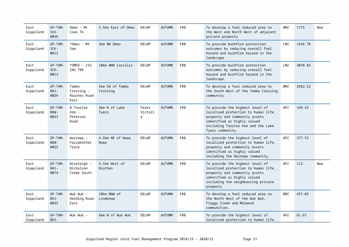
East Gippsland
2OCR0140 Cann River - Lagoon Hill Track
9km S of Cann River DELWP AUTUMN FRB To develop a fuel reduced area to the South West of Cann River township
BMZ 5635.59
East Gippsland
2OOR0038 CAPE CONRAN - HEATHLANDS
17km E of Marlo Parks Victoria
AUTUMN FRB To provide the highest level of localised protection to human life, property and community assets identified as highly valued including Cape Conran campground and amenities
APZ 17.63
East Gippsland
2OCR0171 Club Terrace-Winyar Track
1km South West Club Terrace
DELWP AUTUMN FRB To develop a fuel reduced area to the South West of Club Terrace
BMZ 843.81
East Gippsland
2OCR0030 Genoa - Horse Hill Tk
12km NW of Genoa DELWP AUTUMN FRB To develop a fuel reduced area to the North West of Genoa Township
BMZ 1263.98
East Gippsland
2OCR0040 *Genoa - Upper Wingan River
11km W of Genoa DELWP AUTUMN FRB To provide bushfire protection by reducing overall fuel hazard and bushfire hazard in the landscape
LMZ 2971.95
East Gippsland
2OCR0124 Mallacoota - Betka River
2km W of Mallacoota DELWP AUTUMN FRB To provide the highest level of localised protection to human life, property and community assets identified as highly valued including Mallacoota Township
APZ 379.64
East Gippsland
2OCR0176 Mallacoota - Shipwreck Creek
9KM SW of Mallacoota Parks Victoria
AUTUMN FRB To develop a fuel reduced area to the South West of Mallacoota Township
BMZ 702.46
East Gippsland
2OOR0022 MARLO - RICARDO
10KM E MARLO Parks Victoria
AUTUMN ECO To encourage assemblage of coastal heathlands and to bring fire age class distribution within the idealised distribution for the Coastal Sand Heathland Ecological Vegetation Class as identified through fire ecology study
LMZ 146.54
East Gippsland
2OCR0018A NOORINBEE - A 13km WNW of Cann River
DELWP AUTUMN FRB To develop a fuel reduced area to the north west of Cann River township
BMZ 3460
East Gippsland
2OCR0169 Noorinbee - Leslie Track
12km SW of Cann River DELWP AUTUMN FRB To develop a fuel reduced area to the North of Noorinbee Farming Community
BMZ 133.44
East Gippsland
2OOR0009 ORBOST - FALLS CREEK TRK
30KM E ORBOST DELWP AUTUMN FRB To develop a fuel reduced area to the North of Manorina township
BMZ 886.49
East Gippsland
2OOR0156 Orbost - Garnetts Track
10km NW of Orbost DELWP AUTUMN FRB To develop a fuel reduced area to the North West of Orbost township
BMZ 82.12
DELWP Lead Agency Snowy District Page 51

East Gippsland
2OOR0005 ORBOST - WHITTINGHAMS
28km E of Orbost DELWP AUTUMN FRB To develop a fuel reduced area to the East of Orbost township
BMZ 276.25
Gippsland Region Joint Fuel Management Program 2018/19 – 2020/21 Page 52

DELWP Lead Agency Planned Burns 2020/21
Local Governmen
t Area
BurnNumber
Burn Name GeneralLocation
Land Manager
BurnSeason
Burn Type(FRB/ECO)
Land Management Objective FMZ Planned Burn Size
(ha)
New Burn(New)
East Gippsland
2OOR0140 Bemm River - Pearl Point Road
3km SW of Bemm River Parks Victoria AUTUMN FRB To provide bushfire protection by reducing
overall fuel hazard and bushfire hazard in the landscape
LMZ 608.1
East Gippsland
2OCR0037A BEMM RIVER A
3km N of Bemm River DELWP AUTUMN FRB To develop a fuel reduced area to the North of Bemm River Township
BMZ 4880
East Gippsland
2OBE0113 Bendoc-Bumperbar Track
3km NW of Bendoc DELWP AUTUMN FRB To develop fuel reduced area to the north west of Bendoc township
BMZ 730.54
East Gippsland
2OBE0099 Bonang - Telecom Trk
2km SE of Delicknora DELWP AUTUMN FRB To develop a fuel reduced area to the North of Bonang Farming Community
BMZ 851.33
East Gippsland
2OBE0115 Bonang-Yellow Streak Mine Track
9km NE of Bonang DELWP AUTUMN FRB To develop a fuel reduced area to the North of Bonang Township
BMZ 1168.22
East Gippsland
2OCR0196 Cann River - Walkers Creek
10km NNW of Cann River
DELWP AUTUMN FRB To develop a fuel reduced area to the North West of Cann River township
BMZ 2476.03
East Gippsland
2OCR0053 CANN RIVER - WOMBAT HILL
12km NE Cann River DELWP AUTUMN FRB To provide bushfire protection by reducing overall fuel hazard and bushfire hazard in the landscape
LMZ 3294.82
East Gippsland
2OOR0204 Cape Conran - Old Coast Road
17Km East Marlo PARKS VICTORIA
AUTUMN FRB To provide bushfire protection outcomes by reducing overall fuel hazard and bushfire hazard in the landscape
LMZ 2119
East Gippsland
2OOR0037 CAPE CONRAN - SWAMPY CRK
2.5KM NE CAPE CONRAN
Parks Victoria
AUTUMN FRB To provide bushfire protection by reducing overall fuel hazard and bushfire hazard in the landscape
LMZ 64.04
East Gippsland
2OOR0138 Cape Conran - Yeerung Road North
18km E of Marlo Parks Victoria
SPRING FRB To develop a fuel reduced area to the North of Cape Conran Campground & infrastructure
BMZ 38.94
East Gippsland
2OCR0039 GENOA - JONES CREEK
6.5km W of Genoa DELWP AUTUMN FRB To develop a fuel reduced area to the West of Genoa Township and farming community
BMZ 4113.42
DELWP Lead Agency Snowy District Page 53

East Gippsland
2OCR0175 Gypsy Point - Gypsy Point Road
2KM South West of Gypsy Point
Parks Victoria
SPRING FRB To provide the highest level of localised protection to human life, property and community assets identified as highly valued including Gypsy Point township
APZ 128.22
East Gippsland
2OCR0122 Gypsy Point - Tucks Track
0.5KM South of Gypsy Point
Parks Victoria
SPRING FRB To develop a fuel reduced area to the South East of Township of Gypsy Point
BMZ 96.97
East Gippsland
2OCR0054 Mallacoota - Davis Creek
0KM W MALLACOOTA DELWP AUTUMN FRB To provide the highest level of localised protection to human life, property and community assets identified as highly valued including Mallacoota Township
APZ 113.75
East Gippsland
2OOR0194 Manorina-Hippo Track
1km E of Manorina DELWP AUTUMN FRB To develop a fuel reduced area to the East of Township of Manorina
BMZ 122.01
East Gippsland
2OOR0034 Marlo - Aerodrome
5KM E MARLO Parks Victoria
AUTUMN FRB To provide bushfire protection to Marlo Plains community, Snowy River coastal Campus and Marlo Aerodrome infrastructure by reducing overall fuel hazard and bushfire hazard in the landscape
LMZ 102
East Gippsland
2OCR0018B Noorinbee - B 15km NW of Cann River DELWP AUTUMN FRB To provide bushfire protection by reducing overall fuel hazard and bushfire hazard in the landscape
LMZ 1709.88
East Gippsland
2OOR0159 Orbost - Back Break Track
12 Km NW of Orbost DELWP AUTUMN FRB To provide bushfire protection to the Bete Bolong /Orbost communities, to forestry regen and rainforest site of significance to the east of the burn by reducing overall fuel hazard and bushfire hazard in the landscape
LMZ 1863.9
East Gippsland
2OOR0139 Orbost - FREDS TRACK
28km E of Orbost DELWP AUTUMN FRB To provide bushfire protection to identified environmental and cultural assets by reducing overall fuel hazard and bushfire hazard in the landscape
LMZ 1600.15
East Gippsland
2OOR0197 Orbost - Lightwood Track
12km NE of Orbost DELWP AUTUMN FRB To provide bushfire protection by reducing overall fuel hazard and bushfire hazard in the landscape
LMZ 7090.6
East Gippsland
2OOR0198 Orbost - Old Bonang Highway
5km N of Orbost DELWP AUTUMN FRB To provide the highest level of localised protection to human life, property and community assets identified as highly valued including Orbost Township
APZ 346.84
Gippsland Region Joint Fuel Management Program 2018/19 – 2020/21 Page 54

East Gippsland
2OOR0202 Orbost - Wombat Track
15 Km South West of Orbost
Parks Victoria
AUTUMN FRB To provide bushfire protection by reducing overall fuel hazard and bushfire hazard in the landscape
LMZ 2652.7
East Gippsland
GP-SNO-ORB-0009
Orbost - WSM Road
18km W of Orbost Parks Victoria
AUTUMN FRB To provide bushfire protection outcomes by reducing overall fuel hazard and bushfire hazard in the landscape
LMZ 3090.32
East Gippsland
2OOR0196 Orbost-Knob Track
7km N of Orbost DELWP AUTUMN FRB To provide the highest level of localised protection to human life, property and community assets identified as highly valued including Orbost Township
APZ 219.82
East Gippsland
2OCR0016D SOUTHERN BURN - D
14KM S CANN RIVER Parks Victoria
AUTUMN FRB To develop a fuel reduced area to the South East of The settlements of Peach Tree & Tamboon
BMZ 1927.81
DELWP Lead Agency Snowy District Page 55

SCHEDULE 2: NON-BURN FUEL TREATMENTS 2018/19 - DELWP Lead Agency The table below contains a summary of proposed non-burn fuel treatments over the following year. Some of these fuel treatments are annual, with others prioritised based on the seasonal conditions and which planned burns are scheduled. Accompanying maps provide detail on where these fuel treatment activities are located. Note that the maps show approximate areas only and the actual treatment area will be dependent on the condition of the fuels at the time of assessment. Please contact your local DELWP or Parks Victoria office if further detail is required.
Works by Land ManagerParks Victoria (ha)
DELWP(ha)
Other(ha)
Hectares Planned 50 650 0
Gippsland Region Joint Fuel Management Program 2018/19 – 2020/21 Page 56

CFA LEAD AGENCY 27 DISTRICT SCHEDULESCHEDULE 1: PLANNED BURNS The activities in this schedule are planned burns.
Please note that the planned burn year and season identified for each planned burn is indicative only and may be changed due to weather conditions and operational requirements.
Abbreviations in Schedule1: ‘*’ asterisk on burn name denotes a cross tenure burn; COM - Committee of Management; PP – Private Property; FRB - Fuel Reduction Burn; ECO - ecological burn;
CFA Lead Agency Planned Burns 2018/19
Local Government Area
Burn Number
Burn Name GeneralLocation
Land Owner/Manager
BurnSeason
Burn Type(FRB/ECO)
Land Management Objective Planned Burn Size (ha)
Planned Burn Size (km)
LatrobeD27-15-011
Tyers Road2.15 km East South East of Tyers
Latrobe Shire Council Autumn FRB
To prevent bushfires from starting, escalating, or entering communities whilst minimising the impacts from bushfire to communities and improving access and egress
3 1.6
LatrobeD27-16-002
Old Walhalla Rd
1.3 km North-North West of Toongabbie
Latrobe Shire Council
Autumn FRB
To prevent bushfires from starting, escalating, or entering communities whilst minimising the impacts from bushfire to communities and improving access and egress
11 4
LatrobeD10-15-002
Lindners Road 3 km South of ChurchillLatrobe Shire Council
Autumn FRB
To prevent bushfires from starting, escalating, or entering communities whilst minimising the impacts from bushfire to communities and improving access and egress
1.5 0.5
LatrobeD10-15-001
Junction Road4.7 km South West of Churchill
Latrobe Shire Council
Autumn FRB
To prevent bushfires from starting, escalating, or entering communities whilst minimising the impacts from bushfire to communities and improving access and egress
1.1 .7
LatrobeD10-11-004
Ikara Way Reserve
1.6 km South East of Churchill
Latrobe Shire Council
Autumn FRB
To prevent bushfires from starting, escalating, or entering communities whilst minimising the impacts from bushfire to communities and improving access and egress
5 1.3
LatrobeD27-17-001
135 Watsons Road
3 km South West of Moe
Latrobe Shire Council
Autumn FRB
To prevent bushfires from starting, escalating, or entering communities whilst minimising the impacts from bushfire to communities and improving access and egress
6.5 1.6
CFA Lead Agency 27 District Page 57

LatrobeD10-12-006
Fitzgibons Rd F&F Reserve
1.7 km South West of Tyers
Latrobe Shire Council
Autumn FRB
To prevent bushfires from starting, escalating, or entering communities whilst minimising the impacts from bushfire to communities and improving access and egress
0.6 0.4
LatrobeD27-18-001
Energy Australia Rec Reserve Block
1.6 km North West of Yallourn North
Latrobe Shire Council
Autumn FRB
To prevent bushfires from starting, escalating, or entering communities whilst minimising the impacts from bushfire to communities and improving access and egress
9.8 1.6
Gippsland Region Joint Fuel Management Program 2018/19 – 2020/21 Page 58

CFA LEAD AGENCY 09 DISTRICT SCHEDULESCHEDULE 1: PLANNED BURNS The activities in this schedule are planned burns.
Please note that the planned burn year and season identified for each planned burn is indicative only and may be changed due to weather conditions and operational requirements.
Abbreviations in Schedule1: ‘*’ asterisk on burn name denotes a cross tenure burn; COM - Committee of Management; PP – Private Property; FRB - Fuel Reduction Burn; ECO - ecological burn;
CFA Lead Agency Planned Burns 2018/19
Local Government Area
Burn Number
Burn Name GeneralLocation
Land Owner/Manager
BurnSeason
Burn Type(FRB/ECO)
Land Management Objective Planned Burn Size (ha)
Planned Burn Size (km)
South Gippsland
D09-17-002
Koonwarra Reserve Block 3
0.7 km South East of Koonwarra
South Gippsland Shire Council
Autumn FRB
To prevent bushfires from starting, escalating, or entering communities whilst minimising the impacts from bushfire to communities and improving access and egress
1.3 0.5
South Gippsland
D09-18-003
Baths Road Block B
0.6 km North-North Wast of Mirboo North
South Gippsland Shire Council
Autumn FRB
To prevent bushfires from starting, escalating, or entering communities whilst minimising the impacts from bushfire to communities and improving access and egress
0.7 0.3
South Gippsland
D09-18-005
Pioneer Reserve Block 2
0.2 km South West of Kongwak
South Gippsland Shire Council
Autumn FRB
To prevent bushfires from starting, escalating, or entering communities whilst minimising the impacts from bushfire to communities and improving access and egress
0.7 0.3
South Gippsland
D09-13-005
Wuchatsch Reserve
4 km North West of Nyora
South Gippsland Shire Council
Autumn FRB
To prevent bushfires from starting, escalating, or entering communities whilst minimising the impacts from bushfire to communities and improving access and egress
1.3 0.5
South Gippsland
D09-18-006
Van Cleef Reserve Block 1
3 km North West of Venus Bay
South Gippsland Shire Council
Autumn FRB
To prevent bushfires from starting, escalating, or entering communities whilst minimising the impacts from bushfire to communities and improving access and egress
0.4 0.3
Baw BawD09-14-001
Knots Siding0.8 km North West of Rawson
VicRoads Autumn FRB
To prevent bushfires from starting, escalating, or entering communities whilst minimising the impacts from bushfire to communities and improving access and egress
2.4 1.3
South D09-13- Fish Creek- 8 km South-South East Private Property Autumn FRB To prevent bushfires from starting, escalating, or 1.6 0.7
CFA Lead Agency 27 District Page 59

Gippsland 040 Mathers Road of Fish Creekentering communities whilst minimising the impacts from bushfire to communities and improving access and egress
Gippsland Region Joint Fuel Management Program 2018/19 – 2020/21 Page 60
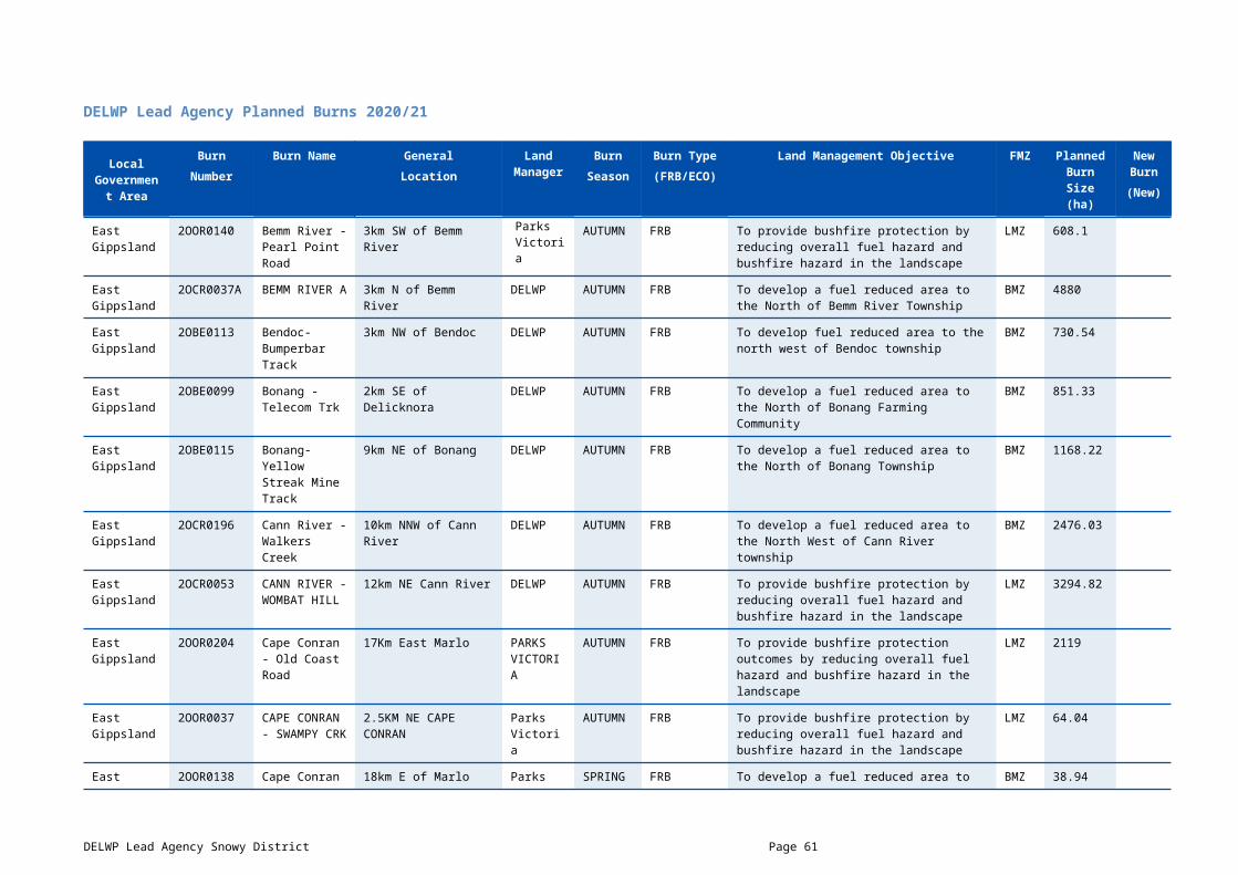
CFA LEAD AGENCY 10 DISTRICT SCHEDULESCHEDULE 1: PLANNED BURNS The activities in this schedule are planned burns.
Please note that the planned burn year and season identified for each planned burn is indicative only and may be changed due to weather conditions and operational requirements.
Abbreviations in Schedule1: ‘*’ asterisk on burn name denotes a cross tenure burn; COM - Committee of Management; PP – Private Property; FRB - Fuel Reduction Burn; ECO - ecological burn;
CFA Lead Agency Planned Burns 2018/19
Local Government Area
Burn Number
Burn Name GeneralLocation
Land Owner/Manager
BurnSeason
Burn Type(FRB/ECO)
Land Management Objective Planned Burn Size (ha)
Planned Burn Size (km)
Wellington Shire
D10-18-009
Fulham-West Sale Aerodrome
5.9 km South East of Wurruk
Wellington Shire
Autumn ECO To encourage the growth of native grasses in the West Sale Aerodrome
8.8ha 1.5
Wellington Shire
D10-16-009
Stratford-469 Briagolong Rd
4 km North of Stratford Private Property Spring FRB To create a fuel reduced buffer on the northern side of a residential area aiding in reducing potential fire spread
3.4 ha 1.5
CFA Lead Agency 27 District Page 61
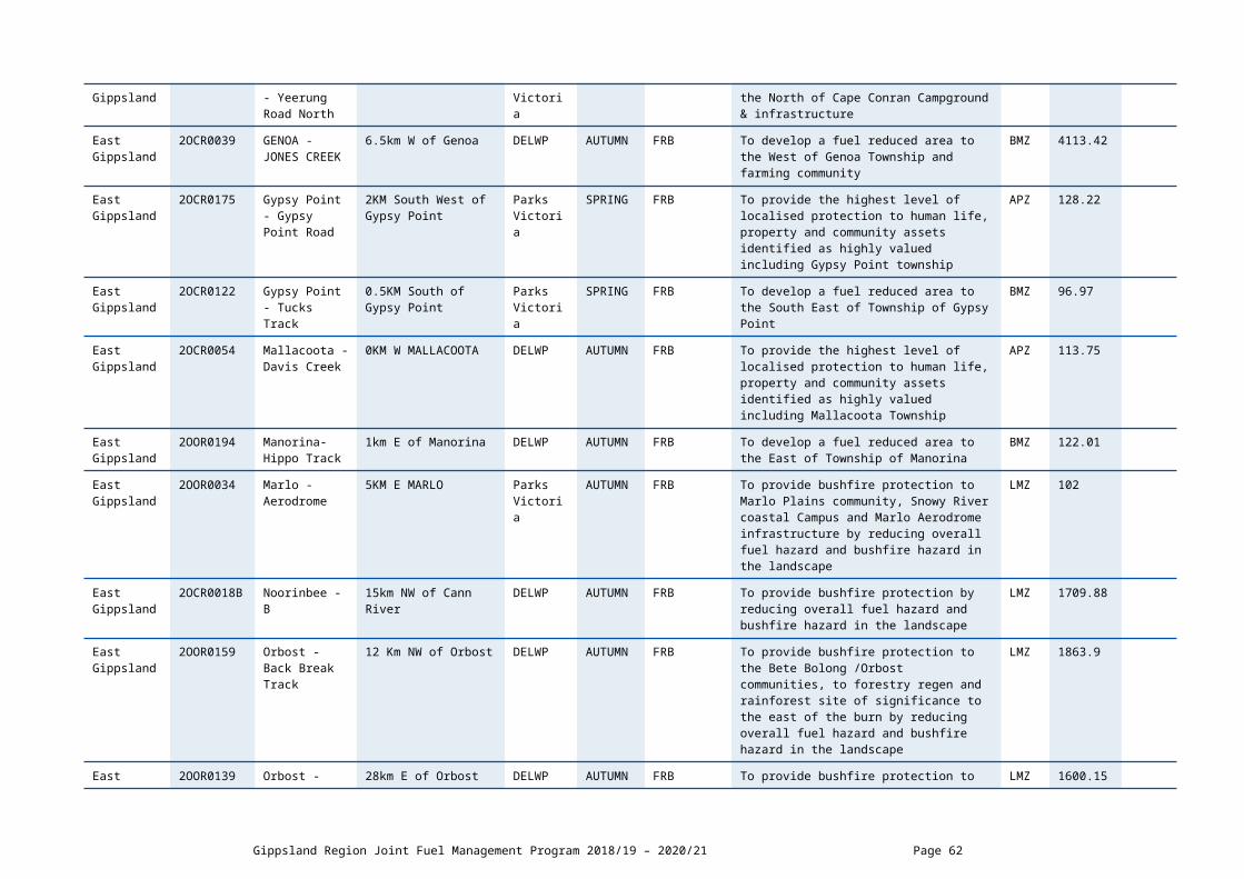
SCHEDULE 2: CFA BULK BURN AND NON-BURN FUEL TREATMENTS - CFA Lead Agency The table below contains a summary of proposed CFA routine brigade burns and non-burn fuel treatments. Some of these fuel treatments are annual, with others prioritised based on the seasonal conditions and which planned burns are scheduled. Accompanying maps provide detail on where these fuel treatment activities are located. Note that the maps show approximate areas only and the actual treatment area will be dependent on the condition of the fuels at the time of assessment. Please contact your local CFA office if further detail is required.
Local Government Area
General Location Land Owner/Manager
Treatment Description Area(ha)
Distance(km)
Wellington Shire
Winnindoo Wellington Shire Roadside burning:Winnindoo - Three Chain Road
10 3.4
Gippsland Region Joint Fuel Management Program 2018/19 – 2020/21 Page 62

CFA LEAD AGENCY 11 DISTRICT SCHEDULESCHEDULE 1: PLANNED BURNS The activities in this schedule are planned burns.
Please note that the planned burn year and season identified for each planned burn is indicative only and may be changed due to weather conditions and operational requirements.
Abbreviations in Schedule1: ‘*’ asterisk on burn name denotes a cross tenure burn; COM - Committee of Management; PP – Private Property; FRB - Fuel Reduction Burn; ECO - ecological burn;
CFA Lead Agency Planned Burns 2018/19
Local Government Area
Burn Number
Burn Name GeneralLocation
Land Owner/Manager
BurnSeason
Burn Type(FRB/ECO)
Land Management Objective Planned Burn Size (ha)
Planned Burn Size (km)
East Gippsland Shire Council
D11-17-003
Benambra-2751 Benambra-Corryong Rd
9 km North-North West of Benambra Private Property
Autumn FRB To compliment the abutting FFMV Fuel Management Burn in reducing fuel to the area North of Benambra Township
169 5.4
East Gippsland Shire Council
D11-17-002
Benambra-2929 Benambra-Corryong Rd
10.3 km North of Benambra
Private Property Autumn FRB To compliment the abutting FFMV Fuel Management Burn in reducing fuel to the area North of Benambra Township
105 3.9
East Gippsland Shire Council
D11-18-008
Orbost-57 Granters Lane
6.8 km North East of Orbost
Private Property Autumn FRB To compliment the ongoing strategic fuel management treatments conducted by FFMV in the Orbost area
35 4.2
East Gippsland Shire Council
D11-16-014
Club Terrace-789 Combienbar Rd
7.3 km North-North West of Club Terrace
Private Property Autumn FRB To create a fuel reduced buffer to the north of Club Terrace thus reducing fire spread in the surrounding area
6 1
Melbourne Water Lead Agency Page 63

MELBOURNE WATER LEAD AGENCY SCHEDULESCHEDULE 1: PLANNED BURNS This schedule lists the location of burns planned to be undertaken by Melbourne Water.
Melbourne Water in conjunction with the CFA undertake a number of planned burns on the Country Area of Victoria
DELWP Lead Agency Planned Burns 2018/19
Local Government
Area
Burn Year
BurnNumber
Burn Name GeneralLocation
Land Manager
BurnSeason
Burn Type(FRB/ECO)
Land Management Objective FMZ Planned Burn Size
(ha)
New Burn(New)
Baw Baw 2018/19 GP-LAT-MW-0002
Melbourne Water Tarago – PB02
2.3km NW of Neerim South
Water Authority Autumn FRB Reduce fuels and possibility of
bushfire spread to built up areas, including rural properties and infrastructure.
NZ 8.6
Baw Baw 2019/20 GP-LAT-MW-0001
Melbourne Water Tarago - PB01
1.1km W of Neerim South
Water Authority AUTUMN FRB To reduce fuels and the possibility of
bushfire spread to built up areas, including human settlements and infrastructure.
Non FPA Land
20.2
Baw Baw 2020/21 GP-LAT-MW-0003
Melbourne Water Tarago - PB03
3km N of Jindivick
Water Authority AUTUMN FRB Reduce fuels and the possibility of
bushfire spread to built up areas, including rural properties and infrastructure.
Non FPA Land
9
Gippsland Region Joint Fuel Management Program 2018/19 – 2020/21 Page 64

GlossaryThis glossary provides information on terms contained within the body of this document and the schedules.
Burn Type – indicates the primary purpose of the burn including fuel reduction burn (FRB), ecological burn (ECO).
Burn Number and Name– the unique identifier for each burn or planned fuel management activity.
Cross-tenure burn – burns that cover both public and private land
Fire Management Zone (FMZ) – an area of public land in which fire is managed for specific asset, fuel and ecological objectives. Values included in this column can be APZ - Asset Protection Zone; BMZ – Bushfire Moderation Zone; LMZ - Landscape Management Zone, PBEZ – Planned Burn Exclusion Zone; or, NZ -Not Zoned.
Forest Fire Management Victoria (FFMVic) - is the organisation that delivers services to achieve DELWP’s legislated responsibilities. It consists of specialist staff from DELWP, Parks Victoria, Melbourne Water and VicForests.
Indicative Burn Season – indicates the preferred season in which the burn will be completed. Actual delivery may be any time of the year.
Land Manager – the organisation responsible for day-to-day management of the works site – DELWP (Department of Environment Land Water and Planning); PV (Parks Victoria).
Land Management Objective - identifies the desired land management outcome(s) of the burn.
Local Government Area (LGA) – the municipality in which the majority of the fuel management activity is located.
Location – a direction and distance of the planned burn from the nearest major township/locality.
Planned Burns - Planned burning is one of FFMVic and CFA’s most important fire prevention activities. It involves the controlled application of fire during periods of lower fire risk, to achieve one of three main purposes: fuel reduction, ecological management and forest regeneration.
It is important to understand that planned burning operations, particularly fuel reduction burns, do not stop or eliminate the risk of bushfires. However, Victorian research, and similar information from other parts of Australia and overseas, clearly shows that firefighters have a much better chance of managing bushfires in areas where fuel reduction burns have been carried out.
Approved burns in this year’s Plan will require a range of preparation works to make the planned area ready to ignite when the weather and other conditions are right. Preparation works may include, brushing up or grading of existing boundaries and internal tracks, management of hazardous trees, the construction and preparation of boundary and control lines with machinery and pest plant controls. The preparation works will have on-site inspections which will assess the surrounding assets and planned burn objectives.
Private Property Burn – burn that occurs wholly on private land.
Planned Burn Size – the maximum area of the fuel management activity measured in hectares (ha), including areas specifically excluded from disturbance.
Strategic Fuelbreak: A strategic fuelbreak is a strip of land where vegetation has been modified to reduce the amount of fuel available to burn during a bushfire.
New Burn– ‘NEW’ = New burn did not appear on last year’s FFMVic JFMP. Blank box = Not a new burn. Burn was approved in the previous (2017/18- 2019/20) Fire Operations Plan but has not been carried out, it is included in this JFMP and may be conducted at any time.
Non-Burn Fuel Treatments – Non burn fuel treatments such as the maintenance and construction of fire control lines, fire access tracks, fuel breaks, fire infrastructure and other fuel management activities are required to support the planned burning program. Treatments to achieve these works can include slashing, pruning, chemical application (in alignment with safety standards), grazing or other operations (such as ploughing, mulching or rolling) that may be more appropriate or practical in certain areas. For example, fuel on small areas or blocks located within townships may be treated mechanically, where burning is impractical. These methods may also be more suitable in certain vegetation types.
Melbourne Water Lead Agency Page 65