Pukatja (Ernabella) Community Structure Plan - APY Lands, SA
62
Transcript of Pukatja (Ernabella) Community Structure Plan - APY Lands, SA


PUKATJA (ERNABELLA) COMMUNITY STRUCTURE PLAN NO. 1 FEBRUARY 2008 Prepared for: Pukatja Community Prepared By: Taylor Burrell Barnett Town Planning and Design 187 Roberts Road SUBIACO WA 6008 Phone: 9382 2911 Fax: 9382 4586 [email protected] In association with: Arup


DOCUMENT HISTORY AND STATUS
Printed 7/02/2008 2:44:00 PM
Last Saved 17/12/2007 12:59:00 PM
Job No. 05/19
Author John Meggitt
Document Version Rev 8
Revision Date Issued Reviewed by Approved by Date Approved
Rev 0 26.01.06 Roger Stein Roger Stein 26.01.06
Rev 1 09.03.06 Roger Stein Roger Stein 09.03.06
Rev 2 22.05.06 John Meggitt John Meggitt 22.05.06
Rev 3 20.09.06 Roger Stein Roger Stein 08.09.06
Rev 4 20.10.06 John Meggitt John Meggitt 20.10.06
Rev 5 08.01.07 John Meggitt John Meggitt 08.01.07
Rev 6 02.03.07 Terry Quinn (Planning SA) Roger Stein 21.03.07
Rev 7 12.09.07 Meg Bartholomew Roger Stein 12.09.07
Rev 8 07.02.08 Terry Quinn (Planning SA) Roger Stein 07.02.08


REPORT LIMITATIONS This Community Structure Plan has been developed in consultation with the Community and Land
Holding Authority as a planning guide for future development within the community. It is proposed
to be updated on a five-yearly basis.
This Plan does not commit the State Government to the funding of infrastructure proposed. The
funding of proposals will be subject to budgets and infrastructure planning processes.


TABLE OF CONTENTS STRUCTURE PLAN REPORT 1 1.0 INTRODUCTION 1
1.1 Content and Purpose of the Community Structure Plan 1 1.2 The Pukatja Community 1
2.0 METHODOLOGY 2 2.1 Background 2 2.2 Tasks 2
2.2.1 Stage 1: Preliminary Investigation 3 2.2.2 Stage 2: Structure Plan - Formulation 3 2.2.3 Stage 3: Draft Structure Plan - Review and Revision 3 2.2.4 Stage 4: Structure Plan and Report - Finalization 3
3.0 REGIONAL AND LOCAL CONTEXT 4 3.1 Land Tenure 4 3.2 Anangu Pitjantjatjara Yankunytjatjara Executive Board 4 3.3 AP Services 4 3.4 Community Management 5
4.0 HUMAN AND ECONOMIC ENVIRONMENT 6 4.1 Community Demographics 6
4.1.1 Population 6 4.1.2 Household Status 7
4.2 Historical Context 7 4.3 Economic Context 7
4.3.1 Local Economy 7 4.3.2 District Community Facilities 8
4.4 Transport Network 8 4.5 Climate 8
5.0 EXISTING DEVELOPMENT 9 5.1 Housing 9 5.2 School and Tertiary Education 9 5.3 Store and Commercial Facilities 10 5.4 Health Facilities 11 5.5 Office 11 5.6 Open Space and Recreation 11 5.7 Industrial 12 5.8 Visitor Accommodation 12 5.9 Police Facilities 12 5.10 Heritage Buildings 13 5.11 Cultural Purpose Sites 13
6.0 EXISTING INFRASTRUCTURE 14 6.1 Water Supply & Reticulation 14 6.2 Effluent Collection & Disposal 14 6.3 Electrical Generation & Distribution 15 6.4 Road Network 15
6.4.1 External 15 6.4.2 Internal 15
6.5 Aerodrome 16 6.6 Drainage 17 6.7 Telecommunications 17

7.0 OPPORTUNITIES AND CONSTRAINTS 18 7.1 Areas of Cultural Significance 18 7.2 Landform 18 7.3 Localised Flooding 18 7.4 Water Bores 19 7.5 Sewerage Ponds 19 7.6 Waste Management 19 7.7 Industrial Area 20
8.0 LAND USE RISK ASSESSMENT/RESPONSE 21 8.1 Flood 21 8.2 Isolation 22 8.3 Access 22 8.4 Potential Hazards 22
STRUCTURE PLAN 25 1.0 STRATEGIC DIRECTION 25
1.1 Community Aspirations or Vision 25 1.2 Strategic Direction 26
2.0 FUTURE DEVELOPMENT 27 2.1 Options Considered 27 2.2 The Structure Plan 27 2.3 Land Use Sites 27 2.4 Buffers 28 2.5 Street Network 28 2.6 Housing Areas 28 2.7 Community Purpose Sites 28 2.8 Parks and Recreation 29 2.9 Swimming Pool 29 2.10 Visitor Accommodation 29 2.11 Commercial 29 2.12 Light Industry 30 2.13 Bush Tucker/Market Garden Site 30 2.14 Development Issues 30 2.15 Service Upgrades 31
2.15.1 Water 31 2.15.2 Effluent Ponds 32 2.15.3 Power 32
2.16 Development Priorities 32 3.0 POLICY AND ADMINISTRATIVE CONTEXT 33
3.1 Strategic and Statutory Planning Context 33 3.2 Land Not Within a Council Area (Far North) Development Plan 33
3.2.1 Form of Development 33 3.2.2 Waste Disposal (Landfill) 34 3.2.3 Conservation 34 3.2.4 Telecommunications Facilities 34 3.2.5 Renewable Energy 34
3.3 Anangu Pitjantjatjara Water Management Plan, May 2002 35 3.4 Natural Resource Management Plan 35
4.0 PUKATJA COMMUNITY STRUCTURE PLAN – PLANNING OBJECTIVES 36 4.1 Form of Development 36 4.2 Integrated Risk Management 36 4.3 Housing Areas 36

4.4 Community Activity Areas 36 4.5 Commercial Activity Areas 37 4.6 Utilities/Industry 37 4.7 Parks/Recreation/Rural 37 4.8 Storm Water Management 37
5.0 PUKATJA COMMUNITY STRUCTURE PLAN – DEVELOPMENT GUIDELINES 38 5.1 Integrated Risk Management 38 5.2 House Sites 38 5.3 Siting of Buildings on House Sites 38 5.4 Stormwater Management 38 5.5 Landscaping 39 5.6 Fences 39
6.0 IMPLEMENTATION AND REVIEW OF THE COMMUNITY STRUCTURE PLAN 40 6.1 Application Requirements for Development 40 6.2 Changes to the Structure Plan 40
ENDORSEMENT 41 BIBLIOGRAPHY 42
APPENDICES APPENDIX 1 Consultation Process


APY LANDS PUKATJA (ERNABELLA) COMMUNITY STRUCTURE PLAN NO. 1
05/19 Rev 8 1
Location Plan [Source, Hema Desert Series]
STRUCTURE PLAN REPORT 1.0 INTRODUCTION
1.1 Content and Purpose of the Community Structure Plan
The Pukatja Structure Plan (Structure Plan) provides a framework within which development can proceed in an orderly and planned manner over the next 5 to 10 years.
The Structure Plan consists of the following:
• A plan depicting the physical layout of the community; • Strategic direction, planning objectives and development guidelines; • An explanation of the Structure Plan; • A report on the preparation of the plan including an overview of the local and
regional context.
The purpose of the Structure Plan is to:
• Establish a vision for the community and a guide to future growth and development; • Provide a community focus for, and involvement in, the development process; • Facilitate proper and orderly planning of the community to establish development
requirements based on need within social, physical, environmental and economic opportunities and constraints;
• Provide a mechanism for a coordinated approach to the provision of services and infrastructure and enable access to existing services and infrastructure information; and
• Promote development that maximises health, safety and welfare outcomes for the community.
The structure plan provides the community with a plan that forms the basis for co-ordination of future development. The Plan can be used to assess future development proposals by government agencies, builders, funding agencies and the community.
1.2 The Pukatja Community
Pukatja is an Anangu community on the Anangu Pitjantjatjara Yankunytjatjara (APY) Lands in the north west of South Australia. The APY Lands are held on freehold title under the terms of the Anangu Pitjantjatjara Yankunytjatjara Land Rights legislation.
The Pukatja (Ernabella) Community is located in South Australia in the Musgrave Ranges about 30 km south of the Northern Territory border. It lies approximately 330 km south west of Alice Springs and approximately 25 kilometres north of Umuwa, the major administrative centre within the APY Lands and the base for the Anangu Pitjantjatjara Yankunytjatjara (APY) Executive. The land surrounding Pukatja is of great cultural significance to the local community.
The population of Pukatja ranges between 600 and 700 people, including a number of Piranpa (non-Aboriginal) people who work in the community to support Anangu.

APY LANDS PUKATJA (ERNABELLA) COMMUNITY STRUCTURE PLAN NO. 1
05/19 Rev 8 2
2.0 METHODOLOGY
2.1 Background
Community Structure Plans were prepared for nine of the major communities within the Anangu Pitjantjatjara Yankunytjatjara Lands (APY Lands) in response to the need to establish a clear framework within which to accommodate development. Building works have, in the past, been initiated in some communities by State and Federal Government agencies without reference to clearly defined plans for the physical growth of the communities.
For the Anangu to be able to take responsibility for guiding the development of their communities and to protect places of cultural significance they need to have structure plans in place which are an expression of how they wish to see the physical development of their communities occurring.
Most of the funding for community facilities comes from a variety of sources outside the APY Lands. In the absence of adopted structure plans, some new facilities have been put in place without adequate input from community members and in locations which could be adversely affected by environmental conditions.
It is recognised that due to the remoteness and limited commercial opportunities within the APY Lands that outside funding to sustain the communities will be required for the foreseeable future. In addition, it is anticipated that local communities will continue to have only limited influence on the timing, scale, scope and funding of the infrastructure and development works being undertaken.
Furthermore, the high cost of providing and maintaining infrastructure in communities located great distances away from major urban centres, necessitates that existing infrastructure and facilities are well utilised.
As such, while it was essential to obtain input from the community members on the content of the structure plans, it was also important to seek out and include input from those agencies and authorities with responsibility for the current and future provision of services and infrastructure.
The plans give cause for questions to be asked about the sustainability of the communities, in particular with regard to underground water resources. At the present time there are concerns regarding the sustainability of water supplies in some communities, however there is no definitive data which can be drawn on to answer such questions. Funding is required for investigations to be undertaken across the APY Lands for how to not only provide for future increases in population but also to accommodate current population levels over time.
The structure plans have been prepared during a time of re-evaluation of past policies towards remote Indigenous communities and uncertainty in regards to future funding. The structure plans however provide a robust framework to accommodate physical changes reasonably expected to occur and allow for flexibility when future development pressures arise within the five to ten year life of the plans.
2.2 Tasks
The methodology followed for the preparation of the Community Structure Plans is summarised below:
• Investigation and research. • Plan formulation and refinement through testing and review. • Development of a preferred plan.
APY LANDS PUKATJA (ERNABELLA) COMMUNITY STRUCTURE PLAN NO. 1
05/19 Rev 8 3
2.2.1 Stage 1: Preliminary Investigation
• Project Inception meeting with Planning SA and other stakeholders • Obtain relevant documents, demographic details, community contact details • Obtain base mapping, aerial photographs and format base plans • Site visit and undertake site inspection • Community consultation • Mapping of physical constraints, opportunities, infrastructure, housing, community
facilities • Documented meeting/s, interviews
2.2.2 Stage 2: Structure Plan - Formulation
• Prepare draft Structure Plan • Site visit • Meeting with Community to present draft Structure Plan and receive comments. • Copies of draft Structure Plan left to be distributed to school, art centre, placed on
community notice boards • Meeting with client • Client and other stakeholders review structure plan, provide comment
2.2.3 Stage 3: Draft Structure Plan - Review and Revision
• Comments received, modifications made to the Draft Structure Plan • Draft Report prepared • Site visit • Meeting with Community to present revised draft Structure Plan and Report, receive
comments • Copies of revised Plan and draft Report left to be distributed, placed on Community
notice boards • Meeting with client, provide copy of revised Structure Plan, draft Report for
comments.
2.2.4 Stage 4: Structure Plan and Report - Finalization
• Comments received from stakeholders, modifications made to final Structure Plan, Report
• Prepare final Structure Plan and Report • Site visit to address APY Executive meeting • Copies of Structure Plan and Report issued.

APY LANDS PUKATJA (ERNABELLA) COMMUNITY STRUCTURE PLAN NO. 1
05/19 Rev 8 4
3.0 REGIONAL AND LOCAL CONTEXT
3.1 Land Tenure
Pukatja is part of the Anangu Pitjantjatjara Yankunytjatjara Lands which are incorporated by the Pitjantjatjara Yankunytjatjara Land Rights Act in which the SA Parliament gave title to the APY Lands to Aboriginal people in 1981.
3.2 Anangu Pitjantjatjara Yankunytjatjara Executive Board
The Pitjantjatjara Yankunytjatjara Land Rights Act, 1981, provided for the vesting of title of the Anangu Pitjantjatjara Yankunytjatjara Lands to the people known as Anangu Pitjantjatjara Yankunytjatjara. The Executive Board of Anangu Pitjantjatjara Yankunytjatjara (APY) was constituted under this Act. The administrative centre of the APY Lands is at Umuwa, 30 km from Pukatja.
The APY Executive Board oversees the activities of the various constituent groups serving the needs of the people on the APY Lands. It also helps shape policies regarding economic and social development. The Executive Board comprises elected members from across the APY Lands and they choose their own Chairperson.
Under the Act the functions of the Executive Board of Anangu Pitjantjatjara Yankunytjatjara are:
• ascertain the wishes and opinions of the traditional owners in relation to the management, use and control of the APY Lands and to seek, where practicable, to give effect to those wishes and opinions;
• protect the interests of traditional owners in relation to the management, use and control of the APY Lands;
• negotiate with persons desiring to use, occupy or gain access to any part of the APY Lands; and
• administer land vested in Anangu Pitjantjatjaraku.
3.3 AP Services
Anangu Pitjantjatjara Services (Aboriginal Corporation) is located at Umuwa and has an administration office, works depot and mechanical repair garage. Umuwa is located approximately central to the seven communities on the APY Lands.
AP Services has evolved as the service providing arm of Anangu Pitjantjatjara Yankunytjatjara. This involves project management and coordinating maintenance programs that support the APY Executive’s responsibility as the land owner/land title holding body, particularly Anangu environmental health and safety. AP Services works very closely with Nganampa Health's UPK section.
AP Services ongoing responsibilities include: road works (including grading and realignment), housing repairs and maintenance, development and construction projects, construction inspection, waste management, homelands essential services, bore maintenance and alternative energy programs and other works related programs as they evolve.
Other projects completed since 1994 are ‘one off’ projects, such as:
• Pipalyatjara Dust Control • Relocation and Lighting of the Amata Airstrip • Septic Tank Survey • Removal of Asbestos Waste

APY LANDS PUKATJA (ERNABELLA) COMMUNITY STRUCTURE PLAN NO. 1
05/19 Rev 8 5
• Construction of 12 Waste Management Landfills • Construction of housing • Nyapari and Pukatja Dust Control • Town Plan Finalisation
3.4 Community Management
Pukatja is controlled by a Governing Council and supported by a small administration team. Several people are in funded positions. The Pukatja Governing Council representing the Pukatja community manages the community. The community has a corporate CDEP with members participating in a range of employment projects. It employs staff through the CDEP for basic maintenance work around the community.

APY LANDS PUKATJA (ERNABELLA) COMMUNITY STRUCTURE PLAN NO. 1
05/19 Rev 8 6
4.0 HUMAN AND ECONOMIC ENVIRONMENT This part of the report provides background information on Pukatja Community. It includes details about its population, economic activities, the transport network and climate. A very brief summary of the history of the community is included. This part of the report is drawn from various other reports and sources.
The main APY communities are Pukatja (Ernabella) with a 2001 Census population of 446, Amata with 273, Kaltjiti (Fregon) with 300, Iwantja (Indulkana) with 280, Mimili with 250 and Pipalyatjara with 114. The remaining estimated 700 to 800 people are located in several smaller communities and approximately 50 occupied homelands.
The APY Lands are located in South Australia’s most northern region. They are bordered by Western Australia to the west, Northern Territory border to the north and encompass the Great Victoria Desert to the northeast. They cover an area of 105,000 km2, which is approximately 10% of the state’s total area.
4.1 Community Demographics
The population of the APY Lands is heavily weighted towards younger age groups with only about 25% of the Anangu on the APY Lands over 35 years old. The Anangu experience high dependency ratios, low life expectancy and poor living standards. People are highly mobile and place a high value on kinship obligations.
The 2001 Census summary for Pukatja provides some context for the community profile. The population recorded for Pukatja and the Anilalya homelands at the time of the census was 669 people.
There are occasional influxes of visitors during lore business and sporting events such as football carnivals. The population can increase with hundreds of people attending such events. Similarly, when lore business and sporting events occur elsewhere in the APY Lands, attended by Pukatja people, the population is temporarily reduced.
4.1.1 Population
Pukatja community had a population of approximately 446 people in 2001. Of those people, 389 (87%) were Indigenous persons. During the dry season this number may be less however it is likely to be significantly more in the wet season. The core population fluctuates with many residents being transient.
The actual current population is difficult to fix given the transient lifestyle of many of the residents however it is indicated by the administration that in 2006 there are now closer to 600-650 people living in the community indicating a much higher level of overcrowding.
Using the 2001 census figures, the median age of Indigenous people in Pukatja is 24. The gender ratio is expressed as the number of males per 100 females. The gender ratio for Indigenous people at Pukatja is 80.93. This suggests a young population, with more females than males.
In regard to household density it was recorded that there were 31 dwellings occupied by 6 or more residents.

APY LANDS PUKATJA (ERNABELLA) COMMUNITY STRUCTURE PLAN NO. 1
05/19 Rev 8 7
4.1.2 Household Status
Occupied private dwellings are used as the basis for analysis and a family is defined as two or more persons, one of whom is at least 15 years of age, who are related by blood, marriage (registered or de facto), adoption, step or fostering and are usually resident in the same house.
In Pukatja 81.5% of households were family households. The most common type of family is couple family (with children) (57.4%), followed by one parent families (12.7%).
The number of houses currently occupied by Anangu is 40 and accepting a 2001 Indigenous population of 446 this indicates an average household size of 9.73 persons per house.
Sometimes residents may be waiting for accommodation; others might be visiting from affiliated homelands or communities, others might be travelling on lore or other culturally related activities. There may be occasional influxes of visitors during lore business and sporting events such as football carnivals. The population can increase significantly to 1,000-1,200 during such events. Similarly, when lore business and sporting events occur elsewhere in the APY Lands, attended by Pukatja people, the population is temporarily reduced.
4.2 Historical Context
In 1933 a homestead was built on the site as the centre for a 1,295 sq km pastoral block, one of four leased to settlers in the region. The lease of Ernabella was transferred to the Presbyterian Church four years later and the sheep industry was maintained.
A school was opened in 1940 with the children instructed in Pitjantjatjara and gospels, hymns and other materials translated into Pitjantjatjara. An Indigenous method of spinning fibres was adapted to spinning wool from sheep to form a handcraft industry for women which developed from 1948 and later became Ernabella Arts Inc. When the sheep industry closed in 1972, batik fabric work became increasingly important in the craft industry.
4.3 Economic Context
4.3.1 Local Economy
Pukatja’s economy comprises locally produced art and craft works with employment available at the school, office, aged persons centre, the health clinic and the store.
Commercial facilities in Pukatja comprise the store, the ‘Wali-K’ Fabricators producing window and door frames, the Pukatja garage and the Pukatja arts centre.
Art and craft is produced within the community by a number of the women and some men. The artists in Pukatja are all a part of the wider Anangu art collective on the APY Lands, Ananguku Arts. There are many different kinds of artworks produced ranging from paintings, screen prints, pottery and batik.
Small tree and date plantations have been established by the creek to the south of the community however these are not in production at present.

APY LANDS PUKATJA (ERNABELLA) COMMUNITY STRUCTURE PLAN NO. 1
05/19 Rev 8 8
4.3.2 District Community Facilities
Alice Springs in the Northern Territory is the nearest major town and supports a population of approximately 25,000 plus many more visitors during peak tourist periods. The town provides a wide range of education, health, administrative, commercial, sporting and cultural facilities.
4.4 Transport Network
Pukatja is serviced regionally by air, and a strategic freight and tourist road network via the Stuart Highway and Giles-Mulga Park Road.
4.5 Climate
Pukatja shares a similar climate to the Giles weather station having a dry climate with hot summers and mild winters. The annual average rainfall is 283 mm spread over an average 48 days and while the average rainfall is higher during the warmer months of the year, there is also considerable variation from year to year.
January is the hottest month with an average maximum temperature of 37° C. By contrast winters are mild with the July average maximum and minimum temperatures being 20°C and 7°C respectively.
The wettest months are November to March with February being the wettest month with an average rainfall of 49 mm spread over five days.
Bureau of Meteorology: http://www.bom.gov.au/weather/wa/giles/climate.shtml

APY LANDS PUKATJA (ERNABELLA) COMMUNITY STRUCTURE PLAN NO. 1
05/19 Rev 8 9
5.0 EXISTING DEVELOPMENT The dispersed layout of the community reflects the undulating topography and areas of rocky ground which limit the choice of development areas. Further constraining the community is the Ernabella Creek, which was straddled by the original mission, and the need to protect groundwater source areas. Additionally, cultural reasons encouraged the separation of housing for different skin/family groups.
With the introduction of facilities including deep sewers and relocation of the water bores further from the centre of the community, there is now an opportunity to consolidate the location of new housing and community facilities.
5.1 Housing
Housing areas were originally established in close proximity to the Mission buildings on the west bank of the creek. As the population has grown additional discrete housing and community facilities have been located on less constrained land south of the main community in the ‘Hidden Valley’ area, adjacent to the school south of the main community area and adjacent to the main Umuwa / Fregon Road. House sites are approximately 900-1,200m2 with frontages of 30 – 35 metres.
Much of the housing was built before the other communities on the APY Lands were established. As a result much of the housing stock in Pukatja is older and a number of houses are in poor condition and require upgrading.
There are currently 72 houses in the community and at the 2001 census Pukatja had a population of 446 people and 74 houses. Of these houses approximately 40 are occupied by Anangu.
This indicates a household density of approximately 9.7 people per house. There are cultural reasons for extended family groups to be housed within one dwelling however this level of overcrowding, within older housing stock not designed for such large numbers, has been associated with poor health outcomes.
5.2 School and Tertiary Education
The current school opened in 1970. The school has an enrolment of over 120 students enrolled and teaches children who predominantly speak English as a second language. Literacy is a high priority for the school. Students also engage in cultural education which is provided by traditional teachers.

APY LANDS PUKATJA (ERNABELLA) COMMUNITY STRUCTURE PLAN NO. 1
05/19 Rev 8 10
Air-conditioned classrooms, library, canteen, hall and staff areas are the main facilities. The school is well equipped with administrative and teaching resources.
Almost all students actively participate in all the sporting activities at the school. From a very early age, children in the community learn ball handling skills and football, basketball and softball are very popular activities among the younger adults. Once a year the students participate in an Across-Lands Sports Day.
The school has an air conditioned hall that is used in warmer months. This hall is also used for school dances and assemblies.
A number of Anangu community members are enrolled in the Anangu Teacher Education Program (a course designed by the AnTEP unit based at the Underdale Campus of the University of South Australia) to formally prepare Anangu people as qualified teachers.
The school employs Indigenous teachers who graduate from the AnTEP course.
During the 2005/2006 financial year $800,000 was allocated to upgrade the Child Parent Centre at the school.
5.3 Store and Commercial Facilities
Commercial facilities in Pukatja comprise the store, the ‘Wali-K’ Fabricators producing window and door frames, the Pukatja garage and the arts centre. Other enterprises which operated during the missionary period included pastoral/sheep grazing. Small plantations of date palms and eucalypts for timber harvesting still exist. Community members are also employed through the school, the health clinic and the respite centre.
The APY Lands are closed to visitors unless they have specific approval to travel to a community and as such only a very limited number of escorted travellers/tourists venture to Pukatja. Pukatja Community is home to Ernabella Arts. Arts and crafts have been produced in the community for over fifty years and the arts centre contributes enormously to the social, economic and cultural life of the community.
Large murals which have been painted on the walls of the Pukatja store. The store and ‘Wali-K Fabricators’ workshop are illustrated above.

APY LANDS PUKATJA (ERNABELLA) COMMUNITY STRUCTURE PLAN NO. 1
05/19 Rev 8 11
5.4 Health Facilities
Nganampa Health Council is an Aboriginal owned and controlled health organisation operating on the Anangu Pitjantjatjara Yankunytjatjara Lands. Across this area, Nganampa Health operates nine clinics, including the Pukatja Health Clinic, an aged care respite facility (Pukatja House) and assorted health related programs including aged care, sexual health, environmental health, health worker training, dental, women’s health, male health, children’s health and substance abuse prevention. In 2006, the Pukatja Health Clinic burnt down. Discussions are underway regarding the replacement of the building.
Nganampa Health runs the respite care program which involves short stay respite at Pukatja House (Tjilpi Pampa Ngura) - a 16 bed respite care facility located at Pukatja. Older frail Anangu come to Pukatja House for respite care and this enables them to continue living in their own country with occasional or regular supported respite.
People come to the Tjilpi Pampa Ngura for a number of reasons. For personal respite, carer respite or for convalescence after surgery. Some clients stay for as many as 6 or 8 weeks, and some come for only a few days while their carers are absent on other business.
5.5 Office
The office is centrally located adjacent the store, church and arts centre. The building is in fair condition and contains a reception area, a number of small offices, a conference room. A small covered parking area adjoins the building
5.6 Open Space and Recreation
Pukatja has an attractive physical setting by Ernabella Creek which is located at the base of a range of hills and adjoins open rangelands. The watercourse is marked by stands of mature eucalypt trees and rock outcrops with a number of vehicle crossing points.
The area in the immediate vicinity of the creek is the community’s main public open space area. It provides shade, community gathering areas, pedestrian routes and a strong geographical focus for the community.
In Pukatja and elsewhere within the APY Lands programmes have been initiated to remove the exotic Athol Pine tree plantings. These trees, which thrive in the local conditions, have invasive root systems and can endanger residents when they drop limbs suddenly when under stress. They are to be replaced with local tree species Indigenous to the local region which can also offer similar benefits in relation to shade and dust control.

APY LANDS PUKATJA (ERNABELLA) COMMUNITY STRUCTURE PLAN NO. 1
05/19 Rev 8 12
The community has a number of recreation facilities. These include two football ovals - one of which has a grassed ground. A softball oval and basketball courts adjoin the football ovals. Shower and changing facilities are also located in this area.
A reticulated and grassed football oval and basketball courts are also located on the school grounds.
5.7 Industrial
Located immediately behind the office and other administration facilities the Industrial/ Utilities area is contained within a 1.0 hectare parcel of land within a 1.8 metre wire mesh fenced compound.
The Industrial area contains diesel generators and a number of above ground diesel fuel tanks. There are also ‘Wali-K’ Fabricators workshops, storage sheds, building equipment and machinery including the fire trailer located within the compound.
5.8 Visitor Accommodation
Visitors to Pukatja from other communities in the APY Lands usually camp in the area to the south of the community and the ‘Hidden Valley’ housing area west of the creek. Basic ablution facilities are provided there.
The other area occupied by visitors for short periods is the area to the south of the football ovals to the east of the Pukatja to Fregon Road. The ablution facilities adjoining the sports grounds are used by the visitors.
5.9 Police Facilities
The new police district of APY Lands was created in November 2005. It is now policed separately from the previous Marla Police District and will be based in Umuwa. As part of the new policing strategy police stations in each major community are opened at identified times.
Ernabella has a small police facility and lockup which is used on the police rounds.
APY LANDS PUKATJA (ERNABELLA) COMMUNITY STRUCTURE PLAN NO. 1
05/19 Rev 8 13
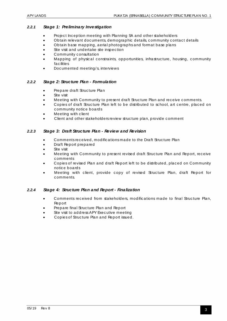
5.10 Heritage Buildings
A number of buildings remain from the period when Pukatja was originally established as a Christian mission. The Ernabella church which was built during the missionary period is currently in disrepair and is not used for church services. However it remains a place of importance especially to many of the senior members of the community.
These places of heritage significance include the Ernabella Old Hospital which played a major role in the treatment and prevention of diseases and epidemics for the Indigenous people of the Central Western Desert.
In addition many elders living throughout the Central Western Desert today were born at the Mission Hospital. Funding has recently been announced for restoration and conservation works.
The hospital buildings are part of a cluster of three heritage buildings that surround the community's central common - the Manse, the Ernabella Church and the Old Hospital. The Manse was renovated after a fire in the 1980's and the Church is in need of restoration work.
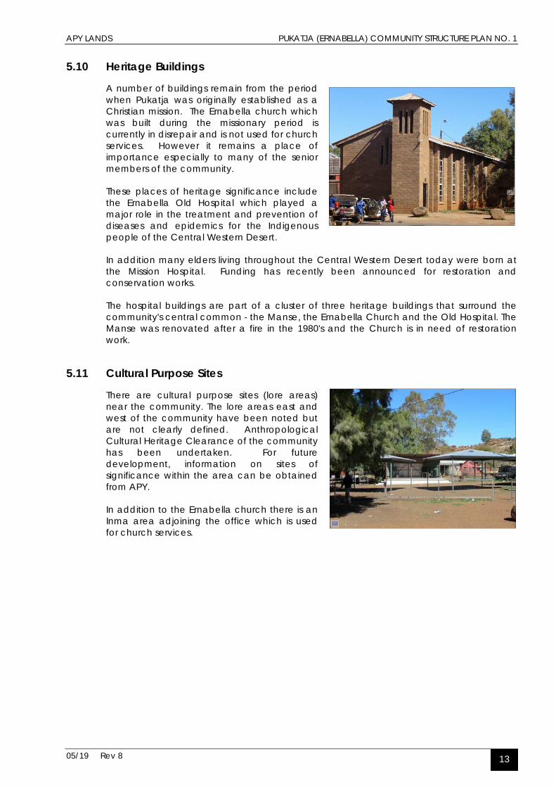
5.11 Cultural Purpose Sites
There are cultural purpose sites (lore areas) near the community. The lore areas east and west of the community have been noted but are not clearly defined. Anthropological Cultural Heritage Clearance of the community has been undertaken. For future development, information on sites of significance within the area can be obtained from APY.
In addition to the Ernabella church there is an Inma area adjoining the office which is used for church services.

APY LANDS PUKATJA (ERNABELLA) COMMUNITY STRUCTURE PLAN NO. 1
05/19 Rev 8 14
6.0 EXISTING INFRASTRUCTURE
6.1 Water Supply & Reticulation
The community water supply is drawn from 6 bores (EMB-E12, E42, E44, E45, 97B & 97L) and all are fitted with electric submersible pumps. Bore EMB-E42 was equipped in 1988, EMB-E44 and E45 in 1992 and EMB-97B and 97L in 1999.
Monitoring equipment was installed on bore EMB-E45 in 1993, then to all bores in 1998, including an electronic rain gauge to EMB-E42, to enable the compilation of relevant data associated with this water source and to assist in the long term planning of additional water supplies.
Water is pumped to three 450 kilolitre (each) ground storage tanks located on an elevated site to provide adequate static pressure. EMT-2 was fibreglassed internally In 2000. Total water storage capacity is 1350 kilolitres. The water supply is treated with a UV disinfection system.
Reticulation of the water throughout the community is via an underground uPVC pipework system to an isolating valve and water meter at each consumer point.
The sustainability of the water sources is not known. Indicators are that the aquifers are small and extraction rates may not be sustainable. Further monitoring is required and investigations will be necessary particularly if a major expansion in the population size of the community is proposed.
6.2 Effluent Collection & Disposal
All existing houses, community buildings and public ablution blocks are connected to a septic tank that flows in turn to the reticulated gravity common effluent drainage system. Effluent waste is collected by 100 and 150 mm uPVC effluent mains and directed to the effluent pumping station.
The effluent pump station is located to the west of the Pukatja School. The pump station is equipped with two 3.7 kW electric submersible effluent pumps. Effluent is then pumped via an 80 mm PVC rising main to the effluent treatment lagoons located some 800m to the south of the community. The reticulation system, pumping station and lagoons were constructed in approximately 1988, and all are in good condition.
Three lined earth banked effluent ponds, are used to treat and evaporate the effluent. Treated effluent is drawn from the last lagoon and disinfected before it is drip reticulated to a wood-lot south of the lagoons for future energy needs.

APY LANDS PUKATJA (ERNABELLA) COMMUNITY STRUCTURE PLAN NO. 1
05/19 Rev 8 15
6.3 Electrical Generation & Distribution
Power is generated on the community by four diesel generators, which are located in a brick constructed powerhouse built in 1989. ETSA is the ‘Licensed Operator, Distribution’. The powerhouse supplies energy to consumers from Watinuma to Yunyarinyi via a 33 kV distribution line, approximately 90 km long.
A control system is installed to provide automatic synchronisation and load sharing for the generators and performance information is recorded via a data monitoring system.
The powerhouse generation has difficulty providing for community demand at times of peak load.
Diesel generators are all Caterpillar machines as follows:
• No. 1 Cat. 3306 installed in 1991 (new 1997) • No. 2 Cat. 3306 installed in 1996 • No. 3 Cat. 3306 installed in 1996 • No. 4 Cat. 3406E installed May 2001
Diesel fuel capacity is 128,000 litres stored in two 42,000 litre above ground tanks and one 45,000 litre above ground tank installed in 1991. A precast concrete modular bunding system is installed around the tanks. Power is reticulated throughout the community by a standard ETSA overhead system with a combination of high voltage (11,000 V) and medium voltage (415/240 V) power lines. Street lighting is provided by standard street lights mounted on stobie poles. Street lighting was installed in September 2001.
The electrical reticulation system has a protection system, which provides protection to consumers for system overload, unbalanced loads and earth fault conditions. The bores providing water supplies to the community are powered by the community reticulation system.
6.4 Road Network
6.4.1 External
The APY Road Network Study classifies the road from Pukatja to Yunyarinyi and the road to the Stuart Highway via Kaltjiti and Mimili as major access roads with high improvement priority.
6.4.2 Internal
The north-south running Pukatja to Kaltjiti (Fregon) road bisects the community marking a division between one of the newer housing areas and sporting ovals and the older established area by Ernabella Creek.
The internal road network is determined by the route of the creek and a number of small rocky hills and outcrops within the community.

APY LANDS PUKATJA (ERNABELLA) COMMUNITY STRUCTURE PLAN NO. 1
05/19 Rev 8 16
Two concrete culvert creek crossings are located to the north and south of the store.
Two other informal crossings to the north provide direct heavy vehicle access to the diesel generators and workshop and to the northern housing area. Both of these crossings connect to unsealed tracks which join the Pukatja Kaltjiti (Fregon) Road.
A pedestrian bridge has been established over the creek near the store to improve access.
The key roads within the township are sealed, with formed underground and above ground drainage. These roads have a 7 metre wide bitumen seal with concrete kerbs and gutters.
The driveways to the existing houses and community buildings are no more than earth tracks with poor or no drainage originally made when the buildings were contracted and do need to be upgraded.
6.5 Aerodrome
A report titled ‘Ernabella Aerodrome Strategic Aerodrome Investigation’ was prepared in April 2002 by Airport Technical Services Pty Ltd. The following information was provided within the context of that comprehensive report.
Ernabella Aerodrome was originally a two-runway licensed aerodrome. The aerodrome serves communities at Pukatja, Anilalya, Turkey Bore, Balfours Well and 22 small homelands. The total population served is approximately 800. The aerodrome is required for the daytime delivery of urgent medical assistance, patient evacuations from the community and charter operations.
The facility is now a single runway aerodrome with no lighting. The presence of hills that surround the aerodrome and the lack of lighting means Ernabella Aerodrome runs as a daytime site only. This causes concern for the delivery of health services as the nearest night landing strip is 25 km away in Umuwa where there are no medical facilities to care for waiting patients. The aerodrome consists of a compacted gravel runway constructed to a formal design by the former Department of Civil Aviation. The design features proper attention to drainage with a crowned formation of the central runway area.
The runway remains in good condition. Rolling after rain would assist in retaining a tightly bound pavement. Consideration should be given to eventual resheeting of the facility to replace material lost as a result of aircraft movements and erosion. Resheeting is not expected to be required within the next 5 years.

APY LANDS PUKATJA (ERNABELLA) COMMUNITY STRUCTURE PLAN NO. 1
05/19 Rev 8 17
6.6 Drainage
The Ernabella Creek flows from the north to the south intermittently after rains fall on the surrounding ranges. At times there are a number of years when the creek remains dry. It has been suggested that the introduction of foreign grasses into the area and the cessation of pastoral activities have also played a part in reducing flow in the watercourse.
Formal records of creek flows are not available however anecdotal evidence indicates that after heavy rains flows are largely confined to the immediate area of the creek without any damage to property occurring.
6.7 Telecommunications
The community is reticulated with Telstra infrastructure with some private phone services in addition to the one public phone and the office phones.

APY LANDS PUKATJA (ERNABELLA) COMMUNITY STRUCTURE PLAN NO. 1
05/19 Rev 8 18
7.0 OPPORTUNITIES AND CONSTRAINTS
7.1 Areas of Cultural Significance The structure plan contains boundaries to the west and east of the existing community which indicate an exclusion to development into these areas. These areas are of cultural significance to Anangu.
These ‘no go’ areas help to define the localities for the future expansion of the community. Taking into account topography and other factors it is apparent that within the remaining north south corridor of land the area to the north east of the creek provides a number of opportunities. No areas of development proposed under the structure plan intrude into the ‘no go areas’.
7.2 Landform Pukatja is located within an area containing a number of low rocky hills and smaller rocky outcrops. The combination of hilly topography and rocky terrain have helped produce the widely dispersed pattern of settlement; it has also provided opportunities for the establishment of discrete clusters of residential development when this was seen as desirable for cultural or other social reasons.
Existing and potential sites for housing and community facilities are located on lower flatter sites with suitable foundations for construction and servicing. However in areas identified for development which adjoin rocky ground it will remain necessary to undertake preliminary testing for near surface rock before building works can be undertaken.
7.3 Localised Flooding Flooding may occur in the immediate area of Ernabella creek if water flow was to be impeded due to a build up of branches and rubbish in the creek bed. Flooding could affect the Nganampa Health Clinic and a number of older houses located immediately south of the child care centre.
The creek places no constraints on the proposed new locations for housing and community facilities. A watercourse which flows after heavy rains and feeds into Ernabella Creek from the east bisects an area proposed for future expansion of housing and other community facilities.
While this will need to be addressed as part of future detailed subdivision design it will not impede the expansion of the community into this area.
Water pooling can occur in the community after heavy rains however this is limited to relatively short periods and usually disperses rapidly without any significant adverse impacts.

APY LANDS PUKATJA (ERNABELLA) COMMUNITY STRUCTURE PLAN NO. 1
05/19 Rev 8 19
7.4 Water Bores
There are three water collection bores in the vicinity of Pukatja; two bores by Ernabella Creek are used to supply the community. The bore located on the Pukatja – Eagle Bore Road is to be used for non drinking or domestic purposes; it is not necessary for development to be restricted in the vicinity of this bore.
A number of houses are located within the 100 metre buffer areas of two of bores by the creek. To ensure the ongoing integrity of these bores it is undesirable to have additional houses within the buffer areas. It is noted that this area is largely unsuitable for additional housing due to the rocky nature of the ground.
It is noted that previously there were water bores located to the east of the creek between the office and the existing motor vehicle fuel station. These are no longer in existence and with the establishment of a deep sewer network this area is now largely available for the development of housing and community facilities.
7.5 Sewerage Ponds
The three ponds are located approximately 1.0 km south (downstream) of the office on the east bank of the creek. The 200 m and 400 m buffers excludes all of the houses within the community with the exception of the aged persons’ respite centre which is located on the opposite side of the creek approximately 350 metres from the ponds.
There is sufficient area to the south of the ponds to accommodate additional ponds should the ongoing growth of the community warrant it.
The ponds have a 1.8 metre high wire mesh fence surrounding them however it has been reported that at times children have been found to have scaled the fence to swim in the ponds. Until a swimming pool has been established it will be necessary ensure that during the warmer months the ponds are monitored to ensure that unauthorised access does not occur.
7.6 Waste Management
The waste management area is located approximately 4.0 km south of the community off the main access road to Umuwa. It has a 1.8 metre wire mesh fence surrounding it however the gate is not locked and access is not restricted.
Domestic rubbish from the community is dumped in pits that are approximately 4 metres in depth. It is later burnt (illegally) and the pits are in-filled. The site has been largely cleared of vegetation within the fenced compound and within the immediate area of the waste disposal area.

APY LANDS PUKATJA (ERNABELLA) COMMUNITY STRUCTURE PLAN NO. 1
05/19 Rev 8 20
7.7 Industrial Area
While the power generators within the Industrial Area produce noise they are not close enough to existing or proposed residential areas to be a problem. Furthermore with the connection of Pukatja to the main power grid within the next twelve months the generators will be kept in standby mode for backup supply.
The storage of building equipment, machinery, fuels and other combustible material warrants the retention of the buffer around the area when the generators are shut down.

APY LANDS PUKATJA (ERNABELLA) COMMUNITY STRUCTURE PLAN NO. 1
05/19 Rev 8 21
8.0 LAND USE RISK ASSESSMENT/RESPONSE The region within which Pukatja is located is not one which is subject to catastrophic events such as cyclones, tropical storms or earthquakes. However isolation from other major regional centres, restrictions on accessibility in the event of an emergency and limited resources to deal with even small scale events increases the vulnerability of the community.
The protection of essential services and infrastructure such as the power supply, water supply and sewerage network is also critical to the normal functioning of the community. In addition the presence of important social services such as the health clinic, store, education facilities and the respite / aged persons centre highlights the need to ensure that measures are in place to reduce the level of risk.
The Pukatja Town Structure Plan provides an important component of an emergency management plan. By reducing the exposure to risk, working with the natural environment and identifying appropriate locations for development it provides a framework within which the emergency management plan can be developed. The most likely hazards to affect Pukatja are flood, isolation or fire.
8.1 Flood
Flooding may be defined as the overflowing by water of the normal confines of a stream or other body of water, or the accumulation of water by drainage over areas not normally submerged (DoTARS, 2002). Flooding may be a result of prolonged or heavy rainfall or severe thunderstorms. A common type of flood in this part of the country is a slow onset flood that can last weeks. Flash flooding can result from relatively short intense bursts of rainfall, often from thunderstorms and poses the most serious threat to loss of life.
Flood mitigation is defined as measures aimed at decreasing or eliminating the impact of floods on society and the environment and should aim to reduce all forms of loss to an acceptable minimum.
Mitigation will vary in remote communities according to the location and cost of implementing any mitigation measures. This is weighed against the level of risk a particular community is willing to accept. In terms of mitigation, there are three approaches commonly adopted:
• Flood modification, • Property modification, and • Response modification.
Land use planning is a property modification measure and can address future risk. It is effective because it is possible to prohibit development of substantial structures in flood areas, or require a modified form of development. It is not always possible to be precise because it relies upon gathering historical data to determine highest known flood levels. There may already be development that has occurred for other reasons, for example proximity to a reliable water supply of infrastructure provision that makes it difficult to re-locate parts or all of a community. Generally uses that will not be adversely affected by potential floods, such as sporting ovals or open space can be located in flood prone areas.

APY LANDS PUKATJA (ERNABELLA) COMMUNITY STRUCTURE PLAN NO. 1
05/19 Rev 8 22
8.2 Isolation
The location of APY communities in the north west of SA is particularly remote making them difficult to travel to at certain times of the year. When rain causes flooding, roads can be cut which then limits supplies of essential goods such as fresh food, fuel for generators and services such as medical attention.
The only alternative is air transport which is very expensive and which cannot re-supply communities with heavy items. In the event of an emergency such as a major fire it may take a number of hours for specialised equipment to reach the community.
8.3 Access
The level and standard of access roads to remote Aboriginal communities is the primary means to address the issue of isolation. This is directly linked to the provision of adequate road funding. Reliability and travel safety is a key issue for roads servicing communities. Poor road condition contributes to isolation and in turn safety and sustainability.
The APY Road Network Study identifies a functional road network hierarchy, sets construction standards and identifies improvement priorities. The road from Pukatja to Yunyarinyi and to Mimili are of high improvement priority.
8.4 Potential Hazards
The Plan integrates a number of initiatives that will help reduce the potential for hazards to impact on the community and also to assist with the response to events should they occur. Possible hazards and the impact they might have on people, houses, community buildings, services and the environment are set out below:
Hazards and What They Might Affect The Impact of Hazards on:
Fire Flooding Storms Transport Accident
People x x x x
Houses x x x
Community Buildings x x x
Services x x
Environment x x
The Pukatja Community Structure Plan integrates a numbers of initiatives that help reduce the potential impact of these hazards on the community and also to assist with the response to events should they occur. These measures include:
• A road pattern which avoids dead end streets and has a legible layout for pedestrians and drivers;
• The use of buffers around water bores to protect water catchment areas from development;
• The use of buffers around the industrial area and sewerage ponds to highlight that these activities generate noise and/or odour problems and are not suitable for development;
• A layout pattern which accommodates existing watercourse flows with development avoided in the potential floodway of Ernabella Creek;
APY LANDS PUKATJA (ERNABELLA) COMMUNITY STRUCTURE PLAN NO. 1
05/19 Rev 8 23
• Good access to the main road and the airstrip in the case of an emergency;
• Direct access is maintained to the industrial area for heavy trucks and machinery which avoids the need for these vehicles to negotiate the community centre;
• Location of the rubbish dumping area away from the community as a protection from fires and from possible contamination of water source areas;
• Water filling points for the community’s fire tanker are identified on the plan.
In addition to these initiatives it is recommended that a number measures are undertaken to reduce risks. These include:
• Ernabella Creek flows only intermittently and floods rarely, however, to reduce the possibility of flooding from storm waters backing up it is recommended that the creek bed should be cleared of fallen trees and other debris yearly or as it builds up.
• The access road between the industrial area and the main road be sealed and a culvert be located at the creek crossing.
• With the sealing of the majority of roads within the community the amount of dust has been significantly reduced. However the community would benefit from a significant increase in tree planting and other revegetation programs to help contain dust from the wider area around the community.
• Although the rubbish pits are some kilometres from the community it is recommended that the illegal practice of burning rubbish be stopped to avoid the potential for fires spreading to the community.

APY LANDS PUKATJA (ERNABELLA) COMMUNITY STRUCTURE PLAN NO. 1
05/19 Rev 8 25
STRUCTURE PLAN 1.0 STRATEGIC DIRECTION
1.1 Community Aspirations or Vision
During the visits to Pukatja discussions were held with community members to develop the Community Structure Plan. It was explained that the Structure Plan makes provision for future development, making sure that buildings and activities are put in the right place so the people who live in the community can be safe and healthy.
It was explained that the Community Structure Plan is not a management plan nor does it incorporate a financial program to undertake the desired improvements although it can assist the development of these strategies. The Plan relates primarily to future building and infrastructure works and will also assist with the consideration of measures for the ongoing sustainability for the community.
In addition to the views and aspirations of the community members, discussions were also held with the administrative staff, APY and AP Services, government agencies and service providers regarding their existing and future programs to fund housing, facilities and infrastructure.
The types of issues raised included:
• Where should new houses go? Do we need different areas for different families? • Where should we put noisy or smelly activities? • Are the roads safe? Where do the trucks go? • Where does the drinking water come from and how can we look after it? • Is there flooding here? • How should we look after visitors? • Should there be more parks or meeting places? • Are there ‘no-go’ areas? • Are there places for young people and old people?
Responses to these matters were incorporated into the draft plans and were modified following further discussion with the stakeholders. The aspirations for the community were tempered by their knowledge that there are modest amounts of funding available for development, short term budget timeframes and limited opportunity for the community members to influence decisions on funding.
Concerns were raised about the living conditions and it is apparent that there is overcrowding within the existing housing and that much of the housing stock requires upgrading. Some additional housing sites can be found within the existing residential areas however areas for future housing expansion are required.
The community had previously initiated discussions on the location for a bush tucker garden and had also had considered sites for a swimming pool. The community is seeking funding for the construction of the swimming pool and has nominated a site within walking distance of the school and centrally located between the housing areas.
The community is well established as a centre for arts and crafts and produces an eclectic and vibrant mix of works which are highly sought after by local and overseas collectors. While this work is largely undertaken by the women it is proposed that more men will be encouraged to become involved in future.

APY LANDS PUKATJA (ERNABELLA) COMMUNITY STRUCTURE PLAN NO. 1
05/19 Rev 8 26
In order to enable a rapid response to disturbances and other law enforcement issues that may arise it has been decided that there is a need for a permanent Police presence within the Pukatja Community. It is proposed that a Police station with court facilities and accommodation will be built.
To assist with the growth of employment opportunities new sites for the expansion of commercial activities are required. These sites would need to be accessible for local community members and also potentially provide goods and services for other communities across the APY Lands.
1.2 Strategic Direction
Pukatja is the largest community within the APY Lands and provides a wide range of education (primary, secondary and tertiary), health, cultural, sporting, community and administrative facilities. It has the potential to expand and accommodate an increased population and to also provide a broader range of facilities and services. The layout of the community contains a number of physical constraints in relation to further growth and it has the opportunity to accommodate additional housing and social and commercial facilities.
Planning for the future of Pukatja is hampered by the reliance on various State and Federal agencies for funding and services with decisions often being made without reference to the local community. In addition policy changes have led to uncertainty about the future of the smaller communities in the APY Lands which may also have implications for larger communities such as Pukatja.
However Pukatja is expected to thrive and grow in its role as one of the major centres within the APY Lands. While it is expected to experience incremental development over the next few years changes in policy may lead to periods of more rapid expansion. As such the structure plan has been designed to have the flexibility to accommodate a range of growth scenarios.

APY LANDS PUKATJA (ERNABELLA) COMMUNITY STRUCTURE PLAN NO. 1
05/19 Rev 8 27
2.0 FUTURE DEVELOPMENT This section of the report describes the Structure Plan for Pukatja. The plan is included as Figure 1 Pukatja Community Structure Plan.
2.1 Options Considered
Our assessment of the existing layout of the community was that there is no need to relocate buildings or other facilities. It is anticipated that future growth in the short to medium term would be incremental and this growth could be accommodated by way of infill development.
No funding is currently available for a major expansion of housing or infrastructure works in the near future however consideration was given in the preparation of the structure plan to the longer term expansion of the community.
Provision has been made however for land to be reserved for the future development of housing, community and commercial facilities in a central location east of the Ernabella Creek. This relatively unconstrained and flat area provides good access to the office, health clinic, shop and school and is supported by the community as an area for future development.
A possible road layout was considered as a basis for discussions on the suitability of the area for development. However the potential layout options will need to be explored in detail in future in the context of the funding, scope and timeframe of the works.
2.2 The Structure Plan
The Structure Plan has been prepared from an assessment of the community’s physical and environmental characteristics, existing infrastructure, regard for the population demographics and constraints (physical, servicing). These factors have guided the form of the plan.
The community is subject to localised flooding from heavy rains, so the area to be developed in the long term will be confined to the more elevated parts areas. Drainage channels have also been constructed and maintained to divert stormwater away from residential areas.
2.3 Land Use Sites
The Structure Plan allocates land use sites throughout the area of the community and provides objectives for each use type and development guidelines to help in the control of the scale and location of buildings on each site.
The Plan identifies preferred locations for land uses. Land use sites include:
• Housing • Community Purposes • Commercial • Industry/Utilities • Parkland/Recreation/Rural
Where an alternative land use is proposed for a site the Community Council may proceed to consider the suitability of the use taking into account the Planning Objectives and Development Guidelines for land uses set out in the Background Report.

APY LANDS PUKATJA (ERNABELLA) COMMUNITY STRUCTURE PLAN NO. 1
05/19 Rev 8 28
2.4 Buffers
The Structure Plan contains buffers as a means of providing separation from incompatible uses or from those that generate noise, smells or other emissions. The buffers also provide protection for sensitive uses or facilities. The following land use buffers are identified in the Plan.
• The existing power station located on the west side of the community has a buffer of 200m. It is proposed that the new central power network will replace the local diesel supply power to the community which will remove the need for this buffer.
• The water bores located on the northern side of the community are shown with 100 m buffers to protect them from encroaching development.
• The areas of cultural significance to the east and west of the community are identified as ‘no go areas’.
2.5 Street Network
It is intended that any future expansion of the road network would provide access to proposed central housing areas. The detail of the road network will require more detailed examination and community consultation when the growth of the population warrants new housing areas. Otherwise the existing road and pedestrian network is to be reinforced with incremental expansion in the vicinity of the established areas.
To address the problem of children and other pedestrians being endangered by fast moving through traffic on the Pukatja Fregon Road it has been proposed that an alternative route be considered that bypasses the community. This future route could be located to the east of the sports ovals.
2.6 Housing Areas
The structure plan includes an additional 35 house sites which adjoin existing housing areas. The plan provides for a large new central housing area where the houses will be between five and ten minutes walk from the store, office and the school.
An alternative longer term area for future housing has also been identified to the south east of the community.
2.7 Community Purpose Sites
The principal Community Purpose sites identified on the structure plan are:
• Administration buildings • The CDEP workshop and utility buildings • Arts and crafts centre • The school and AnTEP facilities • Clinic • Childcare centre
Most of these sites are capable of being upgraded or expanded as the demand arises and funding becomes available.
Additional sites have been identified on the structure Plan for future community facilities including a swimming pool, a community hall and an indoor recreation centre. The sites are centrally located and provide good access from each of the housing areas and the school.

APY LANDS PUKATJA (ERNABELLA) COMMUNITY STRUCTURE PLAN NO. 1
05/19 Rev 8 29
2.8 Parks and Recreation
The recreation facilities include two football ovals, one of which is grassed, basket ball courts and a softball oval. An additional small football oval is located next to the school which also has basketball courts with lighting. A small recreation building is located in the vicinity of the TAFE education facilities.
A BMX track has been located to the south of the community near the access track by Ernabella Creek.
The recreation areas are shown as open space to ensure residential development does not encroach further, however it is likely to remain as undeveloped natural space.
2.9 Swimming Pool
Discussions have been undertaken within the community and with government agencies about the possibility of a swimming pool being built within the next few years. These discussions have yet to be concluded and funding has not yet been allocated for the project.
The community has however examined a number of possible sites for the facility and has identified a preferred location on the east side of the creek on the main access road into Pukatja. This location is centrally located between the three existing residential areas and the proposed new housing sites and between a five to ten minute walk of the office and the school and diagonally opposite the health clinic. The central location will assist with security and monitoring to ensure that is not accessed out of hours.
The location is relatively flat and although it has not been previously developed it has power, water and sewerage infrastructure in close proximity. A 1.0 hectare area has been set aside for the use which could accommodate a 50 metre pool, a smaller wading pool, change rooms, toilets and shower block and outdoor shaded areas.
2.10 Visitor Accommodation
A camping area for visitors to Pukatja has been identified to south of the community to the west of Ernabella Creek.
Visitors are also expected to continue to occupy the area to the south of the football and basketball courts where there are ablution facilities available.
2.11 Commercial
The community’s store is located adjacent to the administration office. The store is in good condition and has the capacity to meet current and future needs. No expansion is foreseen during the period of this plan.
As part of a revamp of the CDEP program a need has been identified to provide better equipped and upgraded workshop facilities in a central location. A preference has been expressed for a central site close to the existing motor vehicle service station. A one hectare site has been identified in the structure plan for the CDEP facilities which fronts onto the main access road in to the community.
Future commercial sites have been located in the vicinity of the service station on the main access road through the community. The structure Plan also makes provision for a new site for a CDEP workshop and equipment storage facility. This 1.0 ha. site is located immediately west of the existing service station/ garage.

APY LANDS PUKATJA (ERNABELLA) COMMUNITY STRUCTURE PLAN NO. 1
05/19 Rev 8 30
2.12 Light Industry
It is proposed that the existing Industrial area would be retained in its current location to the west of the office. When the generators are shut down it is proposed that the area will continue to be used for the storage of construction equipment and machinery.
The Wali-K Fabricators workshop is located within this area. It is compatible with the utilities located in this area. It is anticipated that this activity will continue to operate from this site.
2.13 Bush Tucker/Market Garden Site
A site has been identified immediately to the east of the creek for a bush tucker and market garden area. The site slopes gently down to the creek and access is available to a pipeline from one of the main water bores. Housing to be developed opposite the site would overlook it and provide some monitoring by the residents.
2.14 Development Issues
Issue Response Upgrading Proposals
Housing
Additional housing required to address overcrowding.
Funds limited for housing / capital works.
Additional housing sites provided on the structure plan.
Replacement of housing stock required as well as upgrading works.
Slow increase in the population anticipated, however this may accelerate with change in funding policies.
Funding is available for approximately six new houses in the current financial year.
Need for single person accommodation.
Most housing stock is designed for family groups.
Ongoing works to upgrade housing stock to continue.
Commercial facilities
Limited sites currently identified for commercial activities.
A number of unconstrained sites exist close to the Pukatja Fregon Road.
Sites for additional commercial facilities have been included on the structure plan.
Recreation & Open Space
Limited recreation facilities.
Limitations on the funding for capital works. Negotiations have been initiated to establish a swimming pool at Pukatja.
A possible site for a swimming pool has been identified on the structure plan.
Need for an indoor sports and recreation centre.
A number of unconstrained sites exist close to the centre of the community.
A BMX track is planned for a site south of the Hidden Valley housing area. No funding currently available for the indoor sports centre.
Infrastructure
The sustainability of the water sources is not known.
Ongoing monitoring is required of the water retrieval rates.
Detailed investigations will be necessary if a major expansion in the population size of the community is proposed.

APY LANDS PUKATJA (ERNABELLA) COMMUNITY STRUCTURE PLAN NO. 1
05/19 Rev 8 31
Issue Response Upgrading Proposals
Noise from generator.
Central location of utilities affects some nearby housing.
Power to be sourced from central power station network during 2006.
Speeding traffic is endangering pedestrians.
Traffic calming required. Additional traffic calming devices to be included as part of the next road upgrade.
Community Facilities
A need for a new CDEP workshop and equipment storage facility.
Existing facilities are unsuitable. Limitations on the funding for capital works.
A site has been identified in the structure plan abutting the fuel station to accommodate the proposed CDEP workshop.
A need has been identified for a bush tucker and market garden to be established .
The site is to be developed as part of the CDEP program.
A site has been identified in the structure plan for the bush tucker and market garden area.
The need exists for a community hall.
A number of unconstrained sites exist close to the centre of the community for a hall.
Possible sites identified on the structure plan for the community hall.
Police station requires upgrading.
The existing police station site can accommodate additional facilities.
Funding has been announced for the replacement of the police station and addition of a court room.
The Ernabella Old Hospital .
The Hospital is an important part of the heritage of the community.
Funding has been announced for restoration works to the Old Hospital.
The Ernabella church requires restoration.
The church has in the past played a key role in the development of the community.
No funding is currently available and it is believed that the building contains asbestos which must be removed before the building can be used again.
Potential for a men’s arts centre to be established.
Men’s arts centre concept requires further community discussion .
No definite proposal has been developed at this stage.
Pukatja School. The current child care facilities require upgrading.
During the 2005/2006 financial year $800,000 has been allocated to upgrade the Child Parent Centre at the school.
2.15 Service Upgrades
2.15.1 Water
The water storage facilities are in need of upgrading. Works currently being undertaken include, new or additional storage, paving for weed suppression and compound fencing upgrades.
All new water mains should be installed in accordance with the SA Water ‘Water Supply Construction Manual’. Setback distances to roads and lots should follow the above manual wherever practicable.
It is recommended that all new lots and services be provided with a water meter.

APY LANDS PUKATJA (ERNABELLA) COMMUNITY STRUCTURE PLAN NO. 1
05/19 Rev 8 32
2.15.2 Effluent Ponds
The future design for expansion or new ponds will be assessed based on the most up-to-date figures for expected population growth. Once the relevant authority has established an outlook for housing construction, then Department of the Premier and Cabinet, Aboriginal Affairs and Reconciliation Division would need to plan for the required infrastructure upgrade.
Whether the ponds are eventually expanded or replaced, their location will be dictated by the layout of the existing sewerage reticulation.
2.15.3 Power
The diesel generators are to be shut down within the next 12 months when Pukatja is connected into the APY Lands central power station grid network.
Extensions to the power distribution will be required to service proposed housing sites. Installation or modifications of power lines should be carried out in accordance with ETSA Utilities Technical Standard TS-107 (Overhead Line Design Standard For Transmission & Distribution Systems).
2.16 Development Priorities
It has been possible to prioritise a number of development initiatives through discussions with Pukatja Community Council Chairman, Municipal Services Officer and the Essential Services Officer.
Immediate Priorities (0 – 1 years)
• Generators to be replaced with power from central power network. • Additional housing stock to be provided. • Ongoing upgrading of housing stock. • New police station and magistrate’s court to be established. • Bush tucker and market gardens to be established.
Medium Term Priorities (1 – 3 years)
• Swimming pool to be built. • New CDEP workshops and equipment yards to be established. • Ernabella Old Hospital to be restored. • New indoor recreation centre / community hall required. • Additional landscaping and dust controls. • Additional housing in accordance with funding availability. • Ongoing upgrading of housing stock. • Improvements to the road network.
Long Term Priorities (3 – 5 years)
• Additional housing in accordance with funding availability. • Ongoing upgrading of housing stock. • Men’s arts centre proposal. • Improvements to the road network.

APY LANDS PUKATJA (ERNABELLA) COMMUNITY STRUCTURE PLAN NO. 1
05/19 Rev 8 33
3.0 POLICY AND ADMINISTRATIVE CONTEXT
3.1 Strategic and Statutory Planning Context
In South Australia, there are over 100 Aboriginal communities, many of which are located on land vested in the Anangu Pitjantjatjara Yankunytjatjara under the Pitjantjatjara Land Rights Act 1981. These communities are outside local government areas planning controls.
The Development Act 1993 provides an assessment process for planning and building throughout the state. It also provides for development plans at a regional and Council level, against which development applications are assessed.
In the case of communities outside local government areas, it is the Development Assessment Commission that must approve any development or building work. The Development Assessment Commission receives development applications from a range of sources associated with Aboriginal communities, including the Office for Aboriginal Housing and contractors. It involves the owners of the land to ensure building plans have the agreement of the relevant community.
3.2 Land Not Within a Council Area (Far North) Development Plan
The Pukatja community is located within the Land Not Within a Council Area (Far North) Development Plan Area. The following policies for Far North South Australia apply across the area.
3.2.1 Form of Development
Objective 2: Protection of the environment and minimization of conflict between recreation, tourism and other uses of land.
Objective 4: The economic, social, and cultural interests of the Aboriginal communities safeguarded.
Outside of mining, administrative and service centres, Aboriginal people with traditional ties to the land make up the majority of the population. Provision needs to be made to improve the economic resource base for Aboriginal communities and to protect their culture and heritage.
Development should, whenever appropriate, make special provision to improve the balance and stability of the population and to improve the cultural and economic prospects of affected communities. This will require that all communities and in particular Aboriginal communities, be consulted on all developments which would significantly affect their livelihood, lifestyle or traditional interest in the land. When assessing proposed developments emphasis must be placed on the social impacts as well as other environmental impacts.
Objective 5: Industrial, commercial, tourist and residential development restricted to recognised settlements, so that such development can be efficiently provided with services and interference with pastoral, mining and conservation interests is minimized.
Objective 6: Development which meets adequate standards for public safety, convenience, economy and amenity.
Objective 7: The coordinated provision of roads, public facilities and services in a manner which optimises the use of resources and public funds.

APY LANDS PUKATJA (ERNABELLA) COMMUNITY STRUCTURE PLAN NO. 1
05/19 Rev 8 34
The development of community facilities at new settlements in proximity to existing settlements should be integrated to achieve the best use of resources. As the provision of services, such as electricity, water, sewerage and roads, is very expensive in remote areas, design guides and other means should be used to encourage development which makes the optimum use of available resources.
3.2.2 Waste Disposal (Landfill)
Objective 8: The orderly and economic development of landfill facilities in appropriate locations.
Objective 9: Minimization of environmental impacts from the location, operation, closure and post management of landfill facilities.
3.2.3 Conservation
Objective 11: The identification and management of areas of heritage value or special environmental significance.
The Far North contains many areas, sites and structures which are worthy of preservation. These range from specific localised items, of geological, palaeontological, cultural, archaeological or historical importance, to large areas of sacred, scenic, wilderness, habitat, or other special environmental significance. Because of the vastness and remoteness of the area, many have yet to be identified. Land and development should be managed in a manner which protects the heritage and environmental significance of these items in the long term.
Objective 12: The retention of environmentally-significant areas of native vegetation.
Objective 13: The retention of native vegetation where clearance is likely to lead to problems of soil erosion, soil slip and soil salinisation, flooding or a deterioration in the quality of surface waters.
Objective 14: The retention of native vegetation for amenity purposes, for livestock shade and shelter and for the movement of native wildlife.
3.2.4 Telecommunications Facilities
Objective 18: Telecommunications facilities provided to meet the needs of the community.
Objective 19: Telecommunications facilities located and designed to minimise visual impact on the amenity of the local environment.
Telecommunications facilities are an essential infrastructure required to meet the rapidly increasing community demand for communications technologies. To meet this demand there will be a need for new telecommunications facilities to be constructed.
3.2.5 Renewable Energy
Objective 23: The development of renewable energy facilities, such as wind and biomass energy facilities, in appropriate locations.
Objective 24: Renewable energy facilities located, sited, designed and operated to avoid or minimise adverse impacts and maximise positive impacts on the environment, local community and the State.

APY LANDS PUKATJA (ERNABELLA) COMMUNITY STRUCTURE PLAN NO. 1
05/19 Rev 8 35
3.3 Anangu Pitjantjatjara Water Management Plan, May 2002
The Arid Area Catchment Water Management Board has responsibility for 103,000 km2 that accommodate several large Aboriginal communities. The area is home to a combined population of approximately 2,650 people living in communities of Kalka, Pipalyatjara, Amata, Pukatja, Kaltjiti, Yunyarinyi, Mimili and Iwantja.
The goals of the AP Water Management Plan include:
• Improve knowledge of groundwater resources and implement practices that will sustain groundwater resources.
• Maintain and improve groundwater quality.
• A management recommendation for the purpose of implementing management practices that will maintain the pristine condition of watercourses and surface water.
• Plans for improving community awareness regarding best water management practices.
The Plan makes recommendations for watercourse and surface water management and rehabilitation. It does not contain any specific proposals for Pukatja.
3.4 Natural Resource Management Plan
The Australian and the South Australian Governments are working together to manage and improve the state’s natural resources. The Federal Government Departments of Agriculture, Fisheries and Forestry and the Environment and Heritage jointly administer the Natural Resource Management plan. The Aboriginal Lands Integrated Natural Resource Management Regional Group has been given responsibility for developing and implementing, in consultation with local communities, the Aboriginal Lands Regional Plan for South Australia.
The plan is based on a ‘whole of region’ approach and addresses significant natural resource management issues incorporating social, environmental and economic problems.
Activities to be undertaken include:
• reducing water pollution and maintaining adequate water supplies;
• cleaning and protecting rock holes for biodiversity and cultural values;
• developing a dust mitigation program for at-risk areas, including revegetation with local native vegetation and stock management;
• developing biodiversity management plans for the Anangu Pitjantjatjara Yankunytjatjara Lands.
• monitoring for native and introduced plants and animals and supporting integrated control of weeds and ferals;
• implementing patch burning for wildfire control and associated benefits.
Some planning has occurred in the Anangu Pitjantjatjara Yankunytjatjara Lands, which has helped to identify priorities for future investments and will provide a guide to similar planning elsewhere in the region to determine how to deliver programs and projects that satisfy the criteria for Natural Heritage Trust funding.
Finalisation of these plans will allow funds to flow to enhance environmental and natural resource standards in the region. The Aboriginal Lands region is therefore well placed to take advantage of these government programs to 2007-08.

APY LANDS PUKATJA (ERNABELLA) COMMUNITY STRUCTURE PLAN NO. 1
05/19 Rev 8 36
4.0 PUKATJA COMMUNITY STRUCTURE PLAN – PLANNING OBJECTIVES
4.1 Form of Development
1. Development should form a compact extension of the Pukatja community; 2. Development should not cause undue nuisance, lead to a deterioration in health
and living standards or adversely impact on the environment including groundwater.
4.2 Integrated Risk Management
The approach to the land use planning of the community is to improve risk reduction while addressing requirements for community safety and sustainability. Specific objectives are:
1. Development is to be avoided in areas of high risk; 2. Development should not result in people having an increased exposure to potential
risks; 3. Interference with natural processes is to be minimised in order to reduce risk; 4. Incompatible uses are to be separated; 5. Sensitive land uses and facilities are to be provided with adequate buffers; 6. Buffers are to be identified around activities which expose the community to risk; 7. New development is to incorporate design measures to facilitate a rapid response in
an emergency situation.
4.3 Housing Areas
The objectives for the land to be used for housing are:
1. To provide relatively unconstrained land while avoiding culturally sensitive locations; 2. To provide housing areas convenient to central facilities and amenities; 3. To ensure that the design of the housing areas provides for privacy, security and an
attractive setting; 4. To provide housing areas with appropriate access to power, water, sewerage,
communications and roads; 5. To provide housing areas where there is minimal disturbance from noise and
incompatible activities; 6. To provide housing areas in locations away from incompatible development; 7. To provide for the safety of pedestrians in the design of housing areas through the
use of permeable street patterns and provision for pedestrian access ways between key community facilities and housing areas.
4.4 Community Activity Areas
The objectives for the land to be used for community activity areas are:
1. To set aside land areas for community uses including civic and cultural activities; 2. To provide an appropriate location for special activity centres, meeting areas and
special interest group activities; 3. To provide for educational or training facilities; 4. To provide an area where visitors from places other than the community can stay for
a short time.
APY LANDS PUKATJA (ERNABELLA) COMMUNITY STRUCTURE PLAN NO. 1
05/19 Rev 8 37
4.5 Commercial Activity Areas
The objectives for the land used for commercial purposes are:
1. To set aside sites for commercial uses including retail and business activities; 2. To ensure that sufficient land is available for vehicle access and parking; 3. To provide for areas for people to gather before or after visiting the commercial
facilities.
4.6 Utilities/Industry
The objectives for land to be used for Utilities / Industry are:
1. To provide secure and strategic locations for utilities and industry; 2. To ensure that enough land is allocated to provide for major servicing utilities such as
sewerage, water and power; 3. To select sites that are convenient to service and safeguard, but far enough away
not to be a nuisance to housing areas; 4. To ensure that major underground services are protected and not be built over.
4.7 Parks/Recreation/Rural
The objectives for land in the Parks / Recreation and Rural land are:
1. To provide areas where people can play sport safely; 2. Landscape protection; 3. To assist in the control of dust; 4. To set aside areas for informal and passive uses (sitting, walking, talking); 5. To make sure land areas are set aside in the proper location for major recreation
uses; 6. To make sure that adequate and appropriate land is set aside for formal and active
recreation.
4.8 Storm Water Management
Storm water management should address the following:
1. Stormwater from properties within the catchment area should be collected and used within the locality of the catchment;
2. Stormwater from the area surrounding the community should be managed through the use of ponding banks to avoid large volumes of storm water channelling through the community;
3. The flow of stormwater from hard surfaces within the community should be interrupted by changing the ground profile to arrest the flow and assist with the absorption of stormwater.

APY LANDS PUKATJA (ERNABELLA) COMMUNITY STRUCTURE PLAN NO. 1
05/19 Rev 8 38
5.0 PUKATJA COMMUNITY STRUCTURE PLAN – DEVELOPMENT GUIDELINES
5.1 Integrated Risk Management
1. Development is to occur in localities which avoid potential flood risk areas in the vicinity of Ernabella Creek.
2. Areas which could expose residents to health risks and where housing is to be avoided include the vicinity around the sewerage ponds and the industrial / workshop area.
3. New housing areas are to avoid groundwater protection areas. Buffers have been identified around existing bores to protect catchments Future bores should be located away from areas proposed for future development.
4. Future subdivision design is to facilitate access of emergency vehicles by incorporating where possible interconnected roads and a permeable street pattern.
5. The provision of water tanker filling points should be extended to newly developed areas.
5.2 House Sites
1. House sites should be of a sufficient size to meet family, cultural and environmental needs.
2. A minium of 1,000 square metres and preferably 1,100 to 1,200 sqm should be provided for each house site to allow for outdoor living and accommodate rain water tanks.
5.3 Siting of Buildings on House Sites
1. Front building setback distances should be staggered where desirable, but should generally not be less than 6.0 metres from the front (street) or rear boundary.
2. Houses should be located to maintain privacy from neighbouring dwellings.
3. Houses should be located to take best advantage of prevailing cool breezes and for best solar orientation.
4. Where possible houses should be orientated to overlook community and recreation facilities.
5. Preservation of existing trees is important and house siting can be varied to suit the location of trees.
6. Rainwater tanks should be provided for each house to reduce the impact of stormwater in the catchment area and provide irrigation to shade trees.
5.4 Stormwater Management
1. To export stormwater from the community within the road network, sufficient land should be set aside adjoining the road network for harvesting stormwater from roads at regular intervals.

APY LANDS PUKATJA (ERNABELLA) COMMUNITY STRUCTURE PLAN NO. 1
05/19 Rev 8 39
2. Road verges should be between 5 to 10 metres in width. They should be designed to accommodate the construction of ponding banks and mounds to manage and reduce the amount of stormwater that would otherwise flow away via the road system.
3. Sports ovals and other sporting facilities such as basketball courts and adjoining roads and parking areas provide an opportunity for water harvesting and to utilise captured stormwater. The water can also be used to irrigate shade trees planted in the vicinity of the sports facilities.
5.5 Landscaping
1. Landscaping includes the planting and maintenance of trees, shrubs and grass and may also include street furniture, barriers and equipment. Landscaping also provides shade, helps to reduce dust, assists in the control of vehicle movements and creates a more attractive living environment.
2. Existing trees should be preserved and maintained for shade and screening purposes.
3. Stormwater collected from rooves and overflow should be used in the maintenance of landscaped areas.
5.6 Fences
1. All houses shall be fenced along the front, side and rear and shall be to the full perimeter of the lot.
2. No front fences shall be higher than 1.2 metres, unless otherwise approved by the Community Council.

APY LANDS PUKATJA (ERNABELLA) COMMUNITY STRUCTURE PLAN NO. 1
05/19 Rev 8 40
6.0 IMPLEMENTATION AND REVIEW OF THE COMMUNITY STRUCTURE PLAN The Pukatja Community Structure Plan will be used as a guide to future development and to ensure orderly and proper planning. It will assist the Community Council, APY Executive and Planning SA when they consider future development proposals for housing, community services and facilities, essential services and road works.
6.1 Application Requirements for Development
Development is not to be carried out on the APY Lands within the areas covered by the Structure Plans until a development application is lodged with the Development Assessment Commission (DAC) relevant fees paid and consent approval is obtained.
Development includes building work, land use changes and subdivision. All development requires Development Plan Consent, buildings and structures also require Building Rules consent.
The DAC considers APY approval advice prior to issuing Development Plan Consent.
Bodies proposing development (including government agencies and service providers) are to put forward a development proposal with relevant documentation to APY. Proposals should be consistent with the current Structure Plan for the Community and APY policies regarding development.
The APY Lands Council shall examine the suitability of the proposal based on the objectives applicable to each use as shown on the Structure Plan and in the development guidelines and consult with its members, Community Councils and Traditional Owners, to ascertain their support. APY may request more information where it considers the application is not adequate for its members to arrive at a view.
APY will inform the applicant and the DAC in writing whether or not it supports the proposed application. The DAC will assess the application and may grant Development Plan Consent.
6.2 Changes to the Structure Plan
A proposed change to the Community Structure Plan, is to be prepared in a form that can be copied and circulated throughout the Community in such a way as to clearly show the changes. The revised plan should show the existing situation and how the Community Structure Plan will look with the changes.
From the time the proposed revised plan has been circulated, the Community Council shall not make a decision for at least one month. This time is to let community members tell the elected Community Council members about any concerns that they might have for further discussion and consideration at the Council meeting.
Following approval of the revised plan and endorsement by the Community Council, the Amendment shall be submitted to the APY Executive for its endorsement.
Proposed change to the Plan
Circulated to Community for discussion (notice board,
handouts) One month
Approval (with or without modifications) or refusal by
Pukatja Community Two weeks
APY Executive for Endorsement
One month


APY LANDS PUKATJA (ERNABELLA) COMMUNITY STRUCTURE PLAN NO. 1
05/19 Rev 7 42
BIBLIOGRAPHY Anangu Pitjantjatjara Services (2001) Community Planning Report – Pukatja
Australian Bureau of Statistics (2002). Census Data.
Commonwealth Bureau of Meteorology. Climatic Averages for Ernabella.
Davies, A, Harris, R, Kalotas, A, Tregenza, J, (2002) Anangu Pitjantjatjara Water Management Plan (draft)
South Australian Year Book, (1997) special article Aboriginal Lands in South Australia
Bureau of Meteorology, Available: http://www.bom.gov.au/weather/wa/giles/climate.shtml

APPENDIX 1 Consultation Process


APPENDIX 1 CONSULTATION PROCESS
PREPARATION OF THE COMMUNITY STRUCTURE PLAN
The format and process have generally followed the methodology and consultation detailed below.
Stage 1 – Stakeholder Consultation and Background Research and Initial Community Meeting
Pukatja Community was initially visited in August 2005. Meetings were held with community representatives to inform them of the aims of the project and the process to prepare a structure plan. The stakeholders identified and consulted for issues and advice, included:
• Anangu Pitjantjatjara Yankunytjatjara Executive Board (APY) • Anangu Pitjantjatjara Services (APY Services) • Department of Premier and Cabinet
- Aboriginal Affairs and Reconciliation Division (DPC – AARD) • Department for Families, Community Services
and Indigenous Affairs (FACSIA) • Office for Aboriginal Housing (OHA) • Department for Transport, Energy and Infrastructure (DTEI) • Planning SA • APY Lands Community Councils • Nganampa Health
In addition background research on the community and a review of strategic plans and previous studies were carried out.
A preliminary inspection of the community was undertaken by the town planners and civil engineers to determine the condition of existing infrastructure and to assess constraints and opportunities for development.
Stage 2 – Initial Community Consultation
Initial visit to the community was undertaken on 1 August 2005 by J Meggitt, R. Stein and C. King of Ove Arup. The objective was to introduce the team, and inform the community of the aims of the project and the process of preparing the community structure plan.
Meeting with MSO Makinti Minutjukur, completed field survey. Community Chairperson, Gary Lewis, away from community on business. Inspected community briefly with Michael Lang (community member). Met with Hillary Furlong, Art Centre Co-ordinator, we were introduced to various women working at the Arts Centre. Provided with the names of other people to contact for the next visit.
The need for approximately 20 additional houses was identified. As well we were advised that a swimming pool is to be constructed near the recreation shed. The new clinic thought to be prone to possible flooding events. Other regional education services, AnTEP teacher training programme, Anglicare operating ‘Old Hospital’ for substance abuse kids, Aged care/respite centre. Approximately 50 people on CDEP but currently no co-ordinator so most people on Centrelink payments. Mother care and baby-care programme being established.

Stage 3 – Site Visit 2
A meeting was held at Pukatja in October 2005 with community representatives to inform the community and other interested parties of progress and explore options for the Community Structure Plan.
• The discussion of the Plan was incorporated in the monthly Pukatja Community Council meeting with Gary Lewis the Chairman, Makinti Minutjukur the Municipal Services Officer and other community Councillors and the town clerk Bill Fisher in attendance. Options for the community were discussed, including the need for additional house sites, road alignment, parks and locations for recreation areas.
• At the direction of the Community Council, site investigations were carried out with Council member and elder Graham Kulyuru.
• Meetings were also held with senior women in the Arts centre to discuss the structure plan options.
• Discussions on infrastructure and other services were undertaken with Dudley Dagg the Essential Services Officer.
• At Umuwa the scope of works and timeframe for the structure plan was discussed with Russell Williams, the APY Services Works Manager.
• Following this site visit the Draft Structure Plan and Report was prepared.
Stage 4 – Site Visit 3
Meetings were held with community representatives in Pukatja and other agencies in Umuwa in March 2006.
• Met with Community Council representatives including Gary Lewis (Chairman), Bill Young (Town Clerk), Dudley Dagg (Essential Services Officer) and Makinti Minutjukur (MSO). Discussed the current draft plan and identified further variations and refinements.
• APY Umuwa. Met Ken Newman, General Manager APY at Umuwa and provided him with an overview of the program and the work undertaken to date.
• APY Services Umuwa. Met with Charles Windeyer and Meg Bartholomew of AP Services (Housing Coordinators) at Umuwa. Provided an overview of the program and progress. We discussed measures to make the structure plans more useful to AP Services.
• Office for Aboriginal Housing. Met with Tim Day at Umuwa. We discussed the process undertaken to date in the preparation of the draft structure plan and possible improvements that could be undertaken.
• Pukatja School. Meeting with Sam Osbourne the School Principal. We discussed the constraints associate with the school site, expected changes in the next few years and possible measures to accommodate the future expansion of the school. We also discussed the proposed Bush Food Garden which the school is keen to be involved with.
• Nganampa Health. Met Cindy Cole and two other nursing staff. Provided an overview of the initiatives proposed under the draft structure plan. They had no concerns about their building or site and indicated that future staff houses would generally be replacement of existing old stock at Hidden Valley.
• Pukatja Essential Services and Community Facilities. Discussion with Dudley Dagg (MSO) and Margaret Dagg (a senior Anangu woman). We looked in more detail at the proposed housing areas and discussed other housing needs required within the community.
• Municipal Services Officer, Pukatja. Meeting with Makinti Minutjukur. Makinti indicated that she felt that the houses sites shown on the draft plan needed to be larger and indicated that a lower density generally was desirable. Suggested a future site for houses south of the ANTEP facilities.
Stage 5 – Preparation of final Structure Plan for Endorsement and Approval
Prior to returning to the APY Lands copies of the revised drafts of the Plans were sent to the communities for consideration. These plans incorporated changes suggested during the March visit.
At the APY Executive meeting held at Mimili on 3 May 2006 the project team provided an update on progress of the Community Structure Plans to the representatives from the communities within the APY Lands. The meeting also had in attendance Ken Newman the General Manager of APY other APY staff members and a representative from AP Services.
The following matters were discussed at the meeting:
• Explanation of why community structure plans have been prepared for Pukatja, Kanpi, Nyapari, Amata, Pipalyatjara and Watarru.
• An overview of the process that has been undertaken for preparation of the community structure plans.
• Identification of the major features of the plans.
• Future community structure plans for Yunyarinyi, Indulkana and Mimili.

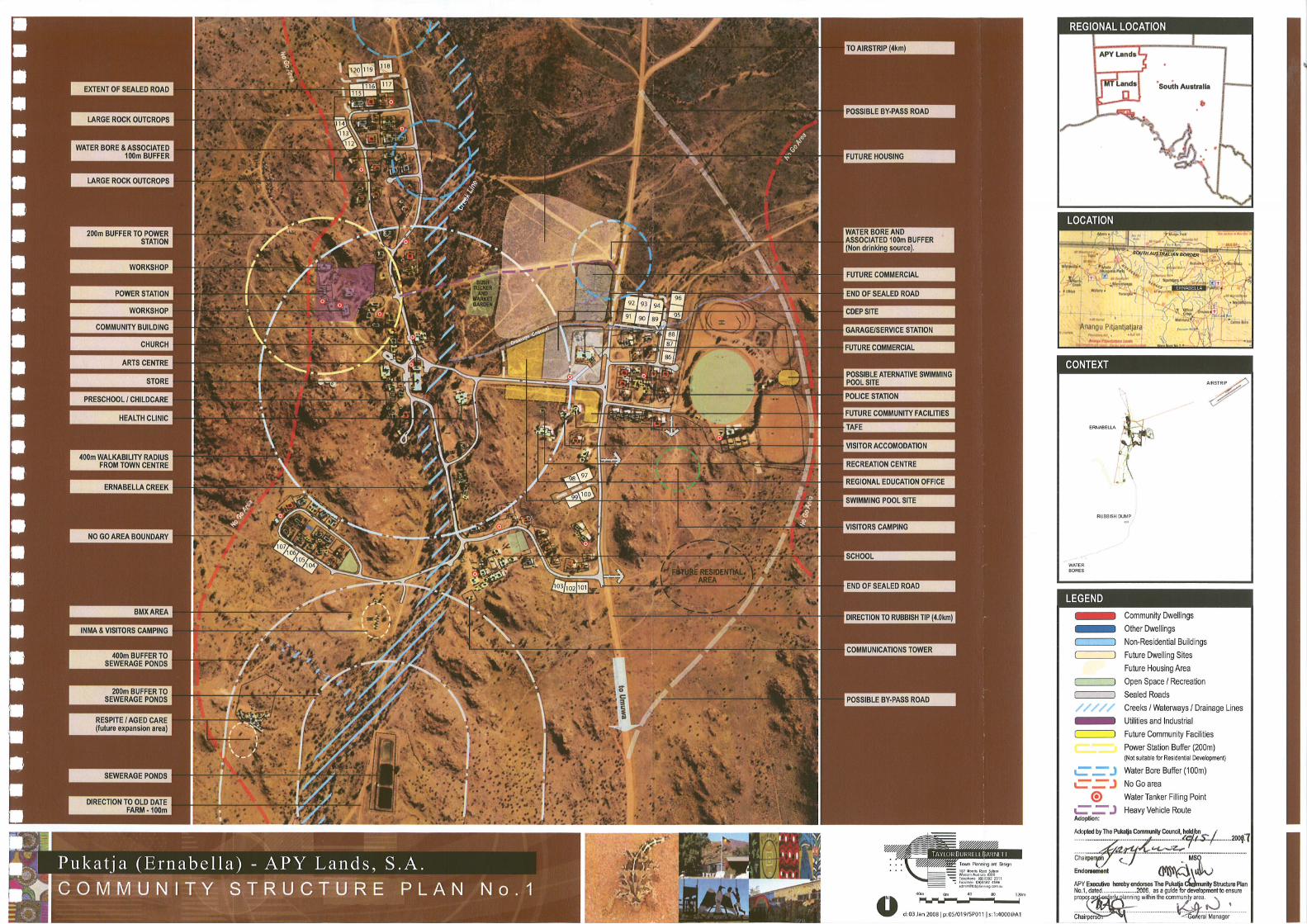

Pukat ja (Ernabel la) - APY Lands, S.A.S E R V I C E S P L A N
187 Roberts Road SubiacoWestern Australia 6008Telephone: (08) 9382 2911Facsimile : (08) 9382 [email protected]
Town Planning and Design
TAYLOR BURRELL BARNETT
100m 0m 100 200 300m
N
d: 30 MARCH 2007 | p: 05/019/011s | s: 1:8,000@A3
REGIONAL LOCATION
LOCATION
CONTEXT
LEGEND
ERNABELLA
SOUTH AUSTRALIAN BORDER
RUBBISH DUMP
ERNABELLA
AIRSTRIP
WATERBORES
Water
Sewer
Electricity
Telstra
Fire Hydrant
Future Water
Future Sewer
Future Electricity
Existing Underground Power
H
W W
W W
E E
E
E
E