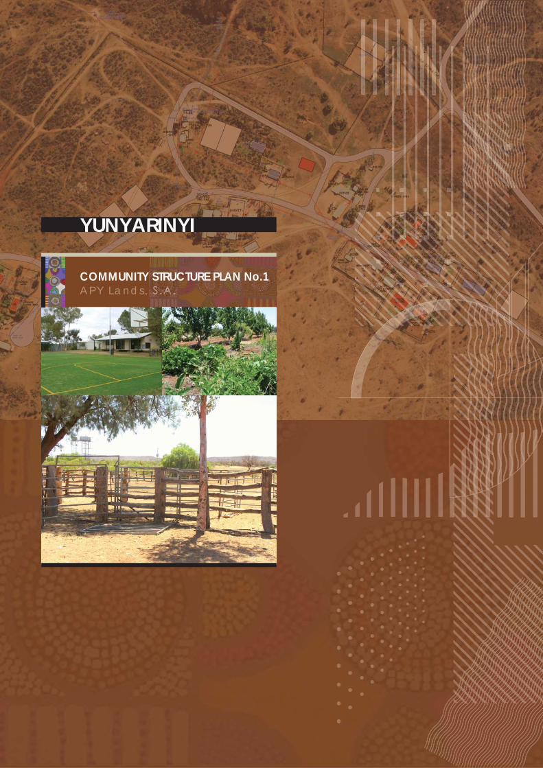
Yunyarinyi Community Structure Plan - APY Lands, SA
52
COMMUNITY STRUCTURE PLAN No.1 A PY Lan d s , YUNYARINYI
Transcript of Yunyarinyi Community Structure Plan - APY Lands, SA
COMMUNITY STRUCTURE PLAN No.1APY Lands,
YUNYARINYI

YUNYARINYI (KENMORE PARK) COMMUNITY STRUCTURE PLAN NO. 1 FEBRUARY 2008 Prepared for: Yunyarinyi Community Prepared By: Taylor Burrell Barnett Town Planning and Design 187 Roberts Road SUBIACO WA 6008 Phone: 9382 2911 Fax: 9382 4586 [email protected] In association with: Arup

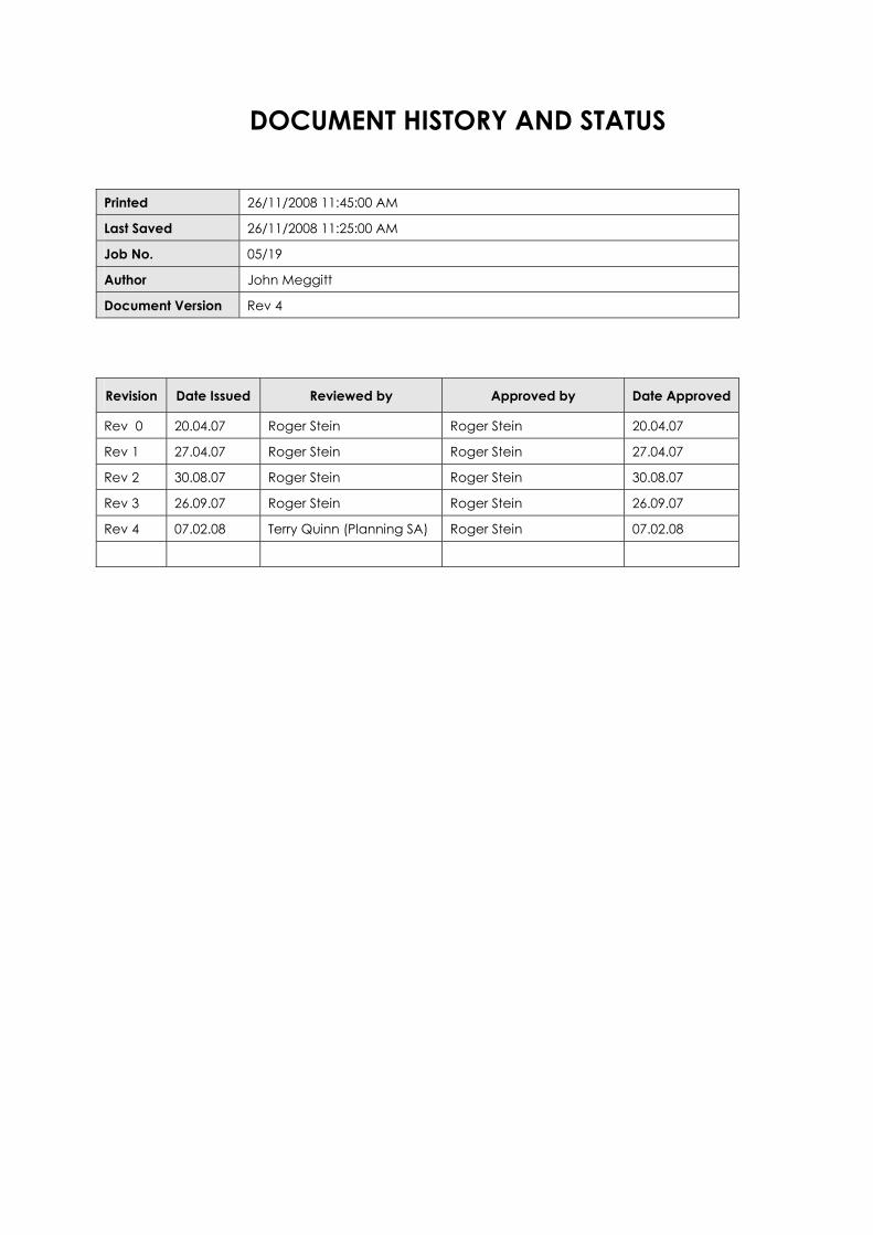
DOCUMENT HISTORY AND STATUS
Printed 26/11/2008 11:45:00 AM
Last Saved 26/11/2008 11:25:00 AM
Job No. 05/19
Author John Meggitt
Document Version Rev 4
Revision Date Issued Reviewed by Approved by Date Approved
Rev 0 20.04.07 Roger Stein Roger Stein 20.04.07
Rev 1 27.04.07 Roger Stein Roger Stein 27.04.07
Rev 2 30.08.07 Roger Stein Roger Stein 30.08.07
Rev 3 26.09.07 Roger Stein Roger Stein 26.09.07
Rev 4 07.02.08 Terry Quinn (Planning SA) Roger Stein 07.02.08


REPORT LIMITATIONS This Community Structure Plan has been developed in consultation with the Community and Land
Holding Authority as a planning guide for future development within the Community. It is proposed
to be updated on a five-yearly basis.
This Plan does not commit the State Government to the funding of infrastructure proposed. The
funding of proposals will be subject to budgets and infrastructure planning processes.

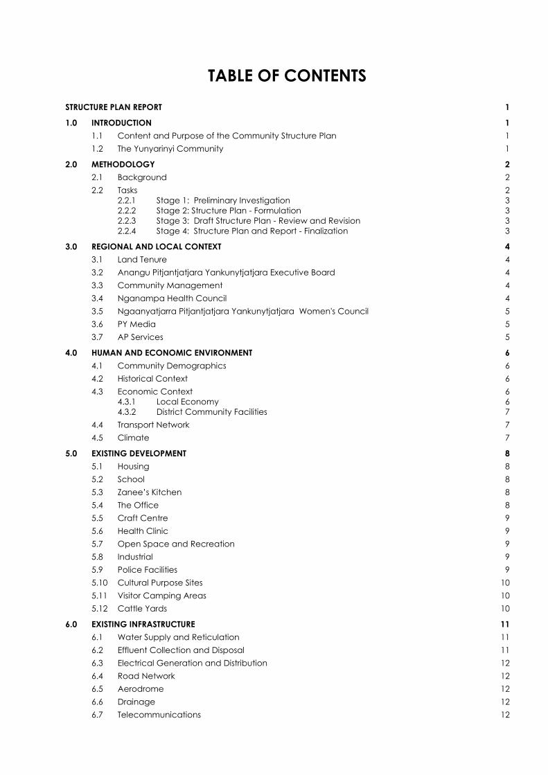
TABLE OF CONTENTS STRUCTURE PLAN REPORT 1
1.0 INTRODUCTION 1 1.1 Content and Purpose of the Community Structure Plan 1 1.2 The Yunyarinyi Community 1
2.0 METHODOLOGY 2 2.1 Background 2 2.2 Tasks 2
2.2.1 Stage 1: Preliminary Investigation 3 2.2.2 Stage 2: Structure Plan - Formulation 3 2.2.3 Stage 3: Draft Structure Plan - Review and Revision 3 2.2.4 Stage 4: Structure Plan and Report - Finalization 3
3.0 REGIONAL AND LOCAL CONTEXT 4 3.1 Land Tenure 4 3.2 Anangu Pitjantjatjara Yankunytjatjara Executive Board 4 3.3 Community Management 4 3.4 Nganampa Health Council 4 3.5 Ngaanyatjarra Pitjantjatjara Yankunytjatjara Women's Council 5 3.6 PY Media 5 3.7 AP Services 5
4.0 HUMAN AND ECONOMIC ENVIRONMENT 6 4.1 Community Demographics 6 4.2 Historical Context 6 4.3 Economic Context 6
4.3.1 Local Economy 6 4.3.2 District Community Facilities 7
4.4 Transport Network 7 4.5 Climate 7
5.0 EXISTING DEVELOPMENT 8 5.1 Housing 8 5.2 School 8 5.3 Zanee’s Kitchen 8 5.4 The Office 8 5.5 Craft Centre 9 5.6 Health Clinic 9 5.7 Open Space and Recreation 9 5.8 Industrial 9 5.9 Police Facilities 9 5.10 Cultural Purpose Sites 10 5.11 Visitor Camping Areas 10 5.12 Cattle Yards 10
6.0 EXISTING INFRASTRUCTURE 11 6.1 Water Supply and Reticulation 11 6.2 Effluent Collection and Disposal 11 6.3 Electrical Generation and Distribution 12 6.4 Road Network 12 6.5 Aerodrome 12 6.6 Drainage 12 6.7 Telecommunications 12
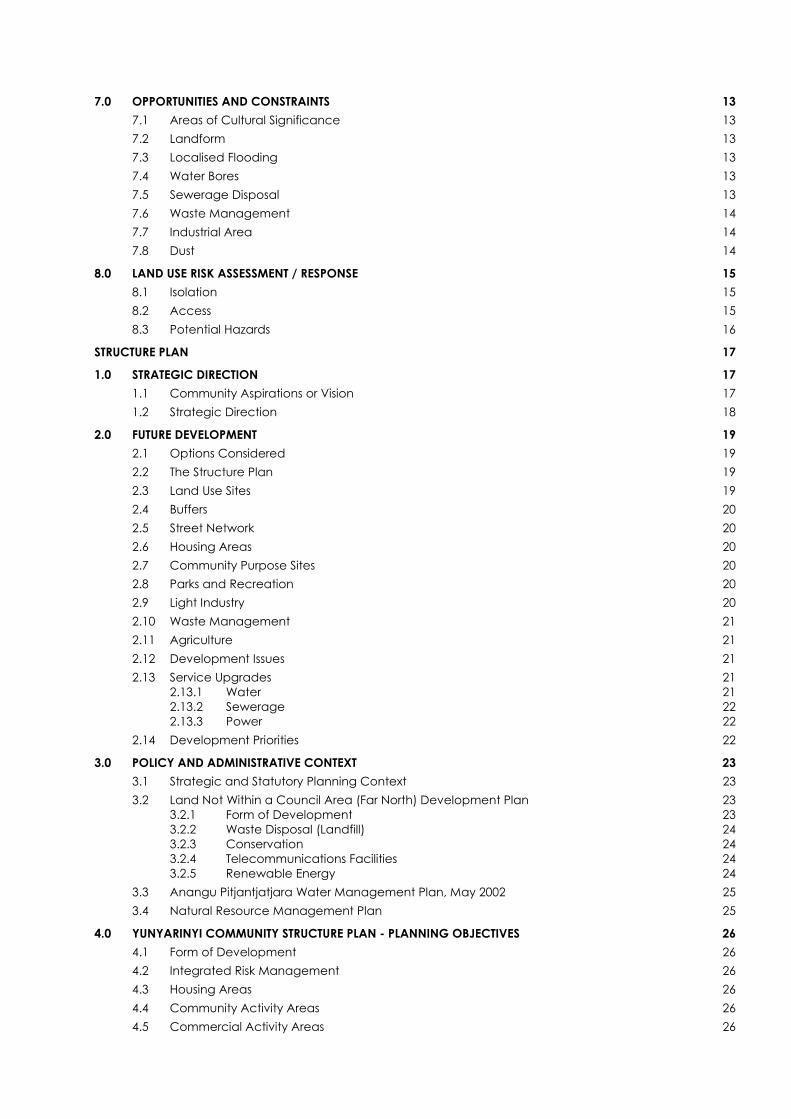
7.0 OPPORTUNITIES AND CONSTRAINTS 13 7.1 Areas of Cultural Significance 13 7.2 Landform 13 7.3 Localised Flooding 13 7.4 Water Bores 13 7.5 Sewerage Disposal 13 7.6 Waste Management 14 7.7 Industrial Area 14 7.8 Dust 14
8.0 LAND USE RISK ASSESSMENT / RESPONSE 15 8.1 Isolation 15 8.2 Access 15 8.3 Potential Hazards 16
STRUCTURE PLAN 17
1.0 STRATEGIC DIRECTION 17 1.1 Community Aspirations or Vision 17 1.2 Strategic Direction 18
2.0 FUTURE DEVELOPMENT 19 2.1 Options Considered 19 2.2 The Structure Plan 19 2.3 Land Use Sites 19 2.4 Buffers 20 2.5 Street Network 20 2.6 Housing Areas 20 2.7 Community Purpose Sites 20 2.8 Parks and Recreation 20 2.9 Light Industry 20 2.10 Waste Management 21 2.11 Agriculture 21 2.12 Development Issues 21 2.13 Service Upgrades 21
2.13.1 Water 21 2.13.2 Sewerage 22 2.13.3 Power 22
2.14 Development Priorities 22
3.0 POLICY AND ADMINISTRATIVE CONTEXT 23 3.1 Strategic and Statutory Planning Context 23 3.2 Land Not Within a Council Area (Far North) Development Plan 23
3.2.1 Form of Development 23 3.2.2 Waste Disposal (Landfill) 24 3.2.3 Conservation 24 3.2.4 Telecommunications Facilities 24 3.2.5 Renewable Energy 24
3.3 Anangu Pitjantjatjara Water Management Plan, May 2002 25 3.4 Natural Resource Management Plan 25
4.0 YUNYARINYI COMMUNITY STRUCTURE PLAN - PLANNING OBJECTIVES 26 4.1 Form of Development 26 4.2 Integrated Risk Management 26 4.3 Housing Areas 26 4.4 Community Activity Areas 26 4.5 Commercial Activity Areas 26
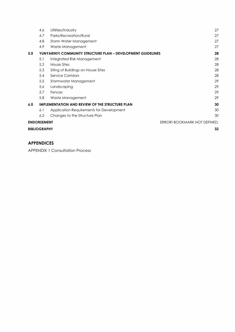
4.6 Utilities/Industry 27 4.7 Parks/Recreation/Rural 27 4.8 Storm Water Management 27 4.9 Waste Management 27
5.0 YUNYARINYI COMMUNITY STRUCTURE PLAN – DEVELOPMENT GUIDELINES 28 5.1 Integrated Risk Management 28 5.2 House Sites 28 5.3 Siting of Buildings on House Sites 28 5.4 Service Corridors 28 5.5 Stormwater Management 29 5.6 Landscaping 29 5.7 Fences 29 5.8 Waste Management 29
6.0 IMPLEMENTATION AND REVIEW OF THE STRUCTURE PLAN 30 6.1 Application Requirements for Development 30 6.2 Changes to the Structure Plan 30
ENDORSEMENT ERROR! BOOKMARK NOT DEFINED.
BIBLIOGRAPHY 32
APPENDICES APPENDIX 1 Consultation Process

APY LANDS YUNYARINYI (KENMORE PARK) COMMUNITY STRUCTURE PLAN NO. 1
STRUCTURE PLAN REPORT 1.0 INTRODUCTION
1.1 Content and Purpose of the Community Structure Plan
The Yunyarinyi Community Structure Plan (Structure Plan) provides a framework within which development can proceed in an orderly and planned manner over the next 5 to 10 years.
The Structure Plan consists of the following:
• A plan depicting the physical layout of the community; • The strategic direction, objectives and principles of development control; • An explanation of the Structure Plan; and • A background report on the preparation of the plan including an overview of the
local and regional context.
The purpose of the Structure Plan is to:
• Establish a vision for the community and a guide to future growth and development;
• Provide a community focus for, and involvement in, the development process;
• Facilitate proper and orderly planning of the community to establish development requirements based on need within cultural, physical, environmental and economic opportunities and constraints;
• Provide a mechanism for a coordinated approach to the provision of services and infrastructure and enable access to existing services and infrastructure information; and
• Promote development that maximises health, safety and welfare outcomes for the community.
The structure plan provides the community with a document that forms the basis for co-ordination of future development. The Plan can be used to assess future development proposals by government agencies, builders, funding bodies and the community.
1.2 The Yunyarinyi Community
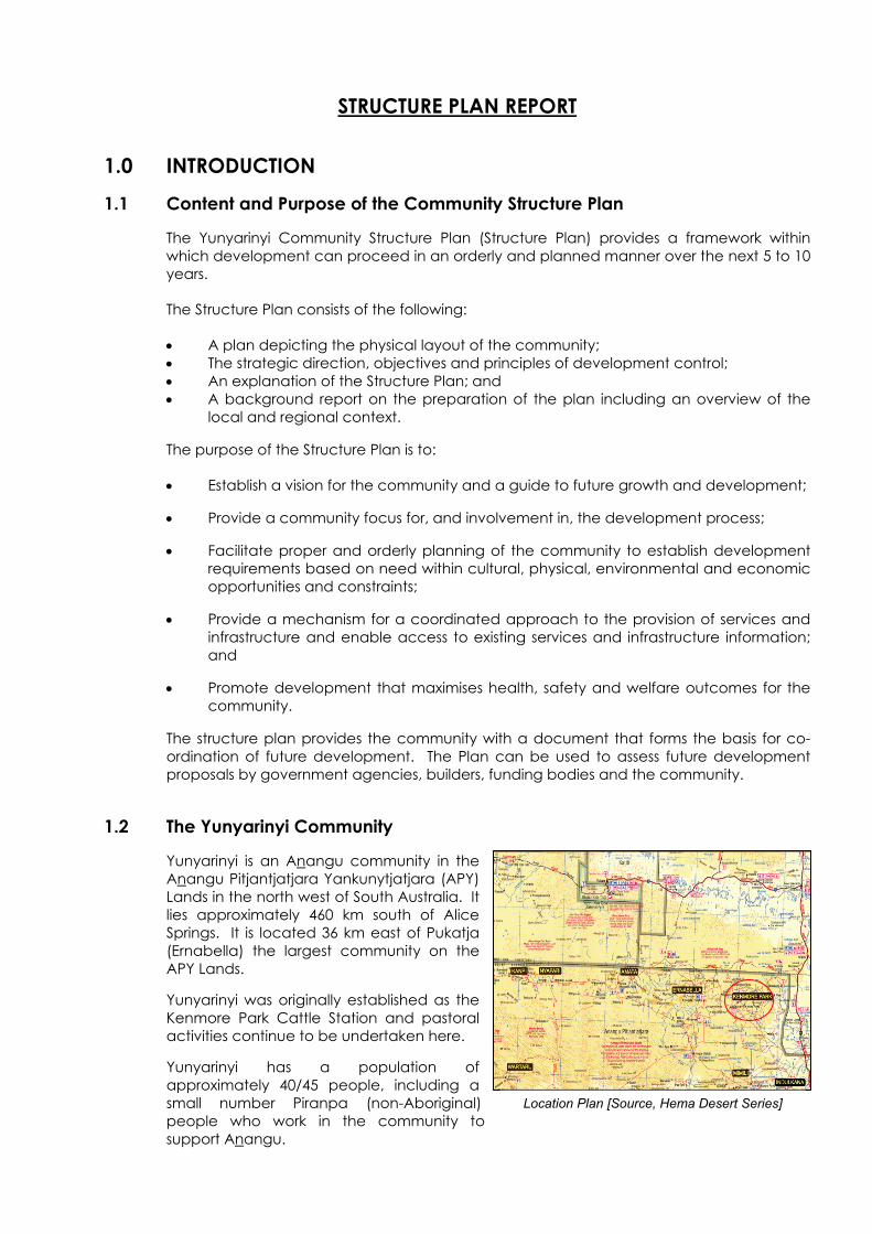
Yunyarinyi is an Anangu community in the Anangu Pitjantjatjara Yankunytjatjara (APY) Lands in the north west of South Australia. It lies approximately 460 km south of Alice Springs. It is located 36 km east of Pukatja (Ernabella) the largest community on the APY Lands.
Yunyarinyi was originally established as the Kenmore Park Cattle Station and pastoral activities continue to be undertaken here.
Yunyarinyi has a population of approximately 40/45 people, including a small number Piranpa (non-Aboriginal) people who work in the community to support Anangu.
Location Plan [Source, Hema Desert Series]
05/19 Rev 4 1
APY LANDS YUNYARINYI (KENMORE PARK) COMMUNITY STRUCTURE PLAN NO. 1
2.0 METHODOLOGY
2.1 Background
Community Structure Plans were prepared for nine of the major communities within the Anangu Pitjantjatjara Yankunytjatjara Lands (APY Lands) in response to the need to establish a clear framework within which to accommodate development. Building works have, in the past, been initiated in some communities by State and Federal Government agencies without reference to clearly defined plans for the physical growth of the communities.
For the Anangu to be able to take responsibility for guiding the development of their communities and to protect places of cultural significance they need to have structure plans in place which are an expression of how they wish to see the physical development of their communities occurring.
Most of the funding for community facilities comes from a variety of sources outside the APY Lands. In the absence of adopted structure plans, some new facilities have been put in place without adequate input from community members and in locations which could be adversely affected by environmental conditions.
It is recognised that due to the remoteness and limited commercial opportunities within the APY Lands that outside funding to sustain the communities will be required for the foreseeable future. In addition, it is anticipated that local communities will continue to have only limited influence on the timing, scale, scope and funding of the infrastructure and development works being undertaken.
Furthermore, the high cost of providing and maintaining infrastructure in communities located great distances away from major urban centres, necessitates that existing infrastructure and facilities are well utilised.
As such, while it was essential to obtain input from the community members on the content of the structure plans, it was also important to seek out and include input from those agencies and authorities with responsibility for the current and future provision of services and infrastructure.
The plans give cause for questions to be asked about the sustainability of the communities, in particular with regard to underground water resources. At the present time there are concerns regarding the sustainability of water supplies in some communities. Ongoing investigations are required across the APY Lands for how to not only provide for future increases in population but also to accommodate current population levels over time.
The structure plans have been prepared during a time of re-evaluation of past policies towards remote Indigenous communities and uncertainty in regards to future funding. The structure plans however provide a robust framework to accommodate physical changes reasonably expected to occur and allow for flexibility when future development pressures arise within the five to ten year life of the plans.
2.2 Tasks
The methodology followed for the preparation of the Community Structure Plans is summarised below:
• Investigation and research. • Plan formulation and refinement through testing and review. • Development of a preferred plan.
2 05/19 Rev 4
APY LANDS YUNYARINYI (KENMORE PARK) COMMUNITY STRUCTURE PLAN NO. 1
2.2.1 Stage 1: Preliminary Investigation
• Project Inception meeting with Planning SA and other stakeholders. • Obtain relevant documents, demographic details, community contact details. • Obtain base mapping, aerial photographs and format base plans. • Site visit and undertake site inspection. • Community consultation. • Mapping of physical constraints, opportunities, infrastructure, housing and
community facilities. • Documented meeting/s, interviews.
2.2.2 Stage 2: Structure Plan - Formulation
• Prepare draft Structure Plan. • Site visit. • Meeting with Community to present draft Structure Plan and receive comments. • Copies of draft Structure Plan left to be distributed to school, art centre and placed
on community notice boards. • Meeting with client. • Client and other stakeholders review structure plan, provide comment.
2.2.3 Stage 3: Draft Structure Plan - Review and Revision
• Comments received, modifications made to the Draft Structure Plan. • Draft Report prepared. • Site visit. • Meeting with Community to present revised draft Structure Plan and Report and
receive comments. • Copies of revised Plan and draft Report left to be distributed, placed on Community
notice boards. • Meeting with client, provide copy of revised Structure Plan, draft Report for
comments.
2.2.4 Stage 4: Structure Plan and Report - Finalization
• Comments received from stakeholders, modifications made to final Structure Plan, Report.
• Prepare final Structure Plan and Report. • Site visit to address APY Executive meeting. • Copies of Structure Plan and Report issued.
05/19 Rev 4 3
APY LANDS YUNYARINYI (KENMORE PARK) COMMUNITY STRUCTURE PLAN NO. 1
3.0 REGIONAL AND LOCAL CONTEXT
3.1 Land Tenure
Yunyarinyi is part of the Anangu Pitjantjatjara Yankunytjatjara Lands which are incorporated by the Pitjantjatjara Yankunytjatjara Land Rights Act in which the SA Parliament gave title to the APY Lands to Aboriginal people in 1981.
3.2 Anangu Pitjantjatjara Yankunytjatjara Executive Board
The Anangu Pitjantjatjara Yankunytjatjara Land Rights Act, 1981, provided for the vesting of title of the Anangu Pitjantjatjara Yankunytjatjara Lands to the people known as Anangu Pitjantjatjara Yankunytjatjara. The Executive Board of Anangu Pitjantjatjara Yankunytjatjara (APY) was constituted under this Act. The administrative centre of the APY Lands is at Umuwa near Pukatja.
The APY Executive Board oversees the activities of the various constituent groups serving the needs of the people on the APY Lands. It also helps shape policies regarding economic and social development. The Executive Board comprises elected members from across the APY Lands and they choose their own Chairperson.
Under the Act the functions of the Executive Board of Anangu Pitjantjatjara Yankunytjatjara are:
• to ascertain the wishes and opinions of traditional owners in relation to the management, use and control of the APY Lands and to seek, where practicable, to give effect to those wishes and opinions;
• to protect the interests of traditional owners in relation to the management, use and control of the APY Lands;
• to negotiate with persons desiring to use, occupy or gain access to any part of the APY Lands; and
• to administer land vested in Anangu Pitjantjatjaraku.
3.3 Community Management
Yunyarinyi is controlled and managed by a Community Council and supported by an administration staff member. The community has a corporate CDEP with members participating in a range of employment activities. It employs staff through CDEP projects including administration and maintenance work within the community.
3.4 Nganampa Health Council
Nganampa Health Council is an Aboriginal owned and controlled health organisation operating on the Anangu Pitjantjatjara Yankunytjatjara Lands in the far north west of South Australia. Across this area, Nganampa Health operates clinics, an aged care respite facility and assorted health related programs including aged care, sexual health, environmental health, health worker training, dental, women’s health, male health, children’s health and substance abuse prevention.
The main clinics are located at Iwantja (Indulkana), Mimili, Fregon, Pukatja (Ernabella), Amata, and Pipalyatjara while smaller clinics are located at Yunyarinyi (Kenmore Park), Nyapari and Watarru. The organisation has administration offices at Umuwa and Alice Springs.
4 05/19 Rev 4
APY LANDS YUNYARINYI (KENMORE PARK) COMMUNITY STRUCTURE PLAN NO. 1
3.5 Ngaanyatjarra Pitjantjatjara Yankunytjatjara Women's Council
The Ngaanyatjarra Pitjantjatjara Yankunytjatjara Women's Council (NPYWC) was formed in 1980. NPYWC has its administrative office in the main regional town of Alice Springs, Regional offices are located at Umuwa in SA and in Wingellina, WA.
The objectives of the organisation are:
• Provide a forum for Ngaanyatjarra, Pitjantjatjara and Yankunytjatjara women to discuss their concerns;
• Promote women's membership of and participation in community councils, ATSIC Regional Councils and other organisations;
• Help individual women achieve further training, education and employment; • Assist in the establishment of appropriate health, education, cultural, artistic and
social services; • Promote and support the achievements and authority of women; • Distribute information about issues of importance to women; • Promote and encourage women's Law and Culture.
3.6 PY Media
PY Media is incorporated as the regional body to assist communities to develop their own community media centres. It has a regional office at Umuwa and offices in Alice Springs.
PY Media is known nationally as a leader in remote communications. Its achievements demonstrate innovative and appropriate technological solutions for Indigenous people living in remote Australia. PY Media manages a number of communication and media projects including:
• Provide services to communities on the APY Lands and NT communities. • Radio: training, maintenance and upgrades. • Video: training, maintenance and upgrades. • IT: training, maintenance and upgrades. • WaruTech: UHF, broadcast maintenance: TV and radio services. • Channel 31: broadcast per day nationally on the Imparja footprint. • Video Conferencing: installation, training and maintenance. • Radio Vision project in all communities.
3.7 AP Services
Anangu Pitjantjatjara Services (AP Services) is based in Alice Springs and has an office and works depot at Umuwa. Umuwa is located approximately central to the major communities on the APY Lands.
AP Services is an independent organisation providing a range of services to Anangu Pitjantjatjara Yankunytjatjara. This involves project management and coordinating maintenance programs that support APY's responsibility as the land owner/land title holding body, particularly Anangu environmental health and safety. AP Services works very closely with Nganampa Health's UPK section.
AP Services has been responsible for: roadworks (including grading and realignment), housing repairs and maintenance, development and construction projects, construction inspection, waste management, homelands essential services, bore maintenance and alternative energy programs and other works related programs as they evolve.
05/19 Rev 4 5
APY LANDS YUNYARINYI (KENMORE PARK) COMMUNITY STRUCTURE PLAN NO. 1
4.0 HUMAN AND ECONOMIC ENVIRONMENT This part of the report provides background information on the Yunyarinyi community. It includes details about its population, economic activities, the transport network and climate. This section is drawn from various reports and other sources.
The APY Lands are located in South Australia’s most northern region. They are bordered by Western Australia to the west, Northern Territory border to the north and encompass the Great Victorian Desert to the northeast. It covers an area of 105,000 square kilometres, which is approximately 10.7% of the state’s total area.
4.1 Community Demographics
There are no specific census statistics for Yunyarinyi as it is a small community and the information gathered was grouped together with a number of other communities when the data was compiled.
The population of the APY Lands is heavily weighted towards younger age groups with only about 25% of the Anangu on the APY Lands over 35 years old. The Anangu experience high dependency ratios, low life expectancy and poor living standards. People are highly mobile and place a high value on kinship obligations.
The population of Yunyarinyi ranges between 40 and 45 people. There are occasional influxes of visitors however Yunyarinyi is not a major focus for lore business or sporting events. When lore business and sporting events occur elsewhere in the APY Lands, attended by Yunyarinyi people, the population is temporarily reduced.
4.2 Historical Context
Yunyarinyi community is located on land that was previously used for pastoral activities when it was known as the Kenmore Park Cattle Station. The community was formally established in 1987.
4.3 Economic Context
4.3.1 Local Economy Employment is provided through pastoral activities, the community garden and through maintenance and administrative works. Art works and craft are also produced at the Craft room. A proposal for tourism associated with camel riding tours is being developed.
The pastoral activities include managing cattle and camels for local and overseas sale. In addition feral horses and donkeys are mustered to prevent them from having a negative impact on waterholes and fences.
A proposed Yunyarinyi camel tourism project is an extension of the feral animal eradication program which has been capturing and domesticating wild camels, horses and donkeys from the country surrounding the community. Some of the camels that are caught will be sold and others will be used for the camel tourism project.
The tourism proposal involves the hosting of winter-time treks through the scenic country around Yunyarinyi. The tours will be lead by experienced camel handlers and local Anangu storytellers. Tourists will gain a unique experience of Anangu culture and of their Country.
These activities provide employment opportunities, some degree of financial independence and give the community a strong sense of direction and control of their affairs.
6 05/19 Rev 4
APY LANDS YUNYARINYI (KENMORE PARK) COMMUNITY STRUCTURE PLAN NO. 1
4.3.2 District Community Facilities
Alice Springs in the Northern Territory is the nearest major town and supports a population of approximately 25,000 plus many more visitors during peak tourist periods. The town provides a wide range of education, health, administrative, commercial, sporting and cultural facilities.
There is a strong reliance on the regional facilities located in Alice Springs due to its proximity and accessibility and this arrangement seems likely to continue into the future.
4.4 Transport Network
Yunyarinyi is serviced regionally via a strategic freight and tourist road network using the Stuart Highway to connect to Alice Springs (640 km to the north). There is a 100 km unsealed road to the Stuart Highway via the Mulga Park Road; however road conditions to the other communities on the Lands vary from impassable after rains to very rough during dry periods.
None of the internal roads are sealed. Improvements were undertaken in 2006 when the access road running past the community was relocated 200 metres to the north and laid with a compact surface material to assist with dust control.
4.5 Climate
Yunyarinyi has a dry climate with hot summers and mild winters. It has a similar climate to Kulgera Roadhouse which is 120 km to the north east on the Stuart Highway and where there is a weather station. The recorded annual average rainfall is 234 mm. While the average rainfall is higher during the warmer months of the year there is also considerable variation from year to year.
January is the hottest month with an average maximum temperature of 37° C. By contrast winters are mild with July average maximum and minimum temperatures being 19°C and 5°C respectively.
The wettest months are November to March, with February being the wettest month with an average rainfall of 37 mm.
05/19 Rev 4 7

APY LANDS YUNYARINYI (KENMORE PARK) COMMUNITY STRUCTURE PLAN NO. 1
5.0 EXISTING DEVELOPMENT
5.1 Housing
Existing residential development consists of 14 houses including an attached pair of dwellings and a caravan used for visiting teaching staff. Five of the houses are reserved for staff and one older dwelling is unoccupied. The remaining eight houses are occupied by Anangu.
With the Anangu population of Yunyarinyi being approximately 45 people this indicates a household density of approximately six people per house. No major overcrowding problem at the community was reported however much of the housing stock is old and in need of significant repairs and/or replacement. House sites are mostly rectangular and have areas of approximately 600-700 m2 with frontages of approximately 24m.
The ‘red house’ a community dwelling
5.2 School
The Yunyarinyi School has approximately 25 students. The school has classes for 'Child Parent Centre' pre-school children, junior primary, upper primary and secondary students. The school can teach up to year 12 level but most of the focus is on ESL learning, as nearly all of the students speak English as a second language. As well as providing for Yunyarinyi students, the school services children from the homelands of Tjuru, Blackhill I and Blackhill II.
Yunyarinyi School
5.3 Zanee’s Kitchen
There is no formal store in the community; people travel 36 km to Pukatja for major shopping purchases. However Zanee’s Kitchen at times provides a community pantry or store which stocks basic food, meat, bread, milk and canned goods as well as cleaning products and personal hygiene items.
Zanee’s Kitchen
5.4 The Office
The office was built within the past five years and is in good condition. It is located at the entrance to the community and adjoins the original station buildings.
The Office
8 05/19 Rev 4
APY LANDS YUNYARINYI (KENMORE PARK) COMMUNITY STRUCTURE PLAN NO. 1
5.5 Craft Centre
The Craft Centre activities have at times included a screen printing operation, a painting centre, an arts resource for the school and spinning and weaving and other fibre-crafts. The screen printing business has in the past included the local screen printer for t-shirts and other items for all of the organizations across the APY L ands. He building is in very poor condition and the centre is not currently running.
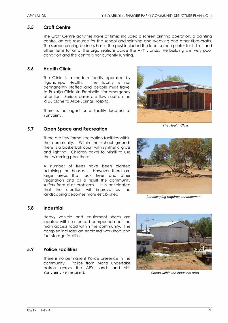
5.6 Health Clinic
The Clinic is a modern facility operated by Nganampa Health. The facility is not permanently staffed and people must travel to Pukatja Clinic (in Ernabella) for emergency attention. Serious cases are flown out on the RFDS plane to Alice Springs Hospital.
There is no aged care facility located at Yunyarinyi.
The Health Clinic 5.7 Open Space and Recreation
There are few formal recreation facilities within the community. Within the school grounds there is a basketball court with synthetic grass and lighting. Children travel to Mimili to use the swimming pool there.
A number of trees have been planted adjoining the houses . However there are large areas that lack trees and other vegetation and as a result the community suffers from dust problems. It is anticipated that the situation will improve as the landscaping becomes more established. Landscaping requires enhancement
5.8 Industrial
Heavy vehicle and equipment sheds are located within a fenced compound near the main access road within the community. The complex includes an enclosed workshop and fuel storage facilities.
5.9 Police Facilities
There is no permanent Police presence in the community. Police from Marla undertake patrols across the APY Lands and visit Yunyarinyi as required. Sheds within the industrial area
05/19 Rev 4 9
APY LANDS YUNYARINYI (KENMORE PARK) COMMUNITY STRUCTURE PLAN NO. 1
5.10 Cultural Purpose Sites
There are no areas currently used for cultural purposes within the community. However when development is proposed further enquiries should be made with the Community Council and APY regarding the significance of the particular site.
5.11 Visitor Camping Areas
There are no formal visitor camping areas. Visitors stay with family members or camp nearby, there is no need at present to provide formal camping facilities.
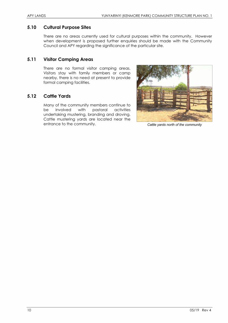
5.12 Cattle Yards
Many of the community members continue to be involved with pastoral activities undertaking mustering, branding and droving. Cattle mustering yards are located near the entrance to the community.
Cattle yards north of the community
10 05/19 Rev 4
APY LANDS YUNYARINYI (KENMORE PARK) COMMUNITY STRUCTURE PLAN NO. 1
6.0 EXISTING INFRASTRUCTURE
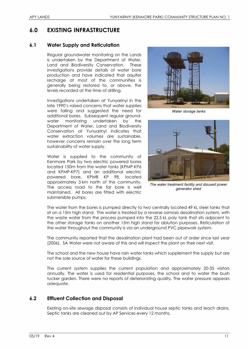
6.1 Water Supply and Reticulation
Regular groundwater monitoring on the Lands is undertaken by the Department of Water, Land and Biodiversity Conservation. These investigations provide details of water bore production and have indicated that aquifer recharge at most of the communities is generally being restored to, or above, the levels recorded at the time of drilling.
Investigations undertaken at Yunyarinyi in the late 1990’s raised concerns that water supplies were falling and suggested the need for additional bores. Subsequent regular ground-water monitoring undertaken by the Department of Water, Land and Biodiversity Conservation at Yunyarinyi indicates that water extraction volumes are sustainable, however concerns remain over the long term sustainability of water supply.
Water is supplied to the community of Kenmore Park by two electric powered bores located 150m from the water tanks (KPMP-KP6 and KPMP-KP7) and an additional electric powered bore, KPMB KP 98, located approximately 3 km north of the community. The access road to the far bore is well maintained. All bores are fitted with electric submersible pumps.
The water from the bores is pumped directly to two centrally located 49 kL steel tanks that sit on a 15m high stand. The water is treated by a reverse osmosis desalination system, with the waste water from the process pumped into the 22.5 kL poly tank that sits adjacent to the other storage tanks on another 15m high stand for ablution purposes. Reticulation of the water throughout the community is via an underground PVC pipework system.
The community reported that the desalination plant had been out of order since last year (2006). SA Water were not aware of this and will inspect the plant on their next visit.
The school and the new house have rain water tanks which supplement the supply but are not the sole source of water for these buildings.
The current system supplies the current population and approximately 20-35 visitors annually. The water is used for residential purposes, the school and to water the bush tucker garden. There were no reports of deteriorating quality. The water pressure appears adequate.
Water storage tanks
The water treatment facility and disused power generator shed
6.2 Effluent Collection and Disposal
Existing on-site sewage disposal consists of individual house septic tanks and leach drains. Septic tanks are cleaned out by AP Services every 12 months.
05/19 Rev 4 11
APY LANDS YUNYARINYI (KENMORE PARK) COMMUNITY STRUCTURE PLAN NO. 1
6.3 Electrical Generation and Distribution
Power is supplied to Kenmore Park from the Central Power Station at Umuwa, 60 km away. This system replaced the local diesel fuelled generator set. The power is transmitted from Umuwa via 33 kV overhead powerlines, then reticulated throughout the community by a standard ETSA overhead system with a combination of high voltage (11,000 V) and medium voltage (415/240 V) power lines. Street lighting is provided by standard street lights mounted on stobie poles.
6.4 Road Network
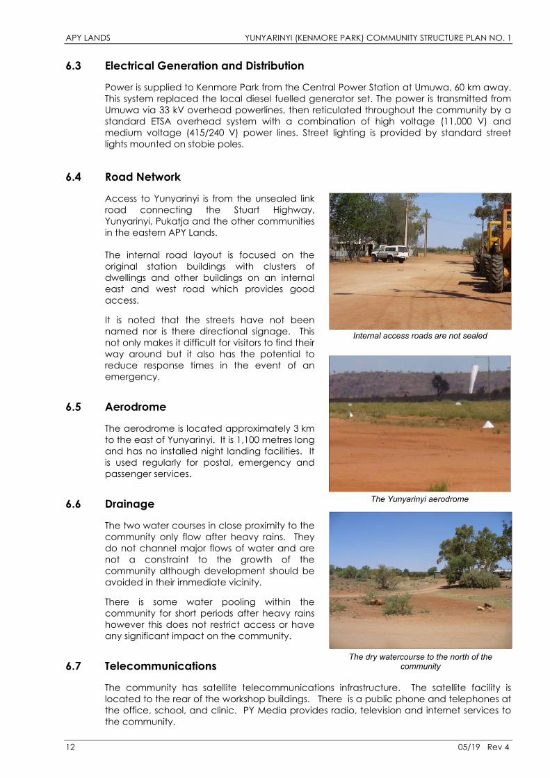
Access to Yunyarinyi is from the unsealed link road connecting the Stuart Highway, Yunyarinyi, Pukatja and the other communities in the eastern APY Lands.
The internal road layout is focused on the original station buildings with clusters of dwellings and other buildings on an internal east and west road which provides good access.
It is noted that the streets have not been named nor is there directional signage. This not only makes it difficult for visitors to find their way around but it also has the potential to reduce response times in the event of an emergency.
Internal access roads are not sealed
6.5 Aerodrome
The aerodrome is located approximately 3 km to the east of Yunyarinyi. It is 1,100 metres long and has no installed night landing facilities. It is used regularly for postal, emergency and passenger services.
The Yunyarinyi aerodrome 6.6 Drainage
The two water courses in close proximity to the community only flow after heavy rains. They do not channel major flows of water and are not a constraint to the growth of the community although development should be avoided in their immediate vicinity.
There is some water pooling within the community for short periods after heavy rains however this does not restrict access or have any significant impact on the community.
6.7 Telecommunications
The community has satellite telecommunications infrastructure. The satellite facility is located to the rear of the workshop buildings. There is a public phone and telephones at the office, school, and clinic. PY Media provides radio, television and internet services to the community.
The dry watercourse to the north of the community
12 05/19 Rev 4
APY LANDS YUNYARINYI (KENMORE PARK) COMMUNITY STRUCTURE PLAN NO. 1
7.0 OPPORTUNITIES AND CONSTRAINTS
7.1 Areas of Cultural Significance
No areas of cultural significance have been identified within the immediate confines of the community. However when development is proposed further enquiries should be made with the Community Council and APY regarding the significance of the particular site.
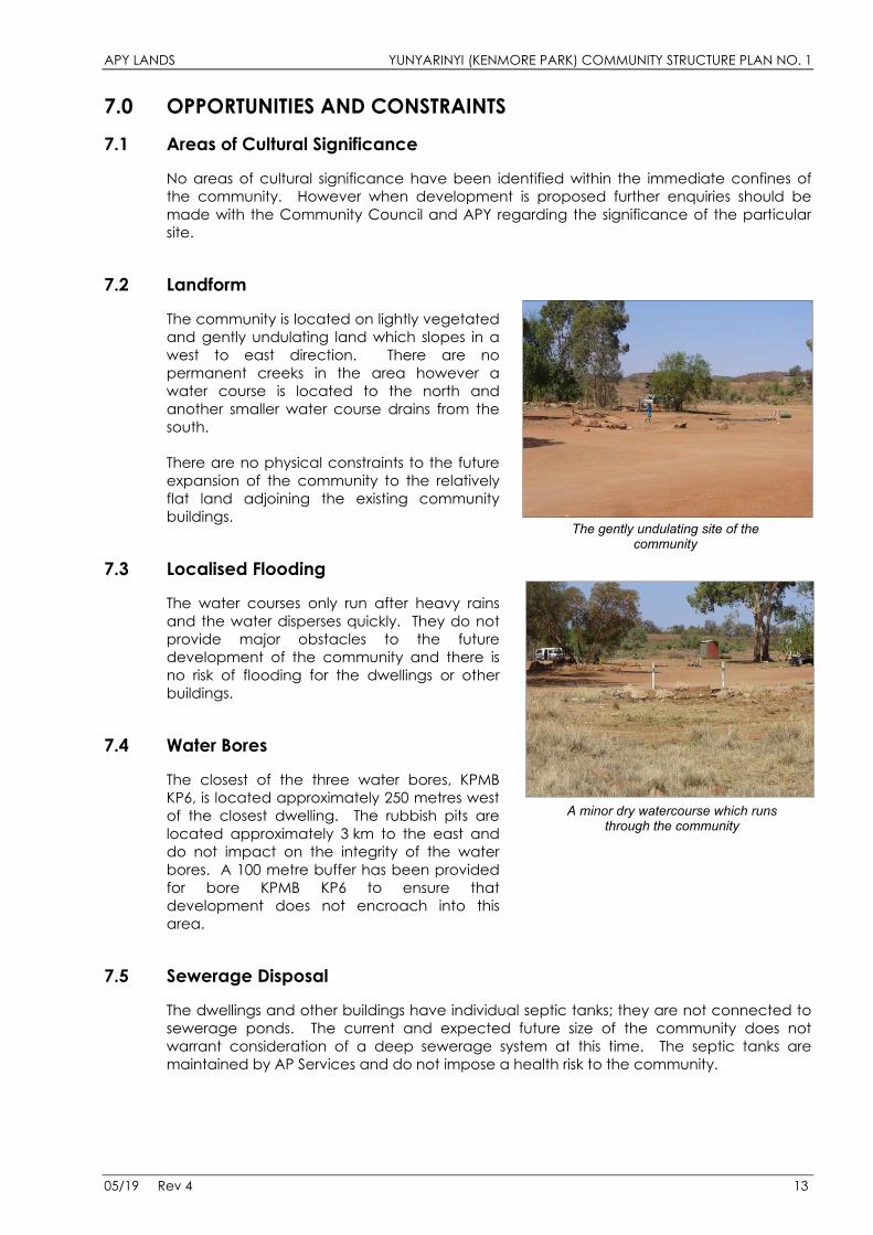
7.2 Landform
The community is located on lightly vegetated and gently undulating land which slopes in a west to east direction. There are no permanent creeks in the area however a water course is located to the north and another smaller water course drains from the south.
There are no physical constraints to the future expansion of the community to the relatively flat land adjoining the existing community buildings.
The gently undulating site of the community
7.3 Localised Flooding
The water courses only run after heavy rains and the water disperses quickly. They do not provide major obstacles to the future development of the community and there is no risk of flooding for the dwellings or other buildings.
7.4 Water Bores
The closest of the three water bores, KPMB KP6, is located approximately 250 metres west of the closest dwelling. The rubbish pits are located approximately 3 km to the east and do not impact on the integrity of the water bores. A 100 metre buffer has been provided for bore KPMB KP6 to ensure that development does not encroach into this area.
A minor dry watercourse which runs through the community
7.5 Sewerage Disposal
The dwellings and other buildings have individual septic tanks; they are not connected to sewerage ponds. The current and expected future size of the community does not warrant consideration of a deep sewerage system at this time. The septic tanks are maintained by AP Services and do not impose a health risk to the community.
05/19 Rev 4 13
APY LANDS YUNYARINYI (KENMORE PARK) COMMUNITY STRUCTURE PLAN NO. 1
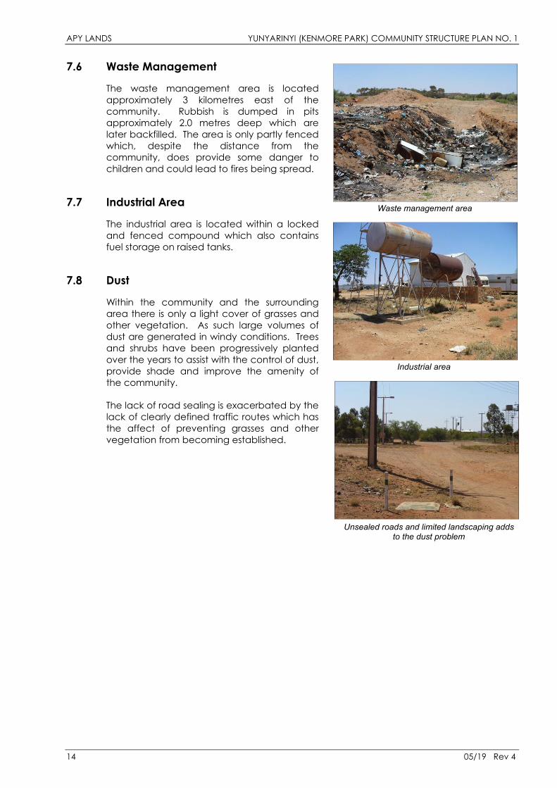
7.6 Waste Management
The waste management area is located approximately 3 kilometres east of the community. Rubbish is dumped in pits approximately 2.0 metres deep which are later backfilled. The area is only partly fenced which, despite the distance from the community, does provide some danger to children and could lead to fires being spread.
7.7 Industrial Area
The industrial area is located within a locked and fenced compound which also contains fuel storage on raised tanks.
Waste management area
7.8 Dust
Within the community and the surrounding area there is only a light cover of grasses and other vegetation. As such large volumes of dust are generated in windy conditions. Trees and shrubs have been progressively planted over the years to assist with the control of dust, provide shade and improve the amenity of the community.
The lack of road sealing is exacerbated by the lack of clearly defined traffic routes which has the affect of preventing grasses and other vegetation from becoming established.
Industrial area
Unsealed roads and limited landscaping adds to the dust problem
14 05/19 Rev 4
APY LANDS YUNYARINYI (KENMORE PARK) COMMUNITY STRUCTURE PLAN NO. 1
8.0 LAND USE RISK ASSESSMENT / RESPONSE The region within which Yunyarinyi is located is not one which is subject to catastrophic events such as cyclones, tropical storms or earthquakes. However isolation from other major regional centres, restrictions on accessibility in the event of an emergency and limited resources to deal with even small scale events increases the vulnerability of the community.
The protection of essential services and infrastructure such as the power supply, water supply and sewerage network is also critical to the normal functioning of the community. The main hazards the community is exposed to are local fires, possibility of severe storms and flash flooding.
The Yunyarinyi Community Structure Plan provides an important component of an emergency management plan. By reducing the exposure to risk, working with the natural environment and identifying appropriate locations for development it provides a framework within which the emergency management plan can be developed.
8.1 Isolation
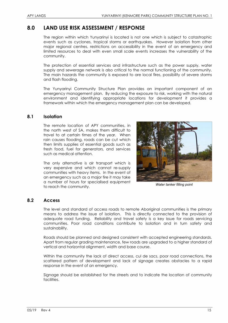
The remote location of APY communities, in the north west of SA, makes them difficult to travel to at certain times of the year. When rain causes flooding, roads can be cut which then limits supplies of essential goods such as fresh food, fuel for generators, and services such as medical attention.
The only alternative is air transport which is very expensive and which cannot re-supply communities with heavy items. In the event of an emergency such as a major fire it may take a number of hours for specialised equipment to reach the community. Water tanker filling point
8.2 Access
The level and standard of access roads to remote Aboriginal communities is the primary means to address the issue of isolation. This is directly connected to the provision of adequate road funding. Reliability and travel safety is a key issue for roads servicing communities. Poor road conditions contribute to isolation and in turn safety and sustainability.
Roads should be planned and designed consistent with accepted engineering standards. Apart from regular grading maintenance, few roads are upgraded to a higher standard of vertical and horizontal alignment, width and base course.
Within the community the lack of direct access, cul de sacs, poor road connections, the scattered pattern of development and lack of signage creates obstacles to a rapid response in the event of an emergency.
Signage should be established for the streets and to indicate the location of community facilities.
05/19 Rev 4 15
APY LANDS YUNYARINYI (KENMORE PARK) COMMUNITY STRUCTURE PLAN NO. 1
16 05/19 Rev 4
8.3 Potential Hazards
Possible hazards and the impact they might have on people, houses, community buildings, services and the environment are set out below:
Hazards and What They Might Affect The Impact of Hazards on: Fire Storms Transport Accident
People x x x
Houses x x
Community Buildings x x
Services x x
Environment x
The Structure Plan integrates a number of initiatives and recognises existing measures that help reduce the impact of hazards and assists with the response to events should they occur. These measures include:
• Avoidance of areas for future development which have the potential to be affected by flooding from the water courses;
• Location of the waste management area away from the community within a fenced compound. This discourages unauthorised access and provides some protection from fire and protects the water catchment areas;
• Avoidance of housing and other development within the buffer area of water bore KPMB KP6 to the north of the community. The other water bores are located further west and north and do not require buffer areas to be identified;
• Good access to the Pukatja medical centre (36 km away) for emergency medical treatment and to the aerodrome if a medical evacuation is required;
• Dust reduction initiatives including increased landscaping and traffic controls; and
• A number of overhead water tanker filling points exist, however in the case of a major fire the community would be reliant on equipment based 2 hours away at Marla.
APY LANDS YUNYARINYI (KENMORE PARK) COMMUNITY STRUCTURE PLAN NO. 1
STRUCTURE PLAN 1.0 STRATEGIC DIRECTION
1.1 Community Aspirations or Vision
During the visits to Yunyarinyi discussions were held with community members to develop the Community Structure Plan. It was explained that the Structure Plan makes provision for future development, making sure that buildings and activities are put in the right place so the people who live in the community can be safe and healthy.
It was explained that, although the Community Structure Plan is not a management plan and does not incorporate a financial program to undertake the desired improvements, it can assist the development of these strategies. The Plan relates primarily to future building and infrastructure works and will also assist with the consideration of measures for the ongoing sustainability for the community.
In addition to the views and aspirations of the community members, discussions were also held with the administrative staff, APY and AP services, government agencies and service providers regarding their existing and future programs to fund housing, facilities and infrastructure.
The types of issues raised included:
• Where should new houses go? Do we need different areas for different families? • Where should we put noisy or smelly activities? • Are the roads safe? Where do the trucks go? • Where does the drinking water come from and how can we look after it? • Is there flooding here? • How should we look after visitors? • Should there be more parks or meeting places? • Are there ‘no-go’ areas? • Are there places for young people and old people?
Responses to these matters were incorporated into the draft plans and were modified following further discussion with the stakeholders. The aspirations for the community were tempered by their knowledge that there are only modest amounts of funding available for development. In addition, budget timeframes set for the community are often short term and there are limited opportunities for community members to influence decisions on funding.
General satisfaction was expressed with the way the community has been developing and there was no desire for major changes. The community has a small population and it is expected that this would continue to be the case in future. While there is not a significant overcrowding problem much of the housing stock is old and requires upgrading.
Dust was put forward as the major issue of concern. The lack of sealed roads and controls on vehicle movements was identified as being the main cause of this problem.
In terms of future facilities, sites were identified for recreation facilities including possible sites for a small swimming pool near the school. A site has been cleared for a football oval and softball triangle between the school and the health clinic. An existing large shed near the office has been identified for a future indoor youth recreation centre. A site has also been identified for an outdoor church at the entrance to the community.
05/19 Rev 4 17
APY LANDS YUNYARINYI (KENMORE PARK) COMMUNITY STRUCTURE PLAN NO. 1
With the exception of Zanee’s Kitchen the community has no store. It is proposed that in future part of the old station buildings to the rear of the office would be fitted out to operate as a store.
The vegetable garden supplements the supplies available brought in from elsewhere. It is proposed that an additional bore would be provided here to better provide for the garden.
1.2 Strategic Direction
It is anticipated that Yunyarinyi will continue to grow with facilities improving in response to the local needs. Community members will maintain ties to the surrounding country which is of great cultural significance to them.
The potential exists for increased economic independence through the current pastoral activities and the proposed tourism ventures. It is also relatively accessible by road and by plane and has attractive scenery in close proximity. The community is stable with no significant social problems and good education outcomes which provide a strong foundation for future development.
The connection of Yunyarinyi with other communities within the Anangu Pitjantjatjara Yankunytjatjara Lands will continue to be highly significant. In addition to cultural, family and sporting ties there are also issues associated with the provision of services such as health, education, administration, infrastructure provision and business that will ensure a strong bond between Yunyarinyi and the other communities on the APY Lands.
Reliance on various State and Federal agencies for funding and as a source of income and changes in policy approaches has led to uncertainty about the medium to longer term sustainability of the some of the communities in the APY Lands. These issues have an impact on population levels, service provision and the capacity of families to remain in the smaller remote communities. As such the structure plan needs to have the flexibility to accommodate a range of growth scenarios.
18 05/19 Rev 4
APY LANDS YUNYARINYI (KENMORE PARK) COMMUNITY STRUCTURE PLAN NO. 1
2.0 FUTURE DEVELOPMENT This section of the report describes the Structure Plan for Yunyarinyi. The plan is included as Figure 1 Yunyarinyi Community Structure Plan.
2.1 Options Considered
The physical layout of the community provides a relatively straight forward and functional framework for the existing dwellings and facilities. It also allows a number of development options for the proposed modest future expansion of the community to occur. Discussions with the community representatives have not indicated any desire to depart from the established layout of the community.
There have been no physical constraints identified that would necessitate the consideration of alternative sites for the community or would prevent the expansion of the community through incremental growth. This approach will also minimise the costs involved with the extension of infrastructure. The available sites which are close to existing services will accommodate the development of the community over the life of this plan.
No preference for housing sites away from the established area of Yunyarinyi was expressed. The high cost of extending infrastructure, the need to fully utilise existing facilities and the relatively uncrowded existing housing areas encourages an incremental approach to the development of the community. In addition there are a number of existing vacant serviced lots in different localities.
These issues also apply to the location of future community facilities. Sites that are centrally located will present less problems and lower costs for the extension of services and will be more accessible. A 400 metre or 5 minute walk catchment area is shown on the structure plan to assist with the consideration of the location of future facilities.
The compact layout of the community and permeable street pattern also has the benefit of encouraging people to walk rather than drive to neighbours’ houses, the office, school and other facilities.
2.2 The Structure Plan
The Structure Plan has been prepared from an assessment of the site’s physical and environmental characteristics, existing infrastructure, population demographics and constraints (physical, servicing). These factors have guided the form of the plan.
2.3 Land Use Sites
The Plan allocates land use sites throughout the area of the community and provides for objectives for each use type and development guidelines to help in the control of the scale and location of buildings on each site.
The Plan identifies preferred locations for land uses. Land use sites include:
• Housing • Community Purposes • Industry/Utilities • Parkland/Recreation/Rural
Where an alternative land use is proposed for a site the Community Council may proceed to consider the suitability of the use taking into account the Planning Objectives and Development Guidelines for land uses set out in the Background Report.
05/19 Rev 4 19
APY LANDS YUNYARINYI (KENMORE PARK) COMMUNITY STRUCTURE PLAN NO. 1
2.4 Buffers
The Structure Plan contains a 100 metre buffer around water bore KPMB KP6 to protect the integrity of the catchment area.
The areas in the vicinity of the water courses adjoining the community have the potential to be affected by flooding. It is proposed that no development be undertaken in these areas.
2.5 Street Network
The structure plan provides an indicative layout for the future sealing of the road network based on the existing pattern of roads. No new roads are required to provide for the proposed additional facilities. It is proposed that the roads at each end of the community would be closed as they do not provide through access.
In conjunction with improved landscaping works it is recommended that the traffic routes be clearly defined to control vehicle movements and assist grasses and other groundcovers to be established.
2.6 Housing Areas
There are no current plans or funding for new housing to be built at Yunyarinyi, however sites have been indicated in the structure plan which have access to infrastructure to accommodate future housing. The plan identifies six housing sites and an additional area between the clinic and the western housing area which could accommodate housing.
2.7 Community Purpose Sites
The Community Purpose sites within the structure plan include the office, school, craft centre and Zanee’s Kitchen. They are capable of being upgraded or expanded as demand arises and funding becomes available. No significant changes are proposed for these facilities.
The site for the future outdoor church is located on the northern boundary of the community. A new classroom is proposed for the school. No other school or teacher accommodation facilities are proposed. It is planned that in future part of the old station buildings to the rear of the office would be used to accommodate a small store.
2.8 Parks and Recreation
The proposed future youth indoor recreation centre, sites for the football oval and softball triangle and possible swimming pool sites is indicated on the plan.
Community members have already initiated a successful tree planting program which has provided shade and some protection from winds. This will be continued in future. Indicative landscape works adjoining the access roads are highlighted on the plan.
2.9 Light Industry
The light industrial area accommodates CDEP equipment, earthmoving vehicles the workshop and repair equipment. No changes are proposed.
20 05/19 Rev 4
APY LANDS YUNYARINYI (KENMORE PARK) COMMUNITY STRUCTURE PLAN NO. 1
2.10 Waste Management
It is not proposed that the waste management area which is located approximately 3.0 km east of the community would be redeveloped. The facility has the capacity to accommodate the waste disposal needs of the current and future population. Attention is required to ensure that the waste is contained at the site through regular infilling and improved fencing.
2.11 Agriculture
The vegetable garden is located at the western edge of the community. This activity is expected to be continued at this site.
2.12 Development Issues
Issue Response Upgrading Proposals
There is a need to upgrade some of the housing.
Limited funding for these works.
Works to be addressed as part of the AP Services management program.
Limited recreation facilities.
Funding is not available for significant works.
Sites for a future swimming pool have been identified; funding has yet to be found.
It is proposed that an existing shed will be refurbished for use as the indoor youth centre.
The site for the football oval has been identified and cleared.
Dust generation from unsealed roads.
Additional landscaping required.
Sealing of the roads is required but not anticipated within the next five years.
Limited funding for works.
Vehicle movements to be controlled, better defined road networks and roadside landscaping.
Continuation of the landscaping program is proposed.
Need for additional community facilities.
A small shop is proposed within part of the old station buildings.
A new outdoor church is proposed.
The fit out works for the shop will be carried out as funds become available.
A site has been identified. Work will be carried out as funds become available.
Commercial facilities. tourism initiatives are being explored.
New facilities to accommodate the tourism proposals have yet to be identified.
2.13 Service Upgrades
2.13.1 Water
Potential future development includes an extension of the bush tucker garden and possibly additional uses of existing buildings. Although the current supply appeared to be adequate, the sustainability of the water supply requires investigation of other potential water supplies. All new water mains should be installed by SA Water in accordance with the SA Water ‘Water Supply Construction Manual’. Standard offsets to lot boundaries should follow the alignments nominated in the manual wherever practicable.
05/19 Rev 4 21
APY LANDS YUNYARINYI (KENMORE PARK) COMMUNITY STRUCTURE PLAN NO. 1
2.13.2 Sewerage
It is not envisaged that the community will grow to the extent that an underground sewer reticulation system and sewage ponds would be necessary. Should there be any new installation of sewerage services, these should be done by SA Water in accordance with the SA Water ‘Sewer Construction Manual’.
2.13.3 Power
The capacity appears to be adequate for community and visitors.
2.14 Development Priorities
It has been possible to gauge some of the Community’s objectives, special needs and requirements through discussions with Yunyarinyi Community Council, the Chairman, and the Municipal Services Officer. It should be noted that it will be essential to upgrade infrastructure prior to any new housing or community facilities being developed.
Immediate Priorities (0 – 1 years)
• Football oval and softball triangle to be established. • Indoor youth recreation centre to be established. • Landscaping works to be continued.
Medium Term Priorities (1 – 3 years)
• A small store to be established within part of the old station buildings. • Additional classroom to be built. • Outdoor church to be established. • Swimming pool to be built. • Vegetable garden to be supplemented with a new water bore. • Upgrading of housing stock.
Long Term Priorities (3 – 5 years)
• Upgrading of infrastructure as required. • Roads within the community to be sealed. • Future tourism facilities yet to be defined.
22 05/19 Rev 4
APY LANDS YUNYARINYI (KENMORE PARK) COMMUNITY STRUCTURE PLAN NO. 1
3.0 POLICY AND ADMINISTRATIVE CONTEXT
3.1 Strategic and Statutory Planning Context
In South Australia, there are over 100 Aboriginal communities, many of which are located on land vested in the Anangu Pitjantjatjara Yankunytjatjara under the Pitjantjatjara Land Rights Act 1981. These communities are outside local government areas planning controls.
The Development Act 1993 provides an assessment process for planning and building throughout the state. It also provides for development plans at a regional and Council level, against which development applications are assessed.
In the case of communities outside local government areas, the Development Assessment Commission must approve any development or building work. The Development Assessment Commission receives development applications from a range of sources associated with Aboriginal communities, including the Office for Aboriginal Housing and contractors. It involves the owners of the land to ensure building plans have the agreement of the relevant community.
3.2 Land Not Within a Council Area (Far North) Development Plan
The Yunyarinyi community is located within the Land Not Within a Council Area (Far North) Development Plan Area. The following policies for Far North South Australia apply across the area.
3.2.1 Form of Development
Objective 2: Protection of the environment and minimization of conflict between recreation, tourism and other uses of land.
Objective 4: The economic, social, and cultural interests of the Aboriginal communities safeguarded.
Outside of mining, administrative and service centres, Aboriginal people with traditional ties to the land make up the majority of the population. Provision needs to be made to improve the economic resource base for Aboriginal communities and to protect their culture and heritage.
Development should, whenever appropriate, make special provision to improve the balance and stability of the population and to improve the cultural and economic prospects of affected communities. This will require that all communities and in particular Aboriginal communities, be consulted on all developments which would significantly affect their livelihood, lifestyle or traditional interest in the land. When assessing proposed developments emphasis must be placed on the social impacts as well as other environmental impacts.
Objective 5: Industrial, commercial, tourist and residential development restricted to recognised settlements, so that such development can be efficiently provided with services and interference with pastoral, mining and conservation interests is minimized.
Objective 6: Development which meets adequate standards for public safety, convenience, economy and amenity.
Objective 7: The coordinated provision of roads, public facilities and services in a manner which optimises the use of resources and public funds.
05/19 Rev 4 23
APY LANDS YUNYARINYI (KENMORE PARK) COMMUNITY STRUCTURE PLAN NO. 1
The development of community facilities at new settlements in proximity to existing settlements should be integrated to achieve the best use of resources. As the provision of services, such as electricity, water, sewerage and roads, is very expensive in remote areas, design guides and other means should be used to encourage development which makes the optimum use of available resources.
3.2.2 Waste Disposal (Landfill)
Objective 8: The orderly and economic development of landfill facilities in appropriate locations.
Objective 9: Minimization of environmental impacts from the location, operation, closure and post management of landfill facilities.
3.2.3 Conservation
Objective 11: The identification and management of areas of heritage value or special environmental significance.
The Far North contains many areas, sites and structures which are worthy of preservation. These range from specific localised items, of geological, palaeontological, cultural, archaeological or historical importance, to large areas of sacred, scenic, wilderness, habitat, or other special environmental significance. Because of the vastness and remoteness of the area, many have yet to be identified. Land and development should be managed in a manner which protects the heritage and environmental significance of these items in the long term.
Objective 12: The retention of environmentally-significant areas of native vegetation.
Objective 13: The retention of native vegetation where clearance is likely to lead to problems of soil erosion, soil slip and soil salinisation, flooding or a deterioration in the quality of surface waters.
Objective 14: The retention of native vegetation for amenity purposes, for livestock shade and shelter and for the movement of native wildlife.
3.2.4 Telecommunications Facilities
Objective 18: Telecommunications facilities provided to meet the needs of the community.
Objective 19: Telecommunications facilities located and designed to minimise visual impact on the amenity of the local environment.
Telecommunications facilities are an essential infrastructure required to meet the rapidly increasing community demand for communications technologies. To meet this demand there will be a need for new telecommunications facilities to be constructed.
3.2.5 Renewable Energy
Objective 23: The development of renewable energy facilities, such as wind and biomass energy facilities, in appropriate locations.
Objective 24: Renewable energy facilities located, sited, designed and operated to avoid or minimise adverse impacts and maximise positive impacts on the environment, local community and the State.
24 05/19 Rev 4
APY LANDS YUNYARINYI (KENMORE PARK) COMMUNITY STRUCTURE PLAN NO. 1
3.3 Anangu Pitjantjatjara Water Management Plan, May 2002
The Arid Area Catchment Water Management Board has responsibility for 103,000 km2 that accommodate several large Aboriginal communities. The area is home to a combined population of approximately 2,650 people living in communities within the APY Lands.
The goals of the AP Water Management Plan include:
• Improve knowledge of groundwater resources and implement practices that will sustain groundwater resources.
• Maintain and improve groundwater quality.
• A management recommendation for the purpose of implementing management practices that will maintain the pristine condition of watercourses and surface water.
• Plans for improving community awareness regarding best water management practices.
The Plan makes recommendations for watercourse and surface water management and rehabilitation. It does not contain any specific proposals for Yunyarinyi.
3.4 Natural Resource Management Plan
The Australian and the South Australian Governments are working together to manage and improve the state’s natural resources. The Federal Government Departments of Agriculture, Fisheries and Forestry and the Environment and Heritage jointly administer the Natural Resource Management plan. The Aboriginal Lands Integrated Natural Resource Management Regional Group has been given responsibility for developing and implementing, in consultation with local communities, the Aboriginal Lands Regional Plan for South Australia.
The plan is based on a ‘whole of region’ approach and addresses significant natural resource management issues incorporating social, environmental and economic problems.
Activities to be undertaken include:
• reducing water pollution and maintaining adequate water supplies;
• cleaning and protecting rock holes for biodiversity and cultural values;
• developing a dust mitigation program for at-risk areas, including revegetation with local native vegetation and stock management;
• developing biodiversity management plans for the Anangu Pitjantjatjara Yankunytjatjara Lands.
• monitoring for native and introduced plants and animals and supporting integrated control of weeds and ferals;
• implementing patch burning for wildfire control and associated benefits.
Some planning has occurred in the Anangu Pitjantjatjara Yankunytjatjara Lands, which has helped to identify priorities for future investments and will provide a guide to similar planning elsewhere in the region to determine how to deliver programs and projects that satisfy the criteria for Natural Heritage Trust funding.
Finalisation of these plans will allow funds to flow to enhance environmental and natural resource standards in the region. The Aboriginal Lands region is therefore well placed to take advantage of these government programs to 2007-08.
05/19 Rev 4 25
APY LANDS YUNYARINYI (KENMORE PARK) COMMUNITY STRUCTURE PLAN NO. 1
4.0 YUNYARINYI COMMUNITY STRUCTURE PLAN - PLANNING OBJECTIVES
4.1 Form of Development
1. Development should form a compact extension of the Yunyarinyi community. 2. Development should not cause undue nuisance, lead to a deterioration in health
and living standards nor adversely impact on the environment including the impact on ground water.
4.2 Integrated Risk Management
The approach to the land use planning of the community is to improve risk reduction while addressing requirements for community safety and sustainability. Specific objectives are:
1. Development is to be avoided in areas of high risk; 2. Development should not result in people having an increased exposure to potential
risks; 3. Interference with natural processes is to be minimised in order to reduce risk; 4. Incompatible uses are to be separated; 5. Sensitive land uses and facilities are to be provided with adequate buffers; 6. Buffers are to be identified around activities which expose the community to risk; 7. New development is to incorporate design measures to facilitate a rapid response in
an emergency situation.
4.3 Housing Areas
The objectives for the land in the housing area are:
1. To provide relatively unconstrained land while avoiding culturally sensitive locations; 2. To provide housing areas convenient to central facilities and amenities; 3. To ensure that the design of the housing areas provides for privacy, security and an
attractive setting; 4. To provide housing areas with appropriate access to power, water, communications
and roads; 5. To provide housing areas where is there is minimal disturbance from noise and
incompatible activities; 6. To protect the housing areas from incompatible development; 7. To provide for the safety of pedestrians in the design of housing areas.
4.4 Community Activity Areas
The objectives for the land in the community activity areas are:
1. To set aside sites for community uses including civic and cultural activities; 2. To provide an appropriate location for special activity centres, meeting areas and
special interest group activities; 3. To provide for educational or training facilities; 4. To provide an area where visitors from places other than the community can stay for
a short time.
4.5 Commercial Activity Areas
The objectives for the land to be used for commercial purposes are:
1. To set aside sites for commercial uses including retail and business activities; 2. To ensure that sufficient land is available for vehicle access and parking;
26 05/19 Rev 4
APY LANDS YUNYARINYI (KENMORE PARK) COMMUNITY STRUCTURE PLAN NO. 1
3. To provide for areas for people to gather before or after visiting the commercial facilities.
4.6 Utilities/Industry
The objectives for the land to be used for Utilities / Industry are:
1. To provide secure and strategic locations for utilities and industry; 2. To ensure that enough land is allocated to provide for major servicing utilities such as
water and power; 3. To select sites that are convenient to service and safeguard, but far enough away
not to be a nuisance to living areas; 4. To ensure that major underground services are protected and not be built over.
4.7 Parks/Recreation/Rural
The objectives for land in the Parks and Recreation area are:
1. To provide areas where people can play sport safely; 2. Landscape protection; 3. To assist in the control of dust; 4. To set aside areas for informal and passive uses (sitting, walking, talking); 5. To make sure land areas are set aside in the proper location for major recreation
uses; 6. To make sure that adequate and appropriate land is set aside for formal and active
recreation.
4.8 Storm Water Management
Storm water management should address the following:
1. Stormwater from properties within the catchment area should be collected and used within the locality of the catchment;
2. Stormwater from the area surrounding the community should be managed through the use of ponding banks to avoid large volumes of storm water channelling through the community;
3. The flow of stormwater from hard surfaces within the community should be interrupted by changing the ground profile to arrest the flow and assist with the absorption of stormwater.
4.9 Waste Management
The objectives for waste management are:
1. The development and provision of waste collection systems and disposal sites which are safe, environmentally sound and aesthetically acceptable, to ensure that the waste from public and private utilities is effectively managed.
05/19 Rev 4 27
APY LANDS YUNYARINYI (KENMORE PARK) COMMUNITY STRUCTURE PLAN NO. 1
5.0 YUNYARINYI COMMUNITY STRUCTURE PLAN – DEVELOPMENT GUIDELINES
5.1 Integrated Risk Management
1. Development is to be avoided in the areas abutting the two water courses which flow after heavy rains.
2. Development is to be avoided in the buffer area to water bore KPMB KP6 which can compromise the integrity of the water source.
3. Future subdivision design is to facilitate access of emergency vehicles by incorporating interconnected roads and a permeable street pattern.
5.2 House Sites
1. House sites should be of a sufficient size to meet the family, cultural and environmental needs. As a guide a minimum of 1,000 square metres should be provided for each house site.
2. All houses must comply with the Performance Provisions set out in the Building Code of Australia (BCA), and must additionally take into account the special conditions associated with the provision of housing for Indigenous people, particularly in rural and remote areas. The National Indigenous Housing Guide provides the underlying principles and guidelines for housing standards to be achieved.
3. Housing design solutions are to be culturally and climatically appropriate, are to address environmental health concerns, and are to incorporate robust, durable, low maintenance materials, services, fixtures and fittings suitable for remote areas.
5.3 Siting of Buildings on House Sites
1. Front building setback distances should be staggered where desirable, but should not be less than 6.0 metres from the front (street) or rear boundary.
2. Residences should be located to take best advantage of prevailing cool breezes. Where possible residences should be orientated to overlook community and recreation facilities.
3. Preservation of existing trees is important and house siting can be varied to suit the location of trees.
4. Shade trees should be planted to the west first, then east and north as funds permit.
5. Rainwater tanks should be provided for each dwelling and community building to reduce the impact of stormwater in the catchment area and provide irrigation to shade trees.
5.4 Service Corridors
1. Where possible new underground infrastructure should be laid parallel to existing services. This will maximise the usable area for houses and community facilities and help avoid future disturbance to the services.
28 05/19 Rev 4
APY LANDS YUNYARINYI (KENMORE PARK) COMMUNITY STRUCTURE PLAN NO. 1
5.5 Stormwater Management
1. To avoid large volumes of stormwater from collecting within the road network sufficient land should be set aside for harvesting stormwater from roads at regular intervals.
2. Road verges should be between 5 to 10 metres in width. They should be designed to accommodate the construction of ponding banks and mounds to manage and reduce the amount of stormwater that would other wise flow into the road system.
3. Sports ovals and other sporting facilities such as basketball courts and adjoining roads and parking areas can provide an opportunity for water harvesting and to utilise captured stormwater. The water can also be used to irrigate shade trees planted in the vicinity of the sports facilities.
5.6 Landscaping
1. Landscaping includes the planting and maintenance of trees, shrubs and grass and may also include street furniture, barriers and equipment. Existing trees should be preserved and maintained for shade and screening purposes.
2. Where possible local flora should be used in landscaping programmes.
3. Landscaping also provides shade, helps to reduce dust, assists in the control of vehicle movements and creates a more attractive living environment.
4. Wind breaks should be established for protection against cold winter winds and hot, dusty summer winds.
5. Stormwater collected from roofs and overflow should be used in the maintenance of landscaped areas.
5.7 Fences
1. All residences shall be fenced along the front, side and rear and shall be to the full perimeter of the lot. No front fences shall be higher than 1.2 metres, unless otherwise approved by the Community Council.
5.8 Waste Management
1. It is necessary to alleviate the potential for disease and nuisance (e.g. by reduced rat harbourage and other vectors of disease) by having an efficient refuse collection system, as well as a disposal site that is orderly, controlled, and one that encourages use.
2. Supplementing collective refuse disposal facilities by waste reduction practices, such as recycling and composting, is encouraged. Waste from large construction projects also needs to be removed and disposed of in acceptable manner, away from the site and at an agreed location, rather than disposed of in the local refuse disposal facility.
05/19 Rev 4 29
APY LANDS YUNYARINYI (KENMORE PARK) COMMUNITY STRUCTURE PLAN NO. 1
6.0 IMPLEMENTATION AND REVIEW OF THE STRUCTURE PLAN The Yunyarinyi Community Structure Plan will be used as a guide to future development and to ensure orderly and proper planning. It will assist the community council, APY and Planning SA when they consider future development proposals for housing, community services and facilities, essential services and road works.
6.1 Application Requirements for Development
Development is not to be carried out on the APY Lands within the areas covered by the Structure Plans until a development application is lodged with the Development Assessment Commission (DAC) relevant fees paid and consent approval is obtained.
Development includes building work, land use changes and subdivision. All development requires Development Plan Consent, buildings and structures also require Building Rules consent.
The DAC considers APY approval advice prior to issuing Development Plan Consent.
Bodies proposing development (including government agencies and service providers) are to put forward a development proposal with relevant documentation to APY. Proposals should be consistent with the current Structure Plan for the Community and APY policies regarding development.
The APY Land Council shall examine the suitability of the proposal based on the objectives applicable to each use as shown on the Structure Plan and in the development guidelines and consult with its members, Community Councils and Traditional Owners, to ascertain their support. APY may request more information where it considers the application is not adequate for its members to arrive at a view.
APY will inform the applicant and the DAC in writing whether or not it supports the proposed application. The DAC will assess the application and may grant Development Plan Consent.
6.2 Changes to the Structure Plan
A proposed change to the Community Structure Plan, is to be prepared in a form that can be copied and circulated throughout the Community in such a way as to clearly show the changes. The revised plan should show the existing situation and how the Community Structure Plan will look with the changes.
From the time the proposed revised plan has been circulated, the Community Council shall not make a decision for at least one month. This time is to let community members tell the elected Community Council members about any concerns that they might have for further discussion and consideration at the Council meeting.
Following approval of the Amendment and endorsement by the Community Council, the Amendment shall be submitted to the APY Executive for its endorsement.
30 05/19 Rev 4
APY LANDS YUNYARINYI (KENMORE PARK) COMMUNITY STRUCTURE PLAN NO. 1
05/19 Rev 4 31
APY LANDS YUNYARINYI (KENMORE PARK) COMMUNITY STRUCTURE PLAN NO. 1
32 05/19 Rev 4
BIBLIOGRAPHY Anangu Pitjantjatjara Services (2001) Community Planning Report – Yunyarinyi.
Australian Bureau of Statistics (2002). Census Data.
Bureau of Meteorology, Available: http://www.bom.gov.au/weather/wa/giles/climate.shtml
Commonwealth Bureau of Meteorology (2007). Climatic Averages for Marla.
Costar A., & Sampson L., (2006) Interim Report on Monitoring of Groundwater Bores in Aboriginal Lands, South Australia.
Davies, A, Harris, R, Kalotas, A, Tregenza, J, (2002) Anangu Pitjantjatjara Water Management Plan (draft.)
Department of Family and Community Services, (2003) National Indigenous Housing Design and Construction Guidelines (Second Edition). Commonwealth, State and Territory Ministers’ Working Group on Indigenous Housing, Canberra.
Department of Health (2006) Code of Practice for Housing and Infrastructure in Western Australian Indigenous Communities.
Dodds, A.R., Hostetler, S., & Jacobson, G., (2001) Community Water Supplies in the Anangu Pitjantjatjara Land, South Australia.
South Australian Year Book, (1997) special article Aboriginal Lands in South Australia.

APPENDIX 1 Consultation Process

APPENDIX 1 CONSULTATION PROCESS
PREPARATION OF THE COMMUNITY STRUCTURE PLAN
The format and process undertaken in the preparation of this structure plan has included the consultation detailed below.
Stage 1 – Stakeholder Consultation and Background Research
• Stakeholders identified and consulted for issues and advice, including:
− Department of Family and Community Services (DFCS) − Department of the Premier and Cabinet
Aboriginal Affairs & Reconciliation Division (DPC-AARD) − Office for Aboriginal Housing (OHA) − Planning SA (PSA) − Anangu Pitjantjatjara Yankunytjatjara (APY) − APY Lands Community Councils − Anangu Pitjantjatjara Services (AP Services) − Nganampa Health
• Background research of the community and review of strategic plans and previous studies.
• Detailed site inspections of the community by the town planners and civil engineers to determine the condition of existing infrastructure and assess constraints and opportunities for development.
Stage 2 – Initial Community Consultation
Initial visit to the community was undertaken on 23 November 2006 by J Meggitt. The objective was to set out the aims of the project and the process of preparing the Community Structure Plan.
A meeting was held with the Community Chairman Donald Fraser and the Municipal Services Officer Lois Fraser and community member Maryanne Fraser. We explained the purpose of a Community Structure Plan and the methodology. The chairman stated the community had a strong focus on pastoral activities. This is seen as a way for the community to be economically independent and in control of its affairs.
School principal Ann Bowering provided some further background information. She advised that with the exception of an additional classroom there were no major new facilities proposed at the school. It was identified that there was shortage of recreation facilities at Yunyarinyi and some new facilities would be developed soon including a football oval and BMX track on sites adjoining the school. It was also suggested that there was a desire for a swimming pool to be established however this would not be funded or managed by the school.
Stage 3 – Community Visit 2
Visited Yunyarinyi on 22 February 2007 with Virginia James, civil engineer from Arup Consulting. Prior to our visit copies of the preliminary draft structure plan were forwarded to the community for consideration. We met Lois Fraser, the ESO and community members Angelina Ridley, Maryanne Fraser, Allan Fraser, and Hazel Fraser. The following matters were discussed:
• No major changes were proposed and most people were content with the community; • No major growth in the population is expected; • The housing stock is not overcrowded however some houses required upgrading;
• Dust is considered to be a significant problem. It would be desirable for the roads to be sealed, additional landscaping provided and traffic controls put in place to control the dust;
• The Ros Cooper hall is used for meetings and an outdoor church site was proposed near the entrance to the community;
• There is no permanent nursing staff but one of the community members is a community health worker and drives the ambulance;
• A desire for a small swimming pool of possibly 10-15 metres in length at a site near the school was expressed;
• There is no local shop and the community is sometimes cut off from Pukatja after heavy rains. It is proposed that part of the old station building may be used for a small store;
• The community garden requires an additional bore; • There is a lack of recreation facilities and it is proposed that the large shed near the office would be
refurbished to be used as an indoor youth recreation centre; and • It was confirmed that there are no places of cultural significance within the community.
Stage 4 – Community Visit 3
Visited the community on 10 May 2007. Met community members Colleen Day and Alan Fraser, the community chairman Donald Fraser was away on business. No significant changes to the draft plan was proposed, it was indicated that it was expected that the community would develop gradually to accommodate family members of the existing community members. It was also confirmed that a CDEP program did operate; it is part of the programme that operates through Mimili.
Community matters were also discussed with Anne Bowering the school principal. She also advised that in regards to the desalination plant she believed that while the infrastructure was in place it was not being used.
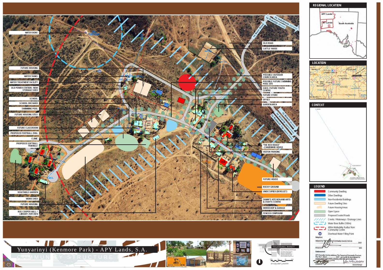
Yunyarinyi (Kenmore Park) - APY Lands, S.A.C O M M U N I T Y S T R U C T U R E P L A N N o . 1
187 Roberts Road SubiacoWestern Australia 6008Telephone: (08) 9382 2911Facsimile: (08) 9382 [email protected]
Town Planning and Design
TAYLOR BURRELL BARNETT
N 20m 0m 20 40m
d: 4 July 2007 | j: 05/019
to Rubbish Tip (approx 3 kms)
to Mim
ili (91 kms)
to Indulkana (112 kms)
to M
ain
Road
to Pukatja (36 kms)
to Airstrip (approx 3 kms)
CONTEXTBORE
TO MIMILI MICROWAVETOWER AND INDULKANA
YUNYARINYI
LOCATION
YUNYARINYI
REGIONAL LOCATION
LEGEND
Chairperson
General Manager
MSO
Community DwellingOther DwellingsNon-Residential BuildingsFuture Dwelling SitesFuture Housing AreasOpen SpaceProposed Sealed RoadsCreeks / Waterways / Drainage LinesWater Bore Buffer (100m)400m Walkability Radius fromCommunity CentreOverhead Water Filling Point Adoption:
Adopted by The Yunyarinyi Community Council, held on ........................................................................................................2007.
.................................................................................................................
Endorsement
APY Executive hereby endorses The Yunyarinyi Community Structure Plan No.1, dated.......................2007, as a guide for development to ensure proper and orderly planning within the community area.
..................................................................................................................Chairperson.
WORK SHED
VEGETABLE GARDEN
FUTURE HOUSE
ROCKY GROUND
VISITOR PARKING
‘THE RED HOUSE’- CHAIRMANS HOUSE
WORKSHOP & GARAGE
FUTURE STORE
ZANNY’S KITCHEN AND ARTS& CRAFTS CENTRE
CLINIC
FUTURE HOUSING
ROS COOPER HALL / LIBRARY / KITCHEN
PROPOSED SOFTBALLTRIANGLE
FUTURE CLASSROOM
PROPOSED FOOTBALL OVAL
FUTURE HOUSING SITES
FUTURE HOUSING
SCHOOL
SCHOOL ORCHARD
SWIMMING POOL
WATER TANKS
WATER TREATMENT FACILITY
WATER BORE
OLD POWER STATION - NOWSTORAGE SHED
UNOCCUPIED (DERELICT)
FENCED COMPOUND
OFFICE
GARDEN AREA
POSSIBLE FUTURE SWIMMINGPOOL SITE
SHED / FUTURE YOUTH CENTRE
POSSIBLE OUTDOORCHURCH AREA
OLD ROAD
CATTLE YARDS
W
W
W

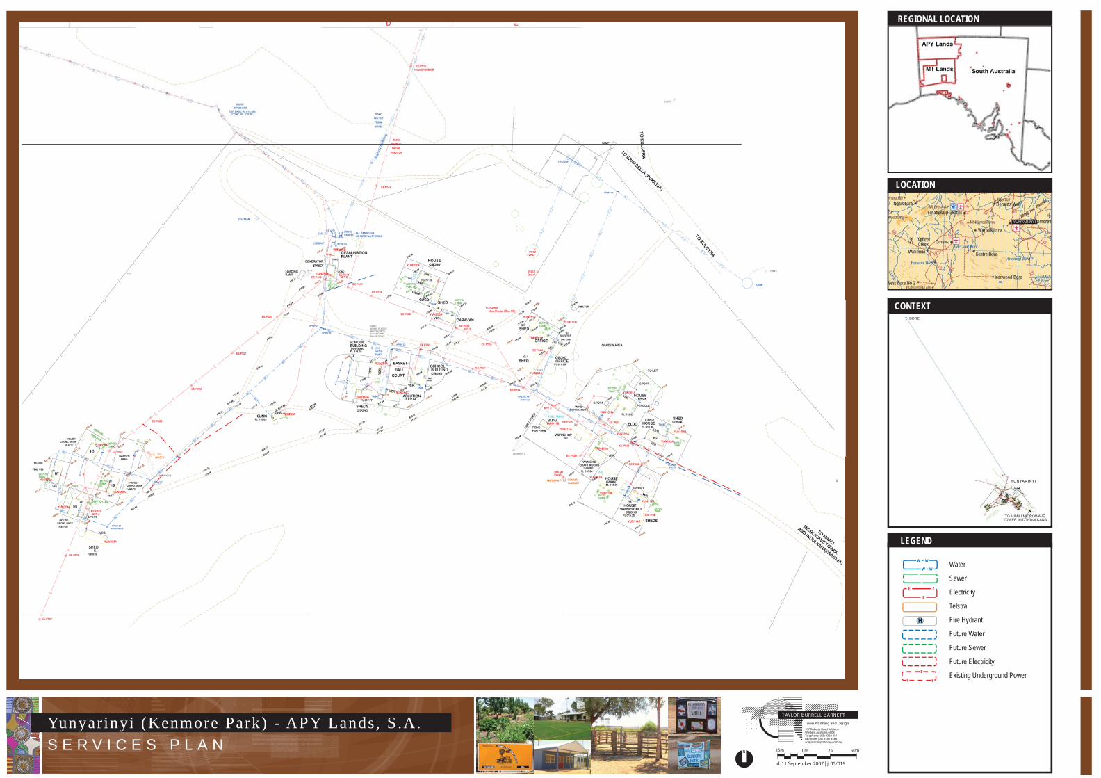
Yunyarinyi (Kenmore Park) - APY Lands, S.A.S E R V I C E S P L A N
187 Roberts Road SubiacoWestern Australia 6008Telephone: (08) 9382 2911Facsimile: (08) 9382 [email protected]
Town Planning and Design
TAYLOR BURRELL BARNETT
N 25m 0m 25 50m
d: 11 September 2007 | j: 05/019
CONTEXTBORE
TO MIMILI MICROWAVETOWER AND INDULKANA
YUNYARINYI
LOCATION
YUNYARINYI
REGIONAL LOCATION
LEGEND
Water
Sewer
Electricity
Telstra
Fire Hydrant
Future Water
Future Sewer
Future Electricity
Existing Underground Power
H
W W
W W
E E
E
E
EE