Publicación Abstracts Jornadas CEACT FINAL DEF · 2018. 4. 30. ·...
38
Transcript of Publicación Abstracts Jornadas CEACT FINAL DEF · 2018. 4. 30. ·...


© Autores
© Universidad de Jaén Febrero 2013
ISBN
978-‐84-‐8439-‐705-‐2
Depósito Legal J-‐50-‐2013
Edita
Publicaciones de la Universidad de Jaén Vicerrectorado de Extensión Universitaria, Deportes y Proyección Institucional
Campus Las Lagunillas, Edificio Biblioteca 23071 Jaén (España)
Teléfono 953 212 355 – Fax 953 212 235 [email protected]
Producción e Impresión
Imadoc Polígono. Industrial Juncaril, C/. Loja, parcela 19.
18210 Peligros (Granada) Telf. 953 430 099 – FAX.: 953 467 051

Centre for Advanced Studies in Earth Sciences. Universidad de Jaén (Spain). 1st workshop 11/2012
ÍNDICE INTRODUCTION……………………………………………………………………………….………………6 Pedro Alejandro Ruiz Ortiz PRESENTACIÓN……………………………………………………………………………………….………7 Pedro Alejandro Ruiz Ortiz Mineralogy and geochemistry in clay-‐rich fault zones………………………………………9 “Mineralogía y geoquímica de zonas de fallas ricas en minerales de la arcilla” Isabel Abad, Juan Jiménez Millán, Francisco Juan García Tortosa and Rosario Jiménez Espinosa
Active tectonic in the Guadix-‐Baza Basin……………………………………………..……….10 “Tectónica Activa en la Cuenca de Guadix-‐Baza” Francisco Juan García Tortosa, Juan Jiménez Millán, Rosario Jiménez Espinosa and María Isabel Abad Martínez
Seismic hazard and seismic potential studies at the University of Jaén……..……11 “Estudios de peligrosidad sísmica y potencial sísmico en la Universidad de Jaén” José A. Peláez, Carlos Sanz de Galdeano and Carlos López Casado
Palaeomagnetic studies in Neogene tectonics from the Betics: Historical overview and examples of new applications……………………………………………..…..12 “El paleomagnetismo en los estudios de Tectónica Neógena en las Béticas: revisión histórica y ejemplos de nuevas aplicaciones” Mario Sánchez-‐Gómez, Luis A. Pérez-‐Valera, Juan J. Villalaín and Fernando Pérez-‐Valera
“GNSS techniques for monitoring deformations” ………………………………...………13 “Sistemas GNSS aplicados al control de deformaciones” Antonio J. Gil, M. Jesús Borque, M. Isabel Ramos, Juan Antonio G. Armenteros, Selmira Garrido, M. Clara de Lacy and Antonio M. Ruiz
Application of SAR interferometry for land subsidence monitoring………………..14 “Aplicación de la interferometría SAR en el estudio de subsidencias del terreno” Antonio M. Ruiz, Joaquim J. Sousa, Ramon F. Hanssen, Miguel Caro, Zbigniew Perski, Antonio J. Gil, Jesús Galindo-‐Zaldívar, Carlos Sanz de Galdeano, Pedro Alfaro, Francisco Lamas, Mª Selmira Garrido, Juan A. Armenteros, Elena Giménez and Manuel Avilés(1)
Applications of stratigraphic and sedimentological analysis………….………………15 “Aplicaciones del análisis estratigráfico y sedimentológico” José Miguel Molina, Luis M. Nieto and Pedro A. Ruiz-‐Ortiz

Centre for Advanced Studies in Earth Sciences. Universidad de Jaén (Spain). 1st workshop 11/2012
Palaeontological analysis and its applications………………………………………..……..16 “El análisis paleontológico y sus aplicaciones” Roque Aguado, Ginés de Gea and Matías Reolid.
“Palaeoflood and historical flood reconstruction: Cases from the Segura River (Late Holocene) and Mont Miné Glacier (Swiss Alps, 1943)” …………...……17 “Reconstrucción de paleoavenidas: Los casos del río Segura (Holoceno Superior) y el glaciar de Mont Miné (Alpes suizos, 1943)” Patricio Bohorquez and Fernando García-‐García
Past, present, and future floods in the Guadalquivir River (Southern Spain)…..18 “Inundaciones pasadas, presentes y futuras del río Guadalquivir (Sur de España)” Patricio Bohorquez and Fernando García-‐García
Dynamic simulation of the catastrophic draining of the Kuray-‐Chuja glacial lake (Altai Mountains, Southern Siberia) and the formation of megadune fields ……………………………………………………………….………………………….19 “Simulación numérica del drenaje del lago Kuray-‐Chuja (Montañas de Altai, Siberia) y de la formación de campos de megadunas” Patricio Bohorquez and Vicente Herrera Calatayud
Susceptibility and hazard mapping in landslides and other processes by means of GIS, SDI, and remote sensing techniques……………………………………20 “Cartografía de susceptibilidad y peligrosidad en deslizamientos de ladera y otros procesos mediante técnicas SIG, IDE y Teledetección” Tomás Fernández, Jorge Delgado, Francisco Javier Cardenal and José Luis Pérez
Integration of sensors and geomatic techniques in earth and environmental sciences…………………………………………………………………………..21 “Integración de sensores y técnicas geomáticas en Ciencias de la Tierra y del Medio Ambiente” Javier Cardenal Escarcena, Tomás Fernández del Castillo, Jorge Delgado García, José Luis Perez Garcia, Emilio Mata de Castro, Mª Ángeles Hernández Caro and Antonio Mozas Calvache
Application of hydrogeology to the characterization of tectonic processes……22 “Aplicación de la Hidrogeología en la caracterización de procesos tectónicos” Rosario Jiménez-‐Espinosa and Pilar Hernández Puentes
Environmental quality in abandoned mining regions: Risk identification and polluted environment characterization……………………………..23 “Calidad ambiental en regiones mineras abandonadas: identificación de riesgos y caracterización de medios contaminados” Carmen Hidalgo, Javier Rey, Julián Martínez, Claus Kohfahl, Mª. José de la Torre, Diego Rojas and José Benavente

Centre for Advanced Studies in Earth Sciences. Universidad de Jaén (Spain). 1st workshop 11/2012
Fibre-‐optic oxygen sensors: A powerful and innovative means to estimate the future environmental impact of mine waste……………..………………24 “Sensores ópticos de oxígeno: Una metodología novedosa y potente para estimar el impacto ambiental futuro de residuos mineros” Claus Kohfahl, Mari Carmen Hidalgo, Diego Rojas, Julián Martínez, Javier Rey and José Benavente
Electrical Resistivity Tomography: An effective tool for subsurface Exploration……………………………………………………………………………………………………25 “Contribución de la tomografía eléctrica al estudio del subsuelo” Javier Rey, Julián Martínez and Carmen Hidalgo
Ground penetrating radar (GPR) and borehole logging as tools in geology: Preliminary data………………………………………………………….…26 “El Georrádar y la Testificación de Pozos como herramientas de trabajo en geología: Datos preliminares” Julián Martínez, Javier Rey and Carmen Hidalgo
Industrial applications of clay minerals………………………………….………………………27 “Aplicaciones industriales de minerales de la arcilla” África Yebra-‐Rodríguez, Cristina Fernández-‐Barranco and Juan Jiménez-‐Millán
Solar radiation estimation from Meteosat Second Generation imagery………...28 “Obtención de radiación solar a partir de imágenes de Meteosat Segunda Generación” Samuel Quesada-‐Ruiz, Joaquín Tovar-‐Pescador, David Pozo-‐Vázquez, José A. Ruiz-‐Arias, Vicente Lara-‐Fanego and Francisco J. Santos-‐Alamillos
Serpentinite dehydration in subduction settings: Petrological, geochemical and petrophysical implications………………………..………………………..29 “Deshidratación de serpentinitas en contextos de subducción: implicaciones petrológicas, geoquímicas y petrofísicas” Vicente López Sánchez-‐Vizcaíno
Mineralogical and spectroscopic study of building materials in monuments………………...………………………………………………………………………….…30 “Estudio mineralógico y espectroscópico de materiales de construcción en edificios históricos” María José Campos-‐Suñol, María José de la Torre López, Ramón Rubio Domene, Ana Domínguez-‐Vidal and María José Ayora-‐Cañada4
Geodiversity and geological heritage………………………………………………………….…31 “Geodiversidad y Patrimonio Geológico” Luis M. Nieto, José Miguel Molina and Pedro A. Ruiz-‐Ortiz

Centre for Advanced Studies in Earth Sciences. Universidad de Jaén (Spain). 1st workshop 11/2012
Sedimentary geochemistry: Application to the study of oceanic anoxic events………………………………………….………………………………….…32 “Geoquímica sedimentaria: aplicación al estudio de Eventos Anóxicos Oceánicos” José Manuel Castro, María Luisa Quijano, Ginés A. de Gea, Roque Aguado, Pedro A. Ruiz-‐Ortiz and Richard D. Pancost
Ecological studies in Mediterranean wetlands……………………………………...…….…33 “Estudios ecológicos en humedales mediterráneos” Francisco Guerrero, Gema Parra, Raquel Jiménez-‐Melero, Enrique García-‐Muñoz, Andrea Galotti, Fernando Ortega, Juan Diego Gilbert, Ana del Arco and Francisco Jiménez-‐Gómez
Aquatic Ecotoxicology…………………………..…………………………………………………….…34 “Ecotoxicología acuática” Gema Parra, Francisco Guerrero, Francisco Jiménez-‐Gómez, Raquel Jiménez-‐Melero, Enrique García-‐Muñoz, Andrea Galotti, Fernando Ortega, Juan Diego Gilbert and Ana del Arco
Ecology of global change: A synthesis between earth and life sciences………….35 “Ecología del Cambio Global: una síntesis entre las Ciencias de la Tierra y de la Vida” Benjamín Viñegla, Víctor Lechuga, Mª Carmen Blanes, Juan Carlos Linares and José A. Carreira1
Soils and the geo-‐hydro-‐biosphere interface: Challenges in the last frontier……………………..………………………………………………………………..…36 “El Suelo como interfase Geo-‐Hidro-‐Biosfera: posibilidades en la última frontera” José A. Carreira, Mª Carmen Blanes and Benjamín Viñegla
Soil genesis and quality in Jaén (Spain): Advances and perspectives………..….…37 “Génesis y Calidad del suelo en Jaén (España): avances y perspectivas”
Julio Calero

Centre for Advanced Studies in Earth Sciences. Universidad de Jaén (Spain). 1st workshop 11/2012
CENTRE FOR ADVANCED STUDIES IN EARTH SCIENCES
1st Workshop. Abstracts
CENTRO DE ESTUDIOS AVANZADOS EN CIENCIAS DE LA TIERRA (CEACTierra)
Actas de las I Jornadas Científicas
9/11/2012
INTRODUCTION
Last November 9th, the 1st workshop of the Centre for Advanced Studies in Earth Sciences (CEACTierra) of the University of Jaén took place. The main goal of this meeting was to provide scientists that are going to be part of CEACTierra with an opportunity to introduce themselves to each other and to present their main achievements in their research fields. An important outcome of the meeting was the idea of publishing the abstracts of the contributions the intention being to have an historical record of this event. Consequently, we now present the record of the first public activity of the, recently created, Centre for Advanced Studies in Earth Sciences of the University of Jaén.
The contribution abstracts appear in the same order as they were presented during the meeting. In the meeting programme the abstracts were ordered on the basis of their contents to construct relatively homogenous sections. The first five contributions deal with active tectonics, seismicity, palaeomagnetism in tectonic studies and techniques for measuring deformations in the Earth’s surface. Then, the applications of stratigraphy, sedimentology, and palaeontology studies begin a set of abstracts dealing with catastrophic sedimentary processes related with natural hazards, flooding and landslides, ending with the presentation of techniques for analysing and monitoring them. Two contributions about the role of water in active faults and as evidence of environmental pollution give way to a series of abstracts showing geophysical techniques applied to monitoring the environmental quality of abandoned mining regions. The industrial applications of clay minerals, solar radiation estimates using satellite pictures, serpentinite dehydration in subduction settings, the study of building materials in monuments and, finally, geodiversity and geological heritage in the Jaén region, make up the next section. This summary concludes with studies being carried out on geochemistry: on one hand, the geochemistry of sedimentary rocks, which locally records global change events that could be used as ancient analogues of present-‐day global change and, on the other hand, of wetlands areas with studies on aquatic ecotoxicology. The publication ends with some considerations about the interactions among the external layers of the Earth and the quality of the resulting products, in the case study, the soils of the province of Jaén.

Centre for Advanced Studies in Earth Sciences. Universidad de Jaén (Spain). 1st workshop 11/2012
PRESENTACIÓN
El pasado 9 de noviembre de 2012, se celebraron las I Jornadas Científicas del Centro de Estudios Avanzados en Ciencias de la Tierra (CEACTierra) de la Universidad de Jaén (UJA). Las jornadas tenían como principal objetivo propiciar un primer contacto entre los científicos interesados en formar parte del Centro, ofreciéndole la oportunidad de darse a conocer entre sus compañeros de otras áreas de conocimiento, grupos de investigación y departamentos de la UJA. Al mismo tiempo que se favoreció ese conocimiento mutuo, los equipos de investigación aprovecharon la ocasión para presentar las principales temáticas en las que trabajan o han trabajado y/o sus principales objetivos de investigación en la actualidad. Las jornadas resultaron realmente interesantes, hilándose el atractivo de una ponencia con el de la siguiente, manteniendo vivamente atenta a toda la audiencia a lo largo de la jornada. El conjunto de las ponencias presentadas dejaron ver claramente la oportunidad de la creación de un Centro de Investigación donde coincidirán investigadores que, en muchos casos, trabajan en temas complementarios o cultivan técnicas que son de aplicación en campos comunes a más de una de las temáticas expuestas, pero que, hasta ahora, estaban la mayoría de ellos totalmente desconectados entre sí. En el ánimo de todos los participantes quedó un cierto regusto muy tonificante para encarar el inmediato futuro.
Tras la experiencia vivida, rápidamente fuimos conscientes de que habíamos disfrutado de algo realmente significativo y que, quizás, no todos esperaban. Se respiraba un cierto ambiente de satisfacción colectiva. Y fue en ese ambiente en el que surgió la idea de publicar los resúmenes de las ponencias presentadas. De algún modo se pensaba que las Jornadas habían sido todo un hito en el inicio de la actividad de un Centro que, apenas unos meses antes, iniciaba su andadura con la aprobación por el Consejo de Gobierno y el Consejo Social de su Carta Fundacional, allá por el mes de junio del año 2012. Quede por tanto esta publicación como registro histórico de la primera actividad pública del Centro de Estudios Avanzados en Ciencias de la Tierra de la Universidad de Jaén.
Por otra parte, el compendio de resúmenes que se presenta, la mayor parte de ellos en lengua inglesa para favorecer su difusión internacional, constituye sin duda una buena carta de presentación de la actividad de los investigadores interesados en formar parte del CEACTierra. Podemos decir que es una buena muestra, bastante amplia aunque no completa, de lo que hacemos los diferentes Grupos de Investigación en los que nos integramos. En total participaron en las Jornadas investigadores pertenecientes a 12 Grupos de Investigación diferentes, distribuidos en 6 Departamentos de la UJA. Se presentaron 26 ponencias, si bien en lo que sigue se incluyen 29 resúmenes. La diferencia procede de la subdivisión de algunas de las ponencias presentadas, ya que los problemas de tiempo o, dicho de otro modo, de espacio en el programa, obligó a sintetizar en una sola ponencia algunas de las propuestas iniciales. Ahora, aquí, volvemos a ver lo que originalmente pretendían los investigadores afectados.
La organización de los resúmenes que se incluyen en esta edición respeta el mismo orden con el que se presentaron en las Jornadas. Para la elaboración del programa de las mismas ya se trabajó los agrupamientos de ponencias en sesiones que mantuvieran una cierta homogeneidad temática. Por ello, se comienza con la tectónica activa, la sismicidad, el

Centre for Advanced Studies in Earth Sciences. Universidad de Jaén (Spain). 1st workshop 11/2012
paleomagnetismo en los estudios tectónicos y en otras aplicaciones, y se cierra el bloque con la exposición de diversas técnicas de control de deformaciones. Sigue, una revisión de las aplicaciones de los estudios estratigráficos, sedimentológicos y paleontológicos, que encabeza una serie de ponencias dedicadas a procesos sedimentarios catastróficos en el ámbito de lo que actualmente denominamos riesgo geológicos, inundaciones y deslizamientos, y se cierra con las técnicas de análisis y control de los mismos. A continuación, dos ponencias tratan la aplicación de la hidrogeología a problemáticas tectónicas y ambientales y dan paso a la exposición de toda una serie de técnicas geofísicas aplicadas a los estudios del subsuelo, que actualmente se están aplicando al control de la calidad ambiental en regiones mineras abandonadas. La deriva hacia problemáticas ambientales se continua con un bloque que, en cierto modo, hizo las veces de cajón de sastre y en el que se recogieron desde las aplicaciones industriales de los minerales de la arcilla, las estimaciones de radiación solar a partir de fotos de satélite, el deterioro ambiental de monumentos y edificios históricos, lo que en alguna época se refirió como “mal de la piedra”, hasta los estudios que se han realizado en nuestro entorno sobre geodiversidad y patrimonio geológico. Completa este compendio la presentación de los estudios que se llevan a cabo sobre geoquímica, por un lado en los sedimentos, donde están registrados eventos de cambio global que pueden ser referencia para los estudios de interacciones en medios recientes o actuales, así como en los humedales mediterráneos, con estudios de ecotoxicología acuática, cerrando la publicación algunas reflexiones sobre las interacciones entre las capas externas de la Tierra y el estudio de la calidad de los productos resultantes, en concreto, y en el caso que nos ocupa, los suelos de la provincia de Jaén.
Pedro Alejandro Ruiz Ortiz
Comisionado para el Centro de Estudios Avanzados en Ciencias de la Tierra (CEATierra) de la Universidad de Jaén (Spain).
Diciembre, 2012

Centre for Advanced Studies in Earth Sciences. Universidad de Jaén (Spain). 1st workshop 11/2012
Mineralogy and geochemistry in clay-‐rich fault zones “Mineralogía y geoquímica de zonas de fallas ricas en minerales de la arcilla”
Isabel Abad, Juan Jiménez Millán, Francisco Juan García Tortosa, and Rosario Jiménez Espinosa
Dpto. de Geología de la Universidad de Jaén, Grupo de Investigación PAIDI: “Procesos y Recursos Geológicos “ (RNM-‐325). [email protected]
ABSTRACT
The nature of fault-‐related clay mineral assemblages, their chemical composition, and their influence on fluid circulation properties are factors controlling active deformation processes in fault zones. The focus of this research is the influence of clays on the mechanical behaviour of fault rocks. The presence of clay minerals is one of the factors contributing to the localization of deformation in weak zones of high shear strain. For instance, clay-‐bearing fault gouges are commonly found in fault zones at shallow levels. Characterizing their microstructural textures is, therefore, essential in order to interpret the larger-‐scale deformational history of these rocks. Moreover, significant rock volume and water-‐content variations are associated with clay dehydration in these areas. These variations are far from negligible, and likely have considerable impact on the behaviour of clay-‐rich fault rocks as they might control processes such as seismicity in fault zones.
Innovative aproaches, such as thermodynamic and laboratory experiments, apart from classic methodologies based on the use of X-‐ray diffraction, optical microscopy, analytical scanning and transmission electron microscopy, isotope geochemistry, and whole-‐rock analyses are being applied to the study of certain active faults in the central-‐eastern Betic Cordillera. Specifically, the Guadix-‐Baza Basin and the Trans-‐Alboran area constitute extraordinary natural laboratories with exceptional outcrops to study how “slow” faults work and, in particular, how clay mineralization is related to processes of tectonic deformation and seismogenesis. The microfabric orientation of the fault rocks and microstructural studies using advanced techniques such as bidimensional X-‐ray diffraction patterns and electron backscatter diffraction are likely to provide significant advances in our knowledge of plastic and brittle deformation mechanisms conditioning the tectonic and seismic processes that occur at faults. The initial results of the Galera fault studies show that sepiolite and smectite formation is restricted to the fault rocks, with the conclusion that the heat and fluid flows associated with clay mineral authigenesis were confined to areas within the fault zone. For the Trans-‐Alboran area, our results suggest clay growth along the fault zones related to fault activity or merely using the fault zones as conduits for fluids of magmatic origin (without fault activity). Upcoming studies on thermodynamic models and simulated laboratory experiments will reproduce volume changes and fluid release of these minerals in the fault rocks. We hope to obtain important information on the physico-‐chemical processes leading to earthquake nucleation in these active faults. Clay-‐forming reactions may suggest significant fluid-‐rock interactions and significant variation in spatial and temporal pore-‐fluid pressures and mechanical properties.

Centre for Advanced Studies in Earth Sciences. Universidad de Jaén (Spain). 1st workshop 11/2012
Active tectonic in the Guadix-‐Baza Basin “Tectónica Activa en la Cuenca de Guadix-‐Baza”
Francisco Juan García Tortosa, Juan Jiménez Millán, Rosario Jiménez Espinosa, and María
Isabel Abad Martínez Dpto. de Geología de la Universidad de Jaén, Grupo de Investigación PAIDI: “Procesos y Recursos geológicos“ (RNM-‐325). [email protected]
ABSTRACT
The Guadix-‐Baza Basin has been the subject of numerous stratigraphic, sedimentological, and palaeontological studies. However, its tectonic activity was not studied until a few years ago even though significant earthquakes had been recorded. One such occurred in 1531 in Baza, causing hundreds of deaths, and a more recent earthquake in Galera in 1964 which caused great social alarm in the town and its surrounding areas.
In the last few years, members of the Junta de Andalucía’s Research Group RNM-‐325, together with other researchers from the Universities of Jaén, Alicante, Granada, and the Andalucian Institute of Earth Sciences, have carried out studies on active tectonic describing, for the first time, some highly relevant faults in the recent geodynamic evolution of the Betic Cordillera, among which the Baza fault stands out. Other active faults have also been labelled, such as the Galera and the Zamborino faults, as well as active folds like the Galera and Guadiana Menor (Alfaro et al., 2008; García-‐Tortosa et al., 2008, 2010).
The studies, such as those that will be carried out in the next few years, have a common objective apart from advancing knowledge of the recent geodynamic evolution of the Betic Cordillera, improving seismic hazard maps, and obtaining better data to calculate the seismic potential of active structures. One of the most interesting pieces of data for the calculation of seismic potential, as well as for the analysis of seismic danger, is the displacement velocity or rates of active faults. However, active faults on the Iberian peninsula are characterized by low rates of displacement. These slow faults are often typified by seismic cycles with long periods of recurrence (several thousands of years), and to calculate their seismic potential we need comprehensive historical records of which there are, unfortunately, none available. In their absence, we must therefore resort to data from geology, geomorphology and geophysics or geodesy. Some of the results obtained in this way are: a) A geological map of active structures in the Guadix-‐Baza basin, integrated in a geographical system that has served as a basis for the discovery and characterization of new active structures; b) The identification of the Pleistocene seismites, whose spectacular outcrops has allowed us to draw relevant conclusions between their dimensions and the magnitude of the earthquakes (Alfaro et al., 2010); c) An initial approximation to quantifying recent deformation produced by active structures using basin geomorphic indices and geomorphic markers of the deformation (García Tortosa et al., 2008; García Tortosa et al., 2010). The displacement speeds obtained for the major faults in the Guadix-‐Baza basin range between 0.17–0.49 mm per year for the Baza fault and 0.08–0.24 mm per year for the Zamborino and Galera faults.

Centre for Advanced Studies in Earth Sciences. Universidad de Jaén (Spain). 1st workshop 11/2012
Seismic hazard and seismic potential studies at the University of Jaén “Estudios de peligrosidad sísmica y potencial sísmico en la Universidad de Jaén”
José A. Peláez1,4, Carlos Sanz de Galdeano2,4 and Carlos López Casado3,4
1. Dpto. de Física Aplicada de la Universidad de Jaén. 2. Instituto Andaluz de Ciencias de la Tierra, Granada. 3. Dpto. de Física Teórica y del Cosmos, Universidad de Granada. 4. Grupo de Investigación PAIDI: “Riesgo Sísmico y Tectónica Activa” (RNM-‐370). [email protected]
ABSTRACT
Our main research lines focus on seismic hazard and seismic potential studies, basically in the Betic Cordilleras (southern Spain) and northern Morocco and Algeria. In addition, other research lines such as seismicity, seismotectonics, seismic attenuation, seismically induced landslides, archaeoseismology, and fractal aspects of seismicity and faults have also been conducted on occasion by our research group in collaboration with other teams.
In practical terms, assessing the seismic hazard in a region implies computing the expected value of ground motion due to earthquakes for a certain return period, usually 475 years (the current return period adopted in most seismic codes). Using the so-‐called spatially smoothed seismicity approach, our research group has conducted seismic hazard assessments in the Iberian Peninsula (both Spain and Portugal) in terms of peak ground horizontal acceleration (PGA) (Peláez & López Casado, 2002), in the Granada Basin (southern Spain) including active fault data, also in terms of PGA (Peláez et al., 2003a), in southern Spain in terms of Arias intensity (Peláez et al., 2005a), and in northern Algeria in terms of PGA, spectral acceleration, and design spectra (Peláez et al., 2003b, 2005b, 2006; Hamdache et al., 2012). Recently, we have also been studying establishing forecasting models for low to moderate earthquakes in northern Morocco and northern Algeria for very short expected return times, just 5 and 10 years. This is the first component of any seismic hazard assessment, do not taking into account the second one, namely the estimation of ground motion.
Although there is no formal definition for this term, seismic potential can be defined as the capability of a fault or region to host earthquakes of a certain magnitude. These studies involve seismic, palaeoseismic, seismotectonic, and active tectonic work. Our research group was a pioneer in this type of studies in the Granada and Guadix-‐Baza basins (Sanz de Galdeano et al., 2003, 2012), both in southern Spain. Moreover, the use of active tectonic information and seismicity data has also allowed us to delimit the main active faults in other regions of the Betic Cordilleras (Sanz de Galdeano & Peláez, 2011; Pedrera et al., 2012).
Hamdache et al. (2012). Pure and Applied Geophysics 169, 711–723. Pedrera et al. (2012). Journal of Iberian Geology 38, 191–208. Peláez, J.A. & López Casado, C. (2002). Pure and Applied Geophysics 159, 2699–2713. Peláez et al. (2003a). Bulletin of the Seismological Society of America 93, 1670–1678. Peláez et al. (2003b). Tectonophysics 372, 105–119. Peláez et al. (2005a). Engineering Geology 77, 139–151. Peláez et al. (2005b). Pure and Applied Geophysics 162, 2163–2177. Peláez et al. (2006). Pure and Applied Geophysics 163, 119–135. Sanz de Galdeano & Peláez (2011). Fallas activas en la Cordillera Bética. ISBN: 9788433851956 Sanz de Galdeano et al. (2012). Journal of Iberian Geology 38, 209–223. Sanz de Galdeano et al. (2003). Pure and Applied Geophysics 160, 1537–1556.
Centre for Advanced Studies in Earth Sciences. Universidad de Jaén (Spain). 1st workshop 11/2012
Palaeomagnetic studies in Neogene tectonics from the Betics: Historical overview and examples of new applications
“El paleomagnetismo en los estudios de Tectónica Neógena en las Béticas: revisión histórica y ejemplos de nuevas aplicaciones”
Mario Sánchez-‐Gómez1, Luis A. Pérez-‐Valera1, Juan J. Villalaín2, and Fernando Pérez-‐Valera1
1. Dpto. de Geología de la Universidad de Jaén. Grupo de Investigación PAIDI: “Riesgo sísmico y tectónica activa” (RNM-‐370). 2. Laboratorio de paleomagnetismo de la Universidad de Burgos. [email protected].
ABSTRACT/RESUMEN
A number of studies in the Betics have shown general and assorted palaeomagnetic rotations of vertical axis, which have led to diverse tectonic models attempting to explain them, often ignoring regional geology and/or structural analysis. To clarify these discrepancies, this working group has paid particular attention to the structure of the sampling areas. Moreover, we analyse the utility of less conventional applications of palaeomagnetism trying to date continental Quaternary sediments, such as travertine, in order to establish the displacement rates of active slow faults.
A lo largo de las pasadas décadas los estudios de paleomagnetismo en las Béticas han sido muy dispersos, tanto en el planteamiento como en el contexto geológico. De los estudios de rotaciones de eje vertical se han derivado modelos tectónicos dispares que intentan explicar los resultados paleomagnéticos, obviando en muchos casos aspectos como la geología regional y/o el análisis estructural. Los últimos trabajos publicados hasta 2004 no resuelven la gran disparidad de ángulos de rotaciones, de tal forma que los modelos tectónicos escogen aquellas que se ajustan a sus presupuestos y descartan las que son menos favorables o los contradicen. En este contexto, puede comprenderse que las rotaciones de eje vertical prácticamente hayan sido olvidadas por otras investigaciones geológicas no tectónicas, como por ejemplo reconstrucciones de carácter paleogeográfico.
Para poder relacionar de forma efectiva las observaciones geológicas con los datos paleomagnéticos se han planteado nuevos estudios con una cuidadosa selección de los potenciales sectores de muestreo teniendo en cuenta litologías y estructuras, de tal forma que permitan obtener resultados de calidad en un marco geológico bien conocido. En este sentido los resultados preliminares a lo largo de la Falla de Socovos, entre las provincias de Albacete y Murcia, muestran la perfecta adecuación de las rotaciones al funcionamiento de la Falla como fractura frágil, y no como una zona de cizalla kilométrica como se había propuesto en investigaciones previas del sector con un débil apoyo paleomagnético.
Por otra parte, se analiza la utilidad del uso de la polaridad magnética para acotar las edades posibles de travertinos cuaternarios que tienen una edad mayor de 500 ka, la edad efectiva que se puede alcanzar mediante la datación U-‐Th. La posibilidad de obtener una zonación espacial de polaridades en edificios travertínicos de diferente edad desplazados por el movimiento de una falla de salto en dirección permitiría, mediante una aplicación poco convencional del paleomagnetismo, la obtención de tasas de desplazamiento medio en los últimos millones de años, similares a las obtenidas en los fondos oceánicos. Estos estudios, desarrollados en fallas lentas, como la mayor parte de las que se encuentran en el sureste español, supondrían un gran avance en la determinación del potencial sísmico de estas fallas.

Centre for Advanced Studies in Earth Sciences. Universidad de Jaén (Spain). 1st workshop 11/2012
“GNSS techniques for monitoring deformations” “Sistemas GNSS aplicados al control de deformaciones”
Antonio J. Gil, M. Jesús Borque, M. Isabel Ramos, Juan Antonio G. Armenteros,
Selmira Garrido, M. Clara de Lacy, and Antonio M. Ruiz Dpto. de Ingeniería Cartográfica, Geodésica y Fotogrametría de la Universidad de Jaén. Grupo de Investigación PAIDI: “Microgeodesia Jaén” (RNM-‐282). [email protected].
ABSTRACT
The research group "Microgeodesia Jaén" was created in 1997 within the Andalusian Plan of Investigation (PAI) in the Department of Cartographic, Geodetic, and Photogrammetric Engineering at the University of Jaén, concentrating its activities in the field of geodesy (GPS, GALILEO, InSAR, etc.). The main research lines of the group are: geodetic control of ground deformation and its application in the prediction of natural disasters, geodetic monitoring in civil engineering, monitoring of movements in olive groves as a result of erosional agents, Satellite Radar Interferometry (InSAR) applied to the study of land subsidence, positioning and navigation based on active GNSS networks, and research tasks based on the GALILEO programme (The European Programme for a Global Navigation Satellite System). In this summary, we concentrate on monitoring deformations by GNSS (Global Navigation Satellite System) techniques. The activities by the group in this context can be divided into three fields: monitoring millimetre-‐level deformation of the crust due to the African and Eurasian tectonic plates, monitoring deformations in specific areas that are important from a seismic point of view, and monitoring deformations in civil engineering works. In all three cases, these tasks include monumentation of the observation points, survey design, field observation, data processing, results analysis, and estimation of deformations and velocity field. Our area of work is the Iberian Peninsula and surrounding areas. The Iberian Peninsula is characterized by the ongoing collision between the Nubia and Eurasian plates. Tectonically, the area can be subdivided into three main domains: the southern (Betic and Rif domain), central, and northern areas. We study the monitoring of deformations in the Iberian Peninsula as an analysis centre within the Topo-‐Iberia project (CONSOLIDER-‐CSD2006-‐00041) and specific areas in the Betic and Rif domain. As part of the Topo-‐Iberia project, a network of 26 continuous GPS stations has been established, covering the Spanish part of the Iberian Peninsula (22 stations) and Morocco (4 stations). These stations complement other GPS networks already operating under the supervision of different institutions. Furthermore, temporary GPS networks have been set up in the following areas: the Bajo Segura Basin (Alicante), Granada Basin, Zafarraya Fault and Sierra Tejeda Fold, Balanegra Fault, Fez, Alhucemas, and Ouarzazate, all of which have been observed since 1999. Finally, related to civil engineering works, the reservoir “El Arenoso” (Córdoba) has been studied using GPS techniques and high-‐precision leveling for several years.

Centre for Advanced Studies in Earth Sciences. Universidad de Jaén (Spain). 1st workshop 11/2012
Application of SAR interferometry for land subsidence monitoring “Aplicación de la interferometría SAR en el estudio de subsidencias del terreno”
Antonio M. Ruiz(1), Joaquim J. Sousa(2,3), Ramon F. Hanssen(4), Miguel Caro(4), Zbigniew Perski(5), Antonio J. Gil(1), Jesús Galindo-‐Zaldívar(6,7), Carlos Sanz de Galdeano(7),
Pedro Alfaro(8), Francisco Lamas(9), Mª Selmira Garrido(1), Juan A. Armenteros(1), Elena Giménez(1), and Manuel Avilés(1)
1. Dpto. de Ingeniería Cartográfica, Geodésica y Fotogrametría de la Universidad de Jaén. Spain. Grupo de investigación PAIDI: “Microgeodesia Jaén” (RNM-‐282). 2. Dept. of Engineering, School of Science and Technology, University of Trás-‐os-‐Montes e Alto Douro, Vila Real, Portugal. 3. Centre of Geology, University of Porto, Portugal. 4. Institute of Earth Observation and Space Systems, Delft University of Technology, The Netherlands. 5. Polish Geological Institute -‐ National Research Institute, Carpathian Branch, Cracow, Poland. 6. Dpto. de Geodinámica, Universidad de Granada, Spain. 7. Instituto Andaluz de Ciencias de la Tierra, CSIC-‐Universidad de Granada, Granada, Spain. 8. Dpto. de Ciencias de la Tierra y Medio Ambiente, Universidad de Alicante, Spain. 9. Dpto. de Ingeniería Civil. Universidad de Granada, Spain. [email protected].
ABSTRACT
Spaceborne Synthetic Aperture Radar Interferometry (InSAR) is a well-‐known and widely used geodetic and remote sensing technique. It allows precise surface deformation measurements of large areas and a high spatial density of measurement points, and is one of the fastest-‐developing research fields in remote sensing. InSAR relies on the processing of two SAR images of the same portion of the earth’s surface obtained either from two slightly displaced passes of the SAR antenna at different times (repeat-‐pass interferometry), or from two antennas placed on the same platform and separated perpendicularly to the flight path (single-‐pass SAR interferometry). However, despite the many successes of InSAR, problems due to changes in the scattering properties of the earth's surface over time as well as the incidence angle of the radar look direction limit the applicability of the technique. This makes detection of slow deformation processes particularly challenging to detect by standard InSAR techniques. In the late 1990s, it was noticed that some radar targets maintain stable backscattering characteristics for a period of months or years, and the phase information from these stable targets (called Persistent Scatterers or PS) can be used, even over a long period, taking advantage of a SAR scene archive in existence since 1991 (ERS-‐1), which allows the establishment of a long-‐term series of SAR images. This led to the development of time series SAR interferometry (MTI) methodologies. These techniques allow us to measure deformation with uncertainties of one millimetre per year, interpreting time series of interferometric phases at these coherent point scatterers (PS). Considering the regular revisit time and wide-‐area coverage of satellite radar sensors, and that PS usually correspond to buildings and other man-‐made structures, these techniques are particularly suitable for application in urban environments. In recent years, we have applied InSAR-‐MTI methods to study the spatial and temporal evolution of some subsidence areas revealed from SAR observations in the Granada Basin (Betic Cordillera) as well as on the southern Spanish coast.

Centre for Advanced Studies in Earth Sciences. Universidad de Jaén (Spain). 1st workshop 11/2012
Applications of stratigraphic and sedimentological analysis “Aplicaciones del análisis estratigráfico y sedimentológico”
José Miguel Molina, Luis M. Nieto, and Pedro A. Ruiz-‐Ortiz Dpto. de Geología de la Universidad de Jaén. Grupo de Investigación PAIDI: “Análisis de Cuencas y Geología Ambiental” (RNM-‐200). [email protected]
ABSTRACT
The RNM-‐200 Research Group of the Junta de Andalucía, “Basin Analysis and Environmental Geology”, has among basic aims:
1) Recognition and classification of sediments and sedimentary rocks, taking into account all the constituents and features of their facies: lithology, texture, structure, geophysical and geochemical properties and fossil content.
2) Identification of lithostraphic units that can be represented on geological maps. 3) Establishing the relative order of stratigraphic units and making up stratigraphic
logs. 4) Genetic interpretation of units and sequences differentiated, trying to decipher the
characteristics of ancient environments and the allocyclic processes controlling their evolution. 5) Correlation or/and comparison studied stratigraphic sections. 6) Placing rocks and historical facts in a time scale mainly using fossils, biostratigraphy,
and, locally, radiodating and numerical ages. 7) Integrating field and lab data for a better understanding of basin geometry and the space/time evolution of their constituent units. 8) Modeling ancient environments and basins and drawing conclusions for an enrichment of the history of the earth system, conclusions that, often, are especially useful in applied geology.
From an economic standpoint, it is worth highlighting the relation of these studies with the exploration and prospecting of energy resources (coal, oil and gas), industrial sedimentary rocks, aquifers, subterranean natural reservoirs for toxic waste or CO2 and archaeological stratigraphy. Sedimentology and stratigraphic analysis are also fundamental tools in studies of environmental geology and natural hazards, with a recent Quaternary record to extend back historical series.
Over the more than twenty years since the foundation of our Research, our main interest has focused on Jurassic and Cretaceous rocks, mainly carbonate, predominantly deposited in shallow marine platforms now cropping out in the External Zones of the Betic Cordillera. Large areas of the provinces of Sevilla, Córdoba, Granada, Jaén, Murcia and Alicante have been studied. More recently, the biostratigraphy of these rocks and their geochemical imprints have become an important part of our main objectives, especially in relation with critical palaeoenvironmental episodes. In addition, our interest in Mesozoic processes and rocks has now been extended to Tertiary and Quaternary examples related mainly with natural hazards.

Centre for Advanced Studies in Earth Sciences. Universidad de Jaén (Spain). 1st workshop 11/2012
Palaeontological analysis and its applications “El análisis paleontológico y sus aplicaciones”
Roque Aguado, Ginés de Gea, Matías Reolid. Dpto. de Geología de la Universidad de Jaén. Grupo de Investigación PAIDI: “Análisis de Cuencas y Geología Ambiental” (RNM-‐200). [email protected]
ABSTRACT
The field of interest of a part of the RNM-‐200 group is the study of fossils in sedimentary rocks. The objects of our studies comprise both macro-‐ (mainly ammonites) and microfossils (benthic and planktonic foraminifera and calcareous nannoplankton).
Ammonites are extinct marine cephalopods of nektonic or nektobenthic lifestyle. They had an aragonitic spirally coiled shell that is usually preserved through fossilization. As they were abundant, distributed globally, and evolved rapidly, they are used as guide fossils through the Jurassic and Cretaceous. However, our interest is now concerned more with the study of processes involved in the fossilization (taphonomy) and changes in assemblage composition over time (ecostratigraphy).
Foraminifera are protozoa with a shell formed by agglutinated, calcite, or aragonite chambers. Benthic foraminifera live on the ocean floor, around the surface of marine sediments. Most are limited by specific environmental parameters and are used in palaeoecological interpretations. By contrast, planktonic foraminifera freely float in the upper ocean waters. Their fossil remains are very abundant in marine sediments and also have a global distribution and rapid evolution, so they are an excellent biostratigraphic and palaeoecological tool. We use fossil benthic foraminifera as a tool in reconstructing palaeoenvironmental parameters mainly throughout the Jurassic. We are using planktonic foraminifera, together with other fossil groups, to develop integrated biostratigraphic studies. Our interest focuses on those intervals in the Cretaceous sedimentary record of the External Zones of the Betic Cordillera recording major palaeoenviromental changes.
Calcareous nannofossils are the smallest of all skeletal fossils routinely preserved in marine sediments. They are usually one of the main components of carbonate rocks. Their rapid evolution and global distribution make them ideal biostratigraphic indicators from the Late Triassic to the Recent. We are currently working on refining calcareous nannofossil biostratigraphic scales for the Lower and mid Cretaceous interval from records in the Subbetic Zone of the Betic Cordillera. Calcareous nannoplankton assemblages are heavily controlled by the nature of the surface water mass they inhabit, which exerts a primary control on their distribution and abundance in fossil assemblages. We are using statistical and numerical analysis to derive the relationships of nannofossil abundances to surface water fertility and palaeotemperature as a way to examine palaeoceanographic change. To this end, we are especially interested in the intervals of major perturbations in oceanic surface water characteristics, such as Mesozoic oceanic anoxic events.

Centre for Advanced Studies in Earth Sciences. Universidad de Jaén (Spain). 1st workshop 11/2012
“Palaeoflood and historical flood reconstruction: Cases from the Segura River (Late Holocene) and Mont Miné Glacier (Swiss Alps, 1943)”
“Reconstrucción de paleoavenidas: Los casos del río Segura (Holoceno Superior) y el glaciar de Mont Miné (Alpes suizos, 1943)”
Patricio Bohorquez1 and Fernando García-‐García2
1.Dpto. de Ingeniería Mecánica y Minera. Grupo de Investigación PAIDI: “Mecánica de Fluidos de Jaén” (TEP-‐235). [email protected]. 2. Dpto. de Geología. Grupo de Investigación PAIDI: Análisis de Cuencas y Geología Ambiental (RNM-‐200). Universidad de Jaén.
ABSTRACT
Palaeofloods are past or ancient floods that occurred without being studied by either direct measurement using hydrological procedures or observation and recording by human observers (in which case the floods are termed historical floods). Short-‐term gauge records can be lengthened by hundreds to thousands of years by reconstructing the discharges of past floods using palaeoflood evidence. Of particular significance is that the availability of flood data has important repercussions in estimating probable maximum floods, which is crucial for flood-‐risk mapping and the selection of design flood magnitudes used to calculate safety factors for dams, bridges, and other engineering works.
The palaeoflood research presented here is based on flood field evidence such as flood slackwater deposits and palaeostage indicators (PSI) using principles of fluvial geomorphology, fluvial sedimentology, and related aspects of stratigraphy and geoarchaeology for flood age dating. In order to obtain accurate results, the topography of the study reach was determined from a LiDAR flight, which was the best option available to us. The accuracy of the discharge estimates depends on the stability of cross-‐section topography through time. Bedrock canyons are the most suitable geomorphological settings for reconstructing palaeoflood discharges because of their stable geometry.
Floods in the Almadenes Canyon (Segura River, 4,000 yr BP to AD 900) have been reconstructed using unsteady two-‐dimensional shallow-‐water modelling. The palaeoreconstruction was performed from a consideration of the bedforms and the hydraulic conditions comparing the simulated dimensionless Shields and Froude numbers with respect to characteristic values for the existence of ripples and upper-‐stage plane bed in slackwater flood deposits at a rockshelter. The hydrologic characteristics of the 1943 outburst flood from the Swiss Mont Miné Glacier were reconstructed using palaeostage indicators in conjunction with one-‐ and two-‐dimensional shallow-‐water modelling techniques.
Methodologically, the combination of fluvial palaeohydrology and geoarchaeology appears to be a robust tool to estimate palaeoflood frequency and to discuss climatic versus anthropogenic factors controlling Holocene fluvial sedimentation.
Estimates of minimal flow discharge magnitudes ranged from 700 to 1000 m3/s in the most recent Segura River palaeoflood (AD 900) and above 400 m3/s in the 1943 outburst flood from the Mont Miné Glacier.
Centre for Advanced Studies in Earth Sciences. Universidad de Jaén (Spain). 1st workshop 11/2012
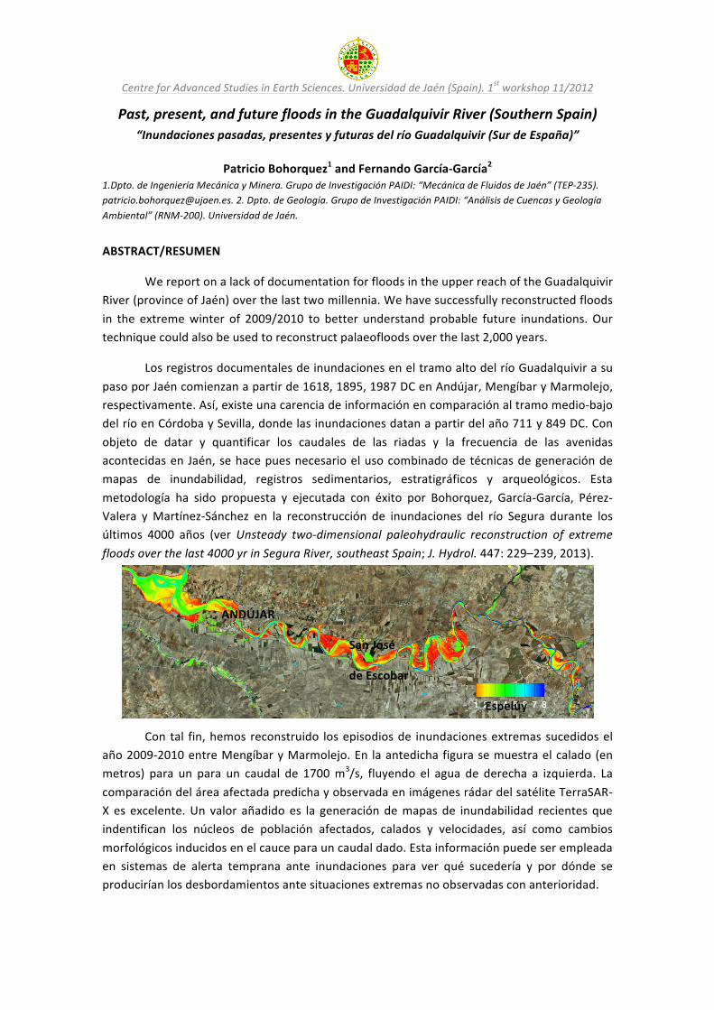
Past, present, and future floods in the Guadalquivir River (Southern Spain) “Inundaciones pasadas, presentes y futuras del río Guadalquivir (Sur de España)”
Patricio Bohorquez1 and Fernando García-‐García2
1.Dpto. de Ingeniería Mecánica y Minera. Grupo de Investigación PAIDI: “Mecánica de Fluidos de Jaén” (TEP-‐235). [email protected]. 2. Dpto. de Geología. Grupo de Investigación PAIDI: “Análisis de Cuencas y Geología Ambiental” (RNM-‐200). Universidad de Jaén.
ABSTRACT/RESUMEN
We report on a lack of documentation for floods in the upper reach of the Guadalquivir River (province of Jaén) over the last two millennia. We have successfully reconstructed floods in the extreme winter of 2009/2010 to better understand probable future inundations. Our technique could also be used to reconstruct palaeofloods over the last 2,000 years.
Los registros documentales de inundaciones en el tramo alto del río Guadalquivir a su paso por Jaén comienzan a partir de 1618, 1895, 1987 DC en Andújar, Mengíbar y Marmolejo, respectivamente. Así, existe una carencia de información en comparación al tramo medio-‐bajo del río en Córdoba y Sevilla, donde las inundaciones datan a partir del año 711 y 849 DC. Con objeto de datar y quantificar los caudales de las riadas y la frecuencia de las avenidas acontecidas en Jaén, se hace pues necesario el uso combinado de técnicas de generación de mapas de inundabilidad, registros sedimentarios, estratigráficos y arqueológicos. Esta metodología ha sido propuesta y ejecutada con éxito por Bohorquez, García-‐García, Pérez-‐Valera y Martínez-‐Sánchez en la reconstrucción de inundaciones del río Segura durante los últimos 4000 años (ver Unsteady two-‐dimensional paleohydraulic reconstruction of extreme floods over the last 4000 yr in Segura River, southeast Spain; J. Hydrol. 447: 229–239, 2013).
ANDÚJAR
San José
de Escobar
Espelúy
Con tal fin, hemos reconstruido los episodios de inundaciones extremas sucedidos el año 2009-‐2010 entre Mengíbar y Marmolejo. En la antedicha figura se muestra el calado (en metros) para un para un caudal de 1700 m3/s, fluyendo el agua de derecha a izquierda. La comparación del área afectada predicha y observada en imágenes rádar del satélite TerraSAR-‐X es excelente. Un valor añadido es la generación de mapas de inundabilidad recientes que indentifican los núcleos de población afectados, calados y velocidades, así como cambios morfológicos inducidos en el cauce para un caudal dado. Esta información puede ser empleada en sistemas de alerta temprana ante inundaciones para ver qué sucedería y por dónde se producirían los desbordamientos ante situaciones extremas no observadas con anterioridad.

Centre for Advanced Studies in Earth Sciences. Universidad de Jaén (Spain). 1st workshop 11/2012
Dynamic simulation of the catastrophic draining of the Kuray-‐Chuja glacial lake (Altai Mountains, Southern Siberia) and the formation of megadune fields “Simulación numérica del drenaje del lago Kuray-‐Chuja (Montañas de Altai, Siberia) y de la
formación de campos de megadunas”
Patricio Bohorquez and Vicente Herrera Calatayud Dpto. de Ingeniería Mecánica y Minera de la Universidad de Jaén. Grupo de Investigación PAIDI: “Mecánica de Fluidos de Jaén” (TEP-‐235). [email protected]
ABSTRACT
In this short communication we show that the sudden draining of Lake Kuray-‐Chuja, in the Pleistocene after the instantaneous breach of an ice dam, was the largest flood on earth. The lake’s flow dynamics were simulated using GeoClaw (George, Int. J. Numer. Methods Fluids, 66: 1000–1018, 2011), an open-‐source two-‐dimensional shallow-‐water code. The input parameters were the Digital Elevation Model (ASTER-‐GDEM with a spatial resolution of 30 metres), the initial elevation of the water surface in the lake at rest (2,100 metres; Carling et al., J. Geolog. Society, 354: 111–128, 2011), and the mean grain size of eroded sediments.
Our numerical results for the instantaneous breach of the ice dam include an objective quantification of the maximum water discharge and minimum draining duration. A peak flow discharge of about 30 Mm3/s occurred during the very early instants of the flood. The flow discharge steadily decreased for 48 hours, by which time 98% of the reservoir volume had been drained. Retrodicted flow discharges of 20 Mm3/s were observed in the same reach studied by Baker, Benito, and Rudoy (Science, 259: 348–350, 1993), who obtained similar results.
In addition, we generated maps of the maximum values of Shields and Froude numbers, as proposed by Bohorquez et al. (J. Hydrol. 447: 229–239, 2013). In doing so, locations where landforms were generated could be readily identified. We discovered the development of dune fields in Aktru, Kuray, and Kara Kjol. Our results are in agreement with megadunes observed in the field, which are marked with solid circles and empty squares in the figure below. Near the ice dam, the Shields parameter was extremely high, which may be the sediment source of Katun landforms.
Centre for Advanced Studies in Earth Sciences. Universidad de Jaén (Spain). 1st workshop 11/2012
Susceptibility and hazard mapping in landslides and other processes by means of GIS, SDI, and remote sensing techniques
“Cartografía de susceptibilidad y peligrosidad en deslizamientos de ladera y otros procesos
mediante técnicas SIG, IDE y Teledetección”
Tomás Fernández, Jorge Delgado, Francisco Javier Cardenal and José Luis Pérez Dpto. Ingeniería Cartográfica, Geodésica y Fotogrametría. Universidad de Jaén. Grupo de Sistemas Fotogramétricos y Topométricos (TEP-‐213). [email protected].
ABSTRACT
This contribution presents a methodology for landslide susceptibility and hazard mapping using geomatics techniques, among which are geographic information systems (GIS), spatial data infrastructures (SDI), and different acquisition data systems from those located on the land surface to remote sensors aboard aircraft or space platforms.
Susceptibility is defined as the spatial probability of the occurrence of a potentially damaging phenomenon within a given region. It can be modeled by different methodologies based on deterministic or probabilistic analyses that start from the correlation between past events and factors that determine the instability. In this case, the methodology used is based on bivariate analysis between landslides and determinant factors through a matrix approach in which the susceptibility is calculated as the percentage of each combination of factors that is occupied by landslides. The methodology begins with a landslide inventory map and database performed in the GIS after being identified by photo interpretation combined with a field survey and then digitally stereoplotted; image analysis techniques can also be used to detect landslide scarps automatically. In addition the factor maps are obtained from SDI, which allows the information to be kept updated and guarantees quality. The susceptibility maps extend the risk areas beyond the phenomena identified in the inventories.
Hazard is defined as the probability that a potentially damaging process could occur in a particular area and within a certain return period. It needs the dating of events or at least the estimation of its activity, and so different techniques can be employed, among which geomatics stands out. For the most recent movements, the techniques used for accurate dating depend on the scale, and they range from the terrestrial laser scanner and photogrammetry to aerial photogrammetry (including unmanned aerial vehicles, UAV) and remote sensing from satellite platforms. For movements over the last 50–100 years, dating can also be done using aerial photogrammetry (historical flights), combined with other techniques such as dendrochronology. For older movements, the activity estimation is based on photo interpretation of current flights identifying abandoned and relict or eroded movements. Four inventories has been obtained corresponding to return periods on a logarithmic scale with active movements (10 years), dormant (100), abandoned (1,000), and relict (10,000), from which susceptibility maps are determined using the methodology described above. The hazard is calculated dividing the susceptibility by the return period and taking at each point the maximum hazard value. Hazard maps are better suited to the conditions of current reality and in this regard are less conservative and more useful than susceptibility maps.

Centre for Advanced Studies in Earth Sciences. Universidad de Jaén (Spain). 1st workshop 11/2012
Integration of sensors and geomatic techniques in earth and environmental sciences
“Integración de sensores y técnicas geomáticas en Ciencias de la Tierra y del Medio Ambiente”
Javier Cardenal Escarcena, Tomás Fernández del Castillo, Jorge Delgado García, José Luis Perez Garcia, Emilio Mata de Castro, Mª Ángeles Hernández Caro and Antonio Mozas
Calvache Dpto. Ingeniería Cartográfica, Geodésica y Fotogrametría. Escuela Politécnica Superior de Jaén. Grupo de Investigación de Sistemas Fotograméticos y Topométricos (TEP-‐213). [email protected]
ABSTRACT
The aim of the research group Photogrammetric and Topometric Systems (TEP-‐213) to improve and optimize documentation and monitoring in earth sciences (natural heritage, erosion and landslide monitoring, etc.) by combining and integrating different geomatic methods and techniques, mainly photogrammetry, laser scanner (LiDAR) and remote sensing. The features of earth and environmental sciences documentation require the use of different types of sensors, for geometric, radiometric and spectral resolutions. Projects can be approached from different working scales and platforms: remote sensing from space, aerial and close range photogrammetry, airborne (ALS) and terrestrial (TLS) LiDAR, and light aerial platforms, such as helium ballons/blimps, tall telescopic masts and unmanned aerial systems (UAS) or drones. Instead of using just one technique, their integration and fusion is highly recommended in order to not only combine the advantages of the different methods but also minimize the disadvantages of each individual technique. Several examples can be mentioned.
Aerial photogrammetry and LiDAR can be advantageous for landslide and erosion monitoring since the combination of semantic information of the image and the high-‐resolution spatial information of LiDAR can produce extremely reliable digital surface models and accurate ortho-‐images. If historical flights are available (in Spain the historical record of photogrammetric information started in the fifties with the well-‐known “American flight”) a complete evolution of the slope and landslide crowns, identification of affected areas, landslide types, and annual rates and volumes can be determined. If the scale and spatial situation of the site (in near-‐vertical slopes) is not appropriate for analysis from aerial platforms, terrestrial techniques (both close-‐range photogrammetry and laser scanner) can be used. Present photogrammetric and digital techniques allow the use of conventional cameras (non-‐metric) and digital stereo photogrammetric workstations (DSPW) with 3D vision capabilities, which improve digital terrain model edition (from raw laser data) and geomorphologic interpretation. In addition, present technology related to unmanned aerial vehicles with improvements in radio control, video transmissions and payload systems, miniaturization in global positioning antennas and inertial navigation units, autopilot facilities, and high-‐resolution and low-‐weight digital cameras allow a wider variety of situations found in environmental monitoring and documentation of natural heritage sites to be covered. Additional information concerning TEP-‐213 group activities can be found in http://coello.ujaen.es/investigacion/websft/.
Centre for Advanced Studies in Earth Sciences. Universidad de Jaén (Spain). 1st workshop 11/2012
Application of hydrogeology to the characterization of tectonic processes “Aplicación de la Hidrogeología en la caracterización de procesos tectónicos”
Rosario Jiménez-‐Espinosa and Pilar Hernández Puentes Dpto. Geología. RNM-‐325. [email protected]
ABSTRACT
The character of the hydrological changes that follow major earthquakes has been investigated and found to depend on the type of faulting (Muir-‐Wood and King, 1993). Our study areas are located in different zones, but in this abstract we present results from the Palomares Fault and Carboneras Fault Zones, in the eastern part of the province of Almería.
A monitoring network has been designed to study the physical and chemical parameters of water in relation to seismic events in the Palomares–Carboneras Zone. We are trying to establish a groundwater circulation model and to identify the sources of aquifer fluids (exogenous/endogenous). Finally, it is important to determine the influence water flow can have on the nucleation of new earthquakes, so the sources directly related to the most significant failures in the study area need to be characterized.
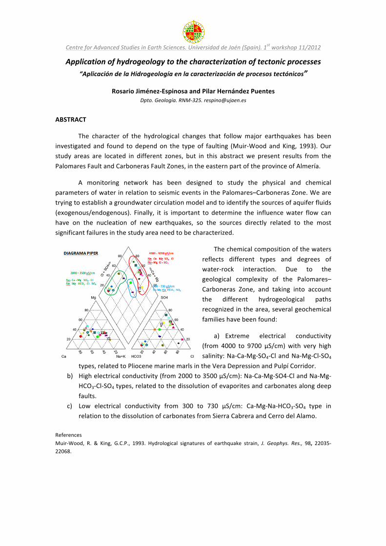
The chemical composition of the waters reflects different types and degrees of water-‐rock interaction. Due to the geological complexity of the Palomares–Carboneras Zone, and taking into account the different hydrogeological paths recognized in the area, several geochemical families have been found:
a) Extreme electrical conductivity (from 4000 to 9700 μS/cm) with very high salinity: Na-‐Ca-‐Mg-‐SO4-‐Cl and Na-‐Mg-‐Cl-‐SO4
types, related to Pliocene marine marls in the Vera Depression and Pulpí Corridor. b) High electrical conductivity (from 2000 to 3500 μS/cm): Na-‐Ca-‐Mg-‐SO4-‐Cl and Na-‐Mg-‐
HCO3-‐Cl-‐SO4 types, related to the dissolution of evaporites and carbonates along deep faults.
c) Low electrical conductivity from 300 to 730 μS/cm: Ca-‐Mg-‐Na-‐HCO3-‐SO4 type in relation to the dissolution of carbonates from Sierra Cabrera and Cerro del Alamo.
References Muir-‐Wood, R. & King, G.C.P., 1993. Hydrological signatures of earthquake strain, J. Geophys. Res., 98, 22035-‐22068.
-‐
-‐

Centre for Advanced Studies in Earth Sciences. Universidad de Jaén (Spain). 1st workshop 11/2012
Environmental quality in abandoned mining regions: Risk identification and polluted environment characterization
“Calidad ambiental en regiones mineras abandonadas: identificación de riesgos y caracterización de medios contaminados”
Carmen Hidalgo*, Javier Rey, Julián Martínez, Claus Kohfahl, Mª. José de la Torre, Diego Rojas, and José Benavente
*Dpto. Geología, EPS de Linares, Universidad de Jaén. Grupo de Investigación PAIDI: “Ciencias de la Tierra e Ingeniería Geológica” (RNM374). [email protected]
ABSTRACT
Significant deep mining of metallic sulphide ores took place in the Linares-‐La Carolina mining district (Jaen). The old mining works (shafts, pits) are at present flooded after the end of dewatering operations and they now store and transmit groundwater. This is a region where natural water quality is controlled by a very high geochemical background and also affected by processes related to the mine closure. Although acid mine drainage (AMD) has been detected in the La Carolina sector, mines in the Linares batholith are characterized by a natural neutralization process of the acidity resulting from sulphur oxidation, giving as a result net alkaline mine waters but with high contents in total dissolved metals. The study of the factors controlling these natural attenuation processes of acid mine drainage is one of the main objectives of this project.
Heavy metal contents in waters higher than the limits established by European regulations are a subject of concern in recent EC Water Framework Directives. In the study area, there are significant differences in lithology and hydrodynamic conditions among the different mining sectors. So, it is considered to be very suitable as a pilot site to analyse the influence of those parameters on heavy metal release and mobilization by means of geochemical modelling, a second objective of this project. Furthermore, the mining district is located in the headwaters catchment of the Guadalquivir River, in the drainage basin of a reservoir (El Rumblar). This circumstance leads to another objective of this study, which is to delimit the environmental risk of mining wastes and the characterization of their dispersal with batch assays and leaching tests.
Associated to these abandoned mines, relatively extensive areas occupied by spoil heaps and tailing impoundments exist and constitute potential sources of water and soil pollution by metals and semimetals. In order to analyse the pollution potential of these mining wastes, we have carried out a mineralogical and geochemical study of tailing dams and surrounding soils in the area. The mineralogy of the samples was studied by X-‐ray diffraction (XRD) and scanning electron microscopy (SEM). In addition, the total metal content of samples was determined by inductively coupled plasma mass spectrometry (ICP-‐MS) analysis and the chemical quality of surface waters has been analysed downstream of the mining area. The results for the contents in minor and trace elements show a mobilization process of Pb, Ni, Cr, and Cu in the surface drainage network.
Apart from the obvious regional interest in environmental, land use, and water management concern, the nature of the proposed methodologies could be applied to other important mining districts with more or less similar features, both in Spain and abroad.
Centre for Advanced Studies in Earth Sciences. Universidad de Jaén (Spain). 1st workshop 11/2012
Fibre-‐optic oxygen sensors: A powerful and innovative means to estimate the future environmental impact of mine waste
“Sensores ópticos de oxígeno: Una metodología novedosa y potente para estimar el impacto
ambiental futuro de residuos mineros”
Claus Kohfahl Mari Carmen Hidalgo, Diego Rojas, Julián Martínez, Javier Rey, and José Benavente
Dpto. Geología. EPS de Linares. Grupo de Investigación PAIDI: “Ciencias de la Tierra e Ingeniería Geológica” (RNM-‐374). [email protected]‐berlin.de
ABSTRACT
The oxidation of pyrite-‐bearing mine waste heaps results in decreasing pH and the release of weathering products such as Fe, dissolved toxic compounds/metals and sulphate. Therefore sulphidic waste rock piles and mine tailings, which are abundant in the Spanish pyrite belt, may constitute significant sources of contamination and are of critical concern for the environment and the mining industry. Contaminant release due to pyrite oxidation depends on weathering rates and is limited and controlled mainly by the availability of oxygen. Therefore, oxygen constitutes a crucial parameter to evaluate and predict the future contamination potential of mining waste.
In contrast to other methods of gas sampling applied in former studies, the use of fibre-‐optic sensors allows non-‐invasive continuous monitoring of oxygen partial pressure in the water and the gas phase and provides a powerful tool for obtaining depth-‐oriented oxygen profiles in the subsurface and their temporal evolution. Several projects are presented in which this technique has been applied in the field and laboratory combined with modeling approaches reproducing the analysed data for prognostic purposes. In a current research project (Junta de Andalucia/RNM 5959), an infrastructure equipped with fibre-‐optic oxygen sensors, TDR probes for conductivity, humidity and temperature has been set up in the Aquisgrana mine waste deposit for a monitoring programme of three years. Recorded oxygen profiles combined with analytical data of sediments and interstitial pore-‐water in boreholes will help to assess the contaminant potential of the deposit. The data obtained will be implemented in reactive multiphase models considering transport of gas, water, and thermodynamic and kinetic reactions to predict and quantify the future contaminant release of mine waste deposits and to design and optimiza possible remediation measures.

Centre for Advanced Studies in Earth Sciences. Universidad de Jaén (Spain). 1st workshop 11/2012
Electrical Resistivity Tomography: An effective tool for subsurface exploration “Contribución de la tomografía eléctrica al estudio del subsuelo”
Javier Rey1,3, Julián Martínez2,3 and Carmen Hidalgo1,3
1. Dpto. de Geología. 2. Dpto. de Ingeniería Mecánica y Minera. 3. Grupo de Investigación PAIDI: “Ciencias de la Tierra e Ingeniería Geológica” (RNM374). Universidad de Jaén-‐EPS Linares. [email protected] ABSTRACT/RESUMEN
Geoelectrical tomography is a high potential tool for studying and exploiting the subsoil. In this paper, first, a brief introduction is given to geoelectrical tomography. Second, results are presented from applying this technique for solving various geological problems.
La Tomografía Eléctrica es un método de prospección geofísica no destructivo que analiza los materiales del subsuelo en función de su comportamiento eléctrico, diferenciándolos en función de su resistividad eléctrica. El método se basa en la implantación de numerosos electrodos a lo largo de perfiles, con una separación determinada que viene condicionada por el grado de resolución y profundidad que se pretendan cubrir. Los electrodos se conectan a un equipo de medida y mediante un programa secuencial específico, se seleccionan cuáles deben ser los conjuntos de electrodos que funcionan en cada momento y con qué disposición. Para cada disposición electródica se hace una medida de resistividad que se atribuye a un determinado punto geométrico de subsuelo. Esta técnica comienza a ser usada con resultados satisfactorios tanto en geología básica (análisis de cuencas sedimentarias, cambios laterales de facies) como para la geología aplicada (Minería, Medio Ambiente, Hidrogeología, Geotecnia, Arqueología). A continuación se destacan algunas de sus aplicaciones.
A.-‐ Minería: Cuando los materiales a explotar ofrecen distintas resistividades que la roca encajante, la tomografía permite el estudio y caracterización del yacimiento así como un estudio preliminar para el cálculo de reservas.
B.-‐ Medio Ambiente: en especial, estudio de balsas mineras, vertederos industriales y urbanos, balsas de purines y alpechines, lo que se basa en el distinto comportamiento geoeléctrico entre estos residuos y el sustrato. Por tanto, permite la cubicación y caracterización de los rellenos, así como el estudio de posibles infiltraciones y fugas.
C.-‐ Hidrogeología: por un lado, permite detectar la presencia de acuíferos en el subsuelo ya que el agua presente muestra una resistividad mucho menor que la correspondiente al terreno seco. Por otro lado, la técnica también puede ser utilizada para la detección de intrusiones salinas en acuíferos costeros ya que el agua marina intruida presenta una resistividad inferior al agua dulce del acuífero.
D.-‐ Geotecnia e Ingeniería Civil: la técnica puede utilizarse para el estudio de deslizamiento de laderas (detectar el contacto entre roca sana y roca alterada), diseño de obras lineales (muy útil para detectar fracturas en el subsuelo) o para la localización de huecos que puedan provocar hundimientos en superficie.
E.-‐ Arqueología: la tomografía eléctrica permite identificar distintos tipos de estructuras en el subsuelo. Al ser una técnica de prospección no destructiva, se convierte en una herramienta útil para cualquier campaña de excavación arqueológica.

Centre for Advanced Studies in Earth Sciences. Universidad de Jaén (Spain). 1st workshop 11/2012
Ground penetrating radar (GPR) and borehole logging as tools in geology: Preliminary data
“El Georrádar y la Testificación de Pozos como herramientas de trabajo en geología: Datos preliminares”
Julián Martínez1,3, Javier Rey2,3 and Carmen Hidalgo2,3
1. Dpto. de Ingeniería Mecánica y Minera. 2. Dpto. de Geología. 3. Grupo de Investigación PAIDI: “Ciencias de la Tierra e Ingeniería Geológica” (RNM374). Universidad de Jaén-‐EPS Linares. [email protected] ABSTRACT/RESUMEN
Ground penetrating radar (GPR) and borehole logging systems are important tools for research in geology and mining and in civil engineering. This summary describes both techniques and their applications.
El Georrádar o método GPR (Ground Penetrating Radar) es una técnica de investigación geofísica no destructiva que se basa en la emisión, propagación y recepción de ondas electromagnéticas a través de un medio. La propagación de la onda en el subsuelo dependerá de la frecuencia de la señal transmitida (tipo de antena) y de las propiedades eléctricas y magnéticas de los materiales atravesados, lo que a su vez determina la profundidad de investigación alcanzada. Ésta técnica se usa en diferentes campos de la geología y de la ingeniería.
A.-‐ Ingeniería Civil: Detección de mallazos y estructuras, instalaciones enterradas (tuberías, cables, depósitos, etc), localización de huecos y/o túneles, estabilidad de taludes, etc. B.-‐ Ingeniería Ambiental: Localización y cubicación de vertederos, etc. C.-‐ Estudios de Patrimonio Histórico-‐Artístico: Localización de yacimientos arqueológicos. Determinación de daños en monumentos y de las características del subsuelo donde se ubica el patrimonio (subsidencias, filtraciones de agua), localización de elementos ocultos (criptas y enterramientos). E.-‐ Estudios forenses y Memoria Histórica: Localización de fosas, cuerpos, armas, drogas.
Con la testificación geofísica en sondeos se obtienen gráficos en continuo (diagrafías) de diferentes propiedades físicas, químicas, mecánicas y ópticas de las rocas atravesadas por la perforación, así como de la calidad de la obras. Podemos obtener información de las litologías de los terrenos atravesados, fracturación, porosidad, presencia de acuíferos, permeabilidad y medida de caudales, calidad del agua, control de plumas de contaminación, etc. Algunas de las sondas más utilizadas en testificación son.
1.-‐ Sonda dual de TV: esta sonda con vídeo-‐cámara permite la observación directa de los sondeos, muy útil para comprobar el estado del sondeo (entubación y filtros). 2.-‐ Sonda Calibre de 3 brazos (38 mm). 3.-‐ Sonda eléctrica, Gamma Natural y Temperatura (44 mm): esta sonda permite medidas de Resistividad, Potencial espontáneo, Gamma natural y Temperatura. 4.-‐ Sonda tomamuestras de agua/gas de 0,5 litros de capacidad. 5.-‐ Sonda de Flujo (45 mm) para medidas de la velocidad del flujo con hélice rotativa. 6.-‐ Sonda de calidad del agua para medida de presión, temperatura, conductividad, pH, oxígeno disuelto, sensor de potencial redox, sensor de nitratos.

Centre for Advanced Studies in Earth Sciences. Universidad de Jaén (Spain). 1st workshop 11/2012
Industrial applications of clay minerals “Aplicaciones industriales de minerales de la arcilla”
África Yebra-‐Rodríguez, Cristina Fernández-‐Barranco and Juan Jiménez-‐Millán
Dpto. de Geología de la Universidad de Jaén. Grupo de Investigación PAIDI: “Procesos y Recursos Geológicos” (RNM-‐325). (CICE, JA, Spain). [email protected]
ABSTRACT
Clay minerals have many industrial uses such as building materials, pharmaceutical formulations, drilling muds, fillers, and in the chemical and oil industries, among others. Since ceramics are suitable for combining inert industrial waste, we have researched the benefits of adding different types of waste to these construction materials. To that end, wastewater from the oil-‐washing stage in the two-‐phase olive oil extraction method was used to replace fresh water in clay brick manufacturing. Additionally, we used wet pomace as a pore-‐forming additive in the manufacture of clay bricks to evaluate the possibility of obtaining a lightweight construction material with good insulating characteristics. Our results revealed that the addition of wastes from the olive oil industry to construction materials is a good possibility for the revalorization of a hazardous waste.
Moreover, the addition of small amounts of clay minerals (usually ca. 5 wt.%) in a polymer matrix produces a large improvement in technical properties suitable for sophisticated industrial applications (high-‐barrier packaging products for food and electronics, materials for gas separation and fuel cell barrier membranes, solid electrolytes for electrochemical and electroanalytical applications, in the automotive and aerospace industries and in textile applications, among others). The mechanical properties of the pristine polymers and clay/polymer nanocomposites mainly depend on crystal properties, as the packing parameters will determine the inter-‐chain interactions in the different type of crystals. In our work we used injection molded samples of clay (montmorillonite, sepiolite) reinforced polyamide-‐6 (PA6) and polyamide-‐66 (PA66) to simulate industrial processing.
The presence of montmorillonite in a PA matrix triggers the crystallization of the metastable γ phase – instead of the α phase – thus avoiding an undesirable solid-‐to-‐solid phase transition α→γ at around 90 °C. The lattice of the PA6 dilates with increasing cooling temperature of the manufactured samples. These data corroborate the conversion of α to γ structure in the pristine polymer at temperatures below melting by switching to a higher symmetry class. In the nanocomposites the montmorillonite nanoparticles yield to a better orientation of the polyamide-‐6 crystals, which is known to be directly related to the enhancement of mechanical properties. Epitaxial mechanisms explain the nucleation of the thermodynamically less stable polyamide-‐6 γ crystal phase. In sepiolite reinforced nanocomposites, higher tensile strength and stiffness and reduction of the strain to failure are observed in the samples with higher sepiolite content. The observed increase in tensile strength is lower than that obtained in montmorillonite reinforced PA systems. These results have been related to unusual textural organization in the injection molded plates as a crosslinked system.

Centre for Advanced Studies in Earth Sciences. Universidad de Jaén (Spain). 1st workshop 11/2012
Solar radiation estimation from Meteosat Second Generation imagery “Obtención de radiación solar a partir de imágenes de Meteosat Segunda Generación”
Samuel Quesada-‐Ruiz1, Joaquín Tovar-‐Pescador2, David Pozo-‐Vázquez2, José A. Ruiz-‐Arias2,
Vicente Lara-‐Fanego2 and Francisco J. Santos-‐Alamillos2
1. Dpto. de Informática. 2. Dpto. Física. Grupo de Investigación PAIDI: Modelización de la Atmósfera y Radiación Solar (MATRAS). Universidad de Jaén. [email protected]
ABSTRACT
In this work we describe a methodology for estimating global solar radiation using images taken from a geostationary meteorological satellite, Meteosat Second Generation (MSG). This methodology is based on the Heliosat-‐II method, which was widely used with the Meteosat First Generation imagery but introduces some improvements and modifications that allows its usage with MSG imagery.
Solar Global Horizontal Irradiance (GHI) spatial distribution is a very important parameter for numerous fields of application (agriculture, hydrology, energy, etc.). Nowadays various methodologies are used to determine this distribution such as geo-‐statistics techniques applied to weather stations solar radiation measurements (Ruiz-‐Arias et al., 2011a; Alsamamra et al., 2009), solar radiation models integrated on Geographical Information Systems (GIS) (Ruiz-‐Arias et al., 2009), weather models that describe the evolution of the combined atmosphere-‐soil system, like Weather Research and Forecasting (WRF) (Ruiz-‐Arias et al., 2011b), and satellite images, which allow solar radiation estimation with high spatial resolution (Ruiz-‐Arias et al., 2010).
The main objective of this work is to evaluate the GHI estimation reliability in the middle part of Spain, obtained from MSG imagery. These estimations were compared against GHI measurements of 10 radiometric stations from the national meteorological agency (AEMET), obtaining a root mean square error of about 15% and a BIAS of over –8% on an hourly basis.
References
ALSAMAMRA, H., RUIZ-‐ARIAS, J.A., POZO-‐VÁZQUEZ, D., TOVAR-‐PESCADOR, J., 2009. Agricultural and Forest Meteorology, 149, 1343-‐1357.
RUIZ-‐ARIAS, J.A., TOVAR-‐PESCADOR, J., POZO-‐VÁZQUEZ, D., ALSAMAMRA, H., 2009. International Journal of Geographical Information Science, 23 (8), 1049-‐1076.
RUIZ-‐ARIAS, J.A., CEBECAUER, T., TOVAR-‐PESCADOR, J., SURI, M., 2010. Solar Energy, 84, 1644-‐1657.
RUIZ-‐ARIAS, J.A., POZO-‐VÁZQUEZ, D., SANTOS-‐ALAMILLOS, F.J., LARA-‐FANEGO, V., TOVAR-‐PESCADOR, J., 2011a. Agricultural and Forest Meteorology, 151, 1812-‐1822.
RUIZ-‐ARIAS, J.A., POZO-‐VÁZQUEZ, D., LARA-‐FANEGO, V., SANTOS-‐ALAMILLOS, F.J., TOVAR-‐PESCADOR, J., 2011b. Journal of Applied Meteorology and Climatology, 50, 2460-‐2472.
Centre for Advanced Studies in Earth Sciences. Universidad de Jaén (Spain). 1st workshop 11/2012
Serpentinite dehydration in subduction settings: Petrological, geochemical and petrophysical implications
“Deshidratación de serpentinitas en contextos de subducción: implicaciones petrológicas,
geoquímicas y petrofísicas”
Vicente López Sánchez-‐Vizcaíno Dpto de Geología de la Universidad de Jaén. Grupo de Investigación PAIDI: “Geoquímica de Procesos Endógenos y
Petrología de Rocas Ígneas y Metamórficas” (RNM-‐145). [email protected]
ABSTRACT
Reactions involving volatiles are fundamental in order to understand the significance of the mass transfer taking place in subduction zones, the origin of the chemical composition of associated arc volcanism, and the physical properties of the rocks controlling the dynamic behaviour of subduction settings. This project is a continuation of previous projects. We plan to carry on with the study of the ultramafic rocks from the Cerro del Almirez (Sierra Nevada, Betic Cordillera) and associated rodingites and metasediments in the light of previous outstanding results of our research team on the dehydration of antigorite serpentinite to chlorite harzburgite (olivine plus enstatite) of two textural types: granofelsic and pseudo-‐spinifex.
The main aim of this study is to contribute to a better understanding of the metamorphic processes, chemical differentiation and variation in the physical conditions produced in subduction settings by the dehydration reaction mentioned above. With this aim, we will make a thorough comprehensive study of rocks that show evidence of the development of such reactions: that is, the reactants, the products and a transition zone between them.
Specific tasks will be taken on by each scientist based in research centres in Spain, Europe and the USA. Each member of the team is a reputed specialist in one of the fields covered by the work that we propose.
The aims and team of researchers presented here enhance the relevance of this project within other international initiatives devoted to the study of subduction zones.

Centre for Advanced Studies in Earth Sciences. Universidad de Jaén (Spain). 1st workshop 11/2012
Mineralogical and spectroscopic study of building materials in monuments “Estudio mineralógico y espectroscópico de materiales de construcción en edificios
históricos” María José Campos-‐Suñol1,2, María José de la Torre López1, Ramón Rubio Domene1,3, Ana
Domínguez-‐Vidal4, and María José Ayora-‐Cañada4 1., Dpto. de Geología de la Universidad de Jaén-‐EPS-‐Linares, Grupo de Investigación PAIDI: “Procesos y recursos geológicos” (RNM-‐325). 2. OTRI-‐UJA. 3. Patronato de la Alhambra y Generalife, Granada. 4. Grupo de Investigación PAIDI: “Innovaciones en análisis químico” (FQM-‐363), Dpto. Química Física y Analítica de la Universidad de Jaén. [email protected].
ABSTRACT
The study of historical and artistic heritage buildings is aimed both at the characterization of construction and decorative materials and at the elucidation of alteration pathways undergone and their causes. This knowledge will contribute to the diagnosis of the state of weathering and to the selection of appropriate conservation approaches.
The low amount of sample available and its small size require careful planning and a conscientious sequence of measurements. We use different analytical techniques including optical microscopy, X-‐ray diffraction, scanning electron microscopy–energy dispersive X-‐ray spectrometry (SEM-‐EDX), Raman microspectroscopy, and attenuated total reflection–Fourier transform infrared spectroscopy (ATR-‐FTIR).
In the last five years, our work has been devoted to the study of the characteristics and the decay forms of the golden stone (calcarenite) of the historical buildings of Úbeda and Baeza. Furthermore, the ochre-‐colored patinas and the reddish and greenish polychromy of Saint Paul's Church in Úbeda were also investigated using a combination of quasi-‐non destructive techniques (Campos et al., 2008; Campos et al., 2009). The polychromy composition of a statue included different pictorial layers with cinnabar, haematite, red lead, orpiment, and azurite. In addition, a green pigment based on copper chloride was detected. Most of the patinas (calcite-‐oxalate patinas) in these buildings were found as a result of the application of a protective treatment over porous stone varieties, which also had a consolidative effect over previously weathered stone.
Our latest studies focus on the vaults of stalactites (mocárabes) of the Hall of the Kings in the Alhambra. Plasters and polychromy were first examined in situ by means of a totally non-‐invasive technique, portable Raman microspectroscopy, which allowed the identification of original black, deep-‐blue, original and restored red pigments, as well as their alteration products (Dominguez-‐Vidal et al., 2012). This research is currently being completed with the study of microsamples by the above-‐mentioned analytical techniques.
[1] Renaissance patinas in Ubeda (Spain): mineralogic, petrographic and spectroscopic study, M. J. Campos-‐Suñol, A. Domínguez-‐Vidal, M. J. Ayora-‐Cañada and M. J. de la Torre López, Anal Bioanal Chem 391, 1039 (2008)
[2] Analytical study of polychromy on exterior sculpted stone, M. J. Campos-‐Suñol, M. J. de la Torre López, M. J. Ayora-‐Cañada and A. Domínguez-‐Vidal, J Raman Spectrosc 40, 2104 (2009)
[3] In situ noninvasive Raman microspectroscopic investigation of polychrome plasterworks in the Alhambra, A. Dominguez-‐Vidal, M. J. de la Torre-‐Lopez, R. Rubio-‐Domene and M. J. Ayora-‐Cañada, Analyst 137, 5763 (2012)

Centre for Advanced Studies in Earth Sciences. Universidad de Jaén (Spain). 1st workshop 11/2012
Geodiversity and geological heritage “Geodiversidad y Patrimonio Geológico”
Luis M. Nieto, José Miguel Molina, and Pedro A. Ruiz-‐Ortiz Dpto. de Geología de la Universidad de Jaén. Grupo de Investigación PAIdi: “Análisis de Cuencas y Geología Ambiental” (RNM-‐200). [email protected]
ABSTRACT
Geodiversity can be defined as variety in the geological record of a study area. Geological heritage comprises the geological outcrops of a region with special scientific, educational, or tourist value, which represent relevant landmarks in the geological history of the study region. The members of the PAI-‐research groups of the Department of Geology from the University of Jaén, along with scientists from the Universidad Complutense (Madrid) belonging to some of these groups, have made considerable efforts to encourage the geological heritage of the province of Jaén and of the Betic External Zones. These achievements have resulted in extensive participation in several projects and books as well as contributions on several committees.
The involvement in the Junta de Andalucía's project “Inventario Andaluz de Georrecursos Culturales” concluded with the definition of 100 geosites in the province of Jaén from its three main geological areas: Central Iberian (Iberian Massif), Guadalquivir Basin, and Betic External Zones. The Global Geosites Project tried to define outstanding international frameworks and, within them, to consider geosites that are also of international value. Our contribution to this international project was summarized in a chapter of an IGME-‐edited book entitled Mesozoic Successions from the Betic and Iberian Cordilleras. Finally, another important project carried out was the analysis and revaluation of the large-‐mammal ichnites cropping out in Messinian gypsums near Jumilla (Murcia), as well as collaboration in the start-‐up of the Jerónimo Molina museum in this town.
Popular science books such as Jaén: pueblos y ciudades, published by Diario Jaén and Cajasur, Patrimonio Geológico de Andalucía, published by the national nuclear waste company ENRESA, and Proyecto Andalucía by Hercules Ediciones, are examples of our role in this realm. Related to the involvement in committees, our participation in the Geological Heritage Commission of the Geological Society of Spain, in the expert group of the IUGS for the evaluation of global natural heritage, as geological advisers of the Subbética Cordobesa Geopark and representing the Andalusian universities on the governing council of various of the natural parks existing in the region, can be cited.
In the near future, and within the Centre for Advanced Studies on Earth Sciences of the University of Jaén, we intend to develop a Unit of Geological Heritage devoted to the popularization of the rich geodiversity of the southern part of the Iberian Peninsula. The publishing of geotourism guides, the identification in the field of nature itineraries, as well as the organization of conferences, courses, and meetings will be the main objectives of this unit.

Centre for Advanced Studies in Earth Sciences. Universidad de Jaén (Spain). 1st workshop 11/2012
Sedimentary geochemistry: Application to the study of oceanic anoxic events “Geoquímica sedimentaria: aplicación al estudio de Eventos Anóxicos Oceánicos”
José Manuel Castro, María Luisa Quijano, Ginés A. de Gea, Roque Aguado, Pedro A. Ruiz-‐
Ortiz, and Richard D. Pancost Dpto. de Geología. G. Inv. Análisis de Cuencas y Geología Ambiental. Universidad de Jaén. [email protected]
ABSTRACT
The chemical composition of sedimentary rocks shows a rich and complex record of the processes that occurred during and after sedimentation. Elemental composition, stable isotopes and biomarkers are powerful tools in the study of the dynamics of the earth's system. The multidisciplinary nature of sedimentary geochemistry lead to a large variety of applications, including palaeoclimatology, sedimentology, stratigraphy, planetary geology, biogeochemistry, exploration of mineral and energy resources, and environmental pollution and remediation.
The study of past climate and environmental changes has become an interesting field of research as these episodes may contain clues to unravel present-‐day global change. Oceanic anoxic events (OAEs) are exceptional episodes of accelerated global change that have left a clear imprint in the sedimentary record. OAEs that caused major environmental change during the Mesozoic include those of the early Toarcian (∼183 Ma), early Aptian (OAE 1a, ∼120 Ma), early Albian (OAE 1b, ∼111 Ma), and Cenomanian–Turonian (OAE 2, ∼93 Ma). Research results suggest that the major process related to OAEs was an abrupt rise in temperature, induced by the rapid influx of CO2 into the atmosphere from volcanogenic and/or methanogenic sources. Global warming was accompanied by an accelerated hydrological cycle, increased continental weathering, enhanced nutrient discharge to oceans, intensified upwelling, and an increase in organic productivity. Intensified burial of organic matter favoured strong oxygen demand in the water column, and restricted marine environments evolved from poorly oxygenated to anoxic and ultimately euxinic. Sequestration of CO2 in organic-‐rich black shales and by silicate weathering on continents would ultimately restore climatic equilibrium, but at time scales of tens to hundreds of thousands of years.
The study of four expanded sections of the Betic Cordillera recording the early Aptian OAE1a has included stable isotopes, biomarkers, and elemental analyses, along with stratigraphy, sedimentology and biostratigraphy. The sections studied represent platform and pelagic settings, and all record a characteristic C-‐isotope profile with a negative spike followed by a positive excursion, globally correlated. Integration of organic (biomarkers) and elemental geochemistry suggests the development of dysoxic-‐anoxic conditions, established earlier in pelagic environments, and later expanded towards shallow platform settings. C-‐isotope-‐based proxies suggest an abrupt rise in pCO2 occurred at the onset of the OAE. High-‐frequency coupled oscillations in the geochemical parameters suggest environmental and climatic instability during OAE1a.
References: Jenkyns, H.C. 2010. Geochemistry, Geophysics, Geosystems. doi:10.1029/2009GC002788. Quijano et al., 2012. Palaeogeography, Palaeoclimatology, Palaeoecology. 365–366, 276–293.

Centre for Advanced Studies in Earth Sciences. Universidad de Jaén (Spain). 1st workshop 11/2012
Ecological studies in Mediterranean wetlands “Estudios ecológicos en humedales mediterráneos”
Francisco Guerrero, Gema Parra, Raquel Jiménez-‐Melero, Enrique García-‐Muñoz, Andrea Galotti, Fernando Ortega, Juan Diego Gilbert, Ana del Arco, and Francisco Jiménez-‐Gómez
Dpto. Biología Animal, Biología Vegetal y Ecología de la Universidad de Jaén. Grupo de Investigación PAIDI: “Ecología y Biodiversidad de Sistemas Acuáticos” (RNM-‐300). [email protected]
ABSTRACT
Wetlands are among the key ecosystems on the earth and constitute a major feature of the landscape in almost all parts of the world. In Mediterranean landscapes, wetlands represent a broad variety of natural resources with environmental, economic, educational, cultural and scientific values, also playing an important role in the maintenance of biological diversity. Andalusia presents a rich ecological diversity of wetlands, including the rarest ecosystem in Western Europe. However little is known about the extent and condition of many of these ecosystems. To resolve this situation, and following the recommendations of the Ramsar Convention, over the last ten years our research group has developed an integrated approach for compiling a wetland directory, inventory and assessment. A wetland directory is a previous necessary step consisting in obtaining a complete list of all wetlands in our study region, the Alto Guadalquivir area. The wetland inventory is to collect information to describe the ecological characteristics of wetlands. Finally, wetland assessment considers the status, pressures and associated risks of adverse changes in the ecological nature of the wetlands.
Our results showed the existence of at least one hundred natural wetlands, situated predominantly in endorheic basins, ninety five artificial wetlands (inland-‐salinas), together with a large number of irrigation ponds (more than a thousand). An initial classification in typologies of natural wetlands considering hydroperiod and salinity ranges allows us to divide them into permanent and temporary ones, and also into subsaline-‐hyposaline (principally located on siliceous, karstic, and olistostrome materials) and mesosaline-‐hypersaline ponds (situated on Trias-‐Keuper materials). In relation with biodiversity, the interannual information obtained reveals a great number of species. Finally, our results show that the demand for increased agricultural production in the Alto Guadalquivir region implies intensive overexploitation of the water resources, which in combination with other factors has been the major cause of the loss of wetlands. Moreover, the regular procedures in agriculture generate unquestionable environmental impacts being responsible in our study area for significant impacts on aquatic ecosystems. These farming practices generate a decrease in water quality owing to the use of fertilizers (eutrophication) and toxic products such as herbicides, fungicide, and pesticides, which can enter the aquatic ecosystem via point or nonpoint sources, inducing changes in ecological characteristics. All this knowledge is necessary for a correct wetland policy that allows the future conservation of these aquatic ecosystems, providing as well a tool for planning, management and restoration of the Mediterranean wetlands.

Centre for Advanced Studies in Earth Sciences. Universidad de Jaén (Spain). 1st workshop 11/2012
Aquatic Ecotoxicology “Ecotoxicología acuática”
Gema Parra, Francisco Guerrero, Francisco Jiménez-‐Gómez, Raquel Jiménez-‐Melero, Enrique
García-‐Muñoz, Andrea Galotti, Fernando Ortega, Juan Diego Gilbert, and Ana del Arco Dpto. Biología Animal, Biología Vegetal y Ecología de la Universidad de Jaén. Grupo de Investigación PAIDI: “Ecología y Biodiversidad de Sistemas Acuáticos” (RNM-‐300). [email protected]
ABSTRACT
Wetlands are aquatic ecosystems that are truly endangered in our territory. Most of them are small, non-‐permanent, shallow and without economic interest, so nobody cares. But they are highly diverse and have many functions that people are unaware of. In our context, the main stressful force occurring on wetlands comes from the activities developed in their watersheds, which are agricultural practices. Considering the overuse of chemical pollutants in olive tree agriculture, most water bodies are suffering their toxic effects. Aquatic ecotoxicology aims to study the adverse or toxic effects of chemicals and other anthropogenic materials or xenobiotics on aquatic organisms and systems. Our focus in this research line is to know to what extent pesticides, fungicides, and fertilizers used around a wetland alter its structure and function. In the laboratory, we are working with different aquatic organisms from phytoplankton to zooplankton, but also with amphibian larvae to determine the threshold concentration that generates lethal and sublethal effects on them. From an ecotoxicological point of view, it would be very useful if one could predict or extrapolate the response at higher organization levels (population, community, and ecosystem) from the responses observed at lower organization levels, such as individual, physiological, biochemical, or behavioural levels. Nowadays, we have published data showing that growth, development, reproduction, and even behaviour are negatively affected by copper sulphate, ammonium nitrate, and dimethoate, three of the most commonly used substances in olive tree agriculture. Moreover, the effects on structure and function must be studied under more natural conditions than those in the laboratory. Consequently in-‐situ, microcosm, and mesocosm experimental designs are also being used. The structure — in terms of diversity — is affected by the toxic 'cocktails' that are spilt on wetlands through so-‐called diffuse pollution, so ecological functions are also affected. The ecosystem function is the result of the interconnected relationship carried out in the ecosystem (complex trophic webs, relation with the sediment and terrestrial ecosystem, etc.) that makes up a interwoven puzzle. If any piece changes, the result in the whole system might be dramatic. Other anthropogenic alterations such as the increase in atmospheric CO2
concentrations, which induces changes in water pH and affects many physiological functions in aquatic organisms, is also being considered in our ecotoxicological studies. The current objective in the research group consists in determining the resistance and adaptation to prolonged CO2 exposure in planktonic organisms.

Centre for Advanced Studies in Earth Sciences. Universidad de Jaén (Spain). 1st workshop 11/2012
Ecology of global change: A synthesis between earth and life sciences “Ecología del Cambio Global: una síntesis entre las Ciencias de la Tierra y de la Vida”
Benjamín Viñegla1, Víctor Lechuga1, Mª Carmen Blanes1, Juan Carlos Linares2, and José A.
Carreira1 1. Departamento de Biología Animal, Biología Vegetal y Ecología de la Universidad de Jaén. Grupo de Investigación
PAIDI: “Ecología Forestal y Dinámica del Paisaje” (RNM296). 2. Departamento de Sistemas Físicos, Químicos y Naturales, Universidad Pablo de Olavide. Sevilla. Grupo de Investigación PAIDI: “Estructura y Función en Ecosiste-‐mas Mediterráneos” (RNM313). [email protected]
ABSTRACT
Global change is a broad subject that includes concepts related to climate change, including global warming, changes in biogeochemical cycles, especially increasing CO2 atmospheric concentrations or acid rain, but also the transformation of natural ecosystems and habitats due to changes in land use altering fire events or promoting deforestation. All these processes are leading to biogeographical changes in plant and animal communities such as the modification of their distribution areas, the expansion of invasive species, and even the extinction of species.
Our research group, Forest Ecology and Landscape Dynamics (RNM296), has performed several studies on relic conifer species and populations from the Mediterranean basin as suitable experimental models for testing global change processes, located in the limits of their distribution and showing fast responses to changes in their environment. As experimental models, we have considered Pinus nigra and Abies pinsapo populations from southern Spain and northern Morocco as well as several populations of Cedrus atlantica from the Rif to the High Atlas. When evaluating climate conditions over the long term, we have found a general temperature increase since the 1970s of around 1.5°C and an increase in the variability of precipitation. Changes in land use have also affected these populations, increasing the distribution of P. nigra and A. pinsapo forests over the last 50 years, but decreasing it in C. atlantica populations. Finally, N saturation in A. pinsapo stands near the industrialized area of Campo de Gibraltar has led to its decline due to chronic N deposition altering the N:P ratios of the trees. We have found a recovery of the trees primary and secondary growth rates when applying compensatory fertilization with P.
We have also evaluated soil mineralization processes in Arctic soils, which must show a fast and accurate response to climate changes at the global scale, focusing on the responses of soil phenol oxidase activity to increasing temperature and melting of the snow cover. This is a free soil enzyme that plays a central role in nutrient mineralization, being involved in phenol degradation in soils, which inhibits the mineralization of nutrients (C, N, and P) mediated by soil enzymes. No phenol content was found when incubating Arctic soils under aerobic conditions, with a significant and fast increase of either phenoloxidase or a whole set of nutrient mineralization-‐related enzyme activities, whereas the opposite was found under anaerobic conditions (N2 bubbling). Increasing temperature had no positive effect on nutrient mineralization when over 15°C, with a significant increase in soil phenol content under these conditions, suggesting the negative effect of global increasing temperature on these soils.

Centre for Advanced Studies in Earth Sciences. Universidad de Jaén (Spain). 1st workshop 11/2012
Soils and the geo-‐hydro-‐biosphere interface: Challenges in the last frontier “El Suelo como interfase Geo-‐Hidro-‐Biosfera: posibilidades en la última frontera”
José A. Carreira, Mª Carmen Blanes, and Benjamín Viñegla
Dpto. de Biología Animal, Biología Vegetal y Ecología de la Universidad de Jaén. Grupo de Investigación PAIDI: “Ecología Forestal y Dinámica del Paisaje” (RNM-‐296). [email protected]
ABSTRACT
Traditionally, soil science has considered the study of soils at meso-‐ and macro-‐scales (e.g., soil profile, catena), and has focused on long-‐term dynamics (e.g., soil genesis) and on geochemical (weathering and neo-‐formation of secondary minerals) and agronomic (soil fertility and crop production) issues. For dealing with these questions, soils were generally considered as isotropous at the microscale (e.g., large bulk soil samples are dried, sieved, and homogenized prior to standard chemical analyses of nutrients), and their biology and ecology are largely ignored. In the last two decades, however, soil science has experienced a sharp paradigm-‐change that enlarged its scope and reallocated this field of study to the cutting edge of scientific development (see, for instance, the special issue “Soils – The Final Frontier” in Science, volume 304, 2004). This shift has been made possible through a marriage between new challenges and new methodological approaches to cope with them. First, at the same time as the Green Revolution made a food surplus instead of a crop-‐production deficit, the problem in developed countries, new environmental problems in which soils play a central regulatory role came forward and caught the attention of researchers from both inside and outside the field of soil science. Nowadays, advanced analytical techniques allow for the unprecedented characterization of the micro-‐structural arrangement of soils in both chemical (e.g., XRD-‐EMP, RNM, etc.) and biological (macro-‐molecules and physiological profiling, DNA-‐ and RNA-‐based methods, etc.) terms. The black-‐box of soil biodiversity and functionality, especially regarding microbial communities, is being opened through the use of these biomolecular techniques. And unexpected findings are arising concerning new taxonomic and/or metabolic groups that, in many instances, also add novel mechanisms and flux-‐paths to our knowledge of the biogeochemical functioning of the earth's system. As a consequence, soil ecology in particular has risen as an emerging inter-‐disciplinary subject; although scientific journals specialized in this field were absent prior to the 1980s, many have flourished since then (e.g., Soil Biology and Biochemistry, Applied Soil Ecology, Biology and Fertility of Soils, and so on). Soils are now conceived of as dynamic living systems showing hierarchical organization at multiple spatial-‐temporal scales, operating as the tri-‐phase and highly heterogeneous milieu that regulates global geo-‐hydro-‐biosphere interactions. We present a review of the work done in this context by our ecology research group, discussing collaboration perspectives in the frame of the CEAT. Reported study cases include the rehabilitation of heavy-‐metal polluted soils through vegetation-‐induced changes in microbial communities, the role of phosphate ion diffusion within soil particle oxide coatings in controlling plant production in frequently burned shrublands, the parent rock-‐dependency of nutrient cycling and responses to atmospheric N deposition in forest ecosystems, and the contribution of ecto-‐mycorrhizae to soil CO2 efflux and its consequences on postulated positive feedbacks on climate change, among others.
Centre for Advanced Studies in Earth Sciences. Universidad de Jaén (Spain). 1st workshop 11/2012
Soil genesis and quality in Jaén (Spain): Advances and perspectives “Génesis y Calidad del suelo en Jaén (España): avances y perspectivas”
Julio Calero
Dpto. Geología de la Universidad de Jaén. Grupo de Investigación PAIDI: “Ciencias del suelo y Geofarmacia” (RNM127). [email protected]
ABSTRACT
Knowledge about the soils of a region is essential for suitable management and territorial planning, producing multiple synergies with other environmental sciences ranging from geology to ecology. Soil quality (SQ), defined as the soil’s fitness to carry out its functions in the ecosystem and society, has acquired a relevant position in soil sciences in recent years. This is a broad concept that includes the traditional agronomic concept of crop fertility to its recent role as a controlling agent of human health. Nevertheless, SQ cannot be properly applied without a deep knowledge about soils, the factors and processes that form them, and the properties and components that define them. These latter are a field of study of soil genesis. Soil genesis is the science and study of the processes that lead to the formation of soil and was first explored by the Russian geologist Vasily Dokuchaev (1846–1903), the so-‐called father of soil science. However, soil as a natural body of the earth's surface, closely integrated in the geological and biological cycles of the planet, has been previously recognized by eminent scientists such as the geologist James Hutton (Theory of the Earth, 1788) or the naturalist Charles Darwin (The Formation of Vegetable Mould through the Action of Worms, 1881). In our research about the soils of Jaén, we applied a genetic perspective. We identified a Quaternary soil chronosequence over fluvial terraces of the Guadalquivir River (sector Andújar-‐Villanueva de la Reina), with ages ranging from 0.03 to 600 kyr. We studied a great number of soil properties, from the morphology to the SEM-‐microfabric and TEM/AEM-‐chrystallochemistry, with the aim of understanding the effects of time in the soil material at several levels (from the field to the nanoscale). Contrary to the decoherence phenomenon highlighted by some researchers, we find soil dynamics independent of scale, according to the classic steady state models by Jenny (1941). The application of our genetic models to the SQ of Jaén soils allows us to develop a suitable soil quality index (SQI). The new SQI employs advanced numerical techniques (non-‐linear optimal scaling) to integrate qualitative pedological indicators (soil structure, consistence, color, etc.) that had not been previously incorporated in SQIs.