PUBLIC NOTICE - Pinal County, Arizona€¦ · PUBLIC NOTICE: Re: 2017 Pinal County ... The...
77
June 16, 2017 PUBLIC NOTICE: Re: 2017 Pinal County Major Comprehensive Plan 60 Day Review Enclosed are the proposed 2017 Major Amendments to the Pinal County Comprehensive Plan. State Law prescribes a 60 day review period for all Major Amendments to County Comprehensive Plans. This year, the 60 day period will run between June 16, 2017 and August 16, 2017. Information regarding this year cases can also be found at http://pinalcountyaz.gov/CommunityDevelopment/Planning/Pages/CompPlan.aspx . To participate in the process, please have your comments to us by 4:30 pm, August 16, 2017. Thank you in advance for your attention, and we hope to hear from you with any questions or comments you may have. 2017 Major Comprehensive Plan Cases: • PZ-PA-002-17 (Picacho Solar Facility) Comments may be submitted to: Enrique Bojorquez Pinal County Community Development Department 31 North Pinal Street, Building F (PO Box 2973) Florence, AZ 85132 Phone (Office): (520) 866-6642 E-Mail Address: [email protected] COMMUNITY DEVELOPMENT PLANNING DIVISION 31 North Pinal Street, Building F, PO Box 2973 Florence, AZ 85132 T 520-866-6442 FREE 888-431-1311 F 520-866-6530 www.pinalcountyaz.gov
-
Upload
vuonghuong -
Category
Documents
-
view
222 -
download
0
Transcript of PUBLIC NOTICE - Pinal County, Arizona€¦ · PUBLIC NOTICE: Re: 2017 Pinal County ... The...

June 16, 2017
PUBLIC NOTICE:
Re: 2017 Pinal County Major Comprehensive Plan 60 Day Review Enclosed are the proposed 2017 Major Amendments to the Pinal County Comprehensive Plan. State Law prescribes a 60 day review period for all Major Amendments to County Comprehensive Plans. This year, the 60 day period will run between June 16, 2017 and August 16, 2017. Information regarding this year cases can also be found at http://pinalcountyaz.gov/CommunityDevelopment/Planning/Pages/CompPlan.aspx. To participate in the process, please have your comments to us by 4:30 pm, August 16, 2017. Thank you in advance for your attention, and we hope to hear from you with any questions or comments you may have. 2017 Major Comprehensive Plan Cases:
• PZ-PA-002-17 (Picacho Solar Facility) Comments may be submitted to: Enrique Bojorquez Pinal County Community Development Department 31 North Pinal Street, Building F (PO Box 2973) Florence, AZ 85132 Phone (Office): (520) 866-6642 E-Mail Address: [email protected]
COMMUNITY DEVELOPMENT PLANNING DIVISION
31 North Pinal Street, Building F, PO Box 2973 Florence, AZ 85132 T 520-866-6442 FREE 888-431-1311 F 520-866-6530 www.pinalcountyaz.gov

PZ-P
A-0
02-1
7
Picacho Solar Facility
Application for a
Comprehensive Plan Amendment in an
Unincorporated Area of Pinal County, Arizona
PZ-PA-002-17
Prepared for
Pinal County
Submitted by
Prepared by
May 31, 2017 (Revised June 8, 30 and July 12, 2017)
1
APPLICATION FOR A COMPREHENSIVE PLAN AMENDMENT IN AN UNINCORPORATED AREA OF PINAL COUNTY, ARIZONA
(All applications must be typed or written in ink.)
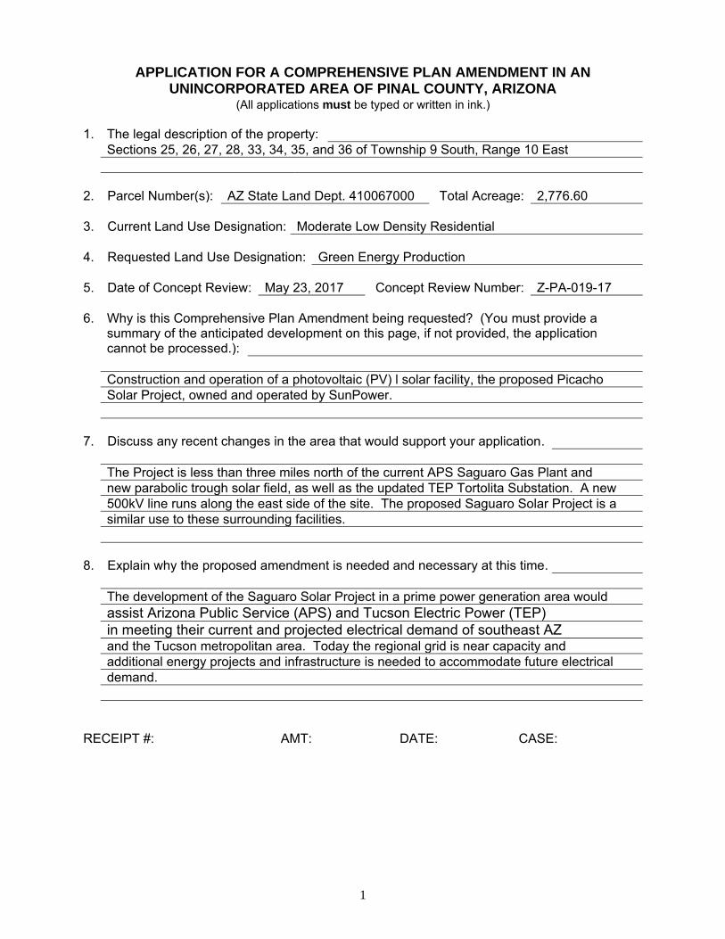
1. The legal description of the property:Sections 25, 26, 27, 28, 33, 34, 35, and 36 of Township 9 South, Range 10 East
2. Parcel Number(s): AZ State Land Dept. 410067000 Total Acreage: 2,776.60
3. Current Land Use Designation: Moderate Low Density Residential
4. Requested Land Use Designation: Green Energy Production
5. Date of Concept Review: May 23, 2017 Concept Review Number: Z-PA-019-17
6. Why is this Comprehensive Plan Amendment being requested? (You must provide asummary of the anticipated development on this page, if not provided, the applicationcannot be processed.):
Construction and operation of a photovoltaic (PV) l solar facility, the proposed Picacho Solar Project, owned and operated by SunPower.
7. Discuss any recent changes in the area that would support your application.
The Project is less than three miles north of the current APS Saguaro Gas Plant and new parabolic trough solar field, as well as the updated TEP Tortolita Substation. A new 500kV line runs along the east side of the site. The proposed Saguaro Solar Project is a similar use to these surrounding facilities.
8. Explain why the proposed amendment is needed and necessary at this time.
The development of the Saguaro Solar Project in a prime power generation area would assist Arizona Public Service (APS) and Tucson Electric Power (TEP) in meeting their current and projected electrical demand of southeast AZ and the Tucson metropolitan area. Today the regional grid is near capacity and additional energy projects and infrastructure is needed to accommodate future electrical demand.
RECEIPT #: AMT: DATE: CASE:
enriqueb
Typewritten Text
PZ-PA-002-17
enriqueb
Typewritten Text
05/31/17
enriqueb
Typewritten Text
444774
2
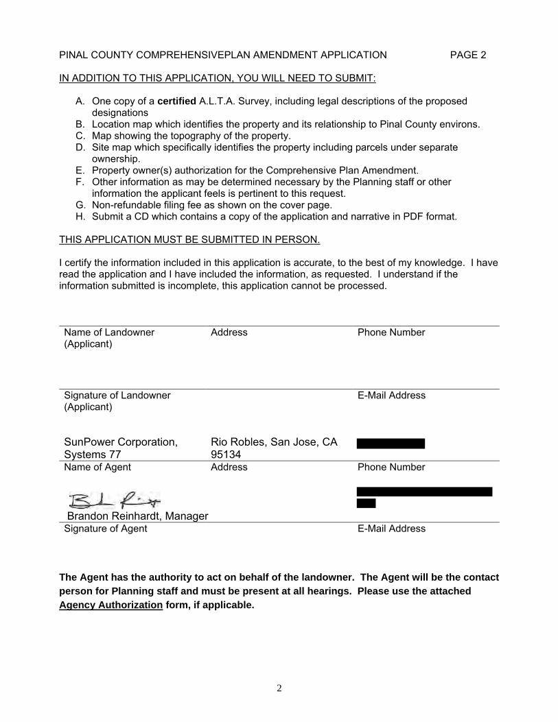
PINAL COUNTY COMPREHENSIVEPLAN AMENDMENT APPLICATION PAGE 2
IN ADDITION TO THIS APPLICATION, YOU WILL NEED TO SUBMIT:
A. One copy of a certified A.L.T.A. Survey, including legal descriptions of the proposeddesignations
B. Location map which identifies the property and its relationship to Pinal County environs.C. Map showing the topography of the property.D. Site map which specifically identifies the property including parcels under separate
ownership.E. Property owner(s) authorization for the Comprehensive Plan Amendment.F. Other information as may be determined necessary by the Planning staff or other
information the applicant feels is pertinent to this request.G. Non-refundable filing fee as shown on the cover page.H. Submit a CD which contains a copy of the application and narrative in PDF format.
THIS APPLICATION MUST BE SUBMITTED IN PERSON.
I certify the information included in this application is accurate, to the best of my knowledge. I have read the application and I have included the information, as requested. I understand if the information submitted is incomplete, this application cannot be processed.
Name of Landowner (Applicant)
Address Phone Number
Signature of Landowner (Applicant)
E-Mail Address
SunPower Corporation, Systems 77
Rio Robles, San Jose, CA 95134
Name of Agent Address Phone Number
Brandon Reinhardt, Manager Signature of Agent E-Mail Address
The Agent has the authority to act on behalf of the landowner. The Agent will be the contact
person for Planning staff and must be present at all hearings. Please use the attached
Agency Authorization form, if applicable.
3
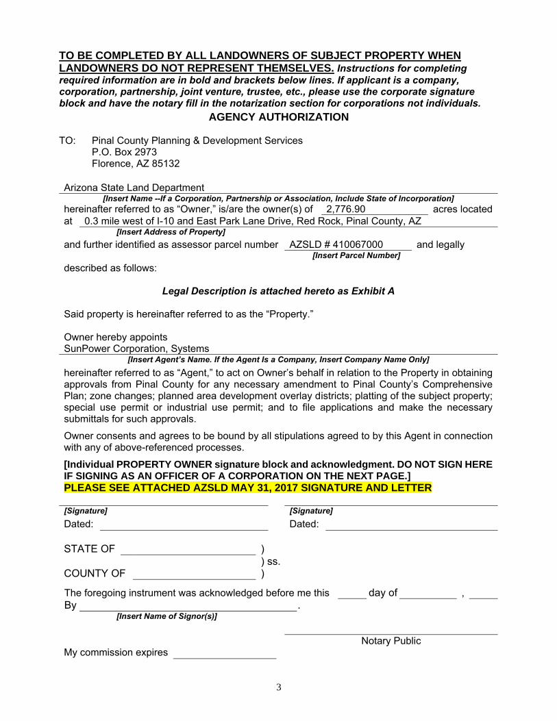
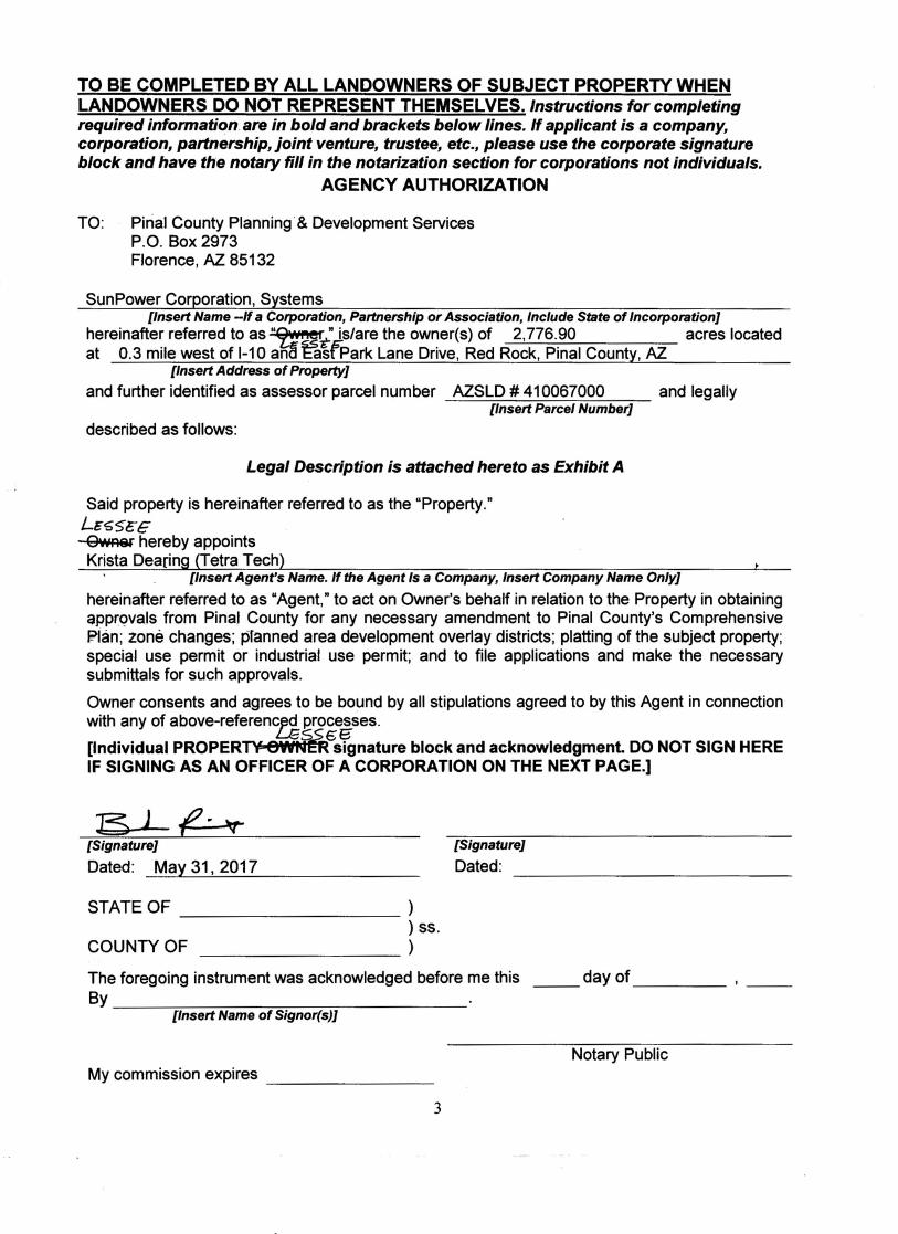
TO BE COMPLETED BY ALL LANDOWNERS OF SUBJECT PROPERTY WHEN LANDOWNERS DO NOT REPRESENT THEMSELVES. Instructions for completing required information are in bold and brackets below lines. If applicant is a company, corporation, partnership, joint venture, trustee, etc., please use the corporate signature block and have the notary fill in the notarization section for corporations not individuals.
AGENCY AUTHORIZATION
TO: Pinal County Planning & Development Services P.O. Box 2973 Florence, AZ 85132
Arizona State Land Department [Insert Name --If a Corporation, Partnership or Association, Include State of Incorporation]
hereinafter referred to as “Owner,” is/are the owner(s) of 2,776.90 acres located at 0.3 mile west of I-10 and East Park Lane Drive, Red Rock, Pinal County, AZ
[Insert Address of Property] and further identified as assessor parcel number AZSLD # 410067000 and legally
[Insert Parcel Number] described as follows:
Legal Description is attached hereto as Exhibit A
Said property is hereinafter referred to as the “Property.”
Owner hereby appoints SunPower Corporation, Systems
[Insert Agent’s Name. If the Agent Is a Company, Insert Company Name Only] hereinafter referred to as “Agent,” to act on Owner’s behalf in relation to the Property in obtaining approvals from Pinal County for any necessary amendment to Pinal County’s Comprehensive Plan; zone changes; planned area development overlay districts; platting of the subject property; special use permit or industrial use permit; and to file applications and make the necessary submittals for such approvals.
Owner consents and agrees to be bound by all stipulations agreed to by this Agent in connection with any of above-referenced processes.
[Individual PROPERTY OWNER signature block and acknowledgment. DO NOT SIGN HERE IF SIGNING AS AN OFFICER OF A CORPORATION ON THE NEXT PAGE.] PLEASE SEE ATTACHED AZSLD MAY 31, 2017 SIGNATURE AND LETTER
[Signature] [Signature] Dated: Dated:
STATE OF ) ) ss.
COUNTY OF )
The foregoing instrument was acknowledged before me this day of , By .
[Insert Name of Signor(s)]
Notary Public My commission expires
Picacho Solar Facility
Application for a
Major Comprehensive Plan Amendment
to Allow a Photovoltaic Power Generation Facility
PZ-PA-002-17
Prepared for Pinal County
Submitted by
Prepared by
May 31, 2017(Revised June 8, 30 & July 12, 2017)
SunPower Corp. iii Major Comprehensive Plan Amendment
Tetra Tech, Inc. May 31, 2017
TABLE OF CONTENTS
1.0 Executive Summary ............................................................................................................... 11.1 Proposed Land Use ........................................................................................................11.2 Location AND Accessibility ..........................................................................................11.3 Site Suitability ................................................................................................................21.4 Public Services/Utilities .................................................................................................2
2.0 Project Narrative .................................................................................................................... 32.1 Introduction ....................................................................................................................32.2 Physical Setting, Existing Uses, and Relationship to Surrounding Land Uses .............4
3.0 Comprehensive Plan Amendment Criteria ............................................................................ 63.1 Consistency with Pinal County’s Vision Components ..................................................6
Sense of Community ..................................................................................................... 6Mobility and Connectivity ............................................................................................ 6Economic Sustainability ............................................................................................... 6Open Spaces and Places ................................................................................................ 7Environmental Stewardship .......................................................................................... 7Happy, Healthy Residents ............................................................................................. 8
3.2 Consistency with the Plan’s Key Concepts Illustrated on Land Use, Economic, and Circulation Graphics ...............................................................................................................8
Consistency with the Land Use Designation Shown on the Graphics .......................... 8Consistency with the Mixed Use Activity Center Concept .......................................... 8Consistency with the Planning Guidelines Described in the Land Use Element ......... 8Quality Employment Opportunities County-Wide ....................................................... 8Viable Agriculture, Equestrian and Rural Lifestyle ..................................................... 9System of Connected Trails and Preservation of Open Space ...................................... 9Natural Resource Conservation .................................................................................. 10Wetland Resources...................................................................................................... 12Water Resources, Public Facilities/Services, and Infrastructure Support................... 12
4.0 References ............................................................................................................................ 14
LIST OF TABLES
Table 1. Species Listed under the Federal Endangered Species Act that May Occur in the Project Area ................................................................................11
LIST OF FIGURES
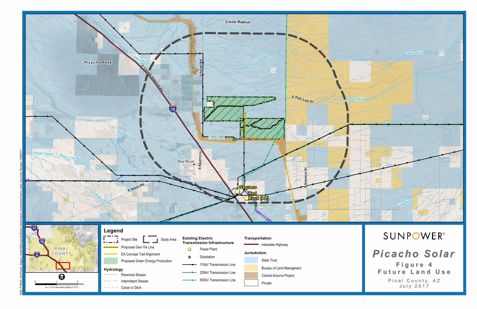
Figure 1. Proposed Project Parcels Figure 2. Existing Land Use Figure 3. Proposed Land UseFigure 4. Future Land Use

iv
LIST OF APPENDICES
Appendix A. Legal Description of AZSLD Leased Area Appendix B. Photographs and Energy Flow Diagram of a Typical PV Solar Facility
SunPower Corp. 1 Major Comprehensive Plan Amendment
Tetra Tech, Inc. May 31, 2017
1.0 EXECUTIVE SUMMARY
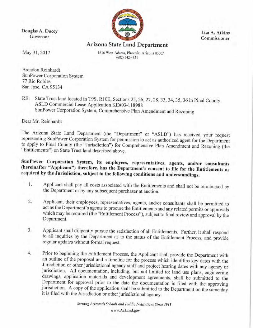
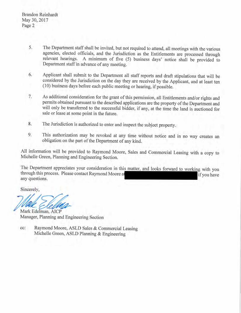
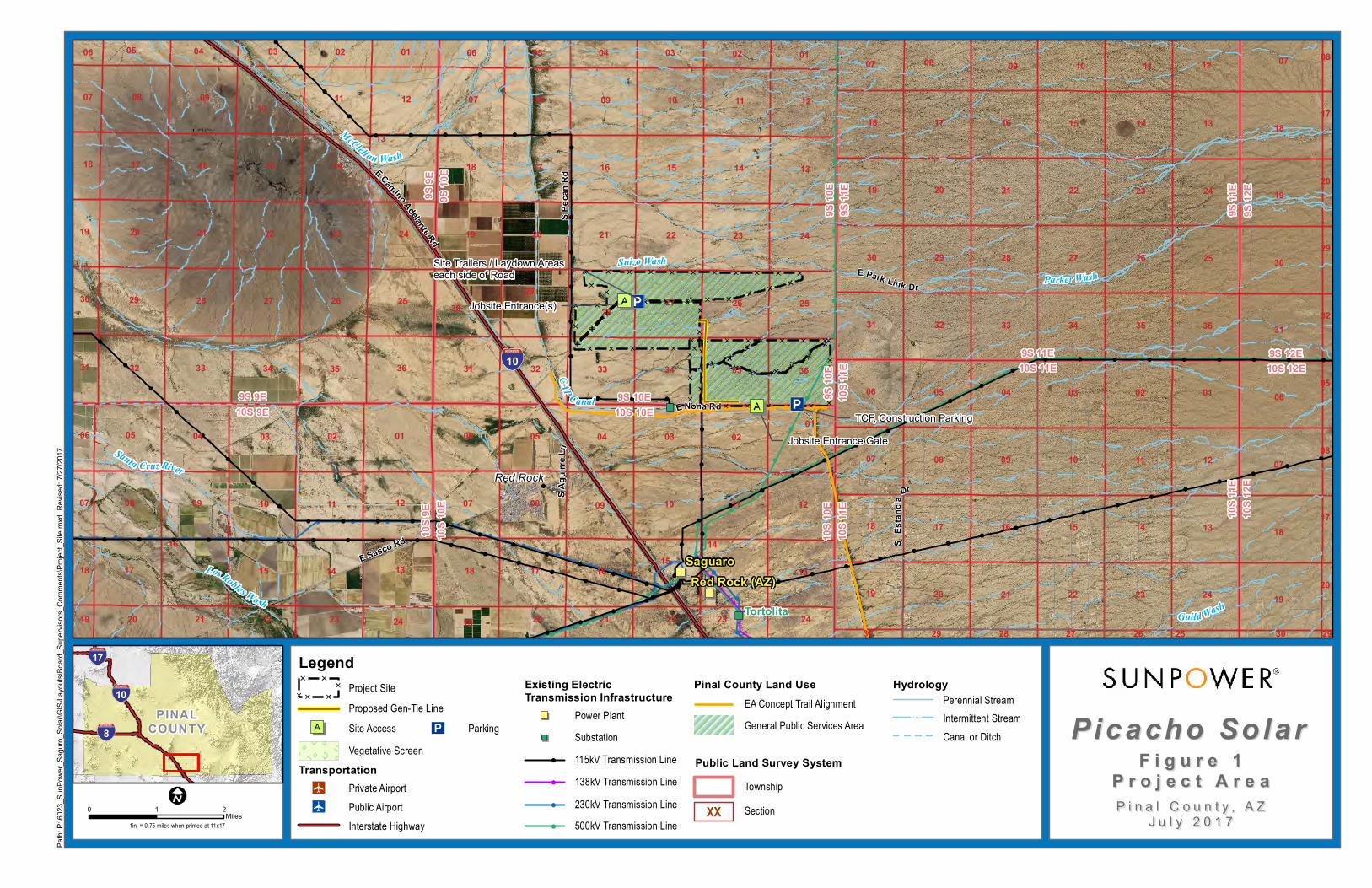
SunPower Corporation, Systems (SunPower) is requesting an amendment to the 2009 Pinal County Comprehensive Plan (Comprehensive Plan, or Plan) in order to construct and operate the proposed Picacho photovoltaic (PV) solar facility (Project) on approximately 2,776.90 acres of vacant land managed by the Arizona State Land Department (ASLD). The Project site is located on parts or all of Sections 25, 26, 27, 28, 33, 34, 35, and 36 of Township 9 South, Range 10 East with Parcel Number 410067000 (Appendix A).
The proposed Project will include a PV field with an expected electrical output of 400 megawatts (MW). The Project will require generation intertie (gen-tie) transmission lines and additional infrastructure including battery storage.
Paved rural roads provide access to the site and adjacent properties. East Park Link Drive divides the site while East Mona Road runs along the south side of the site. Interstate 10 (I-10) is located approximately 0.3 mile west of the site.
The amendment is needed to change the Comprehensive Plan land use designation for the site from Moderate Low Density Residential to Green Energy Production Services for the Project site. Subsequently, granting a zoning district change from General Rural (GR) to Industrial (I-3) would allow development of the Picacho facility in a prime power generation area, which would provide power import to assist Arizona Public Service (APS) and Tucson Electric Power (TEP) in meeting their current and projected electrical demand of southeast Arizona and the Tucson metropolitan area. Because the regional grid has been operating at near capacity, additional infrastructure is needed to accommodate future electrical demand.
The Project will tie into the grid as early as 2020, and 2 to 4 years are expected to be needed for the scheduling, planning, design, and construction of the facility in several phases of build-out.
1.1 PROPOSED LAND USE
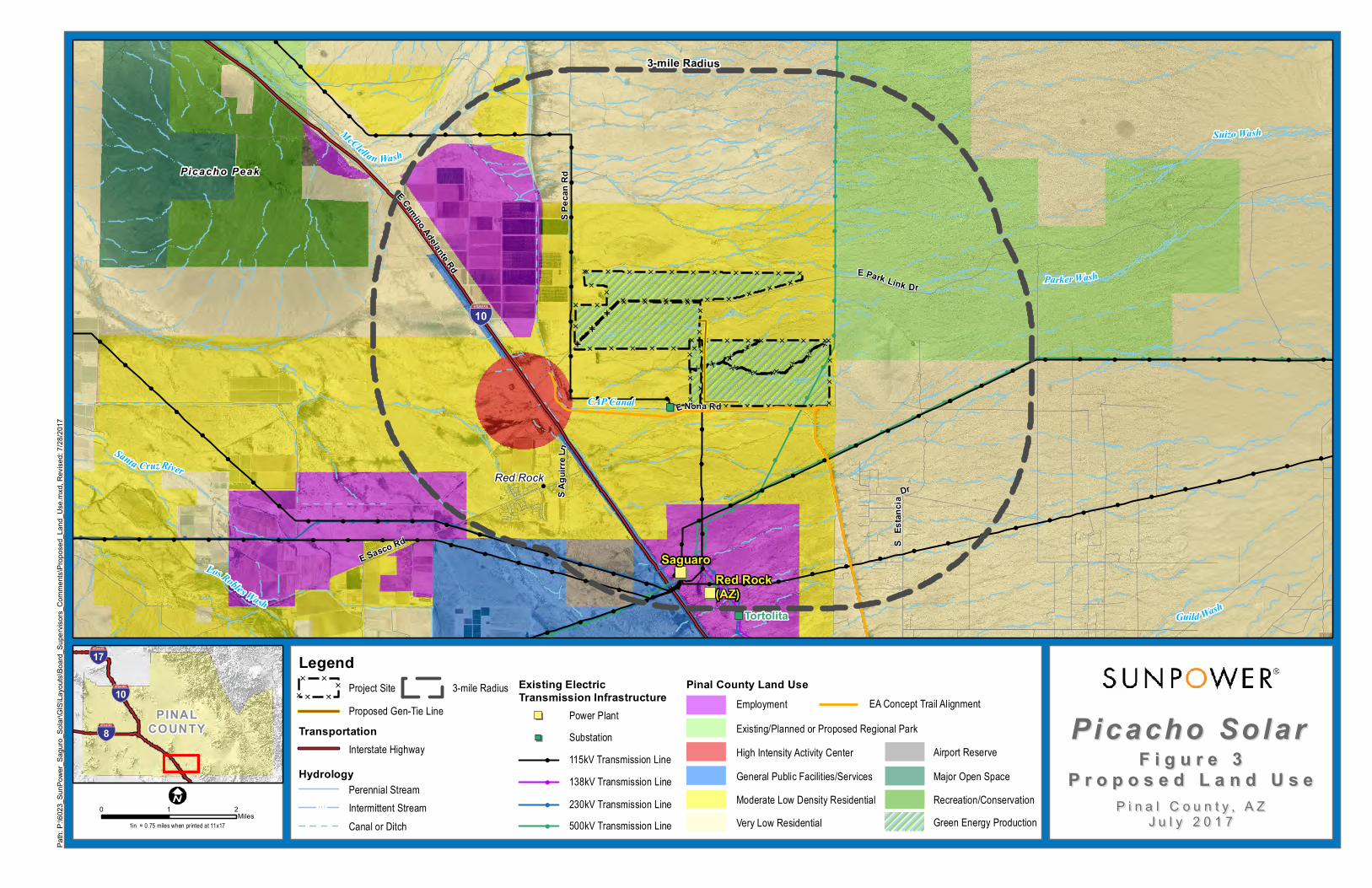
The Project site and land surrounding the Project site are currently designated as Moderate Low Density Residential. This application for proposed amendment is requested to change the land designation from Moderate Low Density Residential to Green Energy Production. The land use change would be consistent with supporting public utility infrastructure and energy uses including the APS Saguaro and TEP Tortolita Substations south of the Project site, and high-voltage transmission lines located near the eastern boundary of the site.
1.2 LOCATION AND ACCESSIBILITY
The Project site is located in the Sonoran Desert in west-central Pinal County (also referred to herein as “the County”) approximately 32 miles northwest of Tucson. The site consists of relatively flat, undeveloped Arizona State Trust land that is administered by the ASLD.
The Project site can be accessed from the I-10 frontage road via East Park Link Drive and East Mona Road. I-10 and the Union Pacific Railroad are located approximately 0.3 mile to the southwest of the site.

SunPower Corp. 2 Major Comprehensive Plan Amendment
Tetra Tech, Inc. May 31, 2017
1.3 SITE SUITABILITY
Both the Project site and the region are well suited for the proposed changes to the Comprehensive Plan. The primary criteria for determining the location of the power generation facilities include the existence of compatible adjacent and nearby land uses, minimal topographic variability, and the proximity to existing electrical infrastructure, major transportation corridors, utility corridors, and electrical load centers.
1.4 PUBLIC SERVICES/UTILITIES
There are numerous electrical distribution lines, communication cables, and canals within the vicinity of the site (Figure 2). The Project site is less than 3 miles north of the current APS Saguaro Gas and Solar Power Plant and the TEP Tortolita Substation adjacent to the east side of I-10 and Union Pacific rail facilities. Immediately east of the site is a 500-kV transmission line.
SunPower Corp. 3 Major Comprehensive Plan Amendment
Tetra Tech, Inc. May 31, 2017
2.0 PROJECT NARRATIVE
2.1 INTRODUCTION
This narrative report provides the required information to support the request for a Major Comprehensive Plan Amendment (MCPA) for the Project located in west-central Pinal County.
SunPower is requesting this amendment in order to construct and operate a solar power generating facility on the Project site. The proposed Project is expected to include a PV solar field with an expected electrical output of up to 400 MW. The Project will also require gen-tie transmission lines and additional project infrastructure including battery storage.
Should the MCPA receive approval from Pinal County, SunPower will apply for a zoning change from the Project site’s current GR zoning district to an Industrial (I-3) zoning district in order to allow for the development and operation of the solar generating facility.
Transmission lines of 115 kilovolts (kV) or greater are subject to Arizona’s Power Plant and Transmission Line Siting Law, codified in Title 14, Chapter 3, Article 2 (R14-3-219) of the Arizona Revised Statutes (ARS) §40-360 et seq. An Arizona Corporation Commission (ACC) Certificate of Environmental Compatibility (CEC) will be required to allow construction and operation of Project because the proposed gen-tie lines connecting the solar facility to the existing substation will be greater than 115 kV. All required environmental studies and public scoping activities for the proposed Project will be incorporated into a CEC application pursuant to the requirements of ARS §40-360 et seq.
Consistency with the Comprehensive Plan will be necessary in order for ACC to grant the CEC. Completing Pinal County’s Comprehensive Plan Amendment process ensures Pinal County’s authority and opportunity for review prior to the CEC process. The public scoping process conducted as part of the Pinal County zoning district change application process will supplement the CEC public involvement requirements.
Changing the Comprehensive Plan land use designation for the site from Moderate Low Density Residential to Green Energy Projection for the Project site, and subsequently granting a zoning district change from GR to I-3, would allow development of the Picacho facility in a prime power generation area, which would provide power import to assist APS and TEP in meeting their current and projected electrical demand of southeast Arizona and the Tucson metropolitan area. The regional grid has been operating at near capacity, and additional infrastructure is needed to accommodate future electrical demand.
Both the Project site and the region are well suited for the proposed changes to the Comprehensive Plan. The primary criteria for determining the location of the power generation facilities include the existence of compatible adjacent and nearby land uses, minimal topographic variability, and the proximity to existing electrical infrastructure, major transportation corridors, utility corridors, and electrical load centers.
SunPower Corp. 4 Major Comprehensive Plan Amendment
Tetra Tech, Inc. May 31, 2017
The Project site location and layout are provided in Figures 1 through 3. The site is generally level and located less than 3 miles north of the current APS Saguaro Gas and Solar Power Plant and TEP Tortolita Substation adjacent to the east side of I-10 and Union Pacific rail facilities.
2.2 PHYSICAL SETTING, EXISTING USES, AND RELATIONSHIP TO
SURROUNDING LAND USES
The Project site is located in the Sonoran Desert in west-central Pinal County approximately 32 miles northwest of Tucson (Figure 1). The site consists of relatively flat, undeveloped Arizona State Trust land that is administered by the ASLD.
The Project area consists of land managed by the ASLD, the Bureau of Reclamation (BOR), and private land under the jurisdiction of Pinal County (Figure 1). Major features in the site area include the Central Arizona Project (CAP) Canal, I-10, Picacho Mountains, Picacho Peak State Park, Union Pacific Railroad, Saguaro Power Plant, a military training facility, and several existing transmission lines and local utilities (Figures 1 through 3). The area is a mixture of flat agricultural and desert/scrub land, small mountains (including the Picacho Mountains), and several ephemeral washes.
The Project site can be accessed from the I-10 frontage road via East Park Link Drive and East Mona Road. Immediately adjacent to the site in all directions is undeveloped land except for the CAP Canal that forms the southern and western boundaries of the site (Figures 1 through 3). Agricultural areas are located to the north of East Park Link Drive. I-10 and the Union Pacific Railroad are located approximately 0.3 mile to the southwest of the site. On the west side of I-10 is the unincorporated residential community of Red Rock. Picacho Peak State Park is located approximately 5 miles northwest of the site. There are no areas designated as Open Space within the proposed Project site, and the proposed Project would not impact known recreational areas.
The Project site is located in an area designated by the Comprehensive Plan as Moderate Low Density Residential. This designation intends to “provide for a larger lot development pattern with options for suburban residential pattern. Suitability is determined by location access, existing land use patterns and natural and man-made constraints” (Pinal County 2009). Areas designated as Moderate Low Density Residential are intended as suburban residential areas with an expected 1 to 3.5 dwelling units per acre.
As an alternative to the proposed Picacho site, SunPower evaluated the General Public Facilities/Services area located south of the community of Red Rock on the west side of I-10 and the railroad. The alternative site was not selected because of the following reasons related to spanning the gen-tie line across I-10 and the railroad to tie into the Tortolita Substation:
The lengthy and costly consultation and permitting process required by the FederalHighway Administration for utility crossings and encroachments on the National HighwaySystem and/or the Interstate Highway System.
The fact railroad companies enact their own rules regarding the issuance of permits fortransmission line crossings of railroad tracks while being immune to statutory deadlines toact on permit requests; SunPower is reluctant to work within a permitting process in whichthere is little control over schedule.
SunPower Corp. 5 Major Comprehensive Plan Amendment
Tetra Tech, Inc. May 31, 2017
The logistics and costs of traffic control on both I-10 and the railroad during constructionand maintenance of the gen-tie line.
SunPower Corp. 6 Major Comprehensive Plan Amendment
Tetra Tech, Inc. May 31, 2017
3.0 COMPREHENSIVE PLAN AMENDMENT CRITERIA
The SunPower-proposed amendment request conforms to the goals, objectives, and policies of the current Comprehensive Plan by meeting the criteria outlined in the Plan’s compliance checklist (Pinal County 2009, Appendix A): The following sections are written in response to the Plan’s compliance checklist:
Consistency with Pinal County’s Vision Components, and Consistency with the Plan’s Key Concepts
3.1 CONSISTENCY WITH PINAL COUNTY’S VISION COMPONENTS
The vison components of the Comprehensive Plan include Sense of Community; Mobility and Connectivity; Economic Sustainability; Open Spaces and Places; Environmental Stewardship; Heathy, Happy Residents; and Quality Educational Opportunities.
Sense of Community
Is the proposal consistent with the Sense of Community vision component?
The proposed amendment is consistent with the Sense of Community vision component. The Project site is located with the Moderate Low Density Residential land use (Pinal County 2009, Chapter 3). This designation allows medium to high density residential, commercial, and employment (office and light industrial) land uses. Adjacent parcels to the Project site are vacant except for the CAP Canal west and south of the site, and a transmission line along the east boundary of the site that ties into the Saguaro Gas and Solar Power Plant approximately 3 miles south of the site. The proposed amendment would be consistent with the Sense of Community vision described in the Plan by consolidating energy facilities in an area that contains similar and compatible land uses, as well as vacant land.
Mobility and Connectivity
Is the proposal consistent with Mobility and Connectivity vision component?
The proposed amendment is consistent with the Mobility and Connectivity vision component. Under the goals, objectives, and policies outlined in Chapter 4 of the Plan, the County will evaluate the transportation impacts of all proposed Plan amendments and rezoning on Pinal County’s regional transportation system. The proposed Project would have minimal impact on planned land uses from traffic because the operation of the solar facility will require fewer than six employees.
There would be a temporary increase in traffic volume during the construction phases due to delivery of equipment and supplies, and commuting construction workers. Existing roads and railroads are sufficient to accommodate the anticipated construction traffic.
Economic Sustainability
Is the proposal consistent with the Economic Sustainability vision component?
The proposed amendment is consistent with the Economic Sustainability vision component. The central theme of the Economic Development element of the Comprehensive Plan (Pinal County
SunPower Corp. 7 Major Comprehensive Plan Amendment
Tetra Tech, Inc. May 31, 2017
2009, Chapter 5) focuses on the County’s ability to provide quality employment opportunities for its residents by setting specific goals, objectives, and policies. Two main goals that address this vision are:
1. Encourage a full range of quality jobs for County residents, and increase the jobs per capitaratio.
2. Encourage sustainable development consistent with the County’s environmentalpreservation philosophy.
The SunPower proposed amendment would promote economic diversity and employment opportunities in the area by providing direct and indirect employment during the construction and operation of the proposed Project. Additionally, power generated by the proposed facility could potentially support residential growth and job creation by providing clean, safe, affordable, efficient, and sustainable electricity to local communities and the region.
Open Spaces and Places
Is the proposal consistent with the Open Spaces and Places vision component?
The proposed amendment is consistent with the Open Spaces and Places vision component. The purpose of the Comprehensive Plan Open Spaces and Places (Pinal County 2009, Chapter 6) is to promote the County’s quality of life by providing passive and active recreational opportunities, conserving existing natural and cultural resources for the benefit of present future generations.
There are no existing dedicated open spaces or recreational opportunities with the Project area. However, the Comprehensive Plan and Pinal County Open Space and Trails Master Plan (LSD 2007) (also referred to herein as “Master Plan”) indicate that the BOR intends to include a 10-foot-wide paved, non-motorized path adjacent to the CAP Canal located on the west and south boundary of the Project site. The proposed amendment is not expected to conflict with the proposed BOR trail, and would not be in conflict with the planned land use. During site development, SunPower would coordinate with the BOR to ensure that SunPower complies with all required setbacks from the canal. If necessary after discussions with the BOR, SunPower would also incorporate construction mitigation measures to ensure that construction activities do not interfere with the operation of the canal or visitor experience along the proposed pedestrian path.
Environmental Stewardship
Is the proposal consistent with the Environmental Stewardship vision component?
The proposed amendment is consistent with the Environmental Stewardship vision component. Having developed other solar projects in Pinal County, SunPower takes pride in incorporating environmental stewardship and conservation practices throughout the construction and operation phases of their projects and is committed to minimizing impacts to natural and cultural resources resulting from the proposed Project. SunPower places a high priority on intergovernmental and interagency communication and cooperation, and will develop the proposed Project in compliance with all county, state, and federal laws, regulations, and guidelines.
Solar energy generation conserves natural resources and minimizes water use. The conversion of farmland to solar power generation would reduce water use and reduce annual air quality issues
SunPower Corp. 8 Major Comprehensive Plan Amendment
Tetra Tech, Inc. May 31, 2017
(dust associated with tilling). Minimization of water use and the use of renewable energy sources are both vision elements of the Comprehensive Plan (Pinal County 2009, Chapter 7). The addition of 400 MW of solar energy to the overall energy supply in the region will help to fulfill renewable energy goals.
Happy, Healthy Residents
Is the proposal consistent with the Happy, Healthy Residents vision component?
The proposed amendment is consistent with the Happy, Healthy Residents vision component. The vision articulated by county residents stresses Economic Sustainability, Sense of Community, Environmental Stewardship, Mobility, and Connectivity, and Heathy, Happy Residents as key components (Pinal County 2009, Chapter 8).
The proposed amendment would be consistent with this vision and would contribute toward the County’s goal of maintaining long term financial stability by generating revenues and contributing to the tax base, while providing clean, safe, affordable, and sustainable energy to the region.
3.2 CONSISTENCY WITH THE PLAN’S KEY CONCEPTS ILLUSTRATED ON
LAND USE, ECONOMIC, AND CIRCULATION GRAPHICS
The Comprehensive Plan includes Key Concepts (Pinal County 2009, Appendix A) that are illustrated on the Land Use, Economic, and Circulation maps.
Consistency with the Land Use Designation Shown on the Graphics
Land uses in the area surrounding the Project site are designated as Moderate Low Density Residential as indicated on the Land Use and Economic Development graphic (Pinal County 2009, Pg. 57). This application for proposed amendment is requested to change the land designation from Moderate Low Density Residential to Green Energy Production. The land use change would be consistent with supporting public utility infrastructure and energy uses including the Saguaro and Tortolita substations south of the Project site, and high-voltage transmission lines located near the eastern boundary of the site.
Consistency with the Mixed Use Activity Center Concept
The Project site is not located within a Mixed Use Activity Center. Two Mixed Use Activity Centers are located within 5 miles of the site. Picacho Peak State Park is located approximately 4 miles northwest of the site, while the Pinal Airpark is located approximately 4.5 miles southwest of the site.
Consistency with the Planning Guidelines Described in the Land Use Element
The Project is located within the West Pinal Growth Area, which is described in the Comprehensive Plan as the “heart of the Sun Corridor Megapolitan Area”, planned for urbanization bordering Native American communities with expansion of new housing and commercial development (Pinal County 2009, Pg. 3). The proposed amendment would contribute additional power generation and infrastructure within this Growth Area.
Quality Employment Opportunities County-Wide
SunPower Corp. 9 Major Comprehensive Plan Amendment
Tetra Tech, Inc. May 31, 2017
The proposed amendment is consistent with the Economic Development element by providing quality jobs during the construction and operation of the facility.
Viable Agriculture, Equestrian and Rural Lifestyle
The proposed amendment would cluster utility development in an area that now supports existing utility uses, thus limiting impacts to agriculture, or sprawl. The site contains vacant land used for grazing.
Researchers have found that solar facilities can raise temperatures in their immediate environments by as much as 5.4 to 7.3 degrees Fahrenheit. The degree of this effect varies depending on the season. While the PV heat island effect is detectable during the day, significant warming was primarily during the evening hours because the PV panels require time to cool down after sunset. However, studies have indicated that the heat island effect is highly localized to within a 90-foot radius, beyond which the heat dissipates (Barron-Gafford, et al. 2016).
System of Connected Trails and Preservation of Open Space
The proposed amendment is consistent with the Comprehensive Plan (Pinal County 2009, Chapter 6) and the Pinal County Open Space and Trails Master Plan (LSD 2007). The ComprehensivePlan’s vision is to site specific proposed open space and trails based on the suitability of activities,surrounding land uses, ecological factors, topography, viewsheds, and cultural resources. TheMaster Plan promotes quality of life of the region by providing areas of passive and activerecreational opportunities, while conserving existing resources such as natural scenic beauty, viewcorridors, wildlife habitat, agricultural resources designated at risk, and cultural heritage for thebenefit of present and future generations.
There are no existing dedicated open spaces, designated scenic resources, or designated view corridors within the Project area. However, in November 2015, the Pinal County Board of Supervisors approved the Master Plan for the Pinal County segment of the CAP National Recreational Trail (Pinal County 2016). Pinal County is currently working on an agreement with the BOR to implement the plan to construct the non-motorized, multi-use trail adjacent to the BOR Canal that bounds the site to the west and south.
The visual sensitivity of a landscape is affected by the viewing distances at which it is seen, such as up close or far away. The visual sensitivity of a landscape is also affected by the travel speed at which a person is viewing the landscape (high speeds on highway, low speeds on a trail, or stationary at a residence).
Highway and roadway users are primarily drivers of vehicles; at standard roadway speeds, their views are of moderate duration and they are fleetingly aware of their immediate surroundings. Roadway users would have low sensitivity to changes in the project area because passing landscape becomes familiar and their attention is typically focused on the roadway and traffic rather than on passing views.
The proposed Project will be visible from the summit of Picacho Peak, which is at an elevation of 3,370 feet above mean sea level (msl) (the site is at approximately 1,950 msl), and at a distance of approximately 4 miles northwest of the site. The developed recreational facilities of the park
SunPower Corp. 10 Major Comprehensive Plan Amendment
Tetra Tech, Inc. May 31, 2017
(campgrounds, trailheads, and trail to summit) are located on the northeast side of the peak approximately 6 miles northwest from the Project site. The current view of the Project site from the summit of Picacho Peak shows a flat area of the desert that has been disturbed by grazing. Man-made features including I-10, the railroad, developed agricultural land, and an ostrich farm are located between Picacho Peak and the proposed facility. The proposed solar facility would be visible from the summit of Picacho Peak, and would contrast with adjacent vegetation. There are no feasible mitigation measures that can be implemented to preserve the existing landscape character while developing the proposed solar facility.
Pedestrians on the proposed CAP National Recreational Trail would be traveling at a slow pace and would be highly sensitive to changes in views. SunPower will install metal fence slats or similar view-screening materials as approved by Pinal County in all perimeter fencing adjacent to the CAP National Recreational Trail. Additionally, drought-tolerant plants, species to be determined through consultation with landscape experts and approval by Pinal County, will be planted along the fence at 500-foot intervals in areas adjacent to the CAP National Recreational Trail.
Site infrastructure related to the proposed Picacho Solar Project would consist of the PV panel arrays, a small (i.e., 20-foot by 30-foot) metal maintenance and office building, battery storage, a potential groundwater well, the gen-tie line, and a site boundary fence. Photographs and an energy production diagram of a typical PV solar facility are presented in Appendix B. While the precise design of panel systems varies by manufacturer and model and is subject to modification as technologies evolve, the photographs provide an accurate indication of the system that would be operated on the Project site. Panels would not exceed 10 feet in height; this gives the project a much lower profile than that of a single-story building. Rows of panels are spaced nearly 18 feet apart, allowing continued agriculture activity and wildlife movement between rows.
Natural Resource Conservation
SunPower has considered potential impacts of the proposed Project, and will mitigate any potential impacts to natural or cultural resources by minimizing ground disturbance where possible. Construction and operation of the Project will be compliant with all county, state, and federal laws, regulations, and guidelines.
SunPower will conduct detailed environmental studies, including pedestrian biological, cultural, and wetlands surveys for the site, and will prepare comprehensive reports. Based on preliminary review, the Project site is located in an area with minimal sensitive resources. Results of the preliminary review of the Project site are described below.
Biological Resources
Vegetation at the site is characteristic of the Lower Colorado River Subdivision of the Sonoran Desert Desertscrub biome (Turner and Brown 1982). The CAP Canal has influenced the vegetation conditions. Mesquite (Prosopis velutina) and creosote bush (Larrea tridentate) account for a large portion of the cover upslope of the canal.
Wildlife in the Project area is likely characteristic of the Desertscrub biome. Open areas with sparse or no vegetative cover, including those that have been disturbed or altered (the site is

SunPower Corp. 11 Major Comprehensive Plan Amendment
Tetra Tech, Inc. May 31, 2017
currently heavily grazed), can also be important to some species of wildlife, notably the burrowing owl (Athene cunicularia). The CAP Canal, I-10 and the frontage road, and the Union Pacific Railroad preclude the Project form having adverse effects on wildlife movement as these features are significant obstacles to movement.
Riparian habitat in the Project area is xeroriparian (extremely dry and lacking humidity and water). These riparian habitats are generally associated with an ephemeral water supply and are important habitat for migratory birds.
Sensitive species lists from the U.S. Fish and Wildlife Service (USFWS) IPaC (Information for Planning and Consultation) were reviewed to determine if the site is within range of listed species. Table 1 provides a summary of the species that may occur at the Project site.
Table 1. Species Listed under the Federal Endangered Species Act that
May Occur in the Project Area
Common Name Taxonomic Name
ESA
Listing
Potential to Occur
Near Site
Potential
Effects of
Project
Lesser Long-nosed Bat
(Leptonycteris curasoae
yerbabauenae)
FE Possible, though key food species sparse or lacking
Negligible
Yellow-billed Cuckoo (Coccyzus americanus) FT No habit – riparian species
None
Mexican Spotted Owl (Strix occidentalis lucida) FT No habitat – prefers old growth forests
None
Sonoran Pronghorn (Antilocapra americana
sonoriensis)
FE Possible – very rare species
Negligible, range limited to southwest Arizona
Colorado Pikeminnow (Ptychocheilus lucius) FE No habit – riparian species
None
ESA = Endangered Species Act FT = Federal threatened FE = Federal endangered
Prior to construction, SunPower will conduct a biological assessment and prepare a Biological Evaluation (BE) report to summarize findings for the Project. The BE will summarize any state or federally protected species that may occur or have the potential to occur within the Project area.
The BE will provide narrative descriptions of all protected species investigated and report whether suitable habitat was identified. SunPower will report any direct observations or evidence of protected species using the Project area, and all final determinations for each species will be based on expert opinion. SunPower will describe the dominant overstory and understory vegetation communities observed within the Project area and provide a plant list of common species observed within the project limits, including any non-natives. The BE will provide appendices for the following:
A summary of AGFD’s Species of Greatest Conservation Need (SGCN) andrecommendations,
A plant evaluation to summarize plant species present within the Project area that areprotected under Arizona Department of Agriculture’s Native Plant Law, and
SunPower Corp. 12 Major Comprehensive Plan Amendment
Tetra Tech, Inc. May 31, 2017
A bird evaluation to summarize birds protected under the Migratory Bird Treaty Act andBirds of Conservation Concern that may have potential to be present within or use theProject area.
The Project will require clearance of all vegetation within the footprint of the facility. The ASLD requires mitigation for development projects that disturb Arizona State Trust Lands. The ASLD has a mitigation fee structure based on the number of damaged trees protected under the native plant law. SunPower will conduct a plant inventory based on ASLD protocols with subsequent reporting.
Cultural Resources
SunPower will conduct a Class III cultural resources survey of the Project site in compliance with the National Historic Preservation Act and State Historic Preservation Act.
SunPower will examine the AZSITE online database, which includes records from the Arizona State Museum (ASM) and Arizona State University, to determine the location of any previously conducted archaeological surveys or previously recorded archaeological sites within a 1-mile radius of the Project area. A cursory review of AZSITE indicates that approximately 20 previously recorded sites are within or very close to the Project site. Government Land Office maps and historic-age USGS quadrangle maps would also be consulted to evaluate the possible presence and location of historic features on the property.
Archaeologists will conduct a full pedestrian survey of the solar facility and the associated transmission line right-of-way following ASM and State Historic Preservation Office (SHPO) inventory standards and guidelines. Archaeologists will walk parallel transects spaced not more than 60 feet apart, recording all isolated occurrences and mapping and recording any archaeological sites identified in the Project area. This will include any historic buildings, structures, or features. A Registered Professional Archaeologist (RPA) who meets the National Secretary of the Interior’s professional standards will lead the fieldwork. SunPower will prepare a Class III survey report that meets ASLD, ASM, BOR, and SHPO standards.
Wetland Resources
SunPower will conduct a preliminary jurisdictional delineation within proposed disturbance corridors associated with the solar facility, transmission line, and access roads. Scientists trained and experienced in the U.S. Army Corps of Engineers (USACE) protocols for conducting routine wetland delineations will assess the Project area and determine the extent of wetlands and other Water of the U.S.
The National Hydrography Data, National Wetlands Inventory, aerial photography, and topographic maps will be used to prioritize locations of potential wetland areas for field assessment and to identify the connectivity of area drainage systems. The regional USACE Arid Supplement will be used to document characteristics of wetland hydrology, hydrophytic vegetation, and hydric soils. Wetlands and other Waters of the U.S. will be delineated and avoided during all Project construction and operation activities.
Water Resources, Public Facilities/Services, and Infrastructure Support
SunPower Corp. 13 Major Comprehensive Plan Amendment
Tetra Tech, Inc. May 31, 2017
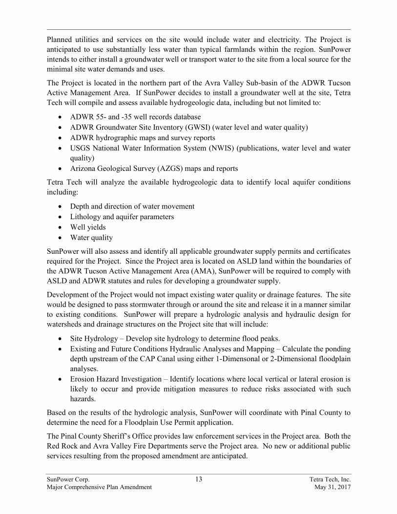
Planned utilities and services on the site would include water and electricity. The Project is anticipated to use substantially less water than typical farmlands within the region. SunPower intends to either install a groundwater well or transport water to the site from a local source for the minimal site water demands and uses.
The Project is located in the northern part of the Avra Valley Sub-basin of the ADWR Tucson Active Management Area. If SunPower decides to install a groundwater well at the site, Tetra Tech will compile and assess available hydrogeologic data, including but not limited to:
ADWR 55- and -35 well records database ADWR Groundwater Site Inventory (GWSI) (water level and water quality) ADWR hydrographic maps and survey reports USGS National Water Information System (NWIS) (publications, water level and water
quality) Arizona Geological Survey (AZGS) maps and reports
Tetra Tech will analyze the available hydrogeologic data to identify local aquifer conditions including:
Depth and direction of water movement Lithology and aquifer parameters Well yields Water quality
SunPower will also assess and identify all applicable groundwater supply permits and certificates required for the Project. Since the Project area is located on ASLD land within the boundaries of the ADWR Tucson Active Management Area (AMA), SunPower will be required to comply with ASLD and ADWR statutes and rules for developing a groundwater supply.
Development of the Project would not impact existing water quality or drainage features. The site would be designed to pass stormwater through or around the site and release it in a manner similar to existing conditions. SunPower will prepare a hydrologic analysis and hydraulic design for watersheds and drainage structures on the Project site that will include:
Site Hydrology – Develop site hydrology to determine flood peaks. Existing and Future Conditions Hydraulic Analyses and Mapping – Calculate the ponding
depth upstream of the CAP Canal using either 1-Dimensonal or 2-Dimensional floodplainanalyses.
Erosion Hazard Investigation – Identify locations where local vertical or lateral erosion islikely to occur and provide mitigation measures to reduce risks associated with suchhazards.
Based on the results of the hydrologic analysis, SunPower will coordinate with Pinal County to determine the need for a Floodplain Use Permit application.
The Pinal County Sheriff’s Office provides law enforcement services in the Project area. Both the Red Rock and Avra Valley Fire Departments serve the Project area. No new or additional public services resulting from the proposed amendment are anticipated.
SunPower Corp. 14 Major Comprehensive Plan Amendment
Tetra Tech, Inc. May 31, 2017
4.0 REFERENCES
Barron-Gafford, G.A. et al. 2016. The Photovoltaic Heat Island Effect: Larger solar plants increase local temperatures. Scientific Reports 6.
LSD (Logan Simpson Design). 2007. Pinal County Open Space and Trails Master Plan. Available at: http://www.pinalcountyaz.gov/OpenSpaceTrails/Pages/Home.aspx. Accessed April 20, 2017.
Pinal County. 2009 (Revised 2015). Pinal County Comprehensive Plan. Available at: http://www.pinalcountyaz.gov/CommunityDevelopment/Planning/Pages/CompPlan.aspx. Accessed April 16, 2017.
Pinal County. 2016. CAP Recreation Trail. Available at: http://www.pinalcountyaz.gov/OpenSpaceTrails/Pages/CAPRecTrail.aspx. Accessed on April 25, 2017.
Turner, R.M., and D.E. Brown. 1982. Sonoran Desertscrub. In D.E. Brown (ed), Biotic Communities in Desert Southwest-United States and Mexico.

SunPower Corp. Tetra Tech, Inc. Major Comprehensive Plan Amendment May 31, 2017
Figures
Jobsite Entrance GateTCF, Construction Parking
Jobsite Entrance(s)
Site Trailers / Laydown Areaseach side of Road
E Nona Rd
E Park Link Dr
E Sasco Rd
E Camino Adelante Rd
SAg u
irreL
nS P
ecan
Rd
SEs
tancia
Dr
Suizo Wash
Guild Wash
Parker Wash
McClellan Wash
Santa Cruz River
Los Robles Wash
CAP C anal
10
Tortolita
Red Rock
01
19
06
34
17
07
05
14
26
2220
20
06
28
23
07
07
21
18
26
14
24
10
15
17
14
10
09
17
25
12
19
12
20
22
34
23
08
17
05 05
36
19
21
02
15
06
02
24
17
29
04
19
33
2424
08
01
35
27
17
04
08
05
35
10
36
01
13
21
14
08
30
16
2732
18
25
31
32
01
18
20
26
19
23
18
17
29
16
13
28
31
16
09
16
13
03
15
33
04 02
05
03
03
08
07
15
27
12
14
11
11
28
02
33
24
11
30
03
12
15
03
09
09
18
05
22
07
19
27
11
01
07
20
22
24
23
21
16
20
31
25 25
09
20
21
11
07
22
30 30
07
2923
29
29
04
16
06
18
08
21
1211
10
12
18
19
30
28
18
14
22
3632
15
06
19 23
30
06 0208
13
31
29
3534
26
0908
20
17
32
13
13
04
10
10
9S 10
E9S
9E
9S 10E10S 10E
9S 10
E9S
11E
9S 10
E10
S 11E
9S 9E10S 9E
10S 12E9S 12E
10S 1
2E10
S 11E
9S 12
E9S
11E
10S 9
E10
S 10E
10S 1
0E10
S 11E
9S 11E10S 11E
Red Rock (AZ)Saguaro
17
10
8PINAL
COUNTY Picacho SolarPicacho Solar
P i n a l C o u n t y , A ZP i n a l C o u n t y , A ZJ u l y 2 0 1 7J u l y 2 0 1 7
Path:
P:\60
23_S
unPo
wer_S
aguro
_Sola
r\GIS\
Layo
uts\Bo
ard_S
uperv
isors_
Comm
ents\
Proje
ct_Sit
e.mxd
, Rev
ised:
7/27/2
017
Legend
Power Plant
115kV Transmission Line
500kV Transmission Line
Existing ElectricTransmission Infrastructure
0 21Miles
1in = 0.75 miles when printed at 11x17
F i g u r e 1F i g u r e 1P r o j e c t A r e aP r o j e c t A r e a
Project Site
Vegetative Screen
Interstate Highway
Canal or DitchIntermittent StreamPerennial Stream
Transportation
Hydrology
138kV Transmission Line230kV Transmission Line
General Public Services Area
Pinal County Land Use
TownshipSection
Public Land Survey System
Proposed Gen-Tie Line EA Concept Trail Alignment
XX
Substation
Private AirportPublic Airport
Site Access Parking

Picach o Peak
E Nona Rd
E Park Link Dr
E Sasco Rd
E Camino Adelante Rd
SAg u
irreL
nS P
ecan
Rd
SEs
tancia
Dr
Suizo Wash
Guild Wash
Parker Wash
McClellan Wash
Santa Cruz River
Los Robles Wash
CAP Canal
10
Tortolita
Red Rock
Red Rock(AZ)
Saguaro
17
10
8PINAL
COUNTY Picacho SolarPicacho Solar
P i n a l C o u n t y , A ZP i n a l C o u n t y , A ZJ u l y 2 0 1 7J u l y 2 0 1 7
Path:
P:\60
23_S
unPo
wer_S
aguro
_Sola
r\GIS\
Layo
uts\Bo
ard_S
uperv
isors_
Comm
ents\
Exist
ing_L
andu
se_1
0-3.m
xd, R
evise
d: 7/2
7/201
7
LegendExisting ElectricTransmission Infrastructure
0 21Miles
1in = 0.75 miles when printed at 11x17
F i g u r e 2F i g u r e 2E x i s t i n g L a n d U s eE x i s t i n g L a n d U s e
Project Site
Interstate Highway
Canal or DitchIntermittent StreamPerennial Stream
Transportation
Hydrology
Proposed Gen-Tie Line
Pinal County Land UseEmploymentExisting/Planned or Proposed Regional ParkHigh Intensity Activity CenterGeneral Public Facilities/ServicesModerate Low Density ResidentialVery Low Residential
EA Concept Trail Alignment
115kV Transmission Line
500kV Transmission Line
138kV Transmission Line230kV Transmission Line
SubstationPower Plant
Airport ReserveMajor Open SpaceRecreation/Conservation
3-mile Radius
3-mile Radius
Picach o Peak
E Nona Rd
E Park Link Dr
E Sasco Rd
E Camino Adelante Rd
SAg u
irreL
nS P
ecan
Rd
SEs
tancia
Dr
Suizo Wash
Guild Wash
Parker Wash
McClellan Wash
Santa Cruz River
Los Robles Wash
CAP Canal
10
Tortolita
Red Rock
Red Rock(AZ)
Saguaro
17
10
8PINAL
COUNTY Picacho SolarPicacho Solar
P i n a l C o u n t y , A ZP i n a l C o u n t y , A ZJ u l y 2 0 1 7J u l y 2 0 1 7
Path:
P:\60
23_S
unPo
wer_S
aguro
_Sola
r\GIS\
Layo
uts\Bo
ard_S
uperv
isors_
Comm
ents\
Prop
osed
_Lan
d_Us
e.mxd
, Rev
ised:
7/28/2
017
LegendExisting ElectricTransmission Infrastructure
0 21Miles
1in = 0.75 miles when printed at 11x17
F i g u r e 3F i g u r e 3P r o p o s e d L a n d U s eP r o p o s e d L a n d U s e
Project Site
Interstate Highway
Canal or DitchIntermittent StreamPerennial Stream
Transportation
Hydrology
Proposed Gen-Tie Line
Pinal County Land UseEmploymentExisting/Planned or Proposed Regional ParkHigh Intensity Activity CenterGeneral Public Facilities/ServicesModerate Low Density ResidentialVery Low Residential
EA Concept Trail Alignment
115kV Transmission Line
500kV Transmission Line
138kV Transmission Line230kV Transmission Line
SubstationPower Plant
Airport ReserveMajor Open SpaceRecreation/Conservation
3-mile Radius
3-mile Radius
Green Energy Production
Picach o Peak
E Nona Rd
E Park Link Dr
E Sasco Rd
E Camino Adelante Rd
SAg u
irreL
nS P
ecan
Rd
SEs
tancia
Dr
Suizo Wash
Greene Canal
McClellan Wash
Santa Cruz River
Parker Wash
Guild Wash
Los Robles Wash
CAP Canal
10
Red Rock
Tortolita
RedRock (AZ)
Saguaro
17
10
8PINAL
COUNTY Picacho SolarPicacho Solar
P i n a l C o u n t y , A ZP i n a l C o u n t y , A ZJ u l y 2 0 1 7J u l y 2 0 1 7
Path:
P:\60
23_S
unPo
wer_S
aguro
_Sola
r\GIS\
Layo
uts\Bo
ard_S
uperv
isors_
Comm
ents\
Futur
e_La
nd_U
se.m
xd, R
evise
d: 7/2
8/201
7
Legend
Substation115kV Transmission Line230kV Transmission Line500kV Transmission Line
Existing ElectricTransmission Infrastructure
0 21Miles
1in = 0.75 miles when printed at 11x17
F i g u r e 4F i g u r e 4F u t u r e L a n d U s eF u t u r e L a n d U s e
Project SiteInterstate Highway
Canal or DitchIntermittent StreamPerennial Stream
Transportation
Hydrology
Proposed Gen-Tie LineEA Concept Trail AlignmentProposed Green Energy Production
Power Plant
Private
State TrustBureau of Land ManagmentCentral Arizona Project
Jurisdiction
Study Area
3-mile Radius
SunPower Corp. Major Comprehensive Plan Amendment
Tetra Tech, Inc. May 31, 2017
APPENDIX A
LEGAL DESCRIPTION OF AZSLD LEASED AREA
OLD REPUBLIC NATIONAL TITLE INSURANCE COMPANY
2375 E. Camelback Road, Suite 110Phoenix, AZ 85016(602) 631-3700 Fax: (602) 277-0963
Our Order Number 4707005350
Customer Reference 300608NCT
OLD REPUBLIC NATIONAL TITLE INSURANCE COMPANY5718 Westheimer RdHouston, TX 77057
Attention: LAUREN M. GRAYWhen Replying Please Contact:
Diana Brewer
See Attached Commitment to Insure

Page 1 of 7 PagesORTIC 1613 (2006) OLD REPUBLIC NATIONAL TITLE INSURANCE COMPANY
ALTA Commitment
COMMITMENT FOR TITLE INSURANCEIssued by Old Republic National Title Insurance Company
OLD REPUBLIC NATIONAL TITLE INSURANCE COMPANY, a Florida corporation (“Company”), for a valuable consideration, commits to issue its policy or policies of title insurance, as identified in Schedule A, in favor of the Proposed Insured named in Schedule A, as owner or mortgagee of the estate or interest in the land described or referred to in Schedule A, upon payment of the premiums and charges and compliance with the Requirements; all subject to the provisions of Schedules A and B and to the Conditions of this Commitment.
This Commitment shall be effective only when the identity of the Proposed Insured and the amount of the policy or policies committed for have been inserted in Schedule A by the Company.
All liability and obligation under this Commitment shall cease and terminate six (6) months after the Effective Date or when the policy or policies committed for shall issue, whichever first occurs, provided that the failure to issue the policy or policies is not the fault of the Company.
The Company will provide a sample of the policy form upon request.
OLD REPUBLIC NATIONAL TITLE INSURANCE COMPANYA Corporation400 Second Avenue South, Minneapolis, Minnesota 55401(612) 371-1111
Issued through the office of:
Old Republic Title Agency2375 E. Camelback Road, Suite 110Phoenix, AZ 85016
Authorized Officer or Agent

Order Number: 4707005350
Page 2 of 7 PagesORTIC 1614 OLD REPUBLIC NATIONAL TITLE INSURANCE COMPANY
ALTA Commitment
SCHEDULE A
Customer Reference: 300608NCT
1. Effective Date: March 28, 2017, at 5:00 PM
2. Policy or Policies to be issued:
CLTA Standard Coverage Policy -1990Amount: Amount to come.Proposed Insured:
The printed Exceptions and Exclusions from the coverage and Limitations on Covered Risks of said Policy or Policies are set forth in Exhibit I attached. Copies of the Policy forms should be read. They are available from the office which issued this Commitment.
3. The estate or interest in the land described or referred to in this Commitment isLeasehold estate as created by that certain lease dated _____, made by and between the State of Arizona,as lessor, and __________, as lessee, for the term commencing on ________ and ending on _______,and upon the terms and conditions contained in said lease and subject to provisions contained in the leasewhich limit the right of possession, said Lease being filed in the State Land Department Records andrecorded ________ at Recorder's No. _______, Maricopa County Official Records.
4. Title to the estate or interest in the land is at the Effective Date vested in:Picacho Peak Land & Cattle, LLC, a Colorado limited liability company
5. The land referred to in this Commitment is described as follows:
Order Number: 4707005350
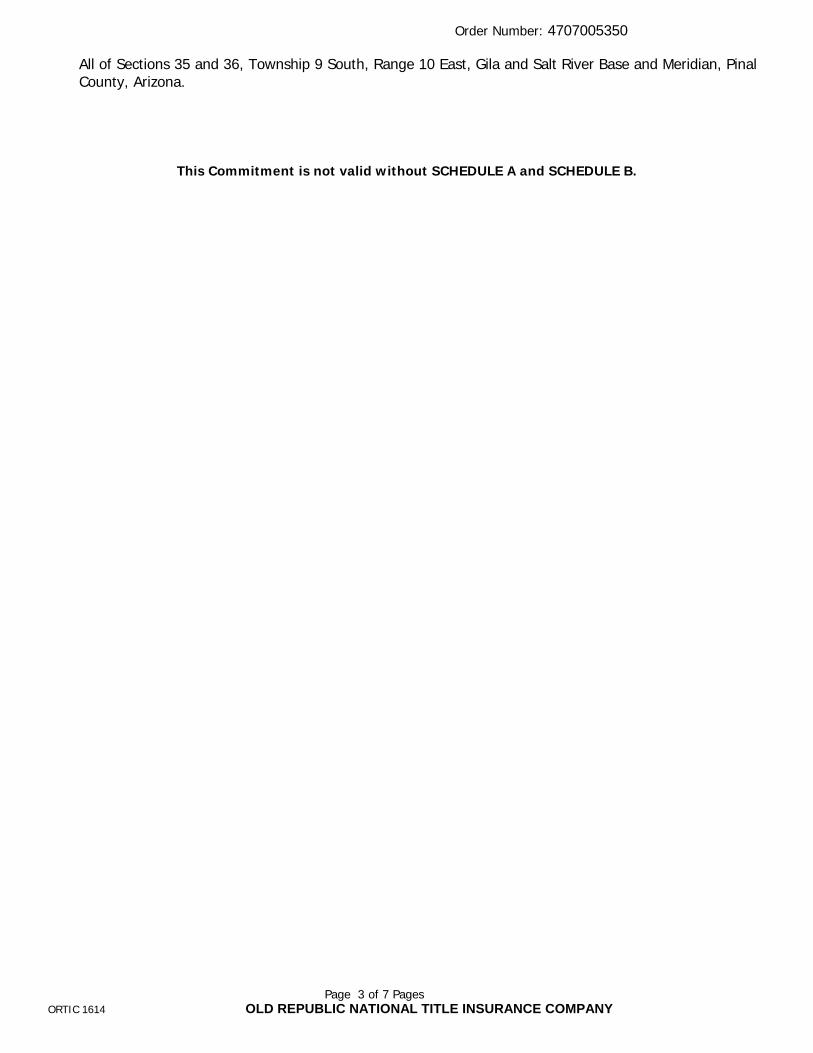
Page 3 of 7 PagesORTIC 1614 OLD REPUBLIC NATIONAL TITLE INSURANCE COMPANY
All of Sections 35 and 36, Township 9 South, Range 10 East, Gila and Salt River Base and Meridian, Pinal County, Arizona.
This Commitment is not valid without SCHEDULE A and SCHEDULE B.

Order Number: 4707005350
Page 4 of 7 PagesORTIC 1616 OLD REPUBLIC NATIONAL TITLE INSURANCE COMPANY
SCHEDULE BCustomer Reference: 300608NCT
I. REQUIREMENTS:
1. FURNISH the following documentation with respect to Picacho Peak Land & Cattle, LLC, aColorado Limited Liability Company:
1. A copy of the Articles of Organization that has been endorsed "filed" with the ColoradoCorporation Commission/Secretary of State and any Certificate of Correction, Certificate ofAmendment or Reinstatement of Articles of Organization.
2. a copy of the Operating Agreement and any amendments thereto.
3. The names of all the members.
NOTE: The right is reserved to make additional requirements or exceptions upon examination of the documents submitted to satisfy this requirement.
2. “The Company reserves the right to make additional exceptions and/or requirements uponexamination of all matters submitted to fulfill the above requirements.”
3. File Termination of Grazing Lease No. 05-246, executed by the State of Arizona, as Lessor,and Picacho Peak Land & Cattle, LLC, as Lessee, with the State Land Department.
4. File State Lease as shown in Schedule A herein with the State Land Department.
5. Record State Lease as shown in Schedule A herein.

Order Number: 4707005350
Page 5 of 7 PagesORTIC 1616 OLD REPUBLIC NATIONAL TITLE INSURANCE COMPANY
NOTE: Arizona Revised Statute 11-480 was amended effective January 1, 1991. This new legislation mandates document size, print type and margin size of all documents being submitted for recording. Non-compliance may result in the County Recorder rejecting your documents.
The following is an excerpt from Arizona Revised Statute 11-480:
1. Each instrument shall have a caption.
2. Each instrument shall be no larger than eight and one-half inches in width andno longer than fourteen inches and shall have a print size no smaller than ten-point type.
3. Each instrument shall have at least one-half inch margin across the bottom andleft and right sides from the top to the bottom. The first page shall have a topmargin of at least two inches of vertical space from left to right and shall bereserved for recordation and return address information.
Order Number: 4707005350
Page 6 of 7 PagesORTIC 1618 OLD REPUBLIC NATIONAL TITLE INSURANCE COMPANY
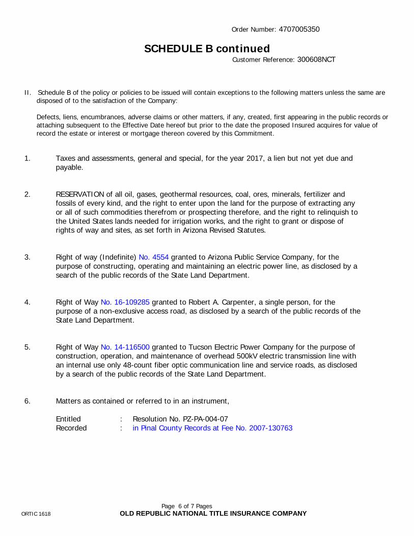
SCHEDULE B continuedCustomer Reference: 300608NCT
II. Schedule B of the policy or policies to be issued will contain exceptions to the following matters unless the same aredisposed of to the satisfaction of the Company:
Defects, liens, encumbrances, adverse claims or other matters, if any, created, first appearing in the public records orattaching subsequent to the Effective Date hereof but prior to the date the proposed Insured acquires for value ofrecord the estate or interest or mortgage thereon covered by this Commitment.
1. Taxes and assessments, general and special, for the year 2017, a lien but not yet due andpayable.
2. RESERVATION of all oil, gases, geothermal resources, coal, ores, minerals, fertilizer andfossils of every kind, and the right to enter upon the land for the purpose of extracting anyor all of such commodities therefrom or prospecting therefore, and the right to relinquish tothe United States lands needed for irrigation works, and the right to grant or dispose ofrights of way and sites, as set forth in Arizona Revised Statutes.
3. Right of way (Indefinite) No. 4554 granted to Arizona Public Service Company, for thepurpose of constructing, operating and maintaining an electric power line, as disclosed by asearch of the public records of the State Land Department.
4. Right of Way No. 16-109285 granted to Robert A. Carpenter, a single person, for thepurpose of a non-exclusive access road, as disclosed by a search of the public records of theState Land Department.
5. Right of Way No. 14-116500 granted to Tucson Electric Power Company for the purpose ofconstruction, operation, and maintenance of overhead 500kV electric transmission line withan internal use only 48-count fiber optic communication line and service roads, as disclosedby a search of the public records of the State Land Department.
6. Matters as contained or referred to in an instrument,
Entitled : Resolution No. PZ-PA-004-07Recorded : in Pinal County Records at Fee No. 2007-130763

Order Number: 4707005350
Page 7 of 7 PagesORTIC 1618 OLD REPUBLIC NATIONAL TITLE INSURANCE COMPANY
7. Any facts, rights, interests or claims which are not shown by the public records, but which could be ascertained by making inquiry of the lessors in the lease or leases described or referred to herein.
8. The terms, covenants and conditions of the lease or leases described or referred to herein and the effect of any failure to comply therewith.
CONDITIONS
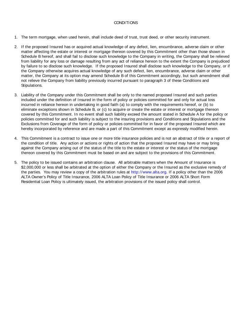
1. The term mortgage, when used herein, shall include deed of trust, trust deed, or other security instrument.
2. If the proposed Insured has or acquired actual knowledge of any defect, lien, encumbrance, adverse claim or other matter affecting the estate or interest or mortgage thereon covered by this Commitment other than those shown in Schedule B hereof, and shall fail to disclose such knowledge to the Company in writing, the Company shall be relieved from liability for any loss or damage resulting from any act of reliance hereon to the extent the Company is prejudiced by failure to so disclose such knowledge. If the proposed Insured shall disclose such knowledge to the Company, or if the Company otherwise acquires actual knowledge of any such defect, lien, encumbrance, adverse claim or other matter, the Company at its option may amend Schedule B of this Commitment accordingly, but such amendment shall not relieve the Company from liability previously incurred pursuant to paragraph 3 of these Conditions and Stipulations.
3. Liability of the Company under this Commitment shall be only to the named proposed Insured and such parties included under the definition of Insured in the form of policy or policies committed for and only for actual loss incurred in reliance hereon in undertaking in good faith (a) to comply with the requirements hereof, or (b) to eliminate exceptions shown in Schedule B, or (c) to acquire or create the estate or interest or mortgage thereon covered by this Commitment. In no event shall such liability exceed the amount stated in Schedule A for the policy or policies committed for and such liability is subject to the insuring provisions and Conditions and Stipulations and the Exclusions from Coverage of the form of policy or policies committed for in favor of the proposed Insured which are hereby incorporated by reference and are made a part of this Commitment except as expressly modified herein.
4. This Commitment is a contract to issue one or more title insurance policies and is not an abstract of title or a report of the condition of title. Any action or actions or rights of action that the proposed Insured may have or may bring against the Company arising out of the status of the title to the estate or interest or the status of the mortgage thereon covered by this Commitment must be based on and are subject to the provisions of this Commitment.
5. The policy to be issued contains an arbitration clause. All arbitrable matters when the Amount of Insurance is $2,000,000 or less shall be arbitrated at the option of either the Company or the Insured as the exclusive remedy of the parties. You may review a copy of the arbitration rules at http://www.alta.org. If a policy other than the 2006 ALTA Owner’s Policy of Title Insurance, 2006 ALTA Loan Policy of Title Insurance or 2006 ALTA Short Form Residential Loan Policy is ultimately issued, the arbitration provisions of the issued policy shall control.

Page 1 of 1
Exhibit I
CALIFORNIA LAND TITLE ASSOCIATIONSTANDARD COVERAGE POLICY - 1990
EXCLUSIONS FROM COVERAGE
The following matters are expressly excluded from the coverage of this policy and the Company will not pay loss or damage, costs, attorneys' fees or expenses which arise by reason of:
1. (a) Any law, ordinance or governmental regulation (including but not limited to building or zoning laws, ordinances, or regulations) restricting, regulating, prohibiting or relating (i) the occupancy, use, or enjoyment of the land; (ii) the character, dimensions or location of any improvement now or hereafter erected on the land; (iii) a separation in ownership or a change in the dimensions or area of the land or any parcel of which the land is or was a part; or {iv) environmental protection, or the effect of any violation of these laws, ordinances or governmental regulations, except to the extent that a notice of the enforcement thereof or a notice of a defect, lien, or encumbrance resulting from a violation or alleged violation affecting the land has been recorded in the public records at Date of Policy.-
(b) Any governmental police power not excluded by (a) above, except to the extent that a notice of the exercise thereof or notice of adefect, lien or encumbrance resulting from a violation or alleged violation affecting the land has been recorded in the public records at Date ofPolicy.
2. Rights of eminent domain unless notice of the exercise thereof has been recorded in the public records at Date of Policy, but not excluding fromcoverage any taking which has occurred prior to Date of Policy which would be binding on the rights of a purchaser for value without knowledge.
3. Defects, liens, encumbrances, adverse claims or other matters:
(a) whether or not recorded in the public records at Date of Policy, but created, suffered, assumed or agreed to by the insured claimant;
(b) not known to the Company, not recorded in the public records at Date of Policy, but known to the insured claimant and not disclosed inwriting to the Company by the insured claimant prior to the date the insured claimant became an insured under this policy;.
(c) resulting in no loss or damage to the insured claimant;
(d) attaching or created subsequent to Date of Policy; or
(e) resulting in loss or damage which would not have been sustained if the insured claimant had paid value for the insured mortgage or forthe estate or interest insured by this policy.
4. Unenforceability of the lien of the insured mortgage because of the inability or failure of the insured at Date of Policy, or the inability or failure ofany subsequent owner of the indebtedness, to comply with the applicable doing business laws of the state in which the land Is situated.
5. Invalidity or unenforceability of the lien of the insured mortgage, or claim thereof, which arises out of the transaction evidenced by the insuredmortgage and is based upon usury or any consumer credit protection or truth in lending law.
6. Any claim, which arises out of the transaction vesting in the insured the estate of interest insured by this policy or the transaction creating theinterest of the insured lender, by reason of the operation of federal bankruptcy, state insolvency or similar creditors' rights laws.
EXCEPTIONS FROM COVERAGE - SCHEDULE B, PART I
This policy does not insure against loss or damage (and the Company will not pay costs, attorneys' fees or expenses) which arise by reason of:
1. Taxes or assessments Which are not shown as existing liens by the records of any taxing authority that levies taxes or assessments on realproperty or by the public records.
Proceedings by a public agency which may result in taxes or assessments, or notices of such proceedings, whether or not shown by the records ofsuch agency or by the public records.
2. Any facts, rights, interests, or claims Which are not shown by the public records but which could be ascertained by an inspection of the landwhich may be asserted by persons in possession thereof,
3. Easements, liens or encumbrances, or claims thereof, which are not shown by the public records.
4. Discrepancies, conflicts in boundary lines, shortage in area, encroachments, or any other facts which a correct survey would disclose, and whichare not shown by the public records.
5. (a) Unpatented mining claims; (b) reservations or exceptions in patents or in Acts authorizing the issuance thereof; (c) water rights, claims or titleto water, whether or not the matters excepted under (a), (b) or (c) are shown by the public records.
6. Any lien or right to a lien for services, labor or material not shown by the public records.

rev. 07/2016
FACTS WHAT DOES OLD REPUBLIC TITLEDO WITH YOUR PERSONAL INFORMATION?
Why?
Financial companies choose how they share your personal information. Federal law gives consumers the right to limit some but not all sharing. Federal law also requires us to tell you how we collect, share, and protect your personal information. Please read this notice carefully to understand what we do.
What?
The types of personal information we collect and share depend on the product or service you have with us. This information can include:
• Social Security number and employment information• Mortgage rates and payments and account balances• Checking account information and wire transfer instructions
When you are no longer our customer, we continue to share your information as described in this notice.
How?
All financial companies need to share customers’ personal information to run their everyday business. In the section below, we list the reasons financial companies can share their customers’personal information; the reasons Old Republic Title chooses to share; and whether you can limit this sharing.
Reasons we can share your personal informationDoes Old Republic
Title share?
Can you limit
this sharing?
For our everyday business purposes — such as to process your
transactions, maintain your account(s), or respond to court orders and
legal investigations, or report to credit bureaus
Yes No
For our marketing purposes —
to offer our products and services to youNo We don’t share
For joint marketing with other financial companies No We don’t share
For our affiliates’ everyday business purposes —
information about your transactions and experiencesYes No
For our affiliates’ everyday business purposes —
information about your creditworthinessNo We don’t share
For our affiliates to market to you No We don’t share
For non-affiliates to market to you No We don’t share
Questions Go to www.oldrepublictitle.com (Contact Us)

Page 2
Who we are
Who is providing this notice? Companies with an Old Republic Title name and other affiliates. Please see below for a list of affiliates.
What we do
How does Old Republic Title protect my personal information?
To protect your personal information from unauthorized access and use, we use security measures that comply with federal law. These measures include computer safeguards and secured files and buildings. For more information, visit http://www.OldRepublicTitle.com/newnational/Contact/privacy.
How does Old Republic Title collect my personal information?
We collect your personal information, for example, when you:
• Give us your contact information or show your driver’s license
• Show your government-issued ID or provide your mortgage information
• Make a wire transfer
We also collect your personal information from others, such as credit bureaus, affiliates, or other companies.
Why can’t I limit all sharing? Federal law gives you the right to limit only:
• Sharing for affiliates’ everyday business purposes - information about your creditworthiness
• Affiliates from using your information to market to you
• Sharing for non-affiliates to market to you
State laws and individual companies may give you additional rights to limit sharing. Seethe "Other important information" section below for your rights under state law.
Definitions
Affiliates Companies related by common ownership or control. They can be financial and nonfinancial companies.
• Our affiliates include companies with an Old Republic Title name, and financialcompanies such as Attorneys’ Title Fund Services, LLC, Lex Terrae National TitleServices, Inc., Mississippi Valley Title Services Company, and The Title Company ofNorth Carolina.
Non-affiliates Companies not related by common ownership or control. They can be financial andnon-financial companies.
• Old Republic Title does not share with non-affiliates so they can market to you
Joint marketing A formal agreement between non-affiliated financial companies that together market financial products or services to you.
• Old Republic Title doesn’t jointly market.

Page 3
Other Important Information
Oregon residents only: We are providing you this notice under state law. We may share your personal information (described on page one) obtained from you or others with non-affiliate service providers with whom we contract, such as notaries and delivery services, in order to process your transactions. You may see what personal information we have collected about you in connection with your transaction (other than personal information related to a claim or legal proceeding). To see your information, please click on "Contact Us" at www.oldrepublictitle.com and submit your writtenrequest to the Legal Department. You may see and copy the information at our office or ask us to mail you a copy for a reasonable fee. If you think any information is wrong, you may submit a written request online to correct or delete it. We will let you know what actions we take. If you do not agree with our actions, you may send us a statement.
Affiliates Who May be Delivering This Notice
American First Abstract, LLC American First Title & Trust Company
American Guaranty Title Insurance Company
Attorneys' Title Fund Services, LLC
Compass Abstract, Inc.
eRecording Partners Network, LLC
Genesis Abstract, LLC Kansas City Management Group, LLC
L.T. Service Corp. Lenders Inspection Company
Lex Terrae National Title Services, Inc.
Lex Terrae, Ltd. Mara Escrow Company Mississippi Valley Title Services Company
National Title Agent's Services Company
Old Republic Branch Information Services, Inc.
Old Republic Diversified Services, Inc.
Old Republic Exchange Company
Old Republic National Title Insurance Company
Old Republic Title and Escrow of Hawaii, Ltd.
Old Republic Title Co. Old Republic Title Company of Conroe
Old Republic Title Company of Indiana
Old Republic Title Company of Nevada
Old Republic Title Company of Oklahoma
Old Republic Title Company of Oregon
Old Republic Title Company of St. Louis
Old Republic Title Company of Tennessee
Old Republic Title Information Concepts
Old Republic Title Insurance Agency, Inc.
Old Republic Title, Ltd. Republic Abstract & Settlement , LLC
Sentry Abstract Company The Title Company of North Carolina
Title Services, LLC
Trident Land Transfer Company, LLC
OLD REPUBLIC NATIONAL TITLE INSURANCE COMPANY
2375 E. Camelback Road, Suite 110Phoenix, AZ 85016(602) 631-3700 Fax: (602) 277-0963
Our Order Number 4707005352
Customer Reference 300608NCT
OLD REPUBLIC NATIONAL TITLE INSURANCE COMPANY5718 Westheimer Road, Suite 1700Houston, TX 77057
Attention: LAUREN M. GRAYWhen Replying Please Contact:
Diana Brewer
See Attached Commitment to Insure

Page 1 of 8 PagesORTIC 1613 (2006) OLD REPUBLIC NATIONAL TITLE INSURANCE COMPANY
ALTA Commitment
COMMITMENT FOR TITLE INSURANCEIssued by Old Republic National Title Insurance Company
OLD REPUBLIC NATIONAL TITLE INSURANCE COMPANY, a Florida corporation (“Company”), for a valuable consideration, commits to issue its policy or policies of title insurance, as identified in Schedule A, in favor of the Proposed Insured named in Schedule A, as owner or mortgagee of the estate or interest in the land described or referred to in Schedule A, upon payment of the premiums and charges and compliance with the Requirements; all subject to the provisions of Schedules A and B and to the Conditions of this Commitment.
This Commitment shall be effective only when the identity of the Proposed Insured and the amount of the policy or policies committed for have been inserted in Schedule A by the Company.
All liability and obligation under this Commitment shall cease and terminate six (6) months after the Effective Date or when the policy or policies committed for shall issue, whichever first occurs, provided that the failure to issue the policy or policies is not the fault of the Company.
The Company will provide a sample of the policy form upon request.
OLD REPUBLIC NATIONAL TITLE INSURANCE COMPANYA Corporation400 Second Avenue South, Minneapolis, Minnesota 55401(612) 371-1111
Issued through the office of:
Old Republic Title Agency2375 E. Camelback Road, Suite 110Phoenix, AZ 85016
Authorized Officer or Agent

Order Number: 4707005352
Page 2 of 8 PagesORTIC 1614 OLD REPUBLIC NATIONAL TITLE INSURANCE COMPANY
ALTA Commitment
SCHEDULE A
Customer Reference: 300608NCT
1. Effective Date: March 28, 2017, at 5:00 PM
2. Policy or Policies to be issued:
CLTA Standard Coverage Policy -1990Amount: Amount to come.Proposed Insured:
The printed Exceptions and Exclusions from the coverage and Limitations on Covered Risks of said Policy or Policies are set forth in Exhibit I attached. Copies of the Policy forms should be read. They are available from the office which issued this Commitment.
3. The estate or interest in the land described or referred to in this Commitment isLeasehold estate as created by that certain lease dated _____, made by and between the State of Arizona,as lessor, and __________, as lessee, for the term commencing on ________ and ending on _______,and upon the terms and conditions contained in said lease and subject to provisions contained in the leasewhich limit the right of possession, said Lease being filed in the State Land Department Records andrecorded ________ at Recorder's No. _______, Maricopa County Official Records.
4. Title to the estate or interest in the land is at the Effective Date vested in:Picacho Peak Land & Cattle, LLC, a Colorado limited liability company
5. The land referred to in this Commitment is described as follows:
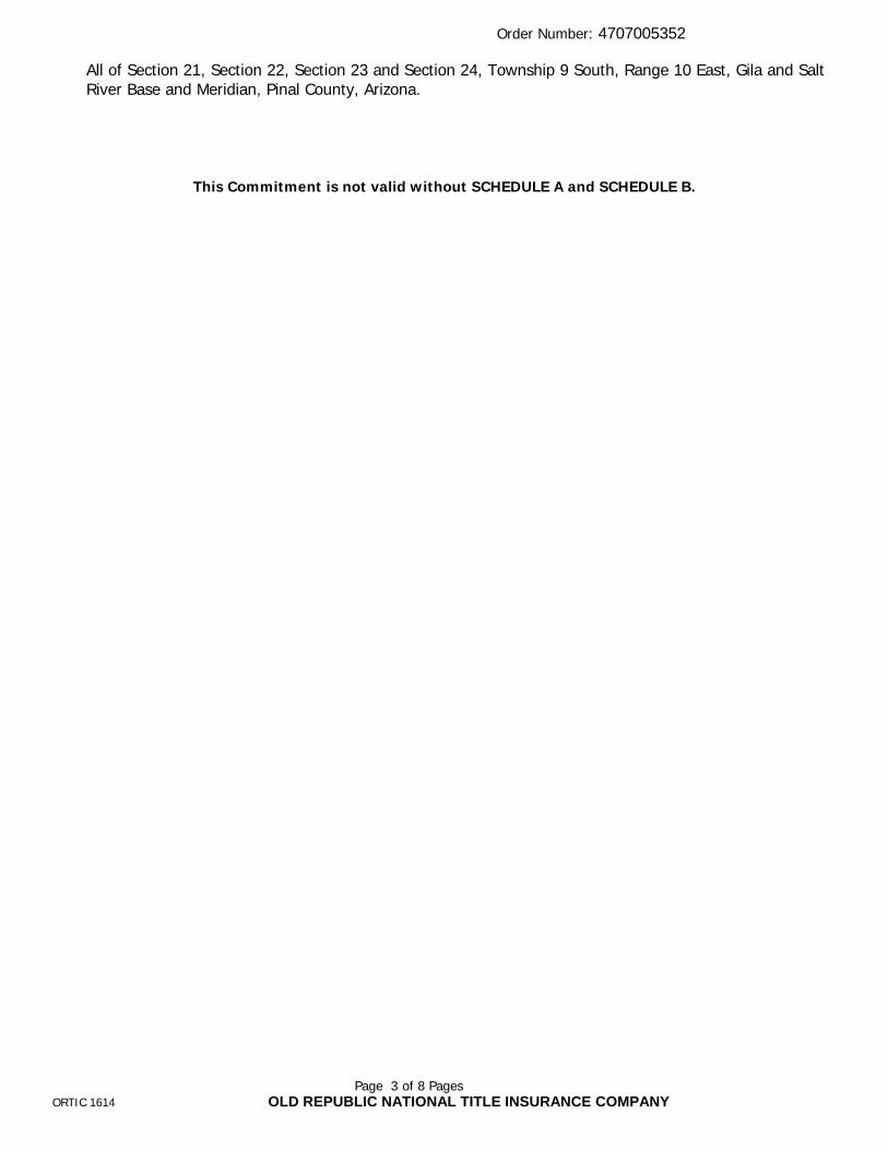
Order Number: 4707005352
Page 3 of 8 PagesORTIC 1614 OLD REPUBLIC NATIONAL TITLE INSURANCE COMPANY
All of Section 21, Section 22, Section 23 and Section 24, Township 9 South, Range 10 East, Gila and Salt River Base and Meridian, Pinal County, Arizona.
This Commitment is not valid without SCHEDULE A and SCHEDULE B.
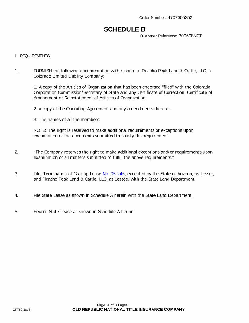
Order Number: 4707005352
Page 4 of 8 PagesORTIC 1616 OLD REPUBLIC NATIONAL TITLE INSURANCE COMPANY
SCHEDULE BCustomer Reference: 300608NCT
I. REQUIREMENTS:
1. FURNISH the following documentation with respect to Picacho Peak Land & Cattle, LLC, aColorado Limited Liability Company:
1. A copy of the Articles of Organization that has been endorsed "filed" with the ColoradoCorporation Commission/Secretary of State and any Certificate of Correction, Certificate ofAmendment or Reinstatement of Articles of Organization.
2. a copy of the Operating Agreement and any amendments thereto.
3. The names of all the members.
NOTE: The right is reserved to make additional requirements or exceptions upon examination of the documents submitted to satisfy this requirement.
2. “The Company reserves the right to make additional exceptions and/or requirements uponexamination of all matters submitted to fulfill the above requirements.”
3. File Termination of Grazing Lease No. 05-246, executed by the State of Arizona, as Lessor,and Picacho Peak Land & Cattle, LLC, as Lessee, with the State Land Department.
4. File State Lease as shown in Schedule A herein with the State Land Department.
5. Record State Lease as shown in Schedule A herein.

Order Number: 4707005352
Page 5 of 8 PagesORTIC 1616 OLD REPUBLIC NATIONAL TITLE INSURANCE COMPANY
NOTE: Arizona Revised Statute 11-480 was amended effective January 1, 1991. This new legislation mandates document size, print type and margin size of all documents being submitted for recording. Non-compliance may result in the County Recorder rejecting your documents.
The following is an excerpt from Arizona Revised Statute 11-480:
1. Each instrument shall have a caption.
2. Each instrument shall be no larger than eight and one-half inches in width and no longer than fourteen inches and shall have a print size no smaller than ten-point type.
3. Each instrument shall have at least one-half inch margin across the bottom and left and right sides from the top to the bottom. The first page shall have a top margin of at least two inches of vertical space from left to right and shall be reserved for recordation and return address information.
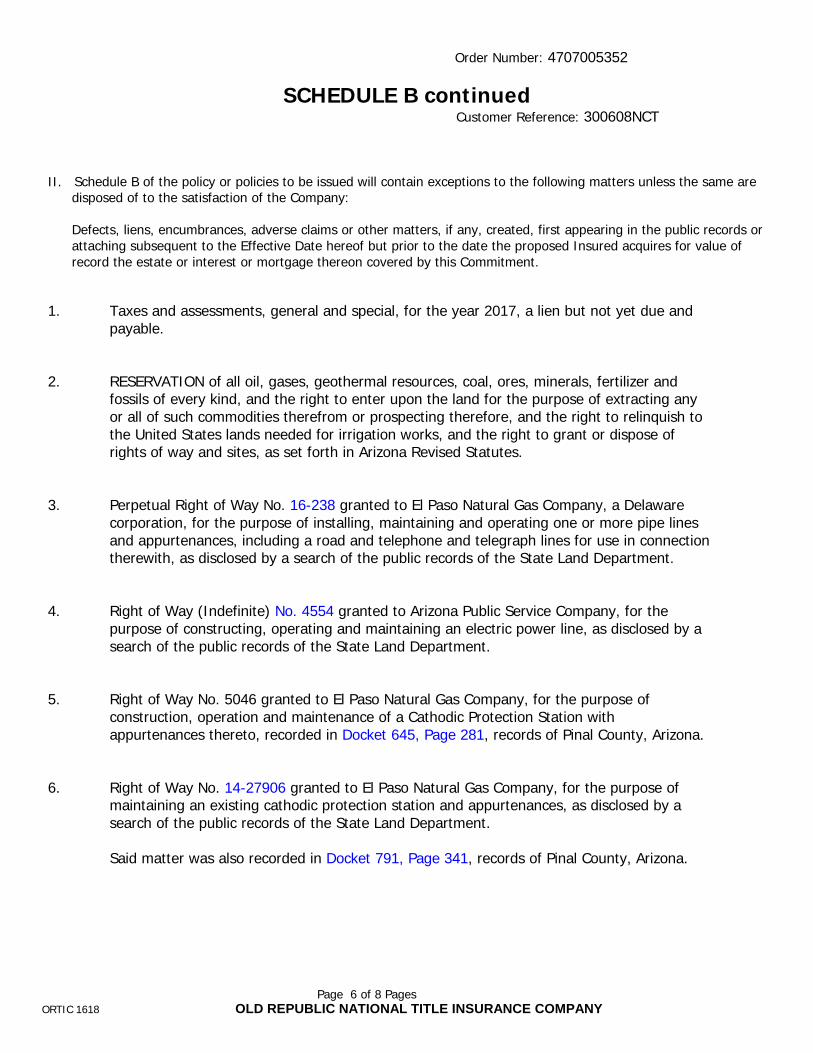
Order Number: 4707005352
Page 6 of 8 PagesORTIC 1618 OLD REPUBLIC NATIONAL TITLE INSURANCE COMPANY
SCHEDULE B continuedCustomer Reference: 300608NCT
II. Schedule B of the policy or policies to be issued will contain exceptions to the following matters unless the same are disposed of to the satisfaction of the Company:
Defects, liens, encumbrances, adverse claims or other matters, if any, created, first appearing in the public records or attaching subsequent to the Effective Date hereof but prior to the date the proposed Insured acquires for value of record the estate or interest or mortgage thereon covered by this Commitment.
1. Taxes and assessments, general and special, for the year 2017, a lien but not yet due and payable.
2. RESERVATION of all oil, gases, geothermal resources, coal, ores, minerals, fertilizer and fossils of every kind, and the right to enter upon the land for the purpose of extracting any or all of such commodities therefrom or prospecting therefore, and the right to relinquish to the United States lands needed for irrigation works, and the right to grant or dispose of rights of way and sites, as set forth in Arizona Revised Statutes.
3. Perpetual Right of Way No. 16-238 granted to El Paso Natural Gas Company, a Delaware corporation, for the purpose of installing, maintaining and operating one or more pipe lines and appurtenances, including a road and telephone and telegraph lines for use in connection therewith, as disclosed by a search of the public records of the State Land Department.
4. Right of Way (Indefinite) No. 4554 granted to Arizona Public Service Company, for the purpose of constructing, operating and maintaining an electric power line, as disclosed by a search of the public records of the State Land Department.
5. Right of Way No. 5046 granted to El Paso Natural Gas Company, for the purpose of construction, operation and maintenance of a Cathodic Protection Station with appurtenances thereto, recorded in Docket 645, Page 281, records of Pinal County, Arizona.
6. Right of Way No. 14-27906 granted to El Paso Natural Gas Company, for the purpose of maintaining an existing cathodic protection station and appurtenances, as disclosed by a search of the public records of the State Land Department.
Said matter was also recorded in Docket 791, Page 341, records of Pinal County, Arizona.
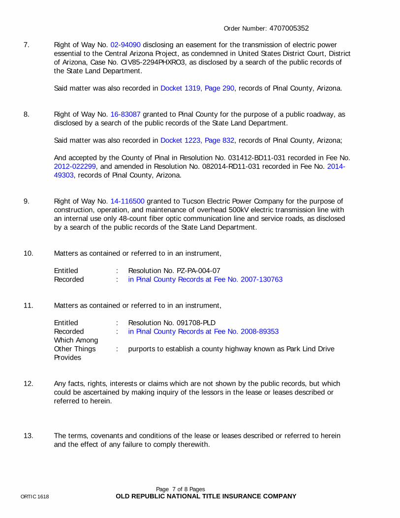
Order Number: 4707005352
Page 7 of 8 PagesORTIC 1618 OLD REPUBLIC NATIONAL TITLE INSURANCE COMPANY
7. Right of Way No. 02-94090 disclosing an easement for the transmission of electric power essential to the Central Arizona Project, as condemned in United States District Court, District of Arizona, Case No. CIV85-2294PHXRO3, as disclosed by a search of the public records of the State Land Department.
Said matter was also recorded in Docket 1319, Page 290, records of Pinal County, Arizona.
8. Right of Way No. 16-83087 granted to Pinal County for the purpose of a public roadway, as disclosed by a search of the public records of the State Land Department.
Said matter was also recorded in Docket 1223, Page 832, records of Pinal County, Arizona;
And accepted by the County of Pinal in Resolution No. 031412-BD11-031 recorded in Fee No. 2012-022299, and amended in Resolution No. 082014-RD11-031 recorded in Fee No. 2014-49303, records of Pinal County, Arizona.
9. Right of Way No. 14-116500 granted to Tucson Electric Power Company for the purpose of construction, operation, and maintenance of overhead 500kV electric transmission line with an internal use only 48-count fiber optic communication line and service roads, as disclosed by a search of the public records of the State Land Department.
10. Matters as contained or referred to in an instrument,
Entitled : Resolution No. PZ-PA-004-07Recorded : in Pinal County Records at Fee No. 2007-130763
11. Matters as contained or referred to in an instrument,
Entitled : Resolution No. 091708-PLDRecorded : in Pinal County Records at Fee No. 2008-89353Which Among Other Things Provides
: purports to establish a county highway known as Park Lind Drive
12. Any facts, rights, interests or claims which are not shown by the public records, but whichcould be ascertained by making inquiry of the lessors in the lease or leases described or referred to herein.
13. The terms, covenants and conditions of the lease or leases described or referred to herein and the effect of any failure to comply therewith.

Order Number: 4707005352
Page 8 of 8 PagesORTIC 1618 OLD REPUBLIC NATIONAL TITLE INSURANCE COMPANY

CONDITIONS
1. The term mortgage, when used herein, shall include deed of trust, trust deed, or other security instrument.
2. If the proposed Insured has or acquired actual knowledge of any defect, lien, encumbrance, adverse claim or other matter affecting the estate or interest or mortgage thereon covered by this Commitment other than those shown in Schedule B hereof, and shall fail to disclose such knowledge to the Company in writing, the Company shall be relieved from liability for any loss or damage resulting from any act of reliance hereon to the extent the Company is prejudiced by failure to so disclose such knowledge. If the proposed Insured shall disclose such knowledge to the Company, or if the Company otherwise acquires actual knowledge of any such defect, lien, encumbrance, adverse claim or other matter, the Company at its option may amend Schedule B of this Commitment accordingly, but such amendment shall not relieve the Company from liability previously incurred pursuant to paragraph 3 of these Conditions and Stipulations.
3. Liability of the Company under this Commitment shall be only to the named proposed Insured and such parties included under the definition of Insured in the form of policy or policies committed for and only for actual loss incurred in reliance hereon in undertaking in good faith (a) to comply with the requirements hereof, or (b) to eliminate exceptions shown in Schedule B, or (c) to acquire or create the estate or interest or mortgage thereon covered by this Commitment. In no event shall such liability exceed the amount stated in Schedule A for the policy or policies committed for and such liability is subject to the insuring provisions and Conditions and Stipulations and the Exclusions from Coverage of the form of policy or policies committed for in favor of the proposed Insured which are hereby incorporated by reference and are made a part of this Commitment except as expressly modified herein.
4. This Commitment is a contract to issue one or more title insurance policies and is not an abstract of title or a report of the condition of title. Any action or actions or rights of action that the proposed Insured may have or may bring against the Company arising out of the status of the title to the estate or interest or the status of the mortgage thereon covered by this Commitment must be based on and are subject to the provisions of this Commitment.
5. The policy to be issued contains an arbitration clause. All arbitrable matters when the Amount of Insurance is $2,000,000 or less shall be arbitrated at the option of either the Company or the Insured as the exclusive remedy of the parties. You may review a copy of the arbitration rules at http://www.alta.org. If a policy other than the 2006 ALTA Owner’s Policy of Title Insurance, 2006 ALTA Loan Policy of Title Insurance or 2006 ALTA Short Form Residential Loan Policy is ultimately issued, the arbitration provisions of the issued policy shall control.
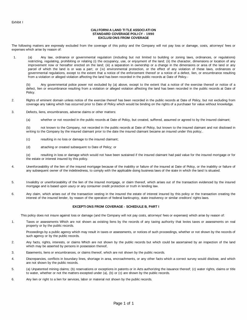
Page 1 of 1
Exhibit I
CALIFORNIA LAND TITLE ASSOCIATIONSTANDARD COVERAGE POLICY - 1990
EXCLUSIONS FROM COVERAGE
The following matters are expressly excluded from the coverage of this policy and the Company will not pay loss or damage, costs, attorneys' fees or expenses which arise by reason of:
1. (a) Any law, ordinance or governmental regulation (including but not limited to building or zoning laws, ordinances, or regulations) restricting, regulating, prohibiting or relating (i) the occupancy, use, or enjoyment of the land; (ii) the character, dimensions or location of any improvement now or hereafter erected on the land; (iii) a separation in ownership or a change in the dimensions or area of the land or any parcel of which the land is or was a part; or {iv) environmental protection, or the effect of any violation of these laws, ordinances or governmental regulations, except to the extent that a notice of the enforcement thereof or a notice of a defect, lien, or encumbrance resulting from a violation or alleged violation affecting the land has been recorded in the public records at Date of Policy.-
(b) Any governmental police power not excluded by (a) above, except to the extent that a notice of the exercise thereof or notice of a defect, lien or encumbrance resulting from a violation or alleged violation affecting the land has been recorded in the public records at Date of Policy.
2. Rights of eminent domain unless notice of the exercise thereof has been recorded in the public records at Date of Policy, but not excluding from coverage any taking which has occurred prior to Date of Policy which would be binding on the rights of a purchaser for value without knowledge.
3. Defects, liens, encumbrances, adverse claims or other matters:
(a) whether or not recorded in the public records at Date of Policy, but created, suffered, assumed or agreed to by the insured claimant;
(b) not known to the Company, not recorded in the public records at Date of Policy, but known to the insured claimant and not disclosed in writing to the Company by the insured claimant prior to the date the insured claimant became an insured under this policy;.
(c) resulting in no loss or damage to the insured claimant;
(d) attaching or created subsequent to Date of Policy; or
(e) resulting in loss or damage which would not have been sustained if the insured claimant had paid value for the insured mortgage or for the estate or interest insured by this policy.
4. Unenforceability of the lien of the insured mortgage because of the inability or failure of the insured at Date of Policy, or the inability or failure of any subsequent owner of the indebtedness, to comply with the applicable doing business laws of the state in which the land Is situated.
5. Invalidity or unenforceability of the lien of the insured mortgage, or claim thereof, which arises out of the transaction evidenced by the insured mortgage and is based upon usury or any consumer credit protection or truth in lending law.
6. Any claim, which arises out of the transaction vesting in the insured the estate of interest insured by this policy or the transaction creating the interest of the insured lender, by reason of the operation of federal bankruptcy, state insolvency or similar creditors' rights laws.
EXCEPTIONS FROM COVERAGE - SCHEDULE B, PART I
This policy does not insure against loss or damage (and the Company will not pay costs, attorneys' fees or expenses) which arise by reason of:
1. Taxes or assessments Which are not shown as existing liens by the records of any taxing authority that levies taxes or assessments on real property or by the public records.
Proceedings by a public agency which may result in taxes or assessments, or notices of such proceedings, whether or not shown by the records of such agency or by the public records.
2. Any facts, rights, interests, or claims Which are not shown by the public records but which could be ascertained by an inspection of the land which may be asserted by persons in possession thereof,
3. Easements, liens or encumbrances, or claims thereof, which are not shown by the public records.
4. Discrepancies, conflicts in boundary lines, shortage in area, encroachments, or any other facts which a correct survey would disclose, and which are not shown by the public records.
5. (a) Unpatented mining claims; (b) reservations or exceptions in patents or in Acts authorizing the issuance thereof; (c) water rights, claims or title to water, whether or not the matters excepted under (a), (b) or (c) are shown by the public records.
6. Any lien or right to a lien for services, labor or material not shown by the public records.
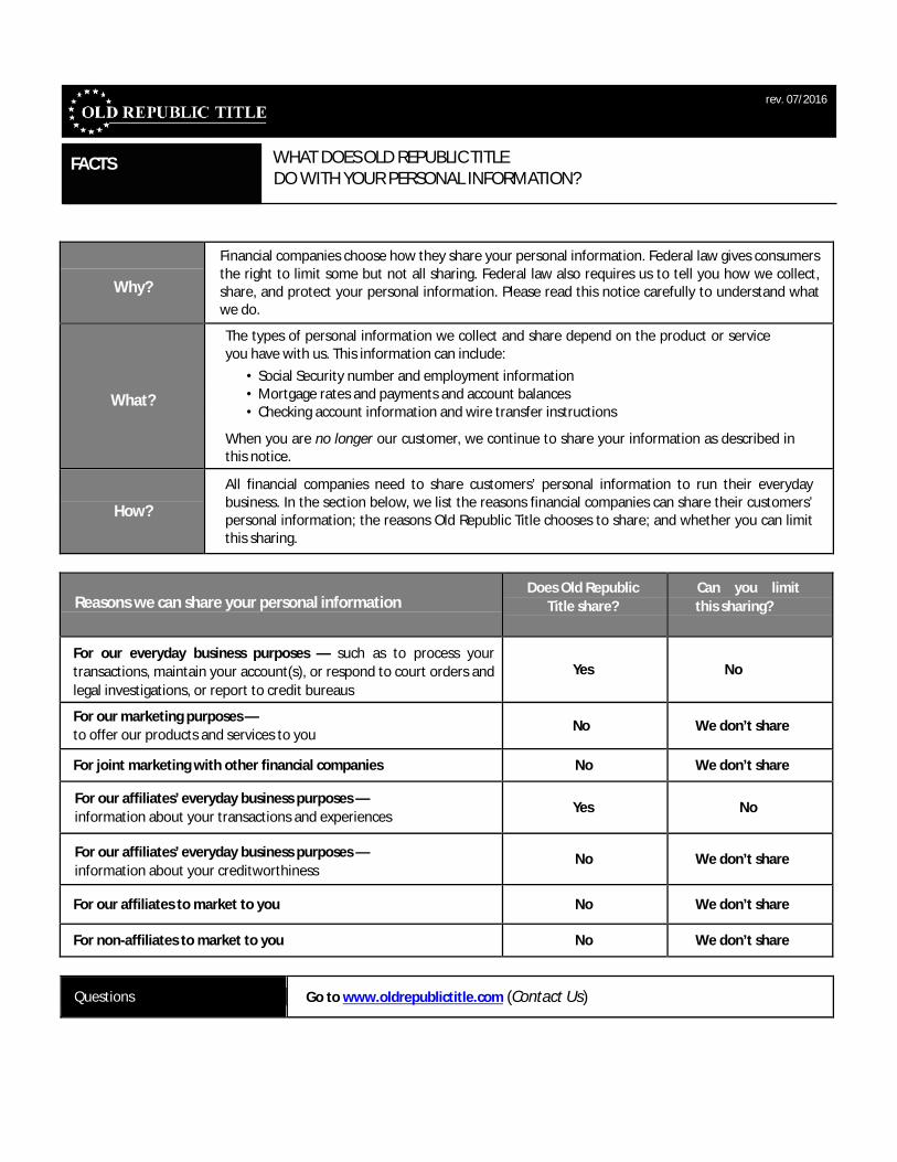
rev. 07/2016
FACTS WHAT DOES OLD REPUBLIC TITLEDO WITH YOUR PERSONAL INFORMATION?
Why?
Financial companies choose how they share your personal information. Federal law gives consumers the right to limit some but not all sharing. Federal law also requires us to tell you how we collect, share, and protect your personal information. Please read this notice carefully to understand what we do.
What?
The types of personal information we collect and share depend on the product or service you have with us. This information can include:
• Social Security number and employment information• Mortgage rates and payments and account balances• Checking account information and wire transfer instructions
When you are no longer our customer, we continue to share your information as described in this notice.
How?
All financial companies need to share customers’ personal information to run their everyday business. In the section below, we list the reasons financial companies can share their customers’personal information; the reasons Old Republic Title chooses to share; and whether you can limit this sharing.
Reasons we can share your personal informationDoes Old Republic
Title share?
Can you limit
this sharing?
For our everyday business purposes — such as to process your
transactions, maintain your account(s), or respond to court orders and
legal investigations, or report to credit bureaus
Yes No
For our marketing purposes —
to offer our products and services to youNo We don’t share
For joint marketing with other financial companies No We don’t share
For our affiliates’ everyday business purposes —
information about your transactions and experiencesYes No
For our affiliates’ everyday business purposes —
information about your creditworthinessNo We don’t share
For our affiliates to market to you No We don’t share
For non-affiliates to market to you No We don’t share
Questions Go to www.oldrepublictitle.com (Contact Us)

Page 2
Who we are
Who is providing this notice? Companies with an Old Republic Title name and other affiliates. Please see below for a list of affiliates.
What we do
How does Old Republic Title protect my personal information?
To protect your personal information from unauthorized access and use, we use security measures that comply with federal law. These measures include computer safeguards and secured files and buildings. For more information, visit http://www.OldRepublicTitle.com/newnational/Contact/privacy.
How does Old Republic Title collect my personal information?
We collect your personal information, for example, when you:
• Give us your contact information or show your driver’s license
• Show your government-issued ID or provide your mortgage information
• Make a wire transfer
We also collect your personal information from others, such as credit bureaus, affiliates, or other companies.
Why can’t I limit all sharing? Federal law gives you the right to limit only:
• Sharing for affiliates’ everyday business purposes - information about your creditworthiness
• Affiliates from using your information to market to you
• Sharing for non-affiliates to market to you
State laws and individual companies may give you additional rights to limit sharing. Seethe "Other important information" section below for your rights under state law.
Definitions
Affiliates Companies related by common ownership or control. They can be financial and nonfinancial companies.
• Our affiliates include companies with an Old Republic Title name, and financial companies such as Attorneys’ Title Fund Services, LLC, Lex Terrae National Title Services, Inc., Mississippi Valley Title Services Company, and The Title Company ofNorth Carolina.
Non-affiliates Companies not related by common ownership or control. They can be financial andnon-financial companies.
• Old Republic Title does not share with non-affiliates so they can market to you
Joint marketing A formal agreement between non-affiliated financial companies that together market financial products or services to you.
• Old Republic Title doesn’t jointly market.
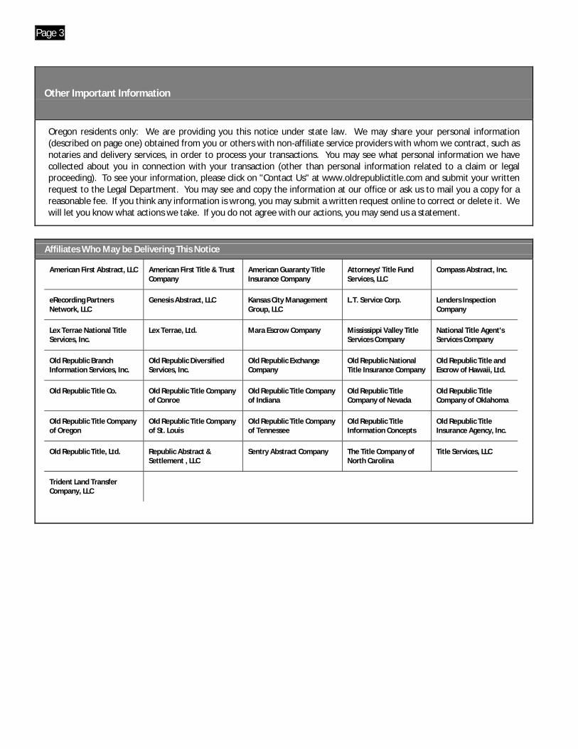
Page 3
Other Important Information
Oregon residents only: We are providing you this notice under state law. We may share your personal information (described on page one) obtained from you or others with non-affiliate service providers with whom we contract, such as notaries and delivery services, in order to process your transactions. You may see what personal information we have collected about you in connection with your transaction (other than personal information related to a claim or legal proceeding). To see your information, please click on "Contact Us" at www.oldrepublictitle.com and submit your writtenrequest to the Legal Department. You may see and copy the information at our office or ask us to mail you a copy for a reasonable fee. If you think any information is wrong, you may submit a written request online to correct or delete it. We will let you know what actions we take. If you do not agree with our actions, you may send us a statement.
Affiliates Who May be Delivering This Notice
American First Abstract, LLC American First Title & Trust Company
American Guaranty Title Insurance Company
Attorneys' Title Fund Services, LLC
Compass Abstract, Inc.
eRecording Partners Network, LLC
Genesis Abstract, LLC Kansas City Management Group, LLC
L.T. Service Corp. Lenders Inspection Company
Lex Terrae National Title Services, Inc.
Lex Terrae, Ltd. Mara Escrow Company Mississippi Valley Title Services Company
National Title Agent's Services Company
Old Republic Branch Information Services, Inc.
Old Republic Diversified Services, Inc.
Old Republic Exchange Company
Old Republic National Title Insurance Company
Old Republic Title and Escrow of Hawaii, Ltd.
Old Republic Title Co. Old Republic Title Company of Conroe
Old Republic Title Company of Indiana
Old Republic Title Company of Nevada
Old Republic Title Company of Oklahoma
Old Republic Title Company of Oregon
Old Republic Title Company of St. Louis
Old Republic Title Company of Tennessee
Old Republic Title Information Concepts
Old Republic Title Insurance Agency, Inc.
Old Republic Title, Ltd. Republic Abstract & Settlement , LLC
Sentry Abstract Company The Title Company of North Carolina
Title Services, LLC
Trident Land Transfer Company, LLC
OLD REPUBLIC NATIONAL TITLE INSURANCE COMPANY
2375 E. Camelback Road, Suite 110Phoenix, AZ 85016(602) 631-3700 Fax: (602) 277-0963
Our Order Number 4707005351
Customer Reference 300608NCT
OLD REPUBLIC NATIONAL TITLE INSURANCE COMPANY5718 Westheimer Road, Suite 1700Houston, TX 77057
Attention: LAUREN M. GRAYWhen Replying Please Contact:
Diana Brewer
See Attached Commitment to Insure
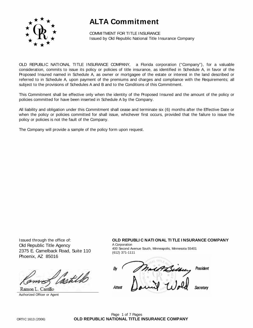
Page 1 of 7 PagesORTIC 1613 (2006) OLD REPUBLIC NATIONAL TITLE INSURANCE COMPANY
ALTA Commitment
COMMITMENT FOR TITLE INSURANCEIssued by Old Republic National Title Insurance Company
OLD REPUBLIC NATIONAL TITLE INSURANCE COMPANY, a Florida corporation (“Company”), for a valuable consideration, commits to issue its policy or policies of title insurance, as identified in Schedule A, in favor of the Proposed Insured named in Schedule A, as owner or mortgagee of the estate or interest in the land described or referred to in Schedule A, upon payment of the premiums and charges and compliance with the Requirements; all subject to the provisions of Schedules A and B and to the Conditions of this Commitment.
This Commitment shall be effective only when the identity of the Proposed Insured and the amount of the policy or policies committed for have been inserted in Schedule A by the Company.
All liability and obligation under this Commitment shall cease and terminate six (6) months after the Effective Date or when the policy or policies committed for shall issue, whichever first occurs, provided that the failure to issue the policy or policies is not the fault of the Company.
The Company will provide a sample of the policy form upon request.
OLD REPUBLIC NATIONAL TITLE INSURANCE COMPANYA Corporation400 Second Avenue South, Minneapolis, Minnesota 55401(612) 371-1111
Issued through the office of:
Old Republic Title Agency2375 E. Camelback Road, Suite 110Phoenix, AZ 85016
Authorized Officer or Agent
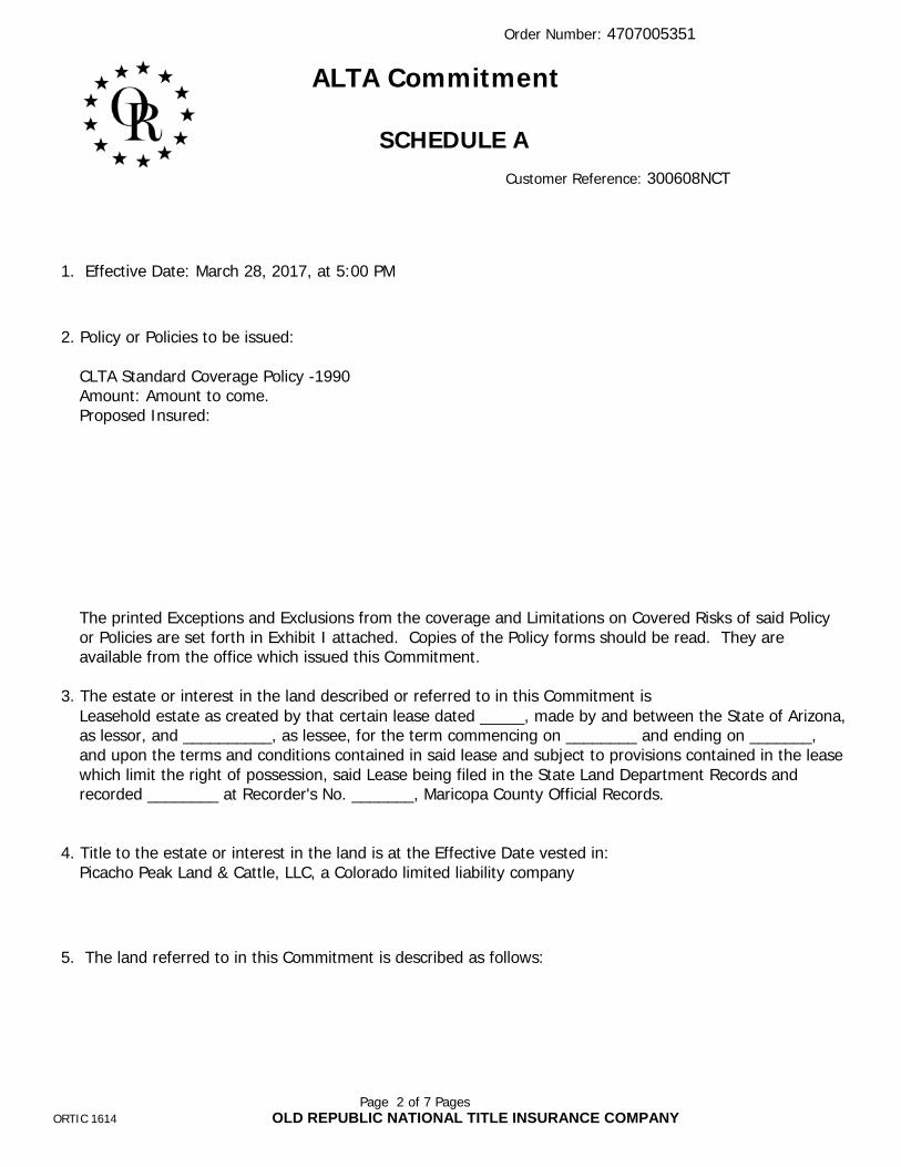
Order Number: 4707005351
Page 2 of 7 PagesORTIC 1614 OLD REPUBLIC NATIONAL TITLE INSURANCE COMPANY
ALTA Commitment
SCHEDULE A
Customer Reference: 300608NCT
1. Effective Date: March 28, 2017, at 5:00 PM
2. Policy or Policies to be issued:
CLTA Standard Coverage Policy -1990Amount: Amount to come.Proposed Insured:
The printed Exceptions and Exclusions from the coverage and Limitations on Covered Risks of said Policy or Policies are set forth in Exhibit I attached. Copies of the Policy forms should be read. They are available from the office which issued this Commitment.
3. The estate or interest in the land described or referred to in this Commitment isLeasehold estate as created by that certain lease dated _____, made by and between the State of Arizona, as lessor, and __________, as lessee, for the term commencing on ________ and ending on _______, and upon the terms and conditions contained in said lease and subject to provisions contained in the lease which limit the right of possession, said Lease being filed in the State Land Department Records and recorded ________ at Recorder's No. _______, Maricopa County Official Records.
4. Title to the estate or interest in the land is at the Effective Date vested in:Picacho Peak Land & Cattle, LLC, a Colorado limited liability company
5. The land referred to in this Commitment is described as follows:
Order Number: 4707005351
Page 3 of 7 PagesORTIC 1614 OLD REPUBLIC NATIONAL TITLE INSURANCE COMPANY
See Legal Description Exhibit.
This Commitment is not valid without SCHEDULE A and SCHEDULE B.

Order Number: 4707005351
Page 4 of 7 PagesORTIC 1616 OLD REPUBLIC NATIONAL TITLE INSURANCE COMPANY
SCHEDULE BCustomer Reference: 300608NCT
I. REQUIREMENTS:
1. FURNISH the following documentation with respect to Picacho Peak Land & Cattle, LLC, aColorado Limited Liability Company:
1. A copy of the Articles of Organization that has been endorsed "filed" with the ColoradoCorporation Commission/Secretary of State and any Certificate of Correction, Certificate ofAmendment or Reinstatement of Articles of Organization.
2. a copy of the Operating Agreement and any amendments thereto.
3. The names of all the members.
NOTE: The right is reserved to make additional requirements or exceptions upon examination of the documents submitted to satisfy this requirement.
2. “The Company reserves the right to make additional exceptions and/or requirements uponexamination of all matters submitted to fulfill the above requirements.”
3. File Termination of Grazing Lease No. 05-246, executed by the State of Arizona, as Lessor,and Picacho Peak Land & Cattle, LLC, as Lessee, with the State Land Department.
4. File State Lease as shown in Schedule A herein with the State Land Department.
5. Record State Lease as shown in Schedule A herein.
Order Number: 4707005351
Page 5 of 7 PagesORTIC 1616 OLD REPUBLIC NATIONAL TITLE INSURANCE COMPANY
NOTE: Arizona Revised Statute 11-480 was amended effective January 1, 1991. This new legislation mandates document size, print type and margin size of all documents being submitted for recording. Non-compliance may result in the County Recorder rejecting your documents.
The following is an excerpt from Arizona Revised Statute 11-480:
1. Each instrument shall have a caption.
2. Each instrument shall be no larger than eight and one-half inches in width and no longer than fourteen inches and shall have a print size no smaller than ten-point type.
3. Each instrument shall have at least one-half inch margin across the bottom and left and right sides from the top to the bottom. The first page shall have a top margin of at least two inches of vertical space from left to right and shall be reserved for recordation and return address information.
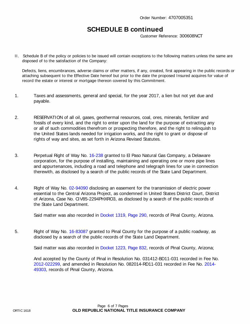
Order Number: 4707005351
Page 6 of 7 PagesORTIC 1618 OLD REPUBLIC NATIONAL TITLE INSURANCE COMPANY
SCHEDULE B continuedCustomer Reference: 300608NCT
II. Schedule B of the policy or policies to be issued will contain exceptions to the following matters unless the same aredisposed of to the satisfaction of the Company:
Defects, liens, encumbrances, adverse claims or other matters, if any, created, first appearing in the public records orattaching subsequent to the Effective Date hereof but prior to the date the proposed Insured acquires for value ofrecord the estate or interest or mortgage thereon covered by this Commitment.
1. Taxes and assessments, general and special, for the year 2017, a lien but not yet due andpayable.
2. RESERVATION of all oil, gases, geothermal resources, coal, ores, minerals, fertilizer andfossils of every kind, and the right to enter upon the land for the purpose of extracting anyor all of such commodities therefrom or prospecting therefore, and the right to relinquish tothe United States lands needed for irrigation works, and the right to grant or dispose ofrights of way and sites, as set forth in Arizona Revised Statutes.
3. Perpetual Right of Way No. 16-238 granted to El Paso Natural Gas Company, a Delawarecorporation, for the purpose of installing, maintaining and operating one or more pipe linesand appurtenances, including a road and telephone and telegraph lines for use in connectiontherewith, as disclosed by a search of the public records of the State Land Department.
4. Right of Way No. 02-94090 disclosing an easement for the transmission of electric poweressential to the Central Arizona Project, as condemned in United States District Court, Districtof Arizona, Case No. CIV85-2294PHXRO3, as disclosed by a search of the public records ofthe State Land Department.
Said matter was also recorded in Docket 1319, Page 290, records of Pinal County, Arizona.
5. Right of Way No. 16-83087 granted to Pinal County for the purpose of a public roadway, asdisclosed by a search of the public records of the State Land Department.
Said matter was also recorded in Docket 1223, Page 832, records of Pinal County, Arizona;
And accepted by the County of Pinal in Resolution No. 031412-BD11-031 recorded in Fee No.2012-022299, and amended in Resolution No. 082014-RD11-031 recorded in Fee No. 2014-49303, records of Pinal County, Arizona.
Order Number: 4707005351
Page 7 of 7 PagesORTIC 1618 OLD REPUBLIC NATIONAL TITLE INSURANCE COMPANY
6. Any facts, rights, interests or claims which are not shown by the public records, but whichcould be ascertained by making inquiry of the lessors in the lease or leases described orreferred to herein.
7. The terms, covenants and conditions of the lease or leases described or referred to hereinand the effect of any failure to comply therewith.

CONDITIONS
1. The term mortgage, when used herein, shall include deed of trust, trust deed, or other security instrument.
2. If the proposed Insured has or acquired actual knowledge of any defect, lien, encumbrance, adverse claim or othermatter affecting the estate or interest or mortgage thereon covered by this Commitment other than those shown inSchedule B hereof, and shall fail to disclose such knowledge to the Company in writing, the Company shall be relievedfrom liability for any loss or damage resulting from any act of reliance hereon to the extent the Company is prejudicedby failure to so disclose such knowledge. If the proposed Insured shall disclose such knowledge to the Company, or ifthe Company otherwise acquires actual knowledge of any such defect, lien, encumbrance, adverse claim or othermatter, the Company at its option may amend Schedule B of this Commitment accordingly, but such amendment shallnot relieve the Company from liability previously incurred pursuant to paragraph 3 of these Conditions andStipulations.
3. Liability of the Company under this Commitment shall be only to the named proposed Insured and such partiesincluded under the definition of Insured in the form of policy or policies committed for and only for actual lossincurred in reliance hereon in undertaking in good faith (a) to comply with the requirements hereof, or (b) toeliminate exceptions shown in Schedule B, or (c) to acquire or create the estate or interest or mortgage thereoncovered by this Commitment. In no event shall such liability exceed the amount stated in Schedule A for the policy orpolicies committed for and such liability is subject to the insuring provisions and Conditions and Stipulations and theExclusions from Coverage of the form of policy or policies committed for in favor of the proposed Insured which arehereby incorporated by reference and are made a part of this Commitment except as expressly modified herein.
4. This Commitment is a contract to issue one or more title insurance policies and is not an abstract of title or a report ofthe condition of title. Any action or actions or rights of action that the proposed Insured may have or may bringagainst the Company arising out of the status of the title to the estate or interest or the status of the mortgagethereon covered by this Commitment must be based on and are subject to the provisions of this Commitment.
5. The policy to be issued contains an arbitration clause. All arbitrable matters when the Amount of Insurance is$2,000,000 or less shall be arbitrated at the option of either the Company or the Insured as the exclusive remedy ofthe parties. You may review a copy of the arbitration rules at http://www.alta.org. If a policy other than the 2006ALTA Owner’s Policy of Title Insurance, 2006 ALTA Loan Policy of Title Insurance or 2006 ALTA Short FormResidential Loan Policy is ultimately issued, the arbitration provisions of the issued policy shall control.
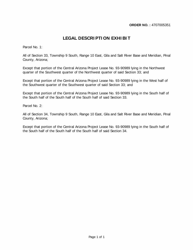
Page 1 of 1
ORDER NO. : 4707005351
LEGAL DESCRIPTION EXHIBIT
Parcel No. 1:
All of Section 33, Township 9 South, Range 10 East, Gila and Salt River Base and Meridian, Pinal County, Arizona;
Except that portion of the Central Arizona Project Lease No. 93-90989 lying in the Northwest quarter of the Southwest quarter of the Northwest quarter of said Section 33; and
Except that portion of the Central Arizona Project Lease No. 93-90989 lying in the West half of the Southwest quarter of the Southwest quarter of said Section 33; and
Except that portion of the Central Arizona Project Lease No. 93-90989 lying in the South half of the South half of the South half of the South half of said Section 33.
Parcel No. 2:
All of Section 34, Township 9 South, Range 10 East, Gila and Salt River Base and Meridian, Pinal County, Arizona;
Except that portion of the Central Arizona Project Lease No. 93-90989 lying in the South half of the South half of the South half of the South half of said Section 34.

Page 1 of 1
Exhibit I
CALIFORNIA LAND TITLE ASSOCIATIONSTANDARD COVERAGE POLICY - 1990
EXCLUSIONS FROM COVERAGE
The following matters are expressly excluded from the coverage of this policy and the Company will not pay loss or damage, costs, attorneys' fees or expenses which arise by reason of:
1. (a) Any law, ordinance or governmental regulation (including but not limited to building or zoning laws, ordinances, or regulations) restricting, regulating, prohibiting or relating (i) the occupancy, use, or enjoyment of the land; (ii) the character, dimensions or location of any improvement now or hereafter erected on the land; (iii) a separation in ownership or a change in the dimensions or area of the land or any parcel of which the land is or was a part; or {iv) environmental protection, or the effect of any violation of these laws, ordinances or governmental regulations, except to the extent that a notice of the enforcement thereof or a notice of a defect, lien, or encumbrance resulting from a violation or alleged violation affecting the land has been recorded in the public records at Date of Policy.-
(b) Any governmental police power not excluded by (a) above, except to the extent that a notice of the exercise thereof or notice of adefect, lien or encumbrance resulting from a violation or alleged violation affecting the land has been recorded in the public records at Date ofPolicy.
2. Rights of eminent domain unless notice of the exercise thereof has been recorded in the public records at Date of Policy, but not excluding fromcoverage any taking which has occurred prior to Date of Policy which would be binding on the rights of a purchaser for value without knowledge.
3. Defects, liens, encumbrances, adverse claims or other matters:
(a) whether or not recorded in the public records at Date of Policy, but created, suffered, assumed or agreed to by the insured claimant;
(b) not known to the Company, not recorded in the public records at Date of Policy, but known to the insured claimant and not disclosed inwriting to the Company by the insured claimant prior to the date the insured claimant became an insured under this policy;.
(c) resulting in no loss or damage to the insured claimant;
(d) attaching or created subsequent to Date of Policy; or
(e) resulting in loss or damage which would not have been sustained if the insured claimant had paid value for the insured mortgage or forthe estate or interest insured by this policy.
4. Unenforceability of the lien of the insured mortgage because of the inability or failure of the insured at Date of Policy, or the inability or failure ofany subsequent owner of the indebtedness, to comply with the applicable doing business laws of the state in which the land Is situated.
5. Invalidity or unenforceability of the lien of the insured mortgage, or claim thereof, which arises out of the transaction evidenced by the insuredmortgage and is based upon usury or any consumer credit protection or truth in lending law.
6. Any claim, which arises out of the transaction vesting in the insured the estate of interest insured by this policy or the transaction creating theinterest of the insured lender, by reason of the operation of federal bankruptcy, state insolvency or similar creditors' rights laws.
EXCEPTIONS FROM COVERAGE - SCHEDULE B, PART I
This policy does not insure against loss or damage (and the Company will not pay costs, attorneys' fees or expenses) which arise by reason of:
1. Taxes or assessments Which are not shown as existing liens by the records of any taxing authority that levies taxes or assessments on realproperty or by the public records.
Proceedings by a public agency which may result in taxes or assessments, or notices of such proceedings, whether or not shown by the records ofsuch agency or by the public records.
2. Any facts, rights, interests, or claims Which are not shown by the public records but which could be ascertained by an inspection of the landwhich may be asserted by persons in possession thereof,
3. Easements, liens or encumbrances, or claims thereof, which are not shown by the public records.
4. Discrepancies, conflicts in boundary lines, shortage in area, encroachments, or any other facts which a correct survey would disclose, and whichare not shown by the public records.
5. (a) Unpatented mining claims; (b) reservations or exceptions in patents or in Acts authorizing the issuance thereof; (c) water rights, claims or titleto water, whether or not the matters excepted under (a), (b) or (c) are shown by the public records.
6. Any lien or right to a lien for services, labor or material not shown by the public records.

rev. 07/2016
FACTS WHAT DOES OLD REPUBLIC TITLEDO WITH YOUR PERSONAL INFORMATION?
Why?
Financial companies choose how they share your personal information. Federal law gives consumers the right to limit some but not all sharing. Federal law also requires us to tell you how we collect, share, and protect your personal information. Please read this notice carefully to understand what we do.
What?
The types of personal information we collect and share depend on the product or service you have with us. This information can include:
• Social Security number and employment information• Mortgage rates and payments and account balances• Checking account information and wire transfer instructions
When you are no longer our customer, we continue to share your information as described in this notice.
How?
All financial companies need to share customers’ personal information to run their everyday business. In the section below, we list the reasons financial companies can share their customers’personal information; the reasons Old Republic Title chooses to share; and whether you can limit this sharing.
Reasons we can share your personal informationDoes Old Republic
Title share?
Can you limit
this sharing?
For our everyday business purposes — such as to process your
transactions, maintain your account(s), or respond to court orders and
legal investigations, or report to credit bureaus
Yes No
For our marketing purposes —
to offer our products and services to youNo We don’t share
For joint marketing with other financial companies No We don’t share
For our affiliates’ everyday business purposes —
information about your transactions and experiencesYes No
For our affiliates’ everyday business purposes —
information about your creditworthinessNo We don’t share
For our affiliates to market to you No We don’t share
For non-affiliates to market to you No We don’t share
Questions Go to www.oldrepublictitle.com (Contact Us)
Page 2
Who we are
Who is providing this notice? Companies with an Old Republic Title name and other affiliates. Please see below for a list of affiliates.
What we do
How does Old Republic Title protect my personal information?
To protect your personal information from unauthorized access and use, we use security measures that comply with federal law. These measures include computer safeguards and secured files and buildings. For more information, visit http://www.OldRepublicTitle.com/newnational/Contact/privacy.
How does Old Republic Title collect my personal information?
We collect your personal information, for example, when you:
• Give us your contact information or show your driver’s license
• Show your government-issued ID or provide your mortgage information
• Make a wire transfer
We also collect your personal information from others, such as credit bureaus, affiliates, or other companies.
Why can’t I limit all sharing? Federal law gives you the right to limit only:
• Sharing for affiliates’ everyday business purposes - information about your creditworthiness
• Affiliates from using your information to market to you
• Sharing for non-affiliates to market to you
State laws and individual companies may give you additional rights to limit sharing. Seethe "Other important information" section below for your rights under state law.
Definitions
Affiliates Companies related by common ownership or control. They can be financial and nonfinancial companies.
• Our affiliates include companies with an Old Republic Title name, and financialcompanies such as Attorneys’ Title Fund Services, LLC, Lex Terrae National TitleServices, Inc., Mississippi Valley Title Services Company, and The Title Company ofNorth Carolina.
Non-affiliates Companies not related by common ownership or control. They can be financial andnon-financial companies.
• Old Republic Title does not share with non-affiliates so they can market to you
Joint marketing A formal agreement between non-affiliated financial companies that together market financial products or services to you.
• Old Republic Title doesn’t jointly market.

Page 3
Other Important Information
Oregon residents only: We are providing you this notice under state law. We may share your personal information (described on page one) obtained from you or others with non-affiliate service providers with whom we contract, such as notaries and delivery services, in order to process your transactions. You may see what personal information we have collected about you in connection with your transaction (other than personal information related to a claim or legal proceeding). To see your information, please click on "Contact Us" at www.oldrepublictitle.com and submit your writtenrequest to the Legal Department. You may see and copy the information at our office or ask us to mail you a copy for a reasonable fee. If you think any information is wrong, you may submit a written request online to correct or delete it. We will let you know what actions we take. If you do not agree with our actions, you may send us a statement.
Affiliates Who May be Delivering This Notice
American First Abstract, LLC American First Title & Trust Company
American Guaranty Title Insurance Company
Attorneys' Title Fund Services, LLC
Compass Abstract, Inc.
eRecording Partners Network, LLC
Genesis Abstract, LLC Kansas City Management Group, LLC
L.T. Service Corp. Lenders Inspection Company
Lex Terrae National Title Services, Inc.
Lex Terrae, Ltd. Mara Escrow Company Mississippi Valley Title Services Company
National Title Agent's Services Company
Old Republic Branch Information Services, Inc.
Old Republic Diversified Services, Inc.
Old Republic Exchange Company
Old Republic National Title Insurance Company
Old Republic Title and Escrow of Hawaii, Ltd.
Old Republic Title Co. Old Republic Title Company of Conroe
Old Republic Title Company of Indiana
Old Republic Title Company of Nevada
Old Republic Title Company of Oklahoma
Old Republic Title Company of Oregon
Old Republic Title Company of St. Louis
Old Republic Title Company of Tennessee
Old Republic Title Information Concepts
Old Republic Title Insurance Agency, Inc.
Old Republic Title, Ltd. Republic Abstract & Settlement , LLC
Sentry Abstract Company The Title Company of North Carolina
Title Services, LLC
Trident Land Transfer Company, LLC
SunPower Corp. Major Comprehensive Plan Amendment
Tetra Tech, Inc. May 31, 2017
APPENDIX B
PHOTOGRAPHS AND ENERGY FLOW DIAGRAM
OF A TYPICAL PV SOLAR FACILITY
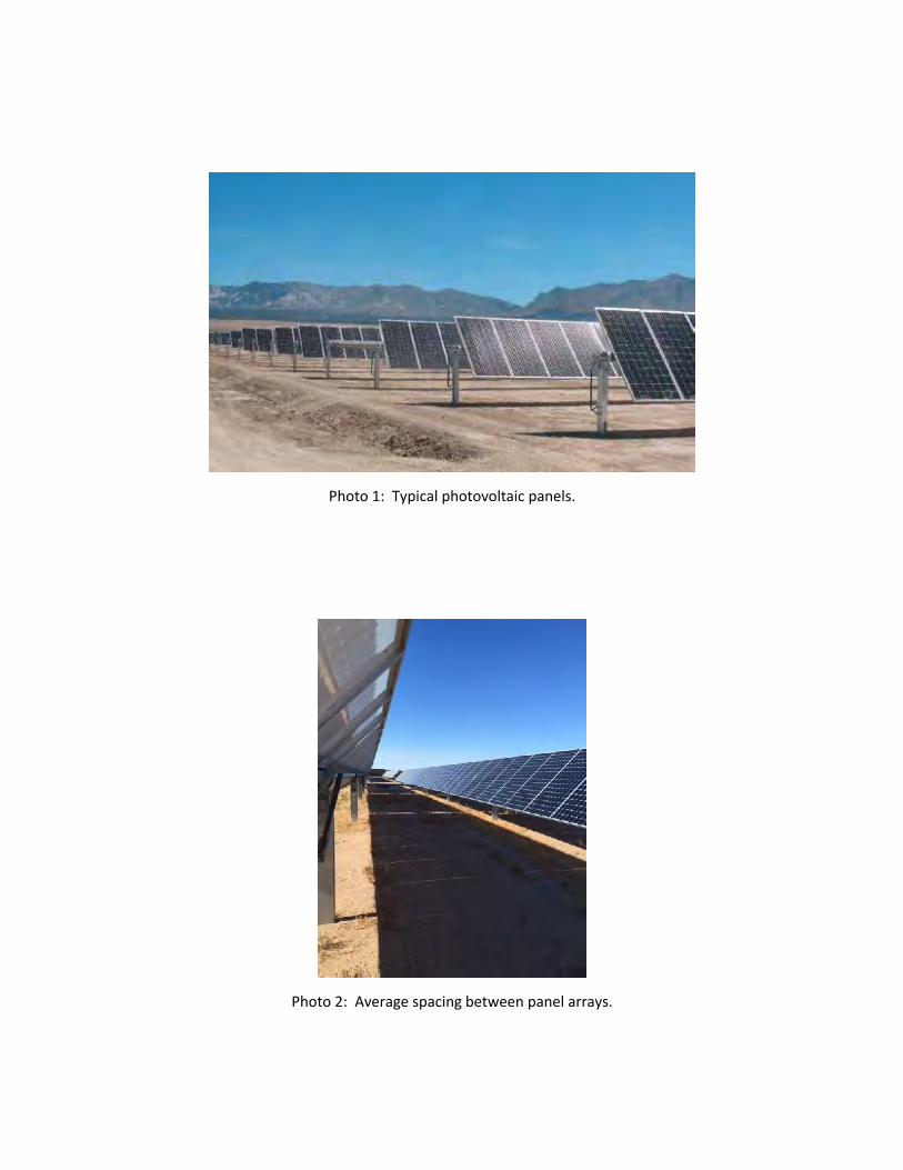
Photo 1: Typical photovoltaic panels.
Photo 2: Average spacing between panel arrays.
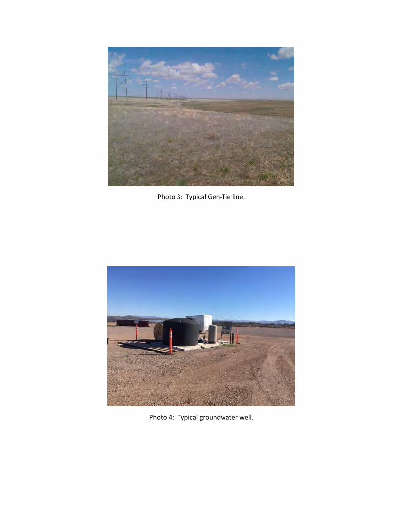
Photo 3: Typical Gen-Tie line.
Photo 4: Typical groundwater well.
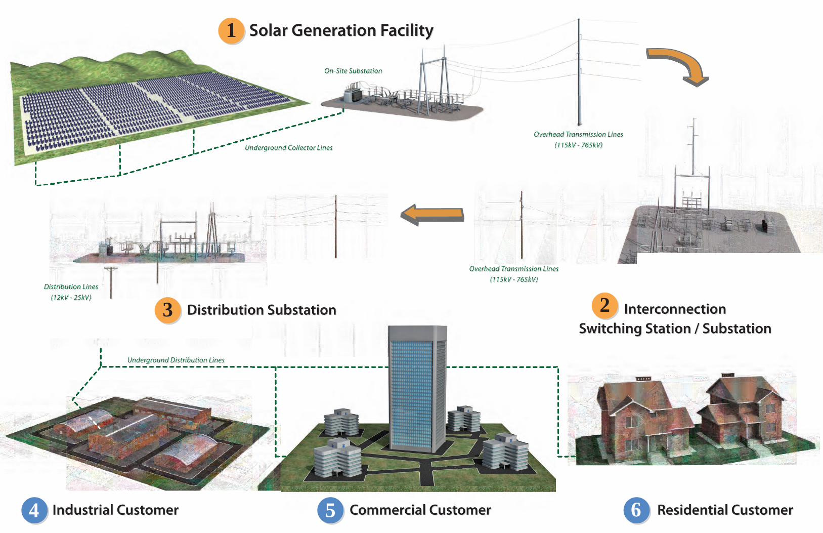
Underground Collector Lines
On-Site Substation
Overhead Transmission Lines(115kV - 765kV)
Distribution Lines(12kV - 25kV)
Underground Distribution Lines
Solar Generation FacilitySolar Generation Facility1
InterconnectionSwitching Station / Substation
InterconnectionSwitching Station / Substation
2Distribution SubstationDistribution Substation3
Industrial CustomerIndustrial Customer4 Commercial CustomerCommercial Customer5 Residential CustomerResidential Customer6
Underground Collector Lines
On-Site Substation
Overhead Transmission Lines(115kV - 765kV)
Distribution Lines(12kV - 25kV)
Underground Distribution Lines
Overhead Transmission Lines(115kV - 765kV)
Overhead Transmission Lines(115kV - 765kV)