Public Notice - nab.usace.army.mil 13-42.pdf · mitigation for activities authorized by Department...
28
Public Notice U.S. Army Corps In Reply Refer to NAB-2006-65477-M21 (St. Charles of Engineers Mitigation Bank, LLC/St. Charles Mitigation Bank) Baltimore District PN 13-42 COMMENT PERIOD: June 25, 2013 to July 25, 2013 The Baltimore District Corps of Engineers (Corps) and Maryland Department of the Environment (MDE) are soliciting comments from the public; Federal, State, and local agencies and officials; Indian Tribes; and other interested parties in order to consider and evaluate the proposed St. Charles Mitigation Bank, LLC/St. Charles Mitigation Bank and the potential of the proposed mitigation bank to provide appropriate compensatory mitigation for activities authorized by Department of the Army and/or State of Maryland Nontidal Wetlands Act permits. At this time, no decision has been made as to whether or not a permit will be issued, or whether the proposed “St. Charles Mitigation Bank” will be approved. We are requesting your comments to determine if approval should be granted for the proposed compensatory wetland mitigation bank to be known as the St. Charles Mitigation Bank. The purpose of the proposed mitigation bank is to provide compensatory mitigation for projects that result in unavoidable wetland impacts authorized by the Department of the Army and State of Maryland Nontidal Wetlands Act permits and for future development projects in the Lower Potomac River drainage basin (USGS hydrologic unit code 02070011), which would include portions of Charles County, Prince George’s County and St. Mary’s County, Maryland. A preliminary review indicates that the proposed work may qualify for U.S. Army Corps of Engineers (Corps) authorization under Nationwide Permit (NWP) #27, Aquatic Habitat Restoration, Establishment, and Enhancement Activities. At this time, in accordance with NWP #27 general condition 31, the prospectus constitutes the pre-construction notification (PCN) that is required for Nationwide Permit #27 for work in waters of the United States to construct the proposed St. Charles Mitigation Bank. A field review of the proposal indicates that there are waters of the United States, including wetlands within the project area. These areas are regulated pursuant to Section 404 of the Clean Water Act and the work described below will require Department of the Army authorization. The Nationwide Permit #27 has undergone a full public interest review as required by Corps regulations (33 CFR 320.4(a)), and NEPA documentation has been prepared that addresses environmental considerations. The MDE is reviewing the application for work in Waters of the State and will issue a Letter of Authorization (LOA) for temporary, permanent and buffer impacts. The Corps and MDE have received a Wetland Mitigation Bank prospectus to establish a compensatory Mitigation Bank. This attached prospectus provides a summary of the information regarding the proposed Mitigation Bank and is in accordance with the Department of Defense/Environmental Protection Agency Final Rule on Compensatory Mitigation for Losses of Aquatic Resources (33 CFR Parts 325 and 332 and 40 CFR Part 320) and MDE’s Mitigation Banking regulations. Oversight of this Mitigation Bank will be undertaken by the Maryland Interagency Review Team (IRT), which is comprised of Federal and State regulatory and resource agencies. The Baltimore
Transcript of Public Notice - nab.usace.army.mil 13-42.pdf · mitigation for activities authorized by Department...

Public Notice U.S. Army Corps In Reply Refer to NAB-2006-65477-M21 (St. Charles of Engineers Mitigation Bank, LLC/St. Charles Mitigation Bank) Baltimore District PN 13-42 COMMENT PERIOD: June 25, 2013 to July 25, 2013
The Baltimore District Corps of Engineers (Corps) and Maryland Department of the Environment (MDE) are soliciting comments from the public; Federal, State, and local agencies and officials; Indian Tribes; and other interested parties in order to consider and evaluate the proposed St. Charles Mitigation Bank, LLC/St. Charles Mitigation Bank and the potential of the proposed mitigation bank to provide appropriate compensatory mitigation for activities authorized by Department of the Army and/or State of Maryland Nontidal Wetlands Act permits. At this time, no decision has been made as to whether or not a permit will be issued, or whether the proposed “St. Charles Mitigation Bank” will be approved. We are requesting your comments to determine if approval should be granted for the proposed compensatory wetland mitigation bank to be known as the St. Charles Mitigation Bank. The purpose of the proposed mitigation bank is to provide compensatory mitigation for projects that result in unavoidable wetland impacts authorized by the Department of the Army and State of Maryland Nontidal Wetlands Act permits and for future development projects in the Lower Potomac River drainage basin (USGS hydrologic unit code 02070011), which would include portions of Charles County, Prince George’s County and St. Mary’s County, Maryland. A preliminary review indicates that the proposed work may qualify for U.S. Army Corps of Engineers (Corps) authorization under Nationwide Permit (NWP) #27, Aquatic Habitat Restoration, Establishment, and Enhancement Activities. At this time, in accordance with NWP #27 general condition 31, the prospectus constitutes the pre-construction notification (PCN) that is required for Nationwide Permit #27 for work in waters of the United States to construct the proposed St. Charles Mitigation Bank. A field review of the proposal indicates that there are waters of the United States, including wetlands within the project area. These areas are regulated pursuant to Section 404 of the Clean Water Act and the work described below will require Department of the Army authorization. The Nationwide Permit #27 has undergone a full public interest review as required by Corps regulations (33 CFR 320.4(a)), and NEPA documentation has been prepared that addresses environmental considerations. The MDE is reviewing the application for work in Waters of the State and will issue a Letter of Authorization (LOA) for temporary, permanent and buffer impacts. The Corps and MDE have received a Wetland Mitigation Bank prospectus to establish a compensatory Mitigation Bank. This attached prospectus provides a summary of the information regarding the proposed Mitigation Bank and is in accordance with the Department of Defense/Environmental Protection Agency Final Rule on Compensatory Mitigation for Losses of Aquatic Resources (33 CFR Parts 325 and 332 and 40 CFR Part 320) and MDE’s Mitigation Banking regulations. Oversight of this Mitigation Bank will be undertaken by the Maryland Interagency Review Team (IRT), which is comprised of Federal and State regulatory and resource agencies. The Baltimore
-2-
District, U.S. Army Corps of Engineers serves as chair of the IRT and the Maryland Department of the Environment serves as co-chair of the IRT. The purpose of this proposed Bank is to provide compensatory mitigation for future unavoidable impacts to aquatic resources, including nontidal wetlands that result from activities authorized under Section 404 of the Clean Water Act and the Maryland Nontidal Wetlands Protection Act, provided such use has met all applicable requirements and is authorized by the appropriate authority(s). The Mitigation Bank would be used to comply with the special condition mitigation requirements of permitted projects by providing in-kind compensation for authorized wetlands losses. The Mitigation Bank may only be used for future projects after all appropriate and practical steps to avoid and minimize adverse impacts to aquatic resources, including nontidal wetlands and streams have been taken. All remaining unavoidable impacts must be compensated to the extent appropriate and practicable. The final mitigation instrument does not provide ultimate DA and/or State authorization for specific future projects impacting Waters of the United States, exclude such future projects from any applicable statutory or regulatory requirements, or as preauthorize the use of credits from the Bank for any particular project. The Corps provides no guarantee that any particular individual or general permit will be granted authorization to use this Mitigation Bank to compensate for unavoidable aquatic resource impacts associated with a proposed permit, even though compensatory mitigation credits may be available within the proposed defined service area. APPLICANT/BANK SPONSOR: St. Charles Mitigation Bank, LLC Mr. Mark MacFarland 10400 O’Donnell Place, Suite 200 St. Charles, Maryland 20603 PROJECT LOCATION: The 13-acre Bank is located in the headwaters of Zekiah Swamp, on the west side of Piney Church Road, at 5305 Piney Church Road, Charles County, Maryland, presently owned by St. Charles Community, LLC. The Latitude of the proposed bank is 38.564°N and the Longitude is -76.909°W BANK DESCRIPTION: The Sponsor proposes, in accordance with the attached plans, to establish, design, construct, and operate the approximate 13-acre compensatory St. Charles Mitigation Bank. The parcel was a former sand and gravel mining site consisting of 13.015 acres. The site presently consists of typical erosion control grasses and a settlement pond. The Mitigation Bank will be subject to a Mitigation Banking instrument that institutes guidelines and responsibilities for the establishment, use, operation and maintenance of the proposed Bank. The sponsor has proposed, for purposes of Section 404 of the Clean Water Act, the primary geographic service area (GSA) of the Mitigation Bank site would be the Lower Potomac River Basin, USGS Hydrologic Unit Code (HUC) 02070011 further defined as portions of land in Charles County, Prince George’s County and St. Mary’s County. (See Appendix B of the Prospectus) The design objectives of the proposed mitigation bank consist of:
• The creation of approximately 1.91 acres of nontidal palustrine forested wetlands (PFO). Upland areas would be graded to an elevation suitable for forested wetlands and planted/seeded with wetlands species.

-3-
• The creation of approximately 1.90 acres of nontidal palustrine emergent wetlands (PEM). Upland areas would be graded to an elevation suitable for emergent wetlands then seeded with appropriate wetland species.
• The creation of a vernal pool would be part of the PEM creation. The vernal pool would
be a seasonally ponded, depressional wetland to provide amphibian habitat. The vernal pool would be seeded and planted with herbaceous species tolerant of a wide range of water depths and draw down. Large woody debris would be placed around the pool for amphibian cover.
• The creation of approximately 0.21 acres of seepage berm (Bog) wetlands (PEM). A
seepage wetland would be developed by constructing a sandy berm with ponded water along the upstream side. The ponded water would seep through the berm, expressing itself along the downstream slope. The sediment and hydrology would be similar to Piney Branch Bog, which supports rare plant species.
• The enhancement of approximately 0.6 acres of open water that is 2.5 to 3.5 feet deep
would be planted with spatterdock and other native floating leaf species, which are prime food sources for many species, including wintering ducks.
• The maintenance of an approximate 1.84 acre densely vegetated upland buffer area that
would extend around the perimeter of the wetlands to filter sediments and nutrients from any sheet flow that might enter the site.
• The enhancement of approximately 1.64 acres of PEM wetlands. A portion of existing
PEM wetlands would be planted with woody species to generate a mosaic of PEM/PFO habitat.
• The creation of wood duck nesting habitat. Thickets of alder and buttonbush around
shallow open water would be planted to provide secluded areas. Nest boxes and suitable nesting trees will also be installed.
The overall proposed goal of the Mitigation Bank is to provide 13.0 acres of wetland mitigation (5.75 wetland compensation credits) through the creation of 4.02 acres of new wetlands, through the enhancement of 2.87 acres of existing degraded nontidal wetlands and enhancement of 0.6 acres of existing open water and through the preservation of 1,84 acres of upland buffer. Although the proposed bank is outside of the Zekiah Watershed Rural Legacy Area (ZSWRA), it would contribute to the protection of water quality and continuity of habitat of outlying tributaries. Zekiah Swamp watershed is considered a high priority for conservation and an “Area of Critical State Concern”. WORK REQUIRING CORPS AND MDE AUTHORIZATION: The approximate total impacts for the enhancement of 2.87 acres of PEM include 3,581 square feet of permanent grading impacts to nontidal wetlands to construct a berm; 405 square feet of permanent impacts to open water, 812 square feet of permanent impacts to the stream and 162 square feet of permanent impacts to nontidal wetlands to construct a permanent dam; and 213 square feet of permanent impacts to nontidal wetlands for an access road. Permanent rip rap would be placed within the man-made channel downstream of the permanent dam to provide scour protection and prevent erosion, which would permanently impact 90 linear feet.

-4-
Temporary impacts would include 2,804 square feet of temporary impacts to open water and 421 square feet of temporary impacts to nontidal wetlands for a temporary rip rap dam; 10,639 square feet of temporary impacts to open water and 313 square feet of temporary impacts to nontidal wetlands to construct a permanent dam; and 23 square feet of temporary impacts to nontidal wetlands for an access road. All of the above mitigation impacts are shown in Appendix C, Advanced Mitigation Site Proposed Bank Design / the plans. A preliminary review of this application indicates that the proposed work will not affect listed species or their critical habitat pursuant to Section 7 of the Endangered Species Act as amended. As the evaluation of this proposal continues, additional information may become available which could modify this preliminary determination. Review of the latest published version of the National Register of Historic Places indicates that no registered properties listed as eligible for inclusion therein are located at the site of the proposed work. Currently unknown archeological, scientific, prehistoric, or historical data may be lost or destroyed by the work to be accomplished under the requested permit for the mitigation bank construction. As the evaluation of this proposal continues, additional information may become available which could modify this preliminary determination. The Magnuson-Stevens Fishery Conservation and Management Act, as amended by the Sustainable Fisheries Act of 1996 (Public Law 104-267), requires all Federal agencies to consult with the National Marine Fisheries Service on all actions, or proposed actions, permitted, funded, or undertaken by the agency, that may adversely affect Essential Fish Habitat (EFH). The proposed project is not located in Essential Fish Habitat and is not likely to affect EFH. The decision whether to adopt this Mitigation Bank instrument and issue a permit would be based upon an evaluation of the probable impacts including cumulative impacts to the proposed Bank on the public interest. That decision would reflect the national concern for both protection and utilization of important resources. The benefit which reasonably may be expected to accrue from the proposal must be balanced against its reasonably foreseeable detriments. All factors which may be relevant to the proposal will be considered including the cumulative effects thereof; among those are conservation, economics, aesthetics, general environmental concerns, wetlands, cultural values, fish and wildlife values, flood hazards, floodplain values, land use, navigation, shoreline, erosion and accretion, recreation, water supply and conservation, water quality, energy needs, safety, food and fiber production, and, in general, the needs and welfare of the people. All work is to be completed in accordance with the approved plan (s) and exhibits, which are available for review at the Baltimore Corps District Office, and the Maryland Department of the Environment, both in Baltimore, Maryland. If you have any questions concerning this matter or wish to review the appendices, please contact Ms. Kelly Neff, MDE, at (410) 537-4018 ([email protected]) or Mr. Eugene Morgenthaler, Corps, at (410) 820-8629 ([email protected]). The applicant must obtain any State or local government permits which may be required. It is requested that you communicate the foregoing information concerning the proposed work to any persons known by you to be interested and being known to this office, who did not receive a copy of this notice.

-5-
Written comments concerning the activity described above must be submitted directly to the District Engineer, U.S. Army Corps of Engineers, Baltimore District, Attn: CENAB-OP-RMS, P.O. Box 1715, Baltimore, Maryland, 21203-1715 and/or the Water Management Administration, Maryland Department of the Environment, 1800 Washington Boulevard, Suite 430, Baltimore, Maryland 21230-1708, within the comment period as specified above to receive consideration. The MDE tracking number for this project is (St. Charles Mitigation Bank, LLC/St. Charles Mitigation Bank) 2006-65477 FOR THE DISTRICT ENGINEER: Kathy B. Anderson Chief, Maryland Section Southern U.S. Army Corps of Engineers Kelly Neff Wetland Mitigation & Technical Assistance Section Maryland Department of the Environment

Mitigation Banking Prospectus St. Charles Mitigation Bank
1
PROSPECTUS
ST. CHARLES MITIGATION BANK
5305 Piney Church Road
CHARLES COUNTY, MARYLAND 20602
(Coordinates 38.5640 N - 76.9090W)
Prepared for:
ST. CHARLES MITIGATION BANK, LLC
Prepared by:
Whitman Requardt and Associates, LLP
801 South Caroline Street
Baltimore, Maryland 21231
December, 2012
Mitigation Banking Prospectus St. Charles Mitigation Bank
2
INTRODUCTION
A. The St. Charles Mitigation Bank, LLC (hereinafter, the Sponsor) proposes to establish the St. Charles Mitigation Bank (hereinafter, the Bank) to provide compensation for future authorized wetland and waterway permit mitigation requirements where impacts to waters of the United States in the Lower Potomac River drainage basin have been determined to unavoidable and appropriately mitigated on a watershed basis and per current federal mitigation guidance. This prospectus proposes to develop a 13-acre Bank located in the headwaters of Zekiah Swamp, a tributary to Wicomico River, in Charles County, Maryland (See USGS Vicinity Map in Appendix A). The purpose of the Bank is to provide off-site compensation for the unavoidable loss of wetlands as a result of impacts from development project authorized under Section 401 and 404 of the Clean Water Act, Section 10 of the Rivers and Harbors Act, and the Maryland Nontidal Wetlands Act and associated Code of Maryland Regulations, provided that such impacts have meet all applicable requirements and are approved by the respective permitting agencies. The proposed Bank was presented to the agencies on June 29, 2009.
B. This Mitigation Banking Prospectus was developed based on Federal regulations (33CFR 332.8(d)(d)/ 40 FR 230.98 (d)(2). This prospectus will provide information at a sufficient level of detail to support informed public and regulatory comment. For public notice mailing, the names and addresses of adjacent property owners are:
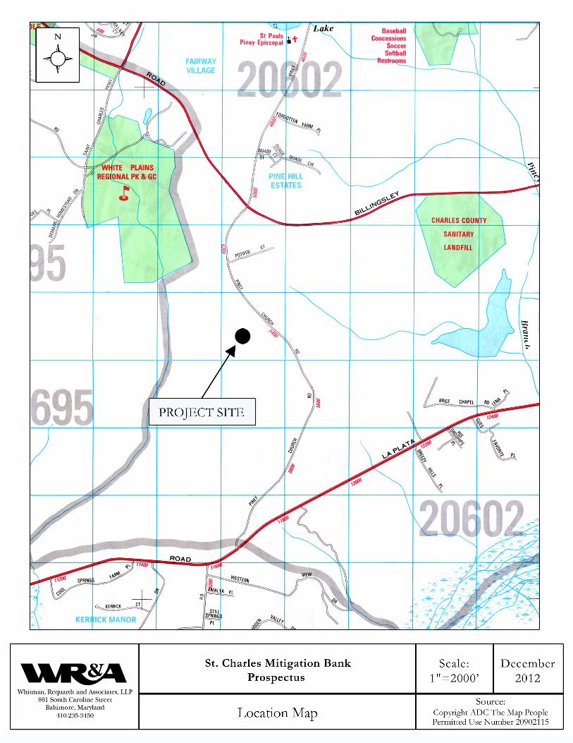
C. The proposed Bank is located west of Piney Church Road, approximately one half mile south of the intersection of Piney Church Road and Billingsley Road (See Location Map in Appendix A). The Bank would be located adjacent to the proposed Fairway High School.
D. The site has been disturbed for sand and gravel mining, so the presence of intact buried resources is unlikely. According to the MD Merlin website, the closest Federal or State historic resource is greater than 1 mile from the site. MD Merlin also indicates that a MDNR Sensitive Species Project Review Area is located approximately 750 feet to the northwest of the project site. A letter was sent to MDNR on May 29, 2012 regarding the presence of State rare, threatened, or endangered species, and critical habitat within the project area. A response is pending. The Maryland Historical Trust stated on May 23, 2012 that the project has been cleared of any historic resource concerns. The U.S. Fish and Wildlife certifies that except for the occasional transient individual, no federally listed endangered or threatened species are known to exist within the La Plata USGS topographic map upon which the project is located.
I. GOALS AND OBJECTIVES
The goal of the proposed Bank is to establish approximately 13.0 acres of diverse, self-sustaining, functional wetlands to replace the functional values and acreage adversely affected by authorized projects within the proposed service area through preservation, enhancement and creation. In doing so, the Bank will satisfy a portion of the existing and prospective demand for compensation within the service area. Some of the targeted functions include improvements to wildlife habitat, water quality, and education.
A. Design Objectives – The specific design objectives for this site include:
1) Creation of approximately 1.91 acres of non-tidal forested wetlands (PFO).
2) Creation of approximately 0.21 acres of Seepage Berm (Bog) wetlands (PEM).
3) Creation of approximately 1.90 acres of non-tidal emergent wetlands (PEM).
4) Habitat Enhancement of approximately 2.87 acres of existing non-tidal emergent wetlands
(PEM).

Mitigation Banking Prospectus St. Charles Mitigation Bank
3
5) Conversion of approximately 1.64 acres of existing non-tidal emergent wetlands (PEM) to
PFO/PEM mosaic.
6) Enhancement of approximately 0.6 acres of existing open water to provide improved habitat
and diverse ecological functions.
7) Preserve approximately 1.84 acres of wetland buffer to further protect the functions and
values of the existing and proposed wetlands.
B. Wetland Functions and Values – The site will provide the following wetland functions and
values: 1) Wildlife Habitat – The mixture of open water, emergent, shrub/scrub and forested wetlands,
with an upland buffer, is a diverse habitat, which will support a wide range of wildlife. The existing open water and emergent wetlands support breeding and wintering ducks, Common Snipe (Gallinago gallinago), Red-winged Blackbird (Agelaius phoeniceus), and American Bittern (Botaurus lentiginosus). The proposed mitigation plan will preserve and enhance the existing open water and wetlands while significantly increasing the area of wetlands and the diversity of wetland communities at this site.
2) Water Quality Improvement – The proposed mitigation site will improve the quality of surface water discharging from the site into the Zekiah Swamp watershed through settling, filtration, and biological uptake.
3) Rare Habitat – The inclusion of a seepage wetland opens the opportunity to establish a
regionally rare wetland type that often supports rare plant species. The bank will work with a recognized expert in seepage/bog wetlands to establish the appropriate habitat and vegetation. A vernal pool for amphibian breeding and wetland enhancements to provide wood duck nesting areas would also be included in the project.
4) Education – The location of the proposed mitigation site within the St. Charles Community,
and more specifically within the grounds of a high school, provides the opportunity for direct and indirect education of the public about the values of wetlands.
II. ESTABLISHMENT AND OPERATION
A Mitigation Banking Instrument (MBI) will be developed by the Sponsor to establish the Bank. The development of the MBI and the operation of the Bank will be in accordance with the “Compensatory Mitigation for Losses of Aquatic Resources: Final Rule, 33 CFR 332” and follow the most current version of the Mitigation Banking Instrument template provided by the Baltimore District, U.S. Army Corps of Engineers. The Sponsor will also obtain all other documentation, permits and other authorizations required to establish and maintain the Bank, such as County grading permits. After approval of the Prospectus, Sponsor shall submit a Bank Development Plan for consideration by the Interagency Review Team (IRT). The detailed content of the Bank Development Plan will be determined in consultation with the IRT.
A. Bank Development Plan Elements – The Bank Development Plan will include the following elements, as required by the Final Mitigation Rules:
1) Objectives – Description of the resources types, amounts, methods and anticipated
functions provided by the Bank.

Mitigation Banking Prospectus St. Charles Mitigation Bank
4
2) Site Selection – Description of factors considered and practicality of accomplishing ecologically self-sustaining compensation at the Bank.
3) Site Protection Instrument – Description of the legal arrangements and instruments to ensure long-term protection of the Bank.
4) Baseline Information – A description of the ecological characteristics of the proposed Bank. 5) Determination of Credits – A description of the number of credits generated and the
rationale for this determination. 6) Mitigation Work Plan – Design plans and specifications to include grading, planting, water
control, invasive species control, sequencing, soil management and erosion control. 7) Maintenance Plan – A description and schedule for maintenance requirements after
construction is completed. 8) Performance Standards – Performance standards that will be used to determine if Bank is
achieving its objectives. 9) Monitoring Requirements – A description of the monitoring requirements required to
measure the performance standards, include monitoring and reporting schedules. 10) Long-term Management Plan – A strategy to manage the Bank after performance
standards have been met, including financing mechanisms, and responsible parties. 11) Adaptive Management Plan – A strategy to address unforeseen changes in the Bank and
the responsible parties. 12) Financial Assurances – A description of the financial assurances that will be provided to
assure successfully completion of the Bank in accordance with its performance standards.
B. Additional Operational Elements – Additional operational elements of the Bank include:
1) The Bank will establish and maintain an accounting system (i.e. ledger) which documents credits and debits to the Bank account. Each time an approved debit or credit transaction occurs, the Bank will submit a statement to the permitting agencies. The Bank will also generate an annual ledger report to be submitted to all members of the IRT.
2) Availability of credits from the Bank will be made based on the schedule of credit release
contained in the MBI. 3) Debits from the Bank will be based on the permit requirements of authorized projects. 4) Any monies received for purchase of wetland mitigation credits prior to completion of
construction will be deposited in an escrow account, the details of which are to be agreed to in the MBI.
5) The prices charged for wetland mitigation credits will be determined solely by Sponsor.
III. GEOGRAPHIC SERVICE AREA
The proposed geographic service area for this Bank shall be consistent with Federal Banking Guidance. The proposed primary geographic service area is the Lower Potomac River Basin (USGS hydrologic unit code 02070011). The proposed geographic service area would include portions of Charles County, Prince George’s County, and St. Mary’s County, Maryland. A service area map for the Bank is provided in Appendix B. IV. GENERAL NEED AND TECHNICAL FEASIBILITY OF MITIGATION SITE
A. General Need – The proposed Bank will provide wetland mitigation credits to third parties in need of compensation for whom this would be the most practicable alternative for impacts to regulated water resources within the proposed geographic service area. The Bank would also provide

Mitigation Banking Prospectus St. Charles Mitigation Bank
5
water quality and wildlife benefits to the Zekiah Swamp watershed, which is considered a high priority for conservation.
B. Technical Feasibility – The technical feasibility of the proposed Bank has been documented in
detail in the Conceptual Mitigation Plan (December 2008), which has been provided to the MDE and COE. Technical studies conducted to evaluate the technical feasibility of the Bank to support a wetland mitigation site include groundwater wells, soil analysis, geotechnical borings, water budgets, and rainfall analysis. The results of these evaluations are summarized below:
1) Historic Conditions – The proposed Bank site, as well as a large portion of the general area
including the 33.5 acre drainage area, was used in the past for sand/gravel mining. Review of USGS maps and soil surveys indicate there is no evidence of wetlands prior to operation of this site as a sand/gravel mine. The original soils at this site (Charles County Soil Survey, 1974) included Beltsville, Bourne sandy clay loam, Gravelly Land, Evesboro loamy sand, and some Rumford loamy sand and Sassafras sandy loam. The soil map indicates that there was an intermittent channel on the site, but that hydric soils were not present. The soils were reclassified to be Udorthents, reclaimed gravel pits, 0 to 5 percent slopes. The mining operation extracted the gravels and sands in the Gravelly Land and Evesboro loamy sands.
2) Existing Geological and Soil Conditions – According to the Geological Map of Charles
County, Maryland (1989), the site was underlain with Pliocene-age sands and gravels of fluvial origin, which are the deposits mined at the site. Underneath these deposits is the Miocene-age Calvert Formation, consisting of green silty clay or clayey silt. In 1988, borings by WR&A of the mined areas indicate the possibility of up to 15-25 feet of heterogeneous overburden (i.e. mining spoils) consisting of a mixture of sand, silts, clays, and gravels. To obtain a better understanding of the deeper strata on the site, six geotechnical borings were advanced with a drill rig to a depth of 10 feet. The top of the underlying clay strata was found typically within 4-6 feet of the surface. Immediately above the clay was a 2-5 feet thick strata of sand often mixed with gravel and clay. Portions of the site retained a natural soil stratigraphy while the remainder of the site was composed of mining overburden.
4) Existing Site Conditions - After completion of mining in 1988, the site was graded and
stabilized with typical erosion control grasses. Drainage from the mining site was controlled with a settling pond. The pond has a maximum depth of six feet (170.8 elev.). The earthen berm and riprap spillway of the pond provide the backwater which provides the hydrology for the wetlands that exist on the site. Although the soil survey indicates an intermittent stream channel on site, the mining removed the original channel. The surface runoff from the site is collected by two long ditches which flow into the settling pond. The upland vegetation surrounding the pond and ditches is composed of fescue grasses (Festuca spp.), scattered red cedars (Juniperius virginiana), scattered Sweetgum (Liquidambar styraciflua), and scattered Virginia pines (Pinus virginiana).
5) Existing Wetland Condition – In June 2012, jurisdictional wetlands on the site were identified and surveyed. Wetlands have developed along the drainage ditches and around the perimeter of the settling pond. There are 2.28 acres of open water, and 4.62 acres of wetlands, mostly emergent. The extent of wetlands is primarily a function of the backwater from the spillway and beaver dam. There appears to be a seep area at the head of each of the ditches.
6) Open Water and Groundwater Conditions – The settling pond developed during the mining
operations and retained upon closure of the mine consists of a rectangular pond and two long drainage ditches. The water level in the pond is maintained by precipitation, surface runoff, and groundwater discharge into the pond. The water levels in the pond fluctuate seasonally with the pond full from fall to late spring. There is a significant draw down during the late spring into the summer and early fall with water elevations typically dropping 2-3 feet. This draw down is very similar to the groundwater hydrology of Zekiah Swamp.

Mitigation Banking Prospectus St. Charles Mitigation Bank
6
A series of groundwater monitoring wells were installed and operated for several years. Based on well data the water table is high during the winter with a period of fluctuating water table during the spring. There is a deep draw down in the summer and fall of up to as much as 5 feet. All wells show rather quick response to large rain events. Drier years (i.e. 2007) exhibit large draw downs, while wetter years show significant recharge during the growing season. The elevation of water in the wells and pond vary together, although the wells show far more variability. Nearly every peak in the groundwater data is mirrored by a peak in the pond data. The direction of ground water flow can be determined by comparing the pond elevation with the ground water elevations in the wells. The 2005 – 2007 data shows that ground water was flowing from the unconfined aquifer into the pond during most of the year. The elevation differences between the water table in the wells and in the pond indicate that groundwater water moves from the uplands toward the pond during the fall through spring, but may flow from the pond into the groundwater during the summer. The technical studies indicate that there is a reliable water table near the surface under the Bank site. The wetlands proposed for this Bank will experience seasonal fluctuations in water elevations similar to the seasonal fluctuations reported for the Zekiah Swamp. Groundwater and pond elevations will be high from late fall through the spring, with a draw down from the late spring through early fall. This seasonal draw down is particularly suitable to seasonally saturated forested wetlands.
6) Proposed Design – The proposed design of the Bank is presented in Appendix C. The
feasibility studies support a mitigation design which would include the following:
a. Rebuilding the existing dam and replacing the eroding riprap spillway with a water level control structure. The water control structure requires minimal maintenance and is not prone to beaver damage or vandalism, but provides the opportunity to control water elevations to optimize site hydrology and plant survival. A ten foot wide access road will be constructed along the western boundary of the site for the dam maintenance.
b. Grading of the western edge of the site where there are suitable soils to create approximately 1.91 acres of non-tidal forested wetlands (PFO).
c. Construction of a porous sandy berm across a portion of the existing wetlands to create approximately 0.21 acres of seepage slope wetland (i.e. bog)
d. Grading the southern end of the site to create approximately 1.90 acres of non-tidal emergent wetlands (PEM), including a vernal pool wetland. This area is not suitable for forested wetland due to presence of clayey soils and mining overburden.
e. Habitat Enhancement of approximately 2.87 acres of existing non-tidal emergent wetlands (PEM) through the addition of large wood material, and creation of pit/mount topography. In addition, several areas will be planted specifically for wood duck habitat.
f. Conversion of approximately 1.64 acres of existing non-tidal emergent wetlands (PEM) to PFO/PEM mosaic by planting woody species throughout the PEM wetland.
g. Enhancement of approximately 0.6 acres of existing open water by planting deep water floating leaf species such as spatterdock.
h. Preserve approximately 1.84 acres of wetland buffer to further protect the functions and values of the existing and proposed wetlands.
i. The mitigation design would also include an educational component, such as signage and trails that allow students and teachers at the adjacent high school to benefit from the site. The site would be fenced to minimize unauthorized access.
Mitigation Banking Prospectus St. Charles Mitigation Bank
7
V. OWNERSHIP AND LONG-TERM MANAGEMENT STRATEGY
The site of the Bank is currently owned by St. Charles Community, LLC (SCC), and the completed Bank will be owned and operated by St. Charles Mitigation Bank, LLC. The Sponsor will be responsible for design, construction, operation, monitoring and maintenance of the bank through the post-construction monitoring period. Decisions concerning the operational life of the proposed Bank, long-term monitoring and maintenance, remedial actions, and financial assurances will be made in accordance with Federal Banking Guidance and approved by the IRT.
The Bank will be provided long-term protection in the form of a perpetual legal instrument that is agreeable to the IRT. A restrictive conveyance or conservation easement will be included in the mitigation banking instrument. A mutually agreeable “holder” of the conservation easement will be agreed upon with the IRT and identified in the Mitigation Banking Instrument.
The Sponsor will obtain from adjacent landowners all rights-of-entry, access and easements necessary to perform the required mitigation design, construction, monitoring and maintenance activities. There are no known encumbrances for the subject property. All mortgages have been paid in full and released. There are no utility or right-of-way easements. A future access easement will be placed over the dam to provide pathway access for the school.
At a time when the Bank has completed all required post-construction monitoring, and has met all success criteria, and all credits have been utilized, the long-term stewardship of the bank will be transferred to a responsible entity agreeable to the IRT. Sponsor will provide a long term management plan to any future long-term stewards of the Bank Escrow accounts will be developed for the routine and long-term management of the bank. The Sponsor will be responsible for insuring that routine site inspections occur. Details will be included in the mitigation banking instrument. The Sponsor shall submit an annual report, which describes conditions of the Bank and relates those conditions to the success criteria, to the CORPS and MDE for distribution to the other members of the Interagency Review Team. Reports will be submitted by November 30 of each calendar year and contain the following:
1. A U.S. Geological Survey map showing location of the Bank. 2. A detailed narrative summarizing the condition of the Bank. 3. Appropriate topographic maps showing location of sampling plots, permanent photo
points, location of transects, etc. 4. Results of hydrology survey. 5. Results of vegetation survey including the following visual estimates of percentage of
overall cover and percentage of cover by each vegetation layer, species diversity, percentage of exotic vegetation in each vegetation layer, total percentage of "facultative" and "upland" species in each vegetation layer, and an estimate of plant vigor.
6. Photographic documentation. The contact information for the Bank is provided below: Bank Sponsor/Land Owner/
Easement Holder: St. Charles Community, LLC Attn: Mr. Mark MacFarland 10400 O’Donnell Place, Suite 200 St. Charles, MD 20603 240-427-1205 [email protected] Consultant: Whitman, Requardt & Associates, LLC 801 South Caroline Street Baltimore, MD 21231
Mitigation Banking Prospectus St. Charles Mitigation Bank
8
Mitigation Lead Designer: Bob Siegfried, WR&A 804-272-8700 [email protected]
Additional Contacts: Andrew Der
443-224-1824 [email protected]
Laura Callens 443-224-1633 [email protected]
VI. QUALIFICATIONS OF BANK SPONSOR
The Bank will be owned and operated by St. Charles Mitigation Bank, LLC, a subsidiary of SCC. SCC has decades of experience in the development and management of property throughout the Waldorf / La Plata region of Charles County, Maryland.
The project is being designed by Whitman Requardt and Associates, LLP, (WRA) an experienced environmental and engineering firm located in Baltimore, Maryland. WRA’s lead technical staff for this project have over two decades of experience in regulatory compliance, civil engineering and mitigation design. His experience includes the design of two large mitigation banks for the Virginia Department of Transportation, and the post-construction monitoring of two large wetland mitigation banks. WRA staff has completed over 150 acres of wetland mitigation and 5 miles of stream restoration design in the Mid-Atlantic Region.
VII. ECOLOGICAL SUITABILITY OF SITE TO MEET OBJECTIVES
The site is located in the rapidly developing area between U.S. Route 301 and the Zekiah Watershed Rural Legacy Area (ZSWRA). The site is part of the Zekiah Swamp Watershed of the Lower Potomac River Basin, and has a hydrological connection to a perennial stream, which flows into Kerrick Swamp, which then flows into Zekiah Swamp. Zekiah Swamp is a tributary of the Wicomico River, which flows into the Potomac River and ultimately into the Chesapeake Bay. Although the proposed Bank is located outside of the ZSWRA, enhancement and creation of wetlands in this area will contribute to the protection of water quality and continuity of habitat of outlying tributaries. The Bank will preserve existing wetlands and create additional wetlands at the headwaters of a tributary to Zekiah Swamp, thus contributing to the conservation of Zekiah Swamp through improved water quality and wildlife habitat.
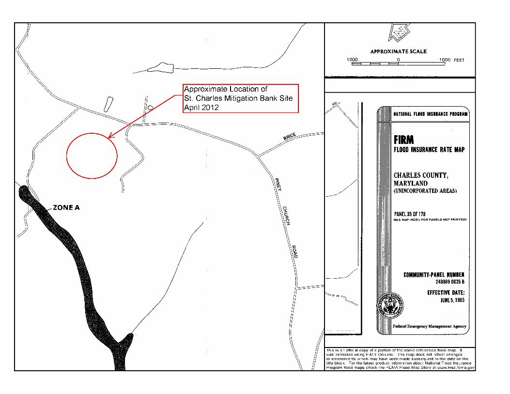
The ecological importance of the Zekiah Swamp is substantial. The Swamp is an “Area of Critical State Concern” and the entire Wicomico River/Zekiah Swamp watershed is designated as a “Scenic River” by the Maryland General Assembly. The 1987 Maryland Scenic Rivers Act designated the entire watershed for special environmental and cultural concern. In 1974, the Smithsonian Institute called Zekiah Swamp “one of the most important remaining ecological areas on the East Coast.” The Wicomico Scenic River Commission calls it the best example of a non-tidal wetland in Charles County. Zekiah Swamp is the largest hardwood swamp in Maryland, and was rated highest for natural areas within the Chesapeake Bay region by the Smithsonian Institute. The Wicomico Scenic River Study and Management Plan recommends, among other considerations, that conservation efforts in both Charles and St. Mary’s Counties be focused on the Wicomico River/Zekiah Swamp watersheds. The location of the bank site is provided in Appendix A – Informational Resource Site Maps showing the site on USGS, Aerial, National Wetlands Inventory, NRCS Soils, and FEMA Floodplain mapping. The Sponsor completed an updated wetland delineation on June 5, 2012 and June 11, 2012 and conducted an agency field review attended by Kelly Neff, MDE, and Eugene Morganthauler, Corps, on September 25, 2012. The wetland boundaries were approved by Mr. Morganthauler during the field review.

Mitigation Banking Prospectus St. Charles Mitigation Bank
9
The construction of the bank would have minimal impact on existing wetlands. The construction of the dam would require minor permanent impacts to open water (<0.05 acre). On the downstream side of the dam, there would be an outflow pipe and riprap installed in the receiving stream channel (15 linear feet). The construction of the seepage wetlands would require approximately 0.1 acres of temporary impacts to existing PEM wetlands. The grading for the forested wetlands would impact a wetland ditch (<0.01 acres). Only minor temporary impacts would be required for the installation of plantings and habitat structures, and during the dewatering for the construction of the dam. All permanent impacts would be compensated for through debiting credits from the bank. VIII. WATER RIGHTS
The existing wetlands on site are supported by a combination of direct precipitation, runoff from the drainage area, and groundwater. Groundwater is delivered by seeps at the heads of the ditches, and by direct discharge into the pond. These sources of hydrology are then captured and retained on-site by the dam and spillway. The clay layer identified by the geotechnical borings retards infiltration and supports an unconfined water table under the uplands. Well data indicates that there is groundwater flow from the uplands toward the pond and ditches from late fall through spring. This pattern of high water table during the winter and early spring with a significant drawdown are very similar to those reported for the Zekiah Swamp in the U.S. Geological Survey Water Resources Investigations Report 6-4097, “Reconnaissance of the ground water, Surface Water System of Zekiah Swamp Run Basin, Charles County, Maryland” (1986).
The existing wetlands on the site are present in part due to the backwater from the existing dam and spillway. In order to preserve the hydrology supporting the existing wetlands, and to create new wetlands, the existing embankment and spillway will be re-built. The dam, spillway and outlet structure will require maintenance typical of any stormwater facility or recreational dam. A Charles County Private Stormwater Management Agreement will be signed and recorded by the Sponsor. A weir board water control structure will be used to allow for the adaptive management of the water levels within the wetland. This structure will require minimal maintenance, and will be protected from vandalism. The intake structure will also be designed to minimize the potential for beaver to block the outlet.
The existing drainage area of the proposed mitigation site is approximately 33.5 acres, composed primarily of the reclaimed sand/gravel mine, which is covered with typical fescues and other grasses. Upon development of the adjacent high school this drainage area will be modified. Approximately 34.68 acres of the school property will drain toward the mitigation bank (see attached Watershed Map- Post School Construction, in Appendix D), however, only 1.3 acres will be impervious surface. The drainage from the impervious area will be routed through an oversized bioretention basin where runoff will be stored and infiltrated into the surrounding soils. The remaining drainage areas into the mitigation bank will be composed of baseball, soccer and football fields. The runoff from these fields will be captured in the upland buffer, filtered through dense grasses, and converted to sheet flow prior to discharge to the wetlands. Some of the runoff will be directed to provide the hydrology for the seepage berm, which will result in additional water quality treatment. IX. ANTICIPATED SCHEDULE FOR COMPLETION The Sponsor believes that this prospectus is complete and sufficient for public notice. To facilitate the public notice process, a list of adjacent property owners is provided in Appendix E.
The Sponsor plans on diligently pursuing approval of the Bank through the IRT. The Sponsor plans on meeting with the IRT prior to submission of the MBI and Bank Development Plan to further discuss the Bank. The Sponsor anticipates completion of the MBI and Bank Development Plan by fall 2013, with construction initiated by winter 2014.

Mitigation Banking Prospectus St. Charles Mitigation Bank
10
APPENDIX A
INFORMATIONAL RESOURCE SITE MAPS


66
Piney Church Rd
UgB
GmF
Pu
PT
HgBGmF
Pu
GgB
UgB
333100
333100
333200
333200
333300
333300
333400
333400
333500
333500
333600
333600
333700
333700
333800
333800
333900
333900
334000
334000
334100
334100
334200
334200
334300
334300
4269
900
4269
900
4270
000
4270
000
4270
100
4270
100
4270
200
4270
200
4270
300
4270
300
4270
400
4270
400
4270
500
4270
500
4270
600
4270
600
0 600 1,200 1,800300Feet
0 100 200 30050Meters
±
38° 34' 8''
76°
54' 5
''
38° 33' 40''
76°
54' 4
''
38° 33' 39''
38° 34' 7''76
° 54
' 57'
'76
° 54
' 58'
'
Map Scale: 1:6,080 if printed on A size (8.5" x 11") sheet.
Soil Map—Charles County, Maryland
Natural ResourcesNatural ResourcesNatural ResourcesNatural ResourcesConservation ServiceConservation ServiceConservation ServiceConservation Service
Web Soil SurveyNational Cooperative Soil Survey
12/4/2012Page 1 of 3
Site
St. Charles Mitigation BankPrinted December 2012
Mitigation Banking Prospectus St. Charles Mitigation Bank
11
APPENDIX B
WATERSHED AND
PROPOSED SERVICE AREA MAP


Mitigation Banking Prospectus St. Charles Mitigation Bank
12
APPENDIX C
PROPOSED BANK DESIGN

180
180
180
1927 DATUM
ZONE PUDL2437/F104
ST. CHARLES COMMUNITY, LLCMAP 24 PARCEL 3
180
180
180
175
180
180
180
180
180
180
180
180
180
180
180
180
180
180
180
180
180
180
180
180
185
185
180
181
183
182
179
179
182
183
178
181
182
183
179
179
179
178
179 178
178
179
179
181
11
180.0
70
174
176
177
175
175
175
175
TO
P
RIP
RAP
175.8
4
177
177
PO
ND
PO
ND
PO
ND
178
WELL G
179.21 ELEV
WELL B
102
N:2
66434.4
946
E:8
26207.2
953
El:180.5
9
WR
AW
RA
WR
A
180.48 ELEV
WELL F
181.23 ELEV
103
N:2
66608.6
826
E:8
25968.0
444
El:182.8
5
E:8
25968.0
444
WR
AW
RA
WR
A
E:8
26210.8
773
El:186.1
1
WR
A
175
175
175 175
17517
6
N54°47'14"E
421.85'
S58°
15'12"
E
282.2
3'
N36°12'25"E
66.43'
N28°51'00"W
98.96'
N10°35'29"W119.09'
N59°52'25"E
54.37'
N50°05'45
"W
177.71'
N51°19'45
"W
104.42'
N74°47'27"
W
85.03'
N60°
23'56
"W
271.18'
N36°19'53"W
203.40'
N26°12'51"W97.32'
N44°11'19"E
44.15'
N25°09'04"W118.80'
S35°41'10"W
79.16'
S21°38'55"E64.41'
S10°
56'39"
W
497.70'
S13°25'26"E276.32'
S18°18'28"E195.92'
180
180
181
182
180
180
181
182
180181182
183
183182
181
179
181
180
179
178
177
180
179
180
180
175
183
DESIN
ED
BY:
SC
AL
E:
DA
TE:
SH
EE
T:
1"=10
0'
R.
C.
S.
CH
AR
LES
CO
UN
TY,
MA
RY
LA
ND
ST. C
HA
RL
ES
CO
MM
UNITIE
S
MARYLAND STATE PLANE
COORDINATE SYSTEM
N
1927 DATUM
LEGEND
0 100' 200'
SCALE
410-235-3450
Baltim
ore,
Maryla
nd
801
So
uth
Carolina
Street
EN
GIN
EE
RS, A
RC
HIT
EC
TS
AN
D
PL
AN
NE
RS
WHIT
MA
N, R
EQ
UA
RD
T
AN
D
AS
SO
CIA
TES, L
LP
SEEPAGE WETLAND (PEM) - 0.21 AC.
WOOD DUCK HABITAT (PSS)
EDGE OF WATER
EXISTING WETLAND BOUNDARY
CREATION (PEM) - 1.90 AC.
EMERGENT WETLAND
ENHANCEMENT (PFO) - 1.64 AC.
FORESTED WETLAND
ENHANCEMENT (PEM) - 2.87AC.
EMERGENT WETLAND
ENHANCEMENT - 0.59 AC.
OPEN WATER
W/L 177.8
PFO ENHANCEMENT
PEM ENHANCEMENT
PEM CREATION
PEM CREATION
PFO CREATION
VERNAL POOL
SEEPAGE WETLAND
3 0
F 3
NO
VE
MB
ER, 2012
UPLAND BUFFER (1.84 AC.)
CREATION (PFO) - 1.91 AC.
FORESTED WETLAND
PR
OP
OS
ED
BA
NK
DESIG
N
AP
PE
NDIX
C
AD
VA
NC
ED
MITIG
ATIO
N
SIT
E
EXISTING SITE CONDITIONS
JURISDICTIONAL WETLANDS - 4.62 AC.
JURISDICTIONAL WATERS - 2.28 AC.
1+00
2+00
4+00
5+00
6+00
7+00
8+00
10+0
0
0+00
3+00
9+00
11+0011+15

Mitigation Banking Prospectus St. Charles Mitigation Bank
13
APPENDIX D
WATERSHED MAP-
POST SCHOOL CONSTRUCTION

DrainageArea to
MitigationSite
Area 205B - TennisCourts Drain to
Bioretention BMP
Area 205C - Athletic Field
Flow to Wetlands
Athletic Fields
Athletic Fields
Mitigation
Bank
ST. CHARLES MITIGATION BANK
SCALE : UNKNOWN DATE : DECEMBER 2012
WATERSHED MAP - POST SCHOOL CONSTRUCTION
BioretentionBMP
DrainagePipe