
“PROTEC OUR RIVERS”
39
“PROTEC OUR RIVERS”
Transcript of “PROTEC OUR RIVERS”

“PROTEC OUR RIVERS”

River Science • Not that old compared to Lake Science or Limnology • Since Noel Hynes Work in early 1960s • Vannote and co-workers forwarded “River Continuum Concept” (1980) • Nutrient Transport along the rivers • Downstream drift • Leaf litter decomposing • Feeding guild and functional Feeding Groups • Coupled with Eco-hydrology and phytotechnology • Microbial Loop • Latest, Near Census River Science

NE Monsoon
Atmospheric
Depression
Atmospheric
Depression
Bay of Bengal
Arabic Sea
SW Monsoon
SRI LANKA

Streams and Rivers • Natural Resources • Responsible for material transport on the plant earth via hydrologic cycle • Hydrologic Cycle is the best treatment plant in nature • Provide a variety of goods and services (Energy, food, transport, etc.,) • People use river systems but, also misuse

NE Monsoon
Atmospheric
Depression
Atmospheric
Depression
Bay of Bengal
Arabic Sea
SW Monsoon
SRI LANKA

Misconception of 103 River basins in Sri Lanka To be corrected as 103 drainage basins, of which only 16 have perennial flows
River Disch. mcm Mahaweli 4009 Kalu 4038 Kelani 3417 Maha Oya 1746 Deduru Oya 1608 Gin 1262 Nilwala 1152
Range (mcm) # Rivers 1000-4999 7 500-999 2 300-499 11 100-299 15 50-99 12 25-49 26 010-24 17 001-09 13

0
10
20
30
40
50
60
70
80
90
0 0.5 1 1.5 2 2.5 3 3.5Discharge per unit area (m)
% d
isch
arge
Wetzone Rivers
Wet & Dryzone Rivers
Dryzone Rivers
River Basins
Water Resources Rainfall 1593 mm/y
PPT Volume 109 km3
Discharge into Indian Ocean 27.8 km3

Mahaweli, Kelani, Kalu and Walawe rivers are not rising from Adam’s Peak • Mahaweli River from Pidurutalagala as Nanu Oya • Kelani River from Adma’s Peak as Baththulu Oya • Kalu Ganga from Adma’s Peak as Seetha Ganguala • Walaw River from Horton Plains as Belihul Oya from Bakers Fall

Bolgoda Ganga, Telwatte Ganga, Madu Ganga, Hikkaduwa Ganga etc., are not rivers; they are back barrier lagoons originated during mid-Holocene sea level rise

None of the major rivers has continuous flow from headwaters to downstream Certain Stretches of trunk streams are totally dead and continuum of river ecosystems • Loss of flood plains or “villus” • Disappeared delta • Loss of material fluxes into the ocean Yan Oya delta and Malathu Oya will be disappeared following the construction of proposed Malathu Oya and Yan Oya reservoirs

8.4 km3
27.8 km3
1.8 km3
??
RESERVOIRS
LAND SURFACE ??
Evaporation
H,P,D 109 km3
ET
I
N
D
I
A
N
O
C
E
A
N
SURFACE RUNOFF
1593 mm
Rainfall
Local Hydrologic Cycle
H, Hydro
P, Paddy
D, Drinking
Sri Lanka

KEY
Reservoir
Spilway
Hydro power
Stations
Irrigation Area
Tunnel
Feeder Canal
Discharge
to Sea
Reservoir
Angamuwa
(Not connected to the Mahaweli System)
Kotmale
Kotmale Oya
Upper Mahweli
Ukuwela Polgolla
Victoria
Sudu Ganga
Randenigala
Rantabe
Mimipe LB
Mim
ipe
RB
Mimipe
Bad
ulu
Oya
Logg
al O
ya
Hep
ola
Oya
Diy
aban
a O
ya
Ulhitiya/ Rathkida
Maduru Oya
Nalanda Kalawewa
Rajangana
Bowatanna
Dambulu
Oya
Elahara
Angammedilla
EMYE
Yoda Ela
Mahwali Ganga
Tissawewa
Nachchaduwa
Nuwarawewa
Kandalama Huruluwewa
Mal
wat
u O
ya
Yan Oya
Vendrasan Kantale Kaudulla
MKYE Minneriya
Giretale Parakrama Samudra
Reservoir
Schematic
Representation
of the Mahaweli
System


15
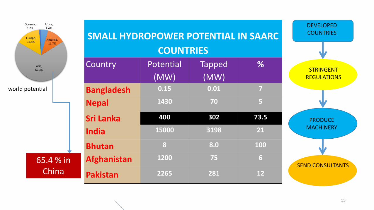
SMALL HYDROPOWER POTENTIAL IN SAARC COUNTRIES
Country Potential (MW)
Tapped (MW)
%
Bangladesh 0.15 0.01 7
Nepal 1430 70 5
Sri Lanka 400 302 73.5
India 15000 3198 21
Bhutan 8 8.0 100
Afghanistan 1200 75 6
Pakistan 2265 281 12
STRINGENT REGULATIONS
PRODUCE MACHINERY
SEND CONSULTANTS
DEVELOPED COUNTRIES
Africa, 4.4%
America, 11.7%
Asia, 67.3%
Europe, 15.4%
Oceania, 1.2%
world potential
65.4 % in China

16
Mini Hydropower Plants in Sri Lanka Mahaweli River 60 Kelani Ganga 31 Kalu Ganga 28 Walawe River 11 Others 13 Total 143 Under construction 37
6
3 5 5 4
12
9
13
4
13
10
4
8
15
23
15
0
5
10
15
20
25
30
35
40
45
50
<2000 2000 2001 2002 2003 2004 2005 2006 2007 2008 2009 2010 2011 2012 2013 2014
MHP Development in Sri Lanka
Number of MHPs Capacity (MW)

Mini-hydro Massive
Constructions
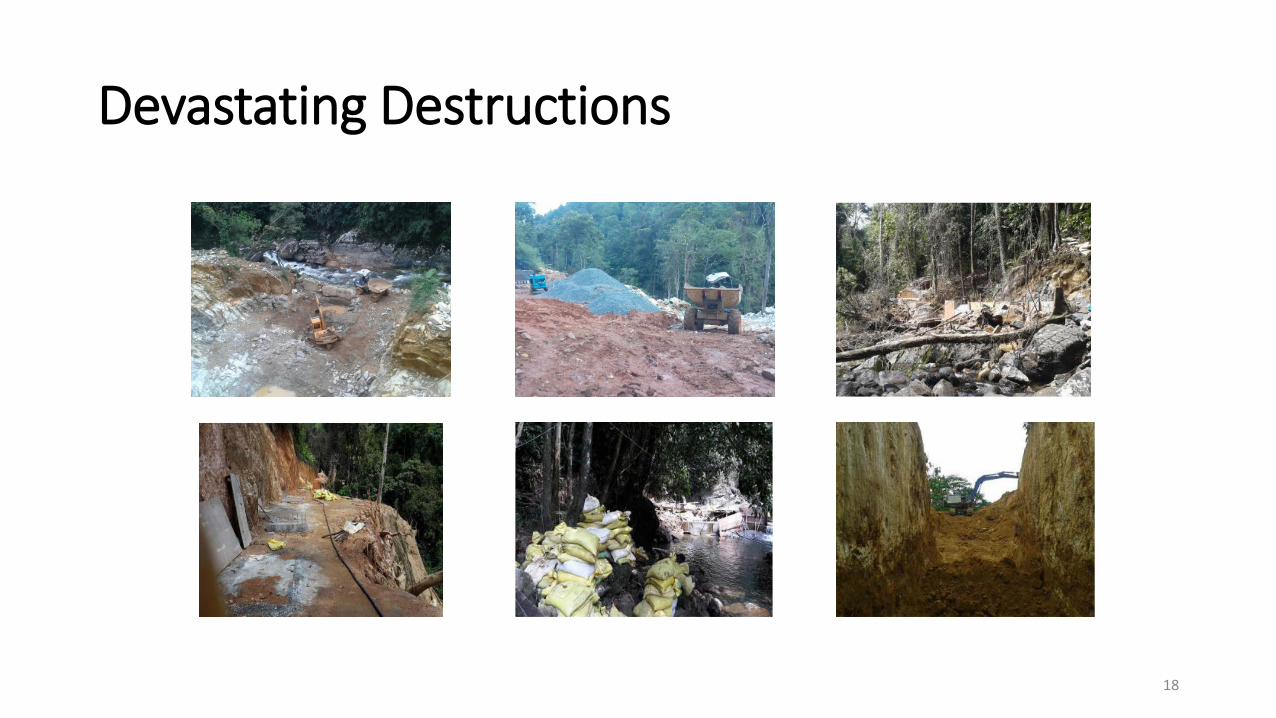
Devastating Destructions
18
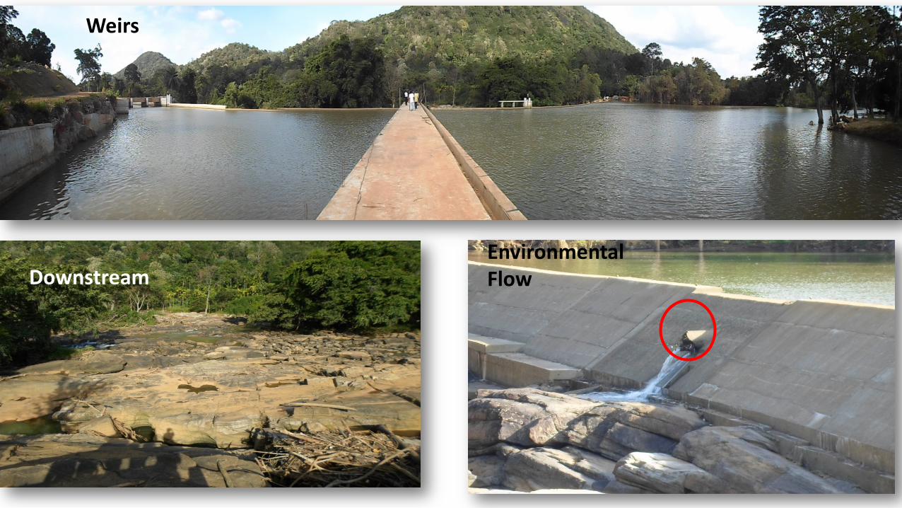
Weirs
Downstream Environmental Flow

20

21

1086420
5
4
3
2
1
0
Capacity of Power Plant (MW)
Aff
ect
ed
Str
ea
m S
tre
tch
(km
)
Scatterplot of Affected Stream Stretch over Capacity ASS vs Generation Capacity
Y = 0.736 + 0.366 X
P=0.000
Affected stream stretch varies with increasing generation capacity (correlation = 0.817)
River Basin Number of Plants Installation
Capacity (MW) Affected Stream Stretch (km)
Mahaweli 57 113.4 77.3 Kelani 32 55.61 47.34
Kalu 28 69.91 20.82 Walawe 14 26.84 17.31
Gin 02 3.95 0.80 Nilawala 03 1.10 0.60 Kirindi Oya 02 1.40 0.40 Maa Oya 03 7..50 4.30 Maduru Oya 02 7.00 00.0 Total 143 279.2 168.9
Basin River length Flow through channels, conduits and penstocks
Mahaweli 345 km 100 km Kelani 145 km 89 km Kalu 129 km ? km

23
Small stagnant pools are scattered along the river stretch from headwater to downstream between the weir and the power house in all four cases
Although Run-of- River Systems ,no regular environmental flows between the weir and the power house
Moneraela Weir

24
Polluted water with epilithic algae, perhaps cyanobacteria with mosquito larvae were abundant in stagnant pools with dense litter
GHG
Fragmented micro habitat not suitable for fish Stagnant pools with dense litter

25
53
41 34
Freshwater Fishes in Sri Lanka
93 Freshwater fishes in Sri Lanka
53 Found in hill streams
41 Endemic to Sri Lanka
34 Found only in hill streams
14 Critically endangered
93
18

26
11
1
2 3
4
5 6 7
Bio geographic Region Endemics Critically Endangered
Mahaweli 08 01
Knuckles 11 04
Kelani 17 01
Kalu 17 02
Gin 17 03
Nilwala 14 02
Walawe 09 01
1

Small Hydropower Plants • Alter stream flow • Expose stream bed • Stop fish movements • Affect waterfalls • Change stream habitats • Erode river banks • Gradually kill streams • Fade away beauty of nature
Affected Stream Stretches • Create habitats for mosquitoes • Vanish bathing pools • Alter water quality • Emit GHGs • Promote toxigenic algae • Promote vector borne diseases • Change groundwater balance • Affect riparian community
The negative effects of small hydropower operation on endemic fish and migratory eels are obvious Many stakeholders including so-called ecologists are responsible for this pathetic ecological crime.

28
Lost Spray Zones due to Major (Red) and Minor (Blue) Hydropower Development Mahaweli Basin Kelani Basin Kalu River Basin Nilwala Basin Walawe Basin
Aberdeen Laxapana Fall Alupola Fall Ethamala Ella Lemastota Oya Devon Fall Ellpita Ella Dehan Fall Fall Pundalu Oya Ganthuna Fall Bambarabotwa
St. Clair Fall Nakkawila Fall Oya Fall Victoria Fall Ritigaha Oya Fall Delta Fall Wee Oya Fall Glassaugh Fall Kabaragala Fall Manelwela Fall

29
St Clair Fall – then St Clair Fall – today

30

31
Tunnel and Conduit Network in the Highland (km) Major hydro Mini Hydro
Basin Tunnels Penstocks Tunnels Penstocks+Canals Mahweli 55.6 0.90 77 Kelani 0.88 22.4 33 Kalu 5.70 0.84 28 Walawe 4.50 0.88 17 Others 15 Total 67 25 170
Penstocks and concrete canals are more injurious on forest vegetation than tunnels Tunnels do not allow lateral transport of moisture Both penstocks and concrete canals prevent lateral transport of moisture and root penetration of canopy trees


Doctor
Engineer
Other Professions
Health Domain
Scientis
Natural Resources Management
Water
Construction &
Maintenance
Irrigation Water Supply Hydropower
No Coordinatiion with Scientists
Scientists
X Wildlife & Forest
Officers
R E J E C T S

Thank you !