PROPOSED LOWER CHURCHILL HYDROELECTRIC
122
Transcript of PROPOSED LOWER CHURCHILL HYDROELECTRIC


•
Department of the Environment Fisheries & Marine Service
Newfoundland Region
AN OVERVIEW OF FISHERIES PROBLEMS ASSOCIATED WITH THE PROPOSED LOWER CHURCHILL HYDROELECTRIC
DEVELOPMENT, .GULL ISLAND, LABRADOR
• by
W. J. Bruce, C.J. Morry, L.W. Rowe, and R.J. Wiseman
Internal Report Series No, NEW/1-75-2
Resource Development Branch Newfoundland Region
AlC 5Xl
1975

•
,

•
• FRONT COVER PHOTO: Angling at the Lower end of Winokapau Lake,
Lower Churchill River. Courtesy of L. Cave,• Graphics Division, Environment Canada,
Ottawa.

•
•

1.0
2.0
3.0
3.1 3.1.1 3.1.2
3.1.3
3.1.4
3.2 3.2.1
3.2.2
3.2.3
3.2.4
3.3 3.3.1 3.3.2
4.0
TABLE OF CONTENTS
LIST OF TABLES ••.......•...•.....•..•.•............•......•.. iii
LIST OF FIGlJRES ... ,.,., •.•.........................•......... iv
I NTRODUCT ION, ...•. , .......................................... . 1
THE PROPOSED PROJECT ••••.••••.•••••••..•••..•.•..••••••••.••• 3
IMPAC'rS •..• 0 8•••••••••••••••••••••••••••••• 0 ••••••••••••••••••
The Churchill River •.•••••• Fish Resources ••••••••.•••• Limnology of the Churchi 11 River. Water Quality. Plankton •••••• The Re servoi r •• Physical •. Chemical. , Biotic •.•. The Dam and Downstream Area •• Dam •.•••••.•••••••• Diversion Tunnels. Spillway Structure. Int ake ............ . .. . The Transmission Line •••• Fish Resources •.•.•••••• Atlantic Salmon Fishery •• Trout Fishery •••.••.•..• , Physical Effects of Construction. Sed imeht .............. .. ......... . Removal of Stream-side Vegetation. Obstructions. . •• Guidelines •.• Right-of-way Clear Cutting. Placement of Towers. Stringing of Wire ..• Construction Camps. Marshalling Yards •.• Chemical Effects of Construction and Post Construction Vegetation Control. Sewage and Solid Waste Disposal. Biting Fly Control •.••••.•.•.•••
..... 8 9
10 10 10 11 .......... . 11 13 ... 14 .... 15 16 17 17
• • , ". ' 0' • 17
18 ... 19 21 24 24 24 26 27 27 28 33 33 33 34
Operation •• 34 34 35 36
The Straits Tunnel •.••.•••..••••.•.••.•. 36 Fish Resources ............... 360 •••••••••
Potential Impact of Tunnel Development. 38
CONCLUSIONS AND RECOMMENDATIONS •••••••..••••••••.•••.••• , •••• 42
i


4.1 4.1.1 4.1.2 4.1. 3 4.1.4
4.2 4.2.1 4.2.2 4.2.3
4.3 4.3.1 4.3.2
5.0
6.0
The Churchill River. Fi sh Resources ••.•••• Limnology of the Churchill River. The Reservoir •.•••••••••••• • • The Dam and Downstream Area • • Dam, ••••••• Diversion Tunnels ••• Spillway Structure. Intake ............ .
The Transmission Line •• Fish Resources ••.••••• Physical Effects of Construction. . , . Chemical Effects of Construction and Operation •• Post Construction Vegetation Control •• Sewage and Solid Waste Disposal •• ... Biting Fly Control • •.••••.•.••• • .
The Straits Tunnel ••.••••.•••• , •.•••.••• Fish Resources ......... "............... . Potential Impact of Tunnel Development.
." '
REFERENCES ...••.•..••••.•••.••.••••.••.•.••.•..•••.••• "•.•.
ENVIRONMENTAL PROTECTION UPDATE ••.••••.••.••...••••..•.. . .•
Page
42 42 42 43 44 44 45 45 45
46 46 47 48 48 48 48
48 49 49
51
52
ii


LIST OF TABLES •
Table Page
1 Checklist of fish species occurring in Newfoundland and La.brador .. 4 •• , • , •••••••••••••••••••••••• 0 •••••••••••• 0 • 20
2 List of scheduled salmon rivers to be crossed by the transmission line ..... d • 0 ••• '0' •••••••••••••••• c • •• • •• • 22
3 1973 commercial salmon landings (pounds and dollars) from fisheries contributed to by rivers crossed by the transmission line ............. 0 ••• , ••••••••••••••• 0 •• 0 0 23
iii


LIST OF FIGURES •
Figure Page
1 Location Maps, showing major centres mentioned in the text and the proposed transmission lines........................ 5
iv

· .

•
1.0 INTRODUCTION
The Churchill River system supports many valuable recreational and
commercial fish species that would be affected by the development of the
river for hydroelectric purposes as proposed. These include the
anadromous and resident Atlantic salmon, brook trout, and char; lake
trout; lake whitefish; northern pike; longnose sucker; white sucker;
burbot; and anadromous American smelt. In addition, there are at least
four other non-consumptive use species which have their importance in
the overall aquatic ecosystem.
Within the proposed transmission line corridor, there are, in
addition to those fish species outlined above, four species of recre
ational-commercial value, and at least eleven others which are at
present of no economic value. The four economically valuable species
include, rainbow trout l brown trout: pink salmon, and the American eel.
Nine commercially important species are encountered within the
corridor of the proposed Straits tunnel. These include cod, halibut,
plaice, herring, salmon, capelin, scallops, lobster, and harp seals.
In addition, many other marine species of ecological importance are
found within the corridor, ~everal of which possess potential for
commercial exploitation.
Generally speaking, there is concern for the protection of
fisheries and fish habitat within the are of influence of the proposed
development. Three areas of concern have been identified in connection
with the development, and the existing fisheries, fish populations and
habitat have been reviewed and guidelines and recommendations presented

..
- 2
for the protection of same. The three areas of concern with respect to
fisheries protection are (1) the Churchill River, (2) the transmission
line corridor, and (3) the Straits tunnel corridor. Generally, our
projections of po~sible fisheries - power development conflicts are
ranked in the order as written above. That is, the most serious con
flicts could occur within the Churchill River while the least sensitive
activity should be the Straits tunnel crossing.
In sUmmary then, the intent of this report is to provide an over
view of the fisheries' problems to be encountered with the development
of the Lower Churchill River for hydroelectric generation, and to provide
reconnnendations for remedial measures to ensure the protection of the
fishery resources. This report, although rather general in nature, is
intended to be the basic working document for those workers having
responsibility for the protection and management of fisheries within the
area of influence of the proposed development.

-3
2.0 THE PROPOSED PROJECT
Development of the Churchill (Hamilton) River system for hydro
electric production began in 1963 with the installation of dams at Twin
Falls on the Unknown River. Production capacity at this site was
increased in 1968; however, in the meantime plans were well underway for
the massive Churchill Falls power project which would soon make Twin
Falls obsolete. In 1972, the Churchill Falls dam and power plant was
completed, with an installed capacity of 5,225 mega watts (roughly
7,000,000 horsepower).
This was the first and greatest step in the total harnessing of
the Churchill River which will eventually supply a total of 7,625 MW.
The remainder of this potential is to be achieved in two phases; the Gull
Island Project, yielding 1,800 MW and Muskrat Falls Project which, at
some time in the future will be developed to provide the final 600 MW,
available.
It is the former of these two phases, the Gull Island Project,
which is the area of immediate concern. Barring production delays the
power is to go on stream in the beginning of the 1980's and as yet little
is known of the River's fisheries resources which could be drastically
altered.
Unlike the Churchill Falls site, Gull Island will be a "run-of
the river" scheme with minimal storage capacity in the newly created
reservoir. The dam is to be located near Gull Island Rapids, 140 miles
downstream from the Churchill Falls powerhouse and about 55 miles up
stream of Happy Valley - Goose Bay. It will be an earthfill-typedam

-4
providing 300 feet of head and the reservoir created will extend almost
the full 140 miles to the Churchill Falls tailrace. Due to the
precipitous nature of the river bed, however, the reservoir will be very
narrow and deep. The only lake to be flooded is Winokapau, which itself
is truly part of ' the Churchill River.
During operations, downstream effects are expected to be minimal
because of the "run-of-the-river" nature of the project. Because the
Churchill Falls Development and that at Gull Island are to be integrated,
it is estimated that downstream flow should never be reduced by more than
6% of present levels. Daily drawdowns behind the dam should be between
1.2 and 5.5 feet and can be replenished in a matter of days. A total
drawdown of 20 feet is hypothetically considered to be the maximum one
can expect.
Six 300 MW generating units will be on stream at full capacity.
The power thus generated will be carried to Insular Newfoundland by two
400 KV, 800 MW, transmission lines. The bipolar transmission lines from
Gull Island to Newfoundland will cover a distance of 685 miles. The two
lines from Gull Island to a converter station at Stony Brook (Grand Falls),
a distance of 485 miles, will require a 350 foot right-of-way. A single
line, two hundred miles long with a 150 foot right-of-way runs the
remaining distance from Stony Brook to Soldiers Pond, near St. John's.
In addition, it is planned to construct a transmission line from the
Gull Island site to Churchill Falls, a distance of approximately 120
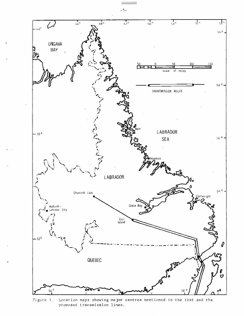
miles (Figure 1).
Actual construction of the transmission line involves the clear
cutting of the right~of-way, installation of towers and stringing of

-5
, ' I fill r) 1
UNGAVA BAY
50 0 50 100 150, ,I A A I J scale of mi les
------~===================t,----- 58 a
\ TRANSMISSION ROUTE
.~\... ,J l
(.J /
.) I
\
r) " :\ LABRADOR r....\,. 56 aSEA .~""
i .... (~.';\ .;J
\.1 \., 7 '. \. '. '"\ -.'. ..-/) v \J
.--".' LABRADOR\
l
Churcilill
i Wabushr··-. Labrador City ~ ,.,", .". ".! i
01 ,"')
rJ ,:",,' " , \ ,'--'
I~r\ }( '._)"1 I \
.' \ ,. ~J:" ,; _.. ...,-., ... - .. - - .. __ .' -"\ )
v
QUEBEC
Figure 1. Location maps showing major centres mentioned in the text and the proposed transmission lines.


I
I
LABRADOR
-6
o i+- Tf) Lull 1,l,wd ~2 .-. ~'-'-'l
QUEBEC
NEWFOUNDLAND
50 o 50 100 E3 E3 E3 • • Seale of mile. Tran~mlssion Route


-7
wire. Associated activities include the building of construction camps.
marshalling yards for equipment and material storage and possibly access
road construction.
The transmission route will be used as a roadway and will require
the use of culverts and temporary bridges.
The maintenance of the right-of-way, in terms of vegetation control,
after construction, will employ either hand-clearing, controlled burning,
or the use of herbicides.
At the Straits crossing a tunnel 11 miles long by 14 feet wide and
17-1/2 feet high will be constructed at an approximate depth of 1,700
feet below the sea floor. Two vertical shafts, one at Pointe Amour,
Labrador, and the other at Yankee Point, Newfoundland, will carry the
transmission lines from the cable switching stations to the tunnel.
Construction activity during the development of the Project will be
concentrated at the dam site, Point Amour, yankee Point, and Stony
Brook with smaller groups working the transmission line. At Gull Island
a trailer camp to accommodate 200 men is presently being assembled. By
1976, this should have expanded to accommodate 2,100 or more workers.
The permanent townsite originally thought necessary for the Project
itself is now to be located at Happy Valley - Goose Bay, thus eliminating
the need of a landing strip at Gull Island. On each side of the Straits
a 120 man construction camp will be built. These will each be served
with new air strips and wharves. At Stony Brook accommodation for 100
men will be necessary and 20 to 50 man camps will be dispersed along
the transmission line route.


-8
3.0 IMPACTS
3.1 The Churchill River
The Churchill River basin is the largest in the province and has a
total drainage area of approximately 36,500 sq.mi. which is about 85 per
cent of the area of the entire island of Newfoundland. The drainage of
the river can generally be divided into three parts: (1) the upper
drainage consists of that area above Churchill Falls, including the
Ashuanipi River drainage, the largest Churchill tributary; (2) the
central drainage area includes the greatest part of the river valley and
its tributaries, and stretches from Churchill Falls to Muskrat Falls, a
distance of 175 miles; and (3) the lower drainage is that area between
Lake Melville and Muskrat Falls, a distance of 25 miles.
This natural drainage system was altered with the beginning of the
Upper Churchill hydroelectric program in 1971. This program meant the
diversion of two large river systems, the Naskaupi and the Upper
Churchill, and flow of water over Churchill Falls itself was greatly
reduced. By means of diversions the water which normally cascaded over
the Falls has been retained on the plateau and channelled to turbines
above the river and east of the Falls (Duthie and Ostrofsky, 1975). A
second alteration of the Churchill River is planned with the Gull Island
hydroelectric development program. This program calls for the construc
tion of a run-of-the-river plant and it will be tied in with Churchill
Falls Development.
There is a 400 foot head available between Churchill Falls and the
mouth of the river at Happy Valley - Goose Bay and this project will
develop about 75 percent of the available head. The remaining 100 foot


-9
• head may be developed at Muskrat Falls at some future date .
3.1.1. Fish Resources
Most, if not all, of the freshwater fish species found in inland
Labrador are present in the Churchill River and its drainage basin. The
most important sport species are resident and sea-run brook trout,
Salvelinus fontinalisj resident and sea-run Atlantic salmon, Salmo salar;
sea-run Arctic char, Salvelinus alpinus; lake trout, Salvelinus namaycushj
and northern pike, Esox lucius. Other species present are lake whitefish,
Coregonus clupeaformisj round whitefish, Prosopium cylindraceum; longnose
sucker, Catostomus catostomus; white sucker, Catostomus commersoni; sea
run American smelt, Osmerus mordax; burbot, ~~; threespine stickle
back, Gasterosteus aculeatusj ninespine stickleback, Pungitius pungitius,
and at least one species of minnow, the lake chub, Couesius plumbeus.
Muskrat Falls is considered a natural barrier to migrating anadromous
or sea-run fish and as a result only about 1.3 percent of the total drain
age area is available to anadromous forms of such species as the Atlantic
salmon, brook trout and Arctic char.
In addition to the main river itself, there are a number of large
river systems which drain into the Churchill River above the proposed dam
site. These are the Metchin and the Cache on the north shore, and the
Elizabeth Fig, Shoal, and Minipi on the south shore. All these rivers
should be good producers of fish, particularly resident salmonids.
Below the dam site the Pinus River and Upper and Lower Brooks empty into
the Churchill from the north, and the McKenzie River, Caroline Brook, and
Traverspine River enter from the south. In addition to these major
river systems there are a large number of smaller tributaries which

•

-10
empty into the Churchill River . •
3.1.2 Limnology of the Churchill River
Very little is known of the limnology of the Lower Churchill River.
The only data available on the Churchill River system are those gathered
on the Upper Churchill River, therefore we are required to extrapolate in
any discussion of limnology of the section between Churchill Falls and
Happy Valley - Goose Bay.
Water Quality:
Water quality studies conducted in various areas of Labrador reveal
the waters are very soft, low in dissolved solids, and the pH values are
generally slightly less than 7. Water quality analyses have been con
ducted on the waters making up the upper Churchill basin by Duthie and
Ostrofsky (1974, 1975). They reported mean conductivity values between
10.2 and 32.0 and pH values ranged between 6.0 and 6.5. The lakes in
western Labrador are generally ice-free between late June and late
October with maximum surface temperature being reached in late July.
Turbidity values are low and they seldom exceed 6 units except during
the spring thaw. The lakes are usually saturated with oxygen during
the ice-free periods.
Plankton:
Very little work has been done on either the phytoplankton or zoo
plankton populations of inland Labrador. Duthie and Ostrofsky (1974)
sampling 10 lakes and a reservoir in the Churchill Falls region of
western Labrador identified 44 taxa of phytoplankton and zooplankton.
Diatoms were the most abundant group reported for the phytoplankters


-11
while the cladocerans were the dominant zooplankton group. The zoo
plankton of western Labrador is very similar to that of other lakes on
the Canadian Precambrian Shield. Limnological studies on a natural lake
and reservoir in western Labrador, conducted by this Department in 1974,
report similar findings of zooplankton as reported by Duthie and
Ostrofsky (1974).
3.1.3 The Reservoir
The impacts arising from reservoir formation will be of a physical,
chemical, and biotic nature.
Physical:
The construction of a 300 foot dam at Gull Island rapids will turn
the river upstream of the dam into an artificial lake (reservoir). At
its maximum design elevation of 403 feet, the reservoir will cover an
area of approximately 77 sq.mi. and will contairi a total volume of about
3 million acre-feet. The maximum depth will be about 300 feet near the
dam, and its total drainage area will be 34,400 sq.mi. The morphometry
of the existing river will be greatly changed; the water level, surface
area and mean depth will be greatly increased, and most of the existing
shoreline will be lost. The littoral zone which includes the lake
shoreline is the most productive area within a lake or river system and
is most influenced by morphometric, edaphic, and climatic factors. This
area lies within the photic zone (zone of light penetration and bio
logical production) and receives a high supply of nutrients. This is
the area of plant growth and benthic communities, both of which are
important links in the freshwater food web. Damming of the river will


-12
eliminate this existing production zone. Many, if not all, of the rivers
and tributaries entering the Churchill River will be partially flooded as
a result of this hydroelectric development project. It is felt that
these systems which are accessible to fish serve as spawning and rearing
areas, particularly for salmonids and coregonids. These spawning and
rearing areas will be lost as a result of inundation. Other areas up
stream, if accessible, may become available for fish spawning. If
barriers do exist even after flooding they could be removed either by
blasting or by the construction of fish passage facilities.
Within the newly formed reservoir, daily load variations at the
generating plant will be reflected in normal drawdowns of some 1.2 to
5.5 feet with the water being replenished within a matter of days.
Drawdowns of up to 20 feet have been predicted for the new
reservoir if the operations of the Churchill Falls and Gull Island plants
are non-integrated. Under a "no tie-in" system this maximum drawdown
could possibly occur once a year, most probably during early spring
before the run-off occurs. Also, a non-integrated operation would
necessitate a possible drawdown of approximately a foot daily, or a 5-7
foot drawdown over a week. Should the two plants operate as an integrated
system, which is most likely, the 20 foot drawdown would not be necessary.
The adverse effects of drawdowns on the long term wellbeing of reservoir
fish stocks is obvious.
The formation of the reservoir would undoubtedly alter the water
temperatures of the existing river. As a result of increase in surface
area more surface water would be receiving solar radiation and the
epilimnion area would be greatly increased. Thermal stratification
would undoubtedly occur during the summer months and a thermocline may
develop.


-13
Chemical:
Generally, with the flooding of terrestrial land surfaces there is
an increase in nutrients as a result of leaching of the soils. The
actual increase of any particular element depends upon the nature of the
soils inundated and the soils of Labrador are generally poor nutrient
wise. Duthie and Ostrofsky (1974) reported that the underlying bedrock
appeared to be more important than flooding in determining the water
chemistry of the newly created Sma~lwood Reservoir. Their studies showed
there were no great changes in the chemical and physical factors they
measured after 8 years of inundation.
Additional changes in water quality are expected if clear-cutting of
the forests is not conducted. These changes included: reduced pH,
increase in humic acid, increase in color and turbidity, increase in
tannin - lignin levels (two very slow decomposing materials found in
wood), increase in oxygen consumed, and a slight increase in total
dissolved solids.
If the forests are clear-cut the adverse effects of dystrophy would
be significantly reduced. Clear-cutting and subsequent disposal of the
forest would, in effect, result in a smoothing out of the peaks and
troughs normally associated with ecological succession in reservoirs.
The over-riding effect would be an environmental stabilization.
In addition to the ecological benefits to be derived from clean
cutting, it would also facilitate operations during any commercial
fishing venture which may be established.
Dissolved oxygen in the reservoir should be comparable to that in
a large oligotrophic lake and there shouldn't be any appreciable
depleting of same.


-14
I\iolic:
Some changes in species composition and biomass of p1ankters is
anticipated as a result of flooding. Increased standing crops of
phytoplankton during the first few years after flooding have been
reported for reservoirs in the U,S,S,R (Prijmatchenko, 1961), Czechoslo
vakia (Javornicky, 1966), and the Smallwood Reservoir (Duthie and
Ostrofsky, 1974). Similarly, associated with this increase in phyto
plankton biomass, there is an increase in zooplankton standing crop. In
addition to phytoplankton, increased particulate matter and bacteria in
new reservoirs are food sources for zooplankton .
. Very few investigations have been conducted on the benthic
communities in the waters of Labrador. Changes in the mean level, · and
continuous fluctuations about the new mean, inevitably affect the
benthos of the littoral zone, Flooding will not only alter the physical
nature of the bottom but will also result in loss of macrovegetation.
As a result of this many species may be deprived of a habitat and may be
replaced either by new species or by increased number of existing species
which are favoured by the new conditions. These changes which occur in
the littoral zone will also affect the feeding and growth of fish.
Generally speaking then, concurrent with an anticipated initial increase
and subsequent levelling off of plankton biomass, there will probably be
a similar pattern for the benthic community. Such is the generally
accepted model for predicting changes in reservoir plankton and benthic
communit ies.
The creation of this 140 miles, narrow, deep lake should provide
suitable habitat for several fish species, particularly lake whitefish
and lake trout. Lake whitefish is the most abundant fish species found


-15
in the Smallwood Reservoir on the Upper Churchill River system, and
appears to be doing quite well in the newly established habitat. Lake
trout are typically a cold water species which inhabit deep, oligo
trophic lakes similar to the one which will be established above Gull
Island.
Other Labrador salmonids, e.g. brook trout and Atlantic salmon
(ouananiche), appear to require fast flowing, well-oxygenated water and
they perhaps will find it difficult to adapt to the environment of the
created reservoir. They presently are found in concentrations near the
mouths of the tributaries that empty into the Churchill River, as well
as in the rapid sections of the main river (e.g. Horsesho~, Minipi~ and
Mouni Rapids).
Definitive statements concerning the future abundance of other fish
species, i.e. suckers and northern pike, are difficult to make since we
don't have quantitative data on their present abundance. However, these
species are generally found in shallow lakes and the proposed reservoir
wouldn't appear to provide much suitable habitat for these species.
Pike spawn in weedy areas and this type of substrate won't be too
abundant in the new reservoir.
Test net results from the Smallwood Reservoir show these species
aren't very abundant in the newly flooded areas. It cannot be stated
definitely that this is the result of flooding because we have no fish
data for pre-impoundment conditions.
3.1.4 The Dam and Downstream Area
As already indicated, the proposed dam is to be of the earthfill


-16
type approximately 300 feet high, and is to be located near the Gull
Island Rapids, specifically at the head of Grizzle Rapid.
Associated with the dam will be twin diversion tunnels located on
the north bank of the river. These are designed to regulate upstream
levels during construction and for final closure of the dam during
reservoir filling. They are designed to pass a diversion flow of
210,000 c.f.s.
The dam will have a concrete chute spillway with the spillway crest
structure comprising seven vertical lift gates.
The intake. to be located between the most southerly tip of the
main dam and the spillway structure, will contain the entrance to the
six separate penstocks.
Dam:
The construction of a 300 foot-high dam (crest length of approxi
mately 4,700 feet) across the river will obviously have impact on any
fish migrations normally occurring in that section of river. To date
there is no documentation of anadromous species above Muskrat Falls.
Some recent, unsubstantiated reports suggest however that sea-run salmon
have surmounted the obstruction at Muskrat Falls. Although of dubious
nature, these reports cannot be dismissed in view of the obvious impli
cations these would have if substantiated.
The section of river downstream from the proposed dam should not be
greatly affected as flow regimes should be somewhat regulated.
Increased erosion will occur immediately downstream of the proposed dam.
It is not expected that ice-jamming will be any more severe than
presently experienced.

-17
DIversion Tunnels:
As indicated, the twin diversion tunnels are designed to divert
flow during dam construction, and it is proposed to close these following
construction to allow the reservoir to fill. It is anticipated this
would require some 15 days at which time there would be no flows through
the dam resulting in a major reduction in flow all the way to Lake
Melville. It is estimated that this reduction would amount to over 90
percent. Over a quarter of a mile would be temporarily dried out
between the dam and Gull Lake.
Spillway Structure:
The spillway will consist of a chute with a low level flip bucket;
a plunge pool downstream of the flip bucket will dissipate the excess
flow energy. The plunge pool will be designed to permit the formation of
a hydraulic jump to facilitate energy dissipation. Frequently, with
certain flow releases, hydraulic jumps have been known to attract fish
and imprison them in the complex back-eddying current associated with
such a jump. There is some suspicion that this is the cause of the
recurring fish kills at the Lobstick Control Structure, in the Upper
Churchill Falls Development.
It is difficult, with the existing information, to say whether
oxygen and nitrogen supersaturation would occur in the water immediately
below the spillway; this has not occurred at the Churchill Falls site,
however.
Intake:
The intake structure will be located between elevation 393' (minimum
water level) and elevation 320'. It will consist of six be11mouth intakes

•

-18
each requiring a set of vertical trashracks. The trashracks will be
handled by means of a rail-mounted gantry crane which is provided with a
mechanical grab to remove trash accumulation. There is no provision in
the project proposal for inclusion of intake fish barriers, such as
revolving screens or electrical screens. Experience at the Upper
Churchill Development intake indicates significant on-going fish mortali
ties are a problem, particularly for slow swimming, pelagic species.
Whitefish in particular are "attracted ll near the intake, become trapped
in the vortex, travel through the penstocks, go through the turbines, and
are flushed out with the tailrace water. The severity of this problem at
the Churchill Falls installation is best illustrated by the fact that a
small gull population is sustained, immediately off the tailrace area, on
the mutilated fish being flushed through the power station.
Since the penstock intake will be located near the top of the dam,
the temperature of the tailrace water, in summer, will perhaps be some
what higher than that of the reservoir. This would be due to taking
water from the warmer epilimnion. In addition, the intake water will be
heated somewhat by its passage through the turbines. In winter, cold
surface water will be taken off, but this will in turn be heated some
what by turbine friction. The net heat gain or loss is difficult, if
not impossible, to determine at this time. The resulting impact, if
any , is to be determined.
3.2 The Transmission Line
Basically, the transmission line will involve (1) the construction
of high voltage direct current (HVDC) facilities for delivery of 1,600


-19
MW of Gull Island power to the 230 KV alternating current Island grid,
and (2) the construction of an extra high voltage alternating current
intertie with the Churchill Falls power development on the Upper
Churchill River.
The development of the HVDC facility will include twO! 400 KV, 800
MW bipolar transmission lines , interconnecting the Gull Island site with
the converter station at Stony Brook (Grand Falls), and one! 400 KV, 800
MW, bipolar line from there to Soldiers Pond near St. John's. In
addition , the planned development calls for the construction of a 735 KV
AC interconnection from Gull Island to Churchill Falls. In all, the
selected route involves the construction of approximately 805 miles of
bipolar transmission lines. This consists of: 250 miles from Gull Island
to Pointe Amour, 235 miles from Yankee Point to Stony Brook, 200 miles
from Stony Brook to Soldiers Pond, and 120 miles from Gull Island to
Churchill Falls.
The right-of-way will consist of a 350 foot-wide corridor. Tangent
and light angle suspension towers will be of the guyed mast type, while
median angle towers will be of the guyed double mast of self-supporting
type. The heavy angle deadend towers will be of the self-supporting
type.
3.2.1 Fish Resources
It is impossible, as well as impractical, to attempt to quantify
the fishery resource that could be affected by the construction of the
Lower Churchill transmission line. It is sufficient to say that all
rivers, streams, lakes and ponds support fish life to some degree.


-20
All fish species as listed in Table I occur in the freshwater
systems of Newfoundland and/or Labrador. The most abundant and most-
utilized, in terms of the commercial and sport fisheries, are Atlantic
salmon and eastern brook trout, both resident and anadromous forms.
Table 1. Checklist of fish species occurring in Newfoundland and Labrador.
Occurrence . Species Newfoundland Labrador
Brook trout
Brown trout
Rainbow trout
Arctic char X X
X
X
Salmon - Pacific pink
X
X
X
Round whitefish
Longnose sucker
White sucker
Northern pike
Burbot
Lake trout
Pigmy sucker
Ouananiche X
Salmon - Atlantic X
American smelt X
American eels X
Lake whitefish X
Minor species
Brook stickleback
Fourspined stickleback
Threespined stickleback
Twospined stickleback
Ninespined stickleback X X
x X
X
X
X
X
X
X
X
X
X
X
X
X


-21
Table 1 (cont'd.)
Occurrence Species Newfoundland Labrador
Mummichog x Banded killifish X
Tom cod X
Mottled sculpin X
Slimy sculpin X
Lake chub X
X indicates presence.
Atlantic Salmon Fishery:
Of the 164 scheduled salmon rivers in the province the transmission
line will pass through the watersheds of 26; 3 in Labrador and 23 in
insular Newfoundland (Table 2). Although the 23 scheduled rivers on the
island represent only 15.5% of the 148 scheduled rivers of insular New
found land , they represent approximately 31% of the total salmon angled
and 39% of the total number of rod days. Similarily, the 3 scheduled
rivers crossed in Labrador comprise only 18.3% of the territory's 16
scheduled rivers, however they contribute over 40/0 of the total number
of fish angled and over 5~k of the total number of rod days. In
consequence, the relative importance of these 26 scheduled rivers, to
the recreational fishery valued at 4.9 million dollars, for 1969 (Inder,
1973) cannot be played down. Also, these rivers are particularly
important to the commercial salmon fishery of Labrador, the Great
Northern Peninsula and the northeast coast, which for 1973 contributed
77.4% of the total landing. (Table 3).


-22
It is important to note that many of the other river systems, to
be crossed by the transmission line, though not scheduled, do support
small runs of Atlantic salmon. Although these rivers may not be
individually significant in their contribution to the commercial and
sport fisheries, collectively they make a significant contribution to
the total production of the province's salmon resource.
Table 2. List of scheduled salmon rivers to be crossed by the transmission lines.
Bellevue Brook River of Ponds
Castors River Riverhead Brook, West Brook
Come-bY-Chance River Salmon Brook, Port Blandford
East River (Hawke's Bay) South Brook (Hall's Bay)
East River (St. Barbe Bay) South River
Exp loit ' s River Southwest Brook (Port Blandford)
Gambo River St. Genevieve River
Gander River Terra Nova River
Humber River Torrent River
Main River (Sops Arm) West River (St. Barbe Bay)
North Arm River, Holyrood Pinware River
Northwest River (Port Blandford) Forteau River
Port land Creek l'Anse au Loup River


-23
Table 3. 1973 commercial salmon landings (lbs. and $) from fisheries contributed to by rivers crossed by the transmission line.
Statistical Section Pounds
01 1,434
02 158,997
03 110,681
04 361,954
05 102,858
06 98,177
07 38,647
08 58,684
09 59,608
10 28,651
11 50,627
12 75,408
13 193,036
14 10,663
15 24,621
16 37,460
17 28,644
18 77 , 981
19 39,872
20 10,679
21 112,532
22 . 139,318
23 101,894
44 20,922
45 9,159
46 7,369
47 2,710
48 16,323
49 208,040
50 148,295
51 464,380
52 477,895
53 348,576
Total 3,446,125


-24
Table 3 (cont'd.)
Statistical Section Pounds
Total value $2,360,036.
Provincial Total, 1973 $4,451,056
Provincial value, 1973 $3,053,622
Trout Fishery:
Unlike the salmon sport fishery, detailed data respecting the
trout fishery are not available. However, Inder (1973) estimated the
economic value of this resource to be $16.3 million for 1969. Though
it is impossible to estimate the portion of this value that could be
affected by construction of the transmission line, the overall benefit
of each trout stream and pond becomes obvious.
3.2.2 Physical Effects of Construction
Sediment:
Fine grains of clay and sand referred to as silt probably have the
greatest detrimental effect on fish productivity. Its introduction
into the aquatic environment in any quantity above that normally
carried by the stream can alter water quality, consequently reducing
productivity.
(l)Effects on Food Supply: Excessive silt increases the
turbidity of water which in turn results in decreased photosynthesis.
Silt also covers bottom organisms thus eliminating an important food


-25
supply. In general, streams with heavy sediment loads show marked
reductions in productivity of fish foods.
(2)Impairment to Spawning: Fish spawn in gravel that is clean and
well oxygenated. The addition of silt may deteriorate spawning gravels
to such a condition that fish will not spawn. The addition of silt
after spawning can kill eggs by completely covering them or by pre
venting flow of water through the gravel, and thus reducing the oxygen
supply to a lethal level. In this respect, the timing of construction
activity near streams is extremely important, so as not to interfere
with incubation of eggs and fry emergence. In general, trout spawning
takes place in insular Newfoundland waters between the first of
October and the first week in December, depending on species and stream
conditions. Salmon generally spawn during the period mid-October to
mid-November. In Labrador, spawning in both trout and salmon popula
tions may occur as much as a month earlier than on the island. The
eggs over-winter in the stream bed and usually hatch during April and
May with the young fish emerging from the gravel during May and June,
at which time they are most susceptible to damage from silt.
(3)Effects on Swimming Fish: Silt has been shown to decrease the
growth rate of fish, reduce their resistance to disease and in some
instances directly kill them by covering the gills, preventing the
intake of oxygen. Trout and salmon will move out of streams that are
heavily silted.
Silt degrades the aquatic environment and all efforts should be
made to prevent its entry into streams and ponds.

-26
Removal of Stream-side Vegetation:
(l)Increase in Water Temperature and O Reduction: In Oregon, it2
was found that removal of stream-side vegetation, due to clear-cutting
operations, increased stream temperatures in Needle Branch Creek from
a pre-cutting high of 60.8°F to 86°F (Hall and Lantz, 1968). Associated
with this, dead juvenile coho salmon and trout were found in the c1ear
cut area. · Decreases in the dissolved oxygen content were also observed;
however, at a nearby stream where streamside vegetation remained after
cutting, no significant increases in temperature or decreases in
dissolved oxygen concentrations were noted. Green (1950) reported
temperature differences of 13°F between forested and cleared stream
sections. It is also possible that the warmer waters may increase
disease and parasite problems.
(2)Reduction in Food Supply: Vegetation provides energy to the
stream or pond through leaf fall, terrestrial insect drop: and addition
of dissolved nutrients. Aquatic insects depend upon terrestrai1 plant
material for a large portion of their diet. In turn these insects
provide food for salmon and trout. Consequently, removal of streamside
vegetation may have detrimental effects on production of fish foods.
(3)Increased Predation: Overhanging vegetation provides protective
cover to fish from predation by larger fish, animals and birds.
(4)Increased Bank and Channel Erosion: Vegetation, protects the
stream bank from channel erosion, erosion from overland flow, and the
erosive effects of precipitation. The major effect of erosion is the
addition of excessive suspended solids into the aquatic environment.
(5)Increased Content of Organic Debris: Vegetation acts as a


-27
buffer against the washing of organic debris, from overland flow, into
the stream. Bacterial decomposition of large quantities of organic
material such as leaves, tree trunks , branches, and soil, in combination
with high water temperatures can rapidly deplete the dissolved oxygen
content of a pond or stream.
Obstructions:
Obstructions to migration are classified under two headings.
Firstly, complete obstructions, are those that prevent the up-stream
movement of all fish and secondly, partial obstructions, are those
that are obstructions only at certain water levels and that only a
small portion of the fish population can surmount. Barriers to migra
tion can be the result of natural phenomena (falls, rock slides and
channel shifts) or man-made activities (dams, debris, culverts,
pollution barriers caused by toxic materials or sediments, and tempera
ture barriers caused by removal of vegetation or entry of heated waste
water). Obstructions reduce productivity by reducing the area avail
able for spawning and rearing.
3 . 2.3 Guidelines
The extent of construction activity and the absence of detailed
information pertinent to each stream crossing, preclude the provision
of specific guidelines. Therefore, general guidelines can only be
presented at this time. These guidelines are designed to cover all
cases and their strict application should minimize or eliminate
environmental disturbance. If, in the event subsequent field surveys
show specific areas to be highly sensitive (in terms of spawning

- 28
habitat, [or example) the contractor should be made aware immediately
of the problem area and of specific guidelines designed for that
crossing.
Right-of-way Clear-cutting:
Essentially , this operation involves cutting and burning of trees
and high shrubs. It is conceivable that in some areas the merchantable
timber will be transported for sale; however, the extent of this type
of operation would depend on proximity to market, price, and volume of
wood available. However, it can be expected that commercial extraction
of timber, would, for the most part, be uneconomical due to the small
width of the area to be cut. Consequently, the problems presented to
the inland fishery by commercial cutting operations will be minimized
due to a decrease in mechanical logging activity, particularly skidding.
However, this does not preclude the use of other heavy equipment.
The following are suggested as guidelines for the clear~cutting
operations:
(l)Tops, slash and other debris are not permitted to be piled or
felled in any water body. All organic debris must be piled at least
150 feet from any water body. As well, debris cannot be burned within
150 feet of any water body or stream.
(2)Mechanical operations cannot be carried out within 300 feet of
any water bodies either standing or river. Within this buffer zone
cutting should proceed in such a manner as to maintain the ground
vegetation layer intact, thus preventing the possibility of soil
erosion.
(3)Skidding and other heavy equipment operations should be kept

-29
to a minimum i.n this huffer zone; skid trails, if any, should run with
the contour, and to a central collector road, the width of which should
be minimal;
(4)Skid roads leading to water bodies must provide for the inter
ception and dispersal of ditch drainage;
(5)In no event may stream beds be used as skid roads;
(6)Skidding across streams must be avoided. However, if this type
of operation becomes necessary, the same crossing site must be used at
all times. The crossing area should have a water depth of at least 8
inches at low water. Upon completion of activity, the crossing area
should be returned to as natural a configuration as possible;
(7)Wood driving on any stream must first be approved by the
Fisheries and Marine Service.
Road Construction:
The transmission line will comprise the construction roadway and
as such will not exhibit the same extent of sediment problems as would
the construction of a public road. This is due primarily to the use of
tracked and low pressure rubber tired all-terrain vehicles, which do
not require the preparation of a good road bed. The area available to
erosion will be greatly reduced due to the absence or minimization of
grubbed side slopes and ditches.
Since construction equipment will be of the tracked and rubber
tire type vehicles, this equipment will ford all small rivers and
bridging will only be used on those river sections which are excessively
deep or turbulent. This creates a significant conflict with the
fisheries resource, since small streams are usually more productive


-30
in terms of available spawning and rearing area. This would certainly
be most important for resident species in isolated habitats.
It is recommended that all care be taken near small streams,
particularly if they possess potential spawning gravels, either at the
crossing site or immediately down-stream. Guidelines for these
crossing areas include:
(l)Maintenance of a vegetation buffer strip; ground vegetation
should remain undisturbed. This can be accomplished by hand-cutting
and removal of timber. The buffer strip should be at least 200-300
feet in width depending on degree of slope;
(2)Stream crossings should be facilitated by temporary bridging.
The approach roads should be with the contour and should also provide
for the retention of excessive ditch drainage. After completion of
construction, these areas, if deemed unstable, should be revegetated.
It should be pointed out to the contractor or engineering consultant
on site that streams containing gravels of 3 inches or less in diameter
with moderate water velocities are capable of providing spawning areas
for trout. With respect to salmon, the gravel size can be increased
from 3 to 6 inches. Guidelines for installation of culverts and
bridges follow. (4 and 5);
(3)For small streams not possessing spawning potential at or
below the stream crossing site, the requirement for temporary bridging
can be deleted. In any event care must be taken to ensure the crossing
area does not become an obstruction to fish migration, either by the
presence of debris or by the disruption of the bed resulting in damming
at low water levels;


-31
(4)With respect to culvert installations, maximum desirable slope
of culverts should comply with the following: culverts 50 feet or less,
5%; culverts 50-100 feet T~; culverts 100 feet or greater, 1.5%.
Culverts should be installed on a uniform slope, preferably
following the existing gradient of the stream, and set 6-12 inches into
the stream bed;
The stream bed at the outlet area should be lined with coarse
material to prevent erosion and consequent free fall;
Water velocity not greater than 4 ft./sec. in culverts under 80
feet in length, and not greater than 3 ft./sec. in culverts over 80
feet in length;
Culverts must be designed to carry the maximum instantaneous dis
charge as calculated for each stream;
Slopes resulting from cut and fill operations should be stabilized
to prevent erosion .and consequent siltation of the stream;
All construction debris must be removed from the culvert area, to
a point above high water, to prevent its return to the stream and
consequent probable clogging of the culvert;
Culverts should be checked frequently and cleaned of debris if
required;
Construction activity must be confined to immediate area of the
culvert. Streams cannot be channelized without prior approval.
(5)With respect to bridge construction, not more than 1/2 of the
stream width shall be blocked at anyone time;
Excavation for the piers, footings, and abutments should be con
ducted in such a manner as to keep the work area separated from the

-12
flowing stream. A cofferdam may be used to separate the work area from
the flowing stream but is to be limited to one side of the river at a
time. Excavated materials shall not be allowed to enter the stream.
Care must be taken during removal of cofferdams to prevent cofferdam
material from washing into the stream. Ensure that excavations are
filled to prevent fish being trapped during low stages;
Extreme care must be taken to see that no cement, lime, or fresh
concrete is allowed to fall into or enter the flowing stream;
Creosote treated lumber or materials shall be completely dry before
use in and near the water;
All construction debris shall be removed from the stream and
adjacent stream area and be disposed of, burned, or placed where it
cannot be washed back into the stream by high water. Excavated
materials not used shall be placed away from the immediate area so
heavy rains or high stream flow will not return it to the stream;
All work operations shall be conducted in a~anner to casue a
minimum of siltation and disturbance to the adjacent and downstream
areas;
Minimize the use of heavy equipment in stream bed;
Slopes resulting from cut and fill operations should be grassed
and stabilized as soon as possible to prevent erosion and subsequent
siltation of the stream;
(6)Respecting borrow pits:
(a) Gravel cannot be removed from neither stream bed or bank
nor the shoreline of a lake or pond;
(b) Borrow pits must be located so as to maintain a minimum
vegetation buffer strip of 300 feet.


-33
Application of these general guidelines will eliminate, or at least
minimize excessive down-stream siltation, especially as it relates to
the cumulative effect of many small tributary streams contributing to
the sediment load of the main river stern. Application is also pertinent
to ponds and lakes in reference to deposition of silt, and its possible
effect on spawning and rearing habitats.
Placement of Towers:
This phase of the operation should not affect fish-bearing waters
in any way, since towers will primarily be placed on high ground and in
areas that provide good support (i.e. bedrock or coarse gravels). These
structures do not require extensive drilling and blasting to e~tablish
footings nor will excessive amounts of concrete be used.
Stringing of Wire:
The only fishery problem during this phase could be the excessive
use of heavy equipment in streams and ponds. Guidelines as proposed
for stream crossings must be applied in this phase.
Construction Camps:
To date the only planned camp sites are at the Gull Island site
and on both sides of Straits of Belle Isle tunnel. Temporary camp
sites along the transmission route are being left to the contractors'
discretion and will depend on factors such as location and length of
contract and speed of work. Related fisheries problems are concerned
with the water supply.
With respect to water supply it can be assumed that it will con
sist primarily of either a foot valve placed in a pond or stream or
at worst, a temporary weir to back up water. Suggested guidelines for

-34
this type of operation are as follows:
1) Under no circumstances can a stream or pond out-flow
be dammed for water supply purposes unless prior approval
is granted by the Fisheries and Marine Service;
2) Foot valves and other water uptake devices must be
properly screened to prevent damage or loss of fry and
young fish.
Marshalling Yards:
Equipment and material storage facilities will most likely comprise
large areas, but should not detrimentally affect fish habitat as long
as a 300 foot vegetation buffer strip is maintained.
3.2.4 Chemical Effects of Construction and Operation
Post Construction Vegetation Control:
Vegetation control along the right-of-way can be accomplished in
three ways; hand-clearing controlled burning, or by the use of herbi
cides. The application of controlled burning techniques would be most
unfavourable due to the resultant forest fire hazard.
Again, hand-clearing of vegetation over a large area become highly
expensive when considering the distance to be maintained. The only
practicable solution is herbicides; its application requires a minimum
of personnel, and the area covered per day can be considerable.
At present the Newfoundland and Labrador Hydro Corporation plans
to apply the herbicide Tordon 10K to the right-of-ways every seven
years. The active agent of Tordon 10K is picloram, which is water
soluble. The lethal level of picloram has been found to range from 1


-35
I. to 300 mg./l for various formulations tested.
For the purpose of this effort it is best to assume that Tordon is
toxic and can have deleterious effects on fish populations. It is
impossible to establish effective buffer strips for control through
absorption. Since picloram is water soluble, its effect on ponds and
streams could come from influent groundwater rather than just overland
flow, which undoubtedly would contribute.
It has been estimated that concentrations of picloram should not
exceed 1 mg./l provided the application rate does not exceed 601
lb/acre and less than 5% of the picloram is removed from a watershed by
surface run-off (Thurlow et al. 1974). However, sufficient data are
not available to effectively evaluate the effects.
It is recommended that bio-assaying be carried out on Tordon 10K
to delineate tolerance levels for trout and salmon. As well, since the
Hydro Corporation is presently using this herbicide, field investiga
tions could be carried out iri conjunction with the biD-assay to determine
possible buffer strip widths.
However, it would be preferred if herbicides were not used within
1,000 feet of any water body. Vegetation control can be accomplished
in these areas by hand-cutting and burning.
Sewage and Solid Waste Disposal:
Sewage and solid waste disposal regulations are under the juris
diction of the Provincial Environment Department and they stipulate
that untreated sewage and solid wastes are not permitted to outfall
into any water body. Project plans call for a dtsposal system at Gull
Island consisting of standard gravity piping, and treatment in an

-36
aerated lagoon. For camps at Pointe Amour , Yankee Point , Stony Brook
and Soldiers Pond, there are plans for sewage treatment systems, however,
specific detail is lacking. For smaller camps, (primarily along the
transmission line) there is no plan to treat sewage.
Biting Fly Control:
It is known that biting fly populations in and around the Gull
Island site will be assessed to determine the advisability of insecti
cide application . Pesticides are to be used subject to Provincial and
Federal regulations.
3.3 The Straits ~unnel
The transmission of power from Gull Island to Insular Newfoundland
requires the construction of a tunnel under the Strait of Belle Isle.
This tunnel will link Pointe Amour, Labrador and Yankee Point, Newfound
land. The tunnel will carry fourHVDC cables; all cables are to be
rated at + 400 KV DC. Access to the tunnel will be via two vertical
shafts.
At present, the project plans do not call for tunnel boring
machines as these would not be feasible considering the hardness of the
Precambrian rock formations. The work is scheduled around the use of
conventional tunneling techniques involving, drill, blast, and muck
cycles.
3.3.1 Fish Resources
An assessment of the fishery resource in the vicinity of the pro
posed tunnel is most easily made by examining the commercial catch


-37
statistics for Statistical Sections 40 and 50 as delineated by
Economics and Intelligence Branch, Fisheries and Marine Service of
Environment Canada.
Statistical Section 49 covers the coast between Ferrole Point and
Cape Norman on the Great Northern Peninsula and Section 50 is the
corresponding coast of Labrador running between Blanc Sablon and Cape
St. Charles . Within these two sections a total of 10,960,535 pounds of
fish valued at $1,309,919 was landed in 1974. However, much of this
catch was the result of off-shore fishing beyond the Straits and
furthermore, not all of Sections 49 and 50 can be considered to be
vulnerable to environmental disruption due to tunnel construction . .
An arbitrary f~ulnerable zone'! extending 5 miles on either side of
the tunnel site would encompass the following communities:
1) In Section 49: Deadman's Cove, Bear Cove, Flowers
Cove, Nameless Cove, Savage Cove, Sandy Cove, Shoal Cove
East, and Paynes Cove;
2) In Section 50: Forteau , Buckles Point, English Point,
l'Anse Amour , Fox Cove, Schooner Cove and l'Anse au Loup.
The 1974 commercial catch for these communities was 3,698,358
pounds valued at $398,692. This is a relatively accurate estimate of
the total value of the fishery because it is primarily based on inshore
fishing results and furthermore no international catch data need be
considered since the narrowness of the Straits (11 miles wide) pro
hibits fishing by foreign fleets.
The following species comprise the catch for the region; cod,
halibut, plaice, herring, salmon, capelin _ scallops, lobster, and harp

-38
seals. Cod is by far the most abundant and important cash crop.
Though there are no scheduled rivers within 5 miles either side of the
tunnel site on the island, there are two on the Labrador side; Forteau
Brook and l'Anse au Loup River. Also, just beyond the arbitrary 5 mile
zone of effect are located several significant salmon rivers including
the Pinware (Labrador), St. Genevieve and East and West Rivers (St.
Ba~be Bay). These rivers yield between 2 , 500 and 3,000 salmon to
anglers annually, and represent a significant draw for tourism purposes,
thus bolstering the otherwise commercial-fishing based economy of the
region. As well as Atlantic salmon there are numerous local brooks and
rivers which support resident and anadromous populations of brook trout
and several also support a run of Arctic char.
3.3.2 Potential Impact of Tunnel Development
Excavation of a tunnel under the Straits of Belle Isle gives rise
to the potential for three basic kinds of deleterious impact. These
are: problems associated with the survey and preparation of the site,
acoustic problems related to blasting and drilling operations and waste
disposal problems (including excavated rock). Approached with care and
common sense, none of these potential trouble areas need be of any
concern to the fishery, marine or freshwater.
Initial survey of the tunnel site has been in progress for over a
year now. Methods used have been exploratory drilling and off-shore
seismic exploration by means of a sonic pinger. The method of drilling
has been by means of a water-cooled diamond drill yielding a (one) inch
core. So far cores have been drilled to a depth of 1,000 feet on the


-39
Lahrador side and 2,000 feet on the island side. Precambrian granitic
rL)ck is the hasic slIhstralc through which these cores have heen taken.
Because no drilling fluids or "muds" have been used as a coolant,
toxicity problems are not an issue.
The sonic pinger used in 1973 and 1974 has proved ineffective
because of the great depth at which the tunnel will be excavated. At
the moment, the engineering firm performing the surveys is attempting
a different method. Charges are being detonated on shore and the echos
recorded by ship-borne geophones. If this method is successful then
seismic blasting off-shore will be unnecessary. On-shore blasting of
the type described above is considered to be harmless to marine life,
though it could potentially divert migrating species. Off-shore
blasting, on the other hand, is a serious hazard to most forms of marine
life.
January 1, 1976, is the commencement date chosen for excavation of
the tunnel. At that time, the two other impact areas will start to be
an area of concern.
The first of these is the impact of tunnel construction itself. A
great deal of concern has been expressed over the effect of sub-marine
blasting and drilling on marine life. Most of this concern has been
directed towards the possibility of diverting migrating species. The
tunnel as planned will be excavated at a depth between 1,500 and 1,700
feet below the sea floor. It therefore seems quite unlikely that shock
waves or even sound waves will penetrate to any extent into the waters
above. Surely, if this were the case, the security of the tunnel
itself would be in serious question.

-40
The removal of rock from the tunnel and the 6 to 10 feet of over
burden at the sites of the down shafts presents the single most visible
problem associated. with the tunnel development. Disposal sites for 142
million cubic yards, or 1.2 million tons, of rock must somehow be found
in environmentally and aesthetically acceptable locations. Waste rock
dump sites should be such as to prevent leachate pollution of fresh or
salt waters, and should have minimal effects on the surrounding land
scape. Several alternatives have been suggested but none has been
definitively selected. One alternative, the creation of rock wharves
at both l'Anse Amour and yankee Point would probably be the least
desirable from the fisheries point of view due to siltation problems.
Dry land or bog land disposal is expected to be the final choice but
selection of sites is still an area of discussion.
Other waste disposal problems associated with the project include
the disposal of human wastes and refuse from the two trailer camps used
by construction crews; shaft and tunnel discharge water; prevention of
petroleum product spills; deposition of solid mine waste (construction
debris) following tunnel completion; and deposition of waste petroleum
products. With respect to these problems; the project plans call for:
(1) Shaft and tunnel discharge water will be impounded in
settling ponds to allow settling of silt and treatment for
any chemical content deemed deleterious;
(2) All petroleum product storage areas will be dyked to
contain any spills;
(3) Solid mine waste (construction materials) will be
consumed in closed incinerators;


-41
(4) Petrolellm wastes will also be burned in contained
areas in closed incinerators.


4.0 CONCLUSIONS AND RECOMMENDATIONS
4.1 The Churchill River
This is the portion of the proposed project which we feel has the
potential to cause the most serious impact to fisheries resources, and
it is this portion of the development which requires the most extensive
research and study to determine the present status of the resource,
specific impacts to result, and suitable mitigation measures required
to minimize same.
4.1.1 Fish Resources
At present the only data on the Lower Churchill River's fish
resources are those obtained through personal communication and popular
accounts. We can perhaps extrapolate from data on the Upper system,
however a detailed resource inventory is required before the exact
status can be documented.
4.1.2 Limnology of the Churchill River
As is the case for data on the Lower River's fish resources, very
little 1imno10gica1 documentation is available on the portion of the
Churchill River to be affected by the proposed project. It is
recommended therefore that a detailed physical and chemical limnology
survey be undertaken immediately to obtain background data on which to
formulate sound predictions respecting changes in the river's ecology
following development. An aquatic (biotic) inventory should also be
• done at this time.

•
-43
11.1 . J The Rescrvni r
It is within the confines of the new reservoir that the most direct
and long term impacts will occur. Basically it will cause a change in
fish species composition, water quality, and plankton and benthic
communities; a loss of spawning and rearing areas for fish; and create
an unstable littoral zone.
With respect to fish species composition, the most likely long
term effects will be to create a suitable habitat for lake whitefish,
lake trout and suckers. Species such as brook trout, ouananiche, and
northern pike may find the new environment unsuitable because of inun
dation of spawning areas, and reduction of suitable rearing and
foraging areas. Even lake whitefish, lake trout and suckers will face
a reduction in spawning area because of inundation. In the event that
significant losses of spawning areas result from reservoir formation,
alternate areas could possibly be made available. In this respect it is
recommended that an immediate documentation of present spawning areas,
both in the main stem and accessible tributaries be undertaken with a
view towards quantifying possible losses. In addition, a detailed
stream reconnaissance survey together with electrofishing studies,
should be conducted on inaccessible tributaries to determine if these
are presently being fully utilized as spawning and rearing areas by
tributary stocks. Should underutilized areas be available to offset
losses in the main stem, these could be made available through a program
of stream remedial work and/or fishway construction.
In connection with water quality changes, an unstable littoral
zone and development of a multi-use concept (power development,


-44
recreation- commercial fishing and subsistence fishing) for the
reservoir, it is recommended that the entire reservoir basin be clear
cut. The full clear-cutting of the area would result in less dramatic
fluctuations in reservoir water quality, aid in the stabilization of a
new littoral zone, be aesthetically pleasing, and facilitate commercial
and/or recreational fishing operations.
To reduce daily drawdown and long term reservoir level fluctuations
it is recommended that there be an integrated approach in producing
power at both Churchill Falls and Gull Island. Both a transmission and
water release inter-tie should be functional.
4.1.4 The Dam and Downstream Area
Dam:
At the outset, it must be determined whether or not anadromous
species can surmount Muskrat Falls. The implications of salmon, char
and trout above Muskrat Falls are obvious as far as the proposed dam
is concerned.
Even in the absence of migratory sea-run fish above Muskrat Falls,
the proposed dam would totally obstruct migratory resident species
should their migrations take them through Gull Island Rapids. This
must also be determined at a very early date if mitigation measures are
to be required.
With the exception of possible obstruction to migrations, the dam
~ ~ should cause no further problems with respect to flow regimes,
bank stability. ice- jamming, etc.


•
-45
I)i V('rH i ,HI '1'1111111' I H:
These tunnels are designed to by-pass river flow during construction,
and these will be closed to allow reservoir filling. With respect to
maintenance of flows at all times prior to, during. and after construc
tion, as well as during normal operations, it is recommended that:
Based on Sections 20(10) and 24(1) of the Fisheries Act and Section
19(1) of the Newfoundland Fishery Regulations, a guaranteed minimum flow,
based on historic minimum mean monthly flows, will be required. It has
been calculated that the minimum long term acceptable flow at Gull
Island - 31,500 c.f.s. Flows beiow this may be acceptable in any given
month during one (1) year in ten (10) but should not then fall below the
appropriate minimum mean monthly flow.
At no time can the flow through Gull Island be cut off in its
entirety, even when reservoir filling is occurring.
Spillway Structure:
The proposed hydraulic jump at the spillway exit may cause some
fish entrainment and deaths. Should this result. steps should then be
taken to provide fish protection devices below the jump; river weirs or
electrical barriers are possible solutions.
With respect to possible 02 and N2 supersaturation problems at the
plunge pool, it is recommended that monitoring for gas bubble disease
be commenced immediately upon operation of the spillway.
Intake:
The intake is located near the reservoir surface and may cause
problems in attracting fish. This problem is evident at the Churchill

•

Falls development where no provision was made for fish protection
devices. It is recommended therefore, that consideration be given to
requiring the proponent to install such devices. Intake fish barriers
could consist of either revolving screens, or electrical screens, for
example.
The penstock opening near the top of the dam could result in a
change in the temperature of the tailrace water, most likely an increase
in summer, and possibly a decrease in winter. It is proposed therefore,
that monitoring be undertaken on the thermal properties of both intake
and tailrace water once the project goes on stream to determine the
magnitude and effect of this change.
4.2 The Transmission Line
It is felt that, following the impact expected on the river, the
impact resulting from the transmission line activities will be the
second greatest experienced as a result of the project. However, in
the absence of adherence to sound environmental guidelines respecting
construction, the cumulative negative impacts which would thereby
result would far outnumber those on the river environment. Therefore,
the rating of the transmission line activities as second to the river
activities is based on the premise that all environmental guidelines
and requirements will be met by the proponent.
4.2.1 Fish Resources
Significant data are available on the general status of fish popu
lations in systems to be crossed by the transmission line. However,


-47
specific detail respecting the status of the fish ~opulation at each
parti cular crossing area is, in most areas, lacking. In this regard, it
is recommended that any areas that are deemed particularly sensitive, or
have little known about their fish populations, should be inventoried as
soon as possible.
4.2.2 Physical Effects of Construction
The principle recommendation for protection of fish resources along
the route is acceptance of and adherence to the "Habitat Protection
Guidelines for Construction and Forestry" prepared by Fisheries and
Marine Service.
Since work will be commencing on the location survey of the power
line this summer, each survey contract section should be viewed by
Fisheries and Marine Service personnel to determine areas of high
sensitivity, particularly in relation to spawning grounds.
a) This could provide for minor alignment changes
designed to protect the resource.
b) Stream crossing areas that are deemed sensitive
should be monitored during construction by Fisheries
and Marine Service personnel t~ ensure adequate
protection of the resource.
During construction the project should be monitored frequently.
This would include discussions with on-site contractors and engineering
consultants, to ensure that our guidelines are being followed. Unless •
the "flag is waved" it is pointless to insist on the uSe of guidelines.


-48
4.2.3 Chemical Effects of Construction and Operation
Post Construction Vegetation Control:
The most favourable method of vegetation control along the right
of-way, from a fish protection viewpoint : would be controlled burning
and this is hereby recommended. However, it would appear that the use
of herbicides will be employed due to the forest fire hazard of con
trolled burning. Project plans call for application of Tordon 10K; the
active agent being picloram. In this respect it is recommended that,
bio-assay investigations and subsequent field investigations should be
carried out to assess the toxicity and possible effects of picloram
(Tordon 10K).
Sewage and Solid Waste Disposal:
All sewage and solid wastes should be disposed of in a manner con
sistent with Provincial Solid Waste Disposal Regulations and Section 33
of the Fisheries Act. It would appear that the proponent intends to do
primary treatment (aerated lagoons) at the larger camps. The smaller
camps should not present any problmes if effluents are kept well back
from water bodies.
Biting Fly Control:
Should biting fly control programs be required in and around the
larger camps, it is anticipated these will be conducted in a manner
consistent with Federal and Provincial Regulations respecting
insecticides .
•
4.3 The Straits Tunnel
Of the three areas of conce~n for protection of fish resources,

..

-49
L ill' Sl ral L s 'J'ulllwl should result j n the least impact.
4.3.1 Fish Reseurces
Considerable general data are available on the marine and fresh
water fish resources in the Straits of Belle Isle between Pointe Amour
and Yankee Point. Although specific deta.il on resource concentrations,
migration routes, population dynamics, gear placement, landings, etc.
are not known at present, it is felt that the general data used will
suffice in view of the expected minimal impact resulting from the
tunnel crossing activities.
A valuable commer cial and recreational fisheries resource exists
in the area of the tunnel development which must be protected from any
deleterious aspects of the project construction. Analyzed impartially,
one would have to say that with the most minimal concern shown for this
resource and the environment in general, no conflicts should be
encountered in the development of such a tunnel. However, certain
aspects of the project do give rise to concern and warrant close
surveillance.
4 . 3.2 Potential Impact of Tunnel Development
If it should be deemed necessary by the engineering consultants
responsible for acoustic exploration that off-shore blasting be used,
• this decision must be communicated to the Fisheries and Marine Service
for approval. Where possible such activities should be co-ordinated or•
monitored by personnel of Fisheries and Marine Service. If serious
mortality results the options available for obtaining the necessary
information should be re-analyzed.

•
•
-50
•
The second possible area of concern to fish resource protection is
the disposal of tunnel waste rock. In this respect, sites must be
approved by Fisheries and Marine Service ensuring that the leachant does
not directly affect fish-bearing waters or indirectly contaminate them
by silt-laden surface run-off. To this end, dry-land storage is
recommended.
Proper septic systems and refuse disposal sites should be con
structed to service the trailer camps housing the development's
personnel.
Finally, throughout the life of the tunnel development and con
struction program monitoring should be carried out by Fisheries and
Marine Service personnel to determine to what extent, if any, the
various program segments are affecting the fisheries resource •
•

•
•

-51
').0 Hl·:FERENCES
ANNON. 1974. Power11ne Clear! ng; Guidel inea for lite Protect j Oil of Fishery Resource in the Pacific Region. PAC/T-74-6. Southern Operations, Pacific Region .
• BUTTON, C.E. and T.J, WELLS. 1975. Atlantic salmon:angled catch and
effort data Newfoundland and Labrador, 1974. Data Rept. Series No. NEW-D-75-4. Res. Dev. Branch, Newfoundland Region. Fish. and Marine Service.
DUTHIE, H.C. andM.L. OSTROFSKY. 1974. Plankton, chemistry , and physics of lakes in the Churchill Falls region of Labrador. J. Fish. Res. Board Can. 31:1105-1117 .
. 1975. Environmental Impact of the Churchill Falls (Labrador)------"
Hydroelectric Project:A Preliminary Assessment. J. Fish. Res. Board Can . 32(1):117-125. ·
GREENE, G.E. 1950. Land use and trout streams. Journal of Soil and Water Conservation. 5(3): 125-126.
GULL ISLAND POWER COMPANY LIMITED. 1975. Project Description and Environmental Policy Statement. 71 p.
HALL, J.D. and R.L. LANTZ. 1968. Effects of logging on the habitat of Coho salmon and cutthroat trout in coastal streams. Oregon Agriculture Experimental Station. Tech. Paper. 2510;
INDER, JAMES G. An economic survey of hunting and sports fishing in Newfoundland, 1969. Department of Tourism Newfoundland, Wildlife Division. Tech. Bull. #2. 1973.
JAVORNICKY P. 1966. Seasonal dynamics of the phytoplankton of Slapy Reservoir 1958-1960. Hydrobiol. Stud. 1:155-163.
PRIJMATCHENKO . A.D. 1961. The phytoplankton of the Gorkovosk Reservoir in the first year of its existence 1956-1957. Tr. Inst. BioI. Vodokhran. Akad. Nauk. USSR 4:3-19.
ROWE, L. W. 1974 . Habitat Protect ion ;Recommended Guidelines for Construction and Forestry. Information Rept. Series No. NEW/W-74-l. Res. Dev. Branch Newfoundland Region. Fish. and Marine Service .
• THURLOW and ASSOCIATES, ENVIRONMENTAL CONTROL CONSULTANTS LTD. 1974. Preliminary environmental overview of the Gull Island Hydroelectric Project Lower Churchill Power Development. 192 p.
WALDRON, DONALD E. 1973. Newfoundland and Labrador Atlantic salmon Commercial Catch Data, Data Record Series No. NEW/D-74-7. Res. Dev. Branch. Newfoundland Region. Fish. and Marine Service.

•
•
-52
6.0 ENVIRONMENTAL PROTECTION UPDATE
Since work was commenced on preparation of this report in early•
1975 several major developments have transpired with respect to environ
mental protection activities associated with the proposed project.
The scenario to date is as follows:
1. A Steering Committee, consisting of federal and
provincial government resource officials was formed
to provide for the Department of Provincial Affairs
and Environment, a preliminary assessment of environ
mental concerns associated with the proposed project.
The firm, Thurlow and Associates, Environmental Control
Consultants Ltd., was retained.
2. The proposed Lower Churchill Development was •
registered by the Atlantic Regiona1 .S.C.C. Halifax,
during September, 1974.
3. A. report entitled IIEnvironmenta1 Overview of the
Lower Churchill Power Deve10pment ll was presented to
the Province in November, 1974.
4. In February, 1975, the Province was informed of
the E.A.R.P. process and Dr. R. Logie's review
panel and indications were the proposed project would
• come up for review .
5. In March, 1975, upon careful review of the Thurlow
report by the Regional S.C.C. it was recommended that
further studies be undertaken in addition to those
recommended in the Thurlow report.
[

•
•

-53
6. In April, 1975, the Lower Churchill Environmental
Assessment Panel (E,A,P.) chaired by Dr. Logie, met
with Provincial officials and pointed out their further.. requirements. One of those was a biophysical inventory
of the Churchill River and its tributaries. The other
major requirement was an Impact Statement fro~ the
proponent.
7. In May, 1975, a "Proposal for the Assessment of
Potential Fisheries Problems Associated with the
Proposed Gull Island Reservoir" was prepared by this
office and forwarded to the Newfoundland and Labrador
Hydro Corporation for review. This was designed to
, meet the requirements of the E,A.P, The proposal
involved mainstem and tributary surveys. •
8. In June. 1975, Fisheries and Marine Service
began a biophysical study of the main stem of the
Lower Churchill River.
9. During June and July, 1975, the immediate fisheries
requirements (under the Fisheries Act), of the project
were relayed to the p.roponent.
10. By late July, 1975, there was tentative agreement
between this Service and the proponent that we would
• complete the main stem study at our cost while the
Hydro Corporation would be responsible for tributary
• studies. For tributary studies, either consultants
or contract staff under F. & M,S, direction would be
possibilities.

•
•
•
•
-54
11. In early August, 1975 a detailed proposal entitled
"A Biophysical Inventory of Major Tributary Streams to
- the Churchill River" was prepared and forwarded to the
proponent for review and comment.
12. There was immediate acceptance of Phase I of the
Proposal involving helicopter reconnaissance during
September, 1975, at the proponent's expense.
13. During mid-August, 197 5 ~ an employment offer was
made by the Province in staffing a Project Ecologist
for the Lower Churchill Development. Employment
offers to a fisheries biologist and a habitat ecology
biologist were also being considered .
• 14. A draft Impact Statement entitled "Project
Description and Environmental Policy Statement",
part of the proponent's obligation to E.A.P. was
forwarded to F. & M.S. in late August for comment.
15. By late August, 1975, the Power Corporation had
advertized for a Senior Ecologist position on the
staff of the Gull Island Power Company.
16. In early September 1975, a helicopter
reconnaissance survey was conducted on the major
tributaries of the Lower Churchill River .
.,

•
,.
•