Lower Churchill Hydroelectric Project - ceaa.gc.ca · • Bank stability assessment / slope...
32
Lower Churchill Hydroelectric Project Large-scale earth flows along Muskrat Falls reservoir Presented by: Dr. Gregory R. Brooks, P.Geo. Geological Survey of Canada Natural Resources Canada Presented at: Joint Review Panel Public Hearing March 9-12, 2011, Happy Valley, NL CEAR No. 07-05-26178
Transcript of Lower Churchill Hydroelectric Project - ceaa.gc.ca · • Bank stability assessment / slope...

Lower Churchill Hydroelectric Project
Large-scale earth flows along Muskrat Falls reservoir
Presented by:Dr. Gregory R. Brooks, P.Geo.
Geological Survey of CanadaNatural Resources Canada
Presented at:Joint Review Panel Public Hearing
March 9-12, 2011, Happy Valley, NLCEAR No. 07-05-26178
Presentation Outline
• Scope of NRCan’s review: Fluvial geomorphology and morphodynamics.
• NRCan’s Views on Impacts, Risks and Uncertainties of the Project:
• Initial concerns
• Bank stability assessment / slope failures
• Large-scale earth flows.
• Recommendations to the Joint Review Panel.
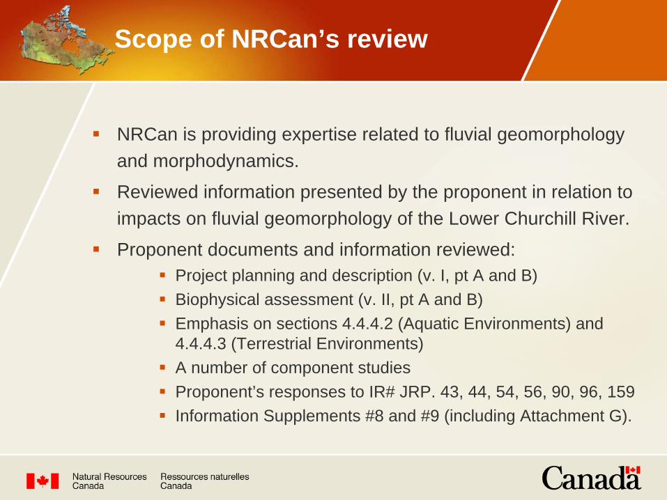
NRCan is providing expertise related to fluvial geomorphology and morphodynamics.
Reviewed information presented by the proponent in relation to impacts on fluvial geomorphology of the Lower Churchill River.
Proponent documents and information reviewed:
Project planning and description (v. I, pt A and B)
Biophysical assessment (v. II, pt A and B)
Emphasis on sections 4.4.4.2 (Aquatic Environments) and 4.4.4.3 (Terrestrial Environments)
A number of component studies
Proponent’s responses to IR# JRP. 43, 44, 54, 56, 90, 96, 159
Information Supplements #8 and #9 (including Attachment G).
Scope of NRCan’s review

Initial concerns:
NRCan had concerns with the proportions of resulting lacustrine and slow-velocity fish habitat in reservoirs – this issue has been adequately addressed by the proponent.
NRCan asked for clarification of a deduction made on the impact of the project on habitat quality below Muskrat Falls – this issue has been adequately addressed by the proponent.
NRCan agreed with recommendation of component study (NW Hydraulics Consultants, 2008) on need to monitor bank recession rates downstream of Muskrat Falls – NRCan has received no response from the proponent.
NRCan’s Views on Impacts, Risks and Uncertainties

Initial concerns (cont’d)
Possibility of occurrence of large-scale slope failures along valley bottom of proposed Muskrat Falls reservoir not adequately addressed in the EIS:
Existence of failures recognized in component study of Jacques Whitford (1998), including recommendations to study:
Susceptibility of [local] glaciomarine silt and clay to failure
Frequency of failure events
Effects of water saturation and changes in fluvial activity or base level resulting from reservoir formation.
NRCan requested that the proponent address the recommendations of Jacques Whitford (1998).
NRCan’s Views on Impacts, Risks and Uncertainties

EIS Bank stability assessment:
Relies on AMEC (2008) component study for assessment of bank stability within the proposed reservoirs.
AMEC report mapped ‘shoreline erosion potential’ from the effects of waves and currents:
Based on the integration of mapping and rating of terrain stability, soil erosion potential and wave energy
Locations of slope failures (“progressive slides”) part of ‘very high’ rating class in terrain classification system
‘Very high’ class anticipates shoreline recession rate of >7 metre / year / metre of shoreline.
NRCan’s interpretation - ‘Very high’ class does not take into account the occurrence of large-scale slope failures along Muskrat Falls reservoir
NRCan’s Views on Impacts, Risks and Uncertainties

What are these slope failures?
Proponent’s response to IR#JRP.55:
“The existing slope failures… are predominately the result of undermining of the lower river bank slope and the continued movement, or creep, of existing progressive slides”
Indicated overlap between progressive slides of AMEC (2008) sites and slope failures of Jacques Whitford (1998).
AMEC (2008):
Identified 11 known “progressive slides” failure sites (as listed in Table 8.2.4)
NRCan’s Views on Impacts, Risks and Uncertainties

What are these slope failures?
Jacques Whitford (1998):
Identified “16 slope failures with surface area greater than 1 km2, each involving at least 20,000 m3 of sediment, are present… from Gull Island Rapids downstream to Muskrat Island”
Largest recent failure has “a surface area of approx. 3 km2
and involves approx. 60,000 m3 of sediment”
This recent failure is located 6 km downstream of Gull Lake failed within past 30 years (presumably relative to 1998).
NRCan conclusion: Volumes incorrect by two to three
orders-of-magnitude
NRCan’s Views on Impacts, Risks and Uncertainties
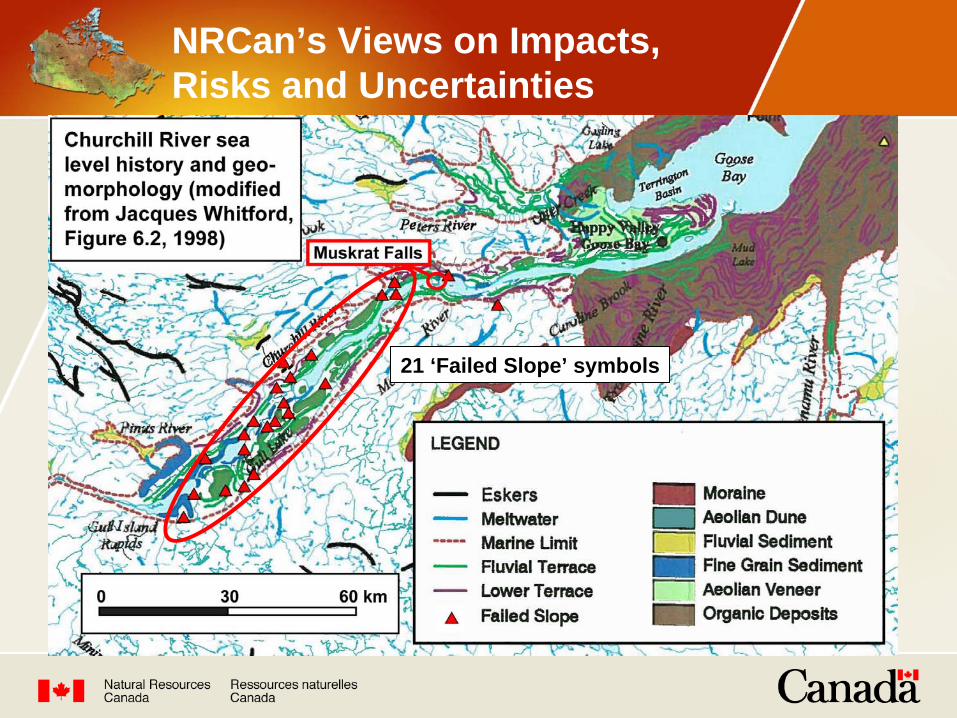
21 ‘Failed Slope’ symbols
NRCan’s Views on Impacts, Risks and Uncertainties

Large “recent failure” of Jacque Whitford (1998)
NRCan data:
Age - predates 1947
Retrogression – 1000 m
Surface area - 740,000 m2
Volume est. - 22.2 Mm3 October 1947
NRCan’s Views on Impacts, Risks and Uncertainties

October 1947
Examples of other scars

NRCan data and map
NRCan’s Views on Impacts, Risks and Uncertainties

Earth flow at Nicolet, QC November 1955Reported to have occurred in 2-3 minutes
Sensitive clay earth flows
NRCan’s Views on Impacts, Risks and Uncertainties

Sensitive clay earth flow
Earth flow – near Notre-Dame-de-la-Salette, QC, June 23, 2010
NRCan’s Views on Impacts, Risks and Uncertainties
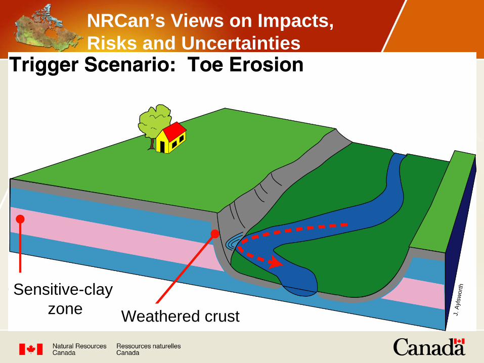
J. A
ylsw
orthSensitive-clay
zone Weathered crust
NRCan’s Views on Impacts, Risks and Uncertainties

J. A
ylsw
orthSensitive-clay
zone
NRCan’s Views on Impacts, Risks and Uncertainties

flow
J. A
ylsw
orthSensitive-clay
zone
NRCan’s Views on Impacts, Risks and Uncertainties

J. A
ylsw
orthSensitive-clay
zone
NRCan’s Views on Impacts, Risks and Uncertainties

Characteristics of sensitive glaciomarine sediments
Disturbed silt-clay
(liquified)Intact silt-clay
(strong)
NRCan’s Views on Impacts, Risks and Uncertainties

Loose framework structure
NRCan’s Views on Impacts, Risks and Uncertainties
NRCan’s interpretation of scars
Analogous to earth flow scars formed in sensitive glaciomarine sediments in eastern Canada
15 large-scale earth flow scars along valley sides of proposed Muskrat Falls reservoir
Represent ‘earth slide-earth flow’ failures, many in excess of 10 Mm3
Failures likely occurred rapidly, in minutes to hours
Pre-existing problem not related to the proposed hydroelectric development
Potential occurrence of large-scale earth flow not adequately considered in the assessment of bank stability in the EIS
(Proponent’s response to IR.JRP.159a indicates failure of 3.5 Mm3 occurred March 2010)
NRCan’s Views on Impacts, Risks and Uncertainties

In IR JRP. 159(a) the proponent was asked:What would be the impact of earth slide–earth flows of 0.5, 5 and 50 Mm3 on aquatic habitat within the Muskrat Falls Reservoir?
Proponent’s response indicates effects will be:
Short-term, localized changes in water quality
May affect local areas of aquatic habitat
May contribute to overall biodiversity.
NRCan has no further concerns with this issue.
NRCan’s Views on Impacts, Risks and Uncertainties

In IR JRP. 159(b) the proponent was asked:What are the potential heights of landslide-generated waves that can be generated by rapid to very rapid, earth slide-earth flows of magnitude 0.5, 5 and 50 Mm3.
The proponent’s response presents an:Estimated wave amplitude of 4.5 m that could be generated by failure of 50 Mm3.
NRCan considers method of estimation to be reasonable.NRCan would like to see the specific quantities used to make
this estimate.
NRCan’s Views on Impacts, Risks and Uncertainties
In IR JRP. 159(c) the proponent was asked:What would be the potential impact of these landslide- generated waves on the Muskrat Falls dam structure?
Proponent’s response indicates that:The design of the facility will include any loading created by a landslide-generated wave.
NRCan has no concerns with the loading issue.NRCan is unclear whether this response includes the
possibility of the dam structure being overtopped by the landslide-generated wave.
NRCan’s Views on Impacts, Risks and Uncertainties

In IR JRP. 159(d) the proponent was asked:How will the creation and operation (i.e., water level fluctuations) of the Muskrat Falls reservoir affect the stability of the glaciomarine deposits and the potential occurrence of large-scale earth slide–earth flows?
Proponent’s response indicates that:
Creation of reservoir may increase potential occurrence of large- scale earth flows
Once stable shoreline established, relatively small fluctuations associated with reservoir operations (±0.5 m) predicted to have minimal effect on the stability of glaciomarine deposits.
NRCan would like to see a stability analysis on the slopes of the glaciomarine deposits to substantiate this prediction.
NRCan’s Views on Impacts, Risks and Uncertainties

In IR JRP. 159(e) the proponent was asked:What are the geotechnical properties and conditions within the glaciomarine deposits of the lower Churchill River Valley that makes them susceptible to large-scale earth slide–earth flows?
Proponent’s Attachment G to Information Supplements #9 (IS#9) contains summary geotechnical data indicating that, for example:
Failure planes at two earth flow scars are deep-seated and situated within silt and clay glaciomarine deposits
Sediment with sensitivities >30 are present within deposits
Some soil samples have moisture contents above liquid limits.NRCan agrees with IS#9 that these geotechnical properties
are consistent with soils in areas elsewhere in Canada that experience large-scale earth slide-earth flow activity.
NRCan’s Views on Impacts, Risks and Uncertainties

Large-scale earth flows
NRCan recommends that the JRP request that Nalcor:
1. Conduct a stability analysis using geotechnical data of the deposits along the proposed Muskrat Falls reservoir to determine the factor-of-safety of the reservoir slopes for:
the normal reservoir operating range of 39±0.5 m asl (above sea level)
a level of 44 m asl, which represents the maximum reservoir elevation during an extreme flood.
Recommendations to the Panel

Large-scale earth flows
NRCan recommends that the JRP request that Nalcor:
2. Establish a procedure for drawing-down the Muskrat Falls reservoir to minimize the chance of triggering a large-scale earth flow, for the following scenarios:
Following an extreme flood event when the reservoir is raised beyond its normal operating range i.e., up to 44 m asl
For substantially lowering the reservoir below 39±0.5 m asl for maintenance reasons (assuming that this will be necessary some day).
Recommendations to the Panel

Large-scale earth flows
NRCan recommends that the JRP request that Nalcor:
3. Provide the variable quantities used to estimate the 4.5 m high wave amplitude height, which will allow the calculation of the landslide-generated wave height to be fully assessed.
Recommendations to the Panel

Large-scale earth flows
NRCan recommends that the JRP request that Nalcor:
4. If this is not already being done, design the Muskrat Falls dam to include the possibility of the structure being overtopped by a landslide-generated wave when the reservoir is at its maximum level of 44 m asl.
Recommendations to the Panel

Changes in river morphology
NRCan recommends that the JRP request Nalcor to:
Establish a program to monitor bank recession rates along the Lower Churchill River downstream of Muskrat Falls, as was recommended by the component study of NW Hydraulics Consultants, 2008.
Recommendations to the Panel
References
AMEC (AMEC Earth & Environmental Ltd.) 2008. Bank Stability Study for the Proposed Lower Churchill Hydroelectric Generation Project: Environmental Baseline Report. Prepared for Newfoundland and Labrador Hydro, St. John’s, NL.
Jacques Whitford. 1998. Sea Level and Geomorphology of the Churchill River and Strait of Belle Isle (LHP 98-23). Jacques Whitford Environment Limited report prepared for Newfoundland and Labrador Hydro, St. John’s, NL.
NW (Northwest) Hydraulic Consultants. 2008. Lower Churchill Hydroelectric Generation Project Sedimentation and Morphodynamics Study. Prepared for Newfoundland and Labrador Hydro, St. John’s, NL.