Proposed Amendment to the Martin County Comprehensive ... · PDF fileMartin County...
44
Proposed Amendment to the Martin County Comprehensive Growth Management Plan REQUEST NUMBER: CPA 2015-01 Kingsley APPLICANTS: PLANNER-IN-CHARGE: John D. and Leslie A. Kingsley Irene A. Szedlmayer, AICP 3324 SW Berry Ave. Palm City, FL REPRESENTED BY: DATE: David R. Giunta PDG Realty, Inc. 1650 SW Prosperity Way Palm City, FL 34990 MEETING DATE: REVISION DATE: LPA Meeting: February 19, 2015 ____________________ BCC Transmittal Hearing: April 14, 2015 March 18, 2015_______ Transmittal to Florida DEO: _____________________ _____________________ BCC Adoption Hearing: _____________________ _____________________ Final Transmittal to DEO: _____________________ _____________________ Hearing Date Action LPA Feb. 19, 2015 LPA voted unanimously to recommend approval of Low density Future Land Use and RS-4 zoning BCC Transmittal April 6, 2015 BCC Adoption
-
Upload
nguyennguyet -
Category
Documents
-
view
213 -
download
0
Transcript of Proposed Amendment to the Martin County Comprehensive ... · PDF fileMartin County...

Proposed Amendment to the Martin County Comprehensive Growth Management Plan
REQUEST NUMBER: CPA 2015-01 Kingsley APPLICANTS: PLANNER-IN-CHARGE: John D. and Leslie A. Kingsley Irene A. Szedlmayer, AICP 3324 SW Berry Ave. Palm City, FL REPRESENTED BY: DATE: David R. Giunta PDG Realty, Inc. 1650 SW Prosperity Way Palm City, FL 34990 MEETING DATE: REVISION DATE: LPA Meeting: February 19, 2015 ____________________ BCC Transmittal Hearing: April 14, 2015 March 18, 2015_______
Transmittal to Florida DEO: _____________________ _____________________ BCC Adoption Hearing: _____________________ _____________________ Final Transmittal to DEO: _____________________ _____________________
Hearing Date Action
LPA Feb. 19, 2015 LPA voted unanimously to recommend approval of Low density Future Land Use and RS-4 zoning
BCC Transmittal
April 6, 2015
BCC Adoption

Property: A five-acre parcel located on the west side of Berry Avenue, east of the Florida Turnpike, north of CR 714 (SW Martin Highway) and south of Sunset Trail. See site location map, Figure 1. Request: The property owners have requested that the Future Land Use Map be amended to change the designation on the subject parcel from Rural Density to Low Density Residential. Staff Recommendation: Staff recommends approval of the requested amendment of the Martin County Future Land Use Map. Figure 1. Location Map for CPA 2015-01, Kingsley
Executive Summary: The owners of five-acres on the east side of SW Berry Avenue, in Palm City, have requested that the Future Land Use Map (FLUM) be amended to change the future land use designation of their property from Rural Density (0.5 dwelling units per acre) to Low Density (up to 5 dwelling units per acre). The applicant’s original request was to concurrently change the zoning district of the parcel from A-1 (Small Farms) to RM-5 (multi-family residential up to five units per acre.) See Attachment: Application Materials. However, subsequent to the public hearing before the LPA,

the applicant has indicated he will be requesting RS-4 or RS-5 zoning. See Attachment: Correspondence. This five-acre parcel is an infill lot. The applicants’ property is located within the Primary Urban Services District and has access to regional water and wastewater utilities. David Giunta, who is representing the property owners in this request, has a contract to purchase the property. He also has an interest in the five-acre parcel to the south of the subject property and intends to develop the ten acres as one project, if successful with the CGMP amendment. The predominant residential future land use in the surrounding area is Low Density and such designation for the subject property is consistent with the CGMP goals, policies and objectives for land use and housing. 1. PROJECT/SITE SUMMARY 1.1 Physical/Site Summary
The property is currently occupied by a 1,882 square foot single-family residence, the home of the applicants, and a 384 square foot accessory structure.
1.2 Major Roadways
SW Berry Avenue is a county-owned and maintained major collector having a 60 foot right-of-way. SW Martin Highway, a major arterial, is 977 feet to the south. SW Sunset Trail, classified as a minor collector, is 1,300 feet to the north. The Florida Department of Transportation’s $15.7 million project to add lanes and reconstruct SW Martin Highway from the Florida Turnpike to Mapp Road commenced in August of 2014. The entrance to the Florida Turnpike is a tad more than one mile south and west of the site.
1.3 Current Amendment Requests: The first set of 2015 proposed amendments to the Future Land Use Map (FLUM) contains 14 applications. CPA 15-2, Berry Retail and CPA 15-6, Berry Retail-Galley are most relevant to CPA 15-1. These amendments involve geographically proximate parcels and seek to change the Rural Density Future Land Use to another future land use. CPA 15-2 seeks to change the FLUM to General Commercial on 4.8-acres on the south side of SW Martin Highway approximately 400 feet west of Berry Avenue. CPA 15-6 seeks to change the FLUM to Limited Commercial on 1.14-acres located on the SW corner of SW Martin Highway and Berry Avenue.
In addition to CPAs 15-1, 15-2 and 15-6, there are four additional privately-initiated amendments, all of which seek Commercial General Future Land Use. These are:
1. CPA 15-3, Sunshine Mobile Manor: A request to change the FLUM from
Mobile Home to Commercial General on 2.2-acres on the west side of US-1, a quarter-mile north of Salerno Road.
2. CPA 15-4, Davis Hobe Sound: A request to change the FLUM from
Medium Density Residential to Commercial General on 1.27-acres on the east side of US-1, just south of SE Woodland Road, in Hobe Sound.
3. CPA 15-5, DeMartini: A request to change the FLUM from Commercial
Limited to Commercial General on 2.1-acres on the east side of US-1, just north of the intersection with Cove Road.
4. CPA 15-7, Seacoast: A request to change the FLUM from Commercial
Limited to Commercial General on one third of an acre east of US-1, on the north side of S.E. Cove Road.
The following County-initiated amendments seek to place seven publicly-owned tracts into the recreation or conservation future land uses and one tract (Florida Oceanographic Institute) into the Institutional General future land use:
1. CPA 15-8, Jensen Beach Impoundment: A request for a FLUM change
from Estate Density 2UPA to Conservation on 91.8-acres on north Hutchinson Island.
2. CPA 15-9, Joe’s River Park: A request for a FLUM change from Medium
Density to Conservation on 2.25-acres on north Hutchinson Island at Joe’s River Park.
3. CPA 15-10, Bob Graham Beach: A request for a FLUM change from Estate
Density 2UPA and Medium Density to Conservation on 5.3-acres on north Hutchinson Island.
4. CPA 15-11, FL Oceanographic Society: A request for a FLUM change from
Estate Density 2UPA and Commercial General to Conservation on 17.3-acres on north Hutchinson Island.

5. CPA 15-12, IRP Water Treatment Plant: A request for a FLUM change from Commercial General to Institutional General on 7.5-acres on north Hutchinson Island.
6. CPA 15-13, River Cove: A request for a FLUM change from Commercial
Waterfront to Recreational on 5.2-acres on north Hutchinson Island. 7. CPA 15-14, Crystal Beach: A request for a FLUM change from Low
Density to Conservation on 16.2-acres on north Hutchinson Island.
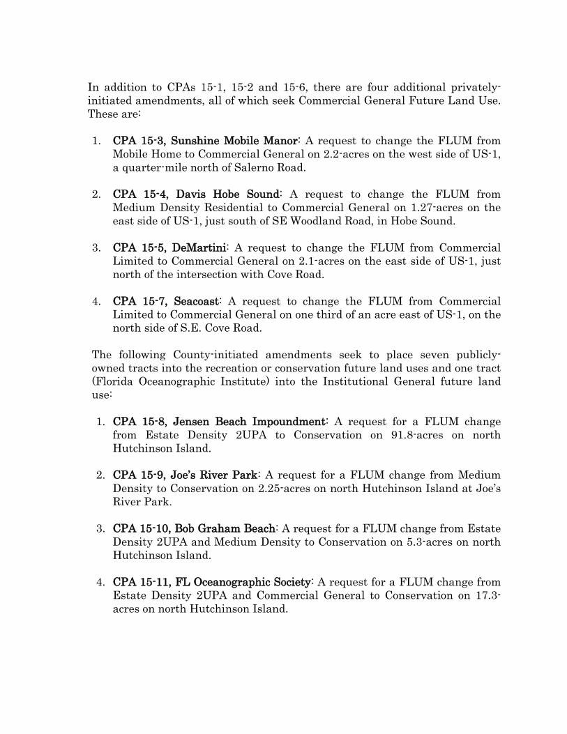
1.4 Past Changes in Future Land Use Designation The Future Land Use designation for this property has been Rural Density since the County’s first Comprehensive Plan was adopted in 1982. See Figures 2 & 3. Figure 2. 1982 Future Land Use Map in vicinity of subject property
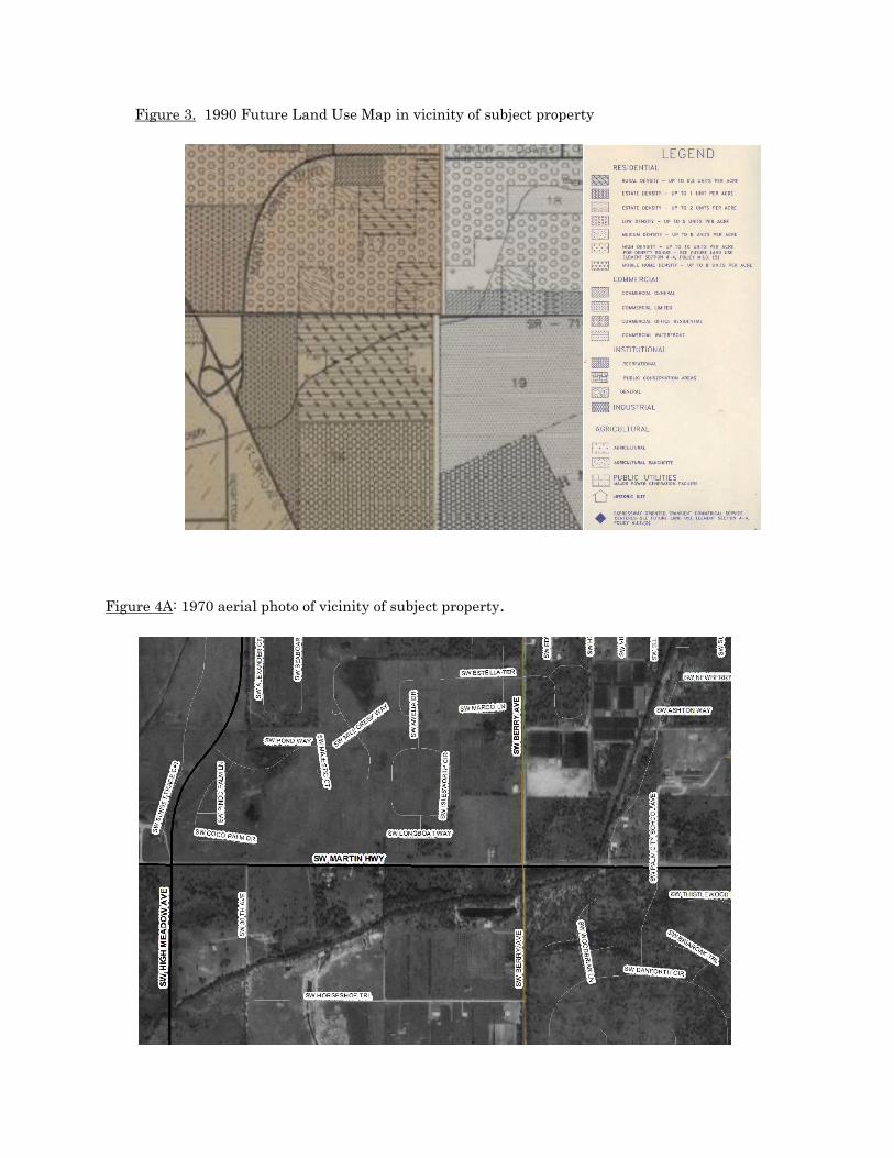
Figure 3. 1990 Future Land Use Map in vicinity of subject property
Figure 4A: 1970 aerial photo of vicinity of subject property.

Figure 4B: 1995 aerial photo of vicinity of subject property.
Figure 4C: 2014 aerial photo of vicinity of subject property

Since 2003, the FLUM has been amended nine times to change the future land use of specific parcels in the general vicinity of the applicants’ property. These nine amendments, summarized below, covered sixty-seven (67) acres of land. See Figure 5. 1. CPA 2006-22, Berry Avenue amended the FLUM for the 5-acre parcel located
at 3424 Berry Avenue. This property is adjacent to and immediately south of the subject property. CPA 2006-22 changed the Rural Density future land use to Low Density Residential and the zoning from A-1 (small farms) to RM-5 (multi-family with up to 5 units/acre), the same changes requested by the present applicants. The property remains vacant. The owner, Berry Avenue Properties, LLC, has a contract to purchase the property that is the subject of this CGMP amendment.
2. CPA 2006-15, Manetta Niessen changed the future land use designation of 2.4 acres SE of the corner of SW Martin Hwy and SW High Meadow Avenue. The property was occupied by a single-family residence but was adjacent to two general commercial uses and the future land use of the land on three sides was General Commercial. The property continues to be utilized as a single-family residence by its owners.
3. CPA 2003-7, Kirby changed the future land use of 9.5 acres at the NE corner of S.W. Berry Avenue and S.W. Martin Highway from Commercial Office Residential to General Commercial. The property is developed with mixed commercial uses.
4. CPA 2006-25, Wolf changed the future land use of 12.5-acres located at the
southern end of Hollis Ave., adjacent to Danforth Creek, between Martin Hwy and Sunset Trail, from Agricultural to Low Density Residential. This irregularly-shaped parcel is accessed only via two narrow local streets (18’ pavement) (and potentially from SW Newberry Ct, across Danforth Creek). It contains a single-family residence.
5. CPA 2006-18, Sentell changed the future land use of a 0.97 acre parcel located on Thelma Street, just off Mapp Road, from Commercial Office Residential to General Commercial. The property has been partially developed as a veterinary and animal boarding facility.
6. CPA 2006-13, Palm Royal changed the future land use from Low Density Residential to Limited Commercial of a 0.4 acre, land-locked parcel, which is part of a larger 2.3 acre property, which remains undeveloped. A site plan for a shopping center was approved for this total site, but it has not been developed.
Figure 5. Amendments to Future Land Use since 2003
The subject property is outlined in pink. The properties outlined in blue were the subject of previous Comprehensive Plan amendments.
7. CPA 2006-30, Awareness Tech changed the future land use of 2.8 acres
within the Old Palm City CRA, from Commercial Office Residential to Industrial. The future land use of the parcels to the east and west of this property had an Industrial Future Land Use. It has not yet been developed.
8. CPA 2003-8, Sunset Trail North changed 20 acres to Low Density Residential, 10 acres from Estate Density and 10 acres from Rural Density. Like, CPA 03-09, these 20 acres were developed as part of the Murano PUD with 91 single-family residential lots.
9. CPA 2003-9, Sunset Trail South changed 10-acres from Estate Density to Low Density and five acres from Rural Density to Estate Density. This property was developed as the Murano PUD with 28 single-family lots.

1.5 Adjacent Future Land Use North: Low Density Residential South: Low Density Residential East: Agricultural West: Estate Density Residential
Figure 6. Future Land Use Map of Surrounding Area
Figure 7. Future Land Use Map of wider vicinity of Subject Property
A recommendation to approve the amendment must be based on a finding that at least one of the following four criteria is met:
a. Past changes in land use designations in the general area make the proposed use
logical and consistent with these uses and adequate public services are available; b. Growth in the area - in terms of development of vacant land, redevelopment and
availability of public services - has altered the character of the area such that the proposed request is now reasonable and consistent with area land use characteristics;
c. The proposed change would correct what would otherwise appear to be an
inappropriately assigned land use designation; or,
d. The proposed change would fulfill a public service need that enhances the health, safety or general welfare of County residents. (CGMP Policy 1.11.C)
The Future Land Use Maps, Figure 5, 6 and 7 above, demonstrates that criterion (a) is
met. The aerial photographs from 1970, 1995 and 2014, presented as Figures 4A, 4B and 4C above, respectively, illustrate the that criterion (b) is met.
1.6 Environmental Considerations
1.6.1. Wetlands, Soils and Hydrology
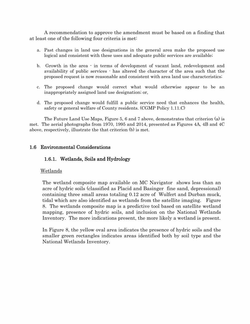
Wetlands The wetland composite map available on MC Navigator shows less than an acre of hydric soils (classified as Placid and Basinger fine sand, depressional) containing three small areas totaling 0.12 acre of Wulfert and Durban muck, tidal which are also identified as wetlands from the satellite imaging. Figure 8. The wetlands composite map is a predictive tool based on satellite wetland mapping, presence of hydric soils, and inclusion on the National Wetlands Inventory. The more indications present, the more likely a wetland is present. In Figure 8, the yellow oval area indicates the presence of hydric soils and the smaller green rectangles indicates areas identified both by soil type and the National Wetlands Inventory.
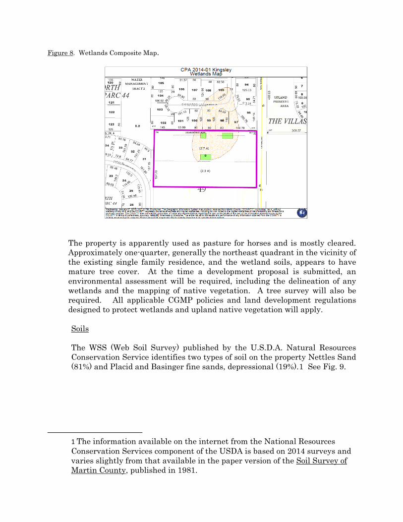
Figure 8. Wetlands Composite Map.
The property is apparently used as pasture for horses and is mostly cleared. Approximately one-quarter, generally the northeast quadrant in the vicinity of the existing single family residence, and the wetland soils, appears to have mature tree cover. At the time a development proposal is submitted, an environmental assessment will be required, including the delineation of any wetlands and the mapping of native vegetation. A tree survey will also be required. All applicable CGMP policies and land development regulations designed to protect wetlands and upland native vegetation will apply.
Soils
The WSS (Web Soil Survey) published by the U.S.D.A. Natural Resources Conservation Service identifies two types of soil on the property Nettles Sand (81%) and Placid and Basinger fine sands, depressional (19%).1 See Fig. 9.
1 The information available on the internet from the National Resources Conservation Services component of the USDA is based on 2014 surveys and varies slightly from that available in the paper version of the Soil Survey of Martin County, published in 1981.

Figure 9. Soil Survey of Subject Property
Source: USDA – NRCS Web Soil Survey
Nettles Sand (63) is described in USDA’s 1981 Soil Survey of Martin County, FL, as follows:
This nearly level soil is poorly drained. It is in broad areas of flatwoods, mainly in the northeastern part of the County. Areas are generally quite large, ranging up to 2,000 acres. Slopes are smooth and range from 0 to 2 percent. Typically, the surface layer is about 12 inches thick. The water table is at a depth of 10 to 40 inches for 4 to 6 months or more during most years. It is at a depth of less than 10 inches for 2 to 4 months during the wet seasons. The water table is perched above the subsoil early in the wet season and after the heavy rains in other seasons. During the extended dry periods, the water table can recede to a depth of more than 40 inches. . . . . Permeability is rapid in the surface and subsurface layers and very slow to moderately slow in the subsoil. Some areas of this soil are used for cultivated crops or for pasture. A few areas are used for urban development. Most areas remain in natural vegetation consisting of Florida slash pine and an understory of gallberry, wax myrtle, saw palmetto,

fetterbush, dwarf huckleberry, red root, running oak, pineland threeawn, bluestems, indiangrass and panicums. This soil has very serious limitations for crops because of wetness. However, if properly controlled and management is good, this soil is suited to many adapted vegetable crops. . . . Under natural conditions this soil is poorly suited for citrus trees. It is suitable for citrus only after a well-designed water control system has been installed to maintain the water table below four feet. . . . The soil is well suited to pasture grasses. . . . Grazing should be controlled to prevent overgrazing and weakening of the plants. The potential is medium on this soil for pine trees. Equipment limitations and seedling mortality are the major management concerns. South Florida slash pine is better suited than other species. The soil is in capability subclass IVw.
Placid and Basinger fine sands, depressional (13) is described in USDA’s 1981 Soil Survey of Martin County, FL as follows:
This nearly level soil is very poorly drained. It is in wet depressions and drainage ways in the flatwoods. Areas range from a few acres to about 30 acres. Slopes are smooth to concave and range from 0 to 2%. . . . Typically the surface layer is black sand. The subsurface layer is sand to a depth of more than 80 inches. . . . Most areas of this soil are ponded for 6 months or more each year. The water table is at a depth of less than 10 inches for most of the year, except in extended dry seasons. Permeability is rapid throughout the profile. The available water capacity is high in the surface layer and low in the subsurface layer. Natural fertility and the content of the organic matter are high. A few areas of this soil are drained and used for improved pasture. Most areas are in natural vegetation. The natural vegetation is pickerel weed, ferns, St. Johnswort, maidencane, redroot, sedges, and water tolerant grasses. Common trees are cypress, sweetbay, willow and swamp maple.
Under natural conditions, this soil is not suited to cultivated crops. . . . This Placid soil is not well suited to citrus trees unless water control is maintained and good soil aeration is provided to a depth of about 4 feet. . . . Under natural conditions, this soil is too wet for improved pasture grasses and legumes.. . . The soil has high potential for pine trees, if the excess water is controlled. Slash pine is better suited than other species. . . . The soil is in capability subclass VIIw.
1.6.2 Wellfield Protection
There are no public wells or wellfields or future water supply well sites on this property or in the vicinity of this property. Any new development near a public well must conform to the Martin County Wellfield Protection Ordinance and Groundwater Protection Ordinance before receiving development approval. If groundwater or surface water withdrawals are proposed for irrigation, then the applicant will be required to submit additional information and obtain a South Florida Water Management District Water Use Permit.
1.7 Adjacent Existing Land Use
North: single-family residential South: vacant East: agriculture (in disuse) West: single-family residential
Figure 10. Aerial photo of subject property showing adjacent land uses

2. ANALYSIS
2.1 Criteria for change in the Future Land Use (§1-11 of CGMP)
The Rural Density Future Land Use is intended for land within the County’s Secondary Urban Services District. The Secondary Urban Service District “is intended to protect the value of rural suburban lands located outside the normal economical service radius of intensive (primary) urban services.” CGMP Policy 4.13A.5. The Rural Density Future Land Use “recognizes the need to concentrate urban development on lands closer to the urban core where intensive facilities and services can be provided cost-effectively. This policy also provides reasonable development options to landowners whose property is on the fringe of secondary urban development in sparsely developed rural or rural suburban areas.” CGMP Policy 4.13A.5(1). This CGMP policy further provides that the zoning regulations for the Rural Density Future Land Use shall be “designed to ensure that development is compatible with the need to preserve [its] rural character.” Id.
Therefore, given the stated purposes of the Rural Density Future Land Use designation, the location of the subject property within the Primary Urban Services District, the previous investment to bring regional water and wastewater services to the area and the availability of those services, and the development pattern of the mostly built-out surrounding area indicate that Rural Density is no longer the most appropriate Future Land Use for the subject parcel.
The CGMP describes the intent of the Low Density Future Land Use as follows:
The Low Density Residential designation is reserved for land in the Primary Urban Service District. Densities shall not exceed five units per gross acre. In reviewing specific densities, the aim shall be to preserve the stability and integrity of established residential development and provide equitable treatment to lands sharing similar characteristics. Landscaping, screening, buffering and similar design techniques shall be used to assure a smooth transition between residential structure types and densities. CGMP Policy 4.13A.7(3)
Given the pattern of the existing residential density and the dominance of
the Low Density Future Land Use designation in the surrounding area, coupled with the Low Density Future Land Use of the adjoining five acres, Low Density is the most appropriate Future Land Use designation for this property.
Comparison of the stated intent of the Low Density Future Land Use to that of Estate Density Future Land Use, on one hand, and Medium Density Future Land Use, on the other hand, confirms the appropriateness of the Low Density Future Land Use for the parcel in question. See, CGMP Policy 4.13A.7(2) (“Residential Estate densities are primarily assigned to established, stable residential areas with a density up to two units per gross acre in the Primary Urban Service District. These areas are generally on the

fringe of the PUSD and lack accessibility to a full complement of urban services. The CGMP also assigns estate densities to selected areas near existing estate development that share similar characteristics with existing residential estates and to areas in the urban service districts that require density limitations because of unique problems of urban services.” and 4.13A.7(4) (“The Medium Density Residential designation is reserved for land in the core of the Primary Urban Service District and accessible to employment centers. The maximum density is eight units per gross acre.”)
The CGMP establishes one principal housing goal: “to provide a diverse
housing stock adequate to serve the needs of current and future populations of Martin County, consistent with the desired development character of the County as set forth in this Plan.” CGMP Goal 6.1. CGMP Objective 6.1B provides as follows: “To strive to provide for the conservation and rehabilitation of the existing housing stock by rehabilitating substandard dwelling units; to maintain and improve existing housing stock, residential neighborhoods and property values; and to provide for a broad mix of housing types.” Numerous policies are designed to help achieve the Goal and this Objective, including:
Policy 6.1B.1. Zone lands for housing. Martin County shall ensure that adequate residential land use designations are designated and zoned at densities sufficient to meet the County's current and future housing needs within the Urban Service District. Policy 6.1B.2. Provision of varied housing types. Martin County shall provide varied housing types, sizes, and prices consistent with local need, including affordable housing. The County shall provide technical assistance, including demographic analysis and other relevant information, to assist developers in planning for a broad mix of housing opportunities consistent with local needs. Policy 6.1B.3. Protection of existing neighborhoods. The County shall promote the use of innovative site planning, landscaping, and other buffering devices to protect existing neighborhoods. Housing needs shall be satisfied by encouraging preservation of the existing housing stock and by revitalizing declining neighborhoods through measures such as rehabilitation, public investments in infrastructure, and fair and equitable development regulations.
Amending the future land use designation on the subject property from
Rural Density (1 unit per 2 acres) to Low Density (up to five units per acre) is consistent with CGMP Goal 6.1, Objective 6.1B and these three policies.
1.1 Urban Sprawl
The Florida Community Planning Act, §163.3177(9), requires that any amendment to the future land use element of the County’s Comprehensive Plan discourage urban sprawl. The statute defines ‘urban sprawl’ as ‘a development pattern characterized by low density, automobile-dependent development with either a single use or multiple uses that are not functionally related, requiring the

extension of public facilities and services in an inefficient manner, and failing to provide a clear separation between urban and rural uses. The statute provides a list of thirteen “primary indicators” that a plan amendment “does not discourage the proliferation of urban sprawl.” Each of the 13 indicators is analyzed with the facts of the subject property.
Figure 11: 2013-14 Aerial photo of larger vicinity of subject property.
(1) Promotes, allows, or designates for development substantial areas of the jurisdiction to develop as low-intensity, low-density, or single-use development or uses.
This future land use amendment does not affect a “substantial area.” The subject parcel is a five acre, in-fill lot in a mostly built-out area which includes residential, commercial and institutional uses. See Figure 11.
(2) Promotes, allows, or designates significant amounts of urban development to occur in rural areas at substantial distances from existing urban areas while not using undeveloped lands that are available and suitable for development.

No. This five-acre parcel does not represent a “significant amount of urban development,” is not a “rural area” and is not a “substantial distance from existing urban areas.” This parcel is an in-fill lot within the County’s Primary Urban Services District. Public water and wastewater services are available and the property is near an elementary school and a middle school. Commercial services, including supermarkets, are nearby on SW Martin Highway in the Old Palm City Community Redevelopment Area, as well as on Martin Downs Blvd.. See Figure 12 for proximity of subject property to Old Palm City CRA.
Figure 12. Map Illustrating proximity of Kingsley Property to Old Palm City CRA
and Boulevard Mixed-Use Overlay District
(3) Promotes, allows, or designates urban development in radial, strip, isolated, or ribbon patterns generally emanating from existing urban developments.
The five-acre parcel represents in-fill development, not land that will be urbanized in a radial, strip, isolated, or ribbon pattern.
(4) Fails to adequately protect and conserve natural resources, such as wetlands, floodplains, native vegetation, environmentally sensitive areas, natural

groundwater aquifer recharge areas, lakes, rivers, shorelines, beaches, bays, estuarine systems, and other significant natural systems.
No. The subject property is currently a residential lot with overgrown cleared pasture. There are no lakes, rivers, shorelines, beaches, bays, or estuarine systems on this parcel. The FEMA FIRM (Flood Insurance Rate Map) designates the area Zone X (“Areas outside of the 100-year floodplain, areas of 100-year sheet flow flooding where average depths are less than 1 foot, areas of 100-year stream flooding where the contributing basin is less than one square mile, or areas protected from the 100-year flood by levees. No base flood elevations or depths are shown in this zone.”) Recharge of the aquifer may occur in the area. The surficial aquifer is recharged in virtually all areas of sandy soil with high permeability. The Soil Survey described the subsoil as having low permeability, but indicated that the water table is as shallow as 10 to 40 inches for 4 to 6 months or more during most years and less than 10 inches for 2 to 4 months during wet seasons. The water table is perched above the subsoil early in the wet season and after the heavy rains in other seasons. The availability of public wastewater collection and treatment services is one way the ground water and aquifer are protected from pollution. The CGMP policy that residential lots maintain 50% open space will help protect recharge capacity. The property appears to have wetlands and areas with mature tree canopy. The County’s LDRs require submission of an environmental assessment showing all wetlands and upland habitat with any development application, as well as a plan to preserve and buffer wetlands and to preserve no less than twenty-five percent (25%) of the upland habitat.
(5) Fails to adequately protect adjacent agricultural areas and activities, including silviculture, active agricultural and silvicultural activities, passive agricultural activities, and dormant, unique, and prime farmlands and soils.
Not true. There is no active agriculture on the subject property and the U.S.D.A.’s Soil Survey indicates the soil is ill-suited for crops or citrus. One ten-acre parcel, on the east side of SW Berry Avenue, was until very recently in active agriculture. It was been farmed by Sunshine State Carnations, Inc. since 1982, but is not currently being farmed. Peter Nissen, President of Sunshine State Carnations, has submitted a letter supporting the requested change to the FLUM. Mr. Nissen explained that, “The proposed change in the Future Land Use from Rural to Low density will not adversely impact our interests. We support the change as logical and timely.” (Included in Attachment: Application Materials).
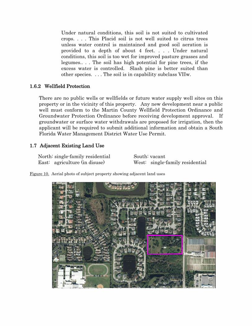
(6) Fails to maximize use of existing public facilities and services.
The requested change to Low Density Residential, by allowing for a greater number of residential units, will better utilize the water and wastewater infrastructure existing in the vicinity. See Figures 13 and 14. The Martin County water and wastewater plants have the capacity to serve the development that may occur here. Additionally, a five-foot wide sidewalk along the east side of Berry Avenue connects the property to SW Martin Highway and SW Sunset Trail, before continuing north to Martin Downs Blvd.
Figure 13. Martin County wastewater collection system
Legend: collection lines (brown), pressure mains (green) and lift stations (green squares)
(7) Fails to maximize use of future public facilities and services.
This indicator is not true. The subject property is well-linked into the regional road network via Martin Downs Blvd. or SW Martin Highway, the capacity of which is currently being expanded. It provides relatively quick and convenient access to the Florida Turnpike, Interstate 95, as well as Palm City, and the City of Stuart.

(8) Allows for land use patterns or timing which disproportionately increase the cost in time, money, and energy of providing and maintaining facilities and services, including roads, potable water, sanitary sewer, stormwater management, law Figure 14. Martin County water lines in vicinity of Kingsley property
enforcement, education, health care, fire and emergency response, and general
government.
This indicator is not present. This five-acre parcel is located within the County’s Primary Urban Services District where the full complement of urban services are expected to be provided. The requested change to Low Density, by allowing a greater number of residential units, will utilize the existing water and wastewater infrastructure in the vicinity, the available utility plant capacity, and the existing sidewalk on SW Berry. Palm City Elementary School and Hidden Oaks Middle School are nearby. No bussing will be required to these schools, pursuant to School District policy of limiting bus transportation to students who live at least two miles away. Provision of essential services such as public water and wastewater will cost less on a per unit basis pursuant to the Low Density Future Land Use (up to 5 upa) than the per unit cost pursuant to the Rural Density Future land Use (2 upa).
(9) Fails to provide a clear separation between rural and urban uses.

Not true. In Martin County, the primary delineation between urban and rural is the boundary of the Urban Services District. Applicants’ property is an infill lot. In the 800-acre area bordered by SW Martin Hwy to the south, Martin Downs Boulevard to the North and West, and Mapp Road to the east, the nearly built-out development pattern is urban. Development that will take place pursuant to the Low Density Residential (up to five units per acre) will be consistent and compatible with the existing urban development.
(10) Discourages or inhibits infill development or the redevelopment of existing neighborhoods and communities.
The requested change in the future land use from Rural Density to Low Density would encourage in-fill development. The owner of the five-acres adjacent to the south has a contingent contract to purchase the subject parcel. He has verbally indicated the intent to develop the ten acres as one property, assuming he is successful in obtaining the requested FLUM amendment.
(11) Fails to encourage a functional mix of uses.
The requested FLU designation is consistent with the development pattern of the surrounding land which contains a mix of institutional, residential and commercial uses. Parcels with the Industrial Future Land Use are also located within a mile of applicants’ property. Needed commercial services are available nearby on SW Martin Hwy and in nearby Old Palm City. An elementary school and middle school are located within walking distance to the property. The requested RM-5 zoning permits duplexes, townhouses, and multi-family as well as detached single-family. While multi-family units are located west of SW High Meadows Avenue (about 1.5 miles to the west) and in Sawgrass Villas (less than one mile to the east), the predominate dwelling type in the area is detached single family. If the applicant proposes, and the County approves, something other than detached single family residences, the mix of residential types available will be diversified.
(12) Results in poor accessibility among linked or related land uses. This indicator is not true. The subject property is connected to the regional road network via Sunset Trail or SW Martin Highway, which is currently being expanded from a two-lane road to a four-lane road. Convenient access to the Florida Turnpike, Interstate 95, Old Palm City and Stuart is available.
(13) Results in the loss of significant amounts of functional open space. The requested change in the FLUM will not cause the loss of significant amounts of functional open space. The requested change in the FLUM will

create more housing units but all residential development must maintain fifty percent (50%) of the gross land area in open space. By accompanying more households, the increased density could be viewed as reducing the pressure for new residential development on parcels located further from urban services.
Florida Statutes also set forth certain factors that evidence that a proposed amendment to the FLUM discourages the proliferation of urban sprawl. These eight factors are the converse of the thirteen set-forth above. The required threshold is that the proposed amendment incorporates a development pattern or urban form that achieves four or more of the following eight factors: (1) Directs or locates economic growth and associated land development to geographic areas of the community in a manner that does not have an adverse impact on and protects natural resources and ecosystems.
The proposed land use amendment achieves this objective. This parcel has previously been used for pasture and is mostly cleared. It is not located on the shoreline of the Atlantic Ocean, or the St Lucie, Indian or Loxahatchee Rivers, nor is it traversed by any creeks, or adjacent to any significant wetlands or natural lands. The development will be served by public wastewater collection and treatment.
(2) Promotes the efficient and cost-effective provision or extension of public infrastructure and services.
The proposed land use amendment achieves this objective. The property is within Martin County’s Primary Urban Service Boundary and water and wastewater lines can be efficiently extended to serve it. Public water lines are available 500 feet to the north and 500 feet to the south. A wastewater lift station is located about 400 feet to the south. The Palm City Elementary School and Hidden Oaks Middle School are within walking distance from the parcel. Each is about 3200 feet from the subject property along existing sidewalks.
(3) Promotes walkable and connected communities and provides for compact development and a mix of uses at densities and intensities that will support a range of housing choices and a multimodal transportation system, including pedestrian, bicycle, and transit, if available.
The proposed land use amendment advances this directive. This parcel is within walking distance of the Palm City Elementary School and Hidden Oaks Middle School, along existing sidewalks. Two supermarkets are each approximately one mile away. An existing sidewalk along Berry Avenue

connects the property to sidewalks on SW Martin Hwy and SW Martin Downs Blvd. The High School is about three miles away. The bus stop for high school students is located within walking distance on the Berry Avenue sidewalk. This ready access to daily institutional and commercial services is better utilized by the requested future land use which allows five units per acre than the current future land use and zoning that limits development to two acres per unit.
(4) Promotes conservation of water and energy.
The proposed land use has the potential to achieve this objective. It will increase the number of residences that are within walking distance of an elementary school and middle school and within one mile of either of two supermarkets, thereby potentially reducing vehicle miles travelled to engage in daily activities.
(5) Preserves agricultural areas and activities, including silviculture, and dormant, unique, and prime farmlands and soils.
The proposed land use amendment achieves this objective. This property does not contain prime farmland soils. The re-designation of the future land use for this property makes it more likely that the land will no longer pasture horses, but that rural activity in this case is more accurately characterized as a hobby than agriculture. The soil survey indicates that the soil is suitable for production of slash pine but five acres is likely to be too small and too isolated from other silvicultural activities to be feasible. To the extent that the proposed land use change increases the maximum number of possible units from two dwellings to up to 25 dwelling units, it might be said to reduce the pressure to convert agricultural lands to urban or suburban uses.
(6) Preserves open space and natural lands and provides for public open space and recreation needs.
Due to the County’s CGMP policies and LDRS, this future land use amendment may be said to indirectly advance this objective. To the extent that the proposed land use change increases the maximum number of possible units from two dwellings to up to 25 dwellings on this five-acre parcel, it might be said to reduce the pressure to convert larger, more sustainable open space and natural lands to urban or suburban uses. Regardless, pursuant to the County’s CGMP policies and land development regulations, this property will be required to preserve 50% of the gross land area as open space. While it is unlikely to be available to the public, the

scenic and aesthetic value of the preserved land benefits everyone in the vicinity.
(7) Creates a balance of land uses based upon demands of the residential population for the nonresidential needs of an area.
The proposed land use amendment satisfies this objective. The persons who will reside in the houses constructed as a result of this future land use amendment from Rural Density to Low Density will be serviced by the various non-residential uses in the area. There are available vacant properties with the appropriate future land use and zoning to permit additional non-residential development in the area.
(8) Provides uses, densities, and intensities of use and urban form that would remediate an existing or planned development pattern in the vicinity that constitutes sprawl or if it provides for an innovative development pattern such as transit-oriented developments or new towns. The proposed CPA achieves this objective. It is an in-fill lot in a mostly built-
out area and thereby may reduce development pressure on land further into rural areas or more capable of being sustained as a rural area. Based on the small size of the parcel, access to and from nearby institutions and commercial services will be fairly direct.
2.2 General Land Use Issues
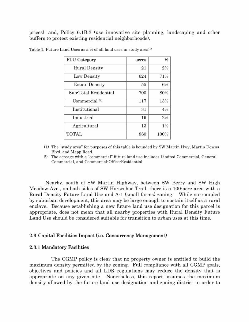
The area is no longer rural. See Figure 11. Of the approximately eight hundred eighty (880) acres between SW Martin Downs Blvd and SW Martin Highway, west of Mapp Road, including the five-acre parcel that is the subject of this application, only twenty-one (21) acres have the Rural Density Future Land Use designation (about 2%). Thirteen acres have the Agricultural Future Land Use designation and fifty-five (55) acres have the future land use designation of Estate Density (2 units per acre). About 71% of the land in this area has the Low Density Future Land Use designation. See Table 1 (next page).
The CGMP policies most relevant to this application were identified and discussed in Section 2.1 of this Report. Granting this parcel the Low Density Future Land Use Designation advances CGMP Policy 4.13A.7(5) (secondary urban services district); 4.13A.7(3) (low density future land use); Goal 6.1 (diverse housing stock adequate to meet demand, and consistent with desired community character); Objective 6.1B (conserve and improve existing housing and neighborhoods and provide a broad mix of housing types) as well as Policy 6.1B.1 (zone an adequate amount of land for housing); Policy 6.1B.2 (provide varied housing types, sizes and
prices); and, Policy 6.1B.3 (use innovative site planning, landscaping and other buffers to protect existing residential neighborhoods).
Table 1. Future Land Uses as a % of all land uses in study area(1)
FLU Category acres %
Rural Density 21 2%
Low Density 624 71%
Estate Density 55 6%
Sub-Total Residential 700 80%
Commercial (2) 117 13%
Institutional 31 4%
Industrial 19 2%
Agricultural 13 1%
TOTAL 880 100%
(1) The “study area” for purposes of this table is bounded by SW Martin Hwy, Martin Downs Blvd. and Mapp Road.
2) The acreage with a “commercial” future land use includes Limited Commercial, General Commercial, and Commercial-Office-Residential.
Nearby, south of SW Martin Highway, between SW Berry and SW High
Meadow Ave., on both sides of SW Horseshoe Trail, there is a 100-acre area with a Rural Density Future Land Use and A-1 (small farms) zoning. While surrounded by suburban development, this area may be large enough to sustain itself as a rural enclave. Because establishing a new future land use designation for this parcel is appropriate, does not mean that all nearby properties with Rural Density Future Land Use should be considered suitable for transition to urban uses at this time.
2.3 Capital Facilities Impact (i.e. Concurrency Management)
2.3.1 Mandatory Facilities
The CGMP policy is clear that no property owner is entitled to build the
maximum density permitted by the zoning. Full compliance with all CGMP goals, objectives and policies and all LDR regulations may reduce the density that is appropriate on any given site. Nonetheless, this report assumes the maximum density allowed by the future land use designation and zoning district in order to

generate worst-case scenarios for purposes of identifying and evaluating the potential impact on capital facilities.
2.3.1.1. Water and Sewer
The property is located within the Martin County Primary Urban
Services District and the Martin County Utilities’ Service area. Martin County’s level of service (LOS) for wastewater collection and treatment services is 100 gallons per capita per day (gpcpd). The 2015 residential LOS service for potable water established by CGMP Policy 11.1B.6 is 110 gpcpd.
If granted the future land use designation of Low Density and a zoning
change to Low Density, the maximum development on this site is 25 dwelling units. With average household size of 2.41 persons per household (U.S. Census Bureau 2013 estimate), 25 units of housing will house sixty (60) people. This population can be expected to consume 6,600 gallons per day and produce 6,000 gallons of wastewater per day.
The “Water Availability Sheet” completed by Ted Robbins, P.E.,
concludes that the County has ample capacity to serve any development that may result from the Future Land Use change. (Included in Attachment: Application Materials). The County has a FDEP permit to treat 18.8 million gallons per day (MGD) at its water treatment plants and a Consumptive Use Permit from the SFWMD for 19.52 MGD from the Floridan aquifer and 4.635 from the Surficial aquifer. The average consumption in the previous calendar year was 9.261 MGD. After accounting for present use, reserved capacity of 540,000 gallons per day (gpd), and 500,000 gpd for potential uses resulting from all requested 2015 FLUM amendments2, Mr. Robbins estimated that the County has nearly 14 MGD allocated from the aquifers to meet all other future needs. The capital facility charge for water is $1,710 per single family residential unit or $855 per multi-family unit which is due at the time of development approval or building permit.
The extension of wastewater collection lines to serve this property is consistent with CGMP Policy 10.1A.6. The property is within the Primary Urban Services District. If the amendment is approved, the residential density will exceed two units per acre, the extension of sanitary sewer service will not promote urban sprawl, and the amendment provides for the efficient use of land and maximizes the
2 The 500,000 gpd theoretically set aside to serve all 2105 Comprehensive Plan amendments is very conservative. Generally, non-residential uses use less water and generate less wastewater than residential uses. Among the first round of requested amendments in 2015, only the Kingsley CPA is requesting a residential future land use. Five hundred thousand (500,000) gpd would provide the commercial level of service of 0.095 gallons per square foot per day to more than five million square feet of non-residential development.
use of existing facilities. The capital facility charge for waste water is $2,100 per single family residential unit or $1,055 per multi-family dwelling unit which is due at the time of development approval or building permit.
2.3.1.2. Drainage Drainage concerns include downstream flooding and non-point source
pollution of surface water. Stormwater detention and retention are required to attenuate those impacts. According to Figures 13-2 and 13-3 of the CGMP, this property is located within the watershed of Danforth Creek, which is within the watershed of the South Fork of the St. Lucie River. The CGMP has established the following levels of service for drainage facilities:
Major Drainage Ways (> 1 sq.mi.) - 8.5" in a 24-hour period
for 25 year/24-hour design storm. Underground Storm Sewers - 6" in a 24-hour period
for 5 year/24- hour design storm. All Other Facilities - 7" in a 24-hour period
for 10-year/24-hour design storm. Finished Floor Elevation - 100-year/3-day storm.
All applicants for development orders must demonstrate compliance with these post-development standards.
2.3.1.3. Transportation Transportation in the vicinity of this property is provided by the
private automobile. The applicants’ traffic analysis is based on a worst-case scenario and assumes that twenty-five single-family residences will each generate 12 daily trips for a total of 293 trips. (Included in Attachment: Application Materials). Each departure from, and arrival at, the home is a separate trip, for purposes of traffic impact analysis. Lisa A. Wichser, P.E., Martin County’s Traffic Engineering/Development Review Administrator reviewed the report and concluded as follows: “Staff finds that the proposed Future Land Use Map designations will not have a negative impact on Martin County’s road facilities in either the short or long term. Staff will reevaluate the traffic impacts prior to the issuance of any development order associated with the property.” Exhibit A.
CGMP Policy 14.1A.2. establishes the level of service (LOS) standards for
county roadways. For arterial and collector roads, the LOS for the peak hour in the peak season is D. LOS D is described as, “approaching unstable flow, slow but tolerable operating speeds, noticeable but tolerable delays at signalized intersections. Stopped cars are not delayed more than two cycles of the signal.” The applicants’ traffic analysis concludes that the traffic generated from this property will have no significant impact on the level of service on nearby roadways and that no roadway improvements would be

necessitated by the change in the future land use. Consistent with CGMP Policy 14.1B.2, any future residential development on this parcel will be subject to transportation impact fees ranging from $2,268 to $4,063 per residential unit depending on the size of the residence.
A park-and-ride lot is located at the Turnpike Interchange with Martin
Downs Blvd., about one mile from the subject property. The Martin County MPO, in its 2014 Transit Development Plan, reports that 10% of workers residing in Martin County commute to St. Lucie County, 24% commute to Palm Beach County, 8% commute to Broward or Miami-Dade Counties, and 16% commute to some other county. The proximity of the park-and-ride lot can increase the feasibility and attractiveness of car-pooling for those with out-of-county commutes.
No fixed-route public transit routes serve Palm City. Fixed-route public
transit bus routes are limited to U.S. 1 (Treasure Coast Connector), Kanner Highway to Indiantown, or within the City of Stuart. Therefore, the complimentary transportation service for persons with disabilities seeking to access a bus route within three-quarters of a mile of their origin or destination also does not serve this area. The only transit service that reaches this property is the demand-response paratransit service available for medical appointments. However, the MPO’s 2014-2023 Transit Development Plan proposes a Palm City route that would loop along Martin Highway and Martin Downs Blvd. to Stuart to be commenced within the next eight years.
2.3.1.4. Solid Waste
In 2002, the Martin County Board of County Commissioners approved
the closure of the Palm City II landfill and entered into a 30-year agreement to dispose of waste in the Okeechobee Landfill. County and municipal laws require all household refuse to be delivered to the Martin County Transfer and Recycling Facility, located approximately 1½ miles northeast of the intersection of State Road 714 and Interstate 95. Construction debris is also accepted at this location. The CGMP reports that as much as 700 to 800 tons of waste is delivered daily for transfer. In 2008, Martin County recycled 34% of the waste processed at the Facility. The Transfer and Recycling Facility is operated under permit from the Florida Department of Environmental Protection (FDEP) and the South Florida Water Management District. The permit requires protection of groundwater, surface water and air from contamination.
The County LOS standard for solid waste facilities is that the County can provide capacity for 1.06 tons per weighted person per year. CGMP Policy 14.1A.2. The actual result in 2015 was 1.5 tons per weighted person. Therefore, as a county we must further reduce the generation of solid waste. However, there is no reason the requested amendment to the FLUM will have any impact on the County’s ability to meet that 1.06 desired LOS.

2.3.1.5. Parks and Recreation
The CGMP Policy 14.1A.2 establishes the following LOS standard for County parks and recreation facilities: developed active parkland is three acres per 1,000 people in each recreational planning district. The subject property is located within the Palm City Recreational Planning District. That Recreational Planning District includes the Palm City Park (25 acres); Penadarvis Park (44 acres); Hidden Oaks Middle School (10 acres); and Leighton Park (5 acres). Additionally, the County has a LOS for beach access --County ocean beaches and beach facilities shall provide 9 parking spaces for every 1000 residents. See Figure 15 (next page).
Hidden Oaks Middle School facilities include a running or walking
track, basketball courts, two baseball diamonds, and some practice fields. The Palm City Elementary School includes a baseball diamond, basketball courts and playground equipment. The other Palm City Parks are further away. The distance to Palm City Park is a bit over 2 miles, to Leighton Park is nearly two miles, and to Pendarvis Park is 2.6 miles.
As explained in section 2.4.1.1. Water and Sewer, above, if granted the future land use designation of Low Density and a zoning change to RM-5, this property can accommodate a maximum of 25 dwelling units and can expect to house sixty (60) people. (For purpose of this report, no distinction is made between the average household size for different dwelling types.) The total park land needed to meet the LOS for sixty people is less than one acre. Consistent with CGMP Policy 14.1B.2, at the time of any development approvals or applications for building permits, the applicable impact fees for parks will be assessed to meet this additional need. The park impact fees range from $1,197 for a dwelling unit less than or equal to 800 square feet to $2,699 for a dwelling that is at least 2,301 square feet.
2.3.1.6. Fire, Public Safety and Emergency Medical Services
The County’s LOS standards for Fire/Rescue as they apply to this property, that is, in Urban Areas, are as follows:
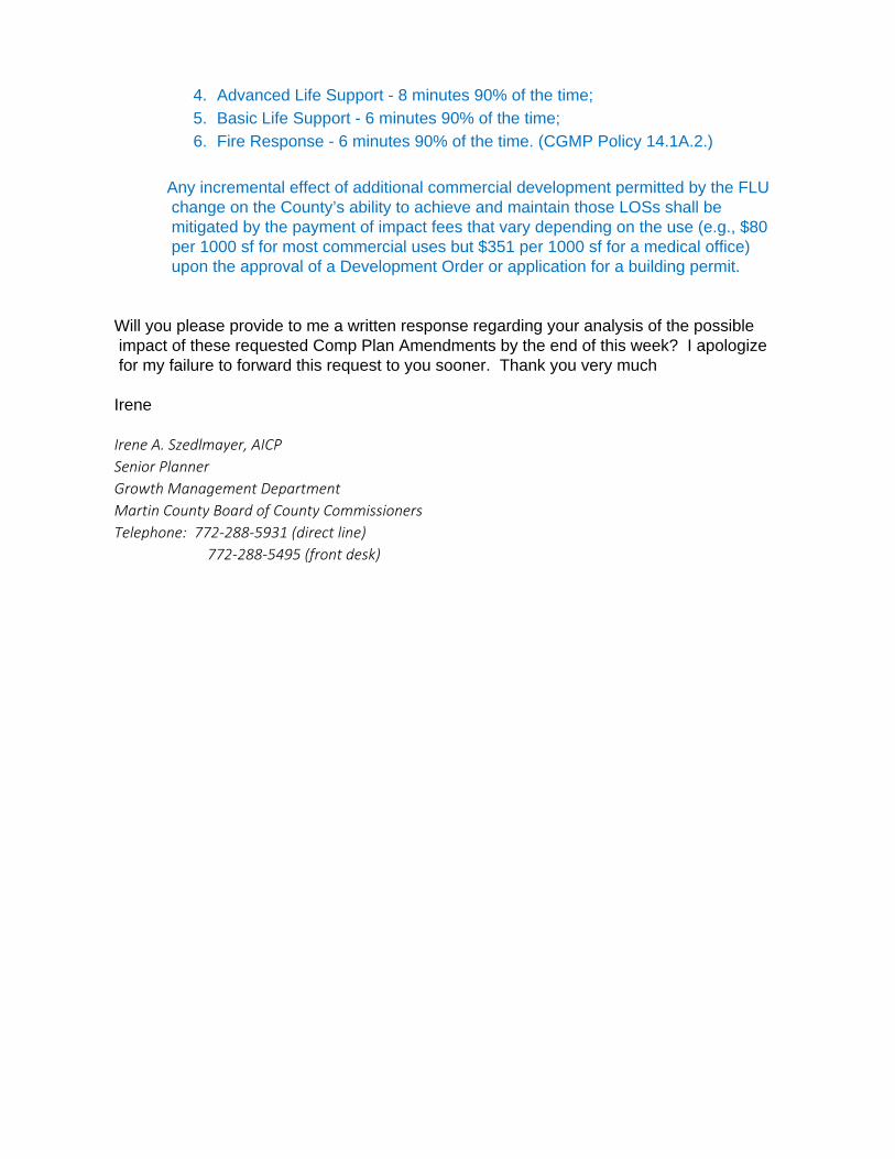
1. Advanced Life Support - 8 minutes 90% of the time; 2. Basic Life Support - 6 minutes 90% of the time; 3. Fire Response - 6 minutes 90% of the time. (CGMP Policy 14.1A.2.)
Doug Killane, Bureau Chief of Fire Prevention with Martin County Fire
Rescue, has indicated that the requested amendment of the CGMP will not negatively impact Fire Rescue’s level of service or response times. See Exhibit B. The incremental effect on the County’s ability to achieve and maintain those levels of service caused by the addition of 60 residents shall be mitigated by the payment of impact fees (from $208/dwelling unit to $780/dwelling unit, depending on size of dwelling) upon the approval of a Development Order or building permit.

Figure 15: Martin County Parks & Recreation Facilities near subject property.
2.3.1.7. Schools
This property is less than one mile from Palm City Elementary School and Hidden Oaks Middle School. Currently to walk or to travel by car from the property to either of the schools requires travel on SW Martin Highway. The opportunity may exist in the future to provide more direct pedestrian access to the Elementary School by creating a right-of-way between property lines on the east side of Berry Avenue.
At the time of approval of a development order or building permit,
impact fees will be assessed according to the following impact fee schedule:
Size of Unit 800 sf or less
801 sf to 1,100 sf
1,101 sf to 2,300 sf
2,301 sf or more
Cost per Unit $3,609.37 $5,355.08 $5,567.39 $5,756.12

The 2011 Palm City Elementary School enrollment was 90% of capacity; enrollment at Hidden Oaks Middle School was 83% of capacity and enrollment at Martin County High School was 89% of capacity. Adequate school capacity for any development, pursuant to the Comprehensive Plan and LDR, is determined during the final site plan review process. In response to a written request for comment on this proposed amendment to the FLUM, Garrett Gabrowski, Director of Facilities and Planning, for the Martin County School District, verbally confirmed that the Palm City Elementary School and the Hidden Oaks Middle School have sufficient capacity to absorb students who might be generated by up to twenty-five new residences on these five acres.
2.4.2. Non-mandatory Facilities 2.4.2.1. Libraries
The County’s LOS standards for library facilities is 0.60 square feet per capita for library buildings and 2.0 volumes per weighted resident for the library collection. CGMP Policy 14.1A.3. The 2015 County Capital Improvements Plan shows the County currently has 110,026 gross square feet of library space, which equals 0.72 square feet per resident. There are currently 370,094 volumes available yielding 2.33 volumes per person. The current Library LOS services meets or exceeds the minimum LOS and the County’s impact fee policies are designed to ensure the continued ability to meet these LOS standards. The library impact fee for new residential uses ranges from $319/dwelling unit to $720/dwelling unit, depending on the size of the dwelling which is due at the time of development approval or building permit.
3.0 REQUEST TO CHANGE THE ZONING DISTRICT 3.1 Criteria to change a Zoning District
In addition to requesting that the Future Land Use designation of their 5-acre parcel be changed, the applicants requested that the zoning district be changed from A-1 (Small Farms) to RM-5 (multi-family residential up to 5 units per acre). (See, Attachments: Correspondence (Applicant will be amending the request to RS-4 or RS-5 zoning. The remainder of this staff report was not amended to reflect this modified request for a change in the zoning district, which is scheduled to be the subject of a public hearing on July21, 2015.)) In considering this request, the County is guided by the Land Development Regulations, in addition to the CGMP, especially the fundamental caveat that the FLUM “shall not be construed to mean that every parcel is guaranteed the maximum density and intensity possible. . . All goals, objectives and policies of the CGMP shall be considered when a proposed rezoning is considered.” [LDR Section 3.2.E.1].

3.1.2 Permitted Uses Six residential zoning districts are potentially available to implement the
Low Density Future Land Use on this property: RS-3, RS-4, RS-5, RM-3, RM-4 and RM-5. The uses permitted in each of these six districts are set-forth in Table 2, along with the uses permitted within the existing A-1 district. One key difference between the different zoning districts is whether duplexes, townhouses, and multi-family dwelling units (RM-3, RM-4 and RM-5) or only detached, single-family residences (RS-3, RS-4, and RS-5) are permitted. The zoning districts also establish different maximum densities and different minimum lot sizes. See Table 3.
Applicants’ property is bordered on two sides by the Islesworth PUD. The
density of Isleworth is 2.4 dwelling units per acre. The lot sizes are approximately one-quarter acre (about 11,000 square feet) each. Some are a little larger; some are a little smaller. The proximity of that neighborhood with that development pattern suggests that the RM-5 zoning district with minimum lot area of 8,500 square feet and density of 5 units per acre, may not be consistent with the protection of existing residential neighborhoods as required by CGMP Policy 6.1B.1.
As set forth in Section 2.1 above, the CGMP contains one housing goal: “To provide a diverse housing stock adequate to serve the needs of current and future populations of Martin County, consistent with the desired development character of the County as set forth in this Plan.” CGMP Goal 6.1. Objective 6.1B reiterates the two overall housing goals-- maintain existing housing stock, residential neighborhoods and property values and provide for a broad mix of housing types. The policies that implement Objective 6.1B. require that adequate residential land be zoned at densities to meet the County’s current and future housing needs within the Urban Services District, that Martin County provide varied housing types, sizes and prices consistent with local need, and that the County promote the use of innovative site planning, landscaping and other buffering devices to protect existing neighborhoods. Consideration of this re-zoning application highlights the inherent tension between these two primary aims. If providing the opportunity for a diverse range of housing types is prioritized, zoning that permits duplexes, townhouses or multi-family development, such as RM-3, RM-4 or RM-5 might be appropriate. Or, zoning that requires detached single family houses, but permits smaller lots and higher density than the existing neighborhood, such as RS-5, could be appropriate. The County’s density transition, landscaping and other policies are relied upon to protect the quality, value and character of the existing detached single family neighborhood. Of course, simply because the zoning district allows townhouses or multi-family does not mean that is the type of housing that will be built. Detached single family residences are permitted in any residential zoning district. However, if the CGMP’s mandates to protect the quality, character and value of existing

residential neighborhoods is understood to mean that new development should be as similar as possible to the existing development, a zoning district that permits only detached single family housing on similar sized lots, such as RS-4, would be most appropriate zoning district for applicants’ property.
TABLE 2. Permitted uses in A-1 zoning district, RM-5 zoning district, and the other 5 zoning districts available to implement Low Density Future Land Use
Small Farm
Single Family Districts
Multi-Family Districts
A-1 RS-3 RS-4 RS-5 RM-3 RM-4 RM-5 Residential Uses
Accessory dwell. units P Modular homes P P P P P P P MF dwellings P P P
SF detached dwellings P P P P P P P
Townhouse dwellings P P P
Duplex dwellings P P P P
Zero lot line SF dwellings
P P P
Agricultural Uses
Agricultural processing, indoor
Agricultural processing, outdoor
Crop farms P Dairies P Farmer's markets P
Orchards and groves P
Plant nurseries and landscape services P
Poultry raising P Stables, private P
Public and Institutional Uses
Community Centers P P P P P P P
Educational institutions P P P P P P P
Neighborhood ass’td P P P P P P P

resid. w/ <=6 residents
(continued on next page) TABLE 2. (continued)
Small Farm
Single Family Districts
Multi-Family Districts
A-1 RS3 RS4 A-1 RS3 RS4 A-1 Public and Institutional Uses
Neighborhood boat launches P P P P P P
Places of worship P P P P P P P
Protective and emergency services P P P P P P P
Public libraries P P P P P P P
Public parks and recreation areas, active
P P P P P P P
Public parks and recreation areas, passive
P P P P P P P
Recycling drop-off centers P P P P P P
Residential care facilities P P P
Utilities P P P P P P P Commercial and Business Uses
Bed & Breakfast inns P P P P P P P Commercial day care P P P P P P P Family day care P P P P P P P Golf courses P P P P P P P Theaters, drive-in P

3.1.3 Development Standards
The development standards applicable to each lot, such as minimum lot area, minimum lot width and setbacks, are presented in Table 3.
TABLE 3. Development Standards for A-1 Zoning District and the six Zoning Districts intended to
implement the Low Density Future Land Use designation.
Zoning District
Minimum.Lot Area 1
Minimum Lot Width
1
Max. Residential
Density
Max.
Height
Min. Open Space
Setbacks Front 2 Side rear
RS-3
15,000 60’ 3/upa 30’ 50% 25’ 10’ 10’
RS-4
10,000 60’ 4/upa 30’ 50% 25’ 10’ 10’
RS-5
7,500 60’ 5/upa 30’ 50% 25’ 10’ 10’
RM-3
15,000 60’ 3/upa 40’ 50% 25’ 10’ 3 10’ 3
RM-4
10,000 60’ 4/upa 40’ 50% 25’ 10’ 3 10’ 3
RM-5
8,500 60’ 5/upa 40’ 50% 25’ 10’ 3 10’ 3
A-1
2 acres none 0.5/upa 40’ 50% 25’ 25’ 25’
Source: Table 3.12.1, Table 3.12.2, LDR, Article 3 Notes: 1. The minimum lot area and lot width standards in this table do not apply to zero
lot line, townhouse, or multi-family development on lots created after March 2002. Zero lot line dwellings must have a minimum lot area of 5,000 sf, lot width of 40,’ front setback of 15,’ rear setback of 10,’ spacing between buildings of 10’, and side setback of 15’ when facing a street. Townhouses must have at least 15’ between buildings.
2. Lots on Berry Avenue are also subject to a 50’ minimum setback from the centerline of the Berry Avenue r.o.w.
3. The 10’ side and rear setback applies to one- and two-storey dwellings. The setback for third and fourth stories is 20’ and 30’, respectively.
Notwithstanding the permitted uses and development standards set forth in Tables 2 and 3 above, in terms of maximum density, minimum lot size and dwelling type, the portion of the applicant’s property measuring one hundred twenty-five feet (125’) from the north property line and adjacent to Lot 31 in Islesworth, may not exceed the density of the Islesworth development, pursuant to the County’s Density Transition Policy set forth at CGMP Policy 4.1F.2. The depth of the residential lots in the adjacent residential community established the density transition zone, in this case 125’. The Density Transition Policy requires new residential development

within the density transition zone to have comparable density and compatible dwelling unit types. Therefore, pursuant to the density transition policy, if the applicants are granted the requested RM-5, which permits multi-family residential of up to five dwelling units per acre, and subsequently a multi-family development is proposed, the use of the land within the 125 foot density transition zone would be limited to detached single-family dwellings on similarly sized lots as the lots in adjacent in Islesworth, or other purposes such as stormwater detention, open space or preserve area.
3.1.4. Adjacent Zoning Districts North: Islesworth (2.5 dwelling units per acre) South: RM-5 (undeveloped) (up to 5 dwelling units/acre) East: A-1A (fallow farm field) West: Islesworth (2.5 dwelling units per acre)
The permitted uses and development standards of the requested RM-5 zoning
district must be evaluated pursuant to criteria governing a request to change the zoning district of a property, pursuant to LDR Section 3.2.E. These are:
a. Whether the proposed zoning amendment is consistent with all applicable provisions of
the Comprehensive Plan; The CGMP policies on housing development emphasize both protection of existing residential neighborhoods from incompatible development and development of diverse housing opportunities. RM-5 may not provide sufficient protection to the adjoining neighborhood.
b. Whether the proposed amendment is consistent with all applicable provisions of the LDR;
At the time a development proposal is submitted, it will be required to comply with all applicable LDRs including uses, density, set-backs, height, open-space, wetlands, uplands, landscaping, etc.
c. Whether the proposed district amendment is compatible with the character of the existing land uses in the adjacent and surrounding area and the peculiar suitability of the property for the proposed zoning use;
The proposed RM-5 zoning district permits greater density than the character of existing land uses. Additionally, while there are duplexes and multi-family dwellings in the surrounding area, none are nearby. See Table 4. Therefore, the RM-5 zoning district would also allow dwelling types that are not consistent with the existing development in the immediate area. However, the

density transition, landscaping and other policies and codes are designed to provide a good transition between different densities.
Table 4. Density and Dwelling Type of Nearby Residential Developments
Residential Development
Approximate Gross Density
Dwelling type
Islesworth 2.50 du/acre detached single family The Villas 3.75 du/acre detached single family Mariposa 4.29 du/acre detached single family Murano (combined) 3.65 du/acre detached single family Mill Creek 4.89 du/acre zero lot line detached Carmel 2.90 du/acre detached single family Sunset Trace 5.68 du/acre townhouses and 4-plexes
d. Whether and to what extent there are documented changed conditions in the area; The aerial photos from 1970, 1995 and 2014 document the change in land use that has occurred in the vicinity. (Figures 4A, 4B and 4 C).
e. Whether and to what extent the proposed amendment would result in demands on
public facilities; As explained earlier in the report, even if development of 5 units per acre is permitted after full compliance with the CGMP and LDRs, the number of people that can be expected to reside within the neighborhood is about 60. That number of people can be served by the existing road network, parks, schools, sidewalks, fire and emergency medical response, and water and wastewater facilities and the County’s impact fee policies ensures those new residences pay their fair share.
f. Whether and to what extent the proposed amendment would result in a logical, timely
and orderly development pattern which conserves the value of existing development and is an appropriate use of the County's resources; and
The proximate availability of water and wastewater services, the proximity of the elementary school and middle school, the mostly built-out character, and a highway network that provides access to Palm City, Stuart and the Turnpike and Interstate 95, makes it logical, timely and orderly to allow increased density on this five acre parcel.
g. Consideration of the facts presented at the public hearings.

ATTACHED EXHIBITS
A. Memorandum from Lisa A. Wichser, P.E., Traffic Engineering/Development
Review Administrator, Martin County
B. Communication from Doug Killane, Martin County Bureau Chief for Fire Rescue

EXHIBIT A
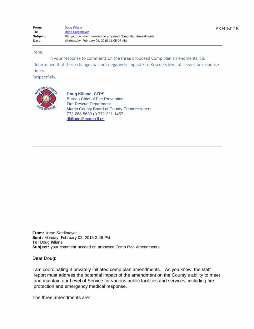
From: Doug KillaneTo: Irene SzedlmayerSubject: RE: your comment needed on proposed Comp Plan AmendmentsDate: Wednesday, February 04, 2015 11:05:07 AM
Irene, In your response to comments on the three proposed Comp plan amendments it is
determined that these changes will not negatively impact Fire Rescue’s level of service or response times.Respectfully,
Doug Killane, CFPS
Bureau Chief of Fire Prevention
Fire Rescue Department
Martin County Board of County Commissioners
772-288-5633 (f) 772-221-1457
From: Irene Szedlmayer Sent: Monday, February 02, 2015 2:49 PMTo: Doug KillaneSubject: your comment needed on proposed Comp Plan Amendments
Dear Doug:
I am coordinating 3 privately-initiated comp plan amendments. As you know, the staff
report must address the potential impact of the amendment on the County’s ability to meet
and maintain our Level of Service for various public facilities and services, including fire
protection and emergency medical response.
The three amendments are:
EXHIBIT B

(1) CPA 2015-01, Kingsley - A request to change the FLUM from Rural Density to Low
Density and to change the zoning district from A-1 to RM-5 for 5-acres located on
Berry Avenue, between CR 714 (Martin Hwy) and Sunset Trail.
(2) CPA 2015-02, Berry Retail - The owners of 4.8-acres on east-bound SW Martin
Hwy, between SW Berry Ave and SW High Meadows Ave, have requested that the
Future Land Use designation of the property be changed from Rural Density (0.5
dwelling units per acre) to General Commercial and that the zoning district be
changed from A-1 (Small Farms) to General Commercial. Regional water and
wastewater will be extended to serve the property.
(3) CPA 2015-06, Berry Retail-Gallley - The owner seeks to change the FLU from Rural
Density to Limited Commercial and the zoning from A-1 Small Farms to Limited
Commercial on 1.14 acres at the southwest corner or SW Berry Ave. and SW
Martin Hwy.
A location map showing the three sites is attached.
With regard to the Kingsley request I said this:
2.4.1.6. Fire, Public Safety and Emergency Medical Services
The County’s LOS standards for Fire/Rescue as they apply to this property, that is, in Urban Areas, are as follows:
1. Advanced Life Support - 8 minutes 90% of the time;2. Basic Life Support - 6 minutes 90% of the time;3. Fire Response - 6 minutes 90% of the time. (CGMP Policy
14.1A.2.) The construction of 25 dwelling units inhabited by 60 residents at this location will have no significant impact on the County’s ability to meet and maintain the LOS for fire, public safety and emergency medical services. Any incremental effect on the County’s ability to achieve and maintain these LOSs shall be mitigated by the payment of impact fees (from $208/dwelling unit to $780/dwelling unit, depending on size of dwelling) upon the approval of a Development Order or submission of a request for a building permit.
With regard to the two Berry Retail requests, I said this:
2.4.1.6. Fire, Public Safety and Emergency Medical Services
Permitting commercial development on this land will have no impact on Fire,
Public Safety and Emergency Medical Services Level of Service. Under the
current FLU and zoning, two single family residences are allowed. With
General Commercial FLU, these two single family residences would not be
allowed. The County’s LOS standards for Fire/Rescue as they apply to this
property, that is, in Urban Areas, are as follows:
4. Advanced Life Support - 8 minutes 90% of the time;
5. Basic Life Support - 6 minutes 90% of the time;
6. Fire Response - 6 minutes 90% of the time. (CGMP Policy 14.1A.2.)
Any incremental effect of additional commercial development permitted by the FLU
change on the County’s ability to achieve and maintain those LOSs shall be
mitigated by the payment of impact fees that vary depending on the use (e.g., $80
per 1000 sf for most commercial uses but $351 per 1000 sf for a medical office)
upon the approval of a Development Order or application for a building permit.
Will you please provide to me a written response regarding your analysis of the possible
impact of these requested Comp Plan Amendments by the end of this week? I apologize
for my failure to forward this request to you sooner. Thank you very much
Irene
Irene A. Szedlmayer, AICPSenior PlannerGrowth Management DepartmentMartin County Board of County CommissionersTelephone: 772-288-5931 (direct line) 772-288-5495 (front desk)