Proposal for Fisheries Management Measures for the protection … · 2018-02-02 · Proposal for...
101
Proposal for Fisheries Management Measures for the protection of reef structures (H1170) in Natura 2000 sites located in the Belt Sea and the Danish part of the Western Baltic Sea (within 12 nautical miles) Submission to the European Commission Proposal for Fisheries Management Measures under art. 11 and 18 of Regulation (EU) No 1380/2013 of The European Parliament and of the Council of 11 December 2013 on the Common Fisheries Policy, amending Council Regulations (EC) No 1954/2003 and (EC) No 1224/2009 and repealing Council Regulations (EC) No 2371/2002 and (EC) No 639/2004 and Council Decision 2004/585/EC
Transcript of Proposal for Fisheries Management Measures for the protection … · 2018-02-02 · Proposal for...
Proposal for Fisheries Management Measures for the
protection of reef structures (H1170) in Natura 2000
sites located in the Belt Sea and the Danish part of
the Western Baltic Sea (within 12 nautical miles)
Submission to the European Commission
Proposal for Fisheries Management Measures under art. 11 and 18 of Regulation (EU) No
1380/2013 of The European Parliament and of the Council of 11 December 2013 on the
Common Fisheries Policy, amending Council Regulations (EC) No 1954/2003 and (EC) No
1224/2009 and repealing Council Regulations (EC) No 2371/2002 and (EC) No 639/2004 and
Council Decision 2004/585/EC
Proposal for fisheries management measures in Danish Natura 2000 sites in the western Baltic Sea – FINAL
2
Content
Summary .................................................................................................................................... 3 Sammenfatning ............................................................................................................................ 4 1. Introduction ............................................................................................................................. 5
1.1 General remarks .................................................................................................................. 5
1.2 Overall aim of the present proposal ........................................................................................ 5
1.3 Recommendations to be implemented .................................................................................... 6
2. Legal framework ....................................................................................................................... 8 2.1 Common Fisheries Policy ...................................................................................................... 8
2.2 Access to the Danish Natura sites .......................................................................................... 9
2.3 Implementation of Natura 2000 in Denmark ............................................................................ 9
2.3.1 Designation of Natura 2000 sites in Denmark .................................................................... 9
2.3.2 Mapping of marine Natura 2000 sites ............................................................................. 10 3. Process .................................................................................................................................. 12
3.1 National coordination and consultation ................................................................................. 12
3.1.1 Natura 2000 Dialogue Forum ........................................................................................ 12
3.1.2. Meetings with stakeholders .......................................................................................... 13 3.1.3. Involvement of Parliament and Committees within the Ministry of Food, Agriculture and Fisheries ............................................................................................................................. 14 3.1.4. Peer review of the proposal .......................................................................................... 14
3.2 International coordination – regionalization ........................................................................... 14
3.2.1. Pre-consultations ........................................................................................................ 14 3.2.2 Regionalization – Scheveningen Natura 2000 working group ............................................. 15
3.2.3 Informal consultations with other Member States ............................................................ 15 3.2.4 Consultations with Advisory Councils .............................................................................. 16
4. Principles and rationale ............................................................................................................ 17 5. Scope of the present proposal .................................................................................................. 20
5.1 Description of the Natura 2000 sites concerned ..................................................................... 20
5.1.1 Natura 2000 site: Munkegrund ...................................................................................... 23 5.1.2 Natura 2000 site: Hatterbarn ........................................................................................ 24 5.1.3 Natura 2000 site: Ryggen ............................................................................................. 25 5.1.4 Natura 2000 site: Broen ............................................................................................... 26
5.1.5 Natura 2000 site: Ertholmene ....................................................................................... 27 5.1.6 Natura 2000 site: Davids Banke .................................................................................... 28 5.1.7 Natura 2000 site: Bakkebrædt & Bakkegrund .................................................................. 29
5.2 Description of proposed fisheries management measures ....................................................... 29
5.2.1 Purpose of the present proposal .................................................................................... 29 5.2.2 Assessment of adequacy and proportionality ................................................................... 30
6. Restriction of fisheries within the Danish Natura 2000 sites .......................................................... 32 6.1 Fleet activity and type of fisheries ........................................................................................ 32
6.2 Target species and annual trends ......................................................................................... 34
6.3 Displacement .................................................................................................................... 47
6.4 Control, enforcement and monitoring ................................................................................... 47
6.4.1 Control and enforcement .............................................................................................. 47 6.4.2 The national monitoring program – NOVANA ................................................................... 48
References ................................................................................................................................. 50 List of Annexes ........................................................................................................................... 52
Proposal for fisheries management measures in Danish Natura 2000 sites in the western Baltic Sea – FINAL
3
Summary For the implementation of the EU Nature directives (Habitat and Birds Directives), Denmark has designated 97
marine Natura 2000 sites in Danish territorial waters of the Western Baltic, Kattegat, Skagerrak and the North
Sea. A total of 65 sites have been designated for reef structures with the following habitat codes: H1170
(reefs) and H1180 (submarine structures made by leaking gasses). In general, the conservation status of reef
structures in the Danish Natura 2000 sites are classified as unfavourable due to physical disturbances and
high nutrient content in the water column.
The overall aim of the present proposal is to ensure adequate protection of reef structures from fisheries,
and thereby contribute to the obligation of achieving favourable conservation status for these habitat types
in accordance with Article 6 (2) of the Habitats Directive.
The present proposal entails fishery management measures in seven Natura 2000 sites located in the
Danish part of the Western Baltic Sea between the baseline and 12 nautical miles:
1. Munkegrund (EU site code: DK00VA304)
2. Hatterbarn (EU site code: DK00VA255)
3. Ryggen (EU site code: DK00VA253)
4. Broen (EU site code: DK00VA256)
5. Ertholmene (EU site code: DK007X079)
6. Davids Banke (EU site code: DK00VA308)
7. Bakkebrædt & Bakkegrund (EU site code: DK00VA310)
Fishing activity with mobile bottom contacting gears is proposed to be prohibited in areas mapped as reefs
(habitat code H1170). The reef structures mapped in the Natura 2000 sites will be protected from impact
from fishing activity by placement of buffer zones around reef structures.
Scientific advice from Aarhus university (Danish Centre for Environment and Energy), DTU Aqua (The
Danish Technical University, (Institute for Aquatic Resources) and ICES alongside the site specific Natura
2000 management plans and mapping of marine habitats, serve as the basis for the proposed fisheries
management measures.
Sweden and Germany have fishing rights in the Danish part of the Western Baltic Sea within 12 nautical
miles. The Western Baltic Sea is an important fishing area for both Denmark, Germany and Sweden.
Analysis of fishery data show, that the proposed management measures will have no or limited impact on
Danish, Swedish and German fishing activity when looking at the period 2010-2012. In general, fishing
does not take place in areas characterized as reefs in these areas. However, it is important to ensure full
protection of these reef structures in accordance with the Habitats Directive.
It is the intention of the Danish government (initiating Member State) to take measures i.a. with respect to
fishing activities exercised by all vessels including fishing vessels carrying the flag of other Member States
of the EU. In order to apply these measures to all vessels, Denmark, as the initiating Member State, has in
accordance with EP/Council Regulation (EU) No 1380/2013 of the Common Fisheries Policy (Basic
Regulation), consulted Germany and Sweden, the Baltic Sea Advisory Council, ICES and the Commission,
national fishermen associations/organizations and NGOs.
The present proposal is submitted to the European Commission jointly by Denmark and Sweden in
accordance with the Basic Regulation, Article 11 and 18. A similar proposal for fisheries management
measures for protection of reef structures have been formulated for three Natura 2000 sites located in the
Danish part of the Kattegat. Germany abstains and thereby does not hinder Denmark and Sweden from
jointly recommending the proposed fisheries management for protection of reef structures, cf. MoU
(BALTFISH) 3.1.11.
Proposal for fisheries management measures in Danish Natura 2000 sites in the western Baltic Sea – FINAL
4
Sammenfatning
Danmark har som led i implementeringen af EU’s naturdirektiver (habitat- og fuglebeskyttelsesdirektivet)
udpeget 97 marine Natura 2000 områder i den danske del af denvestlige Østersø, Kattegat og Skagerrak.
Der er i alt udpeget 65 Natura 2000 områder for rev med habitatkoderne H1170 (rev) og H1180 (boblerev
med udsivende methangas fra undergrunden). Revs bevaringsstatus er ifølge områdernes naturplaner
generelt angivet som ugunstig som følge af fysisk påvirkning og højt næringsstofindhold i vandsøjlen.
Den overordnede målsætning med nærværende forslag er, i overensstemmelse med habitatdirektivets
artikel 6, stk. 2, at sikre tilstrækkelig beskyttelse af revstrukturer i forhold til fiskeri som led i opnåelsen af
gunstig bevaringsstatus for disse habitattyper.
Nærværende forslag omfatter fiskeriregulering i syv Natura 2000 områder, som alle er lokaliseret i
Bælthavet og den vestlige Østersø mellem basislinjen og 12 sømilegrænsen:
1. Munkegrund (EU site code: DK00VA304)
2. Hatterbarn (EU site code: DK00VA255)
3. Ryggen (EU site code: DK00VA253)
4. Broen (EU site code: DK00VA256)
5. Ertholmene (EU site code: DK007X079)
6. Davids Banke (EU site code: DK00VA308)
7. Bakkebrædt & Bakkegrund (EU site code: DK00VA310)
Forslag til fiskeriregulering omfatter forbud mod anvendelse af bundgående redskaber i områder kortlagt
som rev (habitatkode H1170). De kortlagte revstrukturer sikres beskyttelse mod fiskeriaktiviteter ved
placering af en bufferzone omkring revene.
Videnskabelig rådgivning fra DTU Aqua (Danmarks Tekniske Universitet, Institut for Akvatiske Ressourcer),
Aarhus Universitet (Nationalt Center for Miljø og Energi) samt ICES danner sammen med områdernes
naturplaner grundlaget for de fremlagte forslag til fiskeriforanstaltninger.
Sverige og Tyskland har fiskerirettigheder i den danske del af den vestlige Østersø inden for 12 sømil.
Bælthavet og den vestlige Østersø er vigtige områder for især dansk, svensk og tysk fiskeri. Analyser af
fiskeriaktiviteter for perioden 2010-2012 viser dog, at de foreslåede fiskeriforanstaltninger ikke vil have
betydende effekt på den måde fiskeri udøves i Bælthavet og den vestlige Østersø. Generelt set fiskes der
ikke i områder kortlagt som rev. I henhold til habitatdirektivet er det midlertidigt vigtigt, at kortlagte
revstrukturer sikres fuld beskyttelse mod fysisk påvirkning.
Den danske regering ønsker (som initiativtagende medlemsstat), at gennemføre fiskeriforanstaltninger,
som gælder samtlige fartøjer, herunder fartøjer fra andre flagstater, som udøver fiskeri i de pågældende
Natura 2000 områder. For at de foreslåede foranstaltninger kan omfatte samtlige fartøjer, har Danmark i
overensstemmelse med EP/ Rådsforordning nr. 1380/ 2013 om den fælles fiskeripolitik
(Grundforordningen), konsulteret Sverige og Tyskland, det Rådgivende Råd for Østersøen (BSAC), ICES,
EU Kommissionen, nationale fiskeriforeninger/organisationer.
Nærværende forslag er fremsendt til EU Kommissionen i form af fælles henstilling af de danske og svenske
fiskerimyndigheder i overensstemmelse med artikel 11 og 18 i Grundforordningen. Et tilsvarende forslag til
fiskeriforanstaltninger for beskyttelse af rev i tre Natura 2000 områder i Kattegat er ligeledes udarbejdet.
Tyskland har valgt at afstå fra at have en holdning, hvormed Danmark og Sverige fortsat kan fremsende
det danske forslag for beskyttelse af rev i form af fælles henstilling.
Proposal for fisheries management measures in Danish Natura 2000 sites in the western Baltic Sea – FINAL
5
1. Introduction
1.1 General remarks This document contains a proposal for regulation of fishing activities in the Belt Sea and the Danish part of
the Western Baltic area for the protection of reef structures designated under the Habitats Directive.
For the implementation of the EU 2000 directives (Habitat1 and Birds Directives2), Denmark has designated
97 marine Natura 2000 sites in Danish territorial waters in the Western Baltic Sea, Kattegat, Skagerrak
and the North Sea, see Annex A for map of the Danish marine Natura 2000 network. A total of 65 Natura
2000 sites have been designated for reef structures (habitatcode: H1170 - reefs and H1180 – submarine
structures made of leaking gasses), also known as bubbling reefs.
The present proposal entails fisheries management measures in seven Natura 2000 sites located in the
Belt Sea and the Danish part of the Western Baltic Sea between the baseline and 12 nautical miles:
1. Munkegrund (EU site code: DK00VA304)
2. Hatterbarn (EU site code: DK00VA255)
3. Ryggen (EU site code: DK00VA253)
4. Broen (EU site code: DK00VA256)
5. Ertholmene (EU site code: DK007X079)
6. Davids Banke (EU site code: DK00VA308)
7. Bakkebrædt & Bakkegrund (EU site code: DK00VA310)
A similar proposal for fisheries management measures have been formulated for protection of reef
structures in three Danish Natura 2000 sites in the Kattegat.
According to EP/Council Regulation (EU) No 1380/2013 Annex I, Germany and Sweden have historical
fishing rights within 12 nautical miles in the Danish part of Western Baltic Sea.
It is the intention of the Danish government (initiating Member State) to take measures i.a. with respect to
fishing activities exercised by all vessels including fishing vessels carrying the flag of other Member States
of the EU.
This document covers the 11 information items of the Commission’s guidelines from 2008 concerning
development of proposals for fisheries management measures in marine Natura 2000 areas within the
scope of the Common Fisheries Policy (see Annex C for an overview of how the present proposal has
covered the information 11 items).
In order to apply these measures to all vessels, Denmark, as the initiating Member State, has in
accordance with EP/Council Regulation (EU) No 1380/2013 of the Common Fisheries Policy (Basic
Regulation), consulted Sweden and Germany, the North Sea Advisory Council, ICES and the Commission,
as described in section 3.2. The present proposal is submitted to the European Commission jointly by
Denmark and Sweden in accordance with the Basic Regulation, Articles 11 and 18. Germany abstains and
thereby do not hinder Denmark and Sweden from jointly recommending the proposed fisheries
management.
1.2 Overall aim of the present proposal The overall aim of the present proposal is to ensure adequate protection of designated reef structures from
fisheries activities and thereby contribute to the obligation of achieving favourable conservation status for
1 Council Directive 92/43/EEC, of 21 May 1992 on the conservation of natural habitats and of wild fauna and flora: http://eur-lex.europa.eu/LexUriServ/LexUriServ.do?uri=CONSLEG:1992L0043:20070101:EN:PDF 2 Directive 2009/147/EC of the European Parliament and of the Council, of 30 November 2009 on the conservation of wild birds: http://eur-lex.europa.eu/LexUriServ/LexUriServ.do?uri=OJ:L:2010:020:0007:0025:en:PDF
Proposal for fisheries management measures in Danish Natura 2000 sites in the western Baltic Sea – FINAL
6
the habitat types with code H1170 in accordance with art. 6 (2) of the Habitats Directive, stating that
Member States shall take appropriate steps to avoid the deterioration of natural habitats and the habitats
of species as well as disturbance of the species for which the areas have been designated.
According to the Natura 2000 plans for the seven sites, fishery activities with mobile bottom contacting
gear is specified as a threat to reef structures3. The conservation status of the reef structures in the seven
sites is given as ‘unfavourable’ due to physical disturbances and a relatively high level of nutrients in the
water column. It is generally agreed that fishery activity with mobile bottom contacting gear has an impact
on reef structures – both in terms of physical disturbance to the reef structures as well as to the
biodiversity found at the reefs (Dahl 2005; Kaiser et al. 2002; ICES 2009)4. A detailed description of the
seven Natura 2000 sites is given in section 5.1.
Denmark (The Danish AgriFish Agency) is therefore proposing to restrict fishery with mobile bottom
contacting gear in areas mapped as reefs (habitat code H1170). The content of the proposed fisheries
management measures is explained in more detail in section 5.2. The proposed restrictions are identical
and supplementary to fisheries management measures in four coastal Natura 2000 sites under Danish
sovereignty, which came into force by 1 September 2013.
The proposal for protection of reef structures in three Natura 2000 sites in the Kattegat has been peer
reviewed by The Danish Technical University and Aarhus University (see section 3.1.4). The present
proposal is identical to that proposal except for the sections describing the Natura 2000 sites and fishery
data. Thus, the rationale and principles applied have been peer reviewed alongside the threat from fishing
in relation to reef structures.
1.3 Recommendations to be implemented The present proposal applies to:
- A ban for fishery activity with mobile bottom contacting gear in areas mapped as reefs (habitat
code H1170).
Protection of reefs (habitat code H1170)
The outlined zones with mapped reefs (habitat code 1170) will be closed for the following mobile bottom
contacting gear types (see table 1 for gear codes):
- Beam trawls
- Mobile bottom trawl / Otter trawl
- Seine nets (Danish and Scottish seines)
- Dredges
3 Link Management Plans: http://www.naturstyrelsen.dk/Naturbeskyttelse/Natura2000/Natura_2000_planer/Se_Planerne/ 4 Dahl, K. 2005: Effekter af fiskeri på stenrevs algevegetation. Danmarks Miljøundersøgelser. 16 s. – Faglig
rapport fra DMU nr. 526; Kaiser, M. J., Collie, J. S., Hall, S. J., Jennings, S. and Poiner, I. R. (2002), Modification of marine habitats by trawling activities: prognosis and solutions. Fish and Fisheries, 3: 114–136; ICES. 2009. Report of the EMPAS project (Environmentally Sound Fisheries Management in Protected Areas), 2006‐2008, an ICES‐BfN project.
123 pp.; ICES. 2006. Report of the Working Group on Ecosystem Effects of Fishing Activities (WGECO), 5 12 April 2006 , ICES Headquarters, Copenhagen. ACE:05. 174 pp.

Proposal for fisheries management measures in Danish Natura 2000 sites in the western Baltic Sea – FINAL
7
Table 1: Gear codes for the banned gear types.
Gear types that are banned in the closed zones
Habitat code Gear code Annex XI in EU Regulation No. 404/2011
International standard Classification of Fishing Gears (ISSCFG)
Beam trawl 1170 TBB TBB
Bottom trawl / otter trawl
1170 OTB, OTT, PTB, TBN, TBS, TB OTB, OTT, OTP, PTB, TB
Seine nets 1170 SDN, SSC, SX, SV SB, SV, SDN, SSC, SPR, SX
Dredges 1170 DRB DRB, DRH
The outline of the areas in which fisheries activities are proposed to be banned, are given in section 5.1.1-
5.1.3 and 6.2. Annex H gives the coordinates for the proposed buffer zones for the seven Natura 2000
sites.
Proposal for fisheries management measures in Danish Natura 2000 sites in the western Baltic Sea – FINAL
8
2. Legal framework This chapter describes the legal framework of the present proposal; the Common Fisheries Policy and the
implementation of Natura 2000 in Danish waters by the Danish government.
2.1 Common Fisheries Policy According to the Common Fisheries Policy (Reg. No 1380/2013 (The Basic Regulation)) Article 11, Member
States are empowered to adopt conservation measures not affecting fishing vessels of other Member
States that are applicable to waters under their sovereignty or jurisdiction and that are necessary to
comply with their obligations under Article 6 of Directive 92/43/EEC and Article 13(4) of 2008/56/EC.
Where a Member State (“initiating Member State”) considers that measures need to be adopted for the
purpose of complying with the obligations referred to above, and other Member States have a direct
management interest in the fishery to be affected by such measures, the European Commission shall be
empowered to adopt such measures, upon request, by means of delegated acts. For this purpose
cooperation between Member States having a direct management interest5 is foreseen with a view to
formulating a joint recommendation in agreement on draft fisheries management measures to be
forwarded to the Commission.
The initiating Member State shall provide the Commission and the other Member States having a direct
management interest with relevant information on the measures required, including their rationale,
scientific evidence in support and details on their practical implementation and enforcement. Member
States shall consult the relevant Advisory Councils.
The initiating Member State and the other Member States having a direct management interest may
submit a joint recommendation within six months from the provision of sufficient information. The
Commission shall adopt the measures, taking into account any available scientific advice, within three
months from receipt of a complete request (Reg 1380/2013, Articles 11 and 18).
Since Sweden and Germany have historical fishing rights within 12 nautical miles in the Baltic Sea
(including the Belt Sea, the Sound and Bornholm) the initiating Member State, has taken steps to jointly
propose a set of management measures, which will apply to all fishing vessels carrying out fishing
activities in the concerned sites.
The proposed fisheries management measures for protection of reef structures from fishery with certain
gear types is based on the Commission’s guidance document “Fisheries measures for marine Natura 2000
sites – A consistent approach to request for fisheries management measures under the Common Fisheries
Policy (2008)”’6. This document provides guidance on how Member States should prepare a proposal for
fisheries management measures within the CFP framework, for delivering Natura 2000 conservation
objectives.
The guidance document provides the basis for the present proposal. The 11 information items given in the
guidance document, provides the structure of the present proposal. Annex C gives an overview of how the
present proposal deals with the 11 information items.
The following chapters describes how Denmark, as the initiating Member State, has taken the
Commission’s criteria for decision making into account – as well as the requirements for regional
coordination in line with the new Basic Regulation.
5 Basic Regulation 1380/2013, art. 4, § 1, no. 22; “Member State having a direct management interest means a Member
State which has an interest consisting of either fishing opportunities or a fishery taking place in the exclusive economic
zone og the Member State concerned”: http://eur-
lex.europa.eu/LexUriServ/LexUriServ.do?uri=OJ:L:2013:354:0022:0061:EN:PDF 6 Link Guidance document: http://ec.europa.eu/environment/nature/natura2000/marine/docs/fish_measures.pdf
Proposal for fisheries management measures in Danish Natura 2000 sites in the western Baltic Sea – FINAL
9
2.2 Access to the Danish Natura sites According to EP/Council Regulation (EU) No 1380/2013 Annex I, Germany and Sweden have historical
fishing rights within 12 nm in the Danish part of the Baltic Sea area.
Denmark has therefore requested for Swedish and German fishery data for fishery activities carried out in
the Belt Sea and the Danish part of the Western Baltic area (ICES area IIIc, subdivisions 22 and 24) as
well as within the Natura 2000 sites for the period 2010-2012 – as required in the Commissions guidance
document from 2008 (information item 5 & 6).
Detailed descriptions of the fishing activities in and around the seven Natura 2000 sites: Munkegrund,
Hatterbarn, Ryggen, Broen, Ertholmene, Davids Banke and Bakkebrædt & Bakkegrund are given in section
6.1 and 6.2 and Annex J-K.
2.3 Implementation of Natura 2000 in Denmark The Act on Environmental Goals7 contains the legal framework for designation of Natura 2000 sites
according to the Habitats Directive (92/43/EEC) and the Birds Directive (2009/147) in Denmark. The
overall objective of the Habitats Directive of maintaining and restoring favourable conservation status is
nationally implemented in the Administrative Order No. 408/2007 together with the legal designation of
the sites. Until management plans have been adopted and site specific conservation objectives formulated,
the overall objective of favourable conservation status is to be followed.
According to the Environmental objective (§ 36 (6)), the Danish Ministry of Environment is the responsible
authority for the designation of Natura 2000 sites and for ensuring a representative network of protected
sites for the protection of unique, threatened and characteristic marine habitats and species in Danish
waters. Thus, the bilateral communication between Denmark and the European Commission, is handled by
the Ministry of Environment. The Ministry of Environment is also the responsible authority for the national
monitoring program (NOVANA) and for mapping marine habitats. The national monitoring program in
relation to the present proposal is decribed in more detail in section 6.4.2.
In Denmark, the main provisions of the Habitats Directive article 6 for protection and managing the Natura
2000 sites are sector implemented, i.e. the competent authority is responsible for implementing the
necessary measures identified through the Natura 2000 management plans. When it comes to the
regulation of fisheries, the Danish Ministry of Food, Agriculture and Fisheries is the responsible authority
for the supplementary fishery regulation. In June 2008, the Fisheries Act was amended to include the
Habitats Directives provisions8. Thus, in Denmark, the Ministry of Food, Agriculture and Fisheries is the
responsible authority for ensuring adequate protection of marine habitats and species in relation to
fisheries.
2.3.1 Designation of Natura 2000 sites in Denmark
Denmark has in the period between 1998 and 2010 designated 97 Natura 2000 sites for the protection of
marine habitats and species. The designation has been done in accordance with the Administrative Order
No. 408, 1 May 20079 and subsequent amendments thereof, which designates and sets up the overall
conservation objectives as basis for the administration of Natura 2000 sites.
Annex B gives an overview of the designation of the concerned Natura 2000 sites from appointment as
PSCI site in 1995 for Hatterbarn, Ryggen and Broen and in 2002 for Munkegrund, Ertholmene, Davids
Banke and Bakkebrædt & Bakkegrund and as Special Areas of Conservation (SAC’s) in 2011.
7 Link Act on Environmental Goals: https://www.retsinformation.dk/Forms/R0710.aspx?id=127102 8 Link Fisheries Act: https://www.retsinformation.dk/Forms/r0710.aspx?id=121218 9 Link Administrative order no. 408, 1 May 2007: https://www.retsinformation.dk/Forms/R0710.aspx?id=13043
Proposal for fisheries management measures in Danish Natura 2000 sites in the western Baltic Sea – FINAL
10
In December 2011, nature management plans were adopted for the sites designated before 201010. With
the adoption of the plans, the sites were also designated as SAC’s. Nature management plans are in the
process of being formulated for sites designated and/or amended after 2010. A second generation of
management plans for these areas as well as the first generation plans for sites designated in 2010 will be
published early 2016.
For sites designated before 2010, necessary fishery management measures must be formulated and
implemented before 2016, whereas the timeframe is 2021 for sites designated later. The present proposal
for fisheries management measures only contains fishery management measures for sites designated
before 2010.
The European Commission has officially announced that Denmark has designated sufficient area to ensure
a representative network of marine habitats and species. The Danish marine Natura 2000 network covers
17,6 pct. of Denmark’s marine waters. A map showing the 97 marine Natura 2000 sites is given in Annex
A.
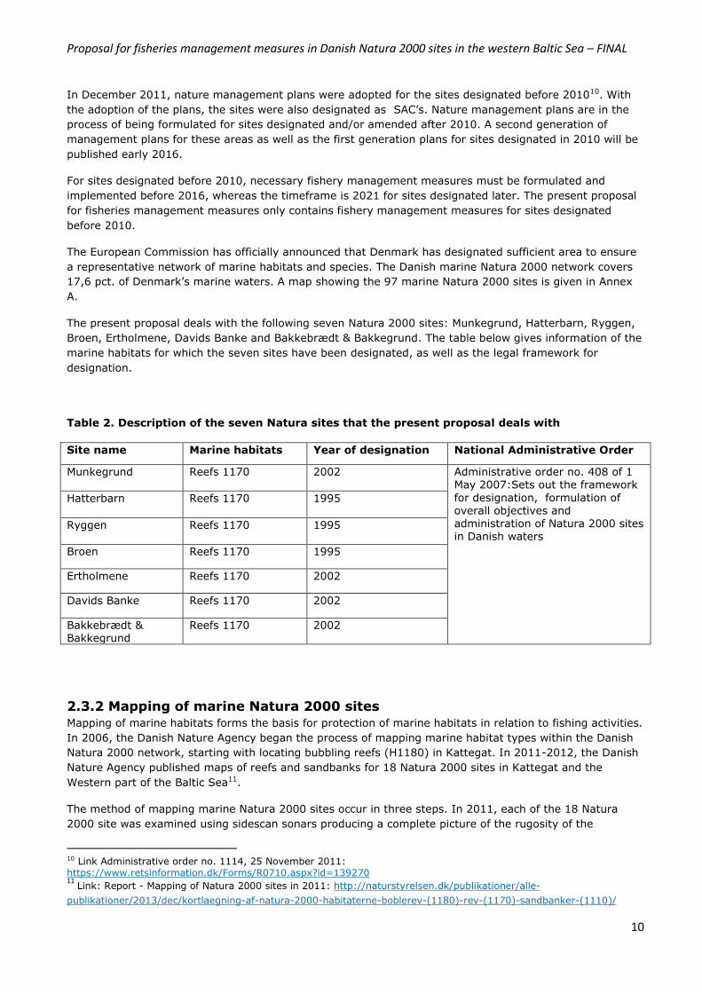
The present proposal deals with the following seven Natura 2000 sites: Munkegrund, Hatterbarn, Ryggen,
Broen, Ertholmene, Davids Banke and Bakkebrædt & Bakkegrund. The table below gives information of the
marine habitats for which the seven sites have been designated, as well as the legal framework for
designation.
Table 2. Description of the seven Natura sites that the present proposal deals with
Site name Marine habitats Year of designation National Administrative Order
Munkegrund Reefs 1170 2002
Administrative order no. 408 of 1 May 2007:Sets out the framework
for designation, formulation of overall objectives and
administration of Natura 2000 sites in Danish waters
Hatterbarn Reefs 1170 1995
Ryggen Reefs 1170
1995
Broen Reefs 1170 1995
Ertholmene Reefs 1170 2002
Davids Banke Reefs 1170 2002
Bakkebrædt & Bakkegrund
Reefs 1170 2002
2.3.2 Mapping of marine Natura 2000 sites
Mapping of marine habitats forms the basis for protection of marine habitats in relation to fishing activities.
In 2006, the Danish Nature Agency began the process of mapping marine habitat types within the Danish
Natura 2000 network, starting with locating bubbling reefs (H1180) in Kattegat. In 2011-2012, the Danish
Nature Agency published maps of reefs and sandbanks for 18 Natura 2000 sites in Kattegat and the
Western part of the Baltic Sea11.
The method of mapping marine Natura 2000 sites occur in three steps. In 2011, each of the 18 Natura
2000 site was examined using sidescan sonars producing a complete picture of the rugosity of the
10 Link Administrative order no. 1114, 25 November 2011: https://www.retsinformation.dk/Forms/R0710.aspx?id=139270 11
Link: Report - Mapping of Natura 2000 sites in 2011: http://naturstyrelsen.dk/publikationer/alle-
publikationer/2013/dec/kortlaegning-af-natura-2000-habitaterne-boblerev-(1180)-rev-(1170)-sandbanker-(1110)/

Proposal for fisheries management measures in Danish Natura 2000 sites in the western Baltic Sea – FINAL
11
substrate of the sea floor. On the basis of this data, an initial map was produced – the so-called ‘first
generation habitat map. The collected data was then thoroughly studied and any abnormality or structures
in the sea bottom not easily classified as the various habitat types (reef, sandbanks etc.) was then
examined further, using either a scuba diver or remote operated vehicle (ROV) equipped with video
cameras. Through this process bubbling reefs were verified. In addition, a number of areas classified as
reefs, sandbanks, etc. were visited to ensure accurate classifications and to study the biological content of
the areas. On the basis of the complete data set, habitat maps were then created showing where within
the Natura 2000 sites, reef structures (H1170 and H1180) and sandbanks (H1110) are located.
Mapping of marine habitats in Danish Natura 2000 sites builds on the Danish definition of the habitat types
designated under the Habitats Directive. According to the Danish definition of stone reefs, an area is
classified as reef, if the coverage of hard substrate is above 25 pct.. Areas with a cover of hard substrate
of 10-25 pct. are also classified as reef, if the areas are directly connected to areas with a coverage of hard
substrate of 25 pct. or more.
Proposal for fisheries management measures in Danish Natura 2000 sites in the western Baltic Sea – FINAL
12
3. Process This chapter describes the process from when the initiative to protect reef structures from fisheries
activities in Danish marine Natura 2000 sites was launched in spring 2011 by the Ministry of Food,
Agriculture and Fisheries/Danish AgriFish Agency and until submission of fisheries management measures
in form of ‘A Joint Recommendation’ by Denmark and Sweden to the European Commission in [January
2015].
The following two sections (3.1 and 3.2) describe the national and international coordination processes,
which have taken place in the course of the last four years (2011-2014) in relation to the formulation of
fisheries management measures for protection of reef structures in Danish Natura 2000 sites.
3.1 National coordination and consultation National coordination and consultation with stakeholders in relation to Natura 2000 and fisheries take place
in the so-called ‘Natura 2000 Dialogue Forum’ as well as in the ministry’s committees. In addition to formal
consultations, informal consultations have also been held with stakeholders with the aim of discussing
protection of reefs in relation to fisheries at a more technical level. Annex E gives an overview of the
formal and informal consulations held since the initiative of protection of reefs from fisheries was launched
in spring 2011.
3.1.1 Natura 2000 Dialogue Forum
The Natura 2000 Dialogue Forum was launched in May 2010 by the Minister for Food, Agriculture and
Fisheries in order to actively involve relevant stakeholders with an interest in fishery and Natura 2000 in
the ministry’s work with the implementation of the Natura 2000 directives. The Natura 2000 Dialogue
Forum is chaired by the Danish AgriFish Agency and consists of representatives from NGOs, fishermen
organizations, research organizations and national authorities12. The Natura 2000 Dialogue Forum meets 2-
3 times a year and is the forum where the Danish AgriFish Agency presents upcoming proposals for
fisheries management measures and in general inform stakeholders of current state of play through open
discussions and dialogue.
Consultations in relation to the present proposal
A pre-draft of the present proposal was initially presented to the Natura 2000 Dialogue Forum in March
2012. Reef types, size and spatial distribution within the particular Natura 2000 sites were in the pre-draft
of 2012 based on historical information. In November 2012, the Danish Ministry of Environment/Danish
Nature Agency published detailed maps of habitat types in 18 Natura 2000 sites, as described in section
2.3.2. Amongst these sites were the seven Natura 2000 sites, that the present proposal deals with. Thus,
all maps have been updated in order to take the new information into account. Updated maps of the 18
Natura 2000 sites were presented to the Natura 2000 Dialogue Forum on November 16th 2012.
The present proposal was first presented to the Natura 2000 Dialogue Forum in the meeting held on June
27th 2013, where also the first national order for protection of reefs in four coastal Natura 2000 sites under
Danish sovereignity was presented before the public hearing.
12 The following organizations participate in meetings in the Natura 2000 Dialogue Forum: The Nature Agency, WWF,
GreenPeace, Oceana, Bird Life Denmark, The Danish Society for Nature Conservation, Danish Fishermen´s Association
and other local fishermen associations. Plus other NGOs with interests in the discussed topics are invited, e.g. The
Danish Hunters Association and ASCOBANS:
http://naturerhverv.dk/fileadmin/user_upload/NaturErhverv/Filer/Fiskeri/Natura_2000_hav/Natura_2000_dialogforum/R
evideret_kommissorium_for_N2000_Dialogforum_020513.pdf
Proposal for fisheries management measures in Danish Natura 2000 sites in the western Baltic Sea – FINAL
13
Natura 2000 Dialogue Forum has been consulted in a parallel session with Sweden and Germany as well as
the Advisory Councils for the North Sea,respectively on the present proposal for fisheries management
measures. The Danish AgriFish Agency presented the proposed fisheries management measrues to the
Natura 2000 Dialogue Forum on 27 June 2014, where also a summary of the meeting with Member States
held on 26 June 2014 were given.
Natura 2000 Dialogue Forum was briefed on state of play regarding the Danish proposals on 7 November
2014 in relation to finalization of the two proposals with Sweden and Germany and drafting of joint
recommendations.
Outcome of consultations held
The Danish Fishermen Associations are supporting the proposed method of buffer zones and stress the
importance of site specific fisheries management measures rather than closure of entire Natura 2000 sites
as an adequate, specific and consequent regulation.
WWF, Oceana, Greenpeace and The Danish Society for Nature Conservation are concerned with the Danish
approach of buffer zones, especially if a given Natura 2000 site contains several reefs. The green NGOs are
of the opinion, that the proposed ban for fishery activitity with mobile bottom contacting gear should apply
to the entire Natura 2000 site, whereby also fish stocks will be protected.
The Ministry of Food, Agriculture and Fisheries is of the opinion that the buffer zone method ensures
adequate protection of the reef structures in line with the provisions of the Habitats Directive and is in
accordance with scientific advice from both DTU Aqua and ICES (see Annex D). The area in which fishing
activity with mobile bottom contacting gear will be banned is designed per site taking into account, reef
size and spatial distribution within the Natura 2000 sites. Fish stocks such as cod and flat fish are not
included in the list of species, which the site has been designated for. Protection of fish stocks like cod and
flatfish falls within the scope of the Common Fisheries Policy. A range of fish species along side macro
algae etc. are used as indicators in relation to assessing the conservation status of reefs. Some studies
indicate that closure of even smaller areas for fishing, will have a significant effect of fish stock , e.g.
Moland et al. 201313.
The Danish AgriFish Agency argues that the aim of art. 6 (2, 3) of the Habitats Directive is to find the
balance between protection of marine habitats and species and management of fisheries activities. The
buffer zone approach meets that challenge by ensuring protection of the mapped reef structures whilst
allowing fishing activity in areas not mapped as reefs, taking into account the principles of proportionality
as described in section 4. The effect of the proposed management measures will be monitored through the
national monitoring program – NOVANA, where also the presence of fish stock is assessed. Aarhus
University carry out these assessements for the Danish Nature Agency, and annually report on
environmental status of the marine waters of Denmark14. The assessments are carried out in accordance
with the article 17 reporting to the European Commission.
3.1.2. Meetings with stakeholders
Bilateral meetings have been held with the Danish Fishermen’s Association in the fall of 2013. The purpose
of these meetings were to discuss the proposed ban for trawling with mobile bottom contacting gear in 10
Natura 2000 sites located within 12 nautical miles in the Kattegat and western Baltic as well as gillnet
fishing activities in areas mapped as bubbling reefs. Furthermore, the consultations were also aimed at
13
Moland E, Olsen EM, Knutsen H, Garrigou P, Espeland SH, Kleiven AR, Andre´ C, Knutsen JA. (2013): Lobster and cod benefit from small-scale northern marine protected areas: inference from an empirical before–after control-impact study. Proc R Soc B 280: 20122679. 14
Dahl, K. & Carstensen, J. (2008): Tools to assess conservation status on open water reefs in Natura 2000 areas. Nat Env R Inst, University of Aarhus, 25 pp. NERI Technical Report No. 663: http:// www.dmu.dk/Pub/FR663.pdf
Proposal for fisheries management measures in Danish Natura 2000 sites in the western Baltic Sea – FINAL
14
obtaining a better understanding of the fishing pattern from smaller vessels in the 10 Natura 2000 sites.
The outcome of these meetings are centered around an in depth understanding of the fishing pattern in the
discussed Natura 2000 sites – also for the smaller vessels not obliged to carry VMS15. These discussions
support the analyses of fishing activity based on VMS, which the Danish AgriFish Agency in collaboration
with DTU Aqua have carried out, assuring that the proposed fisheries measures will have no or low impact
on current fishing activities for vessels above and below 12 meters.
3.1.3. Involvement of Parliament and Committees within the Ministry of Food,
Agriculture and Fisheries
The Danish Government has laid down national procedures for coordination of initiatives in relation to the
implementation of EU’s Natura 2000 directives and the reformed fisheries policy.
For initiatives, where Denmark act as the initiating Member State, The Danish Parliament must be informed
of the intended draft proposals for fisheries management measures prior to regional consultation. All
initiatives both launched by Denmark and by other Member States, where Denmark has direct
management interest, will be coordinated nationally with stakeholders through the Ministry’s national
committees and Natura 2000 Dialogue Forum. The Danish Parliament is informed of these initiatives before
joint recommendations are finalized for submission to the European Commission.
3.1.4. Peer review of the proposal
The rationale and principles applied in the present proposal has been peer reviewed by DTU Aqua (the
Danish Technical University, Institute for Aquatic Resources) and the Univerity of Aarhus (Danish Centre
for Environment and Energy). A peer review of the proposal ensures that, the proposed fisheries
management measures, along side the rationale and principles on which the proposal builds, are
scientifically sound. A peer review has also increased the scientific evidence in terms of references and
ensured that relevant scientific studies have been included.
The outcome of the peer review can, besides minor editorial changes, be summarized to:
i) scientific assessement of the rationale for a ban for fishing activity with mobile bottom contacting
gear in areas mapped as reefs (habitat code H1170 and H1180) and other type of fishery activity
in areas mapped as bubbling reefs (habitat code H1180) in relation to the documented
conservation status.
3.2 International coordination – regionalization The sections below describes the process, that the Danish AgriFish Agency has pursued with respect to the
present proposal in terms of international coordination and consultation with other Member States, the
European Commission and relevant Advisory Councils, see Annex F-G.
3.2.1. Pre-consultations
International coordination and consultations of the present proposal were launched in March 2012, when
Denmark in accordance with art. 9 in Regulation no. 2371/2002 invited German and Swedish fishery- and
environmental authorities, the Regional Advisory Council for the North Sea, ICES and the Commission to a
15
VMS (Vessel monitoring systems) is a satelitebased monitoring system, which is used in commercial fisheries – positions, times, course and speed of the fishing vessels are monitored and stored.

Proposal for fisheries management measures in Danish Natura 2000 sites in the western Baltic Sea – FINAL
15
preconsultation meeting in Copenhagen. A booklet containing all the relevant information was sent out in
February 2012 containing information about the proposed fishery regulation16.
The recent mapping of marine habitats in the Kattegat area in 2011, has enabled the Danish AgriFish
Agency to include protection of more reef strucures in terms of area and number of sites in the present
proposal and that of the Baltic Sea. An updated version of the proposed fishery management measures
including updated maps was sent in a new pre-consultation to the relevant authorities in Sweden and
Germany alongside ICES, North Sea Advisory Council and the European Commission (DG MARE and DG
ENVI) on 6 June 2014 prior to the scheduled meeting on 26 June 2014 – a process in line with the
reformed fisheries policy of regionalization. The proposed management measures were simultaneously sent
to the members of the Natura 2000 Dialogue Forum. A summary of the pre-consultation meeting on 26
June 2014 is given in Annex F. At the June meeting an ad hoc working group, chaired by the Danish
AgriFish Agency as the initiating Member State, was established with Sweden and Germany. A range
meeting were held between August and November 2014. The outcome of these meetings is given in Annex
F. Meetings in the ad hoc working group were held on:
- 27 August 2014
- 30 September 2014 (cancelled)
- 5 November 2014
- 4 December 2014
- 10 December 2014
Denmark, Sweden and Germany have consulted their national fishermen associations/organizations. The
Advisory Councils and NGOs have been consulted by Denmark as the initiating Member State, see Annex E.
3.2.2 Regionalization – Scheveningen Natura 2000 working group
The present proposal will be coordinated regionally in accordance with Article 11 and 18 of the reformed
fisheries policy (Basic Regulation) through the established ad hoc working group in accordance with the
Terms of Reference (ToR) for the BALTFISH cooperation. Sweden and Germany have fishing rights in
Danish waters within 12 nautical miles in the areas where the concerned Natura 2000 sites are located.
Draft ToR for a technical expert group within the scope of the BALTFISH cooperation are currently being
drafted. The draft ToR were discussed by the High Level Group of Fisheries Directors at their meeting on
28 April 2014. In accordance with the current draft ToR’s, Denmark, as the initiating Member State, will
take the lead in the ad hoc working group with Sweden and Germany. These Member States have finalized
the proposal for fisheries management measures for protection of reef structures in collaboration.
Germany, however, abtains from jointly forwarding the proposed measures to the Commission. This
position do not hinder Denmark and Sweden from jointly recommending the proposed fisheries
management measures (MoU BALTFISH corporation).
3.2.3 Informal consultations with other Member States
During the formulation of the present proposal, a range of informal meetings have been held with Sweden.
The focus of the informal meetings with the Swedish authorities have been to discuss the Danish approach
of buffer zones and to explore the possibility of a joint proposal for the Kattegat area. The informal
consultations have taken place on:
- 1 June 2011: meeting in Copenhagen, Denmark
- 17 January 2013: meeting in Göteborg, Sweden
- 10 October 2013: meeting in Göteborg, Sweden
16 Link to booklet: http://naturerhverv.dk/fileadmin/user_upload/NaturErhverv/Filer/Fiskeri/Natura_2000_hav/Rev/Forslag_til_fiskeriregulering_Kattegat.pdf

Proposal for fisheries management measures in Danish Natura 2000 sites in the western Baltic Sea – FINAL
16
The informal discussions between Sweden and Denmark have resulted in Denmark solitarily proposing
fisheries management measures for Natura 2000 sites located within 12 nautical miles.
However, Denmark is still working towards a joint proposal with Sweden, for three Danish Natura 2000
sites (“Kims Top og den Kinesiske Mur”, “Store Middelgrund” and “Schultz, Hastens Grund og Briseis Flak”)
designated for the protection of reef structures (habitat codes H1170 and/or H1180) and sandbanks
(H1110) located in the Kattegat outside 12 nautical miles.
The Danish initiative for reef protection has also been presented at several workshops:
HELCOM/BALTFIMPA (March 2013, Copenhagen, Denmark), Ministry of Environment/Blue Reef workshop
(Copenhagen, April 2013), and the Nordic Marine Green Think Tank (October 2013, Helsingør, Denmark).
3.2.4 Consultations with Advisory Councils
The Advisory Councils for the Baltic Sea and North Sea, respectively, have also been consulted. The
Advisory Councils received the two proposals parallel to Sweden, Germany and the Danish Natura 2000
Dialogue Forum.
The Advisory Council for the Baltic Sea (BSAC) highly welcomes the Danish proposal for fisheries
management measures in the 7 Natura 2000 sites located in the Baltic Sea. During the formulation of the
present proposal, a range of informal meetings have been held with Sweden. The BSAC wish to follow the
process of finalizing the proposal.
The Advisory Council for the North Sea (NSAC) forwarded a range of comments identical to those of the
Danish Fishermen Association. NSAC recommends that buffer zones are made as small as possible and that
special focus is given to the analyses of fishery activity for furture sites to be protected.
A summary of the consultation with the Advisory Councils and Naura 2000 Dialouge Forum is given in
Annex F-G.
Proposal for fisheries management measures in Danish Natura 2000 sites in the western Baltic Sea – FINAL
17
4. Principles and rationale Member States are responsible for ensuring favourable conservation status of designated marine habitats
and species in their respective Natura 2000 network and to take appropriate steps to avoid the
deterioration of natural habitats and the habitats of species as well as the disturbance of the species for
which the Natura 2000 site has been designated. In Denmark, this responsibility falls under the Ministry of
Food, Agriculture and Fishery in relation to fisheries. At the Ministry of Food, Agriculture and Fishery, the
Danish AgriFish Agency is responsible for formulation of fishery regulation as well as fishery control and
enforcement of implemented management measures.
In spring 2011, the Danish AgriFish Agency launched the initiative to ensure adequate protection of reef
structures designated under the Habitats Directive. Of the 97 marine Natura 2000 sites located in Danish
waters, 65 sites have been designated for reefs. A total of 30 of the 65 sites are located within the baseline
or in waters under Danish sovereignity.
Based on scientific advice from DTU Aqua Denmark has decided to protect reef structures (H1170 &
H1180) from physical disturbances due to fishing activities with mobile bottom contacting gears (see
section 5.2 and Annex D). The habitat type H1180 should also be protected from fishing activity with
passive gears like gillnets, longlines, pots and traps, since this habitat type is fragile in terms of physical
impact. DTU Aqua has advised, that a buffer zone equivalent to 6 times the average water depth (meters)
will ensure adequate protection of these reef structures from direct impact from fishing activitities, see
Annex D. The same method has been applied in the National Administrative Order of 28 August 201317,
which applies to protection of reef structures in four Danish coastal Natura 2000 sites. In June 2013, ICES
published a general advice on evaluation of the appropriateness of buffer zones, see Annex D. The ICES
advice is in line with scientific advice from DTU Aqua.
The rationale behind the buffer zone method is that reef structure in its full extent needs protection. Buffer
zones ensures that there is no potential threat from trawls to the reef structures – also if the vessels turn.
The overall aim of the present proposal is protection of reef structures from physical disturbances from
fisheries with mobile bottom contacting gears, which according to the Natura 2000 management plans are
adversely affecting the conservation status of these habitat types. Several scientific studies world wide
state that fishery with mobile contacting gears have a negative impact on reef structures (Dahl 2005;
Kaiser et al. 2002; ICES 2009)18
Over time, the proposed fisheries management measures are believed to significantly contribute to the
improvement of the conservation status of these habitat types (e.g. Dahl 2005; Fenberg et al. 2012; Collie
et al. 2000)19 and, ultimately, to the achievement of favourable conservation status. Full protection of reef
structures from fisheries is indicated as a priority action in all the Danish Natura 2000 management plans
for sites designated for reefs.
At a later stage, Denmark will take the initiative to protect reef structures in Danish waters outside 12
nautical miles in the North Sea as well as in the Baltic Sea, where also protection of sandbanks from
fisheries will be discussed.
17
Link Administrative order no. 1048 of 28 August 2013:
https://www.retsinformation.dk/Forms/R0710.aspx?id=158209 18
Dahl, K. (2005): Effekter af fiskeri på stenrevs algevegetation. Danmarks Miljøundersøgelser. 16 s. – Faglig rapport
fra DMU nr. 526; Kaiser, M. J., Collie, J. S., Hall, S. J., Jennings, S. and Poiner, I. R. (2002), Modification of marine habitats by trawling activities: prognosis and solutions. Fish and Fisheries, 3: 114–136; ICES. 2009. Report of the EMPAS project (Environmentally Sound Fisheries Management in Protected Areas), 2006‐2008, an ICES‐BfN project. 123
pp. 19
Dahl, K. (2005): Effekter af fiskeri på stenrevs algevegetation. Danmarks Miljøundersøgelser. 16 s. – Faglig rapport
fra DMU nr. 526; Fenberg P.B.*, Caselle J., Claudet J., Clemence M., Gaines S., García-Charton J.A., Gonçalves E., Grorud-Colvert K., Guidetti P., Jenkins S., Jones P.J.S., Lester S., McAllen R., Moland E., Planes S. and Sørensen T.K. (2012) The science of European marine reserves: status, efficacy and needs. Marine Policy 36(5), 1012-1021; Collie, J. S., Hall, S. J., Kaiser, M. J. and Poiner, I. R. (2000), A quantitative analysis of fishing impacts on shelf-sea benthos. Journal of Animal Ecology, 69: 785–798.
Proposal for fisheries management measures in Danish Natura 2000 sites in the western Baltic Sea – FINAL
18
When formulating the present proposal, the following principles have been the focal points:
1. Sound scientific basis
Any proposal for fisheries management measures must be based on scientific evidence and advice
and take all relevant information into account. DTU Aqua has provided scientific advice in relation
to the principles and methods pursued in the present proposal – an advice which is supported by
ICES in terms of buffer zones (see Annex D).
Spatial distribution of the habitat types is central when designing fisheries management measures.
The Danish Nature Agency under the Ministry of Environment is the responsible authority in
Denmark for mapping the marine Natura 2000 sites. In November 2012, the Danish Nature Agency
published a detailed mapping exercise of Natura 2000 sites in inner Danish waters – 18 sites in
total. The present proposal builds upon this detailed mapping exercise.
2. Stakeholder involvement
An important element of the process of formulating fisheries management measures is stakeholder
involvement – nationally as well as internationally.
In Denmark, national coordination with stakeholders takes place in the ‘Natura 2000 Dialogue
Forum’, which was established in spring 2010 to ensure coordination with all stakeholders from
green NGOs to fishermens organizations, research bodies, authorities etc. The proposed fisheries
management measures have been discussed in the forum at all meetings since spring 2011, see
Annex E.
Internationally, any proposal for fisheries management measures, which might affect other
Member States must at an early stage be presented to ensure regional coordination. The present
proposal and buffer zone method was initially presented to German and Swedish authorities in
March 2012 at a meeting in Copenhagen, where also the North Sea Advisory Council, ICES and the
European Commission participated. The present proposal has been discussed with Sweden and
Germany in the established ad hoc working group comprising of representatives from fisheries and
environmental departments.
3. Regional coordination
According to the Basic Regulation Articles 11 and 18, Member States may submit joint
reccomendations on conservation measures that are necessary for the purpose of complying with
their obligations under the Common Fisheries Policy (Reg. No 1380/2013 (The Basic Regulation)).
The present proposal is jointly presented to the European Commission after regional coordination
with Member States having a direct management interest within the framework of the Terms of
Reference for the BALTFISH cooperation and the technical expert group/ad hoc working group in
relation to the reformed fisheries policy. A process, which was launched in March 2012 with a pre-
consultation meeting in Copenhagen followed by an additional pre-consulation meeting in
Copenhagen in June 2014 and meetings in the etabslished ad hoc working group with Sweden and
Germany.
4. Transparency
Transparency of data and the methodology which is used is important, and can only be achieved
through stakeholder involvement, regional coordination and use of scientific advice. The data used
to describe the fishing pattern and effort is based on log book and VMS data from the three
countries. In addition to VMS and log book data, information of fishing patterns for smaller Danish
vessels (<12 m) has also been used. In order to collect information of fishing patterns for smaller
Danish vessels, consultations have been held with the Danish Fishermen Association in fall 2013.
Sweden has also analysed the fishing pattern from smaller vessels.
5. Proportionality
The proposed management measures must balance sustainable exploitation of resources and the
need to conserve important habitats and species. This means that the proposed measures must
Proposal for fisheries management measures in Danish Natura 2000 sites in the western Baltic Sea – FINAL
19
comply with the proportionality principle so they do not go further than necessary to ensure the
needed protection of the mapped reefs within the framework of the Habitats Directive.
Furthermore, no other and less burdening measures must be able to provide the same level of
necessary protection seen from a scientific and practical point of view. Consequently this means
that fishery is not prohibited in these areas, unless it is carried out with gears that can possibly
damage the mapped reefs. At the same time, the proposed management measures should be
possible to control and enforce. The present proposal concerns protection of reef structures. For
sites where the reef structures cover the majority of the site – the entire site is closed for fishing
activities, whereas for other sites, the area closed for fishing contains the reef(s) and the
surrounding 240 meter buffer zone – given as 6 times water depth set at an average depth of 40
meters for the area.
6. Non discrimination
The proposal must ensure that measures are applied in a non-discriminatory manner. A
coordinated approach between Member States having direct management interests is key to
ensuring non-discrimination of fleets affected by the proposed fisheries management measures.
This coordination must follow the steps laid down in the framework in the Basic Regulation of the
Common Fisheries Policy, thus ensuring a level playing field for the fishing sector potentially
affected.
The present proposal contains fisheries management measures for sites located within 12 nautical
miles in the Belt Sea and the Danish part of the Western Baltic Sea – where Germany and Sweden
have historical fishing rights. Thus, the proposed fisheries management measures must be
coordinated in accordance with the Common Fisheries Policy (art. 11 and 18).
Proposal for fisheries management measures in Danish Natura 2000 sites in the western Baltic Sea – FINAL
20
5. Scope of the present proposal In the first plan period (2010-2015), special focus should be given to the protection of reef structures from
any form of physical disturbances. The Danish AgriFish Agency launched the initiative to protect reef
structures from impact from fishing activity in spring 2011.
The present proposal aims at ensuring adequate protection of reef structures in seven Natura 2000 sites
located in the Belt Sea and the Danish part of the Western Baltic Sea: Munkegrund, Hatterbarn, Ryggen,
Broen, Ertholmene, Davids Banke and Bakkebrædt & Bakkegrund. The present proposal is part of a larger
plan to implement the Habitats Directive in relation to the protection of reef structures in the 65 Natura
2000 sites designated for reefs in Danish waters. Denmark has designated 97 marine Natura 2000 sites, of
which 65 have been designated for reefs – habitat code H1170 and/or H1180.
The present proposal is identical to a similar proposal for the protection of reef structures in three Natura
2000 sites located in the Danish part of the Kattegat. All ten Natura 2000 sites are located in Danish
waters between within 12 nautical miles.
The principles and methods used in the present proposal and that of the Kattegat proposal, are identical to
those used in the first national administrative order for protection of reefs in four coastal Natura 2000
sites, which came into force on September 1st 201320, where the first fisheries management measures for
protection of reefs were launched. The national administrative order prohibits the usage of mobile bottom
contacting gear in four coastal Natura 2000 sites.
The following two sections describe the Natura 2000 sites in question and the proposed fisheries
management measures to be adopted in order to secure adequate protection of reef structures from fishing
activities in accordance with the Habitats Directive.
5.1 Description of the Natura 2000 sites concerned The present proposal concerns seven Natura 2000 sites located in the Belt Sea and the Western Baltic Sea:
1. Munkegrund (EU site code: DK00VA304)
2. Hatterbarn (EU site code: DK00VA255)
3. Ryggen (EU site code: DK00VA253)
4. Broen (EU site code: DK00VA256)
5. Ertholmene (EU site code: DK007X079)
6. Davids Banke (EU site code: DK00VA308)
7. Bakkebrædt & Bakkegrund (EU site code: DK00VA310)
The seven Natura 2000 sites and the habitat types found in the areas are described in section 5.1.1-5.1.7.
The seven Natura 2000 sites are solely designated for protection of the marine habitat reefs (habitat code
H1170).
The conservation status for the reef structure (H1170) is given as unfavourable for all seven Natura 2000
sites. The annual assessment reports on environmental status do not contain information in relation to
physical disturbances of reefs, however, it is generally accepted and documented, that fishery with mobile
bottom contacting gear has an irreversible impact on reef structure and function (Dahl 2005; Kaiser et al.
2002; ICES 2009)21.
20 Link Administrative order no. 1048 of 28 August 2013:
https://www.retsinformation.dk/Forms/R0710.aspx?id=158209
21
Dahl, K. (2005): Effekter af fiskeri på stenrevs algevegetation. Danmarks Miljøundersøgelser. 16 s. – Faglig rapport
fra DMU nr. 526; Kaiser, M. J., Collie, J. S., Hall, S. J., Jennings, S. and Poiner, I. R. (2002), Modification of marine habitats by trawling activities: prognosis and solutions. Fish and Fisheries, 3: 114–136; ICES. 2009. Report of the
Proposal for fisheries management measures in Danish Natura 2000 sites in the western Baltic Sea – FINAL
21
The aim of the present proposal is to achieve the overall conservation objective of favourable conservation
status, since site specific conservation objectives have not yet been formulated for Danish marine habitats
(see section 2.3). In December 2012, the Danish Ministry of Environment made public the Natura 2000
management plans. The management plans contain a description of the habitats and species for which the
site has been designated, the current conservation status of these habitats and species, possible threats
and actions to be taken. In all management plans for marine Natura 2000 sites designated for reefs –
actions should be taken in relation to fishing activities with mobile bottom contacting gear.
The present proposal solely concerns protection of reef structures. Assessement of necessary protection of
sandbanks will be carried out at a later stage when the management plans for the Natura 2000 sites
designated for sandbanks in the North Sea have been adopted by the end of 2014, and the size and spatial
distribution of the sandbanks have been mapped. The Danish AgriFish Agency pursues an approach (in line
with the Natura 2000 management plans), whereby the marine habitats and species which need urgent
attention are protected first, e.g. reef structures.
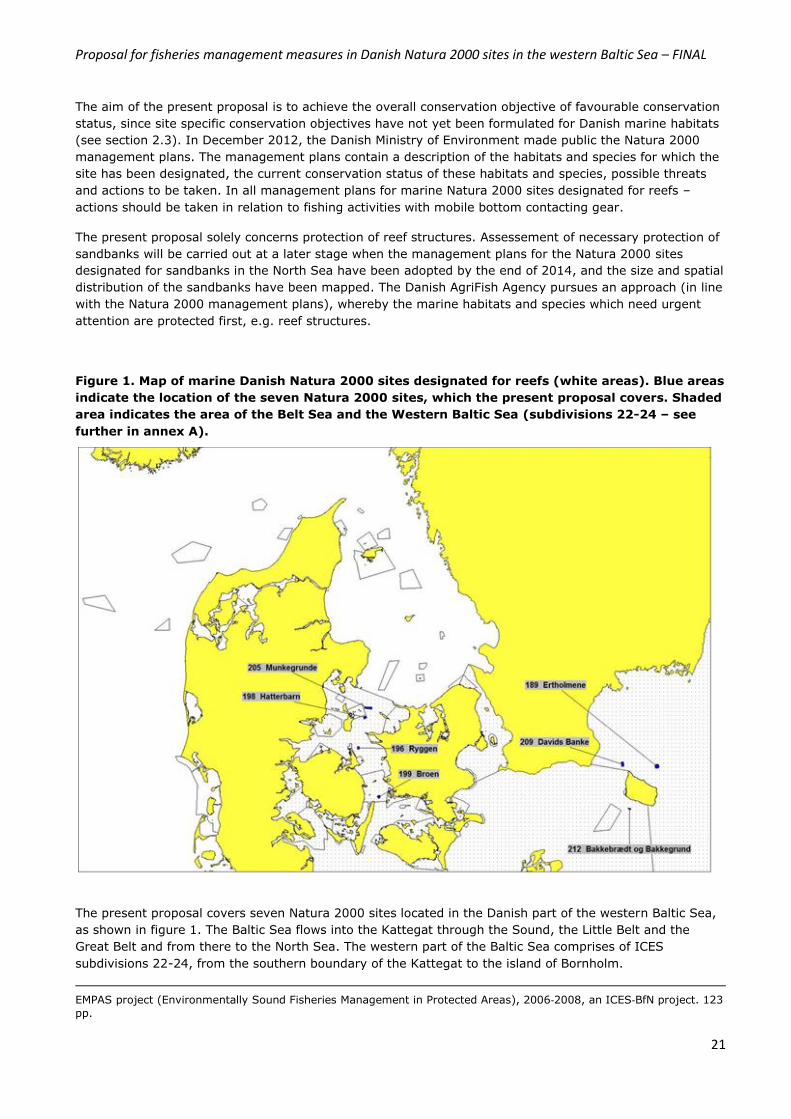
Figure 1. Map of marine Danish Natura 2000 sites designated for reefs (white areas). Blue areas
indicate the location of the seven Natura 2000 sites, which the present proposal covers. Shaded
area indicates the area of the Belt Sea and the Western Baltic Sea (subdivisions 22-24 – see
further in annex A).
The present proposal covers seven Natura 2000 sites located in the Danish part of the western Baltic Sea,
as shown in figure 1. The Baltic Sea flows into the Kattegat through the Sound, the Little Belt and the
Great Belt and from there to the North Sea. The western part of the Baltic Sea comprises of ICES
subdivisions 22-24, from the southern boundary of the Kattegat to the island of Bornholm.
EMPAS project (Environmentally Sound Fisheries Management in Protected Areas), 2006‐2008, an ICES‐BfN project. 123
pp.
Proposal for fisheries management measures in Danish Natura 2000 sites in the western Baltic Sea – FINAL
22
Three of the seven Natura 2000 sites are located in the proximity of the island of Bornholm, whereas the
remaining five sites are located in the Belt Sea, which consists of the straits of the Great Belt and the Little
Belt, as shown in figure 1. The Great Belt is defined as the strait between Zealand and the island of Fyn,
which connects the Kattegat to the Baltic Sea.
The reef structures in the western Baltic Sea comprises of stone reef and biogenic reef structures (H1170).
In the western Baltic Sea, reef structures made of blue mussels are rather common. Mussel fishery for blue
mussels takes place in the Little Belt and northern part of the Belt Sea.
The analyses of fishery activity – both in relation to target species and VMS effort has in the present
proposal been separated into the Baltic subdivisions 22-24 (Western Baltic) and 25 (Eastern Baltic). This
division is in line with the ICES fish stock assessments and variation seen in the target species and gears
used.
The western Baltic Sea (subdivisions (SD) 22-24) is an important fishing area for Denmark, Sweden and
Germany. Target species are cod, eel, herring, plaice and sprat. Sand-eel has in the last two years become
increasingly important in the area. In general fishing activity in the western Baltic Sea (given as catch
value) has decreased by approximately 40 pct. Cod is the main target species, however. The reduction in
landings registered for the area is attributed to a reduction in fishery for cod. The main reduction in cod
landings was seen in 2009, whereafter landings have been somehow stable. Fishery activity in the Western
Baltic Sea is largely conducted by smaller vessel below 15 meters. In the Eastern Baltic Sea, SD 25,
several countries are involved in the fisheries as this area is the main area for cod fishery. In this area,
fishery in the period 2007 to 2012 has been quite stable however, and slightly lower in 2013. Cod is the
main target species followed by herring and sprat.
Several initiatives have been taken for the protection of cod. In 2009, Denmark and Sweden agreed on a
cod fishing ban in the northern part of the Sound (SD 23) in the months of February and March. Fishery in
the Eastern Baltic Sea (SD 25-32) are also regulated by a seasonal closure from 1 July to 31 August to
protect cod, as is fishery for cod in SD 24 where there is a seasonal closure in April. The seasonal closures
alongside the introduction of BACOMA 120 mm trawl gear, which was introduced in 2009 to make sure
undersized cod was not caught form the basis of a focused protection of cod in the Baltic Sea.
VMS effort in the Danish part of the Baltic Sea is given in Annex K. The highest effort is seen for Danish
vessels in both SD 22-24 and SD 25. The highest effort in relation to Danish vessels is seen for mobile
contacting gears. Swedish and German vessels carrying VMS primarily conduct fishing activity in SD 25
and on the western side of the island of Bornholm in SD 24 – Eastern part with mobile bottom contacting
gears. There is some fishing activity from German vessels along the border between Denmark and
Germany in the Belt Sea, primarily with mobile contacting gears.
The seven Natura 2000 sites, which the present proposal covers, are part of the Danish Natura 2000
network for the protection of reefs. A total of 34 Natura 2000 sites have been designated for reefs in the
Belt Sea and the Western Baltic Sea area. Existing regulation protects reef structures from physical
disturbances from fishery activity in five of the 34 Natura 2000 sites. This proposal covers seven other
sites. The remaining 22 sites will be protected at a later stage. Of the 22 sites, one site is located in the
western Baltic Sea outside 12 nautical miles. This site has been mapped and will be protected alongside 3
sites located outside 12 nautical miles in the Kattegat after relevant international coordination at a later
stage.

Proposal for fisheries management measures in Danish Natura 2000 sites in the western Baltic Sea – FINAL
23
5.1.1 Natura 2000 site: Munkegrund
The Natura 2000 site "Munkegrund”22 is located in the northern part of the Belt Sea between the islands of
Samsø and Sejerø, see figure 1. The Natura 2000 site covers an area of 13.3 km2 and is designated for the
protection of reefs (H1170) and sandbanks (H1110), see figure 2. Stone reef structures cover
approximately 6.7 km2 of the area, corresponding to 50 % of the Natura 2000 site.
Munkegrund consists of a smaller and well preserved stone reef area of approximately 9 km2. The reef
structures consist of primarily larger stones. Sandy bottom areas are scattered around the site.
Figure 2. Map of Natura 2000 site “Munkegrund” showing the location and spatial distribution of the reef structures and sandbanks.
According to the Natura 2000 management plan for the area23, fishing activity with mobile bottom
contacting gear is described as a threat to stone reefs and as a possible threat to sandbanks.
22 Habitat No. 205, Natura 2000 site No. 205, EU site code: DK00VA304 23 Link to Natura 2000 management plan for Munkegrund: http://naturstyrelsen.dk/naturbeskyttelse/natura-2000/natura-2000-planer/natura-2000-planer-2009-15/plan-126-246/205-munkegrund/

Proposal for fisheries management measures in Danish Natura 2000 sites in the western Baltic Sea – FINAL
24
5.1.2 Natura 2000 site: Hatterbarn
The Natura 2000 site "Hatterbarn”24 is located east of the island Samsø in Samsø Belt, see figure 1. The
Natura 2000 site covers an area of 6.4 km2 and is designated for the protection of reefs (H1170), see
figure 3. In total, the mapped reef structures cover approximately 3.7 km2. Part of this area is located
outside the boundaries of the Natura 2000 site. Stone reef structures cover approximately 58 % of the
Natura 200 site.
The geological structure of the site consists mainly of moraine bottom and is characterized by a number of
small well-preserved reef areas surrounded by more sandy grounds. The reef structures are located at
water depths between 6 and 17 meters.
For this Natura 2000 site, one of the three monitoring stations are located outside the boundary of the
Natura 2000 site. The monitoring station is located on a reef structures which is in direct contact with the
reef structure within the site, see figure 3.
Figure 3. Map of Natura 2000 site “Hatterbarn” showing the location and spatial distribution of reef and biogenic reef structures.
According to the Natura 2000 management plan for the area25, fishing activity with mobile bottom
contacting gear is described as a threat to the reef structures.
24 Habitat No. 174, Natura 2000 site No. 198, EU site code: DK00VA255 25
Link to Natura 2000 management plan for Hatter Barn: http://www.naturstyrelsen.dk/Naturbeskyttelse/Natura2000/Natura_2000_planer/Se_Planerne/126_246/198_Hatter.htm
Proposal for fisheries management measures in Danish Natura 2000 sites in the western Baltic Sea – FINAL
25
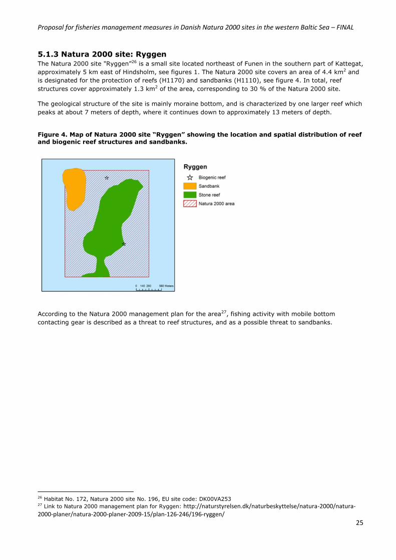
5.1.3 Natura 2000 site: Ryggen
The Natura 2000 site "Ryggen”26 is a small site located northeast of Funen in the southern part of Kattegat,
approximately 5 km east of Hindsholm, see figures 1. The Natura 2000 site covers an area of 4.4 km2 and
is designated for the protection of reefs (H1170) and sandbanks (H1110), see figure 4. In total, reef
structures cover approximately 1.3 km2 of the area, corresponding to 30 % of the Natura 2000 site.
The geological structure of the site is mainly moraine bottom, and is characterized by one larger reef which
peaks at about 7 meters of depth, where it continues down to approximately 13 meters of depth.
Figure 4. Map of Natura 2000 site “Ryggen” showing the location and spatial distribution of reef and biogenic reef structures and sandbanks.
According to the Natura 2000 management plan for the area27, fishing activity with mobile bottom
contacting gear is described as a threat to reef structures, and as a possible threat to sandbanks.
26 Habitat No. 172, Natura 2000 site No. 196, EU site code: DK00VA253 27 Link to Natura 2000 management plan for Ryggen: http://naturstyrelsen.dk/naturbeskyttelse/natura-2000/natura-2000-planer/natura-2000-planer-2009-15/plan-126-246/196-ryggen/

Proposal for fisheries management measures in Danish Natura 2000 sites in the western Baltic Sea – FINAL
26
5.1.4 Natura 2000 site: Broen
The Natura 2000 site "Broen"28 is located 5 km northeast of the northern tip of Langeland in the Great
Belt, see figures 1. The Natura 2000 site covers an area of 5.9 km2 and is designated for the protection of
reefs (H1170) and sandbanks (H1110), see figure 5. In total, stone reef structures cover approximately
4.5 km2 of the area, corresponding to 76 % of the Natura 2000 site.
The site is characterized as a shallow area of approximately 9-11 meters of water depth, where the stone
coverage ranges from 20-50%. The reef continues down to about 17 meters where sandy bottom takes
over.
Figure 5. Map of Natura 2000 site “Broen” showing the location and spatial distribution of reef
structures and sandbanks.
According to the Natura 2000 management plan for the area29, fishing activity with mobile bottom
contacting gear is described as a threat to the reef structure, and as a possible threat to sandbanks.
28
Habitat No. 175, Natura 2000 site No. 199, EU site code: DK00VA256 29
Link to Natura 2000 management plan for Broen: http://naturstyrelsen.dk/naturbeskyttelse/natura-2000/natura-2000-planer/natura-2000-planer-2009-15/plan-126-246/199-broen/
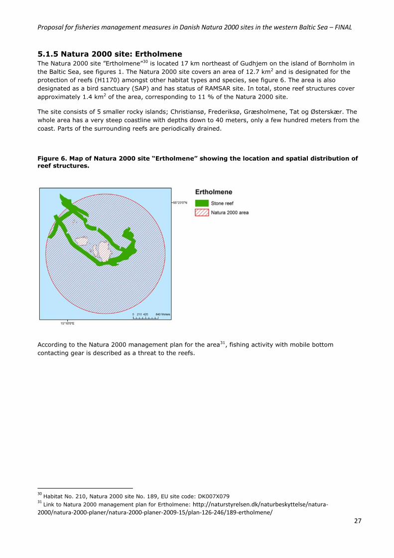
Proposal for fisheries management measures in Danish Natura 2000 sites in the western Baltic Sea – FINAL
27
5.1.5 Natura 2000 site: Ertholmene
The Natura 2000 site ”Ertholmene”30 is located 17 km northeast of Gudhjem on the island of Bornholm in
the Baltic Sea, see figures 1. The Natura 2000 site covers an area of 12.7 km2 and is designated for the
protection of reefs (H1170) amongst other habitat types and species, see figure 6. The area is also
designated as a bird sanctuary (SAP) and has status of RAMSAR site. In total, stone reef structures cover
approximately 1.4 km2 of the area, corresponding to 11 % of the Natura 2000 site.
The site consists of 5 smaller rocky islands; Christiansø, Frederiksø, Græsholmene, Tat og Østerskær. The
whole area has a very steep coastline with depths down to 40 meters, only a few hundred meters from the
coast. Parts of the surrounding reefs are periodically drained.
Figure 6. Map of Natura 2000 site “Ertholmene” showing the location and spatial distribution of reef structures.
According to the Natura 2000 management plan for the area31, fishing activity with mobile bottom
contacting gear is described as a threat to the reefs.
30
Habitat No. 210, Natura 2000 site No. 189, EU site code: DK007X079 31
Link to Natura 2000 management plan for Ertholmene: http://naturstyrelsen.dk/naturbeskyttelse/natura-2000/natura-2000-planer/natura-2000-planer-2009-15/plan-126-246/189-ertholmene/

Proposal for fisheries management measures in Danish Natura 2000 sites in the western Baltic Sea – FINAL
28
5.1.6 Natura 2000 site: Davids Banke
The Natura 2000 site ”Davids Banke”32 is located in the Baltic Sea north of the island Bornholm, see figure
1. The Natura 2000 site covers an area of 8.4 km2 and is designated for the protection of reefs (H1170),
see figure 7. In total, stone reef structures covers approximately 4.3 km2 of the site, corresponding to 51
% of the Natura 2000 site.
The site is characterized by an elongated reef area in a north-south direction, the top of the area is located
at approximately 12 meters of water depth. The reef consists primarily of large and medium-sized stones.
Within the reef area, smaller sandy areas are found. The surrounding base is at a depth of 40-55 meters
and consists primarily of sand and gravel from 30 meters and down.
Figure 7. Map of Natura 2000 site “Davids Banke” showing the location and spatial distribution of reef structures.
According to the Natura 2000 management plan for the area33, fishing activity with mobile bottom
contacting gear is described af a threat to the reef structures.
32
Habitat No. 209, Natura 2000 site No. 209, EU site code: DK00VA308 33
Link to Natura 2000 management plan for Davids Banke: http://naturstyrelsen.dk/naturbeskyttelse/natura-2000/natura-2000-planer/natura-2000-planer-2009-15/plan-126-246/209-davids/
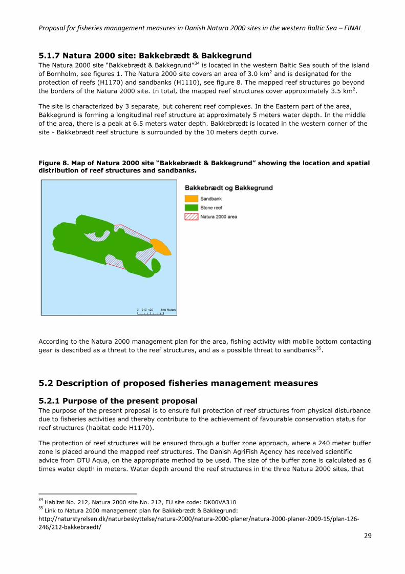
Proposal for fisheries management measures in Danish Natura 2000 sites in the western Baltic Sea – FINAL
29
5.1.7 Natura 2000 site: Bakkebrædt & Bakkegrund
The Natura 2000 site “Bakkebrædt & Bakkegrund”34 is located in the western Baltic Sea south of the island
of Bornholm, see figures 1. The Natura 2000 site covers an area of 3.0 km2 and is designated for the
protection of reefs (H1170) and sandbanks (H1110), see figure 8. The mapped reef structures go beyond
the borders of the Natura 2000 site. In total, the mapped reef structures cover approximately 3.5 km2.
The site is characterized by 3 separate, but coherent reef complexes. In the Eastern part of the area,
Bakkegrund is forming a longitudinal reef structure at approximately 5 meters water depth. In the middle
of the area, there is a peak at 6.5 meters water depth. Bakkebrædt is located in the western corner of the
site - Bakkebrædt reef structure is surrounded by the 10 meters depth curve.
Figure 8. Map of Natura 2000 site “Bakkebrædt & Bakkegrund” showing the location and spatial distribution of reef structures and sandbanks.
According to the Natura 2000 management plan for the area, fishing activity with mobile bottom contacting
gear is described as a threat to the reef structures, and as a possible threat to sandbanks35.
5.2 Description of proposed fisheries management measures
5.2.1 Purpose of the present proposal
The purpose of the present proposal is to ensure full protection of reef structures from physical disturbance
due to fisheries activities and thereby contribute to the achievement of favourable conservation status for
reef structures (habitat code H1170).
The protection of reef structures will be ensured through a buffer zone approach, where a 240 meter buffer
zone is placed around the mapped reef structures. The Danish AgriFish Agency has received scientific
advice from DTU Aqua, on the appropriate method to be used. The size of the buffer zone is calculated as 6
times water depth in meters. Water depth around the reef structures in the three Natura 2000 sites, that
34
Habitat No. 212, Natura 2000 site No. 212, EU site code: DK00VA310 35
Link to Natura 2000 management plan for Bakkebrædt & Bakkegrund:
http://naturstyrelsen.dk/naturbeskyttelse/natura-2000/natura-2000-planer/natura-2000-planer-2009-15/plan-126-246/212-bakkebraedt/
Proposal for fisheries management measures in Danish Natura 2000 sites in the western Baltic Sea – FINAL
30
the present proposal deals with, ranges between 30-40 meters. For the present proposal, a water depth of
40 meter is used – giving a bufferzone of 240 meters, see Annex D.
Once the reefs are mapped and their size and spatial distribution is known, the Danish AgriFish Agency, on
the basis of scientific advice, formulates the necessary fisheries management measures. The final
determination of boundaries within which fishing activities are proposed to be prohibited, follows the
principles and rationale described in section 4. The outline of the area to be closed for fishing activities is
therefore decided upon separately for each Natura 2000 site taking the site specific mapping of marine
habitats, fisheries control and enforcement as well as proportionality in relation to impact on fishing
patterns, into account. Thus, the outline of the proposed areas to be closed for fishing activity is done per
site in order to on one side to ensure adequate protection of the mapped reef structures as well as to
ensure proportianlity in the proposed management measures in relation to fisheries control and
enforcement.
The outline of reef structures and associated buffer zones are given above in section 5.1.1-5.1.7 for the
seven Natura 2000 sites. For the seven Natura 2000 sites, the reef complex is coherent and cover the
majority of the sites. Thus, the area in which fishing activity is proposed to be regulated solely cover reef
structures and the buffer zone area. Biogenic reef structures made from mussels have also been registered
in the sites ‘Hatterbarn’ and ‘Ryggen’. For both sites, the biogenic reef structures are also protected from
fishing activity. Table 3 gives an overview of the size of the seven Natura 2000 sites, the reef structures
and the area proposed closed for fishing activity with mobile bottom contacting gear.
Table 3. Total area of reef structures and buffer zones
Natura 2000 site Total area (km2) Area of reef strucures (km2) Area of reefs and buffer
zones
km2 % of N2000
area
Munkegrund 13.3 6.6 11.6 87.2
Hatterbarn 6.3 3.5 8.7 138.1
Ryggen 4.4 1.3 3.4 77.2
Broen 5.9 4.5 7.4 125.4
Ertholmene 12.6 1.3 6.0 47.5
Davids Banke 8.4 3.6 10.7 127.4
Bakkebrædt & Bakkegrund
3.0 2.3 6.7 223.3
The proposed fisheries management measures will for four of the seven site result in closure of an area
larger than the Natura 2000 site itself. The proposed fisheries management measures aims at protecting
the reef complex in its full extent known from the mapping exercise.
5.2.2 Assessment of adequacy and proportionality
In the present proposal, assessment of adequacy and proportionality as well as the precautionary principle
has been given much focus. DTU Aqua has given scientific advice in terms of adequacy in relation to
protection of reef structures from impact from unintended fishing activities. Proportionality has been
discussed in relation to reef structures, that cross the outline of the Natura 2000 site and/or are located
adjacent to Natura 2000 sites as well as in relation to control and enforcement.
In the same context the precautionary principle has been assessed. The Waddenzee judgment C127-02
has explicitly stated the precautionary principle as part of the required assessments of the Habitats
directive’s requirements. This assessment is specificly stated in the paragraph 59 in the Waddenzee
Proposal for fisheries management measures in Danish Natura 2000 sites in the western Baltic Sea – FINAL
31
judgment, saying that activities only are allowed, if it is made certain that it will not adversely affect the
integrity of that site. This leads to the conclusion that since Natura 2000 sites in Danish waters are
designated prior to the mapping of the reefs, fisheries management measures might be laid down
transboundary to the designated areas if it is asserted that it is needed to protect the integrity of the site.
All reef structures located within a Natura 2000 site must be protected from physical disturbance due to
fishing activity. Reef structures located outside a Natura 2000 site, which are in direct contact with reef
structures located inside the site, must also be protected from physical disturbance, since an impact of
these reef structures may have a negative impact on the reef structures located inside the site. Reef
structures located outside a Natura 2000 site, which are not in direct contact with reef structures inside the
Natura 2000 site, are not included in the provisions of the Habitats Directive, and will therefore in the
present proposal not be protected from fishing activity36.
The rationale behind these principles is to enable the achievement of favourable conservation status for
designated habitats by implementing the necessary restrictions on human activities - in this case by
formulating fisheries management measures.
In relation to the present proposal, reef structures located outside Natura 2000 sites are therefore included
in the protection measure, if they are in direct contact to reef structures located inside the site.
Proportionality is also assessed in relation to control and enforcement of the proposed fisheries
management measures. The proposed measures must be controllable. In some sites, as was the case for
one Natura 2000 site included in the national administrative order of 28 August 2013, the entire Natura
2000 sites was closed for fishing activity with mobile bottom contacting gear, whereby a sandbank located
in the center of the sites was also included in the closure due to control and enforcement of the
implemented fisheries management measures.
36 Further reference to this principle in Danish case law: Decision by the Supreme Court (Højesterets Kendelse
356/2011): http://www.domstol.dk/hojesteret/nyheder/Afgorelser/Documents/356-2011.pdf
Proposal for fisheries management measures in Danish Natura 2000 sites in the western Baltic Sea – FINAL
32
6. Restriction of fisheries within the Danish Natura 2000 sites The present proposal intends to prohibit fishing activities with mobile bottom contacting gear in areas
mapped as reefs and biogenic reefs (habitat code H1170) in seven Natura 2000 sites: Munkegrund,
Hatterbarn, Ryggen, Broen, Ertholmene, Davids Banke and Bakkebrædt & Bakkegrund.
In accordance with the Commissions guidelines of 2008 in relation to the formulation of fisheries
management measures in Natura 2000, the Danish AgriFish Agency has requested for fishery data from
the Swedish and German fisheries authorities. DTU Aqua has carried out a range of analyses regarding
landings, catch value and effort in order to assess the impact, which the proposed measures will have on
current fishing activities. The analyses of fishery activities have been carried out on the basis of VMS and
log book data for vessels above 12 meters, since smaller vessels are not obliged to carry VMS. The fishing
pattern for smaller vessels below 12 meters have only been assessed for Danish and Swedish vessels.
Annex I describes in more detail how fishery data from the three countries have been analyzed, and the
methods used. The following sections (6.1-6.3) describe in more detail information regarding fleet activity,
type of fisheries, target species and annual trends for the period 2010-2012 (average values). Seasonal
trends have not been analysed due to the relatively low fishing activities in and around the seven sites.
Annual landing and catch values are given in Annex J.
6.1 Fleet activity and type of fisheries German and Swedish registered fishing vessels have access to the Danish part of the Western Baltic Sea as
well as to some areas in the Belt Sea, see section 2.2. These areas have historically been important fishing
areas for Danish, Swedish and German fishermen. No other Member State has direct management
interest/rights within 12 nautical miles of the Danish part of the Western Baltic Sea nor the Belt Sea.
Description of fleet activity and type of fisheries will be done separately for the four sites located in SD 22-
24 and the remaining three sites located in SD 25, respectively. The analyses only take vessels carrying
VMS into account (>12 meter). The number of vessels on an annual basis using the seven sites for fishing
activity is farily low. In 2012 no vessels using mobile bottom contacting gear used the seven sites for
fishing. In 2011, one German vessel have been registered using one site for fishing (Ertholmene), whereas
in 2010, three Danish and one German vessels used the two (Ertholmene & Davids Banke) and one area
(Ertholmene), respectively, for fishing.
SD 22-24
The Natura 2000 sites Munkegrund, Hatterbarn, Ryggen, Broen and Bakkebrædt & Bakkegrund are located
in SD 22-24, see Annex A. Only Danish vessels conduct fishing activities in and around these sites, see
figure 5-11 and table 4. Fishing activities are carried out with trawls (bottom as well as pelagic trawls) and
gillnet and traps for a range of species. Primarily fishing activity is carried out will gillnets, pots and traps.
The majority of the landings come from trawlers, yet the majority of the vessels registered in the areas,
are gillnet vessels.
SD 25
The Natura 2000 sites sites Ertholmene and David Banke are located in SD 25, see Annex A. The type of
fishing activities which are conducted in and around these three sites are somewhat similar between
Danish, Swedish and German fishermen. These Natura 2000 sites are all located around the Danish island
of Bornholm, where fishing activities are carried out with trawls (bottom and pelagic trawls), gillnet and
traps.
The number of vessels conducting fishing activity in and around the seven Natura 2000 sites is fairly low,
see table 4, and are primarily gillnet vessels.
Thus, in 2012, no trawlers have been registered in the seven sites. A similar pattern is seen for Swedish
and German vessels, where only one trawler in total in the time period 2010-2012 have used the area for
fishing. Swedish vessels above 12 meters do not use either of the seven Natura 2000 sites for fishery with
mobile bottom contacting gear, whereas one gill net vessels use the area of Davids Banke 2011 and 2012.
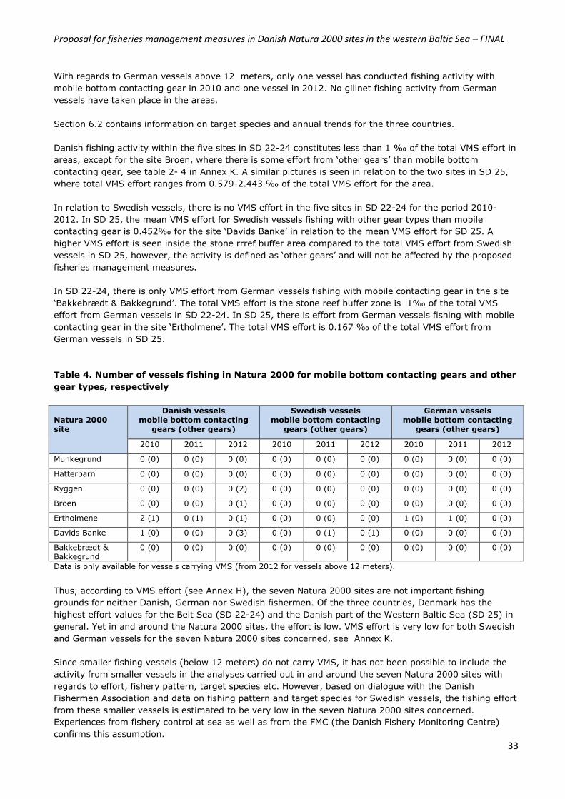
Proposal for fisheries management measures in Danish Natura 2000 sites in the western Baltic Sea – FINAL
33
With regards to German vessels above 12 meters, only one vessel has conducted fishing activity with
mobile bottom contacting gear in 2010 and one vessel in 2012. No gillnet fishing activity from German
vessels have taken place in the areas.
Section 6.2 contains information on target species and annual trends for the three countries.
Danish fishing activity within the five sites in SD 22-24 constitutes less than 1 ‰ of the total VMS effort in
areas, except for the site Broen, where there is some effort from ‘other gears’ than mobile bottom
contacting gear, see table 2- 4 in Annex K. A similar pictures is seen in relation to the two sites in SD 25,
where total VMS effort ranges from 0.579-2.443 ‰ of the total VMS effort for the area.
In relation to Swedish vessels, there is no VMS effort in the five sites in SD 22-24 for the period 2010-
2012. In SD 25, the mean VMS effort for Swedish vessels fishing with other gear types than mobile
contacting gear is 0.452‰ for the site ‘Davids Banke’ in relation to the mean VMS effort for SD 25. A
higher VMS effort is seen inside the stone rrref buffer area compared to the total VMS effort from Swedish
vessels in SD 25, however, the activity is defined as ‘other gears’ and will not be affected by the proposed
fisheries management measures.
In SD 22-24, there is only VMS effort from German vessels fishing with mobile contacting gear in the site
‘Bakkebrædt & Bakkegrund’. The total VMS effort is the stone reef buffer zone is 1‰ of the total VMS
effort from German vessels in SD 22-24. In SD 25, there is effort from German vessels fishing with mobile
contacting gear in the site ‘Ertholmene’. The total VMS effort is 0.167 ‰ of the total VMS effort from
German vessels in SD 25.
Table 4. Number of vessels fishing in Natura 2000 for mobile bottom contacting gears and other
gear types, respectively
Natura 2000 site
Danish vessels mobile bottom contacting
gears (other gears)
Swedish vessels mobile bottom contacting
gears (other gears)
German vessels mobile bottom contacting
gears (other gears)
2010 2011 2012 2010 2011 2012 2010 2011 2012
Munkegrund 0 (0) 0 (0) 0 (0) 0 (0) 0 (0) 0 (0) 0 (0) 0 (0) 0 (0)
Hatterbarn 0 (0) 0 (0) 0 (0) 0 (0) 0 (0) 0 (0) 0 (0) 0 (0) 0 (0)
Ryggen 0 (0) 0 (0) 0 (2) 0 (0) 0 (0) 0 (0) 0 (0) 0 (0) 0 (0)
Broen 0 (0) 0 (0) 0 (1) 0 (0) 0 (0) 0 (0) 0 (0) 0 (0) 0 (0)
Ertholmene 2 (1) 0 (1) 0 (1) 0 (0) 0 (0) 0 (0) 1 (0) 1 (0) 0 (0)
Davids Banke 1 (0) 0 (0) 0 (3) 0 (0) 0 (1) 0 (1) 0 (0) 0 (0) 0 (0)
Bakkebrædt & Bakkegrund
0 (0) 0 (0) 0 (0) 0 (0) 0 (0) 0 (0) 0 (0) 0 (0) 0 (0)
Data is only available for vessels carrying VMS (from 2012 for vessels above 12 meters).
Thus, according to VMS effort (see Annex H), the seven Natura 2000 sites are not important fishing
grounds for neither Danish, German nor Swedish fishermen. Of the three countries, Denmark has the
highest effort values for the Belt Sea (SD 22-24) and the Danish part of the Western Baltic Sea (SD 25) in
general. Yet in and around the Natura 2000 sites, the effort is low. VMS effort is very low for both Swedish
and German vessels for the seven Natura 2000 sites concerned, see Annex K.
Since smaller fishing vessels (below 12 meters) do not carry VMS, it has not been possible to include the
activity from smaller vessels in the analyses carried out in and around the seven Natura 2000 sites with
regards to effort, fishery pattern, target species etc. However, based on dialogue with the Danish
Fishermen Association and data on fishing pattern and target species for Swedish vessels, the fishing effort
from these smaller vessels is estimated to be very low in the seven Natura 2000 sites concerned.
Experiences from fishery control at sea as well as from the FMC (the Danish Fishery Monitoring Centre)
confirms this assumption.
Proposal for fisheries management measures in Danish Natura 2000 sites in the western Baltic Sea – FINAL
34
It can be added that, when looking at the threats from fishing activities on reef structures, the Danish
Agrifish Agency has also been analyzing the potential impact from recreational fishing activities. It is
assessed by DTU Aqua, that commercial fishing activities with gears like mobile bottom contacting trawls,
nets, lines, hooks, pots and traps can have a negative impact on bubbling reefs. Since the risk of damage
to the reef structures depends on the gear type used and not on fishing vessel status, recreational fishing
activities can also pose a risk when using the above mentioned gear types. Recreational fishery is not part
of the Common Fisheries Policy. The Danish Agrifish Agency therefore considers taking steps to introduce
management measures for recreational fishing activities through national regulation (administrative
orders) for the Natura 2000 sites in question.
6.2 Target species and annual trends Analyses of target species and annual trends for fishing activity within the Natura 2000 sites have been
made possible through a coupling of VMS-data and log book data, see Annex I (only for vessels above 12
meters). Focus has been given to the period 2010-2012. Information on gear types and landings have also
been analyzed for Danish, Swedish and German vessels.
The following section describes in more detail fishing activity per site separately for Denmark, Sweden and
Germany for the main target species (given as an average for a three year period (2010-2012)). Annex J
lists fishery data at species level per year per country.
Natura 2000 site “Munkegrund”
According to log book and VMS data there are no records of fishing activities in the Natura 2000 site
Munkegrund, neither from Danish, Swedish or German vessels, respectively, for the period 2010-2012, see
figure 5a and 5b. The proposed fisheries management measures will therefore have no effect on fishing
activities in and around the Natura 2000 site for vessels above 12 meters.
Fishery data for smaller vessels are only available for Swedish vessels (log book data, see Annex I).
Fishing activity with smaller vessels are assessed to similar to that of larger vessels. This assumption is
supported by information of fishing pattern for smaller vessels provided by the Danish Fishermen
Association.
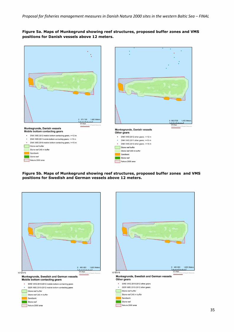
Proposal for fisheries management measures in Danish Natura 2000 sites in the western Baltic Sea – FINAL
35
Figure 5a. Maps of Munkegrund showing reef structures, proposed buffer zones and VMS
positions for Danish vessels above 12 meters.
Figure 5b. Maps of Munkegrund showing reef structures, proposed buffer zones and VMS
positions for Swedish and German vessels above 12 meters.
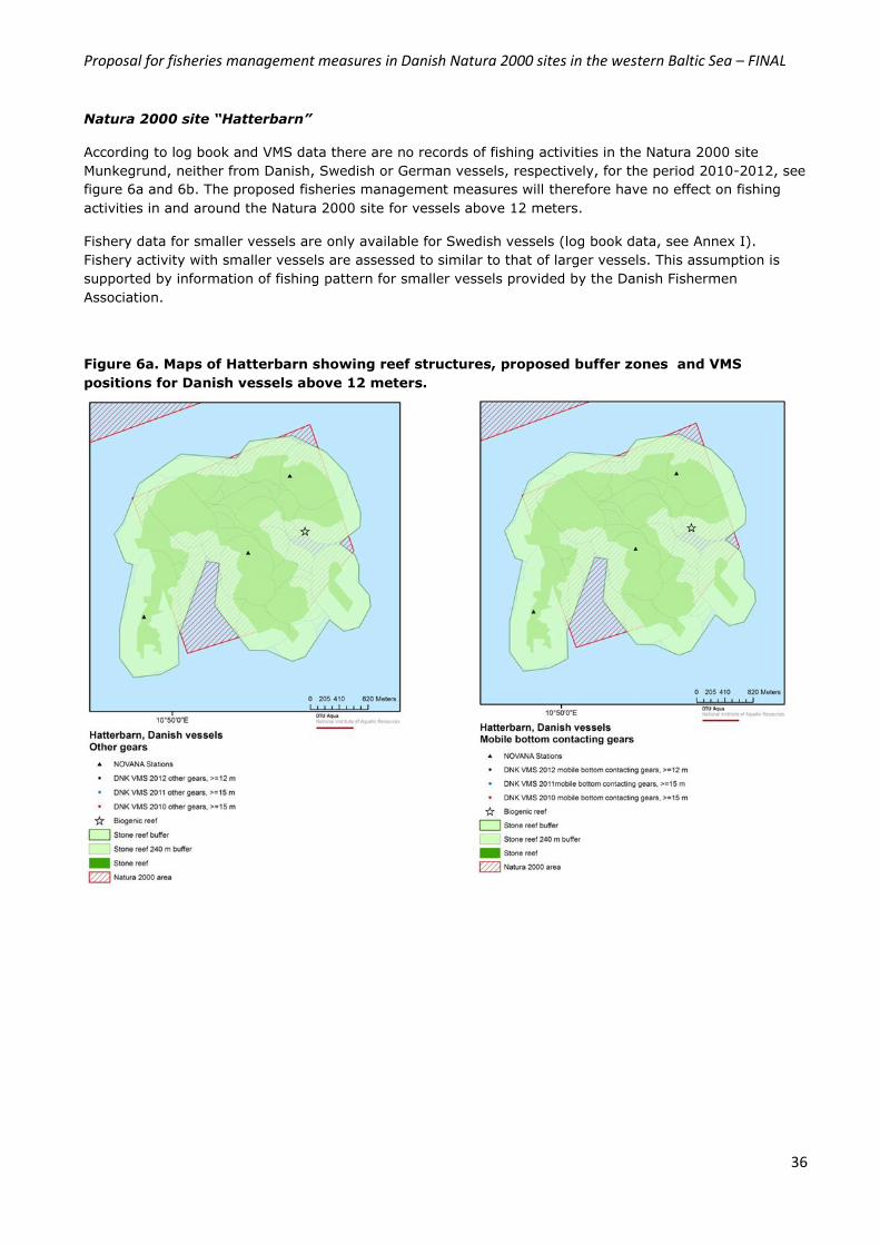
Proposal for fisheries management measures in Danish Natura 2000 sites in the western Baltic Sea – FINAL
36
Natura 2000 site “Hatterbarn”
According to log book and VMS data there are no records of fishing activities in the Natura 2000 site
Munkegrund, neither from Danish, Swedish or German vessels, respectively, for the period 2010-2012, see
figure 6a and 6b. The proposed fisheries management measures will therefore have no effect on fishing
activities in and around the Natura 2000 site for vessels above 12 meters.
Fishery data for smaller vessels are only available for Swedish vessels (log book data, see Annex I).
Fishery activity with smaller vessels are assessed to similar to that of larger vessels. This assumption is
supported by information of fishing pattern for smaller vessels provided by the Danish Fishermen
Association.
Figure 6a. Maps of Hatterbarn showing reef structures, proposed buffer zones and VMS
positions for Danish vessels above 12 meters.
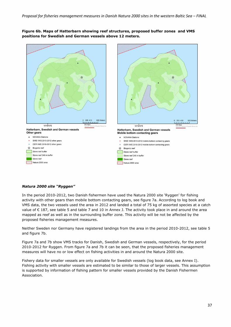
Proposal for fisheries management measures in Danish Natura 2000 sites in the western Baltic Sea – FINAL
37
Figure 6b. Maps of Hatterbarn showing reef structures, proposed buffer zones and VMS
positions for Swedish and German vessels above 12 meters.
Natura 2000 site “Ryggen”
In the period 2010-2012, two Danish fishermen have used the Natura 2000 site ‘Ryggen’ for fishing
activity with other gears than mobile bottom contacting gears, see figure 7a. According to log book and
VMS data, the two vessels used the area in 2012 and landed a total of 75 kg of assorted species at a catch
value of € 187, see table 5 and table 7 and 10 in Annex J. The activity took place in and around the area
mapped as reef as well as in the surrounding buffer zone. This activity will be not be affected by the
proposed fisheries management measures.
Neither Sweden nor Germany have registered landings from the area in the period 2010-2012, see table 5
and figure 7b.
Figure 7a and 7b show VMS tracks for Danish, Swedish and German vessels, respectively, for the period
2010-2012 for Ryggen. From figure 7a and 7b it can be seen, that the proposed fisheries management
measures will have no or low effect on fishing activities in and around the Natura 2000 site.
Fishery data for smaller vessels are only available for Swedish vessels (log book data, see Annex I).
Fishing activity with smaller vessels are estimated to be similar to those of larger vessels. This assumption
is supported by information of fishing pattern for smaller vessels provided by the Danish Fishermen
Association.
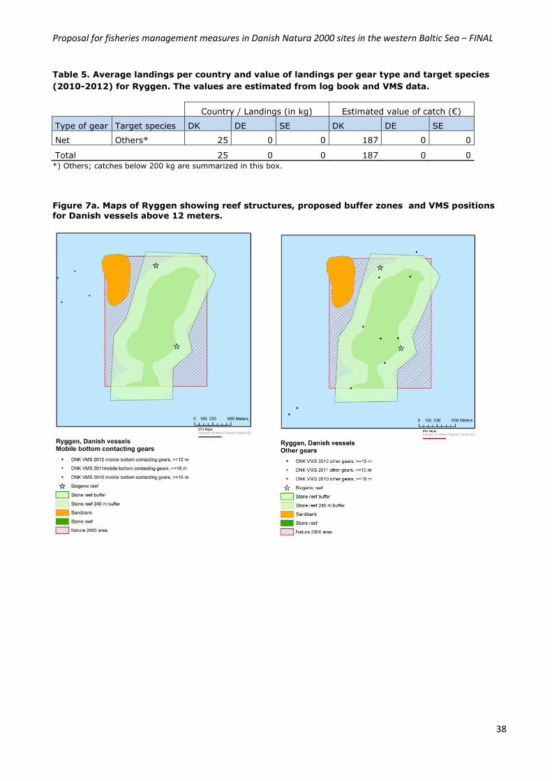
Proposal for fisheries management measures in Danish Natura 2000 sites in the western Baltic Sea – FINAL
38
Table 5. Average landings per country and value of landings per gear type and target species
(2010-2012) for Ryggen. The values are estimated from log book and VMS data.
Country / Landings (in kg) Estimated value of catch (€)
Type of gear Target species DK DE SE DK DE SE
Net Others* 25 0 0 187 0 0
Total 25 0 0 187 0 0
*) Others; catches below 200 kg are summarized in this box.
Figure 7a. Maps of Ryggen showing reef structures, proposed buffer zones and VMS positions for Danish vessels above 12 meters.
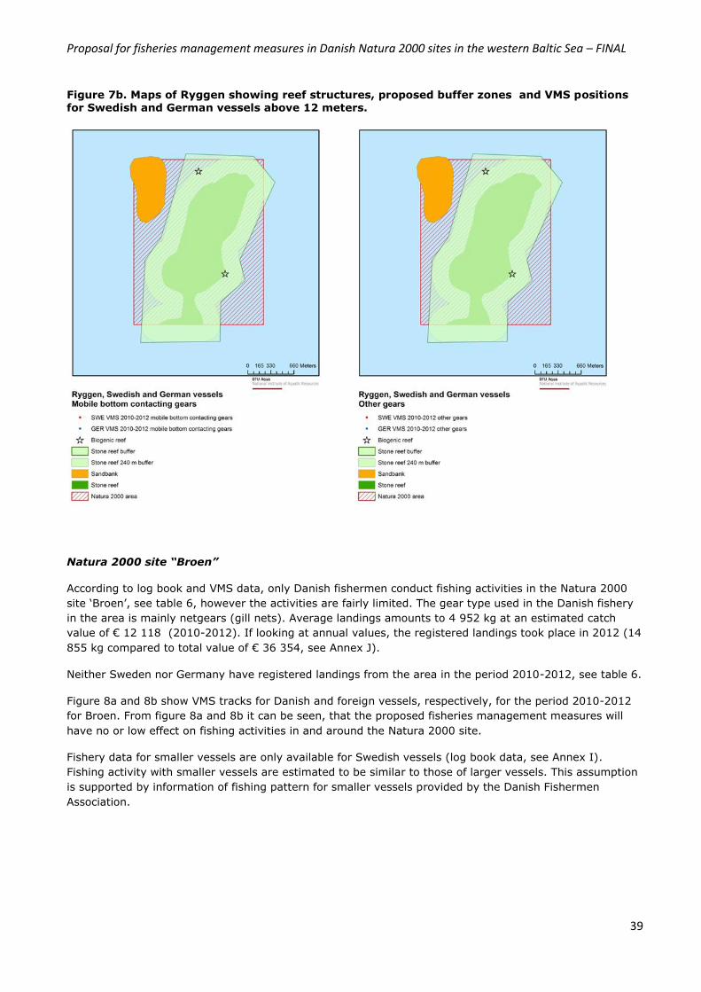
Proposal for fisheries management measures in Danish Natura 2000 sites in the western Baltic Sea – FINAL
39
Figure 7b. Maps of Ryggen showing reef structures, proposed buffer zones and VMS positions
for Swedish and German vessels above 12 meters.
Natura 2000 site “Broen”
According to log book and VMS data, only Danish fishermen conduct fishing activities in the Natura 2000
site ‘Broen’, see table 6, however the activities are fairly limited. The gear type used in the Danish fishery
in the area is mainly netgears (gill nets). Average landings amounts to 4 952 kg at an estimated catch
value of € 12 118 (2010-2012). If looking at annual values, the registered landings took place in 2012 (14
855 kg compared to total value of € 36 354, see Annex J).
Neither Sweden nor Germany have registered landings from the area in the period 2010-2012, see table 6.
Figure 8a and 8b show VMS tracks for Danish and foreign vessels, respectively, for the period 2010-2012
for Broen. From figure 8a and 8b it can be seen, that the proposed fisheries management measures will
have no or low effect on fishing activities in and around the Natura 2000 site.
Fishery data for smaller vessels are only available for Swedish vessels (log book data, see Annex I).
Fishing activity with smaller vessels are estimated to be similar to those of larger vessels. This assumption
is supported by information of fishing pattern for smaller vessels provided by the Danish Fishermen
Association.
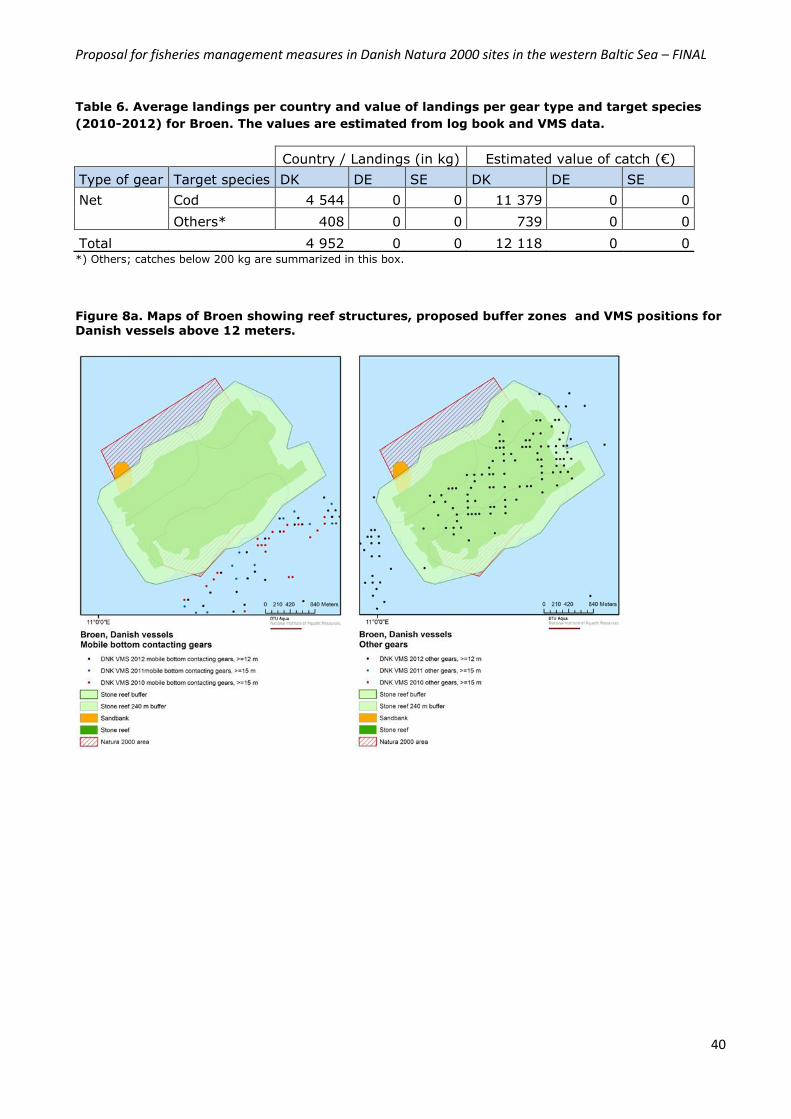
Proposal for fisheries management measures in Danish Natura 2000 sites in the western Baltic Sea – FINAL
40
Table 6. Average landings per country and value of landings per gear type and target species
(2010-2012) for Broen. The values are estimated from log book and VMS data.
Country / Landings (in kg) Estimated value of catch (€)
Type of gear Target species DK DE SE DK DE SE
Net Cod 4 544 0 0 11 379 0 0
Others* 408 0 0 739 0 0
Total 4 952 0 0 12 118 0 0 *) Others; catches below 200 kg are summarized in this box.
Figure 8a. Maps of Broen showing reef structures, proposed buffer zones and VMS positions for Danish vessels above 12 meters.
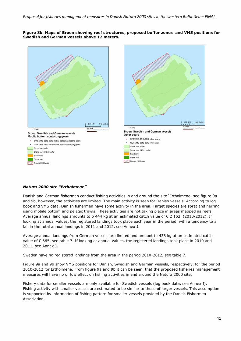
Proposal for fisheries management measures in Danish Natura 2000 sites in the western Baltic Sea – FINAL
41
Figure 8b. Maps of Broen showing reef structures, proposed buffer zones and VMS positions for
Swedish and German vessels above 12 meters.
Natura 2000 site “Ertholmene”
Danish and German fishermen conduct fishing activities in and around the site ‘Ertholmene, see figure 9a
and 9b, however, the activities are limited. The main activity is seen for Danish vessels. According to log
book and VMS data, Danish fishermen have some activity in the area. Target species are sprat and herring
using mobile bottom and pelagic trawls. These activities are not taking place in areas mapped as reefs.
Average annual landings amounts to 6 444 kg at an estimated catch value of € 2 153 (2010-2012). If
looking at annual values, the registered landings took place each year in the period, with a tendency to a
fall in the total annual landings in 2011 and 2012, see Annex J.
Average annual landings from German vessels are limited and amount to 438 kg at an estimated catch
value of € 665, see table 7. If looking at annual values, the registered landings took place in 2010 and
2011, see Annex J.
Sweden have no registered landings from the area in the period 2010-2012, see table 7.
Figure 9a and 9b show VMS positions for Danish, Swedish and German vessels, respectively, for the period
2010-2012 for Ertholmene. From figure 9a and 9b it can be seen, that the proposed fisheries management
measures will have no or low effect on fishing activities in and around the Natura 2000 site.
Fishery data for smaller vessels are only available for Swedish vessels (log book data, see Annex I).
Fishing activity with smaller vessels are estimated to be similar to those of larger vessels. This assumption
is supported by information of fishing pattern for smaller vessels provided by the Danish Fishermen
Association.
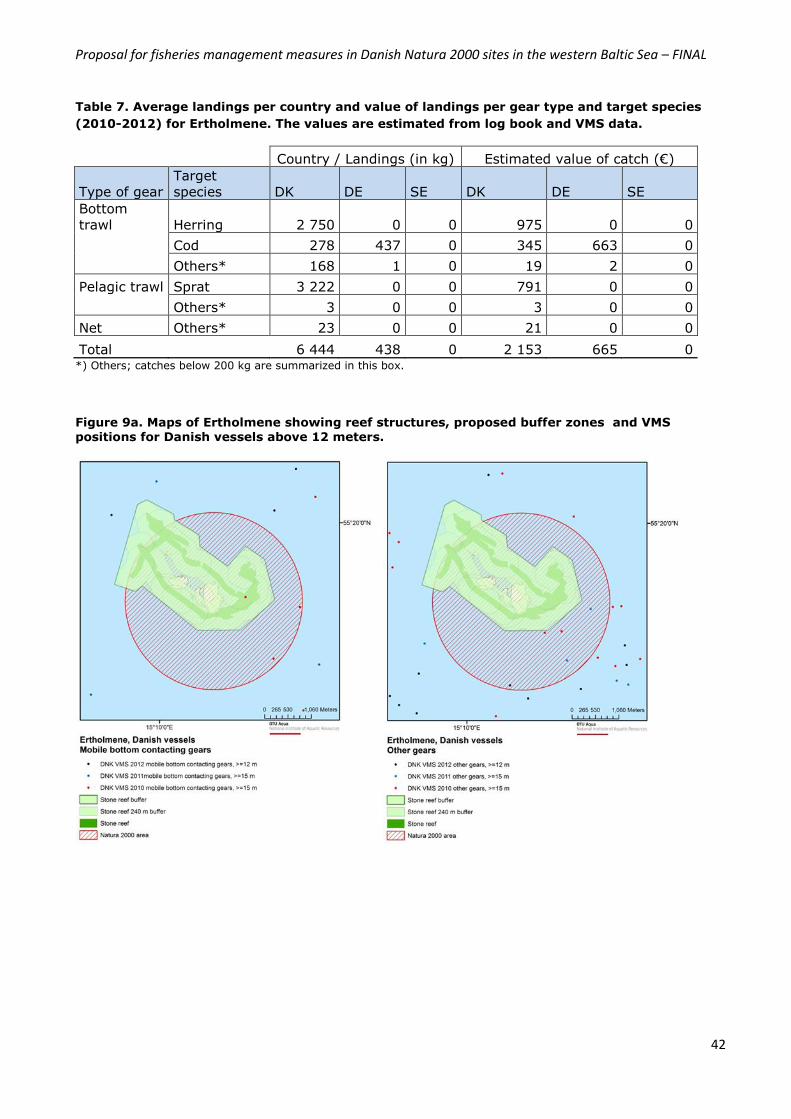
Proposal for fisheries management measures in Danish Natura 2000 sites in the western Baltic Sea – FINAL
42
Table 7. Average landings per country and value of landings per gear type and target species
(2010-2012) for Ertholmene. The values are estimated from log book and VMS data.
Country / Landings (in kg) Estimated value of catch (€)
Type of gear
Target
species DK DE SE DK DE SE
Bottom
trawl Herring 2 750 0 0 975 0 0
Cod 278 437 0 345 663 0
Others* 168 1 0 19 2 0
Pelagic trawl Sprat 3 222 0 0 791 0 0
Others* 3 0 0 3 0 0
Net Others* 23 0 0 21 0 0
Total 6 444 438 0 2 153 665 0 *) Others; catches below 200 kg are summarized in this box.
Figure 9a. Maps of Ertholmene showing reef structures, proposed buffer zones and VMS positions for Danish vessels above 12 meters.
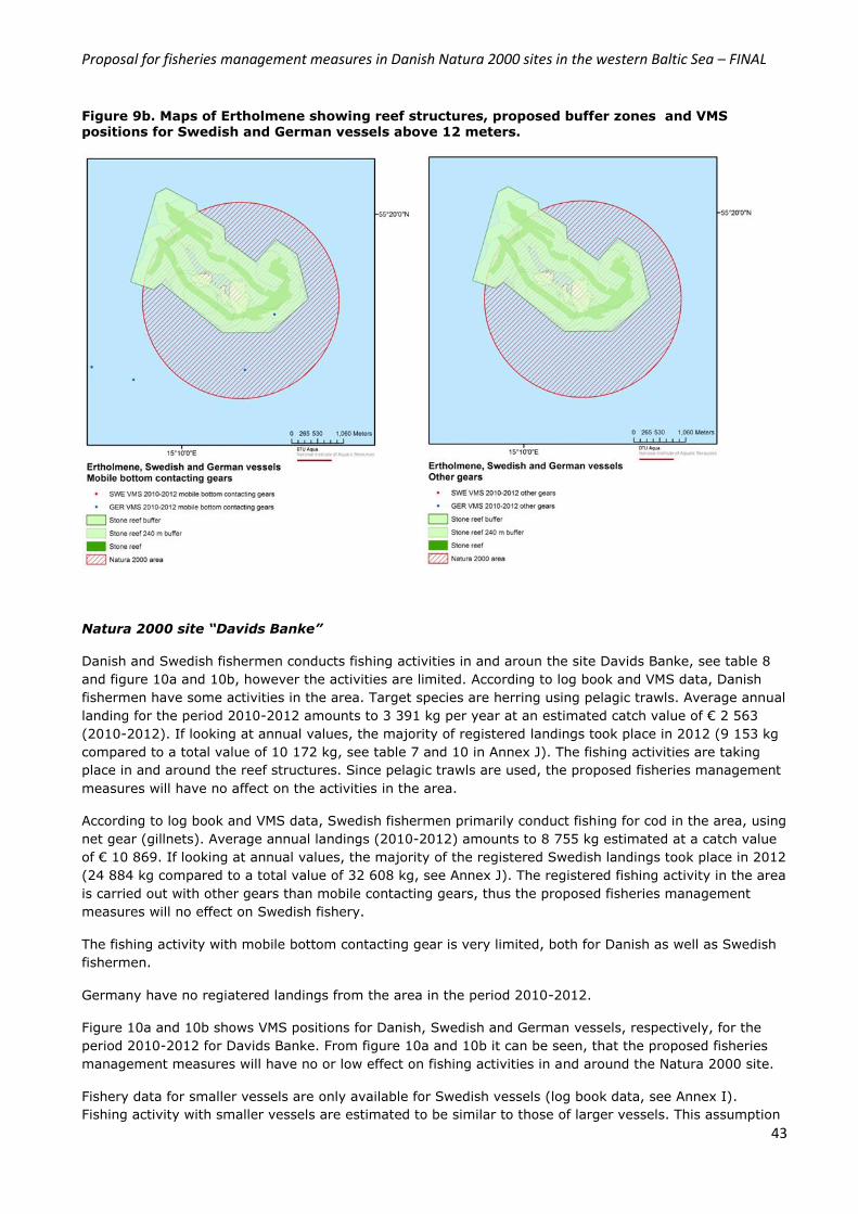
Proposal for fisheries management measures in Danish Natura 2000 sites in the western Baltic Sea – FINAL
43
Figure 9b. Maps of Ertholmene showing reef structures, proposed buffer zones and VMS
positions for Swedish and German vessels above 12 meters.
Natura 2000 site “Davids Banke”
Danish and Swedish fishermen conducts fishing activities in and aroun the site Davids Banke, see table 8
and figure 10a and 10b, however the activities are limited. According to log book and VMS data, Danish
fishermen have some activities in the area. Target species are herring using pelagic trawls. Average annual
landing for the period 2010-2012 amounts to 3 391 kg per year at an estimated catch value of € 2 563
(2010-2012). If looking at annual values, the majority of registered landings took place in 2012 (9 153 kg
compared to a total value of 10 172 kg, see table 7 and 10 in Annex J). The fishing activities are taking
place in and around the reef structures. Since pelagic trawls are used, the proposed fisheries management
measures will have no affect on the activities in the area.
According to log book and VMS data, Swedish fishermen primarily conduct fishing for cod in the area, using
net gear (gillnets). Average annual landings (2010-2012) amounts to 8 755 kg estimated at a catch value
of € 10 869. If looking at annual values, the majority of the registered Swedish landings took place in 2012
(24 884 kg compared to a total value of 32 608 kg, see Annex J). The registered fishing activity in the area
is carried out with other gears than mobile contacting gears, thus the proposed fisheries management
measures will no effect on Swedish fishery.
The fishing activity with mobile bottom contacting gear is very limited, both for Danish as well as Swedish
fishermen.
Germany have no regiatered landings from the area in the period 2010-2012.
Figure 10a and 10b shows VMS positions for Danish, Swedish and German vessels, respectively, for the
period 2010-2012 for Davids Banke. From figure 10a and 10b it can be seen, that the proposed fisheries
management measures will have no or low effect on fishing activities in and around the Natura 2000 site.
Fishery data for smaller vessels are only available for Swedish vessels (log book data, see Annex I).
Fishing activity with smaller vessels are estimated to be similar to those of larger vessels. This assumption
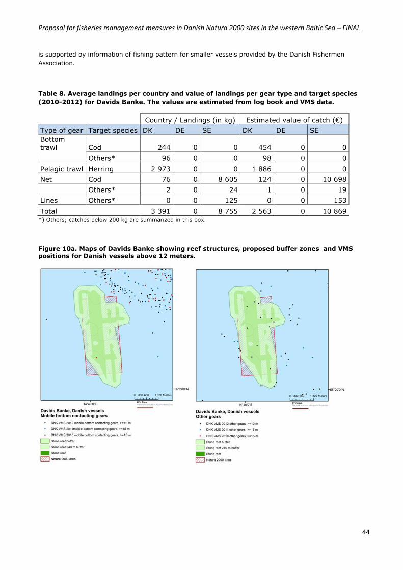
Proposal for fisheries management measures in Danish Natura 2000 sites in the western Baltic Sea – FINAL
44
is supported by information of fishing pattern for smaller vessels provided by the Danish Fishermen
Association.
Table 8. Average landings per country and value of landings per gear type and target species
(2010-2012) for Davids Banke. The values are estimated from log book and VMS data.
Country / Landings (in kg) Estimated value of catch (€)
Type of gear Target species DK DE SE DK DE SE
Bottom
trawl Cod 244 0 0 454 0 0
Others* 96 0 0 98 0 0
Pelagic trawl Herring 2 973 0 0 1 886 0 0
Net Cod 76 0 8 605 124 0 10 698
Others* 2 0 24 1 0 19
Lines Others* 0 0 125 0 0 153
Total 3 391 0 8 755 2 563 0 10 869 *) Others; catches below 200 kg are summarized in this box.
Figure 10a. Maps of Davids Banke showing reef structures, proposed buffer zones and VMS positions for Danish vessels above 12 meters.
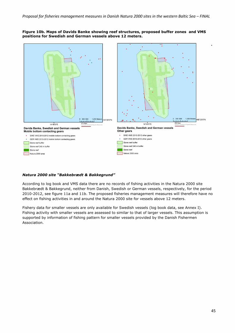
Proposal for fisheries management measures in Danish Natura 2000 sites in the western Baltic Sea – FINAL
45
Figure 10b. Maps of Davids Banke showing reef structures, proposed buffer zones and VMS
positions for Swedish and German vessels above 12 meters.
.
Natura 2000 site “Bakkebrædt & Bakkegrund”
According to log book and VMS data there are no records of fishing activities in the Natura 2000 site
Bakkebrædt & Bakkegrund, neither from Danish, Swedish or German vessels, respectively, for the period
2010-2012, see figure 11a and 11b. The proposed fisheries management measures will therefore have no
effect on fishing activities in and around the Natura 2000 site for vessels above 12 meters.
Fishery data for smaller vessels are only available for Swedish vessels (log book data, see Annex I).
Fishing activity with smaller vessels are assessed to similar to that of larger vessels. This assumption is
supported by information of fishing pattern for smaller vessels provided by the Danish Fishermen
Association.
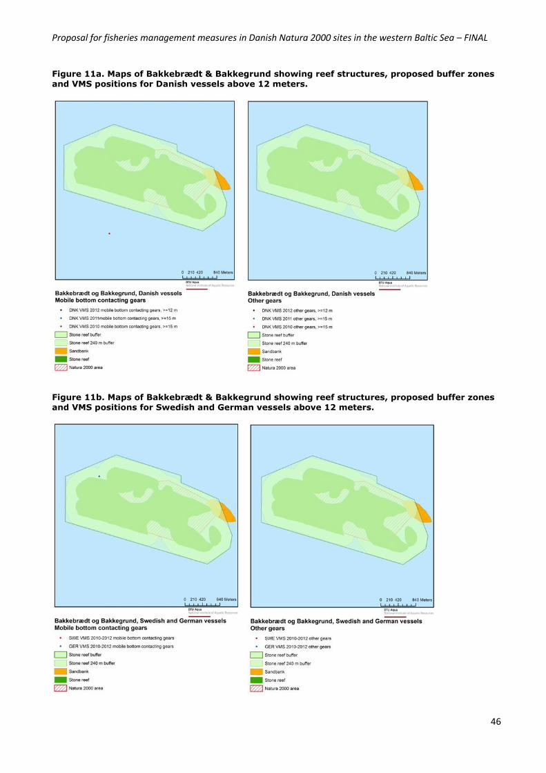
Proposal for fisheries management measures in Danish Natura 2000 sites in the western Baltic Sea – FINAL
46
Figure 11a. Maps of Bakkebrædt & Bakkegrund showing reef structures, proposed buffer zones
and VMS positions for Danish vessels above 12 meters.
Figure 11b. Maps of Bakkebrædt & Bakkegrund showing reef structures, proposed buffer zones
and VMS positions for Swedish and German vessels above 12 meters.
Proposal for fisheries management measures in Danish Natura 2000 sites in the western Baltic Sea – FINAL
47
6.3 Displacement Analyses of fishing patterns based on VMS positions and log book data indicate, that the proposed fisheries
management measures are not likely to have any significant impact in relation to the current fishing
activities in the Danish part of SD 22-24 and 25. For Danish, Swedish and German vessels, the Belt Sea
and western Baltic Sea are important fishing grounds, however, the areas addressed in the present
proposal are characterized by reef structures and are therefore not preferred fishing grounds primarily due
to the risk of damage to the fishing gear used.
Analyses of fishing pattern, landings and effort show that the proposed fisheries management measures
are not in conflict with the fishing activity taking place in and around the seven sites. In general fishing
activity is carried out with pelagic trawls and/or gill nets – an activity which can continue in relation to the
proposed fisheries management measures.
The method of protection of reefs through buffer zones ensures that the proposed measures are targeted
protection of the marine habitats and proportional in relation to the impact in terms of fisheries. However,
the fishing activities which might be taking place in areas mapped as reefs are not compatible with the
required obligation to ensure protection of reef structures from physical disturbances from fishery activity.
The overall conclusion in relation to displacement is therefore, that the proposed fisheries management
measures for protection of reef structures will have no or very limited impact on the fishing activitites
carried out by Danish, Swedish and German fishermen in SD 22-24 as well as SD 25. VMS effort confirms
that the three Natura 2000 sites are not important fishing areas for either Danish, Swedish and German
fishermen. However, it cannot be excluded that the proposed fisheries management measures might have
an effect on some fishermen with vessels smaller than 12 meters. However, this potential impact is
estimated to be minimal.
Assessement of displacement is important not only in terms of potential effects to fisheries but also in
relation to the marine environment. Displacement of fisheries to less productive areas can potentially cause
great damage to the marine environment, thus resulting in an overall negative impact. The proposed
fisheries meaures in the present proposal will in general not result in displacement of fisheries, since the
areas proposed closed to fishing activities are not important fishing grounds for Danish, Swedish and
German fishermen.
6.4 Control, enforcement and monitoring The following two sections describe how the proposed management measures will be controlled, enforced
and monitored. Changes in conservation status as well as monitoring of effects of implemented
management measures are assessed in the Danish Monitoring Program (NOVANA).
6.4.1 Control and enforcement
Control and enforcement of fishery management measures in marine Natura 2000 sites in Denmark is
coordinated by the Fishery Monitoring Centre (FMC) located in Esbjerg, Jutland. The Danish FMC has
developed specific guidelines for fishery control and enforcement, which were launched parallel to the
implementation of the first national order for the protection of reef structures in four coastal Natura 2000
sites located in the western Baltic.
All marine Natura 2000 sites are visible in the Danish V-track system. The Danish FMC has developed a
model whereby the centre is alerted if and when a vessel enters the outlined area (control area) placed
around the Natura 2000 sites for which fisheries management measures have been implemented. The
control area has a minimum size of 4 nautical miles whereby any activity in the area will be detected.
Every day FMC receives a list of the vessels which have been detected in the control areas the previous
day. In case a vessel has been detected within a Natura 2000 site, an analysis of the vessels fishing
Proposal for fisheries management measures in Danish Natura 2000 sites in the western Baltic Sea – FINAL
48
pattern is carried out and the vessel is contacted with the purpose of informing the vessel owner of current
fisheries management measures. The model allows for real time control as well as administrative control.
Since September 2013 when the first national administrative order was implemented for protection of reef
structures in four coastal Natura 2000 sites, the FMC has detected both gillnet vessels and trawlers in
areas closed for fishing activities with mobile bottom contacting gear. An open dialogue with the fishermen
so far seems to have had an effect.
Control and enforcement of fisheries management measures in marine Natura 2000 sites in Danish waters
are centered around the VMS system, the risk based system used in regular fisheries control and
enforcement as well as open dialogue with fishermen and their organizations. The Danish AgriFish Agency
is fully aware of the challenges of control and enforcement of fisheries management measures for relatively
small Natura 2000 sites, which can be passed in the time between two VMS pings. Control and
enforcement needs to be seen in connection with the implementation of the reform of the Common
Fisheries Policy.
Analyses of the fishing patterns in and around the seven Natura 2000 sites which the present proposal
covers, show that fishing activity with mobile bottom contacting gear in the seven sites is relatively limited.
Fishing activity do not take place in areas mapped as reefs (H1170), but some fishing activity is seen in
the buffer zones placed around the reefs. The analyses is based on VMS positions for Danish, Swedish and
German vessels as well as information from smaller Danish vessels – see section 6.1 and 6.2 for more
information on fishing pattern, target species etc. With the current fishing activity in mind, control and
enforcement does not seem to be a major issue under a new regime with prohibition of certain fishing
activities in the seven Natura 2000 sites.
Denmark will reassess whether there is a need for additional technical equipment in relation to control and
enforcement of the proposed fisheries management measures once these measures have been in place for
18 months. Thus, the Danish AgriFish Agency will, if the need arises, require usage of technical equipment
(GPS and sensors as a minimum), in line with the current CCTV and technical specifications for some types
of fishing activities in Danish waters both within and outside 12 nautical miles. If the need arises for
technical equipment in relation to fisheries control and enforcement – Denmark will coordinate such a
requirement in accordance with Article 11 and 18 of the Basic Regulation and with the Member States
having a direct management interest in the area, e.g. Germany and Sweden.
6.4.2 The national monitoring program – NOVANA
In Denmark, reef structures in Natura 2000 sites are monitored through NOVANA, the Danish national
monitoring program. Within this program, reefs in open waters are monitored by the University of Aarhus,
the Danish Centre for Environment and Energy (DCE). DCE monitor reefs in 34 Natura 2000 sites following
specific national guidelines. Of the 34 areas, reefs in 12 areas are monitored yearly, whereas reefs in the
remaining 22 areas are monitored every six years. In addition to this program, the Danish Nature Agency
monitors macroalgae coverage on transects in areas placed in the coastal zone37.
Thus, the effect of the proposed management measures will be monitored through the national monitoring
program NOVANA. Data from the marine monitoring stations located within and/ or close to the Natura
2000 sites concerned provides the basis for the description of the current conservation status both in
relation to basic analyses plans and management plans.
The seven Natura 2000 sites, that the present proposal deals with, are monitored either yearly or every six
years:
1. Munkegrund (EU site code: DK00VA304): Every 6 years
2. Hatterbarn (EU site code: DK00VA255): Yearly
37
Dahl, K. & Carstensen, J. (2008): Tools to assess conservation status on open water reefs in Natura 2000 areas. Nat Env R Inst, University of Aarhus, 25 pp. NERI Technical Report No. 663: http:// www.dmu.dk/Pub/FR663.pdf

Proposal for fisheries management measures in Danish Natura 2000 sites in the western Baltic Sea – FINAL
49
3. Ryggen (EU site code: DK00VA253): Every 6 years
4. Broen (EU site code: DK00VA256): Yearly
5. Ertholmene (EU site code: DK007X079): No monitoring of conservation status
6. Davids Banke (EU site code: DK00VA308): No monitoring og conservation status
7. Bakkebrædt & Bakkegrund (EU site code: DK00VA310): No monitoring og conservation status.
Proposal for fisheries management measures in Danish Natura 2000 sites in the western Baltic Sea – FINAL
50
References
1. Council Directive 92/43/EEC, of 21 May 1992 on the conservation of natural habitats and of wild fauna and flora: http://eur-lex.europa.eu/LexUriServ/LexUriServ.do?uri=CONSLEG:1992L0043:20070101:EN:PDF
2. Directive 2009/147/EC of the European Parliament and of the Council, of 30 November 2009 on the conservation of wild birds: http://eur-lex.europa.eu/LexUriServ/LexUriServ.do?uri=OJ:L:2010:020:0007:0025:en:PDF
3. Link Natura 2000 Management plans: http://www.naturstyrelsen.dk/Naturbeskyttelse/Natura2000/Natura_2000_planer/Se_Planerne/
4. Dahl, K. 2005: Effekter af fiskeri på stenrevs algevegetation. Danmarks Miljøundersøgelser. 16 s. – Faglig rapport fra DMU nr. 526; Kaiser, M. J., Collie, J. S., Hall, S. J., Jennings, S. and Poiner, I. R. (2002), Modification of marine habitats by trawling activities: prognosis and solutions. Fish and Fisheries, 3: 114–136; ICES. 2009. Report of the EMPAS project (Environmentally Sound Fisheries Management in Protected Areas), 2006‐2008, an ICES‐BfN project. 123 pp.; ICES. 2006. Report of
the Working Group on Ecosystem Effects of Fishing Activities (WGECO), 5 12 April 2006 , ICES Headquarters, Copenhagen. ACE:05. 174 pp.
5. Basic Regulation 1380/2013, art. 4, § 1, no. 22; “Member State having a direct management interest means a Member State which has an interest consisting of either fishing opportunities or a fishery taking place in the exclusive economic zone og the Member State concerned”: http://eur-lex.europa.eu/LexUriServ/LexUriServ.do?uri=OJ:L:2013:354:0022:0061:EN:PDF
6. Link Guidance document: http://ec.europa.eu/environment/nature/natura2000/marine/docs/fish_measures.pdf
7. Link Act on Environmental Goals: https://www.retsinformation.dk/Forms/R0710.aspx?id=127102 8. Link Fisheries Act: https://www.retsinformation.dk/Forms/r0710.aspx?id=121218 9. Link Administrative order no. 408, 1 May 2007:
https://www.retsinformation.dk/Forms/R0710.aspx?id=13043 10. Link Administrative order no. 1114, 25 November 2011:
https://www.retsinformation.dk/Forms/R0710.aspx?id=139270 11. Link: Report – Mapping of Natura 2000 sites in 2011: http://naturstyrelsen.dk/publikationer/alle-
publikationer/2013/dec/kortlaegning-af-natura-2000-habitaterne-boblerev-(1180)-rev-(1170)-sandbanker-(1110)/
12. The Natura 2000 Dialogue Forum:
http://naturerhverv.dk/fileadmin/user_upload/NaturErhverv/Filer/Fiskeri/Natura_2000_hav/Natura_2000_dialogforum/Revideret_kommissorium_for_N2000_Dialogforum_020513.pdf
13. Moland E, Olsen EM, Knutsen H, Garrigou P, Espeland SH, Kleiven AR, Andre´ C, Knutsen JA. 2013 Lobster and cod benefit from small-scale northern marine protected areas: inference from an empirical before–after control-impact study. Proc R Soc B 280: 20122679.
14. Dahl, K. & Carstensen, J. (2008): Tools to assess conservation status on open water reefs in Natura 2000 areas. Nat Env R Inst, University of Aarhus, 25 pp. NERI Technical Report No. 663: http:// www.dmu.dk/Pub/FR663.pdf
15. Vessel monitoring systems: satellite based monitoring system used in commercial fisheries. 16. Link Booklet:
http://naturerhverv.dk/fileadmin/user_upload/NaturErhverv/Filer/Fiskeri/Natura_2000_hav/Rev/Forslag_til_fiskeriregulering_Kattegat.pdf
17. Link Administrative order no. 1048 of 28 August 2013: https://www.retsinformation.dk/Forms/R0710.aspx?id=158209
18. Dahl, K. (2005): Effekter af fiskeri på stenrevs algevegetation. Danmarks Miljøundersøgelser. 16 s.
– Faglig rapport fra DMU nr. 526; Kaiser, M. J., Collie, J. S., Hall, S. J., Jennings, S. and Poiner, I.
R. (2002), Modification of marine habitats by trawling activities: prognosis and solutions. Fish and Fisheries, 3: 114–136; ICES. 2009. Report of the EMPAS project (Environmentally Sound Fisheries Management in Protected Areas), 2006‐2008, an ICES‐BfN project. 123 pp.
19. Dahl, K. (2005): Effekter af fiskeri på stenrevs algevegetation. Danmarks Miljøundersøgelser. 16 s. – Faglig rapport fra DMU nr. 526; Fenberg P.B.*, Caselle J., Claudet J., Clemence M., Gaines S., García-Charton J.A., Gonçalves E., Grorud-Colvert K., Guidetti P., Jenkins S., Jones P.J.S., Lester
S., McAllen R., Moland E., Planes S. and Sørensen T.K. (2012) The science of European marine reserves: status, efficacy and needs. Marine Policy 36(5), 1012-1021; Collie, J. S., Hall, S. J., Kaiser, M. J. and Poiner, I. R. (2000), A quantitative analysis of fishing impacts on shelf-sea benthos. Journal of Animal Ecology, 69: 785–798.
20. Link Administrative order no. 1048 of 28 August 2013: https://www.retsinformation.dk/Forms/R0710.aspx?id=158209
21. Dahl, K. (2005): Effekter af fiskeri på stenrevs algevegetation. Danmarks Miljøundersøgelser. 16 s.
– Faglig rapport fra DMU nr. 526; Kaiser, M. J., Collie, J. S., Hall, S. J., Jennings, S. and Poiner, I. R. (2002), Modification of marine habitats by trawling activities: prognosis and solutions. Fish and
Proposal for fisheries management measures in Danish Natura 2000 sites in the western Baltic Sea – FINAL
51
Fisheries, 3: 114–136; ICES. 2009. Report of the EMPAS project (Environmentally Sound Fisheries Management in Protected Areas), 2006‐2008, an ICES‐BfN project. 123 pp.
22. Link Council Regulation (EC) No 2187/2005: http://eur-lex.europa.eu/LexUriServ/LexUriServ.do?uri=OJ:L:2005:349:0001:0023:EN:PDF
23. Link Council Regulation (EC) No 850/1998: http://eur-lex.europa.eu/LexUriServ/LexUriServ.do?uri=CONSLEG:1998R0850:20060117:EN:PDF
24. Munkegrund: Habitat No. 205, Natura 2000 site No. 205, EU site code: DK00VA304 25. Link to Natura 2000 management plan for Munkegrund:
http://naturstyrelsen.dk/naturbeskyttelse/natura-2000/natura-2000-planer/natura-2000-planer-2009-15/plan-126-246/205-munkegrund/
26. Hatterbarn: Habitat No. 174, Natura 2000 site No. 198, EU site code: DK00VA255 27. Link to Natura 2000 management plan for Hatter Barn:
http://www.naturstyrelsen.dk/Naturbeskyttelse/Natura2000/Natura_2000_planer/Se_Planerne/12
6_246/198_Hatter.htm 28. Ryggen: Habitat No. 172, Natura 2000 site No. 196, EU site code: DK00VA253 29. Link to Natura 2000 management plan for Ryggen:
http://naturstyrelsen.dk/naturbeskyttelse/natura-2000/natura-2000-planer/natura-2000-planer-
2009-15/plan-126-246/196-ryggen/ 30. Broen: Habitat No. 175, Natura 2000 site No. 199, EU site code: DK00VA256 31. Link to Natura 2000 management plan for Broen:
http://naturstyrelsen.dk/naturbeskyttelse/natura-2000/natura-2000-planer/natura-2000-planer-2009-15/plan-126-246/199-broen/
32. Ertholmene: Habitat No. 210, Natura 2000 site No. 189, EU site code: DK007X079 33. Link to Natura 2000 management plan for Ertholmene:
http://naturstyrelsen.dk/naturbeskyttelse/natura-2000/natura-2000-planer/natura-2000-planer-2009-15/plan-126-246/189-ertholmene/
34. Davids Banke: Habitat No. 209, Natura 2000 site No. 209, EU site code: DK00VA308 35. Link to Natura 2000 management plan for Davids Banke:
http://naturstyrelsen.dk/naturbeskyttelse/natura-2000/natura-2000-planer/natura-2000-planer-2009-15/plan-126-246/209-davids/
36. Bakkebrædt & Bakkegrund: Habitat No. 212, Natura 2000 site No. 212, EU site code: DK00VA310 37. Link to Natura 2000 management plan for Bakkebrædt & Bakkegrund:
http://naturstyrelsen.dk/naturbeskyttelse/natura-2000/natura-2000-planer/natura-2000-planer-
2009-15/plan-126-246/212-bakkebraedt/ 38. Reference to principle in Danish case law: Decision by the Supreme Court (Højesterets Kendelse
356/2011): http://www.domstol.dk/hojesteret/nyheder/Afgorelser/Documents/356-2011.pdf 39. Dahl, K. & Carstensen, J. (2008): Tools to assess conservation status on open water reefs in
Natura 2000 areas. Nat Env R Inst, University of Aarhus, 25 pp. NERI Technical Report No. 663: http:// www.dmu.dk/Pub/FR663.pdf
Proposal for fisheries management measures in Danish Natura 2000 sites in the western Baltic Sea – FINAL
52
List of Annexes
Annex A: Map of Danish marine Natura 2000 network
Annex B: Overview of designation of Natura 2000 sites
Annex C: Overview of the 11 information items in Commission’s guideline from 2008
Annex D: Scientific advice – Buffer zones
Annex E: Overview of formal and informal consultations
Annex F: Summary of outcome of regional coordination proces
Annex G: Summary of outcome of consultation with the Danish Natura 2000 Dialogue Forum and
Advisory Councils
Annex H: Buffer zone coordinates for Herthas Flak, Læsø Trindel & Tønneberg Banke and Lysegrund
Annex I: Fishery data: Description of methods
Annex J: Total landings and catch values
Annex K: Fishery effort
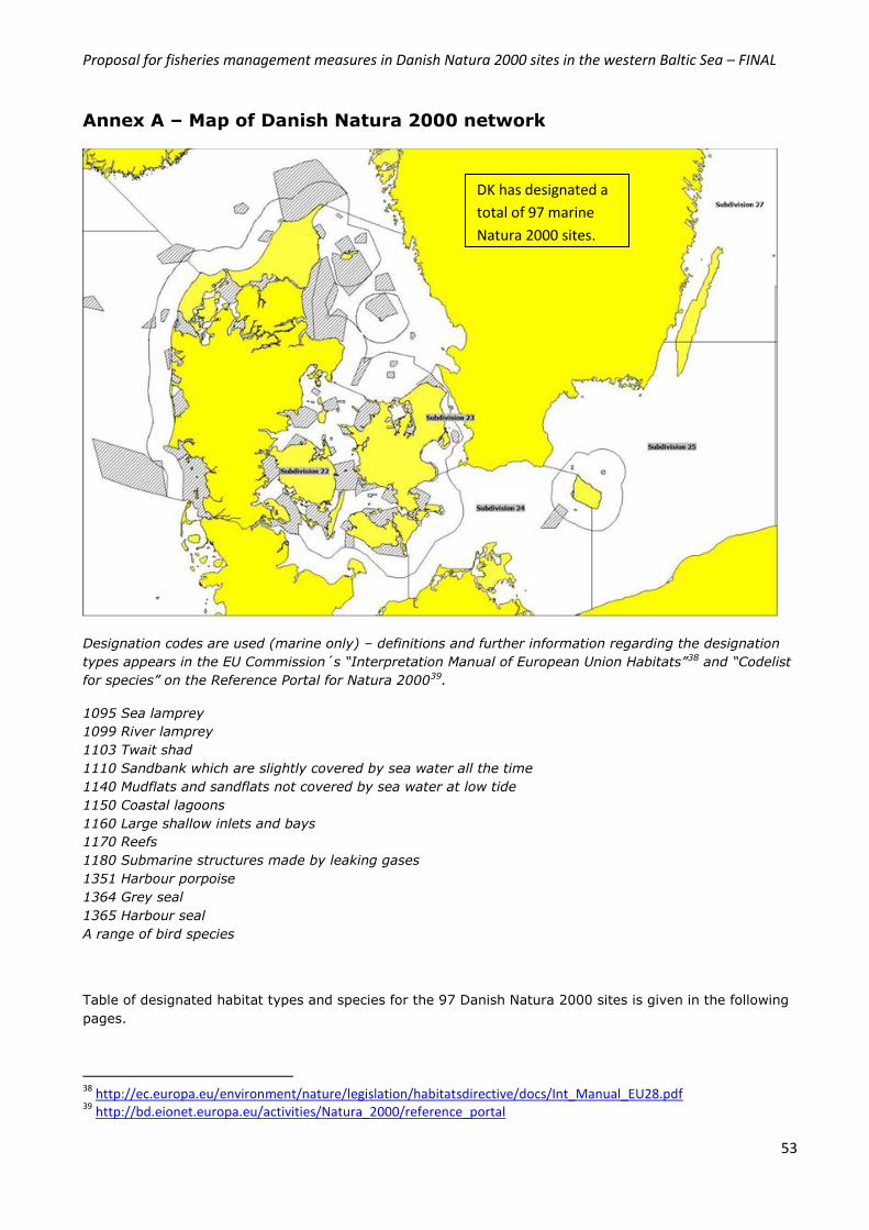
Proposal for fisheries management measures in Danish Natura 2000 sites in the western Baltic Sea – FINAL
53
Annex A – Map of Danish Natura 2000 network
Designation codes are used (marine only) – definitions and further information regarding the designation
types appears in the EU Commission´s “Interpretation Manual of European Union Habitats”38 and “Codelist
for species” on the Reference Portal for Natura 200039.
1095 Sea lamprey
1099 River lamprey
1103 Twait shad
1110 Sandbank which are slightly covered by sea water all the time
1140 Mudflats and sandflats not covered by sea water at low tide
1150 Coastal lagoons
1160 Large shallow inlets and bays
1170 Reefs
1180 Submarine structures made by leaking gases
1351 Harbour porpoise
1364 Grey seal
1365 Harbour seal
A range of bird species
Table of designated habitat types and species for the 97 Danish Natura 2000 sites is given in the following
pages.
38
http://ec.europa.eu/environment/nature/legislation/habitatsdirective/docs/Int_Manual_EU28.pdf 39
http://bd.eionet.europa.eu/activities/Natura_2000/reference_portal
DK has designated a
total of 97 marine
Natura 2000 sites.
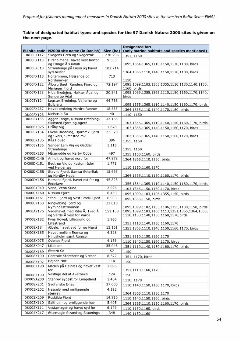
Proposal for fisheries management measures in Danish Natura 2000 sites in the western Baltic Sea – FINAL
54
Table of designated habitat types and species for the 97 Danish Natura 2000 sites is given on
the next page.
EU site code N2000 site name (in Danish) Size (ha) Designated for: (only marine habitats and species mentioned)
DK00FX112 Skagens Gren og Skagerrak 270.295 1351, 1150
DK00FX113 Hirsholmene, havet vest herfor og Ellinge Å’s udløb
9.533 1095,1364,1365,1110,1150,1170,1180, birds
DK00FX010 Strandenge på Læsø og havet syd herfor
102.714 1364,1365,1110,1140,1150,1170,1180, birds
DK00FX118 Holtemmen, Højsande og Nordmarken
713 1150
DK00FX122 Ålborg Bugt, Randers Fjord og Mariager Fjord
72.197 1095,1099,1103,1365,1355,1110,1130,1140,1150, 1160, birds
DK00FX123 Nibe Bredning, Halkær Ådal og Sønderup Ådal
20.341 1095,1099,1355,1365,1110,1150,1160,1170,1140, birds
DK00EY124 Løgstør Bredning, Vejlerne og Bulbjerg
44.768 1095,1355,1365,1110,1140,1150,1160,1170, birds
DK00FX257 Havet omkring Nordre Rønner 18.535 1364,1365,1110,1140,1170,1180, birds
DK00FX128 Kielstrup Sø 40 1110, 1150
DK00EY133 Agger Tange, Nissum Bredning, Skibsted Fjord og Agerø
33.165 1103,1355,1365,1110,1140,1150,1160,1170, birds
DK00EX026 Dråby Vig 1.678 1103,1355,1365,1140,1150,1160,1170, birds
DK00EY134 Lovns Bredning, Hjarbæk Fjord og Skals, Simested mv.
23.520 1103,1355,1365,1140,1150,1160,1170, birds
DK00EX135 Kås Hoved 396 1355, 1150
DK00EY136 Sønder Lem Vig og Geddal Strandenge
1.115 1355, 1150
DK00EX258 Mågerodde og Karby Odde 497 1355,1150,1160, birds
DK00DX146 Anholt og havet nord for 47.878 1364,1365,1110,1150, birds
DK00DX151 Begtrup Vig og kystområder ved Helgenæs
1.771 1110,1150,1160,1170
DK00DX155 Stavns Fjord, Samsø Østerflak og Nordby Hede
15.663 1364,1365,1110,1150,1160,1170, birds
DK00DY156 Horsens Fjord, havet øst for og Endelave
45.823 1355,1364,1365,1110,1140,1150,1160,1170, birds
DK00CY040 Venø, Venø Sund 2.926 1103,1365,1150,1160,1170, birds
DK00CX160 Nissum Fjord 6.430 1095,1099,1103,1106,1355,1150, birds
DK00CX161 Stadil Fjord og Vest Stadil Fjord 6.903 1095,1355,1150, birds
DK00CY163 Ringkøbing Fjord og Nymindestrømmen
21.810 1095,1099,1102,1103,1106,1355,1130,1150, birds
DK00AY176 Vadehavet med Ribe Å, Tved Å og Varde Å vest for Varde
151.158 1095,1099,1103,1106,1113,1351,1355,1364,1365, 1110,1130,1140,1150,1160,1170,birds
DK008X182 Fyns Hoved, Lillegrund og Lillestrand
1.960 1351,1110,1140,1150,1160,1170
DK008X184 Æbelø, havet syd for og Nærå 13.161 1351,1365,1110,1140,1150,1160,1170, birds
DK008X185 Havet mellem Romsø og Hindsholm samt Romsø
4.328 1351,1110,1150,1160,1170
DK008X075 Odense Fjord 4.136 1110,1140,1150,1160,1170, birds
DK008X047 Lillebælt 35.043 1351,1110,1140,1150,1160,1170, birds
DK008X189 Østerø Sø 57 1150
DK008X190 Centrale Storebælt og Vresen 8.572 1351, 1170, birds
DK008X197 Bøjden Nor 114 1150
DK008X198 Maden på Helnæs og havet vest for
1.696 1351,1110,1160,1170
DK008X199 Vestlige del af Avernakø 124 1150
DK00VA200 Stenrev sydøst for Langeland 1.484 1110, 1170
DK008X201 Sydfynske Øhav 37.000 1110,1140,1150,1160,1170, birds
DK003X202 Hesselø med omliggende stenrev
4.193 1364,1365,1110,1150,1170
DK003X209 Roskilde Fjord 14.810 1110,1140,1150,1160, birds
DK002X110 Saltholm og omliggende hav 5.405 1364,1365,1110,1150,1160,1170, birds
DK002X111 Vestamager og havet syd for 6.179 1110,1150,1160, birds
DK004X217 Ølsemagle Strand og Staunings 348 1140,1150,1160
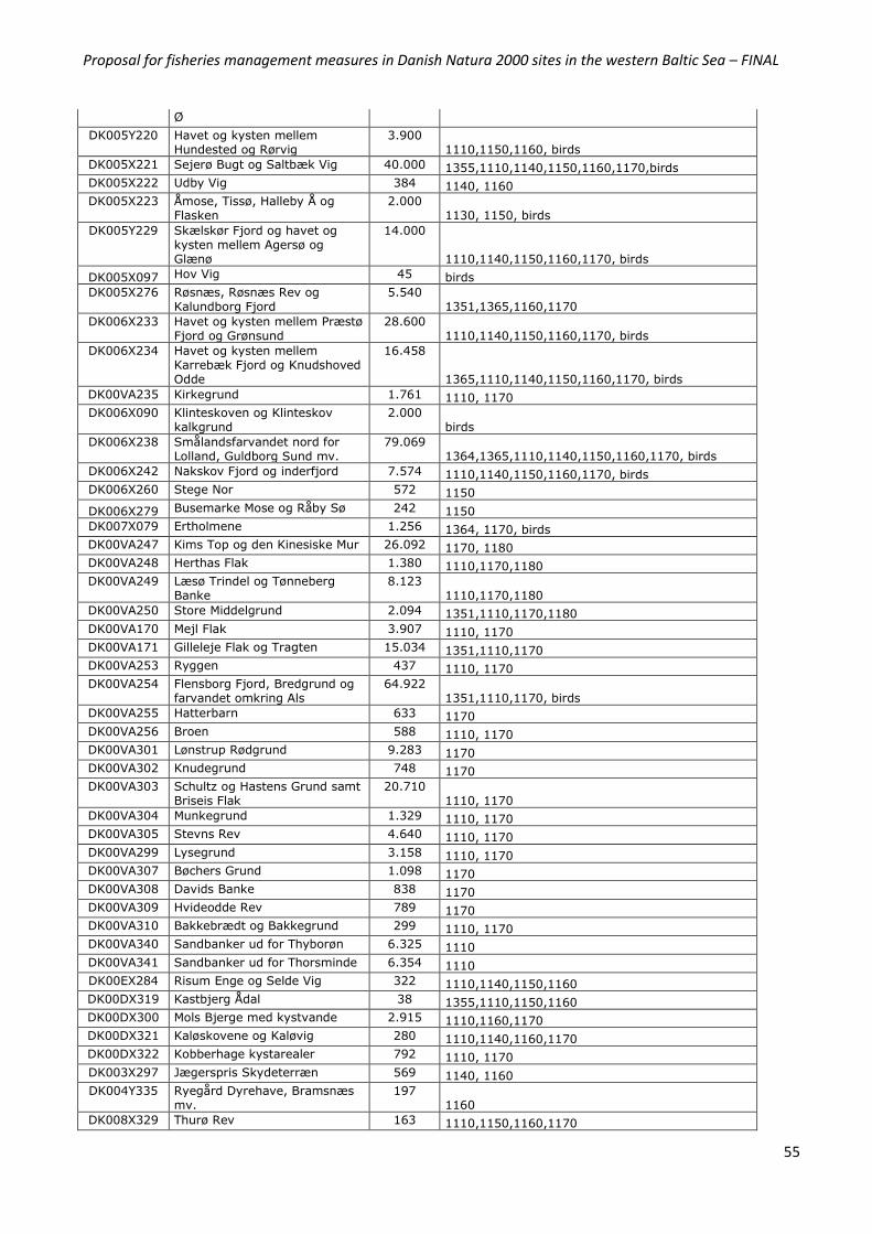
Proposal for fisheries management measures in Danish Natura 2000 sites in the western Baltic Sea – FINAL
55
Ø
DK005Y220 Havet og kysten mellem Hundested og Rørvig
3.900 1110,1150,1160, birds
DK005X221 Sejerø Bugt og Saltbæk Vig 40.000 1355,1110,1140,1150,1160,1170,birds
DK005X222 Udby Vig 384 1140, 1160
DK005X223 Åmose, Tissø, Halleby Å og Flasken
2.000 1130, 1150, birds
DK005Y229 Skælskør Fjord og havet og kysten mellem Agersø og Glænø
14.000
1110,1140,1150,1160,1170, birds
DK005X097 Hov Vig 45 birds
DK005X276 Røsnæs, Røsnæs Rev og Kalundborg Fjord
5.540 1351,1365,1160,1170
DK006X233 Havet og kysten mellem Præstø Fjord og Grønsund
28.600 1110,1140,1150,1160,1170, birds
DK006X234 Havet og kysten mellem Karrebæk Fjord og Knudshoved Odde
16.458
1365,1110,1140,1150,1160,1170, birds
DK00VA235 Kirkegrund 1.761 1110, 1170
DK006X090 Klinteskoven og Klinteskov kalkgrund
2.000 birds
DK006X238 Smålandsfarvandet nord for Lolland, Guldborg Sund mv.
79.069 1364,1365,1110,1140,1150,1160,1170, birds
DK006X242 Nakskov Fjord og inderfjord 7.574 1110,1140,1150,1160,1170, birds
DK006X260 Stege Nor 572 1150
DK006X279 Busemarke Mose og Råby Sø 242 1150
DK007X079 Ertholmene 1.256 1364, 1170, birds
DK00VA247 Kims Top og den Kinesiske Mur 26.092 1170, 1180
DK00VA248 Herthas Flak 1.380 1110,1170,1180
DK00VA249 Læsø Trindel og Tønneberg Banke
8.123 1110,1170,1180
DK00VA250 Store Middelgrund 2.094 1351,1110,1170,1180
DK00VA170 Mejl Flak 3.907 1110, 1170
DK00VA171 Gilleleje Flak og Tragten 15.034 1351,1110,1170
DK00VA253 Ryggen 437 1110, 1170
DK00VA254 Flensborg Fjord, Bredgrund og farvandet omkring Als
64.922 1351,1110,1170, birds
DK00VA255 Hatterbarn 633 1170
DK00VA256 Broen 588 1110, 1170
DK00VA301 Lønstrup Rødgrund 9.283 1170
DK00VA302 Knudegrund 748 1170
DK00VA303 Schultz og Hastens Grund samt Briseis Flak
20.710 1110, 1170
DK00VA304 Munkegrund 1.329 1110, 1170
DK00VA305 Stevns Rev 4.640 1110, 1170
DK00VA299 Lysegrund 3.158 1110, 1170
DK00VA307 Bøchers Grund 1.098 1170
DK00VA308 Davids Banke 838 1170
DK00VA309 Hvideodde Rev 789 1170
DK00VA310 Bakkebrædt og Bakkegrund 299 1110, 1170
DK00VA340 Sandbanker ud for Thyborøn 6.325 1110
DK00VA341 Sandbanker ud for Thorsminde 6.354 1110
DK00EX284 Risum Enge og Selde Vig 322 1110,1140,1150,1160
DK00DX319 Kastbjerg Ådal 38 1355,1110,1150,1160
DK00DX300 Mols Bjerge med kystvande 2.915 1110,1160,1170
DK00DX321 Kaløskovene og Kaløvig 280 1110,1140,1160,1170
DK00DX322 Kobberhage kystarealer 792 1110, 1170
DK003X297 Jægerspris Skydeterræn 569 1140, 1160
DK004Y335 Ryegård Dyrehave, Bramsnæs mv.
197 1160
DK008X329 Thurø Rev 163 1110,1150,1160,1170
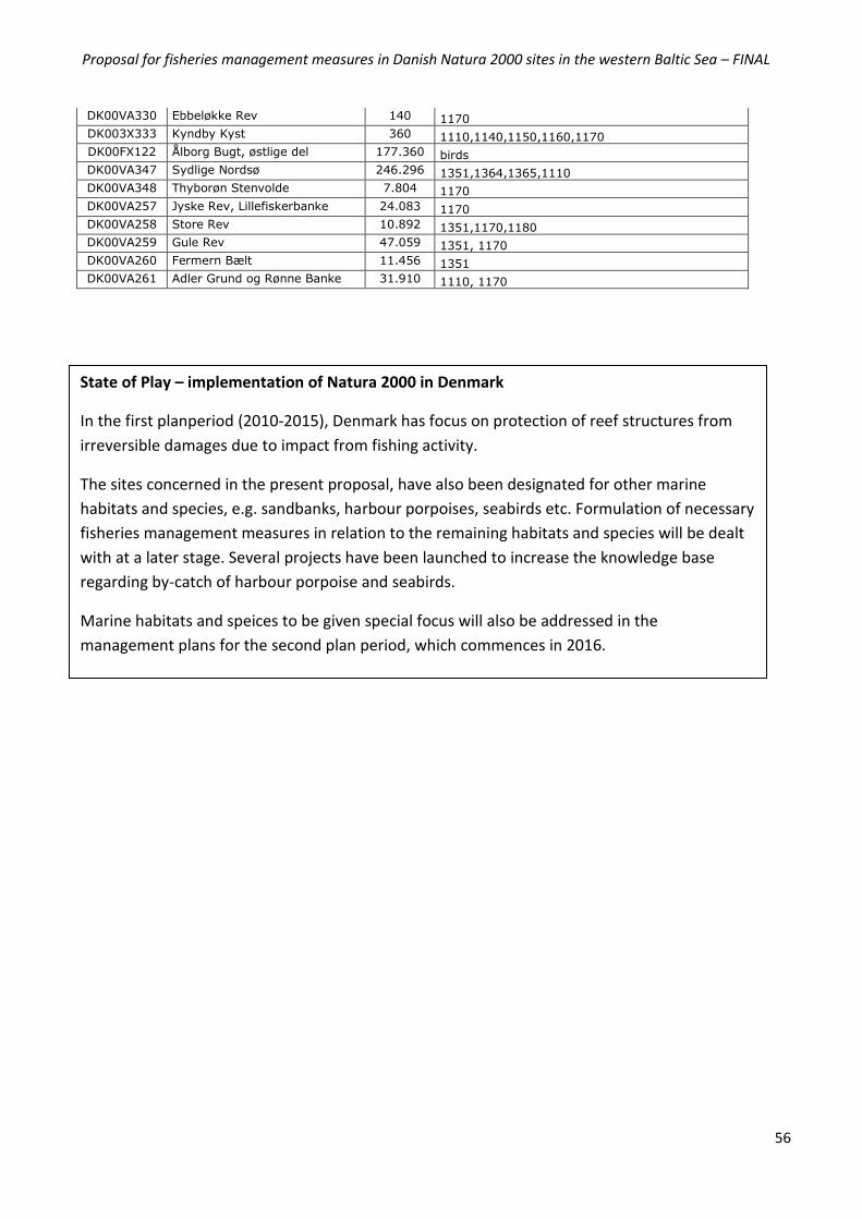
Proposal for fisheries management measures in Danish Natura 2000 sites in the western Baltic Sea – FINAL
56
DK00VA330 Ebbeløkke Rev 140 1170
DK003X333 Kyndby Kyst 360 1110,1140,1150,1160,1170
DK00FX122 Ålborg Bugt, østlige del 177.360 birds
DK00VA347 Sydlige Nordsø 246.296 1351,1364,1365,1110
DK00VA348 Thyborøn Stenvolde 7.804 1170
DK00VA257 Jyske Rev, Lillefiskerbanke 24.083 1170
DK00VA258 Store Rev 10.892 1351,1170,1180
DK00VA259 Gule Rev 47.059 1351, 1170
DK00VA260 Fermern Bælt 11.456 1351
DK00VA261 Adler Grund og Rønne Banke 31.910 1110, 1170
State of Play – implementation of Natura 2000 in Denmark
In the first planperiod (2010-2015), Denmark has focus on protection of reef structures from
irreversible damages due to impact from fishing activity.
The sites concerned in the present proposal, have also been designated for other marine
habitats and species, e.g. sandbanks, harbour porpoises, seabirds etc. Formulation of necessary
fisheries management measures in relation to the remaining habitats and species will be dealt
with at a later stage. Several projects have been launched to increase the knowledge base
regarding by-catch of harbour porpoise and seabirds.
Marine habitats and speices to be given special focus will also be addressed in the
management plans for the second plan period, which commences in 2016.
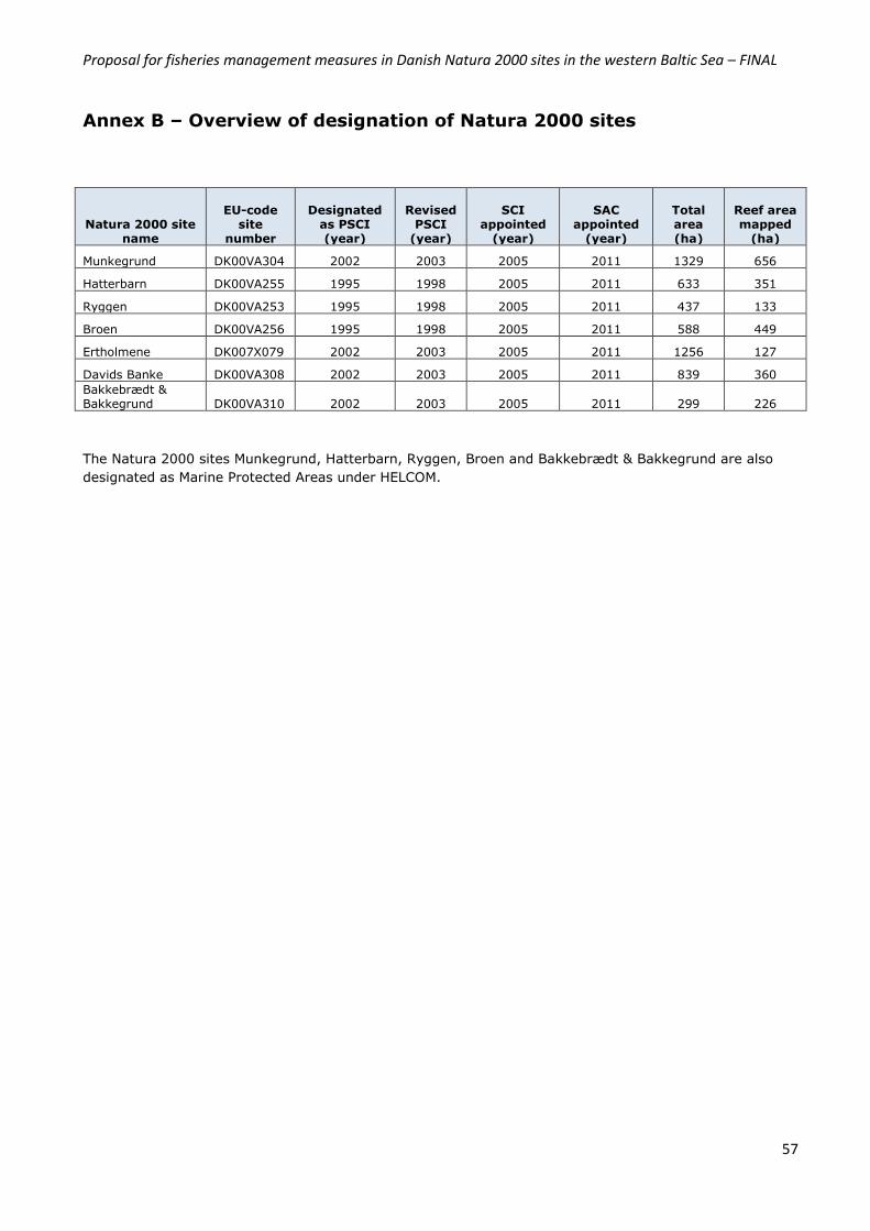
Proposal for fisheries management measures in Danish Natura 2000 sites in the western Baltic Sea – FINAL
57
Annex B – Overview of designation of Natura 2000 sites
Natura 2000 site name
EU-code site
number
Designated as PSCI (year)
Revised PSCI
(year)
SCI appointed
(year)
SAC appointed
(year)
Total area (ha)
Reef area mapped
(ha)
Munkegrund DK00VA304 2002 2003 2005 2011 1329 656
Hatterbarn DK00VA255 1995 1998 2005 2011 633 351
Ryggen DK00VA253 1995 1998 2005 2011 437 133
Broen DK00VA256 1995 1998 2005 2011 588 449
Ertholmene DK007X079 2002 2003 2005 2011 1256 127
Davids Banke DK00VA308 2002 2003 2005 2011 839 360
Bakkebrædt & Bakkegrund DK00VA310 2002 2003 2005 2011 299 226
The Natura 2000 sites Munkegrund, Hatterbarn, Ryggen, Broen and Bakkebrædt & Bakkegrund are also
designated as Marine Protected Areas under HELCOM.
Proposal for fisheries management measures in Danish Natura 2000 sites in the western Baltic Sea – FINAL
58
Annex C – Overview of the 11 information items in Commission
guidelines from 2008
The table below gives an overview of how the present proposal has covered the 11 information items of
the Commission’s guidelines from 200840 concerning development of proposals for fisheries management
measures in marine Natura 2000 within the scope of the CFP.
Section
1. Comprehensive description of the natural features including distribution
within the site
2.3.2, 5.1
2. Scientific rationale for the site´s selection in accordance with the
information provided in the Natura 2000 data form. Intrinsic value of
its features. Specific conservation objectives.
2.3
3. Basis for the spatial extent of the site boundary clearly justified in
terms of conservation objectives.
2.3
4. Threats to habitats and species from different types of fishing gear. List
of other human activities in the area that could damage the habitats.
2.3, 4.1
5. Fleet activity in the area and in the region, distribution of fleets (by
nation, gear and species), and information on target and by-catch
species, all over the last 3 years.
6.1
6. Seasonal trends in fisheries over the last 3 years. 6.2
7. Proposed fisheries management measures to maintain the habitats
features in favourable condition. Are they proportionate and
enforceable? Other conservation measures that apply to the area.
1.2, 1.3, 4, 5.2
8. Control measures envisaged by the Member State, possible ecological
and control buffer zones to ensure site protection and/or effective
control and monitoring measures.
6.4
9. Measures to monitor and assess the maintenance and/or recovery of
the features within the site.
6.4
10. Coordination with neighbouring Member States as appropriate. 3.2
11. Evaluation of possible displacement of fishing effort and impact on new
areas.
6.3
40 Fisheries measures for marine Natura 2000 sites – a consistent approach to requests for fisheries management measures under the Common Fisheries Policy: http://ec.europa.eu/environment/nature/natura2000/marine/docs/fish_measures.pdf
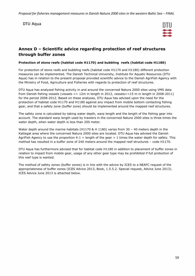
Proposal for fisheries management measures in Danish Natura 2000 sites in the western Baltic Sea – FINAL
59
Annex D – Scientific advice regarding protection of reef structures
through buffer zones
Protection of stone reefs (habitat code H1170) and bubbling reefs (habitat code H1180)
For protection of stone reefs and bubbling reefs (habitat code H1170 and H1180) different protection
measures can be implemented. The Danish Technical University, Institute for Aquatic Resources (DTU
Aqua) has in relation to the present proposal provided scientific advice to the Danish AgriFish Agency with
the Ministry of Food, Agriculture and Fisheries with regards to protection of reef structures.
DTU Aqua has analyzed fishing activity in and around the concerned Natura 2000 sites using VMS data
from Danish fishing vessels (vessels => 12m in length in 2012, vessels>=15 m in length in 2008-2011)
for the period 2008-2012. Based on these analyses, DTU Aqua has advised upon the need for the
protection of habitat code H1170 and H1180 against any impact from mobile bottom contacting fishing
gear, and that a safety zone (buffer zone) should be implemented around the mapped reef structures.
The safety zone is calculated by taking water depth, warp length and the length of the fishing gear into
account. The standard warp length used by trawlers in the concerned Natura 2000 sites is three times the
water depth, when water depth is less than 200 meter.
Water depth around the marine habitats (H1170 & H 1180) varies from 30 – 40 meters depth in the
Kattegat area where the concerned Natura 2000 sites are located. DTU Aqua has advised the Danish
AgriFish Agency to use the proportion 4:1 + length of the gear + 1 times the water depth for safety. This
method has resulted in a buffer zone of 240 meters around the mapped reef structures – code H1170.
DTU Aqua has furthermore advised that for habitat code H1180 in addition to placement of buffer zones in
relation to impact from mobile gear, usage of any other gear type may be prohibited if full protection of
this reef type is wanted.
The method of safety zones (buffer zones) is in line with the advice by ICES to a NEAFC request of the
appropriateness of buffer zones (ICES Advice 2013, Book, 1.5.5.2. Special request, Advice June 2013).
ICES Advice June 2013 is attached below.
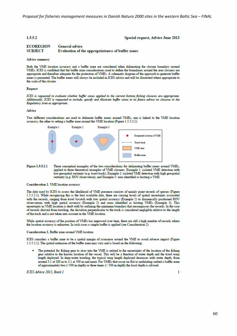
Proposal for fisheries management measures in Danish Natura 2000 sites in the western Baltic Sea – FINAL
60
Proposal for fisheries management measures in Danish Natura 2000 sites in the western Baltic Sea – FINAL
61
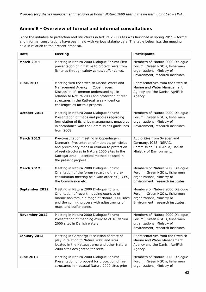
Proposal for fisheries management measures in Danish Natura 2000 sites in the western Baltic Sea – FINAL
62
Annex E - Overview of formal and informal consultations
Since the initiative to protection reef structures in Natura 2000 sites was launched in spring 2011 – formal
and informal consultations have been held with various stakeholders. The table below lists the meeting
held in relation to the present proposal.
Date Meeting Participants
March 2011 Meeting in Natura 2000 Dialogue Forum: First
presentation of initiative to protect reefs from
fisheries through safety zones/buffer zones.
Members of ‘Natura 2000 Dialogue
Forum’: Green NGO’s, fishermen
organizations, Ministry of
Environment, research institutes.
June, 2011 Meeting with the Swedish Marine Water and
Management Agency in Copenhagen:
Discussion of common understandings in
relation to Natura 2000 and protection of reef
structures in the Kattegat area – identical
challenges as for this proposal.
Representatives from the Swedish
Marine and Water Management
Agency and the Danish AgriFish
Agency.
October 2011 Meeting in Natura 2000 Dialogue Forum:
Presentation of maps and process regarding
formulation of fisheries management measures
in accordance with the Commissions guidelines
from 2008.
Members of ‘Natura 2000 Dialogue
Forum’: Green NGO’s, fishermen
organizations, Ministry of
Environment, research institutes.
March 2012 Pre-consultation meeting in Copenhagen,
Denmark: Presentation of methods, principles
and preliminary maps in relation to protection
of reef structures in Natura 2000 sites in the
Kattegat area – identical method as used in
the present proposal.
Authorities from Sweden and
Germany, ICES, NSRAC,
Commission, DTU Aqua, Danish
Ministry of Environment.
March 2012 Meeting in Natura 2000 Dialogue Forum:
Orientation of the forum regarding the pre-
consultation meeting held with other MS, ICES,
the Commission etc.
Members of ‘Natura 2000 Dialogue
Forum’: Green NGO’s, fishermen
organizations, Ministry of
Environment, research institutes.
September 2012 Meeting in Natura 2000 Dialogue Forum:
Orientation of recent mapping exercise of
marine habitats in a range of Natura 2000 sites
and the coming process with adjustments of
maps and buffer zones.
Members of ‘Natura 2000 Dialogue
Forum’: Green NGO’s, fishermen
organizations, Ministry of
Environment, research institutes.
November 2012 Meeting in Natura 2000 Dialogue Forum:
Presentation of mapping exercise of 18 Natura
2000 sites in Danish waters.
Members of ‘Natura 2000 Dialogue
Forum’: Green NGO’s, fishermen
organizations, Ministry of
Environment, research institutes.
January 2013 Meeting in Göteborg: Discussion of state of
play in relation to Natura 2000 and sites
located in the Kattegat area and other Natura
2000 sites designated for reefs.
Representatives from the Swedish
Marine and Water Management
Agency and the Danish AgriFish
Agency.
June 2013 Meeting in Natura 2000 Dialogue Forum:
Presentation of proposal for protection of reef
structures in 4 coastal Natura 2000 sites prior
Members of ‘Natura 2000 Dialogue
Forum’: Green NGO’s, fishermen
organizations, Ministry of
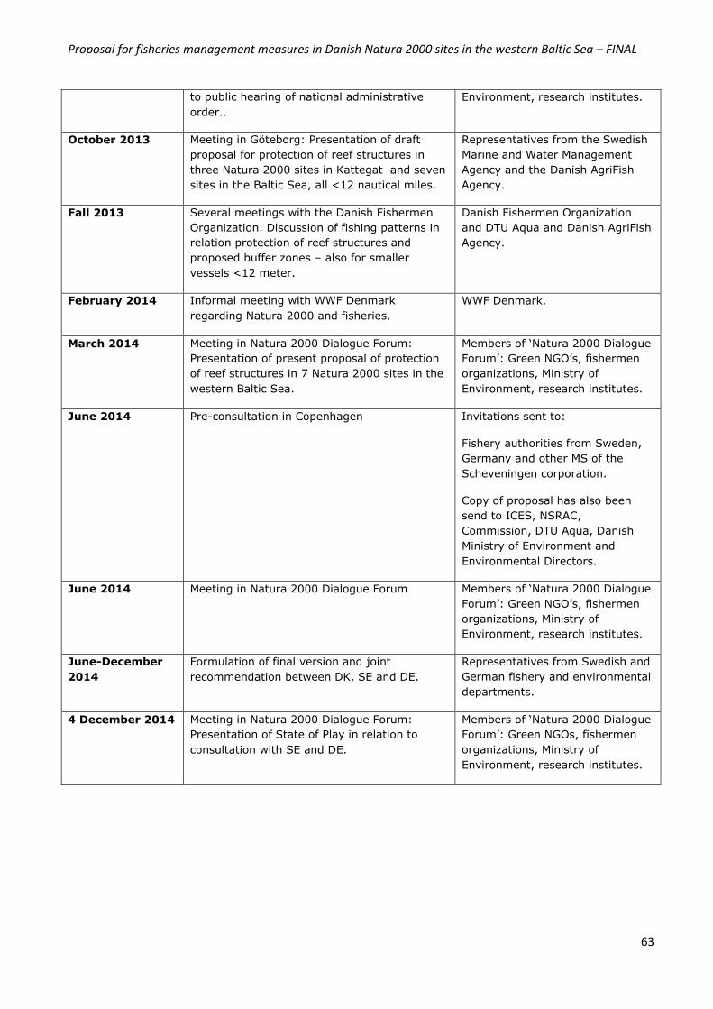
Proposal for fisheries management measures in Danish Natura 2000 sites in the western Baltic Sea – FINAL
63
to public hearing of national administrative
order..
Environment, research institutes.
October 2013 Meeting in Göteborg: Presentation of draft
proposal for protection of reef structures in
three Natura 2000 sites in Kattegat and seven
sites in the Baltic Sea, all <12 nautical miles.
Representatives from the Swedish
Marine and Water Management
Agency and the Danish AgriFish
Agency.
Fall 2013 Several meetings with the Danish Fishermen
Organization. Discussion of fishing patterns in
relation protection of reef structures and
proposed buffer zones – also for smaller
vessels <12 meter.
Danish Fishermen Organization
and DTU Aqua and Danish AgriFish
Agency.
February 2014 Informal meeting with WWF Denmark
regarding Natura 2000 and fisheries.
WWF Denmark.
March 2014 Meeting in Natura 2000 Dialogue Forum:
Presentation of present proposal of protection
of reef structures in 7 Natura 2000 sites in the
western Baltic Sea.
Members of ‘Natura 2000 Dialogue
Forum’: Green NGO’s, fishermen
organizations, Ministry of
Environment, research institutes.
June 2014 Pre-consultation in Copenhagen Invitations sent to:
Fishery authorities from Sweden,
Germany and other MS of the
Scheveningen corporation.
Copy of proposal has also been
send to ICES, NSRAC,
Commission, DTU Aqua, Danish
Ministry of Environment and
Environmental Directors.
June 2014 Meeting in Natura 2000 Dialogue Forum Members of ‘Natura 2000 Dialogue
Forum’: Green NGO’s, fishermen
organizations, Ministry of
Environment, research institutes.
June-December
2014
Formulation of final version and joint
recommendation between DK, SE and DE.
Representatives from Swedish and
German fishery and environmental
departments.
4 December 2014 Meeting in Natura 2000 Dialogue Forum:
Presentation of State of Play in relation to
consultation with SE and DE.
Members of ‘Natura 2000 Dialogue
Forum’: Green NGOs, fishermen
organizations, Ministry of
Environment, research institutes.
Proposal for fisheries management measures in Danish Natura 2000 sites in the western Baltic Sea – FINAL
64
Annex F Summary of outcome of the regional coordination process
Summary of the first meeting in the established ad hoc working group (DK, SE & DE) held on 27 August 2014 at the Danish AgriFish Agency in Copenhagen
Following the pre-consultation meeting on 26 June 2014, where the Danish AgriFish Agency
presented their proposals for Danish fisheries management measures for 10 Natura 2000 sites
(sites where other Member States have direct management interests), the first meeting in the
established ad hoc working group was scheduled.
The two Danish proposals cover fisheries management measures for the protection of reef
structures in 10 Natura 2000 sites; 3 sites in the Kattegat (North Sea) and 7 sites in the
western Baltic Sea, respectively.
Since the June pre-consultation meeting in Copenhagen, the two proposals have been in
consultation in both Germany and Sweden – though due to holiday etc. no specific or detailed
comments were forwarded by the two member states prior to the first meeting in the ad hoc
working group. Therefore, focus for the first meeting in the ad hoc working group was on a
discussion of whether data and information provided in the two draft proposals is sufficient and
whether there is a need for a third scientific review.
The European Commission did not attend the August meeting in the ad hoc working group. The
EU Commission (DG MARE and DG ENVI) have been highly involved in the process of
formulating the two proposals. There was an agreement among SE, DE and DK on the need for
the participation of the Commission at the coming meetings, where draft joint recommendations
are to be discussed.
Terms of Reference for regional coordination in the North Sea and Baltic Sea, respectively
DE gave a brief orientation of the status for the task of drafting Terms of References (ToR) for
the Technical Expert Group in relation to fisheries management measures in the context of
Natura 2000 within the Scheveningen group. The draft ToR was discussed in the July meeting in
Berlin with the purpose of joint acceptance of the document; one delegation however abstained
from accepting the last paragraph in the draft (paragraph on ‘Approval’). The ToR in its current
form will be discussed by the Fisheries Directors in the upcoming meeting in the Scheveningen
group (medio September 2014).
DK highlighted, that it is merely a question of whom each MS designates and thereby provides
the mandate in the situation of signing a joint recommendation. A joint recommendation can
only be obtained if all MS agree. DK briefly gave an orientation of status of the ToR in relation to
the BALTFISH group, which is also currently being drafted. DK, as the coordinator, has focus on
streamlining this ToR as much as possible with the ToR agreed upon for the Scheveningen group
in relation to Natura 2000/ MPA’s.
Proposal for fisheries management measures in Danish Natura 2000 sites in the western Baltic Sea – FINAL
65
Copy of the Agenda
1. Welcome/ by The Danish AgriFish Agency
2. Orientation of outcome of stakeholders views on the Danish proposals (national NGO´s
and AC´s)
3. Discussion of the Danish proposals
a) Proposal for changes to the two documents: Suggestions from SE and DE to be
discussed
b) Data and information: is there a need for more data and information?
c) Scientific advice: is there a need for a third peer-review?
d) Timeframe: clarification regarding national process in SE and DE
4. Further process and meetings in the ad hoc working group: possible topics and
timeframe.
Outcome of the discussion on the two Danish proposals for fisheries
management measures
1. Proposals for changes to the two documents
Prior to the first meeting in the ad hoc working group, SE and DE were invited to forward
comments to the two draft proposals. In a parallel process, national stakeholders and the two
Advisory Councils for the Baltic Sea and the North Sea, respectively, were also invited to
forward their comments.
Prior to the first meeting in the ad hoc working group, a summary of comments received from
national stakeholders (NGO’s and the Danish Fishermen Association) and the two AC’s (NSAC
and BSAC), had been forwarded to SE and DE. The summary will be included in the two
proposals as an annex, Annex F (the same as for any comments given by MS). The comments
received from the above mentioned stakeholders primarily centers around definitions of stone
and biogenic reef structures, mapping of reef structures as well as how the Danish Natura 2000
sites have been designated, and the objective of focused measures, whereby only the reef
structure is protected.
A copy of the comments received will be forwarded to SE and DE after the meeting.
SE and DE had not prior to the meeting forwarded any specific comments/ suggestions for
changes to the two proposals. SE asked for more time to analyze the proposals. SE, however,
found the available fishery data sufficient and adequate.
DK is aware of the challenges with vessels < 12 meter. Dialogue with the Danish Fishermen
Association indicates, that smaller vessels more or less have a similar fishing pattern as larger
vessels. After implementation of the proposed management measures, DK will assess if there is
a need for more initiatives to handle these challenges, e.g. technical equipment on board, as
stated in the two proposals under section 6.4.
DE found the proposals well written and fishery data and analyses sufficient. DE is currently
discussing the Danish proposals with stakeholders.
Proposal for fisheries management measures in Danish Natura 2000 sites in the western Baltic Sea – FINAL
66
2. Data and information
The Danish delegation sought to clarify the need for further data and information in the
proposals, before preparing a joint recommendation.
DE was satisfied with the proposals in their present form, especially, since DK very closely has
followed the suggestions given by DG ENVI and DG MARE. DE does not see the need for further
additional information or data for either of the two proposals.
SE found no need for additional data and information. SE, however, still have a need for further
analysis of the proposals, as well as time for a national process. SE asked whether data for
smaller vessels is included in the analyses carried out. DTU Aqua confirmed that the log book
data for smaller vessels is included. SE is also yet to finalize the dialogue with the fishing
industry before SE can agree to a joint recommendation.
3. Scientific advice: is there a need for a third peer-review?
SE and DE are satisfied with the two peer-reviews. However, DE will confirm their final position
next week.
The Swedish delegation had no comments to the scientific advice, which had been thoroughly
read by SLU (Swedish University of Agricultural Sciences). SE asked whether DK also sought to
link the protection under the Habitats Directives with the obligations under MSFD, HELCOM and
OSPAR.
DK and DE both pointed out, that there for the time being are no legal obligations under the
MSFD, and the HELCOM and OSPAR are not legally binding agreements. DK stated that the
proposed management measures proposals solely seek to fulfill the obligations under the
Habitats Directive. The initiative to protect reef structures is one among several initiatives to
obtain ‘Good Environmental Status’. Thus, the proposed management measures will, at a later
stage play a role in the MSFD. SE finds that the link between Natura 2000 and MFSD, including
obligations within HELCOM and OSPAR, should be discussed further – however, not necessarily
in the ad hoc working group concerning the Danish proposals, but preferably within the expert
group that will be established within the Scheveningen and BALTFISH groups.
Agreement – proposals for changes to text
It was agreed with SE and DE that prior to the second meeting on 30 September 2014,
suggestions for changes to the text (editorial) should be forwarded. Alternatively, any
suggestions to text changes could be presented by SE and DE at the meeting, however, the
final wording etc. must be agreed upon at the third meeting scheduled for 5 November 2014.
Agreement – data and information
It was agreed that data and information is adequate and sufficient. There is therefore no
further need for additional data concerning fisheries.
Proposal for fisheries management measures in Danish Natura 2000 sites in the western Baltic Sea – FINAL
67
4. Timeframe and clarification regarding national process in SE and DE
The tentative timeframe which had been forwarded prior to the meeting seemed to be a bit
optimistic, in light of the fact, that there are yet comments to be forwarded from both Germany
and Sweden to the two draft proposals. During the meeting, the timeframe was edited and – the
second and third scheduled meetings in the ad hoc working group were moved. The second
meeting will be held on the 30 September 2014. A date for the third meeting has been set to 5
November 2014.
The Danish delegation hopes to forward a joint recommendation to the European Commission
within 2014, so the timeframe is quite stringent. To reach the joint recommendations all MS
need to have mandate/political approval. Both the German and the Swedish delegations
informed that there is no need for a parliamentary process in their countries in this regard.
SE and DE complimented the two Danish proposals for being comprehensive and based on
relevant principles and rationale. The extent of data and information in the two proposals were
agreed upon to be sufficient.
Both delegations, however, need to have further national discussions both between ministries
(fishery and environment) and with the industry, before any potential comments or support to a
joint recommendation can be given.
It was agreed upon, that at the next meeting on 30 September 2014 any comments from the
two delegations should preferably be forwarded to the Danish AgriFish Agency prior to the
meeting (latest by 23 September 2014).
The second meeting in the ad hoc working group will address any editorial changes and
hopefully go one step further in reaching a joint recommendation for the two proposals. The
Danish AgriFish Agency will prepare a draft joint recommendation and forward to all participants
before the second meeting on 30 September 2014 – latest by 18 September 2014.
Agreement – scientific advice
It was agreed that there is no need for a third scientific advice.
Furthermore it was stated that the overall objective of the Danish proposals for fisheries
management measures are to fulfill the obligations under the Habitats Directive.
Agreement – timeframe and clarification regarding national process in SE and DE
It was agreed that a tentative timeframe be forwarded with the summary.
In DE, the final agreement to the Danish proposals will be given at Agency level in coordination
with the respective ministries. In SE, an agreement on a joint recommendation will be
approved by the Swedish government. The Parliament in SE and DE do not need to approve of
the Danish proposals.
Proposal for fisheries management measures in Danish Natura 2000 sites in the western Baltic Sea – FINAL
68
List of attending participants
Sweden: Swedish Agency for Marine and Water Management: Karin Bjerner, Lena
Tingström
Germany: Federal Ministry of Food&§ Agriculture (Fisheries): Bruno Hoffstadt
Denmark: Danish Technical University / Institute of Aquatic Ressources: Josefine Egekvist
Ministry of Food, Agriculture and Fisheries / Danish AgriFish Agency: Elsbeth
Teichert, Anja Gadgård Boye, Pernille Birkenborg Jensen (ref.)
Summary of the second meeting in the established ad hoc working group (DK,
SE & DE) held on 5 November 2014 at the Danish AgriFish Agency in
Copenhagen
The second meeting in the ad hoc group was held on 5 November 2014, since the planned
meeting on 30 Septemberr 2014 was cancelled.
As the initiating Member State, the Danish AgriFish Agency had called for the meeting in order
to finalize the draft proposals for fisheries management measures in 10 Natura 2000 sites
located in the North Sea (3 sites) and Baltic Sea (7 sites), respectively as well as to launch the
discussions on the forwarded draft joint recommendations.
The European Commission did not attend the second meeting in the ad hoc working group. SE
reiterated the importance of the participation of the Commission in the process. DK and DE were
of the same view.
Copy of the agenda
1. Welcome/ by the Danish AgriFish Agency
2. Orientation of outcome of national process in Sweden and Germany with stakeholders
3. Discussion of the draft proposals
e) Text changes suggested by the Danish AgriFish Agency, Sweden and Germany
4. Discussion of draft Joint Recommendations
As agreed upon in the 1. Meeting in the ad hoc working group, the Danish AgriFish
Agency has formulated two draft Joint Recommendations as a basis for the discussion
5. Further process and meetings
6. A.O.B.

Proposal for fisheries management measures in Danish Natura 2000 sites in the western Baltic Sea – FINAL
69
Outcome of the discussions on the two Danish proposals for fisheries management
measures and draft joint recommendations
1. Welcome
Prior to the meeting the Danish AgriFish Agency had forwarded revised versions of the draft
proposals containing the proposed editorial changes forwarded by Sweden and Denmark.
On 4 November 2014 the Danish AgriFish Agency forwarded revised versions of table 1 in order
to include a ban for ‘seines’ falling in the category of mobile bottom contacting gears in areas
mapped as reefs (H1170). The gear type ‘dredges’ has also been included – yet this gear type is
not allowed in the Natura 2000 sites concerned for Danish fishermen. However, the aim of
revising table 1 is to list all gear codes for the gears categorized as mobile bottom contacting
gears in the habitats addressed in the proposals.
SE and DE welcomed the Danish initiative to include ‘Seines’ as given in the revised table 1.
2. Orientation of outcome of national process in Sweden and Germany with
stakeholders
As agreed in the first meeting in the ad hoc group, SE and DE were to give a status regarding
the national process of the consultation of their national fishermen organizations/associations.
SE has consulted the Swedish fishermen organization. The Swedish fishermen organization has
no additional comments to the Danish proposals besides the comments forwarded by the
Advisory Councils for the Baltic Sea and the North Sea, respectively.
The German Federal Ministry of Food, Agriculture and Consumer Protection has consulted the
German fishing industry. Until now, no comments have been forwarded to the ministry.
3. Discussion of the draft proposals
The draft proposal for the Kattegat/North Sea was discussed in detail. DK would like the two
proposals to be finalized within the coming weeks, since SE and DE have had the proposals
since early June 2014.
Editorial changes to the text were made at the meeting. Text was added to the summary to
include the national consultation of fishermen organizations/associations in all three countries
and the consultation of the ACs and NGOs by DK. Text was also added to section 6.4.1 ‘Control,
Agreement –consultation of fishermen organizations/ associations, AC’s and NGO’s
It was agreed that i) a consultation of the fishermen organizations/associations have taken
place in the three countries, ii) the two AC’s have been consulted /no changes in the proposals
have been done but we have discussed and analyzed their comments, iii) NGOs have been
consulted by DK (WWF, OCEANA, Greenpeace & national NGOs in DK as well).
The consultation of the Swedish and German fishermen organizations/associations did not
result in changes to the two proposals.
Proposal for fisheries management measures in Danish Natura 2000 sites in the western Baltic Sea – FINAL
70
enforcement and monitoring to clarify that the current model based on VMS is assessed
sufficiently in relation to control and monitoring of the proposed fisheries management
measures and to meet the requirements in the 11 points of the Commission’s Guidelines. In
case a re-evaluation assesses the need for more technical equipment (e.g. in the form of
sensors and GPS), such a requirement must be coordinated in accordance with Article 11 & 18.
Text regarding appointment of the 10 Natura 2000 sites as HELCOM and OSPAR sites will be
added to Annex B. Headline of Annex F was changed to ‘Summary of outcome of regional
coordination process’.
Besides the editorial changes made to the North Sea proposal, there were no additional
corrections to be made to the Baltic Sea proposal. The Danish AgriFish Agency will include all
the editorial changes agreed on for the North Sea proposal to the proposal for the Baltic Sea.
SE underlined that the proposals are part of a regional process initiated by DK. The concerned
fisheries management measures are proposed by the Danish Government in accordance with
the Danish management plans for Natura 2000 and should been seen as a step towards
achieving favorable conservation status for the marine habitat reefs (H1170 and H1180). The
Danish approach should, however, not be regarded as precedent for other conservation
measures regarding fisheries initiated by other Member States. Thus, other Member States will
propose measures in accordance with their perception of necessary actions to be taken in
relation to the implementation of the Habitats Directive and protection of marine habitats and
species from fisheries. The group agreed upon this point referring to the basis of the articles 11
and 18.
4. Discussion of the draft Joint Recommendations
The forwarded two draft Joint Recommendations were discussed. Editorial changes were made
to the introduction and section 2 regarding ‘seines’ and gear groups to be banned in areas
mapped as reefs (H1170 & H1180). Regarding section 3 on ‘Control and enforcement of
proposed fisheries management measures’, it was agreed that DK should consult the
Commission, whether this section is to be included in a Joint Recommendation.
Agreement –discussion of the draft proposals
It was agreed that the wording of the two proposals with the agreed editorial changes reflect
the process and outcome of stakeholder involvement (fishermen, NGOs, ACs etc.) as well as
the discussions in the ad hoc working group.
The proposed changes to table 1 and section 1.3 were agreed upon.
The final proposals will be forwarded to the ad hoc working group on 7 November 2014 for a
very last consultation. Deadline for forwarding comments was set to 21 November 2014.
Proposal for fisheries management measures in Danish Natura 2000 sites in the western Baltic Sea – FINAL
71
5. Further process and meetings
The Danish AgriFish Agency will consult the Commission regarding the Danish proposals
regarding the Commission’s view on the wording of Joint Recommendations.
List of attending participants
Sweden: Swedish Agency for Marine and Water Management: Malin Wilhelmsson, Lena
Tingström
Germany: Federal Ministry of Food & Agriculture & Consumer Protection (Fisheries): Bruno
Hoffstadt
Federal Ministry of Environment: Lothar Fiedler
Denmark: Danish Technical University / Institute of Aquatic Resources: Josefine Egekvist
Danish Nature Agency: Marie-Louise Krawack
Ministry of Food, Agriculture and Fisheries / Danish AgriFish Agency: Elsbeth
Teichert, Anja Gadgård Boye, Pernille Birkenborg Jensen.
Agreement –discussion of the draft Joint Recommendations
It was agreed that the wording of the two Joint Recommendations with the agreed editorial
changes reflect the measures proposed to be regulated in the 10 Natura 2000 sites.
DK will consult the Commission regarding the section on Control and Enforcement and whether
the section should be part of a joint recommendation.
Revised Joint Recommendations will be forwarded to the ad hoc working group on 7 November
2014 for a very last consultation. Deadline for forwarding comments was set to 21 November
2014.
Agreement –further process and meetings
It was agreed that the third meeting in the ad hoc working groups will be held on 1 December
2014 in Copenhagen.
The final proposals and revised Joint Recommendations will be forwarded to the ad hoc
working group on 7 November 2014 for a very last consultation. Deadline for forwarding
comments was agreed to be set to 21 November 2014.
Proposal for fisheries management measures in Danish Natura 2000 sites in the western Baltic Sea – FINAL
72
Summary of the third meeting in the established ad hoc working group (DK, SE & DE) held on 3 December 2014 at the Danish AgriFish Agency in
Copenhagen
The third meeting in the ad hoc group was held on 3 December 2014.
As the initiating Member State, the Danish AgriFish Agency had called for the meeting in order
to finalize the draft joint recommendations. The meeting was held as a skype meeting between
Denmark and Sweden, since Germany, prior to the meeting, had communicated that Germany
abstains and thereby do not hinder Denmark and Sweden from jointly recommending the
proposed fisheries management measures.
Copy of the agenda
1. Outcome of meeting with DG ENVI and DG MARE
2. Discussion of Joint Recommendations – section 3 ‘Control and enforcement’
3. Discussion of timeframe for finalizing the joint recommendations – Dk’s deadline is
submission to the Commission before Christmas.
4. National process in DK
5. National process in SE
6. A.O.B.
1. Outcome of the meeting the Danish AgriFish Agency had with DG ENVI and DG
MARE on 25 November 2014
The Danish AgriFish Agency had requested for a meeting with the Commission regarding the
Danish proposals and draft joint recommendations. From the Commission Fotios Papoulias (DG
ENVI) and Marta Janakakisz (DG MARE) participated in the meeting.
The two proposals were discussed with the Commission. The Commission did not have additional
questions and request for text, data etc. regarding the two proposals besides a request for a
text box regarding state of play in relation to the implementation of Natura 2000 in Denmark. A
text box has therefore been added to Annex A. Sweden has approved of the wording of the text
box as this is in line with the Swedish comments.
Regarding the draft Joint recommendation, the Danish AgriFish Agency had requested for a
discussion on form, format and content. In section three, on Control and Enforcement, the
Agency wanted a clarification from the Commission whether to leave the section in or out of the
Joint recommendation
The Commission found the joint recommendation sufficient regarding information etc. DG MARE
found that section 3 should remain in the joint recommendation and clearly state in the first
paragraph, that no additional requirements in relation to control and enforcement are proposed.
Section 3 of the joint recommendation has been amended as has section 6.4 in order to
streamline the wording.
Proposal for fisheries management measures in Danish Natura 2000 sites in the western Baltic Sea – FINAL
73
There was a short discussion regarding Germany’s position of abstaining. The Danish AgriFish
Agency refereed to the pelagic discard ban, where Denmark also abstained to join the additional
recommendation and thereby did not hinder the formation of consensus according to the MoU
for the Scheveningen corporation. A similar agreement is found in the MoU of the BALTFISH
corporation.
The Danish AgriFish Agency informed the Commission, that the Danish proposals are planned
submitted late December 2014 or early January 2015.
2. Discussion of the Joint Recommendations
There was a short discussion of the draft Joint Recommendations. Sweden agreed to the new
wording of part of section 3.
3. Discussion of timeframe for finalizing the joint recommendations
4 & 5. National process in DK and SE
DK is in the process of briefing Parliament and relevant committees.
SE informed that once the Joint recommendation have been agreed upon at a technical level, a
formal procedure can be launched.
7. A.O.B
No matters were raised.
Agreement – joint recommendations
It was agreed that the joint recommendations be forwarded once again for a last check and
approval at the technical level.
Once the ad hoc group has agreed on the wording – the Joint Recommendations are to be
formally agreed before being presented to the HLG of the BALTFISH and Scheveningen
corporations, respectively.
Agreement – timeframe
It was agreed that DK forward the joint recommendations containing the revised text/ wording
of section 3 for a last check and approval at the technical level.
Once SE has agreed at the technical level – the joint recommendations are to be forwarded to
the members of the ad hoc working group for formal procedure prior to being forwarded to the
HLG (BALTFISH/ Scheveningen) before being submitted to the Commission.
DK hopes to forward the Joint Recommendations to the HLG before Christmas – or by early
January 2015.
Proposal for fisheries management measures in Danish Natura 2000 sites in the western Baltic Sea – FINAL
74
List of attending participants
Sweden: Swedish Agency for Marine and Water Management: Malin Wilhelmsson, Lena
Tingström
Denmark: Ministry of Food, Agriculture and Fisheries / Danish AgriFish Agency: Anja
Gadgård Boye, Pernille Birkenborg Jensen.

Proposal for fisheries management measures in Danish Natura 2000 sites in the western Baltic Sea – FINAL
75
Annex G Summary of outcome of consultation with the Advisory
Councils for the North Sea and Baltic Sea, respectively, and the Natura
2000 Dialogue Forum
National stakeholders and Advisory Councils received the Danish proposals for fisheries management
measures on 10 June 2014 for commenting. Deadline for forwarding comments was set to 18 July 2014.
Comments have been received from the following NGO’s, organizations, etc.:
- WWF Denmark
- OCEANA
- GREENPEACE
- Danish Society for Nature Conservation (DN)
- Danish Fishermen Association (DFPO)
- Advisory Council Baltic Sea
- Advisory Council North Sea
A summary of the comments received in relation to the proposed fisheries management measures is given
below.
NGOs (WWF, OCEANA, GREENPEACE & DN)
The green NGOs in Denmark have jointly submitted their comments. The green NGOs welcome the Danish
initiative and stress the importance of adequate protection of reef structures in Natura 2000 sites.
The green NGOs request the parameters below be taken into account:
- the Natura 2000 areas to be fully closed to fishing activities with mobile bottom contacting gears
- for some areas to be partly or fully closed to all fishing activities – particular those areas containing
the most vulnerable habitats
- that Denmark provides incentives and strategically supports the fisheries using low-impact gear, for
instance by supporting small-scale low impact fisheries under EMFF or by using criteria for allocating
of fishing opportunities as dictated in Article 17 of the new CFP.
The green NGOs find the Danish proposals too unambitious and not sufficient to protect the marine
environment. More focus should be given to habitat functions and characteristic plants and animals that
belong to reef structures. Larger areas in which fisheries is restricted should therefore be persued, which
would also take sandbanks (H1110) into account.
The green NGOs also argue that the definition used in relation to reef structures does not take all relevant
reef structures into account. This discussion has been taking place over the last 2-3 years between the green
NGOs and the Danish Ministry of Environment.
The green NGOs highlight control and enforcement of small areas as a challenge, and ask for clarification of
gear types to be prohibited.
Proposal for fisheries management measures in Danish Natura 2000 sites in the western Baltic Sea – FINAL
76
Danish Fishermen Association (DFPO)
The Danish Fishermen Association welcomes the Danish proposals and foresee little or no conflict with
current fishing activities. DFPO highlights the importance of focused management measures, which takes
into account the technical equipment fishermen make use of in their fishing activities, enabling them to at
any given time to know their precise location.
Buffer zones should be site specific and should take fishing pattern into account. Thus, smaller buffer zones
should be a possibility in those circumstances where fishing activities are restricted in areas where fishing
patterns show straight trawl lines. Only in these circumstances should a reduced buffer zone be a possibility.
This approach is especially important for coastal sites, since small-scale fishermen cannot necessarily move
to other fishing grounds. An example is the Natura 2000 site “Læsø Trindel & Tønneberg Banke”, where
vessels below 12 meters have some activities.
DFPO also stress close dialogue and transparency as important elements in these processes of formulation of
fisheries management measures. DFPO questions the Danish approach to protect reef structures outside the
Natura 2000 sites and finds no explanation thereof in the proposals.
Finally, DFPO argues that catch values can be underestimated by up to 10 pct. Estimates of catch values
should therefore be used with some caution.
Advisory Councils (Baltic Sea & North Sea, respectively)
The Advisory Council – Baltic Sea, welcomes the Danish proposals and is looking forward to following and
contributing to the process of finalizing the two proposals. No specific comments were submitted.
The Advisory Council – North Sea, also welcomes the Danish initiative. The comments submitted by the
Advisory Council for the North Sea do not contain additional comments compared to the comments
submitted by the Danish Fishermen Association, DFPO.
Further process in relation to comments received regarding the Danish proposals for fisheries management
measures for protection of reef structures designated under the Habitats Directives
The Danish AgriFish Agency has discussed the comments received and finds no need for editorial changes.
The proposed fisheries management measures aims at ensuring adequate protection of reef structures
designated under the habitats directive. This initiative will alongside other initiatives contribute to better
environmental status of Denmark’s marine waters. The reef structures are protected in their full extent –
also if the reef structure continues outside the boundary of the Natura 2000 site. The rationale behind this
approach is given in section 4. There is no rationale for protecting the entire site/full closure, if reef
structures are not present. Proposed measures must comply with the proportionality principle so that they
do not go further than necessary to ensure the needed protection of the mapped reef within the framework
of the habitats directive. The aim of Article 6 (2,3) is to find the balance between protection of marine
habitats and species and management of fishing activities – also assessing the precautionary principles. The
gear types to be prohibited are given in section 1.3 at the level of gear codes.
Proposal for fisheries management measures in Danish Natura 2000 sites in the western Baltic Sea – FINAL
77
Denmark is at the moment prioritizing funds for the Danish program under the EMFF, where development of
low impact gear is a priority.
The comments regarding designation of sites and definition of reef structures is not part of the proposed
measures, and have therefore been forwarded to the Ministry of Environment.
The Danish AgriFish Agency has presented the jointly agreed proposed fisheries management measures for
protection of reefs to the Natura 2000 Dialogue Forum and Advisory Councils in a meeting held on 4
December 2014.
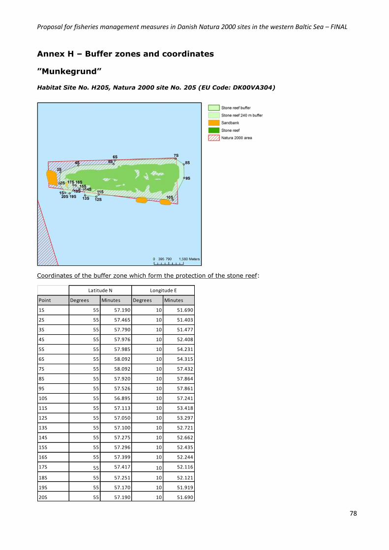
Proposal for fisheries management measures in Danish Natura 2000 sites in the western Baltic Sea – FINAL
78
Point Degrees Minutes Degrees Minutes
1S 55 57.190 10 51.690
2S 55 57.465 10 51.403
3S 55 57.790 10 51.477
4S 55 57.976 10 52.408
5S 55 57.985 10 54.231
6S 55 58.092 10 54.315
7S 55 58.092 10 57.432
8S 55 57.920 10 57.864
9S 55 57.526 10 57.861
10S 55 56.895 10 57.241
11S 55 57.113 10 53.418
12S 55 57.050 10 53.297
13S 55 57.100 10 52.721
14S 55 57.275 10 52.662
15S 55 57.296 10 52.435
16S 55 57.399 10 52.244
17S 55 57.417 10 52.116
18S 55 57.251 10 52.121
19S 55 57.170 10 51.919
20S 55 57.190 10 51.690
Latitude N Longitude E
Annex H – Buffer zones and coordinates
”Munkegrund”
Habitat Site No. H205, Natura 2000 site No. 205 (EU Code: DK00VA304)
Coordinates of the buffer zone which form the protection of the stone reef:
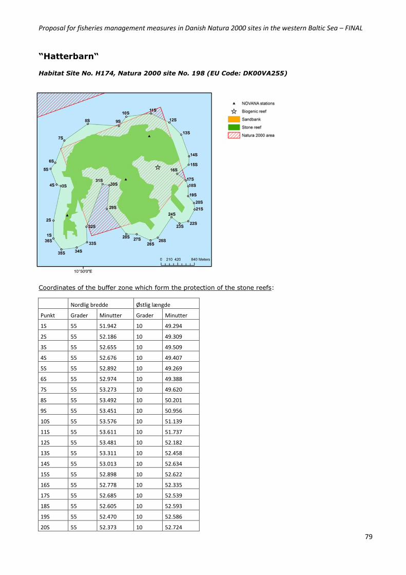
Proposal for fisheries management measures in Danish Natura 2000 sites in the western Baltic Sea – FINAL
79
“Hatterbarn“
Habitat Site No. H174, Natura 2000 site No. 198 (EU Code: DK00VA255)
Coordinates of the buffer zone which form the protection of the stone reefs:
Nordlig bredde Østlig længde
Punkt Grader Minutter Grader Minutter
1S 55 51.942 10 49.294
2S 55 52.186 10 49.309
3S 55 52.655 10 49.509
4S 55 52.676 10 49.407
5S 55 52.892 10 49.269
6S 55 52.974 10 49.388
7S 55 53.273 10 49.620
8S 55 53.492 10 50.201
9S 55 53.451 10 50.956
10S 55 53.576 10 51.139
11S 55 53.611 10 51.737
12S 55 53.481 10 52.182
13S 55 53.311 10 52.458
14S 55 53.013 10 52.634
15S 55 52.898 10 52.622
16S 55 52.778 10 52.335
17S 55 52.685 10 52.539
18S 55 52.605 10 52.593
19S 55 52.470 10 52.586
20S 55 52.373 10 52.724
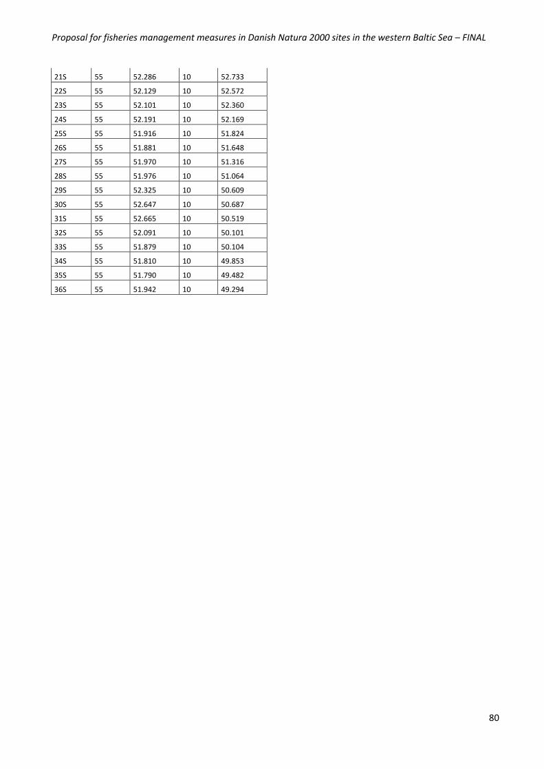
Proposal for fisheries management measures in Danish Natura 2000 sites in the western Baltic Sea – FINAL
80
21S 55 52.286 10 52.733
22S 55 52.129 10 52.572
23S 55 52.101 10 52.360
24S 55 52.191 10 52.169
25S 55 51.916 10 51.824
26S 55 51.881 10 51.648
27S 55 51.970 10 51.316
28S 55 51.976 10 51.064
29S 55 52.325 10 50.609
30S 55 52.647 10 50.687
31S 55 52.665 10 50.519
32S 55 52.091 10 50.101
33S 55 51.879 10 50.104
34S 55 51.810 10 49.853
35S 55 51.790 10 49.482
36S 55 51.942 10 49.294

Proposal for fisheries management measures in Danish Natura 2000 sites in the western Baltic Sea – FINAL
81
Point Degrees Minutes Degrees Minutes
1S 55 37.974 10 44.258
2S 55 37.942 10 45.181
3S 55 37.737 10 45.462
4S 55 37.147 10 44.956
5S 55 36.985 10 45.019
6S 55 36.828 10 44.681
7S 55 36.521 10 44.658
8S 55 36.527 10 43.575
9S 55 37.163 10 43.663
10S 55 37.334 10 43.889
11S 55 37.974 10 44.258
Latitude N Longitude E
”Ryggen”
Habitat Site No. H172, Natura 2000 site No. 196 (EU Code: DK00VA253)
Coordinates of the buffer zone which form the protection of the stone reef:

Proposal for fisheries management measures in Danish Natura 2000 sites in the western Baltic Sea – FINAL
82
Point Degrees Minutes Degrees Minutes
1S 55 11.953 11 0.089
2S 55 12.194 11 0.717
3S 55 12.316 11 0.782
4S 55 12.570 11 1.739
5S 55 12.743 11 1.917
6S 55 12.911 11 2.291
7S 55 12.748 11 2.851
8S 55 12.487 11 3.188
9S 55 12.291 11 3.088
10S 55 12.274 11 3.108
11S 55 12.336 11 3.441
12S 55 12.023 11 3.705
13S 55 11.751 11 2.984
14S 55 11.513 11 2.659
15S 55 11.390 11 2.269
16S 55 11.375 11 2.072
17S 55 11.172 11 1.714
18S 55 11.069 11 0.935
19S 55 11.099 11 0.764
20S 55 11.256 11 0.588
21S 55 11.337 11 0.483
22S 55 11.582 11 0.251
23S 55 11.603 11 0.254
24S 55 11.841 11 0.033
25S 55 11.953 11 0.089
Latitude N Longitude E
“Broen”
Habitat Site No. H175, Natura 2000 site No. 199 (EU Code: DK00VA256)
Coordinates of the buffer zone which form the protection of the stone reef:
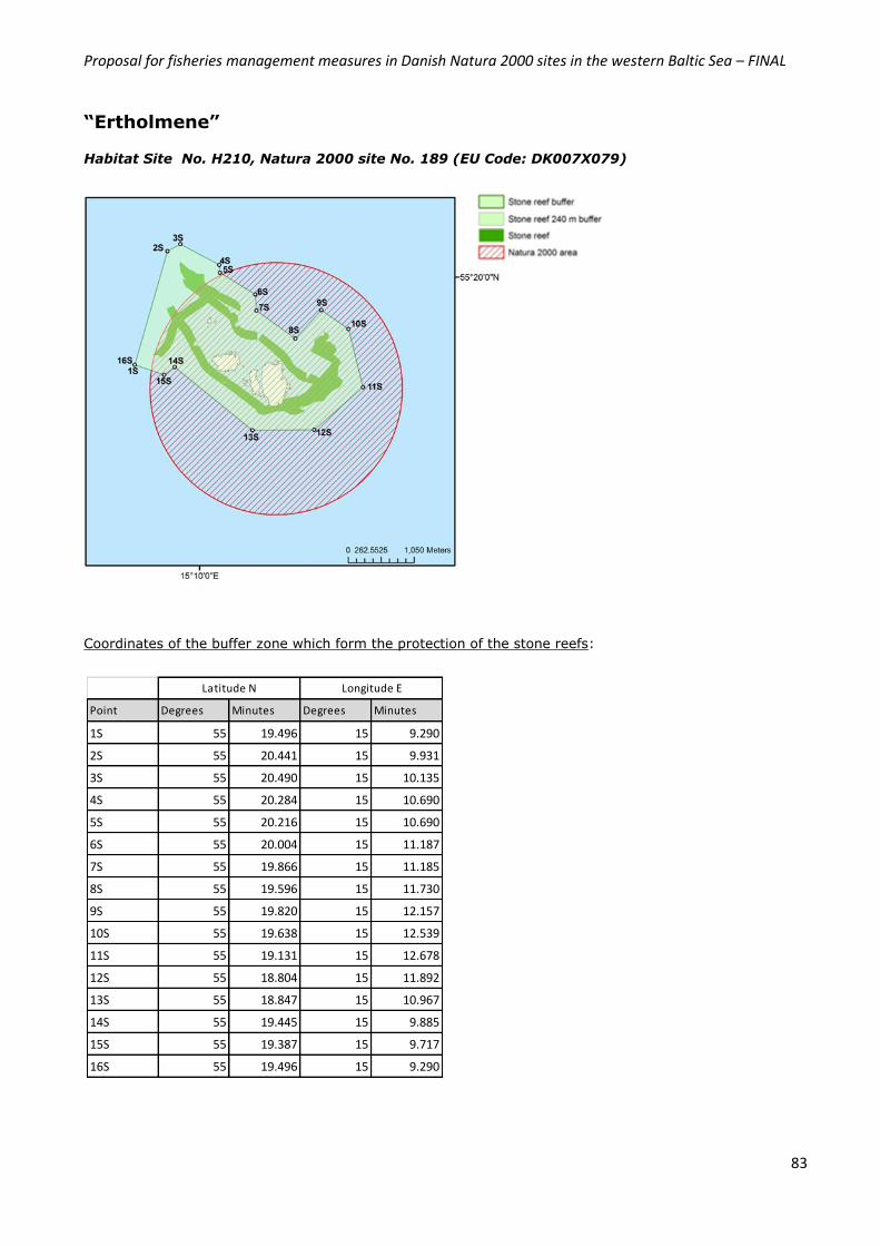
Proposal for fisheries management measures in Danish Natura 2000 sites in the western Baltic Sea – FINAL
83
Point Degrees Minutes Degrees Minutes
1S 55 19.496 15 9.290
2S 55 20.441 15 9.931
3S 55 20.490 15 10.135
4S 55 20.284 15 10.690
5S 55 20.216 15 10.690
6S 55 20.004 15 11.187
7S 55 19.866 15 11.185
8S 55 19.596 15 11.730
9S 55 19.820 15 12.157
10S 55 19.638 15 12.539
11S 55 19.131 15 12.678
12S 55 18.804 15 11.892
13S 55 18.847 15 10.967
14S 55 19.445 15 9.885
15S 55 19.387 15 9.717
16S 55 19.496 15 9.290
Latitude N Longitude E
“Ertholmene”
Habitat Site No. H210, Natura 2000 site No. 189 (EU Code: DK007X079)
Coordinates of the buffer zone which form the protection of the stone reefs:
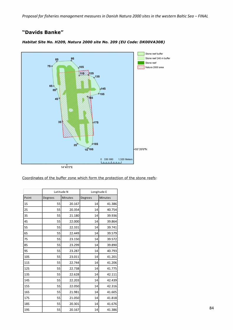
Proposal for fisheries management measures in Danish Natura 2000 sites in the western Baltic Sea – FINAL
84
Point Degrees Minutes Degrees Minutes
1S 55 20.167 14 41.386
2S 55 20.354 14 40.754
3S 55 21.180 14 39.936
4S 55 22.000 14 39.864
5S 55 22.331 14 39.741
6S 55 22.449 14 39.579
7S 55 23.150 14 39.572
8S 55 23.299 14 39.890
9S 55 23.287 14 40.793
10S 55 23.011 14 41.201
11S 55 22.744 14 41.206
12S 55 22.738 14 41.775
13S 55 22.628 14 42.111
14S 55 22.203 14 42.439
15S 55 22.050 14 42.316
16S 55 21.981 14 41.605
17S 55 21.050 14 41.818
18S 55 20.301 14 41.676
19S 55 20.167 14 41.386
Latitude N Longitude E
“Davids Banke”
Habitat Site No. H209, Natura 2000 site No. 209 (EU Code: DK00VA308)
Coordinates of the buffer zone which form the protection of the stone reefs:
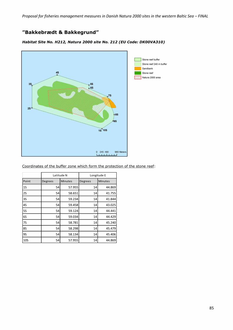
Proposal for fisheries management measures in Danish Natura 2000 sites in the western Baltic Sea – FINAL
85
Point Degrees Minutes Degrees Minutes
1S 54 57.955 14 44.869
2S 54 58.651 14 41.755
3S 54 59.234 14 41.844
4S 54 59.458 14 43.025
5S 54 59.124 14 44.441
6S 54 59.034 14 44.429
7S 54 58.781 14 45.240
8S 54 58.298 14 45.479
9S 54 58.134 14 45.406
10S 54 57.955 14 44.869
Latitude N Longitude E
”Bakkebrædt & Bakkegrund”
Habitat Site No. H212, Natura 2000 site No. 212 (EU Code: DK00VA310)
Coordinates of the buffer zone which form the protection of the stone reef:
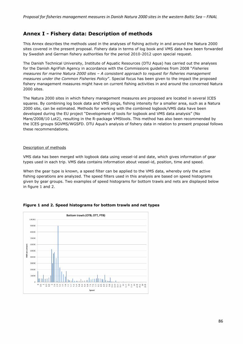
Proposal for fisheries management measures in Danish Natura 2000 sites in the western Baltic Sea – FINAL
86
Annex I - Fishery data: Description of methods
This Annex describes the methods used in the analyses of fishing activity in and around the Natura 2000
sites covered in the present proposal. Fishery data in terms of log book and VMS data have been forwarded
by Swedish and German fishery authorities for the period 2010-2012 upon special request.
The Danish Technical University, Institute of Aquatic Resources (DTU Aqua) has carried out the analyses
for the Danish AgriFish Agency in accordance with the Commissions guidelines from 2008 “Fisheries
measures for marine Natura 2000 sites – A consistent approach to request for fisheries management
measures under the Common Fisheries Policy”. Special focus has been given to the impact the proposed
fishery management measures might have on current fishing activities in and around the concerned Natura
2000 sites.
The Natura 2000 sites in which fishery management measures are proposed are located in several ICES
squares. By combining log book data and VMS pings, fishing intensity for a smaller area, such as a Natura
2000 site, can be estimated. Methods for working with the combined logbook/VMS data have been
developed during the EU project “Development of tools for logbook and VMS data analysis” (No
Mare/2008/10 Lot2), resulting in the R-package VMStools. This method has also been recommended by
the ICES groups SGVMS/WGSFD. DTU Aqua’s analysis of fishery data in relation to present proposal follows
these recommendations.
Description of methods
VMS data has been merged with logbook data using vessel-id and date, which gives information of gear
types used in each trip. VMS data contains information about vessel-id, position, time and speed.
When the gear type is known, a speed filter can be applied to the VMS data, whereby only the active
fishing operations are analyzed. The speed filters used in this analysis are based on speed histograms
given by gear groups. Two examples of speed histograms for bottom trawls and nets are displayed below
in figure 1 and 2.
Figure 1 and 2. Speed histograms for bottom trawls and net types
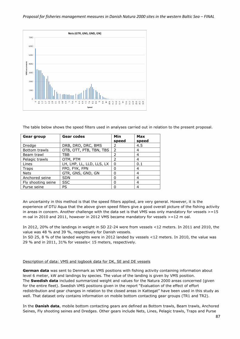
Proposal for fisheries management measures in Danish Natura 2000 sites in the western Baltic Sea – FINAL
87
The table below shows the speed filters used in analyses carried out in relation to the present proposal.
Gear group Gear codes Min speed
Max speed
Dredge DRB, DRO, DRC, BMS 2 4.5
Bottom trawls OTB, OTT, PTB, TBN, TBS 2 4
Beam trawl TBB 2 4
Pelagic trawls OTM, PTM 2 4
Lines LH, LHP, LL, LLD, LLS, LX 0 0.1
Traps FPO, FYK, FPN 0 4
Nets GTR, GNS, GND, GN 0 4
Anchored seine SDN 0 4
Fly shooting seine SSC 0 4
Purse seine PS 0 4
An uncertainty in this method is that the speed filters applied, are very general. However, it is the
experience of DTU Aqua that the above given speed filters give a good overall picture of the fishing activity
in areas in concern. Another challenge with the data set is that VMS was only mandatory for vessels >=15
m oal in 2010 and 2011, however in 2012 VMS became mandatory for vessels >=12 m oal.
In 2012, 20% of the landings in weight in SD 22-24 were from vessels <12 meters. In 2011 and 2010, the
value was 48 % and 39 %, respectively for Danish vessels.
In SD 25, 8 % of the landed weights were in 2012 landed by vessels <12 meters. In 2010, the value was
29 % and in 2011, 31% for vessels< 15 meters, respectively.
Description of data: VMS and logbook data for DK, SE and DE vessels
German data was sent to Denmark as VMS positions with fishing activity containing information about
level 6 metier, kW and landings by species. The value of the landing is given by VMS position.
The Swedish data included summarized weight and values for the Natura 2000 areas concerned (given
for the entire fleet). Swedish VMS positions given in the report “Evaluation of the effect of effort
redistribution and gear changes in relation to the closed areas in Kattegat” have been used in this study as
well. That dataset only contains information on mobile bottom contacting gear groups (TR1 and TR2).
In the Danish data, mobile bottom contacting gears are defined as Bottom trawls, Beam trawls, Anchored
Seines, Fly shooting seines and Dredges. Other gears include Nets, Lines, Pelagic trawls, Traps and Purse
Proposal for fisheries management measures in Danish Natura 2000 sites in the western Baltic Sea – FINAL
88
seines. In the German data mobile bottom contacting gears are defined as OTB, PTB, SSC, TBB, DRB and
SDN. Other gears include GNS, GTR, OTM and PTM. Swedish VMS data only include mobile bottom
contacting gears.
Description of data: Landing weight and values for DK, SE and DE
In order to assess the impact of the proposed fisheries management measures, landings weight and value
need to be assessed per Natura 2000 site for different gear groups.
Log books contain information about landed weight by species while sales slips data includes weight and
value by species per fishing trip.
For the Danish data, DTU Aqua has merged these estimates to distribute the value on the trip
proportionally to the landings weight. The dataset including species, weight and value is then merged with
the VMS positions by vessel-id and date. This means that the weight and value by species is distributed
evenly out on VMS positions where fishing activity is assumed, by vessel-id and date.
The landings and values by species within a Natura 2000 area can then be summarized (see section 5.2).
An average exchange rate of 7.45 DKK/EUR has been used in the analyses.
The Swedish data on landings in the Natura 2000 areas were received as landed kg per year per Natura
2000 area, DCF level 6 metier and species. The data used is based on Swedish log books, which include
fishing event positions. The dataset covers the whole Swedish fleet, thus also landings from smaller vessels
<12 meters. For this study, VMS positions have only been made available for the mobile bottom contacting
gear groups TR1 and TR2. To estimate the value of the Swedish landings, the species prices per kg from
the Danish landings have been used.
The German data includes VMS positions with landings and value associated to each position.
Annex J (table 1-12) show that the landings from the seven Natura 2000 sites are small compared to the
total fishing activities in the Belt Sea and western Baltic Sea.
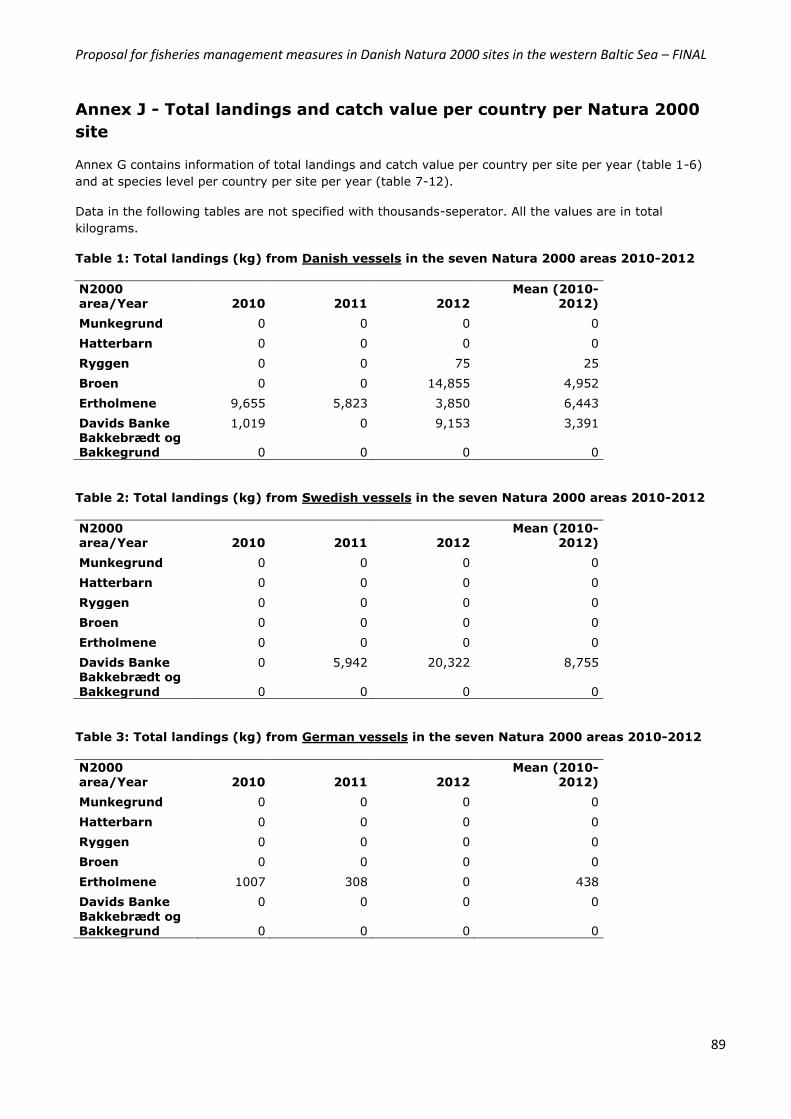
Proposal for fisheries management measures in Danish Natura 2000 sites in the western Baltic Sea – FINAL
89
Annex J - Total landings and catch value per country per Natura 2000
site
Annex G contains information of total landings and catch value per country per site per year (table 1-6)
and at species level per country per site per year (table 7-12).
Data in the following tables are not specified with thousands-seperator. All the values are in total
kilograms.
Table 1: Total landings (kg) from Danish vessels in the seven Natura 2000 areas 2010-2012
N2000 area/Year 2010 2011 2012
Mean (2010-2012)
Munkegrund 0 0 0 0
Hatterbarn 0 0 0 0
Ryggen 0 0 75 25
Broen 0 0 14,855 4,952
Ertholmene 9,655 5,823 3,850 6,443
Davids Banke 1,019 0 9,153 3,391 Bakkebrædt og Bakkegrund 0 0 0 0
Table 2: Total landings (kg) from Swedish vessels in the seven Natura 2000 areas 2010-2012
N2000 area/Year 2010 2011 2012
Mean (2010-2012)
Munkegrund 0 0 0 0
Hatterbarn 0 0 0 0
Ryggen 0 0 0 0
Broen 0 0 0 0
Ertholmene 0 0 0 0
Davids Banke 0 5,942 20,322 8,755 Bakkebrædt og
Bakkegrund 0 0 0 0
Table 3: Total landings (kg) from German vessels in the seven Natura 2000 areas 2010-2012
N2000 area/Year 2010 2011 2012
Mean (2010-2012)
Munkegrund 0 0 0 0
Hatterbarn 0 0 0 0
Ryggen 0 0 0 0
Broen 0 0 0 0
Ertholmene 1007 308 0 438
Davids Banke 0 0 0 0
Bakkebrædt og Bakkegrund 0 0 0 0
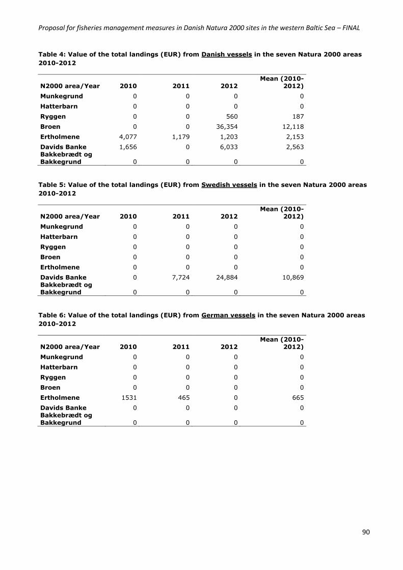
Proposal for fisheries management measures in Danish Natura 2000 sites in the western Baltic Sea – FINAL
90
Table 4: Value of the total landings (EUR) from Danish vessels in the seven Natura 2000 areas
2010-2012
N2000 area/Year 2010 2011 2012 Mean (2010-
2012)
Munkegrund 0 0 0 0
Hatterbarn 0 0 0 0
Ryggen 0 0 560 187
Broen 0 0 36,354 12,118
Ertholmene 4,077 1,179 1,203 2,153
Davids Banke 1,656 0 6,033 2,563 Bakkebrædt og Bakkegrund 0 0 0 0
Table 5: Value of the total landings (EUR) from Swedish vessels in the seven Natura 2000 areas
2010-2012
N2000 area/Year 2010 2011 2012 Mean (2010-
2012)
Munkegrund 0 0 0 0
Hatterbarn 0 0 0 0
Ryggen 0 0 0 0
Broen 0 0 0 0
Ertholmene 0 0 0 0
Davids Banke 0 7,724 24,884 10,869 Bakkebrædt og Bakkegrund 0 0 0 0
Table 6: Value of the total landings (EUR) from German vessels in the seven Natura 2000 areas
2010-2012
N2000 area/Year 2010 2011 2012 Mean (2010-
2012)
Munkegrund 0 0 0 0
Hatterbarn 0 0 0 0
Ryggen 0 0 0 0
Broen 0 0 0 0
Ertholmene 1531 465 0 665
Davids Banke 0 0 0 0 Bakkebrædt og
Bakkegrund 0 0 0 0
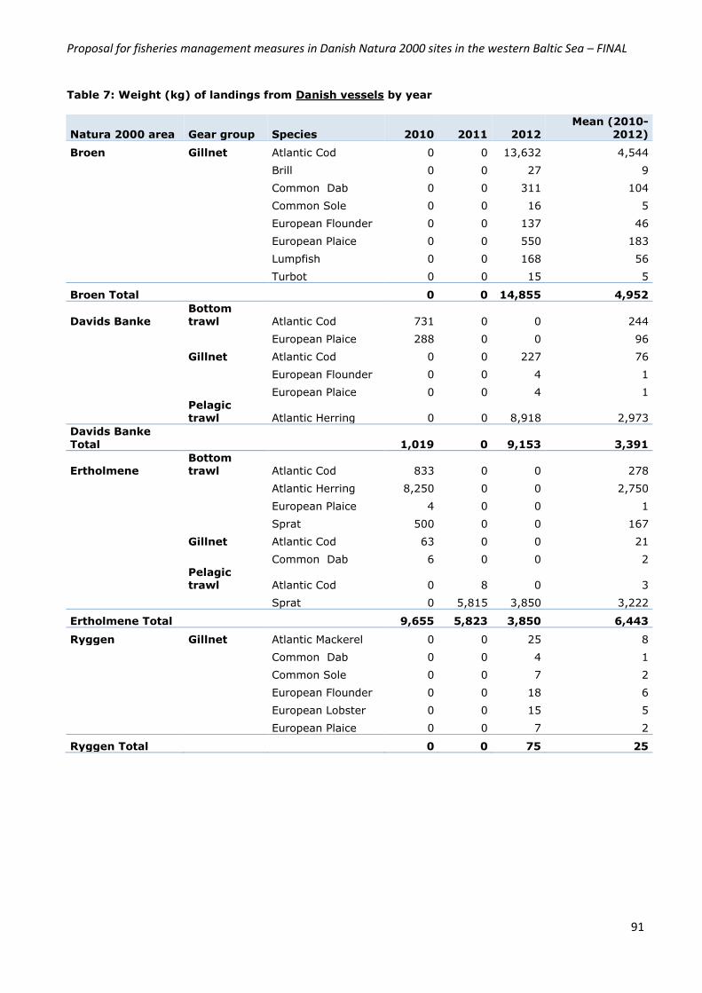
Proposal for fisheries management measures in Danish Natura 2000 sites in the western Baltic Sea – FINAL
91
Table 7: Weight (kg) of landings from Danish vessels by year
Natura 2000 area Gear group Species 2010 2011 2012 Mean (2010-
2012)
Broen Gillnet Atlantic Cod 0 0 13,632 4,544
Brill 0 0 27 9
Common Dab 0 0 311 104
Common Sole 0 0 16 5
European Flounder 0 0 137 46
European Plaice 0 0 550 183
Lumpfish 0 0 168 56
Turbot 0 0 15 5
Broen Total
0 0 14,855 4,952
Davids Banke Bottom trawl Atlantic Cod 731 0 0 244
European Plaice 288 0 0 96
Gillnet Atlantic Cod 0 0 227 76
European Flounder 0 0 4 1
European Plaice 0 0 4 1
Pelagic trawl Atlantic Herring 0 0 8,918 2,973
Davids Banke
Total
1,019 0 9,153 3,391
Ertholmene Bottom trawl Atlantic Cod 833 0 0 278
Atlantic Herring 8,250 0 0 2,750
European Plaice 4 0 0 1
Sprat 500 0 0 167
Gillnet Atlantic Cod 63 0 0 21
Common Dab 6 0 0 2
Pelagic trawl Atlantic Cod 0 8 0 3
Sprat 0 5,815 3,850 3,222
Ertholmene Total
9,655 5,823 3,850 6,443
Ryggen Gillnet Atlantic Mackerel 0 0 25 8
Common Dab 0 0 4 1
Common Sole 0 0 7 2
European Flounder 0 0 18 6
European Lobster 0 0 15 5
European Plaice 0 0 7 2
Ryggen Total
0 0 75 25
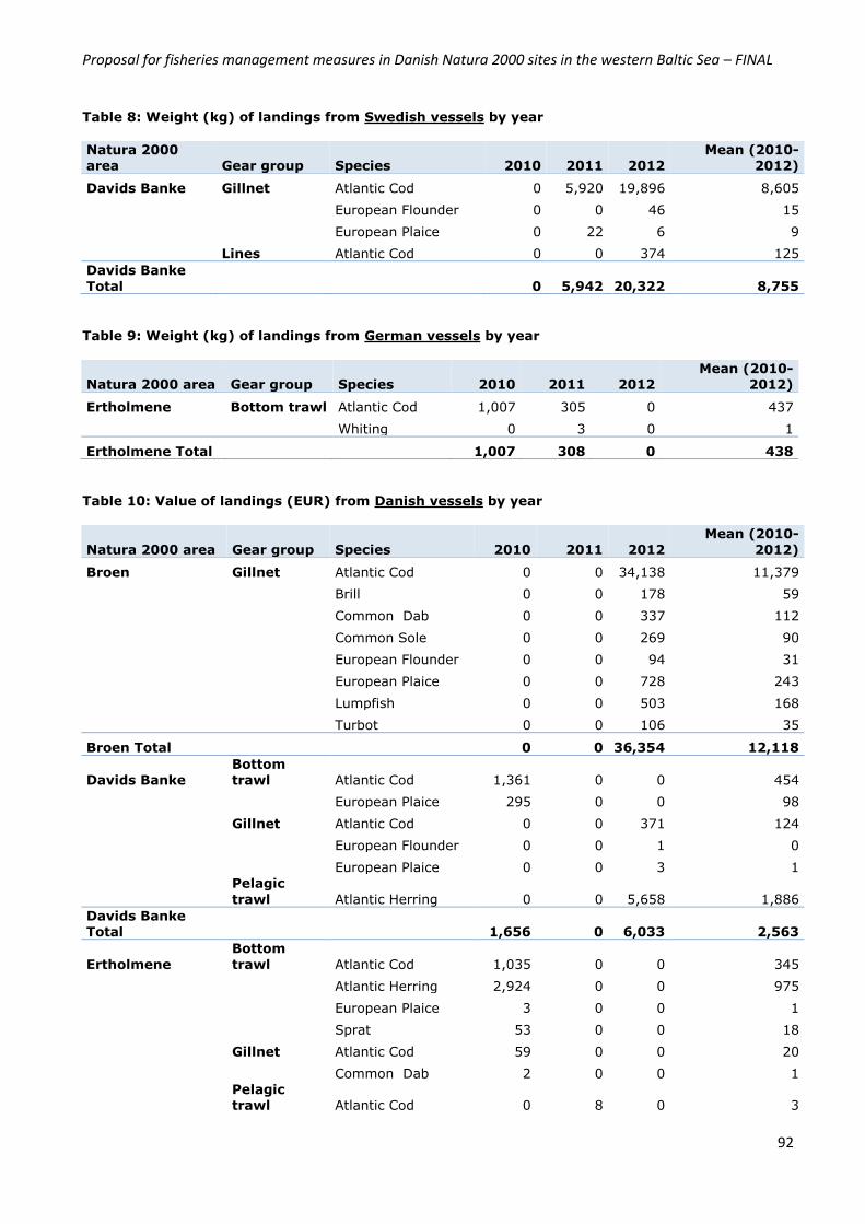
Proposal for fisheries management measures in Danish Natura 2000 sites in the western Baltic Sea – FINAL
92
Table 8: Weight (kg) of landings from Swedish vessels by year
Natura 2000 area Gear group Species 2010 2011 2012
Mean (2010-2012)
Davids Banke Gillnet Atlantic Cod 0 5,920 19,896 8,605
European Flounder 0 0 46 15
European Plaice 0 22 6 9
Lines Atlantic Cod 0 0 374 125
Davids Banke
Total 0 5,942 20,322 8,755
Table 9: Weight (kg) of landings from German vessels by year
Natura 2000 area Gear group Species 2010 2011 2012
Mean (2010-
2012)
Ertholmene Bottom trawl Atlantic Cod 1,007 305 0 437
Whiting 0 3 0 1
Ertholmene Total 1,007 308 0 438
Table 10: Value of landings (EUR) from Danish vessels by year
Natura 2000 area Gear group Species 2010 2011 2012
Mean (2010-
2012)
Broen Gillnet Atlantic Cod 0 0 34,138 11,379
Brill 0 0 178 59
Common Dab 0 0 337 112
Common Sole 0 0 269 90
European Flounder 0 0 94 31
European Plaice 0 0 728 243
Lumpfish 0 0 503 168
Turbot 0 0 106 35
Broen Total
0 0 36,354 12,118
Davids Banke Bottom trawl Atlantic Cod 1,361 0 0 454
European Plaice 295 0 0 98
Gillnet Atlantic Cod 0 0 371 124
European Flounder 0 0 1 0
European Plaice 0 0 3 1
Pelagic
trawl Atlantic Herring 0 0 5,658 1,886
Davids Banke Total
1,656 0 6,033 2,563
Ertholmene
Bottom
trawl Atlantic Cod 1,035 0 0 345
Atlantic Herring 2,924 0 0 975
European Plaice 3 0 0 1
Sprat 53 0 0 18
Gillnet Atlantic Cod 59 0 0 20
Common Dab 2 0 0 1
Pelagic trawl Atlantic Cod 0 8 0 3
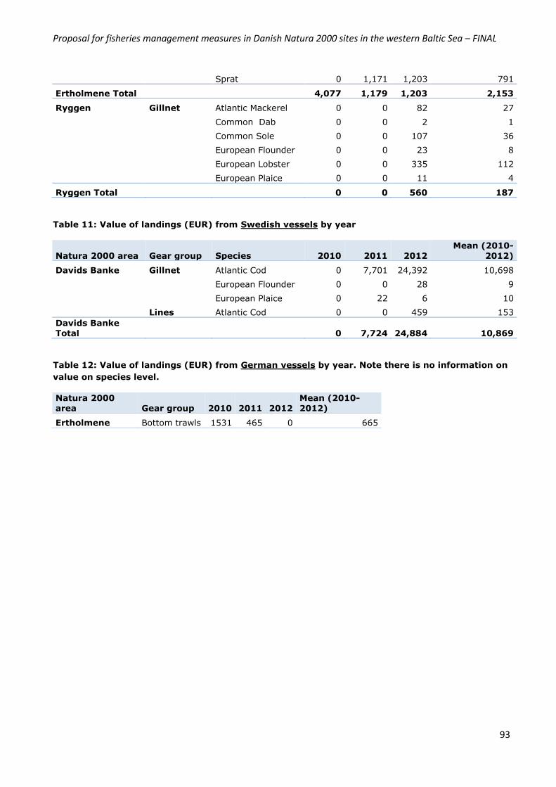
Proposal for fisheries management measures in Danish Natura 2000 sites in the western Baltic Sea – FINAL
93
Sprat 0 1,171 1,203 791
Ertholmene Total
4,077 1,179 1,203 2,153
Ryggen Gillnet Atlantic Mackerel 0 0 82 27
Common Dab 0 0 2 1
Common Sole 0 0 107 36
European Flounder 0 0 23 8
European Lobster 0 0 335 112
European Plaice 0 0 11 4
Ryggen Total
0 0 560 187
Table 11: Value of landings (EUR) from Swedish vessels by year
Natura 2000 area Gear group Species 2010 2011 2012 Mean (2010-
2012)
Davids Banke Gillnet Atlantic Cod 0 7,701 24,392 10,698
European Flounder 0 0 28 9
European Plaice 0 22 6 10
Lines Atlantic Cod 0 0 459 153
Davids Banke Total 0 7,724 24,884 10,869
Table 12: Value of landings (EUR) from German vessels by year. Note there is no information on
value on species level.
Natura 2000 area Gear group 2010 2011 2012
Mean (2010-2012)
Ertholmene Bottom trawls 1531 465 0 665
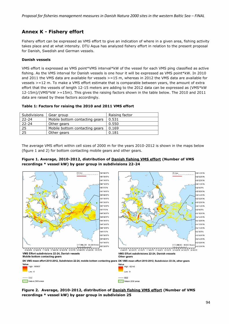
Proposal for fisheries management measures in Danish Natura 2000 sites in the western Baltic Sea – FINAL
94
Annex K - Fishery effort
Fishery effort can be expressed as VMS effort to give an indication of where in a given area, fishing activity
takes place and at what intensity. DTU Aqua has analyzed fishery effort in relation to the present proposal
for Danish, Swedish and German vessels.
Danish vessels
VMS effort is expressed as VMS point*VMS interval*kW of the vessel for each VMS ping classified as active
fishing. As the VMS interval for Danish vessels is one hour it will be expressed as VMS point*kW. In 2010
and 2011 the VMS data are available for vessels >=15 m, whereas in 2012 the VMS data are available for
vessels >=12 m. To make a VMS effort estimate that is comparable between years, the amount of extra
effort that the vessels of length 12-15 meters are adding to the 2012 data can be expressed as (VMS*kW
12-15m)/(VMS*kW >=15m). This gives the raising factors shown in the table below. The 2010 and 2011
data are raised by these factors accordingly.
Table 1: Factors for raising the 2010 and 2011 VMS effort
Subdivisions Gear group Raising factor
22-24 Mobile bottom contacting gears 0.531
22-24 Other gears 0.550
25 Mobile bottom contacting gears 0.169
25 Other gears 0.181
The average VMS effort within cell sizes of 2000 m for the years 2010-2012 is shown in the maps below
(figure 1 and 2) for bottom contacting mobile gears and other gears.
Figure 1. Average, 2010-2012, distribution of Danish fishing VMS effort (Number of VMS
recordings * vessel kW) by gear group in subdivisions 22-24
Figure 2. Average, 2010-2012, distribution of Danish fishing VMS effort (Number of VMS
recordings * vessel kW) by gear group in subdivision 25

Proposal for fisheries management measures in Danish Natura 2000 sites in the western Baltic Sea – FINAL
95
The maps of the Natura 2000 areas with VMS positions shows that there is no VMS effort from Danish
vessels with mobile bottom contacting gears inside the 5 Natura 2000 areas in subdivisions 22-24,
however with other gears there is some effort in the area referred to as “Broen”. In the two Natura 2000
sites located in SD 25 there is nearly no activity with mobile gears, but a small activity with other gears.
Table 2-4 show VMS-effort for Danish vessels in SD 22-24 and 25 for the period 2010-2012. Effort is seen
to be relatively low regardless of site and gear type.
Table 2. VMS Effort inside the Natura2000 areas and buffer zones, relatively to the total VMS
effort in subdivisions 22-24 for Danish vessels with other gears
Natura2000 area Stone reef buffer
Munkegrund 0.000‰ 0.000‰
Hatterbarn 0.000‰ 0.000‰
Ryggen 0.291‰ 0.321‰
Broen 5.109‰ 6.986‰
Bakkebrædt og Bakkegrund 0.000‰ 0.000‰
Total 5.400‰ 7.307‰
Proposal for fisheries management measures in Danish Natura 2000 sites in the western Baltic Sea – FINAL
96
Table 3. VMS Effort inside the Natura2000 areas and buffer zones relatively to the total VMS
effort in subdivision 25 for Danish vessels with mobile bottom contacting gears
Natura2000 area Stone reef buffer
Ertholmene 0.037‰ 0.012‰
Davids Banke 0.012‰ 0.012‰
Total 0.049‰ 0.024‰
Table 4. VMS Effort inside the Natura2000 areas and buffer zones relatively to the total VMS
effort in subdivision 25 for Danish vessels with other gears
Natura2000 area Stone reef buffer
Ertholmene 0.579‰ 0.000‰
Davids Banke 1.864‰ 2.004‰
Total 2.443‰ 2.004‰
Swedish vessels
Swedish VMS data inside Danish EEZ for the years 2010 to 2012 have been submitted for this study. For
each VMS position there is information about gear, ping period, métier and kW. The VMS effort for the
Swedish data is calculated as VMS ping*kW*pingperiod. An average VMS effort map for the years 2010-
2012 is calculated in the same way as for the Danish vessels.
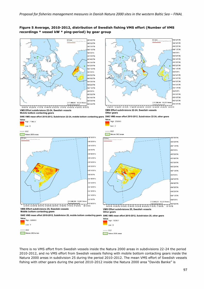
Proposal for fisheries management measures in Danish Natura 2000 sites in the western Baltic Sea – FINAL
97
Figure 5 Average, 2010-2012, distribution of Swedish fishing VMS effort (Number of VMS
recordings * vessel kW * ping-period) by gear group
There is no VMS effort from Swedish vessels inside the Natura 2000 areas in subdivisions 22-24 the period
2010-2012, and no VMS effort from Swedish vessels fishing with mobile bottom contacting gears inside the
Natura 2000 areas in subdivision 25 during the period 2010-2012. The mean VMS effort of Swedish vessels
fishing with other gears during the period 2010-2012 inside the Natura 2000 area “Davids Banke” is
Proposal for fisheries management measures in Danish Natura 2000 sites in the western Baltic Sea – FINAL
98
0.452‰ compared to the total VMS effort from Swedish vessels in the Danish EEZ of subdivision 25. The
VMS effort inside the Stone Reef Buffer of “Davids Banke” is 1.101‰ compared to the total VMS effort
from Swedish vessels in the Danish EEZ part of subdivision 25.
German vessels
The German VMS data has a kw_fishing variable that gives the VMS Effort. The German VMS data covers
the Danish EEZ. Using this variable an average VMS effort map for the years 2010-2012 is calculated in the
same way as for the Danish vessels.
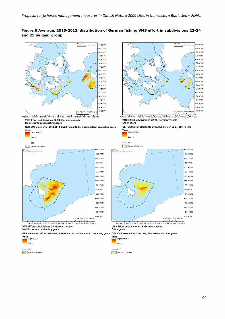
Proposal for fisheries management measures in Danish Natura 2000 sites in the western Baltic Sea – FINAL
99
Figure 6 Average, 2010-2012, distribution of German fishing VMS effort in subdivisions 22-24
and 25 by gear group
Proposal for fisheries management measures in Danish Natura 2000 sites in the western Baltic Sea – FINAL
100
In subdivisions 22-24 there is only VMS effort from German vessels fishing with mobile bottom contacting
gears in the Stone Reef Buffer of the Natura 2000 area “Bakkebrædt og Bakkegrund. The effort inside the
Stone Reef Buffer is 0.123‰ of the total VMS effort from German vessels fishing with mobile bottom
contacting gears inside the Danish EEZ in subdivisions 22-24.
In subdivision 25 there is VMS effort from German vessels fishing with mobile bottom contacting gears in
the Natura 2000 area “Ertholmene”. In the Natura 2000 area Ertholmene the VMS effort is 0.336‰
compared to the total VMS effort from German vessels fishing with mobile bottom contacting gears inside
the Danish EEZ in subdivision 25. Inside the Stone Reef Buffer the VMS effort is 0.167‰ compared to the
total VMS effort from German vessels fishing with mobile bottom contacting gears inside the Danish EEZ in
subdivision 25.
Total VMS effort
The maps below show the combined VMS effort as a mean of the period 2010-2012 for Danish, Swedish
and German vessels using bottom contacting mobile gears and other gears in subdivision 22-24 and 25.
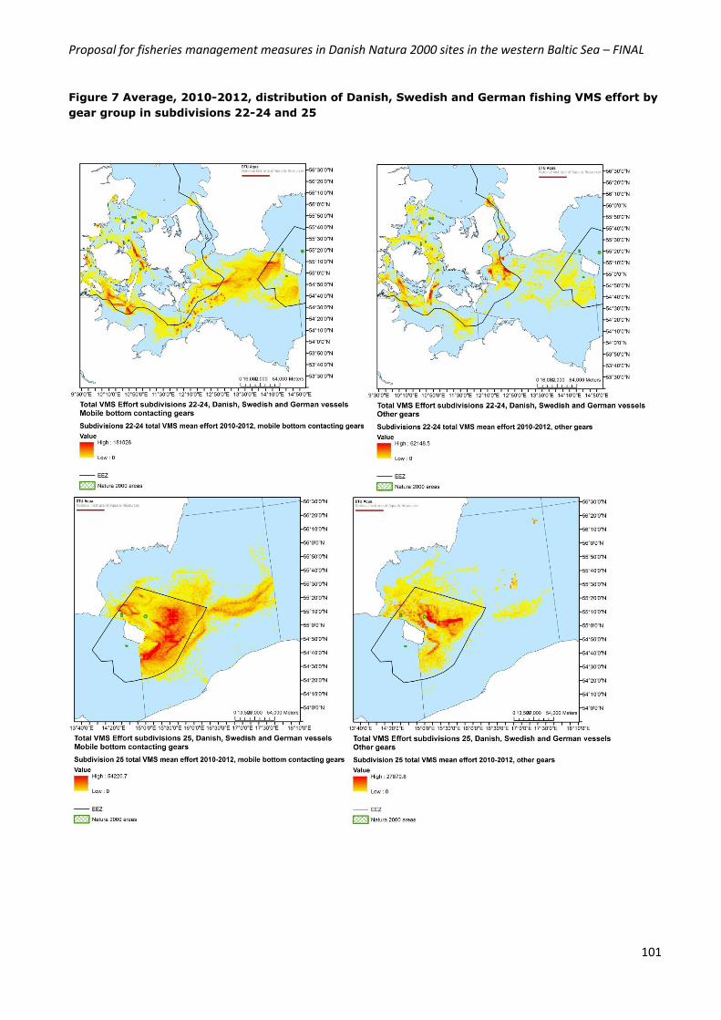
Proposal for fisheries management measures in Danish Natura 2000 sites in the western Baltic Sea – FINAL
101
Figure 7 Average, 2010-2012, distribution of Danish, Swedish and German fishing VMS effort by
gear group in subdivisions 22-24 and 25