Property Report by Property Report for ... · PDF fileTax Assessor's market value $163,333,333...
28
Property Report by PropertyShark.com Property Report for: 4042 Wall St, New York, NY 10005 A. Overview A1. Overview Address Building name The Trump Building Primary address 4042 Wall St First 3 alternate addresses 25 Pine St 2739 Pine St 40 Wall St Zip code 10005 Borough Manhattan Block & lot 000430002 Sanborn map 101S011 Tax map 10101 Owner Name 40 Wall Street Holdin Address 725 5 Ave New York, NY 100222519 Purchase date 12/16/2014 Purchase price $0 Property Taxes Tax class 4 Tax Assessor's market value $163,333,333 Current tax bill $7,090,454 Neighborhood Neighborhood name Financial District Community district 1 Closest Police station 0.88 Miles Closest Fire station 0.20 Miles School district number 2 Census tract 0007.00 Hazards & Environment Toxic site on this property Yes Neighboring toxic sites 2 EDesignation None Building Building class Office Building Tower Type (O4) ? Building sq. ft. 1,061,286 Landmark Manhattan Company Building Building dimensions 150 ft x 194.58 ft Year built 1931 Stories 63 Certificate of Occupancy Click here ? Use Commercial units 1 Office sq. ft. 1,041,265 Retail sq. ft. 20,021 Lot Lot sq. ft. 34,360 ? Lot dimensions 150 ft x 194.58 ft Corner lot No Buildings on lot 1 Zoning Zoning districts C55, LM ? Zoning map 12b Floor Area Ratio (FAR) Residential FAR 10 Commercial FAR 15 Facility FAR 15 FAR as built 30.89 ? Allowed usable floor area 515,400 Usable floor area as built 1,061,380 Violations ECB violations 5
Transcript of Property Report by Property Report for ... · PDF fileTax Assessor's market value $163,333,333...

Property Report by PropertyShark.com
Property Report for:
4042 Wall St, New York, NY 10005
A. Overview
A1. Overview
Address
Building name The Trump BuildingPrimary address 4042 Wall StFirst 3 alternate addresses 25 Pine St
2739 Pine St40 Wall St
Zip code 10005Borough ManhattanBlock & lot 000430002Sanborn map 101S011Tax map 10101
Owner
Name 40 Wall Street HoldinAddress 725 5 Ave
New York, NY 100222519Purchase date 12/16/2014Purchase price $0
Property Taxes
Tax class 4Tax Assessor's market value $163,333,333Current tax bill $7,090,454
Neighborhood
Neighborhood name Financial DistrictCommunity district 1Closest Police station 0.88 MilesClosest Fire station 0.20 MilesSchool district number 2Census tract 0007.00
Hazards & Environment
Toxic site on this property YesNeighboring toxic sites 2EDesignation None
Building
Building class Office Building Tower Type(O4) ?
Building sq. ft. 1,061,286Landmark Manhattan Company BuildingBuilding dimensions 150 ft x 194.58 ftYear built 1931Stories 63Certificate of Occupancy Click here ?
Use
Commercial units 1Office sq. ft. 1,041,265Retail sq. ft. 20,021
Lot
Lot sq. ft. 34,360 ?Lot dimensions 150 ft x 194.58 ftCorner lot NoBuildings on lot 1
Zoning
Zoning districts C55, LM ?Zoning map 12b
Floor Area Ratio (FAR)
Residential FAR 10Commercial FAR 15Facility FAR 15FAR as built 30.89 ?Allowed usable floor area 515,400Usable floor area as built 1,061,380
Violations
ECB violations 5

A3. Photos
Uploaded in December, 2014 by Christopher Bride
Upload photos for this property
Google StreetView Microsoft Bird's Eye View
A5. Sale & Property History
Property History
Event Amount Date
Lis Pendens filed n/a 7/28/2016
Lis Pendens filed n/a 9/13/2013

Event Amount Date
Lis Pendens filed n/a 9/12/2013
Lis Pendens filed n/a 7/3/2007
Deed Transfer recorded $15,792,259 1/6/2006
Lis Pendens filed n/a 9/1/1998
Lis Pendens filed n/a 7/20/1995
Lis Pendens filed n/a 5/27/1993
Lis Pendens filed n/a 1/21/1992
Lis Pendens filed n/a 11/1/1989
Lis Pendens filed n/a 10/26/1989
Lis Pendens filed n/a 4/26/1989
Lis Pendens filed n/a 4/25/1989
A6. Maps

B. Owners & Residents
B1. Ownership

40 Wall Street HoldinAddress: 725 5 AveLocation: New York, NY 100222519Source: Assessment RollLast recorded: 05/26/2016
B2. Building Contacts
Contact Details from Permits
Registration Date Role Name Address Phone Number
11/14/2016 Applicant Peter MirzManengeering Bureau Inc
n/a (718) 8996100
11/14/2016 Owner Steve LafioscaThe Trump Organization
725 5 Ave New York, NY 10022
(212) 7157203
10/06/2016 Applicant Steve LafioscaTrump Development Service
n/a (212) 7157296
09/26/2016 Applicant Thomas Veltre n/a n/a
07/26/2016 Applicant David Bonifacic n/a n/a
07/26/2016 Applicant Kenneth Wink n/a n/a
Phone Records of Tenants
Name Unit Phone number Listed
Harry Batcheleder (212) 5020660 01/01/2010
C. Title History
Phone Lookup
Link this owner to other properties
See who is behind the LLC
Add to Address Book
See past the LLC: 3 Ways to Unmask the real Owner
Find additional information on this property with the help of YardiMatrixYardi Matrix is a sister company of PropertyShark and the apartment market's most complete intelligence source. The service oers comprehensiveinformation on multifamily properties including sales and rent comparables, rental rates history, loan maturity dates and contact details for thetrue owners.
LEARN MORE
recommends

C. Title History
C1. Liens
PropertyShark has records of liens going back to 1985 and updates them nightly.
Effective Expires Creditor Document type Amount
7/28/2016 7/28/2019 Gm Electrical Co Ntracting In C Lis Pendens $0
6/23/2016 6/23/2017 Gm Electrical Contracting Inc494 Palmer Road
Mechanics Lien $156,902
6/1/2015 6/1/2016 Mensch Mill & Lumber Corp3520 College Point Blvd
Mechanics Lien $8,794
5/14/2015 5/14/2016 Secure Door And Hardware Inc265 46TH St
Mechanics Lien $3,902
5/11/2015 5/11/2016 Probuild Company LLC1294 Route 110
Mechanics Lien $3,155
5/7/2015 5/7/2016 Mensch Mill & Lumber Corp3520 College Point Blvd
Mechanics Lien $6,794
5/6/2015 5/6/2016 Feldman Lumber Us Lbm LLC1281 Metropolitan Avenue
Mechanics Lien $3,796
5/6/2015 5/6/2016 Feldman Lumber Us Lbm LLC1281 Metropolitan Avenue
Mechanics Lien $3,922
5/6/2015 5/6/2016 Feldman Lumber Us Lbm LLC1281 Metropolitan Avenue
Mechanics Lien $6,777
5/6/2015 5/6/2016 Feldman Lumber Us Lbm LLC1281 Metropolitan Avenue
Mechanics Lien $4,323
5/6/2015 5/6/2016 Feldman Lumber Us Lbm LLC1281 Metropolitan Avenue
Mechanics Lien $2,316
5/6/2015 5/6/2016 Feldman Lumber Us Lbm LLC1281 Metropolitan Avenue
Mechanics Lien $1,326
5/4/2015 5/4/2016 Marjam Supply Co Inc8 Rewe St
Mechanics Lien $90,616
4/13/2015 4/13/2016 Kamco Supply Cor P8021 St Street
Mechanics Lien $128,205
10/16/2014 10/16/2015 Peace Of Mind Technologies LLC 246 West 38TH St 2ND Floor
Mechanics Lien $7,043
C2. Title Documents
Date Type Amount Party1 Party2LinkToDoc
DocImage
1/11/2016 (Recorded)
Ucc3 Assignment n/a 40 Wall Street LLC C/O Te TrumpOrganization 725 FifthAvenue New York NY 10022
Ladder Capital Finance I LLC345 Park Avenue 8TH Floor New York NY 10154 Series Trs Of Ladder CapitalFinance I LLC345 Park Avenue 8TH Floor New York NY 10154
12/4/2015(Recorded)
Initial Ucc1 n/a Hidrock Realty Inc.40 Wall Street New York NY 10005
Tiger Leasing, LLC 334TH FloorNew York NY 10011

Date Type Amount Party1 Party2LinkToDoc
DocImage
10/8/2015(DocDate)
Asgn Of Asgn OfL&R
n/a Ladder Capital Finance ILLC345 Park Avenue 8THFloorNew York NY 10154 Series Trs Of LadderCapital Finance I LLC345 Park Avenue 8THFloorNew York NY 10154
Wilmington Trust, NationalAssociation, As Trustee 1100 North Market Street Wilmington DE 19890
10/8/2015(DocDate)
Assignment,Mortgage
n/a Ladder Capital Finance ILLC345 Park Avenue 8THFloorNew York NY 10154 Series Trs Of LadderCapital Finance I LLC345 Park Avenue 8THFloorNew York NY 10154
Wilmington Trust, NationalAssociation, As Trustee 1100 North Market Street Wilmington DE 19890
8/4/2015(Recorded)
Initial Ucc1 n/a 40 Wall Street LLC C/O Te TrumpOrganization725 Fifth Avenue New York NY 10022
Ladder Capital Finance I LLC345 Park Avenue 8TH FloorNew York NY 10154
7/16/2015(Recorded)
Ucc3 Termination n/a 40 Wall Street LLC 725 5TH Avenue New York NY 10022
Capital One N A.275 Broadhollow RoadMelville NY 11747
7/2/2015(DocDate)
Agreement n/a Ladder Capital Finance ILLC345 Park Avenue 8TH FloorNew York NY 10154
40 Wall Street LLC 725 Fifth Avenue New York NY 10022 Green Ivy Pine Street LLC25 Pine StreetNew York NY 10005
7/2/2015(DocDate)
Agreement n/a Ladder Capital Finance ILLC345 Park Avenue 8TH FloorNew York NY 10154
Hidrock Realty Inc.65 West 36TH Street New York NY 10018
7/2/2015(DocDate)
Agreement n/a Ladder Capital Finance ILLC345 Park Avenue 8TH FloorNew York NY 10154
Newman Myers KreinesGross Harris P C.40 Wall Street New York NY 10005
7/2/2015(DocDate)
Agreement n/a Ladder Capital Finance ILLC345 Park Avenue 8TH FloorNew York NY 10154
Harry Fox Agency, Inc. 40 Wall Street New York NY 10005
7/2/2015(DocDate)
Agreement n/a Ladder Capital Finance ILLC345 Park Avenue 8TH FloorNew York NY 10154
Weidlinger Associates, Inc. 40 Wall Street New York NY 10005
7/2/2015(DocDate)
Assignment OfLeases And Rents
$160,000,000 40 Wall Street LLC C/O Te TrumpOrganization725 Fifth Avenue New York NY 10022
Ladder Capital Finance I LLC345 Park Avenue 8TH FloorNew York NY 10154
7/2/2015(DocDate)
Agreement $160,000,000 40 Wall Street LLC C/O The TrumpOrganization725 Fifth Avenue New York NY 10022
Ladder Capital Finance I LLC345 Park Avenue 8TH FloorNew York NY 10154
7/2/2015(DocDate)
Assignment,Mortgage
n/a Capital One N A.275 Broadhollow RoadMelville NY 11747
Ladder Capital Finance I LLC345 Park Avenue 8TH FloorNew York NY 10154
7/2/2015(DocDate)
Termination OfAssign Of L&R
n/a Capital One N A.275 Broadhollow RoadMelville NY 11747
40 Wall Street LLC

Date Type Amount Party1 Party2LinkToDoc
DocImage
6/29/2015(Recorded)
Ucc3 Amendment n/a 40 Wall Street LLC 725 Fifth Avenue New York NY 10122
Capital One NaPo Box 1801Laurel MD 20725
6/23/2015(Recorded)
Ucc3 Continuation n/a 40 Wall Street LLC 725 Fifth Avenue New York NY 10122
North Fork Bank275 Broadhollow RoadMelville NY 11747
12/16/2014(DocDate)
Deed n/a 40 Wall Limited Partnership C/O Seyfarth Shaw Llp620 Eighth Avenue New York NY 10018
40 Wall Street Holdings Corp C/O Seyfarth Shaw Llp620 Eighth Avenue New York NY 10018
10/31/2014(DocDate)
NYC Real PropertyTransfer Tax
$3,535,942 Tw Telecom, Inc. C/O Lisa Akins Level 3Communication LLC1025 Eldorado BoulevardBroomfield CO 80021
Level 3 Communications,LLC1025 Eldorado BoulvardBroomfield CO 80021
10/22/2014(DocDate)
Agreement n/a Capital One N A.275 Broad Hollow RoadMelville NY 11747
40 Wall Street LLC, AsLandlord725 Fifth Avenue New York NY 10022 Hidrock Realty, Inc., AsTenant 65 West 36TH Street Suite 1200New York NY 10018
4/19/2013(DocDate)
Agreement n/a Capital One N A.275 Broad Hollow RoadMelville NY 11747
40 Wall Street LLC 725 Fifth Avenue New York NY 10005 Green Ivy Pine Street LLCC/O 70 Battery Place Unit618New York NY 10280
2/13/2013(DocDate)
Memorandum OfLease
n/a 40 Wall Street LLC 725 Fifth Avenue New York NY 10022
Green Ivy Pine Street LLCC/O 70 Battery Place Unit618Attention: Jennifer JonesNew York NY 10280
5/11/2012 (DocDate)
Agreement n/a Capital One N A275 Broadhollow RoadMelville NY 11747 40 Wall Street LLC 725 Fifth Avenue New York NY 10022
Newman Myers KreinesGross Harris P C14 Wall Street 22ND Floor New York NY 10005
12/19/2011 (DocDate)
Agreement n/a Capital One N A275 Broadhollow RoadMelville NY 11747 40 Wall Street LLC 725 Fifth AfvenueNew York NY 10022
The Harry Fox Agency In C601 West 26TH Street New York NY 10001
10/17/2011 (DocDate)
Agreement n/a Capital One N A275 Broadhollow RoadMelville NY 11747 40 Wall Street LLC 725 Fifth Avenue Suite2600New York NY 10022
Weidlinger Associates, In C 375 Hudson Street Suite1201New York NY 10015
6/15/2011 (DocDate)
Ucc3 Amendment n/a 40 Wall Street LLC 725 Fifth Avenue New York NY 10022
Capital One N A275 Broadhollow RoadMelville NY 11747

Date Type Amount Party1 Party2LinkToDoc
DocImage
11/19/2010 (DocDate)
Agreement $160,000,000 40 Wall Street LLC 725 Fifth Avenue New York NY 10022 40 Wall Street Member CorP725 Fifth Avenue New York NY 10022 40 Wall Street DevelopmentAssociates LLC725 Fifth Avenue New York NY 10022 Parc Consulting, In C725 Fifth Avenue New York NY 10022 Trump, Donald J C/O The TrumpOrganization725 Fifth Avenue New York NY 10022
Capital One N A275 Broadhollow RoadMelville NY 11747
3/29/2010(DocDate)
Ucc3 Continuation n/a 40 Wall Street LLC 725 Fifth Avenue New York NY 10022
North Fork Bank275 Broadhollow RoadMelville NY 11211
10/1/2008(DocDate)
NYC Real PropertyTransfer Tax
n/a American Stock ExchangeLLC11 Wall Street Attn: Tax Dept New York NY 10005 Amex MembershipCorporation11 Wall Street Attn: Tax Dept New York NY 10005 Amc Acquisition Sub, In C11 Wall Street Attn: Tax Dept New York NY 10005
Nyse Euronext11 Wall Street Attn: Tax Dept New York NY 10005
1/6/2006(DocDate)
NYC Real PropertyTransfer Tax
$15,792,259 Mci, Inc, On Behalf Of ItsFormer ShareholdersVerizon Property Tax Dept/ Po Box 152206Irving TX 750152206Shareholders Of Mci IncC/O Verizon Property TaxDept / Po Box 152206Irving TX 750152206
Eli Acquisition LLCVerizon Property Tax Dept /Po Box 152206Irving TX 750152206
D. Sales & Value
D1. Income and Expenses
Owners of incomeproducing properties that have an actual assessed value of more than $40,000 are required to file annual Real Property Incomeand Expense (RPIE) statements with the Department of Finance(DOF). The DOF uses the information from these statements, or data fromcomparables, to estimate the market value of a property for tax purposes.
2014 2013 2012 2011 2010 2009 2008 2007
Commercialsq. ft.
1,061,286 1,061,266 1,061,266 1,061,266 1,061,266 1,061,266 1,061,266 1,061,266
Total sq. ft. 1,061,286 1,061,266 1,061,266 1,061,266 1,061,266 1,061,266 1,061,266 1,061,266
Office income $25,105,908 $0 $23,318,275 $23,318,275 $25,906,895 $29,160,867 $28,264,595 $27,184,067
Retail income $1,646,806 $0 $103,711 $103,711 $346,852 $658,925 $592,885 $546,015
Storageincome
$22,760 $0 $7,205 $7,205 $0 $111,326 $108,842
Garageincome
$0 $0 $0 $0 $75,447 $0 $0

2014 2013 2012 2011 2010 2009 2008 2007
Owneroccupiedincome
$0 $0 $214,195 $214,195 $204,638 $198,168 $187,884
Operatingescalationincome
$0 $0 $2,533,390 $2,533,390 $1,871,618 $4,254,181 $3,508,508 $3,359,301
RE taxescalationincome
$766,376 $0 $1,982,261 $1,982,261 $2,425,664 $2,530,393 $2,320,335 $2,137,857
Sale of utilityservicesincome
$1,369,321 $0 $917,264 $917,264 $1,149,690 $1,876,467 $1,662,441 $1,790,593
Sale of otherservicesincome
$0 $0 $0 $0 $1,149,690 $0 $0
Cell towerincome
$229,636 $0 $192,184 $192,184 $162,742 $125,983 $0 $106,749
Other income1
$1,908,535 $0 $266,525 $266,525 $630,335 $778,291 $323,324 $152,261
Total income $31,049,342 $0 $29,535,010 $29,535,010 $33,923,571 $39,694,601 $36,968,814 $35,276,843
Fuel expense $768,339 $0 $765,259 $765,259 $1,146,238 $1,616,913 $1,467,590 $1,379,363
Light expense $1,304,644 $0 $1,320,473 $1,320,473 $1,638,604 $2,737,714 $2,381,903 $2,090,949
Cleaningexpense
$510,186 $0 $41,108 $41,108 $2,784,637 $3,711,896 $3,374,524 $3,122,265
Wagesexpense
$4,169,036 $0 $4,161,883 $4,161,883 $0 $0 $0
Repair &mainenanceexpense
$1,272,917 $0 $1,225,478 $1,225,478 $1,235,869 $1,451,473 $1,517,854 $1,686,574
Managementexpense
$1,236,812 $0 $1,363,474 $1,363,474 $473,549 $1,224,180 $735,494 $724,964
Insuranceexpense
$1,465,209 $0 $1,199,797 $1,199,797 $1,073,004 $1,263,208 $1,483,526 $1,469,045
Water &sewerexpense
$192,431 $0 $124,429 $124,429 $110,784 $176,608 $172,112 $71,471
Advertisingexpense
$3,925 $0 $17,933 $17,933 $29,333 $2,174 $2,415 $49,625
Decoratingexpense
$27,719 $0 $39,280 $39,280 $26,125 $199,414 $113,947 $192,555
Improvementexpense 1
$2,752,539 $0 $1,290,701 $1,290,701 $1,401,878 $1,614,184 $1,675,514 $1,484,067
Miscellaneousexpenses 1
$6,806,494 $0 $2,906,571 $2,906,571 $9,148,196 $4,068,815 $4,588,989 $3,346,121
Totalexpenses
$20,510,251 $0 $14,456,386 $14,456,386 $19,068,217 $18,066,579 $17,513,868 $15,616,999
Net profit $10,539,091 $0 $15,078,624 $15,078,624 $14,855,354 $21,628,022 $19,454,946 $19,659,844
D2. Sales & Values Maps
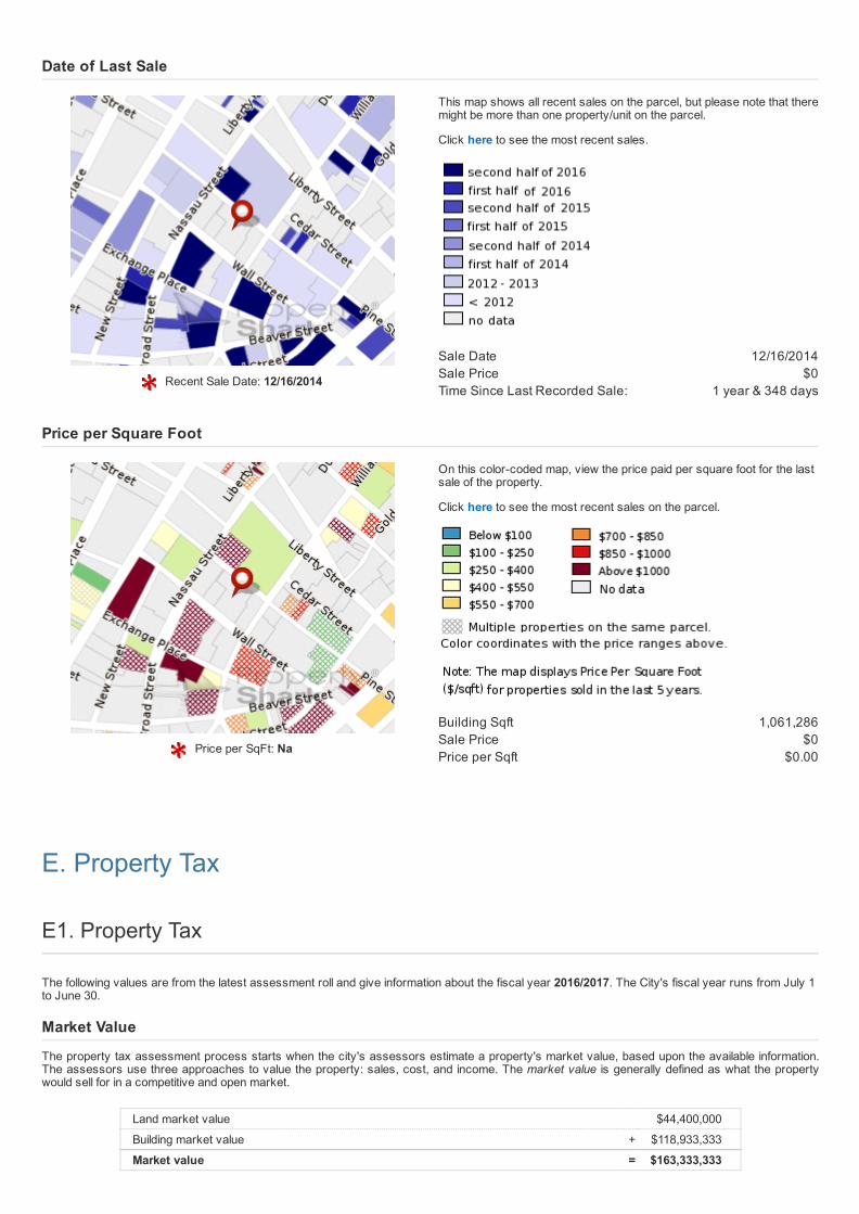
Recent Sale Date: 12/16/2014
This map shows all recent sales on the parcel, but please note that theremight be more than one property/unit on the parcel.
Click here to see the most recent sales.
Sale Date 12/16/2014Sale Price $0Time Since Last Recorded Sale: 1 year & 348 days
Date of Last Sale
Price per SqFt: Na
1,061,286$0
$0.00
On this colorcoded map, view the price paid per square foot for the lastsale of the property.
Click here to see the most recent sales on the parcel.
Building SqftSale PricePrice per Sqft
Price per Square Foot
E. Property Tax
E1. Property Tax
The following values are from the latest assessment roll and give information about the fiscal year 2016/2017. The City's fiscal year runs from July 1to June 30.
Market Value
The property tax assessment process starts when the city's assessors estimate a property's market value, based upon the available information.The assessors use three approaches to value the property: sales, cost, and income. The market value is generally defined as what the propertywould sell for in a competitive and open market.
Land market value $44,400,000
Building market value + $118,933,333
Market value = $163,333,333

Assessed Value
Assessed value is a calculation of the property value for tax purposes. It usually represents a percentage of the market value and is subject to limitson annual increases. Sometimes the city will exempt part of the assessed value from taxation, as an incentive to make improvements to an existingstructure or to build on a vacant lot. There are also several tax reductions programs for residential properties that may apply and may lower theproperty's tax bill.
Land assessed value $19,980,000
Building assessed value + $53,520,000
Assessed value = $73,500,000
Exemptions granted by city $0
Net assessed value = $73,500,000
Transitional Value
While the city's assessors have noted the rapid appreciation of property in New York City, the state understands that it would be burdensome forproperty taxes to rise too fast. Therefore, increases in the assessed value are phased in over a number of years. This introduces the transitionalassessed value, which is a limit on the portion of the assessed value introduced into the tax base. When the assessed value is phased in,sometimes the exemptions are as well.
Transitional land value $19,980,000
Transitional building value + $46,559,551
Transitional value = $66,539,551
Transitional exemption value $0
Transitional net assessed value = $66,539,551
Taxable Value
The taxable value, for 2016/2017, is the smaller of the city's net assessed value and the transitional net assessed value.
Taxable value = $66,539,551
Property Tax
Base tax is an estimate of what an owner not benefiting from tax exemptions or abatements would pay and is determined by multiplying theassessed value by the tax rate. Current tax is calculated by multiplying the taxable value by the tax rate.For a very small number of properties, ownerrelated exemptions (for which we currently don't have information) apply, and so the values givenbelow may be slightly different from the official ones. In addition to exemptions, the city also grants tax abatements to some properties. An abatementis simply a discount which is subtracted directly from the current tax. This results in the property tax, the amount the current owner pays.
Tax description Billable value Tax rate as billed june 2016 Tax amount
Base tax $66,539,551 * 10.6560% = $7,090,454.55
Exemption $0 $0.00
Current tax $66,539,551 = $7,090,454.55
Total abatements $0.00
Property tax as billed june 2016 = $7,090,454.00
Tax description Billable value Final tax rate 16/17 Tax amount
Base tax $66,539,551 * 10.5740% = $7,035,892.12
Exemption $0 $0.00
Current tax $66,539,551 = $7,035,892.12
Total abatements $0.00
Property tax with final tax rate = $7,035,892.12
Property tax with final tax rate $7,035,892.12
Property tax as billed june 2016 $7,090,454.00
Property tax adjustment = $54,562.43
For more information please visit New York City's property tax section. Also, you can view this property's assessment, tax bill and accountstatements here.

E2. Exemptions and Tax Abatements
Both the City and State of New York offer property tax reductions through exemptions and abatements for residential property, commercialconstructions, and properties used by governmental, industrial, and notforprofit organizations. Exemptions provide tax relief by reducing aproperty's assessed value, and abatements reduce taxes by applying credits to the amount of tax due. The information in this section presents asummary of the granted amounts and other related values of the benefit programs. Some of this data comes from NYC Department of HousingPreservation and Development (HPD) and the Department of Finance, departments which administer the J51 Program and the 421a Program.
Exemption Values 15/16
Land exemption value $0Total exemption value $0
Transitional Exemptions 15/16
Transitional land exemptionvalue
$0
Transitional total exemptionvalue
$0
Exemption Values 16/17
Land exemption value $0Total exemption value $0
Transitional Exemptions 16/17
Transitional land exemptionvalue
$0
Transitional total exemptionvalue
$0
E3. Assessment History
Year Use code Market value Assessed value Taxable Tax rate% Base tax Property tax
2015/16 O4 $145,146,000 $65,315,700 $65,315,700 10.656% $6,960,040 $6,960,040
2014/15 O4 $142,463,000 $64,108,350 $64,108,350 10.684% $6,849,336 $6,849,336
2013/14 O4 $148,770,000 $66,946,500 $66,946,500 10.323% $6,910,887 $6,910,887
2012/13 O4 $134,616,000 $60,577,200 $60,577,200 10.288% $6,232,182 $6,232,182
2011/12 O4 $157,777,777 $71,000,000 $71,000,000 10.152% $7,207,920 $7,207,920
2010/11 O4 $160,000,000 $72,000,000 $64,476,000 10.312% $7,229,743 $6,648,765
2009/10 O4 $157,000,000 $70,650,000 $59,697,000 10.426% $7,150,150 $6,224,009
2008/09 O4 $152,000,000 $68,400,000 $54,288,000 10.241% $6,802,072 $5,559,634
2007/08 O4 $164,444,444 $74,000,000 $47,799,000 10.059% $6,355,276 $4,808,101
2006/07 O4 $151,000,000 $67,950,000 $42,840,000 10.997% $6,482,731 $4,711,114
2005/06 O4 $143,000,000 $64,350,000 $37,692,000 11.306% $6,098,117 $4,261,457
2004/05 O4 $133,000,000 $59,850,000 $32,922,000 11.558% $5,682,721 $3,805,124
2003/04 O4 $116,000,000 $52,200,000 $28,422,000 11.431% $5,105,884 $3,248,918
E4. Tax per Square Foot

Tax per SqFt: $6.56
On this map, you can see the tax value paid per square foot for thisproperty.
Property Tax $6,960,040.99Tax Year 2015/2016Square Foot 1061286 SqFtTax per sqft: $6.56
F. Development & Use
F1. Zoning and Building Class
The building class specifies how a property is used or what type of building is present on that property. Building classes range from A to Z (excludingX.) There are at most 10 different subclasses within each building class (ranging from 0 to 10.) These building classes cover all property uses fromresidential and commercial to government buildings and parks.
Building Class: Office Building Tower Type (O4)
Legend
The full list of building classes can be found here.

Zoning Designation
Commercial C55Special districts LMFor more information about zoning district regulations, click here.
Rezoning Projects
No Rezoning Projects found.
New York City is divided into three basic zoning districts: residential (R), commercial (C) and manufacturing (M). These basic zoning districts aresubdivided by the intensity of use. Development is governed by the use, bulk, and parking requirements of the zoning district.
Legend
Map Disclaimer: This map is not an official zoning map. The print version of the NYC Zoning Resolution, which includes the zoning maps, togetherwith any amendments adopted by the City Council subsequent to the most recent update to the print version, remains the official version of theZoning Resolution.
This map was created from the NYC Department of City Planning's online zoning map files. It includes updates found in those files through 06/21/16.
F2. Floor Area Ratio & Air Rights
There are many rules that limit what you can build on a lot and how large it can be. But the most important is the Floor Area Ratio, or FAR. The FARis expressed as a ratio of the size of the building in square feet to the size of the lot in square feet. For example, if a lot is 2,000 square feet and hasan allowable FAR of 4.0, then then you can't build a building larger than 8,000 square feet. Max FAR depends on several factors including zoning, location and use. FAR values for this property are: Facility FAR 15,Commercial FAR 15 andResidential FAR 10.
Area of lot in square feet 34,360FAR x 15Maximum usable floor area of building = 515,400
Available Air Rights by Parcel
The building on this lot exceeds the square footage set by the FAR. Common ways to build more include:
Have an architect remeasure the building to eliminate some floor area from what is countedBuy "air rights" from a nearby lotApply for a zoning variance

Square feet over allowable: 545,980
Usable floor area 1,061,380Maximum usable floor area 515,400Square feet over allowable = 545,980
F3. Historic Districts & Landmarks
Legend
In this map, view if the property is historically or architecturally significant. Find out if it's part of a historic district or a landmark.
Landmark Name Manhattan Company BuildingType Individual LandmarkDesignation Date 12/12/1995Landmark Number LP01936
F4. Economic and Development Incentives
Properties and businesses within NYC qualify for a number of city, state and federal economic and development incentives based on factors suchas location, business type, investment, renovation, new construction, increased employment, and other factors. This section shows you for whichprograms this particular building may qualify.
Program Qualifies? More Information
CRP Yes NYC EDC
CRT Yes NYC EDC
ICIP Yes NYC EDC
LMREAP Yes NYC EDC

Program Qualifies? More Information
Sales tax savings Yes NYC EDC
Empowerment Zone No NYC EDC
Industrial Business Zone No NYC GOV
Ombudsmen Areas No NYC GOV
Need help with the Programs names? Please look at our Incentives FAQ section.
It explains what each of these programs means.
F5. Business Improvement Districts
Name Alliance for Downtown New
YorkNeighborhood Downtown ManhattanBID assessment $15,774,950Block faces 450Retail businesses 1062Date Jan95Boundaries Area generally bounded by
South Street to the southeast,Murray Street and Fulton
Street to the north and WestStreet to the west
Chairman Robert R. DouglassPresident Jessica LappinPhone (212) 566 6700Email [email protected] www.DowntownNY.com
F6. Permits
Pre filingdate
Jobtype Job description Link to job
9/30/2013 AlterationType 2
Remove And Install Fire Hose Rack As Shown On Drawings Filed Herewith. No Change InUse, Egress Or Occupancy. $15,000 — Plan Exam Approved — Standpipe
121795762/01
8/6/2013 AlterationType 2
Respectfully Request Partial Demo.Of Existing Duct Work,And Diffusers.Install Duct Work ToNew Condenser Unit,Existing A/C Unit And Duct Schedule To Remain, Hvac Associated WithTenant Fit Out At Suite AIt, No Change To Use, Occupancy Or Egress. $30,000 — Application Processed Completed — Mechanical
121739413/01
6/28/2013 AlterationType 2
Install Plumbing Fixtures And Related Piping As Shown On Drawings Filed Herewith. NoChange In Use, Egress Or Occupancy. $77,850 — Plan Exam Approved — Plumbing
121687905/03
6/28/2013 AlterationType 2
Install Mechanical Ductwork As Shown On Drawings Filed Herewith. No Change In Use,Egress Or Occupancy. $525,385 — Plan Exam Approved — Mechanical
121687905/02
6/28/2013 AlterationType 2
Construct Interior Partitions, Ceilings And Doors As Shown On Drawings Filed Herewith. NoChange In Use, Egress Or Occupancy. $1,507,567 — Plan Exam Approved — Arch
121687905/01
6/28/2013 AlterationType 2
Install Sprinkler Heads And Related Piping As Shown On Drawings Filed Herewith. No ChangeIn Use, Egress Or Occupancy. $240,750 — Plan Exam Approved — Sprinkler
121685435/01
6/28/2013 AlterationType 2
Install Fire Alarm Devices As Shown On Drawings Filed Herewith. No Change In Use, EgressOr Occupancy. $42,000 — Application Processed Completed — Fire alarm
120846291/01

Pre filingdate
Jobtype Job description Link to job
6/24/2013 AlterationType 2
Remove Sprinkler Heads And Install Temporary Loop As Shown On Drawings Filed Herewith.No Change In Use, Egress Or Occupancy. $27,700 — Plan Exam Approved — Sprinkler
121685328/01
5/1/2013 AlterationType 2
Removal And Insertion Of Beams. Remove Existing Slab And Replace With New Slab AsShown On Drawings Filed Herewith. No Change In Use, Egress Or Occupancy. $95,000 — Plan Exam Approved — Structural
121601971/02
4/29/2013 AlterationType 3
Installation Of Pipe Scaffold As Per Plans. Work Shall Comply With 2008 Building Code Chapter33. No Change In Use Egress Or Occupancy. Permit Issued Entire Job/Work — Equipment
121603381/01
2/2/2007 AlterationType 2
Modification To Sprinkler System As Per Plans Filed Herewith. No Change In Use, Egress OrOccupancy. $11,000 — Permit Issued Entire Job/Work — Sprinkler
104665756/01
1/22/2007 AlterationType 2
Sprinkler Work And Installation Of Newfire Hose Cabinet On 18th Floor No Changes $26,000 — Plan Exam Disapproved — Standpipe, Sprinkler
104657499/01
6/20/2005 AlterationType 2
Plan Exam Approved — Plumbing, Mechanical 104036240/03
4/5/2000 AlterationType 2
Modify Sprinkler System On 3rd Floor As Per Plans Filed$8,000 — Plan Exam Disapproved — Standpipe
102881384/01
12/31/1996 AlterationType 2
New Sprinkler Branch Piping And Heads On The 58th Floor. $75,000 — Plan Exam Approved
101473175/01
F7. Complaints
Complaintnumber Address Date
entered Complaint category Inspectiondate Disposition Status
5095443 33 Pine Street 12/19/2011 Illegal Conversion 12/21/2011 ComplaintUnsubstantiatedBased OnDepartmentRecords
Closed
5095229 33 Pine Street 12/09/2011 Illegal Conversion 12/21/2011 ComplaintUnsubstantiatedBased OnDepartmentRecords
Closed
1293120 40 Wall Street 11/17/2010 After Hours Work Illegal 11/22/2010 No ViolationWarranted ForComplaint AtTime OfInspection
Closed
3286350 25 Pine Street 11/10/2008 Sro Illegal Work/NoPermit/Change In OccupUse
11/24/2008 Access Denied Attempt Made
Active
3286351 25 Pine Street 11/10/2008 Electrical Wiring ???Defective / Exposed, InProgress
11/16/2008 InspectorUnable To GainAccess Attempt Made
Active
1267114 40 Wall Street 10/07/2009 Debris/Building Falling Or InDanger Of Falling
10/07/2009 No ViolationWarranted ForComplaint AtTime OfInspection
Closed
1431831 40 Wall Street 08/30/2016 Elevator Defective /Inoperative
08/30/2016 n/a Active
3277659 25 Pine Street 08/27/2008 Illegal Conversion n/a n/a Active
5086953 33 Pine Street 08/19/2010 Electrical Wiring ???Defective / Exposed, InProgress
n/a n/a Active
1148029 40 Wall Street 08/09/2005 Storefront Or BusinessSign/Awning/Marquee/Canopy??? Illegal
n/a n/a Active
1330512 40 Wall Street 08/01/2012 Electrical Wiring ???Defective / Exposed, InProgress
n/a n/a Active

Complaintnumber Address Date
entered Complaint category Inspectiondate Disposition Status
3313811 37 Pine Street 07/30/2009 Illegal Conversion n/a n/a Active
1262019 40 Wall Street 07/30/2009 Permit None (Building/ Pa/Demo Etc.)
n/a n/a Active
5086495 33 Pine Street 07/23/2010 Illegal Conversion 07/28/2010 Access Denied Attempt Made
Active
1305485 40 Wall Street 07/06/2011 Site Conditions EndangeringWorkers
07/08/2011 No ViolationWarranted ForComplaint AtTime OfInspection
Closed
G. Violations
G1. Housing Preservation and Development Violations
When excessive violations are present, this can adversely affect the support given by The NYC Department of Housing Preservation andDevelopment (HPD). These violations can result in buildingwide inspections, fees, and the requirement of extensive repair work to correctunderlying conditions. In some cases, outstanding violations may result in a lien being placed on the property. It is also substantially more difficult tomortgage a building with extensive violations.
On this colorcoded map, view all properties with open violations thathave been left uncorrected.
Legend
Please note: the NYC HPD is the only authoritative source for information on housing violations. Please consult the HPD website for uptodateviolations.
PropertyShark obtains its records from HPD and updates them monthly.
G2. ECB Violations
There are eleven city agencies that administer the City's qualityoflife laws and issue Notices of Violation (NOVs) for alleged violations. The ECB is aseparate and independent agency that hears challenges to those NOVs. The agencies that issue the most violations for real estate are:
Department of Buildings (DOB)Department of Environmental Protection (DEP)Fire DepartmentLandmarks Preservation Commission (LPC)Department of Sanitation
PropertyShark obtains its ECB NOV records from the DOB and updates them nightly. Records go back to 1988

Issuedate Description
1/29/2013 52h110 hoist ropes loss of diameter at 15th & 40th52nd flrs.10/21/2009 97o2.68m7.69m7.60q3 97 perform clean down on unit;10/21/2009 97o2.68m7.69m7.60q3.97 perform clean doors on unit;6/16/2008 Cu 80i11.79h11.86r11 80i all razor sharp steps as need it 79h boots at; bottom 86r illegally tag device as 2 yr accepted remedy
reschedule for; another 2 yr test in the presence of inspector of this dept cu until;6/16/2008 Cu 80i11.86r# 80i all razor sharp steps as need it 86r illegally tag; device year accepted ok remedy reschedule for a yr test to be
performe; d in the presence of an inspector of this dept cu until item 80i is;For more information about the ECB and the types of NOVs that it handles, visit its home page.
H. Neighborhood
H1. Distance To Schools
Elementary School Proximity
See for which Elementary School is a property zoned for, what otherpublic and private schools are available in the area, with exact distancesfrom the property to the school of interest.
Legend
Attended Elementary School(s)
School name Distance (miles) School code
Battery Park City School 0.418 02M276
Peck Slip School (The) 0.424 02M343
Remarks: For 20162017: Grades K4 are zoned to PS 343 and Grade 5 is zoned to PS 276.
Nearest Public Elementary School (not zoned)
Distance (miles) 0.779School name Ps 150School code 02M150Principal Ms. Jennifer BonnetPhone number 7324392
Nearest Private Elementary School
Distance (miles) 0.111School name Leman Manhattan Prep SchoolSchool code 02M196Principal Administrator Mr. Drew
AlexanderPhone number 2320266
Find more info at: NYC Department of Education

Middle School Proximity
See for which Middle School is a property zoned for, what other publicand private schools are available in the area, with exact distances fromthe property to the school of interest.
Legend
Attended Middle School(s)
School name Distance (miles) School code
Jhs 104 Simon Baruch 2.509 02M104
Nearest Public Middle School (not zoned)
Distance (miles) 0.21School name Lower Manhattan Com Middle
SchoolSchool code 02M896Principal Ms. Kelly McguirePhone number 8268100
Nearest Private Middle School
Distance (miles) 0.111School name Leman Manhattan Prep SchoolSchool code 02M196Principal Administrator Mr. Drew
AlexanderPhone number 2320266
Find more info at: NYC Department of Education
High School Proximity
See for which High School is a property zoned for, what other public andprivate schools are available in the area, with exact distances from theproperty to the school of interest.
Legend
Attended High School(s)No zoned school

Nearest Public High School (not zoned)
Distance (miles) 0.181School name Millennium High SchoolSchool code 02M418Principal Mr. Colin McevoyPhone number 8259008
Nearest Private High School
Distance (miles) 0.111School name Leman Manhattan Prep SchoolSchool code 02M196Principal Administrator Mr. Drew
AlexanderPhone number 2320266
Find more info at: NYC Department of Education
University Proximity
See distance to closest university from your property.
Legend
Nearest University/College
Distance (miles) 0.138School name The King?s CollegeFind more info at: NYC Department of Education
H2. Distance To Subway

Station name: William St Wall St at NW cornerStation lines: 2 3Distance(ft): 193.57
Subway accessibility (nearest subway station)
On this colorcoded map, view the nearest subway station for eachbuilding.
Legend
H3. Businesses

Discover retail businesses in Manhattan. Find restaurants, shops, retail banks, bars and stores on our newinteractive map.
Click on a parcel on the map to look up property ownership data, buildingphotos and other property details.
40 Wall St Website Facebook
40 Wall St Website
Duane Reade
The Country Cafe
40 Wall St Website Facebook
40 Wall St Website
KENJO
Haks
H4. Urban Landscape Maps
Year Built: 1931
Year Built
On this colorcoded map, view the year each property was built.
Legend

Number of Stories: 63
Building Stories
On this map, view the number of stories per building.
Legend
H6. Demographics By Zip Code
Demographic data shown in this section was gathered from the 2014 American Community Survey and refers to zip code 10005.
Population Demographics
Total population 7,570Female population 52.2%Male population 47.8%Median age 28.8Male median age 29.9Female median age 27.7
Race & Ethnicity
White 74.9%Black or african american 3.7%Asian 16.3%Other 5.1%
Education
No highschool 1.1%Some highschool or college 9.0%Bachelors degree 51.7%
Other
Citizens 78.2%Citizens born in US 68.7%English speakers 99.6%
Journey to Work
Work in a metropolitan area 99.5%Work in a micropolitan area 0.3%Work at home 3.0%Go to work by car 2.2%Go to work after 10 am 8.6%
Economic/Employment
Average household income $175,864White collar 99.6%Blue collar 0.4%
Housing
Family households 25.8%Households with kids 10.6%Housing units 5,114Occupied housing units 4,100Owner occupied units 13.3%Average number of people perhousehold
1.84
Median year structure built 1951Houses with mortgages 70.2%
Wealth
Median value for units with amortgage
$1,000,001
Median value for units without amortgage
$1,000,001
Median gross rent $2,001Median housing costs permonth
$2,837
Population in poverty 10.5%
I. Hazards & Environment

I. Hazards & Environment
I1. Toxic Sites
You can get a Phase I Environmental Report Site Assessment or a Home Environmental Database Report for this property directly from ToxicsTargeting by accessing this link.
This screening map, provided to PropertyShark by Toxics Targeting, shows environmental hazards such as toxic dumps, garbage landfills, leakingtanks, hazardous waste sites, and pollution discharges reported by local, state and federal government authorities.
Call 8002TOXICS (8002869427 NYS only) or 6072733391 for more info.
Toxic Sites Total known or potential toxic sites on property: 10
Leaking Tanks and Spills: x 2 Spill
Other Toxic Sites: x 8 Haz Waste Generator or Transporter
Neighboring toxic sites: 2
Leaking Tanks and Spills: x 1 Spill
Other Toxic Sites: x 1 Haz Waste Generator or Transporter
Total toxic sites near the property: 8
This toxic site data is found outside any specific property boundary.
Leaking Tanks and Spills: x 1 Spill
Other Toxic Sites: x 7 Haz Waste Generator or Transporter
Map Disclaimer: Mapped locations are approximate; identified sites based on current and/or historic information; site symbols can refer to largeproperties; additional toxic sites are not mapped; contamination problems can impact properties far from toxic sources; sites include known andpotential hazards; regulatory status of sites may have changed.
I2. Fema Flood Zones Map

To understand flood zoning within the current neighborhood you can review the full map by clicking on this 'minimap'. Flood zoning codes, Fema mappanel, and publication date all can be extracted for this target property.
Find out more about: FEMA Flood Hazard Map
Legend
Note: This map was constructed using Fema Flood DFIRM data set.
Link to the map for this property at FEMA's Map Service Center (may not be available in all locations)
FEMA Flood Zoning
FEMA flood zone(s) XCostal barrier resources systemarea (COBRA)
No
Floodway NoFEMA special flood hazard area NoMap panel ID 3604970184F
Distance to...
Nearest distance to coastline(miles)
.257
Compass direction to coastline 308Nearest distance to 100 yearflood zone area (ft)
414
Angle100 5
I3. After Sandy FEMA Advisory Base Flood Elevation Map
To understand FEMA advisory base flood elevation zoning within the current neighborhood you can review the full map by clicking on this 'minimap'.You can also compare after Hurricane Sandy ABFE zoning codes with the previously released official FEMA map.
On this map, you can see if the property is located in a special advisory base flood elevation hazard area.

Find out more about: FEMA Advisory Base Flood Elevation (ABFE)Glossary
Legend
Note: This map was constructed using FEMA ABFE (After Hurricane Sandy) data set.
Find your ABFE code at: FEMA Official Site.
I4. Hurricane Evacuation Zones
The map shows recent hurricane evacuation zones and evacuationreception centers.
Legend
Zone: 5
Disclaimer
Copyright 20032016 by Property Research Partners LLC
All data comes from government sources. No attempt has been made to validate it. No attempt has been made to validate the accuracy of the
programming of this web site. Do not rely on this report to support investment decisions. The only authoritative source for the information in this
report is the government agencies from which the data was acquired.