Project preparation facility PPF8 - · PDF fileDjerdap system will improve the reliability and...
205
The European Union’s IPA Programme for the Republic of Serbia EuropeAid/137044/DH/SER/RS Service Contract (CRIS)2016/381-052 Project preparation facility PPF8 Updated Environmental Impact Assessment Study for the Adaptation of the Navigational Lock of HPP ”Djerdap I” Draft
Transcript of Project preparation facility PPF8 - · PDF fileDjerdap system will improve the reliability and...

The European Union’s IPA Programme for the Republic of Serbia
EuropeAid/137044/DH/SER/RS Service Contract (CRIS)2016/381-052
Project preparation facility PPF8 Updated Environmental Impact Assessment Study for the Adaptation of the Navigational Lock of HPP ”Djerdap I” Draft

1
5101604-PPF8-DE031
EuropeAid: http://ec.europa.eu/europeaid/home_en
“This publication has been prepared jointly with the European Union. The Contractors (Louis Berger and GIZ) shall be held responsible for the contents of this document and it can in no way be taken to
reflect the views of the European Union.”


3
5101604-PPF8-DE031
LIST OF ABBREVIATIONS PJK Capacity Building Plan (original in Serbian: Plan jačanja kapaciteta)
ZVT Deputy Team Leader (original in Serbian: Zamenik vođe tima)
ESI European Structural and Investment Funds
EU European Union
DEU Delegation of the European Union to the Republic of Serbia
IFIs International Financial Institutions
IPA (EU) Instrument for Pre-Accession Assistance
JASPERS (EU) Joint Assistance to Support Projects in. European Regions
NKE Non-key experts
NKLSE Non-key local senior experts
NKISE Non-key international senior experts
NKJE Non-key local young experts
OVIs Objectively Verifiable Indicators
PM Project Manager (in DEU)
PPF8 Project preparation facility 8
PSC Project Steering Committee
JKP Public utility service company (original in Serbian: Javno komunalno preduzeće)
MEI Ministry of European Integration
SIP Systematic Investment Plan
SPM Senior Program Manager
VT Team leader (original in Serbian: Vodja tima)
TNA Training Need Analysis
PZ Project task (original in Serbian: Projektni zadatak)
WBIF Western Balkans Investment Framework
WD Working day

4
5101604-PPF8-DE031
Contents
1. INTRODUCTION AND INFORMATION ON PROJECT LEADER ............................................................. 23
1.1. Introduction ............................................................................................................................................. 23 1.2. INFORMATION ON THE DEVELOPER ................................................................................................... 25
1.3. Backgound for the development of the Environmental Impact Assessment Study ........................ 26
1.3.1. Legislation ............................................................................................................................................. 26
1.3.2. Available technical documentation .................................................................................................... 32
2. DESCRIPTION OF THE SITE PLANNED FOR PROJECT IMPLEMENTATION ...................................... 33
2.1 Description of the project implementation site ................................................................................... 33 2.2 Overview of pedologic, geomorphologic, geologic and hydrogeologic and seismic characteristics
of the area ................................................................................................................................................ 33
2.3 Proximity of the sanitary zone of protection, waterways and sources of water supply ................. 42
2.4 Climate of the researched area ............................................................................................................. 43
2.5 Flora, fauna and natural resources ....................................................................................................... 50 2.5.1 Description of vegetation on the site - present status ................................................................... 50
2.5.2 Fauna ................................................................................................................................................... 51
2.5.3 Protected natural resources ............................................................................................................. 55
2.6 Landscape characteristic ....................................................................................................................... 56
2.7 Immovable cultural property ................................................................................................................. 56
2.8 Settlement, population and infrastructure ........................................................................................... 58 3. DESCRIPTION OF PROJECT CHARACTERISTICS ................................................................................ 59
3.5 Overview of the planned activities on the adaptation of the navigational lock ................................. 80
4. OVERVIEW OF MAJOR ALTERNATIVES CONSIDERED BY THE DEVELOPER .................................. 88
5. OVERVIEW OF THE ENVIRONMENTAL CONDITIONS AT THE SITE AND THE NEIGHBOURING AREA ..................................................................................................................................................................... 89
5.1. Air quality ................................................................................................................................................ 89 5.2. Surface water quality .............................................................................................................................. 91
5.3. Sediment .................................................................................................................................................. 92
5.4. Soil quality ............................................................................................................................................... 94
5.5. Waste management ................................................................................................................................ 96
5.6. Noise ........................................................................................................................................................ 98 5.7. Interdependance of the stated parameters .......................................................................................... 98
6. DESCRIPTION OF THE POSSIBLE SIGNIFICANT ENVIRONMENTAL IMPACTS OF THE PROJECT 99
6.1. Multi-criterion impact assessment - a semi-quantitative method ..................................................... 99
6.1.1 Estimated effect of impact factors to environmental components ............................................ 104
6.1.1.1 Physical components ...................................................................................................................... 104
6.1.1.2 Biological components ................................................................................................................... 108 6.1.1.3 Socio-cultural components............................................................................................................. 111

5
5101604-PPF8-DE031
6.1.1.4 Environmental impact in case of accident .................................................................................... 113
6.2. Aggregate effect of impact factors to environmental components ................................................. 122 6.3. Overview of potential impacts ............................................................................................................. 123
6.4. Transboundary impact ......................................................................................................................... 124
7. DESCRIPTION OF MEASURES PROVIDED FOR THE PREVENTION, REDUCTION AND REMOVAL OF HAZARDOUS EFFECTS .......................................................................................................................... 126
7.1. Measures provided by laws and other regulations ........................................................................... 126
7.2. Measures of environmental protection during the execution of works .......................................... 129 7.3. Protection measures during exploitation process ............................................................................ 136
7.4. Accident protection measures ............................................................................................................ 138
8. ENVIRONMENTAL IMPACT MONITORING PROGRAM ........................................................................ 143
8.1. Parameters used for determining harmful effects on the environment .......................................... 143
8.2. Location, method and frequency of measurement of the determined parameters ....................... 146 9. NON-TECNICAL SUMMARY WITH CONCLUSIONS OF THE STUDY .................................................. 149
9.1. Description of the planned project site .............................................................................................. 150
9.2. Project description ............................................................................................................................... 156
9.3. Overview of the current environmental aspects at the location and its surroundings ................. 163
9.4. Description of possible significant environmental impacts of the project ..................................... 167
9.5. Description of measures for environment protection ....................................................................... 170 9.6. Environmental impact monitoring program ....................................................................................... 186
9.7. Conclusions of the Study..................................................................................................................... 190
10. INFORMATION ON TECHNICAL FLAWS ............................................................................................... 194
11. REQUIREMENTS BY INSTITUTIONS...................................................................................................... 195

6
5101604-PPF8-DE031
List of tables
Table 2.1 - Average monthly and average annual air temperatures for the period 1970-2016 obtained from the meteorological station Negotin ............................................................................................................................43
Table 2.2 - Amounts of monthly and annual precipitation obtained from the meteorological station Negotin 1970-2016 ............................................................................................................................................................46 Table 2.3 - Average speed and frequency of wind according to meteorological station Negotin 2006-2016 .....49
Table 2.4 - Population on the right bank of he Danube downsteram of HPP ”Djerdap I” ...................................58
Table 5.1 - Water quality monitoring results 2016-2017. Electric Power Industry of Serbia ...............................92
.Table 6.1 - Matrix of the volume of impact factors to the environmental components .....................................100
Table 6.2 - Matrix of impact factors to envionmental components ....................................................................101
Tabela 6.3 - Matrix of the factor probability to environmental components .......................................................102 Tabela 6.4 - Matrix of the impact period to the environmental components .....................................................102
Tabela 6.5 - Matrix of aggregate impacts of factors to the environmental components ...................................103
Table 6.6 - Review of typical values for soil retention capacity .........................................................................117
Table 6.7 - Values of correctional factor for oil derivatives ................................................................................118
Table 6.8 - Review of products of oil derivatives combustion ...........................................................................119 Table 6.9 - Risk assessment method ................................................................................................................120
Table 6.10 - Assessment of accident consequences ........................................................................................120
Table 6.11 - Assessment of risk for navigation lock in HPP ”Djerdap I” ...........................................................121
Table 8.1 - Limit values for assessment of status and quality trend of sediments from the Annex 3 of Regulation 50/2012 ............................................................................................................................................144 Table 8.2 - Limit values for assessing the sediment quality while cleaning out sediments from waterways of the Annex 3 of Regulation 50/2012 .........................................................................................................................145
List of figures
Figure 2.1 - Pedological map of reseach area.....................................................................................................34 Figure 2.2 - Topographic map with the shadowed model of relief of wider research area of the navigational locks site of HPP ”Djerdap I”................................................................................................................................36
Figure 2.3 - Sinaia layers (source: FIELD Trip Guide in the Framework of the XVI Serbian Geological Congress: Donji Milanovac. Belgrade: The Serbian Geological Society. 1.6 A. Grubić Sinaia West of Kosovica) .............................................................................................................................................................................37
Figure 2.4 - Geological map of wider research area of the navigational lock site HPP ”Djerdap I” ...................38 Figure 2.5 - Hydrogeological map of the wider research area of the site of the navigational lock HPP ”Djerdap I” ...........................................................................................................................................................................40
Figure 2.6 - Map of the seismic hazard for basic rock; eturn period of 95 years probability of overcoming 10% in 10 godina and for 975 years the probability of overcoming 5% in 50 years ..................................................41 Figure 2.7 - Macroseismic intensity at the surface of local soil, expressed in degrees according to EMS-98; for the return period of 95 years the probability of overcoming is 10% in 10 years and for the return period 975 years the probability of return is 5% in 50 years..................................................................................................41
Picture 2.8 - Average annual air temperatures obtained from meteorological station Negotin 1970-2016........45

7
5101604-PPF8-DE031
Picture 2.9 - Annual schedule of average monthly air temperatues obtained from meteorological station Negotin 1970-2016 ..............................................................................................................................................45 Picture 2.10 - Sums of annual precipitation for meteorological station Negotin 1970-2016 ..............................48
Picture 2.11 - Average, maximum and minimum sums of precipitation obtained from meteorological station Negotin 1970-2016 ..............................................................................................................................................48
Picture 2.12 - Wind rose diagram for meteorological station Negotin 2006-2016. ..............................................49
Figure 3.1 - Location of ’’Djerdap I” navigational lock .........................................................................................59
Figure 3.2 - HPP ”Djerdap I” ................................................................................................................................61 Figure 3.3 - Navigational lock ”Djerdap I”, right bank ..........................................................................................63
Figure 3.4 - Navigational lock ”Djerdap I”, upstream fore-dock, lower head and upstream chamber .................66
Figure 3.5 - Navigational lock ”Djerdap I”, middle head ......................................................................................67
Figure 3.6 - Navigational lock ”Djerdap I”, command tower ................................................................................68
Figure 3.7 - Navigational lock ”Djerdap I”, downstream chamber, lower head and downstream fore-dock ......69 Figure 3.8 - Navigational lock ”Djerdap I”, upper head, overhaul-repair (in operational position) and main operational door (in the niche) .............................................................................................................................71
Figure 3.9 - Navigational lock ”Djerdap I”, middle head, main double door ...........................................................71
Figure 3.10 - Navigational lock ”Djerdap I”, lower head, overhaul double door ...................................................72
Figure 3.11 - Navigational lock ”Djerdap I”, plant .................................................................................................73
Figure 3.12 - Navigational lock ”Djerdap I”, portal cranes ....................................................................................75 Figure 3.13 - Navigational lock ”Djerdap I”, devices for creating water vortexes ...................................................76
Figure 3.14 - Navigational lock ”Djerdap I”, firefighting..........................................................................................78
Figure 3.15 - Bathymetric record of the bottom of the downward fore-lock, October 2017 ................................82
Figure 5.1 - Conclusion of the report on sediment testing at the location of the downstream fore-dock of Jaroslav Cerni Water Management Institute .......................................................................................................93

8
5101604-PPF8-DE031
GENERAL DOCUMENTATION

9
5101604-PPF8-DE031

10
5101604-PPF8-DE031

11
5101604-PPF8-DE031

12
5101604-PPF8-DE031
List of contributors in the preparation of an updated Environmental Impact Assessment Study for the adaptation of navigation lock of HPP "Djerdap I"
1. Hristina Stevanović Carapina.
2. Sinisa Spegar
3. Predrag Simonovic
4. Igor Jemcov
5. Aljosa Tanaskovic
6. Milos Spasic
7. Danica Nesovic

13
5101604-PPF8-DE031
SERBIAN CHAMBER OF ENGINEERS
LICENSE OF THE CONTRACTOR IN CHARGE Based on the Law on Planning and Construction and the Statute of the Serbian Chamber of Engineers THE BOARD OF DIRECTORS OF THE SERBIAN CHAMBER OF ENGINEERS hereby confirms that
Boško D. Joksimović Bachelor of Science in Spatial Contracting Personal Identification Number 1807974710026 is the contractor in charge License number 100 0141 09 In Belgrade December 24, 2009
(embossed stamp) CHAMBER PRESIDENT (duly signed: D.Šumarac) Dragoslav Šumarac, PhD Bachelor of Science in Civil Engineering

14
5101604-PPF8-DE031
SERBIAN CHAMBER OF ENGINEERS
LICENSE OF THE CONTRACTOR IN CHARGE Based on the Law on Planning and Construction and the Statute of the Serbian Chamber of Engineers THE BOARD OF DIRECTORS OF THE SERBIAN CHAMBER OF ENGINEERS hereby confirms that
Hristina D. Stevanovic-Carapina Bachelor of Science in Technology Personal Identification Number 27049547175129 is the designer in charge License number 371 5698 03 In Belgrade December 11, 2003
(embossed stamp) CHAMBER PRESIDENT (duly signed: M.Lazovic) Milos Lazovic, PhD Bachelor of Science in Civil Engineering

15
5101604-PPF8-DE031
SERBIAN CHAMBER OF ENGINEERS
LICENSE OF THE CONTRACTOR IN CHARGE Based on the Law on Planning and Construction and the Statute of the Serbian Chamber of Engineers THE BOARD OF DIRECTORS OF THE SERBIAN CHAMBER OF ENGINEERS hereby confirms that
Sinisa J. Spegar Bachelor of Science in Hydrotechnics Personal Identification Number 0702966710181 is the designer in charge License number 313 2802 03 In Belgrade October 23, 2003
(embossed stamp) CHAMBER PRESIDENT (duly signed: M.Lazovic) Milos Lazovic, PhD Bachelor of Science in Civil Engineering

16
5101604-PPF8-DE031

17
5101604-PPF8-DE031
SERBIAN CHAMBER OF ENGINEERS
LICENSE OF THE CONTRACTOR IN CHARGE Based on the Law on Planning and Construction and the Statute of the Serbian Chamber of Engineers THE BOARD OF DIRECTORS OF THE SERBIAN CHAMBER OF ENGINEERS hereby confirms that
Igor R. Jemcov Bachelor of Science in Geology-Hydrogelogy Personal Identification Number 07067079010 is the designer in charge License number 392 0790 16 In Belgrade May 12, 2016
(embossed stamp) CHAMBER PRESIDENT (duly signed: M.Damnjanovic) Milisav Damnjanovic, PhD Bachelor of Science in Architecture

18
5101604-PPF8-DE031

19
5101604-PPF8-DE031
REPUBLIC OF SERBIA (coat of arms) UNIVERSITY OF BELGRADE – FACULTY OF MECHANICAL ENGINEERING - BELGRADE
D I P L O M A in acquired higher education
Miloš (Milorad) Spasić BORN ON AUGUST 3, 1982 IN BELGRADE – SAVSKI VENAC, REPUBLIC OF SERBIA
ENROLLED IN THE ACADEMIC YEAR 2001/2002, AND ON DECEMBER 20, 2011, COMPLETED THE UNDERGRADUATE STUDIES AT THE FACULTY OF MECHANICAL ENGINEERING IN BELGRADE AT THE STUDY MODUL OF PROCESS ENGINEERING, WITH AN AVERAGE GRADE POINT OF 7.61 (7 and 61/100) DURING THE STUDIES AND GRADE 10 (TEN) AT THE GRADUATION EXAM. BASED ON THE AFOREMENTIONED, HE IS BEING ISSUED THIS DIPLOMA IN ACQUIRED HIGHER EDUCATION AND IS AWARDED THE PROFESSIONAL TITLE OF
BACHELOR OF SCIENCE IN MECHANICAL ENGINEERING.
Ordinal number in the records of issued Diplomas 193995.
In Belgrade, on December 14, 2012
Dean (duly signed)
Rector (duly signed)
Prof. Milorad Milovančević, PhD Prof. Vladimir Bumbaširević, PhD

20
5101604-PPF8-DE031

21
5101604-PPF8-DE031
Republic of Serbia Ministry of environmental protection Ref: 353-02-304/2017-16 Date: 27/9/2017 Nemanjina 22-26
Pursuant to Articles 14 and 3, 16, 17 and 28 Law on Environmental Impact Assessment (“Official Gazette RS”, no. 135/04 and 36/09) and Article 5a of the Law on Ministries (“Official Gazette RS”, no. 44/14, 14/15, 54/15 и 96/15 – other Law and 62/17) and separate Article 13, paragraphs 2 and 6 of the Law on amendments of the Law on Ministries (“Official Gazette RS”, no. 62/17), Article 23 paragraph 2 of the Law on General Administrative Procedure (“Official Gazette RS” , no. 18/16), upon the request of the project leader – the Ministry of construction, transport and infrastructure – Department for waterborne transport and safety of navigation, Ministry of environmental protection, assistant Minister Aleksandar Vesic, based on the decision on authorization number 021-01- 5/2/2017-01 dated 26/7/2017 passes the
DECISION
1. The scope and the contents of the updated Environmental Impact Assessment Study for the project of adaptation of the navigation lock within HE Djerdap 1 shall be prescribed for the project leader, the Ministry of construction, transport and infrastructure – Department for waterborne transport and safety of navigation
2. The project leader is obligated to prepare the updated Environmental Impact Assessment Study for the stated project, in accordance with Articles 2 - 10 of the Rulebook on the Contents of the Environmental Impact Study (“Official Gazette RS”, no. 69/05).
3. In the chapter defining the existing state of environmental elements on site and in the close surroundings, existing state of environmental elements based on measurement of the quality of waters needs to be defined as well. The project leader is obligated, within the Environmental Impact Assessment Study, to describe the potential significant impacts of the altered project to the environment in detail, to present potential changes of the environment during the realization of the project, standard execution of works and in case of accidents, as well as the estimate whether the changes are temporary or permanent.
4. The Project Leader shall be under the obligation, within a period of one year from the day this Decision becomes final, to submit a request for approval to the Environmental Impact Study, defined in item 1 of this Decision.
5. With updated EIA, all valid conditions and consents issued by other authorities and organisations, obtained by the project leader in accordance with the particular Law.
6. Design used as grounds for preparation of the EIA needs to be specified in EIA as well as the list of regulations used in preparation of the Study.

22
5101604-PPF8-DE031
EXPLANATION
The Project Leader, Ministry of construction, transport and infrastructure – Department for waterborne transport and safety of navigation, has submitted to the Ministry of Environmental Protection, a request for determination of the scope and contents for update of EIA for the project of rehabilitation of the navigation lock in HE Djerdap 1, for which the Ministry of Environmental Protection and spatial planning has passed a Decision number 353-02-401/2009-02, dated 8/10/2009
Noted Design amendments are activities given on the list of projects for which impact assessment is mandatory, the List (1) – item 2.
Completed questionnaires for determination of the scope and contents of the EIA (section I and II) and copies of permits and approvals obtained earlier were enclosed to the request.
Acting in line with the request, pursuant to Article 14, paragraph 1 and Article 29 of the Law on Environmental impact Assessment, interested bodies, organisations and public were informed, for the purpose of obtaining comments to the submitted request – announced in the local newspaper “Nedeljnik Timočke” (“Timocka weekly”) on 25/8/2017 and on the website http://www.ekologija.gov.rs/obavestenja/procena-uticaja-na-zivotnu-sredinu/
In accordance with Article 3 of the Law on protocol of the Convention on Environmental Impact Assessment in a Transboundary Context (“Official Gazette RS - International contracts”, number 102/2007), the procedure of notification of Ministries for environmental protection of Romania was initiated, by issuing the notification with the description of the planned project and possible cross-border impacts, number 353-02-304/2017-02, dated 8/8/2017.
In the process of consideration of the request, Ministry of environmental protection of Romania has submitted a letter through which they notify us that they are interested to participate in the procedure of environmental impact assessment in cross-border context.
Pursuant to Articles 14, paragraph 3, 17 and 28 of the Law on Environmental Impact Assessment (“Official Gazette RS” number 135/04, 36/09) and pursuant to Articles 1 – 10 of the Rulebook on the Contents of the Environmental Impact Study (“Official Gazette RS” 69/05), the scope and contents for updating the subject Study.
In regard to the aforementioned, it has been decided as given in the explanation of this Decision.
LEGAL REMEDY: An appeal against this decision can be filed to the Government of the Republic of Serbia, within 15 days from the day of reception of this Decision, i.e. from the day the interested parties have been infored of the Decision.
To be submitted to:
- Archives
- Employer (the project leader)

23
5101604-PPF8-DE031
1. INTRODUCTION AND INFORMATION ON PROJECT LEADER
1.1. Introduction
The geographical position of Serbia provides natural advantages for intensive river traffic, due to the network of rivers and canals. The infrastructure network of inland waterways of Serbia suffered a lack of maintenance in the past two decades. While other countries have improved the infrastructure of inland waterways, using modern and advanced solutions, Serbia has not been able to respond to these challenges, leading to problems in water transport. For this reason, the revitalization of infrastructure networks is one of the main priorities of Serbia. As a result, many of the investments of international financial institutions are being applied precisely to support this process.
Adaptation of the navigational lock on the Djerdap I system is necessary to improve the reliability and efficiency of river transport along the Pan-European Corridor VII, providing a vital link between Western Europe and the countries of Central and Eastern Europe.
The hydropower and navigation system Djerdap I, a complex and multipurpose facility, was built on 943rd km of the Danube. According to the Agreement on Construction and Operation, signed between the former Yugoslavia and the Federal Republic of Romania, the main structure of HPP Djerdap I has been designed and built in such a way that each state has its own navigational lock. Navigational lock of hydroelectric and navigation system Djerdap I, on the Serbian side, is two-stage. The useful length of each chamber is 310m, width 34m, while the maximum difference between the water levels is 30.5m, which makes it one of the largest in the world.
This navigational lock has been operating continuously since 1970 and has so far carried out about 76,000 transitions and about 400,000 vessels and about 210 million tons of goods have passed through it.
The initially installed equipment at the lock was at that time of the most modern design and was maintained extremely carefully. This resulted in sgnificant extension of the service life and only a few interruptions in the period of exploitation.
Nevertheless, in recent years, the state of equipment has rapidly deteriorated. For this reason, replacing entire equipment without delay proved to be a priority task.
In 2007 and 2008, the European Agency for Reconstruction (EAR) financed the Development of Project and Tender Documentation for the Revitalization of Serbian Navigational Locks Djerdap I and Djerdap II (Ref. EuropeAid/123966/D/SER/IU), implemented by a consortium of companies Vitteveen + Bos and Nebest from the Netherlands and Energoprojekt-Hidroinzenjering from Serbia. Within the framework of project documentation prepared in accordance with EU standards, a procedure for assessing the environmental impact of the project was initiated.

24
5101604-PPF8-DE031
In this context, in accordance with the provisions of the Law on Environmental Impact Assessment (Official Gazette of the Republic of Serbia, no. 135/2004 and 36/09) and other relevant legislation, the Consortium submitted an Application for determining the scope and content of the Environmental Impact Assessment Study on the of the revitalization of the lock.
The content of the Environmental Impact Assessment Study for the navigational locks is defined by Decision no. 353-02-00303 / 2008-02 of October 6, 2008 by the Ministry of Environment and Spatial Planning of the Republic of Serbia during the mandatory procedure under the Law on Environmental Impact Assessment (Official Gazette of RS, no. 135/04, 36/2009).
Approval to the Environmental Impact Assessment Study was obtained on October 8, 2009 by the Ministry of Environment and Spatial Planning of the Republic of Serbia, number 353-02-00401/2009-02.
Upon the completion of the above project and technical documentation (including the Environmental Impact Assessment Study), most of the planned works on the lock were not carried out. In the meantime, in order to ensure the safety of the lock, Public Utility Company EPS performed works on replacement and revitalization of certain parts of the lock (the lower part of the double doors, working head, electromechanical equipment of the pump station).
As EPS through its Hydroelectric Power Station Djerdap Kladovo performed significant capital works on the lock in the period from 2009 to 2017, which significantly reduced the volume of works that is the subject of new project documentation compared to the existing project documentation from 2009, preparation of a new, revised Design Project with Feasibility Study was initiated. It is also envisaged that the Environmental Impact Assessment Study will be updated within the PPF8 project, with the support of the Ministry of European Integration.
Decision number: 353-02-304/2017-16, dated September 27, 2017, the Ministry of Construction, Transport and Infrastructure (the project developer), acting upon the application of the Ministry of Environmental Protection, determined the scope and content of the updated Environmental Impact Assessment Study for the adaptation of the navigational lock in the Đerdap I hydroelectric power plant, in order harmonize the Study for which the approval was granted in 2009 with the existing circumstances and the reduced volume of necessary interventions on the adaptation of the lock.
In 2017, the Ministry of Construction, Transport and Infrastructure submitted an application to CEF (Connecting Europe Facility) for the approval of funds for the adaptation of Derdap I navigational lock in the amount of 40% of the total costs. The remaining funds will be provided from the budget of the Republic of Serbia. This project is considered to be a priority for the Ministry, due to the planner increased safety of navigation and the operation of the facility itself. According to CEF instructions, adaptation works cannot start without a previously approved updated Environmental Impact Assessment Study.

25
5101604-PPF8-DE031
1.2. INFORMATION ON THE DEVELOPER
Full name Ministry of Construction, Transport and Infrastructure
Water Transport and Navigation Safety Department
Seat and address Belgrade, Nemanjina 22-26
Major activities
The following activities are carried out within the Water Transport and Navigation Safety Department: preparation, monitoring and implementation of legal and other regulations and initiation of amendments to the legislation in the field of water transport and navigation safety; land development and encouraging the development of water transport and navigation safety; strategy and plans for the development of water transport; initiating the development, monitoring and implementation of multilateral and bilateral agreements in the field of water transport; cooperation with international organizations in the field of water transport; giving opinions on materials prepared by other bodies and organizations from the scope of activities of the Department; preparing proposals for answers to parliamentary questions; preparation of analises, reports and information from the scope of activities the Department, monitoring projects related to the construction and adaptation of navigation safety facilities and regulation work on inland waterways in order to increase the safety of navigation; obligatory and property and legal relations in the field of water transport; entrance and exit audits at river border crossings in cooperation with other competent authorities; monitoring the movement and retention of vessels; issuing ship documents and books, issuing personal and other documents for crew members; enacting the decision on vessel entries, keeping the register of vessels and records of: vessels, crew, navigation, state of the waterway and navigation safety facilities; carrying out technical and other professional tasks for the safety of navigation; technical supervision and inspection of boats and floating objects for sport and leisure and floating bodies; collection of statistical data on water transport on waterways; giving opinions and instructions on the application of laws in the field of water transport and navigation safety, as well as other activities from the scope of the Department.
The activities of the Water Transport and Navigation Safety Department are performed at the Ministry headquarters and also in the regional units in several municipalities and in port authorities in city areas.
Phone and fax number: 011/3621-698
011/3619-491
e-mail [email protected]

26
5101604-PPF8-DE031
1.3. Backgound for the development of the Environmental Impact Assessment Study
1.3.1. Legislation
Legislation of the European Union
Directive 2011/92/EU on the assessment of the effects of certain public and private projects on the environment, as amended by the Directive 2014/52/EU
Directive on the assessment of the effects of certain public and private projects on the environment acts as a new grounds for the EU policy in the area of environmental impact assessment. The Directive has been effective as of 1985, and it was amended a few times, the last amendment dated 2014.
The Directive defines the following entities in the process of impact evaluation:
Competent authority or authorities which the Member States designate as responsible for performing the duties arising from this Directive;
Public concerned means the public affected or likely to be affected by, or having an interest in, the environmental decision-making procedures, as well as non-governmental organisations promoting environmental protection;
Public means one or more natural or legal persons and, in accordance with national legislation or practice, their associations, organisations or groups;
Developer means the applicant for authorisation for a private project or the public authority which initiates a project;
Authorities which might be interested in the project due to their specific competences as regards environment;
Neighbouring countries as possible stakeholders as regards projects which may have transboundary impact.
The Directive refers to the projects which might result in considerable environmental impact.
With a view to the latest amendments to the Directive, the procedure of impact assessment includes the following components:
Preparation of an environmental impact assessment report by the developer;
Carrying out of consultations with interested authorities and interested public;
Examination of the information presented in the environmental impact assessment report and any supplementary information provided by the developer and obtained through consultations;

27
5101604-PPF8-DE031
Reasoned conclusion by the competent authority on the significant effects of the project on the environment,
Integration of the competent authority's reasoned conclusion into any of the decisions about the project
Member States shall adopt all measures necessary to ensure that, before development consent is given, projects likely to have significant effects on the environment by virtue of their nature, size or location are made subject to a requirement for development consent and an assessment with regard to their effects on the environment.
The environmental impact assessment shall identify, describe and assess in an appropriate manner, in the light of each individual case, the direct and indirect significant effects of a project on the following factors: population and human health, biodiversity, soil, water, air, climate, material assets, cultural heritage and the landscape; and the interaction between the previouslz stated factors, and also impact assessment in terms of vulnerability of the project to the risks of major accidents and/or disasters that are relevant to the project concerned.
The Directive defines two categories of projects, projects for which an impact assessment (Annex I) is required and a project for which the competent authority should assess whether an impact assessment is required before obtaining consent for their implementation in accordance with the definedcriteria (Annex II). In addition, it is stipulated that Member States may define the criteria on the basis of which projects from the other group always have or do not have to be subject to an impact assessment procedure.
Member States need not provide for a specific environmental impact assessment procedure, but have the possibility to include this process in existing or new procedures for obtaining project approvals, and there is a possibility of establishing joint procedures for projects for which assessment is required under other directives.
The competent authority shall decide on the need for an impact assessment within the defined time limit, and such a decision must be reasoned and made available to the public.
The Directive obliges Member States to enable to interested authorities to obtain the information provided by the developer and to give their opinion on such information.
Furthermore, the Directive contains more detailed provisions on informing the public and public concerned. The public concerned shall be given early and effective opportunities to participate in the environmental decision-making procedures and shall, for that purpose, be entitled to express comments and opinions when all options are open to the competent authority or authorities before the decision on the request for development consent is taken. Member States must anticipate a reasonable time-frame for the various stages of the procedure in order to provide sufficient time for the information and participation of the public and interested bodies. It is explicitly stipulated that time-frames for consulting the public concerned on the environmental impact assessment report shall not be shorter than 30 days.

28
5101604-PPF8-DE031
The Directive further provides for the obligations of the Member States as regards transboundary consultations on projects which may significantly affect the environment of other Member States.
Directive on Strategic Environmental Assessment 2001/42/EC
The Directive aims to achieve a high level of environmental protection and create conditions for inclusion of all relevant environmental factors in the process of preparing and adopting plans and programs where there is a possibility that their implementation will cause significant environmental impact
The term plans and programs” refers to plans and programs prepared or adopted by an authority at the national, regional or local level, or which the competent authority prepares for adoption in an appropriate procedure, and which are required by legal, regulatory or administrative provisions.
This Directive provides a wider framework compared to the Directive on the assessment of the effects of certain plans and programmes on the environment.
Water Framework Directive 2000/60/EC
Within the Water Framework Directive (2000/60/EC) the European Union defined the legal framework fro the protection an renewal of clean water throughout Europe, and its long-term policy as regards waters.
The directive establishes an innovative approach to water management based on river basins, natural geographical and hydrological units and sets specific time-frames for Member States to protect marine ecosystems. The Directive applies to inland surface water, transitional waters, coastal waters and groundwaterand and establishes innovative water management principles, including public participation in planning and economic approaches.
The Directive requires Member States to prevent the deterioration of ecological quality and pollution of surface and groundwater and to undertake the remediation of polluted waters in order to achieve good status in all surface and groundwater, as well as to comply with all standards and objectives relating to protected areas.
The Directive directly calls for the coordination of European policies relating to agriculture and fisheries, navigation and transport, regional policy, tourism and energy.
Council Directive 92/43/EEC on habitats and Natura 2000 network
The directive aims to preserve biodiversity through the conservation of natural habitats and wild flora and fauna in the territory of EU Member States. A specific requirement regarding the environmental impact assessment derives from Article 6 (3) of the Habitats Directive. It specifies that Member States are obliged to apply laws and regulations requiring an assessment of each project that could have a significant impact on Natura 2000 sites: a special protection area (SPA) determined in accordance with Directive 79/409 / EEC or a specific conservation zone designated in accordance with Directive 92/43/EEC. In many cases,

29
5101604-PPF8-DE031
this assessment can be done within the development of the elaboration of an environmental impact assessment study, but in some cases, for example, when the project is not included in Annex I or Annex II of the Environmental Impact Assessment Directive, a special procedure is required .
Council Directive 79/409/EEC on birds, as amended by Directive 2009/147/EC
The Birds Directive refers to the preservation of all species of birds that inhabit natural environment of Europe in the territory of the Member States to which this agreement applies. The Directive includes the protection, management and control of these species and adopts rules for their exploitation. It refers to birds, their eggs, nests and habitats.
Member States shall take the necessary measures to maintain the populations of bird species referred to in Article 1 of the Birds Directive at a level consistent with environmental, scientific and cultural requirements, taking account of economic and recreational needs, or take measures to ensure that the bird population is brought to the right level. Member States shall take the necessary measures to preserve, maintain and restore a satisfactory diversity and habitat zone for all bird species referred to in Article 1 of the Birds Directive.
During th development of this study, the provisions of the Council Directive 2006/11/EC of February 15, 2006, on pollution caused by certain dangerous substances discharged into the aquatic environment of the Community and the Directive on on industrial emissions 2010/75/EU were also taken into account.
Legislation of the Republic of Serbia
The legal background of this Environmental Impact Assessment Study includes appropriate regulations governing this matter, the most significant of which are as follows:
Law on Environmental Protection (”Official Gazette of RS”, no. 135/2004, 36/2009, 36/2009 - other law, 72/2009 - other law, 43/2011 - decision of Constitutional Court and 14/2016);
Law on the Assessment of Environmental Effects (”Official Gazette of RS”, no. 135/04, 36/09);
Law on General Administartive Procedure (”Official Gazette of RS”, no. 18/2016);
Law on Strategic Assessment of Environmental Effects (”Official Gazette of RS”, no. 135/04, 88/10);
Law on Natute Protection (”Official Gazette of RS”, no. 36/2009, 88/2010, 91/2010 - correction 14/2016);
Law on Integrated Prevention and Control of Environmental Pollution (”Official Gazette of RS”, no. 135/2004 i 25/2015);
Law on Waters (”Official Gazette of RS”, no. 30/2010, 93/2012 and 101/2016);
Law on Air Protection (”Official Gazette of RS”, no. 36/2009 and 10/2013);
Law on Protection against Noise in the Environment (”Official Gazette of RS”, no. 36/09, 88/10);

30
5101604-PPF8-DE031
Law on Nature Protection (”Official Gazette of RS”, no. 36/2009, 88/2010, 91/2010 - correction and 14/2016);
Law on Cultural Property (”Official Gazette of RS”, no. 71/94, 52/2011 - other laws i 99/2011 - other laws);
Law on Transport of Hazardous Materials (”Official Gazette of RS”, no. 88/2010 and 104/2016 - other laws);
Law on Chemicals (”Official Gazette of RS”, no. 36/2009, 88/2010, 92/2011, 93/2012 an 25/2015);
Law on Waste Management (”Official Gazette of RS”, no. 36/2009, 88/2010 and 14/2016);
Law approving the Convention on Environmental Impact Assessment in a Transboundary Context (”Official Gazette of RS - International Agreements”, no. 102/2007);
Law approving the Protocol on the Strategic Environmental Impact Assessment accompanying the Convention on Environmental Impact Assessment in a Transboundary Context (Official Gazette - Internatioanl Agreements, no. 1/2010);
Law on Ionizing Radiation Protection and on Nuclear Safety (”Official Gazette of RS”, no. 36/2009 and 93/2012);
Law on Non-Ionizing Radiation Protection (”Official Gazette of RS”, no. 36/09);
Law on Planning and Consturction (”Official Gazette of RS”, no. 72/2009, 81/2009 - corection, 64/2010 - decision of the Constitutional Court, 24/2011, 121/2012, 42/2013- decision of the Constitutional Court, 50/2013- decision of the Constitutional Court, 98/2013- decision of the Consititutional Court, 132/2014 and 145/2014);
Law on Spatial Planning of the Republic of Serbia from 2010 to 2020 (”Official Gazette of RS”, no. 88/10);
Law on Approving the Convention on Access to Information, Public Participation in Decision-Making and Access to Justice in Environmental Matters (”Official Gazette of RS”, no. 38/09);
Labour Law (”Official Gazette of RS”, no. 24/2005, 61/2005, 54/2009, 32/2013, 75/2014 and 13/2017 - decision of the Constitutional Court);
Law on Occupational Health and Safety (”Official Gazette of RS”, no. 101/2005 and 91/2015);
Law on Fire Protection (”Official Gazette of RS”, no. 111/2009 and 20/2015);
Regulation on the establishment of a list of projects for which an impact assessment is required and a list of projects for which an environmental impact assessment may be required (”Official Gazette of RS”, no. 114/08);
Regulation on water classification (”Official Gazette of RS”, no. 5/68, 33/75);
Regulation on thresholds of priority substances and priority hazardous substances polluting surface waters and time periods for reaching them (”Official Gazette of RS”, no. 24/2014);

31
5101604-PPF8-DE031
Regulation on waterflows categorization (”Official Gazette of RS”, no. 5/68);
Regulation on thresholds of polluting substances discharge into waters and time periods for reaching them (”Official Gazette of RS”, no. 67/2011, 48/2012 and 1/2016);
Regulation on the monitoring conditions and air quality requirements (”Official Gazette of RS”, no. 11/10);
Regulation on noise indicators, limit values, methods for assessing noise indicators, disturbance and adverse effects of noise in the environment (”Official Gazette of RS”, no. 75/2010);
Rulebook on the content of the application for the need for an impact assessment and the content of the requirements for the determination of the scope and content of the environmental impact assessment study (”Official Gazette of RS”, no. 69/05);
Rulebook on the contents of Environmental Impact Assessment Study (”Official Gazette of RS”, no. 135/2004 i 36/2009);
Rulebook on categories, testing and classification of waste (”Official Gazette of RS”, no. 56/10);
Rulebook on permitted quantities of hazardous and harmful substances in soil and irrigation water and methods of their examination (”Official Gazette of RS”, no. 23/94);
Rulebook on the content of the accident prevention policy and its content and methodology for the safety reports and accident prevention plans (”Official Gazette of RS”, no. 41/2010);
Rulebook on te declaration and protection of strictly protected wild species of plants, animals and fungi (”Official Gazette of RS”, no. 5/2010, 47/2011, 32/2016 and 98/2016);
Rulebook on the content and form of the request for issuing water-related documents, the content of the opinion in the procedure for issuing water-related conditions and the content of the report in the procedure for issuing a water-related permit (”Official Gazette of RS”, no. 72/2017);
Rulebook on reference conditions for surface water types (”Official Gazette of RS”, no. 67/11);
Rulebook on parameters of ecological and chemical status of surface waters and parameters of chemical and quantitative status of groundwaters (”Official Gazette of RS”, no.74/11);
Rulebook on hazardous substances in waters (”Official Gazette of RS”, no. 31/82);
Rulebook on the method and conditions for measuring the quantity and testing the quality of wastewater and the content of the report on the performed measurements (”Official Gazette of RS”, no. 33/2016);
Rulebook on determining water entities of surface and groundwater (”Official Gazette of RS”, no. 96/10);
Decision on determining the boundaries of water areas (”Official Gazette of RS”, no. 92/2017);

32
5101604-PPF8-DE031
1.3.2. Available technical documentation
During the preparation of the Updated Environmental Impact Assessment Study for the Navigational Lock Adaptation within the HPP ”Djerdap I”, technical documentation from the preliminary design project for the adaptation the navitational lock within the HPP ”Djerdap I” (from December 2017) was used, and the Impact Assessment of the Upgrading of Navigational Lock within HPP ”Djerdap I”, which was developed in 2009.
In addition to the aforementioned technical documentation, the available planning documentation, in particular the Report on the strategic impact assessment of the Spatial Plan for the special purpose area of NP Djerdap was used in the preparation of the updated study; as well as the documentation collected by field visits and analysis of study documentation and professional literature for individual sections of the updated Study.
Additionally, the conditions/opinions of the relevant institutions obtained for the needs of the updated Study were also used for its development (Institute for Nature Protection of Serbia, Republic Institute for the Protection of Cultural Monuments and Public Water Management Company Srbijavode).

33
5101604-PPF8-DE031
2. DESCRIPTION OF THE SITE PLANNED FOR PROJECT IMPLEMENTATION
2.1 Description of the project implementation site
The hydropower and navigation system Djerdap I, a complex and multipurpose facility, was built at chainage of 942 + 950 km of the Danube from the mouth of the Black Sea. Location of HPP ”Djerdap I” was formed at the exit of the Danube from the Sip Gorge (Iron Gate).
The formation of the dam created surface water reservoir elevated up to the level of 69.5 m above the sea level. In the high waters of the Danube, impact on surface water level water can be influenced upt to confulece of the river Nera, or till the entrance to the channel Danube - Tisa - Danube near Banatska Palanka. In case of low water levels, the length of the Đerdap water reservoir is 132 km, it occupies an area of 135 km2, while at high water levels, the length of the lake is 264 km and the area is 245 km2. The total volume of water is about 2.800.000.000 m3. The length of the dam construction per axis is 1227.5 m, including the following facilities:
Spillway dam in the middle with 14 overflow sections of total lenght of 441m and height of the section of 29.5m.
Two power plants for electricity production, located on each side of the dam..
Two two-stage navigational locks with 2x310m long and 49.0m wide. Serbian navigational lock is located in on the right of the Danube River bank. The axes of the lock are perpendicular to the axis of the dam and the distance between them is 915m.
The main road M 25.1 Kladovo - Donji Milanovac - Golubac - Veliko Gradiste - Pozarevac is located in the Danube coast, which using the main road M 24 to connect to the motorway E - 75 Belgrade - Nis at Mala Krsna. Hydro power plant is connected with eastern Serbia by the main road E 771 Kladovo - Negotin.
2.2 Overview of pedologic, geomorphologic, geologic and hydrogeologic and seismic characteristics of the area
Pedologic characteristics
Soil cover is the upper part of the terrain obtained by physical and chemical alteration of the basement rock because of weathering processes. The presence of fine-grained materials reduces infiltration and the possibility of contamination. On the other hand, if the soil layer is thick, then the processes of filtration, biodegradation, sorption and volatilization become significant.
The protection that the soil provides is directly dependent on the content and type of clay, the potential of the expansion of the clay and the size of the grain of detrital materials.

34
5101604-PPF8-DE031
The lower constitutive content of the clay that expands and the finer grain size allows for greater protection. Very important is the content of organic matter as it affects the reduction of the concentration of pollutants.
Humus-accumulating are characteristic for the the field of research soils - Rendzina formed on carbonate sediments.
Brown forest soil is the type of cambic soil present.
Brown acid soil are present on sandstone and slates, while brown gravel soils are formed on terraced deposits.
Brown loessified acidic soil is formed on clay, conglomerates and partly slate.
Figure 2.1 - Pedological map of reseach area

35
5101604-PPF8-DE031
Geomorphological characteristics
The valley of the Danube in the stretch of Djerdap Gorge is composed of four canyon-gorge valleys:
Golubac Gorge (14.5 km long, least 230m wide),
Gospodjin Vir Gorge (15km long, least 220m wide),
Veliko i Mali Kazan Canyon (19km long, least 150m wide),
Sipska George, also known as Iron Gate.
and three structural basins: Ljupkovo, Donjomilanovacka and Orsava. Canyon side are incised limestone walls.
At the exit stretch of Djerdap Gorge in the area of Kladovski Kluc there are river terrace and abrasion terraces. The following belong to the group of higher (abrasion) terraces, spreading from Sip settlement at the right angle to Kladovski Kljuc:
Terrace at the altitude of 110-115:
Terrace at the altitude of 208m,
Kalfe terrace at the altitude of 380-440m.
A group of lower river terraces stretches from Sip eastwards alon the Danube:
• The lowest (Kladovska) terrace at the altitude of 52 m and at the same time the less exposed,
• The other (Turn-Severinska) terrace at the altitude of 65-72 m, partly eroded,
• The thir terrace at the altitude of 105m, developed as a section.
Kljucka terrace is a spatious plain located east from the reasearch area, formed by Neogene sediments covered with loess and sand deposits.
Aeolian sand at the east is partialy overlays the Kladovo terrace.
Recent deposits of the Danube appears in sequences. Provulial deposits occur at the confluence of torrential currents in the Danube. The larger deposits of diluvium were formed at the Sipa (Karatas) zone.

36
5101604-PPF8-DE031
Figure 2.2 - Topographic map with the shaded relief of wider research area of the navigational locks
site of HPP ”Djerdap I”
Geological characteristics
The research area belongs to the Carpathian-Balkan arch, which is part of a unique geological structure stretching through Central and Southern Europe.Its direction is approximately N-S from the Danube around the Crni Timok River valley, changing to NW-SE. In the lithological terms, the research area has been built by rocks of different composition and different ages. Sedimentary rocks are predominant, but magmatic (both intrusive and effusive) rocks are also frequently found, all accompanied by products of contact or regional metamorphism.
Proterozoic is present through crystaline rocks of the high levels of metamorphism, participating in the composition of Gethina nappe and the Sip zone of the shist. Apart from amphobolites, migmatites and gneis, there are also leptinolites and types of shist. Disconformity over the Proterozoic rock there are green shrist of Tekija and neritic type of developement of Upper Juraissic rock. These rock mases were found in the immediate vicinity of navigational lock, in the areas of Sip and area towards Manastirica. Shist of the Sip area are overthrusted on the Sinai beds (Early Cretaceous), and superficial unconformity beds of the Neogene and Quaternary deposits. General strike direction in the area of right bank of the Danube is NE-SW, roughly perpendicular to the Danube river.

37
5101604-PPF8-DE031
In the immediate vicinity of navigational lock, these formations are sharply inclined to the east, with the strike and dip direction of beds 105-145o/20-80o. Granites and similar rocks are intruded into gneiss of the crystalline zone.
Mesozoic formations in the research area is represented by classtic and carbonate rocks of Jurassic and Cretaceous age. In the narrow belt of Dzevrin anticline, Malmian sediments are represented by carbonate rocks, i.e. limestone, dolomite and breccia, which are in tectonic contact with shist of the Gethian nappe. Sinaia series - flysch (K11,2) as part of Kraina nappe, are drawn over Senonian beds. Quaternary deposit shows unconformity over Sinaia Flysch. They are built from the clay and marly limestone which gradually turn into sandy limestones, marlstone and clay rock, and then into conglomerate an breccia with calcareous cement, mica conglomerates and gneiss, marlstone and siltstone. Statistics orientation of bed EP – 120-125/40-8. At the Kosiavica area beds are folded and form anticline structure. In the contact zone with the Djerdap nappe there are Sinai beds, significantly folded and partly tektonized. Senonian (K23) strata exposed in the narrow zone in the north part an in disconformity relation to Sinaia beds and Malmian limestone, they structually belong to the Kraina syncline and are represented by conglomerate and sandstone.
Figure 2.3 - Sinaia layers (source: FIELD Trip Guide in the Framework of the XVI Serbian Geological Congress: Donji Milanovac. Belgrade: The Serbian Geological Society. 1.6 A. Grubić Sinaia West of
Kosovica)
Neogene deposits formed primarily in isolated lake basins and tectonically predisposed depressions. They are mostly conglomerate, gravel, sand, clay in unconformities relation with shist. Sarmatian deposits (M13) are presented by gravel and clay formations in undisturbed sequences with Thortonian beds. At the explored area, the Lower and Middle Sarmatian were identified. Meothian formations are represented by clay and marlstone with thin interbeds of sand. Pliocene deposits found east from teh research are in the Pontian stage, exposed at the edge of the terraces (Kljucka and Turn-Severn). Over the Sinaian beds of Kraina nappe and crystalline shist of the Gethian nappe, Ponitan beds are in disconformity, slightly inclined to the south.
Quaternary formations of the Timok region are represented by products of fluvial process (terraces and alluvial deposits) as well as gravitational processes (diluvial-proluvial deposits and fragmented rock), followed by spring a lake deposits, terra rossa and cave deposits. In lithology terms, these formations are basically made of gravel, sand and clayey sand. Terrace deposits at the higher altitude (Kladovska, Turnseverinska, Kosovica and Ključka) belonging to the Pleistocene.

38
5101604-PPF8-DE031
Products of diluvial-proluvial process during the quaternary dominate in comparison with the limnic ones, prevailing up to that period. They are mostly present in the borders of neogene basins. Holocene formations are represented by alluvial deposits comprising of gravels and sands, partially connected to clay. They are distributed immediately along the Danube, but also along some smaller tributaries.
Figure 2.4 - Geological map of wider research area of the navigational lock site HPP ”Djerdap I”

39
5101604-PPF8-DE031
Hydrogeological characteristics
In wider research ares there are the following types of aquifers:
Aquiferwith intergranular porosity formed in sediments of quaternary and neogene age;
Fissured aquifier formed in Albian sandstones an Sanonian conglomerates and sandstones;
Karst aquifer in tectonically isolated parts of Miroc Mountain;
Low permeable formations of schist and Sianian flysch
Aquifer of intergranular porosity of higher potential is formed in the sand and gravel of Quaternary and is significantly widespread over the alluvial and terrace deposits. Less thick aquifers and poorer sorted sediments are also formed within the prolluvial and delluvial-prolluvial areas. Intergranular aquifer of low potential is mostly formed in sand and sandy gravel of higher elevated terraces, Pliocene and Miocene deposits. Karst aquifer are formed in Mesozoic limestone in an isolated belt along the Dzervin anticline. The occurrence of small isolated springs indicated to the typical hydrocarbonate – calcium composition of waters. Fissured aquifers are formed in clastic deposits and magmatites, in smaller isolated parts which are in tectonic contact and over which are partially overthrust Sinaian flysch sediments. Low permeable rock are widely spread in the research area, as well as the dam locations i.e. zone of the navigational locks. Within these formations, in their tectonically damaged parts, shallow fissured aquifer may be formed, in which, in addition to the dominant hydrocarbonate anions, sulphates are also present, and of cations sodium and potassium prevail, and to a lesser extent magnesium. In the zone of the dam, i.e. of the navigational locks (upstream and downstream of the dam), the results of the detailed tests of permeability, i.e. VDP tests at the pressure of 10atm, indicated to the value of 0-1 Lu, and only at certain levels the value exceeded 1 Lu. The analysis of the results indicates to relatively small and uniform permeability, both in the zones of compact and in the zones of softer, clayey or crushed crystalline rock, which caused the absence of aperture systems of voids and fissures. It is necessary to emphasise that groundwater and springs in the right side have a slightly aggressive effect on the concrete construction of the lock and grout curtain, due to the presence of sodium sulphates and carbonic acid.

40
5101604-PPF8-DE031
Figure 2.5 - Hydrogeological map of the wider research area of the site of the navigational lock HPP
”Djerdap I”
Seismic hazard
In order to determine the seismicity of the terrain, maps of the seismic hazard of the Republic Seismological Institute of Serbia were used, calculated on the basis of probability, represented by maximum acceleration - PGA, with seismic activity represented through the reference maximum acceleration of the base soil, corresponding to the return period of seismic activity of 475 years. The numerical values of seismic hazard are calculated by the network of points (7x6 km). The limits for the integration of hazard are for the magnitude range MW=4.3-Mmax. Contour lines of the seismic hazard according to the parameter of maximum horisontal acceleration -PGA are interpolated by the Kriging method and presented on the maps for the return periods of 95 to 975 years.
Based on the presented maps of seismic hazard, when it comes to soil, the area of Djerdap belongs to the V degree of intensity for a return period of 95 years, that is, VII-VIII and VIII degree for a return period of 975 years, the maximum observed intensity of the earthquake. When it comes to the base rock, PGA values for a return period of 95 years range from 0-0.02, while for a return period of 975 years these values range from 0.06-0.12.

41
5101604-PPF8-DE031
Figure 2.6 - Map of the seismic hazard for basic rock; eturn period of 95 years probability of overcoming 10% in 10 years and for 975 years the probability of overcoming 5% in 50 years (Max. horizontal acceleration for the type of soil A Vs30=800m/s; expressed in units of gravitational
acceleration g)
Figure 2.7 - Macroseismic intensity at the surface of local soil, expressed in degrees according to EMS-98; for the return period of 95 years the probability of overcoming is 10% in 10 years and for the return
period 975 years the probability of return is 5% in 50 years
Microseismic exploration at grouting galleries during the construction of HPP ”Djerdap I” indicate to low speeds in the rock mass at the entrance parts of the gallery, while somewhat higher values are recorded in the deeper parts of the gallery V = 5000 m/s. The seismic cross-holes test, carried out at the boundary with the deposit, at 22 and 45 m, report speeds of 3200 to 5000 m/s, and it was found that the rock mass in the zone of the coastal area, that is the navigational lock, is of the best quality in comparison to the overall site of the dam.

42
5101604-PPF8-DE031
2.3 Proximity of the sanitary zone of protection, waterways and sources of water supply
Water supply system utilising the natural flow of the river Kosovica has been designed to supply the main facility of HPP ”Djerdap I” with drinking water and firefighting system. The water intake structure is located upstream of the bridge on the main road Kladovo-Tekija in the river basin of the river Kosovica and consists of a concrete drain (50 m long) with filter layers and a concrete barrier, dug into the gravel of the river bank of the Kosovica River. Raw water is pumped into the catchment basin of the pumping station by concrete pipes (Ø1.000 mm, length 200m).
The pumping station with a capacity of 40 l/s is located at the level of 78.50m on the right bank of Kosovica river. It consists of a concrete reservoirs and well and a building which houses pumps, gas chlorinators and aeration facilities. From the pumping reservoirs, pumps and pressure pipeline (Ø200 mm, length about 1400 m) transported water into the main reservoir. Chlorination is carried out with gas chlorine on the pressure pipeline.
The water reservoir is located on a nearby hill and has two compartments with a total volume of about 2,150 m3. The minimum necessary amount of water for firefighting within the lock is 1,785 m3. The remaining volume of water in the reservoir is used for water supply of the lock, the objects on the dam, the settlements Sip and Karatash. The altitudinal position of the tank is such that it provides a minimum overpressure of 7.8 bars at the entrance to the mixing station. Water is supplied from the tank to the mixing station by gravitational buried fire protection supply line (Ø600 mm, length 720 m). A special supply line (Ø150 mm) for providing drinking water is separated at 390m from the supply tank.
All mentioned water supply systems are built within the immediate protection zone. The watershed of the water intake facility on the river Kosovica is mostly uninhabited, without any industrial facilities and any potential source contamination, so that the sanitary protection of the source is fully ensured.
During the floods in 2014, the flow of the river Kosovica caused damage to the pump station facility, as well as to the part of the water supply system, whose Adaptation was necessary.
As regards groundwater sources for water supply of the population, the nearest source is Davidovac, about 3 km from the barrier dam site. The source, which makes a total of seven wells, up to 74 to 240 m deep, is categorized as deep sub-artesian aquifer.
In terms of chemical composition, the anions of hydrocarbons and sulphates are dominant, while calcium ions are the most prevalent cations; they are characteristic for the elevated iron content. The source is characterized by relatively favourable protection conditions due to the presence of clay layers of significant thickness. Sanitary protection zones for this source have not been identified.
The source Carina is located about 2 km west of Kladovo, which is used for tapping a sub-artesian aquifer with the thickness of 6-34 m, where it has a large number of tubular wells up to 100m deep.

43
5101604-PPF8-DE031
Chemical analyzes in more shallow wells in the area of this source pointed to the presence of contamination of fluorine compounds, and it is assumed that the source of pollution is an abandoned glass factory, which caused the exclusion of certain wells of the Kladovo terrace. All three sanitary protection zones have been established for the source Carina.
2.4 Climate of the researched area
Climate of the research area have been analysed according to the data obtained from meteorology station Negotin (42 m above the sea level). It is necessary to emphasize that the climate characteristics of this area are affected by the Carpathians and openness towards the Vlach Region towards the east. The whole area is characterized by a continental climate.
Air temperature
Temperature analysis included the period from 1970 to 2016. The mean annual air temperature is 11.7 ± 0.9 oC, while the maximum value was 13.5 oC (2008), while the year with the lowest average temperature was 1976 was 9.7 oC. In terms of air temperature, the trend of temperature rise in the considered period is clearly visible.
The annual temperature schedule indicates a gradual increase in temperature from January to February (0-1.9 oC), up to July-August (23.1-22.4 oC), followed by a gradual fall in temperature to December (1.3 oC).
Table 2.1 - Average monthly and average annual air temperatures for the period 1970-2016 obtained from the meteorological station Negotin
Year/Month Jan Feb Mar Apr May June July Avg Sept Okt Nov Dec Av 1970 -1.4 0.8 5.9 12.5 15.2 20.8 21.6 20.9 17.1 9.7 7 2.4 11.0 1971 -1 2.9 4.1 11.5 18.4 19.4 21.8 22.1 15.4 10.4 5.5 4.5 11.3 1972 -1.9 -0.2 5.7 14 16.8 21.7 22.6 21.4 15 9.2 6.8 0.4 11.0 1973 -2 3.4 4.8 11.3 17.3 20.2 21.8 20.8 17.9 10.4 4 -0.4 10.8 1974 -0.8 3.2 4.9 9.5 15.6 19.2 21.1 22.2 17.8 10.1 4.8 4.5 11.0 1975 2.8 1.5 7.7 12.6 17.9 20.4 22 20.1 18.6 11.7 3.1 2.3 11.7 1976 -2.5 -2.6 3.5 11.7 15.8 18.1 21.1 17.8 15.7 10.2 7 0.7 9.7 1977 -1.1 5.3 8.4 10.8 17.1 20.2 21.9 20.7 15.4 10.2 7.6 -3.4 11.1 1978 -1.2 -1.3 7.3 10.6 15.2 19.4 20.7 19.8 15.8 10.8 2.7 1.5 10.1 1979 -4.5 -1.2 7.2 10.6 16.9 21.1 20.4 19.5 17.6 8.2 6.3 4.3 10.5 1980 -1.2 1.3 4.7 10.6 14.8 19.7 21 20.1 15.8 12 5.6 1.8 10.5 1981 -1.3 2.2 7.8 10.4 15.2 21.3 20.9 20.1 17.4 11.9 6.3 0.9 11.1 1982 4.9 -0.2 4.2 9.7 17.1 20.6 21.2 21.5 18.8 11.3 2.4 3.1 11.2 1983 2.2 1.7 7.7 13.2 18.4 19 23.4 21.7 17.1 10.4 2.8 0.2 11.5 1984 -6.6 -0.1 3.9 10.5 16.9 19.8 21.3 20.2 18.4 14 5.2 -0.1 10.3 1985 1.9 -3.4 2.7 13.2 18.9 19.3 22.9 21.7 17.3 10.3 3.9 3.9 11.1 1986 -2.4 -3.3 3.2 13.9 18.4 20.3 20.6 21.9 17.6 10.5 4.9 1.3 10.6 1987 2.6 0.8 1.4 11.3 15.3 21.7 25 21.2 20.6 9.8 6.8 3.2 11.6

44
5101604-PPF8-DE031
Year/Month Jan Feb Mar Apr May June July Avg Sept Okt Nov Dec Av 1988 2.1 2.7 6.8 10.1 16.7 20.9 25.7 23.5 18 9.6 1.6 3.2 11.7 1989 -1 4.9 9.7 14.1 16 19.1 22.5 22 17 11.4 4.8 1.2 11.8 1990 1.6 5.5 10.6 11.8 17 20.7 23.6 22 16.2 11.5 7.1 0.5 12.3 1991 2.3 -1.5 5.6 11.2 14.6 21.4 22.6 20.8 17.3 11.3 5.3 -0.7 10.9 1992 0.6 3.5 7.4 12.7 16.9 20.5 22.8 26.1 17 11.9 7.5 -0.6 12.2 1993 3 0.2 5.3 11.4 18.7 22 23.6 23.9 17.3 13.2 0.4 0.6 11.6 1994 -1.6 1.7 9.3 12.6 18 21.2 23.9 23.4 21 11 6.9 2.1 12.5 1995 -2.6 5.8 6.7 12.1 16.2 21.1 24.3 21.8 16.4 11.5 2.6 -1 11.2 1996 -0.9 -2.8 1.2 11.7 19.5 22.5 23.3 23 14.6 12 7.3 0.5 11.0 1997 1.7 4.5 6.6 8.5 18 21.5 22.2 21.5 16.2 9.5 5.3 1.5 11.4 1998 1.3 5.9 5.7 13.7 16.8 22.1 23.5 23.2 16.2 12.4 3.3 -2.7 11.8 1999 -1.1 2.6 8 12.9 17.2 21.5 23.7 23.1 19.2 12.7 4.7 1.7 12.2 2000 1.4 4.6 7.9 15 18.8 22.8 24 24.7 17.1 11.9 8 3.2 13.3 2001 1.7 3.6 9 11.5 17.9 19.7 24.4 24.9 17.2 13.9 4.9 -1.7 12.3 2002 -0.1 7.1 9.7 11.4 19.9 23.8 25.2 22.2 17.1 11.4 6.8 -1.9 12.7 2003 -1.6 -2.6 5.5 11.1 20.3 24.2 23.9 26 17 10.1 7.1 1.5 11.9 2004 2.6 3.7 7.9 12.5 16.3 20.9 23.4 22.8 17.5 12.9 7.4 2.6 12.5 2005 -0.1 -2.8 5.2 11.8 18.3 20.7 23.1 21.5 17.8 11.9 4.1 2.8 11.2 2006 -2.3 0.2 5.9 13.2 18.2 21.2 23.8 21.9 18.4 13.1 8.2 4.1 12.2 2007 7.1 5.5 8.9 14.8 19.5 24.3 26.5 23.9 16.4 11.6 4.3 -0.4 13.5 2008 -1.6 4.5 9.4 13.4 18.7 22.6 23.7 24.1 16.8 12.9 7 2.5 12.8 2009 -0.3 2.1 7.4 13.2 19.4 21.7 24.4 23.5 18.8 12.4 8.3 1.6 12.7 2010 -1.8 1.3 7.1 13.2 17.9 21.9 24.5 24.9 18.3 9.3 9.9 -0.5 12.2 2011 0 0.6 4.9 12.9 17.7 22.5 23.6 24.1 21.8 11.8 2.9 3.8 12.2 2012 0.7 -4.2 9.6 14.4 18.1 24.4 27.2 25.7 20.8 13.7 7.9 -0.7 13.1 2013 1.2 3.5 5.2 14 19.4 22.2 24.5 25.2 17.5 11.8 8 1.3 12.8 2014 1.4 2.7 10.6 12.9 17 21.2 23.4 23.2 18.1 12.3 6.7 2.7 12.7 2015 -0.8 7.4 8.6 15 17.4 23.2 24.6 22.9 19.5 10.8 5.9 2.3 13.1 2016 -0.8 7.4 8.6 15 17.4 23.2 24.6 22.9 19.5 10.8 5.9 2.3 13.1
Av 0.0 1.9 6.6 12.3 17.4 21.2 23.1 22.4 17.6 11.3 5.6 1.3 11.7
Max 7.1 7.4 10.6 15.0 20.3 24.4 27.2 26.1 21.8 14.0 9.9 4.5 13.5 Min -6.6 -4.2 1.2 8.5 14.6 18.1 20.4 17.8 14.6 8.2 0.4 -3.4 9.7
StDev 2.4 3.1 2.3 1.6 1.4 1.5 1.6 1.8 1.6 1.3 2.0 1.9 0.9

45
5101604-PPF8-DE031
y = 0.0524x + 10.464R² = 0.6151
8
9
10
11
12
13
14
1970
1971
1972
1973
1974
1975
1976
1977
1978
1979
1980
1981
1982
1983
1984
1985
1986
1987
1988
1989
1990
1991
1992
1993
1994
1995
1996
1997
1998
1999
2000
2001
2002
2003
2004
2005
2006
2007
2008
2009
2010
2011
2012
2013
2014
2015
2016
Picture 2.8 - Average annual air temperatures obtained from meteorological station Negotin 1970-2016
Jan Feb Mar Apr Maj Jun Jul Avg Sep Okt Nov DecSr 0.0 1.9 6.6 12.3 17.4 21.2 23.1 22.4 17.6 11.3 5.6 1.3Max 7.1 7.4 10.6 15.0 20.3 24.4 27.2 26.1 21.8 14.0 9.9 4.5Min -6.6 -4.2 1.2 8.5 14.6 18.1 20.4 17.8 14.6 8.2 0.4 -3.4StDev 2.4 3.1 2.3 1.6 1.4 1.5 1.6 1.8 1.6 1.3 2.0 1.9
-10
-5
0
5
10
15
20
25
30
T oC
Picture 2.9 - Annual schedule of average monthly air temperatures obtained from meteorological
station Negotin 1970-2016

46
5101604-PPF8-DE031
Precipitation
Annual precipitation varies in a wide range of 350 mm to almost four times higher than 1237 mm, with an average value for the entire considered period of 655 ± 174.5. The general trend of a slight increase in annual precipitation is the result of two extraordinary rainy years (2006 and 2014).
Regarding the annual distribution of precipitation, when it comes to average monthly values of precipitation, they are fairly uniform and generally amount to about 50 mm. The highest values of average monthly precipitation occur in the period May-June, while the lowest precipitation is recorded in January.
When it comes to minimum values of monthly precipitation, an extraordinary peak indicating to May rains is more pronounced compared to the average monthly precipitation.
When it comes to maximum monthly precipitation, they are most characteristic for the autumn period-September - November, when they are significantly above 200 mm. In addition to the autumn peak, there is also a winter maximum second in volume in February.
Table 2.2 - Amounts of monthly and annual precipitation obtained from the meteorological station Negotin 1970-2016
Year Jan Feb Mar Apr May June July Aug Sept Oct Nov Dec Sum
1970 23.3 56.3 73.5 78.6 70.1 31.4 191.7 21.4 8.3 52.3 28.6 32.9 668.4
1971 43.1 79.4 81.4 12.1 73.3 64.1 39 33.2 100.5 16.2 41.3 26.2 609.8
1972 44.2 85.9 39.1 96.5 69 78.1 53.6 35.9 174 208.1 16.4 5 905.8
1973 42 23.6 43.1 91.6 38.6 72.2 50.2 16 49.3 31.2 13.8 15.2 486.8
1974 30.4 14.5 78.1 104.1 111.8 58.6 20.8 39.1 39.6 98.1 96.6 80.6 772.3
1975 6.5 9.6 50.2 24.6 76 88.4 49 158.4 26.8 131.5 72.6 4.6 698.2
1976 45.1 37.2 39.4 46.6 75.7 171.4 87.6 50.1 46.1 102.6 134.7 27.5 864
1977 80.9 55.3 42.2 51.4 46.5 66.3 47.4 13 45.2 13.5 30.6 39 531.3
1978 23.1 77.3 37.9 74.2 68.9 97.5 15.1 15.7 94.7 26.1 25.4 34.2 590.1
1979 54.1 54 38 33.7 120.9 106.4 74 53.4 2.2 93.1 78 57.7 765.5
1980 50.6 27.2 50 29.1 185.7 76.7 70.7 16.8 19.8 28.8 69.6 105.7 730.7
1981 37.6 11.5 64.5 113 83.6 56.9 19.7 4.5 102.3 61.6 78.3 74.8 708.3
1982 7.9 44.3 151.3 48.8 38.9 48.1 88.2 70.5 22.8 87.1 40.9 74.3 723.1
1983 10.3 24.8 20 14.2 31.4 69.5 61.4 3.4 55.6 8.2 12.9 56.3 368
1984 63.4 148.1 81.6 28.5 76.6 19.4 17.9 13.4 19 15.6 55.1 54.3 592.9
1985 53.5 33.2 40.8 51.3 55.8 30.7 20.8 86.2 2.6 2.7 245.8 21.8 645.2
1986 46.9 225.6 76.6 46.4 33.9 69.2 164 133.5 4.5 13.4 2.9 9.8 826.7
1987 54.5 23 80.1 123.8 97.2 15.7 2 88.2 8.1 23.7 101.4 39.9 657.6
1988 51.8 41.8 59.1 48.7 43.3 43.5 2.4 13 35 30.6 51.9 27.3 448.4
1989 0.1 17 61.3 45.5 69.7 87 14.4 58.8 75.2 58.5 42.4 46.9 576.8
1990 8.7 31.5 16.4 67 43.4 17.8 12.3 38.8 13.5 47 7.8 175 479.2
1991 12.1 73.4 86.4 52.4 66 77.8 110.8 65.8 2.1 39.8 61.9 25.4 673.9

47
5101604-PPF8-DE031
Year Jan Feb Mar Apr May June July Aug Sept Oct Nov Dec Sum
1992 9.7 7.5 3.5 65 36.8 76.7 19.9 0.4 5.5 53.5 24.3 64.9 367.7
1993 25.4 6.1 76.8 26 46.3 26.2 3.1 33.1 39.1 20.1 123.8 47.6 473.6
1994 41.9 23.6 3.2 68.3 41.4 49.3 68.2 21.1 35.3 76.5 28.9 71.1 528.8
1995 66.6 16.6 31.4 39.8 57.5 139.8 51.1 28.1 64.5 5.3 16.7 136.6 654
1996 61.2 47.3 82.6 20.3 58.7 2.6 2.1 35.6 100.5 6.1 70.6 121.4 609
1997 37.7 12.7 49.5 55.3 23.5 55.1 63.6 73.5 15.7 66.5 15.8 102.9 571.8
1998 97.9 20 4.8 69.1 65.8 32 41.4 32.2 123.4 68.9 74.7 12.2 642.4
1999 29.6 9.5 22 87.1 45.1 90.8 89.4 7 33 64 104.7 76.7 658.9
2000 34.2 14.1 5.6 62.1 37.3 9.8 63.2 3.2 75.7 2.9 21.1 21.4 350.6
2001 20.8 30.9 61.5 55.4 43.5 84.8 41.5 26 86.5 9 36.6 6.3 502.8
2002 9.7 1.8 6.1 45.8 37.7 55.9 112.3 117 99.5 95.9 32.8 137.3 751.8
2003 71.7 23.7 5.2 86.6 142 15.2 51.4 0.3 64.7 111.1 46.4 47.5 665.8
2004 83.6 71.2 34.1 37.2 35.8 154.8 12.4 30.2 32.7 53 72.3 23.9 641.2
2005 81.7 73.7 31.3 75.6 62.7 17.3 114.7 187.5 49.9 32.1 71.6 69.2 867.3
2006 60.1 92.8 157.9 76 102.5 140.7 63.9 192.3 46.5 59.6 56.7 63.5 1112.5
2007 24.4 33.9 41.8 0 67.4 22.6 2.3 89.3 25.9 150.6 124.4 27.8 610.4
2008 45 8 30 40.8 19.2 71.3 84.5 12.1 98.7 37.1 26.9 163.4 637
2009 63.1 56.4 58.4 10.8 21.1 108.7 43.3 61.9 22.7 91.7 110.1 131.6 779.8
2010 52.6 104.2 62.9 68.3 31.6 95 19.8 12.7 28.6 141.5 35.9 84 737.1
2011 39.6 82.9 44.6 9.2 24.2 27.6 79 3.2 4.7 15 1 21.4 352.4
2012 57.2 63.7 0.5 64.8 108.3 31 27 1.2 6.8 45.3 37 89.7 532.5
2013 37.3 171.3 72.9 37.5 75.2 43.9 23.3 18 82.6 63.9 70.8 3.4 700.1
2014 56.1 20.8 103.8 108.2 153 116.6 72.3 89.3 304.1 51.8 42.8 118.4 1237.2
2015 53.1 72.5 77.9 28.7 19.3 37.1 11.7 73.3 129.5 140.4 88.6 0 732.1
2016 78.8 57.9 94.1 30.5 102 30.8 138.3 23 18.3 83.4 87.6 0 744.7
Average 43.2 49.3 52.6 54.3 64.6 63.5 53.5 46.8 54.1 58.2 58.1 56.9 655.0
Max 97.9 225.6 157.9 123.8 185.7 171.4 191.7 192.3 304.1 208.1 245.8 175.0 1237.2
Min 0.1 1.8 0.5 0.0 19.2 2.6 2.0 0.3 2.1 2.7 1.0 0.0 350.6
StDev 23.3 44.8 35.0 29.2 36.3 39.8 43.3 47.6 54.7 45.7 44.3 45.3 174.5

48
5101604-PPF8-DE031
0
200
400
600
800
1000
1200
1400
1970
1971
1972
1973
1974
1975
1976
1977
1978
1979
1980
1981
1982
1983
1984
1985
1986
1987
1988
1989
1990
1991
1992
1993
1994
1995
1996
1997
1998
1999
2000
2001
2002
2003
2004
2005
2006
2007
2008
2009
2010
2011
2012
2013
2014
2015
2016
Pada
vine
P (m
m)
Sum.god Sr Linear (Sum.god)
Picture 2.10 - Sums of annual precipitation for meteorological station Negotin 1970-2016
Jan Feb Mar Apr Maj Jun Jul Avg Sep Okt Nov Decsr 43.2 49.3 52.6 54.3 64.6 63.5 53.5 46.8 54.1 58.2 58.1 56.9Max 97.9 225.6 157.9 123.8 185.7 171.4 191.7 192.3 304.1 208.1 245.8 175.0Min 0.1 1.8 0.5 0.0 19.2 2.6 2.0 0.3 2.1 2.7 1.0 0.0
-50.0
0.0
50.0
100.0
150.0
200.0
250.0
300.0
350.0
Pada
vine
P (m
m)
Picture 2.11 - Average, maximum and minimum sums of precipitation obtained from meteorological
station Negotin 1970-2016

49
5101604-PPF8-DE031
Air currents
Morphology of the area, with Djerdap Gorge in the west and openness in the east, makes the west winds the northwest winds dominate. The rarest winds are coming from the south. The speed of the western winds reaches 120 km/h. In addition, higher speeds (over 60km/h) is typical for southwest and northwest winds.
Table 2.3 - Average speed and frequency of wind according to meteorological station Negotin 2006-2016
N NE E SE S SW W NW C Frequency 73.3 92.4 125.1 44.5 32.9 56.4 248.3 118.2 296.6
Speed [km/h] 43.0 43.6 56.4 42.7 45.0 65.8 120.5 61.7
0
50
100
150
200
250N
NE
E
SE
S
SW
W
NW
učestalost brzina [km/h]
296.6
Picture 2.12 - Wind rose diagram for meteorological station Negotin 2006-2016.

50
5101604-PPF8-DE031
2.5 Flora, fauna and natural resources
2.5.1 Description of vegetation on the site - present status
All flora and vegetation of Djerdap is a major component of biodiversity of this area, and at the same time it is one of the most significant natural goods of the Djerdap National Park. Climatic conditions, specific land, complex relief, proximity of the Danube, along with historical factors, enabled the preservation of one of the richest, most complex relict vegetations in Southeast Europe within the Djerdap Gorge. The flora of Djerdap region is extremely rich in taxonomic and ecological terms.
Vegetation of Djerdap National Park is very rich and includes 70 plant communities, with over 50 forest and shrubs associations, out of which 35 are relict type, while 15 are relict polydominant communities of rich floristic composition. The floristic composition of this area s made up of about 1,100 plant taxa, which is about 29% of the total flora of Serbia.
Even before the construction of the dam, the HPP ”Djerdap I” was under anthropogenic influence due to the vicinity of Davidovec and Kladovo, agricultural areas and regional roads. This anthropogenic impact was drastically intensified by the construction of HPP ”Djerdap I” and the opening of the border crossing towards Romania.
Currently, on the free surfaces of the site there is a park vegetation whose maintenance is under the comtence of HPP ”Djerdap I”. There are many species of different decorative evergreen and deciduous trees and bushes. Although most of the area is well maintained on grassland surfaces, black locust (Robinia pseudoacacia), false indigo-bush (Amorpha fruticosa) and ailanthus (Ailanthus altissima) began to grow along the river and downstream the lock. In addition to these allochthonous species whose spread should be controlled and prevented on all green areas and especially in the territory of the national park, the appearance of wild plums (Prunus pseudoarmeniaca), white willow (Salix alba) was also established. In the hinterland of the HPP ”Djerdap I”, and also in the wider surroundings, in addition to the aforementioned species, there are also field maple (Acer campestre), Oriental hornbeam (Carpinus orientalis), manna ash (Fraxinus ornus), walnut (Juglans regia), wild pear (Pirus piraster) and white poplar (Poppulus alba). Fragmentation of the habitat as a result of anthropogenic impact is typical for this area.
The presence of aquatic macrophytes was not detected in the marine environment itself, nor in the downstream part along the right bank of the Danube. This would be expected due to the strength of the current below the dam.

51
5101604-PPF8-DE031
2.5.2 Fauna
The fauna of Djerdap in the area of Djerdap I dam was rather well explored as it located within the Djerdap National Park, which is an area with special natural goods to which the state protection was assigned in 1974.
The area of Djerdap is distinguished by the large number and diversity of the animal world, and according to various sources from the faunoist elements, it includes the following:
Insects: Mayflies (Ephemeroptera), (Homoptera), dragonflies (Odonata), butterflies (Lepidoptera), bed bugs (Hemiptera), (Hymenoptera), (Ortoptera), (Diptera).
fish: sturgeon (Acipenseriformes) - beluga (Huso huso), sterlet (Acipenser ruthenus), fringebarbel sturgeon (A. nudiventris), Danube or Russian sturgeon A. gueldenstaedti, starry sturgeon A. stellatus, and according to certain authors also Atlantic sturgeon A. sturio; harrings (in fact twait shad) (Clupeidae) - danube herring Alosa caspia and Black sea herring Alosa immaculata; eel (Anguillidae) - Anguilla anguilla; trount (Salmonidae) - Danube salmon (Hucho hucho), river trount Salmo cf. trutta i rainbow trout Oncorhynchus mykkis, pike (Esocidae) - Esox lucius; carp (Cyprinidae) - over 30 species from the order of Abramis, Alburnoides, Alburnus, Aspius, Barbus, Blicca, Carassius, Chondrostoma, Ctenopharyngodon, Cyprinus, Gobio, Hypophthalmichthys, Idus, Leuciscus, Pseudorasbora, Rutilus i Vimba, catfish (Siluriformes) - common Silurus glanis and Ameiurus melas, True loaches and river loaches (Cobitidae and Balitoridae) - Stone loach Barbatula barbatula, Golden spined loach Sabanjejewia autara, spined loac Cobitis taenia i European weather loach Misgurnis fossilis, haddock (Gadiidae) - burbot Lota lota, stickleback Gasterosteidae - three-spined stickleback Gasterosteus aculeatus, Pipefishes (Symgnathidae) - black-striped pipefish Syngnathus abaster, (Percidae) - European perch Perca fluviatilis, zander Sander lucioperca, Volga zander Sander volgensis, Zingel balcanicus Zingel zingel, Schraetzer Gymnocephalus schratseri, Eurasian ruffe Gymnocephalus cernuus, Gobies of the orders of Proterorhinus and Neogobius, and also Chinese sleeper Percottus glennii (Odontobutidae) and pumpkinseed (Lepomis gibbosus).
Amphibians: fire salamander Salamandra salamandra, southern crested newt Triturus spp. and frogs (Salientia) - green Rana esculenta, R. lessonae, R. ridibunda, and brown R. temporaria, R. agilis, yellow-bellied toad Bombina variegata and toads Hyla arborea.
Reptiles: forest turtles Testudo hermanni, European pond turtle Emys orbicularis, lizards (Sauria), water snakes - Tropidonotus natrix and dice snake Tropidonotus tesselata, Aesculapian snake Elaphe spp., Coluber spp., Zamenis spp., as well as horned viper Vipera ammodytes;
Birds: about 170 species, out of which the following are of special importance for the Danube ecosystem: cormorants - the great Phalacrocorax carbo and small pygmaeus, Eurasian coot Fulica atra, little egret Egretta garzetta, grey heron Ardea cinerea, predatory birds (Falconiformes) - especially white-tailed eagle Heitaetus albicilla, shorebirds (Charadriidae), black stork Ciconia nigra, white stork Ciconia ciconia, seagull (Laridae), Terns (Sternidae), mallard Anas platyrhynchos, common teal Anas crecca, urasian wigeon Anas penolope, common pochard Aythya ferina, white-eyed pochard Aythya niroca, common merganser Mergus merganser, pigeons Columba spp., owls

52
5101604-PPF8-DE031
(Strigiformes), woodpeckers (Picidae), old world warblers (Sylviidae), thrushes (Turdidae), Tits (Paridae) etc. Out of them, water birds, and especially ducks, wagtails, terns an some species of Charadriiformes spend their winters in large number (over 20.000 birds) in the area of Djerdan accumulation;
Mammals: Insectivora - hedgehogs Erinaceus concolor, moles Talpa europaea, rodents - voles - field Microtus arvalis, water Arvicola amphibius, rat Rattus norvegicus, squirrel Sciurus vulgaris, fat dormouse Myoxus glis, muskrat Fiber zibethicus, nutria Myocastor coypus, bats (Chiroptera), rabbit Lepus europaeus, beasts - bear Urus arctos, wolf Canis lupus, golden jackal Canis aureus, fox Vulpes vulpes, Lynx lynx, wild cat Felis silvestris, east weasel Mustela nivalis, skunk Mustela putorius, pine marten Martes martes, beech marten Martes foina, badger Meles meles, otter Lutra lutra, even-toed ungulates - chamois Rupicarpa rupicarpa, deer Cervus elaphus, roe deer Capreolus capreolus and wild boar Sus scrofa.
From the stated species of faune, according to Article 48 of the Nature Protection Law (Official Gazette of RS, no. 36/2009) and the Rulebook on pronouncing and protection of protected and stricktly protected wild species of plants, animals and funghi (Official Gazette of RS, nos. 5/2010 and 47/2011), almost all species of mammals and birds (except game), reptiles (except for common wall lizard Podarcis muralis) and amphibians, all types of butterflies and numerous other arthropods and other invertebrates inhabiting the coastal area of Djerdap I dam, as well as all types of northern lampreys (Petromyzontodae), sturgeon (ecept sterlet), eels, Black Sea herring, tench, Balon`s ruffe and both types of zingel are strictly protected species and sre listed in the Annex I to Rulebook on amending the Rulebook on pronouncing and protection of stricktly protected and protected wild species of plants, animals and funghi (”Official Gazette of RS”, no. 47/2011). Annex II of that rulebook finds that the protected species, including game and species of fish for fishing, whose use and protecting are governed by the Article 21 of Law on Game Animal and Hunting (”Official Gazette of RS”, no. 18/2010) - Rulebook on pronouncing the hinting season for the protected types of game (”Official Gazette of RS”, no. 9/2012), and Article 23 of the Law on Protection and Sustainable use of Fish (”Official Gazette of RS”, no. 128/2014) - Order on the protection measures and preservation of fish (”Official Gazette of RS”, no. 56/2015), respectively.
There is a fishing zone Djerdap within the Djerdap National Park and also Djerdap hunting ground, known for the large number and the diversity of fish and gaming fauna, and they are both run by the Public Company Djerdap National Park.
Migratory fish species and navigational lock upgrade of Djerdap I dam
Migratory species of fish important for the Environmental Impact Assessment Study regarding the adaptation of the navigational lock within the Djerdap dam include:
Anadromous species of sturgeons of Huso order (beluga H. huso) and Acipenser (fringebarbel sturgeon A. nudiventris, Danube or Russian sturgeon A. gueldenstaedti, starry sturgeon A. stellatus,an according to certain authors also Atlantic sturgeon A. sturio) (family of sturgeons

53
5101604-PPF8-DE031
Acipenseridae) and herrings (in fact twait shad) gender Alosa (Danube herring A. caspia and Black Sea herring Alosa immaculata (family Clupeidae);
catadromous eel Anguilla anguilla (family of Anguillidae eels).
One of the best among the numerous views of the sturgeon fish species in the Danube, can be considered the one given by Reinartz (2002). In addition to the A. ruthenus sterlet, which is the only freshwater species, all other sturgeon species are predominantly anadromous, but a number of them (Danube sturgeon, fringebarbel sturgeon) also have their own resident representatives, with alternative, potamodromous life history, and some of them (sterlet, Danube sturgeon) are often in these two forms: short and long spiked, with permanent features that enable their recognition and other differences in the features of life history, such as the different times of breeding and various places-natural reproduction locations where they breed (Ognjanovic et al., 2008). Apart fom the Atlantic sturgeon, considered to be present only in lower Danube downstream from the Djerdap Gorge (Banarescu 1964), fringebarbel sturgeon is the most endangered species in the Danube basin. However, in the middle part of the Danube in 2005, in the area of Apatin, an old sample of fringebarbel sturgeon was caught (Simonovic and associates, 2005), which was the first reliable finding of this kind of species for the period of 30 years, an which opened the possibility that this species is still alive in the Danube basin. All migratory species of sturgeon are endangered, according to IUCN classification (International Union for Conservation of Nature), starting from vulnerable (VU) to critically endangered (CR), while drastic decrease in the quantity due to excessive fishing for valuable meat and even more valuable caviar, as well as change of habitat for other types of purposes and goals of the flow and coastal area of the Danube, ann furher complete blocking of Danube riverflow by three dams: Djerdap I an Djerdap II in the lower section of the middle part of the Danube (Serbia-Romania) and Gabickovo in the upper part of the middle flow of the Danube (Slovakia - Hungary) are stated to be the most important endangering factors. The stated obstacles to upstream migration of the anadromous sturgeon along the Danube to their hystoriacal reproduction locations upsteam all the way to Bratislava and Vienna may be considered reevant for the Environmental Impact Assessment Study.
Pontiac herrings: Black Sea and Danube herrings migrate every spring (March-May, peak during April) from the Black sea to the Djerdap II dam, and there they are, despite the ban, used as excellent human food, fresh or smoked. Their eggs freely float downwards and develops, and young fish continue down the Danube to the Black Sea, carried by the river current. Upstream passages through the locks of the two Djerdap dams are exteremely rare and they are, apart from sturgeon, the species of fish which are most endangered by the interruption of the migratory ways sue to the construction of the Djerdap dams.
As regards the eel, there are oppsite opinions about its autochthonous origin -some believe that eels were brought into the Danube and its tributaries from another aquaculture and when they reach the repouction age, they start feeing from the breeding facilities and migrate towards the Black Sea, Mediterranain or Sargasso Sea, where their natural reproduction locations are, and there authors also quote that as an important argument to support their standpoint that there is a negligent number of European eels an small ”elvers” (metamorphosed young fish) entering the Danube and migrating upstream. So far there have been no data about the findings of spawn in the upwards migrations in the Serbian part of the Danube.

54
5101604-PPF8-DE031
Downstream migrations of the grown-up eels long even up to 1.5m and weight of over 2kg are taking place from early autumn to the eginning of the winter and are detected by occasional catches of the commercial fisherman in the standing equipment and during electric fishing carried out for scientific an research purposes (reports of the commercial fishermen, personal observations and catches). Due to the changes - metamorphoses taking place while starting the migration, and which include the reduction of the digestive track and stopping feeding, recreational fishermen do not catch the grown-up silver eels by hooks with baits. Recreational fishermen sometimes catch young, ”yellow” eels which have run away from breeding facilities (Hungary or Croatia) and go downstream to our parts of the Danube.
Based on the sites of eel catches, it can be concluded that adult specimens travel downstream along the coast, in the coastal area where it is deeper, or farther from the coast, if the depth in the coastline is inadequate-small. Occassional occurrence of their catches does not give grounds for considering them as important in the framework of this study of the impact of the adaptation navigational locks, although they will not be neglected.
In accordance with the CITES Convention (BSSMAG, 2003), a regional strategy for the conservation and sustainable management of sturgeon populations of the northwestern part of the Black Sea and the basins of the lower Danube is envisaged in the framework of: 1. Objectives of the strategy and management recommendations, 1.2. Protection of essential habitats, 1.2.2. Identification of barriers and other factors within the northwestern part of the Black Sea and the lower Danube, which act negatively on the populations of different types of sturgeon, recommendation: to study the possibility and feasibility of constructing fish passages on the Djerdap I and Djerdap II dams.
The Action Plan for the Conservation of Stratosphere (Acipenseridae) in the Danube Basin was derived from the Regional Strategy (Bloesch et al., 2003). In it, as objective 9, it is stated that the re-opening of the migration paths of sturgeons by allowing the passage upstream and downstream on the dams and other removal of other obstacles to the movement of sturgeon along the Danube, and undertaking measures through actions 9.1-9.6 to defend Gabcikovo, Djerdap I an Djerdap II make it passable for sturgeon by developing a feasibility study, planning, designing and implementing- by creation of migratory funds -infrastructure. The period which was envisaged for achieving this goal and the implementation of these activities was the longest (by priority) and amounted to 5-10 years. Within the activities, it was planned to establish efficient monitoring and evaluation of the effects of fish passages on the Djerdap Dam (activity 9.3), and it was expected that the constructed fish passages would have a positive effect on other migratory species, and above all the pontic herring (Alosa caspia and Alosa immaculata). The governments of Romania and Serbia and Montenegro (then the federal states) were addressed for all the activities to achieve goal 9,
Based on the Regional Strategy, the National Plan of Management of Sturgeon in Romania (Danube Delta National Institute Tulcea, 2006), under Chapter A. Measures, point 2. Protection of essential habitats, sub-section 2.4 studying the possibility and feasibility of constructing fish passages on the dams Djerdap I and Djerdap II, this regional strategy was applied.

55
5101604-PPF8-DE031
In the River Basin Management Plan (GD 80/2011) for the adoption of the National Management Plan for the Romanian Part of the Danube Basin (Mielach et al., 2012), it has been estimated that there are no conditions for the construction of fish passages on dams whose height exceeds 15 meters. This height is considered to be the maximum technically feasible in this study to solve the problem of the construction of fish passages. Dams on the Danube and the construction of fish passages on them were excluded from this plan and should be resolved under the competence of the International Commission for the Protection of the Danube (ICPDR).
In the Republic of Serbia, in the Action Plan for Management of Sturgeon Species in the Fishing Waters of the Republic of Serbia, Lenhardt et al. (2005) have addressed the problem of interruption of migratory pathways of sturgeon in Chapter 2. Protecting important habitats and enabling access to historically important areas for spawning, and at points requiring a feasibility study for the production of undisturbed upstream and downstream migration of sturgeons to Djerdap I and Djerdap II dams, as well as to consider introducing the catch-and-transport system as temporary measures, and in the chapter Dynamics, terms of realization and financial sources, funds of EUR 10.000 are envisaged for the development of the feasibility study, as well the further construction of fish passages and lifts at the Djerdap I and Djerdap II dams, with funds in the amount that should have been determined by the feasibility study.
In the Sturgeon 2020 program ICPDR (Sandu et al., 2013), in the Main topic 1: Acquiring political support for the conservation of sturgeon, within the Measures and Recommendations, under River Transport, the need to promote the improvement of transport in the area of middle and lower Danube by preventing the impact or eliminatingof this impact when it comes to current and future projects, was discussed, while under the heading Hydropower the significance of migration of sturgeons to the Ded outanube was point, where new hydropower plants are concerned, but even more in terms of renewal migration of sturgeon on the Djerdap Dam. In Main Topic 3: In-situ conservation, among Meaures and Recommendations, within A2) there is a recommendation to review the methodologies for implementing the solution for upstream and downstream passages of sturgeon on migratory obstacles and for developing a solution for their passage into the Danube basin, and B) The applied In situ measures refers to preserving and re-establishing or adaptation of the life cycle needs and population habitat as well as unhindered movement between the habitat, including solutions to migrate to obstacles. Among the most important requirements for sturgeons in this document are the dams of the hydroelectric power stations Djerdap I and Djerdap II when it comes to the middle flow of the Danube.
2.5.3 Protected natural resources
After review of the Central Register of Protected Natural Resources of the Institute for Nature Conservation of Serbia (Decision no. 019-2777/2 of November 17, 2017), in accordance with the regulations governing the field of nature protection, the Institute states that the area of the Djerdap National Park is at the level III protection regime and is in the scope of: an ecologically significant area of Djerdap ecological network of the Republic of Serbia; Emerald area - Djerdap RS0000012; Internationally significant bird area (Important Bird Area, IBA - Djerdap RS041IBA); internationally significant area for plants (Important Plant Aera, IPA - Djerdap); the selected area for daily butterflies (Prime Butterfly Area, PBA - Djerdap 05). The area is also located on the list of facilities of the geographic heritage of Serbia.

56
5101604-PPF8-DE031
2.6 Landscape characteristic
Specific features of the area of the Djerdap National Park (IBA, IPA and PBA area and as part of the EMERALD network); special cultural values (the National Park area is located on the Preliminary List for World Cultural and Natural Heritage (UNESCO), sections of the Pan-European Transport Corridor VII, with significant potentials of the international waterway E80 - the Danube with the hydroelectric power plant Djerdap I, diverse cultural values of international importance and important for Danube countries and Serbia: archaeological sites from the Neolithic period (Lepenski Vir), Roman road and bridge in Djerdap and Roman fortifications (Diana and other sunk fortresses of Roman Limes); medieval fortifications (Golubac, Ram, Fetislam) and monasteries; agricultural and forest resources and ecologically sensitive parts of Djerdap Lake and coastal areas, specific stratigraphic, paleontological, geotectonic, geomorphologic forms, create the special features of the naturaland cultural landscape of this area.
Although all the features of a wider area are not characteristic for the very navigational lock stie, it is located in an area sensitive to the change of the landscape, so the preservation of landscape characteristics and landscape diversity is significant also in the realization of the project of adaptation of the ship's gate.
2.7 Immovable cultural property
The following cultural property of extrapordinary importance is located in the Na teritoriji Djerdap national park:
City of Golubac,
Lepenski vir,
Tabula Traiana,
Diana near Karatas.
Golubac is a medieval fortress, built in the 14th century on the ruins of a Turkish fort. Located on high cliffs, it is situated 4 km downstream of today's settlement, at the place where the river narrows, at the entrance to the Djerdap Gorge.
Lepenski vir is one of the largest and most important Mesolithic and Neolithic archaeological sites, located in the gorge of the Gospodjin vir at the 1.005th kilometer of the Danube from its mouth. This site was the seat of one of the most important and most complex cultures of prehistory, and seven settlements and about 140 residential and sacral buildings were discovered, which were built in the period from about 6500 to 5500 BC.
Tabula Traiana is located at the exit from Mali Kazan at the distance of the Danube, km 964 + 800, and it was carved by legionaries of the Roman Emperor Trajan for the glory of the breakthrough and completion of the Danube riverside road (via militaris) through Upper Moesia. Due to the construction of the hydroelectric power plant Djerdap and the accumulation lake and the sinking of the road, Trajan's board was moved from its original location in the sixties and new erected twenty meters upwards.

57
5101604-PPF8-DE031
Diana is a 101-year-old Roman fort located on a high wall near Karatas, about 2km downstream of the Djerdap I Hydroelectric power plant. Diana was the largest and the most important fort on Upper Moeasia Border, built during the Emperor Trayan and his advent to Dacia in the second century. Given that Diana was erected in a strategically significant location next to the Sip Canal, the task of a permanent military crew in the camp was to preserve the boundaries and provide a downstream entrance to the canal, which was upstream from the castle. The appearance of the castrum is of a rectangular shape, and its dimensions are 100 and 200m. Diana was in the fortification building until the 6th century and was the most conserved and most representative Roman castrum from the conservation viewpoint in the area of Djerdap and a significant economic center with a developed port.
There is also a large number of cultural property on sunken sites recorded in the area of the Djerdap national park.
Directly upstream from the city of Kladovo on the bank of the Danube, there is a well-preserved Turkish city of Fetislam, one of the most important cultural monuments from the recent past, which was built by the Turks after the conquest of these parts of Serbia. Fortress Fetislam, which in translation means Peace Gate, was founded by Suleiman the Great in 1524. The fortification consists of two parts: Big and the small town.
The small town was erected at the beginning of the 16th century to gather troops for the attack and conquest of the city and had all the features of an artillery base, it was protected by a constructed wall with circular towers at the corners and loopholes in the wall.
The great city was built later in the 18th and 19th centuries in a period when Turkey, exhausted by long-lasting wars, focused on the defense of previously conquered territories.
The city covers an area of 5 hectares and is of polygonal shape, and around the city there is a trench 20-30 meters wide. There are three gates on the city, which led to the fort, one of them was leadng to the Danube bank, and the other two were facing the mainland, and they were accessed by movable bridges. Marble slabs with inscriptions glorifying the Sultan Mahmoud II were placed above the gates. This city is one of the six Serbian cities, whose keys were handed over to Prince Mihailo in 1867.
In spite of all the mentioned immovable cultural property in the area of Djerdap National Pak, there is no immovable cultural property at the navigational lock site. Namely, after inspecting the Central Registry of Immovable Cultural Property, maintained at the Republic Institute for the Protection of Cultural Monuments, the respective Institute conclude, as registered by letter no. 2/2728, dated December 07, 2017 that the navigational lock on Djerdap I is not under the competetion of this Institute, because it is not part of the immovable cultural property of exceptional significance.

58
5101604-PPF8-DE031
2.8 Settlement, population and infrastructure
The city of Kladovo is located in the furthest north-east of Serbia, at the foot of the mountain Miroc and in the area called Kljuc, which was named after the great Danube meander at the exit from Djerdap Gorge. Kladovo is the center of the municipality of the same name, which belongs to Bor District. In the early centuries, Kladovo was a fortified city whose remains are located just before entering the modern city.
According to the 2011 census, 8,869 inhabitants live in Kladovo. There is a shipyard, an administrative building of the hydrosystem Djerdap, as well as a customs house, a new modern health center, a sports hall Jezero and Djerdap hotel downtown.
Downstream of the Djerdap I dam there is a youth-sports camp Karatash, founded at the time of the construction of HPP Djerdap, as well as the settlements Novi Sip, Davidovac, Kladusnica, Kladovo and Kostol. Since 1991, all the listed settlements of the municipality of Kladovo, except Kladovo and Sipa, according to the official results of the census of the Republic Statistical Office of Serbia, recorded negative demographic trends indicating to a decrease in the population, primarily as a result of migration movements to the municipal center.
Table 2.4 - Population on the right bank of he Danube downsteram of HPP ”Djerdap I”
Settlement Years
1991 2002 2011
Novi Sip 812 909 767
Davidovac 626 640 534
Kladusnica 904 727 634
Kladovo 9,626 9,142 8,869
Kostolac 1,177 1,053 961
Over the Danube, on the other shore, there is a large industrial zone Turnu Severin, a Romanian city with more then 100,000 inhabitants.

59
5101604-PPF8-DE031
3. DESCRIPTION OF PROJECT CHARACTERISTICS
Due to its rivers and channel network, the geographical position of the Republic of Serbia provides natural advantages for intensive water transport. Infrastructure network of inland waterways has been suffering from lack of adequate maintenance in the last twenty years. The revitalization of inland waterway network infrastructure is one of the priorities of the Republic of Serbia and many investments by international financial institutions are carried out in order to support this process. Adaptation of the Serbian navigational lock of the Djerdap system will improve the reliability and efficiency of water transport on the Core TEN-T network - the Rhine-Danube Corridor. The hydropower and navigation system Djerdap I, a complex and multifunctional facility, was built at the 943th kilometer of the Danube. According to the Agreement on Construction and Exploitation between the then SFRY and SR Romania, the main facility HPP Djerdap I was designed and constructed so that each side would hold a power plant, navigational lock, one half of the spillway dam and one half of the non-spillway dam, along with the accompanying facilities.
Figure 3.1 - Location of ’’Djerdap I” navigational lock
Navigational lock of the Đerdap I system has been continuously operatied since 1970, and over 76,000 transitions have been carried out so far, with about 400,000 vessels and about 210 million tons of goods. Upon the first installation, the equipment of the navigational lock was superbly designed, and then maintained with extraordinary care, which resulted in significant extension of its operational period and a small number of outages.

60
5101604-PPF8-DE031
3.1 Project goal
The main objective is to enable undisturbed waterway operations, ensure the continuity of the waterway and improve reliability and efficiency on the CoreTEN-T network - the Rhine-Danube Corridor.
The specific objectives of the project are:
Decreased number and duration of unplanned delays and interruption of navigation;
Reducing the duration and costs of transit and waiting for transit, the predicable waiting time;
Increased reliability and safety of the navigational lock;
Extending the equipment operational period and increasing energy efficiency;
Reduction of negative impacts on the environment due to:
Increase in the volume of water transport, as the most environmentally favorable, resulting in reduction of road and rail traffic;
Increase of the reliability of the facility, which is directly related to the reduction of the number of accidents;
Decrease in maintenance expenses due to:
Reduced number and shorter duration of interventions;
Reduction of the required number of workers on servicing, regular maintenance and interventions;
Modernization of the plant;
Introducing modern and quality monitoring which will enable the transition from the principle of periodic and preventive maintenance to maintenance mode according to the state;
Quality planning of both operation and maintenance.
3.2 Purpose of the facility
Hydro-energy and navigation system ”Djerdap I” is located on the river Danube (at 943rd km) between the Republic of Serbia and the Republic of Romania. The system consists of spillway dam in the middle of the river, two subsidiary power plants (one Serbian and one Romanian) in the extension of the spillway dam and two two-stage navigational locks between each power plant and the adjacent coast. The construction of the HPP system ”Djerdap I” and the subsequent construction of an upstream accumulation lake resulted in the decrease of speed of water at the dam of 35 m. The main purpose of the navigation lock is to enable the continuity of navigation by the Danube, reliable and safe transit. Therefore, two navigational locks have been constructed for each bank, with fore-docks, which allow the vessel to pass from the upper to the lower water and vice versa.

61
5101604-PPF8-DE031
Navigational locks consist of the following sections, in the upstream to downstream direction:
Upstream fore-dock area,
Upstream (upper) head,
Upstream (upper) chamber,
Middle head,
Command tower,
Downstream (lower) head,
Downstream (lower) chamber,
Downstream fore-dock area.
Figure 3.2 - HPP ”Djerdap I”
3.3 Description of previous operations on the facility
Although various project, technical and other documents for the adaptation of the lock were prepared upon several occasions in the past, the adaptation works themselves have not been performed to a large extent. For the safety of the facility, the employer, public utility company EPS, HPP Djerdap Kladovo Unit, has carried out the following works on the adaptation of the navigational lock within the HPP ”Djerdap I” system in the last fifteen years:
Replacement of the lower sections of the two-section door in the middle head of the navigational lock, 2003;
Replacement of the operation door in the upstream head of the navigational lock, 2011;
Partial revitalisation of operational gallery shutters in the upstream head of the lock, 2013;
Revitalization of the double door on the downstream head of the navigational lock, 2013;
Partial revitalization of operational gallery shutters on the downstrean hea of the navigational lock, 2015;

62
5101604-PPF8-DE031
Adaptation of pump station for draining energy gallieries;
Adaptation of manual portal cranes in plant premises of the navigational lock;
Adaptation of Kosovica pump station.
3.4 Description of the facility (technological and other characteristics)
General description of the navigational lock of the Djerdap I system
Navigational lock on the Serbian side (on the right bank) is similar to the navigational lock on the Romanian side (on the left bank). Both locks have two chambers - upstream and downstream chamber. The middle head is built between two chambers. The upstream chamber begins with upstream accumulation, while the downstream chamber is located in the lower water zone.
The axes of the navigationa locks are positioned at right angle to the axis of the dam (i.e. the axis of the power plant), while the distance between the axes of the Serbian and Romanian navigational lock is 915 m. The fore-dock areas are located at the entrance to the upstream and downstream chamber. These areas with the navigational lock facilitate the efficient entrance and exit for the vessels into or out of the navgational lock chambers. In addition, berths for the vessels are provided in these areas as well. Basic data related to the navigtinal lock include:
The width of the upstream and downstream chmber is 34.00 m;
Effective length of the chamber is 310.00 m;
Water depth above the threshold at the lowest water levels 4.5 - 5.0 m;
Minimun debth of water in the downstream fore-dock 3.5 m;
Available height for the possage of vessels 9.5 -13.5 m;
upper water level 63.0 - 69.5 m;
Equalizing level in chambers during transit 52.50 m;
Lower water level 39.0 - 45.5 m;
Width of the fore-dock 100 m;
Length of the upstream fore-dock 580 m;
Length of the downstram fore-lock - river line 550 m;
Length of the downstram fore-lock - bank line 585 m.

63
5101604-PPF8-DE031
Figure 3.3 - Navigational lock ”Djerdap I”, right bank
Charge and discharge of the upstream and downstream chambers is carried out through the distribution system of galleries, which is located in the base plate of both chambers and in each of the three heads of the lock. An international road connecting Romania and Serbia has been built over the dam. This road is open to international traffic. According to the requirements of the Danube Commission, the maximum required height of the navigational lock is 10 m. However, Serbian navigational lock is equipped so that it can create a free shipping gauge of 13.5 m, which corresponds to the requirements for river and sea vessels. The upstream fore-dock is located in the upstream accumulation, and consists of a river port, a coastal port and an entrance to the lock, together with berths for vessels and barges. A special zone for waiting is planned upstream from the fore-dock area, in which vessels can wait before they are granted access to the lock. Grouping of convoys of barges can also take place here. The vertical concrete quay wall located on the river side of the fore-dock is on the embankment, in the shape of an island, and is protected from the stone mound on the side facing the accumulation.
The embankment body is made of rocks and gravel material with a top of about 10 m wide, with an widening in the direction towards the power plant. From the upper head to this vertical quay wall, a bridge was built that allows access to this embankment. The coastal port line consists of a total of 7 vertical massive reinforced concrete pillars and a directing reinforced concrete structure, next to which is the coastal abutment of the upper head. The diameter of these pillars varies in height, ranging from 5m (at the top) to 14m (at the bottom of the pillar). These pillars are placed parallel to the quay wall on the river side, or parallel to the axis of the lock. All three heads of the navigational lock are equipped with doors (located at the ends of the smavigational lock chamber).Manipulating these doors allows the entry of vessels into the chambers of the lock and in the fore-dock area, as well as their exit. Adequate mechanical and electrical equipment is located in and on the construction of the lock, which ensures performing the operations necessary for the transit of vessels. From the command tower located on the coastal side of the middle head, the ship's captain has an view on all the operations on the lock. Commanding, controlling and remote control of the main, that is, the functional equipment of the navigational lock is carried out from the command room of the central command located at the top of the command tower.

64
5101604-PPF8-DE031
Navigation monitoring installations, video surveillance system for certain locations, locks, gallery shutters and ships in the navigatioanl lock chambers, as well as the remote control system for traffic signaling, are located in the central command room. Manipulation of the fire protection system is also carried out from the command tower, and the fire-extinguishers can be put into operation for the sections of the lock. In the course of transit operations and when berthing boats to the fore-dock area, vessels may use special fixed and floating bollards or even fixed anchors.
BUILDINGS
Upstream fore-dock
Upstream fore-dock is located in the accumulation and it enables waiting of vessels at the entrance in to the chamber of the navigational lock and re-grouping of convey for transit. The width of the fore-lock is 100 m and the lengths is 580m and consists of the following units:
River dock line is made of:
Embankment of rock materia 10m wide on the top with the top level of 71.00 m above the sea, inclination of the slope of 1:2 towards the Danube with widening in the downstrean part for directing the blocks of ice u towards the evacuators on the spillway dam;
Vertical quey wall leaning to the embankment with the level of the top of 71.00m above the sea, founding level of 57.20m above the sea extending to the directing construction with the bridge and connecting to the river abutment of the uppoer head of the navigational lock, a which is supplied with the hooks and fixed bollard for berthing the vessels.
Costal dock line consists of:
Directing reinforced concrete horizontally arched construction (counterfort construction, vertical canvas and a bridge 4.0 m wide at the level of 71.0 m) next to which is a coast abutment of the upper head of the navigational lock;
Pillars set parallel to the quey wall on the river side at the distance from each other of 35m of changeable cross section on a rock at the level of 33.50 m above the sea supllied with hooks and fixed fixed bollard on top for berthing the vessels;
Access waterway is located in the zone of the mouth of the river Kosovica and the village of Sip, and the required depth at the queuing places for the convoy to transit is provided;
Station for ships and tugboats is where the convoy is queueing for transit until the fore-dock becomes free, and it is located upstream the mouth of the Kosovica river.
.

65
5101604-PPF8-DE031
Upper head
Upper head is a block of the navigational lock where operational and repair shutter are located, and by means of which the upper chamber is separated for the upper water with water intake buildings for filling of upsteam chamber with water. The construction of the upstream head is of reinforced concreate and consists of: side abutments, thrashholds and the bottom extending to the bottom of the chamber of the navigational lock. The abutments include intakes with main galleries in the curves, by means of which the charging and discharging of the chamber takes place, using manholes and niches for main, ancillary, upstream and downstream gallery shutters. Between the abutments of the head there are three thresholds with crest at the level of 58.00 m above the sea for creating niches for repair and operational shutter of the chamber. Water intake for the gallery on the river wall is from accumulation and for the gallery in the quey wall is from the upstream dock. The level of the threshhold of the intake is 43.5 m above the sea. Each water intake is divided into three parts by partititon wall into three equ parts and equipped with three grates each. In each abutment intakes are with three openings 4.0x6.0 m. In river abutment of the head there are also plant facilities with portal crane of 63 MPa, for the operation of servoengine, repair and operational shutter of the chamber. At the coastal abutment there is also a portal crane of 630 kN on the track 9 m wide.
Upper chamber
Upper chamber is a reinforced concrete construction located next to to upperstream head, 34m wide and constructively it is divided into 17 equal panels 12.5 m wide, which are strained and connected by caulking materials. In the upstream chamber distribution hydraulic system has been applied for charging and discharging of the chamber with main and secondary galleries. Below the bottom of the chamber, in the area of the lower bottom, there are four major longitudinal galleries (18m2 surface) for filling the chamber with water. Water is taken from the fore-dock by the intakes located in the lower part of of the upper head of the navigational lock. Intakes are laid one by one at each side and each of them charges two galleries. The system of secondary galleries (cross section surface 2.4 m2) set above the longitudinal galleries enables the charging of the chamber through her bottom in two zones with ten secondary galleries, located in th second and the fourth firth of the length of the chamber though the side outlets. One of the major-ouside galleries supplies the upstream zone of the secondary galleries, while the inner gallery supplier the downstream zone of the secondary galleries.
Behind the downstream zone of the secondary galleries major galleries are connected in pairs nad lowered to the level of the bottom of the lower chamber, getting out from the bottom into the sides of the chamber where there are two gallery shutters in the zone of the middle head which regulate the discharge of the upper, or charge of the lower chamber. The walls of the chamber have the inclination of 100:1, while the creast of the wals at the level of 71.0 m above the sea is towards the chamber fenced by parapt wall of reinforced concrete 0.8m high, and there are seven pairs of floating bollards. There is a pedestrian pathway on the crest of the river wall 3.5 m wide, which also serves as a traffic road.

66
5101604-PPF8-DE031
Figure 3.4 - Navigational lock ”Djerdap I”, upstream fore-dock, lower head and upstream chamber
Middle head
Middle head is the most complicated facility of the navigational lock, as it includes the deviations of main galleries, manholes and niches of the operational and ancillary shutters, and it also holds the water speed eduction front, and is therefore as a supportive construction tied to the made-up dam on the bank and assembled block of the mechanical building towards the middle of the river. In its bottom it holds injection gallery for the creation and control of injection screen. A road bridge is constructed above the middle head, which connects the two banks, and immediately behind him are steel holders of the portal crane of 1.600 kN for the transport between a bank, entrance construction and spillway dam.
The abutments of the middle head above the main galleries include operational or segment shutters and flat plate repair shutters. Lifting the operational shutters is performed by servoengines, and repair by portal cranes from the level of 71.0 m and moving on the tracks at the distance of 9.0 m.
In the abutments at the level of 65.0 m above the sea, there are plant premises with pump stations for drainage of manholes of gallery shutters. On the coastal abutment at the level of 71.0 m above the sea there is a command tower with a substation in the immediate vicinity with the accompanying administrative and plant premises. The command tower holds the devices fo technology of transmitting convoys for both directions of movement: command for opening and closing of all doors and shutter, control of charging and discharging of the chambers, signalling devices in the navigational lock and ouside the fore-dock, radar and television devices. Deep single-line injection screen derived from the injection gallery provide for the protection and impermiability of the foundation of the middle head. Injection gallery is a part of a unique injection gallery of major facility.
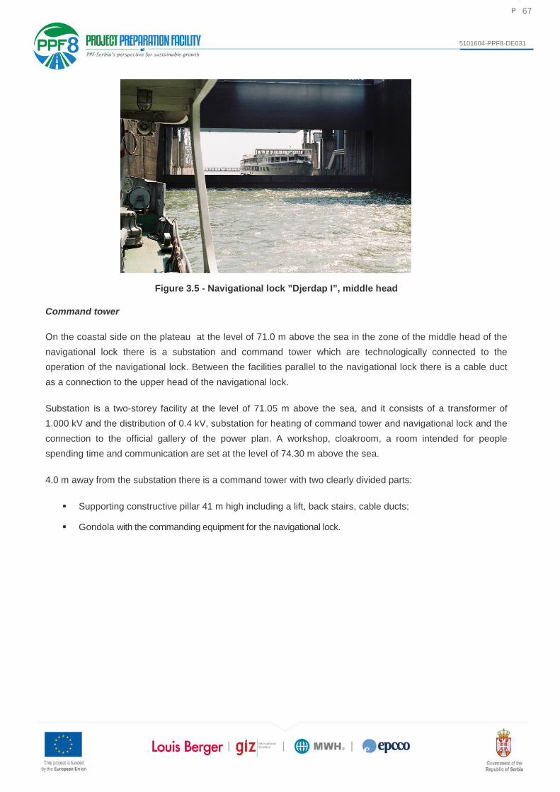
67
5101604-PPF8-DE031
Figure 3.5 - Navigational lock ”Djerdap I”, middle head
Command tower
On the coastal side on the plateau at the level of 71.0 m above the sea in the zone of the middle head of the navigational lock there is a substation and command tower which are technologically connected to the operation of the navigational lock. Between the facilities parallel to the navigational lock there is a cable duct as a connection to the upper head of the navigational lock.
Substation is a two-storey facility at the level of 71.05 m above the sea, and it consists of a transformer of 1.000 kV and the distribution of 0.4 kV, substation for heating of command tower and navigational lock and the connection to the official gallery of the power plan. A workshop, cloakroom, a room intended for people spending time and communication are set at the level of 74.30 m above the sea.
4.0 m away from the substation there is a command tower with two clearly divided parts:
Supporting constructive pillar 41 m high including a lift, back stairs, cable ducts;
Gondola with the commanding equipment for the navigational lock.

68
5101604-PPF8-DE031
Figure 3.6 - Navigational lock ”Djerdap I”, command tower
Downstream chamber
Geometrical elements of the downstram chamber correspond to the geometrical elements of the upstream chamber. Downstream chamber is constructively divided into 16 panels 12.50m wide, two panels 14.0m and three separate panels respectively 14.55m, 15.78m and 22.65m wide. There is the same system of supply using longitudinal galleries and cross-spread secondary galleries. Four major longitudinal galleries in the bottom of the downstream chamer are merged into two galleries whose dimensions are 6x6, which further go through the downstream head on the river side and exit into the lower water through the water cushion. The river wall from the line of the facade of the mehanical building to the downstream head has side overflows, 3.4 to 3.6m wide and woth the total lenght of 182m. On the crest of the river wall there are four grated pillars through which energy is transmitted from the electric power plant to the distibution device. Immediately above zje side overflows on the crest of the river wall there is a pedestrian pathway 3.5m wide, which connects the machine building with the downstream head of the navigational lock. To ensure the crests of the walls from the highest point in the chamber at the level of 54.0mnm reinforced concrete parameters are planned at the river and and coastal side at the height of 1.5m.
Lower head
Lower head of the navigational lock is the ending part of the downstream chamber, and is from the construction point of view adapted to the deviation of main galleries, type of the adopted shutter of the chamber and discharge of water from the chamber to the level of lower water. Operational door are double door and in an open position enter the niches 3.5m wide. Overhaul door protecting the lower water from entering the chamber during the overhaul of the double operational door are with a niche width of 3.0m. In the river abutment next to the premise for servoengine there are premises of power station with boards for automated management, plant premises and pump station for drainage of gallery space.

69
5101604-PPF8-DE031
Additionally, on the downstream head there are also gallery shutters and their menholes, which ae the same as the ones on the upper head. Operational shutters of the door are managed by servoengines, while the overhaul door are operated by a portal crane from the level of 55.0m above the sea.
Downstream fore-dock
Downstream fore-dock is located next to the downstream head in lower water and enables queuing and regrouping the convoys for transit and is made of the following units:
River line formed from the reinforced concrete wall (of total lenght of 550m), with footing of 7.50 m at the founding level of 29.0 and 30.0 m above the sea, krest at the level of 44.00 m above the sea, with hooks and fixed bollards for boats);
Coastal dock line is formed of reinforced concrete suppotive wall 585.0m long,
With slightly inclined water-facing side, founding level of 28.50 m above the sea, which in the end extends to the lining of the downstream regulation of riverbed;
Waterway between the dock lines is 100 m wide.
Figure 3.7 - Navigational lock ”Djerdap I”, downstream chamber, lower head and downstream fore-dock
Cable ducts
Cable ducts wthin the navigational lock hold and trnasmit different cables and installations, such as cables for lighting and signalling, energy cables, fire protection pipes, heating and cooling pipes, pipes for supply of water, air, et. On the coastal side of the navigational lock from the upstream to downstream navigational lock cable ucts are done from the assembling elements set in the riverbank terrain:

70
5101604-PPF8-DE031
Cable duct DJ1-UPCBSC/A for holding the cables for intallations (electricity, telephone, lightning, signaling, energy cables) and cable duct DJ1-UPCBSC/B for holding the pipeline (heating, water an air supply) are parallelly set between the upper and middle head. Firefighting cable channel DJ1-UPCBSC/C is set at 24 m from the mixing station on the middle head.
Cable duct DJ1-DWCBSC/A for holding the electric intstallation and firefighting and DJ1- DWCBSC/B for the pipelines (heatinge, air and water supply) are set parrellelly between a middel and lower head of the nvigational lock.
On the river side of the navigational lock from the upstream to downstream head cable ducts are integral part of concrete constrution of the wall of the chamber of navigational lock:
Cable duct DJ1-UPCRSC is set from the uppr to the middle head.
Cable duct DJ1-DWCRSC is set from the middle head to the lower head, with a part of the duct DJ1-LWHRSC1.
In the zone of the downstream fore-dock - river side cable channel DJ1-DWFDRSC represnts the integral part of the construction of quey wall of the fore-dock.
MECHANICAL INSTALLATIONS
Mechanical equipmnent of navigational lock encompasses main hydromechanical eqpment, electric-hydraulic plants of the doors and shutters and ancilliary equipment necessary for safe operation of the facility.
Hydromechanical equipment
Major equipment of the upper head:
Accident-overhaul doors for the day of 34.0x11.5m;
Main operation vertically lowering door for the day of 34.0x11.5m;
Grates at the water intake of the galleries of the day of 4x6m (three at each of the coastal walls of the upstream fore-dock and three on the river wall from accumulation);
Main gallery flashboard for the day of 6x6m one for each of the river and coastal wall of the upper head;
Two overhaul flat gallery shutters for the day of 6x6m set in bth of the abutments in front of and behind the main gallery shutter.
For the protection of the sideways niches from dicerse floating objects hich may get stuck during the transit, panel floating protective masks at the operational and overhaul doors of the upper hea have been installed. Protective mask floats on the water surface, wile the doors are below the surface of water, a during the lifiting of the dook the mask relies on the door and moves to the end position together with the door.

71
5101604-PPF8-DE031
Figure 3.8 - Navigational lock ”Djerdap I”, upper head, overhaul-repair (in operational position) and main operational door (in the niche)
Main equipment of the middle head:
Main double door for the day of 34.0x18.5m composed from upper and lower section;
Main reverse-segmented gallery shutters for the day 6x6m dimensions, one for river and coastal wall of the middle head;
Overhaul-flat gallery shutters for the day with the dimensions 6x6m set in front and after the main gallery shutter.
Figure 3.9 - Navigational lock ”Djerdap I”, middle head, main double door

72
5101604-PPF8-DE031
Main equipent of the lower head:
Operational double door for the day of 34.0x22.5 m ;
Ovaerhaul double door for the day of 34.0x22.5 m ;
Main flashboards of 6x6m (two) set in the river abutment of the lower head;
Overhaul flat, sliding gallery shutters of 6x6m in front of and behind the main gallery shutter;
Figure 3.10 - Navigational lock ”Djerdap I”, lower head, overhaul double door
In the part of the gallery at which the main and over haul gallery shutters are set, the metal lining of the gallery is also made in concrete:
in the coastal and river wall of the upper head,
in the coastal and river wall of the middle head and
river wall of the lower head.
Electrohydraulic equipment for doors and shutters
All the drives of the doors (excluding overhaul duble door on he lower head) and main gallery shutters are hydroulic servo engines. Hydraulic drives of the doors and shutters on the navigational lock include:
Servoengines for the drive of the door (main-operational and overhaul-repair door of the upper head double door of the iddle head and operational double door of the lower head);
Servoengines for the drive of the main gallery shutters of upper and lower head and main segmenting gallery shutters of upper and lower head and main segmenting gallery shutters of the middle head;
Frames and supports of the stated servoengines;

73
5101604-PPF8-DE031
Devices for oil production under pressure for servo engines of the doors and;
Portal cranes for servicing the equipment in plant premises.
Servo engines of doors and gallery shutters provide for lowering and lifting in different operational modes, and each servo engine has its support fixed to the frame of the servo engine.
Devices for the production of oil under pressure for the plant servo engines are located in special technological premises created within the concrete construction of the coastal and river walls at all three heads of the navigational lock. Devices for heating and ventilation are planned to be installed here, wheras the servivicing of equipment in the premises shall be performed using manual, portal cranes with the capacity of 32kN. Basic concept of the hydraulic installation is closed hydraulic circle with pumps of alternating flow. Hydraulic intallment consists of the following three hydraulic circuits:
Operational hydraulic circuit which consists of: pumpi station, distribution of supression and reversible ducts and hydraulic intallation of serbo engines of operational an overhaul doors, servo engines of main gallery shutters;
Pilot circui including an aggregate for distribution management;
Circuit for pre-charging which includes a tank and pumps for pre-charging
Figure 3.11 - Navigational lock ”Djerdap I”, plant
For mechanical-manual movement of the overhaul double door on the lower head there is a mechanism installed in the most downstream part of the lower head, and also a device with the capacity of 2x1000 kN for lifting the wings of the overhaul door into the overhaul position.

74
5101604-PPF8-DE031
AUXILIARY EQUIPMENT
Pumping stations
Pumping stations are also envisaged on the heads of the navigational locks, used for the draining of the energy galleries, drainage of the niche of the doors and drainage of the the space between the overhaul gallery shutters, with the following arrangement according to the heads:
Upper head: pumping station for the draining of the electrical gallery at the coastal wall, pupming station for draining of the niche of the overhaul - repair doo and drainage of the space between galleries on the river an coastal walls;
Middle head: pumping station for draining of the gallery space between the repair gallery shutters and pumping station for draining of the enegry gallery on the coastal wall of the chamber, pumping sttaion for the draining of the injection gallery in the middle part of the chamber;
Lower head: pumping station for draining of gallery space on the criver wall and pumping station for the draining of energy gallery on the coastal wall.
Portal crane and crane tracks
Portal cranes are envisaged for servicing, i.e. operating with the following eqipment:
Main and repair gallery shutters;
Servo engines of operational and overhaul - repair doors and major gallery shutters;
Grates on the water intake of the galleries;
Equipment of the pumping stations;
Equipment of the device for the production of oil under pressure;
Other auxilliary equipment (covers, frames, servo engines)
Portal cranes set on the crane track are of the following capacities:
on the coastal wall of the upper head (630+2x200) kN;
on the river wall of the upper head (630+2x200+80) kN with the range of 9.0m at the level of 71.0 m above the sea;
on the river wall of the middle head (500+50) kN;
on the river wall of the middle head (500+50) kN with the range of 9.0 m at the level of 71.0 m above the sea;
on the river wall of the lower head (630+2x50) kN MPa with the scope of 18.0 m at the level of 55.0 m above the sea.

75
5101604-PPF8-DE031
On the console of the respective portal crane on the upper head of the navigational lock an electrohydraulic orange peel clamshell bucket for cleawater intake..
Figure 3.12 - Navigational lock ”Djerdap I”, portal cranes
Hydrodynamometer for testing portal cranes
Static and dynamic testing of tdynamic testing of portal cranes is carried out through hydraulic dynamometer to which on both walls of the upper and middle head and on the river wall of the lower head appropriate anchor bollard have been cemented. There is only one hydraulic dynamometer with the accompanying installation, relocated according to the testing needs.
Anchor bollard for hydraulic dynamometer
Anchor bollards have been cemented in the manhole in the direction of each axis of the crane tracks for portal cranes with the purpose of fixing and achoring of hydraulic dynamometer for testing portal cranes.
Electrohydraulic pliers and storage of electrohydraulic pliers
Installment and operation of repair gallery shutters is performed using portal cranes and electrohydraulic pliers with the capacity of 630 kN and range of 6.0m. Within the period of normal exploitation of navigational lock, when there is no operation of the repair gallery shutter, electrohydraulic pliers are located on the storage, i.e. niches inside a concrete construction. The storage of the electrohydraulic pliers is located downstream of the repair gallery shutter on both walls of the upper and middle hea and river wall of the lower head. Pliers are also used for taking out, i.e. installing the main gallery shutters from frame when the whole shutter needs to be taken out of niche.

76
5101604-PPF8-DE031
Devices for creating water vortexes
Immediatly in front of the overhaul - repair door of the uppoer head and behind the repir double door of the lower head of the navigational lock, special devices for ceating water vortexes are planned. In winter periodu without navigation, when the lock is not in use and when the upstream chamber of navigational lock is closed by overhaul - repair door and the downstream chamber discharged and closed by overhaul double door, the device prevents the direct pressur of ice to the metal construction of the door. Prevention of water freezing is achieved through surface and directed current of water, and two devices are installed: one along the river and the other along the coastal wall of the chamber at the entrance and exit of the navigational lock. In order to enale proper functioning of operational and repair doors in cases of low temperatures outside, electic heating of sealing elements of the dor frames in chambers has been planned.
Figure 3.13 - Navigational lock ”Djerdap I”, devices for creating water vortexes
Heating and ventilation appliances
Heating and ventilation appliances are installed in: the premises of devices for production of pressurized oil for servomotors of doors and shutters and pumping stations. In the premises for the production of pressurised oil there are:
System for air suction including: fan, grid, filter for water treatment;
Heating system including: elevtric heaters and distibution through tin ducts;
System of sucking off air including: centrifuge roof ventilator and distribution through tin ducts.
The pumping stations are naturally ventilated and heated by electric radiators.

77
5101604-PPF8-DE031
Equipment for the distribution of ductings for oil and air
Equipment for the distribution of ductings for oil and air consists of:
Distribution of a low pressure air pipeline intended for connection or operation of pneumatic tools;
Distribution of the oil pipeline for supply and release of oil for the hydraulic drives of the servomotors and shutters.
Both pipeline distributions of navigational lock are extenstions to the respective intallations whose basic equipment is located in the mechanical building of the hydroelectric power plant ”Djerdap I”. There is a reception house in the middle head of the lock, where main supplies from the central system pass through and through which a connection between the oil system and pressurised air of the navigation lock is made with the hydropower system ”Djerdap I”.
Transport of clean and spoilt hydrauic oil is carried out between a tank and the device for the production of oil under pressure in the plant premises of coastal and river side, through epower galleries below the heads of the navigational lock and through special pipelines set through the chambers of the lock, all the way down to the downstream annex of the power plant at the level of 27.8m above the sea, where the central oil tretment station is located.
On each head of the navigational lock under the threshhold of the chamber door there is an power gallery derived, through which all the pipes for oil and air are conducted, as well as cables for electric appliances. There is a special pumping station for draining of excess of water from the power gallery, which is located in the vertical manhole of the coastal wall of all heads of the navigational lock.
Firefighting
One of the most fequent and most dangerous causes of fire on ships is oil and oil derivatives. During the transit of boats-tanks through the navigational lock, there are certain conditions for the occurrence of sparks and explosions due to high concentration of explosive and flammable vapours in the chambers of the navigational lock.
The firefighting system on the navigational lock consists of: pumping station Kosovica, a tank with a seal and a mixing station. The Kosovica system uses the river water of the Kosovica river, which is also used for the water supply of the lock, dam facilities and coastal settlements. Water is pumped through the pumps into the reservoir, from where the gravitational supply (Ø600 mm) transfers it to to the mixing station. The mixing station is located within the central head, all the way to the building of the transformer station. Mixing water and 3% synthetic extract for heavy foam are mixed in the mixing station, by adding the extract to the mixer by pumping aggregate. The mixture is then transported through the pipeline system to the final monitors where firefighting foam is created. Ventilation of the mixing station is performed in the ventilation tubes, and drainage into the existing sewage manhole.

78
5101604-PPF8-DE031
The synthetic extract is stored in two steel reservoirs with a diameter of 2,500 mm in the total volume of 2x40 m3, which are filled from the tank through the openings above the reservoir.
Before entering the mixing station, main water supply pipeline (Ø600 mm) is divided into two pipelines (Ø500mm), one being operational and the other spare one. There are shutters at every branch of the pipeline (Ø500 mm) and si pipelines of the diameter (Ø350 mm) for all sections of the navigational lock with the adequate equipment. Poduction of the mixture of ewater and 3% extract of heavy foam is carried out in the venturi mixers using an automatic electrical pump for dozing of extracts. The mixture of water and extracts is brought to the monitors arranged along the chambers of the navigational lock from the mixing station by a special pipeline for upstream and downstream chamber of navigational lock.
The monitors are placed on the appropriate stand above the parapet wall. The capacity of each monitor is approximately 1.9 m3/min, while the pressure is 5.3 bar. The monitors are supplied with a control valve and can be operated manually at the horizontal and vertical levels. A total of 48 monitors are distributed along the length of the chamber of the lock at a distance of 26m. The reach of the jet from the monitor is about 34m, that is, from one to the other wall of the chamber of the lock. The arrangement of monitors from the river and coastal sides of the chamber is alternating, so that the entire surface of the lock is covered.
Figure 3.14 - Navigational lock ”Djerdap I”, firefighting
Other auxiliary equipment
Adequate covers are placed on all niches and opeinings of yje navigational lock, while other auxiliary equipment includes platforms, step irons and railings.
An elevator with the capacity of 300 kg or 4 persons for staff use is installed sin the command tower of the coastal side of the middle head of the navigational lock.

79
5101604-PPF8-DE031
Three transformer stations with the capacity of 6.3/0.4kV for supplying the customers with electricity are operations on the navigational lock, filled with pyralene oil:
Transformer station on the upstream head on the premises of oil-hydrauic aggregarte located on the coastal side with the capacity of 1.000 kVA;
Transformer station on the middle head on the premises on coast with the capacity of 1.000 k VA;
Transformer station on the downstream head on the premises of oil-hydraulic aggregate located on the river side with the capacity of 400 kVA.
Supply of the transformer station of the upstream head is carried out by a cable of 10 kV from the distribution capacity of 6.3 kV in the mechanical building of the power plant from the section I and from the cell no. 20. Transformer station of the middle head is supplied from the distribution plant of 6.3 kV in TS ``SIP through a cable of 10 kV.
Supply of the transformer station of the downstream head is carried our by a cable of 10 kV from the distribution plant of 6.3 kV in the machine building of the power plant from the section II from the cell no. 5.
The equipment for central management an montoring of facilities of the navigational lock is located in the command tower. The central command provides the following:
Management of doors and covers ;
Measurement, signalling related to all the levels of water in the lake and chambers;
Managemnt of TV system of survellance in the navigational lock area;
Radar system management;
Management of traffic light signalling in the dock, fore/dock and chambers of the navigational lock;
Management of the sound system and telephone lines;
Management of the communication system;
Management of firefighting system in chambers.
The power supply of the lighting installation is carried out from the distribution of 0.4 kV transformer station 10/0.4 kV Workshop. The reserve power supply of the installation is carried out from the switchboards of 0.4 kV transformer stations located in the technological premises.
Installation and reserve supply in the command tower is carried out from the main switchboard 0.4 kV in transformer station of the middle head. Installation of the inoor lighting an outlet and installation of the outdoor lighting of the whole navigational lock are supplied from the switchboards of the lighting located in the technological premises.

80
5101604-PPF8-DE031
3.5 Overview of the planned activities on the adaptation of the navigational lock
3.5.1 Architetural Design
Gondola of the command tower. The scope of the architectural (craftwork) works intends to replace the built-in (existing) materials which covered the gondola of the command tower and finely-treated interior surfaces (walls, ceilings and floors) and include demounting, insulating, ceramic, flooring, locksmith, aluminum, painting, plumbing and other works.
Technological premises. The scope of architectural (craftwork) works envisages the replacement of existing materials used for finishing works on the the interior of technological premises (walls, ceilings and floors) and the dismantling (demolition) of the existing concrete stands for pumps and include isolating, ceramic, locksmith, aluminum, painting and other works.
3.5.2 Construction Design
Gondola of the command tower. Within the construction works on the adaptation of the navigational lock of HPP ”Djerdap I”, inspection and repair of the supportive steel grate of the gondolla is envisages, as well as a possible replacement of grate parts if the inspection finds that a replacement is necessary. The inspection of this grate was not performed during the field visit of the design team, due to the unsafe access to the grid space.
Technological premises. Within the construction works on the adaptation of the navigational lock of HPP ”Djerdap I”, the adaptation of the technological premises on the coastal and river side of the ship chamber has been envisaged.
Cable ducts
Upstream chamber - coastal side
The project includes complete removal and storage of the whole existing construction of the cable ducts with their covers, stabilisation of underground construction. Production of a healthy foundation and adoption of new assembling cable and fire-protecting ducts with covers. The project includes construction of a new cable uct and one new duct for fire-protecting pipes alond the whole upstream chamber. This solution envisages the removal of the pipes for fire-protection and their installement under the ground, as well as the construction of two new cable ducts.
Downstream chamber - coastal side
The project includes complete removal and storage of the whole existing construction of cable ducts with covers, stabilising of the underground construction, production of a healthy foundations and installment of new assembling cable ducts with covers.
Downstream lower head - river side

81
5101604-PPF8-DE031
Removal and storage of concrete covering panels on the river side of the downstream chamber and lower head, and installment of steel ribbed covers of 1.25x1.25 m and 6/8 mm wide.
3.5.3 Design of hydrotechnical installations
Dredging of the deposit of the downstream fore-lock. Bathymetric measurements in 2017 found that there is a significant depositing of sediments in the whole locaton of the fore-dock. The recorded levels of the deposited sediment moved within the normal limites of minimum 31.5 m above the sea to maximum of 35.0 m above the sea. The largest quantity of the suspended material which was equally distributed along the lenght of the fore-dock reached the level of 33.5 m above the sea. Despite the significant depositing, the debth of water in the fore-lock is enough for safe and efficient navigation at the lowest level of the lower water (38.57 m above the sea) in the amount of 5.0m on average. However, the bed should reach the level stated in the original project, which is 31.50 m above the sea. According to the present geological and geotechnical research of the soils in the coastal and river area of the Danube, mateial up to the debth of a few meters (3-4m) consists mostly of finely grained, muddy sands. It is assumed that the same material is suspended at the level of the downstream fore-lock. Taking into account the type of the suspended material, it is possible to apply the following method of dredging for the works in the downstream fore-lock:
Removal of the deposited sediment from the downstream fore-lock may be done by cutter suction dredger or suction dredger with floating or partly sunk pipeline.
Depositing, i.e. removal of the dredger material into the fiver floe should be performed at the lenght of 2 km from the most downstream point of the downstream fore-lock.
Dredging operations:
Recording the river profiles in the downstream fore-lock;
Preparation of the terrain (construction of a landfill) for depositing the dredged material in case of depositing to the surface of the terrain in the area of up to 20m wide in the vicinity of the river flow;
Dredging material up to the required level of the riverbed and transport of the dredged material to the landfill (if it is on the coast) or transport by pipeline by returning to the iverflow of the Danulb , but not into the area of waterway;
Final recording of the profile after the dredging for the purpose of contolling.
Environmental protection. It is recommended to perform works after a period of high-level waters and beyond the season of fish breeding, which means in the months of July, August and September and also possible but less desirable in June and October. Therefore, works will be carried out in the period of low and medium-level waters.

82
5101604-PPF8-DE031
Figure 3.15 - Bathymetric record of the bottom of the downward fore-lock, October 2017

83
5101604-PPF8-DE031
3.5.4 Design of electric power installations
Management system of electrochydraulic drives of doors and covers. The initial management system solution is based on analogue technique, relay logic, and hardwired connections, where all the functions were predefined and limited by hardware resources. The equipment for the management system of the lock and other systems has been in operation since then, and part of the equipment has been replaced and modernized in the previous period. In order to make navigational lock work with the appropriate level of availability and reliability in the future, it is necessary to adapt the control system equipment.
Power supply for electro-hydraulic drives for doors and shutters. The project envisages complete replacement of the existing 6.3 kV voltage cells, all three heads of the lock, as well as rail connections from cells to medium voltage terminals on transformers of 6.3/0.4 kV, and cables for connecting these cells to their power supply (6.3 kV distibution in TS Sip and distribution of 6.3 kV in the power plant). Having in mind the significant distance of the supply source, the project envisages replacement of the existing cell 6.3kV, i.e. installation of a circuit breaker -switch panel on the 6.3 kV side of the transformer. In addition to the local separation function of the transformer from the power source, the microprocessor protection from excessive current of the output towards the transformer is also provided in the cell.
The project envisages a complete replacement of existing 0.4kV voltage distributions, on all three heads of the lock, as well as power cables for supplying newly designed and existing consumers which will remain in operation after the adaptation of the lock.
The project envisages complete replacement of the equipment of the source and distribution of the uninterrupted power system 231 V, 50 Hz, as well as cable connections.
The project envisages complete replacement of the equipment of the source and distribution of DC voltage, as well as all cable connections.
DC power supply will be provided at two voltage levels of 220 V jss and 24 V jss.
The project envisages testing of electrical resistance of the ground, as well as existing installations, after which it is necessary to repair and adapt the existing installations in order to provide characteristics in accordance with the applicable technical regulations.
The project envisages the replacement of a complete lightning protection installation, i.e. all lightning conductors placed in the command tower, as a protection against overvoltage caused by lightning.
Auxiliary systems for electrohydraulic drive doors and shutters. Measurement of the water level upstream and downstream from the lock, as well as the measurement of the water level in the chambers of the locks, ensure the safe operation of the lock. Water pressure on the door will be prevented if the door is only allowed to operate if the water levels on both sides of the door are approximately equal, i.e. with a defined tolerance of 3 cm.

84
5101604-PPF8-DE031
Electrohydraulic drive of crane tracks. Since the height of the crane track on the central head of the vessel is such that it acts as an obstacle to the transit of sea-river ships, there ocurred the need to lift the tracks to a maximum height of 3.6m, thus providing for the transit of all ships navigating the Danube. The frequency of such requests for raising and lowering the crane tracks is maximum two times a month. Crane tracks consist of two independent sections and are lifted in an identical manner, with an electro-hydraulic drive. The existing concept of the electro-hydraulic system is implemented with a partially active synchronization and a system of protection and correction in case passive synchronization is not able to maintain the synchronous movement of the two cylinders due to unforeseen interruptions. The existing hydraulic aggregate is located at the half of the section of the crane track that rises. Next to the aggregate, there is an electricity board for the local contol, and on the other hand, a differential mechanical transmitter with two end switches that identify the unauthorized inclination to the left or right. The position of the ends of the section of the crane track which is being lifted is measured through the cable and the system of the pulley, so that one cable is introduced into the differential transmitter for identifying the inclination to the left and the right. The position of the main remote control is a common command electricity board for both crane tracks located below the crane track somewhere at half the distance between them.
In the newly designed solution, the problem of synchronous motion of the cylinder will be solved through four independent positioning systems (2 + 2), that is, the system is projected with two closed position loops, each with its pace driver on the entire cylinder pace. Synchronization errors will be corrected on-line in real time, through proportional chokes, which, like the original solution, are in Graetz circuit with a high resolution guaranteed by the quality of the pace. In addition, the newly designed system will have complete security in case of failure of each active link of the electro-hydraulic system in the lifting phase and in the lowering stage. The system is equipped with one-way plunger cylinders, so a proportional choke in Graetz circuit is applied. In case of failure of one pump, the system continues to operate with another pump.
Due to the expected low frequency of operation of this installation, it is not necessary for a pump to be 100% in the passive reserve, but both pumps will work simultaneously. In case of failure of one pump, the system is envisaged to continue operating with only one pump with a 50% lower speed potential. The power of the engines designed for pump operation is 11 kW. Disposition of the equipment will be the same as with the existing system.
Traffic signal system. The traffic signaling system provides light signals for vessels moving in the following docks and fore-dock zones and in the zone for the entrance and exit of the chamber of the lock. The project envisages replacement of equipment on this system.
Heating and ventilation system for technological premises and command tower. For the purpose of air-conditioning in the gondola of the command tower, a package split system and a channel air ducting with a centrifugal fan and blinds with an electric motor drive are planned.
Heating and ventilation of technological rooms and transformer stations on the lower head will be carried out by three-phase air heaters of 42 kW, 36 kW, 21 kW or 18 kW.

85
5101604-PPF8-DE031
The ventilation of these rooms will be provided by centrifugal and axial fans. Switching on the heaters and fans will be provided by the signal contacts in the contact thermometers, which will be placed in the premises. Distribution boards for heaters and fans, with contactors for their putting into operation, will be installed in each of the premises.
Installation of internal and external lighting. The project envisages a complete replacement of the internal and external lighting of the lock, including all the systems within their composition.
Stable firefighting system. The project envisages the replacement of electrical equipment and installations in the mixing station, cable installations connected to the shutter and mixing station, energy cables providing power supply of the system equipment from the main distribution board, as well as installations of the SCADA system for remote control and monitoring of the system from the command tower.
External portal cranes. The project envisages complete replacement and modernization of existing electrical equipment and installations on the crane. In addition to the replacement of electric motors, the replacement of power and control cabinets, a control panel in the crane cabin, wind indicators, as well as all cables, including electric equipment of electrohydraulic pliers, is envisaged.

86
5101604-PPF8-DE031
3.5.5 Design of mechanical installations
Electro-hydraulic drives of doors and shutters. The electro-hydraulic drives of the doors and shutters are installed on the coastal and river side of the upper head, the coastal and river side of the middle head and coastal and river side of the lower head. The adaptation of hydraulic equipment as part of the electro-hydraulic drives of the door and shutter of the lock envisages the replacement of the complete existing equipment with a new one, conceived on the volumetric-ballast control with the application of a set of pump aggregate common to all doors and shutters from each of the six technological premises.
Electro-hydraulic drives of crane tracks. The crane tracks for the transport of equipment in the machine building and the access plateau on the coastline are lifted using an electro-hydraulic drive. Adaptation of hydraulic equipment within the electro-hydraulic drives of the crane tracks envisages the replacement of the complete existing equipment with a new, with the possibility of active proportional synchronization of the movement of the pistons of the servomotor drives.
Heating and ventilation system for technological premises and command tower. The project of mechanical installations includes mechanical equipment for heating and ventilation of technological premises on the upper, middle and lower heads and the equipment for heating and air conditioning of the command tower. The adaptation envisages the replacement of the existing equipment for heating, cooling and ventilation of technological premises and command towers with the addition of automatic operation while maintaining the specified microclimate parameters (temperature).
Stable firefighting system. The project of mechanical installations for the adaptation of a stable firefighting system on the navigational lock includes the replacement of the existing mechanical equipment of the mixing station and the complete discharge pipeline distribution with the associated equipment.
Operational segment closures in the galleries of the middle head. The project of mechanical installations includes the replacement of hydromechanical equipment of existing operational gallery shutters on the coastal and river side of the middle head.
Overhaul double doors on the lower head. The project of mechanical installations includes replacement of hydromechanical equipment of existing overhaul doors on the lower head.
Electro-hydraulic pliers for manipulating gallery closures. Electro-hydraulic pliers for manipulating gallery closures are mounted on the coastal and river side of the upper head, the coastal and the river side of the middle head and the river side of the lower head. Adaptation of electro-hydraulic pliers equipment envisages the repair of the pliers construction, the replacement of the electrohydraulic drive and the repair of parts installed on the pliers storage.
External portal cranes. Adaptation involves the replacement of equipment and operations on cranes from the river and coastal sides.

87
5101604-PPF8-DE031
3.5.6 Construction and architectural works
Construction and architectural works on the gondola of the command tower
Adaptation or replacement of parts of the steel grid, the method of fixing and new anticorrosion protection
Adaptation or replacement of the telecommunication equipment holder;
Concrete overhaul of the top plate of the gondola and lift cabin;
Replacement of the complete metal railing;
Construction of a new interior of gondola control tower;
Construction and architectural works in technological premises
Adaptation of the damaged parts of the cncrete surfaces in the technological premises;
Adaptation of the caouplings in places of leakage in tecnological premises;
Finishing construction works in technological premises, such as posting floor and wall tiles, carpenty, painting and similar;
Necessary construction works for the installation of new equipment, such as the development of appropriate foundations for the installation of equipment.
Works on the adaptation of cable and pipeline ducts along the cable and pipline ducts through the chambers of the lock
Adaptation of the ducts of the chamber of the lock at the entrance/exit of the ducts from the (MNU) premises.
Works on the dredging of the deposits in the lowerstream fore-dock
Recording the morphological state of the bottom of the Danube riverbed using the multibeam or singlebeam method.
Bringing the bottom of the Danube riverbed of the downstream fore-lock to the projected level for navigation;
Treatment of deposited material from thedownstream fore-lock.

88
5101604-PPF8-DE031
4. OVERVIEW OF MAJOR ALTERNATIVES CONSIDERED BY THE DEVELOPER
Alternative solutions have not been considered within the project of adaptation of the navigational lock. Taking into account the type and scope of interventions (replacement of equipment) at the planned adaptation, alternative solutions could not be considered, but only the timely replacement of worn-out and unreliable equipment, which jeopardizes the further operation of the lock.
If alternatives were discussed regarding the adaptation, the following two could have been conditionally considered:
An alternative implying doing nothing,
Proposed adaptation/revitalization considered in the project.
An alternative implying doing nothing would in the near future cause a complete stop of river traffic through the Djerdap Gorge as, due to the wear and unrealiability of certain parts of the equipment, sooner or later the lock will cease to operate. Although this alternative can create a situation that is favorable to the environment (at least in local terms), it is considered to be an unrealistic scenario given the priority given to this project by the Government of the Republic of Serbia, i.e. competent Ministry of Construction, Transport and Infrastructure. In this context, this conditional alternative cannot be seriously considered.
An alternative of the proposed adaptation of a navigational lock is to be considered the only real one and it is combined with the implementation of measures to prevent and eliminate possible negative environmental impacts favorable for the environment itself, as it will, in a wider context, create preconditions for reducing possible adverse effects as regards the current state f the navigational lock operation.

89
5101604-PPF8-DE031
5. OVERVIEW OF THE ENVIRONMENTAL CONDITIONS AT THE SITE AND THE NEIGHBOURING AREA
5.1. Air quality
The Republic Hydrometeorological Service of Serbia (RHMZ) systematically monitors meteorological parameters, tests, analyses and assesses theair quality in a number of meteorological stations in Serbia. The nearest meteorological stations to Djerdap 1 are Veliko Gradiste and Negotin, which are located at a distance of about 120 km, or about 80 km respectively. Due to the significant distance of the measuring stations from the site of HPP ”Djerdap I”, the data from these stations cannot represent the state of air quality in the area of the navigational lock.
Environmental Protection Agency in accordance with the Law on Air Protection (Official Gazette of RS, No. 36/09 and 10/13) is responsible for the state network for monitoring the air quality for the Republic of Serbia. Operational monitoring, using automatic reference methods, is carried out in accordance with the Regulation on the establishment of a program for the control of air quality within the state network (Official Gazette of RS, no. 58/11) and the Regulation on conditions for monitoring and requirements for air quality (Official Gazette of RS , nos. 11/10, 75/10 and 63/13). By fulfilling the obligations of informing the public about air quality, the Environmental Protection Agency presents the results of automatic air quality monitoring in real time. Verified values and assessment of air quality in agglomerations and zones are given in the Annual Report on the state of air quality in the Republic of Serbia.
Kladovo is the closest urban settlement and is located at a distance of 9km from Djerdap 1. According to the Law on air protection, air monitoring is done according to agglomerations, and City Institute for Public Health Timok from Zajecar carries out the monitoring for Kladovo in accordance with the Regulation on conditions for monitoring and air quality requirements (Official Gazette of RS, nos. 11/2010 and 75/2010, 63/2013). The latest results of the air quality analysis at 3 measuring points in the town and 4 more measuring points in the settlements of Donji and Gornji Klus in the municipality of Kladovo, conducted by experts from the Public Health Institute Timok from Zajecar in the period from June 1, 2017 to July 4, 2017, and according to the program, indicated that all the measured values are within the limits of allowed values.
There are not any significant air pollutants in the municipality of Kladovo and it is regarded as municipality with clean air. Industrial capacities of the municipality of Kladovo include the hydroelectric power plant Djerdap I - production and distribution of electricity, the company for equipping navigating facilities Rhein Donau Yard (mixed Dutch-Romanian-Serbian) - shipbuilding, Fotegs - gas supply - gas for heating and transport, Almag - metalworking industry, Huber - production of advertisements (lightings, neon, plexiglass). The main economic resource is HPP ”Djerdap I”, built in 1972 at 943rd km from the mouth of the Danube to the Black Sea.

90
5101604-PPF8-DE031
The lock is located in the zone of the Djerdap National Park, and therefore monitoring the envirnmental conditions is mandatory. The condition of the environment in the largest part of the territory of the Djerdap National Park is favorable, except field of communal infrastructure (a large number of unregulated dumpsites, unregulated drainage). The best condition of the environment is in the mountain zone of the national park, where there are no intensive economic activities and traffic.
Part of the National Park to which Djerdap I belongs to the III Protection Zone. Although there are no air pollution measurements, it may be concuded that there may be certain emissions at the Đerdap I site which occur periodically and briefly and which originate from potential pollutants such as:
River traffic that taking place through the lock;
Road traffic running along the regional roadway in the coastal area and through the hydroelectric facility Djerdap I towards Romania;
Systems for heating individual households in coastal settlements and tourist facilities-camp Karatas.
In the absence of data on air quality, qualitatively low emissions of air pollution on the Serbian side of the Danube in the area of HPP ”Djerdap I” are expected, and based on the following estimates:
Absence of industrial activities;
Extremely small population density on the right bank of the Danube;
The length of the road network;
Existing intensity of water and road traffic.
However, high level or air pollution appear on the Romanian side of the Danube, especially in the city of Turn Severin, located 13 km southeast of the HPP ”Djerdap I”. The city has a highly developed industry. There are no data on the nature and concentration of pollutants, but the products of air pollution emissions (in particular, the by local wind kosava) are transported to the hydropower facility and all settlements downstream of the hydroelectric power plant. Thus, the usual occasional phenomena of air pollution are manifested by unpleasant smells and a cloud of dust settling on the Serbian side of the Danube.
Environmental protection in the branch of HPP ”Djerdap I” in 2016 was carried out according to the defined procedures and other documents of the environmental management system (EMS). Namely, HPP Djerdap, which belongs to the system of EPS, has adopted the ISO 9000 and 14000 management systems.

91
5101604-PPF8-DE031
5.2. Surface water quality
The assessment of the quality of surface waters has been carried out according to the data on surface water quality monitoring carried out by the Electric Power Industry of Serbia, covering 2016 and 2017 and the results of testing the quality of surface water and groundwater for 2016 of the Environmental Protection Agency of Serbia. From the above reports profiles closest to the location of HPP ”Djerdap I” were selected, includingTekija and Kladovo from the monitoring of Elektroprivreda Srbije and Tekija and Brza Palanka from the monitoring of the Environmental Protection Agency of Serbia.
The monitoring carried out by Ecectric Power Industry of Serbia lasted from September 2016 to June 2017. Four water quality control Danube monitoring campaigns were conducted on each profile, two in 2016 (September and November) and two in 2017 (April and June). Based on the obtained results, the waters of the Danube on the Tekija profile, according to the Regulation on limit values of pollutants in surface and ground waters and sediment and time periods for their reach (Official Gazette of RS, no. 50/2012), correspond to the classes II and III of quality surface waters. The water quality on the Kladovo profile varied according to the same Regulation and ranged from classes II to IV in the tested samples. Some poorer results on the Kladovo profile, one class corresponding to the class II, 2 samples corresponding to the class III and one sample corresponding to the class IV of surface water quality were expected given the position of this profile positioned between the two cities, Kladova on the right bank and Drobeta -Turnu Severin on the left bank of the Danube. Due to this position of the monitoring profile, the pollution caused by wastewaters, primarily municipal ones, does not completely interfere with Danube water and slightly higher values of pollutants were obtained in the taken samples.
The monitoring carried out by the Environmental Protection Agency of Serbia lasted from January to December 2016 and is publicly available on the website of the Serbian Environmental Protection Agency. A total of 12 quality control campaigns were conducted in each of the profiles. Based on the obtained results, the waters of the Danube on the profiles of Tekija and Brza Palanka, according to the Regulation on limit values of pollutants in surface and ground waters and sediment and time periods for their reach (Official Gazette of RS, no. 50/2012), corresponds to classes II and III of surface water quality.
According to the aforementioned Regulation (”Official Gazette of RS”, No. 50/2012), surface waters of classes II and III of surface water quality can be used for drinking water supply if appropriately treated, bathing and recreation, irrigation, industrial use (process and cooling water). Class IV surface waters can be used to supply drinking water after applying appropriate advanced treatment methods, irrigation and industrial use (process and cooling water).
Based on the results of monitoring on the profiles of Tekija, Kladovo and Brza Palanka, it can be concluded that the quality of the Danube water between these profiles is predominantly within the limits for the classes II and III. Since HPP ”Djerdap I” is located in the observed area of the Danube flow, it can be expected that the quality of the water upstream and downstream of the dam is of the classes II and III of surface water quality.

92
5101604-PPF8-DE031
Table 5.1 - Water quality monitoring results 2016-2017. Electric Power Industry of Serbia
Profile Tekija Tekija Tekija Tekija Kladovo Kladovo Kladovo Kladovo
ID number 16-01-273 16-01-312 17-01-139 17-01-281 16-01-274 16-01-313 17-01-166 17-01-282 Date of sampling 28.09.2016. 08.11.2016. 27.04.2017. 13.06.2017. 29.09.2016. 09.11.2016. 28.04.2017. 14.06.2017. Air temp. 17,0 9,0 19,0 27,0 8,0 8,0 14,0 22,0 Water temp. 21,1 10,5 13,1 24,1 20,3 10,6 12,4 23,8 pH value 8,08 8,24 8,18 7,68 8,03 8,23 8,16 7,67 electrical conductivity 419 434 359 344 418 434 358 344
Susp. mat. 4.0 4.6 5.2 4.9 9.2 4.2 6.1 5.9 Dry remains.105°C 274.0 283.6 236.2 226.9 277.0 280.2 237.1 225.9
Loss by ignition 2.1 2.8 3.1 2.3 3.6 2.6 3.8 2.7 Consumption of KMnO4
9.23 10.55 6.28 11.02 10.30 9.42 4.77 6.78
COD dichromate <10 <10 <10 <10 <10 <10 <10 <10 BOD5 2.06 1.27 1.21 2.15 2.38 1.98 1.07 2.24 Diluted oxygen 7.63 9.38 9.89 5.13 7.00 9.19 9.19 4.37 Sulphates 33.1 42.2 35.44 30.3 31.1 35.9 35.77 24.2 Chlorides 21.3 16.7 18.91 16.1 22.2 16.2 18.71 17.1 Amonium iodine <0.02 <0.02 0.04 0.08 <0.02 <0.02 <0.02 0.02 Nitrite 0.010 0.014 0.018 0.045 0.017 0.014 0.032 0.046 Nitrates 1.32 1.51 1.65 0.79 1.28 2.29 1.49 1.60 Total nitrogen 1.46 1.66 1.73 1.29 1.52 2.43 1.61 1.95 Orthophosphates 0.096 0.086 0.040 0.086 0.065 0.059 0.047 0.095 Total phosphorus 0.177 0.147 0.134 0.140 0.153 0.134 0.152 0.143
Fenols <0.001 <0.001 <0.001 <0.001 <0.001 <0.001 <0.001 <0.001 Detergents <0.02 <0.02 <0.02 <0.02 <0.02 <0.02 <0.02 <0.02 TOC 2.31 2.32 1.89 2.47 2.10 2.28 2.47 2.47 Iron 0.022 0.078 <0.005 0.061 0.030 0.067 <0.005 0.092 Mangane 0.005 0.009 0.005 0.053 0.005 <0.005 0.006 0.078 Zinc <2 <2 <2 <2 <2 <2 <2 <2 Copper <2 <2 <2 <2 <2 <2 <2 <2 Lead <2 <2 <2 <2 <2 <2 <2 <2 Chromium <2 <2 <2 <2 <2 <2 <2 <2 Nickel <2 <2 <2 <2 <2 <2 <2 <2 Cadmium <2 <2 <2 <2 <2 <2 <2 <2 Arsen <10 <10 <10 <10 <10 <10 <10 <10 Mercury <1 <1 <1 <1 <1 <1 <1 <1 Boron <20 <20 <20 <20 <20 <20 <20 <20 Class II II II III II III III IV
5.3. Sediment
The planned removal of sediment during adaptation works on the HPP ”Djerdap I” will include cleaning of sediments in the downstream fore-lock zone. Estimated amount of sediment to be cleaned is expected to be 50.513 m3, and after the completed works, the bottom level of riverbed of the downstream fore-dock will be 31.50 m above the sea.
Preparatory works on the adaptation project of the HPP ”Djerdap I” navigational lock included the analysis of the quality of sediments in the downstream zone and its characterization as potential waste. This analysis was carried out by the Jaroslav Cherni Water Management Institute.

93
5101604-PPF8-DE031
Based on the analyzes carried out and according to the Regulation on limit values of pollutants in surface and groundwater and sediment and time-frames for their reach (Official Gazette RS, no. 50/2012), the quality of sediment in the downstream fore-lock is estimated as class II, or slightly polluted sediment. Categorization of sediment in the downstream fore-dock as non-hazardous waste was performed according to the Rulebook on categories, testing and classification of waste (Official Gazette of RS, no. 56/2010).
Figure 5.1 - Conclusion of the report on sediment testing at the location of the downstream fore-dock of Jaroslav Cerni Water Management Institute

94
5101604-PPF8-DE031
According to the aforementioned Regulation, sediment of the quality class II can be postponed without special environmental protection measures in the 20m wide area around the watercourse or as proposed in the Technical Documentation by returning to the river flow and depositing in the deeper parts of the river or transporting the material (as a suspension) by the river. Since sediment is classified as non-hazardous waste, it is even possible to dispose of it on landfills.
5.4. Soil quality
In the area occupied by the Djerdap National Park (within which the project of lock adaptation is planned), there are 41.170ha of agricultural land, which amounts to 26.7% of the total territory. Apart from some smaller areas of the plains of Kljuc and Negotin plains, which are very suitable for intensive agricultural production, mountains and hills dominate other areas, with prevailing forests, while among the agricultural land there are meadows and pastures. On average, about 47% of the total agricultural land consists of arable land (19,552 ha) and almost as much of permanent lawns (47%, i.e. 19,406 ha), among which there are much more meadows (13,449 ha) than pastures (5957 ha). Most arable land is of poor economic potential - 68.2% is in categories/ classes 6-8, which are more environmentally friendly for meadows or orchards, and in cases of stronger erosion for forests.
In the area of National Park, forest land covers a total of 452.4 km2, of which 382.2 km2 (84.5%) and privately owned 70.2 km2 (15.5%) are state-owned. The forest covers 440.7 km2, or 97.4% of the total area of forest land, which from an ecological point of view can be considered optimal. The dominant area under forests is in the municipality of Majdanpek (52.7%), followed by the municipalities of Golubac (30.5%), and the smallest share in the municipality of Kladovo (16.8%). The protective function of the forest is predominantly present In the area of the national park. 35 types of forests and 67 categories of compostion have been recorded in the state forests, with 45 species of trees. The following types of forests are most commonly present: mountain beech (on acidic brown lands, shallow and skeletal brown lands), acidophilous beech forests, sessile oak, sessile oak and hornbeam, sessile oak and Turkey oak, slightly less black hornbeam, black ash and lilac. Tree mixes in private forests follow natural composition and zonality. Clean compositions are slightly more present (on 55.3% of the surface area) compared to mixed forests (44.7%). The found state of composition from the aspect of bio-ecological stability can be assessed as medium-sized, and the problem of long-term management is to increase the degree of mixed trees in these forests. 16 species of trees in private forests have been registered, among which, although slightly, there are some speciaes of non-coniferous wood.
Natural characteristics of the land in the area of the navigational lock of the hydroelectric power station Djerdap I and its immediate environment were completely changed during the preparation of the terrain for the construction, construction and exploitation of HPP (access road, cable ducts, railway track, etc.) of the main road M 25.1 Kladovo - Donji Milanovac, as well as later horticultural decordation of free surfaces.
The basic physical and mechanical characteristics of soil (structure, porosity, consistency), chemical composition and microbiological characteristics have been changed. Generally, the land is of low grade with low humis content and reduced microbiological activity.

95
5101604-PPF8-DE031
The space covered by the Study is not included by the Program for Systematic Testing of Hazardous and Harmful Substances in the soil of Serbia, conducted by the Institute for Soil and the Institute for Pesticides and Environmental Protection, according to the Regulation on the Program for Systematic Monitoring of Land Quality, Indicators for Assessing the Risk of Land Degradation and Methodology for the Development of Remediation Programs (”Official Gazette of RS”, no. 88/2010), so there are no data on the quality and degree of soil contamination, which can only be estimated in the concrete case.
Assessment of soil contamination can be done on the basis of its purpose, proximity to roads, location of facilities and activities leading to pollution of the soil, and it is possible to compare it with the results of tests obtained on the soil of the same pedological composition that is not under anthropogenic influence and has preserved basic natural characteristics.
The soil at the site is likely to contain slightly increased concentrations of nickel, as well as the largest part of the RS, due to the specific geochemical composition, although the anthropogenic effect can not be completely excluded.
The pollution of land along the main road M 25.1 and the access road has been created by decades of washing off of polluted atmospheric waters from the roadway contaminated after intensive use, due to occasional leakage of lubricants and fuel, depositing of particles from the exhaust gases of vehicles and mechanization, spillage of cargo, wear of tires, asphalt and braking system. In addition to the roadways, hazardous organic and inorganic micro-polymers (lead, copper, zinc, petroleum and derivatives, and sporadic and polycyclic aromatic hydrocarbons) are usually detected in the area next to the roads, after several decades of washing off from the roadways, along with the herbicides used to destroy weeds. The concentrations of these pollutants are relatively low along moderately frequent roads, such as the main road M 25.1. It is characteristic that the concentration of lead drastically decreases with the higher distance from the road. Along the roads there is also slightly increased salination due to the application of industrial salt and grained aggregate (grit) in winter months, as prevention of ice on the road. The presence of organic and inorganic micro-polymorphs and soil salination result in the reduction of microorganisms and reduction of microbiological activity, which adversely affects the production of humus and soil quality. Decades long economic activities in the area of the navigational lock of the HPP and the traffic intensity on the main road M 25.1 have led to a change in the natural characteristics of the land, but the content of harmful and dangerous inorganic and organic matters is certainly lower than the planned for soil remediation, i.e. lower than the remedial value in the stated Regulation.

96
5101604-PPF8-DE031
5.5. Waste management
Collection of municipal waste in municipalities within the Djerdap National Park (Kladovo, Golubac, Majdanpek) is under the authority of municipal utility companies. Despite the organized collection of waste, the number of landfills is not reduced. ”Djerdap I” navigational lock is located in the municipality of Kladovo.
Landfils with the greatest risk to the environment and human health are those located at distances less than 100 m from the settlement or at distances less than 50 m from the river bank or spring. The largest number of landfills in the territory of the Djerdap National Park are located in these places, but also along the roads in the road belt on the slopes of the road embankment. The direct consequences of non-sanitary disposal are the contamination of soil and groundwater and surface waters with contaminants from the landfills.
Having in mind that the closest municipality is Kladovo, whose Komunalac Public Utility Service is in charge of municipal waste in Djerdap National Park, that Kladovo is closest to ”Djerdap I”, the study will indicate to the waste management obligations of the municipality of Kladovo. Decision on public utility services in the municipality of Kladovo (Official Gazette of the Municipality, no: 13/97, 9/98, 20/02, 6/03, Official Gazette of Kladovo Municipality, no: 3/05, 2/2007, 4/2009), waste management was regulated by the law, including other utility services such as: decorating and maintaining parks, green and recreational areas, waste management of the city and and settlements within the municipality, maintenance of landfills, design and maintenance of cemeteries and burials, arranging and maintenance streets, roads and other roads, transport of passengers in road traffic, maintenance of public lighting system and other public utility services of local interest. According to the Decision of the municipal authorities, Komunac Kladovo Public Utility Company has been operating as a public utility company since June 21, 1991. The activity of the company is the collection and disposal of waste produced in the municipality of Kladovo, as well as the maintenance of the landfill.
In its Strategic Action Plan for 2004-2006, the municipality of Kladovo included improving the collection and disposal of solid waste and the construction of a new landfill for solid municipal waste in two phases into its priority strategic infrastructural projects. The landfill in the municipality of Kladovo was opened in 1990. The landfill is not completely enclosed by railing, as the fence exists only in certain areas, in the direction of wind blows and towards the road, so it is possible to have free access to the landfill. At the landfill site there is not doorway or gateway installed, and no records are kept of the quantities and types of waste deposited there. The landfill currently occupies an area of 2.36ha (175x135m), of which 1.41 ha is under waste. It is estimated that the total annual amount of waste deposited at the landfill is about 8,500 m3. Such organized waste disposal is not in accordance with the principles of modern waste management, nor with the National Waste Management Strategy, and the municipality of Kladovo joined the regional organization together with the city of Zajecar and the municipalities of Boljevac, Knjazevac, Negotin, Bor, and Majdanpek.
Significant business entities operating in the municipality of Kladovo include some as follows:
”Djerdap I” hydroelectric power plant - production and distribution of electricity.

97
5101604-PPF8-DE031
HPP ”Djerdap I” manages waste in accordance with procedures adopted through ISO 9000 and ISO 14000. The average daily amount of non-hazardous industrial waste generated is about 5 tons of waste wood. HPP ”Djerdap I” is currently in the process of revitalization and the average annual amount of non-hazardous/hazardous waste is much higher. In addition, about 10 kg of waste paper is generated daily. As for the containers for the disposal of waste within the complex, 24 of 1.1m3, 66 of 120l, 20 of 150l and 29 containers of 80l are distributed within the complex. In addition to Komunalac Public Utility Company, there is no permanent contract for the services of purchase and disposal of waste. Companies buying waste change on yearly basis. The branch of HPP Djerdap for waste generated during the year in the hydroelectric power plant facilities temporarily stores and sells it to the same authorized operators, in accordance with the Rulebook on the manner of storage, packaging and labeling of hazardous waste (Official Gazette of RS, no. 92/10 of December 5, 2010), the Rulebook on categories, testing and classification of waste (Official Gazette of RS, no. 56/10 of August 10, 2010), the Rulebook on conditions and method of collection, mode of transport, storage and treatment of waste used as a secondary raw material or for obtaining energy (Official Gazette of RS, no. 98/10 of December 24, 2010), the Rulebooks on conditions, manner and procedure waste oils management (Official Gazette of RS, no. 71/10 of October 4, 2010) and the Regulation on the manner and procedures for management waste containing asbestos (Official Gazette of R, no. 74/10 of October 15, 2010).
Rhein-Donau Yard Company for vessel equipment (mixed Dutch-Romanian-Serbian) - shipbuilding. The average daily amount of non-hazardous industrial waste is 2 tonnes; while non-hazardous industrial waste is 9 kilograms per day. Also, approximately 50 kg/day of plastic and cardboard is generated. Within the company there are 15 containers of 5m3, emptied as necessary.
Other services that collecting waste apart from the utility company are:
JEDNSTVO Sevojno;
MAKSIKO Aleksinac;
JUGO-IMPEKS Nis;
There are contracts with the listed companies on the take over and transport of waste that is classified and categorized. In addition, contracting of the takeover and transport of waste oils (hydraulic, machine, ship, etc.) is underway.

98
5101604-PPF8-DE031
5.6. Noise
There are no measurements of noise intensity at the site of the navigational lock of the HPP ”Djerdap I” system. However, it is certain that the noise produced at the site of the lock can be originate from two sources:
1. as a result of equipment operation of the navigational lock
2. as a result of the operation of the engines of the ships transiting the lock.
While the first stated source of noise will be reduced to a certain extent by adaptation the lock and replacing equipment used for decades, the other will exist at the site of the lock irrespective of the adaptation project that is the subject of an updated Environmental Impact Assessment Study.
As regards the first stated source of noise at the navigational lock, which is considered to be dominant and which originates from the operation of ship engines, it can be assumed that in the future the noise intensity from this source will be reduced as a result of usage of more modern and less noisy ship engines.
5.7. Interdependance of the stated parameters
Summarizing the data on the quality of certain environmental factors, it can be concluded that the quality of the basic environmental factors on the microlocation of navigational lock is somewhat damaged, not as a consequence of operation of the lock itslef but due to other anthropogenic activities in the environment.
If we brought individual environmental factors on the site into a constallation, we could conclude that there is no significant interaction of the elements of the environment in which, as a result of cumulative and/or synergetic factors, there could be increased environmental pollution.
Although Article 6 of the Rulebook on the contents of the Environmental Impact Assessment Study explicitly states that this chapter must include all the factors mentioned above, it should be pointed out that the stated project, due to the nature of the operation and the volume of interventions planned for the adaptation of the navigational lock, will not affect environmental factors, except for small possible impacts of temporally and spatially limited scope, and related to the period of performance of works on the adaptation of the lock. The assessment of possible impacts has been carried out in the further in the Study.

99
5101604-PPF8-DE031
6. DESCRIPTION OF THE POSSIBLE SIGNIFICANT ENVIRONMENTAL IMPACTS OF THE PROJECT
6.1. Multi-criterion impact assessment - a semi-quantitative method
In order to analyze the possible impacts of certain activities and procedures during the pgrade of the lock to environmental aspects, five potential factors have been identified from a broader list of potential impact factors (vulnerabilities) which can be expected for this type of intervention, which are actually individual groups of adaptation activities of the lock, and with all the operations planned within these activities, including as follows:
Architectural project;
Construction project;
Project of hydrotechnical installations;
Project of electric power installations;
Project of mechanical installations.
Although it is possible for each of the stated units to partially determine the cumulative, i.e. the average assessment of the effect (impact factor), we consider that their presentation as a whole, without partial analysis, is sufficiently purposeful and functional. As for individual factors (interventions) within the basic groups of factors, it can be said that they imply the same or similar information, so it seems justified to reduce their number. The synthetic display of the jeopardizing factors is given through their mean values.
Impact factors have been separately evaluated for each environmental component relevant for the scope of this study with assessment marks from 0 to 5 for the impact volume, according to the following scale:
0 - no visible effect;
1 - low effect;
2 - tolerable effect;
3 - moderate effect;
4 - strong effect;
5 - extermely strong effect (devastation).
For denoting the significance of the effet by the scale from L to M, according to the following:
L - effect limited to location;
O - effect siginificant for the municipality;
R - effect of regional character;

100
5101604-PPF8-DE031
N - effect of national character;
M - effect of transboundary character.
For the probability of effect from M to I, according to the following scale:
M - potential effect (probability less than 50%);
V - probable effect (probability over 50%);
I - certain effect (possibility 100%).
For the impact period from P (occasional/temporary) to D (long-lastingi/permanent).
Also, the physical, biological and socio-cultural characteristics of the environment at the site are separated, totalling 12 components of the environment defined.
Factors are assessed according to environmental components at the location (!), while the results of the analysis are shown in the tables: 6.1 - 6.5, for all environmental components and impact factors in Leopold matrix, and appropriately elaborated in section 6.2.1.
.

101
5101604-PPF8-DE031
Table 6.1 - Matrix of the volume of impact factors to the environmental components
Activities in the beginning of adaptation
Prop
osed
impa
ct
fact
ors
Arch
itect
ural
pro
ject
Con
stru
ctio
n pr
ojec
t
Proj
ect o
f hy
drot
echn
ical
in
stal
latio
ns
Proj
ect o
f ele
ctric
po
wer
inst
alla
tions
Proj
ect o
f m
echa
nica
l in
stal
latio
ns
Sum
of
IF
va
lues
ac
cord
ing
to
type
s an
d bi
o. c
ompo
nent
s
Aver
age
valu
es
PHYSICAL COMPONENTS
Water 0 1 2 0 2 5 1.0 Sediment 0 0 2 0 0 2 0.4 Soil 0 1 0 0 0 1 0.2 Air 0 1 1 1 1 4 0.8
BIOLOGICAL COMPONENTS
Flora diversity 0 1 0 0 0 1 0.2 Fauna diversity 0 1 2 0 2 5 1.0
SOCIAL AND CULTURAL COMPONENTS
Landscape 0 0 0 0 0 0 0.0 Land use 0 1 1 0 1 3 0.6 Economy 0 1 1 2 2 6 1.2 Cultural assets 0 0 0 0 0 0 0.0 Noise 0 2 2 1 1 6 1.2 Accidents 0 0 0 1 1 2 0.4
Total values of IF according to environmental factors
0 9 11 5 10
Average 0.000 0.750 0.916 0.416 0.833 IF = 0.583
Table 6.2 - Matrix of impact factors to envionmental components
ACTIVITIES OF THE ADAPTATION PROJECT
Prop
osed
impa
ct
fact
ors
Arch
itect
ural
pro
ject
Con
stru
ctio
n pr
ojec
t
Proj
ect o
f hy
drot
echn
ical
in
stal
latio
ns
Proj
ect o
f ele
ctric
po
wer
inst
alla
tions
Proj
ect o
f m
echa
nica
l in
stal
latio
ns
PHYSICAL COMPONENTS
Water / L L / L Sediment / L / / Soil / L / / / Air / L L L L
BIOLOGICAL COMPONENTS
Flora diversity / L / / / Fauna diversity / L L / L
SOCIAL AND CULTURAL COMPONENTS
Landscape / / / / / Land use / L L / L Economy / N N N N Cultural assets / / / / /

102
5101604-PPF8-DE031
ACTIVITIES OF THE ADAPTATION PROJECT
Prop
osed
impa
ct
fact
ors
Arch
itect
ural
pro
ject
Con
stru
ctio
n pr
ojec
t
Proj
ect o
f hy
drot
echn
ical
in
stal
latio
ns
Proj
ect o
f ele
ctric
po
wer
inst
alla
tions
Proj
ect o
f m
echa
nica
l in
stal
latio
ns
Noise / L L L L Accidents / / / L L
Tabela 6.3 - Matrix of the factor probability to environmental components
ACTIVITIES OF THE ADAPTATION PROJECT
Prop
osed
impa
ct
fact
ors
Arch
itect
ural
pro
ject
Con
stru
ctio
n pr
ojec
t
Proj
ect o
f hy
drot
echn
ical
in
stal
latio
ns
Proj
ect o
f ele
ctric
po
wer
inst
alla
tions
Proj
ect o
f m
echa
nica
l in
stal
latio
ns
PHYSICAL COMPONENTS
Water / M M / M Sediment / I / / Soil / M / / / Air / V V V V
BIOLOGICAL COMPONENTS
Flora diversity / M / / / Fauna diversity / M M / M
SOCIAL AND CULTURAL COMPONENTS
Landscape / / / / / Land use / I I / I Economy / V V V V Cultural assets / / / / / Noise / I I I I Accidents / / / M M
Tabela 6.4 - Matrix of the impact period to the environmental components
ACTIVITIES OF THE ADAPTATION PROJECT
Prop
osed
impa
ct
fact
ors
Arch
itect
ural
pro
ject
Con
stru
ctio
n pr
ojec
t
Proj
ect o
f hy
drot
echn
ical
in
stal
latio
ns
Proj
ect o
f ele
ctric
po
wer
inst
alla
tions
Proj
ect o
f m
echa
nica
l in
stal
latio
ns
PHYSICAL COMPONENTS
Water / P P / P Sediment / P / / Soil / P / / / Air / P P P P

103
5101604-PPF8-DE031
ACTIVITIES OF THE ADAPTATION PROJECT
Prop
osed
impa
ct
fact
ors
Arch
itect
ural
pro
ject
Con
stru
ctio
n pr
ojec
t
Proj
ect o
f hy
drot
echn
ical
in
stal
latio
ns
Proj
ect o
f ele
ctric
po
wer
inst
alla
tions
Proj
ect o
f m
echa
nica
l in
stal
latio
ns
BIOLOGICAL COMPONENTS
Flora diversity / P / / / Fauna diversity / P P / P
SOCIAL AND CULTURAL COMPONENTS
Landscape / / / / / Land use / P P / P Economy / P P P P Cultural assets / / / / / Noise / P P P P Accidents / / / P P
Tabela 6.5 - Matrix of aggregate impacts of factors to the environmental components
ACTIVITIES OF THE ADAPTATION PROJECT
Prop
osed
impa
ct
fact
ors
Arch
itect
ural
pro
ject
Con
stru
ctio
n pr
ojec
t
Proj
ect o
f hy
drot
echn
ical
in
stal
latio
ns
Proj
ect o
f ele
ctric
po
wer
inst
alla
tions
Proj
ect o
f m
echa
nica
l in
stal
latio
ns
PHYSICAL COMPONENTS
Water / 1/L/M/P 2/L/M/P / 2/L/M/P Sediment / 2/L/I/P / / Soil / 1/L/M/P / / / Air / 1/L/V/P 1/L/V/P 1/L/V/P 1/L/V/P
BIOLOGICAL COMPONENTS
Flora diversity / 1/L/M/P / / / Fauna diversity / 1/L/M/P 2/L/M/P / 2/L/M/P
SOCIAL AND CULTURAL COMPONENTS
Landscape / / / / / Land use / 1/L/I/V 1/L/I/V / 1/L/I/V Economy / 1/L/V/N 1/L/V/N 2/L/V/N 2/L/V/N Cultural assets / / / / / Noise / 2/L/I/V 2/L/I/V 1/L/I/V 1/L/I/V Accidents / / / 1/L/M/P 1/L/M/P

104
5101604-PPF8-DE031
6.1.1 Estimated effect of impact factors to environmental components
6.1.1.1 Physical components
Estimated effect of impact factors on water quality
Taking into account that the potential impact of the works on the already existing facility, HPP ”Djerdap I” navigational lock, is being considered in relation to water, as well as according to their type and volume, the highest impact on the quality of the water will leave the dust occuring during the execution of the planned works of the redesign of the existing facilities, dismantling the existing and installing new equipment, as well as transport of construction materials, equipment and generated waste. Dust will contain particles of metal, paint, protective agents, insulation and other contaminants. Dust will reach the water directly by depositing from the air or by washing from manipulative surfaces and roads. The impact of dust generated during the work on the revitalization of the lock will have a negligible impact on the quality of the Danube water. This impact will be temporally and spatially limited to the period during the performance of works and to the water environment of the fore-dock and directly downstream from it. In addition to dust, applied protection agent on the parts of the lock which will be in direct contact with the water may have some negative impact on the water quality. Taking into account the size of the areas to be covered by these works, the impact on the water quality of the Danube will be negligible. Negative impacts on the quality of the Danube water during the works will be left after the works on the clearing of mud from the downstream fore-lock. The first impact of these works will be at the cleaning point and will primarily be associated with increased water turbidity, and will be present independently of the selected method of depositing the cleared out sediment. Since the removal of deposited sediment is planned to be performed by using an foating suction dredger, only small amounts of raised sediment will escape the suction current and result in temporary water turbidity. The effect of cleaning the sediment on the water quality at the cleaning site will be small, time limited primarily to the period of operation of the floating suction dredger and spatially limited to the downstream fore-lock and the right bank of the Danube in the immediate vicinity of the fore-lock. Another impact of works of deepening of the downstream fore-lock to the Danube water quality will be, in the case of overpumping sediment from the cleaning site into the Danube stream, the increased water turbidity and deterioration of certain parameters (eg BPK5, chemical consumption of oxygen, nitrogen and phosphorus parameters). In case of disposal of the cleaned sediment on the bank and overpumping of seepage water back to the Danube may also lead to the increased turbidity, although much less than in case of overpumping the mud, as well to to deterioration of certain parameters (e.g. BPK5, chemical consumption of oxygen, nitrogen and phosphorus parameters). However, if we take into account the volume of the the Danube flow compared to overpumped quantities of the sediment or seepage waters from the waste disposal site, the result will be to the advantage of the Danube flow. This difference will lead to a great dilution, and consequently to a negligible impact on the quality of the Danube water. During normal operation and use of the lock, no negative effects on the quality of the Danube River water are expected. Negative impacts on water quality are expected in the case of accidents and are addressed in the respective chapter.

105
5101604-PPF8-DE031
Total average value of the magnitudes of the expected impacts is within the the low-performance limits (1.0), of local character, and with a temporary effect.
Estimated effect of impact factors on sediment
Taking into account the potential impact of the works on the already existing facility, HPP ”Djerdap I” lock, and on the sediment, as well as its type and volume, the largest effect on the quality of the sediment will leave the dust that will occur during the planned works on the reorganization of the existing facilities, dismantling the existing and installing new equipment, as well as the transport of construction materials, equipment and generated waste. Dust will contain particles of metal, paint, protective agents, insulation and other contaminants. Dust will flow into the water directly by depositing from the air or by washing off from opeartional surfaces and roads. The impact of dust generated during the work on the revitalization of the lock will have a negligible impact on the quality of the Danube sediment. This impact will be temporally and spatially limited to the period during the performance of the works and to the water environment of the fore-lock and directly downstream from it. Regarding the offered options for sediment disposal, both options will have little impact on the quality of the environment. When choosing the option for depositing sediment, it should be taken into account that the HPP ”Djerdap I” is located in the Djerdap National Park in the III zone of protection, as well as near Romanian protected natural assets: Iron gates ROSCI0206, Danube Course - Bazias - Iron Gates ROSPA0026, Mountains of Almajului Locvei ROSPA0080. The dam itself and the downstream fore-dock are located on the 943rd km of the Danube River, while the border of Djerdap National Park is at the 940th km. Therefore, the pumping of the sediment into the Danube water flow or its depositing in a 20m wide area around the watercourse is possible only after the 940th km of the Danube stream and the exit from Djerdap national park. The riverbed cleaning in the downstream fore-lock area should not be performed during the season of fish breeding, thus avoiding any possible clogging of the breeding site. This time period is also favourable from the aspect of the impact on aquatic macrophytes that are present in the water stream downstream from the point where the sediment is pumped. During this period there is a decrease in their physiological activity and they rest in the cold months, so that the temporary increased turbidity of the water will have a negligible effect on photosynthesis, that is, the growth and development of the present aquatic macrophytes.
In case of depositing of sediments along a watercourse in a 20 m wide area, when choosing a site, attention should be paid to the fact that the disposal should take place outside the boundaries of the national park, protected immovable cultural property and outside the protection zone of the water supply. At a selected location, a space should be planned where drainage of excess water from the dredged sediment and its pumping into the Danube stream will be carried out.
Taking this into account, as well as the results of the analysis of the quality of sediments, on the basis of which the sediment is classified as Class 2 - slightly polluted, ie, the performed categorization of sediment as non-hazardous waste, the impact of works on the downstream fore-dock on the environment will be small and time limited only on the period of performance of works. During normal operation and use of the lock, no negative effects on the quality of the sediment are expected. Negative impacts on the quality of sediment are expected in the case of accidents and are addressed below in the chapter on accidents.

106
5101604-PPF8-DE031
Total average value of the magnitudes of the expected impacts is within the low effect (0.4), of local character, with a temporary effect
Estimated effect of impact factors on soil
Time and spatially limited changes in soil quality are caused by less pollution and degradation. Pollution is a change in the chemical composition of soil resulting from the penetration of harmful and hazardous substances, while degradation represents processes that lead to changes in physical and mechanical characteristics, most often permeability. These changes may occur during the adaptation of the lock, but they should not be expected in its regular operation. In the case of leakage of oily materials (oil, derivatives), besides soil contamination, there are also chages in structure due to adhesion, the closure of the pores and the agglomeration of particles in the affected soil layer, which disturbs the air and water regime and endangers the present plants, microorganisms and invertebrates. Large quantities of waste will be generated during the implementation of the planned works on the lock adaptation, because it is necessary to repair and partly replace the old electrical, mechanical, hydraulic and other installations and equipment, as well as to perform construction works on the facilities, which can lead to pollution of soil. The waste that will occur during the adaptation will consist of concrete, metal, parts of electronic and electrical equipment, as well as mechanical and hydraulic elements, which means that it will contain harmful and dangerous materials (heavy metals, paint residues, organic substances including lubricants, hydraulic oils and oil). Inadequate treatment of this waste will lead to the pollution of local soil. Pollution should generally be expected along the routes of transportation of waste and at locations of temporary landfills, unless these are regulated in accordance with the waste management regulations. Change in the mechanical properties of the soil will result from compression when moving heavy construction machines outside the access road and at their parking places, as well as on temporary storages of dismantling heavy hydromechanical equipment and larger pieces of concrete. Part of these impacts can be prevented, but not completely avoided, and it is necessary to train workers, provide equipment and facilities for rapid intervention in cases of soil contamination, which will minimize and limit the negative consequences.
Total average value of the magnitudes of the expected impacts is of low effect (0.2), of local character, with temporary effect

107
5101604-PPF8-DE031
Estimated effect of impact factors on air
Air quality at the site may be subject to a slight temporary deterioration due to dust from traffic on the construction site, while increased levels of nitrogen oxide (NOx) and sulfur oxide (SOx) found in the exhaust gases of the construction mechanization, are the main pollutants. Dust can be deposited on vegetation, on crops, structures and buildings, and can in part cause negative effects. Dust as a result of the operation of the means of transport during the execution of works (excavation, loading and unloading of materials), exhaust gases from the operation of construction machines and motor vehicles can affect the reduction of air quality in the zone of adaptation of the lock during the execution of the works. Workers engaged for the construction of the facility are exposed to the sated effects, as well as the population in the vicinity of the lock, as flora and fauna in the vicinity. These influences can be effectively controlled through proper planning and strict implementation of occupational safety measures.
According to the proposed construction works and the necessary machinery planned for the execution of these works, there may appear some air pollution from exhaust gases and dust during the period of intense excavation and construction works, works on repair of mechanical equipment, especially sand blasting of metal constructions being revitalized, but according to dynamic plan as well as the length of periods for performance of these works, these are short-term effects with no lasting impact on the air quality of the concerned area. Possible effects of the lock adaptation on the environment are of temporary duration, spatially limited to the immediate environment of the location where the works are carried out, i. on the lock, the vehicle fleet, the roads where the transport of materials and equipment is carried out, as well as the locations of landfills. Special emissions can arise from improper and uncontrolled storage of hazardous substances (chemicals, fuels, paints, etc.) as well as temporary non-controlled disposal of waste during the performance of works.
Total average value of the magnitudes of the expected effects is found to be within low effect limits(0.8), of local character, with a temporary effect.

108
5101604-PPF8-DE031
6.1.1.2 Biological components
Estimated effect of impact factors on flora
Considering that the planned works include the revitalization of already existing facilities without their expansion, as well as the type and scope of the planned works on revitalization, the impact of the works on the present vegetation will be moderate and localized in the immediate zone along the lock, along the traffic routes along whih the transport of the construction materials will be carries out, equipment and waste and newly formed operational surfaces. Most of the mentioned impacts will therefore be localized to the HPP ”Djerdap I” and the green areas that are part of it forming its integral part. Since all areas within the HPP ”Djerdap I” are of anthropogenic origin whose primary function is aesthetic and are with a low diversity of plant species that inhabit them, planned works that will lead to partial or complete destruction of parts of the plant cover will have little impact that will be annihilated at the end of works by recultivation of all the affected areas. Reclamation will be carried out in cooperation with the authorized service of NP Djerdap.
The second negative impact which will be present during the revitalization of the lock will be the creation of dust during the cleaning of metal and concrete structures of paint and corrosion, sandblasting as well as during various construction works that are included in the revitalization of the lock.
Thus derived dust will contain particles of metal, paint, protective agents, insulation and other contaminants. The impact of such dust on the present vegetation is twofold: physical and chemical. The purely physical effect is depositing of dust on the plants, which leads to the reduction of the amount of sunlight that the plant can use for growth and development. Chemical effects can occur when dust comes into the soil and depending on the contaminants it contain, certain changes might occur in the composition of the soil or its physical characteristics. These changes may adversely affect the present plants by obstructing the normal development of physiological processes. Since both one and the other influence predominantly depend on the amount of deposited dust, and taking into account the scope of work, the collection of dust during the work and its disposal in the appropriate containers and the transport of raw materials and generated waste in the appropriate trucks with tarps preventing the creating of dust, we can say that the amount of generated dust will be small and that its impact will be at minimum level and localized in the area of works as well as along the road network that will be used for transport, and that soon after the completion of the works, the physical impact will be lost first, followed by the chemical impact. As for the impact on phytocenoses present during the exploitation of the revitalized lock, no changes are expected to be incurred.
Total average value of the magnitudes of the expected impacts is within the low effect limits (0.2), of local character, with a temporary effect.

109
5101604-PPF8-DE031
Estimated effect of impact factors on fauna
Having in mind that the adaptation and accompanying activities are carried out in the narrow area that is connected with the dam Djerdap I, when it comes to certain, expected small number of migratory birds during the winter period, it is not expected thatany faunistic elements be affected in a somewhat more significant way by these works, if during the extraction of various types of liquids from the plant (mineral oils, primarily, etc.) it is ensured that they do not end in water and soil and do not have a toxic effect to the ecosystem and its animals. It is expected that the increased activity and presence of people in the field of work will record negative trend in the presence of animals, thereby reducing their accidental death, but also allowing them to move to parts of the Danube located further away from the dam and beyond the impact of the works. It is assumed that the works on the cleaning of the section along the lock will in some degree impoverish the nutritional basis for migratory detritophageous ducks, and that it will occasionally work on birds and mammals-piscivores predators: cormorants, grebes and otters, but many other feeding locations are available to them upstream and downstream of the dam, so no significant impact is expected in this regard. It is not expected that in any period of adaptation the lock will significantly affect the spawning of the fish, as it will not significantly affect the water flow regime and the water level of the Danube River and the reservoir upstream of the Djerdap I dam, and in all the regime and success of the spawning in the reservoir Djerdap I should take place in accordance with circumstances that have a natural cause, and not with those circumstances related to the adaptation of the lock. The area downstream the Djerdap I dam with a somewhat stronger water stream and a gravel substrate could be a potential spawning ground of reofilic-lithofilic species, sterlet quails, barbell and zingel, and by squeezing the downstream sections there could be siltation-application of sludge to this surface. When it comes to phytophilic and psamophilic fish species that dominate the reservoir upstream of the Djerdap I dam, all activities related to the adaptation of the lock should not have any impact.
Adaptation of the lock at the dam Djerdap I is a technical activity that implies interventions on a device that is neither directly related to the opportunity to substantially contribute to the removal of the consequences of the obstruction of the migratory routes generated by the dam construction nor to improvement of the current state in its shape and the technical characteristics necessary for its basic function. The lock itself, as a technical device, proved inconvenient to simultaneously perform the role of fish passageways. The passage of fish through them is primarily a stochastic-accidental phenomenon because fish are not attracted to enter them, by the very nature of locks, i.e. the hydraulic properties that the locks have in order to perform their role, and also due to the dynamics of the hydraulic characteristics that are opposed to those necessary for signaling to the sturgeon fish where the entrance to the lock is as a fish passage is, in order to enter into it. When the lock opens downstream to receive the vessel, it slightly drains some the water in it, but in the opposite to that sturgeon need. In addition, the lock only slightly enhances the velocity of the current entering it, whicle fish need to have a more continuous water flow of a certain volume coming out of the lock from the upstream side downstream to the stream of the river flow as a signal to enter. They need such a stream of water In each section and the transition step in the lock, and they only have a periodic and reversed order of the one that they actually need.

110
5101604-PPF8-DE031
When entering the lock from the upstream side, in terms of water flow, the situation is again unfavorable, because the water flow of the corresponding strengths for the entry of sturgeon fish is lacking, and even a more favorable flow regime when lifting the vessel to a higher level does not leave almost any effect: the fish do not pass because they did not even enter the lock.
Likewise, the locks are located in the quiet, side, inshore parts of the river, so that vessels can maneuver as easily and efficiently as possible when entering and leaving the lock, and therefore the output current as a signal to the fish for entering the lock from the downstream to migrate upstream of the dam is too weak to be adequate. Some authors believe that less than 1.5% of the migratory fish entered the Bonneville dam on the Columbia River in Oregon.
Although it is possible, however, to make modifications to the work of the lock that which can mitigate the problem of the low input signal from the downstream side and thus somewhat overcome it by leaving of the open gate when filling the lock from the upstream side, but it is unlikely, in the case of the dam Djerdap I that this can be achieved without consequences for the river transport for which the lock is intended for. These modifications to the operation of the lock do not involve any technical changes, but only changes in the operating mode. Such changes in the operating mode were implemented in the Beaucaire lock in Rhône, France, and they thus facilitated that more than 10,000 migratory herrings (order Clupeiformes, family Clupeidae family, genus Alosa) in 49 cycles pass into the upstream parts of the river. This can serve as a suggestion to help conserve endemic migratory (anadromous) Black Sea (pontic) herrings, which besides sturgeon are most endangered by the interruption of migration routes along the Danube, but this kind of activity is in contrast to the basic, transport function of the lock. When it comes to the revitalization of an existing lock and its impact on migratory species, it is not expected that it will be different from the one that the lock had during its regular work, nor are there any possibilities to change that effect during the adaptation, neither negatively nor positively, since the lock itself does not affect the interruption of migration routes, nor is it able to effectively provide for the mitigation of this interruption or its elimination.
Regarding the negative impacts of the works on the adaptation of the lock on the Djerdap I dam to the quantity of fish, especially in the migratory species, there are none, since this lock has not yet shown the effects of fish passing through it to be of any significance. According to the literature on pontiac herrings, it is certain that all migrations end up in the most distant part downstream of the dam of the Djerdap II hydroelectric power plant, and that the beluga and pontiac herrings could not go further upstream and reach the dam Djerdap I. It is therefore expected that the disruption of the operation of the Djerdap I dam during its adaptation will not have any negative impact on either of these two migratory species. Also, since during the adaptation works the lock will be out of function, the entry of other species of fish into it and the passage through it, which is stochastic and irrelevant for their lives and survival, will be disabled, and therefore we can not talk about the possibility of any impact whatsoever of the planned adaptation of the lock on the fish world.
Total average value of magnitudes of expected impacts is within the limits of low effect to tolerant effect (1.0), of local character, with a temporary effect.

111
5101604-PPF8-DE031
6.1.1.3 Socio-cultural components
Estimated effect of impact factors on landscape characteristics
Landscape characteristics represent a subjective category that is not easy to quantify. The visual impact on the environment is a subjective impression, which, apart from the perception of the observer, depends on the type of landscape and the specific visual characteristics. Analyzing the respective site, existing purposes and planned scope of activities on the adaptation of the lock, it is concluded that the project will not have an impact that is significant for modifying the area.
The project retains the purpose it had in the previous period, and the planned adaptation activities will not affect the significant alteration of the visual properties of the building, and consequently the characteristics that are currently present at the respective site.
Total average value of magnitudes of expected impacts is 0.0, which means that there is no noticeable effect of the project for the adaptation of the lock to the landscape.
Estimated effect of impact factors on soil
The project of the adaptation of the lock does not imply significant land occupation during construction, except for the one that will serve for the manipulation of certain machinery and temporary storage of replacement equipment.
The total average value of the magnitudes of the expected effects is in the low-effect (0.6), of local character, with a temporary effect.
Estimated effect of impact factors on economy
In economic terms, the adaptation of the lock will enable the efficient traffic of a large number of ships and the transport of large quantities of goods with all economic benefits that go beyond the local boundaries.
The total average value of the magnitudes of the expected effects is within the limits of a higher (positive!) effect (1.2), of a national character, with long-lasting effects.
Estimated effect of impact factors on immovable cultural assets
In this case, this effect is seen as a positive impact of the implementation of the lock adaptation project, not as negative as in the case of other components of the environment, and this is its special characteristic..
There are no immovable cultural assets at the location of the boat. Upon reviewing the Central Registry of Immovable Cultural Property, maintained at the Republic Institute for the Protection of Cultural Monuments, the Institute stated in its note no. 2/2728, dated December 7, 2017 that the navigational lock on Djerdap I is not within the competence of this Institute, because it is not part of the immovable cultural property of exceptional importance.

112
5101604-PPF8-DE031
In this context, the impact of the project on immovable cultural property cannot be discussed. The total average magnitude of expected impacts is 0.0, which means that there is no obvious effect.
Estimated effect of impact factors on noise
The impact of noise pollution on the population in the process of adaptation of the lock is not expected to rise, having in mind that there are no residential facilities in the vicinity. The noise caused by the repair works has a temporary character and will cease after the completion of the works.
The total average value of magnitudes of expected impacts lies in the framework between low and tolerant action (1.2), is of local character, with a temporary effect..

113
5101604-PPF8-DE031
6.1.1.4 Environmental impact in case of accident
Occurrence of accidents (accidental situations) in the area of navigation lock, which would inflict significant jeopardy to environment and fore-dock, is particularly possible irrespective of all the undertaken preventive measures be it in fore-dock or in the navigation lock chambers. Most serious accidents in this area may jeopardise and even interrupt navigation for a certain period of time. Smaller scale accidents are also possible on traffic lines and manipulation areas within the scope of the navigation lock, and their impact is limited to the round area and partly to underground waters.
Soil pollution from the main road M 25.1 is also possible as very toxic, corrosive, flammable, and explosive matters are transported via that road; also, the entire waste generated during the navigation lock adaptation will be transported through that road. Therefore, any accident or damage in this sector shall have unfavourable impact on the soil surrounding the navigation lock situated on the Danube shore inclination.
Smaller scale pollution may occur from the access road in case of leakage from the trucks that will transport material and equipment for the purpose of navigation lock adaptation, but also from the construction machinery engaged in execution of works.
The most important possible accidental situations are the following:
Affluence of oil and/or derivatives from a damaged vessel;
Fire outbreak on the vessel and in the navigation lock chamber;
Effluent of hazardous matters water soluble leaking from a damaged vessel.
Accident effects depend on the place of occurrence, type and quantity of the spilled matter, its physical-chemical and toxicological properties, meteorological and hydrological conditions, preventive measures undertaken, and the speed and efficiency of intervention performed by the vessel crew and relevant HE services.
The quantities of matter transported through the navigation lock along with transportation frequency, gives the highest probability of spillage of oil and/or derivatives. In case of spillage in the navigation lock chamber, there is also a danger from fire outbreak; consequently, spilling of hydrocarbon and fire outbreak are considered in more details as two most significant possible accidents.
We hereby point out that ever since the commencement of the lock work in 1974, there have been almost 60.000 vessel passages through the lock, while not a single fire outbreak had been recorded in the Serbian river ship lock. This corroborates correct implementation of prevention measures and responsible comportment of vessel crews and employees engaged on the navigation lock.

114
5101604-PPF8-DE031
Water pollution caused by spillage of oil and/or derivatives from a vessel in the lock
A bigger scale pollution may occur in the event of damage on a cistern ship or fuel reservoir on a towboat and that on both - the fore-docks and in lock chambers.
From the aspect of modelling effects in the event of a worst-case scenario - spilling of derivatives into the water environment in the lock chamber - it is very difficult to predict the movement and concentration of pollution, which is always and exclusively intermittent in a larger or smaller scope. This in particular because it is a standing water surface within a chamber with practically controlled exchange of water with the Danube.
For intermittent and sporadic pollution, we can use Talbot’s equation, which gives a description of diffusion in a similar case:
( )( ) ( ) ( )
δ+
δ+
δ−⋅
δδδπ=
)t(z
)t(y
)t(xexp
)t(tt2Mt,z,y,xC 2
z
2
2y
2
2x
2
zyx2/3
Where:
C - Average concentration in any point x, y, z an at the time t
М - Total mass of pollution
δ - Standard deviation
Naturally, in order to be able to use this equation in an adequate manner, it is required to have all the indicated values, which is close to impossible.
Behaviour of oil and derivatives on water surfaces
Natural processes following oil spill and/or derivatives include spreading of the slick and its gradual decomposition. It is important to note that behaviour of the slick depends on the type of the spilled derivative or oil and on climatic and hydrological conditions and ambience where the spill occurred. It has to be noted that dispersion and spread of the oil slick as well as its gradual decomposition and change in physical and chemical properties due to the ageing process - occur simultaneously irrespective of separate description of individual processes.
Spreading and movement of stains of oil and derivatives
Generally, low-weight fractions of oil mostly spread over the surface (due to their insolubility) in the lens-like slick; they partly evaporate (10-75%), and in smaller extent dissolve and enter into chemical reactions. Middle-weight fractions emulsify and disperse while staying unmodified in the water for a longer period of time, while heavy fractions connect to suspended substances and slowly fall towards to the bottom (absorption and sedimentation).

115
5101604-PPF8-DE031
The first phenomenon noticeable when oil and/or derivatives spill is the tendency of slick spreading over the surface. Spreading over the surface also occurs without influence of wind and water currents due to gravity and surface water and derivatives’ stress. As with time the slick spreads into a thinner and thinner layer, gravity reduces its role in continuation of the spreading process. Further spreading depends exclusively on the difference between the surface stress of water and derivatives. The main forces that limit, slow down or stall the spreading process are viscosity of derivatives and inertia. The surface stress represents dominant force that affects spreading of the slick in the absence of external factors such as water streaming and wind, where such conditions are typical for the lock chamber. It is a general rule that slick spreads relatively fast immediately upon spilling. In that initial period of spreading, when gravity plays an important role, the speed of spreading is a function of quantity of spilled derivative, where spills of low-weight oil fractions and larger scale spills spread faster than heavy fractions’ spills and spills of smaller quantities. However, during the following hours the main factor in spreading of oil becomes the surface stress. Momentum of spreading decreases where effect of quantity becomes unimportant. Typical phenomenon is a lens-like slick of the spilled derivative, where inner parts are thicker than the peripheral ones. The spilled derivative will not follow these theoretical postulates only in case of immediate emulsifying of oil, which is highly unlikely in the lock chamber.
Processes of oil and derivatives’ decomposition in the water
Generally, derivative spilled in the water goes through a series of changes in physical and chemical properties, which are together called ageing” or decomposition. The process begins immediately upon spilling, and continues in various speeds depending on the type of derivative and climatic conditions. The speed is not constant and is at its peak during the first couple of hours upon spilling. The main processes leading to decomposition of derivatives spilled over the water are evaporation, dissolution, oxidation, emulsifying, and microbiological degradation. Evaporation reduces the volume of the spilled derivative, its flammability and toxicity, but increases its viscosity and density of the remaining quantity. Dissolution in the water is mostly insignificant and limited to some of the lighter components. Emulsifying reflects in the creation of the so-called chocolate mousse”. Dispersion is spreading of oil over the water surface under the influence of streaming and wind. This process will not occur in the navigation lock due to the lack of the said influences. Hydrocarbons are barely subject to oxidation process, but when in contact with water, air and under the influence of light - they oxidase rather rapidly. Biological decomposition may have a huge effect on decomposition of oil derivatives.
Degree and speed of biological decomposition depend on the following: composition of derivatives and water, presence of microorganisms, quantity of organic matter, temperature and concentration of dissolved oxygen in the water. Under the conditions in the navigation lock, that process may be developing for years. Sedimentation of derivatives occurs because of ageing, which leads to increase in its density. When density of derivatives exceeds the density of water, the derivative will sink. Derivative will also sink when absorbed by heavy particles of send, silt, and alike.
During sedimentation, the processes of derivatives’ decomposition are continued, but drastically decelerated if derivative is covered by silt and sand. Described processes will develop within the navigation lock, while the spilled derivative degree of decomposition remains small and dependent on the type of derivative, speed of reaction and removal of the same.

116
5101604-PPF8-DE031
Pollution of soil and underground waters
A more serious pollution of soil and underground waters is not likely in the area of navigation lock while smaller scale pollution is possible by the main road and along the access road. As there is no higher risk for the environment, we shall indicate only the basic elements of occurrences in the soil in the event of accidental situations as well as the assumed scenario.
Behaviour of oil and derivatives in hydro-geological environment
Oil derivatives belong to the pollution matters of non-halogenic type: pollution due to their appearance in non-saturated zone of hydro-geological environment exists in the following four phases:
Gas phase (vapourable) is present in the soil pores and represents about 1 - 2% of total pollution;
Liquid phase (insoluble in water) represents the biggest part of pollution and consists of a larger part captured between particles of soil and rocks, and a smaller free part which is mobile and which forms the stream;
Liquid phase (water soluble) is usually smaller than 1% of the polluted mass because oil and derivatives are insoluble or very poorly soluble in water;
Solid phase (absorbed n particles) represents - by the size of the polluted mass - the second and very significant part of pollution.
With the course of time and penetration of pollution into the deeper layers, the solid phase increase, while the liquid phase decreases. Mechanism of self-purification of soil consists of physical-chemical changes and biodegradation of oil derivatives, i.e. processes of degradation occurring in the soil can be globally divided into processes of biological and chemical degradation. Oil derivatives are subject to biodegradation under the influence of microorganisms (bacteria, yeast and must) through the processes of respiratory decomposition (aerobic and anaerobic degradation, fermentation, oxidation). Degradation rate depends on the temperature, presence of oxygen, and other ecological factors. Penetration of spilled oil derivatives into the soil and underground waters depends on several factors, and can be calculated in the simplest way by application of the following formula:
S = (1000 x V x A x R x K x d) F
Where:
S - Maximum spreading of oil derivatives over the surface of underground water, m2,
V - Infiltration zone on surfaces in m2,
A - Infiltration zone on surfaces in m2,

117
5101604-PPF8-DE031
R - Retention capacity of soil above level 1 m2,
d - Depth level of water, m,
F - Current content of oils above capillary edges 1 m2,
K - Corresponding coefficient for various viscosities of oil derivatives.
There are three phases following the pollution of soil by oil derivatives in the retention zone of soil: oil, water, and air. Movement of these phases depends on their ratio within the pores. Maximum penetration depth can be expressed by the following formula:
D = (1000 x V) A x R c K
Where:
D - Maximum penetration depth, m,
V - Infiltrated oil volume m3
A - Infiltration surface on the soil surface m2
R - Retention capacity of soil 1/m3
K - Corresponding correctional factor for various viscosities of oil and derivatives.
Table 6.6 - Review of typical values for soil retention capacity
Soil Retention capacity for oil (l/m3)
Stone, rough gravel 5
Rough sand 8
Rough and medium rough sand 15
Medium and fine sand 25
Fine sand and silt 40
We do not have exact data on the type and natural properties of soil in the area of navigation lock, because its properties were completely changed during construction of the HE. Therefore, we only provided an example as to how the movement of pollution in the soil would look like, where the soil is composed of fine sand with admixture of clay, in which case the retention capacity of 30 l/m3 would be appropriate. This means that in case of accidental spill a moderately rapid spreading of oil derivatives would occur with 1.7 m/day. Correctional factor (K) for various viscosities of oil derivatives is presented in the following table.

118
5101604-PPF8-DE031
Table 6.7 - Values of correctional factor for oil derivatives
Matters: Correctional factor (K)
Low viscosity - petrol 0.5
Higher viscosity - diesel fuel 2.0
Heterogeneity of the surface soil layer as well as the type of the spilled derivative, directly affects the migration direction. This is particularly expressed in the cracked terrain or when oil i.e. oil derivatives migrate into the low discharge capacity environment. For the assumed thickness of clay immediate roof of 3m and the estimated value of the renewed parameter (penetration rate Vs = 0.0003 cm/s) a polluter with medium sorption capacity would pass through the immediate roof in about 11 days.
Source of water supply is located upstream from the given locality in the Kosovice riverbed, and pollution of underground waters in the area of navigation lock (of even larger scope and longer duration) would not affect the drinking water quality.
Fire
Fire outbreak on a vessel in the navigation lock represents - by its possible consequences - one of the most serious accidents that may occur on the given location. Most often, fire may break out during the passage of cistern-ships transporting large quantities of oil and derivatives, when unfavourable conditions may lead to increased evaporation and formation of clouds of flammable and explosive steams within the lock chambers. Dense arrangement of ships within the lock chambers and due to poor fixation of the vessels, may lead to mutual crashing and consequent sparks that may cause fire outbreak, and in case of formation of explosive mixture - it can also lead to an explosion. Formation of toxic products of a fire depends on the type and quantity of the burning matter and on the physical-chemical combustion process. Composition of oil derivatives’ induced fire comprises the products of complete and incomplete combustion, as well as various toxic products of thermic oxidation. Total combustion of fuel occurs in conditions of fuel combustion with the presence of sufficient oxygen quantities and if the fuel consists of mixture of alkanes, then it can be presented by the following equation:
3n+1
CнH2н+2 + ------------ О2 = nCO2 + (n+1) H2О + Q (кЈ) 2
Where - as it can be seen - carbon-dioxide is produced together with water steam and heath.
In cases of incomplete fuel combustion due to insufficient quantity of oxygen, the products are also smoke, non-combusted CO, water steam and H2, as well as many other products as presented in the following table:

119
5101604-PPF8-DE031
Table 6.8 - Review of products of oil derivatives combustion
Product type Content (%V)
Carbon-monoxide 48-60
Carbon-dioxide 20-24
Water steam 4-6
Oxygen bez
Hydrogen 1-3
ROx - specific organic compounds 4-6
CC - solid particles 2-3
Steams of non-combusted C6 and C7 1-2
In order to analyse the toxicology of specific organic compounds appearing in a fire, they have to be defined more precisely. In incomplete combustion, a hypothetical composite ROx may comprise over 20 different compounds whose medium molecular mass - in case of oil and its derivatives - would range between 40-45 g/mol and in the highest percentage, the composite would contain formaldehyde and methane.
Considering the toxicology of combustion products, mass of gas products, heath, combustion speed, relatively short time of fire duration, area characteristics (partly opened), as well as the most frequent weather properties at the location, a local and not long air pollution may occur in the navigation lock, on the vessels and in the immediate surrounding in the event of a fire outbreak. There is a high probability that air pollution caused by fire would occur without major consequences for the health of employees on both the vessel and in the HE Đerdap I” all due to accident response speed. In addition, it would be practically inexistent in the nearby settlements (Karataš, Kladovo) as well as on the Romanian side of the Danube. Only unpleasant odour of incomplete combustion products’ may reach individual residential facilities closest to the lock, and even that only in case of unfavourable meteorological conditions.
Accident risk assessment
According to the Rulebook on chemical accidents risk assessment methodology, risk from chemical accident is assessed on the grounds of accident occurrence probability and on the scope of possible consequences. Risk assessment defines whether risk from hazardous activities on the given location is acceptable. Acceptable risk is the risk that can be managed under certain conditions, prescribed regulations and defined manner of procedure in performance of hazardous activities.

120
5101604-PPF8-DE031
Based on the above indicated, the risk from chemical accident is defined as:
1. Negligible (I)
2. Small (II)
3. Medium (III)
4. Large (IV)
5. Very large (V)
Risk from chemical accident is quantified on the grounds of probability for accident occurrence and possible consequences in one of the manners presented in the following table:
Table 6.9 - Risk assessment method
Probability of accident
occurrence
Possible consequences
negligible significant serious Large scale Very large scale
Small I Negligible risk
II small risk
III medium risk
IV high risk
V Very high risk
Medium II small risk
III medium risk
IV high risk
V Very high risk
V Very high risk
Large III medium risk
IV high risk
V Very high risk
V Very high risk
V Very high risk
Generally, assessment of possible consequences for life and health of people and for the environment is performed based on the data obtained by identification of hazards and by damage analysis according to: the number of fatal casualties, number of injured and poisoned, number of dead wild and domestic animals, dead fish, contaminated surfaces, and material damage caused by the accident. Possible consequences are assessed as negligible, significant, serious, large, and very large.
Two most unfavourable scenarios of possible accidents were considered on the navigation lock of HE Đerdap I”: large scale spills from the vessel tank and fire outbreak on the vessel. Probability of occurrence of these accidents, according to domestic and foreign experiences, is very small.
Assessment of possible consequences was performed based on the analysis of events according to the criteria provided by the Rulebook on chemical accidents risk assessment methodology and risk assessment of environmental pollution, and measures to be undertaken aimed at prevention of consequences. The above said is presented in table 6.10.
Table 6.10 - Assessment of accident consequences
Accident type Summary assessment of consequences
Large scale spills from vessel tank significant
Fire outbreak on the vessel significant

121
5101604-PPF8-DE031
Assessment of risk from occurrence of chemical accident in the navigation lock, according to the given scheme for most unfavourable cases of chemical accident, is presented in Table 6.11 (taking into consideration the probability for occurrence of each of them and assessment of possible consequences).
Table 6.11 - Assessment of risk for navigation lock in HPP ”Djerdap I”
Accident type Occurrence probability Consequences Risk assessment
Large scale spills from vessel tank small significant II - small
Fire outbreak on the vessel small significant II - small
Possible level of accident is estimated based on the quantity of spilled derivative, protection measures, and possible consequences. Should it occur in the chamber, it is estimated as level 1 because the aquatory is completely closed, while it is estimated as level 2 in the fore-dock because the accident consequences may spread (to a smaller extent) to the downstream riverbank area.
A larger scope impact on the Danube River is not to be expected due to existence of floating dam and equipment for collection of spilled derivatives. Accident will not affect the Romanian side of the Danube. Total average value of magnitudes of expected influences is within the scope of low and tolerant effects (0.4), is of local nature, and with temporary effects.

122
5101604-PPF8-DE031
6.2. Aggregate effect of impact factors to environmental components
From the Table 6.5. it can be noticed that the effects on all components of the environment are fairly uniform. But if the order is made, the factors with the greatest impact are grouped together on the biological components of the environment (0.60), then on the physical components (0.56), and then on the socio-cultural components (0.53).
Based on the average aggregate value of the impacts factor, it is concluded that the impacts of the project for adaptation of the lock are of extremely low effect, that they are expressed with low intensity, in the limited space and that all impacts are time-limited to the phase / period of the works on the adaptation of the lock replacement of equipment and operation of mechanization), while the potential impacts during the exploitation or functioning of the lock will not be significantly changed in relation to the existing situation (except in terms of increasing safety and security in the work as a positive trend that will also contribute to the contribution in the environment).
Especially the positive impact on the economic development that will enable the adaptation of the lock will be emphasized. This impact goes beyond the local frameworks of the project because it has a national significance.
The effect of the impact factors will have a limited effect on the entire space of the site. Mechanization and transport means will be engaged in the phase of carrying out the works on the adaptation of the lock. It is expected that during the operation of these machines, there will be emissions of hazardous gases in the air, as well as increased noise levels. Negative environmental effects cannot be effectively prevented in this case, and preventive measures relate primarily to the regular maintenance of machines, greater efficiency of exploitation of their work and proper handling of waste materials that can arise in the phase of implementation of the adaptation project.
Nevertheless, if the negative effect of these and other factors is considered on a whole, it should be emphasized that qualitative and quantitative losses in the living world will still be negligible both spatially and temporally very limited, practically to the very site. Negative effects will not be significantly reflected in the surrounding area, and their impact will only be reflected in the existing state during the adaptation of the lock. The survival of neither species nor significant, sensitive or rare ecosystems and other natural values will be challenged nor there would be any significant consequences for the living world and the basic environmental factors.

123
5101604-PPF8-DE031
6.3. Overview of potential impacts
Air, water and soil quality, levels of noise, heat and radiation - Certain negative effects are possible in the phase of carrying out the navigation lock adaptation works. These effects are reflected in the air pollution caused by the manipulation of vehicles and machinery and in the forms of generating dust, creating noise, possible pollution of water and soil on the microlocation of the works. Certain negative effects may also occur in cases of accidents and oil leakage into water, but they are unlikely to happen. The project of the navigation lock adaptation does not produce thermal pollution, nor the occurrence of radiation.
Health of the population - Due to the site particularities and the activities planned, there will be no effects on the health of the population. Possible effects resulting in injuries at work may occur during the performance of works. Theoretical possibilities for jeopardizing health and lives in the population may occur only in accidents, namely only when people themselves are present on the spot when an accident happens.
Meteorologicl parameters - The project does not cause any changes of microclimatic characteristics and parameters.
Flora and fauna - Impacts on the flora are negligible. Ichthyofauna might be potentially affected in the phase of replacing the equipment and cleaning of sediment. In this context, it is necessary to pay special attention to planning the period of adaptation works in order to minimize such impacts.
Population, concentration and migrations of people - The project does not affect the population, concentration and migration of the people.
Purpose and use of surfaces - Project implementation does not imply any changes in the purpose of land use on the site.
Communal infrastructure - The project will not affect the existing communal infrastructure.
Preserved natural areas of special values and immovable cultural property - The project of navigation lock adaptation, although planned in the area of NP Djerdap, will not affect preserved natural areas and immovable cultural property, which was also established by the relevant institutions in charge of nature preservation and protection of immovable cultural property within their findings.

124
5101604-PPF8-DE031
6.4. Transboundary impact
Being a party to the ESPOO Convention (Law on approving the Convention on Environmental Impact Assessment in a Transboundary Context, ‘Official Gazette of RS - International agreements, no. 102/2007) and Kyiv Protocol (Law approving the Kyoto Protocol to the UN Framework Convention on Climate Change, Official Gazette of RS, nos. 88/2007 and 38/2009), as well as international treaties referring to the preservation of migratory species (Law appoving the Convention on the Conservation of Migratory Species of Wild Animals, Official Gazette of RS - International agreements, no. 102/2007); and other international agreements; the Republic of Serbia is obliged to inform other countries of the project with potential transboundary effects.
Under the Espoo Convention on Impact Assessment, transboundary impact is defined as: any impact, not exclusively of a global nature, within an area under the jurisdiction of a Party caused by a proposed activity the physical origin of which is situated wholly or in part within the area under the jurisdiction of another Party.
However, due to the particularities of the specific circumstances:
1. This is a project for the adaptation of a facility that has been in operation for decades on the same site, for which the Environmental Impact Assessment Study was conducted in 2009 and which passed the procedure in accordance with the relevant legislation;
2. The study represents only the examination of new circumstances resulting from the reduction in the volume of works compared to the adopted 2009 Study, which resulted in the necessity to update the Study. If this were not the case, it would not even be necessary to deliver the Environmental Impact Assessment Study under the legislation of the Republic of Serbia for the given scope and type of planned operations for the revitalization of the navigation lock;
3. Adaptation of navigation lock implies replacement of torn parts and equipment without changing the purpose of the object and its functions;
4. Works will be carried out by applying all preventon measures for environmental protection, which should have limited possible negative impacts on the environmental factors assessed in the Study as: little, of local character and minimal spatial dispersion, of temporary character;
Taking into account also the fact that no possible transboundary impacts have been identified, the authors of the Study consider that a neighboring country with an interest in this project - Romania should be informed of all the circumstances and facts, so that the Study would be addressed with ful understanding.
Namely, none of the identified negative impacts of the revitalization of the navigation lock of the HPP ”Djerdap I” nor the operations during its exploitation will have any transboundary impact and, therefore, no impact on Romanian protected natural areas: Iron gates ROSCI0206, Danube Course - Bazias - Iron Gates ROSPA0026, Mountains of Almajului Locvei ROSPA0080.

125
5101604-PPF8-DE031
The waterway of Danube and its huge flows act as a natural barrier, so any small pollution will be held at firts at the right bank of the Danube, and then very quickly diluted and thus neutralized.
Not any options for depositing the cleaned sediment will have a transboundary impact, and therefore no impact to the already mentioned Romanian protected natural areas. The Danube waterway and the huge flow represent a natural barrier that will prevent the spreading of the overpumped sediment towards the Romanian bank of the Danube in the event of selecting an option of pumping the cleaned sediment into the Danube River and focus its deposition on the right bank. Choosing the second option that implies depositing the cleaned sediment on the right bank of the Danube and pumping out drained waters from the landfill into the Danube River, the Danube River waterway and the huge flow of this river will again prevent the impact to the protected natural areas located on the Romanian side. Not only does the huge flow act a barrier, but it also causes significant dilution of the pumped seepage waters.
Proposed works on the navigation lock revitalization HPP ”Djerdap I” as well as its further exploitation will have no effect on the phytocenoses present in the territory of Romania, and the case is similar with the ichthyofauna.

126
5101604-PPF8-DE031
7. DESCRIPTION OF MEASURES PROVIDED FOR THE PREVENTION, REDUCTION AND REMOVAL OF HAZARDOUS EFFECTS
The fact that the lock and the entire HPP ”Djerdap I” are located in Djerdap national park, which is the area with level III protection, must be taken into consideration in the process of defining environmental protection measures.
Environmental protection implies obsevance of all general measures provided by laws and by-laws, relevant standards and specific conditions of competent authorities and enterprises included into the project documentation, as well as measures required by the authors of this Study.
7.1. Measures provided by laws and other regulations
The developer shall meet all the requirements provided by the following laws and bylaws:
Law on Environmental Protection (”Official Gazette of RS”, no. 135/2004, 36/2009, 36/2009 - other law, 72/2009 - other law, 43/2011 - decision of Constitutional Court and 14/2016);
Law on the Assessment of Environmental Effects (”Official Gazette of RS”, no. 135/04, 36/09);
Law on General Administartive Procedure (”Official Gazette of RS”, no. 18/2016);
Law on Strategic Assessment of Environmental Effects (”Official Gazette of RS”, no. 135/04, 88/10);
Law on Natute Protection (”Official Gazette of RS”, no. 36/2009, 88/2010, 91/2010 - correction 14/2016);
Law on Integrated Prevention and Control of Environmental Pollution (”Official Gazette of RS”, no. 135/2004 i 25/2015);
Law on Waters (”Official Gazette of RS”, no. 30/2010, 93/2012 and 101/2016);
Law on Air Protection (”Official Gazette of RS”, no. 36/2009 and 10/2013);
Law on Protection against Noise in the Environment (”Official Gazette of RS”, no. 36/09, 88/10);
Law on Nature Protection (”Official Gazette of RS”, no. 36/2009, 88/2010, 91/2010 - correction and 14/2016);
Law on Cultural Property (”Official Gazette of RS”, no. 71/94, 52/2011 - other laws i 99/2011 - other laws);
Law on Transport of Hazardous Materials (”Official Gazette of RS”, no. 88/2010 and 104/2016 - other laws);
Law on Chemicals (”Official Gazette of RS”, no. 36/2009, 88/2010, 92/2011, 93/2012 an 25/2015);

127
5101604-PPF8-DE031
Law on Waste Management (”Official Gazette of RS”, no. 36/2009, 88/2010 and 14/2016);
Law approving the Convention on Environmental Impact Assessment in a Transboundary Context (”Official Gazette of RS - International Agreements”, no. 102/2007);
Law approving the Protocol on the Strategic Environmental Impact Assessment accompanying the Convention on Environmental Impact Assessment in a Transboundary Context (”Official Gazette - Internatioanl Agreements”, no. 1/2010);
Law on Ionizing Radiation Protection and on Nuclear Safety (”Official Gazette of RS”, no. 36/2009 and 93/2012);
Law on Non-Ionizing Radiation Protection (”Official Gazette of RS”, no. 36/09);
Law on Planning and Consturction (”Official Gazette of RS”, no. 72/2009, 81/2009 - corection, 64/2010 - decision of the Constitutional Court, 24/2011, 121/2012, 42/2013- decision of the Constitutional Court, 50/2013- decision of the Constitutional Court, 98/2013- decision of the Consititutional Court, 132/2014 and 145/2014);
Law on Spatial Planning of the Republic of Serbia from 2010 to 2020 (”Official Gazette of RS”, no. 88/10);
Law on Approving the Convention on Access to Information, Public Participation in Decision-Making and Access to Justice in Environmental Matters (”Official Gazette of RS”, no. 38/09);
Labour Law (”Official Gazette of RS”, nos. 24/2005, 61/2005, 54/2009, 32/2013, 75/2014 and 13/2017 - decision of the Constitutional Court);
Law on Occupational Health and Safety (”Official Gazette of RS”, nos. 101/2005 and 91/2015);
Law on Fire Protection (”Official Gazette of RS”, no. 111/2009 and 20/2015);
Regulation on the establishment of a list of projects for which an impact assessment is required and a list of projects for which an environmental impact assessment may be required (‘’Official Gazette of RS”, no. 114/08);
Regulation on water classification (”Official Gazette of RS”, no. 5/68, 33/75);
Regulation on thresholds of priority substances and priority hazardous substances polluting surface waters and time periods for reaching them (”Official Gazette of RS”, no. 24/2014);
Regulation on waterflows categorization (”Official Gazette of RS”, no. 5/68);
Regulation on thresholds of polluting substances discharge into waters and time periods for reaching them (”Official Gazette of RS”, no. 67/2011, 48/2012 and 1/2016);
Regulation on the monitoring conditions and air quality requirements (”Official Gazette of RS”, no. 11/10);
Regulation on noise indicators, limit values, methods for assessing noise indicators, disturbance and adverse effects of noise in the environment (”Official Gazette of RS”, no. 75/2010);

128
5101604-PPF8-DE031
Rulebook on the content of the application for the need for an impact assessment and the content of the requirements for the determination of the scope and content of the environmental impact assessment study (”Official Gazette of RS”, No. 69/05);
Rulebook on the contents of Environmental Impact Assessment Study (”Official Gazette of RS”, no. 135/2004 i 36/2009);
Rulebook on categories, testing and classification of waste (``Official Gazette of RS”, no. 56/10);
Rulebook on permitted quantities of hazardous and harmful substances in soil and irrigation water and methods of their examination (”Official Gazette of RS”, no. 23/94);
Rulebook on the content of the accident prevention policy and its content and methodology for the safety reports and accident prevention plans (”Official Gazette of RS”, no. 41/2010);
Rulebook on te declaration and protection of strictly protected wild species of plants, animals and fungi (”Official Gazette of RS”, no. 5/2010, 47/2011, 32/2016 and 98/2016);
Rulebook on the content and form of the request for issuing water-related documents, the content of the opinion in the procedure for issuing water-related conditions and the content of the report in the procedure for issuing a water-related permit (”Official Gazette of RS”, no. 72/2017);
Rulebook on reference conditions for surface water types (”Official Gazette of RS”, no. 67/11);
Rulebook on parameters of ecological and chemical status of surface waters and parameters of chemical and quantitative status of groundwaters (”Official Gazette of RS”, no. 74/11);
Rulebook on hazardous substances in waters (”Official Gazette of RS’’, no. 31/82);
Rulebook on the method and conditions for measuring the quantity and testing the quality of wastewater and the content of the report on the performed measurements (”Official Gazette of RS”, no. 33/2016);
Rulebook on determining water entities of surface and groundwater (”Official Gazette of RS”, no. 96/10);
Decision on determining the boundaries of water areas (”Official Gazette of RS”, no. 92/2017);

129
5101604-PPF8-DE031
7.2. Measures of environmental protection during the execution of works
Air quality protection measures
Reducing the total emissions of hazardous gases and dusts should be performed by applying the following measures:
Dust prevention by spraying/spraying using water over a period of dry weather;
Restricting the number and areas of the sites where works are carried out, as well as the duration of the works;
Daily cleaning of access roads near the site (removal of soil and sand) to prevent the appearance of dust;
Controlling the spillage of loose material in vehicles and at the location for the storage of the excavated material;
Proper selection of construction machines and vehicles for the purchase of modern devices with the lowest emission of exhaust gases;
Controlling the proper operation of the engine and mechanization, in order to eliminate excessive emissions of exhaust gases.
Water quality protection measures
Controlled disposal of waste from vessels used for the works on the revitalization of the lock:
Collecting and refining sanitary, ballast and mud waste water from the vessel;
Prevention of uncontrolled disposal of solid waste from vessels and collection in local containers on vessels, and further disposal into containers of municipal waste on the coast;
Implementation of the recommendations of the Danube Commission for the reduction of pollution originating from vessels;
monitoring and maintaining proper operation of the vessels and their engines, in order to prevent oil and fuel leakage;
Regular maintenance and control of the proper operation of construction machines and engines in order to eliminate the possibility of leakage of oil, oil derivatives and machine oil in the water;
Collection of sanitary wastewater from the facilities intended for the accommodation of personnel (offices, workshops, warehouses), with sealed cesspool, with the necessary discharge of tanks of the competent utility service, as well as cleaning and removal after the completion of works;
Controlled use of special materials for repairing concrete structures in accordance with the requirements of the manufacturers of these materials and the technical conditions for performance;

130
5101604-PPF8-DE031
Using high quality crushed stone without addition of soil, in order to reduce the concentration of suspended matter in the river and to perform the rip-rap protection of the upstream fore dock according to the technical performance conditions;
Cleaning the niche of the working door of the upper head installed by the mammoth pump and evacuating the contents from the niche to the upstream of the Danube in conditions of increased river flow, in order to achieve higher levels of dilution and smaller impact on the quality of the Danube;
Controlled manipulation of construction machinery in order to reduce the rate of oil derivatives on the concrete surfaces of the lock construction and the prevent oil from reaching atmospheric waters;
Use of appropriate machinery for the removal of deposits from the downstream fore dock and the lower chamber of the lock in order to prevent the spreading of river deposits containing heavy metals at concentrations higher than the maximum allowed, through the water;
Removal of waste resulting from cleaning surfaces of metal structures and concrete parts from paint and corrosion residues, as well as sand blasting of metal surfaces and transportation of waste to an appropriate landfill;
Controlled use of environmentally-friendly coatings and final colors for the protection of metal surfaces from corrosion according to the requirements of the manufacturers of these materials and technical performance conditions;
Replacement of oil in the complete revitalized system of the electrohydraulic drive of the door and cover in accordance with the existing rules for oil manipulation in HPP ”Djerdap I” with maximum protection measures from any kind of leakage into the environment;
Soil quality protection measures
The excavated material and the surface humus layer should be separated and temporarily stored in the site in order to be used again after the construction works for the decorating of the environment;
Remediation of contaminated soil in extreme cases of devastating damage and spreading of significant quantities of waste hazardous substances, derived from oil and oil derivatives;
Physical removal of the contaminated layer of the soil and transportation to the appropriate landfill, under the conditions of the competent utility service, and its replacement by soil from another site, in case remediation of the polluted land does not yield satisfactory results;
Define the characteristics of sorbent to be used for spraying small quantities of oil, derivatives, motor oil, hydraulic oil, paints, etc. as well as the manner of application, collection and the procedure of dealing with the collected sorbent;
Provide crates with sorbent and container for temporary disposal of the collected, used sorbent;

131
5101604-PPF8-DE031
In case it is determined that the contamination of the land requires remediation, the developer is obliged to perform the Adaptation and remediation of the respective area according to the Adaptation and Remediation Project for which the approval of the competent ministry has been obtained;
A piezometer well should be installed in the area between the main road M-25.1 and the Danube bank to monitor the impact on groundwater regime and indirect monitoring of soil contamination;
Storage of petroleum products and gas in impermeable double reservoirs with an external tank volume corresponding to the stored volume of oil and gas;
Fuel storage tanks should be protected from leakage and placed on a impermiable surface, and for cases of accidental spillage absorbent material and fire-fighting equipment should be provided for collection;
Transport of oil derivatives and hydraulic oil with the approved means of transport, while ensuring constant sanitary control in the transport and usage of these substances;
Proper selection of locations for permanent landfilling of waste construction materials and waste steel material, resulting from revitalization of the lock, shall be carried out as agreed with the competent utility offices;
Provide parking spaces for equipment and vehicles involved in construction (eg, impermeable surface);
Maintenance, fuelling and cleaning of vehicles and equipment should be performed in workshops with respective prevention from leakage;
Conduct regular maintenance and control of proper functioning of engines of construction machines and trucks in order to prevent the leakage of fuels and lubricants into the ground;
It is forbidden to take out oil from construction machines and trucks, or repair these on the site in the course of the preceding works and the works regarding the adaptation of the lock facilities;
A detailed study of the chemical composition of the depositing material in the fore ock of the lock over the entire surface and at various depths, in order to reach the right conclusion about the further treatment of this material.
Waste management measures
Creating hazardous waste landfills is prohibited in the national park area;
Construction site area should be equipped with appropriate residential containers for workers' accommodation, with sanitary facilities for personal hygiene maintenance and chemical mobile toilet cabins, in accordance with the number of engaged workers;
Provision of sufficient number of marked special containers for the collection and temporary disposal of solid municipal waste, as well as containers, tanks and barrels for different types of solid and liquid hazardous waste resulting from the adaptation of the lock;

132
5101604-PPF8-DE031
Collection of solid municipal and construction waste exclusively in special containers and entrust the discharge to the competent public utility company;
Recyclable waste (metal, wood, glass, plastic) should be collected separately and appropriately disposed until handed over to the person authorized or licensed to manage these types of waste;
Resulting solid potentially hazardous waste (oiled equipment, contaminated soil, sorbent used for oils, sand, paint and metal residues after blasting, paint and protective material containers, separator residue, etc.) is to be classified and collected in appropriate containers and analysed;
Disposal of liquid hazardous waste (oiled water, hydraulic fluid, used motor and transformer oils, as well as lubricants, etc.) depending on their quantity into the tanks and the attested, marked metal barrels and perform the analysis;
Application of the further procedure of treatment of solid and liquid hazardous waste in accodance to the results of characterization of waste, and entrust an authorized legal entity with the takeover and final disposal
Manipulative surfaces and surfaces on which containers, tanks and barels for temporary disposal of collected waste are to be located shall be made of waterproof materials resistant to oil and oil derivatives and with curbs preventing the discharge of water from such surfaces to the surrounding land;
Provision of procedures and space for storage and handling of waste, hazardous waste and raw materials (eg. batteries, chemicals, fuels);
Removal of bulky waste from the niche of the working doors of the upper head and from the grids on the water intake manually and transport to the municipal solid waste landfill;
Provision of sufficient number of special, mobile containers, according to the number of permanent and temporary workers for collection of solid municipal waste from the site of revitalization and disposal to the municipal landfill as agreed with the competent municipal utility office;
Optimize the disposal of the depositing material in cooperation with the competent public utility companies;
Define a detailed method of digging, transporting and disposing of depositing materials from the downstream fore-dock.
Noise protection measures
Noise level shall not exceed the allowed thresholds provided by the Regulation on noise indicators, threshold values, methods for assessing noise, disturbance and environmental noise pollutants (”Official Gazette of RS”, no. 75/2010);
Prohibition of construction activities at night;
identification of potentially noise polluted locations in the immediate vicinity of the construction site and use of adequate equipment;

133
5101604-PPF8-DE031
Proper selection of construction machines and vehicles in order to purchase up-to-date devices with the lowest noise emission and least vibration during operation;
Regular maintenance of mechanization in the proper condition, in order to minimize noise and vibration.
Measures to protect biodiversity
The surfaces used during the construction works should be as small as possible and clearly defined in order to preserve the present vegetation as much as possible;
For the purpose of temporary storage and warehousing certain materials necessary for the execution of works locations which are presently used for disposal of soil and waste should be selected;
In order to minimize the generation of dust as well as its impact on plants during the transport of sand and other loose materials, it is necessary to use trucks with protective tarps over the load compartment, to clean the access roads on daily basis and to moisten them during dry periods to reduce generation of dust;
Performing riverbed dredging at the exit of the lock out of the fish breeding season, i.e. in the period from September to March;
Prohibition of unnecessary removal of vegetation and cutting trees in the area of works, ie. construction sites on the Danube bank, which is not in line with the final horticultural landscaping of the area;
Adaptation of the lock location and the construction site area on the Danube bank after the completed works, which includes: removal of temporary facilities, objects and materials from the areas used for the execution of works, transport to the selected landfill, biological and mechanical soil consolidation and surface recultivation using biological measures with priority planting of bushes and grass an long-term afforestation.
Flora protection measures
Plan out which areas under vegetation and of what size should be used during the various stages of the revitalization of the lock;
Consider the possibility of multipurpose use of barren surfaces through several phases of works;
Limit the movement of trucks, working machines and other vehicles to existing roads. In case there are no roads in certain locations, and on the basis of the need to move through this area, temporary roads should be built;
Avoid removal of trees whenever possible;
In order to reduce spreading of dust, and therefore its negative effectt on both plants and other aspects of the environment, trucks with suitable protective tarps over the load compartment should be used for the transport of raw materials and waste. Also, it is necessary to clean the access roads and, in dry periods, to moisten them in order to reduce the spreading of dust after vehicles pass;

134
5101604-PPF8-DE031
Upon the completion of the works and removal of all temporary facilities and manipulative surfaces, it is necessary to perform the recultivation and horticultural landscaping of free surfaces in the lock complex in accordance with the special Project.
Measures to restrict negative effects of the adaptation of the lock of the dam Djerdap I
It is expected that due to the relatively fast, i.e. as short as possible performance of riverbed cleaning due to the measures undertaken to prevent and reduce negative effects of riverbed cleaning on the downstream sections of the Danube, and also due to stronger water currents in that part of the Danube, the siltations would take place to the least possible extent. This should contribute to preserving the areas which represent the natural reproduction areas of the litophile fish and enabling uninterrupeted spawning of these fish species in the spring period with stronger water flows. Having in mind that the spawning periods for certain fish species are as follows:
Sterlet from April 1 to May 31;
Danube sturgeon from March 30 to September 30;
European sturgeon from March 1 to September 30;
Huchen from March 1 to June 1;
Riverine brown trout from October 1 to March 1;
Grayling from March 1 to May 31;
Northern pike from February 1 to March 31;
Common barbel, from May 1 to July 15;
Crucian carp from May 1 to May 31;
Common carp from April 1 to May 31;
Tench from April 15 to June 30;
Catfish from May 1 to June 15;
Zander and Volga pikeperch from March 1 to April 30;
Zingel from March 1 to May 15.
It is necessary to plan the works dynamics of mud removal and other activities related to lock in such a way as not to disrupt the normal regime of waters and sprawning, i.e. to plan their start after the sprawning season, from the end of June onwards. The fishes sprawning in autumn and winter (sturgeon and riverine brown trout) are not in the major flow below the first Djerdap dam, and even if they were in the accumulated water above the dam they do not sprawn there, and they represent Atlantic, introduced (allochthonous) and invasive specimens, they are not subject to protection measures and not relevant for this Study.

135
5101604-PPF8-DE031
All protective measures shall be undertaken while carrying out the works and conducting the storage of waste materials under the conditions and in the manner provided by the legislation, and upon the completion of works, it would be necessary to clear all the ground around the lock where the warehousing of materials and equipment took place from all kinds of waste, materials and production plants and, if required, to sanate the terrain back to the condition favourable for the life of animals and plants, so that after the works have been finished fauna from the area would return and settle there.
Area protection measures
To limit (in terms of space) the size of the construction site;
To conserve vegetation around the construction site as to the highest possible extent so that it would serve as a visual shelter;
To adequately organise and maintain the construction site;
Restore the construction site immediately after the completion of the works.

136
5101604-PPF8-DE031
7.3. Protection measures during exploitation process
Water and sediment protection measures
In addition to the already mentioned measures for direct protection of waters and sediment from pollution, the following should also be added for the adaptation works during the project exploitation process:
To monitor ships using lock in order not to discharge waste and ballast water,
To consider the possibility of constructing a station for receiving these waters.
During the project exploitation period, the planned land protection measures during the project exploitation will also indirectly affect the protection of water and sediment in the same way as during the adaptation works.
Soil protection measures
Part of the protection measures implemented during the adaptation of the lock remain and shall be implemented as protection measures during its regular operation.
Special areas intended for containers, tanks and barrels for temporary disposal of collected waste made of waterproof materials resistant to oil and petroleum products and with curbs preventing the discharge of water to the surrounding ground, shall be used for the same purpose and during the regular operation of the lock.
To retain sufficient number of marked special containers for the collection and temporary disposal of solid municipal waste, as well as containers and barrels for different types of solid and liquid hazardous waste generated during the maintenance of the lock in its regular operation.
To collect solid municipal and construction waste exclusively into special containers and entrust the competent public utility service with the discharge of thos containers.
Recyclable waste (metal, wood, glass, plastic) must be collected separately and properly disposed of until handing over to the person authorized or licensed to manage the specified types of waste.
Solid hazardous waste (oiled equipment, used sorbent for oils, residues of protective agents, paint and their packaging, electronic waste, neon lamps, etc.) should be classified and collected in appropriate containers and analysed.
To dispose liquid hazardous waste (motor and transformer oils, as well as lubricants, hydraulic fluid, oily water, etc.) into the attested, marked metal barrel and to analyse the waste.
Align the treatment of solid and liquid hazardous waste with the results of the waste analysis and entrust a legal entity (authorized operator) holding a permit to manage the specified types of waste with its takeover and final disposal.

137
5101604-PPF8-DE031
Regularly control groundwater from a formed piezometric well for the purpose of verifying the efficiency of the measures taken to protect the land.
To regularly maintain green and horticultural landscapes in the area of the lock.

138
5101604-PPF8-DE031
7.4. Accident protection measures
Organisational protection measures These are general measures which apply and are relevant for timely and effective response in all accidents
It is necessary to develop an Accident Management Plan, so that each employee knows exactly what his/her obligation is, which must contain at least the following:
The method of identifying and recognizing an accidental situation;
The tasks and responsibilities of all employees in the case of an accident
All information about the accident recovery officer;
Notification procedure of the occurrence of the accident
Procedure for evacuation of employees and persons present and evacuation routes.
Create a training program for employees, as well as periodic testing of training for dealing with accident situations;
Establish a system of adequate sound and visual signaling on the systems and facilities where accidents are possible to happen;
Notifying competent authorities in the Republic of Serbia of accidental pollution.
Land protection measures These measures provide protection of land both in smalle-scope incidents and in accidents.
In the area of the national park, hazardous waste ladfills are prohibited;
Construction site should be equipped with appropriate residential containers for workers' accommodation, sanitary facilities for personal hygiene maintenance and chemical mobile toilet cabins, in compliance with the number of engaged workers
Provide sufficient number of marked special containers for the collection and temporary disposal of solid municipal waste, as well as containers, tanks and barrels for different types of solid and liquid hazardous waste, generated during the adaptation of the lock;
Collect solid municipal and construction waste exclusively in specialised containers and entrust the competent public utility service with their discharge
Recyclable waste (metal, wood, glass, plastic) needs to be collected separately and properly postponed until handing over the person authorized or licensed to manage the stated types of waste
The resulting solid potentially hazardous waste, (oily equipment, contaminated soil, used sorbent for oils, sand and paint after blasting, paint and protective agent containers, separator residue, etc.) are to be classified and collected in appropriate containers and further analysed;

139
5101604-PPF8-DE031
Liquid hazardous waste (oiled water, hydraulic fluid, used motor and transformer oils, as well as lubricants, etc.) should be disposed in tanks and in an attested, marked metal barrels and further analysed;
Further process with solid and liquid hazardous waste should be aligned with the results of waste analysis, and the takeover and final disposal should be entrusted to a legal entity (authorized operator) holding a permit to manage these types of waste;
Operating surfaces and surfaces on which containers, tanks and casks for temporary disposal of collected waste will be located shall be made from waterproof materials resistant to oil and oil derivatives and with curbs preventing the discharge of water to the surrounding land
Conduct regular maintenance and ensure proper opeation of engines of construction machines and trucks in order to prevent the leakage of fuels and lubricants into the ground;
It is forbidden to take out oil from construction machinery and trucks, or to repair them at the respective location during previous works and the works on the adaptation of lock facilities;
Prescribe the characteristics of the sorbent, which will be used for spraying small quantities of oil, derivatives, motor oil, hydraulic oil, paints, etc. as well as the manner of application, collection and procedure with the collected sorbent;
Provide crates with sorbent and container for temporary disposal of the collected, used sorbent;
In case it is established that the contamination of land requires remediation, the investor is obliged to perform the Adaptation and remediation of the respective area according to the Adaptation and Remediation Project for which the approval of the competent ministry has been obtained;
A piezometer well should be installed in the area between the main road M-25.1 and the Danube bank to monitor the impact on groundwater system and indirect monitoring of soil contamination;
In case geological-paleontological or mineralogical-petrochemical objects are found during the performance of works, which are presumed to be natural property, , the contractor is obliged pursuant to Article 99 of the Law on Nature Protection to inform the Ministry in charge of environmental protection and take all precautionary measures so that the natural good would suffer no damage until the arrival of an authorized person;
Upon the completion of the adaptation, greening and horticulture landscaping of free surfaces within the lock aras by the combination of autochthonous deciduous trees, conifers and ornamental shrubs according to a special Project should be carried out.
.

140
5101604-PPF8-DE031
Measures of water environment protection Protecting the aquatic environment from pollution in an emergency situation is extremely important for the living world of the Danube, due to the possible extent of pollution and negative consequences, and it is one of the obligations assumed by international conventions and treaties. Water and sediment protection measures can generally be divided into two parts. The first part is the protection against direct pollution due to minor or major accidents on vessels or machinery engaged in the adaptation of the lock which result in the direct discharge of oil and/or petroleum products into the water environment Protection measures in this case are the same as for any similar accident:
Lock must have a floating barrier, appropriate vessel, chemicals and equipment for collection, temporary disposal and neutralization of potentially leaked oil and/or derivatives in chambers and fore-locks;
If it is established in the fore-locks that the oil, petroleum and/or derivatives leak from one of the vessels causing the contamination of water environement, a floating dam must be installed immediately;
Emergency repair or damage to the vessel leading to a accident must be carried out urgently in order to prevent further contamination of the water environment;
The vessel from which oil, derivatives or petroleum has leaked must not leave the space enclosed by a floating dam, until the pollution is collected ith the appropriate equipment and means;
Collect the spilled petroleum products from the surface of the water mirror using special catching devices and pump the oily water and derivatives into specialised containers/containers;
Entrust a legal entity authorized to handle this type of hazardous waste with further treatment of the collected derivatives and oily water;
The second part is the indirect protection of water and sediment through measures of soil protection during the adaptation of the lock. The application of the mentioned soil protection measures by reducing or eliminating soil contamination reduces or eliminates potential pollution of water and sediment caused by the washing off of contaminated soil and dust into the waterflows.
Fire protection measures
The adaptation of the lock will completely replace complete mechanical and electrical equipment and installations of the fire protection system, which provides additional security and ensures the maximum reliability of the revitalized fire protection system;
Ensure continuous operation of the SCADA system for monitoring and remote control of the fire protection system from the command tower;

141
5101604-PPF8-DE031
The fire control unit should be placed in the command tower so that in the event of its cancellation the captain can take over manual control of the fire protection system;
The siren and light signaling of the fire alarm must be installed in the control tower and the mixing station;
The lock is fully covered by a stable fire extinguishing system, while the fire on the vessel is to be extinguished using the equipment of each ship separately
In each chamber, the system is divided into three sections, and dimensioned for safe extinguishing of one section, although it is possible to simultaneously extinguish all three sections, that is, the whole chamber of the lock;
Fire extinguishing in the chamber of the lock is done with monitors placed over a parapet wall, water or a mixture of water and 3% synthetic extract for heavy foam;
Continuous maintenance of the pumping station Kosovica, water reservoir, mixing station (pumping unit, venturi mixer, dosing electric pump), synthetic extractor tank for heavy foam and 48 monitors in operational condition is required;
For fire extinguishing in the reservoir of the Kosovica system, it is necessary to have a permanent water reserve of 1,785 m3, and the water pressure at the entrance to the mixing station must always be 7,8 bars;
Monitors with automatic oscillating mechanisms and a foam launcher must have a capacity of 1900l/min and a jet range of up to 44m, with a pressure of 16 bars at the entrance to the foam pitcher;
In the storage tanks for 3% of synthetic heavy-foam extract must always be provided with its sufficient quantity.
Measures in case of accident
It is obligatory to secure a certain amount of absorbents in case of leakage of fuel and lubricants due to collision and malfunction of machines and means of transport during the construction works. In case of spillage, leakage of petroluem, derivatives or oil, as an accident which can occur at all stages of the construction and regular operation of the lock, it is necessary to immediately start recovery of the site, and the waste generated by recovery should be packed in an impermiable barrels with a covers and act in accordance with the Law on Waste Management (Official Gazette of the Republic of Serbia, nos. 36/2009, 88/2010 and 14/2016); The resulting waste is transferred to an authorized operator holding a permit for hazardous waste management for further treatment, with mandatory records on waste collection; By applying certain preventive protection measures, using the right mechanization, the risk of potential spillage or leakage of petroleum products should be minimized;

142
5101604-PPF8-DE031
In case of sudden pollution, it is necessary to comply with the planned measures. Changes in the composition and concentration of pollutants in water must be monitored by continuous measurement of water quality;
In case of leakage of chemicals, the response to the accident includes: informing the responsible person, wearing protective equipment, taking care of the injured (if any), preventing further leakage and emission of chemicals, collecting chemicals and packing as hazardous waste, recovery of the contaminated site;
Fire extinguishers must be provided at appropriate places, as measures taken against cases of fires of electrical installations.
Fire protection must comply with the regulations on fire protection and occupational safety, ie the construction and maintenance of similar plants. In addition, a hydrant network must be provided for throughout the facility, in accordance with the Fire Protection Law (”Official Gazette of RS”, no. 111/2009 and 20/2015). In the event of a fire, the following should be undertaken: start of the initial fire fighting steps, stopping the operation of the device on fire and switching off electrical energy, reporting the fire to the firefighting unit, taking all measures to prevent spreading of the fire to adjacent facilities, start evacuation of people from the dangerous part of the facility;
While reacting in cases of hazard, it is necessary to use adequate protective equipment (protective overalls, shoes, goggles, gloves, masks);
Installing an alarm system is a very effective measure which can provide an immediate and adequate response in the event of operational failures or an accidents and an effective response to the incidents;
Rescue and first aid operations include: rescue (general), rescue from suffocation risk by inhalation of gases, intoxication induced by inhalation of gas;
After the accident: the Project Holder is obliged to immediately notify the competent authority of the relevant Ministry, or at the latest within 24 hours, about the extraordinary event; The notice shall incude information on the circumstances of the incident, the place, the time, the immediate danger to human health and the description of the measures taken; All places where the damage has occurred must be repaired and recovered as soon as possible.

143
5101604-PPF8-DE031
8. ENVIRONMENTAL IMPACT MONITORING PROGRAM
The concept of monitoring depends on the set goals, the problems observed, material possibilities, the equipment of the laboratories, and the level of education of employees. It must provide data for the assessment of the impact of facilities and activities during adaptation, regular operation and in cases of accidents.
The most important impact on the way of establishing the monitoring process is the goal of monitoring itself, which is in compliance with the identified possible effects to the factors of the environment, and based on which all elements of monitoring are defined. Another important aspect is the readiness of investors and social community to dedicate themselves to resolving the recorded problems.
Monitoring of environmental impacts should be entrusted to laboratory or laboratories accredited according to SRPS EN ISO 17025 standard for sampling and testing of the required matrix. The selected laboratories should be accredited for the parameters covered by the current monitoring, as well as the decision of the competent Ministry to examine the requested matrix.
8.1. Parameters used for determining harmful effects on the environment
Surface water quality monitoring parameters
Surface water quality monitoring parameters have been selected so that they include possible impacts on water quality during the revitalization of the Djerdap I lock, as well as the possible impact during the operation of the lock. In addition to this, the selection of parameters was influenced by the fact that the location of HPP ”Djerdap I” is covered by two monitoring stations.
The parameters for the first phase of the monitoring would be as follows: temperature, electrical conductivity, pH, suspended substances, sediment, dissolved oxygen concentration,% oxygen saturation, BOD5, chemical oxygen consumption (KMnO4), chemical oxygen consumption (K2Cr2O7), hydrocarbon index C10-C40, hydrocarbons originating from gasoline C6-C10, hydrocarbons originating from diesel C10-C28, arsenic, boron, copper, zinc, chromium, iron, manganese, lead, nickel, cadmium, mercury, solvents.
The parameters for the second phase of the monitoring would be as follows: temperature, electrical conductivity, pH, suspended substances, sediment, concentration of dissolved oxygen, oxygen saturation, BOD5, chemical oxygen consumption (KMnO4), chemical oxygen consumption (K2Cr2O7), hydrocarbon index C10-C40, hydrocarbons originating in gasoline C6-C10, hydrocarbons originating from diesel C10-C28, arsenic, boron, copper, zinc, chromium, iron, manganese, lead, nickel, cadmium, mercury.
The parameters for monitoring the quality of surface waters, and their limit values by classes are defined by the Regulation on the Limit Values of Pollutants in Surface and Groundwater and Sediment and Time Periods for Reaching Them (”Official Gazette of RS”, no. 50/2012) and the Regulation on Limit Values priority and priority hazardous substances that pollute surface waters and the time periods for their reach (Official Gazette of RS, no. 24/2014).

144
5101604-PPF8-DE031
Sediment quality monitoring parameters
The parameters of sediment quality monitoring, their limit values and the classification of sediments are defined by the Regulation on the Limit Values of Pollutants in Surface and Groundwater and Sediment and Time Periods for Reaching Them (”Official Gazette of RS”, no. 50/2012).
Table 8.1. from Annex 3 of Regulation 50/2012 should be used in the process of monitoring with the purpose of assessment of the status and trend of sediment quality, while Table 8.2. from Annex 3 of Regulation 50/2012 should be used for assessing the sediment quality in the process cleaning of sediments from waterflows.
Table 8.1 - Limit values for assessment of status and quality trend of sediments from the Annex 3 of Regulation 50/2012
Parameter Unit of measure
Target value
Maximum allowed concentration
Remediation
value
Arsenic (As) mg/kg 29 42 55
Cadmium (Cd) mg/kg 0.8 6.4 12
Chromium (Cr) mg/kg 100 240 380
Copper (Cu) mg/kg 36 110 190
Mercury (Hg) mg/kg 0.3 1.6 10
Lead (Pb) mg/kg 85 310 530
Nickell (Ni) mg/kg 35 44 210
Zinc (Zn) mg/kg 140 430 720
Mineral oils mg/kg 50 3000 5000
Polycyclic aromatic hydrocarbons
(PAH)(1) mg/kg 1 10 40
Naphthalene mg/kg 0.001 0.1
Anthracene mg/kg 0.001 0.1
Phenanthrene mg/kg 0.005 0.5
Fluoranthene mg/kg 0.03 3
Benz[a]anthracene mg/kg 0.003 0.4
Chrysene mg/kg 0.1 11
Benzo[k]fluoranthene mg/kg 0.02 2
Benzo[a]pyrene mg/kg 0.003 3
Benzo(ghi)perylene mg/kg 0.08 8
Indeno[1,2,3-cd]pyrene mg/kg 0.06 6
Polychlorinated biphenyl (PCB)(2) µg/kg 20 200 1
DDD µg/kg 0.02 2
DDE µg/kg 0.01 1
DDT µg/kg 0.09 9

145
5101604-PPF8-DE031
DDT total(3) µg/kg 10 - 4000
Aldrin µg/kg 0.06 6
Dieldrin µg/kg 0.5 450
Endrin µg/kg 0.04 40
Cyclodiene 145inden145de (4) µg/kg 5 - 4000
α-HCH µg/kg 3 20
β-HCH µg/kg 9 20
γ-HCH (145inden) µg/kg 0.05 20
HCH total(5) µg/kg 10 - 2000
Alpha-endosulfan µg/kg 0,01 1 4000
Heptachlor µg/kg 0,7 68 4000
Heptachlor- epoxide µg/kg 0,0002 0,002 4000
Table 8.2 - Limit values for assessing the sediment quality while cleaning out sediments from waterways of the Annex 3 of Regulation 50/2012
Parametar Jedinica mere
Ciljna vrednost
Vrednost limita
Verifikacioni Nivo
Remedijaciona vrednost
Arsenic (As) mg/kg 29 55 55 55
Cadmium (Cd) mg/kg 0.8 2 7.5 12
Chromium (Cr) mg/kg 100 380 380 380
Copper (Cu) mg/kg 36 36 90 190
Mercury (Hg) mg/kg 0.3 0.5 1.6 10
Lead (Pb) mg/kg 85 530 530 530
Nickel (Ni) mg/kg 35 35 45 210
Zinc (Zn) mg/kg 140 480 720 720
Mineral oils mg/kg 50 1000 3000 5000
Polycyclic aromatic hydrocarbons
(PAH)1 mg/kg 1 1 10 40
Polychlorinated biphenyl (PCB)2 mg/kg 0.02 0.2 1
DDT total3 µg/kg 10 10 40 4000
Cyclodiene pesticide 4 µg/kg 5 4000
HCH total5 µg/kg 10 2000
Alpha-endosulfan µg/kg 0.01 4000
Heptachlor µg/kg 0.7 4000
Heptachlor- epoxide µg/kg 0.0002 4000
The procedure itself for assessing the status and quality of sediment is given in Annex 3 of Regulation 50/2012.

146
5101604-PPF8-DE031
Parameters and procedures for classification of sediments as waste in case it is necessary to despose of them at a landfill and the disposal procedure itself are defined by the Rulebook on categories, testing and classification of waste (”Official Gazette of RS”, no. 56/2010).
In the case of modification of current or adoption of new regulations governing the area of quality control of sediment, i.e categorization of waste, the monitoring of the quality of the sediment should be adapted to the current regulations.
Soil and groundwaters monitoring parameters
Soil monitoring is carried out according to the Regulation on the program for systematic monitoring of soil quality, indicators for assessing the risk of soil degradation and the methodology for the development of remediation programs (Official Gazette of RS, no. 88/2010). The parameters for monitoring the quality of the soil and at the same time the quality of groundwater would be as follows: groundwater level, electrical conductivity, pH, dissolved oxygen concentration, oxygen saturation, BOD5, chemical oxygen consumption (KMnO4), chemical oxygen consumption (K2Cr2O7), hydrocarbon index C10- C40, hydrocarbons originating in benzene C6-C10, hydrocarbons originating from diesel C10-C28, arsenic, boron, copper, zinc, chromium, iron, manganese, lead, nickel, cadmium, mercury.
8.2. Location, method and frequency of measurement of the determined parameters
Surface waters
Taking into account that the HPP ”Djerdap I” is already covered by two monitoring programs, the surface water quality monitoring sites are adapted to provide a better reflection of the impacts of revitalization of the lock of ”Djerdap I”, and its subsequent exploitation. Monitoring of surface water quality should be divided into two phases. The first phase is planned to take place in the period of carrying out works on the revitalization of the lock, while the implementation of the second phase is planned for the period of lock exploitation.
The first phase of monitoring would be carried out once a month during the period of carrying out the works on the revitalization of the lock and it would be done in three locations. The planned locations include:
1. Entrance to the upstream fore-ldock of HPP ”Djerdap I”,
2. Downstream fore-dock
3. Chamber of the lock.
Taking into account the planned work, sampling at locations 1 and 2 will be carried out smoothly every month, while sampling in the chambers of the lock shall be carried out when the chamber is filled with water.
The second phase of monitoring would be carried out quarterly. The planned locations include:
1. Entrance to the upstream fore-dock of HPP ”Djerdap I”
2. Downstream fore-dock.

147
5101604-PPF8-DE031
Sediment quality monitoring
To obtain the most representative data, monitoring of the sediment quality should be carried out after the completion of all planned works on the revitalization of the lock on the HPP ’’Djerdap I’’. It should be performed at three locations in downstream fore-dock. Two locations are on a route where ships move through the fore-dock, one at the entrance to the fore-dock, and the other at the middle of the road through the downstream fore-dock. The third location is at the same height as another location, but at a distance of approximately 25m from the right bank of the Danube. This arrangement of locations should be maintained by further monitoring of the lock operation, as it will enable the control of the sediment quality, both on the route by which the ships move through fore-dock, where, due to their passage, depositing of the sediment is less present, and also in the vicinity of the nearby bank where the impact of the ships passing is present to a lesser degree and therefore the depositing of sediment is at higher levels.
Upon the completion of works of the lock adaptation and planned monitoring, further control of the impact of the operation of the lock on the quality of sediment should be carried out once a year in the low water period. An additional point should be included in the monitoring of the work of the lock, which would be located in the upper fore-dock, approximately in the middle of the route where ships move through the upstream fore-dock..
If cleaning of the bottom is planned during the exploitation of the lock, the planned monitoring of the sediment quality should be coordinated in such a way that it is carried out before the start of the planned works. In case the obtained test results for one of the parameters exceed the remediation value, and also in cases of subsequent cleaning of the upstream and downstream fore-dock it is necessary to classify the sediment as waste. Thus, the relevant data will be obtained for handling the cleaned sediment.
Monitoring of the soil and groundwater system quality
The monitoring of soil quality is carried out through monitoring of the groundwater quality, as defined in the Regulation Official Gazette of RS, no. 88/2010. For the purpose of monitoring during the execution of revitalization works of the lock,as well as during its exploitation, it is necessary to install a piezometer well between the main road M-25 and the Danube bank at the level of the downstream fore-dock.
Monitoring of groundwater level should be carried out once a week, while testing the other required parameters should be done once every three months. HPP ”Djerdap I” is located in the territory of NP Djerdap, in the zone with third degree of protection. The piezometer must be installed before the start of the works on the revitalization of the lock of the HPP ”Djerdap I” because it is necessary to perform sampling for the establishment of zero state.
Monitoring the impact of works of the adaptation of Djerdap I lock on the fauna
As it is certain that the adaptation of the lock on the dam Djerdap I will not have a significant imapct on any aspect of its fauna, the monitoring measures during the works and after the completion of the adaptation are practically not required.

148
5101604-PPF8-DE031
The activities of the regular monitoring conducted by the Public Enterprise Djerdap National Park , in the territory of which the Djerdap I dam is located, will provide a reflection to the impact of adaptation works to the birds settled in this environment which make their nests or spend winters in the area of the Djerdap I reservoir in the immediate vicinity of the dam.
As far as fish is concerned, the actual impact of the lock adaptation works will be possible to monitor through regular testing, which, according to Article 17, paragraph 5 of the Law on Protection and Sustainable Use of Fish, PE National Park Djerdap as a user of the fishing area Djerdap within the national park, is obliged to carry out every third year during its management of the area, or through research for the purpose of drafting a new Fish Area Management Program, if the adaptation of the lock is being carried out during the expiry of the ten-year period of the current Program.
Monitoring of the impact of the lock adaptation of the Djerdap I dam on the migratory fish species
Having in mind that the lock adaptation of the Djerdap I’’ dam will not have any additional impact on the migraion potential of sturgeon species (Acipenseridae) and shad Clupeidae species into the sections of the Danube of the upstream direction of the ‘’Djerdap I’’ dam, it is not necessary to implement any special monitoring measures regarding the condition of these species during the lock adaptation period. By application of measures included in regular fish monitoring and regular activities of the Public Enterprise Djerdap National Park as user of the fishing area Djerdap I concerning the recording of the catch of commercial fishermen, according to Article 39 of the Law on the Protection and Sustainable Use of Fish during and after the lock adaptation of the dam Djerdap I, it will be possible to detect individual passages of certain fish species, but such data are expected to be negligent, occasional and the result of extreme randomness, not indicative of the impacts that could point to negative or positive effects of the lock adaptation.

149
5101604-PPF8-DE031
9. NON-TECNICAL SUMMARY WITH CONCLUSIONS OF THE STUDY
The hydropower and navigation system Djerdap I, a complex and multipurpose facility, was built on 943rd km of the Danube. According to the Agreement on Construction and Operation signed between the former Yugoslavia and the Federal Republic of Romania, the main structure of the HPP Djerdap I was designed and built in such a way that each state has its own navigation lock. The navigation lock of the hydroelectric and navigation system Djerdap I, on Serbia side, has two levels. The usable length of each chamber is 310 m, width 34 m, the maximum difference between the water levels is 30.5 m, which makes it one of the largest in the world. This navigating lock has been operating continuously since 1970 and has so far carried out about 76,000 transits with about 400.000 vessels and 210 million tons of goods. The initially installed equipment at the navigation lock was at that time of the most modern design and was maintained particularly carefully. This resulted in multiple extensions of the service life and only a few interruptions in the period of exploitation. Nevertheless, in recent years, the state of equipment has rapidly deteriorated. For this reason, the replacement of the entire equipment without delay has been imposed as an urgent matter. In 2007 and 2008, the European Agency for Adaptation (EAR) financed the Development of Project and Bid Documentation for the Revitalization of Serbian Navigation Lock in Djerdap I and Djerdap II (Ref. EuropeAid/123966/D/SER/IU)``, which was carried out by the Consortium Vitteveen + Bos and Nebest from the Netherlands and Energoprojekt-Hidroinzenjering from Serbia Within project documentation, which was prepared in compliance with EU standards, a procedure for assessing the environmental impact of the project has been launched. In this context, in accordance with the provisions of the Law on Environmental Impact Assessment (Official Gazette of RS, nos. 135/2004 and 36/09) and other relevant legislation, the Consortium submitted an Application for defining the scope and content of the Study on the Environmental Impact Assessment of the Navigation Lock Revitalization. The content of the Study on the Environmental Impact Assessment for the Navigation Lock was defined by decision no. 353-02-00303/2008-02 of 6 October, 2008, the Ministry of Environment and Spatial Planning of the Republic of Serbia during the mandatory procedure prescribed by the Law on Environmental Impact Assessment (Official Gazette of RS, no. 135/04, 36/2009).
Approval to the Impact Assessment Study was obtained on October 8, 2009 by the Ministry of Environment and Spatial Planning of the Republic of Serbia, number 353-02-00401/2009-02. Upon the completion of the above mentioned project and its technical documentation (including the Environmental Impact Assessment Study), most of the planned works on the navigation lock have not been carried out. In the meantime, in order to ensure the safety of the navigation lock, public utility company EPS replaced and revitalized certain parts of the navigation lock (the lower part of the double doors, the working head, the electromechanical equipment of the pump station).

150
5101604-PPF8-DE031
As in the period from 2009 to 2017, public utility company EPS, the Hydroelectric Power Station Djerdap Kladovo Department, performed significant capital works on the navigation lock and thus significantly reduced the scope of works subject to the new project documentation compared to the existing project documentation from 2009, the development of a new, revised Design Project with Feasibility Study was initiated. It is also planned that the Study on the Environmental Impact Assessment would be updated within the PPF8 project, with the support of the Ministry of European Integration.
Based on the the decision number: 353-02-304/2017-16 dated September 27, 2017, the Ministry of Environmental Protection has, pursuant to the application of the Ministry of Construction, Transport and Infrastructure (the project holder), defined the scope and content of the updated Environmental Impact Assessment Study for the adaptation of the navigation lock within the HPP Djerdap I, so that the Study which was approved in 2009 would be harmonized with the current circumstances and the reduced volume of necessary operations regarding the lock adaptation.
In 2017, the Ministry of Construction, Transport and Infrastructure submitted an application with CEF (Connecting Europe Facility) for granting funds for the adaptation of navigation lock on Djerdap I in the amount of 40% of the total costs. The remaining funds will be provided from the budget of the Republic of Serbia. This project is considered as a priority for the Ministry, due to the increased safety of navigation and the operation of the facility itself. According to the CEF instructions, adaptation works cannot start without the previously approved updated Environmental Impact Assessment Study.
9.1. Description of the planned project site
The hydropower and navigation system Djerdap I, a complex and multipurpose facility, was built at the 942-950 km of the Danube from its confluence into the Black Sea. Location of HPP Djerdap 1 is set at the exit of the Danube from the Sipska Gorge (Iron Gate). Bulding of the dam caused the fall in the speed of the river flow of up to a level of 69.5 m above the sea level. In high waters of the Danube, water slows down to the mouth of the river Nera, i.e. to the entrance to the channel Danube - Tisa - Danube near Banatska Palanka. In case of low water level, the length of the lake is 132 km, it occupies an area of 135 km2, while at high water levels, the length of the lake is 264 km and its area is 245 km2. The total volume of water is about 2.800.000.000 m3. The length of the object per axis is 1227,5 m, in which there are two double-stage locks with a length of 2x310 m and a width of 49.0. The Serbian navigation lock is located on the right bank of the Danube. The axes of the navigation lock are directed at right angle towads the axis of the dam and the distance between them is 915 m.
Pedological characteristics
Humus-accumulating soils are characteristic in the field of research - rendzina formed on carbonate sediments. The local type called gajnjaca is present as a cambisol soil. On sandstone and shale there are brown acid soils, while brown gravel soils are formed on terraced deposits. Brownly loessified sour soil is formed on clay, conglomerates and partly shale. The immediate location of navigation locks mostly consists of hydromorphic soils of alluvial and deluvial deposits.

151
5101604-PPF8-DE031
Geomorphological characteristics
After the exit from the Djerdap Gorge in the zone of Klodovski Kljuc, river and abrasion terraces can be distinguished. The Kljuc terrace is a spacious lane east of the research area formed from neogen sediments covered with loess and sandy deposits. The aeolian sand in the east is partially lying across the Kladovo terrace. Recent deposits of the Danube appear with occasional interruptions. Proluvial deposits occur at the confluence of torrential currents in the Danube. The larger layers of diluvium were formed in the Sipa (Karatas) zone.
Geological characteristics
The research area belongs to the Carpathian-Balkans wreath, which is part of a unique geological structure extending through the central and southern Europe. From the Danube, around the Crni Timok valley, the spread is taking the North-South, and then the NW-SE direction. In the lithological terms, the research area has been built by rocks of different composition and different age. Sedimentary rocks dominate, but magmatic rocks are also frequent (both intrusive and effusive), all accompanied by products of contact or regional metamorphism.
Hydrogeological characteristics
In a wider research area the following types of aquifers may be found:
Compact type of aquifier formed in the loose sediments of quaternary and neogene age;
Cracked type of aquifier formed in Albian sandstones an Santonian conglomerates and sandstones;
Karst aquifer in tectonically isolated parts of Miroc Mountain;
Poorly water permiable formations of series of schist and Sianian flysch
Seismic hazard
Based on the presented maps of seismic hazard, when it comes to soil, the area of Djerdap belongs to the V degree of intensity with the return period of 95 years, i.e. VII-VIII and VIII degree for a return period of 975 years, for the maximum observed intensity of an earthquake. When it comes to the base rock, the PGA values for the return period of 95 years range from 0-0,02, while for a return period of 975 years these values range from 0,06-0,12. Microseismic research in research galleries during the construction of HPP Djerdap I present small values of speed in the rock mass at the entrance sections of the gallery, while somewhat higher values are recorded in the deeper parts of the gallery of V = 5000 m/s. The cross-hole seismic tests, applied at the borders with the deposits, at 22 and 45 m, indicate to the speed values from 3200 to 5000 m/s, and it was found that the rock mass in the river bank area, that is the navigating lock area, is of the best quality compared to the whole area where dam is located.

152
5101604-PPF8-DE031
Vicinity of the sanitary protection area
For the purpose of supplying the main facility HPP Djerdap I with drinking water and fire protection system, a water supply system has been designed using the natural flow of the river Kosovica. The water intake structure is located upstream of the bridge on the main road Kladovo - Tekija, in the river basin of the Kosovica River, and consists of a concrete drain (50 m long) with filter layers and a concrete barrier, dug into the gravel bank of the river Kosovica. Crude water is pumped by concrete pipes (Ø1.000 mm, length 200 m) into the water intake basin of the pumping station.
Climate characteristics
The climate characteristics of the research area were analyzed on the basis of the information obtained from the Negotin meteorological station (42 m of altitude). It is necessary to emphasize that the climate characteristics of this area are affected by the Carpathians and openness towards the Vlach Region in the east. The whole area is characterized by a continental climate.
Air temperature
Temperature analysis included the period from 1970 to 2016. The average annual air temperature is 11.7 ± 0.9 oC, while the maximum value was 13.5 oC (2008), and the year with the lowest average temperature was 1976 with 9.7 oC. In terms of air temperature, the trend of rise in temperature in the considered period is clearly visible.
The annual temperature time schedule indicates to a gradual increase from January- February (0-1.9 oC) to July-August (23.1-22.4 oC) when the temperature falls until December (1.3 oC).
Precipitation
Annual volumes of precipitation vary in a wide range of 350mm to almost four times higher than 1237 mm, with an average value for the entire considered period of 655 ± 174.5. The general trend of a slight increase in annual rainfall is the result of two distinct rainy years (2006 and 2014). Regarding the annual precipitation distribution, when it comes to mid-month values of rainfall, they are fairly uniform and generally about 50 mm. The highest values of average monthly rainfall amounts occur in the period May-June, while the lowest precipitation was recorded in January.
Air currents
Morphology of the area, with Djerdap Gorge in the west and openness in the east, makes the west winds the northwest winds dominate. The rarest winds are coming from the south. The speed of the western winds reaches 120 km/h. In addition, higher speeds (over 60km/h) is typical for southwest and northwest winds.

153
5101604-PPF8-DE031
Characteristics of the flora
Even before the construction of the dam, the HPP ”Djerdap I” was under anthropogenic influence due to the vicinity of Davidovec and Kladovo, agricultural areas and regional roads. This anthropogenic impact was drastically intensified by the construction of HPP ”Djerdap I” and the opening of the border crossing towards Romania. Currently, on the free surfaces of the site there is a park vegetation whose maintenance is under the comtence of HPP ”Djerdap I”. There are many species of different decorative evergreen and deciduous trees and bushes. Although most of the area is well maintained on grassland surfaces, black locust (Robinia pseudoacacia), false indigo-bush (Amorpha fruticosa) and ailanthus (Ailanthus altissima) began to grow along the river and downstream the lock. In addition to these allochthonous species whose spread should be controlled and prevented on all green areas and especially in the territory of the national park, the appearance of wild plums (Prunus pseudoarmeniaca), white willow (Salix alba) was also established.
In the hinterland of the HPP ”Djerdap I”, and also in the wider surroundings, in addition to the aforementioned species, there are also field maple (Acer campestre), Oriental hornbeam (Carpinus orientalis), manna ash (Fraxinus ornus), walnut (Juglans regia), wild pear (Pirus piraster) and white poplar (Poppulus alba). Fragmentation of the habitat as a result of anthropogenic impact is typical for this area.
Fauna of the project location
The area of Djerdap is distinguished by the large number and diversity of the animal world, and according to various sources from the faunoist elements, it includes the following:
Insects: Mayflies (Ephemeroptera), (Homoptera), dragonflies (Odonata), butterflies (Lepidoptera), bed bugs (Hemiptera), (Hymenoptera), (Ortoptera), (Diptera).
fish: sturgeon (Acipenseriformes) - beluga (Huso huso), sterlet (Acipenser ruthenus), fringebarbel sturgeon (A. nudiventris), Danube or Russian sturgeon A. gueldenstaedti, starry sturgeon A. stellatus, and according to certain authors also Atlantic sturgeon A. sturio; harrings (in fact twait shad) (Clupeidae) - danube herring Alosa caspia and Black sea herring Alosa immaculata; eel (Anguillidae) - Anguilla anguilla; trount (Salmonidae) - Danube salmon (Hucho hucho), river trount Salmo cf. trutta i rainbow trout Oncorhynchus mykkis, pike (Esocidae) - Esox lucius; carp (Cyprinidae) - over 30 species from the order of Abramis, Alburnoides, Alburnus, Aspius, Barbus, Blicca, Carassius, Chondrostoma, Ctenopharyngodon, Cyprinus, Gobio, Hypophthalmichthys, Idus, Leuciscus, Pseudorasbora, Rutilus i Vimba, catfish (Siluriformes) - common Silurus glanis and Ameiurus melas, true loaches and river loaches (Cobitidae and Balitoridae) - stone loach Barbatula barbatula, Golden spined loach Sabanjejewia autara, spined loac Cobitis taenia i European weather loach Misgurnis fossilis, haddock (Gadiidae) - burbot Lota lota, stickleback Gasterosteidae - three-spined stickleback Gasterosteus aculeatus, pipe fishes (Symgnathidae) - black-striped pipefish Syngnathus abaster, (Percidae) - European perch Perca fluviatilis, zander Sander lucioperca, Volga zander Sander volgensis, Zingel balcanicus Zingel zingel, schraetzer Gymnocephalus schratseri, Eurasian ruffe

154
5101604-PPF8-DE031
Gymnocephalus cernuus, Gobies of the orders of Proterorhinus and Neogobius, and also Chinese sleeper Percottus glennii (Odontobutidae) and pumpkinseed (Lepomis gibbosus).
Amphibians: fire salamander Salamandra salamandra, southern crested newt Triturus spp. and frogs (Salientia) - green Rana esculenta, R. lessonae, R. ridibunda, and brown R. temporaria, R. agilis, yellow-bellied toad Bombina variegata and toads Hyla arborea.
Reptiles: forest turtles Testudo hermanni, European pond turtle Emys orbicularis, lizards (Sauria), water snakes - Tropidonotus natrix and Tropidonotus tesselata, Aesculapian snake Elaphe spp., Coluber spp., Zamenis spp., as well as horned viper Vipera ammodytes;
Birds: about 170 species, out of which the following are of special importance for the Danube ecosystem: cormorants - the great Phalacrocorax carbo and small pygmaeus, Eurasian coot Fulica atra, little egret Egretta garzetta, grey heron Ardea cinerea, predatory birds (Falconiformes) - especially white-tailed eagle Heitaetus albicilla, shorebirds (Charadriidae), black stork Ciconia nigra, white stork Ciconia ciconia, seagull (Laridae), Terns (Sternidae), mallard Anas platyrhynchos, common teal Anas crecca, urasian wigeon Anas penolope, common pochard Aythya ferina, white-eyed pochard Aythya niroca, common merganser Mergus merganser, pigeons Columba spp., owls (Strigiformes), woodpeckers (Picidae), old world warblers (Sylviidae), thrushes (Turdidae), Tits (Paridae) etc. Out of them, water birds, and especially ducks, wagtails, terns an some species of Charadriiformes spend their winters in large number (over 20.000 birds) in the area of Djerdan accumulation;
Mammals: Insectivora - hedgehogs Erinaceus concolor, moles Talpa europaea, rodents - voles - field Microtus arvalis, water Arvicola amphibius, rat Rattus norvegicus, squirrel Sciurus vulgaris, fat dormouse Myoxus glis, muskrat Fiber zibethicus, nutria Myocastor coypus, bats (Chiroptera), rabbit Lepus europaeus, beasts - bear Urus arctos, wolf Canis lupus, golden jackal Canis aureus, fox Vulpes vulpes, Lynx lynx, wild cat Felis silvestris, east weasel Mustela nivalis, skunk Mustela putorius, pine marten Martes martes, beech marten Martes foina, badger Meles meles, otter Lutra lutra, even-toed ungulates - chamois Rupicarpa rupicarpa, deer Cervus elaphus, roe deer Capreolus capreolus and wild boar Sus scrofa.
Migratory species of fish important for the Environmental Impact Assessment Study regarding the adaptation of the navigational lock within the Djerdap dam include:
Anadromous species of sturgeons of genera Huso order (beluga H. huso) and Acipenser (fringebarbel sturgeon A. nudiventris, Danube or Russian sturgeon A. gueldenstaedti, starry sturgeon A. stellatus, and according to certain authors also Atlantic sturgeon A. sturio) (family of sturgeons Acipenseridae) and herrings (in fact twait shad) genus Alosa (Danube herring A. caspia and Black Sea herring A. immaculata (family Clupeidae);
catadromous eel Anguilla anguilla (family of Anguillidae eels).

155
5101604-PPF8-DE031
Protected natural resources
After review of the Central Register of Protected Natural Resources of the Institute for Nature Conservation of Serbia (Decision no. 019-2777/2 of November 17, 2017), in accordance with the regulations governing the field of nature protection, the Institute states that the area of the Djerdap National Park is at the level III protection regime and is in the scope of: an ecologically significant area of Djerdap ecological network of the Republic of Serbia; Emerald area - Djerdap RS0000012; Internationally significant bird area (Important Bird Area, IBA - Djerdap RS041IBA); internationally significant area for plants (Important Plant Aera, IPA - Djerdap); the selected area for daily butterflies (Prime Butterfly Area, PBA - Djerdap 05). The area is also located on the list of facilities of the geographic heritage of Serbia.
Landscape characteristics
Specific features of the area of the Djerdap National Park (IBA, IPA and PBA area and as part of the EMERALD network); special cultural values (the National Park area is located on the Preliminary List for World Cultural and Natural Heritage (UNESCO), sections of the Pan-European Transport Corridor VII, with significant potentials of the international waterway E80 - the Danube with the hydroelectric power plant Djerdap I, diverse cultural values of international importance and important for Danube countries and Serbia: archaeological sites from the Neolithic period (Lepenski Vir), Roman road and bridge in Djerdap and Roman fortifications (Diana and other sunk fortresses of Roman Limes); medieval fortifications (Golubac, Ram, Fetislam) and monasteries; agricultural and forest resources and ecologically sensitive parts of Djerdap Lake and coastal areas, specific stratigraphic, paleontological, geotectonic, geomorphologic forms, create the special features of the natural and cultural landscape of this area.
Immovable cultural property
In spite of all the mentioned immovable cultural property in the area of Djerdap National Pak, there is no immovable cultural property at the navigational lock site. Namely, after inspecting the Central Registry of Immovable Cultural Property, maintained at the Republic Institute for the Protection of Cultural Monuments, the respective Institute conclude, as registered by letter no. 2/2728, dated December 07, 2017 that the navigational lock on Djerdap I is not under the competetion of this Institute, because it is not part of the immovable cultural property of exceptional significance.
Settlement, population and infrastructure
The town of Kladovo is located in the utmost north-east of Serbia, at the foot of the mountain Miroč and in the area called Ključ, named after the great Danube meander at the exit from Đerdap gorge. Kladovo is the center of the municipality called by the same name, which is a part of Bor District. In the early centuries, Kladovo was a fortified city whose remains are located just before the entrance of the today`s town. According to the 2011 census, the population of Kladovo is 8.869 people. Today, in Kladovo there is a shipyard, administrative building of the Djerdap I hydroelectric system, a customs house, a new modern health center, Jezero sports hall and Djerdap hotel.

156
5101604-PPF8-DE031
Downstream the Djerdap I dam there is Karatash youth-sports camp, founded at the time of the construction of HPP Djerdap. Following this direction, there are also the settlements called Novi Sip, Davidovac, Kladusnica, Kladovo and Kostol. Since 1991, negative demographic trends have been recorded in all these villages of the municipality of Kladovo (excluding Kladovo and Sipa), according to the official results of the census of the Republic Statistical Office of Serbia, which indicates to a decrease in population primarily as a result of migrations to the center of the municipality.
9.2. Project description
The main objective of the project is to provide for an uninterrupted development of water transport, ensure the continuity of the waterway and improve reliability and efficiency on the Basic TEN-T network - the Rhine-Danube Corridor.
Specific objetives of the project include:
Reduction of the number and duration of unplanned delays and interruption of navigation;
Reduction of duration and expenses of transit and waiting for transit, predictable time of waiting for transit;
Increased reliability and safety of the operation of navigation lock;
Extension of the operation period of the equipment and increase of energy efficiency,
Mitigation of adverse envirnmental impact on account of:
Increasing the volume of water transport, as the most environmentally friendly, which would result in a decrease in road and rail traffic, increase in the reliability of the facility, which is directly related to the reduction of the number of accidents
reduced expenses of maintainance due to decreased number and shorter period of interventions
Reduction of the required number of workers for servicing, regular maintenance and interventions, modernization of facilities, introduction of modern and quality monitoring that will enable the transition from the principle of periodic and preventive maintenance to the mode of maintenance according to the state of operation;
Quality planning of both operation and maintenance.
The hydroelectric and navigation system Djerdap I is located on the river Danube (at its 943km) between the Republic of Serbia and the Republic of Romania. The system consists of an spillway dam in the middle of the river, two subsidiary power plants (one Serbian and one Romanian) in the extension of the spillway dam and two two-stage nagivation locks between each power plant and the adjacent bank. The construction of the HPP system Djerdap I and the subsequent construction of the upstream accumulation lake resulted in a reduction in the waterflow speed at a dam of 35 m. The main purpose of the navigation lock is to enable the continuity of navigation on the Danube, reliable and safe transit.

157
5101604-PPF8-DE031
Therefore, at both banks, s navigation lockhas been constructed with its fore-docks, which allow the vessel to pass from the upper to the lower water and vice versa.
Navigation lock consists of the following units, starting from upstream towards downstream:
zone of the upper fore-dock,
upstream (upper) head,
upstream (upper) chamber,
middle head,
command tower,
downstream (lower) head,
downstream (lower) chamber,
zone of the downstream fore-dock.
Adaptation of navigation lock implies the following activities:
ARCHITETURAL PROJECT
Gondola of the command tower. The scope of the architectural (craftwork) works intends to replace the built-in (existing) materials which covered the gondola of the command tower and finely-treated interior surfaces (walls, ceilings and floors) and include demounting, insulating, ceramic, flooring, locksmith, aluminum, painting, plumbing and other works.
Technological premises. The scope of architectural (craftwork) works envisages the replacement of existing materials used for finishing works on the the interior of technological premises (walls, ceilings and floors) and the dismantling (demolition) of the existing concrete stands for pumps and include isolating, ceramic, locksmith, aluminum, painting and other works.
CONSTRUCTION PROJECT
Gondola of the command tower. Within the construction works on the Adaptation of the navigational lock of HPP Djerdap I, inspection and repair of the supportive steel grate of the gondolla is envisages, as well as a possible replacement of grate parts if the inspection finds that a replacement is necessary. The inspection of this grate was not performed during the field visit of the design team, due to the unsafe access to the grid space.
Technological premises. Within the construction works on the Adaptation of the navigational lock of HPP Djerdap I, the adaptation of the technological premises on the coastal and river side of the ship chamber has been envisaged.

158
5101604-PPF8-DE031
Cable ducts
Upstream chamber - coastal side
The project includes complete removal and storage of the whole existing construction of the cable ducts with their covers, stabilisation of underground construction. Production of a healthy foundation and adoption of new assembling cable and fire-protecting ducts with covers. The project includes construction of a new cable uct and one new duct for fire-protecting pipes alond the whole upstream chamber. This solution envisages the removal of the pipes for fire-protection and their installement under the ground, as well as the construction of two new cable ducts.
Downstream chamber - coastal side
The project includes complete removal and storage of the whole existing construction of cable ducts with covers, stabilising of the underground construction, production of a healthy foundations and installment of new assembling cable ducts with covers.
Downstream lower head - river side
Removal and storage of concrete covering panels on the river side of the downstream chamber and lower head, and installment of steel ribbed covers of 1.25x1.25 m and 6/8 mm wide.
PROJECT OF HYDROTECHNICAL INSTALLATIONS
Dredging of the deposit of the downstream fore-lock. Bathymetric measurements in 2017 found that there is a significant depositing of sediments in the whole location of the fore-dock. The recorded levels of the deposited sediment moved within the normal limits of minimum 31.5 m above the sea to maximum of 35.0 m above the sea. The largest quantity of the suspended material which was equally distributed along the length of the fore-dock reached the level of 33.5 m above the sea.
Despite the significant depositing, the depth of water in the fore-lock is enough for safe and efficient navigation at the lowest level of the lower water (38.57 m above the sea) in the amount of 5.0m on average. However, the bed should reach the level stated in the original project, which is 31.50 m above the sea. According to the present geological and geotechnical research of the soils in the coastal and river area of the Danube, material up to the depth of a few meters (3-4m) consists mostly of finely grained, muddy sands. It is assumed that the same material is suspended at the level of the downstream fore-lock. Taking into account the type of the suspended material, it is possible to apply the following method of dredging for the works in the downstream fore-lock:
Removal of the deposited sediment from the downstream fore-lock may be done by cutter suction dredger or suction dredger with floating or partly sunk pipeline.

159
5101604-PPF8-DE031
Depositing, i.e. removal of the dredger material into the fiver floe should be performed at the lenght of 2 km from the most downstream point of the downstream fore-lock.
Dredging operations:
Recording the river profiles in the downstream fore-lock;
Preparation of the terrain (construction of a landfill) for depositing the dredged material in case of depositing to the surface of the terrain in the area of up to 20m wide in the vicinity of the river flow;
Dredging material up to the required level of the riverbed and transport of the dredged material to the landfill (if it is on the coast) or transport by pipeline by returning to the iverflow of the Danulb , but not into the area of waterway;
Final recording of the profile after the dredging for the purpose of contolling.
Environmental protection. It is recommended to perform works after a period of high-level waters and beyond the season of fish breeding, which means in the months of July, August and September and also possible but less desirable in June and October. Therefore, works will be carried out in the period of low and medium-level waters.
PROJECT OF ELECTRIC POWER INSTALLATIONS
Management system of electrohydraulic drives of doors and covers. The initial management system solution is based on analogue technique, relay logic, and hardwired connections, where all the functions were predefined and limited by hardware resources. The equipment for the management system of the lock and other systems has been in operation since then, and part of the equipment has been replaced and modernized in the previous period. In order to make navigational lock work with the appropriate level of availability and reliability in the future, it is necessary to adapt the control system equipment.
Power supply for electro-hydraulic drives for doors and shutters. The project envisages complete replacement of the existing 6.3 kV voltage cells, all three heads of the lock, as well as rail connections from cells to medium voltage terminals on transformers of 6.3/0.4 kV, and cables for connecting these cells to their power supply (6.3 kV distribution in TS Sip and distribution of 6.3 kV in the power plant). Having in mind the significant distance of the supply source, the project envisages replacement of the existing cell 6.3kV, i.e. installation of a circuit breaker -switch panel on the 6.3 kV side of the transformer. In addition to the local separation function of the transformer from the power source, the microprocessor protection from excessive current of the output towards the transformer is also provided in the cell.
The project envisages a complete replacement of existing 0.4kV voltage distributions, on all three heads of the lock, as well as power cables for supplying newly designed and existing consumers which will remain in operation after the adaptation of the lock.

160
5101604-PPF8-DE031
The project envisages complete replacement of the equipment of the source and distribution of the uninterrupted power system 231 V, 50 Hz, as well as cable connections.
The project envisages complete replacement of the equipment of the source and distribution of DC voltage, as well as all cable connections.
DC power supply will be provided at two voltage levels of 220 V jss and 24 V jss.
The project envisages testing of electrical resistance of the ground, as well as existing installations, after which it is necessary to repair and adapt the existing installations in order to provide characteristics in accordance with the applicable technical regulations. The project envisages the replacement of a complete lightning protection installation, i.e. all lightning conductors placed in the command tower, as a protection against overvoltage caused by lightning.
Auxiliary systems for electrohydraulic drive doors and shutters. Measurement of the water level upstream and downstream from the lock, as well as the measurement of the water level in the chambers of the locks, ensure the safe operation of the lock. Water pressure on the door will be prevented if the door is only allowed to operate if the water levels on both sides of the door are approximately equal, i.e. with a defined tolerance of 3 cm.
Electrohydraulic drive of crane tracks. Since the height of the crane track on the central head of the vessel is such that it acts as an obstacle to the transit of sea-river ships, there ocurred the need to lift the tracks to a maximum height of 3.6m, thus providing for the transit of all ships navigating the Danube. The frequency of such requests for raising and lowering the crane tracks is maximum two times a month.
Crane tracks consist of two independent sections and are lifted in an identical manner, with an electro-hydraulic drive. The existing concept of the electro-hydraulic system is implemented with a partially active synchronization and a system of protection and correction in case passive synchronization is not able to maintain the synchronous movement of the two cylinders due to unforeseen interruptions. The existing hydraulic aggregate is located at the half of the section of the crane track that rises. Next to the aggregate, there is an electricity board for the local contol, and on the other hand, a differential mechanical transmitter with two end switches that identify the unauthorized inclination to the left or right.
The position of the ends of the section of the crane track which is being lifted is measured through the cable and the system of the pulley, so that one cable is introduced into the differential transmitter for identifying the inclination to the left and the right. The position of the main remote control is a common command electricity board for both crane tracks located below the crane track somewhere at half the distance between them.
In the newly designed solution, the problem of synchronous motion of the cylinder will be solved through four independent positioning systems (2 + 2), that is, the system is projected with two closed position loops, each with its pace driver on the entire cylinder pace. Synchronization errors will be corrected on-line in real time, through proportional chokes, which, like the original solution, are in Graetz circuit with a high resolution guaranteed by the quality of the pace.

161
5101604-PPF8-DE031
In addition, the newly designed system will have complete security in case of failure of each active link of the electro-hydraulic system in the lifting phase and in the lowering stage. The system is equipped with one-way plunger cylinders, so a proportional choke in Graetz circuit is applied. In case of failure of one pump, the system continues to operate with another pump. Due to the expected low frequency of operation of this installation, it is not necessary for a pump to be 100% in the passive reserve, but both pumps will work simultaneously. In case of failure of one pump, the system is envisaged to continue operating with only one pump with a 50% lower speed potential. The power of the engines designed for pump operation is 11 kW. Disposition of the equipment will be the same as with the existing system.
Traffic signal system. The traffic signaling system provides light signals for vessels moving in the following docks and fore-dock zones and in the zone for the entrance and exit of the chamber of the lock. The project envisages replacement of equipment on this system.
Heating and ventilation system for technological premises and command tower. For the purpose of air-conditioning in the gondola of the command tower, a package split system and a channel air ducting with a centrifugal fan and blinds with an electric motor drive are planned.
Heating and ventilation of technological rooms and transformer stations on the lower head will be carried out by three-phase air heaters of 42 kW, 36 kW, 21 kW or 18 kW.
The ventilation of these rooms will be provided by centrifugal and axial fans. Switching on the heaters and fans will be provided by the signal contacts in the contact thermometers, which will be placed in the premises. Distribution boards for heaters and fans, with contactors for their putting into operation, will be installed in each of the premises.
Installation of internal and external lighting. The project envisages a complete replacement of the internal and external lighting of the lock, including all the systems within their composition.
Stable firefighting system. The project envisages the replacement of electrical equipment and installations in the mixing station, cable installations connected to the shutter and mixing station, energy cables providing power supply of the system equipment from the main distribution board, as well as installations of the SCADA system for remote control and monitoring of the system from the command tower.
External portal cranes. The project envisages complete replacement and modernization of existing electrical equipment and installations on the crane. In addition to the replacement of electric motors, the replacement of power and control cabinets, a control panel in the crane cabin, wind indicators, as well as all cables, including electric equipment of electrohydraulic pliers, is envisaged.

162
5101604-PPF8-DE031
PROJECT OF MECHANICAL INSTALLATIONS
Electro-hydraulic drives of doors and shutters. The electro-hydraulic drives of the doors and shutters are installed on the coastal and river side of the upper head, the coastal and river side of the middle head and coastal and river side of the lower head. The adaptation of hydraulic equipment as part of the electro-hydraulic drives of the door and shutter of the lock envisages the replacement of the complete existing equipment with a new one, conceived on the volumetric-ballast control with the application of a set of pump aggregate common to all doors and shutters from each of the six technological premises.
Electro-hydraulic drives of crane tracks. The crane tracks for the transport of equipment in the machine building and the access plateau on the coastline are lifted using an electro-hydraulic drive. Adaptation of hydraulic equipment within the electro-hydraulic drives of the crane tracks envisages the replacement of the complete existing equipment with a new, with the possibility of active proportional synchronization of the movement of the pistons of the servomotor drives.
Heating and ventilation system for technological premises and command tower. The project of mechanical installations includes mechanical equipment for heating and ventilation of technological premises on the upper, middle and lower heads and the equipment for heating and air conditioning of the command tower. The adaptation envisages the replacement of the existing equipment for heating, cooling and ventilation of technological premises and command towers with the addition of automatic operation while maintaining the specified microclimate parameters (temperature).
Stable firefighting system. The project of mechanical installations for the adaptation of a stable firefighting system on the navigational lock includes the replacement of the existing mechanical equipment of the mixing station and the complete discharge pipeline distribution with the associated equipment.
Operational segment closures in the galleries of the middle head. The project of mechanical installations includes the replacement of hydromechanical equipment of existing operational gallery shutters on the coastal and river side of the middle head.
Overhaul double doors on the lower head. The project of mechanical installations includes replacement of hydromechanical equipment of existing overhaul doors on the lower head.
Electro-hydraulic pliers for manipulating gallery closures. Electro-hydraulic pliers for manipulating gallery closures are mounted on the coastal and river side of the upper head, the coastal and the river side of the middle head and the river side of the lower head. Adaptation of electro-hydraulic pliers equipment envisages the repair of the pliers construction, the replacement of the electrohydraulic drive and the repair of parts installed on the pliers storage.
External portal cranes. Adaptation involves the replacement of equipment and operations on cranes from the river and coastal sides.

163
5101604-PPF8-DE031
9.3. Overview of the current environmental aspects at the location and its surroundings
Air quality
Although measurement of air pollution do not regularly take place, it can be concluded that at the location of Đerdap I certain emissions may occur periodically and are of short-lived nature, originating from potential pollutants including:
River traffic operated through nagivation lock;
Road traffic operated along the regional roadway in the coastal area and through the hydroelectric facility Đerdap I towards Romania;
Systems for heating individual households in coastal settlements and tourist facilities-camp Karatas”.
Lacking the data on air quality, qualitatively low emissions of air pollution on the Serbian side of the Danube in the area of HPP Djerdap I are presumed based on the following estimates:
Absence of industrial production;
Extremely small population density on the right bank of the Danube;
Length of road network;
Current intensity of water and road traffic.
However, significant air pollution appears on the Romanian side of the Danube, especially in the city of Turn Severin, located 13 km southeast of the HPP Djerdap I. The city has a highly developed industrial production. There are no data on the nature and concentration of pollutants, but the products of air pollution emissions are transported by air currents (in particular, locally typical wind kosava) exactly to the hydroelectric facility and all settlements downstream of the hydroelectric power plant. Thus, the usual occasional phenomena of air pollution are manifested by unpleasant smells and a cloud of dust which makes deposits on the Serbian side of the Danube.
Environmental protection in the branch of HPP Djerdap in 2016 was carried out according to the defined procedures and other documents of the environmental management system (EMS). Namely, HPP Djerdap, which belongs to the EPS system, has adopted the management system ISO 9000 as well as 14000.

164
5101604-PPF8-DE031
Surface waters and sediment quality
The assessment of the quality of surface waters has been carried out according to the data on surface water quality monitoring carried out by the Electric Power Industry of Serbia for 2016 and 2017, and according to the Results of Inspection of surface and groundwater quality for 2016 of the Environmental Protection Agency of Serbia.
Based on the above mentioned reports profiles have been selected which are closest to the location of HPP Djerdap I, namely Tekija and Kladovo from the monitoring of Electric Power Industry of Serbia and Tekija and Brza Palanka from the monitoring of the Environmental Protection Agency of Serbia.
The monitoring carried out by Electric Power Industry of Serbia lasted from September 2016 to June 2017. Four water quality control Danube monitoring campaigns were conducted on each profile, two in 2016 (September and November) and two in 2017 (April and June). Based on the obtained results, the Danube waters on the Tekija profile, according to the Regulation on limit values of pollutants in surface and ground waters and sediment and time period for reaching them (Official Gazette of RS, no. 50/2012), are of II and III class of surface waters quality. The water quality on the Kladovo profile varied to a larger scale according to the same Regulation and ranged from II to IV class in the tested samples. Somewhat worse results on the Kladovo profile - one sample of II class, two samples of III class and one sample of IV class of surface water quality- were expected due to the position of this profile between the two cities, Kladovo on the right bank and Drobeta -Turnu Severin on the left bank of the Danube. Because of such position of the monitoring profile, the pollution caused by wastewaters, primarily municipal ones, does not completely mix with the Danube water up to that point, which results in slightly higher values of pollutants in the obtained samples.
Sediment quality
The proposed removal of sediment during the adaptation works of HPP Djerdap I will include cleaning sediments in the downstream fore-dock. Estimated amount of sediment that will be cleaned is estimated at 50.513 m3, and after the completed works, the bottom level of the bottom of the downstream fore-dock will be 31.50 m above the sea. Preparatory works on the adaptation project of the HPP ”Đerdap I” navigation lock included the analysis of the quality of sediments in the downstream fore-dock and its characterization as potential waste. This analysis was carried out by the Water Management Institute Jaroslav Cerni.
Based on the results of the analyses, and according to the Regulation on limit values of pollutants in surface and ground waters and sediment and deadlines for their achievement (Official Gazette of RS, no. 50/2012), the quality of sediments in the downstream fore-dock is estimated as II class, or slightly polluted sediment. Categorization of sediment in the downstream predpristaniste as non-hazardous waste was performed according to the Rulebook on categories, testing and classification of waste (Official Gazette of RS, no. 56/2010).

165
5101604-PPF8-DE031
According to the aforementioned Regulation, sediment of Class 2 quality can be disposed of without special environmental protection measures in the area 20m away from the watercourse or as proposed in the Technical Documentation by returning it to the river flow and depositing it in the deeper parts of the river or transporting the material (as a suspension) by the river. Since the sediment is classified as non-hazardous waste, it is possible to dispose of it on landfills.
Soil quality
Natural characteristics of the soil in the area of the navigation lock of the HPP Djerdap I and its immediate environment were completely changed during the preparation of the terrain for the construction, construction works and exploitation of HPPs (access road, cable channels, railway track, etc.), main road M 25.1 Kladovo - Donji Milanovac, as well as later horticultural landscaping of free surfaces. Basic physical and mechanical soil characteristics (structure, porosity, consistency), chemical composition and microbiological characteristics have been changed. In general, the land is assessed with low grades with low levels of humus content and reduced microbiological activity.
The area covered by the Study is not included in the Program for Systematic Testing of Hazardous and Harmful Substances in the Soil of Serbia carried out by the Institute for Soil and the Institute for Pesticides and Environmental Protection, according to the Regulation on the program for systematic monitoring of soil quality, indicators for assessing the risk of soil degradation and methodology for the development of remediation programs (”Official Gazette of RS”, no. 88/2010), so there are no data on the quality and degree of soil contamination, which can only be estimated in the concrete case.
The soil at the respective site is likely to contain slightly increased concentrations of nickel, as well as the mojor part of RS, due to the specific geochemical composition, although the anthropogenic effect cannot be completely excluded.
The pollution of soil along the main road M 25.1 and the access road has been created by decades of washing off the polluted atmospheric waters from the pavements contaminated after intensive use, due to occasional leaking of lubricants and fuel, depositing of particles released from exhaust gases of vehicles and mechanization, spillage of cargo, wear of tires, asphalt and braking system. In addition to the roads themselves, hazardous organic and inorganic micro-polymers (lead, copper, zinc, petroleum and derivatives, and sporadic and polycyclic aromatic hydrocarbons) are usually detected in the road traffic areas, deposited after several decades of washing off from the pavement, along with herbicides used to destroy weeds. The concentrations of these pollutants are relatively low along moderately frequented roads, such as the main road M 25.1.

166
5101604-PPF8-DE031
Waste management
The collection of municipal waste in municipalities within the Djerdap National Park (Kladovo, Golubac, Majdanpek) is under the authority of municipal utility companies. Despite the organized collection of waste, the number of smetlista dump has not been reduced. Dump areas with the greatest risk to the environment and human health are those located at distances less than 100 m from the settlement or at distances less than 50 m from the river bank or a spring. The largest number of dumps in the territory of the National Park Djerdap is located in these places, but also along the roads in the traffic belt on the slopes of the road embankment. The direct consequences of non-sanitary disposal are the contamination of soil and groundwater and surface waters with contaminants from the dump.
Having in mind that the closest municipality of Kladovo, whose Public Utility Company Komunalac is in charge of disposal of the municipal waste located in the territory of the Djerdap National Park, this Study will present the requirements regarding the waste management which the municipality of Kladovo should meet.
Decision on communal activities in the municipality of Kladovo (”Official Gazette of the Municipality”, no. 13/97, 9/98, 20/02, 6/03, Official Gazette of Kladovo Municipality, no: 3/05, 2/2007, 4/2009), waste regulated management has been legally regulated, as well as other municipal activities including: landscaping and maintaining parks, green and recreational areas, keeping town and settlements in the municipality clean, maintenance of landfills, desingingand maintenance of cemeteries and burials, urban development and maintenance streets, roads and other surfaces used fo traffic, transport of passengers in road traffic, maintenance of public lighting I - other communal activities of local interest. According to the decision of the municipal authorities, JKP public utility municipal company ”Komunalac” Kladovo has been operating as a public utility municipal company from June 21, 1991. The activity of the company is the collection and disposal of waste generated in the municipality of Kladovo, and the maintenance of the landfill.
Noise
At the site of the navigaton lock of the HPP ”Đerdap I” system, noise intensity levels have not been measured. A fact which is certain is that the noise produced at the location of the navigation lock can originate from two sources:
1. as a result of the operation of the equipment of the navigation lock and
2. as a result of the operation of the engines of ships that are transmitted through the lock.
While the firstly mentioned source of noise will be reduced to a certain extent by adjusting the navigaton lock and replacing equipment which has been used aleady for decades, the other will remain on the site of the lock irespective of the adaptation project, which is the subject of the updated Environmental Impact Assessment Study. When it comes to the first mentioned source of noise at the navigation lock, considered as prevailing, and originating from the operation of ship engines, it can be assumed that in the future the noise levels from this source will be reduced as a result of using of more modern and less noisy ship engines.

167
5101604-PPF8-DE031
Mutual effects of the stated factors
Summarizing the data on the quality of certain environmental factors, it can be concluded that the quality of the basic environmental factors on the microlocation of the navigation lock is somewhat distorted, but that this is not the consequence of the operation of the lock, but of other anthropogenic activities in the environment.
If we would bring the individual environmental factors on the site into a mutual constellation, we may conclude that there is no significant interaction between the presented elements of the environment in which, as a result of cumulative and/or synergy factors, an increased environmental pollution might arise.
9.4. Description of possible significant environmental impacts of the project
The overall impact of the project to the components of the environment
Based on the average aggregate value of respective factors, it may be concluded that the impacts of the lock adaptation project are extremely low, that thay are of weak intensity and present in a limited space, and that all they are time-limited to the phase/period of carrying out the works on the adaptation of the lock (replacement of equipment and operation of mechanization), while the potential impacts during the exploitation or functioning of the lock will not change significantly compared the existing situation (except in terms of increasing safety and security during its operation as a positive trend which will also contribute to the environment).
Positive effect of lock adaptation to the economic development will be especially emphasized, as it goes beyond the local frameworks and gives national importance to the project.
The impact factors will have a limited scope of application in the entire location. Mechanization and transport means will be engaged in the phase of carrying out the lock adaptation works. Emissions of harmful gases in the air and increased noise levels are expected during the operation of these machines. Negative environmental effects cannot be prevented in this case, and preventive measures relate primarily to regular maintenance of machines, higher levels of efficiency of their work and proper treatment of waste arising in the phase of implementation of the adaptation project. However, if the negative effect of these and other factors is considered as a whole, it should be emphasized that qualitative and quantitative losses in the environment will nevertheless be negligible both spatially and temporally, and limited practically to the site itself. Negative effects will not be significantly reflected in the neoghbouring area, and they will only be effective, compared with the exising state, during the adaptation of the facility. The survival of species, or important, vulnerable or rare ecosystems and other natural values will not be challenged, and there will be no significant consequences for the living world and the basic environmental factors.

168
5101604-PPF8-DE031
Overview of potential impacts
Air, water and soil quality, levels of noise, heat and radiation - Certain negative effects are possible in the phase of carrying out the navigation lock adaptation works. These effects are reflected in the air pollution caused by the manipulation of vehicles and machinery and in the forms of generating dust, creating noise, possible pollution of water and soil on the microlocation of the works. Certain negative effects may also occur in cases of accidents and oil leakage into water, but they are unlikely to happen. The project of the navigation lock adaptation does not produce thermal pollution, nor the occurrence of radiation.
Health of the population - Due to the site particularities and the activities planned, there will be no effects on the health of the population. Possible effects resulting in injuries at work may occur during the performance of works. Theoretical possibilities for jeopardizing health and lives in the population may occur only in accidents, namely only when people themselves are present on the spot when an accident happens.
Meteorologicl parameters - The project does not cause any changes of microclimatic characteristics and parameters.
Flora and fauna - Impacts on the flora are negligible. Ichthyofauna might be potentially affected in the phase of replacing the equipment and cleaning of sediment. In this context, it is necessary to pay special attention to planning the period of adaptation works in order to minimize such impacts.
Population, concentration and migrations of people - The project does not affect the population, concentration and migration of the people.
Purpose and use of surfaces - Project implementation does not imply any changes in the purpose of land use on the site.
Communal infrastructure - The project will not affect the existing communal infrastructure.
Preserved natural areas of special values and immovable cultural property - The project of navigation lock adaptation, although planned in the area of NP Djerdap, will not affect preserved natural areas and immovable cultural property, which was also established by the relevant institutions in charge of nature preservation and protection of immovable cultural property within their findings.
Spatial characteristics of the area - Analyzing the intended location of the planned purpose, it was concluded that the planned adaptation project will in no way affect on the wider area of the lock.

169
5101604-PPF8-DE031
Transboundary Impact
Being a party to the ESPOO Convention (Law on approving the Convention on Environmental Impact Assessment in a Transboundary Context, ”Official Gazette of RS - International agreements”, no. 102/2007) and Kyiv Protocol (Law approving the Kyoto Protocol to the UN Framework Convention on Climate Change, ’’Official Gazette of RS”, nos. 88/2007 and 38/2009), as well as international treaties referring to the preservation of migratory species (Law appoving the Convention on the Conservation of Migratory Species of Wild Animals, ”Official Gazette of RS - International agreements”, no. 102/2007); and other international agreements; the Republic of Serbia is obliged to inform other countries of the project with potential transboundary effects.
Under the Espoo Convention on Impact Assessment, transboundary impact is defined as: any impact, not exclusively of a global nature, within an area under the jurisdiction of a Party caused by a proposed activity the physical origin of which is situated wholly or in part within the area under the jurisdiction of another Party. Howeve, due to the particularities of the specific circumstances:
This is a project for the adaptation of a facility that has been in operation for decades on the same site, for which the Environmental Impact Assessment Study was conducted in 2009 and which passed the procedure in accordance with the relevant legislation;
The study represents only the examination of new circumstances resulting from the reduction in the volume of works compared to the adopted 2009 Study, which resulted in the necessity to update the Study.
If this were not the case, it would not even be necessary to deliver the Environmental Impact Assessment Study under the legislation of the Republic of Serbia for the given scope and type of planned operations for the revitalization of the navigation lock;
Adaptation of navigation lock implies replacement of torn parts and equipment without changing the purpose of the object and its functions;
Works will be carried out by applying all preventon measures for environmental protection, which should have limited possible negative impacts on the environmental factors assessed in the Study as: little, of local character and minimal spatial dispersion, of temporary character;
Taking into account also the fact that no possible transboundary impacts have been identified, the authors of the Study consider that a neighboring country with an interest in this project - Romania should be informed of all the circumstances and facts, so that the Study would be addressed with ful understanding. Namely, none of the identified negative impacts of the revitalization of the navigation lock of the HPP Djerdap I nor the operations during its exploitation will have any transboundary impact and, therefore, no impact on Romanian protected natural areas: Iron gates ROSCI0206, Danube Course - Bazias - Iron Gates ROSPA0026, Mountains of Almajului Locvei ROSPA0080. The waterway of Danube and its huge flows act as a natural barrier, so any small pollution will be held at firts at the right bank of the Danube, and then very quickly diluted and thus neutralized.

170
5101604-PPF8-DE031
Not any options for depositing the cleaned sediment will have a transboundary impact, and therefore no impact to the already mentioned Romanian protected natural areas. The Danube waterway and the huge flow represent a natural barrier that will prevent the spreading of the overpumped sediment towards the Romanian bank of the Danube in the event of selecting an option of pumping the cleanedsediment into the Danube River and focus its deposition on the right bank. Choosing the second option that implies depositing cleaned sediment on the right bank of the Danube and pumping out drained waters from the landfill into the Danube River, the Danube River waterway and the huge flow of this river will again prevent the impact to the protected natural areas located on the Romanian side. Not only does the huge flow act a barrier, but it also causes significant dilution of the pumped-out drained waters.
Proposed works on the navigation lock revitalization HPP ”Djerdap I” as well as its further exploitation will have no effect on the phytocenoses present in the territory of Romania, and the case is similar with the ichthyofauna.
9.5. Description of measures for environment protection
In defining the environmental protection measures, it must be borne in mind that the navigational lock, as well as the entire HPP ”Djerdap I”, is located in the Djerdap National Park in the area that is in the level III protection regime. Environmental protection implies obsevance of all general measures provided for by the laws and by-laws, the relevant standards and specific conditions of the competent authorities and enterprises, which are incorporated into the project documentation, as well as the measures required by the authors of this Study.
Measures provided by laws and other regulations
Investor is under obligation to meet all the requirements under the following laws and by-laws:
Law on Environmental Protection (”Official Gazette of RS”, no. 135/2004, 36/2009, 36/2009 - other law, 72/2009 - other law, 43/2011 - decision of Constitutional Court and 14/2016);
Law on the Assessment of Environmental Effects (”Official Gazette of RS”, no. 135/04, 36/09);
Law on General Administartive Procedure (”Official Gazette of RS”, no. 18/2016);
Law on Strategic Assessment of Environmental Effects (”Official Gazette of RS”, nos. 135/04, 88/10);
Law on Nature Protection (”Official Gazette of RS”, no. 36/2009, 88/2010, 91/2010 - correction 14/2016);
Law on Integrated Prevention and Control of Environmental Pollution (”Official Gazette of RS”, no. 135/2004 i 25/2015);
Law on Waters (”Official Gazette of RS”, no. 30/2010, 93/2012 and 101/2016);
Law on Air Protection (”Official Gazette of RS”, no. 36/2009 and 10/2013);
Law on Protection against Noise in the Environment (”Official Gazette of RS”, no. 36/09, 88/10);

171
5101604-PPF8-DE031
Law on Nature Protection (”Official Gazette of RS”, no. 36/2009, 88/2010, 91/2010 - correction and 14/2016);
Law on Cultural Property (”Official Gazette of RS”, no. 71/94, 52/2011 - other laws i 99/2011 - other laws);
Law on Transport of Hazardous Materials (”Official Gazette of RS”, no. 88/2010 and 104/2016 - other laws);
Law on Chemicals (”Official Gazette of RS”, nos. 36/2009, 88/2010, 92/2011, 93/2012 an 25/2015);
Law on Waste Management (‘’Official Gazette of RS”, no. 36/2009, 88/2010 and 14/2016);
Law approving the Convention on Environmental Impact Assessment in a Transboundary Context (”Official Gazette of RS - International Agreements”, no. 102/2007);
Law approving the Protocol on the Strategic Environmental Impact Assessment accompanying the Convention on Environmental Impact Assessment in a Transboundary Context (‘’Official Gazette - Internatioanl Agreements”, no. 1/2010);
Law on Ionizing Radiation Protection and on Nuclear Safety (”Official Gazette of RS”, no. 36/2009 and 93/2012);
Law on Non-Ionizing Radiation Protection (”Official Gazette of RS”, no. 36/09);
Law on Planning and Consturction (”Official Gazette of RS”, no. 72/2009, 81/2009 - corection, 64/2010 - decision of the Constitutional Court, 24/2011, 121/2012, 42/2013- decision of the Constitutional Court, 50/2013- decision of the Constitutional Court, 98/2013- decision of the Consititutional Court, 132/2014 and 145/2014);
Law on Spatial Planning of the Republic of Serbia from 2010 to 2020 (”Official Gazette of RS”, no. 88/10);
Law on Approving the Convention on Access to Information, Public Participation in Decision-Making and Access to Justice in Environmental Matters (”Official Gazette of RS”, no. 38/09);
Labour Law (”Official Gazette of RS”, nos. 24/2005, 61/2005, 54/2009, 32/2013, 75/2014 and 13/2017 - decision of the Constitutional Court);
Law on Occupational Health and Safety (”Official Gazette of RS”, nos. 101/2005 and 91/2015);
Law on Fire Protection (”Official Gazette of RS”, no. 111/2009 and 20/2015);

172
5101604-PPF8-DE031
Regulation on the establishment of a list of projects for which an impact assessment is required and a list of projects for which an environmental impact assessment may be required (”Official Gazette of RS”, no. 114/08);
Regulation on water classification (”Official Gazette of RS”, nos. 5/68, 33/75);
Regulation on thresholds of priority substances and priority hazardous substances polluting surface waters and time periods for reaching them (”Official Gazette of RS”, no. 24/2014);
Regulation on waterflows categorization (”Official Gazette of RS”, no. 5/68);
Regulation on thresholds of polluting substances discharge into waters and time periods for reaching them (”Official Gazette of RS”, no. 67/2011, 48/2012 and 1/2016);
Regulation on the monitoring conditions and air quality requirements (”Official Gazette of RS”, no. 11/10);
Regulation on noise indicators, limit values, methods for assessing noise indicators, disturbance and adverse effects of noise in the environment (”Official Gazette of RS”, no. 75/2010);
Rulebook on the content of the application for the need for an impact assessment and the content of the requirements for the determination of the scope and content of the environmental impact assessment study (”Official Gazette of RS”, No. 69/05);
Rulebook on the contents of Environmental Impact Assessment Study (”Official Gazette of RS”, no. 135/2004 i 36/2009);
Rulebook on categories, testing and classification of waste (”Official Gazette of RS”,no. 56/10);
Rulebook on permitted quantities of hazardous and harmful substances in soil and irrigation water and methods of their examination (”Official Gazette of RS”, no. 23/94);
Rulebook on the content of the accident prevention policy and its content and methodology for the safety reports and accident prevention plans (”Official Gazette of RS”, no. 41/2010);
Rulebook on te declaration and protection of strictly protected wild species of plants, animals and fungi (”Official Gazette of RS”, no. 5/2010, 47/2011, 32/2016 and 98/2016);
Rulebook on the content and form of the request for issuing water-related documents, the content of the opinion in the procedure for issuing water-related conditions and the content of the report in the procedure for issuing a water-related permit (”Official Gazette of RS”, no. 72/2017);
Rulebook on reference conditions for surface water types (”Official Gazette of RS”, no. 67/11);

173
5101604-PPF8-DE031
Rulebook on parameters of ecological and chemical status of surface waters and parameters of chemical and quantitative status of groundwaters (”Official Gazette of RS”, no. 74/11);
Rulebook on hazardous substances in waters (”Official Gazette of RS’’, no. 31/82);
Rulebook on the method and conditions for measuring the quantity and testing the quality of wastewater and the content of the report on the performed measurements (”Official Gazette of RS”, no. 33/2016);
Rulebook on determining water bodies of surface and groundwater (”Official Gazette of RS”, no. 96/10);
Decision on determining the boundaries of water areas (”Official Gazette of RS”, no. 92/2017);
Measures during the performance of works
Air quality protection measures
Reducing the total emissions of hazardous gases and dusts should be performed by applying the following measures:
Dust prevention by spraying/spraying using water over a period of dry weather;
Restricting the number and areas of the sites where works are carried out, as well as the duration of the works;
Daily cleaning of access roads near the site (removal of soil and sand) to prevent the appearance of dust;
Controlling the spillage of loose material in vehicles and at the location for the storage of the excavated material;
Proper selection of construction machines and vehicles for the purchase of modern devices with the lowest emission of exhaust gases;
Controlling the proper operation of the engine and mechanization, in order to eliminate excessive emissions of exhaust gases.
Water quality protection measures
Controlled disposal of waste from vessels used for the works on the revitalization of the lock:
Collecting and refining sanitary, ballast and mud waste water from the vessel;
Prevention of uncontrolled disposal of solid waste from vessels and collection in local containers on vessels, and further disposal into containers of municipal waste on the coast;

174
5101604-PPF8-DE031
Implementation of the recommendations of the Danube Commission for the reduction of pollution originating from vessels;
Monitoring and maintaining proper operation of the vessels and their engines, in order to prevent oil and fuel leakage;
Regular maintenance and control of the proper operation of construction machines and engines in order to eliminate the possibility of leakage of oil, oil derivatives and machine oil in the water;
Collection of sanitary wastewater from the facilities intended for the accommodation of personnel (offices, workshops, warehouses), with sealed cesspool, with the necessary discharge of tanks of the competent utility service, as well as cleaning and removal after the completion of works;
Controlled use of special materials for repairing concrete structures in accordance with the requirements of the manufacturers of these materials and the technical conditions for performance;
Using high quality crushed stone without addition of soil, in order to reduce the concentration of suspended matter in the river and to perform the rip-rap protection of the upstream fore dock according to the technical performance conditions;
Cleaning the niche of the working door of the upper head installed by the mammoth pump and evacuating the contents from the niche to the upstream of the Danube in conditions of increased river flow, in order to achieve higher levels of dilution and smaller impact on the quality of the Danube;
Controlled manipulation of construction machinery in order to reduce the rate of oil derivatives on the concrete surfaces of the lock construction and the prevent oil from reaching atmospheric waters;
Use of appropriate machinery for the removal of deposits from the downstream fore dock and the lower chamber of the lock in order to prevent the spreading of river deposits containing heavy metals at concentrations higher than the maximum allowed, through the water;
Removal of waste resulting from cleaning surfaces of metal structures and concrete parts from paint and corrosion residues, as well as sand blasting of metal surfaces and transportation of waste to an appropriate landfill;
Controlled use of environmentally-friendly coatings and final colors for the protection of metal surfaces from corrosion according to the requirements of the manufacturers of these materials and technical performance conditions;
Replacement of oil in the complete revitalized system of the electrohydraulic drive of the door and cover in accordance with the existing rules for oil manipulation in HPP Djerdap I with maximum protection measures from any kind of leakage into the environment;

175
5101604-PPF8-DE031
Soil quality protection measures
The excavated material and the surface humus layer should be separated and temporarily stored in the site in order to be used again after the construction works for the decorating of the environment;
Remediation of contaminated soil in extreme cases of devastating damage and spreading of significant quantities of waste hazardous substances, derived from oil and oil derivatives;
Physical removal of the contaminated layer of the soil and transportation to the appropriate landfill, under the conditions of the competent utility service, and its replacement by soil from another site, in case remediation of the polluted land does not yield satisfactory results;
Define the characteristics of sorbent to be used for spraying small quantities of oil, derivatives, motor oil, hydraulic oil, paints, etc. as well as the manner of application, collection and the procedure of dealing with the collected sorbent.
Provide crates with sorbent and container for temporary disposal of the collected, used sorbent
In case it is determined that the contamination of the land requires remediation, the developer is obliged to perform the Adaptation and remediation of the respective area according to the Adaptation and Remediation Project for which the approval of the competent ministry has been obtained.
A piezometer well should be installed in the area between the main road M-25.1 and the Danube bank to monitor the impact on groundwater regime and indirect monitoring of soil contamination
Storage of petroleum products and gas in impermeable double reservoirs with an external tank volume corresponding to the stored volume of oil and gas;
Fuel storage tanks should be protected from leakage and placed on a impermiable surface, and for cases of accidental spillage absorbent material and fire-fighting equipment should be provided for collection;
Transport of oil derivatives and hydraulic oil with the approved means of transport, while ensuring constant sanitary control in the transport and usage of these substances;
Proper selection of locations for permanent landfilling of waste construction materials and waste steel material, resulting from revitalization of the lock, shall be carried out as agreed with the competent utility offices;
Provide parking spaces for equipment and vehicles involved in construction (eg, impermeable surface);
Maintenance, fuelling and cleaning of vehicles and equipment should be performed in workshops with respective prevention from leakage;
Conduct regular maintenance and control of proper functioning of engines of construction machines and trucks in order to prevent the leakage of fuels and lubricants into the ground;

176
5101604-PPF8-DE031
It is forbidden to take out oil from construction machines and trucks, or repair these on the site in the course of the preceding works and the works regarding the adaptation of the lock facilities;
A detailed study of the chemical composition of the depositing material in the fore ock of the lock over the entire surface and at various depths, in order to reach the right conclusion about the further treatment of this material.
Waste management measures
Creating hazardous waste landfills is prohibited in the national park area;
Construction site area should be equipped with appropriate residential containers for workers' accommodation, with sanitary facilities for personal hygiene maintenance and chemical mobile toilet cabins, in accordance with the number of engaged workers;
Provision of sufficient number of marked special containers for the collection and temporary disposal of solid municipal waste, as well as containers, tanks and barrels for different types of solid and liquid hazardous waste resulting from the adaptation of the lock;
Collection of solid municipal and construction waste exclusively in special containers and entrust the discharge to the competent public utility company;
Recyclable waste (metal, wood, glass, plastic) should be collected separately and appropriately disposed until handed over to the person authorized or licensed to manage these types of waste;
Resulting solid potentially hazardous waste (oiled equipment, contaminated soil, sorbent used for oils, sand, paint and metal residues after blasting, paint and protective material containers, separator residue, etc.) is to be classified and collected in appropriate containers and analysed;
Disposal of liquid hazardous waste (oiled water, hydraulic fluid, used motor and transformer oils, as well as lubricants, etc.) depending on their quantity into the tanks and the attested, marked metal barrels and perform the analysis;
Application of the further procedure of treatment of solid and liquid hazardous waste in accodance to the results of characterization of waste, and entrust an authorized legal entity with the takeover and final disposal
Manipulative surfaces and surfaces on which containers, tanks and barels for temporary disposal of collected waste are to be located shall be made of waterproof materials resistant to oil and oil derivatives and with curbs preventing the discharge of water from such surfaces to the surrounding land;
Provision of procedures and space for storage and handling of waste, hazardous waste and raw materials (eg. batteries, chemicals, fuels);
Removal of bulky waste from the niche of the working doors of the upper head and from the grids on the water intake manually and transport to the municipal solid waste landfill;

177
5101604-PPF8-DE031
Provision of sufficient number of special, mobile containers, according to the number of permanent and temporary workers for collection of solid municipal waste from the site of revitalization and disposal to the municipal landfill as agreed with the competent municipal utility office;
Optimize the disposal of the depositing material in cooperation with the competent public utility companies;
Define a detailed method of digging, transporting and disposing of depositing materials from the downstream predpristan
Noise protection measures
Noise level shall not exceed the allowed thresholds provided by the Regulation on noise indicators, threshold values, methods for assessing noise, disturbance and environmental noise pollutants (‘’Official Gazette of RS”, no. 75/2010);
Prohibition of construction activities at night;
identification of potentially noise polluted locations in the immediate vicinity of the construction site and use of adequate equipment;
Proper selection of construction machines and vehicles in order to purchase up-to-date devices with the lowest noise emission and least vibration during operation;
Regular maintenance of mechanization in the proper condition, in order to minimize noise and vibration.
Measures to protect biodiversity
The surfaces used during the construction works should be as small as possible and clearly defined in order to preserve the present vegetation as much as possible;
For the purpose of temporary storage and warehousing certain materials necessary for the execution of works locations which are presently used for disposal of soil and waste should be selected;
In order to minimize the generation of dust as well as its impact on plants during the transport of sand and other loose materials, it is necessary to use trucks with protective tarps over the load compartment, to clean the access roads on daily basis and to moisten them during dry periods to reduce generation of dust;
Performing riverbed dredging at the exit of the lock out of the fish breeding season, i.e. in the period from September to March;
Prohibition of unnecessary removal of vegetation and cutting trees in the area of works, ie. construction sites on the Danube bank, which is not in line with the final horticultural landscaping of the area

178
5101604-PPF8-DE031
Adaptation of the lock location and the construction site area on the Danube bank after the completed works, which includes: removal of temporary facilities, objects and materials from the areas used for the execution of works, transport to the selected landfill, biological and mechanical soil consolidation and surface recultivation using biological measures with priority planting of bushes and grass an long-term afforestation;
Flora protection measures
Plan out which areas under vegetation and of what size should be used during the various stages of the revitalization of the lock;
Consider the possibility of multipurpose use of barren surfaces through several phases of works;
Limit the movement of trucks, working machines and other vehicles to existing roads. In case there are no roads in certain locations, and on the basis of the need to move through this area, temporary roads should be built;
Avoid removal of trees whenever possible;
In order to reduce spreading of dust, and therefore its negative effectt on both plants and other aspects of the environment, trucks with suitable protective tarps over the load compartment should be used for the transport of raw materials and waste. Also, it is necessary to clean the access roads and, in dry periods, to moisten them in order to reduce the spreading of dust after vehicles pass;
Upon the completion of the works and removal of all temporary facilities and manipulative surfaces, it is necessary to perform the recultivation and horticultural landscaping of free surfaces in the lock complex in accordance with the special Project.
Measures to restrict negative effects of the adaptation of the lock of the dam Djerdap I
It is expected that due to the relatively fast, i.e. as short as possible performance of riverbed cleaning due to the measures undertaken to prevent and reduce negative effects of riverbed cleaning on the downstream sections of the Danube, and also due to stronger water currents in that part of the Danube, the siltations would take place to the least possible extent. This should contribute to preserving the areas which represent the natural reproduction areas of the litophile fish and enabling uninterrupeted spawning of these fish species in the spring period with stronger water flows. Having in mind that the spawning periods for certain fish species are as follows:
Sterlet from April 1 to May 31;
Danube sturgeon from March 30 to September 30;
European sturgeon from March 1 to September 30;
Huchen from March 1 to June 1;
Riverine brown trout from October 1 to March 1;

179
5101604-PPF8-DE031
Grayling from March 1 to May 31;
Northern pike from February 1 to March 31;
Common barbel, from May 1 to July 15;
Crucian carp from May 1 to May 31;
Common carp from April 1 to May 31;
Tench from April 15 to June 30;
Catfish from May 1 to June 15;
Zander and Volga pikeperch from March 1 to April 30;
Zingel from March 1 to May 15.
It is necessary to plan the works dynamics of mud removal and other activities related to lock in such a way as not to disrupt the normal regime of waters and sprawning, i.e. to plan their start after the sprawning season, from the end of June onwards. The fishes sprawning in autumn and winter (sturgeon and riverine brown trout) are not in the major flow below the first Djerdap dam, and even if they were in the accumulated water above the dam they do not sprawn there, and they represent Atlantic, introduced (allochthonous) and invasive specimens, they are not subject to protection measures and not relevant for this Study.
All protective measures shall be undertaken while carrying out the works and conducting the storage of waste materials under the conditions and in the manner provided by the legislation, and upon the completion of works, it would be necessary to clear all the ground around the lock where the warehousing of materials and equipment took place from all kinds of waste, materials and production plants and, if required, to sanate the terrain back to the condition favourable for the life of animals and plants, so that after the works have been finished fauna from the area would return and settle there.
Area protection measures
To limit (in terms of space) the size of the construction site;
To conserve vegetation around the construction site as to the highest possible extent so that it would serve as a visual shelter;
To adequately organise and maintain the construction site;
Restore the construction site immediately after the completion of the works.

180
5101604-PPF8-DE031
Protection measures during exploitation process
Water and sediment protection measures
In addition to the already mentioned measures for direct protection of waters and sediment from pollution, the following should also be added for the adaptation works during the project exploitation process:
To monitor ships using lock in order not to discharge waste and ballast water,
To consider the possibility of constructing a station for receiving these waters.
During the project exploitation period, the planned land protection measures during the project exploitation will also indirectly affect the protection of water and sediment in the same way as during the adaptation works.
Soil protection measures
Part of the protection measures implemented during the adaptation of the lock remain and shall be implemented as protection measures during its regular operation.
Special areas intended for containers, tanks and barrels for temporary disposal of collected waste made of waterproof materials resistant to oil and petroleum products and with curbs preventing the discharge of water to the surrounding ground, shall be used for the same purpose and during the regular operation of the lock.
To retain sufficient number of marked special containers for the collection and temporary disposal of solid municipal waste, as well as containers and barrels for different types of solid and liquid hazardous waste generated during the maintenance of the lock in its regular operation.
To collect solid municipal and construction waste exclusively into special containers and entrust the competent public utility service with the discharge of thos containers.
Recyclable waste (metal, wood, glass, plastic) must be collected separately and properly disposed of until handing over to the person authorized or licensed to manage the specified types of waste.
Solid hazardous waste (oiled equipment, used sorbent for oils, residues of protective agents, paint and their packaging, electronic waste, neon lamps, etc.) should be classified and collected in appropriate containers and analysed.
To dispose liquid hazardous waste (motor and transformer oils, as well as lubricants, hydraulic fluid, oily water, etc.) into the attested, marked metal barrel and to analyse the waste.
Align the treatment of solid and liquid hazardous waste with the results of the waste analysis and entrust a legal entity (authorized operator) holding a permit to manage the specified types of waste with its takeover and final disposal.

181
5101604-PPF8-DE031
Regularly control groundwater from a formed piezometric well for the purpose of verifying the efficiency of the measures taken to protect the land.
To regularly maintain green and horticultural landscapes in the area of the lock.
Accident protection measures
Organisational protection measures
These are general measures which apply and are relevant for timely and effective response in all accidents
It is necessary to develop an Accident Management Plan, so that each employee knows exactly what his/her obligation is, which must contain at least the following:
The method of identifying and recognizing an accidental situation;
The tasks and responsibilities of all employees in the case of an accident
All information about the accident recovery officer;
Notification procedure of the occurrence of the accident
Procedure for evacuation of employees and persons present and evacuation routes.
Create a training program for employees, as well as periodic testing of training for dealing with accident situations;
Establish a system of adequate sound and visual signaling on the systems and facilities where accidents are possible to happen;
Notifying competent authorities in the Republic of Serbia of accidental pollution.
Land protection measures
These measures provide protection of land both in smalle-scope incidents and in accidents.
In the area of the national park, hazardous waste ladfills are prohibited;
Construction site should be equipped with appropriate residential containers for workers' accommodation, sanitary facilities for personal hygiene maintenance and chemical mobile toilet cabins, in compliance with the number of engaged workers
Provide sufficient number of marked special containers for the collection and temporary disposal of solid municipal waste, as well as containers, tanks and barrels for different types of solid and liquid hazardous waste, generated during the adaptation of the lock;
Collect solid municipal and construction waste exclusively in specialised containers and entrust the competent public utility service with their discharge

182
5101604-PPF8-DE031
Recyclable waste (metal, wood, glass, plastic) needs to be collected separately and properly postponed until handing over the person authorized or licensed to manage the stated types of waste
The resulting solid potentially hazardous waste, (oily equipment, contaminated soil, used sorbent for oils, sand and paint after blasting, paint and protective agent containers, separator residue, etc.) are to be classified and collected in appropriate containers and further analysed;
Liquid hazardous waste (oiled water, hydraulic fluid, used motor and transformer oils, as well as lubricants, etc.) should be disposed in tanks and in an attested, marked metal barrels and further analysed;
Further process with solid and liquid hazardous waste should be aligned with the results of waste analysis, and the takeover and final disposal should be entrusted to a legal entity (authorized operator) holding a permit to manage these types of waste;
Operating surfaces and surfaces on which containers, tanks and casks for temporary disposal of collected waste will be located shall be made from waterproof materials resistant to oil and oil derivatives and with curbs preventing the discharge of water to the surrounding land
Conduct regular maintenance and ensure proper opeation of engines of construction machines and trucks in order to prevent the leakage of fuels and lubricants into the ground;
It is forbidden to take out oil from construction machinery and trucks, or to repair them at the respective location during previous works and the works on the adaptation of lock facilities;
Prescribe the characteristics of the sorbent, which will be used for spraying small quantities of oil, derivatives, motor oil, hydraulic oil, paints, etc. as well as the manner of application, collection and procedure with the collected sorbent;
Provide crates with sorbent and container for temporary disposal of the collected, used sorbent;
In case it is established that the contamination of land requires remediation, the investor is obliged to perform the Adaptation and remediation of the respective area according to the Adaptation and Remediation Project for which the approval of the competent ministry has been obtained;
A piezometer well should be installed in the area between the main road M-25.1 and the Danube bank to monitor the impact on groundwater system and indirect monitoring of soil contamination;
In case geological-paleontological or mineralogical-petrochemical objects are found during the performance of works, which are presumed to be natural property, , the contractor is obliged pursuant to Article 99 of the Law on Nature Protection to inform the Ministry in charge of environmental protection and take all precautionary measures so that the natural good would suffer no damage until the arrival of an authorized person;
Upon the completion of the adaptation, greening and horticulture landscaping of free surfaces within the lock aras by the combination of autochthonous deciduous trees, conifers and ornamental shrubs according to a special Project should be carried out.
.

183
5101604-PPF8-DE031
Measures of water environment protection
Protecting the aquatic environment from pollution in an emergency situation is extremely important for the living world of the Danube, due to the possible extent of pollution and negative consequences, and it is one of the obligations assumed by international conventions and treaties. Water and sediment protection measures can generally be divided into two parts.
The first part is the protection against direct pollution due to minor or major accidents on vessels or machinery engaged in the adaptation of the lock which result in the direct discharge of oil and/or petroleum products into the water environment. Protection measures in this case are the same as for any similar accident:
Lock must have a floating barrier, appropriate vessel, chemicals and equipment for collection, temporary disposal and neutralization of potentially leaked oil and/or derivatives in chambers and fore-locks;
If it is established in the fore-locks that the oil, petroleum and/or derivatives leak from one of the vessels causing the contamination of water environement, a floating dam must be installed immediately;
Emergency repair or damage to the vessel leading to a accident must be carried out urgently in order to prevent further contamination of the water environment;
The vessel from which oil, derivatives or petroleum has leaked must not leave the space enclosed by a floating dam, until the pollution is collected ith the appropriate equipment and means;
Collect the spilled petroleum products from the surface of the water mirror using special catching devices and pump the oily water and derivatives into specialised containers/containers;
Entrust a legal entity authorized to handle this type of hazardous waste with further treatment of the collected derivatives and oily water;
The second part is the indirect protection of water and sediment through measures of soil protection during the adaptation of the lock. The application of the mentioned soil protection measures by reducing or eliminating soil contamination reduces or eliminates potential pollution of water and sediment caused by the washing off of contaminated soil and dust into the waterflows.
Fire protection measures
The adaptation of the lock will completely replace complete mechanical and electrical equipment and installations of the fire protection system, which provides additional security and ensures the maximum reliability of the revitalized fire protection system;
Ensure continuous operation of the SCADA system for monitoring and remote control of the fire protection system from the command tower;

184
5101604-PPF8-DE031
The fire control unit should be placed in the command tower so that in the event of its cancellation the captain can take over manual control of the fire protection system;
The siren and light signaling of the fire alarm must be installed in the control tower and the mixing station;
The lock is fully covered by a stable fire extinguishing system, while the fire on the vessel is to be extinguished using the equipment of each ship separately
In each chamber, the system is divided into three sections, and dimensioned for safe extinguishing of one section, although it is possible to simultaneously extinguish all three sections, that is, the whole chamber of the lock;
Fire extinguishing in the chamber of the lock is done with monitors placed over a parapet wall, water or a mixture of water and 3% synthetic extract for heavy foam;
Continuous maintenance of the pumping station Kosovica, water reservoir, mixing station (pumping unit, venturi mixer, dosing electric pump), synthetic extractor tank for heavy foam and 48 monitors in operational condition is required;
For fire extinguishing in the reservoir of the Kosovica system, it is necessary to have a permanent water reserve of 1,785 m3, and the water pressure at the entrance to the mixing station must always be 7,8 bars;
Monitors with automatic oscillating mechanisms and a foam launcher must have a capacity of 1900l/min and a jet range of up to 44m, with a pressure of 16 bars at the entrance to the foam pitcher;
In the storage tanks for 3% of synthetic heavy-foam extract must always be provided with its sufficient quantity.
Measures in case of accident
It is obligatory to secure a certain amount of absorbents in case of leakage of fuel and lubricants due to collision and malfunction of machines and means of transport during the construction works. In case of spillage, leakage of petroluem, derivatives or oil, as an accident which can occur at all stages of the construction and regular operation of the lock, it is necessary to immediately start recovery of the site, and the waste generated by recovery should be packed in an impermiable barrels with a covers and act in accordance with the Law on Waste Management (Official Gazette of the Republic of Serbia, nos. 36/2009, 88/2010 and 14/2016); The resulting waste is transferred to an authorized operator holding a permit for hazardous waste management for further treatment, with mandatory records on waste collection; By applying certain preventive protection measures, using the right mechanization, the risk of potential spillage or leakage of petroleum products should be minimized;

185
5101604-PPF8-DE031
In case of sudden pollution, it is necessary to comply with the planned measures. Changes in the composition and concentration of pollutants in water must be monitored by continuous measurement of water quality;
In case of leakage of chemicals, the response to the accident includes: informing the responsible person, wearing protective equipment, taking care of the injured (if any), preventing further leakage and emission of chemicals, collecting chemicals and packing as hazardous waste, recovery of the contaminated site;
Fire extinguishers must be provided at appropriate places, as measures taken against cases of fires of electrical installations. Fire protection must comply with the regulations on fire protection and occupational safety, ie the construction and maintenance of similar plants. In addition, a hydrant network must be provided for throughout the facility, in accordance with the Fire Protection Law (Official Gazette of RS, nos. 111/2009 and 20/2015). In the event of a fire, the following should be undertaken: start of the initial fire fighting steps, stopping the operation of the device on fire and switching off electrical energy, reporting the fire to the firefighting unit, taking all measures to prevent spreading of the fire to adjacent facilities, start evacuation of people from the dangerous part of the facility;
While reacting in cases of hazard, it is necessary to use adequate protective equipment (protective overalls, shoes, goggles, gloves, masks);
Installing an alarm system is a very effective measure which can provide an immediate and adequate response in the event of operational failures or an accidents and an effective response to the incidents;
Rescue and first aid operations include: rescue (general), rescue from suffocation risk by inhalation of gases, intoxication induced by inhalation of gas;
After the accident: the Project Holder is obliged to immediately notify the competent authority of the relevant Ministry, or at the latest within 24 hours, about the extraordinary event; The notice shall incude information on the circumstances of the incident, the place, the time, the immediate danger to human health and the description of the measures taken; All places where the damage has occurred must be repaired and recovered as soon as possible.

186
5101604-PPF8-DE031
9.6. Environmental impact monitoring program
Surface water quality monitoring parameters
Monitoring parameters for surface water quality have been selected to include possible impacts on water quality during the revitalization of the lock of the HPP Djerdap I, as well as the possible impact during the operation of the lock. In addition to this, the selection of parameters was influenced by the fact that the location of HPP ”Djerdap I” is covered with two monitoring stations.
The parameters for the first phase of the monitoring would be: temperature, electrical conductivity, pH, suspended matter, sediment, concentration of dissolved oxygen, % oxygen saturation, BOD5, chemical oxygen consumption (KMnO4), chemical oxygen consumption (K2Cr2O7), hydrocarbon index C10-C40, hydrocarbons originating in gasoline C6-C10, hydrocarbons originating from diesel C10-C28, arsenic, boron, copper, zinc, chromium, iron, manganese, lead, nickel, cadmium, mercury, solvents.
The parameters for the second phase of the monitoring would be: temperature, electrical conductivity, pH, suspended matter, sediment, concentration of dissolved oxygen, oxygen saturation, BOD5, chemical oxygen consumption (KMnO4), chemical oxygen consumption (K2Cr2O7), hydrocarbon index C10-C40, hydrocarbons originating in gasoline C6-C10, hydrocarbons originating from diesel C10-C28, arsenic, boron, copper, zinc, chromium, iron, manganese, lead, nickel, cadmium, mercury.
The parameters for monitoring the quality of surface waters, their limit values per classes are defined by the Regulation limit values for pollutants in surface and groundwater and sediment and time periods for their reach (Official Gazette of RS, no. 50/2012) and the Regulation on Limit values of priority and priority hazardous substances polluting surface waters and the time periods for their reach (”Official Gazette of RS”, no. 24/2014).
Sediment quality monitoring parameters
The parameters of the monitoring of the quality of sediment, their limit values and the classification of sediments are defined by the Regulation on limit values of pollutants in surface and ground waters and sediment and time periods for reaching them (”Official Gazette of RS”, no. 50/2012).
When carrying out monitoring for status assessment and trend of sediment quality, we should use the Table 8.1. from Annex 3 of Regulation 50/2012, while for assessing the quality of sediment in the cleaning out of sediments from the waterway, Table 8.2. from Annex 3 of Regulation 50/2012 should be used.
The procedure for assessing the status and quality of sediment is given in Annex 3 of Regulation 50/2012.
Parameters and procedures for classification of sediment as waste in case of their disposal at the landfill as well as the respective procedure are defined by the Rulebook on categories, testing and classification of waste (”Official Gazette of RS”, no. 56/2010).

187
5101604-PPF8-DE031
In the case of modification of the existing or adoption of new regulations governing the area of quality control of sediment, i.e. categorization of waste, the monitoring of the quality of the sediment should be adapted to the current regulations.
Soil and groundwater monitoring parameters
Soil monitoring is carried out according to the Regulation on the program of systematic monitoring of soil quality, indicators for the assessment of the risk of soil degradation and the methodology for the development of remediation programs (Official Gazette of RS, no. 88/2010). The parameters for monitoring the quality of the soil and at the same time the quality of groundwater would be: groundwater level, electroconductivity, pH, dissolved oxygen concentration, oxygen saturation, BPK5, chemical oxygen consumption (KMnO4), chemical oxygen consumption (K2Cr2O7), hydrocarbon index C10- C40, hydrocarbons originating in benzene C6-C10, hydrocarbons originating from diesel C10-C28, arsenic, boron, copper, zinc, chromium, iron, manganese, lead, nickel, cadmium, mercury.
Places, method and frequency of measurement of the determined parameters
Surface waters
Taking into account that the HPP Djerdap I is already covered with two monitoring programs, the surface water quality monitoring sites are adapted to give a better picture of the impacts of revitalization work on the Djerdap I lock and during its exploitation. The monitoring of surface water quality should be divided into two phases. The first phase is planned for the period of carrying out works on the revitalization of the lock, while the implementation of the second phase is planned for the period of exploitation of the lock.
The first phase of the monitoring would be carried out once a month during the period of carrying out the works on the revitalization of the lock and would be done at three locations. Planned locations are:
1. at the entrance to the upstream fore-dock HPP ”Djerdap I”,
2. downstream fore-dock,
3. Chamber of the lock.
Given the planned operation, the sampling at locations 1 and 2 will be carried out uninterruptedly every month, while sampling in the chambers of the lock will be carried out when the chamber is filled with water.
The second phase of monitoring would be carried out quarterly. Planned locations are:
1. At the entrance of the upstream fore-dock of HPP ”Djerdap I”,
2. Downstream fore-lock.

188
5101604-PPF8-DE031
Monitoring of sediment quality
In order to obtain the most representative data, the monitoring of the quality of the sediment should be carried out after the completion of all planned works on the revitalization of the lock on the HPP Djerdap I. Monitoring should be carried out at three locations in downstream pre-accession. Two locations are on a route through which the ships move through the lock, one at the entrance to the lock, and the other in the middle of the road through the downstream fore-dock. The third location is at the same height with another location, but at a distance of approximately 25 m from the right bank of the Danube. This arrangement of locations should be maintained by further monitoring of the work of the lock, as it will enable the control of the quality of the sediment, both on the route by which the ships move through fore-dock, where, due to the passage of ships, there is less depositing of the sediment, as well as in the vicinity of the nearby shore where the influence of the ships' passing is less pronounced depositing of sediment is more significant. After completing the adaptation of the lock and the planned monitoring, further control of the influence of the lock on the quality of the sediment should be carried out once a year in the period of low water. Another point should be added to the monitoring of the work of the lock, which would be located in the upper fore-dock, approximately in the middle of the route by which the ships move through the upstream fore-lock. In case the during the operation of the lock works are planned on clearing out the bottom or the river, it is necessary to coordinate the planned monitoring of the quality of the sediment so that it is carried out before the planned works. In case the obtained test results for one of the parameters exceed the remediation value, as well as in the case of subsequent clearing the river basin of the downstream and upstream fore-locks, it is also necessary to categorize the sediment as waste. In this way, relevant data will be obtained for the cleared out sediment.
Monitoring soil quality and groundwater regime
The monitoring of soil quality is carried out by monitoring the quality of groundwater as defined in the ”Official Gazette of RS”, no. 88/2010. For the purpose of conducting monitoring during the execution of works on revitalization of the lock as well as during its exploitation, it is necessary to form a piezometer well between the main road M-25 and the Danube bank at the level of the downstream fore-dock.
Groundwater monitoring should be carried out once a week, while testing the other required parameters should be done once in three months. HPP ”Djerdap I” is located in the territory of NP Djerdap, in the zone with third degree of protection. The piezometer must be installed before the start of the works on the revitalization of the lock of HPP ”Djerdap I” because it is necessary to perform sampling for the determination of zero state.
Monitoring the effect of works on the fauna
As it is certain that the adaptation of the lock on the dam Djerdap I will not have a significant effect on any faunistic elements, the monitoring measures during the work and after the completion of the adaptation are practically not required. Regular monitoring activities carried out by the National Park Djerdap, on whose territory is protected by the Djerdap I dam is situated, will provide an answer to the impact of the adaptation of the lock on the aquatic bird nesting or wintering in the area of the Djerdap I reservoir in the immediate vicinity of the dam.

189
5101604-PPF8-DE031
As far as the fish quantity is concerned, it will be possible to have an insight into the actual impact of works on the adaptation of the lock through regular monitoring. According to Article 17, paragraph 5 of the Law on Protection and Sustainable Use of Fish, National Park Djerdap as a fishery manager of the fishing area Djerdap within the national park, is obliged to carry out every third year of the management of that area or through research for the purpose of drafting a new Fisheries Management Plan if the adaptation of the lock is carried out at the expiration of the ten-year validity period of the current Program.
Monitoring the impact of works on migratory fish species
Bearing in mind that the adaptation of the Djerdap I lock will not have any additional impact on the possibility of migrating the sturgeon species (Acipenseridae) and shad (Clupeidae) species to migrate in the Danube upstream of the Djerdap I dam, it is not necessary to undertake any special monitoring measures of the condition these species during the period of the adaptation of the lock. Measures of regular monitoring of fish stock and regular activity of Djerdap National Park as manager of fishing area Djerdap on recording the fishermen's catch according to Article 39 of the Law on the Protection and Sustainable Use of Fish Stock during and after the adaptation of the Djerdap I is to detect individual passages of particular species, but it is expected that such data will be negligent, occasional and the result of extreme randomness, and they would not act to indicate the negative or positive effects of the adaptation of the lock.

190
5101604-PPF8-DE031
9.7. Conclusions of the Study
By its Decision number: 353-02-304/2017-16, dated September 27, 2017, based on the application of the Ministry of Construction, Transport and Infrastructure (the project developer), the Ministry of Environmental Protection has determined the scope and content of the updated Environmental Impact Assessment Study for the project for the adaptation of the navigational lock of the HPP ”Djerdap I”, in order to harmonise the study which was previously approved in 2009 (the Ministry of Environment and Spatial Planning of the Republic of Serbia, number 353-02-00401/2009-02) with the existing circumstances and the reduced volume of necessary interventions on the adaptation of the lock.
Project and other documentation available to the Developer was used for the development of the Study, as well as the requirements of the competent relevant institutions obtained for the needs of the updated study.
Particular attention in the preparation of the Study is devoted to the analysis of the state of the environment at the location where the works are planned, and the adaptation and revitalization of the vessel lock and its wider environment. After analysing the state of the environment and analysing the technical (project) documentation, a multi-criteria evaluation of the possible impacts of the planned activities on the adaptation of the vessel to the components of the environment using the Leopold's matrix was carried out. For evaluation purposes, from a broader list of potential impact factors (threats) that can be expected for this type of intervention in nature, 5 possible factors are identified that actually represent project activities on the object's adaptation. Impact factors were assessed separately for each component of the environment relevant to the scope of this Study, in relation to the magnitude of the impact, the importance of impact, the probability of impact, and the duration of the impact. Also, the physical, biological and socio-cultural characteristics of the environment at the site are separated, and within them a total of 12 components of the environment are defined.
Based on the average cumulative value of the impact factor, it has been concluded that the impacts of the project for adaptation of the lock are extremely low in appearance, that they are expressed in low intensity, in a limited space and that all impacts are time-limited to the phase/period of carrying out the work on the adaptation of the lock (replacement of equipment and operation of mechanization), while the potential impacts during the exploitation or functioning of the lock will not be significantly changed in relation to the existing situation (except in terms of increasing safety and security in the work as a positive trend that will also contribute to the environment)
Especially the positive impact on the economic development that will enable the adaptation of the lock will be emphasized. This impact goes beyond the local frameworks of the project because it has a national significance.
The effect of the impact factors will have a limited effect on the entire space of the site. Mechanization and transport means will be engaged in the phase of carrying out the works on the adaptation of the lock. It is expected that during the operation of these machines, there will be emissions of harmful gases in the air, as well as increased noise levels.

191
5101604-PPF8-DE031
Negative environmental effects cannot be effectively prevented in this case, and preventive measures relate primarily to the regular maintenance of machines, greater efficiency of exploitation of their work and proper handling of waste materials that can arise in the phase of implementing the adaptation project. Nevertheless, if the negative effect of these and other factors is considered as a whole, it should be emphasized that qualitative and quantitative losses in the living world will nevertheless be negligible both spatially and temporally practically to the very site.
Negative effects will not be significantly reflected in the surrounding area, and their effect will only be reflected during the adaptation of the facility. The survival of neither species nor significant, sensitive or rare ecosystems and other natural values will be challenged and there will be no significant consequences for the living world and the basic environmental factors.
Under the Espoo Convention on Impact Assessment, transboundary impact is defined as: any impact, not exclusively of a global nature, within an area under the jurisdiction of a Party caused by a proposed activity the physical origin of which is situated wholly or in part within the area under the jurisdiction of another Party. However, due to the particularities of the specific circumstances:
1. This is a project for the adaptation of a facility that has been in operation for decades on the same site, for which the Environmental Impact Assessment Study was conducted in 2009 and which passed the procedure in accordance with the relevant legislation;
2. The study represents only the examination of new circumstances resulting from the reduction in the volume of works compared to the adopted 2009 Study, which resulted in the necessity to update the Study. If this were not the case, it would not even be necessary to deliver the Environmental Impact Assessment Study under the legislation of the Republic of Serbia for the given scope and type of planned operations for the revitalization of the navigation lock;
3. Adaptation of navigation lock implies replacement of torn parts and equipment without changing the purpose of the object and its functions;
4. Works will be carried out by applying all preventon measures for environmental protection, which should have limited possible negative impacts on the environmental factors assessed in the Study as: little, of local character and minimal spatial dispersion, of temporary character;
Taking into account also the fact that no possible transboundary impacts have been identified, the authors of the Study consider that a neighboring country with an interest in this project - Romania should be informed of all the circumstances and facts, so that the Study would be addressed with ful understanding. Namely, none of the identified negative impacts of the revitalization of the navigation lock of the HPP ”Djerdap I” nor the operations during its exploitation will have any transboundary impact and, therefore, no impact on Romanian protected natural areas: Iron gates ROSCI0206, Danube Course - Bazias - Iron Gates ROSPA0026, Mountains of Almajului Locvei ROSPA0080.

192
5101604-PPF8-DE031
The waterway of Danube and its huge flows act as a natural barrier, so any small pollution will be held at firts at the right bank of the Danube, and then very quickly diluted and thus neutralized. Not any options for depositing the cleaned sediment will have a transboundary impact, and therefore no impact to the already mentioned Romanian protected natural areas. The Danube waterway and the huge flow represent a natural barrier that will prevent the spreading of the pumped sediment towards the Romanian bank of the Danube in the event of selecting an option of pumping the cleaned sediment into the Danube River and focus its deposition on the right bank. Choosing the second option that implies depositing the cleaned sediment on the right bank of the Danube and pumping out drained waters from the landfill into the Danube River, the Danube River waterway and the huge flow of this river will again prevent the impact to the protected natural areas located on the Romanian side.
Not only does the huge flow act a barrier, but it also causes significant dilution of the pumped seepage waters. Proposed works on the navigation lock revitalization HPP ”Djerdap I” as well as its further exploitation will have no effect on the phytocenoses present in the territory of Romania, and the case is similar with the ichthyofauna.
Summarizing the possible impacts of the planned projects on nature and the environment, it was concluded that they are acceptable and will be minimized by the application of a large number of enumerated protection measures defined in the Study and with the appropriate environmental monitoring program at the site. It is mainly a preventive approach to protection in order to prevent possible negative environmental impacts.
In this case, it can be concluded that the adverse effects of limited intensity, spatial extent and time duration have been identified.
Taking into account:
Characteristics of the planned activities on the adaptation of the lock and the existing state of the environment at the site;
Existing purpose of the space that will not be changed by the realization of the project;
Results of multi-criteria evaluation of planned activities on the environment;
Defined environmental protection measures and environmental monitoring program (monitoring).

193
5101604-PPF8-DE031
It is hereby concluded that the navigation lock adaptation project will, in a wider context, achieve certain positive effects on the quality of the environment, as it will facilitate efficient and safe operation of the facility, and that the smaller identified potential negative impacts during construction will not burden the capacity of the space, especially if the defined protection measures are implemented in the implementation phase of the project. For these reasons, it can be concluded that the project cannot be considered as a significant environmental pollutant, that its implementation serves the basic principles of sustainable development and that it complies with the national priority regarding the use of this important facility on the international waterway. Taking all the previusly stated into account, we find that the Project in question is fully acceptable from the point of view of possible environmental impacts.

194
5101604-PPF8-DE031
10. INFORMATION ON TECHNICAL FLAWS
During the development of the Environmental Impact Assessment Study of the navigation lock adaptation project witin the HPP system Djerdap I, the multidisciplinary team which participated in the development did not encounter any specific obstacles and difficulties of importance for the quality of the Study.

195
5101604-PPF8-DE031
11. REQUIREMENTS BY INSTITUTIONS 1. Belgrade City Institute for the Protection of Cultural Monuments
(Round seal) Institute for the Protection of Cultural Monuments of Serbia - Belgrade
Radoslava Grujica 11 11118 Belgrade
Serbia Phone: +381 112454 786 Fax: +381 11 3441 430
e-mail: [email protected]
Date: 07/12/2017
Ref: 2/2728
MINISTRY OF CONSTRUCTION, TRANSPORT AND INFRASTRUCTURE
Belgrade, Nemanjina 22-26
Issue: NAVIGATIONAL LOCK UPGRADING PROJECT ON DJERDAP 1
Reference: Your no. 350-01-00626/2017-06 of November 1, 2017
To Whom It May Concern:
Ministry of Construction, Transport and Infrastructure submitted to the Institute for Protection of Cultural Monuments of Serbia - Belgrade an application for defining the requirements for undertaking measures of technical protection with the purpose of development Project of Upgrading the Navigational Lock on Djerdap I.
After reviewing the application and the documents available from the Central Registry of Immovable Cultural Property maintained with the Republic Institute for Protection of Cultural Monuments of Serbia - Belgrade, it has been concluded that the navigational lock on Djerdap I is not within the competence of this Institute, as it is not listed as a immoveable cultural property of exceptional importance.
Yours sincerely,
Project officers:
Marina Bunardzic, BSc in archeology Managing Director
Jelena Bozic (signature), BSc in Law Mirjana Andric (signature, seal)

196
5101604-PPF8-DE031
REPUBLIC OF SERBIA INSTITUTE FOR NATURE CONSERVATION OF SERBIA NEW BELGRADE, Dr Ivana Ribara Steet no. 91 Phone: +381 11/2093 - 802; 2093-803 Fax: +381 11/2093 -867
The Institute for Nature Conservation of Serbia, Belgrade, Dr Ivana Ribara Steet no. 91, pursuant to Articles 9 and 57 of the Law on Nature Protection (Official Gazette of RS no. 36/2009, 88/2010, 91/2010 - correction and 14/2016) and Article 136 of the Law on General Administrative Procedure (Official Gazette of RS, no. 18/2016), acting upon the Application of the Deputy Prime Minister and Minister of Construction, Transport and Infrastructure, prof. dr Zorana Mihajlovic no. 350-01-00626/2017-06 of November 1, 2017, Belgrade, Nemanjina Street no. 22-26, regarding the definition of the nature protection requirements with the purpose of the development of the project Upgrading of Navigational Lock on Djerdap I, on this November 17, 2017, under ref. 03 no.019-2777/2, issues the following
D E C I S I O N
1. The respective area in which the implementation of the Project Upgrading of Navigational Lock on Djerdap I is planned (hereinafter referred to as: the Project) is located within the protected area Djerdap National Park, with the established protection level III (third). It is situated within the wider ecologically significant region Djerdap of the ecological network of the Republic of Serbia. Therefore, the requirements regarding the nature protection for the development of the Project are issued as follows:
1) Urban development parameters for upgrading of the navigational lock are to be defined according to the rules of landscaping and construction defined within the effective legal and urban planning documents.
2) To plan high quality level of the environment in order to minimize the possible adverse impact of the zone of operation and exploitation to the immediate and wider area.
3) During the upgrading of the navigational lock to envisage all the operations and technologies whose implementation and regular performance will not affect quality of the environment and the health of the population, but for which measures may be planned and implemented to prevent, suspend or remove the potentially negative impacts and effects in the area and in the environment, protection measures and monitoring of the environment in all stages of implementation, regular operation and cases of accidents.
4) Envisage the infrastructural equipment of the lock according to the highest ecological standards. Construction of the communal infrastructure should be carried out according to the requirements of the competent public utility service organisations.
5) To define all the potential sources and ways of jeopardizing the environment resulting from the operation of the navigational lock. To envisage appropriate monitoring of the quality of air and water in compliance with the effective legislation, as well as protection from noise pollutants. To pay attention to the synergy of operation of other sources of pollutants in the surrounding area.
6) While working on the upgrading of the navigational lock to preserve to the highest possible extent the vegetation of the coastal area, which is important as a habitat for certain plant and animal species
7) The respective works may be performed under the condition that undisturbed reproduction of fish, fish migration and preservation of the quantity of fish is maintained.

197
5101604-PPF8-DE031
8) Users of the Djerdap I dam shall eliminate to the maximum possible extent or neutralize the activities and obstacles preventing or disturbing fish migration.
9) It is forbidden to repair machines and vehicles during the works on the site.
10) Unauthorized access to the sites at which works are carried out and other contents shall be prevented an warning on the prohibition of access shall be posted in a visible manner
11) During and after the completion of all the works, the Investor shall maintain the maximum level of communal hygiene.
12) Communal waste management shall be performed in accordance with the Waste Management Plan and local normative acts, while the management of packaging, hazardous and other types of waste of specific technological procedure in accordance with the effective legislation.
13) In case of accidental spillage of fuel, oil and other waste materials into the Danube, it is necessary to localize the substances and neutralize them. Complete and the fastest possible sanitation of the site is mandatory in such events.
14) After the completion of the works to deposit all the waste material from the respective surface to the site and under the conditions as defined by the local competent service. To envisage maximum protection from waste waters and fuel.
15) After the completion of works to envisage the obligation to recover the site itself andall the manipulative surfaces degraded during the works.
2. After the development of the Project, to obtain the opinion on the fulfillment of the requirements as stated in this Decision from the Institute.
3. This Decision does not relieve the application from the obligation to obtain all the other requirements, permits and approvals as required by effective legislations.
4. For all the other works/activities regarding the respective area or in case of changes of project documentations, new application shall be submitted.
5. The applicant is released from paying the fee for issuing this decision in accordance with Article 4 paragraph 1 position 2 of the Rulebook on the amount and method of calculation an collection of fees for issuing documents on the nature protection requirements (Official Gazette of Rs, no. 73/2011 and 106/2013)
R a t i o n a l e
The Institute for the Nature Conservation of Serbia received on the date November 16, 2017 (registered under 03 no. 019-2777/1) the application of the Deputy Prime Minister and Minister of Construction, Transport and Infrastructure prof. dr. Zorana Mihajlovic, for issuing the nature protection requirements for the purpose of the Project of Upgrading the Navigational Lock on Djerdap I.

198
5101604-PPF8-DE031
According the submitted application and the accompanying documentation of the applicant, it has been established that the revitalization of the Project Upgrading of the Navigational Lock on the Djerdap I has been initiated, with the following objectives:
- Decrease in the number and period of unplanned interruption of navigation,
- Increase of operational safety of navigational lock
- Extension of the operational period and operational life of the equipment and increase of the level of energy efficiency to 50%, resulting in the saving of 500 MWh annually, as direct effect of replacement of the hydraulics concept, repair of the indoor and outdoor lighting
- Reduce the adverse impact to the environment
- Increase of the volume of river transport as ecologically most favorable means of transport, which would further result in the reduction of traffic on the roads and railways
- Increase realiability, which directly reduces the number of hazards
- Reduction of maintenance expenses due to:
• less number of interventions and shorter periods of interventions • reduction of the number of workers performing the servicing, regular maintenance and
interventions • initiation of modernization process • introduction on modern and quality monitoring which would facilitate the transfer from
periodical and prevention maintenance to predicative maintenance, • planning of work quality and maintenance.
- The planned scope of work for the upgrading of navigational lock includes the construction works
required for the repair of the identified flaws, as well as dismantling of the present and supply, design, installation, testing and commissioning of new equipment and system (electric and mechanical equipment) which would be repaired and replaced.
Reviewing the Central Registry of Protected Natural Resources and the documents of the Institute, and in compliance with the regulations governing the nature protection aspects, the requirements as previously stated within this Decision have been established. The respective area is the area of Djerdap National Park and is under the level III of protection. Additionally, the respective area is included in the ecologically region Djerdap of the ecological network of the Republic of Serbia. Emerald regions - Djerdap RS 0000012, Internationally Bid Important Area IBA - Djerdap, Important Plant Area, IPA - Djedap, Prime Butterfly Area, PBA - Djerdap 05. Further to this, it is considered as a geoheritage of Serbia.
Legal ground for issuing the Decision refers to: Law on National Parks (Official Gazette of RS, no 84/2015), Law on Nature Protection (Official Gazette of RS no. 36/2009, 88/2010, 91/2010 - correction and 14/2016), Regulation on the protection regimes (Official Gazette of RS, no. 31/2012); Regulation on ecological network (Official Gazette of RS, no. 102/2007).
The Project can be implemented under the requirements defined under this Decision, as it has been estimated that it will not affect the natural resources of the area.
The Decision has been issued according to the above stated.

199
5101604-PPF8-DE031
Pursuant to Article 18 of the Law on Republic Administrative Fees, the applicant is excluded from the obligation to settle any fees (Official Gazette of RS, no. 43/2003, 51/2003, 61/2005, 5/2009, 50/2011, 93/2012. 83/2015, 112/2015, 50/2016 and 61/2017).
Legal remedy: Complaint may be filed against this Decision to the Ministry of Environmental Protection within 15 days from the date of delivery of the Decision. The Complaint is to be filed with the Institute for Nature Conservation of Serbia.
To be delivered to: D I R E C T O R
- Applicant Aleksandar Dragisic (stamp and signature) - Documents department - Archives X 2

200
5101604-PPF8-DE031
Public Water Management Company Srbijavode Water management Department Sava-Danube Operational Unit Negotin
No. 1-6470/1
Date: November 28, 2017
D.M.
According to Article 118, paragraph 5 of the Law on Waters (Official Gazette of RS, no. 30/2010, 93/2012 and 101/2016), Rulebook on contents and form of the application for issuing water-related acts, contents of the opinion in the process of issuing water-related requirements and the contents of the report in the process of issuing water-related permit (Official Gazette of RS, no. 72/2017) and Article 145 of the Law on Planning and Construction (Official Gazette of RS, no. 72/09, 81/09-correction, 24/11, 121/2012, 42/2013-Constitutional Court, 50/2013- Constitutional Court, 132/14 and 145/2014), Rulebook in Process on Implementation of common procedure in an electronic way (Official Gazette of RS, no. 113/2015 and 96/2016), acting upon the application of the Ministry of Construction, Transport and Infrastructure no. 350-01-00626/2017-06 dated November 1, 2017, Public Water Management Company Srbijavode Water Management Department Sava-Danube, New Belgrade (our reference 1-6470 of November 15, 2017), issues the following
OPINION in the process of issuing water-related requirements
1. General information
Title of the facility: Development of technical documentation required for the Project Upgrade of the Navigational Lock on Djerdap I, Kladovo municipality
1.2. Hydrographic information:
- Nearest waterway: the river Danube
- Basin: the river Danube
- Water area: Danube
According to the Decision on establishing the Inventory of waters of the I order, in the territory of the Republic of Serbia, the river of Danube is under the position 1. International water1) Natural waterways (Official Gazette of RS, no. 83/2010).
1.3. Hydrological information:
1.4. Other information:
The following documents were submitted along with the application:

201
5101604-PPF8-DE031
- Graphical annex with the position of the navigational lock
-Opinion of Public Water Management Company Srbijavode Belgrade Water Management department Sava-Danube, Belgrade, Operation Unit Negotin, Negotin, no. 612/3-08 dated January 22, 2009 that the Investor Witteveen - Bos from Belgrade, Bulevar Mihajla Pupina no. 12, may be issued a Decision on the defining of water management requirements for the development of the preliminary design and tender documentation for the revitalization of navigational lock on HPP Djerdap I and HPP Djerdap II.
2. Information of importance for issuing water-related requirements
The Investor plans to develop a Project Upgrade of the navigational lock on Djerdap I. Romania and the Republic of Serbia equally use the hydro energy and navigational system of Djerdap I on the Danube, at the distance of 943km. HPP Djerdap I consists of a spillway dam in the middle of the rive, two coastal hydroelectric power plants and two two-stage navigational locks. Serbian navigational lock is located along the right coast of the Danube at approximately two kilometers and it has been designed for transit of the vessels from the upper into the lower waters and vice versa, its capacity is 37-53X106 t/year.
The respective facility is exceptionally important within the international waterways. It consists of: upstream fore-dock, upstream head, upstream chamber, middle hea, downstream chamber, downstream head and downstream fore-dock. The useable length of the chambers is 310m, width 34m, maximum depth of waters is 5m, the navigational lock operates at the equaling levels in chamers of 52.5 mhm, wheras the level of upper water varies from 63.0-69.5 m above the sea level and the level of lower water 39.0-45.5 m above the sea level.
While exploiting the navigational lock continually for over fifty years now the equipment has become worn an obsolete, some parts of the system have become unreliable, maintenance expenses have increased, and certain damage appeared at the reinforced concrete parts of the construction. All this requires the upgrading of navigational lock order to avoid long-term break in river transport and potential accidents resulting in adverse consequences for nature and environment. In this regards, the Ministry has initiated the implementation of the project Upgrading of the navigational Lock within HPP Djerdap I.
Specific goals of the Project implementation include as follows:
- Decrease in the number and period of unplanned interruption of navigation,
- Increase of operational safety of navigational lock
- Extension of the operational period and operational life of the equipment and increase of the level of energy efficiency to 50%, resulting in the saving of 500 MWh annually, as direct effect of replacement of the hydraulics concept, repair of the indoor and outdoor lighting
- Reduce the adverse impact to the environment
- Increase of the volume of river transport as ecologically most favorable means of transport, which would further result in the reduction of traffic on the roads and railways
- Increase realiability, which directly reduces the number of hazards
- Reduction of maintenance expenses due to:
1) less number of interventions and shorter periods of interventions
2) reduction of the number of workers performing the servicing, regular maintenance and interventions

202
5101604-PPF8-DE031
3) initiation of modernization process
4 ) introduction on modern and quality monitoring which would facilitate the transfer from periodical and prevention maintenance to predicative maintenance,
5) planning of work quality and maintenance.
The planned scope of work for the upgrading of navigational lock includes the construction works required for the repair of the identified flaws, as well as dismantling of the present and supply, design, installation, testing and commissioning of new equipment and system (electric and mechanical equipment) which would be repaired and replaced.
Upper head:
- operational door (capital overhaul at the parts fixed with concrete and protective floating masks, replacement of frames, production of openings at the threshold of operational door for hermetic door, installment of the equipment for monitoring voltage)
- accident repair door (capital overhaul at all mechanical parts, parts fixed in concrete an protective floating masks, replacement of guideways, repair of climbing equipment, protection of dismantling scaffolds for lifting of doors into overhaul position, production of spare protective floating mask)
- grates at the water intakes of the galleries, main and overhaul gallery shutters (replacement of grates, production of operational gallery flashboard shutter, capital overhaul of the present operational shutters and testing, production of wheels for transfer of structural load, review of the grate guideways)
Middle head
- operational two-stage door (capital overhaul of vertical sealing of the upper section, review of the guideways of the door, repair of climbing equipment and platforms)
- Main segmented and overhauls of the planes of gallery shutters (production of new segments, capital overhaul or the remaining equipment, repair of local damage to guideways of the shutters)
Downstream head:
- operational lower door (replacement of metal constructon and mechanical parts, construction od device for lifting the doors into an overhaul position, capital overhaul of parts fixed in concrete, installment of equipment for monitoring voltage)
-overhaul double door (capital overhaul with necessary strengthening of doors and testing after the overhaul)
- main and overhaul gallery shutters (capital overhaul of the shutters and parts fixed in concrete, construction of new wheels for the transfer of structural load, testing after overhaul)
3. Other typical information (restrictions, obligations etc)
Based on the stated information, we porpose that the competent authority for water requirements define technical and other requirements which need to be fulfilled during the production of technical

203
5101604-PPF8-DE031
documentation for the development of the project Upgrading the Navigational Lock of HPP Djerdap I, Kladovo municipality.
3.1. Technical documentation for the development of the project Upgrading of the navigational loc on HPP Djerdap I municipality of Kraljevo should be performed in all aspects according to the provisions of the Law on Planning and Construction (official Gazette of RS no. 72/2009, 81/2009 - correction, 64/2010 - decision of the Constitutional Court, 24/2011, 121/2012, 42/2013 - decision of the Constitutional Court, 50/2013 - decision of the Constitutional Court, 98/2013- decision of the Constitutional Court, 132/2014and 145/2014) and the Law on Waters, provided that all the technical requirements and norms are to be fulfilled, as well as the given water-related requirements;
3.2. That the technical documentation is prepared in compliance with the effective legal and technical regulations for this kind of works and facilities, with necessary technical description of the facility calculations and analyses;
3.3. Within the Project of Upgrading navigational lock on Djerdap I at the facility of HPP Djerdap I to design the navigational lock in all aspects according to technical regulations, standards and norms for this type of facility, based on water-related requirements and detailed project task, by the design company with references and licences for designing such types of facilities, all according to the Law on Planning and Construction.
3.4. To include in the Project of Upgrading the navigational lock at HPP Djerdap I the upgrading of the complex of the navigational lock, to provide detailed information on the state of the navigational lock, with the presentation of all presently damaged, obsolete objects and capacities with all other necessary elements and indicators, of importance for the upgrading of navigational lock.
3.5. The adaptation of navigational lock of HPP Djerdap includes the planned works necessary for the repair of the identified flaws, as well as dismantling of the existing ones which will be renewed or replaced with new equipment, at the construction structures, mechanical equipment with installations and electrical equipment with installations. Of the considered options to select the option which is technically and economically the most justified and the most rational (with the possibility to perform the required works in phases)
3.6. To provide graphical layout of the present and planned designed technical solution of the adaptation of the navigational lock of HPP Djerdap at the location plan of the respective area in the appropriate drawing scale and with a detailed legend;
3.7. To provide within the Project of Adaptation of the navigational lock of HPP Djerdan I the required technical solution for the adaptation of the present facilities, taking into account their capacities ad provide maximum level of utilization fo all the respective objects and hydraulic equipment;
3.8. For the Project technical solution, adaptation of the navigational lock of HPP Djerdap, to proide within the Project all the required hydraulic, static and other calculations, and include in the project all the required graphic annexes, drafts and details. While doing this, geometry of entering into the navigational lock may not be disturbed in any way, nor the bed of the waterway at the profiles of entrance of ships to the lock, in order to avoid any modifications of water regime up to the navigational lock;
3.9. Previously planned and stated facilities of the navigational lock which are in the riverbed, are to be visibly marked, with the purpose of warning all the users of potential accidents or damage during their use;
3.10. The respective Project of the Adaptation of the navigational lock of HPP Djerdap I is to envisage all the required technical measures for the protection of the planned facilities and contents and to respect all

204
5101604-PPF8-DE031
the conditions previously mentioned regarding the previously issued water-related permits for the compete buildings of HPP Djerdap I and HPP Djerdap II.
After the delivery of this Decision, the Investor shall obtain from the Ministry f Agriculture, Forestry and Water management - republic Directorate for Waters, water-related requirements according to Article 118 paragraph 5 of the Law on Waters (Official Gazette of RS, no. 30/2010, 93/2012 and 101/2016) and the Rulebook on the contents and the form of the application for issuing water-related acts, contents of the opinion ain the process of issuing water-related requirements and the contents of the report in the process f issuing the water-related permit (Official Gazette of RS, no. 72/2017).
To be delivered to:
- Applicant (x1) - Archives of Water Management Department Sava-Danube (x1) - Archives of the Operating Unit Negotin (x1)
D I R E C T O R
Dusan Panic, BSc in Engeneering (signature and seal)