transport market study rail freight corridor orient/east-med

Performance Evaluation Report
Operations Evaluation Department
Project Number: PPE: LAO-29271/VIE-32105 Loan Numbers: 1727-LAO(SF) and 1728-VIE(SF) December 2008
Lao People’s Democratic Republic and Socialist Republic of Viet Nam: Greater Mekong Subregion: East−West Corridor Project
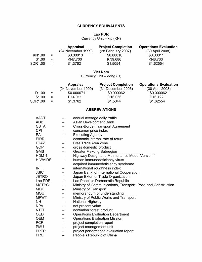
CURRENCY EQUIVALENTS
Lao PDR Currency Unit – kip (KN)
Appraisal
(24 November 1999) Project Completion (28 February 2007)
Operations Evaluation (30 April 2008)
KN1.00 = $0.00013 $0.00010 $0.00011 $1.00 = KN7,700 KN9,686 KN8,733
SDR1.00 = $1.3762 $1.5054 $1.62554
Viet Nam Currency Unit – dong (D)
Appraisal
(24 November 1999) Project Completion (31 December 2006)
Operations Evaluation (30 April 2008)
D1.00 = $0.000071 $0.000062 $0.000062 $1.00 = D14,011 D16,056 D16,122
SDR1.00 = $1.3762 $1.5044 $1.62554
ABBREVIATIONS AADT – annual average daily traffic ADB – Asian Development Bank CBTA – Cross-Border Transport Agreement CPI – consumer price index EA – Executing Agency EIRR – economic internal rate of return FTAZ – Free Trade Area Zone GDP – gross domestic product GMS – Greater Mekong Subregion HDM-4 – Highway Design and Maintenance Model Version 4 HIV/AIDS – human immunodeficiency virus/
acquired immunodeficiency syndrome IRI – international roughness index JBIC – Japan Bank for International Cooperation JETRO – Japan External Trade Organization Lao PDR – Lao People’s Democratic Republic MCTPC – Ministry of Communications, Transport, Post, and Construction MOT – Ministry of Transport MOU – memorandum of understanding MPWT – Ministry of Public Works and Transport NH – National Highway NPV – net present value NTFP – nontimber forest product OED – Operations Evaluation Department OEM – Operations Evaluation Mission PCR – project completion report PMU – project management unit PPER – project performance evaluation report PRC – People’s Republic of China

Q – quarter RCAI – rural community access infrastructure RED – Road Economic Decision RETA – regional technical assistance RMF – road maintenance fund RN – route national RRMU – regional road management unit TA – technical assistance UXO – unexploded ordinance VOC – vehicle operating cost vpd – vehicle per day
NOTES
(i) The fiscal year (FY) of the Government of the Lao People’s Democratic Republic is from 1 October to 30 September. That of the Government of the Socialist Republic of Viet Nam is from 1 January to 31 December. FY before a calendar year denotes the year in which the fiscal year ends, e.g., FY2000 ends on 30 September 2000 (in the Lao PDR) or 31 December 2000 (in Viet Nam).
(ii) In this report, "$" refers to US dollars. (iii) For an explanation of rating descriptions used in ADB evaluation reports, see
ADB. 2006. Guidelines for Preparing Performance Evaluation Reports for Public Sector Operations. Manila.
Director General H. Satish Rao, Operations Evaluation Department (OED) Director H. Hettige, Operations Evaluation Division 2, OED Team Leader N. Singru, Evaluation Specialist, Operations Evaluation Division 2, OED Team Member R. Lumain, Senior Evaluation Officer, Operations Evaluation Division 2,
OED C. Roldan, Senior Operations Evaluation Assistant, Operations Evaluation
Division 2, OED
Operations Evaluation Department, PE-721
Key Words
regional cooperation, regional integration, gms, adb, asian development bank, greater mekong subregion, adb gms, lao, viet nam, development effectiveness, roads, roads maintenance, performance evaluation, transport, infrastructure, trade facilitation, cross-border projects, subregional cooperation, subregional economic analysis

CONTENTS Page
BASIC DATA i EXECUTIVE SUMMARY iii MAP I. INTRODUCTION 1 A. Evaluation Purpose 1 B. Expected Results 1 II. DESIGN AND IMPLEMENTATION 2 A. Formulation 2 B. Rationale 3 C. Cost, Financing, and Executing Arrangements 4 D. Procurement, Construction, and Scheduling 6 E. Design Changes 7 F. Outputs 8 G. Consultants 8 H. Loan Covenants 9 I. Policy Setting 10 III. PERFORMANCE ASSESSMENT 11 A. Overall Assessment 11 B. Relevance 11 C. Effectiveness 12 D. Efficiency 17 E. Sustainability 18 IV. OTHER ASSESSMENTS 20 A. Impact 20 B. ADB Performance 25 C. Borrower and Executing Agency Performance 25 D. Technical Assistance 25 V. ISSUES, LESSONS, AND FOLLOW-UP ACTIONS 26 A. Issues 26 B. Lessons 26 C. Follow-Up Actions 27 The guidelines formally adopted by the Operations Evaluation Department (OED) on avoiding conflict of interest in its independent evaluations were observed in the preparation of this report. Although H. Satish Rao, Director General, OED, headed the East Asia Department, and Ramesh B. Adhikari, Director of Operations Evaluation Division 1, worked for the Southeast Asia Department, they were not involved in preparing, implementing, and supervising Greater Mekong Subregion projects. Mr. Adhikari supervised the report up to interdepartmental review. J.F. Gautrin, H.T. Phuong Nguyen, and P. Phimphachanch were the consultants. To the knowledge of the management of OED, there were no conflicts of interest of the persons preparing, reviewing, or approving this report.

APPENDIXES 1. Design and Monitoring Framework 28 2. Project Costs 32 3. Summary of Physical Achievements 34 4. Traffic Performance 35 5. Rural Community Access Improvement 42 6. Impacts on Cross-Border Activity 46 7. Lao People’s Democratic Republic: Impediments to Maximizing Benefits from Transport and Transport Facilitation 53 8. Economic Reevaluation 55 9. Environment and Resettlement Impacts 63 10. Socioeconomic Impact 65 11. Road Safety 76 12. Related ADB Technical Assistance for the East–West Corridor Project 78
Attachment: Management Response

BASIC DATA GMS: East−West Corridor Project (Loan 1727−LAO[SF]: Lao PDR Component)
Project Preparation/Institution Building TA No.
TA Name Type Person- Months
Amount ($ million)
Approval Date
5586 Study of the Lao PDR–Thailand–Viet Nam East–West Transport Corridor (Government of France)
RETA nc $1.0 18 Jul 1994
5710 GMS East–West Transport Corridor (JSF) RETA 20.5 $3.0 11 Dec 1996 3348 East–West Corridor Coordination (JSF)a ADTA 22.0 $0.7 20 Dec 1999 As per ADB Key Project Data ($ million) Loan Documents Actual Total Project Cost 40.2 40.9 Foreign Exchange Cost 29.8 32.5 Local Currency Cost 10.4 8.4 ADB Loan Amount/Utilization 32.0 32.8
SDR million 23.0 23.0 ADB Loan Amount/Cancellation 0.0 0.0
SDR million 0.0 0.0 Key Dates Expected Actual Fact-Finding 22 Feb–16 Mar 1999 Appraisal 31 May–4 Jun 1999 Loan Negotiations 28 Oct 1999 Board Approval 20 Dec 1999 Loan Agreement 21 Mar 2000 Loan Effectiveness 21 Jun 2000 21 Sep 2000 First Disbursement 11 Dec 2000 Project Completion 31 Jun 2003 28 Feb 2007 Loan Closing 31 Dec 2004 22 Feb 2008 Months (effectiveness to completion) 36 77
Economic Internal Rates of Return (%) Appraisal PCR PPER w/o RTB with RTB Muang Phin–Dansavanh 16 19 20.6 13.2 Kaysone Phomvihane–Xeno nc nc 26.0 nc Lao Component 16 19 21.4 nc Overall Project 19 22.5 20.2 14.5 Borrower Lao People’s Democratic Republic Executing Agency Ministry of Public Works and Transport Mission Data Type of Mission No. of Missions No. of Person-Days Fact-Finding 1 174 Appraisal 1 25 Project Administration 15 93 Inception 1 2 Review 14 91 Project Completion 1 25 Operations Evaluationb 1 nc ________________________ ADB = Asian Development Bank, ADTA = advisory technical assistance, GMS = Greater Mekong Subregion, JSF = Japan Special Fund, nc = not calculated, PCR = project completion report, PPER = project performance evaluation report, RETA = regional technical assistance, RTB = regional trade benefit, SDR = special drawing rights, TA = technical assistance. a Attached advisory TA to Loan 1727-LAO(SF). b Combined under a mission for the sector assistance program evaluation on transport and trade facilitation in
Greater Mekong Subregion, which was carried out in April 2008. Several surveys in purposefully selected sites were also conducted as part of the sector assistance program evaluation.

ii BASIC DATA
GMS: East−West Corridor Project (Loan 1728−VIE[SF]: Viet Nam Component)
Project Preparation/Institution Building TA No.
TA Name Type Person- Months
Amount ($ million)
Approval Date
5586 Study of the Lao PDR–Thailand–Viet Nam East–West Transport Corridor (Government of France)
RETA nc $1.0 18 Jul 1994
5710 GMS East–West Transport Corridor (JSF) RETA 20.5 $3.0 11 Dec 1996
As per ADB Key Project Data ($ million) Loan Documents Actual Total Project Cost 36.0 29.2 Foreign Exchange Cost 19.7 18.4 Local Currency Cost 16.3 10.8 ADB Loan Amount/Utilization 25.0 22.7
SDR million 18.2 15.6 ADB Loan Amount/Cancellation 0.0 3.9
SDR million 0.0 2.6 Key Dates Expected Actual Fact-Finding 22–27 Feb/6–10 Mar 1999 Appraisal 5–11 Jun 1999 Loan Negotiations 22–23 Nov 1999 Board Approval 20 Dec 1999 Loan Agreement 28 Jun 2000 Loan Effectiveness 26 Sep 2000 21 Sep 2000 First Disbursement 16 Mar 2001 Project Completion 31 Dec 2003 31 Dec 2006 Loan Closing 31 Dec 2004 30 Mar 2007 Months (effectiveness to completion) 35 75
Economic Internal Rates of Return (%) Appraisal PCR PPER w/o RTB with RTB Lao Bao–Dong Ha 16 23 17.6 16.2 Dong Ha Northern Bypass 24 30 nc nc Dong Ha Southern Bypass nc nc nc nc Overall Project 19 22.5 20.2 14.5 Borrower Socialist Republic of Viet Nam Executing Agency Ministry of Transport Mission Data Type of Mission No. of Missions No. of Person-Days Fact-Finding 1 66 Appraisal 1 35 Project Administration 16 124 Inception 1 18 Review 15 106 Project Completion 1 8 Operations Evaluationa 1 nc ________________________ ADB = Asian Development Bank, GMS = Greater Mekong Subregion, JSF = Japan Special Fund, nc = not calculated, PCR = project completion report, PPER = project performance evaluation report, PPTA = project preparatory technical assistance, RETA = regional technical assistance, RTB = regional trade benefit, SDR = special drawing rights, TA = technical assistance. a Combined under a mission for the sector assistance program evaluation on transport and trade facilitation in
Greater Mekong Subregion, which was carried out in April 2008. Surveys carried out as part of this PPER were also used as inputs for the sector assistance program evaluation.

EXECUTIVE SUMMARY
The East–West Corridor Project (the Project) is part of a wider East–West Economic Corridor linking Da Nang in Viet Nam and Mawlamyaing in Myanmar—covering Lao People’s Democratic Republic (Lao PDR), Myanmar, Thailand, and Viet Nam. As a flagship project of the Greater Mekong Subregion (GMS) program, it was designed to improve the road linking the landlocked areas of northeast Thailand with the coast of Viet Nam across the Lao PDR. The all-weather road link aimed to expand the market for transit and bilateral trade among the three countries.
The rationale for carrying out this project performance evaluation report within a period of 2 years after project completion is based on several factors. First, most of the project highway was completed in 2005, which provided sufficient time for the results to be visible in 2008. Second, the project completion report was based on traffic data collected by the government agencies in 2007. This needed to be updated independently to understand the outcomes of the Project. Finally, the results of this evaluation study provide a key contribution to the broad sector evaluation of the GMS program carried out in 2008.
The Project is “highly relevant” to development needs at the regional and national levels and to government and Asian Development Bank (ADB) strategies. It is the second cross-border road project in the GMS program and is in line with ADB’s thrust for regional cooperation in the transport sector. The Project’s core component was similar to that of the Phnom Penh to Ho Chi Minh City Highway Project, which was built on the concept of developing economic corridors through cross-border infrastructure and transport agreements. As a regional road, it addressed a strategic need to strengthen links between Lao PDR, Thailand, and Viet Nam. The project road also interconnects national transport networks to generate trade and efficiency benefits in Lao PDR and Viet Nam. It was appropriately designed to support economic centers and complemented poverty reduction strategies. In particular, the rural access road component in the Lao PDR helped to address poverty reduction in rural areas.
The project cost at completion was $40.9 million in Lao PDR and $29.2 million in Viet Nam, lower than the initial estimate. Loan savings financed additional works in both countries. The Project was “effective” in improving road transport efficiency at the national level in Lao PDR and Viet Nam, which was the outcome targeted. Project-level results, as envisaged at appraisal and as part of design changes, were substantially achieved or exceeded in both country components. The rural road component was expanded from three to nine rural roads, and enhanced mobility and access by poor households. The improvement of National Road 9 from Dong Ha (Viet Nam) to Kaysone Phomvihane (Lao PDR) reduced vehicle operating costs and enabled faster vehicle speeds and shorter travel times. There was a considerable amount of design changes, mostly additional works, done during implementation. Except for emergency flood repairs in the Lao PDR, these were within the originally conceived purpose and helped enhance project effectiveness.
The trade facilitation component was “less effective” in achieving its intended outcome of mitigating nonphysical barriers to cross-border movement. Modest gains were made in promoting tourism and cross-border trade and investment among Lao PDR, Thailand, and Viet Nam. However, the current number of vehicles crossing the border daily (i.e., 150 vehicles) is below potential, showing a marginal increase from the number of vehicles that passed through in 2000 (about 131 vehicles). This slight increase could be attributed to the initial implementation of the Cross-Border Transport Agreement (CBTA). However, the CBTA is yet to be fully implemented at the Lao Bao–Dansavanh border crossing. It is expected that the cross-border movements will increase after the CBTA has been implemented. Pending this implementation, the majority of the traffic on the project road is national traffic, i.e., originates and ends within the country. In

iv
landlocked Lao PDR, the amount of vehicle traffic is low although there is a relatively high proportion of international traffic. With full implementation of the CBTA still pending, the expected increases in cross-border traffic have not yet been realized.
The CBTA along with its annexes and protocols was targeted to be ratified by all GMS countries by 2008. However, this has not been achieved yet since the ratification is pending in three countries. Lao Bao–Dansavanh was chosen for pilot implementation of the CBTA in 2005. It has completed the initial phase of the CBTA with single window inspection. The cross-border traffic will increase only after the remaining phases of the CBTA leading up to smoother cross-border movement are implemented.
Pending full implementation of the CBTA, the Lao Bao–Dansavanh border has recovered from the construction years to show a potential upside. Average trade value during 2006−2007 amounted to $142 million compared to $93.5 million during 1999−2000. Most goods passing through the project road comprise bilateral trade. Since the flow of transit goods from Thailand across the Lao PDR has yet to develop fully, total trade has not increased as expected. Border facilities provided by the Project are likely to be maintained and continue to contribute to transport facilitation and enhanced trade. Savings in customs and immigration processing times at the border crossing can be attributed mainly to the bilateral measures established before the CBTA. These savings are likely to continue and improve in the future after the CBTA has been implemented. The Project as a whole and its two country components are rated “effective.”
The Project is economically “efficient.” The economic internal rate of return for the Lao PDR component is reestimated at 13%, while that for the Viet Nam side is 16%. These are generally in line with appraisal estimates of 16% for both. The recalculated economic internal rates of return are based on conservative assumptions (i.e., vehicle operating cost savings and road safety benefits), which are likely to improve with implementation of the CBTA. Currently, the majority traffic on the project roads in both countries is national. This indicates that the regional benefits of the Project are not visible yet.
The efficiency of the Project was marred by the delays in completion caused partly due to implementation issues related to the construction of the main corridor as well as the inclusion of additional works. Overall completion was delayed in Lao PDR by 4 years and in Viet Nam by 3 years. The completion of the main corridor in the Lao PDR was delayed by 15 months, while that in Viet Nam took 18 months longer than expected. Besides delays in loan effectiveness and procurement, the Project witnessed contractor problems, which contributed to the delays in project completion. This reflects poorly on the performance of contractor and provides several areas of improvement for both ADB and the executing agencies.
The Project witnessed substantial loan savings in both countries owing to lower bid costs for civil contracts. These loan savings were used to fund additional works. While the rationale for selection of the additional works was not clear, the use of loan savings could have benefited from a better justification at the PCR stage. Alternative subprojects could have been selected to make better use of the loan savings, e.g., improvement of border facilities at Dansavanh. While including the additional works is seen as appropriate, ADB did not carry out adequate due diligence at project completion to check whether the loan savings had been used efficiently.
About 3 years since completion of civil works, the project road is in good condition, partly because of relatively low traffic levels and the relatively new condition of the road. The allocations for maintenance from the central budget remain lower than requirements. In the Lao PDR, the issue of maintenance allocation is being addressed through a road maintenance fund and the beneficiary communities. The allocated budget for road maintenance is still lower than requirements and sufficient for routine maintenance only. The majority of the rural access roads

v
in the Lao PDR appear in good condition, partly owing to the low traffic on these roads. These are being maintained by the beneficiary communities organized by village maintenance committees. In Viet Nam, the allocations from the central budget have been increasing gradually over the years. The regional road management unit responsible for National Highway 9 has sufficient technical and manpower resources. Although the Vietnamese Government has no intention of levying tolls on this highway, the allocations from the central budget are likely to be sufficient to ensure that the benefits of the road will be sustained. The annual maintenance budget allocation for 2007 and 2008 experienced a threefold increase since 1999 and can now fund 67%−75% of estimated requirements. Given efforts made at focusing on maintenance allocations in both countries, the Project is rated “likely to be sustainable.”
The Project was useful in developing an efficient national and regional transport system and in simplifying custom procedures aimed at strengthening bilateral trade and regional cooperation. Despite implementation problems, delays in ratification of the CBTA, and slow growth in trade, the Project has achieved its main outputs and outcomes. It is expected that with the implementation of the CBTA, the regional impacts will be stronger. Based on the evaluation criteria of relevance, effectiveness, efficiency, and sustainability, the East–West Corridor Project is rated “successful.”
The attached advisory technical assistance (for the Lao PDR) contributed to effective implementation and operation of the road sector and is rated “successful.” ADB performance is “partly satisfactory”. Borrower and Executing Agency performance in both countries was “satisfactory.” While civil works implementation suffered delays, the quality of completed works is considered satisfactory. Compliance by both executing agencies on standard loan covenants was generally satisfactory. Implementation arrangements envisaged at appraisal apparently worked well.
The project impact has been found to be “moderate” in relation to the regional level impacts, but it has been “significant” in terms of socioeconomic changes at the local levels. Economic activity (i.e., growth in the services sector) has increased within the corridor. However, the East–West Corridor remains a transport corridor with little evidence of transformation into an economic corridor. Government officials as well as ADB staff have yet to arrive at a consensus on how a transport corridor can be converted into an economic corridor. The mobilization of private capital investment along the corridor, which could be seen as a key indicator of economic activity has yet to be mainstreamed. Corridor-level impacts show a potential upside in promoting economic activities and facilitating trade, but benefits are limited by institutional constraints on the ground. For the Lao PDR, this is partly explained by inadequate complementary investments and slow growth within the private sector. The completion of the project road establishes a platform to push forward the development process along this strategic east−west alignment.
Positive impacts of the Project are visible at the local levels in terms of improved access to markets and basic social services. The Project has opened up markets and enhanced consumer choices through (i) cheaper prices, and (ii) product availability and diversity. Improved connectivity along the corridor also helped develop surplus areas of production, which resulted in changes in the livelihood and living standards of local residents. The rural roads component enhanced mobility and enabled rural communities including ethnic groups and women to gain access to markets, employment opportunities, and social services.
Resettlement and environmental issues were satisfactorily addressed, and no pending issues are reported. An indirect negative impact of the Project, typical of road corridor development in the GMS, is the risk of human and wildlife trafficking. Some key issues for the future relate to the CBTA, complementary and capacity development in the Lao PDR, and road

vi
safety. The GMS governments have made substantial progress in signing the CBTA and negotiating the annexes and protocols. It needs to be fully ratified by all GMS countries and implemented to ensure that all the benefits of the Project can be achieved. For the Lao PDR to benefit fully from the road and transport facilitation project, it will require complementary investments and capacity development. It needs to attract labor-intensive agro-industries and activities and to identify key imports and exports where it has comparative advantage. This comes across as a key lesson within the subregional context wherein the conversion of the transport corridor into an economic corridor needs to be planned properly. The establishment of economic corridors is likely to benefit poor households, ensuring better opportunities to access productive resources and appropriate technology to improve their livelihood. With expectations of a sustained increase in vehicle traffic, potential road safety issues are likely to persist in the future.
Issues for the Project include (i) the delay in implementation of the CBTA has impeded the growth of cross-border traffic, (ii) complementary investments and capacity development are needed in the Lao PDR to transform the East–West Corridor into an economic corridor, and (iii) road improvement has resulted in an increase in the severity of accidents affecting road safety.
Lessons identified from the Project are (i) the pace of the economic development along the corridors depends on the complementary interventions requiring policy and institutional changes that enable better opportunities for the private sector, (ii) multimodal planning is important for enhancing the effectiveness of transport corridors, and (iii) ADB should use loan savings prudently by carrying out appropriate economic due diligence at approval and at completion. Recommended follow-up actions are provided below: Follow-Up Action
Institution Responsible
Time Frame
Monitoring
Cross-Border Transport Agreement. To achieve the main project impact of enabling cross-border traffic along the East–West Corridor, ADB should work closely with the governments to enable full ratification and implementation of the CBTA.
Southeast Asia Department
Ongoing GMS CBTA implementation plan
Economic corridors. ADB should work with the governments on parallel interventions that enable development of industries, agriculture, and production in general.
Southeast Asia Department
Ongoing Development of economic corridors to be measured using GMS specific indicators
Improve maintenance allocations. ADB should add value by assisting the Lao PDR and Viet Nam governments in developing road maintenance regimes based on needs, achieve a balanced distribution of public funds, identify alternative financing sources including the private sector, and improve cost recovery.
Southeast Asia Department
Ongoing Stepped increase in the allocations for maintenance
ADB = Asian Development Bank, CBTA = Cross-Border Transport Agreement, GMS = Greater Mekong Subregion, Lao PDR = Lao People’s Democratic Republic. Source: Operations Evaluation Mission.
H. Satish Rao Director General Operations Evaluation Department

East–West Economic Corridor
Mekong R
.
Thanlw
in River
Mek
ong Ri
ver
AndamanSea
Gulf ofThailand
Gulf ofTonkin
Gulf of Martaban
Andaman Sea
Phyu
BagoKyaikto
ThatonYangon Myawaddy
Mae Sot
Tak
Sukhothai
Phitsanulok
Kamphaeng PhetKawkareik
Mottama
Mudon
Thanbyuzayat
Kyaikkami
Mawlamyaing
Ye
Nakhon Sawan
Chai Nat
Lop Buri
Chaiyaphum
Phichit Phetchabun
Uttaradit
Lampang
Chiang Mai
VIENTIANE
Udon Thani
Khon Kaen
Kalasin
Maha Sarakham
Roi Et
Yasothon
Khemmarat
Suwannaphum
Ubon Ratchathani
SurinNakhon Ratchasima
Nong Khai
Bung Kan
Pakxan
Pakkading
Khamkeut
Nakhon Phanom
Sakhon Nakhon
Mukdahan
Kuchinarai
Phalanxai
Phin
Xepon
Atsaphangthong
Xaibouri
Xeno
KaysonePhomvihane
Thakhek
Vinh
Ha Tinh
Dong Hoi
Dong Ha
HueLao Bao
Dansavanh
Da Nang
Hoi An
Quang Ngai
Samakkhixai
Lamam
Salavan
Pakxe
Champasak
M Y A N M A R
YUNNAN PROVINCE(PRC)
LAO PEOPLE’SDEMOCRATIC REPUBLIC
V I E T N A MT H A I L A N D
C A M B O D I A
GUANGXI ZHUANGAUTONOMOUS REGION
(PRC)
MYANMAR
THAILAND LAO PEOPLE’SDEMOCRATIC REPUBLIC
VIET NAM
National Capital
City/Town
Border Crossing Point
ADB-financed Project Road
Government of Japan-financed Project Road
National Road
Provincial Road
East–West Economic Corridor
River
International Boundary
Boundaries are not necessarily authoritative.
GREATER MEKONG SUBREGIONEAST–WEST TRANSPORT CORRIDOR PROJECT
0 100 150 200
Kilometers
N
08
-34
17
EG
108 30'Eo108 00'Eo
108 00'Eo98 00'Eo
24 00'No
24 00'No
10 00'No
10 00'No
98 00'Eo
18 00'No
16 00'No
18 00'No
16 00'No
98 00'Eo
98 00'Eo108 30'Eo

I. INTRODUCTION A. Evaluation Purpose 1. The East–West Corridor Project (the Project) is a flagship project of the Greater Mekong Subregion (GMS) program.1 The Project intended to provide an all-weather road link between the landlocked areas of northeast Thailand and the coast of Viet Nam, as well as enhancing the transport infrastructure of the Lao People’s Democratic Republic (Lao PDR). The seaports in Central Viet Nam were seen as key transit points for trade with non-GMS countries and the People’s Republic of China (PRC). The Project is part of a wider East–West Economic Corridor linking Da Nang in Viet Nam and Mawlamyaing in Myanmar—covering Lao PDR, Myanmar, Thailand, and Viet Nam (Map). 2. The Project was selected for an evaluation under the 2008 work program of the Operations Evaluation Department (OED) within a period of 2 years after project completion for various reasons. First, substantial parts of the Project were completed in 2005, which provides a sufficiently long period for the project results to be visible. Second, the project completion report (PCR) was based on traffic data collected by the government agencies in early 2007. This data needed to be updated independently to verify the Project outcomes. Finally, the timing of the project performance evaluation report (PPER) was advanced to provide inputs for the broader sector assistance program evaluation of the transport and trade facilitation sectors of the GMS program.2 The PPER draws on a desk review of the data provided by the PCR3 and other project documents. In addition to the typical assessment of the benefits to the borrowing countries, the PPER includes an assessment of the regional impacts, i.e., trade. OED’s consultants carried out field interviews and surveys (i.e., traffic, border-crossing point, freight forwarders, and border community) to collect primary and secondary data. A copy of the draft PPER was shared with the Southeast Asia Department of the Asian Development Bank (ADB) and the borrowers, and their comments were incorporated where relevant. 3. The PCR circulated in November 2008 rated the Project “successful.”4 It generally met the requirements of self-evaluation.5 This PPER assesses the findings of the PCR and provides lessons and follow-up actions. It also provides additional data on project-level as well as country-level impacts. B. Expected Results 4. The long-term development impact of the Project focused on economic growth and poverty reduction within its area of influence. Specifically, it aimed to promote economic cooperation and facilitate trade among Lao PDR, Thailand, and Viet Nam—thereby improving prospects for poverty reduction along the corridor. An updated project framework is in Appendix 1. The immediate outcomes expected were (i) improved transport infrastructures in the East–
1 The GMS comprises Cambodia, Lao Peoples Democratic Republic (Lao PDR), Myanmar, the People’s Republic of
China’s (PRC) Yunnan Province and Guangxi Zhuang Autonomous Region, Thailand, and Viet Nam. The Project forms part of an overall East–West Corridor Project originally estimated at about $340 million, comprising (i) Second Mekong International Bridge (Lao PDR/Thailand), (ii) Mekong Bridge Access Roads (Thailand), (iii) Road 9 Rehabilitation (Lao PDR), (iv) Highway 1 Periodic Maintenance (Viet Nam), and (v) Da Nang Port Improvement.
2 This PPER is used as a case study for the broader sector assistance program evaluation of the transport and trade facilitation sectors in the GMS.
3 The PCR was finalized in November 2008 although a draft PCR was made available in early 2008. 4 ADB. 2008. Project Completion Report on the Greater Mekong Subregion: East–West Corridor Project (Lao PDR
and Viet Nam). Manila. 5 A PCR validation report will not be prepared since the PPER was completed within a year of PCR circulation.

2
West Corridor, and (ii) mitigation of nonphysical barriers to the movement of goods and people across borders. The Project was designed as a regional project with two country components (basic data). 5. For the Lao PDR component, the expected outputs were (i) rehabilitation of 78 kilometers (km) of route national (RN) 9 (Lao side of National Road 9) from Muang Phin to Dansavanh at the border with Viet Nam (i.e., civil works, land acquisition, resettlement and unexploded ordinance [UXO] clearance, construction supervision, and project management); and (ii) upgrading of three rural access roads connecting to RN9 (i.e., construction and improvement of small bridges, river crossing systems, pathways, rural roads, and other infrastructure).6 The Viet Nam component comprised the reconstruction of 83 km of National Highway (NH) 9 (Viet Nam side of National Road 9) from the Lao Bao border crossing to Dong Ha (on the north–south NH1); the easternmost 8.9 km comprised the Dong Ha Bypass to the north of the town (i.e., civil works, land acquisition, resettlement and UXO clearance, construction supervision, and project management).
II. DESIGN AND IMPLEMENTATION A. Formulation 6. The Project was first identified under the Subregional Transport Sector Study7 as a critical link that needed to be established within the GMS to stimulate subregional cooperation. In 1994, an ADB-executed, Government of France-funded feasibility study was undertaken to investigate the feasibility of a road corridor connecting northeast Thailand, central/southern Lao PDR, and central Viet Nam.8 It recommended improvement of the central corridor using NH9 leading to Da Nang. This was accepted by the governments of Lao PDR, Thailand, and Viet Nam. Technical assistance (TA) was subsequently approved by ADB to carry out the detailed feasibility, including the identification of key transport infrastructure that would require construction, rehabilitation, and improvement.9 7. The Project is the second ADB-assisted cross-border road project in the GMS program aimed at addressing regional cooperation. Except for the absence of cross-border infrastructure,10 its core component was similar to that of the Phnom Penh to Ho Chi Minh City Highway Project,11 which was built on the concept of economic corridor development (para. 10). To facilitate passenger and commercial traffic between Lao PDR and Viet Nam, the Project was designed to have the physical and nonphysical components to proceed concurrently. It addressed ADB operational priorities for regional cooperation and private sector development through improvement of cross-border roads and simplified border procedures. The Project featured a feeder road component to enable RN9 improvements to respond effectively to the national priority of poverty reduction in the Lao PDR and provide economic benefits into the hinterlands of Kaysone Phomvihane Province.
6 About $2 million was allocated for improvement of rural community access infrastructure. Specific works were to be
identified and approved during implementation. 7 ADB. 1992. Studies on Subregional Cooperation among the Countries in Indochina, Myanmar, the People’s
Republic of China, and Thailand − Phase 1. Manila (TA 5487-REG, for $270,000, approved on 9 March). 8 ADB. 1994. Technical Assistance for Study of the Lao–Thailand–Viet Nam East–West Transport Corridor. Manila
(TA 5586-REG, for $1.0 million, approved on 18 July). 9 ADB. 1996. Technical Assistance for the GMS East–West Corridor. Manila (TA 5710-REG, for $3 million, approved
on 11 December). 10 These components were added later as part of several design changes during implementation (paras. 30−31). 11 ADB. 2008. Project Completion Report on the Greater Mekong Subregion: Phnom Penh to Ho Chi Minh City
Highway Project. Manila.

3
8. Lessons from the implementation of ADB’s national road sector projects in Lao PDR and Viet Nam were taken into account in the project preparation, design, and implementation arrangements.12 Environmental and social concerns were also incorporated in the project design through the inclusion of mitigation measures. These measures included implementation of specific safeguards to address issues such as the spread of sexually transmitted diseases and human immunodeficiency virus/acquired immunodeficiency syndrome (HIV/AIDS) during construction. B. Rationale 9. Closer subregional economic cooperation has become an integral part of promoting economic development. Economic cooperation has contributed to sustainable economic and social development, including poverty reduction, in the GMS.13 Accordingly, a number of aid agencies and the Association of Southeast Asian Nations have promoted regional cooperation through a range of initiatives designed to identify and develop strategic growth centers that would serve as engines of growth. The East–West Economic Corridor was planned as part of the broader GMS program to promote regional cooperation and development. It was to serve as a focal point for development plans and as an engine for sustained growth in the area. 10. With the adoption of the concept of economic corridors during the GMS Ministerial Conference in 1998, the Project was regarded by the governments of Lao PDR and Viet Nam as a key strategic instrument of national and regional development.14 The East–West Corridor forms a priority alignment across the GMS. At the time of loan approval, its initial focus was to connect northeast Thailand (Mukdahan) to the coast of central Viet Nam (Da Nang).15 While the setting up of the road infrastructure is a key contribution to the development of the economic corridor, this needs to be supplemented with other interventions to enable the transformation from a transport corridor to an economic corridor, i.e., to ensure that economic activities grow along the corridor. This requires interventions such as setting up of special economic zones, roadside service facilities, and other complementary infrastructure—telecommunications, electricity. It is noted that such interventions are under way.16 11. The governments of Lao PDR and Viet Nam have given high priority to transport infrastructure linkages that facilitate bilateral, subregional, and global trade. In the Lao PDR, RN9 12 For the Lao PDR component, completion of detailed engineering at the feasibility stage and use of advance
procurement action was ensured to minimize startup delays. The financial control, monitoring, and implementation capacity of the then Ministry of Communication, Transport, Post, and Construction, the component’s executing agency, was to be strengthened through concurrent ADB TA (paras. 83–85). In Viet Nam, ADB provided assistance in building capacity in procurement and in improving the Government’s national budget allocation system to minimize delays arising from cumbersome government procedures with regard to procurement, awarding of contracts, and timely release of payments to contractors.
13 After the launching of the GMS strategic framework and its accompanying programs in 1992, economic activities have expanded and flourished driven by the improvements in connectivity (Source: ADB. 2006. Draft Report on Reviewing the Poverty Impact of Regional Economic Integration in the Greater Mekong Subregion Regional Synthesis Report. Manila).
14 Drawing on the paradigm of regional growth triangles, economic corridors will provide the mechanisms to link production, trade, and infrastructure within a specified geographic region. An economic corridor is defined to have a defined location; physical infrastructure (including a transport system around which economic activities converge); and economic activities and software (foreign investment regulations, incentives and institutions, etc.).
15 This corridor influence area was then envisaged to extend westward to connect the South China Sea to the Indian Ocean through Myanmar (Mawlamyaing) and northern Thailand (Phitsanulok).
16 ADB. 2008. Technical Assistance to the Lao People’s Democratic Republic for Building Lao PDR’s Capacity to Develop Special Economic Zones. Manila (TA 7188-LAO, for $700,000, approved on 27 November); and ADB. 2006. Technical Assistance for Development Study of the North South Economic Corridor. Manila (TA 6310-REG, for $600,000, approved on 20 March); and ADB. 2008. Technical Assistance for Development Study of GMS Economic Corridors (Supplementary). Manila (TA 6310-REG, for $600,000, approved on 7 July).

4
along the East–West Corridor route is part of the arterial road network. Its rehabilitation under the Project meets the objective of improving the national road transport system. In Viet Nam, the improvement of NH9, together with the Ho Chi Minh City–Phnom Penh–Bangkok road improvement17 and the planned Kunming–Haiphong Corridor Project,18 was to link three focal growth zones in Viet Nam (Da Nang, Hanoi, and Ho Chi Minh City) into a subregional economy. C. Cost, Financing, and Executing Arrangements 12. The total project cost was within appraisal estimates (Appendix 2) even after adding the substantial number of new works (paras. 29−31).19 The original scope was delivered well below appraisal cost estimates, enabling savings from the loan.20 The final aggregate cost was $70.0 million compared with $76.0 million estimated at appraisal. Total ADB financing amounted to $55.5 million—$1.5 million (2.6%) less than planned. The Borrowers’ combined contribution was $14.5 million. 13. Lao PDR Component. At appraisal, the project cost was estimated at $40.0 million, comprising a foreign exchange cost of $29.0 million (72%) and a local currency cost of $11.0 million (28%). ADB’s loan of $32.0 million was to cover the entire foreign exchange component and part of the local currency component (Table 1). The Government of the Lao PDR was to provide $8.0 million to cover the remainder of the local currency cost. The ADB loan was drawn from its Special Funds resources.21
Table 1: Estimated and Actual Costs ($ million and %) Lao PDR Viet Nam
Description
Appraisal
Actual
Actual/ Appraisal (%)
Appraisal
Actual
Actual/ Appraisal (%)
ADB 32.0 32.8 102.4 25.0 22.7 90.8 Government 8.0 8.0 100.0 11.0 6.5 60.0 Total Project Cost 40.0 40.9 102.0 36.0 29.2 81.2 Base Costs 34.0 36.3 106.7 29.4 28.9 98.2 Of which Civil Works 29.9 32.8 109.6 21.2 23.0 108.6 Consultant Supervision 2.7 3.5 129.6 1.7 2.6 153.5
ADB = Asian Development Bank, Lao PDR = Lao People’s Democratic Republic. Source: ADB. 2008. Project Completion Report on the Greater Mekong Subregion: East–West Corridor Project (Lao
PDR and Viet Nam). Manila.
14. The PCR reported an actual project cost at $40.9 million (Appendix 2, Table A2.1), out of which ADB financed $32.8 million (80%). The cost of civil works at completion aggregated to 17 ADB. 1998. Report and Recommendation of the President to the Board of Directors on Proposed Loans to the
Kingdom of Cambodia and to the Socialist Republic of Viet Nam for the Greater Mekong Subregion: Phnom Penh to Ho Chi Minh City Highway Project. Manila (Loans 1659-CAM[SF] and 1660-VIE[SF] for $40 million and $100 million, respectively, approved on 15 December).
18 ADB. 2007. Report and Recommendation of the President to the Board of Directors on Proposed Loans to the Socialist Republic of Viet Nam for the Greater Mekong Subregion: Kunming–Hai Phong Transport Corridor–Noi Bai–Lao Cai Highway Project. Manila (Loans 2391-VIE and 2392-VIE[SF] for $896 million and $200 million, respectively, approved on 14 December).
19 Because of lower-than-expected bid prices, a significant number of additional works were done during implementation by applying loan savings.
20 The PCR mentioned several possible reasons for the low bids: (i) cost estimates based on normative unit rates did not reflect market conditions; (ii) a very competitive environment; (iii) bidding by state-owned Vietnamese firms that may not fully price their overheads; (iv) under-resourcing by contractors, e.g., mobilizing inadequate management and old equipment; (v) poor understanding by contractors of the standards required of them, especially with respect to environmental and safety issues during construction; and (vi) underestimation of the rigor with which they would be supervised.
21 The loan had a repayment period of 32 years, including a grace period of 8 years, with 1% service charge during the grace period and 1.5% during the amortization period.

5
$32.8 million, about $3.0 million above appraisal estimates. The marginal increase in cost was largely due to additional rural roads under an expanded rural community access infrastructure (RCAI) subcomponent.22 The actual cost of this component was about $7.0 million, compared with an initial estimate of $2.0 million. Because the RCAI subcomponent was largely undefined at appraisal, the resulting cost estimate did not fully reflect the intended scope and nature of works, including the requirements for land acquisition, resettlement, and environmental cost. 15. The actual cost for road rehabilitation (including additional works) was about $26.0 million at appraisal. Savings made from the main civil works contract gave rise to the expansion of the project scope. The actual unit cost was 72% of the appraisal estimate of $339,700 per km (Appendix 2). The PCR estimated that the original contract price for rehabilitation of RN9 from Muang Phin to Dansavanh was only 52% of appraisal estimates. The actual cost for improving the Xeno–Kaysone Phomvihane (formerly Savannakhet) road section was around $5.3 million or about $192,000 per km. Actual construction supervision cost was $0.7 million higher than appraisal due to the extension of consulting services. The cost of land acquisition, resettlement, and UXO clearance was lower than that estimated at appraisal.23 16. The implementation arrangements were as envisaged at appraisal and appeared to have worked well. The Ministry of Public Works and Transport (MPWT), formerly Ministry of Communication, Transport, Post, and Construction, was tasked as the Executing Agency (EA), while project implementation was the responsibility of the project management unit (PMU) within MPWT. The PMU was to be headed by a project manager and supported on a full-time basis by technical and administrative staff. Implementation of the component was assigned to the Department of Roads within MPWT, which set up an office under a project manager at the contractors’ camp at Xepon. 17. Viet Nam Component. The total project cost at appraisal was estimated at $36.0 million, comprising a foreign exchange cost of $19.7 million (55% of total cost) and a local currency cost of $16.3 million (45% of total cost) (Appendix 2, Table A2.2). The ADB loan of $25.0 million was drawn from its Special Funds resources to cover the entire foreign exchange component and part of the local currency costs. The Government of Viet Nam was to provide $11.0 million for the balance of local currency costs. 18. The actual project cost was $29.2 million, 19% lower than the appraisal estimate. Actual financing shares were $22.7 million (78%) from ADB and $6.5 million (22%) from the Government.24 Several factors contributed to the reduction in project costs. First, the physical and price contingencies were not used since the contracts were awarded at prices lower than estimated at appraisal. Second, the actual cost of land acquisition, resettlement, and UXO clearance was lower than that estimated at appraisal. Finally, substantial savings were realized due to low bid prices for the civil works contracts. 19. The savings were sufficient to finance additional works included in the project scope. Consequently, actual costs for civil works amounted to $23.0 million, only 9% higher than the appraisal estimate of $21.2 million. The largest addition was the Dong Ha Southern Bypass (for
22 The share to total cost of the RCAI component significantly exceeded appraisal estimates. Because of the
availability of savings, high priority was given by the Government to improved access for rural communities. Most of the cost of this component was shouldered by the Government outside the loan.
23 The budget for land acquisition, resettlement, and environment costs was a notional estimate arrived at before the actual nature of these activities had been ascertained. Since the roads were rehabilitated on the existing alignment, the number of affected persons was low in the Lao PDR. In Viet Nam, some people opted to take land in lieu of compensation.
24 Financing shares at appraisal were 69% from ADB and 31% from the Government.

6
about $4.1 million).25 The cost for design review and construction supervision was $2.6 million or 53.5% higher than estimated at appraisal. Small local contractors were employed, which necessitated significant supervision; together with the addition of the Kaysone Phomvihane–Xeno portion of RN9, this resulted in a 36% increase in overall project consultancy fees. 20. The implementation arrangements were as envisaged at appraisal except for the extended implementation period. The Ministry of Transport (MOT) was to be the component’s EA. Overall control of the Project was the responsibility of the vice minister of MOT responsible for foreign-funded projects. PMU-85, an agency of MOT based in Vinh City with a project office in Dong Ha, was tasked as the Implementing Agency. D. Procurement, Construction, and Scheduling 21. The procurement of all goods, services, and works were carried out in accordance with ADB’s Guidelines for Procurement (1999). International competitive bidding was adopted for the major civil works contracts in both developing member countries. The overall performance of the contractors was less than satisfactory, requiring close supervision by the EAs and supervision consultants to achieve the desired results. The contractors were found to have limited understanding of the standards required of an internationally-funded project, and the rigor with which contract details are to be monitored and enforced. The penalties for noncompliance with contractual obligations were relatively light. This resulted in several delays in implementation causing the entire Project to be completed more than 3 years late. The completion of the main corridor in the Lao PDR was delayed by 15 months, while that in Viet Nam took 18 months longer. The main causes of the delay in project completion were (i) delay in loan effectiveness in both countries due to slow startup in Viet Nam, which delayed the Lao PDR project since ADB insisted on simultaneous loan effectiveness in both countries; (ii) delays in prequalification and bidding stages in Viet Nam; (iii) underperformance of contractors (paras. 23–24); (iv) unexpected technical problems associated with insufficient initial surveys and UXO clearance in the Lao PDR; and (v) flooding during implementation. While some of these factors could be accepted to be outside the control of the government and contractors, most of the other factors could have been improved upon. This provides a lesson for ADB to not insist on simultaneous loan effectiveness for projects involving more than one country. 22. Lao PDR Component. Civil works for the improvement of RN9 were undertaken under a single contract using international competitive bidding procedures. Advance procurement action, as proposed at appraisal, was also applied to expedite implementation. The prequalification process for the RN9 contract proceeded rapidly, and the contract was signed as soon as the loan became effective in September 2001. The top-ranking firms were invited to submit tenders, and selection was carried out on the basis of price. Civil works for the RCAI subcomponent were procured under local competitive bidding procedures adopting a two-envelope system. A total of seven contractors were selected following ADB’s approval of justification reports for the selected road works. 23. Construction along the main corridor was delayed because of slow mobilization by the contractor. At the beginning of the construction, two independent construction teams were mobilized, each responsible for half of the road length. In October 2001, a third construction team was mobilized which further muddled coordination and project management. Moreover,
25 The Dong Ha Southern Bypass lies along an existing track for much of its length but is essentially a new road with
a length of 10.7 km.

7
the three contractors engaged subcontractors without MPWT’s approval, which in turn led to a substandard quality of works.26 This was rectified during the defects liability period. 24. The addition of new subprojects under the RCAI component contributed to the delay in project completion. Most of the seven contractors engaged for the RCAI component faced problems associated with operating in remote locations causing a range of setbacks during construction. These included geological problems, general inexperience of local contractors, heavily loaded logging trucks using the roads, flood damage to causeways, equipment breakdown, unavailability of materials, and delays in UXO clearance. The PCR noted that some of these were self-inflicted, such as poor mixing of materials and the consequent need to reconstruct sections of road, absentee managers, and roadside dumping of materials. As the local contractors were generally small and inexperienced, they relied heavily on the supervision engineer who effectively took on a training role. While in some cases the defects liability period was extended, all the subprojects were completed with an acceptable level of quality. 25. At appraisal, it was estimated that the Project would be implemented over a period of 54 months, including preconstruction activities. Construction works under the RN9 contract were scheduled to commence in the second quarter (Q2) of 2000, but the start was delayed by 6 months. The construction of the main corridor on RN9 was completed in Q1 2007 with a delay of 4 years. The RCAI subcomponent was to begin in Q2 2001 but did not start until mid-2003. Actual completion in Q4 2006 was delayed by 4 years, partly due to the new works added in this component. 26. Viet Nam Component. Civil works for the improvement of NH9 were divided into two contracts using international competitive bidding procedures as planned. The Government carried out UXO clearance prior to the award of civil works contracts. Procurement was much slower than in the Lao PDR, and prequalification documents were not finalized and approved by ADB until August 2001. Notices to proceed were only issued in December 2002 and January 2003 causing loss of construction time during the dry season. 27. Both contractors mobilized sufficient labor. There were some weaknesses in planning and organization and cash flow (i.e., despite screening for financial capacity during the prequalification process), which affected both contractors’ ability to keep to the work schedule. 28. The Viet Nam component was targeted for completion within 54 months at appraisal. However, delays in contract awards caused construction to begin at the end of 2002 instead of Q2 2001 as planned. The construction of both the main corridor National Highway 9 as well as the Dong Ha Bypass was delayed by 3 years. Project completion in 2006 took 93 months, including preconstruction activities. E. Design Changes 29. The Project witnessed several design changes, mainly additional works, during implementation. Except for the off-corridor emergency flood repairs in the Lao PDR, these
26 ADB’s PCR pointed out that there was one contractor for all RN9 works, which was criticized in MPWT’s
completion report for (i) mobilizing as two separate contracting teams working independently, each with half the road length, resulting in duplication of equipment and loss of efficiency; (ii) subcontracting much of the work to the Lao PDR contractors without the consent or scrutiny of MPWT; (iii) bringing worn-out equipment; and (iv) providing inexperienced, unskilled, and unprofessional staff. Within 3 months of project commencement, the supervision consultant recommended termination of the contract, but MPWT declined. The performance of the other contractors was relatively better.

8
additional works were within the original purpose of the regional project as conceived and helped enhance its effectiveness (paras. 49–50 and Appendix 3).27 30. Lao PDR Component. Additional works under the Lao PDR component comprised (i) upgrade of a 27.8 km section of RN9 from Kaysone Phomvihane to Xeno;28 (ii) expansion in the RCAI subcomponent to a total of nine rural roads (para. 33); (iii) construction of the Xe Namkok bridge; (iv) improved border facilities at Dansavanh; (v) one fixed and four mobile scales to measure axle loads; (vi) road marking and street lighting around Kaysone Phomvihane town; and (vii) emergency repairs to roads outside the corridor during the floods in 2000. The PCR reported that all works were completed albeit with delays. This finding is validated by the PPER. 31. Viet Nam Component. The main addition to the Viet Nam component was the upgrading of the Dong Ha Southern Bypass, which lies along an existing track for much of its length but is essentially a new road of 10.7 km. Other additional works financed by the Project include (i) road widening and other works (to ease traffic) where NH9 passes through the towns of Cam Lo, Khe Sanh, and Lao Bao; (ii) construction of maintenance facilities at Dong Ha, Cam Lo, and Khe Sanh; and (iii) improved border facilities at Lao Bao. F. Outputs 32. Lao PDR Component. The completed physical outputs exceeded appraisal targets and were of satisfactory quality. A total road length of 105.8 km was improved, compared to 78 km envisaged at appraisal. The original project road from Muang Phin to Dansavanh was built to have two 3.5 meter (m) lanes and shoulder widths of 1.0–2.5 m depending on the terrain. New bridges built conformed to local standards and to the improved road widths. The existing ones were maintained; warning signs and road markings were placed where necessary. A number of additional works were undertaken during implementation using loan savings (para. 30). Emergency flood damage repairs (i.e., civil works) outside the corridor were also carried out under the Project (in 2002) for about $1.0 million. 33. Under the RCAI component, a total length of 178 km along nine rural roads (against an appraisal target of three) connecting to the main corridor were improved (para. 5). Of these, 35 km was bituminized where gradients were steep. A bridge was also built at Xe Namkok. 34. Viet Nam Component. Outputs planned at appraisal were generally carried out. There were additions during implementation. A key addition was upgrading of the Dong Ha Southern Bypass (para. 31). As envisaged at appraisal, NH9 was improved from the Lao Bao border crossing to Dong Ha (para. 5). The first 67 km westward from Dong Ha had already been improved with local funds, but not to the standard required for an international road. Project improvements included asphaltic concrete resurfacing; standardization to a carriageway width of 7 m (and up to 11 m on bypasses) with shoulders of 1 m width in mountainous areas or 2 m on the plains; replacement of 15 bridges and various improvements to intersections, road markings, and infrastructure to improve traffic flow and road safety. G. Consultants 35. Supervision consultants’ activities were implemented as envisaged at appraisal, except for extensions attributable to changes in design, inclusion of additional works, and construction 27 Based on the information available to OED, no environmental impact assessment was carried out for the additional
works. The impact of resettlement was assessed at completion for additional works in Viet Nam. 28 The road was not in bad condition but was considered to be below standard to meet the requirements of the yet to
be developed special economic zone.

9
delays caused by poor performance by the contractors. The supervision consultants were recruited in accordance with ADB’s Guidelines on the Use of Consultants (2007, as amended from time to time). The process was smooth, with no disputes between ADB and the EAs. In each country, the team leaders were mobilized in December 2000. 36. International consulting firms were engaged (Kampsax in the Lao PDR and Stanley/Louis Berger Group International in Viet Nam) in association with national consulting firms, which provided the bulk of the consulting inputs. The performance of the supervision consultants under both country components was considered satisfactory. The consultants worked with inexperienced and sometimes uncooperative contractors to minimize delays and maintain quality. 37. Lao PDR Component. At appraisal, it was estimated that 99 person-months of international consulting services and about 424 person-months of national consultant inputs would be required, principally to assist with construction supervision. The consultant team leader was engaged for the duration of the Project and was demobilized in February 2007 after project completion. During implementation, the supervision consultant was effectively engaged in mentoring some of the less experienced local contractors engaged for the RCAI component. 38. Viet Nam Component. About 70 person-months of international consulting services and about 240 person-months of national consulting services was required, mainly to carry out design review, prepare contract documentation, and supervise construction. The consultant remained in post until November 2006. Taking into account the challenges posed by the poor performance of the contractors, the supervision consultant performed satisfactorily in assisting the EA during project implementation. H. Loan Covenants 39. Compliance of both governments and EAs on standard loan covenants was satisfactory, except for a few areas where compliance had to be qualified. 40. Lao PDR Component. The Government and MPWT met 12 (86%) of 14 standard loan covenants. The first covenant that was partly complied with relates to the enforcement of axle load limits. While weigh stations and a punitive fine schedule were set in place, the fines levied were not adequate to deter overloading. Moreover, the axle load limit was increased to 11.0 tons, although the road was only designed for 9.1 tons, eroding the effectiveness of the covenant on load limits and raising concerns on sustainability (para. 76). The second covenant that was not fully complied with relates to the delayed introduction of transit fees. The Lao PDR has the right to determine transit fees unilaterally (with 50-day notice of introduction). Currently, a flat $5 entry fee is applied to all vehicles crossing the border, whether in transit or not. A new entry fee rate has been proposed to the Lao National Assembly for approval, and it is expected that this will be implemented in 2009. 41. Viet Nam Component. The Government and MOT satisfactorily complied with 20 loan covenants. The four covenants that were partly complied with comprise (i) adequacy of counterpart funds to carry out all auxiliary works, in particular, resettlement activities; (ii) contractors’ inability to meet contractual requirements fully as they turned out to be less experienced and under-resourced than expected; (iii) contractors’ and consultants’ lack of skill and resources to comply fully with contractual obligations on awareness of HIV/AIDS and sexually transmitted diseases; and (iv) inadequate financial capacity to execute necessary routine and periodic maintenance.

10
I. Policy Setting 42. The Third GMS Conference in April 1994 accorded high precedence to the development of priority subregional transport projects (including the East–West Economic Corridor) to encourage traffic and trade across international borders. These include strategic roads in the national road networks and interconnections between these national transport networks. At the same time, to mitigate barriers to the cross-border movement of goods and people in the GMS, the six GMS countries have signed the Cross-Border Transport Agreement (CBTA).29 The CBTA is a multilateral instrument for the facilitation of cross-border transport of goods and people.30 The box provides the status of the CBTA. The Joint Committee of the CBTA, which met in Beijing on 20 March 2007, set as a target the ratification or acceptance by all GMS countries of all the annexes and protocols of the CBTA and commencement of the implementation of the national action plans of the CBTA by the time of the Third GMS Summit in 2008. However, this was not achieved owing to the delays in ratification.
Box 1: Current Status of the Cross-Border Transport Agreement (i) All the countries have signed the CBTA, but ratification of the annexes and protocols is pending in
three countries. (ii) Cambodia, Lao PDR, and PRC have fully ratified the CBTA including its annexes and protocols.
The other three countries are at various stages of ratification. (iii) Initial implementation of the CBTA started at the Lao Bao–Dansavanh, Mukdahan–Kaysone
Phomvihane, and Hekou–Lao Cai border-crossing points. (iv) The GMS customs transit system has been adopted by all GMS countries, and the harmonized
customs transit documents have been agreed upon. Implementation at the East–West Corridor is under way.
CBTA = Cross-Border Transport Agreement, GMS = Greater Mekong Subregion, Lao PDR = Lao People’s Democratic Republic, PRC = People’s Republic of China. Source: Asian Development Bank’s Southeast Asia Department. 43. At the Eighth Meeting of the GMS Transport Forum held in Phnom Penh in August 2004, the GMS countries agreed to preempt ratification of the annexes and protocols by undertaking initial implementation of the CBTA, on a pilot basis, at seven key border crossings from a longer list of border crossings included in the CBTA. Initial implementation of the CBTA at the Lao Bao–Dansavanh border-crossing points started in June 2005 by virtue of a memorandum of understanding (MOU) signed by the governments of Lao PDR and Viet Nam. Subsequently, Lao PDR and Thailand signed an MOU for the initial implementation of the CBTA at the Kaysone Phomvihane−Mukdahan border-crossing points. Existing bilateral road transport agreements in force between Lao PDR and Thailand, and Lao PDR and Viet Nam provide interim arrangements for bilateral exchange of traffic rights between respective country pairs until the CBTA is fully implemented.31 Lao PDR, Thailand, and Viet Nam signed in August 2007 a
29 Formulated under a series of ADB TA projects, the CBTA provides a practical approach to streamline regulations
and reduce nonphysical barriers over the short to medium term, and includes measures such as more efficient inspection procedures and reciprocal traffic regulations.
30 The GMS governments recognized that providing physical infrastructure is a necessary but not a sufficient condition for increased subregional connectivity. Mitigating nonphysical barriers to cross-border movement of goods and people is also important to increase efficiency, reduce costs, and maximize economic benefits from improved subregional transport infrastructure.
31 The establishment of MOUs was initiated as part of efforts to accelerate implementation of the CBTA. With full implementation of the CBTA pending, these agreements are intended to jumpstart implementation between countries that have already agreed to the application of certain CBTA provisions and principles between themselves.

11
trilateral MOU, which will combine the above two MOUs and provide for interim arrangements for three-country exchange of traffic rights. 44. The implementation guidelines of the CBTA have all been signed and are expected to be ratified in 2008. Full implementation of the CBTA is expected in 2010. At the Third GMS Summit held in March 2008 in Vientiane, Lao PDR, a plan of action for 2008−2012 was endorsed. For the East−West Corridor, the GMS Plan of Action includes upgrading of the Mae Sot–Mukdahan road corridor within Thailand. The proposal includes two sections to be financed under a proposed ADB loan for the GMS Highway Expansion Project.
III. PERFORMANCE ASSESSMENT A. Overall Assessment 45. Project achievements are summarized in Appendix 3. The relevance of the Project to development needs at the regional and national levels and to Government and ADB strategies is high. The Project met relative success in contributing to the development of a more efficient national and regional transport system and simplified custom procedures that strengthen bilateral trade and regional cooperation. It improved road transport efficiency at the national level. With full implementation of the CBTA still pending, rapid traffic growth has not yet been realized. The importance of cross-border activity along the route is evident since at least a fourth of traffic is international in nature. The investments are economically efficient and in line with appraisal estimates. The probability of sustaining project assets in the two project countries is good. Country-level evaluation of the costs and benefits shows that Viet Nam is benefiting more. For the Lao PDR, the question for the future is how to develop the capacity to maximize benefits from the investments. In other words, the transformation of the transport corridor into an economic corridor is crucial and will require parallel interventions. 46. Overall, this second GMS cross-border transport project was “successful” (Table 2). Its two individual country components are rated “successful” based on OED’s four-category evaluation criteria of relevance, effectiveness, efficiency, and sustainability. The weights used to aggregate individual country components take into account the relative importance of the components to expected project outcomes by taking their share of project cost at completion.
Table 2: Overall Performance Assessment
Country Component Criterion Lao PDR Component Viet Nam Component
Overall
Relevance (20%) 3.0 3.0 3.0 Effectiveness (30%) 2.0 2.0 2.0 Efficiency (30%) 2.0 2.0 2.0 Sustainability (20%) 2.0 2.0 2.0 Overall Ratinga 2.2 2.2 2.2 Successful Successful Successful Lao PDR = Lao People’s Democratic Republic a Highly successful > 2.7; successful 2.7>S>1.6; partly successful 1.6>PS>0.8; unsuccessful <0.8. Source: Operations Evaluation Mission.
B. Relevance 47. The Project was consistent with the development objectives of both governments of Lao PDR and Viet Nam and in line with ADB’s thrust for regional cooperation in the transport subsector: (i) providing access to the sea for landlocked Lao PDR and alternative seaports for northeast Thailand; and (ii) reducing, with the objective of eliminating, nonphysical barriers (such as regulations covering border crossings) to the movement of people and goods. This key

12
east–west axis intends to serve as an engine for subregional development, i.e., addressing a strategic need to develop and strengthen links between Lao PDR and Viet Nam, and between both countries and Thailand. 48. The Project contributes to the development of economic corridors (whereby the linkage between infrastructure, trade expansion, and production investments increases employment and income generation and helps reduce poverty) by interconnecting national transport networks to generate trade and efficiency benefits in the two countries. As a regional road, it was appropriately designed to support economic centers, and complemented the poverty reduction strategies of the two countries. In particular, the rural access road component in the Lao PDR directly targets poverty reduction. Based on its significance at both regional and national levels, the Project as whole is rated “highly relevant.” 49. Lao PDR Component. The Project served a crucial need for the Lao PDR in terms of improving the transport link between Kaysone Phomvihane in the Lao PDR and the sea port of Dong Ha in Viet Nam. The additional works were closely associated with the development of this transport corridor and were relevant to the achievement of the targeted impact. The $1.2 million allocated to carry out emergency flood damage repairs could be seen as a peripheral component, which nevertheless was important to the development needs of the country. The upgrade of a further 28 km of RN9 from Kaysone Phomvihane to Xeno was justified to improve riding quality along the corridor further. The inclusion of border facilities improvement strengthened trade facilitation, while provision of mobile scales addressed sustainability issues. Lastly, the expanded RCAI subcomponent supported the broader social objectives of transport development in the country. Overall, the component is rated “highly relevant.” 50. Viet Nam Component. This component is also “highly relevant.” Additional works that made use of loan savings enhanced the relevance of design and formulation. As in the Lao PDR, the addition of border facilities improvement strengthened trade facilitation under the cross-border road project. Road widening and other works on sections of NH9 further improved access, while provision of maintenance facilities addressed concerns on road maintenance. The main addition of upgrading the Dong Ha Southern Bypass was intended to relieve the urban road network in Dong Ha of heavy traffic traveling from NH9 to NH1 to the south. C. Effectiveness 51. The Project as a whole is rated “effective” in achieving its immediate objectives and outputs. While the national traffic has grown distinctly since project completion, the cross-border traffic has been slow to grow. The growth in cross-border traffic is heavily dependent on implementation of the CBTA (paras. 42–44). 52. Improved Transport Infrastructure on the East–West Economic Corridor. Project-level results as envisaged at appraisal and as part of design changes were substantially achieved in both country components. The average international roughness index (IRI) in particularly good road sections is about 1–3 m/km compared to about 4–12 m/km before the Project.32 With completion of the Project, a key portion of the East–West Economic Corridor has been completed. This has provided new economic opportunities for landlocked areas of Thailand and Lao PDR. The East–West Corridor from Dong Ha to Kaysone Phomvihane
32 Road sections along the corridor that were covered under Government of Japan-financed projects were found to
be in generally good condition, except for some road sections in Phalanxay District where fatigue cracks on the roads are evident.

13
provides a continuous uninterrupted link across the Lao PDR. Traffic from Thailand has reportedly increased since project completion.33 53. The effectiveness of the Project has been enhanced with the recent improvements to the Da Nang Port in Viet Nam.34 This improvement created synergies with the Project and is seen as an important lesson for enabling multimodal planning. The Da Nang Port is now capable of handling double the cargo throughput as compared to 2004. This has removed a bottleneck in the logistics chain and enabled improved effectiveness of the Project. 54. Lao PDR Component. The original scope from Phin District through Xepon to Dansavanh was completed in mid-2004. Pavement problems along the road section during the defect liability period were remedied. Road condition is good, with some localized signs of pavement damage. The IRI improved from 11.8 m/km before the Project to about 2−3 m/km at completion. The additional works from Kaysone Phomvihane Town to the Junction at Xeno were completed in 2005. Road condition here is very good. The average IRI improved from 3.7 m/km to about 1−2 m/km after roadworks completion. The shoulder is sufficiently wide for motorcycle use, and the highway has good traffic signage. The average travel time from Kaysone Phomvihane to Dansavanh has been reduced from 10–12 hours to 4 hours after the project road sections were completed (Table 3). The average vehicle speed was estimated to have increased from 21.5 km per hour to 59.0 km per hour after project completion. A perception survey along the road indicates that a high number of drivers considered the road to be in good condition 5 years ago.35
Table 3: A Comparison of Travel Time along the East–West Corridor and Phnom Penh to Ho Chi Minh City Highway
Average Travel Time (hour)
Average Travel Speed (km/hour)
Road Sections
Distance
(km) Before After
Travel Time Savings
(hour)
Travel Time Savings per Km (hour/km) Before After
Kaysone Phomvihane−Dansavanh 236 10–12 4 7 0.030 21.5 59.0 Dong Ha−Lao Bao 83 4 2 2 0.024 20.8 41.5 East–West Corridor 319 14–16 6 9 0.028 21.3 53.2 Phnom Penh−Bavet 158 7 3 4 0.025 22.6 52.7 Moc Bai−HCMC 80 4 2 2 0.025 20.0 40.0 Phnom Penh–HCMC 238 11 5 6 0.025 21.6 47.6
HCMC = Ho Chi Minh City, km = kilometer. Source: Operations Evaluation Mission’s interviews of road users. 55. Traffic on RN9 has grown at an average rate of more than 8% per year. Traffic from Muang Phin to Dansavanh shows mixed results (Appendix 4). Nonmotorcycle traffic grew by about 87.0% per year during 1995−1997 compared to 3.8% per year over the 9−year period from 1997 to 2008. On the positive side, recent nonmotorcycle traffic growth at 8.4% during 2006−2008 was more than double its past average. This was led by robust performance in the categories of cars (increase of 10.2% per year) and trucks (increase of 16.4% per year) categories. The vehicle mix has not changed much over time, with motorcycles dominating traffic at 63%−72% of annual average daily traffic (AADT). The share of nonmotorcycle traffic (about a third of AADT) has been stable since 1997. The corresponding impact on road safety is discussed in para. 101. 33 In early 2008, a feasibility study funded by the Japan Bank for International Cooperation made a forecast of
600 vehicles per day on the Second Mekong Bridge at Mukdahan−Kaysone Phomvihane between Thailand and Lao PDR. Current traffic levels are about the same.
34 The Japanese Government funded the upgrading of the piers, constructing new wharves, improving electricity networks, warehouses, and goods handling equipment.
35 About 81% of respondents thought the road is in good condition now, compared to 19% 5 years ago.

14
56. Traffic was reported to have increased on the western half of RN9 that was not previously improved. Project road benefits are growing, especially after the Second Mekong Bridge was opened in January 2007 (footnote 33). 57. Project achievements under the RCAI subcomponent exceeded targets (Appendix 5). Nine feeder roads with a total length of 177.5 km were completed. With an orientation toward reducing rural poverty, the feeder roads aimed to improve rural communities’ access to road improvement works on RN9. These access roads covered about 101 villages with a population of about 45,513. At the time of evaluation, seven of the completed access roads (134.5 km) were found to be in good condition, while the remaining two (43.0 km) were considered in poor condition.36 For the latter, the current road conditions are relatively better than before the Project. Based on project achievements in providing links to border crossings and enhancing the mobility of rural communities, the Lao PDR component is considered “effective.” 58. Viet Nam Component. This component is also rated “effective.” Expected outputs were satisfactorily delivered at completion. Road condition is good, with the IRI improving from 5−8 m/km to 2.2 m/km at completion. The average travel time from Dong Ha to Lao Bao was reduced from an estimated 4 hours to 2 hours. Average travel speed now is 41.5 km per hour from 20.8 km per hour before. 59. The project road was handed over to the Quang Tri Road Management and Construction joint stock company under Regional Road Management Unit 4 (RRMU4) as follows: (i) northern bypass in August 2006, (ii) southern bypass in September 2006, and (iii) road sections from Km 0 to Km 84 in November 2006. Compared to the marginal results in the Lao PDR, traffic at the Viet Nam side of the border was robust (Appendix 4). In particular, Khe Sanh, which is 15 km from the border-crossing point, showed marked improvements. Motorcycle traffic increased from 1,477 vehicles per day (vpd) in 1997 to 3,006 vpd in 2008. Nonmotorcycle traffic rose from 601 vpd in 1997 to 2,006 vpd in 2008. In particular, buses and trucks increased from 545 vpd in 1997 to 1,723 vpd in 2008. The share of nonmotorcycle traffic ranged from 41% to 46% of total AADT during 2006−2008 compared to 28.9% in 1997. Meanwhile, traffic data on the Southern Dong Ha Bypass shows that this has not built up to expectations in what is essentially a suburban road, part of the Dong Ha road network. 60. Mitigate Nonphysical Barriers to Cross-Border Movement. The Project partly met a second expected outcome of improved efficiency in moving goods and people across the border (i.e., through cross-border infrastructure and transport agreements). Modest gains were made in promoting tourism and cross-border trade and investment among Lao PDR, Thailand, and Viet Nam. This was most evident in the increased number of people crossing the borders (perhaps above what would have been expected in the absence of the Project) since completion of civil works from 2004 to 2005.37 In particular, there has been a significant increase in the flow of Thai tourists to Viet Nam, some of whom spend time in the Lao PDR as well. The border facilities at Mukdahan–Kaysone Phomvihane and Dansavanh–Lao Bao are both good, with ample capacity for increased cross-border movements. At project completion, passenger formalities were reported to be quick and simple.
36 Of the total 177.51 km of feeder roads completed, 134.52 km (75.8%) were found to be in good condition and the
remaining 42.99 km (24.2%) in poor condition. Project access roads found in good condition traverse 81 villages (80.2%) with a total population of 31,959 (70.2%).
37 People traffic increased significantly from around 95,000 in 2000–2001 to almost 184,000 in 2006 and 274,000 in 2007. On a day-to-day basis, the number of people crossing the borders increased from under 300 persons per day in 2000 to about 500 persons per day in 2006 and 750 persons per day in 2007.
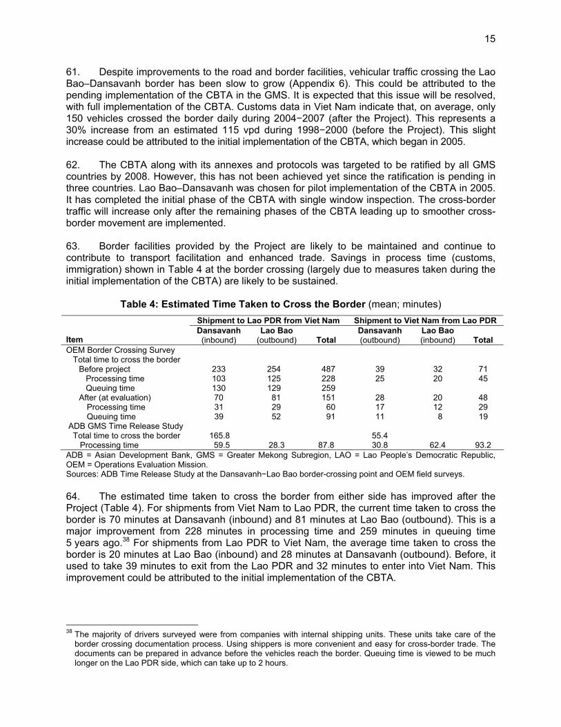
15
61. Despite improvements to the road and border facilities, vehicular traffic crossing the Lao Bao–Dansavanh border has been slow to grow (Appendix 6). This could be attributed to the pending implementation of the CBTA in the GMS. It is expected that this issue will be resolved, with full implementation of the CBTA. Customs data in Viet Nam indicate that, on average, only 150 vehicles crossed the border daily during 2004−2007 (after the Project). This represents a 30% increase from an estimated 115 vpd during 1998−2000 (before the Project). This slight increase could be attributed to the initial implementation of the CBTA, which began in 2005. 62. The CBTA along with its annexes and protocols was targeted to be ratified by all GMS countries by 2008. However, this has not been achieved yet since the ratification is pending in three countries. Lao Bao–Dansavanh was chosen for pilot implementation of the CBTA in 2005. It has completed the initial phase of the CBTA with single window inspection. The cross-border traffic will increase only after the remaining phases of the CBTA leading up to smoother cross-border movement are implemented. 63. Border facilities provided by the Project are likely to be maintained and continue to contribute to transport facilitation and enhanced trade. Savings in process time (customs, immigration) shown in Table 4 at the border crossing (largely due to measures taken during the initial implementation of the CBTA) are likely to be sustained.
Table 4: Estimated Time Taken to Cross the Border (mean; minutes) Shipment to Lao PDR from Viet Nam Shipment to Viet Nam from Lao PDR
Item
Dansavanh (inbound)
Lao Bao (outbound)
Total
Dansavanh (outbound)
Lao Bao (inbound)
Total
OEM Border Crossing Survey Total time to cross the border
Before project 233 254 487 39 32 71 Processing time 103 125 228 25 20 45 Queuing time 130 129 259 After (at evaluation) 70 81 151 28 20 48
Processing time 31 29 60 17 12 29 Queuing time 39 52 91 11 8 19 ADB GMS Time Release Study Total time to cross the border 165.8 55.4 Processing time 59.5 28.3 87.8 30.8 62.4 93.2 ADB = Asian Development Bank, GMS = Greater Mekong Subregion, LAO = Lao People’s Democratic Republic, OEM = Operations Evaluation Mission. Sources: ADB Time Release Study at the Dansavanh−Lao Bao border-crossing point and OEM field surveys. 64. The estimated time taken to cross the border from either side has improved after the Project (Table 4). For shipments from Viet Nam to Lao PDR, the current time taken to cross the border is 70 minutes at Dansavanh (inbound) and 81 minutes at Lao Bao (outbound). This is a major improvement from 228 minutes in processing time and 259 minutes in queuing time 5 years ago.38 For shipments from Lao PDR to Viet Nam, the average time taken to cross the border is 20 minutes at Lao Bao (inbound) and 28 minutes at Dansavanh (outbound). Before, it used to take 39 minutes to exit from the Lao PDR and 32 minutes to enter into Viet Nam. This improvement could be attributed to the initial implementation of the CBTA.
38 The majority of drivers surveyed were from companies with internal shipping units. These units take care of the
border crossing documentation process. Using shippers is more convenient and easy for cross-border trade. The documents can be prepared in advance before the vehicles reach the border. Queuing time is viewed to be much longer on the Lao PDR side, which can take up to 2 hours.

16
65. The relative importance of cross-border activity along the corridor is evident since the majority of the traffic is national, i.e., originating and ending within the country (Table 5).39
Table 5: Distribution of National vis-à-vis International Traffic (%)
Country National Road Number 9 Subregional National Lao PDR Route National 9 36 64 Viet Nam National Highway 9 26 74
Lao PDR = Lao People’s Democratic Republic. Source: Operations Evaluation Mission’s surveys.
66. With full implementation of the CBTA still pending, the expected increases in cross-border traffic have not yet been realized.40 Currently, both Thai and Vietnamese vehicles can drive in the Lao PDR owing to bilateral agreements.41 The Vietnamese restriction on right-hand drive vehicles was lifted in selected routes, including NH9. Meanwhile, most goods that pass through National Road 9 comprise bilateral trade. Since the flow of transit goods has yet to develop fully, total trade has not significantly increased as expected. To date, there is no indication of a major, anticipated diversion of trade from Thailand to Vietnamese ports; this could be attributed to several reasons: (i) the ports at Dong Ha and at Da Nang in Viet Nam have much less capacity than at the Laem Chabang port in Thailand, and (ii) the loading capacity of road bridges within Viet Nam is limited. 67. While enhanced infrastructural connectivity will likely stimulate the development process along the corridor, the pace and extent to which the Lao PDR can benefit from improved connectivity (i.e., act as a strategic hub for east and west trade) will involve more complementary investments including capacity development (Appendix 7). At this time, there is a need to address deficiencies in terms of complementary investments, related institutional changes, and competitiveness, which constrain the country from quickly realizing the full benefits of subregional cooperation. For example, cargo traffic in the Lao PDR is mostly imports. This highlights the need to accelerate exports which could be difficult in a country with only a few emerging major exporters. ADB has provided a TA for building capacity to develop special economic zones in the Lao PDR (footnote 16). This is a step in the right direction and needs to be continued. Another aspect of complementary investments relates to the development of multimodal transport facilities. 68. The business sector sees potential for agricultural development, mining, hydropower, and infrastructure development in the project area. ADB tried to relate ongoing efforts to enhance infrastructural linkage with an overall effort toward increased production and investment activities in the road corridor. For example, a pre-investment study on the East–
39 The Operations Evaluation Mission carried out origin–destination surveys at the Dansavanh border crossing and
Km 25 in the Lao PDR and at the Lao Bao border crossing and Khe Sanh in Viet Nam. At Km 25 in the direction of Kaysone Phomvihane, 9.2% of vehicle traffic is international from Bangkok. In the opposite direction, 9% is international traffic going to Viet Nam (with 7% originating from Kaysone Phomvihane and 2% from Thailand). At the border crossing (Lao PDR side), traffic goes equally from and to three locations—Dong Ha, Hue, and Da Nang. In the Lao PDR, the main origin–destination locations are Kaysone Phomvihane, Atsaphangthong (cement factory and gypsum quarry), and Xepon (mine). Transit vehicles coming and going to Thailand account for 7%–9% of vehicles surveyed at the border.
40 ADB support for preparation and negotiation of the CBTA is a positive contribution toward the key project objective of connectivity between GMS countries. However, additional assistance will need to be allocated to ensure successful implementation of the CBTA.
41 However, Thai vehicles cannot cross into Viet Nam and vice versa. As a result, the Lao PDR is developing into a transshipment area, with Lao-based companies acting as intermediaries between Thai and Vietnamese freight operators. With implementation of the CBTA, it is expected that Thai trucks could drive through the Lao PDR and into Viet Nam. This could reduce the business opportunities for Laotian companies.

17
West Economic Corridor was conducted in 2002, which identified specific industrial, agricultural, and other activities that could be generated by the road corridor and that would help transform it into an economic corridor. The reasons why many of these have not materialized so far could be studied further. An ongoing regional technical assistance (RETA) aims to prepare strategy and action plan for transforming the East–West Corridor into an economic corridor. This is also a step in the right direction since it includes exploring ways to encourage private investment in the provinces adjacent to the East–West Corridor (footnote 16). D. Efficiency 69. The economic reevaluation assesses how economic benefits are evolving. Comparisons have been made with past economic analyses carried out at appraisal and at completion. However, different assumptions underlying these calculations limit their comparability42 (Appendix 8). Project efficiency was generally in line with appraisal estimates of 16% for the main route from Muang Phin to Dong Ha (Table 6). The economic internal rate of return (EIRR) for the Lao PDR component is reestimated at 13.2%, while that for the Viet Nam side is 16.2%.43 It is reasonable to say that these base case estimates are conservative, given current institutional constraints. Other nonquantified benefits are not captured by these EIRRs, including some benefits on informal trade and growth in services sector in the area, savings in time taken to cross the border, incremental benefits in terms of efficient imports and exports at the border, and environmental and social impacts.
Table 6: Comparison of Reestimated EIRRs (m/km and %)
Appraisala
Project Completiona
Operations Evaluation(PPER)a
Road Section
IRI (m/km)
EIRR (%)
IRI (m/km)
EIRR (%)
IRI (m/km)
EIRR (%)
Lao PDR Muang Phin−Dansavanh 11.8 16 2.5 20.6 2−3 13.2 Kaysone Phomvihane−Xeno 3.7 nc 2.0 26.0 1−2 nc Viet Nam Lao Bao–Dong Ha 5−8 16 2.2 17.6 2.2 16.2 Dong Ha Northern Bypass 24 nc nc Dong Ha Southern Bypass nc nc nc
Total Projecta 19 20.2 14.5 EIRR = economic internal rate of return, IRI = international roughness index, km = kilometer, Lao PDR = Lao People’s Democratic Republic, m = meter, nc = not calculated, PPER = project performance evaluation report. a Excluding regional trade benefits. Sources: Asian Development Bank project documents and Operations Evaluation Mission estimates. 70. The country-level distribution of benefits is on par, indicating that the Project provided comparable benefits to both countries. This reinforces the regional cooperation aspect of the 42 The main differences are as follows. First, it is not possible to ensure that the locations of the traffic count were the same
as in previous reports. In quite a few of the referenced reports, there is no clear indication of the exact locations of traffic counts being used. Lao PDR and Viet Nam do not yet conduct regular traffic counts. Second, construction was spread over many years, with some even in 2006; and determining a proper construction price index was not readily available. The CPI has been used instead, but this could introduce a bias because the construction industry is competitive and prices will generally not closely follow the CPI, which is dominated by fuel and food price changes. Third, traffic counts were recorded according to vehicle classifications used by the Highway Development Management 4 and the road economics decision (RED) models. The extent of the use of these models in the previous reports is unclear.
43 The updating of economic analysis combines recent traffic data with growth prospects after 2008 identical to what was envisaged at appraisal and at project completion. The PPER’s EIRR reestimation also carried out different “appraisal/PCR” simulations using RED (i.e., applying new VOC assumptions, adjusted construction prices, and traffic growth after 2008 as expected at appraisal and at project completion). The reestimated EIRR is 14.0% for both Lao PDR and Viet Nam.

18
Project. Moreover, it is apparent that the end users or consumers are the main beneficiaries of the road improvements. Consumers are receiving 56% of the total benefits (50% in the Lao PDR and 61% in Viet Nam) (Appendix 8). 71. Overall, the Project is rated “efficient.” It is economically justified on the assumption that the CBTA will be implemented successfully, which will trigger an increase in traffic and economic activity. The Project has the potential to generate higher trade turnover once the cross-border movement of vehicles is facilitated. 72. The use of loan savings under the Project could have benefited from a better justification at the PCR stage in light of the alternative interventions. In the Lao PDR, instead of the three original rural roads, a total of nine roads were rehabilitated with the extra loan saving. These roads were along RN9 and were selected locally by the district authorities. There was no clear rationale for selection of the nine roads out of the 20 possible candidates, which have yet to be rehabilitated. With rehabilitation of the Kaysone Phomvihane–Xeno road (additional work), it meant that about 32% of the total project cost was outside the original scope and beyond economic appraisal before rehabilitation. In addition, the use of loan savings for the Kaysone Phomvihane–Xeno road deprived the Project of funds to finance the construction of the border facility at Dansavanh, which could be better justified in the context of regional integration. 73. The PCR concluded that the additional works were all positive additions to the original project scope. However, at postevaluation, it is found that the additional works requested by the Borrower were not subjected to the same economic analysis as original road projects at completion. While including the additional works could have been defensible, ADB did not carry out adequate due diligence at completion to check whether the loan savings had been used efficiently. The inclusion of additional works was subjected to preliminary environmental and social assessment, which was followed-up during implementation by the supervision consultant. The approvals for the reallocation of loan proceeds were carried out as per ADB Project Administration Instructions 5.05.44 E. Sustainability 74. Lao PDR Component. Taking into account the ongoing efforts to focus on maintenance allocations, the Lao PDR component is rated “likely to be sustainable.” The Lao PDR has addressed the issue of maintenance allocation through a road maintenance fund (RMF), which is seen as transparent and accountable.45 The RMF receives revenues from road user fees,46 fuel levies, and donor grants. Its intent was to be able to adjust toll and fuel levy rates and extend the RMF’s scope to cover all roads (i.e., only national roads are covered at present).47 In the East−West Corridor, the Department of Public Works and Transport in Kaysone Phomvihane Province has entered into 3-year (2008−2010) lump sum service contracts with the private sector to cover all maintenance on RN9. These contracts came into effect in October 2007 and are funded by the RMF. The allocated budget for road maintenance is KN5.8 billion (about $660,000) or on average $900 per km per year. The budget is lower than requirements and sufficient only for routine maintenance as in the case of Viet Nam ($1,277 per km per year). 44 ADB. 2003. Project Administration Instructions for Reallocating Loan Proceeds. Manila. PAI 5.05. Revised August
2005. 45 The Government established an RMF in January 2001, with collections starting in February 2002. RMF revenues
come from (i) fuel levy; and (ii) road and bridge tolls, heavy vehicle surcharge, and overweight fines. There is no provision for the RMF to favor one national road over another.
46 Tolls levied on all vehicles passing through a collection point on RN9. These points are placed at about 100 km intervals, and the fee is fixed irrespective of the distance traveled on the road.
47 Even with present traffic growth, the RMF will remain dependent on supplementary donor funding.

19
About 3 years since completion of civil works, the ADB-financed sections of RN9 are in good condition, in part because of relatively low traffic levels. In the next 3 years, it is likely that periodic maintenance will need to be carried out on the project roads. Meanwhile, maintenance is also being done on other sections completed earlier with bilateral financing (para. 77). Although the quantum of allocation from the central budget could be falling short of the requirement, the use of the RMF has enabled transparency and accountability in the planning and allocation of the maintenance program. This is expected to generate long-term sustainability for the project road. 75. After 2 years, the majority of RCAI roads still appear in good condition—perhaps in part because few vehicles use them (para. 57)—but also because annual contracts are awarded for the maintenance of these roads. The RCAI roads are being maintained by the beneficiary communities, organized by village maintenance committees.48 The Swedish International Development Cooperation Agency provided funds for training and hand-tools. Periodic maintenance is under annual contract.49 76. A more significant sustainability issue relates to the permissible axle load limits on RN9 and enforcing weight limits. The pavement was designed for a legal axle limit of 9.1 tons, but Thailand and Viet Nam have higher road standards, and persuaded the Lao PDR to increase its limit to 11.0 tons (para. 40).50 The PCR also reported the purchase of one fixed and four transportable scales to supplement existing weighing stations. While these are fully operational and with punitive fines, recorded offenses are rare and the total actual fines levied are small, indicating low incidence of overloading.51 Taking into account the factor of safety ingrained in the original design and the fact that vehicle overloading is minimal, the project road has better potential for sustainability. 77. About 131 km of the East−West Corridor from Xeno junction to Muang Phin were financed by the Government of Japan. In response to cracks on the surface, the MPWT has carried out maintenance on this section.52 This indicates the probability that similar problems on the project road will be addressed promptly by the MPWT. 78. Viet Nam Component. Overall, the Viet Nam component is rated “likely to be sustainable.” The road condition remains good despite growth in traffic (para. 58). While generally lower than requirements, there have been efforts to increase the level of maintenance allocation. For routine maintenance on the East−West Corridor, Viet Nam was reported to have spent the equivalent of $1,300 per km per year (compared to an estimated requirement of $1,875 per km per year). This has been increasing gradually over the years from about $580 per km in 2005 (Table 7).
48 Rural road maintenance includes bud cutting, ditch clearing by machine, repair of erosion damage, and spot filling. 49 For FY2008, contracts for the nine RCAI roads include partial re-graveling of two roads. 50 The PCR reported that MPWT believes the factor of safety in the original design is adequate for the pavement to
withstand the increased load. There might be a need to invest in additional overlay to meet increased load requirements. A study with Swedish International Development Cooperation Agency funding has been undertaken to assess long-term effects.
51 Records from five weigh stations in RN9 (including Friendship Bridge 2) during the last half of 2007 show that only about 1% of trucks were overloaded. No incidence of overloading was recorded in the last 3 months of 2007. If these data are more or less representative, then road maintenance requirements will not be so excessive.
52 Fatigue cracks are in general the result of a loss of structural support and cannot be remedied with surface patching. It is unlikely that this is due to overloading as the failures are in localized sections. The problem is likely to be due to poor subbase/subgrade or poor drainage in these layers.
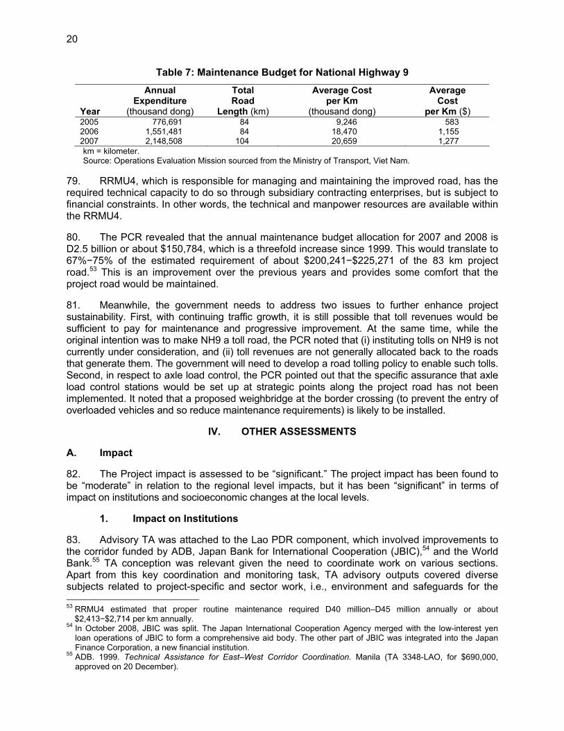
20
Table 7: Maintenance Budget for National Highway 9
Year
Annual Expenditure
(thousand dong)
Total Road
Length (km)
Average Cost per Km
(thousand dong)
Average Cost
per Km ($) 2005 776,691 84 9,246 583 2006 1,551,481 84 18,470 1,155 2007 2,148,508 104 20,659 1,277 km = kilometer. Source: Operations Evaluation Mission sourced from the Ministry of Transport, Viet Nam.
79. RRMU4, which is responsible for managing and maintaining the improved road, has the required technical capacity to do so through subsidiary contracting enterprises, but is subject to financial constraints. In other words, the technical and manpower resources are available within the RRMU4. 80. The PCR revealed that the annual maintenance budget allocation for 2007 and 2008 is D2.5 billion or about $150,784, which is a threefold increase since 1999. This would translate to 67%−75% of the estimated requirement of about $200,241−$225,271 of the 83 km project road.53 This is an improvement over the previous years and provides some comfort that the project road would be maintained. 81. Meanwhile, the government needs to address two issues to further enhance project sustainability. First, with continuing traffic growth, it is still possible that toll revenues would be sufficient to pay for maintenance and progressive improvement. At the same time, while the original intention was to make NH9 a toll road, the PCR noted that (i) instituting tolls on NH9 is not currently under consideration, and (ii) toll revenues are not generally allocated back to the roads that generate them. The government will need to develop a road tolling policy to enable such tolls. Second, in respect to axle load control, the PCR pointed out that the specific assurance that axle load control stations would be set up at strategic points along the project road has not been implemented. It noted that a proposed weighbridge at the border crossing (to prevent the entry of overloaded vehicles and so reduce maintenance requirements) is likely to be installed.
IV. OTHER ASSESSMENTS A. Impact 82. The Project impact is assessed to be “significant.” The project impact has been found to be “moderate” in relation to the regional level impacts, but it has been “significant” in terms of impact on institutions and socioeconomic changes at the local levels.
1. Impact on Institutions 83. Advisory TA was attached to the Lao PDR component, which involved improvements to the corridor funded by ADB, Japan Bank for International Cooperation (JBIC),54 and the World Bank.55 TA conception was relevant given the need to coordinate work on various sections. Apart from this key coordination and monitoring task, TA advisory outputs covered diverse subjects related to project-specific and sector work, i.e., environment and safeguards for the 53 RRMU4 estimated that proper routine maintenance required D40 million–D45 million annually or about
$2,413−$2,714 per km annually. 54 In October 2008, JBIC was split. The Japan International Cooperation Agency merged with the low-interest yen
loan operations of JBIC to form a comprehensive aid body. The other part of JBIC was integrated into the Japan Finance Corporation, a new financial institution.
55 ADB. 1999. Technical Assistance for East–West Corridor Coordination. Manila (TA 3348-LAO, for $690,000, approved on 20 December).

21
rural community component, advice on private sector participation for operation and maintenance, and operation and maintenance arrangements including that of toll and transit fee arrangements. The TA completed all outputs under the original scope. In addition, training in the implementation of a harmonized financial management system resulted in a positive improvement in provincial capacity in its use. Individual consultancy contracts were used instead of a single firm as earlier envisaged. 84. The TA completion report reported that MPWT rated the TA output of the various consultant reports as satisfactory, especially those that contributed directly to effective implementation and operation of the road sectors. The training for central and provincial transport staff in implementing a financial management system was judged successful. Based on the positive contribution to the administration, management, monitoring, and implementation of the various sections of the East−West Corridor Project, the TA is rated “successful.”56 85. The Project could be attributed with bringing in international best practices in the form of better project implementation.57 In terms of the private sector, the Project contributed to the development of the contracting industry in the region wherein local contractors learned new techniques from international ones.
2. Resettlement Impacts 86. No pending resettlement issues were reported.58 In the Lao PDR, minor resettlement was done in two rural access roads. This was implemented without problems. In Viet Nam, an external monitoring group concluded that resettlement activities were conducted fairly and efficiently. At project completion, PMU 85 highlighted the need for appointing a professional agency to monitor the impact to ensure transparency. This suggestion is valid and should be followed by ADB and the EA. Appendix 9 summarizes key findings on resettlement aspects.
3. Environmental Impacts 87. In the Lao PDR, the Project did not create any serious adverse impacts. Some implementation-related issues were satisfactorily addressed. Other environmental concerns relate to the (i) loss of agriculture or productive land to residential or industrial development, and (ii) sustaining forest conservation. In Viet Nam, some contractors did not satisfactorily fulfill obligations to implement environmental protection measures. This has since been addressed. A post-completion environmental concern relates to pressures coming from land development on the Dong Ha Southern Bypass, which environmental specialists have recommended for landscaping and protection from development. Appendix 9 summarizes key findings on environmental aspects.
4. Socioeconomic Impacts 88. Two years after project completion, project-level results are positive on both sides. Economic activity (i.e., growth in the services sector) has increased within the corridor as has the 56 Further institutional development is expected in the Lao PDR with the proposed advisory TA for institutional
strengthening, which is expected to strengthen the Lao PDR's National Transport and Facilitation Committee in charge of implementing the CBTA and identify institutional constraints that limit the emergence of a competitive transport sector in the Lao PDR.
57 For example, the use of international competitive bidding for the consulting and civil works contracts exposed the EA, as well as local contractors, to international standards for better access to advanced technologies.
58 To the knowledge of the Operations Evaluation Mission (OEM), no external monitoring was carried out in the Lao PDR. The OEM discussed this with the staff of the International Union for Conservation of Nature in the Lao PDR, who stated that there were no negative major impacts.

22
roadside population. A key benefit has been improved access to markets and basic social services. The Project has opened up markets and enhanced consumer choices through (i) cheaper prices, and (ii) product availability and diversity. Improved connectivity along the corridor also helped form surplus areas of production, which resulted in changes in the livelihood and living standards of local residents. However, the depth of project impact varied with each household’s access to productive resources and the adoption of appropriate technology. The rural road component enhanced mobility and enabled rural communities including ethnic groups and women to gain access to markets, employment opportunities, and social services. Overall, the Project made substantial positive contributions within the impact area. 89. Corridor-level impacts show an upside in promoting economic activities and facilitating trade, but benefits are still constrained by institutional constraints on the ground. While the transport corridor has been established wherein the roads have been improved, the transformation into economic corridor has not been achieved. Mobilization of private capital was an important feature of the core objective of developing an economic corridor. For the Lao PDR, this is partly explained by inadequate complementary investments and institutional changes. The business sector sees potential for agricultural development, mining, hydropower, and infrastructure development in the area.59 Overall, completion of the project road establishes a platform to push forward the development process along this strategic east−west alignment. Appendix 10 assesses the impacts of this road and transport facilitation venture on economic and social developments at the project and corridor levels.
5. Regional Impacts 90. In light of current restrictions to traffic growth, the impact of the Project on trade has been modest to substantial, partly because of restrictions on vehicle movements. The average trade value through the Lao Bao crossing improved from $92.6 million during 1998−2000 (before the Project) to $99.7 million during 2004−2007 (after the Project). During the last decade, the trade value peaked at $136.2 million in 2006 and $148.5 million in 2007 compared to the previous high of $128.6 million in 1999. 91. Table 8 shows the relative significance of trade passing through Dansavanh to the total trade of the Lao PDR as a whole. Following the drop in trade value due to construction, the share of trade through Dansavanh to the Lao PDR’s total trade has gradually increased from about 2.0% from 2002 to 2003 to around 4.5%−4.9% from 2006 to 2007. Despite competition from new land ports of entry to the Lao PDR, current progress validates the potential upside for trade as Dansavanh accounted for 10.2% of the Lao PDR trade in 1999. Trade data from 1999 to 2007 affirm the relative strategic importance of Dansavanh for the Lao PDR. Being landlocked, the Lao PDR has been the most dependent of the GMS countries on intra-GMS trade.
59 In the Lao PDR, the Government of Japan is funding several initiatives to improve the overall business
environment including promoting the development of transport logistics along the East–West Corridor.

23
Table 8: Trade Impact at Lao Bao–Dansavanh Border Crossing Point, 1999−2007 Impact on Lao PDR Impact on Viet Nam
Year
Lao Bao–Dansavanh Border Crossing Trade Value
($ million)
Share of Trade Value at Dansavanh to Lao PDR’s Total Trade Volume (%)
Share of Trade Value at Lao Bao to Viet Nam's
Total Trade Volume (%) 1999 129 10.15 0.55 2000 58 5.37 0.19 2001 46 4.20 0.15 2002 22 1.99 0.06 2003 29 2.33 0.06 2004 46 2.89 0.08 2005 68 3.46 0.10 2006 136 4.91 0.16 2007 148 4.53 0.14
Lao PDR = Lao People’s Democratic Republic. Source: Trade values at Lao Bao–Dansavanh obtained from Lao Bao Customs. Total trade volumes obtained from
the International Monetary Fund Direction of Trade Statistics CD ROM. 92. A key corridor-level benefit has been improved access to markets and basic social services. In addition, enhanced connectivity along the corridor helped form areas of surplus production. A number of factories in the Lao PDR are using RN9 to transport goods to Viet Nam. These have resulted in changes in the livelihood (diversification of production to other crops) and living standards (with increased production more than consumption) of local residents. East−West transport facilitation (Thailand−Lao PDR−Viet Nam) further opened up markets and enabled consumer choices through (i) cheaper prices, and (ii) product availability and diversity. 93. Despite the favorable outcomes above (paras. 88−92), 2 years after completion, goods passing through RN9 still result mostly from bilateral trade (Thailand−Lao PDR and Viet Nam−Lao PDR). For example, the Lao PDR and Viet Nam have an agreement to allow residents of border villages to cross the borders freely to trade. This has enabled Dansavanh villagers to go on night shopping at the Lao Bao market or opt to use a Viet Nam hospital for more serious illnesses. Improved connectivity in the corridor should further strengthen pre-project bilateral trade between the two countries, which was estimated at $129 million in 1999 or 10% of the Lao PDR’s total trade. 94. Improvement of the project road establishes a platform to push forward the development process along this strategic East−West alignment between Lao PDR, Thailand, and Viet Nam.60 Since the flow of transit goods is yet to develop fully, total trade has not increased significantly as expected. In part, this is explained by inadequate complementary investments and institutional changes in the Lao PDR. The Operations Evaluation Mission (OEM) has estimated that tourism and trade have equal shares of the traffic on this corridor. For trade, these consist mostly of raw commodities such as copper. In the future, this may include raw materials as well as finished goods such as automotive parts, electronic, and electrical appliance between Thailand and Viet Nam. Likewise, agricultural commodities are expected to move from Lao PDR to Thailand or to Viet Nam ports for onward transshipment to the PRC and other countries. 95. Tourism accounts for a major part of the increased traffic between Thailand and Lao PDR. This has more than doubled since project completion. For the Lao PDR, the question for the future is how to encourage more of these tourists to stay longer and spend more in the country.61 This indicates that the Project has contributed to substantial changes in tourism. 60 While the traditional market is to the west, this corridor opens up an eastern market depending on investments
from Japan, Korea, and PRC. 61 As part of Japan’s efforts to develop/promote the corridor, the Japan International Cooperation Agency provided a
$1.5 million grant for a tourism project in Kaysone Phomvihane. It aims to address poverty through development of a one village−one product program (for regional development) along with a one-stop service center near the second Mekong Friendship Bridge.

24
6. Other Social Impacts 96. The RCAI component supported rural development through enhanced mobility. It enabled rural communities including ethnic groups and women to gain access to markets, employment opportunities, and social services. Appendix 5 provides further details on rural community improvements. Other social impacts from the cross-border project are summarized below. 97. Ethnic Communities. The PCR reported that 52 persons of the ethnic minority group in Viet Nam were affected by the Project. The OEM carried out random interviews in the ethnic minority villages. A community survey was carried out on the two main groups—Van Kieu and Pa Co at Klu Village at Dak Rong District located adjacent to the project road. The survey covered 23 households. Farming is the main livelihood of the people and they have a relatively low household income of approximately D200,000/month (equivalent to $12.4 per month). The respondents to the survey were unanimous in their perception that after project completion, (i) their production has increased; (ii) they have sold more goods; (iii) their incomes increased; (iv) their access to markets and health centers improved; and (v) they received better prices for their products. Although the impacts are positive, the intensity of impact remains at a low level since the ethnic minority people continue to live in a secluded community. All the respondents were unanimous in their outlook that it is now easier to cross the border as compared to 3 years back. However, only one third of the community actually crosses the border frequently. A separate report on social impact prepared by the EA after project completion confirmed that there was a favorable social impact on the living standard of minority ethnics, as well as on women headed households living along the road.62 98. Trafficking. There have been distinct negative impacts linked with road corridor development in the GMS. In particular, the PCR highlighted the risk of trafficking of both people63 and wildlife. In the Lao PDR, cross-border movements are common, and it is believed that a large number of people are able to make undocumented crossings to take up unofficial employment. Ethnic minorities, generally the poorest group—particularly in the Lao PDR—are the most at risk to human trafficking, e.g., young ethnic women exploited by businesspersons, migrant workers, etc. 99. HIV/AIDS. A study has found a link between economic development in rural areas, mobility, and HIV/AIDS along the East–West Economic Corridor.64 The improvement of cross-border transport corridors is known to have the potential to contribute to the spread of HIV/AIDS because of increased mobility and the influx of large numbers of construction workers. ADB has carried out case study reviews of four transport projects in the GMS (including the East–West Corridor Project) to provide key lessons and recommendations for tackling the issue.65 These recommendations should be implemented in close coordination with other development partners, as well as the GMS governments. 100. Although the project loan agreements included a covenant requiring contractors to carry out HIV prevention activities, no funding was earmarked specifically for such activities in either country. During implementation, the Project did not include any specific allocation of funds for the implementation of HIV-related activities in the Lao PDR, while $30,000 was assigned from 62 Ministry of Transport, Viet Nam. 2007. East–West Transport Corridor, Viet Nam. Package R2: National Highway
No.9, Rehabilitation and Upgrading. Report. Evaluation on social impact of Project. Ha Noi. 63 This is also closely linked with the spread of communicable diseases. 64 Handicap International. 2006. Development, Mobility, and HIV in South East Asia: A Preliminary Study for the
Implementation of a Development-Based HIV Prevention Programme along the East–West Corridor/Highway 9 in Laos and Vietnam. Paris.
65 ADB. 2007. HIV and Infrastructure: ADB Experience in the Greater Mekong Subregion ADB Synthesis Paper. Manila.

25
the loan to address HIV risks and fulfill the loan covenant requirements in Viet Nam. The supervision consultants and implementing agencies in Lao PDR and Viet Nam had limited technical capacity to design and implement the HIV prevention activities adequately. While the PMUs were given this responsibility, they had limited impact because of capacity constraints and inadequate technical support. The activities were limited to raising awareness about HIV/AIDS and did not specifically target behavior change outcomes. 101. Road Safety. Appendix 11 summarizes developments on road safety along National Road 9. In the Lao PDR, it was difficult to make conclusions on changes in the incidence of road accidents because of data limitations. In Viet Nam, accident statistics show a decline despite increased traffic flow and speeds. However, the severity of accidents increased with higher deaths per accident during 2006−2007. Similarly, accident losses on a per capita basis increased significantly to an average of D9.6 million during 2004−2007 compared with D6.4 million in 2003. B. ADB Performance 102. ADB’s overall performance is rated “partly satisfactory” in view of the frequent change in the project officers, over estimation of project costs, delays in procurement caused by ADB’s reorganization, and lack of adequate economic due diligence for use of loan savings. First, the OEM found that the institutional memory relating to the Project was short since it was managed by various project officers. This led to gaps in information as well as slow decision making. Second, the project costs estimated at appraisal were higher than the contract values resulting in loan savings. This implies lack of performance of the feasibility study funded and coordinated by ADB. Third, ADB witnessed an organizational restructuring that resulted in change of departments and personnel. This contributed to the delays in decision making. Finally, the lack of economic due diligence at approval and at completion stages in relation to use of loans savings is a lapse on the part of ADB (para. 73). On the positive side, the EAs appreciated ADB’s value addition in resolving technical issues, preparation and evaluation of bid documents, and facilitating matters of loan administration. C. Borrower and Executing Agency Performance 103. The performance of the Borrower and the EA in both countries was “satisfactory” with room for improvement. While implementation of the civil works suffered some delays, the quality of the completed works is considered satisfactory. Compliance by both EAs with standard loan covenants was satisfactory, except for a few areas where this was qualified. The implementation arrangements were as envisaged at appraisal and seem to work well. Overall responsibility rested with MPWT in the Lao PDR and MOT in Viet Nam. PMUs were responsible for day-to-day control. In the Lao PDR, the Department of Road set up a project-specific unit, while in Viet Nam, the responsibility was assigned to the PMU based in Vinh City. This was only the second regional project being implemented as part of the GMS program. Although the Project was rationalized as a regional project, the implementation was similar to a national project. In other words, the Project did not entail new procedures for the EAs. In light of this, the EAs’ performance contains room for improvement in the areas of loan effectiveness, procurement, and contractor management. D. Technical Assistance 104. The Project was formulated using two RETA projects. The TA study on Lao PDR–Thailand–Viet Nam–East-West Transport Corridor was approved to investigate the feasibility of a transport corridor connecting central/southern Lao PDR, northeast Thailand, and central Viet Nam (footnote 8). The study investigated three options: (i) a northern corridor using RN8 in the

26
Lao PDR leading to the port of Cia Lo near Vinh, (ii) a central corridor using National Road 9 leading to Da Nang, and (iii) two alternate routes in the south leading to the ports of Da Nang or Quy Nonh. The study recommended implementation of the central corridor, and this was agreed to by the governments of Lao PDR, Thailand, and Viet Nam. The TA for the GMS East–West Corridor carried out the detailed feasibility of the chosen corridor route, including the identification of essential transport infrastructure components that would require construction, rehabilitation, and improvement (footnote 9). Both RETA projects are rated “successful” since they resulted into a loan project, which was implemented successfully. As mentioned in para. 84, the advisory TA (footnote 55) was successful in providing assistance to the EA in the administration, management, monitoring, and implementation of the various sections of the East–West Corridor Project. Appendix 12 provides more details of the TA projects.
V. ISSUES, LESSONS, AND FOLLOW-UP ACTIONS
A. Issues 105. Cross-Border Transport Agreement. The GMS governments have progressed in terms of the CBTA although this is not yet complete. Full regional benefits of the Project will be realized only after the CBTA has been ratified and implemented to strengthen project achievements further. Future milestones for improved road transport facilitation under the GMS program include (i) ratification by all GMS governments of the 20 annexes and protocols, (ii) initial implementation of the CBTA and its annexes and protocols, and (iii) full implementation of the CBTA and its annexes and protocols. It remains to be seen when these milestones will be achieved. 106. Capacity Development in the Lao PDR. For the Lao PDR to benefit fully from the road and transport facilitation project, it will require complementary investments and capacity development. It needs to attract labor-intensive agro-industries and activities, and to identify key imports and exports where it has comparative advantage. Meanwhile, ADB tried to relate ongoing efforts to enhance infrastructural linkage with an overall effort toward increased production and investment activities in the road corridor. For example, a pre-investment study on the East–West Economic Corridor was conducted in 2002, which identified specific industrial, agricultural, and other projects and activities that could be generated by the road corridor and that would help transform it into an economic corridor (para. 68). The barriers for these activities to emerge could be studied and acted upon as soon as possible. 107. Road Safety. With expectations of a sustained increase in vehicle traffic, potential road safety issues are likely to persist in the future (para. 101). These include the (i) need for enforcement of speed limits and driver education, and (ii) need for adequate shoulder width for vehicular stops and parking. Further ideas to improve road safety can be obtained from global knowledge sources such as the global Transport Knowledge Partnership, which brings together best practices from across the world.66 B. Lessons 108. The pace of economic development and conversion of the transport corridor into an economic corridor will depend on the complementary interventions to support the economic activities. The improvement of the road is not sufficient to trigger investments from the private sector. Policy and institutional changes are necessary to encourage private sector activities in production and services.
66 Available: http://www.gtkp.com/

27
109. The improvement of the facilities at Da Nang port has removed a logistics bottleneck on the East–West Corridor. This has created synergies with the Project, indicating that multimodal planning is important for enhancing the effectiveness of the transport corridors. Such planning could be extended to other sectors such as railways and inland waterways. 110. The prudent use of loan savings is an important lesson provided by the Project. Although the use of loan savings for additional works was justified, ADB should have carried out appropriate economic due diligence at approval and at completion to ensure that the selected subprojects were economically viable. C. Follow-Up Actions 111. Recommended follow-up actions are detailed in Table 9.
Table 9: Follow-Up Actions Follow-Up Action
Institution Responsible
Time Frame
Monitoring
Cross-Border Transport Agreement. The Project was designed as a cross-border regional project for developing trade between Lao PDR, Thailand, and Viet Nam. The CBTA has an important role in enabling cross-border traffic along the East–West Corridor. ADB should work closely with the governments to enable full ratification and implementation of the CBTA. The implementation should be closely monitored. This will improve the effectiveness of the Project and generate further regional benefits.
Southeast Asia Department
Ongoing GMS CBTA implementation plan
Economic corridors. Although the CBTA is a necessary condition for development of the economic corridors, it is not sufficient to trigger economic activities. ADB needs to work with the governments on parallel interventions that enable development of industries, agriculture, and production in general. TA 7188-LAO on special economic zones and TA 6310-REG on transforming the transport corridors into economic corridors are steps in the right direction. These need to be supplemented with parallel activities in Viet Nam, as well as other GMS countries.
Southeast Asia Department
Ongoing Development of economic corridors to be measured using GMS specific indicators
Improve maintenance allocations. There is no denying the fact that sustainability of transport infrastructure is crucial. Lao PDR and Viet Nam governments have recognized the need for improving the sustainability of transport infrastructure. However, there is a long way to go in terms of developing maintenance regimes based on needs, achieving a balanced distribution of public funds, identifying alternative financing sources including the private sector, and improving cost recovery. These are the opportunities and areas where ADB can add value in terms of policy dialogue and transfer of knowledge from other countries. ADB need to work closely with the governments in enabling these improvements.
Southeast Asia Department
Ongoing Stepped increase in the allocations for maintenance
ADB = Asian Development Bank, CBTA = Cross-Border Transport Agreement, GMS = Greater Mekong Subregion, Lao PDR = Lao People’s Democratic Republic, TA = technical assistance. Source: Operations Evaluation Mission.

28 Appendix 1
DESIGN AND MONITORING FRAMEWORK
Project Achievements Design Summary Appraisal Performance Indicators/Targets Lao PDR Viet Nam • Average trade value through Lao Bao crossing improved from $92.6 million
during 1998−2000 (before the Project) to $99.7 million during 2004−2007 (after the Project). During the last decade, trade value peaked at $136.2 million in 2006 and $148.5 million in 2007 compared to the previous high of $128.6 million in 2000.
• Improved access to markets and enabled consumer choices through cheaper prices and product availability and diversity.
• Improved access to basic social services. • Tourism accounts for major part of increased traffic between Thailand and
Lao PDR.
Impact Increased economic cooperation and facilitation of trade among Lao PDR, Thailand, and Viet Nam
• Subregional economic growth and social development
• Reduction of poverty a
• About 36% of total traffic is subregional in nature.
• Dansavanh border village has changed and expanded with people in nearby villages and provinces moving to set up trade or seek employment.
• The majority of community survey respondents thought that production, sales, and household income increased after road completion although results were less positive than in Viet Nam.
• With more open border access, Lao PDR traders have lost an old “monopoly” of the markets and have to compete with cheaper products brought in by Vietnamese traders.
• The Savan–Xeno special economic zone near Kaysone Phomvihane is yet to be developed.
• Rural access roads enabled rural communities to gain access to markets and employment opportunities.
• A number of factories using RN9 to transport goods to Viet Nam.
• Growth in the services sector.
• About 26% of total traffic is subregional in nature.
• Community survey in Viet Nam revealed that 88% of respondents thought household income increased after completion of the road. The majority perceived that production and sales increased after road completion.
• Vietnamese traders have increased trade through Dansavanh market and are bringing in cheaper products from Viet Nam and PRC.
• Industrial estates were developed in Lao Bao and Dong Ha and more are being planned. Lao Bao commercial area now has the appearance of a new city and a high rate of urbanization.

Appendix 1 29
Project Achievements Design Summary Appraisal Performance Indicators/Targets Lao PDR Viet Nam • Traffic increased from 1,465 vpd in
1997 to 2,012 vpd in 2008 (Phin−Dansavanh)
• Nonmotorcycle traffic accounts for 33.3% of AADT in 1997 and 36.5% of AADT in 2008 (Phin−Dansavanh)
• Traffic growth more robust compared to Lao PDR side. Traffic increased from 2,078 vpd in 1997 to 5,072 vpd in 2008 (Khe Sanh).
• Nonmotorcycle traffic accounts for 28.9% of AADT in 1997 and 40.7% of AADT in 2008.
• Average roughness index improved from 11.8 m/km to 2–3 m/km (Phin–Dansavanh)
• Average roughness index improved from 3.7 m/km to 1−2 m/km (Kaysone Phomvihane–Xeno)
• Average roughness index improved from 5.0−8.0 m/km to 2.2 m/km (Dong Ha−Lao Bao)
• Greater traffic volumes and changes in vehicle types • Benefits to vehicles using the road within Lao PDR
and Viet Nam in terms of lower vehicle operating costs and faster speeds
• Reduced transport costs by 17%–33% • Reduced travel time by 100 minutes over 161 km
length
• Travel time from Kaysone Phomvihane−Dansavanh reduced from 10−12 hours to 4 hours
• Average vehicle speed increased from 21.5 kph to 59.0 kph
• Travel time from Dong Ha to Lao Bao reduced from 4 hours to 2 hours
• Average vehicle speed increased from 20.8 kph to 41.5 kph
Outcome Improved transport infrastructure in the East–West Corridor
• Community benefits from better road safety Difficult to assess in the absence of data
Decline in road accident incidence despite increases in traffic. However, number of accidents have picked up recently. Accident rate per capita significantly increased since 2003.
Nonphysical barriers to movement of goods and people mitigated in Lao PDR and Viet Nam side of the borders of the project roads
• Increased cross-border movement of freight and passengers
• Estimated total time taken to cross border from Lao Bao to Dansavanh reduced from 487 minutes (before the Project) to 151 minutes (after the Project)
• Estimated processing time taken to cross border from Lao Bao to Dansavanh reduced from 228 minutes to 60 minutes
• Average number of persons crossing per day increased from 261.8 persons per day in 2000 to 502.9 persons in 2006 and 750.3 persons per day in 2007
• Average number of vehicles crossing per day increased from 130.8 vpd in 2000 to 142 vpd in 2006 and 152.2 vpd in 2007
• Estimated total time taken to cross border from Dansavanh to Lao Bao reduced from 71 minutes (before the Project) to 48 minutes (after the Project)
• Estimated processing time taken to cross border from Dansavanh to Lao Bao reduced from 45 minutes to 29 minutes
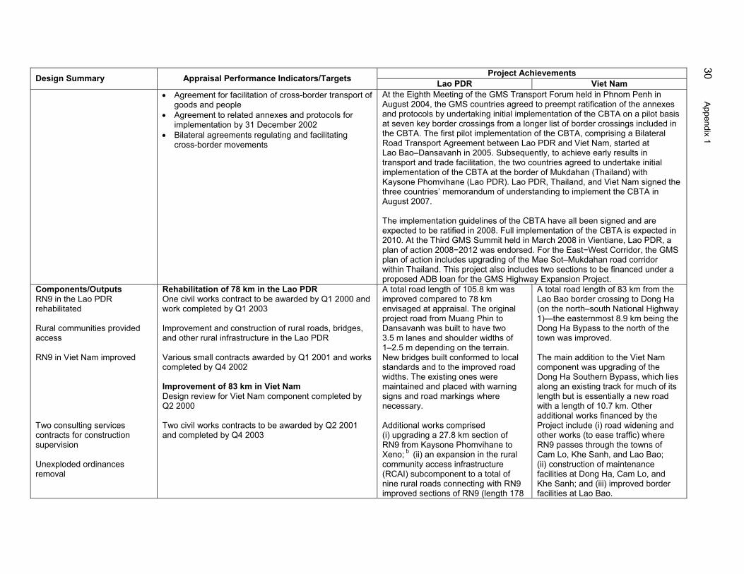
30 Appendix 1
Project Achievements Design Summary Appraisal Performance Indicators/Targets Lao PDR Viet Nam • Agreement for facilitation of cross-border transport of
goods and people • Agreement to related annexes and protocols for
implementation by 31 December 2002 • Bilateral agreements regulating and facilitating
cross-border movements
At the Eighth Meeting of the GMS Transport Forum held in Phnom Penh in August 2004, the GMS countries agreed to preempt ratification of the annexes and protocols by undertaking initial implementation of the CBTA on a pilot basis at seven key border crossings from a longer list of border crossings included in the CBTA. The first pilot implementation of the CBTA, comprising a Bilateral Road Transport Agreement between Lao PDR and Viet Nam, started at Lao Bao–Dansavanh in 2005. Subsequently, to achieve early results in transport and trade facilitation, the two countries agreed to undertake initial implementation of the CBTA at the border of Mukdahan (Thailand) with Kaysone Phomvihane (Lao PDR). Lao PDR, Thailand, and Viet Nam signed the three countries’ memorandum of understanding to implement the CBTA in August 2007. The implementation guidelines of the CBTA have all been signed and are expected to be ratified in 2008. Full implementation of the CBTA is expected in 2010. At the Third GMS Summit held in March 2008 in Vientiane, Lao PDR, a plan of action 2008−2012 was endorsed. For the East−West Corridor, the GMS plan of action includes upgrading of the Mae Sot–Mukdahan road corridor within Thailand. This project also includes two sections to be financed under a proposed ADB loan for the GMS Highway Expansion Project.
Components/Outputs RN9 in the Lao PDR rehabilitated Rural communities provided access RN9 in Viet Nam improved Two consulting services contracts for construction supervision Unexploded ordinances removal
Rehabilitation of 78 km in the Lao PDR One civil works contract to be awarded by Q1 2000 and work completed by Q1 2003 Improvement and construction of rural roads, bridges, and other rural infrastructure in the Lao PDR Various small contracts awarded by Q1 2001 and works completed by Q4 2002 Improvement of 83 km in Viet Nam Design review for Viet Nam component completed by Q2 2000 Two civil works contracts to be awarded by Q2 2001 and completed by Q4 2003
A total road length of 105.8 km was improved compared to 78 km envisaged at appraisal. The original project road from Muang Phin to Dansavanh was built to have two 3.5 m lanes and shoulder widths of 1–2.5 m depending on the terrain. New bridges built conformed to local standards and to the improved road widths. The existing ones were maintained and placed with warning signs and road markings where necessary. Additional works comprised (i) upgrading a 27.8 km section of RN9 from Kaysone Phomvihane to Xeno; b (ii) an expansion in the rural community access infrastructure (RCAI) subcomponent to a total of nine rural roads connecting with RN9 improved sections of RN9 (length 178
A total road length of 83 km from the Lao Bao border crossing to Dong Ha (on the north–south National Highway 1)—the easternmost 8.9 km being the Dong Ha Bypass to the north of the town was improved. The main addition to the Viet Nam component was upgrading of the Dong Ha Southern Bypass, which lies along an existing track for much of its length but is essentially a new road with a length of 10.7 km. Other additional works financed by the Project include (i) road widening and other works (to ease traffic) where RN9 passes through the towns of Cam Lo, Khe Sanh, and Lao Bao; (ii) construction of maintenance facilities at Dong Ha, Cam Lo, and Khe Sanh; and (iii) improved border facilities at Lao Bao.

Appendix 1 31
Project Achievements Design Summary Appraisal Performance Indicators/Targets Lao PDR Viet Nam km); (iii) construction of the Xe
Namkok bridge; (iv) improved border facilities at Dansavanh; (v) one fixed and four mobile scales to measure axle loads; (vi) road marking and street lighting around Kaysone Phomvihane town; and (vii) emergency repairs to roads outside the corridor during the floods in 2000. Under the rural roads component, a total length of 178 km along 9 rural roads (against an appraisal target of 3) connecting to the main corridor, were improved (para. 5). Of these, 35 km were bituminized where gradients were steep. A bridge was also built at Xe Namkok.
AADT = annual average daily traffic, ADB = Asian Development Bank, CBTA = Cross-Border Transport Agreement, GMS = Greater Mekong Subregion, km = kilometer, kph = kilometers per hour, Lao PDR = Lao People’s Democratic Republic, m = meter, PCR = project completion report, PRC = People’s Republic of China, Q = quarter, RN = route national, vpd = vehicles per day. a The achievement of poverty reduction cannot be verified due to lack of specific data in the project impact area. The Operations Evaluation Mission did not include a
household level survey, since this was outside the scope of the evaluation approach. Moreover, the Project’s report and recommendation of the President did not include a specific target for poverty reduction. As a result, the reduction in poverty could not be quantified.
b Road was not in bad condition but was considered to be below standard to meet the requirements of the yet to be developed special economic zone. Source: Operations Evaluation Mission.

32 Appendix 2
PROJECT COSTS ($ million)
Table A2.1: Appraisal and Actual Lao PDR Component Costs
Appraisal Actual Actual/
Project Component
Foreign
Local
Total
Foreign
Local
Total Appraisal
(%) A. Base Cost 1. Land Acquisition/Resettlement 0.00 2.00 2.00 ― 0.01 0.01 0.4 2. Civil Works-Rehabilitation of RN9 21.20 5.30 26.50 21.51 8.25 26.03 98.2 3.
Civil Works-Rural Community Infrastructure
1.20
0.80
2.00
5.57
1.18
6.75
337.5
4. Construction Supervision 2.00 0.80 2.80 3.50 ― 3.50 125.0 5. Project Management 0.00 0.70 0.70 ― ― ― ― Subtotal (A) 24.40 9.60 34.00 30.58 9.44 36.29 106.7 B. Contingencies 1. Physical Contingencies 2.40 1.00 3.40 0.0 0.0 0.0 0.0 2. Price Escalation 1.20 0.40 1.60 0.0 0.0 0.0 0.0
Subtotal (B) 3.60 1.40 5.00 0.0 0.0 0.0 0.0
C. IDC 1.00 0.00 1.00 0.76 ― 0.76 76.0 Grand Total (A+B+C) 29.00 11.00 40.00 31.34 9.44 40.78 102.0
IDC = interest and other charges during construction, Lao PDR = Lao People’s Democratic Republic, RN = route national. Source: Asian Development Bank project completion report.
Table A2.2: Appraisal and Actual Viet Nam Component Costs
Appraisal Actual Actual/
Project Component Foreign Local Total Foreign Local Total Appraisal
(%) A. Base Cost 1. Land Acquisition/Resettlement/
UXO Clearance/Design 0.00
5.00
5.00
0.00
3.13
3.13
62.6
2. Civil Works-Improvement of NH9 9.30 4.60 13.90 10.30 4.96 15.26 109.8 3. Civil Works-Upgrading of Dong Ha
Bypass 4.90
2.40
7.30
5.23
2.53
7.76
106.3
4. Design Review and Construction
Supervision 1.30
0.40
1.70
2.52
0.09
2.61
153.5
5. Project Management 0.00 1.50 1.50 0.00 0.10 0.10 6.7 Subtotal (A) 15.50 13.90 29.40 18.05 10.81 28.86 98.2 B. Contingencies 1. Physical Contingencies 2.20 1.70 3.90 0.00 0.00 0.00 0.0 2. Price Escalation 1.30 0.70 2.00 0.00 0.00 0.00 0.0 Subtotal (B) 3.50 2.40 5.90 0.00 0.00 0.00 0.0 C. IDC 0.70 0.00 0.70 0.38 0.00 0.38 54.3 Grand Total (A+B+C) 19.70 16.30 36.00 18.43 10.81 29.24 81.2
IDC = interest and other charges during construction, NH = national highway, RN = route national, UXO = unexploded ordinance. Source: Asian Development Bank project completion report.

Appendix 2 33
Table A2.3: Cost of Civil Works at Appraisal and Completion
Lao PDR Viet Nam Total Project Item Approval Actual Approval Actual Approval Actual CW − Road Rehabilitation ($ mn) 26.50 26.03 13.90 15.26 40.40 Length of Project Road (km) 78 105.8 84 162 Average Cost per Km ($/km) $339,744 $246,030 $165,476 $249,383 CW − RCAI ($ mn) 2.00 6.75 0.0 0.0 2.00 6.75 Number of Rural Roads 3 9 0.0 0.0 3 9 Avg .Cost Per Rural Road $666,667 $750,000 0.0 0.0 $666,667 $750,000 Length of Project Road (km) 178 0.0 0.0 178 Average Cost per Km ($/km) $37,921 0.0 0.0 $37,921 CW − Dong Ha By pass ($ mn) 0.0 0.0 7.3 7.8 7.3 7.8 Length of Project Road (km) 0.0 0.0 8.9 8.9 Average Cost Per Km ($/km) 0.0 0.0 $820,225 $820,225 Avg = average, CW = civil works, km = kilometer, Lao PDR = Lao People’s Democratic Republic, MN = million, RCAI = rural community access infrastructure. Source: Asian Development Bank project completion report.

34 Appendix 3
SUMMARY OF PHYSICAL ACHIEVEMENTS As Per Loan Documents Design Changes At Completion
Lao PDR 1. East–West Corridor Access. Rehabilitation of RN9 from Muang Phin to Dansavanh at the border with Viet Nam (about 78 km)
• Upgrade a further 27.8 km of RN9 from Kaysone Phomvihane to Xeno to a standard consistent with that of earlier upgraded road sections east of Xeno. These include widening, placing an asphaltic concrete overlay, improving related intersections, and providing 2.5 m shoulders to give a lane for light and slower traffic (bicycles, motorcycles, hand tractors, etc.) • Improve border facilities • One fixed and four mobile scales to measure axle loads along RN9 • Road marking and street lighting around Kaysone Phomvihane town • Off-corridor emergency flood repairs
• A total road length of 105.8 km was improved, more than envisaged at appraisal • Done. • Done. • Done. • Done.
2. Rural Community Access Improvement. Construction and improvement of three access roads including small bridges, river crossing systems, pathways, and other infrastructure in the corridor influence area
• Enlarge RCAI subcomponent to a total of nine rural roads connecting with RN9 (length 178 km), with bitumen applied in areas with steep grades (35 km) • Construction of Xe Namkok bridge
• A total of nine rural roads for a length of 178 km were improved, of which 35 km were bituminized • Done.
Viet Nam 1. East–West Corridor Access. Upgrading and improvement of NH9 from Lao Bao at the border with Lao PDR to Dong Ha on Highway 1 (about 84 km)
• Road widening and other works where NH9 passes through the towns of Cam Lo, Khe Sanh, and Lao Bao • Construction of maintenance facilities at Dong Ha, Cam Lo, and Khe Sanh • Construction of border facilities at Lao Bao
Improvements were carried out as envisaged, which included resurfacing with asphaltic concrete; standardization to a carriageway width of 7 m (and up to 11 m on the bypasses) with shoulders of 1 m width in mountainous areas and 2 m on the plains; replacement of 15 bridges; and various improvements to intersections, road markings, and furniture designed to improve traffic flow and safety
2. Upgrading of the Dong Ha Bypass
• Construction on the Dong Ha Southern Bypass, which lies along an existing track for much of its length but is essentially a new road with a length of 10.7 km
Improvements on the Dong Ha Bypass: (i) Dong Ha Bypass–North including bridges, and (ii) Dong Ha Bypass–South
km = kilometer, Lao PDR = Lao People’s Democratic Republic, m = meter, NH = national highway, RCAI = rural community access infrastructure, RN = route national. Source: Asian Development Bank. 2008. Project Completion Report: Lao People’s Democratic Republic and
Socialist Republic of Viet Nam: Greater Mekong Subregion: East–West Corridor Project. Manila.
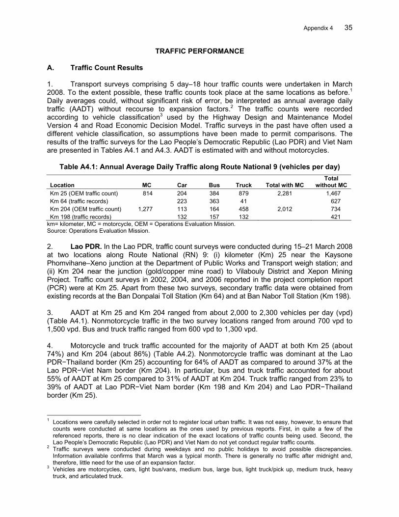
Appendix 4 35
TRAFFIC PERFORMANCE A. Traffic Count Results 1. Transport surveys comprising 5 day–18 hour traffic counts were undertaken in March 2008. To the extent possible, these traffic counts took place at the same locations as before.1
Daily averages could, without significant risk of error, be interpreted as annual average daily traffic (AADT) without recourse to expansion factors.2 The traffic counts were recorded according to vehicle classification3 used by the Highway Design and Maintenance Model Version 4 and Road Economic Decision Model. Traffic surveys in the past have often used a different vehicle classification, so assumptions have been made to permit comparisons. The results of the traffic surveys for the Lao People’s Democratic Republic (Lao PDR) and Viet Nam are presented in Tables A4.1 and A4.3. AADT is estimated with and without motorcycles.
Table A4.1: Annual Average Daily Traffic along Route National 9 (vehicles per day)
Location MC Car Bus Truck Total with MC Total
without MC Km 25 (OEM traffic count) 814 204 384 879 2,281 1,467 Km 64 (traffic records) 223 363 41 627 Km 204 (OEM traffic count) 1,277 113 164 458 2,012 734 Km 198 (traffic records) 132 157 132 421
km= kilometer, MC = motorcycle, OEM = Operations Evaluation Mission. Source: Operations Evaluation Mission. 2. Lao PDR. In the Lao PDR, traffic count surveys were conducted during 15–21 March 2008 at two locations along Route National (RN) 9: (i) kilometer (Km) 25 near the Kaysone Phomvihane–Xeno junction at the Department of Public Works and Transport weigh station; and (ii) Km 204 near the junction (gold/copper mine road) to Vilabouly District and Xepon Mining Project. Traffic count surveys in 2002, 2004, and 2006 reported in the project completion report (PCR) were at Km 25. Apart from these two surveys, secondary traffic data were obtained from existing records at the Ban Donpalai Toll Station (Km 64) and at Ban Nabor Toll Station (Km 198). 3. AADT at Km 25 and Km 204 ranged from about 2,000 to 2,300 vehicles per day (vpd) (Table A4.1). Nonmotorcycle traffic in the two survey locations ranged from around 700 vpd to 1,500 vpd. Bus and truck traffic ranged from 600 vpd to 1,300 vpd. 4. Motorcycle and truck traffic accounted for the majority of AADT at both Km 25 (about 74%) and Km 204 (about 86%) (Table A4.2). Nonmotorcycle traffic was dominant at the Lao PDR−Thailand border (Km 25) accounting for 64% of AADT as compared to around 37% at the Lao PDR−Viet Nam border (Km 204). In particular, bus and truck traffic accounted for about 55% of AADT at Km 25 compared to 31% of AADT at Km 204. Truck traffic ranged from 23% to 39% of AADT at Lao PDR−Viet Nam border (Km 198 and Km 204) and Lao PDR−Thailand border (Km 25). 1 Locations were carefully selected in order not to register local urban traffic. It was not easy, however, to ensure that
counts were conducted at same locations as the ones used by previous reports. First, in quite a few of the referenced reports, there is no clear indication of the exact locations of traffic counts being used. Second, the Lao People’s Democratic Republic (Lao PDR) and Viet Nam do not yet conduct regular traffic counts.
2 Traffic surveys were conducted during weekdays and no public holidays to avoid possible discrepancies. Information available confirms that March was a typical month. There is generally no traffic after midnight and, therefore, little need for the use of an expansion factor.
3 Vehicles are motorcycles, cars, light bus/vans, medium bus, large bus, light truck/pick up, medium truck, heavy truck, and articulated truck.

36 Appendix 4
Table A4.2: Vehicle Mix along Route National 9 (% of Total AADT with MC)
Location MC Car Bus Truck Total with MC Total without MC Km 25 35.7 8.9 16.8 38.6 100.0 64.3 Km 64 35.6 57.9 6.5 100.0 Km 204 63.5 5.6 8.1 22.8 100.0 36.5 Km 198 31.4 37.3 31.4 100.0
AADT = annual average daily traffic, km = kilometer, MC = motorcycle. Source: Operations Evaluation Mission. 5. Viet Nam. The Operations Evaluation Mission undertook traffic surveys at three locations along National Highway (NH) 9 (Viet Nam side of National Road 9): (i) at the border crossing in Lao Bao; (ii) 15 km from the border-crossing point near Khe Sanh; and (iii) at the Southern Dong Ha Bypass, which was added to the original scope of the Project. 6. AADT at the Lao Bao crossing point was 1,165 vpd, of which 541 vpd were nonmotorcycle traffic (Table A4.3). AADT was found to be higher at Khe Sanh, with an estimated traffic level of 5,072 vpd including 2,066 vpd in nonmotorcyle traffic. AADT at the Southern Dong Ha Bypass was 1,291 vpd, including 702 vpd in nonmotorcycle traffic.
Table A4.3: Annual Average Daily Traffic along National Highway 9 (vehicles per day)
Location MC Car Bus Truck Total with MC Total without MC
Lao Bao BCP 624 144 110 287 1,165 541 Khe Sanh (15 Km from BCP) 3,006 343 754 969 5,072 2,066 Southern Dong Ha Bypass 589 108 149 445 1,291 702 BCP = border-crossing point, km = kilometer, MC = motorcycle. Source: Operations Evaluation Mission.
7. Nonmotorcycle traffic was relatively sizeable and ranged from 41% to 54% of AADT at the three survey locations (Table A4.4). In particular, bus and truck traffic ranged from 28% to 50% of AADT. Bus and trucks accounted for around one third of AADT at Lao PDR−Viet Nam border-crossing point and at Khe Sanh, some 15 km away. This proportion increases to 46% of AADT at the Southern Dong Ha Bypass. After motorcycles, trucks account for the second largest number using the three surveyed roads. These ranged from about 25% at the Lao Bao border-crossing point to about 35% at the Southern Dong Ha Bypass. Bus traffic ranged from 9% to 15% of AADT at the surveyed locations.
Table A4.4: Vehicle Mix (% of Total AADT with MC)
Location MC Car Bus Truck Total with MC Total without MC Lao Bao BCP 53.6 12.4 9.4 24.6 100.0 46.4 Khe Sanh 59.3 6.8 14.9 19.1 100.0 40.7 Southern Dong Ha Bypass 45.6 8.4 11.5 34.5 100.0 54.4
AADT = annual average daily traffic, BCP = border-crossing point, MC = motorcycle. Source: Operations Evaluation Mission. B. Comparison of Traffic 8. To get a measure of traffic growth and changes in vehicle composition, observed AADT was compared to survey findings at the time of appraisal and at project completion. This comparison is given in Tables A4.5−A4.8. However, any comparison requires caution. Though

Appendix 4 37
consistency has been seriously attempted in the following tables, discrepancies still exist in survey locations and vehicle classification. The PCR does not indicate survey locations. 9. Lao PDR. Recent traffic data from Phin to Dansavanh reveals a marginal impact toward encouraging rapid international traffic growth. Table A4.5 compares AADT levels in 1995−1997 (before the Project) and 2006−2008 (after the Project). Total traffic including motorcycles ranged from 2,000 vpd to 2,200 vpd during 2006−2008. This is sluggish relative to the rapid growth (from 200 vpd to about 1,500 vpd) during 1995−1997. Specifically, nonmotorcycle traffic grew by about 87% per year during 1995−1997 compared to 3.8% per year over the 9−year period from 1997 to 2008. On the positive side, nonmotorcycle traffic growth was more than double its period average at 8.4% per year during 2006−2008. This pattern was led by robust results performances in the car (10.2% per year) and truck (16.4% per year) categories. Table A4.5: Annual Average Daily Traffic (vehicles per day) – Muang Phin to Dansavanh Item Year MC Car Bus Truck Total with MC Total without MC Appraisal (TA) 1995 60 15 19 106 200 140 Appraisal (RRP) 1997 977 46 53 389 1,465 488 PCR 2006 1,566 93 194 338 2,191 625 PPER 2008 1,277 113 164 458 2,012 735
MC = motorcycle, PCR = project completion report, PPER = project performance evaluation report, RRP = report and recommendation of the President, TA = technical assistance. Source: Operations Evaluation Mission.
Table A4.6: Vehicle Mix (% of Total AADT with MC) – Muang Phin to Dansavanh
Item Year MC Car Bus Truck Total with MC Total without MC Appraisal (TA) 1995 30.0 7.5 9.5 53.0 100.0 70.0 Appraisal (RRP) 1997 66.7 3.1 3.6 26.6 100.0 33.3 PCR 2006 71.5 4.2 8.9 15.4 100.0 28.5 PPER 2008 63.5 5.6 8.2 22.8 100.0 36.5
AADT = annual average daily traffic, MC = motorcycle, PCR = project completion report, PPER = project performance evaluation report, RRP = report and recommendation of the President, TA = technical assistance. Source: Operations Evaluation Mission. 10. Motorcycles dominate traffic along the route at 63%−72% of AADT. On the other hand, the long-term presence of nonmotorcycle traffic (about a third of AADT) has been stable since 1997. Nonmotorcycle traffic ranged from 28% to 37% during 2006−2008 compared to about 33% in 1997. In particular, the ratio of bus and trucks to total AADT, which ranged from 24% to 31% during 2006−2008, was more or less in line with the 1997 average of about 30%. 11. Viet Nam. Compared to marginal results in the Lao PDR, traffic at the Viet Nam side of the border was healthy. In particular, Khe Sanh, which is 15 km from the border-crossing point, showed marked improvements. Motorcycle traffic increased from 1,477 vpd in 1997 to 3,006 vpd in 2008. Nonmotorcycle traffic rose from 601 vpd in 1997 to 2,006 vpd in 2008. In particular, buses and trucks increased from 545 vpd in 1997 to 1,723 vpd in 2008.
Table A4.7: Annual Average Daily Traffic (vehicles per day) – Khe Sanh
Item Year MC Car Bus Truck Total with MC Total without MC Appraisal (RRP) 1997 1,477 56 65 480 2,078 601 PCR 2006 1,362 256 539 352 2,509 1,147 PPER 2008 3,006 343 754 969 5,072 2,066
MC = motorcycle, PCR = project completion report, PPER = project performance evaluation report, RRP = report and recommendation of the President. Source: Operations Evaluation Mission.

38 Appendix 4
12. The share of nonmotorcycle traffic ranged from 41% to 46% of total AADT during 2006−2008 compared to 28.9% in 1997. This was accounted for by an increased share of cars and buses. The proportion of buses increased from 13.1% in 1997 to around 14%−22% of AADT during 2006−2008. For cars, the ratio improved from 2.7% in 1997 to 6.8% in 2007.
Table A4.8: Vehicle Mix (% of Total AADT with MC) – Khe Sanh
Item Year MC Car Bus Truck Total with MC Total without MC Appraisal (RRP) 1997 71.1 2.7 3.1 23.1 100.0 28.9 PCR 2006 54.3 10.2 21.5 14.0 100.0 45.7 PPER 2008 59.3 6.8 14.9 19.1 100.0 40.7
AADT = annual average daily traffic, MC = motorcycle, PCR = project completion report, PPER = project performance evaluation report, RRP = report and recommendation of the President. Source: Operations Evaluation Mission. C. Traffic Forecasts 13. Reassessing the road projects using current traffic observations implies calibrating the traffic forecasts. The purpose is not to propose a new traffic forecast based on a different set of assumptions, but rather to keep the same forecasting methodology adjusted according to the traffic observations of the Operations Evaluation Mission in March 2008. 14. Forecast methodology adopted during appraisal was according to common practice where passenger demand (traffic) is assumed to vary according to gross domestic product (GDP) per capita, population growth, and GDP passenger demand elasticity. Freight demand (traffic), on the other hand, was expected to vary according to GDP and GDP freight demand elasticity. The Operations Evaluation Mission estimates for 2000–2007 are either based on real observations or are calculated by interpolation between starting dates and 2008. The summary of traffic forecasts for National Road 9 is presented in Table A4.9. For the Lao PDR, vehicle traffic by type is presented from 2001 (starting year) to 2020 (ending year). In Viet Nam, vehicle traffic by type is presented from 2003 (starting year) to 2022 (ending year).
Table A4.9: Annual Average Daily Traffic Forecasts (vehicles per day) Lao PDR (Kilometer 204) Viet Nam (Khe Sanh)
Year Normal Generated Induced Total
Year Normal Generated Induced Total 2001 507 0 0 507 2003 803 0 0 803 2002 526 0 0 526 2004 960 0 0 960 2003 547 0 0 547 2005 1,154 0 0 1,154 2004 571 109 0 680 2006 1,394 191 0 1,585 2005 598 118 5 721 2007 1,693 233 0 1,926 2006 640 129 6 775 2008 1,883 259 5 2,147 2007 687 140 7 834 2009 2,096 289 6 2,391 2008 737 153 8 898 2010 2,332 323 7 2,662 2009 792 167 9 968 2011 2,596 360 8 2,964 2010 851 182 10 1,043 2012 2,890 402 9 3,301 2011 924 198 11 1,133 2013 3,124 435 10 3,569 2012 1,003 215 12 1,230 2014 3,376 471 11 3,858 2013 1,089 234 13 1,336 2015 3,649 510 12 4,171 2014 1,182 254 14 1,450 2016 3,945 552 13 4,510 2015 1,284 277 15 1,576 2017 4,265 598 14 4,877 2016 1,395 301 16 1,712 2018 4,611 648 15 5,274 2017 1,516 328 17 1,861 2019 4,985 702 16 5,703 2018 1,647 357 18 2,022 2020 5,391 760 17 6,168 2019 1,790 389 19 2,198 2021 5,829 823 18 6,670 2020 1,946 424 20 2,390 2022 6,304 892 19 7,215 Lao PDR = Lao People’s Democratic Republic. Source: Operations Evaluation Mission consultant estimates.
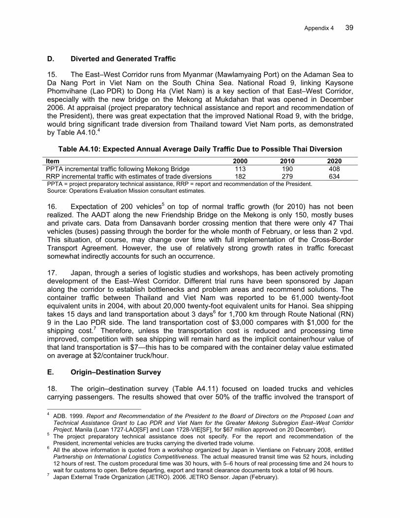
Appendix 4 39
D. Diverted and Generated Traffic 15. The East–West Corridor runs from Myanmar (Mawlamyaing Port) on the Adaman Sea to Da Nang Port in Viet Nam on the South China Sea. National Road 9, linking Kaysone Phomvihane (Lao PDR) to Dong Ha (Viet Nam) is a key section of that East–West Corridor, especially with the new bridge on the Mekong at Mukdahan that was opened in December 2006. At appraisal (project preparatory technical assistance and report and recommendation of the President), there was great expectation that the improved National Road 9, with the bridge, would bring significant trade diversion from Thailand toward Viet Nam ports, as demonstrated by Table A4.10.4
Table A4.10: Expected Annual Average Daily Traffic Due to Possible Thai Diversion Item 2000 2010 2020 PPTA incremental traffic following Mekong Bridge 113 190 408 RRP incremental traffic with estimates of trade diversions 182 279 634 PPTA = project preparatory technical assistance, RRP = report and recommendation of the President. Source: Operations Evaluation Mission consultant estimates. 16. Expectation of 200 vehicles5 on top of normal traffic growth (for 2010) has not been realized. The AADT along the new Friendship Bridge on the Mekong is only 150, mostly buses and private cars. Data from Dansavanh border crossing mention that there were only 47 Thai vehicles (buses) passing through the border for the whole month of February, or less than 2 vpd. This situation, of course, may change over time with full implementation of the Cross-Border Transport Agreement. However, the use of relatively strong growth rates in traffic forecast somewhat indirectly accounts for such an occurrence. 17. Japan, through a series of logistic studies and workshops, has been actively promoting development of the East–West Corridor. Different trial runs have been sponsored by Japan along the corridor to establish bottlenecks and problem areas and recommend solutions. The container traffic between Thailand and Viet Nam was reported to be 61,000 twenty-foot equivalent units in 2004, with about 20,000 twenty-foot equivalent units for Hanoi. Sea shipping takes 15 days and land transportation about 3 days6 for 1,700 km through Route National (RN) 9 in the Lao PDR side. The land transportation cost of $3,000 compares with $1,000 for the shipping cost.7 Therefore, unless the transportation cost is reduced and processing time improved, competition with sea shipping will remain hard as the implicit container/hour value of that land transportation is $7—this has to be compared with the container delay value estimated on average at $2/container truck/hour. E. Origin–Destination Survey 18. The origin–destination survey (Table A4.11) focused on loaded trucks and vehicles carrying passengers. The results showed that over 50% of the traffic involved the transport of 4 ADB. 1999. Report and Recommendation of the President to the Board of Directors on the Proposed Loan and
Technical Assistance Grant to Lao PDR and Viet Nam for the Greater Mekong Subregion East–West Corridor Project. Manila (Loan 1727-LAO[SF] and Loan 1728-VIE[SF], for $67 million approved on 20 December).
5 The project preparatory technical assistance does not specify. For the report and recommendation of the President, incremental vehicles are trucks carrying the diverted trade volume.
6 All the above information is quoted from a workshop organized by Japan in Vientiane on February 2008, entitled Partnership on International Logistics Competitiveness. The actual measured transit time was 52 hours, including 12 hours of rest. The custom procedural time was 30 hours, with 5–6 hours of real processing time and 24 hours to wait for customs to open. Before departing, export and transit clearance documents took a total of 96 hours.
7 Japan External Trade Organization (JETRO). 2006. JETRO Sensor. Japan (February).

40 Appendix 4
goods, 43% commerce and trade, 4% tourism-related, 1% for health and social visits, and 1% for work. Goods transported along the corridor included agricultural products such as fruits and vegetables, logs, wood products and furniture, construction materials (such as cement and steel), textile and cloth, electrical products, food products, and fuel and chemical fluids.
Table A4.11: Origin–Destination Survey
Lao PDR
Km 247 (near Dansavanh border)
Km 25 (near Kaysone Phomvihane town)
Viet Nam (along NR9 from Dong Ha to
Lao Bao and Lao Bao border crossing)
Direction: Kaysone Phomvihane to Dansavanh
• Total number of vehicles surveyed was 284.
• Of the vehicles surveyed, 88% originated within Kaysone Phomvihane Province, 6% from other Lao PDR provinces, and 6% from Thailand.
• Intended final destination of 91% of vehicles was Viet Nam and 9% were only traveling up to the Dansavanh border.
• 39% of vehicles originating from Thailand and 51% originating from Kaysone Phomvihane were heading to the tourist destinations of Hue, Da Nang, and Hue An.
• Almost 99% of vehicles originating in Atsaphangthong (or 55% of all vehicles interviewed) were trucks from the gypsum mine heading for Dong Ha in Viet Nam.
Direction: Kaysone Phomvihane to Dansavanh
• Total number of vehicles surveyed was 525, of which 98% were from Kaysone Phomvihane town, and the rest from Thailand (the high incidence of vehicles originating in Kaysone Phomvihane was due to the proximity of survey location to the town).
• Destinations of vehicles surveyed were within Kaysone Phomvihane Province (68%), other provinces within Lao PDR (15%), Viet Nam (9%), and Dansavanh border (8%).
• Traffic from Thailand was tour buses.
• Average travel time of vehicles surveyed 2.5 hours for an average 108 km distance. This is much lower than the travel time of 3 hours 5 years ago.
• Results showed that 46% of vehicles were domestic traffic (of which 40% were traveling within the project province and 6% were traveling to and from other provinces in Viet Nam), and 54% were international traffic (of which 21% originated in or were bound for the project province, and 33% were outbound for other countries)
• Average travel time of vehicles surveyed 3.5 hours for an average 220 km distance. This is much lower than travel time of 48 hours 5 years ago.
• Average speed increased significantly from 24.15 km/h 5 years ago to 71.3km/h.
• Average speed increased significantly from 55.6 km/h 5 years ago to 64.6 km/h.
Direction: Dansavanh to Kaysone Phomvihane
• Total number of vehicles surveyed was 235.
• 100% of vehicles interviewed originated in Viet Nam (37% were from the town of Hue, 26% from Dong Ha, 21% from Da Nang, and the remainder from various provinces in the country).
• The main destination of vehicles interviewed were Atsaphangthong (32%), Kaysone Phomvihane town (30%), Thailand (12%), Dansavanh (8%), and other. provinces of Lao PDR (12%).
• The majority of vehicles headed for Atsaphangthong were trucks supplying cement from Hue, and
Direction: Dansavanh to Kaysone Phomvihane
• Total number of vehicles surveyed was 313, of which 66% originated within Kaysone Phomvihane Province, 21% from other parts of the Lao PDR, 9% from other countries (1 from the PRC and 2 from Thailand), and 4% from the Dansavanh border.
• Final destination of 99% of vehicles surveyed was Kaysone Phomvihane town.
• The average travel time of vehicles surveyed was 1.9 hours for an average 74 km distance. This is much lower than the travel time of 2.7 hours 5 years ago.
• Average speed increased

Appendix 4 41
Lao PDR
Km 247 (near Dansavanh border)
Km 25 (near Kaysone Phomvihane town)
Viet Nam (along NR9 from Dong Ha to
Lao Bao and Lao Bao border crossing)
vehicles headed for Thailand were mostly returning tourist buses.
• The average travel time of vehicles surveyed was 4 hours for an average 193 km distance. This is much lower than the travel time of 45 hours 5 years ago.
• Average speed increased significantly from 26.56 km/h 5 years ago to 76.27 km/h.
significantly from 49.04 km/h 5 years ago to 58.22 km/h.
h = hour, km = kilometer, Lao PDR = Lao People’s Democratic Republic, PRC = People’s Republic of China, NR = national road. Source: Operations Evaluation Mission survey results.

42
Appendix 5
RURAL COMMUNITY ACCESS IMPROVEMENT
Item
Access Road No. 1: Route National (RN) 9to Houaymao and
Nakaxo
Access Road No. 2: RN9 to Ban Phongphang and further to Ban Koh Kong
Access Road No. 3: RN9 to Ban Nalaidong
Location The road is located in Outhoumphone district, Kaysone Phomvihane Province (from Ban Xanamxay to Houaymao and Nakaxo villages).
The road is located in Atsaphangthong district, Kaysone Phomvihane Province (from Ban Nongpaksong to Ban Koh Kong village).
The road is located in Atsaphangthong district, Kaysone Phomvihane Province (from Houylai to Nalaidong).
Road Length 12.38 km 22.79 km 8.00 km Beneficiary Profile
There are eight villages identified within the area of influence with a population of about 5,135 people, of which 2,585 are women. All of them belong to the Lao Loum ethnic group. All villages have had the same location in the flat areas for more than 50 years. The present land use in the area can be divided into homestead areas, wet paddy fields, and village community forests where farmers can carry out foraging and hunting activities.
There are 12 villages identified within the area of influence with a population of about 7,050 people, of which 3,679 are women, and 11 villages in the extension with a population of 10,147 people. All villages are Lao Loum ethnic group (Lao speaking group) and have had the same location for more than 50 years. The present land use in the area can be divided into homestead areas, wet paddy fields, village community forests where farmers can carry out foraging and hunting activities, and protected forest areas.
This road passes through flat areas. There are six villages identified within the area of influence with a population of about 4,381 people, of which 2,199 are women. The Lao Loum ethnic group is living in three villages and the Lao Theung are also living in three villages. All villages have had the same location for more than 50 years. The present land use in the area can be divided into homestead areas, wet paddy fields, village community forests where farmers can carry out foraging and hunting activities, and protected forest areas.
Project Achievements
Xeno (Outhoumphone district center) is the most important travel destination for the villagers along the project road. In the dry season, villagers go to the district center (Xeno) by tuk-tuk (a cabin compartment attached to a motorcycle) or power tiller (hand tractor). In the wet season, villagers have to walk to Xanamxay village and then take a tuk-tuk or bus to go further. The villagers go to Xeno to sell their products at the market or to visit the health center or hospital. Before the upgrading of the road, the travel time to Xeno was up to 4 hours in the rainy season. Now it may take 30–50 minutes. This road does not cross the major rivers (H. Khao and H. Mao) and only crosses three small streams. These streams have water in the rainy season but no water in the dry season.
Atsaphangthong district center is the most important travel destination for the villagers along the project road. In the dry season, villagers go to the district center by tuk-tuk or power tiller. In the wet season, the villagers have to walk to Nongpaksong village and then take the bus or power tiller to go further. The villagers go to the district center to visit the district administrative office or for medical treatment. Dong Hen is the main destination for market service, which is located at Km 37 of RN9. Before the upgrading of the road, the travel time to the district center or Dong Hen was up to 5 hours in the rainy season. The access road passes three rivers and several seasonal streams.
Atsaphangthong district center is the most important travel destination for the villagers along the project road. In the dry season, villagers go to the district center by power tiller. In the wet season, the villagers have to walk to RN9 and then take the bus or power tiller to go further. The villagers go to the district center to sell their products at the market, visit the district administrative office, or for medical treatment. Before the upgrading of the road, the travel time to the district center or hospital or market could be up to 4 hours in the rainy season. The access road crosses two rivers (Houay Nalai and Houay Lat) and two seasonal streams. For the major rivers, fords were constructed since the rivers are dry during dry season and have pedestrian bridges.
Road Condition
Before Project: Clearing access At Operations Evaluation Mission: Good
Before Project: Bad At Operations Evaluation Mission: Poor
Before Project: Clearing access At Operations Evaluation Mission: Good

Appendix 5 43
Item
Access Road No. 4: RN9 to Ban Kengpham
Access Road No. 5: RN9 at Sethamouak to Houayxay
Access Road No. 6: RN9 to Ban Kengky
Location Phalanxay district, Kaysone Phomvihane Province (from Phalanxay to Ban Kengpham)
Phin district, Kaysone Phomvihane Province (from Sethamouak to Ban Houayxay)
Xepon district, Kaysone Phomvihane Province (from Houayxay to Ban Kengky)
Road Length 20.19 km 18.06 km 8.79 km Beneficiary Profile
There are eight villages identified within the area of influence with a population of 6,504 people, of which 3,308 are women. The Lao Loum ethnic group is living in seven villages, while the Lao Theung is found in five villages. All villages have had the same location for more than 50 years. The present land use in the area can be divided into homestead areas, wet paddy fields, village community forests where farmers can carry out foraging and hunting activities, and protected forest areas.
There are 14 villages identified within the area of influence with a population of 5,093 people, of which 2,707 are women. The Lao Loum ethnic group (Lao speaking group) is living in five villages, while the Lao Theung is found in nine villages. All villages have had the same location for more than 50 years. The present land use in the area can be divided into homestead areas, wet paddy fields, upland rice fields with fallow of 3–4 years, village community forests where farmers can carry out foraging and hunting activities, and protected forest areas.
There are five villages identified within the area of influence with a population of 1,180 people, of which 597 are women. The majority of them belong to the Lao Theung ethnic group. All villages have had the same location since 1975. Kengky used to be the center for storing fuel during the Viet Nam War. The present land use in the area can be divided into homestead areas, wet paddy fields, upland rice fields with fallow of 3–5 years, village community forests where farmers can carry out foraging and hunting activities, and protected forest areas.
Project Achievements
Phalanxay district center is the most important travel destination for the villagers along the project road. In the dry season, villagers go to the district center by power tiller. In the wet season, the villagers have to walk to Phalan Tai village and then take the tuk-tuk or power tiller to go further. The villagers go to the district center to visit the district administrative office or for medical treatment. Before the upgrading of the road, the journey could have taken up to 5 hours in the rainy season to reach the hospital or market. The access road passes four rivers (Houay La Nam, Houay Kalong, Houay Hin Lat, and Houay Tat) and nine seasonal streams. For the river crossings, five causeways were constructed.
Muang Phin is the most important travel destination for the villagers along the project road for medical treatment or consultation with the administration. In the dry season, villagers go to the district center by pickup car or power tiller. In the wet season, the villagers have to walk to Xaysamphanh village and then take the bus or power tiller to go further. The villagers go to the district center to visit the district administrative office or for medical treatment. Sethamouak is the main destination for commercial activities and market service, which is located at the beginning of the road at Km 116 of RN9. Before the upgrading of the road, the trip to Phin could have taken up to 5 hours in the rainy season. The access road crosses seven rivers (Houay Cha Phong, Houay Khonglabay, Houay Khua, H. Nakeo, Houay Kalai, H. Kasang, and Houayxay) and many seasonal streams. H. Kasang and Houayxay are big rivers. For the major river crossings, three causeways were constructed.
The most important travel destination for the villagers along the project road is Xepon district center. Before the upgrading of the road, during the dry and wet seasons, people walk to RN9 and then take the bus to go further. The villagers go to Xepon for going to the market to buy clothes and salt and to sell their animals and nontimber forest products, and for visiting the administration office or the hospital. The journey could have taken up to 3 hours during the rainy season since some of the rivers are impassable at times. The access road crosses two rivers (H. Suak, H. Sad) for which box culverts were constructed. Along the access road from RN9 to Kengky, degraded dry dipterocarp forest, temporary unstocked forest, and rice paddy prevail.
Road Conditions
Before Project: Bad At Operations Evaluation Mission: Poor
Before Project: Clearing access At Operations Evaluation Mission: Good
Before Project: Clearing access At Operations Evaluation Mission: Good

44
Appendix 5
Item
Access Road No. 7: RN9 to Lako Focus
Access Road No. 8: RN9 to Ban Dong to Muang Nong
Access Road No. 9: RN9 at Nonesavang to Ban Tangvay
Location Xepon district, Kaysone Phomvihane Province (from Phalong to Lako Focus/Ban Salane)
Xepon and Nong districts, Kaysone Phomvihane Province (from Ban Dong to Nong District)
Phalanxai and Xaibouly districts, Kaysone Phomvihane Province (from Nonesavang to Bang Tangvay/Lamthauy)
Road Length 23.80 km 34.200 km 29.30 km Beneficiary Description
The access road passes through a hilly or mountainous area. There are 10 villages identified within the area of influence with a population of 2,170 people, of which 1,073 are women. The majority of them belong to the Lao Theung ethnic group; the Lao Loum is found only in Ban Dong Village. During the Viet Nam War, villagers hid in the forest or cave and returned to their own village in 1975. The present land use in the area can be divided into homestead areas, wet paddy fields, upland rice fields with fallow of 5–6 years, village community forests where farmers can carry out foraging and hunting activities, and protected forest areas for watershed management.
The road from Ban Dong to Muang Nong passes through hilly and mountainous terrain. There are 23 villages identified within the area of influence with a population of about 6,000 people, of which 47% are women. The Lao Loum ethnic group (Lao speaking group) is living in only two villages, while the Lao Theung is found in 21 villages. Only two villages have been established in the location for more than 50 years. All other villages along the road were established from 1975 after the Viet Nam War. During the war, the villagers were living in the caves along the Sai Phou Luang. The present land use in the area can be divided into homestead areas, upland rice fields, small area of wet paddy rice, village community forests where farmers can carry out foraging and hunting activities, sacred forests (spirit and cemetery forests), and protected forest.
There are 15 villages within the area of influence, of which 10 are located adjacent to the proposed road and five villages are located within 5 km from the road. The area of influence has a population of about 8,000 people, of which 3,900 are women. All villages belong to the Lao Theung ethnic family. Most villagers have moved to the area in the past 10 years for practicing lowland cultivation. Only Tangvay Khok village is located in this area for more than 50 years. The present land use in the area can be divided into homestead areas, wet paddy fields, village community forests where farmers can carry out foraging and hunting activities, and protected forest areas around Dongmot village.
Project Achievements
Ban Dong Village located along RN9 is the most important travel destination for the villagers along the project road. Before the upgrading of the road during the dry and wet seasons, people from the project road went to Ban Dong to go to the district center (Xepon district) by bus (pickup car for passengers). The villagers go to the district center at Xepon mainly to visit the administration office or the hospital. Ban Dong is the main destination for market service. However, the villagers further away from RN9 in Toheua and Salen Neua/Tai sell their products to Viet Nam. During the dry season, they walk to the border and then take the bus to the market or the hospital. Before the upgrading of the road, the journey to Xepon could have taken up to 1 or 2 days, to Ban Dong up to 1 day during rainy season. These
Muang Nong is the most important travel destination of the villagers along the project road. They walk from their villages to go to the district center to visit the district administrative office or for medical treatment. Muang Nong, Ban Dong, and Dansavanh are the main market destinations. In the district center, there is a transport service to Dansavanh, the border with Viet Nam and to Kaysone Phomvihane. The road passes Xepon River and eight unnamed seasonal streams. Water levels in these streams (apart from the Xepon River) are low in the dry season and high during the rainy season. All existing bridges were retained. The suspension bridge over Xepon River was repainted and some minor repairs were made. The road passes through village-protected forests, district-protected forests, and spirit
Phalanxai and Xaibouly district centers are the most important travel destinations for the villagers along the project road. In the dry season, the villagers go to the district centers by power tillers. Muang Phalan is their main destination during the wet season because the flood cuts off the road to Xaibouly. Thus, during this season, they walk or take power tiller to Phalan and go further to Kaysone Phomvihane provincial town. The villagers go to Xaibouly district center only for administrative purposes; most of them go to the market and hospital in Phalan. Phalanxai District center is the main destination for marketing services, which is located at Km 73 of RN9. The access road passes through flat terrain. Streams and water resources in the area

Appendix 5 45
Item
Access Road No. 7: RN9 to Lako Focus
Access Road No. 8: RN9 to Ban Dong to Muang Nong
Access Road No. 9: RN9 at Nonesavang to Ban Tangvay
people rarely visited Xepon. The access road runs along the river. In total, the access road crosses the river at 16 sites and crosses streams at 53 sites. For the river crossings, 15 fords were constructed. Along the access road from RN9 to Lako Focus, areas with bamboo, temporary unstocked forest, shifting cultivation, and rice paddy exist.
forests. The entire length of the road follows the Dong Phou Vieng National Biodiversity Conservation Area (NBCA); the nearest distance between the road and the NBCA is about 10 km. District- and village-protected forests are evergreen forests and have been reforested. The major forces that have reduced these forests to their present condition are preparation of new swidden rice fields, the destruction of forests by local people cutting down trees, and the impacts from the Indochina War. They are preserved by the local communities for retaining ground moisture for shifting cultivation, flood and fire control, and foraging and nontimber forest products.
through which the access road passes are rare. Tangvay Stream is the only permanent watercourse of the project area. The water level in the stream is low during the dry season and high in the rainy season. A ford was constructed for the river crossing. The access road passes through secondary evergreen forests. Trees are comparatively small and are distantly scattered. Some parts of the forest have been damaged by logging. These forests are considered to have low ecological values. There are no protected forests or NBCA in the project area, except for the spirit forest at Bang Dongmot. The access road project comprised: (i) some paved urban roads in Xepon district, (ii) about 8 km of single bitumen surface treated roads in Dong District, and (iii) part of the access road to Nong District (about 5 km of mountain roads).
Road Conditions
Before Project: Poor At Operations Evaluation Mission: Good
Before Project: Poor At Operations Evaluation Mission: Good
Before Project: Poor At Operations Evaluation Mission: Good
km = kilometer Source: Operations Evaluation Mission survey result.
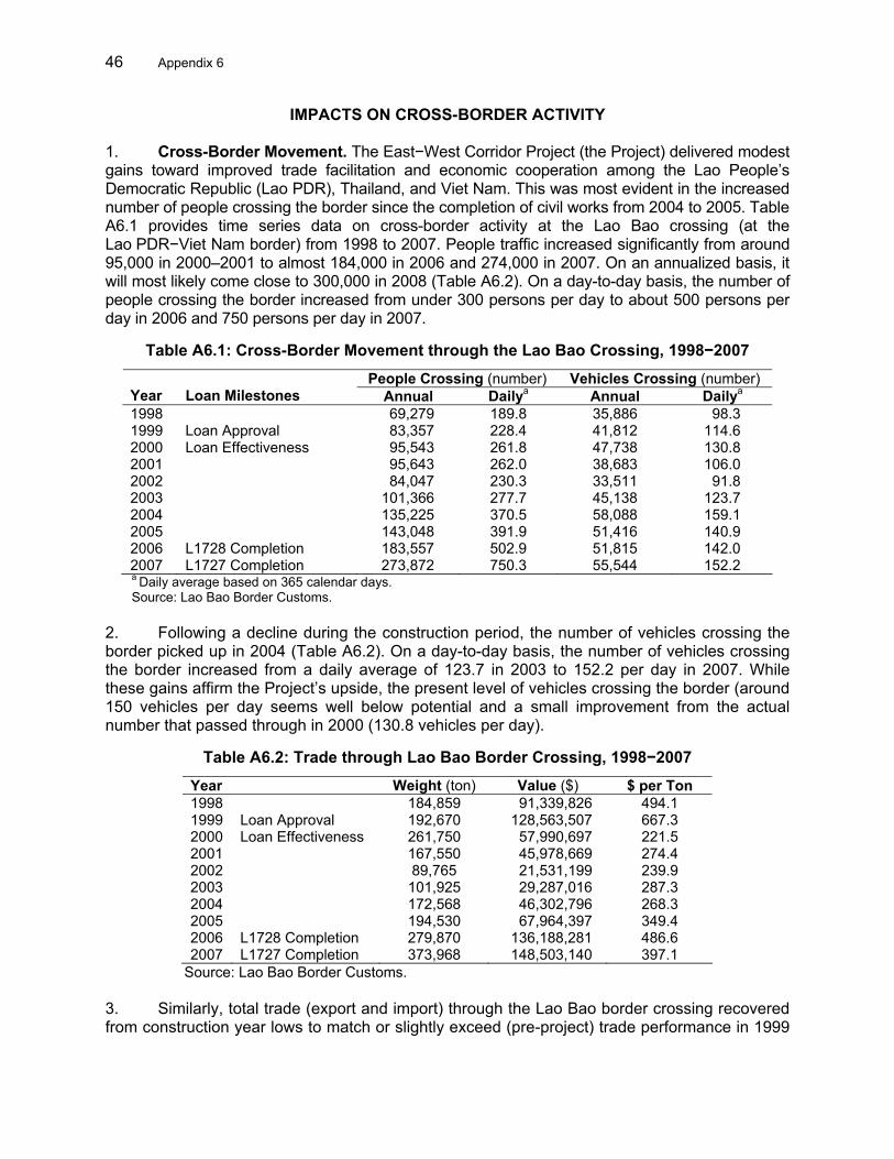
46 Appendix 6
IMPACTS ON CROSS-BORDER ACTIVITY 1. Cross-Border Movement. The East−West Corridor Project (the Project) delivered modest gains toward improved trade facilitation and economic cooperation among the Lao People’s Democratic Republic (Lao PDR), Thailand, and Viet Nam. This was most evident in the increased number of people crossing the border since the completion of civil works from 2004 to 2005. Table A6.1 provides time series data on cross-border activity at the Lao Bao crossing (at the Lao PDR−Viet Nam border) from 1998 to 2007. People traffic increased significantly from around 95,000 in 2000–2001 to almost 184,000 in 2006 and 274,000 in 2007. On an annualized basis, it will most likely come close to 300,000 in 2008 (Table A6.2). On a day-to-day basis, the number of people crossing the border increased from under 300 persons per day to about 500 persons per day in 2006 and 750 persons per day in 2007.
Table A6.1: Cross-Border Movement through the Lao Bao Crossing, 1998−2007
People Crossing (number) Vehicles Crossing (number) Year
Loan Milestones Annual Dailya Annual Dailya
1998 69,279 189.8 35,886 98.3 1999 Loan Approval 83,357 228.4 41,812 114.6 2000 Loan Effectiveness 95,543 261.8 47,738 130.8 2001 95,643 262.0 38,683 106.0 2002 84,047 230.3 33,511 91.8 2003 101,366 277.7 45,138 123.7 2004 135,225 370.5 58,088 159.1 2005 143,048 391.9 51,416 140.9 2006 L1728 Completion 183,557 502.9 51,815 142.0 2007 L1727 Completion 273,872 750.3 55,544 152.2 a Daily average based on 365 calendar days. Source: Lao Bao Border Customs.
2. Following a decline during the construction period, the number of vehicles crossing the border picked up in 2004 (Table A6.2). On a day-to-day basis, the number of vehicles crossing the border increased from a daily average of 123.7 in 2003 to 152.2 per day in 2007. While these gains affirm the Project’s upside, the present level of vehicles crossing the border (around 150 vehicles per day seems well below potential and a small improvement from the actual number that passed through in 2000 (130.8 vehicles per day).
Table A6.2: Trade through Lao Bao Border Crossing, 1998−2007
Year Weight (ton) Value ($) $ per Ton 1998 184,859 91,339,826 494.1 1999 Loan Approval 192,670 128,563,507 667.3 2000 Loan Effectiveness 261,750 57,990,697 221.5 2001 167,550 45,978,669 274.4 2002 89,765 21,531,199 239.9 2003 101,925 29,287,016 287.3 2004 172,568 46,302,796 268.3 2005 194,530 67,964,397 349.4 2006 L1728 Completion 279,870 136,188,281 486.6 2007 L1727 Completion 373,968 148,503,140 397.1
Source: Lao Bao Border Customs. 3. Similarly, total trade (export and import) through the Lao Bao border crossing recovered from construction year lows to match or slightly exceed (pre-project) trade performance in 1999

Appendix 6 47
(Table A6.3). Since completion of civil works from 2004 to 2005, total trade value picked up from $46.3 million in 2004 to reach $136.2 million in 2006 and $148.5 million by 2007. As was the case for number of vehicles crossing the border, recent performance affirms a strong upside but again only a small improvement from the actual trade activity in 1999 of $128.6 million.
Table A6.3: Monthly Traffic at Dansavanh–Lao Bao, 25 January−25 February 2008
Inbound Outbound Inbound and Outbound Item Number Pax Ton Number Pax Ton Number Pax Ton Car/pickup/van 609 1,631 609 1,804 1,218 3,435 Public bus 164 2,636 213 3,886 377 6,522 Tour bus 452 7,418 358 5,887 810 13,305 Truck loaded 327 14,119 679 27,157 1,006 0 41,276 Truck empty 601 131 732 0 Total 2,153 11,685 14,119 1,990 11,577 27,157 4,143 23,262 41,276 pax = passenger. Source: Operations Evaluation Mission (customs data from the border-crossing point). 4. Table A6.4 provides further information on the nature of activities at the border crossing. A total of 70% of the traffic at the border-crossing point can be classified as heavy vehicles (buses or trucks).1 There is a significant volume of empty trucks. These comprise Vietnamese trucks going to the Lao PDR to pick up gypsum (about 20 trucks a day). All trucks carry heavy loads (40 tons on average). Most vehicles crossing are from Viet Nam (54%). About 45% come from the Lao PDR, while transit vehicles coming from Thailand account for only a negligible part (1%).
Table A6.4: Comparative Trade Values at Two Key Border Points, 1999−2007 Lao PDR Cambodia Viet Nam
Lao Bao–Dansavanh
Border Crossing
Bavet–Moc Bai
Border Crossing
Year Trade Value
($ million) Trade Value
($ million)
Share of Trade Value at Dansavanh to Lao PDR’s Total Trade Volume (%)
Share of Trade Value at Bavet to Cambodia's Total Trade Volume (%)
Share of Trade Value at Lao Bao and Moc
Bai to Viet Nam's Total Trade Volume (%)
1999 129 10 10.15 0.44 0.60 2000 58 8 5.37 0.31 0.22 2001 46 7 4.20 0.25 0.17 2002 22 5 1.99 0.16 0.07 2003 29 24 2.33 0.69 0.12 2004 46 22 2.89 0.52 0.12 2005 68 22 3.46 0.40 0.13 2006 136 43 4.91 0.66 0.21 2007 148 68 4.53 0.72 0.20
Lao PDR = Lao People’s Democratic Republic. Source: Trade values at Lao Bao–Dansavanh obtained from Lao Bao Customs and trade values at Bavet–Moc Bai
obtained from Tay Ninh Customs Office. Total trade volumes obtained from the International Monetary Fund Direction of Trade Statistics CD ROM.
5. Table A6.4 shows the relative significance of trade passing through Dansavanh to total trade of the Lao PDR as a whole. Following the drop in trade value caused by construction, the share of trade through Dansavanh to the Lao PDR’s total trade has gradually picked up from about 2% from 2002 to 2003 to around 4.5%−4.9% from 2006 to 2007. Despite competition from new land ports of entry to the Lao PDR, current progress validates the potential upside for trade as Dansavanh once accounted for 10.2% of the Lao PDR trade in 1999. Trade data from 1999 to 2007 affirm the strategic importance of Dansavanh as a port of entry relative to Bavet, 1 The Lao PDR Ministry of Transport’s benefit monitoring and evaluation report of 2006 states that 50% of the traffic
on route national 9 comprise heavy vehicles, with the majority of the trucks (68% in 2006 and 64% in 2002) being Vietnamese trucks.

48 Appendix 6
Lao Bao, and Moc Bai. Bavet accounted for about only 0.5% of Cambodia’s total trade, while Lao Bao and Moc Bai combined added up to only 0.2% of total Viet Nam trade from 1999 to 2007. Being landlocked, the Lao PDR has been the most dependent on intra-Greater Mekong Subregion (GMS) trade among the GMS countries.2 6. Cross-Border Survey on Trade Facilitation. A team of national consultants conducted interviews at the Dansavanh–Lao Bao border-crossing point to assess changes in various parameters such as the length of time taken to obtain customs and immigration clearances, quality of services, adequacy of border infrastructures, and prevalence of unofficial payments as perceived by people crossing the border.3 7. The survey revealed that the total time taken to cross the border from either side has improved after the Project. At the Lao PDR side, the current time taken to cross the border from Viet Nam is 81 minutes and 70 minutes to cross into the Lao PDR (Table A6.5). This is a major improvement from 228 minutes in processing and 259 minutes in queuing time 5 years ago.4 At the Vietnamese side, the average time taken to cross the border from the Lao PDR is 28 minutes and 20 minutes to cross into Viet Nam. Before the Project, it took 39 minutes to cross from the Lao PDR and 32 minutes to cross into Viet Nam.
Table A6.5: Estimated Time Taken to Cross the Border (mean; minutes)
Shipment to Lao PDR from VIE Shipment to Viet Nam from Lao PDR Item
Dansavanh (inbound)
Lao Bao (outbound)
Total
Dansavanh (outbound)
Lao Bao (inbound)
Total
OEM Border Crossing Survey Total time to cross the border
Before project 233 254 487 39 32 71 Processing time 103 125 228 25 20 45 Queuing time 130 129 259 After (at evaluation) 70 81 151 28 20 48
Processing time 31 29 60 17 12 29 Queuing time 39 52 91 11 8 19 ADB GMS Time Release Study Total time to cross the border 165.8 55.4 Processing time 59.5 28.3 87.8 30.8 62.4 93.2 ADB = Asian Development Bank, GMS = Greater Mekong Subregion, Lao PDR = Lao People’s Democratic Republic, OEM = Operations Evaluation Mission, VIE = Viet Nam. Sources: ADB Time Release Study at the Dansavanh−Lao Bao border-crossing point and OEM survey results. 8. Respondents from the Lao PDR side of the border generally perceived border point services both at Lao Bao (inbound) and Dansavanh (outbound) as fast and efficient, with the share of favorable responses ranging from 80% to 90%, except for other services such as quarantine and vehicle inspection (Table A6.6). At the Viet Nam side, satisfaction ratings in Lao Bao (outbound) are relatively better than Dansavanh (inbound) with higher shares of respondents agreeing that border services are fast and efficient at Lao Bao. Border services at Dansavanh, while not generally perceived as fast and efficient, are not considered deficient either. 2 The GMS comprises Lao PDR, Myanmar, People’s Republic of China (Yunnan Province and Guangxi Zhuang
Autonomous Region), Thailand, and Viet Nam. 3 The national consultants were engaged from 25 February to 30 May 2008 as part of the data collection and
analysis tasks of the broader sector assistance program evaluation on transport and trade facilitation in the GMS. 4 The majority of drivers surveyed were from companies with internal shipping units. These units take care of the
border crossing documentation process. Using shippers is more convenient and easy for cross-border trade. The documents can be prepared in advance before the vehicles reach the border. Queuing time is viewed to be much longer on the Lao PDR side, which can take up to 2 hours.

Appendix 6 49
Table A6.6: Perception Survey on Border Crossing Services (% of total respondents)
Lao PDR Viet Nam Item
Dansavanh (outbound)
Lao Bao (inbound)
Dansavanh (inbound)
Lao Bao (outbound)
Processing of documentation are fast and efficient
10% neutral 90% agree
5% neutral 93% agree
70.6% neutral 15.7% agree
33.3% neutral 66.7% agree
Customs services are fast and efficient
13% neutral 85% agree
2% neutral 91% agree
49.0% neutral 25.5% agree
21.6% neutral 76.5% agree
Immigration services are fast and efficient
12% neutral 81% agree
2% neutral 88% agree
72.5% neutral 23.5% agree
56.9% neutral 41.2% agree
Other services (quarantine, vehicle inspection) are fast and efficient
2% neutral 62% agree
0% neutral 57% agree
23.5% neutral 76.5% agree
19.6% neutral 80.4% agree
Lao PDR = Lao People’s Democratic Republic. Source: Operations Evaluation Mission survey results. 9. In terms of cross-border fees, a majority of respondents from both sides of the border indicated that fees at Dansavanh are not fair or too high (Table A6.7). Meanwhile, 90% of respondents coming from Lao Bao into the Lao PDR consider the fees at Lao Bao as not fair or too high, whereas many respondents moving out from Lao Bao consider the fees fair. Nevertheless, the general perception on the fairness of border fees is much better now than before.
Table A6.7: Perception on Cross-Border Fees (% of total respondents)
Lao PDR Viet Nam Item
Dansavanh (outbound)
Lao Bao (inbound)
Dansavanh (inbound)
Lao Bao (outbound)
Fair
71% (now) 12% (before)
60% (now) 5% (before)
43% (now) 8% (before)
94% (now) 96% (before)
Not fair, too high
29% (now) 88% (before)
40% (now) 90% (before)
57% (now) 98% (before)
6% (now) 4% (before)
Too low
― 5% (before) ― ―
Lao PDR = Lao People’s Democratic Republic. Source: Operations Evaluation Mission survey results.
10. Table A6.8 compares perception results between Lao PDR−Thailand and Lao PDR−Viet Nam borders. Border processing appears faster at Lao Bao−Dansavanh. A majority of respondents (80%−90%) perceived customs and immigration services to be fast and efficient in both border crossings. Border facilities are considered adequate in Thailand (94%) but less so in Lao PDR (65%−69%) and Viet Nam (59%). Border fees were generally considered fair in all three countries. A higher percentage of respondents found border fees at Lao PDR−Thailand border to be fair. One hundred percent of respondents said border fees were fair at Mukdahan, and 88% of respondents perceived them fair at Kaysone Phomvihane. This compares with 60% at Lao Bao and 71% at Dansavanh. A much higher percentage of respondents said they would make additional trips through Lao Bao−Dansavanh border crossing if there was 24-hour service. Priority for border improvements in both Lao PDR−Thailand and Lao PDR−Viet Nam borders relate to single window service and electronic data. Electronic data is the first priority at Kaysone Phomvihane since an electronic data interchange system is already being used at the Thai side.

50 Appendix 6
Table A6.8: Comparison of Perception Survey on Dansavanh and Kaysone Phomvihane Item Dansavanh Kaysone Phomvihane Crossing Time
Processing time takes about the same on Dansavanh, Lao PDR and Lao Bao, Viet Nam—0.5–1.0 hours compared to 1−2 hours 5 years before. Queuing times much longer on the Lao PDR side—up to 2 hours.
Over half of respondents said border crossing times are less than 0.5 hour on the Mukdahan side (Thailand). At the Kaysone Phomvihane side (Lao PDR), a third said it was less than 0.5 hour, another third said it was 0.5–1.0 hours and almost a quarter said it was 1.5–2.0 hours.
Quality of Services
Over 80% of respondents perceived both customs and immigration services to be fast and efficient.
Over 90% of respondents think the document processing, customs, and immigration services are fast and efficient.a
Facilities Border facilities are lacking, according to respondents at both borders (69% for Lao Bao and 59% for Dansavanh). Similar perception results were found 5 years ago.
Some 94% of respondents found the facilities adequate on the Mukdahan side, while only 65% said so of the Kaysone Phomvihane side.
Cross-Border Fees
Some 60% said that official border fees are fair for Lao Bao; 71% said the border fees are fair for Dansavanh.
A total of 100% thought that official border fees at Mukdahan were fair; 88% said they were fair on the Kaysone Phomvihane side; and 12% thought they were too high.
Unofficial Payments
Some 59% of respondents strongly agree that the Lao Bao crossing does not involve unofficial fees; 52% strongly agreed that the Dansavanh crossing does not involve unofficial fees. However, although no requests are made for unofficial payments, shippers generally volunteer unofficial payments to speed up the documentation process. Some even suggested that processing is deliberately slow, so that incentives have to be offered to speed it up. Five years ago, over 40% disagreed with the statement for the Lao Bao border and 60% for Dansavanh.
Some 89% said no unofficial payments are involved on the Mukdahan side, while 90% said there were none on the Kaysone Phomvihane side. Only 6% said unofficial payments are required on the Mukdahan side and 10% on the Kaysone Phomvihane side.
Need for 24-hour Border Services
Some 92% of respondents said that they would make additional trips (at least two more) if the border was open 24 hours, and 2% said it would depend on their customers’ order and their capacity to transport.
Only 35% said they would make additional trips if the border was open 24 hours. The remaining 65% said no, or it would depend on whether there was any demand for additional trips.
Priority for Border Improvements
Single window inspections were the number one priority for improving border crossings for 72% of respondents; better training for 18%, use of electronic data for 8%, and pre-clearance of documentation for 2%. Many respondents added that more parking and warehousing facilities on both sides would improve the crossing.
Use of electronic data was ranked the first priority for improving border crossings for 57% of respondents, single window inspections for 14%, better training for 11%, and 18% had no comment or cited added parking and warehousing facilities.
Competition/ Use of Alternative Routes
Alternative routes to this border crossing are through Lak Sao (NR8) and Kiewmouya (NR12) because of lower fees (42%) and less paperwork. Over half decline to give reasons for using alternative routes. A lot of the goods also pass through another border, which is much closer than those listed above. Some goods (sugar, cigarettes, etc.) from Thailand heading to Viet Nam via Lao PDR are prohibited in Viet Nam, but there is demand for these imports so they are illegally imported by boat. The ferry is located about 5 km from the road border crossing. Big warehouses on the Lao PDR side, where these goods are considered legal, belong to import-export companies. These firms have been operating since 1997.
Other alternative crossing routes used are Chongmek in Champasack and the ferry crossing at Khammouane for lower fees and less paperwork.
Lao PDR = Lao People’s Democratic Republic, NR = national road. a Immigration appears to be quick for all passengers. Most passengers were tourists from Thailand, their destination
was touring Viet Nam, and about 2%–5% of the passengers were locals from Kaysone Phomvihane. Source: Operations Evaluation Mission survey results.

Appendix 6 51
11. The Lao PDR freight forwarding industry comprises no more than 20 companies. Of 20 forwarders, 15 are locally owned while 5 are foreign-owned. The two largest forwarders are Lao Freight Forwarders and the Societe Mixed Transport. The results of a survey of Lao freight forwarders are summarized in Table A6.9.
Table A6.9: Perception Survey of Lao Freight Forwarders
Issue Remarks Use of Container Transport
Transport of goods by container is safer than by trucks as there are no problems with rain and humidity, damage, and it is easier to check. Customers are more satisfied with the delivered goods. However, for the container transport, it requires 50–100 containers per month to be transported to Klong Teuy and Lamsabang deep sea port in Thailand to be economical. It is more convenient to transport by trucks for lower volumes of goods. Mammoet, the main transporter for the Xepon Gold–Copper Mine, is the only company operating in the Lao PDR that owns containers. Fifty percent of the goods they transport in the Lao PDR are via containers.
Insurance Goods insurance is required by customers. Normally, shipping, freight forwarders, and transporters take care of the insurance of the truck and driver only. Some transporters have insured goods, but it does not cover the full value of the goods damaged. The insurance company will pay for some damage, and transporters have to cover the rest of the costs to the customers’ satisfaction. Insurance fees are calculated from goods value, time, and distance. Normally, it is 0.35% of goods value, and it is different in the north and south of the Lao PDR because of the road conditions and risks.a Almost all respondents say they have very little damage to their payload, except when there is an accident. In this case, the insurance company handles it and the transport firms cover the balance if the insurance does not cover the full costs.
Cargo Risks It is safe to transport goods by trucks, and there have never been any hijacking problems. In the past, there were some problems as the roads were in poor condition and trucks could only move slowly. When they travel to mountainous areas, especially, people could get into the trucks and take the goods off them.
Customs Processing
Now, document and customs clearance at the border-crossing point is faster than before but not any easier. The procedures do not yet follow international border crossing standards for international transit goods. There are 5–6 documents and steps required for border crossing; this has not changed from 3–5 years before. Some goods are to be checked thoroughly.
Travel Time Today, freight forwarders’ trucks crossing the border may take only 1 day and 2–3 days for a return trip. Five years ago, it could take 1 week, especially for route national 9. It now takes 3–4 hours instead of 7 hours. Apart from changes in the increase in cross-border traffic, there are some changes in customs clearance procedures, although it has become slightly faster. Overall, the process is still slow, especially at the less frequented border crossings.
Cross-Border Fees
Opinions on the amount of official cross-border fees currently being charged are generally fair. However, some transporters disagree, saying there are no standard fees, and they are usually high compared to the value of their goods. Regarding unofficial payments for shipping, 50% said they have to pay an average of 31% of the total value; the other 50% would not admit it officially, saying that no demands were made by customs officers but that unofficial payments helped speed up their customs clearance letters. The payments are based on the price of goods, volume, weight, and other criteria. The percentage of the transshipment service cost was not specified.
Competition Some problems for shippers and freight forwarder companies include competition from nonregistered shippers that pay no taxes and can provide a cheaper service, making it difficult for those who are legally registered. Another problem faced is the different rules that apply in the Lao PDR for import of vehicles. Other customs are based on the bill of lading, i.e., customs is paid on the bill of lading regardless of the number of vehicles on the bill of lading, but in the Lao PDR they are based on the number of vehicles imported.
Lao PDR = Lao People’s Democratic Republic. a In the northern part of the Lao PDR, it is 0.35% because there is more risk than in the southern part where the rate
is slightly lower at 0.30% of the goods value. Source: Operations Evaluation Mission survey results. 12. An interview with a freight forwarding company also raised several points for future consideration. A major constraint of the Lao PDR freight forwarding industry is the need for well equipped and staff ready to prepare documents for transit goods (i.e., staff should know procedure very well). For transshipment of goods, custom clearance need to done at each

52 Appendix 6
border point. Cargo being shipped from Thailand goes through its border, two border points in the Lao PDR (for import and then export clearance), and at the border point in Viet Nam.
(i) Reduce trucking costs. The high trucking costs in the country is partly due to an imbalance in its level and/or direction of trade. The Lao PDR freight charges are high because one-way revenues need to cover a full two-way trip. Unlike freight forwarders, the Lao PDR trucks and trailers have the additional problem of covering overheads such as salary, etc., as there are more imports than exports for the Lao PDR. A truck can return to Bangkok empty in the absence of equivalent Lao exports. The issue of high freight charges affects demand and investing in a modern truck fleet.
(ii) Use of an electronic data interchange system. The Lao PDR border points should promote a paperless or electronic data interchange system in the future. This is already being used in Thailand.
(iii) Maximize benefits from transit traffic. The Lao PDR needs to examine ways to get more income (i.e., service, custom clearance and handling) from regional traffic using the 250 km Kaysone Phomvihane to Dansavanh route. It should also explore use of the Lao PDR-based trucks and tractor heads in the future (e.g., Lao PDR trucks to drive directly into Viet Nam or Thailand).5 This means investments in equipment (including trailers) as the Lao PDR vehicles are not in a condition to go for long distances.
(iv) Low-cost financing to upgrade the Lao PDR truck fleet. The Lao PDR truckers traveling to ports in Thailand (Bangkok) and Viet Nam (Da Nang) are not organized and unable to raise enough funds to buy new trucks and equipment. There is a need for low-cost financing loans (e.g., 3% per annum interest).
(v) Relocation of customs office near Mekong Bridge. The present location is not near the bridge. There is a move to transfer the customs closer to the bridge area, and this should be supported.
(vi) Mitigate need for unofficial costs for faster clearance. This is not actually an issue since it is considered customary to give a tip for favorable or express service. Customs officials do not ask for this. Good relations can help expedite processing and this is normal for an underdeveloped country. While it is not a problem for locals, it can be an issue for foreigners who may not like to wait in long queues.
(vii) Simplification of documentation requirements. When cargo arrives from Thailand, customs need the original set of documents. Customs authorities initially require a copy of the original contract of seller and buyer. Subsequently, customs staff waived this contract requirement but retained both the price original invoice and packing list. These are used to check for misdeclarations.
5 Presently, cargo is transloaded only in the Lao PDR. Because of this, the Lao PDR is not able to take advantage of
its similar left-hand drive vehicles to travel onward to Viet Nam. The Lao PDR trucks can enter Viet Nam. Thailand’s right-hand drive trucks do not match Viet Nam standards and pose safety issues in the Lao PDR.

Appendix 7 53
LAO PEOPLE’S DEMOCRATIC REPUBLIC: IMPEDIMENTS TO MAXIMIZING BENEFITS FROM TRANSPORT AND TRANSPORT FACILITATION
1. Agriculture. A number of constraints hinder the agro-industry subsector from further contributing to corridor development, i.e., increased trade benefits. These include the following: (i) a disadvantage in technology (post-harvest and food production)—the capacity of the Lao People’s Democratic Republic (Lao PDR) is low compared to Thailand, which is able to buy raw materials from the Lao PDR and provide value added; (ii) inadequate market information and promotion—farmers from the Lao PDR do not know how to add value to their products, so there is need for marketing and market information and promotion, i.e., how to identify new products and package and promote existing ones; (iii) insufficient storage capacity for the Lao PDR products—facilities (machinery and equipment) in the Lao PDR are relatively primitive and very slow when compared to Thailand and Viet Nam; and (iv) the quality of facility and services for traders is not adequate, e.g., custom procedures, etc. 2. Industry. Government policy seeks to increase industry’s share of gross domestic product from the current 13% to about 30% by 2020. Accordingly, government strategy seeks to create an environment to invest. This includes the policy of land conversion, e.g., mining. Even though the Government is trying to push for agro-processing, it has not succeeded and efforts have not produced many results—perhaps partly because of the small market, consumer behavior, and reasons cited above (para. 1). Mining is well developed, but this is because of the availability of natural resources. Overall, the industry sector in the Lao PDR is still not well developed and it may take time to change. Regarding labor, the Lao PDR costs are cheaper than its neighbors but there are issues relating to productivity and quality of outputs. Productivity issues partly relate to culture and a working behavior rooted in an agriculture-based and rural economy. 3. Private Sector. Some impediments to increased trade along the corridor include (i) an environment not yet favorable for investment by industry,1 (ii) competitiveness in the Lao PDR is not up to standard compared to markets like the People’s Republic of China or coastal areas of Viet Nam, (iii) trade facilitation issues remain in the Lao PDR,2 (iv) complaints including slow customs processing procedures and increase of nontariff measures resulting in increased costs, and (v) labor.3 4. Freight costs in the Lao PDR are relatively higher since cargo traffic is one way (Appendix 6, para. 12[i]). As such, more exports are needed. Meanwhile, the Lao PDR-based trucks are expensive and sometimes not reliable. In the end, it is cheaper to use Thai trucks
1 For example, basic infrastructure in the Lao PDR has lagged behind. The Lao PDR is now seeking investors for
infrastructure. These include Japan (logistic and commercial park within the industrial zone), Malaysia, and Thailand. Some government policies are still not clear on the need for and use of industrial zones. Currently, industrial zones are not governed by laws, but by decrees from the Prime Minister's Office. There are no laws in the special zone, and this is partly why investors have been reluctant.
2 The investment environment and trade facilitation are under reform. The Lao PDR public institutions do not have the tools and framework to work. At the same time, this framework should take into consideration processes under both the Association of Southeast Asian Nations and World Trade Organization. More has been done at the central level and is lacking at the implementation (i.e., provincial) level. This can present a lot of impediments to free flow of goods.
3 Labor is an issue for Kaysone Phomvihane Province. With an agriculture-based labor force, there is a shortage of skilled labor in the area. In addition, Kaysone Phomvihane also needs to attract more professionals (who tend to migrate to Vientiane).

54 Appendix 7
and, in most cases, local forwarders become subcontractors of Thai companies.4 The Lao PDR needs to look for ways to maximize benefits from its road investment. This includes analyzing income from service, custom clearance, and handling. Presently, in the Lao PDR, the container is transloaded only. The country can also explore using the Lao PDR trucks and tractor heads in the future to generate income for both freight forwarders and truckers, e.g., the Lao PDR trucks to go directly to Viet Nam or Thailand. 5. Special Economic Zone. The designated special economic zone in Kaysone Phomvihane is still largely forest or bush areas. There is virtually no land development or basic infrastructure, e.g., roads, communication, water supply, and electricity. There is no budget to implement earlier feasibility studies for these complementary investments. Major investments are required, as well as another 2–3 years to develop basic infrastructure services within the special economic zone. In part, this lack of basic infrastructure and services has kept investors and their factories on the sidelines. The Government is also experiencing problems regarding compensation for resettlement as land prices have increased. Bilateral assistance from Japan to develop basic infrastructure has been a good start. Likewise, the Asian Development Bank, together with the United Nations Industrial Development Organization, will provide a technical assistance project for developing special economic zones in the country. The TA was approved in November 2007.
4 Large Thai companies have connections with the ports, and ships to transport goods around the world. These Thai
transporters have formed joint ventures with the Lao PDR companies, providing transport services from Thailand to Lao PDR. They are in a better position for customs clearance because they have permission to transport all customers’ cargo through Thailand with no customer taxes and fees. They can take care of all the customs requirements for their customers as far as the Lao PDR border. For example, goods can be transported as far as Thanaleng dry port at Lao–Thai Friendship Bridge I, then the customers take care of customs clearance on the Lao PDR side.

Appendix 8 55
ECONOMIC REEVALUATION 1. The objectives of this economic reevaluation were to (i) determine the economic viability of the East–West Corridor Project based on updated information on traffic (Appendix 4) and vehicle operating costs (VOCs), and (ii) assess the net economic benefits for the Lao People’s Democratic Republic (Lao PDR) and Viet Nam from the transport project. The methodology followed the approach adopted at appraisal1 and by the project completion report (PCR).2 The analyses were carried out in accordance with the Asian Development Bank guidelines by comparing the with- and without-project scenarios that weighed benefits (i.e., savings in VOC and travel time costs and benefits from road safety) against the initial investments and periodic and routine maintenance over a 20-year period. 2. The with-project case is defined by a maintenance regime, from which the Project accrued its principal rationale: (i) to provide periodic maintenance to restore pavement conditions to cost-efficient levels, and (ii) to continue with a balanced mix of routine and periodic maintenance interventions. The without-project case is defined by the maintenance practice that prevailed before the Project—a neglect of proper maintenance—creating a backlog of maintenance and leading to premature deterioration of the road pavement. The behavior of pavement conditions over time, reflecting different maintenance regime and traffic loads, is expressed in terms of the international roughness index (IRI). 3. The economic assessment also attempts to assess comparatively how economic benefits are evolving among participating countries. Comparisons with past project economic analyses are attempted, though caution is required here. Findings from economic analyses are very sensitive to traffic intensity forecasts and assumptions on IRI and VOCs. These background details are often not available and suggest caution when comparing the economic internal rate of return (EIRR) and net present value (NPV) from previous sources. 4. To carry out economic analyses, a set of parameters has to be defined and (Table A8.1).
Table A8.1: Parameters for Economic Analyses of Road Projects Parameter Assumption and Comment
Construction Cost Financial costs came from the PCR, looking at contract value and allocating to the road only the relevant costs including their share of supervision and resettlement. Construction costs were adjusted to 2007–2008 prices using price adjustment factors.
Vehicle Operating Cost Surveys were conducted in the Lao PDR and Viet Nam to obtain market and economic prices of VOC components, reflecting 2007–2008 price situations. It was decided to use two sets of tables—VOC Lao PDR and VOC Viet Nam. Fuel prices are higher than figures used in the PCR, but lower than the latest price hike of the barrel of oil on the world market. VOC in the Lao PDR are higher than VOC Viet Nam, largely because of fuel prices.a
International Roughness Index
IRIs were extracted from previous reports (RRP or PCR) and confirmed by consultant interviews and visual inspection. RN9 (Lao PDR) Pinh Border: IRI = 11.8 m/km without project and 2.5 m/km with project; RN9 (Lao PDR) Kaysone Phomvihane–Xeno: IRI = 3.7 m/km without project and 2.0 m/km with project; and
1 ADB. 1999. Report and Recommendation of the President on a Proposed Loan and Technical Assistance Grant to
the Lao People’s Democratic Republic and a Proposed Loan to the Socialist Republic of Viet Nam for the Greater Mekong Subregion: East–West Corridor Project. Manila (Loans 1727-LAO[SF] and 1728-VIE[SF], for $32 million and $25 million, respectively, approved on 20 December).
2 ADB. 2008. Project Completion Report on the Greater Mekong Subregion: East–West Corridor Project (Lao PDR and Viet Nam). Manila.

56 Appendix 8
Parameter Assumption and Comment National Highway (NH) 9 (Viet Nam): IRI = 5–8 m/km without project and 2.2 m/km with project.
Traffic Forecast Two types: forecasts adjusted for observed 2008 traffic counts and forecasts non-adjusted, both growing using growth rates defined in the PCR (and appraisal).
Generated Traffic RED for generated traffic gives the choice between a percentage of normal traffic or a calculation based on demand VOC elasticity. This method was chosen with elasticity (along PPTA suggestions) retained as 1.0 for passenger vehicles and 0.5 for freight vehicles.
Conversion Factor Conversion factors to adjust financial costs to economic costs vary among reports. For standardization, it has been decided to apply a conversion factor of 0.85 for Lao PDR and Viet Nam.
Diverted Traffic As explained above, the volume of diverted traffic is currently low to nonexistent. Based on information collected in interviews, some minimum diversion effect has been assumed for the Lao PDR.
Value of Time (passengers)
The value of time ($/hour) for passengers varies according to whether it is during or outside working hours; nonworking hours are one third of the value of working hours. At appraisal, the value for working hours was $0.45−$0.50; at project completion (2007), the value used was $0.76. The value for passenger cars has been assumed to be $1 and $0.5 for bus passengers.
Value of Time of Cargo The value of cargo delay has been estimated at $0.4/vehicle-hour based on 8% interest (real) rate; 1,750 working hours; and average value of truckload $1,000/t for a 10 t truck. The value is $0.2 for a medium truck and $0.8 for an articulated truck.
Road Maintenance Expenditure
Maintaining the current situation without the road project requires more than $1,300 and was assumed by the PCR to be $4,000/km/year. With the road project, $1,500/km/year is assumed sufficient for routine maintenance.
Road Accident No systematic data exist. Clear accident reductions are only reported in Viet Nam (reduction by half) and an assumed value of $1,000 per accident was selected. Elsewhere, no benefits from road safety are assumed.
IRI = international roughness index, Lao PDR = Lao People’s Democratic Republic, km = kilometer, m = meter, NH = national highway, PCR = project completion report, PPTA = project preparatory technical assistance, RED = road economic decision, RN = route national, RRP = report and recommendation of the President, t = ton, VOC = vehicle operating cost. a A selected economic cost fuel price for Cambodia/Lao PDR was chosen as $0.58/liter. This corresponds to $80 per
barrel prevailing at that time, with a 15% refinery charge. Viet Nam, an oil producer, has a lower economic price of $0.52/liter. The Ho Chi Minh City–Phnom Penh PCR used $0.39/liter. Adjusted for price rise at the pump, this gives $0.48/liter in 2008.
Source: Operations Evaluation Mission consultant estimates. 5. These parameters are a combination of the assumptions of the Operations Evaluation Mission (OEM) and observations collected by national consultants in March 2008. They also update assumptions used by previous analyses when available. A comparison of VOC data across project road conditions is in Table A8.2. PCR assumptions above are more in line with the OEM estimates. 3 Average VOC saving is estimated between 9% and 22% for the Project.
3 The PCR estimation methodology is rather simple since it adjusts the report and recommendation of the President
VOCs with a standard annual inflation rate of 3%.

Appendix 8 57
Table A8.2: Comparison of Vehicle Operating Costs ($ per vehicle-kilometer)
OEM PCR Lao PDR Viet Nam Lao PDR Viet Nam
Vehicle Type
VOC IRI = 2.5
VOC IRI = 11.8
VOC IRI = 2.2
VOC IRI = 5.8
VOC IRI = 2.2
VOC IRI = 11.8
VOC IRI = 2.2
VOC IRI = 5.0
Car Medium 0.226 0.29 0.204 0.22 0.19 0.28 0.22 0.25 Bus Light 0.208 0.26 0.189 0.201 0.19 0.28 0.25 0.31 Bus Medium 0.357 0.528 0.301 0.355 0.66 0.70 Bus Heavy 0.459 0.639 0.345 0.397 0.27 0.32 0.9 0.96 Truck Light 0.183 0.232 0.165 0.177 0.37 0.47 0.23 0.28 Truck Medium 0.286 0.375 0.247 0.27 0.42 0.56 0.32 0.41 Truck Heavy 0.581 0.741 0.469 0.521 0.52 0.67 0.51 0.63 Truck Articulated 0.776 1.010 0.644 0.697 0.77 1.030 0.84 1.08
IRI = international roughness index, Lao PDR = Lao People’s Democratic Republic, OEM = Operations Evaluation Mission, PCR = project completion report, VOC = vehicle operating cost. Source: Operations Evaluation Mission consultant estimates. 6. Economic analysis of the two road project components was carried out using the Highway Design and Maintenance Model Version 4 (HDM-4) for VOC calculations and the Road Economic Decision (RED)4 model for the complete evaluation. All calculations are in constant 2008 prices,5 and with growth prospects after 2008 similar to what was envisaged at appraisal and at PCR. This applies to VOCs, which reflect an average of 2007–2008 (first quarter) prices. For consistency, construction costs6 have also been adjusted by a price factor (i.e., 1.146 for Lao PDR and 1.07 for Viet Nam) using the country consumer price index (CPI). 7. Benefits from motorcycle traffic are not considered in the RED model and, hence, not included in the economics. However, as VOC savings from motorcycle traffic are quite small, their expected impact on the analyses’ outcome is not material. 8. The most important limitations to the economic analysis come from the use of RED for full economic evaluation of the road projects. The disadvantages are in the constrained formatting of the software: (i) construction periods cannot exceed 3 years, (ii) road benefits start only in the year following full completion of the road, (iii) value of time is fixed for the whole period, (iv) evaluation period is fixed at 20 years, (v) there is no possibility to enter an end-of-period value for the road asset, (vi) traffic grows according to a series of vehicle growth rates defined along periods of 5 years, and (vii) there is no way to account for reductions in congestion. 9. RED has been designed to help economic analysis of rural or semirural roads, not urban roads. Nevertheless, RED and the use of HDM-4 for VOCs were judged sufficiently reliable to reassess the road projects with a certain margin of error. 10. There are other minor limitations. Economic analysis of any road project, including the Project, is focused around savings in VOCs and savings in traveling time. RED allows benefits
4 The RED model was originally developed by the Sub-Sahara Africa Transport Policy Program sponsored by the
World Bank. HDM-4 software is the successor of the HDM III model originally developed by the World Bank and now managed by a consortium.
5 In reality, many prices are 2007 and therefore constant prices should be called 2007–2008 constant prices. 6 Construction was spread over many years with some even in 2006, it was not possible to determine a proper
construction price index. The consumer price index (CPI) has been used instead, but this could introduce a bias because the construction industry is very competitive and prices will generally not closely follow the CPI, which is dominated by fuel and food price changes.

58 Appendix 8
from road safety to be added. Information on road accidents and road project costs is not very reliable and could be contradictory. Results from the economic analysis depend on traffic forecasts. It was beyond the scope of this economic analysis to restart forecasting traffic on road projects as that would have involved a new macroeconomic assessment and reestimation of price elasticity. Therefore, traffic forecasts use growth rates developed by previous studies and calibrate them to the observed 2008 traffic. Results are also very sensitive to roughness measurement before and after road completion. For this, the OEM had to rely on numbers7 quoted in previous project–related reports (i.e., project preparatory technical assistance, appraisal [footnote 1], PCR [footnote 2], and benefit monitoring and evaluation). 11. For the purpose of evaluating the Dong Ha–Lao Bao road (80 kilometers [km]), traffic count results at the Khe Sanh location were used. In the Lao PDR, traffic count results were used for the core component from Phin to Dansavanh. The results of the simulation using the HDM−4 and RED are in Tables A8.3–A8.5.
Table A8.3: Recalculation of Net Economic Benefits (Km 204 in Lao PDR and Khe Sanh in Viet Nam)
($ million in constant 2008 prices) Investment Maintenance VOC Savings Time Savings Road Total Year Costs Costs Normal Generated Total Normal Generated Total Safety 2001 (3.84) 0.00 0.00 0.00 0.00 0.00 0.00 0.00 0.00 (3.84) 2002 (4.80) 0.00 0.00 0.00 0.00 0.00 0.00 0.00 0.00 (4.80) 2003 (15.68) 0.00 0.00 0.00 0.00 0.00 0.00 0.00 0.00 (15.68) 2004 (5.99) 0.19 1.45 0.13 1.58 0.23 0.04 0.27 0.02 (3.93) 2005 (5.99) 0.19 1.51 0.16 1.67 0.26 0.05 0.30 0.02 (3.81) 2006 0.00 0.41 2.84 0.27 3.11 0.68 0.09 0.77 0.02 4.32 2007 0.00 0.43 3.18 0.30 3.48 0.77 0.10 0.87 0.03 4.81 2008 0.00 0.43 3.47 0.34 3.80 0.85 0.12 0.97 0.03 5.23 2009 0.00 0.44 3.78 0.37 4.15 0.94 0.13 1.07 0.03 5.69 2010 0.00 0.45 4.12 0.41 4.52 1.04 0.14 1.19 0.03 6.20 2011 0.00 0.46 4.52 0.45 4.96 1.15 0.16 1.30 0.04 6.77 2012 0.00 0.48 4.96 0.49 5.45 1.26 0.17 1.43 0.04 7.39 2013 0.00 0.49 5.37 0.53 5.91 1.36 0.18 1.55 0.04 7.99 2014 0.00 0.50 5.82 0.58 6.40 1.48 0.20 1.68 0.04 8.63 2015 0.00 0.51 6.31 0.63 6.94 1.61 0.22 1.82 0.05 9.33 2016 0.00 0.53 6.84 0.68 7.52 1.74 0.23 1.98 0.05 10.09 2017 0.00 0.54 7.42 0.74 8.16 1.89 0.25 2.15 0.06 10.91 2018 0.00 0.56 8.05 0.80 8.84 2.06 0.27 2.33 0.07 11.80 2019 0.00 0.58 8.73 0.86 9.59 2.23 0.30 2.53 0.07 12.77 2020 0.00 0.60 9.46 0.94 10.40 2.43 0.32 2.75 0.08 13.82 2021 0.00 0.38 5.10 0.41 5.51 1.63 0.16 1.78 0.02 7.69 2022 0.00 0.40 5.53 0.44 5.97 1.77 0.17 1.94 0.02 8.33 Economic Internal Rate of Return (%) = 14.54 km = kilometer, Lao PDR = Lao People’s Democratic Republic, VOC = vehicle operating cost. Source: Consultant estimates based on Road Economic Decision Model.
7 On occasion, reports differ on the roughness index before road completion.

Appendix 8 59
Table A8.4: Recalculation of Net Economic Benefits for Lao Component (Km 204 only) ($ million in constant 2008 prices)
Investment Maintenance VOC Savings Time Savings Road Total Year Costs Costs Normal Generated Total Normal Generated Total Safety 2001 (3.84) 0.00 0.00 0.00 0.00 0.00 0.00 0.00 0.00 (3.84) 2002 (4.80) 0.00 0.00 0.00 0.00 0.00 0.00 0.00 0.00 (4.80) 2003 (10.55) 0.00 0.00 0.00 0.00 0.00 0.00 0.00 0.00 (10.55) 2004 0.00 0.19 1.45 0.13 1.58 0.23 0.04 0.27 0.02 2.06 2005 0.00 0.19 1.51 0.16 1.67 0.26 0.05 0.30 0.02 2.18 2006 0.00 0.19 1.61 0.18 1.79 0.28 0.06 0.34 0.02 2.33 2007 0.00 0.19 1.72 0.19 1.92 0.31 0.06 0.37 0.02 2.50 2008 0.00 0.19 1.84 0.21 2.05 0.34 0.07 0.41 0.02 2.68 2009 0.00 0.19 1.97 0.23 2.2 0.38 0.07 0.45 0.03 2.87 2010 0.00 0.19 2.11 0.25 2.36 0.42 0.08 0.50 0.03 3.09 2011 0.00 0.20 2.29 0.27 2.56 0.46 0.09 0.54 0.03 3.33 2012 0.00 0.20 2.48 0.30 2.78 0.49 0.10 0.59 0.03 3.60 2013 0.00 0.20 2.69 0.32 3.01 0.53 0.10 0.64 0.03 3.88 2014 0.00 0.21 2.92 0.35 3.27 0.58 0.11 0.69 0.04 4.20 2015 0.00 0.21 3.16 0.38 3.54 0.62 0.12 0.74 0.04 4.53 2016 0.00 0.21 3.43 0.41 3.84 0.67 0.13 0.81 0.04 4.90 2017 0.00 0.22 3.72 0.44 4.17 0.73 0.14 0.87 0.05 5.30 2018 0.00 0.22 4.04 0.48 4.52 0.79 0.15 0.94 0.05 5.73 2019 0.00 0.23 4.38 0.52 4.90 0.86 0.17 1.02 0.06 6.21 2020 0.00 0.23 4.76 0.56 5.32 0.93 0.18 1.11 0.06 6.72 Economic Internal Rate of Return (%) = 13.17 km = kilometer, VOC = vehicle operating cost. Source: Consultant estimates based on Road Economic Decision Model.
Table A8.5: Recalculation of Net Economic Benefits for Viet Nam Component (Khe Sanh only)
($ million in constant 2008 prices)
Investment Maintenance VOC Savings Time Savings Road Total Year Costs Costs Normal Generated Total Normal Generated Total Safety 2003 (5.13) 0.00 0.00 0.00 0.00 0.00 0.00 0.00 0.00 (5.13) 2004 (5.99) 0.00 0.00 0.00 0.00 0.00 0.00 0.00 0.00 (5.99) 2005 (5.99) 0.00 0.00 0.00 0.00 0.00 0.00 0.00 0.00 (5.99) 2006 0.00 0.23 1.23 0.09 1.32 0.40 0.04 0.44 0.01 1.99 2007 0.00 0.24 1.46 0.11 1.57 0.46 0.04 0.50 0.01 2.31 2008 0.00 0.24 1.62 0.13 1.75 0.51 0.05 0.55 0.01 2.55 2009 0.00 0.25 1.80 0.14 1.94 0.56 0.05 0.61 0.01 2.82 2010 0.00 0.26 2.00 0.16 2.16 0.62 0.06 0.68 0.01 3.11 2011 0.00 0.27 2.23 0.17 2.40 0.69 0.07 0.76 0.01 3.44 2012 0.00 0.28 2.48 0.19 2.67 0.77 0.07 0.84 0.01 3.80 2013 0.00 0.29 2.68 0.21 2.89 0.83 0.08 0.91 0.01 4.10 2014 0.00 0.30 2.91 0.23 3.14 0.91 0.09 0.99 0.01 4.43 2015 0.00 0.31 3.15 0.25 3.40 0.98 0.09 1.08 0.01 4.79 2016 0.00 0.32 3.41 0.27 3.68 1.07 0.10 1.17 0.01 5.18 2017 0.00 0.33 3.70 0.29 3.99 1.16 0.11 1.28 0.01 5.61 2018 0.00 0.34 4.01 0.32 4.33 1.27 0.12 1.39 0.02 6.07 2019 0.00 0.35 4.34 0.35 4.69 1.38 0.13 1.51 0.02 6.56 2020 0.00 0.37 4.71 0.37 5.08 1.50 0.14 1.64 0.02 7.11 2021 0.00 0.38 5.10 0.41 5.51 1.63 0.16 1.78 0.02 7.69 2022 0.00 0.40 5.53 0.44 5.97 1.77 0.17 1.94 0.02 8.33 Economic Internal Rate of Return (%) = 16.23 VOC = vehicle operating cost. Source: Consultant estimates based on Road Economic Decision Model.

60 Appendix 8
12. A few important observations/conclusions can be drawn from Tables A8.3−A8.5:
(i) The reestimated EIRR of 16.2% for the Lao Bao to Dong Ha road section in Viet Nam was in line with appraisal and PCR estimates from 16.0% to 17.6%. With stronger economic development along the road, traffic growth has been more sustained on the Viet Nam side of National Road 9, with the overall vehicle traffic increasing by more than three times.
(ii) The reestimated EIRR of 13.2% for the Phin to Dansavanh route is acceptable but less positive than appraisal and PCR estimates, which range from 16.0% to 17.6%. In the Lao PDR, traffic increases on RN9 have been slow to materialize with an overall increase of only 50.0% over more than 10 years.
(iii) No economic analysis were carried out on (a) the Xeno–Kaysone Phomvihane stretch that was completed in 2007, as it was an additional work and analysis based on VOC saving would not give substantial economic benefits. The road was not in bad condition but was considered to be below standard to meet the requirements of the yet to be developed special economic zone; and (b) the 10.7 km of the Southern Dong Ha Bypass, which is also an additional work. No appraisal was carried out and no estimate of road condition before the Project was readily available. The traffic survey conducted by the national consultant shows that traffic has not built up to expectations in what is essentially a suburban road, part of the Dong Ha road network.
13. This economic analysis combines the observed traffic situation with growth prospects after 2008 identical to what was envisaged at appraisal and at PCR. Findings from the different simulations using RED are summarized in Table A8.6. The discount rate for the NPV is 12%. The first columns are the EIRR and NPV from the OEM simulations and for the “appraisal/PCR” simulation. The “appraisal/PCR” simulation estimated by the OEM used new VOCs and adjusted construction prices but allowed traffic to grow as expected at appraisal (and at PCR).
Table A8.6: EIRR and NPV Comparison
Road Project
NPV (12%) in $ million
Appraisal EIRR (%)
PCR EIRR (%)
OEM EIRR (%)
Lao PDR RN9 (Consultant) 1.56 16 (19a) 20.60 13.17 Viet Nam NH9 (Consultant) 6.01 16 (23a) 17.60 16.23
EIRR = economic internal rate of return, NH = national highway, NPV = net present value, OEM = Operations Evaluation Mission, PCR = project completion report, RN = route national. a With additional regional trade traffic benefits. Source: Operations Evaluation Mission consultant estimates.
14. Table A8.7 summarizes the net economic benefits for each participating country of the East–West Corridor Project. Costs and benefits are expressed in economic terms and discounted at a 12% rate.

Appendix 8 61
Table A8.7: Benefit Distribution of the East–West Corridor Project
Item
Total Project ($ million)
Lao PDR RN9 ($ million)
Viet Nam NH9 ($ million)
Discounted Economic Cost 29.11 15.43 13.68 Discounted Economic Benefits 36.68 16.99 19.70 Net Economic Benefits 7.58 1.56 6.02 B/C 1.26 1.10 1.44 EIRR 15% 13% 16% B/C = benefit/cost ratio, EIRR = economic internal rate of return, Lao PDR = Lao People’s Democratic Republic, NH = national highway, RN = route national. Note: Kaysone Phomvihane–Xeno and additional works in Viet Nam not included. Source: Operations Evaluation Mission consultant estimates.
15. Even with a very low traffic base at the start, the Project is economically justifiable although growth has been less than expected in the Lao PDR. Viet Nam benefits more from the Project than the Lao PDR—receiving 54% of the total benefits while contributing 47% of the cost. The relatively high economic benefit on the Viet Nam side is explained by the delay of this project component,8 which started in 2003 when the Lao PDR side was finishing. 16. Beyond the overall results, one could attempt to give the total distribution of benefits by type and by country once assumptions are made on the percentage distribution of economic benefits among consumers, producers, and transporters. Assumptions on distribution are given in Table A8.8. In addition, Vietnamese benefits in Lao PDR and Cambodia and vice versa are derived from observations collected and from interviews.
Table A8.8: Distribution of Benefits (%)
Vehicle Vehicle Operating Costs Value of Time Type Transporters Producers Consumers Transporters Producers Consumers Cars a 20 0 80 20 0 80 Bus b 20 0 80 0 0 100 Trucks c 30 50 20 20 70 10 VOC = vehicle operating cost, VOT = value of time. a Most benefits passed to consumers (private vehicle owners are consumers). Cars are 50:50 taxis and VOC
benefits split between transporters and consumers. b Competitive market where most benefits passed to consumers. c Producers keep most of the benefits of VOC and VOT. Source: Operations Evaluation Mission estimates. 17. Results are provided in Tables A8.9–A8.10 should be interpreted with caution.
8 Delayed projects bring higher benefits because of positive traffic growth. However, what was not accounted for is the
loss of welfare (economic benefits) of road vehicle users because the new road is available only a few years later.

62 Appendix 8
Table A8.9: East–West Corridor Project Benefit Distribution ($ million)
Item
Total VOC
Total VOC
LAO TRANS VOC+ VOT
Benefit
LAO PROD VOC+ VOT
Benefit
LAO CONS VOC+ VOT
Benefit
VIE TRANS VOC+ VOT
Benefit
VIE PROD VOC+ VOT
Benefit
VIE CONS VOC+ VOT
Benefit
LAO Total VOC+ VOT
Benefit
VIE Total VOC+ VOT
Benefit LAO 14.05 2.83 3.13 4.39 7.17 0.77 0.41 1.01 14.68 2.19 VIE 14.95 4.76 0.17 0.17 0.81 3.62 3.30 11.87 1.15 18.79 Grand Total
29.00 7.59 3.30 4.56 7.98 4.39 3.71 12.88 15.83 20.98
LAO = Lao PDR, CONS = consumer, PROD = producer, TRANS = transporter, VIE = Viet Nam, VOC = vehicle operating cost, VOT= value of time. Source: Operations Evaluation Mission consultant estimates.
Table A8.10: Project Completion Report Summary Item NPV B ($) NPV C ($) NPV NB ($) B/C EIRR (%) Lao PDR 32.30 18.30 14.00 1.76 21 Viet Nam 16.80 11.30 5.50 1.48 24 Total 49.10 29.60 19.50 22 B/C = benefit-cost ratio, EIRR = economic internal rate of return, Lao PDR = Lao People’s Democratic Republic, NPV = net present value. Source: Operations Evaluation Mission consultant estimates. 18. The higher total economic benefits (VOC + vehicle operating time) of the Phnom Penh to Ho Chi Minh City Project9 compared to the East–West Corridor Project (footnote 2) reflect higher vehicle traffic and a higher proportion of passenger vehicles. In the former, Viet Nam is able to receive more benefits when using RN1 than Cambodia because of the relatively high proportion of Vietnamese buses traveling in Cambodia and the trucking movements related to the special economic zone in Bavet. 19. Economic benefits are slightly more evenly distributed with Laotian and Vietnamese consumers. In total, consumers receive 56% of the total benefits (50% in Lao PDR and 61% in Viet Nam). 20. Based on the EIRR, Viet Nam is able to benefit more from the Project than the Lao PDR. However, according to the benefit–cost ratio, it is the opposite and the Lao PDR benefits more. The net present value of economic benefits is significantly higher in the Lao PDR. Overall, the general findings of this evaluation do not support the latter view.
9 ADB. 2008. Project Completion Report on the Greater Mekong Subregion: Phnom Penh to Ho Chi Minh City
Highway Project. Manila.

Appendix 9 63
ENVIRONMENT AND RESETTLEMENT IMPACTS
At appraisal, it was envisaged that there would not be any adverse environmental impacts for either country component as they involved the rehabilitation of existing roads, with minimal changes to the alignment. Initial environmental examinations concluded that environmental impacts would be minor and within acceptable limits through identified mitigation measures. The findings of the Project Completion Review Mission and Operations Evaluation Mission consultant on environmental and resettlement aspects are summarized in Table A9.
Table A9: Summary of Environmental and Resettlement Impacts Country Environmental Resettlement Lao PDR Several implementation-related environmental issues were
highlighted: (i) noise and dust near quarry sites during construction, which resulted in complaints by some residents; (ii) oil seepage from at least one contractor camp, which was addressed by building a pit. On completion, villagers also reported some cleanup problems that were easily remedied. In some cases, borrow pits became fishponds turning a problem into a benefit; and (iii) no trees were felled in 29 hectares of forests identified as likely to be affected. Other relevant environmental issues for the future relate to the (i) conversion of agricultural lands to residential and industrial lands, which has reduced productive land in the area; and (ii) forest conservation. The Government continues to adopt conservation measures in protected areas from forest protection to forest conservation and production. The Lao PDR has been traditionally exporting woods and wood products. Since the end of 2007, and stricter enforcement policies, the export of wood products quieted down, with only a few sawmills being granted concessions. Meanwhile, 79% of respondents in an OED community survey thought there was a decline in the movement of logs, while 15% thought there was no change. Overall, the Project did not create any serious adverse impacts.
The RN9 component followed the existing right-of-way with minimal realignment. No resettlement was carried out, as envisaged at appraisal. On the other hand, minor resettlement was done in two rural access roads. This affected an estimated 370 persons (72 households) from villages that shared a total compensation of $22,000.a The PCR reported that resettlement was implemented without any problems and that no complaint was raised by NGOs. MCTPC was not informed of any grievances during implementation, which is in keeping with the Project’s minor impacts. District authorities handled compensation on behalf of MCTPC. Compensation made was in proportion to the impact experienced by the affected persons. The PCR reported that many of the affected persons expressed a willingness to donate the land required because of perceived benefits to their respective community. This was accepted by the authorities except where the individual involved faced a particular disadvantage (e.g., widows).
Viet Nam The contractors did not satisfactorily fulfill obligations to implement environmental protection measures for the Vietnamese component. Although these have since been cleared, works debris, waste construction materials, and remnants of demolished structures were left on roadsides and in waterways on completion. Problems with noise and dust during construction were solved by fitting silencers to equipment, banning work after dark, and covering loads in transit. Meanwhile, PMU 85 advised ADB that MOT would include Km 42 to Km 62 in a slope protection project associated with national roads in the area.
The PCR assessed the resettlement impact to be modest and in line with appraisal expectations. Resettlement affected an estimated 1,772 households (including additional works) or 8,150 persons. About 42 public facilities were also affected, including electricity, water supply, and broadcasting installations; post office facilities; and military facilities. The PCR reported that 91% of approved resettlement payments totaling $2.6 million (compared with an expected total of $2.0 million at appraisal) have been paid. The majority or 98.8% of the unpaid balance was owed to public entities.

64
Appendix 9 Country Environmental Resettlement The PCR noted that environmental specialists recommended
landscaping of the Dong Ha Southern Bypass and protecting it from development.b However, it is likely that this new bypass will be progressively absorbed into the town, and roadside development will extend along it. At completion, early stages of roadside industrial and commercial development, mainly at the eastern end, were observed. The Government expressed an intention to develop housing at a distance from the road, with a limited number of access points and a belt of trees in between.
The resettlement plan was conscientiously followed by a resettlement unit, which worked with provincial committees, quality control bureaus, and district land acquisition units.c Compensation processes were efficient, and no affected persons were treated unfairly. An external monitoring group (under the Nghe An Province Red Cross) concluded that resettlement activities were conducted fairly and efficiently.d An external monitoring group did not find the 52 affected persons from ethnic minorities to have been disadvantaged. No complaints with regard to resettlement were raised by NGOs.
ADB = Asian Development Bank; km = kilometer; Lao PDR = Lao People’s Democratic Republic; MCTPC = Ministry of Ministry of Communication, Transport, Post, and Construction; MOT = Ministry of Transport; NGO = nongovernment organization; OED = Operations Evaluation Department; PCR = project completion report; PMU = project management unit; RN = route national. a The PCR stated that data on the number of affected persons were not collected. The number of affected persons was estimated based on an average household
size of 5.0 for the Lao PDR and 4.6 for Viet Nam. b This bypass was built along a largely new route through unpopulated and hilly country with generally poor vegetation cover. c MOT was responsible for administering the resettlement program and associated payments, which were given in cash and kind with no distinction. The average payment
was D14 million per household, which was close to the appraisal estimate. A total of 48 hectares of land was involved, of which 65% was residential, 18% agricultural, and 17% unused land.
d In January 2005, a sample survey of affected households, including 15 small roadside businesses, revealed universal satisfaction with the Project. Respondents said they expected better transportation, favorable business opportunities, and higher cultural and spiritual living.
Sources: Operations Evaluation Mission and ADB. 2008. Project Completion Report on the Greater Mekong Subregion: East–West Corridor Project (Lao PDR and Viet Nam). Manila.

Appendix 10 65
SOCIOECONOMIC IMPACT 1. Like National Road 3 for Thailand, Lao People’s Democratic Republic (PDR), and People’s Republic of China (PRC), the inland corridor along National Road 9 from Dong Ha to Kaysone Phomvihane has huge potential for both transit and bilateral trade among Lao PDR, Thailand, and Viet Nam. This appendix attempts to validate and update the project completion report (PCR) findings,1 and assess the impacts of this road transport and transport facilitation project on economic and social developments at the project and corridor level. Table A10.1 provides a summary of key socioeconomic impacts along National Road 9.
Table A10.1: Summary of Key Socioeconomic Impacts along National Road 9
Lao Bao−Dong Ha (Viet Nam)
Phin−Dansavanh (Lao PDR)
Kaysone Phomvihane−Xeno (Lao PDR)
A community survey done along the border and along the road revealed that 88% of respondents thought household income increased after road completion. The majority perceived that production and sales have increased after the Project. Traffic, which is mostly national, has also been healthy and suggests increased economic activity and improved living standards.a Industrial estates were developed in Lao Bao and Dong Ha, and more are being planned at Cam Lo and Dak Rong districts and Cua Viet port. Most of the industrial zones were reported to have started around 2002−2003, and local officials cited the improvement of RN9 as a key factor to attracting development. In particular, the Lao Bao Commercial Area, a pilot strategic economic zone, now has the appearance of a new city with a high rate of urbanization. Its present population of 35,000 is seen to increase by 55,000 by 2020. With more open border access, Vietnamese traders have increased trade through Dansavanh market and are bringing in cheaper products from Viet Nam and PRC.
People live near the main road for convenience in traveling, commercial reasons, and services. Dansavanh border village has changed and expanded. Many people moved from nearby villages and other provinces to set up in trade or seek employment. Households have taken opportunities to become traders and are crossing borders more frequently than before.b Farmers have more opportunities for training in rice plantation in the district. Shifting cultivators have changed to more sedentary farming systems. While the majority of community survey respondents thought that production, sales, and household income increased after road completion, the results were less positive than in Viet Nam. While 75% of households interviewed perceived a production increase after road completion, only 66% thought they were able to sell more goods after road completion. While Lao PDR traders are among the high-income households in the area, they have since lost an old “monopoly” of the markets and have to compete with cheaper products brought in by the Vietnamese. The depth of project impact also varied with each household’s access to productive resources and the adoption of appropriate technology. Large-scale farmers and cross-border traders experienced the highest production, sales, and income increase. Some shifting cultivators who adopted sedentary farming systems using new technologies reported a 10%−20% increase in income. Some Lao Theung with no land, using traditional slash-and-burn methods, are not able to make a sufficient living. Growth in the services sector is a key benefit (partly from tourism activities). This includes restaurants, hotels, and small production (charcoal for the Viet Nam market and handicrafts) along RN9. There are not many hotels and restaurants in the area. With strong
Initial steps have been taken to build a large special economic zone (Savan–Xeno Special Economic Zone) near Kaysone Phomvihane along RN9 before Xeno. However, economic development in the Lao PDR has been slow compared to Viet Nam. The economic zone lacks the budget to implement earlier feasibility studies for complementary investments, i.e., land development and basic infrastructure. It will take 2−3 years to develop the basic infrastructure services. Hence, investors have been slow in going in. Meanwhile, the Government has experienced resettlement compensation issues as land prices have doubled in Kaysone Phomvihane because of development. The Government also plans to develop a free trade area zone in Dansavanh but implementation is also slow and its future is not guaranteed.
1 ADB. 2008. Project Completion Report on the Greater Mekong Subregion: East–West Corridor Project (Lao PDR
and Viet Nam). Manila.

66 Appendix 10
Lao Bao−Dong Ha (Viet Nam)
Phin−Dansavanh (Lao PDR)
Kaysone Phomvihane−Xeno (Lao PDR)
demand from tourists and businesspersons (who pass through or work at the border), local service establishments have done very well since the opening up of the borders. Restaurateurs are among the medium-income households in the area.
km = kilometer, Lao PDR = Lao People’s Democratic Republic, PRC = People’s Republic of China, RN = route national. a In the Khe Sanh area (15 km from the border), the traffic level was double the 1997 level. Cars accounted for 6.8%
of total traffic compared to 2.7% in 1997. Bus and truck traffic accounted for 34% of total traffic compared to 26.2% in 1997.
b In the Lao PDR, survey reported that 70% of households interviewed crossed the border more than five times a month.
Source: Operations Evaluation Mission. A. Dansavanh Border Community Survey 2. Dansavanh village (located 2 kilometers [km] from the border-crossing point) was established in 1995 with only a few households living along route national (RN) 9. After project completion, the village had expanded to around 268 households with a population of 1,761 persons (excluding medium- and long-stay businesspersons).2 After the border crossing was improved and the office building built, the village changed and expanded. Many people have come from other nearby villages and some from other provinces to set themselves up in trade, seek employment, and for other reasons. People live near the RN9 for convenience in traveling, commercial purposes, and business services. A few restaurants and hotels cater to tourists and businesspersons who pass through or work at the border. 3. This village has only one market, only open in the morning. The Lao PDR and Viet Nam have an agreement to allow people to cross the borders freely between the villages of Dansavanh and Lao Bao to trade. It is easier to cross the border to go to the market at Lao Bao. There is a health center in Dansavanh village, with a resident doctor and nurse that provides basic primary health care. For serious cases, residents cross over to hospitals in Viet Nam. 4. From village statistics, residents’ occupations are divided into four main categories: lowland farmers, gardeners, shifting cultivators, and traders (Table A10.2).
Table A10.2: Dansavanh Village Socioeconomic Profile
Resident Category Number of Households and Land Ownership
Household Income Remarks
Shifting cultivators 58 households with 16.4 ha
Average income 15 kg of rice/people/month
They are almost of Lao Theung ethnicity. These households are generally rice insufficient.
Lowland rice farmers 30 households with 23 ha Average income is around 20 kg (at KN5,000/kg) of rice per person per month
These households are generally rice sufficient.
Cash crops farmers 100 households with 100 ha
Average income KN10 million/year
Bananas, rubber trees, corn, vegetables
Traders 80 households Average income range are KN15−20 million per year
ha = hectare, kg = kilogram. Source: Operations Evaluation Mission survey result. 2 There are two main ethnic groups—Lao Loum and Lao Theung. The Lao Theung is the majority, totaling
183 households with 1,159 people. The village is located in the highlands and is surrounded by hills, with limited flatlands for rice fields. It also lacks water for living and agriculture.

Appendix 10 67
5. After road completion, the village has seen more development in terms of living standards. Farmers have more opportunities for training in rice plantation in the district, and shifting cultivators have changed to more sedentary farming systems. However, some Lao Theung who have no land and are only familiar with traditional slash-and-burn methods could not make a sufficient living. The geographic limitations of this area and lack of water for living and agriculture means they have no opportunity to have access to rice fields, so they have to continue with the slash and burn. 6. Current average incomes range from KN1 million to KN20 million per year, with 40% of households on an average income of KN15 million–KN20 million per year. These are traders who trade at the border selling to Viet Nam and Dansavanh villagers; farmers who have surplus rice to sell; and cash crop farmers who have plantations such as rubber trees, coffee, pepper, trees to make paper, and other. Thirty-one percent are on a medium income of KN5 million–10 million per year. These are restaurateurs, livestock owners, and some cash crop and rice farmers who have smaller plots of land. Poorer families at 29% have an average income of KN1 million–KN5 million per year and are generally laborers, motorcycle service people, and shifting cultivators. 7. For traders at the border village, the open border policies have negatively affected livelihood. In previous years, business was good when Lao traders almost had a monopoly of trading activities. Vietnamese traders who came to trade on a daily basis did not have permits to go beyond the Dansavanh border market.3 Now, with further opening of the border, the Lao PDR traders have to compete with Vietnamese traders who bring in cheaper products from Viet Nam and PRC. The prices of Thai goods, which are stocked by village traders, have increased so they are not competitive with Vietnamese and Chinese products. Although Thai goods are popular with the Vietnamese, they are also illegally imported into Viet Nam and are on sale at the duty free shops there at a cheaper price, with which Lao PDR traders could not compete. 8. Vegetables, bamboo shoots, and other nontimber food products (NTFPs) are saleable products in Viet Nam but they do not fetch high prices. However, they provide a good income for Dansavanh’s shifting cultivators who have insufficient land for cultivation. Other activities that provide income for landless villagers include transporting large livestock across the Xepon River into Viet Nam (as these are not allowed to cross at the border-crossing point). Other landless villagers who cannot compete with Vietnamese labor find employment by scavenging for scrap metal from old bombs. 9. Hotel and restaurant operators have done very well since the opening up of the borders. There are not many restaurants, hotels, or guesthouses in the area. Some of these are good while others are in poor condition. Overall demand is high and they do not lack customers. 10. As livelihood in Dansavanh improves after road completion, a number of issues need immediate attention as part of the local development process in the area.
(i) The majority of the local community is not able to take full advantage of the trade opportunities that exist in the border community.4 These opportunities are taken by outsiders.
3 Many Vietnamese could now enter the Lao PDR for trade and employment. They come to buy directly from producers
and sometimes make direct orders, leaving out intermediary traders at the village, who previously enjoyed a monopoly because of poor road conditions. The Vietnamese traders had little choice but to trade at the border only.
4 The Lao Theung ethnic groups are traditionally shifting cultivators and are not familiar with trade. They practice shifting cultivation and seek NTFPs to sell at the market.
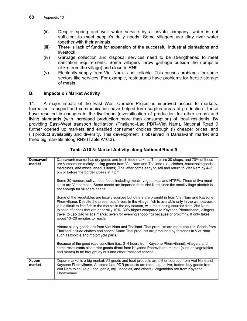
68 Appendix 10
(ii) Despite spring and well water service by a private company, water is not sufficient to meet people’s daily needs. Some villagers use dirty river water together with their animals.
(iii) There is lack of funds for expansion of the successful industrial plantations and livestock.
(iv) Garbage collection and disposal services need to be strengthened to meet sanitation requirements. Some villagers throw garbage outside the dumpsite (4 km from the village) and close to RN9.
(v) Electricity supply from Viet Nam is not reliable. This causes problems for some sectors like services. For example, restaurants have problems for freeze storage of meats.
B. Impacts on Market Activity 11. A major impact of the East–West Corridor Project is improved access to markets. Increased transport and communication have helped form surplus areas of production. These have resulted in changes in the livelihood (diversification of production for other crops) and living standards (with increased production more than consumption) of local residents. By providing East–West transport facilitation (Thailand–Lao PDR–Viet Nam), National Road 9 further opened up markets and enabled consumer choices through (i) cheaper prices, and (ii) product availability and diversity. This development is observed in Dansavanh market and three big markets along RN9 (Table A10.3).
Table A10.3: Market Activity along National Road 9 Dansavanh market
Dansavanh market has dry goods and fresh food markets. There are 30 shops, and 70% of these are Vietnamese mainly selling goods from Viet Nam and Thailand (i.e., clothes, household goods, medicines, and miscellaneous items). The latter come early to sell and return to Viet Nam by 4–5 pm or before the border closes at 7 pm. Some 30 vendors sell various foods including meats, vegetables, and NTFPs. Three of five meat stalls are Vietnamese. Some meats are imported from Viet Nam since the small village abattoir is not enough for villagers needs. Some of the vegetables are locally sourced but others are brought in from Viet Nam and Kaysone Phomvihane. Despite the presence of rivers in the village, fish is available only in the wet season. It is difficult to find fish in the market in the dry season, with most being sourced from Viet Nam. In spite of prices that are generally 10%−30% higher compared to Kaysone Phomvihane, villagers travel to Lao Bao village market (even for evening shopping) because of proximity. It only takes about 10–20 minutes to reach. Almost all dry goods are from Viet Nam and Thailand. Thai products are more popular. Goods from Thailand include clothes and shoes. Some Thai products are produced by factories in Viet Nam such as bicycle and motorcycle parts. Because of the good road condition (i.e., 3–4 hours from Kaysone Phomvihane), villagers and some restaurants also order goods direct from Kaysone Phomvihane market (such as vegetables and meats) to be brought by bus and other transport service.
Xepon market
Xepon market is a big market. All goods and food products are either sourced from Viet Nam and Kaysone Phomvihane. As some Lao PDR products are more expensive, traders buy goods from Viet Nam to sell (e.g., rice, garlic, chili, noodles, and others). Vegetables are from Kaysone Phomvihane.

Appendix 10 69
Xeno and Kaysone Phomvihane Markets
Xeno and Kaysone Phomvihane markets are also large. Fresh foods (such as vegetables) are not sourced from neighboring Outhoumphone or Kaysone districts but from Xiabouly district at Sebangfai River. Goods and foods from Viet Nam are cheaper than Thai products (including tax and customs). Some Thai and Lao PDR products can be bought cheaper at duty free shops in Viet Nam. As a result, some traders do not buy direct from local suppliers but purchase from duty free shops in Viet Nam. These are illegally imported back into the Lao PDR. Some Thai products that are illegally re-imported include instant noodles, foods, and candy. Lao PDR products include Beer Lao, which is 10%–15% cheaper than in the Lao PDR. Rice comes from Kaysone Phomvihane and Champasack Province in the southern part of the Lao PDR.
Lao PDR = Lao People’s Democratic Republic, NTFP = nontimber forest product. Source: Operations Evaluation Mission survey result. C. Community Surveys on Project Impacts 12. In both Lao PDR and Viet Nam, the socioeconomic impact was positive. The PCR found that economic activity has increased within the corridor, as has the roadside population. A community survey was conducted in both countries to confirm recent developments. In general, the responses show positive impacts from transport and transport facilitation through the Project, typically through improved accessibility. Likewise, the impact on household production, sales, and income varies with each household’s access to productive resources and technology (Table A10.4). In Viet Nam, the community survey was done along the border and along the road. It found that 73% of households interviewed perceived an increase in production, while 86% thought that sales volume increased after road completion. A similar observation is made in the Lao PDR although to a lesser extent. While 75% of households interviewed perceived a production increase after road completion, only 66% thought they were able to sell more goods after road completion. 13. The PCR indicated significantly improved farm incomes. In Viet Nam, 88% of respondents thought that household income increased after road completion. In the Lao PDR, large-scale farmers and cross-border traders experienced the highest increase in production, sales, and household income. On the other hand, some shifting cultivators who adopted sedentary farming systems using new technologies reported a 10%−20% increase in production, sales, and household income.
Table A10.4: Community Surveys on Road and Transport Facilitation Impacts
Question Lao PDR (Dansavanh) Viet Nam (NH9) 75% of household respondents thought production increased after road completion
73% of household respondents thought production increased after road completion
Has production increased since road completion?
Of the above, 33% had a small increase of 10%−20%. Some of these were former shifting cultivators who adopted sedentary farming systems using new technologies. Twenty-five percent thought their production increased 20%–40%. These are rice and cash crop farmers with limited land and livestock raisers and traders who have small shops. Large landholding farmers (with industrial plantations) and cross-border traders make up the 17% who have seen production increase 50% or more. The balance or 25% of respondents with no increases comprise shifting cultivators or those engage in nonproduction activities such as laborers and employees.
Two-thirds of households thought they have sold more goods since road completion.
86% of household respondents thought the sale of goods increased after road completion
Are you selling more goods since road completion?
Of the above, 16% were selling 10%–20% more, 29% were selling 20%–40% more, and 22% were selling over 50% more. Those selling

70 Appendix 10
Question Lao PDR (Dansavanh) Viet Nam (NH9) more than 50% are the same as those that have seen an equal percentage increase in production (large-scale farmers). Not available. 88% of household respondents
thought income increased since road completion
Has your household income increased?
Despite the increase in production and sales, 55% of households reported increased households income of only 10%–20%. Thirty percent have increased household income of 20%–40%. These are restaurateurs and banana growers. The remaining 15% have seen their household incomes increase by more than 50%. These are larger plantation farmers; import-export company owners/traders; and large livestock farmers (cows, buffalos, and pigs).
With completion of the road, it is very convenient to go to Kaysone Phomvihane and other districts.
86% of respondents thought they were making more trips to cities
Are household member making more trips to cities? After road completion, household members are making more trips to
cities such as Xepon, Kaysone Phomvihane, and other district cities. The purposes of these trips are social, health, and trade visits. Forty-nine percent still make less than 1 trip per month (2–4 times per year), usually to a larger city such as Kaysone Phomvihane. About 25% would have 1–2 trips per month to Xepon or Kaysone Phomvihane Hospital, while 11% are traders who make 3–5 business trips per month. The remaining 14% who make more than five trips per month are bus service operators and livestock traders. However, it still takes time and money to go to Xepon or Kaysone Phomvihane. Many Dansavanh villagers go to a Viet Nam hospital because of proximity, and the price of treatment is not comparatively high.
In general, respondents thought that the average selling price of products had increased since road completion.
All respondents thought that average selling price of their products had increased.
Has the average selling price of your products increased? For 40% of households, it had increased 50% or more compared to 5
years ago especially for industrial products and livestock. Thirty-two percent said the price of products increased 20%–40% while 24% said there has been an increase of only 10%–20%. The smallest increases noted are from small traders who sell in Viet Nam such agricultural and NTFP products as vegetables and bamboo shoots.
Only 24% admitted to trading with the Vietnamese. These are the farmers who could sell their produce straight from their farms because the Vietnamese come over to buy directly from them to sell in Viet Nam.
86% of respondents said they were trading goods over the border
Are you trading goods over the border?
Forty-four percent of interviewees said they do not trade goods over the border.
Cross-border survey indicates that it is much easier for villagers to cross the border now than 2–3 years ago by using a border pass costing KN2,000 per visit.
39% of respondents thought that it was easier to pass the border than say 2−3 years ago
Is it easier for you to pass the border than say 2−3 years ago? However, villagers would prefer to be able to take their motorcycles and
bicycles across with the same ease as well.
Sixty-seven percent of households say they cross the border more than 5 times per month and nearly a quarter cross between at least once up to five times a month.
98% of respondents stated that household members were crossing the border more often
Are all household members crossing the border more often? Household members are crossing the border more often (almost daily),
especially to visit the market in the evenings when the village market is closed or when they need some things that are not available in the village market, e.g., seafood.
Not available. 63% said they were getting a better price for their goods than before
Are you getting a better price for your goods than before? Twenty-four percent of respondents indicated they are able to
command prices at 50% more than previously. Another 16% said their goods are getting 20%–40% more in price and another 16% said they get only a 10%–20% increase in price.

Appendix 10 71
Question Lao PDR (Dansavanh) Viet Nam (NH9) Not available. 90% said they were selling
more goods than before across the border
Are you selling more goods than before across the border? Fourteen percent said they sell about 20%–40% more and 16% said
they only sell around 10%–20% more. The other 48% have nothing to sell.
Are you more vulnerable to infectious diseases (HIV/AIDS, avian influenza, dengue, etc.) than before?
Fifty-nine percent of those interviewed thought the most prevalent disease was dengue and 41% said others such as sexually transmitted diseases and cholera.
51% thought they were more vulnerable to infectious diseases
Are you more informed about prevention and treatment of these diseases than before?
Most have received information on the prevention of these diseases through the main media sources (television, newspapers, and posters). Respondents thought that they are now more vulnerable to infectious diseases (HIV/AIDS, avian influenza, dengue, etc.) than before. However, many programs (NCA and NGO) have come to the village to provide information on preventing these diseases. They are now better informed on the prevention and treatment of diseases than before. This is through the efforts of village health center staff, district health staff, television, and posters from many programs.
98% thought they were more informed about the prevention and treatment of these diseases than before. Their source of information comprise preventive health care centers.
HIV/AIDS = human immunodeficiency virus/acquired immunodeficiency syndrome, Lao PDR = Lao People’s Democratic Republic, NGO = nongovernment organization, NH = national highway, NTFP = nontimber forest product. Source: Operations Evaluation Mission survey results. D. Special Economic Zones 14. In Viet Nam, the PCR reported that industrial estates have been developed in Lao Bao and Dong Ha, and more are being planned at Cam Lo and Dak Rong districts and Cua Viet port. Most of these industrial units were reported to have started around 2002−2003, and local officials cited that improvement of RN9 was a key factor to attracting development. 15. In Lao Bao, the Government established the Lao Bao Free Trade Area Zone (FTAZ) about 10 years ago. It occupies an area of 15,800 hectares (ha). Fifty investment projects have been confirmed in the FTAZ, with seven under operation or construction. The FTAZ has so far generated 2,500 jobs. Small industries and shops in the vicinity have also profited from the incentives offered by FTAZ and have been expanding.5 Under a separate regulation promulgated by the Government for a strategic economic zone, Lao Bao Commercial Area was allowed to operate as an export processing zone, industrial zone, border gate economic zone, and tax-suspension warehouse. It was authorized to apply the highest level of preferential policies by the Government in accordance with current provisions of Vietnamese Law and international treaties that Viet Nam has signed or acceded to. To date, Lao Bao Commercial Area has the appearance of a new city with a high rate of urbanization. The current population of Lao Bao Commercial Area is about 35,000 people, which is estimated to increase to 90,000 people in 2020. 5 Particularly, Lao Bao Commercial Area has attracted four projects with 100% foreign-owned capital from Thailand.
The total registered investment capital is over $18 million—including factory manufacturing energy drinking Super Horse invested by Chaichareon Viet Thai Co, Ltd. with an investment of $2.8 million; a factory manufacturing tires and tubes for motorbikes invested by Camel Rubber (Viet Nam) Co, Ltd. with an investment of $4.9 million; a factory manufacturing spare parts for motorbikes and bicycles invested by Asean Autoparts Alliance Co, Ltd. with capital of $4.9 million; and a factory manufacturing fishing nets invested by Dechapanich Fishing Nets Company with capital of $4.9 million. Additionally, more than 60 enterprises and about 2,000 business stores are producing and trading within Lao Bao Commercial Area. Of those, there are 400 stores in Lao Bao Trading Center, 20 enterprises in Lao Bao Commercial Area, and 500 stores in Khe Sanh market.

72 Appendix 10
16. In addition to the border control facilities, there are hotels, restaurants, bars, and a large duty free shopping center where a wide range of goods (including liquor, jewelry, electrical appliances, and clothing) are sold from numerous small shops and stalls. It is likely that the increase in import value at Lao Bao is largely due to purchases by these shops. The benefits from this trade are obvious for shoppers, since prices are significantly less than through other channels, but less obvious from a national perspective.6 The Lao PDR plans a similar development. 17. In the Lao PDR, initial steps were taken to build a large special economic zone (Savan–Xeno special economic zone) near Kaysone Phomvihane along RN9 before Xeno.7 Planned business activities to be developed in the economic zone include the following: (i) export processing zone; (ii) free trade zone; and (iii) free service and logistic center (which should include tourism, banking, and other activities). One of the major policies of the Government of the Lao PDR is to attract labor-intensive agro-industries and activities. 18. A total of 270 ha has been allocated to Thai Ground Services to develop new airport infrastructure and other facilities around the existing Kaysone Phomvihane airport. Another 211 ha have been allocated to Malaysia Pacific Streams Development to develop light industries. As much as 300 investors from Japan, Malaysia, PRC, Republic of Korea, Thailand, and United States have expressed interest. Various financial incentives are being offered to attract the private sector, but the Government will retain 30% in equity for land rights equivalent. The Government also plans to develop a free trade area zone in Dansavanh, but implementation has been slow and its future is not guaranteed. 19. Since the opening of the Xeno bridge, it was reported that there has been an increase in demand on the Savan–Xeno special zone in terms of applications. Even outside the special zone, the provincial government has received an increased number of investment applications, i.e., agriculture and mining sectors. In the case of Savan–Xeno special zone, the increased applications indicate the presence of demand that has yet to materialize on the ground. A new investment in the economic zone is a casino hotel being built by investors from Macau, PRC. E. Impact on Industry 20. Economic development in the Lao PDR has been slow compared to Viet Nam. Nonetheless, data from the Committee for Planning and Investment shows that both national and international investors are registered to operate factories in Kaysone Phomvihane. There are 21 joint-venture projects and 36 wholly owned single entity projects. Funding for these projects is from the PRC (15 projects); Thailand (15 projects); Viet Nam (7 projects); Republic of Korea (3 projects); France (3 projects); Australia (3 projects); Malaysia (2 projects); and others (including; Finland, Hong Kong, China; India; Japan; New Zealand; Singapore, Sweden; Taipei,China, and United Kingdom). 21. Along RN9, several factories (i.e., gypsum, cement, sugar, polyvinyl chloride pipe, gold and copper, etc.) provide employment for local labor or purchase agricultural products for their factories (Table A10.5).
6 It is likely that most duty-free purchases simply displace dutiable purchases, resulting in a loss of revenue to the
Government of Viet Nam. 7 The economic zone is geographically located at two separate sites, both in Kaysone Phomvihane Province.
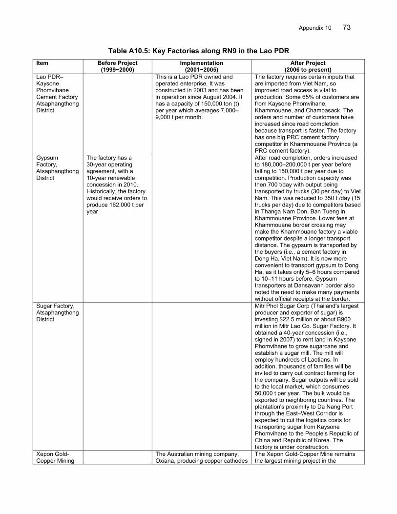
Appendix 10 73
Table A10.5: Key Factories along RN9 in the Lao PDR
Item Before Project (1999−2000)
Implementation (2001−2005)
After Project (2006 to present)
Lao PDR–Kaysone Phomvihane Cement Factory Atsaphangthong District
This is a Lao PDR owned and operated enterprise. It was constructed in 2003 and has been in operation since August 2004. It has a capacity of 150,000 ton (t) per year which averages 7,000–9,000 t per month.
The factory requires certain inputs that are imported from Viet Nam, so improved road access is vital to production. Some 65% of customers are from Kaysone Phomvihane, Khammouane, and Champasack. The orders and number of customers have increased since road completion because transport is faster. The factory has one big PRC cement factory competitor in Khammouane Province (a PRC cement factory).
Gypsum Factory, Atsaphangthong District
The factory has a 30-year operating agreement, with a 10-year renewable concession in 2010. Historically, the factory would receive orders to produce 162,000 t per year.
After road completion, orders increased to 180,000–200,000 t per year before falling to 150,000 t per year due to competition. Production capacity was then 700 t/day with output being transported by trucks (30 per day) to Viet Nam. This was reduced to 350 t /day (15 trucks per day) due to competitors based in Thanga Nam Don, Ban Tueng in Khammouane Province. Lower fees at Khammouane border crossing may make the Khammouane factory a viable competitor despite a longer transport distance. The gypsum is transported by the buyers (i.e., a cement factory in Dong Ha, Viet Nam). It is now more convenient to transport gypsum to Dong Ha, as it takes only 5–6 hours compared to 10–11 hours before. Gypsum transporters at Dansavanh border also noted the need to make many payments without official receipts at the border.
Sugar Factory, Atsaphangthong District
Mitr Phol Sugar Corp (Thailand's largest producer and exporter of sugar) is investing $22.5 million or about B900 million in Mitr Lao Co. Sugar Factory. It obtained a 40-year concession (i.e., signed in 2007) to rent land in Kaysone Phomvihane to grow sugarcane and establish a sugar mill. The mill will employ hundreds of Laotians. In addition, thousands of families will be invited to carry out contract farming for the company. Sugar outputs will be sold to the local market, which consumes 50,000 t per year. The bulk would be exported to neighboring countries. The plantation's proximity to Da Nang Port through the East–West Corridor is expected to cut the logistics costs for transporting sugar from Kaysone Phomvihane to the People’s Republic of China and Republic of Korea. The factory is under construction.
Xepon Gold-Copper Mining
The Australian mining company, Oxiana, producing copper cathodes
The Xepon Gold-Copper Mine remains the largest mining project in the

74 Appendix 10
Item Before Project (1999−2000)
Implementation (2001−2005)
After Project (2006 to present)
Project, Vilabouly District
and gold, started operation in March 2005 in Xepon, Lao PDR. Completion of RN9 was a determining factor in starting the mining activities. From March 2005 to mid-2007, Oxiana sent 5,300 trucks of copper cathode to Thailand and Viet Nam. In addition, supplies to the mine constitute a large trucking movement—accounting on average for 10 trucks a day.
Lao PDR, with the biggest impact on the Lao PDR economy. It is operated by Lane Xang Minerals Limited (Oxiana, Australia) which invested more than $400 million. The Xepon mine currently produces 200,000 ounces of gold and 60,000 t of copper cathode per year. All the copper is currently exported to neighboring countries such as Thailand (60%) and Viet Nam (40%), and the gold to Australia. The transport of copper has increased since road completion from 60,000−80,000 t per year and more. It is convenient, safe, and saves time cost. For example, before road and bridge completion, from Thailand to the mines, it took 2 days to travel 1,000 km; now it takes 1.5–2.0 hours from Thailand to the Lao PDR, 0.5 hour at the border crossing at the second friendship bridge, and 3.5–4.0 hours to the mining project.
PVC Pipe Factory
This factory was established in 2005 after road completion. The capacity is 200 t per year. It supplies the whole country.
─
Lao PDR–Viet Nam Enterprise Electric Line Factory (VNTT Viet Nam Factory)
It was established in 2007 to produce all types of electric line to supply around the world. The capacity is 5,000 t per year.
Kolao Developing Company (Motorcycle and Car Factory)
This was established in 1997 at Km 8 of RN9. Operations comprise motorcycle assembly and car assembly, with parts provided from the Republic of Korea under the brand name of KOLAO. The production capacity for motorcycles is 2,500 motorcycles in 2.5 months. The production capacity for cars is 400–500 per month. Parts and equipment are imported from the Republic of Korea via Thailand at Lam Sabang to the Lao PDR. Some parts and components could be produced at the factory.
This factory was producing before the road construction completed. It was very difficult then to transport equipment and components from Thailand to Lao PDR as they needed to transport by ferry. Materials arrive twice a week with 20–40 containers, taking 2 days. After road and bridge completion, transport will only take 30 minutes.
km = kilometer, Lao PDR = Lao People’s Democratic Republic, PRC = People’s Republic of China, RN = route national, t = ton. Source: Operations Evaluation Mission survey result.

Appendix 10 75
F. Impact on Tourism 22. Tourism accounts for a major part of the increased traffic between Thailand and Lao PDR. This has doubled or even tripled since project completion. Most tourism traffic moves from west to east, i.e., Thailand to Viet Nam. There is a clear demand for the Kaysone Phomvihane—Dansavanh route by Thai tourists who view Viet Nam beaches as a cheaper alternative to Pattaya. Viet Nam to Thailand traffic is not large, perhaps because of restrictions on leaving the country. For the Lao PDR, the question for the future is how to encourage more of these tourists to stay longer and spend more in the country.8
8 As part of Japan’s efforts to develop/promote the corridor, Japan International Cooperation Agency provided a
$1.5 million grant for a tourism project in Kaysone Phomvihane that aims to address poverty through the development of a one village−one product program (for regional development) along with a one-stop service center near the second Mekong Friendship Bridge.

76 Appendix 11
ROAD SAFETY 1. Improvement of roads has a direct correlation with deterioration in road safety. While improved roads provide for safer, more convenient, and easier travel experience, there is an associated risk in the intensity and damages from accidents caused by faster running speeds. This safety issue is common among road improvement projects in other countries. With expectations of a sustained increase in traffic, potential road safety issues are likely to persist in the future. These include (i) a need for enforcement of posted speed limits and adequate driver appreciation of the rationale of these speed limits, (ii) increased pedestrian and motorcycle traffic both crossing and along the roadway, and (iii) a need for adequate shoulder width for vehicular stops and parking. 2. Lao People’s Democratic Republic Component. The project completion report reported that changes in the incidence of road accidents cannot be accurately evaluated because of limited data.1 Statistics are available only at the provincial and district level, and no historical or current statistics are available for route national (RN) 9 or any other specific road. 3. The Operations Evaluation Mission national consultant was not able to collect data on road accidents directly. Instead, an update on road safety issues was drawn from several reports.2 These reports identified several road safety issues as follows: (i) lack of detailed crash data so “accident black spots” were not known; (ii) poor maintenance of traffic lights, guide, posts, safety barriers, kilometer markers, and road markings; (iii) unclear shoulder or slow lanes; (iv) very poor construction safety; (v) inadequate shoulder; (vi) poor construction resulting in the need for many repairs; (vii) inconsistent speed limits; (viii) inadequate traffic calming measures, particularly at the start of communities and school locations; (ix) poor delineation and crash protection at all the bridges; and (x) nonuse of weighbridges. 4. These reports also look into causes of road traffic accidents in villages. The reasons for accidents were identified as (i) speeding, (ii) turning from a minor road into a main road, (iii) changing direction, (iv) underage driving, (v) farm tractors, (vi) motorcycles disrespecting traffic rules, (vii) motorcyclists without a license, (viii) drunk drivers, and (ix) trucks. 5. With limited data, it is difficult to say how much road safety has changed since completion of the road project. Official records from the traffic police of Kaysone Phomvihane province indicate a per capita reduction in the number of victims and fatalities during 2004−2005 (Table A11.1). However, in Dansavanh, villagers still reported some issues resulting from road and border crossing improvements:
(i) The alignment of RN9 passes through Dansavanh village. In the absence of a provision for parking, many trucks and buses stop to drop off and load or take rest stops along RN9, thereby creating congestion. In addition, many import–export companies based in the village have offices beside RN9. When trucks come to transport goods, they stop and wait along both sides of the road,
1 ADB. 2008. Project Completion Report on the Greater Mekong Subregion: East–West Corridor Project (Lao PDR
and Viet Nam). Manila. The statistics for Kaysone Phomvihane Province show the number of (i) reported accidents has increased by 94% from 1996 to 2006 (from 260 to 504); (ii) injuries by 99% (from 466 to 926); and (iii) and fatalities by 129% (from 24 to 55). These increases are approximately in keeping with traffic increases.
2 Goodge, Mike (Road Safety International). 2007. Review of RN9 Kaysone Phomvihane to Lao Bao. (draft report). January; Goodge, Mike (Road Safety International), Review of RN9 Kaysone Phomvihane to Lao Bao (draft final report on part 2 appendixes). Lao People’s Democratic Republic (Lao PDR). March; and Road for Rural Development Project (NDF-426 LAO) Consultancy Services Package 3: Road Safety. 2007. Road Safety Audit Report Kaysone Phomvihane–Xeno Section of RN9. Lao PDR (June).

Appendix 11 77
crowding out other traffic. For example, buses and trucks stop and cover most of the road. Accidents occur when vehicles pass and cannot see the road.
(ii) Trucks and buses drive fast, making the large amount of traffic passing through the village dangerous and accident-prone. More traffic signs and road lighting are desirable to increase safety and speed control.
Table A11.1: Traffic Accidents on Route National 9 (Lao PDR side of National Road 9)
Item 2004 2005 Road Accidents 656 627 Road Accident Victims 1,604 1,253 Victims per Accident 2.45 2.00 Fatalities 62 48 Fatalities per Accident 0.09 0.08
Lao PDR = Lao People’s Democratic Republic. Source: Operations Evaluation Mission survey result.
6. Viet Nam Component. Despite increased traffic flow and speeds, accident statistics show a decline in the number of reported incidents from an average of 51 per year during 2000−2003 (before road completion) to 40 per year during 2004−2007 (after road completion) (Table A11.2). The number of injuries from accidents has declined from 44.8 per year during 2000−2003 to 37.5 per year during 2004−2007. But still, the severity of reported accidents appears to pick up slightly, with the average number of deaths per year at 14.8 during 2000–2003 and 15.3 during 2004−2007. The number of deaths per accident reached 0.38 per year during 2004−2007 from 0.29 during 2000−2003. The increase was due to high fatality accidents reported in 2006 and 2007. On a cumulative basis, annual losses averaged D383.5 million during 2004−2007, which was in line with actual losses of D370.0 million in 2003 (before road completion). However, with the lower incidence in accidents, accident damage on a per capita basis increased significantly to an average of D9.6 million during 2004−2007 (compared with D6.4 million in 2003). Table A11.2: Traffic Accidents on National Highway 9 (Viet Nam side of National Road 9)
Year
Accidents
Fatalities
Fatalities
per Accident
Injuries
Injuries
per Accident
Damaged Vehicles
Damaged
Motor-cycles
Losses (D mn)
Losses per
Accident (D mn)
2000 36 13 0.36 17 1.31 7 9 2001 53 16 0.30 37 2.31 23 17 2002 57 11 0.19 64 5.82 16 19 2003 58 19 0.33 61 3.21 370 6.38 2004 59 15 0.25 53 3.53 632 10.71 2005 31 9 0.29 26 2.89 375 12.10 2006 30 21 0.70 34 1.62 201 6.70 2007 40 16 0.40 37 2.31 326 8.15 2000−2003 51.0 14.8 0.29 44.8 3.03 370.0 2004−2007 40.0 15.3 0.38 37.5 2.46 383.5 9.59 D = dong, mn = million. Source: Operations Evaluation Mission survey result.

78
Appendix 12
RELATED ADB TECHNICAL ASSISTANCE FOR THE EAST−WEST CORRIDOR PROJECT Item Study of Lao−THA−VIE−East–West Transport Corridora GMS East−West Transport Corridorb East−West Corridor Coordinationc Objectives/ Scope
Three corridors were investigated: (i) northern corridor using RN8 leading to the port of Cua Lo near Vinh; (ii) the central corridor suing RN9 leading to Da Nang; and (iii) two alternative new routes for the southern corridor from Pakxe, south Lao PDR, to the port of either Da Nang or Quy Nhon.
The TA was to prepare a project for improving the transport corridor linking northeast Thailand with Southern Lao PDR and Central Viet Nam. The scope of the TA included (i) the Mekong River Crossing comprising the second Thai–Lao Mekong Bridge and its associated approach roads and facilities, (ii) reconstruction of RN9 in the Lao PDR, and (iii) upgrading of facilities in Da Nang and assessment of access roads improvement to port.
Coordinate and monitor implementation of transport infrastructure investments in the East–West Corridor; assist in establishing appropriate O&M arrangements for the Mekong River bridge and RN9, including setting bridge toll structure and transit fees; and study potential adverse environmental and social impacts related to the improvement of cross-border mobility, and recommend mitigation and enforcement measures
Outputs/ Status
The TA recommended that the first priority for investment should be upgrading of the central corridor, comprising RN9 in the Lao PDR and NH9 in Viet Nam. Road improvements should also be supported by expansion of Da Nang port for container movements, and by the construction of a bridge across the Mekong River, between Mukdahan, (Thailand) and Kaysone Phomvihane. A similar high priority exists for the northern corridor to at least maintain and progressively upgrade RN8 in the Lao PDR and Viet Nam. The Northern Corridor, RN8/NH8, remains a highly viable project and should proceed. The Central Corridor, RN9/NH9, is also a viable project. Assumed to be upgraded to a reasonable standard in the base network assumptions, it should be limited to minor upgrading and pavement repair, to maintain the benefits currently provided. Southern Corridor B, RN60, is also a highly viable project and should have priority in a medium-term construction program.
TA activities included (i) review and update of feasibility study; (ii) detailed engineering; (iii) contract documentation and procurement assistance; (iv) environmental and social impact analysis; (v) cross-border traffic aspects; and (vi) private sector participation in operations, financing, and construction. The TA was successful in leading up to the project loan for the East–West Corridor Project. However, the subsequent loan did not include improvement to border facilities on the Lao PDR side. This is expected to be carried out separately by the Government.
At completion, the TA generated several outputs that culminated in the presentation of a final report in January 2007. Individual reports and recommendations were made under the five subdivisions of the TA: (i) project coordination, (ii) environmental and social governance, (iii) study on transit fee and toll of RNs 3 and 9 in the Lao PDR, (iv) report on public–private partnerships in the East–West Corridor, and (v) training on implementation of a financial management system for both MPWT and provincial departments.
Overall Assessment
Highly Successful Successful Highly Successful
Relevance Highly Relevant Highly Relevant Highly Relevant Effectiveness Effective Effective Effective Efficiency Highly Efficient Highly Efficient Highly Efficient Sustainability Likely to Most Likely Likely Likely to Most Likely Impacts Substantial to High Substantial Substantial to High Lao PDR = Lao People’s Democratic Republic, MPWT = Ministry of Public Works and Transport, NH = national highway, O&M = operation and maintenance, RN = route national, TA = technical assistance. a ADB. 1994. Technical Assistance for the Study of the Lao PDR−Thailand–Viet Nam–East-West Transport Corridor. Manila. (TA 5586-REG, for $1 million, approved on
18 July). b ADB. 1996. Technical Assistance for the Greater Mekong Subregion: East–West Transport Corridor. Manila. (TA 5710-REG, for $3 million, approved on 11 December). c ADB. 1999. Technical Assistance for East–West Corridor Coordination. Manila (TA 3348-LAO, for $0.69 million, approved on 20 December). Sources: ADB. 2008. Project Completion Report on the Greater Mekong Subregion: East–West Corridor Project (Lao PDR and Viet Nam). Manila; and ADB. 2008. Sector
Assistance Program Evaluation on Transport and Trade Facilitation in the Greater Mekong Subregion. Manila (draft).

MANAGEMENT RESPONSE TO THE PROJECT PERFORMANCE EVALUATION REPORT FOR THE GREATER MEKONG SUBREGION: EAST–WEST CORRIDOR
PROJECT IN THE LAO PEOPLE'S DEMOCRATIC REPUBLIC AND SOCIALIST REPUBLIC OF VIET NAM
(Loan 1727-LAO[SF] and Loan 1728-VIE[SF])
On 31 March 2009, the Director General, Independent Evaluation Department, received the following response from the Managing Director General on behalf of Management:
I. General Comments 1. We appreciate the Project Performance Evaluation Report's (PPER) evaluation of the East-West Corridor Project. The PPER is significant because it provides useful lessons in implementing a subregional/multi-country infrastructure project. 2. We appreciate the PPER's rating the project “successful” based on the evaluation criteria of relevance, effectiveness, efficiency, and sustainability. We also note that the report rates the regional level impacts of the project as “moderate”, largely due to cross-border traffic and trade developing more slowly than projected. II. Comments on Specific Recommendations 3. Recommendation 1: Ratification and Implementation of Cross Border Transport Agreement. We agree. ADB is working with GMS governments for the expedient ratification by all six countries of the Cross Border Transport Agreement's (CBTA) annexes and protocols, as well as the full implementation of the CBTA. However, since the CBTA is a complex agreement, with 20 annexes and protocols and involving six countries, its full implementation will take time.1 In many cases, the CBTA's ratification will entail a change in laws and regulations in the GMS member countries. 4. A diagnostic review of the CBTA and other transport and trade facilitation (TTF) measures is being undertaken under ADB TA 6450 (Enhancing Transport and Trade Facilitation in the Greater Mekong Subregion), which will identify key issues impeding the CBTA's implementation, and will come out with an action-oriented strategy and work plan for the CBTA and other TTF measures in the GMS. The findings of the review will be presented for the consideration of the 15th GMS Ministerial Conference to be held in Chiang Mai, Thailand in June 2009. It is envisaged to help the GMS countries chart a clear, pragmatic, and results-based direction for expedient TTF in the GMS. 5. Recommendation 2: Conversion of Transport Corridors into Economic Corridors. We agree. We note that under the GMS strategic framework, the establishment of cross-border transport links is only the initial step toward the development of economic corridors. Economic corridor
1 It is to be noted though that the Lao Bao-Dansavanh border crossing point (bcp) along the
EWEC is the first bcp where the CBTA has been implemented on a pilot basis, and where, as the PPER noted, benefits in the form of reductions in border crossing times are already observable.

2
development involves an integrated and holistic approach where infrastructure improvements are directly linked with production, trade, investment, and other economic opportunities. GMS Ministers adopted the economic corridor approach as early as 1998, and the approach was reaffirmed by the GMS Leaders at the Third GMS Summit in March 2009. The Leaders also endorsed the establishment of the Economic Corridors Forum (ECF) as a platform to strengthen and effectively coordinate all efforts toward the development of economic corridors. 6. The ECF will help improve coordination between central and local governments, and between the public and private sectors in the GMS. It will also enhance collaboration among the various GMS sector working groups with respect to their economic corridor-related activities. ADB is helping the six GMS countries prepare strategies and action plans (SAP) for the development of the GMS economic corridors. The SAP for the East-West transport corridor is being prepared and will be discussed at a workshop to be held in April 2009 for consideration of the 15th GMS Ministerial Conference. In addition, the indicative loan/grant programs for Lao PDR and Viet Nam for 2010-2011 include other multi-sectoral initiatives, such as water supply and sanitation, and border towns development projects in towns along the East-West Corridor. These projects will complement the transport infrastructure developed, and will improve the physical, social, and environmental infrastructure, and enhance institutional capacities in key towns along the Corridor. 7. Recommendation 3: Ensuring Adequate Financing for Road Maintenance. We agree with this recommendation. We note that inadequate financing for road maintenance is a problem in Lao PDR and Viet Nam. However, steps are being taken in both countries to improve the situation. In Lao PDR, the fuel levy, the primary source of financing for the Road Maintenance Fund, was increased in late 2008 from 200 to 250 kips per liter, which is more than 6 times the level of 40 kips per liter when the Road Maintenance Fund was established in 2001. The World Bank, with support from ADB and bilateral donors, has taken the lead role in addressing inadequate financing of maintenance in Lao PDR through projects providing assistance to improve road maintenance financing and management. ADB is supporting efforts to improve road maintenance in Lao PDR, for example, by providing financing under specific transport project loans/grants, such as Grant 0082-LAO: Northern GMS Transport Network Improvement Project. This includes periodic maintenance subprojects developed through the maintenance management system. We will continue this practice through proposed projects addressing the national road network. 8. The Government of Viet Nam is also addressing the need for sustainable road maintenance efforts. It recently upgraded the Vietnam Road Administration (VRA) to a new Department of Roads (DOR) within the Ministry of Transport. Among the responsibilities of the new DOR will be strengthening planning of construction, operation, and maintenance of roads and highways. The Government has requested ADB to provide TA support for the establishment of the new DOR and to develop a road asset management system, which will facilitate improved road maintenance. In response to this request, ADB is processing a TA for Capacity Building in the Transport Sector for approval in 2009. In preparing three new road sector projects in Viet Nam proposed for approval in 2010, ADB has included policy dialogue with the government to develop agreed actions to ensure adequate road maintenance financing, as well as use of the road asset management system, which will be developed under the TA.