Project Appraisal Report for Syston - charnwood.gov.uk
37
CHARNWOOD BOROUGH COUNCIL BARKBY BROOK FLOOD ALLEVIATION SCHEME PHASE IV PROJECT APPRAISAL REPORT F EBRUARY 2004 LAND DRAINAGE ENGINEERING TECHNICAL SERVICES SOUTHFIELDS LOUGHBOROUGH LEICS LE11 2TN
Transcript of Project Appraisal Report for Syston - charnwood.gov.uk

C H A R N W O O D B O R O U G H C O U N C I L
BARKBY BROOK FLOOD ALLEVIATION SCHEME
PHASE IV PROJECT APPRAISAL REPORT
FEBRUARY 2004
LAND DRAINAGE ENGINEERING TECHNICAL SERVICES
SOUTHFIELDS LOUGHBOROUGH
LEICS LE11 2TN
Barkby Brook, Syston
CONTENTS List of Figures ............................................................................................................................III List of Tables..............................................................................................................................III
1. EXECUTIVE SUMMARY................................................................................. 1 Introduction ..................................................................................................................................1 Responsibilities.............................................................................................................................1 Conclusion....................................................................................................................................1 Recommendation..........................................................................................................................2
2. BACKGROUND................................................................................................. 3 Introduction ..................................................................................................................................3 Previous Flood Risk Strategy .......................................................................................................4 Current Flood Risk Strategy .........................................................................................................6 New Development & PPG25........................................................................................................7
3. DESCRIPTION OF THE PROBLEM ................................................................ 9 Area under Consideration.............................................................................................................9 Existing Construction ...................................................................................................................9 Structural Assessment ..................................................................................................................9 Hydraulic Assessment ................................................................................................................10
Previous Studies.......................................................................................................................................................10 Current Study...........................................................................................................................................................10
Do-Nothing Scenario..................................................................................................................13 Aims and Objectives...................................................................................................................14
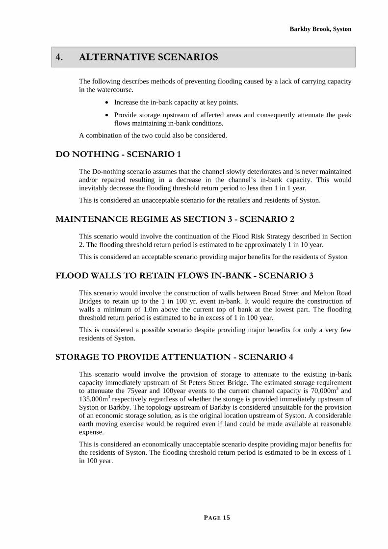
4. ALTERNATIVE SCENARIOS........................................................................ 15 Do Nothing - Scenario 1.............................................................................................................15 Maintenance Regime as Section 3 - Scenario 2..........................................................................15 Flood Walls to Retain Flows In-bank - Scenario 3.....................................................................15 Storage to Provide Attenuation - Scenario 4 ..............................................................................15
5. COSTS............................................................................................................... 16 Summary of Construction Costs.................................................................................................16 Maintenance Costs......................................................................................................................16 Detailed Scenario Costs..............................................................................................................16
6. BENEFITS AND IMPACTS ............................................................................ 17 General .......................................................................................................................................17 Valuation of Benefits..................................................................................................................17 Environmental and Archaeological impact.................................................................................17 Summary of Benefit/Cost Analysis ............................................................................................17 DEFRA Priority Scoring ............................................................................................................17
7. RISK & SENSITIVITY ANALYSIS ............................................................... 19 Flood Risk ..................................................................................................................................19 Sensitivity Analysis ....................................................................................................................19
8. THE PREFERRED SOLUTION....................................................................... 21 Defence Standard........................................................................................................................21 Design Criteria............................................................................................................................21 Preferred Scenario ......................................................................................................................21
PAGE II

Barkby Brook, Syston
9. CONCLUSION & RECOMMENDATION...................................................... 22 Conclusion..................................................................................................................................22 Recommendation........................................................................................................................22
APPENDIX A-BENEFIT COST ASSESSMENT.......................................................... 23 Preamble.....................................................................................................................................23 Scheme Options..........................................................................................................................23 Limiting Assumptions ................................................................................................................24 Do Nothing Damages .................................................................................................................24 Do Minimum Option ..................................................................................................................26 Brookside walls Option ..............................................................................................................26 Summary of Scheme Option benefits .........................................................................................26 Priority Scoring ..........................................................................................................................27
APPENDIX B-Cabinet Report- 10 APRIL 2003 ............................................................ 29
APPENDIX C-Cabinet Minute- 10 APRIL 2003 ........................................................... 33
LIST OF FIGURES
Figure 1- Catchment Plan......................................................................................................... 3 Figure 2 - Previous Phases Locations ...................................................................................... 4 Figure 3- Initial Flood Storage Area ........................................................................................ 5 Figure 4- 100yr Protection Storage Requirement................................................................... 11 Figure 5- Storage Requirement Upstream of Barkby............................................................. 12 Figure 6-Well Maintained 100yr Flooding ............................................................................ 12 Figure 7- Poorly Maintenance 100yr Flooding ...................................................................... 13
LIST OF TABLES
Table 1- Previous Phase Details............................................................................................... 5 Table 2- PPG25 Flood Risk Zones........................................................................................... 8 Table 3- Peak Flows............................................................................................................... 13 Table 4- Summary of Alternative Scenarios Estimates.......................................................... 16 Table 5 – Estimated Scenario Costs (£000’s) ........................................................................ 16 Table 6- Hydraulic Modelling Results ................................................................................... 20 Table 7- Peak Flows............................................................................................................... 21
PAGE III

1. EXECUTIVE SUMMARY
INTRODUCTION
The town of Syston is located approximately 12km south east of Loughborough, near to the outskirts of Leicester. The Barkby Brook, a tributary of the River Wreake, rises near the Village of Hungarton, 13km to the east of Syston, and drains a predominantly rural catchment of approximately 24 km2 running through the centre of Syston before discharging into the River Wreake adjacent to the A46 Road Bridge at the end of Meadow Lane.
RESPONSIBILITIES
The watercourse is an “Ordinary Watercourse” as defined under the Land Drainage Act 1991. In 2001 it was designated a Critical Ordinary Watercourse in consultation with the Environment Agency under the DEFRA High Level Targets. Charnwood Borough Council, as the Operating Authority with powers under the Land Drainage Act 1991, do not ‘own’ the watercourse. Cabinet Report 10/04/03 and Minute 345 defines the maintenance regime proposed for all ordinary watercourses within the borough.
CONCLUSION
It is concluded that: -
1. Benefit/Cost analysis indicates the current maintenance and enforcement regime is extremely cost effective with significant hydraulic benefits and must be continued. If this regime is not continued at its present level the watercourse will deteriorate and performance will fall to a level similar to that which existed during the events in the early 1990’s.
2. The provision of storage upstream of Syston is not an economical solution. The Benefit/Cost analysis indicates that it would not attract DEFRA grant and consequently could not be recommended.
3. Expenditure of approximately £500,000 can be justified, using Benefit/Cost analysis, despite only protecting 2No commercial properties but eliminating out of bank flooding at Brookside for events less that 1 in 100yr. However, it is not recommended because : -
a. A planning application has been received for the redevelopment of the warehouse on Brookside, currently the major contribution to the Benefit/Cost assessment. The PPG25 flood risk assessment will eliminate the benefits associated with this existing property.
b. The operational risk of unknown outlets to the watercourse and/or blockages on existing outlets.
4. The remaining property ‘at-risk’, the Public House on Brookside, would not justify expenditure of £500,000. Provision of individual flood protection measures would be an alternative at a cost of between £2,500 and £5,000.
PAGE 1

Barkby Brook, Syston
RECOMMENDATION
It is recommended that the existing maintenance and enforcement regime is continued as confirmed in Cabinet Minute 345 dated 10/04/03.
It is recommended that a contribution towards the provision of individual flood protection measures be offered to the owners of the public house at a maximum of £5,000.
PAGE 2

Barkby Brook, Syston
2. BACKGROUND
INTRODUCTION
The town of Syston is located approximately 12km south east of Loughborough, near to the outskirts of Leicester. The Barkby Brook, a tributary of the River Wreake, rises near the Village of Cold Newton, 13km to the east of Syston, and drains a predominantly rural catchment of approximately 24km2 as shown in Figure 1.
Figure 1- Catchment Plan
The watercourse is an “Ordinary Watercourse” as defined under the Land Drainage Act 1991. In 2001 parts of it were designated a ‘Critical Ordinary Watercourse’ in consultation with the Environment Agency under the DEFRA High Level Targets. A Critical Ordinary Watercourse is defined as a length of ordinary watercourse, where there is a flood risk to at least 25 housing equivalents per kilometre of one bank
The Council is the Operating Authority and has a power, but not a duty, under The Land Drainage Act 1991 to maintain ordinary watercourses, but it can serve notice to execute maintenance. The DEFRA High Level Targets also require the Council to undertake inspection of all critical ordinary watercourses but the Targets do not require the Council to act where problems are identified.
In 2000 the council, by virtue of the powers and authority vested in them by Section 66 of the Land Drainage Act 1991, promulgated the Land Drainage Byelaws which were considered necessary to secure the efficient working of the drainage system in the District.
PAGE 3

Barkby Brook, Syston
PREVIOUS FLOOD RISK STRATEGY
Although Riparian owners were ultimately responsible for maintenance of the brook, the whole of the watercourse from the River Wreake to St Hildas Close was regularly inspected and obstructions removed by the Council’s Drainage Gang.
Syston experienced severe flooding in September 1992 and January 1993 on both occasions the flooding followed 30-50mm of rainfall lasting approximately 6 hours. Charnwood Borough Council commenced a programme of capital works to alleviate the damage caused by these extreme rainfall events as described in table 1 and indicated in figure 2.
The Council has spent a total of £905,000, excluding staff costs, on the first three phases since 1994, which were designed to provide flood protection up to a 1 in 10 year, return period event.
Figure 2 - Previous Phases Locations
Phase I Channel desilted and widened using Gabion wall revetment to one bank in playing field - completed 1995
Binnie Report
Project Appraisal Report produced jointly by Charnwood Borough Council and consulting engineers Binnie & Partners in 1996. Discussions with MAFF (now DEFRA) indicated that an application for Grant Aid would be unsuccessful.
PAGE 4

Barkby Brook, Syston
Phase II Channel desilted and widened using Brick wall revetment to one bank d/s of Broad Street along with removal of a pipe bridge at Brookfield Street - completed 1997
Phase III Following the collapse of the wall on Meadow Lane the channel was desilted and widened using Gabion wall revetment to one bank and construction of By-Pass Culvert to increase capacity - completed 1998
Phase IV
Flood Storage Considered
In 1999 Flood Storage upstream of Syston was identified as an option (See Figure 3) and work to progress on this option ceased when developer interest in the identified site indicated the probability of excessive land values. From 2002/3 feasibility works continued to identify other suitable storage areas. This appraisal in included in this report
Table 1- Previous Phase Details
Following completion of each of the above phases, Charnwood Borough Council became responsible for the future maintenance of each section, where the bed or bank was altered by the project.
Figure 3- Initial Option considered for Flood Storage Area
PAGE 5
Barkby Brook, Syston
CURRENT FLOOD RISK STRATEGY
In addition to the capital improvement works carried out as detailed above, CBC has initiated a strategy to minimise the flood risk as follows: -
1. Promulgated Land Drainage Bylaws, which came into force on the 6th April 2000, to assist in the enforcement of the Land Drainage Act 1991.
2. Undertaken Regular Inspections with a view to advising riparian owners of action required. The flood risk is exacerbated by encroachment, lack of maintenance of banks/retaining walls and dumping of rubbish. Following recent inspections the Council has requested riparian owners Lafarge and Rail Track to improve maintenance of brook reaches down stream of the town centre. The subsequent removal of reeds and silt at Meadow Lane and trees in the “Triangle” land are good examples of the efforts of staff and riparian owners working together to reduce flood risk. Upstream of the Melton Road Car Park the perceived flood risk arises from the action of riparian owners. In this reach the Council does not own the brook and has no duty to maintain private banks and structures. It only has a duty to maintain flood defence assets such as the flood relief culvert at Victoria Street.
3. The action of the riparian owners and encroachment had made previous informal visits by the Land Drainage Gang less sustainable or effective. A copy of the “Joint Report of the Head of Legal and Democratic Services and the Head of Technical Services, Item 4 Flooding in the Borough Ordinary Watercourses Maintenance and Management Review” submitted to Cabinet, on the 10th April 2003 is enclosed as Appendix A. This item referred to these problems and the Cabinet approved Maintenance regime is restricted to the following: -.
“All flood defence assets installed and or adopted by the Borough Council or its preceding operating authorities under the Act or preceding acts.
All watercourses where the council is riparian owner or through conveyance of land the Council retained the duty.
All watercourses or flood defence assets where an operating authority such as the County Council or the Environment Agency employs the Council at cost.
Watercourses where a Town or Parish Council, within the Borough, has public a open space or an amenity area next to a watercourse and is therefore a riparian owner similar to the Borough Council in Loughborough. Examples are the watercourse in the Glenmore Park at Shepshed or the Fishpool Brook in Barrow-upon-Soar.
Watercourses within the Borough, where there are no clearly defined riparian owners and the Borough Council has historically maintained the watercourse. Examples are the Rearsby Brook and Sileby Brook in the village centres, Brookside, Syston and Brook Street, Wymeswold, but in does not follow there is a responsibility for supporting the public highway or other infrastructure assets.”
4. Constructed concrete access ramps to assist in the removal of obstructions and silt.
5. The Council continues to ensure road bridges such as Fosse Way are clear, for which it receives payment from Leicestershire County Council.
PAGE 6
Barkby Brook, Syston
6. Emergency action will also continue to be undertaken to remove major obstructions reported by the Town Council, Flood Wardens and the public.
7. CBC will continue to monitor the watercourse and inspect the whole of the brook in Syston at regular intervals, which is part of the Council’s Policy Statement on flood defence under DEFRA High Level Targets.
8. CBC, in conjunction with the EA, has implemented an early flood warning system. The three levels of warning are as follows:
1) The Meteorological Centre sends advanced storm warnings to the council who then forward the information to Syston residents volunteer ‘flood wardens’. (Approx. 24hr warning).
2) Rainfall gauges, monitored by the EA, are programmed to alarm and automatically notify CBC above predetermined levels. The council then informs the ‘flood wardens’. (Approx. 5hr warning).
3) A High Water alarm at Brookside, which gives an early warning of potentially high water levels. The alarm warnings are relayed to residents likely to be affected through local flood wardens (Approx. 15-30min warning).
The EA, as a result of the DEFRA Funding Review, propose to en-main the Barkby Brook from the River Wreake to St Hildas Close (i.e. it will be given Main River status as opposed to it’s current ‘Ordinary Watercourse’ status). Whilst CBC will continue to operate its current maintenance policy, as agents for the EA, it will not be able to enforce its Land Drainage By-laws on the ‘Main River’.
NEW DEVELOPMENT & PPG25
In July 2001 the DTLR issued Planning Policy Guidance Note 25 (PPG25). This introduced the sequential tests and the risk based approach to flood risk and development. Development priorities are to be based on flood zones as outlined in PPG25.
The responsibility for determining whether land is suitable for a particular development proposal rests with the developer. In particular, the developer is responsible for: -
�� Determining whether any proposed development will be affected by flooding and whether it will increase flood risk elsewhere; and
�� Satisfying the local planning authority that any flood risk can be successfully managed with the minimum environmental effect to ensure the safe development and secure occupancy of any site.
It is in the developer’s interests to deal with these matters, since they may well affect the value of land and the cost of developing it, as well as any future liability for adverse impacts leading to flood damage elsewhere in the catchment.
Flood Zone Flooding Frequency Zone 1: Little or No Risk Annual probability of flooding ,
0.1% or less (>1 in 1000 yr) Zone 2: Low to Medium Risk Annual probability of flooding
0.1% to 1.0% (1 in 1000 to 1 in 100yr)
PAGE 7

Barkby Brook, Syston
Zone 3: High Risk Annual probability of flooding, with defences where they exist, 1% or greater (<1 in 100yr)
Table 2- PPG25 Flood Risk Zones
The Land Drainage Engineering Section currently monitor all planning applications for proximity/sensitivity to watercourses and, in conjunction with both PPG25 and the Environment Agency, require all such new developments to be carefully managed with respect to flood risk.
PAGE 8

Barkby Brook, Syston
3. DESCRIPTION OF THE PROBLEM
AREA UNDER CONSIDERATION
The areas of Syston adjacent to Brookside and Brookfield Street are the areas that suffered the worst of the 1992/3 flooding. The scope of this report covers the watercourse from St Hildas Close on the eastern outskirts of Syston to its outfall into the River Wreake. Approximately 140 properties in and adjacent to the Brookside and Brookfield St town centre areas are considered to be ‘at risk’ of intermittent flooding as a result of overtopping of the watercourse.
EXISTING CONSTRUCTION
The construction of the watercourse varies from a 2.5m deep x 3.0m wide trapezoidal natural channel upstream of Victoria Street to a 1.5m deep x 5.5m wide trapezoidal artificial concrete channel at Brookside. The watercourse is crossed by major arterial roads/railways at: -
1. Pembrooke Avenue - Single Span Rectangular Road Bridge.
2. College Road - Single Span Rectangular Road Bridge.
3. Melton Road - Multiple Arch Road Bridge
4. St Peters Street - Single Span Rectangular Road Bridge.
5. Broad Street - Single Span Rectangular Road Bridge.
6. East of Fosse Way - 2 No. High Arch Railway Viaducts.
7. Fosse Way (B667) - Single Span Rectangular Road Bridge.
8. A46 Trunk Road - Single Span Rectangular Road Bridge.
STRUCTURAL ASSESSMENT
Charnwood Borough Council carries out periodic inspections of the watercourse in order to comply with the DEFRA High Level Targets. Several locations have been identified as having serious structural degradation and the riparian owners are currently being contacted. The artificial concrete channel alongside Brookside is also beginning to show signs of early deterioration and is being monitored carefully.
Areas of concern are as follows:_
1. Brookfield Street/ Victoria St – currently being monitored by the council.
2. Melton Road/Public Car park – riparian owner to be contacted.
3. ‘Syston Triangle’ – Rail Track Operator to be contacted.
4. Fosse Way – Works to be carried out in conjunction with Leicestershire County Council.
PAGE 9

Barkby Brook, Syston
HYDRAULIC ASSESSMENT Previous Studies
The Council instigated a feasibility study of the existing watercourse following the flooding events in 1992/3. This initial assessment was carried out using technology primarily derived for the analysis of piped catchments (Urban Sewerage Systems).
Analysis of simulations carried out using these early modelling techniques indicated that the flooding threshold, after the schemes described in Section 2 above had been completed, would be in excess of a 1 in 10 year return period. The report further recommended the construction of high walls along 1200m of bank within Syston to provide protection against the 1 in 100 year event.
The results of the study were documented in a Project Appraisal Report jointly produced by CBC and consulting engineers Binnie & Partners in 1996. Following discussions with the DEFRA Engineers, previously MAFF, it was decided that a grant application would be unsuccessful.
It was considered that all the bridges/culverts had a greater capacity than the brook and did not significantly impede flows.
Heavy rainfall in 1999 generated high water levels in the brook, and public opinion prompted the consideration of a fourth phase. Flood Storage was considered another option and an optimum location just upstream of the town was identified which would utilise the existing topography and a low height earth dam without resorting to major excavation.
Phase IV-Flood Storage option restricted the flow through Syston to the 1 in 10 year event by providing protection up to the 1 in 75 year event (i.e. 17.7m3/s reduced to 10.3m3/s) before overtopping. (see Figure 3)
The design was approved by a Panel Engineer under the Dams and Reservoirs Act 1975 and subsequently received planning permission, however, the landowner in the vicinity of the proposed storage area did not wish to be involved with the project.
Despite the project being sited in a ‘green wedge’, identified in the Local Plan, potential land values may result in an uneconomical project even if compulsory purchase powers are used. Charnwood Borough Council understands that the landowner has taken ‘options’ money for the site in anticipation of future development.
Whilst compulsory purchase is an option the landowner will undoubtedly recourse to the Land Tribunal seeking compensation for a valuation based on developable land rather than the current grazing land. This could take many years to resolve with the eventual cost of providing the flood storage option likely to be in excess of £2,500,000. This would not satisfy the DEFRA Benefit/Cost criteria for scheme promotion and would not qualify for grant aid. Current Study
In 2000 Land Drainage Engineering had the benefit of more sophisticated hydraulic modelling tools and the council instigated further feasibility works to locate other potential storage areas. In autumn 2001 flooding also occurred in Barkby and the feasibility was extended to address this additional flooding location to ascertain if: -
1. An alternative flood storage location could be found.
2. Identification of any benefits/damages at Barkby could justifiably be included in a joint scheme with Syston.
3. Any other solution could be found to mitigate the affects of the flooding in both Syston and Barkby.
PAGE 10

Barkby Brook, Syston
Topographical and geological data was obtained for the watercourse upstream of Barkby and Beeby to ascertain if there were any other suitable storage areas. No natural ‘bowls’ were identified from the available information other than the original location as shown in figure 3. The alternative would be to excavate a ‘bowl’ however to create the volume required would require expensive excavation/disposal costs. Geological maps and research has found no valuable sub soils i.e. sands and gravels within the catchment, which would prove economical to excavate for a storage area.
Hydraulic modelling of the watercourse, with all modifications as described in Section 2 completed, indicates that the actual critical bank full flow (at Brookside) is less than the 1 in 5 year return (7.2m3/s), however internal flooding of properties does not occur until flows exceed the 1 in 20 year return (12.2m3/s). It also indicates that the hydraulic control is the railway viaducts. Water levels downstream of Melton Road Bridge are determined by the capacity of the lower viaduct.
In order to provide the 100yr flood protection using storage, as opposed to the 75yr, then additional volume/area and excavation expense will be required. Figure 4 represents the area required for the increased volume at the original location.
Figure 4- 100yr Protection Storage Requirement
Figure 5 indicates the same storage requirement but upstream of Barkby. The proposal utilises the existing ground contours but requires a downstream dam face 4.5m high and demonstrates the use of a site without a natural ‘bowl’. In order to reduce the depth of storage it would be
PAGE 11

Barkby Brook, Syston
necessary to excavate approximately 50-60,000m3 of earth to form a suitable bowl with a storage capacity of 135,000m3.
Figure 5- Storage Requirement Upstream of Barkby
Hydraulic modelling of a well-maintained state of the watercourse, which includes Phases I-III Improvements, confirms that with continued regular maintenance and enforcement the level of internal flood protection is up to a 1 in 10-20 year event. There will be no internal flooding but the watercourse will be ‘out of bank’ at about 1 in 5 year. There are only two properties at risk for a 1 in 100 year event in Syston (Public House & Warehouse/Retail Unit) and one in Barkby. Figure 6 shows the flood outline for the watercourse in its present well-maintained state.
Figure 6-Well Maintained 100yr Flooding
Table 3 shows the anticipated peak flows in the Barkby Brook at Syston for various storm return periods as derived using the latest Flood Estimation Handbook techniques.
PAGE 12

Barkby Brook, Syston
Flood Return period Peak Flow (m3/s)
5yr 8.2 10yr 10.3 25yr 13.4 50yr 16.2 75yr 17.7 100yr 18.9
Table 3- Peak Flows
DO-NOTHING SCENARIO
Downstream of the Brook Street Bridge and upstream of Melton Road the watercourse is generally a natural earth channel and without regular maintenance they can rapidly become overgrown, particularly between the two railway viaducts. The watercourse between Brook St and Melton Road bridges generally consists of an artificial concrete channel, whilst receiving little maintenance other than regular removal of debris, it is unlikely to degrade to the same extent as the rural section downstream. Lack of regular maintenance on the natural channels will inevitably result in a significant degree of over-topping during even very minor storm events, giving rise to flooding of residential and commercial property in the Brookside and Brookfield Street areas. After several years of ‘Do Nothing‘ the result could be a partial blockage of one or some of the highway bridges. Which bridge became blocked would have a significant impact on the extent and location of any flooding. If the channel were allowed to degrade the worst-case scenario would cause 146 No properties to be at risk for a 100yr event. The flood risk would be equivalent to that which existed prior to the Councils commencement of the flood relief works carried out over the past decade.
Figure 7- Poorly Maintenance 100yr Flooding
PAGE 13

Barkby Brook, Syston
AIMS AND OBJECTIVES
Government policy for flood and coastal defence is set out by the Ministry for Agriculture Fisheries and Food (MAFF) in its Strategy for flood and coastal defence, which aims to reduce the risks to people and the developed and natural environment from flooding by:
(i) Encouraging the provision of adequate and cost-effective flood warning systems,
(ii) Encouraging the provision of adequate and technically, environmentally and economically sound and sustainable flood defence measures,
(iii) Discouraging inappropriate development in areas at risk from flooding. The main aims and objectives for a flood alleviation scheme in Syston may be summarised as follows:-
(iv) Reduce the risk of flooding to residential and commercial property in both the Brookside and Brookfield St areas.
(v) Be acceptable technically, environmentally and economically.
PAGE 14
Barkby Brook, Syston
4. ALTERNATIVE SCENARIOS
The following describes methods of preventing flooding caused by a lack of carrying capacity in the watercourse.
• Increase the in-bank capacity at key points.
• Provide storage upstream of affected areas and consequently attenuate the peak flows maintaining in-bank conditions.
A combination of the two could also be considered.
DO NOTHING - SCENARIO 1
The Do-nothing scenario assumes that the channel slowly deteriorates and is never maintained and/or repaired resulting in a decrease in the channel’s in-bank capacity. This would inevitably decrease the flooding threshold return period to less than 1 in 1 year.
This is considered an unacceptable scenario for the retailers and residents of Syston.
MAINTENANCE REGIME AS SECTION 3 - SCENARIO 2
This scenario would involve the continuation of the Flood Risk Strategy described in Section 2. The flooding threshold return period is estimated to be approximately 1 in 10 year.
This is considered an acceptable scenario providing major benefits for the residents of Syston
FLOOD WALLS TO RETAIN FLOWS IN-BANK - SCENARIO 3
This scenario would involve the construction of walls between Broad Street and Melton Road Bridges to retain up to the 1 in 100 yr. event in-bank. It would require the construction of walls a minimum of 1.0m above the current top of bank at the lowest part. The flooding threshold return period is estimated to be in excess of 1 in 100 year.
This is considered a possible scenario despite providing major benefits for only a very few residents of Syston.
STORAGE TO PROVIDE ATTENUATION - SCENARIO 4
This scenario would involve the provision of storage to attenuate to the existing in-bank capacity immediately upstream of St Peters Street Bridge. The estimated storage requirement to attenuate the 75year and 100year events to the current channel capacity is 70,000m3 and 135,000m3 respectively regardless of whether the storage is provided immediately upstream of Syston or Barkby. The topology upstream of Barkby is considered unsuitable for the provision of an economic storage solution, as is the original location upstream of Syston. A considerable earth moving exercise would be required even if land could be made available at reasonable expense.
This is considered an economically unacceptable scenario despite providing major benefits for the residents of Syston. The flooding threshold return period is estimated to be in excess of 1 in 100 year.
PAGE 15

Barkby Brook, Syston
5. COSTS
SUMMARY OF CONSTRUCTION COSTS
The total cost of the alternative flood alleviation scenarios (excluding Council staff costs) are summarised in Table 2 below:
Scenario No.
Description Comment Estimate £000’s
Maximum Protection
1 Do Nothing Left to slowly deteriorate £0 0yr
2 Maintain Only Bi-annual for Ordinary W/C
Every 10yrs heavy maintenance for reach below Fosse Way
£135 (see funding
below) 10yr
3 Walls to retain flows in-bank on ordinary watercourse
Walls need to be ≈0.5m high. Environmentally unacceptable. £450 100yr
4 Storage to attenuate to existing capacity d/s of Melton Road
Storage requirements: - (75yr = 70,000m3)
Preferred 100yr = 135,000m3£1460 100yr
Table 4- Summary of Alternative Scenarios Estimates
MAINTENANCE COSTS
Estimated maintenance costs assuming maintenance at £3,500 each year and £10,000 every tenth year, expressed as Present Value costs (PVc’s) are given for a 100yr period with a discount rate of 3.5% as specified in PAGN 1 are £135,000.
At present the Council’s Watercourse Flood Defence maintenance costs, including staff costs, are approximately 95% funded through FSS via the Office of the Deputy Prime Minister (ODPM).
DETAILED SCENARIO COSTS
The detailed costs of the alternative Scenarios (excluding any Council staff salary costs) are detailed in Table 5.
Table 5 – Estimated Scenario Costs (£000’s) Scenario
Item 1
(DN) 2 (Maint) 3 (Walls) 4 (Storage)
Feasibility 0 0 15 25 Design 0 0 10 25 Site Investigation 0 0 5 20 Maintenance 0 135 150 135 Construction 0 0 250 750 Site Supervision 0 0 15 30 Utility Diversions 0 0 5 0 Land Acquisition 0 0 0 500 Total 0 135 450 1485
PAGE 16

Barkby Brook, Syston
6. BENEFITS AND IMPACTS
GENERAL
The main objectives of a flood alleviation Scenario for Syston may be summarised as follows:
1. Reduce risk of flooding to people and property in the town centre.
2. Avoid increasing the risk of flooding elsewhere.
3. Be acceptable technically, environmentally and economically.
VALUATION OF BENEFITS
J.B. Chatterton & Associates (JCA) was appointed by the Head of Technical Services of Charnwood Borough Council to undertake a benefit/cost appraisal, which is included in Appendix A. The JCA brief was to appraise Scenarios 1 to 3 only. Initial impressions indicated that Scenario 4 (Storage) would be prohibitively expensive and a benefit/cost assessment would not achieve all the necessary criteria to justify DEFRA grant aid.
ENVIRONMENTAL AND ARCHAEOLOGICAL IMPACT
There will be no impact on the Environment and Archaeology, if all the work takes place within the highway.
SUMMARY OF BENEFIT/COST ANALYSIS
The following is reproduced from the report produced by J B Chatterton: - The table below summarises the scheme option benefits. The highest Benefit Cost ratio (BCR) at over 27:1 is quite clearly the Do Minimum maintenance only option. However even though the Brookside Walls option (with continued maintenance at the same level of the Do Minimum option) will only protect a further 2 properties with a BCR of almost 7.5:1 the additional expenditure is worth while under the DEFRA PAG3 decision rule as the Incremental Benefit Cost ratio is >1. This may be explained by the fact that the Dog and Gun and the Warehouse are large structures with high residual damages under the Do Minimum scenario.
DEFRA PRIORITY SCORING
The Defra scoring summary for the Scenario 3 – Walls is set out below:
Economics (7.47:1 BCR)
13.93
People (109 households)
8.00 (no high risk and neutral social deprivation)
Environment 0.00 (no listed buildings and no other environmental gains)
PAGE 17
Barkby Brook, Syston
Total score
21.93
At the time of production of this report the DEFRA total score requirement for 2004/5 is 20 and for 2005/6 is 10.
PAGE 18
Barkby Brook, Syston
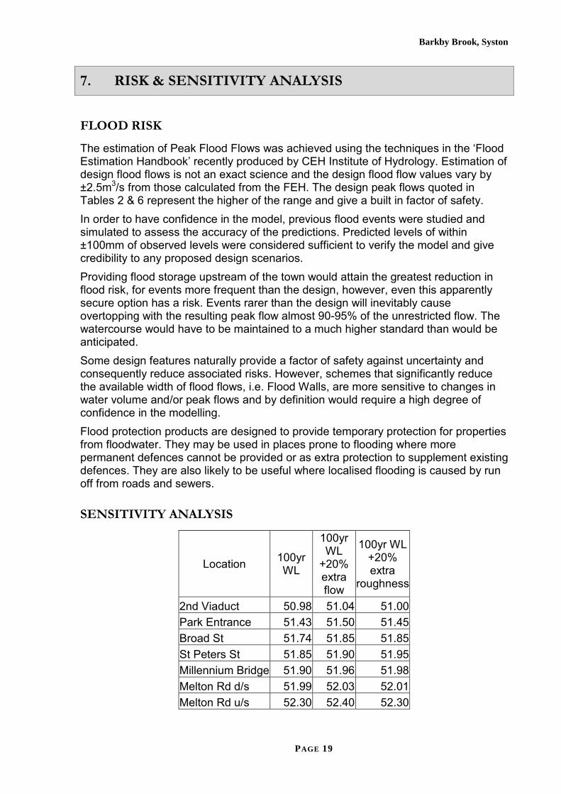
7. RISK & SENSITIVITY ANALYSIS
FLOOD RISK
The estimation of Peak Flood Flows was achieved using the techniques in the ‘Flood Estimation Handbook’ recently produced by CEH Institute of Hydrology. Estimation of design flood flows is not an exact science and the design flood flow values vary by ±2.5m3/s from those calculated from the FEH. The design peak flows quoted in Tables 2 & 6 represent the higher of the range and give a built in factor of safety. In order to have confidence in the model, previous flood events were studied and simulated to assess the accuracy of the predictions. Predicted levels of within ±100mm of observed levels were considered sufficient to verify the model and give credibility to any proposed design scenarios. Providing flood storage upstream of the town would attain the greatest reduction in flood risk, for events more frequent than the design, however, even this apparently secure option has a risk. Events rarer than the design will inevitably cause overtopping with the resulting peak flow almost 90-95% of the unrestricted flow. The watercourse would have to be maintained to a much higher standard than would be anticipated. Some design features naturally provide a factor of safety against uncertainty and consequently reduce associated risks. However, schemes that significantly reduce the available width of flood flows, i.e. Flood Walls, are more sensitive to changes in water volume and/or peak flows and by definition would require a high degree of confidence in the modelling. Flood protection products are designed to provide temporary protection for properties from floodwater. They may be used in places prone to flooding where more permanent defences cannot be provided or as extra protection to supplement existing defences. They are also likely to be useful where localised flooding is caused by run off from roads and sewers.
SENSITIVITY ANALYSIS
Location 100yr WL
100yr WL
+20% extra flow
100yr WL +20% extra
roughness
2nd Viaduct 50.98 51.04 51.00 Park Entrance 51.43 51.50 51.45 Broad St 51.74 51.85 51.85 St Peters St 51.85 51.90 51.95 Millennium Bridge 51.90 51.96 51.98 Melton Rd d/s 51.99 52.03 52.01 Melton Rd u/s 52.30 52.40 52.30
PAGE 19

Barkby Brook, Syston
Table 6- Hydraulic Modelling Results
Table 6 shows the increase in water level of testing the sensitivity of the model to variations in both the flow and roughness of the channel. The 20% increase in flow represents the anticipated change due to climate change whilst the 20% increase in roughness would represent 2years growth in a natural channel without maintenance.
PAGE 20
Barkby Brook, Syston
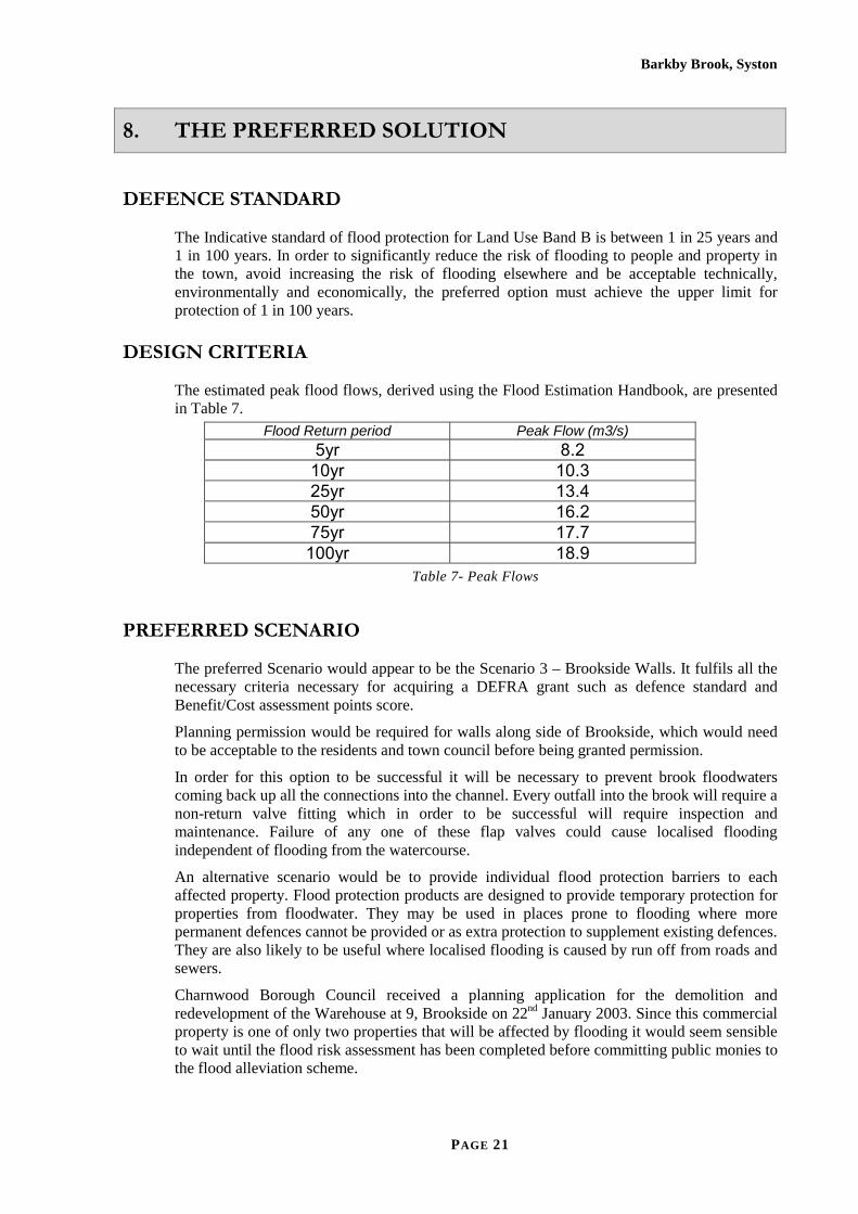
8. THE PREFERRED SOLUTION
DEFENCE STANDARD
The Indicative standard of flood protection for Land Use Band B is between 1 in 25 years and 1 in 100 years. In order to significantly reduce the risk of flooding to people and property in the town, avoid increasing the risk of flooding elsewhere and be acceptable technically, environmentally and economically, the preferred option must achieve the upper limit for protection of 1 in 100 years.
DESIGN CRITERIA
The estimated peak flood flows, derived using the Flood Estimation Handbook, are presented in Table 7.
Flood Return period Peak Flow (m3/s) 5yr 8.2
10yr 10.3 25yr 13.4 50yr 16.2 75yr 17.7
100yr 18.9 Table 7- Peak Flows
PREFERRED SCENARIO
The preferred Scenario would appear to be the Scenario 3 – Brookside Walls. It fulfils all the necessary criteria necessary for acquiring a DEFRA grant such as defence standard and Benefit/Cost assessment points score.
Planning permission would be required for walls along side of Brookside, which would need to be acceptable to the residents and town council before being granted permission.
In order for this option to be successful it will be necessary to prevent brook floodwaters coming back up all the connections into the channel. Every outfall into the brook will require a non-return valve fitting which in order to be successful will require inspection and maintenance. Failure of any one of these flap valves could cause localised flooding independent of flooding from the watercourse.
An alternative scenario would be to provide individual flood protection barriers to each affected property. Flood protection products are designed to provide temporary protection for properties from floodwater. They may be used in places prone to flooding where more permanent defences cannot be provided or as extra protection to supplement existing defences. They are also likely to be useful where localised flooding is caused by run off from roads and sewers.
Charnwood Borough Council received a planning application for the demolition and redevelopment of the Warehouse at 9, Brookside on 22nd January 2003. Since this commercial property is one of only two properties that will be affected by flooding it would seem sensible to wait until the flood risk assessment has been completed before committing public monies to the flood alleviation scheme.
PAGE 21

Barkby Brook, Syston
9. CONCLUSION & RECOMMENDATION
CONCLUSION
It is concluded that:-
1. Benefit/Cost analysis indicates the current maintenance and enforcement regime is extremely cost effective with significant hydraulic benefits and must be continued. If this regime is not continued at its present level the watercourse will deteriorate and performance will fall to a level similar to that which existed during the events in the early 1990’s.
2. The provision of storage upstream of Syston is not an economical solution. The Benefit/Cost analysis indicates that it would not attract DEFRA grant and consequently could not be recommended.
3. Expenditure of approximately £500,000 can be justified, using Benefit/Cost analysis, despite only protecting 2No commercial properties but eliminating out of bank flooding at Brookside for events less that 1 in 100yr. However, it is not recommended because: -
a. A planning application has been received for the redevelopment of the warehouse on Brookside, currently the major contribution to the Benefit/Cost assessment. The PPG25 flood risk assessment will eliminate the benefits associated with this existing property.
b. The operational risk of unknown outlets to the watercourse and/or blockages on existing outlets.
4. The remaining property ‘at-risk’, the Public House on Brookside, would not justify expenditure of £500,000. Provision of individual flood protection measures would be an alternative at a cost of between £2,500 and £5,000.
RECOMMENDATION
It is recommended that the existing maintenance and enforcement regime be continued as confirmed in Cabinet Minute 345 dated 10/04/03.
It is recommended that a contribution towards the provision of individual flood protection measures be offered to the owners of the public house at a maximum of £5,000.
PAGE 22
Barkby Brook, Syston
APPENDIX A-BENEFIT COST ASSESSMENT
Barkby Brook (Syston) Flood Alleviation Scheme Benefit Cost Assessment
PREAMBLE
The benefit cost assessment for Barkby Brook at Syston follows the Guidelines outlined in DEFRA supplementary note to Operating Authorities March 2003 “Revisions to Economic Appraisal procedures arising from new HM Treasury ‘Green Book’ ”. This takes account of the Government’s commitment to ‘Long Termism’ in project appraisal using a base test discount rate of 3.5% reducing to 3% and 2.5% during the course of the 100 year time horizon for most engineering projects (i.e. the length of the longest lived asset). The damage estimates are based on the most up-to-date depth damage data assembled in Flood Hazard Research Unit’s Multi- Coloured Manual (MCM) “ The benefits of Flood and Coastal Defences: Techniques and data for 2003”. However, it is now DEFRA instruction to cap the present value of any damages (PVd) calculated using MCM data should the PVd exceed the assumed market value of the property in question. Market Value is derived as follows:
• Residential property: land registry values of recent house sales as reported by third party proprietary web sites, for example www.proviser.com
• Commercial or Non Residential property (NRP): If precise valuations are not available then the rateable value (RV) per square metre for each bulk class (retail, factory, warehouse or office) for the local authority the flood scheme falls within is factored by the size of individual properties and the anticipated regional yield for that property. For benefit appraisals this is an adequate representation of Market Value as RV and rental value are closely related. Data on RV is extracted from Valuation Office Agency data as compiled in Office of Deputy Prime Minister’s “Commercial and Industrial Floor Space and rateable Value Statistics” November 2003. Yield percentages are derived from “Commercial property: A survey of statistical trends, March 2002”.
SCHEME OPTIONS
Two ‘engineering’ options are considered: • Do Minimum i.e. an effective annual programme to maintain clean
channel conditions throughout Syston to enable unrestricted flows • Walls along Brookside.
Details and costs for these options are to be found in the main report.
PAGE 23

Barkby Brook, Syston
These options are measured against a theoretical “Do Nothing” option i.e. no maintenance of the existing river regime. Although this is an unrealistic option it forms the baseline against which to measure the value of the other two options. The damage avoided by each of these options becomes the benefits of the option. It is assumed that under “Do Nothing” the channel will deteriorate over 10 years with Do Minimum losses in year 0 being linearly increased to the full Do Nothing value by year 9.
LIMITING ASSUMPTIONS
• Non residential damages based on national averages for type without site visit to check authenticity.
• Residential losses exclude: o Temporary Accommodation o Emergency services o Additional electricity consumption during clean-up
• No flooding occurs more frequently than 1 in 5 years • Residential property assumes the “ All residential mean values” from
MCM without reference to type and age of property • Capping value for residential property (postcode LE7) is taken as
£122,674 or mean of terraced and semi-detached property. • Capping value for NRP’s is as below:
Bulk Class Rateable Value
(£/sq.m) Yield (%)
Retail 78 8.1 Factory 26 9.2 Office 59 9.2 Warehouse 28 7.6 All Bulk Classes 36 7.6
Data is for Charnwood Borough Council (Rateable Values) and Midlands and Wales (Yields)
DO NOTHING DAMAGES
“Appraisal Spreadsheet” (see appendix), largely following DEFRA appraisal format, gives details of event damages, annual average damages and present value of damages for 5 return periods for which water surface data has been modelled for the Do Nothing scenario. In summary some 109 residential properties and 10 NRP’s will be affected by flooding during the 100 year event:
Properties Affected
Return Period (years)
Event damages (£)
2 5 109,957 5 10 752,888
60 25 3,008,104 93 50 4,330,604
119 100 5,726,699
PAGE 24
Barkby Brook, Syston
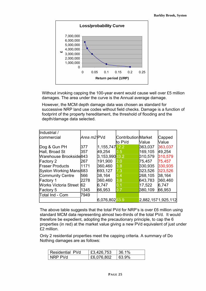
Loss/probability Curve
01,000,0002,000,0003,000,0004,000,0005,000,0006,000,0007,000,000
0 0.05 0.1 0.15 0.2 0.25
Return period (1/RP)
£
Without invoking capping the 100-year event would cause well over £5 million damages. The area under the curve is the Annual average damage. However, the MCM depth damage data was chosen as standard for successive NRP land use codes without field checks. Damage is a function of footprint of the property hereditament, the threshold of flooding and the depth/damage data selected.
Industrial / commercial Area m2 PVd Contribution Market Capped to PVd Value Value Dog & Gun PH 377 1,155,74712.2 363,037 363,037 Hall, Broad St 357 49,254 0.5 169,105 49,254 Warehouse Brookside 843 3,153,99033.2 310,579 310,579 Factory 2 267 191,900 2.0 75,457 75,457 Fraser Products 1171 360,460 3.8 330,935 330,935 Syston Working Mans 683 693,127 7.3 323,526 323,526 Community Centre 566 38,164 0.4 268,105 38,164 Factory 1 2278 360,460 3.8 643,783 360,460 Works Victoria Street 62 6,747 0.1 17,522 6,747 Factory 5 1345 66,953 0.7 380,109 66,953 Total Ind - Com 7949 6,076,80263.9 2,882,157 1,925,112
The above table suggests that the total PVd for NRP’s is over £6 million using standard MCM data representing almost two-thirds of the total PVd. It would therefore be expedient, adopting the precautionary principle, to cap the 6 properties (in red) at the market value giving a new PVd equivalent of just under £2 million. Only 2 residential properties meet the capping criteria. A summary of Do Nothing damages are as follows:
Residential PVd £3,426,753 36.1% NRP PVd £6,076,802 63.9%
PAGE 25

Barkby Brook, Syston
Total £9,503,555 100% Residential capped £3,413,811 63.9% NRP capped 1,925,112 36.1% Total £5,338,923 100% Mean AAD (capped) (TDR over 100 years)
£178,559
It is considered legitimate to cap the NRP’s as described and reverse the contribution of Residential to NRP to two-thirds to one third.
DO MINIMUM OPTION
Worksheet Do Minimum summarises the PVd assuming maintenance at £3,500 each year and £10,000 every tenth year is projected. Only 2 properties remain at risk from flooding (the Dog and Gun Public House and the Warehouse on Brookside). The AAD (after capping) is estimated at £22,529. Damages avoided are therefore the difference between the stream of annual average damages over 100 years assuming Do Nothing at year 9 and the stream of annual average damages under the Do Minimum scenario. This equates to a present value of benefits of £3.75 million.
BROOKSIDE WALLS OPTION
The Brookside Walls option will eliminate all flooding to property up to and including the 1 in 100 standard of protection (1% per year chance of flooding). The residual damages for this option have not been modelled but it is assumed that this residual equates to 5% of Do Nothing damages or £21,986.
SUMMARY OF SCHEME OPTION BENEFITS
The table below summarises the scheme option benefits. The highest Benefit Cost ratio (BCR) at over 27:1 is quite clearly the Do Minimum maintenance only option. However even though the Brookside Walls option (with continued maintenance at the same level of the Do Minimum option) will only protect a further 2 properties with a BCR of almost 7.5:1 the additional expenditure is worth while under the DEFRA PAG3 decision rule as the Incremental Benefit Cost ratio is >1. This may be explained by the fact that the Dog and Gun and the Warehouse are large structures with high residual damages under the Do Minimum scenario. It might be suggested that local flood proofing of the two properties might be a cheaper alternative to the proposed Brookside wall. However, the wall would have the added advantage of keeping all floodwater in-bank during all flood events up to and including the 100 year event, keeping all road and pedestrian accesses free from flooding.
PAGE 26

Barkby Brook, Syston
Project Summary Sheet Client/Authority Prepared (date) 12/02/04 Charnwood Borough Council Printed 16/02/04 Project name Prepared by jc Barkby Brook, Syston Checked by dw Project reference Checked date 12/02/04 Base date for estimates (year 0) 1st Qtr 2004 Scaling factor (e.g. £m, £k, £) £ (used for all costs, losses and benefits) Principle land use band B (A to E) Discount rate 3.5% Costs and benefits of options Costs and benefits £ Option 1 Option 2 Option 3 PV costs PVc - 135,836 585,836 PV damage PVd 4,397,169 644,855 21,986 PV damage avoided 3,752,314 4,375,183 PV assets Pva PV asset protection benefits - - Total PV benefits PVb 3,752,314 4,375,183 Net Present Value NPV 3,616,478 3,789,347 Average benefit/cost ratio 27.62 7.47 Incremental benefit/cost ratio 1.38 Highest b/c - Brief description of options: Option 1 Do Nothing Option 2 Maintain Only Option 3 Brookside Walls Notes: 1) Benefits will normally be expressed either in terms of damage avoided or asset values protected. Care is needed to avoid double counting
2) PV damage avoided is calculated as PV damage (No Project) - PV damage (Option) PV asset protection benefits are calculated as PVa (Option) - PVa (No Project) PV benefits calculated as PV damage avoided + PV asset protection benefits 3) Incremental benefit/cost ratio is calculated as: (PVb(current option) - PVb(previous option))/(PVc(current option) - PVc(previous option))
PRIORITY SCORING
Economics (7.47:1 BCR) 13.93 People (109 households)
8.00 (no high risk and neutral social deprivation)
Environment 0.00 (no listed buildings and no other environmental gains)
Total score
21.93
PAGE 27

Barkby Brook, Syston
John B. Chatterton Birmingham 16th February 2004
PAGE 28

Barkby Brook, Syston
APPENDIX B-Cabinet Report- 10 APRIL 2003
PART 1 (RESERVED TO COUNCIL) CABINET – 10 April 2003
Joint report of the Head of Legal and Democratic Services and the Head of
Technical Services
ITEM 4 FLOODING IN THE BOROUGH ORDINARY WATERCOURSE MAINTENANCE AND
MANAGEMENT REVIEWPurpose of the Report 1. To advise the Cabinet of the progress on the review of maintenance work
carried out by the Council on ordinary watercourses in the Borough and the outcome of the enforcement action.
2. To seek approval of the suggested revised maintenance policy on ordinary watercourses in the Borough, as detailed in this report.
3. To seek approval for the Head of Legal and Democratic Services to complete adoption agreements for balancing facilities by the Council as part of public open spaces as detailed in this report and Appendix A, “Flood Risk Management and Adoption of Balancing Facilities by the Borough Council”.
Recommendation(s) 1. That the Cabinet note the contents of this report, together with the item on this
agenda on the progress of the Department for Environment, Food and Rural Affairs (DEFRA) Funding Review.
2. That the Head of Technical Services be authorised to pursue the suggested revised maintenance policy on ordinary watercourses in the Borough as detailed in this report.
3. That the Head of Legal and Democratic Services be authorised to enter into adoption agreements for balancing facilities by the Council in consultation with the Head of Technical Services if balancing facilities are not to be adopted as part of a Section 106 Agreement under the Planning Act, and that Part 3 (Land/Property (17)) of the Constitution be amended to read “Adoption for a nominal consideration of recreational/amenity/water balancing areas on new developments subject to consultation with the Head of Cultural Services and the Head of Technical Services.
Reason(s) 1. For information. 2. To ensure an equitable and economical local response for flood defence in
respect of ordinary watercourses in the Borough. 3. To ensure the economical and sustainable future maintenance of balancing
facilities by the Council as part of public open spaces.
PAGE 29

Barkby Brook, Syston
Policy Context Strategic Aims - A safe and healthy Borough Key Objective - Minimise the impact of flooding by ordinary
watercourses on properties and individuals in the Borough
Background Since the Charnwood Land Drainage Byelaws were promulgated on 4 April 2000 the flood risk and the need to gain entry onto private land under the Land Drainage Act 1991 (the Act) has been reviewed. Historically some maintenance work was undertaken where the Council was not the riparian owner and without service of an appropriate notice under the Act. The Council has a power, but not a duty, under the Act to maintain ordinary watercourses, but it can serve notice to execute maintenance. The Cabinet should also note the DEFRA High Level Targets require the Council to undertake inspection of all critical watercourses but the Targets do not require the Council to act where problems are identified. At the present time Council staff are carrying out these inspections and when an appropriate flood risk is identified enforcement action is commenced with the riparian owner. A series of enforcement letters have been developed between the Head of Legal and Democratic Services and the Head of Technical Services, and in year 2002/3 riparian owners responded positively to over 80% of the requests to undertake their obligations, without resorting to the Council entering the land to maintain the watercourse. It is therefore suggested the enforcement and inspection regime that has been developed is continued. Review of Maintenance Work Since the developed enforcement and inspection regime has existed, the Works Division has been instructed to restrict maintenance to the following: - All flood defence assets installed and or adopted by the Borough Council or its preceding operating authorities under the Act or preceding acts. All watercourses where the council is riparian owner or through conveyance of land the Council retained the duty. All watercourses or flood defence assets where an operating authority such as the County Council or the Environment Agency employs the Council at cost. Watercourses where a Town or Parish Council, within the Borough, has public a open space or an amenity area next to a watercourse and is therefore a riparian owner similar to the Borough Council in Loughborough. Examples are the watercourse in the Glenmore Park at Shepshed or the Fishpool Brook in Barrow-upon-Soar. Watercourses within the Borough, where there are no clearly defined riparian owners and the Borough Council has historically maintained the watercourse. Examples are the Rearsby Brook and Sileby Brook in the village centres, Brookside, Syston and Brook Street, Wymeswold, but in does not follow there is a responsibility for supporting the public highway or other infrastructure assets. It is suggested that the restricted maintenance regime is continued.
PAGE 30

Barkby Brook, Syston
Adoption of Balancing Facilities Historically the Borough Council has adopted balancing facilities within public open space by virtue of Section 106 Agreement under the Planning Act and in an ad hoc way through adoption of public open space. Such adoptions occurred without clear conditions and without sufficient recovery of the Council’s costs. It is therefore suggested that the future adoption of balancing facilities should be governed by the following criteria: -
• The requirements of the attached Flood Risk Management and Adoption of Balancing Facilities by the Borough Council document (Appendix 1) must be followed by the developer offering the balancing facility for adoption.
• The land must be formally adopted by either a Section 106 Agreement or a separate authorised adoption agreement.
• The Head of Legal and Democratic Services act on the Borough Council’s behalf in drawing up such adoption agreements.
In order to empower the Head of Legal and Democratic Services to carry out these duties it will be necessary to amend Part 3 of the Constitution accordingly.
Department for Environment, Food and Rural Affairs (DEFRA) Funding Review It is suggested that the Cabinet may need to reconsider enforcement and maintenance issues further, when the information regarding the new funding mechanisms is available. Scrutiny Committee(s): Health and Public Protection Key Decision: No Background Papers: Item Date Description From File
Ref. 1 The Land Drainage Act 1991 2 Various Land Drainage Section Maintenance
files Various
3 06/04/00
Charnwood Land Drainage Byelaws 2000
4 13/06/02
Report to Cabinet - Flooding in the Borough – Scheme of Delegation Minute 21
CBC
5 12/03/03
Written ministerial statement Announcement of the conclusions of the flood and coastal defence funding review
Elliot Morley
640.1
Officer(s) to Contact: Peter Rook (01509) 634695 [email protected]
Norman Perkins (01509) 634681 [email protected] David Bird (01509) 634616
PAGE 31

Barkby Brook, Syston
APPENDIX C-Cabinet Minute- 10 APRIL 2003
C A B I N E T 10TH APRIL 2003
PRESENT: The Leader (Councillor Shields) The Deputy Leaders (Councillors Jones and Singleton) Councillors Anthony, Barber, Bush, Hunt and Newton APOLOGY: Councillor Kershaw
343. DISCLOSURES OF PERSONAL INTEREST No disclosures of personal interest were made.
344. MINUTES The minutes of the meeting of the Cabinet held on 27th March 2003 were confirmed and signed.
PART 1 (RESERVED TO COUNCIL)
345. FLOODING IN THE BOROUGH - ORDINARY WATERCOURSE MAINTENANCE AND MANAGEMENT REVIEW A report of the Head of Legal and Democratic Services and the Head of Technical Services:
(vi) on the progress of the review of maintenance work carried out by the
Council on ordinary watercourses in the Borough and the outcome of the enforcement action;
(vii) seeking approval to the suggested revised maintenance policy on ordinary
watercourses in the Borough, as set out in the report;
(viii) seeking approval to the Head of Legal and Democratic Services completing adoption agreements for balancing facilities by the Council as part of public open spaces as detailed in the report;
was submitted (copy filed with these minutes 267/02). RESOLVED
PAGE 33
Barkby Brook, Syston
4. that the Head of Technical Services be authorised to pursue the
suggested revised maintenance policy on ordinary watercourses in the Borough as set out in the Appendix to the report;
5. that the Head of Legal and Democratic Services be authorised to enter
into adoption agreements for balancing facilities by the Council in consultation with the Head of Technical Services if balancing facilities are not to be adopted as part of a Section 106 Agreement under the Planning Act, and Part 3 (Land/Property (17)) of the Constitution be amended to read:
“Adoption for a nominal consideration of recreational/amenity/water balancing areas on new developments subject to consultation with the Head of Cultural and Leisure Services and the Head of Technical Services.”
REASONS 4. To ensure an equitable and economical local response for flood defence in
respect of ordinary watercourses in the Borough. 5. To ensure the economical and sustainable future maintenance of balancing
facilities by the Council as part of public open spaces.
PAGE 34