Program for Postfire Monitoring and Control in the Forest ... · Program for Postfire Monitoring...
10
71 Proceedings of the Second International Symposium on Fire Economics, Planning, and Policy: A Global View Program for Postfire Monitoring and Control in the Forest Ecosystems of Moratalla (Murcia, Spain) 1 Juan de Dios Cabezas, 2 Remigio Masia 2 Abstract The complexity of factors involved in a forest fire, such as the fire regime, the time of year in which the fire occurs in relation to the phase of the yearly development of the existing vegetation, the type of vegetation, its ability to adapt to fire conditions, its germinative characteristics, the post-fire weather conditions and even the microclimatic effects resulting from differences in aspect, makes it impossible to predict with absolute certainty the response ability of vegetation after a fire has occurred. Monitoring the post-fire evolution of forest systems affected by large fires helps fire management specialists to establish the most appropriate action for restoring the burned areas. The Forest Fires Monitoring Program for the Murcia Region, presented herein, has implemented the study of the effects of two large fires on the region’s forest ecosystems, namely Calasparra in 1991, which affected 800 ha, and Moratella in 1994, where 24,000 ha were affected, 65% of which were wooded area. Although the evolution of forest systems depends a great deal on the ecological conditions and the type of management implemented, the structure and constitution of the existing new population—that is, the regeneration—is one of the most decisive aspects. Using territorial information regarding land use, vegetation, relief, edaphology, etc., and basing data primarily on the 1999 National Forestry Inventory conducted in the Region of Murcia, the Program divides the territory into zones according to their current state of regeneration and examines the main indicators of the state of these areas. With the results obtained, the process can be characterized appropriately and used to plan measures aimed at restoration, conservation, and improvement of the vegetation cover, as well as other important measures to diminish erosion, such as stabilizing slopes and correcting torrential flow through hydraulic engineering, and protective measures against the risk of forest fires and the phytosanitary damages that inevitably result from a fire. Introduction In the Region of Murcia, forest fires do not occur with the same frequency as in other areas of the Mediterranean Basin. During the period 1992 – 2001, although 1,393 fires affected almost 28,000 ha, 24,817 ha corresponded to the Moratella fire of 1994. Nevertheless, the weather conditions of scarce precipitation and high temperatures, and more importantly, certain structural conditions such as the desertion of the rural environment and the lack of forest management in the majority 1 An abbreviated version of this paper was presented at the second international symposium on fire economics, planning, and policy: a global view, 19-22 April, 2004, Córdoba, Spain. 2 Consejería de Agricultura, Agua y Medio Ambiente. Dirección General de Medio Natural. Catedrático Eugenio Úbeda, 3. Murcia. CP 30008 (Ministry for Agriculture, Water and the Environment. General Direction for the Natural Environment).
Transcript of Program for Postfire Monitoring and Control in the Forest ... · Program for Postfire Monitoring...

Proceedings of the Second International Symposium on Fire Economics, Planning, and Policy: A Global View
71
Proceedings of the Second International Symposium on Fire Economics, Planning, and Policy: A Global View
Program for Postfire Monitoring and Control in the Forest Ecosystems of Moratalla (Murcia, Spain)1
Juan de Dios Cabezas,2 Remigio Masia 2
AbstractThe complexity of factors involved in a forest fire, such as the fire regime, the time of year in which the fire occurs in relation to the phase of the yearly development of the existingvegetation, the type of vegetation, its ability to adapt to fire conditions, its germinativecharacteristics, the post-fire weather conditions and even the microclimatic effects resultingfrom differences in aspect, makes it impossible to predict with absolute certainty the responseability of vegetation after a fire has occurred.
Monitoring the post-fire evolution of forest systems affected by large fires helps firemanagement specialists to establish the most appropriate action for restoring the burned areas.
The Forest Fires Monitoring Program for the Murcia Region, presented herein, hasimplemented the study of the effects of two large fires on the region’s forest ecosystems,namely Calasparra in 1991, which affected 800 ha, and Moratella in 1994, where 24,000 hawere affected, 65% of which were wooded area.
Although the evolution of forest systems depends a great deal on the ecologicalconditions and the type of management implemented, the structure and constitution of theexisting new population—that is, the regeneration—is one of the most decisive aspects. Usingterritorial information regarding land use, vegetation, relief, edaphology, etc., and basing dataprimarily on the 1999 National Forestry Inventory conducted in the Region of Murcia, theProgram divides the territory into zones according to their current state of regeneration andexamines the main indicators of the state of these areas.
With the results obtained, the process can be characterized appropriately and used to plan measures aimed at restoration, conservation, and improvement of the vegetation cover, aswell as other important measures to diminish erosion, such as stabilizing slopes and correctingtorrential flow through hydraulic engineering, and protective measures against the risk of forest fires and the phytosanitary damages that inevitably result from a fire.
IntroductionIn the Region of Murcia, forest fires do not occur with the same frequency as in other areas of the Mediterranean Basin. During the period 1992 – 2001, although 1,393fires affected almost 28,000 ha, 24,817 ha corresponded to the Moratella fire of 1994.
Nevertheless, the weather conditions of scarce precipitation and high temperatures, and more importantly, certain structural conditions such as the desertion of the rural environment and the lack of forest management in the majority
1 An abbreviated version of this paper was presented at the second international symposium on fire economics, planning, and policy: a global view, 19-22 April, 2004, Córdoba, Spain.2 Consejería de Agricultura, Agua y Medio Ambiente. Dirección General de Medio Natural. CatedráticoEugenio Úbeda, 3. Murcia. CP 30008 (Ministry for Agriculture, Water and the Environment. General Direction for the Natural Environment).

72
Proceedings of the Second International Symposium on Fire Economics, Planning, and Policy: A Global ViewGENERAL TECHNICAL REPORT PSW-GTR-208 Proceedings of the Second International Symposium on Fire Economics, Planning, and Policy: A Global View
Session 4—Post-Fire Monitoring and Control in Forest Ecosystem—Cabezas, Masia
of private forest areas, which leads to the accumulation of forest fuels, all create theideal setting for forest fires.
The gravity of the situation calls for the implementation of an integrated forestpolicy that recognizes the permanent risk of fires and provides for a series of measures aimed at mitigating the problem. This idea is established in the Spanish Forest Strategy and in the Spanish National Forestry Plan, which considers the defence and protection against fires to be a priority for future actions.
Along the same lines, the Region of Murcia Forest Strategy expresses the need to develop Fire Protection Management in order to counter the high degree of damage caused by fires. Such management would involve different levels of planningaccording to the marked objectives.
Among other protective measures, the Region of Murcia Forest Strategyincorporates fire prevention, alertness and suppression, and the promotion of researchand training to improve knowledge of the problem. Special importance and priority is given to the need to develop a Post Forest Fire Monitoring Plan, which throughindividualized, continual and systematic study of fires would make it possible todefine a post-fire action plan establishing regulated procedures for control and restoration of burned areas.
Analysing and reviewing the diverse factors influencing the state of thevegetation cover after fire damage and verifying the efficiency of the measures takenfor the restoration thereof will provide data as to how an ecosystem responds to the effects of a fire. This will in turn help to identify the necessary measures to guaranteea complete restoration of the damaged vegetation cover.
Development of the Plan The area of study is located in northwestern Murcia, mainly in the Northwest Region and the Cieza municipality (figure 1).
Figure 1—Geographic location of the area of study.
The geographic area in question measures 28,137 ha, of which 91% is forest land where tree systems in regeneration clearly dominate the prevailing brushformations. The most extensive tree formations are the Pinus halepensis forests in
USDA Forest Service Gen. Tech. Rep. PSW-GTR-xxx. xxxx.

Proceedings of the Second International Symposium on Fire Economics, Planning, and Policy: A Global View
73
Proceedings of the Second International Symposium on Fire Economics, Planning, and Policy: A Global View
Session 4—Post-Fire Monitoring and Control in Forest Ecosystem—Cabezas, Masia
regenerated state, as oak trees are scarcer and not in pure form, but rather mixedtogether with pine trees (figure 2).
Figure 2—Pinus halepensis in regenerated state.
It is important to note the valuable natural wealth of the area of study, which ishome to diverse ecosystems of important species of flora and fauna. Many of these ecosystems have been granted special protection, such as the Special ProtectionAreas (S.P.A.) under the Bird Directive: Sierra de Moratalla and Sierra del Molino, Quipar Reservoir, and Cagitán Plains; the Sites of Community Importance (S.C.I.):Sierra de la Muela, Sierras and Vega Alta del Segura and Benamor River, and a Protected Natural Area: Sotos y Bosques de Ribera de Cañaverosa Natural Reserve.
After the fires, the vegetation cover was restored with aleppo pine in specific areas and silviculture treatments were carried out on smaller areas, namely earthing-up (ridging), felling and thinning.
Roads were also improved and woodland hydrological structures were restored.This latter measure mainly involved constructing dykes to prevent the possible negative effects of soil loss, erosion, desertification, etc., which are foreseeable in the short and medium terms (figure 3). In addition, treatments to combat the pine processionary caterpillar were carried out in the Moratalla Municipality.
Figure 3—Hydrological works and road improvement in the area of study.
Using territorial information regarding land use, vegetation, geomorphology,edaphology, etc., and basing data primarily on the Third National Forestry Inventory
USDA Forest Service Gen. Tech. Rep. PSW-GTR-xxx. xxxx.
74
Proceedings of the Second International Symposium on Fire Economics, Planning, and Policy: A Global ViewGENERAL TECHNICAL REPORT PSW-GTR-208 Proceedings of the Second International Symposium on Fire Economics, Planning, and Policy: A Global View
Session 4—Post-Fire Monitoring and Control in Forest Ecosystem—Cabezas, Masia
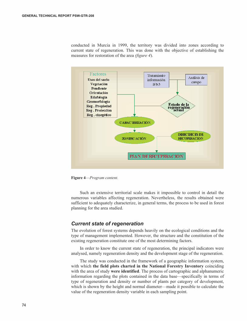
conducted in Murcia in 1999, the territory was divided into zones according to current state of regeneration. This was done with the objective of establishing the measures for restoration of the area (figure 4).
Figure 4—Program content.
Such an extensive territorial scale makes it impossible to control in detail thenumerous variables affecting regeneration. Nevertheless, the results obtained weresufficient to adequately characterize, in general terms, the process to be used in forest planning for the area studied.
Current state of regenerationThe evolution of forest systems depends heavily on the ecological conditions and thetype of management implemented. However, the structure and the constitution of the existing regeneration constitute one of the most determining factors.
In order to know the current state of regeneration, the principal indicators were analysed, namely regeneration density and the development stage of the regeneration.
The study was conducted in the framework of a geographic information system,with which the field plots charted in the National Forestry Inventory coincidingwith the area of study were identified. The process of cartographic and alphanumericinformation regarding the plots contained in the data base—specifically in terms oftype of regeneration and density or number of plants per category of development,which is shown by the height and normal diameter—made it possible to calculate thevalue of the regeneration density variable in each sampling point.
USDA Forest Service Gen. Tech. Rep. PSW-GTR-xxx. xxxx.
Proceedings of the Second International Symposium on Fire Economics, Planning, and Policy: A Global View
75
Proceedings of the Second International Symposium on Fire Economics, Planning, and Policy: A Global View
Session 4—Post-Fire Monitoring and Control in Forest Ecosystem—Cabezas, Masia
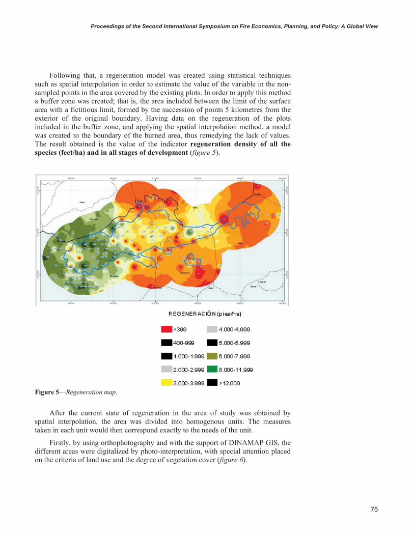
Following that, a regeneration model was created using statistical techniquessuch as spatial interpolation in order to estimate the value of the variable in the non-sampled points in the area covered by the existing plots. In order to apply this methoda buffer zone was created; that is, the area included between the limit of the surfacearea with a fictitious limit, formed by the succession of points 5 kilometres from theexterior of the original boundary. Having data on the regeneration of the plotsincluded in the buffer zone, and applying the spatial interpolation method, a modelwas created to the boundary of the burned area, thus remedying the lack of values.The result obtained is the value of the indicator regeneration density of all the species (feet/ha) and in all stages of development (figure 5).
Figure 5—Regeneration map.
After the current state of regeneration in the area of study was obtained byspatial interpolation, the area was divided into homogenous units. The measurestaken in each unit would then correspond exactly to the needs of the unit.
Firstly, by using orthophotography and with the support of DINAMAP GIS, the different areas were digitalized by photo-interpretation, with special attention placedon the criteria of land use and the degree of vegetation cover (figure 6).
USDA Forest Service Gen. Tech. Rep. PSW-GTR-xxx. xxxx.

76
Proceedings of the Second International Symposium on Fire Economics, Planning, and Policy: A Global ViewGENERAL TECHNICAL REPORT PSW-GTR-208 Proceedings of the Second International Symposium on Fire Economics, Planning, and Policy: A Global View
Session 4—Post-Fire Monitoring and Control in Forest Ecosystem—Cabezas, Masia
Figure 6—Field work: Division of the territory in homogenous units of regeneration(DINAMAP GIS).
Subsequently, in the field work stage, visits were made to the different units in order to verify their homogeneity in terms of existing regeneration density. In caseswhere the density was not homogenous in the unit, new units were identified andzoned in the field. The regeneration density of the dominant species (Pinushalepensis) was estimated, and a nine-level classification was established according to the following values (table 1).
Table 1—Regeneration density. Field data. Levels Number of ft/ha
1 <4002 400-1,0003 1,000-2,0004 2,000-4,0005 4,000-6,0006 6,000-8,0007 8,000-10,0008 10,000-12,0009 >12,000
The results obtained made it possible to identify 92 territorial units that were homogeneous in terms of regeneration, as reflected in the following diagram (figure7):
USDA Forest Service Gen. Tech. Rep. PSW-GTR-xxx. xxxx.

Proceedings of the Second International Symposium on Fire Economics, Planning, and Policy: A Global View
77
Proceedings of the Second International Symposium on Fire Economics, Planning, and Policy: A Global View
Session 4—Post-Fire Monitoring and Control in Forest Ecosystem—Cabezas, Masia
Figure 7—Zoning of the area according to regeneration level.
Once the units of homogenous regeneration were established, the specific characteristics of each were examined in order to facilitate the structuring of the measurements to be taken.
Foundations and guidelines for recovery The recovery of the vegetation cover sometimes occurs naturally with no humanintervention, at least when the intensity of the fire is moderate or low or when the existing vegetation species have fire adaptation mechanisms. This is the case forPinus halepensis, with a high percentage of serotinus seeds whose dormancy is broken by the high temperatures of a fire.
When the natural regeneration process is underway and no measures have been taken immediately following the fire, the best solution is to take no actionwhatsoever, given that movement of machinery could damage budding vegetation.
Nevertheless, human intervention is indeed necessary in the majority of cases,either to promote regeneration through silvicultural measures improving the crop, or through restoration measures when situations of soil loss, erosion, etc., are foreseeable in the short or medium-term.
Once the units were categorized as per their regeneration state, the measuresnecessary for restoring the forest dynamism were planned.
The actions proposed for the area of study were aimed at restoration, conservation and improvement of the vegetation cover. In addition, other importantsteps were planned to reduce the effects of erosion, such as stabilization of slopes and correction of torrential flows through hydraulic engineering.
USDA Forest Service Gen. Tech. Rep. PSW-GTR-xxx. xxxx.

78
Proceedings of the Second International Symposium on Fire Economics, Planning, and Policy: A Global ViewGENERAL TECHNICAL REPORT PSW-GTR-208 Proceedings of the Second International Symposium on Fire Economics, Planning, and Policy: A Global View
Session 4—Post-Fire Monitoring and Control in Forest Ecosystem—Cabezas, Masia
Protecting the head of basins, mainly in areas of high erosion potential, is a priority when a fire has wiped out the vegetation cover of an area.
Likewise, as laid out in the regional Forestry Strategy, special attention must be paid to the restoration and conservation of riverside systems due to their importantrole in preventing erosion, their natural regulation of flood flows, their contributionto water quality improvement, and the diversity and wealth contained in their ecotones.
Finally, a series of measures were carried out to help the woodland overcomeeffects of the forest fires and the phytosanitary damages that are inevitably producedafter a fire.
Restoration was planned bearing in mind the aim of achieving a stable andpermanent tree population in balance with the environmental conditions. This general objective does not exclude the maintenance of less mature vegetation when the ecological or floral value of this vegetation is worth conserving, or when the tree and shrub population is incompatible with the natural site conditions, as is the case with esparto grass areas.
In light of the protective character of these repopulations, they were planned in line with fire protection criteria. In that regard, the density of the repopulation was conceived in such as way as to be coherent with the design of firebreaks in areas nearinfrastructures such as trails, roads, etc.
The measures proposed for restoration of the area were structured in twoseparate categories: firstly, biological measures, which integrate all the actions aimed at restoration, conservation, and improvement of the vegetation cover, as wellas actions to control the phytosanitary damages produced by the fire. Secondly, a series of supplementary measures were developed to prevent erosion and the riskcaused by forest fires.
In order to define the biological measures for the area of study, the units zoned during the fieldwork stage were grouped in a preliminary classification, eliminatingthose areas where no measures were to be taken (such as crop areas, non-productive lands, and esparto grass areas). The rest of the land was consideredpossible areas for implementing measures. For these latter areas, a study was madeof the influence of ecological factors such as current state of regeneration, slope,aspect, altitude, edaphology, rainfall, etc.
In order to establish the units for the different measures to be taken, the mostdetermining factors are considered: the current state of regeneration, altitude and slope of the land, given that as was observed in the field, the regeneration modelreflects the influence of aspect (shaded areas had higher regenerated density) and water availability (more intense regeneration occurs in areas with higher precipitation and water flow accumulation). In addition, in the event the introduction of species isa possibility, the altitude determines the species that can be introduced. Lastly, slope is a determining factor when deciding whether or not mechanized labour will be used for preparing the land. With respect to edaphology, it was demonstrated through the field work that, in general, soils are not determining factors in the regeneration level, except for those with special characteristics and highly localized distribution.
Once it was determined which measures would be carried out on which plots ofland, and in order to determine the surface area marked for restoration, the land was organized according to regeneration development and density. Specifically, the
USDA Forest Service Gen. Tech. Rep. PSW-GTR-xxx. xxxx.

Proceedings of the Second International Symposium on Fire Economics, Planning, and Policy: A Global View
79
Proceedings of the Second International Symposium on Fire Economics, Planning, and Policy: A Global View
Session 4—Post-Fire Monitoring and Control in Forest Ecosystem—Cabezas, Masia
superficial distribution of the regenerated density was considered in each plot of land for each of the categories (table 2).
The measures proposed are as follows: Table 2– Measures according to the category and density of the regeneration.
Measures Number of ft/ha1 Restoration of the vegetation cover in areas with density of 0-400 feet/ha
and regeneration category 12 Restoration of the vegetation cover and earthing-up (ridging) in areas with
density of 0-400 feet/ha and regeneration categories 2, 3 and 43 Restoration of the vegetation cover and earthing-up (ridging) in areas with
density of 400-1,000 ft/ha and regeneration category 1 4 Restoration of the vegetation cover and earthing-up (ridging) in areas with
density of 400-1,000 ft/ha and regeneration categories 2, 3, and 4 5 Support for regeneration in areas with density of 1,000-2,000 ft/ha and
regeneration category 1 6 Earthing-up (ridging) in the regeneration of aleppo pine in areas with
density of 1,000-2,000 ft/ha and regeneration category 2 7 Clearance and earthing-up (ridging) in areas of 1,000-2,000 ft/ha and
regeneration category 3 8 Clearance and earthing-up (ridging) in areas of 1,000-2,000 ft/ha and
regeneration category 4 9 Silvicultural treatments such as thinning and felling, as well as clearing in
areas with density greater than 2,000 ft/ha and regeneration categories 3and 4
10 Phytosanitary treatments: defoliators11 Phytosanitary treatments: wood borers
For those areas with scarce regeneration, biological measures were planned,such as efforts to restore the vegetation cover along with earthing-up, clearing andsupport for regeneration. The total surface area for such measures was 16,545 ha, 23% of which is public woodland.
In those areas with excessive regeneration density, certain silvicultural treatments such as thinning and felling were proposed to encourage the development of the existing regeneration. This was planned for an area greater than 3,200 ha.
In addition, to counteract the weakening of the forest system that occurs after afire, short and medium-term treatments were planned both for defoliators and woodborers over a total area of 24,512 ha.
In order to guarantee the complete restoration of the ecosystems affected, aninvestment of 25,883,956 € was deemed necessary. The majority of this figure(25,130,055 €) was earmarked for biological measures, with the remaining portionallocated for the instrumental measures planned, specifically the preparation of foresthydrological restoration plans and the planning of forest fire protection measures.
BibliographyBrugarolas Molina, Carlos. 2002. Repoblación forestal. Comunidad Autónoma de la
Región de Murcia. Revista Montes nº69; 78-82.
Martínez Fernández, Faustino. 2002. Repoblación forestal. Nuevas experiencias. RevistaMontes nº69; 83-85.
USDA Forest Service Gen. Tech. Rep. PSW-GTR-xxx. xxxx.

80
Proceedings of the Second International Symposium on Fire Economics, Planning, and Policy: A Global ViewGENERAL TECHNICAL REPORT PSW-GTR-208 Proceedings of the Second International Symposium on Fire Economics, Planning, and Policy: A Global View
Session 4—Post-Fire Monitoring and Control in Forest Ecosystem—Cabezas, Masia
Ministerio de Medio Ambiente. Segundo Inventario Forestal Nacional. Región de Murcia.1991.
Ministerio de Medio Ambiente. Tercer Inventario Forestal Nacional. Región de Murcia. 2003.
Páez Blázquez, Manuel; Cabezas Cerezo, Juan de Dios; González Rincón, Alfredo. 1999.Selvicultura preventiva contra incendios forestales. Revista Foresta, Asociación y Colegio Oficial de Ingenieros Técnicos Forestales; 114-119.
Vélez Muñoz, Ricardo. 2000. La defensa contra incendios forestales. Fundamentos yexperiencias. Capítulo 4: Efectos del fuego en los ecosistemas forestales. Mc Graw Hill.
USDA Forest Service Gen. Tech. Rep. PSW-GTR-xxx. xxxx.