Processing MODIS-Aqua satellite ocean colour data using SeaDAS ...

© Crown copyright Met Office
Processing and Use of Direct Broadcast Data at the Met Office Nigel Atkinson (Met Office, UK)
CSPP/IMAPP Users Group meeting – 21st May 2013
© Crown copyright Met Office
Contents
• Met Office capabilities for direct readout processing
• Satellites and software packages
• Developments in VIIRS imagery
• Processing of NPP sounder data
• Example of the use of CSPP for anomaly investigation in ATMS
• Summary
© Crown copyright Met Office
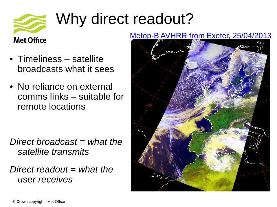
Why direct readout?
• Timeliness – satellite broadcasts what it sees
• No reliance on external comms links – suitable for remote locations
Direct broadcast = what the satellite transmits
Direct readout = what the user receives
Metop-B AVHRR from Exeter, 25/04/2013
© Crown copyright Met Office
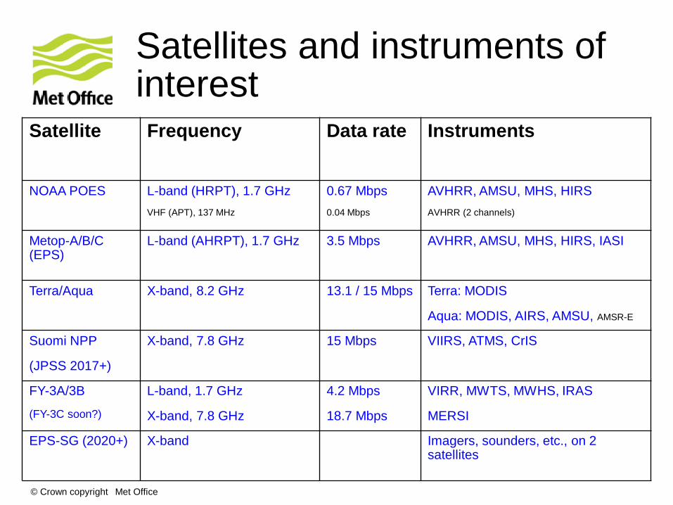
Satellites and instruments of interest
Satellite Frequency Data rate
Instruments
NOAA POES L-band (HRPT), 1.7 GHz VHF (APT), 137 MHz
0.67 Mbps 0.04 Mbps
AVHRR, AMSU, MHS, HIRS AVHRR (2 channels)
Metop-A/B/C (EPS)
L-band (AHRPT), 1.7 GHz 3.5 Mbps AVHRR, AMSU, MHS, HIRS, IASI
Terra/Aqua X-band, 8.2 GHz 13.1 / 15 Mbps Terra: MODIS
Aqua: MODIS, AIRS, AMSU, AMSR-E
Suomi NPP
(JPSS 2017+)
X-band, 7.8 GHz
15 Mbps VIIRS, ATMS, CrIS
FY-3A/3B
(FY-3C soon?)
L-band, 1.7 GHz
X-band, 7.8 GHz
4.2 Mbps
18.7 Mbps
VIRR, MWTS, MWHS, IRAS
MERSI
EPS-SG (2020+) X-band Imagers, sounders, etc., on 2 satellites
© Crown copyright Met Office
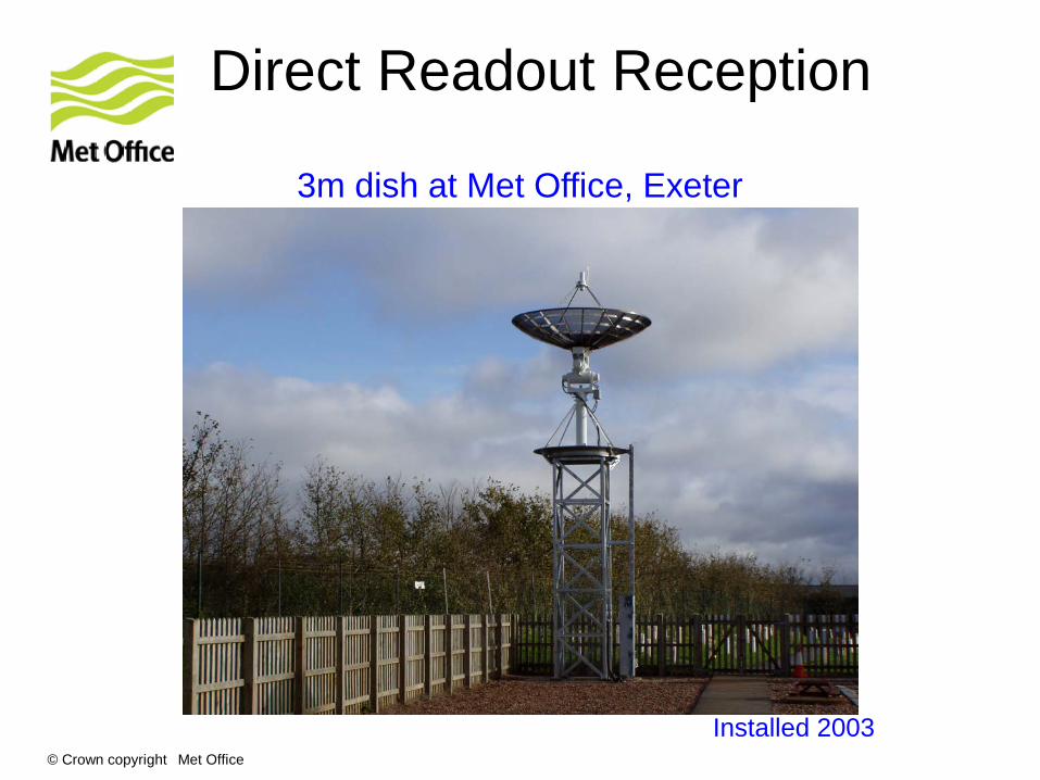
Direct Readout Reception
3m dish at Met Office, Exeter
Installed 2003
© Crown copyright Met Office
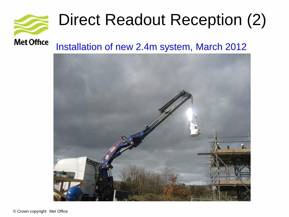
Direct Readout Reception (2) Installation of new 2.4m system, March 2012
© Crown copyright Met Office
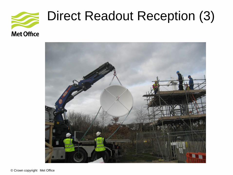
Direct Readout Reception (3)
© Crown copyright Met Office
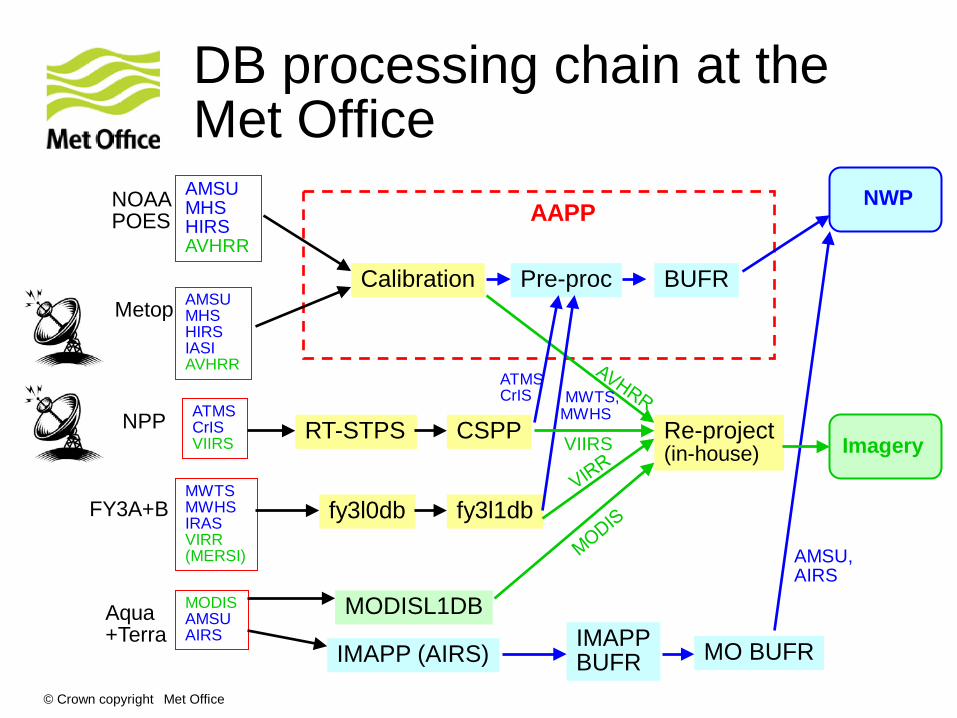
DB processing chain at the Met Office
AMSU MHS HIRS AVHRR
AMSU MHS HIRS IASI AVHRR
ATMS CrIS VIIRS
MWTS MWHS IRAS VIRR (MERSI)
MODIS AMSU AIRS
NOAA POES
Metop
NPP
FY3A+B
Aqua +Terra
Calibration
IMAPP (AIRS)
MODISL1DB
fy3l0db fy3l1db
IMAPP BUFR MO BUFR
Pre-proc BUFR
RT-STPS CSPP
NWP
Imagery
AAPP
AMSU, AIRS
MWTS, MWHS
ATMS CrIS
Re-project (in-house) VIIRS

© Crown copyright Met Office
Processing packages
Satellite Software Available from Output format
Aqua/Terra MODISL1DB (SeaDAS)
IMAPP MODIS level 2 AIRS level 1 & 2 AMSR-E level 1 & 2
http://seadas.gsfc.nasa.gov/
http://cimss.ssec.wisc.edu/imapp/
HDF-EOS
BUFR
NPP RT-STPS (raw → RDR) and CSPP (RDR → SDR)
http://cimss.ssec.wisc.edu/cspp/
HDF5
IPOPP (NASA Direct Readout Lab)
http://directreadout.sci.gsfc.nasa.gov
NOAA POES and Metop
AAPP NWP SAF
http://www.nwpsaf.org
AAPP native
BUFR FY-3A and FY-3B
FY3L0pp and FY3L1pp http://www.nsmc.cma.gov.cn/NewSite/NSMC_EN
Training → FAQs
HDF5
DMSP (U.S. military)
No - -
Meteor-3M (Russia)
No - -
© Crown copyright Met Office
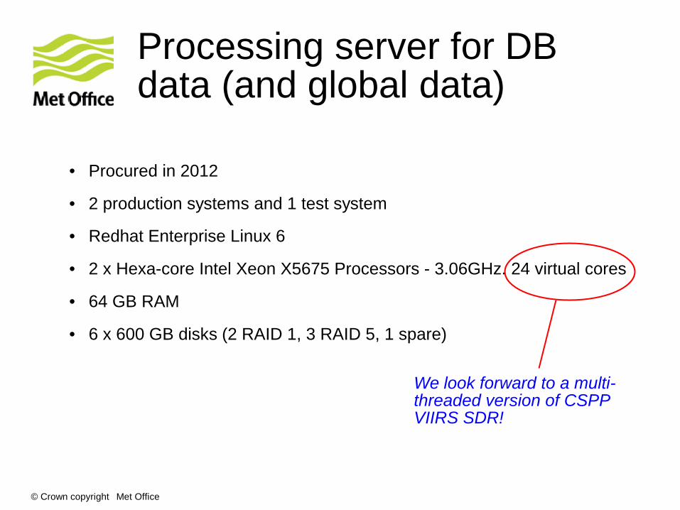
Processing server for DB data (and global data)
• Procured in 2012
• 2 production systems and 1 test system
• Redhat Enterprise Linux 6
• 2 x Hexa-core Intel Xeon X5675 Processors - 3.06GHz. 24 virtual cores
• 64 GB RAM
• 6 x 600 GB disks (2 RAID 1, 3 RAID 5, 1 spare)
We look forward to a multi-threaded version of CSPP VIIRS SDR!
© Crown copyright Met Office
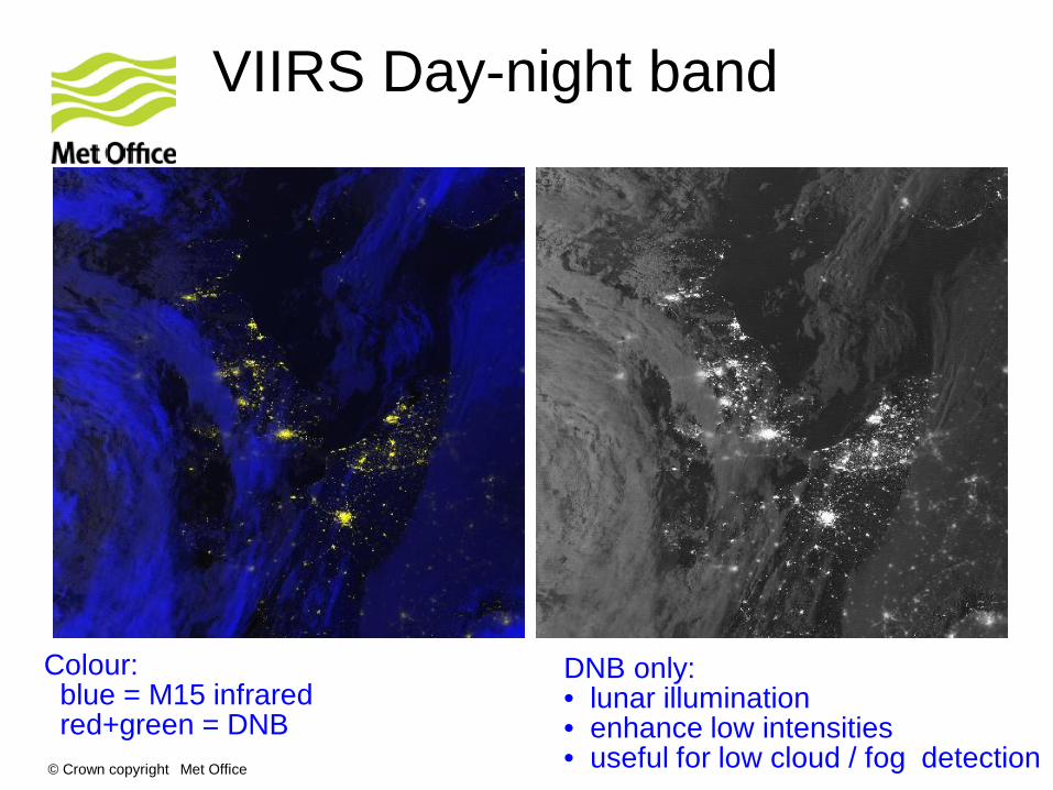
VIIRS Day-night band
Colour: blue = M15 infrared red+green = DNB
DNB only: • lunar illumination • enhance low intensities • useful for low cloud / fog detection
© Crown copyright Met Office
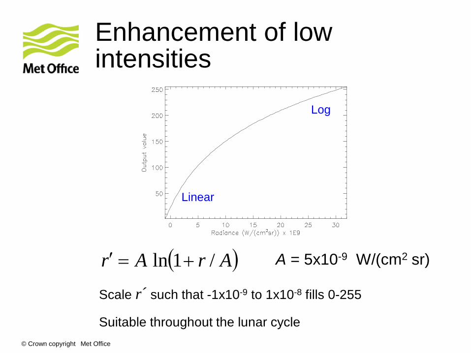
Enhancement of low intensities
( )ArAr /1ln +=′ A = 5x10⁻⁹ W/(cm2 sr)
Scale r´ such that -1x10⁻⁹ to 1x10⁻⁸ fills 0-255 Suitable throughout the lunar cycle
Linear
Log
© Crown copyright Met Office
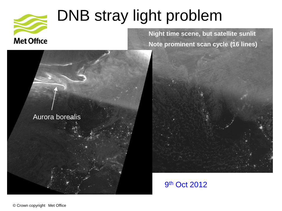
DNB stray light problem Night time scene, but satellite sunlit Note prominent scan cycle (16 lines)
Aurora borealis
9th Oct 2012
© Crown copyright Met Office
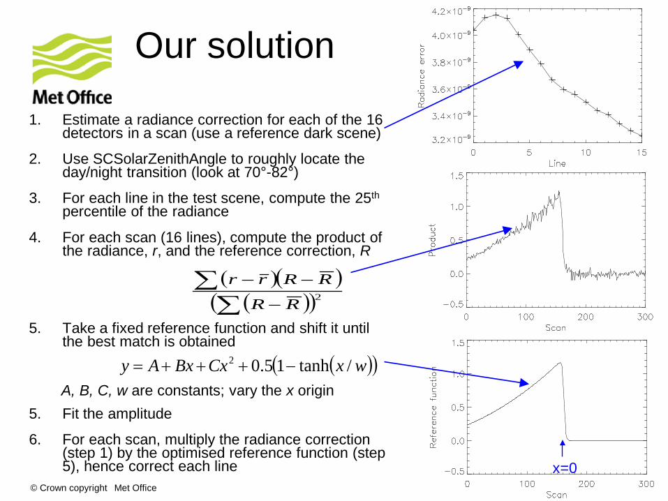
Our solution
1. Estimate a radiance correction for each of the 16 detectors in a scan (use a reference dark scene)
2. Use SCSolarZenithAngle to roughly locate the day/night transition (look at 70°-82°)
3. For each line in the test scene, compute the 25th percentile of the radiance
4. For each scan (16 lines), compute the product of the radiance, r, and the reference correction, R
5. Take a fixed reference function and shift it until the best match is obtained
A, B, C, w are constants; vary the x origin
5. Fit the amplitude
6. For each scan, multiply the radiance correction (step 1) by the optimised reference function (step 5), hence correct each line
( )( )wxCxBxAy /tanh15.02 −+++=
x=0
( )( )( )( )2∑
∑−
−−
RR
RRrr

© Crown copyright Met Office
Corrected DNB imagery
Method in use for several months – works well Happy to share the Fortran code!
© Crown copyright Met Office
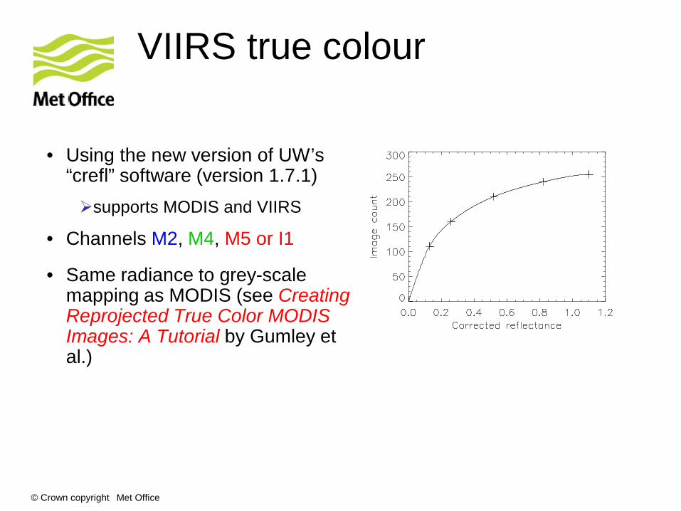
VIIRS true colour
• Using the new version of UW’s “crefl” software (version 1.7.1) supports MODIS and VIIRS
• Channels M2, M4, M5 or I1
• Same radiance to grey-scale mapping as MODIS (see Creating Reprojected True Color MODIS Images: A Tutorial by Gumley et al.)
© Crown copyright Met Office
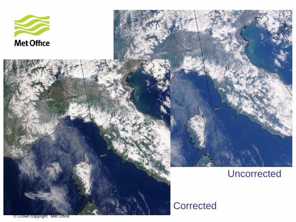
Uncorrected
Corrected
© Crown copyright Met Office
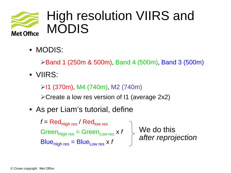
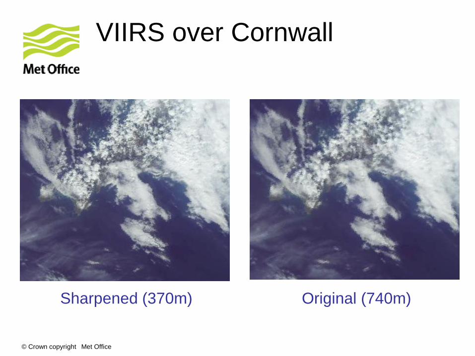
High resolution VIIRS and MODIS
• MODIS: Band 1 (250m & 500m), Band 4 (500m), Band 3 (500m)
• VIIRS: I1 (370m), M4 (740m), M2 (740m) Create a low res version of I1 (average 2x2)
• As per Liam’s tutorial, define f = RedHigh res / Redlow res
GreenHigh res = GreenLow res x f BlueHigh res = BlueLow res x f
We do this after reprojection
© Crown copyright Met Office
VIIRS over Cornwall
Sharpened (370m) Original (740m)
© Crown copyright Met Office
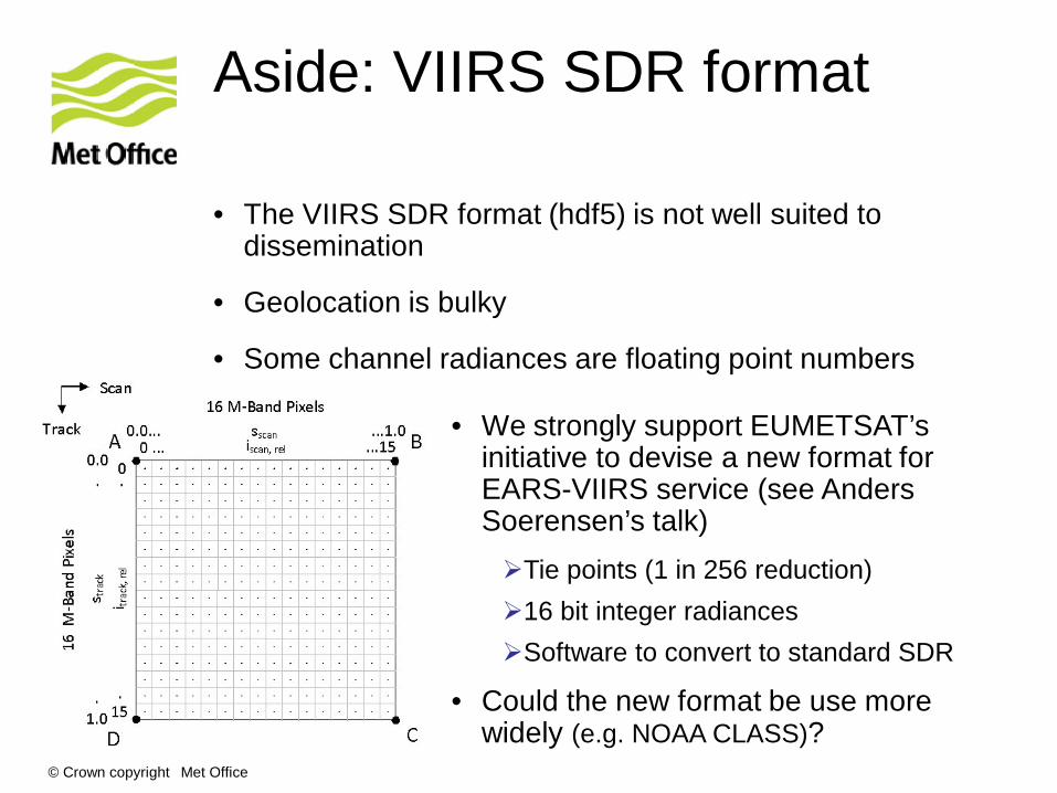
Aside: VIIRS SDR format
• The VIIRS SDR format (hdf5) is not well suited to dissemination
• Geolocation is bulky
• Some channel radiances are floating point numbers
• We strongly support EUMETSAT’s initiative to devise a new format for EARS-VIIRS service (see Anders Soerensen’s talk) Tie points (1 in 256 reduction) 16 bit integer radiances Software to convert to standard SDR
• Could the new format be use more widely (e.g. NOAA CLASS)?
© Crown copyright Met Office
AAPP support for Suomi NPP
AAPP ingests the SDR files – hdf5 or BUFR.
Stores in “AAPP-format level 1c”
ATMS
• Spatial filtering (noise reduction and channel matching)
• Spatial thinning
• Map to CrIS
• BUFR encoding
CrIS
• Channel selection
• Spatial thinning
• BUFR encoding
VIIRS
• Cloud mask coming soon
from AAPP v7.1 (Feb 2012)
DB Global

© Crown copyright Met Office
ATMS spatial filtering
Two issues for NWP:
1. For many channels, raw NEΔT is larger than model background error (and larger than AMSU NEΔT)
2. Difficult to use channels 1&2 due to beamwidth mismatch with channels 3-15 (5.2° vs 2.2°)
These issues are handled by AAPP: • Broaden ch 3-15 beam width to that of AMSU-A • Narrow ch 1-2 (as far as possible without increasing noise) see AAPP document on ATMS processing at http://www.nwpsaf.org
Technique now used operationally at several centres

© Crown copyright Met Office
ATMS noise performance
• Expect NEΔT to be well below AMSU values
Doherty et al., 2012
• However, noise wrt NWP is slightly inferior to AMSU – Why?

© Crown copyright Met Office
Striping noise
• Reported at ITSC-18 (March 2012)
• At that time we were speculating that this was calibration noise
• Difficult to investigate due to lack of access to raw counts for calibration views (not in the SDR)
© Crown copyright Met Office
Extract from ITSC-18 Products Working Group report
• Recommendation: ATMS, VIIRS, and CrIS SDR calibration traceability must be improved to allow users to investigate detailed instrument performance. Action 6.1: Investigate ways to expose or save
calibration information from the RDR files. RayG, NigelA Action 6.2: In order to maintain a record of product
provenance, create a set of guidelines for metadata to be associated with satellite products. GeoffC

© Crown copyright Met Office
Recipe for extracting raw counts for ATMS
1. Configure CSPP to generate a “Verified RDR” file:
Edit ADL/cfg/ProSdrAtmsVerifiedRDR_CFG.xml <group name="ATMS_VERIFIED_RDR"> <config> <name>DataEndianType</name> <configValue>Both</configValue> </config> <config> <name>OutputType</name> <!-- --> <!-- Note changing this from heap will output --> <!-- it with a dataset type tag which is not --> <!-- supported in the DPIS --> <!-- --> <configValue>DMS</configValue> </config> <config> <name>OfficialShortName</name> <configValue>ATMS-Verified-RDR-IP</configValue> </config> </group>
Changed from HEAP
2. Deduce the contents of the Verified RDR – using ADL source code ADL/algorithms/ADL/SDR/ATMS/src/atms_struct.f
3. Wrote an IDL reader • Gives earth counts, space counts and warm counts, as well as other
instrument health data. • IDL code available on request!
Thanks to Ray Garcia
© Crown copyright Met Office
• This procedure is far from obvious! compare the AMSU 1b format in which raw counts are
fundamental
• Consider ways to document for ATMS?
• Can we improve visibility for future instruments and missions?
© Crown copyright Met Office
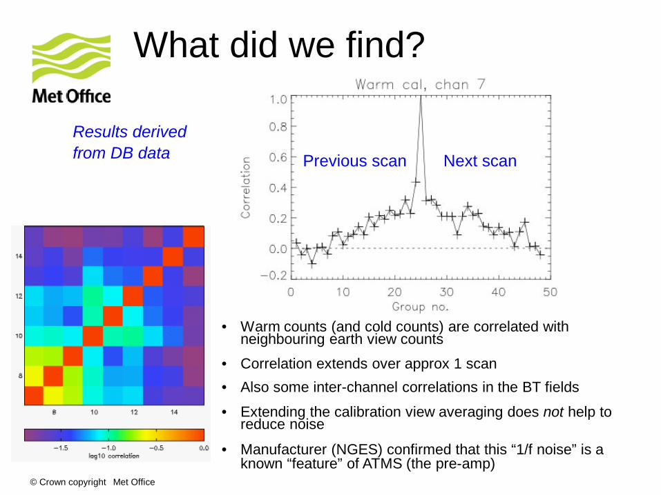
What did we find?
• Warm counts (and cold counts) are correlated with neighbouring earth view counts
• Correlation extends over approx 1 scan
Previous scan Next scan
Results derived from DB data
• Also some inter-channel correlations in the BT fields
• Extending the calibration view averaging does not help to reduce noise
• Manufacturer (NGES) confirmed that this “1/f noise” is a known “feature” of ATMS (the pre-amp)
© Crown copyright Met Office
ATMS striping - conclusions
• Striping (1/f noise) is a characteristic of the instrument
• The NEΔT values in the SDR do not take account of 1/f noise – so are optimistic
• Spatial averaging of the BT fields does not beat down the noise as much as originally expected
• Performance is within the official spec Importance of specifying future instruments correctly
• Nevertheless, impact of ATMS in NWP is positive!

© Crown copyright Met Office
Use of NPP data in NWP • ATMS and CrIS data assimilated operationally
in Met Office global model from April 2013
From package trials
Lower errors
© Crown copyright Met Office
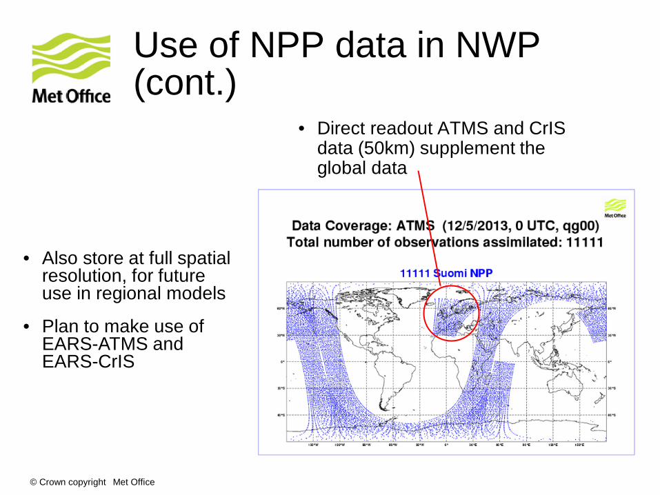
Use of NPP data in NWP (cont.)
• Direct readout ATMS and CrIS data (50km) supplement the global data
• Also store at full spatial resolution, for future use in regional models
• Plan to make use of EARS-ATMS and EARS-CrIS
© Crown copyright Met Office
Summary
• Met Office DB systems receive POES, Metop, NPP, EOS and FY-3
• The data are used for imagery and NWP
• The level 1 processing uses several freely-available processing packages, and runs OK on a Linux server
• Techniques developed for displaying VIIRS e.g. true-color and DNB images
• CSPP can be used for in-depth investigations, as in the ATMS striping anomaly
• ATMS and CrIS deliver positive impact in NWP at the Met Office

© Crown copyright Met Office
Thank you for listening! For more information: http://www.metoffice.gov.uk http://www.nwpsaf.org Questions?


