Premier Gold Mines Limited Hardrock Project Project Description ...

April 15, 2017
RPA T55 University Ave. Suite 501 I Toronto, ON, Canada M5J 2H7 I + 1 (416) 947 0907 www.rpacan.com
PREMIER GOLD MINES LIMITED
TECHNICAL REPORT ON THEMCCOY-COVE GOLD PROJECT,LANDER COUNTY, STATE OF NEVADA,U.S.A.
NI 43-101 Report
Qualified Persons:Luke Evans, M.Sc., P.Eng.Tudorel Ciuculescu, M.Sc., P.Geo.

Report Control Form Document Title Technical Report on the McCoy-Cove Gold Project, Lander
County, State of Nevada, USA
Client Name & Address
Premier Gold Mines Limited 1100 Russell Street Thunder Bay, Ontario P7B 5N2
Document Reference
Project # 2727
Status & Issue No.
FINAL Version
Rev 0
Issue Date April 15, 2017 Authors Tudorel Ciuculescu
Luke Evans (Signed)
(Signed)
Peer Reviewer Deborah McCombe (Signed)
Project Manager Approval Luke Evans
(Signed)
Project Director Approval Deborah McCombe (Signed)
Report Distribution Name No. of Copies Client RPA Filing 1 (project box)
Roscoe Postle Associates Inc.
55 University Avenue, Suite 501 Toronto, ON M5J 2H7
Canada Tel: +1 416 947 0907
Fax: +1 416 947 0395 [email protected]

www.rpacan.com
Premier Gold Mines Limited – McCoy-Cove Project, Project #2727
Technical Report NI 43-101 – April 15, 2017 Page i
TABLE OF CONTENTS PAGE
1 SUMMARY ........................................................................................................................ 1-1 Executive Summary ......................................................................................................... 1-1 Technical Summary ......................................................................................................... 1-4
2 INTRODUCTION ............................................................................................................... 2-1
3 RELIANCE ON OTHER EXPERTS ................................................................................... 3-1
4 PROPERTY DESCRIPTION AND LOCATION ................................................................. 4-1
5 ACCESSIBILITY, CLIMATE, LOCAL RESOURCES, INFRASTRUCTURE AND PHYSIOGRAPHY ................................................................................................................. 5-1
6 HISTORY ........................................................................................................................... 6-1
7 GEOLOGICAL SETTING AND MINERALIZATION ........................................................... 7-1 Regional Geology ............................................................................................................ 7-1 Local and Property Geology ............................................................................................ 7-2 Structural Geology ........................................................................................................... 7-9 Mineralization ................................................................................................................ 7-10
8 DEPOSIT TYPES .............................................................................................................. 8-1
9 EXPLORATION ................................................................................................................. 9-1
10 DRILLING ...................................................................................................................... 10-1 Pre 2012 ........................................................................................................................ 10-1 Premier 2012-2016 ........................................................................................................ 10-7
11 SAMPLE PREPARATION, ANALYSES AND SECURITY ............................................ 11-1 Pre-2012 ........................................................................................................................ 11-1 Premier 2012-2017 ........................................................................................................ 11-3 Quality Assurance and Quality Control .......................................................................... 11-4
12 DATA VERIFICATION ................................................................................................... 12-1 Pre-2012 Drilling Database Management ..................................................................... 12-1 2017 Drill Hole Database Checks .................................................................................. 12-2
13 MINERAL PROCESSING AND METALLURGICAL TESTING ..................................... 13-1
14 MINERAL RESOURCE ESTIMATE .............................................................................. 14-1 Mineral Resource Database .......................................................................................... 14-2 Geological Interpretation ............................................................................................... 14-3 Descriptive Statistics ..................................................................................................... 14-5 Capping of High Grades ................................................................................................ 14-5 Compositing ................................................................................................................... 14-8 Variography and Trend Analysis ................................................................................... 14-8 Density ........................................................................................................................... 14-9 Block Model ................................................................................................................... 14-9

www.rpacan.com
Premier Gold Mines Limited – McCoy-Cove Project, Project #2727
Technical Report NI 43-101 – April 15, 2017 Page ii
Interpolation Strategy .................................................................................................. 14-10 Validation ..................................................................................................................... 14-10 Classification ............................................................................................................... 14-12 Cut-off Grade ............................................................................................................... 14-14 Sensitivity to Cut-off Grade .......................................................................................... 14-14
15 MINERAL RESERVE ESTIMATE ................................................................................. 15-1
16 MINING METHODS ....................................................................................................... 16-1
17 RECOVERY METHODS ............................................................................................... 17-1
18 PROJECT INFRASTRUCTURE .................................................................................... 18-1
19 MARKET STUDIES AND CONTRACTS ....................................................................... 19-1
20 ENVIRONMENTAL STUDIES, PERMITTING, AND SOCIAL OR COMMUNITY IMPACT ............................................................................................................................................ 20-1
21 CAPITAL AND OPERATING COSTS ........................................................................... 21-1
22 ECONOMIC ANALYSIS ................................................................................................ 22-1
23 ADJACENT PROPERTIES ........................................................................................... 23-1
24 OTHER RELEVANT DATA AND INFORMATION ......................................................... 24-1
25 INTERPRETATION AND CONCLUSIONS ................................................................... 25-1
26 RECOMMENDATIONS ................................................................................................. 26-1
27 REFERENCES .............................................................................................................. 27-1
28 DATE AND SIGNATURE PAGE ................................................................................... 28-1
29 CERTIFICATE OF QUALIFIED PERSON ..................................................................... 29-1
30 APPENDIX 1 ................................................................................................................. 30-1 Claim List ....................................................................................................................... 30-1
LIST OF TABLES PAGE
Table 1-1 Mineral Resources – March 21, 2017 ................................................................ 1-2 Table 1-2 Proposed Work Program .................................................................................... 1-4 Table 6-1 Historical Resource and Reserve Estimates ...................................................... 6-3 Table 6-2 Historic Cove and McCoy Mine Production 1986-2006 ...................................... 6-6 Table 10-1 Summary of McCoy-Cove Project Drilling – Pre-2011 ................................... 10-1 Table 10-2 Summary of Victoria Diamond Drilling – Pre-2012 ......................................... 10-2 Table 10-3 Victoria Diamond Drilling Recoveries ............................................................. 10-6 Table 11-1 McCoy – Cove CRMs ..................................................................................... 11-8 Table 13-1 Helen Zone Composite Samples - Average Head Analyses Summary.......... 13-2 Table 13-2 Helen Zone Rock Density Determinations ..................................................... 13-2 Table 14-1 Mineral Resources – March 21, 2017 ............................................................ 14-2 Table 14-2 Resource Assays Gold Descriptive Statistics ................................................. 14-5 Table 14-3 Resource Assays Capped Gold Descriptive Statistics ................................... 14-8

www.rpacan.com
Premier Gold Mines Limited – McCoy-Cove Project, Project #2727
Technical Report NI 43-101 – April 15, 2017 Page iii
Table 14-4 Composites Capped Gold Grade Descriptive Statistics ................................. 14-8 Table 14-5 Block Model Setup ......................................................................................... 14-9 Table 14-6 Interpolation Parameters .............................................................................. 14-10 Table 14-7 Cut-off Grade Parameters ............................................................................ 14-14 Table 14-8 Indicated and Inferred Resources at Various Cut-off Grades ...................... 14-15 Table 26-1 Proposed Work Program ................................................................................ 26-1
LIST OF FIGURES PAGE
Figure 4-1 Location Map ..................................................................................................... 4-2 Figure 4-2 Mineral Claim Map ............................................................................................ 4-3 Figure 5-1 Photograph of the McCoy-Cove Project Area ................................................... 5-3 Figure 7-1 Regional Geology .............................................................................................. 7-4 Figure 7-2 Triassic Stratigraphy and Mineralization ........................................................... 7-5 Figure 8-1 Schematic Cross Section of CSD Gap Zone .................................................... 8-2 Figure 10-1 Photograph of NW-09 2,024 – 2,061 ft ......................................................... 10-6 Figure 10-2 McCoy-Cove Drill Holes - Plan View ............................................................. 10-9 Figure 11-1 2012 to 2014 Blanks ..................................................................................... 11-7 Figure 11-2 2015 and 2016 Blanks .................................................................................. 11-7 Figure 11-3 Low, Medium and High Grade CRMs ........................................................... 11-9 Figure 11-4 Field Duplicate Samples ............................................................................. 11-10 Figure 11-5 Same Laboratory reject Duplicate Samples ................................................ 11-11 Figure 11-6 External Laboratory Pulp Checks ................................................................ 11-12 Figure 14-1 Mineralized Wireframes and Resource Drill Holes ........................................ 14-4 Figure 14-2 Resource Assay Histogram ........................................................................... 14-6 Figure 14-3 Resource Assay Log Probability Plot ............................................................ 14-7 Figure 14-4 Interpolated Block Grades - Typical Cross Section in Helen Zone (6600NW) ..... .......................................................................................................................................... 14-11 Figure 14-5 Grade-Tonnage Curves for Various Interpolation Methods ........................ 14-12 Figure 14-6 Classified Blocks ......................................................................................... 14-13 Figure 14-7 Indicated Resource Grade-Tonnage Curves .............................................. 14-16 Figure 14-8 Inferred Resource Grade-Tonnage Curves ................................................. 14-16
LIST OF APPENDIX FIGURES & TABLES PAGE
Table 30-1 McCoy-Cove Project 100% Owned Unpatented Claims ................................ 30-2 Table 30-2 Cove Project Leased Patented Claims ........................................................... 30-3

www.rpacan.com
Premier Gold Mines Limited – McCoy-Cove Project, Project #2727
Technical Report NI 43-101 – April 15, 2017 Page 1-1
1 SUMMARY EXECUTIVE SUMMARY Roscoe Postle Associates Inc. (RPA) was retained by Premier Gold Mines Limited (Premier)
to prepare a Technical Report on Premier’s McCoy-Cove Project (the Project), which is
located in the McCoy Mining District of Nevada, USA. In June 2012, Premier entered into an
agreement to purchase the Project from Victoria Gold Corp. (Victoria). Since 2012, Premier
has drilled a significant number of diamond drill holes from surface. The purpose of this
Technical Report is to support the public disclosure of an updated Mineral Resource estimate
for the Project.
This Technical Report conforms to National Instrument 43-101 Standards of Disclosure for
Mineral Projects (NI 43-101).
Premier is a gold producer and exploration and development company with multiple gold
projects located in Ontario, Nevada, and Mexico. Premier holds a 100% interest in the
McCoy-Cove property, which hosts one of the highest grade undeveloped gold deposits in
Nevada. Approximately 3.4 million ounces of gold and 110 million ounces of silver were
produced between 1986 and 2006 from this property and it is one of a number of active or
past-producing mines located along the Battle Mountain-Eureka Trend, a highly prospective
gold district in north-central Nevada.
The Mineral Resource estimate as of March 21, 2017 is summarized in Table 1-1. Canadian
Institute of Mining, Metallurgy and Petroleum (CIM) Definition Standards for Mineral
Resources and Mineral Reserves dated May 10, 2014 (CIM definitions) were used for
Mineral Resource estimation. The current Mineral Resource estimate is based on an
underground mining scenario.
RPA is not aware of any environmental, permitting, legal, title, taxation, socio-economic,
marketing, political, or other relevant factors that could materially affect the Mineral Resource
estimate.

www.rpacan.com
Premier Gold Mines Limited – McCoy-Cove Project, Project #2727
Technical Report NI 43-101 – April 15, 2017 Page 1-2
TABLE 1-1 MINERAL RESOURCES – MARCH 21, 2017 Premier Gold Mines Limited – McCoy-Cove Project
Category Area Tonnage (000 t)
Grade (g/t Au)
Contained Metal (000 oz Au)
Indicated Helen 409 12.41 163 CSD 180 9.26 54 CSD Gap 25 14.49 12 2201-VG - - - Total Indicated 614 11.57 228 Inferred Helen 1,138 13.04 477 CSD 200 8.81 57 CSD Gap 1,458 11.59 543 2201-VG 582 13.09 245 Total Inferred 3,378 12.17 1,322
Notes:
1. CIM definitions were followed for Mineral Resources. 2. Mineral Resources are estimated at a cut-off grade of 5.6 g/t Au. 3. Mineral Resources are estimated using a long-term gold price of US$1,400 per ounce, and a US$/C$
exchange rate of 1:1.25. 4. A minimum mining width of 8 ft was used. 5. Bulk density is 2.1 t/m3 for CSD, CSD Gap and Helen, and 2.6 t/m3 for 2201-VG. 6. Numbers may not add due to rounding.
CONCLUSIONS The Project is located in the McCoy Mining District. The Cove-Helen deposit has been
delineated beneath the historically mined Cove open pit and underground mining area and
currently extends approximately 2,000 ft northwest of the pit. Four distinct mineralized zones
were defined: Helen, CSD Gap and CSD zones with Carlin-style mineralization, and 2201-
VG zone with polymetallic sheeted vein mineralization.
The Cove pit was mined by Echo Bay Mines Ltd. (Echo Bay) between 1987 and 2001, and
produced 2.6 million ounces of gold and 100 million ounces of silver.
Exploration drilling since 2012 allowed Premier to develop a new litho-structural model.
Previously known mineralized zones of the Cove-Helen deposit were expanded and new
targets were identified and modelled.
RPA prepared an estimate of Mineral Resources for the Project using Geovia GEMS 6.7.4
software. The current Mineral Resource estimate is based on an underground mining
method and includes 614,000 tonnes at an average grade of 11.57 g/t Au, containing
www.rpacan.com
Premier Gold Mines Limited – McCoy-Cove Project, Project #2727
Technical Report NI 43-101 – April 15, 2017 Page 1-3
228,000 ounces in the Indicated Resource category. An additional 3,378,000 tonnes at an
average grade of 12.17 g/t Au, containing 1,322,000 ounces, are estimated in the Inferred
Mineral Resource category.
The estimate was supported by a block model constrained with mineralized wireframes
capturing mineralized intercepts with nominal grades above 5.6 g/t Au over a minimum
thickness of 8 ft, with occasional lower grade intercepts preserved for mineralized lens
continuity. Erratic higher grade samples were capped at 60 g/t Au prior to compositing to full
intercept length. Block gold grade was estimated using an inverse distance to the power four
(ID4) interpolation method.
The current resource estimate represents a marked increase in Indicated and Inferred
resources compared to the 2013 estimate. This was achieved by expansion of previously
known mineralization through infill and step-out drilling, and delineation of new mineralized
zones through exploration drilling.
RECOMMENDATIONS Premier’s 2017 budget will focus on exploration and infill drilling, to extend and upgrade the
current Mineral Resource estimate. Metallurgical testing, hydrology, engineering, and
permitting activities will also be undertaken to support the ongoing PEA. Positive results
from the aforementioned work will lead to future development of the underground test mining
project with the goal of extracting a bulk sample from the Upper Helen zone of the resource
in 2018. RPA concurs with Premier’s proposed work program and budget (Table 1-2).

www.rpacan.com
Premier Gold Mines Limited – McCoy-Cove Project, Project #2727
Technical Report NI 43-101 – April 15, 2017 Page 1-4
TABLE 1-2 PROPOSED WORK PROGRAM Premier Gold Mines Limited - McCoy-Cove Project
Item Units Cost/Unit Total Cost
(US$) Diamond Drilling 17,000 m 180 3,060,000 Assays 11,000 38 418,000 Geological and Operations Support $96,000/mo 12 1,150,000 Site Administration $33,000/mo 12 400,000 Mineral Resource Update 1 Lump Sum 67,000 Metallurgical Test Work 1 Lump Sum 250,000 Hydrology Study $125,000/mo 12 1,500,000 Preliminary Economic Assessment 1 Lump Sum 225,000 Development – Bulk Sample 1 Lump Sum 6,500,000 Contingency Lump Sum 1,430,000 Total 15,000,000
TECHNICAL SUMMARY
PROPERTY DESCRIPTION AND LOCATION The Project covers 17,252 acres and is located 32 miles south of the Town of Battle
Mountain, in the Fish Creek Mountains of Lander County, Nevada. It is centred
approximately at 40°22’ N and 117°13’ W and lies within the McCoy Mining District. Access
to the Project area is via State Highway 305, 22 miles south from Battle Mountain, and then
west approximately seven miles along the hard surfaced McCoy Mine Road.
The Project is, for the most part, located on land controlled by the US Department of Interior -
Bureau of Land Management (BLM) and partly on private land. The Project consists of 1,535
100%-owned unpatented claims and nine leased patented claims.
EXISTING INFRASTRUCTURE Dirt track access roads are located throughout the property for exploration access. The
Cove Project exploration facilities consist of a guard shack, mechanic shop and numerous
shipping containers used as storage sheds in the laydown and core storage yards. There is
a grid power line to the site.
For the most part, facilities from the former operations have been or are being reclaimed by
Premier.

www.rpacan.com
Premier Gold Mines Limited – McCoy-Cove Project, Project #2727
Technical Report NI 43-101 – April 15, 2017 Page 1-5
HISTORY Gold was first discovered in the McCoy Mining District in 1914 by Joseph H. McCoy, and a
total production through 1977 included approximately 10,000 oz of gold plus minor amounts
of silver, lead, and copper.
In the mid-1980s, Tenneco Minerals Company (Tenneco) carried out drilling, metallurgical
testing, and engineering and feasibility studies at the McCoy deposit, and open pit mining
began in February 1986. Echo Bay purchased the precious metal holdings of Tenneco in
October 1986 and carried out further exploration in the district. In 1987, Echo Bay
discovered the Cove deposit and began open pit mining in 1988. In 1999, Echo Bay carried
out drilling and bulk sampling from an underground exploration drift at Cove, confirming the
presence of a high grade zone that could be mined by underground methods. Newmont
Mining Corporation (Newmont) took ownership of the Cove and McCoy properties in
February 2003. Victoria acquired the lease for the property in June 2006 and, as a result of
drilling in 2006, discovered the Carlin-type Helen zone northwest of the Cove pit. Premier
entered into an agreement to acquire the lease of the McCoy-Cove Project from Victoria in
2012 and subsequently acquired a 100% interest in the land package from Newmont in
September 2014.
Through 2006, a total of 3.41 million ounces of gold and 110.2 million ounces of silver were
produced from Cove and McCoy, with the vast majority of both metals reportedly coming
from the Cove deposit. The Cove open pit produced approximately 2.6 million ounces of
gold.
GEOLOGY AND MINERALIZATION The Project is located in the central Nevada portion of the Basin and Range Province, which
underwent regional extension during the Tertiary that created the present pattern of
alternating largely fault bounded ranges separated by alluvial filled valleys. Prior to this
extension, central Nevada had been the site of numerous tectonic events, including at least
two periods of regional compression. The property lies west of the central part of the Battle
Mountain-Eureka Trend.
Mineralization is hosted in Triassic rocks consisting mainly of limestone with lesser
conglomerate, sandstone, and dolostone. Several formations are presented in the Project

www.rpacan.com
Premier Gold Mines Limited – McCoy-Cove Project, Project #2727
Technical Report NI 43-101 – April 15, 2017 Page 1-6
area, with most of the historic production coming from the Augusta Mountain Formation. The
Cove deposit consists of the Helen, CSD Gap, CSD, and 2201-VG zones. The Carlin-type
mineralization within the Helen, CSD Gap, and CSD zones comprises approximately 85% of
the existing resource with high grade gold and silver occurring as both stratabound and
structurally controlled mineralization at the intersection of the Cove anticline and favourable
lithologic beds, structures, intrusive dikes, and sills. The polymetallic 2201-VG zone is a
separate deposit from the shallower Carlin-type mineralization and is believed to be a
structurally controlled sheeted vein system. Veining is oriented northwest, with vein
geometry being controlled by a northwest striking reverse fault.
EXPLORATION STATUS Since 2012, Premier has carried out diamond drilling with the objective of delineating
extensions of the Helen zone mineralization along the favourable Favret Formation and
Home Station Member of the Augusta Mountain Formation, where they intersect the axial
plane of the Cove anticline. Multiple targets have been tested property-wide with key
discoveries being the polymetallic 2201-VG zone beneath the Cove pit in 2013 and the
Carlin-style CSD Gap zone adjacent to the Helen zone in 2016.
The resource database consists of 2,201 reverse circulation (RC) and core holes, drilled from
surface and underground on the property, with 204,746 samples and a total sampled length
of 1,544,094 ft.
MINERAL RESOURCES RPA prepared an estimate of Mineral Resources for the Project using Geovia GEMS 6.7.4
software. The current Mineral Resource estimate is based on an underground mining
method and includes 614,000 tonnes at an average grade of 11.57 g/t Au, containing
228,000 ounces in the Indicated Resource category. An additional 3,378,000 tonnes at an
average grade of 12.17 g/t Au, containing 1,322,000 ounces, are estimated in the Inferred
Mineral Resource category.
The estimate was supported by a block model constrained with mineralized wireframes
capturing mineralized intercepts with nominal grades above 5.6 g/t Au over a minimum
thickness of 8 ft, with occasional lower grade intercepts preserved for mineralized lens
continuity. Erratic higher grade samples were capped at 60 g/t Au prior to compositing to full

www.rpacan.com
Premier Gold Mines Limited – McCoy-Cove Project, Project #2727
Technical Report NI 43-101 – April 15, 2017 Page 1-7
intercept length. Block gold grade was estimated using an inverse distance to the power four
(ID4) interpolation method. Table 1-1 summarizes the Cove-Helen deposit Mineral Resource
estimate.
All of the drilling and historical assay results were reported in imperial units, while the recent
assays were reported in metric units; the assay database was converted to metric units. The
surveying was based on UTM NAD27, with collar position determined by GPS
measurements.

www.rpacan.com
Premier Gold Mines Limited – McCoy-Cove Project, Project #2727
Technical Report NI 43-101 – April 15, 2017 Page 2-1
2 INTRODUCTION Roscoe Postle Associates Inc. (RPA) was retained by Premier Gold Mines Limited (Premier)
to prepare a Technical Report on Premier’s McCoy-Cove Project (the Project), which is
located in the McCoy Mining District of Nevada, USA. In June 2012, Premier entered into an
agreement to purchase the Project from Victoria Gold Corp. (Victoria). Since 2012, Premier
has drilled a significant number of diamond drill holes from surface. The purpose of this
Technical Report is to support the public disclosure of an updated Mineral Resource estimate
for the Project.
This Technical Report conforms to National Instrument 43-101 Standards of Disclosure for
Mineral Projects (NI 43-101).
Premier is a gold producer and exploration and development company with multiple gold
projects located in Ontario, Nevada, and Mexico. Premier holds a 100% interest in the
McCoy-Cove property, which hosts one of the highest grade undeveloped gold deposits in
Nevada. Approximately 3.4 million ounces of gold and 110 million ounces of silver were
produced between 1986 and 2006 from this property and it is one of a number of active or
past-producing mines located along the Battle Mountain-Eureka Trend, a highly prospective
gold district in north-central Nevada.
SOURCES OF INFORMATION A site visit to the McCoy-Cove Project was carried out by Tudorel Ciuculescu, P.Geo, Senior
Geologist, RPA, on March 28 and 29, 2017.
Discussions were held with the following personnel from Premier:
• Chad Peters, P.Geo., Exploration Manager
• Kenneth Williamson, M.Sc., P.Geo., Manager Technical Services
• Mia O’Neal, Project Geologist and Database Manager
• Julie-Anais Debreil, Ph.D., Geologist Technical Services
• Charlie Ronkos, Executive VP – Project Development, Americas
• Brent Kristof, Senior VP Operations
• Steve McGibbon, Executive VP – Corporate & Project Development

www.rpacan.com
Premier Gold Mines Limited – McCoy-Cove Project, Project #2727
Technical Report NI 43-101 – April 15, 2017 Page 2-2
The documentation reviewed, and other sources of information, are listed at the end of this
report in Section 27 References.
LIST OF ABBREVIATIONS Units of measurement used in this report conform to the metric system. All currency in this
report is US dollars (US$) unless otherwise noted.
a annum kWh kilowatt-hour A ampere L litre bbl barrels lb pound btu British thermal units L/s litres per second °C degree Celsius m metre C$ Canadian dollars M mega (million); molar cal calorie m2 square metre cfm cubic feet per minute m3 cubic metre cm centimetre µ micron cm2 square centimetre MASL metres above sea level d day µg microgram dia diameter m3/h cubic metres per hour dmt dry metric tonne mi mile dwt dead-weight ton min minute °F degree Fahrenheit µm micrometre ft foot mm millimetre ft2 square foot mph miles per hour ft3 cubic foot MVA megavolt-amperes ft/s foot per second MW megawatt g gram MWh megawatt-hour G giga (billion) oz Troy ounce (31.1035g) Gal Imperial gallon oz/st, opt ounce per short ton g/L gram per litre ppb part per billion Gpm Imperial gallons per minute ppm part per million g/t gram per tonne psia pound per square inch absolute gr/ft3 grain per cubic foot psig pound per square inch gauge gr/m3 grain per cubic metre RL relative elevation ha hectare s second hp horsepower st short ton hr hour stpa short ton per year Hz hertz stpd short ton per day in. inch t metric tonne in2 square inch tpa metric tonne per year J joule tpd metric tonne per day k kilo (thousand) US$ United States dollar kcal kilocalorie USg United States gallon kg kilogram USgpm US gallon per minute km kilometre V volt km2 square kilometre W watt km/h kilometre per hour wmt wet metric tonne kPa kilopascal wt% weight percent kVA kilovolt-amperes yd3 cubic yard kW kilowatt yr year

www.rpacan.com
Premier Gold Mines Limited – McCoy-Cove Project, Project #2727
Technical Report NI 43-101 – April 15, 2017 Page 3-1
3 RELIANCE ON OTHER EXPERTS This report has been prepared by RPA for Premier. The information, conclusions, opinions,
and estimates contained herein are based on:
• Information available to RPA at the time of preparation of this report;
• Assumptions, conditions, and qualifications as set forth in this report; and
• Data, reports, and other information supplied by Premier and other third party sources.
For the purpose of this report, RPA has relied on ownership information provided by Premier.
RPA has not researched property title or mineral rights for the Project and expresses no
opinion as to the ownership status of the property.
Except for the purposes legislated under provincial securities laws, any use of this report by
any third party is at that party’s sole risk.

www.rpacan.com
Premier Gold Mines Limited – McCoy-Cove Project, Project #2727
Technical Report NI 43-101 – April 15, 2017 Page 4-1
4 PROPERTY DESCRIPTION AND LOCATION The McCoy-Cove Project covers 17,252 acres and is located 32 miles south of the Town of
Battle Mountain, in the Fish Creek Mountains of Lander County, Nevada. It is centred
approximately at 40°22’ N and 117°13’ W and lies within the McCoy Mining District (Figure 4-
1).
The Cove-Helen deposit consists of the Helen, CSD Gap, CSD, and 2201-VG zones. It is
located beneath the historically mined Cove open pit and underground mining area and
extends approximately 2,000 ft northwest of the Cove pit. The historic McCoy open pit is
located approximately 1.2 km to the southwest. The Cove deposit was mined by Echo Bay
Mines Ltd. (Echo Bay) between 1987 and 2001, and produced 2.6 million ounces of gold and
100 million ounces of silver. McCoy was mined between 1986 and 2001, and produced
approximately 0.88 million ounces of gold and 3.0 million ounces of silver. Gold and silver
production from heap leach pads continued until 2006.
The Project is, for the most part, located on land controlled by the US Department of Interior -
Bureau of Land Management (BLM) and partly on private land.
LAND TENURE The McCoy-Cove Project consists of 1,535 100%-owned unpatented claims and nine leased
patented claims. The claim map provided by Premier is shown in Figure 4-2.
The unpatented claims have annual maintenance fees of $12.00 per claim payable to the
Lander County Recorder as well as $155.00 per claim payable to the Nevada BLM. No
additional annual labour or improvement assessments are required for unpatented claims.
Patented claims, with clear and absolute title, have neither claim maintenance fees nor
annual expenditures for labour or improvement. Patented claims are, however, subject to
property taxes.
Project claims are listed in Appendix 1 Tables 30-1 and 30-2.

80Pershing
Washoe
Elko
EsmeraldaNye
Mineral
Clark
Eureka
White Pine
Lander
Churchill
Humboldt
Lincoln
Douglas
Lyon
Sto
rey
Wells
Tonopah
Hawthorne
Lovelock
Reno
CARSON CITY
Eureka
Ely
BattleMountain
ElkoWestWendover
Austin
McDermitt
Winnemucca
Carlin
Fallon
Las Vegas
N E V A D A
OREGON
CA
LIF
OR
NIA
CALIFO
RNIA
COVE GOLD PROJECT
1000 km
UNITED STATES
Map Area
Major Highway
Legend:
County Boundary
Road
Town/City
Capital City
0 20 100
Miles
40 60 80
UTA
H
IDAHO
AR
IZO
NA
0 40 200
Kilometres
80 120 160
N
April 2017
Location Map
McCoy-Cove Gold Project
Premier Gold Mines Limited
Lander County, Nevada, U.S.A.State of
Figure 4-1
4-2
www.rpacan.com

0 0.5 1 1.5 2 Miles
0 1 4 Kilometres32
May 2017
Map Features
McCoy-CovePropertyBoundary
Claim
Source: Premier Gold, 2017.
Mineral Claim Map
McCoy-Cove Gold Project
Premier Gold Mines Limited
State of Nevada, U.S.A.
Figure 4-2
4-3
www.rpacan.com

www.rpacan.com
Premier Gold Mines Limited – McCoy-Cove Project, Project #2727
Technical Report NI 43-101 – April 15, 2017 Page 4-4
Premier provided a copy of the letter to the Bureau of Land Management (BLM) with the
2016-2017 claim maintenance fee for its claims on the McCoy-Cove Project. Premier also
provided the claim listing indicating that the claims are valid until September 2017.
On June 15, 2006, Victoria entered into a “Minerals Lease and Agreement” to lease a portion
of the Project from Newmont. Under the terms of the agreement, Victoria was subject to
escalating yearly work commitments in the aggregate amount of $8.5 million over a period of
seven years (consisting of $0.3 million, $0.7 million, $1.0 million, $1.25 million, $1.5 million,
$1.75 million, and $2.0 million, respectively, in each year of the first seven years of the
agreement dated June 15, 2006), of which $1.0 million was a firm obligation and must be
expended by June 15, 2008 (completed). Excess expenditures are allowed to be carried
forward. Newmont acknowledged that Victoria spent over $9.1 million in exploration at the
Project between June 15, 2006 and March 16, 2009, and satisfied the work commitment of
Section 2(a) of the Minerals and Lease Agreement.
In June 2012, Premier entered into an agreement with Victoria to acquire the Project. In
connection with the closing of the acquisition, Premier paid an aggregate of $8 million, $4
million of which was paid in cash and $4 million was satisfied by the issuance of an
aggregate of 892,857 common shares of Premier to a wholly-owned subsidiary of Victoria.
In addition, Premier reimbursed Victoria all the exploration and related activities conducted
on the Project by Victoria between March 15, 2012, and the closing of the acquisition.
The aggregate consideration payable for the acquisition was $28 million payable over a two
year term.
In the event of production from the Project, Premier will pay Victoria an additional $20 million
(with Premier having the option to satisfy up to one half of such amount in common shares of
Premier) payable in four installments of $5.0 million each upon the cumulative production, to
Premier’s account, of 250,000, 500,000, 750,000 and 1,000,000 troy ounces of gold from the
Project.
In September 2014, Premier entered into an agreement with Newmont to acquire a 100%
interest in the property. Upon closing of the transaction, Premier paid Newmont US$15
million, replaced bonding of approximately US$4 million via a surety policy, and transferred
to Newmont all land sections that comprised the South Carlin Property. In addition, Premier

www.rpacan.com
Premier Gold Mines Limited – McCoy-Cove Project, Project #2727
Technical Report NI 43-101 – April 15, 2017 Page 4-5
made staged payments to Newmont over 18 months equal to US$6 million. Additional
details of the transaction included the elimination of Newmont’s previous “back-in” rights to
the Project, a 10 year good faith milling agreement for ores mined at McCoy-Cove and
retention of a 1.5% NSR in the South Carlin Property.
PERMITS/LICENCES Currently, Premier is working under the Cove-Helen Underground Exploration Plan of
Operations (POO No. NVN-088795) approved in 2013. The POO authorizes Premier to
complete up to 100 acres of surface exploration disturbance as well as an underground
exploration decline and subsequent bulk sample of up to 120,000 tons.
ENVIRONMENTAL LIABILITIES The Project was under active reclamation by Newmont from 2003 to 2014. Activities include
re-contouring and seeding of the dumps, leach pads, and tailings facility. All surface
infrastructure outside of the maintenance shop and guard shack has been removed.
Premier is responsible for all environmental liabilities related to the closure of the McCoy-
Cove Project as well as final clean-up of surface drill pads and minor drill roads. All closure
activities other than evaporation of the tailings facility and water quality testing have been
temporarily put on hold pending the potential for future production out of the Cove-Helen
Underground.
RPA is not aware of any additional environmental liabilities on the property. Premier has all
required permits to conduct the proposed work on the property. RPA is not aware of any
other significant factors and risks that may affect access, title, or the right or ability to perform
the proposed work program on the property.

www.rpacan.com
Premier Gold Mines Limited – McCoy-Cove Project, Project #2727
Technical Report NI 43-101 – April 15, 2017 Page 5-1
5 ACCESSIBILITY, CLIMATE, LOCAL RESOURCES, INFRASTRUCTURE AND PHYSIOGRAPHY ACCESSIBILITY Access to the Project area is via State Highway 305, 30 miles south from the town of Battle
Mountain, and then west approximately seven miles along the hard surfaced McCoy Mine
Road. Battle Mountain is located on Highway 80, approximately 70 miles west of Elko,
Nevada.
CLIMATE The climate in Lander County is typical of the high-desert environment. Average July
temperatures range between 65°F and 75°F in the lower valleys and cooler in the higher
elevations. Summer highs in the valleys are approximately the mid-90°F, with temperatures
in the range of 50°F or 60°F at night. Winter temperatures average between 20°F and 30°F
in the valleys with the possibility of frost from early September through to June.
Average rainfall is 10 in to 15 in, with less than 10 in. of rain in the lowest areas and up to 20
in. occurring in the mountains. The majority of precipitation falls between November and
May, with the possibility of summer thunderstorms.
Mining operations will be able to continue year round.
LOCAL RESOURCES The McCoy Mining District has a long history of mining activity, and mining suppliers and
contractors are locally available. Both experienced and general labour is readily available
from the towns of Elko in Elko County (100 miles north and east of the Project) and
Winnemucca in Humboldt County (83 miles north and west of the Project). Some services
are also available in Battle Mountain (30 miles north of the Project). There are a number of
mining operations in the area and as such there is always competition for employees.

www.rpacan.com
Premier Gold Mines Limited – McCoy-Cove Project, Project #2727
Technical Report NI 43-101 – April 15, 2017 Page 5-2
INFRASTRUCTURE Dirt track access roads are located throughout the property for exploration access. The
Project exploration facilities consist of a guard shack, mechanic shop and numerous shipping
containers used as storage sheds in the laydown and core storage yards.
Nevada Energy (formerly Sierra Pacific) power lines run to the property at the McCoy-Cove
Project. Since 1994, a 120 kV-30 MVA capacity power line has fed the Cove mine site.
There is grid power delivered to the security office.
Water for exploration and mining was, and would be obtained, by drilling wells. There are
numerous wells on the property that have not been abandoned. Drilling has utilized a water
extraction system from the pit lake in the Cove pit.
Previous mining within the Project has left a legacy of:
• Cove open pit
• Reclaimed leach pads
• Tailings dam (partially reclaimed)
• Reclaimed dumps
• Reclaimed infiltration basins
All aforementioned facilities except for the tailings dam have been released by state and
federal agencies and are considered reclaimed.
PHYSIOGRAPHY The Project lies in the Basin and Range Province, a structural and physiographic province
comprised of generally north to north-northeast trending, fault bounded mountain ranges
separated by alluvial filled valleys.
The property is located on the northeastern side of the Fish Creek Mountains. Altitude in the
McCoy Mining District ranges from about 4,800 ft to 6,900 ft above sea level. The valley in
the Helen deposit area is at approximately the 4,800 ft elevation and the area overlying the
deposit has an elevation of approximately 5,500 ft.
www.rpacan.com
Premier Gold Mines Limited – McCoy-Cove Project, Project #2727
Technical Report NI 43-101 – April 15, 2017 Page 5-3
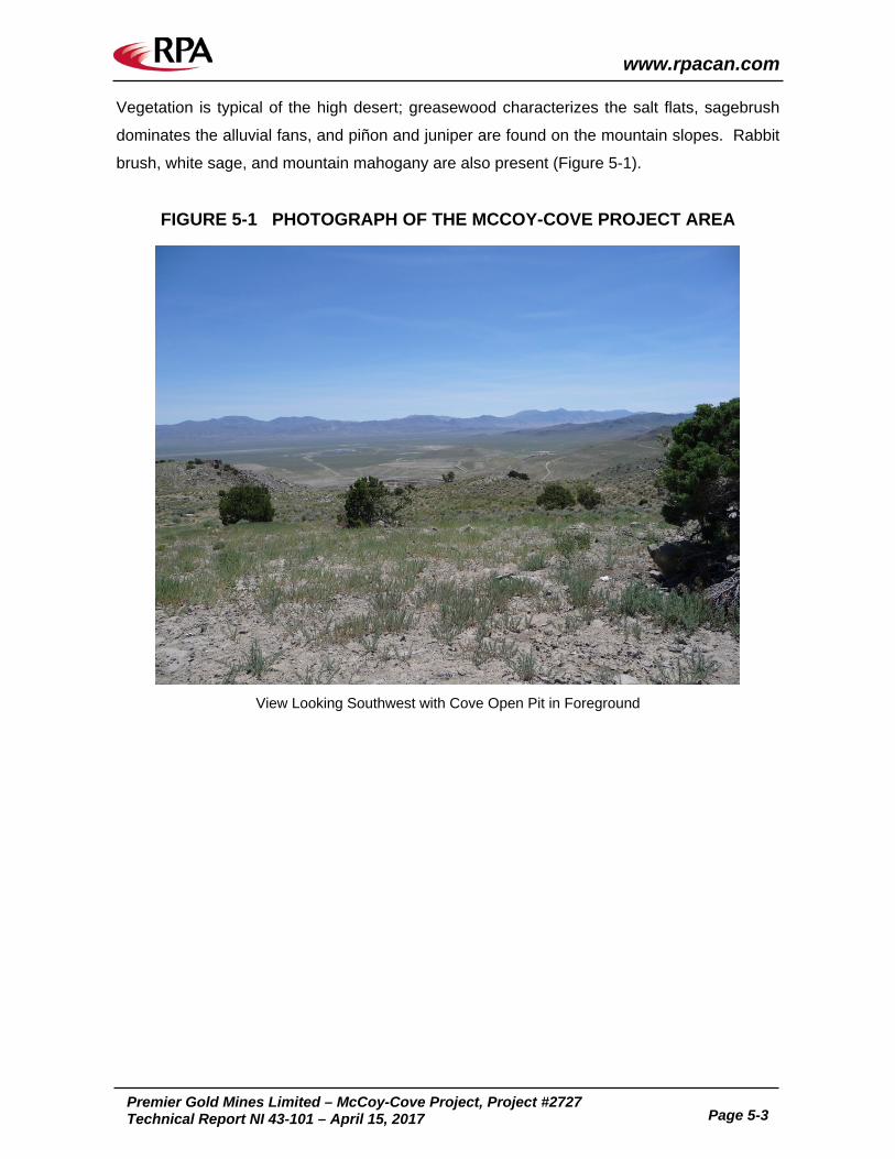
Vegetation is typical of the high desert; greasewood characterizes the salt flats, sagebrush
dominates the alluvial fans, and piñon and juniper are found on the mountain slopes. Rabbit
brush, white sage, and mountain mahogany are also present (Figure 5-1).
FIGURE 5-1 PHOTOGRAPH OF THE MCCOY-COVE PROJECT AREA
View Looking Southwest with Cove Open Pit in Foreground

www.rpacan.com
Premier Gold Mines Limited – McCoy-Cove Project, Project #2727
Technical Report NI 43-101 – April 15, 2017 Page 6-1
6 HISTORY Gold was first discovered in the McCoy Mining District in 1914 by Joseph H. McCoy, and a
total production through 1977 included approximately 10,000 oz of gold plus minor amounts
of silver, lead, and copper. Production in these early years came from placers and from
gold-quartz veins that occurred in northeast striking faults and in intersections of northeast
and northwest striking faults. Most of the non-placer production, however, came from
argillized and oxidized skarn at what became the McCoy open pit mine.
PREVIOUS OWNERS A Howard Hughes company acquired most of the mining claims in the McCoy Mining District
in the 1950s and 1960s. In 1977, Houston Oil and Gas Corporation (Houston) purchased the
McCoy-Cove Project. Gold Fields Mining Corporation (Gold Fields) leased the property in
1981 until September 1984, whereupon the property was returned to Tenneco Minerals
Company (Tenneco), which had acquired Houston. Echo Bay purchased the precious metal
holdings of Tenneco in October 1986. Newmont took ownership of the Cove and McCoy
properties in February 2003 following the merger between TVX Gold Inc. and Kinross Gold
Corporation.
Victoria acquired the lease for the property in June 2006 as previously described in Section
4. In June 2012, Premier entered into an agreement to acquire the lease of the McCoy-Cove
Project from Victoria and subsequently acquired a 100% interest in the land package from
Newmont in September 2014.
HISTORIC EXPLORATION Modern exploration for copper and gold in the McCoy Mining District started in the 1960s by
Bear Creek Mining Company and Pilot Exploration drilling in 1967. Summa Corporation
(Summa) conducted extensive exploration on the McCoy skarn deposit from 1969 to 1977.
Summa also undertook regional geologic mapping of 55 square miles (including the McCoy-
Cove Project area) and extensive rock and chip surveys.

www.rpacan.com
Premier Gold Mines Limited – McCoy-Cove Project, Project #2727
Technical Report NI 43-101 – April 15, 2017 Page 6-2
Houston (which later became Houston International Minerals Corporation) explored the
property in 1980, including geologic mapping, soil geochemical surveys, ground magnetic
surveys, and drilling.
Gold Fields conducted an extensive induced polarization (IP) program, airborne magnetic
surveys, detailed rock chip sampling, as well as limited geologic mapping and drilling
between 1981 and 1984.
In 1985, Tenneco undertook drilling, metallurgical testing, and engineering and feasibility
studies and began mining the McCoy deposit in February 1986. Tenneco also began
systematic district-wide exploration in 1985 with the collection of 500 stream sediment
samples from an eight square mile area around the McCoy deposit. Evidence of what would
become the Cove deposit was found in early 1986, when seven samples yielded gold values
of between 15 ppb and 72 ppb with associated anomalous Ag, As, Hg, Sb, and Tl.
Subsequent detailed geologic mapping identified jasperoid, manganiferous limestone, and
outcrops of altered felsic dikes in the area of the anomalous samples. Surface rock chip
samples of these rocks all contained significant gold mineralization. Tenneco’s detailed
mapping covered a large area that included both McCoy and Cove and extended to the
north, west, and south. In September and October 1986, a total of 147 soil samples were
collected from the B and C soil horizons over the altered area at Cove on a 100 ft by 200 ft
grid.
Echo Bay continued the systematic district exploration program initiated by Tenneco that
included stream sediment, soil, and rock chip sampling plus geologic mapping, exploration
trenching using a bulldozer and drilling. Later soil sampling at Cove defined a gold anomaly
measuring 2,800 ft long by 100 ft to 600 ft wide, with gold values ranging from 100 ppb to
2,600 ppb. Bulldozer trenching exposed ore grade rock over the entire length of this soil
anomaly. Echo Bay discovered the Cove deposit with drilling in January 1987. By March
1987, Echo Bay had drilled 42 shallow exploration holes and development drilling began in
late March. Echo Bay drilled 458 reverse circulation (RC) holes totalling 315,000 ft from
January 1987 through June 1988 and 51 core holes totalling approximately 65,800 ft through
1989 (Briggs, 2001).
In 1999, Echo Bay drilled eight surface drill holes totalling 6,700 ft on the Cove South Deep
deposit. This drilling, combined with bulk sampling from an underground exploration drift,

www.rpacan.com
Premier Gold Mines Limited – McCoy-Cove Project, Project #2727
Technical Report NI 43-101 – April 15, 2017 Page 6-3
confirmed the presence of a high grade zone (0.25 oz/st Au) that could be mined by
underground methods (Briggs, 2001). Detailed underground drilling of this deposit continued
during 2000 as mining proceeded.
Newmont drilled 15 vertical holes on the property from 2004 to 2005. Victoria began
exploring the property in 2006 resulting in the discovery of the Carlin-style Helen zone
immediately northwest of the Cove pit. The Helen zone was similar to the Cove South Deep
deposit defined by Echo Bay in the late 1990s as both are refractory Carlin-type deposits
hosted within the Home Station and Favret Limestone formations.
HISTORIC RESOURCE ESTIMATES Numerous estimates of historical “geological resources” and “proven and probable reserves”
have been reported for the McCoy and Cove deposits. The estimates listed in Table 6-1 pre-
date the introduction of NI 43-101 reporting standards and do not meet the NI 43-101 criteria
for resource/reserve classification as they have not been prepared in compliance with the
Canadian Institute of Mining, Metallurgy and Petroleum (CIM) Definition Standards for
Mineral Resources and Mineral Reserves. As such, these estimates should not be relied
upon. These are relevant as they indicate the potential mineralization in the area. In most
instances, the estimates are for mineralization that was subsequently mined at Cove and
McCoy and thus does not represent remaining “reserves” available for future production.
TABLE 6-1 HISTORICAL RESOURCE AND RESERVE ESTIMATES Premier Gold Mines Limited – McCoy-Cove Project
Company Date Location Tons (M)
Au Grade (oz/st)
Contained Au (000 oz) Comments
Emmons and Coyle 1987 Cove & McCoy 50 to 70 0.065 3,000 to
5,000 Geological Resource
Kuyper et al. 1991 Cove & McCoy 53.7 0.054 2,900 Proven & Probable
Reserves
Emmons and Eng 1995 Cove - - 3,600 Estimated in situ
pre-mining Reserves McCoy - - 880
Echo Bay Minerals Co. 1999 Cove & McCoy 11.8 0.043 500
1999 Year End Proven & Probable Reserves
Nevada Bureau of Mines & Geology 2000 Cove &
McCoy 4.7 0.034 160 Proven & Probable Reserves
Nevada Bureau of Mines & Geology 2001 Cove &
McCoy 0.4 0.031 12 Proven & Probable Reserves
Notes: The estimates have not been prepared in compliance with the CIM definitions pursuant to provisions of NI 43-101 and, as such, should not be relied upon.

www.rpacan.com
Premier Gold Mines Limited – McCoy-Cove Project, Project #2727
Technical Report NI 43-101 – April 15, 2017 Page 6-4
HISTORIC MINING The earliest known significant mining was in the early 1930s by the Gold Dome mine,
previously located on northeast side of the present McCoy open pit mine. This operation
included a 250 ft shaft and five levels of workings at 50 ft intervals producing gold grades
ranging between 0.25 oz/st and 2.0 oz/st.
Table 6-2 summarizes the annual production between 1986 and 2006 at the McCoy and
Cove mines. Tenneco commenced mining at the McCoy open pit mine in 1986 and Echo
Bay began open pit mining of the Cove deposit in 1988, accompanied by three phases of
underground mining.
Underground access at the Cove Mine was via a decline with rubber-tire machines using a
room and pillar mining method. A dual purpose of the underground mining was to assist the
dewatering of the open pit. From 1988 to 1993, underground mining was used to recover
high grade, base metal, vein-type ore. In 1999, additional underground mining at Cove East
followed high grade, base metal, vein-type ore that extended into the east wall near the
bottom of the Cove pit; approximately 100,000 tons were mined from a relatively flat-lying
zone ranging from 10 ft to 80 ft thick. At Cove East, open stoping methods were used. The
last phase of underground mining began in the fall of 1999 and followed the Cove South
Deep upper zone of high grade Carlin-type ore, a relatively flat zone averaging approximately
10 ft thick. Cove South Deep was discovered in the late 1980s and an exploration drift was
driven into it from Cove East in 1999. Cove South Deep was mined by drift and fill mining
methods. Underground mining was finished in July 2001 with an estimate of approximately
300,000 tons of ore extracted from the Cove South Deep deposit.
Conventional open pit mining methods were utilized at Cove open pit, with drilling and
blasting of ore on 20 ft benches (double benched to 40 ft) and waste on 30 ft benches
(double benched to 60 ft). The lower sulphide orebody was reached in late 1991.
Processing of low grade, run-of-mine heap leach ores from Cove began in 1992 and mining
of high grade ores was completed in 1995. Open pit mining ended at Cove in October 2000.
As of 1994, approximately 185,000 tons of ore and waste rock were mined each day from the
Cove open pit.

www.rpacan.com
Premier Gold Mines Limited – McCoy-Cove Project, Project #2727
Technical Report NI 43-101 – April 15, 2017 Page 6-5
An average of 8,000 tons of higher grade ore (>0.036 oz/st Au equivalent (AuEq)) was mined
each day to supply the mill; 15,000 tons per day of leach grade ore (>0.017 oz/st AuEq) were
crushed to supply heap leach operations; an additional 2,000 tons to 4,000 tons of low grade
ore (>0.009 oz/st AuEq) were also leached without crushing; and 160,000 tons of waste rock
were mined each day.
In 1996, the mill facility was expanded from 7,500 stpd to 10,000 stpd, with milling of
stockpiled carbonaceous ores from the Cove open pit beginning in the second half of 1997.
Mill recoveries declined during the remaining life of the mine as lower grade, more refractory
ores were processed. By October 2000, the mill was processing 11,369 stpd. As of that
date, the gold grade was 0.055 oz/st Au and plant gold recovery was 51.8%; silver grade
was 4.00 oz/st Ag and plant silver recovery was 71.5%.
Gold and silver were recovered by milling of higher grade ore and heap leaching of lower
grade ore. The mill contained gravity, flotation, and cyanide leach circuits. Through 2006, a
total of 3.41 million ounces of gold and 110.2 million ounces of silver were produced from
Cove and McCoy, with the vast majority of both metals reportedly coming from the Cove
deposit. Approximately 2.6 million ounces of gold were produced from the Cove open pit.

TABLE 6-2 HISTORIC COVE AND MCCOY MINE PRODUCTION 1986-2006 Premier Gold Mines Limited – McCoy-Cove Project
Year
Ore Processed Mill Grade Heap Leach Au
Ounces Ag
Ounces Milled Oxide
Ore Tons (000)
Milled Sulphide Ore Tons
(000)
Heap Leach Tons (000)
Oxide Ore Sulphide Ore Au oz/st
Ag oz/st Au
oz/st Ag
oz/st Au
oz/st Ag
oz/st 1986 - - 1,851 - - - - 34,035 na1987 - - 4,292 - - - - 0.040 - 90,788 56,8001988 - - 2,994 - - - - 0.053 1.14 104,009 764,1161989 1,358 - 5,696 0.107 3.21 0.020 0.44 214,566 2,259,6531990 2,004 201 5,709 0.084 0.82 0.227 6.17 0.021 0.20 255,044 1,982,4551991 2,094 364 5,174 0.077 1.70 0.194 8.42 0.020 0.69 284,327 5,619,0071992 1,483 990 9,029 0.075 2.54 0.163 7.57 0.014 0.60 301,512 7,921,4961993 2,308 552 8,938 0.107 4.61 0.136 4.65 0.017 0.88 395,608 12,454,3381994 506 2,304 7,892 0.126 6.71 0.143 4.91 0.013 0.48 359,360 10,443,1511995 497 2,151 4,355 0.150 5.42 0.104 5.23 0.018 0.49 310,016 11,905,8061996 - 3,287 6,068 - - 0.086 3.14 0.018 0.27 271,731 7,102,3481997 - 3,391 6,494 - - 0.061 4.54 0.018 0.29 187,034 11,021,7081998 - 4,306 4,112 - - 0.046 2.95 0.021 0.26 167,494 9,412,8231999 - 4,452 4,178 - - 0.038 3.02 0.022 0.37 124,536 8,430,0722000 - 4,172 1,809 - - 0.053 3.71 0.024 0.93 162,784 12,328,2972001 - - - - - 94,633 6,451,4252002 - - - - - 33,142 1,987,4212003 - - - - - 4,699 7062004 - - - - - 8,454 64,3352005 - - - - - 2,740 7762006 - - - - - 2,939 596Total 10,250 26,170 78,591 0.095 2.93 0.076 3.98 0.021 0.48 3,409,451 110,207,329
Source: Mine Development Associates, 2008 – taken from Briggs 2001 & Nevada Bureau of Mines and Geology 2007
Note: The 1996-2000 milled sulphide ore data contained a minor amount of milled oxide ore.
ww
w.rp
acan.co
m
Prem
ier Go
ld M
ines L
imited
– McC
oy-C
ove, P
roject #2727
Tech
nical R
epo
rt NI 43-101 – A
pril 15, 2017
Pag
e 6-6

www.rpacan.com
Premier Gold Mines Limited – McCoy-Cove Project, Project #2727
Technical Report NI 43-101 – April 15, 2017 Page 7-1
7 GEOLOGICAL SETTING AND MINERALIZATION REGIONAL GEOLOGY The McCoy-Cove Project is located in the central Nevada portion of the Basin and Range
Province, which underwent regional extension during the Tertiary that created the present
pattern of alternating largely fault bounded ranges separated by alluvial filled valleys (Figure
7-1). Prior to this extension, central Nevada had been the site of numerous tectonic events,
including at least two periods of regional compression. The property lies west of the central
part of the Battle Mountain-Eureka Trend.
During the Paleozoic, central Nevada was the site of the generally north-northeast trending
continental margin of North America, along which pre-orogenic rocks of Cambrian to Early
Mississippian age were deposited. A carbonate platform sequence was deposited to the
east along the continental margin, with siliceous and volcanic rocks deposited to the west. In
Late Devonian to Early Mississippian time during the Antler Orogeny, rocks of the western
assemblage moved eastward along the Roberts Mountains thrust, perhaps as much as 90
miles over the eastern assemblage carbonate rocks. A post-orogenic assemblage of coarse
clastic sedimentary rocks of Mississippian to Permian age was shed eastward from an
emerging highland to the west, overlapping the two earlier facies.
During Pennsylvanian and Permian time, chert, pyroclastic rocks, shale, sandstone,
conglomerate, and limestone of the Havallah sequence were deposited in a deep
eugeosynclinal trough to the west of the Antler orogenic belt. These rocks were thrust
eastward along the Golconda thrust over the Antler overlap assemblage in Late Permian and
Early Triassic time during the Sonoma Orogeny. The Golconda thrust is exposed to the west
of the Roberts Mountains thrust.
Mesozoic rocks, primarily shallow water siliciclastic and carbonate units with minor volcanic
and volcaniclastic rocks, are found in this part of Nevada. At least three additional tectonic
events are recorded in latest Paleozoic and Mesozoic time, including the formation of the late
Jurassic Luning-Fencemaker fold and thrust belt in western and central Nevada. The most
recent events in the Great Basin are widespread Cenozoic volcanism and extensional

www.rpacan.com
Premier Gold Mines Limited – McCoy-Cove Project, Project #2727
Technical Report NI 43-101 – April 15, 2017 Page 7-2
faulting. Late Jurassic (168-143 Ma), Cretaceous (128-90 Ma), and Eocene to Oligocene
(43-30 Ma) intrusions have been reported from this part of Nevada.
LOCAL AND PROPERTY GEOLOGY The stratigraphy of the McCoy Mining District is well documented, and has been described in
detail by Emmons and Eng (1995) and Johnston (2003). Generalized Triassic stratigraphy of
the local area is presented in Figure 7-2 and the major lithological units are described below.
HAVALLAH FORMATION The Permian Havallah Formation is the deepest drilled unit on the property and is composed
of reddish-brown to green argillite and chert. Where it hosts veins, the Havallah displays
alteration envelopes containing fine-grained quartz-illite/sericite. The total thickness of the
Havallah across the property is unknown. Its contact with the overlying Dixie Valley
Formation is sometimes offset by clearly defined reverse faulting and demarcated by the
presence of an unconformable rhyodacite tuff (assumed to be Koipato Formation), while in
other areas of the property, it is simply defined by the change from coarse-grained clastic
conglomerates and sedimentary breccias to argillite.
KOIPATO FORMATION Locally, at the contact between the Dixie Valley Formation and the Havallah, there is a
maroon rhyodacite tuff assumed to be part of the Permo-Triassic Koipato sequence
described by Silberling and Roberts (1962). The upper and lower contacts of this rhyodacite
tuff are unconformities.
DIXIE VALLEY FORMATION The early Middle Triassic Dixie Valley Formation consists primarily of coarse-grained
conglomerates and intercalated dolomitic sandstones, as well as lesser fossiliferous
limestone units generally restricted to the upper portion of the formation.
FAVRET FORMATION The late Middle Triassic Favret Formation, approximately 750 ft thick, consists of an upper
fossiliferous limestone unit containing ammonites and pelecypods, a middle unit of finely

www.rpacan.com
Premier Gold Mines Limited – McCoy-Cove Project, Project #2727
Technical Report NI 43-101 – April 15, 2017 Page 7-3
interbedded silty limestones and limestones (principal Carlin-style ore host), and a basal unit
of debris flow fossil hash containing ammonites, pelecypods, and star-shaped crinoids.
AUGUSTA MOUNTAIN FORMATION – HOME STATION MEMBER The late Middle Triassic Home Station Member is 100 ft to 150 ft thick and was previously
described as a thicker unit consisting of massive calcareous and dolomitic limestone with
lenses or beds of sandstone and conglomerate (Kuyper et al., 1991). Johnston (2003)
however, classified this unit as silty dolostones based on exposures in the Cove open pit
which displayed medium to dark grey, very thickly bedded (greater than 3 ft) dolostone
consisting of three to 25 volume percent quartz grains (averaging 0.0016 in. diameter) in a
recrystallized dolomite matrix. The clastic components of Kuyper et al.’s (1991) Home
Station are now classified as Panther Canyon and the lower limestone is now considered the
upper part of the Favret Formation. Although the contact between the Home Station Member
and the overlying Panther Canyon Member was described as gradational by Kupyer et al.
(1991), Johnston (2003) mapped the contact in the Cove open pit as sharp, and Premier
geologists use a prominent lag gravel deposit (generally less than 15 ft to 20 ft thick) to mark
this contact.

120�42�
41�
40�
39�
120�
38�
118�
119�
37�
117�
116�
36�
115�
36�
37�
38�
39�
40�
41�
42�
114�115�116�117�118�119�
NEVADA BUREAU OF MINES AND GEOLOGY EDUCATIONAL SERIES E-30 GENERALIZED GEOLOGIC MAP OF NEVADA
Modified from Nevada Bureau of mines and Geology map 57, Million-Scale
Geologic Map of Nevada, by John H. Stewart and John E. Carlson, 1977; and
fault maps by Craig M. dePolo, 1998.
NEVADA BUREAUGEOLOGY
MACKAY SCHOOL OF MINES
First edition, first printing, 1999; 5,000 copies
Printing: Bear Industries, Sparks, Nevada
Cartography: Susan L. Tingley
For sale by the Nevada Bureau of Mines and Geology, Mail Stop 178
Mackay School of Mines, University of Nevada, Reno, Nevada, 89557-0088
(775) 784-6691, ext. 2; [email protected]; www.nbmg.unr.edu
0
0 20 40 60 80 kilometres
10 20 30 40 50 miles
County boundaries
Quaternary and suspected Quaternary faults,
less than 1.6 Ma (million years old),
dashed where age uncertain
Lakes and reservoirs
Alluvial and playa deposits
Volcanic rocks, less than 6 Ma
Upper volcanic rocks, 6–17 Ma
Tuffaceous sedimentary rocks, 6–17 Ma
Lower volcanic rocks, mostly 17–43 Ma
Intrusive rocks, Mesozoic and Tertiary
Igneous and metamorphic complex, Jurassic or Cretaceous
Sedimentary, volcanic, and intrusive rocks, Mesozoic
Sedimentary and volcanic assemblage, upper Paleozoic
Carbonate and other sedimentary rocks, upper Paleozoic
Sedimentary and volcanic assemblage, lower Paleozoic
Carbonate and other sedimentary rocks, lower Paleozoic and Late Proterozoic
Metamorphic and intrusive rocks, Early and Middle Proterozoic
COVE GOLD PROJECT
N
April 2017
McCoy-Cove Gold Project
Regional Geology
Premier Gold Mines Limited
State of Nevada, U.S.A.
Figure 7-1
7-4
www.rpacan.com

April 2017 Source: Premier Gold, 2016.
McCoy-Cove Gold Project
Triassic Stratigraphiy andMineralization
Premier Gold Mines Limited
State of Nevada, U.S.A.
Figure 7-2
7-5
www.rpacan.com

www.rpacan.com
Premier Gold Mines Limited – McCoy-Cove Project, Project #2727
Technical Report NI 43-101 – April 15, 2017 Page 7-6
AUGUSTA MOUNTAIN FORMATION – PANTHER CANYON MEMBER The Panther Canyon Member at Cove is divided into two informal units, the lower Dolostone
Submember and upper Transitional Submember.
The lower Dolostone Submember unit is generally 50 ft to 75 ft thick and consists of a well
bedded, medium grey dolostone. Individual beds are typically less than three feet in
thickness. This unit is a primary dolostone and commonly has stromatolitic algal textures
(Emmons and Eng, 1995). Johnston (2003) noted that quartz grains (0.001 in. diameter)
locally constitute up to 20 volume percent and that the contact with the overlying Transitional
Submember is very gradational over a distance of approximately 10 ft.
The upper Transitional Submember is a 500 ft thick unit which coarsens upward, from a
basal primary dolostone, through middle silty and sandy dolostone and carbonate cemented
silt- and sandstone, to conglomerate near the top. The general transition is not smooth,
however, as contrasting lithologies are interspersed throughout the unit at all levels, typically
as lensoid bodies. This Transitional Submember can be further separated into a lower
carbonate rich and an upper clastic section as follows:
• Lithologies in the 165 ft thick lower carbonate rich section are highly variable. Although the strata are primarily made up of dolostone, lenses, and beds of carbonate cemented siltstone and very fine grained sandstone, coarser sandstone and conglomerate are abundant. The lower 80 ft of this section consists principally of massive dolostone. Typical strata in the upper 80 ft of this section consist of 0.001 in. to 0.003 in. diameter, subrounded, moderately sorted quartz grains. Individual beds are typically less than 3.3 ft in thickness. The diagenetic cement is calcite, but it has been dissolved and/or replaced by illite-sericite where hydrothermally altered.
• The 300 ft thick upper clastic section in the Transitional Submember generally consists of fine grained sandstone to cobble conglomerate. The thickness of bedding is highly variable, but the conglomerate beds are generally thicker (up to 16 ft thick) than the sandstone beds (up to 3.3 ft thick). Cross-bedding is common, and conglomeratic strata typically grade upwards from relatively coarse to relatively fine grained sediments. Detrital grains and cobbles consist of chert, quartzite, and quartz. These grains are rounded to subrounded and moderately sorted. Primary porosity, which was originally high, ranges up to 20 volume percent as observed by Johnston (2003). The contact with the overlying Smelser Pass Member is gradational over several tens of feet.
AUGUSTA MOUNTAIN FORMATION – SMELSER PASS MEMBER The Smelser Pass Member unit is volumetrically the largest at Cove with a maximum
thickness of just over 900 ft. The unit is predominantly a microcrystalline limestone with

www.rpacan.com
Premier Gold Mines Limited – McCoy-Cove Project, Project #2727
Technical Report NI 43-101 – April 15, 2017 Page 7-7
abundant recrystallized bioclasts, however, the upper 500 ft contain very minor thin
interlaminated calcareous shale beds. The limestone is thick bedded to massive, with
individual beds ranging from three feet to 16 ft in thickness. Macro allochemical remains
consist of partial to complete brachiopods, pelecypods, gastropods, crinoids, corals,
sponges, and ammonites, in decreasing order of abundance. The lowermost beds contain
up to 15 volume percent of 0.0006 in. diameter quartz grains.
The Smelser Pass Member is separated from the overlying Oligocene tuffaceous sediments
and Tuff of Cove Mine by an angular unconformity. Kuyper et al. (1991) determined that the
upper 575 ft of the Smelser Pass were removed by erosion prior to deposition of the
Oligocene units. More than 2,100 ft of the Triassic Cane Spring and Osobb Formations,
which overlie the Smelser Pass Member elsewhere in the McCoy Mining District, are also
missing at Cove. Much of the Smelser Pass Member has been subjected to supergene
oxidation, giving the originally medium grey limestone an orange to brown appearance.
TUFF OF COVE MINE The tuff of Cove Mine, previously thought to be the 33.8 Ma Caetano Tuff, has a maximum
thickness of approximately 1,500 ft in the deepest parts of the paleovalley it filled. It consists
of 0.016 in. to 0.276 in. long fragments of plagioclase, biotite, potassium-feldspar, and
resorbed quartz phenocrysts in a glassy to devitrified matrix. Phenocrysts comprise 40
volume percent and matrix 60 volume percent of the rock. John et al. (2008) reported a 40Ar/39Ar age of approximately 34.2 Ma on a set of samples including some collected in the
northern Fish Creek Mountains.
INTRUSIVE IGNEOUS ROCKS Abundant dikes and sills are encountered in drilling at Cove, and historic convention at the
property has been to classify them as ether “felsic” or “mafic.” The majority are “felsic” and
can be mapped at surface associated with and occupying the main faults extending from the
Eocene Brown stock at McCoy. Though commonly altered, their textural similarities to the
unaltered granodioritic feldspar porphyry of the Brown Stock suggest that they were of similar
composition. These dikes are light grey to white in colour due to sericitic or argillic alteration.
Their porphyritic texture is preserved. They may be observed over drill hole intercepts
ranging in length from less than 0.5 to 215 vertical feet and are usually steeply dipping. Less
altered samples collected from the Cove open pit retain evidence for secondary biotite

www.rpacan.com
Premier Gold Mines Limited – McCoy-Cove Project, Project #2727
Technical Report NI 43-101 – April 15, 2017 Page 7-8
replacing hornblende suggesting a weak potassic alteration event that has been overprinted
by lower temperature alteration events at depth. The Gold Dome is the most prominent
“felsic” dike at the deposit and is cross-cut by both polymetallic veins and pervasively altered
by weak Carlin-style mineralization.
As a result of the intense alteration, many occurrences of rocks of different composition have
been incorrectly logged as “felsic.” Multi-element geochemistry from Premier’s data were
used in 2016 to reclassify all igneous rocks by filtering for high occurrences of Cr, Ni, and V.
When the reclassified lithologies were remodelled in 3D it became apparent that the mafic
intrusive rocks are present as thin, laterally extensive, stacked sills that terminate down the
northeast limb of the Cove anticline. As a result of that exercise, two distinct trends were
discovered in the Ni and V concentrations of these mafic dikes and sills. Whole rock
geochemistry and subsequent remodelling confirms the presence of two distinct mafic
compositions. These are classified as “type 1” characterized by high V and lower Ni and
“type 2” characterized by low V and higher Ni. “Type 1” in drill core is typically dark green in
colour, contains abundant calcite, and may be magnetic. Though the “type 1” sills have a
strong spatial association to Carlin-style mineralization across the deposit, they are rarely
mineralized and can be devoid of As, Au, and Ag in direct contact with mineralized limestone.
The “type 2” sills are generally light green to white in colour and can be difficult to distinguish
from similarly altered “felsic” dikes. They appear to have been hornblende-biotite porphyries
prior to alteration and commonly contain magnetite. They also share a spatial association to
Carlin-style mineralization but, unlike “type 1” sills, are very commonly mineralized (up to 20
ppm Au, 20 ppm Ag). “Type 2” sills are less prevalent overall than “type 1” sills, and
concrete cross-cutting relationships between any of these three intrusive rocks have thus far
been elusive.
QUATERNARY ALLUVIUM Emmons and Eng (1995) divided the Quaternary surficial units in the McCoy Mining District
into alluvium, talus, and colluvium. Quaternary sediments exposed in the Cove open pit
were not differentiated in this study. These sediments include unconsolidated sand and
gravel, and are less than 215 ft thick.

www.rpacan.com
Premier Gold Mines Limited – McCoy-Cove Project, Project #2727
Technical Report NI 43-101 – April 15, 2017 Page 7-9
STRUCTURAL GEOLOGY Deposits on the McCoy-Cove Project are related to specific structural features.
MAJOR DEFINING STRUCTURES The major structure and control on fluid movement is the broad northwest-striking, gently
southeast-plunging Cove anticline interpreted as a fault propagation fold over a deep
northwest striking reverse fault identified in deep drill holes under the Cove pit. While the
reverse fault can be identified in the 2201-VG zone, its presence at the CSD Gap and Helen
zones is uncertain due to limited drilling in areas that would confirm its continuation. A
northwest striking vertical dike called the Northwester Dike (classified as “type 2”) extends
from the Bay fault through the CSD Gap and into the Helen zone. It appears to prohibit the
flow of mineralizing fluids to the southwest in areas between the major northeast striking
faults. Though there is no discernible separation on the dike, it may be related to a near
vertical to steeply southwest dipping fault mapped in the pit by Echo Bay geologists called
the Northwester fault.
The other major structures for fluid movement and mineralization are a number of northeast
striking normal faults (Cay, Blasthole, Bay, 110, Gold Dome, and Norm). The northeast
striking faults commonly host altered granodioritic dikes, the largest of which is the Gold
Dome. The north-south striking Lighthouse fault also contains altered granodioritic dikes and
is believed to have had both pre- and post-mineralization movement. Defining the northern
extent of the Helen zone is an east- northeast striking fault called the B fault south of which is
the east-west striking A fault. The A and B faults form a well mineralized “wedge” of high
grade Au that requires additional testing along strike to fully realize the deposit’s potential.
These faults and structures were defined and confirmed by:
• Surficial and open pit geologic mapping by Echo Bay, Victoria, and Premier
• Offset observed during detailed cross section work by Premier in 2016
• Oriented core measurements by Victoria and Premier, especially in the Helen zone and CSD Gap

www.rpacan.com
Premier Gold Mines Limited – McCoy-Cove Project, Project #2727
Technical Report NI 43-101 – April 15, 2017 Page 7-10
MINERALIZATION CONTROLS Carlin-style mineralization appears to be controlled by a combination of the axis of the Cove
anticline, normal faults that cut the anticline, mafic sills and dikes throughout the property,
and contacts between different sedimentary units. Generally, the highest grades are found
where the rhythmically bedded unit of the Favret Limestone is cut by mafic dikes and sills
along the axis of the anticline, and especially where this area is cut by apparent small-scale,
unmapped faults. Lower-grade (0.05 oz/st to 0.25 oz/st Au) Carlin-style mineralization in the
Helen and CSD Gap zones is typically found along the Favret-Home Station contact and the
contact between the Panther Canyon’s upper conglomerate unit and lower dolomite unit.
The northeast striking faults commonly contain quartz-sericite-pyrite and argillic altered
granodioritic dikes that carry low to anomalous values of Au and Ag. Carlin-style
mineralization in the Favret and other units is typically bounded by these northeast structures
with higher grades focused in the axis of the anticline and lower grades with associated
pathfinder elements (As, Sb, Tl, Hg, etc.) typically along the margins of the anticline as well
as immediately adjacent to these major structures.
In the 2201-VG zone, structural controls are poorly defined, however, vein-bearing Au
occurrences do trend northwest and may be related to structures formed in the hanging wall
of the deep-seated reverse fault or to the near vertical to steeply southwest dipping
Northwester fault. .
POST-MINERAL FAULTING There is at least one instance of significant post-mineral faulting. The Striper Splay is
believed to be a splay off of the Lighthouse fault which is known to have both pre- and post-
mineralization movement. It dips steeply northeast and strikes approximately 320° along the
northeast limb of the Cove anticline causing significant post-mineral normal displacement
before terminating against the Bay/110 fault complex. The overlying volcanics are not
significantly faulted, as defined by holes NW-1, NW-2 & 2A, and NW-3.
MINERALIZATION There are four distinct mineralization types known on the property: Carlin-style, polymetallic
sheeted veins, carbonate replacement (Manto) and skarn. The Helen, CSD Gap and CSD

www.rpacan.com
Premier Gold Mines Limited – McCoy-Cove Project, Project #2727
Technical Report NI 43-101 – April 15, 2017 Page 7-11
deposits are Carlin-style deposits while the 2201-VG zone is comprised of steeply dipping
polymetallic sheeted veins.
CARLIN-STYLE (AU-AG) The gold in Carlin-style deposits is usually sub-micron in size and generally occurs in pyrite
and arsenical pyrite. An envelope characterized by decalcification, silicification, and
argillization accompanied by anomalous amounts of silver, arsenic, antimony, thallium, and
mercury often accompanies mineralization. The Carlin-style mineralization at Cove is
relatively rich in silver compared to similar deposits elsewhere in northern Nevada (Johnston,
2003). When Carlin-style mineralization occurs in the silty limestones and packstones of the
Favret Formation and Home Station Dolomite, decarbonatization replaces fine-grained
calcite and/or dolomite with quartz and forms very fine-grained illite and pyrite. Diagenetic
pyrite was probably present in the Helen zone before Carlin-style mineralization based on the
abundant presence of subhedral pyrite grains that bear no arsenian rims. The arsenic-
bearing pyrites precipitated as a product of Carlin-style mineralization in the Helen zone are
fine-grained (~10 microns) patchy, anhedral “fuzzy” pyrites generally smaller than the
diagenetic pyrite grains. In the CSD zone, most pyrite grains in high-grade samples are
larger (~20 microns), display spectacular, sharp geochemical zonations, and are rimmed with
arsenian pyrite or stoichiometric arsenopyrite. The few samples studied from the CSD Gap
under the SEM suggest it shares more in common with the CSD zone though its silver
content is lower overall.
POLYMETALLIC SHEETED VEINS (AU-AG±PB-ZN) The polymetallic veins in the 2201-VG zone are enveloped by a zone of illitization of the
conglomerate matrix detected by sodium cobaltinitride staining and confirmed by scanning
electron microscope (SEM) analysis. Minor silicification is relatively common, especially in
the conglomerate, however, it is not present everywhere and not always directly associated
with mineralization.
CARBONATE REPLACEMENT (AG-PB-ZN±AU) Carbonate replacement mineralization occurs as local pods of manto-style mineralization
characterized by massive sulfide (pyrite-sphalerite-galena) replacing basal limestone at the
Dixie Valley/Favret contact. Mineralization is discontinuous and generally defined by high-
grade Ag-Zn-Pb±Au.

www.rpacan.com
Premier Gold Mines Limited – McCoy-Cove Project, Project #2727
Technical Report NI 43-101 – April 15, 2017 Page 7-12
SKARN (AU-AG±-CU) Skarn mineralization at the historic McCoy pit occurs as both endoskarn and exoskarn
mineralization characterized by a predominantly garnet-diopside-magnetite mineral
assemblage.
The Carlin-style mineralization across the deposit appears to represent an evolving system
from a “primary” endmember represented by the CSD zone with higher Ag/Au, coarser-
grained pyrite, and a close proximal relationship to Ag-Pb-Zn-(Au) mineralization to the
“evolved” endmember represented by the Helen zone with lower Ag/Au, very fine-grained
pyrite, and weak spatial association with any other styles of mineralization. The CSD Gap
can be considered a “transition” zone between the two endmembers until more petrography
is conducted on the recently discovered CSD Gap to test this hypothesis. Helen zone
geochemistry is distinct from the CSD zone in many ways. For samples greater than 1 ppm
Au, less than or equal to 100 ppm Ag, and confirmed to be Carlin-style mineralization by core
photo review, the Helen zone has an average Ag/Au ratio of approximately 0.85 whereas the
CSD zone is 2.25. Gold in both the Helen and CSD zones correlates with As, Sb, and Hg,
however, Au correlates moderately (0.52 correlation coefficient) with Ag in the CSD zone but
more weakly (0.3652 correlation coefficient) in the Helen zone.
Like the geochemistry, the mineralization in the Helen and CSD is also distinct. The As-
bearing (assumed to also be Au-bearing) pyrites in the Helen zone are generally finer-
grained, less euhedral, and more poorly zoned than the As-bearing CSD zone pyrites. Helen
zone pyrites overall have lower As content – ranging from just at detection limit (~0.3 wt% to
0.5 wt%) to 2.1 wt% – than the CSD zone which contains pyrites with arsenic contents
ranging from detection limit to 6 wt%. The SEM-EDS system first detected trace elements
such as Te, Tl, Hg, Sb, and even Au and Ag in CSD zone pyrites, while electron microprobe
analysis confirmed the presence of Au, Ag, As, Tl, Hg, Sb, and Pb in CSD mineralization.
Other pyrites in the CSD zone contain fewer trace elements but still display complex
elemental zoning and growth patterns visible only in backscatter electron imaging. The
complicated nature of the mineralized pyrites at the CSD zone is suggestive of a more
complex and long-lasting mineralizing event in comparison to the seemingly simple Helen
zone mineralization.
In the 2201-VG zone, Au correlates with Ag, As, Cu, Fe, Pb, Sb, and Zn – a distinctly
different grouping of elements from the CSD, CSD Gap, and Helen zones. The 2201-VG

www.rpacan.com
Premier Gold Mines Limited – McCoy-Cove Project, Project #2727
Technical Report NI 43-101 – April 15, 2017 Page 7-13
zone veins typically occur as sheeted veins and range in thickness from 0.1 cm to 6.5 cm
and contain both quartz and carbonate minerals as gangue. Generally, the calcite and
dolomite-dominant veins are shallower and thinner whereas the quartz (-carbonate)-bearing
veins are deeper and can reach widths of 15 cm. The sulphides are mostly pyrite, sphalerite,
and galena with arsenopyrite, chalcopyrite, and pyrrhotite also locally present. Visible gold is
mostly limited to the thicker veins and is always observed along the margins with coarse-
grained quartz. When microscopic, the gold is present as electrum with approximately 15
wt% Ag (measured on SEM-EDS) and hosted within sulphides such as chalcopyrite or
arsenopyrite. Galena may also carry up to 10 wt% Ag. An oriented hole drilled in 2014
(PG14-23) provided some structural data for the vein-type mineralization. There were no
trends for veins grouped by gangue or thickness, however, when grouped by depth, the data
show that veins shallower than 1,750 ft generally strike northeast-southwest with varying dips
and veins deeper than 1,900 ft generally strike northwest-southeast and dip steeply in both
directions.

www.rpacan.com
Premier Gold Mines Limited – McCoy-Cove Project, Project #2727
Technical Report NI 43-101 – April 15, 2017 Page 8-1
8 DEPOSIT TYPES The Cove-Helen deposit consist of two mineralization styles, Carlin-style and polymetallic
sheeted veins, as outlined in Section 7 of the report. The Carlin-style mineralization within
the Helen, CSD Gap, and CSD zones comprises approximately 85% of the existing resource
with high gold and silver grades occurring as both stratabound and structurally controlled
mineralization at the intersection of the Cove anticline and favourable lithologic beds,
structures, intrusive dikes and sills.
The polymetallic 2201-VG zone is a separate deposit from the shallower Carlin-style
mineralization and is believed to be a structurally controlled sheeted vein system. Veining is
oriented northwest, with vein geometry being controlled by a deeper northwest striking
reverse fault. Due to its depth, the 2201-VG zone has seen limited drilling since its original
discovery in late 2013, however, additional infill and step-out drilling in the future will help to
better define deposit potential and mineralization controls.
A schematic cross section of the CSD Gap zone is shown in Figure 8-1, delineating in red
grades greater than 5 g/t Au. High grade mineralization is focused within the dilatant hinge
of the Cove anticline.

0 50 100 150 200 Metres
0 400 500 Feet300200100
April 2017 Source: Premier Gold, 2016.
Schematic Cross Section ofCSD Gap Deposit
McCoy-Cove Gold Project
Premier Gold Mines Limited
State of Nevada, U.S.A.
Figure 8-1
8-2
www.rpacan.com

www.rpacan.com
Premier Gold Mines Limited – McCoy-Cove Project, Project #2727
Technical Report NI 43-101 – April 15, 2017 Page 9-1
9 EXPLORATION Historical exploration in the larger McCoy-Cove claim block area from the mid-1960s to 1991
included the following:
• Stream sediment (silt) sampling
• Soil sampling
• Rock chip sampling
• Geophysical surveys including Magnetics-Electromagnetic (EM) and Induced Polarization (IP)
• Drilling
From 2006 to 2012, exploration in the Project area was conducted by Victoria’s exploration
office in Reno, Nevada. A field office, including core logging and storage facilities, was
situated in Battle Mountain with secondary core storage at the Cove Mine site area.
Since 2012, the structural geometry of the “plunge tube” model as proposed by Victoria has
been disproved and replaced with the litho-structural model proposed by Premier staff. As a
result, the re-interpretation of the Cove-Helen deposit has expanded the existing zones and
identified targets property-wide that Premier has followed up on using a number of
exploration methods including soil sampling, field mapping, geochemistry, and geophysics.
Highlights of exploration from 2013 to present include the discovery of the 2201-VG and CSD
Gap zones as well as a re-interpretation of the Helen zone resulting in improved continuity
throughout the zone. The 2017 exploration program will consist of select infill drilling as well
as utilizing the new litho-structural model to systematically test multiple high priority targets
property-wide.

www.rpacan.com
Premier Gold Mines Limited – McCoy-Cove Project, Project #2727
Technical Report NI 43-101 – April 15, 2017 Page 10-1
10 DRILLING PRE 2012 Table 10-1 presents a summary of pre-2012 drilling activities in the McCoy-Cove Project
area, including Echo Bay and Newmont RC drilling from 1985 to 2005 and Victoria diamond
drilling from 2006 to 2011. The Echo Bay and Newmont holes were drilled at varied
spacings. All Echo Bay, Newmont, and Victoria drilling information was used with the
exception of the Newmont waste dump confirmation hole No. C15-92. The majority of the
Victoria holes were drilled off-azimuth into the lower Helen zone to target specific structural
intersections.
TABLE 10-1 SUMMARY OF MCCOY-COVE PROJECT DRILLING – PRE-2011
Premier Gold Mines Limited – McCoy-Cove Project
Year Hole Type Operator Number of Holes Length (ft) 1985-2000 Reverse Circulation Echo Bay 21 24,680 2004-2005 Reverse Circulation Newmont 15 24,485 2006-2009 Diamond Drill Victoria 18 41,915
Total 54 91,080
All Victoria diamond drilling was completed from surface retrieving whole core. The holes
were collared HQ size (63.5 mm) and reduced down to NQ size (47.6 mm) dependent upon
ground or drilling conditions. Drill muds were utilized to ensure consistent core recovery (MI
Swaco and New Park). Due to poor ground conditions two holes were lost and had to be re-
drilled and wedge drilling was completed from parent hole NW-09 and continued as hole
NW-09A.
Table 10-2 presents a summary of Victoria’s diamond drilling program.

www.rpacan.com
Premier Gold Mines Limited – McCoy-Cove Project, Project #2727
Technical Report NI 43-101 – April 15, 2017 Page 10-2
TABLE 10-2 SUMMARY OF VICTORIA DIAMOND DRILLING – PRE-2012 Premier Gold Mines Limited – McCoy-Cove Project
Hole-Id Footage Start Date Drilling Contractor
NW-01 2,353.0 11-Sep-06 Connors NW-02 1,671.0 21-Oct-06 Connors NW-02A 3,076.5 29-Nov-06 Connors NW-03 3,719.0 26-Sep-06 Connors NW-04 2,690.0 01-Oct-06 Connors NW-05 2,251.0 28-Apr-07 Connors / Action Drilling NW-06 627.5 07-Dec-07 Action Drilling NW-06A 2,229.0 13-Jan-08 Kirkness NW-07 2,355.0 09-Dec-07 Kirkness NW-08 2,429.0 13-Feb-08 Kirkness NW-09 2,142.0 06-Mar-08 Kirkness NW-09A 2,083.0 Kirkness NW-10 2,656.5 17-Apr-08 Progressive NW-11 2,194.0 08-May-08 Kirkness NW-12 1,946.0 08-Aug-08 Kirkness NW-13A 2,407.0 23-Oct-08 Progressive NW-14 2,346.0 16-Feb-09 Kirkness NW-15 2,740.0 02-May-09 Major
SURVEYING PROPERTY GRID AND DRILL HOLE COLLARS The McCoy-Cove Project grid is based on UTM NAD83_11.
No information was made available to RPA concerning the Echo Bay and Newmont collar
positioning, although it is assumed that major company industry standards were employed.
Victoria diamond drill holes NW-01 to NW-09, inclusive, were spotted by hand-held GPS.
This included collar, foresight, and backsight. Drill holes NW-10 to NW-15, inclusive, were
surveyed by All Points North, registered Nevada Land Surveyors. A Brunton compass was
used to set the drill head.
All diamond drill holes prior to 2012 were proposed and collared based on the UTM NAD 27
property grid, which was referenced in a historical digital terrain map (DTM) created prior to
full scale mining and reclamation. After acquiring the property in 2012, Premier converted all
drill hole data to UTM NAD83_11 metres and systematically checked the validity of the

www.rpacan.com
Premier Gold Mines Limited – McCoy-Cove Project, Project #2727
Technical Report NI 43-101 – April 15, 2017 Page 10-3
conversion using historic air photos checked against an updated 2012 aerial survey as well
as field checking historic drill hole collars where available.
DOWNHOLE SURVEY Downhole directional survey information was available for all four of the Echo Bay RC holes
used in the resource model. Holes were surveyed at nominal 50 ft intervals by Boyles
Welnav of Elko, Nevada. The survey instrument was not listed on the files but is assumed to
be a magnetic azimuth and dip tool.
All Newmont RC holes were downhole surveyed at nominal 50 ft intervals by International
Directional Services. The survey instrument, although not listed on the scanned files, is
assumed to be a magnetic azimuth and dip tool.
Victoria downhole surveys were completed using a North Seeking Gyro (NSG) by Major
Technical Services and International Directional Services. NSGs eliminated the need for
sighting on surface (gyro-compass alignment) and offered high accuracy. Generally NSG
surveys were performed twice, once at mid-hole and again at hole completion. Readings of
dip and azimuth were taken at nominal 50 ft intervals.
RPA notes that no directional tests were taken during regular drilling operations. Holes NW-
02 and NW-09A were unable to be downhole surveyed as the holes had to be abandoned
due to poor ground conditions.
SAMPLING No description of RC sampling methods and approach utilized by Newmont or Echo Bay was
made available to RPA. RPA assumes that the methodology employed by these major
companies would have been to industry standards at the time. Reverse circulation drilling
involves a downhole pneumatic hammer. The drill cuttings, ideally dry rock chips, are lifted
to surface inside the rod by differential air pressure and reach the top of a cyclone. The drill
cuttings travel around the inside of the cyclone until they fall through an opening at the
bottom and are collected in a sample bag. The chips are then split and geologically logged.
RPA’s site visits in 2009 occurred after completion of the diamond drilling operations. The
following description related to Victoria’s approach is summarized from discussions with

www.rpacan.com
Premier Gold Mines Limited – McCoy-Cove Project, Project #2727
Technical Report NI 43-101 – April 15, 2017 Page 10-4
Victoria’s geologists as well as from an independent 2007 review of drilling procedures
(Wolverson, 2007).
The rock was drilled using a diamond bit. Whole core was retrieved from the drill string core
barrel (either 5 ft or 10 ft length). The drill helper removed the core from the barrel and
placed the core in boxes that were labelled by hole and box number. Distance tags were
placed at appropriate locations.
The core boxes were picked up at the drill site by a Victoria geologist and delivered to the
core logging facility located at the McCoy-Cove Project site. The boxes were then laid out in
the yard and sorted by specific hole and box number. Footages were double checked to
ensure there were no errors. The core was washed and then transferred onto a core logging
table into the core logging trailer.
The geologist reconstructed the core in the boxes, properly orienting to bedding normal for
core axis structure measurements. The core was initially logged for lithology and contacts,
and then descriptively for hypogene alteration, mineralization, structure, paragenesis,
brecciation, and other diagenetic changes. Quantitative measurements for recovery,
bedding core axis measurements and fracture density (including dip directions and
descriptions) were also taken. Qualitative observations were recorded on a graphic log for
carbonate stain, hypogene alteration (including silicification, clays, dolomites, and others),
oxidation, and sulphides. Observed information was logged onto paper using a standardized
paper logging form. Rock Quality Designation (RQD) measurements were completed over
the length of the holes, only starting with NW-09.
Sample intervals were determined and marked by consideration of lithology, alteration,
structural zone, and a visual estimate of the sulphide mineralization. As a general rule,
sample intervals were approximately five feet long, though the length varied depending on
lithology or type of mineralization. Assigned sample numbers were generally consecutive
and derived from numbered tags. The complete length of the holes was sampled, starting at
the top of the Smelser Pass Member. In the upper parts of the holes, the samples were
composited into longer lengths based on the geologist’s inspection and discretion. In no
cases were samples taken from intervals less than 0.5 ft.

www.rpacan.com
Premier Gold Mines Limited – McCoy-Cove Project, Project #2727
Technical Report NI 43-101 – April 15, 2017 Page 10-5
Before sampling began, the logging intervals and procedures were reviewed with a Victoria
senior geologist. Each box was then photographed and the photographs archived.
Sampling intervals were inputted into an MS Excel spreadsheet from which Quality
Assurance/Quality Control (QA/QC) intervals were randomly generated.
All sample intervals were taken to the cutting facility and wherever practicable were sawn in
half by a diamond saw. The sawing process utilized fresh water obtained from the Cove pit
(which was determined to be potable). If the samples were too soft to saw, they were split as
best as possible.
Half of the core was placed into a plastic bag with its unique sample identification tag.
During this process, as part of the QA/QC protocols, blanks and standards were submitted
into the sample stream by the geological technician. For drill holes NW-1 through NW-4, one
blank and one certified standard were inserted into the sample stream for every 39 samples,
with one duplicate inserted every 78 samples. For holes NW-5 through NW-15, one blank
and one standard were inserted for every 40 samples, with one duplicate for every 80
samples. The other half of the core was returned to the core box and subsequently
transported to Victoria’s Reno office.
The samples were then tagged, bagged and a Laboratory Submittal Sheet was prepared by
the geologist. Samples were kept locked in a secure container before being delivered to the
Inspectorate America Corporation (Inspectorate) in Sparks, Nevada, by Victoria personnel.
A total of 6,789 samples from 18 drill holes were submitted to Inspectorate for analysis. The
average length for these sample intervals is 5.5 ft.
DIAMOND DRILL RECOVERY – PRE-2012 Overall core recovery for Victoria’s diamond drilling at the McCoy-Cove Project is estimated
at 90%. Table 10-3 lists the estimated core recovery for each major formation and by each
mineralized domain.
In RPA’s opinion, these values are likely to be overestimated based on the broken nature of
the samples retrieved. Figure 10-1 illustrates core recoveries from hole NW-09 between
2,024 ft and 2,061 ft depths.

www.rpacan.com
Premier Gold Mines Limited – McCoy-Cove Project, Project #2727
Technical Report NI 43-101 – April 15, 2017 Page 10-6
TABLE 10-3 VICTORIA DIAMOND DRILLING RECOVERIES Premier Gold Mines Limited – McCoy-Cove Project
Formation / Zone % Recovery
Tuff of Cove Mine 86 Tuff of Cove Mine Sediment 87 Augusta Mtn Formation Smelser Pass Limestone 94 Augusta Mtn Formation Panther Canyon Conglomerate 89 Augusta Mtn Formation Panther Canyon Dolomite 89 Augusta Mtn Formation Home Station Dolomite 86 Favret Limestone 91 Dixie Valley Dolomite 83 Fault 86 Felsic Dyke 82 Mafic Dyke 90 Helen Upper Zone 83 Helen Bedding Parallel Zone 92 Helen Fluidized Breccia Zone 85
FIGURE 10-1 PHOTOGRAPH OF NW-09 2,024 – 2,061 FT

www.rpacan.com
Premier Gold Mines Limited – McCoy-Cove Project, Project #2727
Technical Report NI 43-101 – April 15, 2017 Page 10-7
PREMIER 2012-2016 Diamond drilling began in June 2012 with the objective of finding extensions of the Helen
zone mineralization along the favourable Favret Formation and Home Station Members
where they intersect the axial plane of the Cove anticline. Multiple targets have been tested
property-wide since 2012 with key discoveries being the polymetallic 2201-VG zone beneath
the Cove pit in 2013 and the Carlin-style CSD Gap zone adjacent to the Helen zone in 2016.
Figure 10-2 shows the McCoy-Cove Project drill holes.
Major Drilling Group International Inc. (Major), American Drilling Corporation, and National
Drilling have all drilled for Premier since 2012. Major is currently the diamond drill contractor
onsite using one Longyear LF230 drill to drill HQ sized core. All drill holes are spotted with a
hand-held GPS and Brunton compass and then surveyed by ASAP Surveying upon
completion of the hole. Downhole surveys are carried out by a contractor, International
Directional Surveys, using gyro instrumentation at nominal 50 ft spacing. All surveys from
2012 to present have been completed using an NSG survey tool.
The description of drilling and core logging procedures is generally the same as those
described for the Victoria pre-2011 programs.
Premier has implemented digital core logging using the Maxwell Logchief system. Premier
has used both standard and “Triple Tube” core barrels since 2012 and currently uses “Triple
Tubes” whenever possible to improve core recovery. This methodology has maintained the
core recovery at approximately 90% to 100% for the majority of drilling on the property.
Since acquiring the property in 2012, Premier has implemented standard protocols for core
logging, sampling, splitting, and chain of custody procedures.
Overall, RPA considers the data obtained from the Premier exploration program to be
reliable. Premier utilized industry standard procedures and parameters for exploration. The
work was professionally completed to industry standards, with senior geology staff personally
overseeing the exploration practices of the younger geological staff.

www.rpacan.com
Premier Gold Mines Limited – McCoy-Cove Project, Project #2727
Technical Report NI 43-101 – April 15, 2017 Page 10-8
In RPA’s opinion, the Premier sampling method and approach met industry standards.
There were no drilling, sampling, or recovery factors observed that could materially impact on
the accuracy and reliability of the results.

Rock Legend
Map Features
Dump
Alluvium
Tuff of Cove
Cane Springs Limestone
Cane Springs Clastic
Smelser Pass Limestone
Panther Canyon Clastic
Panther Canyon Dolomite
Home Station Dolomite
Sedimentary Breccia
Intrusive
Fold Axis, locatedFold Axis, concealed
Syncline
Anticline
Fault, locatedFault, concealedFault, approximative
Drill hole collar
Drill hole traceRoad
0 100 200 300 400 Metres
N
May 2017 Source: Premier Gold, 2016.
Drill Holes - Plan View
McCoy-Cove Gold Project
Premier Gold Mines Limited
State of Nevada, U.S.A.
0 500 1000 Feet
Figure 10-2
10-9
ww
w.rp
acan
.co
m

www.rpacan.com
Premier Gold Mines Limited – McCoy-Cove Project, Project #2727
Technical Report NI 43-101 – April 15, 2017 Page 11-1
11 SAMPLE PREPARATION, ANALYSES AND SECURITY PRE-2012 Of the 21 Echo Bay RC holes, only seven were presented with assay results. RPA was
unable to determine the sample preparation laboratory or procedures for the Echo Bay and
Newmont RC holes. RPA assumes that they were prepared to industry standards at the time
either in-house or at a commercial facility. The Echo Bay samples were analyzed by Rocky
Mountain Geochemical Corp. in West Jordan, Utah. The Newmont samples were analyzed
by ALS Chemex in Sparks, Nevada. As per the ALS Chemex certificates, pulp samples were
received and a 50 element aqua regia inductively coupled plasma (ICP) analytical package
(ME-MS41) was run. The ICP elements, and their ranges in ppm or percent, are listed
below:
Ag 0.01-100 Cu 0.2-10,000 Na 0.01%-10% Ta 0.01-500 Al 0.01%-25% Fe 0.01%-50% Nb 0.05-500 Te 0.01-500 As 0.1-10,000 Ga 0.05-10,000 Ni 0.2-10,000 Th 0.2-10,000 B 10-10,000 Ge 0.05-500 P 10-10,000 Ti 0.005%-10% Ba 10-10,000 Hf 0.02-500 Pb 0.2-10,000 TI 0.02-10,000 Be 0.05-1,000 Hg 0.01-10,000 Rb 0.1-10,000 U 0.05-10,000 Bi 0.01-10,000 In 0.005-500 Re 0.001-50 V 1-10,000 Ca 0.01%-25% K 0.01%-10% S 0.01%-10% W 0.05-10,000 Cd 0.01-1,000 La 0.2-10,000 Sb 0.05-10,000 Y 0.05-500 Ce 0.02-500 Li 0.1-10,000 Sc 0.1-10,000 Zn 2-10,000 Co 0.1-10,000 Mg 0.01%-25% Se 0.2-1,000 Zr 0.5-500 Cr 1-10,000 Mn 5-50,000 Sn 0.2-500 Cs 0.05-500 Mo 0.05-10,000 Sr 0.2-10,000
ppm unless otherwise indicated
Fire Assay (FA) with an atomic absorption (AA) finish was utilized for gold assays (Au-AA23
package). Any gold FA values over 3 ppm were rerun by gravimetric methods (Au-GRA21).
The detection limit for both gold assaying methods was 0.005 ppm.
Victoria’s Cove samples were all prepared and analyzed by the Inspectorate assay
laboratory located in Sparks, Nevada. The following discussion relates specifically to
Victoria’s samples.

www.rpacan.com
Premier Gold Mines Limited – McCoy-Cove Project, Project #2727
Technical Report NI 43-101 – April 15, 2017 Page 11-2
SAMPLE PREPARATION PROCEDURES Upon receipt by Inspectorate the core samples were reviewed, sorted, and oven dried
(230oF). The samples were crushed to +80% passing 10 mesh by jaw crusher and
pulverized to +90% passing 150 mesh by ring and puck. The samples were then split by a
splitter; one half of the sample was set aside as the “reject” and the remaining half sample
split again. This process was continued until the sample equalled three-fourths of the
volume of a pulp envelope. The total rejects were tied, tagged, and palletized.
LABORATORY ANALYSIS PROCEDURES Gold assays were first run by FA with an AA finish with a detection limit of 5 ppb. Any gold
FA values over 3 ppm were rerun by gravimetric methods. Silver assays were also run by
FA/AA with a detection limit of 0.1 ppm.
A summary of Inspectorate’s FA method is described below:
• Samples are received from weigh-room in labelled envelopes.
• Crucibles are set up in trays of twenty by numbers assigned from Laboratory Information Management System (LIMS).
• Crucibles are charged with the appropriate type and amount of flux.
• Samples are transferred from the envelopes to the appropriately labelled crucible, copper spikes are inserted, and inquarting is conducted.
• Additional reagents are added to the crucible if needed and sample and flux is mixed with cover flux added on to the top of charge.
• Crucibles in sets of 80 charges are then loaded into pre-heated gas fusion furnace and fusion is conducted for one hour at 2,100°F.
• Upon completion of fusion, molten lead-slag is poured into numbered conical moulds. Unsatisfactory fusions are submitted back to the weighing room for reweigh.
• Fusions are allowed to cool and the moulds are transferred in order to the slagging station. Slag is removed with hammer, and lead buttons are cubed and placed in numbered trays.
• MgO cupels are heat treated in the cupel furnace at 1,800°F for a minimum of five minutes to drive off moisture. Cupels are then carefully evaluated for cracks or erosion and are discarded accordingly.
• Lead buttons are loaded into cupels in order and the set is then loaded with a fork into an electric oven set at 1,800°F.

www.rpacan.com
Premier Gold Mines Limited – McCoy-Cove Project, Project #2727
Technical Report NI 43-101 – April 15, 2017 Page 11-3
• Upon full cupellation (lead adsorption), the cupels are allowed to cool and the resulting Ag ± Au prills are placed into numbered trays.
• For AA finish, the prills are dissolved in aqua regia and analyzed on the ICP.
• For gravimetric finish, the prills are placed in parting cups, approximately two-thirds full with 20% Nitric Acid to dissolve the silver, and then heated on a hotplate at 125°F until parted. The gold bead is then allowed to cool, transferred to cups, rinsed with cold de-ionized water, and allowed to dry. The cups are fired at 1,560oF for approximately five minutes, and then allowed to cool. The resulting doré bead is weighed on a microbalance.
A multi-element ICP analytical package was also run for all samples. The ICP elements
determined including their detection limits in ppm are presented below:
Ag 0.1-100 Co 1-10,000 Mg 100-100,000 Sc 1-10,000 Al 100-100,000 Cr 1-10,000 Mn 5-10,000 Se 0.2-1,000 As 5-10,000 Cu 1-10,000 Mo 1-10,000 Sr 0.2-10,000 B 10-10,000 Fe 100-100,000 Na 100-100,000 Ti 100-100,000 Ba 10-10,000 Ga 0.05-10,000 Ni 1 -10,000 TI 10-100,000 Bi 2-10,000 Hg 3-100,000 P 10-50,000 V 1-10,000 Ca 100-100,000 K 100-100,000 Pb 2-10,000 W 10-5,000 Cd 0.5-1,000 La 2 -10,000 Sb 2-10,000 Zn 2-10,000
SECURITY Security measures taken to ensure the validity and integrity of the samples collected
included:
• Chain of custody of drill core from the drill site to the core logging area.
• Buildings were kept locked when not in use.
• Core sampling was undertaken by technicians under the supervision of Victoria geologists.
• All intersections were kept in the Reno office.
• Inspectorate was storing all the rejects and pulps indefinitely.
PREMIER 2012-2017 Drill hole samples collected by Premier were sent for assay analyses to three independent
laboratories:
• American Assay laboratory, Sparks, Nevada, accredited ISO/IEC 17025:2005
• Inspectorate America Corporation, Sparks, Nevada, accredited ISO 9001:2008 and ISO/IEC 17025:2005

www.rpacan.com
Premier Gold Mines Limited – McCoy-Cove Project, Project #2727
Technical Report NI 43-101 – April 15, 2017 Page 11-4
• ALS Minerals, Vancouver, British Columbia, accredited ISO/IEC 17025:2005
From 2012 until end of 2014, samples were sent for analyses to Inspectorate laboratories.
Starting with 2015, samples were sent to ALS. The pulp sample checks were sent to the
American Assay laboratory.
The sample preparation and gold FA procedures for the Premier 2012-2016 drilling programs
at all the laboratories are essentially the same as described above except that gold FA
results greater than 10 g/t Au are re-assayed by FA/gravimetric.
In addition to the fire assay analysis, the current program includes analysis of gold and silver
by screen metallic methods when visible gold is noted in the polymetallic sheeted veins
intercepted in the 2201-VG zone.
The current program also incorporates a 42-element, four-acid, ICP-mass spectrometry,
ultra-trace level analysis.
In RPA’s opinion, the sample preparation, analysis, and security procedures at the Project
are adequate for use in the estimation of Mineral Resources.
QUALITY ASSURANCE AND QUALITY CONTROL
PRE-2012 As part of the data verification process, RPA examined results of QA/QC carried out by
Victoria.
A total of 6,805 samples from 18 holes were sawn and submitted for assay. In addition to
these samples, 178 blanks, 96 duplicates, and 133 reference standards were submitted,
representing approximately 6% of the samples submitted to Inspectorate.
BLANKS Field blanks consist of coarse crushed limestone taken from the site and coarse crushed at
Inspectorate. Five splits were taken which were assayed for Au and Ag and used for
certification. Blanks were submitted into the sample stream at regular intervals of every 40
samples.

www.rpacan.com
Premier Gold Mines Limited – McCoy-Cove Project, Project #2727
Technical Report NI 43-101 – April 15, 2017 Page 11-5
A total of 178 blank samples were inserted into the sample series and assayed, of which 25
(14%) blanks returned a gold assay above the detection limit (5 ppb). Of the 25 samples
above the detection limit, only one sample returned a gold sample above 100 ppb (0.6% of
blanks). Blank sample number 401834 returned a gold content of 4,251 ppb, whereas
sample number 401833 gave a gold value of 4,380 ppb, which indicates possible
contamination.
DUPLICATES One field duplicate was submitted for every 80 samples. An additional tag and bag was
inserted into the sample stream to denote the required duplicate. A total of 91 duplicate
samples were assayed by fire-assay with atomic-absorption finish (FA/AA).
STANDARDS Four Certified Reference Materials (CRMs), or standards, were utilized by Victoria in the
McCoy-Cove Project, and 177 standards were inserted into the sample series. RPA noted a
high number of mislabelled CRMs (RPA, 2012).
LABORATORY QA/QC The Inspectorate laboratory facility holds ISO 9001:2008 accreditation for the Provision of
Metals, Minerals, and Commercial Inspection, Testing and Verification Services. It is a
modern facility with well documented procedures. Inspectorate runs a series of in-house
standards, blanks, and duplicates for the varying assay methods.
2009 SITE VISIT In RPA’s opinion, the Victoria Nevada Office exploration procedures were generally at
industry standards. Enhancements, centred on documentation, QA/QC procedures, and
security issues to meet industry best practices, were, however, required.
During the McCoy-Cove site visit, RPA inspected diamond drilling locations and located drill
collars. A visit to the core shack and storage area was conducted that involved core
examination, mineralization verification, and a discussion of sampling methodology and
preparation procedures.
Mineralization was reviewed in drill holes NW-05, NW-09, and NW-09A. The review
matched the drill logs and no notable discrepancies were revealed.

www.rpacan.com
Premier Gold Mines Limited – McCoy-Cove Project, Project #2727
Technical Report NI 43-101 – April 15, 2017 Page 11-6
As part of the 2009 site visit, RPA also toured the Inspectorate Analytical Laboratory and met
with Ms. Nancy Wolverson, Victoria’s contracted independent QP.
PREMIER 2012-2016 Premier maintains a QA/QC program which comprises the insertion of certified standard
material, blank samples, and duplicates into the sample stream.
Premier drilled 164 holes for the McCoy-Cove Project. The samples stream generated by
the drilling program included 1,279 CRMs, 650 blank samples, and 629 field sample
duplicates (quartered core). A number of 613 laboratory preparation duplicate (reject)
samples were requested and 587 sample pulps were sent to an external laboratory for assay
checks.
QA/QC assay results are analyzed as they are returned. Samples considered outside of
compliance trigger action by the project geologist, which include:
• No action if the non-compliance is a sample switch, barren zone, or other explicable reason,
• A request for re-assay of the entire batch if two or more standards or blanks fall outside of compliance,
• A re-assay of twenty-five samples before and after an instance of one non-compliant result when the aforementioned standard or blank falls within or near mineralized material.
BLANKS Blank samples are inserted at the rate of one per 50 samples. Premier used two types of
blank material. From 2012 to 2014, a mix of silica sand and crushed cinder block were used
and they are referred to as “blank”. Starting in 2015, Premier used cinder block material on
which it ran round-robin tests, this blank material being labelled “blank-CB1”. Figure 11-1
shows the blanks from 2012 to 2014, while Figure 11-2 shows the blanks from 2015
onwards. The performance of the blank material is within expected limits, as can be seen
from the small number of blanks above the threshold value set at 10 times the detection limit.
There were 149 blanks between 0.01 g/t Au and 0.05 g/t Au, which could indicate trace
contamination; however, this is of minor concern considering the cut-off grade. Overall, 14
blanks assayed above 0.05 g/t Au with the largest at 1.1 g/t Au; some of these could
potentially be mislabelled or switched samples. Premier monitored regularly and re-assayed
the batches returning anomalous blank assay values.

www.rpacan.com
Premier Gold Mines Limited – McCoy-Cove Project, Project #2727
Technical Report NI 43-101 – April 15, 2017 Page 11-7
FIGURE 11-1 2012 TO 2014 BLANKS
FIGURE 11-2 2015 AND 2016 BLANKS
CERTIFIED REFERENCE MATERIAL CRMs include samples purchased from CDN Resource Laboratories Ltd. in Langley, British
Columbia. The samples represent an appropriate range of grades and mineralization styles
that may be expected in the drilling. CRMs are inserted at the rate of one high grade and
one low grade standard per 50 samples.
-0.1
0
0.1
0.2
0.3
0.4
0.5
0.6
0.7
0.8
0.9
Assa
y va
lue
(Au
g/t)
Sorted by submission order
Blank
Threshold
-0.1
0.1
0.3
0.5
0.7
0.9
1.1
1.3
Assa
y va
lue
(Au
g/t)
Sorted by submission order
Blank
Threshold

www.rpacan.com
Premier Gold Mines Limited – McCoy-Cove Project, Project #2727
Technical Report NI 43-101 – April 15, 2017 Page 11-8
Over the years, more than 25 types of CRMs have been used at the Project. Table 11-1
presents the CRMS used with highest frequency, with the expected values and the average
assays results. Premier monitored the assayed CRM grades and requested re-assay of the
batches when failure criteria were met.
Figure 11-3 shows the analyses of three CRMs, one close to the cut-off value, one at the
average grade of the deposit, and one high grade. The performance of the CRMs was within
expected limits.
During the analysis of the CRMs performance, RPA noted that some of the labels were
switched or flagged with a generic term, with an overall frequency of 3.5% for samples post
2012. Implementing new procedures to reduce mislabelling is warranted. Reflagging of the
offending CRMs was done prior to analysis.
TABLE 11-1 MCCOY – COVE CRMS Premier Gold Mines Limited – McCoy-Cove Project
Standard Type Count Expected Value (Au g/t)
Expected St Dev (Au g/t)
Average Value (Au g/t)
St Dev (Au g/t)
CDN-GS-11 54 3.265 0.135 3.272 0.188 CDN-GS-12 75 9.795 0.185 9.754 0.311 CDN-GS-13B 8 13.280 0.610 13.130 0.507 CDN-GS-15B 31 15.625 0.355 15.985 0.780 CDN-GS-1A 29 0.780 0.080 0.766 0.047 CDN-GS-22 142 22.380 0.560 22.948 0.666 CDN-GS-2M 85 2.088 0.122 2.190 0.279 CDN-GS-30 32 32.800 0.700 33.597 0.794 CDN-GS-30B 10 28.595 0.615 29.406 0.623 CDN-GS-4D 47 3.685 0.125 3.828 0.404 CDN-GS-5G 45 4.570 0.200 4.712 0.245 CDN-GS-5H 100 3.700 0.140 3.816 0.224 CDN-GS-5L 169 4.630 0.110 4.652 0.118 CDN-GS-P4E 291 0.493 0.058 0.497 0.035 CDN-GS-P7E 54 0.766 0.086 0.756 0.054 CDN-GS-P8C 101 0.728 0.056 0.792 0.032 CDN-ME-1301 69 0.415 0.022 0.458 0.039 CDN-ME-1302 23 2.295 0.117 2.485 0.105 CDN-ME-1304 9 1.740 0.060 1.842 0.064 CDN-ME-1306 18 0.863 0.056 0.932 0.046 CDN-ME-1402 13 13.500 0.400 14.013 0.456 PM-917 132 2.620 0.102 2.737 0.182

www.rpacan.com
Premier Gold Mines Limited – McCoy-Cove Project, Project #2727
Technical Report NI 43-101 – April 15, 2017 Page 11-9
FIGURE 11-3 LOW, MEDIUM AND HIGH GRADE CRMS
3.53.73.94.14.34.54.74.95.15.3
42756668983985910931267141914281439144814571466147414811489168521162165224122752301235023952471250725392565257225792591262126502675
Au (g
/t)
Certified Reference Material CDN-GS-5L Control Chart
6
7
8
9
10
11
12
4 10 13 17 62 80 117125135137537551567610730807814837845882906101112351241124413001321134813651372139920922098210121042217
Au (g
/t)
Certified Reference Material CDN-GS-12 Control Chart
19
20
21
22
23
24
25
263693813934054174314434554676797797918029239389539659779901002104110531068109011171129114111591171118611981210122512612338
Au (g
/t)
Sorted by Submission Order
Certified Reference Material CDN-GS-22 Control Chart
Actual Value +3 Standard Deviations +2 Standard DeviationsCertified Value -2 Standard Deviations -3 Standard DeviationsActual Mean GT3 GT2

www.rpacan.com
Premier Gold Mines Limited – McCoy-Cove Project, Project #2727
Technical Report NI 43-101 – April 15, 2017 Page 11-10
FIELD SAMPLE DUPLICATES Duplicate samples comprise quartered core inserted at the rate of one per 50 samples. A
sample duplicate is inserted in the sample stream consecutive to the original sample.
Figure 11-4 shows the assay scatter plot of the original and duplicate samples. The
coefficient of correlation of 0.839 indicates a good correlation for field sample duplicates.
Removing the highest grade pair from the data would result in a correlation coefficient of
0.813 and a slope very close to 1 (y=0.97x).
FIGURE 11-4 FIELD DUPLICATE SAMPLES
REJECT DUPLICATES Premier instructs the assay laboratories to introduce preparatory duplicates into the sample
stream at a rate of one reject duplicate every 50 samples. Samples subjected to reject
duplication are flagged by Premier staff and the information is sent along with the batch; then
the operation is executed by the laboratory personnel.
y = 0.8334xR² = 0.8387
0
5
10
15
20
25
30
0 5 10 15 20 25 30
Fiel
d D
uplic
ate
Sam
ple
(Au
g/t)
Original Sample (Au g/t)
Field duplicate
1:1
Linear (Field duplicate)

www.rpacan.com
Premier Gold Mines Limited – McCoy-Cove Project, Project #2727
Technical Report NI 43-101 – April 15, 2017 Page 11-11
Figure 11-5 shows the assay scatter plot of the original and preparatory duplicate samples.
The correlation coefficient of 0.988 is excellent, improved compared to the field sample
duplicates, as expected. Relatively little noise can be seen on the graph, indicating that
appropriate preparation procedures were applied.
FIGURE 11-5 SAME LABORATORY REJECT DUPLICATE SAMPLES
EXTERNAL LABORATORY CHECK ASSAYS Check assays are randomly generated by Premier staff on a per batch basis and set aside
as pulps from the original laboratory, which are then sent for analysis to a second laboratory
as a final check, along with CRMs. Pulp check assays were done at a rate of approximately
one in 50.
Figure 11-6 shows the scatter plot of the original and external laboratory pulp check assays.
Two pairs were considered outliers and removed from the data set. The correlation
coefficient of 0.958 shows a good inter-laboratory correlation. Before removing the outlier
pairs, the correlation coefficient was 0.869, with a slope y=1.02x. A QQ plot indicated that no
bias was present until approximately 20 g/t Au, above which a small number of samples
returned approximately 10% higher grades at the check laboratory. The potential low bias of
y = 0.9446xR² = 0.9882
0
5
10
15
20
25
30
35
40
45
50
0 10 20 30 40 50
Reje
ct D
uplic
ate
(Au
g/t)
Original sample (Au g/t)
Reject Duplicate
1:1
Linear (Reject Duplicate)

www.rpacan.com
Premier Gold Mines Limited – McCoy-Cove Project, Project #2727
Technical Report NI 43-101 – April 15, 2017 Page 11-12
the higher grade samples should be further investigated as more check assays become
available.
FIGURE 11-6 EXTERNAL LABORATORY PULP CHECKS
RPA recommends that QA/QC programs implemented by Premier be continued and that a
tighter control on the QA/QC data management should be imposed. Overall, RPA is of the
opinion that the QA/QC program is reasonable and conforms to standard industry practice.
y = 1.0716xR² = 0.9583
0
5
10
15
20
25
30
35
40
45
50
0 5 10 15 20 25 30 35 40 45 50
Exte
rnal
Lab
Sam
ple
(Au
g/t)
Original Sample (Au g/t)
Pulp checks
Excluded Outliers
1:1
Linear (Pulp checks)

www.rpacan.com
Premier Gold Mines Limited – McCoy-Cove Project, Project #2727
Technical Report NI 43-101 – April 15, 2017 Page 12-1
12 DATA VERIFICATION PRE-2012 DRILLING DATABASE MANAGEMENT As part of the 2012 resource estimate, RPA updated the digital drill hole database with
additional information using Gemcom GEMS version 6.2.3. Scanned paper copies of
Victoria’s drill logs were reviewed and digitally inputted into MS Excel and saved as comma
delimited (CSV) files. RPA added new data to the Gemcom database relating to alteration,
bedding and structural core angles, RQD, and other information available in the Victoria drill
holes.
Historical Echo Bay and Newmont drilling logs were also provided as CSV files. Scanned
copies of original Newmont handwritten logs were provided to RPA, however, only the
lithological rock names had been compiled and imported into Gemcom.
The CSV files with additional data were then imported into the GEMS MS Access database
and validation exercises were carried out.
During a review of the master assay spreadsheet, RPA noted inconsistencies in values.
Upon inspection, this was determined to be the result of changes in column locations on the
Inspectorate assay certificates. RPA reviewed the original certificates, re-imported, and
verified the assays. Areas of lost core were also removed from the assay lengths during this
exercise.
All gold and silver assays below detection limits were assigned a value of half the detection
limit. Gravimetric gold assays were preferentially used over gold fire assay results. Lost
core or not sampled areas were assigned zero values, except for those intervals within
mineralized intervals which were assigned a value of half the detection limit.
RPA verified 31 of the 139 resource assays, or 22%. No errors were found. The Newmont
assay certificates were also checked by RPA as part of the original resource estimate work
and no errors were found.

www.rpacan.com
Premier Gold Mines Limited – McCoy-Cove Project, Project #2727
Technical Report NI 43-101 – April 15, 2017 Page 12-2
2017 DRILL HOLE DATABASE CHECKS Premier uses a Maxwell Geoservices software system for drill hole data management. This
includes Logchief for drill hole logging, Datashed for drill hole database management, and
QAQCReporter for QA/QC data. The drill hole data is transferred periodically to a Geovia
GEMS project for geological modelling and exploration. The GEMS project with an up to
date database content was provided to RPA for resource estimation. The drill hole database
contained collar, downhole deviation survey, assay, lithology, recovery, mineralization,
alteration, structural, and density information. Distance measurements were recorded in
imperial system, while the assay results are maintained in g/t.
RPA performed routine database validation checks specific to Geovia GEMS to ensure the
integrity of the database records. RPA also performed visual drill hole trace inspection and
checks on extreme and zero assay values, reviewed intervals not sampled or missing, and
checked for interval overlapping.
Premier provided RPA with copies of original data files or photocopies of historical data for
database validation. RPA carried out spot checks of the database content for both historical
and recent drilling. The focus was on the drill holes used for the resource estimate, with
emphasis on mineralized intercepts retained for the estimate. Assay, deviation survey, and
lithological logging were compared with the database. Approximately 10% of gold values in
the assay database were reviewed. No major issues were identified.
Mr. Tudorel Ciuculescu, P.Geo, RPA Senior Geologist, carried out a site visit on March 28
and 29, 2017. During the site visit, Mr. Ciuculescu reviewed drill core and logs from several
drill holes, visited drilling collar locations, the Cove pit, and the historical production facilities
on the property. Several collar positions were recorded with a hand-held GPS and were
found to be within few metres from the coordinates in the database.
Considering the past production, RPA concluded that collection of check samples for
confirming the presence of gold mineralization was not necessary. RPA is of the opinion that
the drill hole database complies with industry standards and is acceptable for Mineral
Resource estimation.

www.rpacan.com
Premier Gold Mines Limited – McCoy-Cove Project, Project #2727
Technical Report NI 43-101 – April 15, 2017 Page 13-1
13 MINERAL PROCESSING AND METALLURGICAL TESTING Initial metallurgical testing on drill core samples has indicated that the ore will have to be
treated in some manner to increase the precious metal recovery. Follow-up testing has
shown that the roasting of the ore followed by leaching has the highest gold recovery. Direct
leaching, Carbon-in-Leach (CIL) process, and flotation did not provide encouraging gold
recovery, nor did the use of a boiling lime pre-treatment. Therefore, RPA has assumed that
the ore will have to be treated in a roaster or autoclave. There are gold recovery plants in
the area with the capacity to treat ore from the Cove deposits and the contract milling of ores
is a normal business arrangement in the area.
METALLURGICAL TESTING 2008 In April 2008, Victoria requested that Kappes, Cassidy & Associates (KCA) complete a series
of metallurgical tests on material from the Helen zone. A total of 40 samples consisting of 32
crushed core interval samples and eight individual whole rock core samples were sent for
testing. KCA generated nine composite samples from the 32 samples of crushed core
interval material for head analyses, milling tests, flotation tests, and bottle roll leach tests.
The eight individual core samples were utilized for rock density analyses.
HEAD GRADE CHARACTERIZATION The grades of the samples ranged from 0.273 oz/st Au to 1.814 oz/st Au and 0.12 oz/st Ag to
0.64 oz/st Ag (Table 13-1). The arithmetic average gold and silver grades were 0.853 oz/st
and 0.28 oz/st, respectively. When weighted by sample length, the average values are 0.899
oz/st Au and 0.32 oz/st Ag. The total carbon present in the composite samples tested
ranged from 0.11% to 2.89%. The total sulphur present ranged from 0.84% to 1.75%. No
attempt was made to determine the nature of the carbon (non-organic or organic) or sulphur
(sulphate or sulphide) and KCA recommended that speciation of the sulphur content as well
as the carbon content should be completed as a part of future test work.
Density test work determined that the individual core sample densities ranged from 119.58
lb/ft3 to 147.62 lb/ft3, with an average of 134.69 lb/ft3 (Table 13-2).

www.rpacan.com
Premier Gold Mines Limited – McCoy-Cove Project, Project #2727
Technical Report NI 43-101 – April 15, 2017 Page 13-2
TABLE 13-1 HELEN ZONE COMPOSITE SAMPLES - AVERAGE HEAD ANALYSES SUMMARY
Premier Gold Mines Limited – McCoy-Cove Project
KCA Sample Interval Average Au (oz/st)
Average Ag (oz/st)
39121 NW-1 1989.5-2014 0.838 0.16 39122 NW-1 2075-2095 0.461 0.15 39123 NW-5 1870-1885 0.273 0.12 39124 NW-5 1935-1975 1.227 0.37 39125 NW-5 2038-2064 0.539 0.16 39126 NW-7 1795-1831 0.667 0.23 39127 NW-5 1948-1968 1.814 0.64 39128 NW-5 2048-2064 0.664 0.20 39129 NW-7 1815-1831 1.199 0.49
TABLE 13-2 HELEN ZONE ROCK DENSITY DETERMINATIONS Premier Gold Mines Limited – McCoy-Cove Project
KCA Sample No Hole Depth (ft) Sample Dry Wt
(g) Density (g/cc)
Density (lbs/ft3)
39119A NW-1 2,012.0 393046 156.35 2.07 129.22 39119B NW-1 2,093.5 393063 258.52 2.21 137.79 39119C NW-5 1,881.0 400032 131.90 2.36 147.62 39119D NW-5 1,960.0 400049 113.82 2.12 132.12 39119E NW-5 2,055.0 400069 217.73 2.26 141.34 39119F NW-5 2,063.0 400071 201.34 1.92 119.58 39119G NW-7 1,801.0 400787 252.88 2.14 133.80 39119H NW-7 1,822.0 401791 238.40 2.18 136.01 Average 2.16 134.69
All samples were taken from Helen zone core with an attempt to characterize a range of
representative gold grades across the deposit.
FLOTATION The purpose of the flotation test program was to examine the flotation response of the Cove
material using practices similar to those previously used in the area. No attempt at
optimizing the flotation conditions was undertaken and the results of the flotation tests were
generally poor, with low precious metal recoveries and high weight pulls to the concentrate
resulting in low concentrate grades.
Gold recoveries to a rougher concentrate in these tests ranged from 23.9% to 58.6%. Silver
recoveries ranged from 0.7% to 60.2%. The average gold and silver recoveries from the

www.rpacan.com
Premier Gold Mines Limited – McCoy-Cove Project, Project #2727
Technical Report NI 43-101 – April 15, 2017 Page 13-3
flotation test work were 36.7% and 39.3%, respectively. The low precious metal recoveries
in the flotation tests were theorized to be due to the presence of carbonaceous material
absorbing collectors meant for the collection of sulphide material.
CYANIDE LEACHING Cyanide leaching was investigated on pulverized composite samples through bottle roll leach
test work using direct cyanide leaching and CIL.
When the samples were leached directly, the gold recoveries ranged from 1% to 23%, and
silver recoveries ranged from 13% to 53%. The average gold and silver recoveries were 9%
and 31%, respectively, consuming an average of 11.0 lb/st sodium cyanide.
When samples were leached in the presence of granulated activated carbon (GAC), the gold
recoveries ranged from 49% to 82%, and silver recoveries ranged from 30% to 92%. The
average gold and silver recoveries were 63% and 61%, respectively, consuming an average
of 23.5 lb/st sodium cyanide.
Overall, the addition of GAC in the leach had a significantly positive effect on the recovery of
gold and silver. The six fold average increase in recovery observed in gold and twofold
average increase in silver indicate that the material had a strong tendency to reabsorb the
gold and silver, a characteristic referred to as preg-robbing.
DISCUSSION KCA noted that the presence of carbon and sulphur in the Cove material has a negative
effect on flotation and cyanide leaching. KCA recommended additional test work including:
• Additional head analyses for sulphur and carbon.
• Cyanide shake tests to better characterize the material.
• Testing to optimize gold recovery in a CIL test.
• Testing of typical processing techniques which have been developed to treat these refractory ores including 1) roasting or chemical oxidation to decompose sulphide and carbonaceous materials; 2) flotation to reject carbon; and 3) boiling lime pre-treatment followed by cyanide leach.

www.rpacan.com
Premier Gold Mines Limited – McCoy-Cove Project, Project #2727
Technical Report NI 43-101 – April 15, 2017 Page 13-4
2009 METALLURGICAL TEST WORK The 2009 metallurgical testing was completed by KCA using the sample rejects from the
2008 program and targeted three procedures for mitigating the effects of the carbonaceous
material: roasting, hot lime, and flotation.
The carbon and sulphur analyses of the individual samples showed notable concentrations of
each. Cyanide shake tests were conducted to determine which samples demonstrated preg-
robbing characteristics. A comparison of the carbon assays and the samples demonstrating
preg-robbing showed a general trend of higher carbon levels in the preg-robbing samples.
No significant sulphur trend was observed.
Roasting, hot lime, and flotation tests were conducted on the global composite to compare
the effectiveness of each on the mitigation of preg-robbing. From the test work, the roasting
pre-treatment followed by cyanide leaching demonstrated the best recovery. Hot lime pre-
treatment and flotation did not achieve results close to the roasted material.
Two types of cyanide leaching were conducted on the roasted product, direct leaching, and
GAC in leach (CIL). The GAC was added to check the effectiveness of the roasting
treatment on the material. The gold recoveries for the direct leach and the CIL were 87%
and 90%, respectively, based on respective calculated heads of 0.427 oz/st Au and 0.465
oz/st Au. The cyanide consumptions were 2.35 lb/st and 7.01 lb/st, respectively. The
similarity in recoveries suggested that the material was effectively treated during the roasting
procedure.
2017 METALLURGICAL TEST WORK Premier has initiated a detailed metallurgical study to fully characterize the resource material
identified through the 2016 exploration program with final results expected in mid-2017.
Testing will focus primarily on trace element characterization (As, Sb, Hg, C, S) followed by
roaster versus autoclave analysis to determine the optimum processing methods for the
Cove-Helen deposits. Jacobs Engineering provided technical oversight regarding the
preparation and selection of representative core samples with SGS laboratories contracted to
complete the laboratory portion of the study.

www.rpacan.com
Premier Gold Mines Limited – McCoy-Cove Project, Project #2727
Technical Report NI 43-101 – April 15, 2017 Page 14-1
14 MINERAL RESOURCE ESTIMATE RPA prepared an estimate of Mineral Resources for the Project using Geovia GEMS 6.7.4
software. The current Mineral Resource estimate is based on an underground mining
method and includes 614,000 tonnes at an average grade of 11.57 g/t Au, containing
228,000 ounces in the Indicated Resource category. An additional 3,378,000 tonnes at an
average grade of 12.17 g/t Au, containing 1,322,000 ounces, are estimated in the Inferred
Mineral Resource category.
The estimate was supported by a block model constrained with mineralized wireframes
capturing mineralized intercepts with nominal grades above 5.6 g/t Au over a minimum
thickness of 8 ft, with occasional lower grade intercepts preserved for mineralized lens
continuity. Erratic higher grade samples were capped at 60 g/t Au prior to compositing to full
intercept length. Block gold grade was estimated using an inverse distance to the power four
(ID4) interpolation method. Table 14-1 summarizes the Cove-Helen deposit Mineral
Resource estimate.
All of the drilling and historical assay results were reported in imperial units, while the recent
assays were reported in metric units; the assay database was converted to metric units. The
surveying was based on UTM NAD27, with collar position determined by GPS
measurements.
The Cove-Helen deposit was historically mined in McCoy and Cove open pit operations from
1986 until 2006.
RPA is not aware of any environmental, permitting, legal, title, taxation, socio-economic,
marketing, political, or other relevant factors that could materially affect the Mineral Resource
estimate.

www.rpacan.com
Premier Gold Mines Limited – McCoy-Cove Project, Project #2727
Technical Report NI 43-101 – April 15, 2017 Page 14-2
TABLE 14-1 MINERAL RESOURCES – MARCH 21, 2017 Premier Gold Mines Limited – McCoy-Cove Project
Category Area Tonnage (000 t)
Grade (g/t Au)
Contained Metal (000 oz Au)
Indicated Helen 409 12.41 163 CSD 180 9.26 54 CSD Gap 25 14.49 12 2201-VG - - - Total Indicated 614 11.57 228 Inferred Helen 1,138 13.04 477 CSD 200 8.81 57 CSD Gap 1,458 11.59 543 2201-VG 582 13.09 245 Total Inferred 3,378 12.17 1,322
Notes:
1. CIM definitions were followed for Mineral Resources. 2. Mineral Resources are estimated at a cut-off grade of 5.6 g/t Au. 3. Mineral Resources are estimated using a long-term gold price of US$1400 per ounce, and a US$/C$
exchange rate of 1:1.25. 4. A minimum mining width of 8 ft was used. 5. Bulk density is 2.1 t/m3 for CSD, CSD Gap and Helen, and 2.6 t/m3 for 2201-VG. 6. Numbers may not add due to rounding.
MINERAL RESOURCE DATABASE The drill hole database for the Mineral Resource estimate was provided by Premier as a
Geovia GEMS 6.7.4 project. The resource database consists of 2,201 RC and core holes,
drilled from surface and underground on the property, with 204,746 samples and a total
sampled length of 1,544,094 ft. The resource estimate is supported by 127 surface drill
holes that intersect the mineralized wireframes. The resource drilling consists of 30,594
samples for a total sampled length of 177,983 ft. Additional low grade or barren drill holes
helped constrain the mineralized wireframes.
The database comprises collar location, downhole deviation survey, assay, lithology, core
recovery, structural measurements, and specific gravity tables. RPA conducted validation
checks of the database content and found no significant errors. RPA is of the opinion that
the drill hole and sampling database is suitable for use in preparation of the Mineral
Resource estimate.

www.rpacan.com
Premier Gold Mines Limited – McCoy-Cove Project, Project #2727
Technical Report NI 43-101 – April 15, 2017 Page 14-3
GEOLOGICAL INTERPRETATION The Cove-Helen deposit presents multiple styles of mineralization characteristic for
hydrothermal systems. The mineralization appears to be related to the axis of the Cove
anticline, normal faults that cut the anticline, the type of sedimentary units and their contacts,
as well as mafic sills and dikes occurring throughout the property. Premier geologists
interpreted lithologic contact surfaces, faults, as well as mafic and felsic intrusions that were
used to guide and constrain the mineralized wireframes.
The bulk of the mineralization has been defined in Carlin-type stratabound carbonate
replacement settings, with elongated horizontal or shallow dipping mineralized lenses
modelled for Helen, CSD Gap, and CSD zones. Shallow dipping, polymetallic, sulphide
mineralization was modelled for the 2201 zone, while associated steeply dipping polymetallic
sheeted veins were modelled for the VG zone. In total, 43 mineralized lenses were defined.
Figure 14-1 shows the modelled mineralized wireframes and the resource drill holes.
RPA reviewed the geological and structural models and considered that it reflected the
lithology in an appropriate manner.
Initial mineralized wireframe interpretation based on sectional 3Dring interpretation was
provided by Premier. RPA helped refine the mineralized solids and produce cookie-cut
lenses at a nominal cut-off grade of 5.6 g/t Au established for the Cove-Helen deposit.
Helen, CSD Gap, 2201, and VG lenses were modelled and refined in Geovia GEMS, while
CSD lenses were remodelled in Leapfrog Geo and then imported into GEMS to be used for
the block model.
Historical underground workings in the CSD area were provided by Premier as 3D
wireframes. Modelled CSD mineralized lenses that overlapped or were in the proximity of
the mined-out volumes were cookie-cut.

April 2017 Source: RPA, 2017.
Drill Hole Trace
McCoy-Cove Project
Mineralized Wireframes andResource Drill Holes
Premier Gold Mines Limited
State of Nevada, U.S.A.
Figure 14-1
14-4
ww
w.rp
acan
.co
m

www.rpacan.com
Premier Gold Mines Limited – McCoy-Cove Project, Project #2727
Technical Report NI 43-101 – April 15, 2017 Page 14-5
DESCRIPTIVE STATISTICS The mineralized wireframes were used to flag the drill hole samples in the database.
Flagged assay data were examined by zone. Sample gold assay descriptive statistics
weighted by length for each zone and for all zones are shown in Table 14-2.
TABLE 14-2 RESOURCE ASSAYS GOLD DESCRIPTIVE STATISTICS Premier Gold Mines Limited – McCoy-Cove Project
Zone Count Minimum Maximum Mean Stdev Variance CV Helen 477 0.01 183.29 12.14 15.01 225.28 1.24 CSD 358 0.01 81.32 5.58 7.05 49.67 1.26 CSD Gap 277 0.14 72.10 10.26 11.61 134.75 1.13 VG 31 0.09 293.28 18.89 44.01 1936.49 2.33 2201 17 0.12 46.22 9.65 13.57 184.12 1.41 All Zones 1,160 0.01 293.28 9.83 14.28 203.91 1.45
CAPPING OF HIGH GRADES Occasional high grade samples present in the resource assay dataset have a large influence
in the grade estimation process, producing unrealistic results. A usual practice is to
determine and impose a high grade capping threshold, thus reducing the influence of the
high grade values. For Cove-Helen underground deposit, a statistical approach has been
employed for determining the capping grade. Samples from the five different zones
appeared to be statistically similar, hence they were treated as a single population.
Histograms, log probability plots, decile analysis, and cutting curves were used to assess the
impact of high gold grade samples. The capping level determined for Cove-Helen deposit
was 60 g/t Au. The resource assay histogram is shown in Figure 14-2 and the log probability
plot is shown in Figure 14-3.

www.rpacan.com
Premier Gold Mines Limited – McCoy-Cove Project, Project #2727
Technical Report NI 43-101 – April 15, 2017 Page 14-6
FIGURE 14-2 RESOURCE ASSAY HISTOGRAM
0%
1%
2%
3%
4%
5%
6%
7%
8%
9%
10%
0.004.008.0012.0016.0020.0024.0028.0032.0036.0040.0044.0048.0052.0056.0060.0064.0068.0072.0076.0080.0084.0088.0092.0096.00100.00
Freq
uenc
y (%
)
Au (ppm)
Resource Assays Histogram (n=1,160)

www.rpacan.com
Premier Gold Mines Limited – McCoy-Cove Project, Project #2727
Technical Report NI 43-101 – April 15, 2017 Page 14-7
FIGURE 14-3 RESOURCE ASSAY LOG PROBABILITY PLOT
Descriptive statistics of capped assays are presented in Table 14-3.
0.01
0.050.10.20.5
12
5
101520304050607080
90
95
9899
99.599.8
99.95
99.9999.995
60
0.01 0.1 1 10 100
Perc
eent
ile (%
)
Au (ppm)
Resource Assays Log Probability Plot

www.rpacan.com
Premier Gold Mines Limited – McCoy-Cove Project, Project #2727
Technical Report NI 43-101 – April 15, 2017 Page 14-8
TABLE 14-3 RESOURCE ASSAYS CAPPED GOLD DESCRIPTIVE STATISTICS Premier Gold Mines Limited – McCoy-Cove Project
Zone Count Minimum Maximum Mean Stdev Variance CV Helen 477 0.01 60.00 11.66 11.90 141.54 1.02 CSD 358 0.01 60.00 5.57 6.91 47.69 1.24 CSD Gap 277 0.14 60.00 10.20 11.34 128.57 1.11 VG 31 0.09 60.00 13.84 15.98 255.32 1.15 2201 17 0.12 46.22 9.65 13.57 184.12 1.41 All Zones 1,160 0.01 60.00 9.46 10.95 119.89 1.16
COMPOSITING The compositing was done for the full length of the mineralized intercept, for each
intersection of a drill hole with a mineralized lens. Table 14-4 presents the descriptive
statistics of the caped composites, which were used in the Mineral Resource estimate.
TABLE 14-4 COMPOSITES CAPPED GOLD GRADE DESCRIPTIVE STATISTICS Premier Gold Mines Limited – McCoy-Cove Project
Zone Count Minimum Maximum Mean Stdev Variance CV
Helen 121 1.59 35.92 11.64 7.49 56.14 0.64 CSD 125 0.01 27.71 5.52 4.80 23.09 0.87 CSD Gap 47 0.54 40.74 10.16 7.12 50.74 0.70 VG 9 3.12 18.42 13.84 4.43 19.59 0.32 2201 6 5.15 13.08 9.65 3.26 10.62 0.34 All Zones 308 0.01 40.74 9.43 7.06 49.88 0.75
VARIOGRAPHY AND TREND ANALYSIS The narrow, northwest elongated mineralized lenses contained insufficient data for a
variographic analysis. Hints of ranges from 100 ft to 250 ft were present in the relatively poor
variograms with a low number of pairs; however, as there were virtually no data pairs below
70% of the sill, indicating a lack of close distance drill hole spacing, the results of the
variographic analysis were considered inconclusive.
Grade trend analysis in the largest lenses prior to cookie-cutting mimicked the mineralized
lens geometry and orientation, hence the results were considered of low relevance.

www.rpacan.com
Premier Gold Mines Limited – McCoy-Cove Project, Project #2727
Technical Report NI 43-101 – April 15, 2017 Page 14-9
DENSITY The drill hole database contained 108 specific gravity (SG) measurements, with 19 of them
inside mineralized intercepts. A number of 13 lenses located in Helen, CSD Gap, 2201, and
VG zones had one to three measurements.
The SG measurements from the mineralized lenses were grouped by mineralization style
and average values were determined. The lenses with Carlin-style mineralization (Helen,
CSD Gap, CSD) were assigned an SG value of 2.08 g/cm3 (0.065 st/ft3), while the
polymetallic mineralization style lenses (VG and 2201) were assigned an SG value of 2.63
g/cm3 (0.082 st/ft3).
BLOCK MODEL Geovia GEMS 6.7.4 was used to create a block model for the Mineral Resource estimate. A
rotated, single folder percent model, with 5 ft by 5 ft by 5 ft blocks, containing all zones, was
flagged with rock codes corresponding to the mineralized solids. Various types of
information were stored in the blocks including domain, percent, density, interpolated grade,
and classification. The block model setup is presented in Table 14-5.
TABLE 14-5 BLOCK MODEL SETUP Premier Gold Mines Limited – McCoy-Cove Project
Element Minimum Easting 1579500 Minimum Northing 14652300 Minimum Elevation 4500
Number of Rows 1350 Number of Columns 490 Number of Levels 460
Row Size 5 Column Size 5 Level Size 5
Rotation(GEMS convention) -45°

www.rpacan.com
Premier Gold Mines Limited – McCoy-Cove Project, Project #2727
Technical Report NI 43-101 – April 15, 2017 Page 14-10
INTERPOLATION STRATEGY Gold grades were interpolated into blocks using ID4 in one pass, using a spherical search
ellipse, with hard boundaries between mineralized lenses. With a full intercept approach,
only one composite is produced for every mineralized solid intercept, while the spherical
search ellipse ensures availability of the closest composites for interpolation regardless of
the lens thickness variation or elevation change. Table 14-6 presents the sample selection
and search strategy, and interpolation parameters.
TABLE 14-6 INTERPOLATION PARAMETERS Premier Gold Mines Limited – McCoy-Cove Project
Pass Composite selection Ellipse radii Rotation
Min Comps Max comps Max per hole Major Semi-Major Minor Gems ADA 1 1 3 1 300 ft 300 ft 300 ft 0°/0°/0°
VALIDATION Block model estimated grades were validated by various methods. These included visual
comparison of the interpolated block grades versus composite grades on plan views and
vertical sections, lens average intercept grade, and comparison with alternative interpolation
methods. A typical cross section (Section 6600NW) showing the mineralized lenses,
composites, drill hole traces, and colour coded interpolated block grades is presented in
Figure 14-4. Classified blocks grade-tonnage curves at various cut-offs for ID4 interpolated
grades and alternative interpolation methods - Inverse Distance Squared (ID2), Nearest
Neighbour (NN), and Mean Value (Avg) – are shown in Figure 14-5 for comparison.

< 3.00
Au (g/t)
5.60 - 700
3.00 - 5.60
7.00 - 10.00
10.00 - 15.00
15.00 - 20.00
20.00 - 30.00
> 30.00
0 50 75 100 Metres
0 200 Feet100
25
April 2017 Source: RPA, 2017.
Drill Hole Trace
McCoy-Cove Project
Interpolated Block Grades -Typical Cross Section in
Helen Zone (6600NW)
Premier Gold Mines Limited
State of Nevada, U.S.A.
Figure 14-4
14-11
www.rpacan.com

www.rpacan.com
Premier Gold Mines Limited – McCoy-Cove Project, Project #2727
Technical Report NI 43-101 – April 15, 2017 Page 14-12
FIGURE 14-5 GRADE-TONNAGE CURVES FOR VARIOUS INTERPOLATION METHODS
CLASSIFICATION The definitions used for resource categories in this report are consistent with the CIM (2014)
definition standards incorporated by reference in NI 43-101. For the Project, RPA classified
blocks into either Indicated or Inferred category considering the drill hole spacing and the
distance from closest drill hole for interpolated blocks.
For each mineralized lens, blocks in areas with at least two drill holes at maximum 100 ft
nominal drill hole spacing and within 50 ft from a drill hole were numerically identified, then a
smooth, manual contour was drawn. Blocks retained inside the manual contours were
classified as Indicated Resource. The remaining interpolated blocks in areas of nominal
maximum drill hole spacing of 300 ft and within maximum distance to outermost drill hole of
100 ft were classified as Inferred Resource. Figure 14-6 shows the blocks classified as
Indicated and Inferred Resource.
6
8
10
12
14
16
18
20
0
1000000
2000000
3000000
4000000
5000000
6000000
7000000
0 1 2 3 4 5 6 7 8 9 10
Grad
e (A
u g/
t)
Tons
Cut-off grade (Au g/t)
Capped Au grade-tonnage curves for classified blocks from all zones
Tons CAu_ID4 Tons CAu_ID2 Tons CAu_NN Tons CAu_Avg
Grade CAu_ID4 Grade CAu_ID2 Grade CAu_NN Grade CAu_Avg

Inferred
Classification:
Indicated
April 2017
Drill Hole Trace
Source: RPA, 2017.
McCoy-Cove Project
Classified Blocks
Premier Gold Mines Limited
State of Nevada, U.S.A.
Figure 14-6
14-1
3
ww
w.rp
acan
.co
m
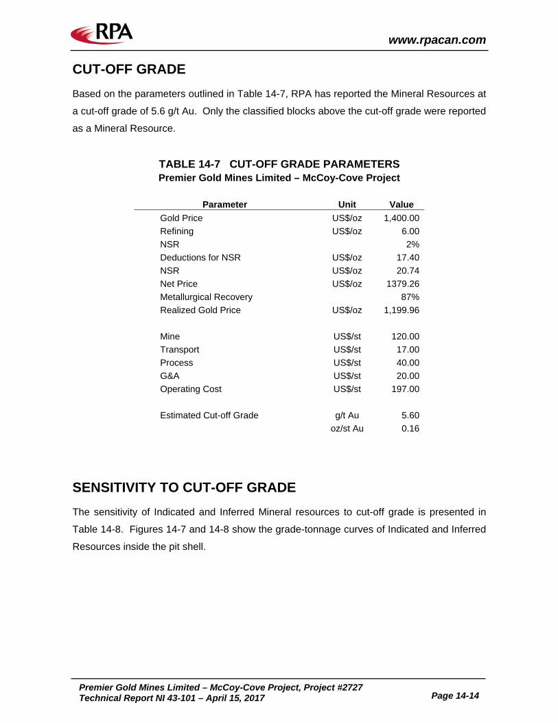
www.rpacan.com
Premier Gold Mines Limited – McCoy-Cove Project, Project #2727
Technical Report NI 43-101 – April 15, 2017 Page 14-14
CUT-OFF GRADE Based on the parameters outlined in Table 14-7, RPA has reported the Mineral Resources at
a cut-off grade of 5.6 g/t Au. Only the classified blocks above the cut-off grade were reported
as a Mineral Resource.
TABLE 14-7 CUT-OFF GRADE PARAMETERS Premier Gold Mines Limited – McCoy-Cove Project
Parameter Unit Value Gold Price US$/oz 1,400.00 Refining US$/oz 6.00 NSR
2%
Deductions for NSR US$/oz 17.40 NSR US$/oz 20.74 Net Price US$/oz 1379.26 Metallurgical Recovery
87%
Realized Gold Price US$/oz 1,199.96
Mine US$/st 120.00 Transport US$/st 17.00 Process US$/st 40.00 G&A US$/st 20.00 Operating Cost US$/st 197.00
Estimated Cut-off Grade g/t Au 5.60
oz/st Au 0.16
SENSITIVITY TO CUT-OFF GRADE The sensitivity of Indicated and Inferred Mineral resources to cut-off grade is presented in
Table 14-8. Figures 14-7 and 14-8 show the grade-tonnage curves of Indicated and Inferred
Resources inside the pit shell.

www.rpacan.com
Premier Gold Mines Limited – McCoy-Cove Project, Project #2727
Technical Report NI 43-101 – April 15, 2017 Page 14-15
TABLE 14-8 INDICATED AND INFERRED RESOURCES AT VARIOUS CUT-OFF GRADES
Premier Gold Mines Limited – McCoy-Cove Project
Indicated Inferred
Cut-off grade Au (g/t)
Tonnes (kt)
Grade Au (g/t)
Ounces (koz)
Tonnes (kt)
Grade Au (g/t)
Ounces (koz)
10.0 275.6 16.29 144 1,824.2 16.23 952 9.5 315.8 15.46 157 1,983.3 15.71 1,002 9.0 354.6 14.78 168 2,051.5 15.50 1,022 8.5 395.4 14.16 180 2,135.7 15.23 1,046 8.0 421.0 13.80 187 2,306.2 14.71 1,091 7.5 451.6 13.39 194 2,501.9 14.17 1,140 7.0 492.9 12.88 204 2,697.3 13.67 1,185 6.5 531.2 12.43 212 2,884.8 13.22 1,226 6.0 581.4 11.90 222 3,144.4 12.64 1,278 5.6 614.0 11.57 228 3,378.2 12.17 1,322 5.5 623.2 11.48 230 3,443.0 12.05 1,333 5.0 674.3 11.01 239 3,661.1 11.64 1,370 4.5 738.0 10.47 249 3,871.8 11.26 1,402 4.0 801.6 9.98 257 4,065.2 10.93 1,429 3.5 842.3 9.68 262 4,170.3 10.75 1,441 3.0 892.4 9.32 267 4,325.0 10.48 1,457 2.5 929.3 9.06 271 4,391.1 10.37 1,463 2.0 960.1 8.84 273 4,522.4 10.13 1,473 1.5 993.9 8.60 275 4,599.6 9.99 1,477 1.0 1,011.1 8.47 275 4,630.2 9.93 1,478 0.5 1,035.8 8.29 276 4,649.7 9.89 1,479 0.0 1,044.4 8.22 276 4,655.0 9.88 1,479

www.rpacan.com
Premier Gold Mines Limited – McCoy-Cove Project, Project #2727
Technical Report NI 43-101 – April 15, 2017 Page 14-16
FIGURE 14-7 INDICATED RESOURCE GRADE-TONNAGE CURVES
FIGURE 14-8 INFERRED RESOURCE GRADE-TONNAGE CURVES
0.0
2.0
4.0
6.0
8.0
10.0
12.0
14.0
16.0
18.0
0
200
400
600
800
1000
1200
0 1 2 3 4 5 6 7 8 9 10
Grad
e Au
(g/t
)
Tonn
age
('000
)
Cut-off grade Au (g/t)
Ind Tonnage Ind Grade Au
0.0
2.0
4.0
6.0
8.0
10.0
12.0
14.0
16.0
18.0
0
500
1000
1500
2000
2500
3000
3500
4000
4500
5000
0 1 2 3 4 5 6 7 8 9 10
Grad
e Au
(g/t
)
Tonn
age
('000
)
Cut-off grade Au (g/t)
Inf Tonnage Inf Grade Au

www.rpacan.com
Premier Gold Mines Limited – McCoy-Cove Project, Project #2727
Technical Report NI 43-101 – April 15, 2017 Page 15-1
15 MINERAL RESERVE ESTIMATE This section is not applicable.

www.rpacan.com
Premier Gold Mines Limited – McCoy-Cove Project, Project #2727
Technical Report NI 43-101 – April 15, 2017 Page 16-1
16 MINING METHODS This section is not applicable.

www.rpacan.com
Premier Gold Mines Limited – McCoy-Cove Project, Project #2727
Technical Report NI 43-101 – April 15, 2017 Page 17-1
17 RECOVERY METHODS This section is not applicable.

www.rpacan.com
Premier Gold Mines Limited – McCoy-Cove Project, Project #2727
Technical Report NI 43-101 – April 15, 2017 Page 18-1
18 PROJECT INFRASTRUCTURE This section is not applicable.

www.rpacan.com
Premier Gold Mines Limited – McCoy-Cove Project, Project #2727
Technical Report NI 43-101 – April 15, 2017 Page 19-1
19 MARKET STUDIES AND CONTRACTS This section is not applicable.

www.rpacan.com
Premier Gold Mines Limited – McCoy-Cove Project, Project #2727
Technical Report NI 43-101 – April 15, 2017 Page 20-1
20 ENVIRONMENTAL STUDIES, PERMITTING, AND SOCIAL OR COMMUNITY IMPACT This section is not applicable.

www.rpacan.com
Premier Gold Mines Limited – McCoy-Cove Project, Project #2727
Technical Report NI 43-101 – April 15, 2017 Page 21-1
21 CAPITAL AND OPERATING COSTS This section is not applicable.

www.rpacan.com
Premier Gold Mines Limited – McCoy-Cove Project, Project #2727
Technical Report NI 43-101 – April 15, 2017 Page 22-1
22 ECONOMIC ANALYSIS This section is not applicable.

www.rpacan.com
Premier Gold Mines Limited – McCoy-Cove Project, Project #2727
Technical Report NI 43-101 – April 15, 2017 Page 23-1
23 ADJACENT PROPERTIES The McCoy and Cove mines are former producers that are adjacent to the McCoy-Cove
Project and are described in Section 6 of this report.

www.rpacan.com
Premier Gold Mines Limited – McCoy-Cove Project, Project #2727
Technical Report NI 43-101 – April 15, 2017 Page 24-1
24 OTHER RELEVANT DATA AND INFORMATION No additional information or explanation is necessary to make this Technical Report
understandable and not misleading.

www.rpacan.com
Premier Gold Mines Limited – McCoy-Cove Project, Project #2727
Technical Report NI 43-101 – April 15, 2017 Page 25-1
25 INTERPRETATION AND CONCLUSIONS The Project is located in the McCoy Mining District. The Cove-Helen deposit has been
delineated beneath the historically mined Cove open pit and underground mining area and
currently extends approximately 2,000 ft northwest of the pit. Four distinct mineralized zones
were defined: Helen, CSD Gap and CSD zones with Carlin-style mineralization, and 2201-
VG zone with polymetallic sheeted vein mineralization.
The Cove pit was mined by Echo Bay between 1987 and 2001, and produced 2.6 million
ounces of gold and 100 million ounces of silver.
Exploration drilling since 2012 allowed Premier to develop a new litho-structural model.
Previously known mineralized zones of the Cove-Helen deposit were expanded and new
targets were identified and modelled.
RPA prepared an estimate of Mineral Resources for the Project using Geovia GEMS 6.7.4
software. The current Mineral Resource estimate is based on an underground mining
method and includes 614,000 tonnes at an average grade of 11.57 g/t Au, containing
228,000 ounces in the Indicated Resource category. An additional 3,378,000 tonnes at an
average grade of 12.17 g/t Au, containing 1,322,000 ounces, are estimated in the Inferred
Mineral Resource category.
The estimate was supported by a block model constrained with mineralized wireframes
capturing mineralized intercepts with nominal grades above 5.6 g/t Au over a minimum
thickness of 8 ft, with occasional lower grade intercepts preserved for mineralized lens
continuity. Erratic higher grade samples were capped at 60 g/t Au prior to compositing to full
intercept length. Block gold grade was estimated using an inverse distance to the power four
(ID4) interpolation method.
The current resource estimate represents a marked increase in Indicated and Inferred
resources compared to the 2013 estimate. This was achieved by expansion of previously
known mineralization through infill and step-out drilling, and delineation of new mineralized
zones through exploration drilling.

www.rpacan.com
Premier Gold Mines Limited – McCoy-Cove Project, Project #2727
Technical Report NI 43-101 – April 15, 2017 Page 26-1
26 RECOMMENDATIONS Premier’s 2017 budget will focus on exploration and infill drilling, to extend and upgrade the
current Mineral Resource estimate. Metallurgical testing, hydrology, engineering, and
permitting activities will also be undertaken to support the ongoing PEA. Positive results
from the aforementioned work will lead to future development of the underground test mining
project with the goal of extracting a bulk sample from the Upper Helen zone of the resource
in 2018. RPA concurs with Premier’s proposed work program and budget (Table 26-1).
TABLE 26-1 PROPOSED WORK PROGRAM Premier Gold Mines Limited - McCoy-Cove Project
Item Units Cost/Unit Total Cost
(US$) Diamond Drilling 17,000 m 180 3,060,000 Assays 11,000 38 418,000 Geological and Operations Support $96,000/mo 12 1,150,000 Site Administration $33,000/mo 12 400,000 Mineral Resource Update 1 Lump Sum 67,000 Metallurgical Test Work 1 Lump Sum 250,000 Hydrology Study $125,000/mo 12 1,500,000 Preliminary Economic Assessment 1 Lump Sum 225,000 Development – Bulk Sample 1 Lump Sum 6,500,000 Contingency Lump Sum 1,430,000 Total 15,000,000

www.rpacan.com
Premier Gold Mines Limited – McCoy-Cove Project, Project #2727
Technical Report NI 43-101 – April 15, 2017 Page 27-1
27 REFERENCES Amendment to Minerals Lease and Agreement between Newmont McCoy Cove Limited and
Victoria Resources (US) Inc, September 29, 2008. Briggs, D. F., McCoy-Cove Complex: Mining operations report prepared by Geomineinfo,
2001. Canadian Institute of Mining, Metallurgy and Petroleum (CIM) Definition Standards for
Mineral Resources and Mineral Reserves, adopted by the CIM Council on May 10, 2014. Emmons, D. L., and Eng, T. L., Geology and Mineral Resources of the McCoy Mining
District, Lander County, Nevada: Text to accompany Nevada Bureau of Mines Map 103, 1995.
Johnston, M. K., Geology of the Cove Mine, Lander County, Nevada, and a Genetic Model
for the McCoy-Cove Magmatic-Hydrothermal System, University of Nevada, Reno, Ph.D. dissertation, May 2003.
John, D.A., Henry, C.D., and Colgan, J.P., Magmatic and tectonic evolution of the Caetano
caldera, north-central Nevada: A tilted, mid-Tertiary eruptive center and source of the Caetano Tuff, Geosphere, v.4, no. 1, 2008
Kappes Cassiday & Associates, Cove Project Report of Metallurgical Test Work, December
2008. Kappes Cassiday & Associates, Cove Project Report of Metallurgical Test Work, August
2009. Kappes Cassiday & Associates, Cove Project Report of Metallurgical Test Work, November
2009. Kuyper, B. A., Mach, L. E., Streiff, R. E., and Brown, W. A., Geology of the Cove Gold-Silver
Deposit: Society for Mining, Metallurgy, and Exploration, Inc., 1991. Madrid, R. J., Anatomy of the Helen Gold System, a Carlin –Type Intersection Zone, McCoy-
Cove Mining District, North Central Nevada. Victoria Resources, 2009. Magorian Mine Services, Preliminary Cost Estimate for Cove Helen Zone, April 23, 2009. Memorandum of Agreement between Newmont Corporation and Victoria Resources (US)
Inc., June 15, 2006. Minerals Lease and Agreement between Newmont McCoy Cove Limited and Victoria
Resources (US) Inc June 15, 2006. Mine Development Associates, Technical Report Cove Project Lander County, Nevada,
U.S.A., October 24, 2008.

www.rpacan.com
Premier Gold Mines Limited – McCoy-Cove Project, Project #2727
Technical Report NI 43-101 – April 15, 2017 Page 27-2
Nevada Ratepayers Association, Understanding Nevada’s Net Proceeds Minerals Tax, 2008-8 Edition.
Roscoe Postle Associates Inc., Preliminary Assessment of the Cove Project, Nevada,
Prepared by Valliant, W., Evans, L., and Bergen, R.D., for Premier Gold Mines Limited, October 3, 2012.
Second Amendment to Minerals Lease and Agreement between Newmont McCoy Cove
Limited and Victoria Resources (US) Inc, March 29, 2009. Silberling, N. and Roberts, R.J., Pre-Tertiary stratigraphy and structure of northwestern
Nevada: Geol. Soc. America Special Paper 72, 58 p., 1962 Struhsacker, D. W., Overview of Permitting Requirements for Mineral Projects in Nevada,
July 2009. Victoria Gold Corp., presentations, press releases and web site. Widman Contractors Inc, Helen Zone Underground Development Cost Estimate, January 25,
2010. Widman Contractors Inc, Company Resume. Wolverson, N. J., Review of Cove-McCoy Drilling QA/QC and Procedures, December 9,
2007.

www.rpacan.com
Premier Gold Mines Limited – McCoy-Cove Project, Project #2727
Technical Report NI 43-101 – April 15, 2017 Page 28-1
28 DATE AND SIGNATURE PAGE This report titled “Technical Report of the McCoy-Cove Gold Project, Lander County, State of
Nevada, USA” and dated April 15, 2017, was prepared and signed by the following authors:
(Signed and Sealed) “Luke Evans” Dated at Toronto, Ontario April 15, 2017 Luke Evans, M.Sc., P.Eng. Principal Geologist (Signed and Sealed) “Tudorel Ciuculescu” Dated at Toronto, Ontario April 15, 2017 Tudorel Ciuculescu, M.Sc., P.Geo. Senior Geologist

www.rpacan.com
Premier Gold Mines Limited – McCoy-Cove Project, Project #2727
Technical Report NI 43-101 – April 15, 2017 Page 29-1
29 CERTIFICATE OF QUALIFIED PERSON LUKE EVANS I, Luke Evans, M.Sc., P.Eng., as an author of this report titled “Technical Report of the McCoy-Cove Gold Project, Lander County, State of Nevada, USA”, prepared for Premier Gold Mines Limited, and dated April 15, 2017, do hereby certify that:
1. I am a Principal Geologist and Executive Vice President, Geology and Mineral Resources, with Roscoe Postle Associates Inc. of Suite 501, 55 University Ave., Toronto, ON M5J 2H7.
2. I am a graduate of University of Toronto, Ontario, Canada, in 1983 with a Bachelor of
Science (Applied) degree in Geological Engineering and Queen’s University, Kingston, Ontario, Canada, in 1986 with a Master of Science degree in Mineral Exploration.
3. I am registered as a Professional Engineer in the Province of Ontario (Reg.
#90345885). I have worked as a professional geologist for a total of 30 years since my graduation. My relevant experience for the purpose of the Technical Report is: • Consulting Geological Engineer specializing in resource and reserve estimates,
audits, technical assistance, and training since 1995. • Review and report as a consultant on numerous exploration and mining projects
around the world for due diligence and regulatory requirements. • Senior Project Geologist in charge of exploration programs at several gold and
base metal mines in Quebec. • Project Geologist at a gold mine in Quebec in charge of exploration and definition
drilling. • Project Geologist in charge of sampling and mapping programs at gold and base
metal properties in Ontario, Canada.
4. I have read the definition of "qualified person" set out in National Instrument 43-101 (NI 43-101) and certify that by reason of my education, affiliation with a professional association (as defined in NI 43-101) and past relevant work experience, I fulfill the requirements to be a "qualified person" for the purposes of NI 43-101.
5. I did not visit the property.
6. I share responsibility with my co-author for all sections of the Technical Report.
7. I am independent of the Issuer applying the test set out in Section 1.5 of NI 43-101.
8. I have had prior involvement with the property that is the subject of the Technical Report including preparing Technical Reports on the underground resources in 2011.
9. I have read NI 43-101, and the Technical Report has been prepared in compliance with NI 43-101 and Form 43-101F1.
10. At the effective date of the Technical Report, to the best of my knowledge, information, and belief, the Technical Report contains all scientific and technical

www.rpacan.com
Premier Gold Mines Limited – McCoy-Cove Project, Project #2727
Technical Report NI 43-101 – April 15, 2017 Page 29-2
information that is required to be disclosed to make the Technical Report not misleading.
Dated this 15th day of April, 2017 (Signed and Sealed) “Luke Evans” Luke Evans, M.Sc., P.Eng.

www.rpacan.com
Premier Gold Mines Limited – McCoy-Cove Project, Project #2727
Technical Report NI 43-101 – April 15, 2017 Page 29-3
TUDOREL CIUCULESCU I, Tudorel Ciuculescu, M.Sc., P.Geo., as an author of this report entitled “Technical Report of the McCoy-Cove Gold Project, Lander County, State of Nevada, USA”, prepared for Premier Gold Mines Limited, and dated April 15, 2017, do hereby certify that: 1. I am Senior Geologist with Roscoe Postle Associates Inc. of Suite 501, 55 University Ave
Toronto, ON, M5J 2H7. 2. I am a graduate of University of Bucharest, Romania, with a B.Sc. degree in Geology in
2000 and University of Toronto, Ontario, Canada with a M.Sc. degree in Geology in 2003.
3. I am registered as a Professional Geologist in the Province of Ontario (Reg. #1882). I
have worked as a geologist for a total of 13 years since my graduation. My relevant experience for the purpose of the Technical Report is: • Preparation of Mineral Resource estimates. • Over 5 years of exploration experience in Canada and Chile.
4. I have read the definition of "qualified person" set out in National Instrument 43-101 (NI
43-101) and certify that by reason of my education, affiliation with a professional association (as defined in NI43-101) and past relevant work experience, I fulfill the requirements to be a "qualified person" for the purposes of NI 43-101.
5. I visited the site on March 28 and 29, 2017. 6. I share responsibility with my co-author for all sections of the Technical Report. 7. I am independent of the Issuer applying the test set out in Section 1.5 of NI 43-101. 8. I have had no prior involvement with this Project. 9. I have read NI 43-101, and the Technical Report has been prepared in compliance with
NI 43-101 and Form 43-101F1. 10. At the effective date of the Technical Report, to the best of my knowledge, information,
and belief, the Technical Report contains all scientific and technical information that is required to be disclosed to make the Technical Report not misleading.
Dated this 15th day of April, 2017 (Signed and Sealed) “Tudorel Ciuculescu” Tudorel Ciuculescu, M.Sc., P.Geo.

www.rpacan.com
Premier Gold Mines Limited – McCoy-Cove Project, Project #2727
Technical Report NI 43-101 – April 15, 2017 Page 30-1
30 APPENDIX 1 CLAIM LIST

www.rpacan.com
Premier Gold Mines Limited – McCoy-Cove Project, Project #2727
Technical Report NI 43-101 – April 15, 2017 Page 30-2
TABLE 30-1 MCCOY-COVE PROJECT 100% OWNED UNPATENTED CLAIMS Premier Gold Mines Limited – Cove Project
County BLM Serial Number Area (acres/claim) Expiry Date
Lander NMC 47898 - 47901 20.66 July 2017
Lander NMC
90158, 90159, 90165-90167, 90190-90212, 90214-90220, 90555, 90557, 90559, 90561, 90563, 90565, 90567, 90569, 90571, 90573-90581, 90603, 90605, 90607, 90609, 90611, 90613, 90615, 90617, 90620-90633, 90677, 90678, 90680-90715, 90720, 90722-90777, 90799, 90800, 90802, 90804-
90858, 90869-90908,
20.66 July 2017
Lander NMC 140448, 140452, 140453, 140457, 140458, 14-462, 140463, 140467 20.66 July 2017
Lander NMC
181303-181306, 181309-181312, 181315-181318, 181321, 181324, 181327-181332, 181335-181341, 181344-181350, 181353-181361
20.66 July 2017
Lander NMC 229272-229338 20.66 July 2017 Lander NMC 247384-247393, 247395-247402 20.66 July 2017 Lander NMC 252707, 252708 20.66 July 2017 Lander NMC 351858-351937 20.66 July 2017 Lander NMC 352026-352055 20.66 July 2017 Lander NMC 353523-353546, 353604-353611 20.66 July 2017 Lander NMC 362273-362276 20.66 July 2017
Lander NMC 362285-362287, 362291-362297, 362300-363350, 362352-362357 20.66 July 2017
Lander NMC 410758-410778, 410817-410837, 410880-410900, 410916-410966,
410979-410999 20.66 July 2017
Lander NMC 411000-411038, 411051-411098, 411111-411154, 411167-411173, 411186-411192, 411205-411211
20.66 July 2017
Lander NMC 420631-420639 20.66 July 2017 Lander NMC 543040 20.66 July 2017
Lander NMC 555378, 555380-555382, 555384-555388 20.66 July 2017
Lander NMC 570937, 570938 20.66 July 2017 Lander NMC 717472-717484 20.66 July 2017 Lander NMC 851138-851287 20.66 July 2017 Lander NMC 940301-940739 20.66 July 2017
Totals 1,535 31,713.1 Note. Claims renewed upon annual payment of federal claim maintenance fees at $155.00 per claim. Last payment for 2016-2017 to BLM on July 26, 2016.

www.rpacan.com
Premier Gold Mines Limited – McCoy-Cove Project, Project #2727
Technical Report NI 43-101 – April 15, 2017 Page 30-3
TABLE 30-2 COVE PROJECT LEASED PATENTED CLAIMS Premier Gold Mines Limited – Cove Project
Parcel
Number Township Range Section Sub-Section Area (acres)
098-800-81
28N/29N 42E 2/36
Tony 31
144.627
098-800-82 Tony31, Tony 32 098-800-83 Tony 33 098-800-84 Tony 34 098-800-85 Tony 36 098-800-86 WT 39 098-800-87 WT 41 098-800-88 28N 42E 1 COY 101M 41.3222 098-800-89 COY 105M
Totals 9 186