A PRELIMINARY ARCHAEOLOGICAL AND HISTORICAL DOCUMENTATION OF
Preliminary Documentation Assessment Albion Park Rail bypass January 2018
FINAL DOCUMENTRMS 17.628ISBN: 978-1-925737-28-8

ALBION PARK RAIL BYPASS —PRELIMINARY DOCUMENTATION ASSESSMENT OF IMPACTS ON MATTERS OF NATIONAL ENVIRONMENTAL SIGNIFICANCE - FINAL DOCUMENTRoads and Maritime Services Page ii
THIS PAGE LEFT INTENTIONALLY BLANK

ALBION PARK RAIL BYPASS —PRELIMINARY DOCUMENTATION ASSESSMENT OF IMPACTS ON MATTERS OF NATIONAL ENVIRONMENTAL SIGNIFICANCE - FINAL DOCUMENTRoads and Maritime Services Page iii
Hyder Cardno Joint Venture
ABN 58 300 126 782
Level 5, 141 Walker Street Locked Bag 6503 North Sydney NSW 2060 Australia
Tel: +61 2 8907 9000
Fax: +61 2 8907 9001
ROADS AND MARITIME SERVICES
ALBION PARK RAIL BYPASS
PRELIMINARY DOCUMENTATION ASSESSMENT
(EPBC 2017 / 7909)
Author Tanja Mackenzie
Checker Cassy Baxter
Approver Kevin Roberts
Report No
Date
Revision
FCHC-APRB-R-07 Preliminary
Documentation 11 January 2018
07

ALBION PARK RAIL BYPASS —PRELIMINARY DOCUMENTATION ASSESSMENT OF IMPACTS ON MATTERS OF NATIONAL ENVIRONMENTAL SIGNIFICANCE - FINAL DOCUMENTRoads and Maritime Services Page v
Executive Summary Roads and Maritime Services (Roads and Maritime) proposes to build a 9.8 kilometre extension of the
Princes Motorway between Yallah and Oak Flats that would bypass the suburb of Albion Park Rail. The
project would form part of the Princes Highway upgrade program that seeks to improve road safety and
efficiency. The project forms one of the last remaining sections of the Princes Highway to be upgraded and
will complete the missing link of a high standard road between Sydney and Bomaderry.
On 29 March 2017, Roads and Maritime referred the project to the federal Department of the Environment
and Energy (the Department), and on 29 May 2017 the delegate determined that the proposed action (i.e.
the project; EPBC Ref: 2017/7909) is a ‘controlled action’ under the Environment Protection and Biodiversity
Conservation Act 1999 (EPBC Act). The Department’s advice issued on 7 June 2017 detailed the further
information required for the preliminary documentation package to be prepared by Roads and Maritime in
support of their referral.
Subsequently, Roads and Maritime made an application on 16 August 2017 to vary the proposed action and
remove the impacts of the proposed reconfiguration of Croom Regional Sporting Complex from the referral.
This variation was approved by the Department on 10 September 2017. As a result, the preliminary
documentation has been prepared based on the varied action.
The Department’s request for further information seeks further assessment of the potential impacts of the
controlled action on the following Matters of National Environmental Significance (MNES), as listed under the
EPBC Act:
> Illawarra and south coast lowland forest and woodland ecological community, which is listed as
critically endangered under the EPBC Act
> Grey-headed Flying-fox (Pteropus poliocephalus), which is listed as vulnerable under the EPBC Act
> Large-eared Pied Bat (Chalinobus dwyeri), which is listed as vulnerable under the EPBC Act
> Koala (Phascolarctos cinereus), which is listed as vulnerable under the EPBC Act.
The following assessment outcomes were identified for each of the MNES. The amount of clearing and
therefore level of impact are reduced from the original project referral because of the revised assessment
following additional field investigations and the removal of the Croom Regional Sporting Complex
reconfiguration from the referred action.
Illawarra and south coast lowland forest and woodland
The proposed project would result in the removal of 1.5 ha of high condition and 3.3 ha of moderate
condition Illawarra and South Coast Lowland Forest and Woodland (ISCLFW) within the project footprint.
There is also the potential for indirect impacts of up to 7.3 ha of high and 1.5 ha of moderate condition
ISCLFW. Mitigation measures would be implemented during the project’s construction phase to ensure
minimum vegetation is impacted, including exclusion fencing, weed management plans, and sediment and
erosion controls. The direct and indirect impacts from the proposed project would be offset as detailed in the
Biodiversity Offset Strategy. The project is unlikely to have a significant impact on this ecological community.
Grey-headed Flying-fox (Pteropus poliocephalus)
The Grey-headed Flying-fox was detected foraging in several locations within the project site, including the
vegetation next to Yallah Road and Croom Reserve. The project footprint does not have any Grey-headed
Flying-fox camps and is not close to any known camps. Up to 30.6 ha of potential Grey-headed Flying-fox
foraging habitat would be removed from within the project footprint. The potential Grey-headed Flying-fox
foraging habitat was determined to meet the definition of ‘foraging habitat critical to survival’ species due to
the presence of winter-spring flowered trees within the project footprint. Due to the small amount of habitat
proposed to be impacted and the abundance of similar habitat that will be retained in the local area, the
project is unlikely to have a significant impact on this species.

ALBION PARK RAIL BYPASS —PRELIMINARY DOCUMENTATION ASSESSMENT OF IMPACTS ON MATTERS OF NATIONAL ENVIRONMENTAL SIGNIFICANCE - FINAL DOCUMENTRoads and Maritime Services Page vi
Large-eared Pied Bat (Chalinobus dwyeri)
One possible anabat recording of the Large-eared Pied Bat occurred within the project footprint and there
are records of the species close to the project footprint. No suitable roosting habitat for this species occurs
within the project footprint in the form of caves, cliff crevices, old mines, disused Fairy Martin mud nests or
similar habitat. Up to 30.6 ha of potential Large-eared Pied Bat foraging habitat would be removed from
within the project footprint. As no suitable roosting habitat would be impacted and the potential foraging
habitat is common to the area, the project is unlikely to have a significant impact on this species.
Koala (Phascolarctos cinereus)
The Koala was not detected within the project footprint despite targeted surveys including spotlighting, call
playback and searches for scratchings and scats. The species has not been recorded close to the project
footprint, with the closest records on top of the Illawarra Escarpment, about 8 kilometres to the west. There is
an absence of connective continuous vegetation between the escarpment and the project footprint. Up to
30.6 ha of potential Koala foraging habitat would be removed from within the project footprint. However, an
assessment of habitat using the commonwealth assessment guidelines indicates that, despite the presence
of feed trees within the project footprint, the project is unlikely to significantly impact this species.
Mitigation and management measures would be implemented to address the direct and indirect impacts of
the project on biodiversity in line with the Biodiversity Guidelines: Protecting and managing biodiversity on
RTA projects. These measures have been defined in an Environmental Management Plan for Matters of
National Environmental Significance, which would be utilised in the project Construction Environment
Management Plan.
This project would result in benefits to the community by facilitating local movement to and from major
centres, improving access to local facilities and services by reducing through traffic, and improving
separation of through and local traffic.
Community values, particularly local identification with a rural lifestyle, views and scenery, would be retained.
A major improvement in the character of highway communities could be anticipated to occur with the transfer
of through traffic from the existing highway through the centre of urban areas to the proposed bypass.
Overall the socio-economic impact arising from direct land use impacts would be relatively low, with the
highest socio-economic impacts of land acquisition being on agricultural land users, particularly lands used
for dairying.

ALBION PARK RAIL BYPASS —PRELIMINARY DOCUMENTATION ASSESSMENT OF IMPACTS ON MATTERS OF NATIONAL ENVIRONMENTAL SIGNIFICANCE - FINAL DOCUMENTRoads and Maritime Services Page vii
Glossary and Abbreviations
Aquifer A geological structure of formation or part thereof, permeated with water or capable of- (a)
being permeated permanently or intermittently with water; and (b) transmitting water.
CEEC Critically endangered ecological community
EMP Environmental Management Plan
EP&A Act NSW Environmental Planning and Assessment Act 1979
EPBC Act Environment Protection and Biodiversity Conservation Act 1999
Groundwater dependent
ecosystem
Ecosystems which have their species composition and natural ecological processes wholly
or partially determined by groundwater
ha hectares
ISCFW Illawarra and south coast lowland forest and woodland
km kilometres
m metres
mm millimetres
MNES Matters of National Environmental Significance. There are nine Matters of National
Environmental Significance listed under the Environment Protection and Biodiversity
Conservation Act 1999. This preliminary documentation focusses on listed threatened
species and ecological communities.
NSW The State of New South Wales
WoNS Weed of National Significance

ALBION PARK RAIL BYPASS —PRELIMINARY DOCUMENTATION ASSESSMENT OF IMPACTS ON MATTERS OF NATIONAL ENVIRONMENTAL SIGNIFICANCE - FINAL DOCUMENTRoads and Maritime Services Page viii
Table of Contents
1 Introduction 12
1.1 Scope and purpose of this report 13
1.2 Project description 18
1.3 Assessment guidelines and standards 22
1.4 Authors of this report 23
2 Consultation 24
2.1 Consultation with the Commonwealth Department of the Environment and Energy 24
2.2 Consultation with other agencies 24
2.3 Community Consultation 26
2.3.1 Environmental impact statement 26
2.3.2 Submissions and preferred infrastructure report 26
2.3.3 EPBC Referral 26
3 Identification of matters of national environmental significance 27
3.1 Illawarra and south coast lowland forest and woodland 27
3.1.1 Description and characteristics of the ecological community 27
3.1.2 Conservation status and advice 28
3.1.3 Survey methodology 28
3.1.4 Survey results 29
3.1.5 Indirect impact assessment 39
3.2 Grey-headed Flying-fox 52
3.2.1 Ecology and characteristics of the species 52
3.2.2 Conservation status and advice 53
3.2.3 Survey methodology 54
3.2.4 Survey results 54
3.3 Large-eared Pied Bat 59
3.3.1 Ecology and characteristics of the species 59
3.3.2 Conservation status and advice 59
3.3.3 Survey methodology 60
3.3.4 Survey results 60
3.4 Koala 65
3.4.1 Ecology and characteristics of the species 65
3.4.2 Conservation status and advice 66
3.4.3 Survey methodology 67
3.4.4 Survey results 67
4 Assessment of impacts 72
4.1 Illawarra and south coast lowland forest and woodland 72
4.1.1 Direct impacts 72
4.1.2 Indirect impacts 72
4.1.3 Assessment of significance 72
4.1.4 Summary of impact to the species 74
4.2 Grey-headed Flying-fox 75
4.2.1 Direct impacts to habitat 75
4.2.2 Indirect impacts 75
4.2.3 Assessment of significance 75

ALBION PARK RAIL BYPASS —PRELIMINARY DOCUMENTATION ASSESSMENT OF IMPACTS ON MATTERS OF NATIONAL ENVIRONMENTAL SIGNIFICANCE - FINAL DOCUMENTRoads and Maritime Services Page ix
4.2.4 Summary of impact to the species 80
4.3 Large-eared Pied Bat 80
4.3.1 Direct impacts to habitat 80
4.3.2 Indirect impacts 80
4.3.3 Assessment of significance 80
4.3.4 Summary of impact to the species 82
4.4 Koala 82
4.4.1 Direct impacts to habitat 82
4.4.2 Indirect impacts 82
4.4.3 Koala habitat assessment tool 83
4.4.4 Summary of impact to the species 84
5 Proposed avoidance, mitigation and management measures 85
5.1 Project planning framework 85
5.2 Environmental management plan for MNES 87
5.2.1 Conclusion 87
6 Biodiversity offsets 88
6.1 EPBC Act Environmental Offsets Policy 88
6.2 NSW Biodiversity Offsets Policy for Major Projects 88
6.3 Project biodiversity offset strategy 88
7 Economic and social matters 90
7.1 Project cost 90
7.2 Socio-economic impacts 90
7.2.1 Construction phase impacts 90
7.2.2 Operational phase impacts 92
7.3 Summary of Socio-economic impacts 98
8 Environmental record of the proponent 99
8.1 Roads and Maritime’s corporate environmental policy and planning framework 99
8.2 Environmental record 99
9 References 101
Appendices
Appendix A Original Referral (EPBC 2017/7909)
Appendix B Assessment Approach Decision
Appendix C Additional Information Request
Appendix D Request for Variation to the Referral (EPBC 2017/7909)
Appendix E Environmental Management Plan for MNES
Appendix F CEEC Condition Plot Data
Appendix G Roads and Maritime Environment Policy
Appendix H Indirect Offset Calculations
Appendix I Direct Impact Offset Requirements

ALBION PARK RAIL BYPASS —PRELIMINARY DOCUMENTATION ASSESSMENT OF IMPACTS ON MATTERS OF NATIONAL ENVIRONMENTAL SIGNIFICANCE - FINAL DOCUMENTRoads and Maritime Services Page x
Tables
Table 1-1 Preliminary documentation requirements 13
Table 1-2 Project footprint coordinates 20
Table 2-1 Consultation with the Department of the Environment and Energy 24
Table 2-2 Agency consultation 25
Table 3-1 Climatic conditions during the day of the field survey (Source: Bureau of Meteorology) 29
Table 3-2 Assessment of the rapid assessment plots (RAP) against the key diagnostic characteristics (DoEE, 2016). 30
Table 3-3 Assessment of the CEEC condition plots against the key diagnostic characteristics (DoEE, 2016). 33
Table 3-4 Impact area of Illawarra and south coast lowland forest and woodland 34
Table 3-5 Edge effect analysis – Yallah Road North 43
Table 3-6 Edge effect analysis – Yallah Road south 45
Table 3-7 Edge effect analysis – Croom Reserve 49
Table 3-8 Climatic conditions during the day of the field survey (Source: Bureau of Meteorology) 54
Table 3-9 Koala feed tree species for the South Coast of NSW 65
Table 3-10 Climatic conditions during the day of the field survey (Source: Bureau of Meteorology) 67
Table 4-1 Grey-headed Flying-fox camps within approximately 50km of the project footprint. 78
Table 4-2 Koala habitat assessment tool 84
Table 6-1 Indirect area site value assessment results 89
Table 6-2 Indirect impact credit calculations 89
Table 6-3 Total offsets required for ISCLFW 89
Table 8-1 Penalty infringement notices 100
Table 9-1 Vegetation plot data 115
Figures
Figure 1-1 Proposed Albion Park Rail bypass project footprint 19
Figure 3-1 Illawarra and south coast lowland forest and woodland ecological community - Overview 35
Figure 3-2 Illawarra and south coast lowland forest and woodland ecological community - North 36
Figure 3-3 Illawarra and south coast lowland forest and woodland ecological community – Croom 37
Figure 3-4 Illawarra and south coast lowland forest and woodland ecological community - South 38
Figure 3-5 Overview - Illawarra and south coast lowland forest and woodland 40
Figure 3-6 Yallah Road - Illawarra and south coast lowland forest and woodland 41
Figure 3-7 Croom Reserve - Illawarra and south coast lowland forest and woodland 42
Figure 3-8 Grey-headed Flying-fox potential habitat - Overview 55
Figure 3-9 Grey-headed Flying-fox potential habitat - North 56
Figure 3-10 Grey-headed Flying-fox potential habitat – Croom 57
Figure 3-11 Grey-headed Flying-fox potential habitat - South 58
Figure 3-12 Large-eared Pied Bat potential habitat - Overview 61
Figure 3-13 Large-eared Pied Bat potential habitat - North 62
Figure 3-14 Large-eared Pied Bat potential habitat - Croom 63

ALBION PARK RAIL BYPASS —PRELIMINARY DOCUMENTATION ASSESSMENT OF IMPACTS ON MATTERS OF NATIONAL ENVIRONMENTAL SIGNIFICANCE - FINAL DOCUMENTRoads and Maritime Services Page xi
Figure 3-15 Large-eared Pied Bat potential habitat - South 64
Figure 3-16 Koala potential habitat - Overview 68
Figure 3-17 Koala potential habitat - North 69
Figure 3-18 Koala potential habitat - Croom 70
Figure 3-19 Koala potential habitat - South 71
ALBION PARK RAIL BYPASS—PRELIMINARY DOCUMENTATION ASSESSMENT OF IMPACTS ON MATTERS OF NATIONAL ENVIRONMENTAL SIGNIFICANCE - FINAL DOCUMENTRoads and Maritime Services Page 12
Page 12
1 Introduction
Roads and Maritime Services propose to build a 9.8 kilometres (km) extension of the Princes Motorway
between Yallah and Oak Flats that would bypass the suburb of Albion Park Rail (Figure 1-1). The project
would form part of the Princes Highway upgrade program that seeks to improve road safety and efficiency.
The project forms one of the last remaining sections of the Princes Highway to be upgraded between Sydney
and Bomaderry and would complete a missing link of a high standard road.
The project is considered to be State significant infrastructure under the NSW Environmental Planning and
Assessment Act (EP&A Act) 1979. An environmental impact statement was prepared in accordance with
Section 5.1 of the EP&A Act, and placed on public exhibition in October 2015. A submissions and preferred
infrastructure report was prepared to address the issues raised in submissions made by the community and
stakeholders during public exhibition of the environmental impact statement and assess design refinements.
The report was published on the NSW Department of Planning and Environment’s major projects website on
11 September 2017. The NSW Minister for Planning is currently reviewing the submissions and preferred
infrastructure report in order to determine the project.
On 29 March 2017, Roads and Maritime referred the project to the federal Department of the Environment
and Energy (the Department). On 29 May 2017 the delegate determined that the proposed action is a
‘controlled action’ under the Environment Protection and Biodiversity Conservation Act 1999 (EPBC Act).
The Department’s advice issued 7 June 2017 detailed the further information required for the preliminary
documentation to be prepared by Roads and Maritime in support of the referral.
Subsequently, Roads and Maritime made an application on 16 August 2017 to vary the proposed action and
remove the impacts of the proposed reconfiguration of Croom Regional Sporting Complex from the referral.
This variation was approved by the Department on 10 September 2017. As a result, the preliminary
documentation has been prepared based on the varied action.
The following documents are attached:
> Original referral prepared by Roads and Maritime, included as Appendix A
> Assessment approach decision issued by the Department, included as Appendix B
> The letter from the Department issued 7 June 2017 detailing further information required for the
documentation, included as Appendix C
> Variation request prepared by Roads and Maritime on 16 August 2017 and the approval of the
variation by the Department, included as Appendix D
> The requested environmental management plan for matters of national environmental significance,
included as Appendix E
> Critically Endangered Ecological Community (CEEC) plot data, included as Appendix F
> Roads and Maritime environmental policy, included as Appendix G
> Calculations utilised in the determination of the indirect impact credit requirements, included as
Appendix H; and
> The direct impact credit report, included as Appendix I.

ALBION PARK RAIL BYPASS—PRELIMINARY DOCUMENTATION ASSESSMENT OF IMPACTS ON MATTERS OF NATIONAL ENVIRONMENTAL SIGNIFICANCE - FINAL DOCUMENTRoads and Maritime Services Page 13
Page 13
1.1 Scope and purpose of this report
This preliminary documentation has been prepared to fulfil of the requirements of the assessment approach
decision (refer Appendix B). It has been prepared to further assess the potential impacts of the action on the
following Matters of National Environmental Significance (MNES), as listed under the EPBC Act:
> Illawarra and south coast lowland forest and woodland ecological community
> Grey-headed Flying-fox (Pteropus poliocephalus)
> Large-eared Pied Bat (Chalinobus dwyeri); and
> Koala (Phascolarctos cinereus).
Table 1-1 summarises the various requirements of Appendix B and where these requirements are met within
this document.
Table 1-1 Preliminary documentation requirements
Requirements Where addressed
The preliminary documentation package (PD) to be provided as a
consolidated package with any appendices. The original referral and
any additional information supplied during the referral period is to be
included as an appendix (under s95A (3)(a) and (b) of the EPBC Act).
This document and its appendices consist of
the preliminary documentation package. The
original referral and its attachments are
included in the Appendices.
The PD should include a list of persons or agencies consulted and the
names of, and work done by, the persons involved in preparing the
documentation.
Consultation undertaken as part of the
development of this package are described
in Section 2. Staff involved in the preparation
of this document are identified in Section 1.4.
The documentation should be written to enable interested stakeholders
and the Minister to understand the environmental consequences of the
proposed development. The information presented should also allow
any conclusions reached to be independently assessed. Detailed
technical information, studies or investigations supporting the text of the
main document should be included as appendices, or at least directly
linked to avoid readers having to search for the documents. Any such
documents that are not already available to the public should be made
available at appropriate locations at least during the period for public
display of the PD.
This document has been written in
accordance with this requirement. Relevant
technical documents are either attached as
appendices or referenced to include internet
links to the document.
Any variables or assumptions made in the assessment should be
clearly stated and discussed.
This document has been written in
accordance with this requirement.
The assessment should clearly address any standards or criteria
published by the Department that are relevant to matters being
assessed, and appropriate reference must be made to any relevant
policy documents.
This document has been written in
accordance with this requirement.

ALBION PARK RAIL BYPASS—PRELIMINARY DOCUMENTATION ASSESSMENT OF IMPACTS ON MATTERS OF NATIONAL ENVIRONMENTAL SIGNIFICANCE - FINAL DOCUMENTRoads and Maritime Services Page 14
Page 14
Requirements Where addressed
Impacts on threatened species and communities listed under the
EPBC Act must be quantified with reference to all relevant
Commonwealth policies, definitions and survey guidelines (for
example, this affects how ‘patch sizes’ are determined for some
listed threatened communities).
If the proposed action is approved and offsets are required, the PD
must demonstrate how those offsets are ‘like for like’ according to
Commonwealth descriptions of the MNES.
The offset must be provided prior to the action commencing.
Section 3
Section 6
As described in Section 6 offsets are
currently being obtained through the
Biodiversity Offset Strategy which is being
finalised in consultation with the NSW Office
of Environment and Heritage.
Illawarra and South Coast Lowland Forest and Woodland
Undertake additional flora surveys of the proposed action area using
the information provided in the Approved Conservation Advice.
Survey effort should be adequate to identify all areas of the
community, ascertain the condition, and delineate patches in a
manner consistent with the Conservation Advice
Analyse survey data using key diagnostic characteristics described
in the Conservation Advice to accurately assess the extent and
condition of the community. Provide a summary table against the
key diagnostic characteristics and condition thresholds, for each
quadrat
Please discuss and assess the indirect impacts to the community
such as:
o clearing and fragmentation of vegetation
o development (including the upgrade of the Princes
Highway, hydrological change, dumping)
o weeds
o feral animals
o fire
Discuss hydrological changes to both ground and surface water
from the action including the nature and quality of water, where and
how these will be channelled and discharged
Assess and quantify the impact of hydrological changes (including
water quality) to retained vegetation inside the action area and the
areas around the action area. Hydrological impacts to the Croom
Reserve which is a groundwater dependent ecosystem (GDE)
should also be considered
Discuss the potential for polluting or toxic spills during construction
and operation of the project
Discuss the introduction of soil and fill for construction and
landscaping purposes and their potential impacts, for example,
sedimentation, pH change, drainage of polluting substances,
introduction of weed species etc.
Section 3.1
Table 3-2
Section 4.1.2
Section 3.1.5 and Section 4.1.3
Section 3.1.5 and Section 4.1.3
Section 3.1.5 and Section 4.1.3
Section 3.1.5 and Section 4.1.3

ALBION PARK RAIL BYPASS—PRELIMINARY DOCUMENTATION ASSESSMENT OF IMPACTS ON MATTERS OF NATIONAL ENVIRONMENTAL SIGNIFICANCE - FINAL DOCUMENTRoads and Maritime Services Page 15
Page 15
Requirements Where addressed
Consider impacts from the landscaping plan and the species that
will be introduced to the site and the risk of disease introduction and
spread in the construction or operational stages
Section 5.2 and Appendix E
Assess and quantify the impact of edge effects and fragmentation
on remaining patches of the community
Provide a discussion and analysis of the ecological integrity and
future viability of the remaining patches of the community given that
their small and/or linear nature and position in the landscape
(surrounded by development) make them susceptible to, and will
exacerbate, a number of threats
Discuss whether buffer zones for the community have been adopted
for the proposed action
Assess the impact of the use of Asset Protection Zones on the
community (if used)
Provide an updated map showing the community in the proposed
action area and buffer zones. Please also show the relationship with
surrounding vegetation and indicate whether that vegetation is also
the community.
Section 4.1.2
Section 4.1.2
Section 3.1.5
Not used
Figures 3-1 to 3-6
Grey-headed Flying-fox (Pteropus poliocephalus)
Provide an assessment of the quality and extent of winter and spring
foraging habitat for the species
Discuss the habitat in the surrounding area and whether is it also
winter and spring foraging habitat
Confirm the extent of the winter and spring foraging habitat (critical
to the survival of the species) and other foraging habitat
Quantify how much of those types of foraging habitat will be cleared
Assess the edge and fragmentation effects on the viability and
integrity of the remaining foraging habitat
Discuss the impact to the species.
Section 3.2.4
Section 3.2.4
Section 3.2.4
Section 4.2.1
Section 4.2.2
Section 4.2
Large-eared Pied Bat (Chalinolobus dwyeri)
Clarify the total area of forest, woodland and grassy woodland, andvegetated riparian areas in the action area
Discuss the habitat and connectivity values in the action area andthe surrounding landscape for the species with particular referenceto the information on the National recovery plan for the Large-earedPied Bat Chalinolobus dwyeri
Clarify the total area of forest, woodland and grassy woodland, andvegetated riparian areas proposed to be cleared
Identify and quantify areas to habitat in the action area andsurrounds that will be fragmented by the proposed clearing or suffera reduction in connectivity
Identify and discuss areas of habitat that will experience edgeeffects due to the proposed clearing
Discuss the impact to the species.
Section 4.3.1
Section 4.3.1 and Section 1.3
Section 4.3.1
Section 4.3.2
Section 4.3.2
Section 4.3

ALBION PARK RAIL BYPASS—PRELIMINARY DOCUMENTATION ASSESSMENT OF IMPACTS ON MATTERS OF NATIONAL ENVIRONMENTAL SIGNIFICANCE - FINAL DOCUMENTRoads and Maritime Services Page 16
Page 16
Requirements Where addressed
Koala (Phascolarctos cinereus) combined populations of Qld, NSW and
the ACT
Assess the vegetation in the action area using the Koala habitat
assessment tool
Assess the value of the area in the context of the surrounding
landscape and connectivity and fragmentation
Provide mapping of habitat and connectivity in the action area and
surrounds
Quantify the habitat critical to the survival of the Koala to be cleared
Discuss and identify the impacts of the proposed clearing on
remaining vegetation fragmentation and edge effects
Analyse the impacts to connectivity in the action area and surrounds
Discuss and quantify the potential impacts from vehicle strikes both
in the construction and operational stages
Discuss the impact to the species.
Section 3.4.3
Section 4.4.2
Figure 3-15 to 3-18
Section 4.4.1
Section 4.4.2
Section 4.4.2
Section 4.4.2
Section 4.4
Proposed avoidance, mitigation and management measures
Provide:
Specific and detailed descriptions of proposed avoidance and
mitigation measures for the impacts identified for each MNES
Include, for each measure:
I. An assessment of the expected or predicted effectiveness of the
measures in reducing impacts to the community and other
MNES. Include supporting evidence and details of the
expected on-ground benefits to be gained through each of
these measures
II. Environmental objectives; performance criteria and measurability
of outcomes; monitoring; corrective actions (including trigger
points or thresholds for actions) and adaptive management;
responsibility; and timeframes for proposed mitigation
measures
III. Demonstrated willingness and capability of achieving outcomes.
Clear commitments about how these measures will be
reported and audited (by whom, to whom, how often)
IV. Predicted cost of mitigation and management measures and
how they will be funded in perpetuity (and by whom),
especially the buffer zones
V. Any statutory or policy basis for the mitigation measures
VI. A risk analysis associated with achieving the outcomes and the
level of control the proponent will have in achieving
environmental objectives
VII. The mechanisms (and the period of operation) for ensuring the
actions and protections are maintained
Appendix E

ALBION PARK RAIL BYPASS—PRELIMINARY DOCUMENTATION ASSESSMENT OF IMPACTS ON MATTERS OF NATIONAL ENVIRONMENTAL SIGNIFICANCE - FINAL DOCUMENTRoads and Maritime Services Page 17
Page 17
Requirements Where addressed
VIII. Plans should refer to relevant conservation advices , recovery
plans, threat abatement plans and other guidance documents
published by the Department.
IX. A copy of the Construction Environment Management Plan
(CEMP) referred to in the referral. This plan should address all
of the above.
X. A consolidated list and description of mitigation measures
proposed to be undertaken.
Offsets
Details of how the offset meets an endorsed state offsets policy
A statement on the cost effectiveness of the measures proposed
and how these will be funded.
A description of how the offset package meets the EPBC Act
Environmental Offsets Policy (October 2012) and accompanying
Offsets Assessment Guide.
Section 6
Section 1.1.3 of Appendix E
Section 6
Economic and social matters
The PD must provide information on the relevant economic and social
impacts of the proposed action (positive and negative). Consideration of
economic and social matters should include:
costs as well as benefits
consideration of different scales where relevant
specific dollar or other numeric values where relevant.
Section 7
Environmental record of person(s) proposing to take the action
The information provided must include details of any proceedings under
a Commonwealth, State or Territory law for the protection of the
environment or the conservation and sustainable use of natural
resources against:
(a) the person proposing to take the action; and
(b) For an action for which a person has applied for a permit, the person
making the application.
If the person proposing to take the action is a corporation, details of the
corporation’s environmental policy and planning framework must also
be included.
Section 8
ALBION PARK RAIL BYPASS—PRELIMINARY DOCUMENTATION ASSESSMENT OF IMPACTS ON MATTERS OF NATIONAL ENVIRONMENTAL SIGNIFICANCE - FINAL DOCUMENTRoads and Maritime Services Page 18
Page 18
1.2 Project description
This section of the preliminary documentation provides a description of the proposed action. The project is
described as follows:
> Road alignment – The northern end of the proposed motorway would connect to the existing Princes
Motorway at Yallah, traversing south and crossing the Macquarie Rivulet slightly to the west of the
existing Princes Highway. South of the Macquarie Rivulet the alignment would generally follow the
existing alignment of the Illawarra Highway to the west of Illawarra Regional Airport. The alignment
would then continue to the south, travelling between Albion Park and Albion Park Rail, crossing
Tongarra Road. In its southern extent, the project alignment would skirt the southern boundary of
Croom Reserve and pass through the north-eastern section of the existing Croom Regional Sporting
Complex. The alignment would then head east following the existing East West Link road alignment
before connecting to the Princes Highway at the Oak Flats Interchange
> An interchange at Yallah would connect the bypass to the Princes Highway and provide free flowing
vehicle movements to and from Albion Park Rail, Dapto and Yallah to the bypass
> An interchange at Albion Park would provide access between the township of Albion Park and the
proposed motorway via a northbound entry ramp and a southbound exit ramp connecting to the
Illawarra Highway, and a northbound exit ramp and southbound entry ramp connecting to Tongarra
Road. The Illawarra Highway would be closed to local traffic. The interchange would be able to
connect to a potential future bypass of Albion Park (Tripoli Way); and
> A southern interchange at Oak Flats would include a northbound exit ramp and a southbound entry
ramp to and from the motorway. A local road with one lane in each direction would connect Croome
Road and the Oak Flats Interchange. This would separate local and through traffic and replace the
existing East West Link. The Oak Flats Interchange would be reconfigured to allow for the connection
of the local road network.
The key features of the project include:
> Two lanes in each direction divided by a median (with capacity to upgrade to three lanes in each
direction in future)
> Three interchanges provided at Yallah, Albion Park and Oak Flats would connect the local road
network with the motorway
> Bridges to carry the motorway over Duck Creek, the Macquarie Rivulet and Frazers Creek
> Bridges to carry the motorway over the Princes Highway and Tongarra Road
> A bridge to carry the motorway over the South Coast Rail Line; and
> Improved pedestrian and cyclist facilities.
Further information on the proposed action can be found in the original referral (see Appendix A).
The project would be undertaken with the area shown in Figure 1-1, as defined by the coordinates provided
in Table 1-2. The project footprint is 267.5 hectares.

ALBION PARK RAIL BYPASS—PRELIMINARY DOCUMENTATION ASSESSMENT OF IMPACTS ON MATTERS OF NATIONAL ENVIRONMENTAL SIGNIFICANCE - FINAL DOCUMENTRoads and Maritime Services Page 19
Page 19
Figure 1-1 Proposed Albion Park Rail bypass project footprint

ALBION PARK RAIL BYPASS—PRELIMINARY DOCUMENTATION ASSESSMENT OF IMPACTS ON MATTERS OF NATIONAL ENVIRONMENTAL SIGNIFICANCE - FINAL DOCUMENTRoads and Maritime Services Page 20
Page 20
Table 1-2 Project footprint coordinates
Point Latitude Longitude
Degrees Minutes Seconds Degrees Minutes Seconds
1 -34 30 49.88 150 47 20.44
2 -34 30 49.87 150 47 22.95
3 -34 31 31.75 150 47 23.55
4 -34 31 37.98 150 47 29.05
5 -34 31 38.58 150 47 28.74
6 -34 31 35.87 150 47 20.06
7 -34 31 59.64 150 47 14.61
8 -34 32 29.50 150 47 8.09
9 -34 32 30.17 150 47 8.42
10 -34 32 46.38 150 47 7.70
11 -34 32 59.43 150 47 10.02
12 -34 32 59.94 150 47 8.80
13 -34 32 57.93 150 47 7.00
14 -34 33 37.65 150 46 41.29
15 -34 34 10.78 150 46 59.17
16 -34 34 11.29 150 47 6.33
17 -34 34 11.94 150 47 6.44
18 -34 34 12.10 150 47 4.56
19 -34 34 29.60 150 47 16.53
20 -34 34 29.30 150 47 19.18
21 -34 34 32.12 150 47 17.73
22 -34 34 40.59 150 47 40.19
23 -34 34 32.86 150 47 44.30
24 -34 34 38.07 150 47 48.28
25 -34 34 34.40 150 48 15.65
26 -34 34 20.43 150 48 14.09
27 -34 34 21.11 150 48 15.45
28 -34 34 21.16 150 48 15.15
29 -34 34 34.13 150 48 17.68
30 -34 34 32.04 150 48 42.29
31 -34 34 31.58 150 48 46.58
32 -34 34 29.56 150 48 48.04
33 -34 34 29.97 150 48 49.99
34 -34 34 32.04 150 48 49.09
35 -34 34 23.98 150 49 13.40
36 -34 34 21.43 150 49 9.60
37 -34 34 19.06 150 49 10.57
38 -34 34 22.39 150 49 20.31
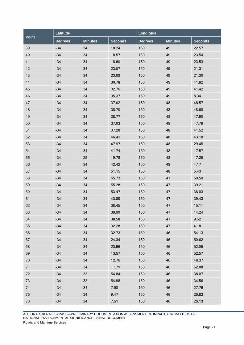
ALBION PARK RAIL BYPASS—PRELIMINARY DOCUMENTATION ASSESSMENT OF IMPACTS ON MATTERS OF NATIONAL ENVIRONMENTAL SIGNIFICANCE - FINAL DOCUMENTRoads and Maritime Services Page 21
Page 21
Point Latitude Longitude
Degrees Minutes Seconds Degrees Minutes Seconds
39 -34 34 18.24 150 49 22.57
40 -34 34 18.57 150 49 23.54
41 -34 34 18.60 150 49 23.53
42 -34 34 23.07 150 49 21.31
43 -34 34 23.08 150 49 21.30
44 -34 34 30.78 150 49 41.82
45 -34 34 32.76 150 49 41.42
46 -34 34 35.37 150 49 8.34
47 -34 34 37.02 150 48 48.57
48 -34 34 38.70 150 48 48.68
49 -34 34 38.77 150 48 47.90
50 -34 34 37.03 150 48 47.79
51 -34 34 37.28 150 48 41.52
52 -34 34 46.41 150 48 43.18
53 -34 34 47.97 150 48 29.45
54 -34 34 41.74 150 48 17.57
55 -34 25 19.78 150 48 17.29
56 -34 34 42.42 150 48 4.17
57 -34 34 51.15 150 48 5.43
58 -34 34 55.73 150 47 50.50
59 -34 34 55.28 150 47 39.21
60 -34 34 53.47 150 47 38.03
61 -34 34 43.89 150 47 39.43
62 -34 34 38.45 150 47 15.11
63 -34 34 39.99 150 47 14.24
64 -34 34 38.58 150 47 9.52
65 -34 34 32.28 150 47 4.18
66 -34 34 32.73 150 46 54.13
67 -34 34 24.34 150 46 50.62
68 -34 34 23.96 150 46 52.05
69 -34 34 13.57 150 46 52.57
70 -34 34 12.76 150 46 48.37
71 -34 34 11.79 150 46 52.08
72 -34 33 54.84 150 46 38.07
73 -34 33 54.98 150 46 34.56
74 -34 34 7.98 150 46 27.76
75 -34 34 9.47 150 46 26.83
76 -34 34 7.51 150 46 26.13

ALBION PARK RAIL BYPASS—PRELIMINARY DOCUMENTATION ASSESSMENT OF IMPACTS ON MATTERS OF NATIONAL ENVIRONMENTAL SIGNIFICANCE - FINAL DOCUMENTRoads and Maritime Services Page 22
Page 22
Point Latitude Longitude
Degrees Minutes Seconds Degrees Minutes Seconds
77 -34 33 49.44 150 46 32.56
78 -34 33 35.32 150 46 37.16
79 -34 33 35.32 150 46 37.16
80 -34 33 4.36 150 46 55.17
81 -34 32 49.89 150 46 56.83
82 -34 32 37.41 150 46 56.05
83 -34 32 21.90 150 46 56.83
84 -34 32 16.70 150 46 47.15
85 -34 32 16.04 150 46 47.12
86 -34 32 13.88 150 47 0.51
87 -34 32 5.94 150 47 4.77
88 -34 31 57.24 150 47 2.75
89 -34 31 56.74 150 47 6.24
90 -34 31 28.86 150 47 12.98
91 -34 31 27.07 150 47 8.01
92 -34 31 22.34 150 47 8.14
93 -34 31 21.38 150 47 4.36
94 -34 31 12.44 150 47 4.91
95 -34 31 18.27 150 47 13.22
96 -34 31 17.43 150 47 16.03
1.3 Assessment guidelines and standards
This preliminary documentation has been prepared in accordance with relevant commonwealth guidelines
and standards, including:
> Approved conservation advice for the Illawarra and south coast lowland forest and woodland
ecological community (DoEE, 2016)
> Environment Protection and Biodiversity Conservation Act 1999 Environmental Offsets Policy
(DSEWPC, 2012)
> Matters of National Environmental Significance significant impact guidelines 1.1 (DoE, 2013)
> Draft national recovery plan for the Grey-headed Flying-fox Pteropus poliocephalus (DECCW, 2009)
> National recovery plan for the Large-eared Pied Bat Chalinolobus dwyeri (DERM, 2011)
> Survey guidelines for Australia’s threatened bats (DEWHA, 2010); and
> EPBC Act referral guidelines for the vulnerable Koala (DoE, 2014).

ALBION PARK RAIL BYPASS—PRELIMINARY DOCUMENTATION ASSESSMENT OF IMPACTS ON MATTERS OF NATIONAL ENVIRONMENTAL SIGNIFICANCE - FINAL DOCUMENTRoads and Maritime Services Page 23
Page 23
1.4 Authors of this report
This preliminary documentation has been prepared by suitably qualified professionals. The report authors
are listed below:
> Kevin Roberts provided technical direction and review. Kevin holds a Bachelor of Science (Honours),
Master of Science (Environmental Studies), and is accredited by the NSW Office of Environment and
Heritage as a BioBanking Assessor
> Tanja Mackenzie is the lead author. Tanja holds a Bachelor of Science and a Master of Applied
Science (Environmental Science), and is Certified Environmental Practitioner (Cert0447)
> Andrew Smith is a contributing author and also conducted the ecological field surveys. Andrew has a
Doctorate of Philosophy and Bachelor of Environmental Biology
> Cassy Baxter is a contributing author and checker for the preliminary documentation and
environmental management plan for MNES. Cassy holds a Bachelor of Environmental Science and
Masters in Planning and Management
> Michael Park is a contributing author. Michael holds a Bachelor of Urban and Regional Planning; and
> Leanne Laughton is lead author of the environmental management plan for MNES. She has a
Bachelor of Science and a Master of Applied Science (Environmental Science).

ALBION PARK RAIL BYPASS—PRELIMINARY DOCUMENTATION ASSESSMENT OF IMPACTS ON MATTERS OF NATIONAL ENVIRONMENTAL SIGNIFICANCE - FINAL DOCUMENTRoads and Maritime Services Page 24
Page 24
2 Consultation
This section of the preliminary documentation provides an overview of the consultation activities undertaken
by Roads and Maritime in relation to the project, identifies the key matters discussed and identifies how they
have been addressed. It focusses on consultation undertaken since the conclusion of public exhibition of the
project environmental impact statement (Roads and Maritime, 2015); that is, consultation undertaken since
November 2015 and including consultation undertaken in relation to this referral.
Further detail on consultation activities undertaken prior to November 2015 in relation to the Albion Park Rail
bypass project can be found in Section 2.6 of the original referral (EPBC 2017/7909; refer Appendix A).
2.1 Consultation with the Commonwealth Department of the Environment and Energy
Roads and Maritime has consulted with the Department regarding referral EPBC 2017/7909 on several
occasions. The consultation activities are summarised in Table 2-1.
Table 2-1 Consultation with the Department of the Environment and Energy
Meeting Date Purpose / topic(s)
19 September 2016 Pre-lodgement meeting to provide information on the project, potential impacts on MNES, and
the proposed mitigation measures and biodiversity offsetting strategy.
29 March 2017 Lodgement of the referral.
14 June 2017
Requirements for the preliminary documentation package.
Proposed variation to EPBC 2017/7909 to reduce the project footprint and requirements for the
request to vary the action
Biodiversity offsetting mechanisms and processes for the project.
12 July 2017 Requirements for the variation request.
16 August 2017 Lodgement of variation request
10 September 2017 Approval of the variation request by the Department.
2.2 Consultation with other agencies
Roads and Maritime has also undertaken consultation with numerous other agencies. These consultation
activities are summarised in Table 2-2.

ALBION PARK RAIL BYPASS—PRELIMINARY DOCUMENTATION ASSESSMENT OF IMPACTS ON MATTERS OF NATIONAL ENVIRONMENTAL SIGNIFICANCE - FINAL DOCUMENTRoads and Maritime Services Page 25
Page 25
Table 2-2 Agency consultation
Agency Meeting dates and purpose
NSW Department of
Planning and
Environment
5 May 2017 - project update issued
25 August 2017 – discuss comments raised on the Response to Submissions from
agencies
11 September 2017 – Submissions and preferred infrastructure report issued for public
exhibition.
NSW Department of
Primary Industries 5 May 2017 - project update issued.
NSW Environment
Protection Authority
27 February 2017 and 24 April 2017 – project updates
21 March 2017 - Implementation of extended work hours across the project including the
outcomes of targeted community consultation
Illawarra Bicycle Users
Group
9 March 2017 - Telephone conversation - proposed shared pathway adjacent to the
Illawarra Highway
19 July 2017 discuss changes to proposed shared paths.
NSW Office of
Environment and
Heritage
27 February 2017, 1 May 2017 and 31 August 2017 – biodiversity impacts and offsetting
2 August 2017 – flood impacts and mitigation
5 May 2017 - project update issued.
Shellharbour City
Council
Meeting held every two months to discuss the interactions with the Albion Park bypass
(Tripoli Way)
Regular collaboration during the design of:
o The interchange at Albion Park
o Croom Regional Sporting Complex
o Asset handover requirements
o Property acquisition.
Wollongong City Council
Regular meetings undertaken to discuss the traffic modelling, and the design of Yallah
Road
Regular collaboration during the design review of the interchange at Albion Park.
Utility providers:
TransGrid
Jemena Networks
Jemena Eastern Gas
Pipeline
Sydney Water
Endeavour Energy
Energy Australia
Telstra
Optus
TPG
NBN Corp
Sydney Trains
RailCorp
Ongoing consultation with utilities regarding impacts of the project and proposed utilities
relocations.

ALBION PARK RAIL BYPASS—PRELIMINARY DOCUMENTATION ASSESSMENT OF IMPACTS ON MATTERS OF NATIONAL ENVIRONMENTAL SIGNIFICANCE - FINAL DOCUMENTRoads and Maritime Services Page 26
Page 26
2.3 Community Consultation
2.3.1 Environmental impact statement
An environmental impact statement was prepared for the project in accordance with Part 5.1 of the EP&A
Act. The environmental impact statement was publicly exhibited by the Department of Planning and
Environment from 28 October 2015 – 27 November 2015. A total of 108 submissions were received,
including 101 from the community and seven from government agencies and advisory bodies. Of the
submissions received, nine related to biodiversity. None of the submissions related to MNES.
2.3.2 Submissions and preferred infrastructure report
A submissions and preferred infrastructure report was prepared to address the issues raised in submissions
made by the community and stakeholders during public exhibition of the environmental impact statement and
to assess design refinements made to the project. The report was published on the NSW Department of
Planning and Environment’s major projects website on 11 September 2017.
The environmental impact statement and submissions and preferred infrastructure report are available to be
viewed at: http://www.rms.nsw.gov.au/projects/illawarra/albion-park-rail-bypass/
2.3.3 EPBC Referral
The EPBC referral was placed on public exhibition from 29 March 2017 to 12 April 2017. No submissions
were received during the public comment period. In addition to the EPBC referral, the request for variation to
the project was also made publicly available on the Departments website.
This preliminary documentation will also be placed on public exhibition, and any submissions received will be
addressed in a subsequent submissions report.

ALBION PARK RAIL BYPASS—PRELIMINARY DOCUMENTATION ASSESSMENT OF IMPACTS ON MATTERS OF NATIONAL ENVIRONMENTAL SIGNIFICANCE - FINAL DOCUMENTRoads and Maritime Services Page 27
Page 27
3 Identification of matters of national environmental significance
3.1 Illawarra and south coast lowland forest and woodland
3.1.1 Description and characteristics of the ecological community
Key diagnostic characteristics
The Illawarra and South Coast Lowland Forest and Woodland (ISCLFW) ecological community description is
based on the following key diagnostic characteristics (DoEE, 2016):
> The ecological community occurs within the state of New South Wales in the Jervis, Ettrema and
Illawarra subregions of the Sydney Basin Bioregion and the Bateman subregion of the South East
Corner Bioregion
> The ecological community occurs below approximately 350 metres ASL, on the coastal plain or
foothills between the immediate coastal strip and the escarpment
> The ecological community is a forest or woodland with at least 10% foliage cover (foliage cover is “the
percentage of the sample site occupied by the vertical projection of foliage and woody branches”)
> Eucalyptus tereticornis (Forest Red Gum) or E. longifolia (Woollybutt) is typically present and often
dominant in the mature tree canopy. One or more of the following canopy species may also be
dominant, especially where there has been selective removal of trees (for example, E. tereticornis)
from some patches of the ecological community: Angophora floribunda (Rough-barked Apple); E.
bosistoana (Coast Grey Box); E. eugenioides (Thin-leaved Stringybark); E. globoidea (White
Stringybark) (Patches with hybrid dominant canopy species may be included in the ecological
community i.e. areas should not be excluded on the basis of hybridisation. Amongst the other tree
species commonly found in the ecological community, but not typically dominant are: Corymbia
maculata (Spotted Gum); E. amplifolia subsp. amplifolia (Cabbage Gum); E. botryoides (Bangalay); E.
paniculata subsp. paniculata (Grey Ironbark); E. pilularis (Blackbutt); and E. quadrangulata (Coastal
White Box); and
> The ecological community is characterised by the plant species described in Appendix A – Species
lists in the approved listing advice and conservation advice for this Critically Endangered Ecological
Community (CEEC) (DoEE, 2016).
In addition, the vegetation must also meet the condition thresholds which excludes small isolated patches
(< 0.5 ha and >30m distance from other patches) and patches where less than 30% of the total understory
vegetation is native (DoEE, 2016).
Known distribution
Over 70% of the remaining extent of the ecological community occurs in the Illawarra subregion;
approximately 16% is in the Jervis subregion, with small amounts in each of Ettrema and Bateman
subregions (DoEE, 2016). Most remnants of the ecological community are small, as clearing for grazing and
agriculture has been extensive throughout the coastal plain. These activities have been concentrated within
the lowland coastal strip due to the shallow slopes, accessibility and good quality volcanic and alluvial soils,
in comparison with the steep rocky cliffs and infertile soils of the escarpment to the west.
ALBION PARK RAIL BYPASS—PRELIMINARY DOCUMENTATION ASSESSMENT OF IMPACTS ON MATTERS OF NATIONAL ENVIRONMENTAL SIGNIFICANCE - FINAL DOCUMENTRoads and Maritime Services Page 28
Page 28
3.1.2 Conservation status and advice
National legal status
The Illawarra and south coast lowland forest and woodland ecological community is listed as a CEEC under
the EPBC Act (DoEE, 2017a).
Threatening process
Key threatening processes are defined under the EPBC Act (DoEE, 2016). Those most relevant to ISCLFW
are:
> Land clearance
> Novel biota and their impact on biodiversity
> Loss and degradation of native plant and animal habitat by invasion of escaped garden plants,
including aquatic plants
> Predation by feral cats
> Predation by European Red Fox
> Competition and land degradation by rabbits
> Loss of climatic habitat caused by anthropogenic emissions of greenhouse gases
> Novel biota and their impact on biodiversity; and
> Predation, habitat degradation, competition and disease transmission by feral pigs.
Recovery strategies and other guidelines
A recovery plan was not recommended for this ecological community as the main threats to the ecological
community and priority actions required to address them are largely understood (DoEE, 2016). The
Conservation Advice sufficiently outlines the priority research and conservation actions needed for this
ecological community (DoEE, 2016). The priority protection and restoration actions include:
> Protect the ecological community to prevent further loss of extent and condition
> Restore the ecological community within its original range by active abatement of threats,
revegetation and other conservation initiatives; and
> Communicate with and support researchers, land use planners, landholders, land managers,
community members, including the Indigenous community, and others to increase understanding of
the value and function of the ecological community and encourage their efforts in its protection and
recovery.
3.1.3 Survey methodology
In addition to the 2014-2016 vegetation plots and assessment presented in the original referral, a field survey
was undertaken during the 26–28 June 2017 utilising condition and rapid assessment plots to assess the
extent and condition of patches of ISCLFW within and adjacent to the project footprint. The survey method to
determine the presence and condition of the CEEC within and adjacent to the project footprint was
undertaken in accordance with the sampling protocol (Section 2.6.4) outlined in the approved listing advice
and conservation advice for this CEEC (DoEE, 2016). As such, the following methods were employed:
> Random meanders across all accessible patches of native vegetation to undertake Rapid Assessment
Plots (RAPs) of the location where Eucalyptus or Angophora species occurred . The size of the RAP
included the area within a 20 m radius. In total, 18 RAPs were undertaken, including 4 plots which
were completed as CEEC condition plots (see Figure 3-1 to Figure 3-3); and
> Within accessible patches of native vegetation were either of the above key canopy species occurred
and the native understorey was >30%, a plot of 0.04 ha (quadrat of 20 by 20 metres) was surveyed. A

ALBION PARK RAIL BYPASS—PRELIMINARY DOCUMENTATION ASSESSMENT OF IMPACTS ON MATTERS OF NATIONAL ENVIRONMENTAL SIGNIFICANCE - FINAL DOCUMENTRoads and Maritime Services Page 29
Page 29
total of four CEEC condition plots (quadrat of 20 by 20 metres) were surveyed (Figure 3-1). Within
each plot, the following attributes were recorded:
The individual vascular plant species, both native and exotic
The cover abundance of each species
The size of the patch and proximity to other patches (determined post field survey
using GIS data)
The percentage of native/exotic understorey species
Several photographs; and
Any other notable features e.g. recent fire, rubbish dumping, threatened species,
etc.
The climate condition during the days of the field survey are outlined in Table 3-1 below.
Table 3-1 Climatic conditions during the day of the field survey (Source: Bureau of Meteorology)
Date Temperature (°C) Rainfall (mm)
26 June 2017 7.6–19.1 0.0
27 June 2017 3.6–16.4 0.0
28 June 2017 7.1–17.3 0.0
Source: BoM 2017.
3.1.4 Survey results
3.1.4.1 Rapid assessment plots
Large areas within the project footprint are disturbed/modified. Patches of native vegetation with Eucalyptus
tereticornis (Forest Red Gum) and/or E. longifolia (Woollybutt) present occurred within and adjacent to the
footprint. The condition of this vegetation varied across the patches. Many of the low condition patches were
dominated by Lantana camara (Lantana), which is a weed of national significance, and other exotic weed
species, including Pennisetum clandestinum (Kikuya Grass), Bidens pilosa (Cobbers Pegs) and
Verbena bonariensi (Purple Top). As low condition patches are not protected under the EPBC Act (DoEE,
2016), these patches have not been considered further as forming part of the CEEC. An assessment of the
RAPs against the key diagnostic characteristics is included in Table 3-2.
3.1.4.2 CEEC condition plots
Patches of high condition occurred north of Yallah Road and within the Croom Reserve. A moderate
condition patch occurred south Yallah Road. A summary of the survey results from each of the CEEC
condition plots against the key diagnostic characteristics is included in Table 3-3.

ALBION PARK RAIL BYPASS—PRELIMINARY DOCUMENTATION ASSESSMENT OF IMPACTS ON MATTERS OF NATIONAL ENVIRONMENTAL SIGNIFICANCE - FINAL DOCUMENTRoads and Maritime Services Page 30
Page 30
Table 3-2 Assessment of the rapid assessment plots (RAP) against the key diagnostic characteristics (DoEE, 2016).
Key diagnostic
characteristics
RAP 1 RAP 2 RAP 3 RAP 4 RAP 5 RAP 6, 7
and 8
RAP 9 RAP 10 RAP 11 RAP 12 RAP 13 RAP 14
The ecological community occurs within the state of New South Wales in the Jervis, Ettrema and Illawarra subregions of the Sydney Basin Bioregion and the Bateman subregion of the South East Corner Bioregion.
Yes. Project footprint within the Illawarra sub-regions of the Sydney Basin Bioregion.
The ecological community occurs below approximately 350 metres ASL, on the coastal plain or foothills between the immediate coastal strip and the escarpment.
Yes. Project footprint occurs below 350 metres ASL on the coastal plain between the immediate coastal strip and the escarpment.
The ecological community is a forest or woodland with at least 10% foliage cover.
Yes. Woodland > 10% foliage cover.
Eucalyptus tereticornis (forest red gum) or E. longifolia (woollybutt) is typically present and often dominant in the mature tree canopy. One or more of the following canopy species may also be dominant, especially where there has been selective removal of trees (for example, E. tereticornis) from some patches of the ecological community: Angophora floribunda (rough-barked apple); E. bosistoana (coast grey box); E. eugenioides (thin-leaved stringybark); E. globoidea (white stringybark). 2 Amongst the other tree species commonly found in the ecological community, but not typically dominant are: Corymbia maculata (spotted gum); E. amplifolia subsp. amplifolia (cabbage gum); E. botryoides (bangalay).
Yes both. Yes. E. longifolia only
Yes. C. maculata
Yes. C. maculata
Yes both. Yes. C. maculata
Yes both. Yes both. Yes. E. longifolia only
Yes. E. longifolia only
Yes. C. maculata
Yes. C. maculata

ALBION PARK RAIL BYPASS—PRELIMINARY DOCUMENTATION ASSESSMENT OF IMPACTS ON MATTERS OF NATIONAL ENVIRONMENTAL SIGNIFICANCE - FINAL DOCUMENTRoads and Maritime Services Page 31
Page 31
Key diagnostic
characteristics
RAP 1 RAP 2 RAP 3 RAP 4 RAP 5 RAP 6, 7
and 8
RAP 9 RAP 10 RAP 11 RAP 12 RAP 13 RAP 14
The ecological community is characterised by the plant species described in Appendix A – Species lists: Table 8. Not all species are present at each site.
Many species absent
Many species absent
Many species absent
Many species absent
Many species absent
Many species absent
Many species absent
Many species absent
Many species absent
Many species absent
Many species absent
Many species absent
The ecological community may include drainage lines and periodically inundated areas but typically occurs in locations less subject to regular or long term inundation than two nearby ecological communities ‘River-flat eucalypt forest on coastal floodplains of the NSW North Coast, Sydney Basin and South East Corner Bioregions’ (NSW Scientific Committee, 2004a) and ‘Swamp sclerophyll forest on coastal floodplains of the NSW North Coast, Sydney Basin and South East Corner Bioregions’ (NSW Scientific Committee, 2004b).
Yes Yes Yes Yes Yes Yes Yes Yes Yes Yes Yes Yes
A sub-canopy of Melaleuca decora (paper bark), M. ericifolia (swamp paper bark), M. styphelioides (prickly-leaved tea tree), tree-sized Acacias and/or Casuarina glauca (swamp oak) may be present.
Absent Yes. M. decora
Yes. M. decora
Absent Absent Absent Absent Absent Absent Yes. M. decora
Absent Yes. M. decora

ALBION PARK RAIL BYPASS—PRELIMINARY DOCUMENTATION ASSESSMENT OF IMPACTS ON MATTERS OF NATIONAL ENVIRONMENTAL SIGNIFICANCE - FINAL DOCUMENTRoads and Maritime Services Page 32
Page 32
Key diagnostic
characteristics
RAP 1 RAP 2 RAP 3 RAP 4 RAP 5 RAP 6, 7
and 8
RAP 9 RAP 10 RAP 11 RAP 12 RAP 13 RAP 14
The ecological community occurs on a variety of substrates, most commonly fine grained sedimentary or plutonic rocks, from which sandy loam, loam to clay loam soils with moderately high fertility are derived. It does not typically occur on infertile sandy soils or primary alluvium. It can occur on basic volcanic soils but in the northern part of the range these soils more typically support other ecological communities.
Yes. Alluvium soils.
Yes. Alluvium soils.
Yes. Alluvium soils
Yes. Alluvium soils
Yes. Alluvium soils.
Yes. Alluvium soils
Yes. Alluvium soils.
Yes. Alluvium soils.
Yes. Alluvium soils.
Yes. Alluvium soils.
Yes. Alluvium soils
Yes. Alluvium soils
The ecological community is less likely to be present where there is: dominance by rainforest-associated plant species, particularly palms or tree ferns.
Not dominated by rainforest plants
Not dominated by rainforest plants
Not dominated by rainforest plants
Not dominated by rainforest plants
Not dominated by rainforest plants
Not dominated by rainforest plants
Not dominated by rainforest plants
Not dominated by rainforest plants
Not dominated by rainforest plants
Not dominated by rainforest plants
Not dominated by rainforest plants
Not dominated by rainforest plants
Condition thresholds
Patch size thresholds >0.5 ha >0.5 ha >0.5 ha >0.5 ha >0.5 ha >0.5 ha >0.5 ha >0.5 ha >0.5 ha >0.5 ha >0.5 ha >0.5 ha
Biotic thresholds <30 % total perennial under-storey vegetative cover is comprised of native species
<30 % total perennial under-storey vegetative cover* is comprised of native species
<30 % total perennial under-storey vegetative cover* is comprised of native species
<30 % total perennial under-storey vegetative cover* is comprised of native species
<30 % total perennial under-storey vegetative cover is comprised of native species
<30 % total perennial under-storey vegetative cover* is comprised of native species
<30 % total perennial under-storey vegetative cover is comprised of native species
<30 % total perennial under-storey vegetative cover is comprised of native species
<30 % total perennial under-storey vegetative cover is comprised of native species
<30 % total perennial under-storey vegetative cover is comprised of native species
<30 % total perennial under-storey vegetative cover* is comprised of native species
<30 % total perennial under-storey vegetative cover* is comprised of native species
Category Low Low Low Low Low Low Low Low Low Low Low Low

ALBION PARK RAIL BYPASS—PRELIMINARY DOCUMENTATION ASSESSMENT OF IMPACTS ON MATTERS OF NATIONAL ENVIRONMENTAL SIGNIFICANCE - FINAL DOCUMENTRoads and Maritime Services Page 33
Page 33
Table 3-3 Assessment of the CEEC condition plots against the key diagnostic characteristics (DoEE, 2016).
Key diagnostic characteristics Plot 1 Plot 2 Plot 3 Plot 4
The ecological community occurs within the state of New South Wales in the Jervis, Ettrema and Illawarra subregions of the Sydney Basin Bioregion and the Bateman subregion of the South East Corner Bioregion.
Yes. Project footprint within the Illawarra sub-regions of the Sydney Basin Bioregion and the Bateman sub-region of the South East Corner Bioregion.
The ecological community occurs below approximately 350 metres ASL, on the coastal plain or foothills between the immediate coastal strip and the escarpment.
Yes. Project footprint occurs below 350 metres ASL on the coastal plain between the immediate coastal strip and the escarpment.
The ecological community is a forest or woodland with at least 10% foliage cover.
Yes. Woodland > 10% foliage cover.
Eucalyptus tereticornis (forest red gum) or E. longifolia (woollybutt) is typically present and often dominant in the mature tree canopy.
Yes. Both species present.
The ecological community is characterised by the plant species described in Appendix A – Species lists: Table 8. Not all species are present at each site.
Yes. Many of the listed species are present
The ecological community may include drainage lines and periodically inundated areas but typically occurs in locations less subject to regular or long term inundation than two nearby ecological communities ‘River-flat eucalypt forest on coastal floodplains of the NSW North Coast, Sydney Basin and South East Corner Bioregions’ (NSW Scientific Committee, 2004a) and ‘Swamp sclerophyll forest on coastal floodplains of the NSW North Coast, Sydney Basin and South East Corner Bioregions’ (NSW Scientific Committee, 2004b).
Potential. Not located in close association with a major drainage line, however, has the potential to be inundated during majoring flooding events.
A sub-canopy of Melaleuca decora (paper bark), M. ericifolia (swamp paper bark), M.styphelioides (prickly-leaved tea tree), tree-sized Acacias and/or Casuarina glauca (swampoak) may be present.
Yes. Sub-canopy of Melaleuca decora present.
The ecological community occurs on a variety of substrates, most commonly fine grained sedimentary or plutonic rocks, from which sandy loam, loam to clay loam soils with moderately high fertility are derived. It does not typically occur on infertile sandy soils or primary alluvium. It can occur on basic volcanic soils but in the northern part of the range these soils more typically support other ecological communities.
Yes. Alluvium soils.
The ecological community is less likely to be present where there is: dominance by rainforest-associated plant species, particularly palms or tree ferns.
No. Not dominated by rainforest-associated plant species.
Condition thresholds
Patch size thresholds >2 ha >0.5 ha >2 ha 2 ha

ALBION PARK RAIL BYPASS—PRELIMINARY DOCUMENTATION ASSESSMENT OF IMPACTS ON MATTERS OF NATIONAL ENVIRONMENTAL SIGNIFICANCE - FINAL DOCUMENTRoads and Maritime Services Page 34
Page 34
Key diagnostic characteristics Plot 1 Plot 2 Plot 3 Plot 4
Biotic thresholds 50% of its total understorey vegetation cover is comprised of native species (exotic annuals are excluded from this assessment) and at least 6 native plant species per 0.5 ha in the ground layer.
At least 50% of its total understorey vegetation cover is comprised of native species (exotic annuals are excluded from this assessment) and at least 6 native plant species per 0.5 ha in the ground layer.
50% of its total understorey vegetation cover is comprised of native species (exotic annuals are excluded from this assessment) and at least 6 native plant species per 0.5 ha in the ground layer.
50% of its total understorey vegetation cover is comprised of native species (exotic annuals are excluded from this assessment) and at least 6 native plant species per 0.5 ha in the ground layer.
Category A. Highconditionclass
C. Moderateconditionclass
A. Highconditionclass
A. Highconditionclass
Table 3-4 describes the amount of ISCLFW that occurs within the project footprint and the indirect impact
area.
Table 3-4 Impact area of Illawarra and south coast lowland forest and woodland
Condition Direct impact (within the project
footprint)
Indirect impact
High (A) 1.5 ha (approximately) 7.3 ha (within a 50m buffer of the project
footprint) Yallah Road North and Croom
Reserve
Moderate (C) 3.3 ha (approximately) 1.5 ha (within a 30m buffer of the project
footprint
The moderate and high condition patches of the ISCLFW located within and adjacent to the project footprint,
and survey effort locations are mapped in Figure 3-1 to Figure 3-4. Patches of low condition ISCLFW were
determined not to meet the definition of the CEEC (DoEE, 2016). These patches have not been considered
within the direct or indirect impact areas. Please note that the referral included these low condition patches in
the total area of directly impacted CEEC and as a result the total area of CEEC impacted by the proposal
has been reduced compared to the referral.

ALBION PARK RAIL BYPASS—PRELIMINARY DOCUMENTATION ASSESSMENT OF IMPACTS ON MATTERS OF NATIONAL ENVIRONMENTAL SIGNIFICANCE - FINAL DOCUMENTRoads and Maritime Services Page 35
Page 35
Figure 3-1 Illawarra and south coast lowland forest and woodland ecological community - Overview

ALBION PARK RAIL BYPASS—PRELIMINARY DOCUMENTATION ASSESSMENT OF IMPACTS ON MATTERS OF NATIONAL ENVIRONMENTAL SIGNIFICANCE - FINAL DOCUMENTRoads and Maritime Services Page 36
Page 36
Figure 3-2 Illawarra and south coast lowland forest and woodland ecological community - North

ALBION PARK RAIL BYPASS—PRELIMINARY DOCUMENTATION ASSESSMENT OF IMPACTS ON MATTERS OF NATIONAL ENVIRONMENTAL SIGNIFICANCE - FINAL DOCUMENTRoads and Maritime Services Page 37
Page 37
Figure 3-3 Illawarra and south coast lowland forest and woodland ecological community – Croom

ALBION PARK RAIL BYPASS—PRELIMINARY DOCUMENTATION ASSESSMENT OF IMPACTS ON MATTERS OF NATIONAL ENVIRONMENTAL SIGNIFICANCE - FINAL DOCUMENTRoads and Maritime Services Page 38
Page 38
Figure 3-4 Illawarra and south coast lowland forest and woodland ecological community - South

ALBION PARK RAIL BYPASS—PRELIMINARY DOCUMENTATION ASSESSMENT OF IMPACTS ON MATTERS OF NATIONAL ENVIRONMENTAL SIGNIFICANCE - FINAL DOCUMENTRoads and Maritime Services Page 39
Page 39
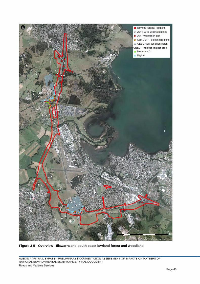
3.1.5 Indirect impact assessment
The indirect impacts of the project have been assessed with due consideration of the change in adjacent
land use intensity and its impact on the ecological integrity of the patches of CEEC in the buffer zone. In
accordance with the conservation advice (DoEE, 2016), buffer zones of 50 metres have been adopted for
High (A) condition patches of CEEC, and buffer zones of 30 metres have been adopted for Moderate (C)
condition patches of CEEC. The patches are mapped in Figures 3-5 and Figure 3-6.
The indirect impacts relevant for the project and associated with different types of adjacent land use include:
> Road or rail line – Excessive light, noise, introduction of weeds, may attract introduced fauna due to
rubbish
> Industrial / commercial – Excessive light, noise, introduction of weeds, may attract introduced fauna
due to rubbish
> Recreational areas – Excessive light, noise, introduction of weeds, attraction of introduced fauna due
to rubbish
> Rural residential – Excessive light, noise, introduction of weeds, attraction of introduced fauna due to
rubbish
> Pasture or other cleared areas – Introduction of weeds
> Vegetated areas – generally dependent on the condition of the vegetation, but may include weeds.
The conservation advice for the CEEC (DoEE, 2016) lists a number of potentially threatening processes,
several of which are relevant to this assessment of indirect impacts:
> Development – developments such as the Princes Highway upgrade can modify the hydrological
regime. Impacts associated with urban development include bike trails, rubbish and firewood collection
> Agriculture – Indirect impacts of ongoing grazing include changes to the nutrient status and structure
of soils, which affects species composition and preventing regeneration, as well as promotion of some
weed species
> Weeds – agricultural weeds and garden escapes contribute to weed loads, competing for light, space,
water and nutrients. Particularly problematic weed species include Lantana (Lantana camara)
> Feral animals – feral animals such as cats, foxes and introduced rats and mice affect the ecological
community by predation and competition to native fauna. Goats, pigs and deer may also be
problematic due to grazing of groundcover species
> Fire – both increases and decreases in natural fire regimes can result in shifts in the species
composition and structure of the ecological community
> Hydrological change – if the surface or groundwater hydrology is modified there is potential for
impacts on the community.
This section summarises the assessment of indirect impacts on patches of CEEC mapped in Figure 3-5,
Figure 3-6 and Figure 3-7. Data collected to determine the presence and condition of the CEEC is located in
Appendix F.
ALBION PARK RAIL BYPASS—PRELIMINARY DOCUMENTATION ASSESSMENT OF IMPACTS ON MATTERS OF NATIONAL ENVIRONMENTAL SIGNIFICANCE - FINAL DOCUMENTRoads and Maritime Services Page 40
Page 40
Figure 3-5 Overview - Illawarra and south coast lowland forest and woodland

ALBION PARK RAIL BYPASS—PRELIMINARY DOCUMENTATION ASSESSMENT OF IMPACTS ON MATTERS OF NATIONAL ENVIRONMENTAL SIGNIFICANCE - FINAL DOCUMENTRoads and Maritime Services Page 41
Page 41
Figure 3-6 Yallah Road - Illawarra and south coast lowland forest and woodland

ALBION PARK RAIL BYPASS—PRELIMINARY DOCUMENTATION ASSESSMENT OF IMPACTS ON MATTERS OF NATIONAL ENVIRONMENTAL SIGNIFICANCE - FINAL DOCUMENTRoads and Maritime Services Page 42
Page 42
Figure 3-7 Croom Reserve - Illawarra and south coast lowland forest and woodland

ALBION PARK RAIL BYPASS—PRELIMINARY DOCUMENTATION ASSESSMENT OF IMPACTS ON MATTERS OF NATIONAL ENVIRONMENTAL SIGNIFICANCE - FINAL DOCUMENTRoads and Maritime Services Page 43
Page 43
Yallah Road - North
Figure 3-5 delineates the areas of CEEC occurring within 50 metres of the project footprint to the north of
Yallah Road, which is categorised High Condition (A) as per the Conservation Advice (DoEE, 2016). The
areas are divided to allow a more detailed assessment of the quality of the vegetation. Each of the individual
areas of CEEC north of Yallah Road are assessed in Table 3-5 for potential indirect impacts arising from the
project. The value of each site has been assessed and scored in accordance with the Framework for
Biodiversity Assessment (FBA) to assist with determining offset calculations in the BBAM.
Table 3-5 Edge effect analysis – Yallah Road North
Area
ID Description
YN1
Area: 0.49 ha
FBA Site Value Score : 64.7 (plot TG3)
Existing adjacent land use: Yallah Road to south, high voltage power line 60 m to north, access road to west,
vegetation immediately to west and north. The high voltage power line easement is maintained as cleared
land.
Current level of impact: Currently subject to edge effects on southern and eastern margins (weeds, light,
noise, mowing). There are several walking / bike tracks through the area. The site hydrology and water
quality is negatively impacted due to the past clearing of vegetation for development in the surrounding land.
Future adjacent land use: No material change in type or intensity of land use; Yallah Road would be the same
distance from the area. Minor change in land use intensity.
Future level of impact: No material change. Impacts on hydrology as a result of the project not anticipated as
it is up-gradient of the footprint and a sufficient distance away. Proposed mitigation measures as per
Appendix E.
YN2
Area: 0.95 ha
FBA Site Value Score: 52.50 (BioBanking plot 1)
Existing adjacent land use: Yallah Road to south, high voltage power line to north, TransGrid access roads to
west and intersecting the area. The high voltage power line easement is maintained as cleared land free of
vegetation.
Current level of impact: Currently subject to edge effects (weeds, light, noise, mowing) due to absence of
vegetation on north-western margin and due to presence of the access road in the middle of the area. The
site hydrology and water quality is negatively impacted due to the clearing of vegetation and development of
the surrounding land.
Future adjacent land use: No material change in type or intensity of land use; Yallah Road would be realigned
further to the south and a service road would be constructed to access the TransGrid site. Minor change in
land use intensity. The landscape plans (Spackman Mossop, 2017) propose re-vegetation within the road
reserve with species representative of the CEEC.
Future level of impact: No material change. Proposed mitigation measures as per Appendix E.
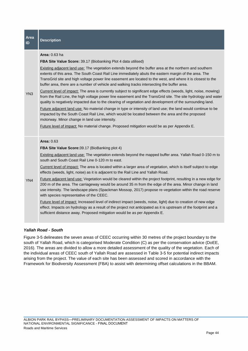
ALBION PARK RAIL BYPASS—PRELIMINARY DOCUMENTATION ASSESSMENT OF IMPACTS ON MATTERS OF NATIONAL ENVIRONMENTAL SIGNIFICANCE - FINAL DOCUMENTRoads and Maritime Services Page 44
Page 44
Area
ID Description
YN3
Area: 0.63 ha
FBA Site Value Score: 39.17 (Biobanking Plot 4 data utilised)
Existing adjacent land use: The vegetation extends beyond the buffer area at the northern and southern
extents of this area. The South Coast Rail Line immediately abuts the eastern margin of the area. The
TransGrid site and high voltage power line easement are located to the west, and where it is closest to the
buffer area, there are a number of vehicle and walking tracks intersecting the buffer area.
Current level of impact: The area is currently subject to significant edge effects (weeds, light, noise, mowing)
from the Rail Line, the high voltage power line easement and the TransGrid site. The site hydrology and water
quality is negatively impacted due to the clearing of vegetation and development of the surrounding land.
Future adjacent land use: No material change in type or intensity of land use; the land would continue to be
impacted by the South Coast Rail Line, which would be located between the area and the proposed
motorway. Minor change in land use intensity.
Future level of impact: No material change. Proposed mitigation would be as per Appendix E.
YN4
Area: 0.63
FBA Site Value Score:39.17 (BioBanking plot 4)
Existing adjacent land use: The vegetation extends beyond the mapped buffer area. Yallah Road 0-150 m to
south and South Coast Rail Line 0-120 m to east.
Current level of impact: The area is located within a larger area of vegetation, which is itself subject to edge
effects (weeds, light, noise) as it is adjacent to the Rail Line and Yallah Road.
Future adjacent land use: Vegetation would be cleared within the project footprint, resulting in a new edge for
200 m of the area. The carriageway would be around 35 m from the edge of the area. Minor change in land
use intensity. The landscape plans (Spackman Mossop, 2017) propose re-vegetation within the road reserve
with species representative of the CEEC.
Future level of impact: Increased level of indirect impact (weeds, noise, light) due to creation of new edge
effect. Impacts on hydrology as a result of the project not anticipated as it is upstream of the footprint and a
sufficient distance away. Proposed mitigation would be as per Appendix E.
Yallah Road - South
Figure 3-5 delineates the seven areas of CEEC occurring within 30 metres of the project boundary to the
south of Yallah Road, which is categorised Moderate Condition (C) as per the conservation advice (DoEE,
2016). The areas are divided to allow a more detailed assessment of the quality of the vegetation. Each of
the individual areas of CEEC south of Yallah Road are assessed in Table 3-5 for potential indirect impacts
arising from the project. The value of each site has been assessed and scored in accordance with the
Framework for Biodiversity Assessment (FBA) to assist with determining offset calculations in the BBAM.

ALBION PARK RAIL BYPASS—PRELIMINARY DOCUMENTATION ASSESSMENT OF IMPACTS ON MATTERS OF NATIONAL ENVIRONMENTAL SIGNIFICANCE - FINAL DOCUMENTRoads and Maritime Services Page 45
Page 45
Table 3-6 Edge effect analysis – Yallah Road south
Area
ID Description
YS1
Area: 0.06
FBA Site Value Score: 41.67 (BioBanking plot 5 data utilised)
Existing adjacent land use: Formerly used as a golf course. Scattered trees to north and east. The easement for
the high voltage power line and a rural residential property that has been largely cleared of vegetation are located
to the south and west. Yallah Road is currently 190 m away at its closest point, and a commercial / industrial site
is located 88 m to the south-east.
Current level of impact: The area is currently subject to significant edge effects (weeds, light, noise). The site
hydrology and water quality is negatively impacted due to the clearing of vegetation and development of the
surrounding land. Very limited connectivity with more substantial areas of vegetation north of Yallah Road.
Future adjacent land use: Vegetation would be cleared within the project footprint, resulting in a new edge effect
for 25 m of the area. The carriageway would be around 40 m from the edge of the area. Minor change in land use
intensity. The landscape plans for the project (Spackman Mossop, 2017) propose re-vegetation within the road
reserve with species representative of the CEEC.
Future level of impact: Increased level of indirect impact (weeds, noise, light) due to creation of new edge effect.
There is the potential for minor impact on local hydrology, however, run-off towards this area would be captured
by project’s drainage system for treatment. Proposed mitigation would be as per Appendix E.
YS2
Area: 0.16
FBA Site Value Score: 41.67 (BioBanking plot 5)
Existing adjacent land use: Formerly used as a golf course and largely cleared of vegetation. There are two dams
located to the south and east. Yallah Road is currently 210 m away, and a commercial / industrial site is located
60 m to the south-east.
Current level of impact: The area is currently subject to edge effects (weeds, light, noise). The site hydrology and
water quality is negatively impacted due to the clearing of vegetation and development of the surrounding land.
Very limited connectivity with more substantial areas of vegetation north of Yallah Road.
Future adjacent land use: Vegetation would be cleared within the project footprint, resulting in a new edge effect
for 30 m of the area. The carriageway of the realigned Yallah Road would be around 70 m from the edge of the
area. Minor change in land use intensity The landscape plans for the project (Spackman Mossop, 2017) propose
re-vegetation within the road reserve with species representative of the CEEC.
Future level of impact: Increased level of indirect impact (weeds, noise, light) due to creation of new edge effect.
Minor impact on local hydrology. Proposed mitigation would be as per Appendix E.

ALBION PARK RAIL BYPASS—PRELIMINARY DOCUMENTATION ASSESSMENT OF IMPACTS ON MATTERS OF NATIONAL ENVIRONMENTAL SIGNIFICANCE - FINAL DOCUMENTRoads and Maritime Services Page 46
Page 46
Area
ID Description
YS3
Area: 0.10
FBA Site Value Score: 41.67 (BioBanking plot 5 data utilised)
Existing adjacent land use: Formerly used as a golf course and largely cleared of vegetation. There are two dams
located to the south and east. Yallah Road is currently 125 m away, and a commercial / industrial site is located
165 m to the south-east.
Current level of impact: The area is currently subject to edge effects (weeds, light, noise). The site hydrology and
water quality is negatively impacted due to the clearing of vegetation and development of the surrounding land.
Very limited connectivity with more substantial areas of vegetation north of Yallah Road.
.
Future adjacent land use: Vegetation would be cleared within the project footprint, resulting in a new edge effect
for 35 m of the area. The carriageway of the realigned Yallah Road would be around 45 m from the edge of the
area. Minor change in land use intensity. The landscape plans for the project (Spackman Mossop, 2017) propose
re-vegetation within the road reserve with species representative of the CEEC.
Future level of impact: Increased level of indirect impact (weeds, noise, light) due to creation of new edge effect.
Minor impact on local hydrology. Proposed mitigation would be as per Appendix E.
YS4
Area: 0.10
FBA Site Value Score: 41.67 (BioBanking plot 5 data utilised)
Existing adjacent land use: Formerly used as a golf course and largely cleared of vegetation. There are two dams
located to the south. Yallah Road is currently 34 m away, and the high voltage power line easement is located 65
m to the west.
Current level of impact: The area is currently subject to edge effects (weeds, light, noise) and comprises a few
scattered trees. The site hydrology and water quality is negatively impacted due to the clearing of vegetation and
development of the surrounding land. It has very limited connectivity with more substantial areas of vegetation
north of Yallah Road.
Future adjacent land use: Vegetation would be cleared within the project footprint, resulting in a new edge effect
for 48 m of the area. The carriageway of the realigned Yallah Road would be around 20 m from the edge of the
area. Minor change in land use type and intensity. The landscape plans for the project (Spackman Mossop, 2017)
propose re-vegetation within the road reserve with species representative of the CEEC.
Future level of impact: Increased level of indirect impact (weeds, noise, light) due to creation of new edge effect.
Minor impact on local hydrology. Proposed mitigation would be as per Appendix E.

ALBION PARK RAIL BYPASS—PRELIMINARY DOCUMENTATION ASSESSMENT OF IMPACTS ON MATTERS OF NATIONAL ENVIRONMENTAL SIGNIFICANCE - FINAL DOCUMENTRoads and Maritime Services Page 47
Page 47
Area
ID Description
YS5
Area: 0.14
FBA Site Value Score: 41.67 (BioBanking plot 5 data utilised)
Existing adjacent land use: Formerly used as a golf course and largely cleared of vegetation. There are two dams
located to the south and east. Yallah Road is currently 5 m to the north, and there is an informal access track and
high voltage power line easement immediately to the west.
Current level of impact: The area is currently subject to edge effects (weeds, light, noise). The site hydrology and
water quality is negatively impacted due to the clearing of vegetation and development of the surrounding land. It
has very limited connectivity with more substantial areass of vegetation north of Yallah Road.
Future adjacent land use: Vegetation would be cleared within the project footprint, resulting in a new edge effect
for 50 m of the area. The carriageway of the realigned Yallah Road would be around 5-10 m from the edge of the
area. Minor change in land use type and intensity. The landscape plans for the project (Spackman Mossop, 2017)
propose re-vegetation within the road reserve with species representative of the CEEC.
Future level of impact: Increased level of indirect impact (weeds, noise, light) due to creation of new edge effect.
Minor impact on local hydrology. Proposed mitigation would be as per Appendix E.
YS6
Area: 0.55
FBA Site Value Score: 22.3 (GC1 data utilised)
Existing adjacent land use: Formerly used as a golf course and largely cleared of vegetation. Yallah Road forms
the 35 m eastern boundary of the area.
Current level of impact: The area is currently subject to edge effects (weeds, light, noise) from Yallah Road. The
site hydrology and water quality is negatively impacted due to the clearing of vegetation and development of the
surrounding land. It has very limited connectivity with more substantial areas of vegetation north of Yallah Road.
Future adjacent land use: The existing Yallah Road would become a maintenance access track. Vegetation
would be cleared within the project footprint, resulting in a new edge effect for 10 m of the area, with the
carriageway of the realigned Yallah Road 5-10 m from the edge of the area. Minor change in land use type and
intensity. The landscape plans for the project (Spackman Mossop, 2017) propose re-vegetation within the road
reserve with species representative of the CEEC.
Future level of impact: Increased level of indirect impact (weeds, noise, light) due to creation of new edge effect.
Minor impact on local hydrology. The patch would be identified as an ‘environmental protection area’ and fenced
as an exclusion zone in the environmental management plan (Appendix E). Proposed mitigation would be as per
Appendix E.
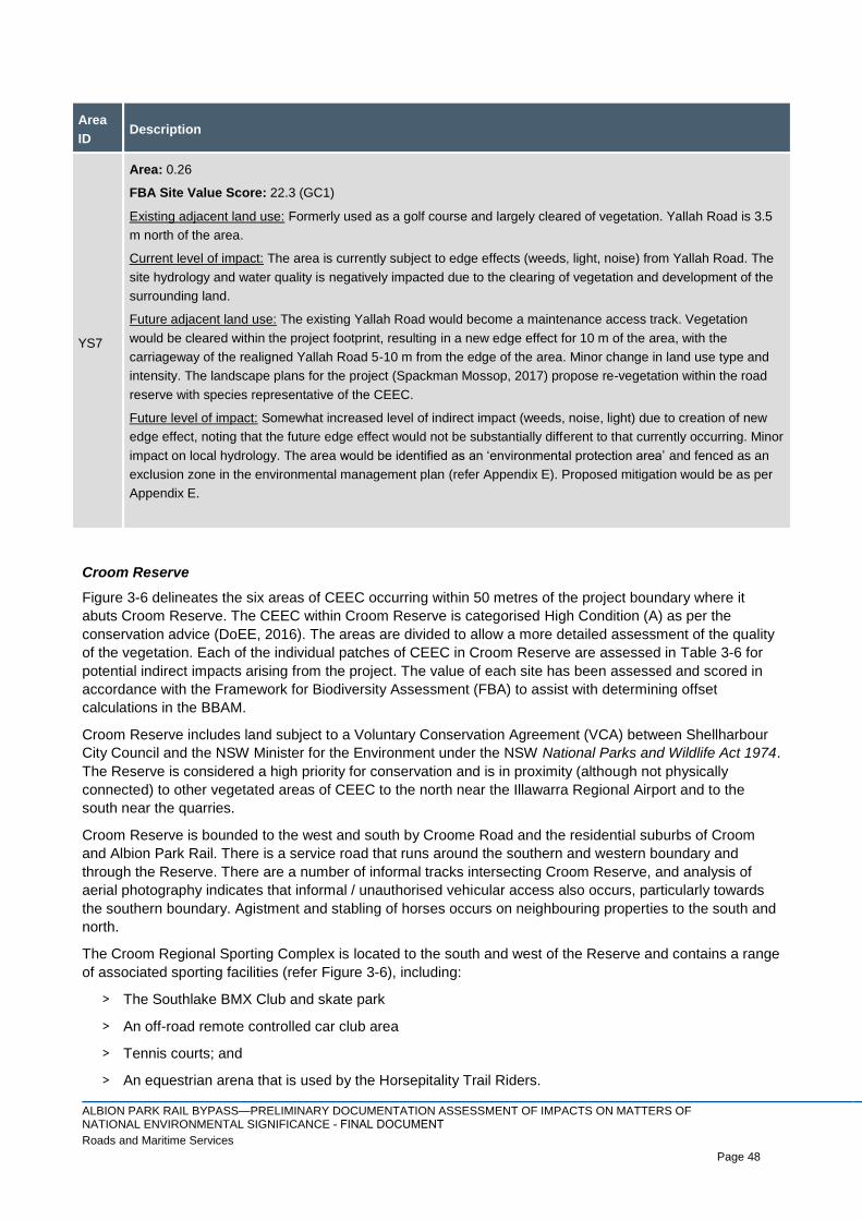
ALBION PARK RAIL BYPASS—PRELIMINARY DOCUMENTATION ASSESSMENT OF IMPACTS ON MATTERS OF NATIONAL ENVIRONMENTAL SIGNIFICANCE - FINAL DOCUMENTRoads and Maritime Services Page 48
Page 48
Area
ID Description
YS7
Area: 0.26
FBA Site Value Score: 22.3 (GC1)
Existing adjacent land use: Formerly used as a golf course and largely cleared of vegetation. Yallah Road is 3.5
m north of the area.
Current level of impact: The area is currently subject to edge effects (weeds, light, noise) from Yallah Road. The
site hydrology and water quality is negatively impacted due to the clearing of vegetation and development of the
surrounding land.
Future adjacent land use: The existing Yallah Road would become a maintenance access track. Vegetation
would be cleared within the project footprint, resulting in a new edge effect for 10 m of the area, with the
carriageway of the realigned Yallah Road 5-10 m from the edge of the area. Minor change in land use type and
intensity. The landscape plans for the project (Spackman Mossop, 2017) propose re-vegetation within the road
reserve with species representative of the CEEC.
Future level of impact: Somewhat increased level of indirect impact (weeds, noise, light) due to creation of new
edge effect, noting that the future edge effect would not be substantially different to that currently occurring. Minor
impact on local hydrology. The area would be identified as an ‘environmental protection area’ and fenced as an
exclusion zone in the environmental management plan (refer Appendix E). Proposed mitigation would be as per
Appendix E.
Croom Reserve
Figure 3-6 delineates the six areas of CEEC occurring within 50 metres of the project boundary where it
abuts Croom Reserve. The CEEC within Croom Reserve is categorised High Condition (A) as per the
conservation advice (DoEE, 2016). The areas are divided to allow a more detailed assessment of the quality
of the vegetation. Each of the individual patches of CEEC in Croom Reserve are assessed in Table 3-6 for
potential indirect impacts arising from the project. The value of each site has been assessed and scored in
accordance with the Framework for Biodiversity Assessment (FBA) to assist with determining offset
calculations in the BBAM.
Croom Reserve includes land subject to a Voluntary Conservation Agreement (VCA) between Shellharbour
City Council and the NSW Minister for the Environment under the NSW National Parks and Wildlife Act 1974.
The Reserve is considered a high priority for conservation and is in proximity (although not physically
connected) to other vegetated areas of CEEC to the north near the Illawarra Regional Airport and to the
south near the quarries.
Croom Reserve is bounded to the west and south by Croome Road and the residential suburbs of Croom
and Albion Park Rail. There is a service road that runs around the southern and western boundary and
through the Reserve. There are a number of informal tracks intersecting Croom Reserve, and analysis of
aerial photography indicates that informal / unauthorised vehicular access also occurs, particularly towards
the southern boundary. Agistment and stabling of horses occurs on neighbouring properties to the south and
north.
The Croom Regional Sporting Complex is located to the south and west of the Reserve and contains a range
of associated sporting facilities (refer Figure 3-6), including:
> The Southlake BMX Club and skate park
> An off-road remote controlled car club area
> Tennis courts; and
> An equestrian arena that is used by the Horsepitality Trail Riders.
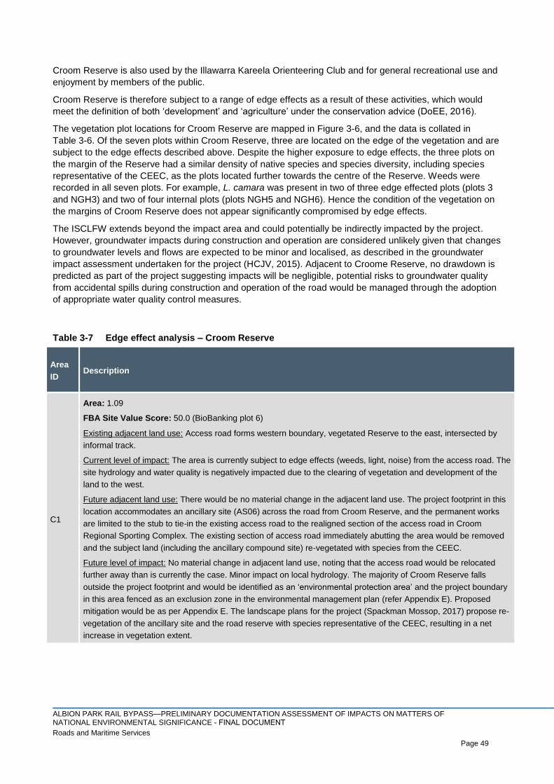
ALBION PARK RAIL BYPASS—PRELIMINARY DOCUMENTATION ASSESSMENT OF IMPACTS ON MATTERS OF NATIONAL ENVIRONMENTAL SIGNIFICANCE - FINAL DOCUMENTRoads and Maritime Services Page 49
Page 49
Croom Reserve is also used by the Illawarra Kareela Orienteering Club and for general recreational use and
enjoyment by members of the public.
Croom Reserve is therefore subject to a range of edge effects as a result of these activities, which would
meet the definition of both ‘development’ and ‘agriculture’ under the conservation advice (DoEE, 2016).
The vegetation plot locations for Croom Reserve are mapped in Figure 3-6, and the data is collated in
Table 3-6. Of the seven plots within Croom Reserve, three are located on the edge of the vegetation and are
subject to the edge effects described above. Despite the higher exposure to edge effects, the three plots on
the margin of the Reserve had a similar density of native species and species diversity, including species
representative of the CEEC, as the plots located further towards the centre of the Reserve. Weeds were
recorded in all seven plots. For example, L. camara was present in two of three edge effected plots (plots 3
and NGH3) and two of four internal plots (plots NGH5 and NGH6). Hence the condition of the vegetation on
the margins of Croom Reserve does not appear significantly compromised by edge effects.
The ISCLFW extends beyond the impact area and could potentially be indirectly impacted by the project.
However, groundwater impacts during construction and operation are considered unlikely given that changes
to groundwater levels and flows are expected to be minor and localised, as described in the groundwater
impact assessment undertaken for the project (HCJV, 2015). Adjacent to Croome Reserve, no drawdown is
predicted as part of the project suggesting impacts will be negligible, potential risks to groundwater quality
from accidental spills during construction and operation of the road would be managed through the adoption
of appropriate water quality control measures.
Table 3-7 Edge effect analysis – Croom Reserve
Area
ID Description
C1
Area: 1.09
FBA Site Value Score: 50.0 (BioBanking plot 6)
Existing adjacent land use: Access road forms western boundary, vegetated Reserve to the east, intersected by
informal track.
Current level of impact: The area is currently subject to edge effects (weeds, light, noise) from the access road. The
site hydrology and water quality is negatively impacted due to the clearing of vegetation and development of the
land to the west.
Future adjacent land use: There would be no material change in the adjacent land use. The project footprint in this
location accommodates an ancillary site (AS06) across the road from Croom Reserve, and the permanent works
are limited to the stub to tie-in the existing access road to the realigned section of the access road in Croom
Regional Sporting Complex. The existing section of access road immediately abutting the area would be removed
and the subject land (including the ancillary compound site) re-vegetated with species from the CEEC.
Future level of impact: No material change in adjacent land use, noting that the access road would be relocated
further away than is currently the case. Minor impact on local hydrology. The majority of Croom Reserve falls
outside the project footprint and would be identified as an ‘environmental protection area’ and the project boundary
in this area fenced as an exclusion zone in the environmental management plan (refer Appendix E). Proposed
mitigation would be as per Appendix E. The landscape plans for the project (Spackman Mossop, 2017) propose re-
vegetation of the ancillary site and the road reserve with species representative of the CEEC, resulting in a net
increase in vegetation extent.

ALBION PARK RAIL BYPASS—PRELIMINARY DOCUMENTATION ASSESSMENT OF IMPACTS ON MATTERS OF NATIONAL ENVIRONMENTAL SIGNIFICANCE - FINAL DOCUMENTRoads and Maritime Services Page 50
Page 50
Area
ID Description
C2
Area: 1.03
FBA Site Value Score: 47.2 (Plot CR1)
Existing adjacent land use: Access road forms south-western boundary, vegetated Reserve to the north-east.
Current level of impact: The area is currently subject to edge effects (weeds, light, noise) from the access road and
use of the sports fields. The site hydrology and water quality is negatively impacted due to the clearing of
vegetation and development of the land to the south-west.
Future adjacent land use: Vegetation would be cleared within the project footprint, resulting in a new edge effect for
175 m of the area, with the motorway carriageway 15-20 m from the edge of the area. The land adjacent to the
area’s western extent would be revegetated following demolition of the existing access road, reducing the edge
effect in this location as the vegetation matures. Net increase in intensity of land use.
Future level of impact: Increased level of indirect impact (weeds, noise, light) due to creation of new edge effect.
Minor impact on local hydrology. The majority of Croom Reserve falls outside the project footprint and would be
identified as an ‘environmental protection area’ and fenced as an exclusion zone in the environmental management
plan (refer Appendix E). Proposed mitigation would be as per Appendix E. The landscape plans for the project
(Spackman Mossop, 2017) propose re-vegetation of the ancillary site and the road reserve with species
representative of the CEEC.
C3
Area: 0.61
FBA Site Value Score: 49.17 (BioBanking plot 7)
Existing adjacent land use: Cleared land on southern border that currently appears to be used for informal parking.
A vehicular access road intersects the area, providing access to the equestrian arena and tennis courts. Vegetated
Reserve to north.
Current level of impact: The area is currently subject to edge effects (weeds, light, noise) from the access road, use
of the cleared parking area and the informal access track, and the use of the sports fields to the south. The site
hydrology and water quality is negatively impacted due to the clearing of vegetation and development of the land to
the south.
Future adjacent land use: The land adjacent to the area’s western extent would be revegetated following demolition
of the existing access road, reducing the edge effect in this location as the vegetation matures. No increase in
intensity of land use.
Future level of impact: No new edge effect created. Minor impact on local hydrology. Existing edge effect would be
mitigated by the revegetation of the adjacent cleared land and road reserve. Croom Reserve falls outside the
project footprint and would be identified as an ‘environmental protection area’ and fenced as an exclusion zone in
the environmental management plan (refer Appendix E). Proposed mitigation would be as per Appendix E. The
landscape plans for the project (Spackman Mossop, 2017) propose re-vegetation of the ancillary site and the road
reserve with species representative of the CEEC.

ALBION PARK RAIL BYPASS—PRELIMINARY DOCUMENTATION ASSESSMENT OF IMPACTS ON MATTERS OF NATIONAL ENVIRONMENTAL SIGNIFICANCE - FINAL DOCUMENTRoads and Maritime Services Page 51
Page 51
Area
ID Description
C4
Area: 0.84
FBA Site Value Score: 64.17 (Biobanking plot 8)
Existing adjacent land use: Access road forms southern boundary and there is what appears to be an informal
parking area and access track for the equestrian arena in this area. Vegetated Reserve to the north.
Current level of impact: The area is currently subject to clearing and edge effects (weeds, light, noise) from the
access road and the informal parking area and access track. The site hydrology and water quality is negatively
impacted due to the clearing of vegetation and development of the land to the south.
Future adjacent land use: A new edge effect would occur for 50 m of the area of CEEC due to clearing in the works
footprint, noting that the extent of clearing would be limited to the removal of two trees (with no understorey). The
existing access road and information car park would be demolished and revegetated. The motorway carriageway
would be 30 m from the edge of the area. The road reserve would also be revegetated. No material change in
intensity of land use.
Future level of impact: Although the clearing would result in a “new” edge effect, the subsequent change in land
use and revegetation of the land would be an improvement over the existing condition. Minor impact on local
hydrology. Croom Reserve falls outside the project footprint and would be identified as an ‘environmental protection
area’ and fenced as an exclusion zone in the environmental management plan (refer Appendix E). Proposed
mitigation would be as per Appendix E. The landscape plans for the project (Spackman Mossop, 2017) propose re-
vegetation of the ancillary site and the road reserve with species representative of the CEEC.
C5
Area: 0.57
FBA Site Value Score: 50.83 (Biobanking plot 9)
Existing adjacent land use: Access road forms southern boundary, Croome Road forms south-eastern boundary,
equestrian arena forms the north-western boundary, and there is a gravel parking area to the east. Intersected by
access track in the south-western section of the area.
Current level of impact: The area is currently subject to clearing and edge effects (weeds, light, noise) from the
access road, equestrian arena, parking area and Croome Road. The site hydrology and water quality is negatively
impacted due to the clearing of vegetation and development of adjacent land.
Future adjacent land use: There would be a net reduction in the intensity of the adjacent land use. The permanent
works in the project footprint in this location are limited to the construction of the stub to tie-in the realigned Croome
Road, which would now be located 15-45 m further away from the area than is currently the case. The existing
section of Croome Road immediately abutting the area would be demolished and the subject land re-vegetated.
Future level of impact: The change in land use and revegetation of the land would be an improvement over the
existing condition. Minor impact on local hydrology. Croom Reserve falls outside the project footprint and would be
identified as an ‘environmental protection area’ and fenced as an exclusion zone in the environmental management
plan (refer Appendix E). Proposed mitigation would be as per Appendix E. The landscape plans for the project
(Spackman Mossop, 2017) propose re-vegetation of the ancillary site and the road reserve with species
representative of the CEEC.
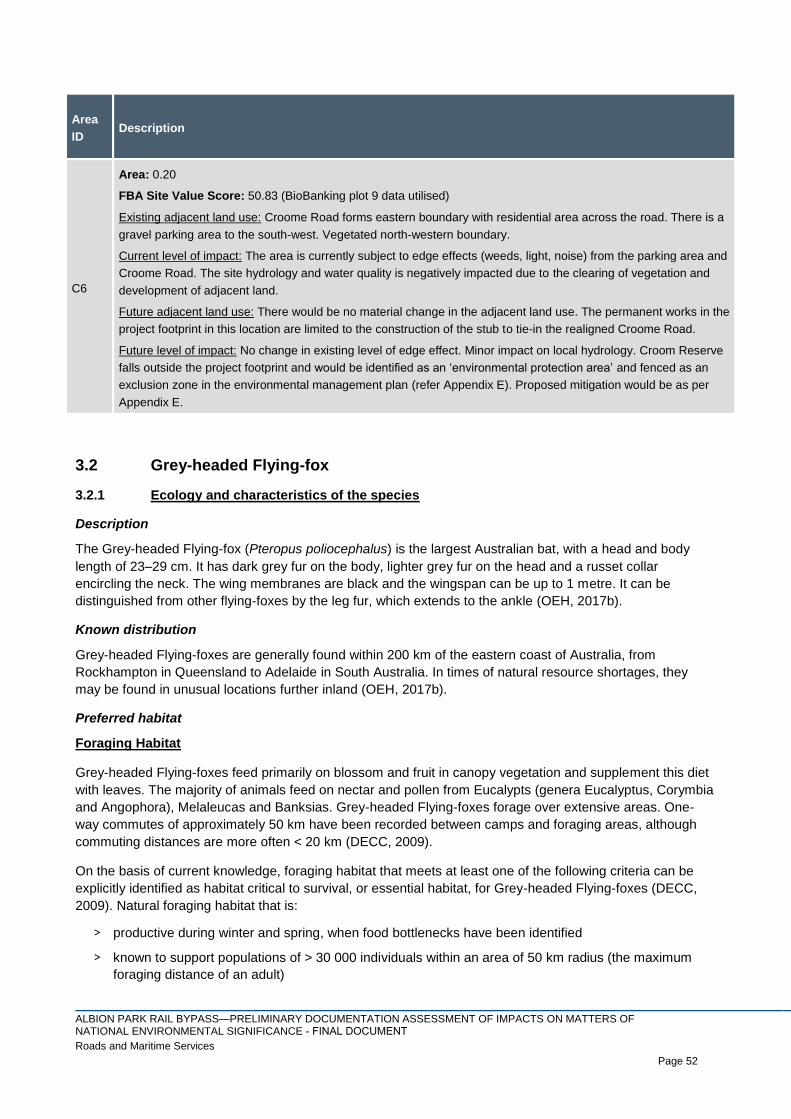
ALBION PARK RAIL BYPASS—PRELIMINARY DOCUMENTATION ASSESSMENT OF IMPACTS ON MATTERS OF NATIONAL ENVIRONMENTAL SIGNIFICANCE - FINAL DOCUMENTRoads and Maritime Services Page 52
Page 52
Area
ID Description
C6
Area: 0.20
FBA Site Value Score: 50.83 (BioBanking plot 9 data utilised)
Existing adjacent land use: Croome Road forms eastern boundary with residential area across the road. There is a
gravel parking area to the south-west. Vegetated north-western boundary.
Current level of impact: The area is currently subject to edge effects (weeds, light, noise) from the parking area and
Croome Road. The site hydrology and water quality is negatively impacted due to the clearing of vegetation and
development of adjacent land.
Future adjacent land use: There would be no material change in the adjacent land use. The permanent works in the
project footprint in this location are limited to the construction of the stub to tie-in the realigned Croome Road.
Future level of impact: No change in existing level of edge effect. Minor impact on local hydrology. Croom Reserve
falls outside the project footprint and would be identified as an ‘environmental protection area’ and fenced as an
exclusion zone in the environmental management plan (refer Appendix E). Proposed mitigation would be as per
Appendix E.
3.2 Grey-headed Flying-fox
3.2.1 Ecology and characteristics of the species
Description
The Grey-headed Flying-fox (Pteropus poliocephalus) is the largest Australian bat, with a head and body
length of 23–29 cm. It has dark grey fur on the body, lighter grey fur on the head and a russet collar
encircling the neck. The wing membranes are black and the wingspan can be up to 1 metre. It can be
distinguished from other flying-foxes by the leg fur, which extends to the ankle (OEH, 2017b).
Known distribution
Grey-headed Flying-foxes are generally found within 200 km of the eastern coast of Australia, from
Rockhampton in Queensland to Adelaide in South Australia. In times of natural resource shortages, they
may be found in unusual locations further inland (OEH, 2017b).
Preferred habitat
Foraging Habitat
Grey-headed Flying-foxes feed primarily on blossom and fruit in canopy vegetation and supplement this diet
with leaves. The majority of animals feed on nectar and pollen from Eucalypts (genera Eucalyptus, Corymbia
and Angophora), Melaleucas and Banksias. Grey-headed Flying-foxes forage over extensive areas. One-
way commutes of approximately 50 km have been recorded between camps and foraging areas, although
commuting distances are more often < 20 km (DECC, 2009).
On the basis of current knowledge, foraging habitat that meets at least one of the following criteria can be
explicitly identified as habitat critical to survival, or essential habitat, for Grey-headed Flying-foxes (DECC,
2009). Natural foraging habitat that is:
> productive during winter and spring, when food bottlenecks have been identified
> known to support populations of > 30 000 individuals within an area of 50 km radius (the maximum
foraging distance of an adult)

ALBION PARK RAIL BYPASS—PRELIMINARY DOCUMENTATION ASSESSMENT OF IMPACTS ON MATTERS OF NATIONAL ENVIRONMENTAL SIGNIFICANCE - FINAL DOCUMENTRoads and Maritime Services Page 53
Page 53
> productive during the final weeks of gestation, and during the weeks of birth, lactation and conception
(September to May)
> productive during the final stages of fruit development and ripening in commercial crops affected by
Grey-headed Flying-foxes (months vary between regions); or
> known to support a continuously occupied camp.
Roosting Habitat
Grey-headed Flying-foxes roost in large aggregations in the exposed branches of canopy trees. The
locations of camps are generally stable through time, and several sites have documented histories that
exceed 100 years. Camps provide resting habitat, sites of social interactions and refuge for animals during
significant phases of their annual cycle, such as birth, lactation and conception (DECCW, 2009).
On the basis of current knowledge, roosting habitat that meets at least one of the following criteria can be
explicitly identified as habitat critical to survival, or essential habitat, for Grey-headed Flying-foxes (DECCW,
2009). Roosting habitat that:
> is used as a camp either continuously or seasonally in > 50% of years
> has been used as a camp at least once in 10 years (beginning in 1995) and is known to have
contained > 10 000 individuals, unless such habitat has been used only as a temporary refuge, and
the use has been of limited duration (i.e. in the order of days rather than weeks or months); or
> has been used as a camp at least once in 10 years (beginning in 1995) and is known to have
contained > 2 500 individuals, including reproductive females during the final stages of pregnancy,
during lactation, or during the period of conception (i.e. September to May).
3.2.2 Conservation status and advice
National legal status
The Grey-headed Flying-fox (Pteropus poliocephalus) is listed as Vulnerable under the EPBC Act (DoEE,
2017a).
Threatening process
The Grey-headed Flying-fox has a number of key threatening processes that impact on the biology and
ecology of the species e.g. shooting, disturbance of roosting sites, electrocution on power lines and loss of
foraging habitat (Eby and Law, 2008). These threatening processes impact on the following aspects of the
species biology and ecology (DECCW, 2009):
> Diet and foraging ecology;
> Long distance movements
> Roosting ecology
> Breeding
> Relationship with other Australian flying-foxes; and
> Disease.
Recovery strategies and other guidelines
The overall objectives of recovery are (DECCW, 2009):
> to reduce the impact of threatening processes on Grey-headed Flying-foxes and arrest decline
throughout the species’ range
> to conserve the functional roles of Grey-headed Flying-foxes in seed dispersal and pollination; and

ALBION PARK RAIL BYPASS—PRELIMINARY DOCUMENTATION ASSESSMENT OF IMPACTS ON MATTERS OF NATIONAL ENVIRONMENTAL SIGNIFICANCE - FINAL DOCUMENTRoads and Maritime Services Page 54
Page 54
> to improve the standard of information available to guide recovery of the Grey-headed Flying-fox, in
order to increase community knowledge of the species and reduce the impact of negative public
attitudes on the species.
3.2.3 Survey methodology
During September 2013 (ngh Environmental, 2017a), the following surveys were undertaken:
> Habitat assessment - Search for Flying-fox camps and foraging habitat; and
> Spotlighting - 2 sites over 2 nights (4.67 hrs).
Additional field surveys were undertaken during 26–28 June 2017 by two qualified ecologists. The following
methods were used during the field survey to detect the species:
> Rapid diurnal searches of all accessible native vegetation for the presence of flying-fox camp sites;
and
> Spotlighting of all accessible native vegetation for forging individuals, focusing on tree in blossom.
The climate conditions during the days of field survey are outlines in Table 3-8 below.
Table 3-8 Climatic conditions during the day of the field survey (Source: Bureau of Meteorology)
Date Temperature (°C) Rainfall (mm)
26 June 2017 7.6–19.1 0.0
27 June 2017 3.6–16.4 0.0
28 June 2017 7.1–17.3 0.0
Source: BoM 2017.
3.2.4 Survey results
Ngh environmental (2017a) recorded Grey-headed Flying-fox within the project footprint. Also, one individual
Grey-headed Flying-fox was heard calling and spotlighted foraging in a blossoming Eucalyptus robusta
(Swamp Mahogany) on the 26 June 2017, between Duck Creek and Yallah Bay Road. In addition, two Grey-
headed Flying-foxes where sighted foraging adjacent to the Croom Reserve (per obs, Cardno, July 2017).
Potential winter and spring foraging habitat is likely to occur with all vegetation types where eucalyptus trees
occur. In particular, Eucalyptus tereticornis (flowers in winter / spring) and Eucalyptus eugenoides (flowers in
spring) can provide winter and spring foraging habitat. Therefore, potentially up to 30.6 ha of winter and
spring foraging habitat for the Grey-headed Flying Fox occurs within the project footprint. The quality of this
habitat varies across the project footprint from past land management history. In particular, the habitat south
of Yallah Road and close to the current road reserve would provide moderate foraging habitat as these areas
have been disturbed; and the habitat north of Yallah Road and within the Croom Reserve would provide high
quality habitat as these areas have been largely undisturbed. As Eucalyptus tereticornis forms a major
component of the ISCFWS, it is likely that large areas of the potential winter and spring foraging habitat for
the Grey-headed Flying-fox occurs in the surrounding area of the project footprint, including the Illawarra
TAFE Yallah site, Mount Brown Reserve, Blackbutt Reserve, Croom Reserve and further afield in
surrounding national parks such as Macquarie Pass National Park. In total, there is potentially 381 ha of
ISCFW within 5 km of the project footprint (subject to a condition assessment)
The potential foraging habitat located within the project footprint is considered to be ‘foraging habitat critical
to survival’ of the Grey-headed Flying Fox in accordance with the Draft National Recovery Plan as winter-
spring flowering trees occurs (DECCW, 2009). The potential Grey-headed Flying-fox foraging habitat, survey
effort, and sighting location within and adjacent to the project footprint are mapped in Figure 3-7 to Figure 3-
10.
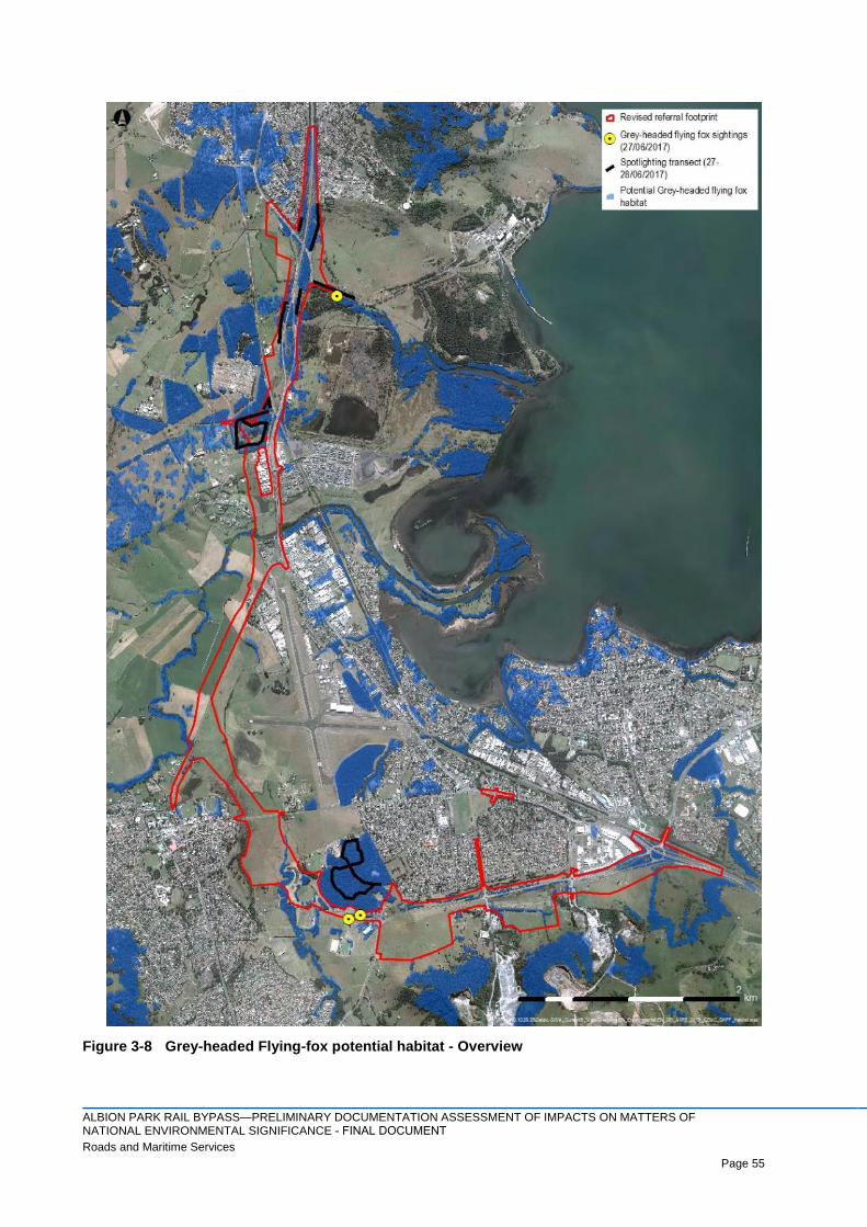
ALBION PARK RAIL BYPASS—PRELIMINARY DOCUMENTATION ASSESSMENT OF IMPACTS ON MATTERS OF NATIONAL ENVIRONMENTAL SIGNIFICANCE - FINAL DOCUMENTRoads and Maritime Services Page 55
Page 55
Figure 3-8 Grey-headed Flying-fox potential habitat - Overview

ALBION PARK RAIL BYPASS—PRELIMINARY DOCUMENTATION ASSESSMENT OF IMPACTS ON MATTERS OF NATIONAL ENVIRONMENTAL SIGNIFICANCE - FINAL DOCUMENTRoads and Maritime Services Page 56
Page 56
Figure 3-9 Grey-headed Flying-fox potential habitat - North

ALBION PARK RAIL BYPASS—PRELIMINARY DOCUMENTATION ASSESSMENT OF IMPACTS ON MATTERS OF NATIONAL ENVIRONMENTAL SIGNIFICANCE - FINAL DOCUMENTRoads and Maritime Services Page 57
Page 57
Figure 3-10 Grey-headed Flying-fox potential habitat – Croom

ALBION PARK RAIL BYPASS—PRELIMINARY DOCUMENTATION ASSESSMENT OF IMPACTS ON MATTERS OF NATIONAL ENVIRONMENTAL SIGNIFICANCE - FINAL DOCUMENTRoads and Maritime Services Page 58
Page 58
Figure 3-11 Grey-headed Flying-fox potential habitat - South

ALBION PARK RAIL BYPASS—PRELIMINARY DOCUMENTATION ASSESSMENT OF IMPACTS ON MATTERS OF NATIONAL ENVIRONMENTAL SIGNIFICANCE - FINAL DOCUMENTRoads and Maritime Services Page 59
Page 59
3.3 Large-eared Pied Bat
3.3.1 Ecology and characteristics of the species
Description
The Large-eared Pied Bat (Chalinolobus dwyeri) is a small to medium-sized bat with long, prominent ears
and glossy black fur. The lower body has broad white fringes running under the wings and tail-membrane,
meeting in a V-shape in the pubic area. This species is one of the wattled bats, with small lobes of skin
between the ears and corner of the mouth (OEH, 2017b).
Known distribution
Found mainly in areas with extensive cliffs and caves, from Rockhampton in Queensland south to Bungonia
in the NSW Southern Highlands. It is generally rare with a very patchy distribution in NSW. There are
scattered records from the New England Tablelands and North West Slopes (OEH, 2017b).
Preferred habitat
Roosts in caves (near their entrances), crevices in cliffs, old mine workings and in the disused, bottle-shaped
mud nests of the Fairy Martin (Petrochelidon ariel), frequenting low to mid-elevation dry open forest and
woodland close to these features. Females have been recorded raising young in maternity roosts (c. 20-40
females) from November through to January in roof domes in sandstone caves and overhangs. They remain
loyal to the same cave over many years (OEH, 2017b).
3.3.2 Conservation status and advice
National legal status
The Large-eared Pied Bat (Chalinolobus dwyeri) is listed as Vulnerable under the EPBC Act (DoEE, 2017a).
Threatening process
The only confirmed threat to the Large-eared Pied Bat is disturbance and damage to primary nursery sites
by animals (particularly Goats (Capra hircus)) and humans. The first known primary nursery site was
destroyed by the flooding of Copeton Dam in 1976. One of the other three known primary nursery sites being
monitored was abandoned after disturbance by macropods. Many suitable roost caves in for example, the
Pilliga region of New South Wales have been used by goats and/or other animals and these are not used by
the bats (Hoye, 2005).
Clearing or timber harvesting in or around roosts has the potential to affect foraging resources and fragment
surrounding vegetation. This is likely to be particularly detrimental in the vicinity of maternity roosts where
pregnant and lactating females require sufficient food resources to raise young. Also, clearing could alter
microclimate, including solar radiation and groundwater levels (Hoye, 2005).
One of the two currently known breeding sites is a disused mine in Barraba, NSW (Hoye, 2005). This type of
site may be important, particularly where caves are uncommon or not suitable for roosting.
Portions of the range of the Large-eared Pied Bat occur in conjunction with mine leases for underground coal
in both NSW and Queensland. Alteration of habitat following subsidence due to longwall mining has been
listed as a key threatening process in NSW. Much of the habitat of the Large-eared Pied Bat occurs in
sandstone that is underlain by coal seams that are potentially at risk of collapse from underground mining
(Hoye, 2005).
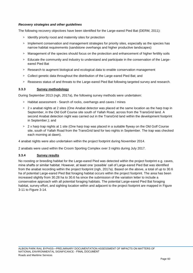
ALBION PARK RAIL BYPASS—PRELIMINARY DOCUMENTATION ASSESSMENT OF IMPACTS ON MATTERS OF NATIONAL ENVIRONMENTAL SIGNIFICANCE - FINAL DOCUMENTRoads and Maritime Services Page 60
Page 60
Recovery strategies and other guidelines
The following recovery objectives have been identified for the Large-eared Pied Bat (DERM, 2011):
> Identify priority roost and maternity sites for protection
> Implement conservation and management strategies for priority sites, especially as the species has
narrow habitat requirements (sandstone overhangs and higher productive landscapes)
> Management of the species should focus on the protection and enhancement of higher fertility soils
> Educate the community and industry to understand and participate in the conservation of the Large-
eared Pied Bat
> Research to augment biological and ecological data to enable conservation management
> Collect genetic data throughout the distribution of the Large-eared Pied Bat; and
> Reassess status of and threats to the Large-eared Pied Bat following targeted survey and research.
3.3.3 Survey methodology
During September 2013 (ngh, 2017a), the following survey methods were undertaken:
> Habitat assessment - Search of rocks, overhangs and caves / mines
> 2 x anabat nights at 2 sites (One Anabat detector was placed at the same location as the harp trap in
September, in the Old Golf Course site south of Yallah Road, across from the TransGrid land. A
second Anabat detection night was carried out in the TransGrid land within the development footprint
in September.); and
> 2 x harp trap nights at 1 site (One harp trap was placed in a suitable flyway on the Old Golf Course
site, south of Yallah Road from the TransGrid land for two nights in September. The trap was checked
each morning at dawn).
4 anabat nights were also undertaken within the project footprint during November 2014.
2 anabats were used within the Croom Sporting Complex over 3 nights during July 2017.
3.3.4 Survey results
No roosting or breeding habitat for the Large-eared Pied was detected within the project footprint e.g. caves,
mine shafts or similar habitat. However, at least one ‘possible’ call of Large-eared Pied Bat was identified
from the anabat recording within the project footprint (ngh, 2017a). Based on the above, a total of up to 30.6
ha of potential Large-eared Pied Bat foraging habitat occurs within the project footprint. The area has been
increased slightly from 30.28 ha to 30.6 ha since the submission of the variation letter to include a
conservative approach with all potential foraging habitats. The potential Large-eared Pied Bat foraging
habitat, survey effort, and sighting location within and adjacent to the project footprint are mapped in Figure
3-11 to Figure 3-14.

ALBION PARK RAIL BYPASS—PRELIMINARY DOCUMENTATION ASSESSMENT OF IMPACTS ON MATTERS OF NATIONAL ENVIRONMENTAL SIGNIFICANCE - FINAL DOCUMENTRoads and Maritime Services Page 61
Page 61
Figure 3-12 Large-eared Pied Bat potential habitat - Overview
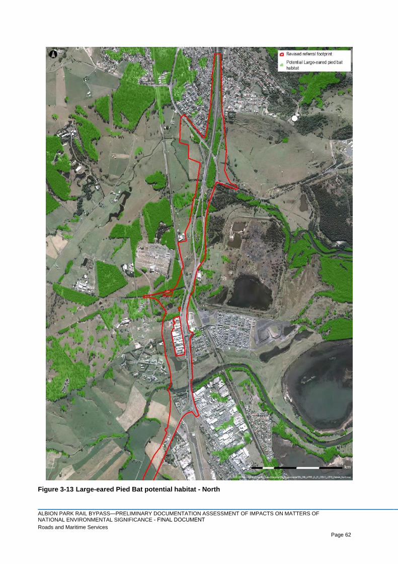
ALBION PARK RAIL BYPASS—PRELIMINARY DOCUMENTATION ASSESSMENT OF IMPACTS ON MATTERS OF NATIONAL ENVIRONMENTAL SIGNIFICANCE - FINAL DOCUMENTRoads and Maritime Services Page 62
Page 62
Figure 3-13 Large-eared Pied Bat potential habitat - North
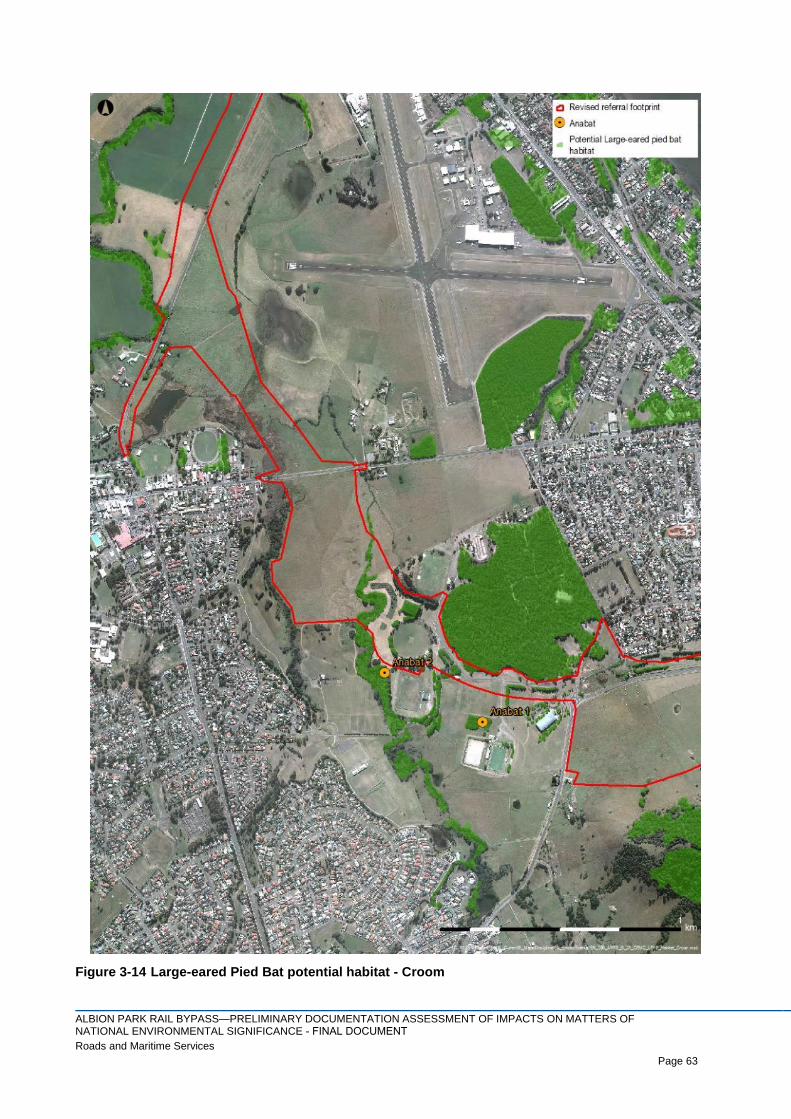
ALBION PARK RAIL BYPASS—PRELIMINARY DOCUMENTATION ASSESSMENT OF IMPACTS ON MATTERS OF NATIONAL ENVIRONMENTAL SIGNIFICANCE - FINAL DOCUMENTRoads and Maritime Services Page 63
Page 63
Figure 3-14 Large-eared Pied Bat potential habitat - Croom
ALBION PARK RAIL BYPASS—PRELIMINARY DOCUMENTATION ASSESSMENT OF IMPACTS ON MATTERS OF NATIONAL ENVIRONMENTAL SIGNIFICANCE - FINAL DOCUMENTRoads and Maritime Services Page 64
Page 64
Figure 3-15 Large-eared Pied Bat potential habitat - South

ALBION PARK RAIL BYPASS—PRELIMINARY DOCUMENTATION ASSESSMENT OF IMPACTS ON MATTERS OF NATIONAL ENVIRONMENTAL SIGNIFICANCE - FINAL DOCUMENTRoads and Maritime Services Page 65
Page 65
3.4 Koala
3.4.1 Ecology and characteristics of the species
Description
The Koala (Phascolarctos cinereus) is an arboreal marsupial with fur ranging from grey to brown above, and
white below. It has large furry ears, a prominent black nose and no tail. It spends most of its time in trees and
has long, sharp claws, adapted for climbing. Adult males weigh 6–12 kg and adult females weigh 5–8 kg.
During breeding, males advertise with loud snarling coughs and bellows (OEH, 2017b).
Known distribution
The Koala has a fragmented distribution throughout eastern Australia from north-east Queensland to the
Eyre Peninsula in South Australia. In NSW, it mainly occurs on the central and north coasts with some
populations in the west of the Great Dividing Range. It was briefly historically abundant in the 1890s in the
Bega District on the south coast of NSW, although not elsewhere, but it now occurs in sparse and possibly
disjunct populations. Koalas are also known from several sites on the southern tablelands (OEH, 2017b).
Preferred habitat
Koala habitat can be broadly defined as any forest or woodland containing species that are known koala
food trees, or shrubland with emergent food trees. The distribution of this habitat is largely influenced by land
elevation, annual temperature and rainfall patterns, soil types and the resultant soil moisture availability and
fertility. Preferred food and shelter trees are naturally abundant on fertile clay soils.
Within the south coast of NSW, Local Land Services: Southern Rivers have nominated the following Koala
feed trees in Table 3-9 (OEH, 2017a).
Table 3-9 Koala feed tree species for the South Coast of NSW
Main Koala Food Trees
Primary food tree species
Cabbage Gum (E. amplifolia) Forest Red Gum (E. tereticornis)
Ribbon Gum (E. viminalis)
Secondary food tree species
Yellow Box (E. melliodora) Woollybutt (E. longifolia)
Brittle Gum (E. mannifera) Maiden’s Gum (E. maidenii)
Yertchuk (E. consideniana) Snow Gum (E. pauciflora)
Swamp Gum (E. ovata) Red Box (E. polyanthemos)
Large-fruited Red Mahogany (E. scias) Coast Grey Box (E. bosistoana)
Apple-topped Box (E. bridgesiana) Blue Box (E. baueriana)
Monkey Gum (E. cypellocarpa) Bastard Eurabbie (E. pseudoglobulus)
Stringybarks/supplementary species
White Stringybark (E. globoidea) Brown Stringybark (E. capitellata)
Yellow Stringybark (E. muelleriana) Southern White Stringybark (E. yangoura)
Blue-leaved Stringybark (E. agglomerate) E. baxteri

ALBION PARK RAIL BYPASS—PRELIMINARY DOCUMENTATION ASSESSMENT OF IMPACTS ON MATTERS OF NATIONAL ENVIRONMENTAL SIGNIFICANCE - FINAL DOCUMENTRoads and Maritime Services Page 66
Page 66
3.4.2 Conservation status and advice
National legal status
The Koala (Phascolarctos cinereus) is listed as Vulnerable under the EPBC Act (DoEE, 2017a).
Threatening process
No National Koala recovery plan currently exists. However, the following key threatening processes under
the EPBC Act are likely to be relevant to the Koala:
> Dieback caused by the root-rot fungus (Phytophthora cinnamomi)
> Land clearance
> Loss and degradation of native plant and animal habitat by invasion of escaped garden plants,
including aquatic plants
> Loss of climatic habitat caused by anthropogenic emissions of greenhouse gases
> Novel biota and their impact on biodiversity; and
> Predation by European red fox.
Recovery strategies and other guidelines
The following recovery actions have been proposed und the NSW approved recovery plan for Koala (DECC,
2008b):
> Objective 1: Conserve koalas in their existing habitat:
Specific objective 1a: Identify and conserve habitat important for koala conservation
Specific objective 1b: Assess the impact of habitat loss and fragmentation on koala
populations
Specific objective 1c: Integrate koala habitat conservation into local and state
government planning processes
Specific objective 1d: Develop appropriate road risk management in koala habitat
Specific objective 1e: Implement strategies which minimise the impacts of dogs on
koala populations; and
Specific objective 1f: Develop and implement strategies to reduce the impact of fires on
koala populations.
> Objective 2: Rehabilitate and restore koala habitat and populations:
Specific objective 2a: Revegetate and rehabilitate selected sites; and
Specific objective 2b: Make appropriate use of translocation.
> Objective 3: Develop a better understanding of the conservation biology of koalas
> Objective 4: Ensure that the community has access to factual information about the distribution,
conservation and management of koalas at a national, state and local level:
Specific objective 4a: Prepare and distribute educational material and involve the
community in koala conservation; and
Specific objective 4b: Understand the cultural significance of koalas.

ALBION PARK RAIL BYPASS—PRELIMINARY DOCUMENTATION ASSESSMENT OF IMPACTS ON MATTERS OF NATIONAL ENVIRONMENTAL SIGNIFICANCE - FINAL DOCUMENTRoads and Maritime Services Page 67
Page 67
> Objective 5: Manage captive, sick or injured koalas and orphaned wild koalas to ensure consistent and
high standards of care
> Objective 6: Manage over browsing to prevent both koala starvation and ecosystem damage in
discrete patches of habitat; and
> Objective 7: Coordinate, promote the implementation, and monitor the effectiveness of the NSW Koala
Recovery Plan across New South Wales.
3.4.3 Survey methodology
A field survey was undertaken during the 26–28 June 2017 by two qualified Ecologists. The following
methods were used during the field survey to detect the species in accordance with the koala habitat
assessment methodologies recommended in the referral guidelines (DoE, 2014):
> Scat search - Spot Assessment Technique (SAT) (see Phillips and Callaghan, 2011)
> Spotlighting of all accessible native vegetation, focusing on known Koala feed tree species
> Scratching search – assessment of smoothed-barked trees for scratches; and
> Call playback - male mating call.
The climate conditions during the days of field survey are outlined in Table 3-10 below.
Table 3-10 Climatic conditions during the day of the field survey (Source: Bureau of Meteorology)
Date Temperature (°C) Rainfall (mm)
26 June 2017 7.6–19.1 0.0
27 June 2017 3.6–16.4 0.0
28 June 2017 7.1–17.3 0.0
Source: BoM 2017.
3.4.4 Survey results
No Koala or signs of the Koala were detected during the field surveys. In total, approximately 30.6 ha of
potential Koala habitat occurs within the project footprint. The potential habitat within the project footprint
appeared to be suboptimal as it was often disturbed, fragmented and is isolated from patches of suitable
vegetation where Koala are known to occur, on the Illawarra escarpment 8 km west of the project footprint.
This area is slightly greater than that presented in the variation letter due to a rounding error which has now
been amended. The potential Koala habitat, survey effort, and sighting location within and adjacent to the
project footprint are mapped in Figure 3-15 to Figure 3-18.

ALBION PARK RAIL BYPASS—PRELIMINARY DOCUMENTATION ASSESSMENT OF IMPACTS ON MATTERS OF NATIONAL ENVIRONMENTAL SIGNIFICANCE - FINAL DOCUMENTRoads and Maritime Services Page 68
Page 68
Figure 3-16 Koala potential habitat - Overview
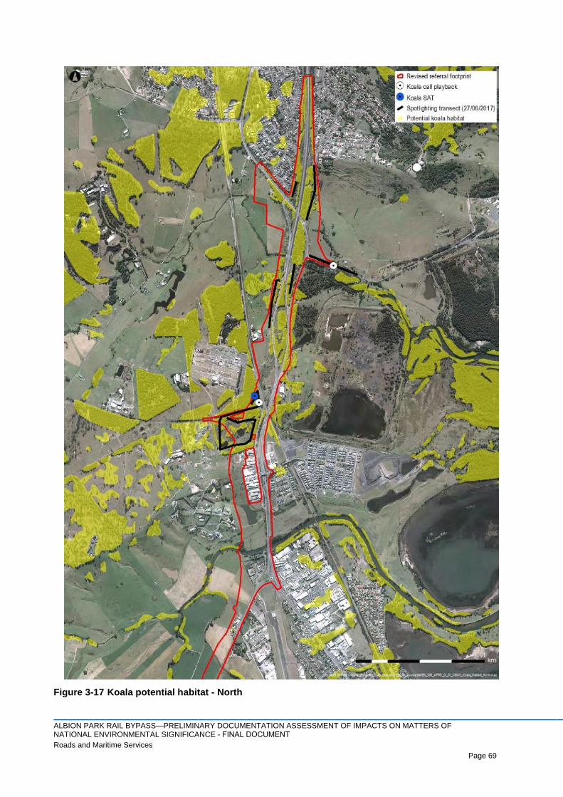
ALBION PARK RAIL BYPASS—PRELIMINARY DOCUMENTATION ASSESSMENT OF IMPACTS ON MATTERS OF NATIONAL ENVIRONMENTAL SIGNIFICANCE - FINAL DOCUMENTRoads and Maritime Services Page 69
Page 69
Figure 3-17 Koala potential habitat - North

ALBION PARK RAIL BYPASS—PRELIMINARY DOCUMENTATION ASSESSMENT OF IMPACTS ON MATTERS OF NATIONAL ENVIRONMENTAL SIGNIFICANCE - FINAL DOCUMENTRoads and Maritime Services Page 70
Page 70
Figure 3-18 Koala potential habitat - Croom

ALBION PARK RAIL BYPASS—PRELIMINARY DOCUMENTATION ASSESSMENT OF IMPACTS ON MATTERS OF NATIONAL ENVIRONMENTAL SIGNIFICANCE - FINAL DOCUMENTRoads and Maritime Services Page 71
Page 71
Figure 3-19 Koala potential habitat - South

ALBION PARK RAIL BYPASS—PRELIMINARY DOCUMENTATION ASSESSMENT OF IMPACTS ON MATTERS OF NATIONAL ENVIRONMENTAL SIGNIFICANCE - FINAL DOCUMENTRoads and Maritime Services Page 72
Page 72
4 Assessment of impacts
4.1 Illawarra and south coast lowland forest and woodland
4.1.1 Direct impacts
Clearing and fragmentation of vegetation
In total, the proposed project would result in the direct impact of up to approximately 1.53 ha of High (A)
condition and 3.32 ha of Moderate (C) condition Illawarra and south coast lowland forest and woodland
(ISCLFW).
4.1.2 Indirect impacts
The indirect impacts of the project have been assessed with due consideration of the change in adjacent
land use intensity and its impact on the ecological integrity of the patch of ISCLFW in the buffer zone.
Potential indirect impacts include clearing and fragmentation of vegetation, development (including the
upgrade of the Princes Highway, hydrological change, dumping), weeds, feral animals and fire. In
accordance with the Conservation Advice (DoEE, 2016), buffer zones of 50 metres have been adopted for
High (A) condition patches of CEEC, and buffer zones of 30 metres have been adopted for Moderate (C)
condition patches of ISCLFW. The project would result in the indirect impact of 7.3 ha of high and 1.5 ha of
moderate condition ISCLFW.
The ecological integrity and future viability of the remaining patches of the community, given that their small
and/or linear nature and position in the landscape (surrounded by development), may be reduced as a result
of the project. Given the current state of many of the patches, the project is unlikely to substantial reduce the
ecological integrity and future viability of the remaining patches. Provided the range of mitigation measure
are implemented, the project is unlikely to exacerbate or increase the number of threats.
4.1.3 Assessment of significance
An action is likely to have a significant impact on a critically endangered or endangered ecological
community if there is a real chance or possibility that it would (DoE, 2013). Additional survey has been
undertaken for the preliminary document resulting in a revised assessment of significance as prepared
below:
a) Reduce the extent of an ecological community.
The action would result in the reduced extent of up to approximately 1.53 ha of High (A) condition and 3.32
ha of Moderate (C) condition ISCLFW. In addition, the action would have an indirect impact on 7.3 ha of High
(A) condition and 1.5 ha of Moderate (C) condition vegetation.
b) Fragment or increase fragmentation of an ecological community, for example by clearing
vegetation for roads or transmission lines.
The project could increase the existing fragmentation of the CEEC. In the north of the project footprint, the
ISCLFW currently persists as fragmented patches extending across the existing highway; the project would
result in further fragmentation of these patches. A small patch of ISCLFW may be isolated in the western
section of the Old Golf Course site following clearing of adjacent areas of the patch; there may still be
adequate connectivity across Yallah Road, with a gap of 25–30 metres remaining. The section the
community south of Yallah road was found to be of moderate condition and is already fragmented. The
continuing viability of this patch would depend on the future land uses in this area. The clearing of the
western parts of the Road reserve patch would result in the remaining area of the patch being further
fragmented and isolated from the low condition patches to the east; however, these patches are currently

ALBION PARK RAIL BYPASS—PRELIMINARY DOCUMENTATION ASSESSMENT OF IMPACTS ON MATTERS OF NATIONAL ENVIRONMENTAL SIGNIFICANCE - FINAL DOCUMENTRoads and Maritime Services Page 73
Page 73
separated by gaps of 100 metres (or greater), so there is no existing connectivity. Therefore, the project is
unlikely to substantially increase the fragmentation of the ISCLFW.
c) Adversely affect habitat critical to the survival of an ecological community.
ISCLFW has a wide distribution from Moruya to Wollongong regions (DOEE, 2017a). The large remnant
patches within Croom Reserve will be mostly avoided from direct impacts. Therefore, as larger extents of
ISCLFW occurring outside of the project footprint will be retained, the action is unlikely to adversely affect
habitat critical to the survival of ISCLFW. In total, there is potentially 381 ha of plant community types that
could comprise ISCLFW within 5 km of the project footprint (subject to a condition assessment)
d) Modify or destroy abiotic (non-living) factors (such as water, nutrients, or soil) necessary for an
ecological community’s survival, including reduction of groundwater levels, or substantial
alteration of surface water drainage patterns.
ISCLFW is a Groundwater Dependent Ecosystem (GDE). The ISCLFW that extends beyond the impact area
and could potentially be indirectly impacted by the project, however groundwater impacts during construction
and operation are considered unlikely given that:
> Groundwater flow direction at the alluvium aquifer in the Croom Reserve GDE is from south to north
and as such would not be affected by possible reduced flows along certain sections of the proposed
alignment. Changes to groundwater levels and flows are expected to be minor and localised as
described in the groundwater impact assessment undertaken for the project (HCJV, 2015).
> The worst case average drawdown predicted at the centreline of the Albion Park Rail bypass proposal
is 1.6 m. This location is to the north of Macquarie Rivulet and is over 500 metres from the Yallah
Road intersection. Considering the proximity of the current water table to the land surface, the
drawdown is unlikely to lower the water table to beyond the reach of the tree roots. Impacts would be
considered minor at this worst case location and are likely to be negligible at Yallah Road. Adjacent to
Croome Reserve no drawdown is predicted as part of the project suggesting impacts will be negligible.
> Potential risks to groundwater quality from accidental spills during construction and operation of the
road would be managed through appropriate water quality control measures to be adopted during
construction and operation.
Surface water drainage patterns alteration will be managed in accordance with the environmental
management plan (Appendix E). This plan will ensure that surface water will not drain off directly into any
patch of ISCLFW.
As such, the action is unlikely to modify or destroy abiotic (non-living) factors (such as water, nutrients, or
soil) necessary for ISCLFW survival, including reduction of groundwater levels, or substantial alteration of
surface water drainage patterns.
e) Cause a substantial change in the species composition of an occurrence of an ecological
community, including causing a decline or loss of functionally important species, for example
through regular burning or flora or fauna harvesting.
The action does not involve burning or flora or fauna harvesting. Therefore, the action is unlikely to cause a
substantial change in the species composition of an occurrence of an ecological community, including
causing a decline or loss of functionally important species, for example through regular burning or flora or
fauna harvesting.

ALBION PARK RAIL BYPASS—PRELIMINARY DOCUMENTATION ASSESSMENT OF IMPACTS ON MATTERS OF NATIONAL ENVIRONMENTAL SIGNIFICANCE - FINAL DOCUMENTRoads and Maritime Services Page 74
Page 74
f) Cause a substantial reduction in the quality or integrity of an occurrence of an ecological
community, including, but not limited to:
– assisting invasive species, that are harmful to the listed ecological community, to become
established, or
– causing regular mobilisation of fertilisers, herbicides or other chemicals or pollutants into the
ecological community which kill or inhibit the growth of species in the ecological community.
During and following construction, there is the potential for edge effects and weed invasion to alter the
species composition of the community on the periphery of the project footprint. The patches of ISCLFW in
the project footprint currently already have noxious weeds present of which Lantana (Lantana camara) is the
most common. Weeds are listed as a threat to this community (DoEE, 2016). Considering invasive weeds
such as Lantana are already established in ISCLFW within the project, it is unlikely that the project would
further contribute to this threat, and the implementation of safeguards would include management of invasive
weeds e.g. surface water drainage provisions will assist in preventing the transport of weeds and sediment
from the road into the ISCLFW.
Invasive herbivores, including European Rabbit (Oryctolagus cuniculus) and deer (Cervus sp.) which were
recorded within the project footprint are likely to be a threat to ISCLFW due to their consumption of native
groundcover flora species. Considering invasive fauna such as deer and European rabbits are already
established in ISCLFW within the project, and other invasive fauna are likely to already be occurring within
the disturbed surrounding locality, it is unlikely that the project would further contribute to these threats.
Suitable and established mitigation measures have been recommended (Appendix E) to prevent further
impacts by invasive flora and fauna due to the project.
Operational water quality controls as defined in Appendix E, such as water quality basins, grassed swales
and spill containment would be implemented as part of the project. This would help to prevent invasive
species becoming established that are harmful to ISCLFW and soil or fill for construction and landscaping
been transported outside of the project footprint. In addition, this would help to prevent the regular
mobilisation of fertilisers, herbicides or other chemicals or pollutants from the road into ISCLFW which could
kill or inhibit the growth. Therefore, the action is unlikely to cause a substantial reduction in the quality or
integrity to the ISCLFW.
g) Interfere with the recovery of an ecological community.
The action would result in the removal of up to approximately 1.53 ha of High and 3.32 ha of Moderate
condition ISCLFW. In addition, the action would have an indirect impact on up to 7.3 ha of high and 1.5 ha of
moderate condition vegetation. Whilst the project would result in the loss of a small amount of this ecological
community, it would be offset. In addition, a range of mitigation measure would be implemented during the
construction phase of the project to ensure the minimum amount of the vegetation is impacted, including
exclusion fencing, weed and pathogen management plans, and sediment and erosion controls. Therefore,
the action is unlikely to substantially interfere with the recovery of this ecological community.
4.1.4 Summary of impact to the species
There is unlikely to be a significant impact on the local occurrence of ISCLFW because:
> The amount of ISCLFW to be directly impacted or potential indirectly impacted is small relative to the
amount of the community that will be avoided within the region, including at the Illawarra TAFE Yallah
site, Mount Brown Reserve, Blackbutt Reserve, Croom Reserve and further afield in surrounding national
parks such as Macquarie Pass National Park. In total, there is potentially 381 ha of plant community types
that could comprise ISCLFW within 5 km of the project footprint (subject to a condition assessment).
ALBION PARK RAIL BYPASS—PRELIMINARY DOCUMENTATION ASSESSMENT OF IMPACTS ON MATTERS OF NATIONAL ENVIRONMENTAL SIGNIFICANCE - FINAL DOCUMENTRoads and Maritime Services Page 75
Page 75
4.2 Grey-headed Flying-fox
4.2.1 Direct impacts to habitat
This species was recorded foraging within and in close proximity to the project footprint. Up to 30.6 ha of
potential Grey-headed Flying-fox foraging habitat would be removed from within the project footprint.
Foraging habitat within the project footprint includes the following plant community types:
> Derived forest red gum
> River oak open forest
> Swamp mahogany swamp sclerophyll forest
> Woollybutt - white stringybark - forest red gum grassy woodland
> Blackbutt – turpentine – bangalay moist open forest on sheltered slopes and gullies
> Forest red gum – thin-leaved stringybark grassy woodland on coastal lowlands
> Grey myrtle – lilly pilly dry rainforest in dry gullies
> Lilly pilly- sassafras- stinging tree subtropical/warm temperate rainforest on moist fertile lowlands
> Swamp oak – prickly tea-tree- swamp paperbark swamp forest on coastal floodplains; and
> Swamp oak – swamp forest fringing estuaries
4.2.2 Indirect impacts
Habitat fragmentation
Whilst the project is likely to lead to some fragmentation of potential foraging habitat for the Grey-headed
Flying-fox, the species is highly mobile and generally travels within 20 km of food sources. Also, most of the
native vegetation within the project footprint already occurs in a highly fragmented state. Therefore, whilst
the project is likely to lead to some further fragmentation of habitat for this species, it is likely to have a
negligible impact.
Connectivity
As the Grey-headed Flying-fox is a highly mobile species, it is unlikely to be impacted by the small reduction
in habitat connectivity that would occur as part of the project.
Edge Effects
The project has the potential in create edge effects to the retained vegetation that provides potential foraging
habitat for this species. However, as much of this vegetation has already be subject to edge effects, it is
considered unlikely that the project will result in a substantial increase in this type of impact.
4.2.3 Assessment of significance
Under the EPBC Act 1999 significant impact guidelines (DoE, 2013), a population of a vulnerable species
must be considered to be an 'important population' to require further assessment of impact. An important
population is defined as a population that is necessary for a species’ long-term survival and recovery. This
may include populations identified as such in recovery plans, and/or that are:
> key source populations either for breeding or dispersal
> populations that are necessary for maintaining genetic diversity; and/or
> populations that are near the limit of the species range.
The habitat within the project footprint does not provide breeding habitat for the Grey-headed Flying-fox. In
addition, the population within the project footprint is not near the limits of the species range. However, the
population could be necessary for maintaining genetic diversity. As such, the presence of the Grey-headed

ALBION PARK RAIL BYPASS—PRELIMINARY DOCUMENTATION ASSESSMENT OF IMPACTS ON MATTERS OF NATIONAL ENVIRONMENTAL SIGNIFICANCE - FINAL DOCUMENTRoads and Maritime Services Page 76
Page 76
Flying-fox within the project footprint should be treated as an ‘important population’ and thus has been
assessed further for the potential for it to be significantly impacted.
An action is likely to have a significant impact on a vulnerable species if there is a real chance or possibility
that it would (DoE, 2013). Additional survey has been undertaken for the preliminary document resulting in a
revised assessment of significance as prepared below:
a) Lead to a long-term decrease in the size of an important population of a species.
The Grey-headed Flying-fox is an aerial forager feeding on nectar from the flowers of native trees and fruit
from figs and exotic species. During the day this species roosts in camps in trees which are generally located
within 20 km of food sources. The closest camp to the project footprint occurs in Blackbutt Reserve,
approximately 5.5 km to the east of the project footprint. The Grey-headed Flying-fox was recorded flying
over and foraging on blossoming Eucalyptus species in the Croom Regional Sporting Complex and near
Duck Creek. Up to approximately 30.6 ha of foraging habitat located in the project footprint would be
removed as a result of the project.
Other foraging habitat unaffected by this project and conserved in reserves occurs at the Illawarra TAFE
Yallah site, Mount Brown Reserve, Blackbutt Reserve, Croom Reserve and further afield in surrounding
national parks such as Macquarie Pass National Park. Furthermore, vegetation suitable for this species
occurs in farming and urban land including isolated native trees and landscaped gardens with native trees
and shrubs.
The Illawarra and south coast lowland forest and woodland is listed in the Draft National Recovery Plan for
the Grey-headed Flying-fox (DECCW, 2009) as a community which would benefit from actions to recover the
Grey-headed Flying-fox and therefore clearing of this community would negatively impact on the habitat of
this species. Approximately 1.53 ha of High and 3.32 ha of Moderate condition of this community would be
removed.
The vegetation within the project footprint provides foraging habitat and does not include any Grey-headed
Flying-fox camps. As the project will result in the loss of a small amount of habitat in comparison to the large
areas of high quality habitat found outside of the project footprint, the project is unlikely to lead to a long-term
decrease in the size of the local population of this species.
b) Reduce the area of occupancy of an important population.
Up to approximately 30.6 ha of foraging habitat for the Grey-headed Flying-fox would be removed as a result
of the project, comprising a mixture remnant and regrowth vegetation in a range of conditions. Considering
the Grey-headed Flying-fox is an aerial species capable of travelling many kilometres to forage (~20 km per
night), and considering the large amounts of available foraging habitat in the locality (approximately 430 ha
within 5 km of the project footprint), the loss of foraging habitat in the project footprint would not cause a
decrease in the area of occupancy for this species. Furthermore, an important population of the Grey-
headed Flying-fox is not known in the project footprint.
c) Fragment an existing important population into two or more populations.
There were no camps for the Grey-headed Flying-fox recorded in or near the project footprint. Therefore, the
project would not cause any population of this aerial species to become fragmented into two or more
populations.
d) Adversely affect habitat critical to the survival of a species.
Habitat critical to the survival of the Grey-headed Flying-fox includes at least one the following attributes:

ALBION PARK RAIL BYPASS—PRELIMINARY DOCUMENTATION ASSESSMENT OF IMPACTS ON MATTERS OF NATIONAL ENVIRONMENTAL SIGNIFICANCE - FINAL DOCUMENTRoads and Maritime Services Page 77
Page 77
> A continuous sequence of productive foraging habitats, the migration corridors or stopover habitats
that link them, and suitable roosting habitat within nightly commuting distance of foraging areas
(Fleming and Eby, 2003).
> Foraging habitat that meets at least one of the following criteria can be explicitly identified as habitat
critical to survival, or essential habitat, for Grey-headed Flying-foxes. Natural foraging habitat that is:
- productive during winter and spring, when food bottlenecks have been identified (Parry-Jones and
Augee, 1991; Eby et al., 1999)
- known to support populations of > 30,000 individuals within an area of 50 km radius (the maximum
foraging distance of an adult)
- productive during the final weeks of gestation, and during the weeks of birth, lactation and conception
(September to May)
- productive during the final stages of fruit development and ripening in commercial crops affected by
Grey-headed Flying-foxes (months vary between regions); and
- known to support a continuously occupied camp.
Winter / spring flowering plants that have the potential to provide critical habitat include Eucalyptus
tereticornis (flowers in winter / spring) and Eucalyptus eugenoides (flowers in spring). Both these species
occur in the project footprint and would be removed as part of the works. Therefore, habitat critical to the
survival of the Grey-headed Flying-fox would be adversely affected.
No roosting habitat critical to survival of the Grey-headed Flying-fox occurs within the project footprint.
Up to approximately 30.6 ha of potential Grey-headed Flying-fox foraging habitat would be directly impacted
by the project; however, all of this is planted vegetation and is therefore unlikely to provide preferred habitat.
Eucalypts are the most important contributors of nectar and pollen to the diet of Australian flying foxes (Eby
and Law, 2008).
There is one nationally important Grey-headed Flying-fox camp located at Bomaderry Creek, approximately
36 km to the south-west of the project footprint (2,500-9,999 individuals as at February 2017) (Table 4-1:
DoEE, 2017b). There are some other popular camps (that are not listed as nationally important) which are
monitored as part of the National Flying-fox Monitoring Program (DOEE, 2017b). The nearest such site is at
Blackbutt Reserve approximately 5.5 km to the east of the project footprint with anywhere from 500 to 2499
individuals have been counted during surveys in late 2016. A Grey-headed Flying-fox camp in the suburb of
Figtree, around 17 km north of the project footprint, has recorded between 500 to 2499 individuals in late
2016 (Table 4-1: DoEE, 2017b).
No breeding camps of the Grey-headed Flying-fox occur in the project footprint; however, this species would
readily travel over 20 km and up to 50 km to forage (DECCW, 2009). There are approximately 160 records of
this species in the Illawarra region, with a concentration of sightings around Wollongong and Bomaderry
(Atlas of Living Australia, accessed 17/01/17). With an abundance of camp sites in the region, it would not be
uncommon for a Grey-headed Flying-fox to occur in the general study area. While the project footprint does
not provide breeding habitat, it does provide some foraging habitat.

ALBION PARK RAIL BYPASS—PRELIMINARY DOCUMENTATION ASSESSMENT OF IMPACTS ON MATTERS OF NATIONAL ENVIRONMENTAL SIGNIFICANCE - FINAL DOCUMENTRoads and Maritime Services Page 78
Page 78
Table 4-1 Grey-headed Flying-fox camps within approximately 50km of the project footprint.
Flying-fox Camp Name Latest population count results
Kereela (364) 10,000-15,999
Menai (249) The following camp has been surveyed, but no Flying-foxes were
found.
Macquarie Fields (482) 2,500-9,999
Campbelltown (489) 2,500-9,999
Picton (769) 2,500-9,999
Menangle (63) The following camp has been surveyed, but no Flying-foxes were
found.
Bulli (136) The following camp has been surveyed, but no Flying-foxes were
found.
Woonona (264) The following camp has been surveyed, but no Flying-foxes were
found.
Wollongong, Figtree (342) 500-2,499
Mount Kembla (70) The following camp has been surveyed, but no Flying-foxes were
found.
West Dapto 500-2,499
Shellharbour, Blackbutt Reserve (517) 500-2,499
Jamberoo (47) The following camp has been surveyed, but no Flying-foxes were
found.
Kiama, Spring Creek (894) 1-499
Wattamolla (642) The following camp has been surveyed, but no Flying-foxes were
found.
Mossvale (892) 1-499
Mittagong (893) 1-499
Nowra, Comerong Island (30) 2,500-9,999
Bomaderry Creek (233) 2,500-9,999
Nowra, Bugong Creek (24) 500-2,499
The Draft National Recovery Plan for the Grey-headed Flying-fox (DECCW, 2009) states that if foraging
habitat is “known to support populations of >30,000 individuals within an area of 50 km radius of the subject
site, then the site can be defined as habitat critical to survival, or essential habitat, for Grey-headed Flying-
foxes. According to the latest records in the National Flying-fox Monitoring Program, the area of 50 km radius
from the project footprint may support anywhere between 3500 to 15,000 individuals.

ALBION PARK RAIL BYPASS—PRELIMINARY DOCUMENTATION ASSESSMENT OF IMPACTS ON MATTERS OF NATIONAL ENVIRONMENTAL SIGNIFICANCE - FINAL DOCUMENTRoads and Maritime Services Page 79
Page 79
It is considered unlikely that the project footprint would support more than 30,000 individuals. There are large
areas of better quality native vegetation in the locality that would be capable of supporting this species. The
Grey-headed Flying-fox is an extremely mobile species with a large distribution and potential to range over a
large area, and the presence of a foraging individual adjacent to the site does not qualify the site as
important habitat.
e) Disrupt the breeding cycle of an important population.
No roosting camps for the Grey-headed Flying-fox occur in the project footprint and no important population
is known from the site, therefore, the breeding cycle for an important population would not be disrupted.
f) Modify, destroy, remove or isolate or decrease the availability or quality of habitat to the extent
that the species is likely to decline.
Up to approximately 30.6 ha of potential foraging habitat for the Grey-headed Flying-fox would be removed
as a result of the project. Due to the aerial mobility of this species, no areas of this potential habitat would
become isolated or fragmented due to the project. There is an abundance of foraging habitat in the local
area outside the project footprint (approximately 430 ha within 5 km of the project footprint); therefore, the
loss of habitat due to the project is unlikely to cause the local population of Grey-headed Flying-fox to
decline.
g) Result in invasive species that are harmful to a vulnerable species becoming established in the
vulnerable species’ habitat.
The project can potentially facilitate the spread of Lantana camara and other weeds into areas of habitat
near the project footprint for the Grey-headed Flying-fox. This would decrease the quality of habitat for this
species by preventing the regeneration of favoured food sources like Eucalyptus species. Mitigation
measures have been recommended (refer Section 5.2 and Appendix E) to minimise the likelihood of this
occurring.
h) Introduce disease that may cause the species to decline.
The project is unlikely to cause the introduction of a disease that would lead to a decline of the Grey-headed
Flying-fox in the local area.
i) Interfere substantially with the recovery of the species.
A Draft National Recovery Plan for the Grey-headed Flying-fox has been prepared (DECCW, 2009). The
overall objectives of recovery are:
> To reduce the impact of threatening processes on Grey-headed Flying-foxes and arrest decline
throughout the species’ range
> To conserve the functional roles of Grey-headed Flying-foxes in seed dispersal and pollination
> To improve the standard of information available to guide recovery of the Grey-headed Flying-fox, in
order to increase community knowledge of the species and reduce the impact of negative public
attitudes on the species.
There is unlikely to be a significant impact on the local population of Grey-headed Flying-fox because:
> The habitat to be cleared is foraging habitat of which there is suitable larger areas within the locality;
and
> No important roosting camps would be impacted.
The project would not interfere with any of these objectives.

ALBION PARK RAIL BYPASS—PRELIMINARY DOCUMENTATION ASSESSMENT OF IMPACTS ON MATTERS OF NATIONAL ENVIRONMENTAL SIGNIFICANCE - FINAL DOCUMENTRoads and Maritime Services Page 80
Page 80
4.2.4 Summary of impact to the species
There is unlikely to be a significant impact on the local population of Grey-headed Flying-fox because:
> The habitat to be cleared is foraging habitat of which there is suitable larger areas within the locality;
and
> No roosting habitat would be impacted.
4.3 Large-eared Pied Bat
4.3.1 Direct impacts to habitat
In total, up to approximately 30.6 ha of potential Large-eared Pied Bat foraging habitat would be removed
from within the project footprint. Potential foraging habitat includes forest, woodland and grassy woodland,
and vegetated riparian areas.
4.3.2 Indirect impacts
Habitat fragmentation
Whilst the project is likely to lead some fragmentation of habitat for the Large-eared Pied Bat. However, the
species is highly mobile, and potentially travels up to 20 km whilst foraging. Also, most of the native
vegetation within the project footprint already occurs in a highly fragment state. Therefore, whilst the project
is likely to lead to some further fragmentation of habitat for this species, it is likely to have a negligible
impact.
Connectivity
As the Large-eared Pied Bat is highly mobile species, it is unlikely to be impacted by the small reduction of
habitat connectivity that would occur as part of the project.
Edge Effects
The project has the potential to create edge effects to the retained vegetation that provides potential foraging
habitat for this species. However, as much of this vegetation has already be subject to edge effects, it is
considered unlikely that the project will result in a substantial increase in this type of impact.
4.3.3 Assessment of significance
Under the EPBC Act 1999 significant impact guidelines (DoE, 2013), a population of a vulnerable species
must be considered to be an 'important population' to require further assessment of impact. An important
population is defined as a population that is necessary for a species’ long-term survival and recovery. This
may include populations identified as such in recovery plans, and/or that are:
> key source populations either for breeding or dispersal
> populations that are necessary for maintaining genetic diversity; and/or
> populations that are near the limit of the species range.
Within NSW, based on available records, the largest concentration of populations appears to be in the
sandstone escarpments of the Sydney basin and northwest slopes of NSW (DERM, 2011). Much of this
habitat occurs within state reserves and should be the subject of recovery actions (DERM, 2011). The
species has also been recorded from a few locations in the sandstone escarpments of the Morton National
Park at the southern end of its range (DERM, 2011). Modelling based on presence-only data indicates that
bats forage in fertile valleys and plains, as well as areas with moderately-tall to taller trees along water
courses. The majority of records are from canopied habitat, suggesting a sensitivity to clearing, although
narrow connecting riparian strips in otherwise cleared habitat are sometimes quite heavily used (DECC,
2007). Sandstone cliffs and fertile wooded valley habitat within close proximity of each other should be
considered habitat critical to the survival of the large-eared pied bat (DECC, 2007).

ALBION PARK RAIL BYPASS—PRELIMINARY DOCUMENTATION ASSESSMENT OF IMPACTS ON MATTERS OF NATIONAL ENVIRONMENTAL SIGNIFICANCE - FINAL DOCUMENTRoads and Maritime Services Page 81
Page 81
The habitat within the project footprint does not provide breeding habitat for the Large-eared Pied Bat. In
addition, the population within the project footprint is not near the limits of the species range. However, the
population could be necessary for maintaining genetic diversity. In addition, the habitat is likely to be critical
to the survival of the species as it is in a fertile wooded valley near sandstone cliffs (DECC, 2007). As such,
the presence of the Large-eared Pied Bat within the project footprint should be treated as an ‘important
population’ and thus has been assessed further for the potential for it to be significantly impacted.
An action is likely to have a significant impact on a vulnerable species if there is a real chance or possibility
that it would (DoE, 2013). Additional survey has been undertaken for the preliminary document resulting in a
revised assessment of significance as prepared below:
a) Lead to a long-term decrease in the size of an important population of a species.
The Large-eared Pied Bat roosts in caves, cliff crevices, old mines and disused Fairy Martin mud nests. It
forages below well-timbered forest and woodland canopies for flying insects. Whilst this species was not
recorded within the project footprint, it has been recorded in close proximity to project footprint. Given the
paucity of roosting habitat for the Large-eared Pied Bat it is unlikely that this species would use the project
footprint for roosting. Therefore, this species would only be using the site for foraging. Large expanses of
similar foraging habitat for microbats can be found at Mount Brown Reserve, Blackbutt Reserve, the Light
Rail Museum site, the Hargrave Avenue woodland site, Croom Reserve, the TransGrid Site and the
woodland within the Yallah Illawarra TAFE site. It is therefore unlikely that the project would lead to a long-
term decrease in the size of the local population of this species.
b) Reduce the area of occupancy of an important population.
Up to approximately 30.6 ha of potential foraging habitat for the Large-eared Pied Bat would be removed as
a result of the project footprint. The local area outside the project footprint contains enough available
foraging habitat for this species such that the project would not cause the area of occupancy to decrease for
the Large-eared Pied Bat (approximately 430 ha within 5 km of the project footprint). Furthermore, an
important population of this species is not known in the project footprint.
c) Fragment an existing important population into two or more populations.
The project would not cause any population of this aerial species to become fragmented into two or more
populations.
d) Adversely affect habitat critical to the survival of a species.
Critical habitat for the Large-eared Pied Bat includes diurnal roosting sites that are either disused mine
shafts, caves, overhangs and abandoned fairy martin nests. None of this habitat occurs within the project
footprint.
e) Disrupt the breeding cycle of an important population.
No roosting habitat occurs in the project footprint. Therefore, the project would not disrupt the breeding cycle
of this population.

ALBION PARK RAIL BYPASS—PRELIMINARY DOCUMENTATION ASSESSMENT OF IMPACTS ON MATTERS OF NATIONAL ENVIRONMENTAL SIGNIFICANCE - FINAL DOCUMENTRoads and Maritime Services Page 82
Page 82
f) Modify, destroy, remove or isolate or decrease the availability or quality of habitat to the extent
that the species is likely to decline.
Up to approximately 30.6 ha of potential foraging habitat for the Large-eared Pied Bat would be removed due
to the project. The habitat to be removed in the project footprint is foraging habitat for the Large-eared Pied
Bat. Considering none of this is breeding habitat and the abundance of similar habitat in the local area
including Blackbutt Reserve, Mount Brown Reserve, Croom Reserve, the Yallah TAFE site, the TransGrid
site and Macquarie Pass National Park, the project would not adversely affect this habitat such that this
species is likely to decline.
g) Result in invasive species that are harmful to a vulnerable species becoming established in the
vulnerable species’ habitat.
The project is unlikely to facilitate the spread of any invasive species that are harmful to the Large-eared
Pied Bat.
h) Introduce disease that may cause the species to decline.
The project is unlikely to cause the introduction of a disease that would lead to a decline of the Large-eared
Pied bat in the local area.
i) Interfere substantially with the recovery of the species.
Specific recovery objectives for the recovery of the Large-eared Pied Bat relevant to the proposal include:
> Identify priority roost and maternity sites for protection
> Educate the community and industry to understand and participate in the conservation of the large-
eared pied bat.
The project would not interfere with any of these objectives.
4.3.4 Summary of impact to the species
There is unlikely to be a significant impact on the local population of Large-eared Pied Bat because:
> The habitat to be cleared is foraging habitat of which there is suitable larger areas within the locality;
and
> No roosting habitat would be impacted.
4.4 Koala
4.4.1 Direct impacts to habitat
In total, up to 30.6 ha of potential Koala foraging habitat would be removed from within the project footprint.
4.4.2 Indirect impacts
Habitat fragmentation
The project is likely to lead to some fragmentation of potential habitat for the Koala. However, the Koala was
not detected during targeted surveys and is considered unlikely to occur within the project area. Also, most
of the native vegetation within the project footprint already occurs in a highly fragmented state. Therefore,
whilst the project is likely to lead to some further fragmentation of potential habitat for this species, it is likely
to have a negligible impact.

ALBION PARK RAIL BYPASS—PRELIMINARY DOCUMENTATION ASSESSMENT OF IMPACTS ON MATTERS OF NATIONAL ENVIRONMENTAL SIGNIFICANCE - FINAL DOCUMENTRoads and Maritime Services Page 83
Page 83
Connectivity
No other State or Regionally Significant Biodiversity Links occur within or near the project footprint. East-
west wildlife connectivity through the project footprint is mostly provided by the Yallah – Marshall Mount
Biodiversity Corridor, however it is also provided by the Macquarie Rivulet. Although useful for some fauna
types as a connective corridor, these riparian habitats do not provide linkage to large tracts of vegetation.
Duck Creek (and its tributaries), provides minimal wildlife connectivity. Croom Reserve is not recognised as a
local area biodiversity link as it is less than the required 250 ha. There is also a distinctive lack of
connectivity between the project and the escarpment where records of Koalas occurs. As the project would
not be impacting on the wildlife corridor which Koala are likely to be utilising, the project is likely to have a
negligible impact on this species.
Potential for vehicle strikes
As the project footprint occurs within an area that currently has a high level of urban development, the
current risk of vehicle strike to Koala is likely to be high if the species commonly occurred in this location.
The risk of vehicle strike has the potential to increase above current levels during the construction and
operational stages of the projects. However, the koala is considered unlikely to occur as it is not known to
occur in the area. Therefore, the consequence of this potential increased risk would be negligible.
Edge Effects
The project has the potential to create edge effects to the retained vegetation that provides potential foraging
habitat for this species. However, as much of this vegetation has already be subject to edge effects, it is
considered unlikely that the project will result in a substantial increase in this type of impact.
4.4.3 Koala habitat assessment tool
The EPBC Act referral guideline for vulnerable Koala (combined populations of Queensland, New South
Wales and the Australian Capital Territory) (DoE, 2014) was followed when preparing this impact
assessment. The guidelines provide a series of steps to consider if the proposal is likely to impact on the
koala populations. These steps are summarised below:
1) Familiarise yourself with the EPBC Act approvals process and the Significant Impact Guidelines1.1 (see Section 1).
Completed
2) Familiarise yourself with the koala’s ecology and recovery needs (see Section 1 and SPRAT).
Completed
3) Determine your action’s impact area. Could the impact(s) of your action occur within the modelleddistribution of the koala (see Section 2, Figure 1 and the Protected Matters Search Tool)?
The projects occurs within the modelled distribution and the Protected Matters Search Tool, with a 10 km
buffer from the project footprint, stated that ‘species or species habitat known to occur within area’.
4) Determine the geographic context of your action (see Section 3).
The project footprint occurs within the mapped coastal koala distribution.
5) Does your impact area contain koala habitat (see section 4)?
Koala habitat: any forest or woodland containing species that are known koala food trees, or shrubland with
emergent food trees. This can include remnant and non- remnant vegetation in natural, agricultural, urban
and peri-urban environments. Koala habitat is defined by the vegetation community present and the
vegetation structure; the Koala does not necessarily have to be present (DoE, 2014).
The Biodiversity Assessment Report for the Albion Park Rail Bypass undertaken by ngh environmental
(2017a) and the addition survey undertaken by Cardno (July 2017) recorded the following five Koala feed
tree species within the project footprint (OEH, 2017):
> Eucalyptus amplifolia (Cabbage Tree Gum)

ALBION PARK RAIL BYPASS—PRELIMINARY DOCUMENTATION ASSESSMENT OF IMPACTS ON MATTERS OF NATIONAL ENVIRONMENTAL SIGNIFICANCE - FINAL DOCUMENTRoads and Maritime Services Page 84
Page 84
> Eucalyptus microcorys (Tallowwood)
> Eucalyptus robusta (Swamp Mahogany)
> Eucalyptus tereticornis (Forest Red Gum); and
> Eucalyptus viminalis (Ribbon Gum).
6) Define your study area and undertake desktop and on-ground surveys for the koala. The decisionon whether to carry out on-ground surveys is dependent on the availability and quality of desktopinformation (see Section 5).
A review of the NSW Wildlife Atlas data within 10 km of the project footprint was undertaken (accessed 7
June 2017). The records indicated that the closest atlas records of Koala occur approximately 8 km west of
the project footprint on the Illawarra escarpment. There were no atlas records of Koala within 10 km of the
project footprint on the lowlands. Targeted field surveys were performed during ecological assessments for
the project including SAT, spotlighting and call playback. No evidence of koala presence was found during
the field surveys. Therefore, it is unlikely that the habitat within the project footprint supports a Koala
population.
7) Does your impact area contain habitat critical to the survival (score ≥ 5 in the habitat assessmenttool) (see section 6)?
An assessment using the Koala Habitat Assessment Tool (DoE, 2014: Table 4-1) for coastal Koalas gave a
habitat score of ‘2’, which is less than the ≥ 5 habitat score threshold required to trigger further assessment.
Table 4-1 below outlines how a score of ‘2’ was obtained.
Table 4-2 Koala habitat assessment tool
Attribute Score Coastal
Koala Occurrence
0
(Low)
There is no evidence of one or more koalas within 2 km of the edge of the impact
area within the last 5 years.
Vegetation
composition
+2
(high) Has forest or woodland with 2 or more known koala food tree species.
Habitat connectivity
0
(Low) Area is not part of a contiguous landscape ≥ 300 ha.
Key existing threats
0
(Low)
Areas which score 0 for koala occurrence and have a significant dog or vehicle
threat present.
Recovery value
0
(Low)
Habitat is unlikely to be important for achieving the interim recovery objectives
for the relevant context.
Total Score 2
4.4.4 Summary of impact to the species
The occurrence of the koala in the project footprint is considered unlikely. The removal of the potential koala
habitat vegetation within the project footprint has a low risk of resulting in any impact to the Koala.
Furthermore, preclearing checks and stop-work procedures would be implemented to reduce any potential
harm to the species if it did occur within the project footprint during the construction phase of the project.

ALBION PARK RAIL BYPASS—PRELIMINARY DOCUMENTATION ASSESSMENT OF IMPACTS ON MATTERS OF NATIONAL ENVIRONMENTAL SIGNIFICANCE - FINAL DOCUMENTRoads and Maritime Services Page 85
Page 85
5 Proposed avoidance, mitigation and management measures
5.1 Project planning framework
Over the last 30 years, Roads and Maritime has carried out substantial work to improve the Princes Highway
corridor between Wollongong and Nowra. The ultimate need for an upgrade at Albion Park Rail has been
acknowledged for many years. From the early planning phase to identify a road corridor in the 1990s,
biodiversity has been a key consideration and has informed the route selection, interchange configuration
and design of the project.
In 1994, the then Roads and Traffic Authority carried out a route selection study for a suitable long-term road
corridor between Yallah and Oak Flats, so that planning for the surrounding land could occur. The route
selection study was informed by background investigations including of flora and fauna, protected wetlands,
creek lines and parcels of undisturbed vegetation. The route selection study investigated a number of
options for possible locations of the road corridor. Given the physical limitations within the surrounding area
imposed by Lake Illawarra to the west, the townships of Albion Park and Albion Park Rail as well as an array
of environmental issues and constraints, the possible number of reasonable and feasible route options was
limited.
The overall suitability of each of the route alignment options was considered against weighted criteria. Out of
12 key assessment factors, natural environment/heritage was given the second greatest weighting. The
route selection study was finalised in 1996, selecting option 6 as the preferred road corridor for the project.
Option 6 would bypass the existing Princes Highway and the township of Albion Park Rail to the west. This
corridor was then placed in the Wollongong City and Shellharbour City Council’s Local Environmental Plans.
In 2013, Roads and Maritime carried out a road corridor review to assess the road corridor identified in 1996
to decide if it was still a suitable location for the bypass of Albion Park Rail. A Biodiversity Constraints
Analysis was undertaken as part of the corridor review. The analysis identified the biodiversity values for
consideration, and identified areas of EEC and potential habitat for threatened species. Following the release
of the Road Corridor Review Report, Roads and Maritime carried out preliminary design investigations and
prepared four road alignment options; in addition to the alignment prepared as part of the route selection
study in 1996.
On 4 July 2014, Roads and Maritime held a workshop to identify key environmental issues for the project.
The outcomes of the workshop, combined with previous preliminary investigations, identified key constraints
including ecology. A number of other constraints were identified including flooding and hydrology, traffic
impacts and restrictions resulting from the Illawarra Regional Airport and its obstacle limitation surface. The
key constraints informed the development of the road alignment options. Interchange configuration options
were developed, also considering the key constraints, for three sections of the bypass near Yallah
(connecting the motorway to Albion Park) and between Croome Road and Oak Flats Interchange.
An options shortlisting workshop, held on 15 July 2014, eliminated all alignment options except one, and a
number of interchange options. Options were eliminated if they failed to meet a prescribed set of criteria,
including if the option demonstrated that it could minimise environmental impacts. Three alignment options
and four interchange options were eliminated due to failure against these criteria. Notably, two alignment
options were eliminated as they would have passed through the Illawarra Lowlands Grassy Woodland EEC
within the Croom Reserve. This decision reduced potential impact on the EEC and the EPBC Act listed
CEEC (ISCLFW) by between 2.85 and 3.42 ha. Remaining options were then ranked comparatively against
a range of assessment criteria at a value management workshop held on 5-6 August 2014 and a technical
workshop on 29 August 2014. The criteria used to rank options included their ability to minimise impact on
terrestrial and aquatic ecology. Other criteria included social and economic costs and benefits.
The selection of the preferred option for the Albion Park Rail bypass followed an intense process of reviews,
investigations, planning, community and stakeholder consultation, and design work. Following selection of a
preferred option throughout the concept design phase continued adjustments to the project were made. In

ALBION PARK RAIL BYPASS—PRELIMINARY DOCUMENTATION ASSESSMENT OF IMPACTS ON MATTERS OF NATIONAL ENVIRONMENTAL SIGNIFICANCE - FINAL DOCUMENTRoads and Maritime Services Page 86
Page 86
some cases, adjustments were made to further minimise impacts on identified EECs, for example the
horizontal alignment through the Macquarie Rivulet floodplain was adjusted during preparation of the 50 per
cent concept design.
The construction boundary and project footprint were determined following identification of the preferred
route and interchange configurations. However, consideration was also given to the extent of the project
footprint during the options appraisal. Once the preferred project had been selected the project footprint was
finalised, to the extent possible, so that the minimum extent of area possible would be impacted while still
allowing for constructability of the bypass. Construction compounds outside of the project boundary were
selected to ensure the minimum vegetation clearing possible and to minimise disturbance. Consequently, the
temporary works boundary largely encompasses previously cleared and sparsely vegetated areas. As such,
no clearing would be required for any temporary ancillary sites.
The project proposes to adjust a 390 metre long section of Frazers Creek north of the existing Croom
Regional Sporting Complex. Several options were considered and it was found that modifying the creek path
would minimise the overall impacts to the creek in the long term. The current alignment of the creek is
shaped like an ‘S’, and would be crossed or shaded at several points by the motorway. The proposed
adjustment to the creek would mean that it passes under the motorway only once, under bridge BR11, and
then flows through a new creek channel before connecting to the existing creek upstream to the north of the
motorway.
Following the Environmental Impact Statement display in 2015, a review of the design was undertaken in
response to feedback following stakeholder consultation. As a result of this review process, Roads and
Maritime has refined a number of aspects of the project as exhibited in the Environmental Impact Statement.
Design refinements, as presented in the Submissions and Preferred Infrastructure Report, have been
developed to minimise Environmental Impact Statement impacts where possible and in response to:
> Consultation with the community during the Environmental Impact Statement exhibition period
> Submissions received during and following the Environmental Impact Statement exhibition period
> Landowner discussions; and
> Further concept design review of the Environmental Impact Statement design.
The key design refinements proposed include:
> Reconfiguration of the central interchange to minimise the impact on agricultural land
> Reduction in the project footprint within agricultural land, and provision of additional connectivity
across the highway for agricultural use; and
> Some refinements to intersection arrangements in response to further detailed traffic modelling.
The route selection process, interchange configuration determination and concept design refinements have
all been informed by knowledge of biodiversity values. Consideration has been given to avoiding and
minimising impacts to biodiversity throughout each phase of the project to date, since its inception in the mid-
1990s. Route and interchange options have been assessed against key environmental, social and economic
criteria, with several alignment and interchange options being eliminated due to their impact on
environmental values; notably on EECs, threatened species habitat and wetlands. The residual impacts are
now considered unavoidable given the array of additional constraints the project has faced; such as flooding
and traffic. Further, given the project objective to complete the missing link for a high standard road between
Sydney and Bomaderry as well as the physical limitations within the surrounding area (such as Lake
Illawarra and the townships of Albion Park Rail and Albion Park), the potential route options were finite.
Notwithstanding this, the rigorous option selection process has ensured the greatest avoidance and
minimisation of impacts on biodiversity whilst considering other project constraints.
ALBION PARK RAIL BYPASS—PRELIMINARY DOCUMENTATION ASSESSMENT OF IMPACTS ON MATTERS OF NATIONAL ENVIRONMENTAL SIGNIFICANCE - FINAL DOCUMENTRoads and Maritime Services Page 87
Page 87
5.2 Environmental management plan for MNES
The Department’s advice issued 7 June 2017 in regards to further information required for the preliminary
documentation package requested that an Environment Management Plan (EMP) be developed for the
project and included in the package to be provided to the Department.
A copy of the EMP for MNES is attached at Appendix E. The EMP details actions to avoid, mitigate and
management measure specific to each of MNES identified above.
In regards to the proposed landscaping, plant species selected for us would be native species. No plant
species would be used that are known to spread and become weeds within native vegetation. Examples of
the type of plant species includes Corymbia maculata (Spotted Gum), Leptospermum polygalifolium (Lemon
Scented Tea Tree) and Lomandra multiflora (Mat-rush) (Roads and Maritime 2015).
5.2.1 Conclusion
Whilst the range of avoidance and mitigation measures will great reduce the impact from the project on
MNES, the project will results in the removal of some areas of an ecological community and potential
foraging habitat for a number of threatened species. As such, offsets have been proposed to compensate for
this impact.

ALBION PARK RAIL BYPASS—PRELIMINARY DOCUMENTATION ASSESSMENT OF IMPACTS ON MATTERS OF NATIONAL ENVIRONMENTAL SIGNIFICANCE - FINAL DOCUMENTRoads and Maritime Services Page 88
6 Biodiversity offsets
6.1 EPBC Act Environmental Offsets Policy
The EPBC Act Biodiversity Offset Policy (DSEWPC, 2012) outlines the Australian Government’s approach to
the use of environmental offsets under the EPBC Act.
The EPBC Act Condition-setting Policy (DoE, 2016) endorses the NSW BioBanking assessment
methodology (‘BBAM’) (OEH, 2014) under section 127B of the NSW Threatened Species Conservation Act
1995. However, all proposals are required to be consistent with the Biodiversity Offsets Policy (DSEWPC,
2012) and other relevant Commonwealth policies.
A pre-lodgement meeting with the Department held on 19 September 2016 confirmed that, although this
project would not be covered by the bilateral agreement (due to the timing of the listing being after exhibition
of the project environmental impact statement), the Department would endorse the use of the NSW BBAM
for calculation of offset requirements. The final offset package is required to ensure ‘like for like’ offset of
impacts for the EPBC Act listed CEEC. No separate calculation of EPBC Act offsets has therefore been
undertaken.
6.2 NSW Biodiversity Offsets Policy for Major Projects
The NSW Biodiversity Offsets Policy for Major Projects (OEH, 2014a) standardises biodiversity impact
assessment and offsetting for major projects in NSW. Offsets are intended to provide biodiversity benefits to
compensate for the unavoidable adverse impacts of an action on biodiversity. The Policy applies to State
significant infrastructure, and is therefore relevant to the Albion Park Rail bypass project.
The Policy requires that proponents avoid and minimise impacts on biodiversity in the first instance, after
which the unavoidable impacts on biodiversity are quantified under the framework for biodiversity
assessment (OEH, 2014b). The assessment report generates the offset requirements using biodiversity
credits. The proponent is then required to prepare a biodiversity offset strategy that details how the
proponent would fulfil the offset requirements for the project.
6.3 Project biodiversity offset strategy
In accordance with the Policy described above, a Biodiversity Offset Strategy was developed for the Project
(ngh, 2017b). The strategy defines the offset requirements for the project, and is currently being finalised in
consultation with the NSW Office of Environment and Heritage to meet the offsetting requirements identified
within the strategy.
The strategy identifies, utilising the NSW BBAM, that 361 credits will be required for the plant community
type Woollybutt – White Stringybark – Forest Red Gum grassy woodland. The MNES ISCLFW is a subset of
this plant community as the MNES impacted by the project only includes High (A) condition and Moderate
(C) condition vegetation within this plant community type. To ensure the credits required under the BBAM
were adequate for the offsetting of ISCLFW the BBAM was utilised to calculate credit requirements for areas
of directly impacted ISCLFW. The resulting credit report is included in Appendix I.
An assessment has also been undertaken to determine biodiversity credits required to offset indirect impacts
arising from the Albion Park Rail bypass project. This section explains the calculation approach used and the
results, noting that the Framework for Biodiversity Assessment does not provide a method for determining
the credits required to offset indirect impacts.
In order to provide a quantitative basis to determine likely indirect impacts, this assessment compares
currently edge and non-edge affected plots using the vegetation condition assessment module of the
Framework for Biodiversity Assessment. The plots are shown in Figures 3-5 to 3-6 in Section 3.1.5.
This approach assumes that the plots currently not subject to edge effects will, once the road is constructed
and over time, decline in condition to match plots that are currently subject to edge effects.

ALBION PARK RAIL BYPASS—PRELIMINARY DOCUMENTATION ASSESSMENT OF IMPACTS ON MATTERS OF NATIONAL ENVIRONMENTAL SIGNIFICANCE - FINAL DOCUMENTRoads and Maritime Services Page 89
Edge affected plots are defined to be those currently within 50m of linear infrastructure. Non-edge affected
plots are those that are currently further than 50 metres away from linear infrastructure. This is consistent
with the observed differences in site value within remnant vegetation.
The results of the site value assessment for edge and non-edge affected plots are shown at Appendix H and
summarised at Table 6-1.
Table 6-1 Indirect area site value assessment results
Remnant Current average site value
score
Expected average future
site value score based on
reference plots
Expected decrease in site
value score based on
reference plots
Yallah Road / old
Golf Course
45.8 37.4 8.4
Croom Reserve 69.9 52.3 17.7
The expected change in site value score has been used to determine the biodiversity credits required to
offset the expected indirect impacts.
Credit calculations are based on Equation 5 of the Framework for Biodiversity Assessment.
Credit calculations are shown on Table 6-2 and are provided in Appendix H.
Table 6-2 Indirect impact credit calculations
Remnant Area subject
to indirect
impacts
Change in site
value score
Species offset
multiplier
Total
landscape
value change
Credits
required
Yallah Road / old
Golf Course
4.45 ha 8.4 0.33 23.5 28
Croom Reserve 4.37 ha 17.7 0.33 23.5 32
Total indirect credits required for PCT 1326 (ISCLFW) 60
Table 6-3 Total offsets required for ISCLFW
Impact Total area (ha) Credits required
Direct impact 4.8 243
Indirect impact 8.8 60
Total 303
As demonstrated above, the 361 credits identified as being required under the NSW BBAM are more than
the credits required for ISCLFW including consideration of direct and indirect impacts. In accordance with
requirements provided by the Department, credits sought to compensate ISCLFW will be sought on a ‘like for
like’ basis with offset credits of a comparable species composition being sought.

ALBION PARK RAIL BYPASS—PRELIMINARY DOCUMENTATION ASSESSMENT OF IMPACTS ON MATTERS OF NATIONAL ENVIRONMENTAL SIGNIFICANCE - FINAL DOCUMENTRoads and Maritime Services Page 90
7 Economic and social matters
The Department of the Environment and Energy requires that this preliminary documentation package
provide information on the economic and social impacts of the proposed action, both positive and negative.
The information provided in Sections 7.2 and 7.3 is a summary of the socio-economic impact assessment
undertaken for the project environmental impact statement and submissions and preferred infrastructure
report.
A copy of the environmental impact statement and submissions and preferred infrastructure report can be
accessed via the Roads and Maritime Albion Park Rail bypass project webpage
(http://www.rms.nsw.gov.au/projects/illawarra/albion-park-rail-bypass).
The socio-economic assessment used the comprehensive assessment guidelines in Environmental Planning
and Impact Assessment Practice Note: Socio-economic Assessment (Roads and Maritime, 2013c). The
assessment is based on quantitative data, such as population statistics, and qualitative data, such as
location and types of social infrastructure.
The methodology for the assessment included:
> Scoping: Identifying the socio-economic issues of concern to the project
> Baseline analysis: Describing and analysing the existing socio-economic environment of the project to
understand the potentially affected groups or communities
> Assessment: Assessing potential changes to existing socio-economic conditions during operation and
construction of the project
> Mitigation: Recommending management measures to enhance the project’s positive benefits and to
avoid, manage or mitigate its potential negative socio-economic impacts.
A business impact assessment was prepared to define the existing business environment and patterns of
business use. It included the following tasks:
> Survey of land uses and businesses
> Survey of vehicle parking at three locations within the study area to establish the origin of patrons and
their length of stay
> Survey of shoppers at two locations within the study area in order to understand how the retail areas
were being used and by whom
> Interviews with selected businesses at four locations within the study area to understand their
businesses, their views on the project, and the extent of perceived impacts.
7.1 Project cost
In 2015 the NSW Government announced a funding commitment of $550 Million for the construction of the
Albion Park Rail bypass.
7.2 Socio-economic impacts
7.2.1 Construction phase impacts
The overall social impact of construction is considered likely to be minor. Potential construction impacts are
discussed below. A Community Involvement Framework was prepared and included in the environmental
impact statement to ensure effective communication with affected community members and minimise
impacts during the construction of the project.
Property and land use impacts
Construction of the project would result in some temporary access changes to a number of properties, as
well as the use of some portions of properties for ancillary site locations. Where possible access would be

ALBION PARK RAIL BYPASS—PRELIMINARY DOCUMENTATION ASSESSMENT OF IMPACTS ON MATTERS OF NATIONAL ENVIRONMENTAL SIGNIFICANCE - FINAL DOCUMENTRoads and Maritime Services Page 91
maintained or alternative access provided to properties with impacted access during the construction of the
project.
Roads and Maritime would consult affected landowners regarding temporary construction impacts.
A number of businesses would be directly impacted by the construction of the project.
Socio-demographic profile
Construction of the project would generate temporary employment opportunities. The composition of the
construction workforce would vary over the construction period depending on the activities undertaken and
the staging strategy. The estimated total workforce to be employed over the course of the project would be
about 400 personnel. Some of the workforce would be sourced from the local area and would include a wide
range of subcontractors and suppliers. Any recruitment of construction personnel by the construction
contractor would consider opportunities for Aboriginal employment in accordance with the NSW Government
Policy on Aboriginal Participation in Construction (NSW Government, 2015).
The community profile identified that median individual, family and household incomes in the Shellharbour
local government area are well below the average of NSW, and unemployment is higher. Increases in local
employment due to the project would stimulate local jobs and local businesses.
Changes to access and connectivity
Construction activities would have minimal impact on the road network, with only minor impact to traffic
operation on the Princes Highway, Illawarra Highway and Tongarra Road. Construction methods and staging
of the project would minimise road closures, and staged construction would ensure disruption to the existing
traffic is maintained within acceptable levels.
The project would not result in any long duration temporary closures of existing roads during construction.
However, construction may require a number of short-term traffic management measures that reduce speed
zones and restricted access at times. These temporary road impacts would normally occur outside of peak
hours and would be subject to management measures and traffic control.
There would be minimal impact during construction on pedestrian or cycling paths. A temporary impact on
public transport would be experienced due to temporary traffic control measures for bus routes on the
Princes Highway, Tongarra Road and Croome Road, resulting in longer travel times.
Minor social impacts would accrue from temporary disruption and change. Where temporary access changes
are required, access arrangements would be discussed and implemented with early notification to affected
communities and businesses. This should help to minimise concern among residents. It may result in some
inconvenience for short periods of time. Ancillary sites that are in rural areas or visible to the community are
likely to cause some visual impacts in that they appear out of place in the environment.
There would be some temporary changes to community movement patterns. The attitude of many local
residents and businesses is that the project needs to be built urgently. Progress toward resolving the
congestion, delays and road conditions which they currently experience would be likely, on the whole, to be
perceived as positive. This may outweigh temporary inconvenience and disruption.
Amenity
Extended construction hours are proposed for the project. Extended construction hours are considered to be
in the public interest as they would shorten the overall construction period and related amenity impacts, and
potentially reduce the overall cost of construction. Targeted consultation is being undertaken with affected
residents.
Construction activities would introduce new facilities, vehicles and workers into the area which may
temporarily act to change the perception of the district as having a quiet, rural lifestyle. They may lead to the
perception of a busier, industrious area. This would be perceived as a greater change in rural areas.
However, these changes would be temporary and in the case of many members of the community, would be
seen to provide evidence that the congestion and issues associated with the existing highway is being
resolved.

ALBION PARK RAIL BYPASS—PRELIMINARY DOCUMENTATION ASSESSMENT OF IMPACTS ON MATTERS OF NATIONAL ENVIRONMENTAL SIGNIFICANCE - FINAL DOCUMENTRoads and Maritime Services Page 92
Some loss of amenity would be experienced in areas close to construction sites, which could cause
temporary loss of amenity, inconvenience and annoyance for surrounding areas.
Impact on businesses
The impact of the construction of the project on retail, commercial and industrial businesses would be
anticipated to be minor. Some positive impact is likely due to the presence of the workforce in the local area,
and their need to use local businesses and services.
There may be minor impacts on tourism as tourists became accustomed to the temporary change in traffic
conditions during construction. There may be some delay in tourism benefits accruing to Albion Park while
tourists find their way to this destination.
7.2.2 Operational phase impacts
7.2.2.1 Property and land use
The project would directly impact upon a number of land uses including agricultural lands, residential
properties, commercial, industrial and extractive industries, open space / recreational areas, and utilities and
services.
The project has been designed to minimise the severance and fragmentation of properties by remaining
within the existing road reserve to the greatest extent possible. Land use viability would be maintained for
most directly impacted properties. However, for some properties, the size of the remaining portion of land
would make the continued use or future development infeasible. In these cases, the property would be
acquired by Roads and Maritime. Roads and Maritime is consulting with relevant landowners about the
acquisition process.
An assessment of each directly affected land parcel was undertaken to determine the likely level of impact of
the project on current use, future use, functionality and viability of the land. The impacts would include:
> Fragmentation and severance, which may impact on the operation and productivity and / or viability of
some properties
> Acquisition of agricultural land, which may result in some residual land parcels being too small, or
poorly configured, to maintain the existing agricultural activity.
Agricultural land
The project would traverse a number of parcels of land used for agricultural purposes, and all or part of these
properties would be subject to land acquisition and converted to transport corridor. The project would have a
direct impact on a number of dwellings and agricultural facilities, including stables, fencing, sheds, storage
areas and grazing yards.
The project has been designed to minimise the impacts on agricultural land as much as practical and to
maintain internal property access to isolated agricultural land parcels through the maintenance of existing, or
provision of new, access.
Commercial, industrial and extractive industries
The project would have a direct impact on a number of commercial and industrial properties. Although most
properties impacted would likely remain viable, there would be impacts on:
> Three commercial premises fronting the Princes Highway near Hayward Bay. Each of these properties
would be partially impacted, however would remain viable
> A number of commercial enterprises to the south of the Macquarie Rivulet, east of the Princes
Highway. The commercial area would be wholly impacted and converted from commercial uses to
transport corridor.
There would also be minor impacts on land associated with the two quarries located south of the project
area, but these impacts would not impact the operation of the quarries or their viability. Access to the
quarries would be provided via a signalised intersection on the new service road with to the south of the
motorway.
ALBION PARK RAIL BYPASS—PRELIMINARY DOCUMENTATION ASSESSMENT OF IMPACTS ON MATTERS OF NATIONAL ENVIRONMENTAL SIGNIFICANCE - FINAL DOCUMENTRoads and Maritime Services Page 93
Future land use
The project would support and facilitate future changes in land use across the region by creating consistent
travel conditions for through traffic travelling between Sydney and Nowra. It would improve travel times and
efficiency for local traffic and improve east west connectivity locally. The project would substantially improve
the reliability of journey times in the future, particularly during peak travel periods, and reduce congestion.
The project is occurring in an area subject to land use change via the development of future growth areas
(e.g. Calderwood, Tallawarra and West Dapto urban release areas). The project would facilitate future land
use changes across the region by accommodating the increased traffic on the local and regional road
network, and by creating consistent travel conditions for through traffic travelling between Sydney and
Nowra.
Anticipated and unanticipated change in land use
A corridor for a bypass of Albion Park Rail has been included in the Shellharbour City Council local
environmental plans in some form since the 1990’s. Changes in the corridor from what had been gazetted
within the local environmental plan can introduce stress and anxiety, and create impacts where none were
expected to occur.
The project would impact a small number of rural residential properties who did not previously anticipate
being impacted. The social impact on this group of residents in terms of an unexpected change would in the
short term be high. In each case the actual land use impact would be only partial. Access would be
maintained, or alternative access provided to each property.
Social impacts of change in land uses
Properties totally affected by the project would be acquired by Roads and Maritime. Property acquisition
would be undertaken in accordance with the provisions of the (NSW) Land Acquisition (Just Terms
Compensation) Act 1991.
Roads and Maritime has commenced consultation with directly affected property owners. Where possible,
properties affected by the project would be purchased under voluntary agreements. This would help to
provide affected property owners and businesses with certainty about future decisions and provide financial
security. It would also help landowners to relocate.
The project would impact a number of commercial enterprises to the south of the Macquarie Rivulet, east of
the Princes Highway. While this may cause stress and uncertainty among owners, employees and their
families, these businesses would be compensated in accordance with the NSW Land Acquisition (Just
Terms Compensation) Act 1991. There may be a social impact for users of these businesses, who would be
required to travel further to use alternative services, unless these businesses are able to re-establish locally.
The land use impact on the Darcy Dunster Reserve on the southern side of the Macquarie Rivulet may deter
people from using the reserve, particularly during construction, removing a picnic place for locals and
visitors.
Agricultural properties to the south of the East West Link would be partially impacted. These properties are
used for grazing, and one property between the two quarries is used for horse agistment. This would reduce
the land available for agistment in the area. Horse agistment is important from a social viewpoint to retain the
equine character and equestrian uses of the area.
Overall, the social impact arising from direct land use impacts, other than on agricultural uses, would be
relatively insubstantial compared to the length of the project. This has resulted due to the early identification
of the corridor, and the design of the project has remained within this corridor as far as has been possible.
This has substantially reduced potential social impact.
7.2.2.2 Socio-demographic profile
The project is not expected to have a direct negative impact on population or demographic characteristics.
The project responds to the effects of increasing population growth, and would facilitate the achievement of
ongoing population trends in the region, thereby providing a direct positive impact. In the long term, the

ALBION PARK RAIL BYPASS—PRELIMINARY DOCUMENTATION ASSESSMENT OF IMPACTS ON MATTERS OF NATIONAL ENVIRONMENTAL SIGNIFICANCE - FINAL DOCUMENTRoads and Maritime Services Page 94
project could result in some demographic change, due to the removal of highway traffic making Albion Park
Rail a more desirable place to live.
Community values / local identity and character
People living in Shellharbour local government area identified the physical beauty and lifestyle of the area as
being a key reason for living in the area, which is closely tied with the relationship between urban and rural
lifestyle views and scenery. The backdrop of the Illawarra escarpment constitutes an important community
value. The project would not impact the view of the backdrop; however, there would be an increased
demarcation of the urban edge of the area. The project would ensure attractive views of the broader
landscape are maintained and visual impacts would be minimised through landscaping and plantings.
The function of the existing connections between urban and rural areas would not be changed and the other
types of characteristics which were valued by the community would not be altered.
A major improvement in the character of Albion Park Rail is anticipated to occur with the removal of a
substantial volume of traffic. It is likely that some regeneration and potential redevelopment around the
Albion Park Train Station may occur. It is possible that opportunities for improved urban design and place
making could be initiated.
Overall, the effect on local identity and character from the Princes Highway corridor would be beneficial.
Community cohesion
Community cohesion relates to the ability of members of the community to participate and interact together,
to develop a shared sense of place and community, the presence of community networks and ease of
movement across barriers. The types of factors valued by Shellharbour residents, include ‘the people’, the
‘sense of community’, ‘community values’ and community spirit’, and the ‘unique culture’, ‘laid back lifestyle’,
‘progressive attitudes’ and peaceful lifestyle. These factors would not be reduced by the project.
The factors valued by the community, particularly sense of community, may further develop with the removal
of the large traffic volumes that currently transit Albion Park Rail onto the new motorway. An improvement in
personal safety, peaceful lifestyle, quality of life and quality of the residential and retail environment would
likely occur within Albion Park Rail as a result of the project. These qualities would be much more conducive
to the development of a sense of community in the suburb.
Community cohesion in Albion Park and Albion Park Rail may be improved by the project. Some decreased
perception of regional cohesion may occur within Albion Park; however, the function of linkages would be
maintained and potentially be improved by reduced traffic on Tongarra Road.
7.2.2.3 Access and connectivity
Regional access and connectivity
The project is one of the last remaining sections to be upgraded between Sydney and Bomaderry. The
project would complete the ‘missing link’ for a high standard road, providing more consistent driving
conditions for the general public.
The project would provide motorists with shorter trips, bypassing six sets of traffic lights. In addition,
substantial road safety benefits could be expected to be achieved by the project. This would provide an
opportunity to save lives and reduce road trauma, the direct cost of which is borne by not only individuals,
their friends and families, but also the wider community through increased cost of health and welfare
services, operating emergency services.
Improved reliability of journeys through improved flood immunity is a further substantial benefit to the wider
community. This represents a benefit to the travelling public, the freight industry, business and commercial
industries, agricultural industries, quarrying, tourism and to local residents.

ALBION PARK RAIL BYPASS—PRELIMINARY DOCUMENTATION ASSESSMENT OF IMPACTS ON MATTERS OF NATIONAL ENVIRONMENTAL SIGNIFICANCE - FINAL DOCUMENTRoads and Maritime Services Page 95
Access to major centres in and around the region
The project would substantially improve access to the north to and from Wollongong providing access to the
highest order retail, commercial cultural, community and recreational purposes. A large proportion of
Shellharbour local government area residents commute to Wollongong for employment.
For local residents using the motorway, travel time between Yallah and Oak Flats would be considerably
reduced. Travel times for local residents using the Princes Highway would improve, and key intersections
would operate with improved levels of service making shorter local trips easier.
The project would facilitate local movement to and from major centres in and around the region. This benefit
would apply both to residents who access the motorway, and those continuing to use the Princes Highway.
Access to facilities and services
Access to and from cultural, community and / or recreation facilities within Albion Park, Oak Flats and Albion
Park Rail is important to both users and services. Emergency services in the area service wide catchments,
requiring access both to the north and south, as well as east-west. The improved travel times between
Yallah and Oak Flats would improve response times for emergency services located in the area and / or
accessing the area. The project is providing cross-over points for emergency vehicles at three locations
along the project, which would make it easier to respond to emergencies.
Local access, and in particular east-west linkages between Albion Park Rail and Albion Park, is critical to
users of facilities such as schools, preschools and child care centres, especially for residents of Albion Park
Rail which has relatively few facilities. Access between Albion Park and Albion Park Rail would not be
substantially altered. The reduction in traffic volumes on the Princes Highway and Tongarra Road would
make local access within the study area easier and subject to fewer delays in all directions.
The reduction in travel times and traffic volumes would improve the travel time reliability for buses and taxis,
especially during peak periods. Access to the Albion Park Train Station would become increasingly important
in the future, as development in the future growth areas progress.
Overall, access around the area to local facilities would be improved by a reduction in through traffic and
improved separation of through trips and local traffic.
Effect on cyclists and pedestrians
Forecast growth in traffic volumes, if the project were not developed, would potentially increase conflicts
between motor vehicles, and pedestrians and cyclists. The project includes a number of facilities for cyclists
and pedestrians, providing improvements to the cycle networks, particularly for commuter cyclists.
The project would provide a link for cyclists travelling between Albion Park Rail and Yallah. The shoulders of
the new motorway would provide an opportunity for experienced / commuter cyclists to travel between
destinations such as Albion Park and Shellharbour or Wollongong, and from Shellharbour towards Albion
Park / Calderwood and Wollongong. The shoulders would provide a good facility for touring cyclists who may
be travelling to destinations beyond the study area, such as Kiama, Sydney or the Southern Highlands. This
would further add to the tourist attractions of the region as well as provide the opportunity for active travel
and recreational experiences for local people.
Cycle access to the shoulders of the Princes Highway in both northbound and southbound directions would
allow cyclists to take advantage of the reduced traffic volumes on the Princes Highway. This would enable
improved access to community, cultural and recreation facilities, particularly those located along the highway
corridor and in the southern part of the study area, including access to Shellharbour City Centre.
The shared paths and improved pedestrian footpath facilities would have many social benefits, including off-
road pedestrian and cycle connectivity to planned future growth areas, between Albion Park Rail and Albion
Park.
7.2.2.4 Amenity
Change in amenity can occur through a combination of effects, including an increase / decrease in traffic
volumes or type, noise and vibration, air quality, visual appearance or changes to flooding behaviour. The

ALBION PARK RAIL BYPASS—PRELIMINARY DOCUMENTATION ASSESSMENT OF IMPACTS ON MATTERS OF NATIONAL ENVIRONMENTAL SIGNIFICANCE - FINAL DOCUMENTRoads and Maritime Services Page 96
project’s impact on each of these is assessed in detail in this environmental impact statement. A review of
these impacts indicates that some areas would experience multiple amenity impacts. The significance of this
is reduced by the early identification and awareness of the corridor.
The residential areas around Oak Street / Jarrah Way, and the residential areas around Terry and Tongarra
Street, would have an amenity impact that would be greater than may have been anticipated from the
gazetted corridor. Additionally, the Oaks Street / Jarrah Way area would have access reduced by the closure
of Woollybutt Drive.
Positive impact on amenity would result around the existing Princes Highway to the diversion of through
traffic onto the new motorway, and the consequent decrease in noise.
It is not anticipated that in either case the amenity of these areas would be so substantially affected in the
long term that residents would experience a lack of property enjoyment.
7.2.2.5 Local and regional industry and commercial activities
Retail and commercial businesses
With the exception of the direct loss of business from property acquisition (discussed above), the primary
impact of the project on retail and commercial businesses would be a result of changes to accessibility and
amenity.
The project would divert a substantial proportion of through traffic at Albion Park Rail onto the motorway.
This would help residents undertake business at the Albion Park Rail town centre, but reduce passing trade
substantially.
Access between suburbs would generally not be substantially altered by the project. In particular, east-west
linkages between Albion Park Rail and Albion Park, as well as into Shellharbour City Centre, which are
critical to the functioning of the area, are retained with the project.
Access to the arterial road network is important for most businesses. The Albion Park Rail Central Business
Park would retain a good level of access to the arterial road network. The business park would benefit from
high visibility due to its location adjacent to the Princes Highway and the motorway.
The project could positively impact on delivery times for some business. The project would improve travel
times between Yallah and Oak Flats which could create opportunities to service new markets and increase
the attraction and competitiveness of some businesses.
Businesses would be impacted to different degrees depending upon the type of business, its location and its
reliance on passing trade or specific purpose visitors.
The removal of through traffic from Albion Park Rail would have substantial amenity-related benefits for
businesses along its current length, and an increase in safety. It could be anticipated that the existing
highway would develop an increased focus for local business with the easing of traffic congestion and by
providing improved access.
While some patterns of movement and trade may change somewhat and cause some temporary
inconvenience, it is not anticipated that trade would be adversely permanently affected by the project.
Highway dependent businesses
The loss of highway driven trade would impact highway dependent business, including motels, service
stations, takeaway food stores, cafes and restaurants. Passing trade comprises at least one third of patrons
of the Albion Park neighbourhood centre. Without access to passing trade this neighbourhood centre
services only a small area of Albion Park Rail, Albion Park and Oak Flats.
Without any other action, the contraction of trade due to the loss of passing trade could result in the closure
of some businesses, in particular food businesses. It may be possible for national franchises to relocate;
however, this is unlikely for small businesses. It is considered unlikely that the Albion Park Rail centre could
support eight service stations.

ALBION PARK RAIL BYPASS—PRELIMINARY DOCUMENTATION ASSESSMENT OF IMPACTS ON MATTERS OF NATIONAL ENVIRONMENTAL SIGNIFICANCE - FINAL DOCUMENTRoads and Maritime Services Page 97
Reductions in turnover are likely to result in reduced levels of employment by affected businesses. However,
it is considered likely that the retail offer at the Albion Park Rail neighbourhood centre would remain diverse
and trade, while lower, would be at sustainable levels. Any business lost would not be an anchor business
and their loss would not affect other trade in the centre. The project could be utilised as an opportunity for
positive renewal of the suburb. Actions may be possible to generate trade which replaces some of that lost
from the highway realignment.
As a major town centre, businesses in Albion Park are unlikely to be negatively impacted by the project.
Existing levels of east-west connectivity would be maintained and even improved along Tongarra Road. The
route of the motorway passing in closer proximity to the town may beneficially provide Albion Park the
opportunity to capture some of the passing trade, which would be removed from Albion Park Rail.
Tourism
There may be a positive impact on tourism throughout the area, predominantly due to improved travel times.
The project would lead to increased efficiency and reliability of tourist travel, particularly during holiday peak
periods. The project would allow tourists to more easily access the Southern Highlands and Jamberoo and
destinations further south.
Albion Park Rail has limited accommodation and few attractions for tourists. The impact to Albion Park Rail
would therefore be minimal.
Albion Park has a more established tourism trade, particularly through tourists using the Illawarra Highway.
The Illawarra Highway passes through Albion Park to the west, and leads to the popular Macquarie Pass,
which links Albion Park with the Southern Highlands. Albion Park is also on a direct route to the south to
Jamberoo. It is not anticipated that visitation or passing tourists through Albion Park would lessen due to the
project.
Tourists would be able to readily leave the motorway when approaching Albion Park from the north. From
the south, the exit to Albion Park would be after the town. It is possible that this may deter some tourists
without particular plans to visit Albion Park or ongoing routes; however, it is unlikely that the existing access
to Albion Park via the Princes Highway and Tongarra Road encourages many casual tourists.
Agriculture
The project would directly impact on land used for milk production, in particular the dairy enterprise located
adjacent to the Illawarra Highway. The dairy is one of four remaining dairy farms in the Albion Park area. The
enterprise currently produces 4.5 million litres of milk annually, contributing about 12.1 per cent (by value) of
the production in the Illawarra region (0.45 per cent of NSW production).
The project would have direct and indirect impacts on the dairy farm including the likely acquisition of about
17 ha of dairying land, dairy infrastructure and changes in access.
The region has experienced a substantial decline in dairying as a whole over the last decade. Impact to the
dairy may continue this decline. The operation of the dairy enterprise would be altered by the project;
however, the enterprise would be expected to remain viable, and the loss of land would be a small
percentage of the overall dairy land. Roads and Maritime is in consultation with the dairy operator to
appropriately manage the impacts to the dairy.
Quarrying
The project would partially directly impact two quarries. Both quarries currently have approvals for quarrying
for the next 20 years. Land forming part of each quarry would be converted to transport corridor, and the
access roads to each would be slightly impacted, however quarry operations would not be impacted.
Access to the quarries would be via the new service road replacing the existing East West Link, to the south
of the motorway. All quarry trucks would therefore be able to move between the quarries and the Oak Flats
Interchange using this road. It is not anticipated that the project would therefore have any substantial social
or economic impact on quarrying in the area.

ALBION PARK RAIL BYPASS—PRELIMINARY DOCUMENTATION ASSESSMENT OF IMPACTS ON MATTERS OF NATIONAL ENVIRONMENTAL SIGNIFICANCE - FINAL DOCUMENTRoads and Maritime Services Page 98
7.3 Summary of Socio-economic impacts
The environmental impact statement (Roads and Maritime, 2015) and the submission and preferred
infrastructure report (Roads and Maritime, 2017) identified a range of socio-economic impacts associated
with the proposed bypass. The socio-economic impacts are detailed below:
> There would be some adverse social impact associated with land acquisition for the project. This
would include disruption, stress and uncertainty
> Highest socio-economic impacts of land acquisition would fall on agricultural land users, particularly
lands used for dairying
> Overall the socio-economic impact arising from direct land use impacts (other than on agricultural
uses) would be relatively low. This has occurred due to the early identification of the corridor, and the
design of the project largely within this corridor
> The project would benefit the community by facilitating local movement to and from major centres in
and around the region, improved access to local facilities and services by a reduction in through traffic,
and improved separation of through and local traffic
> Community values, particularly local identification with a rural lifestyle, views and scenery would be
retained, and a major improvement in the character of highway communities could be anticipated to
occur with the transfer of through traffic from the existing highway through the centre of urban areas
> Community cohesion in highway communities may be improved by the project
Some areas near the project would experience adverse amenity impacts:
> Impact on retail and commercial businesses would occur for highway dependent trade, including a
motel, seven service stations, as well as numerous takeaway food stores, cafes and restaurants
> The project may result in the closure of a number of businesses
> The retail offer at the Albion Park Rail neighbourhood centre would remain diverse and trade, while
lower, would be at sustainable levels
> There may be a positive impact on tourism throughout the district, predominantly due to improved
travel times
> While there would be some loss of employment through closure of businesses and reduction of trading
hours at highway dependent businesses, the project itself would provide construction employment
> There would be substantial social and economic benefits to the travelling public. The negative social
impacts on the wider community of “’doing nothing” are considered to be considerable and the social
benefits of the project are considered substantial.
The environmental impact statement (Roads and Maritime, 2015) and the submission and preferred
infrastructure report (Roads and Maritime, 2017) detail a range of mitigation measures to manage these
socio-economic impacts.

ALBION PARK RAIL BYPASS—PRELIMINARY DOCUMENTATION ASSESSMENT OF IMPACTS ON MATTERS OF NATIONAL ENVIRONMENTAL SIGNIFICANCE - FINAL DOCUMENTRoads and Maritime Services Page 99
8 Environmental record of the proponent
8.1 Roads and Maritime’s corporate environmental policy and planning framework
Roads and Maritime is a major infrastructure agency with responsibility for the delivery of substantial road
and bridge development and maintenance programs. Within this context Roads and Maritime has a good
environmental record, with few infringements over the last decade, especially considering the scale of
activities it undertakes. Roads and Maritime puts significant resources into environment and conservation
measures on its construction and maintenance projects. Roads and Maritime is committed to reducing its
impact on the environment through continual environmental performance improvement.
Roads and Maritime has set the environmental direction for the organisation in its Corporate Framework,
which seeks to minimise impacts on the natural, cultural and built environment from road use and Roads and
Maritime activities.
Roads and Maritime commitment to meeting this priority is demonstrated in its environment policy and the
environmental considerations incorporated into its activities. A copy of the policy is provided in Appendix G.
To strengthen this commitment and to ensure environmental policy is carried out, Roads and Maritime has
implemented an Environmental Management System (EMS). Roads and Maritime EMS provides a
framework for environmental management of Roads and Maritime activities and enables Roads and Maritime
to manage its obligations more effectively to move beyond compliance with legislative requirements. It
provides a basis for improving overall environmental performance by providing tools for effective planning,
implementation and review mechanisms.
8.2 Environmental record
Roads and Maritime road projects have achieved significant environmental achievements in regards to
environmental design innovation, urban design innovation, fauna underpasses and fencing, environmental
learnings, erosion and sediment control learnings / training, learnings from incidents, other learnings and
improvements and high standard approaches to undertaking inspection and closeout of issues. Given the
scale and complexity of works undertaken, Roads and Maritime has a very good environmental record.
There have, however, been occasions where successful proceedings have been brought against Roads and
Maritime and penalty infringement notices have been issued. In such instances, Roads and Maritime has
instituted measures to ensure that appropriate lessons are communicated to its staff and/or contractors and
that any necessary changes are made to management systems and operating procedures.
Details of infringement notices received by Roads and Maritime since 1998 are provided in Table 8-1.

ALBION PARK RAIL BYPASS—PRELIMINARY DOCUMENTATION ASSESSMENT OF IMPACTS ON MATTERS OF NATIONAL ENVIRONMENTAL SIGNIFICANCE - FINAL DOCUMENTRoads and Maritime Services Page 100
Table 8-1 Penalty infringement notices
Date Circumstance
2 February 1998
The NSW Land and Environment Court found that grit blasting operations on the
Wallaby Rock Bridge over the Turon River near Bathurst resulted in material containing
paint, limestone and copper slag grit entering the river.
3 June 1998 Penalty Notice (P8669550) for inadequate sediment controls at a site on the corner of
Stoney Creek Road and King Georges, Beverly Hills.
21 February 2000
Penalty Notice (Z0578326) for the inappropriate cleaning of a bitumen sprayer at a
roadside stockpile site near Bowenfels. The infringement was for cleaning the sprayer at
a location which created the potential to pollute an onsite drain and possibly other
waters.
18 January 2002
Penalty Notice (N7899706) for contravention of a condition of environment protection
licence number 10008 for the Pacific Highway Upgrade at Mullumbimby. Sub-contractor
employed an incorrect sediment basin pump out procedure.
28 October 2002
Penalty Notice (B5102543) issued to the Mona Vale Road upgrade project for pollution
of waters. Sediment laden water escaped the site into stormwater drains during the
works.
7 August 2006 Penalty Notices (7616962760 and 7616962751) for failing to supply Dangerous Goods
Shipping documents to two drivers of asphalt trucks near Nyngan, western NSW.
8 November 2007 Penalty Notice (7616957069) for unauthorised discharge of water from a construction
site to an adjacent watercourse at Pambula.
11 December 2008 Penalty Notice (7616963164) for clearing of native vegetation (Myall Woodland)
adjacent to Mitchell Highway west of Trangie.
29 April 2008 Penalty Notice (7633250250) for pollution of waters as a result of inadequate sediment
control measures, Great Western Highway, Marangaroo.
28 September 2010
Penalty Notice (7601508934) for a breach of environment protection licence 13204 for
failure to maintain pollution control equipment leading to the discharge of material from
the Oxley Highway Upgrade construction works at Port Macquarie.
22 October 2010 Penalty Notice (7601508961) for pollution of waters arising from discharges from the
Central Coast Highway Upgrade project.
31 March 2011 3 Penalty Notices (3013382406, 3013382415 & 3013382424) for breaches of
Dangerous Goods transport legislation for RFS vehicle on New England Highway.
17 November 2011
Penalty Notice (3068038537) for pollution of waters of Byarong and America Creeks,
Wollongong for failure to fully implement the sediment and erosion control measures
outlined in the review of environmental factors prepared for the project.
15 June 2012
Penalty Notice (3085764202) for a breach of environment protection licence 13135 for
failure to operate pollution control equipment to prevent the discharge of material from
the Central Coast Highway upgrade construction works at Erina Heights.
17 January 2017 Penalty Notice for breaches of Dangerous Goods transport legislation for a Roads and
Maritime vehicle on Cormorant Road at Kooragang.

ALBION PARK RAIL BYPASS—PRELIMINARY DOCUMENTATION ASSESSMENT OF IMPACTS ON MATTERS OF NATIONAL ENVIRONMENTAL SIGNIFICANCE - FINAL DOCUMENTRoads and Maritime Services Page 101
9 References
BoM (Bureau and Meteorology) (2017). Daily Weather Observations. Albion Park, New South Wales.
Accessed: June 2017, http://www.bom.gov.au/climate/dwo/201706/html/IDCJDW2001.201706.shtml
DoE (Commonwealth Department of the Environment) (2013). Matters of National Environmental Significance Significant impact guidelines 1.1 Environment Protection and Biodiversity Conservation Act 1999. Commonwealth of Australia: Canberra. http://www.environment.gov.au/system/files/resources/42f84df4-720b-4dcf-b262-48679a3aba58/files/nes-guidelines_1.pdf
DoE (2014). EPBC Act Referral Guidelines for the vulnerable koala (combined populations of Queensland,
New South Wales and the Australian Capital Territory). Commonwealth of Australia: Canberra.
http://www.environment.gov.au/system/files/resources/dc2ae592-ff25-4e2c-ada3-843e4dea1dae/files/koala-
referral-guidelines.pdf
DoEE (Commonwealth Department of the Environment and Energy) (2016). Environment Protection and
Biodiversity Conservation Act 1999 (s266B) Approved conservation advice (incorporating listing advice) for
the Illawarra south coast lowland forest and woodland ecological community. Prepared by the Department of
the Environment and Energy, Canberra. Listing Effective September 2016.
http://www.environment.gov.au/biodiversity/threatened/communities/pubs/144-conservation-advice.pdf
DoEE (Commonwealth Department of the Environment and Energy (2017a). Species Profile and Threats
Database. http://www.environment.gov.au/cgi-bin/sprat/public/sprat.pl
DoEE (2017b). National Flying-fox monitoring viewer, http://www.environment.gov.au/webgis-
framework/apps/ffc-wide/ffc-wide.jsf, accessed: 30/07/2017.
DECC (NSW Department of Environment and Climate Change) (2007). Terrestrial vertebrate fauna of the
Greater Southern Sydney region: Volume 2 Species of conservation concern and priority pest species. A
joint project between the Sydney Catchment Authority and the Parks and Wildlife Division of the Department
of Environment and Climate Change by the Information and Assessment Section, Metropolitan Branch,
Climate Change and Environment Protection Group, Department of Environment and Climate Change
(NSW).
DECC (2008a). Managing Urban Stormwater: Soils and Construction Vol 2D Main road construction. NSW
Government, Sydney.
DECC (2008b). Recovery plan for the Koala (Phascolarctos cinereus).
http://www.environment.nsw.gov.au/resources/threatenedspecies/08450krp.pdf
DECCW (NSW Department of Environment, Climate Change and Water) (2009). Draft National Recovery
Plan for the Grey-headed Flying-fox Pteropus poliocephalus. Prepared by the Department of Environment,
Climate Change and Water NSW, Sydney.
http://www.environment.nsw.gov.au/resources/threatenedspecies/08214dnrpflyingfox.pdf
DERM (QLD Department of Environment and Resource Management) (2011). National Recovery Plan for
the Large-eared Pied Bat Chalinolobus dwyeri. State of Queensland and the Department of Environment and
Resource Management, Brisbane. https://www.environment.gov.au/system/files/resources/9e59696a-f72f-
4332-8eda-25eeb4460349/files/large-eared-pied-bat.pdf
DEWHA (Commonwealth Department of Environment, Water, Heritage and the Arts) (2010). Survey
guidelines for Australia’s threatened bats. Commonwealth of Australia: Canberra.
DSEWPC (Commonwealth Department of Sustainability, Environment, Water, Population and Communities)
(2011). Hygiene protocols for the control of diseases in Australian frogs. June 2011.
http://www.environment.gov.au/system/files/resources/1e8d9000-4bf3-4cdb-9b21-abe243a0473b/files/frogs-
hygiene-protocols.pdf

ALBION PARK RAIL BYPASS—PRELIMINARY DOCUMENTATION ASSESSMENT OF IMPACTS ON MATTERS OF NATIONAL ENVIRONMENTAL SIGNIFICANCE - FINAL DOCUMENTRoads and Maritime Services Page 102
DSEWPC (Commonwealth Department of Sustainability, Environment, Water, Population and Communities)
(2012). Environment Protection and Biodiversity Conservation Act 1999 Environmental Offsets Policy.
Commonwealth of Australia: Canberra.
Eby, P., Richards, G., Collins, L. and Parry-Jones, K. (1999). The distribution, abundance and vulnerability to
population reduction of a nomadic nectarivore, the Grey-headed Flying-fox Pteropus poliocephalus in New
South Wales, during a period of resource concentration. Australian Zoologist 31(1): 240–253.
Eby, P. and Law, B., (2008). Ranking the feeding habitats of Grey-headed flying foxes for conservation
management. Department of Environment, Water, Heritage and the Arts, Canberra. 66 pp.
Fisheries NSW (2013). Policy and guidelines for fish habitat conservation and management. Department of
Primary Industries, Fisheries NSW: Wollongbar.
Fleming, T.H. and Eby, P. (2003). Ecology of bat migration. In: Kunz TH, Fenton MB, editors. Ecology of
bats. Chicago: University of Chicago Press, Chicago: pp. 156–208.
HCJV (Hyder Cardno Joint Venture) (2015) Environmental Impact Statement Technical Paper 11:
Groundwater Impact Assessment. Report prepared for the NSW Roads and Maritime. October 2015.
Hoye, G.A. (2005). Recovery plan for the large-eared pied bat Chalinolobus dwyeri. Fly By Night Bat Surveys
Pty Ltd. Brisbane: Queensland Parks and Wildlife Service.
Landcom (2004). Managing Urban Stormwater: Soils and Construction. Vol 1. NSW Government, Sydney.
NGH Environmental (2017a). Biodiversity Assessment Report – Albion Park Rail bypass. Report prepared
for the NSW Roads and Maritime. September 2017.
NGH Environmental (2017b). Biodiversity Offset Strategy – Albion Park Rail bypass. Report prepared for the
NSW Roads and Maritime. September 2017
NSW Office of Water (2012a). Guidelines for riparian corridors on waterfront land. NSW Government,
Sydney.
NSW Office of Water (2012b). Guidelines for vegetation management plans on waterfront land. NSW
Government, Sydney.
OEH (NSW Office of Environment and Heritage) (2014). BioBanking Assessment Methodology 2014. Office
of Environment and Heritage NSW: Sydney.
http://www.environment.nsw.gov.au/resources/biobanking/140661BBAM.pdf
OEH (2017a). Koala habitat and feed trees – South Coast.
http://www.environment.nsw.gov.au/animals/koalahabitat.htm#south
OEH (2017b). Threatened species profiles. http://www.environment.nsw.gov.au/threatenedspeciesapp/
Parry-Jones, K. and Augee, M.L. (1991). Food selection by Grey-headed Flying Foxes (Pteropus
poliocephalus) occupying a summer colony site near Gosford, New South Wales. Wildlife Research 18(1):
111–124.
Phillips, S. and Callaghan, J. (2011). The Spot Assessment Technique: a tool for determining localised levels
of habitat use by Koalas Phascolarctos cinereus. Australian Zoologist 35(3): 774–780.
http://www.biolink.com.au/sites/www.biolink.com.au/files/publications/Phillips%20%26%20Callaghan.pdf
Roads and Maritime (NSW Roads and Maritime Service) (2014). Beyond the Pavement: Urban design policy
procedures and design principles. NSW Roads and Maritime Services.
Roads and Maritime (2015). Urban Design Concept, Landscaping Character and Visual Impact Assessment
Report. Albion Park Rail Bypass – M1 Princes Highway. NSW Roads and Maritime Services. October 2015.
Roads and Maritime (2016). Environmental Incident Classification and Reporting Procedure. NSW Roads
and Maritime Services.

RTA (NSW Roads and Traffic Authority) (2011). Biodiversity Guidelines Protecting and managing biodiversity
on RTA projects. NSW Roads and Traffic Authority.
http://www.rms.nsw.gov.au/documents/about/environment/biodiversity_guidelines.pdf


Preliminary Documentation (EPBC 2017 / 7909)
APPENDIX
A ORIGINAL REFERRAL (EPBC 2017/7909)


Preliminary Documentation (EPBC 2017 / 7909)
APPENDIX
B ASSESSMENT APPROACH DECISION


Preliminary Documentation (EPBC 2017 / 7909)
APPENDIX
C ADDITIONAL INFORMATION REQUEST


Preliminary Documentation (EPBC 2017 / 7909)
APPENDIX
D REQUEST FOR VARIATION TO THE REFERRAL (EPBC 2017/7909)

Preliminary Documentation (EPBC 2017 / 7909)
APPENDIX
E ENVIRONMENTAL MANAGEMENT PLAN FOR MNES


Preliminary Documentation (EPBC 2017 / 7909)
APPENDIX
F CEEC CONDITION PLOT DATA

Table 9-1 Vegetation plot data
Veg
Plot ID
Area
ID Description
1^ N/A
Native plant species: 12
☒ E. longifolia ☒ E. tereticornis
Native understorey cover: >70%
Weed species: 7 (incl. L. camara)
Condition category (DoEE, 2016): High (A)
2^ N/A
Native plant species: 23
☒ E. longifolia ☒ E. tereticornis
Native understorey cover: 30-50%
Weed species: 15 (incl. L. camara)
Condition category (DoEE, 2016): Moderate (C)
3^ C1
Native plant species: 25
☒ E. longifolia ☐ E. tereticornis
Native understorey cover: >70%
Weed species: 6 (incl. L. camara)
Condition category (DoEE, 2016): High (A)
4^ C3
Native plant species: 22
☒ E. longifolia ☐ E. tereticornis
Native understorey cover: >70%
Weed species: 4
Condition category (DoEE, 2016): High (A)
NGH1* YS7
Native plant species: 17
☐ E. longifolia ☒ E. tereticornis
Native overstorey cover: 12.5%
Native mid-storey cover: 3%
Native ground cover (grass): 12%
Native ground cover (shrub): 2%
Native ground cover (other): 20%
Exotic plant cover: 58% (incl. L. camara)
Number of hollow trees: 0
Canopy regeneration: 1/3
Fallen logs (length): 2 m
Total site value score: 22.3
Condition category: low.

Veg
Plot ID
Area
ID Description
NGH2* N/A
Native plant species: 1
☐ E. longifolia ☐ E. tereticornis
Native overstorey cover: 36%
Native mid-storey cover: 29%
Native ground cover (grass): 0%
Native ground cover (shrub): 0%
Native ground cover (other): 0%
Exotic plant cover: 96%
Number of hollow trees: 0
Canopy regeneration: 0
Fallen logs (length): 2 m
Total site value score: 0
Condition category: low.
NGH3* C2
Native plant species: 23
☒ E. longifolia ☐ E. tereticornis
Native overstorey cover: 34%
Native mid-storey cover: 7%
Native ground cover (grass): 78%
Native ground cover (shrub): 12%
Native ground cover (other): 22%
Exotic plant cover: 2% (incl. L. camara)
Number of hollow trees: 0
Canopy regeneration: 1/3
Fallen logs (length): 1 m
Total site value score: 47.2
Condition category: moderate to good.
NGH4* N/A
Native plant species: 24
☒ E. longifolia ☒ E. tereticornis
Native overstorey cover: 21.5%
Native mid-storey cover: 3.5%
Native ground cover (grass): 50%
Native ground cover (shrub): 22%
Native ground cover (other): 30%
Exotic plant cover: 2%
Number of hollow trees: 3
Canopy regeneration: 3/3
Fallen logs (length): 58 m
Total site value score: 85.6
Condition category: moderate to good.

Veg
Plot ID
Area
ID Description
NGH5* N/A
Native plant species: 24
☐ E. longifolia ☐ E. tereticornis
Native overstorey cover: 18%
Native mid-storey cover: 7%
Native ground cover (grass): 42%
Native ground cover (shrub): 14%
Native ground cover (other): 22%
Exotic plant cover: 10% (incl. L. camara)
Number of hollow trees: 0
Canopy regeneration: 2/2
Fallen logs (length): 2 m
Total site value score: 60.5
Condition category: moderate to good.
NGH6* N/A
Native plant species: 27
☒ E. longifolia ☒ E. tereticornis
Native overstorey cover: 24.5%
Native mid-storey cover: 1%
Native ground cover (grass): 42%
Native ground cover (shrub): 28%
Native ground cover (other): 12%
Exotic plant cover: 4% (incl. L. camara)
Number of hollow trees: 0
Canopy regeneration: 2/3
Fallen logs (length): 7 m
Total site value score: 51.4
Condition category: moderate to good.
NGH7* N/A
Native plant species: 26
☒ E. longifolia ☐ E. tereticornis
Native overstorey cover: 16%
Native mid-storey cover: 5%
Native ground cover (grass): 40%
Native ground cover (shrub): 12%
Native ground cover (other): 26%
Exotic plant cover: 4%
Number of hollow trees: 1
Canopy regeneration: 3/3
Fallen logs (length): 32 m
Total site value score: 82.2
Condition category: moderate to good.


Preliminary Documentation (EPBC 2017 / 7909)
APPENDIX
G ROADS AND MARITIME ENVIRONMENT POLICY

Preliminary Documentation (EPBC 2017 / 7909)
APPENDIX
H INDIRECT OFFSET CALCULATIONS

Preliminary Documentation (EPBC 2017 / 7909)
APPENDIX
I DIRECT IMPACT OFFSET REQUIREMENTS


![TE - PIA Preliminary Impact Assessment · Web viewEuropean Aviation Safety Agency Preliminary Impact Assessment Preliminary Impact Assessment – [Title] TE.RPRO.00091-001© European](https://static.fdocuments.us/doc/165x107/5ea0558447409873380e0624/te-pia-preliminary-impact-assessment-web-view-european-aviation-safety-agency.jpg)