
Preliminary Assessment Report - Idaho
36
Bullwhacker Mine (aka Abbie, Bodie, Friedman claims) And Grey Eagle Patented Mining Claim Preliminary Assessment Report Blaine County State of Idaho Department of Environmental Quality November 2007 Submitted to: U. S. Environmental Protection Agency Region 10 1200 Sixth Avenue Seattle, WA 98101
Transcript of Preliminary Assessment Report - Idaho

Bullwhacker Mine
(aka Abbie, Bodie, Friedman claims)
And Grey Eagle Patented Mining Claim
Preliminary Assessment Report
Blaine County State of Idaho
Department of Environmental Quality November 2007
Submitted to:
U. S. Environmental Protection Agency Region 10
1200 Sixth Avenue Seattle, WA 98101

STATE OF IDAHO
DEPARTMENT OF ENVIRONMENTAL QUALITY
1410 North Hilton. Boise, Idaho 83706 • (208) 373·0502 C.L. "Butch" Otter, Governor Toni Hardesty, Director
December 18, 2007
Mr. Tim Murphy 1460 Winter Lane Jerome, Idaho 83338
RE: Site Assessment of the Abbie, Bodie, Freidman (aka Bullwhacker Mine) and Grey Eagle patented mining claim.
Dear Mr. Murphy:
The Idaho Department of Environmental Quality (lDEQ) has completed a review of historical mining data and geological information at the above referenced sites. Subsequent to that review, IDEQ conducted a site visit of the Abbie, Bodie, Friedman and Grey Eagle claims (properties). During the site visit, mining facilities were mapped and sampled to complete the analysis necessary to complete a final Preliminary Assessment (PA) report.
Preliminary Assessments are conducted according to the Federal Comprehensive Environmental Response, Compensation and Liabilities Act. The reasons to complete a Preliminary Assessment include:
1) To identify those sites which are not CERCUS caliber because they do not pose a threat to public health or the environment (No Remedial Action Planned (NRAP));
2) To determine if there is a need for removal actions or other programmatic management of sites;
3) To determine if a Site Investigation, which is a more detailed site characterization, is needed; and/or
4) To gather data to facilitate later evaluation of the release through the Hazard Ranking System (HRS)
IDEQ has also completed PAs under contract with the U.S. Environmental Protection Agency in order to identify risks to human health and the environment, and to make recommendations to land owners regarding how risks might be managed under current site conditions and in future use scenarios.

Letter to T. Murphy December 18,2007 Page 2
Based on existing conditions and uses, historic information, data observations made during the site visit, and analysis of the mine wastes, potential pathways of contaminants to receptors, and potential exposures to ecological and human receptors, IDEQ has determined that No Remedial Action is Planned (NRAP) for the referenced properties and mine sites. However, should site conditions or uses change in the future, owners of these properties would be well advised to conduct additional site assessment work and incorporate risk management in their development and/or operating plans. IDEQ has noted numerous physical hazards on the properties, specifically the open shaft and an adit on the Abbie Claim, which are beyond the scope of IDEQ's risk analysis. However, these openings are extremely dangerous and should be permanently closed or have access to them restricted.
Attached is an "abbreviated" Preliminary Assessment Report of the properties and mine facilities. The report contains copies of historic mining reports, geologic information, data results, and maps of the properties, along with a brief checklist of how IDEQ came to its recommendation that the property status is NRAP.
IDEQ very much appreciates your cooperation and approval for our access, and looks forward to addressing any questions you may have regarding our findings.
Bruce A. Schuld Mine Waste Projects Coordinator Waste Management and Remediation Division
BAS: tg \abble bodle friedman fmlll pa.doc
Attachment
cc: Ken Marcie - U.S. Environmental Protection Agency Jeff Gabardi - USDA Sawtooth National Forest Megan Ste1ma - Blaine County file

SECTION 1 The relative per cent of ownership and listed owners is not warranted by the Idaho Department of Environmental Quality. The following names and addresses of owners and their relative percentage of ownership were obtained from the tax rolls at the Blaine County Tax Assessor’s Office. Ownership Contacts: Claims and Per Cent Ownership: Tim Murphy 75% Bodie Patented Claim 1460 Winter Lane 25% Friedman Patented Claim Jerome, Idaho 83338 208-731-3447 William D. Hurley, Jr. 50% Friedman Patented Claim 1729 Laird Avenue 50% Abbie Patented Claim Salt Lake City, Utah 84108 Sarah J. Calop 50% Abbie Patented Claim c/o Augustine Spanel 25% Bodie Patented Claim 3000 N. Sam Houston Parkway E 25% Friedman Patented Claim Houston Texas 77032 50% Grey Eagle Patented Claim
1

2

SECTION 2 Introduction This document presents the results of the preliminary assessment (PA) of the Abbie, Bodie, Friedman (aka Bullwhacker Mine) and Grey Eagle patented mining claims. The Department of Environmental Quality (DEQ) was contracted by Region 10 of the United States Environmental Protection Agency (EPA) to provide technical support for completion of preliminary assessments at various mines within the Mineral Hill Mining District in Blaine County, Idaho.
DEQ often receives complaints or information about sites that may be contaminated with hazardous waste. These sites can include abandoned mines, rural airfields that have served as bases for aerial spraying, old landfills, illegal dumps, and abandoned industrial facilities that have known or suspected releases.
In February 2002, DEQ initiated a Preliminary Assessment Program to evaluate and prioritize assessment of such potentially contaminated sites. Due to accessibility and funding considerations, priority is given to sites where potential contamination poses the most substantial threat to human health or the environment. Priority was also given to mining districts where groups or clusters of sites could be assessed on a watershed basis.
For additional information about the Preliminary Assessment Program, see the following: http://www.deq.idaho.gov/waste/prog_issues/mining/pa_program.cfm
Access to assess the Bodie and Friedman patented mining claim was provided by Mr. Tim Murphy (owner). Access to the Bodie and Friedman properties is gained by traveling west from Hailey, Idaho on Deer Creek Road. The Deer Creek Road is paved for several miles after which it turns into an improved dirt road. Approximately, eight miles up Deer Creek, one turns north (right) onto a Forest Service Development (FSD) road in Panther Gulch. Approximately 0.75 miles from the junction with Deer Creek, the road splits. The north fork leads to the Nay Aug and Jolly Sailor Mines, while the west fork (FSD #100) heads up a steep windy road. The FSD 100 road traverses to the southeast along the west face of Panther Gulch before switching back to the northwest, crossing a ridge saddle and terminating at the Sun Valley Barite Mine. Portions of the road appear to have been improved, possibly by the J.R. Simplot Company, when it operated the Sun Valley Barite Mine. An unmarked, narrow road continues southeast from the switchback to the Barium Sulfate Group workings. The southern-most portion of the Barium Sulfate Group appears to have been developed within the Grey Eagle patented mine claim. The end of the road is on Forest Service administered lands on the eastern edge of an open pit on the Grey Eagle Claim. From the end of the road, the Abbie, Bodie and Friedman patented claims are accessed by foot by traveling approximately 500 feet westward through the open pit and across a ridge spur.
Property access was granted by Tim Murphy for the Bodie and Friedman, but reaching these claims required crossing other patented mining claims including the Grey Eagle and Abbie, where access was either not restricted by public notice or physical barrier. Additionally, as there were no significant ecological or human health risks associated with either the Abbie or Grey
3

Eagle mine sites, therefore, the Abbie and Grey Eagle patented mining claims were included in this assessment so that they could be discounted from consideration for future assessments or remedial actions. There is, however, a very dangerous opening (shaft) on the Abbie, which is obscured from view until one has just about fallen into it. This opening should be permanently closed, or restricted.
4

SECTION 3 Mine Site History J.B Umpleby (et al) and the Idaho Geological Survey describe the Abbie, Bodie and Friedman Claims in context of the Bullwhacker Mine. The descriptions do not translate accurately with what DEQ found on the ground, but it appears that the Bullwhacker lies mainly on the Abbie claim. The Bullwhacker Mine was discovered in 1882, but work did not commence until 1883. A shaft (presumably on the Abbie) was sunk to 50 feet where it struck a well defined vein of solid galena, carbonates a oxides varying in thickness from 6 to 28 (House of Representative Report, 1883). Between fifteen and 20 tons of ore were extracted and shipped which averaged 100 ounces of silver and sixty percent lead. The Abbie, Bodie, Friedman and Grey Eagle mine claims were patented in 1890, 1891 1890 and 1892 respectively.
The open pit barite located on the Grey Eagle patented mining claim, appears as though it was explored and developed along with or subsequent to the Bonnie Group. Theses mining claims are located on the ridge between Ajax creek and the north Fork of Deer Creek. It was owned by Bunker Hill and Sullivan mining Company. It was later operated under a lease to the J.R. Simplot Fertilizer Company. (Kiilsgaard et al, 1950). Between 1947 and 1949 approximately 6600 tons of barite ore was mined and shipped to Pocatello.
5

SECTION 4 Climate Climate information provided in this section is based on a climatological summary for Hailey, Idaho which was obtained from the National Oceanic and Atmospheric Administration (NOAA), National Climatic Data Center. The climatological data was collected at the Hailey Airport (elevation 5,328 amsl), and is for the period of 1951 through 1980. Each site for which this data is used is subject to more localized meteorological conditions that result from difference in elevation, orientation of slopes in watershed, vegetation and other factors. The area around the site is characterized by short cool dry summers and very cold winters. The total annual precipitation measured at the Hailey Airport averages 16.2 inches. The majority of precipitation occurs as snow. Total annual snowfall averages 78.2 inches with most snowfall occurring in December and January. The driest months are July, August and September. Based on records from 1951 to 1980, the average annual temperature measured at the Hailey Airport is 43 degrees Fahrenheit (F). The lowest temperature recorded for this period was – 28 degrees F in 1962. The highest temperature for this period of record was 100 degrees F in 1953. January is the coldest month with an average temperature of 19.5 degrees F. July is the hottest month with an average temperature of 67 degrees F.
6

SECTION 5
General Geology
The Hailey-Bellevue mineral belt is underlain by a varied assemblage of sedimentary and igneous rocks, which, except for volcanics of mid-Tertiary age and some still younger unconsolidated sedimentary rocks, are all older than the ore deposits. The earlier rocks include fairly wide exposures of the Milligen and Wood River formations that host many of the ore deposits in the Wood River region. They also host rather large intrusive bodies of diorite and quartz monzonitic rock which are regarded as outliers of the Idaho batholith. There is a younger group of intrusive rocks which are of more pertinent interest because of their close association with the mineralization.…In addition to the Milligen formation (Mississippian age) and the Wood River formation (Pennsylvanian age), the area contains some strata in and beneath a series of Tertiary volcanics (Oligocene) and much poorly consolidated and unconsolidated slope wash, terrace gravels, and stream alluvium of Quaternary age.
Anderson, 1950, p. 2
Anderson (p 7) went on to note that, “The folding within the area is comparatively simple and consequently faulting constitutes the outstanding feature.”
Numerous studies of the geology and mineral resources of the Wood River and adjacent areas have been made. Geologic studies have been conducted to investigate mineral deposits (Lindgren, 1900 & 1933; Umpleby et al, 1930; Anderson and Wagner, 1946; Anderson et al, 1950; Hall et al, 1978; Wavra and Hall, 1989; Link and Worl, 2001; Worl and Lewis, 2001); individual formations and units (Hall et al, 1974; Sandberg et al, 1975; Wavra and Hall, 1986; Worl and Johnson, 1995); quadrangles (Batchelder and Hall, 1978; Mitchell et al, 1991; Kiislgaard et al, 2001) and to compile regional information (Rember and Bennett, 1979). Preliminary and environmental assessment investigations have been conducted to assess current and potential impacts from historic mining in the region (Mitchell and Gillerman, 2005; IDEQ, 2002 & 2006; IDEQ & USEPA, 2006 & 2007). Kiilsgaard (et al) noted;
“The barite deposits are described in U.S. Geological Survey Bulletin 814, p. 160, as a series of lenticular masses enclosed in the Wood River formation which in general strikes N 50 W and dips 50 SW with many variations. At the pit face the deposit is irregularly iron stained and appears contaminated with oxidized matter, however sample analysis frequently shows the iron-stained barite to have a higher specific gravity than the white and more pure appearing ore.
With regards to chemical analysis, the ore varied from 84 to 88 per cent BaSO4 “
Stratigraphy and Lithology
Link and Worl (2001) reviewed previous geologic and historic information relating to stratigraphy and mineralization relationships in the Mineral Hill district, including Red Elephant Gulch.
7

The Bullion mineralized area...is underlain by the lower and middle members of the Pennsylvanian and Permian Dollarhide Formation, which are folded into upright and west-overturned map scale folds….The lower member of the Dollarhide Formation hosts most of the
8

mineralized rock (Skipp and others, 1994). Fryklund (1950), following Umpleby and others (1930), labeled these rocks as Wood River Formation, though he notes, “it is possible that Milligen formation is also present” (p. 64). An unpublished map (circa 1970) of W.E. Hall labels the dark-colored rocks in the Bullion area as Milligen Formation. Hall (1985) showed the rocks as Dollarhide Formation, and Wavra and Hall (1989) showed them as upper member, Dollarhide Formation. The lower member of the Dollarhide Formation in the Bullion area contains fine- to medium-grained sandstone, black siltite and black limestone or marble. A distinctive lithology in the lower member is channelized disorganized conglomerate that contains mainly intrabasinal soft-sediment clasts of siltstone and sandstone. The lower member occupies both sides of Bullion Gulch and the central part of Red Elephant Gulch. The rocks east of Bullion Gulch are mapped as being stratigraphically high in lower member Dollarhide Formation, because the middle member quartzite is not present. They are intruded on the east by the Deer Creek stock. In the Bullion area the middle member of the Dollarhide Formation (regionally about 300 m [984 ft] thick) contains silicified sandstone that crops out as light-gray to brown quartzite that forms the high ridge between Red Elephant and Bullion Gulches. These rocks were shown as Wood River Formation on the map of Hall (1985). The mineralized veins of the Bullion area do not extend southward into the middle member Dollarhide Formation. The middle member, much less silicified, is also present in west-dipping beds on the ridge of Kelly Mountains.
Link and Worl, 2001, pp. 12 & 14
In addition to mill tailings, the lower portion of the Gulch nearby the mill appears to contain detritus from adjacent bedrock as well as outwash from mine workings located in the upper Gulch areas. Elk Creek dispersed the tailings throughout the drainage. The tailings appeared light to dark gray and coarse at the surface. Tailings away from and less influenced by flowing water were more uniformly dark gray and fine to very fine-grained, especially several inches beneath the surface. Vegetation was sparse over a significant portion of the tailings. Structure
Fryklund (1950, pp. 65-66) noted the following in regards to the structure of the rocks:
The most obvious and significant structural features of the area are the major faults or fault zones which divide the area into a number of distinct blocks...The age of the oldest faults are to be placed as pre-intrusive and possibly all the major faulting is pre-intrusive...All of the major faults are probably pre-mineral as well as pre-intrusive.
Umpleby, et al (1930, p. 217) noted a broad anticline southwest of the river: Southwest of the river the beds dip generally westward at inclinations that largely range from 20º to 40º. It’s thus clear that the sediments form a broad anticline, of which the crest almost coincides with the Big Wood River Valley.
9

SECTION 6 Current and Future Potential Beneficial Uses Current land uses in the area include biking, hiking, hunting, horseback riding and off-road vehicle touring, timber harvest and mineral exploration. Currently, there are no indications of active mining operations.
Due to its remoteness and the potential for avalanches, it is very unlikely that full time residences would be developed on these patented mining claims. There is a potential for development of season housing such as hunting cabins, or housing and mine buildings if mineral values made it conducive to redevelop operations of these claims. There have been no communications with land owners that indicate that there is any desire to develop these claims in the future.
10
SECTION 7 Site Conditions and Waste Characterization Generally speaking, the mine workings on the Abbie, Bodie, Friedman and Grey Eagle patent are high in elevation and skirt ridgelines. There is no evidence of springs or drainage from any of the open or caved adits. There is no evidence, in the ephemeral drains immediately beneath the workings, of riparian or wetland communities. No water samples were collected at or near these claims Accuracy for the location of mine openings and waste dumps on the claim is questionable because mapping was conducted using GPS, county maps, and patented plat maps, none of which have been tied together by a land survey. Therefore IDEQ does not warrant any of the maps, or diagrams contained in this Preliminary Analysis. Each of the workings of the Abbie, Bodie and Friedman are assumed to be very shallow as the dumps that remain on the hillside are very small (less than 50 – 250 cubic yards). None of them contain massive sulfide mineralization, and that may be indicative that there was no significant ore production. The Abbie claim has three adits one of which is completely caved and two of which are partially open. The Abbie likely also contains the only open raise in the area, which is extremely dangerous as it is not easily seen when approaching from the up hill side, which is the most likely direction of approach since this is the direction of the nearest roadway. These openings, particularly the Abbie raise should be closed. The Friedman claim contains two caved adits and waste dumps none of which appear to present any type of physical hazard, or human or ecological risks. The Bodie claim contains two caved adits and the largest dump, aside from the Grey Eagle open pits. The Bodie also has several exploration “dog holes” and several cabin sites where various mining and domestic artifacts may be found. There are no significant physical or environmental hazards or risks associated with this claim. The four open pit levels on the Grey Eagle patented claim, indicate significant production of barite bearing ore, and was most likely an extension of operations and exploration from J.R. Simplot’s Sun Valley Barite Mine to the north. The ground surrounding the open pits is difficult to navigate, and there are some unstable high walls along the pits. However, in spite of these insignificant safety hazards, there is little evidence that the mine workings pose any human health or biological risks. Sample Collection Although the sizes of the dumps are small, one sample (BDF WD2-SS1) was collected from the Abbie Waste Dump #2. The analysis is contained in Table 1. Sample BDF WD2-SS1 was coarse (+ 50% +10 mesh) light brown to grey, and contained no visible organic materials. The sample
11

was collected in a small area of the dump where some sulfide material was noted. The sample is, perhaps, representative of the vein material, but not the host rock material that dominates the Abbie waste rock dumps. Sample Analysis Essentially, the mine waste concentrations for total arsenic, total cadmium, total chromium, total lead, total silver and total zinc exceed Idaho’s Initial Default Target Levels (IDTLs). These IDTLs are risk-based target levels for certain chemicals that have been developed by DEQ using conservative input parameters, a target acceptable risk of 10-6, and a Hazard Quotient of 1. An exceedence of the IDTLs indicates that if pathways are complete, and receptors can get a prolonged exposure to contaminants from the site, then additional site assessment work may be necessary to qualify true risk under current site conditions. An exceedence of the IDTLs may also be indicative of risks that may evolve under new site conditions if the site conditions change such as development for residential uses. Abbie -Bodie-Freidman Mines
IDTLs
EPA Region 6 PRGs
Sample Description
Description BDF WD2-
SS1 Aluminum Antimony 4.77 31 Arsenic 0.391 23 991 Barium 896 1600 105.0 Beryllium 1.63 160 Cadmium 1.35 39 14.1 Calcium Chromium 7.9 210 14.6 Cobalt 900 Copper 921 2900 570 Iron 55000 Lead 49.6 1950 Magnesium Manganese 223 3600 Mercury 0.00509 23 Nickel 59.1 1600 Potassium Selenium 2.03 390 <4.0 Silver 0.189 390 6.48 Vanadium 390 Zinc 886 23 8210
12
Total arsenic, total barium, and total zinc also exceed EPA region 6’s Preliminary Remedial Goals. These numbers, although used for comparison even at remote locations, are more applicable in locations were these types of contaminants are determined to be readily available to receptors, where exposures might produce an acute or chronic toxicological effect in a population. In the case of the Abbie-Bodie-Friedman mines, these numbers would be more indicative that additional site assessment should be undertaken if the sites were to be developed for “unrestrictive uses” such as residential in the future. Abbie Patented Claim Photos
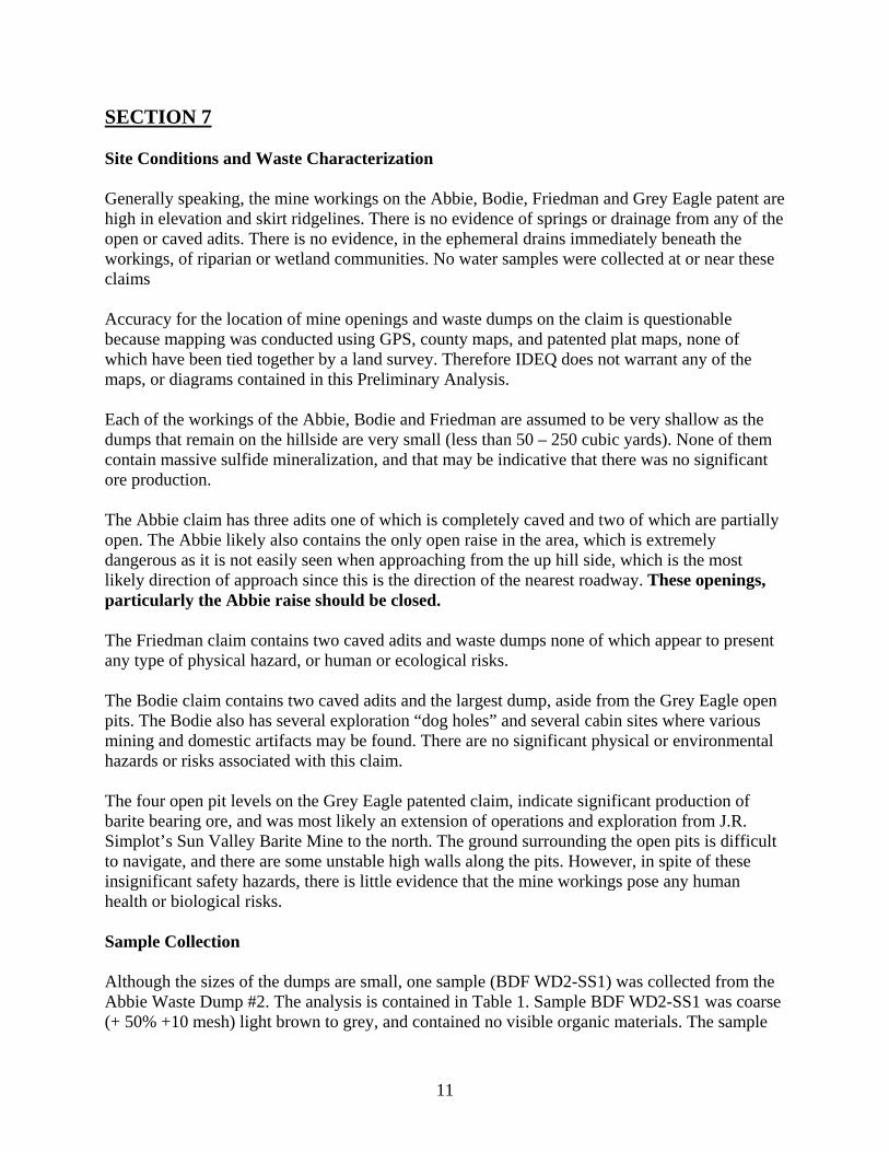
Abbie Waste Dumps #1 - #3 from lower left to upper right in
photo. The dumps are no longer much other than thin veneers of local host rock, containing few sulfides or evidence of ore.
13

Caved Abbie Adit # 1, Waste Dump contains less than 50 cubic yards, with very few sulfides apparent.
Collapsed Abbie Adit # 2. Waste Dump contains less than 50 cubic yards, with very few sulfides apparent.
14

Abbie #2 Waste Dump
Looking down Abbie WD#2 towards the Abbie Open Raise, below which Bruce Schuld (DEQ) is standing and taking notes.
15

Open Abbie Adit #3, is partially closed but still dangerous. Waste Dump contains less than 50 cubic yards, with very few sulfides apparent.
Looking into open Abbie Mine raise.
16

Collar of open Abbie raise. The opening is extremely treacherous and hidden, especially when approached from the up hill side from which one could approach it from the road over by the Grey Eagle Claim. This opening should be closed.
17

Bodie Patented Claim Photos
Bodie #1 Waste Dump. Adit #1 is caved and located deep in the trees behind the waste dump.
Friedman Patented Claim Photos
Looking eastward from the ridge between the Bodie and Abbie claim. The Abbie open raise is located to the right of the distant pine tree in the lower right hand corner of the photo. The Abbie waste dumps #1 - #3 are on a diagonal from lower right to upper left in the photo.
18
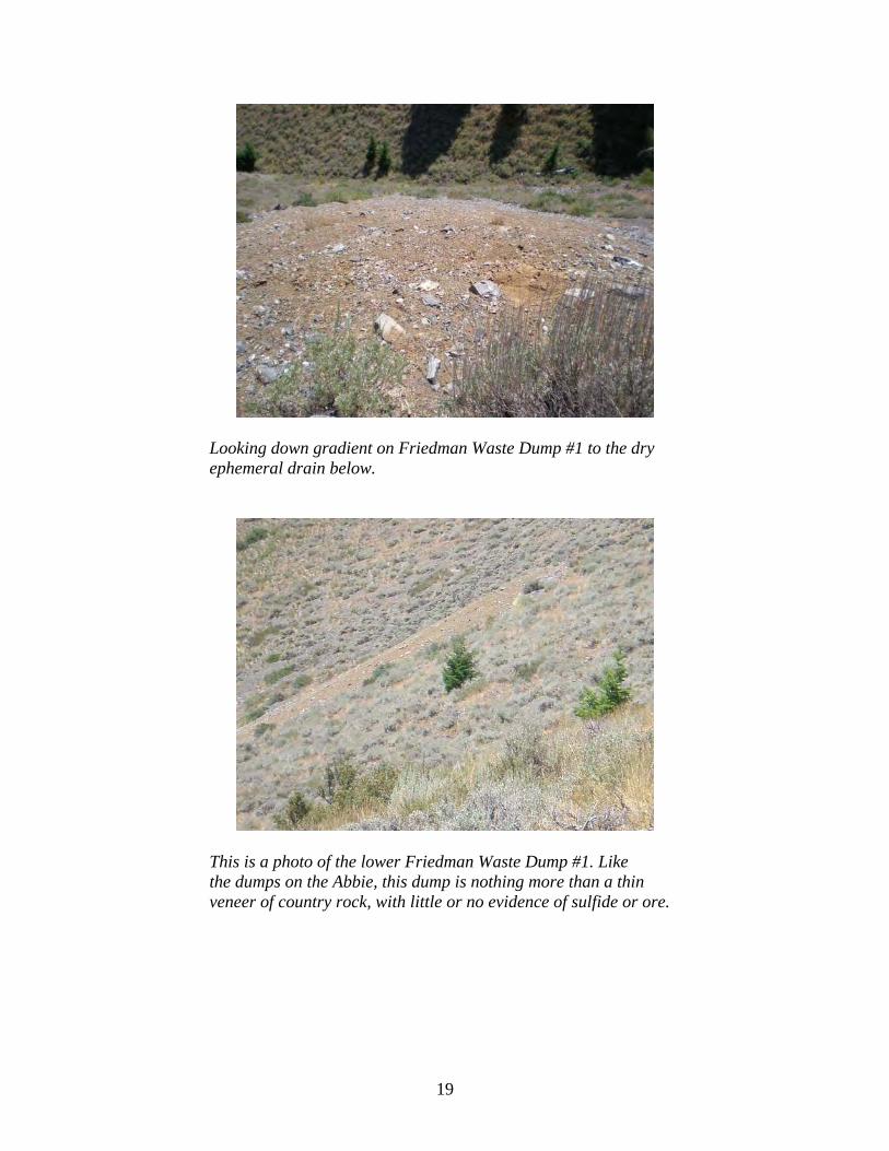
Looking down gradient on Friedman Waste Dump #1 to the dry
ephemeral drain below.
This is a photo of the lower Friedman Waste Dump #1. Like the dumps on the Abbie, this dump is nothing more than a thin veneer of country rock, with little or no evidence of sulfide or ore.
19

Grey Eagle Patented Claim Photos
Looking eastward from the ridge separating the Grey Eagle from the Abbie patented claims. The point in the distance is the end of the road. The pit across which the photo was taken is the lower pit noted on the maps. There is, however, another small but insignificant pit lower to the right in this drainage.
The lowest open pit on the Grey Eagle was not, because of
lack of access, mapped or located. But like pits above, which were traversed en route to the Abbie/Bodie/Friedman claims, does not appear to represent anything of significance from a risk perspective.
20
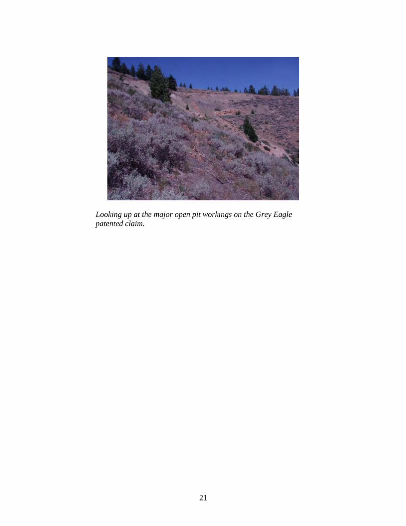
Looking up at the major open pit workings on the Grey Eagle patented claim.
21

SECTION 8 Pathway and Environmental Hazards Surface Water Pathways There does not appear to be significant erosion features on any of the mine dumps, and there is no indication that large quantities of the mine wastes have made their way from the open pits and mine waste dumps into the ephemeral drains below any of the claims. The nearest perennial drain appears to be Deer Creek, which is approximately ¾ mile below the lowest waste dump. Therefore, there does not appear to be a significant surface water pathway. Ground Water Pathways Although there may be some infiltration of meteoric waters, the surface areas of the mine waste dumps and the extent of the underground workings, which are near the ridge top, are insignificant when compared to the ground water recharge area of the entire sub-watershed. Therefore, the ground water pathway appears insignificant. Air Quality Pathways Generally speaking, mine waste on dumps was very coarse with very few fines that might be subject to suspension on the wind. In fact during the site visit, the normal afternoon thermal activity did not seem to cause any suspension at all. Therefore, it appears there is no complete airborne pathway. Soil Exposure
When compared to the Idaho Initial Default Target Levels (IDTLs) for “unrestricted uses”, particularly residential, at the mines soil exposure is considered to be elevated for all receptors, due to the high concentrations measured in the soil samples. These IDTLs are risk-based target levels for certain chemicals that have been developed by DEQ using conservative input parameters, a target acceptable risk of 10-6, and a Hazard Quotient of 1. These values are designed to aid in the development of clean-up and remediation goals that would allow the closure of a site based on the risks associated with various receptors for specific media to be less than 10-6.
According to IDEQ’s Risk Evaluation Manual if pathways are complete, or pathways are anticipated to become complete, and the IDTL’s are exceeded for any constituents, two options should be considered:
1. Adopt the IDTLs as the cleanup levels and develop a Risk Management Plan (RMP)
2. Perform a more detailed, site-specific evaluation, which includes developing site-specific background concentrations for comparative purposes.
22
However, there are very few indications that these waste dumps, particularly those on the Abbie, Bodie and Friedman are frequented by human receptors. There are, however, indications of a very robust deer and elk community present at least for a part of the year. Therefore the IDTL’s are not applicable and would not be so unless redevelopment of the mines involved residential development.
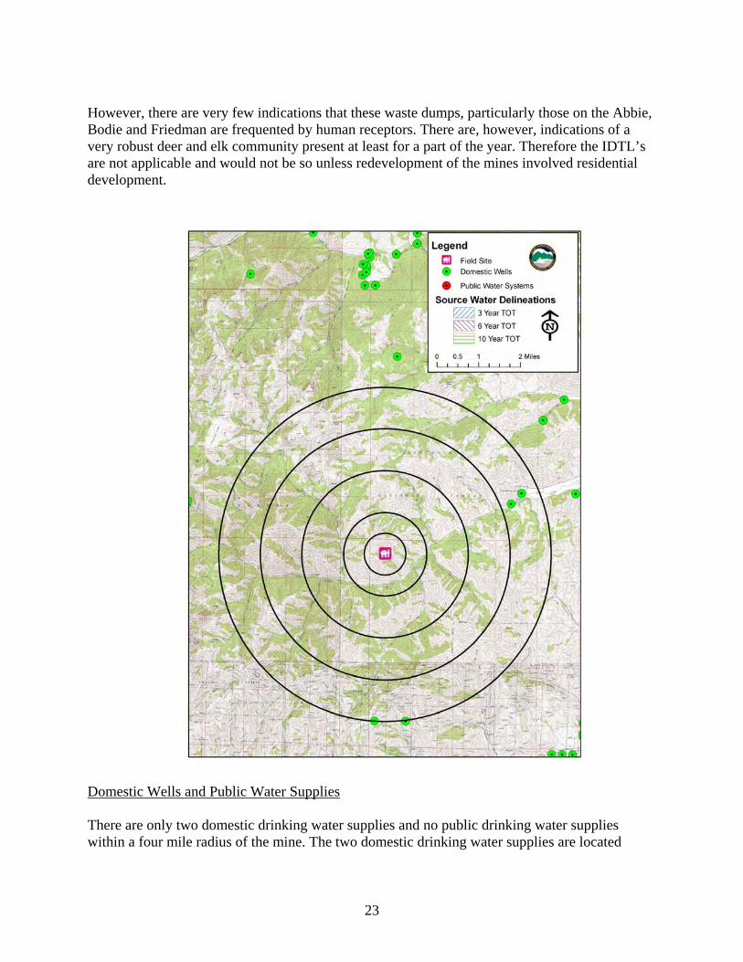
Domestic Wells and Public Water Supplies There are only two domestic drinking water supplies and no public drinking water supplies within a four mile radius of the mine. The two domestic drinking water supplies are located
23

approximately 3.5 miles from the site are more likely affected by watershed wide sources of contaminants than by this mine site.
Sensitive Species (Plant and Animal) Although the site is located within a defined range and habitat for wolves, the size of the dumps relative to the total range is very minuscule and therefore unlikely to be a significant source for exposure.
24

Wetlands There are significant wetlands along Deer Creek approximately ¾ mile below the mine site. However, there was no appreciable evidence of erosion of mine dumps and no delivery to the ephemeral drain apparent. Therefore, it appears that there was no overland delivery of mine wastes to Deer Creek below. Fisheries Fish presence/absence studies have not been conducted on Deer Creek to confirm any fish species that may reside in this stream. Visual observations confirm the presence of brook trout [Salvelinus foninalis] in Deer Creek. Redband rainbow trout [Oncorhynchhus mykiss gairdneri], mountainwhitefish [Prosopium williamsoni], wood river sculpin [Cottus leiopomus], and brook trout [Salvelinus foninalis] are present within the Big Wood River (IDFG, 2000).
Sensitive Waterways There are no Clean Water Act 303(d) listed streams immediately down gradient from the site, which might be adversely affected by contaminant delivery from the site.
25

Residences, Schools and Day Care Facilities The nearest residence is approximately 3.5 miles due east of the mine site. The nearest Day Care or School Facility is more than 6 miles due east of the mine site. Livestock Receptors There are no indications that the area is used for livestock grazing. However, there are indications that hunters have seasonally grazed horses and mules on a seasonal basis.
26

Summary and Conclusions Based on existing conditions and uses, historic information, data observations made during the site visit, and analysis of the mine wastes, potential pathways of contaminants to receptors, and potential exposures to ecological and human receptors, IDEQ has determined that No Remedial Action is Planned (NRAP) for the referenced properties and mine sites. However, should site conditions or uses change in the future, owners of these properties would be well advised to incorporate more detailed site assessment and perhaps risk management in their development and/or operating plans. IDEQ has noted numerous physical hazards on the properties, specifically the open raise and an adit on the Abbie Claim. These are beyond the scope of IDEQ’s risk analysis. However, these openings are extremely dangerous and should be permanently closed or have access to them restricted.
27
References
Bureau of Land Management, 2006, Land Patent Details – BLM GLO Records. http://www.glorecords.blm.gov/PatentSearch/Detail.asp?Accession=IDIDAA+046037&Index=1&QryID=41620.75&DetailTab=1
Idaho Department of Water Resources (IDWR), 2006. http://www.idwr.idaho.gov/water/well/search.htm
Anderson, A.L., Kiislgaard, T.H., and Fryklund, V.C., Jr., 1950, Detailed geology of certain areas in the Mineral Hill and Warms Springs mining districts, Blaine County, Idaho; Idaho Bureau of Mines and Geology, Pamphlet No. 90, 37 p.
Blaine County, 2006, Blaine County Treasurer-Tax Collections, Hailey, Idaho Bureau of Land Management, 2006, Land Patent Details – BLM GLO Records.
http://www.glorecords.blm.gov/PatentSearch/Detail.asp?Accession=IDIDAA+046037&Index=1&QryID=41620.75&DetailTab=1
Environmental Protection Agency (EPA), 2002. Preliminary Remediation Goals. http://www.epa.gov/region9/waste/sfund/prg/index.htm
Idaho Department of Fish and Game (IDF&G), 2002. http://www2.state.id.us/fishgame/info/cdc/plants/vasc_plants&status_n-r.htm
Idaho Department of Fish and Game (IDF&G), 2000. Redband Trout Distribution. Idaho Department of Environmental Quality (DEQ), 2006. Safe Drinking Water Information
System (SDWIS). Idaho Department of Environmental Quality (DEQ), 2000. 1998 303(d) list. Idaho Department of Water Resources (IDWR), 1997. COVERAGE IDOWN -- Idaho Surface
Ownership. IDWR2, 2002. GIS shapefile of well database. Kiislgaard, T.H., Lewis, R.S., and Bennett, E.H., 2001, Plutonic and Hypabyssal Rocks of the
Hailey 1ºx2º Quadrangle, Idaho, USGS Bulletin 2064-U, 18 p. Link, P.K. and Worl, R.G., 2001, Geology and Mineral Deposits of the Minnie Moore and
Bullion Mineralized Areas, Blaine County, Idaho, USGS Bulletin 2064-Y, 22 p. Mitchell, V.E., and V.S. Gillerman, 2005, Site Inspection Report for the Abandoned and Inactive Mines in Idaho on U.S. Bureau of Land Management Property in the Hailey-Bellevue Area: Red Elephant Gulch, Blaine County, Idaho; Idaho Geological Survey, 66 p.
Umpleby, J.B., Westgate, L.G., and Ross, C.P., 1930, Geology and ore deposits of the Wood River region, Idaho, with a description of the Minnie Moore and nearby mines by Hewett, USGS Bulletin 814, 250 p.
United States Geological Survey (USGS), 1991. Digital map file of major land uses in the United States.
Western Regional Climate Center (WRCC), 2006. http://www.wrcc.dri.edu/cgi-bin/cliMAIN.pl?idhail
28

APPENDIX A
29
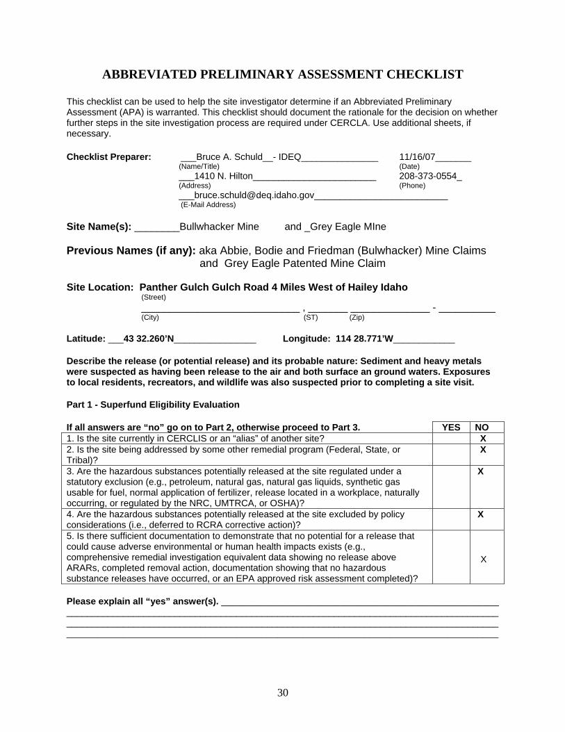
ABBREVIATED PRELIMINARY ASSESSMENT CHECKLIST
This checklist can be used to help the site investigator determine if an Abbreviated Preliminary Assessment (APA) is warranted. This checklist should document the rationale for the decision on whether further steps in the site investigation process are required under CERCLA. Use additional sheets, if necessary. Checklist Preparer: ___Bruce A. Schuld__- IDEQ_______________ 11/16/07_______
(Name/Title) (Date) ___1410 N. Hilton________________________ 208-373-0554_ (Address) (Phone) [email protected]__________________________
(E-Mail Address) Site Name(s): ________Bullwhacker Mine and _Grey Eagle MIne Previous Names (if any): aka Abbie, Bodie and Friedman (Bulwhacker) Mine Claims
and Grey Eagle Patented Mine Claim Site Location: Panther Gulch Gulch Road 4 Miles West of Hailey Idaho
(Street) ____________________________ , _______ ______________ - __________ (City) (ST) (Zip) Latitude: ___43 32.260’N________________ Longitude: 114 28.771’W____________ Describe the release (or potential release) and its probable nature: Sediment and heavy metals were suspected as having been release to the air and both surface an ground waters. Exposures to local residents, recreators, and wildlife was also suspected prior to completing a site visit. Part 1 - Superfund Eligibility Evaluation
If all answers are “no” go on to Part 2, otherwise proceed to Part 3. YES NO 1. Is the site currently in CERCLIS or an “alias” of another site? X 2. Is the site being addressed by some other remedial program (Federal, State, or Tribal)?
X
3. Are the hazardous substances potentially released at the site regulated under a statutory exclusion (e.g., petroleum, natural gas, natural gas liquids, synthetic gas usable for fuel, normal application of fertilizer, release located in a workplace, naturally occurring, or regulated by the NRC, UMTRCA, or OSHA)?
X
4. Are the hazardous substances potentially released at the site excluded by policy considerations (i.e., deferred to RCRA corrective action)?
X
5. Is there sufficient documentation to demonstrate that no potential for a release that could cause adverse environmental or human health impacts exists (e.g., comprehensive remedial investigation equivalent data showing no release above ARARs, completed removal action, documentation showing that no hazardous substance releases have occurred, or an EPA approved risk assessment completed)?
X
Please explain all “yes” answer(s). ______________________________________________________ ____________________________________________________________________________________________________________________________________________________________________________________________________________________________________________________________
30

Part 2 - Initial Site Evaluation For Part 2, if information is not available to make a “yes” or “no” response, further investigation may be needed. In these cases, determine whether an APA is appropriate. Exhibit 1 parallels the questions in Part 2. Use Exhibit 1 to make decisions in Part 3. If the answer is “no” to any of questions 1, 2, or 3, proceed directly to Part 3. YES NO 1. Does the site have a release or a potential to release? X 2. Does the site have uncontained sources containing CERCLA eligible substances? X 3. Does the site have documented on-site, adjacent, or nearby targets? X If the answers to questions 1, 2, and 3 above were all “yes” then answer the questions below before proceeding to Part 3.
YES NO
4. Does documentation indicate that a target (e.g., drinking water wells, drinking surface water intakes, etc.) has been exposed to a hazardous substance released from the site?
X
5. Is there an apparent release at the site with no documentation of exposed targets, but there are targets on site or immediately adjacent to the site?
X
6. Is there an apparent release and no documented on-site targets or targets immediately adjacent to the site, but there are nearby targets (e.g., targets within 1 mile)?
X
7. Is there no indication of a hazardous substance release, and there are uncontained sources containing CERCLA hazardous substances, but there is a potential to release with targets present on site or in proximity to the site?
X
Notes: Although the potential exists for a release the source is remotely located, the pathways are incomplete to viable receptors, or there is no indication at the proximity to receptors that and exposure(s) have occurred. _____________________________________________________________________________________
31

EXHIBIT 1 SITE ASSESSMENT DECISION GUIDELINES FOR A SITE
Exhibit 1 identifies different types of site information and provides some possible recommendations for further site assessment activities based on that information. You will use Exhibit 1 in determining the need for further action at the site, based on the answers to the questions in Part 2. Please use your professional judgment when evaluating a site. Your judgments may be different from the general recommendations for a site given below. Suspected/Documented Site Conditions APA Full PA PA/SI SI
1. There are no releases or potential to release. Yes No No No
2. No uncontained sources with CERCLA-eligible substances are present on site.
Yes No No No
3. There are no on-site, adjacent, or nearby targets. Yes No No No
4. There is documentation indicating that a target (e.g., drinking water Option 1: APA SI Yes No No Yes
wells, drinking surface water intakes, etc.) has not been exposed to a hazardous substance released Option 2: PA/SI No No Yes NA from the site. 5. There is not an apparent release at the site with no documentation of Option 1: APA SI Yes No No Yes
targets, but there are targets on site or immediately adjacent to the site. Option 2: PA/SI No Yes NA 6. There is an apparent release and no documented on-site targets and no documented targets immediately adjacent to the site, but there are nearby targets. Nearby targets are those targets that are located within 1 mile of the site and have a relatively high likelihood of exposure to a hazardous substance migration from the site.
No Yes No No
7. There is no indication of a hazardous substance release, and there are uncontained sources containing CERCLA No Yes No No hazardous substances, but there is a potential to release with targets present on site or in proximity to the site.
Part 3 - EPA Site Assessment Decision When completing Part 3, use Part 2 and Exhibit 1 to select the appropriate decision. For example, if the answer to question 1 in Part 2 was “no,” then an APA may be performed and the “NFRAP” box below should be checked. Additionally, if the answer to question 4 in Part 2 is “yes,” then you have two options (as indicated in Exhibit 1): Option 1 --conduct an APA and check the “Lower Priority SI” or “Higher Priority SI” box below; or Option 2 -- proceed with a combined PA/SI assessment.
Check the box that applies based on the conclusions of the APA: NFRAP X Refer to Removal Program - further site assessment needed Higher Priority SI Refer to Removal Program - NFRAP Lower Priority SI Site is being addressed as part of another CERCLIS site Defer to RCRA Subtitle C Other: ________________________________ Defer to NRC
Regional EPA Reviewer: __Bruce A. Schuld_______________________ _______________ Print Name/Signature Date
32

33
PLEASE EXPLAIN THE RATIONALE FOR YOUR DECISION: ___No direct discharges of mine adit
drainage were identified, and the amount of wastes did not cover a large enough area to represent a
significant source of human or ecological receptors. Therefore the source pathway and exposure were
incomplete.


![TE - PIA Preliminary Impact Assessment · Web viewEuropean Aviation Safety Agency Preliminary Impact Assessment Preliminary Impact Assessment – [Title] TE.RPRO.00091-001© European](https://static.fdocuments.us/doc/165x107/5ea0558447409873380e0624/te-pia-preliminary-impact-assessment-web-view-european-aviation-safety-agency.jpg)

