PowerPoint Presentation · “Ideal” Projection Would Preserve: Length of lines Direction of...
10
2/4/2013 1 Great Circle • Shortest distance between two points on Earth’s surface. • Any slice of a plane through a sphere that intersects the sphere’s center point • Equator & all lines of Longitude Map Projections The GLOBE ADVANTAGES • Directions True • Distances True • Shapes True • Area True DISADVANTAGES • Very small scale with little detail. • Costly to reproduce and update. • Difficult to carry around. • Bulky to store. FACTS • Parallels are parallel & equally spaced on meridians • Meridians (& arcs of Great Circles) are straight lines (If viewed perpendicular to Earth’s surface) • Meridians equally spaced on parallels, but converge at poles & diverge toward the equator • Meridian spacing = Parallel spacing at Equator • Meridians @ 60 o are ½ as far apart as parallels • The scale factor at each point is the same in any direction Great circles • Disks with centers at Earth’s center • The shortest 2-point distance on a sphere Rhumb Lines (loxodromes) • Cross all meridians of LON @ same angle • Walking along a fixed bearing (e.g., N45 o E) Rhumb Line (Loxodrome) Line of constant bearing (e.g., 292.5 o )
Transcript of PowerPoint Presentation · “Ideal” Projection Would Preserve: Length of lines Direction of...

2/4/2013
1
Great Circle
• Shortest distance between two points on Earth’s surface.
• Any slice of a plane through a sphere that intersects the sphere’s center point
• Equator & all lines of Longitude
Map Projections The GLOBE
ADVANTAGES • Directions True • Distances True • Shapes True • Area True
DISADVANTAGES • Very small scale with little detail. • Costly to reproduce and update. • Difficult to carry around. • Bulky to store.
FACTS • Parallels are parallel & equally spaced on meridians • Meridians (& arcs of Great Circles) are straight lines (If viewed
perpendicular to Earth’s surface) • Meridians equally spaced on parallels, but converge at poles
& diverge toward the equator • Meridian spacing = Parallel spacing at Equator • Meridians @ 60o are ½ as far apart as parallels
• The scale factor at each point is the same in any direction
Great circles • Disks with centers at Earth’s center • The shortest 2-point distance on a sphere
Rhumb Lines (loxodromes) • Cross all meridians of LON @ same angle • Walking along a fixed bearing (e.g., N45oE)
Rhumb Line (Loxodrome)
Line of constant bearing (e.g., 292.5o)
2/4/2013
2
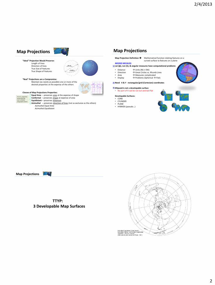
Map Projections “Ideal” Projection Would Preserve: Length of lines Direction of lines True Size of Features True Shape of Features “Real” Projections are a Compromise: Maintain (as nearly as possible) one or more of the desired properties at the expense of the others Classes of Map Projections Properties: Equal Area – preserves area at the expense of shape Conformal – preserves shape at expense of area Equidistant – preserves distances Azimuthal – preserves direction of lines (not as exclusive as the others) Azimuthal Equal Area Azimuthal Equidistant
For all…properties preserved only over a limited Geographic Extent
Map Projections
Map Projection Definition Mathematical function relating features on a curved surface to features on a plane NEEDED BECAUSE: Lat (ɸ), Lon (λ), & angular measures have computational problems
• Distance Units (NS ≠ EW) • Direction Great Circles vs. Rhumb Lines • Area Measures complicated • Display Problems (Spherical Flat)
Need X & Y rectangular/grid (Cartesian) coordinates Ellipsoid is not a developable surface • No part of it can be cut out and laid flat Developable Surfaces: • CONE • CYLINDER • PLANE • HYBRIDS (pseudo…)
1)
2)
3)
Map Projections
TTYP: 3 Developable Map Surfaces

2/4/2013
3

2/4/2013
4
Map Projections Group projections in 2 basic ways (with special cases)
1) ASPECT Cylindrical, Conic, or Azimuthal (basic projection layout)
• These are the 3 “Developable Surfaces”
• Each has a single line or single point that touches globe tangent
• Hybrids exist …usually prefixed by “Pseudo”
2) PROPERTIES Conformal & Equal-area (also, equidistant)
• Conformal projections • Maintain shape (of small regions) at the expense of size • Angles are correct at any 1 point
• Equal-Area Projections -- Maintain size at the expense of shape
CASES shifting the graticule (lines of lat. & lon.) on the globe
• Conventional, e.g., Azimuthal projection (polar)
• Transverse (90o shift) • E.g., Transverse Mercator • E.g., Azimuthal projection (equatorial)
• Oblique (<90o shift), e.g., Oblique Mercator
Maintaining both requires
a globe
Mercator Transverse Oblique
Map Projections Other Projection “PROPERTIES” • EQUIDISTANT – preserve distance from some standard point or line (NOT equal area or conformal)
• Azimuthal Equidistant – distances along great circles radiating from center are true
• Equidistant Conic – longitudinal distances are preserved
• Equirectangular – distances along meridians are preserved • Plate carrée (centered at equator)
• GNOMONIC – Great Circles are displayed as straight lines
Distance NOT preserved
Ellipses of equal Latitude & Longitude
on Earth’s surface
Ellipses are now perfect circles on this Mercator projection
What is being preserved in this projection? Area?
Shape? Direction?
And, at the expense of what property?
Map Projections
True Scale: Tangent Projection Case
1 LAT of True Scale “Standard Circle” 1 Point of True Scale Scale Factor = 1 or (1:1)
Conical Cylindrical Azimuthal

2/4/2013
5
Map Projections
True Scale: Secant Projection Case
Now, each has 2 LATs of True Scale Now, 1 LAT of True Scale, rather than a single point
Conical Cylindrical Azimuthal
Standard Circles
Distortion are Unavoidable
True Scale: Secant Projection Case
Scale factor > 1
Scale factor < 1
Scale factor = 1
Unequal Differences in Scale: AB < AʹBʹ AʹBʹ scale > 1 BC < BʹCʹ BʹCʹ scale > 1 But AʹBʹ ≠ BʹCʹ CD > CʹDʹ CʹDʹ scale < 1 And BʹCʹ ≠ CʹDʹ
Center of Ellipsoid and Projection Source
To Approximate Scale Factor
Compare… Great Distance AB &
GRID XY Distance AʹBʹ
Projection Source Distorts in Different Ways
Affected by…. • Projection Source (imaginary light)
• Orthographic • Stereographic • Gnomonic
• Orientation of Map Surface • Tangent • Secant
Planar Maps • Tangent 1 point of true scale • Secant Circle of true scale
Cylindrical Maps • Tangent 1 line/circle of true scale • Secant 2 lines/circles of true scale
Conical Maps • Tangent 1 parallel of true scale • Secant 2 circles of true scale
Map Projections
In general, scale-factor going away from map’s center (tangent line or point)…
• Increases for a conformal projection
• Decreases for an equal-area projection

2/4/2013
6
• Size • Angle • Distance • Direction
Equivalence So called Equal-Area • Maintain correct proportion in sizes of areas
(but, scales differ globe grid) • Ellipses in Cylindrical Equal-Area are distorted…
but the areas are maintained
Conformality Same shape • Circles distorted in size, but not shape • Angles measured anywhere can be plotted without distortion • Good for large scale surveying & mapping • Transverse Mercator, Lambert Conformal Conic, Polar Stereographic
Equidistance Distance measures accurate along straight lines… • From 1 or 2 points only • Ellipses on Cylindrical Equidistant map vary in size & shape • N-S axis of each ellipse is same length & true scale along meridians
Azimuthality Preserve directions • From 1 or 2 points to all other points on the map • Ellipses on Gnomonic map vary in size & shape, but all orient toward center
• And, is the true direction
Geometric Properties Preserved & Distorted
Map projections that avoid 1 or more of these are said to preserve certain properties of the globe
Mu
tual
ly E
xclu
sive
4 Distortions
Gall Peters – Cylindrical Equal Area
Mercator – Cylindrical Conformal (Angles & Shapes)
Map Projections
Week4, Thursday
Projection Names
Reflect the developed surface… • Conical (cone) • Cylindrical (cylinder) • Azimuthal (plane)
And, Orientation…
• Cylindrical surface with axis = polar axis EQUATORIAL tangent line = equator or secants parallel to equator
• Cylinder with tangent perpendicular to equator TRANSVERSE tangent line or central meridian on line of longitude Odd-ball not based on the 3 basic shapes…
• Pseudocylindrical (Mollweide) • Sinusoidal • Goode Homolosine • HEALPix

2/4/2013
7
Projection Parameters
MUST SPECIFY FOR EACH…… Azimuthal (plane) • Projection center (imaginary light source) • Orientation of plane (with ref. to light source) • Tangent vs. standard circle intersection secant
Conical (cone) • Size & Orientation of cone • Points of intersections
• Standard parallels • Central Meridian • Origin
Cylindrical (cylinder)
• Central Meridian • Origin
Three Measures of NORTH?
Magnetic Geographic Grid North ???
Common Map Projections
Lambert Conformal Conic (LCC) • Cone intersects Ellipsoid in 2 places Standard Parallels (SP’s)
• SP’s are where distortion is least • SP’s chosen to enclose 2/3 of N-S map area • Distortion between SP’s uniformly lower than outside SP’s • Distortion increasingly complex away from SP’s
• Meridians converging straight lines (off the map extent)
• Parallels are concentric circles
• Meridian & Parallels cross at right angles • An essential of Conformality preserves angles • FAA sectional aeronautical charts are LCC Good Direction & Shape relationships
• LCC best for large E-W map extents • U.S.A • Russia • Montana
FAA Sectional Chart – LCC

2/4/2013
8
Common Map Projections Mercator • Equator tangent to the CYLINDER (or secant, 10o N & S) • Used for Navigation or Maps of Equatorial Regions • Any straight line is a Rhumb Line (constant Direction) • Directions along a Rhumb Line are true between any two
points on a Mercator map, but usually not the shortest distance between two points.
• Lines of LAT straight & parallel • Distances are true only along Equator, but are reasonably
correct within 15o N or S • Areas & Shapes greatly distorted @ high LATs • Mercator maps are considered conformal in that angles &
shapes for “small areas” (7.5’ topo quad) are basically true • Mercator maps are not:
• True perspective • Equal Area • Equidistant
Nautical Navigation Chart – Mercator
Common Map Projections Transverse Mercator (TM)
• Projection Origin (imaginary light) = Ellipsoid Center
• Intersects Ellipsoid at 1 tangent or 2 secant lines • = lines of true scale (scale factor = 1) • Between secants middle line = Central Meridian (CM) • LON lines ≈ straight & evenly spaced near tangent • Bands of no/low distortion run N-S • Distortion ↑ dramatically outside & away from secant lines
• Most lines of LAT & LON are curved… • Great Circle & Rhumb Lines curved • So, quadrangle sizes & shapes all different • Complicates point location & direction measures • Solution New X, Y GRID
• Superimposed on warped GEO projection • = True rectangle intersections • Permits linear & angular measurements
• TM best for large N-S map extents • South America, Chile, Illinois
Multiple TM map extents
The UTM System

2/4/2013
9
The UTM System 7.5 Minute Topo Quads – UTM
Common Map Projections Polar Gnomonic
• Tangent to Ellipsoid @ N or S pole
• Projection center is often Earth center, but can vary
• LAT lines are concentric rings but not equally spaced
• All LAT lines (but equator) can be shown
• LON lines are straight & radiate from tangent
• Angles of LON are true Great Circles
• Rhumb lines approximated by straight lines
• Scale factor is variable • Good @ tangent • Good within standard circle
• Polar regions are routinely mapped this way
Common Map Projections
Polyconic (PC) • Lines projected from Earth center to series or cones
• Each cone is tangent to a parallel of LAT
• Central meridian (CM) of map extent is straight & scale factor = 1
• LAT lines are not concentric, but intersect with extension of CM
• Distances between LAT lines along CM are ∝ to true distances
• Distance between meridians are similarly proportioned
• Projection is neither conformal or equivalent • Is a compromise that minimizes all distortions • Both map qualities are closely approx. for small areas
2/4/2013
10
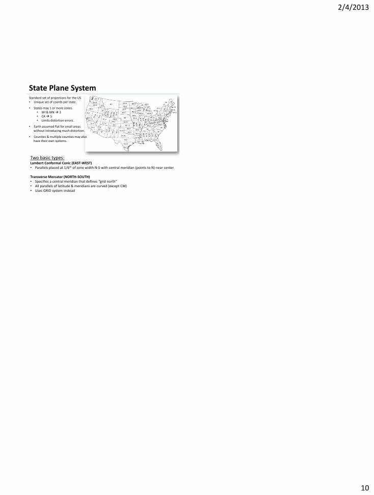
State Plane System Standard set of projections for the US • Unique set of coords per state.
• States may 1 or more zones. • WI & MN 3 • CA 5 • Limits distortion errors.
• Earth assumed flat for small areas without introducing much distortion.
• Counties & multiple counties may also have their own systems.
Two basic types: Lambert Conformal Conic (EAST-WEST) • Parallels placed at 1/6th of zone width N-S with central meridian (points to N) near center Transverse Mercator (NORTH-SOUTH) • Specifies a central meridian that defines “grid north” • All parallels of latitude & meridians are curved (except CM) • Uses GRID system instead