POTENTIAL NATURAL VEGETATION MAPPING IN THE...
54
POTENTIAL NATURAL VEGETATION OF THE MISSISSIPPI ALLUVIAL VALLEY: OUACHITA BASIN, NORTHEASTERN LOUISIANA 2011 Prepared for the U.S. Fish and Wildlife Service Lower Mississippi Valley Joint Venture Vicksburg Mississippi Prepared by Jody Pagan 1 Thomas Foti 1 Charles Klimas 2 Amy Keister 3 1 Five Oaks Wildlife Services, L.L.C., 620 East 22 nd St., Suite 206, Stuttgart, AR 72160 2 US Army Engineer Research and Development Center, 3909 Halls Ferry Road, Vicksburg, MS 39180 3 US Fish and Wildlife Service, Lower Mississippi Valley Joint Venture, 2524 South Frontage Road, Suite C, Vicksburg, Mississippi 39180
Transcript of POTENTIAL NATURAL VEGETATION MAPPING IN THE...

POTENTIAL NATURAL VEGETATION OF THE MISSISSIPPI
ALLUVIAL VALLEY: OUACHITA BASIN, NORTHEASTERN
LOUISIANA
2011
Prepared for the
U.S. Fish and Wildlife Service
Lower Mississippi Valley Joint Venture
Vicksburg Mississippi
Prepared by
Jody Pagan1
Thomas Foti1
Charles Klimas2
Amy Keister3
1 Five Oaks Wildlife Services, L.L.C., 620 East 22
nd St., Suite 206, Stuttgart, AR
72160
2 US Army Engineer Research and Development Center, 3909 Halls Ferry Road,
Vicksburg, MS 39180
3 US Fish and Wildlife Service, Lower Mississippi Valley Joint Venture, 2524 South
Frontage Road, Suite C, Vicksburg, Mississippi 39180

2
INTRODUCTION
Studies of wetland plant communities over the past decade in the Arkansas and Mississippi
portions of the Mississippi Alluvial Valley (MAV) have produced a site classification approach
based on hydrology and geomorphic setting (Klimas et al. 2005, Klimas et al. 2009). The
approach is consistent with the “hydrogeomorphic” or HGM classification system proposed by
Brinson (1993), but it has been adapted and refined specifically to support the development of
detailed maps of the Potential Natural Vegetation (PNV) of the region. The purpose of PNV
maps is to serve as a template for restoration planning and prioritization in a landscape that has
been highly modified. Most of the bottomland hardwood forests and other native plant
communities of the MAV were converted to agriculture during the 20th
century, the remnants
being largely those forest types adapted to the wettest sites where row cropping was infeasible.
At the same time, tremendous local and federal effort has gone into drainage, flood control, and
navigation projects that have permanently altered the hydrology of the floodplain and alluvial
terraces in the region. Therefore, the PNV maps are not designed to represent the distribution of
the original, pre-settlement vegetation, but rather they identify the natural communities that are
appropriate to the altered site conditions ─ hence the “potential” designation. This means that
persons interested in restoring particular tracts of land can identify the plant communities
appropriate to the various site conditions present, or conversely, persons interested in restoring
particular plant communities can identify parts of the landscape that could support those types.
Because this information is available in GIS format, various other restoration scenarios can be
explored, such as corridor reestablishment, and alternatives compared in terms of costs and
ecological effectiveness.
This approach was developed and refined in Arkansas, where PNV mapping is underway or
complete for all of the sub-basins within the Arkansas portion of the MAV. Mapping also has
been completed for the Tensas Basin portion of northeastern Louisiana (Foti et al. 2011) and this
report describes PNV mapping for the adjacent Ouachita Basin portion of Louisiana, including
Macon Ridge. This report consists of a discussion of the methods used, descriptions of the site
classification criteria and vegetation of the PNV community types, and metadata describing the
content and structure of the accompanying shapefiles that comprise the PNV map. Readers are
referred to the publications cited previously for details on the basic HGM classification approach
and its application within the MAV. For additional information on geomorphic features, their
ages, origins, and characteristics, all of which are primary considerations in the PNV mapping
process, see Autin et al. (1991), Saucier (1994), and Rittenour et al. (2007). All discussions of
geomorphology in the following sections are based on those documents, particularly the
comprehensive treatment published by Saucier.
STUDY AREA – OUACHITA BASIN
Location, Boundaries and General Character
The study area is that portion of the MAV within Louisiana that includes the Ouachita River
lowlands and Macon Ridge (Figure 1). Although the Ouachita River is the largest stream
present, the lowland portion of the study area is considered to be part of the Bouef Basin, one of
six major lowland areas that comprise the MAV (Saucier 1994). Macon Ridge is not normally

3
considered part of any lowland basin but is included in this PNV mapping effort. Because most
of the internal drainage of Macon Ridge flows to the Ouachita lowlands, we have designated the
study area as the “Ouachita Basin” portion of Louisiana.
The Ouachita Basin lies directly to the west of the Tensas Basin, which is of particular interest
today because it includes the site of the most comprehensively-studied population of Ivory-billed
Woodpeckers (IBWO), in the “Singer Tract,” much of which is now the Tensas National
Wildlife Refuge (Tanner 1942, see also U.S. Fish and Wildlife Service 2010). The reported
rediscovery of IBWO in Arkansas in 2004 motivated renewed inventory efforts for the species
in the MAV and elsewhere, and opened up the possibility of targeting ecosystem restoration
efforts towards sites that would support potential IBWO habitat. The PNV map developed for
the Tensas Basin was specifically intended to be used for that purpose, among others, and the
adjacent Ouachita Basin might provide similar opportunities for IBWO recovery through
restoration. Like the Tensas Basin PNV map, the Ouachita Basin map is designed to characterize
the potential vegetation of cleared as well as currently forested lands, based on understanding of
the relationships between vegetation and physical site characteristics, specifically
geomorphology, soil and hydrology.
Figure 1. Location of the Ouachita Basin in northeastern Louisiana
4
Geomorphology
The study area consists of sedimentary deposits of widely varied ages, origins, and
characteristics. The most extensive type of deposit is Early Wisconsin glacial outwash (or
“valley train”) that coursed through the Mississippi Valley on numerous occasions as the result
of waning continental glaciations far to the north. The remnants of at least five such episodes
remain as a series of levels or terraces that comprise Macon Ridge, which forms a broad
interfluve between the Ouachita lowlands on the west and the Tensas basin on the east. On the
eastern border, the older, higher terraces rise 30 feet or more above the Tensas lowlands, but on
the western side where the most recent and lowest terraces occur they are often nearly the same
elevation as the adjacent Ouachita River bottoms. The drainage patterns of modern streams on
the surfaces of the outwash terraces tend to be oriented north-to-south, following the former
braided outwash channels. Sediments in the former channels often are coarse sands, with finer
or unsorted material making up the interfluves, but both surfaces tend to be blanketed with fairly
fine-grained sediments laid down during waning flows, or later backwater flooding from streams,
or by post-glacial erosion.
Several other major Pleistocene events produced unique and very different geomorphic
landforms in the study area, all located in the northwestern corner of the area in the vicinity of
the Ouachita River. On either side of the river, along the valley walls, are fairly extensive high
terraces known as the Prairie Complex, which are understood to be remnant backswamp deposits
of ancient river systems that flowed at a much higher level than the current base level of streams
in the vicinity. Backswamp deposits are typically dense clays that drain poorly, but because the
Prairie Complex terraces are relatively old and elevated, they are dissected and fairly well-
drained along the margins and internal drainageways.
Somewhat lower in the landscape and nearer the modern Ouachita River are several extensive,
very level areas known to geologists as “flatwoods terraces.” These have been recognized in
recent decades as lacustrine deposits, the remnants of an extensive ancient lake that formed when
glacial outwash (now Macon Ridge) blocked the Ouachita River. Evidence of the resulting Lake
Monroe persist as lacustrine plain, beach, and dune deposits with unique soil characteristics.
Lower and younger still and directly flanking the modern floodplain of the Ouachita River are
two expanses of the Deweyville Terrace, a landform found along coastal plain streams
throughout the southeastern US. Deweyville terraces consist of the classic sequence of
meandering-river deposits such as point bars, natural levees, and backswamps, but the scale of
these features is much greater than that of modern examples of the same features in the same
landscapes. This is evident in the large lakes and swamps found on the Deweyville terraces
within the study area, which are abandoned channels of a Pleistocene Ouachita River that clearly
carried many times the flow of the modern river, due to complex climatic changes during periods
of continental glaciation.
The remainder of the study area is made up of alluvial deposits of Holocene (post-glacial) age.
However, they too are complex in origin and represent a variety of depositional environments.
In general, the Holocene environments include the landforms typically found in association with
meandering river systems: point bars deposited by meandering channels, forming ridge-and-
swale topography; backswamps formed where slackwaters were trapped following floods,
leaving poorly-drained flat basins; and short stretches of former river channels that were cut off
or abandoned and are now occupied by lakes, depressions, or have captured the flow of other

5
smaller streams. In many areas, these features are blanketed by a veneer of natural levee
deposits formed during overbank flooding, such that the deposits nearest the stream channels are
high and well drained, and the veneer blanket becomes thinner and more fine-grained with
distance from the stream.
Remarkably, essentially no part of the Holocene environment within the study area fully
conforms to the general model described above. As it enters Louisiana from Arkansas, the
Ouachita River flows for a few dozen miles within a meander belt of its own point bar deposits,
but the confining effects of the Pleistocene landforms described previously have restricted the
extent of those deposits and precluded the development of backswamps. And downstream of
that reach, the Ouachita enters an environment dominated by the influence of a much larger
river, the Arkansas. Throughout the history of the MAV, both the Mississippi River and the
Arkansas River established multiple different meander belts that took them far from their current
paths. Even though today the Arkansas River is confluent with the Mississippi in Arkansas, in
the past it has flowed deep into Louisiana, in the process shaping much of what today are the
Boeuf lowlands.
Three separate Arkansas River meander belts are mapped within the study area and several major
streams including the Ouachita River, Bayou Bartholomew, the Boeuf River, and Bayou Bonne
Idee, flow for much of their length within the former channels of the Arkansas. Because the
Arkansas was a much larger river, where these streams occupy former Arkansas channels they
are mostly entrenched and not capable of meandering freely to create their own geomorphic
features and instead they are flanked by the point bars, abandoned channels, and natural levees
left behind by the Arkansas. Certainly the modern streams have contributed sediments to the
floodplain over the centuries, especially the extensive backswamps, but the scale and form of
those features all reflect the Arkansas.
Holocene alluvial deposits also occur in small valleys that have developed within the various
Pleistocene terraces and along the western flank of the study area. In some cases those stream
systems are large enough to have developed significant floodplains and alluvial terraces of their
own. These features formed by the same processes as those in the lowlands, but are much
smaller in extent and scale. Also found along the valley walls are alluvial fan deposits left by
streams and runoff from the uplands, and occasionally these are large enough to be mapped as
distinct landforms.
Soils
Soils within the study area generally reflect their geomorphic origins. For example, backswamps
and filled abandoned channel segments are characterized by massive clays such as Alligator
clays, while loamy soils such as Gallion and Rilla silt loams are typical of natural levee deposits.
However, soil mapping within the study area has not been entirely consistent among parishes,
and some soils span a variety of geomorphic settings and topographic positions. Therefore, in
this project, soils are used in specific situations to add detail to the mapped geomorphic setting.
For instance, Yorktown and Dowling soils consistently indicate depressional wetlands that may
occur within a more variable geomorphic setting, such as point bar. Therefore the PNV map
overlays polygons of these soils on the more general geomorphic unit and highlights the
corresponding changes in vegetation.

6
It must be emphasized that soils cannot be used as a substitute for geomorphology in this PNV
mapping process. Soil series as mapped in the study area are based on the physical and chemical
parameters observed through the soil profile and follow accepted soil taxonomy conventions. In
many cases these taxonomic differences may be of little importance in distinguishing plant
communities at a useful level of distinctiveness, and in even more cases the specific relationships
between a soil map unit and appropriate vegetation units may not be known. The mapping
criteria in this project are based primarily on geomorphology with soils known to be associated
with specific plant communities used as secondary mapping criteria.
Vegetation
The native vegetation of the study area is primarily bottomland hardwood forest, comprising a
variety of community types distributed primarily along gradients of flood frequency, depth and
duration, as well as soil drainage conditions and ponding. Since the area has been substantially
cleared for many decades, there are few scientific studies of the vegetation, particularly of the
vegetation prior to extensive alteration of the physical and biological features of the landscape.
Perhaps the most useful as background for this study is a Forest Survey of the North Louisiana
Delta by the Southern Forest Experiment Station (Winters et al. 1938). The study area of that
report includes Macon Ridge and the Boeuf lowlands. The study area comprised 3,987,000 acres,
of which 69% was forested and 29% agriculture. Of the forested land, 22% was uncut old
growth, 26% partly cut old growth and 31% sawlog-size second growth.
Winters, et al. recognized 8 forest types and presented the composition and site affinity of each
(Table 1, Table 2) and a general distribution map (Figure 2). The Louisiana Department of
Wildlife and Fisheries has noted that there were areas of tallgrass prairie (Mississippi Terrace
Prairie) on Macon Ridge that were similar to the prairies on Pleistocene terraces in Arkansas
(http://www.wlf.louisiana.gov/fact-sheet-community/mississippi-terrace-prairie). These
are assumed to be extirpated, but could be an additional restoration option if appropriate
knowledge of the required site conditions were available.
Hydrology
Throughout the MAV, natural hydrologic patterns have been modified by man since the earliest
settlers arrived and began draining and leveeing individual farms. The scale of those changes
ramped up in the early 20th
century with local drainage districts deepening and straightening
small streams throughout the Delta region. However, the biggest changes began in the mid-20th
century with authorization of the Mississippi River and Tributaries (MR&T) project that was
implemented by the U.S. Army Corps of Engineers (USACE). For much of the MAV, the
principal effect of the MR&T was a massive reduction in flooding that was accomplished
primarily thorough a system of mainline levees on the major streams and reservoirs, and channel
engineering on tributary systems. Within the study area for this project, both of these methods
were used to reduce flooding, but the drainage projects and channel improvements played a
particularly big role, and the resulting changes to natural flooding and drainage patterns are
highly complex. Most of the study area is above or outside the influence of Mississippi River
floods and backwater effects, but the hydrology of the area has been repeatedly modified by

7
Table 1. Composition of major forest types in northeastern Louisiana expressed in percent of total gross cubic volume (from Winters
et al. 1938, Table 3.)
Species Red gum-water oak
Hackberry-elm-ash
Overcup oak-bitter
pecan
Cottonwood willow
Cypress-tupelo
Water oak Mixed oak-
mixed hardwood
Pine-hardwood
Average (weighted)
1
all types
Percent Percent Percent Percent Percent Percent Percent Percent Percent
Red gum 39.3 1.6 0.6 1.5 1.8 3.4 17.3 12.5 13.9
Water oaks 2 19.7 9.4 8.4 (
3 ) 1.3 66.9 14.9 8.7 15.1
Overcup oak 6.8 6.5 36.5 0.1 2.2 3.6 3.9 2.7 13.9
White oaks 4 0.4 0.1 (
3 ) ---------------- (
3 ) 2.0 17.2 10.7 1.3
Red oaks 5 0.1 0.1 (
3 ) ---------------- ---------------- 0.7 9.6 4.0 0.7
Bitter pecan 3.5 5.4 34.9 1.3 4.2 2.2 1.9 ---------------- 12.3
Sweet pecan 4.3 1.2 0.3 0.5 0.1 1.3 0.9 ---------------- 1.7
Green ash 5.1 18.2 4.9 0.6 4.0 3.5 ---------------- ---------------- 6.0
White ash ---------------- 0.5 0.1 ---------------- ---------------- 1.0 3.3 1.2 0.4
White elm 4.8 9.0 1.8 0.3 0.8 4.7 2.8 0.9 3.8
Rock or cedar elm 2.9 19.0 2.6 ---------------- ---------------- 1.9 3.3 ---------------- 4.6 Winged and red elm 0.1 1.2 ---------------- ---------------- ---------------- 2.2 4.8 2.8 0.7
Hackberry 4.7 20.4 3.3 0.5 0.2 2.4 0.7 ---------------- 5.6
Cottonwood 0.8 0.1 0.1 39.9 0.5 0.1 0.1 ---------------- 4.2
Willow 0.2 0.4 0.2 52.4 2.7 ( 3 ) 0.1 ---------------- 5.4
Cypress 0.8 0.1 1.5 0.6 40.2 ( 3 ) 0.3 ---------------- 2.4
Tupelo gum ( 3 ) ---------------- (
3 ) 0.1 37.4 ---------------- ---------------- ---------------- 1.5
Black gum 0.6 0.2 0.1 ---------------- ---------------- 0.9 6.9 3.0 0.7
Hickory 0.1 0.1 ( 3 ) ---------------- ---------------- 0.4 7.6 4.5 0.5
Red maple, boxelder 1.3 1.9 (
3 ) 0.2 1.0 0.6 0.8 0.5 0.8
Sycamore 0.5 0.8 ---------------- 0.8 ---------------- ---------------- ---------------- ---------------- 0.3
Persimmon 0.9 1.0 2.6 0.3 1.1 0.6 0.6 ---------------- 1.3 Other hardwoods 5 3.1 2.8 2.1 0.9 2.5 1.5 0.9 0.1 2.3
Loblolly pine ( 3 ) (
3 ) ---------------- ---------------- ---------------- 0.1 2.1 48.4 0.6
1 Total gross cubic volume includes bark in stemwood of good trees 5 inches and over in diameter.
2 Chiefly water oak, bottom land red oak and willow oak.
3 Less than 0.1 percent.
4 Cow oak, forked-leaf white oak and delta post oak.
5 Chiefly cherry bark oak, southern red oak and black oak.
6 Chiefly honeylocust, mulberry and water locust.

8
Figure 2. Distribution of Forest Types in northeastern Louisiana (from Winters et al. 1938)

9
Table 2. “Topographic situation” of each of the 8 forest types recognized by Winters, et al.
(1938) in the North Louisiana Delta. The topographic situations are defined as follows: Swamp
– Forested areas normally under water during the greater portion of the year; Terrace – Non
swampy ancient floodplains now above the level of all but exceptional floods; River margin –
Relatively high sandy areas adjacent to present or recent stream courses and comprising the most
recent alluvial deposits in the delta; and Bottomland – Present floodplains which cannot be
classified as swamp or river margin.
Forest Type Bottom
land Terrace Swamp River
margin All Situations
Acres Acres Acres Acres Acres Percent
Red gum-water oak 659,900 10,100 2,500 9,500 682,000 25.4
Hackberry-elm-ash 386,300 16,000 1,700 3,700 404,000 15.1
Overcup oak-bitter pecan 772,400 21,900 14,300 139,600 812,300 30.2
Cottonwood-willow 30,500
48,900
219,000 8.2
Cypress-tupelo 11,000 1,700 82,400
95,100 3.5
Water oak 135,000 59,000
194,900 7.3 Mixed oak-mixed hardwood 51,000 193,700 1,700
246,800 9.2
Pine-hardwood ---------------- 28,600
28,600 1.1
Total 2,047,400 331,000 151,500 152,800 2,682,700
All types, percent 76.3 12.3 5.7 5.7
100
private and federal projects both within the study area and upstream in Arkansas, including
channel cutoffs, straightening, snagging, and deepening of major streams such as the Boeuf
River, Bayou Bartholomew, Big Creek, and Bayou Lafourche. The Ouachita River itself is a
major navigation channel that has been deepened and fitted with locks to allow barge traffic as
far as Camden Arkansas. A flood control levee has been constructed that extends from Bastrop
on Bayou Bartholomew to the Ouachita River and then south to a point more than 70 miles
below Monroe.
METHODS
The PNV map for the Ouachita basin was developed using spatial data layers in a Geographic
Information System (GIS) and field studies. The purpose was to identify and characterize
relatively stable assemblages of tree species that consistently occur on particular combinations of
site factors. The plant communities were classified based on hydrogeomorphic (HGM) criteria
to maintain consistency with other PNV mapping conducted in the Delta Region of Arkansas.
The details of the Arkansas HGM classification system and criteria are summarized in Klimas et
al. (2005) and the PNV mapping approach is described in Klimas et al. (2009). The data layers
and procedures used in the Ouachita basin study are detailed below.

10
Spatial Data Assembly and Preparation
This project uses a combination of three primary criteria (hydrology, geomorphology, and soils)
to classify the potential natural vegetation of an area. Spatially representing these three criteria
required the use of several datasets that were collected from existing publicly available sources
and assembled in a Geographic Information System (GIS) by the U.S. Fish and Wildlife Service
Lower Mississippi Valley Joint Venture Office (JVO). Some of these input data required
significant preparation before modeling could begin. Primary inputs were geomorphology, soils,
flood frequency and hydrography. Additional spatial data such as roads, political boundaries and
aerial photography were used for orientation. All data were clipped to the study area and
projected to UTM Zone 15 North (NAD83). The ModelBuilder application in ArcGIS 10 was
used to create three custom models that streamlined this process of clipping and preparing these
data. These models have been archived along with the final spatial layers in the JVO. Due to the
relatively small study area for this project, the modeling was performed in a vector environment
in an attempt to preserve some of the detailed linework of some input datasets.
Geomorphology
The main source of spatial geomorphology data for this project was a digital version of the
1:250,000 scale map prepared by Saucier (1994). These data were originally presented as a
series of 1:64,000 scale maps (Saucier 1967, Fleetwood 1969) that were subsequently
generalized to a scale of 1:250,000 and digitized by the USACE. Some edits were made to the
digital version of this map to correct a few attribution errors where the digital data did not match
the hard copy.
Three of the geomorphology features that were essential for HGM classification were not
transferred to the 1:250,000 scale Saucier map when it was digitized. These features were
natural levee veneer deposits, small abandoned channels and courses, and alluvial fans. To obtain
those features the JVO obtained scans of the 1:62,500 scale geomorphology maps, geometrically
corrected them using ground control points from 1:24,000 DRGs, and digitized the three relevant
features. The geometric correction was completed using ERDAS Imagine 9.2 software. The
RMS errors for these maps were below 3 meters, though in many areas it was challenging to find
control points due to a lack of road infrastructure in parts of the study area. After the veneer,
small abandoned channels and courses, and alluvial fans were digitized from the georeferenced
1:64,000 maps some additional editing was performed to correct edge mapping problems that
arose from discrepancies in mapping of features along adjoining maps. These discrepancies
were corrected by the authors of this report using expert opinion, aerial photography, and soils
maps.
Soils
Soil data for this project were obtained from the 1:24,000 scale parish level Soil Survey
Geographic (SSURGO) soils databases. For each individual parish an attribute join was
performed to add the soil name to the attribute table associated with the soil map. Then all of the
SSURGO maps for each parish in the study area were merged together and clipped to the project
extent.

11
Hydrography
Stream and waterbody features for this project were extracted from the National Hydrography
Dataset (NHD). Waterbodies were used to identify the fringe wetland class within the HGM
classification system. Streams were extracted by selecting feature types of “stream/river,”
“artificial path,” and “connector” from the flowline file. The latter two categories represent
modified streams. These streams were used to differentiate between connected and unconnected
fringe and depression wetland classes as well as to define some riverine backwater and
riverineoverbank community types. Where these line features are used to define riverine
backwater and overbank community types a standard 200 meter buffer was applied to the line to
define the mapped polygon.
Hydrology
Processing of the hydrology data was by far the most complicated data preparation process in the
study. Spatially explicit hydrology data was available for the area that falls within the
Mississippi Alluvial Valley (MAV), which covers the majority of the study area.
Our available information for the MAV portion of the study area consisted of two datasets that
had been assembled by the Southern Regional Office of Ducks Unlimited
(http://www.ducks.org/conservation/southern-regional-office/southern-regional-office), which
they had designated as the Flood Frequency and Observed Flood Models. Ideally we would have
only used flood frequency data to supply the spatial flooding information because the HGM
classification system uses 2, and 5 year events to separate certain wetland subclasses. However,
the available flood frequency data did not exactly match those intervals for all parts of the study
area, so we also used the DU observed flood index to supplement the frequency information. By
combining these two datasets, we were able to develop reasonable approximations of the 2, and 5
year flood zones.
Flood Frequency. The Flood Frequency Model is a dataset that covers most of the
MAV. The dataset consists of a large collection of both tabular gauge data and spatial
data created by classifying water from satellite imagery. The model is a living model and
can continually be updated with new gauge and satellite data. In the model the MAV is
subset using watershed boundaries that Ducks Unlimited created specifically for this
project. The pour point (lowest point) of each watershed is a gauge where flood data has
been recorded. Ideally each gauge would have sufficient gauge data to calculate
frequency, but because some gauges have missing records or short period of records,
sometimes watersheds are combined and the nearest downstream gauge with sufficient
data is used to calculate frequencies for the combined watersheds. For each individual or
combined watershed with sufficient gauge data, the gauge data is used to calculate flood
frequencies associated with specific gauge heights. The calculated flood
frequencies/gauge heights are then used to find frequencies we could use as surrogates
for the flood extent cutoffs used in the HGM classification. The dates when the gauge
was at or near that height are then used to locate classified satellite scenes in the DU
Flood Frequency Model taken on that date. We can then use the flood extent captured

12
on that imagery as a surrogate for the flood extent cutoffs that are used in the HGM
classification.
For this project, information from the DU Flood Frequency Model was used to create a
surrogate HGM flood frequency raster for each watershed in the study area. This process
included identifying dates of imagery that would be used as a surrogate for HGM
flooding criteria, mosaicing several dates of imagery together for each watershed so that
each watershed contains a surrogate for the 2 and 5 year events, cleaning up the imagery
to remove suspected classification errors by performing a “clump and eliminate” to
remove isolated pixels, recoding the original frequency values (in months) to the values
that were ultimately used in the HGM model as surrogates for 2 and 5 year events,
converting to a vector format, and cleaning up the attribute table in the vector format.
However, for some watersheds this dataset did not capture any event that could be used
as a surrogate for a 5 year event. Because of this we additionally used the DU Observed
Flood Index to help create a surrogate for a 5 year event.
DU Observed Flood Index. The DU Observed Flood Index Dataset also used a
combination of gauge data and satellite imagery to characterize flooding; however, it did
not calculate values in terms of flood frequency. The values in this dataset show the ratio
of how many times a pixel was classified as wet to classified as dry for each scene. For
instance, a pixel with a value of 20% was classified as water in 2 of the 10 Landsat
scenes for that path and row.
For this project, information from the DU Observed Flood Index was used as a surrogate
for the 5 year flood. All pixels were reclassed as water/no water and all single pixel
clumps were removed. Next, all polygons that did not intersect a stream (as defined by a
subset of the National Hydrography Dataset which included Stream/River, Artificial Path,
and Connector) were removed. This step was taken to eliminate sites where the presence
of water was attributable to ponding of precipitation, and not overbank or backwater
stream flooding.
Final Flood Layer. The final hydrology layer for this project was created by combining
the final outputs of the flood frequency model for each watershed and the stream-
intersected observed flood index. Three flood frequency categories were established (2,
5, and >5 year) that correspond to the HGM classification criteria, but which are not
intended to directly reflect actual measured flood return intervals. Rather, they represent
three categories of relative “wetness” that should be interpreted as; sites that flood in
most years; sites that flood commonly; and sites where flooding is not common enough to
strongly influence the composition of the vegetation.
In this study area, as a surrogate for the 2 year floodplain cutoff we used flooded extents
calculated by the DU flood frequency model of 1 year and less. As a surrogate for the 5
year floodplain cutoff we used data from both the DU Flood Frequency model where it
was available, and the DU Observed Flood layer where 5 year events were not captured
by the Flood Frequency model.

13
The DU flood models did not include coverage of a relatively small part of the study are
that lies to the north and west of Bayou Bartholomew, encompassing the upper reach of
the Ouachita River and adjacent lowlands. Flood frequencies were assigned in this
section based on patterns observed on contiguous landforms that were within the area of
DU flood model coverage, extrapolated using topographic maps, landforms, soils, and
direct field observations of flood indicators and plant communities (Figure 2).
Figure 2. Flood model coverage within the study area.
Combined Base Data
After the all the above layers were created, they were combined into one vector file using the
“union” tool in ArcGIS 910. This process preserved the linework from each layer and allowed
the pertinent field information from each layer to be combined into one attribute table.
Four separate union processes were performed to create the base layer used as the first input into
the model. Through trial and error we found that performing the unions separately allowed us to
more carefully clean sliver polygons and control errors with topology. After each union, the
“repair geometry” tool was used on the resulting layer to clean up some errors that were
produced by the union. The “eliminate” tool was then used to remove sliver polygons that were
less than 200 square meters in area. This process combined those sliver polygons with the

14
adjacent polygon with the longest shared border. Sliver polygons were created when the
linework of multiple input layers were so close together that for practical applications of this
model they should be considered one line. The cutoff value was chosen because an exploration
of the individual input layers revealed that none of the input layers contained polygons that were
less than 200 square meters. Removing these sliver polygons proved essential to maintaining a
vector dataset size that could be processed with the model. Like the data preparation mentioned
above, this process was also streamlined using a custom, iterative model. This fourth model has
been archived along with the final spatial layers in the JVO. The attribute data for the resulting
file was then cleaned up to remove unnecessary fields and to ensure that the names of the fields
which contained site factor data matched the codes used in the model.
The first union combined all of the geomorphology data into one layer. The second union
combined the above geomorphology data with the NHD waterbodies. The third union combined
the above geomorphology and NHD waterbodies layer with the final flood layer. And finally,
the fourth union combined the above geomorphology, NHD waterbodies and flood layer with the
buffered stream layer. This process combined all of the layers except for the soils, which are
added in a separate step in the GIS model.
Field Studies
The field portion of this project involved stand-level characterizations of canopy composition
and dominance. The objective was to locate and characterize as many stands as possible across a
wide range of site conditions rather than to gather detailed structural data on a small number of
stands, which would have precluded the kind of comprehensive overview required to assemble a
complete PNV map coverage. Two field investigations were conducted; the first to develop the
classification system and identify key site relationships for the major plant communities, and the
second to fill in gaps, resolve discrepancies, and otherwise troubleshoot problems with the draft
classification and map.
The field procedure involved locating mature forest stands on a wide range of site conditions,
characterizing the dominance patterns and understory of each stand, and recording observations
regarding the limits of distribution of the community and its adjacent communities. We identified
specific sampling sites in the field using a laptop computer, linked to a Geographic Positioning
System (GPS) that contained the GIS coverages for soils, geomorphology, flood frequency, and
hydrography, as well as USGS topographic maps and recent aerial photography. The sampling
strategy was to stratify the study area according to geomorphic setting, then by flood frequency,
and identify mature forest tracts within each major combination of those categories. The GPS
and GIS were used to select observation points in each target tract, and to identify variations in
soils within those stands for additional observations. By this means, general conceptual models
of community distribution relative to site conditions were developed and refined as the field
surveys progressed, and recorded in a matrix format, where each HGM subclass designation was
associated with a particular set of geomorphic and hydrologic conditions, as well as soils. The
HGM community type was described in terms of dominant species and characteristic understory
components.

15
Classification
HGM classification divides all wetlands into one of five classes (riverine, fringe, flat, depression,
and slope), according to their hydrologic and geomorphic setting. The term “geomorphic” in
HGM terminology, however, is somewhat misleading, in that it is intended to reflect topography
rather than the age and origin of landforms. Thus, a depression can occur in a point bar swale, an
abandoned channel segment, an upland sinkhole, or other settings where a closed basin is
formed. Similarly, a fringe wetland can occur on the margins of an oxbow lake in an abandoned
channel, as well as on the margins of a man-made body of water. However, the geomorphic
mapping available for the study area had great utility for recognizing fundamental differences
among sites above the level of the HGM classification. Past experience and the initial field
studies showed major differences in plant communities and site characteristics on each of the
Pleistocene terraces and Holocene meander belts described previously, and the classification
system was stratified first on that basis. The HGM classes were superimposed below that level,
based on topography and hydrology, and HGM subclasses and PNV communities were
designated within those classes based primarily on hydrology, the presence of natural levee
veneers, and soils. Thus, the classification hierarchy was General Geomorphic Setting – HGM
Class – HGM Subclass/PNV Community.
Most PNV communities were associated with more than one soil, but not all possible unique
combinations of soils and other site factors were observed in the field studies. Therefore, several
soils with limited distribution within the study area and clear vegetation affinities were used in
defining appropriate categories in the classification based on soil survey descriptions and our
professional experience. The classification was revised and refined as the mapping process
proceeded. The final classification system was structured to be consistent with the approach
previously applied to the PNV maps developed for the Tensas basin.
Mapping & GIS Model
The classification system was constructed as a matrix of PNV community types and their
associated site factors, and map assembly rules were developed that were designed to produce
polygons that represented those specific combinations. Certain subclasses and communities
were designated by only one or two site factors, and these were identified first and removed from
further consideration. The remaining subclasses and community types were defined based on
unique combinations of geomorphology, hydrology, and soils. The principal task in developing
assembly rules was to specify a stepwise order of operations that produced a unique solution for
each PNV community, and avoided conflicts or gaps.
The ModelBuilder application was used again to perform this mapping of the potential natural
vegetation types. The model applies the information in the classification matrix (Appendix A)
to the spatial layers representing geomorphology, soils, and hydrology listed above. The
computer code used to perform the classification of this map was saved in two ArcGIS models
(models 5 and 6), due to the large number of processes. These models are archived as part of the
documentation of this product. They can be used in the future to run the model again on new
input datasets if they become available. For instance, if improved flood data becomes available
these models can be used to apply the same classification rules to the new data.

16
The fifth model uses the following data layers (described above) as inputs: the combined base
data and NHD stream lines. This model performs the classification of all of the fringe and
depression classes. The classification of fringe and depression PNV classes is more complicated
than the other PNV classes. Both fringe and depression classes are further classified as
“connected” or “unconnected” to a stream. This model creates a new spatial layer as an output.
The sixth model performs the classification of the remaining PNV classes. This model only has
one input, which is the output spatial layer from the fifth part of the model. This model contains
48 processes, but all of them are simple “select by attribute” processes that select a set of
polygons based on a combination of geomorphology, soils, and hydrology data and “calculate
field” processes that write the correct PNV class into the attribute table. Due to the way the
classification matrix uses combinations of geomorphology, soils, and flooding information to
identify PNV classes, the order of operations for applying the mapping criteria is crucial. This
order is captured in the two ArcGIS models saved as a part of this project.
Numerous iterations of test maps were developed and reviewed, and modifications were made to
either the classification system or the map assembly rules as appropriate. Details of the final
assembly rules and order of operations are contained in the archived ArcGIS models and in the
metadata that describe the final PNV shapefile. In addition to the PNV class codes, the output of
the model contains all of the linework and all of the attribute data from the input dataset. To
create a final product that is more manageable for the user we used the “dissolve” process to
limit the linework and the attribute data to the data that is necessary to see individual PNV
classes.
RESULTS
Appendix A presents the final PNV classification for the Ouachita Basin portion of Louisiana. A
total of 23 unique PNV community types were recognized. Appendix A includes the PNV and
HGM community designations, a listing of common and dominant species characteristic of the
type, and associated site factors and mapping criteria. The Appendix A classification uses the
same community type designations as were used in the adjacent Tensas basin, such that a
specific PNV community code (e.g., RB3) indicates a similar geomorphic and hydrologic setting
and similar species assemblages and dominance patterns. Where there are gaps in the numbering
sequence in Appendix A, it means that a community type that occurs in the Tensas does not
occur in the Ouachita basin. For example, the Tensas classification system includes several
community types restricted to recent Mississippi River sediments, which do not occur in the
Ouachita study area.
The classification in Appendix A is organized according to HGM class and subclass, but the
mapping criteria used geomorphology as the fundamental level of organization, as explained
above. After summarizing the field data according to geomorphic settings and examining the
results, four broad geomorphic groupings were established for detailed classification based on
hydrology, the presence of natural levee veneers, and soils.
1. Abandoned channels and courses, large swales within point bar deposits, and water
bodies.
2. Holocene point bar and backswamp deposits of the Arkansas and Ouachita Rivers.

17
3. Pleistocene terraces and included Holocene valleys and alluvial fans.
4. Pleistocene lake bed deposits.
Within each of these four broad groupings, HGM classes and subclasses were recognized based
on hydrology and topographic setting, as follows:
1. Riverine and river-connected wetlands are restricted to the 5-year flood frequency
zone.
2. Fringe wetlands are associated only with bodies of water identified as lakes on the
NHD Coverage. They are further classified as connected or unconnected depending on
whether they intersect perennial streams.
3. Depression wetlands are identified based on soils and are classified as connected or
unconnected depending on whether they intersect perennial streams.
4. Flat wetlands are all remaining sites outside the 5-year floodplain, except those
designated as upland types.
5. Uplands, which are not an HGM class because they are not wetlands, are included in
this classification to provide seamless coverage of the entire study area, and because they
are likely to be considered when using this mapping to plan landscape-scale restoration.
They are above the 5-year floodplain, and are distinguished from flats and unconnected
depressions and fringe wetlands based on geomorphology and soils. Uplands include
alluvial fans, most of the older terrace sites, valley sideslopes, and similar well-drained
areas.
Within the HGM subclasses, community types were recognized where specific combinations of
soils, geomorphic setting, and hydrologic criteria consistently supported particular plant
communities. Plant communities were defined in terms of overall physiognomy (i.e., forest,
savanna, prairie) and composition, where the objective was to describe the typical characteristics
of mature systems that are likely to occupy a particular site type under the natural disturbance
regime typical for the site. In the case of prairie systems, the descriptions are based largely on
experience in remnant prairies outside the study area, and assume that appropriate fire regimes
would exist to restore and maintain the composition described here. In other complex and
dynamic systems such as fringe wetlands, where subtle variations in water depth and fluctuation
regimes can favor any of a wide range of structural and compositional combinations, we describe
the most common variants but do not attempt to link them with specific site characteristics.
However, the majority of the communities described in Appendix A are forested and we describe
them consistently in terms of leading dominant trees in the canopy as well as characteristic
secondary and understory species where those were consistently present.
This level of description is intended to support the primary objective of the study, which is to
provide general guidance for planning and evaluating multiple alternative restoration options.
The community types described here represent the predominant conditions that would be
expected to exist indefinitely on the restored landscape, and to guide species selection and site

18
preparation for establishing those communities. We recognize that under natural conditions
there are multiple possible developmental stages and inclusions of earlier stages within canopy
gaps in the community types we identify as “typical” of a site, but overall the composition and
structure should be essentially stable over the long term and over large areas.
Appendix A is organized primarily in terms of the HGM classification described previously,
therefore the same leading dominant species often appear in more than one community type. For
example, communities dominated by baldcypress or co-dominated by baldcypress and water
tupelo are identified in riverine overbank, riverine backwater, connected depression,
unconnected depression, connected fringe and unconnected fringe HGM subclasses. These
communities are all compositionally consistent with the descriptions of the Baldcypress (101)
and Baldcypress-tupelo (102) types of the Society of American Foresters (Eyre 1980) as well as
the Bald-cypress Semipermanently Flooded Forest Alliance (A.346) and Water Tupelo - (Bald-
cypress) Semipermanently Flooded Forest Alliance (A.345) of NatureServe (Grossman et al.
1998; Anderson et al. 1998). They also fit the definition of the Cypress-Tupelo type of Winters
et al. (1938). However, within the HGM classification these types all have different hydrologic
regimes and varying degrees of connection to other aquatic systems, and therefore are identified
as separate types reflecting their functional and structural differences. The other HGM
community types listed in Appendix A can also be cross-referenced to their SAF, NatureServe,
and Winters counterparts if that is desirable for management recommendations or for more
detailed listings of associated plants, but for specific site affinities and the functional insights
provided by HGM classification, the community types identified in Appendix A are more useful.
In addition to listing dominant and secondary species, Appendix A presents the principal criteria
used to separate the community types. Some key characteristics of the classification system and
certain unique community types are described below.
Riverine systems
The HGM classification distinguishes riverine overbank from riverine backwater systems based
on the energy of the flowing waters during flood stages, and the related ability of the system to
export organic material, deposit fine sediments, and similar functions. This distinction is
reflected mostly in the separation of overbank community from backwater sites, and the further
subdivision of backwater sites according to flood frequency, with frequently flooded areas (1 and
2-year floodplain) being dominated by species such as overcup oak, while less flooded sites (3-5-
year floodplain) support a broader suite of species, usually including some combination of
Nuttall, cherrybark, and willow oaks. However, in the Ouachita basin, the numerous abandoned
courses of the Arkansas River that are currently occupied by smaller streams account for the
widespread occurrence of a community type we refer to as the river swamp, a variant of the
riverine overbank HGM subclass. The river swamp community type (RO2) usually consists of a
baldcypress-dominated forest that is situated in the bottom of the former river channel, within
and along the edges of the much smaller watercourse that now occupies it. Because the steep
channel sides confine normal high flows, the river swamp is often flooded deeply and with high-
velocity flows, but the trees may stand in nearly stagnant water at most times if the present
stream is small. Because the sideslopes of the abandoned course also receive high-velocity flows
but are relatively well-drained and even drought-prone the rest of the time, they tend to support a
combination of somewhat resilient and broadly tolerant species such as sugarberry, box elder,
and elms. Because most abandoned courses include this same combination of open water,
19
baldcypress forest, and typical riverfront hardwoods, the entire complex is mapped as the river
swamp type in this classification. Note that in some cases, the former large channel has been so
completely filled that the river swamp community may be little more than a narrow band of trees
in a shallow channel – nevertheless, the basic mechanism that maintains the type (sluggish, near-
permanent flows) are usually present as long as a perennial stream occupies the abandoned river
course.
An additional type of riverine overbank wetland (RO1) can be found on the floodplains and low
Holocene terraces of the small drainageways that dissect the margins of the major Pleistocene
terraces in the study area. These narrow valley bottoms support a suite of species that include
most of the major dominants found on the large river deposits, such as cherrybark oak, water
oak, and sweetgum. However, numerous other species such as sycamore, loblolly pine,
American beech, and ironwood occur commonly in these small valleys but are typically localized
or scattered in distribution elsewhere in the study area. In some instances, where lakes occupy
the former stream valleys, a narrow band of the RO1 type still exists on the valley footslopes
along the lake perimeter.
Appendix A includes 6 Riverine Backwater types. RB2, RB3, and RB4 are occasionally-flooded
(2-5 year floodplain) communities of the large stream bottoms, with willow oak as a
characteristic dominant. They differ primarily in their drainage characteristics and topography
and the effects of those factors on community composition. For example, the ridge-and-swale
terrain and natural levee veneers of RB2 sites account for a much greater importance of water
oak (veneered ridges) and more pronounced development of vernal pools (swales) than are found
in the other two community types. Vernal pools in the RB2 sites tend to be narrow, relatively
deep, and typically have a variety of bottomland species (often including Nuttall oak) while
those in the backswamp settings of RB4 are usually very shallow pools dominated by overcup
oak. RB5 is also an occasionally-flooded, typically willow oak-dominated community, but it
occupies a very different setting. It is found on the slightly elevated interfluves between the
former outwash channels of the Pleistocene valley train terraces. The channels themselves,
which are often long, interconnected, parallel-trending low areas, usually are flooded frequently
(1-2 year floodplain) and like the most frequently-flooded sites in Holocene settings, they are
classified as RB7. These sites most commonly support overcup oak-bitter pecan communities,
but the community type includes wetter (cypress-tupelo) and drier (Nuttall oak – green ash)
phases within that flood zone. The RB8 riverine backwater type is unlike any of the others. It is
the sand prairie community which is restricted to the former beaches of Pleistocene Lake
Monroe, all of which lie within the 5-year floodplain of the Ouachita River.
Fringe
Fringe wetlands include a wide range of potential compositional and structural expressions, for
the reasons noted above. Nearly all water bodies in the study area are either man-made or have
water control structures on them, therefore the structure, composition and distribution of fringing
plant communities cannot be regarded as “stable” in the long term, since water regimes often
don’t follow natural fluctuation patterns and may be changed at any time. From a functional
standpoint, the most important distinction among fringe communities is whether they occur
along a water body that is connected to a perennial stream or not. If the water body is connected
to a perennial stream, the slowing of water in the water body and the associated fringe wetland

20
detain floodwater and export organic carbon, functions that unconnected wetlands do not
perform.
There are two fringe types in the classification (Appendix A). FR1 occurs along water bodies
connected to a perennial stream, and FR2 occurs along water bodies not connected to a perennial
stream.
Depression
Depression wetlands are relatively consistent in composition and structure. Most are some
combination of cypress-tupelo or overcup oak–water hickory, depending on the depth and
duration of standing water. By HGM convention, depressions are less than 2m deep, therefore
they do not often have an open water zone like fringe wetlands, but may include a buttonbush
zone at the deepest point. Along the margins, depressions also often include fairly dense
understories of water privet and water elm. The classic arcuate depression wetlands (D1 and
D3) are Holocene features commonly found in geomorphic settings that were created by
meandering rivers, rather than valley train areas, because that is where large closed basins remain
in the remnants of abandoned channels and swales. D2 and D4 depressions are usually long,
linear features that occur in the remnants of glacial outwash channels on Pleistocene valley train
terraces. As with fringe wetlands, function is highly influenced by whether the depression is
connected to a perennial stream or not. Connected depressions have functions (detention of
floodwater and export of organic carbon) that unconnected depressions do not have.
Flats
Flat wetlands are defined as being unflooded by the 5-year event, and many have never been
flooded in recent geologic history. However, most flats are on river-deposited sediments that are
poorly-drained and which pond water sufficiently to sustain wetland characteristics and
functions. Thus, the old valley train and meandering river terraces of Pleistocene age, which are
elevated well above the modern floodplain level, are the expected locations for flat wetlands.
And in fact, most wetlands on those surfaces are classified as flats, and support a variety of plant
communities depending on soil characteristics. Typically, the forests of the F7 Pleistocene flats
include cherrybark oak and Delta post oak among the dominants, but a variety of other species
occur there. This is the “matrix” forest of the valley train terraces, and also occurs on some sites
on the Deweyville and Prairie terraces where poor drainage and microsite variation lead to
ponding and prolonged sol saturation. Vernal pools dominated by wet-site species such as
overcup oak are common on the younger, lower valley train terraces. The F9 and F10 flat types
are variants of the true “flatwoods” forest type, which occur on specific poorly-drained soils,
usually with extensive vernal pools and a variety of tree species. Flatwoods are precipitation-
driven wetlands, typically on terraces, with a pronounced wet-dry seasonal variation. Species
have a broad range of moisture tolerance ranging from very wet (e.g. overcup oak) to upland
(post oak, southern red oak). Species requiring greater moisture probably regenerate during wet
cycles and those requiring less moisture regenerate during dry cycles, resulting in this high
diversity. Fire historically played an important role in these communities because of the
summer-fall drought that is typical, often resulting in a woodland physiognomy – relatively open
tree canopy allowing light to the ground that resulted in a dense, diverse, herbaceous and often
prairie-like ground flora. Although flatwoods in the study area occur on all Pleistocene surfaces,

21
they have been considered particularly characteristic of the Pleistocene Lake Monroe lacustrine
plains, also known as the “flatwoods terraces.”
One additional unique flat type is the alkali prairie/savanna (F11) that is found only on a specific
soil on the Pleistocene terraces. The relative importance of trees versus herbaceous plants is
dependant in part on fire frequency and soil properties (salinity and alkalinity) in this
community, and in some settings the highly saline soils form salt slicks where the federally
endangered plant, Geocarpon minimum, is found.
Uplands
The plant communities that we have included in the HGM classes described above are
designated as wetlands because they are prone to periodic flooding or they are on alluvial
surfaces with topography and soils that promote prolonged soil saturation. They are in that sense
ecological wetlands, regardless of whether they meet the current criteria for jurisdictional
wetlands under the Clean Water Act or other wetland definitions. However, there are a variety
of sites within the study area that are clearly non-wetland. These are primarily on the highest
Pleistocene terraces and the sideslopes of small valleys that have formed along the margins of
those terraces, and on alluvial fans that occur along the valley walls. Vegetation on these sites is
hardwood and pine-hardwood forest ranging from mesic to xeric in species composition.
Although the HGM classification system was designed specifically to be applied to wetlands,
these upland types have been included in the classification in Appendix A as type U2 in order to
assure consistent and complete map coverage of the study area.
DISCUSSION
General Patterns of PNV in the Study Area
The following discussion references the PNV community type classification system presented in
Appendix A. The geomorphic surface designations are from Saucier (1994) and are defined at
the end of Appendix A.
The Ouachita basin PNV map reveals distinctive large-scale patterns across the study area.
There are 4 general vegetation areas – Macon Ridge; the lowlands along Bayou Bartholomew,the
lower Ouachita River and the Boeuf River ; The upper Ouachita River lowlands; and the western
Pleistocene terraces. These are described below:
Macon Ridge
The PNV of Macon Ridge is a relatively simple pattern of F7 poorly-drained flats dominated by
cherrybark oak, delta post oak and blackgum, with numerous D2 and D4 depressions in outwash
channels potentially dominated by overcup oak, cypress and tupelo. This landscape is unlike any
other in northeastern Louisiana, and is most like areas in northeastern Arkansas. Fire was
probably frequent on these terraces, and much of the vegetation may have been woodland rather
than forest. The scattered areas of the oldest, highest Pve5 terrace are upland forest dominated
by southern red oak, white oak and other species not normally found in wetlands. Since flooding

22
is of little concern on these terraces, they have been extensively cleared for agriculture and
towns. Some soils that occur on Macon Ridge (Calloway, Calhoun and Loring series) are known
to have supported tallgrass prairie on certain sites in Arkansas, however, these soils are
widespread on Macon Ridge and certainly not always associated with former prairie.
Furthermore, the soils that consistently support prairie in Arkansas (Crowley- sometimes
classified as Overcup - and Stuttgart) do not occur on Macon Ridge. Therefore, although there
may have been areas of tallgrass prairie on Macon Ridge, we were not able to identify any
specific combination of soils and geomorphology that are sufficiently predictive of grasslands to
justify mapping that community. If specific locations of former or remnant prairie can be
identified, it may be possible to model their potential occurrence and modify the PNV map.
Lowlands along Bayou Bartholomew, the Lower Ouachita River and Boeuf River (and others)
In this section, “lower Ouachita River” refers to that reach of the Ouachita within the study area
below the mouth of Bayou Bartholomew, near Bastrop. These lowlands, as discussed
previously, were formed by the Arkansas River and their character is dominated by its influence.
As such, the PNV of these lowlands is essentially the same as much of the Tensas basin,
southeastern Arkansas and large parts of the rest of the MAV. They comprise a mix of
frequently-flooded basins and depressions dominated by overcup oak, baldcypress, and
associated species, and more diverse mixed-oak systems on less flooded sites. Natural levee
communities dominated by water oak, cherrybark oak, sugarberry, and pecan occur along active
and abandoned stream channels. Cottonwood and sycamore are characteristic of the most active
streamfronts and bars.
Lowlands along the Upper Ouachita River
In this section, “upper Ouachita River” refers to that reach of the Ouachita within the study area
above the mouth of Bayou Bartholomew. This reach has a very different character than that of
the lower Ouachita River in that it is not occupying a meander belt formed by the Arkansas
River. Furthermore, it is bounded on both sides by high terraces and Tertiary uplands.
Therefore, flooding along this reach is more confined than along the lower river so in any
substantial flood event, essentially the entire alluvial valley is flooded. Also sandy substrates are
more limited than along the lower river. For these reasons, there are no F1 high, well-drained
natural levees along the upper river; even the lower natural levees are moderately drained F4
flats occupied by Sugarberry-Elm-Ash forest. As described previously there are no geomorphic
backswamp settings mapped along this reach, but there are extensive F7 backwater areas subject
to extended inundation. There are also large areas of moderately drained point bars dominated
by F3 Willow Oak forest. Furthermore, the distinctive PNV of the bed and beaches of
Pleistocene Lake Monroe (discussed further below), much of which is within the floodplain of
the Ouachita River, add to the distinctive character of this reach. Interestingly, this upper
Ouachita reach is often not included within the MAV; for example, the U.S. Fish and Wildlife
Service Lower Mississippi Valley Joint Venture designates the meander belt of Bayou
Bartholomew as the western boundary of the MAV in northern Louisiana. The distinct change in
PNV at that point as documented in this study provides support for that decision. However, all
PNV mapping in the MAV has followed Saucier’s (1994) boundary, which includes the upper
Ouachita and the adjacent Pleistocene Terraces, and for consistency we follow that convention.
In addition, there are numerous restoration opportunities unique to those surfaces .

23
Western Pleistocene Terraces
These terraces lie to the west of the upper and part of the lower Ouachita River, and between the
Ouachita River and Bayou Bonne Idee in Hpa3 and Bayou Coulee and others now occupying
Hpa5. Bayou Bartholomew, in Hpa2, is east of these terraces at the state line, but cuts through
them almost immediately upon entering the study area. The terraces include Lake Monroe,
Deweyville and Prairie. The Prairie Terrace is the highest and oldest, and consequently the most
dissected, with both flats wetlands – typically F10 Pine-Hardwood Flatwoods, and upland
vegetation on better-drained, more sloping sites. Deweyville and Lake Monroe terraces have
extensive areas of both F10 and F9, poorly drained flatwoods dominated by cherrybark oak and
water oak, along with F7, poorly drained flats dominated by cherrybark oak and delta post oak
with overcup oak in vernal pools, sometimes within the current (but >5 year) floodplain of the
Ouachita River. A community unique to the Lake Monroe terrace is the Lowland Sand Prairie
that occurs on former beaches of Lake Monroe. This community, despite its common name, is
not a tallgrass prairie type but rather a “barrens” community that is adapted to the extremely
droughty sandy sites that also have levels of aluminum in the soils that render them toxic to
many plant species.
The PNV Map as a Model for Restoration
The PNV mapping process was conceived as a way to provide the best available representation
of restoration potential for the natural plant communities of the Lower Mississippi Valley. The
key aspect is that these maps reflect current, rather than historic, hydrologic patterns. The
primary purpose is to support restoration planning and prioritization, and to help identify
opportunities to address resource management and recovery objectives. There are many possible
uses for the PNV maps, including the following:
Replacement of critical habitat
The Tensas Basin PNV map was developed specifically to address the loss of habitat for the
Ivory-Billed Woodpecker (IBWO), and the Ouachita basin PNV map was created as an
extension of that effort. The recent rediscovery of the IBWO in Arkansas prompted interest in
restoring habitats that might support that animal. Until that rediscovery, it had been more than 60
years since a breeding population of the IBWO had last been known to exist in the MAV, and
that group was in the Tensas Basin. Foti et al. (2008) present a discussion of how PNV mapping
can contribute to both understanding of the habitat conditions preferred by the IBWO as well as
help identify where those habitats might be restored in the modern landscape.
Site-specific restoration design.
Because the PNV maps often recognize mapping units of a fraction of an acre, they can normally
inform restoration design even on relatively small or diverse sites. The site descriptions and
geomorphic settings in Appendix A indicate the extent to which a particular community tends to
be affiliated with the ridges or swales of point bars, or the almost-imperceptible vernal pools in
backswamps, and similar subtle variations in terrain that may have been moderated or eliminated
by agricultural practices. Users should evaluate any particular site in light of these descriptions,
and restore the appropriate topography prior to planting the area. The classification system in

24
Appendix A also contains the information needed to modify the prescribed plant community if
hydrologic restoration can be accomplished on a site. If filling a ditch or breaking a levee is part
of the restoration plan, the expected change in flood frequency should be applied to the
Appendix A matrix to identify the appropriate community for the wetter site conditions. While
all of these features will help guide restoration design, users are encouraged to adjust their site
preparation and planting plans as needed based on their local knowledge, experience, and
observations of actual conditions in the field. In particular, it is important to recognize that the
accuracy of the community boundaries on the PNV map are limited by the precision and
resolution of the underlying geomorphic, soils, and hydrology mapping, and that actual
transitions between communities are normally more gradual than community mapping implies.
Appendix B presents an example of site-level restoration planning at the Mollicy Farm unit of
Upper Ouachita NWR.
Landscape-level restoration planning
PNV maps can be useful for identifying restoration needs and opportunities where resource
objectives involve the distribution of particular habitats over large regions. In a GIS
environment, it is relatively simple to identify sites appropriate for the restoration of extremely
rare communities (e.g., prairies), sites that would support the maximum habitat diversity within a
single large block of restored forest, or the appropriate forest communities for restoration within
riparian corridors. PNV maps directly reflect flood frequency, therefore restoration projects can
be designed to assure that flood refugia are included in projects intended to provide habitat for
terrestrial wildlife. Because the PNV maps use the HGM classification system, they reflect
other wetland characteristics of potential interest. For example, the PNV map distinguishes
between sites suitable for establishing Connected Depressions and Unconnected Depressions.
Though these sites support the same forest communities, the latter is far more suitable for
restoring amphibian populations due to the lack of predatory fish. There are numerous similar
types of applications that can add flexibility and insight to the restoration planning process.
Mitigation design
The PNV maps have some obvious applications in meeting regulatory or planning requirements,
such as finding suitable locations for in-kind mitigation of project impacts, or planning
mitigation in a watershed context, as is currently required in federal programs. However,
because the PNV maps use the HGM classification system, they can also be used in conjunction
with HGM Regional Guidebooks to help calculate the amount of restoration of particular
wetland subclasses that is required under any particular impact scenario. The HGM guidebooks
for the LMV include assessment models and recovery trajectories that can be used to estimate
the degree to which restored wetlands perform certain functions over time. This means that
restoration priorities can be adjusted to offset the loss of particular functions, or to favor
restoration scenarios that will most quickly meet particular functional needs
Currently, there are PNV maps available or under development for all of the MAV in
Mississippi, Arkansas, and in Louisiana north of the Red River. There are some fundamental
and dramatic differences among the sub-basins across this large area. Pleistocene deposits are
more extensive in Arkansas than Holocene deposits, while the opposite is true in Mississippi.
Arkansas River deposits are more extensive than Mississippi River deposits across northeastern

25
Louisiana and southeastern Arkansas, but are nonexistent north and east of that zone. These
types of patterns account for some observed variation in the distribution of community types
throughout the region, but the classification system used here, being based on physical site
characteristics rather than biota, allows consistent labeling and characterization within and across
all sub-basins. Those differences within communities that relate to the range limitations of
particular species and climatic influences are handled as general comments in the classification
matrix for each basin (Appendix A in this report) rather than by creating entirely new community
types. This characteristic of the classification system – basing community designations on site
conditions rather than species composition – also prevents misclassification of sites based on
past management practices or other historic influences that we are unable to characterize with
much certainty. For example, water oak is a component of various community types throughout
the MAV, but it is much more likely to dominate those communities in the Louisiana portions
than in any area to the north. In fact, water oak is dominant or at least important on all sites
except the very wettest in Louisiana, but the natural history and site preferences of several other
species indicate that they would be expected to predominate on at least some of those sites, as
they do elsewhere in the MAV. It seems likely that water oak is over-represented in many
remnant forest tracts in the region as an artifact of past management and successional patterns.
Being near the center of its range in northeastern Louisiana, and having a broad tolerance of
disturbance and varied water regimes, may have given water oak an advantage over other species
in the post-settlement environment. However, note that water oak was abundant in 1934 as well
(Table 1), so its present dominance is not strictly due to recent changes in forest management or
site conditions. The community type descriptions in Appendix A reflect our best estimate of the
probable long-term dominance patterns, including the relative dominance of water oak, in the
various communities of the Ouachita Basin under restored conditions. In the case of water oak,
this is less than the current level of abundance, but more than that seen in most other examples of
the same community types in MAV sub-basins in Arkansas and Mississippi.
These and other examples illustrate a basic characteristic of the PNV mapping approach, which
is that sites designated as appropriate for establishment of a particular community type across
multiple basins likely will vary somewhat in relative species dominance across that range.
However, where a community type is mapped as occurring across the MAV, it can be assumed
that it is fundamentally the same in terms of community structure, general composition, and site
characteristics.
LITERATURE CITED
Anderson, M., P. Bourgeron, M. T. Bryer, R. Crawford, L. Engelking, D. Faber-Langendoen, M.
Gallyoun, K. Goodin, D. H. Grossman, S. Landaal, K. Metzler, K. D. Patterson, M. Pyne, M.
Reid, L. Sneddon, and A. S. Weakley. 1998. International classification of ecological
communities: terrestrial vegetation of the United States. Volume II. The National Vegetation
Classification System: list of types. The Nature Conservancy, Arlington, Virginia, USA.
Autin, W. J., S.F. Burns, B. J. Miller, R. T. Saucier, and J. I. Snead. 1991. Quaternary geology
of the lower Mississippi Valley. p. 547-582 In R.B. Morrison (ed.), Quaternary nonglacial

26
geology: conterminous U.S. Vol. K-2, The Geology of North America. Geological Society of
America, Boulder, CO, USA.
Comer, P., D. Faber-Langendoen, R. Evans, S. Gawler, C. Josse, G. Kittel, S. Menard, M. Pyne,
M. Reid, K. Schulz, K. Snow, and J. Teague. 2003. Ecological systems of the United States: a
working classification of U.S. terrestrial systems. NatureServe, Arlington, VA, USA.
Eyre, F.H., 1980, Forest Cover Types of the United States and Canada: Society of American
Foresters, 148p.
Fleetwood, A. R. 1969. Geological investigation of the Ouachita River area, Lower Mississippi
Valley. U.S. Army Engineer Waterways Experiment Station Technical Report S-69-2.
Vicksburg, MS.
Foti, T, C.V. Klimas, J. B. Pagan and E. O. Murray. 2008. Using hydrogeomorphic community
maps to better understand potential Ivory-billed Woodpecker habitat in Arkansas and Louisiana.
Presented at the Ivory-billed Woodpecker Science Symposium June 10-12, 2008 at the National
Wetlands Research Center Lafayette, Louisiana. Published as Appendix A in Foti, T. J.B.
Pagan, and C.V. Klimas. 2011. Potential Natural Vegetation mapping in the Tensas Basin
portion of the Mississippi Alluvial Valley in northeastern Louisiana. Report to the Lower
Mississippi Valley Joint Venture Office, US Fish and Wildlife Service, Vicksburg MS.
Foti, T. J.B. Pagan, and C.V. Klimas. 2011. Potential Natural Vegetation mapping in the Tensas
Basin portion of the Mississippi Alluvial Valley in northeastern Louisiana. Report to the Lower
Mississippi Valley Joint Venture Office, US Fish and Wildlife Service, Vicksburg MS.
Grossman, D. H., D. Faber-Langendoen, A. S. Weakley, M. Anderson, P. Bourgeron, R.
Crawford, K. Goodin, S. Landaal, K. Metzler, K. D. Patterson, M. Pyne, M. Reid, and L.
Sneddon. 1998. International classification of ecological communities: terrestrial vegetation of
the United States. Volume I. The National Vegetation Classification System: development,
status, and applications. The Nature Conservancy, Arlington, Virginia, USA.
Harrison, Robert W. 1961. Alluvial Empire A study of state and local efforts toward land
development in the alluvial valley of the lower Mississippi River, including flood control, land
drainage, land clearing, land forming. (Volume 1) Delta Fund in cooperation with the Economic
Research Service, USDA. Pioneer Press, Little Rock, Arkansas. 338pp.
Heggem, Daniel T., Anne C. Neale, Curtis M. Edmonds, Lee A. Bice, Rick D. Van Remortel,
and K. Bruce Jones. 1999. An ecological assessment of the Louisiana Tensas River Basin.
EPA/600/R-99/016 U.S. Environmental Protection Agency, Office of Research and
Development, Washington DC. http://www.epa.gov/nerlesd1/land-sci/tensas/
Klimas, C. V., E. O. Murray, J. Pagan, H. L. Langston, and T. Foti. 2004. A regional guidebook
for applying the hydrogeomorphic approach to assessing wetland functions of forested wetlands
in the Delta Region of Arkansas, Lower Mississippi River Alluvial Valley. U.S. Army Engineer
Research and Development Center, Vicksburg, MS, USA. Technical Report ERDC/EL-TR-04-
16.

27
Klimas, C. V., R. D. Smith, J. Raasch, and R. Saucier. 2005. Hydrogeomorphic classification of
forested wetlands in the Lower Mississippi Valley. p. 77-91. In L.H. Fredrickson, S.L. King, and
R.M. Kaminski, (eds.) Ecology and Management of Bottomland Hardwood Systems: the State
of Our Understanding. University of Missouri-Columbia Gaylord Memorial Laboratory Special
Publication No. 10, Puxico, MO, USA.
Klimas, C.V., E.O. Murray, T. Foti, J. Pagan, M. Williamson, and H. Langston. 2009. An
ecosystem restoration model for the Mississippi Alluvial Valley based on geomorphology, soils,
and hydrology. Wetlands in press.
Pough, Richard H. 1944. Report to the Executive Director, National Audubon Society on the
present condition of the Tensas River forests of Madison Parish, Louisiana, and the status of the
Ivory-billed Woodpecker in this area as of January, 1944. Unpublished report. 9pp.
Rittenour, T.M., M.D. Blum, and R.J. Goble. 2007. Fluvial evolution of the lower Mississippi
River valley during the last 100 k.y. glacial cycle: response to glaciation and sea-level change.
Geological Society of America Bulletin 119: 586-608.
Saucier, R.L. 1967. Geological investigation of the Boeuf-Tensas Basin, Lower Mississippi
Valley. U.S. Army Engineer Waterways Experiment Station Technical Report 3-757. Vicksburg,
MS.
Saucier, R. L. 1994. Geomorphology and Quaternary geologic history of the Lower Mississippi
Valley. Volumes I (report) and 2 (map folio). U.S. Army Engineer Waterways Experiment
Station, Vicksburg, MS, USA.
Society of American Foresters. 1980. Forest cover types of North America (exclusive of
Mexico). SAF, Washington, D.C.
Tanner, James T. 1942. The Ivory-Billed Woodpecker. Research Report #1, National Audubon
Society, Dover Publications, Inc., Mineola, New York. 111pp.
U.S. Fish and Wildlife Service. 2010. Recovery Plan for the Ivory-billed Woodpecker
(Campephilus principalis). U.S. Fish and Wildlife Service, Atlanta, Georgia. 156 pp. Available
at http://www.fws.gov/ivorybill/pdf/IBWRecoveryPlan2010.pdf
Wharton, Charles H., Wiley M. Kitchens, Edward C. Pendleton and Timothy W. Sipe. 1982.
The ecology of bottomland hardwood swamps of the southeast: a community profile. U.S. Fish
and Wildlife Service, Biological Services Program Washington, DC FWS/OBS-81/37. 133pp.
Winters, R.K., J.A. Putnam, and I.F. Eldridge. 1938. Forest Resources of the North-Louisiana
Delta. USDA Misc. Publication 309, Washington DC. 49pp.

28
APPENDIX A
Characteristic dominant and associated plant species and landscape settings of the Potential
Natural Vegetation communities of the Ouachita River Basin of northeastern Louisiana in the
Lower Mississippi Alluvial Valley; also included are the principal mapping criteria used to
establish the distribution of the community types. Codes used to define geomorphic settings
correspond to the map legend in Saucier (1994) and are defined below the following table.
HGM SUBCLASSES: CONNECTED AND UNCONNECTED DEPRESSION
COMMUNITY TYPE
CHARACTERISTICS MAPPING CRITERIA
TYPICAL VEGETATION
DESCRIPTION FLOOD ZONE
GEOMORPHIC SETTING
SOILS
D1
Stream-connected
depressions in
abandoned channels
Dominants:
Baldcypress Water tupelo Overcup Oak Bitter pecan
Understory and associated species:
Water elm Waterlocust Swamp privet Buttonbush Styrax
Topographic depressions with very poorly drained soils in former stream channels and large swales across most geomorphic surfaces other than valley train deposits. Connected to downstream systems by a perennial stream channel. Species composition is restricted to the most water-tolerant plants, which distinguishes true depressions from vernal pools. Vines and ground cover species are uncommon. In general, abandoned channels on the Deweyville terraces are occupied by cypress and tupelo, while the smaller-scale channels on other surfaces usually support overcup oak and bitter pecan.
Any flood zone; intersects a perennial stream
All Holocene, Deweyville, Lake Monroe, and Prairie Terrace settings with the listed soils;
All Deweyville channels (Pdch) regardless of soils
Richland Parish-Yorktown Series Maurepas Series Ouachita Parish – Ac (Alligator clay), Af (Alligator clay, freq. flooded). Caldwell Parish–YO (Yorktown clay, freq. flooded) Catahoula Parish-Dowling clay (previously mapped as Fausse) Morehouse parish – Ad(Allamands muck, drained); Yo (Yorktown clay, freq. flooded)

29
HGM SUBCLASSES: CONNECTED AND UNCONNECTED DEPRESSION
COMMUNITY TYPE
CHARACTERISTICS MAPPING CRITERIA
TYPICAL VEGETATION
DESCRIPTION FLOOD ZONE
GEOMORPHIC SETTING
SOILS
D2
Stream-connected
depressions on
Pleistocene outwash terraces
Dominants:
Baldcypress Water tupelo Water elm
Associates:
Overcup oak Bitter pecan Drummond’s red maple Green ash Persimmon
Included Interfluves:
Nuttall oak Willow oak Delta post oak Water oak Cherrybark oak Sweetgum Sugarberry
Depressions (valley train ponds) that occur in the remnants of glacial outwash channels on Pleistocene valley train terraces. The original coarse channel materials have mostly been veneered with fine-grained sediments and support swamp and floodplain species. Localized areas where the veneer is thin may be sandy and support individual trees or small groups of riverfront species such as river birch and sycamore. Small areas of higher ground (interfluves) not identified on soils maps are included in these units.
intersects a perennial stream
All Pleistocene Valley Train settings except Pve 5
Gilbert Calhoun
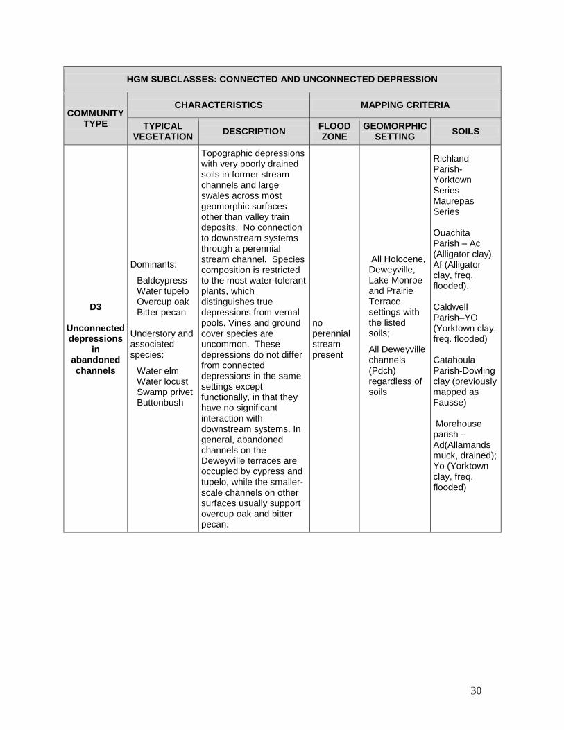
30
HGM SUBCLASSES: CONNECTED AND UNCONNECTED DEPRESSION
COMMUNITY TYPE
CHARACTERISTICS MAPPING CRITERIA
TYPICAL VEGETATION
DESCRIPTION FLOOD ZONE
GEOMORPHIC SETTING
SOILS
D3
Unconnected depressions
in abandoned channels
Dominants:
Baldcypress Water tupelo Overcup oak Bitter pecan
Understory and associated species:
Water elm Water locust Swamp privet Buttonbush
Topographic depressions with very poorly drained soils in former stream channels and large swales across most geomorphic surfaces other than valley train deposits. No connection to downstream systems through a perennial stream channel. Species composition is restricted to the most water-tolerant plants, which distinguishes true depressions from vernal pools. Vines and ground cover species are uncommon. These depressions do not differ from connected depressions in the same settings except functionally, in that they have no significant interaction with downstream systems. In general, abandoned channels on the Deweyville terraces are occupied by cypress and tupelo, while the smaller-scale channels on other surfaces usually support overcup oak and bitter pecan.
no perennial stream present
All Holocene, Deweyville, Lake Monroe and Prairie Terrace settings with the listed soils;
All Deweyville channels (Pdch) regardless of soils
Richland Parish-Yorktown Series Maurepas Series Ouachita Parish – Ac (Alligator clay), Af (Alligator clay, freq. flooded). Caldwell Parish–YO (Yorktown clay, freq. flooded) Catahoula Parish-Dowling clay (previously mapped as Fausse) Morehouse parish – Ad(Allamands muck, drained); Yo (Yorktown clay, freq. flooded)

31
HGM SUBCLASSES: CONNECTED AND UNCONNECTED DEPRESSION
COMMUNITY TYPE
CHARACTERISTICS MAPPING CRITERIA
TYPICAL VEGETATION
DESCRIPTION FLOOD ZONE
GEOMORPHIC SETTING
SOILS
D4
Unconnected depressions
on Pleistocene
outwash terraces
Dominants:
Baldcypress Water tupelo Water elm
Associates:
Overcup oak Bitter pecan Drummond’s red maple Green ash Persimmon
Included Interfluves:
Nuttall oak Willow oak Delta post oak Water oak Cherrybark oak Sweetgum Sugarberry
Depressions (valley train ponds) that occur in the remnants of glacial outwash channels on Pleistocene valley train terraces. The original coarse channel materials have mostly been veneered with fine-grained sediments and support swamp and floodplain species. Localized areas where the veneer is thin may be sandy and support individual trees or small groups of riverfront species such as river birch and sycamore. Small areas of higher ground (interfluves) not identified on soils maps are included in these units. These depressions do not differ from connected depressions in the same settings except functionally, in that they have no significant interaction with downstream systems.
no perennial stream present
All Pleistocene Valley Train terraces except Pve 5
Gilbert Calhoun

32
HGM SUBCLASSES: CONNECTED AND UNCONNECTED FRINGE
COMMUNITY TYPE
CHARACTERISTICS MAPPING CRITERIA
TYPICAL VEGETATION
DESCRIPTION FLOOD ZONE
GEOMORPHIC SETTING
SOILS
FR1
Stream-connected lake and
pond fringe wetlands
Common dominants in systems with natural fluctuation patterns:
Baldcypress Water tupelo Buttonbush Numerous herbaceous species
Common dominants in systems with highly modified fluctuation patterns:
Black willow Buttonbush American lotus
Wetlands within stream-connected permanent lakes and ponds, including borrow pits, but not aquaculture ponds. Natural systems typically support baldcypress and tupelo forests within the fluctuation zone and in the immediate lakefront zone where water tables remain near the surface. Buttonbush thickets may dominate in shallow, near-permanent water, and zones of emergent species are usually present, with erect rooted species in shallow water, floating-leaved species in deeper water, and submerged aquatics present throughout the open water area. Where water levels are manipulated, these patterns are usually altered in various ways. Because water depths and fluctuation patterns are unknown, the entire water body is mapped as fringe wetland.
Water body connected to a perennial stream
Permanent water bodies (not streams)
Mapped as water bodies on soils maps
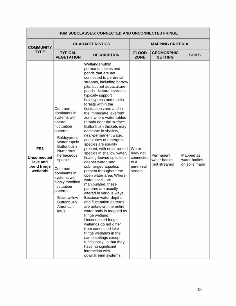
33
HGM SUBCLASSES: CONNECTED AND UNCONNECTED FRINGE
COMMUNITY TYPE
CHARACTERISTICS MAPPING CRITERIA
TYPICAL VEGETATION
DESCRIPTION FLOOD ZONE
GEOMORPHIC SETTING
SOILS
FR2
Unconnected lake and
pond fringe wetlands
Common dominants in systems with natural fluctuation patterns:
Baldcypress Water tupelo Buttonbush Numerous herbaceous species
Common dominants in systems with highly modified fluctuation patterns:
Black willow Buttonbush American lotus
Wetlands within permanent lakes and ponds that are not connected to perennial streams, including borrow pits, but not aquaculture ponds. Natural systems typically support baldcypress and tupelo forests within the fluctuation zone and in the immediate lakefront zone where water tables remain near the surface. Buttonbush thickets may dominate in shallow, near-permanent water, and zones of emergent species are usually present, with erect rooted species in shallow water, floating-leaved species in deeper water, and submerged aquatics present throughout the open water area. Where water levels are manipulated, these patterns are usually altered in various ways. Because water depths and fluctuation patterns are unknown, the entire water body is mapped as fringe wetland. Unconnected fringe wetlands do not differ from connected lake-fringe wetlands in the same settings except functionally, in that they have no significant interaction with downstream systems.
Water body not connected to a perennial stream
Permanent water bodies (not streams)
Mapped as water bodies on soils maps

34
HGM SUBCLASS: PRECIPITATION-MAINTAINED FLAT
COMMUNITY TYPE
CHARACTERISTICS MAPPING CRITERIA
TYPICAL VEGETATION
DESCRIPTION FLOOD ZONE
GEOMORPHIC SETTING
SOILS
F1
High natural levees
Dominants:
Cottonwood Water oak Sugarberry Pecan
Associates:
Cow oak Blackgum Cherrybark oak Sycamore Sweetgum Box elder
Characteristic understory:
Numerous vines Cane Paw-paw
High, well drained linear features that were formed along the banks of the Mississippi River. Near the modern river course they may have a strong riverfront character, being dominated by cottonwood and sugarberry, and with abundant vines usually including poison ivy, trumpet creeper, and river grape. On older deposits dominance shifts to water oak and pecan. Cow oak, blackgum, and cherrybark oak increase in abundance with increasing site age, but rarely dominate. Cane and paw-paw are characteristic understory plants.
Outside 5 year floodplain
High natural levee crests on holocene point bar and some backswamp deposits
Ouachita Parish: SrB (Sterlington silt loam, 1 to 3 percent slopes), RlB (Rilla silt loam, 1 to 3 percent slopes), Ga (Gallion silt loam) Caldwell Parish: Ga (Gallion silt loam), St (Sterlington silt loam Catahoula Parish: Ra (Rilla silt loam), St (Sterlington Silt loam).

35
HGM SUBCLASS: PRECIPITATION-MAINTAINED FLAT
COMMUNITY TYPE
CHARACTERISTICS MAPPING CRITERIA
TYPICAL VEGETATION
DESCRIPTION FLOOD ZONE
GEOMORPHIC SETTING
SOILS
F3
Ridge and swale
topography in older alluvium
in lowlands
Dominants on ridges and flats:
Cow oak Cherrybark oak Water oak
Associated species:
American elm Box elder
Dominants in swales:
Overcup oak Nuttall oak
Characteristic understory species:
Rough-leaf dogwood Deciduous holly Paw-paw Cane
Well-drained ridge and swale point bar deposits and natural levee deposits over backswamps. Typical natural levee species such as cow oak occupy the higher sites while most of the undulating terrain is dominated by cherrybark and water oaks. Nuttall oak and overcup oak usually dominate in ponded sites, which are most commonly point bar swales.
Outside 5 year floodplain
Veneered point bar
Any except high natural levee and depression soils

36
HGM SUBCLASS: PRECIPITATION-MAINTAINED FLAT
COMMUNITY TYPE
CHARACTERISTICS MAPPING CRITERIA
TYPICAL VEGETATION
DESCRIPTION FLOOD ZONE
GEOMORPHIC SETTING
SOILS
F4
Moderately drained
lowlands
Dominants:
Sugarberry Green ash American elm Sweetgum
Associates:
Water oak Willow oak Persimmon Cherrybark oak
Vernal Pools: Overcup oak Bitter pecan
Gently undulating, moderately drained point bars and veneered backswamps of various ages and origins. The characteristic community is sugarberry-elm-ash, but subtle site variations favor water oak on better drained ridges and Nuttall oak or willow oak on true topographic flats. Overcup oak usually dominates in swales.
Outside 5 year floodplain
Unveneered point bars Veneered backswamps
Any except high natural levee and depression soils
F6
Poorly drained lowlands
Dominants:
Willow oak Nuttall oak Sweetgum
Associates:
Cherrybark oak American elm
Vernal pools:
Overcup oak Green ash
Poorly drained flats dominated by Nuttall and Willow oaks with large shallow vernal pools. Better-drained sites within this type often include cherrybark oak.
Outside 5 year floodplain
Unveneered backswamps and abandoned channels not otherwise classified
Any except high natural levee and depression soils
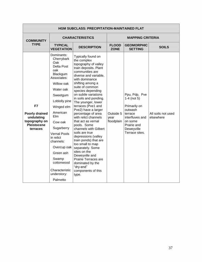
37
HGM SUBCLASS: PRECIPITATION-MAINTAINED FLAT
COMMUNITY TYPE
CHARACTERISTICS MAPPING CRITERIA
TYPICAL VEGETATION
DESCRIPTION FLOOD ZONE
GEOMORPHIC SETTING
SOILS
F7
Poorly drained undulating
topography on Pleistocene
terraces
Dominants: Cherrybark Oak Delta Post oak Blackgum
Associates:
Willow oak
Water oak
Sweetgum
Loblolly pine
Winged elm
American Elm
Cow oak
Sugarberry
Vernal Pools in relict channels:
Overcup oak
Green ash
Swamp cottonwood
Characteristic understory:
Palmetto
Typically found on the complex topography of valley train deposits. Plant communities are diverse and variable, with dominance shifting among a suite of common species depending on subtle variations in soils and ponding. The younger, lower terraces (Pve1 and Pve2) have a larger percentage of area with relict channels that act as vernal pools. Some channels with Gilbert soils are true depressions (valley train ponds) that are too small to map separately. Some sites on the Deweyville and Prairie Terraces are dominated by the “dry-end” components of this type.
Outside 5 year floodplain
Ppu, Pdp, Pve 1-4 (not 5) Primarily on outwash terrace interfluves and on some Prairie and Deweyville Terrace sites.
All soils not used elsewhere

38
HGM SUBCLASS: PRECIPITATION-MAINTAINED FLAT
COMMUNITY TYPE
CHARACTERISTICS MAPPING CRITERIA
TYPICAL VEGETATION
DESCRIPTION FLOOD ZONE
GEOMORPHIC SETTING
SOILS
F9
Flatwoods on poorly drained
Pleistocene Terraces
Dominants: Cherrybark oak Water oak
Associates: Delta Post oak
Loblolly pine blackgum
Vernal pools:
Willow oak Laurel oak Green ash Understory: Palmetto
Very flat terrain on the Prairie Terrace and the Lake Monroe Terraces where precipitation ponds shallowly but soils are not appropriate to sustain prairie. The terrain is primarily flat but includes numerous hummocks and extensive vernal pools which considerably increase the diversity of the forest. Very little pine is found in this type, mostly restricted to hummocks.
Any
Specific soils on the Prairie, Deweyville, and Lake Monroe Terraces regardless of flooding regime.
Morehouse Parish: Gu (Guyton silt loam), He (Haggerty silty clay) Union Parish: GO (Groom silty clay loam, frequently flooded), HA (Haggerty fine sandy loam freq. flooded), HB (Haggerty silty clay) Ouachita Parish: GU (Guyton Association), Wa (Waller loam), Wr (Wrightsville silo) West Carroll Parish: (Foley silt loam), (Memphis silt loam 0-2%slopes) Richland Parish: (Necessity) Catahoula Parish: Cw (Callaway silt loam), (Loring silt loam) (Memphis silt loam 0-2% slopes)

39
HGM SUBCLASS: PRECIPITATION-MAINTAINED FLAT
COMMUNITY TYPE
CHARACTERISTICS MAPPING CRITERIA
TYPICAL VEGETATION
DESCRIPTION FLOOD ZONE
GEOMORPHIC SETTING
SOILS
F10 Pine Flatwoods
of the Pleistocene
terraces
Dominants: Loblolly pine Shortleaf pine Southern red oak Associates: Water oak Delta post oak White oak Post oak Blackgum Vernal pools Willow oak Nuttall oak
Pine flatwoods. Poorly drained flats with mixed pine-hardwoods and a wet or dry prairie groundcover. Most sites are currently pushed to greater pine dominance but would naturally be dominated by pine with regular burning, while fire suppression favors hardwoods. Nebkhas (prairie mounds) and vernal pools are often present, and local variation in drainage can result in distinctly upland or wetland plant communities. Near the dissected margins of the Plm terraces upland communities prevail, usually characterized by shortleaf pine.
>5
Plm1 and Plm 2 Ppu, Pdp
On the Plm1 and Plm 2: All soils not used to define other communities On the Ppu and Pdp: Morehouse Parish: Fr ( Frizzell Silo) To (Tillou Silt Loam) Wr (Wrightsville Silt Loam) Gm (Groom very fine sandy loam) GO (Groom fine sandy loam occasionally flooded) Gp ( Groom-Mollicy complex) Gs(Groom-Mollicy complex occasionally flooded) Hh (Haggerty silty clay, frequently flooded) Union Parish: Fr (Frizzell silo) Gm (Groom silo, occas flooded) Le (Libuse silo, 1-5% slopes) Sg (Savannah fine sandy loam 1-5% slopes) Sk (Sawyer silo, 1-5% slopes) Wr (Wrightsville silo, occfl) SaC (Savannah fsl, 1-5% slopes) Ouachita Parish: FrA (Frizzell silo 0-1% slopes) PvB (Providence silo, 1-3% slopes) (Savannah fsl, 1-5% slopes)

40
HGM SUBCLASS: PRECIPITATION-MAINTAINED FLAT
COMMUNITY TYPE
CHARACTERISTICS MAPPING CRITERIA
TYPICAL VEGETATION
DESCRIPTION FLOOD ZONE
GEOMORPHIC SETTING
SOILS
F-11 Alkali
Prairie/Savanna
Herbaceous dominants: three-awn grass poorjo little bluestem Shrubs: dwarf palmetto saltbush Marginal woodland dominants: delta post oak post oak, blackjack oak shortleaf pine loblolly pine
Expansive flats with saline soils that support Delta Post oak/three-awn savanna under natural conditions with fire present. The characteristic herbaceous and shrub species are present under the canopy of the woodland that forms a transition zone to the flatwoods that typically surround the saline flats. Where terrain is somewhat dissected or in the long-term absence of fire, the hardwood forest that replaces the savanna also includes willow oak, cherrybark oak, and winged elm. This community characteristically includes unique salt slicks with bare soil fringed with a cryptogamic lip of algae and lichens. This narrow cryptopgamic zone supports the federally endangered plant, Geocarpon minimum.
Any Any surface
Lafe silo
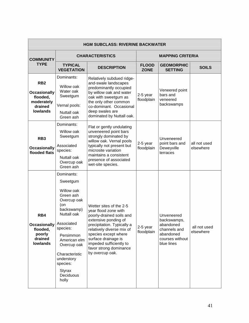
41
HGM SUBCLASS: RIVERINE BACKWATER
COMMUNITY TYPE
CHARACTERISTICS MAPPING CRITERIA
TYPICAL VEGETATION
DESCRIPTION FLOOD ZONE
GEOMORPHIC SETTING
SOILS
RB2
Occasionally flooded,
moderately drained
lowlands
Dominants:
Willow oak Water oak Sweetgum
Vernal pools:
Nuttall oak Green ash
Relatively subdued ridge-and-swale landscapes predominantly occupied by willow oak and water oak with sweetgum as the only other common co-dominant. Occasional deep swales are dominated by Nuttall oak.
2-5 year floodplain
Veneered point bars and veneered backswamps
RB3
Occasionally flooded flats
Dominants:
Willow oak Sweetgum
Associated species:
Nuttall oak Overcup oak Green ash
Flat or gently undulating unveneered point bars strongly dominated by willow oak. Vernal pools typically not present but microsite variation maintains a consistent presence of associated wet-site species.
2-5 year floodplain
Unveneered point bars and Deweyville terraces
all not used elsewhere
RB4
Occasionally flooded, poorly drained
lowlands
Dominants:
Sweetgum Willow oak Green ash Overcup oak (on backswamp) Nuttall oak
Associated species:
Persimmon American elm Overcup oak
Characteristic understory species:
Styrax Deciduous holly
Wetter sites of the 2-5 year flood zone with poorly-drained soils and extensive ponding of precipitation. Typically a relatively diverse mix of species except where surface drainage is impeded sufficiently to favor strong dominance by overcup oak.
2-5 year floodplain
Unveneered backswamps, abandoned channels and abandoned courses without blue lines
all not used elsewhere
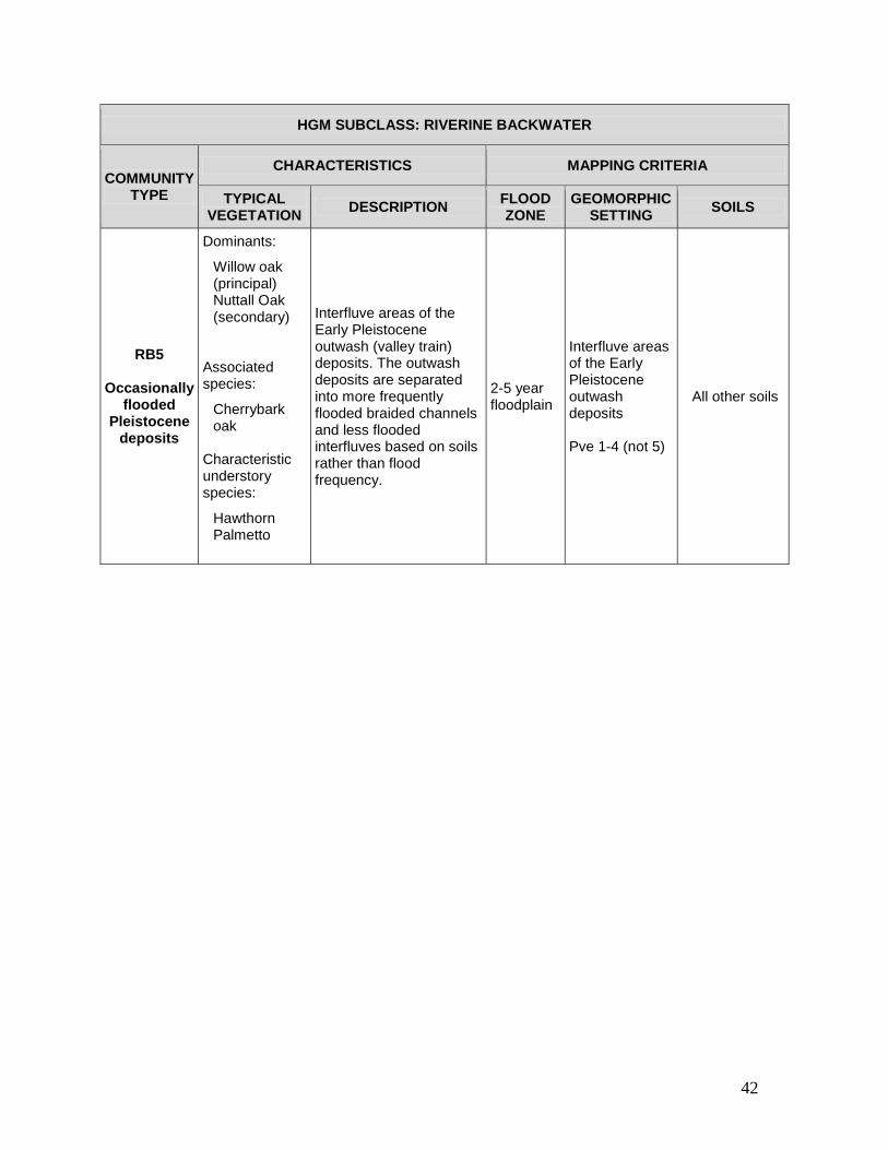
42
HGM SUBCLASS: RIVERINE BACKWATER
COMMUNITY TYPE
CHARACTERISTICS MAPPING CRITERIA
TYPICAL VEGETATION
DESCRIPTION FLOOD ZONE
GEOMORPHIC SETTING
SOILS
RB5
Occasionally flooded
Pleistocene deposits
Dominants:
Willow oak (principal) Nuttall Oak (secondary)
Associated species:
Cherrybark oak
Characteristic understory species:
Hawthorn Palmetto
Interfluve areas of the Early Pleistocene outwash (valley train) deposits. The outwash deposits are separated into more frequently flooded braided channels and less flooded interfluves based on soils rather than flood frequency.
2-5 year floodplain
Interfluve areas of the Early Pleistocene outwash deposits Pve 1-4 (not 5)
All other soils

43
HGM SUBCLASS: RIVERINE BACKWATER
COMMUNITY TYPE
CHARACTERISTICS MAPPING CRITERIA
TYPICAL VEGETATION
DESCRIPTION FLOOD ZONE
GEOMORPHIC SETTING
SOILS
RB7
Frequently flooded
lowlands
Dominants:
Overcup Oak Bitter pecan
Understory:
Swamp privet
mayhaw Associates on wetter sites:
Baldcypress Water tupelo
Associates on drier sites:
Nuttall oak Green ash Drummond red maple American elm Persimmon
This community type occurs on a wide variety of geomorphic settings and soil types where forest composition is strongly controlled by extended periods of backwater flooding in most years. The characteristic community is dominated by overcup oak, bitter pecan, and a limited group of associated canopy and understory species. Vines and ground cover species also are less abundant and diverse than on less flooded sites. Additional species occur in all strata on the less-flooded sites and upslope margins of the overcup oak zone. Dominance may shift to baldcypress and water tupelo in the deepest parts of abandoned channels and stream courses, and in localized sumps and along minor interior drainageways in backswamps, point bars, and Pleistocene outwash channels.
1-2 year floodplain
Abandoned channels and abandoned courses without a stream connection Backswamps Point bars Pleistocene outwash channels
All other soils

44
HGM SUBCLASS: RIVERINE BACKWATER
COMMUNITY TYPE
CHARACTERISTICS MAPPING CRITERIA
TYPICAL VEGETATION
DESCRIPTION FLOOD ZONE
GEOMORPHIC SETTING
SOILS
RB8 Sand Prairie
Dominant herbaceous species: Little bluestem Switchgrass Poorjo wooly croton Woody dominants on margins: Buttonbush stiff dogwood mayhaw green haw honeylocust persimmon Stylisma aquatica is limited to and characteristic of this habitat.
Sand prairie wetlands are a unique wetland type that is associated with sandy deposits that accumulated along the shoreline of the Pleistocene Lake Monroe. The remnants of the former beach are now herbaceous-dominated gaps in the lowland forest system. The reason for herbaceous dominance on these sites is unclear, but may be related to droughtiness, salt and metal accumulations, fire, or all of these factors. Sand prairie wetlands often include uncommon species. They are regularly and deeply flooded by the nearby river.
Any any
Haggerty loamy fine sand; Haggerty loamy fine sand frequently flooded

45
HGM SUBCLASS: RIVERINE OVERBANK
COMMUNITY TYPE
CHARACTERISTICS MAPPING CRITERIA
TYPICAL VEGETATION
DESCRIPTION FLOOD ZONE
GEOMORPHIC SETTING
SOILS
RO-1
Floodplains and terraces
of small stream valleys
Floodplains of small stream valleys: Dominants:
Water oak
Willow oak Sweetgum Cow oak
Associates: Bitternut hickory Red maple Overcup oak Terraces within stream valleys: Dominants: Cherrybark oak Water oak
Cow oak
Laurel oak
Blackgum
Loblolly pine
Delta Post oak
Seeps on Terrace/Upland margins:
Sweetbay magnolia
Possumhaw viburnum
Net-vein chain fern
Royal Fern
Overbank zones of small stream valleys. Broader, well-defined valleys (mapped as Holocene Alluvium) typically include one or more terraces and support mesic communities similar to those in stream valleys of the nearby Tertiary uplands. Seeps often occur on the upland margins of terraces, particularly where stream valleys transit the Prairie Terrace. Less defined drainageways in Pleistocene terraces generally are swale-like, without distinct terraces parallel to the stream channel but with irregular terrain, and support plant communities similar to those in the Holocene Mississippi Alluvial Valley lowlands. Where smaller stream valleys broaden and flatten near their confluence with the floodplain of a large river, they often support stands of pure baldcypress."
Any
Hal Pleistocene terraces
On Hal: all soils On Pleistocene terraces: Any Guyton other than Guyton Association or Guyton silt loam in Morehouse Parish Any Guyton other than Guyton Association in all other Parishes

46
HGM SUBCLASS: RIVERINE OVERBANK
COMMUNITY TYPE
CHARACTERISTICS MAPPING CRITERIA
TYPICAL VEGETATION
DESCRIPTION FLOOD ZONE
GEOMORPHIC SETTING
SOILS
RO-2
River swamps in
underfit channels
Channel bottom zone: Dominants:
Baldcypress Water tupelo Buttonbush
Lower bank or narrow terrace adjacent to stream: Dominants:
Overcup oak Water locust Bitter pecan
Associated species:
Nuttall oak Water elm Swamp privet
Sideslopes of abandoned channel:
Mixed hardwoods and riverfront species
"River swamps" of slow-moving streams that have occupied large abandoned courses of the Arkansas River. Typically a swamp forest of baldcypress dominates the zone occupied by the modern stream at normal flows. The rest of the former channel sideslope supports a series of forest species reflecting flood frequency, from overcup oak adjacent to the cypress community through natural levee species such as cow oak along the channel rim. A wide variety of other species may occupy the intervening zones. A standard buffer along the center lines of the abandoned courses as mapped on 1:62.5K quad sheets was used to delimit this type, and therefore the boundaries are less precise than other mapped features.
Usually near-permanent inundation in the active stream channel, grading to annual flooding in the adjacent zone through rarely flooded sites along the channel rim.
Abandoned courses of the Arkansas River and small streams (defined as 400m zone along mapped abandoned course line and indeterminate abandoned courses) with blue-line present
Not diagnostic,

47
HGM SUBCLASS: UPLAND
COMMUNITY TYPE
CHARACTERISTICS MAPPING CRITERIA
TYPICAL VEGETATION
DESCRIPTION FLOOD ZONE
GEOMORPHIC SETTING
SOILS
U2
Well-drained soils of the Pleistocene
terraces
Dominant species: Xeric sites:
Post oak Blackjack oak Shortleaf pine Black hickory Red cedar
Dry sites:
Southern red oak Loblolly pine White oak Dogwood Shagbark hickory
Mesic sites:
Sweetgum Water oak Blackgum Willow oak White oak
Upland forests of the Pleistocene terraces and alluvial fans. Species composition can vary widely depending on local soils and drainage conditions, but generally is similar to other upland forests of the West Gulf Coastal Plain region. Species tolerant of highly xeric conditions are found on the oldest, highly dissected outwash surfaces (Pve5) and on remnant sand dunes mapped as Liddyville soils.
No flooding
All Pleistocene Valley Train Terraces and alluvial fans.
All soils not used to define other sites in Pve5 and on alluvial fans On Pve1-4: West Carroll Parish: Grenada silo, 3-5% slopes; Richland Par. - Grenada Series; Liddieville silo Catahoula Par – (Mh) Memphis silo, 2-5 % slopes; ( Mm) Memphis silo 5-12 % slopes;(MP) Memphis-kisatchee-Oula assn 4-40% slopes; (MS) Memphis-Smithdale Assoc
Notes:
1. This Appendix describes the community types represented on the Potential Natural
Vegetation map. It identifies groups of species–principally trees– adapted to specific
combinations of soils and geomorphic settings within the hydrologic regimes that
currently exist on the landscape. Species lists reflect principal dominants and associated
species in mature, compositionally stable communities. The listed species do not
necessarily occur together in a particular stand, but may be found on similar sites. In
some instances, understory species or other characteristics strongly associated with the
48
particular community type are noted. No early successional communities are described,
although seral patches exist in all of the community types, and in some settings, such as
point bars within and along active channels, they may be extensive. Similarly, the
community descriptions do not necessarily reflect the current vegetation found on many
sites, which may have established under a previous hydrologic regime or been
extensively manipulated. Because the purpose of the classification is to support
restoration design and planning, the focus of this map is on the predominant long-term
equilibrium condition best adapted to persist on each site under the current hydrologic
and climatic regime.
2. Site characterizations in this table list the primary conditions associated with the
community type. Minor inclusions of other geomorphic settings may occur, and the
order in which the mapping rules were applied affected the final distribution of
community types represented on the map. Consult the mapping metadata and assembly
rules for a full presentation of the mapping criteria.
3. Flood frequency refers to the return interval of inundation originating within the stream
channel (either overbank or backwater) but not inundation that occurs entirely as the
result of ponding of precipitation. Flood zones are designated as 1-2, 2-5, 1-5, or >5
years. The sources for these categories vary by sub-basin and in some cases are not tied
to gage data but are derived from images estimated to approximate the assigned
frequency. Ponded sites are recognized by soils, geomorphology, and in some instances,
the presence of standing water in particular satellite images. See report for further
discussion of flood data sources and interpretation.
4. Geomorphic terminology reflects Saucier (1994), but has been modified for this
application as follows:
Abandoned channels and courses of the Arkansas River are those labeled “A” on
the Saucier basemaps and the associated point bar deposits are labeled Hpa 1-5.
Abandoned channels and courses of “minor streams” and the northernmost reach
of the Ouachita River are those labeled “S” on the Saucier basemaps and the
associated point bars are labeled Hps. Backswamps (Hb) are not differentiated as
to their origin.
Undifferentiated holocene alluvium (Hal) is mapped primarily in small tributary
valleys where they are incised into Pleistocene terraces or Tertiary uplands.
Abandoned channels (cutoffs) on the Deweyville terraces (Pdch) are
differentiated from all other abandoned channels of Arkansas River or smaller
streams (Hch). Abandoned courses (Hco) are long channel sections left behind by
avulsing streams rather than cutoffs, and are primarily of Arkansas River origin.
The original 1:62.5K geomorphic maps for the region (Saucier 1967, Fleetwood
1969) included a symbol for the presence of a natural levee veneer on top of the
major geomorphic surfaces such as point bars and backswamps. The natural
levee symbol was omitted when Saucier consolidated those quad sheets into a
1:250K coverage. For this study, the natural levee veneer deposits were digitized
from the original source maps and are used as modifiers (“veneered”) to the
geomorphic setting. Alluvial fans also were digitized and added to the
geomorphic basemap.
Pleistocene Valley Train Terraces are glacial outwash deposits of various ages
and relative elevations, mapped by Saucier (1994) as Pve1-5, where level 5 is the

49
oldest and highest. The Prairie Terraces (Ppu 1-2) comprise non-glacial
Pleistocene alluvial deposits that are older and higher in the landscape than the
outwash terraces.
Pleistocene lacustrine deposits – the Lake Monroe Complex – are mapped as two
units. Plm 1 includes beaches and bars and Plm 2 is primarily lake plain.
5. Soils are used here as modifiers to geomorphic setting in certain wetland subclasses (e.g.
depressions, sand prairies, the high crests of natural levees). Soils are represented in this
table according to the standard soil series codes used in the official soil survey for each
Parish.
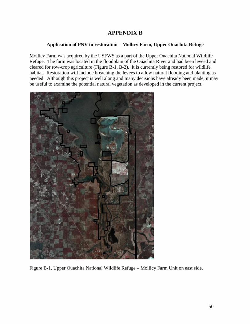
50
APPENDIX B
Application of PNV to restoration – Mollicy Farm, Upper Ouachita Refuge
Mollicy Farm was acquired by the USFWS as a part of the Upper Ouachita National Wildlife
Refuge. The farm was located in the floodplain of the Ouachita River and had been leveed and
cleared for row-crop agriculture (Figure B-1, B-2). It is currently being restored for wildlife
habitat. Restoration will include breaching the levees to allow natural flooding and planting as
needed. Although this project is well along and many decisions have already been made, it may
be useful to examine the potential natural vegetation as developed in the current project.
Figure B-1. Upper Ouachita National Wildlife Refuge – Mollicy Farm Unit on east side.

51
Figure B-2. Mollicy Farm Unit.
The aerial photo shows the portion of the unit that are subject to frequent flooding along with the
microrelief remaining in this area that has otherwise been heavily modified. The Mollicy unit
primarily occupies two geomorphic settings – small stream and river meander belt and
Deweyville terrace (Figure B-3). However, there are abandoned channels and small areas of
Lake Monroe terrace within it as well.

52
Figure B-3. Geomorphology of the Mollicy unit.
Soils of the Mollicy unit are relatively complex and provide additional basis for classifying sites
for PNV (Figure B-4). In the frequently flooded bottomland (small stream and river meander
belt) the most extensive soils are Litro clay, Perry clay and Portland clay. These soils indicate
poorly drained, wet sites. On the Deweyville terrace the most extensive soils are Haggerty silty
clay, Groom fine sandy loam, Groom-Mollicy complex and Haggerty loamy fine sand. These
soils have high potential for loblolly and shortleaf pine, except that Haggerty loamy fine sand is
indicative of the lowland sand prairie, typically herbaceous dominated.

53
Figure B-4. Soils of the Mollicy unit.
The combination of differences in flood frequency, geomorphology and soils provide a diversity
of potential natural vegetation over the Mollicy unit, ranging from wet to well-drained
bottomland hardwoods, hardwood or pine-hardwood flatwoods to droughty lowland sand prairie
(Figure B-5)

54
Figure B-5. PNV of the Mollicy unit
This exercise demonstrates that the PNV map may be used to provide diverse and appropriate
restoration targets for an area the size of the Mollicy unit. Although these are by no means
prescriptive, they may provide perspective on whatever restoration targets are selected.