Polyphemus 1.0 User’s Guide - Inria · Polyphemus 1.0 User’s Guide CEREA – ENPC / EDF R&D...
124
Polyphemus 1.0 User’s Guide CEREA – ENPC / EDF R&D Meryem Ahmed de Biasi, Vivien Mallet, Ir` ene Korsakissok, ´ Edouard Debry, Lin Wu and Marilyne Tombette http://www.enpc.fr/cerea/polyphemus/ [email protected]
Transcript of Polyphemus 1.0 User’s Guide - Inria · Polyphemus 1.0 User’s Guide CEREA – ENPC / EDF R&D...

Polyphemus 1.0User’s Guide
CEREA – ENPC / EDF R&DMeryem Ahmed de Biasi, Vivien Mallet,
Irene Korsakissok, Edouard Debry, Lin Wu and Marilyne Tombette
http://www.enpc.fr/cerea/polyphemus/[email protected]

2

Contents
1 Introduction and Installation 71.1 Polyphemus Overview . . . . . . . . . . . . . . . . . . . . . . . . . . . . . . . . . 71.2 Requirements . . . . . . . . . . . . . . . . . . . . . . . . . . . . . . . . . . . . . . 91.3 Installation . . . . . . . . . . . . . . . . . . . . . . . . . . . . . . . . . . . . . . . 10
1.3.1 Main instructions . . . . . . . . . . . . . . . . . . . . . . . . . . . . . . . . 101.3.2 AtmoPy . . . . . . . . . . . . . . . . . . . . . . . . . . . . . . . . . . . . . 111.3.3 Newran . . . . . . . . . . . . . . . . . . . . . . . . . . . . . . . . . . . . . 11
2 Using Polyphemus 132.1 Remark . . . . . . . . . . . . . . . . . . . . . . . . . . . . . . . . . . . . . . . . . 132.2 Configuration Files . . . . . . . . . . . . . . . . . . . . . . . . . . . . . . . . . . . 13
2.2.1 Definitions . . . . . . . . . . . . . . . . . . . . . . . . . . . . . . . . . . . 132.2.2 Flexibility . . . . . . . . . . . . . . . . . . . . . . . . . . . . . . . . . . . . 132.2.3 Comments . . . . . . . . . . . . . . . . . . . . . . . . . . . . . . . . . . . . 142.2.4 Markups . . . . . . . . . . . . . . . . . . . . . . . . . . . . . . . . . . . . . 152.2.5 Sections . . . . . . . . . . . . . . . . . . . . . . . . . . . . . . . . . . . . . 152.2.6 Multiple Files . . . . . . . . . . . . . . . . . . . . . . . . . . . . . . . . . . 162.2.7 Dates . . . . . . . . . . . . . . . . . . . . . . . . . . . . . . . . . . . . . . 162.2.8 Booleans . . . . . . . . . . . . . . . . . . . . . . . . . . . . . . . . . . . . 17
2.3 Running Programs . . . . . . . . . . . . . . . . . . . . . . . . . . . . . . . . . . . 172.3.1 Compiling Programs . . . . . . . . . . . . . . . . . . . . . . . . . . . . . . 172.3.2 Running a Program . . . . . . . . . . . . . . . . . . . . . . . . . . . . . . 172.3.3 Sharing Configuration . . . . . . . . . . . . . . . . . . . . . . . . . . . . . 182.3.4 Notes about Models . . . . . . . . . . . . . . . . . . . . . . . . . . . . . . 19
2.4 Useful Tools . . . . . . . . . . . . . . . . . . . . . . . . . . . . . . . . . . . . . . . 202.4.1 Information about Binary Files . . . . . . . . . . . . . . . . . . . . . . . . 202.4.2 Differences between Two Binary Files . . . . . . . . . . . . . . . . . . . . 212.4.3 MM5 Files . . . . . . . . . . . . . . . . . . . . . . . . . . . . . . . . . . . 222.4.4 Script call dates . . . . . . . . . . . . . . . . . . . . . . . . . . . . . . . 26
2.5 Setting Up a Simulation . . . . . . . . . . . . . . . . . . . . . . . . . . . . . . . . 262.5.1 Suggested Directory Tree . . . . . . . . . . . . . . . . . . . . . . . . . . . 262.5.2 Roadmaps . . . . . . . . . . . . . . . . . . . . . . . . . . . . . . . . . . . . 272.5.3 Mandatory Data in Preprocessing . . . . . . . . . . . . . . . . . . . . . . 282.5.4 Mandatory Data for Models . . . . . . . . . . . . . . . . . . . . . . . . . . 292.5.5 Models / Modules Compatibilities . . . . . . . . . . . . . . . . . . . . . . 312.5.6 Checking Results . . . . . . . . . . . . . . . . . . . . . . . . . . . . . . . . 312.5.7 Important Notice . . . . . . . . . . . . . . . . . . . . . . . . . . . . . . . . 32
3

4 CONTENTS
3 Preprocessing 333.1 Remark . . . . . . . . . . . . . . . . . . . . . . . . . . . . . . . . . . . . . . . . . 333.2 Introduction . . . . . . . . . . . . . . . . . . . . . . . . . . . . . . . . . . . . . . . 33
3.2.1 Running Preprocessing Programs . . . . . . . . . . . . . . . . . . . . . . . 333.2.2 Configuration . . . . . . . . . . . . . . . . . . . . . . . . . . . . . . . . . . 343.2.3 Data Files . . . . . . . . . . . . . . . . . . . . . . . . . . . . . . . . . . . . 35
3.3 Ground Data . . . . . . . . . . . . . . . . . . . . . . . . . . . . . . . . . . . . . . 353.3.1 Land Use Cover – GLCF: luc-glcf . . . . . . . . . . . . . . . . . . . . . 353.3.2 Land Use Cover – USGS: luc-usgs . . . . . . . . . . . . . . . . . . . . . 363.3.3 Conversions: luc-convert . . . . . . . . . . . . . . . . . . . . . . . . . . 373.3.4 Roughness: roughness . . . . . . . . . . . . . . . . . . . . . . . . . . . . . 38
3.4 Meteorological Fields . . . . . . . . . . . . . . . . . . . . . . . . . . . . . . . . . . 393.4.1 Program meteo . . . . . . . . . . . . . . . . . . . . . . . . . . . . . . . . . 393.4.2 Program attenuation . . . . . . . . . . . . . . . . . . . . . . . . . . . . . 403.4.3 Program Kz . . . . . . . . . . . . . . . . . . . . . . . . . . . . . . . . . . . 413.4.4 Program Kz TM . . . . . . . . . . . . . . . . . . . . . . . . . . . . . . . . . 423.4.5 Program MM5-meteo . . . . . . . . . . . . . . . . . . . . . . . . . . . . . . 433.4.6 Program MM5-meteo-castor . . . . . . . . . . . . . . . . . . . . . . . . . 45
3.5 Deposition Velocities . . . . . . . . . . . . . . . . . . . . . . . . . . . . . . . . . . 473.5.1 Program dep . . . . . . . . . . . . . . . . . . . . . . . . . . . . . . . . . . 473.5.2 Program dep-emberson . . . . . . . . . . . . . . . . . . . . . . . . . . . . 49
3.6 Emissions . . . . . . . . . . . . . . . . . . . . . . . . . . . . . . . . . . . . . . . . 493.6.1 Mapping Two Vertical Distributions: distribution . . . . . . . . . . . . 493.6.2 Anthropogenic Emissions (EMEP): emissions . . . . . . . . . . . . . . . 503.6.3 Biogenic Emissions for Polair3D Models: bio . . . . . . . . . . . . . . . . 523.6.4 Sea Salt Emissions: sea-salt . . . . . . . . . . . . . . . . . . . . . . . . . 53
3.7 Initial Conditions: ic . . . . . . . . . . . . . . . . . . . . . . . . . . . . . . . . . 543.8 Boundary Conditions . . . . . . . . . . . . . . . . . . . . . . . . . . . . . . . . . . 54
3.8.1 Boundary Conditions for Gaseous Species: bc . . . . . . . . . . . . . . . . 543.8.2 Boundary Conditions for Aerosol Species: bc-gocart . . . . . . . . . . . 55
3.9 Preprocessing for Gaussian Models . . . . . . . . . . . . . . . . . . . . . . . . . . 593.9.1 Program discretization . . . . . . . . . . . . . . . . . . . . . . . . . . . 593.9.2 Programs gaussian-deposition and gaussian-deposition aer . . . . . 60
4 Drivers 694.1 BaseDriver . . . . . . . . . . . . . . . . . . . . . . . . . . . . . . . . . . . . . . . 694.2 PlumeDriver . . . . . . . . . . . . . . . . . . . . . . . . . . . . . . . . . . . . . . 694.3 PuffDriver . . . . . . . . . . . . . . . . . . . . . . . . . . . . . . . . . . . . . . . . 694.4 StationaryDriver . . . . . . . . . . . . . . . . . . . . . . . . . . . . . . . . . . . . 704.5 OptimalInterpolationDriver . . . . . . . . . . . . . . . . . . . . . . . . . . . . . . 704.6 Output Savers . . . . . . . . . . . . . . . . . . . . . . . . . . . . . . . . . . . . . 70
4.6.1 BaseOutputSaver . . . . . . . . . . . . . . . . . . . . . . . . . . . . . . . . 704.6.2 SaverUnitDomain and SaverUnitDomain aer . . . . . . . . . . . . . . . . 714.6.3 SaverUnitSubdomain and SaverUnitSubdomain aer . . . . . . . . . . . . . 724.6.4 SaverUnitDomain assimilation . . . . . . . . . . . . . . . . . . . . . . . . 724.6.5 SaverUnitNesting and SaverUnitNesting aer . . . . . . . . . . . . . . . . . 72
4.7 Observation Managers . . . . . . . . . . . . . . . . . . . . . . . . . . . . . . . . . 734.7.1 GroundObservationManager . . . . . . . . . . . . . . . . . . . . . . . . . . 734.7.2 SimObservationManager . . . . . . . . . . . . . . . . . . . . . . . . . . . . 73

CONTENTS 5
5 Models 755.1 GaussianPlume . . . . . . . . . . . . . . . . . . . . . . . . . . . . . . . . . . . . . 75
5.1.1 Configuration File: plume.cfg . . . . . . . . . . . . . . . . . . . . . . . . 755.1.2 Source Description: plume-source.dat . . . . . . . . . . . . . . . . . . . 765.1.3 Vertical Levels: plume-level.dat . . . . . . . . . . . . . . . . . . . . . . 775.1.4 Species: gaussian-species.dat . . . . . . . . . . . . . . . . . . . . . . . 77
5.2 GaussianPlume aer . . . . . . . . . . . . . . . . . . . . . . . . . . . . . . . . . . . 785.2.1 Configuration File: plume aer.cfg . . . . . . . . . . . . . . . . . . . . . . 785.2.2 Source Description: plume-source aer.dat . . . . . . . . . . . . . . . . . 785.2.3 Vertical Levels: plume-level.dat . . . . . . . . . . . . . . . . . . . . . . 785.2.4 Species: gaussian-species aer.dat . . . . . . . . . . . . . . . . . . . . . 785.2.5 Diameters: diameter.dat . . . . . . . . . . . . . . . . . . . . . . . . . . . 78
5.3 GaussianPuff . . . . . . . . . . . . . . . . . . . . . . . . . . . . . . . . . . . . . . 795.3.1 Configuration File: puff.cfg . . . . . . . . . . . . . . . . . . . . . . . . . 795.3.2 Puff Description: puff.dat . . . . . . . . . . . . . . . . . . . . . . . . . . 805.3.3 Vertical Levels and Species . . . . . . . . . . . . . . . . . . . . . . . . . . 80
5.4 GaussianPuff aer . . . . . . . . . . . . . . . . . . . . . . . . . . . . . . . . . . . . 805.4.1 Configuration File: puff aer.cfg . . . . . . . . . . . . . . . . . . . . . . 805.4.2 Source Description: puff aer.dat . . . . . . . . . . . . . . . . . . . . . . 805.4.3 Vertical Levels, Species and Diameters . . . . . . . . . . . . . . . . . . . . 81
5.5 Polair3DTransport . . . . . . . . . . . . . . . . . . . . . . . . . . . . . . . . . . . 815.5.1 Main Configuration File: polair3d.cfg . . . . . . . . . . . . . . . . . . . 815.5.2 Data Description: polair3d-data.cfg . . . . . . . . . . . . . . . . . . . 825.5.3 Vertical Levels and Species . . . . . . . . . . . . . . . . . . . . . . . . . . 85
5.6 Polair3DChemistry . . . . . . . . . . . . . . . . . . . . . . . . . . . . . . . . . . . 865.6.1 Main Configuration File: polair3d.cfg . . . . . . . . . . . . . . . . . . . 865.6.2 Data Description: polair3d-data.cfg . . . . . . . . . . . . . . . . . . . 865.6.3 Vertical Levels and Species . . . . . . . . . . . . . . . . . . . . . . . . . . 87
5.7 Polair3DAerosol . . . . . . . . . . . . . . . . . . . . . . . . . . . . . . . . . . . . 875.7.1 Main Configuration File: polair3d.cfg . . . . . . . . . . . . . . . . . . . 875.7.2 Data Description: polair3d-data.cfg . . . . . . . . . . . . . . . . . . . 885.7.3 Vertical Levels and Species . . . . . . . . . . . . . . . . . . . . . . . . . . 88
5.8 Polair3DChemistryAssimConc . . . . . . . . . . . . . . . . . . . . . . . . . . . . . 885.9 CastorTransport . . . . . . . . . . . . . . . . . . . . . . . . . . . . . . . . . . . . 89
5.9.1 Main Configuration File: castor.cfg . . . . . . . . . . . . . . . . . . . . 895.9.2 Data Description: castor-data.cfg . . . . . . . . . . . . . . . . . . . . . 905.9.3 Vertical Levels and Species . . . . . . . . . . . . . . . . . . . . . . . . . . 91
6 Modules 936.1 Transport modules . . . . . . . . . . . . . . . . . . . . . . . . . . . . . . . . . . . 93
6.1.1 AdvectionDST3 . . . . . . . . . . . . . . . . . . . . . . . . . . . . . . . . . 936.1.2 DiffusionROS2 . . . . . . . . . . . . . . . . . . . . . . . . . . . . . . . . . 936.1.3 TransportPPM . . . . . . . . . . . . . . . . . . . . . . . . . . . . . . . . . 93
6.2 Chemistry Modules . . . . . . . . . . . . . . . . . . . . . . . . . . . . . . . . . . . 936.2.1 ChemistryRACM . . . . . . . . . . . . . . . . . . . . . . . . . . . . . . . . 936.2.2 ChemistryRACM SIREAM . . . . . . . . . . . . . . . . . . . . . . . . . . 946.2.3 ChemistryRADM . . . . . . . . . . . . . . . . . . . . . . . . . . . . . . . . 956.2.4 ChemistryCastor . . . . . . . . . . . . . . . . . . . . . . . . . . . . . . . . 966.2.5 Decay . . . . . . . . . . . . . . . . . . . . . . . . . . . . . . . . . . . . . . 96

6 CONTENTS
7 Postprocessing 997.1 Visualizing Results . . . . . . . . . . . . . . . . . . . . . . . . . . . . . . . . . . . 99
7.1.1 Configuration File: disp.cfg . . . . . . . . . . . . . . . . . . . . . . . . . 997.1.2 Visualizing Results . . . . . . . . . . . . . . . . . . . . . . . . . . . . . . . 99
7.2 Aerosol Postprocessing . . . . . . . . . . . . . . . . . . . . . . . . . . . . . . . . . 1027.2.1 Configuration File . . . . . . . . . . . . . . . . . . . . . . . . . . . . . . . 1027.2.2 Script init aerosol.py . . . . . . . . . . . . . . . . . . . . . . . . . . . . 1037.2.3 Script graph aerosol.py . . . . . . . . . . . . . . . . . . . . . . . . . . . 103
A Polyphemus Eulerian Test-Case 105A.1 Preparing the Test-Case . . . . . . . . . . . . . . . . . . . . . . . . . . . . . . . . 105A.2 Modifying the General Configuration File . . . . . . . . . . . . . . . . . . . . . . 106A.3 Computing Ground Data . . . . . . . . . . . . . . . . . . . . . . . . . . . . . . . 106
A.3.1 Land Use Cover . . . . . . . . . . . . . . . . . . . . . . . . . . . . . . . . 106A.3.2 Roughness . . . . . . . . . . . . . . . . . . . . . . . . . . . . . . . . . . . . 107
A.4 Computing Meteorological Data . . . . . . . . . . . . . . . . . . . . . . . . . . . . 107A.5 Launching the Simulation . . . . . . . . . . . . . . . . . . . . . . . . . . . . . . . 108
A.5.1 Modifying the Configuration File . . . . . . . . . . . . . . . . . . . . . . . 108A.5.2 Modifying the Data File . . . . . . . . . . . . . . . . . . . . . . . . . . . . 108A.5.3 Modifying Saver File . . . . . . . . . . . . . . . . . . . . . . . . . . . . . . 109A.5.4 Simulation . . . . . . . . . . . . . . . . . . . . . . . . . . . . . . . . . . . 109
A.6 Visualizing Results . . . . . . . . . . . . . . . . . . . . . . . . . . . . . . . . . . . 109A.6.1 Modifying Configuration File . . . . . . . . . . . . . . . . . . . . . . . . . 109A.6.2 Using IPython . . . . . . . . . . . . . . . . . . . . . . . . . . . . . . . . . 110
B Polyphemus Gaussian Test-Case 113B.1 Preprocessing . . . . . . . . . . . . . . . . . . . . . . . . . . . . . . . . . . . . . . 113B.2 Discretization . . . . . . . . . . . . . . . . . . . . . . . . . . . . . . . . . . . . . . 114B.3 Simulations . . . . . . . . . . . . . . . . . . . . . . . . . . . . . . . . . . . . . . . 114
B.3.1 Plume . . . . . . . . . . . . . . . . . . . . . . . . . . . . . . . . . . . . . . 114B.3.2 Puff with Aerosol Species . . . . . . . . . . . . . . . . . . . . . . . . . . . 115B.3.3 Puff with Line Source . . . . . . . . . . . . . . . . . . . . . . . . . . . . . 116
B.4 Result Visualization . . . . . . . . . . . . . . . . . . . . . . . . . . . . . . . . . . 117B.4.1 Gaussian Plume . . . . . . . . . . . . . . . . . . . . . . . . . . . . . . . . 117B.4.2 Gaussian Puff with Aerosol Species . . . . . . . . . . . . . . . . . . . . . . 117B.4.3 Gaussian Puff with Line Source . . . . . . . . . . . . . . . . . . . . . . . . 118

Chapter 1
Introduction and Installation
1.1 Polyphemus Overview
Polyphemus is an air-quality modeling system built to manage:
- several scales: local, regional and continental scales;
- many pollutants: from non-reactive species to particulate matter;
- several chemistry-transport models;
- a bunch of advanced methods in data assimilation and ensemble forecasting;
- model integration.
Further details are available in:Mallet, V., Quelo, D., and Sportisse, B. (2005). Software architecture of an ideal modeling plat-form in air quality – A first step: Polyphemus. Technical Report 11, CEREA
Polyphemus is made of:
- data processing abilities (available in libraries);
- a library for physical parameterizations (library AtmoData);
- programs to compute input data to chemistry-transport models;
- chemistry-transport models;
- drivers, that is, object-oriented codes responsible for driving models in order to perform,for instance, simulations and data assimilation;
- programs to analyze and display output concentrations (notably based on the libraryAtmoPy).
Its flowchart is shown in Figure 1.1, in which three steps may be identified: (1) preprocess-ing (interpolations, physical parameterizations), (2) model computations (possibly with dataassimilation or any other method implemented in a driver), (3) postprocessing (comparisons tomeasurements, statistics, visualization).
7

8 CHAPTER 1. INTRODUCTION AND INSTALLATION
Computes physical fields
Numericalintegration(Polair3D)
D R I V E R
Files Input data processing
Data processing libraries(AtmoData, SeldonData, ...)
Libraries with physicalparameterizations
(AtmoData)
Input
Output
Physics
Files
Polyphemus
Statistics(AtmoPy)
Database
Figure 1.1: Polyphemus flowchart (preprocessing, model computations, postprocessing).
As a consequence, Polyphemus code is organized with the following directories tree:
preprocessing
bc: boundary conditions (Mozart 2, Gocart);
bio: biogenic emissions;
dep: deposition velocities;
emissions: pollutant emissions (EMEP);
ground: ground data (land use cover, roughness);
ic: initial conditions (Mozart 2);
meteo: meteorological data (ECMWF and MM5, including cloud attenuation andvertical diffusion);
driver: forward simulations, data assimilation;
example: a series of examples of configuration files for several applications;
observation: observation managers for data assimilation (ground observations andsimulated observations);
output saver: modules to save the results of a simulation;
postprocessing: comparisons to measurements;
water plume: liquid water diagnosis in a plume;
include
Talos: C++ library to manage configuration files (used everywhere in Polyphemus),dates and string processing;
SeldonData: C++ library to perform data processing (interpolations, input/outputoperations);
AtmoData: C++ library of physical parameterizations;
atmopy: AtmoPy is a Python library for statistical analysis and visualization;

1.2. REQUIREMENTS 9
common: some functions used to parse and manage the arguments of preprocessingprograms;
models: chemistry-transport models to be used by the drivers;
modules
common: a base module from which transport and chemistry modules derive,transport: numerical schemes for advection and diffusion;chemistry: chemical mechanisms;
utils: some useful tools.
Polyphemus is an open source software distributed under the GNU General Public License.It is available at http://www.enpc.fr/cerea/polyphemus/. Polyphemus development and sup-port team can be contacted at [email protected].
1.2 Requirements
Polyphemus is designed to run under Unix or Linux-based systems. It should be able to rununder Windows. AtmoPy has been tested under Windows and Polair3D has been compiled withMicrosoft Visual Studio.NET 2003. There is no obvious reason why other parts of Polyphemusshould not work under Windows.
Polyphemus is based on three computer languages: C++, Fortran 77 and Python. Thereare also a very few lines of C.
Supported C++ compilers are GNU GCC (G++) 3.2, 3.3, 3.4, 4.0 and 4.1. GNU GCC 2.xseries is too old to compile Polyphemus. Intel C++ compiler (ICC, versions 7.1 and 8.0) shouldwork.
Corresponding Fortran compilers are acceptable: GNU G77 3.2, 3.3 and 3.4, GNU GFOR-TRAN 4.0 and 4.1, and Intel Fortran compilers IFC 7.1 and IFORT 8.0.
Note for GCC users: Please note that Fortran 77 compiler has changed between version3.x and version 4.x of GCC and that those two versions are not compatible. In particular, ifyou choose to use GFORTRAN make sure to use the corresponding C++ compiler and not anolder version.
Python supported versions are 2.3 and 2.4.
With regard to software requirements, below is a list of possible requirements (depending onthe programs to be run):
- the C++ library Blitz++ (http://www.oonumerics.org/blitz/): versions 0.6, 0.7, 0.8and 0.9 are supported. Note that your compiler may exclude a few versions.
- Blas/Lapack: any recent version.
- NewRan: C++ library for generation of random numbers, from version 2.0.
- NetCDF: C++ library, any version from series 3.x should work.
- Numarray: series 1.x is supported.
- Matplotlib: any recent version and corresponding pylab version (usually, pylab is includedin Matplotlib package). It is recommended to install the corresponding version of Basemapin order to benefit from AtmoPy map-visualizations.

10 CHAPTER 1. INTRODUCTION AND INSTALLATION
- SciPy: any recent version.
All of them are open source software. Requirements are shown in Table 1.1.NewRan is not included in Table 1.1 because it is only needed if one uses the class SimObservationManager
with data assimilation drivers.
Table 1.1: Polyphemus requirements.Blitz++ Blas/Lapack NetCDF Numarray Matplotlib SciPy
driver X Xinclude
/atmopy X X Xpreprocessing
/bc X X/bio X/dep X/emissions X/ground X/ic X X/meteo X
postprocessing X X X/water plume X
1.3 Installation
1.3.1 Main instructions
As soon as libraries and compilers are available, Polyphemus is almost installed. First, extractPolyphemus sources to a given directory. Polyphemus is usually distributed in a .tar, .tgz,.tar.gz or .tar.bz2 file. These files are extracted with one of these commands:
tar -xvf Polyphemus.tartar -zxvf Polyphemus.tgztar -zxvf Polyphemus.tar.gztar -jxvf Polyphemus.tar.bz2
Polyphemus programs must be compiled by the user when needed. Makefiles are provided sothat program compilation should be easy. For instance, one may compile the program meteo.cppin this way:
cd Polyphemus/preprocessing/meteomake meteo
Then the program meteo is compiled and can be run. Launch make in order to compile allprograms in a given directory. In directory driver/, you may use scons instead of make if youare familiar with SCons†1.
†1http://www.scons.org/

1.3. INSTALLATION 11
1.3.2 AtmoPy
A special step is required with the Python library AtmoPy. This library makes calls to a C++program in order to parse configuration files. Follow the steps below to have AtmoPy fullyinstalled:
cd Polyphemus/include/atmopy/talosg++ -I../../Talos -o extract_configuration extract_configuration.cpp
You may replace g++ with any supported compiler (see Section 1.2).
1.3.3 Newran
The library Newran is required with Kalman algorithms (RRSQRT and ensemble) to generaterandom numbers. It should be installed in include/newran/.
Download Newran from http://www.robertnz.net/download.html (or type “Newran” insearch engine). At the time these lines are written, Newran 3.0 beta is available at http://www.robertnz.net/ftp/newran03.tar.gz. The following commands work with Newran 3.0beta (released 22 April 2006); there may be slight changes with other versions.
Create directory include/newran/, expand Newran in it:
mkdir Polyphemus/include/newrancd Polyphemus/include/newranwget http://www.robertnz.net/ftp/newran03.tar.gztar -zxvf newran03.tar.gz
If all is fine, you should have a file called include/newran/newran.h. Next, you have toedit include/newran/include.h and uncomment the line:
//#define use_namespace // define name spaces
That is, remove the first two slashes:
#define use_namespace // define name spaces
Compile the library (here, with GNU C++ compiler):
make -f nr_gnu.mak libnewran.a
This should create include/newran/libnewran.a. To complete the installation, you haveto create a directory where the seed values are stored, for instance:
mkdir ~/.newrancp fm.txt lgm.txt lgm_mix.txt mother.txt mt19937.txt multwc.txt wh.txt ~/.newran/
Recall the path to your seed directory since this is an entry of a configuration file(driver/example/assimilation/perturbation.cfg).

12 CHAPTER 1. INTRODUCTION AND INSTALLATION

Chapter 2
Using Polyphemus
2.1 Remark
In configurations files, in output logs, and so on, indices start at 0 (as in C++ and Python, notat 1 as in Fortran).
2.2 Configuration Files
2.2.1 Definitions
All Polyphemus programs rely on flexible configuration files. These configuration files definesimulation domains, input and output paths, options, etc.
Configurations files are text files, preferably with extension .cfg. They primarily containfields, that is, entries associated with values provided by the user. In a configuration file, a lineusually reads:
field = value
A practical example is a discretization definition:
x_min = 12.5Delta_x = 0.5Nx = 100
The fields x min, Delta x and Nx are associated with proper values specified by the user.The characters put between a field and its value are delimiters. In the previous example,
the delimiters are blank spaces and equal signs. Delimiters are discarded characters. They maybe put anywhere in a configuration file but they are always ignored. Their aims are to delimitwords (i.e., fields and values) and to make the configuration file clearer.
2.2.2 Flexibility
The fields and values can be introduced in many ways. First, many delimiters are supported:
• blank space ( ),
• tabulation ( ),
• line break,
13

14 CHAPTER 2. USING POLYPHEMUS
• equal sign (=),
• colon (:),
• semicolon (;),
• coma (,), and
• vertical bar (|).
For example,
x_min = 12.5Delta_x = 0.5Nx = 100
is equivalent to
x_min 12.5Delta_x == 0.5Nx: 100
Recall that delimiters can only be used to delimit words, and are discarded otherwise. Itmeans that a field or a value cannot contain a delimiter.
Fields and values go by pair, but they can be placed anywhere. In particular, several fieldsmay be put on a single line:
x_min = 12.5 Delta_x = 0.5 Nx = 100y_min = -6.2 Delta_y = 1. Ny = 230
The order in which the fields are placed may or may not be important. In most Polyphemusconfiguration files, the order does not matter. Then
x_min = 12.5 Delta_x = 0.5 Nx = 100y_min = -6.2 Delta_y = 1. Ny = 230
is the same as
y_min = -6.2 Delta_y = 1. Ny = 230Nx = 100 x_min = 12.5 Delta_x = 0.5
Recommandation – Use equal sign ’=’ between a field and its value if the value is a numberand use semi-colon ’:’ if the value is a string. Example:
x_min = 12.5Output_directory: /home/user/path
2.2.3 Comments
Comment lines may be added. They start with ’#’ or with ’%’:
# Path where results are written.Output_directory: /home/user/path
They may also be put at the end of a line:
Output_directory: /home/user/path # Path where results are written.
Recommandation – Prefer ’#’ for comments, so as to be consistent with Polyphemus defaultconfiguration files.

2.2. CONFIGURATION FILES 15
2.2.4 Markups
In order to avoid duplications in a configuration file, Polyphemus features a markup management.A markup is denoted with surrounding ’<’ and ’>’, e.g. <path>. A markup is automaticallyreplaced with its value whenever it is found. Its value should be provided somewhere in theconfiguration file with a proper field; for instance, <path> refers to the field path. Here is acomplete example:
Root: /home/userInput_directory: <Root>/input/Output_directory: <Root>/output/
means:
Input_directory: /home/user/input/Output_directory: /home/user/output/
The markup can be used before its value is defined:
Input_directory: <Root>/input/Output_directory: <Root>/output/Root: /home/user # After calls to <Root>. This is legal.
Any field may be used as a markup. The user may define any new markup (that is a newfield). Moreover, several markup substitutions can be performed in a single value, and nestedmarkups are properly handled:
Home: /home/userRoot: <Home>/Polyphemus/workNumber = 7Input_directory: <Root>/input-<Number>/
is accepted and means:
Input_directory: /home/user/Polyphemus/work/input-7/
Notice that markups may also replace numbers and may be based on preexisting fields:
x_min = 12.5 Delta_x = 0.5 Nx = 100y_min = <x_min> Delta_y = 1. Ny = <Nx>
2.2.5 Sections
Fields and values may be protected inside sections. Assume that two domains are defined, onefor input data and another for output data. Instead of:
x_min_in = 12.5 Delta_x_in = 0.5 Nx_in = 100x_min_out = 35.8 Delta_x_out = 0.3 Nx_out = 400
one may prefer:
[input]x_min = 12.5 Delta_x = 0.5 Nx = 100
[output]x_min = 35.8 Delta_x = 0.3 Nx = 400

16 CHAPTER 2. USING POLYPHEMUS
Conflicts are avoided and the syntax is clear. This is why most Polyphemus configuration fileshave sections.
Sections are enclosed by square brackets (’[’ and ’]’).
Markups are not bound to any section.
Recommandation – Put two blank lines before each section and one blank line after:
( blank line )( blank line )[input]( blank line )x_min = 12.5 Delta_x = 0.5 Nx = 100
[output]
x_min = 12.5 Delta_x = 0.5 Nx = 100
2.2.6 Multiple Files
Several Polyphemus programs accept two configuration files as input. Providing two config-uration files is then equivalent to providing a single configuration file that would contain allthe lines of both files. This is useful to let several programs share a same configuration base.For instance, the simulation domain (whose description is needed by most programs) is usuallydefined in a configuration file that is provided to every program, in addition to a file dedicatedto the specific configuration of the program.
For instance:
./emissions general.cfg emissions.cfg 20010506
launches the program emissions with two configuration files as input: (1) the configuration filegeneral.cfg shared with other programs and notably defining the domain description, (2) aspecific configuration file, emissions.cfg, that includes options for emission generation.
Markups defined in one configuration file can be used in the other file. Note however thateach section must be defined in one file only.
2.2.7 Dates
Date formats are:
YYYY # Year.YYYY-MM # With the month.YYYY-MM-DD # With the day.YYYY-MM-DD_HH # With the hour.YYYY-MM-DD_HH-II # With the minute.YYYY-MM-DD_HH-II-SS # With the second.
Months range from 01 to 12. Days range from 01 to 31. Hours range from 00 to 23. Minutesand seconds range from 00 to 59.

2.3. RUNNING PROGRAMS 17
If the month is not specified (format YYYY), then the month is set to 01 (January). If theday is not specified (formats YYYY and YYYY-MM), it is set to 01 (first day of the month). If thehour, the minute or the second is not specified, it is set to zero (00).
Hyphens and underscores may be replaced with any character that is neither a delimiter (seeSection 2.2.2) nor a cipher. They can also be removed. Examples:
199604131996-04-13_20h301996/04/13@2030
Recommandation – Use hyphens around the month and around minutes. Use an underscorebetween the day and the hour (YYYY-MM-DD HH-II-SS).
2.2.8 Booleans
Booleans are supported in configuration files and can be specified in any of the following ways:
true t yes yfalse f no n
This is case unsensitive: e.g., True or NO are valid.
2.3 Running Programs
2.3.1 Compiling Programs
Along with all programs are provided makefiles, in the same directory. Edit these makefiles tochange the compiler. Main variables are the C++ compiler CC, the Fortran compiler F77, thelinker LINK, and maybe the libraries LIBS and the include paths INCPATH.
2.3.2 Running a Program
Most programs require one or two input configuration-files, and sometimes a date. Most pro-grams provide help when launched without any input file. Here is an example with the programmeteo†1:
~/Polyphemus/preprocessing/meteo/> ./meteo
Usage:./meteo [main configuration file] [secondary configuration file] [date]./meteo [main configuration file] [date]./meteo [date]
Arguments:[main configuration file] (optional): main configuration file. Default: meteo.cfg[secondary configuration file] (optional): secondary configuration file.[date]: date in format YYYYMMDD.
Program meteo takes from one to three arguments. Below are three possible calls:
†1Further details about specific programs are provided in chapter 3.

18 CHAPTER 2. USING POLYPHEMUS
./meteo 20010422
./meteo meteo.cfg 20010422
./meteo ../general.cfg meteo.cfg 20010422
The first line is equivalent to meteo meteo.cfg 20010422. The third line involves twoconfiguration files. The program meteo behaves as if these two configuration files were merged.It means that the fields required by the program may be put in any of these two files. Markupsdefined in one file can be expanded in the other file. The only constraint is that each sectionshould appear in a single file only.
2.3.3 Sharing Configuration
The command line:
./meteo ../general.cfg meteo.cfg 20010422
with the two configuration files general.cfg and meteo.cfg, is the advocated line. The con-figuration file general.cfg gathers information that may be needed by several programs in thepreprocessing directory (meteo, attenuation, luc-usgs, etc.). Such a configuration file isprovided with Polyphemus/preprocessing/general.cfg:
[general]
Home: /u/cergrene/0/bordasDirectory_computed_fields: <Home>/B/dataDirectory_ground_data: <Directory_computed_fields>/groundPrograms: <Home>/codes/Polyphemus-HEAD
[domain]
Date: 20010422t_min = 0.0 Delta_t = 3.0 Nt = 9x_min = -10.0 Delta_x = 0.5 Nx = 65y_min = 40.5 Delta_y = 0.5 Ny = 33Nz = 5Vertical_levels: <Programs>/levels.dat
The simulation domain and the simulation dates are defined. In addition, markups(Directory computed fields, Directory ground data and Programs) are introduced and maybe referred by other configuration files such as meteo.cfg.
Actually most configuration files (meteo.cfg, luc-usgs.cfg, emissions.cfg, etc.) pro-vided in Polyphemus, along with the programs, are examples that refer to the markups definedin general.cfg. Essentially three markups are defined in general.cfg:
• Directory computed fields: where output results (i.e., fields computed by preprocessingprograms) are stored.
• Directory ground data: where ground data (land use cover, roughness) is stored.
• Programs: path to Polyphemus preprocessing directory.

2.3. RUNNING PROGRAMS 19
Polyphemus configuration files are written so that mainly changes in general.cfg shouldbe needed to perform a reference simulation. In general.cfg, one changes the paths (markups)to the programs (Programs) and to the output results (Directory computed fields andDirectory ground data), and one chooses its simulation domain. Other configuration filesprovide paths to input data (meteorological files, emissions data, etc.) and fine options.
2.3.4 Notes about Models
To launch a simulation you have to compile and execute a C++ program which differs frompreprocessing programs. After preprocessing steps, the simulation is made of a driver (on topof the model itself), a model and its modules (if any). See Section 1.1 for a short descriptionof the flowchart. The program of the simulation looks like driver/polair3d.cpp: it is a shortC++ code that declares the driver, the model and the modules.
You may have to modify this program in case you change the model, the driver or a module.In that case, duplicate driver/polair3d.cpp (or another example) and modify it according tothe notes below. Actually it is likely that the model/driver combination is already in use in oneof the examples: have a look in driver/*.cpp.
First determine which model you need, depending on your simulation target:
• for a passive simulation: Polair3DTransport or CastorTransport;
• for a simulation with chemistry for gaseous species: Polair3DChemistry or CastorChemistry;
• for a simulation with aerosol species: Polair3DAerosol;
• for a simulation with gaseous species and data assimilation: Polair3DChemistryAssimConc;
• for a simulation at local scale using an Eulerian model: one of Polair3D models with driverStationaryDriver;
• for a simulation with a plume Gaussian model: GaussianPlume, or GaussianPlume aer ifthere are aerosol species;
• for a non-stationary simulation at local scale with a Gaussian model: GaussianPuff, orGaussianPuff aer if there are aerosol species.
To set the model, just modify the definition of ClassModel:
typedef MyModel<Argument(s)> ClassModel;
For instance:
typedef Polair3DAerosol<real, AdvectionDST3<real>,DiffusionROS2<real>, Decay<real> > ClassModel;
If you change a model, you may also change the modules (a model may need less modulesor no module at all: remove them is necessary). The modules are all (template) arguments ofthe model (AdvectionDST3<real>, DiffusionROS2<real> and Decay<real>, in the previousexample), except for real that should not be changed. The order in which the modules areprovided matters: it is always advection, diffusion and chemistry, or transport (single module)and chemistry. See Section 2.5.5 for the modules you can use with the model you chose.
Then, in your main C++ program, declare the right driver. You may replace BaseDriverwith a new driver at this line (in driver/polair3d.cpp):

20 CHAPTER 2. USING POLYPHEMUS
BaseDriver<real, ClassModel, BaseOutputSaver<real, ClassModel> >Driver(argv[1]);
Finally make sure to include all models, modules, drivers and output savers you use (atthe beginning of the file – statements #include "...cxx"). The makefile may need changestoo if the module uses Fortran functions. In particular, chemistry modules ChemistryRADM andChemistryRACM need Fortran routines, make sure that they are included in SRC77:
• for ChemistryRACM: LU decompose.f, LU solve.f, angzen.edf.f, chem.f, dratedc.f,fexchem.f, jacdchemdc.f, kinetic.f, rates.f, roschem.f and solvlin.f (in directoryinclude/modules/chemistry/ChemistryRACM).
• for ChemistryRADM: LU decompose.f, LU solve.f, angzen.edf.f, chem.f, fex-chem.f, jacdchemdc.f, kinetic.f, roschem.f and solvlin.f (in directoryinclude/modules/chemistry/ChemistryRADM).
Chemistry module ChemistryRACM-SIREAM also needs Fortran routines, but a specific makefileis provided for simulations using this module.
If you are not confident with your own changes, have a look at the examples: it is likely thatyou find a close combination there. In case you try an unusual combination, you may [email protected].
The directory named driver/example provides examples of configuration and data files touse with the programs. These examples should be launched in directory driver. Their outputswill then be stored in driver/results, so make sure that this directory exists before you startthe simulation (indeed Polyphemus programs do not create directories before saving results).
2.4 Useful Tools
A few useful tools are provided in directory Polyphemus/utils. Here is a brief explanation oftheir aim and their use.
2.4.1 Information about Binary Files
Two programs provided in Polyphemus/utils are meant to provide information about thecontent of binary files. It is highly recommended to use these programs to check the output filesof preprocessing programs and drivers/models (e.g. in Section 2.5.6).
These two programs perform the same thing but on binary files with different floating pre-cision:
• get info float gives the minimum, maximum and mean of a binary file in single precision.
• get info double gives the minimum, maximum and mean of a binary file in double pre-cision.
It is assumed that the binary file to be analyzed by get info float or get info double,contains only floating point numbers. No extra data such as headers should be in the file. Out-put binary files from preprocessing programs and from drivers/models satisfy this condition andcan be properly read by get info float or get info double. Note that Polyphemus programsusually generate single precision files: it is very likely that one only uses get info float.
Using get info float or get info double is straightforward:

2.4. USEFUL TOOLS 21
$ get_info_float Temperature.bin
Minimum: 257.621Maximum: 300.882Mean: 282.262
$ get_info_float Temperature.bin Pressure.bin
-- File "Temperature.bin"Minimum: 257.621Maximum: 300.882Mean: 282.262
-- File "Pressure.bin"Minimum: 56369.2Maximum: 102496Mean: 87544.1
2.4.2 Differences between Two Binary Files
There are two different types of programs to compute statistics about the differences betweentwo files:
• get diff precision where precision is float or double. They return statistics aboutthe difference between two files. As for get info precision, the files should only containfloating point numbers.
• get partial diff precision where precision is float or double. They return statis-tics about the difference between two files. If these two files have the same size,get partial diff precision does the same as get diff precision. If the files do nothave the same size, only the first values (as much as possible) are compared.
Here is an example with get diff float:
~Polyphemus/driver/results> ../../utils/get_diff_float O3.bin O3-other.bin
File #0 File #1Minima: 0.0145559 0.0181665Maxima: 136.795 175.123Means: 71.578 65.4088Standard dev.: 26.958 28.643
DifferenceMinimum: -57.324Maximum: 66.9219Mean: 6.16919Standard dev.: 14.4999
Correlation between files #0 and #1: 0.865696

22 CHAPTER 2. USING POLYPHEMUS
2.4.3 MM5 Files
It can be useful to get information from MM5 file, in particular to modify the configuration fileMM5-meteo.cfg (see Section 3.4.5). To do so, two programs are provided:
• MM5 var list gives a list of all variables stored in a MM5 file. It also gives miscellaneousinformation about the file. Information provided can be needed in preprocessing step(program MM5-meteo – Section 3.4.5): number of space steps, time step and projectiontype.
• get info MM5 gives the minimum, maximum, mean and standard deviation of a variablestored in a MM5 file (use program MM5 var list to know what variables are stored in thefile).
For instance, the output of MM5 var list for the file MM5-2004-08-09 used in the Euleriantest case (see Section A) is:
Metadata (-999 means unknown):
OUTPUT FROM PROGRAM MM5 V3 : 11TERRAIN VERSION 3 MM5 SYSTEM FORMAT EDITION NUMBER : 1TERRAIN PROGRAM VERSION NUMBER : 6TERRAIN PROGRAM MINOR REVISION NUMBER : 0COARSE DOMAIN GRID DIMENSION IN I (N-S) DIRECTION : 76COARSE DOMAIN GRID DIMENSION IN J (E-W) DIRECTION : 86MAP PROJECTION. 1: LAMBERT CONFORMAL, 2: POLAR STEREOGRAPHIC, 3: MERCATOR : 1IS COARSE DOMAIN EXPANDED?, 1: YES, 0: NO : 0EXPANDED COARSE DOMAIN GRID DIMENSION IN I DIRECTION : 76EXPANDED COARSE DOMAIN GRID DIMENSION IN J DIRECTION : 86GRID OFFSET IN I DIR DUE TO COARSE GRID EXPANSION : 0GRID OFFSET IN J DIR DUE TO COARSE GRID EXPANSION : 0DOMAIN ID : 1MOTHER DOMAIN ID : 1NEST LEVEL (0: COARSE MESH) : 0DOMAIN GRID DIMENSION IN I DIRECTION : 76DOMAIN GRID DIMENSION IN J DIRECTION : 86I LOCATION IN THE MOTHER DOMAIN OF THE DOMAIN POINT (1,1) : 1J LOCATION IN THE MOTHER DOMAIN OF THE DOMAIN POINT (1,1) : 1DOMAIN GRID SIZE RATIO WITH RESPECT TO COARSE DOMAIN : 1
: 1REGRID Version 3 MM5 System Format Edition Number : 2REGRID Program Version Number : 16REGRID Program Minor Revision Number : 1COARSE DOMAIN GRID DISTANCE (m) : 36000COARSE DOMAIN CENTER LATITUDE (degree) : 47COARSE DOMAIN CENTER LONGITUDE (degree) : 6CONE FACTOR : 0.715567TRUE LATITUDE 1 (degree) : 60TRUE LATITUDE 2 (degree) : 30POLE POSITION IN DEGREE LATITUDE : 90APPROX EXPANSION (m) : 360000

2.4. USEFUL TOOLS 23
GRID DISTANCE (m) OF THIS DOMAIN : 36000I LOCATION IN THE COARSE DOMAIN OF THE DOMAIN POINT (1,1) : 1J LOCATION IN THE COARSE DOMAIN OF THE DOMAIN POINT (1,1) : 1I LOCATION IN THE COARSE DOMAIN OF THE DOMAIN POINT (IX,JX) : 76J LOCATION IN THE COARSE DOMAIN OF THE DOMAIN POINT (IX,JX) : 86TERRAIN DATA RESOLUTION (in degree) : 0.0833333LANDUSE DATA RESOLUTION (in degree) : 0.0833333
MM5 Version 3 MM5 System Format Edition Number : 1MM5 Program Version Number : 6MM5 Program Minor Revision Number : 1FOUR-DIGIT YEAR OF START TIME : 2004INTEGER MONTH OF START TIME : 8DAY OF THE MONTH OF THE START TIME : 9HOUR OF THE START TIME : 0MINUTES OF THE START TIME : 0SECONDS OF THE START TIME : 0TEN THOUSANDTHS OF A SECOND OF THE START TIME : 0MKX: NUMBER OF LAYERS IN MM5 OUTPUT : 25TIMAX: SIMULATION END TIME (MINUTES) : 5760TISTEP: COARSE-DOMAIN TIME STEP IN SECONDS : 100TAPFRQ: TIME INTERVAL (MINUTES) THAT DATA WERE SAVED FOR GRIN : 60
Outputs:
Name Dim. 1 2 3 4 Stag. Ord. Units DescriptionU 3 76 86 25 D YXS m/s U COMPONENT OF
HORIZONTAL WINDV 3 76 86 25 D YXS m/s V COMPONENT OF
HORIZONTAL WINDT 3 76 86 25 C YXS K TEMPERATUREQ 3 76 86 25 C YXS kg/kg MIXING RATIOCLW 3 76 86 25 C YXS kg/kg CLOUD WATER MIXING RATIORNW 3 76 86 25 C YXS kg/kg RAIN WATER MIXING RATIOICE 3 76 86 25 C YXS kg/kg CLOUD ICE MIXING RATIOSNOW 3 76 86 25 C YXS kg/kg SNOW MIXING RATIOGRAUPEL 3 76 86 25 C YXS kg/kg GRAUPEL MIXING RATIORAD TEND 3 76 86 25 C YXS K/DAY ATMOSPHERIC RADIATION TENDENCYW 3 76 86 26 C YXW m/s VERTICAL WIND COMPONENTPP 3 76 86 25 C YXS Pa PRESSURE PERTURBATIONPSTARCRS 2 76 86 C YX Pa (REFERENCE) SURFACE PRESSURE
MINUS PTOPGROUND T 2 76 86 C YX K GROUND TEMPERATURERAIN CON 2 76 86 C YX cm ACCUMULATED CONVECTIVE
PRECIPITATIONRAIN NON 2 76 86 C YX cm ACCUMULATED NONCONVECTIVE
PRECIPITATIONTERRAIN 2 76 86 C YX m TERRAIN ELEVATIONMAPFACCR 2 76 86 C YX (DIMENSIONLESS) MAP SCALE FACTOR

24 CHAPTER 2. USING POLYPHEMUS
MAPFACDT 2 76 86 D YX (DIMENSIONLESS) MAP SCALE FACTORCORIOLIS 2 76 86 D YX 1/s CORIOLIS PARAMETERRES TEMP 2 76 86 C YX K INFINITE RESERVOIR SLAB
TEMPERATURELATITCRS 2 76 86 C YX DEGREES LATITUDE (SOUTH NEGATIVE)LONGICRS 2 76 86 C YX DEGREES LONGITUDE (WEST NEGATIVE)LAND USE 2 76 86 C YX category LANDUSE CATEGORYTSEASFC 2 76 86 C YX K SEA SURFACE TEMPERATUREPBL HGT 2 76 86 C YX m PBL HEIGHTREGIME 2 76 86 C YX (DIMENSIONLESS) PBL REGIMESHFLUX 2 76 86 C YX W/m^2 SENSIBLE HEAT FLUXLHFLUX 2 76 86 C YX W/m^2 LATENT HEAT FLUXUST 2 76 86 C YX m/s FRICTIONAL VELOCITYSWDOWN 2 76 86 C YX W/m^2 SURFACE DOWNWARD SHORTWAVE
RADIATIONLWDOWN 2 76 86 C YX W/m^2 SURFACE DOWNWARD LONGWAVE
RADIATIONSWOUT 2 76 86 C YX W/m^2 TOP OUTGOING SHORTWAVE
RADIATIONLWOUT 2 76 86 C YX W/m^2 TOP OUTGOING LONGWAVE
RADIATIONSOIL T 1 2 76 86 C YX K SOIL TEMPERATURE IN LAYER 1SOIL T 2 2 76 86 C YX K SOIL TEMPERATURE IN LAYER 2SOIL T 3 2 76 86 C YX K SOIL TEMPERATURE IN LAYER 3SOIL T 4 2 76 86 C YX K SOIL TEMPERATURE IN LAYER 4SOIL M 1 2 76 86 C YX m^3/m^3 TOTAL SOIL MOIS IN LYR 1 4SOIL M 2 2 76 86 C YX m^3/m^3 TOTAL SOIL MOIS IN LYR 2 4SOIL M 3 2 76 86 C YX m^3/m^3 TOTAL SOIL MOIS IN LYR 3 4SOIL M 4 2 76 86 C YX m^3/m^3 TOTAL SOIL MOIS IN LYR 4 4SOIL W 1 2 76 86 C YX m^3/m^3 SOIL LQD WATER IN LYR 1 4SOIL W 2 2 76 86 C YX m^3/m^3 SOIL LQD WATER IN LYR 2 4SOIL W 3 2 76 86 C YX m^3/m^3 SOIL LQD WATER IN LYR 3 4SOIL W 4 2 76 86 C YX m^3/m^3 SOIL LQD WATER IN LYR 4 4CANOPYM 2 76 86 C YX m CANOPY MOISTUR E CONTENTWEASD 2 76 86 C YX mm WATER EQUIVALENT SNOW DEPTHSNOWH 2 76 86 C YX m PHYSICAL SNOW DEPTHSNOWCOVR 2 76 86 C YX fraction FRACTIONAL SNOW COVERALB 2 76 86 C YX fraction ALBEDOGRNFLX 2 76 86 C YX W m{-2} GROUND HEAT FLUXVEGFRC 2 76 86 C YX fraction VEGETATION COVERAGESEAICE 2 76 86 C YX (DIMENSIONLESS) SEA ICE FLAGSFCRNOFF 2 76 86 C YX mm SURFACE RUNOFFUGDRNOFF 2 76 86 C YX mm UNDERGROUND RUNOFFT2 2 76 86 C YX K 2-meter TemperatureQ2 2 76 86 C YX kg kg{-1} 2-meter Mixing RatioU10 2 76 86 C YX m s{-1} 10-meter U ComponentV10 2 76 86 C YX m s{-1} 10-meter V ComponentALBD 2 27 2 CA PERCENT SURFACE ALBEDOSLMO 2 27 2 CA fraction SURFACE MOISTURE AVAILABILITY

2.4. USEFUL TOOLS 25
SFEM 2 27 2 CA fraction SURFACE EMISSIVITY AT 9 umSFZ0 2 27 2 CA cm SURFACE ROUGHNESS LENGTHTHERIN 2 27 2 CA 100*cal cm^-2
K^-1 s^1/2 SURFACE THERMAL INERTIASFHC 2 27 2 CA J m^-3 K^-1 SOIL HEAT CAPACITYSCFX 1 27 CA fraction SNOW COVER EFFECTSIGMAH 1 25 H S sigma VERTICAL COORDINATE
Total number of time steps read in the file: 97
For each variable is provided:
• its name;
• its number of dimensions;
• its length along dimension 1 (if applicable);
• its length along dimension 2 (if applicable);
• its length along dimension 3 (if applicable);
• its length along dimension 4 (if applicable);
• the position at which the variable is given (Stag.): dot points (D, corner of the gridsquares) or cross points (C, center of the grid squares);
• its dimensions ordering;
• its unit (or (DIMENSIONLESS));
• a short description.
Then you can use the program get info MM5 to have statistical data about one of the variablesonly. Note that some variables have a blank space in their name so in that case you need to putthe name between quotes to use get info MM5. If the name has no blank spaces, quotes are notnecessary but can be used.
~/TestCase/raw_data/MM5> get_info_MM5 MM5-2004-08-09 ’GROUND T’
Min: 271.911Max: 327.747Mean: 294.112Std. dev.: 6.46779
~/TestCase/raw_data/MM5> get_info_MM5 MM5-2004-08-09 ALB
Min: 0.0738Max: 0.8Mean: 0.122658Std. dev.: 0.0501975

26 CHAPTER 2. USING POLYPHEMUS
2.4.4 Script call dates
The script call dates allows to call a program (in particular for preprocessing) over severalconsecutive days. Launch it without arguments to get help:
~/Polyphemus/utils> ./call_dates
Script "call_dates" calls a program over a range of dates.Usage:"call_dates" [program] {arguments} [first date] [second date / number of days]
Arguments:[program]: program to be launched over the range of dates.{arguments}: arguments. Any occurence of %D is replaced with the date;
otherwise the date is assumed to be the last argument.[first date]: first date of the range of dates.[second date / number of days]: last date of the range of dates
or number of days of this range.
Below is an example:
~/Polyphemus/utils> call_dates echo "Current date:" 20060720 20060722
------------------------------------------------------------------------------nice time echo Current date: 20060720Current date: 200607200.00user 0.00system 0:00.00elapsed 0%CPU (0avgtext+0avgdata 0maxresident)k0inputs+0outputs (0major+176minor)pagefaults 0swaps------------------------------------------------------------------------------nice time echo Current date: 20060721Current date: 200607210.00user 0.00system 0:00.00elapsed 0%CPU (0avgtext+0avgdata 0maxresident)k0inputs+0outputs (0major+177minor)pagefaults 0swaps------------------------------------------------------------------------------nice time echo Current date: 20060722Current date: 200607220.00user 0.00system 0:00.00elapsed 200%CPU (0avgtext+0avgdata 0maxresident)k0inputs+0outputs (0major+177minor)pagefaults 0swaps------------------------------------------------------------------------------
For each day, the command that is launched is shown (note that nice time has been prepended)and its output is displayed below.
2.5 Setting Up a Simulation
This section is a quick overview of how a simulation should be set up. It is not meant to andcannot replace the chapters about preprocessing, models, modules, . . .
2.5.1 Suggested Directory Tree
It is advocated not to modify Polyphemus code, including the configuration files provided withit. The whole Polyphemus directory should not be modified (except maybe makefiles). Copy

2.5. SETTING UP A SIMULATION 27
the configuration files you need in a dedicated directory, modify the new configuration files inthis directory, and run Polyphemus programs from this directory. Your directory tree may looklike:
Polyphemus-{version}/driver//include//postprocessing//preprocessing//utils/
MyStudy/configuration//data/emissions/
/meteo//[...]
/results/reference//new_emissions//[...]
where MyStudy contains Polyphemus configurations files set for the study (configuration withgeneral.cfg, meteo.cfg, . . . in it), data generated by preprocessing programs (directory data),and output results from the chemistry-transport model (results, with results from differentruns).
Notice that Polyphemus directory includes the version number (or the date). This is veryuseful in order to properly track simulations. In directory MyStudy, you should add a file calledversion which should contain Polyphemus version (and maybe the version of other tools).
You may also want to copy configuration files in your output directory. For instance, youmay copy meteo.cfg in directory MyStudy/data/meteo/ so as to know with which configurationyour meteorological data were generated.
2.5.2 Roadmaps
Roadmaps with Eulerian Models
In short, the main steps to set up an Eulerian simulation are:
1. generation of ground data (land use cover, roughness height) – preprocessing/ground;
2. preprocessing of meteorological fields – preprocessing/meteo;
3. other preprocessing steps if relevant (deposition velocities, emissions, . . . );
4. compiling the right combination of model, module(s) and driver (see Sections 2.5.5 and2.3.4).
Passive tracer Below is a possible sequence of programs to be launched to perform a basicpassive simulation:
preprocessing/ground/luc-glcfpreprocessing/ground/roughnesspreprocessing/meteo/MM5-meteopreprocessing/meteo/Kz_TMdriver/polair3d-transport
Program polair3d-transport is not provided with Polyphemus. It should be built withPolyphemus components: BaseDriver (driver), Polair3DTransport (model), AdvectionDST3(module), DiffusionROS2 (module). See Section 2.3.4 for details.

28 CHAPTER 2. USING POLYPHEMUS
Photochemistry Below is a possible sequence of programs to be launched to perform a pho-tochemistry simulation:
preprocessing/ground/luc-glcfpreprocessing/ground/roughnesspreprocessing/meteo/MM5-meteopreprocessing/meteo/Kz_TMpreprocessing/emissions/emissionspreprocessing/bio/biopreprocessing/dep/deppreprocessing/ic/icpreprocessing/bc/bcdriver/polair3d
Roadmaps with Gaussian Models
In short, the main steps to set up a Gaussian simulation are:
1. generation of meteorological data: no program is available to do it, but as onlylittle information is required this should be quite easy. Examples of meteo-rological files are provided in driver/example/gaussian/gaussian-meteo.dat anddriver/example/gaussian/gaussian-meteo aer.dat.
2. preprocessing: discretization to generate source files and gaussian-deposition orgaussian-deposition aer to compute deposition velocities (without or with aerosol speciesrespectively). For more details, see Section 3.9
3. compiling the right combination of model (GaussianPlume, GaussianPlume aer, GaussianPuff,GaussianPuff aer) and driver (PlumeDriver or PuffDriver).
2.5.3 Mandatory Data in Preprocessing
ECMWF Fields
In ECMWF files, it is recommended to have the following fields (with their Grib codes):
• Volumetric soil water layer 1 (39),
• Volumetric soil water layer 2 (40),
• Volumetric soil water layer 3 (41),
• Volumetric soil water layer 4 (42),
• Temperature [3D] (130),
• U velocity [3D] (131),
• V velocity [3D] (132),
• Specific humidity [3D] (133),
• Snow depth (141),
• Stratiform precipitation (Large-scale precipitation) [accumulated] (142),

2.5. SETTING UP A SIMULATION 29
• Convective precipitation [accumulated] (143),
• Snowfall (convective + stratiform) [accumulated] (144),
• Surface sensible heat flux [accumulated] (146),
• Surface latent heat flux [accumulated] (147),
• Logarithm of surface pressure (152),
• Boundary layer height (159),
• Total cloud cover (164),
• 2 meter temperature (167),
• Surface solar radiation downwards [accumulated] (169),
• Surface solar radiation [accumulated] (176),
• East-West surface stress [accumulated] (180),
• North-South surface stress [accumulated] (181),
• Evaporation [accumulated] (182),
• Low cloud cover (186),
• Medium cloud cover (187),
• High cloud cover (188),
• Skin temperature (235),
• Forecast albedo (243),
• Cloud liquid water content [3D] (246),
• Cloud ice water content [3D] (247),
• Cloud cover [3D] (248).
Not all data may be required, depending on the programs you actually run.
2.5.4 Mandatory Data for Models
The table below presents all variables needed by various models (and the name under whichthey appear in the data configuration files). Note that additional data can be necessary to addinitial conditions, boundary conditions, source terms (volume emissions, surface emissions) orloss terms (deposition velocities, scavenging). In the table, Gaussian represents any Gaussianmodel (GaussianPlume, GaussianPuff, GaussianPlume aer or GaussianPuff aer) as they allneed the same data.

30 CHAPTER 2. USING POLYPHEMUS
Table 2.1: Mandatory data for each models.
Model Data necessary.CastorTransport Temperature,
Pressure,Altitude,AirDensity,MeridionalWindZonalWindVerticalDiffusion.
CastorChemistry The same as CastorTransport andSpecificHumidity,LiquidWaterContent,Attenuation.
Polair3DTransport MeridionalWind (for advection),ZonalWind (for advection),VerticalDiffusion (for diffusion),Horizontal diffusion (if Isotropic diffusion is set tono; this value is given in the main configuration file),Temperature (if With air density is set to yes or formicrophysical scavenging model),Pressure (if With air density is set to yes or for micro-physical scavenging model).
Polair3DChemistry The same as Polair3DTransport andSpecificHumidity,Attenuation.
Polair3DChemistryAssimConc The same as Polair3DChemistry.Polair3DAerosol The same as Polair3DChemistry and
LiquidWaterContent,SnowHeight.
Gaussian Temperature,Wind angle,Wind (wind module),Inversion height,Stability.
All data for Eulerian models are outputs of meteorological preprocessing programs:
• meteo, Kz, attenuation (and Kz TM if you use Troen & Mahrt parameterization for ver-tical diffusion), for models of type “Polair3D” while using raw meteorological data fromECMWF.
• MM5-meteo (and Kz TM if you use Troen & Mahrt parameterization for vertical diffusion)for models of type “Polair3D” while using raw meteorological data from model MM5;
• MM5-meteo-castor (and Kz TM if you use Troen & Mahrt parameterization for verticaldiffusion) for models of type “Castor” while using raw meteorological data from modelMM5.

2.5. SETTING UP A SIMULATION 31
2.5.5 Models / Modules Compatibilities
Models of type “Polair3D” require two transport modules (one for advection and one for dif-fusion), while models of type “Castor” only require one transport module (which deals withadvection and diffusion). This does not mean that a module could not be shared by bothmodels (although there is no common module in current Polyphemus version).
Table 2.2 and Table 2.3 present a summary of the compatibility between models and modules.Note that Gaussian models are not included in these tables because they don’t need any module.
Table 2.2: Compatibility between models and transport modules.AdvectionDST3 DiffusionROS2 TransportPPM
Polair3DTransport X XPolair3DChemistry X XPolair3DAerosol X XPolair3DChemistryAssimConc X XCastorTransport XCastorChemistry X
Table 2.3: Compatibility between models and chemistry modules.Castor RACM RADM SIREAM Decay
Polair3DChemistry X X X XPolair3DAerosol X XPolair3DChemistryAssimConc X XCastorChemistry X
In Table 2.3, module names are shortened to be displayed on one line: Castor isactually ChemistryCastor, RACM is ChemistryRACM, RADM is ChemistryRADM, SIREAM isChemistryRACM-SIREAM.
As for drivers, BaseDriver is the simplest and the most used of them. The other driversavailable are:
• StationaryDriver: for local scale Eulerian simulations.
• PlumeDriver: for Gaussian plume model (with or without aerosol species).
• PuffDriver: for Gaussian puff model (with or without aerosol species).
• OptimalInterpolationDriver: for data assimilation (optimal interpolation), to be asso-ciated with Polair3DAssimConc model.
2.5.6 Checking Results
It is highly recommended to check the fields generated by Polyphemus programs: meteorologicalfields, deposition velocities, output concentrations, . . .
First you can check the size of the binary files. The results are saved as floating point numberswith single precision. This means that most results file must be of size 4×Nt ×Nz ×Ny ×Nx
bytes where Nx and Ny are the space steps along x and y directions respectively, Nz is thenumber of vertical levels of the field and Nt is the number of time steps. Note that, Nt is not thenumber of time steps of the simulation but the number of time steps for which concentrationsare saved.

32 CHAPTER 2. USING POLYPHEMUS
Second you should check that the fields have reasonable values using the programs from direc-tory utils, mainly get info float (see Section 2.4.1). The command line to use get info floatis:
get_info_float results/O3.bin
And the output looks like:
Minimum: 0.0563521Maximum: 169.219Mean: 91.3722
2.5.7 Important Notice
As for now, under Linux, Talos cannot read text files with Windows end-of-lines. In particular,if you send a configuration file through FTP or transfer it on a USB flash disk, chances are thecoding system will be Windows and Talos won’t be able to read the configuration.
In that case, to solve the problem if needed, simply open the file with emacs†2.If in the mode line (line at the bottom of the buffer) appears (DOS), the coding system is
incorrect. To modify it, type:
C-X <Ret> f <Ret>
Actually the last <Ret> sets the coding system to its default value, which is UNIX encoding.
†2http://www.gnu.org/software/emacs/

Chapter 3
Preprocessing
This chapter introduces all preprocessing programs. It details the input files (data files andconfiguration files) of every program, and it describes their output files. In Section 3.2, config-urations and features shared by almost all programs are explained.
3.1 Remark
In the descriptions of preprocessing programs, there are references to functions likeComputePressure, ComputeAttenuation LWC, etc. These functions are part of AtmoData andare described in AtmoData scientific documentation [Njomgang et al., 2005].
3.2 Introduction
3.2.1 Running Preprocessing Programs
Most preprocessing programs:
• accept one or two configuration files as arguments;
• process data day per day (one call to a program processes a single day);
• append their results at the end of binary files (if they already exist) or create them. Notethat they cannot create the directory so you have to make sure it exists before launchinga preprocessing program.
For instance, program meteo processes meteorological data over one day. To generate datafrom day 2001-05-19 to day 2001-05-21, one should launch:
./meteo ../general.cfg meteo.cfg 20010519
./meteo ../general.cfg meteo.cfg 20010520
./meteo ../general.cfg meteo.cfg 20010521
Another option is to use the script call dates (see Section 2.4.4). In that case, to generatedata from day 2005-05-19 to day 2005-05-21, one should launch:
meteo> ../utils/call_dates meteo ../general.cfg meteo.cfg 20050519 20050521
or
meteo> ../utils/call_dates meteo ../general.cfg meteo.cfg 20050519 3
33

34 CHAPTER 3. PREPROCESSING
Remember that the results are appended at the end of the output files if they already exist.If you decide to recompute your fields from the first day, you have to first remove old outputbinary files.
In order to know what are the arguments of a program, you may launch it without arguments.For instance:
emissions> ./emissions
Usage:./emissions [main configuration file] [secondary configuration file] [date]./emissions [main configuration file] [date]./emissions [date]
Arguments:[main configuration file] (optional): main configuration file. Default: emissions.cfg[secondary configuration file] (optional): secondary configuration file.[date]: date in format YYYYMMDD.
3.2.2 Configuration
Almost all programs require the description of the domain over which computationsshould be performed. Since this configuration is shared by many programs, it is putin a common configuration file called general.cfg. An example of such a file isPolyphemus/preprocessing/general.cfg, whose content is quoted below:
[general]
Home: /u/cergrene/0/bordasDirectory_computed_fields: <Home>/B/dataDirectory_ground_data: <Directory_computed_fields>/groundPrograms: <Home>/codes/Polyphemus-HEAD
[domain]
Date: 20010102t-min = 0.0 Delta_t = 3.0 Nt = 9x_min = -10.0 Delta_x = 0.5 Nx = 65y_min = 40.5 Delta_y = 0.5 Ny = 33Nz = 5Vertical_levels: <Programs>/levels.dat
Entries in section [general] are markups provided for convenience. See Section 2.3.3 forfurther explanations.
The section [domain] contains the domain (in space and time) description.

3.3. GROUND DATA 35
[domain]Date The date at which the simulation (of the chemistry-transport model) is
starting. It is also the date at which meteorological data (processed byPolyphemus – output from programs meteo or MM5-meteo) starts. As aconsequence, any program that needs to read this meteorological data refersto this date. The date must be in a format described in Section 2.2.7.
t min Hours at which the simulation is starting.Delta t Time step in hour of output meteorological data processed by Polyphemus.Nt Number (integer) of meteorological steps per day.x min Abscissa of the center of the lower-left cell. It is usually in longitude (de-
grees).Delta x Step length along x, usually in degrees (longitude).Nx Number of cells along x (integer).y min Ordinate of the center of the lower-left cell. It is usually in latitude (degrees).Delta y Step length along y, usually in degrees (latitude).Ny Number of cells along y (integer).Nz Number of vertical levels (integer).Vertical levels Path to the file that defines vertical levels interfaces in m.
3.2.3 Data Files
Polyphemus reads ECMWF Grib files, MM5 files, NetCDF files (for Mozart 2), text files andbinary files. All files generated by Polyphemus are text files or binary files.
Unless specified otherwise, all binary files store single-precision floating-point numbers. Theydo not contain any header. Each binary file only stores the values of a single field. Four-dimensional fields are stored this way:
Loop on time tLoop on z
Loop on yLoop on x
Let this storage be symbolized by {t, z, y, x}. Dimensions t, z, y and x always appear in this order.For instance, three-dimensional fields may be stored in formats {z, y, x} or {t, y, x}, {t, z, x} or{t, z, y}.
3.3 Ground Data
Computing ground data is the first step of a preprocessing as they are necessary to pro-cess meteorological fields. All programs related to ground-data generation are available inPolyphemus/preprocessing/ground.
The first step should be program luc-usgs or luc-glcf depending on what raw data youhave. Land use data may come from the US Geological Survey (USGS) or from the Global LandCover Facility (GLCF).
3.3.1 Land Use Cover – GLCF: luc-glcf
In order to prepare land use cover from GLCF, one should use program luc-glcf. It is rec-ommended to download the global land use cover file at 1 km resolution provided in latitude–

36 CHAPTER 3. PREPROCESSING
longitude coordinates. At the time this documentation is written, the file is available†1 at:ftp://ftp.glcf.umiacs.umd.edu/glcf/Global Land Cover/Global/
gl-latlong-1km-landcover/gl-latlong-1km-landcover.bsq.gz (single line, no whitespace – you may use wget to download it, or copy and paste the URL in your favorite browser).
You need to uncompress this file (e.g., gunzip gl-latlong-1km-landcover.bsq.gz).Finally you have to fill the configuration file luc-glcf.cfg. Note that the default values
in section [GLCF] are for file gl-latlong-1km-landcover.bsq: no need to change them if youdownloaded this recommended file.
[paths]Database luc-glcf Directory where the raw data from GLCF can be found (directory
where gl-latlong-1km-landcover.bsq lies).LUC in Name of the file containing raw data (i.e.,
gl-latlong-1km-landcover.bsq or its new name if you re-named it).
Directory luc-glcf Output directory.LUC out Output filename. The default filename LUC-glcf.bin is recom-
mended for clarity.
[GLCF]Step Space step in degrees in GLCF input file.x min Minimum longitude in the input file (degrees).y min Minimum latitude in the input file (degrees).Nx Number of cells along longitude in the input file.Ny Number of cells along latitude in the input file.Nc Number of land use categories.
The output land-cover file is in format {c, y, x} where c stands for (land use) category.To launch luc-glcf, just type:
./luc-glcf ../general.cfg luc-glcf.cfg
3.3.2 Land Use Cover – USGS: luc-usgs
For a simulation over Europe, program luc-usgs requires two files found at url http://edcsns17.cr.usgs.gov/glcc/:
• USGS Land Use/Land Cover Scheme for Eurasia in Lambert Azimuthal Equal Area Projec-tion (optimized for Europe) available at http://edcftp.cr.usgs.gov/pub/data/glcc/ea/lamberte/eausgs2 0le.img.gz in compressed format.
• USGS Land Use/Land Cover Scheme for Africa in Lambert Azimuthal Equal Area Projec-tion available at http://edcftp.cr.usgs.gov/pub/data/glcc/af/lambert/afusgs2 0l.img.gz in compressed format.
The configuration file luc-usgs.cfg requires:
†1In case the file has been moved, try to find it from http://glcf.umiacs.umd.edu/data/landcover/, or evenfrom GLCF homepage http://glcf.umiacs.umd.edu/index.shtml.

3.3. GROUND DATA 37
[paths]Database luc-usgs Directory where the raw data from USGS can be found.LUC in ea Input file containing raw data for Eurasia.LUC in af Input file containing raw data for Africa.Directory luc-usgs Output directory.LUC out Output file name.The default filename LUC-usgs.bin is recom-
mended for clarity.
[USGS]Step Space step in meters.lon origin ea Longitude of the center of lower-right cell for Eurasia.lat origin ea Latitude of the center of the lower-right cell for Eurasia.lon origin af Longitude of the center of the lower-right cell for Africa.lat origin af Latitude of the center of the lower-right cell for Eurasia.lon upper left ea Longitude of the center of the upper-left cell for Eurasia.lat upper left ea Latitude of the center of the upper-left cell for Eurasia.lon upper left af Longitude of the center of the upper-left cell for Africa.lat upper left af Latitude of the center of the upper-left cell for Africa.Nx ea Number of cells along longitude in the input file for Eurasia.Nx af Number of cells along longitude in the input file for Africa.Ny ea Number of cells along latitude in the input file for Eurasia.Ny af Number of cells along latitude in the input file for Africa.Nc Number of land categories.Sea index Index of the sea in land categories (Remember that indices start
at 0).
The output land-cover file is in format {c, y, x} where c stands for (land use) category.To launch luc-usgs, just type:
./luc-usgs ../general.cfg luc-usgs.cfg
3.3.3 Conversions: luc-convert
The output of luc-glcf or luc-usgs are land use cover described with GLCF or USGS cat-egories. It is often useful to convert these descriptions to another set of land use categories.This means, for example, summing up the contributions of sparsely vegetated and bare groundtundra (USGS categories #19 and #22) to estimate the proportion of barren land in Weselydescription (category #8). An input category may also be split into several output categories.In practice, one may want to convert in Wesely or Zhang land use cover using luc-convert. Inparticular it is necessary to convert land data from USGS or GLCF to Zhang categories beforecomputing deposition velocities with program dep (see Section 3.5.1).
In addition to the domain definition (Section 3.2.2), below is the information required in theconfiguration file (or configuration files) for luc-convert:
[paths]Database luc-convert Directory where the input file (input land use categories) is located.File in Input file name (in Database luc-convert).Directory luc-convert Directory where the output file (output land use categories) should
be stored.

38 CHAPTER 3. PREPROCESSING
File out Output file name (in Directory luc-convert).
[dimensions]Nc in Number of land categories in the input format.Nc out Number of land categories in the output format.
[coefficients]Correspondence matrix between input land categories and output land categories.Each line corresponds to an input category. Each line contains: the index of the category(or any number: this first column is not read) and the distribution of the input categoryin all output categories (columns). The distribution is a set of numbers in [0, 1]whose sum should be 1.
Several configuration files are provided to convert GLCF or USGS categories to We-sely or Zhang categories: glcf to wesely.cfg, glcf to zhang.cfg, usgs to wesely.cfg andusgs to zhang.cfg.
The output land-cover file is in format {c, y, x} where c stands for (land use) category.The conversion can be launched with:
./luc-convert ../general.cfg usgs_to_wesely.cfg
3.3.4 Roughness: roughness
After land use cover has been computed, roughness data can be estimated, using programroughness.
[domain]Nx Number of grid points along longitude.Ny Number of grid points along latitude.
[paths]LUC file File where the land use cover data are stored (e.g., computed using
luc-glcf or luc-usgs).Directory roughness Directory where the output file will be stored.Roughness out Output file name.
[data]Roughness data file Path to the file giving the roughness of land categories. This file
should be a text file with three columns: the land category in-dex (starting at 0), the roughness height (in m) and the cate-gory name. Two examples are provided: roughness-glcf.datand roughness-usgs.dat
The program may be launched with:
./roughness ../general.cfg roughness.cfg
Section [domain] is in general.cfg and the other sections are read in roughness.cfg.

3.4. METEOROLOGICAL FIELDS 39
3.4 Meteorological Fields
3.4.1 Program meteo
Program Polyphemus/preprocessing/meteo/meteo reads ECMWF Grib files and generatesmeteorological fields required by chemistry-transport models. Most fields are interpolated fromECMWF grid to a regular grid (latitude/longitude in the horizontal, altitudes in meters in thevertical). It is assumed that ECMWF input data are stored in daily Grib files.
Note that meteo needs as input data the land use cover which can be built using programsin preprocessing/ground.
The reference configuration files for meteo is Polyphemus/preprocessing/meteo/meteo.cfgtogether with Polyphemus/preprocessing/general.cfg. In addition to the domain definition,below are options of meteo:
[paths]Database meteo Directory in which ECMWF input files may be found. It is as-
sumed that ECMWF file names are in format ECMWF-YYYYMMDDwhere YYYY is the year, MM the month and DD the day. If programmeteo is launched for a day D, ECMWF data files for days D-1and D must be available. Data for day D-1 are needed to processcumulated data (e.g., solar radiation).
LUC file Path to the binary file that describes land use cover over the outputgrid (described in section [domain]). This file must be in format{l, y, x} (l is the land category) and it must contain proportions(in [0, 1]) of each land category in every grid cell.
Sea index Index of sea in land categories (recall that indices start at 0).Roughness file Path to the binary file that describes roughness heights (in meters)
in output grid cells. Its format is {y, x}. It is needed only if optionFlux diagnosed is activated.
Roughness in Path to the binary file that describes roughness heights (in meters)in ECMWF grid cells. Its format is {y, x}. It is needed only ifoption Richardson with roughness is activated.
Directory meteo Directory where output meteorological files are stored.Directory Kz TM Directory where the vertical diffusion using Troen and Mahrt pa-
rameterization is stored (output of Kz TM).
[ECMWF]t min First hour stored in every ECMWF file.Delta t Time step (in hour) of data stored in every ECMWF file.Nt Number of time steps stored in every ECMWF file.x min Longitude in degrees of the center of the lower-left cell in ECMWF
grid.Delta x Step length (in degrees) along longitude of ECMWF grid.Nx Number of cells along longitude (integer) in ECMWF grid.y min Latitude in degrees of the center of the lower-left cell in ECMWF
grid.Delta y Step length (in degrees) along latitude of ECMWF grid.Ny Number of cells along latitude (integer) in ECMWF grid.Nz Number of vertical layers (integer) in ECMWF grid.
40 CHAPTER 3. PREPROCESSING
[meteo]Richardson with roughness Should the surface Richardson number be computed taking into
account roughness height?
[accumulated data]Accumulated time For data storing values cumulated in time (e.g., solar radiation),
length number of time steps over which data is cumulated.Accumulated index Start index of the first complete cycle of cumulated data. Data
is then cumulated from t min plus Accumulated index timesDelta t.
The program basically reads data in the ECMWF Grib file and interpolates it in time andspace to Polyphemus grid. ECMWF data is described in meteo.cfg and Polyphemus grid isdescribed in general.cfg. For the sake of simplicity, it is recommended to work with ECMWFfiles containing data for one day: all Polyphemus programs work on a daily basis. Programmeteo should be called for each day (preferably from 0h to 24h), that is, for each availableECMWF file (except the first one – see below). If ECMWF files are not provided on a dailybasis, it is recommended to contact the Polyphemus team at [email protected].
In order to process the ECMWF file for a given day, the ECMWF file for the previous daymust be available. Indeed, ECMWF files contain data that is accumulated over several timesteps (like rain), and values from previous steps (including from the previous day) must besubtracted to get the actual value of the field.
Here is the list of input data needed in ECMWF files (with their Grib code): surface temper-ature (167), skin temperature (235), surface pressure (152), temperature (130), specific humidity(133), liquid water content (246), medium cloudiness (187), high cloudiness (188), meridionalwind (132), zonal wind (131), zonal friction velocity (180), meridional friction velocity (181),solar radiation (169), boundary layer height (159), soil water content (39), sensible heat (146),evaporation (182).
The list of output variables is: pressure, surface pressure, temperature, surface temperature,skin temperature, Richardson number, surface Richardson number, specific humidity, liquid wa-ter content, solar radiation, photosynthetically active radiations (direct beam, diffuse and total),zonal wind, meridional wind, wind module, wind friction module, boundary layer height, soilwater content, evaporation, sensible heat and first-level wind module.
Inside meteo, ECMWF variables are read and decumulated (in time) if necessary. Pres-sures at ECMWF levels are computed with ComputePressure and altitudes are computed withComputeInterfHeight and ComputeMiddleHeight. Richardson number is then estimated withComputeRichardson. All input fields are then interpolated on the vertical. Finally photosynthet-ically active radiation are estimated, based on solar radiation and zenith angle (ZenithAngle).
To get the complete set of input meteorological data for a transport model, one should thenlaunch attenuation, Kz and maybe Kz TM.
3.4.2 Program attenuation
Program Polyphemus/preprocessing/attenuation should be launched after program meteo.It computes cloud attenuation for photolysis rates. It also computes cloud related data, such ascloud height. Even for passive simulations this program should be launched.

3.4. METEOROLOGICAL FIELDS 41
The reference configuration files for attenuation is Polyphemus/preprocessing/meteo/meteo.cfgtogether with Polyphemus/preprocessing/general.cfg. In addition to the domain definitionand to the entries of meteo.cfg introduced in Section 3.4.1, below are options for attenuation:
[paths]Directory attenuation Directory where the output of program attenuation is stored.
[attenuation]Type Parameterization to be used to compute cloud attenuation. Put 1
to use RADM parameterization or put 2 to use ESQUIF parameteri-zation.
[clouds]Min height Minimum cloud basis height in m.
Just like in program meteo, ECMWF data is read and interpolated. Then therelative humidity and the critical relative humidity are computed respectively withComputeRelativeHumidity and ComputeCriticalRelativeHumidity. The cloud fractionis computed with ComputeCloudFraction. For it the cloudiness and cloud heightare diagnosed using ComputeCloudiness and ComputeCloudHeight. Finally attenua-tion coefficients are computed with ComputeAttenuation LWC (RADM parameterization) orComputeAttenuation ESQUIF (ESQUIF parameterization).
Output files are:
• the rain intensity (Rain.bin) in mm h−1,
• the convective rain intensity (ConvectiveRain.bin) in mm h−1,
• the 3D cloud attenuation coefficient (in [0, 2]),
• the cloud height in m.
3.4.3 Program Kz
Program Kz computes the vertical diffusion coefficients (needed in almost all applications) usingLouis parameterization [Louis, 1979]. It should be launched after attenuation.
The reference configuration files for Kz is Polyphemus/preprocessing/meteo/meteo.cfgtogether with Polyphemus/preprocessing/general.cfg. In addition to the domain definitionand to the entries of meteo.cfg introduced in Section 3.4.1 and 3.4.2, below are options for Kz:
[paths]File Kz Name of the file where the vertical diffusion coefficients (output)
are stored.
[Kz]Min Lower threshold for vertical diffusion in m2 s−1.Max Higher threshold for vertical diffusion in m2 s−1.Apply vert If set to no, the lower threshold is applied only at the top of the
first layer, otherwise it is applied to all levels.
This programs mainly computes the vertical diffusion coefficients with a call to ComputeLouisKz.

42 CHAPTER 3. PREPROCESSING
Simple corrections are also performed to take into account convective conditions.The output is a 3D time-dependent field (format {t, z, y, x}) of vertical diffusion coefficients
(in m2 s−1). Along the vertical, the coefficients are defined on the interfaces. So the size of thefield (for each day) is Nt× (Nz +1)×Ny×Nx. It is stored in the path given by entry File Kz.
3.4.4 Program Kz TM
Program Kz TM “overwrites”, in the boundary layer height, the vertical diffusion coefficientscomputed with Louis parameterization, with coefficients computed according to Troen & Mahrtparameterization [Troen and Mahrt, 1986]. It should be launched either after Kz or afterMM5-meteo.
The reference configuration files for Kz TM is Polyphemus/preprocessing/meteo/meteo.cfgor Polyphemus/preprocessing/meteo/MM5-meteo.cfg together withPolyphemus/preprocessing/general.cfg. In addition to the domain definition ingeneral.cfg, below are the entries for Kz TM:
[path]LUC file Path to the binary file that describes land use cover over the output
grid (described in section [domain]). This file must be in format{l, y, x} (l is the land category) and it must contain proportions(in [0, 1]) of each land category in every grid cell.
Sea index Index of sea in land categories (remember that indices start at 0).Roughness file Path to the binary file that describes roughness heights (in meters)
in output grid cells. Its format is {y, x}. It is needed only if optionFlux diagnosed is activated.
Directory meteo Directory where output meteorological files are stored.File Kz Name of the file where the vertical diffusion coefficients as com-
puted with the Louis parameterization are stored.Directory Kz TM Name of the directory where the vertical diffusion coefficients (out-
put) are stored (the filename being Kz TM).
[Kz]Min Lower threshold for vertical diffusion in m2 s−1.Max Higher threshold for vertical diffusion in m2 s−1.Apply vert If set to no, the lower threshold is applied only at the top of the
first layer, otherwise it is applied to all levels.p Coefficient used in Troen and Mahrt parameterization (see Troen
and Mahrt [1986]).C Coefficient used in Troen and Mahrt parameterization (see Troen
and Mahrt [1986]).SBL Ratio between the surface layer and the atmospheric boundary
layer (0.1 in Troen and Mahrt [1986]).Ric Critical Richardson number used to estimate the atmospheric
boundary layer height (in case BL diag is set to 2).Fluxes diagnosed Should the friction module, the evaporation and the sensible heat
be diagnosed? If not, they are read in input data (which is recom-mended).

3.4. METEOROLOGICAL FIELDS 43
BL diag What kind of diagnosis is used to estimate the boundary layerheight? Put 1 to use Troen and Mahrt diagnosis [Troen and Mahrt,1986]; put 2 to rely on a critical Richardson number; and put 3to use ECMWF (or MM5) boundary layer height (so, there is nodiagnosis – this option is more robust and it is recommended).
TM stable The vertical diffusion as computed by Troen and Mahrt parame-terization is applied only within the boundary layer. It is possibleto further restrict its application: if TM stable is set to no, theparameterization is not applied in stable conditions. In this case,the Troen and Mahrt parameterization is only applied in unstableboundary layer.
Several meteorological fields are computed with ComputePotentialTemperature,ComputeSaturationHumidity and ComputeSurfaceHumidity diag. If fluxes are not di-agnosed, the Monin-Obukhov length is computed with ComputeLMO. Then the boundarylayer height may be diagnosed with ComputePBLH TM (Troen & Mahrt parameterization)or ComputePBLH Richardson (critical Richardson number). Finally the vertical diffusioncoefficients are computed with ComputeTM Kz.
The main output is a 3D time-dependent field (format {t, z, y, x}) of vertical diffusion co-efficients (in m2 s−1). Along the vertical, the coefficients are defined on the interfaces. Sothe size of the field (for each day) is Nt × (Nz + 1) × Ny × Nx. It is stored in Kz TM.binin the directory given by entry Directory Kz TM. The surface relative humidity is saved inSurfaceRelativeHumidity.bin. Depending on the options, additional fields may be saved,such as the Monin-Obukhov length in file LMO.bin.
3.4.5 Program MM5-meteo
Program Polyphemus/preprocessing/meteo/MM5-meteo processes MM5 data and generatesmeteorological fields required by chemistry-transport models. Most fields are interpolated fromMM5 grid to a regular grid (latitude/longitude in the horizontal, altitudes in meters in thevertical).
Note that MM5-meteo needs as input data the land use cover which can be built usingprograms in preprocessing/ground.
Note for ECMWF users: program MM5-meteo is equivalent to what is performed by meteo,attenuation and Kz successively. As for ECMWF files, Kz TM can be used afterwards.
The configuration file MM5-meteo.cfg contains several options:
[paths]Database MM5 meteo Directory in which MM5 input files may be found. If &D appears
in the file name, it is replaced by MM5-YYYY-MM-DD where YYYY isthe year, MM the month and DD the day.
LUC file Path to the binary file that describes land use cover over the outputgrid (described in section [domain]). This file must be in format{l, y, x} (l is the land category) and it must contain proportions(in [0, 1]) of each land category in every grid cell.
Sea index Index of sea in land categories (remember that indices start at 0).Roughness file Path to the binary file that describes roughness heights (in meters)
in output grid cells. Its format is {y, x}. It is needed only if optionFlux diagnosed is activated.

44 CHAPTER 3. PREPROCESSING
Directory meteo Directory where output meteorological files are stored.Directory attenuation Directory where the output of program attenuation is stored.File Kz Name of the file where the vertical diffusion coefficients (computed
according to Louis parameterization) are stored.
[MM5]t min First hour stored in every MM5 file.Delta t Time step (in hour) of data stored in every MM5 file.Nt Number of time steps stored in every MM5 file.x min Index in MM5 coordinates of the center of the lower-left cell in
MM5 grid. This is most likely 0.5.Delta x Index (MM5 coordinates) increase along longitude of MM5 grid.
This is most likely 1.Nx Number of cells (or dot points) along longitude (integer) in MM5
grid.y min Index in MM5 coordinates of the center of the lower-left cell in
MM5 grid. This is most likely 0.5.Delta y Index (MM5 coordinates) increase along latitude of MM5 grid.
This is most likely 1.Ny Number of cells (or dot points) along latitude (integer) in MM5
grid.Nz Number of vertical layers (integer) in MM5 grid.projection type Type of projection. 1 corresponds to Lambert conformal conic, 2
to Mercator and 3 to stereographic.
[accumulated rain]Prev accumulated rain Is the rain accumulated from the previous day?
[attenuation]Type Parameterization to be used to compute cloud attenuation. Put 1
to use RADM parameterization or put 2 to use ESQUIF parameteri-zation.
[clouds]Min height Minimum cloud basis height in m.
[Kz]Min Lower threshold for vertical diffusion in m2 s−1.Max Higher threshold for vertical diffusion in m2 s−1.Apply vert If set to no, the lower threshold is applied only at the top of the
first layer, otherwise it is applied to all levels.
The program basically reads data in MM5 output file and interpolates it in time and spaceto Polyphemus grid. MM5 file is described in MM5-meteo.cfg and Polyphemus grid is describedin general.cfg. Note that each time a field is loaded by MM5-meteo, all time steps are loadedin memory. Note that the fields are released from memory when unused, but you may still needa lot of memory for big MM5 output files.
The program first computes the altitude of MM5 layers, and converts the Polyphe-

3.4. METEOROLOGICAL FIELDS 45
mus grid coordinates (latitude/longitude) to MM5 grid coordinates (Lambert, Mercator orstereographic) for interpolations. Interpolations on the horizontal are performed in MM5grid for efficiency. The pressure is computed based on MM5 fields. The winds are ro-tated: this gives meridional and zonal winds. The Richardson number is then computed(ComputeRichardson). The relative humidity and the critical relative humidity are computedrespectively with ComputeRelativeHumidity and ComputeCriticalRelativeHumidity. Thecloud fraction is computed with ComputeCloudFraction. For it the cloudiness and cloudheight are diagnosed using ComputeCloudiness and ComputeCloudHeight. Finally attenua-tion coefficients are computed with ComputeAttenuation LWC (RADM parameterization) orComputeAttenuation ESQUIF (ESQUIF parameterization). The vertical diffusion coefficientsare computed with ComputeLouisKz [Louis, 1979]. Finally photosynthetically active radiationare estimated, based on solar radiation and zenith angle (ZenithAngle).
Among output files one may find:
• the pressure and the surface pressure in Pa,
• the temperature, the surface temperature and the skin temperature in K,
• the meridional and zonal winds (MeridionalWind.bin and ZonalWind.bin) in m s−1,
• the Richardson number and the surface Richardson number,
• the boundary layer height in m,
• the vertical diffusion coefficients (time-dependent 3D field, defined on layer interfaces onthe vertical, Kz Louis.bin) in m2 s−1,
• the specific humidity in kg kg−1,
• the liquid water content in kg kg−1,
• the cloud attenuation coefficients (3D field, Attenuation.bin) in [0, 2],
• the solar radiation intensity (SolarRadiation.bin) in W m−2,
• the rain intensity (Rain.bin) in mm h−1,
• the convective rain intensity (ConvectiveRain.bin) in mm h−1,
• the cloud height in m.
3.4.6 Program MM5-meteo-castor
Program MM5-meteo-castor processes MM5 data and generates meteorological fields requiredby chemistry-transport model Castor.
[paths]Database MM5 meteo Directory in which MM5 input files may be found. If &D
appears in the file name, it is replaced by YYYY-MM-DDwhere YYYY is the year, MM the month and DD the day.
Roughness file Path to the binary file that describes roughness heights(in meters) per month in output grid cells.
Hybrid coefficients File containing the parameters alpha and beta used tocompute the pressure at various levels and the altitudes.

46 CHAPTER 3. PREPROCESSING
Directory meteo Directory where output meteorological files are stored.
[MM5]t min First hour stored in every MM5 file.Delta t Time step (in hour) of data stored in every MM5 file.Nt Number of time steps stored in every MM5 file.x min Index in MM5 coordinates of the center of the lower-left
cell in MM5 grid. This is most likely 0.5.Delta x Index (MM5 coordinates) increase along longitude of
MM5 grid. This is most likely 1.Nx Number of cells (or dot points) along longitude (integer)
in MM5 grid.y min Index in MM5 coordinates of the center of the lower-left
cell in MM5 grid. This is most likely 0.5.Delta y Index (MM5 coordinates) increase along latitude of MM5
grid. This is most likely 1.Ny Number of cells (or dot points) along latitude (integer)
in MM5 grid.Nz Number of vertical layers (integer) in MM5 grid.projection type Type of projection. 1 corresponds to Lambert conformal
conic, 2 to Mercator and 3 to stereographic.Horizontal interpolation Type of horizontal interpolation used. MM5 corresponds
to MM5 coordinates and latlon to latitude/longitudecoordinates.
Dot coordinates File containing coordinates of dot points. Used ifHorizontal interpolation is set to latlon.
[meteo]Relative humidity threshold Minimum relative humidity above which cloud are
formed.Low cloud top max Low clouds maximum height (in m).
Kz]Min dry Minimum value of Kz in PBLH for dry conditions (in
m s−2).Min wet Minimum value of Kz in PBLH for cloudy conditions (in
m s−2).Min above PBLH Minimum value of Kz above PBLH (in m s−2).Max Maximum value for Kz (in m s−2).
Among output files one may find:
• the altitude in meters,
• the air density (AirDensity.bin)
• the pressure in Pa (Pressure.bin),
• the temperature and temperature at 2 m in K (Temperature.bin and Temperature 2m.bin),
• the meridional wind , zonal wind, convective velocity and wind module at 10 m (MeridionalWind.bin,ZonalWind.bin, ConvectiveVelocity.bin and WindModule 10m.bin) in m s−1,

3.5. DEPOSITION VELOCITIES 47
• the boundary layer height in m (PBLH.bin),
• the vertical diffusion coefficients using Troen and Mahrt parameterization (Kz.bin) inm2 s−1,
• the specific humidity in kg kg−1 (SpecificHumidity.bin),
• the surface relative humidity (SurfaceRelativeHumidity.bin,
• the liquid water content in kg kg−1 (LiquidWaterContent.bin),
• the cloud attenuation coefficients (Attenuation.bin)
• the soil moisture (SoilMoisture.bin),
• the aerodynamic resistance (AerodynamicResistance.bin),
• the friction velocity in m s−1 (FrictionModule.bin),
3.5 Deposition Velocities
Deposition velocities are generated on the basis of meteorological fields and land data. Theprograms must be launched after meteorological and ground preprocessing.
The computation of deposition velocities for Gaussian models is presented in Section 3.9.2.
3.5.1 Program dep
The program dep computes deposition velocities according to Wesely [1989] or Zhang et al.[2003].
In addition to general.cfg, the program reads the configuration in dep.cfg. In this file,paths to several files generated by programs meteo or MM5-meteo are given.
[paths]SurfaceTemperature File where surface temperature is stored.SurfaceRichardson File where surface Richardson number is stored.SolarRadiation File where solar radiation is stored.WindModule File where wind module is stored.PAR File where photosynthetically active radiation is stored.PARdiff File where the diffuse part of the photosynthetically active radia-
tion is stored.PARdir File where the direct beam part of photosynthetically active radi-
ation is stored.SpecificHumidity File where (3D) specific humidity is stored.SurfacePressure File where surface pressure is stored.FrictionVelocity File where friction velocity is stored.CanopyWetness File where canopy wetness is stored.Rain File where rain is stored.RoughnessHeight File where roughness height is stored.Type Configuration file that describes land use cover (see below for de-
tails about this file).

48 CHAPTER 3. PREPROCESSING
Data File containing the data for species. This file should contain:the species name, the molecular weight (g mol−1), Henry con-stant, diffusivity, reactivity, alpha [Zhang et al., 2003], beta [Zhanget al., 2003], Rm. An example for RADM/RACM is available inpreprocessing/dep/input/species data.txt.
Directory dep Directory where the output files are stored.
[Species]Ns Number of species for which data are pro-
vided. This should be the number of columns inpreprocessing/dep/input/species data.txt.
[Options]CellRoughness If this option is set to yes, the roughness height used in calculations
only depends on the model cell (and not on the land use category).In this case, it uses the data file whose path is given in entryRoughnessHeight (section [paths]). If the options is set to no(recommended), the roughness height depends on the land usecategory (see entry Type).
Ra Parameterization used to compute the aerodynamic resistance.You can choose between fh (heat flux), fm (momentum flux) ordiag (diagnostic).
Rb Parameterization used to compute the quasi-laminar sublayer re-sistance. You can choose between friction and diag.
Rc Parameterization used to compute the canopy resistance (Zhanget al. [2003] or Wesely [1989]).
Save resistance Should Ra, Rb and Rc be saved? This may take a lot of storagespace: put no if you do not work on the deposition parameteriza-tions.
Entry Type is the path to a configuration file whose entries should be:
File Path to the file describing the land use cover. The number of cate-gories in the file is deduced from its size, but it must be consistentwith the data provided in the following entries (Midsummer, etc.)
Midsummer Data file for midsummer (see below for details).Autumn Data file for autumn (see below for details).Late autumn Data file for late autumn (see below for details).Snow Data file for snow (see below for details).Spring Data file for spring (see below for details).
The data files mentioned above for the five “seasons” must contain a column for each landuse category with 22 parameters in each column. You may modify these files or create new filesonly if you are well aware of deposition parameterizations. With Polyphemus, a set of 5 filesis provided for convenience, and any beginner should use them. They are suited for land usecategories as defined in Zhang et al. [2002].
A key step is therefore to generate a land use description with these categories (referred asZhang categories). The recommended program to generate this file is luc-convert which isdescribed in Section 3.3.3. You should use this program to convert GLCF or USGS land cover

3.6. EMISSIONS 49
to Zhang categories.
The program may be launched this way:
./dep ../general.cfg dep.cfg 20040809
3.5.2 Program dep-emberson
The program dep-emberson is used to compute deposition velocities for Castor model, usingEmberson parameterization.
[paths]Altitude File where altitude is stored.SurfaceTemperature File where surface temperature is stored.SurfaceRelativeHumidity File where surface relative humidity is stored.FrictionVelocity File where the friction velocity is stored.Attenuation File where the attenuation is stored.AerodynamicResistance File where the aerodynamic resistance is stored.LUC file File containing the land use cover.Nc Number of land use cover categories.Nveg Number of vegetation classes.Land data File containing land data in Chimere format.Species data File containing the data for species (molecular weight, Henry con-
stant, reactivity).Directory dep Directory where the output files are stored.
[Species]Ns Number of species for which data are provided.
The program must be launched with:
./dep-emberson ../general.cfg dep-emberson.cfg 20040809
3.6 Emissions
Emissions are generated on the basis of land data (anthropogenic emissions) and meteorologicalfields (biogenic emissions). The programs must be launched after meteorological and groundpreprocessing.
For Gaussian models, a preprocessing step may also be required in case line emissions areincluded (see Section 3.9.1).
3.6.1 Mapping Two Vertical Distributions: distribution
Program distribution may be used to define the distribution of emissions along the vertical.It reads the vertical distribution of emissions in some input grid and maps this distribution onan output vertical grid. Thus it generates a file with the vertical distribution of emissions in theoutput grid. It is based on AtmoData function ComputeVerticalDistribution.
Running this program is not compulsory. Even if the vertical distribution of emissions isrequired to compute anthropogenic emissions (program emissions), the vertical distributioncan be generated by other means (including “by hand”).

50 CHAPTER 3. PREPROCESSING
[domain]Nz Number of output vertical levels.Vertical levels Path to the text file that stores the altitudes (in m) of
output level interfaces (hence Nz+1 values are read).
[EMEP]Nz in Number of input vertical levels.Vertical levels Path to the text file that stores the altitudes (in m) of
input level interfaces (hence Nz in+1 values are read).Vertical distribution Path to the file with the input vertical distribution of
emissions. This file should contain one line per emissionsector. Each line contains the percentage of emissions atground level (first column) and the percentage of emis-sions in each vertical level (Nz in following columns).
Polair vertical distribution Path to the output file where the output vertical distri-bution of emissions should be stored. The format is thesame as in file Vertical distribution.
Nsectors Number of activity sectors.
3.6.2 Anthropogenic Emissions (EMEP): emissions
Program emissions processes an EMEP emission inventory and generates (anthropogenic) sur-face and volume emissions needed by Polair3D.
First you must download Expert emissions inventories from http://webdab.emep.int/.Download emissions for CO, NH3, NNMVOC, NOx, SOx, PM2.5 and PMcoarse and make sureto have a file for each species called CO.dat, NH3.dat, NMVOC.dat, NOX.dat, SOX.dat, PM2.5.datand PMcoarse.dat.
Download files with the following options:
• for all countries;
• for the year of your choice (up to 2004);
• for all activity sectors (SNAP) or, even better, without the eleventh EMEP sector whoseemissions are better estimated with program bio (Section 3.6.3);
• in format “Grid (50 km × 50 km), Semicolon-Separated”;
• for one species.
In addition to the domain definition (Section 3.2.2), program emissions reads a configurationfile such as emissions.cfg:
[paths]Directory surface emissions Directory where the computed surface emissions are
stored.Directory volume emissions Directory where the computed volume emis-
sions are stored. This should be different fromDirectory surface emissions since files for surfaceemissions and volume emissions have the same names(species names).

3.6. EMISSIONS 51
[EMEP]Polair vertical distribution File where the vertical distribution of emissions is stored.
This file should contain one line per emission sector.Each line contains the percentage of emissions at groundlevel (first column) and the percentage of emissions ineach vertical level (Nz following columns).
Input directory Directory containing EMEP emissions inventory.Hourly factors File defining hourly factors (see below).Weekdays factors File defining weekdays factors (see below).Monthly factors File defining monthly factors (see below).Time zones File defining the time zone for various countries.Nx emep Number of cells along longitude (integer) in EMEP grid.Ny emep Number of cells along latitude (integer) in EMEP grid.Ncountries Maximum number of countries covered by the inventory.Species Names of inventory species.Nsectors Number of activity sectors.Urban ratio Emission ratio for urban areas (see below).Forest ratio Emission ratio for forest (see below).Other ratio Emission ratio for other areas (see below).
[LUC]File Path to land use cover file.x min Longitude in degrees of the center of the lower-left cell
in LUC grid.Delta x Step length (in degrees) along longitude of LUC grid.Nx Number of cells along longitude (integer) in LUC grid.y min Latitude in degrees of the center of the lower-left cell in
LUC grid.Delta y Step length (in degrees) along latitude of LUC grid.Ny Number of cells along latitude (integer) in LUC grid.
[Species]N Number of emitted species.Aggregation Aggregation matrix file (relations of the emitted species
to the real chemical species).Speciation directory Directory in which, for each inventory species XXX, a file
XXX.dat contains the speciation to real chemical speciesas function of the emission sector (columns).
Deposition factor NH3 Part of emitted NH3 which is deposited right away.
The program emissions reads EMEP emissions inventory, multiplies them by temporalfactors and interpolates them on Polair3D grids. EMEP emissions are read with AtmoDatafunction ReadEmep. The spatial interpolation is performed with EmepToLatLon.
Urban, forest and “other” ratios Ratios Urban ratio, Forest ratio and Other ratioenable to distribute emissions of an EMEP cell according to the type of land (urban, forestsand other categories). For instance, in an EMEP cell, emissions are distributed so that theratio between total urban emissions and total emissions is Urban ratio on top of the sum of

52 CHAPTER 3. PREPROCESSING
Urban ratio, Forest ratio and Other ratio.
Temporal Factors EMEP emissions are provided as annual values. They are multiplied bytemporal factors to estimate their time evolution (as function of month, week day and hour) inall emission sectors and in all countries.
Here are examples on how these factors should be provided:
• monthly factors.dat gives the factors for each country index (CC), each activity sector(SNAPsector) and each month.
# Formate: CC SNAPsector JAN FEB MAR APR MAY JUN JUL ...2 1 1.640 1.520 1.236 1.137 0.798 0.459 0.393 ..
• weekdays factors.dat gives the factors for each country index (CC), each activity sector(SNAPsector) and each day of the week.
# Formate: CC SNAPsector MON TUE WED Thu FRI SAT SUN2 1 1.0159 1.0348 1.0399 1.0299 1.0298 0.9651 0.8846
• hourly factors.dat gives the factor for each activity sector (SNAPsector) and each hour.
# 1 2 3 4 5 6 7 8 9 10 11 12 13 14 15 16 17 ...1 1.0 1.0 1.0 1.0 1.0 1.0 1.0 1.0 1.0 1.0 1.0 1.0 1.0 1.0 1.0 1.0 1.0 ...
3.6.3 Biogenic Emissions for Polair3D Models: bio
Program bio computes biogenic emissions on the basis of meteorological fields and land usecover.
In addition to the domain definition (Section 3.2.2), below is the information required in theconfiguration for bio (see example bio.cfg):
[paths]SurfaceTemperature Binary file where the surface temperature is stored.PAR Binary file where the photosynthetically active radiation
is stored.LUC file Binary file where the land use cover is stored.Land data Data file giving emission factors for isoprene, terpenes
and NOx for all land categories defined in LUC file. Inthis file, each line (which is not empty or does not startwith “#”) provides data for one land use category. forsuch a line, the first 55 characters are discarded: you mayput the category number and description for convenience.Then four columns are read with the biomass density(g m−2), and the emission factors for isoprene, terpenesand NOx (in this order). Two examples are providedwith land data glcf.dat and land data usgs.dat, tobe used in combination with land use cover generated byluc-glcf or luc-usgs respectively.
Directory bio Directory where output biogenic emissions are stored.

3.6. EMISSIONS 53
[biogenic]Delta t Time step (in hours) for the output biogenic emissions.
For simulations with Polair3D, anthropogenic emissionsand biogenic emissions must have the same time step(that is, usually one hour).
Rates Should emission rates be saved? These rates are notneeded by chemistry-transport models.
Terpenes Names of the species included in terpenes emissions. ForRACM Stockwell et al. [1997], put API and LIM.
Terpenes ratios Distribution of terpenes emissions among species (entryTerpenes).
Biogenic emissions are computed according to Simpson et al. [1999]. Meteorological datais first interpolated in time so that its time step is Delta t (section [biogenic]). Emissionrates are then computed using AtmoData function ComputeBiogenicRates and emissions usingComputeBiogenicEmissions.
3.6.4 Sea Salt Emissions: sea-salt
Program sea salt computes the emissions of sea-salt aerosols. Its options and parameters aregiven in sea salt.cfg.
[paths]Surface wind module file Binary where the wind module at surface is stored.Directory sea salt Directory where sea-salt emissions are stored.
[sea salt]Threshold radius Radius above which Monahan parameterization is used
(in µm).Delta t Time step for sea-salt emissions computation.
[LUC]File File containing land use cover.Nb luc Number of land categories.Sea index Index of sea in land categories (recall that indices start
at 0).
[PM]Section computed Should diameter classes bounds be computed? Otherwise
they are read in File sections.Diameter min Minimum diameter if diameter classes bounds are com-
puted.Diameter max Maximum diameter if diameter classes bounds are com-
puted.Nsections Number of diameter classes.File sections File containing the diameter classes bounds if they are
not computed.

54 CHAPTER 3. PREPROCESSING
3.7 Initial Conditions: ic
Climatological concentrations from Mozart 2 [Horowitz et al., 2003] (Home page at http://gctm.acd.ucar.edu/mozart/index.shtml) are used to generate initial concentrations forphotochemistry simulation with Polair3D. Program ic has been tested with Mozart 2 outputfiles downloaded on NCAR data portal at https://cdp.ucar.edu/.
In addition to the domain definition (Section 3.2.2), below is the information required in theconfiguration for ic (see example ic.cfg):
[ic input domain]Date ic Date for which initial conditions are generated.Nt Number of time steps in Mozart 2 files.Delta t Time step of Mozart 2 files (in hours).Nx Number of grid points along latitude in Mozart 2 files (integer).Ny Number of grid points along longitude in Mozart 2 files (integer).Nz Number of vertical levels in Mozart 2 files (integer).Database ic Directory where the Mozart 2 files are available. Mozart 2 file-
names are in form h00xx.nc where xx is computed by the programaccording to the date Date ic.
[ic files]Species File providing correspondence between the name of species
in Mozart 2 files and the name of species in simulation. Inthis file, the first column contains Mozart 2 species. Aftereach Mozart 2 species name, the corresponding output species(e.g., RACM species) is put, if any. If Mozart 2 species gath-ers two output species, put the names of all output speciesfollowed by their proportion in Mozart 2 bulk species. Forinstance, the line C4H10 HC5 0.4 HC8 0.6 splits Mozart 2species C4H10 into HC5 (40%) and HC8 (60%). Three ex-amples are provided: preprocessing/bc/species v1.dat,preprocessing/bc/species v2.dat andpreprocessing/bc/species v3.dat.
Molecular weight File providing the molecular weights of output species.Directory ic Directory where the output initial conditions must be stored.
The name of the Mozart 2 files must be in the form h00xx.nc where xx is computed asfollows: xx = 40 + bNd+6
10 c and where Nd is the number of days since the beginning of the year(0 for first January). In case your Mozart 2 files do not satisfy this format (this may happenif Mozart files are updated on the NCAR data portal), you may modify the code or contactPolyphemus team at [email protected].
3.8 Boundary Conditions
3.8.1 Boundary Conditions for Gaseous Species: bc
In addition to the domain definition (Section 3.2.2), below is the information required in theconfiguration for bc (see example bc.cfg):

3.8. BOUNDARY CONDITIONS 55
[bc input domain]Nt Number of time steps in Mozart 2 files.Delta t Time step of Mozart 2 files (in hours).Nx Number of grid points along latitude in Mozart 2 files (integer).Ny Number of grid points along longitude in Mozart 2 files (integer).Nz Number of vertical levels in Mozart 2 files (integer).
[bc files]Directory bc Directory where the output boundary conditions must be stored.Species File providing correspondence between the name of species
in Mozart 2 files and the name of species in simulation. Inthis file, the first column contains Mozart 2 species. Aftereach Mozart 2 species name, the corresponding output species(e.g., RACM species) is put, if any. If Mozart 2 species gath-ers two output species, put the names of all output speciesfollowed by their proportion in Mozart 2 bulk species. Forinstance, the line C4H10 HC5 0.4 HC8 0.6 splits Mozart 2species C4H10 into HC5 (40%) and HC8 (60%). Three ex-amples are provided: preprocessing/bc/species v1.dat,preprocessing/bc/species v2.dat andpreprocessing/bc/species v3.dat.
Molecular weight File providing the molecular weights of output species.
Program bc processes an entire Mozart 2 output file. If this file contains concentrations for10 days, the program generates boundary conditions for 10 days.
The program must be launched with:
./bc bc.cfg ../general.cfg /net/libre/adjoint/mallet/mozart/h0067.nc
The last argument is the path to the Mozart 2 file. You have to select the file to use accordingto date as what is shown in Section 3.7.
The results are stored as &f &c.bin where &f is replaced by the name of the species and&c by the direction associated with the boundary condition (x, y or z). For example, theconcentrations in O3 x.bin are interpolated at both ends of the domain along x, for all gridpoints along y and z.
3.8.2 Boundary Conditions for Aerosol Species: bc-gocart
Boundary conditions for aerosol species are obtained using Gocart model†2 thanks to the programbc-gocart.
Gocart format and conventions
Gocart model usually provides files with the following naming convention:
file name significationyyyymm.XX.vs.g 6-hourly concentrations in g m−3.yyyymm.XX.vs.g.day daily averaged concentrations in g m−3.yyyymm.XX.vs.g.avg monthly averaged concentrations in g m−3.
†2http://code916.gsfc.nasa.gov/People/Chin/gocartinfo.html

56 CHAPTER 3. PREPROCESSING
where yyyymm is the year and month (e.g., 200103), XX is the Gocart species, which canbe either SU (sulfur), CC (carbonaceous), DU (dust), SS (sea-salt), and vs is the version (e.g.,STD.tv12).
Gocart species may have further speciations:
• SU (sulfur): Total 4, 1-DMS, 2-SO2, 3-SO4, 4-MSA.
• CC (BC+OC): Total 4, 1-hydrophobic BC, 2-hydrophobic OC, 3-hydrophilic BC, 4-hydrophilic OC.
• DU (dust): Total 5, 1-Re=0.1-1, 2-Re=1-1.8, 3-Re=1.8-3, 4-Re=3-6, 5-Re=6-10 µm. Thefirst group (0.1-1 µm) contains the following subgroups:
– 0.10-0.18 µm (fraction = 0.01053)
– 0.18-0.30 µm (fraction = 0.08421)
– 0.30-0.60 µm (fraction = 0.25263)
– 0.60-1.00 µm (fraction = 0.65263)
• SS (sea-salt): Total 4, 1-Re=0.1-0.5, 2-Re=0.5-1.5, 3-Re=1.5-5, 4-Re=5-10 µm.
The data format of Gocart files is “direct access binary, 32 bits, big endian”. As an example,here is how they should be read in Fortran 77 language:
dimension Q(imx,jmx,lmx)do k=1,nstepdo n=1,nmxread(unit) nt1,nt2,nn,Qend doenddo
where
• imx = total number of longitudinal grid (144),
• jmx = total number of latitudinal grid (91),
• lmx = total number of vertical layers (version dependent),
• nmx = total number of species (4 or 5, see species list above),
• nt1 = yyyymmdd after 2000 (year-month-day, e.g., 20010201), or yymmdd before 2000(e.g., 970101)
• nt2 = hhmmss (hour-minute-second, e.g., 120000)
• nn = tracer number (see species list above)
• Q = 3-dimensional concentration of tracer nn
• nstep = total time step (e.g., in 200101, nstep=4*31 for 4-times/day, nstep=31 for dailyaverage files, and nstep=1 for monthly average files ).

3.8. BOUNDARY CONDITIONS 57
Important
• If you plan to read Gocart data on your own, do not forget to translate files from bigendian to little endian if necessary.
• The conventions and format of Gocart files may change in the future.
Fields resolution
The horizontal resolution of Gocart fields is 2 degree latitude × 2.5 degree longitude, exceptat the poles where latitudinal resolution is 1 degree. In other words the longitude interval is[−180 : 2.5 : 177.5] (144 cells) and the latitude one is [−89.5− 88 : 2 : 8889.5] (91 cells).
The vertical resolution is given as a given number of vertical sigma levels. The number ofvertical levels depends of the year :
• 1980-1995: 20 sigma layers centered at 0.993936, 0.971300, 0.929925, 0.874137, 0.807833,0.734480, 0.657114, 0.578390, 0.500500, 0.424750, 0.352000, 0.283750, 0.222750, 0.172150,0.132200, 0.100050, 0.0730000, 0.0449750, 0.029000, 0.00950000
• 1996-1997: 26 vertical sigma layers centered at 0.993935, 0.971300, 0.929925, 0.875060,0.812500, 0.745000, 0.674500, 0.604500, 0.536500, 0.471500, 0.410000, 0.352500, 0.301500,0.257977, 0.220273, 0.187044, 0.157881, 0.132807, 0.111722, 0.0940350, 0.0792325, 0.0668725,0.0565740, 0.0447940, 0.0288250, 0.00997900
• 2000-2002: 30 vertical sigma layers centered at 0.998547, 0.994147, 0.986350, 0.974300,0.956950, 0.933150, 0.901750, 0.861500, 0.811000, 0.750600, 0.682900, 0.610850, 0.537050,0.463900, 0.393650, 0.328275, 0.269500, 0.218295, 0.174820, 0.138840, 0.109790, 0.0866900,0.0684150, 0.0539800, 0.0425750, 0.0335700, 0.0239900, 0.0136775, 0.00501750, 0.00053000
Gocart files processing
Gocart files are handled by bc-gocart program which takes 4 arguments:
./bc-gocart ../general.cfg bc-gocart-CC.cfg 200101.CC.STD.tv15.g.day 200101
where
• ../general.cfg is the general configuration file,
• bc-gocart-CC.cfg is the configuration file for CC Gocart species,
• 200101.CC.STD.tv15.g.day is the Gocart file
• 200101 is the date of Gocart file, this file corresponds to daily carbonaceous values duringmonth of January 2001.
The gocart configuration file bc-gocart-CC.cfg provides all necessary informations to readGocart fields and how to translate them into polair3d species.
[paths]Temperature Meteorological file of temperature.Directory bc Directory where output will be written.
[bc input domain]

58 CHAPTER 3. PREPROCESSING
x min Minimum longitude in Gocart resolution.y min Minimum latitude in Gocart resolution.Delta x Gocart longitude resolution.Delta y Gocart latitude resolution.Nx Number of grid cells in the longitude Gocart axe.Ny Number of grid cells in the latitude Gocart axe.Nz Number of Gocart vertical layers.Sigma levels File where are written the center of Gocart sigma levels.Scale height Scale height in meter.Surface pressure Surface pressure in atm.Top pressure Pressure at top of Gocart level (in atm).
There are two more sections in configuration file.The first one is [input species]. Each non blank line of this section corresponds to one
speciation of Gocart species, e.g. CC is sub-divided in CC-1, CC-2, CC-3, CC-4. The rangeafter the delimiter “:” is the aerosol size range (in SIµm) to which this sub-species apply. Mostof the time this is the whole aerosol size range of polair3d model (e.g. 0.1 − 10.0), but in thecase of dust (DU) each sub-species may correspond to a precise part of the polair3d aerosolsize range, see configuration file bc-gocart-DU.cfg for an illustration.
The second section is [output species]. Each non blank line of this section correspondsto one aerosol species of polair3d model. The columns after “:” delimiter correspond to theGocart sub-species. Therefore the number of line in previous section must equal the number ofcolumn after “:” delimiter. The numbers in these columns are the fraction (between 0.0 − 1.0)of given Gocart sub-species that will contribute to given model species. As an example inbc-gocart-CC.cfg the first line
PBC: 1. 0. 1. 0.
means that sub-species CC-1 and CC-3 will fall into PBC Polair3D species, and nowhere else.In the same way the following line
PPOA: 0. 0.4 0. 0.4
means that PPOA species is composed of 40% of CC-2 and 40% of CC-4.
Important The Gocart files are proceeded month by month.
• The beginning date of computation is the one provided in ../general.cfg if the beginningmonth is equal to the Gocart month, beginning of Gocart month otherwise.
• The end date of computation is provided by the length of file Temperature. If this lengthexceeds the Gocart month, the end date is set to end of Gocart month.
• If some boundary files already exist, the program bc-gocart will not overwrite them butappend its result to each.
For example if you want to compute boundary conditions between 15th of April to 15th of June2001, you would launch bc-gocart three times:
./bc-gocart ../general.cfg bc-gocart-CC.cfg 200104.CC.STD.tv15.g.day 200104
./bc-gocart ../general.cfg bc-gocart-CC.cfg 200105.CC.STD.tv15.g.day 200105
./bc-gocart ../general.cfg bc-gocart-CC.cfg 200106.CC.STD.tv15.g.day 200106

3.9. PREPROCESSING FOR GAUSSIAN MODELS 59
The file given in Temperature field of configuration file bc-gocart-CC.cfg must respectivelystart and end exactly at dates 2001-04-15 and 2001-06-15.
The python script bc-gocart.py provides an easy way to compute boundary conditionswithout worrying about how many times to launch bc-gocart. In the last example, one shouldsimply launch:
./bc-gocart.py ../general.cfg 04 06
where 04 and 06 respectively stands for the first and last month to treat. Pay attention thatsome paths must be supplied inside this script (paths of Gocart configuration and data files) forit to work.
Remarks
Gocart does not provide any boundary conditions for nitrate and ammonia, you have to com-pute them on your own.
3.9 Preprocessing for Gaussian Models
3.9.1 Program discretization
The aim of this program is to discretize a line emission in the case of a continuous source (plumesource) or an instantaneous one (puff source). It reads a line source given by two points ormore, and gives in return the discretized source. The output data is a list of point sourceswhose coordinates have been calculated given the line coordinates and the number of points todiscretize the line, or the source velocity in the case of a moving source (for puff sources only).
The program discretization is launched with one configuration file. The reference config-uration file is discretization.cfg. It contains the following information:
[trajectory]Trajectory file Path to the data file that contains the line coordinates.Np Number of points to calculate on the discretized trajectory. Used
only when the source is continuous or when it is not moving.Delta t Time step to calculate the discretized trajectory in the case of a
moving source.
[source]Source type Source type: puff or continuous.Species name Name of the species emitted by the source (only one species for
one line source).[plume-source]
Rate Source rate (in mass per second) of the line source.Velocity Velocity of the gas or aerosol emitted by the source (in m s−1).Temperature Temperature of the gas or aerosol emitted by the source (Celsius
degrees).Section Section of the source in m2.
[puff-source]Quantity Total mass released on the line source (mass unit).

60 CHAPTER 3. PREPROCESSING
Source velocity Source velocity (in km h−1) (0. for non mobile sources).tinit Release time for the first trajectory point (in s).
[output]With comment Are comments written?Source file Path to the data file where the list of sources will be written.
The associated data file (reference: line-emission.dat) contains the coordinates of the linesource to be discretized. The line source is a continuous line made of segments. Each segmentis defined by two end points. The data file contains three columns corresponding to the coordi-nates (X, Y, Z in meters) of all end points. It contains at least the coordinates of two points.
This is an example of data file, defining a straight line emission between two points:
#X(m) Y(m) Z(m)0. 0. 30.20. 0. 30.
The output data file contains a list of point sources. All points have the same source dataand their coordinates have been calculated by the program. It is presented as a list of sectionsnamed [source], each section containing the coordinates and other data for one point source.
3.9.2 Programs gaussian-deposition and gaussian-deposition aer
The aim of these programs is to calculate the scavenging coefficient and the deposition velocity ofthe species. The program gaussian-deposition is used when all species are gaseous species, andgaussian-deposition aer is used when some or all species are aerosol species. The input dataare meteorological data and species data, and the output file is a file containing meteorologicaldata and the scavenging coefficients and deposition velocities of all species. This file can be usedas input meteorological file for the programs plume and puff for gaseous species, or plume aerand puff aer in the case of aerosol species.
Program gaussian-deposition
Configuration File The program gaussian-deposition is launched with one configurationfile and two input files. The configuration file contains the path to the two input files and tothe output file. The reference configuration file is gaussian-deposition.cfg. It contains thefollowing information:
[data]Species Path to the data file that contains the species data.Meteo Path to the data file that contains the meteorological data.
[scavenging]Type Parameterization to be used to calculate the scavenging coeffi-
cients.
[deposition]Type Parameterization to be used to calculate the deposition velocities.
[output]

3.9. PREPROCESSING FOR GAUSSIAN MODELS 61
With comment Are comments written in the output file? (put yes or no).Output file Path to the file where the output data are written.
The parameterization type for the scavenging coefficient can be chosen between:
• none: the scavenging coefficient is set to 0. for all species
• constant: the scavenging coefficient is constant for one given species and entered in thespecies file.
• belot: the scavenging coefficient is calculated with a Belot parameterization. In that case,the input data are a rainfall rate given in the meteorological data file, and coefficients aand b given for each species in the species file.
Concerning the deposition velocity, the type can be chosen between:
• none: the deposition velocity is set to 0. for all species
• constant: the deposition velocity is constant for one given species and is given in thespecies file.
Input Files There are two input data files for this program: the meteorological data file (ref-erence: meteo.dat) and the species file (reference: species.dat).
1. Meteorological data file: it contains as many sections as there are meteorological situations.For each situation, meteorological data are given: the temperature (in Celsius degrees),the wind angle (in degrees), the wind speed (in m s−1), the inversion height (in m) and thestability class which is given by a letter between a and f (based on the Pasquill stabilityclasses). These five data must always be provided (the inversion height is set to 0. if notknown) and they are written in the output file which will be the meteorological data file ofthe main program. Other meteorological data might be needed, depending on the chosenparameterization. Currently, the only parameterization that needs other information is theBelot parameterization. If the type belot is chosen for the calculation of the scavengingcoefficient, a rainfall rate must be provided (in mm h−1). If the chosen type is constantor none, the rainfall rate or other information can be provided but will be ignored by theprogram. So, the meteorological data file finally looks like this:
[situation]
# Temperature (Celsius degrees)Temperature = 10.
# Wind angle (degrees)Wind_angle = 30.
# Wind speed (m/s)Wind = 3.0

62 CHAPTER 3. PREPROCESSING
#Inversion height (m)Inversion_height = 1000.
# Stability classStability = D
# Rainfall rate (mm/hr)Rainfall_rate = 1.
In this example, there is only one meteorological situation described. Others can be addedsimply by adding similar sections [situation] at the end of the file.
2. Species data file: it contains several sections, but not all are needed for the preprocessing.The needed sections are:
• [species] Contains the list of all species.
• [scavenging] Contains the list of the species for which scavenging occurs. Thescavenging coefficient of the others is set to 0.
• [deposition] Contains the list of the species for which deposition occurs. Thedeposition velocity of the others is set to 0.
• [scavenging constant] This section is needed when the type of parameterizationchosen for the scavenging is constant. It contains the name of a species followedby the value of its scavenging coefficient (in s−1). Only one species per line must beprovided. All species listed in the section [scavenging] must be present (the orderis not important), the others will be ignored.
• [scavenging belot] This section is needed when the type of parameterization cho-sen for the scavenging is belot. It contains the name of a species followed by twovalues corresponding to the coefficients a and b respectively in the Belot parameteri-zation. Only one species per line must be provided. All species listed in the section[scavenging] must be present, the others will be ignored.
• [deposition constant] This section is needed when the type of parameterizationchosen for the deposition is constant. It contains the name of a species followedby the value of its deposition velocity (in m s−1). Only one species per line must beprovided. All species listed in the section [deposition] must be present, the otherswill be ignored.
A species file might look like this:
[species]
Caesium Iodine
[scavenging]
Iodine Caesium
[deposition]

3.9. PREPROCESSING FOR GAUSSIAN MODELS 63
Caesium Iodine
[scavenging_constant]
Caesium: 1.e-4Iodine: 1.e-4
[scavenging_belot]
Caesium: 2.8e-05 0.51Iodine: 7e-05 0.69
[deposition_constant]
Caesium: 0.05e-2Iodine: 0.5e-2
Output File The output data file contains as many sections as there are meteorological situ-ations. Each section [situation] contains the temperature, wind angle, wind speed, inversionheight and stability class that are provided. In addition, it contains the list of all species followedby their scavenging coefficient, and the list of all species followed by their deposition velocity.It looks like this:
[situation]
# Temperature (Celsius degrees)Temperature = 10
# Wind angle (degrees)Wind_angle = 30.
# Wind speed (m/s)Wind = 3.
# Inversion height (m)Inversion_height = 1000
# Stability classStability = D
# Scavenging coefficient of the species (s^-1)Scavenging_coefficient =Caesium 6.36257e-05 Iodine 0.000212514
# Deposition velocity of the species (m/s)

64 CHAPTER 3. PREPROCESSING
Deposition_velocity =Caesium 0.0005 Iodine 0.005
Program gaussian-deposition aer
The program gaussian-deposition aer works the same way as the programgaussian-deposition, except that there are some more information specific to the aerosolspecies. The input and output files are the same as described in the section aboutgaussian-deposition, so in this section we will only describe the data that are added tothe files described previously. One input file is needed in addition to the meteorological dataand species data files. It is the diameter file (reference: diameter.dat) which contains thediameters of the aerosol particles.
Configuration File In the configuration file, the following information are added:
[data]Diameter Path to the data file that contains the particle diameters.
[scavenging]Type aer Parameterization to be used to calculate the scavenging coefficients
for aerosol species.Value Values to be used for a Slinn parameterization (choose between
best estimate and conservative.[deposition]
Type aer Parameterization to be used to calculate the deposition velocitiesfor aerosol species.
The parameterization type for the scavenging coefficient of aerosol species can be chosenbetween:
• none: the scavenging coefficient is set to 0. for all aerosol species
• constant: the scavenging coefficient is constant for one given diameter and entered in thespecies file.
• slinn: the scavenging coefficient is calculated with a Slinn parameterization. In that case,the only input data that are used are the rainfall rate and the particle diameters.
Concerning the deposition velocity, the type can be chosen between:
• none: the deposition velocity is set to 0. for all species
• constant: the diffusive part of the deposition velocity is constant for one given diameterand entered in the species file. The gravitational settling velocity is calculated for eachparticle, given the density and the diameter (provided in the species file) and the pressureand temperature (provided in the meteorological data file).
Input Files
1. Meteorological data file: it is the same as the one for gaussian-deposition. If the pa-rameterization type for the deposition velocity calculation is constant, the pressure must

3.9. PREPROCESSING FOR GAUSSIAN MODELS 65
be provided (in Pa).
2. Diameter file: it contains the list of particle diameters (in µm). The first number is thediameter of index 0, the second of index 1, and so on. This is an example of diameter file:
#Diameter (micrometer)[diameter]0.11.
The diameter of index 0 corresponds to the value 0.1 µm, the diameter of index 1 to thevalue 1. µm and so on. When referring to a given diameter in the other data files, onehas to give the corresponding index. Note that there is only one diameter file for allaerosol species. Therefore all particulate species are assumed to have the same diameterdistribution. The diameter file can also be the main configuration file. In that case, thesection [diameter] is simply added to the main configuration file.
3. Species file: it is the same as described before, but the sections described forgaussian-deposition concern only gaseous species. All data concerning aerosol speciesare added in the following sections:
• [aerosol species] Contains the list of all aerosol species.
• [scavenging constant aer] This section is needed when the type of parameteri-zation chosen for the scavenging for aerosol species is constant. In that case, thescavenging coefficient is assumed to be constant for one particle diameter. So thesection contains the index of one diameter followed by the corresponding value of thescavenging coefficient (in s−1). Only one diameter per line must be provided.
• [deposition constant aer]This section is needed when the type of parameteriza-tion chosen for the deposition of aerosol species is constant. It contains the indexof a diameter followed by the value of its deposition velocity (in m s−1). Only onediameter per line must be provided.
• [density aer] It contains the density of the aerosol species. That is, the name ofeach aerosol species followed by the corresponding density (in kg m−3). Only onespecies per line must be provided. This section is needed in order to calculate thegravitational settling velocity of a particle. The calculated deposition velocity ofone species of a given diameter is therefore a combination of the diffusive part givenin the section [deposition constant aer] and the gravitational settling velocitycalculated by the program.
Note that while some gaseous species might not be concerned by scavenging or deposition,the loss processes are assumed to occur for all aerosol species. Therefore, there is no needof a section containing the species for which scavenging or deposition occur in the caseof aerosol species, as it is the case for gaseous species. Here is an example of species filecontaining the sections dedicated to aerosol species:
[aerosol_species]
aer1

66 CHAPTER 3. PREPROCESSING
aer2aer3
[scavenging_constant_aer]
# Scavenging coefficient for aerosol species ( Unit: seconds^(-1) )# Depends on the diameter (first value: diameter index in file diameter.dat).# Only one diameter per line.
0: 1.e-41: 2.e-4
[deposition_constant_aer]
# Dry deposition velocity (diffusive part) of the species (Unit: m/s)# Depends on the diameter# Only one diameter per line.
0: 0.05e-21: 0.5e-2
[density_aer]
# Particle density (aerosol species) (kg/m^3)# Only one species per line.
aer1: 1.88aer2: 1.aer3: 4.93
Output File The output file is the same file as the one for gaussian-deposition, exceptthat the scavenging coefficients and deposition velocities of aerosol species are also written. Onecoefficient corresponds to a given species of a given diameter. It is written as “species-name”-”diameter-index” followed by the value of the corresponding scavenging coefficient (or depositionvelocity). The following example corresponds to a case with two gaseous species named “gas1”and “gas2” and three aerosol species named “aer1”, “aer2” and “aer3”. The diameter file is thesame as displayed before, that is, contains two diameters. The output file looks like this:
[situation]
# Temperature (Celsius degrees)Temperature = 10
# Pressure (Pa)Pressure = 101325

3.9. PREPROCESSING FOR GAUSSIAN MODELS 67
# Wind angle (degrees)Wind_angle = 30
# Wind speed (m/s)Wind = 3
# Inversion height (m)Inversion_height = 1000
# Stability classStability = D
# Scavenging coefficient of the gaseous species (s^-1)Scavenging_coefficient =gas1 0.0001 gas2 0.0001
# Deposition velocity of the gaseous species (m/s)Deposition_velocity =gas1 0.0005 gas2 0.005
# Scavenging coefficient of the aerosol species (s^-1)Scavenging_coefficient_aer =aer1-0 5.95238e-05 aer1-1 5.95238e-05 aer2-0 5.95238e-05aer2-1 5.95238e-05 aer3-0 5.95238e-05 aer3-1 5.95238e-05
# Deposition velocity of the aerosol species (m/s)Deposition_velocity_aer =aer1-0 2.11708 aer1-1 6.69479 aer2-0 1.54404aer2-1 4.88268 aer3-0 3.42833 aer3-1 10.8413
The value following “aer1-0” corresponds to the calculated coefficient for the species “aer1”and the diameter of index 0, that is, in the case of our diameter file, the diameter equal to0.1 µm. The value following “aer1-1” corresponds to the coefficient for the species “aer1” andthe diameter of index 1, that is, equal to 1 µm, and so on.

68 CHAPTER 3. PREPROCESSING

Chapter 4
Drivers
4.1 BaseDriver
BaseDriver is configured with a file which contains the displaying options for the simulation.
[display]Show iterations If activated, each iteration is displayed on screen.Show date If activated, the starting date of each iteration is displayed
on screen in format YYYY-MM-DD HH:II (notations from Sec-tion 2.2.7).
4.2 PlumeDriver
It is the driver dedicated to the Gaussian plume model. The associated configuration file isthe same as the one for the BaseDriver, and it is usually part of the model configuration filedescribed in Section 5.1. The associated input data file describes the meteorological data (ref-erence: gaussian-meteo.dat) for gaseous species and gaussian-meteo aer.dat for aerosoland/or gaseous species. The meteorological data file contains the meteorological data that areneeded. It can be the output file of the preprocessing program gaussian-deposition.
The meteorological data file describes one or several meteorological situations. For each situ-ation, the driver calls the model to calculate the concentrations, that is, the stationary solutionfor the given meteorological situation. It is associated with two models: the GaussianPlumemodel for gaseous species only (described in Section 5.1) and the GaussianPlume aer modelwhich is the same model for aerosol and/or gaseous species (see Section 5.2).
4.3 PuffDriver
It is the driver dedicated to the Gaussian puff model. The associated configuration file is thesame as the one for the BaseDriver, and it is usually part of the model configuration file describedin Section 5.3. The associated input data file describes the meteorological data. It is the samefile as for the plume model.
For each meteorological situation, the driver calculates the concentrations that depend ontime. That is, for a given situation, it makes a loop on time and calls the model at each timestep to calculate the current concentrations. It is associated with two models: the GaussianPuffmodel for gaseous species only (described in Section 5.3) and the GaussianPuff aer model whichis the same model for aerosol and/or gaseous species (see Section 5.4).
69

70 CHAPTER 4. DRIVERS
4.4 StationaryDriver
This driver, as the Gaussian drivers presented before, is used to perform a simulation at localscale, the only difference being that in that case an Eulerian model is used.
An additional section [stationary] is necessary in the configuration file:
[stationary]Nt Number of stationary steps.Delta t Time-step between stationary steps.
4.5 OptimalInterpolationDriver
It is the driver dedicated to data assimilation applications using optimal interpolation algo-rithm. The associated configuration file is an extension of that of BaseDriver, and it is usuallypart of the model configuration file exemplified in Section 5.8. It has an additional section[observation management] similar to what can be seen below:
[observation_management]
# For configuration file, choose between observation.cfg# and observation-sim.cfg.Configuration_file: example/assimilation/observation.cfg
The value of Configuration file can be set to observation.cfg if you useGroundObservationManager (see Section 4.7.1) and to observation-sim.cfg if you useSimObservationManager (see Section 4.7.2).
The optimal interpolation algorithm estimates model state status by minimizing the errorvariance of the estimation (called analysis in data assimilation terminology). It searches fora linear combination between background state (model simulations) and the background depar-tures. The background departures are defined as the discrepancies between observations andbackground state. It involves with observation managements (described in Section 4.7) andstorage managements of forecast and analysis results (see for instance Section 4.6.4).
4.6 Output Savers
4.6.1 BaseOutputSaver
The saver BaseOutputSaver is configured with a file that contains one or several sections[save]. Each section is associated with one element of a list of output-saver units managed byBaseOutputSaver.
According to the value of Type in every section, different saver units are called. Note howeverthat a group attribute can be set in BaseOutputSaver (the default being all, and the otherchoices being forecast and analysis) and that only savers with the same group are called.
Some parameters must be provided for any kind of savers:
Species Chemical species to be saved. If it is set to all, concentrations forall species are saved.

4.6. OUTPUT SAVERS 71
Date beg The date from which the concentrations are saved. If concen-trations are averaged, the first step at which concentrations areactually saved if not Date beg, but Date beg plus the number ofsteps over which concentrations are averaged. If the value - 1 issupplied, Date beg is set at the start of the simulation.
Date end The last date at which concentrations may be saved. If the value- 1 is supplied, Date end is set at the end of the simulation.
Interval length The number of steps between saves.Type The type of saver, see Table 4.4 for details.Output file The full path of output files, in which &f will be replaced by the
name of the chemical species. Note that the directory in which thefiles are written must exist before the simulation is started.
Note that Species, Date beg, Date end, Interval length must appear before Type. AfterType, put additional options relevant for the chosen output saver.
Here is a list of all types of saver units available at the moment:
Table 4.4: Types of saver
domain To save entire vertical layers.domain aer The same as domain but for aerosol species.domain assimilation The same as domain but for data assimilation applications.nesting To perform nested simulations.nesting aer The same as nesting but for aerosol species.subdomain To save concentrations only for an horizontal subdomain.subdomain aer The same as subdomain but for aerosol species.
4.6.2 SaverUnitDomain and SaverUnitDomain aer
The output saver SaverUnitDomain defines an output-saver unit when Type is set to “do-main”and requires additional parameters presented in the table below.
Levels A list of integers that determines the vertical layers to be saved.Note that 0 is the first layer. Remember that the heights youspecified in the file levels.dat are those of the level interfaces,while concentration are saved in the middle of each levels.
Averaged Should concentrations be averaged over Interval length? If not,instantaneous concentrations are saved.
Initial concentration Should initial concentrations be saved? This option is only avail-able if concentrations are not averaged.
For aerosol species, the saver should be SaverUnitDomain aer and the Type “domain aer”.The section [save] is very similar to the one for gaseous species, except that you have to specifyfor which diameters the concentrations are saved. Hence, the list of species to be saved lookslike this:
Species: aer1_{0} aer 1_{2} aer2_{0-1}
In that case, the species named “aer1” is to be saved for the diameter of indices 0 and 2,and “aer2” for the diameters of indices 0 and 1.

72 CHAPTER 4. DRIVERS
In Output file, &f will be replaced by the species name and &n by the bin index. You canuse any symbol which is not a delimiter (or even nothing) to separate the species name fromthe bin index, even though &f &n.bin is the advised form.
If Species is set to “all” the concentrations will be saved for all aerosol species and for alldiameters.
4.6.3 SaverUnitSubdomain and SaverUnitSubdomain aer
These saver units allow the user to save concentrations only over an horizontal subdomain (forexample, if they perform a simulation over the whole of Europe but only want the concentrationsover one country or region). Their Type is “subdomain” and “subdomain aer” respectively. Theuser must provide between which indices for x and y they want to save concentrations. Thespecific parameters for these saver units are:
Levels A list of integers that determines the vertical layers to be saved.Note that 0 is the first layer. Remember that the heights youspecified in the file levels.dat are those of the level interfaces,while concentration are saved in the middle of each levels.
Averaged Should concentrations be averaged over Interval length? If not,instantaneous concentrations are saved.
Initial concentration Should initial concentrations be saved? This option is only avail-able if concentrations are not averaged.
i min Minimum latitude index of the subdomain.i max Maximum latitude index of the subdomain.j min Minimum longitude index of the subdomain.j max Maximum longitude index of the subdomain.
4.6.4 SaverUnitDomain assimilation
The output saver SaverUnitDomain assimilation defines an output-saver unit similar toSaverUnitDomain, except that it requires additional parameters presented in the table below.
Date file The full path name of the file that stores the date sequences of theassimilation results.
The group attribute of the output saver SaverUnitDomain assimilation is set to “analy-sis”, whereas the group attributes of other saver units are set to “forecast” by default. Its Typeis “domain assimilation”.
4.6.5 SaverUnitNesting and SaverUnitNesting aer
The saver units SaverUnitNesting and SaverUnitNesting aer are used to perform nestedsimulations. That means that the results of a first simulation on a large domain are interpolatedand saved at the boundary of a subdomain and are then used as boundary conditions for asecond simulation on the subdomain. If the saver unit is of Type “nesting” or “nesting aer”, theadditional parameters needed in the section [save] are presented in the table below.
x min Origin of the subdomain along x.Delta x Step along x for the subdomain.Nx Number of points along x for the subdomain.y min Origin of the subdomain along y.

4.7. OBSERVATION MANAGERS 73
Delta y Step along y for the subdomain.Ny Number of points along y for the subdomain.levels File giving the interfaces of the layers for the subdomain.Nz Number of layers in the subdomain.
In Output file &f and &n are replaced as for SaverUnitDomain or SaverUnitDomain aerand &c is replaced by the direction along which the boundary conditions were interpolated (thatmeans that &c is replaced by x, y or z).
4.7 Observation Managers
The observation managers deal with available observational data at different locations and dates.These managers are designed to prepare for applications related to observation treatments,especially for data assimilation. The observation operator are implemented for the mappingfrom observation space into model space. For a given date, these managers retrieve observationdata values and the corresponding statistical information, e.g. observational error covariances.
4.7.1 GroundObservationManager
The GroundObservationManager is dedicated to ground observation managements.
[general]Species Name of observed species. The current version deals with only one
observed species.Error variance Error variance for the observed species.With spatial interpolation Should observations be interpolated at adjacent model grid points?With perturbation Should the observation be perturbed?Perturbation scale If With perturbation is set to “yes”, gives the amplitude of the
perturbation.
[stations]Nstations Total number of stations.Stations file File containing station information (code, name, latitude, longi-
tude and altitude). &s in path names is replaced by species namespecified in [general] section.
Input directory Directory where the observations are stored.
4.7.2 SimObservationManager
The SimObservationManager is dedicated to synthetic observation managements. LibraryNewRan is needed for random number generations. Note that NewRan is not included in thedistribution, and it is the user’s duty to install NewRan. The associated configuration file is anextension of that of GroundObservationManager. The additional sections are mainly for dataspecifications of the binary data files.
[simulation manager]Simulation option Specifies how observations are provided. The current version deals
only with observations at ground stations.

74 CHAPTER 4. DRIVERS
Input file Files containing the observation data. They usually are generatedby certain reference run of Polair3D. &s in path names is replacedby species name.
Date min Starting date for the simulation results in data files.Delta t Time step in seconds for the simulation results in data files.Levels Levels for the simulated data in files.Initial concentration Flag that indicates whether initial concentrations are included in
data file.

Chapter 5
Models
There are three major types of models: Gaussian models (see Section 5.1, 5.2, 5.3 and 5.4),Polair models (see Section 5.5, 5.6, and 5.7) and Castor models (see Section 5.9). All variantsof a model have the same principles but can deal with various applications and phenomena.
Polair models were the first implemented in Polyphemus. They allow, as well as Castormodels, to compute the advection and diffusion of pollutants at a large scale and can integratevarious additional phenomena (such as photochemical chemistry or deposition). Gaussian mod-els have been added to perform simulation at a local scale of the effect of a continuous (plume)or instantaneous (puff) source of pollutant.
As for now, Castor models only deal with gaseous species, while the other models deal withgaseous or aerosol species.
5.1 GaussianPlume
Model GaussianPlume is the Gaussian plume model for gaseous species only. The associated pro-gram to be run is plume and it is configured with one configuration file (plume.cfg) and four datafiles (plume-source.dat, plume-level.dat, gaussian-meteo.dat and gaussian-species.dat).The configuration file provides the paths to the four other files. Basically, given a series of con-tinuous point sources, it calculates the concentration of each species along a specified grid. Thereare several output files, one for each species, that are binary files. The way results are saved isdescribed in an additional configuration file which corresponds to the file described in Section 4.6(reference: plume-saver.cfg).
In these configuration files, there are entries that are not relevant for the Gaussian model butthat must be provided anyway. In descriptions of configuration files (below), they are describedas irrelevant.
5.1.1 Configuration File: plume.cfg
[domain]Date min Irrelevant. Provide a date.Delta t Irrelevant. Provide any number.Nt Irrelevant. Provide an integer.x min Abscissa in meter of the center of the lower-left cell.Delta x Step length along x (in m).Nx Number of cells along x (integer).y min Ordinate in meter of the center of the lower-left cell.
75

76 CHAPTER 5. MODELS
Delta y Step length along y (in m).Ny Number of cells along y (integer).Nz Number of vertical levels (integer).Vertical levels Path to the file that defines vertical levels heights.Land category Land category (choose between rural and urban).Time Choose whether it is nighttime (night) or daytime (day). Relevant
only when there is biological decay.Species Path to the file that defines involved species.
[gaussian]With plume rise Is plume rise taken into account?With radioactive decay Is radioactive decay taken into account?With biological decay Is biological decay taken into account?With scavenging Is scavenging taken into account?With dry deposition Is dry deposition taken into account?File meteo Path to the file containing the meteorological data.File source Path to the file that describes the sources.
[deposition]Deposition model Model used to take dry deposition into account (Chamberlain for
Chamberlain model, Overcamp for Overcamp model).Nchamberlain Number of points to calculate the Chamberlain integral (integer).
Relevant only when dry deposition with Chamberlain model istaken into account.
[output]Configuration file Path to the configuration for the output saver.
Note: The Chamberlain integral for the calculation of dry deposition is discretized and approx-imated as a sum. The integer that is provided corresponds to the number of terms of the sumin the plume model. In the puff model, it is incremented at each time step, so as to have anumber of points consistent with the range of the integral (that is, not to have too many pointsto discretize an integral whose range is very small).
5.1.2 Source Description: plume-source.dat
Sources are described in a single configuration file containing as many sections as there aresources. Each section named [source] is associated with a new source. Each section containsthe following information: (1) the emission rate (in mass per seconds – the mass unit doesnot matter: the model will stick to it), (2) the velocity of emitted pollutants (m s−1), (3) thetemperature of pollutants when emitted (oC), (4) the section area (in m2) of the source (mostlikely a stack), (5) the abscissa of the source (m), (6) the ordinate of the source (m), (7) theheight of the source (m), and (8) the species that is emitted.
A typical source file looks like this:
[source]
# Source coordinates (meters)Abscissa: 100.Ordinate: 100.

5.1. GAUSSIANPLUME 77
Altitude: 0.5# Species nameSpecies_name: Iodine
# Source rate (mass/s)Rate = 56.5# Source velocity (m/s)Velocity = 10.1# Source temperature (Celsius degrees)Temperature = 60.# Source section (m^2)Section = 5.725
In this example, only one section is provided, but other sources may be added simply byadding the corresponding sections at the end of the file. One species may have several sources.The source file can contain a list of point sources provided by the user or a discretized linesource. In that case, it corresponds to the output file of the discretization preprocessing programdiscretization.
5.1.3 Vertical Levels: plume-level.dat
Vertical levels are defined in a single data file. They are defined by their interfaces. Thismeans that the file contains Nz+1 heights, where Nz is the number of levels specified in the mainconfiguration file. The concentrations are computed at layers mid-points.
5.1.4 Species: gaussian-species.dat
Species are listed in the section [species] of a data file (the same as the species data file usedin the preprocessing program gaussian-deposition, see Section 3.9.2). When radioactive orbiological decay is taken into account, a section containing the half-life times of the species hasto be provided. The section [radioactive decay] contains the list of all species followed bytheir half-life time in days (put 0. in the case of non-radioactive species). Provide only onespecies per line. The section [biological decay] contains two values following each speciesname, the first corresponding to its half-life time (in s) during daytime and the second to thevalue during nighttime (put 0. in the case of non biological species). Here is an example:
[species]
# List of the speciesCaesium Iodine bio1
[radioactive_decay]
# Half-life of the species (Unit: days)# 0 coresponds to non-radioactive speciesCaesium: 1.1e4Iodine: 8.04bio1: 0.

78 CHAPTER 5. MODELS
[biological_decay]
# Half-life of the species ( Unit: seconds )# First value: day, second value: night# 0 corresponds to non-radioactive species.Caesium: 0. 0.Iodine: 0. 0.bio1: 1000 500
In that case we have two radioactive species, “Caesium” and “Iodine”, and one biological species,“bio1”.
If scavenging is taken into account, sections [scavenging] and [scavenging constant]must be added. The section [scavenging] contains the name of all species for which scavengingoccur and [scavenging constant] their constants in s−1.
5.2 GaussianPlume aer
It is the Gaussian plume model for aerosol species. The corresponding program is plume aer.It can be run when there are aerosol species only, or both aerosol and gaseous species. Ittakes the same input files as the Gaussian plume model, except that they contain in additionsome sections dedicated to aerosol species. It takes in addition another input file that describesthe diameters of particles (file diameter.dat already described in Section 3.9.2). The outputfiles are binary files, one for each gaseous species and one for each couple (aerosol species,diameter). The way results are saved is described in an additional configuration file (reference:plume-saver aer.cfg) described in Section 4.6.
5.2.1 Configuration File: plume aer.cfg
It is exactly the same file as the configuration file described in Section 5.1. The only data thatmay differ are the paths to the input files.
5.2.2 Source Description: plume-source aer.dat
It is the same file as the source file for gaseous species, except that obviously some (or all) emittedspecies will be particulate species. The corresponding sections are named [aerosol source].
5.2.3 Vertical Levels: plume-level.dat
It is the same file as in Section 5.1.
5.2.4 Species: gaussian-species aer.dat
The section [species] lists the gaseous species, and the section [aerosol species] lists theaerosol species. In the case of radioactive or biological decay, the sections are the same asdescribed in Section 5.1 and contain the half-life times of both gaseous and aerosol species.
5.2.5 Diameters: diameter.dat
See Section 3.9.2.

5.3. GAUSSIANPUFF 79
5.3 GaussianPuff
Model GaussianPuff is the Gaussian puff model for gaseous species only. The associated pro-gram to be run is puff and it is configured with one configuration file (puff.cfg) and four datafiles (puff.dat, puff-level.dat, gaussian-meteo.dat and gaussian-species.dat). Theconfiguration file provides the paths to the four other files. Basically, given a series of instan-taneous puffs emitted at different times, it calculates the concentration of each species along aspecified grid. There are several output files, one for each species, that are binary files. (sameas in the Gaussian plume model, and fully described in Section 4.6).
5.3.1 Configuration File: puff.cfg
[display]Show date Irrelevant. Provide any Boolean.
[domain]Date min Irrelevant. Provide any date (see Section 2.2.7).Delta t Time step of the simulation (in seconds).Nt Number of time steps (integer).x min Abscissa in meter of the center of the lower-left cell.Delta x Step length along x (in m).Nx Number of cells along x (integer).y min Ordinate in meter of the center of the lower-left cell.Delta y Step length along y (in m).Ny Number of cells along y (integer).Nz Number of vertical levels (integer).Vertical levels Path to the file that defines vertical levels heights.Land category Land category (choose between rural and urban).Time Choose whether it is nighttime (night) or daytime (day). Relevant
only when there is biological decay.Species Path to the file that defines involved species.
[gaussian]With radioactive decay Is radioactive decay taken into account?With biological decay Is biological decay taken into account?With scavenging Is scavenging taken into account?With dry deposition Is dry deposition taken into account?File meteo Path to the file containing the meteorological data.File puff Path to the file that contains the puff data.
[deposition]Deposition model Model used to take dry deposition into account (Chamberlain for
Chamberlain model, Overcamp for Overcamp model)Nchamberlain Number of points to calculate the Chamberlain integral (integer).
Relevant only when dry deposition with Chamberlain model istaken into account.
[output]Configuration file Path to the configuration for the output saver.

80 CHAPTER 5. MODELS
5.3.2 Puff Description: puff.dat
Puffs are described in a single configuration file containing as many sections as there are puffs.Each section named [source] is associated with a new source. Each section contains thefollowing information: (1) the time when the puff is released (s) (from the beginning of thesimulation) (2) the total mass emitted (in mass unit – the mass unit does not matter: the modelwill stick to it),(3) the abscissa of the point of emission (m), (4) the ordinate of the point ofemission (m), (5) the height of the point of emission (m), and (6) the species that is emitted.
[source]
# Source coordinates (meters)Abscissa: 0.Ordinate: 5.Altitude: 25.# Species nameSpecies_name: Iodine
# Release time (seconds)Release_time: 0.# Total mass released (mass)Quantity: 1.
One species may have several puffs. The puff file can contain a list of puffs provided by theuser or a discretized line source or trajectory. In that case, it corresponds to the output file ofthe discretization preprocessing program discretization.
5.3.3 Vertical Levels and Species
They are exactly the same file as those described in Section 5.1.
5.4 GaussianPuff aer
It is the Gaussian puff model for aerosol species. It can be run when there are aerosol speciesonly, or both aerosol and gaseous species. It takes the same input files as the Gaussian puffmodel, except that they contain in addition some sections dedicated to aerosol species. It takesin addition another input file that describes the diameters of particles (file diameter.dat alreadydescribed in the Section 3.9.2). The output files are binary files, one for each gaseous speciesand one for each couple (species, diameter).
5.4.1 Configuration File: puff aer.cfg
It is exactly the same file as the configuration file described in Section 5.3. The only data thatmay differ are the paths to the input files.
5.4.2 Source Description: puff aer.dat
It is the same file as the puff file for gaseous species described in Section 5.3, except that obviouslysome (or all) emitted species will be particulate species. The corresponding sections are named[aerosol source].

5.5. POLAIR3DTRANSPORT 81
5.4.3 Vertical Levels, Species and Diameters
Vertical level file has been described in Section 5.1 and diameter files is the same as in Sec-tion 3.9.2. Species file is the same file as described for the plume model for aerosol species(Section 5.2.4).
5.5 Polair3DTransport
The model Polair3DTransport is configured with three configuration files (polair3d.cfg,polair3d-data.cfg and polair3d-saver.cfg) and two data files (levels.dat andspecies.dat). The main configuration file (polair3d.cfg) provides the paths to the fourother files.
5.5.1 Main Configuration File: polair3d.cfg
[domain]Date min Starting date in any legal format (see Section 2.2.7). The date can
therefore include seconds.Delta t Time step in seconds.Nt Number of iterations of the simulation (integer).x min Abscissa of the center of the lower-left cell. Provide a longitude (in
degrees) or, in case Cartesian coordinates are chosen, an abscissain meters.
Delta x Step length along x, in degrees (longitude) or in meters (for Carte-sian coordinates).
Nx Number of cells along x (integer).y min Ordinate of the center of the lower-left cell. Provide a latitude (in
degrees) or, in case Cartesian coordinates are chosen, an ordinatein meters.
Delta y Step length along y, in degrees (latitude) or in meters (for Carte-sian coordinates).
Ny Number of cells along y (integer).Nz Number of vertical levels (integer).Vertical levels Path to the file that defines vertical levels interfaces.Cartesian If activated, coordinates are Cartesian and in meters. Otherwise,
coordinates are latitudes and longitudes in degrees.Species Path to the file that defines involved species and their chemical
properties.
[options]With advection Are species advected?With diffusion Are species diffused?With air density If activated, vertical wind is diagnosed from div(ρV ) = 0 where
ρ is the air density and V the wind, and the diffusion term isdiv
(ρK∇ c
ρ
)where c is the concentration and K is the diffusion
matrix. If this option is not activated, it is assumed that ρ isconstant and therefore disappears from the previous equations.
With initial condition Are initial conditions provided for given species? If not, initialconcentrations are set to zero.

82 CHAPTER 5. MODELS
With boundary condition Are boundary conditions available for given species?With deposition Is dry deposition taken into account?With point emission Are point emissions provided?With surface emission Are emissions at ground provided?With volume emission Are volume emissions provided?Scavenging model Which scavenging model is applied? If none, the scavenging is
not taken into account. Otherwise, the following model is applied:constant for constant scavenging coefficient, belot for the Belotmodel (of the form a p0
b, where p0 is the rain intensity in mm h−1)or microphysical for the scavenging model based on microphysi-cal properties of species.
[data]Data description Path to the configuration file that describes input data.Horizontal diffusion Horizontal diffusion coefficient in m2 s−1.Isotropic diffusion If activated, horizontal diffusion is set equal to vertical diffusion.
[output]Configuration file Path to the configuration for the output saver.
5.5.2 Data Description: polair3d-data.cfg
This configuration file describes input data files (binary files). It is divided into sections: fordeposition, for meteorological fields, etc. A section roughly looks like this:
[meteo]
Date_min: 2004-08-09Delta_t = 10800.
Fields: MeridionalWind ZonalWind Temperature Pressure Rain CloudHeight Attenuation\SpecificHumidityFilename: /u/cergrene/a/ahmed-dm/TestCase-1.0/data/meteo/&f.bin
VerticalDiffusion: /u/cergrene/a/ahmed-dm/TestCase-1.0/data/meteo/Kz_TM.bin
It is assumed that all binary files start at the same date, and this date is Date min (see datesformats in Section 2.2.7). The time step is Delta t, in seconds.
Then a list of fields is provided after Fields. These are fields that the model needs, andtheir names are determined by the model. Below, all fields required by the model (dependingon its options) are listed. A generic path (full file name) is then provided (entry Filename).In this path, the shortcut ’&f’ refers to a field name. In the previous example, the full path tothe temperature is /u/cergrene/a/ahmed-dm/TestCase-1.0/data/Temperature.bin. In thespecific case of boundary conditions, the shortcut ‘&c’ is replaced by x, y and z.
If a few fields are not stored in a file with a generic path, their specific paths can be providedafter the entry Filename. This is the case for VerticalDiffusion in the previous example.
Note that:
1. entries Fields, Filename and additional paths must be at the end of the section, and inthis order;

5.5. POLAIR3DTRANSPORT 83
2. at least one element (possibly not a required field) must be provided to Fields and atleast one element (possibly not a path) to Filename; for instance:
Fields: ---Filename: --- # means no generic path.
but:
Fields: # Illegal: one element required.Filename: # Illegal: one element required.
In most sections, Fields is used to specify all chemical species involved in the process, e.g.:
[deposition]
Date_min: 2001-01-02Delta_t = 10800.
Fields: O3 NO NO2 H2O2 HCHO PAN HONO SO2 HNO3 OP1 PAA ORA1Filename: /u/cergrene/A/mallet/2001/data/dep-2005-01-19/&f.bin
ALD /u/cergrene/A/mallet/2001/data/dep-2005-01-19/ALD-modified.binCO 0.002
Notice that CO is not associated with a path but with a numerical value. This is a feature: abinary file may be replaced with a numerical value. In this case, the field (in the example, COdeposition velocity) is set to a constant value (in every cell and at every time step). This workswith any field, including meteorological fields (section [meteo]). This feature is often used toset constant boundary conditions.
In polair3d-data.cfg, several sections are required. Several sections have to be includedonly if given options are activated. In the following table, all possible sections are listed, withtheir entries.
Section Entries Comments[initial condition] Fields, Filename If initial conditions are activated
(With initial condition).[boundary condition] Date min,
Delta t,Fields,Filename
If boundary conditions are activated(With boundary condition).
[meteo] Date min, Delta t,Fields, Filename
Required fields are: MeridionalWindand ZonalWind if advection is activated,VerticalDiffusion if diffusion is activated,and Temperature and Pressure in case airdensity is taken into account.
[deposition] Date min, Delta t,Fields, Filename
If deposition is activated (With deposition).
[point emission] file Path to the file which defines the point emis-sions (described below). If point emissions areactivated (With point emissions).

84 CHAPTER 5. MODELS
[surface emission] Date min, Delta t,Fields, Filename
If surface emissions are activated(With surface emission).
[volume emission] Date min, Delta t, Nz,Fields, Filename
If volume emissions are activated(With volume emission). Nz is the num-ber of levels in which pollutants are emitted.
[scavenging] Fields If the scavenging model is not set to “none”(Scavenging model).
The file for point emissions have to contain a section [source] for each point emissions,with the following features:
• its location: Abscissa and Ordinate are given in degrees (or in meters, in case Cartesiancoordinates are chosen) and Altitude is the vertical height in meters. Notice that theemission is released in the cell containing the location of the point emission.
• the emitted species is filled after Species. Only one species is possible for each section[source].
• the type Type may be continuous or puff for instantaneous release. The continuousemission is described with entries Rate which corresponds to the quantity averaged onthe duration of the release, Date beg and Date end which are the beginning and endingdates of the emissions (with format as described in Section 2.2.7). The puff emission isdescribed with entries Quantity and Date.
It may look like this:
[source]
Abscissa: 5.2Ordinate: 48.5Altitude: 10.
Species: NO
Type: continuousRate: 1.Date_beg: 2001-04-22_00-05Date_end: 2001-04-22_00-07
[source]
Abscissa: 10.3Ordinate: 48.Altitude: 80.
Species: SO2
Type: puffQuantity: 1.Date: 2001-04-22_00-05

5.5. POLAIR3DTRANSPORT 85
5.5.3 Vertical Levels and Species
Vertical levels are defined in a single data file. They are defined by their interfaces. Thismeans that the file contains Nz+1 heights, where Nz is the number of levels specified in the mainconfiguration file. The concentrations are computed at layers mid-points.
Species are listed in the section [species] of a configuration file. In addition, some scav-enging models needs extra data:
• The constant model requires a section [scavenging coefficient] which contains athreshold of rain to apply scavenging (in mm h−1) and the name of the species with itsassociated scavenging coefficient (in s−1); for instance:
[scavenging_coefficient]
# Scavenging is applied above the following threshold over rain [mm / h].Scavenging_rain_threshold: 1.
# Scavenging coefficient of the species: [s^{-1}]NO2 1.e-4 SO2 1.e-4
Notice that if the previous lines are replaced by
# Scavenging coefficient of the species: [s^{-1}]all 1.e-4
the same scavenging coefficient will be used for all scavenged species.
• The belot model has the following expression a p0b where coefficients a and b have to be
provided for every species in a section [belot]; for instance:
[belot]
# Coefficients a and b for the Belot parameterization ($a * {p_0}^b$)# where po is the rain intensity [mm / h].
# species a ball 1.e-05 0.8
• In case the microphysical model is used, Henry constants (in mol L−1 atm−1) and gas-phase diffusivities (in cm2 s−1) should be provided. Henry constants are listed in section[henry]; for instance:
[henry]
# Henry constant: [mol / L / atm]
O3 1.e-2 NO 2.e-3 NO2 1.e-2 H2O2 1.e5HCHO 6.e3 ALD 15. PAN 3.6 HONO 1.e5SO2 1.e5 HNO3 1.e14 OP1 2.4e2 PAA 5.4e2ORA1 4.e6 CO 1.e3 N2O5 1.e14
Gas-phase diffusivities are provided in the same way in section [diffusivity].

86 CHAPTER 5. MODELS
5.6 Polair3DChemistry
Model Polair3DChemistry is configured with three configuration files (polair3d.cfg,polair3d-data.cfg and polair3d-saver.cfg) and two data files (levels.dat andspecies.dat). The main configuration file (polair3d.cfg) provides the paths to the fourother files.
A configuration for Polair3DChemistry is an extension of the configuration for Po-lair3DTransport. In this section, the description is limited to Polair3DChemistry additionalconfiguration. See Section 5.5 for the rest of the configuration.
5.6.1 Main Configuration File: polair3d.cfg
In addition to fields introduced in Section 5.5.1, the following fields are read by Polair3DChemistry:
[options]With chemistry Should chemistry occur?With photolysis Should photolysis occur?With forced concentrations If activated, the concentrations of a few species are set
to values read in files.Source splitting If activated, source splitting is used within chemistry in-
tegration. Advection and diffusion fluxes are includedin the chemistry integration as sources. This slightly in-creases the memory requirements but is recommendedfor numerical stability.
5.6.2 Data Description: polair3d-data.cfg
In addition to the configuration described in Section 5.5.2, a section [photolysis rates] maybe required (if the chemical mechanism includes photolysis reactions). Photolysis rates dependon days, time angle, latitude and altitude. During the time integration, they are linearly inter-polated in all cells.
Section Entries Comments[photolysis rates] Date min Starting date of photolysis rates.
Delta t Time step in days.Ndays Number of steps.Time angle min Starting time angle in hours.Delta time angle Time angle step in hours.Ntime angle Number of time angles.Latitude min First latitude in degrees.Delta latitude Step along latitude in degrees.Nlatitude Number of latitude steps.Altitudes List of altitudes in meters at which photolysis
rates are provided.Fields, Filename Photolysis reaction names and the paths to the
files in which photolysis rates are stored.

5.7. POLAIR3DAEROSOL 87
5.6.3 Vertical Levels and Species
Section 5.5.3 is relevant for Polair3DChemistry, and in particular the file giving the lev-els is exactly the same. As for species, a section [molecular weight] lists the molecu-lar weights (in g mol−1) of all species. If photolysis reactions are involved, the section[photolysis reaction index] is required. This section provides all reaction names and theirindices in the list of reactions. Below is an example.
[photolysis_reaction_index]
NO2 0 O3O1D 1 O3O3P 2 HONO 3HNO3 4 HNO4 5 NO3NO 6 NO3NO2 7H2O2 8 HCHOmol 9 HCHOrad 10 ALD 11MHP 12 HOP 13 PAA 14 KETONE 15GLYform 16 GLYmol 17 MGLY 18 UDC 19ORGNIT 20 MACR 21 HKET 22
The previous section is quoted from Polyphemus/driver/species.dat and is consistentwith RACM (as implemented in ChemistryRACM – Section 6.2.1).
5.7 Polair3DAerosol
Polair3DAerosol is configured with three configuration files (polair3d.cfg, polair3d-data.cfgand polair3d-saver.cfg) and two data files (levels.dat and species.dat). The main con-figuration file (polair3d.cfg) provides the paths to the four other files.
A configuration for Polair3DAerosol is an extension of the configuration for Polair3DChemistry.In this section, the description is limited to Polair3DAerosol additional parameters. See Sec-tion 5.6 for the rest of the configuration.
5.7.1 Main Configuration File: polair3d.cfg
In addition to fields introduced in Section 5.6.1, the following fields are read by Polair3DChemistry.
[domain]Bin bounds The bounds of the diameter classes for aerosol species.
Note that the classes are the same for each aerosolspecies.
[options]With initial condition aerosol Are initial conditions provided for given aerosol species?
If not, initial concentrations are set to zero.With boundary condition aerosol Are boundary conditions available for given aerosol
species?With pH Does the aerosol module returns cloud droplet pH?Lwc cloud threshold Liquid water content threshold above which a cloud is
diagnosed in the cell.Fixed aerosol density Fixed aerosol density in kg m−3 used in the model.With deposition aerosol Is dry deposition taken into account for aerosol species?Compute deposition aerosol If set to yes, deposition velocities for aerosol species are
computed with land data, otherwise they are read in files.Only needed if dry deposition is taken into account.

88 CHAPTER 5. MODELS
With point emission aerosol Are point emissions provided for aerosol species?With surface emission aerosol Are emissions at ground provided for aerosol species?With volume emission aerosol Are volume emissions provided for aerosol species?With scavenging aerosol Is there scavenging for aerosol species?
The bin bounds are presented as follow:
Bin_bounds:# diameter of the particle classes in micrometers.0.0 0.1 1 1.5 2 5
Note that these values are the bounds of the various diameter classes and that therefore thereis one more value than there are classes.
5.7.2 Data Description: polair3d-data.cfg
In addition to the sections described in Section 5.6.2, some parameters may be necessary:
Section Entries Comments[initial condition aerosol] Fields, Filename If initial conditions are activated
(With initial condition aerosol).[boundary condition aerosol] Date min, Delta t,
Fields, FilenameIf boundary conditions are activated(With boundary condition aerosol).
[deposition velocity aerosol] Fields, Filename If deposition is activated(With deposition aerosol) and de-position velocities are not computed(Compute deposition aerosol set to no).
[point emission aerosol] file Path to the file which defines the pointemissions. If point emissions are activated(With point emissions aerosol).
[surface emission aerosol] Date min, Delta t,Fields, Filename
If surface emissions are activated(With surface emission aerosol).
[volume emission aerosol] Date min, Delta t,Nz Fields,Filename
If volume emissions are activated(With volume emission aerosol). Nzis the number of levels in which pollutantsare emitted.
5.7.3 Vertical Levels and Species
Section 5.6.3 is relevant for Polair3DAerosol. In addition, there is at least a section added inthe file species.dat:
[aerosol_species]
PMD PBC PNA PSO4 PNH4 PNO3 PHCL PARO1PARO2 PALK1 POLE1 PAPI1 PAPI2 PLIM1 PLIM2 PPOA PH2O
5.8 Polair3DChemistryAssimConc
Polair3DChemistryAssimConc is dedicated for a state space formulation of the underlying dy-namical model. The stochastic modeling is implemented for diverse applications such as data

5.9. CASTORTRANSPORT 89
assimilation.Polair3DChemistryAssimConc is configured with three configuration files (polair3d.cfg,
polair3d-data.cfg and polair3d-saver.cfg) and two data files (levels.dat and species.dat).The four files other than the main configuration file (polair3d.cfg) are the same as those forPolair3DChemistry. The main configuration file is an extension of that of Polair3DChemistry.
The additional parameters are:
[state]Species List of species included in model state vector.Levels List of vertical levels of model domain included in model state
vector.
[data assimilation]Error covariance model Stochastic model for model and background error covariance.
With option set to Balgovind, the corresponding error covariancematrix is calculated using Balgovind correlation function; withoption set to diagonal constant, the corresponding error covari-ance matrix is a diagonal matrix of which the diagonal elementsare error variances.
Background error variance Error variance for background concentrations. The unit for theoption value is µg m−3.
Balgovind scale background Balgovind scale for background error covariance. The model gridinterval is chosen to be the unit for option values.
Model error variance Error variance for model simulations (in µg m−3).Balgovind scale model Balgovind scale for model error covariance. The model grid inter-
val is chosen to be the unit for option values.
[observation management]Configuration file Choose between observation.cfg (to use observations) and
observation-sim.cfg (to use simulated observations).
The data file is the same as in Section 5.6.2, the species and levels files are the same as thosepresented in Section 5.6.3.
5.9 CastorTransport
5.9.1 Main Configuration File: castor.cfg
Model CastorTransport is based on IPSL model Chimere. Its option are provided in a config-uration file:
[domain]Date min Starting date in any legal format (see Section 2.2.7). The
date can therefore include seconds.Delta t Time step in seconds.Nt Number of iterations of the simulation (integer).x min Abscissa of the center of the lower-left cell. Provide a
longitude (in degrees) or, in case Cartesian coordinatesare chosen, an abscissa in meters.

90 CHAPTER 5. MODELS
Delta x Step length along x, in degrees (longitude) or in meters(for Cartesian coordinates).
Nx Number of cells along x (integer).y min Ordinate of the center of the lower-left cell. Provide a
latitude (in degrees) or, in case Cartesian coordinates arechosen, an ordinate in meters.
Delta y Step length along y, in degrees (latitude) or in meters(for Cartesian coordinates).
Ny Number of cells along y (integer).Nz Number of vertical levels (integer).Vertical levels Path to the file that defines vertical levels interfaces.
This field is read but is not used.Species Path to the file that defines involved species and their
chemical properties.
[options]With transport Is transport taken into account?With initial condition Are initial conditions used?Interpolated initial condition If set to yes, initial conditions are interpolated from
boundary conditions, otherwise they are read in binaryfiles.
With boundary condition Are boundary conditions provided?With deposition Is deposition taken into account?With volume emission Are volume emissions taken into account?
[data]Data description Path to the configuration file that describes input data.
5.9.2 Data Description: castor-data.cfg
The data description is very similar to that of Polair3DTransport (see Section 5.5.1), exceptthat the data can be different.
Section Entries Comments[initial condition] Fields, Filename If initial conditions are activated
(With initial condition) and not inter-polated (Interpolated initial conditionset to no).
[boundary condition] Fields, Filename If boundary conditions are activated(With boundary condition).
[meteo] Date min, Delta t,Fields, Filename
Required fields are: Temperature, Pressure,Altitude, AirDensity, MeridionalWind,ZonalWind and VerticalDiffusion.
[deposition] Date min, Delta t,Fields, Filename
If deposition is activated (With deposition).
[volume emission] Date min, Delta t, Nz,Fields, Filename
If volume emissions are activated(With volume emission). Nz is the num-ber of levels in which pollutants are emitted.

5.9. CASTORTRANSPORT 91
5.9.3 Vertical Levels and Species
A file containing vertical levels similar to the one for “Polair” models is read but is not useful.Give any such file.
Species file has two sections:
• [species] which contains all species managed by the simulation.
• [species ppm] which contains all species for which an upwind scheme is not used.

92 CHAPTER 5. MODELS

Chapter 6
Modules
6.1 Transport modules
6.1.1 AdvectionDST3
Module AdvectionDST3 is the transport module associated to advection for Polair3D. It isbased on a third-order “direct space-time” scheme with a Koren-Sweby flux limiter. The dataneeded are the wind components and boundary conditions if they are available.
Please note that Courant-Friedrichs-Lewy (CFL) condition is not verified and that the usershould choose the mesh dimensions and the time-step of simulations very carefully.
6.1.2 DiffusionROS2
Module DiffusionROS2 is the transport module associated to diffusion for Polair3D. It is basedon a second-order Rosenbrock method. Fortran routines are used to perform all numericalcomputations.
6.1.3 TransportPPM
Module TransportPPM is the numerical solver for transport used in Castor model. It usespiecewise parabolic method (PPM) for advection but can also use an upwind scheme for somespecies.
In the species file associated with castor there are two sections: [species] and [ppm species].For all species in [species] but not in [ppm species] an upwind scheme will be used.
6.2 Chemistry Modules
6.2.1 ChemistryRACM
Module ChemistryRACM is the most common photochemical module used with Polair3D. Itimplements RACM (Stockwell et al. [1997]) and uses a second-order Rosenbrock method fortime integration. Computations are performed by Fortran routines (automatically generated bythe chemical preprocessor SPACK) and a C++ program is used as a frame to launch all thesecalculations.
It only deals with gaseous species and manages 72 species, 237 reactions (including 23 pho-tolysis reactions).
93

94 CHAPTER 6. MODULES
6.2.2 ChemistryRACM SIREAM
Remark Before using this module, please read the file README-SIREAM provided in driver.To use this module, sources for ISORROPIA (Nenes et al. [1998]) are necessary. You can
obtain them from its home page http://nenes.eas.gatech.edu/ISORROPIA/.Another step before using ChemistryRACM SIREAM is to modify slightly the file
Polair3DChemistry.cxx in models:
• l 414 and 415: comment out
if (this->option_process["with_chemistry"])Chemistry_.Init(*this);
• l 601: comment out
Chemistry_.Forward(*this);
And finally compile the file polair3d-siream.cpp using the makefile makefile.sireamprovided. A specific makefile has been provided because ChemistryRACM SIREAM redefinessome Fortran routines defined by ChemistryRACM.
ChemistryRACM SIREAM This chemistry module is used for gas and aerosol species forgeneral purposes as air quality modeling and risk assessment. The gas chemistry is solved withthe RACM (Stockwell et al. [1997]) mechanism and the aerosol dynamics by the SIREAM model(Debry et al. [2006]). When a cloud is diagnosed in one cell of the domain, then instantaneousaerosol activation is assumed and the SIREAM model is replaced by the VSRM cloud chemistrymodel (Fahey and Pandis [2003]).
The number of aerosol bins is directly inferred from the number of bounds provided by theBin bounds option in main configuration file (polair3d.cfg). Further options are required inthis configuration file.
[options]With pH Does the aerosol module returns cloud droplet pH?Scavenging model Which below cloud scavenging model is used?Lwc cloud threshold Liquid water content threshold for clouds.With coagulation Is coagulation taken into account?With condensation Is condensation taken into account?With nucleation Is nucleation taken into account?Fixed aerosol density Fixed aerosol density in kg m−3 used in the moduleWith cloud chemistry Is cloud chemistry taken into account?With in cloud scavenging Is in-cloud scavenging taken into account?With heterogeneous reactions Are heterogeneous reactions taken into account?With kelvin effect Is Kelvin effect taken into account?Dynamic condensation solver Which solver is used for dynamic condensation?Fixed cutting diameter Fixed cutting diameter in µm.Sulfate computation Which method is used to solve sulfate condensation?
Choices are equilibrium or dynamic.Redistribution method Which redistribution method is used?Nucleation model Which nucleation model is used?With fixed density Is aerosol density fixed in the module?Wet diameter estimation Which method is used to compute aerosol wet diameters?

6.2. CHEMISTRY MODULES 95
The liquid water content threshold is the amount of liquid water in the air above which acloud is diagnosed in the cell.
This chemistry module returns the cloud droplet pH, this means that With pH can be setto yes, and that microphysical-pH scavenging model can be used. Otherwise choosing themicrophysical-pH scavenging model may result in crash or errors.
Note that options With pH, Lwc cloud threshold and Fixed aerosol density are used byboth model and module. That is to say the fixed aerosol density is the same in the model as inthe module.
The fixed cutting diameter has to be given as an aerosol diameter in µm. Aerosol bins belowthat diameter are assumed at equilibrium, and those above that diameter are not consideredat equilibrium. The criteria is the comparison between the fixed cutting diameter and the binbounds. The aerosol bin whose bounds are surrounding the fixed cutting diameter is includedin the equilibrium bins.
Dynamic condensation is intended for aerosol bins which are not at equilibrium, and thereforetime resolved mass transfer has to be computed for them. The solver for dynamic condensationmay be set to either etr or ros2 or ebi. The etr solver is an Explicit Trapezoidal Rule secondorder algorithm, the ros2 solver is the Rosenbrock implicit second order scheme (Rosenbrock[1963]), and ebi is an Euler Backward Iterative scheme. Each of these solvers usually needssome numerical parameters, these are gathered in the Fortran include file paraero.inc.
Option With kelvin effect only affects dynamic bins.Among aerosol species, sulfate condensation may have a different treatment. If
Sulfate computation is set to equilibrium then its treatment is equivalent to other speciesfor both equilibrium and dynamic bins. But if it is set to dynamic then sulfate condensation istime resolved for all bins, using an analytic solution of mass transfer equations. This method isimplemented in the sulfdyn.f Fortran routine.
As dynamic condensation is solved with a Lagrangian scheme, a redistribution process overthe fixed aerosol size grid has to be performed at the end of condensation. Two methodsare possible: number-conserving or interpolation. The former conserves the relationshipbetween mass and number concentration in each bin, the latter relaxes this relationship.
Available nucleation models are either binary nucleation H2SO4–H2O (Vehkamaki et al.[2002]) or ternary nucleation H2SO4–H2O–NH3 (Arstila et al. [1999]).
In the aerosol module, the aerosol density can be either fixed or recomputed at run timeaccording to option With fixed density. If set to yes the aerosol density will always be equal tothe fixed aerosol density mentioned above, if set to no the module will recompute one density foreach aerosol bins according to their chemical compositions given by the thermodynamic model.
Two parameterizations are available to compute wet diameters depending on the optionWet diameter estimation. If set to Isorropia the aerosol liquid water content computed bythe thermodynamic model, for instance ISORROPIA, is used. If set to Gerber, a simpler butfaster method, the Gerber formula, is used.
Note that when Gerber option is used, the aerosol density is fixed for all aerosol processesexcept condensation even if option With fixed density is set to no. In other words if runtime computation of density is chosen, it will only affect condensation. Indeed when using theGerber formula for fastness purpose there is little interest in recomputing density. Then thefixed density is that specified with Fixed aerosol density option.
6.2.3 ChemistryRADM
Module ChemistryRADM is quite similar to ChemistryRACM. RACM has actually been derivedfrom RADM.

96 CHAPTER 6. MODULES
RADM manages 61 species, 157 reactions involving those species and 21 photolysis reactions.
6.2.4 ChemistryCastor
Module ChemistryCastor is the default chemical module for Castor. It involves 44 speciesand 118 reactions. It is based on several data files which must be provided: Reaction file,Stoichiometry file, Photolysis file and Rate file.
6.2.5 Decay
This chemistry module is used for species (gaseous or particulate) which have a radioactive orbiological decay, that is to say a natural decrease in their concentrations over time. This decayrequires two more options in the configuration file (polair3d.cfg).
[options]With time dependence If set to yes, the value of the half-life time for each species depend
on the time of the day (see below).With filiation matrix If set to yes, decay and filiation are represented by a matrix (see
below).
Note that With time dependence and With filiation matrix cannot be both set to yes atthe same time.
Use of One Value of Decay The first possibility is that each species has a half-life time whichis given in species.dat. In that case With time dependence and With filiation matrix areboth set to no. The variation of concentration due to decay only is described in equation (6.1)where T1/2 is the species half-life time in days and t0 is a reference time. If a species has nodecay, its half-life time is set to 0, and this is interpreted by Decay as the fact that concentrationdoes not vary due to decay.
C(t) = C(t0) exp(−(t− t0) ln 2
T1/2
)(6.1)
The parameters needed are provided in species.dat as follow.
[species]
Sp1 Sp2 Sp3 Sp4
[aerosol_species]
Aer1 Aer2
[half_life]
# Half-lives in days, put 0 for species without decay.Sp1 300Sp2 216Sp3 0Sp4 41

6.2. CHEMISTRY MODULES 97
[half_life_aerosol]
# Half-lives in days, put 0 for species without decay.Aer1 250Aer2 120
Use of Two Values of Decay Another option is that each species has two values of T1/2,one for the day and one for the night. This is in particular the case for species which have abiological effect. As before, for a species without decay, both half-life times are set to 0. Theequation involved is very similar to equation (6.1), except that the value of T1/2 can vary. Inthat case With time dependence is set to yes and With filiation matrix to no.
The parameters needed are provided in species.dat.
[species]
Sp1 Sp2 Sp3 Sp4
[aerosol_species]
Aer1 Aer2
[half_life_time]
# Half-lives in days, put 0 for species without decay.# First value for day, second for night.
Sp1 300 500Sp2 216 300Sp3 0 0Sp4 41 72
[half_life_time_aerosol]
# Half-lives in days, put 0 for species without decay.# First value for day, second for night.Aer1: 250 350Aer2: 120 180
Decay tests whether it is day or night and chooses the value of half-life time to use.
Use of a Filiation Matrix The last solution is that a single matrix (called filiation matrix)is specified for all gaseous species (and one for all aerosol species), which takes into accountboth decay and the fact that a species can react to form other species. As a result, the evo-lution of the concentration due to chemistry only is described in equation (6.2). In that caseWith time dependence is set to no and With filiation matrix to yes.
Cn+1(x, y, z) = ACn(x, y, z) (6.2)

98 CHAPTER 6. MODULES
where A is the s × s filiation matrix and Cn(x, y, z) =
cn0 (x, y, z)
. . .cni (x, y, z)
. . .cns−1(x, y, z)
with cni (x, y, z) the
concentration of species i at time-step n in point of coordinate (x, y, z) and s the number ofspecies involved.
The parameters are specified as follows, in species.dat
[species]
Sp1 Sp2 Sp3 Sp4
[aerosol_species]
Aer1 Aer2
[filiation_matrix]File: example/decay/matrix.dat
[filiation_matrix_aerosol]File: example/decay/matrix_aer.dat
The s× s filiation matrix is specified in file matrix.dat as below :
0.7 0.05 0 0.10 0.8 0.1 0.050.1 0.1 0.6 0.10.15 0 0.1 0.7
The matrix for aerosol species is very similar to the one for gaseous species.

Chapter 7
Postprocessing
7.1 Visualizing Results
7.1.1 Configuration File: disp.cfg
Once you have checked that your binary files seem to be all right (see Section 2.5.6), youmay want to visualize the results. The first step to do that using Matplotlib†1 is to create aconfiguration file - usually named ”disp.cfg” - which contains the following information:
[input]Nt Number of time steps for which the concentrations are saved.Nx Space steps in the x direction.Ny Space steps in the y direction.Nz Number of vertical layers on which concentrations are saved.file Binary file containing the results to be visualized (relative or ab-
solute path).
Here is an example of such a configuration file:
[input]
Nt = 121x_min = -10.0 Delta_x = 0.5 Nx = 67y_min = 35 Delta_y = 0.5 Ny = 46Nz = 8
file: /u/cergrene/a/ahmed-dm/Polyphemus-RC/driver/results/O3.bin
An easy way to do that is to copy the section [domain] of the configuration file used for thesimulation in this file. But the number of time steps and vertical layers might be different fromthose used for the simulation, for it depends on what has been specified in the saver configurationfile.
7.1.2 Visualizing Results
The quicker way to visualize the results is to use the interactive python interpreter IPython(launched with the command ipython). However, you can also write your commands into a
†1http://matplotlib.sourceforge.net/
99

100 CHAPTER 7. POSTPROCESSING
python script that you will launch afterwards with the command python script.py. In anycase, you must first check that the program extract configuration (see Section 1.3) has beencompiled before you follow the steps below.
First you need to make sure that Python will look in include/atmopy for unknown modules.Therefore, to use it, it is necessary to put it in the $PYTHONPATH. For example, for bash users:
export PYTHONPATH=~/usr/lib/python
Using a Background Map
In the case of continental simulations, follow these steps to visualize your results with a back-ground map corresponding to your simulation domain. That is irrelevant in the case of regional orlocal simulations, especially if you are using Cartesian coordinates instead of longitude/latitude.
1. The first step is to import the modules that are needed:
import atmopyfrom atmopy.display import *
2. Then, import the data from the configuration file:
m, d = getmd(’disp.cfg’)
In that step, you have created an array named ‘d’ (but you can name it otherwise) whichcontains your results. It is a 4D-array of shape Nt×Nz×Ny×Nx given in the configurationfile. You can access a concentration at time t, level z, point (x,y) with the command d[t,z, y, x]. You can also verify its shape with the command d.shape.
3. Display the concentration map at time step t and vertical level z:
disp(m, d[t, z])
Figure 7.1 gives an example of output figure with the command disp(m, d[t, z]). Thesimulation domain corresponds to Europe, so that is the background map.
You can afterwards save the figures in any format you wish (*.png, *.eps, . . . ).If you want to display results for several species, you do not have to create the background
map each time because you will use the same for all species. In that case, for all species but thefirst, create only a data with function getd. This is similar to what is shown below.
Without a Background Map
The following steps allow you to visualize your results without a background map. This isespecially required in the case of local simulations, so the example given here has been madewith Gaussian models.
1. The first step is to import the modules that are needed:
import atmopyfrom atmopy.display import *

7.1. VISUALIZING RESULTS 101
-10 -5 0 5 10 15 2035
40
45
50
55
200000000000.0
400000000000.0
600000000000.0
800000000000.0
1000000000000.0
1200000000000.0
1400000000000.0
1600000000000.0
Figure 7.1: Concentration map obtained with the command disp.
2. Then, import the data from the configuration file:
d = getd(’disp.cfg’)
In that step, you have created an array named ‘d’ (but you can name it otherwise) whichcontains your results. It is a 4D-array of shape Nt×Nz×Ny×Nx given in the configurationfile. You can access a concentration at time t, level z, point (x,y) with the commandd[t, z, y, x]. You can also verify its shape with the command d.shape.
3. Display the concentration at time step t and vertical level z:
contourf(d[t, z])
4. Add a colorbar. You can specify the type of notation you want in the colorbar:
• colorbar(’%n.mf’) to have numbers in decimal format with n significant figuresbefore the dot and m significant figures after.
• colorbar(’%n.me’) to have numbers in scientific notation with n significant figuresbefore the dot and m significant figures after.
•
Figure 7.2 gives an example of concentration map.
Note that: In that case, the information necessary is only Nt, Nz, Ny and Nx, and thefilename. You don’t need to use a configuration file to give these parameters, you can alsomodify the call to function getd :
d = getd(filename=’O3.bin’, Nt = 24, Nz = 1, Ny = 19, Nx = 13)

102 CHAPTER 7. POSTPROCESSING
Figure 7.2: Concentration map obtained with the command contourf.
7.2 Aerosol Postprocessing
7.2.1 Configuration File
The configuration file simulation aerosol.cfg is the same as simulation.cfg described pre-viously, where aerosol parameters are added:
[input]Nbins Number of size bins.computed If yes, the bin bounds are computed using a logarithmic law. If
no, they are given in a file.Dmin, Dmax If bin bounds are computed, the minimum and the maximum di-
ameters.file bounds If bin bounds are given in a file, the name of the file.bin index shift Number of the first bin (typically 0 or 1).primary Names of the primary species in the model.inorganics Names of the inorganic species in the model.organics Names of the organic species in the model.primary names Real names of the primary species (to be displayed).inorganics names Real names of the inorganic species (to be displayed).output species Aggregated data in output (PM10, PM2.5, total mass for each
chemical component, total mass and number in each bin).with organics If yes, total masses will take into account organic species.graph type Graphs that will be displayed when launching graph aerosol.py
(chemical composition, mass and number distribution, time series).graphs at station If yes, the graphs will be displayed for the simulation at a given
station. If no, graphs will be an average over the domain definedby i range and j range.

7.2. AEROSOL POSTPROCESSING 103
i range First and last indices in x direction for the considered domain.j range First and last indices in y direction for the considered domain.log plot If yes, the mass and number distributions will be displayed with a
log scale for diameters.directory list List of directories where outputs are, the aggregated data will be
written in a file in the same directory as the output.
The file simulation aerosol.cfg is used by scripts init aerosol.py and graph aerosol.py.
7.2.2 Script init aerosol.py
The outputs of the model for aerosols will be several files: <species> <number>.bin where<species> is an aerosol chemical component (in [aerosol species], see Section 5.5.3) and<number> is the index of the size bin. But often, measurements are aggregated data:
• PM10 and PM2.5 are the mass of aerosol with a diameter smaller than 10 µm and 2.5 µmrespectively,
• Total mass of one chemical component.
One can also be interested by the number of particles in each size bin (granulometry), or by themass distribution along the size bins. This will be done by the script graph aerosol.py, butbefore you have to launch init aerosol.py by the command:
python init_aerosol.py simulation_aerosol.cfg
Then you can launch disp.py and evaluation.py with species such as PM10, PM2.5, PNA(total mass for sodium), etc.
7.2.3 Script graph aerosol.py
You can launch graph aerosol.py by the command:
python graph_aerosol.py simulation_aerosol.cfg}
Then each desired graphs (specified in graph type section of the configuration file) will bedisplayed in a different window.

104 CHAPTER 7. POSTPROCESSING

Appendix A
Polyphemus Eulerian Test-Case
The test case is available on Polyphemus site†1. In order to use the test-case, you shoulddownload:
• The meteorological data file MM5-2004-08-09.tar.bz2. The file is not included in thetest-case so that it can be used for various applications and has not to be downloaded eachtime.
• The archive TestCase.tar.bz2.
Note that you should have Polyphemus installed and working in order to use the test-case.
A.1 Preparing the Test-Case
The first step is to extract the archive TestCase.tar.bz2
tar -xjvf TestCase.tar.bz2
The directory TestCase that will be created is divided in four subdirectories:
• data, which contains all precomputed data.
• raw data, which contains all data used for preprocessing. After preprocessing, the resultsare stored in data to be used directly during the simulation.
• config, where configuration files are provided.
• results, where the results of the simulation are stored.
In addition a file version is included to indicate for which version of Polyphemus the test-caseis designed, and which versions of the libraries are needed.
MM5-2004-08-09 should be extracted and then placed in raw data.
tar -xjvf MM5-2004-08-09.tar.bz2mv MM5-2004-08-09 TestCase/raw_data/MM5/
Now you have all data necessary to perform preprocessing for the ground and for meteorologicaldata. All other data (emissions, deposition velocities . . . ) are provided and ready-to-use.
†1http://www.enpc.fr/cerea/polyphemus/
105

106 APPENDIX A. POLYPHEMUS EULERIAN TEST-CASE
A.2 Modifying the General Configuration File
The file general.cfg is used by all preprocessing programs and as such must be the first fileyou modify when performing preprocessing. Make sure to modify and use the file provided inthe directory TestCase/config. Here is a copy of this file:
[general]
Home: /u/cergrene/a/ahmed-dmPath_to_test_case: <Home>/TestCase-1.0Path_to_polyphemus: <Home>/Polyphemus-1.0
Directory_raw_data: <Path_to_test_case>/raw_dataDirectory_computed_fields: <Path_to_test_case>/dataDirectory_ground_data: <Directory_computed_fields>/groundPrograms: <Path_to_polyphemus>/preprocessing
[domain]
Date: 20040809t_min = 0.0 Delta_t = 1.0 Nt = 24x_min = -10.0 Delta_x = 0.5 Nx = 65y_min = 40.5 Delta_y = 0.5 Ny = 33Nz = 5Vertical_levels: <Programs>/levels.dat
Replace Home by the path to your home directory, Path to test case by the path toTestCase and Path to polyphemus by the path to Polyphemus. Other paths needed for thesimulation depend on these ones so modifying them should be sufficient. The domain is definedfor a simulation over Europe. Make sure that the date is 20040809 (date for which meteorologicalraw data is provided).
It is advised to put both TestCase and Polyphemus in your home directory, as this is whatwill be used below.
A.3 Computing Ground Data
Ground data are not necessary to perform the simulation but they are needed to compute thevertical diffusion using Troen and Mahrt parameterization. If you wish to use Louis parameter-ization, this step is not necessary and you can go to Section A.4.
A.3.1 Land Use Cover
Compile and execute luc-usgs (from your Polyphemus directory):
cd Polyphemus/preprocessing/groundmake luc-usgs./luc-usgs ~/TestCase/config/luc-usgs.cfg ~/TestCase/config/general.cfg
The output on screen will be:

A.4. COMPUTING METEOROLOGICAL DATA 107
Reading configuration files... done.Memory allocation for data fields... done.
Reading LUC data... done.Building LUC data on output grid... done.
Writing output data... done.
A.3.2 Roughness
The preprocessing program roughness needs as input data the results of luc-usgs.The file roughness.cfg in Polyphemus/preprocessing/ground should be ready to use (just
check that the markup LUC origin is set to “usgs”). Then compile and execute roughness.
make roughness./roughness roughness.cfg ~/TestCase/config/general.cfg
The output on screen will be:
Reading configuration files... done.Reading roughness data... done.Writing roughness binary ... done.
A.4 Computing Meteorological Data
No modification to configuration file MM5-meteo.cfg should be necessary but make sure to usethe version of this file included in directory TestCase and not in directory Polyphemus.
You can open the file and check that Database MM5-meteo is the path to the file MM5-2004-08-09,where the date is represented by &D. For details about the other options available in the config-uration file, see Section 3.4.5.
Then compile MM5-meteo:
cd ../meteomake MM5-meteo
and execute it:
./MM5-meteo ~/TestCase/config/MM5-meteo.cfg ~/TestCase/config/general.cfg 20040809
The output on screen will be:
Reading configuration files... done.Memory allocation for grids... done.Memory allocation for output data fields... done.Conversion from sigma levels to heights... done.Converting from latlon to MM5 indices... done.Applying transformation to read fields... done.Computing pressure... done.Computing surface pressure... done.Interpolations... done.Computing Richardson number... done.Computing attenuation...

108 APPENDIX A. POLYPHEMUS EULERIAN TEST-CASE
+ Computing relative humidity and critical relative humidity... done.+ Computing cloud profile... done.+ Computing attenuation... done.
Linear interpolations...+ Attenuation+ SpecificHumidity+ Liquid Water content+ CloudHeight+ SurfaceTemperature+ SkinTemperature+ SoilWater+ SensibleHeat+ Evaporation+ SolarRadiation+ Rain+ FrictionModule+ BoundaryHeightdone.Computing Kz... done.Computing PAR... done.Writing data... done.
If you want to compute vertical diffusion using Troen and Mahrt parameterization, compileand execute Kz TM.
make Kz_TM./Kz_TM ~/TestCase/config/MM5-meteo.cfg ~/TestCase/config/general.cfg 20040809
The output on screen will be:
Reading configuration files... done.Memory allocation for data fields... done.
Extracting fields... done.
Computing Kz... done.Writing output files... done.
A.5 Launching the Simulation
A.5.1 Modifying the Configuration File
You should check and modify polair3d.cfg if necessary. You have to check the paths(in particular check that the data and saver files are config/polair3d-data.cfg andconfig/polair3d-saver.cfg) and to make sure that the date for the simulation is 20040809(date for which the meteorological data have been computed).
A.5.2 Modifying the Data File
Check config/polair3d-data.cfg. If you decided to use Louis parameterization for verticaldiffusion, modify the file associated to VerticalDiffusion in the section [meteo].

A.6. VISUALIZING RESULTS 109
As before, check the paths and dates. In particular, if the dates in any section (except for[photolysis], see below) are not right, you can have an error message.
ERROR!An input/output operation failed in FormatBinary<T>::Read(ifstream& FileStream, Array<TA, N>& A).
Unable to read 42900 byte(s). The input stream is empty.
Indeed, input data can be computed for several days, so the program will discard the datafor the days between Date min in a section of polair3d-data and Date min for the simulation.Here, as the data has been computed for one day only, it would be as if the data files wereempty, hence this error.
Remark In the case of photolysis, data are provided for a whole year and Date min must be2004-01-01 12.
A.5.3 Modifying Saver File
The file polair3d-saver.cfg should be ready to use. You can modify the species to save (youare advised against saving concentrations for all species). You can choose to save instantaneousconcentrations or concentrations averaged over Interval length by setting Averaged to no oryes respectively.
A.5.4 Simulation
Compile the driver.
cd ../../Polyphemus/drivermake polair3d
Launch the simulation from TestCase:
cd ../../TestCase/../Polyphemus/driver/polair3d config/polair3d.cfg
A.6 Visualizing Results
A.6.1 Modifying Configuration File
Modify results/disp.cfg if necessary (in particular if you have modified polair3d-saver.cfg).
[input]
# Number of time steps for which concentrations are saved.Nt = 22# Domain description for x and y.x_min = -10.0 Delta_x = 0.5 Nx = 65y_min = 40.5 Delta_y = 0.5 Ny = 33# Number of levels for which concentration are saved.Nz = 1
file: O3.bin

110 APPENDIX A. POLYPHEMUS EULERIAN TEST-CASE
A.6.2 Using IPython
For details see Section 7.1.2. Remember that the directory atmopy should be in your $PYTHONPATH.Launch IPython and then type in command line (comments starting with “#”have been addedto explain the meaning of each line):
from atmopy.display import * # Import to the interactive session all# functions from the module ’display’# of ’atmopy’
m = getm(’disp.cfg’) # Create the map.d = getd(’disp.cfg’) # Create a data with the results.dispcf(m, d[7,0]) # Display the data for the 8th time step
# and the first vertical level (remember# that indices start at 0).
The image obtained is Figure A.1.You can create other data if you like to visualize concentrations for other species. In that
case, the map has already been created and less information is needed to create the data. Inparticular it is not necessary to provide a file disp.cfg:
d2 = getd(filename = ’NO.bin’, Nt = 22, Nz = 1, Ny = 33, Nx = 65)disp(m, d2[7,0])

A.6. VISUALIZING RESULTS 111
� ��� ��� � � ��� � � � �
� �
���
�
��
� �
���
� �
�
� �
��
��
���
�����
� � �
��� �
����
�����
Figure A.1: Figure obtained using IPython and AtmoPy (unit is µg m−3)

112 APPENDIX A. POLYPHEMUS EULERIAN TEST-CASE

Appendix B
Polyphemus Gaussian Test-Case
This document explains how to proceed to perform simulations using the test case for Gaussianmodels provided with Polyphemus.
When the archive TestCase-1.0-Gaussian.tar.bz2 is extracted a directory TestCase-1.0-Gaussian/is created. It is referred to below as TestCase.
tar -xjvf TestCase-1.0-Gaussian.tar.bz2
The subdirectory config/ holds all configuration files necessary and the subdirectory results/is meant to store the results of simulations. It is divided in three subdirectories (one for each pos-sible simulation) : puff line/ for the Gaussian puff model and a gaseous line source, puff aer/for the puff model with point sources of gaseous and aerosol species, and plume/ for the Gaussianplume model with gaseous species only. In each of those subdirectory a python program whichallows to visualize some results easily can be found.
To launch the test cases, you do not need to modify the configuration files. You just have tomake sure to replace Polyphemus/ and TestCase/ by your path to the last version of Polyphemusand the Gaussian test case respectively.
B.1 Preprocessing
Prior to use Gaussian models, you need to compute scavenging coefficients and deposition ve-locities for the various species. This is achieved by using gaussian-deposition aer.
First compile it :
cd ~/Polyphemus/preprocessing/dep/make gaussian-deposition_aer
Then run it from the test case directory:
cd ~/TestCase/~/Polyphemus/preprocessing/dep/gaussian-deposition_aer
config/gaussian-deposition_aer.cfg
The output on screen will be :
Reading configuration file... done.Reading meteorological data... done.
113

114 APPENDIX B. POLYPHEMUS GAUSSIAN TEST-CASE
Reading species... done.Reading diameter... done.Computation of the scavenging coefficients... done.Computation of the deposition velocities..done.Writing data... done.
The file gaussian-meteo aer.dat has been created in the directory TestCase/config/. Itwill be used for all simulations.
Note that if your simulation only involves gaseous species, you can use the preprocessingprogram gaussian-deposition. Here we use gaussian-deposition aer because its outputcan be used for simulations with or without aerosol species.
B.2 Discretization
This step is only necessary for the simulation with a line source. Its aim is to discretize thissource into a series of puffs. To do so, compile the preprocessing program discretization:
cd ~/Polyphemus/preprocessing/emissions/make discretization
Then run it from the test case directory:
cd ~/TestCase/~/Polyphemus/preprocessing/emissions/discretization
config/discretization.cfg
The output on screen will be:
Reading configuration file... done.Reading trajectory data... done.Length of the trajectory: 48.0278Number of points on the trajectory: 26Writing source data... done.
The file puff-source-discretized.dat has been created in the directory TestCase/config.It contains a series of puffs representing the discretized line source.
B.3 Simulations
B.3.1 Plume
This simulation uses the program plume, which is the program for the Gaussian plume model.It uses the following data:
• Gaseous species : Caesium, Iodine.
• Sources : 2 point sources for Iodine, one point source for Caesium.
• Meteorological situations : 4 situations, rotating wind with an increasing speed (0.1m/s,2m/s, 5m/s et 10m/s).
• Urban environment.

B.3. SIMULATIONS 115
The simulation uses the following files :
• plume.cfg gives the simulation domain, the options and the paths to the other files.
• gaussian-levels.dat gives the vertical levels.
• gaussian-species aer.dat gives all meteorological data and scavenging and depositioncoefficients. It was created during preprocessing (see Section B.1).
• plume-source.dat contains all the data on stationary sources.
• plume-saver.cfg contains the options and paths to save the results.
Compile the program plume :
cd ~/Polyphemus/driver/make plume
Then execute it from TestCase/ :
cd ~/TestCase/~/Polyphemus/driver/plume config/plume.cfg
The output on screen will be :
Temperature Wind angle Wind velocity StabilityCase #0
15 -100 0.5 DCase #1
10 -5 2 DCase #2
10 20 5 DCase #3
10 60 10 D
Results are stored in results/plume/.
B.3.2 Puff with Aerosol Species
The simulation uses puff aer, which is the program for puffs with aerosol species, and thefollowing data:
• Gaseous species : Caesium, Iodine.
• Aerosol species : aer1, aer2.
• Sources : 1 point source per species.
• Meteorological situations : 4 situations, rotating wind with an increasing speed (0.1m/s,2m/s, 5m/s et 10m/s).
• Urban environment.
The simulation uses the following files:
• puff aer.cfg gives the simulation domain, options and the paths to the other files.

116 APPENDIX B. POLYPHEMUS GAUSSIAN TEST-CASE
• gaussian-levels.dat gives the vertical levels.
• gaussian-species aer.dat gives all meteorological data and data on scavenging anddeposition. It was created during preprocessing (see Section B.1).
• puff-source aer.dat contains all the data on gaseous and aerosol sources.
• puff-saver aer.cfg contains the options and paths to save the results.
Compile the program puff aer:
cd ~/Polyphemus/driver/make puff_aer
Then execute it from TestCase/:
cd ~/TestCase/~/Polyphemus/driver/puff_aer config/puff_aer.cfg
Results are stored in results/puff aer/.
B.3.3 Puff with Line Source
The simulation uses puff, which is the program for puffs with gaseous species only, and thefollowing data:
• Gaseous species : Iodine.
• Source : 1 line source.
• Meteorological situations : 4 situations, rotating wind with an increasing speed (0.1m/s,2m/s, 5m/s et 10m/s).
• Urban environment.
The simulation uses the following files:
• puff.cfg gives the simulation domain, options and the paths to the other files.
• gaussian-levels.dat gives the vertical levels.
• gaussian-species aer.dat gives all meteorological data and scavenging and depositioncoefficients. It was created during preprocessing (see Section 3).
• puff-source-discretized.dat gives data on the discretized source. It has been createdusing program discretization (see Section B.2).
• puff-saver.cfg gives the options and paths to save the results.
Compile the program puff:
cd ~/Polyphemus/driver/make puff
Then execute it from TestCase/:
cd ~/TestCase/~/Polyphemus/driver/puff config/puff.cfg
Results are stored in results/puff line/.

B.4. RESULT VISUALIZATION 117
B.4 Result Visualization
B.4.1 Gaussian Plume
Python scripts are provided to display easily and quickly the results of a simulation. For theplume simulation, just launch:
cd ~/TestCase/python results/plume/display_plume.py
It creates 5 figures in results/plume/:
• plume gas max gives the repartition of the maximum of concentration of Iodine for allmeteorological situations.
• plume gas meteo1 gives the concentration for the first meteorological situation.
• plume gas meteo2 gives the concentration for the second meteorological situation.
• plume gas meteo3 gives the concentration for the third meteorological situation.
• plume gas meteo4 gives the concentration for the fourth meteorological situation.
Figure B.1 shows the result of display plume.py. Note that you can replace Iodine.binwith Caesium.bin in results/plume/disp.cfg to display the results for Caesium.
B.4.2 Gaussian Puff with Aerosol Species
Launch the python script to display the results:
cd ~/TestCase/python results/puff_aer/display_puff.py
This creates 4 figures in results/puff aer/:
• puff aer meteo1 shows the puff at t = 0s, t = 3s and t = 8s for the first meteorologicalsituation.
• puff aer meteo2 shows the puff at t = 0s, t = 3s and t = 8s for the second meteorologicalsituation.
• puff aer meteo3 shows the puff at t = 0s, t = 3s and t = 8s for the third meteorologicalsituation.
• puff aer meteo4 shows the puff at t = 0s, t = 3s and t = 8s for the fourth meteorologicalsituation.
Figure B.2 shows what is displayed. It shows how the puff evolves in time. By default, thespecies displayed is the first aerosol species and the first diameter class(aer1 0). Just modifythe file results/puff aer/disp puff.cfg to display other species or diameters.
118 APPENDIX B. POLYPHEMUS GAUSSIAN TEST-CASE
B.4.3 Gaussian Puff with Line Source
Launch the python script to display the results:
cd ~/TestCase/python results/puff_line/display_puff.py
This create 4 figures in results/puff line/:
• linepuff meteo1 gives the concentration for the first meteorological situation.
• linepuff meteo2 gives the concentration for the second meteorological situation.
• linepuff meteo3 gives the concentration for the third meteorological situation.
• linepuff meteo4 gives the concentration for the fourth meteorological situation.
Concentrations are given for Iodine at t = 4s (middle of the simulation). Figure B.3 showswhat is displayed.

B.4. RESULT VISUALIZATION 119
(a) Situation 1 (b) Situation 2
(c) Situation 3 (d) Situation 4
Figure B.1: Plume for the various meteorological situations.

120 APPENDIX B. POLYPHEMUS GAUSSIAN TEST-CASE
(a) Situation 1 - Concentration at t = 0s, t = 3s andt = 8s
(b) Situation 2 - Concentration at t = 0s, t = 3s andt = 8s
(c) Situation 3 - Concentration at t = 0s, t = 0.5s andt = 2.5s
(d) Situation 4 - Concentration at t = 0s, t = 0.5s andt = 2.5s
Figure B.2: Evolution of the puff for the various meteorological situations.

B.4. RESULT VISUALIZATION 121
(a) Situation 1 (b) Situation 2
(c) Situation 3 (d) Situation 4
Figure B.3: Concentration at t = 4s for the various meteorological situations.

122 APPENDIX B. POLYPHEMUS GAUSSIAN TEST-CASE
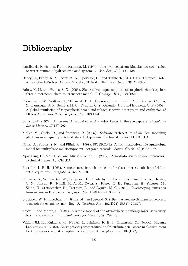
Bibliography
Arstila, H., Korhonen, P., and Kulmala, M. (1999). Ternary nucleation: kinetics and applicationto water-ammonia-hydrochloric acid system. J. Aer. Sci., 30(2):131–138.
Debry, E., Fahey, K. M., Sartelet, K., Sportisse, B., and Tombette, M. (2006). Technical Note:A new SIze REsolved Aerosol Model (SIREAM). Technical Report 37, CEREA.
Fahey, K. M. and Pandis, S. N. (2003). Size-resolved aqueous-phase atmospheric chemistry in athree-dimensional chemical transport model. J. Geophys. Res., 108(D22).
Horowitz, L. W., Walters, S., Mauzerall, D. L., Emmons, L. K., Rasch, P. J., Granier, C., Tie,X., Lamarque, J.-F., Schultz, M. G., Tyndall, G. S., Orlando, J. J., and Brasseur, G. P. (2003).A global simulation of tropospheric ozone and related tracers: description and evaluation ofMOZART, version 2. J. Geophys. Res., 108(D24).
Louis, J.-F. (1979). A parametric model of vertical eddy fluxes in the atmosphere. Boundary-Layer Meteor., 17:187–202.
Mallet, V., Quelo, D., and Sportisse, B. (2005). Software architecture of an ideal modelingplatform in air quality – A first step: Polyphemus. Technical Report 11, CEREA.
Nenes, A., Pandis, S. N., and Pilinis, C. (1998). ISORROPIA: A new thermodynamic equilibriummodel for multiphase multicomponent inorganic aerosols. Aquat. Geoch., 4(1):123–152.
Njomgang, H., Mallet, V., and Musson-Genon, L. (2005). AtmoData scientific documentation.Technical Report 10, CEREA.
Rosenbrock, H. H. (1963). Some general implicit processes for the numerical solution of differ-ential equations. Computer J., 5:329–330.
Simpson, D., Winiwarter, W., Borjesson, G., Cinderby, S., Ferreiro, A., Guenther, A., Hewitt,C. N., Janson, R., Khalil, M. A. K., Owen, S., Pierce, T. E., Puxbaum, H., Shearer, M.,Skiba, U., Steinbrecher, R., Tarrason, L., and Oquist, M. G. (1999). Inventorying emissionsfrom nature in Europe. J. Geophys. Res., 104(D7):8,113–8,152.
Stockwell, W. R., Kirchner, F., Kuhn, M., and Seefeld, S. (1997). A new mechanism for regionalatmospheric chemistry modeling. J. Geophys. Res., 102(D22):25,847–25,879.
Troen, I. and Mahrt, L. (1986). A simple model of the atmospheric boundary layer; sensitivityto surface evaporation. Boundary-Layer Meteor., 37:129–148.
Vehkamaki, H., Kulmala, M., Napari, I., Lehtinen, K. E. J., Timmreck, C., Noppel, M., andLaaksonen, A. (2002). An improved parameterization for sulfuric acid–water nucleation ratesfor tropospheric and stratospheric conditions. J. Geophys. Res., 107(D22).
123

124 BIBLIOGRAPHY
Wesely, M. L. (1989). Parameterization of surface resistances to gaseous dry deposition inregional-scale numerical models. Atmos. Env., 23:1,293–1,304.
Zhang, L., Brook, J. R., and Vet, R. (2003). A revised parameterization for gaseous dry depo-sition in air-quality models. Atmos. Chem. Phys., 3:2,067–2,082.
Zhang, L., Moran, M. D., Makar, P. A., Brook, J. R., and Gong, S. (2002). Modelling gaseousdry deposition in AURAMS: a unified regional air-quality modelling system. Atmos. Env.,36:537–560.