Policy Brief 1/2018 CURRENT ISSUES OF THE PHILIPPINE LAND ...
4
Policy Brief 1/2018 CURRENT ISSUES OF THE PHILIPPINE LAND USE PLANNING AND MANAGEMENT SYSTEM Summary Land use planning is an instrument that facilitates a fair and transparent allocation of land resources. Besides land registration it is a core instrument in the steering of local development trajectories and it helps to ensure the sustainable use of vital resources. However, land use planning is often subject to diverging interests of governmental agencies as well as political will. This policy brief explores the structures of land use and development planning in the Philippines, highlights the challenges associated with plan implementation in the administrative context and discusses the consequences for socio-economic development. The following findings lead us to our recommendation towards a consistent national policy framework for land use planning: • The complexity of developing Comprehensive Land Use Plans (CLUPs), their updating, and their subsequent enforcement pose challenges for municipal planning administrations. Training municipal staff is a prerequisite for successful planning and implementation. • Plan development and implementation should be based on objective criteria and aligned with peoples’ needs. Decoupling land use planning from the interests of executive officers and powerful landowners is essential and contributes to the common good. • Land use planning (physical planning) and development planning require alignment. The existing mismatch is a consequence of different and overlapping mandates between governmental authorities. • Incomplete and outdated cadastral information and shortcomings in sectoral information exchange inhibit the steps necessary to solve the pressing issue of insecure tenure rights. • Cooperation of agencies is currently partial and not yet systematic, which hampers a consistent alignment of plans and integration of efforts in the country. Introduction: Structure of Land Use and Development Planning Land is the basis for livelihoods. It requires fair and transparent management to allow equal participation and sustainable use. Land use planning is the mechanism to allow this kind of resource management and the reconciliation of diverging interests. It lays the foundation for controlled urban and rural development. In the Philippines, land use planning is hierarchically structured and most activities take place at a subnational, particularly at the provincial and municipal level. The planning levels are interlinked: lower-tier plans with shorter coverage periods are set to follow the priority setting of larger-scale plans. Municipal land use planning was strengthened by the Republic Act No. 7160 in 1991 to follow the principle of subsidiarity. Local governments gained responsibilities in a variety of planning fields, including development and land use planning: (a) the permission to process and approve subdivision plans from the Housing and Land Use Regulatory Board (HLURB), (b) the enforcement of the Key planning terms in the Philippines Land use planning is the process of identifying zones of regulated land use. It usually comprises a status quo assessment of the current status of land use, and the setting of priorities for future spatial development and implementation. Following spatial plans, development planning identifies priorities and projects for future socio-economic development. Sectoral planning is pursued on topics of limited scope in various thematic fields by sectoral agencies. Infrastructure planning or water treatment are examples.
Transcript of Policy Brief 1/2018 CURRENT ISSUES OF THE PHILIPPINE LAND ...

Policy Brief 1/2018
CURRENT ISSUES OF THE PHILIPPINE LAND USE PLANNING AND MANAGEMENT SYSTEM
Summary
Land use planning is an instrument that facilitates a fair and
transparent allocation of land resources. Besides land registration
it is a core instrument in the steering of local development
trajectories and it helps to ensure the sustainable use of vital
resources. However, land use planning is often subject to diverging
interests of governmental agencies as well as political will.
This policy brief explores the structures of land use and
development planning in the Philippines, highlights the challenges
associated with plan implementation in the administrative context
and discusses the consequences for socio-economic development.
The following findings lead us to our recommendation towards a
consistent national policy framework for land use planning:
• The complexity of developing Comprehensive Land Use Plans
(CLUPs), their updating, and their subsequent enforcement
pose challenges for municipal planning administrations.
Training municipal staff is a prerequisite for successful
planning and implementation.
• Plan development and implementation should be based on
objective criteria and aligned with peoples’ needs. Decoupling
land use planning from the interests of executive officers and
powerful landowners is essential and contributes to the
common good.
• Land use planning (physical planning) and development
planning require alignment. The existing mismatch is a
consequence of different and overlapping mandates between
governmental authorities.
• Incomplete and outdated cadastral information and
shortcomings in sectoral information exchange inhibit the
steps necessary to solve the pressing issue of insecure tenure
rights.
• Cooperation of agencies is currently partial and not yet
systematic, which hampers a consistent alignment of plans
and integration of efforts in the country.
Introduction: Structure of Land Use and Development Planning
Land is the basis for livelihoods. It requires fair and transparent
management to allow equal participation and sustainable use.
Land use planning is the mechanism to allow this kind of resource
management and the reconciliation of diverging interests. It lays
the foundation for controlled urban and rural development.
In the Philippines, land use planning is hierarchically structured
and most activities take place at a subnational, particularly at the
provincial and municipal level. The planning levels are interlinked:
lower-tier plans with shorter coverage periods are set to follow
the priority setting of larger-scale plans.
Municipal land use planning was strengthened by the Republic
Act No. 7160 in 1991 to follow the principle of subsidiarity. Local
governments gained responsibilities in a variety of planning fields,
including development and land use planning: (a) the permission
to process and approve subdivision plans from the Housing and
Land Use Regulatory Board (HLURB), (b) the enforcement of the
Key planning terms in the Philippines
Land use planning is the process of identifying zones of
regulated land use. It usually comprises a status quo
assessment of the current status of land use, and the setting
of priorities for future spatial development and
implementation.
Following spatial plans, development planning identifies
priorities and projects for future socio-economic
development.
Sectoral planning is pursued on topics of limited scope in
various thematic fields by sectoral agencies. Infrastructure
planning or water treatment are examples.

DEval Policy Brief 1 /2018
National Building Code from the Department of Public Works
and Highways including granting or declining of building permits,
as well as (c) the reclassification of agricultural land from the
Department of Agrarian Reform, except those lands distributed
to agrarian reform beneficiaries pursuant to the Republic Act
No. 6657 (Republic of the Philippines, 1991).
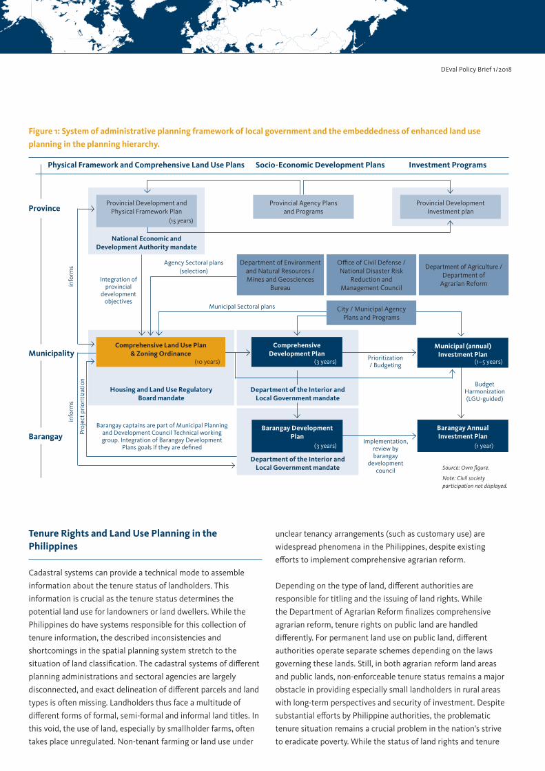
The CLUP, the main planning instrument, aims to provide a sound
foundation for managing past, current and projected land use and
for the allocation of land resource use of the whole territory of a
municipality. Figure 1 shows the embeddedness of the CLUP in
the planning hierarchy. The CLUP is highly dependent on the
cooperation of different agencies and is supposed to have primacy
over other sectoral, development and investment plans of
governmental agencies at the municipal level.
To address shortcomings of older CLUP guidelines, the HLURB
has developed the new enhanced comprehensive land use
planning (eCLUP) guidebooks in a joint effort with the Philippine–
German cooperation. The new guidelines, officially launched in
late 2015, serve as an improved planning tool for comprehensive
and information-driven planning as well as the integration of the
whole municipal territory. It and aims for a stronger integration
between spatial and development planning, more coherence in
aligning socio-economic development and land use as well as the
linking of development planning and budget allocation (Housing
and Land Use Regulatory Board (HLURB) Philippines, 2013).
While eCLUP makes the planning process more consistent and
comprehensive, data collection for the CLUP and the planning
process itself remain highly complex. As emphasized in interviews,
this requires more personnel and further trainings on CLUP
development and updating.
Current Issues of the Land Use Planning and Management System
In theory, the interplay of plans and hierarchies in the Philippine
planning system has been well defined for many years. In reality,
the system has been characterized by multiple policies of
different authorities with overlapping mandates.
For example, large portions of Philippine land are classified as
forest land, and are managed through Forest Land Use Plans
under the mandate of the Department of Environment and
Natural Resources. This separation of types of land hinders
municipal planners to integrate this land into comprehensive
land use planning and thus largely excludes residents using these
lands from the provision of municipal public services.
Vertical frictions in the planning system occur, due to the timely
misalignment of different plans and incomplete information
exchange between agencies. The CLUPs are supposed to be
harmonized with the Provincial Development and Physical
Framework Plan—frequently not sufficiently achieved in either
direction. At the same time, inputs provided by a Barangay
Development Plan, mandated by the Department of the Interior
and Local Government, are supposed to be incorporated into the
planning goals of the CLUP. In the absence of a formulated
Barangay Development Plan, the CLUP can thus only assume
barangay planning goals, which reduces the quality of local
representation.
Horizontal frictions occur due to the misalignment of the CLUP
and the Comprehensive Development Plans (CDP)—both
municipal level plans. In theory, the CLUP is operationalized in
the CDP, followed by integration into investment plans and
transfer into municipal budgeting. This linkage of aligning spatial
and socio-economic development goals with budgetary planning
often lacks coherence. The process of developing and updating
CLUPs is lengthy and the approval process can be extensive.
Hence, municipal executives often rely solely on the CDP for
quick project implementation. These inconsistencies in the
planning process leave greater leeway for politicized decisions
and ad hoc project prioritizations by powerful executives or local
political elites, in which, for example, political supporters are
more likely beneficiaries of projects and the disbursement of
funds. In extreme cases, vested interests of executive officers and
influential landowners block the formulation and approval of
zoning ordinances as well as implementation according to plans.
Main hindering factors for successful CLUP formulation, updating
and implementation are: Frictions and political interference;
complexity in planning policies; rivalling mandates; limited
capacities of local governments; as well as tenure conflicts.
Consequently, HLURB estimated in 2012 that 70% of
municipalities had no or outdated land use plans (GIZ and
ANGOC, 2014). A DEval survey of Municipal Planning and
Development Offices in the Visayas region in 2016 found that
while 84 out of 100 municipalities had land use planning
documents, only 37 had been approved by the Provincial Land
Use Committee. A share that is likely even lower countrywide
because almost half of those municipalities received additional
support for CLUP development.
DEval Policy Brief 1 /2018
Tenure Rights and Land Use Planning in the Philippines
Cadastral systems can provide a technical mode to assemble
information about the tenure status of landholders. This
information is crucial as the tenure status determines the
potential land use for landowners or land dwellers. While the
Philippines do have systems responsible for this collection of
tenure information, the described inconsistencies and
shortcomings in the spatial planning system stretch to the
situation of land classification. The cadastral systems of different
planning administrations and sectoral agencies are largely
disconnected, and exact delineation of different parcels and land
types is often missing. Landholders thus face a multitude of
different forms of formal, semi-formal and informal land titles. In
this void, the use of land, especially by smallholder farms, often
takes place unregulated. Non-tenant farming or land use under
unclear tenancy arrangements (such as customary use) are
widespread phenomena in the Philippines, despite existing
efforts to implement comprehensive agrarian reform.
Depending on the type of land, different authorities are
responsible for titling and the issuing of land rights. While
the Department of Agrarian Reform finalizes comprehensive
agrarian reform, tenure rights on public land are handled
differently. For permanent land use on public land, different
authorities operate separate schemes depending on the laws
governing these lands. Still, in both agrarian reform land areas
and public lands, non-enforceable tenure status remains a major
obstacle in providing especially small landholders in rural areas
with long-term perspectives and security of investment. Despite
substantial efforts by Philippine authorities, the problematic
tenure situation remains a crucial problem in the nation’s strive
to eradicate poverty. While the status of land rights and tenure
Figure 1: System of administrative planning framework of local government and the embeddedness of enhanced land use
planning in the planning hierarchy.
Physical Framework and Comprehensive Land Use Plans Socio-Economic Development Plans Investment Programs
National Economic and Development Authority mandate
Housing and Land Use Regulatory Board mandate
Department of the Interior and Local Government mandate
Department of the Interior and Local Government mandate
Provincial Development and Physical Framework Plan
Provincial Agency Plans and Programs
Department of Environment and Natural Resources / Mines and Geosciences
Bureau
Office of Civil Defense / National Disaster Risk
Reduction and Management Council
Comprehensive Development Plan
Barangay Development Plan
Municipal (annual) Investment Plan
Barangay Annual Investment Plan
Department of Agriculture / Department of
Agrarian Reform
Provincial Development Investment plan
(1–5 years)(3 years)
(1 year)
Agency Sectoral plans (selection)
Barangay captains are part of Municipal Planning and Development Council Technical working group. Integration of Barangay Development
Plans goals if they are defined
Proj
ect p
rior
itiz
atio
n
Integration of provincial
development objectives
info
rms
info
rms
Prioritization / Budgeting
Implementation, review by barangay
development council
Budget Harmonization (LGU-guided)
Municipal Sectoral plans
Comprehensive Land Use Plan & Zoning Ordinance
City / Municipal Agency Plans and Programs
Source: Own figure.
Note: Civil society participation not displayed.
(15 years)
(10 years)
(3 years)
Province
Municipality
Barangay
Dr Malte Lech
Evaluator
Dr Gerald Leppert
Senior Evaluator
GIZ and ANGOC (2014), Review of Selected Land Laws and the Governance of Tenure in the Philippines. Discussion Paper in the context of the Voluntary Guidelines on the Governance of Tenure (VGGT), GIZ, Bonn/Eschborn.
Housing and Land Use Regulatory Board (HLURB) Philippines (2013), CLUP Guidebook. A Guide to Comprehensive Land Use Plan Preparation. Volume 1 – The Planning Process. Housing and Land Use Regulatory Board, Manila.
Republic of the Philippines (1991), The Local Government Code of the Philippines, Republic Act.
AuthorsReferences
has a direct impact on the life and welfare of the affected
population, land rights surprisingly remain separated from the
process of land use planning.
A fair, consistent and comprehensive assignment of tenure
rights and land titles is an unresolved issue in the Philippines.
Rights and titles are excluded from the eCLUP process and not
sufficiently addressed in the distribution of mandates.
Challenges and the Way Ahead
Successful implementation of enhanced land use planning depends
on the willingness of sectoral agencies and administration to
commit to a stronger exchange of planning and tenure information
as well as on capacity building for municipal planning personnel.
ECLUP introduced reasonable, but complex processes that may
overburden current local planning capacities. Politicization of
municipal planning and personal interest can jeopardize technical
planning efforts, ultimately hampering socio-economic
development. Rivalling mandates between the HLURB and the
Department of the Interior and Local Government frequently lead
to decoupling of the municipal planning process from the
barangay-level as well as from provincial-level planning.
Land use rights remain excluded from the planning process,
ultimately reducing in municipal development options and
welfare effects. The unresolved issue of tenure rights and land
titles hampers planning efforts and impacts.
A more consistent and effective Land Use Planning and
Management System requires:
• Stronger coordination of sectoral agencies and
administrations. A national (legal) framework aligning plans
and agencies is a necessary step to improve cooperation.
• Legal provisions that barangay development aspirations are
sufficiently reflected in municipal planning. The consistent
integration of the Barangay Development Plans in CLUPs
could contribute to this.
• Plan development and implementation to be based on
objective criteria and aligned with peoples’ needs. This
requires that the vested interests of executive officers and
powerful landowners are decoupled from land use planning.
Explicit legal measures should be defined to ensure this
separation and to bind executive officers and legislative
officials to goals that serve the common good.
• Public accountability. Broad and transparent modes of public
participation are one aspect, but the other is the introduction
of sanctions if execution contradicts plans, for example by
establishing a complaints mechanism and appointing
ombudsmen.
• Further training in municipal planning. Personnel shortages
in planning administrations need to be addressed.
• A safe, consistent and comprehensive system of land use
rights. The current bureaucratic and legal structure of the
Philippines does not provide a functioning and fair tenure
system and thus needs to be revisited.
DEval Policy Brief 1 /2018
The German Institute for Development Evaluation (DEval) is mandated by the German Federal Ministry for Economic Cooperation and Development (BMZ) to independently analyse and assess German development interventions. Evaluation reports contribute to the transparency of development results and provide policy-makers with evidence and lessons learned, based on which they can shape and improve their development policies.
German Institute Fritz-Schäffer-Straße 26 · D-53113 Bonn, Germany [email protected] for Development Evaluation (DEval) Phone +49 228 33 69 07-0 www.DEval.org